indot 25-year long range plan 2003 amendment update ... · indot 25-year long range plan 2003...
TRANSCRIPT

INDOT 25-Year Long Range Plan
2003 Amendment Update Executive Summary
INDOT 25-Year Long Range Plan The Indiana Department of Transportation (INDOT) 25-Year Long Range Plan lays out a strategy for the future of the state highway system, which is intended to provide Hoosiers the highest level of mobility and safety possible, and to meet the needs of economic development and quality of life into the next quarter century. The Long Range Plan provides an update of the 1995 Statewide Multimodal Transportation Plan entitled Transportation in Indiana: Multimodal Plan Development for the 1990’s and Beyond. The 1995 multimodal policy plan provides a foundation for developing more detailed plans for specific transportation modes. This highway plan document is intended to extend the planning period for highway improvements from the initial five years of the 1995 Plan to a 25 year planning horizon. This extended planning period provides INDOT and our planning partners, including the state’s Metropolitan Planning Organizations (MPOs) and other key transportation stakeholders, a long range vision of how the state jurisdictional highway system will develop in the future.
2003 Amendments
INDOT has amended its 2000 to 2025 Long-Range Transportation Plan that was originally adopted on March 6, 2002. The 2003 amendments were introduced in order to maintain the INDOT long range plan relative to new information resulting from planning and environmental studies, in addition to revisions of project schedules and costs from the INDOT production scheduling system. Some recent planning and environmental studies which have provided more detailed information on major expansion transportation improvements include:
The I-69 Evansville to Indianapolis Environmental Impact Statement (EIS)
US 31 Corridor Study and EIS The Ohio River Bridges EIS The SR 62 (Lloyd Expressway) Corridor Planning
Study & Environmental Assessment (EA) The US 231, I-70 to I-65 Corridor Planning Study The Northeast Connections Planning Study & EIS
for I-69 & I-465 in Indianapolis The SR 25 Hoosier Heartland.
The amendments to the INDOT Long Range Transportation Plan consist of fifty-nine primary amendments of significant cost (over $10 million per project) and 136 minor cost and schedule revisions. Additionally, forty-two projects identified in the initial twenty-five year plan have been let and or completed and have been removed from the active funding listing within the plan. These projects do remain listed for historical purposes; they can be identified in the project listings as projects that have the word “Let” in the plan support column and have a zero under the cost column.
Public Input is Vital INDOT has established a proactive public involvement process in the planning and development of transportation projects. Over the past several years, INDOT has communicated the plan development process to state transportation professionals, local elected officials, and the public at a variety of venues, including an annual series of INDOT District “Open House” meetings, the Purdue University Road School and Consultation meetings held with Metropolitan Planning Organization (MPO) and Rural Planning Organizations (RPOs). INDOT also conducted an Indiana Futures Symposium, bringing national transportation experts and community and business leaders together to identify potential improvements to the state’s transportation system. The 25-Year Long Range Plan has been developed with the input of our statewide planning partners, including the state’s Metropolitan Planning Organizations, the
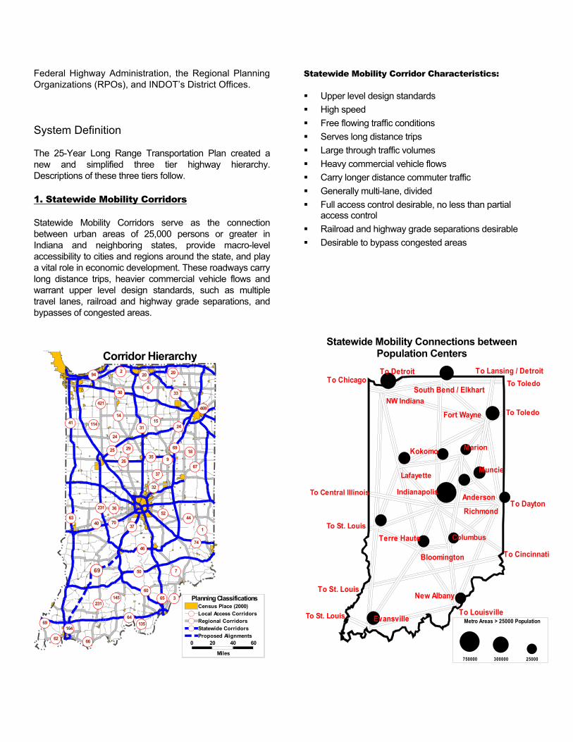
Federal Highway Administration, the Regional Planning Organizations (RPOs), and INDOT’s District Offices. System Definition The 25-Year Long Range Transportation Plan created a new and simplified three tier highway hierarchy. Descriptions of these three tiers follow.
1. Statewide Mobility Corridors
Statewide Mobility Corridors serve as the connection between urban areas of 25,000 persons or greater in Indiana and neighboring states, provide macro-level accessibility to cities and regions around the state, and play a vital role in economic development. These roadways carry long distance trips, heavier commercial vehicle flows and warrant upper level design standards, such as multiple travel lanes, railroad and highway grade separations, and bypasses of congested areas.
6
421
60
62
37
26
15
36231
14
32
52
3
1
41
145
24
67
7
29
231
2
135
9
4044
70
31
33
20
114
65
3518
66
37
64
164
50
30
74
69
46
69
20
469
63
25
94
24
69
0 20 40 60
Miles
Planning ClassificationsCensus Place (2000)Local Access CorridorsRegional CorridorsStatewide CorridorsProposed Alignments
Corridor Hierarchy
Statewide Mobility Corridor Characteristics:
Upper level design standards High speed Free flowing traffic conditions Serves long distance trips Large through traffic volumes Heavy commercial vehicle flows Carry longer distance commuter traffic Generally multi-lane, divided Full access control desirable, no less than partial
access control Railroad and highway grade separations desirable Desirable to bypass congested areas
Statewide Mobility Connections between Population Centers
$
$$
$
$
$ $
$
$
$
$$
$
$
$Marion
To Lansing / Detroit
To Dayton
To Cincinnati
To Central Illinois
Muncie
South Bend / ElkhartNW Indiana
Lafayette
Kokomo
AndersonIndianapolis
Fort Wayne
Columbus
Bloomington
Terre Haute
New Albany
EvansvilleTo St. Louis
To St. Louis
To DetroitTo Chicago
To Louisville
To Toledo
To Toledo
Metro Areas > 25000 Population
$ $ $750000 300000 25000
Richmond
To St. Louis

2. Regional Corridors
Regional Corridors serve as a connection to smaller cities and regions, feed traffic to the Statewide Mobility Corridors, and provide for regional accessibility.
Regional Corridor Characteristics: Mid-level design standards High to moderate speed Free-flow to the extent practicable in rural areas Serve medium distance trips Carry medium distance commuter traffic Moderate through traffic volumes Moderate commercial vehicle flows Potential for heavy local traffic volumes Typically, at grade intersections with highways and
railroads, with consideration for railroad separation High-level two-lane or multi-lane Partial access control desirable Conventionally routed through cities and towns
Highway Needs 2000 – 2025 Traffic growth rates from the Indiana Statewide Travel Demand Model are used to identify future year traffic volumes based upon forecasted socio-economic growth. Over the 2000 – 2025 time period, statewide population is forecasted to increase 17%, statewide employment is forecasted to increase 30%; however, travel demand is estimated to increase much more rapidly at 62%. The Highway Economic Requirements System for Indiana (HERS_IN) is one of the system planning tools developed for statewide transportation plan development. HERS_IN is a long-range planning tool for the analysis of highway system investments. HERS_IN is developed from the National Highway Economic Requirements System developed by the Federal Highway Administration (FHWA) for national highway investment analysis. INDOT has modified the national model for specific application to Indiana’s highway system analysis needs in developing HERS_IN. Two alternative levels of highway system investment were evaluated for the years 2000 to 2025. A full needs scenario, which allows the selection of any HERS_IN identified highway improvement, is compared to a no-build alternative to identify the impacts of future growth without any highway investment.
3) Local Access Corridors Local Access Corridors serve intra- and inter-county short distance trips, provide access to local residences and businesses, and provide access to rural areas and small towns.
Local Access Corridor Characteristics:
Lower-level design standards Moderate to low speed At-grade intersections with highways and railroads Minimal access control Short distance trips Low through traffic volumes Moderate local traffic volumes Typically two-lane with multi-lane exceptions Frequent interaction with non-motorized vehicles
and pedestrians Routed through cities and towns
90 90
74
94
80
6569
64
70
65
469
164
465
275150
421
27
31
30
33
20
35
50
24
231
52
6
41
36
136
40
231
12131
HERS_IN NEEDS ANALYSIS 2000-2025
Map LayersCountiesCensus PlaceDistrictsState HighwaysU.S. HighwaysInterstatesIMP_2025 Layer

The full needs scenario identified 1074 miles of added travel lanes projects. Assuming these improvements were made, the miles of congested highway would decrease from 4% in 2000 to 2% in 2025. Urban Interstate speeds would remain constant from 2000 to 2025. Overall highway system performance would remain stable with a 1% reduction from 53 mph in 2000 to 52 mph in 2025. The no-build scenario resulted in the increase of congestion from 4% of highway mileage in 2000 to 25% in 2025. Urban Interstate system speed would decrease 25% by 2025. Overall system performance as measured by operating speed would decrease 10% from 53 mph in 2000 to 48 mph in 2025. The Fiscal Forecast As part of the plan update process to evaluate the proposed amendments, the fiscal forecast developed in the initial INDOT Long-Range Transportation was revisited to determine fiscal constraint. The earlier forecast, prepared under the oversight of the INDOT Office of the Chief Financial Officer estimated revenues over the next 25 years at $ 31.3 billion. The fiscal evaluation for the plan update effort evaluated the 1980 to 2003 historical funding trend line of approximately 9 % annual growth in addition to the upcoming federal reauthorization proposals for the anticipated next six-year USDOT legislation. A funding scenario of an 8.5 % annual increase during the next federal reauthorization legislation with a remaining 1 % annual increase over the balance of the 25 year forecast period results in an estimated $ 33.2 billion being available for transportation investment. Of this amount 45 % would be used for added capacity improvements associated with the 25 year plan and 55 % for system preservation activities.
25 Year Fiscal ForecastEstimated Expansion/Preservation Split
$0.0
$200.0
$400.0
$600.0
$800.0
$1,000.0
$1,200.0
$1,400.0
$1,600.0
2003
2004
2005
2006
2007
2008
2009
2010
2011
2012
2013
2014
2015
2016
2017
2018
2019
2020
2021
2022
2023
2024
2025
2026
2027
2028
Year
Fund
s (M
illio
ns)
Preservation ($millions) Expansion ($millions)
INDOT CONSTRUCTION SPENDING HISTORY FY 80 Thru FY 02
0100200300400500600700800900
1980
1981
1982
1983
1984
1985
1986
1987
1988
1989
1990
1991
1992
1993
1994
1995
1996
1997
1998
1999
2000
2001
2002
Fiscal Years
Dol
lars
(mill
ions
)
The 25-Year Long Range Plan The 25-Year Long Range Plan Projects map illustrates the highway improvements recommended in the INDOT 25-Year Long Range Plan. The full INDOT 25-Year Long Range Plan provides maps of each district and MPO, along with detailed project listings, providing improvement type and implementation phasing information.
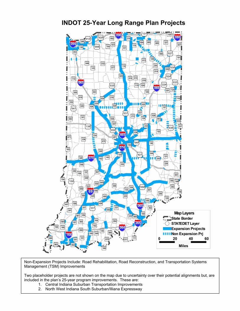
Non-Expansion Projects Include: Road Rehabilitation, Road Reconstruction, and Transportation Systems Management (TSM) Improvements Two placeholder projects are not shown on the map due to uncertainty over their potential alignments but, are included in the plan’s 25-year program improvements. These are:
1. Central Indiana Suburban Transportation Improvements 2. North West Indiana South Suburban/Illiana Expressway
150
090
039
421
024
074
067
027
022
094
080
031
052
030
068
018
028
033
063
020
056
065
058
003
069
064
241
066
120
142
035
070
047
050
231
025
002
075
114
250
009
062
037
218
048
337
014
005
006
046
041
054
065
026
001
019
036
124
038
059
129
164
055
015
111
160
104
040
252
168
110
070
057
234
043
013
161
032
145
064
016
010
105
044
049
007
119
350
060
229
065
545
165
061
256
136
011
341
227
166
156
004
008
450
245
257
244
240
205
128
017
069
116
159
101
246
327
045
550
135
446
042
130
340
358 235
352
164
224
261
236
115
238
331
258
154
267
109
364
162
071
167
023
029
465
213
362
103
157
265
144121
427
163
012
356 335
262
143
524
225
219
053
249
526
232
650
131
140
930
645
100
148
662
441
201
357
0 20 40 60
Miles
Map LayersState BorderSTATEDET LayerExpansion ProjectsNon Expansion Prj
69
INDOT 25-Year Long Range Plan Projects

Long Range Plan Improvement Types
The Long Range Plan is focused upon improvement types that increase the carrying capacity of the transportation system and improve the highway's ability to serve longer distance, higher speed inter-city travel, including commercial vehicles. These expansion projects receive special attention due to their long development time. A typical expansion project usually has a minimum seven to eight year development process made of four stages: planning/environmental studies, design engineering, land acquisition, and construction. Each stage requires one, two, or sometimes three years for completion. In addition to the long lead time needed for project implementation, expansion projects may create significant impacts to our environment which require consideration of long-range impacts. Improvement types are:
1. Added Travel Lanes
2. New Road Construction
3. Reconstruction 4R
4. Rehabilitation 3R
5. Transportation System Management
6. Median Construction
7. Interchange Modification
8. New Interchange Construction
9. New Bridge Construction
10. Freeway Upgrade
For more information regarding the INDOT 25-Year Long Range Transportation Plan, please contact the Long Range Transportation Planning Section at: [email protected].
An Evolving Document The Indiana Department of Transportation 25-Year Long Range Plan is an evolving document. The 25 year project listing contained within the full report is flexible. Predicting the future is a difficult task. This plan will be amended periodically so that we can adapt to changing needs, priorities, and fiscal realities. INDOT anticipates that our Long Range Plan will be formally updated every two years. In the meantime, we are receptive to and encourage your comments. Together, we can provide for a safe, efficient, effective, reliable transportation system for all Hoosiers and those who pass between our borders here at the Crossroads of America.
The INDOT 25-Year Long Range Transportation Plan, including detailed maps and project listings, and the 2003 amendments are both available on INDOT’s Web site: http://www.in.gov/dot/pubs
Or contact us in writing at: Indiana Department of Transportation
Long Range Transportation Planning Section Room N901 Indiana Government Center North 100 North Senate Avenue Indianapolis, Indiana 46204