in the matter of the bay of bengal maritime …
TRANSCRIPT

IN THE MATTER OF THE BAY OF BENGAL MARITIME BOUNDARY ARBITRATION
- between -
THE PEOPLE’S REPUBLIC OF BANGLADESH
- and -
THE REPUBLIC OF INDIA
AWARD
The Arbitral Tribunal:
Judge Rüdiger Wolfrum (President)
Judge Jean-Pierre Cot
Judge Thomas A. Mensah
Dr. Pemmaraju Sreenivasa Rao
Professor Ivan Shearer
Registry:
Permanent Court of Arbitration
The Hague, 7 July 2014

this page intentionally blank

AGENT OF BANGLADESH AGENT OF INDIA
Dr. Dipu Moni, MP Government of the People’s Republic of Bangladesh
Dr. Neeru Chadha Joint Secretary & the Legal Adviser Ministry of External Affairs
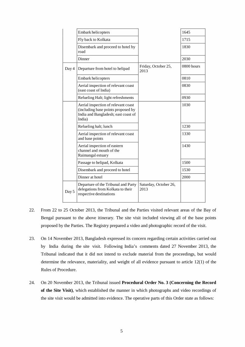
DEPUTY AGENT OF BANGLADESH
CO-AGENT OF INDIA
Rear Admiral Md. Khurshed Alam (Retd) Secretary, Maritime Affairs Unit Ministry of Foreign Affairs, Government of the People’s Republic of
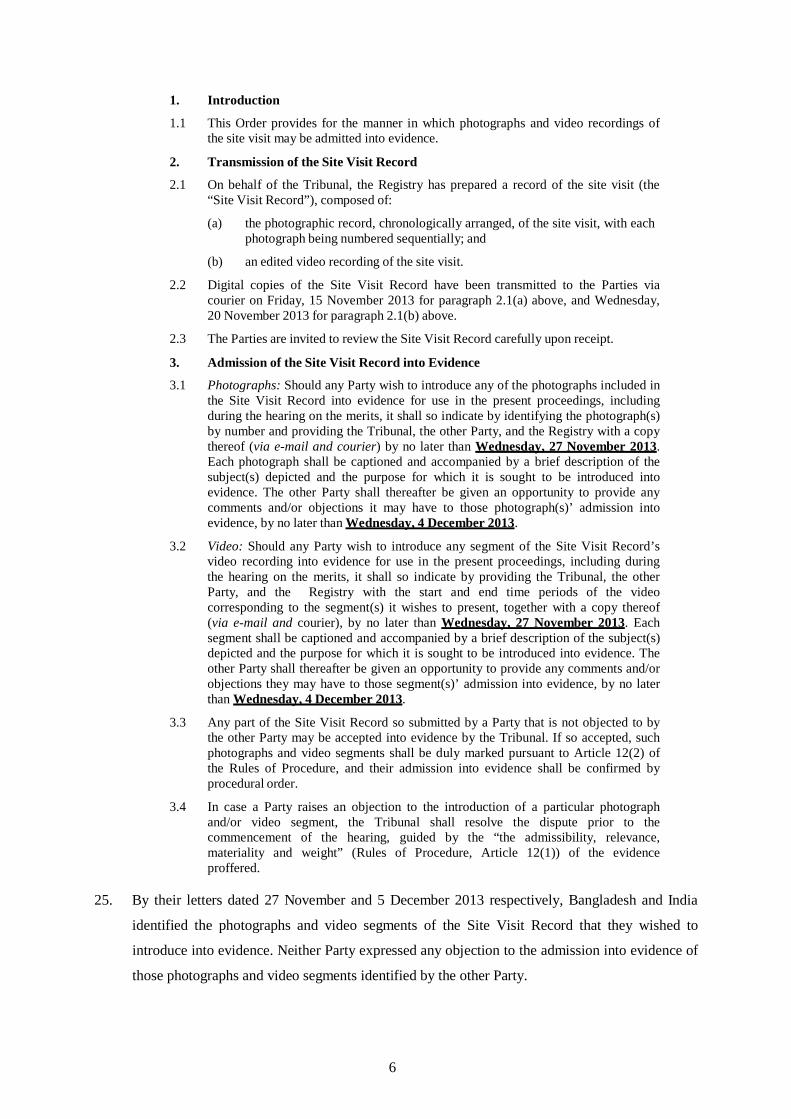
Mr. Harsh Vardhan Shringla Joint Secretary (BSM) Ministry of External Affairs
Mr. Puneet Agrawal Deputy Agent, Director (BSM) Ministry of External Affairs
COUNSEL AND ADVOCATES FOR BANGLADESH
CHIEF COUNSEL FOR INDIA
H.E. The Honourable A.H. Mahmood Ali, MP Foreign Minister, Ministry of Foreign Affairs, Government of the People’s Republic of Bangladesh
Mr. Md. Shahidul Haque Foreign Secretary, Ministry of Foreign Affairs Government of the People’s Republic of Bangladesh
Mr. Mohammad Shahidul Haque Secretary, Legislative & Parliamentary Affairs Division, Ministry of Law, Justice and Parliamentary Affairs, Dhaka
Professor Payam Akhavan McGill University
Professor Alan Boyle University of Edinburgh
Professor James Crawford SC, FBA University of Cambridge
Mr. Lawrence H. Martin Foley Hoag LLP
Mr. Paul S. Reichler Foley Hoag LLP
Professor Philippe Sands QC University College London
H.E. Mr. G. E. Vahanvati Attorney General of India
COUNSEL FOR INDIA
Professor Alain Pellet University of Paris Ouest, Nanterre-La Défense Former Member & Chairman of the International Law Commission, Associate Member of the Institut de Droit International
Professor W.M. Reisman McDougal Professor of Law, Yale University Member of the Institut de Droit international
Mr. R.K.P. Shankardass Senior Advocate, Supreme Court of India Former President, International Bar Association
Sir Michael Wood, K.C.M.G Member of the English Bar Member of the International Law Commission
AGENTS, COUNSEL AND OTHER REPRESENTATIVES OF THE PARTIES
Bangladesh DEPUTY AGENT OF INDIA
i

ADVISORS FOR BANGLADESH REPRESENTATIVES FOR INDIA
Mr. Shiekh Mohammed Belal Director General, Ministry of Foreign Affairs and Bangladesh Ambassador-designate to the Netherlands
M.R.I. Abedin, System Analyst Maritime Affairs Unit, Ministry of Foreign Affairs
Mr. Mohammad Hazrat Ali Khan, Director Maritime Affairs Unit ,Ministry of Foreign Affairs
Dr. Robin Cleverly Law of the Sea Consultant, The United Kingdom Hydrographic Office
Mr. Scott Edmonds Cartographic Consultant, International Mapping
Dr. Lindsay Parson Director, Maritime Zone Solutions Ltd.
Mr. Robert W. Smith Geographic Consultant
JUNIOR COUNSEL FOR BANGLADESH
Mrs. Clara Brillembourg Foley Hoag LLP
Mr. Vivek Krishnamurthy Foley Hoag LLP
Mr. Yuri Parkhomenko Foley Hoag LLP
Mr. Remi Reichhold Matrix Chambers
H.E. Mr. R.N. Prasad Ambassador of India to the Netherlands
Dr. A. Sudhakara Reddy Counsellor (Legal)
JUNIOR COUNSEL FOR INDIA
Mr. Devadatt Kamat Assistant Counsel to Attorney General of India
Mr. Benjamin Samson University of Paris Ouest
Mr. Eran Sthoeger New York University
SCIENTIFIC & TECHNICAL ADVISORS
FOR INDIA
Vice Admiral S.K. Jha, Chief Hydrographer to the Government of India
Rear Admiral K.M. Nair Joint Chief Hydrographer National Hydrographic Office (NHO)
Prof. Martin Pratt Expert Cartographer Director of Research, International Boundary Research Unit (IBRU) Durham University
Commodore Adhir Arora, Principal Director of Hydrography, NHO
Captain Peush Pawsey Director of Hydrography (Ops.), NHO
Dr. Dhananjay Pandey Scientist, National Centre for Antarctic & Ocean Research (NCAOR)
Mr. R. C. Samota Cartographic Assistant, NHO
RESEARCH ASSOCIATES FOR INDIA
Mr. K. S. Mohammed Hussain Legal Officer, Ministry of External Affairs
Ms. Héloise Bajer-Pellet, Member of the Paris Bar
ii

TABLE OF CONTENTS
CHAPTER I - PROCEDURAL HISTORY ................................................................................................ 1
A. Initiation of this Arbitration ............................................................................................................................ 1
B. Constitution of the Arbitral Tribunal ............................................................................................................... 1
C. The First Procedural Meeting and the Adoption of the Rules of Procedure .................................................... 2
D. Appointment of Expert Hydrographer ............................................................................................................ 2
E. Site Visit .......................................................................................................................................................... 3
F. The Parties’ Written Submissions on the Merits ............................................................................................. 7
G. The Hearing on the Merits .............................................................................................................................. 8
CHAPTER II - INTRODUCTION .............................................................................................................. 13
A. Geography ..................................................................................................................................................... 13
B. Historical Background of the Dispute ........................................................................................................... 14
C. The Dispute between the Parties ................................................................................................................... 15
CHAPTER III - THE TRIBUNAL’S JURISDICTION .............................................................................. 19
A. The Submission of the Dispute to Arbitration under the Convention............................................................ 19
B. Jurisdiction and the Delimitation of the Continental Shelf beyond 200 nm .................................................. 20
CHAPTER IV - THE LAND BOUNDARY TERMINUS ........................................................................... 25
A. Interpretation of Annexure A of the Radcliffe Award ................................................................................... 26
1. “the main channel . . . of the rivers Ichhamati and Kalindi, Raimangal and Haribhanga till it meets the Bay” .................................................................................................................................................... 26
2. “for the time being” and the relevance of the Bagge Award ................................................................ 27
B. The 1951 Exchange of Letters ...................................................................................................................... 29
C. Map Evidence Presented by the Parties ........................................................................................................ 31
1. The Radcliffe Map ............................................................................................................................... 31
2. British Admiralty Chart 859 ................................................................................................................ 36
3. Satellite Imagery .................................................................................................................................. 39
D. Commander Kennedy’s Report ..................................................................................................................... 41
E. The Relevance of uti possidetis juris ............................................................................................................. 42
F. “the midstream of the main channel” ............................................................................................................ 42
G. “the point where that boundary meets the Bay of Bengal” ............................................................................ 44
H. The Tribunal’s Decision on the Land Boundary Terminus ........................................................................... 45
CHAPTER V - THE SELECTION OF BASE POINTS AND THE DELIMITATION OF THE TERRITORIAL SEA ........................................................................................ 57
A. General Considerations concerning a Maritime Boundary ........................................................................... 57
B. General Considerations concerning the Selection of Base Points ................................................................. 57
C. The Parties’ Approaches to the Territorial Sea ............................................................................................. 65
1. Applicable law for the delimitation of the territorial seas and method of delimitation ........................ 65
2. The delimitation lines proposed by the Parties .................................................................................... 67
3

D. The Tribunal’s Delimitation of the Territorial Sea ........................................................................................ 71
1. Location of Base Points in the Territorial Sea ..................................................................................... 72
2. Establishment of the median/equidistance line in the territorial sea ..................................................... 75
3. Adjustment of the median line in the territorial sea ............................................................................. 75
CHAPTER VI - RELEVANT COASTS AND RELEVANT AREA FOR DELIMITATION BEYOND THE TERRITORIAL SEA ............................................................................. 79
A. The Relevant Coast of Bangladesh ............................................................................................................... 80
B. The Relevant Coast of India ......................................................................................................................... 81
C. The Relevant Area ........................................................................................................................................ 88
CHAPTER VII - DELIMITATION OF THE EXCLUSIVE ECONOMIC ZONE AND THE CONTINENTAL SHELF WITHIN 200 NM .................................................................. 91
A. Methodology ................................................................................................................................................ 91
1. Applicability of the equidistance method ............................................................................................ 91
2. Applicability of the angle-bisector method .......................................................................................... 93
3. The Tribunal’s Decision on Methodology ........................................................................................... 97
B. The Provisional Equidistance Line ............................................................................................................. 100
1. Base points for the equidistance line within 200 nm ......................................................................... 102
2. The Tribunal’s Provisional Equidistance Line ................................................................................... 105
C. Relevant Circumstances ............................................................................................................................. 105
1. Coastal instability .............................................................................................................................. 105
2. Concavity and Cut-Off Effects .......................................................................................................... 110
3. Other circumstances .......................................................................................................................... 115
4. The Tribunal’s Decision on Relevant Circumstances ........................................................................ 115
D. The Parties’ Views on the Adjustment of the Provisional Equidistance Line within 200 nm ..................... 124
E. The Tribunal’s Decision on the Adjustment of the Provisional Equidistance Line within 200 nm ............. 129
CHAPTER VIII - DELIMITATION OF THE CONTINENTAL SHELF BEYOND 200 NM ........................................................................................................... 131
A. Methodology .............................................................................................................................................. 131
B. The Parties’ Proposed Delimitation Lines Beyond 200 nm ........................................................................ 131
C. The Tribunal’s Delimitation of the Continental Shelf beyond 200 nm ....................................................... 138
1. Base points for the equidistance line beyond 200 nm ........................................................................ 141
2. Provisional equidistance line beyond 200 nm .................................................................................... 142
3. Relevant circumstances ..................................................................................................................... 142
CHAPTER IX - ADJUSTMENT OF THE PROVISIONAL EQUIDISTANCE LINE WITHIN AND BEYOND 200 NM ................................................................................. 147
A. The Tribunal’s Considerations in Adjusting the Provisional Equidistance Line ......................................... 147
B. The Tribunal’s Adjustment of the Provisional Equidistance Line ............................................................... 147
CHAPTER X - DISPROPORTIONALITY TEST .................................................................................. 151
CHAPTER XI - GREY AREA ................................................................................................................... 155
CHAPTER XII - DISPOSITIF .................................................................................................................... 165
APPENDIX - TECHNICAL REPORT OF THE TRIBUNAL’S HYDROGRAPHER .................... A-1
4
CHAPTER I - PROCEDURAL HISTORY
A. INITIATION OF THIS ARBITRATION
1. By a Notification and Statement of Claim dated 8 October 2009, the People’s Republic of
Bangladesh initiated arbitral proceedings against the Republic of India, pursuant to article 287
of the 1982 United Nations Convention on the Law of the Sea (the “Convention”) and in
accordance with Annex VII to the Convention. Bangladesh and India (the “Parties”) ratified the
Convention on 27 July 2001 and 26 June 1995, respectively.
2. In its Notification and Statement of Claim, Bangladesh sought the following relief:
Bangladesh requests the Tribunal to delimit, in accordance with the principles and rules set forth in UNCLOS, the maritime boundary between Bangladesh and India in the Bay of Bengal, in the territorial sea, the EEZ, and the continental shelf, including the portion of the continental shelf pertaining to Bangladesh that lies more than 200 nautical miles from the baselines from which its territorial sea is measured.1
B. CONSTITUTION OF THE ARBITRAL TRIBUNAL
3. The Arbitral Tribunal (the “Tribunal”) was established pursuant to article 3, Annex VII of the
Convention. Subparagraph (a) of article 3 of Annex VII calls for the appointment of five
members of the Tribunal.
4. On 8 October 2009, Bangladesh appointed Professor Vaughan Lowe QC as a member of the
Tribunal in accordance with subparagraph (b) of article 3 of Annex VII.
5. On 6 November 2009, India appointed Dr. Pemmaraju Sreenivasa Rao as a member of the
Tribunal in accordance with subparagraph (c) of article 3 of Annex VII.
6. In the absence of an agreement between the Parties on the appointment of the remaining
members of the Tribunal, after consultation with the Parties in accordance with subparagraph
(e) of article 3 of Annex VII, the President of the International Tribunal for the Law of the Sea
on 10 February 2010 appointed Judge Rüdiger Wolfrum, Professor Ivan Shearer, and Professor
Tullio Treves as members of the Tribunal, with Judge Rüdiger Wolfrum as President.
7. The members of the Tribunal signed declarations of independence and impartiality, which were
communicated to the Parties on 16 June and 23 July 2010.
8. On 23 August 2010, the PCA informed the Parties that Professor Vaughan Lowe QC had
announced his withdrawal from the proceedings on 18 August 2010 with immediate effect. On
13 September 2010, Bangladesh appointed Judge Thomas A. Mensah in replacement of
1 Bangladesh’s Notification and Statement of Claim, paragraph 21.
1

Professor Vaughan Lowe QC in accordance with article 6(1)(a) of the Rules of Procedure
(discussed below).
9. On 17 June 2013, the PCA communicated to the Parties Professor Tullio Treves’ decision to
withdraw from his position as arbitrator on 16 June 2013. On 18 July 2013, the President of the
International Tribunal for the Law of the Sea appointed Judge Jean-Pierre Cot in accordance
with article 6(1)(b) of the Rules of Procedure.
C. THE FIRST PROCEDURAL MEETING AND THE ADOPTION OF THE RULES OF PROCEDURE
10. On 24 March 2010, the President of the Tribunal wrote to the Secretary-General of the
Permanent Court of Arbitration (the “PCA”) to inquire whether the PCA would serve as
Registry in these proceedings, and whether it would attend a First Procedural Meeting between
the Parties and the Tribunal to be held at the Max Planck Institute for Comparative Public Law
and International Law in Heidelberg, Germany.
11. On 25 March 2010, the Secretary-General of the PCA confirmed the PCA’s willingness to
assume the function of Registry and to attend the first procedural meeting.
12. On 8 April 2010, the President of the Tribunal informed the Secretary-General of the PCA of
both Parties’ approval to entrust the PCA with the function of Registry in the current
proceedings. Mr. Brooks W. Daly was subsequently appointed to serve as Registrar.
13. On 26 May 2010, the First Procedural Meeting was held in Heidelberg, Germany, during which
the Tribunal adopted its Rules of Procedure with the consent of the Parties.2
14. Thereafter, the draft Terms of Appointment agreed upon at the Meeting were sent to the Parties
for their approval. In the absence of objections of the Parties, the Terms of Appointment were
signed by the Parties, the President of the Tribunal, and the Secretary-General of the PCA, with
effect from 19 November 2010.
D. APPOINTMENT OF EXPERT HYDROGRAPHER
15. On 22 February 2011, the PCA informed the Parties that the Tribunal was considering the
appointment of Mr. David H. Gray as an expert hydrographer, pursuant to article 12(4) of the
Rules of Procedure, and invited their comments on this appointment. A copy of Mr. Gray’s
curriculum vitae and a draft of the Tribunal’s proposed Terms of Reference for the
hydrographer were enclosed with this communication.
2 The Rules of Procedure are available at http://www.pca-cpa.org/showpage.asp?pag_id=1376.
2

16. On 13 and 22 March 2011, respectively, Bangladesh and India confirmed their agreement to the
appointment of Mr. Gray as expert hydrographer.
17. On 18 April 2011, the Tribunal appointed Mr. Gray as expert hydrographer in these
proceedings. The PCA transmitted to the Parties a copy of the Terms of Reference, as signed by
the hydrographer and the President of the Tribunal, and requested that the hydrographer be
copied on all future correspondence.
E. SITE VISIT
18. Article 6(b) of Annex VII to the United Nations Convention on the Law of the Sea provides that
“[t]he parties to the dispute shall facilitate the work of the arbitral tribunal” and shall “enable it
when necessary […] to visit the localities to which the case relates”.
19. On 11 February 2013, the Tribunal communicated to the Parties its decision to conduct a site
visit and invited the Parties to confer and agree upon a joint itinerary for the site visit. The
Parties exchanged views on 3 May, 30 June and 8 July 2013.
20. Having considered the Parties’ views on the site visit itinerary, the Tribunal wrote to the Parties
on 11 July 2013 with a proposal for the itinerary and invited the Parties’ further comments. The
Parties’ comments were received on 26 July and 5 August 2013.
21. Having considered the comments of the Parties on the details of the itinerary and further
comments on a draft Procedural Order sent to the Parties on 16 August 2013, the Tribunal
issued Procedural Order No. 1 (Concerning the Site Visit of October 2013) on 28 August
2013. The Procedural Order established the itinerary of the proposed visit and the size of the
delegations, and also dealt with matters concerning the confidentiality of the site visit and the
manner in which the costs were to be apportioned between the Parties. Procedural Order No. 1
sets out the site visit itinerary as follows:
1. The Site Visit Itinerary
1.1 The Tribunal records that after consulting the Parties, it had earlier set aside October 22-26, 2013 for the conduct of the site visit, with October 22 and 26 being dates of arrival to and departure from the region. The Tribunal hereby fixes these dates.
1.2 The Tribunal takes note of Bangladesh’s correspondence dated May 3 and June 30, 2013 as well as India’s correspondence dated July 8 and 26, 2013, in which they outline their respective views on the proper itinerary for this site visit. The Parties agree that Bangladesh will host the delegations on October 23 and the first half of October 24; India will host the delegations from the second half of October 24 and October 25. Having considered the Parties’ further views on the matter, the Tribunal hereby adopts the following itinerary:
3

DAY
DETAILS OF VISIT
PROPOSED DAY AND DATE
TIME
Day 1 Arrival of the Tribunal and the
Party delegations at Dhaka Tuesday, October 22, 2013
Day 2
Departure from hotel to helipad Wednesday, October
23, 2013 0845 hours
Depart Dhaka by helicopter to base point B5
0900
Arrive area of base point B5; depart for Chittagong
1115
Arrive Chittagong, lunch and helicopter refuelling
1230
Depart Chittagong for Raimangal Estuary via base point B4 and Bengal Delta coast
1430
Aerial reconnaissance of Haribhanga River3 and the Raimangal Estuary, including all the proposed base points in the area (including South Talpatty/New Moore)
1630
Depart Raimangal Estuary for Jessore Air Force base
1715
Arrive Jessore Air Force base 1745
Day 3
Depart Jessore Air Force base for vessel embarkation site
Thursday, October 24, 2013
0600 hours
Arrive vessel embarkation site
0645
Depart for western channel 0700
Sea site inspection of the Haribhanga River and the western channel
0800
Light refreshments 1030
Transit to disembarkation point identified by India and Bangladesh
1130
Embark hovercraft at disembarkation point for sea site inspection; lunch on-board
1200
Sea site inspection of the Eastern Channel and mouth of the Raimangal Estuary
1330
Passage from site to helipad 1500
3 The river is spelled alternatively Hariabhanga or Haribhanga throughout the record. As a matter of convenience the Tribunal will refer to it as the ‘Haribhanga’ in this Award.
4
Embark helicopters 1645
Fly back to Kolkata 1715
Disembark and proceed to hotel by road
1830
Dinner 2030 Day 4
Departure from hotel to helipad Friday, October 25,
2013 0800 hours
Embark helicopters 0810
Aerial inspection of relevant coast (east coast of India)
0830
Refueling Halt; light refreshments 0930 Aerial inspection of relevant coast
(including base points proposed by India and Bangladesh; east coast of India)
1030
Refueling halt; lunch 1230
Aerial inspection of relevant coast and base points
1330
Aerial inspection of eastern channel and mouth of the Raimangal estuary
1430
Passage to helipad, Kolkata 1500
Disembark and proceed to hotel 1530
Dinner at hotel 2000 Day 5
Departure of the Tribunal and Party delegations from Kolkata to their respective destinations
Saturday, October 26, 2013
22. From 22 to 25 October 2013, the Tribunal and the Parties visited relevant areas of the Bay of
Bengal pursuant to the above itinerary. The site visit included viewing all of the base points
proposed by the Parties. The Registry prepared a video and photographic record of the visit.
23. On 14 November 2013, Bangladesh expressed its concern regarding certain activities carried out
by India during the site visit. Following India’s comments dated 27 November 2013, the
Tribunal indicated that it did not intend to exclude material from the proceedings, but would
determine the relevance, materiality, and weight of all evidence pursuant to article 12(1) of the
Rules of Procedure.
24. On 20 November 2013, the Tribunal issued Procedural Order No. 3 (Concerning the Record
of the Site Visit), which established the manner in which photographs and video recordings of
the site visit would be admitted into evidence. The operative parts of this Order state as follows:
5
1. Introduction
1.1 This Order provides for the manner in which photographs and video recordings of the site visit may be admitted into evidence.
2. Transmission of the Site Visit Record
2.1 On behalf of the Tribunal, the Registry has prepared a record of the site visit (the “Site Visit Record”), composed of:
(a) the photographic record, chronologically arranged, of the site visit, with each photograph being numbered sequentially; and
(b) an edited video recording of the site visit.
2.2 Digital copies of the Site Visit Record have been transmitted to the Parties via courier on Friday, 15 November 2013 for paragraph 2.1(a) above, and Wednesday, 20 November 2013 for paragraph 2.1(b) above.
2.3 The Parties are invited to review the Site Visit Record carefully upon receipt.
3. Admission of the Site Visit Record into Evidence
3.1 Photographs: Should any Party wish to introduce any of the photographs included in the Site Visit Record into evidence for use in the present proceedings, including during the hearing on the merits, it shall so indicate by identifying the photograph(s) by number and providing the Tribunal, the other Party, and the Registry with a copy thereof (via e-mail and courier) by no later than Wednesday, 27 November 2013. Each photograph shall be captioned and accompanied by a brief description of the subject(s) depicted and the purpose for which it is sought to be introduced into evidence. The other Party shall thereafter be given an opportunity to provide any comments and/or objections it may have to those photograph(s)’ admission into evidence, by no later than Wednesday, 4 December 2013.
3.2 Video: Should any Party wish to introduce any segment of the Site Visit Record’s video recording into evidence for use in the present proceedings, including during the hearing on the merits, it shall so indicate by providing the Tribunal, the other Party, and the Registry with the start and end time periods of the video corresponding to the segment(s) it wishes to present, together with a copy thereof (via e-mail and courier), by no later than Wednesday, 27 November 2013. Each segment shall be captioned and accompanied by a brief description of the subject(s) depicted and the purpose for which it is sought to be introduced into evidence. The other Party shall thereafter be given an opportunity to provide any comments and/or objections they may have to those segment(s)’ admission into evidence, by no later than Wednesday, 4 December 2013.
3.3 Any part of the Site Visit Record so submitted by a Party that is not objected to by the other Party may be accepted into evidence by the Tribunal. If so accepted, such photographs and video segments shall be duly marked pursuant to Article 12(2) of the Rules of Procedure, and their admission into evidence shall be confirmed by procedural order.
3.4 In case a Party raises an objection to the introduction of a particular photograph and/or video segment, the Tribunal shall resolve the dispute prior to the commencement of the hearing, guided by the “the admissibility, relevance, materiality and weight” (Rules of Procedure, Article 12(1)) of the evidence proffered.
25. By their letters dated 27 November and 5 December 2013 respectively, Bangladesh and India
identified the photographs and video segments of the Site Visit Record that they wished to
introduce into evidence. Neither Party expressed any objection to the admission into evidence of
those photographs and video segments identified by the other Party.
6

26. On 6 December 2013, the Tribunal issued Procedural Order No. 4 (Concerning Admission of
the Site Visit Record into Evidence), which confirmed the admission into evidence of those
photographs and video segments identified by Bangladesh and India in their respective letters
dated 27 November and 5 December 2013. The operative parts of this Order state as follows:
1. Pursuant to paragraph 3.3 of Procedural Order No. 3, all photographs and video segments of the site visit listed in Bangladesh’s letter to the Tribunal dated 27 November 2013 and India’s letter to the Tribunal dated 2 December 2013 are admitted into evidence.
2. When cited by the Parties, these photographs and video segments shall be duly marked in accordance with Article 12(2) of the Rules of Procedure, which provides that “[e]ach document submitted to the Tribunal shall be given a number (for Bangladesh’s documents, B-1, B-2 etc; for India’s documents, IN-1, IN-2 etc); and each page of each document shall be numbered.”
F. THE PARTIES’ WRITTEN SUBMISSIONS ON THE MERITS
27. On 31 May 2011, Bangladesh submitted its Memorial.
28. By communications dated 30 November, 19 December and 26 December 2011, the Parties
agreed that the deadline for India to submit its Counter-Memorial be extended from 31 May to
31 July 2012.
29. On 31 July 2012, India submitted its Counter-Memorial.
30. By communications dated 5 September and 13 September 2012, the Parties further agreed that
the deadline for the submission of the Reply and Rejoinder be extended for two months, i.e. to
31 January 2013 and 31 July 2013, respectively.
31. On 31 January 2013, Bangladesh submitted its Reply.
32. On 11 February 2013, the Tribunal requested additional information from the Parties concerning
charts, maps, and hydrographic surveys of the area that is the subject of the dispute, as well as
shipping, navigation and fishing activities in the area relevant to the dispute.
33. By their letters dated 4 March and 30 April 2013 respectively, Bangladesh and India provided
the Tribunal with information requested in the Tribunal’s letter of 11 February 2013.
34. On 30 July 2013, India submitted its Rejoinder.
35. On 4 November 2013, the Tribunal informed the Parties that it wished them to elaborate further
on issues concerning base points and the Radcliffe Award and Map, either by brief written
submissions or during the oral hearing.
7

36. By letter dated 2 December 2013, India submitted a brief written statement on the issues
mentioned in the Tribunal’s letter of 4 November. By letter dated 3 December 2013,
Bangladesh stated that it would address these issues during the oral hearing.
G. THE HEARING ON THE MERITS
37. On 28 January 2013, the Tribunal informed the Parties that it had reserved the period of 9-18
December 2013 for the hearing.
38. The Rules of Procedure adopted on 26 May 2010 concerned, inter alia, the conduct of hearings.
By letter dated 11 February 2013, the Tribunal amended certain provisions of the Rules of
Procedure, including the time limit for the Tribunal to conduct hearings after the submission of
the Rejoinder.
39. On 6 November 2013, the Tribunal issued Procedural Order No. 2 (Concerning the Hearing
on the Merits), which was corrected on 8 and 12 November 2013. This Order set out, inter alia,
the time and place of the hearing, the schedule of the hearing, and the degree of confidentiality
for the proceedings.
40. By letter dated 20 November 2013, the Tribunal clarified the purpose of the 15-minute period
allocated to each Party for “Introductory Remarks” in Paragraph 2.4 of Procedural Order
No. 2. India indicated that it intended to give a general overview of the case during this 15-
minute period, Bangladesh stated that it had no objection to India’s intended use of the 15-
minute period.
41. The hearing on the merits took place from 9 to 18 December 2013 in the Peace Palace, The
Hague, the Netherlands. The following individuals participated on behalf of the Parties:
Bangladesh India
H.E. Dr. Dipu Moni, MP Agent of Bangladesh and Former Foreign Minister, Government of the People’s Republic of Bangladesh
Rear Admiral (Retd) Mohammad Khurshed Alam Mphil, ndc, psc
Deputy Agent of Bangladesh & Secretary (Maritime Affairs Unit), Ministry of Foreign Affairs, Dhaka
Counsel and Advocates
H.E. The Honourable A.H. Mahmood Ali, MP Foreign Minister, Government of the People’s Republic of Bangladesh
Dr. Neeru Chadha Agent, Joint Secretary & the Legal Adviser, Ministry of External Affairs, Government of India
Mr. Harsh Vardhan Shringla
Co-Agent, Joint Secretary (BSM), Ministry of External Affairs
Mr. Puneet Agrawal
Deputy Agent, Director (BSM), Ministry of External Affairs
Chief Counsel
H.E. Mr. G.E. Vahanvati
Attorney General of India
8
Mr. Mohammad Shahidul Haque
Secretary, Legislative & Parliamentary Affairs Division, Ministry of Law, Justice and Parliamentary Affairs, Dhaka
Professor Payam Akhavan
McGill University
Professor Alan Boyle University of Edinburgh
Professor James Crawford AC,SC, FBA
University of Cambridge
Mr. Lawrence H. Martin Foley Hoag LLP
Mr. Paul S. Reichler
Foley Hoag LLP
Professor Philippe Sands QC University College London
Advisors
Mr. Shiekh Mohammed Belal
Director General, Ministry of Foreign Affairs and Bangladesh Ambassador-designate to the Netherlands
Ms. Ishrat Jahan
Counsellor & CDA, ad. i, Embassy of Bangladesh, The Hague
Mr. Mohammad Shaheen Iqbal
Bangladesh Navy
M.R.I. Abedin, System Analyst Ministry of Foreign Affairs
Mr. Mohammad Hazrat Ali Khan, Director
Ministry of Foreign Affairs
Md. Abdullah Al Mamun Bangladesh Army
Md. Abu Rayhan
Bangladesh Air Force
Md. Abdul Moktader Private Secretary to the Foreign Minister, Ministry of Foreign Affairs
Mr. Syed Shah Saad Andalib
Assistant Secretary, Ministry of Foreign Affairs
Mr. Haripada Chandra Nag
Assistant Secretary, Ministry of Foreign Affairs
Counsel
Professor Alain Pellet University of Paris Ouest, Nanterre-La Défense
Professor W. Michael Reisman
Yale University
Mr. R.K.P. Shankardass Senior Advocate, Supreme Court of India
Sir Michael Wood, KCMG
20 Essex Street
Representatives
H.E. Mr. R.N. Prasad Ambassador of India to the Netherlands
Dr. A. Sudhakara Reddy
Counsellor (Legal)
Junior Counsel
Mr. Devadatt Kamat Assistant Counsel to the Attorney General
Mr. Benjamin Samson
University of Paris Ouest
Mr. Eran Sthoeger New York University
Scientific & Technical Advisors
Vice Admiral S.K. Jha
Chief Hydrographer to the Government of India
Rear Admiral K.M. Nair
Joint Chief Hydrographer, National Hydrographic Office (NHO)
Professor Martin Pratt
Expert Cartographer, International Boundary Research Unit, Durham University
Commodore Adhir Arora
Principal Director of Hydrography, NHO
Capt. Peush Pawsey Director of Hydrography (Ops), NHO
Dr. Dhananjay Pandey
Scientist, National Centre for Antarctic and Ocean Research (NCAOR)
Mr. R.C. Samota
Cartographic Assistant, NHO
9

Dr. Robin Cleverly Law of the Sea Consultant, The United Kingdom Hydrographic Office
Mr. Scott Edmonds
Cartographic Consultant, International Mapping
Mr. Thomas Frogh
Senior Cartographer, International Mapping
Dr. Lindsay Parson Director, Maritime Zone Solutions Ltd.
Mr. Robert W. Smith
Geographic Consultant
Junior Counsel
Mrs. Clara Brillembourg Foley Hoag LLP
Mr. Vivek Krishnamurthy
Foley Hoag LLP
Mr. Yuri Parkhomenko Foley Hoag LLP
Mr. Remi Reichhold
Matrix Chambers
Legal Assistants
Mr. Dara In University College London
Ms. Nancy Lopez
Foley Hoag LLP
Mr. Rodrigo Tranamil Foley Hoag LLP
Research Associates
Mr. K. S. Mohammed Hussain Legal Officer, Ministry of External Affairs
Ms. Héloise Bajer-Pellet
Member of the Paris Bar
42. On 9 December 2013, the Rules of Procedure and the Tribunal’s Procedural Orders were
published on the PCA website pursuant to paragraph 3.4(a) of Procedural Order No. 2. On the
same day, the PCA issued a press release on the commencement of the hearing on the merits in
accordance with paragraph 3.4(b) of Procedural Order No. 2.
43. By letter dated 10 December 2013, India asked the Tribunal’s permission to use certain
photographs of South Talpatty/New Moore Island taken in April 2004 in its first round of oral
pleadings. Having considered Bangladesh’s letter dated 11 December stating that it had no
objection to India’s request, the Tribunal informed the Parties on 11 December that the
photographs accompanying India’s 10 December letter would be admitted into the record.
10

44. On 11 December 2013, Bangladesh corrected the record of its oral pleading on 10 December
2013. The Tribunal informed the Parties that it had taken note of the correction of the record by
Bangladesh. The Tribunal also took note of India’s correction of the record of its oral pleading
on 12 December 2013.
45. On 18 December 2013, the PCA issued a press release on the conclusion of the hearing on the
merits in accordance with paragraph 3.4(b) of Procedural Order No. 2.
46. On 23 December 2013, the Parties each wrote to the Tribunal in response to certain technical
questions posed by the Tribunal’s Expert Hydrographer on 18 December 2013, at the close of
the hearing.
the remainder of this page intentionally blank
11

this page intentionally blank
12

CHAPTER II - INTRODUCTION
A. GEOGRAPHY
47. The Bay of Bengal is situated in the north-eastern Indian Ocean, covering an area of
approximately 2.2 million square kilometres, and is bordered by India, Bangladesh, Myanmar
and Sri Lanka. The maritime area to be delimited in the present case lies in the northern part of
the Bay.
48. The land territory of Bangladesh encompasses approximately 147,570 square kilometres, and its
coast extends from the land boundary terminus with India to the land boundary terminus with
Myanmar. The population of Bangladesh is approximately 160 million.
49. The land territory of India encompasses approximately 3.3 million square kilometres, including
both mainland and island territories, such as the Andaman Islands. The coast of India extends
from the land boundary with Bangladesh in the east around peninsular India to the land
boundary with Pakistan, and also includes the Andaman Islands. The population of India is over
1.2 billion.
(Bangladesh’s Memorial, Figure 2.1)
13
B. HISTORICAL BACKGROUND OF THE DISPUTE
50. This dispute originates from the partition of British India into the two States of India and
Pakistan by the Indian Independence Act, 1947 of the United Kingdom (the “Act”).4 Section 2 of the Act specified, inter alia, that the newly formed province of East Bengal became part of
Pakistan while the newly formed province of West Bengal remained part of India.5 Provisional boundaries between East Bengal and West Bengal were drawn in Section 3 of the Act, paragraph 3 of which provided for the final boundaries to be determined by the award of a
boundary commission appointed by the Governor-General of India.6
51. The Bengal Boundary Commission was established on 30 June 1947 and tasked with the
demarcation of the boundaries between East Bengal and West Bengal. The Commission, chaired by Sir Cyril Radcliffe, submitted its Report, known as the “Radcliffe Award”, on
13 August 1947.7 The Radcliffe Award described the boundary line between East and West
Bengal in its Annexure A and delineated the line on the map in Annexure B.8
52. Paragraph 8 of Annexure A to the Radcliffe Award sets out the final segment of the boundary
line between East and West Bengal which is of relevance in this case. It reads:
The line shall then run southwards along the boundary between the districts of Khulna and 24 Parganas to the point where that boundary meets the Bay of Bengal.
53. The pre-existing boundary between the districts of Khulna and 24 Parganas was described in
Notification No. 964 Jur., issued by the Governor of Bengal on 24 January 1925, as
pass[ing] along the south-western boundary of Chandanpur . . . till it meets the midstream of the main channel of the river Ichhamati, then along the midstream of the main channel for the time being of the rivers Ichhamati and Kalindi, Raimangal and Haribhanga till it meets the Bay.
54. In light of disputes over the interpretation of the Radcliffe Award, an Indo-Pakistan Boundary
Disputes Tribunal (known as the “Bagge Tribunal” after its chairman, Justice Algot Bagge of
Sweden) was established by a special agreement and issued a decision in January 1950.9 This
award dealt with other segments of the boundary than the one of relevance in this case.
55. On 26 March 1971, Bangladesh declared its independence from Pakistan and succeeded to the
territory of the former East Pakistan and its boundaries.10
4 Bangladesh’s Memorial, paragraph 3.3; India’s Counter-Memorial, paragraph 3.3. 5 Bangladesh’s Memorial, paragraph 3.3; India’s Counter-Memorial, paragraph 3.4. 6 Bangladesh’s Memorial, paragraph 3.4; India’s Counter-Memorial, paragraph 3.4. 7 Bangladesh’s Memorial, paragraph 3.6; India’s Counter-Memorial, paragraph 3.5. 8 Bangladesh’s Memorial, paragraph 3.6; India’s Counter-Memorial, paragraph 3.6. 9 Bangladesh’s Memorial, paragraph 3.17; India’s Counter-Memorial, paragraph 3.5. 10 Bangladesh’s Memorial, paragraph 3.18; India’s Counter-Memorial, paragraph 3.11.
14

C. THE DISPUTE BETWEEN THE PARTIES
56. The Parties are in dispute regarding the delimitation of the maritime boundary between them in
the territorial sea, the exclusive economic zone and the continental shelf within and beyond 200
nm in the Bay of Bengal.
57. In the absence of agreement between the Parties, the delimitation of the territorial sea is
governed by article 15 of the Convention. The delimitation of the exclusive economic zone and
the continental shelf is governed by article 74 and article 83, respectively, of the Convention.
The Parties disagree on the interpretation of these provisions, and on their application.
58. The Parties agree that the land boundary terminus is to be used as the starting point of the
maritime boundary between them. The Parties further agree that the land boundary terminus is
to be established on the basis of the Radcliffe Award, and that the Tribunal has jurisdiction to
identify it on that basis.
59. The Parties disagree, however, on the interpretation of the Radcliffe Award and on the location
of the land boundary terminus determined by it.
60. In its final submissions, Bangladesh requests the Tribunal to declare and adjudge that:
(1) The maritime boundary between Bangladesh and India follows a line with a
geodesic azimuth of 180° from the location of the land boundary terminus at 21° 38´ 14˝N– 89° 06´ 39˝E to the point located at 17° 49´ 36˝N – 89° 06´ 39˝E;
(2) from the latter point, the maritime boundary between Bangladesh and India follows a line with a geodesic azimuth of 214° until it meets the outer limits of the continental shelf of Bangladesh as established on the basis of the recommendations of the Commission on the Limits of the Continental Shelf (“CLCS”);
(3) from the point located at 16° 40´ 57˝N – 89° 24´ 05˝E, which marks the intersection of the geodesic line as adjudged by the International Tribunal for the Law of the Sea in the Dispute Concerning Delimitation of the Maritime Boundary between Bangladesh and Myanmar in the Bay of Bengal (Bangladesh/Myanmar) with the limits of the claim submitted by India to the Commission on the Limits of the Continental Shelf on May 2009, the maritime boundary between Bangladesh and India follows the same geodesic line until it meets the outer limits of the continental shelf of Bangladesh as established on the basis of the recommendations of the CLCS; and
(4) from the points specified in Submissions (2) and (3), and along the outer limits of the continental shelf of Bangladesh as established on the basis of the recommendations of the CLCS.
61. Bangladesh’s claim is depicted graphically as follows:
15

(Bangladesh’s Reply, Figure R5.7)
62. In its final submissions, India requests the Tribunal to declare and adjudge that:
Having regard to the facts and law set out in its Counter-Memorial, its Rejoinder and during the oral proceedings, the Republic of India requests the Tribunal to adjudge and declare that the maritime boundary between India and Bangladesh (in WGS 84 datum terms) runs as follows:
- Starting from the land boundary terminus at Point L with co-ordinates 21° 38´ 40.4˝N, 89° 10´ 13.8˝E, the boundary follows a geodetic azimuth of 149.3° until it reaches Point T1, with the co-ordinates 21° 37´ 15.7˝N, 89° 11´ 07.6˝E.
- From Point T1, the boundary follows a geodetic azimuth of 129.4° until it reaches Point T2, with co-ordinates 21° 35´ 12.7˝N, 89° 13´ 47.5˝E.
- From Point T2, the boundary follows a geodetic azimuth of 144.2° until it reaches Point T3, with co-ordinates 21° 32´ 25.7˝N, 89° 15´ 56.5˝E.
- From Point T3, the boundary follows a geodetic azimuth of 168.6° until it reaches Point T4, with the co-ordinates 20° 30´ 17.9˝N, 89° 29´ 20.9˝E.
- From Point T4, the boundary follows a geodetic azimuth of 157.0° until it reaches Point T5, with the co-ordinates 19° 26´ 40.6˝N, 89° 57´ 54.9˝E.
- From Point T5, the boundary follows a geodetic azimuth of 171.7° until it reaches Point T6, with the co-ordinates 18° 46´ 43.5˝N, 90° 04´ 02.5˝E.
- From Point T6, the boundary follows a geodetic azimuth of 190.7° until it reaches Point T7, with the co-ordinates 17° 22´ 08.8˝N, 89° 47´ 16.1˝E.
- From Point T7, the boundary follows a geodetic azimuth of 172.342° until it meets the maritime boundary line between Bangladesh and Myanmar at Point Z with co- ordinates 17° 15´ 12.8˝N, 89° 48´ 14.7˝E.
16

63. India’s Claim is depicted graphically as follows:
(India’s Rejoinder, Figure RJ 7.1)
17

this page intentionally blank
18

CHAPTER III - THE TRIBUNAL’S JURISDICTION
64. The Tribunal begins by addressing its jurisdiction to hear and decide the dispute before
it, noting that neither Party has objected to its jurisdiction.
A. THE SUBMISSION OF THE DISPUTE TO ARBITRATION UNDER THE CONVENTION
65. The Tribunal recalls that both Bangladesh and India are parties to the Convention. Accordingly,
both are bound by the dispute settlement procedures in Part XV of the Convention in respect of
a dispute between them concerning the interpretation or application of the Convention.
Section 2 of Part XV provides for compulsory procedures entailing binding decisions. Article
287 of the Convention provides that States may choose by written declaration among several
binding procedures for the settlement of their disputes. It reads in part:
Article 287
Choice of procedure
1. When signing, ratifying or acceding to this Convention or at any time thereafter, a State shall be free to choose, by means of a written declaration, one or more of the following means for the settlement of disputes concerning the interpretation or application of this Convention:
(a) the International Tribunal for the Law of the Sea established in accordance with Annex VI;
(b) the International Court of Justice;
(c) an arbitral tribunal constituted in accordance with Annex VII;
(d) a special arbitral tribunal constituted in accordance with Annex VIII for one or more of the categories of disputes specified therein.
2. A declaration made under paragraph 1 shall not affect or be affected by the obligation of a State Party to accept the jurisdiction of the Seabed Disputes Chamber of the International Tribunal for the Law of the Sea to the extent and in the manner provided for in Part XI, section 5.
3. A State Party, which is a party to a dispute not covered by a declaration in force, shall be deemed to have accepted arbitration in accordance with Annex VII.
4. If the parties to a dispute have accepted the same procedure for the settlement of the dispute, it may be submitted only to that procedure, unless the parties otherwise agree.
5. If the parties to a dispute have not accepted the same procedure for the settlement of the dispute, it may be submitted only to arbitration in accordance with Annex VII, unless the parties otherwise agree.
[…]
66. Neither Party has made a declaration pursuant to paragraph 3 of article 287. This means that the
Parties are deemed to have accepted arbitration in accordance with Annex VII.
19

67. The Tribunal notes the agreement between the Parties that it has jurisdiction to identify the
location of the land boundary terminus on the basis of the Radcliffe Award of 1947.11
68. The Tribunal concludes that a dispute between the Parties concerning the interpretation and
application of the Convention may be submitted to an arbitral tribunal for binding decision in
accordance with Annex VII to the Convention. Such a submission is not subject to any
limitation other than those contained in the terms of Part XV and Annex VII.
69. Article 298 of the Convention permits a State party to exclude certain categories of disputes
from the procedures set out in Section 2 of Part XV of the Convention by means of a written
declaration. Neither Party has made such a declaration.
70. The Tribunal must now consider whether the dispute has properly been submitted to it in
accordance with the Convention. The requirements for the submission of a dispute to the
Tribunal are set out in Annex VII of the Convention.
71. Article 1 of Annex VII of the Convention states that any party to the dispute may submit the
dispute to arbitration by written notification, accompanied by a statement of the claim and the
grounds on which it is based. Bangladesh filed its written notification on 8 October 2009,
accompanied by the required statement and grounds.
72. Article 283 of the Convention provides that, when a dispute arises, the “parties to the dispute
shall proceed expeditiously to an exchange of views regarding its settlement by negotiation or
other peaceful means”. The Tribunal notes that the Parties have sought to reach an agreement on
the delimitation of their maritime zones in 11 rounds of negotiations since 1974 without
success. Although India has suggested that these negotiations were close to agreement, it does
not claim that article 283 of the Convention has not been complied with.
73. Accordingly, the Tribunal finds that Bangladesh has complied with the requirements of the
Convention for the submission of the dispute to arbitration under Annex VII.
B. JURISDICTION AND THE DELIMITATION OF THE CONTINENTAL SHELF BEYOND 200 NM
74. Both Parties agree that the Tribunal has jurisdiction to delimit the continental shelf beyond
200 nm.
75. The Tribunal observes that international jurisprudence on the delimitation of the continental
shelf beyond 200 nm is rather limited. In this connection, the Tribunal takes note of the Award
of 11 April 2006 by the Arbitral Tribunal in the case between Barbados and Trinidad and
11 India’s Counter-Memorial, paragraph 4.1; Bangladesh’s Reply, paragraph 3.7.
20

Tobago (RIAA, Vol. XXVII, p. 147), the Judgment of 14 March 2012 of the International
Tribunal for the Law of the Sea on the Dispute Concerning the Delimitation of the Maritime
Boundary between Bangladesh and Myanmar in the Bay of Bengal (Bangladesh/Myanmar), and
the Judgment of 19 November 2012 of the International Court of Justice in the Territorial and
Maritime Dispute (Nicaragua v. Colombia) (Judgment, I.C.J. Reports 2012, p. 624).
76. The Tribunal notes that in the present case, the outer limits of the continental shelf have not yet
been established in accordance with article 76 and Annex II to the Convention, concerning the
Commission on the Limits of the Continental Shelf (the “CLCS”). However, recalling the
reasoning of the International Tribunal for the Law of the Sea in Bangladesh/Myanmar
(Judgment of 14 March 2012, paragraphs 369-394), the Tribunal sees no grounds why it should
refrain from exercising its jurisdiction to decide on the lateral delimitation of the continental
shelf beyond 200 nm before its outer limits have been established.
77. The Tribunal emphasizes that article 76 of the Convention embodies the concept of a single
continental shelf. This is confirmed by article 77, paragraphs 1 and 2 of the Convention,
according to which a coastal State exercises exclusive sovereign rights over the continental shelf
in its entirety. No distinction is made in these provisions between the continental shelf within
200 nm and the shelf beyond that limit. Article 83 of the Convention, concerning the
delimitation of the continental shelf between States with opposite or adjacent coasts, likewise
makes no such distinction. This view is in line with the observation of the tribunal in
Barbados/Trinidad and Tobago that “there is in law only a single ‘continental shelf’ rather than
an inner continental shelf and a separate extended or outer continental shelf” (Award of 11 April
2006, RIAA, Vol. XXVII, p. 147, at pp. 208-209, paragraph 213).
78. In the present case both Parties have put forward claims to the continental shelf beyond 200 nm
where they overlap. Both Parties agree that they have entitlements, and neither Party denies that
there is a continental shelf beyond 200 nm in the Bay of Bengal.
79. The Convention assigns to different bodies functions regarding decisions on the entitlement of
coastal States to the continental shelf beyond 200 nm. The coastal State is given the power to
establish final and binding limits of its continental shelf. To realize this right, the coastal State is
required to submit information on the limits of its continental shelf beyond 200 nm to the
CLCS, which has the mandate to make recommendations to the coastal State. According to
article 76, paragraph 8, of the Convention the coastal State concerned may, on the basis of the
recommendations of the CLCS, establish the outer limits of its continental shelf which will be
final and binding.
21

80. There is a clear distinction in the Convention between the delimitation of the continental shelf
under article 83 of the Convention and the delineation of its outer limits under article 76
(Bangladesh/Myanmar, Judgment of 14 March 2012, paragraph 376; Territorial and Maritime
Dispute (Nicaragua v. Colombia), Judgment of 19 November 2012, Judgment, I.C.J. Reports
2012, p. 624 at p. 669, paragraph 129). Whilst the function of settling disputes with respect to
the delimitation of maritime boundaries between adjacent or opposite States is entrusted to the
dispute settlement procedures under Part XV of the Convention, the CLCS plays an
indispensable role in the delineation of the continental shelf beyond 200 nm.On the one hand,
the recommendations of the CLCS “shall not prejudice matters relating to delimitation of
boundaries”, (Convention, Annex III, art. 9), and on the other hand, the decision of an
international court or tribunal delimiting the lateral boundary of the continental shelf beyond
200 nm is without prejudice to the delineation of the outer limits of that shelf. In short, the
mandates of these bodies complement one another.
81. In the present case, the Tribunal notes that India made a submission to the CLCS on 11 May
2009 in respect of its claims beyond 200 nm. On 29 October 2009, Bangladesh notified the
Secretary General of the United Nations of its objections to India’s claim. Taking into account
Bangladesh’s position, the CLCS deferred consideration of the submission made by India
(Statement by the Chairman of the Commission on the Progress of Work in the Commission,
U.N. Doc. CLCS/68, 17 September 2010). Thereafter, Bangladesh made a submission to the
CLCS on 25 February 2011. India did not object to the CLCS considering Bangladesh’s
submission. However, the CLCS decided to defer consideration (Statement by the Chairman of
the Commission on the progress of work in the Commission, CLCS/72, 16 September 2011).
82. In the view of the Tribunal, the consequence of these decisions by the CLCS is such that, if the
Tribunal were to decline to delimit the continental shelf beyond 200 nm, the outer limits of the
continental shelf of each of the Parties would remain unresolved, unless the Parties were able to
reach an agreement. In light of the many previous rounds of unsuccessful negotiations between
them, the Tribunal does not see that such an agreement is likely. Accordingly, far from enabling
action by the CLCS, inaction by this Tribunal would in practice leave the Parties in a position in
which they would likely be unable to benefit fully from their rights over the continental shelf.
The Tribunal does not consider that such an outcome would be consistent with the object and
purpose of the Convention.
*
22

83. For the foregoing reasons, the Tribunal finds that it has jurisdiction to adjudicate the present
case, to identify the land boundary terminus and to delimit the territorial sea, the exclusive
economic zone, and the continental shelf between the Parties within and beyond 200 nm in the
areas where the claims of the Parties overlap.
the remainder of this page intentionally blank
23

this page intentionally blank
24

CHAPTER IV - THE LAND BOUNDARY TERMINUS
84. The Tribunal will now turn to the determination of the precise location of the land boundary
terminus between India and Bangladesh in the Bay of Bengal, since it is from that point that the
Tribunal must proceed in delimiting the maritime boundaries between the Parties.
85. As stated above and agreed by the Parties, the location of the land boundary terminus is to be
determined by application of the Radcliffe Award of 1947, which drew the boundaries between
India and the new State of Pakistan.
86. As stated above, Sir Cyril Radcliffe12 was appointed by the pre-independence Government of
India to chair the Bengal Boundary Commission, which was tasked to draw the boundaries
between India and what would become East Pakistan. In accordance with the terms of section 3
of the Indian Independence Act, 1947 (UK), in the absence of a consensus of its five members,
Sir Cyril had the sole power of decision. It is not the function of this Tribunal to consider the
total boundary line, but only that portion which pertains to the point at which the land boundary
enters the Bay of Bengal.
87. The Parties agree that, within the area of the land boundary terminus, the Radcliffe Award
adopted the pre-partition district boundary between the districts of Khulna and 24 Parganas in
the following terms:
The line shall then run southwards along the boundary between the Districts of Khulna and 24 Parganas, to the point where that boundary meets the Bay of Bengal.13
88. The district boundary, in turn, had been delimited in 1925 by Notification No. 964 Jur. of the
Governor of Bengal as follows:
Notification No. 964 Jur.
[T]he western boundary of district Khulna passes along the south-western boundary of Chandanpur . . . till it meets the midstream of the main channel of the river Ichhamati, then
12 Sir Cyril Radcliffe (1899-1977), later the Right Honourable Viscount Radcliffe, GBE, PC, QC, was a distinguished British lawyer. Soon after the outbreak of the Second World War he was appointed Director-General of the Ministry of Information in the British Government. He was knighted in 1944. In 1947 he was appointed by the Viceroy of India to head the boundary commissions that bear his name. In view of his eminence, and notwithstanding his lack of previous service as a judge, he was made a member of the UK’s highest court as a Lord of Appeal in Ordinary from 1949 to 1964. A hereditary peerage as Viscount Radcliffe was conferred on him in 1962. It is reported that he was so distressed at the violence that followed the partition of India, he returned the fee he had been offered for his services. See Lucy P. Chester, Borders and Conflict in South Asia: The Radcliffe Boundary Commission and the Partition of Punjab, at pg. 180.
13 Bengal Boundary Commission, Report to His Excellency the Governor General, Annexure A at paragraph 8 (12 August 1947).
25
along the midstream of the main channel for the time being of the rivers Ichhamati and Kalindi, Raimangal and Haribhanga till it meets the Bay.14
89. The Radcliffe Award includes as Annexure B a map of Bengal, indicating the boundary
determined by the Commission. In the area of concern to the Tribunal, the map shows a black
dash-dot-dash line descending from the Haribhanga River to the Bay of Bengal, highlighted in
green and red on either side. Sir Cyril’s introductory report states that the map was “for
purposes of illustration, and if there should be any divergence between the boundary as
described in Annexure A and as delineated in Annexure B, the description in Annexure A is to
prevail”.
90. The Parties disagree on the interpretation of Annexure A to the Radcliffe Award and the text of
the Governor of Bengal’s Notification referenced therein. They disagree also on the relevance
and the interpretation of the Map in Annexure B. The Tribunal will discuss each area of
disagreement in turn.
A. INTERPRETATION OF ANNEXURE A OF THE RADCLIFFE AWARD
91. The Parties disagree on the meaning of two phrases in Annexure A and in the corresponding
provision of Notification No. 964 Jur, namely: (1) “ the main channel … of the rivers Ichhamati
and Kalindi, Raimangal and Haribhanga till it meets the Bay” and (2) “for the time being”.
1. “the main channel . . . of the rivers Ichhamati and Kalindi, Raimangal and Haribhanga till it meets the Bay”
92. Bangladesh contends that the course of the boundary through the rivers “Ichhamati and Kalindi,
Raimangal and Haribhanga” is sequential.15 Accordingly, the land boundary terminus lies where the midstream of the main channel of the river Haribhanga meets the Bay of Bengal.
93. According to Bangladesh, the placement of the word “and” in the phrase “Raimangal and
Haribhanga” does not imply the “twinning” of the rivers or a conjoined channel, but simply
ends a series of more than three objects. The earlier use of the word “and” in the phrase
“Ichhamati and Kalindi” is, in Bangladesh’s view, nothing more than a stylistic choice.16 Used
here, the word “and” cannot indicate a conjoined channel as “there is no such conjoined channel
between the Ichhamati and the Kalindi Rivers”.17 In other words, “the Ichamati branches between the Ichamati and the Kalindi, and the boundary follows the latter; the Raimangal
14 Government of Bengal, Notification 964 Jur. (24 January 1925), reprinted in The Calcutta Gazette at p. 178 (29 January 1925).
15 Bangladesh’s Memorial, paragraph 5.9. 16 Hearing Tr., 84:20 to 85:11. 17 Hearing Tr., 85:15-16.
26

branches between the Raimangal and the Haribhanga, and here too the boundary follows the
latter”.18
94. According to Bangladesh, this interpretation is also consistent with the geographic reality
depicted by British Admiralty Chart 859, which shows that the channels of the Raimangal and Haribhanga were separate and did not meet until they were about half a mile south of where the
river boundary met the Bay of Bengal.19 “In 1947”, Bangladesh argues, “there was no single
channel formed by the Raimangal and Haribhanga rivers in the area in question”.20
*
95. India emphasizes the double placement of the word “and” in the phrase “the rivers Ichhamati and Kalindi, Raimangal and Haribhanga till it meets the Bay”. According to India, “Bangladesh has ignored the ‘twinning’ of each set of rivers and has simply assumed that the relevant river is
the last in the series, i.e., the Haribhanga”.21 The earlier use of “and” was not a stylistic choice
as the drafters of such a regulation would have taken care in the use of words.22 Rather, it
reflects the fact that the Ichhamati River joins the Kalindi, requiring the word “and”.23
96. In India’s view, the result of this construction is that the boundary follows the conjoined
channel of the Raimangal and Haribhanga and that its terminus lies where that channel meets
the bay. India argues, however, that both the main channel of the Haribhanga and the conjoined
channel “meet [the Bay] at the same point east of New Moore Island”.24
2. “for the time being” and the relevance of the Bagge Award
97. Another point of difference between the Parties regarding the interpretation of the 1925
Notification No. 964 Jur (and thus of the Radcliffe Award) is on the meaning of the words “for
the time being”.
98. Bangladesh accepts that the use of the phrase “for the time being” in Notification 964 Jur. may
have contemplated a fluid district boundary, shifting to the extent that the main channel of the
river shifted. According to Bangladesh, however, this changed when the district boundary was
incorporated into the Radcliffe Award. “August 1947”, Bangladesh argues, “is the crucial
18 Hearing Tr., 85:3-6. 19 Hearing Tr., 87:1-2. 20 Hearing Tr., 88:10-11. 21 India’s Counter-Memorial, paragraph 4.17 22 Hearing Tr., 312:10-11. 23 Hearing Tr., 578:21 to 579:2. 24 India’s Counter-Memorial, paragraph 4.17.
27
moment. . . . whatever change occurred subsequently could not alter the location of the
boundary as then determined and the land boundary terminus as then determined”.25
99. In support of the position that the Radcliffe Award fixed the boundary and its terminus in
August 1947, Bangladesh refers to the award of the Indo-Pakistan Boundary Disputes Tribunal,
i.e., the “Bagge Tribunal”, which was constituted by an agreement between India and Pakistan
in December 1948 to address disagreement in the application of the Radcliffe Award. The
Bagge Tribunal consisted of a member nominated by each of the Dominions of India and
Pakistan and a neutral chairman. In case of disagreement among the members, the decision of
the chairman was to prevail. In considering the river boundary located by Sir Cyril Radcliffe in
the midstream of the main channel of the Ganges, the Bagge Award found that the boundary
had been fixed “as it was at the time of the award given by Sir Cyril Radcliffe in his Report of
August 12th, 1947”.26
100. Bangladesh adopts the reasoning of the Indian member of the Bagge Tribunal (Justice Aiyar),27
who stated as follows:
The overriding purpose or object of the division must be borne in mind in construing the award. The idea was to bring into existence two independent Sovereign States which would have nothing more to do with each other except as the result of treaty or agreement or adjustment. The interpretation of the boundary on the basis of a fluid line would definitely frustrate this idea if the river changes its course. Pakistan territory might become Indian territory and vice versa; and pockets might be created in each State of what must be regarded as foreign territory. . . . Surely, a person of the eminence and experience of Sir Cyril Radcliffe must have envisaged all these difficulties and made up his mind to provide for definite and inflexible boundaries.
[. . .]
The very Delhi agreement under which the Tribunal is constituted contemplates elaborate demarcation operations in connection with the boundary line to be conducted by experts of both the States. What is there to demarcate, if the boundary is a fluid one liable to change or alteration at any moment? Is all the trouble to be taken only to ascertain what the boundary is on a particular date, knowing full well that it may not be a boundary the next day? Surveys of the river, cadastral or otherwise, will then be a futile endeavour; and topographical maps prepared at elaborate expense and cost by means of aerial photographs have to be thrown aside every time the river changes. It is very difficult to see the purpose behind so much trouble or the usefulness of such undertakings, if Sir Cyril intended a fluid boundary.
(Case concerning boundary disputes between India and Pakistan relating to the interpretation of the report of the Bengal Boundary Commission,12 and 13 August 1947, Decision of 26 January 1950, RIAA, Vol. XXI, p. 1 at p. 21-22, paragraphs 23, 31).
*
25 Hearing Tr., 67:20 to 68:2. 26 Hearing Tr., 78:12-13. 27 Hearing Tr., 79:24.
28

101. According to India, the use in Notification 964 Jur. of the phrase “for the time being” is
consistent with the Parties’ subsequent agreement (addressed at paragraph 104 below) for the
river boundary between them in the districts of Khulna and 24 Parganas to be fluid.28
102. Moreover, India disagrees with Bangladesh’s characterization of the Bagge Award and its
relevance. According to India, although Justice Aiyar held the view set out by Bangladesh, the
Indian and Pakistani members of the tribunal disagreed, and the binding decision was taken by
Justice Bagge alone. While Justice Bagge accepted the idea of a fixed boundary, as advocated
by Justice Aiyar, he also qualified it in the following terms:
If the demarcation of this line is found to be impossible, the boundary between India and Pakistan in this area shall then be a line consisting of the land portion of the above mentioned boundary and of the boundary following the course of the midstream of the main channel of the river Ganges as determined on the date of demarcation and not as it was on the date of the Award . . .
(Case concerning boundary disputes between India and Pakistan relating to the interpretation of the report of the Bengal Boundary Commission,12 and 13 August 1947, Decision of 26 January 1950, RIAA, Vol. XXI, p. 1 at p. 12).
103. In India’s view, the Bagge Award in fact provides for the river boundary to be determined on
the date of demarcation, unless its location in 1947 can be clearly established.
B. THE 1951 EXCHANGE OF LETTERS
104. In support of its position that the boundary was not definitively fixed in 1947, India refers to an
exchange of letters between the Government of Pakistan and the Government of India which it
considers to be a subsequent agreement as to the implementation of the Radcliffe Award. This
exchange was initiated by Pakistan. In a letter dated 7 February 1951, A.A. Shah on behalf of
the Secretary to the Government of Pakistan wrote as follows to the Secretary to the
Government of India, Ministry of External Affairs, New Delhi:
Sub. Demarcation of undisputed boundary between East Bengal and West Bengal.
Sir, With reference to correspondence resting [sic] with telegram from the Government of Pakistan, Ministry of Foreign Affairs and Commonwealth Relations dated the 5th January 1951, I am directed to say that the Government of Pakistan have very carefully considered the question of river boundary between Khulna ad 24 Parganas, and they are of the opinion that the boundary in this section should be fluctuating. It is hoped that the Government of India will agree and issue necessary instructions to the authorities concerned.
(Letter from the Secretary to the Government of Pakistan to the Secretary to the Government of India, Ministry of External Affairs, No. 1(1).3/10/50, 7 February 1951, India’s Rejoinder, Annex RJ-1).
28 Hearing Tr., 265:1-5, 16-18.
29
105. India replied by an express letter dated 13 March 1951 from “Foreign, New Delhi to Foreign,
Karachi”, stating as follows:
Reference your letter No.1(1).3/10/50 dated the 7th February 1951 regarding demarcation of undisputed portion of West Bengal-East Bengal boundary.
2. We agree that the boundary between Khulna and 24 Parganas running along the midstream of the rivers should be a fluid one and are issuing necessary instructions to the authorities concerned. Kindly issue instructions to East Bengal also.
(Copy of Express Letter from Foreign, New Delhi to Foreign, Karachi, No. F. 20/50- Pak.III, 13 March 1951, India’s Rejoinder, Annex RJ-2).
106. The reply of India was unsigned but contained the notation “The issue of the above has been
authorised”.
*
107. Bangladesh characterizes the foregoing correspondence as nothing more than “an exchange of
letters between two civil servants, one of whom is identified, the other (the Indian) is not”.29 In Bangladesh’s view, it is simply not credible that an “anonymous, unknown Indian civil servant could somehow have bound India to an agreement on its land and maritime boundary, by means
of a single three-sentence letter”.30 Moreover, Bangladesh argues, “India has not been able to produce any evidence to show that any actions were actually taken by India or by Pakistan, or
by Bangladesh in reliance on that momentary and fleeting proposition”.31
108. With respect to the legal value of this exchange, Bangladesh recalls the holding of the
International Court of Justice in Nicaragua v. Honduras to the effect that “[t]he establishment of
a permanent maritime boundary is a matter of grave importance and agreement is not easily to
be presumed” (Territorial and Maritime Dispute between Nicaragua and Honduras in the
Caribbean Sea (Nicaragua v. Honduras), Judgment, I.C.J. Reports 2007, p. 735, paragraph
253). Bangladesh further notes that the exchange of letters was not registered with the United
Nations as a treaty and argues that it would fall short of the standard adopted by the
International Tribunal for the Law of the Sea for the existence of a binding agreement.
(Bangladesh/Myanmar, Judgment of 14 March 2012 at paras. 95-99). In short, Bangladesh
argues, “it is plain that there was no such agreement”.32
*
29 Hearing Tr., 472:3-4. 30 Hearing Tr., 472:15-17. 31 Hearing Tr., 73:4-6. 32 Hearing Tr., 473:6-7.
30

109. According to India, the exchange of letters indicates that India and Pakistan “at first accepted
the Radcliffe Award, found it impracticable to apply in certain aspects and simply mutually
agreed to change the position from treating the boundary between Khulna and 24-Parganas as a
fixed boundary and treating it instead as a ‘fluid’ boundary”.33
110. India notes that negotiations on the demarcation of its boundary with East Pakistan and, more
recently, with Bangladesh, have continued since independence and have involved “many routine
agreements”.34 India considers the 1951 agreement to be unexceptional, and argues that it “has
no reason to doubt this Pakistani governmental communication”.35
111. With respect to the legal significance of the letters, India submits that
If one applies by analogy the customary rules on treaty interpretation, as reflected in the Vienna Convention, the agreement concluded in 1951 would be a subsequent agreement between the parties regarding the interpretation of the Radcliffe Award or the application of its provisions, within the meaning of article 31.3(a) of the Vienna Convention.36
112. India concludes that, “the midstream of the main channel, until the Award [of this Tribunal]
fixes it permanently, . . . is a fluid boundary in accordance with the agreement of the Parties and
remains so until the Tribunal fixes it”.37
C. MAP EVIDENCE PRESENTED BY THE PARTIES
113. In keeping with their differing interpretations of the Radcliffe Award, the Parties have relied on
different maps in locating the land boundary terminus. Each contests the evidentiary value of
the maps relied upon by the other.
1. The Radcliffe Map
114. India submitted a “certified copy” of the Radcliffe Award map in its Counter-Memorial,38 and
“a true copy of the original prepared by the Radcliffe Commission” in its Rejoinder.39
According to India, the true copy is identical on all points with the copy India had adduced in its Counter-Memorial with the exception of a red dotted line on the certified copy. India explains
that this was “inserted by an Indian official on a facsimile used in the Bagge proceedings”.40 A section of the second, “true” copy of the Radcliffe Map is depicted as follows:
33 Hearing Tr., 264:17-20 34 Hearing Tr., 580:8. 35 Hearing Tr., 324:5-6. 36 Hearing Tr., 581:6-10. 37 Hearing Tr., 576:11-13. 38 India’s Counter-Memorial, paragraphs 3.9, 4.25. 39 India’s Rejoinder, paragraph 2.61. 40 India’s Rejoinder, paragraph 2.61.
31

(India’s Rejoinder, Figure RJ 2.2)
115. Without access to a certified copy of the original Radcliffe Award map, Bangladesh submitted
(1) a “Map Showing the Boundaries between East and West Bengal & Sylhet District of
Assam” published in the Gazette of Pakistan of 17 August 1947 and (2) a map showing
“Partition Boundaries in Bengal and Assam” produced by the British Foreign Office.41
Bangladesh admits that these maps cannot depict the course of the boundary with precision, but
asserts that they can “identify the same boundary as described in the text of the [Radcliffe]
Award”.42
41 Bangladesh’s Memorial, paragraph 5.7 ; Bangladesh’s Reply, paragraph 3.27. 42 Bangladesh’s Memorial, paragraph 5.8.
32

*
116. Bangladesh challenges the authenticity of the first copy of the Radcliffe Map produced by India,
noting that the red dotted line depicted on it differs from the historical records indicating that
the boundary was delimited with a solid red line. With respect to the second copy of the
Radcliffe Map, Bangladesh states that it “is not in a position to confirm the authenticity of this
latest map, or to challenge it. Nor is Bangladesh able to express any view on whether it is, as the
Tribunal asks, ‘an authentic reproduction of the original map’”.43 In Bangladesh’s view,
authenticating India’s Radcliffe Map would require expert evidence that has not been presented
to the Tribunal.44
117. Even if the Radcliffe Map is authentic, Bangladesh submits that it is “not sufficient to allow the
Tribunal to determine with any degree of precision the location of the north-south axis along the
midstream of the channel of Haribhanga River”.45 Bangladesh offers four reasons that militate
against reliance on the Radcliffe Map.
118. First, Bangladesh argues that no copy of the Radcliffe Map depicts the land boundary terminus
with sufficient precision. “Due to the scale of the map on which the line is drawn”, Bangladesh
notes, “the line depicted in India’s original ‘true’ copy of the map, filed with the Counter-
Memorial, was more than one mile wide and covered 20 percent of the estuary’s opening. The
width of the line in the second ‘true’ copy is 0.6 miles”.46 “For this reason alone”, Bangladesh
concludes “India cannot rely on these maps to accurately determine the location of the land
boundary terminus”.47
119. Second, Bangladesh observes that the Radcliffe Award itself provides that the description of the
boundary is authoritative, and the Map merely illustrative.
120. Third, Bangladesh questions the accuracy of the Radcliffe Map in the area of the estuary, noting
that the Haribhanga River is incorrectly identified as the “Haringhata”. When faced with a
similar difficulty in respect of the Mathabanga River, Bangladesh notes, the Bagge Tribunal
“declined to give precedence to the map (as India had urged), and instead it relied on the
Award’s description, combined with contemporaneous evidence of the geographical
43 Hearing Tr., 61:17 to 62:1. 44 Hearing Tr., 62:1-3. 45 Hearing Tr., 62:10-12. 46 Hearing Tr., 62:15-18. 47 Hearing Tr., 62:18-20.
33

circumstances of the river boundary in 1948”.48 Bangladesh considers the same approach appropriate here.
121. Fourth and finally, Bangladesh considers that the small scale of the Radcliffe Map makes it
inappropriate for delimitation. In Bangladesh’s view, the Radcliffe Map is “nothing more than a
general reference map prepared by the Bengal Drawing Office in 1944; it shows political
subdivisions, but it shows no hydrographic or bathymetric information. The Bengal Drawing
Office apparently drew the line described in the Radcliffe Award on its 1944 map to illustrate
the division of the territory. It is a line of attribution—showing roughly which State got what
territory—not a line of delimitation”.49 According to Bangladesh, to “delimit the boundary in
the estuary Sir Cyril Radcliffe and the Bengal Drawing Office would have needed a larger scale
nautical chart, not a small-scale general reference map”.50
122. The Tribunal notes that, in 1944, the Bengal Drawing Office would not have been aware that
the line it was drawing might in the future constitute an international boundary.
*
123. India submits that the Radcliffe Map is an integral part of the award and is “admissible as an
authentic and authoritative illustration of the boundary”.51 For India, any doubts as to the authenticity of the map presented during the hearing are addressed by the handwritten certification by Sir Cyril Radcliffe, which reads “Certified as Annexure B of my report dated
12th August 1947, Cyril Radcliffe, Chairman—Bengal Boundary Commission”.52 A stamp and the writing above the legend of the map also indicate that it was submitted in the Bagge
arbitration.53
124. In India’s view, as an annex to the Radcliffe Award, the map forms part of the Award’s context
in the sense of article 31 of the Vienna Convention on the Law of Treaties.54 According to India,
Bangladesh misapprehends the import of the Radcliffe Award’s own treatment of the
comparative value of the description of the boundary and of the map. India argues that the
Radcliffe Award should be understood to have indicated that, where there is no divergence
between the boundary line on the map and the description of the boundary in Annexure A, “the
48 Hearing Tr., 63:13-16. 49 Hearing Tr., 63:23 to 64:5 50 Hearing Tr., 64:5-7 51 India’s Rejoinder, paragraph 2.70. 52 India’s Rejoinder, paragraph 2.24. 53 India’s Rejoinder, paragraph 2.24. 54 India’s Rejoinder, paragraph 2.25.
34

map should be conclusive as to the meaning of the text of the Award”.55 The land boundary
depicted on the Map, India submits, does not diverge from the boundary described in the Radcliffe Award and depicts a main channel that lies to the east of South Talpatty/New Moore
Island.56
125. In support of its view, India relies on the Frontier Dispute case, in which the International Court
of Justice discussed the evidentiary value of maps and stated that maps may acquire legal force
“when [they] are annexed to an official text of which they form an integral part” (Frontier
Dispute (Burkina Faso/Mali), Judgment, I.C.J. Reports 1986, p. 582, paragraph 54). India
considers the Radcliffe Map to have acquired such legal force.57 India considers the
International Court of Justice to have maintained this jurisprudence in its treatment of map
evidence in the recent decision in Burkina Faso/Niger. (Frontier Dispute (Burkina Faso/Niger),
Judgment of 13 April 2013, paragraph 64).
126. Turning to the usefulness of the Radcliffe Map in the present proceedings, India rejects the
suggestions that the map is “roughly drawn”. It is not, India emphasizes, a sketch map prepared
by Sir Cyril himself, but a “professionally prepared government map” issued by the Bengal
Drawing Office in 1944.58 The district boundaries were printed in black and highlighted in
green in the original printing by the Bengal Drawing Office.59 Sir Cyril then added a red
highlight to indicate the boundary being decided by the Commission, but “Radcliffe, or whoever
he authorized to prepare the map for his signature, did not draw a ‘new line’. There is no
Radcliffe line in that sense in the section of the boundary that interests us; the Award’s line
simply traces the specific, pre-existing district boundary between Khulna and 24 Parganas
which was already inscribed on the 1944 map.”60
127. As to the scale of the Radcliffe Map, India submits that Bangladesh “mistakes the evidentiary
relevance of the Radcliffe Map in this case. The function of the Map was not to show ‘the exact location of the boundary along the midstream of the main channel’; it could only identify the
main channel, which it clearly does.”61 According to India, the midstream of that main channel
is then fluctuating, and has remained fluid until the present day.62
55 India’s Rejoinder, paragraph 2.30. 56 India’s Rejoinder, paragraph 2.32. 57 India’s Rejoinder, paragraph 2.27. 58 Hearing Tr., 318:4. 59 Hearing Tr., 319:3-11. 60 Hearing Tr., 319:13-17. 61 Hearing Tr., 321:16-19. 62 Hearing Tr., 321:19 to 322:1
35

2. British Admiralty Chart 859
128. Bangladesh introduced a copy of the 1931 printing of British Admiralty Chart 859. The relevant
section of the chart, depicting the area of the Raimangal Estuary is reproduced as follows:
(Bangladesh’s Reply, Figure R3.6)
*
129. To determine the location of the land boundary terminus, Bangladesh relies on the 1931 printing
of British Admiralty (“BA”) Chart 859 as “the most authoritative chart”, noting that it was
“available and current” at the time of the Radcliffe Award of 1947.63 According to Bangladesh,
this Chart clearly shows two distinct channels in the Raimangal Estuary: the channel of the
Haribhanga River (western side of the estuary) and the channel formed by the Raimangal and
63 Bangladesh’s Memorial, paragraph 5.9; Bangladesh’s Reply, paragraph 3.31.
36

Jamuna River (eastern side of the estuary).64 Bangladesh notes that the BA Chart 859 of 1953
and BA Chart 829 of 1959 also show the separation of channels in the estuary.65
130. In Bangladesh’s view, BA Chart 859 provides the details lacking in the Radcliffe Map itself,
and makes it possible to locate the land boundary terminus as it was in 1947. According to
Bangladesh,
This is a task that could have been carried out in 1947, and it can be carried out just as easily today by reference to the situation that prevailed back then. Your task is simply to determine the location of the land boundary terminus as Sir Cyril Radcliffe and his team would have done in 1947. . . . Armed with the Radcliffe Award, and the 1931 edition of BA 859, you can identify the location of the “midstream of the main channel” of the Haribhanga River, and the closing line that separates the Raimangal Estuary from the Bay of Bengal, as at the critical date.66
131. Recourse to such contemporaneous evidence, Bangladesh argues, is entirely appropriate. In
Bangladesh’s view, the Radcliffe Map “merely describes the course of the land boundary; and it
offers no coordinates. It tells us how to find the terminus, but it does not tell us where it is. To
locate it with precision, one must turn to other contemporaneous charts and material that would
have been available at that time.”67
132. According to Bangladesh, this approach is consistent with the practice of the International Court
of Justice regarding analogous rivers. Bangladesh submits that
The Court has consistently determined the location of international river boundaries by using evidence that is contemporaneous to the critical date on which that boundary was established – and specifically contemporaneous charts – unless the course of the river was identical in the present-day, in which case modern evidence might be used to determine the location of the river boundary as of the date of independence.68
133. In the Frontier Dispute (Benin/Niger) case, the International Court of Justice relied on
contemporaneous evidence to determine that the boundary followed the “main navigable
channel of the River Niger as it existed at the dates of independence” and the median line of the
River Mekrou. (Frontier Dispute (Benin/Niger), Judgment, I.C.J. Reports 2005, p. 90 at p. 133,
paragraph 33). Bangladesh points out that, in that case, later evidence showing the
circumstances of the river boundary following independence was considered to be irrelevant
unless it served as proof of the parties’ agreement. In the case concerning Kasikili/Sedudu
Island, the International Court of Justice employed as its reference point the Chobe River as it
existed at the time of the particular treaty establishing the boundary. While the International
Court of Justice ultimately consulted modern documents, this was only because both parties
64 Bangladesh’s Reply, paragraph 3.31. 65 Bangladesh’s Reply, paragraph 3.32. 66 Hearing Tr., 477:9-17. 67 Hearing Tr., 69:12-15. 68 Hearing Tr., 73:11-16.
37

agreed that the channels had “remained relatively stable throughout that period of time”.
(Kasikili/Sedudu Island (Botswana/Namibia), Judgment, I.C.J. Reports 1999, p. 1065 at
paragraph 31). Similarly, in El Salvador/Honduras, the International Court of Justice considered
the contemporaneous evidence of the river’s course at that time when reaching its final
determination, and held that “since what is important is the course of the river in 1821, more
significance must be attached to evidence nearer to that date”.69 (Frontier Dispute
(Benin/Niger), Judgment, paragraph 26; Land, Island and Maritime Frontier Dispute (El
Salvador/Honduras: Nicaragua Intervening), Judgment, I.C.J. Reports 1993 at paragraph 313).
Bangladesh also asserts that this same approach was adopted by the Bagge Tribunal when it
determined the location of other river boundaries established by the same Radcliffe Award.70
*
134. India questions the accuracy and relevance of BA Chart 859. Although issued in 1931, India
points out that the surveys on which this chart was based were conducted in 1879, using survey
methods that India considers “rudimentary”.71 In light of the survey dates, India argues that
BA 859 is not, in fact, contemporaneous with 1947. In India’s view, the Radcliffe Map
constitutes the contemporaneous evidence before the Tribunal.
135. India further disagrees with the view that only contemporaneous charts, rather than subsequent
cartographic evidence, can be used to ascertain the exact location of the main channel.72
According to India, if the location has not changed over time—which India contends is the
case—subsequent cartographic evidence should be preferable and accorded more weight
because it provides the best evidence of the facts.73 India notes that in Kasikili/Sedudu Island,
the International Court of Justice used modern documents because the course of the river in
question had not changed. Moreover, India argues, the International Court of Justice in El
Salvador/Honduras gave weight to evidence near to 1829 specifically because both parties
acknowledged that the course of the Goascorán River had changed over time (Land, Island and
Maritime Frontier Dispute, (El Salvador/Honduras; Nicaragua intervening), Judgment, I.C.J.
Reports 1992, p. 549, paragraph 313.).74 India also challenges the relevance of the Benin/Niger
judgment, pointing out that the International Court of Justice stated that “the consequences of
such a course on the ground, particularly with regard to the question of to which Party the
69 Bangladesh’s Reply, paragraph 3.23. 70 Hearing Tr., 9 December 2013, at pg. 77:11-15. 71 India’s Rejoinder, paragraph 2.48. 72 India’s Rejoinder, paragraph 2.48. 73 India’s Rejoinder, paragraph 2.48.
74 India’s Rejoinder, paragraph 2.49.
38

islands in the River Niger belong, must be assessed in relation to present-day physical realities”
(Frontier Dispute (Benin/Niger), Judgment, I.C.J. Reports 2005, p. 109, paragraph 25).75
136. In any event, however, India argues that BA Chart 859 nevertheless shows the main channel of
the Haribhanga and Raimangal rivers passing to the east of South Talpatty/New Moore Island
(marked here by the notation “breakers”):
(India’s Rejoinder, Figure RJ 2.5A)
3. Satellite Imagery
137. With a view to demonstrate the location of the relevant channel, India has submitted a satellite
image of the estuary, which is reproduced as follows:
75 India’s Rejoinder, paragraph 2.50.
39
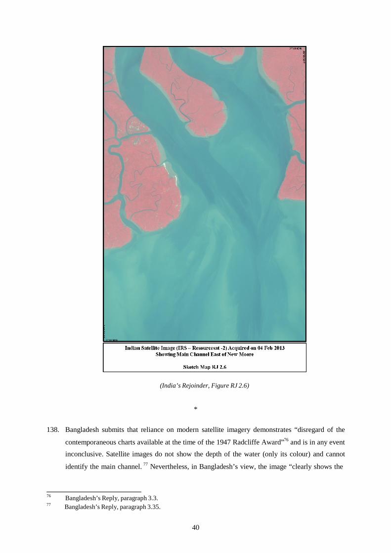
(India’s Rejoinder, Figure RJ 2.6)
*
138. Bangladesh submits that reliance on modern satellite imagery demonstrates “disregard of the
contemporaneous charts available at the time of the 1947 Radcliffe Award”76 and is in any event inconclusive. Satellite images do not show the depth of the water (only its colour) and cannot
identify the main channel. 77 Nevertheless, in Bangladesh’s view, the image “clearly shows the
76 Bangladesh’s Reply, paragraph 3.3. 77 Bangladesh’s Reply, paragraph 3.35.
40

channel of the Hariabhanga River lying to the west and entirely separate from the combined
Raimangal/Jamuna channel”.78
*
139. India submits that
cartographic and satellite evidence after 1947 is admissible and probative. Moreover, it is a matter of common sense: where the area has not changed but better data is available, as compared to the rudimentary hydrographic, bathymetric and cartographic methods in use 134 years ago, surely one will turn to the better data.79
According to India,
satellite imagery of 4 February 2013 shows in the most dramatic fashion that the main channel is to the east of New Moore Island, precisely where the bathymetric soundings of all the charts, including Bangladesh’s own charts, place it. And it is consistent with the bathymetric data of the other charts which are before you.80
D. COMMANDER KENNEDY’S REPORT
140. India further refers to a study of 48 bays and estuaries prepared by Commander R.H. Kennedy
in 1957 for the United Nations First Conference on the Law of the Sea. The study includes a
description and sketch map of the Raimangal Estuary.
*
141. Bangladesh accepts the relevance of Commander Kennedy’s study, but submits that it supports
Bangladesh’s view that the Haribhanga and Raimangal meet the bay separately. Bangladesh
notes that Commander Kennedy described the course of the rivers as each running “towards the
side of the estuary, leaving a shallow bank between and south of the island separating the
rivers”.81 Bangladesh further notes Commander Kennedy’s description that “[s]eaward of the entrance [to the estuary], the channels unite to form a single approach over a distance of about
15 miles between the coastal banks”.82 In Bangladesh’s view, “Commander Kennedy directly contradicts India’s contention, and makes it unquestionably clear that in 1958 still the channels
did not conjoin until seaward of the point where Cyril Radcliffe’s boundary met the Bay”.83
*
78 Bangladesh’s Reply, paragraph 3.34. 79 Hearing Tr., 316:23 to 317:3. 80 Hearing Tr., 329:9-13. 81 Hearing Tr., 86:14-15. 82 Hearing Tr., 87:19-21. 83 Hearing Tr., 88:1-4.
41

142. India draws attention to Commander Kennedy’s statement that the Haribhanga and Raimangal
“meet in a common estuary”.84 According to India, “[t]here is no question that Commander Kennedy’s description in his 1957 study and all the maps of the Estuary show the Raimangal and Haribhanga joining just before the point at which India proposes as its land boundary
terminus.”85
E. THE RELEVANCE OF UTI POSSIDETIS JURIS
143. Both Parties refer to the principle of uti possidetis juris. They differ as to the interpretation of
this principle and its potential relevance for the determination of the land boundary terminus.
144. Since the Tribunal is of the view that the uti possidetis juris principle does not contribute to the
determination of the land boundary terminus, it refrains from considering the arguments
advanced by the Parties.
F. “THE MIDSTREAM OF THE MAIN CHANNEL”
145. On the basis of their differing interpretations of the Radcliffe Award and the available evidence,
each Party identifies a different “midstream of the main channel” for the purpose of identifying
the location of the land boundary terminus.
*
146. Following its interpretation of the Radcliffe Award and the evidence reviewed above, Bangladesh locates “the midstream of the main channel” of the Haribhanga on the basis of the
1931 printing of BA Chart 859.86
147. Bangladesh submits that “the Hariabhanga River (and its ‘main channel’), and the estuary and
the coast, have changed significantly in the intervening seven decades”,87 and that “modern evidence cannot serve as a snapshot of the course of the river channel as it was on August 15,
1947”.88
148. Nor, in Bangladesh’s view, need the Tribunal consider other factors. According to Bangladesh,
“‘[e]quitable’ considerations can have no role in determining the location of the land boundary
or its terminus”.89 Social and economic factors, including navigability, are likewise irrelevant in
84 Hearing Tr., 311:19. 85 Hearing Tr., 578:12-15.
Hearing Tr., 93:5-11. Hearing Tr., 467:21-22. Hearing Tr., 76:2-3. Hearing Tr., 470:6-8.
86
87
88
89
42

the context of the Radcliffe Award and were never mentioned.90 Nor would there be any basis
on which to split the difference between the Parties.91
*
149. India submits that “[t]he Radcliffe Map clearly marks the location of the main channel and,
inasmuch as it is consistent with the verbal description in Annexure A, it is an authoritative
illustration.”92 According to India, the main channel indicated on the Radcliffe Map is the
conjoined channel of the Haribhanga and Raimangal and flows to the east of South
Talpatty/New Moore Island. On the basis of the Parties’ 1951 agreement, however, the
midstream of that channel remains fluid and may be located on the basis of present day
evidence.93
150. With respect to change in the geographic situation, India asserts that its position “is not that no
change whatsoever has taken place in the Estuary”.94 Rather, its position is that “with respect to the profile of the Estuary and its major features, successive and increasingly refined maps and satellite imagines confirm a remarkable stability in the profile of the Estuary and the location of
its rivers”.95
151. Finally, India points out that if the Tribunal concludes that the western channel is the main
channel and accepts Bangladesh’s proposed land boundary terminus, the internal sector of this
part of India will be effectively land-locked, inasmuch as the western channel is not navigable
south of Bangladesh’s proposed land boundary terminus. Simultaneously, the eastern channel
will be closed to India, as it will have become Bangladesh’s internal waters through which no
right of innocent passage avails.96 In contrast, if the Tribunal confirms that the eastern channel
is the main channel and accepts India’s proposed land boundary terminus, both India and
Bangladesh will have fluvial access to and egress from the Bay of Bengal. Bangladesh will also
have access to the eastern channel because its midstream will be the boundary between the two
States.97
90 Bangladesh’s Reply, paragraph 3.37. 91 Hearing Tr., 470:9-12. 92 Hearing Tr. 325:5-7.
93 Hearing Tr., 576:11-13. Hearing Tr., 583:6-7. Hearing Tr., 583:8-10. Hearing Tr., 588:3-10. Hearing Tr., 588:11-16.
94
95
96
97
43

G. “THE POINT WHERE THAT BOUNDARY MEETS THE BAY OF BENGAL”
152. The Parties also disagree on “the point where that boundary meets the Bay of Bengal”.
*
153. Following from its interpretation of the Radcliffe Award, Bangladesh locates the point where
the main channel of the Haribhanga meets the Bay of Bengal on the basis of a closing line
drawn on BA Chart 859. “In accordance with established practice at that time”, Bangladesh
argues, “as at 1947 the line dividing British India’s internal waters from the sea was the closing
line across the mouth of the Raimangal Estuary.”98
154. Bangladesh submits that the precise coordinates for points where the horizontal line meets the
headlands in the graphic are 21° 38´ 09.8˝N, 89° 05´ 15˝E and 21° 38´ 09.8˝N, 89° 11´ 01˝E,
referenced to BA Chart 859.99 Bangladesh’s depiction of the closing line is set out as follows:
(Bangladesh’s Hearing Folder, Tab 4.7)
*
155. India agrees with Bangladesh regarding the applicability of the inter fauces terrae doctrine, but
plots its closing line on the basis of Indian charts issued in 2011. India submits that the precise
98 Hearing Tr., 91:5-7. Hearing Tr., 92:16-17; 478:4-7. 99
44

coordinates for points where the horizontal line meets the headlands in the graphic are 21° 37´
56.0˝N, 89° 05´ 10.6˝E and 21° 39´ 00.2˝N, 89° 12´ 29.2˝E (WGS-84), depicted graphically in
the following chart.
(India’s Rejoinder, Figure RJ 2.1)
156. India notes, however, that it cannot follow the modern World Geodetic System 1984
(“WGS-84”) coordinates offered by Bangladesh in transposing its closing line from BA
Chart 859. According to India, “[o]n the three modern charts, the closing point supposedly on
Mandarbaria Island now plots at sea and this, in turn, must infect the land boundary
terminus.”100
H. THE TRIBUNAL’S DECISION ON THE LAND BOUNDARY TERMINUS
157. The Tribunal will now determine the location of the land boundary terminus. The Tribunal notes
in this respect that each Party has proposed a different point that, in its view, represents the land
boundary terminus identified in the Radcliffe Award. The Tribunal will address the issue of the
location of the land boundary terminus on the basis of the Radcliffe Award, taking into
account the submissions of the Parties.
100 Hearing Tr., 574:13-14.
45

158. As far as the “twinning” of the rivers Ichhamati and Kalindi, Raimangal and Haribhanga is
concerned, the Tribunal observes that the four rivers all flow south (see the section of the
Radcliffe Map reproduced above). The first two flow at separate points into the Raimangal
which in turn flows partly into the Haribhanga. The Raimangal and Haribhanga then proceed
southward separately and roughly in parallel, until they reach the Bay of Bengal at separate
points. It appears clear that the 1925 determination was intended to refer only to the midstream
of the main channel of the Haribhanga River as it entered the Bay.
159. Another point of difference between the Parties in the interpretation of the 1925 Notification
(and thus of the Radcliffe Award) is the meaning of the phrase “for the time being”. This phrase
is indeed, on the face of it, ambiguous. “For the time being” might mean “as at present” (i.e. in
1925), or it might mean “from time to time” as the main channel of the rivers might move as a
result of natural fluctuations in the deepest channel, which would mean a fluid boundary.
160. Both Parties refer in this context to the Bagge Award. The Tribunal notes that passages from the
proceedings of the Bagge Tribunal were argued with the view to interpret the general meaning
of the Radcliffe Award. Regarding river boundaries, Pakistan’s nominee to the tribunal (Mr
Justice Shahabuddin) urged an interpretation of the midstream of the River Ganges that was
“flexible and not rigid . . . subject only to such geographical variations as may result from
changes occurring in the course of the river Ganges” ((Case concerning boundary disputes
between India and Pakistan relating to the interpretation of the report of the Bengal Boundary
Commission,12 and 13 August 1947, Decision of 26 January 1950, RIAA, Vol. XXI, p. 1 at p.
12) This was opposed by India’s nominee (Mr Justice Chandrasekhara Aiyar), who argued as
follows:
The overriding purpose or object of the division must be borne in mind in construing the award. The idea was to bring into existence two independent Sovereign States which would have nothing more to do with each other except as the result of treaty or agreement or adjustment. The interpretation of the boundary on the basis of a fluid line would definitely frustrate this idea if the river changes its course. Pakistan territory might become Indian territory and vice versa; and pockets might be created in each State of what must be regarded as foreign territory. How is the government to be carried on of such areas? What is to happen to the administration, and what would be the method of approach to the pockets situated in the centre of one State surrounded on all sides by an area belonging to an alien State? Surely, a person of the eminence and experience of Sir Cyril Radcliffe must have envisaged all these difficulties and made up his mind to provide for definite and inflexible boundaries.
(Case concerning boundary disputes between India and Pakistan relating to the interpretation of the report of the Bengal Boundary Commission,12 and 13 August 1947, Decision of 26 January 1950, RIAA, Vol. XXI, paragraph 23).
161. Justice Aiyar’s argument in this respect was adopted by Chairman Bagge, who concluded that
“the course of the midstream of the main channel of the River Ganges as it was at the time of
the Award given by Sir Cyril Radcliffe in his report of August 12th 1947 is the boundary between India and Pakistan to be demarcated on the site” (Case concerning boundary disputes between
46

India and Pakistan relating to the interpretation of the report of the Bengal Boundary
Commission,12 and 13 August 1947, Decision of 26 January 1950, RIAA, Vol. XXI, p. 1 at p.
12 (emphasis added)). The Chairman’s decision continued: “If the demarcation of this line is
found to be impossible, the boundary between India and Pakistan in this area shall then be a line
consisting of the land portion of the above-mentioned boundary and of the boundary following
the course of the midstream of the main channel of the river Ganges as determined on the date
of demarcation and not as it was on the date of the Award. The demarcation of this line shall be
made as soon as possible and at the latest within one year from the date of the publication of this
decision” (ibid. at p. 12).
162. No evidence was presented to the Tribunal that demarcation of the line was found to be
impossible, or that any demarcation of the river boundary, in such forms as marker posts or
buoys, was in fact carried out.
163. In the view of the present Tribunal, the Bagge Award establishes clearly that the determination
of the midstream of the main channel of the Haribhanga River must be as it was in 1947 at the
time of the Radcliffe Award, and not as it might become at later times.
164. In the present proceeding, India also sought to strengthen its argument for a “fluid” land
boundary terminus by reference to the exchange of correspondence between officers of India
and Pakistan in 1951 (see paragraph 109 above), whereas Bangladesh rejected the significance
of the exchange of letters.
165. The Tribunal is not convinced that the clear determination of the Bagge Award was undone by
the exchange of correspondence between officials of the two governments in 1951. As noted by
Bangladesh, the Indian letter was unsigned. While recognizing that a subsequent agreement in
the sense of article 31(3)(a) of the Vienna Convention on the Law of Treaties need not itself
possess all the formalities of a treaty (see International Law Commission, Report on the Sixty-
Fifth Session, UN Doc. A/68/10 at p. 32 (2013)), the Tribunal does not consider the exchange of
letters to be sufficiently authoritative to constitute such a subsequent agreement between the
Parties. Above all, it is difficult for the present Tribunal to accept that such a low-level and brief
exchange of correspondence between civil servants, purporting to reverse an important general
determination of the formal Indo-Pakistani Boundary Disputes Tribunal established by a solemn
agreement at the Inter-Dominion Conference at New Delhi on 14 December 1948, represents an
authentic agreement of the Parties.
166. The Parties also referred to a 1957 report prepared by Commander R.H. Kennedy for the United
Nations First Conference on the Law of the Sea that includes a description of the area of the
land boundary terminus. Drafted with reference to BA Chart 859 and the Bay of Bengal Pilot
47

(8th edition, 1953), Commander Kennedy’s report states that “[t]he boundary between India and
East Pakistan reaches the sea in the vicinity of the mouths of the Haribhanga and Raimangal
Rivers, two of the rivers forming part of the delta of the River Ganges. These two rivers meet in
a common estuary.” (Kennedy Report, UN Document A/CONF.13/151 at p. 209.) In the
Tribunal’s view, Commander Kennedy’s report offers no greater precision as to the location of
the land boundary terminus which he identifies with the words “in the vicinity of”.
167. Finally, the Tribunal notes that the uses of the rivers shed no light on the meaning of the
Radcliffe Award. Neither Party adduced evidence regarding the history of navigation or other
uses of the rivers concerned, especially during the period 1947-1951. With respect to current
uses, Bangladesh has stated that “[t]here are virtually no shipping or navigation activities
around the mouth and length of the Hariabhanga and Raimangal rivers.” (Bangladesh’s Letter to
the Tribunal dated 4 March 2013 at paragraph 7.) India concurs, stating as follows:
Because of the sensitive nature of the area and existence of the present dispute, there are currently no commercial shipping or navigation activities within and around mouth of the Hariabanga and Raimangal Rivers up to Biharikhal (latitude 21 Deg 57 Min 36.986 Secs and longitude 89 Deg 04 Min 10.728 Secs) upstream of the mouth, except movement of our border security agency / coast guard and Forest department and West Bengal Police etc. Biharikhal is the point on the India-Bangladesh International Boundary that lies along the existing India-Bangladesh Protocol Route (Haldia- Mongla) under the Protocol on Inland Water Trade and Transit (PIWTT) between India and Bangladesh. [. . .]
However shipping, navigation and fishing activities take place along Hariabanga and Raimangal Rivers north of the India-Bangladesh Protocol Route.
(India’s Letter to the Tribunal dated 30 April 2013 at paragraphs 4-5).
168. The Parties provided no further details when questioned regarding historical navigation.101
*
169. On the basis of the foregoing, the Tribunal concludes that the midstream of the main channel of
the Haribhanga River must be located as it was in 1947 at the time of the Radcliffe Award. It
also considers that the Radcliffe Award, incorporating the 1925 Notification, referred to the
Haribhanga River alone and not to the combined waters of the Haribhanga and Raimangal
Rivers as they meet the Bay of Bengal.
170. In identifying the location of the land boundary terminal at a critical date—here, 1947—
reference must be had to the “photograph of the territory” at that time (Frontier Dispute
(Burkina Faso/Mali), Judgment, 1986 I.C.J. Reports, p. 568, paragraph 30). As the Chamber of
the Court noted in 2005:
The Chamber cannot exclude a priori the possibility that maps, research or other documents subsequent to that date may be relevant in order to establish, in application of
101 Hearing Tr., 334:9-18.
48
the uti possidetis juris principle, the situation that existed at the time. In any event, since the effect of the uti possidetis principle is to freeze the territorial title [reference to Burkina/Mali, para. 29], the examination of documents posterior to independence cannot lead to any modification of the ‘photograph of the territory’ at the critical date unless, of course, such documents clearly express the Parties’ agreement to such a change.
Frontier Dispute (Benin/Niger), Judgment, 2005 I.C.J. Reports, p. 109, paragraph 26.
171. The Tribunal will locate the land boundary terminus as it was decided in 1947 on the basis of
the available information at the time and supplemented by more recent information as to the
situation at the critical date. The Tribunal considers that determination of this point, including
the drawing of a closing line across the entrance to the Bay, requires reference to charts drawn
at different times.
172. In addition to their differences as to the interpretation of the Radcliffe Award, the Parties make
use of different charts to identify the location of the land boundary terminus. Whereas
Bangladesh used the 1931 printing of BA Chart 859, India based itself on the Radcliffe Map.
This difference requires the Tribunal to address the question of what charts should be used for
identifying the exact location of the land boundary terminus.
173. As far as the charts presented to the Tribunal by the Parties are concerned, it is to be noted that
no survey of the Haribhanga River was carried out in 1947. The difficulty of taking a
“photograph” of the river in 1947 is compounded by the evident change over the last century of
the major geographical features of the estuary (including receding coastlines, possible changes
in the course of the main channel, etc.). The Tribunal is nevertheless in possession of evidence,
as described below, allowing it to locate the land boundary terminus as it was in 1947 .
174. The Tribunal has available to it (1) the 1931 Reprint of BA Chart 859 provided by Bangladesh,
which is based on a survey conducted in or before 1879; (2) the 2011 edition of Indian Navy
Chart 351 submitted by India, reflecting a survey done by the Indian Navy in 1998-2004; and
(3) the Radcliffe Map. It goes without saying that the Indian Navy Chart 351 was prepared
much later than in 1947. There is no evidence that BA Chart 859 was relied upon by Sir Cyril;
otherwise, the Radcliffe Award would have referred to BA Chart 859. Neither chart is thus
decisive.
175. As far as BA Chart 859 is concerned, the Tribunal does not consider that it gives a reliable
‘photograph’ of the Raimangal Estuary as it existed in 1947. BA Chart 859 was first issued on
18 July 1880, with new editions issued in 1886, 1887, 1903 and 1904. The chart itself states that
the surveys were compiled in 1879, which in the view of the Tribunal means they were
conducted even earlier.
176. The Tribunal notes also that there is some uncertainty in the pleading of Bangladesh as to how
coordinates on this chart were to be transformed to the modern WGS-84 datum. In this regard,
49

the Tribunal notes that in its letter of 23 December 2013, Bangladesh stated that it would not
rely on the method that it had used to calculate the transposition to WGS-84 in its pleadings, but
did not offer an alternative shift or new WGS-84 coordinates derived from a comparison of
established points of reference.
177. Although the Tribunal could undertake the conversion of BA Chart 859 to WGS-84 itself, in
light of the fact that BA Chart 859 was in any event based on surveys undertaken many years
before the critical date, i.e. 1947, and taking into account the instability of the coast in the
relevant area (on this see paragraphs 372-379 below) the Tribunal does not consider this chart to
form a primary source for identifying the land boundary terminus.
178. As far as the Radcliffe Map is concerned, the Tribunal notes that Bangladesh, amongst others,
questions the authenticity of this map. Considering that the Radcliffe Map displayed at the
hearing showed the signature of Sir Cyril Radcliffe and an indication that it was used by the
Bagge tribunal, the Tribunal has no doubt that this map was the authentic Radcliffe Map.
179. As far as concerns the survey on which this map is based, the Tribunal accepts that, as recorded
in the Bagge Award, the Radcliffe Map was compiled from a survey conducted in 1915-1916.
The Radcliffe Map depicts the river boundary between the districts of 24 Parganas and Khulna
as a black dash-dot-dash line. Like other district boundaries on the map, the dash-dot-dash line
was highlighted on one side in green. The boundary determined by Sir Cyril was then indicated
by a red highlight along the other side of the black dash-dot-dash line.
180. With regard to the argument of Bangladesh that the scale of the Radcliffe Map makes it
unsuitable for establishing the land boundary terminus, the Tribunal notes that the scale
indicated on the Radcliffe Map is 1 inch = 8 miles, or 1:506,880. With respect to precision at
this scale, the Tribunal recalls that the maximum precision with which a map point can be
plotted is generally considered as being within 1/100th of an inch. Applied to the Radcliffe Map,
this equates to a maximum precision of within approximately 128 meters. This is—contrary to
the arguments advanced by Bangladesh—sufficiently precise to justify the use of this map.
181. The Radcliffe Map does not indicate the datum on which its coordinates are based. Considering
the surveys undertaken in India, however, it may be assumed that the Indian Datum was used.
The shift necessary to transform that datum to WGS-84 is a constant set of mathematical
parameters and has been published by the International Hydrographic Organization in its
“User’s Handbook on Datum Transformations Involving WGS-84”.
182. The Tribunal notes that the river and maritime aspects of the Radcliffe Map lack the precision
of most nautical charts. The Map does not, for example, depict river depths that would enable
the Tribunal to confirm that the boundary line drawn on the map does in fact follow the
50

“midstream of the main channel” of the Haribhanga as it “meets the Bay”. Apart from that, the
Map was based on a survey conducted in 1915-16 and thus does not fully reflect the situation at
the critical date. The members of the Bagge Tribunal had similar reservations. For example,
Justice Shahabbudin observed that “[t]he map which was used by Sir Cyril was based on the
Survey of 1915-16” and considered that “it did not represent the actual state of the river on the
date of the award”. (Case concerning boundary disputes between India and Pakistan relating to
the interpretation of the report of the Bengal Boundary Commission,12 and 13 August 1947,
Decision of 26 January 1950, RIAA, Vol. XXI, p. 1 at p. 25). Similarly, Justice Bagge stated
that
concerning the part of the district boundaries which are following the midstream of the river Ganges difficulties arise in making use of the map […].
The map […] does not reproduce the position of the river at the time of the notifications but at the time of the survey. The map, in fact, does on the stretch which is following the river Ganges not reproduce any other district boundaries than those determined by the position of the river Ganges at the time about thirty years ago when the survey maps were made on which the map in Annexure B is based.
(Ibid. at p. 28-29).
183. The Tribunal nevertheless emphasizes that the lack of references in the Radcliffe Map to river
depths does not mean that this information was not available to those who drew the map. The
district boundaries set out on the map sometimes follow the midstream and sometimes carefully
follow one or the other river bank. It may therefore be assumed that the end of the black dash-
dot-dash line indicates the midstream of the main channel of the Haribhanga River. In this
context the Tribunal notes that Bangladesh has not established that the boundary depicted on the
Radcliffe Map—and this includes its endpoint—departs from the description of the boundary in
the Radcliffe Award. The Tribunal also recalls that the Radcliffe Map was based upon a survey
much closer to the critical date than BA Chart 859 and that this survey obviously was
acceptable to Sir Cyril Radcliffe.
184. A critical reason for the Tribunal to use the Radcliffe Map to establish the land boundary
terminus is the fact that Sir Cyril himself had found the Map reliable enough to use and
incorporate into his award. The Tribunal considers that it should not attempt to establish the
land boundary terminus on the basis of the wording of the Radcliffe Award without giving due
regard to the attached map.
185. Turning to the coordinates of the land boundary terminus indicated on the Radcliffe Map, the
Tribunal concludes that a closing line can be drawn with its western end located at 21° 38′
24.3″N; 89° 06′ 17.4″E (Indian Datum) on the map, equivalent to 21° 38′ 27.3″N; 89° 06′
08.0″E (WGS-84), and its eastern end at 21° 38′ 50.1″N; 89° 12′ 42.8″E (Indian Datum),
51

equivalent to 21° 38′ 53.1″N; 89° 12′ 33.3″E (WGS-84). This closing line is depicted
graphically in Map 1 on page 53 of this Award.
186. The terminus of the black dash-dot-dash line of the district boundary itself plots to 21° 38′
37.2″N, 89° 09′ 29.4″E (Indian Datum), equivalent to 21° 38′ 40.2″N; 89° 09′ 20.0″E (WGS-
84). This point is on the closing line as it would have been drawn in 1947.
187. Transposed to a modern chart, the ends of the closing line and the land boundary terminus
indicated on the Radcliffe Map are depicted in Map 2 on p. 55 of this Award (with the
difference between the closing line of the Radcliffe Map and the present shoreline representing
erosion in the time since the 1915-1916 survey was undertaken).
188. The resulting position of the land boundary terminus is 21° 38′ 40.2″N, 89° 09′ 20.0″E (WGS-
84).
189. The Tribunal has reviewed the location of the land boundary terminus reached in this manner
through comparison to the modern charts before it (see Kasikili/Sedudu Island at paragraph 20).
Nothing in these charts contradicts the Tribunal’s location of the land boundary terminus; they
rather confirm its accuracy.
52

22°0’N 22
°0’N
89°0’E 90°0’E
N
W E
Legend S Tribunal’s closing line
89°0’E 90°0’E
T R I B U N A L ’ S C L O S I N G L I N E O N
R A D C L I F F E M A P
Nautical Miles
10 5 0 10 20 30 Nominal Scale at Latitude 21°N - 1:961,000
Map 1 Projection / Datum:
Unknown / Indian Datum (assumed)
The base map is taken from the Radcliffe Map.
This map is for illustrative purposes only.
53

this page intentionally blank
54

21°40’N
21°35’N 21
°35’
N
21°4
0’N
89°05’E 89°10’E
N Legend
Tribunal’s closing line on Radcliffe Map W E Land boundary terminus End of closing line on Radcliffe Map S
89°05’E 89°10’E
R A D C L I F F E M A P C L O S I N G L I N E D E P I C T E D O N B A N G L A D E S H
N A V Y C H A R T 7 5 0 1 Nautical Miles
1 0.5 0 1 2 3
Nominal Scale at Latitude 21°30’N - 1:117,000
Map 2 Projection / Datum: Mercator / WGS84
The base map is taken from Bangladesh Navy chart 7501.
This map is for illustrative purposes only.
55

this page intentionally blank
56

CHAPTER V - THE SELECTION OF BASE POINTS AND THE DELIMITATION OF THE TERRITORIAL SEA
A. GENERAL CONSIDERATIONS CONCERNING A MARITIME BOUNDARY
190. Both Parties, in their final submissions, asked the Tribunal to draw a maritime boundary
delimiting their respective territorial seas, exclusive economic zones and the continental shelf
within and beyond 200 nm in the disputed area.
191. In delimiting the various maritime spaces, however, different considerations need to be taken
into account. In the delimitation of the territorial sea, for instance, it is of considerable
significance that the rights of the coastal State are not functional, but territorial, and entail
sovereignty over the seabed, the superjacent waters and the air column (see Maritime
Delimitation and Territorial Questions between Qatar and Bahrain (Qatar v. Bahrain), Merits,
Judgment, I.C.J. Reports 2001, p. 93, paragraph 173-174, referring to Delimitation of the
Maritime Boundary in the Gulf of Maine Area, I.C.J. Reports 1984, p. 327, paragraph 194).
Further to seaward, sovereign rights, rather than sovereignty itself, are at issue, and the relevant
considerations differ. For this reason, the Tribunal will deal with the delimitation of the
territorial seas, the exclusive economic zones and the continental shelf within and beyond
200 nm separately. Before doing so, however, the Tribunal considers it appropriate to first
address the role of base points in the delimitation of maritime areas and the manner in which
they should be selected.
B. GENERAL CONSIDERATIONS CONCERNING THE SELECTION OF BASE POINTS
192. Although the Parties disagree regarding the appropriate methodology for the delimitation of the
territorial sea, exclusive economic zone, and continental shelf, each has proposed base points
for the construction of a provisional equidistance line.
193. Bangladesh proposes the following base points in respect of its own coast and the coast of India
(all coordinates in WGS-84):102
No. Location Latitude Longitude B-1 Clump Island 21° 39´ 04˝N 89° 12´ 40˝E B-2 Clump Island 21° 39´ 08˝N 89° 14´ 45˝E B-3 Putney Island 21° 40´ 15˝N 89° 19´ 56˝E B-4 Pussur Point 21° 42´ 42˝N 89° 35´ 00˝E B-5 Shahpuri Point 20° 43´ 26.3˝N 92° 19´ 45.5˝E
I-1 Moore Island 21° 37´ 00˝N 89° 05´ 35˝E I-2 Bhangaduni Island 21° 32´ 21˝N 88° 53´ 13˝E
102 Bangladesh’s Reply, paragraph 4.57; Letter from Bangladesh dated 5 March 2013 (correcting coordinates of Shahpuri Point).
57

I-3 False Point 20° 20´ 29˝N 86° 47´ 07˝E I-4 Devi Point 19° 57´ 33˝N 86° 24´ 20˝E
194. India proposes the following base points in respect of its own coast and the coast of Bangladesh
(all coordinates in WGS-84):103
No. Location Latitude Longitude B-1 Clump Island 21° 38´ 56.0˝N 89° 12´ 41.8˝E B-2 Clump Island 21° 38´ 57.4˝N 89° 14´ 47.6˝E B-3 Putney Island 21° 37´ 32.7˝N 89° 20´ 25.5˝E B-4 Andar Char Island 21° 38´ 00.5˝N 90° 33´ 32.0˝E B-5 Shahpuri Point 20° 43´ 38.6˝N 92° 19´ 30.2˝E
I-1 South Talpatty/New
Moore Island 21° 37´ 50.7˝N 89° 08´ 49.9˝E
I-2 South Talpatty/New Moore Island
21° 35´ 30.0˝N 89° 09´ 40.6˝E
I-3 West Spit -Dalhousie Sand
21° 22´ 47.6˝N 88° 43´ 43.7˝E
I-4 Devi Point 19° 57´ 33.1˝N 86° 24´ 20.0˝E
195. Each Party takes issue with the base points proposed by the other.
*
196. Bangladesh objects to India’s base points I-1, I-2, I-3, B-3, and B-4 on the grounds that they are
located on alleged low-tide elevations, the existence of which Bangladesh disputes.
197. Bangladesh’s objection to base points I-1 and I-2 is particularly acute. First, Bangladesh
challenges the existence of South Talpatty/New Moore Island on which the points are located. In Bangladesh’s view, the island disappeared permanently below the surface in the late 1980s or
early 1990s.104 Bangladesh submits that South Talpatty/New Moore Island is absent on any
satellite images after 1989,105 and recalls that nothing more than breakers was seen during the
site visit, despite multiple trips to the area.106
198. According to Bangladesh, even if South Talpatty/New Moore Island does exist as a low-tide
elevation, it is “on the Bangladesh side of any conceivable boundary line” and inappropriate for
a base point.107 In this respect Bangladesh notes that in Qatar v. Bahrain, the International Court of Justice held that low-tide elevations situated in the zone of overlapping claims must be
disregarded for the purpose of drawing the equidistance line.108 In Bangladesh/Myanmar, the
103 India’s Rejoinder, paragraphs 4A.2- 4A.10. 104 Bangladesh’s Reply, paragraph 3.77. 105 Bangladesh’s Reply, paragraph 3.78. 106 Hearing Tr., 99:21 to 101:3 107 Bangladesh’s Reply, paragraph 3.72. 108 Bangladesh’s Reply, paragraph 3.73.
58

Parties respected this practice and no low-tide elevations for base points were proposed in the
delimitation of the territorial sea. 109
199. Sovereignty over South Talpatty/New Moore Island, Bangladesh argues, can only be
determined by reference to the delimitation line as “a coastal State has sovereignty over low-
tide elevations which are situated within its territorial sea” (Maritime Delimitation and
Territorial Questions between Qatar and Bahrain, Merits, Judgment, I.C.J. Reports 2001, p. 40
at p. 101, paragraph 204). Bangladesh notes the decision in the Nicaragua v. Colombia case that
low-tide elevations may not be appropriated, (Nicaragua v. Colombia, Judgment of 19
November 2012, paragraph 26) as well as decisions in the Malaysia/Singapore and Nicaragua v.
Honduras cases in which the Court declined to determine sovereignty over the low-tide
elevations in dispute (Case Concerning Sovereignty Over Pedra Branca/Pulau Batu Puteh,
Middle Rocks and South Ledge (Malaysia/Singapore), Judgment, I.C.J. Reports 2008, paras.
291-299; Territorial and Maritime Dispute between Nicaragua and Honduras in the Caribbean
Sea (Nicaragua v. Honduras), Judgment, I.C.J. Reports 2007, paragraphs 144-145).
200. In addition, Bangladesh submits that South Talpatty/New Moore is “far too insignificant, and its
stability far too suspect, to be accorded such importance in this delimitation”.110 Citing the
Black Sea and Gulf of Maine decisions, Bangladesh argues that “the International Court of
Justice has made it clear on several occasions that what it refers to as ‘minor geographical
features’ should not be used as the basis for delimiting a maritime boundary” (Maritime
Delimitation in the Black Sea (Romania/Ukraine) I.C.J Reports 2009, p. 61, paragraph 137;
Delimitation of the Maritime Boundary in the Gulf of Maine Area (Canada/USA), I.C.J. Reports
1984, p. 329, paragraphs 201, 210). In the Black Sea case in particular, Bangladesh further
observes, the International Court of Justice declined to place a base point on Serpent’s Island, a
much larger and more prominent feature than South Talpatty/New Moore.111 Similar small
islands were disregarded in Libya/Malta and Nicaragua v. Colombia.
201. Bangladesh raises similar objections to India’s proposed base points I-3, B-3, and B-4, disputing
the existence of each alleged low-tide elevation. Noting that none were observable during the
site visit, Bangladesh submits that “[i]t is plainly visible that all of these base points are out at
sea”.112
202. Finally, although not located on low-tide elevations, Bangladesh objects to the locations of
India’s proposed base points B-1 and B-2. Although Bangladesh itself placed base points on
109 Bangladesh’s Reply, paragraph 3.74. 110 Bangladesh’s Reply, paragraph 4.33. 111 Bangladesh’s Reply, paragraph 4.34. 112 Hearing Tr., 95:15.
59
Mandarbaria/Clump Island, it submits that the island is receding due to “constant and extensive
coastal erosion”, placing the coordinates of India’s points under water.113
203. In contrast to what it considers India’s “capricious and subjective” approach to the location of
base points,114 Bangladesh submits that all of the base points it has proposed are located on the coastline. In its view, “[t]hese base points are less unstable than those of India”. Nevertheless, Bangladesh notes, “they are still inherently unstable because of massive erosion in the Bengal
Delta”.115
*
204. India rejects Bangladesh’s critique of its selection of base points, and argues that there is
extensive State practice to support “the use of the low-water lines on low-tide elevations as the
baseline for measuring the territorial sea, and the use of base points on such low-water lines for
the purposes of delimitation”.116 India quotes article 13 of the Convention, which provides in
part as follows:
Where a low-tide elevation is situated wholly or partly at a distance not exceeding the breadth of the territorial sea from the mainland or an island, the low-water line on that elevation may be used as the baseline for measuring the breadth of the territorial sea.117
205. With respect to the visibility of India’s low-tide elevation base points during the site visit, India
makes three submissions. First, India asserts that it had repeatedly warned that sighting the low-
tide elevations was uncertain because the days of the site visit coincided with neap tides.118
Second, in India’s view, it would not have been possible for the Parties and the Tribunal to view the low-tide elevation of South Talpatty/New Moore given that it would have been visible only
at 6:30 am and 6:30 pm, neither of which coincided with the Tribunal’s visit to the area.119
Third, India asserts that another reason for the lack of visibility of the low-tide elevations was
the bad weather and poor meteorological conditions.120 In any event, India argues, it is universal practice to select base points in accordance with maritime charts, and all modern charts depict
South Talpatty/New Moore as a low-tide elevation.121
113 Bangladesh’s Reply, paragraph 3.80; Hearing Tr., 95:17-20. 114 Bangladesh’s Reply, paragraph 4.43. 115 Hearing Tr., 102:14-15. 116 India’s Counter-Memorial, paragraph 5.50. 117 India’s Rejoinder, paragraph 4.52. 118 Hearing Tr., 298:21-299:9. 119 Hearing Tr., 299:11-23. 120 Hearing Tr., 300:3-18. 121 Hearing Tr., 299:20-23.
60

206. According to India, South Talpatty/New Moore has demonstrated stability over the years and, having been an island from 1970 onwards, is now a low-tide elevation according to satellite
images from 2012.122 Once the location of the land boundary terminus is fixed by the Tribunal, sovereignty over South Talpatty/New Moore Island will become evident and any concerns
arising from disputed sovereignty will evaporate.123 India argues that the decision of the International Court of Justice to disregard low-tide elevations in Qatar v. Bahrain was specific to the circumstances of that case, especially with regard to the issue of disputed sovereignty. In
India’s view, the same concerns do not apply here.124
207. With respect to its base points B-1 and B-2, India argues that these base points are just south of
the low-water line of Mandarbaria/Clump Island and demonstrate the relative stability of the
coastline.125 Rather than representing erosion, India argues that the different locations of the Parties’ base points on the Island reflect different source data, differences in survey technology
and errors inherent in the transformation from the local datum to the global WGS-84 Datum.126
*
208. For its part, the Tribunal notes that, initially, the Parties’ positions on base points were entirely
at odds. Bangladesh argued, in its Memorial, that the identification of base points was not
feasible and that the construction of a provisional equidistance line was not appropriate.
According to Bangladesh, the instability of the coast precluded any firm location of base points,
whether on the coastline or on low tide elevations. Bangladesh therefore resorted to a 180°
angle bisector for the delimitation.
209. In contrast, India constructed a provisional equidistance line in its Counter-Memorial, choosing
for some of its base points low-tide elevations located at some distance from the coast.
210. Following the decision of the International Tribunal for the Law of the Sea in the Maritime
Boundary between Bangladesh and Myanmar in the Bay of Bengal, Bangladesh changed its
position in its Reply. Bangladesh’s principal argument in its Reply remained that an angle
bisector would be the most appropriate method of delimitation. But it added its own
construction of a provisional equidistance line in the alternative, locating its base points on the
low-water line of the coasts concerned, and proposed an adjustment of the provisional line.
122 India’s Rejoinder, paragraph 4.49. 123 India’s Rejoinder, paragraph 4.54. 124 India’s Counter-Memorial, paragraphs 5.51-5.52. 125 India’s Rejoinder, paragraph 4.62. 126 Hearing Tr., 385:8-16.
61

211. Prior to the oral proceedings, the Tribunal referred the Parties to the jurisprudence of the
International Court of Justice and indicated that it would “welcome further arguments from the
Parties concerning their selection of base points”. The Tribunal referred in particular to the
decision in the Black Sea case, which states that equidistance lines “are to be constructed from
the most appropriate points on the coasts of the two States concerned, with particular attention
being paid to those protuberant coastal points situated nearest to the area to [be] delimited”
(Judgment, I.C.J. Reports 2009, p. 61 at p. 101, paragraph 117). In that decision, the
International Court of Justice further identified the appropriate points as those “which mark a
significant change in the direction of the coast, in such a way that the geometrical figure formed
by the line connecting all these points reflects the general direction of the coastlines” (ibid., at p.
105, paragraph 127). In response, India referred to articles 13 and 15 of the Convention and
maintained its selection of base points situated on low-tide elevations. Bangladesh confirmed its
choice of base points located on the low-water line of the coasts concerned.
212. The Tribunal emphasizes that the delimitation of the maritime spaces in the Bay of Bengal is a
different exercise from the determination of the location of the land boundary terminus. The
Tribunal’s task is not to identify the geographical features and the coast line as they were in
1947. Neither Party suggests that the Radcliffe Award purported to delimit the territorial sea,
much less the exclusive economic zone and continental shelf. The task of the Tribunal is to
delimit de novo the territorial sea, exclusive economic zone, and continental shelf. The Tribunal
must therefore choose base points that are appropriate in reference to the time of the
delimitation, i.e. the date of its Award.
213. Bangladesh argues that the instability of the coastline is a major factor weighing against the use
of the provisional equidistance/relevant circumstances method, in particular in view of the
potential effect of climate change and sea level rise in the Bay of Bengal. Within a few years,
Bangladesh submits, the low tide elevations chosen by India will likely have changed or
disappeared. Even the coastal locations of the base points chosen by Bangladesh will probably
be submerged.
214. In the view of the Tribunal, this argument is not relevant. The issue is not whether the coastlines
of the Parties will be affected by climate change in the years or centuries to come. It is rather
whether the choice of base points located on the coastline and reflecting the general direction of
the coast is feasible in the present case and at the present time. As the International Court of
Justice stated in the Black Sea case:
62

In this respect, the Court observes that the geometrical nature of the first stage of the delimitation exercise leads it to use as base points those which the geography of the coast identifies as a physical reality at the time of the delimitation. That geographical reality covers not only the physical elements produced by geodynamics and the movements of the sea, but also any other material factors that are present.
(Judgment, I.C.J. Reports 2009, p. 61, at p. 106, paragraph 131)
215. The Tribunal is concerned with the “physical reality at the time of the delimitation” (ibid.). It
need not address the issue of the future instability of the coastline.
216. The Tribunal notes that maritime delimitations, like land boundaries, must be stable and
definitive to ensure a peaceful relationship between the States concerned in the long term. As
the International Court of Justice noted in its decision in the Temple of Preah Vihear case, “[i]n
general, when two countries establish a frontier between them, one of the primary objects is to
achieve stability and finality” (Merits, Judgment of 15 June 1962, I.C.J. Reports 1962, p. 6 at
p. 34). The same consideration applies to maritime boundaries.
217. In the view of the Tribunal, neither the prospect of climate change nor its possible effects can
jeopardize the large number of settled maritime boundaries throughout the world. This applies
equally to maritime boundaries agreed between States and to those established through
international adjudication.
218. The importance of stable and definitive maritime boundaries is all the more essential when the
exploration and exploitation of the resources of the continental shelf are at stake. Such ventures
call for important investments and the construction of off-shore installations, including those
governed by the Convention in Parts VI and XI and in article 60. Bangladesh rightly points out
the importance of such resources to a heavily populated State with limited natural resources. In
the view of the Tribunal, the sovereign rights of coastal States, and therefore the maritime
boundaries between them, must be determined with precision to allow for development and
investment. The possibility of change in the maritime boundary established in the present case
would defeat the very purpose of the delimitation.
219. The Tribunal further notes that the problem has been greatly simplified by modern technology.
Whereas it was important in the past to rely on permanent coastal features for the identification
of boundaries at sea, satellite navigation systems now allow users of the oceans to easily locate
any geodetic point without resorting to the actual physical features used at the date of
delimitation.
220. As indicated above (at paragraphs 193-194), both Parties considered the selection of appropriate
base points to be feasible (even as they differed as to the advisability of such an approach). Both
Parties identified base points and constructed a provisional equidistance line. The Tribunal
observes that the provisional equidistance lines proposed by Bangladesh and by India are in
63

close proximity to each other. The principal difference between them stems from disagreement
on the location of the land boundary terminus. The close similarity in the lines proposed by the
Parties demonstrates that it is feasible to construct an equidistance line using base points that
reflect the general direction of the coast.
221. In the present case, both Parties have proposed base points, but both also recognize that it is
open to the Tribunal to choose its own base points. As the International Tribunal for the Law of
the Sea noted:
The Tribunal observes that, while coastal States are entitled to determine their base points for the purpose of delimitation, the Tribunal is not obliged, when called upon to delimit a maritime boundary between the parties to a dispute, to accept base points indicated by either or both of them. The Tribunal may establish its own base points, on the basis of the geographical facts of the case.
(Bangladesh/Myanmar, Judgment, 14 March 2012, paragraph 264).
222. In identifying base points, the Tribunal stresses that
determining the baseline for the purpose of measuring the breadth of the continental shelf and the exclusive economic zone and the issue of identifying base points for drawing an equidistance/median line for the purpose of delimiting the continental shelf and the exclusive economic zone between adjacent/opposite States are two different issues.
(Maritime Delimitation in the Black Sea (Romania v. Ukraine), I.C.J. Reports 2009, p. 61 at p. 108, paragraph 137).
As the Court added in the same case:
In . . . the delimitation of the maritime areas involving two or more States, the Court should not base itself solely on the choice of base points made by one of those Parties. The Court must, when delimiting the continental shelf and exclusive economic zones, select base points by reference to the physical geography of the relevant coasts.
(Ibid.).
223. The Tribunal will determine the appropriate base points by reference to the physical geography
at the time of the delimitation and to the low-water line of the relevant coasts. The Tribunal
recalls the decision in the Eritrea/Yemen (Maritime Delimitation) case that
the use of the low-water line is laid down by a general international rule in the Convention’s article 5, and that both Parties have agreed that the Tribunal is to take into account the provisions of the Convention in deciding the present case. The median line boundary will, therefore, be measured from the low-water line, shown on the officially recognized charts . . . , in accordance with the provision in Article 5 of the Convention.
(Award of the Arbitral Tribunal in the second stage of the proceedings between Eritrea and Yemen (Maritime Delimitation), Decision of 17 December 1999 at paragraph 135, PCA Award Series at p. 40, RIAA, Vol. XXII, p. 335 at p. 366).
224. The Parties have presented opposing views on the accuracy of the maps and charts produced,
due in particular to the rapid erosion of the coastline. The Tribunal will avail itself of the most
reliable evidence, resulting from the latest surveys and incorporated in the most recent large
scale charts officially recognized by the Parties in accordance with article 5 of the Convention.
64

225. As different base points control the course of an equidistance line though the territorial sea, the
exclusive economic zone, and the continental shelf within and beyond 200 nm, the Tribunal will
consider the specific points proposed by the Parties in connection with its discussion of each
maritime zone.
C. THE PARTIES’ APPROACHES TO THE TERRITORIAL SEA
1. Applicable law for the delimitation of the territorial seas and method of delimitation
226. Both Parties agree that article 15 of the Convention governs the delimitation of territorial sea in
this case. Article 15 provides that:
Where the coasts of two States are opposite or adjacent to each other, neither of the two States is entitled, failing agreement between them to the contrary, to extend its territorial sea beyond the median line every point of which is equidistant from the nearest points on the baselines from which the breadth of the territorial seas of each of the two States is measured. The above provision does not apply, however, where it is necessary by reason of historic title or other special circumstances to delimit the territorial seas of the two States in a way which is at variance therewith.
227. Neither Party claims the existence of any agreement between them on the delimitation of the
territorial sea or a “historic title” within the meaning of article 15 in the area to be delimited.127
The Parties, however, disagree on the interpretation of “special circumstances” as referred to in
article 15 of the Convention and whether they are applicable in this case. They equally disagree
on the appropriate method of delimitation under article 15.
*
228. Bangladesh recalls that the concept of “special circumstances” in article 15 was imported from
article 6 of the Convention on the Continental Shelf (1958), which employed the same
language.128 It further notes that the Court of Arbitration in the Anglo/French Continental Shelf case concluded that the concept “special circumstances” was included in article 6 to provide a
remedy to potentially inequitable results arising from the application of the equidistance
principle in areas with “particular geographical features or configurations”.129 Under article 15, Bangladesh goes on to argue, the equidistance method is to be used where it would lead to an
equitable solution; where it would not, “an alternative method of delimitation is to be
utilized”.130
127 Bangladesh’s Memorial, paragraph 5.16; India’s Counter-Memorial, paragraph 5.5; Bangladesh’s Reply, paragraph 3.46.
128 Bangladesh’s Memorial, paragraph 5.30. 129 Bangladesh’s Memorial, paragraph 5.31. 130 Bangladesh’s Memorial, paragraph 5.32.
65

229. Bangladesh contends that the equidistance/special circumstances rule should be applied flexibly, and notes that this approach is supported by the International Law Commission’s commentary
on the parallel provisions of the Convention on the Territorial Sea and the Contiguous Zone and
the Convention on the Continental Shelf.131 Bangladesh also recalls the Court’s observation in the North Sea Continental Shelf Cases and Libya/Malta, that any distorting effect of an
equidistance line in a situation of adjacent coasts is potentially magnified.132
230. Bangladesh challenges India’s assertion that recent case law on the territorial sea demonstrates a
shift away from an expansive understanding of special circumstances and toward the
equidistance rule.133 To the contrary, Bangladesh relies on the decision of the International
Court of Justice in Nicaragua v. Honduras which declined to accord the equidistance method
automatic priority over other methods of delimitation and rejected its application in the
territorial sea as a result of special circumstances. (Territorial and Maritime Dispute between
Nicaragua and Honduras in the Caribbean Sea (Nicaragua v. Honduras), Judgment, I.C.J.
Reports 2007, p. 659 at p. 741, paragraph 272). The special circumstances recognized by the
International Court of Justice, Bangladesh argues, included the close proximity of base points,
active morpho-dynamism of the delta and coastline, the absence of viable base points claimed or
accepted by the parties, and the difficulty in identifying reliable base points.134 In its analysis,
the International Court of Justice took the view that article 15 does not per se preclude
geomorphological problems from being “special circumstances”, nor does it provide that
“special circumstances” may only be used to correct a line already drawn. (Territorial and
Maritime Dispute between Nicaragua and Honduras in the Caribbean Sea (Nicaragua v.
Honduras), Judgment, I.C.J. Reports 2007, p. 659 at p. 743, paragraphs 280-281). The Court
further concluded that the wording of the special circumstance exception envisages the
possibility that a special configuration of the coast may require a different delimitation method
(ibid.)135 Bangladesh recalls that, in Nicaragua v. Honduras, the Court ultimately concluded that
the “very active morpho-dynamism” of the delta of the River Coco “might render any
equidistance line so constructed today arbitrary and unreasonable in the near future”.136
231. Finally, Bangladesh submits that there is no inconsistency between its view of special
circumstances in this arbitration and the position it recently took before the International
Tribunal for the Law of the Sea in Bangladesh/Myanmar. In that case, Bangladesh argued
131 Bangladesh’s Memorial, paragraph 5.33. 132 Bangladesh’s Memorial, paragraph 5.34. 133 Bangladesh’s Reply, paragraph 3.51. 134 Bangladesh’s Memorial, paragraph 5.37. 135 Bangladesh’s Memorial, paragraph 5.38. 136 Hearing Tr., 114:7-10.
66

against treating Saint Martin’s Island as a special circumstance, but no question of coastal
instability or concavity was at issue.137
*
232. India submits that recent international jurisprudence demonstrates a shift from an expansive
understanding of special circumstances and favours the use of equidistance.138 According to India “the equidistance/relevant circumstances method is to be applied unless it is impossible to identify appropriate base points, rendering it unfeasible to construct a provisional equidistance
line”.139 In India’s view, Bangladesh misuses the Nicaragua v. Honduras decision: the mere
presence of deltaic coasts does not make an equidistance line unfeasible.140 Rather, in that case, the geographical configuration of the needle-like Cape made it impossible to identify base
points on the tip of the needle.141 Relying on the judgment in the Black Sea case, India argues that the proper role of special circumstances is in the second stage of the delimitation, after a
provisional equidistance line is drawn.142 According to India, only if there are “compelling reasons” why an equidistance line is unfeasible does Nicaragua v. Honduras support
abandoning the method entirely.143
233. India contends that, although Bangladesh now argues that equidistance lacks a priori character,
Bangladesh recently endorsed the opposite position in Bangladesh/Myanmar, where it had
recognized the priority of “equidistance” over “special circumstances”.144 Indeed, India recalls, Bangladesh has conceded even in these proceedings that “the median line method is accorded
primacy under UNCLOS”.145
2. The delimitation lines proposed by the Parties
234. Bangladesh proposes the use of an angle-bisector line in light of the prevailing coastal
instability and concavity in the Bay of Bengal.146 India insists on the use of the median line on
137 Bangladesh’s Reply, paragraph 3.54. 138 India’s Counter-Memorial, paragraph 5.6, India’s Rejoinder, paragraph 6.5. 139 India’s Counter-Memorial, paragraph 5.9. 140 India’s Counter-Memorial, paragraph 5.19. 141 India’s Counter-Memorial, paragraph 5.17. 142 India’s Rejoinder, paragraphs 5.9-5.10. 143 India’s Rejoinder, paragraph 4.10. 144 India’s Counter-Memorial, paragraph 5.7. 145 India’s Rejoinder, paragraph 6.5. 146 Bangladesh’s Memorial, paragraph 5.48.
67

the ground that Bangladesh has failed to prove the existence of special circumstances within the
meaning of article 15 to justify a departure from the median line.147
235. Given that many issues concerning the appropriateness of the angle-bisector method are also
discussed by the Parties in relation to the delimitation of the exclusive economic zone and
continental shelf, the Tribunal will, in this Chapter, only address the issues that relate
specifically to the delimitation of the territorial sea, and leave issues that relate also the
exclusive economic zone or continental shelf for subsequent consideration.
*
236. Bangladesh objects to India’s proposed equidistance line on the ground that the incorrect location of the land boundary terminus claimed by India results in an incorrect starting point for
the proposed line.148 Bangladesh also contends that, as explained above, the base points selected by India are inappropriately located, which leads to an erroneous equidistance line constructed
from these points.149
237. Bangladesh asserts that there is scientific evidence of extreme coastal instability in the Bengal
Delta,150 and that this constitutes a “special circumstance” within the meaning of article 15 of
the Convention.151 Bangladesh cites various studies on coastal erosion in the Bengal Delta and argues that article 7(2) of the Convention, concerning the drawing of straight baselines, was
adopted by States with the specific instability of the Bengal Delta in mind.152 Accordingly, Bangladesh submits that the “unrebutted evidence” of extreme coastal instability in the Bengal Delta qualifies as a “special circumstance” and that base points on that coastline are “unstable” and would become “uncertain within a short period of time (if they are not already
uncertain)”.153 Bangladesh, therefore, submits that in the present case any equidistance line
would become “arbitrary and unreasonable in the near future”154 and that the angle-bisector
methodology is the more appropriate rule to apply.155 Thus Bangladesh submits that the
147 India’s Counter-Memorial, paragraphs 5.33-5.45. 148 Bangladesh’s Reply, paragraph 3.83. 149 Bangladesh’s Reply, paragraph 3.83. 150 Hearing Tr., 106 to 112. 151 Hearing Tr., 113:3-7. 152 Hearing Tr., 117:1 to 118:16. 153 Hearing Tr., 114:19 to 115:3. 154 Hearing Tr., 115:3-4. 155 Hearing Tr., 119:3-4.
68

maritime boundary “follows a line with a geodesic azimuth of 180° from the location of the land
boundary terminus at 21° 38´ 14˝N, 89° 06´ 39˝E”.156
238. In response to India’s argument that Nicaragua v. Honduras can be distinguished on the basis
that in that case it was not feasible to draw an equidistance line, Bangladesh argues that in the
present case just one or two base points on each coast control the entire equidistance line and
that all of these points are unstable. Bangladesh also argues that all of India’s base points are
either submerged or will almost certainly be submerged in the near future.157 According to
Bangladesh, unstable base points will result in an “arbitrary or unreasonable” line in the near
future.158
239. Bangladesh also submits that its coastal concavity constitutes a special circumstance.
Bangladesh challenges India’s position that concavity may not be a significant factor in the
context of a narrow belt such as the 12 nm territorial sea, arguing that the impact of the
application of an equidistance line in the territorial sea is on the entire course of the maritime
boundary.159 Bangladesh reiterates that concavity is one of the recognized special circumstances where equidistance does not offer an equitable result, and recalls that a situation similar to that
of Bangladesh was invoked by Germany in the North Sea Continental Shelf Cases.160
240. Bangladesh rejects India’s contention that the area in which the territorial sea is to be delimited
is not located in a concavity, referring to the decisions of the Guinea/Guinea Bissau tribunal and
the International Tribunal for the Law of the Sea in Bangladesh/Myanmar, where the focus on
macro-geography was endorsed even in relation to the territorial sea. Accordingly, Bangladesh
argues, that the delimitation should take overall account of the shape of the coast.161
*
241. India argues that the territorial sea should be delimited on the basis of a median line constructed
using the base points identified above. India’s proposed line follows a course such that:
(i) Starting from the land boundary terminus at Point L (21° 38´ 40.4˝N; 89° 10´ 13.8˝E), the boundary follows a geodetic azimuth of 149.3° until it reaches Point T1, with the co-ordinates 21° 37´ 15.7˝N, 89° 11´ 07.6˝E.
(ii) From Point T1, the boundary follows a geodetic azimuth of 129.4° until it reaches Point T2, with the co-ordinates 21° 35´ 12.7˝N, 89° 13´ 47.5˝E.
156 Hearing Tr., 560:20-22. 157 Hearing Tr., 115:19 to 116:5. 158 Hearing Tr., 116:6-14. 159 Bangladesh’s Reply, paragraph 3.66. 160 Bangladesh’s Reply, paragraph 3.66. 161 Bangladesh’s Reply, paragraph 3.67.
69

(iii) From Point T2, the boundary follows a geodetic azimuth of 144.2° until it reaches Point T3, with the co-ordinates 21° 32´ 25.7˝N, 89° 15´ 56.5˝E.
(iv) From point T3, the boundary follows a geodetic azimuth of 168.6°, until it reaches the end of the delimitation line in the territorial sea, at a distance of 12 nautical miles from the low water line of both States’ coast.162
242. India submits that the Tribunal should not apply the angle-bisector method, as there are no
circumstances in the present case that would make it impossible to delimit the territorial sea
using equidistance and special circumstances.163 In India’s view, Bangladesh’s reliance on
Nicaragua v. Honduras distorts the reasoning of that case.164 According to India, the coastal
geography in the Bay of Bengal is nothing like that of the River Coco. India argues that the
Tribunal must not lower the threshold for considering coastal instability as relevant in
delimitation.165 India points out that in Nicaragua v. Honduras, the coastal configuration was
such that there were only two possible locations for appropriate base points, both of which were highly unstable and were unusually close to each other. In India’s view, it was this particular
coastal configuration that made it impossible for the Court to construct an equidistance line in
the river mouth because there were no other controlling points available to the Court.166
243. In contrast, India asserts that even if the Tribunal in the present case were to find one or more of
the base points selected by the Parties inappropriate, there are other prominent base points that
reflect the general direction of the coasts to choose from. Thus, India submits that the
requirement that the construction of an equidistance line be impossible is not satisfied.167
Additionally, India observes that if the physical geography of the coastline will change as
dramatically as Bangladesh argues, a fixed angle-bisector will be no less arbitrary than a fixed
equidistance line.168
244. India also rejects the relevance Bangladesh attributes to concavity in the context of delimiting
the 12 nm territorial sea, arguing that in that narrow area neither Party’s relevant coast indicates
any considerable concavity.169
245. Finally, in response to Bangladesh’s reliance on article 7(2) of the Convention to suggest that
the instability of the Bengal Delta has been widely recognized, India makes three points. First,
India notes that article 7(2) is a general provision that does not refer to the Bengal Delta.
Second, India argues that article 7(2) cannot establish as a matter of law that the Bengal Delta is
162 India’s Counter-Memorial, paragraph 5.58. 163 India’s Rejoinder, paragraph 6.9. 164 Hearing Tr., 369:7 to 371:7. 165 Hearing Tr., 369:13-15. 166 Hearing Tr., 370:18-23. 167 Hearing Tr., 371:27 to 372:4. 168 Hearing Tr., 373:3-4. 169 India’s Counter-Memorial, paragraph 5.40.
70

highly unstable; stability or instability is not a matter to be determined by treaty. Third,
according to India, the States Parties when negotiating article 7(2) merely agreed on a form of
words as part of the overall political package concluded at the Conference; they did not agree
specifically to the application of an angle-bisector.170
D. THE TRIBUNAL’S DELIMITATION OF THE TERRITORIAL SEA
246. The Tribunal notes that the methods governing the delimitation of the territorial sea are more
clearly articulated in international law than those used for the other, more functional maritime
areas. It emphasizes that in the first sentence of article 15, the Convention refers specifically to
the median/equidistance line method for the delimitation of the territorial sea failing an
agreement between the parties concerned. In Maritime Delimitation and Territorial Questions
between Qatar and Bahrain the International Court of Justice stated:
The most logical and widely practised approach is first to draw provisionally an equidistance line and then to consider whether that line must be adjusted in the light of the existence of special circumstances.
(Qatar v. Bahrain), Judgment of 16 March 2001, I.C.J. Reports 2001, p. 94, paragraph 176.
247. The Tribunal observes that in its second sentence article 15 of the Convention provides for the
possibility of an alternative solution where this is necessary by reason of historic title—which
neither Party claims—or “other special circumstances”.
248. On the basis of this interpretation of article 15 of the Convention, the Tribunal has assessed the
arguments advanced by Bangladesh. The Tribunal notes that, as Bangladesh has done following
the decision in Bangladesh/Myanmar, it is possible to identify appropriate base points on the
basis of which an equidistance line can be constructed. Bangladesh invoked no further
considerations which would in the view of the Tribunal justify a deviation from the application
of the median line/equidistance method. Given the Tribunal’s concern with the “physical reality
at the time of the delimitation”, discussed in connection with the selection of base points (see
paragraph 215 above), the Tribunal need not consider whether instability could in some
instances qualify as a special circumstance under article 15. The Tribunal also does not consider
that the general configuration of the coast in the Bay of Bengal is relevant to the delimitation of
the narrow belt of the territorial sea. To the extent Bangladesh refers to the specific geographic
particularities of the area in question—the Raimangal estuary—the Tribunal notes that these
geographic particularities apply equally to the territorial seas of both Parties in the area and
therefore cannot be invoked by either Party to justify adjustments of the equidistance line
established below.
170 Hearing Tr., 610:11 to 611:4.
71

249. The Tribunal will now turn to the construction of the equidistance line in the territorial sea
between Bangladesh and India. It will proceed to do so in two steps. First it will identify the
base points relevant for the delimitation of the territorial sea. Thereafter it will identify the
median/equidistance line.
1. Location of Base Points in the Territorial Sea
250. The Tribunal notes that both Parties have agreed that the delimitation of the territorial sea
should start from the land boundary terminus. They also agree not to rely on the straight
baselines established by them for delimitation of the outer limit of their territorial seas. Instead,
they both have identified base points specifically for the present lateral delimitation.
251. Article 15 of the Convention defines the median line as a line “every point of which is
equidistant from the nearest points on the baselines from which the breadth of the territorial seas
of each of the two States is measured”.
252. The Tribunal recalls the dictum of the International Court of Justice in the Fisheries case that
“[t]he delimitation of sea areas has always an international aspect; it cannot be dependent
merely upon the will of the coastal State . . .” ((United Kingdom v. Norway), Judgment, 18
December 1951, I.C.J. Reports 1951, p. 116 at p. 132). This point is all the more relevant in
relation to a delimitation between States with adjacent or opposite coasts. The possible
distortions consequent on a unilateral choice of base points or baselines are just as true within
the territorial sea as within the exclusive economic zone or continental shelf.
253. The Tribunal will choose the base points it considers appropriate for the present delimitation of
the territorial sea. It will naturally begin by considering the base points proposed by the Parties.
254. On its own coast, Bangladesh has proposed the following base points:
- base point B-1, located on the low-water line of the coastline of Mandarbaria/Clump
Island;
- base point B-2, also located on the low-water line of the coastline of Mandarbaria/Clump
Island;
72
255. On the coast of India, Bangladesh has proposed the following base points:
- base point I-1, said to be on the low-water line of Moore Island;171
256. On the coast of Bangladesh, India has proposed the following base points:
- base points B-1 and B-2, said to be on the low-water line of Mandarbaria/Clump Island.
- base point B-3, located on the south-western edge of a low-tide elevation lying south-east
of Putney Island.
257. On its own coast, India has proposed the following base points:
- base points I-1 and I-2, located on South Talpatty/New Moore Island.
258. The differing selection of base points by the Parties directly raises the question of whether base
points located on low tide elevations are appropriate.
259. Low-tide elevations may certainly be used as baselines for measuring the breadth of the
territorial sea. Article 13 of the Convention provides:
Article 13
Low-tide elevations.
1. A low-tide elevation is a naturally formed area of land which is surrounded by and above water at low tide but submerged at high tide. Where a low-tide elevation is situated wholly or partly at a distance not exceeding the breadth of the territorial sea from the mainland or an island, the low-water line on that elevation may be used as the baseline for measuring the breadth of the territorial sea.
2. When a low-tide elevation is wholly situated at a distance exceeding the breadth of the territorial sea from the mainland or an island, it has no territorial sea of its own.
260. It does not necessarily follow, however, that low-tide elevations should be considered as
appropriate base points for use by a court or tribunal in delimiting a maritime boundary between
adjacent coastlines. Article 13 specifically deals with the measurement of the breadth of the
territorial sea. It does not address the use of low-tide elevations in maritime delimitations
between States with adjacent or opposite coasts.
261. The Tribunal considers that base points located on low-tide elevations do not fit the criteria
elaborated by the International Court of Justice in the Black Sea case and confirmed in more
recent cases. In the Black Sea case, the International Court of Justice described the selection of
base points as follows:
171 Bangladesh has referred to the area of India’s coast immediately adjacent to the estuary as “Moore
Island”, although this name does not appear on charts of the area and at points in the proceedings, the name Baghmarah Island was also used. For the sake of consistency, the Tribunal will refer to area as Moore Island.
73

Equidistance and median lines are to be constructed from the most appropriate points on the coasts of the two States concerned, with particular attention being paid to those protuberant coastal points situated nearest to the area to the delimited. The Court considers elsewhere the extent to which the Court may, when constructing a single-purpose delimitation line, deviate from the base points selected by the Parties for their territorial seas. When construction of a provisional equidistance line between adjacent States is called for, the Court will have in mind considerations relating to both Parties’ coastlines when choosing its own base points for this purpose. The line thus adopted is heavily dependent on the physical geography and the most seaward points of the two coasts.
In this stage of the delimitation exercise, the Court will identify the appropriate points on the Parties’ relevant coast or coasts which mark a significant change in the direction of the coast, in such a way that the geometrical figure formed by the line connecting all these points reflects the general direction of the coastlines. The points thus selected on each coast will have an effect on the provisional equidistance line that takes due account of the geography.
(Judgment, I.C.J. Reports 2009, p. 61 at p. 101, 105, paragraphs 117, 127)
262. If alternative base points situated on the coastline of the parties are available, they should be
preferred to base points located on low-tide elevations. Such is the case in the present instance.
263. The site visit by the Tribunal and representatives of both Parties confirmed the location,
visibility and protuberance of the base points located on the respective coastlines of Bangladesh
and India identified by the Parties. It did not confirm the visibility of the base points located on
low tide elevations, with the possible exception of the base point situated on South
Talpatty/New Moore Island. Breakers observed in that area did signal the existence of a feature,
although it was not apparent whether the feature was permanently submerged or constituted a
low-tide elevation. In any event, whatever feature existed could in no way be considered as
situated on the coastline, much less as a “protuberant coastal point”, to use the expression of the
International Court of Justice (Maritime Delimitation in the Black Sea, Judgment, I.C.J. Reports
2009, p. 61 at p. 101, paragraph 117). In the opinion of the Tribunal, South Talpatty/New
Moore Island is not a suitable geographical feature for the location of a base point.
264. The Tribunal has decided that it will not rely on base points located on low tide elevations
detached from the coast in the present case for the purpose of delimitation of the territorial seas
of the two Parties. It concludes, therefore, that the locations of India’s proposed base points I-1,
I-2, and B-3 are not acceptable.
265. India has also proposed base points B-1 and B-2, which are said to be located on the low water
line of Mandarbaria/Clump Island. While a base point on such a location is acceptable, the
Tribunal notes that the coordinates proposed by India in fact plot to seaward of the low-water
line.
266. Bangladesh has also proposed base points B-1 and B-2 on the low water line of
Mandarbaria/Clump Island. Bangladesh has further proposed base point I-1, which it claims to
74

be situated on the low-water line of the coast of Moore Island. While this location is acceptable,
the coordinates proposed by Bangladesh plot to seaward of the low-water line.
267. Having reviewed the additional base points proposed by the Parties, the Tribunal decides that
the following base points are appropriate for construction of the median/equidistance line in the
territorial sea.
268. On the coast of Bangladesh:
- base point B-1 as proposed by Bangladesh at 21° 39´ 04˝N; 89° 12´ 40˝E
269. On the coast of India:
- a point located on the low-water line of Moore Island at 21° 38´ 06˝N; 89° 05´ 36˝E.
2. Establishment of the median/equidistance line in the territorial sea
270. The provisional median/equidistance line in the territorial sea starts at the mid-point between
B-1 and I-1; namely, at:
Prov-0 = 21° 38′ 35.0″N, 89° 09′ 08.0″E
and continues along the geodetic line at an initial azimuth of 171° 40′ 32.81″ until it reaches the
territorial sea limits of Bangladesh and India, separately.
3. Adjustment of the median line in the territorial sea
271. The Tribunal has already declined the argument of Bangladesh that “special circumstances”
called for an approach other than the median/equidistance line (see paragraph 248 above).
272. The Tribunal is equally of the view that Bangladesh did not adduce facts substantiating
sufficiently its arguments that special circumstances exist which call for an adjustment of the
median line in the delimitation of the territorial sea. Accordingly, the Tribunal takes the view
that, within the 12 nm limit of the territorial sea, the concavity of the coastline of the Bay of
Bengal does not produce a significant cut-off that warrants adjustment of the median line.
273. The Tribunal, however, notes that the land boundary terminus it has identified by reference to
the Radcliffe Award (see paragraph 188 above) is not at a point equidistant from the base points
selected by the Tribunal for the delimitation of the territorial sea. Since the delimitation of the
territorial sea begins from equidistance line between the Parties, using the land boundary
terminus in this case would not begin the delimitation on the “median line” as called for by
article 15 of the Convention.
75

274. The Tribunal considers that the need to connect the land boundary terminus to the median line
constructed by the Tribunal for the delimitation of the territorial sea constitutes a special
circumstance in the present context.
275. This circumstance is similar to that faced by the tribunal in Guyana v. Suriname, where the
seaward terminus of a previous delimitation of the three-nautical mile (3 nm) wide territorial sea
was not on the median line in the sense of article 15 and had to be connected to the tribunal’s
delimitation line based on equidistance (Guyana v. Suriname, Award of 17 September 2007,
RIAA, Vol. XXX, p. 1 at p. 90, paragraph 323).
276. Bearing this special circumstance in mind, the Tribunal decides that the boundary should take
the form of a 12 nm long geodetic line continuing from the land boundary terminus in a
generally southerly direction to meet the median line at 21° 26′ 43.6″N; 89° 10′ 59.2″E. This
line avoids any sudden crossing of the area of access to the Haribhanga River and interposes a
gradual transition from the land boundary terminus to the median line. The connecting line may
be depicted graphically in Map 3 on page 77 of this Award.
the remainder of this page intentionally blank
76

21°50’N
21°40’N
21°30’N 21
°30’
N
21°4
0’N
21
°50’
N
89°0’E 89°10’E 89°20’E
BANGLADESH
INDIA
Prov-0 Prov-1
Bay of Bengal
Legend Delimitation Provisional equidistance line Drying area Provisional equidistance line point Land boundary terminus
N
W E
Prov-2 S
89°0’E 89°10’E 89°20’E
C O N N E C T I O N O F T H E L A N D B O U N D A R Y T E R M I N U S W I T H T H E
M E D I A N / E Q U I D I S T A N C E L I N E Nautical Miles
2 1 0 2 4 6
Nominal Scale at Latitude 21°30’N - 1:236,100
Map 3 Projection / Datum: Mercator / WGS84
The base map is taken from ETOPO2.
This map is for illustrative purposes only.
77

this page intentionally blank
78

CHAPTER VI - RELEVANT COASTS AND RELEVANT AREA FOR DELIMITATION BEYOND THE TERRITORIAL SEA
277. Both Parties have set out what they consider to be the relevant portions of their coasts for the
purpose of delimitation by the Tribunal. Both Parties also agree that the concept of relevant
coasts plays multiple roles in the process of maritime boundary delimitation and that “the
identification of the relevant coasts for the delimitation in general and the depiction of the
general direction of the coast when applying the angle-bisector method are two distinctly
different operations”.172
278. The Tribunal notes that the Parties are broadly in agreement in their submissions with respect to
the coast of Bangladesh. However, they differ significantly as to which segments of the Indian
coastline are relevant. The Tribunal will address the coast of each State in turn. Before doing so,
however, the Tribunal considers it helpful to recall the differing purposes served by the
identification of the relevant coasts. As the International Court of Justice noted in the Black Sea
case,
[t]he role of relevant coasts can have two different though closely related legal aspects in relation to the delimitation of the continental shelf and the exclusive economic zone. First, it is necessary to identify the relevant coasts in order to determine what constitutes in the specific context of a case the overlapping claims to these zones. Second, the relevant coasts need to be ascertained in order to check, in the third and final stage of the delimitation process, whether any disproportionality exists in the ratios of the coastal length of each State and the maritime areas falling either side of the delimitation line.
(Judgment of 3 February 2009, I.C.J. Reports 2009, p. 61 at p. 89, paragraph 78.)
279. The Tribunal further observes that the principles underpinning the identification of the relevant
coast are well established. First, it is axiomatic to the delimitation of a maritime boundary that
the “land dominates the sea”, (North Sea Continental Shelf (Federal Republic of
Germany/Denmark; Federal Republic of Germany/Netherlands), Judgment, I.C.J. Reports
1969, p. 51, paragraph 96) such that “coastal projections in the seaward direction generate
maritime claims” (Maritime Delimitation in the Black Sea (Romania v. Ukraine), Judgment,
I.C.J. Reports 2009, pp. 96-97, paragraph 99). Second, “the coast, in order to be considered as
relevant for the purpose of the delimitation, must generate projections which overlap with
projections from the coast of the other Party”(ibid.). At the same time, “the submarine extension
of any part of the coast of one Party which, because of its geographic situation, cannot overlap
with the extension of the coast of the other, is to be excluded from further consideration”
(Maritime Delimitation in the Black Sea (Romania v. Ukraine), Judgment, I.C.J. Reports 2009,
pp. 96-97, paragraph 99). In practice, therefore, the relevance of any segment of the coast of a
Party depends upon the identification of the projections generated by that coast.
172 India’s Counter-Memorial, paragraph 6.28; see also Bangladesh’s Reply, paragraph 5.67.
79

A. THE RELEVANT COAST OF BANGLADESH
280. With respect to Bangladesh, the Parties are in agreement that the entire coast, extending from the land boundary terminus with India to the land boundary terminus with Myanmar at the
mouth of the Naaf River, is relevant to this delimitation.173 The Parties differ only as to the
length of Bangladesh’s coast.174
*
281. Bangladesh accepts the decision by the International Tribunal for the Law of the Sea that the
correct method of calculating Bangladesh’s relevant coast, in light of the sinuosity of the
coastline, is as a straight line from the land boundary terminus with Myanmar at the mouth of
the Naaf River to the lighthouse on Kutubdia Island and as a second straight line from Kutubdia
Island to the land boundary with India.175 Bangladesh also accepts India’s determination that the
length of this line, if calculated to a point on Mandarbaria/Clump Island near the mouth of the
Raimangal Estuary is 417 kilometres.176
282. In Bangladesh’s view, however, India has “measured the Bangladesh coast from the wrong land
boundary terminus”.177 According to Bangladesh, rather than stopping at a point on Mandarbaria/Clump Island near the land boundary terminus, the relevant coastal length should be extended to the actual land boundary terminus, which Bangladesh places 7 kilometres to the
west.178 Bangladesh therefore considers the length of its relevant coast to be 424 kilometres.179
*
283. India submits that “the conclusion of the ITLOS” regarding Bangladesh’s relevant coast “is
equally applicable in the instant case”.180 According to India however, the line drawn by the
International Tribunal for the Law of the Sea measures 417 kilometres in length (4 kilometres
longer than the measurement set out in the decision) (Dispute Concerning Delimitation of the
Maritime Boundary between Bangladesh and Myanmar in the Bay of Bengal
(Bangladesh/Myanmar), Judgment of 14 March 2012, para. 202).
173 India’s Counter-Memorial, paragraph 6.37; Bangladesh’s Reply, paragraph 5.61. 174 Bangladesh’s Reply, paragraph 5.61. 175 Bangladesh’s Reply, paragraph 5.61; India’s Counter-Memorial, paragraph 6.37. 176 Bangladesh’s Reply, paragraph 5.62. 177 Bangladesh’s Reply, paragraph 5.62. 178 Bangladesh’s Reply, paragraph 5.62. 179 Bangladesh’s Reply, paragraph 5.62. 180 India’s Counter-Memorial, paragraph 6.36.
80

284. India notes that the only difference between the Parties with respect to Bangladesh’s relevant
coast concerns the location of the land boundary terminus.181 In India’s view, however, the minor differences between the lengths calculated by the International Tribunal for the Law of the Sea, India, and Bangladesh (413 km / 417 km / 424 km) “are immaterial in the context of
applying the non-disproportionality test”.182
*
285. The Tribunal notes the Parties’ agreement that the entire coast of Bangladesh is relevant for the
purpose of its delimitation. The minor difference between the Parties with respect to the length
of Bangladesh’s coast stems entirely from their differing views on the location of the land
boundary terminus. The Tribunal has now determined the exact location of the land boundary
terminus from which the maritime boundary in the Bay of Bengal between Bangladesh and
India will be drawn (see paragraph 188 above).
286. Accordingly, the Tribunal concludes that the first segment of the coastline of Bangladesh will
extend from the land boundary terminus with India to the lighthouse on Kutubdia Island
identified by the International Tribunal for the Law of the Sea in its decision. The second
segment of the Bangladesh coastline will then extend from the said point on Kutubdia Island to
the land boundary terminus with Myanmar in the Naaf River. As a result, the length of
Bangladesh’s relevant coast is 418.6 kilometres.
B. THE RELEVANT COAST OF INDIA
287. Bangladesh submits, citing the decision by the International Tribunal for the Law of the Sea,
that the test for whether a coast is relevant for the purpose of delimitation is whether it
“generate[s] projections which overlap with those of another party”183 (Dispute concerning
Delimitation of the Maritime Boundary between Bangladesh and Myanmar in the Bay of Bengal
(Bangladesh/Myanmar), Judgment of 14 March 2012, para. 198). Applying this standard to the
coastline of India, Bangladesh argues that the relevant coast “extend[s] the entire length of coast
that faces onto the area to be delimited”, including in areas where the projection of the coast of
Bangladesh extends beyond 200 nm.184
288. In concrete terms, Bangladesh agrees with the relevance of the first three segments of India’s
coast identified by India. Bangladesh disagrees, however, with India’s location of the land
181 India’s Rejoinder, paragraph 3.15. 182 India’s Rejoinder, paragraph 3.16. 183 Hearing Tr., 229:18-19. 184 Hearing Tr., 231:6-8.
81

boundary terminus and argues that the length of these three segments should be measured at 404
kilometres, rather than the 411 kilometres calculated by India (the difference corresponding to
the 7 kilometre difference between the Parties with respect to the length of Bangladesh’s
relevant coast).185
289. Further, Bangladesh does not agree that India’s relevant coast stops at Devi Point. According to
Bangladesh, the relevant coast includes a fourth segment, running from Devi Point in a south-
west direction until it reaches Sandy Point.186 In this area, the projection from India’s coast overlaps with the projection extending beyond 200 nm from Bangladesh’s coast. Including this additional segment, Bangladesh submits that India’s relevant coast would amount to 708
kilometres.187 India’s relevant coast, according to Bangladesh, is depicted graphically in the
following chart from Bangladesh’s Reply:188
(Bangladesh’s Reply, Figure R5.10)
290. In Bangladesh’s view, this approach directly follows the approach taken by the International
Tribunal for the Law of the Sea, which calculated the relevant coast of Myanmar as extending
185 Bangladesh’s Reply, paragraph 5.63. 186 Bangladesh’s Reply, paragraphs 5.64-5.65. 187 Bangladesh’s Reply, paragraphs 5.64-5.65.
188 Bangladesh’s Reply, Volume II, Figure R5.10
82
up to Cape Negrais, including coastline from which a projection would overlap only with
Bangladesh’s claim to the continental shelf beyond 200 nm.189 According to Bangladesh, there is “no reason to adopt a different approach in this case”, and “it would be rather anomalous to
do so, given the geographic similarities of the case”.190 Defining the relevant coasts of the two Parties as only those from which the projections overlap within 200 nm, Bangladesh argues,
would be “wholly artificial”.191 In Bangladesh’s view
The area in dispute in this case includes substantial areas that are beyond 200 miles. Indeed, it is one of the most critical issues in dispute. That being the case, the relevant coasts must also include the coasts that project into those areas.192
*
291. India describes the first three segments of its coast (between the land boundary terminus and
Devi Point) as follows:
- the first segment runs in a westerly direction from the land boundary terminus with Bangladesh to a point close to and due south of Haripur in the vicinity of the city of Balasore;
- from that point, the coastline turns radically to proceed in a north/south direction up to Maipura Point (second segment);
- from Maipura Point the coast runs in a north-east/south-west direction until it reaches Devi Point (third segment).193
292. These are the same segments accepted in principle by Bangladesh. In light of where India
locates the land boundary terminus, however, India measures the length of these three segments
at 411 kilometres.
293. According to India, however, these segments comprise the entirety of India’s relevant coast. In
India’s view, there is no basis for a fourth segment between Devi Point and Sandy Point, the
selection of which is “entirely arbitrary”.194
294. In particular, India argues that the decision of the International Tribunal for the Law of the Sea
in Bangladesh/Myanmar does not support the approach adopted by Bangladesh for identifying
India’s relevant coast. Although the International Tribunal for the Law of the Sea did consider
the coastline of Myanmar beyond 200 nm to be relevant, India argues that “[t]he fact that there
was an overlapping area of continental shelf beyond 200 nautical miles did not affect the
189 Hearing Tr., 230:10-15. 190 Hearing Tr., 230:16-17. 191 Hearing Tr., 232:13. 192 Hearing Tr., 232:13-16. 193 India’s Counter-Memorial, paragraph 6.40. 194 Hearing Tr., 356:3-4.
83

calculation of the relevant coast.”195 Considering the decision, India notes that the International Tribunal for the Law of the Sea stated only that
The Tribunal finds that the coast of Myanmar from the terminus of its land boundary with Bangladesh to Cape Negrais does, contrary to Bangladesh’s contention, indeed generate projections that overlap projections from Bangladesh’s coast.196
(Dispute Concerning Delimitation of the Maritime Boundary between Bangladesh and Myanmar in the Bay of Bengal (Bangladesh/Myanmar), Judgment of 14 March 2012, para. 203.)
295. Although the International Tribunal for the Law of the Sea did not give any further reasons why
it considered this section of the Myanmar coast to be relevant, India submits that the area of
overlapping projections referred to “cannot have been throughout the area within 200 nautical
miles projected from the stretch of coast beyond Bhiff Cape to the south”.197 In India’s view, the
mere fact that a line can be drawn from a section of coast to overlap with the projection from the
coast of the other State is insufficient, without more, to render that coast relevant. In the case of
Myanmar, India suggests that the coast between Bhiff Cape and Cape Negrais was considered
relevant because it faces “back into the relevant area and towards the coast of Bangladesh”.198
296. India contends that “the coast between Devi Point and Sandy Point, . . . faces” “in a
southeasterly direction, not back into the head of the Bay”.199 Moreover, although a line drawn from the coast between Devi Point and Sandy Point can overlap with the area of continental
shelf beyond 200 nm claimed by Bangladesh, the same can be said of the coast beyond Sandy
Point, which also projects onto the continental shelf beyond 200 nm. In India’s view, “there is
no reason to choose one point over another” and the selection of Sandy Point is arbitrary.200
297. In advancing this view, India recognizes that Bangladesh has, in its submission to the CLCS,
claimed areas of the continental shelf beyond 200 nm. However, it argues that there is “no need
to extend India’s coast beyond Devi Point to reflect any entitlements beyond 200 nautical
miles”.201 According to India, the projection of Bangladesh’s coast beyond 200 nm is already
overlapped by the projection from the Indian coast north of Devi Point. In other words,
If the Bangladesh coast that generates overlapping projections with India within 200 nautical miles generates these projections beyond 200 nautical miles, then India’s relevant coast up to Devi Point can also generate overlapping maritime projections both within and beyond 200 nautical miles.202
195 India’s Rejoinder, paragraph 3.23. 196 Hearing Tr., 355:1-3. 197 Hearing Tr., 355:5-7. 198 Hearing Tr., 355:9-10. 199 Hearing Tr., 355:17-19. 200 India’s Rejoinder, paragraph 3.21. 201 Hearing Tr., 355:22-23. 202 Hearing Tr., 355:23-27.
84

298. In light of this, India sees no basis and no authority to support the extension of its relevant coast beyond Devi Point. India’s depiction of the relevant coast is represented graphically in the
following sketch map from India’s Counter-Memorial:203
(India’s Counter-Memorial, Sketch Map No. 6.6)
*
299. In evaluating the Parties’ respective contentions, the Tribunal recalls that its task is to identify
the coast that “generate[s] projections which overlap with projections from the coast of the other
Party” (Black Sea (Romania v. Ukraine), Judgment of 3 February 2009, I.C.J. Reports 2009,
p. 61 at pp 96-97, paragraph 99). In keeping with its view that there is a single continental shelf
(see paragraph 77 above), this Tribunal sees no basis for distinguishing between projections
within 200 nm and those beyond that point. Accordingly, the Tribunal considers the Indian
coast to be relevant to the extent that its projection generates any overlap with the projection
generated by the coast of Bangladesh. That being so, the coast is relevant, irrespective of
whether that overlap occurs within 200 nm of both coasts, beyond 200 nm of both coasts, or
within 200 nm of one and beyond 200 nm of the other. The question facing the Tribunal is
203 India’s Counter-Memorial, Sketch Map 6.6.
85

therefore whether the Indian coast between Devi Point and Sandy Point generates a projection
that overlaps with a projection generated by the coast of Bangladesh.
300. To establish the projection generated by the coast of a State, the Tribunal considers that “what
matters is whether [the coastal frontages] abut as a whole upon the disputed area by a radial or
directional presence relevant to the delimitation” (Arbitration between Barbados and the
Republic of Trinidad and Tobago, Award of 11 April 2006, RIAA, Vol. XXVII, p. 147 at p.
235, paragraph 331). Between Devi Point and Sandy Point, the Indian coast faces directly on the
projection of the continental shelf beyond 200 nm claimed by Bangladesh. Accordingly, the
Tribunal has no difficulty in determining that the Indian coast between Devi Point and Sandy
Point generates a projection that overlaps with a projection from the coast of Bangladesh and is
therefore relevant to the delimitation to be effected by the Tribunal.
301. In reaching this decision, the Tribunal recognizes, as India argues, that the Indian coast north of
Devi Point can also generate projections that overlap with the areas beyond 200 nm claimed by
Bangladesh. In the Tribunal’s view, however, this has no bearing on the relevance of the Indian
coast between Devi Point and Sandy Point. The projection of the coast of one Party can easily
be overlapped by the projections of multiple segments of the coast of the other. The task facing
the Tribunal is simply to identify those sections of coast that generate projections overlapping
those of the coast of the other party.
302. The Tribunal further recognises that a radial line drawn to the north-east from a point south of
Sandy Point would also overlap with the projection of the coast of Bangladesh beyond 200 nm.
In the Tribunal’s view, there is a margin of appreciation in determining the projections
generated by a segment of coastline and a point at which a line drawn at an acute angle to the
general direction of the coast can no longer be fairly said to represent the seaward projection of
that coast. Between Devi Point and Sandy Point, this question does not arise, as the overlapping
projection extends in a nearly perpendicular line from the coast. Beyond Sandy Point, neither
Party has suggested that the Indian coastline remains relevant. Accordingly, the Tribunal need
not determine whether a line drawn to overlap with the projection generated by the coast of
Bangladesh would represent the projection of that coast.
303. The Tribunal notes that the coast of India’s Andaman Islands also generates projections that
overlap with those of the coast of Bangladesh. Although India considers that Bangladesh’s
entitlements should not extend so far as to conflict with India’s entitlement on the basis of the
Andaman Islands, it maintains the view that “India is entitled to a continental shelf beyond 200
nautical miles both off its mainland coast and off the Andaman Islands.”204 That projections of
the coast of the northern islands of the Andaman chain overlap with those of the coast of
204 India’s Counter-Memorial, paragraph 7.54(iii); see also India’s Rejoinder, paragraph 7.3, n. 393.
86

Bangladesh can also clearly be seen in the following figure from Bangladesh’s Memorial, which
indicates the respective projections from the coast of mainland India and from the Andaman
Islands:
(Bangladesh’s Memorial, Figure 7.5)
The Tribunal is aware that the projection of the coast from the northern islands of the Andaman
chain also overlaps with the projection of the mainland coast of India. This will be taken into
account in the calculation of the relevant area.
304. The Tribunal concludes that the relevant coast of the Andaman Islands is the western coast of
the northern half of the island chain, running from Interview Island in the south to Landfall
Island in the north, and measures 97.3 kilometres. As with the coast of mainland India to the
south of Sandy Point, the Tribunal excludes the coast of the island chain to the south of
Interview Island (as well as the Nicobar Islands further to the south). In the view of the Tribunal
these islands lie too far to the south to be fairly considered to generate projections that overlap
with those of the coast of Bangladesh.
305. For the foregoing reasons, the Tribunal determines that the relevant coast of mainland India runs
from the land boundary terminus to Sandy Point and measures 706.4 kilometres. This is
combined with the relevant coast of the Andaman Islands measuring 97.3 kilometres to produce
87
a total of 803.7 kilometres of relevant coast for India. By this decision, the Tribunal takes no
position at this stage on the delimitation of the maritime boundary on the basis of article 83 of
the Convention (for this see paragraph 478 below).
C. THE RELEVANT AREA
306. The Tribunal now turns to the question of the relevant area. On this question, the Parties’
differing views on the extent of the relevant area stem entirely from their differing appreciation
of the relevant coasts. Having identified what it considers to be the relevant coasts of the
Parties, it remains for the Tribunal only to identify the area resulting from the projections of
those coasts.
307. To the west, north, and north-east, the relevant area is bounded by the coasts of India and
Bangladesh identified above, running in six segments from Sandy Point along the coast of India,
through the terminus of the land boundary between Bangladesh and India, and along the coast
of Bangladesh until the terminus of the land boundary between Bangladesh and Myanmar at the
mouth of the Naaf River.
308. To the east, the relevant area is bounded by the delimitation line between the maritime areas of
Bangladesh and Myanmar identified by the International Tribunal for the Law of the Sea in that
decision until it reaches the 200 nm limit from the coast of Myanmar (Dispute Concerning
Delimitation of the Maritime Boundary between Bangladesh and Myanmar in the Bay of Bengal
(Bangladesh/Myanmar), Judgment of 14 March 2012, paragraphs 500-505). From there, the
relevant area is bounded by the 200 nm limit from the coast of Myanmar until it reaches the
limit of Bangladesh’s submission to the CLCS.
309. To the south, the relevant area is bounded by the limit of Bangladesh’s submission to the CLCS
(see Government of Bangladesh, Submission by the People’s Republic of Bangladesh to the
Commission on the Limits of the Continental Shelf: Executive Summary (February 2011) at pp.
14-17), from the point where it intersects with the 200 nm limit from the coast of Myanmar to
the point where it joins the 200 nautical mile line drawn from the coast of India.
310. To the south-west, the Tribunal considers that the simplest solution is to connect the limit of
Bangladesh’s submission to the CLCS to the coast by way of a straight line. The relevant area is
therefore bounded by a line running from the point where the limit of Bangladesh’s submission
to the CLCS intersects with the 200 nautical mile line drawn from the coast of India until it
reaches the relevant coast of India at Sandy Point.
311. The relevant area is depicted graphically in Map 4 on p. 89 of this Award. Within these limits,
the size of the relevant area is calculated to be approximately 406,833 square kilometres.
88

25°0’N
20°0’N
15°0’N 15
°0’N
20
°0’N
25
°0’N
An
85°0’E 90°0’E
N
W E
S
BANGLADESH
INDIA
INDIA
MYANMAR
Sandy Point
Bay of Bengal
Legend Relevant coast Bangladesh Relevant coast India Relevant area Exclusive Economic Zone limit Maritime boundaries Bangladesh’s CLCS submission Boundary of relevant area
Andaman Islands
(INDIA)
85°0’E 90°0’E
T O T A L R E L E V A N T A R E A
Nautical Miles
100 50 0 100 200 300
Nominal Scale at Latitude 20°N - 1:8,194,000
Map 4 Projection / Datum: Mercator / WGS84
The base map is taken from ETOPO2.
This map is for illustrative purposes only.
89

this page intentionally blank
90

CHAPTER VII - DELIMITATION OF THE EXCLUSIVE ECONOMIC ZONE AND THE CONTINENTAL SHELF WITHIN 200 NM
A. METHODOLOGY
312. The Parties agree that articles 74(1) and 83(1) of the Convention govern the delimitation of the
exclusive economic zone and the continental shelf within 200 nm. These articles provide in the
same terms that the delimitation “shall be effected by agreement on the basis of international
law, as referred to in article 38 of the Statute of the International Court of Justice, in order to
achieve an equitable solution”.
313. While the Parties agree that the construction of an equidistance line is the first step of the
delimitation process,205 they disagree on the centrality of the equidistance method and the circumstances that would call for the application of the angle-bisector method.
1. Applicability of the equidistance method
314. Bangladesh submits that there is no presumption in favour of the equidistance rule in
international jurisprudence206 and attributes the use of equidistance as a starting point to factors
such as “practical convenience” and “certainty of application”.207 In its view, the International Court of Justice has recognized the unfair results that would have been produced by the equidistance methodology in the North Sea Continental Shelf Cases, Libya/Malta, Gulf of
Maine, and Nicaragua v. Honduras.208
315. Bangladesh argues that of the judgments of courts and tribunals delimiting maritime boundaries
since the North Sea Continental Shelf Cases (1969), only two have drawn a line based purely on
equidistance. In all other cases, either an adjusted equidistance line was used or an entirely
different methodology was employed.209
316. According to Bangladesh, this remains true of the most recent cases of Bangladesh/Myanmar
and Nicaragua v. Colombia.210 While both decisions nominally adopted the three-stage
equidistance/relevant circumstances method, the ultimate delimitations departed significantly
from equidistance and, in Bangladesh’s view, reinforce its position. Bangladesh submits that in
Bangladesh/Myanmar, the International Tribunal for the Law of the Sea effectively applied an
205 India’s Counter-Memorial, paragraph 6.5; Bangladesh’s Reply, paragraphs 4.27, 4.31. 206 Bangladesh’s Memorial, paragraphs 6.22-6.23. 207 Bangladesh’s Memorial, paragraph 6.24. 208 Bangladesh’s Memorial, paragraphs6.25- 6.28. 209 Bangladesh’s Memorial, paragraph 6.31. 210 Bangladesh’s Reply, paragraphs 4.2-4.29.
91

angle bisector, albeit without so stating.211 Bangladesh notes that the 215° azimuth that was ultimately adopted to adjust the equidistance line was the same as the bisector proposed by
Bangladesh.212 The lines differ only in the point of departure.213
317. Turning to Nicaragua v. Colombia, Bangladesh recalls the Court’s observation that the
construction of a provisional equidistance line is “nothing more than a first step and in no way
prejudges the ultimate solution which must be designed to achieve an equitable result”
(Territorial and Maritime Dispute (Nicaragua v. Colombia), Judgment of 19 November 2012,
paragraph 196). According to Bangladesh,
The Court’s mixing of different methodologies, none of them equidistance, starkly refutes India’s argument according to which the ICJ supposedly made clear in the Black Sea case that “equity” and “relevant circumstances” may, “in appropriate circumstances, call for the adjustment or shift of a provisional equidistance line, but never its abandonment.”214
318. Bangladesh disputes India’s view that the law has shifted from subjective consideration of
equity to more objective criteria through the equidistance method.215 Bangladesh argues that, as the International Court of Justice stated in Nicaragua v. Colombia, the function of relevant circumstances is to verify that the provisional line is not “perceived as inequitable” given the particular circumstances of the case (Territorial and Maritime Dispute (Nicaragua v.
Colombia), Judgment of 19 November 2012, paragraph 205).216 Bangladesh maintains that articles 74 and 83 call for an equitable solution by their express terms; thus, it is equity infra
legem, not equity in a generalized sense, that is required by law.217 Nevertheless, Bangladesh argues, the question of what will be “perceived as inequitable” involves a significant margin of
appreciation.218
*
319. India notes that no particular method is specified by articles 74(1) and 83(1) to achieve an
equitable solution. However, India relies on Guyana v. Suriname and Bangladesh/Myanmar to
argue that international jurisprudence has developed in favour of equidistance.219 India quotes
the arbitral tribunal’s finding in Guyana v. Suriname that in the course of the last two decades
international courts and tribunals dealing with maritime delimitation “have come to embrace a
211 Bangladesh’s Reply, paragraph 4.8. 212 Bangladesh’s Reply, paragraph 4.7. 213 Bangladesh’s Reply, paragraph 4.7. 214 Bangladesh’s Reply, paragraph 4.25 (emphasis by Bangladesh). 215 Bangladesh’s Reply, paragraph 4.16. 216 Bangladesh’s Reply, paragraph4.15. 217 Bangladesh’s Reply, paragraph 4.17. 218 Bangladesh’s Reply, paragraph 4.18. 219 India’s Counter-Memorial, paragraph 6.4; Hearing Tr., 392:4-12.
92

clear role for equidistance”.220 India also submits that the equidsitance/relevant circumstances
rule, as developed in Black Sea and Bangladesh/Myanmar, must be applied.221
320. India notes that more recent jurisprudence does not depart from this approach, which the
International Court of Justice confirmed in Nicaragua v. Colombia.222 Although, in that case, the Court shifted the provisional equidistance line and enclaved certain islands, India considers that this merely represents the second stage of the equidistance/relevant circumstances method
and was a consequence of certain relevant circumstances.223
321. India explains that the first stage of the three-stage method entails the establishment of a
provisional equidistance line using methods that are “geometrically objective and also
appropriate for the geography of the area”.224 Having noted that equity does not raise any
concern at the first stage, India challenges Bangladesh’s argument that instability and concavity
render an equidistance line inappropriate. According to India, such “special/relevant
circumstances” come into play only in the second stage of the methodology and differ from
“compelling reasons” that may lead international courts and tribunals to abandon equidistance
entirely.225
322. India emphasizes that relevant circumstances must not be confused with the factors rendering
the construction of an equidistance line unfeasible.226 In Nicaragua v. Honduras, a provisional
equidistance line was rejected only because it was unfeasible to construct such a line.227 This, according to India, is the standard, and India contends that the compelling reasons that would render the establishment of an equidistance line unfeasible are purely objective—namely, the
drawing of the line must not be possible.228
2. Applicability of the angle-bisector method
323. Bangladesh argues for the application of the angle bisector method. Relying on Nicaragua v.
Honduras, Bangladesh recalls that the angle-bisector method begins with rendering the Parties’
relevant coasts as straight lines depicting their general direction, and moves to bisect the angle
formed by the intersection of these straight lines to yield the direction of the delimitation line.229
220 Hearing Tr., 392:9-12. 221 India’s Counter-Memorial, paragraph 6.5. 222 India’s Rejoinder, paragraph 4.6. 223 Hearing Tr., 436:2-5. 224 India’s Counter-Memorial, paragraph 6.8. 225 India’s Rejoinder, paragraphs 4.9-4.10. 226 Hearing Tr., 395:17-18. 227 India’s Counter-Memorial, paragraph6.10. 228 Hearing Tr., 395:18-20. 229 Bangladesh’s Memorial, paragraphs 6.86-6.87.
93

In Bangladesh’s view, this method focuses on macro-geographical rather than micro- geographical features, and produces results that correspond to the dominant geographic
circumstances since it relies on straight-line coastal façades rather than actual coastlines.230
324. Bangladesh notes that the angle-bisector method has been used on several occasions by
international courts and tribunals. In the Gulf of Maine case, a chamber of the International Court of Justice, in opting for the angle-bisector approach, noted the inappropriateness of
making minor geographical features the basis for the determination of the dividing line.231 In that judgment, different bisectors were used to delimit separate segments of the maritime
boundary.232 Bangladesh emphasizes that the decision does not suggest that it was impossible to
locate base points.233
325. More recently, faced with an unstable coast characterized by a very active morpho-dynamism in
Nicaragua v. Honduras, the International Court of Justice deployed the angle-bisector approach by drawing two straight-line coastal fronts and bisecting the angle formed by their
intersection.234 Bangladesh stresses the Court’s finding that an angle-bisector is a viable method
in circumstances where equidistance is “not possible or appropriate”.235 In Bangladesh’s view, the test applied in Nicaragua v. Honduras is not one requiring impossibility, but one of
impossibility or inappropriateness, either of which will suffice.236 To support its argument, Bangladesh quotes the Court’s observation in Nicaragua v. Colombia that “it will not be
appropriate in every case to begin with a provisional equidistance line”,237 as well as the statement by the International Tribunal for the Law of the Sea in Bangladesh/Myanmar that the angle-bisector method has been applied by courts and tribunals “where recourse to
[equidistance] has not been possible or appropriate”.238
326. Bangladesh also cites the decision of the arbitral tribunal in Guinea/Guinea-Bissau, which
employed the angle-bisector method (Delimitation of the maritime boundary between Guinea
and Guinea-Bissau, Award of 14 February 1985, RIAA, Vol. XIX p. 149).239 Bangladesh
maintains that the arbitral tribunal intended to produce a delimitation line “suitable for equitable
integration into the existing delimitations of the West African region” as well as future
230 Bangladesh’s Memorial, paragraph 6.87. 231 Bangladesh’s Memorial, paragraph 6.88. 232 Bangladesh’s Memorial, paragraphs 6.89-6.90. 233 Hearing Tr., 177:18 to 178:1. 234 Bangladesh’s Memorial, paragraph 6.91. 235 Hearing Tr., 172:16-19. 236 Hearing Tr., 172:20 to 173:2. 237 Hearing Tr., 173:11-12.
238 Hearing Tr., 174:9-11. Bangladesh’s Memorial, paragraph 6.92. 239
94

delimitations.240 The arbitral tribunal, in rejecting the equidistance method due to coastal concavity, noted that the equidistance method may result in “the middle country being enclaved
by the other two and thus prevented from extending its maritime territory as far seaward as
international law permits”.241 The tribunal drew a single straight line across the coastal fronts of the five States in the region to approximate the maritime façade of the coast of the whole West
Africa, and drew a perpendicular (a 180º angle-bisector) to this straight line façade.242 Apart
from concavity, Bangladesh adds that Guinea/Guinea-Bissau also shares other similarities to the
geography of this case, such as the presence of mangrove swamps, river deltas, coastal islands that join together at low tide, and a continental shelf “which bears the traces of successive coast
lines”.243
327. In Bangladesh’s view, all of the reasons that have previously favoured the adoption of the
angle-bisector method are present in its dispute with India. Like the highly irregular coast in the Gulf of Maine, the Bengal Delta coast is deeply indented with offshore islands and low-tide
elevations.244 The risk of enclaving Bangladesh through equidistance lines resembles the
situation in Guinea/Guinea-Bissau, where the coast in the region is concave in shape.245 Finally, active morpho-dynamism of the Bengal Delta recalls the shifting coastline in Nicaragua v.
Honduras.246
328. Indeed, Bangladesh argues, Nicaragua v. Honduras and the present case present multiple
similarities. In both cases, there are unstable coastlines and difficulties in identifying agreed
base points.247 Both also feature concavity that renders the equidistance line more inappropriate
the further the boundary extends from the coastline.248 Even the Parties’ present dispute regarding the Radcliffe Award recalls the difficulties in Nicaragua v. Honduras concerning the arbitral award addressing sovereignty over the islets formed near the mouth of the River
Coco.249
329. Bangladesh concludes that the angle-bisector method produces a more equitable solution in
those cases where it has been employed because it produces a more effective reflection of the
coastal relationships and a result that constitutes a better expression of the principle of equal
240 Bangladesh’s Memorial, paragraph 6.93. 241 Bangladesh’s Memorial, paragraph 6.94. 242 Bangladesh’s Memorial, paragraph 6.95. 243 Hearing Tr., 505:11-14. 244 Bangladesh’s Memorial, paragraph 6.97. 245 Bangladesh’s Memorial, paragraph 6.98. 246 Bangladesh’s Memorial, paragraph 6.99. 247 Hearing Tr., 180:4-7.
248 Hearing Tr., 180:7-11. Hearing Tr., 181:14-16, 182:5-7. 249
95

division of the areas in dispute.250 Bangladesh adds that the angle-bisector method is more consistent with the non-encroachment principle and prevents, as far as possible, any cut-off of
the seaward projection of the coast of the States concerned.251
*
330. India submits that the leading authority for the modern law on maritime delimitation is the
Black Sea judgment and challenges the relevance of Guinea/Guinea-Bissau on the basis that it
was a special case and has not subsequently been followed.252 India contests Bangladesh’s interpretation of Gulf of Maine, arguing that the Court’s main reason for choosing the angle-
bisector method was that an equidistance line would be controlled by base points located on
features over which sovereignty was disputed.253
331. India objects to the heavy reliance that Bangladesh would have the Tribunal place on the
International Court of Justice’s decision in Nicaragua v. Honduras, which in India’s view,
Bangladesh takes “out of context”.254 According to India, the principal reason for the Court’s
decision to apply an angle bisector was that the geographic configuration of the needle-shaped
Cape Gracias a Dios rendered the identification of base points impossible. According to India,
if any two base points were to have been used for the purposes of generating a provisional equidistance line, the Court would have had to select two points along opposite sides of the needle-like Cape. Even if two such base points could have been forced upon the geography of the Cape, they would have formed the base for a completely arbitrary equidistance line.255
332. The changing geography of the Cape, or its morpho-dynamism, were in India’s view only
secondary considerations for the Court: “it was not the mere presence of deltaic coasts that thwarted the drawing of an equidistance line; the accretion of sediment along the delta merely
made evident the arbitrariness of using ‘two sides of a needle’ as base points.”256 In any event, India notes, the degree of accretion and advance of the coast were unlike anything to be seen in
the mouth of the Raimangal Estuary.257 India points out that, in sharp contrast to the present case, both Nicaragua and Honduras recognized the significance of the advancing coastline.
Moreover, neither advocated for the use of equidistance.258
250 Hearing Tr., 183:1-4. 251 Hearing Tr., 183:5-7. 252 India’s Counter-Memorial, paragraph 5.10. 253 India’s Counter-Memorial, paragraph 5.11. 254 India’s Counter-Memorial, paragraph 5.12. 255 India’s Counter-Memorial, paragraph 5.17. 256 India’s Counter-Memorial, paragraph 5.19. 257 India’s Counter-Memorial, paragraph 5.15. 258 India’s Rejoinder, paragraph 4.15.
96
333. According to India, “[t]he decisive factor, at this step of the delimitation process, is not whether
the relevant coasts of the Parties are stable or not throughout their whole length, but whether
base points appropriate for drawing an equidistance line can be determined on these coasts.”259
Abandoning the high threshold of “impossibility” set by the Court as a criterion for departing
from the equidistance/relevant circumstances method would, India argues, “put in question the
difficult and long, but most fortunate, decisive trend towards more objectivity and more
predictability of the law of maritime delimitation”, and “open[] the door to full subjectivity”.260
334. Turning to other jurisprudence, India observes that in Nicaragua v. Colombia the International
Court of Justice rejected Nicaragua’s argument in favour of a departure from equidistance, stating that, unlike Nicaragua v. Honduras, “this is not a case in which the construction of such a line is not feasible” (Territorial and Maritime Dispute (Nicaragua v. Colombia), Judgment of
19 November 2012, paragraph 195).261 In India’s view, the circumstances of the present case more closely resemble those of Nicaragua v. Colombia. There, as here, the coastline involved a
long stretch of the mainland and a set of islands,262 and no morpho-dynamism that would
preclude the selection of base points is in evidence. 263
335. In sum, India concludes that Bangladesh is attempting to reawaken outdated jurisprudence, the
angle-bisector having been applied only once in the 13 cases decided after Libya/Malta, which
was rendered almost 30 years ago.264 According to India, under modern jurisprudence, and in the absence of any compelling reason, a provisional equidistance line must be drawn first.
Relevant circumstances—if any—play a role only during the second phase of the three-stage
methodology.265
3. The Tribunal’s Decision on Methodology
336. The Parties disagree on the centrality of the equidistance/relevant circumstances method in the
delimitation process and on the circumstances that would call for an alternative method in the
form of an angle-bisector. In this respect they draw different conclusions from the judgments
and awards issued by international courts and tribunals in other delimitation cases. The Parties
further disagree on whether, if the equidistance/relevant circumstances method is used, the
provisional equidistance line will require adjustment.
259 India’s Counter-Memorial, paragraph 5.16. 260 Hearing Tr., 397:17-21. 261 India’s Rejoinder, paragraph 4.10 (emphasis by India). 262 Hearing Tr., 396:6-11. 263 Hearing Tr., 396:12-15. 264 Hearing Tr., 400:3-12. 265 Hearing Tr., 400:13-16.
97

337. In the view of the Tribunal two different, although interrelated, issues must be addressed. The
first is whether a presumption exists in favour of the equidistance/relevant circumstances
method for the delimitation of the exclusive economic zone and the continental shelf within
200 nm. The second is the application of this method in this particular case. The Tribunal will
address each of these issues in turn.
338. The Tribunal notes that articles 74 and 83 of the Convention, which govern the delimitation of
the exclusive economic zone and the continental shelf respectively, do not refer to a specific
method of delimitation. The reference in article 15 to the median line as method of delimitation
cannot be read into articles 74 and 83 of the Convention
339. Since articles 74 and 83 of the Convention do not provide for a particular method of
delimitation, the appropriate delimitation method—if the States concerned cannot agree—is left
to be determined through the mechanisms for the peaceful settlement of disputes. In addressing
this question, international courts and tribunals are guided by a paramount objective, namely,
that the method chosen be designed so as to lead to an equitable result and that, at the end of the
process, an equitable result be achieved. In this connection, the Tribunal recalls the principles
stated by the International Tribunal for the Law of the Sea in its judgment in
Bangladesh/Myanmar (Judgment of 14 March 2012, paragraph 235). This Tribunal wishes to
add that transparency and the predictability of the delimitation process as a whole are additional
objectives to be achieved in the process. The ensuing—and still developing—international case
law constitutes, in the view of the Tribunal, an acquis judiciaire, a source of international law
under article 38(1)(d) of the Statute of the International Court of Justice, and should be read into
articles 74 and 83 of the Convention.
340. The Tribunal will now discuss the two methods advocated by the Parties, namely the
equidistance/relevant circumstances method and the angle-bisector method for the delimitation
of the exclusive economic zone/continental shelf within 200 nm.
341. The Tribunal recalls that the first stage of the equidistance/relevant circumstances method
involves the identification of a provisional equidistance line “using methods that are
geometrically objective and also appropriate for the geography of the area in which the
delimitation is to take place” (Maritime Delimitation in the Black Sea (Romania v. Ukraine),
Judgment of 3 February 2009, I.C.J. Reports 2009, p. 61 at p. 101, paragraph 116 referring also
to the Continental Shelf case (Libyan Arab Jamahiriya/Malta), Judgment 3 June 1985, I.C.J
Reports 1985, p. 13, paragraph 60 et seq.). The second stage calls for the consideration of
relevant circumstances that may call for the adjustment of the provisional equidistance line in
order to achieve an equitable result. The third stage consists of an ex post facto check of non-
disproportionality of the result reached at the second stage.
98
342. Relying on the judgment of the International Court of Justice in the Territorial and Maritime
Dispute between Nicaragua and Honduras in the Caribbean Sea ((Nicaragua v. Honduras),
Judgment, I.C.J. Reports 2007, p. 659), Bangladesh notes that the angle-bisector method starts
with rendering the Parties’ relevant coasts as straight lines depicting their general direction. The
angle formed by the intersection of these straight lines is then bisected to yield the direction of
the delimitation line.
343. The International Court of Justice noted in the Nicaragua v. Honduras that the angle-bisector
method is meant to generalize irregular coastal features through a linear approximation of the
relevant coasts. The Tribunal notes that the equidistance/relevant circumstances and angle-
bisector methods are both based upon geometric techniques. In the view of the Tribunal, the
advantage of the equidistance/relevant circumstances method lies in the fact that it clearly
separates the steps to be taken and is thus more transparent. The identification of a provisional
equidistance line is based on geometrically objective criteria, while at the same time account is
taken of the geography of the area through the selection of appropriate base points. By contrast,
depicting the relevant coasts as straight lines under the angle-bisector method involves
subjective considerations. As the present case demonstrates, there may be more than one way of
depicting the relevant coast with straight lines.
344. In the second stage of the equidistance/relevant circumstances method, the provisional
equidistance line may be adjusted to reflect the particularities of the case. International
jurisprudence gives some guidance on the considerations relevant in this process. The Tribunal
is aware that the decision whether to adjust a provisional equidistance line, as well as the
decisions on how much and in which direction the line should be adjusted, requires an
assessment by the Tribunal of the facts and the probable impact of the provisional equidistance
line. While such an assessment is largely a matter of appreciation, the Tribunal is of the view
that, by separating the first and second stages in the application of the equidistance/relevant
circumstances method, a high degree of transparency can be achieved. Transparency is, of
course, also dependent on the reasoning given for any particular decision. However, the
Tribunal considers that, even if clearly reasoned, a decision based on the angle-bisector method
does not possess the same structure or the same degree of transparency.
345. For these reasons, the Tribunal considers that equidistance/relevant circumstances method is
preferable unless, as the International Court of Justice stated in Nicaragua v. Honduras, there
are “factors which make the application of the equidistance method inappropriate” (Judgment,
I.C.J. Reports 2007, p. 659 at p. 741, paragraph 272).
346. This is not the case here. Bangladesh was able to identify base points on its coast, as well as on
the coast of India. The argument of Bangladesh that the “coastal configuration renders the
99
No Latitude Longitude Controlling points 1 21° 38´ 14˝N 89° 06´ 39˝E LBT
9 17° 53´ 57˝N 89° 45´ 32˝E B-5, I-2, I-3 10 17° 15´ 18˝N 89° 48´ 27˝E B-5, I-3, I-4 (intersection
with ITLOS judgment)
identification of equidistance base points impractical or unreliable” is not sustainable. Nor does
the Tribunal find the depiction of the coastal façade proposed by Bangladesh to be convincing
as it does not reflect the geography of the northern part of the Bay of Bengal. For this reason
also, the Tribunal considers it appropriate to apply the equidistance/relevant circumstances
method in this case.
B. THE PROVISIONAL EQUIDISTANCE LINE
347. The Parties agree that the appropriate first step in this delimitation process is the construction of
a provisional equidistance line.266 Bangladesh emphasizes that the construction of such a line neither prejudges the ultimate solution nor precludes substantial adjustment to, or shifting of, the provisional line. Bangladesh also stresses that it does not preclude the adoption of a different
delimitation method.267
*
348. Bangladesh submits that base point B-1 controls the course of the provisional equidistance line
between 5 nm and 17 nm from the shore; base point B-2 controls between 17 nm and up to 130
nm; base point B-3 controls between 130 nm and 154 nm; base point B-4 controls between 154
nm and 173 nm; and base point B-5 controls beyond a distance of 173 nm.268 Bangladesh
explains that base points I-1 and I-2 control the course of the line between 2 nm and 223 nm
from the coast; base points I-3 controls the line between 223 nm and 255 nm; and base point I-4
controls the line from 255 nm until it meets the Bangladesh and Myanmar delimitation drawn
by the International Tribunal for the Law of the Sea.269
349. Accordingly, Bangladesh submits the precise location of the turning points on the provisional
equidistance line described above as follows:
2 3
21° 36´ 21˝N 21° 34´ 25˝N
89° 07´ 48˝E 89° 10´ 20˝E
LBT, I-1 LBT, B-1, I-1
4 5 6
21° 22´ 14˝N 20° 23´ 53˝N 19° 31´ 37˝N
89° 14´ 22˝E 89° 29´ 40˝E 89° 48´ 06˝E
B-1, B-2, I-1 B-2, I-1, I-2 B-2, B-3, I-2
7 8
19° 09´ 14˝N 18° 51´ 13˝N
89° 55´ 26˝E 90° 00´ 22˝E
B-3, B-4, I-2 B-4, B-5, I-2
266 Bangladesh’s Reply, paragraph 4.31. 267 Bangladesh’s Reply, paragraph 4.28. 268 Bangladesh’s Reply, paragraph 4.46-4.51. 269 Bangladesh’s Reply, paragraph 4.55-4.56.
100

350. Bangladesh’s provisional equidistance line is depicted graphically as follows:
(Bangladesh’s Reply, Figure R4.12)
*
351. India submits that the provisional equidistance line is to be constructed as follows:
- from Point X, the delimitation line described at paragraph 6.25 above continues along the geodetic azimuth of 168.6° until it reaches Point T4, with co-ordinates 20° 30´ 17.9” N, 89° 29´ 20.9˝E, which is equidistant from base points I-2, I-3 and B-3;
- from Point T4, the line continues in a south direction and follows a geodetic azimuth of 157.0° until it meets Point T5, with co-ordinates 19° 26´ 40.6˝N, 89° 57´ 54.9˝E, which is equidistant from base points I-3, B-3 and B-4;
- from Point T5, the line takes a broadly south direction and follows a geodetic azimuth of 171.7° until it reaches Point T6, with co-ordinates 18° 46´ 43.5˝N, 90° 04´ 02.5˝E, which is equidistant from base points I-3, B-4 and B-5;
101

- from Point T6, the equidistance line follows a geodetic azimuth of 190.7° until it reaches the limit of 200 nautical miles at point Y, with co-ordinates 18° 19´ 06.7˝N, 89° 58´ 32.1˝E.270
352. India’s provisional equidistance line is depicted graphically as follows:
(India’s Counter-Memorial, Figure 6.12)
1. Base points for the equidistance line within 200 nm
353. The Tribunal will now turn to the identification of the base points for establishing the
provisional equidistance line. Here again, as with the delimitation of the territorial sea, the
Tribunal must assess the appropriateness of the base points chosen by the Parties or choose
different base points, as the case may be. In this respect, the Tribunal refers to its considerations
on the selection of base points for the delimitation of the territorial sea (see paragraphs 222-223,
263-264 above).
354. On its own coast, Bangladesh has proposed the following base points:
270 India’s Rejoinder, paragraph 7.11.
102
- base point B-1, located on the low-water line of the coastline of Mandarbaria/Clump
Island;
- base point B-2, also located on the low-water line of the coastline of Mandarbaria/Clump
Island;
- base point B-3, located on the low-water line of Putney Island;
- base point B-4, said to be located on the low-water line at Pussur Point;
- base point B-5, said to be on the low-water line at Shahpuri Point, in the vicinity of the
boundary with Myanmar.
355. In the view of the Tribunal, based on the criteria for the selection of base points as set out above
(see paragraphs 222-223, 263-264), all these locations are acceptable. The Tribunal notes,
however, that the effect on the equidistance line of base point B-3 is quite minor, and that the
coordinates proposed by Bangladesh for base points B-4 and B-5 plot to seaward of the low
water line.
356. On the coast of India, Bangladesh has proposed the following base points:
- base point I-1, said to be on the low-water line of Moore Island (but already rejected by
the Tribunal in relation to the territorial sea);
- base point I-2, located on the low-water line of Bhangaduni Island;
- base point I-3, located on the low-water line at False Point;
357. As point I-4 (Devi Point) only has effect beyond 200 nm, the Parties’ proposals and the
Tribunal’s decision are discussed below in the section on the equidistance line beyond 200 nm.
358. In the view of the Tribunal, the locations of base point I-2 and base point I-3 are acceptable with
regard to the criteria set out above (see paragraphs 222-223, 263-264). As discussed in relation
to the delimitation of the territorial sea (see above at paragraph 255), however, the coordinates
proposed by Bangladesh for base point I-1 plot to seaward of the low-water line.
359. On the coast of Bangladesh, India has proposed the following base points:
- base points B-1 and B-2, said to be on the low-water line of Mandarbaria/Clump Island
(but rejected by the Tribunal in relation to the territorial sea);
- base point B-3, located on the south-western edge of a low-tide elevation lying south-east
of Putney Island (but rejected by the Tribunal in relation to the territorial sea);
103
- base point B-4, located on the southern tip of a low-tide elevation located south-east of
Andar Char Island;
- base point B-5, said to be on the low-water line at Shahpuri Point in the vicinity of the
boundary with Myanmar.
360. In the view of the Tribunal, the locations proposed by India for points B-1, B-2, and B-5 are
acceptable in principle. For each of these points, however, the coordinates proposed by India
plot to seaward of the low-water line. India’s proposed base points B-3 and B-4 are located on
detached low-tide elevations and are accordingly not acceptable.
361. On its own coast, India has proposed the following base points:
- base points I-1 and I-2, located on South Talpatty/New Moore Island (but rejected by the
Tribunal in relation to the territorial sea);
- base point I-3, located on the low-tide elevation south of Dalhousie Island.
362. In the view of the Tribunal, India’s proposed base points are not acceptable because they are
located on low-tide elevations.
363. The Tribunal has already decided (see paragraphs 267-269 above) that a point located on the
low-water line at Moore Island (at 21° 38´ 06˝N; 89° 05´ 36˝E) and base point B-1 as proposed
by Bangladesh (at 21° 39´ 04˝N; 89° 12´ 40˝E) are appropriate for the construction of the
provisional equidistance line in the territorial sea. These points remain appropriate with respect
to the equidistance line for the exclusive economic zone and continental shelf within 200 nm.
364. Having thus reviewed the base points proposed by the Parties, the Tribunal decides that the
following additional base points are appropriate for the construction of the provisional
equidistance line in the exclusive economic zone and continental shelf within 200 nm.
365. On the coast of Bangladesh:
- Base point B-2 as proposed by Bangladesh at 21° 39´ 08˝N; 89° 14´ 45˝E;
- A point located on the low-water line at Pussur Point at 21° 42´ 45˝N; 89° 35´ 00˝E;
- A point located on the low-water line at Shahpuri Point at 20° 43´ 39˝N; 92° 20´ 33˝E.
104
366. On the coast of India:
- Base point I-2 as proposed by Bangladesh at 21° 32´ 21˝N; 88° 53´ 13˝E;
- Base point I-3 as proposed by Bangladesh at 20° 20´ 29˝N; 86° 47´ 07˝E.
367. As both Parties decided not to locate a base point on Saint Martin’s Island, the Tribunal will not
address the issue.
2. The Tribunal’s Provisional Equidistance Line
368. The provisional equidistance line within 200 nm of the territorial sea baselines starts where the
geodetic line from the point Prov-0 (described in paragraph 270, above) having an initial
azimuth of 171° 40′ 32.81″ intersects the territorial sea limits of Bangladesh and India,
separately, and continues along the same line to:
Number Controlling Points Latitude Longitude
Prov-3 I-2, I-1, B-1 21° 07′ 44.8″N 89° 13′ 56.5″E
369. From point Prov-3, the provisional equidistance line is the geodetic lines joining the following
points in the order given until the 200 nm limits of Bangladesh and India, separately, are
reached.
Number Controlling Points Latitude Longitude
Prov-4 I-2, B-1, B-2 21° 05′ 11.3″N 89° 14′ 56.7″E
Prov-5 I-2, B-2, B-4 19° 12′ 29.5″N 89° 54′ 43.2″E
Prov-6 I-2, B-4, B-5 18° 50′ 16.7″N 90° 00′ 49.6″E
Prov-7 I-3, I-2, B-5 17° 52′ 42.7″N 89° 46′ 00.3″E
370. The Tribunal’s provisional equidistance line is represented graphically in Map 5 on p. 107 of
this Award.
C. RELEVANT CIRCUMSTANCES
371. Bangladesh argues that the instability and concavity of its coastline constitute relevant
circumstances in the context of articles 74 and 83 of the Convention. India disagrees.
1. Coastal instability
372. Bangladesh submits that the coastline of the Bengal Delta is highly unstable and that this
instability constitutes a special circumstance requiring an adjustment of the provisional
equidistance line.
105

373. According to Bangladesh, “the forces that have created – and continue to create – the Bengal
Delta render it one of the most unstable coastlines in the world.”271 The Ganges and
Brahmaputra Rivers transport massive quantities of the sediment into the Delta each year, while
the change in the main course of the Ganges from the Hooghly River to the Meghna River has
created a situation in which the western portions of the Delta are rapidly eroding, while
sediment and the resulting accretion are directed eastwards. As Bangladesh describes it, “[t]he
western two-thirds of the Bengal Delta (from Bangladesh’s Haringhata River to the mouth of
India’s Hooghly River) has been eroding for at least two centuries now. Moreover, erosion of
this deltaic front is now well above the long-term historic rate, due to sea level rise.”272
374. Bangladesh notes that the International Court of Justice paid special attention in the Nicaragua
v. Honduras case to the “geomorphological changes” which it considered to be a “special
circumstance”, necessitating the use of an angle bisector.273 As in Nicaragua v. Honduras, Bangladesh argues that its unstable coast will inevitably change the location of the base points
used for the purpose of the equidistance line.274 According to Bangladesh, all of the base points
selected by India are now underwater,275 and it would be against equity and common sense to
draw a permanent boundary line using base points on an unstable coast.276 Bangladesh also notes that the instability of its coastline was the rationale behind its 1974 straight baselines
claim.277
375. In Bangladesh’s view, the maps and satellite images in the record provide concrete proof of the
instability of the coast. The very fact that South Talpatty/New Moore appeared as an island before receding below the waves demonstrates this, as does the significant erosion of
Mandarbaria/Clump Island over the years.278 Bangladesh also notes significant erosion of
India’s Sagar Island near the mouth of the Hooghly River.279
271 Hearing Tr., 49:8-9. 272 Bangladesh’s Reply, paragraph 3.59. 273 Bangladesh’s Memorial, paragraph 5.41. 274 Bangladesh’s Memorial, paragraph 6.77. 275 Hearing Tr., 164:13-14, 166:14-15, 170:2. 276 Bangladesh’s Memorial, paragraph 6.83. 277 Bangladesh’s Memorial, paragraph 5.44. 278 Bangladesh’s Reply, paragraph 3.58. 279 Bangladesh’s Reply, paragraph 3.59.
106

24°0’N
22°0’N
20°0’N
18°0’N
16°0’N 16
°0’N
18
°0’N
20
°0’N
22
°0’N
24
°0’N
86°0’E
N
W E
S
88°0’E 90°0’E
BANGLADESH
92°0’E INDIA
INDIA
Pussur I.
Bhangaduni I. Mandarbaria I. Prov-0 Prov-2 Prov-3 Prov-4 MYANMAR
False Pt.
Shahpuri Pt.
Devi Pt.
Prov-5
Prov-6
Prov-7
Prov-8 Bay of Bengal
Legend Exclusive Economic Zone limit
Maritime boundaries Provisional equidistance line Turning point
Note: Point Prov-1 (the land boundary terminus) is not on the equidistance line and is not depicted. SeeMap 3.
86°0’E 88°0’E 90°0’E 92°0’E
P R O V I S I O N A L E Q U I D I S T A N C E L I N E
Map 5
Projection / Datum: Mercator / WGS84
50 25
Nautical Miles
0 50 Nominal Scale at Latitude 20°N - 1:4,747,000
100 150
The base map is taken from ETOPO2. This map is for illustrative purposes only.
107

this page intentionally blank
108

376. In any event, Bangladesh argues, the changes taking place in the Bengal Delta are accelerating
with sea-level rise, and recent predictions anticipate major changes to the coastline by 2100.280
According to Bangladesh, the International Court of Justice’s decision in Tunisia/Libya in no
way diminishes the relevance of such future changes. While the Court was reluctant to accord significance to geologic circumstances prevailing millions of years ago, the changes anticipated
in the Delta will take place within the life span of Bangladeshi and Indian citizens alive today.281
*
377. India disputes Bangladesh’s factual assertions concerning the instability of its coastline. On the
contrary, India argues that “the coast of the Bay of Bengal does not present an unusual case of
coastal fluctuation and . . . has demonstrated relative stability over the years, maintaining the
general configuration of the coast.”282
378. More importantly, India argues, that any instability is simply irrelevant to the issue before the
Tribunal. As the International Court of Justice stated in Tunisia/Libya, what needs to be taken
into account for the purpose of delimitation are “the physical circumstances as they are today”
and “the geographical configuration of the present-day coasts” (Continental Shelf
(Tunisia/Libyan Arab Jamahiriya), Judgment, I.C.J. Reports 1982, p. 18 at p. 54, paragraph
61).283 Accordingly, India argues, “[w]hat the Tribunal has to do in the present case is to
identify appropriate base points for drawing an equidistance line; it is not required to ascertain
whether the relevant coasts of the Parties are stable or not throughout their whole length.”284
India notes that in the case of Guyana v. Suriname, the tribunal rejected Suriname’s argument
that coastal instability favoured the use of an angle-bisector, and—in contrast to Nicaragua v.
Honduras—base points along the coast of the Bengal Delta can be located with “no great
challenge”.285 India observes that even Bangladesh was able to construct an equidistance line
using the most stable base points.286
379. To the extent that instability were relevant, India submits that Bangladesh’s evidence is
“pseudo-scientific” and “no more than speculation”.287 “[S]cientific research”, India argues, “has concluded that the Sundarbans, the world’s largest mangrove forest, have a stabilizing
280 Bangladesh’s Reply, paragraphs 4.116-4.117. 281 Bangladesh’s Reply, paragraph 4.117. 282 India’s Counter-Memorial, paragraph 5.35. 283 India’s Counter-Memorial, paragraph 5.24. 284 India’s Counter-Memorial, paragraph 5.37. 285 India’s Counter-Memorial, paragraph 5.38. 286 India’s Rejoinder, paragraph 4.44. 287 India’s Rejoinder, paragraph 4.32.
109

effect on the coast and slow the erosion process down considerably.”288 India also notes that
only the Meghna Estuary, to the east of the Delta is significantly affected by instability.289 In
India’s view, the “[s]elective speculation” evident in Bangladesh’s submissions is “a weak
premise on which to base an argument for coastal instability as a legally-relevant compelling reason to discard the usual delimitation method. The end results of natural processes and human
behaviour are unpredictable, subject to changes and shifts and by their very nature
speculative.”290
2. Concavity and Cut-Off Effects
380. According to Bangladesh, the Parties agree that (i) Bangladesh’s entire coast is concave, (ii)
Bangladesh’s coast has a concavity within a concavity, (iii) coastal concavity can be a relevant
circumstance, where the State with a concave coast is pinched between two other States, or
where the concavity causes a cut-off effect, (iv) the International Tribunal for the Law of the
Sea determined that Bangladesh’s coastal concavity was a relevant circumstance justifying a
departure from equidistance, (v) Bangladesh’s concavity, even after the judgment in
Bangladesh/Myanmar, cuts off Bangladesh from its maritime entitlements.291
381. Bangladesh contends that the “double concavity” of its coastline constitutes a relevant
circumstance that justifies a departure from equidistance in favour of an angle bisector, or in the
alternative, a substantial adjustment to the provisional equidistance line.292 As a result of the
double concavity, Bangladesh notes, the two equidistance lines claimed by India and Myanmar form a narrowing wedge that truncates Bangladesh’s maritime entitlement before it reaches the
200 nm limit.293 Bangladesh notes the similarity of the present situation with that faced by
Germany in the North Sea Continental Shelf Cases,294 and describes the tapering wedge of its
maritime entitlement. Starting from a coastal opening of 188 nm, with the potential to extend to
approximately 390 nm,
the maritime space equidistance would leave to Bangladesh narrows rapidly the further off shore the proposed boundary goes. At just 75 M from shore, the breadth of Bangladesh’s maritime space has been reduced by nearly 40%, from 188 M to just 117 M. At 150 M from shore, it is far worse: the breadth has been reduced to a mere 45 M, only 24% of the near- shore figure. At 200 M, it is just 26 M, less [than] 1/7th as much as its original extent. And at approximately 235 M, it terminates completely.295
288 India’s Rejoinder, paragraph 4.35. 289 India’s Rejoinder, paragraph 4.42. 290 India’s Rejoinder, paragraph 4.41. 291 Hearing Tr., 527:5-14. 292 Hearing Tr., 528:11-15. 293 Bangladesh’s Memorial, paragraphs 6.37-6.39; Bangladesh’s Reply, paragraph 4.71. 294 Hearing Tr., 43:20 to 44:2. 295 Bangladesh’s Reply, paragraph 4.79.
110
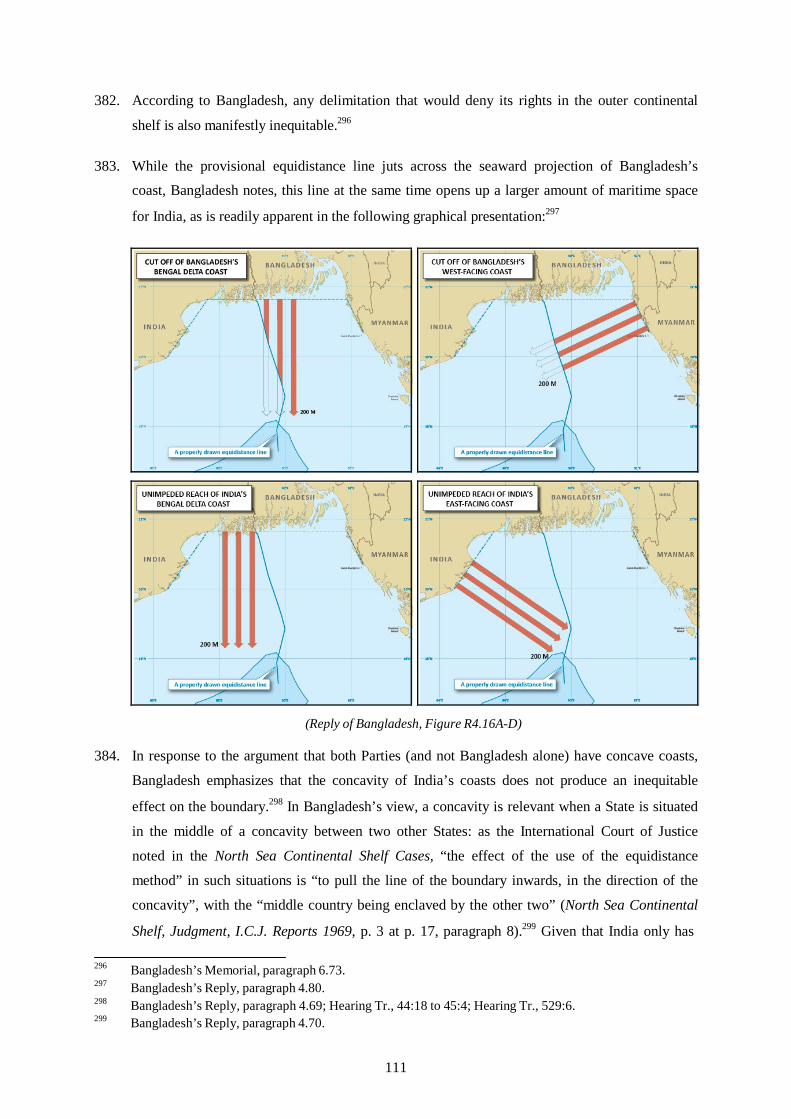
382. According to Bangladesh, any delimitation that would deny its rights in the outer continental
shelf is also manifestly inequitable.296
383. While the provisional equidistance line juts across the seaward projection of Bangladesh’s
coast, Bangladesh notes, this line at the same time opens up a larger amount of maritime space
for India, as is readily apparent in the following graphical presentation:297
(Reply of Bangladesh, Figure R4.16A-D)
384. In response to the argument that both Parties (and not Bangladesh alone) have concave coasts,
Bangladesh emphasizes that the concavity of India’s coasts does not produce an inequitable
effect on the boundary.298 In Bangladesh’s view, a concavity is relevant when a State is situated
in the middle of a concavity between two other States: as the International Court of Justice
noted in the North Sea Continental Shelf Cases, “the effect of the use of the equidistance
method” in such situations is “to pull the line of the boundary inwards, in the direction of the
concavity”, with the “middle country being enclaved by the other two” (North Sea Continental
Shelf, Judgment, I.C.J. Reports 1969, p. 3 at p. 17, paragraph 8).299 Given that India only has
296 Bangladesh’s Memorial, paragraph 6.73. 297 Bangladesh’s Reply, paragraph 4.80. 298 Bangladesh’s Reply, paragraph 4.69; Hearing Tr., 44:18 to 45:4; Hearing Tr., 529:6. 299 Bangladesh’s Reply, paragraph 4.70.
111

one land boundary terminus within the concavity, Bangladesh argues, the effect of base points on India’s Bhangaduni Island (I-2) and at False Point (I-3) is to remove any effect of the
concavity on the equidistance line.300 India’s maritime space cannot be pinched off and can be extended as far seaward as international law permits until it reaches the maritime boundary with
Sri Lanka.301
385. Bangladesh further rejects the suggestion that concavity is no longer an issue on the ground that
the Bangladesh/Myanmar judgment eliminated any cut-off effect.302 According to Bangladesh, it remains appreciably cut off by the equidistance line, notwithstanding the Bangladesh/Myanmar judgment, and the cut-off effect is most obvious in the continental shelf beyond 200 nm where the equidistance line would allocate to Bangladesh only a small wedge of
space.303 Moreover, in Bangladesh’s view, the North Sea Continental Shelf Cases directly address the situation of three States situated in a concavity and the interplay between two separate cases. In such a situation, the Court observed “neither of the lines in question, taken by
itself, would produce this [cut-off] effect, but only both of them together”304 and “although two separate delimitations are in question, they involve—indeed actually give rise to—a single
situation”.305 The Court’s judgment alleviated the cut-off to Germany in both directions to a
roughly equivalent degree.306
386. Bangladesh then goes on to review seven decisions of international courts and tribunals in
which measures were taken to abate a cut-off effect: Anglo-French Continental Shelf,
Qatar/Bahrain, Newfoundland/Nova Scotia, Dubai/Sharjah, Black Sea, Bangladesh/Myanmar,
and Nicaragua v. Colombia. Based on these cases, Bangladesh argues that where an anomalous
geographical feature exerts an excessive influence on a delimitation line in such manner as to
produce an inequitable cut-off of a State’s maritime entitlements, the feature is eliminated from
consideration in the construction of the final delimitation line, even where that line is based on
equidistance.307 Although islands are different from coastal concavities, Bangladesh maintains
that their treatment in the jurisprudence is the same, highlighting that the issue is whether they
cause cut-offs, and whether those cut-offs are inequitable.308 Moreover, looking specifically at
cut-off arising from coastal concavity, Bangladesh observes that in two of the three relevant
300 Hearing Tr., 529: 13-16. 301 Bangladesh’s Reply, paragraph 4.72; Hearing Tr., 44:18 to 45:4. 302 Bangladesh’s Reply, paragraphs 4.75-4.76; Hearing Tr., 45:19 to 46: 9. 303 Bangladesh’s Reply, paragraph 4.76; Hearing Tr., 45:5-18. 304 Bangladesh’s Reply, paragraph 4.85. 305 Bangladesh’s Reply, paragraph 4.85. 306 Bangladesh’s Reply, paragraph 4.87. 307 Hearing Tr., 144:4-7. 308 Hearing Tr., 535:15-17.
112

cases (i.e., North Sea Continental Shelf Cases and Guinea/Guinea Bissau), equidistance was
rejected altogether.
*
387. India disputes Bangladesh’s claim that concavity constitutes a relevant circumstance. In India’s view, the Parties agree only that both Parties’ coasts are concave and, India emphasizes, that
concavity per se is not necessarily a relevant circumstance.309
388. According to India, a coastal concavity does not become a relevant circumstance merely
because a State with a concave coast is “pinched” between two other States.310 Rather, what
matters in India’s view is the relationship between the coasts of the States concerned.311
Accordingly, even when a State is located between two others, any concavity could constitute a relevant circumstance with respect to one neighbour without necessarily being so in respect of
the other.312
389. In India’s view, concavity becomes a relevant circumstance only when adjustment is necessary
to avoid treating States in a grossly unequal manner. India notes in particular the observation of
the International Court of Justice in the North Sea Continental Shelf Cases that “[i]t is therefore
not a question of totally refashioning geography whatever the facts of the situation but, given a
geographical situation of quasi-equality as between a number of States, of abating the effects of
an incidental special feature from which an unjustifiable difference of treatment could result”
(North Sea Continental Shelf, Judgment, 20 February 1969, I.C.J. Reports 1969, pp. 49-50,
para. 91). Thus, India considers, in Cameroon v. Nigeria the International Court of Justice
declined to adjust the provisional equidistance line notwithstanding that, as a result of the
concavity of its coast, Cameroon was cut-off to a far greater extent than is Bangladesh in the
instant case. India recalls the Court’s observation in that case, “[t]he geographical configuration
of the maritime areas that the Court is called upon to delimit is a given. It is not an element open
to modification by the Court but a fact on the basis of which the Court must effect the
delimitation” (Land and Maritime Boundary between Cameroon and Nigeria (Cameroon v.
Nigeria: Equatorial Guinea intervening), Judgment, I.C.J. Reports 2002, p. 303 at pp. 443-444,
paragraph 295).
390. In the present case, India accepts that the coast of Bangladesh is concave, but emphasizes that
its coast is also concave, not convex, and the Bay of Balasore is a “concavity within the
309 Hearing Tr., 622:13-16. 310 Hearing Tr., 623:9-11. 311 Hearing Tr., 624:1-2. 312 Hearing Tr., 624:4-6.
113

concavity”.313 As it is, India argues, Bangladesh’s coastal concavity is balanced by the
comparable concavity of the Indian coast.314 Taken together, India submits, “these two
concavities do not produce a distortion of the limit drawn in accordance with the equidistance
line which would entail a grossly unequal treatment between both States”.315 Rather, India
argues, the cut-off effect produced by the equidistance line is shared by the Parties in a mutually
balanced way, and both Parties enjoy reasonable entitlements in the areas into which their coasts
project.316
391. In the absence of gross inequality or “an unjustifiable difference of treatment”, India considers
that treating concavity as a relevant circumstance, and adjusting the equidistance line
accordingly, would amount to the Tribunal refashioning nature.317 Although India recognizes
that the International Tribunal for the Law of the Sea considered the concavity of the Bay of
Bengal to be a relevant circumstance in Bangladesh/Myanmar (Judgment of 14 March 2012,
paragraph 297), it submits that the circumstances of that case differ from the present one. In
particular, India argues that, in contrast to the situation prevailing in Bangladesh/Myanmar, its
land boundary terminus with Bangladesh is located in an area where the coast is relatively
straight, and both States are located in the northern end of the Bay of Bengal. Moreover, to the
extent that Bangladesh was cut-off by the concavity of the Bay, India considers that the
Bangladesh/Myanmar decision to have rectified that situation. According to the International
Tribunal for the Law of the Sea, India notes, “such an adjustment, . . . remedies the cut-off effect
on the southward projection of the coast of Bangladesh with respect to both the exclusive
economic zone and the continental shelf” (Bangladesh/Myanmar, Judgment of 14 March 2012,
paragraph 335).318 The judgment in Bangladesh/Myanmar, India notes, also already permits
Bangladesh access to the continental shelf beyond 200 nm.319
392. India further rejects the suggestion that adjustment of the line is necessary in light of
Bangladesh’s alleged “need for access to its entitlement in the outer continental shelf”.320 In
India’s view, this argument is circular: “If a ‘need for access to its entitlement’ were a valid
argument, it would equally apply to any maritime claim . . . But then articles 74(1) and 83(1) of
UNCLOS would be meaningless since both States would have in such a situation overlapping
313 India’s Counter-Memorial, paragraph 6.75. 314 Hearing Tr., 413:24-25. 315 Hearing Tr., 417:6-8. 316 India’s Rejoinder, paragraph 5.25. 317 Hearing Tr., 414:3-7. 318 Hearing Tr., 412:12-14. 319 India’s Counter-Memorial, paragraph 6.84. 320 India’s Counter-Memorial, paragraph 6.77.
114
rights – and not claims.” 321 Nor, India argues, does international jurisprudence support the principle that delimitation must be such as to allocate to a State the area required to achieve the
“maximum reach” of its entitlement.322
3. Other circumstances
393. Bangladesh submits that its people depend heavily on fish from the Bay of Bengal, which exacerbates the inequitableness of limiting Bangladesh to the narrow wedge of maritime space
resulting from the application of an equidistance line.323
*
394. India contends that economic considerations are only relevant when they entail “catastrophic
repercussions” for the livelihood and economic well-being of the people.324 India maintains that a State Party must produce strong and well-documented evidence to justify the relevance of economic considerations, referring to Barbados/Trinidad and Tobago, in which the arbitral tribunal stated that the weight of evidence presented by Barbados did not sustain its
contention.325 According to India, the published study produced by Bangladesh is insufficient to show the alleged dependence of the Bangladeshi people on fisheries in the Bay of Bengal, because the authors point out the greater importance of Bangladesh’s inland waters for fish
production.326 India notes that in Bangladesh/Myanmar, the International Tribunal for the Law
of the Sea did not find it necessary to consider marine resources in its delimitation.327
4. The Tribunal’s Decision on Relevant Circumstances
395. The Tribunal will now turn to the question whether relevant circumstances exist and call for an
alternative delimitation method, or for an adjustment of the provisional equidistance line
established on the basis of the equidistance/relevant circumstances method.
396. Having noted the arguments of the Parties, the Tribunal affirms its decision to use the
equidistance/relevant circumstances method (see paragraph 345 above). Before dealing with the
arguments concerning relevant circumstances, the Tribunal considers it necessary to make a
general observation in this respect.
321 India’s Counter-Memorial, paragraph 6.80 (emphasis by India). 322 Hearing Tr., 634:15-17. 323 Bangladesh’s Memorial, paragraph 6.63. 324 India’s Counter-Memorial, paragraph 6.103. 325 India’s Counter-Memorial, paragraph 6.104. 326 India’s Counter-Memorial, paragraph 6.105. 327 India’s Counter-Memorial, paragraph 6.106.
115
397. The overarching objective of the delimitation process is to achieve an equitable solution. The
Tribunal notes that a considerable jurisprudence has been developed as to which circumstances
may be considered as relevant. This jurisprudence has also established the purpose and limits
for the adjustment of an equidistance line. In line with this jurisprudence, the Tribunal
emphasizes that the purpose of adjusting an equidistance line is not to refashion geography, or
to compensate for the inequalities of nature; there can be no question of distributive justice (see
Continental Shelf (Libyan Arab Jamahariya/Malta), Judgment of 3 June 1985, I.C.J. Reports
1985, p.13, paragraph 46). In this context, the Tribunal notes the statement of the International
Court of Justice in the North Sea Continental Shelf Cases on what is meant by “refashioning
nature”. The International Court of Justice decided that “equity does not require that a State
without access to the sea should be allotted an area of continental shelf, any more than there
could be a question of rendering the situation of a State with an extensive coastline similar to
that of a State with a restricted coastline” (I.C.J. Reports 1969, p. 3 at paragraph 91). The
International Court of Justice added that
It is therefore not a question of totally refashioning geography whatever the facts of the situation but, given a geographical situation of quasi-equality as between a number of States, of abating the effects of an incidental special feature from which an unjustifiable difference of treatment could result.
(I.C.J. Reports 1969, p. 3 at paragraph 91)
398. The Tribunal further points out that any delimitation—with or without adjusting an equidistance
line—results in limiting the exercise of coastal States’ sovereign rights over the continental
shelf off its coast to the full extent authorized by international law. These limits have to be
borne in mind when assessing whether relevant circumstances exist, whether they call for an
adjustment of the equidistance line and, if so, to what extent.
*
399. The Tribunal will first address the instability of the coast of the Raimangal and Haribhanga
estuary. It notes that the relevant coast of Bangladesh is unstable. In coming to this conclusion,
the Tribunal is guided by the documented changes in the size and shape of some formations in
the Raimangal estuary. South Talpatty/New Moore Island is one example. The Tribunal does
not consider it necessary, however, to go into any detail on this issue, since it does not consider
this instability to be a relevant circumstance that would justify adjustment of the provisional
equidistance line in the delimitation of the exclusive economic zone and continental shelf. This
decision of the Tribunal is not at variance with the judgment of the International Court of
Justice in the Territorial and Maritime Dispute between Nicaragua and Honduras in the
Caribbean Sea ((Nicaragua v. Honduras), Judgment, I.C.J. Reports 2007, p. 659 at p. 745,
paragraph 281). That judgment considered the instability of a coast solely with respect to
116
whether the establishment of base points was feasible. Moreover, as this Tribunal has
emphasized in respect of the territorial sea (see paragraphs 214-219, 248 above), only the
present geophysical conditions are of relevance. Natural evolution, uncertainty and lack of
predictability as to the impact of climate change on the marine environment, particularly the
coastal front of States, make all predictions concerning the amount of coastal erosion or
accretion unpredictable. Future changes of the coast, including those resulting from climate
change, cannot be taken into account in adjusting a provisional equidistance line.
*
400. The Tribunal will now consider whether the concavity of the coast of Bangladesh constitutes a
relevant circumstance warranting an adjustment of the provisional equidistance line. It notes
that the configuration of the coast, in particular concavity, has been invoked frequently as a
relevant circumstance.
401. The Tribunal notes the various arguments and counter arguments advanced by the Parties in
reliance on various cases decided by international courts and tribunals. Before dealing with the
question of concavity in this case, however, the Tribunal considers some general remarks to be
in order.
402. The Tribunal notes the common view in international jurisprudence that concavity as such does
not necessarily constitute a relevant circumstance requiring the adjustment of a provisional
equidistance line. The Tribunal recalls in this respect the Judgment of the International Tribunal
for the Law of the Sea in Bangladesh/Myanmar:
The Tribunal notes that in the delimitation of the exclusive economic zone and the continental shelf, concavity per se is not necessarily a relevant circumstance. However, when an equidistance line drawn between two States produces a cut-off effect on the maritime entitlement of one of those States, as a result of the concavity of the coast, then an adjustment of that line may be necessary in order to reach an equitable result.
(Judgment of 14 March 2012, paragraph 292).
The Tribunal also notes the judgment of the International Court of Justice in Cameroon v.
Nigeria (I.C.J. Reports 2002, p. 303, paragraph 272).
403. In the view of the Tribunal, one of the decisive questions separating the Parties is the definition
of what is—and conversely what is not—to be considered a “cut-off” effect. In other words, is a
State “cut-off” only if its entitlement to an exclusive economic zone and continental shelf does
not reach the 200 nm limit, or is it equally “cut-off” if its entitlement does not reach the
theoretical outer limit of the continental shelf beyond 200 nm? Also, is a State cut-off if its
entitlement reaches the limit beyond 200 nm, but is limited in extent?
117

404. The Tribunal considers that the existence of a cut-off effect should be established on an
objective basis and in a transparent manner. Further, the Tribunal emphasizes that a decision as
to the existence of a cut-off effect must take into account the whole area in which competing
claims have been made. The Tribunal proceeds from the position that there is only a single
continental shelf and it is, therefore, inappropriate to make a distinction between the continental
shelf within and beyond 200 nm. In the view of the Tribunal, the configuration and extent of the
Parties’ entitlements to areas of the continental shelf beyond 200 nm may equally be of
relevance.
405. The Tribunal is aware that an equidistance line for the delimitation of marine areas in a
geographic situation marked by concavity will often result in a cut-off of the maritime
entitlements of one or more of the States concerned. Whether any such cut-off requires
adjustment of the provisional equidistance line is a different issue and will be dealt with
separately.
406. The coast of Bangladesh is manifestly concave and is often used as an example for concave
coasts, as in the Memorial of Germany in the North Sea Continental Shelf Case ((Federal
Republic of Germany v. Denmark), Memorial of the Federal Republic of Germany at pp. 42, 44,
1968 I.C.J. Pleadings, Oral Arguments, Documents).
407. The Tribunal notes that, in the present case, the seaward projections of the west-facing coast of
Bangladesh on the north-eastern margins of the Bay of Bengal (from Kutubdia Island to the land
boundary terminus with Myanmar) are affected by the provisional equidistance line. The effect
is even more pronounced in respect of the southward projection of the south facing coast of
Bangladesh (from the land boundary terminus with India to Kutubdia Island) as far as the area
beyond 200 nm is concerned. The cut-off effect is evidently more pronounced from point
Prov-3 southwards, where the provisional equidistance line bends eastwards to the detriment of
Bangladesh, influenced by base point I-2 on the Indian coast and the receding coast of
Bangladesh in the inner part of the Bay. The Tribunal finally notes that the seaward projections
of the coast of Bangladesh decrease, whereas the projections of the south-facing as well as the
south-east-facing coasts of India progressively increase, as the provisional equidistance line
travels further southward from the shore. The effect of the provisional equidistance line is
depicted graphically in Map 6 on p. 119 of this Award.
118
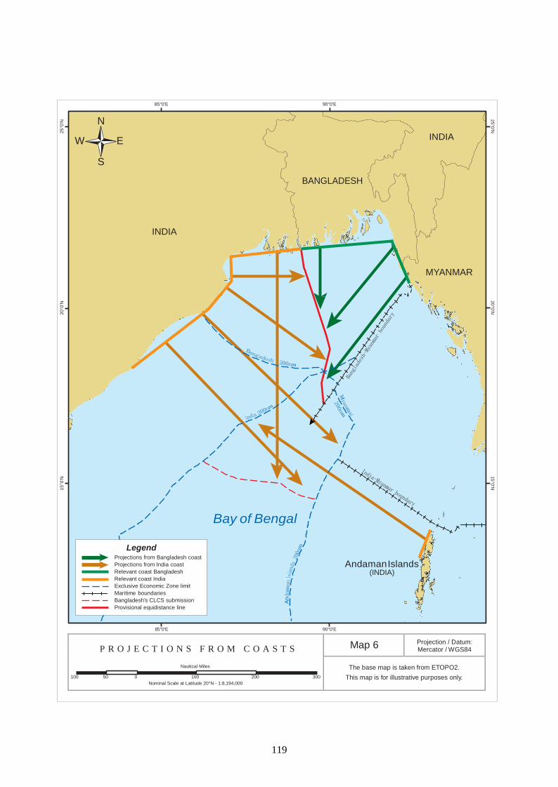
25°0’N
20°0’N
15°0’N 15
°0’N
20
°0’N
25
°0’N
An
85°0’E 90°0’E
N
W E
S
BANGLADESH
INDIA
INDIA
MYANMAR
Bay of Bengal
Legend Projections from Bangladesh coast Projections from India coast Relevant coast Bangladesh Relevant coast India Exclusive Economic Zone limit Maritime boundaries Bangladesh’s CLCS submission Provisional equidistance line
Andaman Islands (INDIA)
85°0’E 90°0’E
P R O J E C T I O N S F R O M C O A S T S
Nautical Miles
100 50 0 100 200 300
Nominal Scale at Latitude 20°N - 1:8,194,000
Map 6 Projection / Datum: Mercator / WGS84
The base map is taken from ETOPO2.
This map is for illustrative purposes only.
119

this page intentionally blank
120

408. On the basis of the foregoing, the Tribunal concludes that, as a result of the concavity of the
coast, the provisional equidistance line it constructed in fact produces a cut-off effect on the
seaward projections of the coast of Bangladesh. For that reason, the Tribunal considers the cut-
off to constitute a relevant circumstance which may require the adjustment of the provisional
equidistance line it constructed.
409. The Tribunal will now consider the extent to which the cut-off effect it has identified requires
adjustment of the provisional equidistance line, bearing in mind the parameters for adjusting a
provisional equidistance line set out above (see paragraphs 397-398 above). In addressing this
question, the Tribunal must first consider India’s argument that no adjustment in favour of
Bangladesh is required because the cut-off effect produced by the concavity of the Bay has
already been ameliorated by the Judgment of the International Tribunal for the Law of the Sea.
(Dispute Concerning Delimitation of the Maritime Boundary between Bangladesh and
Myanmar in the Bay of Bengal (Bangladesh/Myanmar), Judgment of 14 March 2012,
paragraphs 331-336).
410. In this respect, the Tribunal notes that the Judgment in Bangladesh/Myanmar has established
the entitlement of Bangladesh to the continental shelf beyond 200 nm. But the entitlement of a
State to reach the continental shelf beyond 200 nm is not the only relevant consideration. The
Tribunal must examine the geographic situation as a whole.
411. More fundamentally, the Tribunal wishes to emphasize that the case before the International
Tribunal for the Law of the Sea between Myanmar and Bangladesh and the present arbitration
are independent of each other. They involve different Parties, separate proceedings, and
different fora. Accordingly, the Tribunal must consider the Judgment of the International
Tribunal for the Law of the Sea as res inter alios acta. This Tribunal will, therefore, base its
decision solely on consideration of the relationship between Bangladesh and India and their
respective coastlines. This decision is in line with the award in the case of Barbados/Trinidad
and Tobago, where the arbitral tribunal refused to take into consideration a delimitation
agreement between Trinidad and Tobago and Venezuela (Award of 11 April 2006, RIAA, Vol.
XXVII, p. 238, paragraph 346). The Tribunal will, however, take into account any
compensation Bangladesh claims it is entitled to due to any inequity it suffers in its relation to
India as a result of its concave coast and its location in the middle of two other States, sitting on
top of the concavity of the Bay of Bengal.
412. The Tribunal will now consider the relevance of the cut-off effect of the provisional
equidistance line.
121

413. That the establishment of an equidistance line may produce a cut-off effect has been recognized
since the decision in the North Sea Continental Shelf Cases, in which the International Court of
Justice explained that:
it has been seen in the case of concave or convex coastlines that if the equidistance method is employed, then the greater the irregularity and the further from the coastline the area to be delimited, the more unreasonable are the results produced. So great an exaggeration of the consequences of a natural geographical feature must be remedied or compensated for as far as possible, being of itself creative of inequity.
(North Sea Continental Shelf, Judgment, I.C.J. Reports 1969, p. 3, at p. 49, paragraph 89).
414. Moreover, as the distance from the coastline grows, the inequity of the resulting line becomes
increasingly severe (North Sea Continental Shelf, Judgment, I.C.J. Reports 1969, p. 3, at p. 49,
paragraph 89).
415. In this regard, the International Court of Justice further observed that “in the case of a concave
or recessing coast . . . , the effect of the use of the equidistance method is to pull the line of the
boundary inwards, in the direction of the concavity”, causing the area enclosed by the
equidistance lines “to take the form approximately of a triangle with its apex to seaward and, as
it was put on behalf of the Federal Republic, ‘cutting off’ the coastal State from the further areas
of the continental shelf outside of and beyond this triangle” (ibid. at p. 17, paragraph 8). The
Tribunal notes that the North Sea Continental Shelf Cases dealt with the situation of a State
situated between two other States along a concave coastline. In Guinea/Guinea-Bissau, the
arbitral tribunal stated that “[w]hen in fact . . . there are three adjacent States along a concave
coastline, the equidistance method has the other drawback of resulting in the middle country
being enclaved by the other two and thus prevented from extending its maritime territory as far
seaward as international law permits” (Decision of 14 February 1985, ILR, Vol. 77, p. 635, at p.
682, paragraph 104).
416. In its judgment in Bangladesh/Myanmar, the International Tribunal for the Law of the Sea noted
that, on account of the concavity of the coast in question, the provisional equidistance line it
constructed produced a cut-off effect on the maritime projection of Bangladesh and hence
required an adjustment to produce an equitable solution (Judgment of 14 March 2012,
paragraph 293).
417. The Tribunal considers that a cut-off produced by a provisional equidistance line must meet two
criteria to warrant adjustment of the provisional equidistance line. First, the line must prevent a
coastal State from extending its maritime boundary as far seaward as international law permits.
Second, the line must be such that—if not adjusted—it would fail to achieve the equitable
solution required by articles 74 and 83 of the Convention. This requires an assessment of where
the disadvantage of the cut-off materializes and of its seriousness. In adjusting the provisional
equidistance line in the present case, the Tribunal must give due consideration to the need to
122

avoid encroaching on the entitlements of third States and also the entitlement of India, including
the entitlement arising from the presence of the Andaman Islands.
418. With respect to the first criterion, the provisional equidistance line prevents Bangladesh from
extending its maritime boundary as far seaward as international law permits. Equally it is to be
noted that the area allocated to Bangladesh narrows distinctively as it extends from the coast.
This area forms, generally speaking a triangle standing on the tip of one narrow angle. This
configuration is typical for the cut-off of a State located between two States in a concave
coastline, as is the position of Bangladesh in the present case. Second, and as noted above, from
point Prov-3 the provisional equidistance line bends markedly eastward to the detriment of
Bangladesh. Accordingly, the Tribunal concludes that the provisional equidistance line does not
produce an equitable result in delimiting the exclusive economic zone and continental shelf area
within 200 nm where the entitlements of the two Parties overlap.
419. The Tribunal is mindful that the provisional equidistance line—in particular if adjusted—may
produce a cut-off of the south-eastward and southward projection of the Indian coast. Adjusting
the equidistance line would not improve the situation if it were merely to transfer the cut-off
from one Party to the other. Accordingly, the Tribunal must ensure that any adjustment in
favour of Bangladesh will not produce an unreasonable result for India.
420. The Tribunal considers the geographic reality, however, to be that most of the southeast-facing
coast of India (the coast running north-east from Sandy Point) as well as its south-facing coast
(India’s part of the delta) are not significantly affected by the provisional equidistance line.
Whether an adjustment of that line may have unreasonable consequences for India will have to
be addressed in the context of a possible adjustment.
421. On the basis of the foregoing, the Tribunal comes to the conclusion that the provisional
equidistance line it has constructed must be adjusted in order to avoid an unreasonable cut-off
effect to the detriment of Bangladesh. Since this adjustment will have to take into account also
any cut-off in the area beyond 200 nm, the nature and extent of the adjustment will be indicated
following the Tribunal’s examination of the Parties arguments on the appropriate adjustment of
the provisional equidistance line within 200 nm and on the delimitation in the area beyond
200 nm.
*
422. The Tribunal will now turn to a further argument advanced by Bangladesh, namely that its
people depend heavily on fish from the Bay of Bengal and that this dependency exacerbates the
123
inequitableness of limiting Bangladesh to the narrow wedge of maritime space produced by the
provisional equidistance line.
423. The Tribunal notes that fishing interests were taken into consideration for the establishment of a
delimitation line in the Jan Mayen case (Case Concerning Maritime Delimitation in the Area
between Greenland and Jan Mayen (Denmark v. Norway), Judgment of 14 June 1993, I.C.J.
Reports 1993, p. 38). Quoting the judgment of the Chamber in the Gulf of Maine, the
International Court of Justice stated that it was necessary to “take account of the effects of the
delimitation on the Parties’ respective fishing activities by ensuring that the delimitation should
not entail ‘catastrophic repercussions for the livelihood and economic well-being of the
population of the countries concerned’” (ibid. at p. 71, paragraph 75, quoting Delimitation of the
Maritime Boundary in the Gulf of Maine Area, Judgment, I.C.J. Reports 1984, p. 342,
paragraph 237). The International Court of Justice then adjusted the provisional equidistance
line on the basis of migration patterns, so as to give Denmark equitable access to the fish stocks
concerned (ibid. at p. 72, paragraph 76). In Barbados and Trinidad and Tobago, however, the
tribunal declined to adjust the provisional equidistance line to accommodate the interests of the
fishermen from Barbados, holding that evidence indicated that the practice of fishing in the area
was not longstanding and that the result of the delimitation would not be catastrophic
(Barbados/Trinidad and Tobago, Award of 11 April 2006, RIAA, Vol. XXVII, p. 147 at pp.
221-223, paragraphs 264-271).
424. In view of the jurisprudence cited above, the Tribunal concludes that Bangladesh has not
submitted sufficient evidence of its dependence on fishing in the Bay of Bengal to justify an
adjustment of the provisional equidistance line.
D. THE PARTIES’ VIEWS ON THE ADJUSTMENT OF THE PROVISIONAL EQUIDISTANCE LINE WITHIN 200 NM
425. Bangladesh submits that the boundary line should be a line on an azimuth of 180°, which can be
adopted directly as an angle bisector or “indirectly by using the angle bisector as a vehicle to
determine the adjustment to the equidistance line that is required to produce an equitable
solution”.328 India maintains that the delimitation line should be the equidistance line, which
should not be adjusted.
*
426. Bangladesh argues for the adjustment of the provisional equidistance line to the 180° azimuth
(i.e., an adjustment by way of an angle bisector) for the same reasons it advocated the use of the
328 Bangladesh’s Reply, paragraph 4.113.
124

angle-bisector method in the first instance (see above at paragraph 323 et seq.). Whereas an equidistance line is affected by every irregular or anomalous feature, an angle-bisector line can
be drawn according to the macro-geographic depiction of the coastline.329 In Bangladesh’s view,
this approach is therefore more appropriate in the case of an unstable and irregular coastline.
427. With respect to identifying the appropriate angle-bisector, Bangladesh argues that the Tribunal
may follow either of two approaches. First, Bangladesh submits that the Tribunal could identify
the general direction of the coast of each Party and then bisect the angle formed by the two
lines, as was done most recently by the International Court of Justice in Nicaragua v. Honduras.
Bangladesh’s application of this approach to the present delimitation is depicted as follows:
(Bangladesh’s Memorial, Figure 6.17)
428. Alternatively, Bangladesh submits, it would be open to the Tribunal to follow the approach
adopted in Guinea/Guinea-Bissau, and employ an angle bisector in a way that a perpendicular is
329 Bangladesh’s Reply, paragraph 3.88.
125
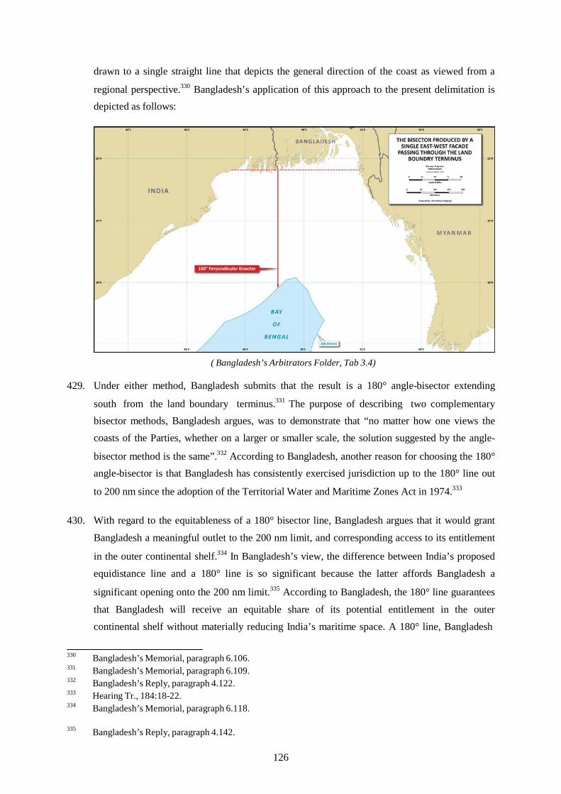
drawn to a single straight line that depicts the general direction of the coast as viewed from a
regional perspective.330 Bangladesh’s application of this approach to the present delimitation is depicted as follows:
( Bangladesh’s Arbitrators Folder, Tab 3.4)
429. Under either method, Bangladesh submits that the result is a 180° angle-bisector extending
south from the land boundary terminus.331 The purpose of describing two complementary bisector methods, Bangladesh argues, was to demonstrate that “no matter how one views the coasts of the Parties, whether on a larger or smaller scale, the solution suggested by the angle-
bisector method is the same”.332 According to Bangladesh, another reason for choosing the 180° angle-bisector is that Bangladesh has consistently exercised jurisdiction up to the 180° line out
to 200 nm since the adoption of the Territorial Water and Maritime Zones Act in 1974.333
430. With regard to the equitableness of a 180° bisector line, Bangladesh argues that it would grant
Bangladesh a meaningful outlet to the 200 nm limit, and corresponding access to its entitlement
in the outer continental shelf.334 In Bangladesh’s view, the difference between India’s proposed equidistance line and a 180° line is so significant because the latter affords Bangladesh a
significant opening onto the 200 nm limit.335 According to Bangladesh, the 180° line guarantees
that Bangladesh will receive an equitable share of its potential entitlement in the outer continental shelf without materially reducing India’s maritime space. A 180° line, Bangladesh
330 Bangladesh’s Memorial, paragraph 6.106. 331 Bangladesh’s Memorial, paragraph 6.109. 332 Bangladesh’s Reply, paragraph 4.122. 333 Hearing Tr., 184:18-22. 334 Bangladesh’s Memorial, paragraph 6.118.
335 Bangladesh’s Reply, paragraph 4.142.
126

observes, would leave India with about 98 percent of the maritime area it claims, thus achieving
the goal of sharing in a reasonable and mutually balanced way.336
431. Within 200 nm, a 180° line abates, but does not eliminate, the prejudicial effects of the
concavity of the Bay of Bengal. Bangladesh is still left with only a tapering wedge of maritime
space.337 Nevertheless Bangladesh considers that the 180° line produces a delimitation that would be suitable for equitable integration into the existing and future delimitations in the
region.338 A 180° line, Bangladesh notes, would also be easy to administer.339 Bangladesh refers to the decision of the Gulf of Maine, in which the International Court of Justice observed that
exploitation of fishery resources needs clear boundaries that do not require fishermen to
constantly check their position “in relation to the complicated path of the line to be
respected”.340
432. Finally, Bangladesh argues that a straight line bisector, akin in practice to the approach in
Bangladesh/Myanmar, would ensure harmony between these two related cases.341 Adjusting the provisional equidistance line to the 180° line would grant Bangladesh comparable measures of
relief from the concavity from both India and Myanmar.342 In comparing the degree of relief from the concavity on the India side and on the Myanmar side, Bangladesh finds that the 180° line would grant to Bangladesh 25,069 square kilometres beyond the equidistance line, an amount smaller than the 25,654 square kilometres resulting from the adjustment of line in
Bangladesh/Myanmar.343
*
433. India submits that Bangladesh’s positions on angle bisectors are inconsistent and that it has
misapplied the method. In India’s view, Bangladesh distorts the concept of relevant coasts in
order to obtain an artificial angle and to construct its favoured bisector line.344 In Bangladesh’s
first construction of a bisector, India notes, the two starting points of the coastal façade do not
coincide, because Bangladesh moves the starting point of its claimed coastal façade northward
336 Bangladesh’s Reply, paragraphs 4.139, 4.144. 337 Bangladesh’s Reply, paragraph 4.135. 338 Bangladesh’s Memorial, paragraph 6.119. 339 Bangladesh’s Memorial, paragraph 6.120. 340 Bangladesh’s Memorial, paragraph 6.120. 341 Bangladesh’s Reply, paragraph 4.147. 342 Bangladesh’s Reply, paragraph 4.147. 343 Bangladesh’s Reply, paragraph 4.148.
344 India’s Counter-Memorial, paragraph 5.42; India’s Rejoinder, paragraph 6.10.
127

and that of India southward.345 India observes that Bangladesh appeared to abandon this method
during the hearing.346
434. Turning to the alternative bisector method in the form of a straight line in the general direction
of the parties’ respective coastlines, India maintains that Bangladesh’s proposed straight line does not correlate with the coast but runs over the sea, leaving more than 11,463 square
kilometres of sea north of that straight line.347 India argues that the straight line is entirely disconnected from the general direction of the coast and the resulting perpendicular is
unjustified.348 India submits that a proper application of the angle-bisector method would result
in a line that runs in a south-easterly direction at 168.8°.349
435. India also disputes Bangladesh’s assertion that a 180° angle-bisector line would have a de
minimis effect on India’s maritime space. In India’s view, its entitlement to a large maritime
space results from its geographical circumstances; and its maritime areas that are not subject to
overlapping claims are irrelevant for the purpose of delimitation.350 India also disagrees with Bangladesh’s description of how the angle-bisector ensures the equitable sharing of the cut-off
effect between the Parties.351 India submits that the blocking effect can be seen in figure RJ 6.3
from India’s Rejoinder (reproduced on the following page).
436. India submits that the angle-bisector line is not geographically justified and is inconsistent with
the methodology under international law.352 It also submits that the angle-bisector line would
not be an equitable delimitation line between the Parties.353 Finally, India maintains that there is no compelling reason to find the drawing of an equidistance line unfeasible or “inappropriate”,
nor are there relevant circumstances requiring the adjustment of the provisional equidistance
line. Accordingly, India submits that the Tribunal’s final delimitation should follow the
equidistance line.
345 India’s Counter-Memorial, paragraph 5.42. 346 Hearing Tr., 420:27-29. 347 India’s Counter-Memorial, paragraph 5.43. 348 India’s Counter-Memorial, paragraph 5.43. 349 India’s Counter-Memorial, paragraph 5.44; India’s Rejoinder, paragraph 6.10. 350 India’s Rejoinder, paragraph 6.18. 351 India’s Rejoinder, paragraph 6.19. 352 India’s Rejoinder, paragraph 6.21. 353 India’s Rejoinder, paragraph 6.21.
128

(India’s Rejoinder, Figure RJ 6.3)
E. THE TRIBUNAL’S DECISION ON THE ADJUSTMENT OF THE PROVISIONAL EQUIDISTANCE LINE WITHIN 200 NM
437. Since the Tribunal is of the view that, consistent with the concept of a single continental shelf
(see paragraph 77 above), any adjustment of the provisional equidistance line within 200 nm
should result in a delimitation line extending into the area beyond 200 nm, its decision on this
question will be considered below in Chapter IX.
129

this page intentionally blank
130
CHAPTER VIII - DELIMITATION OF THE CONTINENTAL SHELF BEYOND 200 NM
A. METHODOLOGY
438. The Parties agree that they both have entitlements to the continental shelf beyond 200 nm. Both
Parties have made submissions to the CLCS.354 The Parties also agree that the law applicable to
the delimitation of the continental shelf beyond 200 nm is article 83 of the Convention,355 which provides that the delimitation “shall be effected by agreement on the basis of international law, as referred to in article 38 of the Statute of the International Court of Justice, in order to achieve an equitable solution”.
439. Bangladesh has withdrawn the argument advanced in its Memorial that the continental shelf
beyond 200 nm is geologically the “most natural prolongation” of its coast, noting that this view
was rejected by the International Tribunal for the Law of the Sea in Bangladesh/Myanmar.356
Bangladesh recalls the finding in that case that “the reference to natural prolongation . . . should
be understood in light of the subsequent provisions of the article defining the continental shelf
and the continental margin. Entitlement to a continental shelf beyond 200 nm should thus be
determined by reference to the outer edge of the continental margin” (Judgment of 14 March
2012, paragraph 437).357 Bangladesh accepts that the outer limits of the Parties’ entitlements
beyond 200 nm are determined by application of article 76(4) of the Convention, and that
neither Party is entitled to claim a superior entitlement based on geological or geomorphological
factors in the overlapping area.358
B. THE PARTIES’ PROPOSED DELIMITATION LINES BEYOND 200 NM
440. Bangladesh submits that the concavity of its coast constitutes a relevant circumstance for the
purpose of delimitation of the continental shelf beyond 200 nm, in much the same fashion as it
considers concavity to be a relevant circumstance within 200 nm.359 Bangladesh notes in
particular the finding in Bangladesh/Myanmar that “[h]aving considered the concavity of the
Bangladesh coast to be a relevant circumstance for the purpose of delimiting the exclusive
economic zone and the continental shelf within 200 nm, the Tribunal finds that this relevant
354 Bangladesh’s Reply, paragraph 5.13; India’s Rejoinder, paragraph 7.3. 355 India’s Counter-Memorial, paragraph 7.45;.Bangladesh’s Reply, paragraph 5.13; India’s Rejoinder,
paragraph 7.3.
356 Bangladesh’s Reply, paragraph 5.10. Bangladesh’s Reply, paragraph 5.9. Bangladesh’s Reply, paragraph 5.11. Bangladesh’s Reply, paragraph 5.12.
357
358
359
131

circumstance has a continuing effect beyond 200 nm” (Judgment of 14 March 2012, paragraph
461).360
441. Bangladesh emphasizes that, in the case of a concave coast, the results of the equidistance
method become more unreasonable as the equidistance line moves further from the coast.361 In Bangladesh’s view, India’s proposed equidistance line in the continental shelf beyond 200 nm would not produce an equitable solution and would be inconsistent with the judgment in
Bangladesh/Myanmar.362 Beyond 200 nm, Bangladesh argues, the equidistance line cuts Bangladesh off from most of its potential entitlement in that part of the continental shelf and leaves it only a small triangle that terminates a full 140 nm short of the claimed outer limits it
submitted to the CLCS.363
442. Moreover, Bangladesh notes, an equidistance line would allocate to India areas in the outer
continental shelf that India has never claimed before the CLCS, and which were claimed by
Bangladesh and Myanmar.364 In light of the decision in Bangladesh/Myanmar, the provisional
equidistance line in the present case runs to the east of the outer limits of India’s submission to
the CLCS. In effect, Bangladesh argues, India’s proposed line would delimit an area beyond
200 nm that India has never claimed, allocating to Bangladesh only that which already belongs
to it, while granting India a larger area than its full claim to the CLCS.365 This discrepancy is
depicted graphically in figure R5.1 from Bangladesh’s Reply (reproduced on the following
page).
443. Bangladesh agrees with India that the key delimitation principles are applicable “irrespective of
the nature of maritime zones to be delimited or the method applied to the delimitation”.366 In
Bangladesh’s view, however, the fact that there is only one continental shelf in law does not
mean that the line adopted within 200 nm must necessarily be extended unchanged through the
area beyond 200 nm, because, as the International Tribunal for the Law of the Sea observed in
Bangladesh/Myanmar, “the method to be followed should be one that, under the prevailing
geographic realities and the particular circumstances of each case, can lead to an equitable
result” (Judgment of 14 March 2012, paragraph 235).367 According to Bangladesh, a
delimitation line that is equitable in one part of the delimitation area is not per se equitable in
360 Bangladesh’s Reply, paragraph 5.2 361 Bangladesh’s Reply, paragraph 5.16. 362 Bangladesh’s Reply, paragraph 5.15. 363 Bangladesh’s Reply, paragraph 5.4.
364 Bangladesh’s Reply, paragraph 5.5. Bangladesh’s Reply, paragraph 5.5. Bangladesh’s Reply, paragraph 5.27. Bangladesh’s Reply, paragraph 5.28.
365
366
367
132

other parts.368 Bangladesh further recalls the finding in Bangladesh/Myanmar that the
equidistance/relevant circumstances method “can, and does in this case, permit resolution also
beyond 200 miles of the problem of the cutoff effect that can be created by an equidistance line
where the coast of one party is markedly concave” (Judgment of 14 March 2012, paragraph
455).369
(Bangladesh’s Reply, Figure R5.1)
444. Based on the foregoing, Bangladesh submits that, when the 180° line reaches the 200 nm limit,
it should bend and run along an azimuth of 215° parallel to the Bangladesh-Myanmar
delimitation line up to the outer limit of Bangladesh’s continental shelf.370 Bangladesh’s
proposed delimitation beyond 200 nm is presented graphically in Figure R5.7 from
Bangladesh’s Reply (reproduced on the following page).
445. With respect to the eastern extent of this area along the 215° azimuth identified by the
International Tribunal for the Law of the Sea, Bangladesh recalls the finding in
Bangladesh/Myanmar that the 215° line should extend until it reaches the area where the rights
of third States may be affected. Although its approach would extend the azimuth into the area
where Bangladesh, India, and Myanmar all maintain claims, Bangladesh states that, in any
event, the 215° line should “continue to mark the limits of its maritime jurisdiction” and it
368 Bangladesh’s Reply, paragraph 5.29. Hearing Tr., 201: 11-13. Bangladesh’s Reply, paragraph 5.41.
369
370
133

“makes no claim to anything east of the line”.371 If any portions of this area are later determined to appertain to India, Bangladesh accepts, the same 215° line shall equally delimit the area
between India and Bangladesh.372
(Bangladesh’s Reply, Figure R5.7)
446. Bangladesh argues that its proposed delimitation would equitably abate the cut-off effect and
avoid the highly prejudicial effect of concavity in the areas furthest from shore.373 Bangladesh also argues that this approach would be consistent with the Bangladesh/Myanmar judgment and
the general directional axis of the Bay.374 Bangladesh explains that nature has oriented the Bay along an axis running from the head of the Bay to the point where the Indian coast turns in a more southerly direction nearer Sri Lanka, the direction of which is approximately 214°/215°,
virtually identical to the Bangladesh/Myanmar delimitation line.375
447. Furthermore, Bangladesh maintains that this approach corresponds to the State practice of
according a maritime corridor out to the natural limits of entitlements to States trapped in the
371 Bangladesh’s Reply, paragraph 5.54. 372 Bangladesh’s Reply, paragraph 5.54. 373 Bangladesh’s Reply, paragraphs 5.42-5.43.
374 Bangladesh’s Reply, paragraph 5.44. Bangladesh’s Reply, paragraph 5.44. 375
134

middle of a concavity, as well as Professor Charney’s principle of “maximum reach”.376
According to Bangladesh, the “maximum reach” principle provides that maritime boundaries
are delimited in a way that “all disputants are allotted some access to the areas approaching the
maximum distance from the coast permitted for each zone”.377 Bangladesh submits that the
North Sea Continental Shelf Cases, Gulf of Fonseca, St. Pierre & Miquelon, Guinea/Guinea-
Bissau, and Nicaragua v. Colombia are all instances in which the principle of maximum reach
implicitly constituted a factor in the decision-making of the relevant court or tribunal.
448. Finally, Bangladesh notes the observation in Bangladesh/Myanmar that an equitable solution
requires that any adjustment not have “a converse distorting effect on the seaward projection” of
the coast of the other Party.378 In other words, any adjustment in favour of Bangladesh must not
be such as to subject India to a cut-off. In Bangladesh’s view, however, this principle would
readily be met: even if the Tribunal granted Bangladesh the entire overlapping area beyond 200
nm, India would still be entitled to the substantial area beyond 200 nm to the south of the outer
limit of Bangladesh’s claim.379
*
449. India disagrees that different legal regimes apply within and beyond 200 nm of the continental
shelf, and submits that the maritime boundary beyond 200 nm is the prolongation of the
boundary within 200 nm and must be drawn in accordance with the standard
equidistance/relevant circumstances method.380
450. India points to Bangladesh/Myanmar, in which the International Tribunal for the Law of the Sea
decided that the delimitation method for the outer continental shelf should not differ from that
within 200 nm and that the equidistance/relevant circumstances method would continue to apply
to the delimitation of the outer continental shelf.381 India quotes the Bangladesh/Myanmar
judgment, which provides as follows:
the adjusted equidistance line delimiting both the exclusive economic zone and the continental shelf within 200 nm between the Parties . . . continues in the same direction beyond the 200 nm limit of Bangladesh until it reaches the area where the rights of third States may be affected.382
376 Bangladesh’s Reply, paragraphs 5.47-5.48. 377 Bangladesh’s Reply, paragraph 5.48. 378 Bangladesh’s Reply, paragraph 5.39. 379 Bangladesh’s Reply, paragraph 5.40. 380 Hearing Tr., 434:10-11; Hearing Tr., 437:15-17. 381 India’s Counter-Memorial, paragraph 7.49; Hearing Tr., 435:17. 382 India’s Rejoinder, paragraph 7.6.
135

451. India submits that the delimitation line for the continental shelf beyond 200 nm should remain
the equidistance line and should “continue[] from point Y along the same azimuth until it meets
point T7 with co-ordinates 17° 22´ 08.8˝N, 89° 47´ 16.1˝E, which is equidistant from base
points I-3, I-4 and B-5”.383 From point T7, “the boundary follows a geodetic azimuth of
172.342° until it meets the maritime boundary line between Bangladesh and Myanmar at Point
Z with co-ordinates 17° 15´ 12.8˝N, 89° 48´ 14.7˝E.” India’s proposed approach can be seen in
the following figure:
(Counter-Memorial of India, Sketch Map No. 7.6)
452. In response to Bangladesh’s argument that this proposed line would allocate to India areas in the
outer continental shelf it has not claimed before the CLCS, India explains that, at the time of its
submission (11 May 2009), it assumed that maritime boundaries in the Bay of Bengal would be
comprised of two equidistance lines, which would leave Bangladesh no access to the continental
shelf beyond 200 nm.384 India assumed that the same principle of equidistance would apply
between India and Myanmar, and therefore submitted the equidistance line between India’s
peninsular coast and Myanmar’s Rakhine coast as the outer limit of India’s claim before the
383 India’s Counter-Memorial, paragraph 7.51. 384 India’s Rejoinder, paragraph 7.26.
136

CLCS.385 Although India had not yet included this area in its submission to the CLCS, India
challenges Bangladesh’s argument that this area already belongs to Bangladesh.386 According to
India, submissions to the CLCS cannot prejudice matters relating to maritime boundary
delimitations, and Bangladesh has no pre-existing rights in this area to which both Parties have
overlapping entitlement.387 India also emphasizes that it has sent a Note Verbale to the United
Nations Secretary-General, stating that “the outer limits of the continental shelf of India beyond
200 M in the Bay of Bengal as provided by India in its Submission to the CLCS may have to be
modified” and that “India would be making an amended Submission to the partial submission of
11 May 2009” (Note Verbale PM/NY/443/1/2013 from the Permanent Mission of India to the
United Nations to the Secretary-General of the United Nations, 16 July 2013).
453. Turning to Bangladesh’s proposed deflection of the delimitation line, India rejects the idea of a line running parallel to the maritime boundary between Bangladesh and Myanmar up to the
outer limit of the continental shelf claimed by Bangladesh.388 India first contests existence of the allegedly dramatic cut-off effect produced by an equidistance line to justify such a second
deflection of the delimitation line.389 According to India, the International Tribunal for the Law of the Sea did not apply a second deflection to the delimitation line between Bangladesh and
Myanmar but simply decided that the line would continue in the same direction.390 India contends that Bangladesh cannot rely on its coastal concavity to claim repeated deflections of
the equidistance line.391 In India’s view, a second deflection would produce a cut-off effect on India, blocking the seaward projection of both the south-facing and south-east-facing coasts of
India.392 This is represented graphically in Figure RJ 7.2 from India’s Rejoinder (reproduced on the following page).
454. India rejects the validity of a “maximum reach principle” and differs from Bangladesh in its
interpretation of the jurisprudence from which Bangladesh attempts to draw such a principle.
According to India, the North Sea Continental Shelf Cases do not support a maximum reach
principle, as it was the subsequent negotiation agreement, not the judgment, that achieved that
purpose.393 India similarly distinguishes the St. Pierre & Miquelon case, on the grounds that
385 India’s Rejoinder, paragraph 7.26. 386 India’s Rejoinder, paragraph 7.27. 387 India’s Rejoinder, paragraph 7.27. 388 India’s Rejoinder, paragraph 7.16. 389 India’s Rejoinder, paragraph 7.17. 390 India’s Rejoinder, paragraph 7.17. 391 India’s Rejoinder, paragraph 7.18. 392 India’s Rejoinder, paragraph 7.19. 393 Hearing Tr., 633:5-9.
137

France was not given a corridor, but rather that its maritime areas were reduced to a corridor.394
Nor, in India’s view, is a maximum reach principle evident in Nicaragua v. Colombia.395
(India’s Rejoinder, Figure RJ 7.2)
455. India also contests Bangladesh’s automatic extension of the Bangladesh/Myanmar azimuth
up to 390 nm and into the area in which Bangladesh, India, and Myanmar all have claims.396
In India’s view, the Bangladesh/Myanmar judgment does not bind third States and, as a
result, does not affect India397 or its claim to a 350 nm continental shelf from its Andaman
Islands.398
C. THE TRIBUNAL’S DELIMITATION OF THE CONTINENTAL SHELF BEYOND 200 NM
456. The Tribunal will now turn to the delimitation of the continental shelf beyond 200 nm. This task
requires the interpretation and application of article 76 as well as article 83 of the Convention.
394 Hearing Tr., 633:20-21. 395 Hearing Tr., 634:2-12. 396 India’s Rejoinder, paragraph 7.24. 397 India’s Rejoinder, paragraph 7.24. 398 India’s Rejoinder, paragraph 7.24.
138

25°0’N
20°0’N
15°0’N 15
°0’N
20
°0’N
25
°0’N
d b s
An
85°0’E 90°0’E
Legend
Relevant coast Bangladesh Relevant coast India Area of overlapping entitlements beyond 200 nm from both Bangladesh and India
Exclusive Economic Zone limit Maritime boundaries
CLCS submissions Provisional equidistance line
BANGLADESH
INDIA
N
W E
S
INDIA MYANMAR
Bay of Bengal
Andaman Islands (INDIA)
85°0’E 90°0’E
A R E A O F O V E R L A P P I N G E N T I T L E M E N T S B E Y O N D 2 0 0 N M
F R O M B O T H B A N G L A D E S H A N D I N D I A Nautical Miles
100 50 0 100 200 300
Nominal Scale at Latitude 20°N - 1:8,194,000
Map 7 Projection / Datum: Mercator / WGS84
The base map is taken from ETOPO2.
This map is for illustrative purposes only.
139

this page intentionally blank
140

457. The Tribunal notes the Parties’ agreement that both States have entitlements beyond 200 nm,
and both have made submissions to the CLCS. The Parties also agree that their entitlements
beyond 200 nm are determined by application of article 76, paragraph 4, of the Convention, and
that neither may claim a superior entitlement based on geological or geomorphological factors
in the overlapping area.
458. The Tribunal further notes the judgment of the International Tribunal for the Law of the Sea in
Bangladesh/Myanmar which ruled that the delimitation of the continental shelf beyond 200 nm
through judicial settlement was in conformity with article 76 of the Convention (Judgment of 14
March 2012, paragraphs 439–449). On the basis of the foregoing, it remains for this Tribunal
only to establish the delimitation line in the area beyond 200 nm where the entitlements of the
Parties overlap, as set out in Map 7 on p. 139 of this Award
1. Base points for the equidistance line beyond 200 nm
459. As with delimitation of the exclusive economic zone and continental shelf within 200 nm, the
Tribunal must assess the appropriateness of the base points chosen by the Parties or choose
different base points, as the case may be.
460. In addition to the base points discussed earlier, both Parties have proposed a further base
point I-4 on the Indian coast, located on the low-water line at Devi Point that has effect only
beyond 200 nm. The coordinates proposed by the Parties respectively for this point differ
slightly.
461. In the view of the Tribunal, this location is acceptable with regard to the criteria for the
selection of base points as set out above (see paragraphs 222-223 above).
462. The Tribunal has already decided (see paragraphs 365-366 above) that a point on the low-water
line at Shahpuri Point on the coast of Bangladesh (at 20° 43´ 39˝N; 92° 20´ 33˝E) and base point
I-3 on the coast of India, as proposed by Bangladesh (at 20° 20´ 29˝N; 86° 47´ 07˝E), are
appropriate for the construction of the provisional equidistance line. These points continue to
affect the equidistance line beyond 200 nm and remain appropriate.
463. Further, the Tribunal decides that the following additional base point is appropriate for
construction of the provisional equidistance line beyond 200 nm:
- Base point I-4 as proposed by India at 19° 57´ 33.1˝N; 86° 24´ 20.0˝E.
141
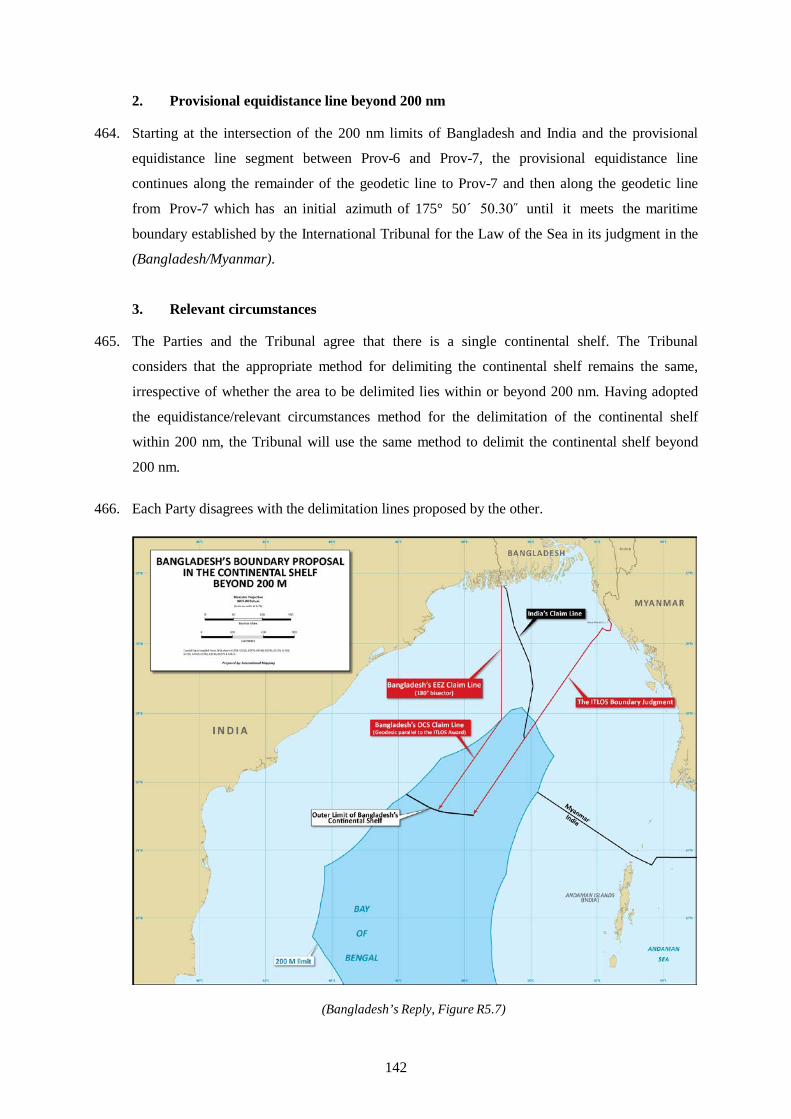
2. Provisional equidistance line beyond 200 nm
464. Starting at the intersection of the 200 nm limits of Bangladesh and India and the provisional
equidistance line segment between Prov-6 and Prov-7, the provisional equidistance line
continues along the remainder of the geodetic line to Prov-7 and then along the geodetic line
from Prov-7 which has an initial azimuth of 175° 50´ 50.30˝ until it meets the maritime
boundary established by the International Tribunal for the Law of the Sea in its judgment in the
(Bangladesh/Myanmar).
3. Relevant circumstances
465. The Parties and the Tribunal agree that there is a single continental shelf. The Tribunal
considers that the appropriate method for delimiting the continental shelf remains the same,
irrespective of whether the area to be delimited lies within or beyond 200 nm. Having adopted
the equidistance/relevant circumstances method for the delimitation of the continental shelf
within 200 nm, the Tribunal will use the same method to delimit the continental shelf beyond
200 nm.
466. Each Party disagrees with the delimitation lines proposed by the other.
(Bangladesh’s Reply, Figure R5.7)
142

467. Bangladesh submits that, beyond 200 nm, the provisional equidistance line does not produce an
equitable solution and that, without adjustment, its use would be inconsistent with the judgment
in Bangladesh/Myanmar. Bangladesh reiterates that the results produced by an equidistance line
in the case of a concave coast become more unreasonable as the line moves further from the
coast. Bangladesh submits that a substantial departure from the provisional equidistance line
beyond 200 nm is required. It challenges India’s argument that the equidistance line within 200
nm should simply be extended into the continental shelf beyond 200 nm.
468. India disagrees with the arguments advanced by Bangladesh. It contends that the provisional
equidistance line does not call for adjustment and should be prolonged into the area beyond 200
nm until it meets the delimitation line established by the International Tribunal for the Law of
the Sea in the case between Bangladesh and Myanmar.
(India’s Rejoinder, Figure RJ 7.1)
469. The Tribunal has examined the delimitation line as advocated by Bangladesh. In the Tribunal’s
view the implementation of this approach would lead to a significant cut-off to the detriment of
India’s entitlement to the area beyond 200 nm and cannot be accepted for that reason. The
Tribunal wishes to point out in this context that international jurisprudence on the delimitation
143
of the continental shelf does not recognize a general right of coastal States to the maximum
reach of their entitlements, irrespective of the geographical situation and the rights of other
coastal States.
470. The Tribunal has further examined the result of the delimitation process if it were to accept
India’s contention that no adjustment should be made to the provisional equidistance line. The
Tribunal considers that this approach would provide no redress to Bangladesh from the cut-off
resulting from the concavity of its coast, and cannot be accepted for this reason.
471. In this context, the Tribunal takes note of the decision the International Tribunal for the Law of
the Sea which stated:
Having considered the concavity of the Bangladesh coast to be a relevant circumstance for the purpose of delimiting the exclusive economic zone and the continental shelf within 200 nm, the Tribunal finds that this relevant circumstance has a continuing effect beyond 200 nm.
(Judgment of 14 March 2012, paragraph 461).
472. The International Tribunal for the Law of the Sea continued:
The Tribunal therefore decides that the adjusted equidistance line delimiting both the exclusive economic zone and the continental shelf within 200 nm between the Parties as referred to in paragraphs 337-340 continues in the same direction beyond the 200 nm limit of Bangladesh until it reaches the area where the rights of third States may be affected.
(Ibid. at paragraph 462).
473. The Tribunal has already noted (see paragraphs 400-408 above) that the continental shelf and
exclusive economic zone area within 200 nm attributed to Bangladesh is, due to the particular
geographic configuration of the inner part of the Bay of Bengal, limited in scope in comparison
to the area in which the entitlements of Bangladesh and India overlap. In a like manner, it is to
be noted that the area attributed to Bangladesh in the area beyond 200 nm is limited in scope in
comparison to the area in which the entitlements of the Parties overlap.
474. The Tribunal reiterates that a coastal State has an entitlement if its coast projects into the area
claimed. This is the case here. In particular, the south facing coast of Bangladesh is given
insufficient weight by the provisional equidistance line from Point Prov-3 to the south. The
effect of the provisional equidistance line is depicted graphically in Map 8 on p. 145 of this
Award.
475. The above considerations lead the Tribunal to the conclusion that the provisional equidistance
line requires adjustment beyond (as well as within) 200 nm to produce an equitable result.
144

25°0’N
20°0’N
15°0’N 15
°0’N
20
°0’N
25
°0’N
An
85°0’E 90°0’E
N
W E
S
BANGLADESH
INDIA
INDIA
MYANMAR
Bay of Bengal
Legend Projections from Bangladesh coast Projections from India coast Relevant coast Bangladesh Relevant coast India Exclusive Economic Zone limit Maritime boundaries Bangladesh’s CLCS submission Provisional equidistance line
Andaman Islands (INDIA)
85°0’E 90°0’E
T H E C U T - O F F O F T H E P R O J E C T I O N S F R O M B A N G L A D E S H
Nautical Miles 100 50 0 100 200 300
Nominal Scale at Latitude 20°N - 1:8,194,000
Map 8 Projection / Datum: Mercator / WGS84
The base map is taken from ETOPO2.
This map is for illustrative purposes only.
145

this page intentionally blank
146

CHAPTER IX - ADJUSTMENT OF THE PROVISIONAL EQUIDISTANCE LINE WITHIN AND BEYOND 200 NM
476. The Parties views on the appropriate adjustment of the provisional equidistance line are set out
above with respect to the area within (see paragraphs 425 to 436) and beyond 200 nm (see
paragraphs 440 to 455). In the paragraphs that follow, the Tribunal will set out what it
considers to be the appropriate adjustment of the provisional equidistance line.
A. THE TRIBUNAL’S CONSIDERATIONS IN ADJUSTING THE PROVISIONAL EQUIDISTANCE LINE
477. In deciding on the adjustment of the provisional equidistance line, the Tribunal is guided by the
following considerations. The Tribunal should seek to ameliorate excessive negative
consequences the provisional equidistance line would have for Bangladesh in the areas within
and beyond 200 nm, but it must not do so in a way that unreasonably encroaches on the
entitlement of India in that area. Such adjustment will allow the “coasts of the Parties to
produce their effects, in terms of maritime entitlements, in a reasonable and mutually balanced
way” (Maritime Delimitation in the Black Sea (Romania v. Ukraine), Judgment of 3 February
2009, I.C.J. Reports 2009, p. 61 at p. 127, paragraph 201). Further the adjustment of the
provisional equidistance line must not infringe upon the rights of third States.
B. THE TRIBUNAL’S ADJUSTMENT OF THE PROVISIONAL EQUIDISTANCE LINE
478. To ameliorate the excessive negative impact the implementation of the provisional equidistance
line would have on the entitlement of Bangladesh to the continental shelf/exclusive economic
zone and the continental shelf beyond 200 nm and to achieve an equitable result, the Tribunal
decides that, from point Prov-3, the adjusted line delimiting the exclusive economic zone and
the continental shelf between Bangladesh and India within and beyond 200 nm is a geodetic line
with an initial azimuth of 177° 30´ 00˝ until this line meets with the maritime boundary
established by the International Tribunal for the Law of the Sea to delimit the exclusive
economic zone and the continental shelf between Bangladesh and Myanmar within and beyond
200 nm. The Tribunal’s adjustment is depicted graphically in Map 9 on p. 149 of this Award.
479. As far as the whole area in dispute is concerned the Tribunal considers that the adjusted
delimitation line does not unreasonably limit the entitlement of India.
480. The Tribunal would like to point out that this adjusted delimitation line avoids turning points
and is thus simpler to implement and administer by the Parties.
147

this page intentionally blank
148

25°0’N
20°0’N
15°0’N 15
°0’N
20
°0’N
25
°0’N
An
85°0’E 90°0’E
N
W E
S BANGLADESH
INDIA
INDIA
Prov-3 MYANMAR
Bay of Bengal
Legend Exclusive Economic Zone limit Maritime boundaries Bangladesh’s CLCS submission Provisional equidistance line
Andaman Islands (INDIA)
85°0’E 90°0’E
A D J U S T M E N T O F T H E P R O V I S I O N A L E Q U I D I S T A N C E L I N E
Nautical Miles 100 50 0 100 200 300
Nominal Scale at Latitude 20°N - 1:8,194,000
Map 9 Projection / Datum: Mercator / WGS84
The base map is taken from ETOPO2.
This map is for illustrative purposes only.
149

this page intentionally blank
150
CHAPTER X - DISPROPORTIONALITY TEST
481. The Parties agree that the final step in the delimitation process involves a test to ensure that the
delimitation line does not yield a disproportionate result.399 The disproportionality test compares
the ratio of the relevant maritime space accorded to each Party to the ratio of the Parties’ relevant coastal lengths.
*
482. Bangladesh emphasizes that the disproportionality test is only employed at the third stage of the
delimitation process and does not work backwards to influence the Tribunal’s consideration of
relevant circumstances at the second stage.400 In Bangladesh’s view, India improperly attempts
to import the disproportionality analysis into the second stage, arguing that if no
disproportionality is to be found, no relevant circumstances can justify the adjustment of the
provisional equidistance line.
483. Bangladesh refers to the decision in Nicaragua v. Colombia, in which the International Court of
Justice considered the purpose of this test to be a final check for any result that is “tainted by
some form of gross disproportion”, and stated that this final check is performed by the basis of
“only approximate” numbers (Territorial and Maritime Delimitation (Nicaragua v. Colombia),
Judgement of 19 November 2012, paragraph 241). Bangladesh maintains that the proportionality
test during the third stage of the delimitation process differs from the role of proportionality
during the second stage. While proportionality can play a legitimate role in the examination of
relevant circumstances, its use in the second stage involves a margin of appreciation to make
sure that the delimitation line allows each State to enjoy reasonable maritime entitlements in the
areas into which its coasts project.”401
484. Bangladesh argues that the International Court of Justice made clear in Nicaragua v. Colombia
that the broader notion of proportionality comes into play at the second stage, concluding that
the provisional equidistance line in that case would have inequitably cut Nicaragua off from
three quarters of its entitlement. In Bangladesh’s view, this amounts to stating that Nicaragua
was “disproportionately deprived . . . of maritime areas to which it was potentially entitled” by
the provisional line.402 Similarly, Bangladesh interprets the Court’s statement that extending the
“equiratio” line (a line drawn by giving proportionally more weight to the base points of one
399 Bangladesh’s Reply, paragraph 4.150; India’s Counter-Memorial, paragraph 6.108. 400 Bangladesh’s Reply, paragraph 4.159.
Bangladesh’s Reply, paragraph 4.156. Bangladesh’s Reply, paragraph 4.157.
401
402
151

party) would “still leave Colombia with a significantly larger share of the relevant area than that
accorded to Nicaragua” as meaning that the result would not have been proportionate.403
485. Bangladesh’s views on the relevant area are set out above at paragraphs 277 to 305. In short,
Bangladesh considers that the relevant area must encompass the entire area in which the
projections of the coasts of the Parties overlap, including the area beyond 200 nm. Bangladesh
recalls that such an approach was adopted in Bangladesh/Myanmar.
486. According to Bangladesh, its proposed boundary line divides this area in a way that Bangladesh
and India receives maritime space of 145,364 square kilometres and 211,490 square kilometres,
respectively, the ratio of which is 1 : 1.52 in favour of India.404 Bangladesh submits that this result is consistent with the ratio of coastal lengths and therefore passes the disproportionality
test.405 Bangladesh sets out the disproportionality test for each of the delimitation lines claimed
by the Parties as follows:406
Bangladesh India Ratio Coastline (km) 424 708 1 : 1.67 Area Calculations (sq km) India’s Claim Line 82,689 284,165 1 : 3.44 Provisional Equidistance Line Bangladesh’s Claim Line
86,294 145,364
280,560
221,490
1 : 3.25
1 : 1.52
487. Bangladesh observes that both India’s claim line and the provisional equidistance line would
accord India over two times more space than the proportionate delimitation line it claims.407 In
contrast, Bangladesh considers the ratio resulting from its proposed delimitation to be not disproportionate.
*
488. India submits that the relevant area should encompass the “maritime zones lying directly off the
respective relevant coasts of the Parties”, limited to the boundary line as set out in
Bangladesh/Myanmar. India excludes areas beyond 200 nm from both its calculation of the
relevant area and its assessment of disproportionality. Moreover, India argues, Bangladesh’s
inclusion in the relevant area of areas within 200 nm of India that are more than 200 nm from
403 Bangladesh’s Reply, paragraph 4.158. 404 Bangladesh’s Reply, paragraph 5.71. 405 Bangladesh’s Reply, paragraph 5.71.
Bangladesh’s Reply, paragraph 5.73. Bangladesh’s Reply, paragraph 5.73.
406
407
152

Bangladesh is inappropriate.408 In India’s view, such areas cannot be the subject of
“overlapping” claims.409
489. India measures what it considers to be the relevant area at 172,219.7 square kilometres and
submits that its proposed line satisfies the test insofar as the ratio of the relevant coasts of the
Parties is 1 : 1.015 and the ratio of the relevant areas result from India’s proposed line is
1 : 0.942.410 India notes that only marked differences in the ratio between the coastal lengths
require the adjustment of the delimitation line.411 In Romania/Ukraine, India argues, the International Court of Justice found that the delimitation line satisfied the test when the ratio of
the respective coastal lengths for the parties is approximately 1 : 2.8 and the ratio of the relevant
area between them is approximately 1 : 2.1.412 According to India, it is where courts and tribunals have found substantial discrepancies in the ratio between the Parties’ relevant coasts
and their delimited share of relevant area that the disproportionality test has not been met.
* * *
490. The Tribunal’s views on the relevant area are set out above at paragraphs 306 to 311. As
described above, the relevant area encompasses all of the areas, within and beyond 200 nm in
which the seaward projections of the Parties’ relevant coasts overlap.
491. The Tribunal begins its consideration of the disproportionality test by noting that
The test of disproportionality is not in itself a method of delimitation. It is rather a means of checking whether the delimitation line arrived at by other means needs adjustment because of a significant disproportionality in the ratios between the maritime areas which would fall to one party or other by virtue of the delimitation line arrived at by other means, and the lengths of their respective coasts.
(Maritime Delimitation in the Black Sea (Romania v. Ukraine), Judgment of 3 February 2009, I.C.J. Reports 2009, p. 61 at pp 99-100, paragraph 110)
492. The Tribunal emphasizes that proportionality is not a mathematical exercise that results in the
attribution of maritime areas as a function of the length of the coasts of the Parties or other such
ratio calculations. As the International Court of Justice stated in Nicaragua v. Colombia
“[m]aritime delimitation is not designed to produce a correlation between the lengths of the
Parties’ relevant coasts and their respective shares of the relevant area” (Judgment of 19
November 2012, paragraph 240). In the view of the Tribunal such an approach could itself
produce inequity. In particular it is not the function of the Tribunal to refashion nature. It is
408 Hearing Tr., 356:19-26. 409 Hearing Tr., 356:27 to 357:4. 410 India’s Counter-Memorial, paragraph 6.111. 411 India’s Counter-Memorial, paragraph 6.112. 412 India’s Counter-Memorial, paragraph 6.110.
153

rather the responsibility of the Tribunal to check, ex post facto, the equitableness of the
delimitation line it has constructed (see also Delimitation of the maritime boundary between
Guinea and Guinea-Bissau, RIAA, Vol. XIX, pp. 183-184, paragraphs 94-95). What constitutes
such disproportionality may vary from case to case.
493. The Tribunal notes the international jurisprudence concerning the disproportionality test. As the
International Court of Justice stated in its judgments in Romania v. Ukraine (Judgment, I.C.J.
Reports 2009, p. 61 at p. 129, paragraph 210) and Nicaragua v. Colombia (Judgment of
19 November 2012, paragraphs 239, 242 and 243), a significant disproportionality is to be
avoided.
494. Whether or not significant disproportionality exists remains a matter for the Tribunal’s
appreciation, which it will exercise by reference to the overall geography of the area.
495. As set out above, the length of the relevant coast of Bangladesh is 418.6 kilometres. The length
of the relevant coast of India is 803.7 kilometres. The ratio between the lengths of the relevant
coasts of the parties is thus 1 : 1.92.
496. As set out above, the relevant area comprises 406,833 square kilometres. Having adjusted the
provisional equidistance line, the Tribunal’s delimitation lines allocates approximately 106,613
square kilometres of the relevant area to Bangladesh and approximately 300,220 square
kilometres of the relevant area to India. The ratio of the allocated areas is approximately
1 : 2.81.
497. The Tribunal finds that this ratio does not produce any significant disproportion in the allocation
of maritime areas to the Parties that would require alteration of the adjusted equidistance line to
ensure an equitable solution.
154

CHAPTER XI - GREY AREA
498. The Tribunal’s delimitation of the Parties’ exclusive economic zones and of the continental
shelf within and beyond 200 nm gives rise to an area that lies beyond 200 nm from the coast of
Bangladesh and within 200 nm from the coast of India, and yet lies to the east of the Tribunal’s
delimitation line. The resulting “grey area” is a practical consequence of the delimitation
process. Such an area will arise whenever the entitlements of two States to the continental shelf
extend beyond 200 nm and relevant circumstances call for a boundary at other than the
equidistance line at or beyond the 200 nm limit in order to provide an equitable delimitation.
The grey area resulting from the Tribunal’s delimitation in the present case is depicted in
Map 10 on p. 159 of this Award.
499. A similar situation arose between Bangladesh and Myanmar as a result of the delimitation line
drawn by the International Tribunal for the Law of the Sea. The judgment in that case held that
in the area beyond Bangladesh’s exclusive economic zone that is within the limits of Myanmar’s exclusive economic zone, the maritime boundary delimits the Parties’ rights with respect to the seabed and subsoil of the continental shelf but does not otherwise limit Myanmar’s rights with respect to the exclusive economic zone, notably those with respect to the superjacent waters.
Delimitation of the Maritime Boundary between Bangladesh and Myanmar in the Bay of Bengal (Bangladesh/Myanmar), Judgment of 14 March 2012, paragraph 474.
500. The International Tribunal for the Law of the Sea went on to note, with respect to the division of
rights in the grey area, that
There are many ways in which the Parties may ensure the discharge of their obligations in this respect, including the conclusion of specific agreements or the establishment of appropriate cooperative arrangements. It is for the Parties to determine the measures that they consider appropriate for this purpose.
Delimitation of the Maritime Boundary between Bangladesh and Myanmar in the Bay of Bengal (Bangladesh/Myanmar), Judgment of 14 March 2012, paragraph 476.
*
501. In its written submissions, Bangladesh endorsed the approach adopted by the International
Tribunal for the Law of the Sea and considered it appropriate in the present case:
Bangladesh submits that the Arbitral Tribunal should adopt the same solution in this case. The area beyond 200 M from Bangladesh but within 200 M from India should be continental shelf as to Bangladesh and EEZ as to India. Beyond 200 M from India, the boundary would be a pure continental shelf boundary.413
502. As India was of the view that no relevant circumstances called for an adjustment of a
provisional equidistance line, it did not address the question of the grey area.
413 Bangladesh’s Reply, paragraph 5.58.
155

*
503. The Tribunal emphasizes that beyond 200 nm from Bangladesh’s coast, it has an entitlement
only to the seabed and its subsoil pursuant to the legal regime governing the continental shelf.
Within the grey area, Bangladesh has no entitlement to an exclusive economic zone that would
give it sovereign rights in the water column or over the living resources therein. As the
Tribunal’s power to delimit the respective entitlements of the Parties exists only where those
entitlements overlap, there can be no question of delimiting entitlements in the grey area, except
with respect to the continental shelf.
504. The Tribunal notes that, in the grey area, the exclusive economic zone to which India is entitled
includes rights to the seabed and subsoil pursuant to article 56(1)(a) of the Convention that also
fall within the regime for the continental shelf. In practice, however, the Convention
distinguishes between the rights that arise under multiple regimes and those that pertain only to
the exclusive economic zone. Article 56(3) provides that rights with respect to the seabed and
subsoil in the exclusive economic zone are to be exercised in accordance with the regime for the
continental shelf. Article 68 excludes sedentary species from the provisions relating to the
exclusive economic zone altogether.
505. Accordingly, within the area beyond 200 nm from the coast of Bangladesh and within 200 nm
of the coast of India, the boundary identified by the Tribunal delimits only the Parties’
sovereign rights to explore the continental shelf and to exploit the “mineral and other non-living
resources of the seabed and subsoil together with living organisms belonging to sedentary
species” as set out in article 77 of the Convention. Within this area, however, the boundary
does not otherwise limit India’s sovereign rights to the exclusive economic zone in the
superjacent waters.
506. The Tribunal notes that the grey area it has described overlaps in part with the grey area
described in Bangladesh/Myanmar. The present delimitation does not prejudice the rights of
India vis-a-vis Myanmar in respect of the water column in the area where the exclusive
economic zone claims of India and Myanmar overlap. This overlap of grey areas is depicted
graphically in Map 11 on p. 161 of this Award.
507. The establishment of a maritime area in which the States concerned have shared rights is not
unknown under the Convention. The Convention is replete with provisions that recognize to a
greater or lesser degree the rights of one State within the maritime zones of another. Within the
provisions of the Convention relating to the exclusive economic zone and continental shelf,
articles 56, 58, 78, and 79 all call for States to exercise their rights and perform their duties with
due regard to the rights and duties of other States.
156

508. It is for the Parties to determine the measures they consider appropriate in this respect, including
through the conclusion of further agreements or the creation of a cooperative arrangement. The
Tribunal is confident that the Parties will act, both jointly and individually, to ensure that each is
able to exercise its rights and perform its duties within this area.
the remainder of this page intentionally blank
157

this page intentionally blank
158

24°0’N
22°0’N
20°0’N
18°0’N
16°0’N 16
°0’N
18
°0’N
20
°0’N
22
°0’N
24
°0’N
86°0’E
N
W E
S
88°0’E 90°0’E 92°0’E INDIA
BANGLADESH
INDIA
MYANMAR
Legend Exclusive Economic Zone limit
Maritime boundaries Provisional equidistance line
India’s CLCS submission Grey area - India Grey area - Myanmar Grey area - Overlap
Bay of Bengal
86°0’E 88°0’E 90°0’E 92°0’E
G R E Y A R E A S
Map 10
Projection / Datum: Mercator / WGS84
50 25
Nautical Miles
0 50 Nominal Scale at Latitude 20°N - 1:4,747,000
100 150
The base map is taken from ETOPO2. This map is for illustrative purposes only.
159

this page intentionally blank
160

h m
18°30’N
18°0’N
17°30’N 17
°30’
N
18°0
’N
18°3
0’N
89°0’E
N
W E
89°30’E 90°0’E
S
200n
Bay of Bengal
Legend Exclusive Economic Zone limit
Maritime boundaries Provisional equidistance line Grey area - India Grey area - Myanmar Grey area - Overlap
89°0’E 89°30’E 90°0’E
G R E Y A R E A S - D E T A I L
Nautical Miles
10 5 0 10 20 30
Nominal Scale at Latitude 18°N - 1:953,100
Map 11 Projection / Datum: Mercator / WGS84
The base map is taken from ETOPO2.
This map is for illustrative purposes only.
161

this page intentionally blank
162

24°0’N
22°0’N
20°0’N
18°0’N
16°0’N 16
°0’N
18
°0’N
20
°0’N
22
°0’N
24
°0’N
86°0’E
N
W E
S
88°0’E 90°0’E 92°0’E INDIA
BANGLADESH
INDIA
Delim-1 Delim-2
Delim-3 MYANMAR
Bay of Bengal
Legend Exclusive Economic Zone limit
Maritime boundaries Delimitation point
86°0’E 88°0’E 90°0’E 92°0’E
T H E T R I B U N A L ’ S A W A R D
Map 12
Projection / Datum: Mercator / WGS84
50 25
Nautical Miles
0 50 Nominal Scale at Latitude 20°N - 1:4,747,000
100 150
The base map is taken from ETOPO2. This map is for illustrative purposes only.
163

this page intentionally blank
164

CHAPTER XII - DISPOSITIF
509. For the foregoing reasons, the Tribunal:
(1) Decides unanimously that it has jurisdiction to adjudicate the present case, to identify the
land boundary terminus and to delimit the territorial sea, the exclusive economic zone,
and the continental shelf between the Parties within and beyond 200 nautical miles in the
areas where the claims of the Parties overlap.
(2) Determines, unanimously, that the terminus of the land boundary between Bangladesh
and India is located at 21° 38′ 40.2″N, 89° 09′ 20.0″E (WGS-84).
(3) Decides, by four votes to one, that the maritime boundary between Bangladesh and India
is a series of geodetic lines joining the following points in the order listed and shown for
illustrative purposes only in Map 12 on page 163 (all coordinates in WGS-84):
Point No. Latitude Longitude
Land Boundary Terminus (Delimitation Point 1)
21° 38′ 40.2″N,
89° 09′ 20.0″E
Delimitation Point 2
21° 26′ 43.6″N,
89° 10′ 59.2″E
Delimitation Point 3
21° 07′ 44.8″N,
89° 13′ 56.5″E
then along a geodetic line that has an initial azimuth of 177° 30′ 00″ until it meets the
maritime boundary established by the International Tribunal for the Law of the Sea in
paragraph 505 of its judgment of 14 March 2012 in the Delimitation of the Maritime
Boundary between Bangladesh and Myanmar in the Bay of Bengal
(Bangladesh/Myanmar).
165

this page intentionally blank
166


this page intentionally blank
168

APPENDIX
Technical Report of the Tribunal’s Hydrographer
David H. Gray M.A.Sc., P.Eng., C.L.S.
1. The full description of the line of delimitation, together with the necessary geographical coordinates, is given in the Award. All computations have been made on the Geodetic Reference System (1980) ellipsoid and all geographical coordinates are referenced to the World Geodetic System 1984 (WGS-84) unless otherwise indicated. The International Nautical Mile (nm) of 1852 metres has been used. Azimuths are clockwise from North.
LAND BOUNDARY TERMINUS
2. The Radcliffe Map was prepared in the Bengal Drawing Office in 1944 but based on surveys done in 1915-16. According to Mr. Justice H. Chandrasekhara Aiyar of the 1949 Bengal Boundary Commission, the parties to that proceeding agreed that
it [the map] was prepared on the basis of a Survey in the year 1915-16. Neither side is able to tell us how Sir Cyril got this map and from whom. There is not much point however in harping on these deficiencies. As arbitrator, Sir Cyril used this map and drew the boundary line in it between East and West Bengal in red ink. We are bound by it, except as far as any discrepancy or divergence between the boundary line as shown in the map and the line as specified in Annexure A in which event the latter has to prevail.414
3. Although the folds in the original map and folds in the copies provided in Volume 2 of the Rejoinder somewhat limit the precision of points plotted from the Radcliffe Map, the Land Boundary Terminus can be plotted at the position 21° 38′ 37.2″N, 89° 09′ 29.4″E.
4. As a map of land territory produced in 1915-1916, the Radcliffe Map can reasonably be
assumed to have used geographic coordinates based on the Indian Datum in use at that time and can be converted to WGS-84 on the basis of this assumption. The datum used in the Radcliffe Map can also be confirmed through a comparison of the coordinates of cultural features identified on both the Radcliffe Map and modern maps.
Conversion of the Land Boundary Terminus to WGS-84
5. Using a position of 21° 38′ 37.2″N, 89° 09′ 29.4″E (Indian Datum) for the Land Boundary Terminus and the datum shift parameters from the IHO User’s Handbook on Datum Transformations Involving WGS 84415, the resulting WGS-84 position is 21° 38′ 40.20766″N, 89° 09′ 19.96488″E. The mathematical constants are:
- Indian Datum uses the Everest Ellipsoid of 1830, which has an equatorial semi-
diameter of 6,377,276.345 m and a flattening of 1/300.8017, which means that the pole-to-pole semi-diameter is 6,356,075.413 m.
414 Boundary disputes between India and Pakistan relating to the interpretation of the report of the Bengal Boundary Commission, Report of International Arbitral Awards, United Nations, 2006, Volume XXI, pp 1-51, 26 January 1950, page 18.
415 International Hydrographic Organization, 2003: User’s Handbook on Datum Transformations Involving
WGS 84, Special Publication No. 60, 3rd Edition, Monaco.
A-1

- World Geodetic System 1984 uses an ellipsoid with an equatorial semi-diameter of 6,378,137.000 m and a flattening of 1/298.257,223,563, which means that the pole-to- pole semi-diameter is 6,356,752.231 m.
- The relationship of the centre of the Indian Datum in the area of Bangladesh to the
centre of the WGS-84 datum is: ΔX = -282 m, ΔY = -726 m, and ΔZ = -254 m. The positive X-axis is from the centre of the ellipsoid towards the 0° meridian at the Equator, the positive Y-axis is from the centre of the ellipsoid towards the 90°E meridian at the Equator, and the positive Z-axis is from the centre of the ellipsoid to towards the North Pole.
The Closing Line
6. The most probable closing line that would have been drawn using the Radcliffe Map is between the following points:
Point Map Latitude Map Longitude
West 21° 38′ 24.3″N 89° 06′ 17.4″N
East 21° 38′ 50.1″N 89° 12′ 42.8″E
7. This equates to the following coordinates in WGS-84 using the IHO Handbook on Datum Transformations method of conversion described above:
Point WGS-84 Latitude WGS-84 Longitude
West 21° 38′ 27.31″N 89° 06′ 07.99″E
East 21° 38′ 53.11″N 89° 12′ 33.34″E
8. Map 1 of the Award on p. 53 depicts the closing line plotted on the Radcliffe Map. Map 2 of the Award on p. 55 depicts the same closing line transferred to Bangladesh Navy Chart 7501.
9. Using the position for the Land Boundary Terminus reached above, the Land Boundary
Terminus is located 0.4 m off this closing line. It is therefore reasonable to say that the scaled Land Boundary Terminus is on the closing line. The Land Boundary Terminus is 5534.5 m from the west end of the Radcliffe Map closing line and 5574.6 m from the east end.
*
10. The Land Boundary Terminus has a position of 21° 38′ 40.20766″N, 89° 09′ 19.96488″E
(WGS-84).416 This position is 1548 metres at 269° 47′ (roughly west) from India’s claimed position of the Land Boundary Terminus and 4698 m at 80° 07′ (roughly east) from Bangladesh’s claimed position of the Land Boundary Terminus.
BASE POINTS FOR PROVISIONAL EQUIDISTANCE LINE
11. Since neither Party accepted the coordinate values proposed by the other Party for all base points, or in some cases even the geographic location for the proposed point, the Tribunal evaluated each location separately and decided on the geodetic coordinate values to be assigned
416 The Land Boundary Terminus is also referred to as Delimitation Point 1 in the Dispositif of the Award, and as point Prov-1 in the construction of the provisional equidistance line.
A-2

to each location. In its assessment of the base points, the Tribunal consulted the nautical charts provided by the Parties for their respective coasts.
12. For the base points along the coast of Bangladesh, the Tribunal decided on the following points
(all positions in WGS-84):
No. Physical location Source Latitude Longitude
B-1 Mandarbaria Island Bangladesh Reply 21° 39′ 04″N 89° 12′ 40″E
B-2 Mandarbaria Island Bangladesh Reply 21° 39′ 08″N 89° 14′ 45″E
B-4 Pussur Island BN chart 7501 21° 42′ 45″N 89° 35′ 00″E
B-5 Shahpuri Point BN chart 35001 20° 43′ 39″N 92° 20′ 33″E
13. For the base points along the coast of India, the Tribunal decided on the following points (all positions in WGS-84):
No. Physical location Source Latitude Longitude
I-1 Moore Island IN chart 351 21° 38′ 06″N 89° 05′ 36″E
I-2 Bhangaduni Island Bangladesh Reply 21° 32′ 21″N 88° 53′ 13″E
I-3 False Point Bangladesh Reply 20° 20′ 29″N 86° 47′ 07″E
I-4 Devi Point India Counter Mem. 19° 57′ 33.1″N 86° 24′ 20.0″E
PROVISIONAL EQUIDISTANCE LINE
14. The turning points along the provisional equidistance line between Bangladesh and India from the point midway between the closest two base points to the first equidistance turning point that is south of the delimitation line from the Bangladesh/Myanmar decision are (all positions in WGS-84):
No. Controlling Points Latitude Longitude
Prov-0 I-1, B-1 21° 38′ 35.03758″N 89° 09′ 07.98824″E
Prov-1 Land Boundary Terminus (not on equidistance line)
21° 38′ 40.20766″N 89° 09′ 19.96488″E
Prov-2 Number reserved for point on provisional equidistance line 12 nm from the land boundary terminus (see below).
Prov-3 I-2, I-1, B-1 21° 07′ 44.80407″N 89° 13′ 56.52123″E
Prov-4 I-2, B-1, B-2 21° 05′ 11.26238″N 89° 14′ 56.71299″E
Prov-5 I-2, B-2, B-4 19° 12′ 29.48512″N 89° 54′ 43.20142″E
Prov-6 I-2, B-4, B-5 18° 50′ 16.67474″N 90° 00′ 49.63171″E
Prov-7 I-3, I-2, B-5 17° 52′ 42.73262″N 89° 46′ 00.32864″E
Prov-8 Reserved for intersection of provisional equidistance line and the delimitation line from the Bangladesh/Myanmar decision (see below).
Prov-9 I-4, I-3, B-5 17° 12′ 58.02218″N 89° 49′ 00.48535″E
A-3

JOINING LAND BOUNDARY TERMINUS WITH EQUIDISTANCE LINE
15. The Tribunal decided that the delimitation line from the Land Boundary Terminus ought to be joined to the equidistance line by a geodetic line 12 nm long. To identify this intersection, the required data is:
- Mid-point between I-1 and B-1 (Prov-0) = 21° 38′ 35.03758″N, 89° 09′ 07.98824″E
- Azimuth from the Prov-0 to Prov-3 (the first turning point along the equidistance line)
= 171° 40′ 32.810″
- The Land Boundary Terminus (Prov-1) = 21° 38′ 40.20766″N, 89° 09′ 19.96488″E (from paragraph 10, above)
16. The resulting point on the equidistance line 12 nm from the Land Boundary Terminus is point
Prov-2, located at 21° 26′ 43.61961″N, 89° 10′ 59.17311″E
17. The physical relationship of these points is depicted in Map 3 on page 77 of the Award.
COMPUTATION OF THE INTERSECTION OF THE PROVISIONAL EQUIDISTANCE LINE AND THE DELIMITATION LINE OF THE BANGLADESH/MYANMAR DECISION
18. In order to calculate the change in the relevant area as a result of the adjustment for the purposes
of the disproportionality test, it is necessary to calculate the point at which the provisional equidistance line in this case intersects with the delimitation line established between Bangladesh and Myanmar by the International Tribunal on the Law of the Sea (ITLOS).
19. In Bangladesh/Myanmar, ITLOS decided that the maritime boundary, in part, extends
southwestwards from Point #11 (20° 03′ 32.0″N, 91° 50′ 31.8″E WGS-84) as a geodetic line with an initial azimuth of 215° until it reaches the area where the rights of third States may be affected.
20. It is necessary to compute trial points along the equidistance line until a point is found where the
azimuth at Point #11 of the ITLOS decision is 215°. That point on the equidistance line is 466,870.41 metres from I-3 and B-5 (all positions in WGS-84):
No. Controlling Points Latitude Longitude
Prov-8 I-3, B-5 17° 15′ 46.46743″N 89° 48′ 47.80306″E
21. As a check, the azimuth from Prov-7 to Prov-9 is 175° 50′ 50.305″ and the azimuth from Prov-7 to Prov-8 is 175° 50′ 50.306″, a miniscule difference.
COMPUTATION OF THE ADJUSTMENT
22. The Tribunal decided that the provisional equidistance line ought to be adjusted by extending the delimitation line from Prov-3 along an initial azimuth of 177° 30′ 00″ until the line intersects the Bangladesh/Myanmar delimitation line.
23. In order to calculate the area of the adjustment, it is necessary to calculate the coordinates of
such intersection. The point of intersection is 16° 43′ 28.77187″N, 89° 25′ 54.39092″E
A-4

COORDINATES OF POINTS ALONG THE DELIMITATION LINE
24. The following coordinates of points along the delimitation line are set out for use in the Award (all positions in WGS-84):
No. Latitude Longitude
Delimitation Point 1 21° 38′ 40.2″N 89° 09′ 20.0″E
Delimitation Point 2 21° 26′ 43.6″N 89° 10′ 59.2″E
Delimitation Point 3 21° 07′ 44.8″N 89° 13′ 56.5″E
25. From Delimitation Point 3, the delimitation follows a geodetic line that has an initial azimuth of 177° 30′ 00″ until it meets the maritime boundary established by the International Tribunal for the Law of the Sea in paragraph 505 of its judgment of 14 March 2012 in the Delimitation of the Maritime Boundary between Bangladesh and Myanmar in the Bay of Bengal (Bangladesh/Myanmar).
26. These positions have been rounded off to the nearest 0.1″ for listing in the Award.
LENGTHS OF THE RELEVANT COASTS
27. The Tribunal decided that the relevant coast of Bangladesh extends from Point #1 of the Bangladesh/Myanmar decision to Kutubdia Lighthouse and from there to the land boundary terminus (Delimitation Point 1). The coordinates of these points for this calculation are (all positions in WGS-84):
Points Latitude Longitude Distance from
Previous Point Point #1 20° 42′ 15.8″N 92° 22′ 07.2″E
Kutubdia LH 21° 51′ 53.8″N 91° 50′ 32.5″E 139.62 km
Land boundary terminus
21° 38′ 40.2″N 89° 09′ 20.0″E 278.99 km
Total distance 418.61 km
28. The Tribunal decided that the relevant coast of India extends from the land boundary terminus to the low water line near Haripur, then to the low water line of Maipuri Point (for which the low water line of Wheeler Island was used), to the low water line at Devi Point (base point I-4), and then to Sandy Point. The coordinates of these points for this calculation are (all positions in WGS-84):
Points Latitude Longitude Distance from
Previous Point
Land boundary terminus
21° 38′ 40.2″N 89° 09′ 20.0″E
Haripur 21° 26′ 24″N 87° 04′ 45″E 216.28 km
Maipuri Pt (Wheeler Island)
20° 45′ 42″N 87° 05′ 48″E 75.13 km
Devi Point (I-4) 19° 57′ 33.1″N 86° 24′ 20.0″E 114.45 km
A-5

Sandy Point 18° 18′ 41″N 84° 08′ 07″E 300.52 km
Total distance 706.38 km
29. The Tribunal decided that the relevant coast of India’s Andaman Islands extends from the southwest extremity of Interview Island to the northwest extremity of Landfall Island. The coordinates of these points for this calculation are (all positions in WGS-84):
Points Latitude Longitude Distance from
Previous Point
Interview Island 12° 51′ 00″N 92° 39′ 00″E
Landfall Island 13° 40′ 00″N 92° 59′ 00″E 97.30 km
COMPUTATION OF THE RELEVANT AREAS
30. To be able to calculate areas, the location of 200 nm limits of India, the Andaman Islands (India), Bangladesh, and Myanmar were sometimes needed. Published territorial sea baselines were not considered. The points along the low water line of mainland, islands and detached low tide elevations within 12 nm of mainland or an island were scaled from the official nautical charts provided by the Parties. Where charts were not available, the ETOPO2 shoreline that is available in the CARIS LOTS™ software was used.
31. The limits of the continental shelf as submitted to the Commission on the Limits of the
Continental Shelf (CLCS) were abstracted from the Executive Summaries deposited with the CLCS and are available on the United Nations Division of Ocean Affairs and Law of the Sea (DOALOS) website.
32. The relevant area of Bangladesh for a disproportionality/proportionality test is the enclosed area
bounded on the north and east sides by the lines describing the relevant coasts in paragraph 27, above, the decision line from the Bangladesh/Myanmar case on the southeast, and the provisional equidistance line on the west, described in paragraphs 11 to 14, above, or the delimitation line, described in paragraph 24 to 25, above.
33. The relevant area of India for the disproportionality/proportionality test is the enclosed area
bounded on the north and northwest sides by the lines describing the relevant coasts in paragraph 28, above, the line joining Sandy Point to the point of intersection of India’s 200 nm limit and outer limit of Bangladesh’s continental shelf in its submission to the Commission on the Limits of the Continental Shelf on the southwest, that outer limit on the south, the 200 nm limit of the Andaman Islands and of Myanmar on the southeast, the decision line from the Bangladesh/Myanmar case on the southeast, and the provisional equidistance line on the west, described in Paragraphs 11 to 14, above, or the delimitation line, described in Paragraph 24 to 25, above.
34. The following areas can be computed on the basis of the provisional equidistance line, prior to
the Tribunal’s adjustment of it:
- The area appertaining to Bangladesh east of the provisional equidistance line is 87,145 sq. km.
- The area appertaining to India west of the provisional equidistance line is 319,688 sq.
km.
A-6

35. The following areas can be computed on the basis of the Tribunal’s delimitation line, following the adjustment of the provisional equidistance line:
- The area appertaining to Bangladesh east of the delimitation line is 106,613 sq. km.
- The area appertaining to India west of the delimitation line is 300,220 sq. km.
36. This means that the adjustment done to the provisional equidistance line increased Bangladesh’s
maritime area by 19,467 sq. km.
PROPORTIONALITY TEST
37. The ratio of the relevant coasts is: 418.48 to 803.68 (Bangladesh to India). Expressed as a ratio, this equates to 1 : 1.92, or as a percentage to 34.2% : 65.8%.
38. The ratio of the relevant areas before any adjustment is 87,145 to 319,688 (Bangladesh to
India). Expressed as a ratio, this equates to 1 : 3.67, or as a percentage to 21.4% : 78.6%.
39. The ratio of the relevant areas after the adjustment is 106,613 to 300,220 (Bangladesh to India). Expressed as a ratio, this equate to 1 : 2.81, or as a percentage to 26.2% : 73.8%.
A-7