impacts of the great lakes on regional climate...
TRANSCRIPT

J. Great Lakes Res. 22(4):845-863Internat. Assoc. Great Lakes Res., 1996
Impacts of the Great Lakes on Regional Climate ConditionsRobert W. Scott and Floyd A. Huff
Illinois State Water Survey2204 Griffith Drive
Champaign, Illinois 61820
ABSTRACT. Estimates of lake-induced spatial changes of six climate variables (precipitation, meanminimum and mean maximum temperatures, cloud cover, vapor pressure, and wind speed) were derivedfor the entire Great Lakes basin. These patterns were estimated by a comparison of maps ofeach weathervariable using: (1) all regional climate data, and (2) regional data when observations within an 80-kmzone around the lakes were removed. Results generally confirm expectations and prior findings, but pointto inadequacies in data collection that limit a highly precise analysis. Lake effects are most noticeable inprecipitation and temperature and vary considerably by season, time of day, and lake size. Greatest lakeinfluences are found near Lake Superior where up to 100% more precipitation falls downwind of the lakein winter compared to that expected without its presence. During summer, all lakes cause a downwinddecrease in rainfall of 10% to 20%. Mean minimum temperatures in the basin are higher in all seasonsand over all lakes. Lake-induced reductions in mean maximum temperatures in the region are observedduring spring and summer. Effects on cloud cover are greatest during winter and show increases ofapproximately 25% in areas downwind of Lakes Superior and Michigan. Conversely, the cool summertime waters of Lakes Michigan and Huron reduce cloudiness roughly 10%. Variations in vapor pressureare consistent with observed changes in temperature. Amounts in winter are estimated to be 10% to 15%higher across the center of the basin, but decrease by roughly 5% to 10% at many lake shore sites insummer. Seasonal wind speed data were considered to lack an appropriate number of quality long-termclimate stations to determine spatial lake effects. Surface elevations, increasing east of the basin, complicated detection ofeffects due solely to the lakes.
INDEX WORDS: Great Lakes, precipitation, temperature, clouds, vapor pressure, climate impacts.
INTRODUCTION
It is well known that the Great Lakes exert aconsiderable influence on the climate of their region. Much of this influence is due to differencesin the heat capacities between the water and landsurfaces of the area, and to the large source ofmoisture the lakes provide to the lower atmosphere. In addition, changes in terrain height adjacent to the lakes further alter climate variables.Physical considerations suggests that major effectsof the lakes are: 1) to moderate maximum and minimum temperatures of the region in all seasons(with perhaps little net effect on mean temperatures), 2) to increase cloud cover and precipitationover and just downwind of the lakes during winterdue to the relatively large heat and moisture sourcepresent, and 3) to decrease summertime convectiveclouds and rainfall over the lakes because of thegreater atmospheric stability imparted at the surface by the relatively cooler water.
845
Past research has confirmed these expectationsfor portions of several lakes or entire individuallakes. However, seasonal c1im~te effects over theGreat Lakes basin as a whole are still somewhat illdefined. This is due largely to a continued lack ofquality long-term climatic data surrounding alllakes obtained with a station spacing sufficient toresolve and define adequately the boundaries andextents of the effects the lakes superimpose on synoptic weather variables. Substantial climate research has been performed on portions of the GreatLakes, specifically for Lakes Michigan and Ontario.Indeed, recent work has been completed on shortrange mesoscale forecasting and monitoring of winter time variables over Lake Ontario (Reinking etai. 1993). However, the effects displayed by the remaining lakes and that of the entire basin on localclimate have received much less attention.
Climate studies over parts of the Great Lakesbasin are not new. Early work by Day (1926) and

846 Scott and Huff
Horton and Grunsky (1927) documented seasonaleffects by the lakes on precipitation. These effectswere suspected to be due, in part, to increased snowfall downwind of the lakes in winter. Blust and DeCooke (1960) quantified higher precipitation totalsover the land in summer and over the lake waters inwinter. These results were echoed by others, including Hunt (1959) and Wilson (1977) in studies conducted around Lake Ontario, and by Changnon(1968) and Bolsenga (1977) in additional researchon Lake Michigan.
The increases in wintertime precipitation, for themost part, result from lake-effect snow events, created by the transfer of heat and moisture to cold,dry, continental polar air masses moving over thelakes. Danard and McMillan (1974) estimated thatapproximately 52% of the moisture that evaporatesfrom the lakes in winter immediately precipitatesdownwind within the lakes' region, causing a substantial increase in the lee-side snowfall. Preferredareas for this enhanced accumulation have beenwell documented by Petterssen and Calabrese(1959), Changnon (1968), Strommen (1968),Eichenlaub (1970), Wilson (1977), Braham andDungey (1984), and others.
Day (1926) also suggested an enhancement oflake-generated thunderstorm activity over landareas adjacent to the lakes during warm months.Changnon (1966), Lyons (1966), and Wilson (1977)attributed these effects to shoreline low-level convergence generated locally by the lake breeze phenomenon. Conversely, Lyons (1966) providedevidence that deep convection does not often formover the lakes in summer, and existing storms substantially dissipate when moving over the lakes dueto the greater stability imparted to the lower atmosphere by the cooler lake surfaces.
Lake effects on temperature have been quantifiedas well. Kopec (1967) found substantially higher airtemperatures along the northern shores of Lake Superior in January and lower values in July compared to areas well away from the lake at the samelatitude. Danard and Rao (1972), Boudra (1981),and Sousounis and Fritch (1994) found similar results for winter based on modeling efforts of cyclones over the Great Lakes. Similarly, Dare (1981)showed a large negative departure of heating degreeday accumulations near the shores of Lake Michigan during the early part of winter due to the lag inthe cooling of lake waters compared to land surfaces.
Phillips (1972) statistically examined factors controlling temperature modification over Lake On-
tario and explained 86% of the variance by: the surface temperature of the upwind air mass, the surface water temperature, and the length of time airwas in contact with the lake. He concluded thattemperature modification happened quite rapidly asair moved over the lake with more than half of thechange occurring within the first 10 minutes ofairnake contact and within about 3 km of the windward coastline. Wylie and Young (1979) found similar results over Lake Michigan, indicating thatsurface-based temperature inversions in wintertimerose to their maximum heights after only 50 km oftravel from the windward shoreline.
Examination of other climate variables has revealed measurable lake influences as well. Danardand McMillan (1974) estimated that 48% of themoisture evaporated from the Great Lakes remainsin the atmosphere as increased water vapor andclouds well downwind of the lakes. Cox (1917),Petterssen and Calabrese (1959), Eichenlaub(1970), Danard and Rao (1972), Colucci (1976),and Hjelmfelt (1988) are among many notingchanges in atmospheric pressure due to both laketemperature and lake shape. All cited the GreatLakes as a preferred region for wintertime cyclogenesis. Similarly, Strong (1972) documented anticyclonic development over the lakes in summer due tocooler lake waters.
Changes in wind speed and direction and cloudcover have been reported by Lyons (1966), Weber(1978), Scott and Grosh (1979), and Comer andMcKendry (1993). All describe the effects of summertime lake-land contrasts and lake breezes onambient conditions. Similarly, Passarelli and Braham (1981) have pointed to a link between landbreezes and parallel shoreline snow bands in winter.More recently, Kristovich and Steve (1995) documented wintertime lake-effect cloud frequenciesover the lakes using satellite data. Sousounis andFritsch (1994) show evidence that the lakes notonly alter the speed and direction of the surfacewind fields but also alter the structures and paths ofweather systems moving through the region on alake aggregate scale.
Interests in the impacts of the Great Lakes extendfar beyond their initial meteorological effects. Thoseinvolved in lake hydrology and lake managementare interested in the long-term weather features andfeedback mechanisms in place within the basin.What is not available for hydrologic research is detailed information on the average spatial patterns oflake effects by all lakes on seasonal precipitation,temperatures, winds, clouds, and vapor pressure.

Climatic Impacts ofthe Great Lakes 847
The primary objective of this research was to estimate, in as much detail as possible, the magnitudeof lake effects imposed by each of the Great Lakeson the above climate variables. It was our intent toremove substantial lake influences from the climatedata. In this created scenario, downwind climateconditions likely are dominated to a much greaterextent by the large-scale synoptic weather patternsmoving across the area. All aggregate lake effectsmay not be addressed adequately by this work, andmay remain in some analyses at a noticeable level.Thus, reference in this paper to a "lake-effect" or"no-lake-effect" area may not always encompass thetotal of these larger scale lake influences.
DATA AND METHOD OF ANALYSIS
The climate of the Great Lakes basin was analyzed for lake effects on six climate variables.These included: precipitation, mean minimum temperature, mean maximum temperature, cloud cover,wind speed, and water vapor pressure. Althougheach parameter is recorded within standard meteorological observations, all data were not obtainedfrom a single source. Temperature and precipitationdata were extracted from the archives of daily dataof the National Climate Data Center (NCDC) orCanada's Atmospheric Environment Service. Cloudcover, vapor pressure, and wind speed data in theUnited States were averaged from hourly surfaceairways observations at selected first-order stations,obtained from NCDC, and described by Petersen(1991). In Canada, these data were taken from averages listed in several data publications (Canada Department of Transportation 1968; EnvironmentCanada 1982, 1984).
Data for each element were averaged by season(winter = December, January, and February, etc.)for the period 1951-1980. This was the last 30-yearinterval for which all data elements were available(except for cloud cover data in Canada that werefrom 1941-1960). Only sites with less than 10 percent missing data were included in the temperatureand precipitation analyses. Some of the hourly datafor the United States were of a lesser temporal quality as were some of the Canadian published data.No attempt was made to adjust for missing values.
An analytical technique was devised to extractlake effects from the full analysis of climate dataencompassing the basin. Past research at the IllinoisState Water Survey on the Lake Michigan basinprovided climatological techniques for defining theextent of lake effects on monthly, seasonal, and an-
nual precipitation, temperature, and other weatherconditions (Changnon 1968). Inspection of these results and those of other studies found significantlake effects within a variety of distances from thelake shores. Gatz and Changnon (1976) consideredlake-induced visibility restrictions due to enhancedcondensation on hygroscopic nuclei to be confinedto within 10 km of the lake. Scott and Grosh (1979)studied infrared satellite imagery to investigatesummertime cloud cover over southern Lake Michigan and found a tendency for pre-existing afternooncloud cover (cloudy or clear) to be advected overthe land-lake boundaries for distances up to 40 km.Braham and Dungey (1984) used a 40-km wideband to estimate the effects of Lake Michigan onwinter snowfall. Lyons (1966) reported on a casestudy of the effects a lake breeze imposed on a transient squall line 80 km inland from Lake Michigan.Strommen and Harman (1978) tracked lake-effectsnow over the Michigan shore from 65 km to as faras 105 km inland (although the latter distance likelywas enhanced by topography).
Considering these and other studies and analysesof air mass and storm characteristics, an 80-kmwide band around the lakes was selected that it wasthought would likely include most of the area withdetectable lake effects. Surrounding this band, a relatively large area was chosen within which a fullregional analysis was conducted of each climate parameter to define the spatial characteristics of theelements well beyond the lake-effect region. Thislatter region extended for approximately 300 kmbeyond the lake-effect areas, except for only about100 km in Pennsylvania and New York where largetopographic effects complicate the analysis. In thismanner, we attempted to exclude from our analysisas much of the terrain influences on climate as possible in order to investigate those effects derivedsolely from the lakes.
Averaged data were plotted and manually analyzed to establish a seasonal pattern of each element over the entire Great Lakes basin and thesurrounding areas. Then, a second map was constructed ignoring all data within the 80-km lake-effect band, and thereby, defining a "no-lake-effect"pattern across the basin, derived only from regionspresumably unaffected by the lakes. These twomaps were compared, and the measured differenceswere attributed to the "lake-effect" within the basin.
The variability of the above parameters acrossthe Great Lakes basin due solely to lake effects iscomplex. That is, much of the basin is devoid ofobservational data due to the lakes themselves; ap-

848 Scott and Huff
proximately 35% of the region is covered by water.Unfortunately, much of the land area also has a lackof quality, high resolution, long-term climate data.Substantially fewer precipitation sites exist to thenorth of Lake Huron and around nearly all of LakeSuperior compared to the remainder of the lakeshores and surrounding land areas of the UnitedStates and southern Ontario (Fig. la). These arecritical locations to establish the magnitude and extent of lake influences. The concern is heightenedwith temperature which is observed at fewer sites(Fig. 3a), and even more so with the remaining parameters (Fig. 7b) that are observed largely fromfirst-order stations only. Thus, isopleth constructionover water and over land areas in data poor regions,are subject to some analytical uncertainty.
Prior research has provided some useful guidancein pattern estimation in data void areas. As statedearlier, Phillips (1972) and Wylie and Young (1979)reported rapid modification of surface air flowingout over Lake Ontario. Thus, considering that theprevailing wind in winter, for example, has a strongwesterly or northwesterly component, spatial patterns in the current research are drawn to reflect arelatively rapid change in weather conditions on thepredominant windward side of the lakes.
Analytical difficulties are not limited to poor datacoverage. The substantial change in orographyaround the basin can complicate detection of lakeinfluences. Air masses that approaches the GreatLakes from the west are continental in nature.These air masses are seasonally homogeneous because they move off the vast, relatively flat farmlands of the North American prairies. To the east ofthe Great Lakes, however, the general terrain risesabruptly into the rolling hills of the AppalachianMountains. Petterssen and Calabrese (1959), Wilson (1977), and Strommen and Harman (1978) havedocumented the strong terrain effects in the climaterecord around the Great Lakes, especially east ofLake Ontario. Estoque and Gross (1981) andHjelmfelt (1988) have shown similar results fromnumerical simulation.
Beyond this, another complication exists withinthe data themselves. Along the common border between Canada and the United States, it became apparent that wintertime precipitation totals atCanadian sites were 25% to 40% higher than totalsin adjacent areas of the United States. Other seasons displayed no such discrepancy. It is likely thatthis difference results from contrasting methods ofquantifying melted precipitation from snow fall.Most stations in the United States measure precipi-
tation during snow events by melting the amount ofsnow collected in a standard 8-inch rain gage. InCanada, however, the method employed is to estimate precipitation from a straight 1O-to-l ratio between snow depths and liquid precipitation.
The quality of snowfall measurements is poordue to the fact that as wind speeds increase, gagesbecome less able to catch and retain fallen snow forobservation. This has been well reported in the literature, most recently by Groisman and Legates(1994). Warnick (1956) and Larson (1971), amongmany others, documented observation deficienciesas high as 80% and 67%, respectively. Groismanand Legates (1994) extend the problem to wind-driven rainfall as well. Bolsenga (1977) summarizedthat these deficiencies substantially obscure lakeland differences in precipitation, especially differences that are small.
Snowfall measurements in the United States inevitably underestimate actual wintertime precipitation. However, the 10-to-l ratio of depthmeasurement in Canada may frequently result in observations that are too moist during events of evenmoderately dry snow. Therefore, the analyses of wintertime precipitation between the two countries werekept separate, but with isohyets in the United Statesbeing matched roughly with values 25% higher onthe Canadian side. Regardless, since this researchconsidered only the changes in precipitation inducedby the Great Lakes, the lake-effect charts should berelatively unaffected by this procedure.
SELECTED ANALYSIS AND RESULTS
The full compliment of charts concomitant withthis report is quite large. Only a select sample of results will be presented here. These include the "alldata" and "lake-effect" charts for: precipitation,component temperature, cloud cover, and vaporpressure during winter and summer. Charts delineating climate as it may appear with the lakes removed and all spring and autumn charts can befound in Scott and Huff (1996).
Winter Precipitation
Figure la shows the total precipitation pattern forwinter (which includes lake-induced effects) for theGreat Lakes basin and the surrounding region. Precipitation site locations are indicated by dots. Isohyets on precipitation maps are drawn for every 25mm. Dashed lines are used over the lakes, indicating that the analyses in these areas represent only a

a. All data
b. Lake-effect
(100)
Climatic Impacts ofthe Great Lakes
(150)
o
'200 ,',, ..
849
FIG. I. Average precipitation (mm) over the Great Lakes basin in winter: a) using all dataand b) showing lake-induced changes. Heavy line on b) represents the 80-km lake-effectboundary. Dots indicate locations ofprecipitation sites. Values in parentheses are for Canada.

850 Scott and Huff
best approximation. As stated in the previous section, data across Canada and the United States areanalyzed separately for this season only; isohyet labels in Canada are shown in parentheses.
A general increase in precipitation is observedfrom northwest to southeast across the entire area.Superimposed on this overall pattern are large maxima in precipitation over the eastern portion of alllakes and adjacent land areas. Highest magnitudesare associated with Lakes Superior, Huron, and Ontario. Maxima found inland over central and western New York and northern lower Michigan likelyare enhanced by terrain effects (Strommen and Harman 1978). Unlike many previous studies, isohyetsin the current investigation are not analyzed in atight pattern along the eastern lake shore. Instead,they are spread further to the west, reflecting the results of Phillips (1972), Wylie and Young (1979),and Braham and Dungey (1995), all of whom suggested rapid modification of air masses flowingover the lakes.
Results here compare reasonably well with thosefrom prior climatological studies. Gatz andChangnon (1976) show similar locations of mostmaxima and minima centers over Lake Michigan,but with magnitudes that differed by ±1O%. A primary difference is the precipitation maximum innorthern lower Michigan. Eichenlaub (1970) placeda similar feature further to the west while Gatz andChangnon (1976) placed the feature even furtherwest. Strommen and Harman (1978) matched thelocation given by the present work, but then presented evidence that the center moves from west toeast, and then back west throughout the late autumnto early spring period. All of these differenceslikely can be attributed to natural variability causedby different temporal domains and the stationsused. In addition, broad pattern agreement is foundbetween this study and Wilson's (1977) I-year investigation over Lake Ontario. Both studies showhigher precipitation over the southwestern and eastern parts of the area, and the enhanced influencefrom the rise in terrain well to the east.
A comparison of the analysis in Figure la to theno-lake-effect chart for winter (not shown) revealsthe location and magnitude of lake effects on wintertime precipitation (Fig. 1b). (The location of the80-km boundary is superimposed.) Precipitationmaxima attributed to lake influences are observedto the east of all lakes. Greatest effects are foundover eastern Lake Superior and over the land justeast of the lake. Here, the increase reaches 125 mm,corresponding to a percentage increase slightly
greater than 100% of the no-lake-effect estimate.The maximum is exceptionally high due likely tothe lake's large surface area, great depth, and westeast orientation which aligns the lake approximately parallel to the prevailing wintertime winddirection. The lake seldom freezes over a substantial portion of its surface. Thus, this allows for along fetch of airflow over open water, and conditions develop that promote a strong influence by itswarm moist surface to the air mass above it.
Lake-effect precipitation increases of 90% and50% are observed downwind of Lakes Huron andOntario, respectively. East of Lake Huron, an areaof enhanced precipitation extends past the 80-kmboundary to about 100 km from the lake. These occurrences were uncommon throughout our analyses.The high precipitation totals east of Lake Erie andwell east of Lake Ontario are influenced also by thelocal topography, and thus are difficult to separateby cause. Wilson (1977) found precipitation increases of approximately 25% near Lake Ontario,and over 50% in regions of higher terrain just to theeast. The current study shows a 50-mm increase insouthwestern lower Michigan that represents a departure of about 35%. Changnon (1968) calculateda 30% increase for this area, but a much higher increase in extreme northwestern Michigan of about50% compared to just 20% for the current study. Itis likely that differences in precipitation patternsand amounts between the current work and priorstudies are due mostly to natural temporal variability and variances in the number and location of stations used. Aggregate lake effects on wintertimeprecipitation appear to be contained within the 80km boundary.
Summer Precipitation
Long-term summer precipitation patterns (Fig. 2a)reveal a general trend of higher precipitation in alldirections away from the Great Lakes basin. Distinctminima of precipitation are seen over each lake. Thecooler lake waters help stabilize the surface boundary layer above them and inhibit surface-based convection that commonly accompanies summertimeprecipitation. The patterns over Lake Michiganclosely parallel those of Gatz and Changnon (1976),although rainfall amounts in the current study areabout 10% higher. Similarly, Wilson (1977) also indicated lower precipitation over Lake Ontario, andshowed higher precipitation to the south and northof the lake as is revealed here. Rainfall near LakeErie shows a less well defined rainfall minimum.

Climatic Impacts ofthe Great Lakes 851
a. All data
b. Lake-effect
250 275
FIG. 2. Similar to Figure 1, except for average precipitation (mm) in summer.

852 Scott and Huff
Since it is the shallowest of the Great Lakes, itwarms faster seasonally. Therefore, its water surfacetemperature more quickly approximates the air temperature of adjacent land areas, and thus, reduces thenegative effect of a cooler lake surface on convective precipitation.
The summer no-lake-effect chart (not shown)suggests that some influence due to the lakes' presence may remain in the analysis. The rainfall pattern for the region outside the basin was quitevariable and created a minimum within the basinwith higher rainfall towards the southwest, southeast, and northeast. The cooling effect of the lakeslikely generates a concomitant large scale subsidence in the summer season (Strong 1972) thatmay extend beyond the 80-km boundary set by thisstudy. A much larger region of extended analysisthan is used here would be needed to test for thiseffect.
The resulting lake-effect analysis (Fig. 2b) indicates less rainfall across most lakes during the summer due to the inhibiting influence of the lakes.Maximum departures exceed the no-lake-effect estimates by 50 mm over north central Lake Huron,eastern Lake Ontario, and south central Lake Superior, corresponding to a change of about 20%. Elsewhere, decreases were about 25 mm (10%).Increases found well to the southeast of Lake Erieare likely terrain enhanced.
The general summertime lake-effect pattern hassimilar attributes to those of Changnon (1968) andLyons (1966), both showing decreases in rainfallover Lake Michigan. In addition, results here arecomparable to work by Augustine et al. (1994) whoused a satellite-based rainfall estimation techniqueand found mean summer decreases on precipitationof 18%, 14%, and 32% over Lakes Michigan, Superior, and Huron, respectively. Changnon (1968)shows a 20% increase in rainfall over northernlower Michigan (perhaps terrain enhanced) and a10% increase in its Upper Peninsula (likely convergence of lake breezes). Only the latter of these isweakly detected here. Part of the region in northernlower Michigan is outside the 80-km zone and,therefore by definition, is not affected by the lakesin the present study.
Over-lake precipitation, expressed as a percentage of change attributed to lake effects, are summarized in Table 1. In general, lake-inducedprecipitation is highest during winter and autumnwhen lake waters are typically much warmer thanthe air flowing over them. This scenario providesmoisture for enhancing clouds and precipitation.
TABLE 1. Approximate seasonal change in precipitation (in percent) from the no-lake-effectanalysis for each of the Great Lakes by season.
Lake Winter Spring Summer Autumn
Superior 100 40 -20 50Michigan 40 -25 -10 20Huron 60 0 -20 20Ontario 15 -20 -20 20Erie 15 10 -10 20
Conversely, beginning in spring over Lakes Michigan and Ontario and spreading to all lakes in summer, the lakes act as a stabilizing force on the loweratmosphere, decreasing convective rainfall.
In all seasons, effects are greatest over Lake Superior, a result of its large size, and east-west orientation (being approximately parallel to theprevailing westerlies). These factors maximize thetime available for air to move over the lake and bemodified. Conversely, being the smallest waterbody, Lake Erie, as would be expected, creates theleast influence. In addition, it must be pointed outthat air masses reaching Lakes Erie and Ontariotypically have been modified by first passing overthe larger lakes to the north. This would tend to decrease the intensity of lake influences here compared with that measured near the larger lakes.Departures east of Lakes Erie and Ontario are alsosubstantially influenced by the rapid increase in elevation of the adjacent terrain, masking the effectsdue solely to the lakes.
Temperature
Lake effects on mean seasonal temperatures arevery evident due to differences in the heat capacities of land and water. The Great Lakes provide asignificant source of warmth to the atmosphere during colder seasons, but conversely, they generallycool the region in summer. Seasonal analyses indicate that the greatest lake influence occurs on meanminimum temperatures in winter and on mean maximum temperatures in summer.
Wintertime mean minimum temperatures increase substantially from north to south across theGreat Lakes region (Fig. 3a). Superimposed on thispattern are relatively high values over and south ofeach lake. Temperature contours are drawn tightlyon the northern shores of most lakes, based on the

a. All data
Climatic Impacts ofthe Great Lakes
-24
853
b. Lake-effect
FIG. 3. Similar to Figure I, except for mean minimum temperature CC) in winter. Dotsindicate locations oftemperature sites.

854 Scott and Huff
findings of Phillips (1972) and others, with thestrongest gradient found over Lake Superior. A 6°Cchange in air temperature occurs in a distance ofabout 50 km into the lake from the northwesternshore, with a total increase of goC across the lake.Similar increases of 4°C to 5°C are found alongnorthern shores of Lakes Huron and Ontario. Conditions over Lake Michigan display a latitudinalcomponent due to the north-south orientation of thelake with a 3°C to 4°C increase along its easternshore. The effect over Lake Erie is minimal, againdue to the lake's smaller volume and likely morerapid temperature moderation, concomitant with adjacent land surfaces.
The rather zonal appearance in the isotherms westof the lakes was extended across the region to createthe no-lake-effect chart with little assistance fromisotherms east of Lakes Ontario and Erie. Values atstations in the east were highly variable due to thetopographical influences that complicated the analysis. Regardless, the resulting lake-effect chart showspositive departures of mean minimum temperaturesnear each lake (Fig. 3b). A warmer over-lake airmass in excess of goC is seen over south centralLake Superior. Northern Lake Michigan and centralLake Huron generated a 4°C increase. The smallerand more southerly lakes (Ontario and Erie) createda +1°C to +2°C departure.
Wintertime mean maximum temperatures likewise increase from north to south across the domain(Fig. 4a) but with less range than was observednocturnally. The pattern across the region is againstrongly zonal. Warmer latitudinal conditions areobserved again over the basin and are quantified inthe temperature anomalies of the lake-effect chart(Fig. 4b). Differences are much smaller than wereobserved in mean minimum temperatures. A 2°Ctemperature increase attributed to lake-effect existsover parts of extreme western and southeasternLake Superior and northern Lake Michigan. A 1°Cincrease is observed over most larger lakes andsouth central Lake Ontario. Once again, effects attributable to Lake Erie are negligible.
This research included analyses on the components of daily temperature. A comparison of Figures3b and 4b describe lake effects on mean temperature. Maximum departures in winter approach 5°Cover southern Lake Superior and 2°C to 3°C overthe northern portions of Lakes Huron and Michigan.Lake Ontario shows departures of 1°C to 2°e. LakeErie indicates a positive 1°C change in mean temperature that maximizes in the eastern part of thelake. These seasonal data (December - February) are
in reasonable agreement with findings of Kopec(1967) who showed higher mean temperatures forJanuary alone of 7°C over Lake Superior, 2°C to3°C over Lakes Michigan, Huron, and Ontario, and1°C to 2°C over eastern Lake Erie. Gatz andChangnon (1976) revealed a 3°C lake-effect warming over northern Lake Michigan for January.
Mean minimum temperatures in summer (Fig.5a) continue the pattern found for nocturnal conditions during winter. That is, the substantial effect ofthe Great Lakes on nighttime temperatures in summer is to warm the overlying air. The effect is mostevident around the more southerly lakes. Maximumtemperature gradients of about 2°C to 3°C arefound around Lakes Erie and Ontario. Thesesmaller lakes likely warm faster seasonally, andthus, at night will be warmer than adjacent land surfaces. Lake Superior stands out as an exceptionwith essentially no shoreline temperature differences, except for one small region adjacent to theKeweenaw Peninsula. The warmer conditions in extreme southwestern Lake Michigan may be enhanced by an urban effect of Chicago.
In quantifying these effects, the extent of warmerconditions is greatest (in excess of 3°C) over northern Lake Huron and on the western sides of LakesOntario and Erie (Fig. 5b). Temperatures at least2°C higher are found over the balance of theselakes, and also in smaller areas of eastern LakeMichigan and extreme south-central Lake Superior.Thus, diurnal warming of the smaller and moresoutherly lakes in summer raises over-lake temperatures to values higher than the temperatures thatoccur over the land due to nocturnal cooling. A nearneutral influence on temperature is shown overLake Superior. Due to its size (hence, slower warming) and more northerly location (i.e., less insolation), temperatures over Lake Superior moreclosely parallel nocturnal land temperatures. Onlynear the Keweenaw Peninsula, which may trapwater to its east and allow it to warm more, do effects on mean temperature occur at levels similarthan that observed near other lakes.
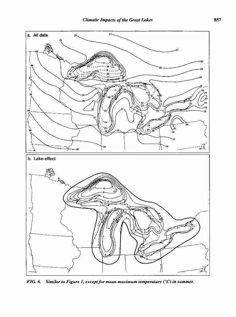
Typical diurnal heating increases summertimemean maximum temperatures over land to valueswell above those observed near the lake shore (Fig.6a). Substantially cooler conditions are indicatedover all of the Great Lakes, but not outside the 80km buffer region. Temperature anomalies of 3°C to4°C are found over the larger lakes, and maximizeat 5°C over Lake Superior. The coolest air masswithin the domain is actually found in this arearather than far north of the basin.

a. All data
b. Lake-effect
-10
Climatic Impacts of the Great Lakes
-10-------9
-ll
___________ -7
--~-~:~~~ ~-3
855
FIG. 4. Similar to Figure 1, except for mean maximum temperature eC) in winter.

856
a. All data
b. Lake-effect
8
Scott and Huff
~7 8
8
FIG. 5. Similar to Figure 1, except for mean minimum temperature (0C) in summer.
Climatic Impacts of the Great Lakes 857
a. All data
----¥---3O29
21
21-----~22
22_______ 23
24
(27
28 d~\~
b. Lake-effect
FIG. 6. Similar to Figure 1, exceptfor mean maximum temperature (OC) in summer.

858 Scott and Huff
Isotherms away from the basin again suggest thata rather zonal pattern would exist across the regionwithout the presence of the lakes, and thus, thelake-effect chart (Fig. 6b) displays substantiallycooler conditions due to the lakes. Greatest departures in mean maximum temperatures (-6°C) areobserved over northern Lake Superior. Temperaturechanges of at least -3°C are present over much ofthe three largest lakes. Lakes Erie and Ontario showchanges of -2°C.
Lake effects on summertime mean temperatures(combining Figs. 3b and 4b), suggest a net coolingeffect imposed by the lakes over Lake Superior(about -3°C) and Lake Michigan (-1°C). Conversely, the western ends of Lakes Erie and Ontarioshow slightly warmer conditions, while the effectsof Lake Huron on temperature at night are largelycanceled by opposite effects generated during theday. Results over Lake Superior are comparablewith July mean temperatures analyzed by Kopec(1967) where departures of -4°C to -5°C were indicated. He likewise found only small lake effectselsewhere, about _1°C. Gatz and Changnon (1976)show a _1°C departure in July mean temperaturesover most of Lake Michigan and _2°C in the extreme southern portion of the lake. Once again, departures there may have an urban effectsuperimposed. Besides natural variability, differences between these past studies and the present investigation were influenced from the inclusion ofJune and August data in the current work only.
Magnitudes of lake effects on temperature duringother seasons are not as great (Table 2). Mean minimum temperatures increase as a result of the lakes'presence during all seasons and over all lakes. Conversely, the influence of the lakes on mean maximum temperatures results in a cooler nearby airmass during spring and summer, but with slightlywarmer conditions over some lakes in autumn andwinter. Overall, effects on component temperatures
are smallest during spring with mean minimumtemperatures and in autumn with mean maximumtemperatures, both transitional periods. Not unexpectedly, largest and smallest absolute changes intemperature are found over Lakes Superior andErie, respectively, largely a function of their respective sizes and, thus, the amount of water mass avail~
able for air temperature modification. Once again,air masses passing over the southeasterly mostlakes typically have been influenced by first passing over the larger lakes to the north. That is, thetemperature differences between these air massesand the lake water surface is not the same as thatobserved over the larger lakes. This suggests thetendency for a smaller lake effect on temperatureover the smaller lakes.
Summary of Other Climate Conditions
The seasonal values of cloud cover, vapor pressure, and wind speed were computed from surfaceairways hourly data provided by NCDC (1986) andprepared by Petersen (1991). These data possess amuch reduced station density compared with precipitation and temperature (shown in Fig. 7). Nevertheless, lake influences on some of thesevariables are detectable and are displayed in Figures 7 and 8 and summarized in Table 3.
Cloud cover parallels the results observed withprecipitation. That is, cloud frequency is most affected by the lakes during winter due to the vastheat and moisture source the lakes provide to thelower atmosphere into the cold, dry, continentalpolar air masses moving over them (Fig. 7a). Maximum effects occur over the larger lakes and tend toreach greatest magnitudes on their eastern sides.Conversely, summertime cloudiness is reduced dueto the increased stability imparted to the lower atmosphere from the relatively cooler lake waters(Fig. 7b). As might be expected, lake-influences in
TABLE 2. Maximum temperature departures (0C) attributed to lake-effect for each ofthe Great Lakes byseason.
Mean minimum temperature Mean maximum temperature
Lake Winter Spring Summer Autumn Lake Winter Spring Summer Autumn
Superior 8 3 0 3 Superior 2 -3 -6 0Michigan 4 1 2 3 Michigan 2 ~ ~ 0Huron 4 1 3 4 Huron 1 -3 -3 1Ontario 2 1 3 3 Ontario 1 -1 -2 1Erie 1 1 3 2 Erie 0 -2 -2 0

Climatic Impacts ofthe Great.Lakes
a. Winter lake-effect
859
b. Summer lake-effect
FIG. 7. Lake-induced changes in cloud cover (tenths of sky covered) over the Great Lakesbasin in a) winter and b) summer. Dots indicate locations ofhourly data sites.

860 Scott and Huff
a. Winter lake-effect
b. Summer lake-effect
FIG. 8. Similar to Figure 7, except for average water vapor pressure (mb).

Climatic Impacts ofthe Great Lakes 861
TABLE 3. Maximum departures (0C) in cloud cover and vapor pressure attributed to lake-effects for theGreat Lakes by season.
Cloud cover Vapor pressure
Lake Winter Spring Summer Autumn Lake Winter Spring Summer Autumn
Superior 25 0 0 0 Superior 0 4 -8 3Michigan 25 0 -9 11 Michigan 15 0 -6 6Huron 15 0 -12 0 Huron 17 0 0 12Ontario 7 0 0 5 Ontario 14 0 -4 3Erie 7 0 0 5 Erie 0 0 -2 3
summer are smaller in magnitude than those duringwinter. Summertime cloud reductions are relatedstrongly to daytime heating over the adjacent landwhile the relatively warmer lake water conditionsinfluencing wintertime cloud cover occur nocturnally, as well.
Even so, it is likely that the extent of summertimereductions in cloud cover are greater than what isshown here. In general, cloud reductions in summerare limited predominantly to the skies directly overthe lakes. However, due to the lake breeze phenomenon, clouds frequently form just inland from thelake shore and offset cloud reductions as viewedfrom lake shore sites. Cloud data from over-lake regions would be required to document the full extentof lake-induced summertime cloud reductions.
Values of average water vapor pressure parallelthose of temperature and show strongest lake influences (increasing values) across the central part ofthe basin during winter and autumn (Table 3).These are seasons when the relatively warmer lakewaters provide a high moisture source to the surfaceboundary layer above the lakes and a direct effecton vapor pressure. Wintertime increases appearmost associated with Lakes Huron, Michigan andOntario (Fig. 8a). However, the lack of sufficientlake shore sites, especially east of Lake Superior,was a large limiting factor in the analysis. Althoughactual vapor pressure is higher in summer than inwinter, substantial sources of moisture exist overthe land in the warmer seasons (evaporation andtranspiration) that are not present in the cooler seasons. Therefore, variations across the lake-landboundaries are reduced. Due to the relatively coolerwater temperatures, lake effects in summer generally decrease water vapor pressure, but in reality,changes are small. Maximum effects that straddlesouthern Lake Superior and Michigan's UpperPeninsula do not exceed 8%.
Lake effects on wind speed, generated by differ-
ences in land-lake surface roughness and land andlake breeze thermal circulations, are well-documented in the literature. Nevertheless, data fromthe sparse number of long-term climate stationspresented here do not reveal detectable lake influences. Averaging of hourly reports greatly smoothshort term diurnal wind speed anomalies generatedby the lakes. In addition, wind speed measurements are influenced strongly by local topographyand instrument exposure. All of these factors mayhave masked lake influences beyond the point ofdetection.
SUMMARY AND CONCLUSIONS
This paper summarizes the results of an effort toincorporate the findings of previous investigators,along with those generated by our recent research,into a ready reference on much of the quantitativeimpacts of the Great Lakes on regional climate conditions within the entire basin of the five lakes.Such information is not presently available, but represents a pertinent need to hydrologists, meteorologists, climatologists, and others concerned with theproblems generated by this huge inland water body.
Average spatial distributions of seasonal climateconditions over the entire Great Lakes basin wereinvestigated to derive estimates of lake-induced influences on six weather parameters: precipitation,mean maximum and mean minimum temperatures,cloud cover, vapor pressure, and wind speed. Effects were estimated by first analyzing each variable using all data within the basin, and thenperforming a second analysis which eliminated datawithin an 80-km buffer zone around the lakes. Aquantitative measure of lake-effects was obtainedby a comparison of these two analyses. The analytical intent was to remove as much lake effects aspossible from the climatic record, leaving primarilythe synopticly-derived influences on each parame-

862 Scott and Huff
ter. Aggregate lake effects likely were not resolvedadequately by this research as was indicated insome analyses. However, the substantial local effects observed just downwind of each lake appearsto have been documented well in most cases for theparameters investigated.
Lake effects are observed most clearly in precipitation and temperature with considerable variationbetween seasons. However, lake influences arefound also in other weather variables examined. Results generally confirm theory and analyses fromprevious research. Analyses indicate that the greatest modification occurs over and just downwind (tothe east and southeast) of all lake shores while upwind regions are only minimally affected. Observeddifferences between this study and those in the pastare likely due to natural temporal and spatial variability across the basin. Due to the strong subjectivenature of this and many prior works, it would bedifficult to suggest anyone study as presenting amore accurate analysis. Nevertheless, this is thefirst work to specify the local seasonal influencesby all lakes on these variables.
The use of an 80-km band around the GreatLakes in order to encompass all lake effects appeared to be adequate for this study. Discriminationbetween lake effects and topographical influenceson climate conditions, especially large just to theeast of the basin, was not undertaken. Although,only partial results are presented here, a full reportis available (Scott and Huff 1996).
In conclusion, our work has provided new quantitative evidence of the magnitude of lake effects onseveral climate variables. Nevertheless, the lack ofa good quality, high density, long-term climate datanetwork across the entire basin is a limiting factorin any future effort to define lake effects more precisely. This is especially true in the documentationof cloud cover, vapor pressure, and wind speed, butalso to a lesser degree in quantification of precipitation and temperature variations within sub-basinsaround the lakes. One suggested improvementwould be a cloud climate study using infrared satellite imagery over the region as the period-of-recordof these data increase towards an acceptable climatenorm. Improved sensors within current and futuresatellite imagery and NEXRAD radar facilities,combined with surface measurements, should assistin quantifying conditions in data void areas. Finally,development of an alternative technique to incorporate greater resolution of aggregate lake effectswould be beneficial.
ACKNOWLEDGMENTS
The authors wish to thank Stanley A. Changnonand Kenneth E. Kunkel of the Illinois State WaterSurvey for their review and comments on the manuscript. We extend thanks to Linda Mortsch of Environment Canada for arranging access to theCanadian data. In addition, we sincerely appreciatethe work of Water Survey staff members, DaveCox, for his assistance in preparation of the illustrations, and Jean Dennison for her professional wordprocessing support. This work is supported underNOAA Grants COM NA16WN0351-01 and COMNA27RA0173-0l.
REFERENCESAugustine, LA., Woodley, W.L., Scott, R.W., and
Changnon, S.A. 1994. Using geosynchronous satelliteimagery to estimate summer-season rainfall over theGreat Lakes. J. Great Lakes Res. 20:683-700.
Blust, F., and DeCooke, B.G. 1960. Comparison of precipitation on islands of Lake Michigan with precipitation on the perimeter of the lake. J. Geophys. Res.65: 1565-1572.
Bolsenga, S.J. 1977. Lake-land precipitation relationships using northern Lake Michigan data. J. Appl.Meteor. 16:1158-1164.
Boudra, D.B. 1981. A study of the early winter effects ofthe Great Lakes. I: Comparison of very fine scalenumerical simulations with observed data. Mon. Wea.Rev. 109:2507-2526.
Braham, R.R., Jr., and Dungey, M.J. 1984. Quantitativeestimates of the effect of Lake Michigan on snowfall.J. Climate & Appl. Meteor. 23:940-949.
___, Jr., and Dungey, M.J. 1995. Lake-effect snowfall over Lake Michigan. J. Appl. Meteor.34:1009-1019.
Canada Department of Transportation 1968. ClimaticNormals, Vol. 3: Sunshine, Clouds, Pressure andThunderstorms. Toronto, Ontario: MeteorologicalOffice.
Changnon, S.A. 1966. Effect of Lake Michigan onsevere weather. In Proc. 9th Con! Great Lakes Res.15, pp. 220-234.
____. 1968. Precipitation Climatology of LakeMichigan Basin. Urbana, Illinois: Illinois State WaterSurvey, Bulletin 52.
Colucci, S.J. 1976. Winter cyclone frequencies over theeastern United States and adjacent western Atlantic:1964-1973. Bull. Amer. Meteor. Soc. 57:548-553.
Comer, N.T., and McKendry, I.G. 1993. Observationsand numerical modeling of Lake Ontario breezes.Atmosphere-Ocean. 31:481-499.
Cox, H.J. 1917. Influence of the Great Lakes uponmovement of high and low pressure areas. In Proc.Second Pan American Sci. Congress 2(2), pp.432-459.

Climatic Impacts ofthe Great Lakes 863
Danard, M.B., and McMillan, A.C. 1974. Further numerical studies of the effects of the Great Lakes on wintercyclones. Mon. Wea. Rev. 102:166-175.
___, and Rao, G.V. 1972. Numerical study of theeffects of the Great Lakes on a winter cyclone. Mon.Wea. Rev. 100:374-382.
Dare, P.M. 1981. A study of the severity of the Midwestern winters of 1977 and 1978 using heating degreedays determined from both measured and wind chilltemperatures. Bull. Amer. Meteor. Soc. 62:974-982.
Day, P.C. 1926. Precipitation in the drainage area of theGreat Lakes, 1875-1924. Mon. Wea. Rev. 54:85-106.
Eichenlaub, V.1. 1970. Lake effect snowfall to the lee ofthe Great Lakes: Its role in Michigan. Bull. Amer.Meteor. Soc. 51:403-412.
Environment Canada. 1982. Canadian Climate Normals,Vol. 5, Wind, 1951-1980. Downsview, Ontario: Canadian Climate Centre.
____. 1984. Canadian Climate Normals, Vol. 8,Atmospheric Pressure, Temperature, and Humidity,1951-1980. Downsview, Ontario: Canadian ClimateCentre.
Estoque, M.A, and Gross, J.M. 1981. Further studies ofa lake breeze. Part II: Theoretical study. Mon. Wea.Rev. 109:619-634.
Gatz, D.F., and Changnon, S.A 1976. Atmospheric environment of the Lake Michigan drainage basin. Volume 8 in Environmental Status of the Lake MichiganRegion. ANLlES-40. Argonne, Illinois: ArgonneNational Laboratory.
Groisman, P.Y., and Legates, D.R 1994. The accuracyof United States precipitation data. Bull. Amer.Meteor. Soc. 75:215-227.
Hjelmfelt, M. 1988. Numerical sensitivity study of themorphology of lake-effect snow storms over LakeMichigan. In Proc. 10th Int. Conf Cloud Physics, pp.413-415. Bad Homburg, F.RG.
Horton, R.E., and Grunsky, G.E. 1927. Hydrology of theGreat Lakes. Chicago, Illinois: Chicago Sanitary District Report.
Hunt, LA. 1959. Evaporation of Lake Ontario. J.Hydraul. Div. 85:13-33.
Kopec, RJ. 1967. Areal patterns of seasonal temperatureanomalies in the vicinity of the Great Lakes. Bull.Amer. Meteor. Soc. 48:884-889.
Kristovich, D.A.R., and Steve, R 1995. A satellite studyof cloud band frequencies of the Great Lakes. J. Appl.Meteor. 34:2083-2090.
Larson, L.W. 1971. Shielding precipitation gages fromadverse wind effects with snow fences. Laramie,Wyoming: Water Resources Research Institute Series25.
Lyons, W.A. 1966. Some effects of Lake Michigan uponsquall lines and summertime convection. Chicago,Illinois: Univ. Chicago Satellite Mesometeor.Research Project Paper 57.
National Climatic Data Center (NCDC). 1986. Surface
Airways Hourly. Asheville, North Carolina. U. S.Dept. Com. TD-3280.
Passarelli, R.E., Jr., and Braham, RR, Jr. 1981. The roleof the winter land breeze in the formation of GreatLakes snow storms. Bull. Amer. Meteor. Soc.62:482-491.
Petersen, M.A. 1991. Guide to hourly surface meteorological data. Champaign, Illinois: Midwestern Climate Center Pub. 91-02.
Petterssen, S., and Calabrese, P.A. 1959. On someweather influences due to warming of the air by theGreat Lakes in winter. J. Meteor. 16:646-652.
Phillips, D.W. 1972. Modification of surface air overLake Ontario in winter. Mon. Wea. Rev. 100:662-670.
Reinking, R.F., Caiaszza, R, Kropfi, R.A, Orr, B.W.,Martner, B.E., Niziol, T.A, Byrd, G.P., Penc, R.S.,Zamora, R.J., Snider, J.B., Ballentine, R.I., Stamm,AJ., Bedford, C.D., Joe, P., and Koscienly, A.J. 1993.The Lake Ontario Winter Storms (LOWS) project.Bull. Amer. Meteor. Soc. 74:1828-1849.
Scott, RW., and Grosh, RC. 1979. Chicago area clouddistributions from satellite photography. In Studies ofUrban and Lake Influences on Precipitation in theChicago Area. Vol. II. Champaign, Illinois: IllinoisState Water Survey Contract Report 220.
___. and Huff, F.A. 1996. Lake effects on climaticconditions in the Great Lakes basin. Champaign, Illinois: Midwest Center Research Report.
Strommen, N.D. 1968. Michigan snowfall statistics:First 1-, 3-, 6-, and 12-inch depths. Lansing, Michigan: Michigan Dept. of Agriculture.
___, and Harman, J.R. 1978. Seasonally changingpatters of lake-effect snowfall in western Lake Michigan. Mon. Wea. Rev. 106:503-509.
Strong, A.E. 1972. The influence of a Great Lake anticyclone on the atmospheric circulation. J. Appl. Meteor.11:598-612.
Sousounis, P.J., and Fritsch, J.M. 1994. Lake-aggregatemesoscale disturbances. Part II: A case study on theeffects on regional and synoptic-scale weather systems. Bull. Amer. Meteor. Soc. 75:1793-1811.
Warnick, C.C. 1956. Influence of wind on precipitationmeasurements at high altitudes. Moscow, Idaho:Univ. of Idaho Engineering Exp. Sta. Bull. 10.
Weber, M.R. 1978. Average diurnal wind variation insouthwestern lower Michigan. J. Appl. Meteor.17:1182-1189.
Wilson, J.W. 1977. Effect of Lake Ontario on precipitation. Mon. Wea. Rev. 105:207-214.
Wylie, D.P., and Young, J.A. 1979. Boundary-layerobservations of warm air modification over LakeMichigan using a tethered balloon. Boun. Lay.Meteor. 17:279-291.
Submitted: 4 December 1995Accepted: 1 August 1996