ii the effect of rainrate modeling for the...
TRANSCRIPT

ii
THE EFFECT OF RAINRATE MODELING FOR THE PREDICTION OF
SATELLITE PROPAGATION IN MALAYSIA
AYMAN.A.A. ALWARFALLI
A project report submitted in partially of the requirements for the award of the Degree
of Master of Electrical –Electronic Telecommunication Engineering
Faculty of Electrical Engineering
University Teknologi Malaysia
NOVEMBER 2005

iv
DEDICATIONS
To my beloved parents, brothers, and sisters.

v
ACKNOWLEDGEMENTS
My highest appreciation naturally belongs to my supervisor, PM Dr. Jafri Bin Din.
Who is also given a number of valuable advices to enhance this project. A special
thanks to Dr. Norhisham who has inspired me at the final stage of this project. A
sincere thank to Prof. Dr. Tharek for his kind and unselfish advices.
Special thanks to my brother Segaier for his full support all these years. Sweet
thanks to all my friends in G29 and S 46 for making my life a tasteful one.

v
ABSTRACT
By increasing number of commercial applications are being promoted for
future satellites broadband services, the appearance of such systems with due to its
growing demand for radio frequency spectrums. Since lower frequencies have
become saturated, a transition to higher frequencies band such as Ka-band (20/30
GHz) and above has become necessary. These bands are attractive because it offers
wider bandwidth, higher data rates and smaller component sizes. On the other hand,
higher frequencies have more propagation problems. Attenuation caused by rain is
major limitation can be a serious problem especially in the tropical regions. In
Malaysia, the tropical climate effects study for higher frequency band become
increasingly important. The main concern of this project is therefore, to study and
analyze the measured field data of the rain attenuation within these bands. To
achieve this, previous researchers measured field data are studied and analyzed to
understand the behavior of signal propagation during rainfall event, particularly for
Malaysia. To achieve this goal, various experiments were conducted using
microwave links, satellite broadcasting receiver and rain gauges. An overview of
published and proposed prediction model of rain attenuation on satellite link is
discussed based on this data, the latest developments in prediction and modeling
techniques presented and discussed. Moreover, a proposed prediction model of rain
attenuation in Malaysia is employed and tested, in order to determine the rain
attenuation of slant and terrestrial path. The project goals are extended to an
adaptive prediction model of the specific attenuation, rain height and effective
horizontal length. With the verifications of the proposed model using ITU-R (Study
Group3), it is possible to improve the efficiency of satellite communication in
Malaysia with an improved design for future broadband and multimedia satellite.
vi
ABSTRAK
Peningkatan terhadap aplikasi komersil telah memperkembangkan lagi perkhidmatan jalur
lebar satelit pada masa sekarang dan akan datang. Kemunculan sistem ini adalah seiring dengan
pertambahan permintaan terhadap spektrum frekuensi radio. Memandangkan frekuensi rendah telah
menjadi tepu, peralihan kepada jalur frekuensi-frekuensi tinggi seperti jalur-Ka (20/30 Ghz) dan ke
atas sangat diperlukan. Jalur-jalur ini menarik kerana ianya menyediakan lebar jalur yang luas, kadar
data yang tinggi dan saiz komponen yang kecil. Namun , frekuensi-frekuensi tinggi mempunyai lebih
banyak masalah peranbatn. Pelemahan yang disebabkan oleh hujan merupakan pembatasan utama
yang boleh menyebabkan masalah yang serius terutama dikawasan-kawasan tropika. Dalam iklim
tropika di malaysia, kajian pelemahan oleh hujan pada jalur berfrekuensi tinggi menjadi sangat
penting. Tujuan utama projek ini dijalankan adalah untuk mengkaji pelemahan oleh hujan dalam
lingkungan jalur-jalur ini. Bagi mencapai objektif ini, data-data daripada kajian terdahulu telah
dianalisa untuk memahami sifat perambatan isyarat semasa hujan. Sumber-sumber untuk data ini telah
diuruskan secara eksperimen menggunakan talian gelombag micro, penerima penyiaran satelit dan
tolok hujan. Kajian secara umum berkaitan penulisan dan model cadangan jangkaan pelemahan oleh
hujan pada perhuaurgen satelit telah dibincangkan dengan berdasarkan kepada data, dan juga
perkembangan-perkembangan terkini dalam penentuan dan teknik-teknik pemodelan. Cadangan
model jangkaan pelemahan oleh hujan di malaysia telah digunakan dan diuji, bertujuan untuk
menentukan pengecilan oleh hujan pada lalvan uagak dan mendatar. Matlamat projek telah
diperkembangkan lagi kepada model jangkaan penyesuaian spesifikasi pelemahan, ketinggian hujan
dan lalvan mendatar effektif. Dengan pengesahan model cadangan yang menggunakan ITU-R
(kumpulan perbincangan 3) yang mana mengkaji keberkesanan komunikasi satelit di malaysia boleh
dipertingkatkan lagi untuk tujuan rekabentuk jalur lebar satelit dan multimedia pada masa akan datang.

TABLE OF CONTENTS
CHAPTER
SUBJECT
PAGE
DECLARATIONS iii
DEDICATIONS iv
ACKNOWLEDGEMENTS v
ABSTRACT vi
ABSTRAK vii
TABLE OF CONTENTS viii
LIST OF TABLES xiv
LIST OF TABLES xv
LIST OF FIGURES xviii
LIST OF SYMBOLS xx
LIST OF ABBREVIATIONS
LIST OF APPENDICES xxi
1 INTRODUCTION 1
1.1 Introduction 1
1.2 Project Background 3
1.3 Problem Statement 7
1.4 Objectives of the Project 8
1.5 Research Scope and Methodology 9
1.6 Thesis Outline 13

2. SATELLITE COMMNICATION AND CLIMATE
THEORIES
14
2.1 Introduction 14
2.2 Satellite Communications 16
2.2.1 Satellite System Fundamentals 17
2.2.2 Frequency Spectrum 18
2.2.3 Satellite Communications Features 19
2.2.4 Rainfall Impact on Satellite Link 20
2.3 Rainfall Structure and Types 21
2.3.1 Principles Sources of Rainfall Data 22
2.3.2 Malaysia Climate and Rainfall
Distribution
23
2.3.2.1 ITU-R Global Rainfall Rate Model 24
2.3.2.2 Crane Global Rainfall Rate Model 25
2.3.2.3 Moupfouma Rainfall Rate Model 25
2.4 Rain Vertical Profile 26
2.5 Summary 29
3. RAIN ATTENUATION MODELS 30
3.1 Introduction
30
3.2 Rain Attenuation Modeling 30
3.3 Specific Rain Attenuation Models 33
3.3.1 ITU-R Model for Specific Attenuation 35
3.4 Effective Path Length 36
3.4.1 Effective Terrestrial Path 37
3.4.1.1 Moupfouma Reduction Factor
Model
38
3.4.1.2 CETUC Reduction Factor Model 38
3.4.1.3 Garcia Reduction Factor Model 39
3.4.2 Slant Path Prediction Models 40

3.4.2.1 ITU-R Slant Path Prediction Model 41
3.5 Summary 44
4.
THE METHODOLOGY OF WORK
45
4.2 The Overall Project Methodology 46
4.3 Rainfall Rate Modeling 47
4.4 Specific Rain Attenuation Model 48
4.5 Effective horizontal path 50
4.6 Effective Rain Height Model 52
4.7 Verification of the Proposed Model 53
4.7.1 Testing Criteria for Comparing Prediction
Methods
53
4.7.2 Physical Basis of the Testing Method 54
4.7.2.1 The Model Simplicity 54
4.7.3 Testing Variable for Comparing Rain
Attenuation Predictions
55
4.7.3.1 Procedure of the Model
Performance Analysis
55
4.7.3.2 The Curve Fitting Method 57
4.8 ITU-R Study Group Three Data Bank 57
4.9 Summary 59
5.
RESULTS AND ANALYSIS
60
5.1 Introduction 60
5.2 Rainfall Rate Data Analysis 61
5.2.1 Surface Point Rainfall Rate Modeling 61
5.2.2 Rainfall Rate Data at UTM-Skudai Site 62
5.2.3 Rainfall Rate Data at Various Locations in
Malaysia
65
5.2.4 Rainfall Rate Data at Various Locations in
Tropical Sites
66

5.3 Specific Rain Attenuation 69
5.3.1 Short path Rain Attenuation Data Description 69
5.3.2 Comparison of the Specific Attenuation
Models
71
5.3.3.1 Analysis of Din and Ajayi Models 73
5.3.3.2 Modification and Analysis of Din
and Ajayi Models
75
5.3.3.3 Verification of the Modified Model 78
5.4 Rain Attenuation Data for Long Terrestrial Path 80
5.4.1 The Measured Effective Path Length 81
5.4.2 Comparison of Measured and Predicted
Effective Path Length
82
5.4.3 Proposed Effective Path Model 85
5.4.4 Verification of the Proposed Model 87
5.4.5 Discussion of the Result 90
5.5 Satellite Path Descriptions 91
5.5.1 Slant Path Rain Attenuation Data 91
5.5.2 Surface Rain Data Measurements 92
5.5.3 The Effective Rain Height 93
5.6 Summary 95
6.
CONCLUSION AND RECOMMENDATIONS
97
6.1 Conclusion 96
6.2 Future work
98
REFERENCES 99
APPENDICES A – X 105

LIST OF TABLES
TABLE TITLE
PAGE
2.1 Satellite frequency spectrum 18
2.2 ITU-R Annual rain rate cumulative distributions for region P 25
2.3 Annual rainfall rate cumulative distribution for region H 25
5.1 Rainfall measurements specifications at UTM-Skudai. 62
5.2 The averaged one year cumulative distribution at UTM-skudai 63
5.3 Rainfall Measurements at various sites at Malaysia. 65
5.4 Measurements specifications at various locations in tropical 67
5.5 Specific attenuation model specifications 69
5.6 Short path data specification at UTM-Skudai 70
5.7 The statistical test result of the specific attention model. 72
5.8 Measurements of specific rain attention at Singapore 78
5.9 The measurements of the long terrestrial path at Malaysia site 80
5.10 The horizontal reduction factor models 83
5.11 Measurements of rain attenuation data at several locations in
tropics
87

LIST OF FIGURES
FIGURE TITLE
PAGE
1.1 The methodology diagram of overall project 10
2.1 Hydrometeor effects over the satellite path 20
2.2 The climatic zones and rainfall rate. 24
2.3 The three rain height terms. 27
3.1 Volume of spherical, uniformly distributed Raindrops. 32
3.2 Schematic presentation of an Earth-space path. 41
4.1 The block diagram of the rainfall rate model comparison. 47
4.2 The block diagram of the specific rain attenuation process. 49
4.3 The block diagram for processing the effective path length. 51
4.4 Screen shoot of the user graphical interface window of the
DBSG5.exe
58
5.1 Several years measurements of the exceeded rainfall rate at
UTM-Skudai.
63
5.2 Averaged one year statistic at UTM site against rainfall rate
models.
64
5.3 The performance of Moupfouma model several sites in
Malaysia.
66
5.4 Exceedance rainfall rate distribution in tropical sites Vs
Moupfouma model
68
5.5 measured specific rain attenuation data at UTM site with
rainfall rate
70
5.6 The performance of the specific attenuation models against
measured data at UTM-skudai
71
5.7 Comparison between Ajayi and Din model performance

against measured attenuation 74
5.8 The Matlab curve fitting results for Din model 75
5.9 The Matlab curve fitting results for Ajayi model 76
5.10 The comparison between modified din and modified Ajayi
models
77
5.11 Comparison between the modified Din models with other
models against measured data at UTM-Skudai
77
5.12 The measured rain attenuation frequencies band at Singapore
site.
79
5.13 Shows the RMS of Percentage of error of the models
performance.
79
5.14 The sample for 11.87 effective path results with averaged
effective path along all the path lengths.
82
5.15 Comparison the effective path model performance 84
5.16 The fitting curve of the averaged effective path length 86
5.17 Measured attenuation at Uganda against proposed model 87
5.18 Measured attenuation at Brazil against proposed model 88
5.19 Measured attenuation at Congo against proposed model 89
5.20 The MEASAT satellite Footprint 91
5.21 Cumulative Distribution of Rain Attenuation 92
5.22 Figure Cumulative Distribution of rainfall rate 93
5.22 The effective rain height conducted at UTM-Skudai. 94

LIST OF SYMBOLS
A Attenuation
A0.01 Attenuation at 0.01% of time
Am Measured attenuation
Ap Predicted attenuation
dB Decibel unite
f Frequency
GHz Giga Hertz
ho Rain freezing height
HR Rain height (km)
Hs Height above mean sea level of the earth station (km).
k, α Regression coefficients
km Kilometer
Leff Effective Path length
LG Horizontal projection of the slant path
Lo Rain cell diameter
L path length
m Meter
mm Millimeter
P (%) Percentage in time of the year
R(p) Rain rate at percentage in time of the year
r(P) Horizontal reduction factor of percentage in time of the year
r0.01 Horizontal reduction factor for 0.01% time of the year
R0.01 Rain rate at 0.01% of time of the year
v0.01 Vertical reduction factor for 0.01% time of the year
γR Specific attenuation
θ Elevation Angle
Φ Latitude of the earth station
τ Polarization Tilt angel

μV Statistical mean
σV Standard deviation
ρV Root Mean Square

LIST OF ABBREVIATIONS
C Centigrade
DBSG5 ITU-R Study Group Three Data Bank
DTH Direct to Home
EHF Extremely High Frequency
EIRP Effective Isotropic Radiating Power
FSS Fixed Satellite Service
GEO Geosynchronous Earth Orbit
IEEE Institute of Electrical and Electronic Engineering
ITU-R International Telecommunication Union Radio-Broadcasting
LEO Low Earth Orbit
MEO Medium Earth Orbit
MMS Malaysia Metrological Services
RF Radio Frequency
RMS Root Mean Square
SHF Super High Frequency
TRMM Tropical Rainfall Measuring Mission
U.S United State of America
UTM Universiti Teknologi Malaysia
VSAT Very Small Aperture Terminal

LIST OF APPENDICES
APPENDIX TITLE
Appendix A
The ITU-R specific attenuation parameters.
Appendix B
The Din and Ajayi attenuation parameters.
Appendix C
IEEE Attenuation Parameters.
Appendix D
MATLAB Program for rain fall rate.
Appendix E
MATLAB Program for specific attenuation.
Appendix F
MATLAB Program for effective horizontal path.
Appendix G
MATLAB Program for effective rain height.

CHAPTER 1
INTRODUCTION
1.1 Introduction
Satellite communications systems become an important segment of the global
telecommunication infrastructure. This includes an integration of number of
applications and services use the satellites to relay radio transmissions between earth
terminals. These services had traditionally been available via terrestrial networks and
radio broadcastings.
With the rapid growth of the information technology there is an increasing
demand for broadband satellite services, which will provide reliable transmission of
information. Multi-media applications including data and video require large
bandwidth and low error rates for satisfactory performance. This demand will exceed
the present services existence today, and there will be increasing problems of finding
the required frequency spectrum to provide the bandwidth for broadband services,
which has brought saturation to the conventional frequency bands allocated for
satellite services, namely L (1/2 GHz), S (2/4 GHz), and C (4/6 GHz).

2
New and demanding satellite applications evolved has led to utilize and exploit
a higher frequencies bands such as Ka-band (20/30 GHz) and above. Spectrum at
Ka-band (20/30 GHz) or higher frequencies band is great importance for broadband
services. This is because it’s relatively unused spectrum with no congestion problem,
which offers much greater bandwidths, frequency reuse capability than the current
spectrum at Ku-band (11/12 GHz), and smaller component sizes.
Satellite signal propagation above 10 GHz over an atmosphere is a subject of
impairs and natural phenomena such as, gaseous attenuation, cloud and fog attenuation,
and rain attenuation. Those are degrading the propagation of satellite signal on the
path. Unfortunately, as frequency increases, so does the impact of atmospheric
conditions on the radiowave propagation (L. J. Ippolito, 1986). That is resulted a
reduction in the quality of analog transmissions, and increasing in the bit error rate of
digital transmissions, which is caused a reduction on the availability, and the reliability
of the satellite systems performance at higher frequencies band.
The issue of greatest importance in the study of the performance of microwave
and satellite links is rain attenuation. In the design of such systems, the attenuation
due to rain must be accurately accounted using prediction model to ensure the
reliability and availability of the system during the rain event. Systems that are poorly
designed lead to an increase in transmission errors, or worst, to an outage in the
received signal (L. J. Ippolito, 1986).
The prediction model developments have to rely on rain process statistics
which could contain an insufficient amount of data for long-term predictions.
Especially for tropical climates which are vaguely understood of the rain fall structure
as compared to climate regions in temperate regions such as North-America or Europe
where the largest number of observing stations are located. Therefore, the practical
solution has been discussed by Moupfouma (1994), where the rainfall rate model has
been modeled to be applicable to use in tropical regions.

3
1.2 Project Background
Rain attenuation is one of the most fundamental limitations on the performance
of the satellite links above 10 GHz. Rain attenuation caused by scattering and
absorption by water droplets, causing large variations in the received signal power,
with little predictability and many sudden changes (Freeman, 1997). Thus, the
knowledge of the rain attenuation is extremely required for a design of a reliable
satellite system. According to Lin (1977), to overcome these limitations an accurate
statistical prediction model is required to improve the system performance during a
heavy rain fall.
Rain attenuation researches were began by Ryde studies (1945) carried out in
the year immediately following World War II. Lin (1977) developed a published
prediction model based on experimental data in United State. Crane (1980) presented
a model for estimating rain attenuation on either terrestrial or slant satellite paths. The
development of these models has proceeded from these early studies to the present
with further enhancement and improvement.
The primary goal of a rain attenuation prediction method is to achieve
acceptable estimates of the attenuation incurred on the signal due to rain. According to
Lin (1977), in order to predict a reliable and accurate rain prediction model, it is
required to determine the one minute integration time of rain fall rate together with
direct measurements of rain attenuation. Therefore, unavailability of time for reliable
communication systems in a year (Outage time) has to be kept at 0.01 percent of time.
This corresponds to 99.99 percent of time availability for one year (ITU-R, 1997).

4
Stutzman et al. (1986) developed a simple rain attenuation model for
earth-space radio links operating at 10-35 GHz. The model takes into account the
effect of wave polarization and was verified by observations in a database created from
62 experiments conducted in the U.S.A., Europe, and Japan. Goldhirsh et al. (1992)
computed rain rate statistics and rain distributions at 20 and 30 GHz derived from a
network of rain gauges along the mid-Atlantic coast over a five-year period.
Dissanayake et al. (1997) combined rain attenuation and other types of propagation
impairment along earth-satellite paths in a prediction model whose estimates of
propagation impairment were compared with simultaneous-beacon and radiometer
measurements.
While numerous studies have demonstrated good agreement between model
predictions and field measurements in the estimates of propagation impairment, most
of them have primarily focused upon regions in the middle and high latitudes such as
United State of America and European countries. Those are mainly applicable to use
in the regions of higher latitude.
The effect of rain is more critical for countries located in tropical and
equatorial regions which experience a high rainfall rate throughout the year.
According to Moupfouma (1994), when those models are applied to tropical regions
the performances are lower than accepted, and the results of these researches indicate
poor agreement between the measured and predicted attenuations. This has been
considered due to significant climatic difference between temperate region and the
tropical region.
Therefore, researches have been conducted at tropical countries such as, Brazil,
Singapore, and Malaysia (Chebil, 1997), in order to get a better performance in term of
more accurate results and well suited to the local climatic conditions in tropical
countries. Moupfouma (1984) indicates that since the rain drops in tropical regions are
larger than the temperate regions, the incidence of rainfall becomes more critical as
low as 7 GHz.

5
In 1997, the Tropical Rainfall Measuring Mission (TRMM) satellite was
launched as a joint project between the U.S.A. and Japan that carries the first space
borne rain radar. Because of the rapid progress in space borne sensor technology,
many studies on space-based remote sensing have also been performed in recent years.
Malaysia has a tropical climate weather which experiences a high rainfall rate
throughout the year. The mean annual rain fall ranging between 2400 mm to 3200
mm per year (Chebil,1997). Geographically the rainfall pattern is greatly influenced
by its oceanic surrounding. Therefore, Malaysia was involved in the world researches
competition toward to the satellite system technology in order to enhance the existing
satellite services and to access the globalization for the future satellite technology
Researches have been carried out in the early 1990’s at Universiti Teknologi
Malaysia (UTM) by Tharek (1994), Din (1997), Chebil (1997), Rafiqul (2000),
Kareem, (2000), Asrul (2002), and Sum (2002). Almost all of these studies were
focused on the signal propagation of the microwave links, and only limited
experiments were conducted for satellite link. Recently, it has become increasingly
important to develop sophisticated prediction model to improve the satellite
communications services in Malaysia.
The parameters investigated in this project are mainly rain attenuation beyond
the rain rate modeling. The problem of predicting attenuation by rain is quite difficult,
because of non-uniform distribution of rainfall rate along the entire path length (L. A.
R. Silva Mello et al, 2002). According to Lin (1977), the path is divided into small
incremental volumes, which the rainfall is approximately uniform. The rainfall rate in
each small volume is associated with a corresponding attenuation called specific
attenuation, and the multiplication of the specific attenuation along the rainy path
presents the total attenuation along the path.
6
Generally, for the microwave link path which is known as terrestrial path, the
horizontal reduction factor is taken into account for inhomogeneity distribution of
rainfall horizontally. Which cause the effective path length is shorter than the actual
path length, where the effective path length is approximately the cell diameter length
(Bruce R. E., 1997).
An effort has been developed to give a better understanding of the effective
path length concept and its dependence on metrological factors and link parameters.
Almost of these reduction factors were derived in purely empirical method at a number
of geographical locations (Crane, 1980). According to Dissanayake (1990) based on
radiometric rain attenuation measurements in Peru. The most probable cause for the
overestimation of attenuation is the horizontal factor reduction factor, which is not
applicable to climates dominated by tropical high rainfall rate.
Specifically, for this project the main concern is to calculate the rain
attenuation along the satellite path which is known as slant path. The rain has
non-uniform distributions in both horizontal and vertical directions along the slant
path. That caused more difficulties to consider the horizontal reduction factor concept
within the variation of the vertical structure of the rain height. Therefore, the vertical
adjustment factor has been established to adapt the limitations of horizontal reduction
factor.
According to Bandera et al. (1999), it is more applicable to use a vertical
adjustments factor on the calculation of an effective path length for the slant path.
Furthermore, this effective path length used to establish an accurate prediction model
of the rain attenuation over the satellite path. Generally, a few studies have been
conducted on the vertical adjustment factor comparing to horizontal reduction factor,
these studies mainly based on meteorological radar reflectivity.

7
Practically, the number of terrestrial links experimental available is much
higher than the satellite experimental data, which it has given the opportunity to study
the usage of the horizontal reduction model as a function to develop an accurate
prediction model of the slant path.
According to Goldhirsh (1979), there are high correlation between attenuation
on the terrestrial path and the slant path at low elevation angel. Furthermore, for low
and medium elevation angles, the horizontal variability of the specific attenuation is
greater than that in the vertical plane. Therefore, an overall concentration of this
project has taken into account the slant effective rainy path concept to overcome the
limitation of the horizontal reduction factor whish can cause the effective path to be
more than the actual slant path.
According to Bandera et al, (1999), for high elevation angles the fixed specific
attenuation concept approximation cannot be applied and the better approach is using
vertical adjustment factor for the prediction of rain attenuation along the slant path.
Therefore, the ultimate concern of this project is to address this issue and propose an
appropriate prediction model for Malaysia tropical climate based on point rainfall
modeling.
1.3 Problem Statement
The problem statements of this project are stated in the following points:
i. The incapability of the published prediction models to be sensitive of
the available knowledge of rainfall on Malaysia climate.

8
ii The lack of satellite propagation studies in Malaysia, especially for
higher frequencies band.
iii. The lack of the knowledge in the vertical profile of rainfall structure.
iv. The weakness of using surface point rainfall (rain gauges)
measurements.
1.4 Objectives of the Project
The objective main approach is to develop a prediction model of the rain
attenuation for slant path and terrestrial path, in order to enhance the existing satellite
services at Ku-band, and to propose a new design parameter for future satellite systems
at higher frequency band. The specific objectives of this project can be summarize as
follow
i. To provide an up to date review of the published and proposed rain
attenuation models, and study on the performance of these models
within Malaysia tropical climate and geographical parameters.
ii. To use the local experimental data to enhance the prediction techniques
for satellite path instead of using the theoretical models, those are
mainly based on experimental data of temperate regions.

9
iii. To develop a simple and accurate rain attenuation prediction
techniques in Malaysia based on rain rate modeling which included:
Rain rate modeling.
Specific rain attenuation.
Effective horizontal path.
Effective rain height.
A computer program has been developed to calculate the slant path rain
attenuation and terrestrial path rain attenuation based on the actual measured
attenuation strength which in turn used for comparison with available prediction
models.
1.5 Project Scope and Methodology
The main contribution of this project is to study the usage of previous
researches on the terrestrial path as function to develop the prediction model of slant
satellite path. This is instead of using the theoretical models, which mainly based on
experimental data of temperate regions. Therefore the scope of this project consists of
two parts, rain attenuation prediction techniques of slant path and terrestrial path. The
methodology diagram of overall project is illustrated in Figure 1.1. The scope of this
project is phased to the following steps

10
Step 1
Step 2
Step 3
Step 4
The Experimental
Data
Predicted Attenuation
Specific Attenuation
Rainfall Rate
Effective rain height
Effective horizontal Path
The prediction
models
Figure 1.1: The methodology diagram of overall project
The first step is studying and comparison between the collected measured data
for rainfall rate with theoretical rain rate models. According to (Z. Zhao, 2003), the
agreement for the variations of rain rate per year has been taken into account to adapt
the model with the respect of significant variations in site climate. This in need to
indicate the best distribution model of rain fall rate within tropical climate
The second step is to obtain the specific attenuation from the short length
terrestrial path (300 meters). An experimental data of terrestrial path were conducted
at frequency bands 15, 18, 23, 26 and 38 GHz. These data were obtained at
UTM-skudai by preceding studies [Chebil (1997), (Rafiqul (2000), and Asrul (2002)].
The empirical equations between the rainfall rate model and rain attenuation is
extended to be 1 km length. That will be appropriate to estimate the specific
attenuation coefficients instead of using the theoretical model to calculate the specific
attenuation (Chebil, 1997). Simple regression fitting techniques are used to modify
the specific attenuation model to be applicable in Malaysia, and the verifications of the
proposed model have been done against other measured data at tropical region. This
has been done to understand the effect of the uniform distributions of rainfall along the
short path.

11
The Third step is to study the performance of the effective horizontal path
against experimental data of a long terrestrial path (more than 1 km), with link
parameters 7, 15 GHz of several path lengths measurements conducted by Kareem
(2000). These terrestrial microwave links were centered at UTM-skudai and extended
to several path lengths. The effective horizontal path model has been proposed based
on modified specific attenuation model and rainfall rate model from previous steps
results using fitting curve techniques. This has been done to understand the effect of
non-uniform distributions of rainfall to calculate the effective path of the long path.
On the other hand, the terrestrial path view is expressed the horizontal projection of the
slant path.
The fourth step is to study the effective rain height model. That is based on
different factors such as rain height 0° isotherm freezing height. Unfortunately, there
are no statistical direct measurements for the rain height using radar reflectivity at
UTM-skudai campus. The cost of the radar reflectivity and the availability of the
statistical techniques have given the opportunity to build a suitable effective rain
height model in Malaysia. The effective rain height model can be used either to built
prediction model or for other climatology applications.
According to A. Pawlina (1999), the rain height can be proposed as parameter
for the prediction models using statistic approach techniques in instead of using
theoretical model. The effective rain height model have been proposed empirically
based on point rainfall rate model and slant path experimental data in instead of using
direct radar reflectivity measurements at UTM-Skudai campus. The vertical extended
of rain height will be used to calculate the slant path length. Furthermore, it is used to
calculate the horizontal projection length of slant path measured link attenuation at the
elevation angel 70° (Sum, 2002).
The comparison between the estimated attenuation against the direct
measurement at Ku-band has been done, and the effective rain height was developed.
12
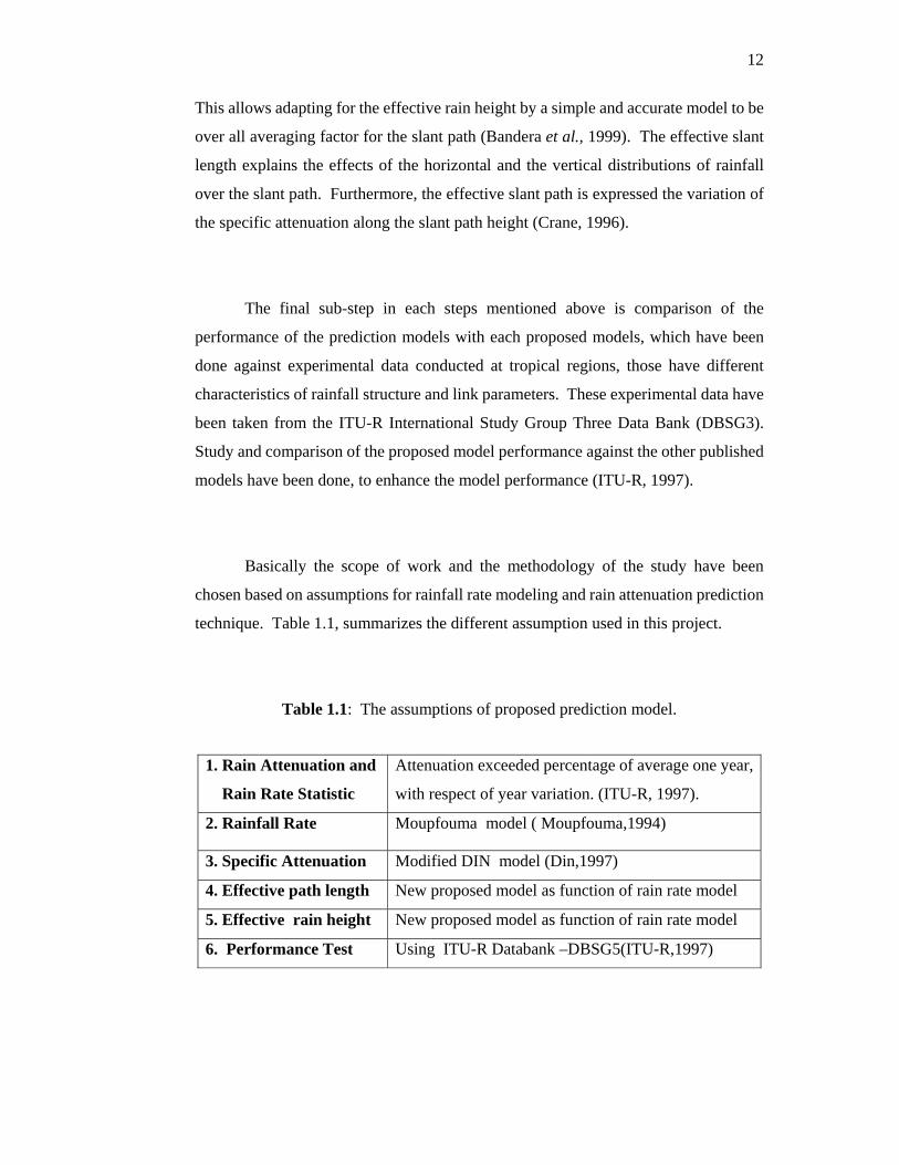
This allows adapting for the effective rain height by a simple and accurate model to be
over all averaging factor for the slant path (Bandera et al., 1999). The effective slant
length explains the effects of the horizontal and the vertical distributions of rainfall
over the slant path. Furthermore, the effective slant path is expressed the variation of
the specific attenuation along the slant path height (Crane, 1996).
The final sub-step in each steps mentioned above is comparison of the
performance of the prediction models with each proposed models, which have been
done against experimental data conducted at tropical regions, those have different
characteristics of rainfall structure and link parameters. These experimental data have
been taken from the ITU-R International Study Group Three Data Bank (DBSG3).
Study and comparison of the proposed model performance against the other published
models have been done, to enhance the model performance (ITU-R, 1997).
Basically the scope of work and the methodology of the study have been
chosen based on assumptions for rainfall rate modeling and rain attenuation prediction
technique. Table 1.1, summarizes the different assumption used in this project.
Table 1.1: The assumptions of proposed prediction model.
1. Rain Attenuation and
Rain Rate Statistic
Attenuation exceeded percentage of average one year,
with respect of year variation. (ITU-R, 1997).
2. Rainfall Rate Moupfouma model ( Moupfouma,1994)
3. Specific Attenuation Modified DIN model (Din,1997)
4. Effective path length New proposed model as function of rain rate model
5. Effective rain height New proposed model as function of rain rate model
6. Performance Test Using ITU-R Databank –DBSG5(ITU-R,1997)

13
Traditionally, during the flow of the project these assumptions has been proved
and verified based on previous experiments of slant path and the new methodology has
been proposed to use the terrestrial path experiments as well, in order to be suitable to
predict the rain attenuation at different frequency bands in Malaysia.
1.6 Thesis Outline
Chapter 1 consists of introduction to the project. In this section, a brief general
background is presented. The objectives of the project are clearly phased with details.
The research scope and methodology background are also presented.
Chapter 2 presents the first part of the literature review. There are two sections
in this chapter. Section one presents an introduction to the satellite communication
systems, frequency spectrum, satellite communications features, and satellite
propagation impairments are also provided. Section two explains brief details about
Rainfall distribution models, background on the characteristic of rainfall structure,
included Malaysia climates and the vertical profile of rainfall are presented also.
Chapter 3 is the second part of the Literature review. Includes the descriptions
of the basic concepts of the prediction models, the latest developments in the modeling
over terrestrial and slant path, techniques for the evaluation of propagation
degradation with theory background, emphasis is placed on promising modeling for
prediction techniques are reviewed and the ITU-R world wide model for rain
attenuation, and effective bath length along horizontal reduction and vertical
adjustment factors are also presented.

14
Chapter 4 represents the methodology of the project. Including the details
handling and the flow of processing for each step of the methodology for rain rate
modeling, specific attenuation, effective horizontal path and effective rain height are
also presented.
Chapter 5 presents the results and discussions for the methodology steps.
Comparison is also done in this chapter for verification. Discussion for the simulation
program and discussion of the rainfall rate and rain attenuation models performance is
presented.
Chapter 6 concludes the thesis. The conclusion is given based on the analysis
of results from the previous chapter. Recommendations for future works are also
presented.

98
program for prediction of rain attenuation in both satellite and terrestrial paths during
heavy rainfall event in Malaysia.
6.2 Future work
To complement and extend the result further, the following suggestions are
made
i. It is recommended to conduct more continued rainfall measurements
in UTM –Skudai and various places in Malaysia using rain gauges
and radar reflectively. For better understand of spatial and temporal
structure of rainfall.
ii. More rain attenuation measurements are recommended at different
frequencies band and elevation angel for all the path geometry to
enhance the proposed prediction model.
iii. More work on ITU-R databank are recommended (DBSG5) for signal
propagation in tropical countries.
iv. More work in the adapted Matlab program of the rain height proposed
model for allowing process of more on verifications data.

99
REFRENCES
Asrul .K. (2002). Study of Microwave Signal Attenuation Over Terrestrial Link at
26GHz in Malaysia. M. Sc Thesis, Faculty of Electrical Engineering, University
Technology Malaysia
Ajayi .G. O (1989). Some Characteristics of the Rain Height in a Tropical
Environment. Sixth International Conference on Antenna and Propagation. Vol. 2.
pp 80-82.
Ajayi. G.O and Olsen. R.L.(1985), .Modeling of a Tropical Raindrop Size
Distribution for Microwave and Milliliter wave. Radio Since, vol.20,No.2pp.193-
202.
A.Pawlina, (1998).Essential Knowledge of Rain Structure for Radio Application
Based on Available Data and Models. Proc. CLIMPARA'98, URSI Comm. F Open
Symp. on Cli
matic Parameters in Radiowave Prop. Prediction, Ottawa, Canada, April 27-29, pp.
81-84
Bandera, et al (1999) .Vertical path reduction factor for high elevation
communication systems. Trans. IEICE Japan, Vol. 35 No. 18,pp. 1584-1585
Chebil J., (1997).Rain Rate and Rain Attenuation Distribution for Microwave Study
in Malaysia ,Ph.D. Thesis, Faculty of Electrical Engineering ,University Technology
Malaysia (UTM),1997.
Crane, R. K. (1980) .Prediction of attenuation by rain. IEEE Trans. Communications,
28, 17(7-173).

100
DIN J and Tharek .A.R (1994). Predicted Rain Induced Attenuation at Microwave in
Malaysia. Preceding of the international Conference on Robotic Vision and Parallel
Processing for Industrial Automation (POVPIA’94).
Din Jafri (1997). Influence of Rain Drop Size Distribution on Attenuation at
Microwave Frequency in a Tropical Regions .Ph .D Thesis, Faculty of Electrical
Engineering, University Technology Malaysia
Dissanayake A.W. and J.E. Allnutt (1990). Radiometric Rain Attenuation
Measurements at 11.6GHz in Peru. Electronic Letters. Vol. 26. pp 168-170.
Dissanayake, A., J. Allnutt, and F. Haidara (1997) A prediction model that combines
rain attenuation and other propagation impairments along earth-satellite paths. IEEE
Trans. Antennas and Propag. 45, 1546-1558.
Elbert B.R. (1997). The Satellite Communication Applications Handbook Artech
House Inc.
Freeman .R.L (1997).Radio System Design for Telecommunication, Second Edition,
AWiley Insterscince Publication, John Wiley &Sons Inc.
Garcia, N.A.P.(2004). Improved method for prediction of rain attenuation in
terrestrial links. Electron Lett (UK) 22: 656 2004 Vol. 40 No. 11 pp.
Goldhirsh J, Katz I (1979) .Useful experimental results for earth-satellite rain
attenuation modelling. IEEE Trans Antennas & Propag AP-27: 413-415
Goldhirsh, J., V. Krichevsky. and N. E. Gebo (1992). Rain Rate Statistics and Fade
Distributions at 20 and 30 GHz Derived From a Network of Rain Gauges in the Mid-
Atlantic Coast Over a Five Year Period. IEEE Trans. Antennas and Propag. 40,
1408-1415.

101
H. H. Nor (2002). Determination of rain cell a size distribution for microwave in link
design Malaysia. Microwave conference, Kula Lumpur. 45, 1546-2004.
H. H. Nor et al (2000). Space Diversity Study for Satellite Communications by
Using Radar Data in Tropical Region. IWTS 2000. pp 101-103.
Hall MPM (1979). Effect of Troposphere on Radio Communication. London,
UK.Peter Peregrine
Hufford G (1991) .A Model For the Complex Permittivity of Ice. Int .J Infrared
Millimeter Waves (GSA) 12: 677-681
Hwang, S. H., J. Y. Ahn, T. J. Kim, and K. C. Whang (1998). The Effects of Rain
Attenuation in a Quasi-synchronous CDMA Return Link For a Ka-band Satellite
Communication system. IEEE Trans. Fundamentals, E81-A, 1436-1444.
ITU-R Rec.P.618-5 (1997) .Propagation data and prediction methods required for
design of earth-space telecommunications systems.
ITU-R Rec.P.838 (1992) Specific attenuation model for rain for use in prediction
methods.
ITU-R Recommendations (1997). Rain Height Model for Prediction Methods.”
P839-2. pp1
J.N Slater and L.A Trinogga (1985). Satellite Broadcasting System – Planning and
Design. Ellis Horwood Limited.
Kareem .M.(2000). Effective path length for terrestrial path links prediction
based on rain attenuation measurements) M. Sc Thesis ,Faculty of Electrical
Engineering , University Technology Malaysia
Klassen W (1988).Radar observations and simulation of the melting layer of
precipitation. J Atmos Sci (USA) 45:374 1-3753

102
L J. Ippolito Jr. (1986). Radiowave Propagation In Satellite Communications. Van
Nostrand Reinhold Company. New York.
L.A.R Silva et al (2002). Rain Attenuation Measurements at 15 and 18 GHz. IEEE
Electronic Letters. Vol. 38. No. 4. pp 197-198.
Lin, S.H (1997). National long term rain statistics and empirical calculation of
11GHz microwave rain attenuation. The Bell System Technical Journal, Vol
56,No.9,pp.1581-1604.
Malaysia Metrological Services (1999). Annual Summary of Meteorological
Observation 1997.March
Moupfouma. F (1994). More about rainfall rate and their prediction for Radio
system engineering , IEE Procedings,Vol.134,Pt.H,No.6,pp.527-537.
Matricciani E (1993). Rain attenuation predicted with a two- layer rain model.
Electron Lett (UK) 29: 72-73
Mondal NC, Bhattacharya AB, Sarkar SK (1997). Some more results on 0°C
isotherm height over several Indian stations for rain attenuation estimation. Indian J
Phys 718:641
Olsen RL, Rogers DV, lodge DB (1978). The aRb relation in the calculation of rain
attenuation. IEEE Trans Antennas & Propag (USA), AP-25: 318-329
Ponte. M .S et al (1993). An improved Method for Slant Path Rain Attenuation
Prediction , SBMO 93, International Microwave Conference, Sao Paulo ,Brazil, July
1993
Pontes MS, Silva Mello L.A.R, Souza RL (1995) Statistical Behavior of the
Effective Rain Height in a Tropical Region (ICAP, Netherlands).
103
R. K. Crane (2003). Propagation Handbook for Wireless Communication System
Design. CRC Press LLC.
Rafiqul Islam .N (2000). Rain Attenuation Prediction for Terrestrial Microwave
Link Based on Rain Rate and Rain attenuation Measurements in Tropical Regions.
Ph .D Thesis ,Faculty of Electrical Engineering ,University Technology Malaysia
Robert K. Crane (1996). Electromagnetic Wave Propagation Through Rain.
University of Oklahoma. National Space Development Agency of Japan. (2001)
TRMM Data Users Handbook.
Sander, J (1975). Rain Attenuation of Millimeter Wave at λ= 5.77,3.3 and 2 mm.
IEEE Transaction on Antenna and Propagation,Vol.AP-23,No.2,March,pp.213-220.
Sarkar SK, Mondal NC, Bhattacharya AS (1999) .Results on 0°C isotherm height
over Port Blair and Jodhpur for satellite communication and radar propagation.
Indian J Phys 738: 73 1-737
Shanmugan K.S and Breipohl, A.M (1998). Random Signals: Detection, Estimation
and Data Analysis. john Wiley &Sons, Inc
Stutzman W. L. and K. M. Yon (1986). A Simple Rain Attenuation Model for Earth-
Space Radio Links Operating at 10-35 GHz. Radio Sci., 21, 65-72.
Sum .C.S (2002). Investigation of Band Rain Induced Degradation at 11 GHz in
Malaysia. M. Sc Thesis, Faculty of Electrical Engineering, University Technology
Malaysia
T. Hariman, (1990). Rain Rate Measurements In Indonesia , ELECTRONICS
LETTERS 26th April 1990 Vol. 26 No. 9 pp 596-597
Timothy P.and Charles W. Bostian (1986). Satellite Communications. John Wiley
and Sons.

104
ITU-R Recommendations (1999). Specific Attenuation Model for Rain for Use in
Prediction Methods. P838-1. pp 1.
J.T. Ong and C.N. Zhu (1997). Slant Path Attenuation at 11GHz in Singapore.
Electronic Letters. Vol. 33. No.13.
Watson PA (1994) .Climatically related parameters for prediction of attenuation and
cross polarisation in rainfall. Proc UIRSI Commission F Open Symposium (Moscow,
Russia), pp 2.1.1-2.1.6
W. Zhang, et al(1999).Prediction of Radio Waves Attenuation Due to Melting Layer
of Precipitation. IEEE Trans. Antennas Propag., vol. 42, 1994, pp. 492–500.
W. Zhao et al (2000). An Analytic Model of Specific Attenuation Due To Rain"
IEEE Trans. Antennas Propag. vol. 44,200, pp. 471-472.
Westwater, E. R, J. B. Snider, and M. J. Falls (1990). Ground-Based Radiometric
Observations of Atmospheric Emission and Attenuation at 20.6, 31.65, and 90 GHz:
a Comparison of Measurement and Theory. IEEE Trans. Antennas Propag. 38, 1569-
1580.
Yeo, T. S., P. S. Kooi, and M. S. Leong (1993). A two-year Measurement of Rainfall
Attenuation of CW Microwaves in Singapore. IEEE Trans. Antennas Propag. 41,
709-712.
Z. Zhao (2003) .A Prediction Model of Rain Attenuation Along Earth-Space Path. J.
IEICE Japan, vol. 83 Trans. Antennas Propag. pp. -7803-7831-