i-710 corridor project rdeir/sdeis - california … · 2017-07-21 · i-710 corridor project...
TRANSCRIPT
I-710 Corridor Project RDEIR/SDEIS
Page 1
U.1.1 UTILITY PROVIDER COMMENTS

I-710 Corridor Project RDEIR/SDEIS
Page 2
This page intentionally left blank

Subject: I-710 Corridor Project Feedback
From: [email protected] ([email protected])
To: [email protected];
Cc: [email protected]; [email protected];
Date: Tuesday, July 10, 2012 3:18 PM
From: William FongOrganization: Metropolitan Water District of Southern CaliforniaPhone: 213-217-6899Mailing Address: 700 N. Alameda StreetCity, State: Los Angeles, CAZip: 90012
Comment/Question:Please provide me with a copy of the DEIR for our review. We are a protentially affected public agency.
*You received this message because William Fong submitted feedback regarding the I-710 Corridor Project.
Regards,System Administrator
Print http://us.mg6.mail.yahoo.com/neo/launch?.rand=32bht1fkrk6lk
1 of 1 8/20/2012 10:53 AM

I-710 Corridor Project RDEIR/SDEIS
Page 4
This page intentionally left blank

I-710 Corridor Project RDEIR/SDEIS
Page 5
U-1-1
A compact disc of the Draft Environmental Impact Report/Environmental Impact Statement
(EIR/EIS) was provided to the Metropolitan Water District of Southern California (MWDSC) on
June 28, 2012, and MWDSC has been added to the project’s distribution list.

I-710 Corridor Project RDEIR/SDEIS
Page 6
This page intentionally left blank

THE METROPOLITAN WATER, D'STRICTOFSOUIHIRN CALIFORNIA
)ffice of the General Manager
August 22,2012
Mr. Ron Kosinski l.l<Deputy District Director Environmental StudiesCalifornia Department of Transportation100 South Main Street Mail Stop 164Los Angeles, Californi a 90012
Dear Mr. Kosinski:
Interstate-710 Corridor Project Draft EIR/EIS
The Metropolitan Water District of Southern California (Metropolitan) has received the I-710Corridor Project Draft Environmental Impact ReporlEnvironmental Impact Statement. The
California Department of Transportation (Caltrans), in cooperation with the Los Angeles County
Metropolitan Transportation Authority (Metro), the Gateway Cities Council of Govemments, the
Southern California Association of Governments, the Ports of Los Angeles and Long Beach, and
the Interstate 5 Joint Powers Authority, are proposing to improve Interstate 710 (I-710) in LosAngeles County between Ocean Blvd. and State Route 60 (SR-60). Major features include
widening I-710 up to ten general purpose lanes (five lanes in each direction), modemize and
reconfigure the I-405, SR-91 and aportion of the I-5 interchanges with l-710, modernize and
reconfigure most local arterial interchanges along I-710, and provision of a separated four-lanefreight corridor to be used by conventional or zero-emission trucks. This letter contains
Metropolitan's response to the Draft EIR/EIS as a responsible agency.
Our review of the Draft EIR/EIS indicates Metropolitan owns and operates several pipelines and
facilities that cross or are adjacent to your project:
o The Middle Cross Feeder is a72- to 78-inch welded steel pipe that runs east and west
along Southern Avenue and crosses the I-710 just south of the Firestone intersection.
o The Rio Hondo Pressure Control Structure and Power Plant is located near Miller Wayand Frontage Road East, adjacent to the I-710.
o The West Coast Feeder is a 60-inch welded steel pipe that runs east and west along the I-105 and crosses the I-710 at the I-105 intersection.
700 N. Alameda Street, Los Angeles, California 90012 . Mailing Address: P.O. Box 54153, Los Angeles, California, 90054-0153 ' Telephone: (213) 2174000

Mr. Ron KosinskiPage2August 22,2012
o The Middle Feeder is a 72-inchwelded steel pipe that runs east and west along GreenleafBlvd and crosses the I-710 at Greenleaf Blvd.
o The Second Lower Feeder is a 78-inch pre-stressed pipe that runs east and west alongCarson Street and crosses the I-710 at Carson Street.
o The Long Beach Lateral is a 37-inch welded steel pipe that runs east and west alongBaker Street and crosses the I-710 at Baker Street.
o The Yictoia-223'd Street Cross Feeder is a 45-inch precast concrete pipe that runs northand south along Alameda Street on the west side of your project
Metropolitan is concerned with the potential impacts to the pipeline that may result from theconstruction and implementation of the proposed Project.
Development and redevelopment associated with the proposed Project must not restrict any ofMetropolitan's day-to-day operations, and/or access to it facilities. Metropolitan must beallowed to maintain its rights-of-way and requires unobstructed access to its facilities andproperties at all times in order to repair and maintain its system. Detailed prints of drawings ofMetropolitan's pipelines and rights-of-way may be obtained by calling Metropolitan'sSubstructures Information Line at (213) 217-6564. To assist in preparing plans that are
compatible with Metropolitan's facilities, easements, and properties, we have enclosed a copy ofthe "Guidelines for Developments in the Area of Facilities, Fee Properties, and lor easements ofThe Metropolitan Water District of Southern California." Please note that all submitted designsor plans must clearly identiff Metropolitan's facilities and rights-of-way.
We appreciate the opportunity to provide input to your planning process. If you have anyquestions, please contact Mr. V/illiam Fong at (2I3) 2I7-6899.
Deirdre WestManager, Environmental Planning Team
WF/wf(r-7 l 0)
)- Ð!=--flír-..i ' ¡ i;¡ .;
Enclosures: MapGuidelines
Very truly yours,

a
.ÈlTötsø
c-jq
THIS EXHIBII IS TO 8E USED FOR APPROXIMAÎE POSITIONING ONLY.
IT IS NOT TO BE USED. NOR IS IT INTENDED TO BE USED FOR ENGINEER]NG,
RECORDING OR TITIGATION PURPOSES NO WARRÁNTY OF ACCURACY
lS ll¡PUED OR GUAnANTEED.
ê ch ¡vo¡ Avc
W J.llsson BlvdRod.o Rd I
oí.fo ¡trr S\ ? ¡ryzâ-s
**,
,I,
,:oIeqe
þ., ,
tårro^ ,, ,
J 't'"
L¿.
i ''ô.,
: ;""ntnt"'ro
f I ,i",.." Av. ¡¡ywæd
lo"s. r'. B.lt
3l-3.3 8dû Cuddty
G¡btyd
^
: V{ G¡9. Aye
2E W Fl6úc. Av.
øàlnglewood \ i
Ê!
tóøE
tOo*n"y ¿'
irdd,€cr6íi¡;;_
j .*..o, ",,o
LylÈood .o¡
1IIIII
o I Souñ S¡iËlË t ,'[i"",.oi \ Dd Amo Brvd f' udrì¡;\:;; \ ì ic'"'.-ts€ càr5oh æJtarérrfom ! rrncorn lvet5
: Or:ng.Avc úat
oor
eoØ
<c:;t-6
: E W¡lld Sr
.E
t.al
vi' '^¿
Ò\_
ScrlEaadt
An ùh etm8oy
Eurrldr õ3on¡.t 6Br¡cñ 5
i
Torrance. _lÁndI orr d.ca gYd
W C¡rioñ SlS.pu,ved¡ Blvd
.l¡t
I Ldnlblorr¿nceMunktpEl
3tænS.ål B€æh
o¿ Hill¡
i "'Êr'. iEAn
J
ÊJft st
T
,];.1.', l,nt ï*-o*.tt
H¡rborClly
-tl W lm ngtq o
@
Ltr. Dr
Pðrå
ìtCec
ç.o- 21!
Y.t- .9e¿ '"o
!-.lt'
o
ong 'Beach
aih.?tdC ål :ìl;teUn,r Long
8Pr h
I
lJddeslsland .
tBolÊà Av.
Esri China Esri fihailand), ï 2012
'lIIIJ"uIt"t-
sr¡
ÞIiå:c T¡;rl K¿t.llô Avô
l-710 Gorridor ProjectMWD lnterests
The Metropolilan Water District of Southem CaliforniaEngineaíng Seruiæs Group

1. Introéuction.-å. Ît¡c follovl.ng general gruiôel5'nes ehould bê
f,ollored for tt¡e deeÍgn ót ¡rropoeed facLtlt1cs a¡dlããvcfopoeats in tlrc aiea of- Metropof:lta¡¡ | s facilltLes r feepro¡rertiesr ¡¡¡d/or eascnånts-
b, lfc rcquire tåat 3 eoftnal tscotd DePsr Ereü1nE' Palarrdscape¡ stoil draLnr a¡ê utfor our revl,cw a¡¡d writtcn aPPl{ctropoliü¡nf s facilltiee. feeeasenenÈl r prior to th€ ccmeDwork
Pla¡¡s r Parcel and T.ract llaPe
Ebe f,ollowÍng ate Èletropolita¡'e requl,reoenta f,or tl¡eidlãntfficatió¡ of ite fãsllLttes, fée propertl'ee, anô/orsåae¡Ëntt on your planar P¡rcel naPs and tract trlPss
Ê. l.tetro¡lolita¡rta fsc properties an¿/oE eaacûêntt andl
its plpel:Lnes iãa otner facllitiäs nugt Þe fully- rborr¡ a¡rdl
faenãi-ffcd ¿g t{atropolit¡nrs o¡ all applicablc plane.
b. l{ctropoll.t¿nrB !¡e propcrtica_and/ol aaË-cûePtsnuÊt be ¡howa aia taentifte¡l ãs iretropolfta¡¡rs wl'tlr theoffi"f"I recoràÍnE data on aII applicàble parcel a¡¡dtract mlPË.
c. l{etropoll,taDtE fee Pt'oP€lties.rnd/or Êa!€üÊntsaua eiieting aurtvcy Donune¡t¡-uuËt be di.¡nanslonelly tledto the parcét or traet bot¡¡ôarieg.
d. tlctropolite¡rre rseorûE of suFveys rust þereferencedl on tie pareel and tr.ct nåp8'
2.
t'-*

2-
3.
â. Proposcd eut or fil+ sloper exceedL¡g 10 percÊntare noümally not ¡,lrowed pithin Heiropõiitan's feepropertiee or easenenta. This r= rãqüiied to facl,rltate theuse of constructLon anrt n¿inteniñcã-ãq;iFrent, anã liovfaeacceBs to irs abovegrounå and uerowgro'unä ¡aeiridreãltb. t{e require ttrat 16-foot-wLde comercial-trmedrlveway approaches be consrruered on boih ;iããã-"ííirstrÊctÊ croesing ltetro¡rolitan
arê rÊqulred in any nedian isln€ê€saar1l, nu¡t be at le¡et lrare nolrnally not alloued to exot a¡ acceas aenp nust exceed!9ngSrap¡y, tlre rau¡r uuat be paved. Ite requirc e4O-foot-rong levet árca on råå ari"c*ii apfroich to acees¡{a¡ps wl¡ere tÌre ranp neete the street. AL trtetropolitsn'sfee propertÍesr !nê nay requr.re fenããã-."ä'dî;;:'-----
c- The teræa of rrretro¡rorJ.tanr' p€r.anent eag€mentdeeds nornalty precrude tÌre Èuilar"E-"ãìaintenance ofstructures of any nature or kind wfi¡ín ite eaicmeat , toensurre eafety a¡û avoLö interfereneÊ witt¡ operitio"-iáamaiatenance of Hetropollt¡D,s pipeiin;; or ottrer frclll-ties.tletropollÈân nust b¡ve vehLcr¡l-a¡- accJai irong -ãrre-ãic.r"nrt
at ell ti¡nes for ins¡rcclion, patrolrtnÈ, ana for ueiateaanceo-f tlre pipelines and-other. iaåürtl;tãå a routlne þ¡¡f.¡.I. lçglre 1 2O-foot-wÍdo cleer zone around a11: a¡ovjlgror¡ndfaciritiee lor this routrne rceesg. Thl"s cle¡r zonc shoulÉtllope avfr f_r-ø our facllity on a grraôe not Èo crceed2 percent. lle nust alco have acee.Es arong trre eiicoe¡tawÍtb conatn¡ctl,on cquí¡rnanÈ. An axanple õt ürLs ir ;horn onFÍEure 1.
pro_poecd buildLnga adjeccnt toa¡rd/or easëGentg Er¡at Dot,' or easêoent or Í.uposeita¡'s ¡lf.geli¡ee oi otber¡ítuation ia ahorl onI plane of the footinge forany buirding or Êtruær¡re adjacent to the fcc propeiiv oreaseEent uuËt þs 3'tnn{tted for our revJ.es ena õrrãtcn-approval as- ttrey pêrtain to ttre pÍpelLne or othcr fecilj.tfeetherel,n. Also, roof åaves of bulfäings adjacent tõ-ifrce¡sfrent or fee propcrty EuÊt not oveihang-into tàe fec
ProPerty or Gaaenent area.
t-
4.
-3-
€. Dletropolitanrs piBelines and other facilities,e.9.. structureõ, manholas, equipment, survey nonunsnts, €tc.within its fee properties and/or easÊments must be proteetedfron danage by the easenent holder on ltetro¡rclitan. sproperty or the property owber where tletropolita¡r has aneasenentr at no Ê¡(pense to lrletropolitan. If the facility iaa cathodic protecÈion station Lt ehall be locatcd prior toany gradlng or excavatl,on. the exact locaÈion, deecriptionand way of proteeÈion shall be sho$n on the related plansfor the eaaenent areer
Ease!ìente on lfetrop-o_Iitan I s Propertv
a. we encouraEe the uge of MetropolLtrnra fac righta-of-way by Eovern¡ental agencLcs for prrÞlÍc street enduttlity purpoBeË, provided tlrat such use does not interferesittt ltletropolLtan'E use of the pro¡rerty, the entire wLÖtl¡ oftlre property is accepteð lnto the aEencyrs publfc etreeteyetem and fair narket value ís pald f,or sueh use of theriEht-of-'way.
b. Please eontact the Direetor of lietropolf.tanreRight of Way and Land DivlsLonr telephone (2131 250-6302,concerning easeüents for landscaplrg, Btrect, aton draíntseflêtr water or other prblic facilitics propo¡erl witl¡LnIitetropolitanrs feê proþertles. À Brp and lcEel ðeecriptJ,onof the requested eaecnents ur¡ct be errhitteô. ÀI¡or ¡vrittenevidence Eust be auhitËed tt¡at shot a the city or countyrrill aêcepÈ the easenent for the s¡rectflc purposct inÈo itapublf,c systear. Ttre grant of the e¿¡euent will be eubject totletropolLtan'e ri.ghte to uae J.ts lanil for water pipelineaanô relateô purpoaes to the Banê extent as ff Êuch grant badnot been måde. T!¡ere will be ¡ cbarge for tlre €aseuent.Plaase noÈe ttrat' lf cntrT fs reçrJ,rcd on tlre property priorto is8uance of 'bhe eaeenent, ¡n €nttT¡ penit mu¡t beobtained. There will aleo be a chargê for tl¡e enËry penit.
Lanðscapinq.......-ttetropolitanrs landecape gruideliaes for it¡ fee
properties and/or easeüeDts are as follovs:ê. A green belt üåy þ€ allowed vithLn lletropoliÈanrs
fee property or easene¡t.
b. All landlcapc plans ehall Ehoút thc locatlon endsizc of lletropolltan'g fãe property ¡¡¡cl/or easene¡t and tÌ¡elocation and size of ltetropolltanf s Pl.pelLne or otherfacilitleg therain.
5.
I-

6.
c- åbeolutcly no trees wÍrr be allowed witäln ls feeÈof the centerll"e-gÍ üerroporitinas ãr,rãtrrrg or tuiurepipelÍnes and facÍlÍties.dt. Deep-¡ooted trees are prohfbJ.ted within
and/or sasÊmentg. Shallow-¡s allowed. Ihe shallow-rootedry closer Èhan 15 f,eet from therô euch trees shall not be,t spread no EreatÊr thari20 feet in dianeter at uaturity. 'Shrr¡bs, Éushee, vinàs, andrt larger shn¡bs and buehee/ over our pipellne. Turf lertal of landsca¡re plane forrd written approval. (See
e- The rand.ssal¡G prans Bust contain provlsions foruçt¡opolitan's vehicular-aecess at alr tl-ueã along it¡rights-of-way to irs pipelineg or facittlies ttrerÉr;;-Gates capable of acceþting liletropolit¡n's loeks arerequire9 in any tences aeioss ttË rights-of-way. Arso,any walks or draf-naEe facilttie¡ acrãgs its aecess routeDuat be constn¡cÈedl to åÀsETo tr-20 roading Ftan.rards.
any of l{etropolit¿nrs feeou ltg RiEht of ÌÎay andtr¡r petnite mrst bc obteinederty. îlrere will be a charEenta rcquircö.
Fgnsj'uq
l{etropol+tin rcquires tbat perf.ueter fencLnE of lte fee¡rroperties a¡d faeilitieg be constÍr¡ctcd'of r¡¡ivãrsal chaLnrink, 6 feet in heigbt sad toppedl wi'th 3 strandg of barbedwire angleô u¡rwarrl a¡rô outra¡á at a {E ctegree anrgle or anapproved equal for a total fenee heiEht oi Z feet. SuÍtrblesubstitute fe¡cíng 4rI be consLðeret by lrletropolÍta¡r.fPlease see Figrure 5 for detailg).
-4-
üetropolitants poliey for the alinennent of uttlitl,espqmitted wftÌ¡Ln J.ta fee propcrtics ancl/ot eesêscnt¡ rndstscct riEhte-of-wuy is a¡ followr:
?.
r-

-5-
a, Pe¡manent strîuctures, including catch basÍnst¡nanholesr power poles, telephone riger boxeg¡ etc.¡ shallnot be loc¿ted wittlin its fee propertiee anô/or eaaements.
b. lYe request that pernànent utility structr¡.reswithín public atreeta, in whl,ch liletropolitan's facllftiesare conrtrueted unåer the lletropolitan rfater D5.ËtríctActr be placed as far fron our pipeline aa pos:Íble' butnot closer than 5 feet from ttre outslde of our pipell.ne.
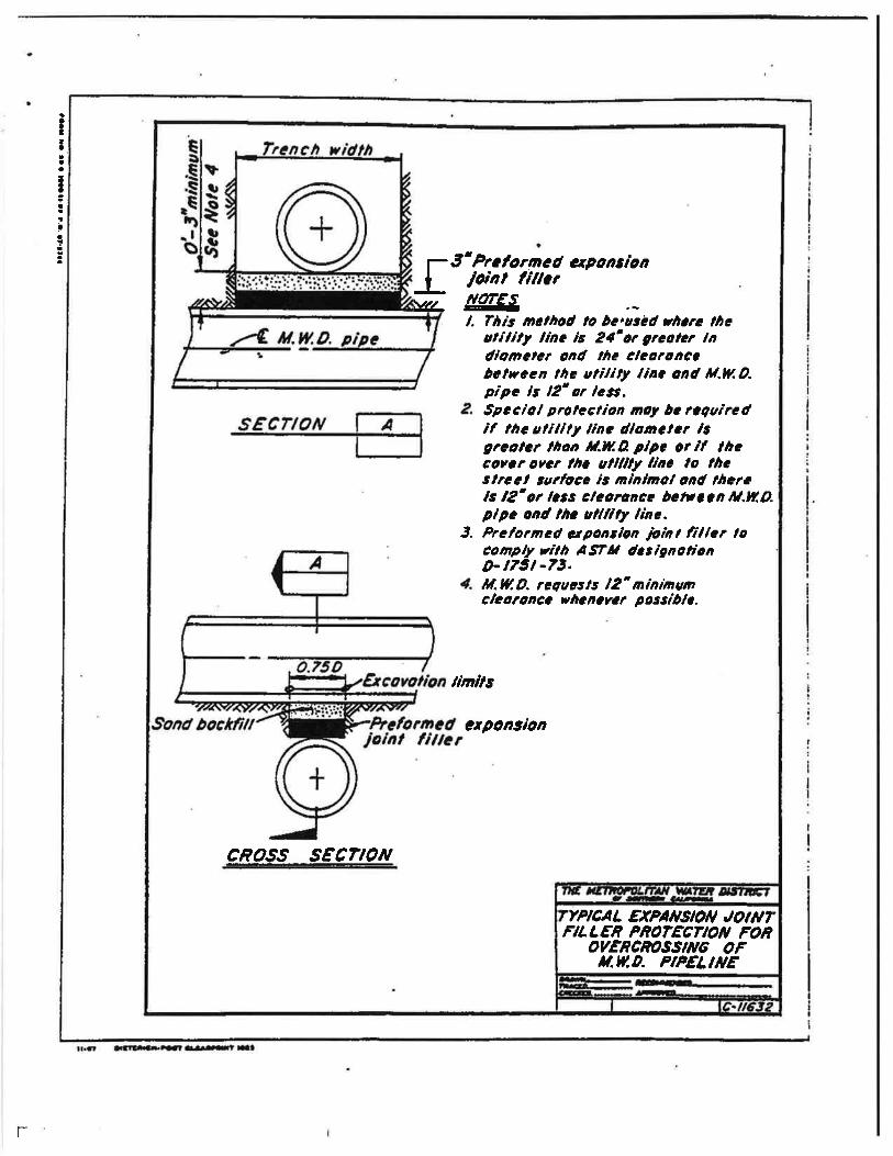
c. The installation of utÍlities over or unôertrletropolJ.tan'e pipeline (al must be in accordance nj.th therequiieoentÊ shoun on 'È,1¡e enclosedl prints of, DrawingsNoa. C-11632 and C-95,17. IYhenever possl,ble wE rGqF¡eat auininr¡¡r of one foot clearance betweèn l{etropolitente PlPeand your facility. TeNnporary suPPort of l'letropolitanrspipe nay also be required at undercrossLnEs of I'ts PiPein a¡r opeü trench. fbe tenporata¡ ÈuPPort plans nust berevíewed and a¡lproved by l{etropolfta¡.
al. Lateral uÈility crossing¡ of lletropolit.an'gpi¡relines must be ae perþenilícular to itE pl'pelfnealinenent aa practical. Prior to any ellcev¡tl'on oulpipeline shall be locateô ¡anually and any excevationiftfrin twe feet of ot¡r plpelfne Bust be ôone by barrd.:Ihis shall be noted oa the appropríate drawings.
€r UtilÍtLea coactnretecl longitutlLnally withinltetropolitanr e righte-of-ttãY nuet be locatgd outsiôe 'El¡ett¡eorãtical trencú prism,foi uncoverJ¡rg Lts pl¡nline anclmust be loeated parallel to anrd as close to I'ta rlEhts-of-way línes aÉ Practfcal.
f. I{hea pipiag la Jackedl or I'nstalledl ln jackedcaring or tr¡n¡rel r¡n¿er lletropolltanrs pipc, thcre-nust bleat leåat trro feet of vertical clearå.ncê Þetreen thebotts¡ of lletropolíta¡r5 Pipe and the top of _thc jackedpl.pe, jacked casing or tunnêl. rte also require thatãe-taif-¿rawinge of, tbe lhorlng fo¡ tùe jackJ-ng ortunnelíng pítã be aubitteð tór our revies and a?PrPv.a1.Provisioãe-muet be ¡rôe to grout any void.s a¡ounÉl tl¡eexterlor of the jacked piPe, jaclceö easinE or tu"nnel. - Ifthe piping is inÉtallad iä a iaclced_casLng or ttuurel tù.an¡ruiai eþace Þetreen tbe piping and the jacked easing ortun¡rel Eust be fitletl *itb grout-
t-

6-
g. Overhead eleetrical and telephone linereguírenents!
1) Conductor clearanees erê to conforn to thecalifornia st¡te publlc ttiliries comiegÍon, Generalorder 95 r for or¡erhead EleetrÍcal r.ine construction or_lt_a greater crearance if requireú by llatropolitan.under no circumgtances eharr'clearanËe be lêss than35 f,eeÈ.
2l A uarker ntrsÈ be attached to tlre power ¡rolesbowing the grourd crearance and rÍne vortaäe, to heloprevent clgnaEe to yor¡r faclltties during nainienance ärother norh being done fn the area.
3) Line clearance over üetropotltaars feeproperties and/ol eereuent€ shall bè showa on tlrndrawinE to indLeate the lorest polnt of ttre ll.neunder the nost adversa condltioás !,neludtinEconsíderatíon otÊ aag, wind load, tÊE¡reretuie change,ind aupport tlpê. ïe reSrire that overheaô rines-beIocatedt at least 30 fcet laterally evay frm allabove-ground structurês on tbe pJ,þelinás.
ll l{hen urdergrounô electrical conöuitg,120 volts or greetet, arc Laetatledt wíthinlletropolitan's fee ¡lrogerty and/or easement, theconduite nust be inÊa¡ãa rñ a uininr¡n of three lnchesof red concrete. lthere poasfÞle, above grouad warningsl.gms üuËt also-be pteeeå at ttre rfEht:oi-way llneswl¡ere tl¡e sondul.ts êuter and exit tùe rigbt-äf-wey.h. lbe constsr¡etLon of sererrines Ln lrletroporit¿nrs
fee propertÍes and./or eageuents nuat coafo¡a to tåecalifor¡ia Departnent of Eealtt¡ gen¡ices crLteria for tlre9cparation of lfater üal,nc a¡d Sa¡Ítarlr Service¡ a¡¡d thelocal city or connty ãealtå coðe oldfiartcË aÊ it rclates toínatall-atùon of se*Ërg Ln tt¡e vicinity of pree:urewaüerliaeg. the coastruction of aeveÍli¡ce .shoulü alsoconforur to these ¡ta¡rdarde Ln streËt rlghts-of- w- t.
L. Cross seetions ghall be provided for aII pÍpelinecroaeings showinE l{e€ropotltan,s fêe ptolrerty a¡d/oi -
Gasenent l{rrts and tt¡e location of our pLpeline{el . !!beexact locations of the crossiag plpelines ãnd theLrerevatl,ons shall be uarked on as-birilt drawinEs for ou¡ínforuatlon.
r.

- j. Potholing of lrletropolltan I s pipelíne ís reguíredif the vertical clearance bclween a ut-ility andtletropolitanrs pipeline ís indicated on thã pran to be onefoot or legs, rf the indicated clearance ís-betwcen onc andtrÉ feet, pottrolÍng is auggeeted. trtetropolitan will providea representative to assLsts othere in locating andtdentifyíng Íts pipeline. Two-working days notice ísrequested.
k. àdequate ehoringr and bracing fs required for ttrefuII depth of the t¡ench r*ùen tlre excavation encroacheswithin the zone shown on Fignrre tL.
I. The location of uttlfties withLn t{etropolit¿n'efee pro¡rerty and/or easenent shall be ptaLnly uarlced tohelp prevent damage duriug msintena¡rce or other work donein the area. Detectable tape over burled utíIj.tiesshould be placed a niainun of 12 Ínches above ttre utílityand ahall confo¡rn to the follosing requircne¡¡ts:
1) lfater pipellne¡ À twp-inch blue rrarnÍlgtape shall be i^uprínted wittr;
IICÀT'TION EURIED }IAITER PIPEI,INBü
2) Gasr oil, or cheuical ¡llpelines âtwo-inch yellou warníng tape eball be imprlutedwith:
TCAUTION BI'RIED PIPELI¡ÛET
3) sesêr or storm clraLn pLgeline: Àtro-inch Ereer warning tape shall be t-u¡rrlnted wi.thr
ICÀUTTqI BURIED PIPTLIITET
-
4l ElectrLc, etreet ltghtlngr or tratfic=Ígnals conduit¡ À tno-iach redl rar¡ing tape shallbe i.uprinted wítlr:
rCAT'T'IOII BIIRIED CONDT'Il!T
5l lelephoner or televieion condult: Àtwo-inch oråDge varníug tape shall be inprintedwith r
rgLul[loN BqrED collDttrlti

-8-
!r. Cathodic protection requÍrenents:f) If there ís a catbodfc proteetLon EtåtÍonfor ltetrop.or+lalr'!s_¡riperlne J.n thå area of thã-frogoseduorkr ít shall be róclted prior to any grailing ärexcavation. The exact rocitlon, aescitþtlon ãnd nånn€r
9f protection eharr be sbown on all appiicalre plans.Pleaee contaet tr[etropoHta¡¡rs corrosiää EnglnecifngSection, located at lletropolftan.B F. E. wãymouthsoftening ilrd Filtratton Þla¡¡t, T0o üorth uãreuoAvanue,.La Ve¡ner Calífor¡ia 91?S0r telephone l?fat593-7474, for tl¡e locatione of tGtro¡lolllanrs eattrod,l.cproteetfon statíons,
2l If an Lnduced-surrent cathodic proteetf,onlystem is to bc inatalled on any pipelLne-croaaingMetropol+trljî. p+pelinêr ptease- cõnlact l{r. r{a¡rne-E.Risner at (71{} S93-?{?{ or (Zf3} 250-5095. tã willreview the pro¡rosed aysten and d,ete::uine l'f anyconflicts will arj.se wittr tl¡e existing cattroðÍêprotection systerus installed by ltetropolíta¡r.
lÈan'a rights-of-uaytrB lcaelngs) sball be soatedre coatlng to conform toltr a¡rd shall be ¡aiatained ÍnLon as ôfrected by l{etropolita¡r.
on rhe _prperine and "*"irJ'lf,3rit.3i;l*t:""iitî3tå3"",the Code of Federal'Regrulitionsr part 19F.
¡û) If a steel carricr pipe fcaslng! i¡ ugcd:
{a} Catl¡oÉlic protectÍon sball be provf.dedby uae of a sacrffLõial nagmeel.rn a¡od,e- (¡ sketchshowing tlre cethoåíc ¡lrotectton ôct¡l,ls cÊ¡ bcprovideü f,or the deeiþere iafo¡nrtLonl .
(bl fhe gteel carrigr plpe ehal']' beprotêeterl with a coal. taË eDäDel coating J,nsideand out iu accorda¡ce uÍ.tù ÀIfi{A C203 spcciftcatÍon.
tl¡ àlI trenches shall be excavated to csqFly wittr tlrecl¡/osEÀ conetruction safety orders, Àrtl,êre 6, ÉegùrnraEwith sections 1539 through L547. Trench backfirt eball bepraced ín 8*inch lifte and shalt bc con¡racteð to 95 ¡nrccutrerative cøp_-action fÀsru D6981 acroas roadways anô throuEhprotective dLkes. Trench baehflll elsewhere wLll bccoapacÈed to 90 pereent relative cæpactfoa (Asrlt D69B).
r-
8.
-9-
o. Control. cables connected with the operatÍon ofItletropolùtan I s systen are buried within streets, itg feeproperties and/or easênènts. The locations and elevationsof these cables shall he shown on the drawínga, llhedraul.ngs ehall note that prior to any exõavatfon Ln theârêâr the conÈrol cables shall be locateô and r¡easuteesball be tahen by the contractor to protect the cables ùnplace.
p. ltletropolita¡r is a menber of Underground ServiceAlert (USn¡. Ihe contractor (encavator) shall contaetUSÀ at 1-800-¡!22-¡[133 {southern Calífornial at least 18hours prior Èo startínE any excavatLon work. trhe corrtractorwíll be líable for any darnagè to ltletropolitan I s f ecil.lt,iesas a result of t'he congtrucÈl,on.
ParqgounÌ, RiFht
FacÍlLties çonstnrcted witÌ¡in MetropolitanIs feeproperties and/or eas€Bente ehall be eubject to tbcpartmount right of t'tetropolÍtan to use itg fee propeËtie5and/or easenents for tlre purpoaÊ for whl.ch they wgreaequfred. If at eny ti.ne ìletropoll,tan or itB aasf.gmsshould' in the exerciae of tbel,r rlghts, flnd ft nccessaryto remove any of tbe facilttl.es frm the fee ProP€rtiesand/or easeneuta, sueh renoval and replacêEent ehall Þe atthe expense of the owner of the facility.
ttolification sf uçtroqglit+,-þ Facl.litieslflren a nant¡ole oa other of lletro¡rolitÈn I I f,acllLtiee
DuEt bc nodifLed to accomodête your construetion of fêcotlÊ-truction, lletropolita¡¡ ¡ptll nodliy the facl,J.LtÍes rltlr itsforces. IhLs tboulô be rroteð on tþe sonsËruction plans. Theesti:nated cost to pertorn ttrís roôJ,f,ication will be given toyou aad we will require a de¡neit for thig ånou¡lt Þefore thework is perfomed. Onee the deposLt ie recelvedr 11Ê will - -schedule- tlre rrotk. Our torces rill coordl,¡ate tåe work withyour contractor. Our final Þilllng ïitL be based on actualãoat íncurredr anô will iuclute naterl.ale' co¡sttl¡ctionrengineering plan teview, inspectJ'on' and adnLnl'strativeovãrheaô ctralges calculateô l.n accoröancè rûitb l,letropolLtanrsstandlardl aecor¡¡tl,nE Practicee. If tbe cost Ls less than thedeposit, a refunal will be nadc¡ hosever, if tl¡e COEt exceedsthã deposltr an Lnvolce will be fornariled for palæent of theadcll.tional a¡oru¡t.
9.
t

l0 -
10. Dr.ainaae
â. ResidentÍar or co¡mrercial developnent t¡pteatryíncreasae a¡rd coneentrates tlre peak ËÈorn ùater rúäoff, aËl runoff from an area, therebyrr atoÐ drain facílíties
Also, throuEhout, the year,ftr ear washinE, and otlreroFÊ into tlre BtorD drainage
system resulting in weed abateuent, ineect infestatlonr-obst¡ucted access a¡rd other probleus. Therefore, it leYgtroPolitanre usual practícã noÈ to approve plans that showdischarge of drainagc f¡on ðevelo¡nentÈ-onto its feeproperties and/or eàseuent,s.
b. rf water EqEt be carried acro¡a or discharged, ontolrietro¡rolJ.tant-s fee-þlìftrties ¡urd/or eagements, ltetrópoülal¡will insiet Fh"t -plan! for develo¡ment proviôe tlraÈ ii ¡ecaffiad by closed co:rduft or llneä open ct¡arurel approved inwritLng by l{etropoliÈan. Also tlre diainage tacililies must bemaintainerl by others¡ ê.g., city, êountyr-honeorîerg aa¡ociation,etc. If tl¡e develo¡nent proposes chanEés to existi"ng draLneEcfeetures, then tlre ðeveloþer- eball ¡akã provJ.aS.on¡ tó providãfor replacement and these-chanEes uust bå approved by ltetropolitenin wzitinE.
11. ConEtnrctfon CoordÍnation
During construct:Lon', Metropolita¡rrs fLeld represêntatl,vewill make ¡reriod,Íc ins¡rectLonË. Íle request that ã etiputationbe added to the pl¡ns or epecifÍcatLo¡À for notif,icatíón oftl¡. of lletro¡rolita¡rrs O¡nratioae Seryices Eranch,tele@TTÎ3t zs0--:r Êr Íeast-lrro-roär¡g-aiys prior tåany work in tbe vicítFÇ of ou¡ facilitics.
12. Pipell,ne Loadinq nest¡ietLona
å. Itletro¡rolítânrs pfpellnes a¡rd conöultc vary instrn¡ctural strength, a¡d aome åac not adequate forãAsElto E-20 roedinE. llhereforer speclfl,c roaôs over tlres¡recÍfic tectLons of pLpe or conðuit uust bs rcvLewed a¡dla¡lprovecl by_lletropolitanr. EorrievG5r tletropolltl¡r s pl¡nllneeâte tl?icaIIy adequate for ÀåSEllO E-20 loadfng provid-è tl¡atthe cover over the ptpell.nc is ¡ot le¡a thaa four fect orthe cover is not cubsta¡rtLally increased. If tbe teuporarycov€r over tlre pipeline ötrring constn¡ctíon is betsecn tlrrêeand four f.eÊt t eguipuent üurt rcstrJ.ctedl to tbat $ùich

11 -
iu¡roaes loads no greater thån ¡ÀSHTO H-10. If the eover isbeÈrleen tt¡o and three feet, eguipmefit nuBt be regtrÍetad totl¡at of a Caterpillar D-lt trect-tlpe tractor. If the coveris less than two feet, only hand eguipuent Eay be used.Àlso, if the eontractor plans to use any eguf,pment overl{etropolitanre pipeline whleh trill inpose loads greater thanÀASEIO E-20, Ít wíII be necessary to eubmit the specÍficationsof sueh equipnnent for our revies and approval at leagt oneweek prior to its u8e. More reEtrictive requf.renents nayäppty to the loadinE gruiileline over the San Diego PJ,pelines1and,2r portions of tt¡e Orange County Feeder, and ttreCol.orado River Àqueduct. Please contâct us for loaûingrestrlctlons on all of lletropolitan's pipelÍnes a¡rdconduits.
b. the existing cover over the pipeline ¡haIl bemaintained unless Dletropolítan detetmrines thtt proposeÈlchanges do not pose a hazard to the íntegríÈy of thepípeline or an Í:opeã5-nent to its malntenenêe.
13. BlastinE
a. Àt least 20 days prior to the etert of anydlrilling for rock excavati.on blastírE, or any blastíng, íntt¡e vicinity of lletro¡rolitan I s facilitiee, e two-partpreliminary conceptual plan shall Þe subnítÈed tolletropolitan as follolre:
b. Part I of ttre coneeptual Þla¡r shall incluðe acæplete sumâry of proposed tranÉporËationr handling,storage, aåd uee of erçlosions.
G. Part 2 shall include the proposedl gencral conceptfor ÞlastLng, íncludLng controlled blastLng techniques andconÈrols of .nofser fly rock, airÞlast, and grounð vl,br¡tLon'
11. CEOÀ Requirerments
-
âr liüren Environ¡nental Docunents Eg ê lfq! ËeenPrepared
1l Regrulations i-uPlenentl,nE the CalifomiaEnvironmental Qr¡ality Act ICEQA) reqrrire th¡tlleÈropolitan have an opportwriËy to consult uítlt theagency or consultants preparing ar¡y GnvltonnÊntaldócr¡rãntation. tfe are reguired to revicw e¡rd, consídertbe Bneiron¡ental effects of thc proJect es shour¡ J.nthe'llegative Declaration or Envl,ronnentùI Iupact Bcport(EIR) prepared for yonr ProjËct before eomittingl{etropolitan to approve your rêquest.
t'

t2-
2l In order to ensure compliance rittr tt¡eregulatioas i-rnptffiìgnting CEQÀ whãre Ètetropoll.tan is notÈhe l¡ead AggT"y, thg foÍlowinE mlnLuu¡r prãcedureg toe¡¡Eure cmpliance with tt¡e Act have beeir establisbedl
al Uetropolitan shall be tlnely advleed ofany_òetermÍnation that a Categorical Éxenptionapplies to tlre_proJeet. The lea¿l Àgency is toadvige lletropolitan that it end othãr alencfespartl.cipatf.ng l.n rhe project have couplied withthe requireuente of C!@-pr{or to l{etiopolitantspartJ,cípatLÞn.
bl lttetropoll.tan is to be consulted durLngthe pre¡lrration of the Negative DeclaraËion orEIR.
cl lletropoliüan is to review a¡¡d suhit a¡rynGegas1ry coilrênts on the Negative DeclaratLon ord¡aft EIR.
dl l,letropolítar¡ Ls to be índennified forany- costs or ltebility arl.eing out of anryviolation of any laws or reEulations incluêing butnot linLted to ttre Calffornia EnvironnentalQuality Act ¿nd lts i-uplencntinE regulatiot¡s.
b. I{lren Epvirolmental Dgcrrents Eave Been Prepa¡:ed
rf envLro¡meatar dogrneuts have bcen prepared for yourproJect' please fi¡nlsh ua e copy for our icviery a¡rdl fliesin a tÍnely Dânner so tl¡at we ney have sufficlent tL¡s toreview and csment. the followiñg steps ur¡sÈ also beaccmpliehed:
1l The Lead â,geucy ie to aövl,se trtetro¡rolit¡ntlrat it and ott¡er_ agénciés pÊrrLc¿patíng tn the projeethave cmplied wLth the reguireueats of cEeÀ prl.oi tóttetropolitåri I s pertLcÍ¡lation.
2l lor¡ ur¡st agree Èo indem¡¡lfy I'tetropolitan, itsofficers, engineers, and agents for any eosts orfiabiltt-y arieing out of any violaÈLon of any laws orregrulaüions includfag but uot li.qited to tl¡e CalLforniaEnviro¡¡nental Oualtty Act and fte inplenentínE regrulatioDs.
15. MetropolijEqgrs Plan-Revleu CosÊ
t. en cngtnecriag revl.ar of your propoeed f¡cL1l,tl,esand develo¡nenta a¡d the preparatl,on of a letter responsc
. IJ
giving t{eÈropolitan's comrnenÈs, reguiremenÈs and/or approvalthat will reguire I man-hours or less of effort is Èlpicall¡rp€rformed at Do cost Êo the ðeveloperr unless Ê facilitymrJst be modified wherc Uctropolitan has superior riEhts. Ifan engineering review and leÈter r€sponse requÍres norê than8 nan-hours of effort by l{etropolitan to deÈernlne if theproposed facJ-lity or development ås compatíble with ítsfacilities, or Íf nodifications to lletropolitanr¡ nanhole(elor othe¡ facilitfe¡ uill be requiredr then ell oftl¡etropolitan's eosts åÊsocÍ¡ted with tlc projeet ¡nust Þepaid Ly tlre develo¡rer¡ unless the develo¡rer has superforrights.
b. A âeposit of fund,s will be reguired fron thedeveloper befoie r.fetro¡rolltan can begl'n i'Ès detaíIedenEineãrinE plan revJ.ee that will exceed I hour¡- thea.nount of ttrã reçrLred ôeposít will be ôete¡ruíncd rfÈer aeursory review oi the plans for the proposed developent.
cr Metro¡rolitenrs fin¡l bitlíng wlll be based-onactu¡l coet incurredr ilDd rill include engineering planreview, inspecÈion, materíals, congtruct:lonr andadninistrativc overhead chargas caleulated J.n ¡ccordancerrith ltetropolitanIs stendard accounÈtng prÊctl.cea. If thecost is less than the deposJ.Èr a rafundl wLll be rnedelhowever, if the cost erceeds the deposít, an iuvoice wfll beforwarded f,or ¡layuent of the aôditlonal a¡ount, ådd.Ítioneldeposfts nay be reçrtred if the cost of l{€troPolitan'sreview exeeeds Èhe tmount of Èhc initial deposit.
16. Caution
Ite aËlví8e you that uctropolítan's plan_ reviews anåresironses are bãsed upon infol¡ation available ËouetiopolÍtan rhich was prepareå by or on bshalt oflletroþolitan for general record pgrPos€s gnly. Suehinfo¡ùation nay nãt be suffíciently Actailed or âccuraÈè foryour purPoses. No warranty of-åny kLnd' either ÊxPress_orimpliäa, i3 eæÊchêdl Ëo thè infomation therein colveyeð asio'its accurècy' and no ínference shOuld be drat¡t¡ frooUetiopotigan's-faÍIurê to coÍünent otr-any esPeet of yourprojeãt. Tou are therefore cauÈÍoned to ¡take such_surveysãnit- other f ield investigations as you may dee¡n prudcut toassure yourself that any plans for your Project åËe corEeet.
t-

-1{
1?. AddfElpnat l$formerlonshould you require addltlonal fnfoñneÈlon, greasc sonÈâcti
Çlvtl Elrglqccflnc Sub¡cn¡cEurçr SecÈLoJLMetropollÈrn t{aË,Gr DtrtrlcÈof Southsrn C¡lffornLap.O. Ecx 5{1SlLoi A$gclcr, Cellfornlr 9005{-0153
(2131 21?-6000
iIEll/!lRI{./I¡(
Rev. ilanuary 22.' lg8g
Enc1.
T

!i
¡
¡
It
-LAY]IIO
CNAilE
NEEDEO FOF lRE DUIIF TRUCI(PÂRTIilE
ilnruuil T|¡D1H roñrULLY IIÍTITEREO
'-dt.u. t go'-d'LeNgTH9OTOOO LBs.
TiENCII
REOUIFED COt't3lRUCTtOllWIDTHS
FIGURË

aII!aa
Ia
Iaaa
ûIO PERilANEIIIT S7RUC TURß PERhfIrTEÐilTTO. PENilAilETIT RT6HT OF I(ÅY
iTO ROOF OVERHANç PEfrLîITTEO
FOOTtrvo friusÍ r{oTEilCîOACH ilffO
EUILOIN6AOJACEilT10 aßHfoF hrârnrcHf oF
FINTSHEÐSUNFA€E
I¡'I¡
III
REOUNEÐO€PTH OFFOOTtN6
rTPßAL
E u.t+to. PIPELnwE
NOTE : tLrt D. P t PEUÃÊ gZE, DEFfiH, LOHnOilA¡{D
'YTOTH OF PEPilAilEIIT NßHT OF
wÅr uARtEs.
,EOUIñEilETV7S FOREUTLOWAS AilO &Ofliles
ADJACEilT TO H.WÐ.RI6HT OF IYAY
I

APPNOVEO 'HâLLOWßoonilç silfltaî 0R dRâSSES
ROOTEO rnEES
il.V.o. PERMÂilEI,IT NrcHT OF WAY
LÅIVOSCâPE âUIOELIIIESFOn
it.uo. ilGflr oF vÂr
flcuRE 3
,ra¡ ti !t a lm la I a n iñ. la lalt

t\¡\L
Et
/45' TTHCAL
SHOEilT6 ATII' EN'GilVoNEOUIREHETTS
tx¡ H_ It t titt tt,ta t I 5 al ltit

-ltq. *t;J.a.J',r*afrÐ'*r.-tffi.1tu
'|l.tt.t#'J-ñ ùña*ú¡Cætþ
fl,qnflut t?rywffin cEffiùtx4
a'æ.*N,_¿lttlßrÜrrr¡! tÐffi_'-W tgffiH_:
!# ..tît
ÉrAù_oF 6u70arrãnãgetw LæK
lHr.xtffiU"à!
wfiF,grc-wht*É;-¡É7:-
. atlî.ng#l.lì¡' a tßtY-þt
VHÔþTãu,
JU,¡rwtn'ã¡ü.trtl t *óL
l7fîr/.
FrcUNE 5

aIItIata
I¿
!taa
a-1
x îtprcmolúcdcxpotttlott Ja'nlfillts---
tpl w erccad * tlc yalum.øf. lÍ¡c tupgorîtury wtt
L Supportng tall sltoll l¡avc a fìna Þcarìag qt lltcsuôgrode oqd ogoitpl lM sidt of tlt¿ ctcctolìca.
2. Pramøtuiþd erponsian Joinl fillcÌ p.r ASfil D-1751-73lo E oscd ìn saport for sfitl gìpc only.
3. tl trench üdlìt tls 4lccl or gn otcrrmeosured olwtgcênlulita of tí.w.D. 4ipc,cürefctc tuppft mustþc coactruetcd.
4. lf trencà *tdtñ ít lçss tt dr 4 fælrchon sotú Òoctr-lillrcuttpoctêd to 9OZ &atil¡ in occorloacc rìlltthc prouìstons of AgTrl Slaa¿lotú D-1557-7O moyòc'uscd Ín liaa øf làc Gonêr.t suport roil.
CROSS SECTION
SECTION 'A-A- J
TTPrcAL SUPPONT FORß.u0. PIPELtilE
t¡.at ¡3Ltla¡.raútr C¡a.rt[¡t t-l
f-
ItIta
aa
Ia
!!a!I
7 3' Prtfo¡med ct4onsìonI ¡Aot fÍficr
yr¿- &IEE--rl. ll¡is melhod ,o þ€,atëd rl¡t¡a làc
ahÍtìly linc ìs 24'êr grcolcr inúÌomctcr oad the clêa?oâê?
J.
bclvcea lhe ulilil¡ liae ond n.rv.O.pipa is 12'or lcgs.Spccìol eroleclion moy Òc reçuìredlf the utlllly llac dlomct.r lsgrcolcr tl¡on Il.IlAplpc orÍl lhscorar oret llrc allllly llac lo lñcslreel surfocc is mìalmol and lhar.ls l2'or /¿,ss ctcoroacs òctrtta lll.Ll.O-plpc oal tàc allllty linc.Prcformed ugonsìoa jarinl f¡llct loêompv vìtlt Agîil dcsìgaolíonD- t75t -73.if. fl, D. r¡?aas ls 12' minnwtêl¿aronêc vheaevcr possibls.
l¡¡r¡ls
ÇrqonE¡oa
c?oss sECTtorv
f YPtcA L EXPA¡VSIOil,t O t t!îFILLER PROTECTIOil FON
ouEncno8silvî 0FA.V,D. PIPELITIE
f-

I-710 Corridor Project RDEIR/SDEIS
Page 31
U-2-1
The information regarding specific Metropolitan Water District of Southern California (MWDSC)
facilities in the Interstate 710 (I-710) Corridor Project area provided in this comment letter is
noted. A complete list of utility facilities in the Study Area, including MWDSC facilities, is
provided in the various utility reports as cited in Section 3.4, and this information is summarized
in Section 3.4.2 of the Recirculated Draft Environmental Impact Report/Supplemental Draft
Environmental Impact Statement (EIS). MWDSC’s requirements regarding access to its facilities
are acknowledged. If a build alternative is selected for implementation, the California
Department of Transportation (Caltrans) will coordinate closely with MWDSC during final design
to ensure that all MWDSC facilities are properly identified and mapped, and that any needed
easements for, and protection in place, and/or relocation of, those facilities are noted in detail on
the project plans.

I-710 Corridor Project RDEIR/SDEIS
Page 32
This page intentionally left blank

0A Joint Powers A16401 Paramount Blvd., Paramount, CA90723
14 September 2012
. 562.663.685O phone 562-634-8216 fax . www.gateway¡rwmp.org
Ronald Kosinski AL-Caltrans District 7, Division of Environmental Planning100 South Main Street, MS 164Los Angeles, CA 90012
Subject: Comments on Draft Environment Impact Report/Environmental Impact Statement(EIR/EIS) for the Interstate 710 (I-710) Corridor Project
Dear Mr. Kosinski:
I am writing on behalf of the Gateway 'Water Management Authority (Los Angeles GatewayRegion Integrated Regional Water Management Joint Powers Authority), or "GWMA," a
growing coalition currently comprised of 20 cities and goveTnment entities. The GV/MA isresponsible for the regional water planning needs of approximately 2 million people in the 26cities of the Gateway Region. It was designated by the State of California as an IntegratedRegional Water Management Group - a collaborative effort to manage all aspects of waterresources in a region and involves multiple agencies, stakeholders, and groups acrossjurisdictional boundaries.
The G'WMA member cities and agencies will both benefit from and be impacted by the CaltransI-710 Corridor Project.
'We appreciate the opportunity to present our comments and concerns
about how water quality is treated in the Project's Draft EIRÆIS.
Caltrans Partnership with Local Governments in the Watershed
Caltrans has been an active partner with the local agencies in the Los Angeles River watershed inaddressing surface water quality impairments. Fifteen of our member cities, along with LosAngeles County and Caltrans, are regulated under multiple TMDLs for the Los Angeles Riverand Estuary watershed. Additional TMDLs are contemplated as shown on Table 3.9-2 of theEIR/EIS.
Caltrans is currently participating in two watershed-level Memoranda of Agreement (MOAs)with the Gateway Cities Council of Governments, our sponsoring entity. One MOA assists thelocal agencies monitoring metals in the Los Angeles River and its tributaries, and the other is forthe completion of two scientific studies on the impacts of lead and copper in the watershed.Caltrans is also participating in the development of implementation plans for the Metals TMDLsin the region.
Christopher Cash, Board Ghair r Adriana Figueroa, Vice-Chair o Charlie Honeycutt, Secretary/Treasurer o Kevin Wattier, Chair Emeritus
current Members: Be,, Be,,o"-".1'ii,Ï"iî::Ïåï1''"i:i:#i;ïJï:;::i:ï:i:i"'.ii:"':5:-'#'1" u¡,"¿, Lakewood Lons BeachLong Beach Water Department' Lynwood Norwalk Paramount Pico Riverâ ' Santa Fe Springs ' Signal Hill ' South Gate ' Vernon Whittier

Page l2
hope that Caltrans will continue to partner with our communities in planning for comprehensivewater quality improvements throughout the development and implementation of the I-710Project.
More Emphasis Should be Given to \ilater Quality Improvements in the I-710 CorridorProject
Although Caltrans has been a valued partner in several regional projects to improve the scienceof water quality in TMDL implementation planning, water quality improvement has been giveninsufficient emphasis in the I-710 Corridor Project. Section 1.2.2.I of the Draft EIfuEISspecifies five important project pu{poses, including to "Improve air quality and public health."We think water quality improvement should also be listed as a project purpose since the corridorproject runs along the Los Angeles River for several miles, and the river is listed as impaired formany pollutants. Furlhermore, as mentioned above, municipal dischargers, including Caltrans,are subject to the requirements of several TMDLs that have been approved or established byEPA. Water quality-based effluent limitations in the new stormwater permits about to be adoptedare being drafted to be consistent with the assumptions and requirements of the waste loadallocations in the applicable TMDLs. A new water quality purpose could be expressed as"Improve water quality and aquatic health."
Need for Improved Cooperative Watershed Planning between Caltrans and the AdjacentCommunities
Implementation of the I-710 Corridor Project will likely be the largest and most significantconstruction project along the Estuary, Reach 1, and lower Reach 2 of the Los Angeles River inthe next several decades. It should be viewed as an opportunity to make significantimprovements in the quality of stormwater and urban runoff to the river and the estuary.Unfortunately, the I-710 project appears to be a "stand alone" project in terms of dealing withwater quality impacts to the Los Angeles River. The draft EIR/EIS fails to recognize the need forwatershed planning and outreach to the surrounding communities.
For example, the project may require the removal and replacement of the West Basin of theDominquez Gap project. The Draft EIR/EIS is the first time we have been made aware of this. Acooperative watershed approach to the project would examine the ability to reconstruct the basinto provide additional benefits not only to the project, but to surrounding communities. The samesituation exists with respect to the construction of Austin sand fïlters at various sites in theproject. The Draft EIR/EIS should explore opportunities to work with the surroundingcommunities by increasing the size of the sand filters to accommodate water quality from theimmediate vicinity of the project.
The 'Water
Quality Technical Report that formed the basis for part of the Draft EIR/EIS states,"Llpon selection of a preferred altemative and prior to design, it is recommended that a newCorridor Stormwater Management Study be prepared for the project." However, we have been
Ghristopher Cash, Board Chair . Adriana Figueroa, Vice-Ghair o Charlie Honeycutt, Secretary/Treasurer o Kevin Wattier, Chair Emeritus
Proudly serving Gateway cities and agencies in Southeastern Los Angeles CountyCurrent Members: Bell ' Bell Gardens' Bellflower Central Basin Municipal Water District Cerritos . Commerce . Downey . La Mirada Lakewood . Long Beach
Lons Beach water Department Lynwood Norwalk ' li:,T"""j:j,:,:i? Y::i,;:il",j^"^Sprinss Sisnel Hill South Gate Vernon whittier
Page l3
unable to find a commitment to prepare a new Corridor Stormwater Management Study in theDraft EIR/EIS itself. We strongly urge Caltrans to make such a commitment. The GWMA alsorecommends that Caltrans establish a Water Quality
'Working Group that would includerepresentatives of the GWMA, the cities within the I-710 study area, the ports, stormwaterquality consultants, aîd, potentially, the Construction lndustry Coalition for Clean Water andenvironmental organizations, to advise Caltrans on how to most effectively make use of theopportunities presented by the I-7I0 Corridor Project to improve water quality in the LosAngeles River.
Improved coordination of watershed planning between Caltrans and cities within in I-710 studyarea could be especially useful if the County's proposed Water Quality Funding Initiative isapproved next year by property owners. Several millions of dollars would be available to cities,the unincorporated county, and'Watershed Authority Groups over many years to potentially helpfund joint water quality improvement projects with Caltrans within or near the I-710 CorridorProject.
NPDES Receiving Water's Limitation Language - Impact on the Project and theSurrounding Communities
The 2001 MS4 NPDES Permit for Los Angeles County required that all discharges into thesurface waters not cause applicable water quality standards to be exceeded. Although the statedintent of this requirement is protection of beneficial uses of waters receiving the discharges, thepractical effect of this requirement is that, in many cases, runoff being discharged into the LosAngeles River would have to eventually meet qnd exceed drinking water standards. Efforts toachieve compliance with these requirements are extremely costly to Permittees.
The draft 2012 i|l4S4 Permit significantly "ups the ante" on these compliance costs, since thepermit proposes to incorporate dozens of TMDLs into the permit, including those impacting theI-710 Project. The new permit requires compliance with a series of interim milestones andultimately requires that runoff into the Los Angeles River meet numeric limits. Failure to meetthese numeric limits could expose Caltrans and the surrounding communities to third-partylitigation and significant Water Board fines for failure to comply.
In a May 10, 2000 letter from Caltrans Secretary Maria Contreras-Sweet to CallEPA SecretaryWinston Hickox, Caltrans recognized the extraordinary regulatory burden that receiving waterslimitation provisions in the MS4 permits placed on the Agency and Califomia's communities.The letter called for greater cooperation between CallEPA, Caltrans, and local agencies. Theletter stated, in part:
"To acltieve these requirements, Cølifornia's communities, und Caltranswill need to make substøntiøl continuing investments to provideenhønced efforts to prevent the releøse of pollutønts within runoff or toprovide for the capture and treøtment of storm wøter runoff prior todiscltørge.
Christopher Cash, Board Chair r Adriana Figueroa, vice-Chair r Charlie Honeycutt, Secretary/Treasurer o Kevin Wattier, Chair Emer¡tus
Proudly serving Gateway cities and agencies in Southeastern Los Angeles CountyCurrent Members: Bell ' Bell Gardens Bellflower'Central Bas¡n Municipal Water District. Cerr¡tos Commerce . Downey . La Mirada . Lakewood . Long Beach
Lons Beach water Department . Lynwood . Nonryalk . li,:,Tgr:1,:.,::?.Y:j,:,;:Tllpsprinss sisnat Hiil . south Gate . vemon whittier

Page l4
Failure to comply with the Clean Water Act exposes California'smunicipalities and Caltrøns to regulatory øction and Jines, and thírdpørty løwsuíts. Caltrans has ølready been sued in federal court in tltreelocations ønd ìs operating under tlte terms of ø permanent ínjunction inLos Angeles, ønd ø consent decree in Ssn Diego." (Page 2).
The letter went on to describe a series of actions that Caltrans was taking and would continue toimplement in order to improve water quality. These included developing new maintenance,design and construction specifications for best management practices, active monitoring ofrunoff, and increased construction inspection activities. The letter also indicated that Caltranswould pilot new structural water quality control devices and coordinate activities with localcommunities as follows:
"Facilitating communily-bøsed wøtershed plønning elforts where allafficted støkeholders can øddress the practical dfficulty of achievingcurrent wøter qua@ objectives, and work to develop the best, affordøbleøpproaches for attøirting and møintaíning øcceptable community wøterquol¡A gools and objecfistes" (Pøge 2)
Secretary Contreras-Sweet commented that, even with large expenditures to reduce stormwaterpollution "Csltrans will likely not be in full compliance with the receivittg tusters limitationsprovisions of the current permít. Full compliønce in the neør term may not be technícally oreconomicully feasiblefor Caltrans or any munícípalifii." (Page 3). The letter urged CallEPA toassist Caltrans and the local agencies that were working together to pursue strategies to meet theNPDES Permit requirements. The letter concluded by raising the policy question of how best tobalance needed investments in water quality with other community needs. We encourageCaltrans to consider that question when moving forward with elements of the I-710 CorridorProiect.
Specific Impacts of the 710 Freeway on the Surrounding Communities
Limiting Future Treatment Options by Covering Existing Open Space
The GWMA Cities are concerned that the proposed alignment of the freeway will cover existingopen spaces adjacent to the Los Angeles River that could otherwise be available for futurestormwater treatment and infiltration. The Cities believe that a more detailed description of thealignment, including frontage roads and interchanges on the existing retention and infiltrationareas adjacent to the River is necessary to understand the fu1l impacts of the project. (SeeAnaheim #9, PCH #10, Willow Street #11, Martin Luther King Avenue #27, Imperial Highway#22,Firestone Boulevard#26, and Slauson Avenue #28 alignment exhibits.) By constructing inopen spaces adjacent to the Los Angeles River, the project will foreclose on future options totreat and infiltrate stormwater for the surroundins communities. We all need to have a thoroush
Christopher Cash, Board Chaír o Adriana Figueroa, Vice-Chair ¡ Charlie Honeycutt, Secretary/Treasurer o Kevin Wattier, Chair Emeritus
Proudly serving Gateway c¡t¡es and agencies in Southeastern Los Angeles CounlyCurrentMembers: Bell Bell Gardens'Bellflower'Central BasinMunicipel WaterDistrict Cerr¡tos Commerce Downey LaMirada.Lakewood LongBeach
Lons Beach water Department Lynwood Norwalk_ H,:,Tgrjj,:,::î.*:j:,,:T:1j:Sprinss Sisnat Hiil South Gate . Vernon . Wh¡ttier
Page l5
understanding of the proposed alignment and its impacts. The Draft EIR/EIS should provide a
more detailed description and analysis of the relationship between the open spaces to beeliminated and the existing onsite and off-site storm drain systems.
It may be that that the only viable option is to construct the *""*u, in the remaining open spacesadjacent to the Los Angeles River. However, the EIR/EIS should examine working with thesurrounding cities to add compensating open space where water quality projects could beconstructed. These areas need not be immediately adjacent to the freeway, but could be inlocations that take advantage of the adjacent city's drainage system, soil suitability and otherlocal factors.
Sources of Zinc Pollution
One of the metals TMDLs for the Los Angeles River is for zinc. In addition to tire wear, theother major source of zinc is galvanized metal. The Hydrology Technical Study notes that mostexisting storm drain systems will be removed or significantly altered in conjunction withproposed construction. However, we did not see an explanation of the materials that will be usedin new construction. Caltrans should commit to not using galvanized comrgated metal pipe(CMP) in construction of new or extended storm drains. In fact, as much of existing CMP stormdrain systems as possible should be removed, Release of zinc from I-710 CMP storm drainscould increase pressure on sullounding communities to remove more zinc from their stormwaterdischarges to compensate for Caltrans discharges.
In addition, Caltrans should commit to using only coated galvanízed metal in exposed uses ofgalvanized metal in the I-710 Corridor Project in order to help achieve compliance with the LosAngeles River zinc TMDL and the TMDL for toxic pollutants in Dominguez Channel, GreaterLos Angeles and Long Beach Harbor Waters.
Impacts of Atmospheric Depositíonfrom the Freeway on Surrounding Communities
Several major studies have concluded that freeways are a significant source of metals onproperties near to freeways and in regional atmospheric deposition. For example, copper dustfrom brake pads and zinc from tire wear are routinely deposited on the watersheds near freeways.The EIR/EIS should disclose the amount of copper, lead, zinc, and other compounds that areestimated to be deposited on lands near the freeway from atmospheric deposition, as well as theamounts that are expected to get into City and County storm drains near the project.
Uncertain Level of Treatment of Discharges of Stormwater and Urban Runoff
The Final Storm Water Data Repof indicates that, based on a strategy to treat runoff whereverpossible, treatment systems will process discharges from approximately 83o/o of the paved area ofthe project. Apparently, the remainder of the flow cannot be treated due to space and hydrauliclimitations. The report also says that further analysis is required in subsequent project phases toverify type and feasibility of treatment, given such considerations as utility conflicts, existing
Christopher Gash, Board Chair o Adriana Figueroa, Vice-Ghair o Charlie Honeycutt, Secretary/Treasurer o Kevin Watt¡er, Chair Emeritus
Proudly serving Gateway cities and agencies in Southeastern Los Angeles County
Current Members: Bell Bell Gardens Bellflower'Central Basin Municipal Water District Cerritos Commerce Downey La Mirada ' Lakewood ' Long Beach 'Lons Beach Water Department' Lynwood . Norwalk .
lXr,:.:""r:j,^,:iT..T:::,:,,:i:1j:Sprinss Sisnal Hill South Gate . Vernon wh¡ttier
Page l6
drainage inverts, and right-of-way impacts. The GWMA believes that Caltrans should makeevery effort to treat 100% of the runoff from the project up to the 85th percentile design storm.High volume freeways such as I-710 are major conduits for pollutants from direct deposition and
atmospheric deposition, and I-710 is in such clear proximity to the Los Angeles River that extraattention must be given to preventing pollutants from discharging into the river. If necessary,Caltrans should purchase property near to the project site to treat stormwater and urban runoffthat cannot be treated onsite because of site constraints such as those mentioned above.Alternatively, Calbrans could install ofÊsite stormwater treatment systems for mitigation credit.
One other reference in the Final Storm Water Data Report adds to our uncertainty about the levelof treatment required for stormwater discharges for the I-710 Corridor Project. The report brieflydiscusses a January 17, 2008 stipulation and order that requires Caltrans to prepare CorridorStormwater Management Studies to determine the technical feasibility of implementing BMPs insuch a manner that they reduce overall pollutant loading to 20o/o below the 1994 levels withineach watershed. How will the 2009 studies for the portion of the 710 within the I-710 CorridorProject impact the level of treatment of stormwater discharges from the project? Wouldenlargement of Caltrans treatment BMPs to also treat off-site stormwater from adjacentcommunities that discharge through the project to the river help meet the requirement to reduceoverall pollutant loading to 20%o below 1994 levels in this watershed?
Uncertain Impacts on Local Storm Droins
Table 3-1 in the Final Preliminary Hydrology Report shows that several Caltrans drainage areas
outlet to local municipal storm drains and pump stations. The Hydrology Report also states that,as part of the proposed improvements along the I-710 Corridor, the existing off-site drainagepeak flows will be accommodated. The repoft also says that many of the existing onsite stormdrain systems handle off-site flows, but that design flows from off-site storm drains were notalways available. The Draft EIR/EIS should provide a more detailed description of when newfreeway drains are proposed to connect local storm drains. It appears that additional research isrequired. This additional research should include analysis of opportunities for low-flowdiversions to publicly-owned treatment works to assist with compliance with the dry-weathercomponent of the Los Angeles River Bacteria TMDL.
The GWMA appreciates the presentation on the key findings of the Water Technical Studies byJeny 'Wood, Director of Transportation and Engineering for the Gateway Cities Council ofGovemments. However, the uncertain impacts on local storm drains and pump stations, and theuncertainties about levels of treatment of stormwater discharges from the Corridor Project,indicate that more communication between Caltrans and the GWMA would be beneficial.
Monitoring
The EIR/EIS should provide a detailed description of the outfall monitoring proposed at theProject's connections with the local and Los Angeles County Flood Control District (LACFCD)drains, as well as the Los Angeles River. The draft MS4 NPDES Permit for Los Angeles
Christopher Cash, Board Chair o Adriana Figueroa, Vice-chair o Gharlie Honeycutt, Secretary/Treasurer o Kevin Wattier, Cha¡r Emeritus
Proudly serving Gateway cit¡es and agencies in Southeastern Los Angeles County
Currenl Members: Bell Bell Gardens' Bellflower'Central Basin Municipal Water District Cerr¡tos . Commerce Downey La Mirada Lakewood ' Long BeachLons Beach wâter Department Lynwood Norwalk
lXf,Tgr:1,^,::î.T:::,:,,j^il",I^"^Sprinss Sisnal Hill South Gate Vernon whittier
Page l7
County requires outfall monitoring by each city. The cities will need to know the amount ofpollutants being discharged into the Los Angeles River from the project and into adjacent localor LACFCD storm drain systems. Further, the Project EIR/EIS should discuss whether Caltranswill continue to participate in joint monitoring efforts in the Los Angeles River.
Conclusion
Our review of the Draft EIR/EIS and supporting Technical Reports indicates that portions of thedocuments need to be updated to reflect the latest 303(d) impaired waters listings, recentlyadopted TMDLs, and the new requirements of the Statewide Caltrans MS4 permit scheduled foradoption by the State 'Water Board on September 19, 2012. Our review has also indicated thatwater quality management within the project area requires more emphasis and more coordinationwith surrounding communities. There are many areas of common interest between Caltrans andthe GV/MA, and we are available to meet with you and your water quality consultants at anytime.
Thank you again for the opportunity to provide these comments.
Sincerely,
GATEWAY V/ATER MANAGEMENT AUTHORITY
Christopher CashBoard Chair
Ghristopher Cash, Board Chair o Adriana Figueroa, Vice-Chair o Charlie Honeycutt, Secretary/Treasurer ¡ Kevin Wattier, Chair Emer¡tus
Proudly serving Gateway cities and agenc¡es in Southeastern Los Angeles County
Current Members: Bell Bell Gardens ' Bellflower Central Basin Municipal Water District Cerritos . Commerce . Downey La Mirada . Lakewood ' Long Beach 'Lons Beach water Department . Lynwood . Norwelk_ li:,Ti"jll,:,::? T:::,i,;:Tl1j:Sprinss
. sisnal Hill . South Gate ' Vernon . whittier
I-710 Corridor Project RDEIR/SDEIS
Page 40
This page intentionally left blank

I-710 Corridor Project RDEIR/SDEIS
Page 41
U-3-1
The California Department of Transportation (Caltrans) will continue to participate in programs
and activities related to improving water quality in the Los Angeles River watershed as part of
both its existing operating and maintenance activities and in the planning and construction of
improvements to its facilities throughout the watershed.
U-3-2
While Caltrans strongly supports the Gateway Water Management Authority’s (GWMA) efforts
in improving water quality in the region, improving water quality was not identified as a specific
need in the Interstate 710 (I-710) Corridor that should be addressed as part of the project
purpose. As discussed in Section 3.9.3.1 of the Recirculated Draft Environmental Impact
Report/Supplemental Draft Environmental Impact Statement (RDEIR/SDEIS), the I-710 Corridor
Project build alternatives provide an overall water quality benefit by including design and
treatment Best Management Practices (BMPs) (committed to in Measures WQ-1 and WQ-2).
U-3-3
This comment suggests that the I-710 Corridor Project should include watershed planning and
outreach to the surrounding communities is noted. There is no obligation for the I-710 Corridor
Project (or any other major infrastructure or private project) to address water quality impacts
beyond those resulting from the proposed project improvements unless a proposed project,
when considered with other reasonably foreseeable projects, contributes to a cumulative
adverse impact. As discussed in Section 3.24.5.9, Water Quality and Stormwater Runoff, the
I-710 Corridor Project would be required to comply with National Pollutant Discharge Elimination
System (NPDES) requirements and to implement water quality Design Pollution Prevention and
Treatment BMPs during both construction and operations. The cumulative land use and
transportation projects discussed in Section 3.25, Cumulative Impacts, would also be required
to comply with NPDES requirements and to implement water quality Design Pollution
Prevention and Treatment BMPs during construction and operations. Because the I-710
Corridor Project and the other cumulative projects are required to comply with these measures,
any adverse water quality impacts resulting from these projects would not be adverse.
Therefore, they would not contribute to a cumulative adverse effect on water quality.
Caltrans has conducted extensive outreach efforts for the I-710 Corridor Project as described in
Chapter 5.0, Comments and Coordination, which have provided many opportunities for
interested agencies, groups, and members of the general public to comment on the project,
including potential project effects on water quality in the Los Angeles River watershed.
Therefore, Caltrans is not proposing additional separate outreach related only to water quality.
I-710 Corridor Project RDEIR/SDEIS
Page 42
The EIR/EIS addresses the potential project-related short-term impacts to water quality during
construction and long-term impacts to water quality during operation that are related to water
quality, and measures to address those effects as summarized below.
Section 3.24.3.9, Water Quality and Stormwater Runoff, addresses the potential water quality
impacts during construction of the I-710 Corridor Project improvements, including improvements
to both I-710 and local area streets impacted by the project. The project construction will include
the removal of existing structures and construction of new highway, road, and other
infrastructure improvements. The project construction has the potential to impact the quality of
the receiving waters through the transport of pollutants to those waters. In addition, the build
alternatives include some construction in and adjacent to water bodies, most notably the Los
Angeles River. During construction, applicable construction site BMPs will be incorporated into
the construction specifications, including temporary soil stabilization, sediment and tracking
control, and waste management. Measure CON-WQ-1 (Section 3.24.4) requires the
construction contractor to comply with the provisions of the NPDES General Permit for
Stormwater Discharges Associated with Construction and Land Disturbance Activities including
development and implementation of a Storm Water Pollution Prevention Plan (SWPPP). The
SWPPP will meet the requirements of the NPDES Permit and will identify pollutant sources
associated with construction activities; identify non-stormwater discharges; include a water
quality monitoring and sampling plan; and identify, implement, and maintain BMPs to reduce or
eliminate construction site pollutants. Measure CON-WQ-2 requires the construction contractor
to comply with the provisions of the Waste Discharge Requirements for Discharges of
Groundwater from Construction and Project Dewatering to Surface Waters in Coastal
Watersheds of Los Angeles and Ventura Counties as they relate to discharge of non-stormwater
dewatering wastes for the project. With the incorporation of the site-specific BMPs during the
construction of the I-710 Corridor Project, no short-term adverse water quality impacts are
anticipated.
The potential water quality effects during operation of the I-710 Corridor Project, including
improvements to I-710 and local area streets impacted by the project, are discussed in detail in
Section 3.9, Water Quality and Stormwater Runoff. The build alternatives would increase
impervious surface areas, which would increase runoff volume and pollutant loads. They would
also require replacement or extension of the existing drainage systems such as drainage inlets
along the median and shoulders to accommodate the increased project flows. Impacts to water
quality of receiving waters would occur as a result of various constituents typically associated
with highway runoff. These potential water quality impacts during operations would be
addressed based on the implementation of design development and operational maintenance
BMPs and adherence to the necessary operational maintenance protocols identified in the
Caltrans Stormwater Management Plan as required in Measure WQ-1 (Section 3.9.4). With
I-710 Corridor Project RDEIR/SDEIS
Page 43
these BMPs, no adverse water quality impacts would occur during operation of the build
alternatives.
U-3-4
Coordination regarding the disposition of the Dominguez Gap West Basin has been with the Los
Angeles County Department of Public Works (LACDPW). Section 3.8.3.1 of the Draft EIR/EIS
indicated that the Dominguez Gap West Basin would need to be relocated under Alternatives
6A/B/C to accommodate the freight corridor. Measure FP-2 (Section 3.8.4) in the Draft EIR/EIS
acknowledged that, if a build alternative is selected for implementation, Caltrans will coordinate
with LACDPW during final design to identify a suitable location for replacement of that retention
basin that would provide equal or greater capacity than the basin impacted by the I-710 Corridor
Project. Based on the design refinements of the build alternatives, Alternative 7 would also
require the removal of the entire Dominguez Gap West Basin; however, only a portion along the
western edge of the existing basin would be permanently incorporated into the transportation
facility, and the remaining land would be restored as a basin following construction, as
discussed further in Section 3.8 and Appendix B of the RDEIR/SDEIS.
U-3-5
During the preparation of the Draft EIR/EIS, the State Water Resources Control Board
(SWRCB) was revising the Caltrans Municipal Separate Storm Sewer Systems (MS4) Permit.
This permit covers Caltrans rights of way, properties, facilities, and activities in the State. The
assessment of the affected environment and environmental consequences were based upon
Caltrans Statewide Storm Water Management Plan (SWMP), which complies with the MS4
permit in use at the time. These assessments were captured in a Water Quality and Stormwater
Runoff Study and Storm Water Data Report, and summarized in Section 3.9 of the Draft
EIR/EIS. Section 3.9 describes the regulatory setting, affected environment, and the build
alternatives’ environmental consequences.
In the fall of 2012, the SWRCB adopted a new Caltrans MS4 Permit. Effective July 1, 2013,
redevelopment projects such as the I-710 Corridor Project must comply with the new permit. To
comply with SWRCB’s order dated September 19, 2012, Caltrans will update its SWMP. The
revised SWMP will include several elements. Among these elements are Monitoring and
Discharge Characterization Program, Project Planning and Design, and BMP Development and
Implementation. These elements have been addressed in revised technical studies and
summarized in Section 3.8 of the RDEIR/SDEIS. This section addresses the build alternatives’
effects on beneficial uses of surface and coastal waters and how the alternatives meet water
quality objectives established for water bodies within the Study Area. BMP features have been
incorporated in the design of the build alternatives in accordance with revised applicable

I-710 Corridor Project RDEIR/SDEIS
Page 44
guidance, standards, and tools, including updated Caltrans Storm Water Quality Project
Planning and Design Guide (PPDG).
U-3-6
During the preparation of the Draft EIR/EIS, the SWRCB was revising the Caltrans MS4 Permit.
This permit covers Caltrans rights of way, properties, facilities, and activities in the State. The
assessment of the affected environment and environmental consequences were based upon
Caltrans Statewide SWMP, which complies with the MS4 permit in use at the time. These
assessments were captured in a Water Quality and Stormwater Runoff Study and Storm Water
Data Report, and summarized in Section 3.9 of the Draft EIR/EIS. Section 3.9 describes the
regulatory setting, affected environment, and the build alternatives’ environmental
consequences.
In the fall of 2012, the SWRCB adopted a new Caltrans MS4 Permit. Effective July 1, 2013,
redevelopment projects such as the I-710 Corridor Project must comply with the new permit. To
comply with SWRCB’s order dated September 19, 2012, Caltrans will update its SWMP. The
revised SWMP will include several elements. Among these elements are Monitoring and
Discharge Characterization Program, Project Planning and Design, and BMP Development and
Implementation. These elements have been addressed in revised technical studies and
summarized in Section 3.9 of the RDEIR/SDEIS. This section addresses the build alternatives’
effects on beneficial uses of surface and coastal waters and how the alternatives meet water
quality objectives established for water bodies within the Study Area. BMP features have been
incorporated in the design of the build alternatives in accordance with revised applicable
guidance, standards, and tools, including updated Caltrans Storm Water Quality PPDG.
As noted above in Response to Comment U-3-3, there is no obligation for Caltrans to address
water quality impacts beyond those resulting from the proposed I-710 Corridor Project
improvements. Further, the cumulative projects including the I-710 Corridor Project are not
expected to contribute to a cumulative adverse effect to water quality. As a result, it not
necessary for Caltrans to form a working group to address water quality issues in the Los
Angeles River beyond those effects already identified as a result of the I-710 Corridor Project.
U-3-7
It is acknowledged that the proposed Water Quality Funding Initiative could provide funds to
local agencies for water quality improvements, potentially including improvements in the I-710
Corridor Project Study Area. However, as noted above, at this time, Caltrans is not proposing to
provide improvements for water quality impacts as part of the project improvements, beyond the
measures to address the specific impacts of the project improvements. If the proposed Initiative

I-710 Corridor Project RDEIR/SDEIS
Page 45
is approved by the voters and funds become available for local and regional water quality
improvements, Caltrans work with those types of agencies to consider possible joint
improvements that would mutually benefit Caltrans facilities, other land uses, and receiving
waters such as the Los Angeles River.
U-3-8
Caltrans’ mission statement is “To provide a safe, sustainable, integrated, and efficient
transportation system to enhance California’s economy and livability.” Caltrans has further
identified five strategic goals in meeting that mission. One goal is “Stewardship and Efficiency -
Responsibly manage California’s transportation-related assets” (Caltrans’ website, accessed
March 8, 2017). As a result, in its planning activities, Caltrans already balances needed mobility
improvements with the protection of resources including water resources, through construction
and operations BMPs and other measures to minimize the effects of Caltrans facilities and
operations on water quality.
U-3-9
This comments requests that “the EIR/EIS should examine working with the surrounding cities
to add compensating open space where water quality projects could be constructed.” Much of
the land referred to in this comment as “open space” is either vacant land not designated as
open space or is designated as parks, wetlands, and other related uses. Other than the existing
Dominquez Gap West Basin, none of the land anticipated to be used for the build alternatives is
currently used for existing, or designated for future, water quality projects. As a result, there is
no obligation for the I-710 Corridor Project to compensate the adjacent local jurisdictions for
vacant or other land acquired by Caltrans for the project (with the exception of the West Basin)
unless that land is owned by a local jurisdiction. The acquisition of land for the project would be
conducted in compliance with the Uniform Relocation Assistance and Real Property Acquisition
Policies Act of 1970 (Uniform Act).
U-3-10
This comment requests that “Caltrans should commit to not using galvanized corrugated metal
pipe in construction of new or extended storm drains. In fact, as much of existing corrugated
metal pipe storm drain systems as possible should be removed.” This will be taken into account
as the preferred alternative moves into final design. At this point in the design process, the use
of specific construction materials has not been decided.
U-3-11

I-710 Corridor Project RDEIR/SDEIS
Page 46
This comment requests that “Caltrans should commit to using only coated galvanízed metal in
exposed uses of galvanized metal in the I-710 Corridor Project in order to help achieve
compliance with the Los Angeles River zinc TMDL and the TMDL for toxic pollutants in
Dominguez Channel, Greater Los Angeles and Long Beach Harbor Waters.” Please refer to
Response to Comment U-3-10, above.
U-3-12
During the preparation of the Draft EIR/EIS, the SWRCB was revising the Caltrans MS4 Permit.
This permit covers Caltrans rights of way, properties, facilities, and activities in the State. The
assessment of the affected environment and environmental consequences were based upon
Caltrans Statewide SWMP, which complies with the MS4 permit in use at the time. These
assessments were captured in a Water Quality and Stormwater Runoff Study and Storm Water
Data Report, and summarized in Section 3.9 of the Draft EIR/EIS. Section 3.9 describes the
regulatory setting, affected environment, and the build alternatives’ environmental
consequences.
In the Fall of 2012, the SWRCB adopted a new Caltrans MS4 Permit. Effective July 1, 2013,
redevelopment projects such as the I-710 Corridor Project must comply with the new permit. To
comply with SWRCB’s order dated September 19, 2012, Caltrans will update its SWMP. The
revised SWMP will include several elements. Among these elements are Monitoring and
Discharge Characterization Program, Project Planning and Design, and BMP Development and
Implementation. Please refer to Section 3.9 of the RDEIR/SDEIS for an updated discussion of
the water quality impacts of the proposed project.
U-3-13
During the preparation of the Draft EIR/EIS, the SWRCB was revising the Caltrans MS4 Permit.
This permit covers Caltrans rights of way, properties, facilities, and activities in the State. The
assessment of the affected environment and environmental consequences were based upon
Caltrans Statewide SWMP, which complies with the MS4 permit in use at the time. These
assessments were captured in a Water Quality and Stormwater Runoff Study and Storm Water
Data Report, and summarized in Section 3.9 of the Draft EIR/EIS. Section 3.9 describes the
regulatory setting, affected environment, and the build alternatives’ environmental
consequences.
In the Fall of 2012, the SWRCB adopted a new Caltrans MS4 Permit. Effective July 1, 2013,
redevelopment projects such as the I-710 Corridor Project must comply with the new permit. To
comply with SWRCB’s order dated September 19, 2012, Caltrans will update its SWMP. The
revised SWMP will include several elements. Among these elements are Monitoring and

I-710 Corridor Project RDEIR/SDEIS
Page 47
Discharge Characterization Program, Project Planning and Design, and BMP Development and
Implementation.
Please see the updated Water Quality Assessment Report and Section 3.9 of the RDEIR/SDEIS
for an updated discussion of water quality-related impacts of the proposed project.
Approximately 74 percent of impervious surface area would be treated under Alternative 5C and
approximately 78 percent of impervious surface area would be treated under Alternative 7.
U-3-14
During the preparation of the Draft EIR/EIS, the SWRCB was revising the Caltrans MS4 Permit.
This permit covers Caltrans rights of way, properties, facilities, and activities in the State. The
assessment of the affected environment and environmental consequences were based upon
Caltrans Statewide SWMP, which complies with the MS4 permit in use at the time. These
assessments were captured in a Water Quality and Stormwater Runoff Study and Storm Water
Data Report, and summarized in Section 3.9 of the Draft EIR/EIS. Section 3.9 describes the
regulatory setting, affected environment, and the build alternatives’ environmental
consequences.
In the fall of 2012, the SWRCB adopted a new Caltrans MS4 Permit. Effective July 1, 2013,
redevelopment projects such as the I-710 Corridor Project must comply with the new permit. To
comply with SWRCB’s order dated September 19, 2012, Caltrans will update its SWMP. The
revised SWMP will include several elements. Among these elements are Monitoring and
Discharge Characterization Program, Project Planning and Design, and BMP Development and
Implementation. Please refer to Section 3.9 of the RDEIR/SDEIS for an updated discussion of
the water quality impacts of the proposed project.
U-3-15
During the preparation of the Draft EIR/EIS, the SWRCB was revising the Caltrans MS4 Permit.
This permit covers Caltrans rights of way, properties, facilities, and activities in the State. The
assessment of the affected environment and environmental consequences were based upon
Caltrans Statewide SWMP, which complies with the MS4 permit in use at the time. These
assessments were captured in a Water Quality and Stormwater Runoff Study and Storm Water
Data Report, and summarized in Section 3.9 of the Draft EIR/EIS. Section 3.9 describes the
regulatory setting, affected environment, and the build alternatives’ environmental
consequences.
In the fall of 2012, the SWRCB adopted a new Caltrans MS4 Permit. Effective July 1, 2013,
redevelopment projects such as the I-710 Corridor Project must comply with the new permit. To
I-710 Corridor Project RDEIR/SDEIS
Page 48
comply with SWRCB’s order dated September 19, 2012, Caltrans will update its SWMP. The
revised SWMP will include several elements. Among these elements are Monitoring and
Discharge Characterization Program, Project Planning and Design, and BMP Development and
Implementation. Please refer to Section 3.9 of the RDEIR/SDEIS for an updated discussion of
the water quality impacts of the proposed project.
U-3-16
During the preparation of the RDEIR/SDEIS, Caltrans has coordinated with the GWMA and will
continue to do so as required. The GWMA is encouraged to submit comments on the
RDEIR/SDEIS.
U-3-17
During the preparation of the Draft EIR/EIS, the SWRCB was revising the Caltrans MS4 Permit.
This permit covers Caltrans rights of way, properties, facilities, and activities in the State. The
assessment of the affected environment and environmental consequences were based upon
Caltrans Statewide SWMP, which complies with the MS4 permit in use at the time. These
assessments were captured in a Water Quality and Stormwater Runoff Study and Storm Water
Data Report, and summarized in Section 3.9 of the Draft EIR/EIS. Section 3.9 describes the
regulatory setting, affected environment, and the build alternatives’ environmental
consequences.
In the fall of 2012, the SWRCB adopted a new Caltrans MS4 Permit. Effective July 1, 2013,
redevelopment projects such as the I-710 Corridor Project must comply with the new permit. To
comply with SWRCB’s order dated September 19, 2012, Caltrans will update its SWMP. The
revised SWMP will include several elements. Among these elements are Monitoring and
Discharge Characterization Program, Project Planning and Design, and BMP Development and
Implementation. Please refer to Section 3.9 of the RDEIR/SDEIS for an updated discussion of
the water quality impacts of the proposed project.
Caltrans will continue to participate in joint monitoring efforts in the Los Angeles River as long
as they are legally required to do so and in accordance with any applicable Memorandums of
Agreement.
U-3-18
This comment is a summary comment restating the key concerns of the GWMA. Please refer to
Responses to Comments U-3-1 through U-3-17, above, for the responses to individual
comments provided in the GWMA letter. Caltrans will continue to coordinate with the GWMA
through the remainder of the EIR/EIS and into final design and construction.

Subject: I-710 Corridor Project Feedback
From: [email protected] ([email protected])
To: [email protected];
Cc: [email protected]; [email protected];
Date: Friday, September 28, 2012 9:03 AM
From: Anthony KlechaOrganization: Southern California Gas CompanyPhone: (213) 244-4339Mailing Address: 555 W. 5th Street, GT17-021City, State: Los Angeles, CaliforniaZip: 90035
Comment/Question:September 28, 2012
Ronald Kosinski Caltrans District 7Division of Environmental Planning100 South Main Street, MS 16ALos Angeles, CA 90012
Comments on the I-710 Corridor Project Draft Environmental Impact Report/Environmental Impact Statement and Section 4(f)Evaluation
Dear Mr. Kosinki:
Southern California Gas Company (SoCalGas) appreciates the opportunity to review and comment on the I-710 Corridor Project, DraftEnvironmental Impact Report/Environmental Impact Statement (Draft EIR/EIS) and Section 4(f) Evaluation(“I-710 Corridor Project”). We understand that the I-710 Corridor Project is currently analyzing five alternatives, including one “nobuild” alternative. We also understand that under each of the four “build” alternatives utility relocations would be required prior toproject construction. We further understand that the Preferred Alternative has not yet been selected, but will be identified in the FinalEIR/EIS. Below, please find our comments for your consideration.
Relocation of SoCalGas Pipelines
SoCalGas understands that each of the four build alternatives (Alternatives 5A, 6A/B/C) will require the relocation of several SoCalGasnatural gas pipelines, including Line 765, a 26-inch diameter transmission line that runs parallel to the project alignment for approximately4.5 miles between the 405 Freeway and State Route 91. While we recognize and appreciate the importance of the transportationimprovements proposed under this project, it’s imperative that you collaborate with us throughout the planning phases to ensure thatSoCalGas can continue to provide safe and reliable natural gas service to our customers. We note that the Draft EIR/EIS does notdescribe any particular locations where our pipelines will be moved. Any new locations for displaced pipelines will have to be mutuallydetermined and agreed upon by Caltrans and SoCalGas well in advance of any relocation, including resolving any issues related toobtaining new easements and/or rights-of-way. At a minimum, SoCalGas must be assured that it retains equal or superior real propertyrights in the outcome of any relocation. In addition, SoCalGas must not be placed in a location or corridor where it may suffer asubstantial conflict with other utilities. Finally, please note that you may need to build sufficient time into your construction schedule toallow for any additional regulatory permitting required of SoCalGas in order to undertake relocation activities.
Please address any technical inquiries to Robert Itnyre, Project Manager, at (213) 244-2269 or via email at [email protected]. Right-of-way inquiries should be address to Artemis Manos, Land Advisor, at (714) 256-1673 or via email [email protected].
Once again, SoCalGas recognizes the importance of this project and will continue to collaborate with you as you advance in determiningyour Preferred Alternative. For general questions, please feel free to contact me at (213) 244-4339 or via email [email protected].
Sincerely,
Anthony A. KlechaPrincipal Environmental Specialist
Print http://us.mg6.mail.yahoo.com/neo/launch?.rand=f2uh9dq494av7
1 of 2 10/8/2012 10:39 AM

Environmental Services Department
*You received this message because Anthony Klecha submitted feedback regarding the I-710 Corridor Project.
Regards,System Administrator
Print http://us.mg6.mail.yahoo.com/neo/launch?.rand=f2uh9dq494av7
2 of 2 10/8/2012 10:39 AM

I-710 Corridor Project RDEIR/SDEIS
Page 51
U-4-1
Section 3.4 of the Recirculated Draft Environmental Impact Report/Supplemental Draft
Environmental Impact Statement (RDEIR/SDEIS) has been revised to describe the utility
relocations that would be required under the revised build alternatives. Caltrans will continue to
coordinate with affected utility providers to determine the least impactful relocation strategy
feasible.

I-710 Corridor Project RDEIR/SDEIS
Page 52
This page intentionally left blank


I-710 DRAFT ENVIRONMENTAL IMPACT REPORT/ENVIRONMENTAL IMPACT STATEMENT
SCE COMMENTS & SUGGESTED REVISIONS
- 1 -
No. § Pg. Comment Suggested Revision
1. ES
17
S.5.4.1 BUILD ALTERNATIVES subheading. The DEIR/EIS assumes that Alternative 5A will require the relocation of SCE’s 220 kV and 66 kV facilities. SCE recommends a specific reference to Alternative 5A in addition to Alternatives 6A/B/C, as well as a modification to the picture caption to include 5A.
Please revise the section text as follows: “Alternative 5A would impact cable television, gas, oil, power, sewer, telephone, and water utility lines, and electric transmission facilities owned and operated by Southern California Edison.” Please revise the picture caption text as follows: “Under Alternatives 5A, 6A, 6B, and 6C, electrical transmission lines will be relocated to provide room for expanding I-710 to help reduce the amount of property that would otherwise need to be acquired.”
2. ES
17
S.5.4.1 BUILD ALTERNATIVES subheading. SCE understands that the transmission line owned and operated by the Southern California Gas Company will be impacted by the Project. SCE recommends a specific reference to the Gas Company in last paragraph.
Please revise the text as follows: “In addition to the utilities relocated under Alternative 5A, Alternatives 6A/B/C would require extensive relocation of electric and gas transmission facilities owned and operated by Southern California Edison (SCE), the Southern California Gas Company and the Los Angeles Department of Water and Power (DWP)."
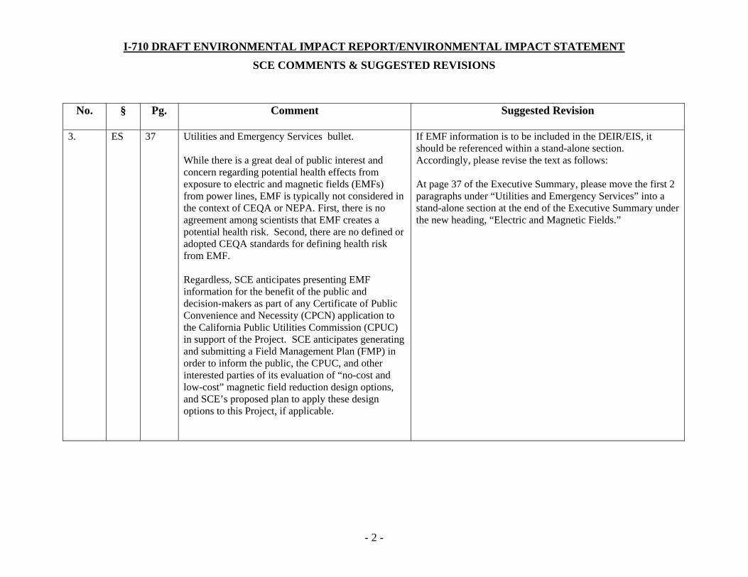
I-710 DRAFT ENVIRONMENTAL IMPACT REPORT/ENVIRONMENTAL IMPACT STATEMENT
SCE COMMENTS & SUGGESTED REVISIONS
- 2 -
No. § Pg. Comment Suggested Revision
3. ES
37
Utilities and Emergency Services bullet. While there is a great deal of public interest and concern regarding potential health effects from exposure to electric and magnetic fields (EMFs) from power lines, EMF is typically not considered in the context of CEQA or NEPA. First, there is no agreement among scientists that EMF creates a potential health risk. Second, there are no defined or adopted CEQA standards for defining health risk from EMF. Regardless, SCE anticipates presenting EMF information for the benefit of the public and decision-makers as part of any Certificate of Public Convenience and Necessity (CPCN) application to the California Public Utilities Commission (CPUC) in support of the Project. SCE anticipates generating and submitting a Field Management Plan (FMP) in order to inform the public, the CPUC, and other interested parties of its evaluation of “no-cost and low-cost” magnetic field reduction design options, and SCE’s proposed plan to apply these design options to this Project, if applicable.
If EMF information is to be included in the DEIR/EIS, it should be referenced within a stand-alone section. Accordingly, please revise the text as follows: At page 37 of the Executive Summary, please move the first 2 paragraphs under “Utilities and Emergency Services” into a stand-alone section at the end of the Executive Summary under the new heading, “Electric and Magnetic Fields.”
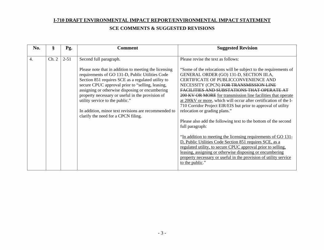
I-710 DRAFT ENVIRONMENTAL IMPACT REPORT/ENVIRONMENTAL IMPACT STATEMENT
SCE COMMENTS & SUGGESTED REVISIONS
- 3 -
No. § Pg. Comment Suggested Revision
4. Ch. 2 2-51 Second full paragraph. Please note that in addition to meeting the licensing requirements of GO 131-D, Public Utilities Code Section 851 requires SCE as a regulated utility to secure CPUC approval prior to “selling, leasing, assigning or otherwise disposing or encumbering property necessary or useful in the provision of utility service to the public.” In addition, minor text revisions are recommended to clarify the need for a CPCN filing.
Please revise the text as follows: “Some of the relocations will be subject to the requirements of GENERAL ORDER (GO) 131-D, SECTION III.A, CERTIFICATE OF PUBLICCONVENIENCE AND NECESSITY (CPCN) FOR TRANSMISSION LINE FACILITIES AND SUBSTATIONS THAT OPERATE AT 200 KV OR MORE for transmission line facilities that operate at 200kV or more, which will occur after certification of the I-710 Corridor Project EIR/EIS but prior to approval of utility relocation or grading plans.” Please also add the following text to the bottom of the second full paragraph: “In addition to meeting the licensing requirements of GO 131-D, Public Utilities Code Section 851 requires SCE, as a regulated utility, to secure CPUC approval prior to selling, leasing, assigning or otherwise disposing or encumbering property necessary or useful in the provision of utility service to the public.”

I-710 DRAFT ENVIRONMENTAL IMPACT REPORT/ENVIRONMENTAL IMPACT STATEMENT
SCE COMMENTS & SUGGESTED REVISIONS
- 4 -
No. § Pg. Comment Suggested Revision
5. Ch. 2
2-52
Third full paragraph. Modification of text warranted to reflect SCE’s utility relocation planning considerations.
Please revise the text at page 2-52 as follows: “…with due consideration of system capacity and needs, access and maintenance needs, long-term utility planning considerations, maintaining system reliability and necessary service to customers, maintaining safe system operations, providing for long-term reliability planning needs, providing for necessary property rights and just compensation, complying with required regulatory requirements, and the transportation improvements necessary to allow the safe and efficient movement of people and goods through the I-710 Corridor.”
6. Ch. 2
2-78 Table 2.7-1, Permits and/or Approvals Needed. Please note that SCE would comply with all applicable Federal Aviation Administration (FAA) regulations and procedures, including submittal of a NOTICE OF PROPOSED CONSTRUCTION OR ALTERATION (Form 7460-1), prior to construction. SCE recommends the addition of FAA Compliance to Table 2.7-1.
Please revise Table 2.7-1 to add FAA and associated approvals.
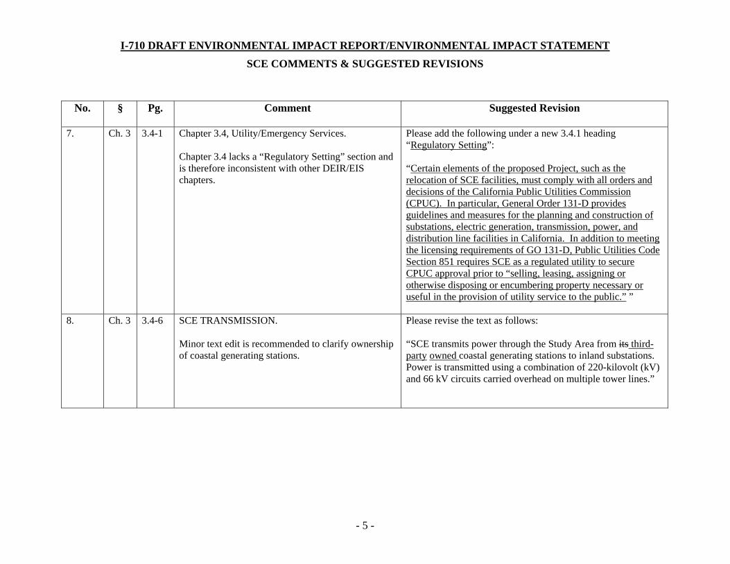
I-710 DRAFT ENVIRONMENTAL IMPACT REPORT/ENVIRONMENTAL IMPACT STATEMENT
SCE COMMENTS & SUGGESTED REVISIONS
- 5 -
No. § Pg. Comment Suggested Revision
7. Ch. 3
3.4-1 Chapter 3.4, Utility/Emergency Services. Chapter 3.4 lacks a “Regulatory Setting” section and is therefore inconsistent with other DEIR/EIS chapters.
Please add the following under a new 3.4.1 heading “Regulatory Setting”: “Certain elements of the proposed Project, such as the relocation of SCE facilities, must comply with all orders and decisions of the California Public Utilities Commission (CPUC). In particular, General Order 131-D provides guidelines and measures for the planning and construction of substations, electric generation, transmission, power, and distribution line facilities in California. In addition to meeting the licensing requirements of GO 131-D, Public Utilities Code Section 851 requires SCE as a regulated utility to secure CPUC approval prior to “selling, leasing, assigning or otherwise disposing or encumbering property necessary or useful in the provision of utility service to the public.” ”
8. Ch. 3
3.4-6
SCE TRANSMISSION. Minor text edit is recommended to clarify ownership of coastal generating stations.
Please revise the text as follows: “SCE transmits power through the Study Area from its third-party owned coastal generating stations to inland substations. Power is transmitted using a combination of 220-kilovolt (kV) and 66 kV circuits carried overhead on multiple tower lines.”

I-710 DRAFT ENVIRONMENTAL IMPACT REPORT/ENVIRONMENTAL IMPACT STATEMENT
SCE COMMENTS & SUGGESTED REVISIONS
- 6 -
No. § Pg. Comment Suggested Revision
9. Ch. 3
3.4-6
SCE TRANSMISSION. In addition to the facility relocations along the I-710 between the I-405 and SR-91, there are numerous additional facilities that will likely require relocation. Additional text is recommended to summarize the scope of these relocations. Exact details of these relocations would be determined following completion of additional engineering.
SCE recommends inserting the following paragraph under SCE TRANSMISSION: “In addition to the major facilities between the I-405 and SR-91, SCE has three (3) 220 kV transmission lines north of SR-91, as well as approximately thirty-eight (38) 66 kV subtransmission lines, twenty-five (25) 12 kV distribution lines, eighteen (18) telecommunication lines, and at least one regional substation (Bandini) that either cross, or run in parallel to, or are located in areas impacted by the Project.”
10. Ch. 3
3.4-8 Section 3.4.2.2 UTILITIES. Minor text revision recommended.
Please revise text as follows: "...all utility dispositions relocations are expected to occupy new or existing fee owned or easement rights-of-way or public rights-of-way."
11. Ch. 3
3.4-10 SCE TRANSMISSION. The DEIR/EIS assumes that Alternative 5A will require the relocation of SCE’s 220 kV and 66 kV facilities. It is assumed that at least seven 66 kV circuits (comprising approximately 30 circuit miles) will be relocated from their current location to public streets in six cities and unincorporated Los Angeles County.
Please revise text of fourth paragraph under the SCE TRANSMISSION heading as follows: “The construction of new 220 kV and 66 kV utility structures may move the new existing structures closer to businesses and residential areas on locations on public streets that are on the east side of the Los Angeles River and the Los Angeles River Trail.”

I-710 DRAFT ENVIRONMENTAL IMPACT REPORT/ENVIRONMENTAL IMPACT STATEMENT
SCE COMMENTS & SUGGESTED REVISIONS
- 7 -
No. § Pg. Comment Suggested Revision
12. Ch. 3
3.4-11
SOUTHERN CALIFORNIA GAS COMPANY. Minor text revision to clarify the description of SCE’s facilities warranted.
Please revise the text as follows: “One active and one idle 26-inch gas transmission lines main owned and operated by SCG is are located within SCE’s rights-of-way along I-710 between I-405 and SR-91. Due to the relocation of the 66 kV 220 kV lines in parts of this area, this gas main these gas transmission lines will need to be relocated within the relocation area shown in Figure 3.4-4.”
13. Ch. 3
3.4-11 Tables 3.4-1 & 3.4-2, describing utility impacts per alternative: At least within the Alternative 6 options (A/B/C), it is unclear why the numbers of affected power utilities would vary between each Alternative. For example, if the only difference between Alternatives 6B and 6C is the introduction of tolling on the dedicated freight corridor, why are the numbers of affected power utilities different (i.e., 95 for Alternative 6B, and 92 for Alternative 6C)? Presumably, these Alternatives would have the same physical footprint and same number of affected power utilities.
Please explain the basis for the total number of affected utilities, as well as the rationales supporting why these numbers would vary between the various Alternatives considered.
I-710 DRAFT ENVIRONMENTAL IMPACT REPORT/ENVIRONMENTAL IMPACT STATEMENT
SCE COMMENTS & SUGGESTED REVISIONS
- 8 -
No. § Pg. Comment Suggested Revision
14. Ch. 3
3.4-15 SCE 220 kV TRANSMISSION LINES. At the bottom of the page, the last sentence reads “Given the constraints of the Los Angeles River and levee, and the 200-foot corridor for SCE, the following relocations of the SCE 220 kV transmission lines would be required:” However, the bullet list that continues on page 3.4-21 does not represent SCE’s relocations. Minor text revision is suggested to accurately introduce project components that trigger the need for the 220 kV relocations.
Please revise the text of the last full sentence on page 3.4-15 as follows: “The Project’s need for 100 feet of SCE’s rights-of-way between the I-405 and SR 91 will require the relocation of the 220 kV lines found primarily within the existing utility corridor. Furthermore, given the constraints of the Los Angeles River and levee, and the 200-foot corridor for SCE, the following additional modifications will occur the following relocations of the SCE 220 kV transmission lines would be required:”
15. Ch. 3
3.4-15 SCE 220 kV TRANSMISSION LINES. Minor text revision to clarify the meaning of “no relocation provisions” within second full paragraph.
Please revise the text of second full paragraph as follows: “New 220 kV right-of-way with no relocation provisions (i.e., non-revocable property rights) and appropriate access to each rights-of-way location is required from the Los Angeles County Flood Control District (with the approval of the USACE), which operates and maintains the Los Angeles River in this section of the Study Area.”

I-710 DRAFT ENVIRONMENTAL IMPACT REPORT/ENVIRONMENTAL IMPACT STATEMENT
SCE COMMENTS & SUGGESTED REVISIONS
- 9 -
No. § Pg. Comment Suggested Revision
16. Ch. 3
3.4-21
Second full paragraph. Minor text revision recommended to clarify location of SCE’s facilities.
Please revise the text as follows: “To meet the minimum vertical clearance, the 220kV line was relocated further northwest from the existing I-710/I-405 interchange and further west east of the I-710/SR-91 interchange.”
17. Ch. 3
3.4-21 Last paragraph at bottom of page referring to “…the reconstruction of the city streets for trenching…” SCE does not currently foresee the need to trench within city streets during the construction/relocation of the 220 kV lines.
Please revise the text as follows: “Indirect impacts as a result of the SCE 220 kV transmission line relocation would include traffic disruption during construction, the need for construction staging areas and temporary construction easements, the reconstruction of city streets from trenching, and the presence of construction equipment and dump trucks during construction.”
18. Ch. 3
3.4-22
SCE 66 kV SUBTRANSMISSION LINE. Text asserts that “Figure 3.4-2 shows the relocation strategies for the SCE 66kV subtransmission line…” The relocation strategy is not depicted in this figure. SCE recommends additional text to clarify the relocation of the 66 kV circuits.
Please revise the text as follows: “SCE will be required to relocate the four 220 kV circuits primarily within the existing transmission corridor, as well as relocate at least seven 66 kV circuits (comprising approximately 30 circuit miles) from their current location to public streets in six cities and unincorporated Los Angeles County. Figure 3.4-2 shows certain the relocation strategy for the SCE 66 kV subtransmission line, and Figure 3.4-4 shows the potential relocation area for the SCE 66 kV subtransmission line.”
I-710 DRAFT ENVIRONMENTAL IMPACT REPORT/ENVIRONMENTAL IMPACT STATEMENT
SCE COMMENTS & SUGGESTED REVISIONS
- 10 -
No. § Pg. Comment Suggested Revision
19. Ch. 3
3.4-22
SCE 66 kV SUBTRANSMISSION LINE. Recommended text clarification to confirm the need for relocations of SCE’s 66 kV subtransmission lines.
Please revise the text as follows: “The following relocations may will be required for the SCE 66kV subtransmission lines with Alternatives 6 A/B/C…”
20. Ch. 3
3.4-26 First paragraph. SCE recommends additional text to account for businesses potentially impacted by future utility relocations. In addition, as stated in the cover letter, SCE requests confirmation that all potential impacts associated with SCE’s relocation were analyzed per the applicable CEQA criteria.
Please revise the text as follows: “However, based on the SCE relocation criteria described above, direct land use and visual impacts are not expected to be substantial, because even if the utility structures shift slightly closer to the homes, businesses, and the Los Angeles River Trail, there would not be a change in land use or a substantial difference in the existing view from the homes or the Trail.”

I-710 DRAFT ENVIRONMENTAL IMPACT REPORT/ENVIRONMENTAL IMPACT STATEMENT
SCE COMMENTS & SUGGESTED REVISIONS
- 11 -
No. § Pg. Comment Suggested Revision
21. Ch. 3
3.4-28 3.4.2.3 PUBLIC HEALTH CONSIDERATIONS. While there is a great deal of public interest and concern regarding potential health effects from exposure to electric and magnetic fields (EMFs) from power lines, EMF is typically not considered in the context of CEQA or NEPA. First, there is no agreement among scientists that EMF creates a potential health risk. Second, there are no defined or adopted CEQA standards for defining health risk from EMF. Regardless, SCE anticipates presenting EMF information for the benefit of the public and decision-makers as part of any Certificate of Public Convenience and Necessity (CPCN) application to the California Public Utilities Commission (CPUC) in support of the Project. SCE anticipates generating and submitting a Field Management Plan (FMP) in order to inform the public, the CPUC, and other interested parties of its evaluation of “no-cost and low-cost” magnetic field reduction design options, and SCE’s proposed plan to apply these design options to this Project, if applicable.
Please revise the DEIR/EIS and remove section 3.4.2.3 in its entirety. In the alternative and if EMF information is included in the DEIR/EIS, it should be referenced within a stand-alone section. Accordingly, Section 3.4.2.3 “Public Health Considerations” should be renamed “Electric & Magnetic Fields.”
22. Ch. 3 3.4-31 Footnote #1. SCE website referenced within footnote #1 does not appear to contain the quoted information.
Please re-check the website link and provide additional references as may be warranted for the quoted language in the DEIR/EIS.
I-710 Corridor Project RDEIR/SDEIS
Page 68
This page intentionally left blank

I-710 Corridor Project RDEIR/SDEIS
Page 69
U-5-1
For the Recirculated Draft Environmental Impact Report/Supplemental Draft Environmental
Impact Statement (RDEIR/SDEIS), Caltrans has coordinated with Southern California Edison
(SCE) in identifying an acceptable relocation strategy for their 220-kilovolt (kV) transmission
lines. Please refer to Section 3.4 of the RDEIR/SDEIS for an updated description of the impacts
to utilities under the revised build alternatives Caltrans also acknowledges the potential need for
and the stipulations of a Relocation Agreement between SCE and Caltrans/Los Angeles County
Metropolitan Transportation Authority (Metro) as described in this comment upon SCE’s review
of the revised impacts.
U-5-2
It is acknowledged that SCE intends to use the Interstate 710 (I-710) Corridor Project EIR/EIS is
support of its Certificate of Public Convenience and Necessity (CPCN) application to the
California Public Utilities Commission (CPUC) to conduct work on SCE facilities required by the
I-710 Corridor Project. The need for a CPCN application has already been acknowledged in the
EIR/EIS as noted in this comment.
U-5-3
Please refer to Section 3.4 for a substantially revised version of impacts to utilities in the
RDEIR/SDEIS. Caltrans has coordinated with SCE in identifying impacts to and potential
relocation strategies for their 66 kV transmission lines.
U-5-4
The environmental document for the I-710 Corridor Project is a joint EIR/EIS intended to comply
with the requirements of both the California Environmental Quality Act (CEQA) and the National
Environmental Policy Act (NEPA). As a result, the Environmental Commitments Record (ECR)
in Appendix F is intended to serve as both the ECR under NEPA and the Mitigation Monitoring
and Reporting Program (MMRP) under CEQA. The ECR lists all the avoidance, minimization,
and mitigation measures included in the build alternatives, including measures for effects that
may be less than significant under CEQA prior to mitigation. Chapter 4.0 in the EIR/EIS
describes the impacts of the build alternatives under CEQA and the avoidance, minimization,
and mitigation measures included in the build alternatives to address those impacts determined
to be significant before mitigation. The impact discussions in Chapter 4.0 in the categories of
“no impact” and “less than significant impacts” do not describe any mitigation for those
categories because, under CEQA, no mitigation is required for project effects in those two
categories. As a result, because Chapter 4.0 clearly describes the impacts that require

I-710 Corridor Project RDEIR/SDEIS
Page 70
mitigation under CEQA and the applicable measures, and the ECR is intended to serve as both
the ECR and MMRP for the project, none of the avoidance, minimization, and mitigation
measures in the ECR were removed as requested in this comment. For purposes of SCE’s
future application to the CPUC, Caltrans can assist SCE in identifying those measures which
address significant impacts under CEQA.
U-5-5
The purpose of the Specific Utility Relocation Plans required in Measure U&ES-2 is to prepare
detailed specific work plans for the relocations of affected utilities, in conjunction with the utility
owners and operators. Those plans will also identify any avoidance, minimization, and mitigation
measures from the EIR/EIS that would apply to activities associated with the utility relocations.
Caltrans is committed to implementing or requiring its construction contractors to properly
implement all the measures in the ECR in Appendix F, wherever they are applicable to project
work and project construction areas, including work and work areas associated with utility
relocations. At this time, the measures in the ECR are anticipated to be implemented by
Caltrans and/or its construction contractors. However, if the Specific Utility Relocation Plans
determine that some work associated with the relocations would be conducted by the utility
owners or operators rather than Caltrans, the measures in the ECR, or similar measures if
required under CEQA for those relocations, would be implemented by the utility owner/operator
and/or its contractors. Once a preferred alternative is identified, Caltrans will coordinate with
SCE and other utility providers to identify those specific measures that would be the
responsibility of the utility providers.
U-5-6
As discussed in Section 2.4.2 of the RDEIR/SDEIS, Alternative 5A has been withdrawn from
further consideration.
U-5-7
Due to changes in project design, impacts to the Bandini substation are no longer anticipated.
U-5-8
Caltrans and Metro coordinated with SCE on conducting the additional load flow studies noted
in this comment regarding the details of the power consumption and distribution system for the
zero emission freight corridor in the build alternatives. However, the revised build alternatives
are characterized as “technology neutral” and are not assumed to be powered by electric,
catenary, or wayside power. Please refer to the revised Section 3.4 in this RDEIR/SDEIS for an
updated discussion of the project impacts to utilities.

I-710 Corridor Project RDEIR/SDEIS
Page 71
U-5-9
The Executive Summary has been revised to accurately reflect the updated impacts of the
revised build alternatives and currently reads: “Alternatives 5C and 7 would result in the
relocation of electric and gas transmission facilities owned and operated by Southern California
Edison (SCE) [and others]…”
The comment regarding the cited figure in the Executive Summary is no longer applicable due
to the revised build alternatives currently under consideration.
U-5-10
The cited sentence in Section S.5.4.1 was revised to read (changes shown in italics):
“…extensive relocation of electric and gas transmission facilities owned and operated by SCE,
the Southern California Gas Company, and the Los Angeles…”
U-5-11
The analyses in Chapter 3.0, Affected Environment, Environmental Consequences, and
Avoidance, Minimization, and/or Mitigation Measures, in the EIR/EIS for individual parameters
(parks, environmental justice, utilities, etc.) included analysis of public health considerations.
Section S.5.25 summarizes the finding of the analyses from the individual sections in Chapter
3.0 related to public health considerations. The discussion of electromagnetic fields (EMF)
exposure in Section S.5.25 is based on the analysis provided in Section 3.4, Utility/Emergency
Services. As a result, the discussion of EMF exposure is provided in the Utilities and Emergency
Services subsection in Section S.5.25 and not as a separate section in the Executive Summary
as requested in this comment.
U-5-12
The last sentence in the third paragraph in Section 2.3.2.1, Major Utility Relocations, was
revised to read (changes shown in italics): “Some of the relocations will be subject to the
requirements of GENERAL ORDER (GO) 131-D, SECTION III.A, CERTIFICATE OF PUBLIC
CONVENIENCE AND NECESSITY (CPCN) for transmission line facilities that operate at 200
kV or more, which will occur after certification of the I-710 Corridor Project EIR/EIS but prior to
approval of utility relocation or grading plans. In addition to meeting the licensing requirements
of GO 131-D, Public Utilities Code Section 851 requires SCE, as a regulated utility, to secure
CPUC approval prior to selling, leasing, assigning or otherwise disposing or encumbering
property necessary or useful in the provision of utility service to the public.”

I-710 Corridor Project RDEIR/SDEIS
Page 72
In addition, Section 3.4 of the RDEIR/SDEIS was substantially revised to reflect the updated
utility impacts of the revised set of build alternatives.
U-5-13
The first sentence in the last paragraph in Section 2.3.2.1, Major Utility Relocations, was revised
to read (changes shown in italics): “All utility relocation planning will be made in concert with the
utility providers, with due consideration of maintaining system reliability and necessary service
to customers, maintaining safe system operations, providing for long-term reliability planning
needs, providing for necessary property rights and just compensation, complying with required
regulatory requirements, and the transportation improvements necessary…”
U-5-14
Due to the design of the revised build alternatives, Federal Aviation Administration (FAA)
permits are not anticipated to be necessary.
U-5-15
The Caltrans Annotated Outline does not contain a Regulatory Setting subsection in Section
3.4. However, the requested text has been added in Section 2.3.2.1, Common Features of the
Build Alternatives.
U-5-16
Section 3.4 of the RDEIR/SDEIS has been revised in a manner that makes the suggested
revisions no longer relevant, given the revised impacts of the build alternatives.
U-5-17
Section 3.4 of the RDEIR/SDEIS has been substantially revised to describe the extent of major
facilities that cross, run in parallel to, or are located in areas that may be impacted by the project
build alternatives.
U-5-18
The text within the first paragraph under Section 3.4.2.2, Utilities of the RDEIR/SDEIS, was
revised as requested.
U-5-19

I-710 Corridor Project RDEIR/SDEIS
Page 73
Section 3.4 of the RDEIR/SDEIS has been revised in a manner that makes the suggested
revisions no longer relevant, given the revised impacts of the build alternatives.
U-5-20
Section 3.4 of the RDEIR/SDEIS has been revised in a manner that makes the suggested
revisions no longer relevant, given the revised impacts of the build alternatives.
U-5-21
Data collection for existing facilities within the alignments of Alternatives 6A/B/C presented in
the Draft EIR/EIS, were based on utility base maps that established the approximate location in
relation to existing freeways and arterials. The descriptions and locations rely upon the record
data collected, field reconnaissance, and limited coordination with utility owners. Positive
identification methods, such as potholing or surveying, were not used to verify the location of
facilities at this stage of the proposed project. This information has been updated in Section
3.4.1.2 of the RDEIR/SDEIS, based upon the revised design of the build alternatives and the
updated utility relocation studies.
U-5-22
Section 3.4 of the RDEIR/SDEIS has been revised in a manner that makes the suggested
revisions no longer relevant, given the revised impacts of the build alternatives.
U-5-23
Section 3.4 of the RDEIR/SDEIS has been revised in a manner that makes the suggested
revisions no longer relevant, given the revised impacts of the build alternatives.
U-5-24
Section 3.4 of the RDEIR/SDEIS has been revised in a manner that makes the suggested
revisions no longer relevant, given the revised impacts of the build alternatives.
U-5-25
Section 3.4 of the RDEIR/SDEIS has been revised in a manner that makes the suggested
revisions no longer relevant, given the revised impacts of the build alternatives.
U-5-26

I-710 Corridor Project RDEIR/SDEIS
Page 74
Section 3.4 of the RDEIR/SDEIS has been revised in a manner that makes the suggested
revisions no longer relevant, given the revised impacts of the build alternatives.
U-5-27
Section 3.4 of the RDEIR/SDEIS has been revised in a manner that makes the suggested
revisions no longer relevant, given the revised impacts of the build alternatives.U-5-28
Section 3.4 of the RDEIR/SDEIS has been revised in a manner that makes the suggested
revisions no longer relevant, given the revised impacts of the build alternatives.
U-5-29
The discussion of potential EMF exposure in Section S.5.25 is based on the analysis provided
in Section 3.4, Utility/Emergency Services. Public health considerations as a result of the I-710
Corridor Project are considered throughout the EIR/EIS in part because these types of issues
were raised by many agency representatives and members of the general public during the
scoping process and the public hearings for the Draft EIR/EIS. Sections S.5.25 and 3.4 both
acknowledge that there is no scientific agreement regarding potential EMF exposure.
Nonetheless, the information in those sections of the EIR/EIS is provided to inform the public of
potential health considerations related to EMFs. As a result, the discussions of EMF exposure
provided in Sections S.5.25 and 3.4 in the RDEIR/SDEIS were not removed. The topic of public
health consideration from electric and magnetic fields will remain in Section 3.4.2.3 in order to
be consistent with the public health consideration discussion throughout the RDEIR/SDEIS.
U-5-30
The quoted information within Section 3.4.2.3 was taken from several sources accessed
through the SCE website. Therefore, the text now states (revisions in italics):
“The following information regarding EMFs was accessed through several
resources on the SCE website.”
Therefore, no revisions to the footnote are necessary at this time.
COUNTY
1955 Workmon Mill Rood. Whiltier. CA 90ó0'l-1400Moiling Address: PO. Box 4998, Wh¡tlier, CA 9O607 -4998Telephone: (562) 699-741 l, FAX: (562) 699-5422www. rocso.org
SANITA.TION DISTFICTSOF LOS A.NGELES COUNTY
GRACE ROBINSON CHANChief Enginee r ond Generol Monoger
September 26,2012
Ronald KosinskiCaltrans District 7
Division of Environmental Planning100 South Main Streel MS 164Los Angeles, CA 90012
Dear Mr. Kosinski:
I-710 Corridor Proiect
The County Sanitation Dishicts of Los Angeles County (Districts) received a DraftEnvironmental Impact Report/Environmental Impact Statement (EIRÆIS) for the subject project onJuly 2,2012. We offer the following comments on the Draft EIRÆIS:
Chapter 7.0 Distribution List
o On page 7-3, under Parlicipating Agencies/County Agencies, please update to reflect GraceRobinson Chan as the Chief Engineer and General Manager of the Districts.
Districts' Long Beach Main Pumping Plant (LBMPP)
o Under Section 5.3.2, Agency Involvement, please include a listing for the attached letter fromthe Districts dated October 13, 20II, to the Los Angeles County Metropolitan TransportationAuthority (Metro).
As early as May 2008, Districts' staffcontacted Caltans about the proposed I-710 Conidor Projectto find out the time frame for the freeway project and how wide of a corridor would be impacted onthe west side ofthe freeway where the Districts' LBMPP facility is located.
The LBMPP handles an average flow of 28 million gallons per day (MGD) and serves the Citiesof Long Beach, Signal Hill, and portions of the cities of Artesia, Bellflower, Cerritos, HawaiianGardens, Lakewood, and Norwalk (see Figure 1). Wastewater is collected from a tributary area
of approximately 70 square miles for conveyance to the Districts' Joint Water Pollution ControlPlant in Carson for treatment.
o Due to the age of the facilþ, it is necessary to upgrade and expand the LBMPP. Theconfiguration and size of both the inlet gravity sewers and force mains requires that the LBMPPReplacement Project be sited on the property located adjacent to and west of the existingpumping plant. The Replacement Project is progressing with plans to advertise in December2012 and construction is anticipated to be completed in early 2015. The tot¿l project cost isapproximately $25 million
DOC # 2368825Recycled roo", al}
Mr. Ronald Kosinski September 26,2012
o The Districts have met with staff from Metro, URS Colporation, and AECOM on various dates todiscuss both projects and potential impacts to the Districts' existing and proposed facilities.Districts' st¿ff has kept Metro staff informed of properly acquisitions as they were completed inAugust 2010 and January 20II, as well as the LBMPP Replacement Project schedule via email andtelephone.
o The Districts have acquired a total of five parcels specifically for the LBMPP ReplacementProject. Four of the five parcels are listed in the Appendix L of the Draft EIRÆIS under TableL-l Parcel Acquisitions (pages L-19,L-20) and are shown on the acquisition map (Sheet 3 of 41)to be fully acquired by Caltrans. The APNs listed in Table L-1 are incorrect and should beupdated per attached Assessor's map. Caltrans is proposing to acquire these parcels which is inconflict with the LBMPP Replacement Project and as such, is not acceptable to the Districts.
¡ Concept Plans in Appendix O (Sheet 2 of 24) depicts a Caltrans proposed elevated structure on aportion of the parcel located directþ west of the freeway and adjacent to the existing LBMPP.The Districts acquired this parcel in 2008 and the Assessor's staff has recently assigned APN7432-022-906 to the parcel. This parcel not only contains existing electrical equipment thatsupports the existing LBMPP, but will be used for telemetry and electrical facilities expansionrelated to the LBMPP Replacement Project. Caltrans is proposing to acquire a major portion ofthis parcel which is in conflict with the LBMPP Replacement Project and as such, is notacceptable to the Districts.
o Concept Plans in Appendix O (Sheet 2 of 24) also depict temporary construction easements onDistricts' properties identified as APNs 7432-022-902, 903, 904 and 905. The LBMPPReplacement Project will be constructed on these parcels and as such, use of these properties byCalhans is not possible.
o The Districts again respectfully request that Metro/Caltrans redesign its proposed truck off/onramps to avoid conflict with the LBMPP Replacement Project.
Districts' Regional Trunk Sewers
o It is noted that both the Draft EIRÆIS and Utility Impact Report consider the followingstrategies for utilities that will be impacted and include: 1) protect in place, 2) continuousaboveground relocation, and 3) continuous underground relocation. The Utility Impact Reportalso breaks down the I-710 project into seven segments and identifres Districts' facilities in theAppendix 2, Utilily Base Maps and Appendix 3, Utility Crossing Report. Along the I-720Corridor Project, there are existing Districts' sewer lines/facilities located directly under and/orcross directly beneath the proposed project alignment at various locations.
o At this time, the Districts cannot issue a detailed response to, or allow construction of theproposed I-710 project until project plans and specifications that incorporate Districts' sewetagefacilities are submitted. In order to prepare these plans, Caltrans will need to submit a map ofthe proposed project alignment, when available, to the attention of Mr. Jon Ganz of the Districts'Sewer Design Section at the address shown above. The Districts will then provide Calhans withthe plans for all Districts' facilities that will be impacted by the proposed project. When revisedplans that incorporate Districts facilities have been prepared, copies of the same shall besubmitted to the Districts for review and comment.
-2-
DOC # 236882s
Mr. Ronald Kosinski -3- September 26,2012
The Districts acknowledge that Mr. Ernesto Chaves of Metro recently contacted Districts' staffand indicated an avoidance option is being formulated that would avoid impacting the LBMPPReplacement Project and that once the revised plans are completed, Metro will schedule a meeting withDistricts' staff. Any conflict from the proposedl-7I} Corridor Project that detrimentally impacts theDistricts' ability to operate and maintain the replacement wastewater pumping plant is unacceptable, as
public health and safety must be protected.
If you have any questions, please contact Ms. Margarita E. Cabrera at (562) 908-4288,extension 2710.
Very truly yours,
Grace Robinson Chan
An\L%e*David GreenwoodSupervising EngineerFacilities Planning Department
DG:MEC:rvr
Attachments
cc: Jon GanzJane FongErnesto Chaves, LACMTA
DOC # 2368825

COUNTY
I955 Workmon Mill Rood, Whillier, CA 90ó0ì -1400Moiling Address: PO. Box 4998, Whillie r, CA 906O7 -4998Telephone: 1562) 699-74 I l, FAX: (562) ó99-5422www locsd org
¡tlt,
SANITATION DISTFIICTSOF LOS ANGELES COUNTY
STEPHEN R. MAGUINChiel Engrneer ond Ger¡erol Monoger
October 73,2011
Douglas R. Failing P.E.Exeoutive Director, Highway hogramLos Angeles County Metropolitan Transportation AuthorityOne Gateway Plaz+ lvfail Stop: 99-22-7Los Angeles, CA 90012-2952
DearMr. Failing:
County Sanitation Distric'ß of Los Angeles County
The County Sanitation Districts of Los Angeles County @istricts) arc a confederatiott ofindependent qpecial districts that serve the wastewater and solid waste management needs of over5 million people in Los Angeles County. The Disüicts' service ûea coveß approximately E00 squaremiles and encompass€s 78 cities and unincorporated Couuty ûenitory. The Disüicts own, op€rate, andmaintain over 1,300 miles of tn¡ok sewers, 54 purnping plants, and l1 wastßwater teatment plants.
The Districts' I¡ng Beach Main hrmping Plant (LBMPP) facility located at l24E W. 16ü Steetin the City of Iong Beach (west of the I-710 Freeway and south of Pacific Coast Highway) is beingrebuilt in order to continue to provide adequate wastewater services thereby protecting the health andsafety of the general public. As background, the LBMPP was built tn 1947, and the proposed subjectproject (Replacement ProjecÐ will replace it. Additional property has been acquired adjaccnt to theexisting plant to consfruct a new purtping plant while keeping the existing plant in service (as shown inFigure l). The LBMPP handles an average flow of 28 million gallons p€r day (MGD) and a wet weatherpeak flow of 60 MGD. It conveys wastewater from all or part of the cities of Artesiq Bellflower,Cerritos, Hawaüan Gardens, Lakewoo4 Long Beacl¡ Norwalb and Sig¡al Hill to the Disüicts' JointWatpr Pollution Cont¡ol Plant in Carson. Figure 2 shows the locdion of the LBMPP and its 70 squaremile service area.
In May 200E, Disbicts' Propely Management staff contacted Caltrans to inquire if there weremy current plans to expand the I-710 freeway in the subject area. If so, the Disbícts wasted to know thetime fra¡re for expansion and how wide of a corridor on úe west side of the freeway would be required.Caltans responded that it had determined that the Dishicts' LBMPP property was not within the fooþrintof the futre freeway e¡pansion project. Cathans also indicated that, althouglu the freeway project is stillin the earþ planning stages, based on the inform¡tion on han4 it would be very unlikely that theDistricts' LBMPP would be affected by the expansion of the 710 Freeway. The Districts proc.eede.d tomove forwa¡d with identifying potential locations of acquisition properties for the Replacæment hoject.Due to the configuration and size of both the inlet gravity sewers and force meins, the ReplacæmentProject would need to be sited on property located adjacent to and west ofthe existing punrping plant.
Recycled Poper
Doc#2051336

Douglas R. Failing P.E October l3,20ll
In Jr¡ne 2009, Districts' Property Management stafr was contacted by Paragon Partners,requesting an entry perrrit to the LBMPP to perform an envi¡onmental survey associated with the futr¡¡efreeway expansion, the I-710 Conidor Project. Accordingþ, Disticts' staffrequested and held a meetingon July 8, 2009, with Mr. Ernesto Chaves of Mehopolitan Transportation Authority (Metro) andMr. Shannon Willits of URS Corporation, to discuss the I-710 Conidor Project and its potential impactsto the LBMPP and the Replacement Project. It was reiterated by Meto that the I-710 Conidor Projectwas still in the planning stages with no project timeline available, and that the Districts shouldindependently move forward with the Replacement hoject. During this meeting it was discussed thattherc may be other Districts' faoilities, such as sewetrs, that may be impacted by the projeet and that a
Caltans/Tvfetro consultant was reviewing those utility impacts.
Base.d on conespondence received from Caltrans dated August 18, 2009, pertaining to the I-710Co¡ridor Environmental fmpact ReportÆnvironmental Impact Statenent Purpose and Nee{ Districtsstaff requested another meeting to review Caltrans' preliminary plans for the various alærnatives beingdeveloped. On October 22,2009, Metro and tlRS met with the Districts to discuss Caltrans' preliminaryplans and the potential properties on which the Districts could feasibly constnrct fhe Replaceme,nt Project.It is noted that Districts' staffinformed Mefro staffwhen properly acquisition we,nt into escrow and whenit closed. The proporty acquisitions wer,e completed on July 29,20L0 and Ma¡ch 4,2011.
On August 2,2011, the Districts met with Mr. Willits of URS to discuss the Replacement Projectlayout on the acquired property and its relationship to the ñ¡tr¡re I-710 Cor¡idor Project. Mr. Willits notedthat the Drafr EIR alternative with the Freight Corridor has the proposed location of the tn¡ck off/onramps south of Pacific Coast Higbway in conflict with portions of the Replacement Project. Districts'staffrequesûed that the layout of the tn¡ck off/on ramps be redesþed to avoid any conflict. Mr. Willitswas inforured that design of the Districts' Replacement Project is scheduled to be complet€d in spring2012 and that the Distriots plan to advertise in lvlay 2012 with construction beginning in fall 2012.Constn¡ction is estimated to be completed within a timefr¿me of two years (late 2014). The constn¡ctioncost of the project is estimated at approximately $20 million dolla¡s and the total project cost isapproximately $25 million dollars.
After this meeting, Districts' staff qpoke to and confirmed with Mr. Chaves of Metro that theDistricts should continue to move forward with the subject project due to the fact that funding is not inplace for the I-710 Conidor Project and the project timeline is currently indetenninate. However,M¡. Chaves wanted Metro's 'l¡tility team" consultant, AECOM, to meet with the Districts to identi$ theReplacement Project's impacts to the proposed I-710 conidor improvements and investigate/proposerelocation strategies for the impacted utilities. On September 27,2011, a meeting was held betweenM€tro's, AECOM's, and Districts' staff 1o s¡efoenge/gather information. Portions of the existingpumping plant are projected to be demolished sometime in year 2015 afrer the Replacæme,nt Project isconstn¡cted and proven to be operational. Mr. Chaves indicated that the ea¡liest projected date thatfunding for the I-710 Conidor Project would be in place is the year 2018, assuming the Freigbt Conidoralternative is selected. He further indicated that there will be one year be¡peen the Draft and Final EIRsand that the Final EIR should show a *relocation sch€me" accæptable to both parties.
The Disticts respectfrrlþ requests Meto/Caltans redesign its proposed tn¡ck oflon ramps toavoid conflict with the proposed Replacement Project. Futr¡¡e interferencæs from the proposed I-710Conidor Project will detimentally impact the ability to operate and maintain the new plant.

Douglas R. Failing, P.E October l3,20l[
If you have any questions or require additional information, please contact Margarita E. Cabreraat(562) 9084288, extension 2710.
Very truly yours,Stephen R. Maguin
f,\ '1 r\ llU^*JL/\tt'*"4/
David GreenwoodSupervising EngineerFacilities Planning DeParünent
MEC:mh
Enclosures
c: Jane FongMargarita E. CabreraEmesto Chaves, LACMTA
-3-
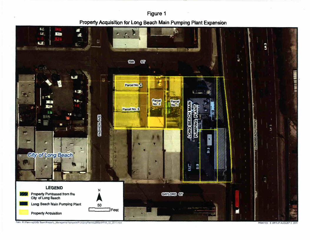
Figure 1
PropertyAcquisition for Long Beach Main Pumping Plant Expansion

C\l
r¡¡ú,ÐoIL

TI
Fu¡Éfol¡.

OF THEOF LOS
COPYRIGHT O 2OO2
REVISED2002111912201 0'1 20802008001 -26
201 1 04061000600 1-2620t2a82902@tôol-262at2¿87902'26
N
MÆPING AND GISSERVICES
SCALE 1" - 80'
=tTL
¡..-
t.lJ
É.
IOul
aqz9
60
uJ
z
=LL60
BO
uJ
É.(JmtT80
3 16TH
A GAYLORD
òt õ
*qE
11
6ùI
40
l0
tNcTR;
@
23
ñT8
@
OF
7I
15000Ê3F
6¡
I
\-t
'o*lI
4950+SF
t27I
- tzPOR
l3ì 14@lq to
6olVK17-
178
oi'.,(ù18POR
ST3
òL
. ¡lK: PoRi
B
10
{29900rf
@)
OF
40
tTHI
ð
\-/
_oc
7
Sl¡
o
@r
22
1
NER5
.t
4
o
TO
'f
HAR¿á
,@\14950rSF
24rôa
1
{
40
ì12ë
POR
.M(¿- so
IJ
40
3
14G)tf,
t7)
16 17eÒr '18
10
I 10)
19@20 ¿t
40
)950rSF
6à^. :l¿z
V\€SI
ALL 9OO SERIES PARCELS ON THIS PAGE ARE ASSESSEDTHE LOS ANGELES COUNTY SANITATION DISTRICT NO 3,UNLESS OTHERIVISE NOTED

I-710 Corridor Project RDEIR/SDEIS
Page 85
U-6-1
Ms. Chan was added to the distribution list in Chapter 7 as follows:
“County Sanitation Districts of Los Angeles County
Grace Robinson Chan, Chief Engineer and General Manager
P.O. Box 4998
Whittier, CA 90607-4998”
U-6-2
Chapter 5 has been revised to only discuss in detail agency coordination that has taken place
since the Draft Environmental Impact Report/Environmental Impact Statement circulation period
in 2012. Further coordination regarding the potential impacts to this facility has taken place and
is reflected in Section 3.4, Utility and Emergency Services, and the Interstate 710 (I-710) South
End Utility Study (AECOM, 2016).
U-6-3
The information provided in this comment about the LBMPP project has been added to Section
3.25, Cumulative Impacts, of the Recirculated Draft EIR/Supplemental Draft EIS
(RDEIR/SDEIS). Table 3.25-1 details relevant cumulative environmental factors as follows: The
City of Long Beach General Plan EIR identified no cumulatively considerable effects to the
environment as it relates to utilities through full build out. The City of Long Beach General Plan
Land Use Element establishes PlaceTypes, each subject to unique design guidelines in
accordance with the City’s Urban Design Element. As such, the LBMPP Upgrades Project was
subject to its own General Plan consistency analysis and was reviewed for consistency with
adopted land use plans and policies. No cumulatively considerable effects on the environment
were identified.
U-6-4
Please refer to Section 3.4 of the RDEIR/SDEIS for an updated description of impacts to the
LBMPP facility under the revised build alternatives.
U-6-5
Please refer to Section 3.4 of the RDEIR/SDEIS for an updated description of impacts to the
LBMPP facility under the revised build alternatives.

I-710 Corridor Project RDEIR/SDEIS
Page 86
U-6-6
Please refer to Section 3.4 of the RDEIR/SDEIS for an updated description of impacts to the
LBMPP facility under the revised build alternatives.
U-6-7
Please refer to Section 3.4 of the RDEIR/SDEIS for an updated description of impacts to the
LBMPP facility under the revised build alternatives.
U-6-8
Please refer to Section 3.4 of the RDEIR/SDEIS for an updated description of impacts to the
LBMPP facility under the revised build alternatives.
U-6-9
Please refer to Section 3.4 of the RDEIR/SDEIS for an updated description of impacts to the
LBMPP facility under the revised build alternatives.

Watler and PoL,n"etr
ANTONIOR VILLARAIGOSAMayor
CommissionTHOMAS S. SAYLES, Pres;derr
ERIC HOLOMAN, r/íce President
RICHARD F. MOSSCHRISTINAE. NOONANJONATHAN PARFREYBARBARA E. MOSCHOS, Secrerary
RONALD O. NICHOLSGeneral Managet
Septembet 27,2012
Mr. Ronald Kosinski l,/(Deputy District DirectorCaltrans District 7, Division of Environmental Plannino100 South Main Street, MS 164Los Angeles, CA 90012
Dear Mr. Kosinski:
Re: Review of the Draft Environmental lmpact ReporlEnvironmental lmpact Study forthe l-710 Corridor Project
The City of Los Angeles, Department of Water and Power (LADWP) has receivedcopies of the Draft Environmental lmpact Report (Draft EIR) for the l-710 CorridorProject (the Project). Specifically, the Project is a proposal by the California Deparlmentof Transportation (CalTrans), in cooperation with the Los Angeles County MetropolitanTransportation Authority, the Gateway Cities Council of Governments, the SouthernCalifornia Association of Governments, the Ports of Los Angeles and Long Beach, andthe lnterstate 5 Joint Powers Authority, to make improvements to lnterstate 710 (l-710)in Los Angeles County between Ocean Boulevard in Long Beach and State Route 60(sR-60)
The proposed Project and a number of its alternatives will adversely impact theLADWP's operations. The 100- to 15O-foot corridor contains four 230-kV circuits thattransmit electricity from Haynes Generating Station (HnGS) and one 220-kV circuit tiewith Southern California Edison (SCE), all of which are vital to LADWP's electricalsystem which feeds the City of Los Angeles and some of the surrounding cities. Furlherinformation will be required to determine if the relocations proposed in the Draft EIR arephysically and procedurally possible. Please consider and/or address the followingcomments regarding the Project:
1. Please change all acronyms in the document from DWP to LADWP when referringto the City of Los Angeles, Department of Water and Power.
2. The applicant shall acknowledge that the LADWP's transmission line rights-of-way(ROW) are integral components of the transmission line system, which provideselectric power to the City of Los Angeles and other local communities. Their use isunder the jurisdiction of the Federal Norlh American Electric Reliability Corporation(NERC). Safety and protection of critical facilities are the primary factors used toevaluate secondary land use proposals. The rights of way serve as platforms for
Water and Power Conservation . . . a way of life111 North Hope Street, Los Angeles, California 90012-2601 Mailing address: Box 5111 1, Los Angeles 90051-5700
Telephone: (2I3) 361-4211 Cable address: DEWAPOLAReqdaHe and mde fim ræ'ded %¡le ffi


Mr. Ronald KosinskiPage 2September 27,2012
3.
access, construction, maintenance, facility expansion and emergency operations.Therefore, the Project may from time to time be subject to temporary disruptioncaused by such operations.
The LADWP's interest in the land in question is owned in "fee" and would requirerelocation under the alternatives 5A, 64, 68, and 6C mentioned in the DraftEIR/EIS. The LADWP's existing land rights, if relocated, would require therequesting agency to acquire equivalent land interests. The proposed relocationsmentioned in the Draft EIR pose significant challenges in the acquisition of landsfor the LADWP's use, including acquiring temporary rights of way during theconstruction phase of the relocations. Access to and from the proposed ROW,storm water run-off impacts to the LADWP structures, transmission lineclearances, emergency access, including perceived inferior property rights above alarge body of water opposed to that of existing property rights are among theissues clouding an equivalent exchange of lands.
Please provide plans illustrating the LADWP's transmission line ROW boundarieswithin the l-710 Corridor Project. lnclude towers and clearances from proposedimprovements. Also, provide grading plans, storm drain plans, utility plans, andstreet plans, including pertinent plans illustrating the impacts to the l-ADWP'stransmission line ROW.
Conductor Clearances will be subject to the review and approval of theTransmission Engineering Group. The LADWP will require a copy of the conductorsurvey illustrating the cross sections showing our existing conductors andproposed improvements. See the LADWP Conductor Survey lnstructions(Enclosure 1). The Transmission Engineering Group will use the data to calculateand confirm conductor clearances meet the State of California, Public UtilitiesCommission (CPUC), General Order (GO) No. 95 clearances.
All construction activities shall adhere to the LADWP's Standard Conditions forConstruction (Enclosure 2).
Please provide the location and elevations (heights) of all above- and below-ground structures, including the cross sections of existing and proposedimprovements within and adjacent to the l-ADWP's transmission line ROW. Cut &fill slopes inside the LADWP's transmission line ROW steeper than 2 horizontal to1 vertical require retaining structures or geotechnical report approval.
Please note that grading activity resulting in a vertical clearance between theground and the transmission line conductor elevation of less than thirty-five (35)feet or as noted in the CPUC, GO 95 within the LADWP's transmission line ROWis unacceptable. Ground cover for all below ground utilities shall not be less thanfour (4) feet unless otherwise stated.
4.
5
6.
7.


Mr. Ronald KosinskiPage 3September 27,2012
11.
8.
I
10.
12.
13
14
15.
16
When grading activity affects the transmission line access roads, Caltrans shallreplace or restore the affected access roads using the LADWP's Access RoadDesign Criteria (Enclosure 3).
A cathodic protection system, if employed, shall have a design that does not causecorrosion to the LADWP facilities. A detailed design of the cathodic protectionsystem shall be submitted for approval to the LADWP.
All aboveground metal structures including, but not limited to, pipes, drainagedevices, fences, and bridge structures located within or adjoining the ROW shall beproperly grounded, and shall be insulated from any fencing or other conductivematerials located outside of the right of way. For the safety of personnel andequipment, all equipment and structures shall be grounded in accordance withCalifornia Code of Regulations, Title 8, Section 2941, and National Electric Code,Article 250.
The ROW contains high-voltage electrical conductors; therefore, Caltrans shallutilize only such equipment, material, and construction techniques that arepermitted under applicable safety ordinances and statutes, including the following:the California Code of Regulations, Title 8, lndustrial Relations, Chapter 4, Divisionof lndustrial Safety, Subchapter 5, Electrical Safety Orders; CPUC, GO No. 95,Rules for Overhead Electric Line Construction.
No grading shall be conducted within the LADWP's transmission line ROW withoutprior written approvalfrom the LADWP.
No structures shall be constructed within the LADWP's transmission line ROWwithout prior written approval from the LADWP.
The I-ADWP prohibits drainage structures or the discharging of drainage onto thetransmission line ROW. Concentrated runoff can cause erosion especially to thetransmission line tower footings. All Project alternatives must address this.
Caltrans shall compact all fill slopes within the LADWP's transmission line right-of-way. The compaction shall comply with applicable Building Code requirements.
Please note that all extended decks proposed in the Project are intended toprovide work space and access to the towers to allow for construction, operations,and maintenance activity, and requires an area at least 50 feet around the base ofeach tower to remain open and unobstructed.
No grading is allowed below the top of tower footing within the LADWP'stransmission line ROW, in the immediate vicinity of the towers.
17.

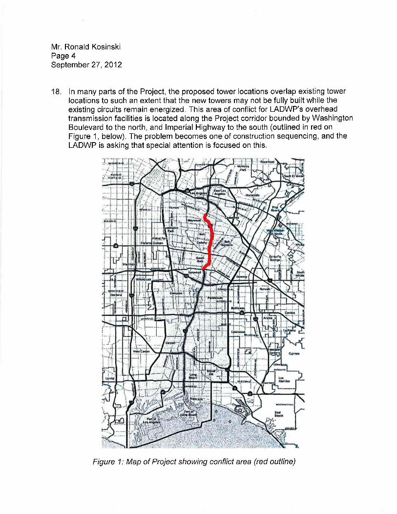
Mr. Ronald KosinskiPage 4September 27,2012
18. ln many parts of the Project, the proposed tower locations overlap existing towerlocations to such an extent that the new towers may not be fully built while theexisting circuits remain energized. This area of conflict for l-ADWP's overheadtransmission facilities is located along the Project corridor bounded by WashingtonBoulevard to the north, and lmperial Highway to the south (outlined in red onFigure 1, below). The problem becomes one of construction sequencing, and theLADWP is asking that special attention is focused on this.
i
i-t-i.,,.J.,-
Figure 1: Map of Project showing conflict area (red outline)

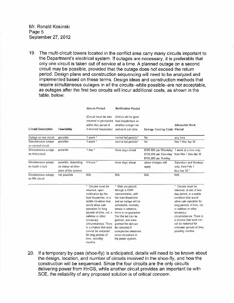
Mr. Ronald KosinskiPage 5September 27,2012
19. The multi-circuit towers located in the conflict area carry many circuits important tothe Department's electrical system. lf outages are necessary, it is preferable thatonly one circuit is taken out of service at a time. A planned outage on a secondcircuit may be possible, provided that the outage does not exceed the returnperiod. Design plans and construction sequencing will need to be analyzed andimplemented based on these terms. Design ideas and construction methods thatrequire simultaneous outages in all the circuits-while possible-are not acceptable,as outages after the first two circuits will incur additional costs, as shown in thetable, below:
CircuitDescription FeasibiliÇ
Return Period
(Circuit must be able
retumed to perrnãnent
wìth¡n this period ofif deemed necessaryJ
Notification Period
{Notice wìll be given
load disoalchers on
whether outage can Allowable Workãnd work can take Energy Trading CÐsts Period
Outage on one ci¡cuit possible 1 week' normal bid periods' No any tinre
Simultaneousoutage possible
on second circuit
1 week. normal bid periods' No Nov I thru Apr 30
Simultaneousoutage possible
on th¡rd c¡rcuit
1 day. three days ahead 5160,000 per Weekday 1 we ek at a time only,
$150,000 per Saturday from Nov 1 thru Apr 30
9125,000 per Sunda,y
Sinrultaneous outage possible, depending 4 hours'on foudh circu¡t on stãtus of other
perts ofthe syslem
three days ahead above charges still
appty
Saturdays and Sundays
only, fiom Feb 1
thru Apr 30 t
Simultaneous outage not possibleon fifth circuit
t Circuits must be
returned, upon
notification by the
load dispatcher, in a
stable condit¡on lhatwould allow safe
operation for iongper¡ods of time, not insefetìes or otherremporarycircumstances- There
is a chance thet workcannot be restarted
for long periods oftime, possiblymonths
' Bids are placed,
through a DWP
representat¡ve, with
the load díspatcherand an outage will be
scheduled, normallyweeks in advance;
there is no guarantee
that tie bid cen be
granted, end oncegranted the bid can
be canceled ifunexpected siluationsoccur elsewhere in
the power system.
" Circuits must be
retu¡ned, at end of two-
day period. in a stable
condition that would
allow safe operat¡on for
ìong periods oltime, not
in safeties or other
temporarycircumstances. There is
a chance that work cen
not be restârted for
unknown periods of time,
possibly months-
20. lf a temporary by-pass (shoe-fly) is anticipated, details will need to be known aboutthe design, location, and number of circuits involved in the shoe-fly, and how theconstruction will be sequenced. Since the four circuits are the only circuitsdelivering power from HnGS, while another circuit provides an important tie withSCE, the reliability of any proposed solution is of critical concern.


Mr. Ronald KosinskiPage 6September 27,2012
21
22.
23
As the new towers under consideration will be located near a modified wall of theLos Angeles River or on an efended deck area overhanging the river, the designand construction of the tower footings will need to receive engineering input fromLADWP. Tower geometry and structural design will need to be reviewed andapproved by LADWP, and comply with all applicable codes and permits
ln certain locations, towers will need to be raised to get over newly constructedstructures, causing the lines crossing them to be raised as well.
The followíng comments discuss detailed impacts on transmission lines,addressing specific locations starting at the north end of the conflict area within theProject and moving southward:
a. H-l26 to H-106. There are significant replacements and/or tower raisings inthis region. As there is considerable overlap between the proposed towerlocations and proposed ROW with the existing towers and existing ROW, itmay not be possible to construct the new towers in their entirety while thecircuits remain in service. Construction sequencing plans must address thisproblem. lt will be important to determine precisely how these new towers willbe constructed in order to ensure that the construction does not severelyimpact the provision of service.
b. H-1 14 to H-113. This span crosses Florence Ave. The proposed modificationsto the interchange appear to require the relocation of Tower H-114, probablyto the north, where it is likely that a new tower may need to be constructed.
c, H-105 to H-l04. This span crosses over Firestone Blvd. The interchange isbeing significantly modified and it is not clear whether the Project maintainsadequate electrical clearance with tower H-105. Modifications to theinterchange will also need to maintain access-or address concernsregarding access-to both towers from Firestone Boulevard.
d. H-98 to H-96. The project crosses under these two spans. Please followappropriate regulatory guidelines to ensure adequate electrical clearancebetween the transmission lines and the Project along this location, or includeplans to address clearance issues.
e. 262D2 to 262D4. The Project either crosses these spans or requiresmodifications to lines that affect these spans. Please follow appropriateregulatory guidelines to ensure adequate electrical clearance between thetransmission lines and the Project along this location, or include plans toaddress clearance issues.

Mr. Ronald KosinskiPageTSeptember 27,2012
f. LB-VEL 1-1 to H-103. The project crosses this span. Please followappropriate regulatory guidelines to ensure adequate electrical clearancebetween the transmission lines and the Project along this location, or includeplans to address clearance issues.
24. Additional conditions may be required following a review of the detailed site plans,grading and drainage plans, etc.
25. Please include the l-ADWP's Real Estate Section, 1'11 North Hope Street, Room1031 , Los Angeles, California 90012, in all future correspondences.
26. This reply shall in no way be construed as an approval of the Project.
Please continue to include LADWP in your mailing list and address it to the undersignedin Room 1044.lf there are any questions, please contact Mr. Michael Mercado of mystaff by email at [email protected] or by phone at (213) 367-0395.
for
Manager, Environmental Planning and Assessment
MM:msEnclosuresc: Michael Mercado


Attachment 1
GONDUCTOR SURVEYDEPARTMENT OF WATER AND POWER
OVERHEAD TRANSMISSION ENGINEERING
Please perform a survey of each Department transmission line affected by theproject. For each span (the section of wire between two (2) towers) provide thefollowing information :
1. The tower numbers of the Department transmission lines related to thespan. The tower number is located near ground level on at least one (1)leg of each tower.
2. Survey the top-of-concrete of each footing of each tower related to thissurvey. For example, a survey involving one (1) span would involve two(2) towers, each with four (4) footings, for a total of eight (s) top-of-concrete shots.
3. survey at least eight (8) points along the span - the two (2) points wherethe insulator attaches to the tower, the two (2) points where the wireattaches to the insulator, and four (4) additional points along the wire(preferred spacing of 200 - 300 feet). see attached conductorAttachments Points for additional information. lnclude additional pointswhere special features of the proposed improvements cross thetransmission line (such as high points, street lights, signs, etc.). For eachpoínt provide the following information:
a. The station relative to that particular spanb. The elevation of the wirec. The existing ground elevationd. The proposed ground elevatione. Date and Timef. Temperatureg. Sunlight (sunny, partly cloudy, or cloudy)h. Approximate wind speed
lmportant: All eight (8) wire shots on each individual span shall becompleted within one (1) hour after the first wire shot is made. Failureto comply with this requirement wífl render data useless.
" See attached Data Sheet for sample of submittal document.
Updated: 0612712011

^i..I
I
thd)L I .YY.
r.OS NITIEET.ES DEPARTMENT OF WATEH AND POWEHTHANSMISSION LINE CONDUCTOH CLEARANCE SURVEYDATA SHEET
TBANSMISSION LINE B/Iñ/:SURVEY DATE:
nFl-^1ã.-^-r
PAGE:
TOWEHFOOTING.ELEV.
POINTSTATION
CONDUCTORELEV.
SI(Y I WNDDESCRIPTION

Attachment 2
1. Energized transmission lines can produce electrical effects including, but not limited to,induced voltages and currents in persons and objects. Licensee heieby acknowledges aduty to conduct activities in such manner that wili not expose persons to injury orproperty to damage from such effects.
2. The Los Angeles Department of Water and Power (LADWP) personnel shall haveaccess to the right of way at all times.
3. Unauthorized parking of vehicles or equipment shall not be allowed on the right of wayat any time.
4. Unauthorized storage of equipment or material shall not be allowed on the right of wayat any time.
5. Fueling of vehicles or equipment shall not be allowed on the right of way at any time.
6. Patrol roads and/or the ground surfaces of the right of way shall be restored by theLicensee to original conditions, or better.
7 ' All trash, debris, waste, and excess earth shall be removed from the right of way uponcompletion of the project, or the LADWP may do so at the sole risk and expensã oï tneLicensee.
8. All cut and fill slopes within the right of way shall contain adequate berms, benches, andinterceptor terraces. Revegetation measures shall also be provided for dust and erosioncontrol protection of the right of way.
9. All paving, driveways, bridges, crossings, and substructures located within the right ofway shall be designed to withstand a combined weight of 40,000 pounds in accordancewith the American Association of State Highway and Transportation Officials H2O-44(M18) wheel loadings.
10. The location of underground pipelines and conduits shall be marked at all points wherethey cross the boundaries of the right of way and at all locations where they changedirection within the right of way. The markings shall be visible and identifiaOle metal postmarkers for underground pipelines. Utility markers flush with surface may be used onpavement.
11F.. General Grounding Condition
All aboveground metalstructures including, but not limited to, pipes, drainage devices,fences, and bridge structures located within or adjoining the right oi*"y snált Oeproperly grounded, and shall be insulated from any fenóing or other conductivematerials located outside of the right of way. For safety of personnel and equipment, allequipment and structures shall be grounded in accordance with State of California Godeof Regulations, Title 8, Section 2941, and National Electric Code. Article 2S0.
Rev. 01-29-07

11F.. Groundinq condition for cellular Facilities on Towers
All aboveground metalstructures including, but not limited to, pipes, drainage devices,
fences, añO UriOge structures located within or adjoining the right of way shall be
properly g nsulated from any fencing or other conductive
materials ight of way' For safety of personnel and equipment' all
equipmen e grounded in accordance with American National
Standards lnstitute of Electrical anã Electronics Engineers Standard 487-latest edition,
IEEE Guide for Safety in AC Substation Grounding'
12. Licensee shall neither hold the LADWP liable for nor seek indemnity from the LADWP
for any damage to the Licensee's project due to future construction or reconstruction by
the LADWP within the right of waY.
13. Fires and burning of materials is not allowed on the right of way'
14. Licensee shall control dust by dust-abatement procedures approved by the I-ADWP,
such as the application of a dust palliative or water'
15. The right of way contains high-voltage electrical conductors; therefore, the Licensee
shall utilize only such equipment, material, and construction techniques that are
permitted unOer applicable safety ordinances and statutes, including the following:
State of California Code of Regulations, Title 8, Industrial Relations, Chapter 4, Division
of lndustrial Safety, Subchapter 5, Electrical Safety Orders; and Galifornia Public Utilities
Commission, Genêral Order No. 95, Rules for Overhead Electric Line Construction'
16. Licensee is hereby notified that grounding wires may be buried in the right of way;
therefore, the Licénsee shall notity the LADWP's Transmission Construction and
Maintenance Business Group at (-e1 8) 771-5018, or (81 8) 771-5076, at least 48 hours
prior to the start of any construction activities in the right of way.
17A. Vehicle Parkins
An area within 50 feet on one side of each tower measured along the longitudinal
direction of the right of way,25 feet on the opposite side of each tower, and ten feet on
the remaining twõ sides of each tower, shall remain open and unobstructed for
maintenance-an6 emergencies, including periodic washing of insulators by high-
pressure water sPraY.
17P.. Trucking Operations and Storage Operations
An area within 50 feet on one side of each tower measured along the longitudinal
direction of the right of way, and 25 feel on the remaining three sides of each tower,
shall remain opeñ and unóbstructed for maintenance and emergencies, including
periodic washing of insulators by high-pressure water spray.
17C. PermanentStructures
An area within 100 feet on all sides of each tower shall remain open and unobstructed
for maintenance and emergencies, including periodic washing of insulators by high-
pressure water sPraY.
2

18' Detailed plans for any grading, paving, and construction work within the right of wayshall be submitted for approval to the Real Estate Business Group, Department ofWaterand Power, P.O. Box51111, Room 1031, LosAngeles, Catifornìa 9OOSI-O1OO,no later than 45 days prior to the start of any grading, paving, or construction work.Notwithstanding any other notices given by Licensee requirJd herein, Licensee shallnotify the LADWP's Transmission Construction and Maintenance Business Group at(818) 771-5018, or (818) 771-5076, no earlier than 14 days and no later than two daysprior to the start of any grading, paving, or construction work.
19. 'As Constructed" drawings showing all plans and profiles of the Licensee's projectshall be furnished to the Real Estate Business Group, Los Angeles Department ofWaterand Power, P. O. Box5l111, Room 1031, LosAngeles-, California 90051-0100,within five days after completion of Licensee's project.
20' ln the event that construction within the right of way is determined upon inspection bythe LADWP to be unsafe or hazardous to the I-ADWP facilities, tne i¡OWp may
"=rigna line patrol mechanic at the Licensee's expense.
21' lf the LADWP determines at any time during construction that the Licensee's efforts arehazardous or detrimentalto the LADWP facilities, the LADWp shall have the right toimmediately terminate said construction.
22F* All concentrated surface water which is draining away from the permitted activity shallbe directed to an approved storm drain system where accessible, or othenruise restoredto sheet flow before being released within or from the right of way.
22B. Drainage from the paved portions of the right of way shall not enter the unpaved areaunder the towers. Drainage diversions such as curbs shall be used on three sides ofeach tower. The open side of each tower shall be the lowest elevation side to allowstorm water which falls under the tower to drain. The area under the towers shall bemanually graded to sheet flow out from under the towers.
22C. Ponding or flooding conditions within the right of way shall not be allowed, especiallyaround the transmission towers. All drainage shall flow off of the right of way.
22D. Licensee shall comply with all Los Angeles County Municipal Storm Water permit andstandard urban storm water Mitigation plan requirements.
234. Fills, including backfills, shall be in horizontal, uniform layers not to exceed six inches inthickness before compaction, then compacted to g0 percent relative compaction inaccordance with the American Society for Testing and Materials D15S7.
23B. The top two inches to six inches of the concrete footings of the towers shall remainexposed and not covered over by any fill from grading operations.
23C. Licensee shall provide the LADWP with one copy each of the compaction report and aCertificate of Compacted Fill, for clean fill compaction within the LADWp's right of way inaccordance with the American Society for Testing and Materials D15S7, appioved by ageotechnical engineer licensed in the state of california.
24. A surety bond in the amount to be determined by the LADWP shall be supplied by theLicensee to assure restoration of the LADWP's right of way and facilities, andcompliance with all conditions herein.
25. The Licensee shall obtain and pay for all permits and licenses required for performance
of the work and shall comply with all laws, ordinances, rules, orders, or regulations
including, but not limited to, those of any agencies, departments, districts, or
commissions of the State, County, or City having jurisdiction thereover.
26. The term "construction", as used herein, refers only to that construction incidental to the
maintenance or repair of the existing (requested facility) and shall not be construed to
mean permission to construct any additional (requested facilíty).
27. Signs shall not exceed four feet wide by eight feet long, shall not exceed a height of
14 feet, shall be constructed of noncombustible materials, and shall be installed
manually at, and parallel with, the right of way boundary'
2g. Remote-controlled gates, or lock boxes containing the device or key for opening the
remote-controlled gãt"r, shall be capable of being interlocked with an I-ADWP padlock
to altow access to tne right of way by the I-ADWP. Licensee shall contact the Right of
Way Supervisor at (818t771-5048 to coordinate the installation of an I-ADWP padlock'
29. Licensee's cathodic protection system, if any, shall have a design that does not cause
corrosion to l-ADWp facilities. A detailed design of.the Licensee's cathodic protection
system shall be submitted for approval to the Real Estate Business Group, Department of
Waterand power, P. O. gox51111, Room 1031, LosAngeles, California 90051-0100, no
later than 45 days prior to the start of construction or installation of the cathodic protection
system.
3OA. Licensee shall install K-rails at a distance of ten feet from each side of the tower base
for protection of towers. A distance of five feet from the tower base may be acceptable
in locations where the patrol roads would be obstructed'
308. Licensee shall install removable pipe bollards, spaced four feet apart, and at a distance
of ten feet from each side of the tower base for protection of towers. A distance of five
feet from the tower base may be acceptable in locations where the patrol roads would
be obstructed.
31A Licensee shall provide and maintain a minimum 2O-foot wide transition ramp for the
patrol roads from the pavement to the ground surface. The ramp shall not exceed a
slope of ten Percent.
318. Licensee shall provide and maintain a minimum 2O-foot wide driveway and gate at all
Iocations where the (road/street) crosses the LADWP's patrol roads. The designed
gates must be capable of being interlocked with an LADWP padlock to allow access to
the right of waY bY the LADWP-
g2. Licensee shall post a sign on the entrance gate to the right of way, or in a visible
Iocation inside ihe entrance gate, identifying the contact person's name and telephone
number for the prompt moving of (vehicles/trucks/trailers/containers) at times of LADWP
maintenance or emergency activities, or any other event that(vehicles/trucks/trailers/containers) m ust be moved. I n emergency conditions, the
LADWp reserves all rights at any time to move or tow (vehicles/trucks/trailersi
containers) out of specific areas for any transmission operation or maintenancepurposes.
4

Attachment 3
ACCESS ROAD DESIGN CRITERIA
1. When grading activity affects the Transmission Line access roads, the developershall replace¡Jhe affected access roads using the following access road designcriteria. Tyþi8al road sections are illustrated in the accompanying diagram.
2- The access road right-of-way width shall be 50 feet minimum.
3. The access road drivable width shall be 20 feet minimum, and increased on curvesby a distance equal to 400 divided by the radius of curve. Additional 2 feet oneither side of the road shall be provided for berms and ditches, as detailed in theattached Typical Road Sections.
4. The minimum centerline radius of curves shall be 50 feet.
5. The vertical alignment grades shall be limited to 10 percent.
6. Roads entirely located on fills or with cross sections showing more than 30 percentfill along the drivable width of the road require paving.
7. lntersections or driveways shall have a minimum sight distance of 300 feet in eitherdirection along the public street.
8. The developer shall provide a commercial driveway at locations where thereplaced access roads terminate at, or cross public roads.
9. The developer shall provide lockable gates on LADWP property or easement atlocations where access roads terminate or cross public roads.
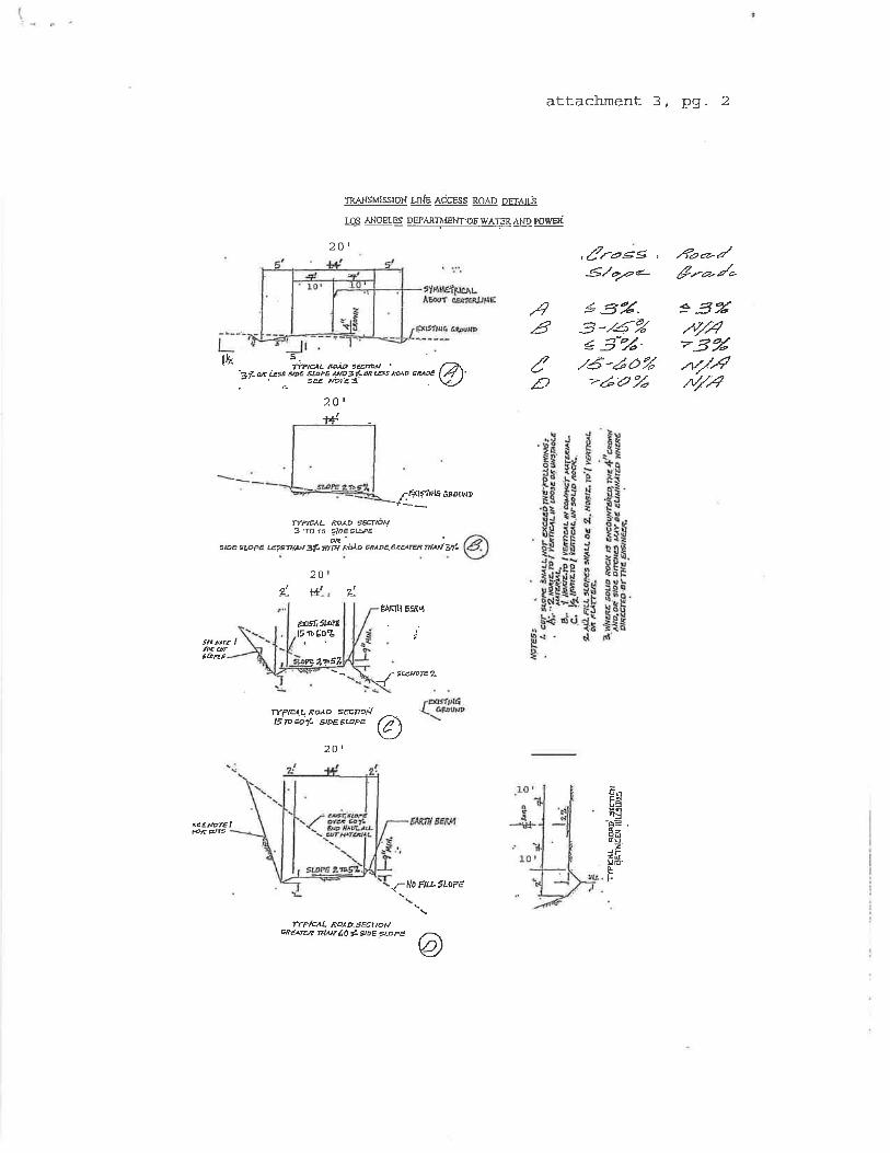
attachment 3, pg. 2
TR.ANSMI5SION Lh¡E AdCESS ROAD DEr.¡.fÉ
LOS ANOETES DEPAXT]\IENT.OF WAT,ER AND porvd
20 1
= 3'Á.v/4?3"2n/-4//ft|
,4â
.ì.7(,Ð
,¿!ro.çs ,
-€./a¡¿¿-
13'2.3-/6%13-'Å-
./6-¿Õ%>é'a "¿
.4¿o-/ê-*/,
*r¡]<tÍfiu arourrr
ÍYHCAL ROAO çéE|TON7 'To i 5 1ioE stæÉ
q{.srÞÉ tLopg Etsntp{ 3* wrñ, ß¡Àø çrtoe.erm tilui Zf-
ZU
ttÈJKIII EÉßflI
FiÈ ø5&Æt
r SECPÍÉ?-\J
s¿¿uøre I
{N0 ÉlLL1LÐPÉ
ÍYPEAL ROAD SECNAPcResx¡ dwé0tgÞÈ%pE
TYPTâL EOAD 9æ,TONtÈpcó/- s,oes-e, Q\Y-/
20 1
'FpU=ñg
dü.7
Ëfiuú'
t-.
à
tb s.i*ptaL ßÞÀD sÊcfñil ''?f-q i¿s soÉ supÉ J¡to71ç 8'G5 Mo 6RAÉ I 7l I'' sæ NoÍEa . \¿_/
201
14
É-û9ÍíDrÊlrrôCo'L
f51T54

I-710 Corridor Project RDEIR/SDEIS
Page 109
U-7-1
This is an introductory comment stating the Los Angeles Department of Water and Power’s
(LADWP) concerns with the design of Alternatives 6A/B/C that proposed relocation of a portion
of the LADWP’s 230 kilovolt (kV) transmission lines. Please refer to Responses to Comments
U-7-2 through U-7-27, below, for responses to the individual comments in this letter and refer to
Section 3.4 of the Recirculated Draft Environmental Impact Report/Supplemental Draft
Environmental Impact Statement (RDEIR/SDEIS) for an updated description of impacts to
utilities as a result of the revised build alternatives.
U-7-2
Citations to this agency in the EIR/EIS were changed to either “City of Los Angeles, Department
of Water and Power” or “LADWP” as requested.
U-7-3
The following was inserted as the second paragraph in the subsection titled “LADPW” in Section
3.4.2.2: “The LADWP's transmission line rights-of-way (ROW) are integral components of its
transmission line system, which provides electric power to the City of Los Angeles and other
local communities. The use of those rights-of-way is under the jurisdiction of the Federal North
American Electric Reliability Corporation (NERC). The safety and protection of the critical
transmission facilities are the primary factors used to evaluate secondary land use proposals in
the same rights-of-way. The rights-of-way are used by the LADWP for access, construction,
maintenance, facility expansion, and emergency operations. As a result, it is possible that I-710
Corridor Project improvements within or immediately adjacent to LADWP transmission line
rights-of-way could be subject to temporary disruption in the event LADWP needs to access its
rights-of-way.”
U-7-4
Due to changes in project design of the revised build alternatives analyzed in the
RDEIR/SDEIS, the build alternatives now avoid any longitudinal impacts to the LADWP 230 kV
transmission lines and towers except for two towers located between the Firestone Blvd. and
Florence Ave. interchanges on Interstate 710 (I-710). Please review the substantially revised
Section 3.4 of the RDEIR/SDEIS, as many of the impacts referred to in this letter have been
superseded by the impacts of the revised build alternatives.
I-710 Corridor Project RDEIR/SDEIS
Page 110
U-7-5
Coordination since the 2012 Draft EIR/EIS circulation has occurred with LADWP regarding the
revised alternatives and the associated updated impacts to LADWP facilities. A description of
the revised impacts to LADWP facilities has been included in Section 3.4. Due to the revisions
to alternatives and associated impacts, the maps referenced in this comment would not be
indicative of the alternatives currently under study in this RDEIR/SDEIS.
U-7-6
Please refer to Response to Comment U-7-4.
U-7-7
It is acknowledged that, when working on or immediately adjacent to LADWP facilities, the
Caltrans construction contractor will be required to comply with the LADWP Standard
Conditions for Construction. Caltrans construction specifications for the I-710 Corridor Project
will require the construction contractor to coordinate directly with all utility providers, including
the LADWP, regarding any work on utility facilities and/or within utility facility rights-of-
way/easements and to comply with the applicable conditions within each utility provider’s
Standard Conditions for Construction.
U-7-8 through U-7-23
Please refer to Response to Comment U-7-4.
U-7-24
Please review the substantially revised Section 3.4 of the RDEIR/SDEIS, as many of the
impacts referred to in this letter have been superseded by the impacts of the revised build
alternatives.
U-7-25
Due to changes in project design of the revised build alternatives analyzed in the
RDEIR/SDEIS, the build alternatives now avoid any longitudinal impacts to the LADWP 230 kV
transmission lines and towers except for two towers located between the Firestone Blvd. and
Florence Ave. interchanges on I-710. It is acknowledged that, if a build alternative is selected for
implementation, additional conditions may be placed on the project by the LADWP as part of its
review and approval of the project design where any LADWP facilities are affected.

I-710 Corridor Project RDEIR/SDEIS
Page 111
U-7-26
The following was added under the subheading “City Officials/City of Los Angeles”:
“City of Los Angeles
Department of Water and Power, Real Estate Section
111 North Hope Street, Room 1031
Los Angeles, CA 90012”
U-7-27
It is acknowledged that the September 27, 2012, letter from the LADWP provides comments on
the Draft EIR/EIS for the I-710 Corridor Project and does not provide any approval for the
proposed project.

I-710 Corridor Project RDEIR/SDEIS
Page 112
This page intentionally left blank