hydropower resource mapping resource... hydropower resource mapping doug hall, water energy...
TRANSCRIPT

ww
w.in
l.gov
Hydropower Resource Mapping
Doug Hall, Water Energy Technical Lead INL Wind and Water Power Program
9 May 2012
World Bank ESMAP Knowledge Exchange Forum

Large Hydro - Niagara Falls
2
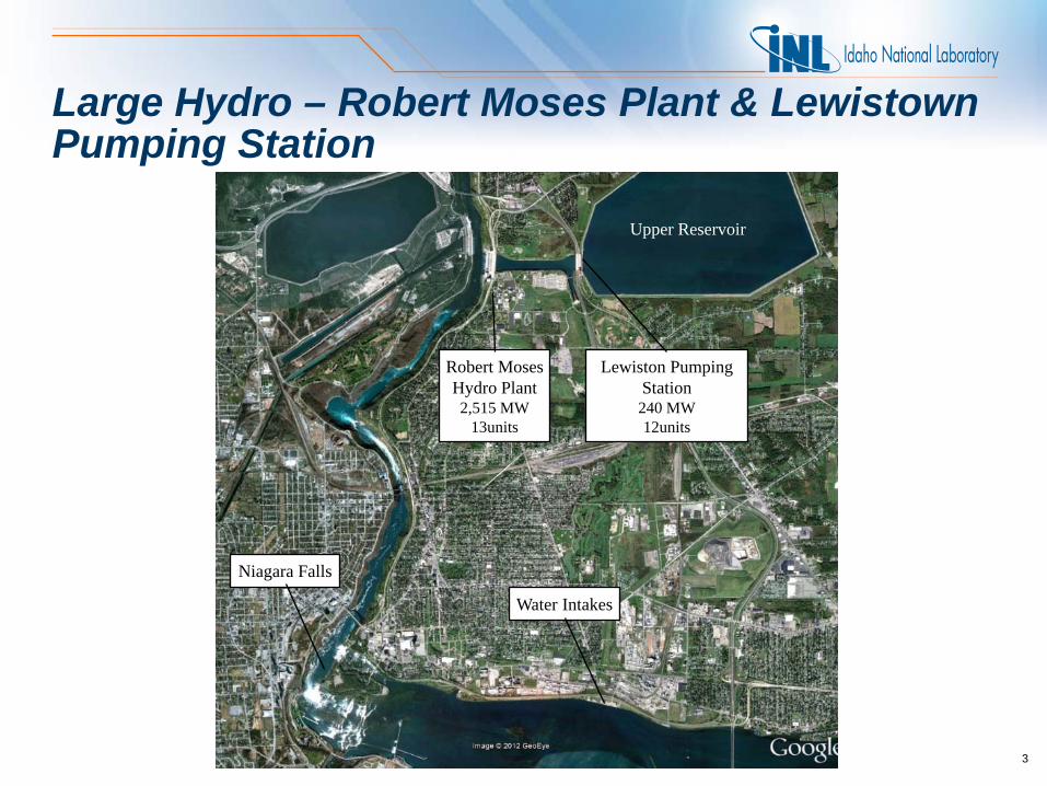
Large Hydro – Robert Moses Plant & Lewistown Pumping Station
3
Niagara Falls
Water Intakes
Robert Moses Hydro Plant 2,515 MW
13units
Lewiston Pumping Station 240 MW 12units
Upper Reservoir

Small Hydro – distributed generation
4
Diversion weir – Canal Inlet
1½ mi. subterranean Penstock
Canal End – Penstock Entrance
10 MW Fall River Plant in Fall River Canyon
Fall River & Canal

Virtual Hydropower Potential Mapping – Gross Hydraulic Head
5
Digital Elevation Model (DEM)
Verification of Synthetic Hydrography
3D Synthetic Hydrography

Virtual Hydropower Potential Mapping – Gross Power Potential
6
Stream Reach Profile
Estimated Flow Rate • Regression Equation • Unit Runoff Model • Runoff Model
P (kW) = κQ(cms)H(m)
where P = annual average power Q = annual average flow rate H = gross hydraulic head
Gross Hydraulic Head
Upstream Elevation
Downstream Elevation

U.S. Feasible Potential Hydropower Sites
7

Brazilian UHE and PCH Potential Hydropower Sites
8

Potential Project Characteristics
9
Hood River
Power Characteristics
• Capacity potential: 10 MW
• Flow rate average: 459 cfs
• Hydraulic head: 122 ft
Site Characteristics
• Reach length: 1.6 mi
• Principal dam maximum height: 141 ft
• Principal dam length: 2,461 ft
• Number of impoundment boundary segments: 2
• Impoundment constructed boundary length: 2,756 ft
• Reservoir area: 191 acres
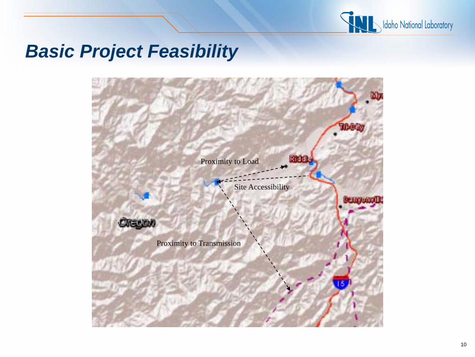
Basic Project Feasibility
10
Proximity to Load
Site Accessibility
Proximity to Transmission

Virtual Hydropower Prospector – U.S.
11
Map Navigation Tools
Feature Selection
Tools
Information Window
Legend
Map Print
Geographic Coordinates
Readout

Virtual Hydropower Prospector do Brasil
12

Virtual Renewable Energy Prospector – U.S.
13
Typical features displayed • Renewable energy features
– Geothermal – Hydropower – Solar – Wind
• Areas and places – Cities – Populated areas – County boundaries – State boundaries – Hydrologic region boundaries
• Hydrography (5 feature sets)
• Power system – Hydro plants – Other plants – Power lines – Substations – Dams
• Transportation – Roads – Railroads
• Land Use – Excluded areas
• Federally designated • Environmentally sensitive
– Bureau of Indian Affairs (BIA) – Bureau of Land Management (BLM) – Bureau of Reclamation (BOR) – Department of Defense (DOD) – U.S. Forest Service (FS) – U.S. Fish & Wildlife Service (FWS) – U.S. National Park Service (NP)
14

Virtual Renewable Energy Prospector for Malawi
15

Water Energy Resources to be Mapped
16
• Natural streams – Potential energy systems – Hydrokinetic technology
• Constructed waterways (canals, water supply, water treatment, industrial effluents)
– Potential energy systems – Hydrokinetic technology
• Tidal estuaries – Hydrokinetic technology
• Ocean currents – Hydrokinetic technology
• Waves – Near-shore and off-shore

Hydrokinetic and Wave Technologies
17

Hydropower Resource Mapping & Renewable Energy Prospecting Tools
• For more information contact: Doug Hall [email protected] 208-526-9525
18

Access to INL Prospector applications
• Virtual Hydropower Prospector – U.S. http://hydropower.inl.gov/prospector/index.shtml
• Virtual Renewable Energy Prospector – U.S. http://gis-ext.inl.gov/vrep
• Virtual Hydropower Prospector do Brasil http://hydropower.inl.gov/prospector-brazil/index.shtml
• Virtual Renewable Energy Prospector for Malawi http://arcgisserver.northwind-inc.com/vrepmalawi/