huntington district, corps of engineers huntington, …
TRANSCRIPT

DEPARTMENT OF THE ARMY HUNTINGTON DISTRICT CORPS OF ENGINEERS
502 EIGHTH STREET HUNTINGTON WEST VIRGINIA 25701-2070
_L I certiappend
f~ th~t the following electronic file consisting o2J4pages ~ exhibits and ices 1s a true correct and complete copy of the original document
7~ Acting Chief Environmental Analysis Section Dated i$ J 4( loc 7
3) ~ TWd JR ~e 0~~ NV BeeQh
foih W-rG MGfrev un Fm No
1)( l_f--- t)e_sGell
be~ deg~i
DEPARTMENT OF THE ARMY HUNTINGTON DISTRICT CORPS OF ENGINEERS
502 EIGHTH STREET
HUNTINGTON WEST VIRGINIA 25701-2070
REPLY TO
TTENTION or
CEORH-PD-R (1110-2-240a) 1 December 1995
MEMORANDUM FOR Commander Huntington District
SUBJECT Supplement No 14 Master Plan Design Memorandum No 11 Beech Fork Lake West Virginia
1 Authority ER 1130-2-435 paragraph 7b Preparation of Project Master Plans dated 30 December 1987
2 The following Exhibits are enclosed
a Beech Fork Lake project map
b To_pographic map of pond location
c Plan view of pond
d Cross section of dike
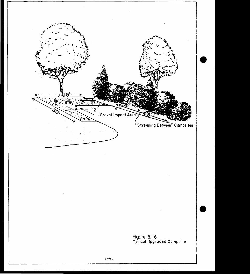
3 The purpose of this Supplement is to request approval for the construction of a five acre fishing pond on the wildlife management area at Beech Fork Lake West Virginia Division of Natural Resources will be responsible for the construction costs and future maintenance The pond will be stockedmiddotmiddot with trout bass bluegills and channel catfish to provide additional fishing opportunities for children and adults Another benefit wi~l be the increase of habitat for waterfowl and other aquatic animals
4 The location is adjacent to Millers Fork Creek about 07 mile from the intersection of State Routes 17 and 22 (Exhibits A and B) Present land use at the site is two-thirds hayfield and one third brush and scattered small trees around an old 015 acre pond The dam for the pond is designed by the Natural Resource Conservation Service (NRCS) and will meet their specifishycations for small watershed impoundments The construction will be inspected by NRCS
5 The dam design consists of a dike on three sides about seven feet high on the landward side which will impound water from a 30 acre watershed Soil from the pond area is used as fill for the dike There will be a 18 inch diameter riser and outlet
CEORH-PD-R (1110-2-240a) SUBJECT Supplement No 14 Master Plan Design Memorandum No 11 Beech Fork Lake West Virginia
to the creek tq m~intain a maximum water depth of six feet An emergency spillway is built into the corner of the dike with an elevation one foot higher than the normal water depth The slope of the dike on the pond side is one foot vertical to three feet horizontal which would allow easy access along the shore for fisherman (Exhibits C and D) The pond area is upstream of the seasonal pool and within the upper area of the flood pool The maximum flood pool at elevation 614S feet will be on the side of the dike displacing a maximum of 30 acre feet of flood storage capacity This would be an insignificant loss compared to the gross st9rage capacity of 37500 acre feet
6 A parking area with a gravel surface will be built adjacent tothe dike and is accessed by an existing road from SR 22 to a gas pump station The drke and all disturbed areas will be fertilized middotmyl_ch(d and seeded with grass
7 The pond will be considered a part of the wildlife area and willbe open at all times No restrooms or other recreation facilities will be provided Enforcement of wildlife regulations at the pond will be the responsibility ofthe Wayne County conservashytion officers and the wildlife manager in charge of Beech Fork Lake Tl)e maintenanceoperations building for the wildlife -area is located one mile from the pond on SR 17
8 The fishing pond may be utilized by all anglersmiddotexcept for certain sche_d_microled days when an organized Kids Fishing Derby will be held One or two events per year will probably be held in May June or July The proposal has been reviewed by all concerned District elements Approval is recommended
4 Encls as
APPROVED BY
4t-J~ RICHARD W A Colonel C s of Engineers Commanding
FC75-C
~etw~u WEST VIRGINIA -~ ~
bull Qgt
RESERS-IR AT FLOOD bull CONTROPOOL EL 6145
~ --
~
1 j
~ )+0gt
Ot I
- t
~C ( - -1 PUBLIC USE GUIDE
~ gtBOAT RAMP CONCESSION MARINAIA amp PICNIC AREA 0 MAINTENANCE BUILDING FISHE~MAN ACCESSamp PICNIC AREA
VISITORS CENTER l SWIMMING BEACH amp PICNIC copy AREA
CAMPING AREA amp REST ROOMS regmiddot BOAT RAMP sU- reg~v=M~
~J TWELVEPOLE CREEK BASIN HFECH FORK
BEECH FORK LAKE Scale In Feet
4000 0 4000 8000
HUNTINGTON DISTRICT HUNTINGTON W VA Revised 30 SEPTEMBER 1988
---
~ 011 LL~lt e_ K K D7deg f1 S-f ( Je faAJ O
toc4 a r-J M JOt-f
l)J 1vSlt-DW ~ vrt O J~~~bullbull 6=owe~ c_eF- cegt2-eft_
- Po-J 0 J - PmiddotA-iltJ(1~6--~A ~
~) -
_ wATampSrlE1gt- ieu~pfl
~ 7l((fl4~~~B~
lt( ILI a
laquogt CD
(Q Q)
middot lo
E-t H Ill H i x
ii
i
I
l(J Qm
I rl
er ii
Iz
11
bulltl__f 8yen111
PSI UUT (Cfttcbull 1Jp1 Ibullbullbull 1114)
lf of Cen1tr1el14 FIii lit (Y1rl11) (Stt I Prell It) lcftCbull Slllnr EfH~
o (IV-DIH2)
_Concrelbull In 1 lnltl (IVmiddot--14)
__Drop bullbull Eln tto
(W-OC-15)
SJNIJPIPE
bullCnopr bull~tto4
ltllflh-5_Fl 1===1r=======tr~DI~ Ptr ftr1amp1onh11
No Ytrllcel of Perf1r1tlbull11 Stclftl 1f Ptrftrttlbulls_lbull(cc) Sllfllr pert1r1lltrt1 In rbullt bullbull p1rttrtll1111 111 Ml 1ll1n14 1roUll4 lht pipe clr1bullftr111c1
WATER stfflY Cit IIIAIN PIPE 0111r ~ h1 ltfttlll bull L Fl
lllltrl1I bull ASN Amiddot110 S-1111 1111 fttl1bull1t11 Sclttftlt - (Cr11HH1I Dt1lptllot1 Ml 11114)
ESHMTID CJMTITIES
ITDI IIIIT E1rlll flll - c11 CT1 PSI Pl t rt
I tr Drtll Pl bull rt Fence Rttl RI r Ttrt Concnlbull cuu
R1l1Ac
_ ~lmiddot11 clN_~
10
-)
-
jJ
i-~fc4sbull bullN s+u I c olfy
P9 PIPE 01 bull IL In lt1tlh bull to Fl lllltrltl bull Cnl ASTU C Ill I Thlckn111 Sh_I (Crt1bull11I 0111111111111 Ml 1111)
~~s=_ii==~~~~~~~~~~~~~~~~51I~~Y ------ J -bull 2 bull bull It l Sh I
Cltlf Tranebull I lLft cotibull) ~ r- ~
A --1
Clt Vtht nen lrtbullth
V1h1 bullbullbull bull114(pipe 11cllon Ml
111 0lll Lrt bull bull
DP ICAL moss SECTICJt ltf Plt11gt (SU PUN VIEi Fml ACltW lorATIClt Mil
Al IGNIJIT Cf PIPO) (m SUPAGE alfflQ D[TAILS If IDIIRED)
FIii Sltft
-ZiaL s11111 PM --shy
I H Illa
s111bull 10bull s 011lt sbullbull rtc11111 w1 plpt 011lt 10bull S I1th Pt1 NJ 12bull 4ttp reel Rlr1p (Jbull Ibull 1bull StlM) tr 4bull thick Coacrlt bullbullbullbull 1bull-10 lIbull 1lr1 r1l11ftrc111nt 1t lht c11t1r
PUAIL fSIMLEI
(r Pondbull 1llh PSIbullbull bullbullbull lhon DI)
tlgtlt lhtn lht PSI Plpt D11 l 1ampbull(=bull 11V-F9rr-lJ nr WY-EffC-17)
c111cr11 pr11111r1 lr11ltl n4 trbull~
UllllfT IGTlrlCAll(lf bullth Stll Clft11r1lltn s1c1 111111111 bullbull Ibull I~bull 11l1l1nc1 1r lot tnJ 1Ulll11 ti lht con1lrucllon 1 1
lh111 con1lrucllt1t bullrwlntt 1r1 lht1 bulllch httt bull1111 14tntlfl It 11 II 1111 c1nlreclor1111111 lhMttl11 Ill 111111 r _ 1111 tcc1r It ulll
FARM POND WI TH ORO
Ibull Apprntl CltH ip Cttptrtltr bNt bull WbullbullP 4-tlI
Wr111 Y4 Count~ l
Dial t X bullOo gt11 r Dbull - ~ BEECH FORK LAKrMASTER PLAN SUPPLEMENT NO 14 NOVEMBER 1995 EXHIBIT D
DEPARTMENT OF THE ARMY HUNTINGTON DISTRICT CORPS OF ENGINEERS
502 EIGHTH STREET
HUNTINGTON WEST VIRGINIA 25701-2070
REPLY TO April 8 1991 ATTENTION or
CEORH-PD-B (1110-2-240a)
MEMORANDUM FOR Commander Huntington District
SUBJECT Supplement No 11 Design Memorandum No 11 Master Plan Beech Fork Lake Twelvepole Creek West Virginia
1 Authority ER 1130-2-435 Preparation of Project Master Plans dated 30 December 1987 One copy of this approved supplement will be submitted concurrently to CEORD-CO-OE and CECW-ON for 30 day review for comment
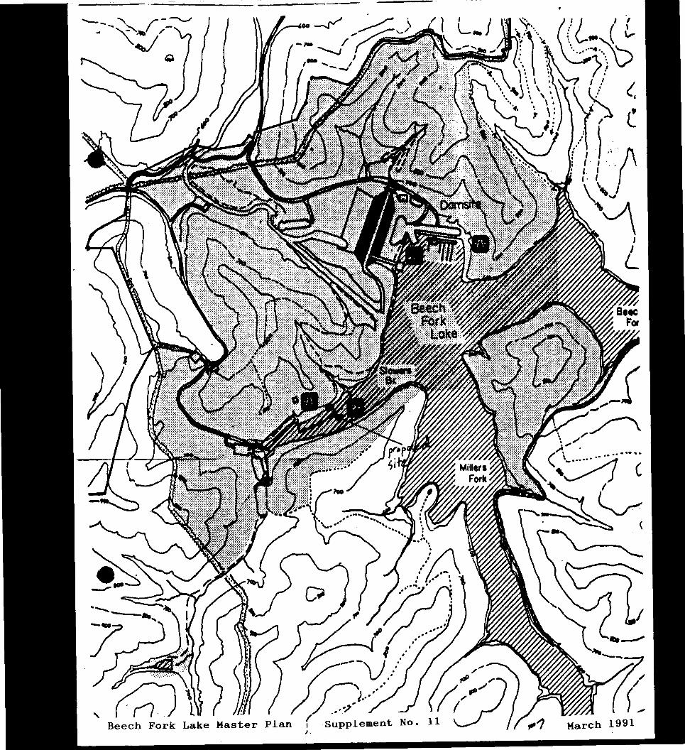
2 Exhibit enclosed Map of dam area
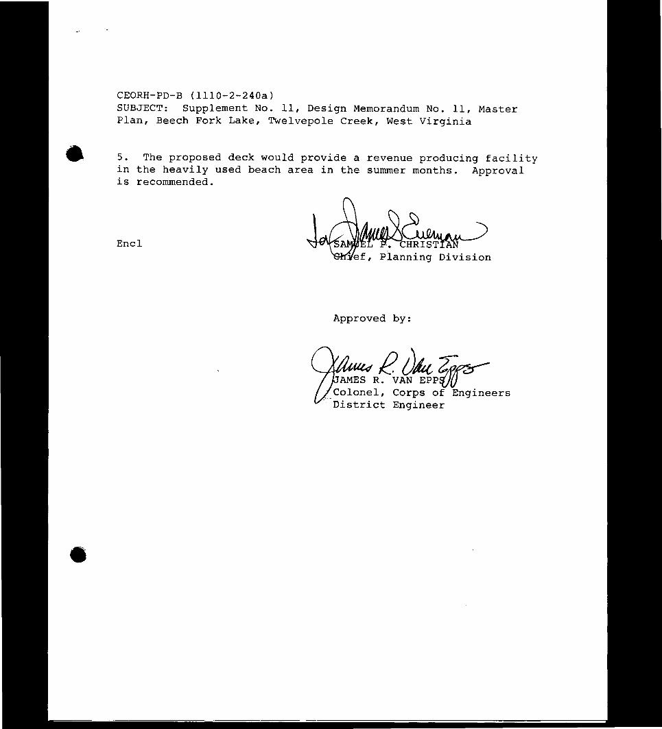
3 The purpose of this Supplement is to request approval for the construction of a deck at Stowers Branch beach The deck will be of pressure treated pine approximately 13 x 33 feet in size and located back from the beach in a partially wooded area The deck will be available for reservation and will provide groups families and organizations with a place to meet and enjoy the beach area Space on the deck will accommodate 4 or 5 picnic tables and will provide a level platform in this mostly sloping area
4 Special Recreation User Fee Funds (SRUF) will be utilized to construct the deck at a estimated cost of $3000 It is proposed to reserve the deck for a fee of $2000 per day Cost recovery would take place over a 3 or 4 year period assuming the deck is reserved 45 days per year
CEORH-PD-B (1110-2-240a) SUBJECT Supplement No 11 Design Memorandum No 11 Master Plan Beech Fork Lake Twelvepole Creek West Virginia
5 The proposed deck would provide a revenue producing facility in the heavily used beach area in the summer months Approval is recommended
Encl -~ ef Planning Division
Approved by
AMESR~~~PF Corps of Engineers
District Engineer Colonel
-
--
______c-=- ------------
bull Xmiddotbull I I(l middot ~-- ( ( l
bull I
~_ z ~ middotmiddot)) ~~-)
1) _f amp I I middot I
j
v I
L I
~ ~
~ ( Viilfiliil
~ (
Jmiddot1 I -
Beech Fork La e aster an I Supplemen o J
BEECH FORK IAKE IWELVEKgtIE CREEK WEST VIRGINIA
bull MASTER PIAN
DESIGN MEM)RANilJM NO 11
FINAL DRAFT DECEMBER- 1988
Prepared by Department of the Arnrj
Huntington District Corps of Engineers 502 Eighth Street
Huntington West Virginia 25701-2070
Exhibits prepared by R J Ankrom Associates
1107 Ninth Street Suite N Vienna West Virginia 26105
and
Booker Associates Inc 343 Waller Avenue
Iexington Kentucky 40504
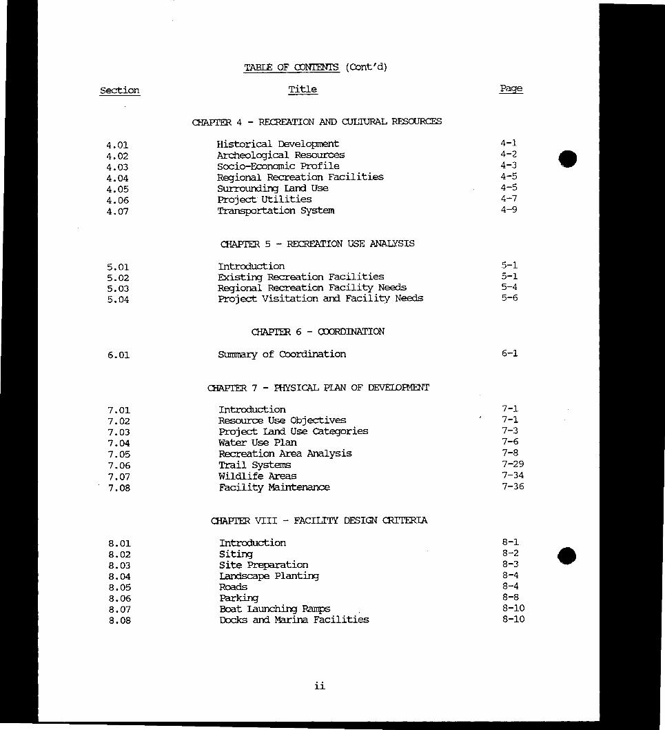
Section
101 102 103 104 105 106 107 108
201 202 203 204 205 206
301 302 303 304 305 306 307 308 309
BEEOI FORK AKE WEST VIRGINIA
MASTER PIAN
TABIE OF CONTENTS
Title
Table of Contents List ofTables List of Figures List of Ibotographs List of Exhibits
OIAPIER 1 - INmOWcrION
Project Authorization Project Purpose Purpose of Master Plan Pertinent Prior Reports Applicable PUblic raws Scope of the Master Plan Master Plan Objectives Master Plan Fonnat
OIAPIER 2 - PROJECI DESClUPIION
Project uxation General Project Description Project Developnent Corps of Engineers Operational structures State Operational stru~ Reselvoir Operation
aJAPrER 3 - ENVIroNMENTAL RF50URCES
Ibysical Geography Climate Hydrology Water Quality Geology Mineral Resources Soils Vegetation Fish and Wildlife
i
i iv
V
vi vii
1-1 1-1 1-2 1-2 1-3 1-6 1-7 1-9
2-1 2-1 2-4 2-5 2-7 2-8
3-1 3-2 3-2 3-5 3-11 3-12 3-13 3-13 3-14
TABIE OF agtNTENTS (Contd)
Section Title Page
aIAPrER 4 - RECRFATION 1illD ClJIJIURAL RESOURCES
401 Historical Developnent 4-1 402 Archeological Resources 4-2
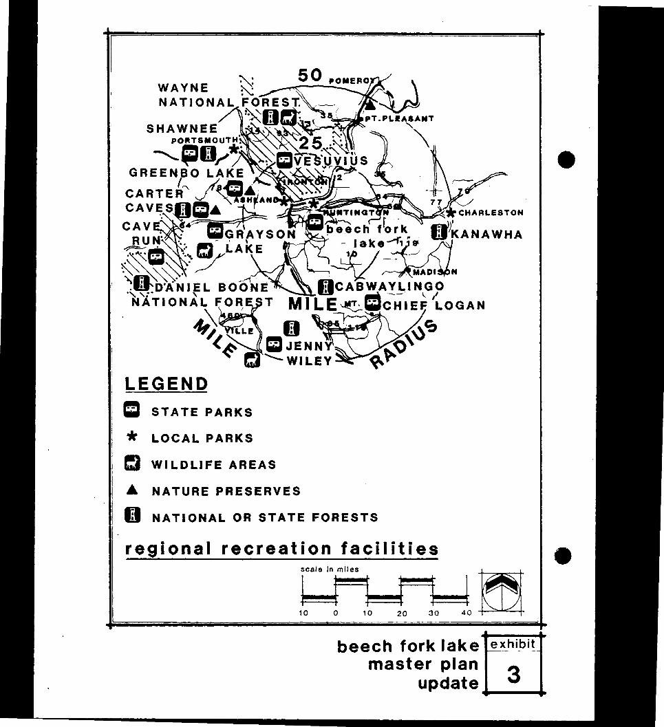
404 Regional Recreation Facilities 4-5 -403 Scxio-Economic Profile 4-3
405 Surrounding Iand Use 4-5 406 Project Utilities 4-7 407 Transportation System 4-9
aIAPrER 5 - RErnEATION USE ANALYSIS
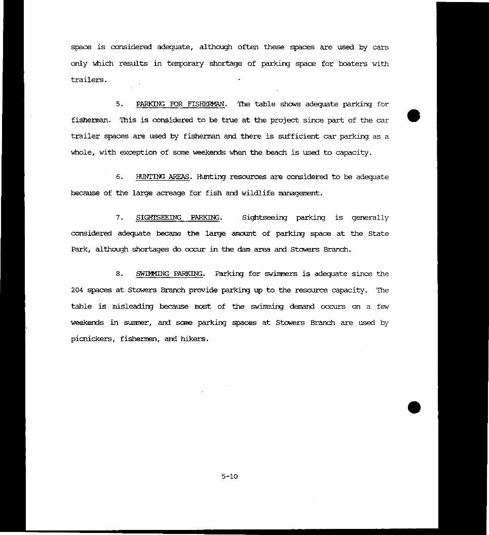
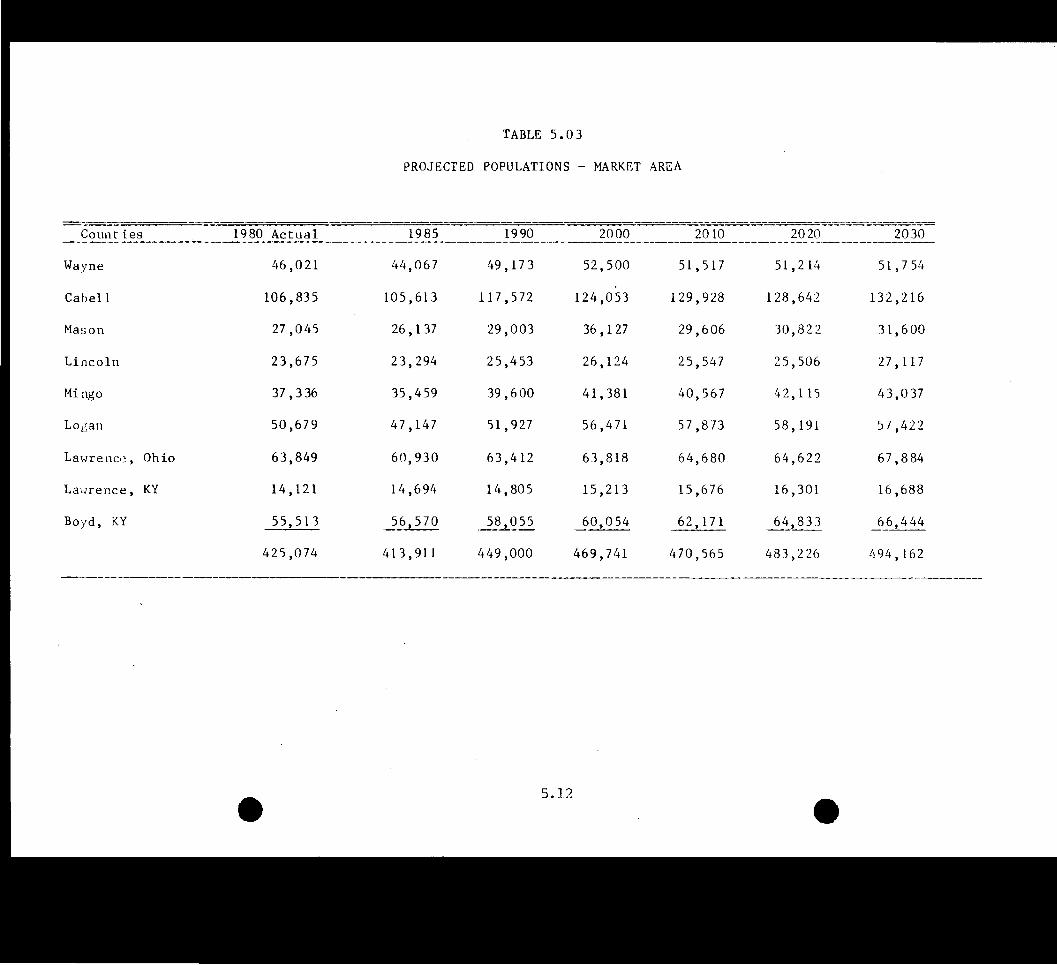
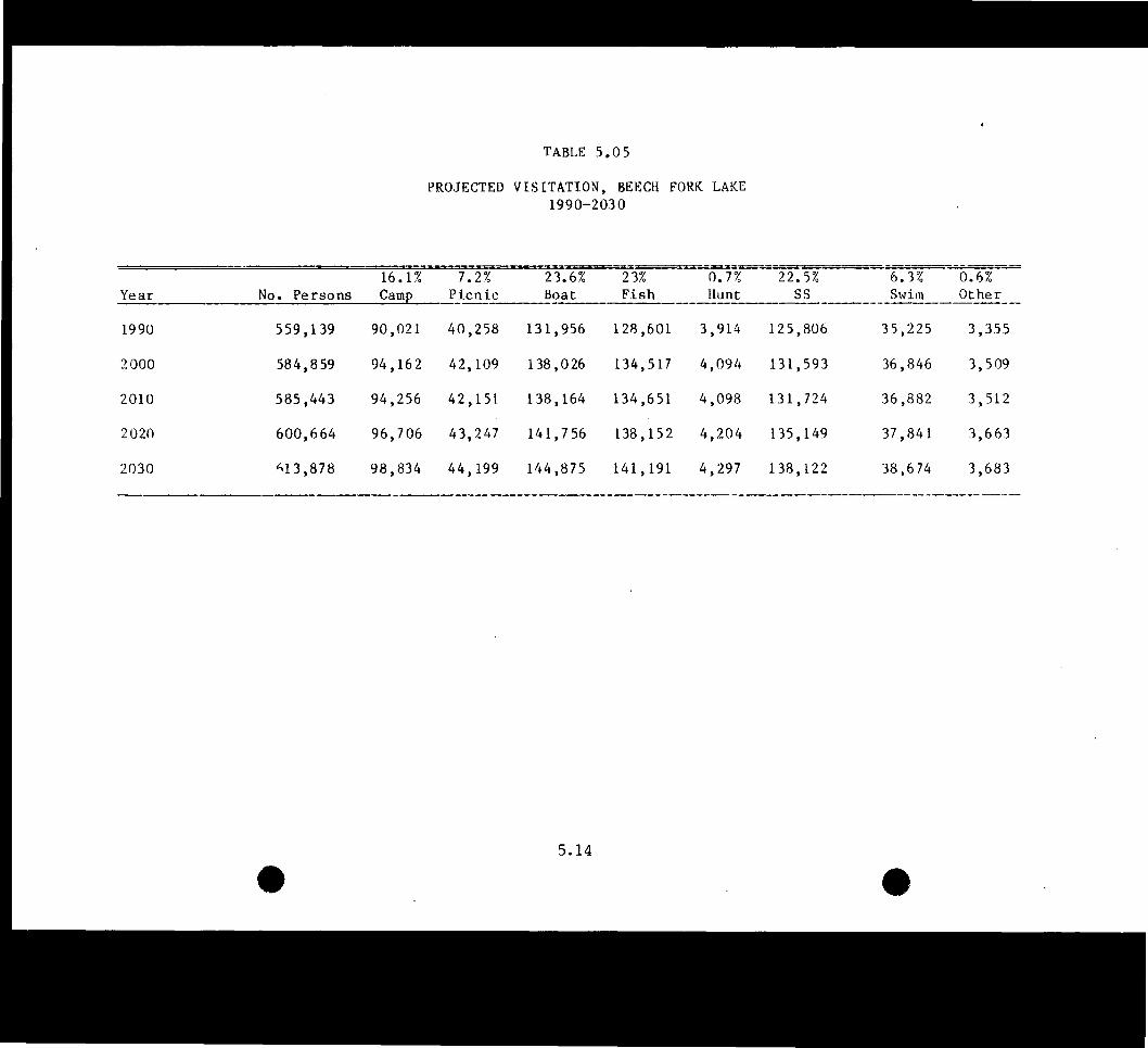
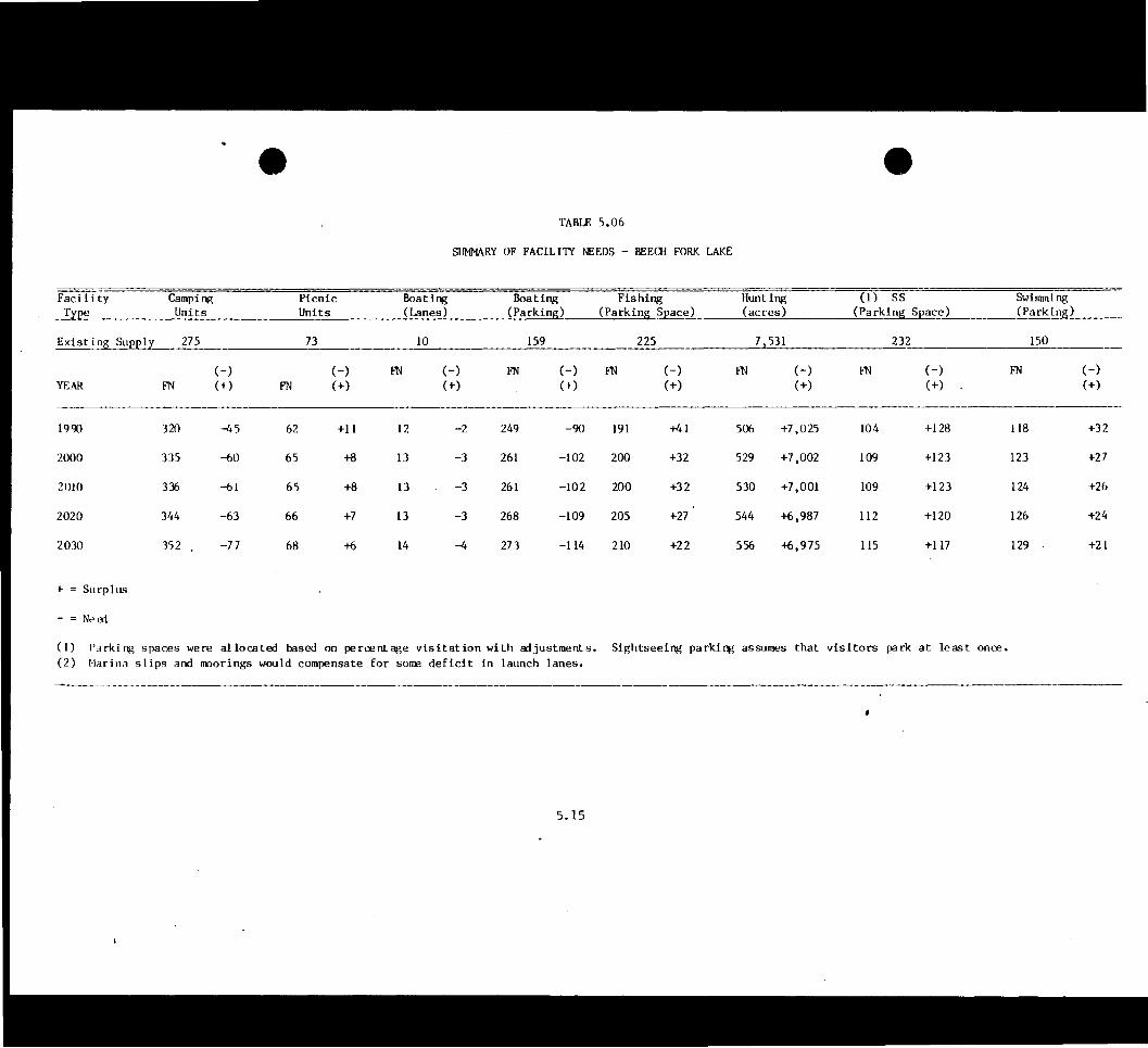
501 Introduction 5-1 502 Existing Recreation Facilities 5-1 503 Regional Recreation Facility Needs 5-4 504 Project Visitation and Facility Needs 5-6
ClIAPlER 6 - axgtRDINATION
601 SUmrnary of Coordination 6-1
ClIAPlER 7 - IHYSICAL PIAN OF DEVEIDEMENT
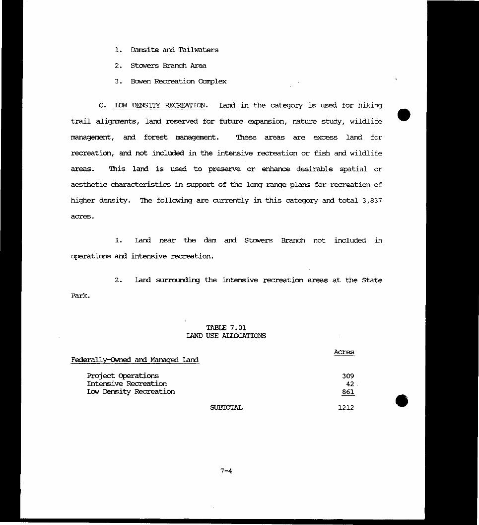
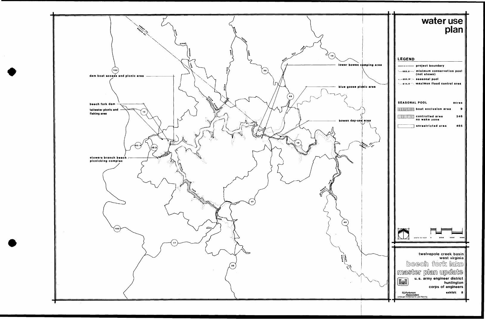
701 Introduction 7-1 702 Resource Use Objectives 7-1 703 Project Iand Use categories 7-3 704 Water Use Plan 7-6 705 Recreation Area Analysis 7-8 706 Trail Systems 7-29 707 Wildlife Areas 7-34 708 Facility Maintenance 7-36
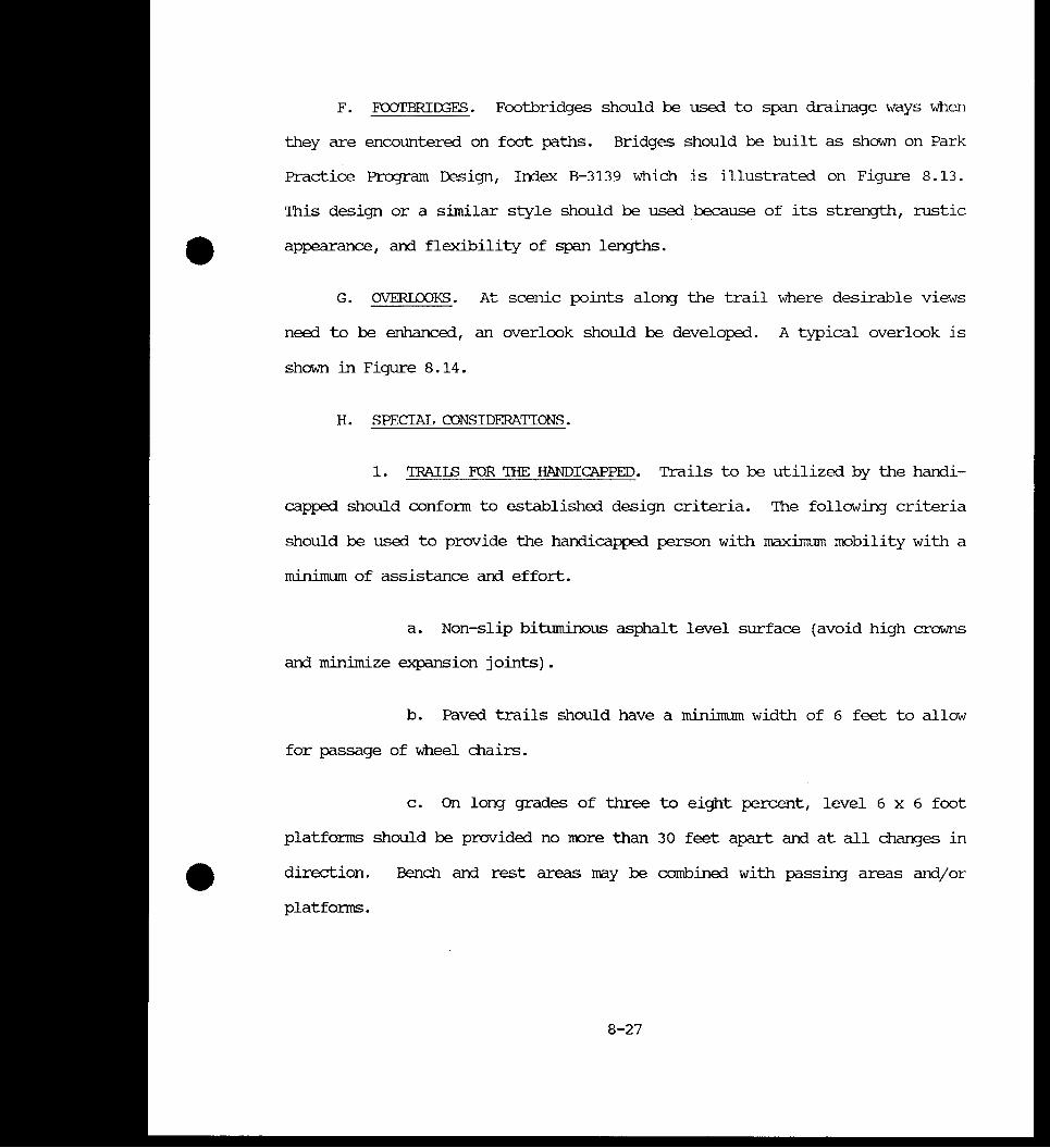
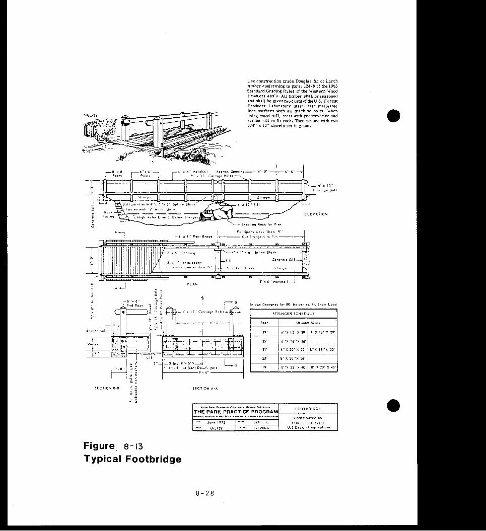
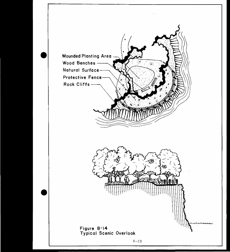
ClIAPlER VIII - FACILITY DESIGN auTERIA
801 Introduction 8-1
803 Site Preparation 8-3 802 Siting 8-2
804 Iamscape Planting 8-4 -805 Roads 8-4 806 Parking 8-8 807 Boat Iaunchirg Ranps 8-10 808 Docks and Marina Facilities 8-10
ii
Section
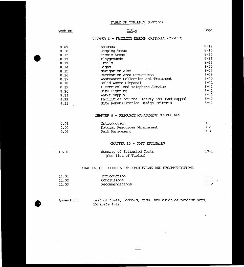
bull 809 810 811 812 813 814 815 816 817 818 819 820 821 822 823
901 902 903
1001
1101 1102 1103
Appendix I
TABIE OF CONIENTS (Contd)
Title
CHAPIER 8 - FACILITY DESIGN CRITERIA (Contd)
Beaches camping Areas Picnic Areas Playgrounds Trails Signs Navigation Aids Recreation Area Structures Wastewater Collection and Treatment Solid Waste Disposal Electrical and Telephone Service Site Lighting Water Supply Facilities for the Elderly and Handicapped site Rehabilitation Design Criteria
CHAPIER 9 - RESOURCE MANAGEMENT GUIDELINES
Introouction Natural Resources Management Park Management
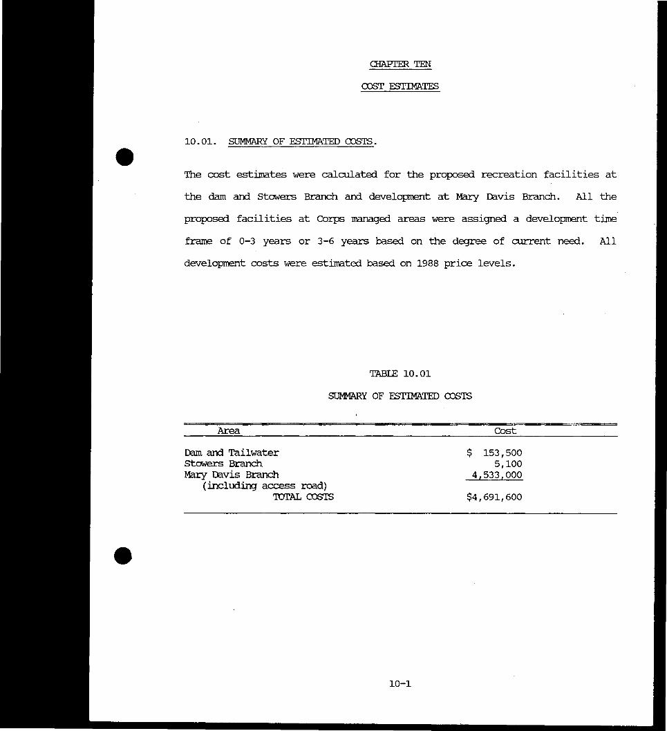
a-lAPIER 10 - COST ESTIMATES
Summary of Estimated Costs (See list of Tables)
rnAPIER p - SUMMARY OF CONCLUSIONS AND RECOMMENDATIONS
Introouction Conclusions Recorrnnendations
Page
8-12 8-16 8-20 8-21 8-22 8-30 8-39 8-39 8-40 8-41 8-41 8-41 8-42 8-42 8-43
9-1 9-2 9-8
10-1
11-1 11-1 11-2
List of trees mammals fish and birds of project area Exhibits 4-12
iii
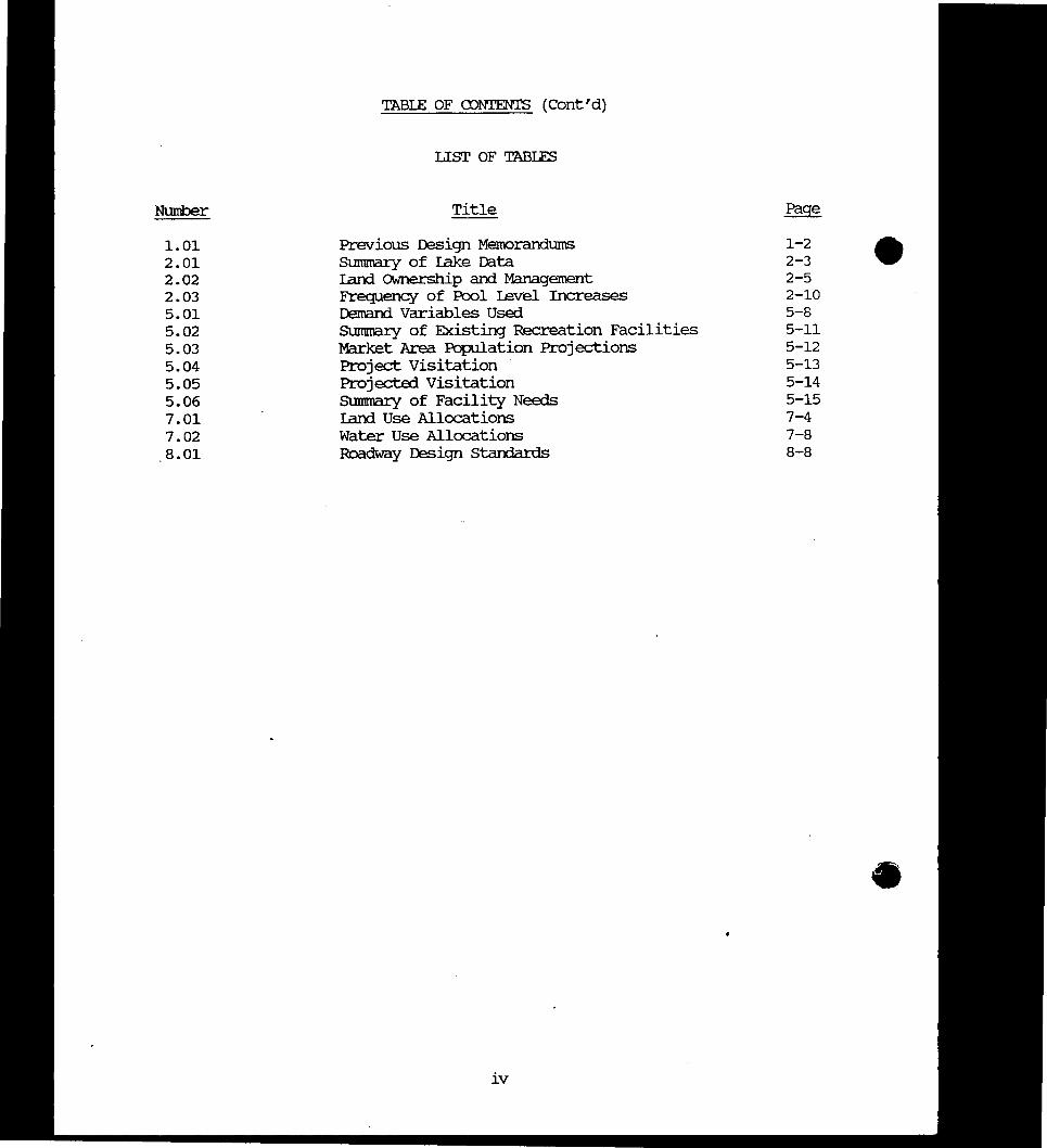
TABIE OF CDNTENTS (contd)
LIST OF TABIFS
Number Title
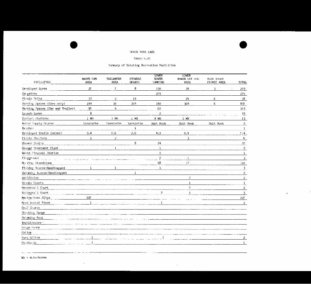
101 Previous Design Memorandums 1-2 201 summary of lake Data 2-3 202 Iand OWnership and Management 2-5 203 Frequency of Pool Level Increases 2-10 501 Dmand Variables Used 5-8 502 SUmmary of Existing Recreation Facilities 5-11 503 Market Area Population Projections 5-12 504 Project Visitation 5-13 505 Projected Visitation 5-14 506 SUmmary of Facility Needs 5-15 701 Iand Use Allocations 7-4 702 Water Use Allocations 7-8
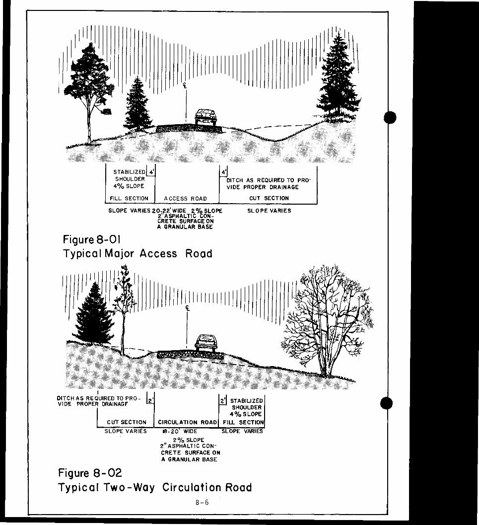
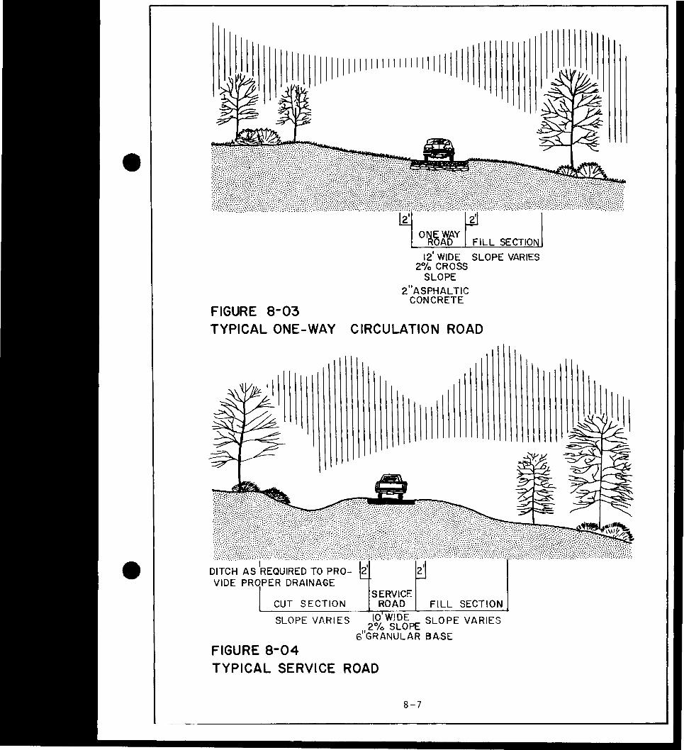
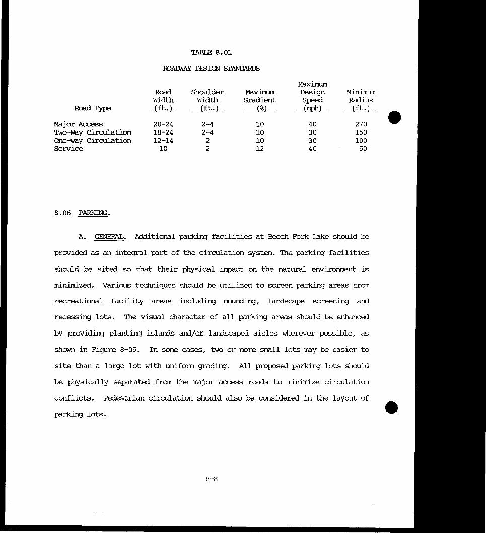
801 Roadway Design Standards 8-8
iv
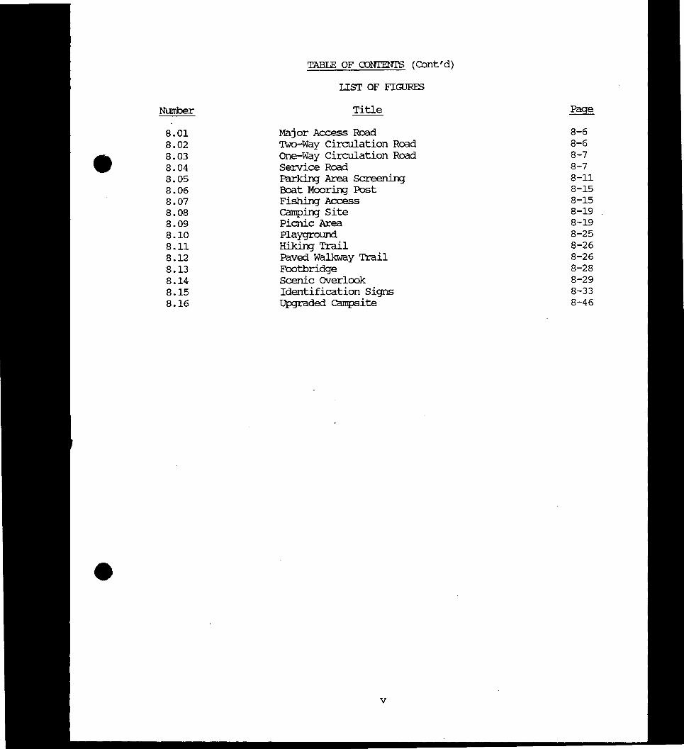
TABIE OF OJNIENTS Contd)
Lisr OF FIGURES
Number Title Page
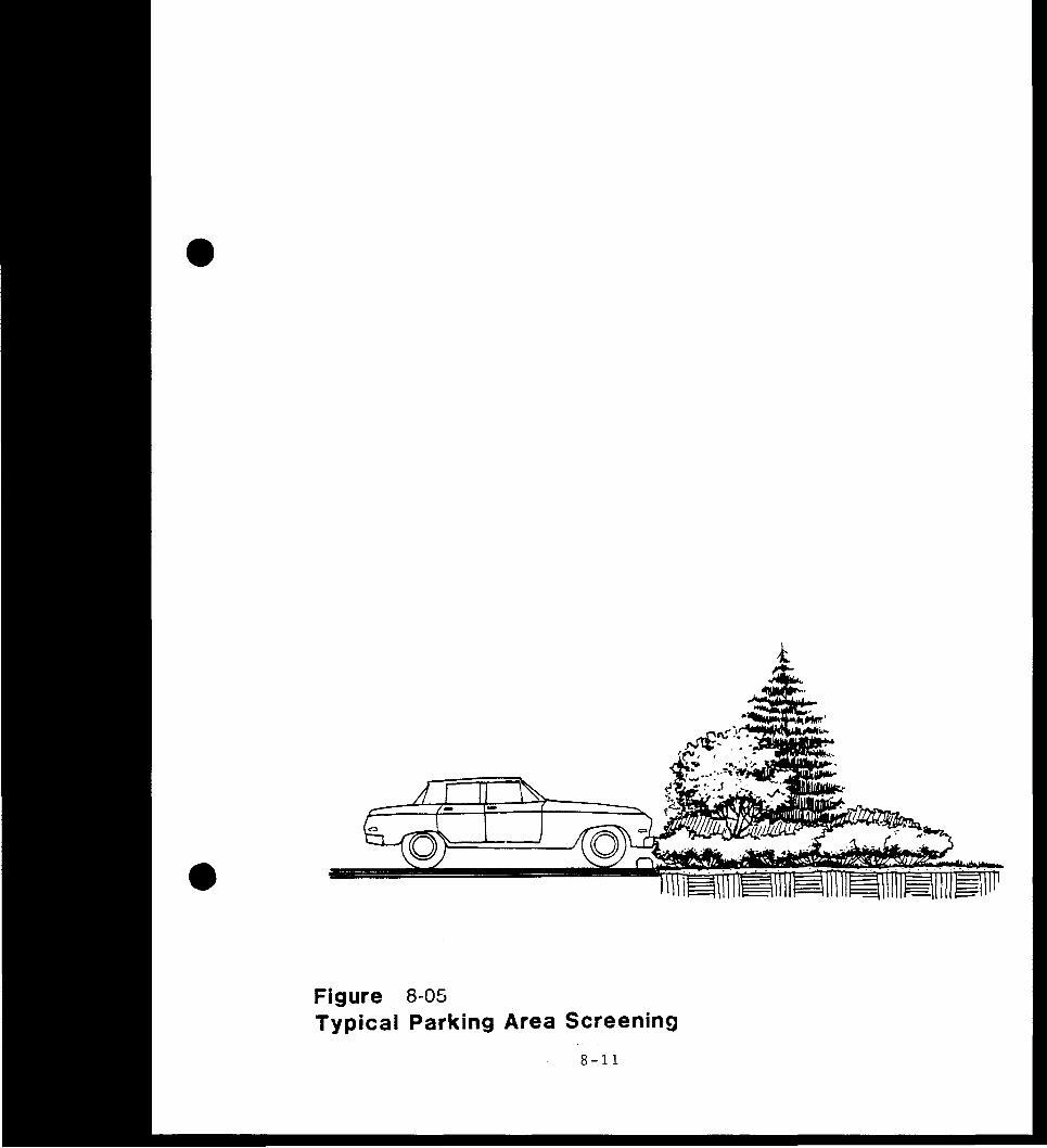
801 Major Access Road 8-6
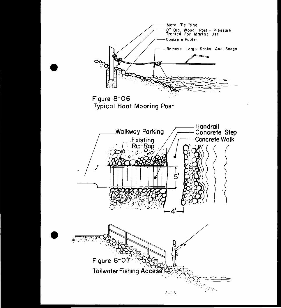
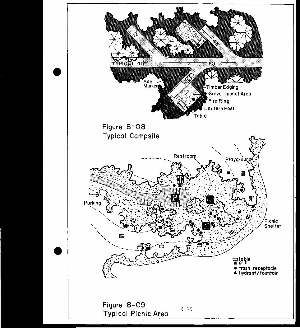
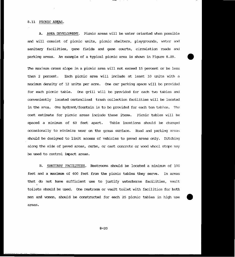
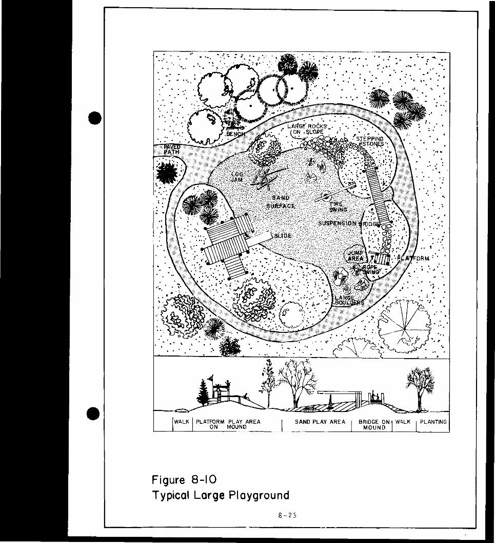
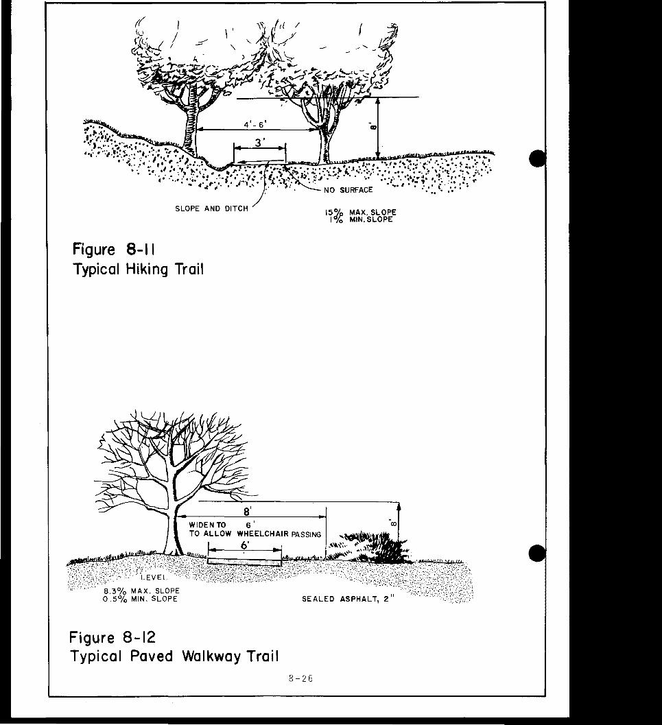
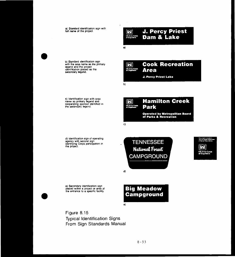
bull 802 Iwo-Way Circulation Road 8-6 803 One-Way Circulation Road 8-7 804 Seivice Road 8-7 805 Parking Area Screening 8-11 806 Boat Mooring Post 8-15 807 Fishing Access 8-15 808 camping Site 8-19 809 Picnic Area 8-19 810 Playgrounl 8-25 811 Hiking Trail 8-26 812 Paved Walkway Trail 8-26 813 Footbridge 8-28 814 Scenic overlook 8-29 815 Identification Signs 8-33 816 U]xJraded campsite 8-46
V
TABIE OF CONIENIS (Contd)
LIST OF FHOIOGRAFHS
Number Title Page
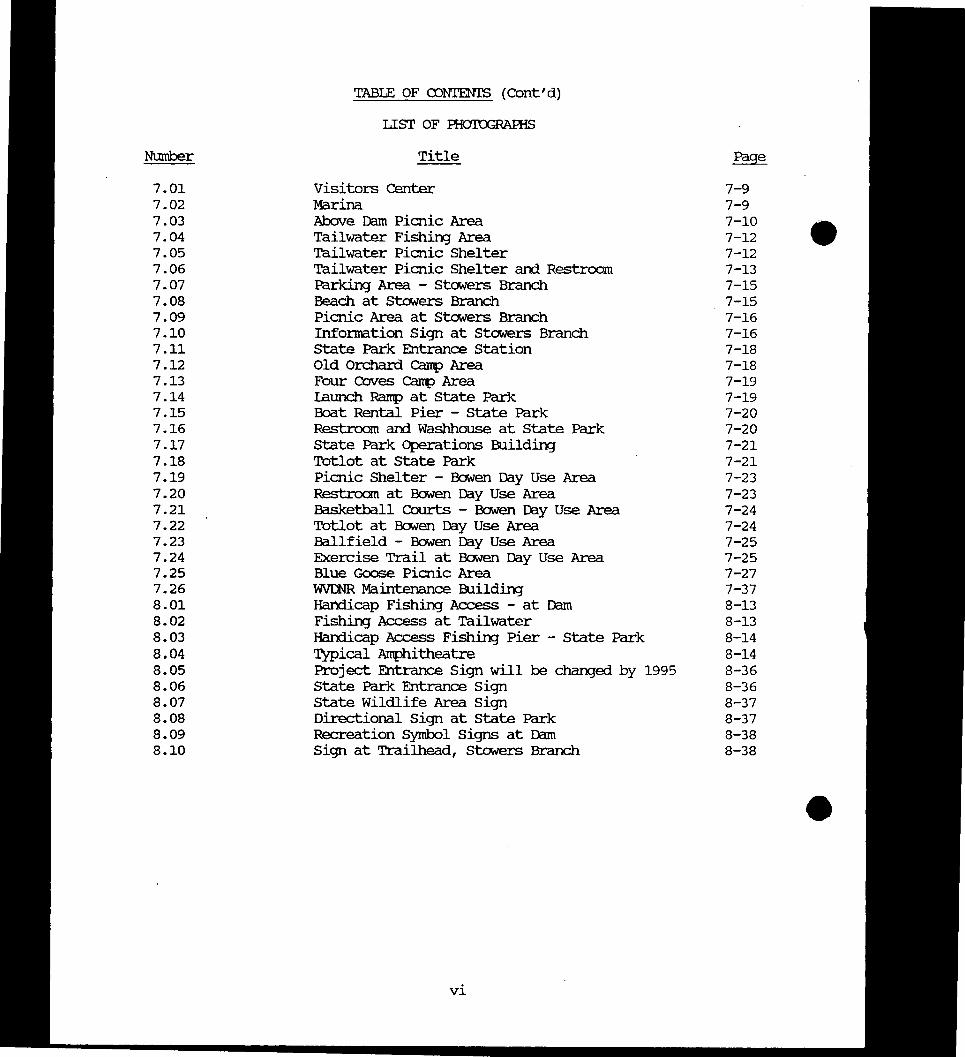
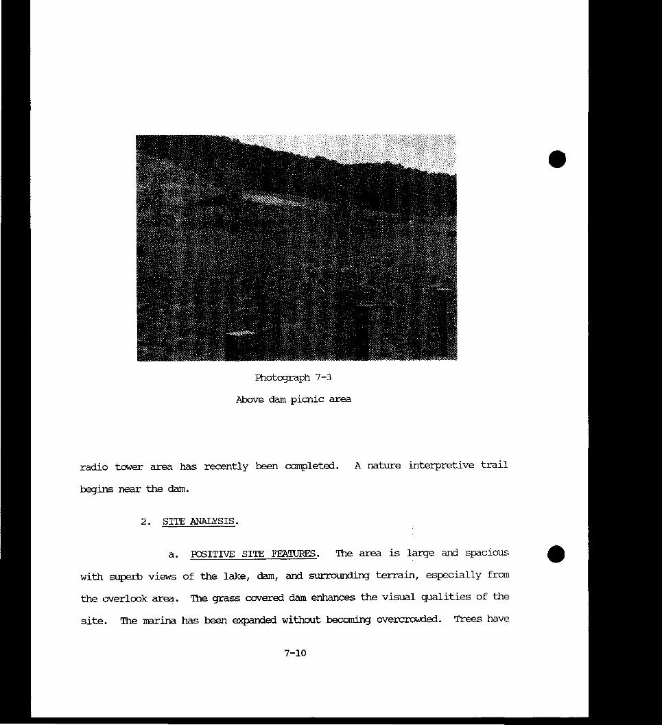
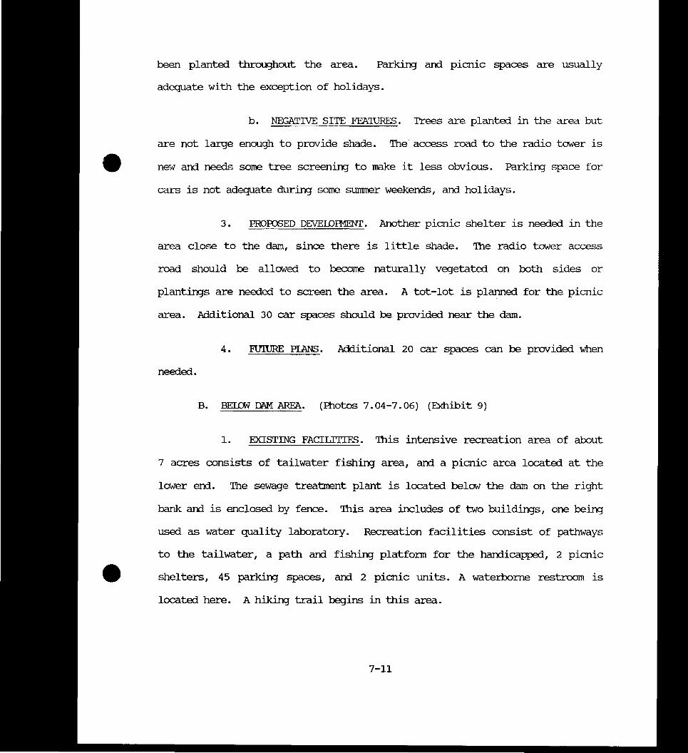
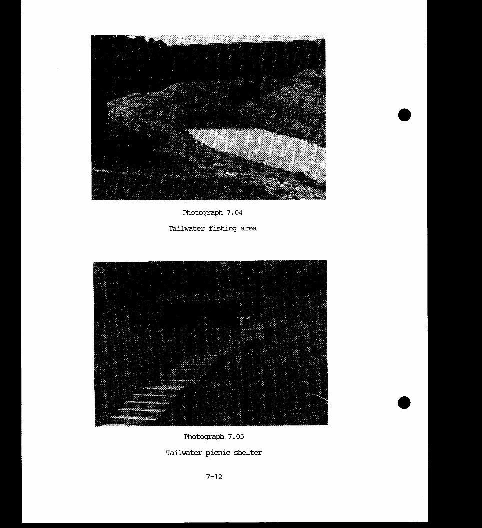
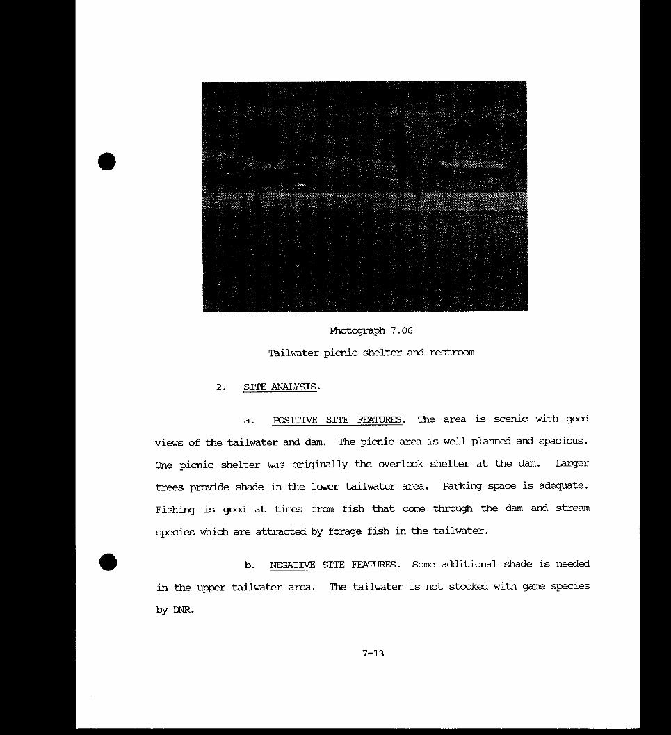
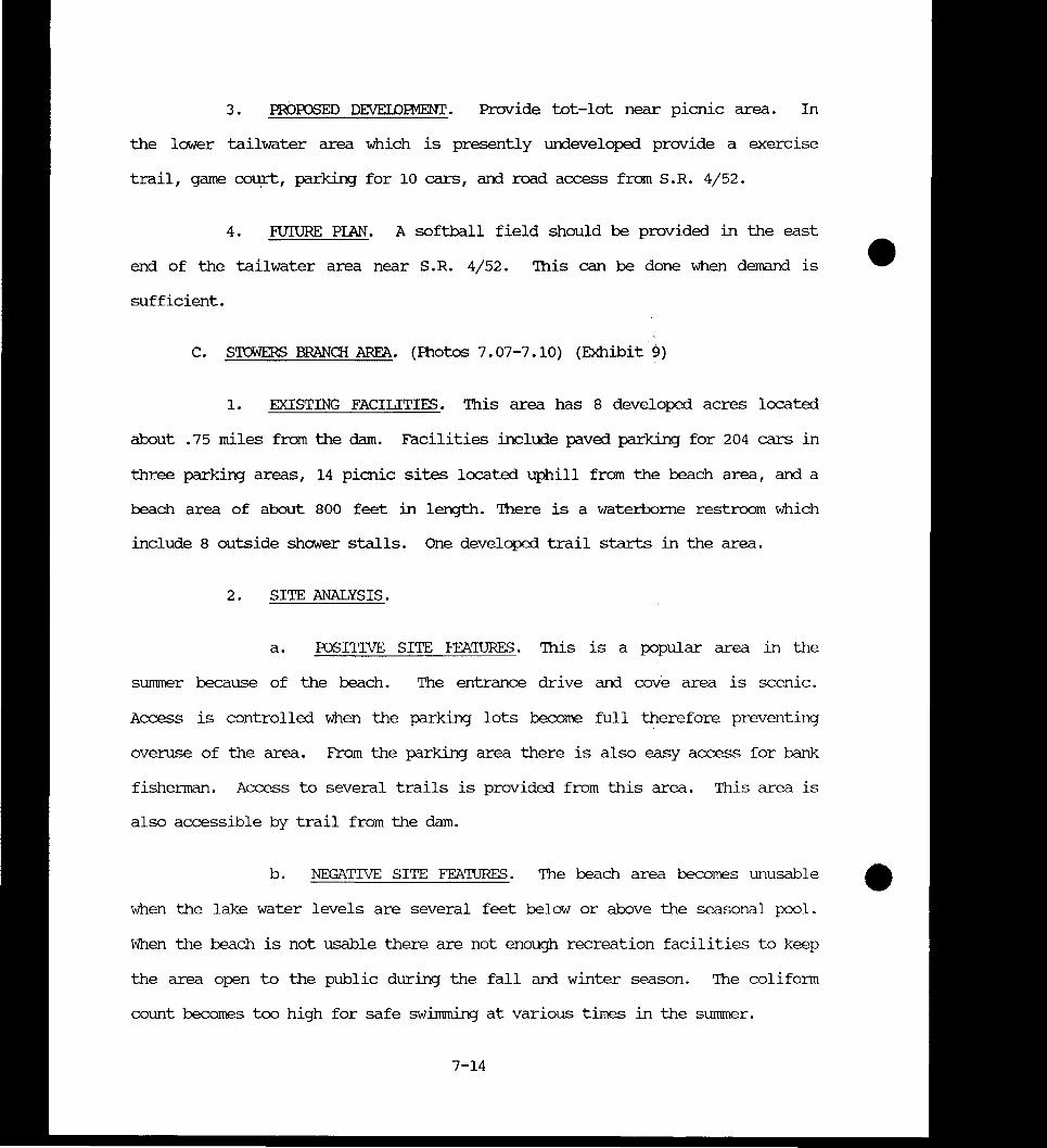
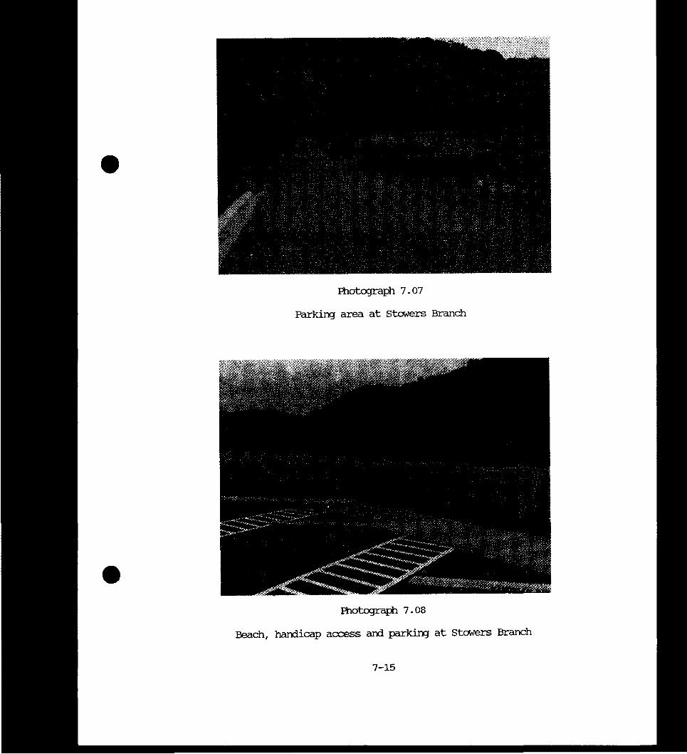
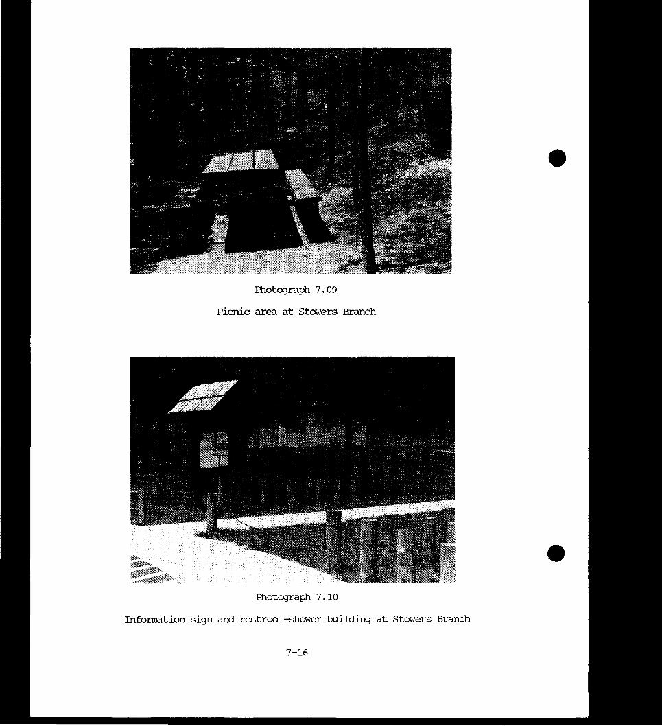
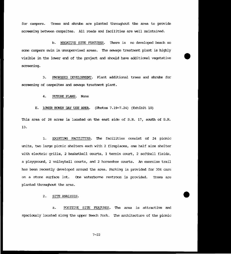
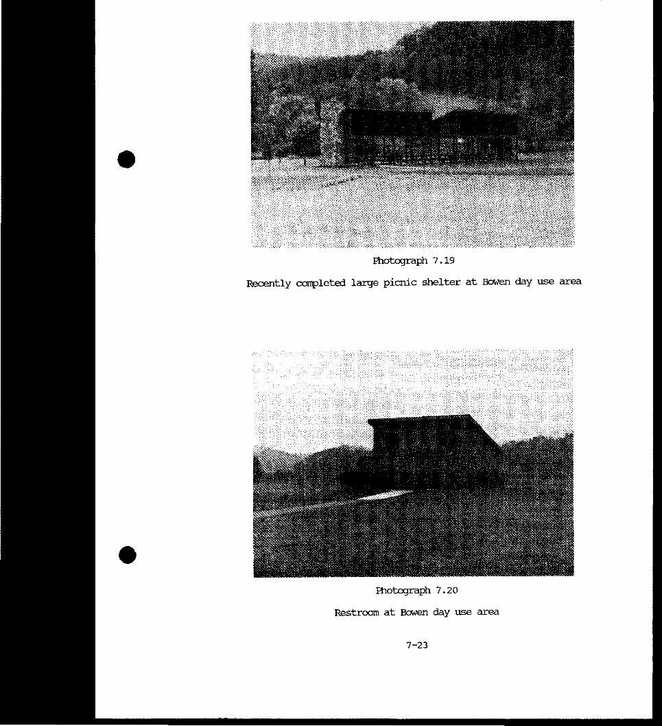
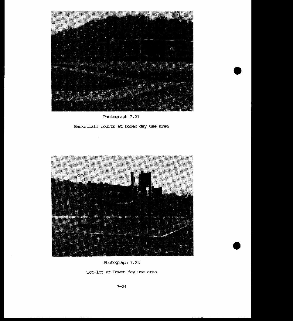
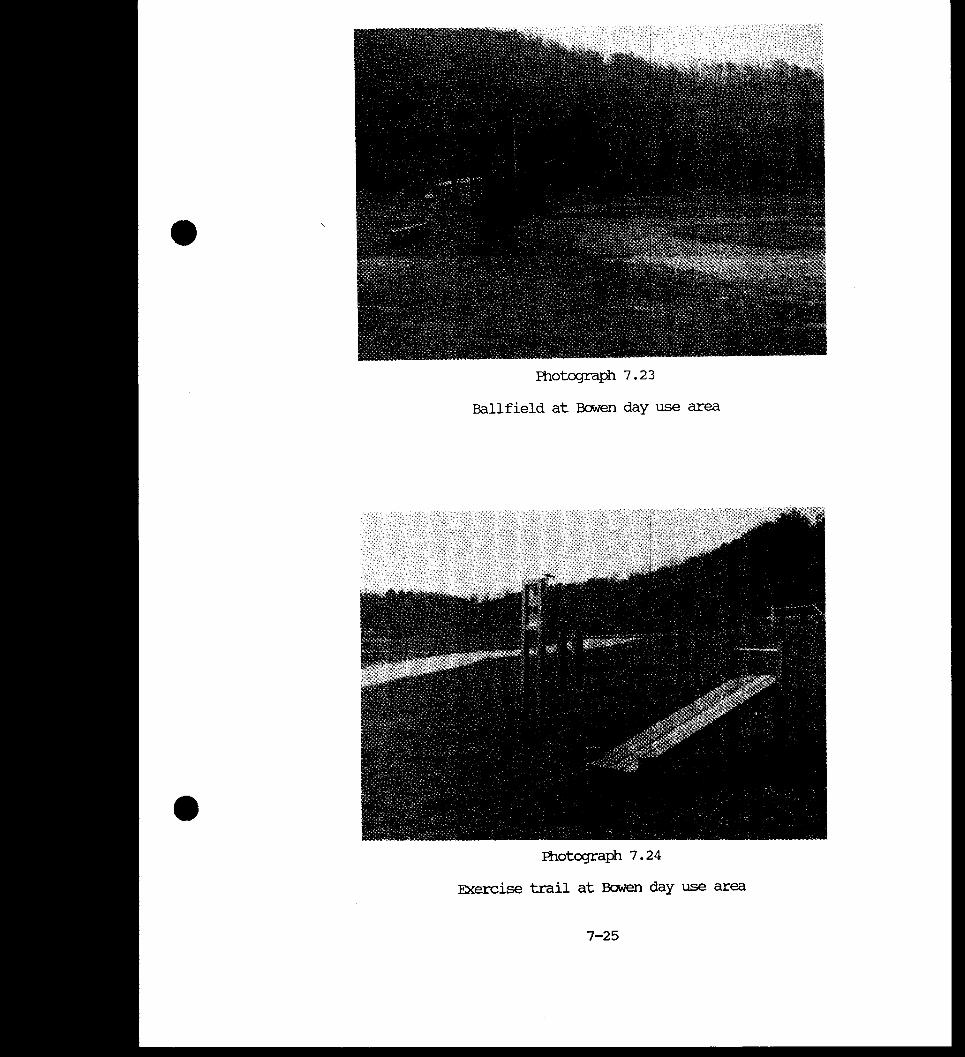
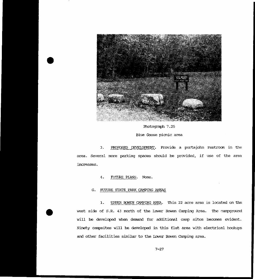
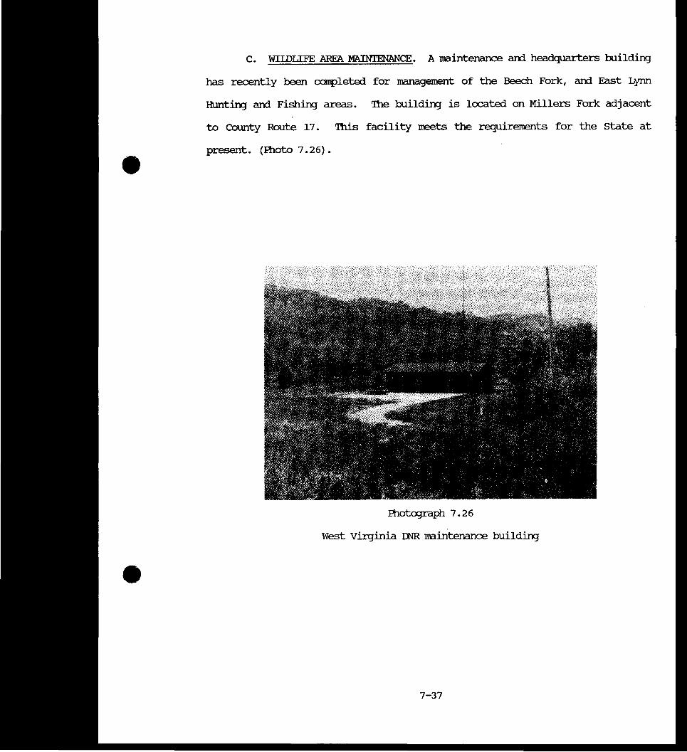
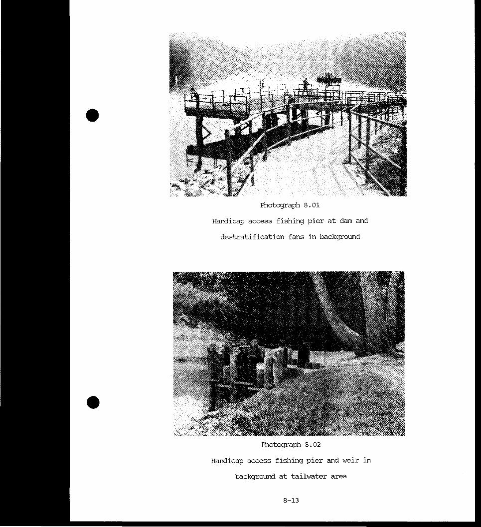
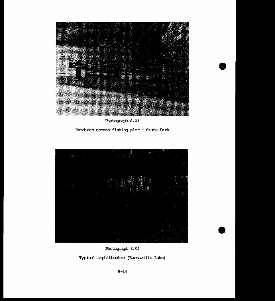
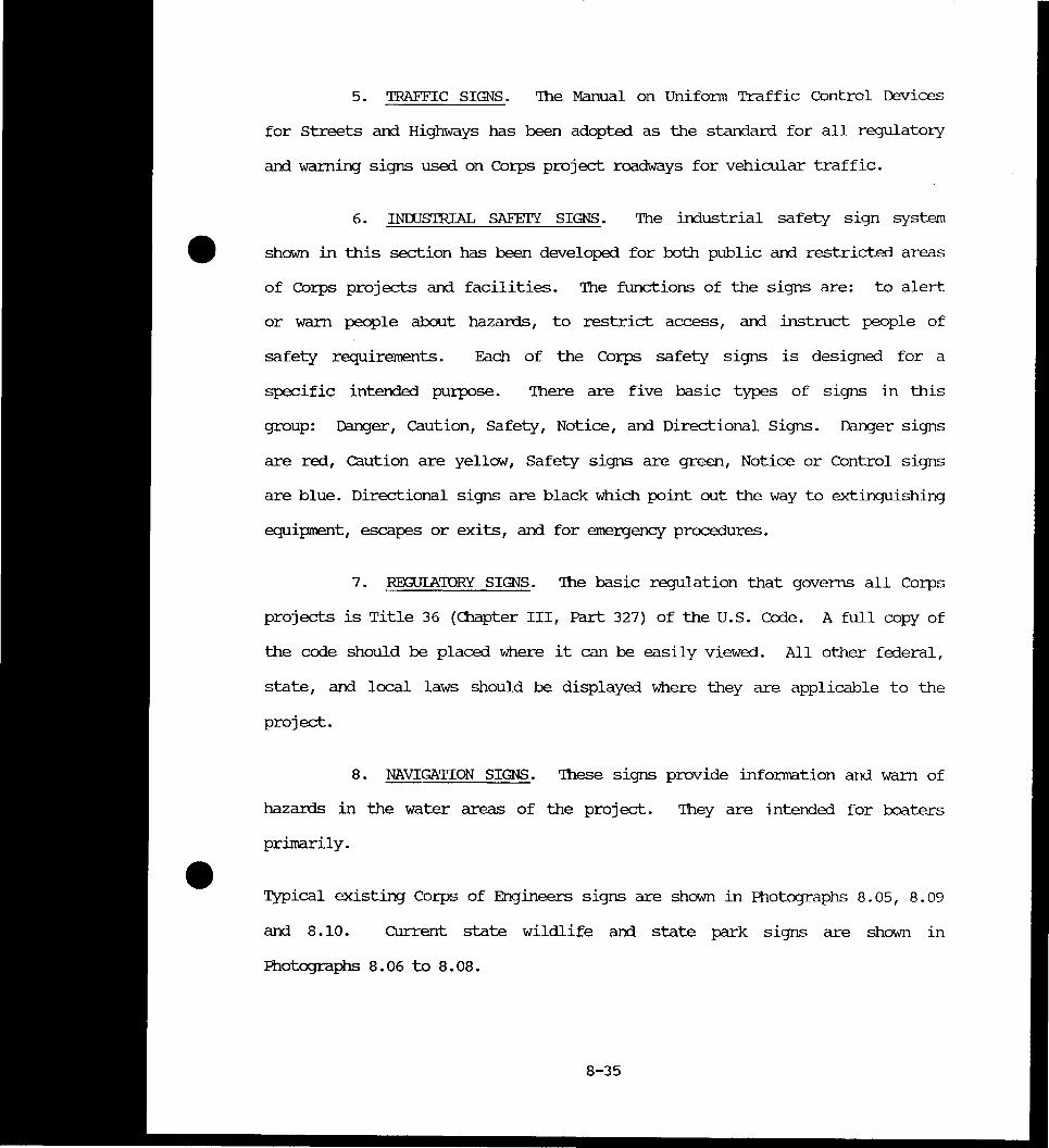
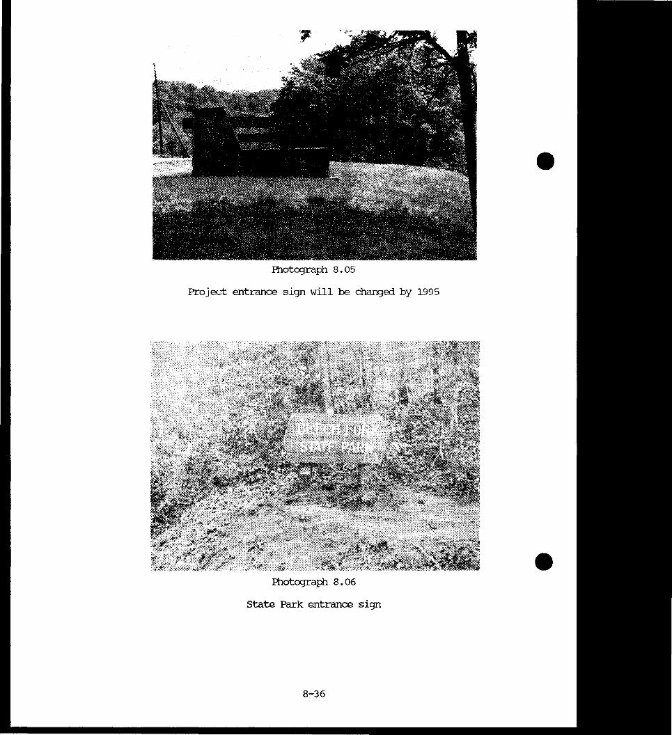
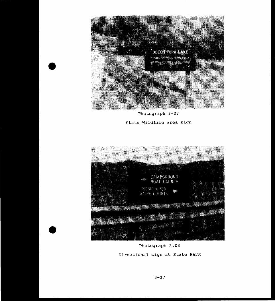
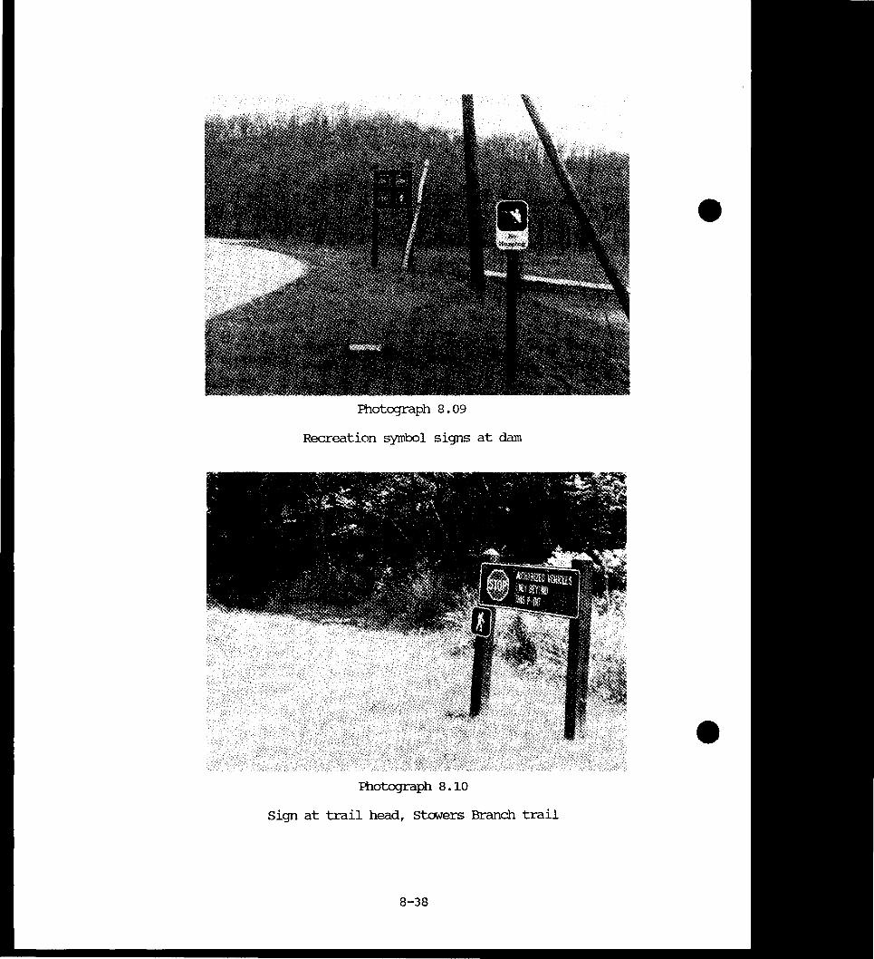
701 Visitors Center 7-9 702 Marina 7-9 703 Above Dam Picnic Area 7-10 704 Tailwater Fishing Area 7-12 705 Tailwater Picnic Shelter 7-12 -706 Tailwater Picnic Shelter and Restroommiddot 7-13 707 Parking Area - Stavers Branch 7-15 708 13each at Stavers Branch 7-15 709 Picnic Area at Stowers Branch 7-16 710 Infonnation Sign at Stowers Branch 7-16 711 state Park Entrance Station 7-18 712 Old Orchard camp Area 7-18 713 Four Coves camp Area 7-19 7 14 Iaunch Ramp at State Park 7-19 715 Poat Rental Pier - State Park 7-20 716 Restroom and Washhouse at State Park 7-20 717 State Park Operations amplilding 7-21 718 Totlot at State Park 7-21 719 Picnic Shelter - Bowen Day Use Area 7-23 720 Restroom at Bowen Day Use Area 7-23 721 Basketball Courts - Bowen Day Use Area 7-24 722 Totlot at Bowen Day Use Area 7-24 723 Ballfield - Bowen Day Use Area 7-25 724 Exercise Trail at Bowen Day Use Area 7-25 725 Blue Goose Picnic Area 7-27 726 wvrnR Maintenance amplilding 7-37 801 Handicap Fishing Access - at Dam 8-13 802 Fishing Access at Tailwater 8-13 803 Handicap Access Fishing Pier - State Park 8-14 804 Typical Amphitheatre 8-14 805 Project Entrance Sign will be chanJed by 1995 8-36 806 State Park Entrance Sign 8-36 807 State Wildlife Area Sign 8-37 808 Directional Sign at State Park 8-37 809 Recreation Symbol Signs at Dam 8-38 810 Sign at Trailhead Stowers Branch 8-38
-
vi
Number
1 2 3 4 5 6 7 8 9
10 11 12
bull
TABIE OF (X)NTENlS (Contd)
LIST OF EXHIBITS
Title
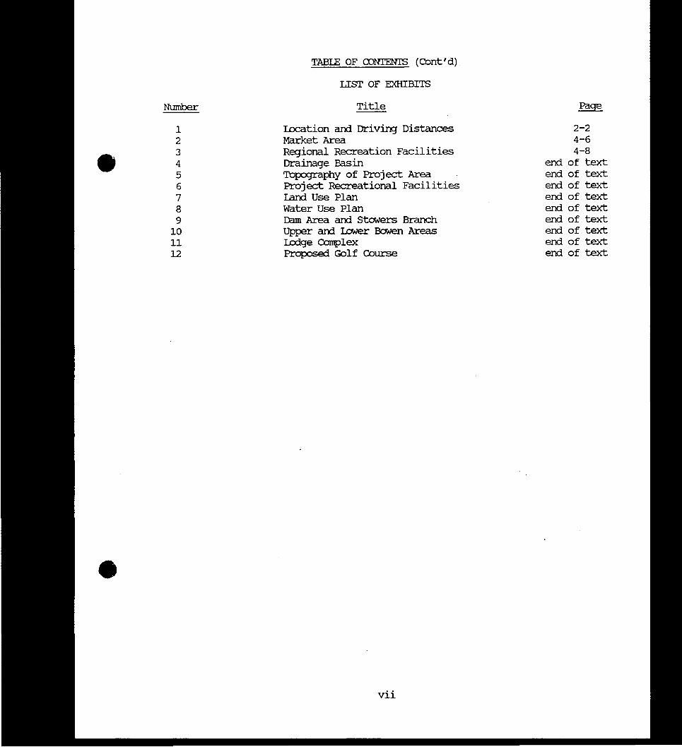
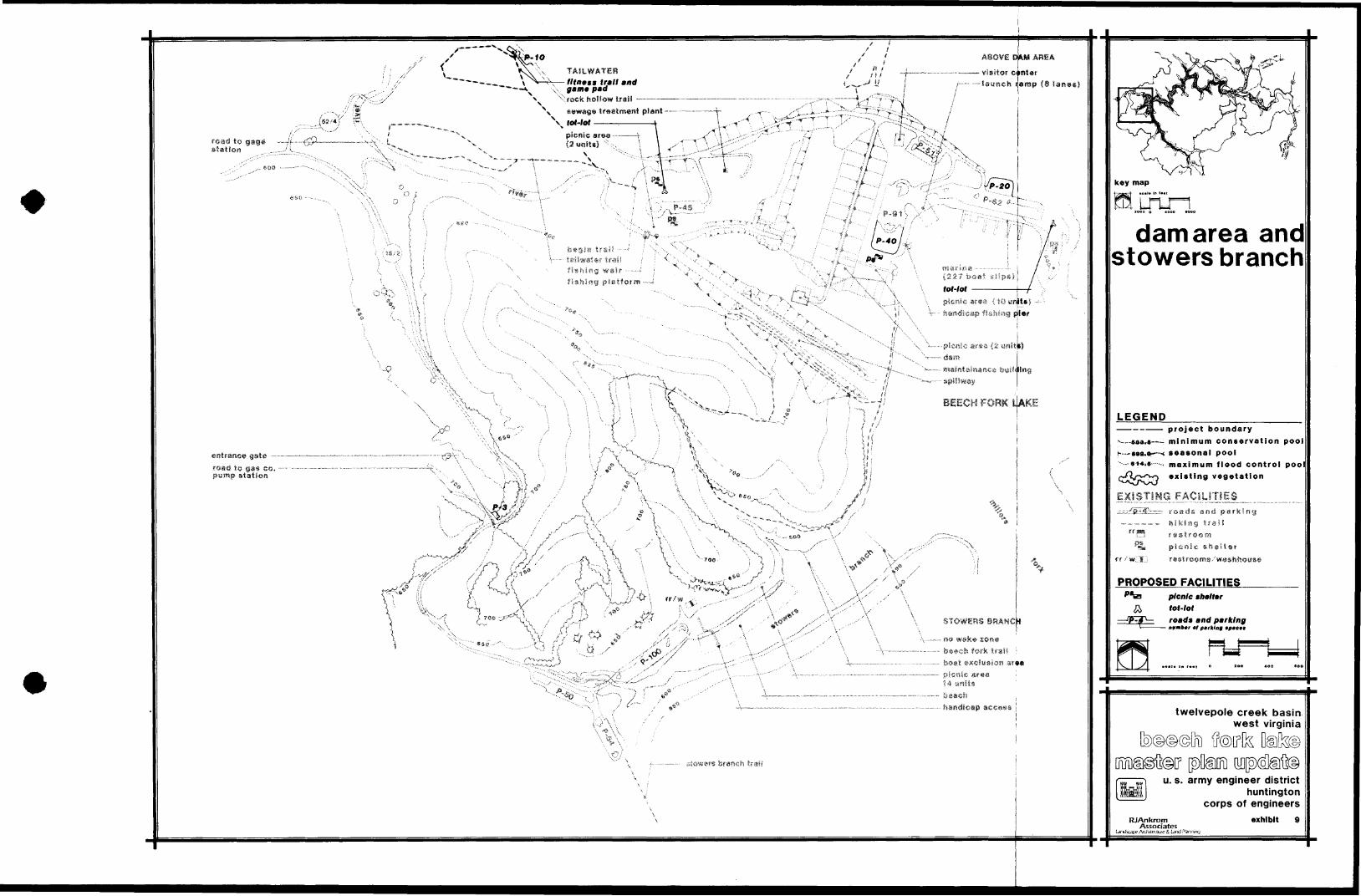
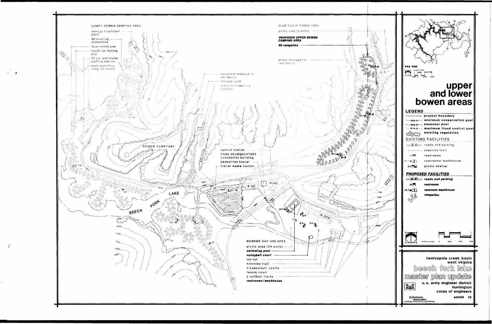
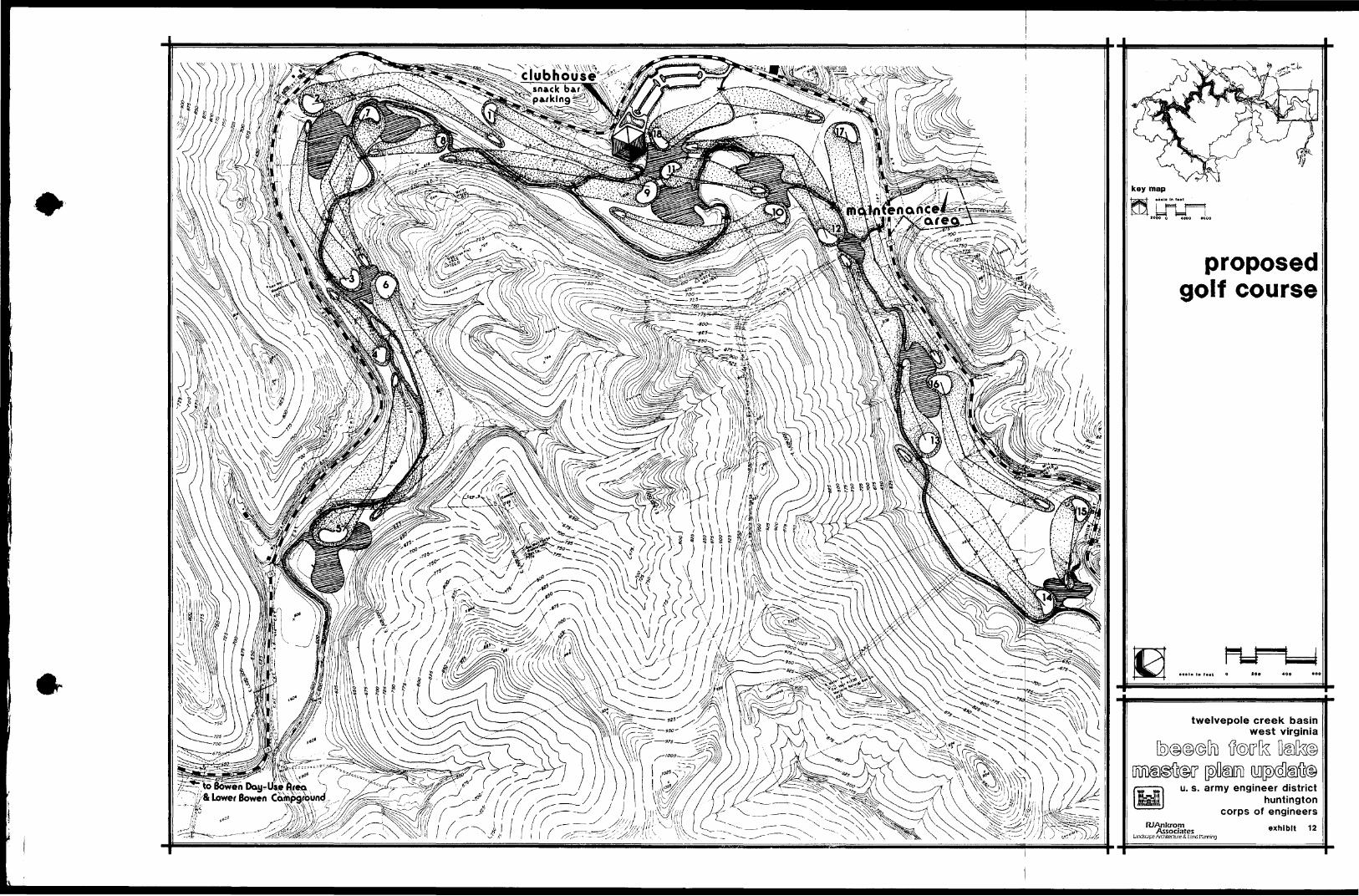
location am Driving Distances Market Area Regional Recreation Facilities Drainage Basin Topography of Project Area Project Recreational Facilities Land Use Plan Water Use Plan Dam Area am Stowers Branch Upper am IcMer saen Areas lodge Complex Proposed Golf Course
2-2 4-6 4-8
end of text end of text end of text end of text end of text end of text end of text end of text end of text
vii
chapter 1 introduction
CHAPIER 1 INIROUJCTION
1-01 PROJECT AllIBORIZATION
Ihe Beech Fork lake project was authorized by the Flood Control Act of 1962 as
a unit in the larger comprehensive flood control plan for the Ohio River as
discussed in the Flood Control committee Dxument No 1 75th congress first
session
1-02 PROJECT roRroSE
Ihe authorized purposes of the project are flood control outdoor recreation
and fish and wildlife conservation
A FI00D CONTROL Beech Fork lake is operated for the reduction of
flood damages on the Twelvepole Creek and as a unit of the coordinated system
for flood protection on the Ohio River
B RECREATION he Federal and State constructed recreation facilities
completed include camping picnic areas boat ramps swimming beach and
fishing access (3144) acres of Federal land have been outgranted to West
Virginia Department of Commerce for park and recreation purposes
C FISH AND WIIDLIFE (8247) acres of Federal land and the lake
waters have been outgranted to West Virginia Department of Natural Resources
to manage the forest fish and wildlife resources
1-1
D WATER cpALITY Although not a authorized purpose low flows on the
Beech Fork and the Iwelvepole Creek are augmented to maintain a minimum of
10 cfs to preserve the downstream fishery and enhance water quality Ihe
dam has selective withdrawal capability
1 03 RJRFOSE OF lHE MASTER PIAN
Ihe Beech Fork Master Plan provides revised and currentinfonnation relative
to guidincJ the management and developnent of the project resources It
consolidates the original Public Use Plan tM No 11 with SUpplements and
all other available related documents within a comprehensive planning fonnat
Ihe Master Plan establishes the policies programs and objectives for the
development of the project resources in acxord with ER 1130-2-435 and related
Cocps regulations
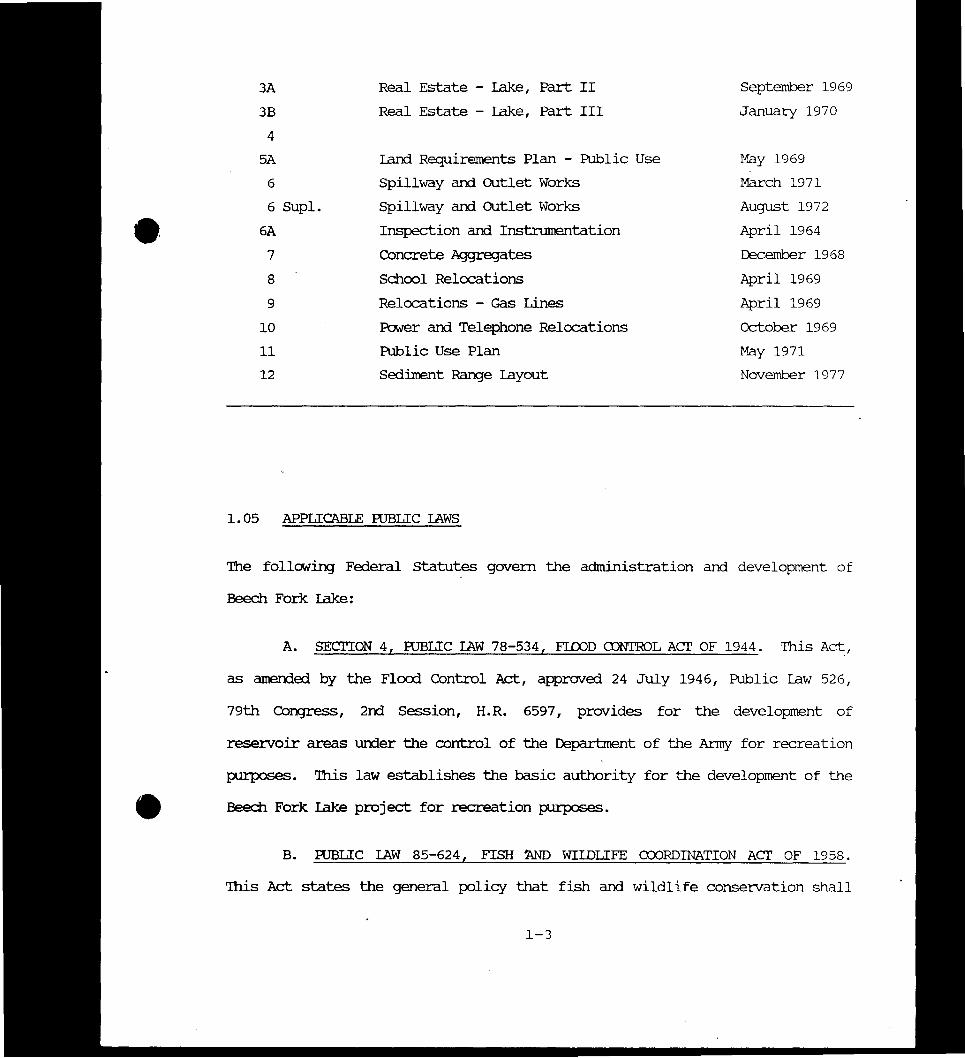
1 04 PERlINENT PRIOR REroRIS
A number of design memorandums and other reports conceniing Beech Fork lake
have been completed by the Corps of Engineers and are listed in Table 1-01
lhese reports have been utilized in the preparation of the Master Plan
TABIE 1-01
mEVIOOSLY ISSUED DESIGN MEMgtRANCUMS BEEQI FORK IAKE
DesignMerooramum No Title Approval Date
1 Hydrology November 1965
2 General Design Melooranium December 1967
3 Real Estate - cam Site Part 1 May 1968
1-2
3A Real Estate - lake Part II September 1969
3B Real Estate - lake Part III January 1970
4
5A Iand Requirements Plan - Public Use May 1969
Spillway and outlet Works March 1971
6 SUpl Spillway and outlet Works August 1972
6A Inspection and Instnnnentation April 1964
7 Concrete Agglegates December 1968bull 6
8 School Relocations April 1969
9 Relocations - Gas Lines April 1969
10 Power and Telephone Relocations October 1969
11 Public Use Plan May 1971
12 Sedilnent RanJe layout November 1977
105 APPLICABLE RJBLIC IAWS
Ihe following Federal statutes govern the administration and development of
Beech Fork lake
A SEClION 4 RJBLIC IAW 78-534 FIOOD ltDNTROL ACT OF 1944 Ihis Ad
as amended by the Flcxxi Control Act approved 24 July 1946 Public law 526
79th Congress 2nd Session HR 6597 provides for the development of
resezvoir areas unier the control of the Department of the Anny for recreation
purposes Ihis law establishes the basic authority for the development of the
Beech Fork lake project for recreation purposes
B RJBLIC IAW 85-624 FISH Nm WIIDLIFE CDJRDINATION ACT OF 1958
Ihis Act states the general policy that fish and wildlife conseivation shall
1-3
receive equal consideration with other features of water resource development
projects Farly arrl continuing coordination is encouraged to fulfill the
spirit arrl intent of the law arrl administrative policy This law establishes
the basis for detailed consideration of fish arrl wildlife values in formulatshy
inJ future development plans for Beech Fork lake
C RJBLIC IAW 89-72 FEDERAL WATER PROJECT RECREATION ACT OF 1965
his Act inposes requirements of non-Federal cooperation arrl cost-sharing
participation in recreation financinJ arrl administration These requirements
have been applied administratively to projects authorized before 1965
therefore all Corps of Engineers participation in recreation development at
Beech Fork lake is subject to the requirements of PL 89-72 The cost-share
policy at the time of contract negotiation will prevail
D IUBLIC IAW 86-717 OF 1960 his Act provides for the protection of
forest cover for reservoir areas urxier the jurisdiction of the Secretary of
the Anrr arrl the Cltief of Engineers The Act requires that where practicable
fee lands shall be developed arrl maintained so as to encourage promote and
assure fully adequate am deperxlable future resources of readily available
timber through sustained yield programs reforestation arrl accepted consershy
vation practices arrl to increase the value of forest areas for conservation
recreation arrl other beneficial uses
E IUBLIC IAW 89-65 NATIONAL HISIORIC PRESERVATION ACT OF 1966 The
National Historic Preseivation Act of 1966 (PUblic raw 89-65) established a
national policy of historic preservation directed the expansion of the
National Register of Historic Places to include cultural resources of state
1-4
and local as well as national significance and established certain proceshy
dures to be followed by Federal agencies in the event of a proposal that might
have an effect on the National Register properties
F FUBLIC IAW 89-669 PROIECIION OF RARE AND ENDANGERED SPECIES ACT
- his Act states the policy of Congress that the Secretaries of the Interior
Agriculture and Defense shall seek to protect species of native fish and
wildlife including migratory birds that are threatened with extinction and
insofar as is practicable and consistent with the primary purposes of these
agencies shall preserve the habitats of such threatened species on lands
uncler their jurisdiction
G FUBLIC IAW 91-190 NATIONAL ENVIRONMENT FOLICY ACT OF 1969 Ihis
Act requires that an Envirornnental Impact Assessment shall be prepared to
evaluate the impacts of any significant actions that may affect the environshy
mental quality of Federally-owned land
H FUBLIC IAW 91-611 RIVER AND HAROOR AND FI00D CONTROL ACTS OF 1970
Title II section 234 of this Act gives citation authority to designated
Federal personnel for violations of those rules adopted by the Secretary of
the Anny related to the protection of Corps of Engineers projects resources
I FUBLIC IAW 93-291 PRESERVATION OF HISTORIC AND ARaIEQrcxICAL DATA
ACT OF 1974 his Act provides for the preservation of significant scientific
prehistoric historic or archeological data that might be lost or destroyed
as a result of various Federal actions
1-5
J roBLIC IAW 99-662 WATER RESOURCES DEVEIDMENT ACT OF 1986 Ihis
law provides for the conservation and development of water and related
resources and the inprovement and rehabilitation of the Nations water
resources infrastructure lhe Act discusses the new partnership relationships
between Federal and non-Federal public entities as a result of increased costshy
sharing in all stages of development and civil works projects
K roBLIC IAW 81-152 FEDERAL PROPERIY ACMINISTRATION SERVICES ACT OF
1949 lhis Act provides the Goverrnnent an economical and efficient system for
the disposal of surplus property
L roBLIC IAW 93-205 ENDANGERED SPECIES ACT OF 1973 lhe purposes of
this Act are to provide a means whereby the ecosystems upon which endangered
species and threatened species depeni may be conserved to provide a program
for the conservation of such endangered species and threatened species and to
take such steps as may be appropriate to achieve the purposes of the
international treaties and conventions
1-06 SCDPE OF IHE ~ PIAN
In accordance the Engineering Regulation (ER) 1130-2-435 the Master Plan
describes how all project resources will be enhanced developed used and
managed in the public interest lhe Master Plan is focused primarily on those
features contributing to the enhancement of existing recreational facilities
and fish and wildlife areas In recanmerrling the development of new and -
upgraded fcilities a variety of elements have been considered including the
natural and cultural environment current and projected recreation demand
1-6
operation and management capabilities and facility costs Ihe goals of the
Master Plan are to
1 Provide for the best possible utilization of project
resources
2 Provide for the enhancement of exist~ outdoor recreation
opportunities as well as fish and wildlife resources
3 Provide development concepts and criteria that will be in
hannony with the character of the physical historical cultural and biologishy
cal envirornnent of the area
4 Assure sustained public utilization of project resources up
to a capacity which is consistent with aesthetic values and the natural
envirornnent
5 Provide an inventory of project resources for developing
future plans and a base for coordination with other agencies
107 MASTER PIAN OBJECIIVES
Ihe following objectives represent specific tasks that will be addressed by
this Master Plan Ihe objectives will guide the data collection analysis
and systhesis process throughout the plan Ihe objectives are
1 Evaluate the natural and cultural resources of the Beech Fork
lake project and to identify the relationship between these resource
characteristics and potential recreational use
1-7
2 Investigate historical recreational use trends and to predict
the type and quantity of recreational facilities that will be required to meet
future facility demand
3 Develop Resource Use Objectives which specify the attain-
able publicly acceptable options for resource use based upon an analysis of -
resource capabilities and public needs
4 Identify potential land and water use conflicts and to develop
a land and water use plan that will minimize conflict and enhance multiple use
of the area
5 Develop conceptual development plans for existing and proposed
recreational areas Ihese site plans shall consider
a Potential consolidation or elimination of areas that are
currently underutilized
b Ihe need for repair and replacement of existing recreation
facilities to protect the health and safety of the public and to prevent
degradation of natural resources
c Identification of appropriate future facilities that will
be required to meet future recreational demand and that will minimize longshy
tenu environmental damages and operational and maintenance costs
d Ihe potential for cost-shared facility development
6 Provide general plans for the development of appropriate
facilities that are required to support or enhance the use of primary recieashy
tion sites
1-8
7 Develop design criteria that can be used to guide the
preparation of a physical plan of development and the preparation of more
detailed facility plans
bull 8 Clarify long-term project management responsibilities and to
identify minimum management planning programs
9 Develope plans to enhance fish and wildlife utilization of the
project
10 Identify possible special problem areas that may require
corrective action where appropriate
1 08 MASTER PIAN FORMAT
lhe Master Plan has been divided into eleven chapters Olapters 1 through 6
provide a review of the various natural and cultural resources that
characterize Beech Fork lake an analysis of existing and future recreational
facility needs and a smnmary of coordination efforts with other agencies
Ihese chapters were developed utilizing a variety of existing data sources
provided by local state and Federal agencies information obtained from onshy
site investigations coordination with various branches of the Corps of
Erqineers and established planning and design procedures
Oiapter 7 presents facility reccmnendations that can by used to guide the
future development of recreational facilities at Beech Fork lake he general
recanmerx2tions included in the Master Plan are designed to serve as a base
for preparing detailed site plans as required in the future Cliapter 7 also
includes the land am water use plan for the project Cliapter 8 presents
facility design criteria that were used to fonnulate development plans
1-9
Chapter 9 discusses broad management guidelines and policies which form the
basis for preparing a detailed Operational Management Plan for Beech Fork
lake These guidelines address the purpose and scope of the required plan as
well as unique characteristics of Beech Fork lake as they relate to the
preparation of the plan bullChapter 10 presents cost estimates for the proposed recreation site developshy
ments and includes estimates for the rehabilitation of existing facilities
lllese cost estimates relate directly to the design criteria established in
Chapter 8
Chapter 11 is a summaiy of the conclusions reconnnendations and special
considerations developed and presented throughout the plan
llle appendix contains lists of mamnal fish trees and bird species and will
include copies of letters received in the review process
1-10
chapter 2 project description
aJAPIERII PROJECI DFSCRIPrION
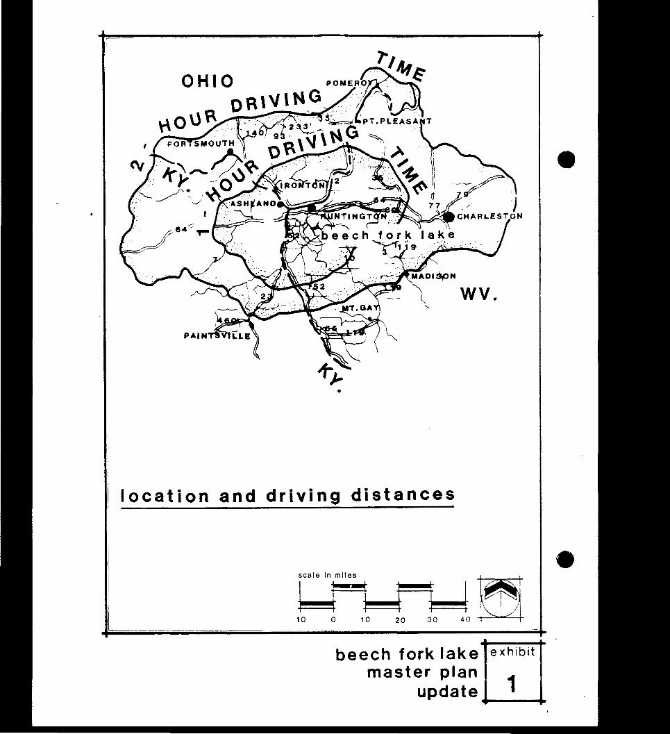
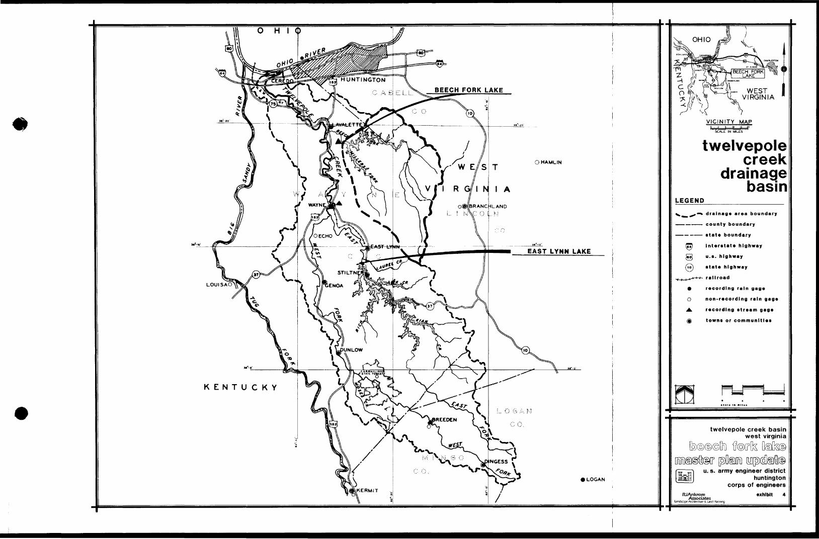
201 PROJECI LOCATION lhe planning area consists of 12755 acres located
in wayne am cabell counties in southwestern West Virginia lhe dam site is
bull located 2 miles southeast of the Village of Iavalette am 9 miles south of
Huntington Access to the dam from Huntirqton is accomplished by using State
-Route 152 from Huntirqton am county Route 13 from Iavalette Access to the
Bowen state Park area am Millers Fork is by state Route 152 am state Route
17 An alternative route to the state Park area is us Route 10 am State
Routes 35 am 43 Interstate 64 passes through the southern part of Huntington
am provides exits to both state Route 152 am state Route 10 A location am
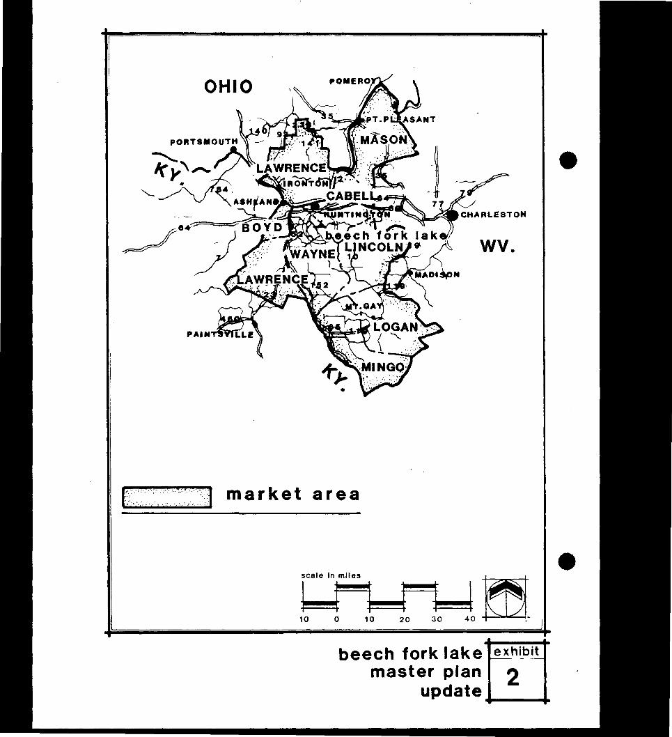
driving distance map is shCMn as Exhibit 1
2 02 GENERAL PROJECI DFSCRIPlION
Beech Fork lake Ism is located on Beech Fork of Twelvepole Creek 3 5 miles
upstream from the confluence with the lwelvepole Creek lhe 88-foot high dam
fonns a lake at the seasonal pool of 8 3 miles in length am an area of
716 acres lhe width of the lake varies from 1000 feet near the dam to 600
feet over IOOSt of the lenJth am the mean depth at the seasonal pool is 127
feet 1he largest tributary branch of the lake is Millers Fork which is
about 3 miles lag lhe lake is sinuous in shape with rnnnerous coves am
flooded tributaries Shoreline areas are usually wooded am steep except in
the cove areas Topography of the project area consists of rugged terra1n
with steep hillsides am sinuous ridgelines IDeal elevations vary from
592 feet at the seasonal pool to 1000 feet on the hill crests for a relief of
about 400 feet Table 201 summarizes inpgtrtant lake data
2-1
I
OHIO
r ~ I --~I middot ~~~~~~--- 1T
WV
bull
location and driving distances
scale In miles
I 17~ ~I t~l10 0 10 20 30 40
beech fork lake master plan
update
exhibit
1~--
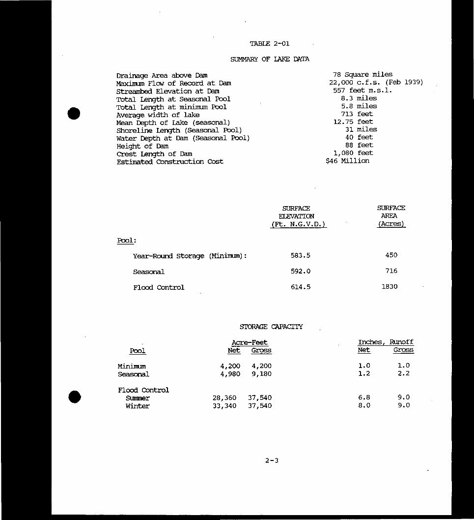
TABIE 2-01
SUMMARY OF IAKE DATA
Drainage Area above Dam Maximum FlCM of Record at Dam Streambed Elevation at Dam TOtal length at Seasonal Pool TOtal length at minimum Pool Average width of lake Mean Depth of Lake (seasonal) Shoreline length (Seasonal Pool) Water Depth at Dam (Seasonal Pool Height of Dam Crest length of Dam Estimated construction eost
SURFACE EIEVATION
(Ft NGVD)
Pool
Year-Rourd Storage (Minimum) 5835
seasonal 5920
Flcxrl Control 6145
SroRAGE CAPACITY
Acre-Feet Pool Net Gross
Minimum Seasonal
4200 4980
4200 9180
Flcxrl control SUnnner Winter
28360 33340
37540 37540
78 Square miles 22000 cfs (Feb 1939)
557 feet msl 83 miles 58 miles 713 feet
12 75 feet 31 miles 40 feet 88 feet
1080 feet $46 Million
SURFACE AREA
(Acres)
450
716
1830
Inchest Runoff Net Gross
10 10 12 22
68 90 80 90
2-3
203 PROJECT DEVEIDFMENT
A GENERAL Construction was initiated on the project in June 1970
The dam was completed in 1977 and irnpoundment was begun in the spring of 1978
Construction of the initially planned recreation facilities was completed in
1986 except for the State Park IDdge Complex and golf course The State Park
camping facilities at the Bowen recreation complex were completed in 1980
The StcMers Branch swinnning area opened to the public in 1980 with temporary
bathhouse facilities In 1985 a pennanent bathhouse and paved parking were
provided at Stowers Branch and the work on the tailwater fishennan access and
picnic area was completed Also in 1985 the visitor center was completed
B REAL ESTATE ACQUISITION Project lands were acquired under the
Joint Iand Acquisition Policy for Resenroir Projects as published in the
22 February 1962 Federal Register This policy called for a 300-foot
horizontal guide-taking linrit Additional land some of which is located
above the limit was acquired for construction operation and rnaintenance
facilities and public-use areas The 300-foot minimum guide-taking line
embraced all of the more valuable valley andlower slopes which left only low
value residual hill lands that were acquired because providing access was
neither practical or economically feasible About 8901 acres above the
300-foot lilnit was acquired Table 2-02 shcMS the general breakdown of land
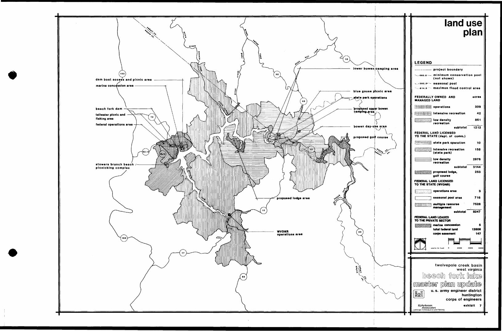
use he land use allocations will be presented in more detail in Chapt9r 7
2-4
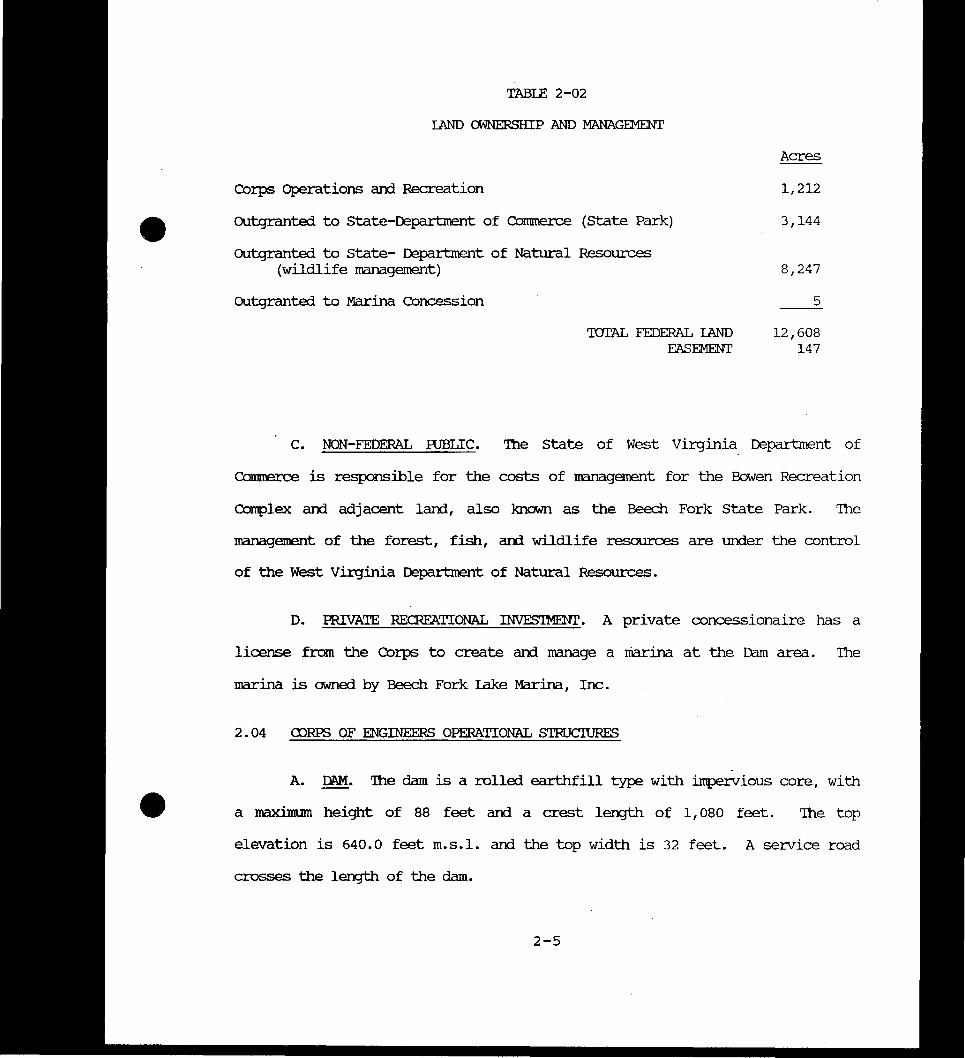
TABIE 2-02
1AND OWNERSHIP AND MANAGEMENT
Acres
Corps Operations and Recreation 1212
OUtgranted to state-Department of Commerce (State Park) 3144
OUtgranted to state- Department of Natural Resources (wildlife management) 8247
OUtgranted to Marina Concession 5
IOIAL FEDERAL IAND 12608 EASEMENT 147
C NON-FEDERAL RJBLIC Ihe State of West Virginia Department of
Commerce is responsible for the costs of management for the Bowen Recreation
Complex and adjacent land also known as the Beech Fork State Park The
management of the forest fish and wildlife resources are under the control
of the West Virginia Department of Natural Resources
D PRIVATE RECREATIONAL INVESIMENT A private concessionaire has a
license from the Corps to create and nanage a marina at the Dam area The
marina is owned by Beech Fork lake Marina Inc
2 04 CDRPS OF ENGINEERS OPERATIONAL SIRUCIURES
A DAM Ihe dam is a rolled earthfill type with impervious core with
a maximum height of 88 feet and a crest length of 1080 feet The top
elevation is 6400 feet msl and the top width is 32 feet A service road
crosses the length of the dam
2-5
B SPILIWAY Ihe spillway is located about 500 feet from the left
abutment of the dam It is uncontrolled concrete lined with a crest length
of 80 feet at elevation 6145 It discharges into a 313-foot long raceway and
stillinJ basin
c OUIIEI WJRFS Ihe outlet works are located near the left abutment
Ihe intake stnicture is rectangular concrete wet well type 117 feet high
Two gated sluices of 4 -6 xmiddot10 1 each controlled by a single hydraulically
operated tractor gate and discharges through a 8 -6 x 11 -3 split circle
corrluit 720 feet long into a jump type stillinJ basin 73 feet long Iwo lowshy
flow wells are located on each 5x4 inlets and a 2-12 by 3 discharge gate
Well No 1 has inlet invert elevations at 582 and 573 feet msl and well No
2 has inlet invert elevations at 582 and 564 feet ms1
D MAINrENANCE BJIIDING Ihe building is located on the left abutment
of the dam accessed by the service road across the top of the dam Ihe area
consists of a maintenance and utility building and associated garages shops
fenced storage yard with a total area of 3640 sq feet
E SEWAGE DISrosAL Ihe sewage treatment plant and control building
is located below the dam on the right bank about 300 feet from the tailwater
area lhe disposal plant serves the dam area and Stowers Branch Another
small building is located adjacent to the plant which serves as a water
quality testing facility
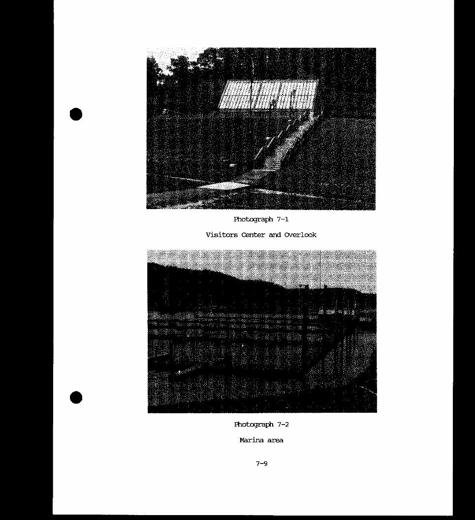
F VISIIOR CENTER he building is on the right abutment of the dam
and is used as an overlook and for use as an operations office and visitor
center he contemporacy style energy efficient building has incorporated
2-6
exhibit area a theatre for visitors and an outdoor fenced overlook which
faces the lake and marina area
2 05 STATE OPERATIONAL BUIIDINGS
A STATE PARK HEAfXPARlERS his is located in the east end of the
lower Bowen camping area and is part of the concession and operations
building
B MAINTENANCE IUIIDING his building is located at the end of
School House Branch about 1500 feet north of the main access road at Lower
Bowen campgrourrl lhe building and grounds provide storage space and
facilities for all maintenance activities at the state Park area
C RESIDENTIAL BUIIDINGS ll1ere are two houses built by the State for
the state Park SUperintendent and the Assistant Ihe Assistants residence is
located on School House Branch north of the camping area and the
SUperinternents residence is l~ted on Route 43 between the Day Use area and
the Blue Goose Picnic area
D WEST VIRGINIA rnR OPERATIONAL BUIIDING Ihis recently constructed
building houses office and maintenance facilities for operations at Beech Fork
lake and Fast IyenJ1I1 lake It is located on upper Millers Fork branch of the
lake near Route 17
E SEWAGE TRFAIMENT PIAN lhe plant is located at the l0v1er end of
the Bowen campground and seives the State Park area A sewage dump stationbull for campers is located near the Old Orebani camp area
2-7
middot 2 06 RESERVOIR OPERATION
A PIAN OF RESERVOIR REXDIATION Beech Fork lake is operated as a
unit in the comprehensive flood control plan for the Ohio River Basin Its
operation is correlated with Fast Lynn lake for regulation of Iwelvepole
Creek he plan of regulation is based on an adequate flood forecasting and
waining system in operation at all times he control stage on Beech F~rk has
been set l0v1 enough so that only nominal damages would occur at downstream
points taking into consideration the safe and effective operation of the
reservoir It is desirable to empty the reservir of flood storage as quickly
as EXgtS5ible in view of the EXgtS5ibility of a major flood occurring at a time
when the reservoir is partly filled Operation for Ohio River flood control
is based on the maximum retention of flows which would add to crest stages in
excess of 52 feet on the Ohio River at Ashland Kentucky A stage of 52 feet
at Ashland represents the point at which damage begins to occur in unprotected
ccmmmities of the Ohio River Valley bel0v1 Twelvepole Creek
he maximum flood control pool elevation has been set at 614 5 feet Flood
storage allocations of approxilnately 33340 acre-feet (winter) and 28360
acre-feet (summer) would control all known floods in the Beech Fork Basin
his annmt of storage would limit the outfl0v1 for the Standard Project Flood
to 6860 cfs and the Starrlam Project Flood Series to 3170 cfs A
reduction in crest flow- would be effected for each flood at all downstream
control points bullB MINlMJM R)()L he elevation of the mininunn pool has been set at
elevation 5835 feet msl which provides a capacity of 4200 acre-feet and
2-8
a surface area of 450 acres Ihis storage seJVes to support the fish popushy
lation during the winter months and is used to maintain the mininunn
downstream release of 10 cfs during the winter months
c SEASONAL R)()L A seasonal pool at elevation 5920 feet msl
- with a surface area of 716 acres is provided from April to mid-September for
recreational purposes and to maintain the 10 cfs minimum release during the
sunnner months he pool extends 85 miles above the dam Recreation
facilities which provide access to and for utilization of the 716-acre
seasonal pool include boat latmehing facilities a beach camping and
picnicking areas
D EFFECIS OF IAKE OPERATION ON RECREATION A rise or fall in the
pool elevation at Beech Fork lake affects the lands surrounding the lake
recreation facilities and project visitation A rise in the flood pool to
elevations a foot or two above 592 feet would make the beach area at Stowers
Branch unusable A rise of 5 feet to elevation 597 would inurdate some of the
lcrer lying camping and day-use facilities at the Bowen State Park area he
launch ramps at the dam and state Park would be unusable Damages to facilishy
ties would be caused mostly by siltation and erosion Most buildings have
been located above the 10 year seasonal pool flood level of middotelevation 600 5
feet he maxinunn flood control pool at 614 5 feet would be exceeded at the
300 year frequ~ although various flood events would raise the pool to
various levels belOirl this which would cause various deltJrees of siltation and
erosion damage Some trees and other vegetation would be killed or damaged if
high water stays high long enough Some years the seasonal pool level is not
reached because of a dry winter and spring In order to maintain minimum
2-9
flows this condition sometimes persists all smnmer making the beach area
unusable To offset this the pool is usually raised earlier than norrral to
take advantage of spring rainfall to enable the pool to reach the seasonal
level
The minimum pool is set at elevation 5835 a reduction of 85 feet from the
seasonal pool and reduces the area from 716 acres to 450 acres Most of the
land left bare with drawdown is located in the upper section of Peech Fork
Price Creek and Millers Fork where the water is middotshallow but also affects
Stowers Branch and other cove areas The prinary adverse impacts of this is
the large areas of mud flats in these areas which are bare of vegetation and
thus susceptible to erosion from rainfall This tends to make the pool turbid
during the winter and spring months The launch ramp at the dam can still be
used although most other facilities are not norrrally in use during the cold
season The draWdown makes the lake less pleasing along the shoreline because
of the exposed bank areas
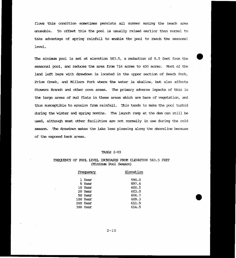
TABIE 2-03
FRapENCY OF RJOL LEVEL INCRFASES FRCM ELEVATION 5835 FEEr (Minimum Pool Season)
Frequency Elevation
1 Year 5900 5 Year 5976
10 Year 6005 20 Year 6030 50 Year 6067
100 Year 6093 200 Year 6119 300 Year 6145
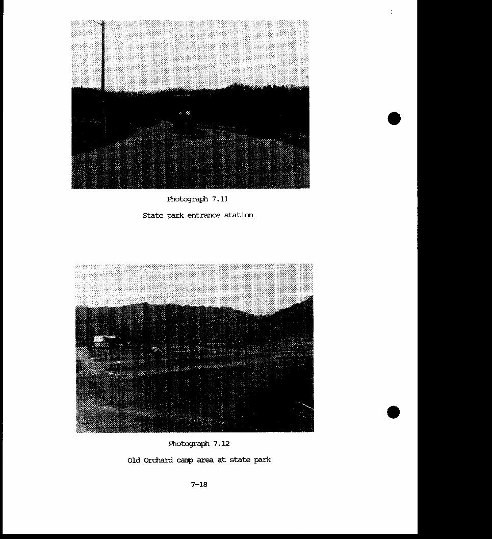
2-10
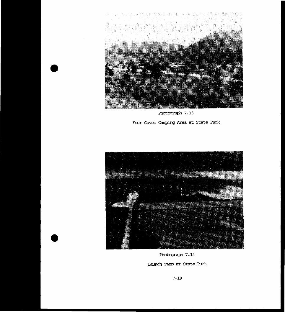
chapter 3 environmental resources
aIAPIER 3 ENVIRONMENTAL RESOURCES
301 R-IYSICAL GECGRAFHY bull
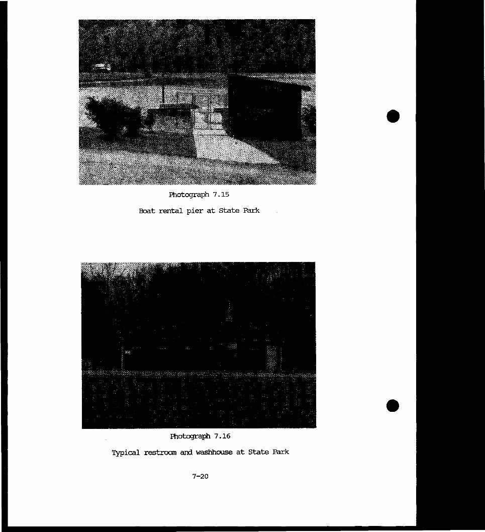
bull he project is located on the Beech Fork of the Iwelvepole Creek drainage
basin Iwelvepole Creek basin lies within the maturely dissected Kanawha
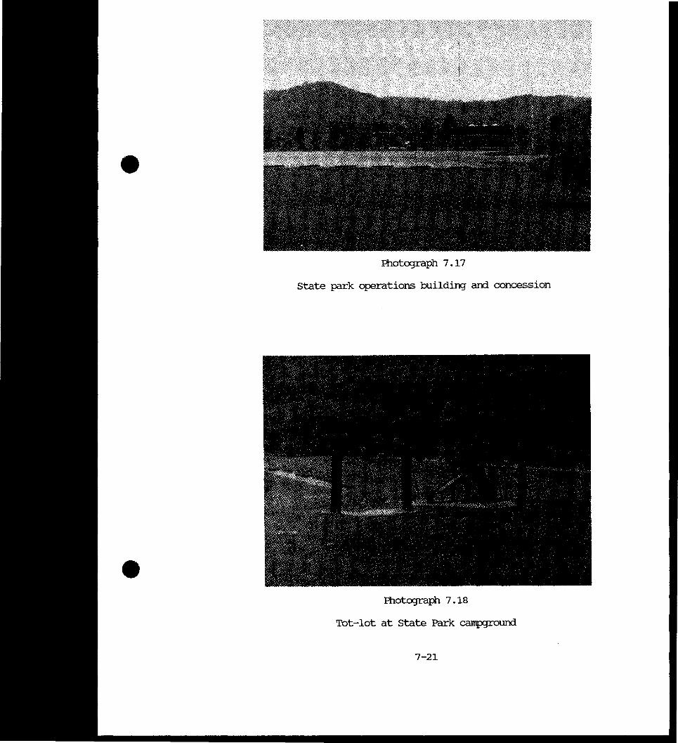
section of the Appalachian Plateau physiexJraphic province Erosion has
dissected the plateau to fonn a dendritic drainage pattern The Iwelvepole
Creek Basin is located in cabell Wayne Lincoln and Mingo Counties The
watershed has a drainage area of 441 square miles and is elongated and
irregular in shape being about 46 miles long with a maximum width of 12
miles Iwelvepole Creek is formed by the junction of the east and west forks
almost a mile south of the TCMl1 of Wayne (pop 1385) It flows 32 miles
northward to its confluence with the Ohio River between Ceredo and
Huntington he Beech Fork portion of the basin has an area of 78 square
miles above the dam and has its headwaters in the mcxierately rugged hilly
terrain near the Wayne-Lincoln County line It flows northwest to its
confluence with Iwelvepole Creek above Iavalette 154 miles upstream from
Huntington he floodplain varies in width from a few feet to about 2 000
feet wide at its confluence with Iwelvepole Creek
he stream fall from source to mouth is 440 feet an average of 15 9 feet per
mile In the reservoir area the terrain is rugged consisting of narrow
steep-walled valleys Maximum relief is about 460 feet Most level land is
3-1
confined to the flood plains of Beech Fork and the tributaries of Millers Fork
and Price Creek
302 CLil1ATE
Ihe climate of Beech Fork Creek Basin is continental and temperate with large
variations in seasonal temperatures Ihe entire basin is affected by frontal
air-mass activity and is subject to both continental polar and maritime
tropical air masses he prevailing meteorological front movement is from the
southwest Annual precipitation is unifonn over the basin normally averaging
about 42 inches Ihe average annual snowfall is about 21 inches Extreme
temperatures in the year have varied from a minimum of -14degF during February
to a maxil1tum of 105degF during July Ihe growing season averages about six
months usually from mid-April to mid--october Iwo distinct types of storms
are prevalent in the basin Ihe surmner type is usually characterized by
rainfall of short duration but high intensity and over a small area Ihe
winter-type storm is less intense but covers a larger area and is of extended
duration
303 HYDROIOGY
A RAINFAIL RUNOFF Ihe headwater portion of the Beech Fork Basin is
dlaracterized by narrow valleys with steeply sloping sides Runoff from these
slopes tends to collect quickly in stream channels causing rapid fluctuations
of stream stages Infiltration losses are generally lOw due to the relatively
shallow soils overlying bedrock on the slopes Basin runo~f is highest during
the winter months when storm rainfall may be augmented by snow melt and When
frozen or saturated ground results in low infiltration rates Runoff is lowest
3-2
during the late summer and early fall when the ground is dry and infiltration
rates are high Flow measurements estimated at the Beech Fork dam site indishy
cate a normal average flow of 89 cubic feet per second varying from 211 cubicmiddot
feet per second in February to 12 cubic feet per second in October The
maximum monthly average flow is almost 400 cubic feet per second and the
minimum average has been an almost urnneasurable 0168 cubic foot per second
B FICX)J6 lhe upper portion of Beech Fork is subject to headwater
floods whereas the lower portion is subject to backwater from Ohio River
floods as well as headwater floods or a combination of both Ohio River
floods have caused backwater effects on Beech Fork as far upstream as the dam
site Floods are of short duration seldom remaining above flocxl stage more
than 24 hours except in the lower reaches when prolonged by backwater from
the Ohio River lhe largest recorded flocxl for the Twelvepole Creek Basin
occurred on 4 February 1939 at a stage of 31 feet 15 feet above the no-damage
stage of 16 feet at the gaging station in Wayne West Virgina The discharge
was 22000 cubic feet per second and major damage occurred to residences
schools churches highways and bridges Flocxl damages on Beech Fork are
almost exclusively confined to low-lying residences farns and buildings
although for certain floods agriailture crop danages occur
C GRaJND WATER lhe ground water table in the lake area has the
following characteristics a colluvitnn mantle and zone of weatherEyenf rock on
the slopes and colluvial and alluvial rraterials in the valley fill are
slightly to mcxlerately penneable Dlrirg the late spring months these
rraterials approach COIIt)lete saturation with a water table at or near the
ground surface Ibis is evidenced by the many seeps along the valley walls
3-3
and is indicated by the higher frequency of slides during March April and
May Within these zones water levels customarily recede during the summer
months despite higher quantities of rainfall primarily because of higher
rates of evapgt-transpiration
Ille lithology of the lake area consists of horizontally stratified bedrock
containing widely spaced aquifers separated by less permeable rock with
permeability regulated through fractures and contacts Seasonal water level
variations are nonnally small particularly for deeper aquifers Within this
ground water reservoir a continual ground water movement downward from the
surface through successive permeable layers occurs with a loss in head
through each intervening aquiclude Where bedrock (sandstones and siltstones)
have a higher permeability than the upper weathered zone either through
vertical fracturing or because of lithological characteristics a distribution
of water levels between the two zones occurs Where bedrock is cornparatively
irnpenneable saturation in the weathered zone results causing a uniform
distribution of head throughout and a true water table When surface recharge
falls below the rate of discharge to bedrock a zonal distribution of water
levels in near-surface materials also results Both conciitions occur
depending upon the season
Hydrostatic conditions in rock strata are similar to those in overburden Ille
relatively higher permeability of the siltstone and sandstone aquifers results
in a stratification of water levels with the levels in each penneable zone
being dependent upon relative rates of rechalge and dischalge Because of
these conditions a true water table condition is the exception and may be
3-4
only of seasonable duration Generally appreciable seasonal fluctuations of
water levels are to be expected
3 04 WATER QUALITY
A SPECIAL PROBLEMS Ihe most noticeable problem relates to the
excessive levels of manganese and iron in hypolirnnetic waters during periods
of thermal stratification The dissolved metals present in water discharged
from the hypolirnnion is oxidized and precipitates in the outflow and downshy
stream of the project The result is coating of bed and banks of the stream
and indigenous organisms Other problems include high levels of cadmium and
mercury found throughout the watershed and high fecal colifonn found in the
lake
B GENERAL CONDITIONS IN 1984-85 Specific conductance alkalinity
and hardness are all relatively low The water is classified as soft has low
concentration of dissolved naterials and has little inherent capacity to
resist shifts in pH Taken together these facts indicate that the water is
very delicately poised with respect to quality changes and is especially
susceptible tosuspended solid and pH problems
lhermal stratification nonnally becomes established in Beech Fork lake in May
and June Severe stratification occurs during the summer months A deteriorshy
ation of thermal stratification begins in the fall and nonnally extends into
October lhe duration and extent of thermal stratification depends on hydroshy
meteorological variations and will vary from year to year lhe lake is nearly
isothermal during the winter period with a transition period during the
spring as stratification becomes established
3-5
Dissolved oxygen concentrations remain fairly constant throughout the water
coltmm during the winter period but decreases as a function of depth during
the surnmer months Throughout the epilimnion dissolved oxygen concentrations
remain greater than or equal to 50 rrg1 As temperature decreases through
the thenocxline region dissolved oxygen disappears rapidly resulting in
anoxic conditions near the bottom of the downstream section of the main lake
during late summer
Streams entering the project have a mean dissolved oxygen of 8 1 rrg1 which is
higher than the West Vilginia state standard minimum of 5 o rrg1 This is
also true of the discharge mean of 89 rrg1 despite the dissolved oxygen
depletion within the reservoir hypolimnion during late summer
All values for nitrate plus nitrite were lawer than the levels set in the
state standard of 1 0 rrg1 of nitrite As the depletion of oxygen occurs in
the hypolimnion during the summer months the amount of arrononia and Kj eldahl
nitrogen increases in the hypolimnion mean ammonia does not exceed the state
standard of 50 ug1 although occasionally the hypolimnic levels exceed the
standard at the roain lake station Dle to proper reservoir regulation the
outflow has no significant concentrations of nitrate plus nitrite arranonia or
Kjeldahl nitrogen associated with it
Prcxiuctivity at Beech Fork lake is fair to poor due to the foll0wing two
limited factors
(1) Jbe lake itself is turbid due to the physical nature of the
watershed with the mean turbidity at 283 NIUs on the roain lake station
High tumidity blocks out the needed light for optimum algae growth
3-6
(2) Ihe phosphorus content has been steadily decreasing at the
inflows and lake stations since 1979 Ihe mean total phosphorus of 40 9 ug1
at the inflowing streams is deceiving In 1979 the mean total phosphorus was
123 5 ug1 and in 1983 it was less than 10 ug1 Ille same situation is
bull reflected at the main lake station for both total and dissolved phosphorus In
1978 total phosphorus had highs of 205 ug1 and in 1983 the total phosphorus
is less than 10 ug1 throughout the water column
Streams entering the project have a pH range of about 60 to 80 with a mean
of 7 04 In the pool pH decreased immediately below the thennocline during
periods of thennal stratification Values in the epilirnnion during such
periods ranged from 7 O to 8 2 and those in the hypolirnnion from 6 2 to 7 O
At the outflow pH ranges from 60 to 85 with a mean of 68 Ille pH of the
outflow is within the range of the West Virginia State Standard (60 to 90)
Total iron at the two major inflow stations frequently exceeds the West
Virginia state standard of 10 nq1 with a mean of 115 nq1 and a range of
028 to 34 nq1 Iron also occurs in high concentrations within the reservoir
prior to stratification with a mean of 3 3 nq1 at the main lake station
ruring surmner months total iron increases rapidly in the hypolirnnion and has
even been as high as 35 ng1 Fall overtwn eliminates stratification and
total iron is then evenly redistributed
Dissolved iron in inflows and the epilimnion constitute less than one half of
the total content thereby indicating that susperxied solids are the primacy
source of iron within the reservoir Behavior of iron within the lake is
governed by distribution of oxygen and resultant effects on pH and oxidation-
3-7
reduction potential Total iron concentrations at the outflow are in excess
of the state standard of 1 rrg1 with a mean of 2 04 rrg1 cue to the severe
effects of metal precipitating out in the outflow the temperature objective
curve has been abandoned in early fall to avoid discharging hyp)limnic waters
CUring months when the lake is stratified decreases in iron concentrations
can occur in the outflow as a consequence of epilimnetic discharges Periods
of mixing such as in spring prior to stratification and fall after overturn
can result in increased outflow iron concentrations
High levels of manganese in water systems give an objectionable taste to water
supply and leave tenacious black stains on laundry As a result the West
Virginia state standards limit total manganese to 1 rrg1 in all state waters
High concentrations of manganese exist in both the watershed and lake throughshy
out the year Ihe major inflows average 6 79 rrg1 of total manganese with
highs of 200 rrg1 Ihe dissolved manganese is low with a mean of 011 rrg1
and range of o 01 to o 31 rrg1 Most of the manganese is tied up in sediment
as it flows into the reservoir
Both total and dissolved manganese are high at the main lake station with
means of 714 and 126 n-g1 respectively CUring stratification periods the
total manganese is conuronly greater than 7 nq1 in the hyp)limnion Conseshy
quently water fran the outflow can contain concentrations in excess of the
state stamard By careful reservoir regulation the manganese problem can be
mininrized when the water is stratified iJy releasing the epilimnion waters -
which are lower in concentrations than the hypolimnion CUring fall and
spring overtwns manganese is evenly distributed throughout the water column
3-8
thus no selective withdrawal is possible and the concentration can increase at
the outflows
cadmium is a heavy metal with a high toxic potential for both man and aquatic
bull life he West Virginia state requires waters with hardness of below 50 ng1
of caco3 as in Beech Fork reseJVOir to have cadmium levels below 78 ug1
his level has been violated at the main lake station al)d possibly at the
inflows
Total mercmy in all West Virginia waters is restricted to 0144 ug1 As is
com[[K)n in new- lakes the mercmy grossly violated the state standard at six
different inflows the main lake station and the outflow in 1978 and 1979
Ievels were measured at less than 1 ug1 since 1980 but whether or not these
values are above the standard of 0144 ug1 is not known
lwo collections of aquatic invertebrates taken in 1970 and 1971 revealed the
presence of seven orders of insects at Beech and Millers Fork By number 76
of these organisms were pollution sensitive thus indicating good water
quality Benthos samples collected during April 1976 have been processed and
ten species have been identified lhe diversity index (Shannon-Weaver) was
309 indicating good species diversity and water quality Samples collected
since inpunhnent have been partially analyzed Tentative analyses show
moderate diversities and numbers at the inflows Effects of construction
high concentrations of heavy metals and disruption of mechanisms of carbon
input through the ecosystem are possible reasons why the benthic macroinverteshy
brate population below Beech Fork Dam during the study period has been
3-9
severely reduced Density and diversity were extremely low and the organisms
collected were highly tolerant forms
On the basis of plankton data the inflow waters at Beech Fork lake constitute
a moderate quality relatively low productivity aquatic envirorunent in vvhich
phos]i1ate is probably the limitirxJ nutrient bull lhe low concentrations and lack of diversity of lake plankton also indicate
low productivity Since nannoplankton concentrations were not evaluated it
is possible that production is higher than estimated
IDw plankton concentrations and lack of diversity at the outflow indicate
minimal loss of biomass from the lake However since nannoplankton
concentrations were not documented it is possible that losses are much higher
Periphyton was not collected and productivity from this ecosystem component
in the outflow area in terms of such water quality indicators as diversity
and community structure are unknown
C DFSmATIFICATION PROJECr DlrirxJ a typical summer the lake is
devoid of oxygen below eight feet To alleviate this problem
clestratification fans are installed in the lake near the dam Ihe facility
was installed in May 1987 and the giant fan blades are floated six feet below
the surface he fans have six foot blades are powered by three-horsepower
electric IOOtors lhese fans force down the lighter wanner surface water vvhich
contains nDre oxygen to create a better mixture for lower depths Ihe fans
are designed to create enough force to destratify the entire 716 acre lake
1he lake conditions will be nDnitored to detennine the effectiveness of the
new destratification apparatus
3-10
305 GEDIOOY
lhe Beech Fork Basin lies within the sedimentary strata of the Pennsylvanian
age Monongahela and the Conemaugh groups comprise the fonnations lhe
depositional environment of the Conemaugh group in the basin consists of
- repeated marine advances and retreats lhe fluctuations are indicated by
lenticular deposits of vacyirg thickness
Numerous redbed sequences ocxur some of these grade laterally to gray nodular
limestones Another indication of this environment was the accumulation of
sandstones of a lenticular configuration such as the Saltsburg In some
areas sams -were deposited in dlannels which cut through tmderlyirg deposits
and into older sandstones lhe Morgantown and Grafton samstones are local
examples of coalescirg fonnations lhe fonnations encountered during subsurshy
face investigations range from the Brush Creek coal to the Upper Connellsville
sandstone Marker beds include the Elk Lick limestone at elevation 608 the
Upper Ames shale (limestone) encountered at elevation 565 the lower Ames
limestone (shale) at elevation 532 and Brush middotCreek limestone at elevation
472
Ihe fonnations encountered at the project site consist of clays indurated
clays claystones shales siltstones sandstones and thin limestones and
coals lhe clays ocxur as inclusions in the indurated clay and claystone
strata lhese clays are soft gray and slightly to moderately plastic lhe
- majority of the rock encountered at the site (70 to 75 percent) consists of
irrlurated clay lhese redbeds (irrlurated clays) are soft to moderately hard
and slake readily on exposure to alternate wettirg and drying They are
3-11
calcareous slick sided and contain thin limestone stringers and nodules Ihe
claystones at the site are soft to moderately hard gray and slickesided
lhey contain discontinuous silty and calcareous lenses Ihe siltstones in the
reservoir area are sandy to clayey soft to moderately hard gray to brown
slightly calcareous and slightly micaceous Ihe sandstones encountered at -
Beech Fork are silty to clayey moderately hard to hard fine grained brown
to gray and fractured Ihe fractures are ferruginously stained and generally
vertical Ihe limestones at Beech Fork are hard gray and lithographic The
coal seams occur as thin lenses and as blossoms in the clays and claystones
3 06 MINERAL RESOORCES
Ihe No 5 Block coal seam of the Allegheny series is below the valley fl(X)r
throughout the entire reservoir although the seam is not considered to be
mineable at present No coal seams of the Conemaugh series are known to be
present in mineable thickness in the area
Ihe Pittsburgh coal seam at the base of the Monongahela series generally
outcrops about halfway up the slope of hills at elevations well above the
flood plain throughout portions of the reservoir area several old openings
in that seam from which domestic coal was produced some years ago are
evident within and adjacent to the general reservoir area Ihe only known
ccmnercial production from the seam was at a discontinued strip mine location
at Moxley Branch
All proven resources within the reservoir area are in the Pittsburgh coal
seam and are not expected to be comrrercially mineable for some period of time
because of the poor quality of the coal Ihe reserves are not sufficient to
3-12
justify installation of rail facilities and would require long and expensive
truck haul
lhe area within and adjacent to the Beech Fork lake has been a producer of
natural gas for the past 60 years and is expected to continue for another
bull 20-30 years Production has been obtained from several horizons Some oil is
associated with the gas wells but is not in sufficient abundance to justify
bull production drilling Some gas well access roads are built in the area which
connect with the public roads
307 SOIIS
In the area of Beech Fork lake the overtgturden and soils on the valley slopes
are composed of detritus derived from weathered indurated clay siltstones
and samstones lhe soil is subject to movement on moderate slopes Slides
occur on the slopes and frequently appear as hummocks or overburden flows
along the valley walls he flood plain soils are mostly silt soils
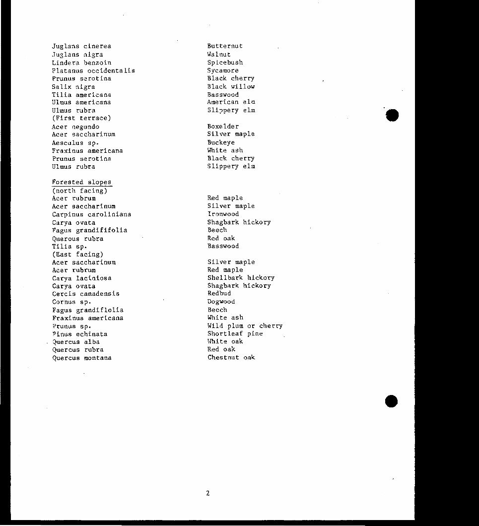
308 VOOErATION
he project area is located in the IDtl Hills Belt of the CUmberland and
Allegheny Plateau region of the Mixed Mesophytic Forest Most of the area
once ocxupied by Mixed Mesophytic Forest is ocxupied by second growth or has
been converted to other land uses once the cutover areas have been converted
to cultivation or pasture the sucxeeding plant communities were predominately
oak-hickoey and scrub pine he present timber resource is generally of poor
quality and reflects a histoey of land abuse Forest fires have damaged some
areas and erosion has caused losses of topsoil
3-13
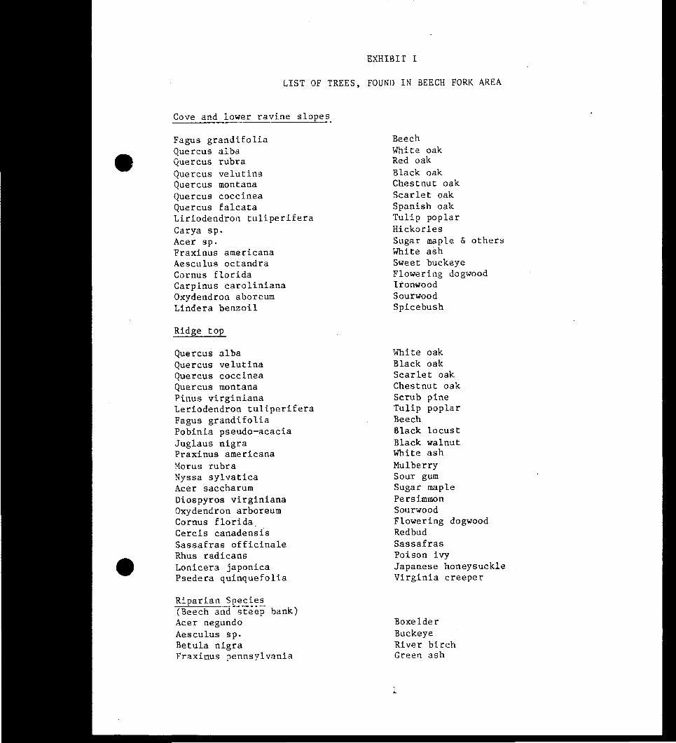
Remnants of typical mixed mesophytic forest are supported in some coves and
lower ravine slopes lhese areas contain about 30 percent beech 30 percent
oak 15 percent tulip poplar and 25 percent mixture of hickory maple white
ash and sweet buckeye Some of these beech tulip poplars sugar maples and
red oak are 36 inches in diameter and 80-100 feet high In the flocxi plain
and lower slopes the sycamgtre is the dcminant species in diameter and crown
size Multiflora rose is a ccmmon shrub and box elder and slippery elm are
conmn on the first terrace areas
3 09 FISH AND WIIDLIFE
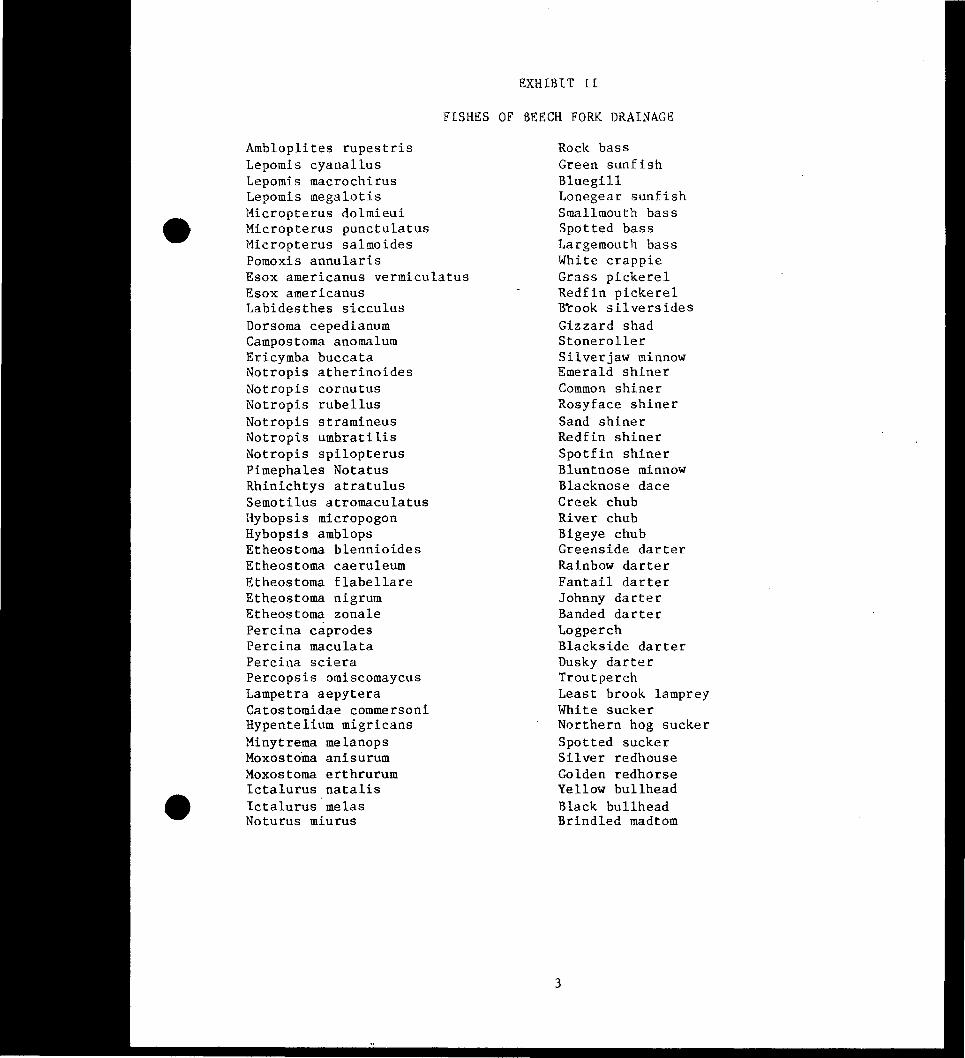
A lgJATIC LIFE here are at least 43 species of fish which are
known to occur in the Beech Fork stream above the reservoir lhe lake itself
has a growing fishery from initial stockings done when the lake was filled in
1977-78 Fish stocking done by the West Virginia OOR included channel
catfish walleye largemouth bass and black crappie Also present are
numerous other species including bluegills and bullh~ds lhe lake is
beginning to be a good producer of fish from the numerous gocxi habitat cove
and dlannel areas lhe West Virginia OOR has canpleted building and stocking
two subiJrpcurrlmerrt near upper Beech Fork for raising and intrcxlucing hybrid
bass and tiger nuskys Another subinpundment is planned for the Rubens
Branch area
B MAMMAIS According to a survey corrlucted by the state of West
Virginia during 1948-51 some 30 species of mammals may be expected to occur
in or near the Beech Fork project lhese species include 1 marsupial (the
oppgtsUm) 2 moles 2 shrews 4 bats 6 carnivores 14 roients one rabbit
3-14
bull
(cottontail) and 1 hoofed animal (deer) Examination of range maps published
from another source shows that up to 45 species of mammals might be expected
in this area of West Virginia Not all of these could be expected within the
immediate project vicinity because of habitat conditions and middotthe fact that
sane mammals do not occur in significant numbers within their specific ranges
Based on the above infonaation it is believed reasonable to asstnne that
between 30-40 species of mammals might be found within the project vicinity
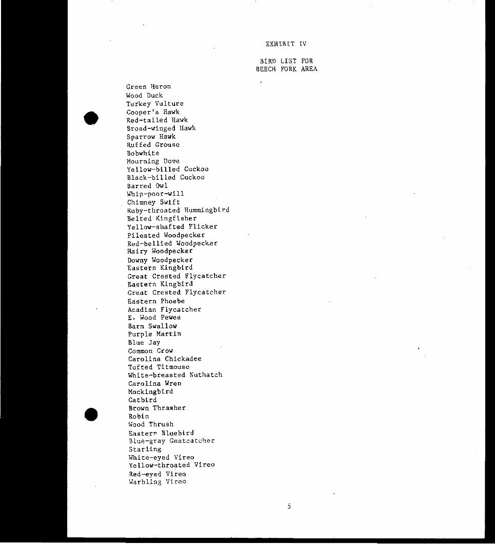
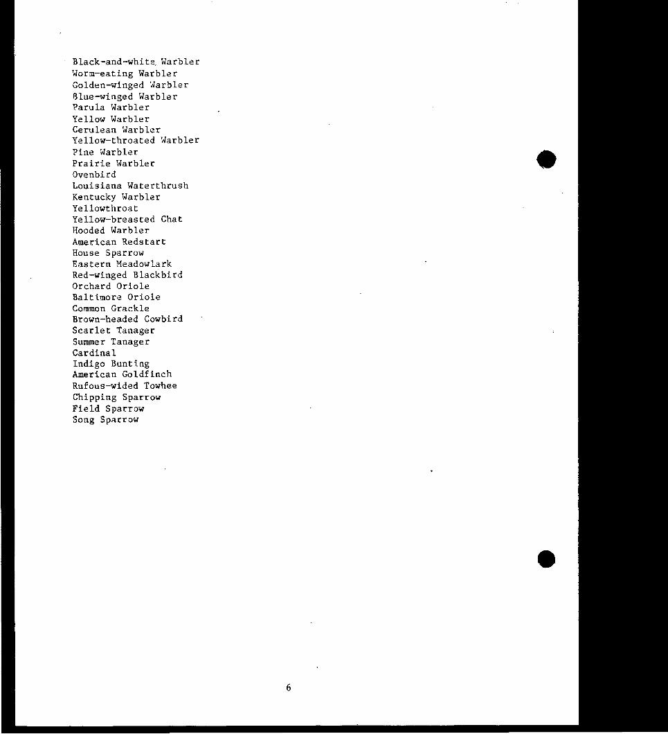
A list of trees birds mammals and fish of the lwelvepole Creek basin is
included in the the Appendixmiddot
c BIRilS Members of the Brooks Bird Club conducted a swvey in the
Beech Fork area durinJ 28 May-1 June 1969 At that time 81 species of
breedirg birds were identified TaJdnj into account winter residents and
sprinJ and fall migrants the rnnnber of birds which occur throughout the year
in the Beech Fork area would be considerably greater than the 81 species
reported durinJ late May to early June It is inpgtrtant to note that 8
53Cies of birds were included in Ihe Blue List for 1973 Ihe Blue List is
a list of those 100re cxmnon and widespread species which middot appear to be
declininJ in popllation or beccminJ 100re restricted in range for reasons not
clearly understood For instance the Eastern Bluebird is undergoinJ a rather
widespread population decline yet was one of the IOOSt abundant species
reported at Beech Fork Ihe yellowbilled cuckoo yellow wamler and yellow
throat are declininJ in califomia but are considered fairly connnon to connnon
in the Beech Fork area Ihe purple martin is declininJ throughout its range
and also was reported as scarce at Beech Fork Ihe red-headed woodpecker
3-15
appears to be declining nationwide nor was it found at Beech Fork by members
of the Brooks Bird Club
D GAME ANIMAIS Grey and Fox squirrels _ Ruffed grouse and
whitetailed deer are the predominant game species in the area Raccoon and
woodchucks are ccmnon and are often hunted he bottom land food plots and bullland formerly used for farming are good habitat for Cottontail rabbits Deer
rnnnbers are gradually increasing and provide hunting for a two week gun
season other game species present are grey and red fox oppossum morning
doves and mallards teal and wood ducks which nest or stop over during
migration Beaver and mink are found in low rnnnbers canada geese have been
introduced from the New York area and nesting platfonns have been provided in
various areas arourrl the lake Recently the state rnR introduced wild turkeys
into the area he success of the stockiryen] program will be monitored and
continued if necessazy
E RARE OR ENDANGERED SPECIES lhe following animal species found in
West Virginia or historically found in West Virginia are considered
errlangered or threatened species by the Deparbnent of the Interior Fish and
Wildlife Service in accordance with the Endangered Species Act of 1973 as
amenied
conmm Name Scientific Name Status
Virginia big-eared bat Plecotus townsenlii virginianus Endangered Fastem cougar felis concolor cougar Enda~ered Intiana bat Myotis sodalis Endangered American peregrine falcon Falco peregrine anatum Endangered Bald eagle Haliaeetus leucocephalus Endangered Kirtlands warbler Deroroica kirtlandii Endangered Pink mucket pearly mussel Iampsilis orbiculata orqiculata Endangered
3-16
Tuberculed-blossom pearly Epioblasrna (=Dysnomia) torulosa Endangered nrussel torulosa
Flat-spired three-toothed Triodopsis platysayoides Endangered
If any rare endangered or threatened - animals or plants are found to be
present in the project area Natural Area habitat designations will be
studied to protect these resources At the present time two rare plants are
probably found in the Stowers Branch area These are Agave virginica False
Aloe and Spiranthus ovalis oval ladies Tresses Ihese species will be
investigated for possible protection
3-17
chapter middot4 recreation and cultural resources
ClfAPlER 4 RECREATION AND aJLIURAL RESOURCES
4 01 HISIORICAL DEVELOFMENT Ihe first white men known to come to the
present limits of Wayne county were those of the Big Sandy Expedition of 1758
who were sent to attack the Shawnee villages of the Scioto Valley in Ohio as
retaliation for the Shawnee attacks on the Roanoke river settlements in 1757
Ibis expedition reached the Big Sandy River area and was recalled to Virginia
by Governor Francis Fauquier
In 1772 King George III wished to reward his soldiers who had defeated France
in the French and Indian War The lands of this part of Virginia were
partitioned and portions were granted to those entitled The first patent for
lands in what is ncM Wayne county was issued on 15 December 1772 to John
Savage and to soldiers who had served in his company John Savage obtained
the services of George Washington to swvey the lands The tract included
27672 acres and many of the important landmarks bore the letters GWS formiddot
George Washington Swveyor
Ihe first major grants in the Beech Fork area were made to John P ruval and
samuel M Hopkins ruval received a chain of grants from 1785 to 1793 along
Iwelvepole Creek_ and near the mouth of Beech Fork amounting to nearly 10000
acres Hqkins was granted 70000 acres in 1796 including parts of Butler
Ceredo Union and Stonewall Districts of present Wayne County in addition to
sections of present cabell county In some instances the Dlval and Hopkins
grants overlapped in which case the Dlval grant was recognized
4-1
Settlement in the area began with Samuel Hatton in 1796 Peter Ioar in 1797
and Hemy Haney in 1802 however major settlement did not occur until after
the transfermiddot of the DIval and Hopkins deeds in 1803 and 1808 respectively
after their deaths Known settlers after this time included Reuben Booton
Berry Adkins Asa Booton and Jefferson Bowen
No major battles of the Civil War were fought in the area but lcxal lore puts
sane guerilla activity in the area Rebel leader Bill Smith is said to have
been active here at that time and present residents of Winslow believe that
there was a Union encampment in stream bottoms southwest of the connnunity
Although no occurrences of major historical significance are known for the
area there is sane evidence of early settlements in the form of several log
houses All were built of ham hewn logs with half dove-tail notching
lacking log gables and eave beams ailinneys were situated on the exterior of
the gabled end of each of the houses with exterior fire boxes lhese
structural details imicate the houses were probable built between 1825 and
1850 More precise dating can only be done by studying land deeds and tax
records one log stnIcture was moved to the camping area and is presently
beinq managed by the West Virginia Department of Connnerce Ihe log cabin may
not qualify for the National Register but an official Determination of
Eligibility should eventually be requested
4 02 ARaIEDIOOICAL RESOURCES
An ardleologiral smvey at Beech Fork lake was completed in 1975 during which
19 archeological sites were recorded Eleven out of the nineteen sites are
located on Government property
4-2
bull
A total of 15 temporal components and 8 cultural components have been
identified Four Early Archaic (8000-6000 BC) 4 Iate Archaic (3000-1000
BC) 1 Early Woodland (1000 BC-100 AD) 1 Middle Woodland (100-600
AD) 3 Iate Woodland (600-1200 AD) and 2 Iate Prehistoric (1200-1600 AO)
temporal components are present and 1 Buck Garden 1 Fort Ancient 2 Buffalo
3 Brewerton and 1 Adena cultural components are present
Ihe sites consist of 1 rockshelter (46WA22) 3 lithic scatters (46WA21 23 and
24) 1 mound (46WA26) 1 open habitation with a mound (46WA34) and 2 workshops
(46WA35 and 38) Ihe rest of the sites are of unidentified function
Price Creek Rockshelter (46WA22) the most significant site in the reservoir
was excavated during the 1975 SUJVey
Ihe archeological SUJVey of all Federal lands should be completed with
priority given to areas that may be subject to bank erosion or new
construction
403 SOCIO-ECDNCMIC PROFILE
Ihe project area is within the two counties of Wayne and cabell cabell County
is more highly urbanized because of the City of Huntington and is part of the
AshlamjirontonjHuntinJton metropolitan area Ihe population of cabell County
in 1980 was 106835 with 378 persons _per square mile Seventy _percent of the
population is considered urban Ninety-five _percent of the population is
White 5 percent is black or other minorities Between 1970-80 the
population decreased slightly partly because of migration to suburban areas
4-3
The labor force in cabell County is occupied in diverse economic activities
Twenty-three percent is employed in professional or related services 22
percent is wholesale or retail trade 21 percent is in manufacturing and 9
percent is in public utilities Fanning is a minor but important part of the
economic structure and 20 percent of the land total is considered to be in
fanns with an average fann size of 97 acres over half of the fanners work
part time away from the fann
DJring the 1970-80 period there was a housing shortage which has since been
improved by suburban and rural building Housing in the area has increased
over 20 percent since 1979 and 65 percent of the homes are owner cxcupiecl
Education of the population has been improving steadily with 616 percent of
persons over 25 having a high school education and 14 percent having four
years of college or more
Wayne County where most of the project is located is much more rural in
nature and has a smaller population of 46021 in 1980 a 22 percent increase
from 1970 Thirty percent of the population is considered urban mainly
concentrated in Iavalette Wayne and Ceredo-Kenova Nearly all the populashy
tion is white or 996 percent Housing has substantially improved with a 36
percent increase in housing units from 1970 and a median value of $40300
Employment in the County is concentrated mostly in manufacturing wholesale
and retail trade and professional or related savices Eight percent of the
land is considered to be in fanns with an average fann size of 155 acres
over 50 percent of fann owners are employed away from the fann Education
levels are lower than in cabell County Fifty percent of the persons over 25
have a high school education and 7 percent have a college education The
market area for the project is shown on Exhibit 2
4-4
4 04 REXIONAL RErnEATIONAL FACILITIES
lhe area within a 50-mile radius of Beech Fork includes a large number of outshy
door recreational and historical points of interest About 20 miles south
Fast Lym Iake is another major Corps-operated recreation area lhe 50-mile
- radius of the project includes the large population centers of Huntington
Olarleston Ashland (Kentucky) and Ironton (Ohio) other nearby Corps
facilities are Dewey Iake Paintsville Iake and Grayson Iake in Kentucky
state-nm outdoor recreation facilities in the area include cabvaylingo State
Forest laurel creek Public Hunting Area Chief IDgan State Park Big Ugly
Public Hunting Area Fork creek Public Hunting Area Kanawhamiddot State Forest
Hilbert Public Hunting Area and Chief Cornstalk Public Hunting Area In
Ohio Wayne National Forest and Iake Vesuvius provide hunting fishing and
other outdoor activities A regional recreation map (Exhibit 3) shows the
distribution of these resources
4 05 SURROONDING IAND USE
Lani use surrourrling the project and within the drainage area is about 83
percent woodland 8 percent cultivated 5 percent pasture and 4 percent
roads_ hanesites and canunercial development Most land development occurs in
the flat flood plains or lower hillsides along Beech Fork and the larger
tributaries Fann cultivated areas are restricted to the flood plains and
sane hillsides are used for pasture Some l1eW home development is occurring
along the State Route 13 access road to the dam area Route 524 in the
stowers Branch area and along State Route 17 to Millers Fork Part of this
development is stimulated by the proximity of the Beech Fork recreation area
4-5
OHIO POME
POIITSMOUTH middot
Jr~ 0
ASH
_ - _ _ -_ ALESTON
ebull- --e ~ - WV
N
bull
beech fork lake ~hi_bit
master plan 2 update---~
Iumbering of the laige areas of timber is done mostly on a small scale as the
second and third growth timber becomes mature Coal mining is a minor
activity in the Pieech Fork basin since the coal seams are mostly too thin to
be profitable
406 PROJECT UTILITIES
A SOLID WASTE Solid waste produced by the project is put in trash
receptacles is then deposited in dumpsters where it is picked up by a
contractor and transported to landfills in cabell and Wayne Counties
B EIECIRICITY Ihe Appaladrian Power Company is the only power
company serving the project and adjacent area A high tension power
transmission line crosses the upper end of Millers Fork and also crosses the
upper end of Beech Fork in the Bowen area
c GAS Five gas utility companies have gas distribution lines within
the project area Ihey are cranberry Pipeline Corporation Gas Supply
corporation Tennessee Gas Pipeline Company Big Sandy Gas Corporation and
HH Illsher All of these are easements except for HH lusher which is lease
agreement
D TEIEFHONE here is one telephone company funlishing telephone
savice to the project area the Chesapeake and Potomac Telephone Company of
West Virginia
E WATER SUPPLY Water for the dam area and Stowers Branch is
provided by water distribution lines from the Lavalette Iublic Service
4-7
LEGEND
lJ STATE PARKS
LOCAL PARKS
f3 WILDLIFE AREAS
A NATURE PRESERVES
0 NATIONAL OR STATE FORESTS
regional recreation facilities
beech fork lake exhi_bi_
master plan 3update --middot
District based inmiddot Iavalette West Virginia The Bowen State Park area is
served by the Salt Rock Public Service District
F WASTE WATER TRFAIMENT There are two sewage treabnent plants
located on the project area The dam area and Stowers Branch are servicei by
bull a plant located below the dam The Beech Fork State Park has a plant located
in the Lower Bowen camping area
407 TRANSFORIATION SYSTEM
Access to the project from the main State highways of State Route 1~2 and SR
Route 10 are provided by several routes depending on the destination at the
project
A DAM State Route 13 from Lavalette is the principal access road to
the dam It is a narrow two-lane road which is subject to undennining and
slumping in several areas but has been recently upgraded with new asphalt and
is presently in good condition
B SIOOERS BRANCH This area can be reached by state Route 13 and
then Route 524 to Route 152 An alternate route is 524 from Route 152 and
then 152 These roads are paved narrow and winding but are usually in good
condition Route 152 from Falls Branch road has recently been paved to the
entrance gate at Stowers Branch
C OCMEN STAIE PARK ARFA The shortest route is from State Route 10
and cabell County Routes 35 and 43 These are two-lane paved winding roads
and are difficult in some areas for campers and trailered vehicles An
4-9
alternative access is using State Route 17 from State Route 152 Ihese roads
are continuously maintained
D MILIERS roRK AREA County Rout 17 from state Route 152 provides
access It has been upgraded but is a winding mountain road
E PROJECT ACCESS ROAOO All roads within the operations and bull recreation areas are relatively new and continuously maintained the State
Park and the Corps maintain the roads within their respective operations and
recreation areas
4-10
chapter 5 recreation use analysis
QfAPIER 5 RECREATION USE ANALYSIS
501 INTROIXJCTION
Ihis chapter provides an analysis of the current and projected recreation use
pattern at Beech Fork lake Analysis of the impact that regional demand has
on project demand and facility needs is also discussed Through a careful
analysis of existing conditions as well as future visitation projections
potential recreational demand and facility needs can be identified Detenninshy
ation of suggested facility levels involves the application of planning
judgment and standards -- results should be used as general guidelines for
facility development plans Final plans for recreation development must
additionally consider budgetacy constraints agency goals and other planning
and management considerations
502 EXISTING RECREATION FACILITIES
Information regarding existing recreation facilities is necessary in order to
establish current and future facility needs for the project Each recreation
area is discussed in the following paragraphs Table 5 02 is a more complete
listing of facilities for each site
A DAM SIIE AND TAIIWATERS middothis 34-acre corps-operated complex
offers a variety of recreational activities in two locations (1) A 7-acre
area below the dam is completed as a day-use area mainly for picnicking and
for access to the below-dam fishing area Ihe tailwater fishennan access area
5-1
is located along the outlet Facilities include 45 parking spaces waterlx)rne
restroom asphalt paths to a handicapped access fishing pier two picnic
shelters 2 picnic units and a hiking trail (2) llle above dam area contains
27 acres Facilities include an access road to an eight-lane boat launching
ramp and canoe launch facility parking lots for 144 cars and 97 car-trailer
combinations and a handicap fishenran access platform llle area also has
waterlx)rne restrooms a picnic shelter 12 picnic units and two trails begin
in this area A combined overlook and visitor center with parking is
located at the right abutment to the dam llle visitor center also serves as
an operation office llle maintenance area is located at the left dam abubnent
and access is provided by the service road across the dam A concessionaireshy
leased marina area is located upstream of the launch ramp and is operated by
the Beech Fork lake Marina Ihe marina has been recently expanded to 227
rental slips here are rental boats available a concession store and
fueling facilities
B s~ BRANClI AREA his is a 8-acre (land) beach and picnic area
operated by the Corps located on Stowers Branch a half mile upstream from
the dam on the left bank It has a 800-foot beach 3 paved parking lots for
204 cars 14 picnic units waterborne restroom and bathhouse A hiking trail
also starts in this area
C BEEal FORK STATE PARK lhe state of West Virginia Department of
Commerce has a license for 3144 acres of land for public park and recreation
Within this area is a 158-acre intensive recreation complex located on the
Beech Fork ann of the lake approximately 5 miles from the dam Ihe complex
is composed of three recreation sites-the IDwer Bowen camping Area Blue
Goose picnic area and the Bowen day use Area One area has been reseived for
5-2
future camping the Upper Bowen CcmpJround Ihis area will be developed by
the state when there is additional demam for camping Ihe Lower Bowen
camping Area was developed by the Corps Facilities include 275 campsites
parking for 140 cars and 62 cars with trailers a two-lane launching ramp
nine waterborne restrooms (four of which are also washhouses) interior roads
and a sewage treatment plant A concession and office building constructed
by the state seives the needs of canJlerS and others using the area Ihis
building contains the state Park Operations office recreation rooms
restrooms and grcxery store Ihe Bowen day-use area has been developed by the
State and has two softball fields volleyball courts a 304 parking lot
three picnic shelters restrocms two basketball courts a tennis court and a
exercise trail Ihe Blue Goose Picnic Area is located a half mile north of
the day use area and consists of 6 picnic units near a small pond Ihe State
Park SUperintendent and his assistant live in two separate dwellings
constructed by the state In 1987 225330 visitors made use of the area
D MARINA Ibis area containing 4 7 acres of land and water in the
vicinity of the dam site is leased to a concessionaire to develop and manage
the Beech Fork lake Marina lhe Marina is operated by the Beech Fork Marina
Inc and provides boat slips for rent boats for rent gasoline food and
boating supplies Ihe marina has been recently expanded to 227 boat slips
E FISH AND WIIDLIFE MANAGE)1ENl ARFA Ihe remaining land a total of
8247 acres including the lake is licensed to the State of West Virginia
Deparbnent of Natural Resources for fish wildlife and forest management
pmpses Ihe state has designated this land the Beech Fork lake Public
Hunting and Fishing Area An operations headquarters building has been
5-3
Hunting and Fishing Area An operations headquarters building has been
constructed in the upper Millers Fork area of the project lhe state will
manage both Beech Fork lake and Fast Lynn lake Public Hunting and Fishing
Areas from this building Also the state is constructing two waterforrl and
fish nursery ponds within the license area Ihe state furnishes an Annual
Management Plan and operates and maintains the land in accordance with the
plan Same other activities being corxiucted by the state are installing and
bullmaintaining infornation signs and bourrlary markers sharecropping planting
and nowing for wildlife providing waterfowl nesting structures maintaining
some access roads and closing others Visitation for this area was 11400
during 1986
5 03 RmIONAL RECREATION FACILITY NEEOO
A CAMPJNG canping continues to be a popular activity in West
Virginia SUrveys indicate that roughly half of State residents participate
in camping In Scorp Region II in 1980 there were a total of 854 camp sites
Based on estimated demarxi the number of camping sites should be doubled
B PIOITCKING Participation studies continue to irrlicate that
picnickirg is an extremely popular outdoor recreation activity with
participation exceeding 60 Group picnic facilities are an important part of
basic park design here are no definite demand imicators for the region
C SroRlS AND PIAYFIEIm here is a defilite need for additional
sports facilities outside thf larger communities in Scorp Region II Because
5-4
of the lack of flat land in many areas ballfields tennis courts and basketshy
ball courts are in special demarrl
D GOIF lhere are irrlications of a neei for additional middotgolf courses
to meet resident population needs especially in regions 1 2 and 3 Based on
a standard of one regulation course per 25 000 population region 2 has a need
for 45 additional golf holes
E SWlraquoITNG It is estimated that in West Virginia 55 percent of the
households participate in swimming In region II in 1980 there was a need
for 11 additional swimming pools or beaches
F OOATING Recreational boating is a popular and growing activity
within the state Motorboating requires public agency involvement to provide
public access rarips on the major rivers arrl inp)undments In the past public
access to wateJways was a special problem which is now gradually being
inproved In Region II notorboat registration fran 1969 to 1980 increased
fran 1830 to 5392 (194) lhis trend will continue if lake waters are
available
G WAilGNG AND HIKING Hiking is expected to be one of the fastest
growing activities in the State West Virginia has excellent possibilities
for the development of a statewide system of trails
H HORSEBACK RIDING Horseback riding and pedestrian activities are
popular in the state lhe Federal and state agencies generally recommend that
the private sector take the lead in developing horse trails
bull
5-5
I BICYCLING During the past few years there has been tremendous
national resurgence in the interest of bicycling and this is also true in
west Virginia A grants ptogram to fund construction of bikeways bike
safety and related projects was established by Section 141 of the Surface
Transportation Assistance Act of 1978 (PL 95-599)
J FISHING West Virginia waters offer excellent opportunities for
freshwater fishing in some areas and extremely limited opportunities in other
areas About 15 percent of the State popllation participates in fishing West
Virginia has only one significant natural lake so impoundments and stream
fishing are the rcajor sources for fishing In 1985 for the State the supply
of fishing resources exceeded the demand for most species of fish although
the quality of fishing should be conserved or iltlproved to satisfy increasing
future demani
K HUNTING west Virginia offers some of the best hunting opportshy
unities in the United States AWroximately 18 percent of West Virginians
hunt lhe indications are that public demand for hunting areas will continue
to increase lhe supply of garnet and hunting areas is expected to be more than
adequate in the future
5 04 PRQJECI VISITATION AND FACILITY NEEilgt
A GENERAL An analysis of past visitation at Beech Fork lake may be
used to jetennine future recreation needs and priorities Visitation estimates bull
have been obtained by pericxiically surveying recreation activity use and
traffic entering the Beech Fork lake area lhese surveys are designed to
accxAmt for seasonality weekerxl and weekday use and recreation area use
5-6
B PROCEilJRES FOR DEIERMINING VISITATION Ihe percentage of vehicles
actually entering the facility for recreation purposes and the average number
of persons per vehicle is used to develop an estimate of the total number of
visitors at Beech Fork Lake A further breakdown by activity is then applied
to this number in order to arrive at an estimate of use for each activity
Visitor use estimates for 1982 through 1986 are shown in Table 5 04 Table
505 shows projected visitation for years 1990 2000 2010 2020 and 2030
Ibis data was calculated as follows
Base ccnlitions were detennined by using visitation for the years 1985 1986
when all the facilities were nearly camplete
To obtain the projected visitation the population of the market area in 1980
was projected to years 1990 2000 2010 2020 2030 his is shown in Table
503
lhe actual visitation for the 1985-1986 period was then projected for the same
rate of increase as the general population of the market area The percentage
breakdown for each recreation activity was obtained lrugely from 1986 with
some adjustments to conpensate for the swimming beach being closed in 1986
and completion of the below dam area
C DESIGN DAD AND FACILITY NEEIE lhe design load is defined as the
projected visitation which will cxcur on an average weekenl day during the
peak 100nth of the recreation season To calculate the design load for an
average weekern day the following methodology was used
DL = D X IM x WE N
5-7
-------
Where DL = ~ign load
D = Demand (Projected Visitation from Table 505)
EM = Percent of Annual Use Expected During Peak Month
WE = Percent of Peak Month Use Occurring on Weekends
N = Nmnber of Peak (weekend) Days in a Month (9)
Ihe total number of facility units needed to meet projected demand can be
calculated througha fonnula based on maximum one-day use average group size
and turnover rates Table 501 presents the percent peak month and percent
use occurring on weekends and also average group size and turnover rates
TABIE 501
DEMAND VARIABIES USEl)x
Average Turnover Activity 1M WE Group Size Rate
camping 207 62 4 1 Picnicking 195 71 5 2 Boating 184 74 4 40 launches (2) Fishing 163 74 3 3 Hunting 364 64 01per acre 2 Sightseeing 145 62 4 3 swinmdng 35 69 4 2
Demand variables were obtained from actual visitation and smRP data
Ihe fonnula used to calculate facility needs for maximum one-day use is as
follows
FN = DL XG X IR
5-8
Where FN = Facility Needs
DL = Design Load (as calculated)
XG == Average Group Size (as shown in Table 5 01)
IR= Turnover Rates (as shown in Table 501)
bull he results of this fonnula along with a list of existing facilities are
shown in Table 5 06 By subtracting the projected demand from the existing
supply the quantity of needs or surplus can be detennined
D SUMMARY OF TABIE 5 06
1 CAMPING UNITS he table states there is a shortage of
canping units available during high use periods his is occasionally true at
the state Park can-pJrOUIld on holiday weekends on most summer weekends the
supply is adequate
2 PICNIC UNITS Picnic units at the project are divided between
the Dam area stowers Branch and the state Park he table states there are
adequate numbers of picnic units and actual conditions bear this out at this
project
3 OOAT IAUNanNG IANES he table states there is a slight
shortage in boat launch lanes during high use periods his is not considered
true at the project since sane of the ~ for launch facilities is
satisfied by the rental boats and slips at the Beech Fork Marina and the
- IOOOrings available at the State Park
4 ooAT TRAILER PARKING he table shows a large shortage of
boat trailer parking At the dam and the state Park the amotmt of parking
5-9
space is considered adequate although often these spaces are used by cars
only which results in temporary shortage of parking space formiddot lxgtaters with
trailers
5 PARKING FOR FISHERMAN The table shows adequate parking for
fishennan This is considered to be true at the project since part of the car
trailer spaces are used by fishennan and there is sufficient car parking as a
whole with exception of some weekends when the beach is used to capacity
6 HUNTING AREAS Huntirg resources are considered to be adequate
because of the large acreage for fish and wildlife management
7 SIGHISEEING PARKING Sightseemr parking is generally
considered adequate became the large amount of parkingmiddot space at the State
Park although shortages do occur in the dam area and Stowers Branch
8 SWIMMING PARKING Parking for swimmers is adequate since the
204 spaces at Stowers Branch provide parking up to the resource capacity Ihe
table is misleadinr because most of the swimming demand occurs on a few
weekends in summer and some parking spaces at Stowers Branch are used by
picnickers fishennen and hikers
5-10
BE~H ~OHK LAKE
TABLE 502
Surrmary of Eltist1rg Recreation Joac1lltles
IDWER IDWER ABOVE DAM TAILWATER SIDWERS OOWEN OOWEN DAY IJSR BLUE COOSE
FACILITIES AREA AREA ffiANCH CAMPHU AREA PICNIC AREA TOTAL
Developed Acres 27 7 8 130 28 3 203
Cam sites 275 275 Picnic 1Jnlts 12 2 14 24 6 58
Parking Spaces (Cars only) 144 39 204 140 304 6 837 Parking Spaces (Car ani Trailer) 97 4 62 163
Launch Lanes 8 2 10
Comfort Stations 1 WB 1 WB 1 WB 9 WB 1-WB 13
Water Supply Source Lavalette Lavalette Lavalette Salt Rock Salt Rock Salt Rock 2
Beaches 1 1
Developed Trails (miles) 04 o6 20 40 o4 74
Picnic Shelters 1 2 3 6
Shower Stalls 8 24 32 Sewage Treatment Plant 1 1 2
Waste Disposal Station 1 1
Pla round 2 l 3 Mooring Stanchions 98 12 110
Fishing Access-Harrlicapped 1 1 1 3 Sw~mmlng Access-Handicapped 1 2
Bal lflelds 2 2
Tennis Courts 1 1 Basketball Court 2 2
Volle ha] l Court 2 1 3 Marina-boat Slips 227 227
Boat Rental Piers 1 1 2
Golf Course
Swinmir
Amphitheatremiddot
Lltxiiie fooms-------------------------------------------------------Cahins
Park Offtce 1 1 2
Overlooks 1 1
WB = Waterborne
TABLE 503
PROJECTED POPULATIONS - MARKET AREA
Counties 1980 Actual 1985 1990 2000 2010 2020 2030
Wayne 46021 44067 49173 52500 51517 51214 51754
Cabell 106835 105613 117572 124053 129928 128642 132216
Mason 27045 26137 29003 36127 29606 30822 31600
Lincoln 23675 23294 25453 26124 25547 25506 27117
Mingo
Logan
Lawrence Ohio
La1-rrence KY
37336
50679
63849
14121
35459
47147
60930
14694
middot
39600
51927
63412
14805
41381
56471
63818
15213
40567
57873
64680
15676
42115
58191
64622
16301
43037
57422
67884
16688
Boyd KY 55513 56570 58055 60054 62171 64833 66444
425074 413911 449000 469741 470565 483226 194 162
512
TABLE 504
V[SITATION - liEECH FORK 1982-1987
Year No Persons Camp Picnic Boat Fish Hunt ss Swim Other
1982 426200 42500 31800 96500 94900 4100 97600 58000 0
Percent Use 10 7 23 22 l 23 140 0
1983 470690 80569 46431 117069 116693 3476 115322 87362 3941
Percent Use 14 8 20 20 0 20 15 0
1984 525523 81926 39602 117348 115812 3954 118772 44690 3543
Percent Use 16 7 22 22 1 23 8 1
1985 515811 84258 37 8_36 118612 11~ 946 4092 118356 32554 4155 Percent Use 163 73 229 226 07 229 63 08
1986 526730 84798 37498 128190 126228 4058 128978 13553 3454 Percent Use 161 12 244 24 07 245 25 06
1987 552188 82276 37292 116365 121932 6777 145030 38820 4106 Percent Use 148 67 210 220 12 262 70 o7
s-13
- -
TABLE 505
PROJECTED VISITATION BEECH FORK LAKE 1990-2030
161 72 236 23 07 225 63 06 Year No Persons Camp Picnic Boat Fish Hunt ss ----- Swim Other
1990 559139 90021 40258 131956 128601 3914 125806 35225 3355
2000 584859 94162 42109 138026 134517 4094 131593 36846 3509
2010 585443 94256 42151 138164 134651 4098 131724 36882 3512
2020 600664 96706 43247 141756 138152 4204 135149 37841 3663
2030 13878 98834 44 199 144875 141191 4297 138122 38674 3683
514
TABLE 506
SUMMARY OF FACILITY NEEDS - BEECH FORK LAKE
Facil I ty Campi~ Picnic Boating Boating Fishing Hunting (l) SS Swimming Units Units (Lanes) (Parking) (Parking Space) (acres) (Parking Space) (Parking)~-
Exist i~upply
YEAR FN
275
(-) (+) FN
73
(-) (+)
FN
IO
(-) (+)
FN
159
(-) (+)
FN
225
(-) (+)
FN
7 531
(-) (+)
FN
232
(-) (+)
FN
ISO
(-) (+)
19~
2000
2010
320
335
336
-45
-60
-61
62
65
65
+11
+8
+8
12
13
l3
-2
-3
-3
249
261
261
-90
-102
-102
191
200
200
+41
+32
+32
506
529
530
+7 025
+7002
+7001
104
109
109
+128
+123
+123
118
123
124
+32
+27
+26
2020 344 -63 66 +7 13 -3 268 -109 205 +27 544 +6987 112 +120 126 +24
2030 352 -77 68 +6 14 -4 273 -114 210 +22 556 +6975 115 +117 129 +21
+ = Surplus
- = Nein
( I) (2)
Parking spaces were allorated based on percentage visitation with adjustments Marin~ slips and nnorings would compensate for SOIIE deficit in launch lanes
Sightseeing parking assumes that visitors park at least once
515
chapter 6 coordination with other agencies
aIAPIER SIX COORDINATION
6 01 SUMMARY OF OX)RDINATION
Ihe Master Pl~ process requires the active participation of most elements
of the Corps of Engineers the major outgrant holders especially the West
Virginia Department of Natural Resources and the Department of Conunerce as
well as all interested private organizations and irxlividuals coordination
with all public and private agencies will be conducted throughout the plarming
process
It is important that these larrls which are a part of the Public Domain be
developed and managed to maximize public benefits Ihis requires a large
amount of coordination throughout the plarming process to ensure that solution
to water resource problems satisfies the needs of the people to the maximum
degree possible
A goal of the Master Plan is to maintain the channels of communication estabshy
lished in the developnent of the project and to ensure maximum utilization of
project resources through these channels Ihis final draft Master Plan will
be reviewed by various branches of the Corps District and also various state
and federal agencies All suggestions and CXJlmleilts will be utilized in the
final report and review letters will be included in the appendix
6-1
bull
chapter 7 physical plan of development
ClIAPIER7 EHYSICAL PIAN OF DEVEIOEMENT
701 INIROWCTION
bull Ihis chapter presents a series of resource use objectives that were developed
to guide the overall planning process Also discussed are the land and water
use allocations that are designed to guide the overall management and physical
use of project resources Ihe existing facilities are described iPl detail and
site analysis shows various short~ Ihe recommendations propose improveshy
ments to the existing facilities
702 RESOORCE USE OBJECIIVES
bullResource use objectives have been developed for Beech Fork Iake in accord with
ER 1105-2-167 Ihis ER defines resource use objectives as specific to the
project which define the attainable publicly acceptable options for resource
use detennined from study and analysis of resource capabilities and public
needs as detennined from previous chapters Ihe objectives are presented in
two major categories Recreational Design Operation and Maintenance and
Fish- Wildlife and Forest Management
Ihe initial recreation facilities are canpleted at Beech Fork Iake and are
generally adequate to meet current demams although site brprovement to
existinJ areas may be required
A RECREATIONAL DESIGN OPERATIONS AND MAINIENANCE
Objective 1 Maintain high quality camping day use and swimming
facilities to meet current and future demand within the resource
capabilities
7-1
Objective 2 Provide sufficient parking for recreation users
without exceeding the resource capacity
Objective 3 Make improvements to the trail system to meet the
needs of a variety of users
Objective 4 Provide for the improved visual qualities of the
recreation sites by using lamscaping elements and erosion control methods
Objective 5 Upgrade all facilities to current design standards
Objective 6 Provide additional playgrounds and athletic
facilities
Objective 7 Plan operations and maintenance practices to minimize
costs
Objective 8 Plan project operations activity to minimize damages
from over use and vamalism
B WIIDLIFE ARFA OBJEcrIVES
Objective 9 Provide access and appropriate facilities for
fishenoon and hunters
Objective 10 middot Inprove wildlife resources and associated habitat
within a stewardship concept as required by PL 89-72 and to protect flora and
fauna identified within national programs such as endangered species or
species for special emphasis
7-2
Objective 11 Protect and manage the forest resources including
timber wildlife soil water and aesthetics as prescribed by PL 86-717
703 PROJECT LAND USE CATEGORIES
bull The land use plan for the Beech Fork Lake project provides the basic framework
that will guide the development management and operation of all project
resources Four general land use categories have been established based on
the function of each and the management agency federal or state
A PROJECT OPERATIONS Lands in the category provide for the safe
efficient operation of the project for authorized purposes other than
recreation and fish and wildlife These lands are required to provide space
for operational structures maintenance and storage facilities waste
treatment administrative facilities and operations function
B INIENSIVE RECREATION These recreation sites support the greatest
concentrations of people participating in all types of recreation These
include campgrounds the lx)at launch area picnic or day use areas swimming
beaches and fishing access areas These areas are the most developed
Temporary use of the acreage on these sites may include primitive camping and
other uses in order to preserve or enhance desirable spatial or aesthetic
characteristics in support of the long range plans
Three intensive use areas have been developed at Beech Fork Lake and are
listed below These areas total 203 acres and facilities are developed at
each site Table 701 gives the breakdown by acreage for Land Use categories
7-3
1 Darnsite and Tailwaters
2 Stowers Branch Area
3 Bowen Recreation complex
C LOO DENSITY RECREATION Land in the category is used for hiking
trail alignments land reserved for future expansion nature study wildlife
management arrl forest management lllese areas are excess larrl for
recreation arrl not included in the intensive recreation or fish arrl wildlife
areas his larrl is used to preserve or enhance desirable spatial or
aesthetic characteristics in support of the long range plans for recreation of
higher density llle following are currently in this category arrl total 3837
acres
1 Land near the dam arrl Stowers Branch not included in
operations arrl intensive recreation
2 Land surrounding the intensive recreation areas at the State
Park
TABLE 701 IAND USE ALIOCATIONS
Acres Federally-Otmed arrl Managed land
Project Operations 309 Intensive Recreation 42 low Density Recreation 861
SUBIUIAL 1212
7-4
Federal Iand Licensed to West Virginia IBparbnent of Commerce
state Park Operations 10 Intensive Recreation (State Park) 158 IDw IBnsity Recreation (State Park) 2976
SUBTOTAL 3144
Federal Iand Licensed to West Virginia IBparbnent of Natural Resources
Operations Area 3
Seasonal Pool Area 716 Wildlife and Forest Management (Multiple Use) 7528
SUBTOTAL 8247
Federal Iand Ieased to Private Sector
Marina Concession 5
TOIAL FEDERAL LAND 12608 CORPS EASEMENT 147
D MULTIPLE RESOURCE MANAGEMENT Iand in the category is managed to
support wildlife Fishery and forest resources by protection and
conservation Ihese areas are also used for low density recreation Ihey
take in the largest part of the project acreage and includes the forests
fonner farmlands and the lake waters Ihe West Virginia IBpartment of
Natural Resources has a license from the Corps to manage these areas
according to the annually approved management plan Conservation of these
areas includes fire protection game and fish management plantings and
habitat control for game cover and food law enforcement fish stocking and
research activities Forest management involves all applicable silvicultural
practices Which includes timber harvest within a sustained yield concept in
order to achieve multiple objectives
7-5
E USER FEES The Chief of Engineers is authorized under the land and
Water Conservation Act of 1965 as amended (16 usc 1401 (Public Law 93-303)
to charge certain use fees at public park and recreation facilities provided
at Federal expense at water resource development projects operated and
maintained by the Department of the Anny The charges consist of camping fees -
where the followinJ facilities are provided designated tent andor trailer
spaces drinking water access roads refuse containers fireplaces visitor
protection and toilets
The revenues collected under this act are credited into a special account in
the Treasury of the United states to be administered in conjunction with but
separate from revenues in the land and Water Conseivation Fund Revenues in
the special accotmt are available to the Cocps of Engineers only by direct
appropriation The appropriated funds are allocated back to the projects at
which fees are collected in proportion to the revenues collection Guidance
for the use of these funds is contained in OCE letter of 4 october 1984
704 WATER USE PIAN
The water use plan is designed to protect the boating public minimize
conflicts between water and land use activities and to protect the environshy
ment The water areas are leased to the State of West Virginia for the
management of fish and wildlife in cooperation with the Cocps of Engineers
The water use zones for the lake are divided into three areas as described
below Exhibit 8 illustrates the zones and Table 702 presents the acreage in
each categocy at the seasonal pool
7-6
A UNRESTRICIED AREA Ibis is the unlimited speed zone and is
available for all water-oriented recreation activity he zone is the largest
and is located npstly in the wider deeper parts of the lake where user
conflicts can be minimized and urrlerwater obstructions do not present a
hazard lhese are the best areas for pleasure boating sailing and deep
water fishing
B CONIR)LIED AREA NO WAKE ZONE craft speeds in this zone are
controlled to a level which will not create a significant wake which would
disturtgt other water uses lhe following types of areas are effected Buoys
designate these areas
1 Water areas in proximity to boat launching ranps and marinas
where wave action would create a disturbance or damage facilities
2 Water ~ whidl are shallow narrow or contain submerged
obstacles and would be a hazard to fast moving boats
3 Waters whidl are best suited for fishing hunting canoeing
protection of natural habitat or other water uses that require an undisturbed
environment
C OOAT EXCIIJSION AREA ibis category applies to areas used for
operational pwposes such as dam water intakes or other areas where boats
would create a safety hazard such as near scuba diving activities or swinnning
beaches Buoys or other signs designate these areas
7-7
TABIE 702
WATER USE ALIOCATIONS (SEASONAL FCOL)
ACRES
Unrestricted Area 461 Controlled Area - (No-Wake Zone) 250 Restricted Area - (Dam Intake Beach) 5
716
7 05 RECREATION AREA ANALYSIS
At Beech Fork lake all of the intensive recreation areas have been developed
and are essentially complete he primary focus of the Updated Master Plan is
on preservation and enhancement of existinJ recreation areas lhe following
intensive use areas are described in detail site analysis is perfonned and
recanmemationsmiddot middotare proposed for inprovements to these areas
A AOOVE DAM AREA (Ihotos 701-703) (Exhibit 9)
1 EXISTING FACILITIES his area of 27 acres has been developed
as the boat access area arrl also for picnickinJ fishinJ and sightseeing
Facilities located here include the 8 lane lalllChing ramp parkinJ for 97 cars
with boat trailers 144 for cars only here is a picnic shelter and 12
picnic units Also in ~ area is a watemorne restroan and harrlicapped
fishing access 1he visitor center is located on the right aootment of the
dam and has an interior exhibit area theatre and office facilities outside
is the overlCXgtk area 1he concessionaire marina is located opposite the launch
ramp and has 227 boat slips a store and rental boats An access road to the
7-8
bull
Rlotograin 7-1
Visitors Center arrl OVerlCXgtk
bull Rlotograiil 7-2
Marina area
7-9
Rlotograph 7-3
liliove dam picnic area
radio tower area has recently been completed A nature interpretive trail
begins near the dam
2 SIIE ANALYSIS
a FOSITIVE SIIE FFAIURES The area is large and spacious bull
with superb views of the lake dam and surrounding terrain especially from
the overlook area The grass covered dam enhances the visual qualities of the
site The narina has been expanded without becoming overcrowded Trees have
7-10
been planted throughout the area Parking and picnic spaces are usually
adequate with the exception of holidays
b NmATIVE SITE FFAIURES Trees are planted in the area but
are not large enough to provide shade hemiddot access road to the radio tower is
- new and needs some tree screening to make it less obvious Parking space for
cars is not adequate during some summer weekends and holidays
3 PRORISED DEVEIOIMENI Another picnic shelter is needed in the
area close to the dam since there is little shade he radio tower access
road should be allowed to become naturally vegetated on both sides or
plantings are needed to screen the area A tot-lot is planned for the picnic
area Mditional 30 car spaces should be provided near the dam
4 FUIURE PIANS Mditional 20 car spaces can be provided when
needed
B BEia-1 DAM ARFA (Fhotos 704-706) (Exhibit 9)
1 EXISTING FACILITIES lhis intensive recreation area of about
7 acres consists of tailwater fishing area and a picnic area located at the
lower end lhe sewage treatment plant is located below the dam on the right
bank and is enclosed by fence lhis area includes of two buildings one being
used as water quality laboratory Recreation facilities consist of pathways
to the tailwater a path and fishing platform for the handicapped 2 picnic
- shelters 45 parking spaces and 2 picnic units A waterlxgtrne restroom is
located here A hiking trail begins in this area
7-11
Phot~ph 704
Tailwater fishing area
Photograph 705
Tailwater picnic shelter
7-12
bull
Rlotograph 706
Tailwater picnic shelter and restroom
2 SITE ANALYSIS
a IOSITIVE SITE FEAIURFS Ihe area is scenic with good
views of the tailwater and dam Ihe picnic area is well planned and spacious
One picnic shelter was originally the overlook shelter at the dam larger
trees provide shade in the lorer tailwater area Parking space is adequate
Fishing is good at times from fish that come through the dam and stream
species which are attracted by forage fish in the tailwater
- b NffiATIVE SITE FFAIURES Some additional shade is needed
in the upper tailwater area Ihe tailwater is not stocked with game species
by om
7-13
3 PROIDSED DEVEIOFMENT Provide tot-lot near picnic area In
the lower tailwater area which is presently undeveloped provide a exercise
trail game court parking for 10 cars and road access from SR 452
4 FUIURE PIAN A softball field should be provided in the east
end of the tailwater area near SR 452 This can be done when demand is
sufficient
C SIDWERS BRANO AREA (Ihotos 707-710) (Exhibit 9)
1 EXISTING FACILITIES This area has 8 developed acres located
about 75 miles from the dam Facilities include paved parking for 204 cars in
three parking areas 14 picnic sites located uphill from the beach area and a
beach area of about 800 feet in length There is a waterborne restroom which
include 8 outside shower stalls One developed trail starts in the area
2 SIIE ANALYSIS
a IDSITIVE SIIE FFAIURFS This is a popular area in the
summer because of the beach Ihe entrance drive and cove area is scenic
Access is controlled when the parking lots become full therefore preventing
overuse of the area From the parking area there is also easy access for bank
f ishennan Access to several trails is provided from this area This area is
also accessible by trail from the dam
b NEGATIVE SIIE FFAIURFS Ihe beach area becomes unusable
when the lake water levels are several feet below or above the seasonal pool
When the beach is not usable there are not enough recreation facilities to keep
the area open to the public during the fall and winter season The coliform
count becomes too high for safe swirrnning at various times in the summer
7-14
bull
Fhotograph 707
Parking area at StOWers Branch
Fhotograph 708
Beach handicap access and parking at StOWers Branch
7-15
bull
Photograph 709
Picnic area at Stowers Branch
Photograph 710
Infonuation sign and restroom-shower building at Stowers Branch
7-16
3 PROFOSED DEVEIOFMENT Near the entrance gate provide 3
additional pcrrking spaces for hikers using the area
4 Future Plan None
bull D IOOER Ea-IBN CAMPING AREA (Fhotos 711-718) (Exhibit 10)
The State Park intensive use area consists of 158 acres divided into three
recreation sites the lower Bowen camping Area lower Bowen Day Use Area and
the Blue Goose Picnic Area
1 EXISTING FACILITIES This 130 acre camping area consists of
226 camping sites for trailers or tents and 49 sites with full hookups for
trailers only There are 140 paved pcrrking spaces for cars only and 62 for
cars with trailers sanitary facilities consist of 9 restrooms 4 of which
are washhouses Wo playgrounds and volleyball courts are provided There is
a concession and park headquarters building in this area and a two-lane boat
launch area other facilities in this area are the maintenance building
sewage treatment plant and residential buildings for the SUrerintendent and
Assistant Recently completed is a handicap fishing pier and a boat rental
pier
2 SITE ANALYSIS
a FOSITIVE SITE FFAIURES Spacious area with varied campshy
ground settings close to the lake All sites have electric hook-ups 49 of
the sites developed by the State have full hookups with water and sewage
service There are two playgrounds volleyball courts and handicap
facilities at the restrooms Several hiking trails in the area are convenient
7-17
bull Rlotograyn 7 11
State park entrance station
Rlotograph 712
Old 0rcham canp area at state park
7-18
Photograph 713
Four Coves camping Area at state Park
Photograph 714
launch ramp at State Park
7-19
Photograph 715
Boat rental pier at State Park
Fhotograph 7 16
Typical restroom and washhouse at state Park
7-20
Photograph 717
State park operations buildirg and concession
Photograph 718
Tot-lot at State Park carrpground
7-21
for campers Trees and shrubs are planted throughout the area to provide
screening between campsites All roads and facilities are well maintained
b NEXATIVE SITE FFAIURFS here is no developed beach so
some campers swim in unsupervised areas he SeWage treabnent plant is highly
visible in the lower em of the project and should have additional vegetative bullscreening
3 PROFOSED DEVEIDPMENT Plant additional trees and shrubs for
screening of campsites and SeWage treabnent plant
4 FUIURE PIANS None
E IavER JnvEN mY USE ARFA (Ihotos 719-724) (Exhibit 10)
his area of 28 acres is located on the east side of SR 17 south of SR
13
1 EXISTING FACILITIES Ihe facilities consist of 24 picnic
units two large picnic shelters each with 2 fireplaces one half size shelter
with electric grills 2 basketball courts 1 tennis court 2 softball fields
a playground 2 volleyball courts and 2 horseshoe courts An exercise trail
has been recently developed around the area Parking is provided for 304 cars
on a stone surface lot One waterborne restroom is provided Trees are
planted throughout the area
2 SITE ANALYSIS
a rosITIVE SITE FFAIURFS The area is attractive and
spaciously located along the upper Beech Fork The architecture of the picnic
7-22
Photograph 719
Recently completed large picnic shelter at Bowen day use area
Photograph 720
Restroom at Bowen day use area
7-23
Rlotograin 7 21
Basketball courts at Bowen day use area
bull Rlotograph 722
Tot-lot at Bowen day use area
7-24
bull Photograph 723
Ballfield at Bowen day use area
Photograph 724
Exercise trail at Bowen day use area
7-25
shelters and restroom is conterrpgtrcuy dark stained wood construction which
blerm well with the envirornnent Parking space is adequate here are a
large variety of activities for the area
b NexATIVE SITE FEAIURES he area needs additional shade
Some of whidl will be provided by growth of trees nrring the hot months the
athletic facilities are urrlerused
3 PRgtRlSED DEVEIOFMENT Provide the planned swimning pool area
for the use of canJgterS and day users Ibis would be a popular hot weather
activity and would increase visitation An additional large picnic shelter
has recently been canpleted One smaller picnic shelter has also been added
4 FUIURE PIANS IWo additional small shelters will be built
when needed
F BIIJE GltlaiE PICNIC ARFA (Fhoto 7 25) (Exhibit 10)
1 EXISTING FACILITIES Ibis 3 acre area is located 2000 feet
north of the park entrance on SR 43 Ibis site has 6 picnic tables with 3
cookers located below a small manmade porn here is stone parking for 6
cars No restroan is provided
2 SITE ANAULSIS
a rosITIVE SITE FEAIURES Ibis quiet area is isolated from
the rest of the recreation area and has a natural setting near a small dam
and pom here is adequate space between picnic units
b NEXATIVE SITE FFAIURES Parking space is barely adequate
if all picnic units are being used No restroan is provided although the day
use area is not far away
7-26
bull
3 PROIUSED DEVEIOIMENT Provide a portajohn restroom in the
area Several more parking spaces should be provided if use of the area
increases
4 FlJIURE PlANS None
G FlJlURE STATE PARK CAMPING AREAS
1 UPPER ocMEN CAMPING ARFA This 22 acre area is located on the
west side of SR 43 north of the Lower Bowen camping Area lhe caI1p3rOUI1d
will be developed when demand for additional camp sites becomes evident
Ninety canpsites will be developed in this flat area with electrical hookups
and other facilities sbnilar to the lower Bowen camping area
7-27
Rlotograph 7 25
Blue Goose picnic area
H FUIURE GOLF CXXJRSE A 18-hole golf course has been proposed by the
state to be part of the Beedl Fork state Park Iocation of the golf course
will be in the area of the Village of Winslow about 2 5 miles east of the
present canping area Ihe course will be ~oped when the demand exists and
fums are available As an alternative to the proposed lcxige complex described
in paragraph I an expanded clubhouse with meeting rooms and guest cabins may
be developed here
I FUIURE IOOOE AND CABm ltXfflgtIEX A future lcxigeswinnning poolcabin
cxmplex is being studied for the Mary Davis Branch area of the lake located
3 5 miles upstream of the Beech Fork 0ml on the south side of the lake Ihe
Bowen QmpJround is 15 miles upstream of the lcxige site here are several
plateau areas on this branch with excellent views of the lake Ihe lcxige will
contain about 115 guest rooms which will oonnect with the swinuning pool
here will be meeting rooms a restaurant and gift shop here will also be
game courts a miniature golf course am a picnic area Iocated neaiby there
will be 30 deluxe guest cabins facing the lake A proposed access road to be
oost shared with the corps will be 3 miles long and will extend from the
Government property line to the lcxige area Ihe alignment of the road will
follow the relatively flat ridge line Ihe state will build the 06 miles
fran the Government property line to SR 17 As described in SUWlenent No
6 to the original Master Plan the corps will cost share the developnent of a
launch ranp and picnic area near the IDdge Facilities will consist of a one
lane launch ranp parking lots for 315 cars or trailers game courts picnic
shelters and 50 picnic llllits
7-28
706 RAIL SYSTEMS
A RCxK HOIJCM TRAIL Ibis nature interpretive trail is located north
of the entrance road into the dam area lhe 2200 feet circular route trail
begins a short distance from the visitor center
1 EXISTING FACILITIES A sign identifies the starting point and
a brochure and interpretive signs along the way point out significant
ecological infonnation for the trail user
2 SITE ANALYSIS
a FOSITIVE SITE FFAIURFS Ihe trail is relatively short
along a wooded hillside with frequent changes in grade The trail is well
maintained and a easy walk for most users Interpretive signs and trail
markers make this a self guided nature trail
b NffiATIVE SITE FFAIURFS None
3 EVAIIJATION Ihe trail is easily accessible from the visitor
center and parking facilities It is the most developed trail at the
project
4 PROFOSED DEVELOIMENT None
B TAIIWATER TRAIL The trail begins in the tailwater area near the
upper level picnic shelter and follows Beech Fork Creek to 524 and loops
back lhe distance of the trail is about 3000 feet
1 EXISTING FACILITIES lhere are signs identifying the trail
Part of the trail is used by fishermen for access to the creek area
7-29
2 SITE ANALYSIS
a IOOITIVE SITE FEAIURES 1he trail is located on nearly
level terrain along the wooded streambank am field edges It provides access
to fishing spots along the creek am for observation of wildlife Parking is
available in the tailwater area Grass is mJWed along the aligrnnent Most of bullthe trail is located high enough to avoid high water Trail signs have
recently been added
b NEXATIVE SITE FEAlURES On part of the length there is
uneven footing over nDWed grass although frequent use of the trail would
probably inprove the surface
3 EVAIIJATION lhe trail is easily accessible from the tailwater
parking is relatively short am provides opportunities for fishing and
wildlife observation
4 PROIOOED DEVELOFMENT Provide a corrpact surface on the trail
where needed to making walking easier
C BEECll FORK TRAIL lhe trail begins above the dam in the picnic
area am extends along the bank to the Stowers Branch Recreation Area and
loops back through the woods to the mouth of the spillway
1 EXISTING FACILITIES here are signs identifying the trail
2 SITE ANALYSIS bull a RgtSITIVE SITE FFAIURFS Sections of the trail provide
good views ofthe lake It also provides access for the lake shore for bank
7-30
fishing Parking is available near the dam and at Stowers Branch Ille trail
is well maintained
bull b NEGATIVE SITE FEAIURES There is a need for additional
trail signs Ille trail surface is frequently wet and could use stone
surfacing
3 EVAIDATION Ille trail is easily accessible from the above dam
parking area and provides a scenic and easy walk along the lake shore
4 PROEOSED DEVEIDFMENT Provide additional signs identifying
the trail
D SIOOERS BRANClI TRAIL The trail begins near the parking lot at
Stowers Branch and extends south for 3000 feet to a small pond
1 EXISTING FACILITIES A sign identifies the beginning of the
trail The trail follows mostly the stream bottom upstream the route is
lllOlrled and signs identify the route as well as no hunting areas along the
trail
2 SITE ANALYSIS
a R)SITIVE SITE FFAIURES Ille trail is relatively level
and traverses open areas and woodland Ille pond is an interesting terminous
which has a Beaver lodge and shows considerable beaver activity An unmarked
Millers Fork fire access trail branches off this to reach the lake The trail
is well marked and maintained
b NEGATIVE SITE FFAIURES None
7-31
3 EVAIDATION Ibis is an easy and pleasant trail for most users
and provides access to other trails in the area
4 PROFOSED DEVEIDFMENT None
E MILIERS FORK TRAIL
1 EXISTING FACILITIES Ibis trail branches off from the Stowers
Branch trail lhere are no trail signs or markers Length is about 2500 feet
to the lake shore
2 SITE ANALYSIS
a FOSITIVE SITE FFAIURFS The trail traverses wocxied hill
land with numerous changes in gradient It provides access to the lake shore
areas and rnR wildlife area
b NmATIVE SITE FFAIURFS lhe trail ascends a ridge which
may be difficult for some hikers lhere are no trail signs or markers
3 EVAIDATION The trail is the primary foot access to interior
areas of the project and to the Millers Fork shore areas
4 PROIOSED DEVEIDFMENT The trail needs a sign at the beginning
and markers along the way
F STAIE PARK TRAIIS
1 EXISTING FACILITIES There are four developed trails within
or adjacent to the state Park intensive recreation areas
7-32
a OVERLOOK TRAIL This trail begins in the Bowen campground
from the main access road near the Old Orchard camp area and extend for 3850
feet in a loop route There is a scenic overlook along a ridge
bull b IAKEVIEW TRAIL This trail connects the Four Coves camp
area with Iakeview camping area with two connecting branches from the boat
launch area and one washhouse The length is about 5500 feet
c IOST TRAIL This trail begins in the Moxley Branch camp
area and traverses a loop route along a ridge on the opposite side of the lake
from the four coves camp area The length is about 12 000 feet
d EXERCISE TRAIL This trail is part of the Bowen Day Use
area and features a paved walkway and exercise equipment at various locations
along the route
(1) ffiSITIVE SITE FFAIURES Ihese trails all have signs
identifying the trail head or are identified on brochure maps The routes are
well marked The trail surfaces are bare ground or wood chips Bridges are
built in crossing streams or ravines here is at least one nearby trail for
each camp area and also the day use area
(2) NEXATIVE SITE FFAIURES None
e EVAIIJATION Ihese trails are a valuable recreation
resource for campers and day users and should be maintained or upgraded when
necessacy
f PROFOSED DEVEIDFMENT None
7-33
7 07 WIIDLIFE AREAS
A GENERAL DESCRIPIION Ihe West Virginia Department of Natural
Resources has entered into a forest fish and wildlife management license for
most of the project area not managed by the corps of Engineers or as a part of
the State Park area Ihe license area totals 7531 acres of land and bull716 acres of water or 60 percent of the project area and is knOwI1 as the Peech
Fork lake Hunting and Fishing Area Ihe lake waters are managed by wvrnR who
are responsible for fishery enhancement and law enforcement
Areas within the state Park and some Corps managed land allocated to low
density recreation are managed as natural areas although no hunting is
nonnally allCMed Hunting is pennitted on all the rnR wildlife area and some
Corps managed area not restricted by other uses Fishing is pennitted on all
lake waters except where restricted because of dam operations marina
operation launch ramps and near the beach area
West Virginia rnR activities for management of fish and wildlife resources
includes fish stocking maintenance of access trails and infonnation signs
planting of trees and shrubs mowing and brush clearing to irrprove habitat
sharecropping agreements with fanners transplanting of beaver turkey and
deer construction of nesting structures fire prevention and developing fish
ponds and waterfowl marshes An operations building to manage the wildlife
areas at Beech Fork lake and Fast Lynn lake has been constructed in the
Millers Fork area next to SR 17
B FISH REARING SUB-IMroUNCMENTS Iwo ponds for raising tiger musky
and other game fish has been constructed on a tributary of the Beech Fork
upstream of the Bowen Day Use area Another fish rearing pond will be
7-34
constructed on Rubens Branch about 2 miles from the dam The size of the
ponds are about 2 acres and will also provide habitat for waterfowl Both
porns have been designei by the wvrtm and US Soil Conservation Service
labor and equipment are provided by the wvrtm and the West Virginia National
Guard
C PRORgtSED WIIDLIFE ARFA IMPROVEMENTS
1 Develop forest fire control access road into Lyons Branch from
Bowen Ridge Cemetery Road Fram near the lake provide access into Wolfpen
Branch to repair old fishing lake and dam Develop two or more water control
devices in Lyons Branch and adjacent hollow using old road grade and
culverts Ibis would be a relatively large endeavor but would be cost
effective since most of the work would be done in one area Portions of this
area are located on public htmting areas and some are on state Park land
Ibis project on state Park land would serve as a refuge for wildlife and would
enhance the aesthetics for park visitors Equipment needed would be a
backhoe bulldozer culverts and culvert pipe suitable for siIrple water
control devices
2 Develop a waterfowl marsh on Upper Millers Fork using existing
dikes and road grades Equipnent needed would be backhoe bulldozer culverts
and culvert pipe
3 Control burn several scattered woodland tracts to iIrprove
wildlife habitat especially for turkey
7-35
4 Designate natural area for rare Agave virginica and
Spiranthes ovalis plants on the Stowers Branch area uphill from beach area
Ihis will be studied by the Corps
708 FACILITY MAINIENANCE
A GENERAL DFSCRIPIION OF CORPS FACILITIES The Corps of Engineers
has a maintenance building and fenced parking area located on the left
descending side of the dam Access to the area is provided by the road across
the dam The building and grounds total 3640 feet and includes storage
area garage and workshops The sewage treatment plant and two associated
buildings are located below the dam One building (384 square feet) is the
control building for the plant and the other building (576 square feet) is
used as a water quality laboratory Both buildings are enclosed by a fence
and provide space for additional maintenance equipment
Project personnel are capable of perfonning all routine maintenance work
Maintenance items that are accomplished under contract are done so because of
the need for specialized equipment and training or because of limited project
manpower Present equipment allows maintenance in areas of welding mechanics
carpentry and painting Most vehicle maintenance is accomplished at the
project as are the bulk of equiprnent repairs and woodworkirg tasks
1 ~TIONS he present facilities are adequate to meet
the needs for maintenance of the Dam area and Stowers Branch -
B STATE PARK MAINIENANCE FACILITIES A large maintenance building
and storage yard has been built and is located at the end of School House
Branch in the Bowen camping area Ibis is a new buildinJ and meets the needs
for maintenance facilities
7-36
C WIIDLIFE ARFA MAINTENANCE A maintenance arrl headquarters buildirg
has recently been canpleted for management of the Beech Fork am Fast IyenIU1
Hunting arrl Fishing areas he building is located on Millers Fork adjacent
to County Route 17 his facility meets the requirements for the State at
present (Photo 726) bullbull
Photograin 7 26
West Vilginia OOR maintenance building
7-37
bull
chapter 8 facility design criteria
CHAPlER 8 FACILITY DESIGN CRITERIA
801 INrnOilJClION
bull General policies and procedures for the planning design operation and
maintenance of recreation facilities at Corps of Engineers Civil Works
projects are established in the Engineer Manuals Engineer Regulations and
Technical Reports referenced below
EM 1110-2-400 Recreation Planning arrl Design Criteria
ER 1110-2-400 Design of Recreation Sites Areas arrl Facilities
ER 1110-2-102 Design Features to Make Buildings arrl Facilities Usable
by the Physically Handicapped
EM 1110-2-103 Design for the Rlysically Handicapped
EM 1110-2-410 Design of Recreation Areas arrl Facilities
EM 1120-2-400 Recreation Resources Planning
EM 1130-2-400 Recreation - Resource Management of Civil Works Water
Resource Project
EM 1165-2-400 Recreational Planning Development and Management
Policies
EP 310-1-6 Graphic Standard Manual
EM 110-2-4201
CERL Technical Report D-63 Design Guidelines for Recreational Roads
These guidelines along with State of West Virginia public health and
sanitation requirements arrl state building codes fonn a basis for the
detailed design and construction phases of the project Design principles and
criteria appropriate to the Beech Fork lake project are discussed in this
8-1
chapter Sections 8 02 through 8 22 address the general standards necessary
for expanding existing areas and developing new facilities
8 02 SITING
A GENERAL here are a number of site characteristics that influence
the site selection for proposed facilities Topography area size access
potential relative location and site attractiveness are all major
considerations which dictate site selection for recreation facilities The
likelihood and impact of flooding wind and wave action and operations and
maintenance requirements are also important
Only the most adaptable topography should be used for siting facilities
Forced siting should be avoided unless the efficient use of the area requires
modification of existing land fonns Major cuts and fills should be used only
when a satisfactory alternative site is unavailable and then only for the
siting of a specific facility Existing clearings should be used whenever
possible Similarly existing disturbed areas and roads or road beds should
be used whenever possible
Final design and construction supervision should play a key role in the
successful implementation of the proposals presented in the Master Plan The
layout of roads and facilities must be considered as preliminary in order to
provide the project designer and field supervisor the latitude necessary to
adapt the construction plans to the site
8-2
B ELEVATION CXgtNSIDERATIONS
1 Habitable buildings washhouses and restrooms sanitary sewage
and water systems (except closed systems) and other facilities subject to
substantial damage from inundation should be sited at levels aoove the flood
- control pool level of 614 5 feet (National Geodetic Vertical Datum) DJe to
the long horizontal and vertical distance from the lake edge at sunnner pool to
the flood control pool and the desirability of placing facilities near the
lake these facilities may need to be located below this In these cases the
structures should be designed to withstand inundation Circulation roads
parking picnic sites and campsites may extend to the five year flood pool
level of 5976 feet
2 Boat launching ramps should be constructed to extend at least to
elevation 578 5 feet or 5 feet below the normal rninilllum pool at elevation
5835 feet to accommodate launching and removal of boats during dry seasons
Basins for marinas and boat service facilities will be dredged to at least
elevation 5775 feet
3 Boat mooring posts should be located within four horizontal feet
above the seasonal pool level of 592 feet
4 The top of combination wallsdocks should be set at elevation
594 feet to accommodate docking and loading of boats when the lake is at the
seasonal pool elevations of 592 feet
8 03 SITE PREPARATION
Site preparation (including excavation clearing and grubbing) for the various
buildings camping areas and day-use areas should vary according to individual
8-3
site conditions sudl as slope vegetation surrounding land use and soil
characteristics All grading and earthwork should be done in accordance with
established erosion control measures and shall meet all state and local
regulations Dlring all site construction operations particular enphasis
should be placed on the protection of vegetation and other site features and
on blending necessary cuts and fills unifonnly with the existing contours
bull
804 IANOOCAPE PIANTING
lhe major objectives for providing landscape planting within recreation areas
include screening undesirable features reducing wind and noise providing
shade providing privacy the enhancement of structures the definition of
recreational use areas reforestation erosion control and the enhancement of
wildlife habitats Planting in all areas should strive to imitate the
character of the site through naturalistic planting concepts and the use of
plant materials whidl are native to the area All plant materials selected
should be indigenous maintenance free and functional
805 ROAOO
he road system within the project boundary plays a significant role in
providing a quality recreational experience for the visiting public The
following guidelines will be considered in locating and designing proposed
access and circulation roads
A ALIGNMENI CUrvilinear aligmnent is preferred over long tangents
Roads will be designed to COITplenent the existing terrain and to optimize
scenic views In addition consideration will be given to the creation and
bull 8-4
maintenance of irregular right-of-way Jxnders to enhance the visual charactershy
istics of the roadway
B PROFIIE ~p cuts and high fills are to be avoided to reduce
environmental impacts When suitable borrow material is available
consideration should be given to building the roadbed slightly above the
natural ground level Positive effects of this method of road construction
relate to improved drainage minimal envirornnental disturbance reduced cost
and control of vehicular traffic in undesignated areas
C DRAINAGE swales and interceptor ditches will be constructed as
necessacy Ihe use of culverts will be kept to a minimum One-way
circulation roads will be cross-sloped where possible to minimize ditching
D MATERIAIS All access and circulation roads will be paved The
thickness of these sections will be based on soil studies conducted during the
final Feature Design Memorandum stage Service roads may be a gravel surface
Ihe cost estimates for roads include materials labor and grading
Major design standards for the development of various types of roads are
included in CERL Technical Report ~63 and EM 1110-2-400
Existing paved roads which are not necessacy should be removed and replaced
with natural lamscape features
1 Design Standards and Typical Road Sections Table 8 01 includes
the major design standards associated with the various types of roads that
should seive the proposed recreational and operational areas within the
project boundaries A typical section of each road type is shown on Figures
801 through 804
8-5
1111111
4 DITCH AS REQUIRED TO PROshyVIDE PROPER DRAINAGE
SLOPE VARIES 20~2 WIDE
FILL SECTION ACCESS ROAD CUT SECTJON
2 deg14 SLOPE SLOPE VARIES 2 ASPHALTIC ltONbullCRETE SURFACE ON A GRANULAR BASE
Figure 8-01 Typica I Major Access Road
I DITCH AS REQUIRED TO PRO VIDE PROPER DRAINAGF
CUT SECTION
11 II 111 I1111 II I I ~
2 1 STABILIZED SHOULDER
4 SLOPE
CIRCULATION ROAD FILL SECTION
SLOPE VARIES 18-20 WIDE SLOPE VARIES
211 ASPHALTIC CONshyCRETE SURFACE ON A GRANULAR BASE
2 SLOPE
Figure 8-02 Typical Two-Way Circulation Road
8-6
1111111111111111111111 I11
ONE WAY ROAD FILL SECTIO
121 WIDE SLOPE VARIES 2 CROSS
SLOPE
2 11 ASPHALTIC CONCRETE
FIGURE S-03 TYPICAL ONE-WAY CIRCULATION ROAD
SERVICE CUT SECTION ROAD FILL SECTION
SLOPE VARIES 21~0 ~E6PE SLOPE VARIES
6 11 GRANULAR BASE
FIGURE 8-04 TYPICAL SERVICE ROAD
8-7
TABIE 801
ROAtradeAY DESIGN STANDARIB
Road Shoulder Maximum Maximum Design Minimum
Width Width Gradient Speed Radius Road Type (ft (ft () (mph) (ft)
Major Aaess 20-24 2-4 10 40 270 Iwo-Way Circulation 18-24 2-4 10 30 150 bullOne-way Circulation 12-14 2 10 30 100 Service 10 2 12 40 50
806 PARKING
A GENERAL Additional parking facilities at Beech Fork Lake should be
provided as an integral part of the circulation system The parking facilities
should be sited so that their physical inpact on the natural environment is
minimized Various techniques should be utilized to screen parking areas from
recreational facility areas including mounding landscape screening and
recessing lots The visual character of all parking areas should be enhanced
by providing planting islands andor landscaped aisles wherever possible as
shawn in Figure 8-05 In some cases two or more small lots may be easier to
site than a large lot with uniform grading All proposed parking lots should
be physically separated from the major access roads to minimize circulation
conflicts Pedestrian circulation should also be considered in the layout of
parking lots
8-8
B DESIGN CRITERIA
1 MATERIAIS All pertiner)t parking areas will be paved and
overflow parking areas will have a gravel surface Design of parking areas
bull and thickness of sections will be detennined during the Feature Design
Memorandum stage Installation of gravel or porous paving rather than
nonporous materials should be considered as a means of reducing large expanses
of nonna11 y unused paved parking Cost estimates for parking areas include
paving materials site preparation grading and labor
2 SIZE car-trailer spaces will be a minimum 10 feet by 40 feet
and car parking spaces will be 10 feet by 20 feet Approximately two percent
of the total number of spaces in each use area will be specifically designed
and reserved for the use of the handicapped persons Ihese spaces will be
13 feet wide and conveniently located to walkways buildings site impact
areas etc
3 IAYour Parking lots should be designed to allow for efficient
movement of vehicles through the lot Parking areas may be in separate lots
off of the circulation or access roads or may have spaces which are at 90
degrees to a circulation road lots for cars with trailers will provide pullshy
through spaces where possible or pull-in and back-out spaces in areas where
space is limited by slopes vegetation or other constraints car with trailer
spaces will be at a 45 degree angle to the aisle when possible
4 OIHER FFAIURES All parking spaces except pull-throughs will
be provided with wheel stops CUrbing and catch basins will be minimized
stonn run-off will be surface drained whenever possible
8-9
8 07 OOAT IAUNOIING RAMPS
All ramps shall have a slope between 12 and 16 percent be lower limit of
each all season raq should be elevation 5785 feet five feet below the
normal minimmn pool at elevation 5835 feet Ihe upper limit should be
elevation 598 feet six feet above the surrnner seasonal pool A vehicular
turnaround will be provided at each multiple launch area At least one
courtesy dock should be provided at each boat access launch raq
8 08 IXXKS AND MARINA FACILITIES
A CXJURrFSY IXXKS A minimmn of one concrete courtesy dock should be
provided at each boat launch ramp to facilitate safe and convenient boat
loading launching and retrieval rgtdlts should be accessible from both sides
so that boats can be moved from the launch area before loading Basic
criteria for the design of courtesy docks include
1 LIVE IOADS Fifty psf unifonn live load on dock and bridge or
400 pounds concentrated load applied over an area of 12 by 12 inches
2 WIND IOAOO Unifonn load of 17 psf (80 mph) on all projected
surfaces assuming 100 percent boat occupancy
3 WAVE AND aJRRENT IOADINGS Will be considered on a site by site
basis
4 FREEPDARD Dead load freeboard of all floating dock units shall
be 18 by 24 inches Freeboard under dead load and 30 psf live load shall not
be less than 10 inches
8-10
bull
Figure 8-05 Typical Parking Area Screening
8-11
B M)()RING FOSTS lhe wood posts should be spaced 20 feet apart and
should be located within four horizontal feet above the seasonal pool level of
592 feet A typical 1000ring post facility is shown in Figure 806
c FISHING ACCESS ORDR 1130-2-18 provides authority for the
construction of access to lake waters near dam areas Steps can be provided
also filling of voids in riprap with small stones to provide for a
construction of fishing platfonns An access benn above the seasonal pool can
be a part of the design stage of new projects A typical access design is
shown in Figure 807
bull
D HANDICAP FISHING ACCESS Design of these facilities can be of
several types to fit the terrain situation at each site Handicap access
should be provided at each major recreation site lhese facilities are
illustrated in Photographs 801 through 803
8 09 BFAClIFS
Beaches will be surfaced with sand at a slope of three to five percent
Slopes greater than 5 percent are not feasible as the sand will shift during
drawdown even when the area is stabilized with retaining walls or curbs A
turf sunning area will extend above the sand area Ihis turf area will be
surrouMed by a diversion benn to minimize maintenance problems resulting
fran large quantities of surface runoff moving over the beach area large
turf areas may be provided with intennittent plantings to provide partial
shade and protection fran strorg winds Beaches and sunbathing areas should
be separated from parkinJ areas with a vegetation buffer strip
bull
8-12
bull
Photograph 801
Handicap access fishing- pier at dam and
destratification fans in background
bull Photograph 802
Handicap access fishing pier and weir in
background at tailwater area
8-13
bull
Photograin 8 03
Handicap acxess fi~ pier - state Park
Photograin 804
lypical anptitheatre (Burnsville lake)
8-14
--Metal Tie Ring --a Ota Wood Post - Pressure
Treated For Marine Use --Concrete Footer
Remove Large Rocks And Snags
Figure 8-06 Typical Boat Mooring Post
---Handrail __Walkway Parking --- Concrete Step
Existing _ __ a middot_ ~ip~sectltP middot middot
__ middot ~ -~-P_ middot- middotoltt -- middot middot
~Concrete Walk
-
Figure a-o Tailwater Fishing Aceemiddot
middot middotbullbull
8-15
SWimning areas will be outlined with buoys international orange in color
with cable passing through each buoy he buoys should be visible to a
swinmer at a distance of not less than 100 feet Additionally warning buoys
to boaters should be provided at 200-foot intervals or a minimum of two per
area lhe warning buoys should be parallel to an1 300 feet (100 feet minimum) bull
beyoni the buoyed safety line defining the swimning area
SUpporting facilities will include a changehouse an1 comfort station lhese
structures should be located as high as possible without being inconvenient to
the swinmer an1 should be constructed to withstand flooding
810 CAMPING ARFAS
A GENERAL camping areas should be designed to blem with the natural
landscape Iherefore deep cuts an1 fills will be avoided individual sites
will be located in the field giving particular emphasis to individual site
characteristics such as terrain vegetation an1 views All campsites should
be located as close to the lakeshore as possible above the five year flood
level of 5976 feet elevation to minimize flood damage to facilities
B CAMRROtJND IAYCgtUr Circulation roads in campgrounds should be one
way when possible to minimize construction costs an1 traffic conflicts Spurs
should be designed as pull-throughs an1 back-ins to increase diversity
Tables grills an1 impact areas should be opposite camper trailer doors which
are generally located on the right side of the trailer Pull-through and -
roadside spurs should only be used on the right side of roadways Back-in
spurs should be angled 30 to 60 degrees If 90 degree angle spurs are
necessitated by terrain spur entrances should be flared to provide adequate
8-16
width Dle to visibility problems with backing a trailer into a spur 90
degree angle spurs should only be placed on the left side of roads
C SPACING AND IANIBCAPING Sites will be spaced to allow an average
bull of 60 feet between sites and a density of approximately five sites per acre
Dense landscape planting providing both canopy and understory vegetation will
be developed and maintained within camping areas Whenever possible to provide
each camping group with a sense of privacy
D TRASH COUECTION centralized trash collection facilities may be
provided to minimize operational expenses A centralized trash collection
facility will be located within 60 feet of each camp unit or trash
receptacles may be provided at each site
E CAMP UNIT DESIGN Each camp unit will be provided with a gravel or
paved cartrailer parking spur (10 feet by 45 feet) with a maximum slope of
two percent on the rear half of the spur Also to be included are one lantern
post one picnic table a fire ring or grill an enclosed gravel impact area
(approximately 15 feet by 30 feet) a site identification marker and
electrical hookups These items and site preparation and grading are included
in the cost of each unit Impact areas and spurs should be integrated Where
possible so that the site may be used by a tent camper pop-up camper van
trailers or any other type of recreational vehicle Figure 808 illustrates
the basic components of a camp unit
F PRIMITIVE CAMPSITES Provide at least 4 camp spaces fire circle
and 1 trash receptacle for each group of 4 spaces Provide a vault toilet or
porta-john to serve each 8 spaces
8-17
G SITES FOR IHE HANDICAPPED JWroximately four percent of the camp
units should be designed for use by the handicapped preferably the sites
nearest the washhouse Design considerations for these sites include paving
iIrpact areas providing a wide spur for wheelchair movement around the
vehicle providing paved pathways to the site providing a picnic table which -
can accommodate wheelchairs and providing curbs around the area Ihese sites
should be on a level surface
H SANITARY FACILITIES AND UlILITIES All areas will be provided with
waterborne sanitary facilities All camp units will be located within 300
feet of a restroom or washhouse and not more than 600 feet from a washhouse
Facilities located in these areas will be distributed as described in EM 1110-
2-400 with a restroom for each 50 camp units and a washhouse for each 50 to
100 units in addition to the comfort station One water hydrantfountain will
be provided for each 8 camp units or 1 hand pump for 25 spaces
I PIAY ARFAS Iwo or three acres of relatively open flat land should
be provided as play areas for each 50 space campground Facilities in these
areas can consist of ballfields tot-lots horseshoe pits volleyball courts
or other appropriate facilitiesmiddot
J AMEHIIHEATERS Can be provided where there is enough demand for use
such as in group camps campgrounds and large day use areas An amphitheatre
should have sufficient parking space nearby either in a campground or day use
area A typical amphitheater is shCMn in photograph 8 04
8-18
Timber Edging ravel Impact Area
Fire Ring
Lantern Post
Table
Figure 8-08 Typical Campsite
Restoom------- flaygro
Parking
secttabe gril bull trash receptacle bull hydrant fountain
Figure 8-09 8-19
Typical Picnic Area
811 PIOITC AREAS
A AREA DEVEIDIMENT Picnic areas will be water oriented when possible
and will consist of picnic units picnic shelters playgrounds water and
sanitary facilities game fields and game courts circulation roads and
parking areas An example of a typical picnic area is sham in Figure 809 -
Ihe maximum cross slope in a picnic area will not exceed 15 percent or be less
than 2 percent Fach picnic area will include at least 10 units with a
maximum density of 12 units per acre One car parking space will be provided
for each picnic table One grill will be provided for each two tables and
conveniently located centralized trash collection facilities will be located
in the area One hydrantfountain is to be provided for each ten tables lhe
cost estinlate for picnic areas include these items Picnic tables will be
spaced a minimum of 60 feet apart Table locations should be changed
occasionally to minimize wear on the grass surface Road and parking areas
should be designed to limit access of vehicles to paved areas only Ditching
along the side of paved areas curbs or cast concrete or wood wheel stops may
be used to control irrpact areas
B SANITARY FACILITIES Restrooms should be located a minimum of 100
feet and a maximum of 600 feet from the picnic tables they serve In areas
that do not have sufficient use to justify waterlxgtrne facilities vault
toilets should be used One restroom or vault toilet with faciliticS for both
men and wanen should be constructed for each 25 picnic tables in high use -
areas
8-20
bull
C PICNIC SHELTERS Picnic shelters should be placed where deroand
warrants their construction and maintenance lhe style of picnic shelters
should match those already constructed in the area because of their high
quality and good appearance Fach shelter will be designed to accommodate at
least six tables Additional support facilities should include three grills
a trash dumpster and potable water Fees can be charged for group use
D PIAYGROUNOO One playgroun1 or tot-lot should be provided at each
area with 30 or more picnic tables Playgrounds are discussed in Section
812
E OPEN PIAY ARFA cpen play areas of approximately one acre in size
will be provided at picnic areas with 50 or more tables
812 PIAYGROUNOO
A GENERAL A minimum of one playground should be provided in each
recreation area Natural materials should be utilized and the play area
layout should be designed to fit into the natural setting with consideration
given to preservation of trees and other vegetation Equipment which promotes
a creative kim of play is reconunended such as wood climbers playwalls
sculptured earth mounds swings sand areas and benches
Appropriate surface materials include sand bark chips turf and smooth pea
gravel Small play areas with one or two climbing structures should be added
to some existing areas where no play structure exist
B DESIGN CRITERIA lhe following general guidelines apply to all
playgrourxl development
8-21
1 Ihe location should be near the major use areas within each site
in a manner that does not conflict with pedestrian or vehicular traffic
patterns
2 Playgrounds should be landscaped to provide partial shade if the
site does not provide it already
3 Open turf areas should be preseived adjacent to playgrounds
whenever possible to provide OE=P()rtunities for field games and free play
activities
4 One playground will be provided for each camp area or picnic
area
813 TRAIIS
A GENERAL Trails should be used where they enhance public enjoyment
of the environment and utilization of fish and wildlife resources Important
factors to consider when designing a trail include alignment terrain toposhy
graphy vegetation aesthetic values points of interest road crossings or
other potential dangers and final destinations Zoning of trails for various
types of use intended is also necessaiy Ihe trail type to be provided at
Beech Fork will be hiking Hiking trails should provide secondary benefits by
providing access for hunting fire control etc
B DESIGN CRITERIA (GENERAL) Ihe following general guidelines are
applicable to all trail development
8-22
bull
1 Vegetation or native rock materials should be placed Where
necessary to prevent erosion
2 Trails should be routed around large trees Where practical to
avoid unnecessary tree removal bull
3 Trails should be inspected periodically to check trail
corrlitions and markings
4 Pedestrian trails should be used for travel only except Where
access roads will be used by both pedestrians and maintenance vehicles
Trails Which are designated for pedestrian use only should be closed off with
lCXJS zig-zag barriers or staiiways to discourage non-pedestrian users
5 If it is necessary to develop trails utilizing side-hill
construction techniques the cut slopes may be as steep as the soil material
will tolerate without serious erosion Most soils will tolerate a 121 or
341 cut slope care should be taken to ensure that an angle of repose is
used that will maintain a stable corrlition irrlefinitely and will pennit
vegetation to grow-
6 All trail construction should be planned to produce the least
disturbance to the natural envrrornnent consistent with the interned use
7 Trails should provide a variety of experiences taking advantage
of panoramic arrl focal views traversing ridges arrl valleys open spaces arrl
forested areas arrl traveling along water bodies Whenever possible
8 CUrbs arrlor harrlrails should be provided Where appropriate
8-23
9 Inter-site walkways should be considered to link major
recreational facilities
10 Abrupt changes of direction or grade should be avoided Ihe
linear f(X)t unit cost estimate for each trail type includes the construction
of the trail surface materials stairs curbs handrails signage and -
grading
C SIGNAGE Adequate signage is essential at trail heads
intersections points of interest and at locations on the trail where the
direction is not readily discernible Trail signs should include mileages to
various points of interest along the way along with the total trail
mileage Frequent mileage markers along the trail are helpful to the hiker
and useful in the operations and maintenance of the area
D SURFAClliG SUrfacing is a costly item in trail construction
Iherefore natural materials will be used wherever feasible Asphaltic
concrete material will only be used on trails for the handicapped bicycle
trails and on trails with concentrated use Wcxxi chips chaff or other
natural surfacing materials will be used for most hiking trails that are not
designed for use by the handicapped
E TYPICAIS Typical hiking trail and paved walkway sections are shegtvm
on Figures 8 11 and 8 12 Ihese typicals sh0v1 minimum and maximum grades for
the trail types surface materials trail width and other pertinent
infonnation
8-24
bull
WALK PLATFORM PLAY AREA SAND PLAY AREA BRIDGE ON WALK PLANTINGbull ON MOUND MOUND
middotmiddot-
-
- middot
bullbull bull
t
bull -middot middot-
bullbull
middot
t
i
bull
middot-
Figure 8-10 Typical Large Playground
8-25
SLOPE AND DITCH 1s0t1 MAX SLOPE 1c14 MINSLOPE
Figure 8-11 Typical Hiking Trail
Figure 8-12 Typical Paved Walkway Trail
8-26
F FCXJIBRIOOFS Footbridges should be used to span drainage ways when
they are encountered on foot paths Bridges should be built as shOlrJIl on Park
Practice Program Design Index B-3139 which is illustrated on Figure 8 13
his design or a similar style should be used_because of its strength rustic
appearance and flexibility of span lengths
G OVERIOOKS At scenic points along the trail where desirable views
need to be enhanced an overlook should be developed A typical overlook is
shOlrJIl in Figure 8 14
H SPECIAL O)NSIDERATIONS
1 TRAIIS FOR THE HANDICAPPED Trails to be utilized by the handishy
capped should confonn to established design criteria Ihe following criteria
should be used to provide the handicapped person with maximum mobility with a
minimum of assistance and effort
a Non-slip bituminous asphalt level surface (avoid high crowns
and minimize expansion joints) bull
b Paved trails should have a minimum width of 6 feet to allow
for passage of wheel chairs
c on long grades of three to eight percent level 6 x 6 foot
platfonns should be provided no mgtre than 30 feet apart and at all changes in
direction Bench and rest areas may be combined with passing areas andor
platfonns
bull
bull
8-27
Use construction grade Douglas fir or Larch timber conforming to para 124-b of the 1965 Standard Grading Rules of the Western Wood Products Assn All timber shall be seasoned and shall be giventwocoatsoftheUS Forest Products Laboratory stain Use malleable iron washers with all machine bolts When using wood sill treat with preservative and scribe sill to flt rock Then secure with two 34 x 12 dowels set in grout
_J_
Stringe
Butt Joint with 4a l 111 6 Splice Block
11
4X 6 Handaol APPbullbullbullbull Spocn9+ 6bull 0+6bullbull 0 I 1a 13middotbull Corage Bolts 7
- ltfl====r-l====A====1c==ftcft==~i-t====t-t====i-b
T 0
_L _
l 0
u
J 1
lt( -ampbull smiddotmiddot r -1-bulldeg1-E-nd_P_o--1 -~ ~ m ____Jou
SECTION BmiddotB
ELEVATION
I For Spans Less Thon 19 I r-4bull 4 Post Broebull ----- c Stringers to Fit----j
i _4-_ - - L 2bull 6 Declung
f-- 3 12 at midspan
~ _ lfi 12 Dowel Stringer-for bullpons greotu than 19
IILJIII Ill
PLAN
B Briclgbull Onign d for 80 lbs pbullr sq ft Snow LoocI
13 C~rrioge Bal t
~----+-- 6middot O
STRINGER SCHEDULE
Span Stringer Sizes
19 6X 12X 20 4X 16X 20
25 6X 16X 26
31 6X 20X 32 BX IBX 32
35 amiddotmiddotx 20X 36
39 BX 22X 40 1omiddotmiddotx 2omiddotmiddotx omiddot
SECTION AbullA
U 5- 0bullHMHt bullf IQmiddotbull--bull N--middot Sbullou
THE PARK PRACTICE PROGRAM
June 1972 I 824 L
1-__Fo_o_T_B_Ri_o_G_E---1
Contributed by FOREST SERVICE
US Dept of AgricuhureB-3139
-= bull bullu
Figure_ e-13
Typical Footbridge
bull
8-28
Mounded Planting Area
Wood Benches-shy
Natural Surfoce----shy
0
Protective Fence
Rock Cliffs---
Figure S-14 Typical Scenic Overlook
8-29
d Contrasting shoulder material (in texture and color) should
be provided
e Hand rails or curbs may be necessary if there is a steep
cross slope to the trail
814 SIGNS
A FOLICY It is the responsibility of the Corps of Engineers to
provide appropriate signs and markers at each project to guide infonn and
protect visitors and employees The effective use of signs is an integral
part of project management Both Corps policy and individual project
requirements nn1St be satisfied
B SIGNAGE GUIDELINES Signs should confonn to the sign guidelines
oontained in the Sign Standards Manual Chapter 4 of EP 310-1-6 Graphics
Standards Manual All other regulations are superseded by this manual State
of West Virginia managed areas will use signs to confonn to state standards
although in new license agreement the Corps sign standards should be made part
of license documents Corps project personnel should work with licensees in
irrplementing the sign program The folltradeing principles will guide the use of
signs
1 SIGN MESSAGE A sign is designed for the first time viewer It
is irrportant that sign legend be brief using as few words as possible All
signs except for directionals should convey no more than one thought -
2 SIGN PANEL DESIGN An effectively designed sign integrates a
clear succinct legend with legible well spaced typography
8-30
3 TYKlGRAmY lhe Corps sign system uses the Helvetica lettershy
style for all sign legends his typeface is both highly legible and readily
available
bull 4 VIEWING DISTANCE View distance charts are used to specify the
size of the legend typography
5 SIGN mIDR Viewer response time is a function of target value
and legibility Ihese factors are also dependent on contrast between legend
and background color
6 SIGN PIACEMENT lhe following are general guidelines for
placing signs
a straight Ahead Sign placement must be within the
approaching drivers inmediate cone-of-vision
b Perpendicular lhe sign face should be perpendicular to the
approaching viewer
c Right Side Place signs on the right side of the roadway
d Distance Legibility All signs must be legible at the
distance they are to be read
e Advance Warning Signs must be placed well in advance to
- provide safe distance for reaction
f Viewing Angle Mount signs at eye level
g Spacing Signs must be located with respect to other signs
8-31
h Site Preparation Placement must be carefully considered to
ensure that the sign fits the location without major regrading Domestic
landscaping will not be used around signs
i Field Test Sign placement should be field tested prior to
permanent placement
7 SIGN MOUNIING here are two principle methods of mounting
signs Ihese are ground mounting on posts fixed in the ground and on
existing walls
8 SIGN MATERIAIS Certain materials are specified because of
their proven suitability
9 SIGN MAINTENANCE Ihe maintenance of signs is an integral part
of a corrprehensive sign program management Ihis includes inspection
repairing replacing removing cleaning and refinishing
C TYPES OF O)E SIGNS
1 IDENTIFICATION SIGNS All US Anny Corps of Engineers projects
and facilities are identified with a standard identification sign Ihe
graphic fonnat has been standardized for use at all locations Ihe standard
identification sign is intended for use along public access routes and
incorporates the COE signature on the sign panel At a location where illlder
the terms of the lease a different managing agency has placed their own
identification sign a Corps Participation Credit sign is used Examples of
standard identification signs are shown in Figure 815
8-32
a) Standard identification sign with full name of the project [ii J Percy Priest
~st7~ Dam amp Lake
bull b) Standard identification sign with the area name as the primary legend and the project identification placed as the secondary legend
c) Identification sign with area name as primary legend and cooperating sponsor identified in the secondary legend
d) Identification sign of operating agency with second sign identifying Corps participation in the project
e) Secondary identification sign placed within a project or area at the entrance to a specific facility
Figure 815 Typical Identification Signs
a)
~ i~
Cook Recreation Area J Percy Priest Lake
b)
[ri] Hamilton Creek ~ Park
Operated by Metropolitan Board of Parks amp Recreation
c)
d)
Big Meadow Campground
e)
From Sign Standards Manual
8-33
A secorrlary identification sign is available for use within a corps project
It is placed along project roadways to identify individual facilities within
the project lhe corps Signature is not used on the panel Once a sign is
located within a project boundary the Mark is no longer appropriate No
District or Division identification will be placed on signs
2 DIREClIONAL SIGNS Well planned and properly designed bull directional signs are iIrp)rtant visitor aids hey lead visitors to a corps
project direct them to various recreation areas and then guide them to
facilities within each area Directional signs are highly visable and seen by
recreation users and people traveling in the vicinity of corps projects A
sign should be provided at all intersections where change of direction is
necessary Signs directing potential users to a corps project may be located
several miles from the project Within a recreation area symbols can be used
for directional signs instead of words
3 RECREATION AREA SIGNS 1hese signs represent the majority of
the signs which will be used on a corps lake project his group of signs has
a variety of purposes and applications hey outline fees charged hours of
operation services available and procedures to be followed The legends
used on these signs have been carefully developed reviewed and approved for
nationwide use
4 RECREATION SYMOOL SIGNS A group of recreation area symbols has
been created as part of the corps Sign Standards System Most of the symbols -
were adapted from the National Park Service (NPS) system and refined for
greater legibility and clarity of meaning A number of new symbols have been
added to address specific connnunication needs
8-34
5 TRAFFIC SIGNS Ihe Manual on Uniform Traffic Control Ievices
for Streets and Highways has been adopted as the standard for all regulatory
and warning signs used on Corps project roadways for vehicular traffic
6 INLUSTRIAL SAFEIY SIGNS Ihe industrial safety sign system
- shown in this section has been developed for both public and restricted areas
of Corps projects and facilities Ihe functions of the signs are to alert
or warn people about hazards to restrict access and instruct people of
safety requirements Each of the Corps safety signs is designed for a
specific intended purpose Ihere are five basic types of signs in this
group Danger caution Safety Notice and Directional Signs Danger signs
are red caution are yellow Safety signs are green Notice or Control signs
are blue Directional signs are black which point out the way to extinguishing
equipment escapes or exits and for emergency procedures
7 RmJIAIDRY SIGNS Ihe basic regulation that governs all Corps
projects is Title 36 (Chapter III Part 327) of the US Code A full copy of
the cooe should be placed where it can be easily viewed All other federal
state and local laws should be displayed where they are applicable to the
project
8 NAVIGATION SIGNS Ihese signs provide infonnation and warn of
hazards in the water areas of the project Ihey are intended for boaters
priniarily
Typical existing Corps of Engineers signs are shown in Fhotographs 805 809
and 8 10 CUrrent state wildlife and state park signs are shown in
Fhotographs 806 to 808
8-35
bull PhotoJraph 805
Project entrance sign will be changed by 1995
Photograph 806
State Park entrance sign
8-36
bull Photograph 8-07
State Wildlife area sign
Photograph 808
Directional sign at State Park
8-37
IbotDyenc1ph 809
Recreation symbol signs at dam
Fhotograph 810
Sign at trail head Stowers Branch trail
8-38
8 15 NAVIGATION AICS
small boat navigation aids at Beech Fork lake should include warning
directional caution and control buoys which conform to the Uniform state
Wateiway Marking System and to Coast Guard regulations Boat launching ramps
bull and marinas should provide adequate lighting to guide evening fishermen and
other boaters back to shore Potential shallows created by drawdowns should
be identified as danger areas and buoyed accordingly other potential hazard
areas should also be identified lhe Corps is responsible for providing these
navigational aids in the water management areas
Boating courtesy and safety rules should be posted at all launching ramps and
marinas to praoote safe and enjoyable boating experiences
8 16 RErnEATION ARFA SIRUCIURFS
lhe development of detailed design doannents for all of the proposed
recreational structures should be based on the following design criteria
1 All major buildings must present a positive image to the public
2 lhe functional areas of the building must be discernible to
provide for efficient usage
bull 3 Facilities should be designed for minimum maintenance and operashy
tional expense and should be as varx1a1proof as possiblebull
4 lhe design of all stnictures should reflect the envirornnent
which is characteristic of the Beech Fork lake area Natural materials that
are attractive visually unobtrusive and that withstand weather and age
should be utilized
8-39
5 Natural lighting and ventilation should be optimized to reduce
operational costs and to enhance the personal use of structures
6 he same architectural style and materials should be used
throughout the project to provide continuity
7 Arfj structures to be located in probable flcxxi zones should be
constructed to withstand the effects of flcxxiing
Some of the existing structures at Beech Fork lake are shOvJn in Photographs
701 702 718 and 723
8 17 WASIa1ATER agtLIEClIOO AND TREAIMENTbull
he type and extent of the system should be designed after thorough
investigation of the specific site and discussion with health officials Some
of the type plants and facilities for disposal of wastes are listed below
A CONNECIION ro EXISTmG PIANT connection with existing treatment
plant system or participation with a new treatment plant is a lOJical
choice- Under Section 107 of the Water Resources Development Act of 1974
(PL 93-251 88 stat 12) federal participation with local government entities
for sewage treatment installation is permitted
B TYPES OF SEWAGE TREAIMENT SYSTEM
1 Central Treatment Plant
2 Package Units his type of treatment should be coridered for
irrlividual facilities
3 land Treatment
8-40
4 Stabilization Ponds
5 Septic Tanks with Tile Fields 6 Vault and Pit Toiletsbull
bull 7 Cllemical Toilets
8 sanitary waste stations
8 18 SOLID WASTE DISIOSAL
For solid waste disposal feasible solutions are contracting with off-project
sanitary collection using a land fill on project lands in isolated areas or
incineration he plan of disposal shoulq be coordinated with local health
officials Dmpsters used on the project should be enclosed by wooden fences
8 19 EIECIRICAL AND TEIEmONE SERVICE
lhese facilities will be located in such a manner as to preserve the landscape
and enhance the quality of the environment to the maximum extent his can be
accamplished through the placement of these facilities underground wherever
practicable especially with recreation sites Where plblic telephones are
required these facilities can be provided within basic structures or
especially within park-adapted structures
bull 820 SITE LIGHIING bull
ro level night lighting should be provided around camping areas control
stations and sanitary facilities Security lighting to discourage vandalism
and provide lighting for emergency work should be provided at administrative
maintenance and operational structures A high intensity light should be
8-41
provided at boat launch ramps for night identification and night-time
launchings All lighting and electricai service should be designed in
accotdance with thecriteria and standards contained in Appendix A of EM 1110-
2-400
821 WATER SUPPLY SYSTEM bull ]otable water facilities should be designed in accordance with EM 1110-2-4201
Wells and storage tanks should be screened from ]blic view
822 FACILITIES FOR HE EIDERLY AND HE HANDICAPPED
lb exterd practical existirg and future micromlic use facilities should incorshy
porate measures to accommodate the elderly and the handicapped Facilities
design will take into acxount the special needs of the elderly and the handishy
capped and will be built accoitirq to latest standards Considerations
include
1 Trails and walks designed with appropriate slope surfacirg and
related design features to facilitate easy access and use by all visitors
2 Buildirg entrance ramps with non-slip surfaces for wheelchair
access
3 Wa~ closets for use by the haniicapped inmiddot each restroom and a
minimum of one accessible restroom in each major recreation area
4 Special parkinl spaces to accommodate wheelchair unloading and
that allow safe and convenient access to related facility areas
5 Play equipnent picnic tables drinking fountains and other
site furniture that allow use by the handicapped
8-42
823 SITE REHABILITATION DFSIGN CRITERIA
A GENERAL Since Feature Design Mernqrandums might not be prepared
prior to implementing facility rehabilitation projects general design
bull criteria have been included herein Rehabilitation efforts at Beech Fork lake
will be aimed at upgrading existing facilities to the general standards and
criteria provided in the earlier portions of this chapter Ibe authority for
the rehabilitation program is provided by the 1979 Cormnand Goals and
Objectives of the US Anny Corps of Engineers
B ROAIS Existing gravel or paved roads that are in poor condition
or that are inadequate for current use levels should be repaired and surfaced
to meet the standards for new roads
c PARKING AREAS Existing parking areas which show signs of excessive
wear and unsurfaced areas which are used for parking should be upgraded with
a paved or gravel surface depending on the amount of use Existing parking
areas may need to be made more functional and circulation patterns improved by
redesign andor placement of planting islands Wheel stops should be placed
in lots where they are not existing and mounds or vegetation screen should le
provided where they are necessacy
D CAMPING AREAS Ihe campground is new and generally meets the design
standards Items which need to be studied further in the rehabilitation of
canping areas include
1 Repaving where necessary
2 Creation of gravel impact areas
8-43
3 SUrfacing or paving paths worn by pedestrian traffic to control
and direct carrpers to use these paths and to reduce the amount of site
disturbance
4 Provide additional larrlscaping to provide a bnffer between sites
and to increase the aesthetic quality of the area -
5 P--uvide areas for basketball or volleyball and horseshoes to
enhance visitor use of the area
Figure 816 shows the appropriate measures taken to rehabilitate each site
Ihese measures include paving the parking spur if not already done adding a
lantern post to avoid damage to trees adding a gravel impact area at all
sites to avoid site disturbance and provide a place for tents and replacement
of deteriorated wood site number posts with a new one
E PIAYGROUNIE In the design and rehabilitation of playgrounds one
of the most important factors to be considered is the safety of the children
who will use the area Existing play structures which are worn or broken
should be replaced with new structures which meet current standards The
surfaces of playgrounds become worn with time and need to be replenished with
additional sand shredded bark pea gravel or turf depending on the existing
material Playgrounds which receive more use than originally anticipated
should be made larger and provided with additional play structures
F TRAIIS Pedestrian trails should be sited to direct the traffic of -
users and to try to limit the area of site disturbance caused by constant foot
traffic over an area In locations where pedestrian use had compacted the
8-44
soil and eliminated grourrl cover efforts should be made to aerate and
revegetate Paths and steps will be provided to minimize site disturbance
Trails should be cleared of tree branches and vegetation that represent a
potential safety hazard to trail users CUlverts and ditching should be
provided where necessary to minimize trail erosion Steps or ramps should be
provided where steeper trail areas are erodirg steps or switch backs and new
trails may be specified for areas where the slopes of existing trails are too
steep Further study for an area may determine areas where existing trails
should be made accessible to handicapped persons in which case the materials
and criteria clisalssed in Section 8 22 will be followed Trail markeP5 and
signs should also be replaced and added as needed
G RECRFATIONAL ARFA STRUCIURES
1 GENERAL The criteria in this chapter for new structures has
been established to provide for aesthetically pleasing and functional
structures throughalt the project These criteria also seive to establish
unity between sites through the use ofmiddot similar architectural types and
materials Consideration will be given (during planned rehabilitation
efforts) to make existing structures confonn to these standards and add to the
unity of the project Rehabilitation efforts will include but are not
limited to the following
o Modifying appropriate sites buildings and interiors to be
bull accessible to the handicapped
o Providing doors and windows which are resistant to
vandalism
8-45
bull
8-46
Figure 816 d d Campsite Typical Upgra e
o Provide landscaping to add to the visual appeal of the
structure
o Enlarge structures as detenninei to be necessary
o Repair or replace any pltnnbing electrical interior
finishes and fixtures as required
H SHORELINE AND DRAINAGEWAY STABILIZATION Erosion protection is
needed in some areas of the shoreline at 13eech Fork lake Protection is
especially needed where the shore is highly visible andjor where the water has
already severely eroded the bank Increasing the grades at the shoreline
results in less surface area for erosion to take place and provides a more
constant stable and attractive bank Examples of good shoreline
stabilization techniques include placing interlocking rip-rap on the bank
placing gabions as a wall to retain soil and resits wave action along the
bank or constructing walls along the shore where wave action takes place
Planting a water tolerant ground cover with extensive root systems to hold the
soil in place will successfully prevent erosion in less critical areas It is
reconunended that a more comprehensive study of shoreline erosion be done and
that a plan for shoreline stabilization be adopted
8-47
chapter 9 resource management guideline
CHAPIER 9 RESOURCE MANAGEMENT GUIDELINES
901 INTROOOCTION
In conformance with ER 1130-2-400 the Districts Operations and Readiness
Division will prepare an Operational Management Plan (OMP) for Beech Fork
lake This plan combines information formerly contained in the Resource
Management Forest Management Fire Protection and Fish and lvildlife
Management Plans and Project Safety Plans The Divisions respor1sibilities
will include the coordination of this plan with non-Federal entities actively
involved in the operation and maintenance of public access sites associated
with the project The Operational Management Plan will be subject to approval
by the Division Engineer and will appear under separate cover
This section of the Master Plan establishes broad management guidelines and
policies which form the basis for preparing a detailed OMP Therefore this
chapter does not provide specific administrative or operational procedures for
Beech Fork lake However recommendations are included to guide the develshy
opment of effective policy pertaining to the management of project resources
It is particularly important that the Master Plan provides for the early
identification of management relationships and responsibilities in order to
minimize conflicts inefficient management activities or duplicated efforts
The OMP is divided into two parts Natural Resources Management and Park
1anagement Natural Resources Management will replace the former Master Plan
Appendices B (ForestRange Management) C (Fire Control) and D (Fish and
9-1
Wildlife Management) Ihis part will be based on a total ecosystem or
comparbnent approach to management of natural resources Iand use andor
water use ares are typ-ically used as compartment areas especially as they
relate to cover type development for species management Park Management
(Part 2) will replace the fonner Master Plan Appendices A (Project Resource -
Management Plan) and E (Project Safety Plan) It will be composed of
descriptions objectives and implementation plans for the overall management
of the project
9 02 NATURAL RESOURCES MANAGEMENT
A OBJECTIVES Ihe major objectives of this part of the OMP are
1 To provide development procedures that are responsive to the
characteristics and needs of the Beech Fork lake project
2 To increase the value of project lands and waters to support
fish wildlife and forest resources in a manner that is compatible with
outdoor recreation and to promote natural ecological processes by following
accepted conservation practices
3 To protect all lands and waters from damage caused by natural or
man induced forces including fire insect or disease outbreaks pollution
encroachment etc
B COMPARIMENT DFSCRIPIIONS ~scriptions based on the logical
comparbnentalization of project lands typically by land use will be
provided As a minirmnn descriptions are to include the following
9-2
1 Topography (slope aspect general soil type etc)
2 Aquatic Resources (type temperature turbidity etc)
3 Vegetation (species size density etc)
4 Fish and Wildlife (species)
5 Special Considerations or Problems (protected habitat rare and -endangered species pollution forest fire control)
C MANAGEMENT OBJECTIVES Forest fish and wildlife management
objectives and activities will be addressed in the Annual Management Plans
prepared by the West Virginia Department of Natural Resources and Department
f Commerce The annual management plans establish specific objectives for
the integration of fish wildlife and forest resource management and
conservation
D IMPLEMENTATION PIAN This plan will address the issue of forest
management and fish and wildlife management within the framework of the
variety of ecosystems present at Beech Fork lake Management techniques to
meet the objectives of this report are discussed below
1 FOREST MANAGEMENT
a General The forest management program at Beech Fork lake
emphasizes protection management and improvement of the forest resources by
conservation of timber wildlife habitat watershed capacity and aesthetics
Recreational opportunities also result from proper management of these
resources
9-3
b Forest Management Plan In accordance with Public Iaw 86-
717 and ER 1130-2-400 the Corps of Engineers completed a draft Forest
Management Plan for the Beech Fork lake project area This plan was developed
in order to initiate a program of forest management for the enhancement of
aesthetics recreation timber watershed and fish and wildlife resources bull
It included a reconnaissance and description of the area forest resources
along with recommendations for forest improvement The plan included a
comprehensive classification of the forest stands that are within project area
lands by age cover type and slope aspect It also included a forest cover
type map and a cataloging of timber quantity and quality This analysis of
middot forest conditions was utilized to establish the silviculture activities
necessary for achieving desired results
Future planning efforts will
o Improve measures to protect resource from fire insects and
disease
o Identify forested areas that may be suitable for intensive
sustained yield forest management as requested by PL 86-717
o Identify specific reforestation and landscaping activities
that will be undertaken to improve the overall visual character of the
project especially in areas with substantial recreational use opportunities
9-4
o Identify areas with erosion problems and implement
corrective practices establish guidelines regarding all phases of project
management and operations to assure watershed protection
c Forest Management of Various land Use Areas The developshy
ment of detailed policies and procedures and the recommendation of forest
management techniques is beyond the scope of this report However genera1
guidelines for the management of the fbrest in various land allocation
categories are suggested as described below
0 Intensive Recreation lands - The potential for adverse
impacts resulting from public use is relatively high in these areas Forested
areas within intensive recreation lands should be managed to reduce hazards to
visitors to reduce impacts to the forest from those visitors to provide
maximum aesthetic enjoyment and to provide for utilitarian needs such as
screening and shade
o Multiple Resource Management lands - Managementmiddot of the
forest in the multiple resource management area should attempt to create
diverse habitats that can support a variety of game and non-game wildlife
species Management practices should include resource protection stocking
and release programs shrub and tree planting and thinning and timber
harvest and should be accomplished under the guidance of a professional
forester and a wildlife biologist Species composition the location and
shape of openings and edge treatment should be designed to create an
environment that is beneficial to wildlife and aesthetically pleasing to
users
9-5
o Monitoring Program and Plan Review - A forest resource monishy
toring program should be designed and implemented to record the impact of
various land use activities on plant conununities The results of this monishy
toring program would be helpful in making planning and management decisions in
the future and in detecting areas endangered by overutilization bull2 FISH AND WIIDLIFE MANAGEMENT
a General Beech Fork lake provides an environment which
is capable of sustaining diverse fish and wildlife populations It is
important that these resources be protected and managed so that the public may
derive benefits associated with such activities as fishing hunting nature
study and photography
The fish and wildlife management program must be coordinated
with other management plans including forest management public use area
development and maintenance and interpretive programs The program should
consider the species being managed habitat needs condition of existing
habitat habitat maintenance programs staff requirements and planned
coordination between the Corps of Engineers and the West Virginia Department
of Natural Resources
Major objectives of the updated management program are
o To preserve and maintain suitable habitat conditions
necessary for optimtnn fish and wildlife propagation while maintaining an
appropriate ecological balance
9-6
bull
o To provide recreational opportunities through both
consumptive and nonconsumptive use of fish and wildlife resources
o To protect native fish and wildlife populations from
exploitation and envirorunental degradation
o To manage the fish and wildlife resources to obtain maximum
benefits comnensurate with the lakes other functions of flood protection
water quality control and recreation
o Coordination of the fish and wildlife program with other
activities such as forest management recreation area development and
interpretive programs
b Existing Plans Ihe West Virginia Department of Natural
Resources is primarily engaged in management activities for game species under
its existing Annual Management Plan Ihis involves the establishment of
wildlife food plots building public use facilities planting of trees and
shrubs control of vegetation fire break maintenance and building nest
structures
Other habitat techniques are employed such as edge cover
protection vegetation manipulation and a stocking and release program in
remote areas
Ihe state closely monitors the deer herd populations in the
areas and periodically is engaged in a stocking program Other game species
found in the area and receiving management considerations are Wild Turkeys
cottontail rabbit mourning dove raccoon and grouse
9-7
3 FIRE PRCJIECTION A fire protection program has been developed
by the Corps of Engineers to establish a plicy with regard to the control and
suppression of fires Ihis program includes guidelines related to equipment
needs training of personnel visitor education and awareness fire response
procedures cooperative agreements with local community fire departments and bull
procedures for communication with these groups
West Virginia and the Corps of Engineers cooperate with regard
to fire suppression activities Ihis arrangement was formalized by a
MernorandlIln of Understanding which established procedures and guidelines for
fire control on public lands
Ihe Resource Manager is resp115ible for initiating action
regarding fire protection at Beech Fork lake Fire hazard rating information
is provided to the Manager by West Virginia Department of Agriculture West
Virginia IJNR has primary respnsibility for surveillance
9 03 PARK MANAGEMENT
A GENERAL Ihe Park Management section of the OMP incorprates the
former Master Plan Appendices A (Project Resource Management Plan) and E
(Project Safety Plan) Ihe following detailed discussion is based on the
subject areas presented in ER 1130-2-400 Appendix Band is divided into two
general headings--Project Safety and Project Resource Management
B PROJECT SAFETY
1 AllIHORITY AND SO)PE Ihis part of the OMP will be prepared by
the Corps of Engineers to insure maximum safety to the public and staff with
9-8
regard to maintenance and operation of the dam and all project facilities
Ihe safety plan shall address accident prevention equipment facilities
operations procedures water safety and health and safety standards
bull 2 OBJECTIVE Ihe primary objective of the safety program is to
provide a safe envirornnent for project personnel and the visiting public and
to prevent damage from accidents or fires Ihe Resource Manager will fully
coordinate the implementation of this plan with all parties having management
responsibility at Peech Fork lake
3 GENERAL PRCGRAM GUIDELINES Ihe safety program involves
training project pesonnel in first aid emergency procedures identification_
of safety hazards and the proper handling of equipment materials and
chemicals In addition pericxlic safety inspections are conducted by the
Corps of Engineers and OSHA to ensure compliance with standards of operation
Existing safety measures also include debris and drift removal and the
erection of warning signs bQrricades and buoys in hazardous areas
Standards and procedures shall be outlined in the safety plan to
provide safe conditions throughout the project area Ihese include basic
controls for the safe movement of pedestrians vehicles and boats and an
inspection procedure to ensure that safety hazards are identified andor
corrected Minimum health and safety standards shall be established for
restrooms maintenance areas and all other facilities
4 STAFF REQUIREMENTS Ihe Resource Manager should develop plans
bulland programs designed to implement and enforce pertinent provisions of
EM 385-1-1 as well as regulations in the 385 series and requirements related
9-9
to accident prevention Basically such planning will encompass two general
areas (1) contractor and Corps employees and (2) programs designed to
provide a hazard-free environment for the visiting public The Resource
Manager will maintain close liaison with the District Safety Office
5 lMPLEMENTATION AND PIAN REVISIONS The plan shall be bulladministered under the direction of the Resource Manager It is essential
that the plan be coordinated between all agencies reponsible for project
lands Where there are overlapping safety reponsibilities which could be more
affectively administered jointly such provisions should be made The safety
plan should be reviewed periodically to assure that it is current Exhibits
included in the Project Safety Plan should be changed as required
C PROJECT RESOURCE MANAGEMENT
1 INTROOOCTION Beech Fork lake is under the joint management of
the Huntington District Corps of Engineers and the West Virginia DNR and
Department of Commerce The- Corps of Engineers is responsible for operation
of the project for its primary purposes and for defining administrative policy
for management of its land and water resources The management of land and
water areas by West Virginia will continue to be accomplished under a license
agreement for recreational purposes and for fish wildlife and forest
management
2 GENERAL Due to the nature of the cooperative arrangement
between the Corps of Engineers and the State both of these agencies will
support the pnrnary proJect purposes of flood control pollution abatement
recreation and fish and wildlife conservation
9-10
3 SCOPE Ibis part of the OMP will include a discussion of the
authorized purposes of the project operational concepts land acquisition
policy Corps of Engineers staffing organization maintenance management
bull security and interpretive programs
4 CCX)RDINATION MEEIINGS It is recornrnended that pericxiic meetings
be held at the project for the purpose of discussing common problems andmiddot
detennining which agency is best equipped to handle these problems and also
for the purpose of revising the Resource Management Plan Representatives
from the District office project resource management office and appropriate
State representatives in decision-making positions should attend these
meetings In addition it may be appropriate to include law enforcement
agencies local groups and others that have an interest in the project
5 RESOURCE MANAGEMENT PIAN REVISION Ihe Resource Management Plan
should be reviewed annually for any necessary changes at the time of the
annual C(X)rdinating meeting If changes are required they will be forwarded
as a revision to the Huntington District office for approval
6 MANAGEMENT AND OPERATIONAL RESFONSIBILITIES Ihe Huntington
District Corps of Engineers will assume primary responsibility for the
C(X)rdination of planning management and operations activities Ihe West
Virginia DNR and Deparbnent of Cormnerce will assume a major role in matters
regarding natural resource management and public fishing and hunting In
compliance with the license agreement between the state and the Department of
the Army the Corps of Engineers will be responsible for monitaring and
approving activities initiated on all federally-a-med land
9-11
7 CORPS OF ENGINEERS Ille Corps of Engineers in cooperation with
the West Virginia DNR and Department of Commerce will
a Monitor all types of public recreation use and recreation
technology 1Jeing used so as to insure management practices and recreation
developments that are consistent with public preferences bull b Monitor changes in environmental quality (terrestrial and
aquatic) that may occur as a result of certain use activities on or near
project lands
c Keep records on water quality and volume of water discharged
from the dam
d Establish and maintain seasonal water levels that are most
compatible with the projects authorized purposes Ille Corps of Engineers
will provide the State with a written copy of the water management plan so
that they can coordinate their activities with anticipated pxgtl fluctuations
e Review and approve all subleases licenses concession
contracts management plans and development plans proposed by the State
f Periodically review the need to-acquire or lease additional
lands and establish and maintain boundary monuments
g Periodically update the Master Plan to reflect current
conditions and public needs with the assistance of appropriate cooperating
agencies
h Monitor and resolve all cases of unauthorized use of project
lands and waters including visual and physical encroachments
9-12
i Encourage local governments to adopt and enforce appropriate
regulations to control private development adjacent to the project thereby
avoiding the resultant problems of water pollution visual pollution solid
bull waste disposal on public lands or use of project roads to provide access to
private property
j Establish a permanent prcxJram to identify areas of
significant environmental problems or degradation and remedy these situations
through established conservation techniques
8 STATE OF WEST VIRGINIA The following management activities
will be the responsibility of the State of West Virginia Ipoundpartments of
Commerce and Natural Resources
RECREATION MANAGEMENT
a Participate in the coordination and review of the Master
Plan for Beech Fork Lake including recommendations related to recreation area
priorities design criteria use policies cost estimates land and water use
allocations etc
b Coordinate with the Corps of Engineers during the detailed
planning and construction stages of all cost-shared facilities and
improvements
c Perform all cleanup activities on areas licensed to the
State
9-13
d Maintain all facilities including buildings roads
barricades etc on State licensed areas
emiddot Maintain all traffic control and recreation signs on
licensed land
f Provide planning and design d~nts required to develop
any 100 percent state-funded facilities beyond the general guidelines provided
in the Master Plan and coordinate this planning and development with the Corps
of Engineers
FOREST FISH AND WILDLIFE MANAGEMENT
a Assume general responsibility as defined by the license
agreement for management operation and maintenance of all project lands
licensed to the State for forest fish and wildlife management Ille Corps has
ultimate respnsibility for all land use on the project
b Develop specific Fish and Wildlife and Forest Management
recommendations as part of the Annual Management Plans to be submitted to the
Corps of Engineers
c Post boundaries on State licensed land such as No Hunting
Areas etc
d Enforce laws and regulations pertaining to hunting fishing
boating and other special middotrelt3lllations and will provide training in boating
and hunting safety
9-14
bull
IAW ENFORCEMENTSEaJRITY
a Mqintain law and order through the joint efforts of the
Sheriffs Deparbnents of cabell and Wayne Counties the State Police Local
State Conservation Officers and Water Safety Officer
b Patrol leased area_ boundary line for unauthorized use and
encroachment
9 OPERATION AND MAINIENANCE FACILITIES The Corps of Engineers
maintains an office and maintenance building at the dam site These buildings
provide office space for Corps of Engineers personnel maintenance and storage
areas required to maintain the dam and adjacent recreation areas
10 IAW ENFORCEMENT A specific law enforcement policy should be
developed in conjunction with the project CMP Definite jursidiction boundshy
aries should be established and provisions made to handle all situations
Several law enforcement agencies patrol the project lands and waters In
acquiring lands necessary for the project the Federal Government did not seek
or obtain exclusive jurisdiction on fee-owned lands Consequently all state
laws continue to apply and State and local law enforcement agencies continue
to have jurisdiction and enforcement responsibilities The following is a
list of concerned agencies and their jurisdiction
a Corps of Engineers Corps of Engineers personnel have the
authority to enforce certain Federal regulations (Title 36 CFR Chapter III
Part 327) on project land and water primarily on federally-managed Project
Operations lands such enforcement operates under the Federal Court system
consisting essentially of a violation citation program Public law 91-611
9-15
River and Harbor and Flood Control Act of 1970 gives citation authority to
designated federal personnel for violations of those rules adopted by the
Secretary of middotthe Anny related to the protection of Corps of Engineers project
resources
b law Enforcement Agencies County Sheriffs Departments
andor local connnunities have law enforcement powers and responsibility on
project lands in their respective juridsictions The West Virginia
Conservation Officers also assume responsibility for game law enforcement
within the project boundaries
11 FEE SYSTEMS AND agtLIECTION
a Corps of Engineers Entrance or admission fees may not be
charged by the Corps of Engineers on project lands that are managed by the
Corps of Engineers However user fees may be collected at Corps of Engineers
facility areas that have been designated by the Secretary of the Army in
accordance with applicable law The Corps collects fees for reserving picnic shelters
b State of West Virginia The State DNR does not collect fees
for usemiddot of the licensed land and water areas The State Department of
Commerce collects fees for use of campsites
12 UPDATE SCliEIXJLING Ihe Resource Manager will prepare an annual
work plan to implement the work required to fulfill the Corps of Engineers
ranagement procedures described in the OMP This work plan will include such
items as equipment and material needs manpower requirements budgetary
requirements schedules for starting and completing each task and other data
bull
-
9-16
that will be requireci to implement the plan All planning will be done within
a five-year time frame and the entire OMP is to be updateci when considereci
necessary
9-17
bull middot chapter 1 0 cost estimates
CHAPlER TEN
COST ESTIMATES
bull 10 0
Ihe
the
1 SUMMARY OF ESTIMATED rosrs
cost estimates were calculated for the proposed recreation facilities at
dam aIXi Stowers Branch ani developnent at Mary Davis Branch All the
proposed facilities at Corps managed areas were assigned a development time
frame of 0-3 years or 3-6 years based on the degree of current need All
development costs were estimated based on 1988 price levels
TABIE 1001
SUMMARY OF ESTIMATED ltXgtSIS
Area Cost
ram aIXi Tailwater $ 153500 stowers Branch 5100 Macy Davis Branch 4533000
(including access road) IDIAL rosrs $4691600
10-1
TABIE 1002
DAM AND TAIIWATER ARFA
Development Unit Description Period Unit Cost Quantity Cost
Picnic Shelter 3-6 ea 21000 1 21000 Signage (trails) 3-6 ea 100 10 1000 Game Court 3-6 ea 5000 1 5000 Fitness trail 3-6 lf 100 1800 18000 Fitness equip 3-6 ea 200 6 1200 car Parking (stone) 3-6 space 500 3 5000 car Parking (paved) 3-6 space 800 50 40000 Tot-lots 0-3 ea 5000 2 10000 Access road (stone) 3-6 SY 500 222 1111
SUBIDIAL $102311 Contingency (25) 25577
IOIAL FACILITIES 127888 Eng and Design (10) 12788 SUp and Admin (10) 12788
IOIAL FACILITY rosrs $153500
TABIE 1003
SIDWERS BRANOf
Development Unit Description Period Unit Cost Quantity Cost
Signage-Trails 0-3 ea car Parking (paved) J-6 space
100 10 $1000 800 3 2400
SUB1UIAL $3400 Contingency (25) 850 IOIAL FACILITIES 4250 Eng and Design (10) 425 SUp and Admin (10) 425
IOIAL FACILITY rosrs $5100
10-2
TABIE 1004
~y mVIS BRANCH IAUNCH AND PICNIC AREA
bull Description
20 wide Asphalt Concrete Road
Quantity
18800
Unit
LF
Unit Cost
$ 94
Cost
$1767200
Par~ Lot Asphalt Concrete
220 Fa 800 176000
Par~ Lot Asphalt Concrete
70 Fa 800 56000
Par~ Lot Asphalt Concrete car ampTrailer
25 Fa 1600 40000
50 1 X 30 1 Asphalt ~ Court
2 Fa 2100 4200
12 I Backstop and 3 Fence
640 LF 25 16000
6 wide Asphalt Sidewalk
2500 LF 540 13500
1 lane Boat-launching Ramp with Piers
1 Job 25000 25000
Picnic Units (including 2 tables 1 cooker 1 trash receptacle)
50 Fa 1300 65000
Picnic Shelters (Wood)
2 Fa 21000 42000
Tot Lot 2 Fa 40000 80000
- Dlsk-to-Dawn Lights 8 Fa 1500 12000
Drinking Fountains with Dry Wells
6 Fa 4300 25800
sewage TreatJnent Plant 5000 GPD
1 Job 50000
10-3
TABIE 1004 (Contd)
Description Quantity Unit Unit Cost Cost
7 bain Link Fence
10 wide Aggregate Maintenance Road
440
1300
LF
LF
1500
1000
6600
13000 -Small Grinier Lift Station
1 Fa 18000
Iarge Grinier Lift Station
1 Fa 23000
Restroam-Waterlxgtnie 1 Fa 80000
Restroam-Waterlxgtnie 1 Fa 80000
100000 Gallon Water Storage Tank with Altitude Valve
1 Job 116000
6 water Line 6800 LF 1400 95200
4 Water Line 2600 LF 1000 26000
2 Water Line 1000 LF 870 20880
2 Force Main SeWer Line
2400 LF 870 20880
1011 Gravity Line with Manholes
2100 LF 2500 52500
Electric-Urrlerground 2500 (Secorrlary) Aerial (Primary)
LF 900
SUBrolAL Contingency (25) ID1AL FACILITIES
Telephone Relocations
22500
$2947260 736740
3684000
93000 -Total with Relocations
Eng and Design SUpmiddot and Admin
3777000 378000 378000
bull
ID1AL FACILITY COSTS $4533000
10-4
1 1 summary of conclusions
and recommendations
ClIAPlERll OONCIIJSIONS AND RECDMMENDATIONS
1101 INIROIXJCIION
Based on the primary goals stated in Olapter 1 the major purposes of the
Beech Fork lake Master Plan are to (1) provide for the best possible
utilization of project resources ( 2) prepare plans for a variety of outdoor
recreation opportunities and to enhance the wildlife resources (3) develop
concepts and criteria to guide future de(elopment in hannony with existing
character of the area (4) assure sustained public utilization of project
resources up to a capacity which is consistent with cultural values and the
natural envirornnent and (5) to provide a inventory of project resources In
order to accomplish these broad goals a number of secondary objectives as
described in Olapter 1 were urrlertaken lhese tasks guided the data
collection analysis and systhesis processes utilized throughout the plan and
ultimately shaped the physical plan of development
1102 OONCIIJSIONS
A major task of the Master Plan was to identify the potential of the project
for future outdoor recreation activities In order to accomplish this task
the recreational needs of the Beech Fork lake market area were identified and
the existing recreation resources were examined to detennine their success and
potential for satisfyin3 these needs lhe study of facility needs imicates
that the existing swimmirg picnicking boat launch fishing hunting and
sightseeing facilities meet demam while deficiencies exist in parking space
and cantgt spaces during heavy use periods here is also a need for new
11-1
playgrouros and athletic facilities in the dam area llle 1980-85 statewide
West Virginia CClnprehensive outdoor Recreation Plan (SCDRP) also indicated
regional demand for additional facilities including canping picnickin
swinming horseback-riding golf and boatinJ lhe existing and proposed
facilities at the project will help satisfy these demams except for horseback bull
trails Golf facilities are planned as part of the State Park expansion
Future visitation to the project was estimated on the basis of population
projections for the market area and historical visitation on this basis
Beech Fork lake can be expected to experience 559000 visits in the year
1990 By the year 2030 the project can be expected to generate 61400 visits
annually lllis indicates these will be a gradual increase in demand and the
existing and planned facilities should be periodically evaluated to gradually
increase developnent to meet demanl within the resource capability
In order to properly design and inprove recreational development specific
design criteria must be developed and adhered to criteria in effect for
Corps of Engineer projects and other accepted criteria were incorporated intomiddot
a single set of criteria that can guide facility design at the project
1103 ~TIONS
A mYSICAL DEVEIOFMENr ~ONS It is recanmerxied that the
reccmmermtions and criteria pertaining to the Fhysical developnent of the
project presented in this plan be accepted and used to guide the present and -
future development and use of the Beech Fork lake project
11-2
B MANAGEMENT REltD1MENDATIONS
1 It is recornmendei that the Corps of Engineers and the West
Virginia Departments of Natural Resources and Corrnnerce continue fonnulation
of programs and policies that address the issues and management
responsib~lities sumrnarizei in Chapter 9 of the Master Plan in the fonnulation
of an CMP his plan will include specific recommendations for Natural
Resource Management and Park Management - It will replace the former Master
Plan Appendices A (Project Resource Management) B (Forest Management) c
Forest Fire Control) D (Fish and Wildlife Management) and E (Project Safety
Plan)
2 It is recormnendei that all management plans and activities be
closely monitorei coordinatei between the Corps of Engineers and the State of
West Virginia and periodically reviewei
11-3
bull
appendices
EXHIBIT I
LIST OF TREES
Cove and lower ravine slopes
Fagus grandifolia Quercus alba Quercus rubra Quercus velutina Quercus montana Quercus coccinea Quercus falcata Liriodendron tuliperifera Carya sp Acer sp Fraxinus americana Aesculus octandra Cornus florida Carpinus caroliniana Oxydendron aboreum Lindera benzoil
Ridge top
Quercus alba Quercus velutina Quercus coccinea Quercus montana Pinus virginiana Leriodendron tuliperifera Fagus grandifolia Pobinia pseudo-acacia Juglaus nigra Praxinus americana Marus rubra Nyssa sylvatica Acer middotsaccharum Diospyros virginiana Oxydendron arboreum Cornus florida Cercis canadensis Sassafras officinale Rhus radicans Lonicera japonica Psedera quinquefolia
Riparian Species (Beech and steep bank) Acer negundo Aesculus sp Betula nigra Fraximus pennsylvania
FOUND IN BEECH FORK AREA
Beech White oak Red oak Black oak Chestnut oak Scarlet oak Spanish oak Tulip poplar Hickories Sugar maple amp others White ash Sweet buckeye Flowering dogwood Ironwood Sourwood Spicebush
White oak Black oak Scarlet oak Chestnut oak Scrub pine Tulip poplar Beech Black locust Black walnut White ash Mulberry Sour gum Sugar maple Persimmon Sourwood Flowering dogwood Redbud Sassafras Poison ivy Japanese honeysuckle Virginia creeper
Boxelder Buckeye River birch Green ash
1
Juglans cinerea Juglans nigra Tindera benzoin Platanus occidentalis Prunus serotina Salix nigra Tilia americana Ulmus americana Ulmus rubra (First terrace) Acer negundo Acer saccharinum Aesculus sp Fraxinus americana Prunus serotina Ulmus rubra
Forested slopes (north facing) Acer rubrum Acer saccharinum Carpinus caroliniana Carya ovata Fagus grandififolia Querous rubra Tilia sp (East facing) Acer saccharinum Acer rubrum Carya laciniosa Carya ovata Cercis canadensis Cornus Smiddot Fagus grandiflolia Fraxinus americana Prunus sp Pinus echinata Quercus alba Quercus rubra Quercus montana
Butternut Walnut Spicebush Sycamore Black cherry Black willow Basswood American elm Slippery elm
Boxelder Silver maple Buckeye White ash Black cherry Slippery elm
Red maple Sil 1Ter maple Ironwood Shagbark hickory Beech Red oak Basswood
Silver maple Red maple Shellbark hickory Shagbark hickory Redbud Dogwood Beech White ash Wild plum or cherry Shortleaf pine White oak Red oak Chestnut oak
2
EXHIBIT 11
FISHES OF BEECH FORK DRAINAGE
Ambloplites rupestris Rock bass Lepomis cyanallus Green sunfish Lepomis macrochirus Bluegill Lepomis megalotis Lonegear sunfish Micropterus dolmieui Smallmouth bass Micropterus punctulatus Spotted bass Micropterus salmoides Largemouth bass Pomoxis annularis White crappie Esox americanus vermiculatus Grass pickerel Esox americanus Redfin pickerel Labidesthes sicculus B~ook silversides Dorsoma cepedianum Gizzard shad Campostoma anomalum Stoneroller Ericymba buccata Silverjaw minnow Notropis atherinoides Emerald shiner Notropis cornutus Common shiner Notropis rubellus Rosyface shiner Notropis stramineus Sand shiner Notropis umbratilis Redfin shiner Notropis spilopterus Spotfin shiner Pimephales Notatus Bluntnose minnow Rhinichtys atratulus Blacknose dace Semotilus atromaculatus Creek chub Hybopsis micropogon River chub Hybopsis amblops Bigeye chub Etheostoma blennioides Greenside darter Etheostoma caeruleum Rainbow darter Etheostoma flabellare Fantail darter Etheostoma nigrum Johnny darter Etheostoma zonale Banded darter Percina caprodes Logperch Percina maculata Blackside darter Percina sciera Dusky darter Percopsis omiscomaycus Trout perch Lampetra aepytera Least brook lamprey Catostomidae commersoni White sucker Hypentelium migricans Northern hog sucker
bull Minytrema melanops Spotted sucker Moxostomiddotma anisurum Silver redhouse Moxostoma erthrurum Golden redhorse Ictalurus natalis Yellow bullhead Ictalurus melas Black bullhead Noturus miurus Brindled madtom
3
MAMMALS
MARSUPIALS 1 Didelphis virginiana
MOLES 2 Parascalops breweri 3 Scalopus aquaticus
SHREWS 4 Cryptotis parva s Blarina brevicauda
BATS 6 Myotls lucifugus 7 Pipistrellus subflavus 8 Lasiurus borealis 9 Eptesicus fuscus
CARNIVORES 10 Procyon lotor 11 Mustela frenata 12 Mustela vison 13 Spilogale putorius 14 Mephitis mephitis 15 Urocygon cinereoargenteus 16 Vulpes fulva RODENTS 17 Marmota monax 18 Tamias striatus 19 Sciurus carolinensis 20 Sciurus niger 21 Glaucomys volans 22 Reithrodontomys humulis 23 Peromyscus leucopus 24 middot Neotoma floridana 25 Synaptomys cooperi 26 Microtus pennsylvanicus 27 Ondatra zibethica 28 Rattus norvegicus 29 Mus musculus 30 Napaeozapus insignus 31 Castor canadensis RABBITS 32 Sylvilagus floridanus HOOFED MAMMALS 33 Odocoileus virginianus
EXHIBIT III
OF BEECH FORK AREA
Oppossum
Hairytail mole Eastern mole
Least shrew Shorttail shrew
Little brown myotis Eastern pipistrel Red bat Big brown bat
Raccoon Longtail weasel Mink Spotted skunk Striped skunk Gray fox Red fox
Woodchuck Eastern chipmunk Eastern gray squirrel Fox squirrel Southern flying squirrel Eastern harvest mouse White-footed mouse Eastern woodrat Southern bog lemming Meadow vole Muskrat Norway rat House mouse Woodland jumping mouse Beaver
Eastern cottontail
Whitetail deer
4
EXHIBIT IV
BIRD LIST FOR BEECH FORK AREA
Green Heron Wood Duck
bull Turkey Vulture Coopers Hawk Red-tailed Hawk Broad-winged Hawk Sparrow Hawk Ruffed Grouse Bobwhite Mourning Dove Yellow-billed Cuckoo Black-billed Cuckoo Barred Owl Whip-poor-will Chimney Swift Ruby-throated Hummingbird Belted Kingfisher Yellow-shafted Flicker Pileated Woodpecker Red-bellied Woodpecker Hairy Woodpecker Downy Woodpecker Eastern Kingbird Great Crested Flycatcher Eastern Kingbird Great Crested Flycatcher Eastern Phoebe Acadian Flycatcher E Wood Pewee Barn Swallow Purple Martin Blue Jay Common Crow Carolina Chickadee Tufted Titmouse White-breasted Nuthatch Carolina Wren Mockingbird Catbird Brown Thrasher Robin Wood Thrush Easterfl Bluebird Blue-gray Gnatcatcher Starling White-eyed Vireo Yellow-throated Vireo Red-eyed Vireo Warbling Vireo
5
Black-and-white Warbler Worm-eating Warbler Golden-winged Narbler Blue-winged Warbler Parula Warbler Yellow Warbler Cerulean Warbler Yellow-throated Warbler Pine Warbler Prairie Warbler Ovenbird Louisiana Waterthrush Kentucky Warbler Yellowthroat Yellow-breasted Chat Hooded Warbler American Redstart House Sparrow Eastern Meadowlark Red-winged Blackbird Orchard Oriole Baltimore Oriole Common Grackle Brown-headed Cowbird Scarlet Tanager Summer Tanager Cardinal Indigo Bunting American Goldfinch Rufous-wided Towhee Chipping Sparrow Field Sparrow Song Sparrow
bull
6
WEST VIRGINIA
0 H I
BEECH FORK LAKE
VICINITY MAP f o 5 Li go
SCALE IN MILES
twelvepole C_ I
0 HAMLIN creekT draina~e
basin i~
+ A LEGEND
LAND _ _- drainage area boundary
--- county boundary middotbull middotbullbullr-gt
---- etate boundary
iJ interetate highway EAST LYNN LAKE
~ us highway
e state highway
~ r a II r o a d
bull recording rain gage
o non-recording rain gage
amp recording stream gage
(j) towns or communities
1emiddot-
KENTUCKY ~
twelvepole creek basin west virginia
~ copyUl) lf([k ~[kreg
~ -_ -1~ []IT[)~[ ~~reg[ru [ill~reg~
_middot__ 09 u s army engineer districtriiim huntingtoneLOGAN ~
corps of engineers
RJAnkrom exhibit
middota
~ I Associates Landscape Architecture amp Lllnd Planning
4
bull
project area topography
LEGEND
------ project boundary
----seaa--- minimum conservation pool (not shown)
----- suo- -- seasonal pool
1114s-middotmiddotmiddotmiddot rnaxlmun flood control area
~
twelvepole creek basin west virginia
copyW liulk ~reglk mrureguregu ~~regD1l M~CQJregureg
u s army engineer district huntington
corps of engineers
RJAnlltrom exhibit ~sociates
I lndltC7fX Architecture amp Land Planning
5
bull
recreation facility
distribution map
LEGEND I I
lower bowen cbullmplng area
IICD~ D se ____ project boundary
---seaa--- minimum conservation pool (not shown)
_ - nao-- seasonal pool
-_ e14a-middot _ maxlmun flood control area
Cj hunting area
mcamping area
II marina
mlaunching ramp a swimmingbeach
f handicapped fishing pier
D hiking trailmiddotmiddotmiddotmiddotmiddotmiddotmiddotmiddot
g fitness trait
II bicycle trait
playground
mpicnic area
1sect1 picnic shelter
lliJ restroomsshowers
~ trailer sanitary station
6 Informationvisitor canter
mpark headquarters
proposed recreation site
m ~ cbulllbull In fbullbull 1 Q 1cloq oqo bull
twelvepole creekb~s~n west v1rgm1a
uu ~[~ D~
ITiruregllIT [WO[R) M[Wltillregll u s army engineer district
~ huntington ~ corps of engineers
RJAnkrom exhibit Associates
lndscape Architeaure amp land Planning
6
bull
bull
dam boat access and picnic area
beech fork dam----------shy
tallwater picnic and fishing area
federal operations area
amptowers branch beach 1---shy
picnlcklng complex
proposed lodge area
WVDNR operationbull area
land use plan
LEGEND
---- project boundary
---5835--- minimum conservation pool (not shown)
~nzo---- seasonal pool
-- 11145middotmiddot middot maxlmun flood control area
FEDERAILY OWNED MANAGED LAND
AND acres
llll+llllllff operations 309
1111111111111111 Intensive recreation 42
~ low density recreation
subtotal
861
1212
FEDERAL LAND LICENSED TO THE STATE (dept of comm)
1
- _ -- stateparkoperatlon 10
~ Intensive recreation 158 (state park)
E~~3 low density 2976 recreation
subtotal 3144
~ proposed lodge 253 golf course
FEDERAL LAND LICENSED TO THE STATE (WVDNR)
H~~~---I operationbull area 3
~--~ seasonal pool area 716
I11 I I II11111 I I I multiple resourae 7528 manatement
eubtot~I 8241
FEDERAL LAND LEASED TO THE PRIVATE SECTOR ~ marina concession 5
total federal land 12608 corps easement 147
~bullbullbullbullbull In rebullI 0 bullooo aooa
twelvepole creek basin west virginia
regregcopy[ru u[(~ ~~reg [firult[ ~~ffil QJ]~copyJlt
~ u s army engineer district
huntington corps of engineers
RJAnlltrom exhibit Associates
landSG1pe Archicecture amp Land Plamrq
7
bull
bull
wateruse plan
~ --
0 ~
~ - project blower bowen c
~ --middot5835-- oundary - minimum con
(not show ) servat1on P - ~middotmiddot n ool
V - seasonal a1s-middotmiddotmiddot- pool maxlmun fl ood contr0 I area
1
--~ SEASONAL POOL acres_j 9I boat excl usion area
middotmiddotmiddot controlled 246 middot--J no wak area e zone
unrestricted area 465
middotmiddotmiddot ff~ Lyen~middot ~)
-~ stowers b middotmiddotmiddot bullpicnlcklngranch beach
complex
~--- bull
lmiddotmiddot
~acioo 4000 bullooo
twelvepo1e creek b middot rs we asm illlcopylm gO st virginia
~reg [i~ 0fil~ Cf [W~[ru M[WCQJreg~
fiwil u s army engineer d ~ bullstrict huntingt
corps of on I
engineers
RJAnkrom exhibit landscape ~ociates
ecture amp LxJ Flaming
8
bull
I
----~P--10 I
I I
Ilt I I TAIIWATfl I
-------- middot fitness frail and----4 middotlt game pad
f
i rock hollow trail _____________
1ltu11wa9a tnatment tot-lot -------+
ro(H to 9age tation
BEECH fORK tjAKE
I
entrance gate -middot-middot-middot ----------
mad to 9as co t11mp ahiton
no Wtlk$ tOf4
middot+middot-middot-- blt1ech fork wm boat ex-0hJlio11 area
I
bandicep- atgtG$G (
I
key map
ffl_Cfiri 2000 0 4000 8000
damarea and stowers branch
LEGEND ------ project boundary
middot--middot6ampaa-- minimum coneervation pool i-a- seaeonal pool middotmiddot u4- maximum flood control pool
~ exlatlng vegetation
bull - bull middotbull - middotmiddot Id k i l 9 t la ii HE5 restroom
plcnic 1hltir
PROPOSED FACILITIES P~ picnic shelter
~ lot-lot
~ roads and parking nbullbullbull1 of pattlnbull bull1Mcbullbull
~
twelvepole creek basin west virginia
LQ)copylru uu[z ~reg[z Wureg1[ ~~reg[ru (ill~
u s army engineer district huntington
corps of engineers(WJ
RJAnkrom exhibit Associates
lan(1capa lrchitlture amp LYid P1Ming
9
bullmiddot
bull
tHtwsg0 trintrn0ot plant
98 nv10dn9 middotmiddot~middotmiddotmiddotmiddotmiddotmiddotmiddotmiddot it mcMorHt
bull-i------ wtd fiHtlll piet
PROPOSED UPPER BOWEN CAMPING AREA
90 campsites
hHiknp fishing
~~-lf~T _ road$ and parkins
nerciwe trail
r w[JJ
)$~
PROPOSED FACILITIES ~ roadbull and parking
rr~ restroombull
rrw[]] restroom 1waahhouae
campsites
key map
ffl CriF42000 o bullooo aooo
upperand lower
bowen areas LEGEND ----- project boundary
---5836--- minimum conservation pool -----H2o-middotmiddotmiddot seasonal pool middot- amp146--middotmiddotmiddotmiddotmiddot maximum flood control pool
~ existing vegetation
~bullbullbullle In febullI
swimming pool --------ishyrolleyball court tot-lot exercise trail
2 basketball courh
tennis court
2 softball fields realroombull lweahhouae
twelvepole creek basin west virginia
regcopyGu ~[[k ~reg[kreg ITimreg~l [g)~regffil M[~XQ]reg~
u s army engineer district huntington
corps of engineers(M)
RJAnkrom exhibit 10 Associates
landsGpe Jrchitecnxe amp lard Plaming
(
key map
J)(Y(l lfif
~ -[ -_- 1bull lt clubho middot bullAt-
- middotsnack b
(_
proposed golf course
IE ~bullbullbulltbull 111 bullbullt o Joo 40o bulloo
twelvepole creek b~sn west v1rg1ma
[Q)copym lf((z reg[z
Wureg~[ ~~[ru (ill~~~~ u s army engineer district
fii1 huntington ~ corps of engineers
RJAnlcrom exhibit 12landscape~~~~i~IIanrung
- document2009-07-24-101011pdf
- 33 - Twelvepole Creek WV Beech Fork Lake Master Plan Final
-
DEPARTMENT OF THE ARMY HUNTINGTON DISTRICT CORPS OF ENGINEERS
502 EIGHTH STREET
HUNTINGTON WEST VIRGINIA 25701-2070
REPLY TO
TTENTION or
CEORH-PD-R (1110-2-240a) 1 December 1995
MEMORANDUM FOR Commander Huntington District
SUBJECT Supplement No 14 Master Plan Design Memorandum No 11 Beech Fork Lake West Virginia
1 Authority ER 1130-2-435 paragraph 7b Preparation of Project Master Plans dated 30 December 1987
2 The following Exhibits are enclosed
a Beech Fork Lake project map
b To_pographic map of pond location
c Plan view of pond
d Cross section of dike
3 The purpose of this Supplement is to request approval for the construction of a five acre fishing pond on the wildlife management area at Beech Fork Lake West Virginia Division of Natural Resources will be responsible for the construction costs and future maintenance The pond will be stockedmiddotmiddot with trout bass bluegills and channel catfish to provide additional fishing opportunities for children and adults Another benefit wi~l be the increase of habitat for waterfowl and other aquatic animals
4 The location is adjacent to Millers Fork Creek about 07 mile from the intersection of State Routes 17 and 22 (Exhibits A and B) Present land use at the site is two-thirds hayfield and one third brush and scattered small trees around an old 015 acre pond The dam for the pond is designed by the Natural Resource Conservation Service (NRCS) and will meet their specifishycations for small watershed impoundments The construction will be inspected by NRCS
5 The dam design consists of a dike on three sides about seven feet high on the landward side which will impound water from a 30 acre watershed Soil from the pond area is used as fill for the dike There will be a 18 inch diameter riser and outlet
CEORH-PD-R (1110-2-240a) SUBJECT Supplement No 14 Master Plan Design Memorandum No 11 Beech Fork Lake West Virginia
to the creek tq m~intain a maximum water depth of six feet An emergency spillway is built into the corner of the dike with an elevation one foot higher than the normal water depth The slope of the dike on the pond side is one foot vertical to three feet horizontal which would allow easy access along the shore for fisherman (Exhibits C and D) The pond area is upstream of the seasonal pool and within the upper area of the flood pool The maximum flood pool at elevation 614S feet will be on the side of the dike displacing a maximum of 30 acre feet of flood storage capacity This would be an insignificant loss compared to the gross st9rage capacity of 37500 acre feet
6 A parking area with a gravel surface will be built adjacent tothe dike and is accessed by an existing road from SR 22 to a gas pump station The drke and all disturbed areas will be fertilized middotmyl_ch(d and seeded with grass
7 The pond will be considered a part of the wildlife area and willbe open at all times No restrooms or other recreation facilities will be provided Enforcement of wildlife regulations at the pond will be the responsibility ofthe Wayne County conservashytion officers and the wildlife manager in charge of Beech Fork Lake Tl)e maintenanceoperations building for the wildlife -area is located one mile from the pond on SR 17
8 The fishing pond may be utilized by all anglersmiddotexcept for certain sche_d_microled days when an organized Kids Fishing Derby will be held One or two events per year will probably be held in May June or July The proposal has been reviewed by all concerned District elements Approval is recommended
4 Encls as
APPROVED BY
4t-J~ RICHARD W A Colonel C s of Engineers Commanding
FC75-C
~etw~u WEST VIRGINIA -~ ~
bull Qgt
RESERS-IR AT FLOOD bull CONTROPOOL EL 6145
~ --
~
1 j
~ )+0gt
Ot I
- t
~C ( - -1 PUBLIC USE GUIDE
~ gtBOAT RAMP CONCESSION MARINAIA amp PICNIC AREA 0 MAINTENANCE BUILDING FISHE~MAN ACCESSamp PICNIC AREA
VISITORS CENTER l SWIMMING BEACH amp PICNIC copy AREA
CAMPING AREA amp REST ROOMS regmiddot BOAT RAMP sU- reg~v=M~
~J TWELVEPOLE CREEK BASIN HFECH FORK
BEECH FORK LAKE Scale In Feet
4000 0 4000 8000
HUNTINGTON DISTRICT HUNTINGTON W VA Revised 30 SEPTEMBER 1988
---
~ 011 LL~lt e_ K K D7deg f1 S-f ( Je faAJ O
toc4 a r-J M JOt-f
l)J 1vSlt-DW ~ vrt O J~~~bullbull 6=owe~ c_eF- cegt2-eft_
- Po-J 0 J - PmiddotA-iltJ(1~6--~A ~
~) -
_ wATampSrlE1gt- ieu~pfl
~ 7l((fl4~~~B~
lt( ILI a
laquogt CD
(Q Q)
middot lo
E-t H Ill H i x
ii
i
I
l(J Qm
I rl
er ii
Iz
11
bulltl__f 8yen111
PSI UUT (Cfttcbull 1Jp1 Ibullbullbull 1114)
lf of Cen1tr1el14 FIii lit (Y1rl11) (Stt I Prell It) lcftCbull Slllnr EfH~
o (IV-DIH2)
_Concrelbull In 1 lnltl (IVmiddot--14)
__Drop bullbull Eln tto
(W-OC-15)
SJNIJPIPE
bullCnopr bull~tto4
ltllflh-5_Fl 1===1r=======tr~DI~ Ptr ftr1amp1onh11
No Ytrllcel of Perf1r1tlbull11 Stclftl 1f Ptrftrttlbulls_lbull(cc) Sllfllr pert1r1lltrt1 In rbullt bullbull p1rttrtll1111 111 Ml 1ll1n14 1roUll4 lht pipe clr1bullftr111c1
WATER stfflY Cit IIIAIN PIPE 0111r ~ h1 ltfttlll bull L Fl
lllltrl1I bull ASN Amiddot110 S-1111 1111 fttl1bull1t11 Sclttftlt - (Cr11HH1I Dt1lptllot1 Ml 11114)
ESHMTID CJMTITIES
ITDI IIIIT E1rlll flll - c11 CT1 PSI Pl t rt
I tr Drtll Pl bull rt Fence Rttl RI r Ttrt Concnlbull cuu
R1l1Ac
_ ~lmiddot11 clN_~
10
-)
-
jJ
i-~fc4sbull bullN s+u I c olfy
P9 PIPE 01 bull IL In lt1tlh bull to Fl lllltrltl bull Cnl ASTU C Ill I Thlckn111 Sh_I (Crt1bull11I 0111111111111 Ml 1111)
~~s=_ii==~~~~~~~~~~~~~~~~51I~~Y ------ J -bull 2 bull bull It l Sh I
Cltlf Tranebull I lLft cotibull) ~ r- ~
A --1
Clt Vtht nen lrtbullth
V1h1 bullbullbull bull114(pipe 11cllon Ml
111 0lll Lrt bull bull
DP ICAL moss SECTICJt ltf Plt11gt (SU PUN VIEi Fml ACltW lorATIClt Mil
Al IGNIJIT Cf PIPO) (m SUPAGE alfflQ D[TAILS If IDIIRED)
FIii Sltft
-ZiaL s11111 PM --shy
I H Illa
s111bull 10bull s 011lt sbullbull rtc11111 w1 plpt 011lt 10bull S I1th Pt1 NJ 12bull 4ttp reel Rlr1p (Jbull Ibull 1bull StlM) tr 4bull thick Coacrlt bullbullbullbull 1bull-10 lIbull 1lr1 r1l11ftrc111nt 1t lht c11t1r
PUAIL fSIMLEI
(r Pondbull 1llh PSIbullbull bullbullbull lhon DI)
tlgtlt lhtn lht PSI Plpt D11 l 1ampbull(=bull 11V-F9rr-lJ nr WY-EffC-17)
c111cr11 pr11111r1 lr11ltl n4 trbull~
UllllfT IGTlrlCAll(lf bullth Stll Clft11r1lltn s1c1 111111111 bullbull Ibull I~bull 11l1l1nc1 1r lot tnJ 1Ulll11 ti lht con1lrucllon 1 1
lh111 con1lrucllt1t bullrwlntt 1r1 lht1 bulllch httt bull1111 14tntlfl It 11 II 1111 c1nlreclor1111111 lhMttl11 Ill 111111 r _ 1111 tcc1r It ulll
FARM POND WI TH ORO
Ibull Apprntl CltH ip Cttptrtltr bNt bull WbullbullP 4-tlI
Wr111 Y4 Count~ l
Dial t X bullOo gt11 r Dbull - ~ BEECH FORK LAKrMASTER PLAN SUPPLEMENT NO 14 NOVEMBER 1995 EXHIBIT D
DEPARTMENT OF THE ARMY HUNTINGTON DISTRICT CORPS OF ENGINEERS
502 EIGHTH STREET
HUNTINGTON WEST VIRGINIA 25701-2070
REPLY TO April 8 1991 ATTENTION or
CEORH-PD-B (1110-2-240a)
MEMORANDUM FOR Commander Huntington District
SUBJECT Supplement No 11 Design Memorandum No 11 Master Plan Beech Fork Lake Twelvepole Creek West Virginia
1 Authority ER 1130-2-435 Preparation of Project Master Plans dated 30 December 1987 One copy of this approved supplement will be submitted concurrently to CEORD-CO-OE and CECW-ON for 30 day review for comment
2 Exhibit enclosed Map of dam area
3 The purpose of this Supplement is to request approval for the construction of a deck at Stowers Branch beach The deck will be of pressure treated pine approximately 13 x 33 feet in size and located back from the beach in a partially wooded area The deck will be available for reservation and will provide groups families and organizations with a place to meet and enjoy the beach area Space on the deck will accommodate 4 or 5 picnic tables and will provide a level platform in this mostly sloping area
4 Special Recreation User Fee Funds (SRUF) will be utilized to construct the deck at a estimated cost of $3000 It is proposed to reserve the deck for a fee of $2000 per day Cost recovery would take place over a 3 or 4 year period assuming the deck is reserved 45 days per year
CEORH-PD-B (1110-2-240a) SUBJECT Supplement No 11 Design Memorandum No 11 Master Plan Beech Fork Lake Twelvepole Creek West Virginia
5 The proposed deck would provide a revenue producing facility in the heavily used beach area in the summer months Approval is recommended
Encl -~ ef Planning Division
Approved by
AMESR~~~PF Corps of Engineers
District Engineer Colonel
-
--
______c-=- ------------
bull Xmiddotbull I I(l middot ~-- ( ( l
bull I
~_ z ~ middotmiddot)) ~~-)
1) _f amp I I middot I
j
v I
L I
~ ~
~ ( Viilfiliil
~ (
Jmiddot1 I -
Beech Fork La e aster an I Supplemen o J
BEECH FORK IAKE IWELVEKgtIE CREEK WEST VIRGINIA
bull MASTER PIAN
DESIGN MEM)RANilJM NO 11
FINAL DRAFT DECEMBER- 1988
Prepared by Department of the Arnrj
Huntington District Corps of Engineers 502 Eighth Street
Huntington West Virginia 25701-2070
Exhibits prepared by R J Ankrom Associates
1107 Ninth Street Suite N Vienna West Virginia 26105
and
Booker Associates Inc 343 Waller Avenue
Iexington Kentucky 40504
Section
101 102 103 104 105 106 107 108
201 202 203 204 205 206
301 302 303 304 305 306 307 308 309
BEEOI FORK AKE WEST VIRGINIA
MASTER PIAN
TABIE OF CONTENTS
Title
Table of Contents List ofTables List of Figures List of Ibotographs List of Exhibits
OIAPIER 1 - INmOWcrION
Project Authorization Project Purpose Purpose of Master Plan Pertinent Prior Reports Applicable PUblic raws Scope of the Master Plan Master Plan Objectives Master Plan Fonnat
OIAPIER 2 - PROJECI DESClUPIION
Project uxation General Project Description Project Developnent Corps of Engineers Operational structures State Operational stru~ Reselvoir Operation
aJAPrER 3 - ENVIroNMENTAL RF50URCES
Ibysical Geography Climate Hydrology Water Quality Geology Mineral Resources Soils Vegetation Fish and Wildlife
i
i iv
V
vi vii
1-1 1-1 1-2 1-2 1-3 1-6 1-7 1-9
2-1 2-1 2-4 2-5 2-7 2-8
3-1 3-2 3-2 3-5 3-11 3-12 3-13 3-13 3-14
TABIE OF agtNTENTS (Contd)
Section Title Page
aIAPrER 4 - RECRFATION 1illD ClJIJIURAL RESOURCES
401 Historical Developnent 4-1 402 Archeological Resources 4-2
404 Regional Recreation Facilities 4-5 -403 Scxio-Economic Profile 4-3
405 Surrounding Iand Use 4-5 406 Project Utilities 4-7 407 Transportation System 4-9
aIAPrER 5 - RErnEATION USE ANALYSIS
501 Introduction 5-1 502 Existing Recreation Facilities 5-1 503 Regional Recreation Facility Needs 5-4 504 Project Visitation and Facility Needs 5-6
ClIAPlER 6 - axgtRDINATION
601 SUmrnary of Coordination 6-1
ClIAPlER 7 - IHYSICAL PIAN OF DEVEIDEMENT
701 Introduction 7-1 702 Resource Use Objectives 7-1 703 Project Iand Use categories 7-3 704 Water Use Plan 7-6 705 Recreation Area Analysis 7-8 706 Trail Systems 7-29 707 Wildlife Areas 7-34 708 Facility Maintenance 7-36
ClIAPlER VIII - FACILITY DESIGN auTERIA
801 Introduction 8-1
803 Site Preparation 8-3 802 Siting 8-2
804 Iamscape Planting 8-4 -805 Roads 8-4 806 Parking 8-8 807 Boat Iaunchirg Ranps 8-10 808 Docks and Marina Facilities 8-10
ii
Section
bull 809 810 811 812 813 814 815 816 817 818 819 820 821 822 823
901 902 903
1001
1101 1102 1103
Appendix I
TABIE OF CONIENTS (Contd)
Title
CHAPIER 8 - FACILITY DESIGN CRITERIA (Contd)
Beaches camping Areas Picnic Areas Playgrounds Trails Signs Navigation Aids Recreation Area Structures Wastewater Collection and Treatment Solid Waste Disposal Electrical and Telephone Service Site Lighting Water Supply Facilities for the Elderly and Handicapped site Rehabilitation Design Criteria
CHAPIER 9 - RESOURCE MANAGEMENT GUIDELINES
Introouction Natural Resources Management Park Management
a-lAPIER 10 - COST ESTIMATES
Summary of Estimated Costs (See list of Tables)
rnAPIER p - SUMMARY OF CONCLUSIONS AND RECOMMENDATIONS
Introouction Conclusions Recorrnnendations
Page
8-12 8-16 8-20 8-21 8-22 8-30 8-39 8-39 8-40 8-41 8-41 8-41 8-42 8-42 8-43
9-1 9-2 9-8
10-1
11-1 11-1 11-2
List of trees mammals fish and birds of project area Exhibits 4-12
iii
TABIE OF CDNTENTS (contd)
LIST OF TABIFS
Number Title
101 Previous Design Memorandums 1-2 201 summary of lake Data 2-3 202 Iand OWnership and Management 2-5 203 Frequency of Pool Level Increases 2-10 501 Dmand Variables Used 5-8 502 SUmmary of Existing Recreation Facilities 5-11 503 Market Area Population Projections 5-12 504 Project Visitation 5-13 505 Projected Visitation 5-14 506 SUmmary of Facility Needs 5-15 701 Iand Use Allocations 7-4 702 Water Use Allocations 7-8
801 Roadway Design Standards 8-8
iv
TABIE OF OJNIENTS Contd)
Lisr OF FIGURES
Number Title Page
801 Major Access Road 8-6
bull 802 Iwo-Way Circulation Road 8-6 803 One-Way Circulation Road 8-7 804 Seivice Road 8-7 805 Parking Area Screening 8-11 806 Boat Mooring Post 8-15 807 Fishing Access 8-15 808 camping Site 8-19 809 Picnic Area 8-19 810 Playgrounl 8-25 811 Hiking Trail 8-26 812 Paved Walkway Trail 8-26 813 Footbridge 8-28 814 Scenic overlook 8-29 815 Identification Signs 8-33 816 U]xJraded campsite 8-46
V
TABIE OF CONIENIS (Contd)
LIST OF FHOIOGRAFHS
Number Title Page
701 Visitors Center 7-9 702 Marina 7-9 703 Above Dam Picnic Area 7-10 704 Tailwater Fishing Area 7-12 705 Tailwater Picnic Shelter 7-12 -706 Tailwater Picnic Shelter and Restroommiddot 7-13 707 Parking Area - Stavers Branch 7-15 708 13each at Stavers Branch 7-15 709 Picnic Area at Stowers Branch 7-16 710 Infonnation Sign at Stowers Branch 7-16 711 state Park Entrance Station 7-18 712 Old Orchard camp Area 7-18 713 Four Coves camp Area 7-19 7 14 Iaunch Ramp at State Park 7-19 715 Poat Rental Pier - State Park 7-20 716 Restroom and Washhouse at State Park 7-20 717 State Park Operations amplilding 7-21 718 Totlot at State Park 7-21 719 Picnic Shelter - Bowen Day Use Area 7-23 720 Restroom at Bowen Day Use Area 7-23 721 Basketball Courts - Bowen Day Use Area 7-24 722 Totlot at Bowen Day Use Area 7-24 723 Ballfield - Bowen Day Use Area 7-25 724 Exercise Trail at Bowen Day Use Area 7-25 725 Blue Goose Picnic Area 7-27 726 wvrnR Maintenance amplilding 7-37 801 Handicap Fishing Access - at Dam 8-13 802 Fishing Access at Tailwater 8-13 803 Handicap Access Fishing Pier - State Park 8-14 804 Typical Amphitheatre 8-14 805 Project Entrance Sign will be chanJed by 1995 8-36 806 State Park Entrance Sign 8-36 807 State Wildlife Area Sign 8-37 808 Directional Sign at State Park 8-37 809 Recreation Symbol Signs at Dam 8-38 810 Sign at Trailhead Stowers Branch 8-38
-
vi
Number
1 2 3 4 5 6 7 8 9
10 11 12
bull
TABIE OF (X)NTENlS (Contd)
LIST OF EXHIBITS
Title
location am Driving Distances Market Area Regional Recreation Facilities Drainage Basin Topography of Project Area Project Recreational Facilities Land Use Plan Water Use Plan Dam Area am Stowers Branch Upper am IcMer saen Areas lodge Complex Proposed Golf Course
2-2 4-6 4-8
end of text end of text end of text end of text end of text end of text end of text end of text end of text
vii
chapter 1 introduction
CHAPIER 1 INIROUJCTION
1-01 PROJECT AllIBORIZATION
Ihe Beech Fork lake project was authorized by the Flood Control Act of 1962 as
a unit in the larger comprehensive flood control plan for the Ohio River as
discussed in the Flood Control committee Dxument No 1 75th congress first
session
1-02 PROJECT roRroSE
Ihe authorized purposes of the project are flood control outdoor recreation
and fish and wildlife conservation
A FI00D CONTROL Beech Fork lake is operated for the reduction of
flood damages on the Twelvepole Creek and as a unit of the coordinated system
for flood protection on the Ohio River
B RECREATION he Federal and State constructed recreation facilities
completed include camping picnic areas boat ramps swimming beach and
fishing access (3144) acres of Federal land have been outgranted to West
Virginia Department of Commerce for park and recreation purposes
C FISH AND WIIDLIFE (8247) acres of Federal land and the lake
waters have been outgranted to West Virginia Department of Natural Resources
to manage the forest fish and wildlife resources
1-1
D WATER cpALITY Although not a authorized purpose low flows on the
Beech Fork and the Iwelvepole Creek are augmented to maintain a minimum of
10 cfs to preserve the downstream fishery and enhance water quality Ihe
dam has selective withdrawal capability
1 03 RJRFOSE OF lHE MASTER PIAN
Ihe Beech Fork Master Plan provides revised and currentinfonnation relative
to guidincJ the management and developnent of the project resources It
consolidates the original Public Use Plan tM No 11 with SUpplements and
all other available related documents within a comprehensive planning fonnat
Ihe Master Plan establishes the policies programs and objectives for the
development of the project resources in acxord with ER 1130-2-435 and related
Cocps regulations
1 04 PERlINENT PRIOR REroRIS
A number of design memorandums and other reports conceniing Beech Fork lake
have been completed by the Corps of Engineers and are listed in Table 1-01
lhese reports have been utilized in the preparation of the Master Plan
TABIE 1-01
mEVIOOSLY ISSUED DESIGN MEMgtRANCUMS BEEQI FORK IAKE
DesignMerooramum No Title Approval Date
1 Hydrology November 1965
2 General Design Melooranium December 1967
3 Real Estate - cam Site Part 1 May 1968
1-2
3A Real Estate - lake Part II September 1969
3B Real Estate - lake Part III January 1970
4
5A Iand Requirements Plan - Public Use May 1969
Spillway and outlet Works March 1971
6 SUpl Spillway and outlet Works August 1972
6A Inspection and Instnnnentation April 1964
7 Concrete Agglegates December 1968bull 6
8 School Relocations April 1969
9 Relocations - Gas Lines April 1969
10 Power and Telephone Relocations October 1969
11 Public Use Plan May 1971
12 Sedilnent RanJe layout November 1977
105 APPLICABLE RJBLIC IAWS
Ihe following Federal statutes govern the administration and development of
Beech Fork lake
A SEClION 4 RJBLIC IAW 78-534 FIOOD ltDNTROL ACT OF 1944 Ihis Ad
as amended by the Flcxxi Control Act approved 24 July 1946 Public law 526
79th Congress 2nd Session HR 6597 provides for the development of
resezvoir areas unier the control of the Department of the Anny for recreation
purposes Ihis law establishes the basic authority for the development of the
Beech Fork lake project for recreation purposes
B RJBLIC IAW 85-624 FISH Nm WIIDLIFE CDJRDINATION ACT OF 1958
Ihis Act states the general policy that fish and wildlife conseivation shall
1-3
receive equal consideration with other features of water resource development
projects Farly arrl continuing coordination is encouraged to fulfill the
spirit arrl intent of the law arrl administrative policy This law establishes
the basis for detailed consideration of fish arrl wildlife values in formulatshy
inJ future development plans for Beech Fork lake
C RJBLIC IAW 89-72 FEDERAL WATER PROJECT RECREATION ACT OF 1965
his Act inposes requirements of non-Federal cooperation arrl cost-sharing
participation in recreation financinJ arrl administration These requirements
have been applied administratively to projects authorized before 1965
therefore all Corps of Engineers participation in recreation development at
Beech Fork lake is subject to the requirements of PL 89-72 The cost-share
policy at the time of contract negotiation will prevail
D IUBLIC IAW 86-717 OF 1960 his Act provides for the protection of
forest cover for reservoir areas urxier the jurisdiction of the Secretary of
the Anrr arrl the Cltief of Engineers The Act requires that where practicable
fee lands shall be developed arrl maintained so as to encourage promote and
assure fully adequate am deperxlable future resources of readily available
timber through sustained yield programs reforestation arrl accepted consershy
vation practices arrl to increase the value of forest areas for conservation
recreation arrl other beneficial uses
E IUBLIC IAW 89-65 NATIONAL HISIORIC PRESERVATION ACT OF 1966 The
National Historic Preseivation Act of 1966 (PUblic raw 89-65) established a
national policy of historic preservation directed the expansion of the
National Register of Historic Places to include cultural resources of state
1-4
and local as well as national significance and established certain proceshy
dures to be followed by Federal agencies in the event of a proposal that might
have an effect on the National Register properties
F FUBLIC IAW 89-669 PROIECIION OF RARE AND ENDANGERED SPECIES ACT
- his Act states the policy of Congress that the Secretaries of the Interior
Agriculture and Defense shall seek to protect species of native fish and
wildlife including migratory birds that are threatened with extinction and
insofar as is practicable and consistent with the primary purposes of these
agencies shall preserve the habitats of such threatened species on lands
uncler their jurisdiction
G FUBLIC IAW 91-190 NATIONAL ENVIRONMENT FOLICY ACT OF 1969 Ihis
Act requires that an Envirornnental Impact Assessment shall be prepared to
evaluate the impacts of any significant actions that may affect the environshy
mental quality of Federally-owned land
H FUBLIC IAW 91-611 RIVER AND HAROOR AND FI00D CONTROL ACTS OF 1970
Title II section 234 of this Act gives citation authority to designated
Federal personnel for violations of those rules adopted by the Secretary of
the Anny related to the protection of Corps of Engineers projects resources
I FUBLIC IAW 93-291 PRESERVATION OF HISTORIC AND ARaIEQrcxICAL DATA
ACT OF 1974 his Act provides for the preservation of significant scientific
prehistoric historic or archeological data that might be lost or destroyed
as a result of various Federal actions
1-5
J roBLIC IAW 99-662 WATER RESOURCES DEVEIDMENT ACT OF 1986 Ihis
law provides for the conservation and development of water and related
resources and the inprovement and rehabilitation of the Nations water
resources infrastructure lhe Act discusses the new partnership relationships
between Federal and non-Federal public entities as a result of increased costshy
sharing in all stages of development and civil works projects
K roBLIC IAW 81-152 FEDERAL PROPERIY ACMINISTRATION SERVICES ACT OF
1949 lhis Act provides the Goverrnnent an economical and efficient system for
the disposal of surplus property
L roBLIC IAW 93-205 ENDANGERED SPECIES ACT OF 1973 lhe purposes of
this Act are to provide a means whereby the ecosystems upon which endangered
species and threatened species depeni may be conserved to provide a program
for the conservation of such endangered species and threatened species and to
take such steps as may be appropriate to achieve the purposes of the
international treaties and conventions
1-06 SCDPE OF IHE ~ PIAN
In accordance the Engineering Regulation (ER) 1130-2-435 the Master Plan
describes how all project resources will be enhanced developed used and
managed in the public interest lhe Master Plan is focused primarily on those
features contributing to the enhancement of existing recreational facilities
and fish and wildlife areas In recanmerrling the development of new and -
upgraded fcilities a variety of elements have been considered including the
natural and cultural environment current and projected recreation demand
1-6
operation and management capabilities and facility costs Ihe goals of the
Master Plan are to
1 Provide for the best possible utilization of project
resources
2 Provide for the enhancement of exist~ outdoor recreation
opportunities as well as fish and wildlife resources
3 Provide development concepts and criteria that will be in
hannony with the character of the physical historical cultural and biologishy
cal envirornnent of the area
4 Assure sustained public utilization of project resources up
to a capacity which is consistent with aesthetic values and the natural
envirornnent
5 Provide an inventory of project resources for developing
future plans and a base for coordination with other agencies
107 MASTER PIAN OBJECIIVES
Ihe following objectives represent specific tasks that will be addressed by
this Master Plan Ihe objectives will guide the data collection analysis
and systhesis process throughout the plan Ihe objectives are
1 Evaluate the natural and cultural resources of the Beech Fork
lake project and to identify the relationship between these resource
characteristics and potential recreational use
1-7
2 Investigate historical recreational use trends and to predict
the type and quantity of recreational facilities that will be required to meet
future facility demand
3 Develop Resource Use Objectives which specify the attain-
able publicly acceptable options for resource use based upon an analysis of -
resource capabilities and public needs
4 Identify potential land and water use conflicts and to develop
a land and water use plan that will minimize conflict and enhance multiple use
of the area
5 Develop conceptual development plans for existing and proposed
recreational areas Ihese site plans shall consider
a Potential consolidation or elimination of areas that are
currently underutilized
b Ihe need for repair and replacement of existing recreation
facilities to protect the health and safety of the public and to prevent
degradation of natural resources
c Identification of appropriate future facilities that will
be required to meet future recreational demand and that will minimize longshy
tenu environmental damages and operational and maintenance costs
d Ihe potential for cost-shared facility development
6 Provide general plans for the development of appropriate
facilities that are required to support or enhance the use of primary recieashy
tion sites
1-8
7 Develop design criteria that can be used to guide the
preparation of a physical plan of development and the preparation of more
detailed facility plans
bull 8 Clarify long-term project management responsibilities and to
identify minimum management planning programs
9 Develope plans to enhance fish and wildlife utilization of the
project
10 Identify possible special problem areas that may require
corrective action where appropriate
1 08 MASTER PIAN FORMAT
lhe Master Plan has been divided into eleven chapters Olapters 1 through 6
provide a review of the various natural and cultural resources that
characterize Beech Fork lake an analysis of existing and future recreational
facility needs and a smnmary of coordination efforts with other agencies
Ihese chapters were developed utilizing a variety of existing data sources
provided by local state and Federal agencies information obtained from onshy
site investigations coordination with various branches of the Corps of
Erqineers and established planning and design procedures
Oiapter 7 presents facility reccmnendations that can by used to guide the
future development of recreational facilities at Beech Fork lake he general
recanmerx2tions included in the Master Plan are designed to serve as a base
for preparing detailed site plans as required in the future Cliapter 7 also
includes the land am water use plan for the project Cliapter 8 presents
facility design criteria that were used to fonnulate development plans
1-9
Chapter 9 discusses broad management guidelines and policies which form the
basis for preparing a detailed Operational Management Plan for Beech Fork
lake These guidelines address the purpose and scope of the required plan as
well as unique characteristics of Beech Fork lake as they relate to the
preparation of the plan bullChapter 10 presents cost estimates for the proposed recreation site developshy
ments and includes estimates for the rehabilitation of existing facilities
lllese cost estimates relate directly to the design criteria established in
Chapter 8
Chapter 11 is a summaiy of the conclusions reconnnendations and special
considerations developed and presented throughout the plan
llle appendix contains lists of mamnal fish trees and bird species and will
include copies of letters received in the review process
1-10
chapter 2 project description
aJAPIERII PROJECI DFSCRIPrION
201 PROJECI LOCATION lhe planning area consists of 12755 acres located
in wayne am cabell counties in southwestern West Virginia lhe dam site is
bull located 2 miles southeast of the Village of Iavalette am 9 miles south of
Huntington Access to the dam from Huntirqton is accomplished by using State
-Route 152 from Huntirqton am county Route 13 from Iavalette Access to the
Bowen state Park area am Millers Fork is by state Route 152 am state Route
17 An alternative route to the state Park area is us Route 10 am State
Routes 35 am 43 Interstate 64 passes through the southern part of Huntington
am provides exits to both state Route 152 am state Route 10 A location am
driving distance map is shCMn as Exhibit 1
2 02 GENERAL PROJECI DFSCRIPlION
Beech Fork lake Ism is located on Beech Fork of Twelvepole Creek 3 5 miles
upstream from the confluence with the lwelvepole Creek lhe 88-foot high dam
fonns a lake at the seasonal pool of 8 3 miles in length am an area of
716 acres lhe width of the lake varies from 1000 feet near the dam to 600
feet over IOOSt of the lenJth am the mean depth at the seasonal pool is 127
feet 1he largest tributary branch of the lake is Millers Fork which is
about 3 miles lag lhe lake is sinuous in shape with rnnnerous coves am
flooded tributaries Shoreline areas are usually wooded am steep except in
the cove areas Topography of the project area consists of rugged terra1n
with steep hillsides am sinuous ridgelines IDeal elevations vary from
592 feet at the seasonal pool to 1000 feet on the hill crests for a relief of
about 400 feet Table 201 summarizes inpgtrtant lake data
2-1
I
OHIO
r ~ I --~I middot ~~~~~~--- 1T
WV
bull
location and driving distances
scale In miles
I 17~ ~I t~l10 0 10 20 30 40
beech fork lake master plan
update
exhibit
1~--
TABIE 2-01
SUMMARY OF IAKE DATA
Drainage Area above Dam Maximum FlCM of Record at Dam Streambed Elevation at Dam TOtal length at Seasonal Pool TOtal length at minimum Pool Average width of lake Mean Depth of Lake (seasonal) Shoreline length (Seasonal Pool) Water Depth at Dam (Seasonal Pool Height of Dam Crest length of Dam Estimated construction eost
SURFACE EIEVATION
(Ft NGVD)
Pool
Year-Rourd Storage (Minimum) 5835
seasonal 5920
Flcxrl Control 6145
SroRAGE CAPACITY
Acre-Feet Pool Net Gross
Minimum Seasonal
4200 4980
4200 9180
Flcxrl control SUnnner Winter
28360 33340
37540 37540
78 Square miles 22000 cfs (Feb 1939)
557 feet msl 83 miles 58 miles 713 feet
12 75 feet 31 miles 40 feet 88 feet
1080 feet $46 Million
SURFACE AREA
(Acres)
450
716
1830
Inchest Runoff Net Gross
10 10 12 22
68 90 80 90
2-3
203 PROJECT DEVEIDFMENT
A GENERAL Construction was initiated on the project in June 1970
The dam was completed in 1977 and irnpoundment was begun in the spring of 1978
Construction of the initially planned recreation facilities was completed in
1986 except for the State Park IDdge Complex and golf course The State Park
camping facilities at the Bowen recreation complex were completed in 1980
The StcMers Branch swinnning area opened to the public in 1980 with temporary
bathhouse facilities In 1985 a pennanent bathhouse and paved parking were
provided at Stowers Branch and the work on the tailwater fishennan access and
picnic area was completed Also in 1985 the visitor center was completed
B REAL ESTATE ACQUISITION Project lands were acquired under the
Joint Iand Acquisition Policy for Resenroir Projects as published in the
22 February 1962 Federal Register This policy called for a 300-foot
horizontal guide-taking linrit Additional land some of which is located
above the limit was acquired for construction operation and rnaintenance
facilities and public-use areas The 300-foot minimum guide-taking line
embraced all of the more valuable valley andlower slopes which left only low
value residual hill lands that were acquired because providing access was
neither practical or economically feasible About 8901 acres above the
300-foot lilnit was acquired Table 2-02 shcMS the general breakdown of land
use he land use allocations will be presented in more detail in Chapt9r 7
2-4
TABIE 2-02
1AND OWNERSHIP AND MANAGEMENT
Acres
Corps Operations and Recreation 1212
OUtgranted to state-Department of Commerce (State Park) 3144
OUtgranted to state- Department of Natural Resources (wildlife management) 8247
OUtgranted to Marina Concession 5
IOIAL FEDERAL IAND 12608 EASEMENT 147
C NON-FEDERAL RJBLIC Ihe State of West Virginia Department of
Commerce is responsible for the costs of management for the Bowen Recreation
Complex and adjacent land also known as the Beech Fork State Park The
management of the forest fish and wildlife resources are under the control
of the West Virginia Department of Natural Resources
D PRIVATE RECREATIONAL INVESIMENT A private concessionaire has a
license from the Corps to create and nanage a marina at the Dam area The
marina is owned by Beech Fork lake Marina Inc
2 04 CDRPS OF ENGINEERS OPERATIONAL SIRUCIURES
A DAM Ihe dam is a rolled earthfill type with impervious core with
a maximum height of 88 feet and a crest length of 1080 feet The top
elevation is 6400 feet msl and the top width is 32 feet A service road
crosses the length of the dam
2-5
B SPILIWAY Ihe spillway is located about 500 feet from the left
abutment of the dam It is uncontrolled concrete lined with a crest length
of 80 feet at elevation 6145 It discharges into a 313-foot long raceway and
stillinJ basin
c OUIIEI WJRFS Ihe outlet works are located near the left abutment
Ihe intake stnicture is rectangular concrete wet well type 117 feet high
Two gated sluices of 4 -6 xmiddot10 1 each controlled by a single hydraulically
operated tractor gate and discharges through a 8 -6 x 11 -3 split circle
corrluit 720 feet long into a jump type stillinJ basin 73 feet long Iwo lowshy
flow wells are located on each 5x4 inlets and a 2-12 by 3 discharge gate
Well No 1 has inlet invert elevations at 582 and 573 feet msl and well No
2 has inlet invert elevations at 582 and 564 feet ms1
D MAINrENANCE BJIIDING Ihe building is located on the left abutment
of the dam accessed by the service road across the top of the dam Ihe area
consists of a maintenance and utility building and associated garages shops
fenced storage yard with a total area of 3640 sq feet
E SEWAGE DISrosAL Ihe sewage treatment plant and control building
is located below the dam on the right bank about 300 feet from the tailwater
area lhe disposal plant serves the dam area and Stowers Branch Another
small building is located adjacent to the plant which serves as a water
quality testing facility
F VISIIOR CENTER he building is on the right abutment of the dam
and is used as an overlook and for use as an operations office and visitor
center he contemporacy style energy efficient building has incorporated
2-6
exhibit area a theatre for visitors and an outdoor fenced overlook which
faces the lake and marina area
2 05 STATE OPERATIONAL BUIIDINGS
A STATE PARK HEAfXPARlERS his is located in the east end of the
lower Bowen camping area and is part of the concession and operations
building
B MAINTENANCE IUIIDING his building is located at the end of
School House Branch about 1500 feet north of the main access road at Lower
Bowen campgrourrl lhe building and grounds provide storage space and
facilities for all maintenance activities at the state Park area
C RESIDENTIAL BUIIDINGS ll1ere are two houses built by the State for
the state Park SUperintendent and the Assistant Ihe Assistants residence is
located on School House Branch north of the camping area and the
SUperinternents residence is l~ted on Route 43 between the Day Use area and
the Blue Goose Picnic area
D WEST VIRGINIA rnR OPERATIONAL BUIIDING Ihis recently constructed
building houses office and maintenance facilities for operations at Beech Fork
lake and Fast IyenJ1I1 lake It is located on upper Millers Fork branch of the
lake near Route 17
E SEWAGE TRFAIMENT PIAN lhe plant is located at the l0v1er end of
the Bowen campground and seives the State Park area A sewage dump stationbull for campers is located near the Old Orebani camp area
2-7
middot 2 06 RESERVOIR OPERATION
A PIAN OF RESERVOIR REXDIATION Beech Fork lake is operated as a
unit in the comprehensive flood control plan for the Ohio River Basin Its
operation is correlated with Fast Lynn lake for regulation of Iwelvepole
Creek he plan of regulation is based on an adequate flood forecasting and
waining system in operation at all times he control stage on Beech F~rk has
been set l0v1 enough so that only nominal damages would occur at downstream
points taking into consideration the safe and effective operation of the
reservoir It is desirable to empty the reservir of flood storage as quickly
as EXgtS5ible in view of the EXgtS5ibility of a major flood occurring at a time
when the reservoir is partly filled Operation for Ohio River flood control
is based on the maximum retention of flows which would add to crest stages in
excess of 52 feet on the Ohio River at Ashland Kentucky A stage of 52 feet
at Ashland represents the point at which damage begins to occur in unprotected
ccmmmities of the Ohio River Valley bel0v1 Twelvepole Creek
he maximum flood control pool elevation has been set at 614 5 feet Flood
storage allocations of approxilnately 33340 acre-feet (winter) and 28360
acre-feet (summer) would control all known floods in the Beech Fork Basin
his annmt of storage would limit the outfl0v1 for the Standard Project Flood
to 6860 cfs and the Starrlam Project Flood Series to 3170 cfs A
reduction in crest flow- would be effected for each flood at all downstream
control points bullB MINlMJM R)()L he elevation of the mininunn pool has been set at
elevation 5835 feet msl which provides a capacity of 4200 acre-feet and
2-8
a surface area of 450 acres Ihis storage seJVes to support the fish popushy
lation during the winter months and is used to maintain the mininunn
downstream release of 10 cfs during the winter months
c SEASONAL R)()L A seasonal pool at elevation 5920 feet msl
- with a surface area of 716 acres is provided from April to mid-September for
recreational purposes and to maintain the 10 cfs minimum release during the
sunnner months he pool extends 85 miles above the dam Recreation
facilities which provide access to and for utilization of the 716-acre
seasonal pool include boat latmehing facilities a beach camping and
picnicking areas
D EFFECIS OF IAKE OPERATION ON RECREATION A rise or fall in the
pool elevation at Beech Fork lake affects the lands surrounding the lake
recreation facilities and project visitation A rise in the flood pool to
elevations a foot or two above 592 feet would make the beach area at Stowers
Branch unusable A rise of 5 feet to elevation 597 would inurdate some of the
lcrer lying camping and day-use facilities at the Bowen State Park area he
launch ramps at the dam and state Park would be unusable Damages to facilishy
ties would be caused mostly by siltation and erosion Most buildings have
been located above the 10 year seasonal pool flood level of middotelevation 600 5
feet he maxinunn flood control pool at 614 5 feet would be exceeded at the
300 year frequ~ although various flood events would raise the pool to
various levels belOirl this which would cause various deltJrees of siltation and
erosion damage Some trees and other vegetation would be killed or damaged if
high water stays high long enough Some years the seasonal pool level is not
reached because of a dry winter and spring In order to maintain minimum
2-9
flows this condition sometimes persists all smnmer making the beach area
unusable To offset this the pool is usually raised earlier than norrral to
take advantage of spring rainfall to enable the pool to reach the seasonal
level
The minimum pool is set at elevation 5835 a reduction of 85 feet from the
seasonal pool and reduces the area from 716 acres to 450 acres Most of the
land left bare with drawdown is located in the upper section of Peech Fork
Price Creek and Millers Fork where the water is middotshallow but also affects
Stowers Branch and other cove areas The prinary adverse impacts of this is
the large areas of mud flats in these areas which are bare of vegetation and
thus susceptible to erosion from rainfall This tends to make the pool turbid
during the winter and spring months The launch ramp at the dam can still be
used although most other facilities are not norrrally in use during the cold
season The draWdown makes the lake less pleasing along the shoreline because
of the exposed bank areas
TABIE 2-03
FRapENCY OF RJOL LEVEL INCRFASES FRCM ELEVATION 5835 FEEr (Minimum Pool Season)
Frequency Elevation
1 Year 5900 5 Year 5976
10 Year 6005 20 Year 6030 50 Year 6067
100 Year 6093 200 Year 6119 300 Year 6145
2-10
chapter 3 environmental resources
aIAPIER 3 ENVIRONMENTAL RESOURCES
301 R-IYSICAL GECGRAFHY bull
bull he project is located on the Beech Fork of the Iwelvepole Creek drainage
basin Iwelvepole Creek basin lies within the maturely dissected Kanawha
section of the Appalachian Plateau physiexJraphic province Erosion has
dissected the plateau to fonn a dendritic drainage pattern The Iwelvepole
Creek Basin is located in cabell Wayne Lincoln and Mingo Counties The
watershed has a drainage area of 441 square miles and is elongated and
irregular in shape being about 46 miles long with a maximum width of 12
miles Iwelvepole Creek is formed by the junction of the east and west forks
almost a mile south of the TCMl1 of Wayne (pop 1385) It flows 32 miles
northward to its confluence with the Ohio River between Ceredo and
Huntington he Beech Fork portion of the basin has an area of 78 square
miles above the dam and has its headwaters in the mcxierately rugged hilly
terrain near the Wayne-Lincoln County line It flows northwest to its
confluence with Iwelvepole Creek above Iavalette 154 miles upstream from
Huntington he floodplain varies in width from a few feet to about 2 000
feet wide at its confluence with Iwelvepole Creek
he stream fall from source to mouth is 440 feet an average of 15 9 feet per
mile In the reservoir area the terrain is rugged consisting of narrow
steep-walled valleys Maximum relief is about 460 feet Most level land is
3-1
confined to the flood plains of Beech Fork and the tributaries of Millers Fork
and Price Creek
302 CLil1ATE
Ihe climate of Beech Fork Creek Basin is continental and temperate with large
variations in seasonal temperatures Ihe entire basin is affected by frontal
air-mass activity and is subject to both continental polar and maritime
tropical air masses he prevailing meteorological front movement is from the
southwest Annual precipitation is unifonn over the basin normally averaging
about 42 inches Ihe average annual snowfall is about 21 inches Extreme
temperatures in the year have varied from a minimum of -14degF during February
to a maxil1tum of 105degF during July Ihe growing season averages about six
months usually from mid-April to mid--october Iwo distinct types of storms
are prevalent in the basin Ihe surmner type is usually characterized by
rainfall of short duration but high intensity and over a small area Ihe
winter-type storm is less intense but covers a larger area and is of extended
duration
303 HYDROIOGY
A RAINFAIL RUNOFF Ihe headwater portion of the Beech Fork Basin is
dlaracterized by narrow valleys with steeply sloping sides Runoff from these
slopes tends to collect quickly in stream channels causing rapid fluctuations
of stream stages Infiltration losses are generally lOw due to the relatively
shallow soils overlying bedrock on the slopes Basin runo~f is highest during
the winter months when storm rainfall may be augmented by snow melt and When
frozen or saturated ground results in low infiltration rates Runoff is lowest
3-2
during the late summer and early fall when the ground is dry and infiltration
rates are high Flow measurements estimated at the Beech Fork dam site indishy
cate a normal average flow of 89 cubic feet per second varying from 211 cubicmiddot
feet per second in February to 12 cubic feet per second in October The
maximum monthly average flow is almost 400 cubic feet per second and the
minimum average has been an almost urnneasurable 0168 cubic foot per second
B FICX)J6 lhe upper portion of Beech Fork is subject to headwater
floods whereas the lower portion is subject to backwater from Ohio River
floods as well as headwater floods or a combination of both Ohio River
floods have caused backwater effects on Beech Fork as far upstream as the dam
site Floods are of short duration seldom remaining above flocxl stage more
than 24 hours except in the lower reaches when prolonged by backwater from
the Ohio River lhe largest recorded flocxl for the Twelvepole Creek Basin
occurred on 4 February 1939 at a stage of 31 feet 15 feet above the no-damage
stage of 16 feet at the gaging station in Wayne West Virgina The discharge
was 22000 cubic feet per second and major damage occurred to residences
schools churches highways and bridges Flocxl damages on Beech Fork are
almost exclusively confined to low-lying residences farns and buildings
although for certain floods agriailture crop danages occur
C GRaJND WATER lhe ground water table in the lake area has the
following characteristics a colluvitnn mantle and zone of weatherEyenf rock on
the slopes and colluvial and alluvial rraterials in the valley fill are
slightly to mcxlerately penneable Dlrirg the late spring months these
rraterials approach COIIt)lete saturation with a water table at or near the
ground surface Ibis is evidenced by the many seeps along the valley walls
3-3
and is indicated by the higher frequency of slides during March April and
May Within these zones water levels customarily recede during the summer
months despite higher quantities of rainfall primarily because of higher
rates of evapgt-transpiration
Ille lithology of the lake area consists of horizontally stratified bedrock
containing widely spaced aquifers separated by less permeable rock with
permeability regulated through fractures and contacts Seasonal water level
variations are nonnally small particularly for deeper aquifers Within this
ground water reservoir a continual ground water movement downward from the
surface through successive permeable layers occurs with a loss in head
through each intervening aquiclude Where bedrock (sandstones and siltstones)
have a higher permeability than the upper weathered zone either through
vertical fracturing or because of lithological characteristics a distribution
of water levels between the two zones occurs Where bedrock is cornparatively
irnpenneable saturation in the weathered zone results causing a uniform
distribution of head throughout and a true water table When surface recharge
falls below the rate of discharge to bedrock a zonal distribution of water
levels in near-surface materials also results Both conciitions occur
depending upon the season
Hydrostatic conditions in rock strata are similar to those in overburden Ille
relatively higher permeability of the siltstone and sandstone aquifers results
in a stratification of water levels with the levels in each penneable zone
being dependent upon relative rates of rechalge and dischalge Because of
these conditions a true water table condition is the exception and may be
3-4
only of seasonable duration Generally appreciable seasonal fluctuations of
water levels are to be expected
3 04 WATER QUALITY
A SPECIAL PROBLEMS Ihe most noticeable problem relates to the
excessive levels of manganese and iron in hypolirnnetic waters during periods
of thermal stratification The dissolved metals present in water discharged
from the hypolirnnion is oxidized and precipitates in the outflow and downshy
stream of the project The result is coating of bed and banks of the stream
and indigenous organisms Other problems include high levels of cadmium and
mercury found throughout the watershed and high fecal colifonn found in the
lake
B GENERAL CONDITIONS IN 1984-85 Specific conductance alkalinity
and hardness are all relatively low The water is classified as soft has low
concentration of dissolved naterials and has little inherent capacity to
resist shifts in pH Taken together these facts indicate that the water is
very delicately poised with respect to quality changes and is especially
susceptible tosuspended solid and pH problems
lhermal stratification nonnally becomes established in Beech Fork lake in May
and June Severe stratification occurs during the summer months A deteriorshy
ation of thermal stratification begins in the fall and nonnally extends into
October lhe duration and extent of thermal stratification depends on hydroshy
meteorological variations and will vary from year to year lhe lake is nearly
isothermal during the winter period with a transition period during the
spring as stratification becomes established
3-5
Dissolved oxygen concentrations remain fairly constant throughout the water
coltmm during the winter period but decreases as a function of depth during
the surnmer months Throughout the epilimnion dissolved oxygen concentrations
remain greater than or equal to 50 rrg1 As temperature decreases through
the thenocxline region dissolved oxygen disappears rapidly resulting in
anoxic conditions near the bottom of the downstream section of the main lake
during late summer
Streams entering the project have a mean dissolved oxygen of 8 1 rrg1 which is
higher than the West Vilginia state standard minimum of 5 o rrg1 This is
also true of the discharge mean of 89 rrg1 despite the dissolved oxygen
depletion within the reservoir hypolimnion during late summer
All values for nitrate plus nitrite were lawer than the levels set in the
state standard of 1 0 rrg1 of nitrite As the depletion of oxygen occurs in
the hypolimnion during the summer months the amount of arrononia and Kj eldahl
nitrogen increases in the hypolimnion mean ammonia does not exceed the state
standard of 50 ug1 although occasionally the hypolimnic levels exceed the
standard at the roain lake station Dle to proper reservoir regulation the
outflow has no significant concentrations of nitrate plus nitrite arranonia or
Kjeldahl nitrogen associated with it
Prcxiuctivity at Beech Fork lake is fair to poor due to the foll0wing two
limited factors
(1) Jbe lake itself is turbid due to the physical nature of the
watershed with the mean turbidity at 283 NIUs on the roain lake station
High tumidity blocks out the needed light for optimum algae growth
3-6
(2) Ihe phosphorus content has been steadily decreasing at the
inflows and lake stations since 1979 Ihe mean total phosphorus of 40 9 ug1
at the inflowing streams is deceiving In 1979 the mean total phosphorus was
123 5 ug1 and in 1983 it was less than 10 ug1 Ille same situation is
bull reflected at the main lake station for both total and dissolved phosphorus In
1978 total phosphorus had highs of 205 ug1 and in 1983 the total phosphorus
is less than 10 ug1 throughout the water column
Streams entering the project have a pH range of about 60 to 80 with a mean
of 7 04 In the pool pH decreased immediately below the thennocline during
periods of thennal stratification Values in the epilirnnion during such
periods ranged from 7 O to 8 2 and those in the hypolirnnion from 6 2 to 7 O
At the outflow pH ranges from 60 to 85 with a mean of 68 Ille pH of the
outflow is within the range of the West Virginia State Standard (60 to 90)
Total iron at the two major inflow stations frequently exceeds the West
Virginia state standard of 10 nq1 with a mean of 115 nq1 and a range of
028 to 34 nq1 Iron also occurs in high concentrations within the reservoir
prior to stratification with a mean of 3 3 nq1 at the main lake station
ruring surmner months total iron increases rapidly in the hypolirnnion and has
even been as high as 35 ng1 Fall overtwn eliminates stratification and
total iron is then evenly redistributed
Dissolved iron in inflows and the epilimnion constitute less than one half of
the total content thereby indicating that susperxied solids are the primacy
source of iron within the reservoir Behavior of iron within the lake is
governed by distribution of oxygen and resultant effects on pH and oxidation-
3-7
reduction potential Total iron concentrations at the outflow are in excess
of the state standard of 1 rrg1 with a mean of 2 04 rrg1 cue to the severe
effects of metal precipitating out in the outflow the temperature objective
curve has been abandoned in early fall to avoid discharging hyp)limnic waters
CUring months when the lake is stratified decreases in iron concentrations
can occur in the outflow as a consequence of epilimnetic discharges Periods
of mixing such as in spring prior to stratification and fall after overturn
can result in increased outflow iron concentrations
High levels of manganese in water systems give an objectionable taste to water
supply and leave tenacious black stains on laundry As a result the West
Virginia state standards limit total manganese to 1 rrg1 in all state waters
High concentrations of manganese exist in both the watershed and lake throughshy
out the year Ihe major inflows average 6 79 rrg1 of total manganese with
highs of 200 rrg1 Ihe dissolved manganese is low with a mean of 011 rrg1
and range of o 01 to o 31 rrg1 Most of the manganese is tied up in sediment
as it flows into the reservoir
Both total and dissolved manganese are high at the main lake station with
means of 714 and 126 n-g1 respectively CUring stratification periods the
total manganese is conuronly greater than 7 nq1 in the hyp)limnion Conseshy
quently water fran the outflow can contain concentrations in excess of the
state stamard By careful reservoir regulation the manganese problem can be
mininrized when the water is stratified iJy releasing the epilimnion waters -
which are lower in concentrations than the hypolimnion CUring fall and
spring overtwns manganese is evenly distributed throughout the water column
3-8
thus no selective withdrawal is possible and the concentration can increase at
the outflows
cadmium is a heavy metal with a high toxic potential for both man and aquatic
bull life he West Virginia state requires waters with hardness of below 50 ng1
of caco3 as in Beech Fork reseJVOir to have cadmium levels below 78 ug1
his level has been violated at the main lake station al)d possibly at the
inflows
Total mercmy in all West Virginia waters is restricted to 0144 ug1 As is
com[[K)n in new- lakes the mercmy grossly violated the state standard at six
different inflows the main lake station and the outflow in 1978 and 1979
Ievels were measured at less than 1 ug1 since 1980 but whether or not these
values are above the standard of 0144 ug1 is not known
lwo collections of aquatic invertebrates taken in 1970 and 1971 revealed the
presence of seven orders of insects at Beech and Millers Fork By number 76
of these organisms were pollution sensitive thus indicating good water
quality Benthos samples collected during April 1976 have been processed and
ten species have been identified lhe diversity index (Shannon-Weaver) was
309 indicating good species diversity and water quality Samples collected
since inpunhnent have been partially analyzed Tentative analyses show
moderate diversities and numbers at the inflows Effects of construction
high concentrations of heavy metals and disruption of mechanisms of carbon
input through the ecosystem are possible reasons why the benthic macroinverteshy
brate population below Beech Fork Dam during the study period has been
3-9
severely reduced Density and diversity were extremely low and the organisms
collected were highly tolerant forms
On the basis of plankton data the inflow waters at Beech Fork lake constitute
a moderate quality relatively low productivity aquatic envirorunent in vvhich
phos]i1ate is probably the limitirxJ nutrient bull lhe low concentrations and lack of diversity of lake plankton also indicate
low productivity Since nannoplankton concentrations were not evaluated it
is possible that production is higher than estimated
IDw plankton concentrations and lack of diversity at the outflow indicate
minimal loss of biomass from the lake However since nannoplankton
concentrations were not documented it is possible that losses are much higher
Periphyton was not collected and productivity from this ecosystem component
in the outflow area in terms of such water quality indicators as diversity
and community structure are unknown
C DFSmATIFICATION PROJECr DlrirxJ a typical summer the lake is
devoid of oxygen below eight feet To alleviate this problem
clestratification fans are installed in the lake near the dam Ihe facility
was installed in May 1987 and the giant fan blades are floated six feet below
the surface he fans have six foot blades are powered by three-horsepower
electric IOOtors lhese fans force down the lighter wanner surface water vvhich
contains nDre oxygen to create a better mixture for lower depths Ihe fans
are designed to create enough force to destratify the entire 716 acre lake
1he lake conditions will be nDnitored to detennine the effectiveness of the
new destratification apparatus
3-10
305 GEDIOOY
lhe Beech Fork Basin lies within the sedimentary strata of the Pennsylvanian
age Monongahela and the Conemaugh groups comprise the fonnations lhe
depositional environment of the Conemaugh group in the basin consists of
- repeated marine advances and retreats lhe fluctuations are indicated by
lenticular deposits of vacyirg thickness
Numerous redbed sequences ocxur some of these grade laterally to gray nodular
limestones Another indication of this environment was the accumulation of
sandstones of a lenticular configuration such as the Saltsburg In some
areas sams -were deposited in dlannels which cut through tmderlyirg deposits
and into older sandstones lhe Morgantown and Grafton samstones are local
examples of coalescirg fonnations lhe fonnations encountered during subsurshy
face investigations range from the Brush Creek coal to the Upper Connellsville
sandstone Marker beds include the Elk Lick limestone at elevation 608 the
Upper Ames shale (limestone) encountered at elevation 565 the lower Ames
limestone (shale) at elevation 532 and Brush middotCreek limestone at elevation
472
Ihe fonnations encountered at the project site consist of clays indurated
clays claystones shales siltstones sandstones and thin limestones and
coals lhe clays ocxur as inclusions in the indurated clay and claystone
strata lhese clays are soft gray and slightly to moderately plastic lhe
- majority of the rock encountered at the site (70 to 75 percent) consists of
irrlurated clay lhese redbeds (irrlurated clays) are soft to moderately hard
and slake readily on exposure to alternate wettirg and drying They are
3-11
calcareous slick sided and contain thin limestone stringers and nodules Ihe
claystones at the site are soft to moderately hard gray and slickesided
lhey contain discontinuous silty and calcareous lenses Ihe siltstones in the
reservoir area are sandy to clayey soft to moderately hard gray to brown
slightly calcareous and slightly micaceous Ihe sandstones encountered at -
Beech Fork are silty to clayey moderately hard to hard fine grained brown
to gray and fractured Ihe fractures are ferruginously stained and generally
vertical Ihe limestones at Beech Fork are hard gray and lithographic The
coal seams occur as thin lenses and as blossoms in the clays and claystones
3 06 MINERAL RESOORCES
Ihe No 5 Block coal seam of the Allegheny series is below the valley fl(X)r
throughout the entire reservoir although the seam is not considered to be
mineable at present No coal seams of the Conemaugh series are known to be
present in mineable thickness in the area
Ihe Pittsburgh coal seam at the base of the Monongahela series generally
outcrops about halfway up the slope of hills at elevations well above the
flood plain throughout portions of the reservoir area several old openings
in that seam from which domestic coal was produced some years ago are
evident within and adjacent to the general reservoir area Ihe only known
ccmnercial production from the seam was at a discontinued strip mine location
at Moxley Branch
All proven resources within the reservoir area are in the Pittsburgh coal
seam and are not expected to be comrrercially mineable for some period of time
because of the poor quality of the coal Ihe reserves are not sufficient to
3-12
justify installation of rail facilities and would require long and expensive
truck haul
lhe area within and adjacent to the Beech Fork lake has been a producer of
natural gas for the past 60 years and is expected to continue for another
bull 20-30 years Production has been obtained from several horizons Some oil is
associated with the gas wells but is not in sufficient abundance to justify
bull production drilling Some gas well access roads are built in the area which
connect with the public roads
307 SOIIS
In the area of Beech Fork lake the overtgturden and soils on the valley slopes
are composed of detritus derived from weathered indurated clay siltstones
and samstones lhe soil is subject to movement on moderate slopes Slides
occur on the slopes and frequently appear as hummocks or overburden flows
along the valley walls he flood plain soils are mostly silt soils
308 VOOErATION
he project area is located in the IDtl Hills Belt of the CUmberland and
Allegheny Plateau region of the Mixed Mesophytic Forest Most of the area
once ocxupied by Mixed Mesophytic Forest is ocxupied by second growth or has
been converted to other land uses once the cutover areas have been converted
to cultivation or pasture the sucxeeding plant communities were predominately
oak-hickoey and scrub pine he present timber resource is generally of poor
quality and reflects a histoey of land abuse Forest fires have damaged some
areas and erosion has caused losses of topsoil
3-13
Remnants of typical mixed mesophytic forest are supported in some coves and
lower ravine slopes lhese areas contain about 30 percent beech 30 percent
oak 15 percent tulip poplar and 25 percent mixture of hickory maple white
ash and sweet buckeye Some of these beech tulip poplars sugar maples and
red oak are 36 inches in diameter and 80-100 feet high In the flocxi plain
and lower slopes the sycamgtre is the dcminant species in diameter and crown
size Multiflora rose is a ccmmon shrub and box elder and slippery elm are
conmn on the first terrace areas
3 09 FISH AND WIIDLIFE
A lgJATIC LIFE here are at least 43 species of fish which are
known to occur in the Beech Fork stream above the reservoir lhe lake itself
has a growing fishery from initial stockings done when the lake was filled in
1977-78 Fish stocking done by the West Virginia OOR included channel
catfish walleye largemouth bass and black crappie Also present are
numerous other species including bluegills and bullh~ds lhe lake is
beginning to be a good producer of fish from the numerous gocxi habitat cove
and dlannel areas lhe West Virginia OOR has canpleted building and stocking
two subiJrpcurrlmerrt near upper Beech Fork for raising and intrcxlucing hybrid
bass and tiger nuskys Another subinpundment is planned for the Rubens
Branch area
B MAMMAIS According to a survey corrlucted by the state of West
Virginia during 1948-51 some 30 species of mammals may be expected to occur
in or near the Beech Fork project lhese species include 1 marsupial (the
oppgtsUm) 2 moles 2 shrews 4 bats 6 carnivores 14 roients one rabbit
3-14
bull
(cottontail) and 1 hoofed animal (deer) Examination of range maps published
from another source shows that up to 45 species of mammals might be expected
in this area of West Virginia Not all of these could be expected within the
immediate project vicinity because of habitat conditions and middotthe fact that
sane mammals do not occur in significant numbers within their specific ranges
Based on the above infonaation it is believed reasonable to asstnne that
between 30-40 species of mammals might be found within the project vicinity
A list of trees birds mammals and fish of the lwelvepole Creek basin is
included in the the Appendixmiddot
c BIRilS Members of the Brooks Bird Club conducted a swvey in the
Beech Fork area durinJ 28 May-1 June 1969 At that time 81 species of
breedirg birds were identified TaJdnj into account winter residents and
sprinJ and fall migrants the rnnnber of birds which occur throughout the year
in the Beech Fork area would be considerably greater than the 81 species
reported durinJ late May to early June It is inpgtrtant to note that 8
53Cies of birds were included in Ihe Blue List for 1973 Ihe Blue List is
a list of those 100re cxmnon and widespread species which middot appear to be
declininJ in popllation or beccminJ 100re restricted in range for reasons not
clearly understood For instance the Eastern Bluebird is undergoinJ a rather
widespread population decline yet was one of the IOOSt abundant species
reported at Beech Fork Ihe yellowbilled cuckoo yellow wamler and yellow
throat are declininJ in califomia but are considered fairly connnon to connnon
in the Beech Fork area Ihe purple martin is declininJ throughout its range
and also was reported as scarce at Beech Fork Ihe red-headed woodpecker
3-15
appears to be declining nationwide nor was it found at Beech Fork by members
of the Brooks Bird Club
D GAME ANIMAIS Grey and Fox squirrels _ Ruffed grouse and
whitetailed deer are the predominant game species in the area Raccoon and
woodchucks are ccmnon and are often hunted he bottom land food plots and bullland formerly used for farming are good habitat for Cottontail rabbits Deer
rnnnbers are gradually increasing and provide hunting for a two week gun
season other game species present are grey and red fox oppossum morning
doves and mallards teal and wood ducks which nest or stop over during
migration Beaver and mink are found in low rnnnbers canada geese have been
introduced from the New York area and nesting platfonns have been provided in
various areas arourrl the lake Recently the state rnR introduced wild turkeys
into the area he success of the stockiryen] program will be monitored and
continued if necessazy
E RARE OR ENDANGERED SPECIES lhe following animal species found in
West Virginia or historically found in West Virginia are considered
errlangered or threatened species by the Deparbnent of the Interior Fish and
Wildlife Service in accordance with the Endangered Species Act of 1973 as
amenied
conmm Name Scientific Name Status
Virginia big-eared bat Plecotus townsenlii virginianus Endangered Fastem cougar felis concolor cougar Enda~ered Intiana bat Myotis sodalis Endangered American peregrine falcon Falco peregrine anatum Endangered Bald eagle Haliaeetus leucocephalus Endangered Kirtlands warbler Deroroica kirtlandii Endangered Pink mucket pearly mussel Iampsilis orbiculata orqiculata Endangered
3-16
Tuberculed-blossom pearly Epioblasrna (=Dysnomia) torulosa Endangered nrussel torulosa
Flat-spired three-toothed Triodopsis platysayoides Endangered
If any rare endangered or threatened - animals or plants are found to be
present in the project area Natural Area habitat designations will be
studied to protect these resources At the present time two rare plants are
probably found in the Stowers Branch area These are Agave virginica False
Aloe and Spiranthus ovalis oval ladies Tresses Ihese species will be
investigated for possible protection
3-17
chapter middot4 recreation and cultural resources
ClfAPlER 4 RECREATION AND aJLIURAL RESOURCES
4 01 HISIORICAL DEVELOFMENT Ihe first white men known to come to the
present limits of Wayne county were those of the Big Sandy Expedition of 1758
who were sent to attack the Shawnee villages of the Scioto Valley in Ohio as
retaliation for the Shawnee attacks on the Roanoke river settlements in 1757
Ibis expedition reached the Big Sandy River area and was recalled to Virginia
by Governor Francis Fauquier
In 1772 King George III wished to reward his soldiers who had defeated France
in the French and Indian War The lands of this part of Virginia were
partitioned and portions were granted to those entitled The first patent for
lands in what is ncM Wayne county was issued on 15 December 1772 to John
Savage and to soldiers who had served in his company John Savage obtained
the services of George Washington to swvey the lands The tract included
27672 acres and many of the important landmarks bore the letters GWS formiddot
George Washington Swveyor
Ihe first major grants in the Beech Fork area were made to John P ruval and
samuel M Hopkins ruval received a chain of grants from 1785 to 1793 along
Iwelvepole Creek_ and near the mouth of Beech Fork amounting to nearly 10000
acres Hqkins was granted 70000 acres in 1796 including parts of Butler
Ceredo Union and Stonewall Districts of present Wayne County in addition to
sections of present cabell county In some instances the Dlval and Hopkins
grants overlapped in which case the Dlval grant was recognized
4-1
Settlement in the area began with Samuel Hatton in 1796 Peter Ioar in 1797
and Hemy Haney in 1802 however major settlement did not occur until after
the transfermiddot of the DIval and Hopkins deeds in 1803 and 1808 respectively
after their deaths Known settlers after this time included Reuben Booton
Berry Adkins Asa Booton and Jefferson Bowen
No major battles of the Civil War were fought in the area but lcxal lore puts
sane guerilla activity in the area Rebel leader Bill Smith is said to have
been active here at that time and present residents of Winslow believe that
there was a Union encampment in stream bottoms southwest of the connnunity
Although no occurrences of major historical significance are known for the
area there is sane evidence of early settlements in the form of several log
houses All were built of ham hewn logs with half dove-tail notching
lacking log gables and eave beams ailinneys were situated on the exterior of
the gabled end of each of the houses with exterior fire boxes lhese
structural details imicate the houses were probable built between 1825 and
1850 More precise dating can only be done by studying land deeds and tax
records one log stnIcture was moved to the camping area and is presently
beinq managed by the West Virginia Department of Connnerce Ihe log cabin may
not qualify for the National Register but an official Determination of
Eligibility should eventually be requested
4 02 ARaIEDIOOICAL RESOURCES
An ardleologiral smvey at Beech Fork lake was completed in 1975 during which
19 archeological sites were recorded Eleven out of the nineteen sites are
located on Government property
4-2
bull
A total of 15 temporal components and 8 cultural components have been
identified Four Early Archaic (8000-6000 BC) 4 Iate Archaic (3000-1000
BC) 1 Early Woodland (1000 BC-100 AD) 1 Middle Woodland (100-600
AD) 3 Iate Woodland (600-1200 AD) and 2 Iate Prehistoric (1200-1600 AO)
temporal components are present and 1 Buck Garden 1 Fort Ancient 2 Buffalo
3 Brewerton and 1 Adena cultural components are present
Ihe sites consist of 1 rockshelter (46WA22) 3 lithic scatters (46WA21 23 and
24) 1 mound (46WA26) 1 open habitation with a mound (46WA34) and 2 workshops
(46WA35 and 38) Ihe rest of the sites are of unidentified function
Price Creek Rockshelter (46WA22) the most significant site in the reservoir
was excavated during the 1975 SUJVey
Ihe archeological SUJVey of all Federal lands should be completed with
priority given to areas that may be subject to bank erosion or new
construction
403 SOCIO-ECDNCMIC PROFILE
Ihe project area is within the two counties of Wayne and cabell cabell County
is more highly urbanized because of the City of Huntington and is part of the
AshlamjirontonjHuntinJton metropolitan area Ihe population of cabell County
in 1980 was 106835 with 378 persons _per square mile Seventy _percent of the
population is considered urban Ninety-five _percent of the population is
White 5 percent is black or other minorities Between 1970-80 the
population decreased slightly partly because of migration to suburban areas
4-3
The labor force in cabell County is occupied in diverse economic activities
Twenty-three percent is employed in professional or related services 22
percent is wholesale or retail trade 21 percent is in manufacturing and 9
percent is in public utilities Fanning is a minor but important part of the
economic structure and 20 percent of the land total is considered to be in
fanns with an average fann size of 97 acres over half of the fanners work
part time away from the fann
DJring the 1970-80 period there was a housing shortage which has since been
improved by suburban and rural building Housing in the area has increased
over 20 percent since 1979 and 65 percent of the homes are owner cxcupiecl
Education of the population has been improving steadily with 616 percent of
persons over 25 having a high school education and 14 percent having four
years of college or more
Wayne County where most of the project is located is much more rural in
nature and has a smaller population of 46021 in 1980 a 22 percent increase
from 1970 Thirty percent of the population is considered urban mainly
concentrated in Iavalette Wayne and Ceredo-Kenova Nearly all the populashy
tion is white or 996 percent Housing has substantially improved with a 36
percent increase in housing units from 1970 and a median value of $40300
Employment in the County is concentrated mostly in manufacturing wholesale
and retail trade and professional or related savices Eight percent of the
land is considered to be in fanns with an average fann size of 155 acres
over 50 percent of fann owners are employed away from the fann Education
levels are lower than in cabell County Fifty percent of the persons over 25
have a high school education and 7 percent have a college education The
market area for the project is shown on Exhibit 2
4-4
4 04 REXIONAL RErnEATIONAL FACILITIES
lhe area within a 50-mile radius of Beech Fork includes a large number of outshy
door recreational and historical points of interest About 20 miles south
Fast Lym Iake is another major Corps-operated recreation area lhe 50-mile
- radius of the project includes the large population centers of Huntington
Olarleston Ashland (Kentucky) and Ironton (Ohio) other nearby Corps
facilities are Dewey Iake Paintsville Iake and Grayson Iake in Kentucky
state-nm outdoor recreation facilities in the area include cabvaylingo State
Forest laurel creek Public Hunting Area Chief IDgan State Park Big Ugly
Public Hunting Area Fork creek Public Hunting Area Kanawhamiddot State Forest
Hilbert Public Hunting Area and Chief Cornstalk Public Hunting Area In
Ohio Wayne National Forest and Iake Vesuvius provide hunting fishing and
other outdoor activities A regional recreation map (Exhibit 3) shows the
distribution of these resources
4 05 SURROONDING IAND USE
Lani use surrourrling the project and within the drainage area is about 83
percent woodland 8 percent cultivated 5 percent pasture and 4 percent
roads_ hanesites and canunercial development Most land development occurs in
the flat flood plains or lower hillsides along Beech Fork and the larger
tributaries Fann cultivated areas are restricted to the flood plains and
sane hillsides are used for pasture Some l1eW home development is occurring
along the State Route 13 access road to the dam area Route 524 in the
stowers Branch area and along State Route 17 to Millers Fork Part of this
development is stimulated by the proximity of the Beech Fork recreation area
4-5
OHIO POME
POIITSMOUTH middot
Jr~ 0
ASH
_ - _ _ -_ ALESTON
ebull- --e ~ - WV
N
bull
beech fork lake ~hi_bit
master plan 2 update---~
Iumbering of the laige areas of timber is done mostly on a small scale as the
second and third growth timber becomes mature Coal mining is a minor
activity in the Pieech Fork basin since the coal seams are mostly too thin to
be profitable
406 PROJECT UTILITIES
A SOLID WASTE Solid waste produced by the project is put in trash
receptacles is then deposited in dumpsters where it is picked up by a
contractor and transported to landfills in cabell and Wayne Counties
B EIECIRICITY Ihe Appaladrian Power Company is the only power
company serving the project and adjacent area A high tension power
transmission line crosses the upper end of Millers Fork and also crosses the
upper end of Beech Fork in the Bowen area
c GAS Five gas utility companies have gas distribution lines within
the project area Ihey are cranberry Pipeline Corporation Gas Supply
corporation Tennessee Gas Pipeline Company Big Sandy Gas Corporation and
HH Illsher All of these are easements except for HH lusher which is lease
agreement
D TEIEFHONE here is one telephone company funlishing telephone
savice to the project area the Chesapeake and Potomac Telephone Company of
West Virginia
E WATER SUPPLY Water for the dam area and Stowers Branch is
provided by water distribution lines from the Lavalette Iublic Service
4-7
LEGEND
lJ STATE PARKS
LOCAL PARKS
f3 WILDLIFE AREAS
A NATURE PRESERVES
0 NATIONAL OR STATE FORESTS
regional recreation facilities
beech fork lake exhi_bi_
master plan 3update --middot
District based inmiddot Iavalette West Virginia The Bowen State Park area is
served by the Salt Rock Public Service District
F WASTE WATER TRFAIMENT There are two sewage treabnent plants
located on the project area The dam area and Stowers Branch are servicei by
bull a plant located below the dam The Beech Fork State Park has a plant located
in the Lower Bowen camping area
407 TRANSFORIATION SYSTEM
Access to the project from the main State highways of State Route 1~2 and SR
Route 10 are provided by several routes depending on the destination at the
project
A DAM State Route 13 from Lavalette is the principal access road to
the dam It is a narrow two-lane road which is subject to undennining and
slumping in several areas but has been recently upgraded with new asphalt and
is presently in good condition
B SIOOERS BRANCH This area can be reached by state Route 13 and
then Route 524 to Route 152 An alternate route is 524 from Route 152 and
then 152 These roads are paved narrow and winding but are usually in good
condition Route 152 from Falls Branch road has recently been paved to the
entrance gate at Stowers Branch
C OCMEN STAIE PARK ARFA The shortest route is from State Route 10
and cabell County Routes 35 and 43 These are two-lane paved winding roads
and are difficult in some areas for campers and trailered vehicles An
4-9
alternative access is using State Route 17 from State Route 152 Ihese roads
are continuously maintained
D MILIERS roRK AREA County Rout 17 from state Route 152 provides
access It has been upgraded but is a winding mountain road
E PROJECT ACCESS ROAOO All roads within the operations and bull recreation areas are relatively new and continuously maintained the State
Park and the Corps maintain the roads within their respective operations and
recreation areas
4-10
chapter 5 recreation use analysis
QfAPIER 5 RECREATION USE ANALYSIS
501 INTROIXJCTION
Ihis chapter provides an analysis of the current and projected recreation use
pattern at Beech Fork lake Analysis of the impact that regional demand has
on project demand and facility needs is also discussed Through a careful
analysis of existing conditions as well as future visitation projections
potential recreational demand and facility needs can be identified Detenninshy
ation of suggested facility levels involves the application of planning
judgment and standards -- results should be used as general guidelines for
facility development plans Final plans for recreation development must
additionally consider budgetacy constraints agency goals and other planning
and management considerations
502 EXISTING RECREATION FACILITIES
Information regarding existing recreation facilities is necessary in order to
establish current and future facility needs for the project Each recreation
area is discussed in the following paragraphs Table 5 02 is a more complete
listing of facilities for each site
A DAM SIIE AND TAIIWATERS middothis 34-acre corps-operated complex
offers a variety of recreational activities in two locations (1) A 7-acre
area below the dam is completed as a day-use area mainly for picnicking and
for access to the below-dam fishing area Ihe tailwater fishennan access area
5-1
is located along the outlet Facilities include 45 parking spaces waterlx)rne
restroom asphalt paths to a handicapped access fishing pier two picnic
shelters 2 picnic units and a hiking trail (2) llle above dam area contains
27 acres Facilities include an access road to an eight-lane boat launching
ramp and canoe launch facility parking lots for 144 cars and 97 car-trailer
combinations and a handicap fishenran access platform llle area also has
waterlx)rne restrooms a picnic shelter 12 picnic units and two trails begin
in this area A combined overlook and visitor center with parking is
located at the right abutment to the dam llle visitor center also serves as
an operation office llle maintenance area is located at the left dam abubnent
and access is provided by the service road across the dam A concessionaireshy
leased marina area is located upstream of the launch ramp and is operated by
the Beech Fork lake Marina Ihe marina has been recently expanded to 227
rental slips here are rental boats available a concession store and
fueling facilities
B s~ BRANClI AREA his is a 8-acre (land) beach and picnic area
operated by the Corps located on Stowers Branch a half mile upstream from
the dam on the left bank It has a 800-foot beach 3 paved parking lots for
204 cars 14 picnic units waterborne restroom and bathhouse A hiking trail
also starts in this area
C BEEal FORK STATE PARK lhe state of West Virginia Department of
Commerce has a license for 3144 acres of land for public park and recreation
Within this area is a 158-acre intensive recreation complex located on the
Beech Fork ann of the lake approximately 5 miles from the dam Ihe complex
is composed of three recreation sites-the IDwer Bowen camping Area Blue
Goose picnic area and the Bowen day use Area One area has been reseived for
5-2
future camping the Upper Bowen CcmpJround Ihis area will be developed by
the state when there is additional demam for camping Ihe Lower Bowen
camping Area was developed by the Corps Facilities include 275 campsites
parking for 140 cars and 62 cars with trailers a two-lane launching ramp
nine waterborne restrooms (four of which are also washhouses) interior roads
and a sewage treatment plant A concession and office building constructed
by the state seives the needs of canJlerS and others using the area Ihis
building contains the state Park Operations office recreation rooms
restrooms and grcxery store Ihe Bowen day-use area has been developed by the
State and has two softball fields volleyball courts a 304 parking lot
three picnic shelters restrocms two basketball courts a tennis court and a
exercise trail Ihe Blue Goose Picnic Area is located a half mile north of
the day use area and consists of 6 picnic units near a small pond Ihe State
Park SUperintendent and his assistant live in two separate dwellings
constructed by the state In 1987 225330 visitors made use of the area
D MARINA Ibis area containing 4 7 acres of land and water in the
vicinity of the dam site is leased to a concessionaire to develop and manage
the Beech Fork lake Marina lhe Marina is operated by the Beech Fork Marina
Inc and provides boat slips for rent boats for rent gasoline food and
boating supplies Ihe marina has been recently expanded to 227 boat slips
E FISH AND WIIDLIFE MANAGE)1ENl ARFA Ihe remaining land a total of
8247 acres including the lake is licensed to the State of West Virginia
Deparbnent of Natural Resources for fish wildlife and forest management
pmpses Ihe state has designated this land the Beech Fork lake Public
Hunting and Fishing Area An operations headquarters building has been
5-3
Hunting and Fishing Area An operations headquarters building has been
constructed in the upper Millers Fork area of the project lhe state will
manage both Beech Fork lake and Fast Lynn lake Public Hunting and Fishing
Areas from this building Also the state is constructing two waterforrl and
fish nursery ponds within the license area Ihe state furnishes an Annual
Management Plan and operates and maintains the land in accordance with the
plan Same other activities being corxiucted by the state are installing and
bullmaintaining infornation signs and bourrlary markers sharecropping planting
and nowing for wildlife providing waterfowl nesting structures maintaining
some access roads and closing others Visitation for this area was 11400
during 1986
5 03 RmIONAL RECREATION FACILITY NEEOO
A CAMPJNG canping continues to be a popular activity in West
Virginia SUrveys indicate that roughly half of State residents participate
in camping In Scorp Region II in 1980 there were a total of 854 camp sites
Based on estimated demarxi the number of camping sites should be doubled
B PIOITCKING Participation studies continue to irrlicate that
picnickirg is an extremely popular outdoor recreation activity with
participation exceeding 60 Group picnic facilities are an important part of
basic park design here are no definite demand imicators for the region
C SroRlS AND PIAYFIEIm here is a defilite need for additional
sports facilities outside thf larger communities in Scorp Region II Because
5-4
of the lack of flat land in many areas ballfields tennis courts and basketshy
ball courts are in special demarrl
D GOIF lhere are irrlications of a neei for additional middotgolf courses
to meet resident population needs especially in regions 1 2 and 3 Based on
a standard of one regulation course per 25 000 population region 2 has a need
for 45 additional golf holes
E SWlraquoITNG It is estimated that in West Virginia 55 percent of the
households participate in swimming In region II in 1980 there was a need
for 11 additional swimming pools or beaches
F OOATING Recreational boating is a popular and growing activity
within the state Motorboating requires public agency involvement to provide
public access rarips on the major rivers arrl inp)undments In the past public
access to wateJways was a special problem which is now gradually being
inproved In Region II notorboat registration fran 1969 to 1980 increased
fran 1830 to 5392 (194) lhis trend will continue if lake waters are
available
G WAilGNG AND HIKING Hiking is expected to be one of the fastest
growing activities in the State West Virginia has excellent possibilities
for the development of a statewide system of trails
H HORSEBACK RIDING Horseback riding and pedestrian activities are
popular in the state lhe Federal and state agencies generally recommend that
the private sector take the lead in developing horse trails
bull
5-5
I BICYCLING During the past few years there has been tremendous
national resurgence in the interest of bicycling and this is also true in
west Virginia A grants ptogram to fund construction of bikeways bike
safety and related projects was established by Section 141 of the Surface
Transportation Assistance Act of 1978 (PL 95-599)
J FISHING West Virginia waters offer excellent opportunities for
freshwater fishing in some areas and extremely limited opportunities in other
areas About 15 percent of the State popllation participates in fishing West
Virginia has only one significant natural lake so impoundments and stream
fishing are the rcajor sources for fishing In 1985 for the State the supply
of fishing resources exceeded the demand for most species of fish although
the quality of fishing should be conserved or iltlproved to satisfy increasing
future demani
K HUNTING west Virginia offers some of the best hunting opportshy
unities in the United States AWroximately 18 percent of West Virginians
hunt lhe indications are that public demand for hunting areas will continue
to increase lhe supply of garnet and hunting areas is expected to be more than
adequate in the future
5 04 PRQJECI VISITATION AND FACILITY NEEilgt
A GENERAL An analysis of past visitation at Beech Fork lake may be
used to jetennine future recreation needs and priorities Visitation estimates bull
have been obtained by pericxiically surveying recreation activity use and
traffic entering the Beech Fork lake area lhese surveys are designed to
accxAmt for seasonality weekerxl and weekday use and recreation area use
5-6
B PROCEilJRES FOR DEIERMINING VISITATION Ihe percentage of vehicles
actually entering the facility for recreation purposes and the average number
of persons per vehicle is used to develop an estimate of the total number of
visitors at Beech Fork Lake A further breakdown by activity is then applied
to this number in order to arrive at an estimate of use for each activity
Visitor use estimates for 1982 through 1986 are shown in Table 5 04 Table
505 shows projected visitation for years 1990 2000 2010 2020 and 2030
Ibis data was calculated as follows
Base ccnlitions were detennined by using visitation for the years 1985 1986
when all the facilities were nearly camplete
To obtain the projected visitation the population of the market area in 1980
was projected to years 1990 2000 2010 2020 2030 his is shown in Table
503
lhe actual visitation for the 1985-1986 period was then projected for the same
rate of increase as the general population of the market area The percentage
breakdown for each recreation activity was obtained lrugely from 1986 with
some adjustments to conpensate for the swimming beach being closed in 1986
and completion of the below dam area
C DESIGN DAD AND FACILITY NEEIE lhe design load is defined as the
projected visitation which will cxcur on an average weekenl day during the
peak 100nth of the recreation season To calculate the design load for an
average weekern day the following methodology was used
DL = D X IM x WE N
5-7
-------
Where DL = ~ign load
D = Demand (Projected Visitation from Table 505)
EM = Percent of Annual Use Expected During Peak Month
WE = Percent of Peak Month Use Occurring on Weekends
N = Nmnber of Peak (weekend) Days in a Month (9)
Ihe total number of facility units needed to meet projected demand can be
calculated througha fonnula based on maximum one-day use average group size
and turnover rates Table 501 presents the percent peak month and percent
use occurring on weekends and also average group size and turnover rates
TABIE 501
DEMAND VARIABIES USEl)x
Average Turnover Activity 1M WE Group Size Rate
camping 207 62 4 1 Picnicking 195 71 5 2 Boating 184 74 4 40 launches (2) Fishing 163 74 3 3 Hunting 364 64 01per acre 2 Sightseeing 145 62 4 3 swinmdng 35 69 4 2
Demand variables were obtained from actual visitation and smRP data
Ihe fonnula used to calculate facility needs for maximum one-day use is as
follows
FN = DL XG X IR
5-8
Where FN = Facility Needs
DL = Design Load (as calculated)
XG == Average Group Size (as shown in Table 5 01)
IR= Turnover Rates (as shown in Table 501)
bull he results of this fonnula along with a list of existing facilities are
shown in Table 5 06 By subtracting the projected demand from the existing
supply the quantity of needs or surplus can be detennined
D SUMMARY OF TABIE 5 06
1 CAMPING UNITS he table states there is a shortage of
canping units available during high use periods his is occasionally true at
the state Park can-pJrOUIld on holiday weekends on most summer weekends the
supply is adequate
2 PICNIC UNITS Picnic units at the project are divided between
the Dam area stowers Branch and the state Park he table states there are
adequate numbers of picnic units and actual conditions bear this out at this
project
3 OOAT IAUNanNG IANES he table states there is a slight
shortage in boat launch lanes during high use periods his is not considered
true at the project since sane of the ~ for launch facilities is
satisfied by the rental boats and slips at the Beech Fork Marina and the
- IOOOrings available at the State Park
4 ooAT TRAILER PARKING he table shows a large shortage of
boat trailer parking At the dam and the state Park the amotmt of parking
5-9
space is considered adequate although often these spaces are used by cars
only which results in temporary shortage of parking space formiddot lxgtaters with
trailers
5 PARKING FOR FISHERMAN The table shows adequate parking for
fishennan This is considered to be true at the project since part of the car
trailer spaces are used by fishennan and there is sufficient car parking as a
whole with exception of some weekends when the beach is used to capacity
6 HUNTING AREAS Huntirg resources are considered to be adequate
because of the large acreage for fish and wildlife management
7 SIGHISEEING PARKING Sightseemr parking is generally
considered adequate became the large amount of parkingmiddot space at the State
Park although shortages do occur in the dam area and Stowers Branch
8 SWIMMING PARKING Parking for swimmers is adequate since the
204 spaces at Stowers Branch provide parking up to the resource capacity Ihe
table is misleadinr because most of the swimming demand occurs on a few
weekends in summer and some parking spaces at Stowers Branch are used by
picnickers fishennen and hikers
5-10
BE~H ~OHK LAKE
TABLE 502
Surrmary of Eltist1rg Recreation Joac1lltles
IDWER IDWER ABOVE DAM TAILWATER SIDWERS OOWEN OOWEN DAY IJSR BLUE COOSE
FACILITIES AREA AREA ffiANCH CAMPHU AREA PICNIC AREA TOTAL
Developed Acres 27 7 8 130 28 3 203
Cam sites 275 275 Picnic 1Jnlts 12 2 14 24 6 58
Parking Spaces (Cars only) 144 39 204 140 304 6 837 Parking Spaces (Car ani Trailer) 97 4 62 163
Launch Lanes 8 2 10
Comfort Stations 1 WB 1 WB 1 WB 9 WB 1-WB 13
Water Supply Source Lavalette Lavalette Lavalette Salt Rock Salt Rock Salt Rock 2
Beaches 1 1
Developed Trails (miles) 04 o6 20 40 o4 74
Picnic Shelters 1 2 3 6
Shower Stalls 8 24 32 Sewage Treatment Plant 1 1 2
Waste Disposal Station 1 1
Pla round 2 l 3 Mooring Stanchions 98 12 110
Fishing Access-Harrlicapped 1 1 1 3 Sw~mmlng Access-Handicapped 1 2
Bal lflelds 2 2
Tennis Courts 1 1 Basketball Court 2 2
Volle ha] l Court 2 1 3 Marina-boat Slips 227 227
Boat Rental Piers 1 1 2
Golf Course
Swinmir
Amphitheatremiddot
Lltxiiie fooms-------------------------------------------------------Cahins
Park Offtce 1 1 2
Overlooks 1 1
WB = Waterborne
TABLE 503
PROJECTED POPULATIONS - MARKET AREA
Counties 1980 Actual 1985 1990 2000 2010 2020 2030
Wayne 46021 44067 49173 52500 51517 51214 51754
Cabell 106835 105613 117572 124053 129928 128642 132216
Mason 27045 26137 29003 36127 29606 30822 31600
Lincoln 23675 23294 25453 26124 25547 25506 27117
Mingo
Logan
Lawrence Ohio
La1-rrence KY
37336
50679
63849
14121
35459
47147
60930
14694
middot
39600
51927
63412
14805
41381
56471
63818
15213
40567
57873
64680
15676
42115
58191
64622
16301
43037
57422
67884
16688
Boyd KY 55513 56570 58055 60054 62171 64833 66444
425074 413911 449000 469741 470565 483226 194 162
512
TABLE 504
V[SITATION - liEECH FORK 1982-1987
Year No Persons Camp Picnic Boat Fish Hunt ss Swim Other
1982 426200 42500 31800 96500 94900 4100 97600 58000 0
Percent Use 10 7 23 22 l 23 140 0
1983 470690 80569 46431 117069 116693 3476 115322 87362 3941
Percent Use 14 8 20 20 0 20 15 0
1984 525523 81926 39602 117348 115812 3954 118772 44690 3543
Percent Use 16 7 22 22 1 23 8 1
1985 515811 84258 37 8_36 118612 11~ 946 4092 118356 32554 4155 Percent Use 163 73 229 226 07 229 63 08
1986 526730 84798 37498 128190 126228 4058 128978 13553 3454 Percent Use 161 12 244 24 07 245 25 06
1987 552188 82276 37292 116365 121932 6777 145030 38820 4106 Percent Use 148 67 210 220 12 262 70 o7
s-13
- -
TABLE 505
PROJECTED VISITATION BEECH FORK LAKE 1990-2030
161 72 236 23 07 225 63 06 Year No Persons Camp Picnic Boat Fish Hunt ss ----- Swim Other
1990 559139 90021 40258 131956 128601 3914 125806 35225 3355
2000 584859 94162 42109 138026 134517 4094 131593 36846 3509
2010 585443 94256 42151 138164 134651 4098 131724 36882 3512
2020 600664 96706 43247 141756 138152 4204 135149 37841 3663
2030 13878 98834 44 199 144875 141191 4297 138122 38674 3683
514
TABLE 506
SUMMARY OF FACILITY NEEDS - BEECH FORK LAKE
Facil I ty Campi~ Picnic Boating Boating Fishing Hunting (l) SS Swimming Units Units (Lanes) (Parking) (Parking Space) (acres) (Parking Space) (Parking)~-
Exist i~upply
YEAR FN
275
(-) (+) FN
73
(-) (+)
FN
IO
(-) (+)
FN
159
(-) (+)
FN
225
(-) (+)
FN
7 531
(-) (+)
FN
232
(-) (+)
FN
ISO
(-) (+)
19~
2000
2010
320
335
336
-45
-60
-61
62
65
65
+11
+8
+8
12
13
l3
-2
-3
-3
249
261
261
-90
-102
-102
191
200
200
+41
+32
+32
506
529
530
+7 025
+7002
+7001
104
109
109
+128
+123
+123
118
123
124
+32
+27
+26
2020 344 -63 66 +7 13 -3 268 -109 205 +27 544 +6987 112 +120 126 +24
2030 352 -77 68 +6 14 -4 273 -114 210 +22 556 +6975 115 +117 129 +21
+ = Surplus
- = Nein
( I) (2)
Parking spaces were allorated based on percentage visitation with adjustments Marin~ slips and nnorings would compensate for SOIIE deficit in launch lanes
Sightseeing parking assumes that visitors park at least once
515
chapter 6 coordination with other agencies
aIAPIER SIX COORDINATION
6 01 SUMMARY OF OX)RDINATION
Ihe Master Pl~ process requires the active participation of most elements
of the Corps of Engineers the major outgrant holders especially the West
Virginia Department of Natural Resources and the Department of Conunerce as
well as all interested private organizations and irxlividuals coordination
with all public and private agencies will be conducted throughout the plarming
process
It is important that these larrls which are a part of the Public Domain be
developed and managed to maximize public benefits Ihis requires a large
amount of coordination throughout the plarming process to ensure that solution
to water resource problems satisfies the needs of the people to the maximum
degree possible
A goal of the Master Plan is to maintain the channels of communication estabshy
lished in the developnent of the project and to ensure maximum utilization of
project resources through these channels Ihis final draft Master Plan will
be reviewed by various branches of the Corps District and also various state
and federal agencies All suggestions and CXJlmleilts will be utilized in the
final report and review letters will be included in the appendix
6-1
bull
chapter 7 physical plan of development
ClIAPIER7 EHYSICAL PIAN OF DEVEIOEMENT
701 INIROWCTION
bull Ihis chapter presents a series of resource use objectives that were developed
to guide the overall planning process Also discussed are the land and water
use allocations that are designed to guide the overall management and physical
use of project resources Ihe existing facilities are described iPl detail and
site analysis shows various short~ Ihe recommendations propose improveshy
ments to the existing facilities
702 RESOORCE USE OBJECIIVES
bullResource use objectives have been developed for Beech Fork Iake in accord with
ER 1105-2-167 Ihis ER defines resource use objectives as specific to the
project which define the attainable publicly acceptable options for resource
use detennined from study and analysis of resource capabilities and public
needs as detennined from previous chapters Ihe objectives are presented in
two major categories Recreational Design Operation and Maintenance and
Fish- Wildlife and Forest Management
Ihe initial recreation facilities are canpleted at Beech Fork Iake and are
generally adequate to meet current demams although site brprovement to
existinJ areas may be required
A RECREATIONAL DESIGN OPERATIONS AND MAINIENANCE
Objective 1 Maintain high quality camping day use and swimming
facilities to meet current and future demand within the resource
capabilities
7-1
Objective 2 Provide sufficient parking for recreation users
without exceeding the resource capacity
Objective 3 Make improvements to the trail system to meet the
needs of a variety of users
Objective 4 Provide for the improved visual qualities of the
recreation sites by using lamscaping elements and erosion control methods
Objective 5 Upgrade all facilities to current design standards
Objective 6 Provide additional playgrounds and athletic
facilities
Objective 7 Plan operations and maintenance practices to minimize
costs
Objective 8 Plan project operations activity to minimize damages
from over use and vamalism
B WIIDLIFE ARFA OBJEcrIVES
Objective 9 Provide access and appropriate facilities for
fishenoon and hunters
Objective 10 middot Inprove wildlife resources and associated habitat
within a stewardship concept as required by PL 89-72 and to protect flora and
fauna identified within national programs such as endangered species or
species for special emphasis
7-2
Objective 11 Protect and manage the forest resources including
timber wildlife soil water and aesthetics as prescribed by PL 86-717
703 PROJECT LAND USE CATEGORIES
bull The land use plan for the Beech Fork Lake project provides the basic framework
that will guide the development management and operation of all project
resources Four general land use categories have been established based on
the function of each and the management agency federal or state
A PROJECT OPERATIONS Lands in the category provide for the safe
efficient operation of the project for authorized purposes other than
recreation and fish and wildlife These lands are required to provide space
for operational structures maintenance and storage facilities waste
treatment administrative facilities and operations function
B INIENSIVE RECREATION These recreation sites support the greatest
concentrations of people participating in all types of recreation These
include campgrounds the lx)at launch area picnic or day use areas swimming
beaches and fishing access areas These areas are the most developed
Temporary use of the acreage on these sites may include primitive camping and
other uses in order to preserve or enhance desirable spatial or aesthetic
characteristics in support of the long range plans
Three intensive use areas have been developed at Beech Fork Lake and are
listed below These areas total 203 acres and facilities are developed at
each site Table 701 gives the breakdown by acreage for Land Use categories
7-3
1 Darnsite and Tailwaters
2 Stowers Branch Area
3 Bowen Recreation complex
C LOO DENSITY RECREATION Land in the category is used for hiking
trail alignments land reserved for future expansion nature study wildlife
management arrl forest management lllese areas are excess larrl for
recreation arrl not included in the intensive recreation or fish arrl wildlife
areas his larrl is used to preserve or enhance desirable spatial or
aesthetic characteristics in support of the long range plans for recreation of
higher density llle following are currently in this category arrl total 3837
acres
1 Land near the dam arrl Stowers Branch not included in
operations arrl intensive recreation
2 Land surrounding the intensive recreation areas at the State
Park
TABLE 701 IAND USE ALIOCATIONS
Acres Federally-Otmed arrl Managed land
Project Operations 309 Intensive Recreation 42 low Density Recreation 861
SUBIUIAL 1212
7-4
Federal Iand Licensed to West Virginia IBparbnent of Commerce
state Park Operations 10 Intensive Recreation (State Park) 158 IDw IBnsity Recreation (State Park) 2976
SUBTOTAL 3144
Federal Iand Licensed to West Virginia IBparbnent of Natural Resources
Operations Area 3
Seasonal Pool Area 716 Wildlife and Forest Management (Multiple Use) 7528
SUBTOTAL 8247
Federal Iand Ieased to Private Sector
Marina Concession 5
TOIAL FEDERAL LAND 12608 CORPS EASEMENT 147
D MULTIPLE RESOURCE MANAGEMENT Iand in the category is managed to
support wildlife Fishery and forest resources by protection and
conservation Ihese areas are also used for low density recreation Ihey
take in the largest part of the project acreage and includes the forests
fonner farmlands and the lake waters Ihe West Virginia IBpartment of
Natural Resources has a license from the Corps to manage these areas
according to the annually approved management plan Conservation of these
areas includes fire protection game and fish management plantings and
habitat control for game cover and food law enforcement fish stocking and
research activities Forest management involves all applicable silvicultural
practices Which includes timber harvest within a sustained yield concept in
order to achieve multiple objectives
7-5
E USER FEES The Chief of Engineers is authorized under the land and
Water Conservation Act of 1965 as amended (16 usc 1401 (Public Law 93-303)
to charge certain use fees at public park and recreation facilities provided
at Federal expense at water resource development projects operated and
maintained by the Department of the Anny The charges consist of camping fees -
where the followinJ facilities are provided designated tent andor trailer
spaces drinking water access roads refuse containers fireplaces visitor
protection and toilets
The revenues collected under this act are credited into a special account in
the Treasury of the United states to be administered in conjunction with but
separate from revenues in the land and Water Conseivation Fund Revenues in
the special accotmt are available to the Cocps of Engineers only by direct
appropriation The appropriated funds are allocated back to the projects at
which fees are collected in proportion to the revenues collection Guidance
for the use of these funds is contained in OCE letter of 4 october 1984
704 WATER USE PIAN
The water use plan is designed to protect the boating public minimize
conflicts between water and land use activities and to protect the environshy
ment The water areas are leased to the State of West Virginia for the
management of fish and wildlife in cooperation with the Cocps of Engineers
The water use zones for the lake are divided into three areas as described
below Exhibit 8 illustrates the zones and Table 702 presents the acreage in
each categocy at the seasonal pool
7-6
A UNRESTRICIED AREA Ibis is the unlimited speed zone and is
available for all water-oriented recreation activity he zone is the largest
and is located npstly in the wider deeper parts of the lake where user
conflicts can be minimized and urrlerwater obstructions do not present a
hazard lhese are the best areas for pleasure boating sailing and deep
water fishing
B CONIR)LIED AREA NO WAKE ZONE craft speeds in this zone are
controlled to a level which will not create a significant wake which would
disturtgt other water uses lhe following types of areas are effected Buoys
designate these areas
1 Water areas in proximity to boat launching ranps and marinas
where wave action would create a disturbance or damage facilities
2 Water ~ whidl are shallow narrow or contain submerged
obstacles and would be a hazard to fast moving boats
3 Waters whidl are best suited for fishing hunting canoeing
protection of natural habitat or other water uses that require an undisturbed
environment
C OOAT EXCIIJSION AREA ibis category applies to areas used for
operational pwposes such as dam water intakes or other areas where boats
would create a safety hazard such as near scuba diving activities or swinnning
beaches Buoys or other signs designate these areas
7-7
TABIE 702
WATER USE ALIOCATIONS (SEASONAL FCOL)
ACRES
Unrestricted Area 461 Controlled Area - (No-Wake Zone) 250 Restricted Area - (Dam Intake Beach) 5
716
7 05 RECREATION AREA ANALYSIS
At Beech Fork lake all of the intensive recreation areas have been developed
and are essentially complete he primary focus of the Updated Master Plan is
on preservation and enhancement of existinJ recreation areas lhe following
intensive use areas are described in detail site analysis is perfonned and
recanmemationsmiddot middotare proposed for inprovements to these areas
A AOOVE DAM AREA (Ihotos 701-703) (Exhibit 9)
1 EXISTING FACILITIES his area of 27 acres has been developed
as the boat access area arrl also for picnickinJ fishinJ and sightseeing
Facilities located here include the 8 lane lalllChing ramp parkinJ for 97 cars
with boat trailers 144 for cars only here is a picnic shelter and 12
picnic units Also in ~ area is a watemorne restroan and harrlicapped
fishing access 1he visitor center is located on the right aootment of the
dam and has an interior exhibit area theatre and office facilities outside
is the overlCXgtk area 1he concessionaire marina is located opposite the launch
ramp and has 227 boat slips a store and rental boats An access road to the
7-8
bull
Rlotograin 7-1
Visitors Center arrl OVerlCXgtk
bull Rlotograiil 7-2
Marina area
7-9
Rlotograph 7-3
liliove dam picnic area
radio tower area has recently been completed A nature interpretive trail
begins near the dam
2 SIIE ANALYSIS
a FOSITIVE SIIE FFAIURES The area is large and spacious bull
with superb views of the lake dam and surrounding terrain especially from
the overlook area The grass covered dam enhances the visual qualities of the
site The narina has been expanded without becoming overcrowded Trees have
7-10
been planted throughout the area Parking and picnic spaces are usually
adequate with the exception of holidays
b NmATIVE SITE FFAIURES Trees are planted in the area but
are not large enough to provide shade hemiddot access road to the radio tower is
- new and needs some tree screening to make it less obvious Parking space for
cars is not adequate during some summer weekends and holidays
3 PRORISED DEVEIOIMENI Another picnic shelter is needed in the
area close to the dam since there is little shade he radio tower access
road should be allowed to become naturally vegetated on both sides or
plantings are needed to screen the area A tot-lot is planned for the picnic
area Mditional 30 car spaces should be provided near the dam
4 FUIURE PIANS Mditional 20 car spaces can be provided when
needed
B BEia-1 DAM ARFA (Fhotos 704-706) (Exhibit 9)
1 EXISTING FACILITIES lhis intensive recreation area of about
7 acres consists of tailwater fishing area and a picnic area located at the
lower end lhe sewage treatment plant is located below the dam on the right
bank and is enclosed by fence lhis area includes of two buildings one being
used as water quality laboratory Recreation facilities consist of pathways
to the tailwater a path and fishing platform for the handicapped 2 picnic
- shelters 45 parking spaces and 2 picnic units A waterlxgtrne restroom is
located here A hiking trail begins in this area
7-11
Phot~ph 704
Tailwater fishing area
Photograph 705
Tailwater picnic shelter
7-12
bull
Rlotograph 706
Tailwater picnic shelter and restroom
2 SITE ANALYSIS
a IOSITIVE SITE FEAIURFS Ihe area is scenic with good
views of the tailwater and dam Ihe picnic area is well planned and spacious
One picnic shelter was originally the overlook shelter at the dam larger
trees provide shade in the lorer tailwater area Parking space is adequate
Fishing is good at times from fish that come through the dam and stream
species which are attracted by forage fish in the tailwater
- b NffiATIVE SITE FFAIURES Some additional shade is needed
in the upper tailwater area Ihe tailwater is not stocked with game species
by om
7-13
3 PROIDSED DEVEIOFMENT Provide tot-lot near picnic area In
the lower tailwater area which is presently undeveloped provide a exercise
trail game court parking for 10 cars and road access from SR 452
4 FUIURE PIAN A softball field should be provided in the east
end of the tailwater area near SR 452 This can be done when demand is
sufficient
C SIDWERS BRANO AREA (Ihotos 707-710) (Exhibit 9)
1 EXISTING FACILITIES This area has 8 developed acres located
about 75 miles from the dam Facilities include paved parking for 204 cars in
three parking areas 14 picnic sites located uphill from the beach area and a
beach area of about 800 feet in length There is a waterborne restroom which
include 8 outside shower stalls One developed trail starts in the area
2 SIIE ANALYSIS
a IDSITIVE SIIE FFAIURFS This is a popular area in the
summer because of the beach Ihe entrance drive and cove area is scenic
Access is controlled when the parking lots become full therefore preventing
overuse of the area From the parking area there is also easy access for bank
f ishennan Access to several trails is provided from this area This area is
also accessible by trail from the dam
b NEGATIVE SIIE FFAIURFS Ihe beach area becomes unusable
when the lake water levels are several feet below or above the seasonal pool
When the beach is not usable there are not enough recreation facilities to keep
the area open to the public during the fall and winter season The coliform
count becomes too high for safe swirrnning at various times in the summer
7-14
bull
Fhotograph 707
Parking area at StOWers Branch
Fhotograph 708
Beach handicap access and parking at StOWers Branch
7-15
bull
Photograph 709
Picnic area at Stowers Branch
Photograph 710
Infonuation sign and restroom-shower building at Stowers Branch
7-16
3 PROFOSED DEVEIOFMENT Near the entrance gate provide 3
additional pcrrking spaces for hikers using the area
4 Future Plan None
bull D IOOER Ea-IBN CAMPING AREA (Fhotos 711-718) (Exhibit 10)
The State Park intensive use area consists of 158 acres divided into three
recreation sites the lower Bowen camping Area lower Bowen Day Use Area and
the Blue Goose Picnic Area
1 EXISTING FACILITIES This 130 acre camping area consists of
226 camping sites for trailers or tents and 49 sites with full hookups for
trailers only There are 140 paved pcrrking spaces for cars only and 62 for
cars with trailers sanitary facilities consist of 9 restrooms 4 of which
are washhouses Wo playgrounds and volleyball courts are provided There is
a concession and park headquarters building in this area and a two-lane boat
launch area other facilities in this area are the maintenance building
sewage treatment plant and residential buildings for the SUrerintendent and
Assistant Recently completed is a handicap fishing pier and a boat rental
pier
2 SITE ANALYSIS
a FOSITIVE SITE FFAIURES Spacious area with varied campshy
ground settings close to the lake All sites have electric hook-ups 49 of
the sites developed by the State have full hookups with water and sewage
service There are two playgrounds volleyball courts and handicap
facilities at the restrooms Several hiking trails in the area are convenient
7-17
bull Rlotograyn 7 11
State park entrance station
Rlotograph 712
Old 0rcham canp area at state park
7-18
Photograph 713
Four Coves camping Area at state Park
Photograph 714
launch ramp at State Park
7-19
Photograph 715
Boat rental pier at State Park
Fhotograph 7 16
Typical restroom and washhouse at state Park
7-20
Photograph 717
State park operations buildirg and concession
Photograph 718
Tot-lot at State Park carrpground
7-21
for campers Trees and shrubs are planted throughout the area to provide
screening between campsites All roads and facilities are well maintained
b NEXATIVE SITE FFAIURFS here is no developed beach so
some campers swim in unsupervised areas he SeWage treabnent plant is highly
visible in the lower em of the project and should have additional vegetative bullscreening
3 PROFOSED DEVEIDPMENT Plant additional trees and shrubs for
screening of campsites and SeWage treabnent plant
4 FUIURE PIANS None
E IavER JnvEN mY USE ARFA (Ihotos 719-724) (Exhibit 10)
his area of 28 acres is located on the east side of SR 17 south of SR
13
1 EXISTING FACILITIES Ihe facilities consist of 24 picnic
units two large picnic shelters each with 2 fireplaces one half size shelter
with electric grills 2 basketball courts 1 tennis court 2 softball fields
a playground 2 volleyball courts and 2 horseshoe courts An exercise trail
has been recently developed around the area Parking is provided for 304 cars
on a stone surface lot One waterborne restroom is provided Trees are
planted throughout the area
2 SITE ANALYSIS
a rosITIVE SITE FFAIURFS The area is attractive and
spaciously located along the upper Beech Fork The architecture of the picnic
7-22
Photograph 719
Recently completed large picnic shelter at Bowen day use area
Photograph 720
Restroom at Bowen day use area
7-23
Rlotograin 7 21
Basketball courts at Bowen day use area
bull Rlotograph 722
Tot-lot at Bowen day use area
7-24
bull Photograph 723
Ballfield at Bowen day use area
Photograph 724
Exercise trail at Bowen day use area
7-25
shelters and restroom is conterrpgtrcuy dark stained wood construction which
blerm well with the envirornnent Parking space is adequate here are a
large variety of activities for the area
b NexATIVE SITE FEAIURES he area needs additional shade
Some of whidl will be provided by growth of trees nrring the hot months the
athletic facilities are urrlerused
3 PRgtRlSED DEVEIOFMENT Provide the planned swimning pool area
for the use of canJgterS and day users Ibis would be a popular hot weather
activity and would increase visitation An additional large picnic shelter
has recently been canpleted One smaller picnic shelter has also been added
4 FUIURE PIANS IWo additional small shelters will be built
when needed
F BIIJE GltlaiE PICNIC ARFA (Fhoto 7 25) (Exhibit 10)
1 EXISTING FACILITIES Ibis 3 acre area is located 2000 feet
north of the park entrance on SR 43 Ibis site has 6 picnic tables with 3
cookers located below a small manmade porn here is stone parking for 6
cars No restroan is provided
2 SITE ANAULSIS
a rosITIVE SITE FEAIURES Ibis quiet area is isolated from
the rest of the recreation area and has a natural setting near a small dam
and pom here is adequate space between picnic units
b NEXATIVE SITE FFAIURES Parking space is barely adequate
if all picnic units are being used No restroan is provided although the day
use area is not far away
7-26
bull
3 PROIUSED DEVEIOIMENT Provide a portajohn restroom in the
area Several more parking spaces should be provided if use of the area
increases
4 FlJIURE PlANS None
G FlJlURE STATE PARK CAMPING AREAS
1 UPPER ocMEN CAMPING ARFA This 22 acre area is located on the
west side of SR 43 north of the Lower Bowen camping Area lhe caI1p3rOUI1d
will be developed when demand for additional camp sites becomes evident
Ninety canpsites will be developed in this flat area with electrical hookups
and other facilities sbnilar to the lower Bowen camping area
7-27
Rlotograph 7 25
Blue Goose picnic area
H FUIURE GOLF CXXJRSE A 18-hole golf course has been proposed by the
state to be part of the Beedl Fork state Park Iocation of the golf course
will be in the area of the Village of Winslow about 2 5 miles east of the
present canping area Ihe course will be ~oped when the demand exists and
fums are available As an alternative to the proposed lcxige complex described
in paragraph I an expanded clubhouse with meeting rooms and guest cabins may
be developed here
I FUIURE IOOOE AND CABm ltXfflgtIEX A future lcxigeswinnning poolcabin
cxmplex is being studied for the Mary Davis Branch area of the lake located
3 5 miles upstream of the Beech Fork 0ml on the south side of the lake Ihe
Bowen QmpJround is 15 miles upstream of the lcxige site here are several
plateau areas on this branch with excellent views of the lake Ihe lcxige will
contain about 115 guest rooms which will oonnect with the swinuning pool
here will be meeting rooms a restaurant and gift shop here will also be
game courts a miniature golf course am a picnic area Iocated neaiby there
will be 30 deluxe guest cabins facing the lake A proposed access road to be
oost shared with the corps will be 3 miles long and will extend from the
Government property line to the lcxige area Ihe alignment of the road will
follow the relatively flat ridge line Ihe state will build the 06 miles
fran the Government property line to SR 17 As described in SUWlenent No
6 to the original Master Plan the corps will cost share the developnent of a
launch ranp and picnic area near the IDdge Facilities will consist of a one
lane launch ranp parking lots for 315 cars or trailers game courts picnic
shelters and 50 picnic llllits
7-28
706 RAIL SYSTEMS
A RCxK HOIJCM TRAIL Ibis nature interpretive trail is located north
of the entrance road into the dam area lhe 2200 feet circular route trail
begins a short distance from the visitor center
1 EXISTING FACILITIES A sign identifies the starting point and
a brochure and interpretive signs along the way point out significant
ecological infonnation for the trail user
2 SITE ANALYSIS
a FOSITIVE SITE FFAIURFS Ihe trail is relatively short
along a wooded hillside with frequent changes in grade The trail is well
maintained and a easy walk for most users Interpretive signs and trail
markers make this a self guided nature trail
b NffiATIVE SITE FFAIURFS None
3 EVAIIJATION Ihe trail is easily accessible from the visitor
center and parking facilities It is the most developed trail at the
project
4 PROFOSED DEVELOIMENT None
B TAIIWATER TRAIL The trail begins in the tailwater area near the
upper level picnic shelter and follows Beech Fork Creek to 524 and loops
back lhe distance of the trail is about 3000 feet
1 EXISTING FACILITIES lhere are signs identifying the trail
Part of the trail is used by fishermen for access to the creek area
7-29
2 SITE ANALYSIS
a IOOITIVE SITE FEAIURES 1he trail is located on nearly
level terrain along the wooded streambank am field edges It provides access
to fishing spots along the creek am for observation of wildlife Parking is
available in the tailwater area Grass is mJWed along the aligrnnent Most of bullthe trail is located high enough to avoid high water Trail signs have
recently been added
b NEXATIVE SITE FEAlURES On part of the length there is
uneven footing over nDWed grass although frequent use of the trail would
probably inprove the surface
3 EVAIIJATION lhe trail is easily accessible from the tailwater
parking is relatively short am provides opportunities for fishing and
wildlife observation
4 PROIOOED DEVELOFMENT Provide a corrpact surface on the trail
where needed to making walking easier
C BEECll FORK TRAIL lhe trail begins above the dam in the picnic
area am extends along the bank to the Stowers Branch Recreation Area and
loops back through the woods to the mouth of the spillway
1 EXISTING FACILITIES here are signs identifying the trail
2 SITE ANALYSIS bull a RgtSITIVE SITE FFAIURFS Sections of the trail provide
good views ofthe lake It also provides access for the lake shore for bank
7-30
fishing Parking is available near the dam and at Stowers Branch Ille trail
is well maintained
bull b NEGATIVE SITE FEAIURES There is a need for additional
trail signs Ille trail surface is frequently wet and could use stone
surfacing
3 EVAIDATION Ille trail is easily accessible from the above dam
parking area and provides a scenic and easy walk along the lake shore
4 PROEOSED DEVEIDFMENT Provide additional signs identifying
the trail
D SIOOERS BRANClI TRAIL The trail begins near the parking lot at
Stowers Branch and extends south for 3000 feet to a small pond
1 EXISTING FACILITIES A sign identifies the beginning of the
trail The trail follows mostly the stream bottom upstream the route is
lllOlrled and signs identify the route as well as no hunting areas along the
trail
2 SITE ANALYSIS
a R)SITIVE SITE FFAIURES Ille trail is relatively level
and traverses open areas and woodland Ille pond is an interesting terminous
which has a Beaver lodge and shows considerable beaver activity An unmarked
Millers Fork fire access trail branches off this to reach the lake The trail
is well marked and maintained
b NEGATIVE SITE FFAIURES None
7-31
3 EVAIDATION Ibis is an easy and pleasant trail for most users
and provides access to other trails in the area
4 PROFOSED DEVEIDFMENT None
E MILIERS FORK TRAIL
1 EXISTING FACILITIES Ibis trail branches off from the Stowers
Branch trail lhere are no trail signs or markers Length is about 2500 feet
to the lake shore
2 SITE ANALYSIS
a FOSITIVE SITE FFAIURFS The trail traverses wocxied hill
land with numerous changes in gradient It provides access to the lake shore
areas and rnR wildlife area
b NmATIVE SITE FFAIURFS lhe trail ascends a ridge which
may be difficult for some hikers lhere are no trail signs or markers
3 EVAIDATION The trail is the primary foot access to interior
areas of the project and to the Millers Fork shore areas
4 PROIOSED DEVEIDFMENT The trail needs a sign at the beginning
and markers along the way
F STAIE PARK TRAIIS
1 EXISTING FACILITIES There are four developed trails within
or adjacent to the state Park intensive recreation areas
7-32
a OVERLOOK TRAIL This trail begins in the Bowen campground
from the main access road near the Old Orchard camp area and extend for 3850
feet in a loop route There is a scenic overlook along a ridge
bull b IAKEVIEW TRAIL This trail connects the Four Coves camp
area with Iakeview camping area with two connecting branches from the boat
launch area and one washhouse The length is about 5500 feet
c IOST TRAIL This trail begins in the Moxley Branch camp
area and traverses a loop route along a ridge on the opposite side of the lake
from the four coves camp area The length is about 12 000 feet
d EXERCISE TRAIL This trail is part of the Bowen Day Use
area and features a paved walkway and exercise equipment at various locations
along the route
(1) ffiSITIVE SITE FFAIURES Ihese trails all have signs
identifying the trail head or are identified on brochure maps The routes are
well marked The trail surfaces are bare ground or wood chips Bridges are
built in crossing streams or ravines here is at least one nearby trail for
each camp area and also the day use area
(2) NEXATIVE SITE FFAIURES None
e EVAIIJATION Ihese trails are a valuable recreation
resource for campers and day users and should be maintained or upgraded when
necessacy
f PROFOSED DEVEIDFMENT None
7-33
7 07 WIIDLIFE AREAS
A GENERAL DESCRIPIION Ihe West Virginia Department of Natural
Resources has entered into a forest fish and wildlife management license for
most of the project area not managed by the corps of Engineers or as a part of
the State Park area Ihe license area totals 7531 acres of land and bull716 acres of water or 60 percent of the project area and is knOwI1 as the Peech
Fork lake Hunting and Fishing Area Ihe lake waters are managed by wvrnR who
are responsible for fishery enhancement and law enforcement
Areas within the state Park and some Corps managed land allocated to low
density recreation are managed as natural areas although no hunting is
nonnally allCMed Hunting is pennitted on all the rnR wildlife area and some
Corps managed area not restricted by other uses Fishing is pennitted on all
lake waters except where restricted because of dam operations marina
operation launch ramps and near the beach area
West Virginia rnR activities for management of fish and wildlife resources
includes fish stocking maintenance of access trails and infonnation signs
planting of trees and shrubs mowing and brush clearing to irrprove habitat
sharecropping agreements with fanners transplanting of beaver turkey and
deer construction of nesting structures fire prevention and developing fish
ponds and waterfowl marshes An operations building to manage the wildlife
areas at Beech Fork lake and Fast Lynn lake has been constructed in the
Millers Fork area next to SR 17
B FISH REARING SUB-IMroUNCMENTS Iwo ponds for raising tiger musky
and other game fish has been constructed on a tributary of the Beech Fork
upstream of the Bowen Day Use area Another fish rearing pond will be
7-34
constructed on Rubens Branch about 2 miles from the dam The size of the
ponds are about 2 acres and will also provide habitat for waterfowl Both
porns have been designei by the wvrtm and US Soil Conservation Service
labor and equipment are provided by the wvrtm and the West Virginia National
Guard
C PRORgtSED WIIDLIFE ARFA IMPROVEMENTS
1 Develop forest fire control access road into Lyons Branch from
Bowen Ridge Cemetery Road Fram near the lake provide access into Wolfpen
Branch to repair old fishing lake and dam Develop two or more water control
devices in Lyons Branch and adjacent hollow using old road grade and
culverts Ibis would be a relatively large endeavor but would be cost
effective since most of the work would be done in one area Portions of this
area are located on public htmting areas and some are on state Park land
Ibis project on state Park land would serve as a refuge for wildlife and would
enhance the aesthetics for park visitors Equipment needed would be a
backhoe bulldozer culverts and culvert pipe suitable for siIrple water
control devices
2 Develop a waterfowl marsh on Upper Millers Fork using existing
dikes and road grades Equipnent needed would be backhoe bulldozer culverts
and culvert pipe
3 Control burn several scattered woodland tracts to iIrprove
wildlife habitat especially for turkey
7-35
4 Designate natural area for rare Agave virginica and
Spiranthes ovalis plants on the Stowers Branch area uphill from beach area
Ihis will be studied by the Corps
708 FACILITY MAINIENANCE
A GENERAL DFSCRIPIION OF CORPS FACILITIES The Corps of Engineers
has a maintenance building and fenced parking area located on the left
descending side of the dam Access to the area is provided by the road across
the dam The building and grounds total 3640 feet and includes storage
area garage and workshops The sewage treatment plant and two associated
buildings are located below the dam One building (384 square feet) is the
control building for the plant and the other building (576 square feet) is
used as a water quality laboratory Both buildings are enclosed by a fence
and provide space for additional maintenance equipment
Project personnel are capable of perfonning all routine maintenance work
Maintenance items that are accomplished under contract are done so because of
the need for specialized equipment and training or because of limited project
manpower Present equipment allows maintenance in areas of welding mechanics
carpentry and painting Most vehicle maintenance is accomplished at the
project as are the bulk of equiprnent repairs and woodworkirg tasks
1 ~TIONS he present facilities are adequate to meet
the needs for maintenance of the Dam area and Stowers Branch -
B STATE PARK MAINIENANCE FACILITIES A large maintenance building
and storage yard has been built and is located at the end of School House
Branch in the Bowen camping area Ibis is a new buildinJ and meets the needs
for maintenance facilities
7-36
C WIIDLIFE ARFA MAINTENANCE A maintenance arrl headquarters buildirg
has recently been canpleted for management of the Beech Fork am Fast IyenIU1
Hunting arrl Fishing areas he building is located on Millers Fork adjacent
to County Route 17 his facility meets the requirements for the State at
present (Photo 726) bullbull
Photograin 7 26
West Vilginia OOR maintenance building
7-37
bull
chapter 8 facility design criteria
CHAPlER 8 FACILITY DESIGN CRITERIA
801 INrnOilJClION
bull General policies and procedures for the planning design operation and
maintenance of recreation facilities at Corps of Engineers Civil Works
projects are established in the Engineer Manuals Engineer Regulations and
Technical Reports referenced below
EM 1110-2-400 Recreation Planning arrl Design Criteria
ER 1110-2-400 Design of Recreation Sites Areas arrl Facilities
ER 1110-2-102 Design Features to Make Buildings arrl Facilities Usable
by the Physically Handicapped
EM 1110-2-103 Design for the Rlysically Handicapped
EM 1110-2-410 Design of Recreation Areas arrl Facilities
EM 1120-2-400 Recreation Resources Planning
EM 1130-2-400 Recreation - Resource Management of Civil Works Water
Resource Project
EM 1165-2-400 Recreational Planning Development and Management
Policies
EP 310-1-6 Graphic Standard Manual
EM 110-2-4201
CERL Technical Report D-63 Design Guidelines for Recreational Roads
These guidelines along with State of West Virginia public health and
sanitation requirements arrl state building codes fonn a basis for the
detailed design and construction phases of the project Design principles and
criteria appropriate to the Beech Fork lake project are discussed in this
8-1
chapter Sections 8 02 through 8 22 address the general standards necessary
for expanding existing areas and developing new facilities
8 02 SITING
A GENERAL here are a number of site characteristics that influence
the site selection for proposed facilities Topography area size access
potential relative location and site attractiveness are all major
considerations which dictate site selection for recreation facilities The
likelihood and impact of flooding wind and wave action and operations and
maintenance requirements are also important
Only the most adaptable topography should be used for siting facilities
Forced siting should be avoided unless the efficient use of the area requires
modification of existing land fonns Major cuts and fills should be used only
when a satisfactory alternative site is unavailable and then only for the
siting of a specific facility Existing clearings should be used whenever
possible Similarly existing disturbed areas and roads or road beds should
be used whenever possible
Final design and construction supervision should play a key role in the
successful implementation of the proposals presented in the Master Plan The
layout of roads and facilities must be considered as preliminary in order to
provide the project designer and field supervisor the latitude necessary to
adapt the construction plans to the site
8-2
B ELEVATION CXgtNSIDERATIONS
1 Habitable buildings washhouses and restrooms sanitary sewage
and water systems (except closed systems) and other facilities subject to
substantial damage from inundation should be sited at levels aoove the flood
- control pool level of 614 5 feet (National Geodetic Vertical Datum) DJe to
the long horizontal and vertical distance from the lake edge at sunnner pool to
the flood control pool and the desirability of placing facilities near the
lake these facilities may need to be located below this In these cases the
structures should be designed to withstand inundation Circulation roads
parking picnic sites and campsites may extend to the five year flood pool
level of 5976 feet
2 Boat launching ramps should be constructed to extend at least to
elevation 578 5 feet or 5 feet below the normal rninilllum pool at elevation
5835 feet to accommodate launching and removal of boats during dry seasons
Basins for marinas and boat service facilities will be dredged to at least
elevation 5775 feet
3 Boat mooring posts should be located within four horizontal feet
above the seasonal pool level of 592 feet
4 The top of combination wallsdocks should be set at elevation
594 feet to accommodate docking and loading of boats when the lake is at the
seasonal pool elevations of 592 feet
8 03 SITE PREPARATION
Site preparation (including excavation clearing and grubbing) for the various
buildings camping areas and day-use areas should vary according to individual
8-3
site conditions sudl as slope vegetation surrounding land use and soil
characteristics All grading and earthwork should be done in accordance with
established erosion control measures and shall meet all state and local
regulations Dlring all site construction operations particular enphasis
should be placed on the protection of vegetation and other site features and
on blending necessary cuts and fills unifonnly with the existing contours
bull
804 IANOOCAPE PIANTING
lhe major objectives for providing landscape planting within recreation areas
include screening undesirable features reducing wind and noise providing
shade providing privacy the enhancement of structures the definition of
recreational use areas reforestation erosion control and the enhancement of
wildlife habitats Planting in all areas should strive to imitate the
character of the site through naturalistic planting concepts and the use of
plant materials whidl are native to the area All plant materials selected
should be indigenous maintenance free and functional
805 ROAOO
he road system within the project boundary plays a significant role in
providing a quality recreational experience for the visiting public The
following guidelines will be considered in locating and designing proposed
access and circulation roads
A ALIGNMENI CUrvilinear aligmnent is preferred over long tangents
Roads will be designed to COITplenent the existing terrain and to optimize
scenic views In addition consideration will be given to the creation and
bull 8-4
maintenance of irregular right-of-way Jxnders to enhance the visual charactershy
istics of the roadway
B PROFIIE ~p cuts and high fills are to be avoided to reduce
environmental impacts When suitable borrow material is available
consideration should be given to building the roadbed slightly above the
natural ground level Positive effects of this method of road construction
relate to improved drainage minimal envirornnental disturbance reduced cost
and control of vehicular traffic in undesignated areas
C DRAINAGE swales and interceptor ditches will be constructed as
necessacy Ihe use of culverts will be kept to a minimum One-way
circulation roads will be cross-sloped where possible to minimize ditching
D MATERIAIS All access and circulation roads will be paved The
thickness of these sections will be based on soil studies conducted during the
final Feature Design Memorandum stage Service roads may be a gravel surface
Ihe cost estimates for roads include materials labor and grading
Major design standards for the development of various types of roads are
included in CERL Technical Report ~63 and EM 1110-2-400
Existing paved roads which are not necessacy should be removed and replaced
with natural lamscape features
1 Design Standards and Typical Road Sections Table 8 01 includes
the major design standards associated with the various types of roads that
should seive the proposed recreational and operational areas within the
project boundaries A typical section of each road type is shown on Figures
801 through 804
8-5
1111111
4 DITCH AS REQUIRED TO PROshyVIDE PROPER DRAINAGE
SLOPE VARIES 20~2 WIDE
FILL SECTION ACCESS ROAD CUT SECTJON
2 deg14 SLOPE SLOPE VARIES 2 ASPHALTIC ltONbullCRETE SURFACE ON A GRANULAR BASE
Figure 8-01 Typica I Major Access Road
I DITCH AS REQUIRED TO PRO VIDE PROPER DRAINAGF
CUT SECTION
11 II 111 I1111 II I I ~
2 1 STABILIZED SHOULDER
4 SLOPE
CIRCULATION ROAD FILL SECTION
SLOPE VARIES 18-20 WIDE SLOPE VARIES
211 ASPHALTIC CONshyCRETE SURFACE ON A GRANULAR BASE
2 SLOPE
Figure 8-02 Typical Two-Way Circulation Road
8-6
1111111111111111111111 I11
ONE WAY ROAD FILL SECTIO
121 WIDE SLOPE VARIES 2 CROSS
SLOPE
2 11 ASPHALTIC CONCRETE
FIGURE S-03 TYPICAL ONE-WAY CIRCULATION ROAD
SERVICE CUT SECTION ROAD FILL SECTION
SLOPE VARIES 21~0 ~E6PE SLOPE VARIES
6 11 GRANULAR BASE
FIGURE 8-04 TYPICAL SERVICE ROAD
8-7
TABIE 801
ROAtradeAY DESIGN STANDARIB
Road Shoulder Maximum Maximum Design Minimum
Width Width Gradient Speed Radius Road Type (ft (ft () (mph) (ft)
Major Aaess 20-24 2-4 10 40 270 Iwo-Way Circulation 18-24 2-4 10 30 150 bullOne-way Circulation 12-14 2 10 30 100 Service 10 2 12 40 50
806 PARKING
A GENERAL Additional parking facilities at Beech Fork Lake should be
provided as an integral part of the circulation system The parking facilities
should be sited so that their physical inpact on the natural environment is
minimized Various techniques should be utilized to screen parking areas from
recreational facility areas including mounding landscape screening and
recessing lots The visual character of all parking areas should be enhanced
by providing planting islands andor landscaped aisles wherever possible as
shawn in Figure 8-05 In some cases two or more small lots may be easier to
site than a large lot with uniform grading All proposed parking lots should
be physically separated from the major access roads to minimize circulation
conflicts Pedestrian circulation should also be considered in the layout of
parking lots
8-8
B DESIGN CRITERIA
1 MATERIAIS All pertiner)t parking areas will be paved and
overflow parking areas will have a gravel surface Design of parking areas
bull and thickness of sections will be detennined during the Feature Design
Memorandum stage Installation of gravel or porous paving rather than
nonporous materials should be considered as a means of reducing large expanses
of nonna11 y unused paved parking Cost estimates for parking areas include
paving materials site preparation grading and labor
2 SIZE car-trailer spaces will be a minimum 10 feet by 40 feet
and car parking spaces will be 10 feet by 20 feet Approximately two percent
of the total number of spaces in each use area will be specifically designed
and reserved for the use of the handicapped persons Ihese spaces will be
13 feet wide and conveniently located to walkways buildings site impact
areas etc
3 IAYour Parking lots should be designed to allow for efficient
movement of vehicles through the lot Parking areas may be in separate lots
off of the circulation or access roads or may have spaces which are at 90
degrees to a circulation road lots for cars with trailers will provide pullshy
through spaces where possible or pull-in and back-out spaces in areas where
space is limited by slopes vegetation or other constraints car with trailer
spaces will be at a 45 degree angle to the aisle when possible
4 OIHER FFAIURES All parking spaces except pull-throughs will
be provided with wheel stops CUrbing and catch basins will be minimized
stonn run-off will be surface drained whenever possible
8-9
8 07 OOAT IAUNOIING RAMPS
All ramps shall have a slope between 12 and 16 percent be lower limit of
each all season raq should be elevation 5785 feet five feet below the
normal minimmn pool at elevation 5835 feet Ihe upper limit should be
elevation 598 feet six feet above the surrnner seasonal pool A vehicular
turnaround will be provided at each multiple launch area At least one
courtesy dock should be provided at each boat access launch raq
8 08 IXXKS AND MARINA FACILITIES
A CXJURrFSY IXXKS A minimmn of one concrete courtesy dock should be
provided at each boat launch ramp to facilitate safe and convenient boat
loading launching and retrieval rgtdlts should be accessible from both sides
so that boats can be moved from the launch area before loading Basic
criteria for the design of courtesy docks include
1 LIVE IOADS Fifty psf unifonn live load on dock and bridge or
400 pounds concentrated load applied over an area of 12 by 12 inches
2 WIND IOAOO Unifonn load of 17 psf (80 mph) on all projected
surfaces assuming 100 percent boat occupancy
3 WAVE AND aJRRENT IOADINGS Will be considered on a site by site
basis
4 FREEPDARD Dead load freeboard of all floating dock units shall
be 18 by 24 inches Freeboard under dead load and 30 psf live load shall not
be less than 10 inches
8-10
bull
Figure 8-05 Typical Parking Area Screening
8-11
B M)()RING FOSTS lhe wood posts should be spaced 20 feet apart and
should be located within four horizontal feet above the seasonal pool level of
592 feet A typical 1000ring post facility is shown in Figure 806
c FISHING ACCESS ORDR 1130-2-18 provides authority for the
construction of access to lake waters near dam areas Steps can be provided
also filling of voids in riprap with small stones to provide for a
construction of fishing platfonns An access benn above the seasonal pool can
be a part of the design stage of new projects A typical access design is
shown in Figure 807
bull
D HANDICAP FISHING ACCESS Design of these facilities can be of
several types to fit the terrain situation at each site Handicap access
should be provided at each major recreation site lhese facilities are
illustrated in Photographs 801 through 803
8 09 BFAClIFS
Beaches will be surfaced with sand at a slope of three to five percent
Slopes greater than 5 percent are not feasible as the sand will shift during
drawdown even when the area is stabilized with retaining walls or curbs A
turf sunning area will extend above the sand area Ihis turf area will be
surrouMed by a diversion benn to minimize maintenance problems resulting
fran large quantities of surface runoff moving over the beach area large
turf areas may be provided with intennittent plantings to provide partial
shade and protection fran strorg winds Beaches and sunbathing areas should
be separated from parkinJ areas with a vegetation buffer strip
bull
8-12
bull
Photograph 801
Handicap access fishing- pier at dam and
destratification fans in background
bull Photograph 802
Handicap access fishing pier and weir in
background at tailwater area
8-13
bull
Photograin 8 03
Handicap acxess fi~ pier - state Park
Photograin 804
lypical anptitheatre (Burnsville lake)
8-14
--Metal Tie Ring --a Ota Wood Post - Pressure
Treated For Marine Use --Concrete Footer
Remove Large Rocks And Snags
Figure 8-06 Typical Boat Mooring Post
---Handrail __Walkway Parking --- Concrete Step
Existing _ __ a middot_ ~ip~sectltP middot middot
__ middot ~ -~-P_ middot- middotoltt -- middot middot
~Concrete Walk
-
Figure a-o Tailwater Fishing Aceemiddot
middot middotbullbull
8-15
SWimning areas will be outlined with buoys international orange in color
with cable passing through each buoy he buoys should be visible to a
swinmer at a distance of not less than 100 feet Additionally warning buoys
to boaters should be provided at 200-foot intervals or a minimum of two per
area lhe warning buoys should be parallel to an1 300 feet (100 feet minimum) bull
beyoni the buoyed safety line defining the swimning area
SUpporting facilities will include a changehouse an1 comfort station lhese
structures should be located as high as possible without being inconvenient to
the swinmer an1 should be constructed to withstand flooding
810 CAMPING ARFAS
A GENERAL camping areas should be designed to blem with the natural
landscape Iherefore deep cuts an1 fills will be avoided individual sites
will be located in the field giving particular emphasis to individual site
characteristics such as terrain vegetation an1 views All campsites should
be located as close to the lakeshore as possible above the five year flood
level of 5976 feet elevation to minimize flood damage to facilities
B CAMRROtJND IAYCgtUr Circulation roads in campgrounds should be one
way when possible to minimize construction costs an1 traffic conflicts Spurs
should be designed as pull-throughs an1 back-ins to increase diversity
Tables grills an1 impact areas should be opposite camper trailer doors which
are generally located on the right side of the trailer Pull-through and -
roadside spurs should only be used on the right side of roadways Back-in
spurs should be angled 30 to 60 degrees If 90 degree angle spurs are
necessitated by terrain spur entrances should be flared to provide adequate
8-16
width Dle to visibility problems with backing a trailer into a spur 90
degree angle spurs should only be placed on the left side of roads
C SPACING AND IANIBCAPING Sites will be spaced to allow an average
bull of 60 feet between sites and a density of approximately five sites per acre
Dense landscape planting providing both canopy and understory vegetation will
be developed and maintained within camping areas Whenever possible to provide
each camping group with a sense of privacy
D TRASH COUECTION centralized trash collection facilities may be
provided to minimize operational expenses A centralized trash collection
facility will be located within 60 feet of each camp unit or trash
receptacles may be provided at each site
E CAMP UNIT DESIGN Each camp unit will be provided with a gravel or
paved cartrailer parking spur (10 feet by 45 feet) with a maximum slope of
two percent on the rear half of the spur Also to be included are one lantern
post one picnic table a fire ring or grill an enclosed gravel impact area
(approximately 15 feet by 30 feet) a site identification marker and
electrical hookups These items and site preparation and grading are included
in the cost of each unit Impact areas and spurs should be integrated Where
possible so that the site may be used by a tent camper pop-up camper van
trailers or any other type of recreational vehicle Figure 808 illustrates
the basic components of a camp unit
F PRIMITIVE CAMPSITES Provide at least 4 camp spaces fire circle
and 1 trash receptacle for each group of 4 spaces Provide a vault toilet or
porta-john to serve each 8 spaces
8-17
G SITES FOR IHE HANDICAPPED JWroximately four percent of the camp
units should be designed for use by the handicapped preferably the sites
nearest the washhouse Design considerations for these sites include paving
iIrpact areas providing a wide spur for wheelchair movement around the
vehicle providing paved pathways to the site providing a picnic table which -
can accommodate wheelchairs and providing curbs around the area Ihese sites
should be on a level surface
H SANITARY FACILITIES AND UlILITIES All areas will be provided with
waterborne sanitary facilities All camp units will be located within 300
feet of a restroom or washhouse and not more than 600 feet from a washhouse
Facilities located in these areas will be distributed as described in EM 1110-
2-400 with a restroom for each 50 camp units and a washhouse for each 50 to
100 units in addition to the comfort station One water hydrantfountain will
be provided for each 8 camp units or 1 hand pump for 25 spaces
I PIAY ARFAS Iwo or three acres of relatively open flat land should
be provided as play areas for each 50 space campground Facilities in these
areas can consist of ballfields tot-lots horseshoe pits volleyball courts
or other appropriate facilitiesmiddot
J AMEHIIHEATERS Can be provided where there is enough demand for use
such as in group camps campgrounds and large day use areas An amphitheatre
should have sufficient parking space nearby either in a campground or day use
area A typical amphitheater is shCMn in photograph 8 04
8-18
Timber Edging ravel Impact Area
Fire Ring
Lantern Post
Table
Figure 8-08 Typical Campsite
Restoom------- flaygro
Parking
secttabe gril bull trash receptacle bull hydrant fountain
Figure 8-09 8-19
Typical Picnic Area
811 PIOITC AREAS
A AREA DEVEIDIMENT Picnic areas will be water oriented when possible
and will consist of picnic units picnic shelters playgrounds water and
sanitary facilities game fields and game courts circulation roads and
parking areas An example of a typical picnic area is sham in Figure 809 -
Ihe maximum cross slope in a picnic area will not exceed 15 percent or be less
than 2 percent Fach picnic area will include at least 10 units with a
maximum density of 12 units per acre One car parking space will be provided
for each picnic table One grill will be provided for each two tables and
conveniently located centralized trash collection facilities will be located
in the area One hydrantfountain is to be provided for each ten tables lhe
cost estinlate for picnic areas include these items Picnic tables will be
spaced a minimum of 60 feet apart Table locations should be changed
occasionally to minimize wear on the grass surface Road and parking areas
should be designed to limit access of vehicles to paved areas only Ditching
along the side of paved areas curbs or cast concrete or wood wheel stops may
be used to control irrpact areas
B SANITARY FACILITIES Restrooms should be located a minimum of 100
feet and a maximum of 600 feet from the picnic tables they serve In areas
that do not have sufficient use to justify waterlxgtrne facilities vault
toilets should be used One restroom or vault toilet with faciliticS for both
men and wanen should be constructed for each 25 picnic tables in high use -
areas
8-20
bull
C PICNIC SHELTERS Picnic shelters should be placed where deroand
warrants their construction and maintenance lhe style of picnic shelters
should match those already constructed in the area because of their high
quality and good appearance Fach shelter will be designed to accommodate at
least six tables Additional support facilities should include three grills
a trash dumpster and potable water Fees can be charged for group use
D PIAYGROUNOO One playgroun1 or tot-lot should be provided at each
area with 30 or more picnic tables Playgrounds are discussed in Section
812
E OPEN PIAY ARFA cpen play areas of approximately one acre in size
will be provided at picnic areas with 50 or more tables
812 PIAYGROUNOO
A GENERAL A minimum of one playground should be provided in each
recreation area Natural materials should be utilized and the play area
layout should be designed to fit into the natural setting with consideration
given to preservation of trees and other vegetation Equipment which promotes
a creative kim of play is reconunended such as wood climbers playwalls
sculptured earth mounds swings sand areas and benches
Appropriate surface materials include sand bark chips turf and smooth pea
gravel Small play areas with one or two climbing structures should be added
to some existing areas where no play structure exist
B DESIGN CRITERIA lhe following general guidelines apply to all
playgrourxl development
8-21
1 Ihe location should be near the major use areas within each site
in a manner that does not conflict with pedestrian or vehicular traffic
patterns
2 Playgrounds should be landscaped to provide partial shade if the
site does not provide it already
3 Open turf areas should be preseived adjacent to playgrounds
whenever possible to provide OE=P()rtunities for field games and free play
activities
4 One playground will be provided for each camp area or picnic
area
813 TRAIIS
A GENERAL Trails should be used where they enhance public enjoyment
of the environment and utilization of fish and wildlife resources Important
factors to consider when designing a trail include alignment terrain toposhy
graphy vegetation aesthetic values points of interest road crossings or
other potential dangers and final destinations Zoning of trails for various
types of use intended is also necessaiy Ihe trail type to be provided at
Beech Fork will be hiking Hiking trails should provide secondary benefits by
providing access for hunting fire control etc
B DESIGN CRITERIA (GENERAL) Ihe following general guidelines are
applicable to all trail development
8-22
bull
1 Vegetation or native rock materials should be placed Where
necessary to prevent erosion
2 Trails should be routed around large trees Where practical to
avoid unnecessary tree removal bull
3 Trails should be inspected periodically to check trail
corrlitions and markings
4 Pedestrian trails should be used for travel only except Where
access roads will be used by both pedestrians and maintenance vehicles
Trails Which are designated for pedestrian use only should be closed off with
lCXJS zig-zag barriers or staiiways to discourage non-pedestrian users
5 If it is necessary to develop trails utilizing side-hill
construction techniques the cut slopes may be as steep as the soil material
will tolerate without serious erosion Most soils will tolerate a 121 or
341 cut slope care should be taken to ensure that an angle of repose is
used that will maintain a stable corrlition irrlefinitely and will pennit
vegetation to grow-
6 All trail construction should be planned to produce the least
disturbance to the natural envrrornnent consistent with the interned use
7 Trails should provide a variety of experiences taking advantage
of panoramic arrl focal views traversing ridges arrl valleys open spaces arrl
forested areas arrl traveling along water bodies Whenever possible
8 CUrbs arrlor harrlrails should be provided Where appropriate
8-23
9 Inter-site walkways should be considered to link major
recreational facilities
10 Abrupt changes of direction or grade should be avoided Ihe
linear f(X)t unit cost estimate for each trail type includes the construction
of the trail surface materials stairs curbs handrails signage and -
grading
C SIGNAGE Adequate signage is essential at trail heads
intersections points of interest and at locations on the trail where the
direction is not readily discernible Trail signs should include mileages to
various points of interest along the way along with the total trail
mileage Frequent mileage markers along the trail are helpful to the hiker
and useful in the operations and maintenance of the area
D SURFAClliG SUrfacing is a costly item in trail construction
Iherefore natural materials will be used wherever feasible Asphaltic
concrete material will only be used on trails for the handicapped bicycle
trails and on trails with concentrated use Wcxxi chips chaff or other
natural surfacing materials will be used for most hiking trails that are not
designed for use by the handicapped
E TYPICAIS Typical hiking trail and paved walkway sections are shegtvm
on Figures 8 11 and 8 12 Ihese typicals sh0v1 minimum and maximum grades for
the trail types surface materials trail width and other pertinent
infonnation
8-24
bull
WALK PLATFORM PLAY AREA SAND PLAY AREA BRIDGE ON WALK PLANTINGbull ON MOUND MOUND
middotmiddot-
-
- middot
bullbull bull
t
bull -middot middot-
bullbull
middot
t
i
bull
middot-
Figure 8-10 Typical Large Playground
8-25
SLOPE AND DITCH 1s0t1 MAX SLOPE 1c14 MINSLOPE
Figure 8-11 Typical Hiking Trail
Figure 8-12 Typical Paved Walkway Trail
8-26
F FCXJIBRIOOFS Footbridges should be used to span drainage ways when
they are encountered on foot paths Bridges should be built as shOlrJIl on Park
Practice Program Design Index B-3139 which is illustrated on Figure 8 13
his design or a similar style should be used_because of its strength rustic
appearance and flexibility of span lengths
G OVERIOOKS At scenic points along the trail where desirable views
need to be enhanced an overlook should be developed A typical overlook is
shOlrJIl in Figure 8 14
H SPECIAL O)NSIDERATIONS
1 TRAIIS FOR THE HANDICAPPED Trails to be utilized by the handishy
capped should confonn to established design criteria Ihe following criteria
should be used to provide the handicapped person with maximum mobility with a
minimum of assistance and effort
a Non-slip bituminous asphalt level surface (avoid high crowns
and minimize expansion joints) bull
b Paved trails should have a minimum width of 6 feet to allow
for passage of wheel chairs
c on long grades of three to eight percent level 6 x 6 foot
platfonns should be provided no mgtre than 30 feet apart and at all changes in
direction Bench and rest areas may be combined with passing areas andor
platfonns
bull
bull
8-27
Use construction grade Douglas fir or Larch timber conforming to para 124-b of the 1965 Standard Grading Rules of the Western Wood Products Assn All timber shall be seasoned and shall be giventwocoatsoftheUS Forest Products Laboratory stain Use malleable iron washers with all machine bolts When using wood sill treat with preservative and scribe sill to flt rock Then secure with two 34 x 12 dowels set in grout
_J_
Stringe
Butt Joint with 4a l 111 6 Splice Block
11
4X 6 Handaol APPbullbullbullbull Spocn9+ 6bull 0+6bullbull 0 I 1a 13middotbull Corage Bolts 7
- ltfl====r-l====A====1c==ftcft==~i-t====t-t====i-b
T 0
_L _
l 0
u
J 1
lt( -ampbull smiddotmiddot r -1-bulldeg1-E-nd_P_o--1 -~ ~ m ____Jou
SECTION BmiddotB
ELEVATION
I For Spans Less Thon 19 I r-4bull 4 Post Broebull ----- c Stringers to Fit----j
i _4-_ - - L 2bull 6 Declung
f-- 3 12 at midspan
~ _ lfi 12 Dowel Stringer-for bullpons greotu than 19
IILJIII Ill
PLAN
B Briclgbull Onign d for 80 lbs pbullr sq ft Snow LoocI
13 C~rrioge Bal t
~----+-- 6middot O
STRINGER SCHEDULE
Span Stringer Sizes
19 6X 12X 20 4X 16X 20
25 6X 16X 26
31 6X 20X 32 BX IBX 32
35 amiddotmiddotx 20X 36
39 BX 22X 40 1omiddotmiddotx 2omiddotmiddotx omiddot
SECTION AbullA
U 5- 0bullHMHt bullf IQmiddotbull--bull N--middot Sbullou
THE PARK PRACTICE PROGRAM
June 1972 I 824 L
1-__Fo_o_T_B_Ri_o_G_E---1
Contributed by FOREST SERVICE
US Dept of AgricuhureB-3139
-= bull bullu
Figure_ e-13
Typical Footbridge
bull
8-28
Mounded Planting Area
Wood Benches-shy
Natural Surfoce----shy
0
Protective Fence
Rock Cliffs---
Figure S-14 Typical Scenic Overlook
8-29
d Contrasting shoulder material (in texture and color) should
be provided
e Hand rails or curbs may be necessary if there is a steep
cross slope to the trail
814 SIGNS
A FOLICY It is the responsibility of the Corps of Engineers to
provide appropriate signs and markers at each project to guide infonn and
protect visitors and employees The effective use of signs is an integral
part of project management Both Corps policy and individual project
requirements nn1St be satisfied
B SIGNAGE GUIDELINES Signs should confonn to the sign guidelines
oontained in the Sign Standards Manual Chapter 4 of EP 310-1-6 Graphics
Standards Manual All other regulations are superseded by this manual State
of West Virginia managed areas will use signs to confonn to state standards
although in new license agreement the Corps sign standards should be made part
of license documents Corps project personnel should work with licensees in
irrplementing the sign program The folltradeing principles will guide the use of
signs
1 SIGN MESSAGE A sign is designed for the first time viewer It
is irrportant that sign legend be brief using as few words as possible All
signs except for directionals should convey no more than one thought -
2 SIGN PANEL DESIGN An effectively designed sign integrates a
clear succinct legend with legible well spaced typography
8-30
3 TYKlGRAmY lhe Corps sign system uses the Helvetica lettershy
style for all sign legends his typeface is both highly legible and readily
available
bull 4 VIEWING DISTANCE View distance charts are used to specify the
size of the legend typography
5 SIGN mIDR Viewer response time is a function of target value
and legibility Ihese factors are also dependent on contrast between legend
and background color
6 SIGN PIACEMENT lhe following are general guidelines for
placing signs
a straight Ahead Sign placement must be within the
approaching drivers inmediate cone-of-vision
b Perpendicular lhe sign face should be perpendicular to the
approaching viewer
c Right Side Place signs on the right side of the roadway
d Distance Legibility All signs must be legible at the
distance they are to be read
e Advance Warning Signs must be placed well in advance to
- provide safe distance for reaction
f Viewing Angle Mount signs at eye level
g Spacing Signs must be located with respect to other signs
8-31
h Site Preparation Placement must be carefully considered to
ensure that the sign fits the location without major regrading Domestic
landscaping will not be used around signs
i Field Test Sign placement should be field tested prior to
permanent placement
7 SIGN MOUNIING here are two principle methods of mounting
signs Ihese are ground mounting on posts fixed in the ground and on
existing walls
8 SIGN MATERIAIS Certain materials are specified because of
their proven suitability
9 SIGN MAINTENANCE Ihe maintenance of signs is an integral part
of a corrprehensive sign program management Ihis includes inspection
repairing replacing removing cleaning and refinishing
C TYPES OF O)E SIGNS
1 IDENTIFICATION SIGNS All US Anny Corps of Engineers projects
and facilities are identified with a standard identification sign Ihe
graphic fonnat has been standardized for use at all locations Ihe standard
identification sign is intended for use along public access routes and
incorporates the COE signature on the sign panel At a location where illlder
the terms of the lease a different managing agency has placed their own
identification sign a Corps Participation Credit sign is used Examples of
standard identification signs are shown in Figure 815
8-32
a) Standard identification sign with full name of the project [ii J Percy Priest
~st7~ Dam amp Lake
bull b) Standard identification sign with the area name as the primary legend and the project identification placed as the secondary legend
c) Identification sign with area name as primary legend and cooperating sponsor identified in the secondary legend
d) Identification sign of operating agency with second sign identifying Corps participation in the project
e) Secondary identification sign placed within a project or area at the entrance to a specific facility
Figure 815 Typical Identification Signs
a)
~ i~
Cook Recreation Area J Percy Priest Lake
b)
[ri] Hamilton Creek ~ Park
Operated by Metropolitan Board of Parks amp Recreation
c)
d)
Big Meadow Campground
e)
From Sign Standards Manual
8-33
A secorrlary identification sign is available for use within a corps project
It is placed along project roadways to identify individual facilities within
the project lhe corps Signature is not used on the panel Once a sign is
located within a project boundary the Mark is no longer appropriate No
District or Division identification will be placed on signs
2 DIREClIONAL SIGNS Well planned and properly designed bull directional signs are iIrp)rtant visitor aids hey lead visitors to a corps
project direct them to various recreation areas and then guide them to
facilities within each area Directional signs are highly visable and seen by
recreation users and people traveling in the vicinity of corps projects A
sign should be provided at all intersections where change of direction is
necessary Signs directing potential users to a corps project may be located
several miles from the project Within a recreation area symbols can be used
for directional signs instead of words
3 RECREATION AREA SIGNS 1hese signs represent the majority of
the signs which will be used on a corps lake project his group of signs has
a variety of purposes and applications hey outline fees charged hours of
operation services available and procedures to be followed The legends
used on these signs have been carefully developed reviewed and approved for
nationwide use
4 RECREATION SYMOOL SIGNS A group of recreation area symbols has
been created as part of the corps Sign Standards System Most of the symbols -
were adapted from the National Park Service (NPS) system and refined for
greater legibility and clarity of meaning A number of new symbols have been
added to address specific connnunication needs
8-34
5 TRAFFIC SIGNS Ihe Manual on Uniform Traffic Control Ievices
for Streets and Highways has been adopted as the standard for all regulatory
and warning signs used on Corps project roadways for vehicular traffic
6 INLUSTRIAL SAFEIY SIGNS Ihe industrial safety sign system
- shown in this section has been developed for both public and restricted areas
of Corps projects and facilities Ihe functions of the signs are to alert
or warn people about hazards to restrict access and instruct people of
safety requirements Each of the Corps safety signs is designed for a
specific intended purpose Ihere are five basic types of signs in this
group Danger caution Safety Notice and Directional Signs Danger signs
are red caution are yellow Safety signs are green Notice or Control signs
are blue Directional signs are black which point out the way to extinguishing
equipment escapes or exits and for emergency procedures
7 RmJIAIDRY SIGNS Ihe basic regulation that governs all Corps
projects is Title 36 (Chapter III Part 327) of the US Code A full copy of
the cooe should be placed where it can be easily viewed All other federal
state and local laws should be displayed where they are applicable to the
project
8 NAVIGATION SIGNS Ihese signs provide infonnation and warn of
hazards in the water areas of the project Ihey are intended for boaters
priniarily
Typical existing Corps of Engineers signs are shown in Fhotographs 805 809
and 8 10 CUrrent state wildlife and state park signs are shown in
Fhotographs 806 to 808
8-35
bull PhotoJraph 805
Project entrance sign will be changed by 1995
Photograph 806
State Park entrance sign
8-36
bull Photograph 8-07
State Wildlife area sign
Photograph 808
Directional sign at State Park
8-37
IbotDyenc1ph 809
Recreation symbol signs at dam
Fhotograph 810
Sign at trail head Stowers Branch trail
8-38
8 15 NAVIGATION AICS
small boat navigation aids at Beech Fork lake should include warning
directional caution and control buoys which conform to the Uniform state
Wateiway Marking System and to Coast Guard regulations Boat launching ramps
bull and marinas should provide adequate lighting to guide evening fishermen and
other boaters back to shore Potential shallows created by drawdowns should
be identified as danger areas and buoyed accordingly other potential hazard
areas should also be identified lhe Corps is responsible for providing these
navigational aids in the water management areas
Boating courtesy and safety rules should be posted at all launching ramps and
marinas to praoote safe and enjoyable boating experiences
8 16 RErnEATION ARFA SIRUCIURFS
lhe development of detailed design doannents for all of the proposed
recreational structures should be based on the following design criteria
1 All major buildings must present a positive image to the public
2 lhe functional areas of the building must be discernible to
provide for efficient usage
bull 3 Facilities should be designed for minimum maintenance and operashy
tional expense and should be as varx1a1proof as possiblebull
4 lhe design of all stnictures should reflect the envirornnent
which is characteristic of the Beech Fork lake area Natural materials that
are attractive visually unobtrusive and that withstand weather and age
should be utilized
8-39
5 Natural lighting and ventilation should be optimized to reduce
operational costs and to enhance the personal use of structures
6 he same architectural style and materials should be used
throughout the project to provide continuity
7 Arfj structures to be located in probable flcxxi zones should be
constructed to withstand the effects of flcxxiing
Some of the existing structures at Beech Fork lake are shOvJn in Photographs
701 702 718 and 723
8 17 WASIa1ATER agtLIEClIOO AND TREAIMENTbull
he type and extent of the system should be designed after thorough
investigation of the specific site and discussion with health officials Some
of the type plants and facilities for disposal of wastes are listed below
A CONNECIION ro EXISTmG PIANT connection with existing treatment
plant system or participation with a new treatment plant is a lOJical
choice- Under Section 107 of the Water Resources Development Act of 1974
(PL 93-251 88 stat 12) federal participation with local government entities
for sewage treatment installation is permitted
B TYPES OF SEWAGE TREAIMENT SYSTEM
1 Central Treatment Plant
2 Package Units his type of treatment should be coridered for
irrlividual facilities
3 land Treatment
8-40
4 Stabilization Ponds
5 Septic Tanks with Tile Fields 6 Vault and Pit Toiletsbull
bull 7 Cllemical Toilets
8 sanitary waste stations
8 18 SOLID WASTE DISIOSAL
For solid waste disposal feasible solutions are contracting with off-project
sanitary collection using a land fill on project lands in isolated areas or
incineration he plan of disposal shoulq be coordinated with local health
officials Dmpsters used on the project should be enclosed by wooden fences
8 19 EIECIRICAL AND TEIEmONE SERVICE
lhese facilities will be located in such a manner as to preserve the landscape
and enhance the quality of the environment to the maximum extent his can be
accamplished through the placement of these facilities underground wherever
practicable especially with recreation sites Where plblic telephones are
required these facilities can be provided within basic structures or
especially within park-adapted structures
bull 820 SITE LIGHIING bull
ro level night lighting should be provided around camping areas control
stations and sanitary facilities Security lighting to discourage vandalism
and provide lighting for emergency work should be provided at administrative
maintenance and operational structures A high intensity light should be
8-41
provided at boat launch ramps for night identification and night-time
launchings All lighting and electricai service should be designed in
accotdance with thecriteria and standards contained in Appendix A of EM 1110-
2-400
821 WATER SUPPLY SYSTEM bull ]otable water facilities should be designed in accordance with EM 1110-2-4201
Wells and storage tanks should be screened from ]blic view
822 FACILITIES FOR HE EIDERLY AND HE HANDICAPPED
lb exterd practical existirg and future micromlic use facilities should incorshy
porate measures to accommodate the elderly and the handicapped Facilities
design will take into acxount the special needs of the elderly and the handishy
capped and will be built accoitirq to latest standards Considerations
include
1 Trails and walks designed with appropriate slope surfacirg and
related design features to facilitate easy access and use by all visitors
2 Buildirg entrance ramps with non-slip surfaces for wheelchair
access
3 Wa~ closets for use by the haniicapped inmiddot each restroom and a
minimum of one accessible restroom in each major recreation area
4 Special parkinl spaces to accommodate wheelchair unloading and
that allow safe and convenient access to related facility areas
5 Play equipnent picnic tables drinking fountains and other
site furniture that allow use by the handicapped
8-42
823 SITE REHABILITATION DFSIGN CRITERIA
A GENERAL Since Feature Design Mernqrandums might not be prepared
prior to implementing facility rehabilitation projects general design
bull criteria have been included herein Rehabilitation efforts at Beech Fork lake
will be aimed at upgrading existing facilities to the general standards and
criteria provided in the earlier portions of this chapter Ibe authority for
the rehabilitation program is provided by the 1979 Cormnand Goals and
Objectives of the US Anny Corps of Engineers
B ROAIS Existing gravel or paved roads that are in poor condition
or that are inadequate for current use levels should be repaired and surfaced
to meet the standards for new roads
c PARKING AREAS Existing parking areas which show signs of excessive
wear and unsurfaced areas which are used for parking should be upgraded with
a paved or gravel surface depending on the amount of use Existing parking
areas may need to be made more functional and circulation patterns improved by
redesign andor placement of planting islands Wheel stops should be placed
in lots where they are not existing and mounds or vegetation screen should le
provided where they are necessacy
D CAMPING AREAS Ihe campground is new and generally meets the design
standards Items which need to be studied further in the rehabilitation of
canping areas include
1 Repaving where necessary
2 Creation of gravel impact areas
8-43
3 SUrfacing or paving paths worn by pedestrian traffic to control
and direct carrpers to use these paths and to reduce the amount of site
disturbance
4 Provide additional larrlscaping to provide a bnffer between sites
and to increase the aesthetic quality of the area -
5 P--uvide areas for basketball or volleyball and horseshoes to
enhance visitor use of the area
Figure 816 shows the appropriate measures taken to rehabilitate each site
Ihese measures include paving the parking spur if not already done adding a
lantern post to avoid damage to trees adding a gravel impact area at all
sites to avoid site disturbance and provide a place for tents and replacement
of deteriorated wood site number posts with a new one
E PIAYGROUNIE In the design and rehabilitation of playgrounds one
of the most important factors to be considered is the safety of the children
who will use the area Existing play structures which are worn or broken
should be replaced with new structures which meet current standards The
surfaces of playgrounds become worn with time and need to be replenished with
additional sand shredded bark pea gravel or turf depending on the existing
material Playgrounds which receive more use than originally anticipated
should be made larger and provided with additional play structures
F TRAIIS Pedestrian trails should be sited to direct the traffic of -
users and to try to limit the area of site disturbance caused by constant foot
traffic over an area In locations where pedestrian use had compacted the
8-44
soil and eliminated grourrl cover efforts should be made to aerate and
revegetate Paths and steps will be provided to minimize site disturbance
Trails should be cleared of tree branches and vegetation that represent a
potential safety hazard to trail users CUlverts and ditching should be
provided where necessary to minimize trail erosion Steps or ramps should be
provided where steeper trail areas are erodirg steps or switch backs and new
trails may be specified for areas where the slopes of existing trails are too
steep Further study for an area may determine areas where existing trails
should be made accessible to handicapped persons in which case the materials
and criteria clisalssed in Section 8 22 will be followed Trail markeP5 and
signs should also be replaced and added as needed
G RECRFATIONAL ARFA STRUCIURES
1 GENERAL The criteria in this chapter for new structures has
been established to provide for aesthetically pleasing and functional
structures throughalt the project These criteria also seive to establish
unity between sites through the use ofmiddot similar architectural types and
materials Consideration will be given (during planned rehabilitation
efforts) to make existing structures confonn to these standards and add to the
unity of the project Rehabilitation efforts will include but are not
limited to the following
o Modifying appropriate sites buildings and interiors to be
bull accessible to the handicapped
o Providing doors and windows which are resistant to
vandalism
8-45
bull
8-46
Figure 816 d d Campsite Typical Upgra e
o Provide landscaping to add to the visual appeal of the
structure
o Enlarge structures as detenninei to be necessary
o Repair or replace any pltnnbing electrical interior
finishes and fixtures as required
H SHORELINE AND DRAINAGEWAY STABILIZATION Erosion protection is
needed in some areas of the shoreline at 13eech Fork lake Protection is
especially needed where the shore is highly visible andjor where the water has
already severely eroded the bank Increasing the grades at the shoreline
results in less surface area for erosion to take place and provides a more
constant stable and attractive bank Examples of good shoreline
stabilization techniques include placing interlocking rip-rap on the bank
placing gabions as a wall to retain soil and resits wave action along the
bank or constructing walls along the shore where wave action takes place
Planting a water tolerant ground cover with extensive root systems to hold the
soil in place will successfully prevent erosion in less critical areas It is
reconunended that a more comprehensive study of shoreline erosion be done and
that a plan for shoreline stabilization be adopted
8-47
chapter 9 resource management guideline
CHAPIER 9 RESOURCE MANAGEMENT GUIDELINES
901 INTROOOCTION
In conformance with ER 1130-2-400 the Districts Operations and Readiness
Division will prepare an Operational Management Plan (OMP) for Beech Fork
lake This plan combines information formerly contained in the Resource
Management Forest Management Fire Protection and Fish and lvildlife
Management Plans and Project Safety Plans The Divisions respor1sibilities
will include the coordination of this plan with non-Federal entities actively
involved in the operation and maintenance of public access sites associated
with the project The Operational Management Plan will be subject to approval
by the Division Engineer and will appear under separate cover
This section of the Master Plan establishes broad management guidelines and
policies which form the basis for preparing a detailed OMP Therefore this
chapter does not provide specific administrative or operational procedures for
Beech Fork lake However recommendations are included to guide the develshy
opment of effective policy pertaining to the management of project resources
It is particularly important that the Master Plan provides for the early
identification of management relationships and responsibilities in order to
minimize conflicts inefficient management activities or duplicated efforts
The OMP is divided into two parts Natural Resources Management and Park
1anagement Natural Resources Management will replace the former Master Plan
Appendices B (ForestRange Management) C (Fire Control) and D (Fish and
9-1
Wildlife Management) Ihis part will be based on a total ecosystem or
comparbnent approach to management of natural resources Iand use andor
water use ares are typ-ically used as compartment areas especially as they
relate to cover type development for species management Park Management
(Part 2) will replace the fonner Master Plan Appendices A (Project Resource -
Management Plan) and E (Project Safety Plan) It will be composed of
descriptions objectives and implementation plans for the overall management
of the project
9 02 NATURAL RESOURCES MANAGEMENT
A OBJECTIVES Ihe major objectives of this part of the OMP are
1 To provide development procedures that are responsive to the
characteristics and needs of the Beech Fork lake project
2 To increase the value of project lands and waters to support
fish wildlife and forest resources in a manner that is compatible with
outdoor recreation and to promote natural ecological processes by following
accepted conservation practices
3 To protect all lands and waters from damage caused by natural or
man induced forces including fire insect or disease outbreaks pollution
encroachment etc
B COMPARIMENT DFSCRIPIIONS ~scriptions based on the logical
comparbnentalization of project lands typically by land use will be
provided As a minirmnn descriptions are to include the following
9-2
1 Topography (slope aspect general soil type etc)
2 Aquatic Resources (type temperature turbidity etc)
3 Vegetation (species size density etc)
4 Fish and Wildlife (species)
5 Special Considerations or Problems (protected habitat rare and -endangered species pollution forest fire control)
C MANAGEMENT OBJECTIVES Forest fish and wildlife management
objectives and activities will be addressed in the Annual Management Plans
prepared by the West Virginia Department of Natural Resources and Department
f Commerce The annual management plans establish specific objectives for
the integration of fish wildlife and forest resource management and
conservation
D IMPLEMENTATION PIAN This plan will address the issue of forest
management and fish and wildlife management within the framework of the
variety of ecosystems present at Beech Fork lake Management techniques to
meet the objectives of this report are discussed below
1 FOREST MANAGEMENT
a General The forest management program at Beech Fork lake
emphasizes protection management and improvement of the forest resources by
conservation of timber wildlife habitat watershed capacity and aesthetics
Recreational opportunities also result from proper management of these
resources
9-3
b Forest Management Plan In accordance with Public Iaw 86-
717 and ER 1130-2-400 the Corps of Engineers completed a draft Forest
Management Plan for the Beech Fork lake project area This plan was developed
in order to initiate a program of forest management for the enhancement of
aesthetics recreation timber watershed and fish and wildlife resources bull
It included a reconnaissance and description of the area forest resources
along with recommendations for forest improvement The plan included a
comprehensive classification of the forest stands that are within project area
lands by age cover type and slope aspect It also included a forest cover
type map and a cataloging of timber quantity and quality This analysis of
middot forest conditions was utilized to establish the silviculture activities
necessary for achieving desired results
Future planning efforts will
o Improve measures to protect resource from fire insects and
disease
o Identify forested areas that may be suitable for intensive
sustained yield forest management as requested by PL 86-717
o Identify specific reforestation and landscaping activities
that will be undertaken to improve the overall visual character of the
project especially in areas with substantial recreational use opportunities
9-4
o Identify areas with erosion problems and implement
corrective practices establish guidelines regarding all phases of project
management and operations to assure watershed protection
c Forest Management of Various land Use Areas The developshy
ment of detailed policies and procedures and the recommendation of forest
management techniques is beyond the scope of this report However genera1
guidelines for the management of the fbrest in various land allocation
categories are suggested as described below
0 Intensive Recreation lands - The potential for adverse
impacts resulting from public use is relatively high in these areas Forested
areas within intensive recreation lands should be managed to reduce hazards to
visitors to reduce impacts to the forest from those visitors to provide
maximum aesthetic enjoyment and to provide for utilitarian needs such as
screening and shade
o Multiple Resource Management lands - Managementmiddot of the
forest in the multiple resource management area should attempt to create
diverse habitats that can support a variety of game and non-game wildlife
species Management practices should include resource protection stocking
and release programs shrub and tree planting and thinning and timber
harvest and should be accomplished under the guidance of a professional
forester and a wildlife biologist Species composition the location and
shape of openings and edge treatment should be designed to create an
environment that is beneficial to wildlife and aesthetically pleasing to
users
9-5
o Monitoring Program and Plan Review - A forest resource monishy
toring program should be designed and implemented to record the impact of
various land use activities on plant conununities The results of this monishy
toring program would be helpful in making planning and management decisions in
the future and in detecting areas endangered by overutilization bull2 FISH AND WIIDLIFE MANAGEMENT
a General Beech Fork lake provides an environment which
is capable of sustaining diverse fish and wildlife populations It is
important that these resources be protected and managed so that the public may
derive benefits associated with such activities as fishing hunting nature
study and photography
The fish and wildlife management program must be coordinated
with other management plans including forest management public use area
development and maintenance and interpretive programs The program should
consider the species being managed habitat needs condition of existing
habitat habitat maintenance programs staff requirements and planned
coordination between the Corps of Engineers and the West Virginia Department
of Natural Resources
Major objectives of the updated management program are
o To preserve and maintain suitable habitat conditions
necessary for optimtnn fish and wildlife propagation while maintaining an
appropriate ecological balance
9-6
bull
o To provide recreational opportunities through both
consumptive and nonconsumptive use of fish and wildlife resources
o To protect native fish and wildlife populations from
exploitation and envirorunental degradation
o To manage the fish and wildlife resources to obtain maximum
benefits comnensurate with the lakes other functions of flood protection
water quality control and recreation
o Coordination of the fish and wildlife program with other
activities such as forest management recreation area development and
interpretive programs
b Existing Plans Ihe West Virginia Department of Natural
Resources is primarily engaged in management activities for game species under
its existing Annual Management Plan Ihis involves the establishment of
wildlife food plots building public use facilities planting of trees and
shrubs control of vegetation fire break maintenance and building nest
structures
Other habitat techniques are employed such as edge cover
protection vegetation manipulation and a stocking and release program in
remote areas
Ihe state closely monitors the deer herd populations in the
areas and periodically is engaged in a stocking program Other game species
found in the area and receiving management considerations are Wild Turkeys
cottontail rabbit mourning dove raccoon and grouse
9-7
3 FIRE PRCJIECTION A fire protection program has been developed
by the Corps of Engineers to establish a plicy with regard to the control and
suppression of fires Ihis program includes guidelines related to equipment
needs training of personnel visitor education and awareness fire response
procedures cooperative agreements with local community fire departments and bull
procedures for communication with these groups
West Virginia and the Corps of Engineers cooperate with regard
to fire suppression activities Ihis arrangement was formalized by a
MernorandlIln of Understanding which established procedures and guidelines for
fire control on public lands
Ihe Resource Manager is resp115ible for initiating action
regarding fire protection at Beech Fork lake Fire hazard rating information
is provided to the Manager by West Virginia Department of Agriculture West
Virginia IJNR has primary respnsibility for surveillance
9 03 PARK MANAGEMENT
A GENERAL Ihe Park Management section of the OMP incorprates the
former Master Plan Appendices A (Project Resource Management Plan) and E
(Project Safety Plan) Ihe following detailed discussion is based on the
subject areas presented in ER 1130-2-400 Appendix Band is divided into two
general headings--Project Safety and Project Resource Management
B PROJECT SAFETY
1 AllIHORITY AND SO)PE Ihis part of the OMP will be prepared by
the Corps of Engineers to insure maximum safety to the public and staff with
9-8
regard to maintenance and operation of the dam and all project facilities
Ihe safety plan shall address accident prevention equipment facilities
operations procedures water safety and health and safety standards
bull 2 OBJECTIVE Ihe primary objective of the safety program is to
provide a safe envirornnent for project personnel and the visiting public and
to prevent damage from accidents or fires Ihe Resource Manager will fully
coordinate the implementation of this plan with all parties having management
responsibility at Peech Fork lake
3 GENERAL PRCGRAM GUIDELINES Ihe safety program involves
training project pesonnel in first aid emergency procedures identification_
of safety hazards and the proper handling of equipment materials and
chemicals In addition pericxlic safety inspections are conducted by the
Corps of Engineers and OSHA to ensure compliance with standards of operation
Existing safety measures also include debris and drift removal and the
erection of warning signs bQrricades and buoys in hazardous areas
Standards and procedures shall be outlined in the safety plan to
provide safe conditions throughout the project area Ihese include basic
controls for the safe movement of pedestrians vehicles and boats and an
inspection procedure to ensure that safety hazards are identified andor
corrected Minimum health and safety standards shall be established for
restrooms maintenance areas and all other facilities
4 STAFF REQUIREMENTS Ihe Resource Manager should develop plans
bulland programs designed to implement and enforce pertinent provisions of
EM 385-1-1 as well as regulations in the 385 series and requirements related
9-9
to accident prevention Basically such planning will encompass two general
areas (1) contractor and Corps employees and (2) programs designed to
provide a hazard-free environment for the visiting public The Resource
Manager will maintain close liaison with the District Safety Office
5 lMPLEMENTATION AND PIAN REVISIONS The plan shall be bulladministered under the direction of the Resource Manager It is essential
that the plan be coordinated between all agencies reponsible for project
lands Where there are overlapping safety reponsibilities which could be more
affectively administered jointly such provisions should be made The safety
plan should be reviewed periodically to assure that it is current Exhibits
included in the Project Safety Plan should be changed as required
C PROJECT RESOURCE MANAGEMENT
1 INTROOOCTION Beech Fork lake is under the joint management of
the Huntington District Corps of Engineers and the West Virginia DNR and
Department of Commerce The- Corps of Engineers is responsible for operation
of the project for its primary purposes and for defining administrative policy
for management of its land and water resources The management of land and
water areas by West Virginia will continue to be accomplished under a license
agreement for recreational purposes and for fish wildlife and forest
management
2 GENERAL Due to the nature of the cooperative arrangement
between the Corps of Engineers and the State both of these agencies will
support the pnrnary proJect purposes of flood control pollution abatement
recreation and fish and wildlife conservation
9-10
3 SCOPE Ibis part of the OMP will include a discussion of the
authorized purposes of the project operational concepts land acquisition
policy Corps of Engineers staffing organization maintenance management
bull security and interpretive programs
4 CCX)RDINATION MEEIINGS It is recornrnended that pericxiic meetings
be held at the project for the purpose of discussing common problems andmiddot
detennining which agency is best equipped to handle these problems and also
for the purpose of revising the Resource Management Plan Representatives
from the District office project resource management office and appropriate
State representatives in decision-making positions should attend these
meetings In addition it may be appropriate to include law enforcement
agencies local groups and others that have an interest in the project
5 RESOURCE MANAGEMENT PIAN REVISION Ihe Resource Management Plan
should be reviewed annually for any necessary changes at the time of the
annual C(X)rdinating meeting If changes are required they will be forwarded
as a revision to the Huntington District office for approval
6 MANAGEMENT AND OPERATIONAL RESFONSIBILITIES Ihe Huntington
District Corps of Engineers will assume primary responsibility for the
C(X)rdination of planning management and operations activities Ihe West
Virginia DNR and Deparbnent of Cormnerce will assume a major role in matters
regarding natural resource management and public fishing and hunting In
compliance with the license agreement between the state and the Department of
the Army the Corps of Engineers will be responsible for monitaring and
approving activities initiated on all federally-a-med land
9-11
7 CORPS OF ENGINEERS Ille Corps of Engineers in cooperation with
the West Virginia DNR and Department of Commerce will
a Monitor all types of public recreation use and recreation
technology 1Jeing used so as to insure management practices and recreation
developments that are consistent with public preferences bull b Monitor changes in environmental quality (terrestrial and
aquatic) that may occur as a result of certain use activities on or near
project lands
c Keep records on water quality and volume of water discharged
from the dam
d Establish and maintain seasonal water levels that are most
compatible with the projects authorized purposes Ille Corps of Engineers
will provide the State with a written copy of the water management plan so
that they can coordinate their activities with anticipated pxgtl fluctuations
e Review and approve all subleases licenses concession
contracts management plans and development plans proposed by the State
f Periodically review the need to-acquire or lease additional
lands and establish and maintain boundary monuments
g Periodically update the Master Plan to reflect current
conditions and public needs with the assistance of appropriate cooperating
agencies
h Monitor and resolve all cases of unauthorized use of project
lands and waters including visual and physical encroachments
9-12
i Encourage local governments to adopt and enforce appropriate
regulations to control private development adjacent to the project thereby
avoiding the resultant problems of water pollution visual pollution solid
bull waste disposal on public lands or use of project roads to provide access to
private property
j Establish a permanent prcxJram to identify areas of
significant environmental problems or degradation and remedy these situations
through established conservation techniques
8 STATE OF WEST VIRGINIA The following management activities
will be the responsibility of the State of West Virginia Ipoundpartments of
Commerce and Natural Resources
RECREATION MANAGEMENT
a Participate in the coordination and review of the Master
Plan for Beech Fork Lake including recommendations related to recreation area
priorities design criteria use policies cost estimates land and water use
allocations etc
b Coordinate with the Corps of Engineers during the detailed
planning and construction stages of all cost-shared facilities and
improvements
c Perform all cleanup activities on areas licensed to the
State
9-13
d Maintain all facilities including buildings roads
barricades etc on State licensed areas
emiddot Maintain all traffic control and recreation signs on
licensed land
f Provide planning and design d~nts required to develop
any 100 percent state-funded facilities beyond the general guidelines provided
in the Master Plan and coordinate this planning and development with the Corps
of Engineers
FOREST FISH AND WILDLIFE MANAGEMENT
a Assume general responsibility as defined by the license
agreement for management operation and maintenance of all project lands
licensed to the State for forest fish and wildlife management Ille Corps has
ultimate respnsibility for all land use on the project
b Develop specific Fish and Wildlife and Forest Management
recommendations as part of the Annual Management Plans to be submitted to the
Corps of Engineers
c Post boundaries on State licensed land such as No Hunting
Areas etc
d Enforce laws and regulations pertaining to hunting fishing
boating and other special middotrelt3lllations and will provide training in boating
and hunting safety
9-14
bull
IAW ENFORCEMENTSEaJRITY
a Mqintain law and order through the joint efforts of the
Sheriffs Deparbnents of cabell and Wayne Counties the State Police Local
State Conservation Officers and Water Safety Officer
b Patrol leased area_ boundary line for unauthorized use and
encroachment
9 OPERATION AND MAINIENANCE FACILITIES The Corps of Engineers
maintains an office and maintenance building at the dam site These buildings
provide office space for Corps of Engineers personnel maintenance and storage
areas required to maintain the dam and adjacent recreation areas
10 IAW ENFORCEMENT A specific law enforcement policy should be
developed in conjunction with the project CMP Definite jursidiction boundshy
aries should be established and provisions made to handle all situations
Several law enforcement agencies patrol the project lands and waters In
acquiring lands necessary for the project the Federal Government did not seek
or obtain exclusive jurisdiction on fee-owned lands Consequently all state
laws continue to apply and State and local law enforcement agencies continue
to have jurisdiction and enforcement responsibilities The following is a
list of concerned agencies and their jurisdiction
a Corps of Engineers Corps of Engineers personnel have the
authority to enforce certain Federal regulations (Title 36 CFR Chapter III
Part 327) on project land and water primarily on federally-managed Project
Operations lands such enforcement operates under the Federal Court system
consisting essentially of a violation citation program Public law 91-611
9-15
River and Harbor and Flood Control Act of 1970 gives citation authority to
designated federal personnel for violations of those rules adopted by the
Secretary of middotthe Anny related to the protection of Corps of Engineers project
resources
b law Enforcement Agencies County Sheriffs Departments
andor local connnunities have law enforcement powers and responsibility on
project lands in their respective juridsictions The West Virginia
Conservation Officers also assume responsibility for game law enforcement
within the project boundaries
11 FEE SYSTEMS AND agtLIECTION
a Corps of Engineers Entrance or admission fees may not be
charged by the Corps of Engineers on project lands that are managed by the
Corps of Engineers However user fees may be collected at Corps of Engineers
facility areas that have been designated by the Secretary of the Army in
accordance with applicable law The Corps collects fees for reserving picnic shelters
b State of West Virginia The State DNR does not collect fees
for usemiddot of the licensed land and water areas The State Department of
Commerce collects fees for use of campsites
12 UPDATE SCliEIXJLING Ihe Resource Manager will prepare an annual
work plan to implement the work required to fulfill the Corps of Engineers
ranagement procedures described in the OMP This work plan will include such
items as equipment and material needs manpower requirements budgetary
requirements schedules for starting and completing each task and other data
bull
-
9-16
that will be requireci to implement the plan All planning will be done within
a five-year time frame and the entire OMP is to be updateci when considereci
necessary
9-17
bull middot chapter 1 0 cost estimates
CHAPlER TEN
COST ESTIMATES
bull 10 0
Ihe
the
1 SUMMARY OF ESTIMATED rosrs
cost estimates were calculated for the proposed recreation facilities at
dam aIXi Stowers Branch ani developnent at Mary Davis Branch All the
proposed facilities at Corps managed areas were assigned a development time
frame of 0-3 years or 3-6 years based on the degree of current need All
development costs were estimated based on 1988 price levels
TABIE 1001
SUMMARY OF ESTIMATED ltXgtSIS
Area Cost
ram aIXi Tailwater $ 153500 stowers Branch 5100 Macy Davis Branch 4533000
(including access road) IDIAL rosrs $4691600
10-1
TABIE 1002
DAM AND TAIIWATER ARFA
Development Unit Description Period Unit Cost Quantity Cost
Picnic Shelter 3-6 ea 21000 1 21000 Signage (trails) 3-6 ea 100 10 1000 Game Court 3-6 ea 5000 1 5000 Fitness trail 3-6 lf 100 1800 18000 Fitness equip 3-6 ea 200 6 1200 car Parking (stone) 3-6 space 500 3 5000 car Parking (paved) 3-6 space 800 50 40000 Tot-lots 0-3 ea 5000 2 10000 Access road (stone) 3-6 SY 500 222 1111
SUBIDIAL $102311 Contingency (25) 25577
IOIAL FACILITIES 127888 Eng and Design (10) 12788 SUp and Admin (10) 12788
IOIAL FACILITY rosrs $153500
TABIE 1003
SIDWERS BRANOf
Development Unit Description Period Unit Cost Quantity Cost
Signage-Trails 0-3 ea car Parking (paved) J-6 space
100 10 $1000 800 3 2400
SUB1UIAL $3400 Contingency (25) 850 IOIAL FACILITIES 4250 Eng and Design (10) 425 SUp and Admin (10) 425
IOIAL FACILITY rosrs $5100
10-2
TABIE 1004
~y mVIS BRANCH IAUNCH AND PICNIC AREA
bull Description
20 wide Asphalt Concrete Road
Quantity
18800
Unit
LF
Unit Cost
$ 94
Cost
$1767200
Par~ Lot Asphalt Concrete
220 Fa 800 176000
Par~ Lot Asphalt Concrete
70 Fa 800 56000
Par~ Lot Asphalt Concrete car ampTrailer
25 Fa 1600 40000
50 1 X 30 1 Asphalt ~ Court
2 Fa 2100 4200
12 I Backstop and 3 Fence
640 LF 25 16000
6 wide Asphalt Sidewalk
2500 LF 540 13500
1 lane Boat-launching Ramp with Piers
1 Job 25000 25000
Picnic Units (including 2 tables 1 cooker 1 trash receptacle)
50 Fa 1300 65000
Picnic Shelters (Wood)
2 Fa 21000 42000
Tot Lot 2 Fa 40000 80000
- Dlsk-to-Dawn Lights 8 Fa 1500 12000
Drinking Fountains with Dry Wells
6 Fa 4300 25800
sewage TreatJnent Plant 5000 GPD
1 Job 50000
10-3
TABIE 1004 (Contd)
Description Quantity Unit Unit Cost Cost
7 bain Link Fence
10 wide Aggregate Maintenance Road
440
1300
LF
LF
1500
1000
6600
13000 -Small Grinier Lift Station
1 Fa 18000
Iarge Grinier Lift Station
1 Fa 23000
Restroam-Waterlxgtnie 1 Fa 80000
Restroam-Waterlxgtnie 1 Fa 80000
100000 Gallon Water Storage Tank with Altitude Valve
1 Job 116000
6 water Line 6800 LF 1400 95200
4 Water Line 2600 LF 1000 26000
2 Water Line 1000 LF 870 20880
2 Force Main SeWer Line
2400 LF 870 20880
1011 Gravity Line with Manholes
2100 LF 2500 52500
Electric-Urrlerground 2500 (Secorrlary) Aerial (Primary)
LF 900
SUBrolAL Contingency (25) ID1AL FACILITIES
Telephone Relocations
22500
$2947260 736740
3684000
93000 -Total with Relocations
Eng and Design SUpmiddot and Admin
3777000 378000 378000
bull
ID1AL FACILITY COSTS $4533000
10-4
1 1 summary of conclusions
and recommendations
ClIAPlERll OONCIIJSIONS AND RECDMMENDATIONS
1101 INIROIXJCIION
Based on the primary goals stated in Olapter 1 the major purposes of the
Beech Fork lake Master Plan are to (1) provide for the best possible
utilization of project resources ( 2) prepare plans for a variety of outdoor
recreation opportunities and to enhance the wildlife resources (3) develop
concepts and criteria to guide future de(elopment in hannony with existing
character of the area (4) assure sustained public utilization of project
resources up to a capacity which is consistent with cultural values and the
natural envirornnent and (5) to provide a inventory of project resources In
order to accomplish these broad goals a number of secondary objectives as
described in Olapter 1 were urrlertaken lhese tasks guided the data
collection analysis and systhesis processes utilized throughout the plan and
ultimately shaped the physical plan of development
1102 OONCIIJSIONS
A major task of the Master Plan was to identify the potential of the project
for future outdoor recreation activities In order to accomplish this task
the recreational needs of the Beech Fork lake market area were identified and
the existing recreation resources were examined to detennine their success and
potential for satisfyin3 these needs lhe study of facility needs imicates
that the existing swimmirg picnicking boat launch fishing hunting and
sightseeing facilities meet demam while deficiencies exist in parking space
and cantgt spaces during heavy use periods here is also a need for new
11-1
playgrouros and athletic facilities in the dam area llle 1980-85 statewide
West Virginia CClnprehensive outdoor Recreation Plan (SCDRP) also indicated
regional demand for additional facilities including canping picnickin
swinming horseback-riding golf and boatinJ lhe existing and proposed
facilities at the project will help satisfy these demams except for horseback bull
trails Golf facilities are planned as part of the State Park expansion
Future visitation to the project was estimated on the basis of population
projections for the market area and historical visitation on this basis
Beech Fork lake can be expected to experience 559000 visits in the year
1990 By the year 2030 the project can be expected to generate 61400 visits
annually lllis indicates these will be a gradual increase in demand and the
existing and planned facilities should be periodically evaluated to gradually
increase developnent to meet demanl within the resource capability
In order to properly design and inprove recreational development specific
design criteria must be developed and adhered to criteria in effect for
Corps of Engineer projects and other accepted criteria were incorporated intomiddot
a single set of criteria that can guide facility design at the project
1103 ~TIONS
A mYSICAL DEVEIOFMENr ~ONS It is recanmerxied that the
reccmmermtions and criteria pertaining to the Fhysical developnent of the
project presented in this plan be accepted and used to guide the present and -
future development and use of the Beech Fork lake project
11-2
B MANAGEMENT REltD1MENDATIONS
1 It is recornmendei that the Corps of Engineers and the West
Virginia Departments of Natural Resources and Corrnnerce continue fonnulation
of programs and policies that address the issues and management
responsib~lities sumrnarizei in Chapter 9 of the Master Plan in the fonnulation
of an CMP his plan will include specific recommendations for Natural
Resource Management and Park Management - It will replace the former Master
Plan Appendices A (Project Resource Management) B (Forest Management) c
Forest Fire Control) D (Fish and Wildlife Management) and E (Project Safety
Plan)
2 It is recormnendei that all management plans and activities be
closely monitorei coordinatei between the Corps of Engineers and the State of
West Virginia and periodically reviewei
11-3
bull
appendices
EXHIBIT I
LIST OF TREES
Cove and lower ravine slopes
Fagus grandifolia Quercus alba Quercus rubra Quercus velutina Quercus montana Quercus coccinea Quercus falcata Liriodendron tuliperifera Carya sp Acer sp Fraxinus americana Aesculus octandra Cornus florida Carpinus caroliniana Oxydendron aboreum Lindera benzoil
Ridge top
Quercus alba Quercus velutina Quercus coccinea Quercus montana Pinus virginiana Leriodendron tuliperifera Fagus grandifolia Pobinia pseudo-acacia Juglaus nigra Praxinus americana Marus rubra Nyssa sylvatica Acer middotsaccharum Diospyros virginiana Oxydendron arboreum Cornus florida Cercis canadensis Sassafras officinale Rhus radicans Lonicera japonica Psedera quinquefolia
Riparian Species (Beech and steep bank) Acer negundo Aesculus sp Betula nigra Fraximus pennsylvania
FOUND IN BEECH FORK AREA
Beech White oak Red oak Black oak Chestnut oak Scarlet oak Spanish oak Tulip poplar Hickories Sugar maple amp others White ash Sweet buckeye Flowering dogwood Ironwood Sourwood Spicebush
White oak Black oak Scarlet oak Chestnut oak Scrub pine Tulip poplar Beech Black locust Black walnut White ash Mulberry Sour gum Sugar maple Persimmon Sourwood Flowering dogwood Redbud Sassafras Poison ivy Japanese honeysuckle Virginia creeper
Boxelder Buckeye River birch Green ash
1
Juglans cinerea Juglans nigra Tindera benzoin Platanus occidentalis Prunus serotina Salix nigra Tilia americana Ulmus americana Ulmus rubra (First terrace) Acer negundo Acer saccharinum Aesculus sp Fraxinus americana Prunus serotina Ulmus rubra
Forested slopes (north facing) Acer rubrum Acer saccharinum Carpinus caroliniana Carya ovata Fagus grandififolia Querous rubra Tilia sp (East facing) Acer saccharinum Acer rubrum Carya laciniosa Carya ovata Cercis canadensis Cornus Smiddot Fagus grandiflolia Fraxinus americana Prunus sp Pinus echinata Quercus alba Quercus rubra Quercus montana
Butternut Walnut Spicebush Sycamore Black cherry Black willow Basswood American elm Slippery elm
Boxelder Silver maple Buckeye White ash Black cherry Slippery elm
Red maple Sil 1Ter maple Ironwood Shagbark hickory Beech Red oak Basswood
Silver maple Red maple Shellbark hickory Shagbark hickory Redbud Dogwood Beech White ash Wild plum or cherry Shortleaf pine White oak Red oak Chestnut oak
2
EXHIBIT 11
FISHES OF BEECH FORK DRAINAGE
Ambloplites rupestris Rock bass Lepomis cyanallus Green sunfish Lepomis macrochirus Bluegill Lepomis megalotis Lonegear sunfish Micropterus dolmieui Smallmouth bass Micropterus punctulatus Spotted bass Micropterus salmoides Largemouth bass Pomoxis annularis White crappie Esox americanus vermiculatus Grass pickerel Esox americanus Redfin pickerel Labidesthes sicculus B~ook silversides Dorsoma cepedianum Gizzard shad Campostoma anomalum Stoneroller Ericymba buccata Silverjaw minnow Notropis atherinoides Emerald shiner Notropis cornutus Common shiner Notropis rubellus Rosyface shiner Notropis stramineus Sand shiner Notropis umbratilis Redfin shiner Notropis spilopterus Spotfin shiner Pimephales Notatus Bluntnose minnow Rhinichtys atratulus Blacknose dace Semotilus atromaculatus Creek chub Hybopsis micropogon River chub Hybopsis amblops Bigeye chub Etheostoma blennioides Greenside darter Etheostoma caeruleum Rainbow darter Etheostoma flabellare Fantail darter Etheostoma nigrum Johnny darter Etheostoma zonale Banded darter Percina caprodes Logperch Percina maculata Blackside darter Percina sciera Dusky darter Percopsis omiscomaycus Trout perch Lampetra aepytera Least brook lamprey Catostomidae commersoni White sucker Hypentelium migricans Northern hog sucker
bull Minytrema melanops Spotted sucker Moxostomiddotma anisurum Silver redhouse Moxostoma erthrurum Golden redhorse Ictalurus natalis Yellow bullhead Ictalurus melas Black bullhead Noturus miurus Brindled madtom
3
MAMMALS
MARSUPIALS 1 Didelphis virginiana
MOLES 2 Parascalops breweri 3 Scalopus aquaticus
SHREWS 4 Cryptotis parva s Blarina brevicauda
BATS 6 Myotls lucifugus 7 Pipistrellus subflavus 8 Lasiurus borealis 9 Eptesicus fuscus
CARNIVORES 10 Procyon lotor 11 Mustela frenata 12 Mustela vison 13 Spilogale putorius 14 Mephitis mephitis 15 Urocygon cinereoargenteus 16 Vulpes fulva RODENTS 17 Marmota monax 18 Tamias striatus 19 Sciurus carolinensis 20 Sciurus niger 21 Glaucomys volans 22 Reithrodontomys humulis 23 Peromyscus leucopus 24 middot Neotoma floridana 25 Synaptomys cooperi 26 Microtus pennsylvanicus 27 Ondatra zibethica 28 Rattus norvegicus 29 Mus musculus 30 Napaeozapus insignus 31 Castor canadensis RABBITS 32 Sylvilagus floridanus HOOFED MAMMALS 33 Odocoileus virginianus
EXHIBIT III
OF BEECH FORK AREA
Oppossum
Hairytail mole Eastern mole
Least shrew Shorttail shrew
Little brown myotis Eastern pipistrel Red bat Big brown bat
Raccoon Longtail weasel Mink Spotted skunk Striped skunk Gray fox Red fox
Woodchuck Eastern chipmunk Eastern gray squirrel Fox squirrel Southern flying squirrel Eastern harvest mouse White-footed mouse Eastern woodrat Southern bog lemming Meadow vole Muskrat Norway rat House mouse Woodland jumping mouse Beaver
Eastern cottontail
Whitetail deer
4
EXHIBIT IV
BIRD LIST FOR BEECH FORK AREA
Green Heron Wood Duck
bull Turkey Vulture Coopers Hawk Red-tailed Hawk Broad-winged Hawk Sparrow Hawk Ruffed Grouse Bobwhite Mourning Dove Yellow-billed Cuckoo Black-billed Cuckoo Barred Owl Whip-poor-will Chimney Swift Ruby-throated Hummingbird Belted Kingfisher Yellow-shafted Flicker Pileated Woodpecker Red-bellied Woodpecker Hairy Woodpecker Downy Woodpecker Eastern Kingbird Great Crested Flycatcher Eastern Kingbird Great Crested Flycatcher Eastern Phoebe Acadian Flycatcher E Wood Pewee Barn Swallow Purple Martin Blue Jay Common Crow Carolina Chickadee Tufted Titmouse White-breasted Nuthatch Carolina Wren Mockingbird Catbird Brown Thrasher Robin Wood Thrush Easterfl Bluebird Blue-gray Gnatcatcher Starling White-eyed Vireo Yellow-throated Vireo Red-eyed Vireo Warbling Vireo
5
Black-and-white Warbler Worm-eating Warbler Golden-winged Narbler Blue-winged Warbler Parula Warbler Yellow Warbler Cerulean Warbler Yellow-throated Warbler Pine Warbler Prairie Warbler Ovenbird Louisiana Waterthrush Kentucky Warbler Yellowthroat Yellow-breasted Chat Hooded Warbler American Redstart House Sparrow Eastern Meadowlark Red-winged Blackbird Orchard Oriole Baltimore Oriole Common Grackle Brown-headed Cowbird Scarlet Tanager Summer Tanager Cardinal Indigo Bunting American Goldfinch Rufous-wided Towhee Chipping Sparrow Field Sparrow Song Sparrow
bull
6
WEST VIRGINIA
0 H I
BEECH FORK LAKE
VICINITY MAP f o 5 Li go
SCALE IN MILES
twelvepole C_ I
0 HAMLIN creekT draina~e
basin i~
+ A LEGEND
LAND _ _- drainage area boundary
--- county boundary middotbull middotbullbullr-gt
---- etate boundary
iJ interetate highway EAST LYNN LAKE
~ us highway
e state highway
~ r a II r o a d
bull recording rain gage
o non-recording rain gage
amp recording stream gage
(j) towns or communities
1emiddot-
KENTUCKY ~
twelvepole creek basin west virginia
~ copyUl) lf([k ~[kreg
~ -_ -1~ []IT[)~[ ~~reg[ru [ill~reg~
_middot__ 09 u s army engineer districtriiim huntingtoneLOGAN ~
corps of engineers
RJAnkrom exhibit
middota
~ I Associates Landscape Architecture amp Lllnd Planning
4
bull
project area topography
LEGEND
------ project boundary
----seaa--- minimum conservation pool (not shown)
----- suo- -- seasonal pool
1114s-middotmiddotmiddotmiddot rnaxlmun flood control area
~
twelvepole creek basin west virginia
copyW liulk ~reglk mrureguregu ~~regD1l M~CQJregureg
u s army engineer district huntington
corps of engineers
RJAnlltrom exhibit ~sociates
I lndltC7fX Architecture amp Land Planning
5
bull
recreation facility
distribution map
LEGEND I I
lower bowen cbullmplng area
IICD~ D se ____ project boundary
---seaa--- minimum conservation pool (not shown)
_ - nao-- seasonal pool
-_ e14a-middot _ maxlmun flood control area
Cj hunting area
mcamping area
II marina
mlaunching ramp a swimmingbeach
f handicapped fishing pier
D hiking trailmiddotmiddotmiddotmiddotmiddotmiddotmiddotmiddot
g fitness trait
II bicycle trait
playground
mpicnic area
1sect1 picnic shelter
lliJ restroomsshowers
~ trailer sanitary station
6 Informationvisitor canter
mpark headquarters
proposed recreation site
m ~ cbulllbull In fbullbull 1 Q 1cloq oqo bull
twelvepole creekb~s~n west v1rgm1a
uu ~[~ D~
ITiruregllIT [WO[R) M[Wltillregll u s army engineer district
~ huntington ~ corps of engineers
RJAnkrom exhibit Associates
lndscape Architeaure amp land Planning
6
bull
bull
dam boat access and picnic area
beech fork dam----------shy
tallwater picnic and fishing area
federal operations area
amptowers branch beach 1---shy
picnlcklng complex
proposed lodge area
WVDNR operationbull area
land use plan
LEGEND
---- project boundary
---5835--- minimum conservation pool (not shown)
~nzo---- seasonal pool
-- 11145middotmiddot middot maxlmun flood control area
FEDERAILY OWNED MANAGED LAND
AND acres
llll+llllllff operations 309
1111111111111111 Intensive recreation 42
~ low density recreation
subtotal
861
1212
FEDERAL LAND LICENSED TO THE STATE (dept of comm)
1
- _ -- stateparkoperatlon 10
~ Intensive recreation 158 (state park)
E~~3 low density 2976 recreation
subtotal 3144
~ proposed lodge 253 golf course
FEDERAL LAND LICENSED TO THE STATE (WVDNR)
H~~~---I operationbull area 3
~--~ seasonal pool area 716
I11 I I II11111 I I I multiple resourae 7528 manatement
eubtot~I 8241
FEDERAL LAND LEASED TO THE PRIVATE SECTOR ~ marina concession 5
total federal land 12608 corps easement 147
~bullbullbullbullbull In rebullI 0 bullooo aooa
twelvepole creek basin west virginia
regregcopy[ru u[(~ ~~reg [firult[ ~~ffil QJ]~copyJlt
~ u s army engineer district
huntington corps of engineers
RJAnlltrom exhibit Associates
landSG1pe Archicecture amp Land Plamrq
7
bull
bull
wateruse plan
~ --
0 ~
~ - project blower bowen c
~ --middot5835-- oundary - minimum con
(not show ) servat1on P - ~middotmiddot n ool
V - seasonal a1s-middotmiddotmiddot- pool maxlmun fl ood contr0 I area
1
--~ SEASONAL POOL acres_j 9I boat excl usion area
middotmiddotmiddot controlled 246 middot--J no wak area e zone
unrestricted area 465
middotmiddotmiddot ff~ Lyen~middot ~)
-~ stowers b middotmiddotmiddot bullpicnlcklngranch beach
complex
~--- bull
lmiddotmiddot
~acioo 4000 bullooo
twelvepo1e creek b middot rs we asm illlcopylm gO st virginia
~reg [i~ 0fil~ Cf [W~[ru M[WCQJreg~
fiwil u s army engineer d ~ bullstrict huntingt
corps of on I
engineers
RJAnkrom exhibit landscape ~ociates
ecture amp LxJ Flaming
8
bull
I
----~P--10 I
I I
Ilt I I TAIIWATfl I
-------- middot fitness frail and----4 middotlt game pad
f
i rock hollow trail _____________
1ltu11wa9a tnatment tot-lot -------+
ro(H to 9age tation
BEECH fORK tjAKE
I
entrance gate -middot-middot-middot ----------
mad to 9as co t11mp ahiton
no Wtlk$ tOf4
middot+middot-middot-- blt1ech fork wm boat ex-0hJlio11 area
I
bandicep- atgtG$G (
I
key map
ffl_Cfiri 2000 0 4000 8000
damarea and stowers branch
LEGEND ------ project boundary
middot--middot6ampaa-- minimum coneervation pool i-a- seaeonal pool middotmiddot u4- maximum flood control pool
~ exlatlng vegetation
bull - bull middotbull - middotmiddot Id k i l 9 t la ii HE5 restroom
plcnic 1hltir
PROPOSED FACILITIES P~ picnic shelter
~ lot-lot
~ roads and parking nbullbullbull1 of pattlnbull bull1Mcbullbull
~
twelvepole creek basin west virginia
LQ)copylru uu[z ~reg[z Wureg1[ ~~reg[ru (ill~
u s army engineer district huntington
corps of engineers(WJ
RJAnkrom exhibit Associates
lan(1capa lrchitlture amp LYid P1Ming
9
bullmiddot
bull
tHtwsg0 trintrn0ot plant
98 nv10dn9 middotmiddot~middotmiddotmiddotmiddotmiddotmiddotmiddotmiddot it mcMorHt
bull-i------ wtd fiHtlll piet
PROPOSED UPPER BOWEN CAMPING AREA
90 campsites
hHiknp fishing
~~-lf~T _ road$ and parkins
nerciwe trail
r w[JJ
)$~
PROPOSED FACILITIES ~ roadbull and parking
rr~ restroombull
rrw[]] restroom 1waahhouae
campsites
key map
ffl CriF42000 o bullooo aooo
upperand lower
bowen areas LEGEND ----- project boundary
---5836--- minimum conservation pool -----H2o-middotmiddotmiddot seasonal pool middot- amp146--middotmiddotmiddotmiddotmiddot maximum flood control pool
~ existing vegetation
~bullbullbullle In febullI
swimming pool --------ishyrolleyball court tot-lot exercise trail
2 basketball courh
tennis court
2 softball fields realroombull lweahhouae
twelvepole creek basin west virginia
regcopyGu ~[[k ~reg[kreg ITimreg~l [g)~regffil M[~XQ]reg~
u s army engineer district huntington
corps of engineers(M)
RJAnkrom exhibit 10 Associates
landsGpe Jrchitecnxe amp lard Plaming
(
key map
J)(Y(l lfif
~ -[ -_- 1bull lt clubho middot bullAt-
- middotsnack b
(_
proposed golf course
IE ~bullbullbulltbull 111 bullbullt o Joo 40o bulloo
twelvepole creek b~sn west v1rg1ma
[Q)copym lf((z reg[z
Wureg~[ ~~[ru (ill~~~~ u s army engineer district
fii1 huntington ~ corps of engineers
RJAnlcrom exhibit 12landscape~~~~i~IIanrung
- document2009-07-24-101011pdf
- 33 - Twelvepole Creek WV Beech Fork Lake Master Plan Final
-
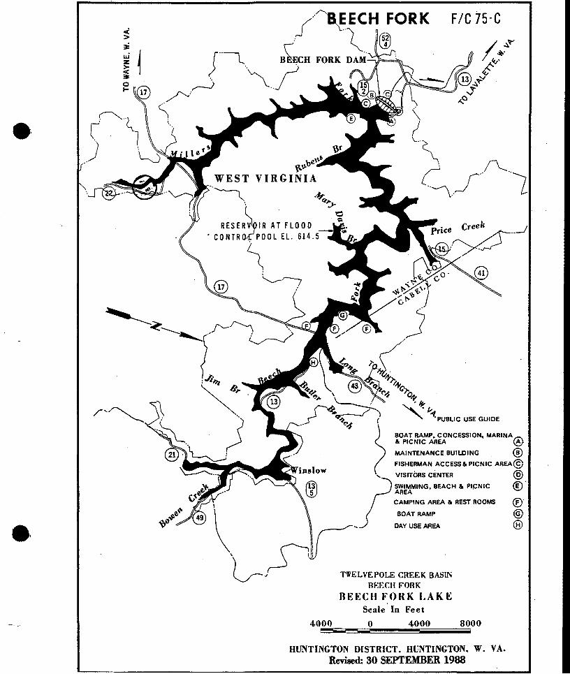
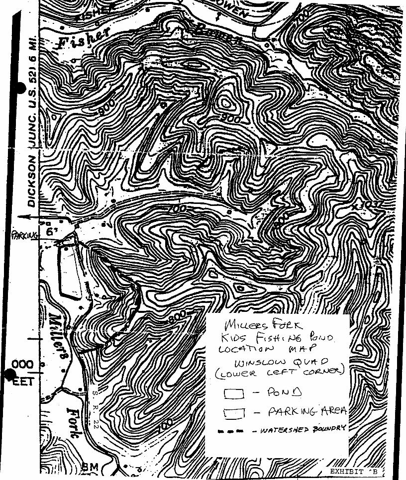
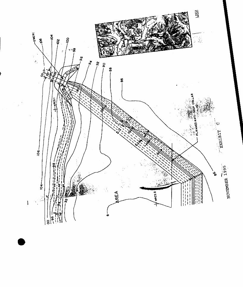
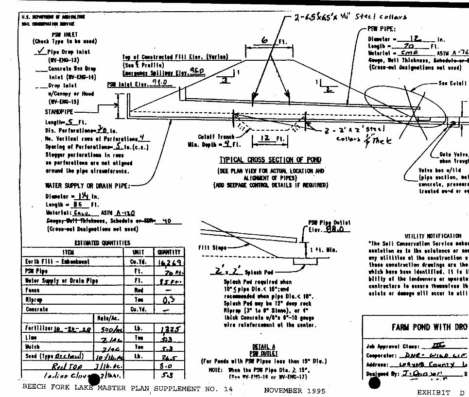
11
bulltl__f 8yen111
PSI UUT (Cfttcbull 1Jp1 Ibullbullbull 1114)
lf of Cen1tr1el14 FIii lit (Y1rl11) (Stt I Prell It) lcftCbull Slllnr EfH~
o (IV-DIH2)
_Concrelbull In 1 lnltl (IVmiddot--14)
__Drop bullbull Eln tto
(W-OC-15)
SJNIJPIPE
bullCnopr bull~tto4
ltllflh-5_Fl 1===1r=======tr~DI~ Ptr ftr1amp1onh11
No Ytrllcel of Perf1r1tlbull11 Stclftl 1f Ptrftrttlbulls_lbull(cc) Sllfllr pert1r1lltrt1 In rbullt bullbull p1rttrtll1111 111 Ml 1ll1n14 1roUll4 lht pipe clr1bullftr111c1
WATER stfflY Cit IIIAIN PIPE 0111r ~ h1 ltfttlll bull L Fl
lllltrl1I bull ASN Amiddot110 S-1111 1111 fttl1bull1t11 Sclttftlt - (Cr11HH1I Dt1lptllot1 Ml 11114)
ESHMTID CJMTITIES
ITDI IIIIT E1rlll flll - c11 CT1 PSI Pl t rt
I tr Drtll Pl bull rt Fence Rttl RI r Ttrt Concnlbull cuu
R1l1Ac
_ ~lmiddot11 clN_~
10
-)
-
jJ
i-~fc4sbull bullN s+u I c olfy
P9 PIPE 01 bull IL In lt1tlh bull to Fl lllltrltl bull Cnl ASTU C Ill I Thlckn111 Sh_I (Crt1bull11I 0111111111111 Ml 1111)
~~s=_ii==~~~~~~~~~~~~~~~~51I~~Y ------ J -bull 2 bull bull It l Sh I
Cltlf Tranebull I lLft cotibull) ~ r- ~
A --1
Clt Vtht nen lrtbullth
V1h1 bullbullbull bull114(pipe 11cllon Ml
111 0lll Lrt bull bull
DP ICAL moss SECTICJt ltf Plt11gt (SU PUN VIEi Fml ACltW lorATIClt Mil
Al IGNIJIT Cf PIPO) (m SUPAGE alfflQ D[TAILS If IDIIRED)
FIii Sltft
-ZiaL s11111 PM --shy
I H Illa
s111bull 10bull s 011lt sbullbull rtc11111 w1 plpt 011lt 10bull S I1th Pt1 NJ 12bull 4ttp reel Rlr1p (Jbull Ibull 1bull StlM) tr 4bull thick Coacrlt bullbullbullbull 1bull-10 lIbull 1lr1 r1l11ftrc111nt 1t lht c11t1r
PUAIL fSIMLEI
(r Pondbull 1llh PSIbullbull bullbullbull lhon DI)
tlgtlt lhtn lht PSI Plpt D11 l 1ampbull(=bull 11V-F9rr-lJ nr WY-EffC-17)
c111cr11 pr11111r1 lr11ltl n4 trbull~
UllllfT IGTlrlCAll(lf bullth Stll Clft11r1lltn s1c1 111111111 bullbull Ibull I~bull 11l1l1nc1 1r lot tnJ 1Ulll11 ti lht con1lrucllon 1 1
lh111 con1lrucllt1t bullrwlntt 1r1 lht1 bulllch httt bull1111 14tntlfl It 11 II 1111 c1nlreclor1111111 lhMttl11 Ill 111111 r _ 1111 tcc1r It ulll
FARM POND WI TH ORO
Ibull Apprntl CltH ip Cttptrtltr bNt bull WbullbullP 4-tlI
Wr111 Y4 Count~ l
Dial t X bullOo gt11 r Dbull - ~ BEECH FORK LAKrMASTER PLAN SUPPLEMENT NO 14 NOVEMBER 1995 EXHIBIT D
DEPARTMENT OF THE ARMY HUNTINGTON DISTRICT CORPS OF ENGINEERS
502 EIGHTH STREET
HUNTINGTON WEST VIRGINIA 25701-2070
REPLY TO April 8 1991 ATTENTION or
CEORH-PD-B (1110-2-240a)
MEMORANDUM FOR Commander Huntington District
SUBJECT Supplement No 11 Design Memorandum No 11 Master Plan Beech Fork Lake Twelvepole Creek West Virginia
1 Authority ER 1130-2-435 Preparation of Project Master Plans dated 30 December 1987 One copy of this approved supplement will be submitted concurrently to CEORD-CO-OE and CECW-ON for 30 day review for comment
2 Exhibit enclosed Map of dam area
3 The purpose of this Supplement is to request approval for the construction of a deck at Stowers Branch beach The deck will be of pressure treated pine approximately 13 x 33 feet in size and located back from the beach in a partially wooded area The deck will be available for reservation and will provide groups families and organizations with a place to meet and enjoy the beach area Space on the deck will accommodate 4 or 5 picnic tables and will provide a level platform in this mostly sloping area
4 Special Recreation User Fee Funds (SRUF) will be utilized to construct the deck at a estimated cost of $3000 It is proposed to reserve the deck for a fee of $2000 per day Cost recovery would take place over a 3 or 4 year period assuming the deck is reserved 45 days per year
CEORH-PD-B (1110-2-240a) SUBJECT Supplement No 11 Design Memorandum No 11 Master Plan Beech Fork Lake Twelvepole Creek West Virginia
5 The proposed deck would provide a revenue producing facility in the heavily used beach area in the summer months Approval is recommended
Encl -~ ef Planning Division
Approved by
AMESR~~~PF Corps of Engineers
District Engineer Colonel
-
--
______c-=- ------------
bull Xmiddotbull I I(l middot ~-- ( ( l
bull I
~_ z ~ middotmiddot)) ~~-)
1) _f amp I I middot I
j
v I
L I
~ ~
~ ( Viilfiliil
~ (
Jmiddot1 I -
Beech Fork La e aster an I Supplemen o J
BEECH FORK IAKE IWELVEKgtIE CREEK WEST VIRGINIA
bull MASTER PIAN
DESIGN MEM)RANilJM NO 11
FINAL DRAFT DECEMBER- 1988
Prepared by Department of the Arnrj
Huntington District Corps of Engineers 502 Eighth Street
Huntington West Virginia 25701-2070
Exhibits prepared by R J Ankrom Associates
1107 Ninth Street Suite N Vienna West Virginia 26105
and
Booker Associates Inc 343 Waller Avenue
Iexington Kentucky 40504
Section
101 102 103 104 105 106 107 108
201 202 203 204 205 206
301 302 303 304 305 306 307 308 309
BEEOI FORK AKE WEST VIRGINIA
MASTER PIAN
TABIE OF CONTENTS
Title
Table of Contents List ofTables List of Figures List of Ibotographs List of Exhibits
OIAPIER 1 - INmOWcrION
Project Authorization Project Purpose Purpose of Master Plan Pertinent Prior Reports Applicable PUblic raws Scope of the Master Plan Master Plan Objectives Master Plan Fonnat
OIAPIER 2 - PROJECI DESClUPIION
Project uxation General Project Description Project Developnent Corps of Engineers Operational structures State Operational stru~ Reselvoir Operation
aJAPrER 3 - ENVIroNMENTAL RF50URCES
Ibysical Geography Climate Hydrology Water Quality Geology Mineral Resources Soils Vegetation Fish and Wildlife
i
i iv
V
vi vii
1-1 1-1 1-2 1-2 1-3 1-6 1-7 1-9
2-1 2-1 2-4 2-5 2-7 2-8
3-1 3-2 3-2 3-5 3-11 3-12 3-13 3-13 3-14
TABIE OF agtNTENTS (Contd)
Section Title Page
aIAPrER 4 - RECRFATION 1illD ClJIJIURAL RESOURCES
401 Historical Developnent 4-1 402 Archeological Resources 4-2
404 Regional Recreation Facilities 4-5 -403 Scxio-Economic Profile 4-3
405 Surrounding Iand Use 4-5 406 Project Utilities 4-7 407 Transportation System 4-9
aIAPrER 5 - RErnEATION USE ANALYSIS
501 Introduction 5-1 502 Existing Recreation Facilities 5-1 503 Regional Recreation Facility Needs 5-4 504 Project Visitation and Facility Needs 5-6
ClIAPlER 6 - axgtRDINATION
601 SUmrnary of Coordination 6-1
ClIAPlER 7 - IHYSICAL PIAN OF DEVEIDEMENT
701 Introduction 7-1 702 Resource Use Objectives 7-1 703 Project Iand Use categories 7-3 704 Water Use Plan 7-6 705 Recreation Area Analysis 7-8 706 Trail Systems 7-29 707 Wildlife Areas 7-34 708 Facility Maintenance 7-36
ClIAPlER VIII - FACILITY DESIGN auTERIA
801 Introduction 8-1
803 Site Preparation 8-3 802 Siting 8-2
804 Iamscape Planting 8-4 -805 Roads 8-4 806 Parking 8-8 807 Boat Iaunchirg Ranps 8-10 808 Docks and Marina Facilities 8-10
ii
Section
bull 809 810 811 812 813 814 815 816 817 818 819 820 821 822 823
901 902 903
1001
1101 1102 1103
Appendix I
TABIE OF CONIENTS (Contd)
Title
CHAPIER 8 - FACILITY DESIGN CRITERIA (Contd)
Beaches camping Areas Picnic Areas Playgrounds Trails Signs Navigation Aids Recreation Area Structures Wastewater Collection and Treatment Solid Waste Disposal Electrical and Telephone Service Site Lighting Water Supply Facilities for the Elderly and Handicapped site Rehabilitation Design Criteria
CHAPIER 9 - RESOURCE MANAGEMENT GUIDELINES
Introouction Natural Resources Management Park Management
a-lAPIER 10 - COST ESTIMATES
Summary of Estimated Costs (See list of Tables)
rnAPIER p - SUMMARY OF CONCLUSIONS AND RECOMMENDATIONS
Introouction Conclusions Recorrnnendations
Page
8-12 8-16 8-20 8-21 8-22 8-30 8-39 8-39 8-40 8-41 8-41 8-41 8-42 8-42 8-43
9-1 9-2 9-8
10-1
11-1 11-1 11-2
List of trees mammals fish and birds of project area Exhibits 4-12
iii
TABIE OF CDNTENTS (contd)
LIST OF TABIFS
Number Title
101 Previous Design Memorandums 1-2 201 summary of lake Data 2-3 202 Iand OWnership and Management 2-5 203 Frequency of Pool Level Increases 2-10 501 Dmand Variables Used 5-8 502 SUmmary of Existing Recreation Facilities 5-11 503 Market Area Population Projections 5-12 504 Project Visitation 5-13 505 Projected Visitation 5-14 506 SUmmary of Facility Needs 5-15 701 Iand Use Allocations 7-4 702 Water Use Allocations 7-8
801 Roadway Design Standards 8-8
iv
TABIE OF OJNIENTS Contd)
Lisr OF FIGURES
Number Title Page
801 Major Access Road 8-6
bull 802 Iwo-Way Circulation Road 8-6 803 One-Way Circulation Road 8-7 804 Seivice Road 8-7 805 Parking Area Screening 8-11 806 Boat Mooring Post 8-15 807 Fishing Access 8-15 808 camping Site 8-19 809 Picnic Area 8-19 810 Playgrounl 8-25 811 Hiking Trail 8-26 812 Paved Walkway Trail 8-26 813 Footbridge 8-28 814 Scenic overlook 8-29 815 Identification Signs 8-33 816 U]xJraded campsite 8-46
V
TABIE OF CONIENIS (Contd)
LIST OF FHOIOGRAFHS
Number Title Page
701 Visitors Center 7-9 702 Marina 7-9 703 Above Dam Picnic Area 7-10 704 Tailwater Fishing Area 7-12 705 Tailwater Picnic Shelter 7-12 -706 Tailwater Picnic Shelter and Restroommiddot 7-13 707 Parking Area - Stavers Branch 7-15 708 13each at Stavers Branch 7-15 709 Picnic Area at Stowers Branch 7-16 710 Infonnation Sign at Stowers Branch 7-16 711 state Park Entrance Station 7-18 712 Old Orchard camp Area 7-18 713 Four Coves camp Area 7-19 7 14 Iaunch Ramp at State Park 7-19 715 Poat Rental Pier - State Park 7-20 716 Restroom and Washhouse at State Park 7-20 717 State Park Operations amplilding 7-21 718 Totlot at State Park 7-21 719 Picnic Shelter - Bowen Day Use Area 7-23 720 Restroom at Bowen Day Use Area 7-23 721 Basketball Courts - Bowen Day Use Area 7-24 722 Totlot at Bowen Day Use Area 7-24 723 Ballfield - Bowen Day Use Area 7-25 724 Exercise Trail at Bowen Day Use Area 7-25 725 Blue Goose Picnic Area 7-27 726 wvrnR Maintenance amplilding 7-37 801 Handicap Fishing Access - at Dam 8-13 802 Fishing Access at Tailwater 8-13 803 Handicap Access Fishing Pier - State Park 8-14 804 Typical Amphitheatre 8-14 805 Project Entrance Sign will be chanJed by 1995 8-36 806 State Park Entrance Sign 8-36 807 State Wildlife Area Sign 8-37 808 Directional Sign at State Park 8-37 809 Recreation Symbol Signs at Dam 8-38 810 Sign at Trailhead Stowers Branch 8-38
-
vi
Number
1 2 3 4 5 6 7 8 9
10 11 12
bull
TABIE OF (X)NTENlS (Contd)
LIST OF EXHIBITS
Title
location am Driving Distances Market Area Regional Recreation Facilities Drainage Basin Topography of Project Area Project Recreational Facilities Land Use Plan Water Use Plan Dam Area am Stowers Branch Upper am IcMer saen Areas lodge Complex Proposed Golf Course
2-2 4-6 4-8
end of text end of text end of text end of text end of text end of text end of text end of text end of text
vii
chapter 1 introduction
CHAPIER 1 INIROUJCTION
1-01 PROJECT AllIBORIZATION
Ihe Beech Fork lake project was authorized by the Flood Control Act of 1962 as
a unit in the larger comprehensive flood control plan for the Ohio River as
discussed in the Flood Control committee Dxument No 1 75th congress first
session
1-02 PROJECT roRroSE
Ihe authorized purposes of the project are flood control outdoor recreation
and fish and wildlife conservation
A FI00D CONTROL Beech Fork lake is operated for the reduction of
flood damages on the Twelvepole Creek and as a unit of the coordinated system
for flood protection on the Ohio River
B RECREATION he Federal and State constructed recreation facilities
completed include camping picnic areas boat ramps swimming beach and
fishing access (3144) acres of Federal land have been outgranted to West
Virginia Department of Commerce for park and recreation purposes
C FISH AND WIIDLIFE (8247) acres of Federal land and the lake
waters have been outgranted to West Virginia Department of Natural Resources
to manage the forest fish and wildlife resources
1-1
D WATER cpALITY Although not a authorized purpose low flows on the
Beech Fork and the Iwelvepole Creek are augmented to maintain a minimum of
10 cfs to preserve the downstream fishery and enhance water quality Ihe
dam has selective withdrawal capability
1 03 RJRFOSE OF lHE MASTER PIAN
Ihe Beech Fork Master Plan provides revised and currentinfonnation relative
to guidincJ the management and developnent of the project resources It
consolidates the original Public Use Plan tM No 11 with SUpplements and
all other available related documents within a comprehensive planning fonnat
Ihe Master Plan establishes the policies programs and objectives for the
development of the project resources in acxord with ER 1130-2-435 and related
Cocps regulations
1 04 PERlINENT PRIOR REroRIS
A number of design memorandums and other reports conceniing Beech Fork lake
have been completed by the Corps of Engineers and are listed in Table 1-01
lhese reports have been utilized in the preparation of the Master Plan
TABIE 1-01
mEVIOOSLY ISSUED DESIGN MEMgtRANCUMS BEEQI FORK IAKE
DesignMerooramum No Title Approval Date
1 Hydrology November 1965
2 General Design Melooranium December 1967
3 Real Estate - cam Site Part 1 May 1968
1-2
3A Real Estate - lake Part II September 1969
3B Real Estate - lake Part III January 1970
4
5A Iand Requirements Plan - Public Use May 1969
Spillway and outlet Works March 1971
6 SUpl Spillway and outlet Works August 1972
6A Inspection and Instnnnentation April 1964
7 Concrete Agglegates December 1968bull 6
8 School Relocations April 1969
9 Relocations - Gas Lines April 1969
10 Power and Telephone Relocations October 1969
11 Public Use Plan May 1971
12 Sedilnent RanJe layout November 1977
105 APPLICABLE RJBLIC IAWS
Ihe following Federal statutes govern the administration and development of
Beech Fork lake
A SEClION 4 RJBLIC IAW 78-534 FIOOD ltDNTROL ACT OF 1944 Ihis Ad
as amended by the Flcxxi Control Act approved 24 July 1946 Public law 526
79th Congress 2nd Session HR 6597 provides for the development of
resezvoir areas unier the control of the Department of the Anny for recreation
purposes Ihis law establishes the basic authority for the development of the
Beech Fork lake project for recreation purposes
B RJBLIC IAW 85-624 FISH Nm WIIDLIFE CDJRDINATION ACT OF 1958
Ihis Act states the general policy that fish and wildlife conseivation shall
1-3
receive equal consideration with other features of water resource development
projects Farly arrl continuing coordination is encouraged to fulfill the
spirit arrl intent of the law arrl administrative policy This law establishes
the basis for detailed consideration of fish arrl wildlife values in formulatshy
inJ future development plans for Beech Fork lake
C RJBLIC IAW 89-72 FEDERAL WATER PROJECT RECREATION ACT OF 1965
his Act inposes requirements of non-Federal cooperation arrl cost-sharing
participation in recreation financinJ arrl administration These requirements
have been applied administratively to projects authorized before 1965
therefore all Corps of Engineers participation in recreation development at
Beech Fork lake is subject to the requirements of PL 89-72 The cost-share
policy at the time of contract negotiation will prevail
D IUBLIC IAW 86-717 OF 1960 his Act provides for the protection of
forest cover for reservoir areas urxier the jurisdiction of the Secretary of
the Anrr arrl the Cltief of Engineers The Act requires that where practicable
fee lands shall be developed arrl maintained so as to encourage promote and
assure fully adequate am deperxlable future resources of readily available
timber through sustained yield programs reforestation arrl accepted consershy
vation practices arrl to increase the value of forest areas for conservation
recreation arrl other beneficial uses
E IUBLIC IAW 89-65 NATIONAL HISIORIC PRESERVATION ACT OF 1966 The
National Historic Preseivation Act of 1966 (PUblic raw 89-65) established a
national policy of historic preservation directed the expansion of the
National Register of Historic Places to include cultural resources of state
1-4
and local as well as national significance and established certain proceshy
dures to be followed by Federal agencies in the event of a proposal that might
have an effect on the National Register properties
F FUBLIC IAW 89-669 PROIECIION OF RARE AND ENDANGERED SPECIES ACT
- his Act states the policy of Congress that the Secretaries of the Interior
Agriculture and Defense shall seek to protect species of native fish and
wildlife including migratory birds that are threatened with extinction and
insofar as is practicable and consistent with the primary purposes of these
agencies shall preserve the habitats of such threatened species on lands
uncler their jurisdiction
G FUBLIC IAW 91-190 NATIONAL ENVIRONMENT FOLICY ACT OF 1969 Ihis
Act requires that an Envirornnental Impact Assessment shall be prepared to
evaluate the impacts of any significant actions that may affect the environshy
mental quality of Federally-owned land
H FUBLIC IAW 91-611 RIVER AND HAROOR AND FI00D CONTROL ACTS OF 1970
Title II section 234 of this Act gives citation authority to designated
Federal personnel for violations of those rules adopted by the Secretary of
the Anny related to the protection of Corps of Engineers projects resources
I FUBLIC IAW 93-291 PRESERVATION OF HISTORIC AND ARaIEQrcxICAL DATA
ACT OF 1974 his Act provides for the preservation of significant scientific
prehistoric historic or archeological data that might be lost or destroyed
as a result of various Federal actions
1-5
J roBLIC IAW 99-662 WATER RESOURCES DEVEIDMENT ACT OF 1986 Ihis
law provides for the conservation and development of water and related
resources and the inprovement and rehabilitation of the Nations water
resources infrastructure lhe Act discusses the new partnership relationships
between Federal and non-Federal public entities as a result of increased costshy
sharing in all stages of development and civil works projects
K roBLIC IAW 81-152 FEDERAL PROPERIY ACMINISTRATION SERVICES ACT OF
1949 lhis Act provides the Goverrnnent an economical and efficient system for
the disposal of surplus property
L roBLIC IAW 93-205 ENDANGERED SPECIES ACT OF 1973 lhe purposes of
this Act are to provide a means whereby the ecosystems upon which endangered
species and threatened species depeni may be conserved to provide a program
for the conservation of such endangered species and threatened species and to
take such steps as may be appropriate to achieve the purposes of the
international treaties and conventions
1-06 SCDPE OF IHE ~ PIAN
In accordance the Engineering Regulation (ER) 1130-2-435 the Master Plan
describes how all project resources will be enhanced developed used and
managed in the public interest lhe Master Plan is focused primarily on those
features contributing to the enhancement of existing recreational facilities
and fish and wildlife areas In recanmerrling the development of new and -
upgraded fcilities a variety of elements have been considered including the
natural and cultural environment current and projected recreation demand
1-6
operation and management capabilities and facility costs Ihe goals of the
Master Plan are to
1 Provide for the best possible utilization of project
resources
2 Provide for the enhancement of exist~ outdoor recreation
opportunities as well as fish and wildlife resources
3 Provide development concepts and criteria that will be in
hannony with the character of the physical historical cultural and biologishy
cal envirornnent of the area
4 Assure sustained public utilization of project resources up
to a capacity which is consistent with aesthetic values and the natural
envirornnent
5 Provide an inventory of project resources for developing
future plans and a base for coordination with other agencies
107 MASTER PIAN OBJECIIVES
Ihe following objectives represent specific tasks that will be addressed by
this Master Plan Ihe objectives will guide the data collection analysis
and systhesis process throughout the plan Ihe objectives are
1 Evaluate the natural and cultural resources of the Beech Fork
lake project and to identify the relationship between these resource
characteristics and potential recreational use
1-7
2 Investigate historical recreational use trends and to predict
the type and quantity of recreational facilities that will be required to meet
future facility demand
3 Develop Resource Use Objectives which specify the attain-
able publicly acceptable options for resource use based upon an analysis of -
resource capabilities and public needs
4 Identify potential land and water use conflicts and to develop
a land and water use plan that will minimize conflict and enhance multiple use
of the area
5 Develop conceptual development plans for existing and proposed
recreational areas Ihese site plans shall consider
a Potential consolidation or elimination of areas that are
currently underutilized
b Ihe need for repair and replacement of existing recreation
facilities to protect the health and safety of the public and to prevent
degradation of natural resources
c Identification of appropriate future facilities that will
be required to meet future recreational demand and that will minimize longshy
tenu environmental damages and operational and maintenance costs
d Ihe potential for cost-shared facility development
6 Provide general plans for the development of appropriate
facilities that are required to support or enhance the use of primary recieashy
tion sites
1-8
7 Develop design criteria that can be used to guide the
preparation of a physical plan of development and the preparation of more
detailed facility plans
bull 8 Clarify long-term project management responsibilities and to
identify minimum management planning programs
9 Develope plans to enhance fish and wildlife utilization of the
project
10 Identify possible special problem areas that may require
corrective action where appropriate
1 08 MASTER PIAN FORMAT
lhe Master Plan has been divided into eleven chapters Olapters 1 through 6
provide a review of the various natural and cultural resources that
characterize Beech Fork lake an analysis of existing and future recreational
facility needs and a smnmary of coordination efforts with other agencies
Ihese chapters were developed utilizing a variety of existing data sources
provided by local state and Federal agencies information obtained from onshy
site investigations coordination with various branches of the Corps of
Erqineers and established planning and design procedures
Oiapter 7 presents facility reccmnendations that can by used to guide the
future development of recreational facilities at Beech Fork lake he general
recanmerx2tions included in the Master Plan are designed to serve as a base
for preparing detailed site plans as required in the future Cliapter 7 also
includes the land am water use plan for the project Cliapter 8 presents
facility design criteria that were used to fonnulate development plans
1-9
Chapter 9 discusses broad management guidelines and policies which form the
basis for preparing a detailed Operational Management Plan for Beech Fork
lake These guidelines address the purpose and scope of the required plan as
well as unique characteristics of Beech Fork lake as they relate to the
preparation of the plan bullChapter 10 presents cost estimates for the proposed recreation site developshy
ments and includes estimates for the rehabilitation of existing facilities
lllese cost estimates relate directly to the design criteria established in
Chapter 8
Chapter 11 is a summaiy of the conclusions reconnnendations and special
considerations developed and presented throughout the plan
llle appendix contains lists of mamnal fish trees and bird species and will
include copies of letters received in the review process
1-10
chapter 2 project description
aJAPIERII PROJECI DFSCRIPrION
201 PROJECI LOCATION lhe planning area consists of 12755 acres located
in wayne am cabell counties in southwestern West Virginia lhe dam site is
bull located 2 miles southeast of the Village of Iavalette am 9 miles south of
Huntington Access to the dam from Huntirqton is accomplished by using State
-Route 152 from Huntirqton am county Route 13 from Iavalette Access to the
Bowen state Park area am Millers Fork is by state Route 152 am state Route
17 An alternative route to the state Park area is us Route 10 am State
Routes 35 am 43 Interstate 64 passes through the southern part of Huntington
am provides exits to both state Route 152 am state Route 10 A location am
driving distance map is shCMn as Exhibit 1
2 02 GENERAL PROJECI DFSCRIPlION
Beech Fork lake Ism is located on Beech Fork of Twelvepole Creek 3 5 miles
upstream from the confluence with the lwelvepole Creek lhe 88-foot high dam
fonns a lake at the seasonal pool of 8 3 miles in length am an area of
716 acres lhe width of the lake varies from 1000 feet near the dam to 600
feet over IOOSt of the lenJth am the mean depth at the seasonal pool is 127
feet 1he largest tributary branch of the lake is Millers Fork which is
about 3 miles lag lhe lake is sinuous in shape with rnnnerous coves am
flooded tributaries Shoreline areas are usually wooded am steep except in
the cove areas Topography of the project area consists of rugged terra1n
with steep hillsides am sinuous ridgelines IDeal elevations vary from
592 feet at the seasonal pool to 1000 feet on the hill crests for a relief of
about 400 feet Table 201 summarizes inpgtrtant lake data
2-1
I
OHIO
r ~ I --~I middot ~~~~~~--- 1T
WV
bull
location and driving distances
scale In miles
I 17~ ~I t~l10 0 10 20 30 40
beech fork lake master plan
update
exhibit
1~--
TABIE 2-01
SUMMARY OF IAKE DATA
Drainage Area above Dam Maximum FlCM of Record at Dam Streambed Elevation at Dam TOtal length at Seasonal Pool TOtal length at minimum Pool Average width of lake Mean Depth of Lake (seasonal) Shoreline length (Seasonal Pool) Water Depth at Dam (Seasonal Pool Height of Dam Crest length of Dam Estimated construction eost
SURFACE EIEVATION
(Ft NGVD)
Pool
Year-Rourd Storage (Minimum) 5835
seasonal 5920
Flcxrl Control 6145
SroRAGE CAPACITY
Acre-Feet Pool Net Gross
Minimum Seasonal
4200 4980
4200 9180
Flcxrl control SUnnner Winter
28360 33340
37540 37540
78 Square miles 22000 cfs (Feb 1939)
557 feet msl 83 miles 58 miles 713 feet
12 75 feet 31 miles 40 feet 88 feet
1080 feet $46 Million
SURFACE AREA
(Acres)
450
716
1830
Inchest Runoff Net Gross
10 10 12 22
68 90 80 90
2-3
203 PROJECT DEVEIDFMENT
A GENERAL Construction was initiated on the project in June 1970
The dam was completed in 1977 and irnpoundment was begun in the spring of 1978
Construction of the initially planned recreation facilities was completed in
1986 except for the State Park IDdge Complex and golf course The State Park
camping facilities at the Bowen recreation complex were completed in 1980
The StcMers Branch swinnning area opened to the public in 1980 with temporary
bathhouse facilities In 1985 a pennanent bathhouse and paved parking were
provided at Stowers Branch and the work on the tailwater fishennan access and
picnic area was completed Also in 1985 the visitor center was completed
B REAL ESTATE ACQUISITION Project lands were acquired under the
Joint Iand Acquisition Policy for Resenroir Projects as published in the
22 February 1962 Federal Register This policy called for a 300-foot
horizontal guide-taking linrit Additional land some of which is located
above the limit was acquired for construction operation and rnaintenance
facilities and public-use areas The 300-foot minimum guide-taking line
embraced all of the more valuable valley andlower slopes which left only low
value residual hill lands that were acquired because providing access was
neither practical or economically feasible About 8901 acres above the
300-foot lilnit was acquired Table 2-02 shcMS the general breakdown of land
use he land use allocations will be presented in more detail in Chapt9r 7
2-4
TABIE 2-02
1AND OWNERSHIP AND MANAGEMENT
Acres
Corps Operations and Recreation 1212
OUtgranted to state-Department of Commerce (State Park) 3144
OUtgranted to state- Department of Natural Resources (wildlife management) 8247
OUtgranted to Marina Concession 5
IOIAL FEDERAL IAND 12608 EASEMENT 147
C NON-FEDERAL RJBLIC Ihe State of West Virginia Department of
Commerce is responsible for the costs of management for the Bowen Recreation
Complex and adjacent land also known as the Beech Fork State Park The
management of the forest fish and wildlife resources are under the control
of the West Virginia Department of Natural Resources
D PRIVATE RECREATIONAL INVESIMENT A private concessionaire has a
license from the Corps to create and nanage a marina at the Dam area The
marina is owned by Beech Fork lake Marina Inc
2 04 CDRPS OF ENGINEERS OPERATIONAL SIRUCIURES
A DAM Ihe dam is a rolled earthfill type with impervious core with
a maximum height of 88 feet and a crest length of 1080 feet The top
elevation is 6400 feet msl and the top width is 32 feet A service road
crosses the length of the dam
2-5
B SPILIWAY Ihe spillway is located about 500 feet from the left
abutment of the dam It is uncontrolled concrete lined with a crest length
of 80 feet at elevation 6145 It discharges into a 313-foot long raceway and
stillinJ basin
c OUIIEI WJRFS Ihe outlet works are located near the left abutment
Ihe intake stnicture is rectangular concrete wet well type 117 feet high
Two gated sluices of 4 -6 xmiddot10 1 each controlled by a single hydraulically
operated tractor gate and discharges through a 8 -6 x 11 -3 split circle
corrluit 720 feet long into a jump type stillinJ basin 73 feet long Iwo lowshy
flow wells are located on each 5x4 inlets and a 2-12 by 3 discharge gate
Well No 1 has inlet invert elevations at 582 and 573 feet msl and well No
2 has inlet invert elevations at 582 and 564 feet ms1
D MAINrENANCE BJIIDING Ihe building is located on the left abutment
of the dam accessed by the service road across the top of the dam Ihe area
consists of a maintenance and utility building and associated garages shops
fenced storage yard with a total area of 3640 sq feet
E SEWAGE DISrosAL Ihe sewage treatment plant and control building
is located below the dam on the right bank about 300 feet from the tailwater
area lhe disposal plant serves the dam area and Stowers Branch Another
small building is located adjacent to the plant which serves as a water
quality testing facility
F VISIIOR CENTER he building is on the right abutment of the dam
and is used as an overlook and for use as an operations office and visitor
center he contemporacy style energy efficient building has incorporated
2-6
exhibit area a theatre for visitors and an outdoor fenced overlook which
faces the lake and marina area
2 05 STATE OPERATIONAL BUIIDINGS
A STATE PARK HEAfXPARlERS his is located in the east end of the
lower Bowen camping area and is part of the concession and operations
building
B MAINTENANCE IUIIDING his building is located at the end of
School House Branch about 1500 feet north of the main access road at Lower
Bowen campgrourrl lhe building and grounds provide storage space and
facilities for all maintenance activities at the state Park area
C RESIDENTIAL BUIIDINGS ll1ere are two houses built by the State for
the state Park SUperintendent and the Assistant Ihe Assistants residence is
located on School House Branch north of the camping area and the
SUperinternents residence is l~ted on Route 43 between the Day Use area and
the Blue Goose Picnic area
D WEST VIRGINIA rnR OPERATIONAL BUIIDING Ihis recently constructed
building houses office and maintenance facilities for operations at Beech Fork
lake and Fast IyenJ1I1 lake It is located on upper Millers Fork branch of the
lake near Route 17
E SEWAGE TRFAIMENT PIAN lhe plant is located at the l0v1er end of
the Bowen campground and seives the State Park area A sewage dump stationbull for campers is located near the Old Orebani camp area
2-7
middot 2 06 RESERVOIR OPERATION
A PIAN OF RESERVOIR REXDIATION Beech Fork lake is operated as a
unit in the comprehensive flood control plan for the Ohio River Basin Its
operation is correlated with Fast Lynn lake for regulation of Iwelvepole
Creek he plan of regulation is based on an adequate flood forecasting and
waining system in operation at all times he control stage on Beech F~rk has
been set l0v1 enough so that only nominal damages would occur at downstream
points taking into consideration the safe and effective operation of the
reservoir It is desirable to empty the reservir of flood storage as quickly
as EXgtS5ible in view of the EXgtS5ibility of a major flood occurring at a time
when the reservoir is partly filled Operation for Ohio River flood control
is based on the maximum retention of flows which would add to crest stages in
excess of 52 feet on the Ohio River at Ashland Kentucky A stage of 52 feet
at Ashland represents the point at which damage begins to occur in unprotected
ccmmmities of the Ohio River Valley bel0v1 Twelvepole Creek
he maximum flood control pool elevation has been set at 614 5 feet Flood
storage allocations of approxilnately 33340 acre-feet (winter) and 28360
acre-feet (summer) would control all known floods in the Beech Fork Basin
his annmt of storage would limit the outfl0v1 for the Standard Project Flood
to 6860 cfs and the Starrlam Project Flood Series to 3170 cfs A
reduction in crest flow- would be effected for each flood at all downstream
control points bullB MINlMJM R)()L he elevation of the mininunn pool has been set at
elevation 5835 feet msl which provides a capacity of 4200 acre-feet and
2-8
a surface area of 450 acres Ihis storage seJVes to support the fish popushy
lation during the winter months and is used to maintain the mininunn
downstream release of 10 cfs during the winter months
c SEASONAL R)()L A seasonal pool at elevation 5920 feet msl
- with a surface area of 716 acres is provided from April to mid-September for
recreational purposes and to maintain the 10 cfs minimum release during the
sunnner months he pool extends 85 miles above the dam Recreation
facilities which provide access to and for utilization of the 716-acre
seasonal pool include boat latmehing facilities a beach camping and
picnicking areas
D EFFECIS OF IAKE OPERATION ON RECREATION A rise or fall in the
pool elevation at Beech Fork lake affects the lands surrounding the lake
recreation facilities and project visitation A rise in the flood pool to
elevations a foot or two above 592 feet would make the beach area at Stowers
Branch unusable A rise of 5 feet to elevation 597 would inurdate some of the
lcrer lying camping and day-use facilities at the Bowen State Park area he
launch ramps at the dam and state Park would be unusable Damages to facilishy
ties would be caused mostly by siltation and erosion Most buildings have
been located above the 10 year seasonal pool flood level of middotelevation 600 5
feet he maxinunn flood control pool at 614 5 feet would be exceeded at the
300 year frequ~ although various flood events would raise the pool to
various levels belOirl this which would cause various deltJrees of siltation and
erosion damage Some trees and other vegetation would be killed or damaged if
high water stays high long enough Some years the seasonal pool level is not
reached because of a dry winter and spring In order to maintain minimum
2-9
flows this condition sometimes persists all smnmer making the beach area
unusable To offset this the pool is usually raised earlier than norrral to
take advantage of spring rainfall to enable the pool to reach the seasonal
level
The minimum pool is set at elevation 5835 a reduction of 85 feet from the
seasonal pool and reduces the area from 716 acres to 450 acres Most of the
land left bare with drawdown is located in the upper section of Peech Fork
Price Creek and Millers Fork where the water is middotshallow but also affects
Stowers Branch and other cove areas The prinary adverse impacts of this is
the large areas of mud flats in these areas which are bare of vegetation and
thus susceptible to erosion from rainfall This tends to make the pool turbid
during the winter and spring months The launch ramp at the dam can still be
used although most other facilities are not norrrally in use during the cold
season The draWdown makes the lake less pleasing along the shoreline because
of the exposed bank areas
TABIE 2-03
FRapENCY OF RJOL LEVEL INCRFASES FRCM ELEVATION 5835 FEEr (Minimum Pool Season)
Frequency Elevation
1 Year 5900 5 Year 5976
10 Year 6005 20 Year 6030 50 Year 6067
100 Year 6093 200 Year 6119 300 Year 6145
2-10
chapter 3 environmental resources
aIAPIER 3 ENVIRONMENTAL RESOURCES
301 R-IYSICAL GECGRAFHY bull
bull he project is located on the Beech Fork of the Iwelvepole Creek drainage
basin Iwelvepole Creek basin lies within the maturely dissected Kanawha
section of the Appalachian Plateau physiexJraphic province Erosion has
dissected the plateau to fonn a dendritic drainage pattern The Iwelvepole
Creek Basin is located in cabell Wayne Lincoln and Mingo Counties The
watershed has a drainage area of 441 square miles and is elongated and
irregular in shape being about 46 miles long with a maximum width of 12
miles Iwelvepole Creek is formed by the junction of the east and west forks
almost a mile south of the TCMl1 of Wayne (pop 1385) It flows 32 miles
northward to its confluence with the Ohio River between Ceredo and
Huntington he Beech Fork portion of the basin has an area of 78 square
miles above the dam and has its headwaters in the mcxierately rugged hilly
terrain near the Wayne-Lincoln County line It flows northwest to its
confluence with Iwelvepole Creek above Iavalette 154 miles upstream from
Huntington he floodplain varies in width from a few feet to about 2 000
feet wide at its confluence with Iwelvepole Creek
he stream fall from source to mouth is 440 feet an average of 15 9 feet per
mile In the reservoir area the terrain is rugged consisting of narrow
steep-walled valleys Maximum relief is about 460 feet Most level land is
3-1
confined to the flood plains of Beech Fork and the tributaries of Millers Fork
and Price Creek
302 CLil1ATE
Ihe climate of Beech Fork Creek Basin is continental and temperate with large
variations in seasonal temperatures Ihe entire basin is affected by frontal
air-mass activity and is subject to both continental polar and maritime
tropical air masses he prevailing meteorological front movement is from the
southwest Annual precipitation is unifonn over the basin normally averaging
about 42 inches Ihe average annual snowfall is about 21 inches Extreme
temperatures in the year have varied from a minimum of -14degF during February
to a maxil1tum of 105degF during July Ihe growing season averages about six
months usually from mid-April to mid--october Iwo distinct types of storms
are prevalent in the basin Ihe surmner type is usually characterized by
rainfall of short duration but high intensity and over a small area Ihe
winter-type storm is less intense but covers a larger area and is of extended
duration
303 HYDROIOGY
A RAINFAIL RUNOFF Ihe headwater portion of the Beech Fork Basin is
dlaracterized by narrow valleys with steeply sloping sides Runoff from these
slopes tends to collect quickly in stream channels causing rapid fluctuations
of stream stages Infiltration losses are generally lOw due to the relatively
shallow soils overlying bedrock on the slopes Basin runo~f is highest during
the winter months when storm rainfall may be augmented by snow melt and When
frozen or saturated ground results in low infiltration rates Runoff is lowest
3-2
during the late summer and early fall when the ground is dry and infiltration
rates are high Flow measurements estimated at the Beech Fork dam site indishy
cate a normal average flow of 89 cubic feet per second varying from 211 cubicmiddot
feet per second in February to 12 cubic feet per second in October The
maximum monthly average flow is almost 400 cubic feet per second and the
minimum average has been an almost urnneasurable 0168 cubic foot per second
B FICX)J6 lhe upper portion of Beech Fork is subject to headwater
floods whereas the lower portion is subject to backwater from Ohio River
floods as well as headwater floods or a combination of both Ohio River
floods have caused backwater effects on Beech Fork as far upstream as the dam
site Floods are of short duration seldom remaining above flocxl stage more
than 24 hours except in the lower reaches when prolonged by backwater from
the Ohio River lhe largest recorded flocxl for the Twelvepole Creek Basin
occurred on 4 February 1939 at a stage of 31 feet 15 feet above the no-damage
stage of 16 feet at the gaging station in Wayne West Virgina The discharge
was 22000 cubic feet per second and major damage occurred to residences
schools churches highways and bridges Flocxl damages on Beech Fork are
almost exclusively confined to low-lying residences farns and buildings
although for certain floods agriailture crop danages occur
C GRaJND WATER lhe ground water table in the lake area has the
following characteristics a colluvitnn mantle and zone of weatherEyenf rock on
the slopes and colluvial and alluvial rraterials in the valley fill are
slightly to mcxlerately penneable Dlrirg the late spring months these
rraterials approach COIIt)lete saturation with a water table at or near the
ground surface Ibis is evidenced by the many seeps along the valley walls
3-3
and is indicated by the higher frequency of slides during March April and
May Within these zones water levels customarily recede during the summer
months despite higher quantities of rainfall primarily because of higher
rates of evapgt-transpiration
Ille lithology of the lake area consists of horizontally stratified bedrock
containing widely spaced aquifers separated by less permeable rock with
permeability regulated through fractures and contacts Seasonal water level
variations are nonnally small particularly for deeper aquifers Within this
ground water reservoir a continual ground water movement downward from the
surface through successive permeable layers occurs with a loss in head
through each intervening aquiclude Where bedrock (sandstones and siltstones)
have a higher permeability than the upper weathered zone either through
vertical fracturing or because of lithological characteristics a distribution
of water levels between the two zones occurs Where bedrock is cornparatively
irnpenneable saturation in the weathered zone results causing a uniform
distribution of head throughout and a true water table When surface recharge
falls below the rate of discharge to bedrock a zonal distribution of water
levels in near-surface materials also results Both conciitions occur
depending upon the season
Hydrostatic conditions in rock strata are similar to those in overburden Ille
relatively higher permeability of the siltstone and sandstone aquifers results
in a stratification of water levels with the levels in each penneable zone
being dependent upon relative rates of rechalge and dischalge Because of
these conditions a true water table condition is the exception and may be
3-4
only of seasonable duration Generally appreciable seasonal fluctuations of
water levels are to be expected
3 04 WATER QUALITY
A SPECIAL PROBLEMS Ihe most noticeable problem relates to the
excessive levels of manganese and iron in hypolirnnetic waters during periods
of thermal stratification The dissolved metals present in water discharged
from the hypolirnnion is oxidized and precipitates in the outflow and downshy
stream of the project The result is coating of bed and banks of the stream
and indigenous organisms Other problems include high levels of cadmium and
mercury found throughout the watershed and high fecal colifonn found in the
lake
B GENERAL CONDITIONS IN 1984-85 Specific conductance alkalinity
and hardness are all relatively low The water is classified as soft has low
concentration of dissolved naterials and has little inherent capacity to
resist shifts in pH Taken together these facts indicate that the water is
very delicately poised with respect to quality changes and is especially
susceptible tosuspended solid and pH problems
lhermal stratification nonnally becomes established in Beech Fork lake in May
and June Severe stratification occurs during the summer months A deteriorshy
ation of thermal stratification begins in the fall and nonnally extends into
October lhe duration and extent of thermal stratification depends on hydroshy
meteorological variations and will vary from year to year lhe lake is nearly
isothermal during the winter period with a transition period during the
spring as stratification becomes established
3-5
Dissolved oxygen concentrations remain fairly constant throughout the water
coltmm during the winter period but decreases as a function of depth during
the surnmer months Throughout the epilimnion dissolved oxygen concentrations
remain greater than or equal to 50 rrg1 As temperature decreases through
the thenocxline region dissolved oxygen disappears rapidly resulting in
anoxic conditions near the bottom of the downstream section of the main lake
during late summer
Streams entering the project have a mean dissolved oxygen of 8 1 rrg1 which is
higher than the West Vilginia state standard minimum of 5 o rrg1 This is
also true of the discharge mean of 89 rrg1 despite the dissolved oxygen
depletion within the reservoir hypolimnion during late summer
All values for nitrate plus nitrite were lawer than the levels set in the
state standard of 1 0 rrg1 of nitrite As the depletion of oxygen occurs in
the hypolimnion during the summer months the amount of arrononia and Kj eldahl
nitrogen increases in the hypolimnion mean ammonia does not exceed the state
standard of 50 ug1 although occasionally the hypolimnic levels exceed the
standard at the roain lake station Dle to proper reservoir regulation the
outflow has no significant concentrations of nitrate plus nitrite arranonia or
Kjeldahl nitrogen associated with it
Prcxiuctivity at Beech Fork lake is fair to poor due to the foll0wing two
limited factors
(1) Jbe lake itself is turbid due to the physical nature of the
watershed with the mean turbidity at 283 NIUs on the roain lake station
High tumidity blocks out the needed light for optimum algae growth
3-6
(2) Ihe phosphorus content has been steadily decreasing at the
inflows and lake stations since 1979 Ihe mean total phosphorus of 40 9 ug1
at the inflowing streams is deceiving In 1979 the mean total phosphorus was
123 5 ug1 and in 1983 it was less than 10 ug1 Ille same situation is
bull reflected at the main lake station for both total and dissolved phosphorus In
1978 total phosphorus had highs of 205 ug1 and in 1983 the total phosphorus
is less than 10 ug1 throughout the water column
Streams entering the project have a pH range of about 60 to 80 with a mean
of 7 04 In the pool pH decreased immediately below the thennocline during
periods of thennal stratification Values in the epilirnnion during such
periods ranged from 7 O to 8 2 and those in the hypolirnnion from 6 2 to 7 O
At the outflow pH ranges from 60 to 85 with a mean of 68 Ille pH of the
outflow is within the range of the West Virginia State Standard (60 to 90)
Total iron at the two major inflow stations frequently exceeds the West
Virginia state standard of 10 nq1 with a mean of 115 nq1 and a range of
028 to 34 nq1 Iron also occurs in high concentrations within the reservoir
prior to stratification with a mean of 3 3 nq1 at the main lake station
ruring surmner months total iron increases rapidly in the hypolirnnion and has
even been as high as 35 ng1 Fall overtwn eliminates stratification and
total iron is then evenly redistributed
Dissolved iron in inflows and the epilimnion constitute less than one half of
the total content thereby indicating that susperxied solids are the primacy
source of iron within the reservoir Behavior of iron within the lake is
governed by distribution of oxygen and resultant effects on pH and oxidation-
3-7
reduction potential Total iron concentrations at the outflow are in excess
of the state standard of 1 rrg1 with a mean of 2 04 rrg1 cue to the severe
effects of metal precipitating out in the outflow the temperature objective
curve has been abandoned in early fall to avoid discharging hyp)limnic waters
CUring months when the lake is stratified decreases in iron concentrations
can occur in the outflow as a consequence of epilimnetic discharges Periods
of mixing such as in spring prior to stratification and fall after overturn
can result in increased outflow iron concentrations
High levels of manganese in water systems give an objectionable taste to water
supply and leave tenacious black stains on laundry As a result the West
Virginia state standards limit total manganese to 1 rrg1 in all state waters
High concentrations of manganese exist in both the watershed and lake throughshy
out the year Ihe major inflows average 6 79 rrg1 of total manganese with
highs of 200 rrg1 Ihe dissolved manganese is low with a mean of 011 rrg1
and range of o 01 to o 31 rrg1 Most of the manganese is tied up in sediment
as it flows into the reservoir
Both total and dissolved manganese are high at the main lake station with
means of 714 and 126 n-g1 respectively CUring stratification periods the
total manganese is conuronly greater than 7 nq1 in the hyp)limnion Conseshy
quently water fran the outflow can contain concentrations in excess of the
state stamard By careful reservoir regulation the manganese problem can be
mininrized when the water is stratified iJy releasing the epilimnion waters -
which are lower in concentrations than the hypolimnion CUring fall and
spring overtwns manganese is evenly distributed throughout the water column
3-8
thus no selective withdrawal is possible and the concentration can increase at
the outflows
cadmium is a heavy metal with a high toxic potential for both man and aquatic
bull life he West Virginia state requires waters with hardness of below 50 ng1
of caco3 as in Beech Fork reseJVOir to have cadmium levels below 78 ug1
his level has been violated at the main lake station al)d possibly at the
inflows
Total mercmy in all West Virginia waters is restricted to 0144 ug1 As is
com[[K)n in new- lakes the mercmy grossly violated the state standard at six
different inflows the main lake station and the outflow in 1978 and 1979
Ievels were measured at less than 1 ug1 since 1980 but whether or not these
values are above the standard of 0144 ug1 is not known
lwo collections of aquatic invertebrates taken in 1970 and 1971 revealed the
presence of seven orders of insects at Beech and Millers Fork By number 76
of these organisms were pollution sensitive thus indicating good water
quality Benthos samples collected during April 1976 have been processed and
ten species have been identified lhe diversity index (Shannon-Weaver) was
309 indicating good species diversity and water quality Samples collected
since inpunhnent have been partially analyzed Tentative analyses show
moderate diversities and numbers at the inflows Effects of construction
high concentrations of heavy metals and disruption of mechanisms of carbon
input through the ecosystem are possible reasons why the benthic macroinverteshy
brate population below Beech Fork Dam during the study period has been
3-9
severely reduced Density and diversity were extremely low and the organisms
collected were highly tolerant forms
On the basis of plankton data the inflow waters at Beech Fork lake constitute
a moderate quality relatively low productivity aquatic envirorunent in vvhich
phos]i1ate is probably the limitirxJ nutrient bull lhe low concentrations and lack of diversity of lake plankton also indicate
low productivity Since nannoplankton concentrations were not evaluated it
is possible that production is higher than estimated
IDw plankton concentrations and lack of diversity at the outflow indicate
minimal loss of biomass from the lake However since nannoplankton
concentrations were not documented it is possible that losses are much higher
Periphyton was not collected and productivity from this ecosystem component
in the outflow area in terms of such water quality indicators as diversity
and community structure are unknown
C DFSmATIFICATION PROJECr DlrirxJ a typical summer the lake is
devoid of oxygen below eight feet To alleviate this problem
clestratification fans are installed in the lake near the dam Ihe facility
was installed in May 1987 and the giant fan blades are floated six feet below
the surface he fans have six foot blades are powered by three-horsepower
electric IOOtors lhese fans force down the lighter wanner surface water vvhich
contains nDre oxygen to create a better mixture for lower depths Ihe fans
are designed to create enough force to destratify the entire 716 acre lake
1he lake conditions will be nDnitored to detennine the effectiveness of the
new destratification apparatus
3-10
305 GEDIOOY
lhe Beech Fork Basin lies within the sedimentary strata of the Pennsylvanian
age Monongahela and the Conemaugh groups comprise the fonnations lhe
depositional environment of the Conemaugh group in the basin consists of
- repeated marine advances and retreats lhe fluctuations are indicated by
lenticular deposits of vacyirg thickness
Numerous redbed sequences ocxur some of these grade laterally to gray nodular
limestones Another indication of this environment was the accumulation of
sandstones of a lenticular configuration such as the Saltsburg In some
areas sams -were deposited in dlannels which cut through tmderlyirg deposits
and into older sandstones lhe Morgantown and Grafton samstones are local
examples of coalescirg fonnations lhe fonnations encountered during subsurshy
face investigations range from the Brush Creek coal to the Upper Connellsville
sandstone Marker beds include the Elk Lick limestone at elevation 608 the
Upper Ames shale (limestone) encountered at elevation 565 the lower Ames
limestone (shale) at elevation 532 and Brush middotCreek limestone at elevation
472
Ihe fonnations encountered at the project site consist of clays indurated
clays claystones shales siltstones sandstones and thin limestones and
coals lhe clays ocxur as inclusions in the indurated clay and claystone
strata lhese clays are soft gray and slightly to moderately plastic lhe
- majority of the rock encountered at the site (70 to 75 percent) consists of
irrlurated clay lhese redbeds (irrlurated clays) are soft to moderately hard
and slake readily on exposure to alternate wettirg and drying They are
3-11
calcareous slick sided and contain thin limestone stringers and nodules Ihe
claystones at the site are soft to moderately hard gray and slickesided
lhey contain discontinuous silty and calcareous lenses Ihe siltstones in the
reservoir area are sandy to clayey soft to moderately hard gray to brown
slightly calcareous and slightly micaceous Ihe sandstones encountered at -
Beech Fork are silty to clayey moderately hard to hard fine grained brown
to gray and fractured Ihe fractures are ferruginously stained and generally
vertical Ihe limestones at Beech Fork are hard gray and lithographic The
coal seams occur as thin lenses and as blossoms in the clays and claystones
3 06 MINERAL RESOORCES
Ihe No 5 Block coal seam of the Allegheny series is below the valley fl(X)r
throughout the entire reservoir although the seam is not considered to be
mineable at present No coal seams of the Conemaugh series are known to be
present in mineable thickness in the area
Ihe Pittsburgh coal seam at the base of the Monongahela series generally
outcrops about halfway up the slope of hills at elevations well above the
flood plain throughout portions of the reservoir area several old openings
in that seam from which domestic coal was produced some years ago are
evident within and adjacent to the general reservoir area Ihe only known
ccmnercial production from the seam was at a discontinued strip mine location
at Moxley Branch
All proven resources within the reservoir area are in the Pittsburgh coal
seam and are not expected to be comrrercially mineable for some period of time
because of the poor quality of the coal Ihe reserves are not sufficient to
3-12
justify installation of rail facilities and would require long and expensive
truck haul
lhe area within and adjacent to the Beech Fork lake has been a producer of
natural gas for the past 60 years and is expected to continue for another
bull 20-30 years Production has been obtained from several horizons Some oil is
associated with the gas wells but is not in sufficient abundance to justify
bull production drilling Some gas well access roads are built in the area which
connect with the public roads
307 SOIIS
In the area of Beech Fork lake the overtgturden and soils on the valley slopes
are composed of detritus derived from weathered indurated clay siltstones
and samstones lhe soil is subject to movement on moderate slopes Slides
occur on the slopes and frequently appear as hummocks or overburden flows
along the valley walls he flood plain soils are mostly silt soils
308 VOOErATION
he project area is located in the IDtl Hills Belt of the CUmberland and
Allegheny Plateau region of the Mixed Mesophytic Forest Most of the area
once ocxupied by Mixed Mesophytic Forest is ocxupied by second growth or has
been converted to other land uses once the cutover areas have been converted
to cultivation or pasture the sucxeeding plant communities were predominately
oak-hickoey and scrub pine he present timber resource is generally of poor
quality and reflects a histoey of land abuse Forest fires have damaged some
areas and erosion has caused losses of topsoil
3-13
Remnants of typical mixed mesophytic forest are supported in some coves and
lower ravine slopes lhese areas contain about 30 percent beech 30 percent
oak 15 percent tulip poplar and 25 percent mixture of hickory maple white
ash and sweet buckeye Some of these beech tulip poplars sugar maples and
red oak are 36 inches in diameter and 80-100 feet high In the flocxi plain
and lower slopes the sycamgtre is the dcminant species in diameter and crown
size Multiflora rose is a ccmmon shrub and box elder and slippery elm are
conmn on the first terrace areas
3 09 FISH AND WIIDLIFE
A lgJATIC LIFE here are at least 43 species of fish which are
known to occur in the Beech Fork stream above the reservoir lhe lake itself
has a growing fishery from initial stockings done when the lake was filled in
1977-78 Fish stocking done by the West Virginia OOR included channel
catfish walleye largemouth bass and black crappie Also present are
numerous other species including bluegills and bullh~ds lhe lake is
beginning to be a good producer of fish from the numerous gocxi habitat cove
and dlannel areas lhe West Virginia OOR has canpleted building and stocking
two subiJrpcurrlmerrt near upper Beech Fork for raising and intrcxlucing hybrid
bass and tiger nuskys Another subinpundment is planned for the Rubens
Branch area
B MAMMAIS According to a survey corrlucted by the state of West
Virginia during 1948-51 some 30 species of mammals may be expected to occur
in or near the Beech Fork project lhese species include 1 marsupial (the
oppgtsUm) 2 moles 2 shrews 4 bats 6 carnivores 14 roients one rabbit
3-14
bull
(cottontail) and 1 hoofed animal (deer) Examination of range maps published
from another source shows that up to 45 species of mammals might be expected
in this area of West Virginia Not all of these could be expected within the
immediate project vicinity because of habitat conditions and middotthe fact that
sane mammals do not occur in significant numbers within their specific ranges
Based on the above infonaation it is believed reasonable to asstnne that
between 30-40 species of mammals might be found within the project vicinity
A list of trees birds mammals and fish of the lwelvepole Creek basin is
included in the the Appendixmiddot
c BIRilS Members of the Brooks Bird Club conducted a swvey in the
Beech Fork area durinJ 28 May-1 June 1969 At that time 81 species of
breedirg birds were identified TaJdnj into account winter residents and
sprinJ and fall migrants the rnnnber of birds which occur throughout the year
in the Beech Fork area would be considerably greater than the 81 species
reported durinJ late May to early June It is inpgtrtant to note that 8
53Cies of birds were included in Ihe Blue List for 1973 Ihe Blue List is
a list of those 100re cxmnon and widespread species which middot appear to be
declininJ in popllation or beccminJ 100re restricted in range for reasons not
clearly understood For instance the Eastern Bluebird is undergoinJ a rather
widespread population decline yet was one of the IOOSt abundant species
reported at Beech Fork Ihe yellowbilled cuckoo yellow wamler and yellow
throat are declininJ in califomia but are considered fairly connnon to connnon
in the Beech Fork area Ihe purple martin is declininJ throughout its range
and also was reported as scarce at Beech Fork Ihe red-headed woodpecker
3-15
appears to be declining nationwide nor was it found at Beech Fork by members
of the Brooks Bird Club
D GAME ANIMAIS Grey and Fox squirrels _ Ruffed grouse and
whitetailed deer are the predominant game species in the area Raccoon and
woodchucks are ccmnon and are often hunted he bottom land food plots and bullland formerly used for farming are good habitat for Cottontail rabbits Deer
rnnnbers are gradually increasing and provide hunting for a two week gun
season other game species present are grey and red fox oppossum morning
doves and mallards teal and wood ducks which nest or stop over during
migration Beaver and mink are found in low rnnnbers canada geese have been
introduced from the New York area and nesting platfonns have been provided in
various areas arourrl the lake Recently the state rnR introduced wild turkeys
into the area he success of the stockiryen] program will be monitored and
continued if necessazy
E RARE OR ENDANGERED SPECIES lhe following animal species found in
West Virginia or historically found in West Virginia are considered
errlangered or threatened species by the Deparbnent of the Interior Fish and
Wildlife Service in accordance with the Endangered Species Act of 1973 as
amenied
conmm Name Scientific Name Status
Virginia big-eared bat Plecotus townsenlii virginianus Endangered Fastem cougar felis concolor cougar Enda~ered Intiana bat Myotis sodalis Endangered American peregrine falcon Falco peregrine anatum Endangered Bald eagle Haliaeetus leucocephalus Endangered Kirtlands warbler Deroroica kirtlandii Endangered Pink mucket pearly mussel Iampsilis orbiculata orqiculata Endangered
3-16
Tuberculed-blossom pearly Epioblasrna (=Dysnomia) torulosa Endangered nrussel torulosa
Flat-spired three-toothed Triodopsis platysayoides Endangered
If any rare endangered or threatened - animals or plants are found to be
present in the project area Natural Area habitat designations will be
studied to protect these resources At the present time two rare plants are
probably found in the Stowers Branch area These are Agave virginica False
Aloe and Spiranthus ovalis oval ladies Tresses Ihese species will be
investigated for possible protection
3-17
chapter middot4 recreation and cultural resources
ClfAPlER 4 RECREATION AND aJLIURAL RESOURCES
4 01 HISIORICAL DEVELOFMENT Ihe first white men known to come to the
present limits of Wayne county were those of the Big Sandy Expedition of 1758
who were sent to attack the Shawnee villages of the Scioto Valley in Ohio as
retaliation for the Shawnee attacks on the Roanoke river settlements in 1757
Ibis expedition reached the Big Sandy River area and was recalled to Virginia
by Governor Francis Fauquier
In 1772 King George III wished to reward his soldiers who had defeated France
in the French and Indian War The lands of this part of Virginia were
partitioned and portions were granted to those entitled The first patent for
lands in what is ncM Wayne county was issued on 15 December 1772 to John
Savage and to soldiers who had served in his company John Savage obtained
the services of George Washington to swvey the lands The tract included
27672 acres and many of the important landmarks bore the letters GWS formiddot
George Washington Swveyor
Ihe first major grants in the Beech Fork area were made to John P ruval and
samuel M Hopkins ruval received a chain of grants from 1785 to 1793 along
Iwelvepole Creek_ and near the mouth of Beech Fork amounting to nearly 10000
acres Hqkins was granted 70000 acres in 1796 including parts of Butler
Ceredo Union and Stonewall Districts of present Wayne County in addition to
sections of present cabell county In some instances the Dlval and Hopkins
grants overlapped in which case the Dlval grant was recognized
4-1
Settlement in the area began with Samuel Hatton in 1796 Peter Ioar in 1797
and Hemy Haney in 1802 however major settlement did not occur until after
the transfermiddot of the DIval and Hopkins deeds in 1803 and 1808 respectively
after their deaths Known settlers after this time included Reuben Booton
Berry Adkins Asa Booton and Jefferson Bowen
No major battles of the Civil War were fought in the area but lcxal lore puts
sane guerilla activity in the area Rebel leader Bill Smith is said to have
been active here at that time and present residents of Winslow believe that
there was a Union encampment in stream bottoms southwest of the connnunity
Although no occurrences of major historical significance are known for the
area there is sane evidence of early settlements in the form of several log
houses All were built of ham hewn logs with half dove-tail notching
lacking log gables and eave beams ailinneys were situated on the exterior of
the gabled end of each of the houses with exterior fire boxes lhese
structural details imicate the houses were probable built between 1825 and
1850 More precise dating can only be done by studying land deeds and tax
records one log stnIcture was moved to the camping area and is presently
beinq managed by the West Virginia Department of Connnerce Ihe log cabin may
not qualify for the National Register but an official Determination of
Eligibility should eventually be requested
4 02 ARaIEDIOOICAL RESOURCES
An ardleologiral smvey at Beech Fork lake was completed in 1975 during which
19 archeological sites were recorded Eleven out of the nineteen sites are
located on Government property
4-2
bull
A total of 15 temporal components and 8 cultural components have been
identified Four Early Archaic (8000-6000 BC) 4 Iate Archaic (3000-1000
BC) 1 Early Woodland (1000 BC-100 AD) 1 Middle Woodland (100-600
AD) 3 Iate Woodland (600-1200 AD) and 2 Iate Prehistoric (1200-1600 AO)
temporal components are present and 1 Buck Garden 1 Fort Ancient 2 Buffalo
3 Brewerton and 1 Adena cultural components are present
Ihe sites consist of 1 rockshelter (46WA22) 3 lithic scatters (46WA21 23 and
24) 1 mound (46WA26) 1 open habitation with a mound (46WA34) and 2 workshops
(46WA35 and 38) Ihe rest of the sites are of unidentified function
Price Creek Rockshelter (46WA22) the most significant site in the reservoir
was excavated during the 1975 SUJVey
Ihe archeological SUJVey of all Federal lands should be completed with
priority given to areas that may be subject to bank erosion or new
construction
403 SOCIO-ECDNCMIC PROFILE
Ihe project area is within the two counties of Wayne and cabell cabell County
is more highly urbanized because of the City of Huntington and is part of the
AshlamjirontonjHuntinJton metropolitan area Ihe population of cabell County
in 1980 was 106835 with 378 persons _per square mile Seventy _percent of the
population is considered urban Ninety-five _percent of the population is
White 5 percent is black or other minorities Between 1970-80 the
population decreased slightly partly because of migration to suburban areas
4-3
The labor force in cabell County is occupied in diverse economic activities
Twenty-three percent is employed in professional or related services 22
percent is wholesale or retail trade 21 percent is in manufacturing and 9
percent is in public utilities Fanning is a minor but important part of the
economic structure and 20 percent of the land total is considered to be in
fanns with an average fann size of 97 acres over half of the fanners work
part time away from the fann
DJring the 1970-80 period there was a housing shortage which has since been
improved by suburban and rural building Housing in the area has increased
over 20 percent since 1979 and 65 percent of the homes are owner cxcupiecl
Education of the population has been improving steadily with 616 percent of
persons over 25 having a high school education and 14 percent having four
years of college or more
Wayne County where most of the project is located is much more rural in
nature and has a smaller population of 46021 in 1980 a 22 percent increase
from 1970 Thirty percent of the population is considered urban mainly
concentrated in Iavalette Wayne and Ceredo-Kenova Nearly all the populashy
tion is white or 996 percent Housing has substantially improved with a 36
percent increase in housing units from 1970 and a median value of $40300
Employment in the County is concentrated mostly in manufacturing wholesale
and retail trade and professional or related savices Eight percent of the
land is considered to be in fanns with an average fann size of 155 acres
over 50 percent of fann owners are employed away from the fann Education
levels are lower than in cabell County Fifty percent of the persons over 25
have a high school education and 7 percent have a college education The
market area for the project is shown on Exhibit 2
4-4
4 04 REXIONAL RErnEATIONAL FACILITIES
lhe area within a 50-mile radius of Beech Fork includes a large number of outshy
door recreational and historical points of interest About 20 miles south
Fast Lym Iake is another major Corps-operated recreation area lhe 50-mile
- radius of the project includes the large population centers of Huntington
Olarleston Ashland (Kentucky) and Ironton (Ohio) other nearby Corps
facilities are Dewey Iake Paintsville Iake and Grayson Iake in Kentucky
state-nm outdoor recreation facilities in the area include cabvaylingo State
Forest laurel creek Public Hunting Area Chief IDgan State Park Big Ugly
Public Hunting Area Fork creek Public Hunting Area Kanawhamiddot State Forest
Hilbert Public Hunting Area and Chief Cornstalk Public Hunting Area In
Ohio Wayne National Forest and Iake Vesuvius provide hunting fishing and
other outdoor activities A regional recreation map (Exhibit 3) shows the
distribution of these resources
4 05 SURROONDING IAND USE
Lani use surrourrling the project and within the drainage area is about 83
percent woodland 8 percent cultivated 5 percent pasture and 4 percent
roads_ hanesites and canunercial development Most land development occurs in
the flat flood plains or lower hillsides along Beech Fork and the larger
tributaries Fann cultivated areas are restricted to the flood plains and
sane hillsides are used for pasture Some l1eW home development is occurring
along the State Route 13 access road to the dam area Route 524 in the
stowers Branch area and along State Route 17 to Millers Fork Part of this
development is stimulated by the proximity of the Beech Fork recreation area
4-5
OHIO POME
POIITSMOUTH middot
Jr~ 0
ASH
_ - _ _ -_ ALESTON
ebull- --e ~ - WV
N
bull
beech fork lake ~hi_bit
master plan 2 update---~
Iumbering of the laige areas of timber is done mostly on a small scale as the
second and third growth timber becomes mature Coal mining is a minor
activity in the Pieech Fork basin since the coal seams are mostly too thin to
be profitable
406 PROJECT UTILITIES
A SOLID WASTE Solid waste produced by the project is put in trash
receptacles is then deposited in dumpsters where it is picked up by a
contractor and transported to landfills in cabell and Wayne Counties
B EIECIRICITY Ihe Appaladrian Power Company is the only power
company serving the project and adjacent area A high tension power
transmission line crosses the upper end of Millers Fork and also crosses the
upper end of Beech Fork in the Bowen area
c GAS Five gas utility companies have gas distribution lines within
the project area Ihey are cranberry Pipeline Corporation Gas Supply
corporation Tennessee Gas Pipeline Company Big Sandy Gas Corporation and
HH Illsher All of these are easements except for HH lusher which is lease
agreement
D TEIEFHONE here is one telephone company funlishing telephone
savice to the project area the Chesapeake and Potomac Telephone Company of
West Virginia
E WATER SUPPLY Water for the dam area and Stowers Branch is
provided by water distribution lines from the Lavalette Iublic Service
4-7
LEGEND
lJ STATE PARKS
LOCAL PARKS
f3 WILDLIFE AREAS
A NATURE PRESERVES
0 NATIONAL OR STATE FORESTS
regional recreation facilities
beech fork lake exhi_bi_
master plan 3update --middot
District based inmiddot Iavalette West Virginia The Bowen State Park area is
served by the Salt Rock Public Service District
F WASTE WATER TRFAIMENT There are two sewage treabnent plants
located on the project area The dam area and Stowers Branch are servicei by
bull a plant located below the dam The Beech Fork State Park has a plant located
in the Lower Bowen camping area
407 TRANSFORIATION SYSTEM
Access to the project from the main State highways of State Route 1~2 and SR
Route 10 are provided by several routes depending on the destination at the
project
A DAM State Route 13 from Lavalette is the principal access road to
the dam It is a narrow two-lane road which is subject to undennining and
slumping in several areas but has been recently upgraded with new asphalt and
is presently in good condition
B SIOOERS BRANCH This area can be reached by state Route 13 and
then Route 524 to Route 152 An alternate route is 524 from Route 152 and
then 152 These roads are paved narrow and winding but are usually in good
condition Route 152 from Falls Branch road has recently been paved to the
entrance gate at Stowers Branch
C OCMEN STAIE PARK ARFA The shortest route is from State Route 10
and cabell County Routes 35 and 43 These are two-lane paved winding roads
and are difficult in some areas for campers and trailered vehicles An
4-9
alternative access is using State Route 17 from State Route 152 Ihese roads
are continuously maintained
D MILIERS roRK AREA County Rout 17 from state Route 152 provides
access It has been upgraded but is a winding mountain road
E PROJECT ACCESS ROAOO All roads within the operations and bull recreation areas are relatively new and continuously maintained the State
Park and the Corps maintain the roads within their respective operations and
recreation areas
4-10
chapter 5 recreation use analysis
QfAPIER 5 RECREATION USE ANALYSIS
501 INTROIXJCTION
Ihis chapter provides an analysis of the current and projected recreation use
pattern at Beech Fork lake Analysis of the impact that regional demand has
on project demand and facility needs is also discussed Through a careful
analysis of existing conditions as well as future visitation projections
potential recreational demand and facility needs can be identified Detenninshy
ation of suggested facility levels involves the application of planning
judgment and standards -- results should be used as general guidelines for
facility development plans Final plans for recreation development must
additionally consider budgetacy constraints agency goals and other planning
and management considerations
502 EXISTING RECREATION FACILITIES
Information regarding existing recreation facilities is necessary in order to
establish current and future facility needs for the project Each recreation
area is discussed in the following paragraphs Table 5 02 is a more complete
listing of facilities for each site
A DAM SIIE AND TAIIWATERS middothis 34-acre corps-operated complex
offers a variety of recreational activities in two locations (1) A 7-acre
area below the dam is completed as a day-use area mainly for picnicking and
for access to the below-dam fishing area Ihe tailwater fishennan access area
5-1
is located along the outlet Facilities include 45 parking spaces waterlx)rne
restroom asphalt paths to a handicapped access fishing pier two picnic
shelters 2 picnic units and a hiking trail (2) llle above dam area contains
27 acres Facilities include an access road to an eight-lane boat launching
ramp and canoe launch facility parking lots for 144 cars and 97 car-trailer
combinations and a handicap fishenran access platform llle area also has
waterlx)rne restrooms a picnic shelter 12 picnic units and two trails begin
in this area A combined overlook and visitor center with parking is
located at the right abutment to the dam llle visitor center also serves as
an operation office llle maintenance area is located at the left dam abubnent
and access is provided by the service road across the dam A concessionaireshy
leased marina area is located upstream of the launch ramp and is operated by
the Beech Fork lake Marina Ihe marina has been recently expanded to 227
rental slips here are rental boats available a concession store and
fueling facilities
B s~ BRANClI AREA his is a 8-acre (land) beach and picnic area
operated by the Corps located on Stowers Branch a half mile upstream from
the dam on the left bank It has a 800-foot beach 3 paved parking lots for
204 cars 14 picnic units waterborne restroom and bathhouse A hiking trail
also starts in this area
C BEEal FORK STATE PARK lhe state of West Virginia Department of
Commerce has a license for 3144 acres of land for public park and recreation
Within this area is a 158-acre intensive recreation complex located on the
Beech Fork ann of the lake approximately 5 miles from the dam Ihe complex
is composed of three recreation sites-the IDwer Bowen camping Area Blue
Goose picnic area and the Bowen day use Area One area has been reseived for
5-2
future camping the Upper Bowen CcmpJround Ihis area will be developed by
the state when there is additional demam for camping Ihe Lower Bowen
camping Area was developed by the Corps Facilities include 275 campsites
parking for 140 cars and 62 cars with trailers a two-lane launching ramp
nine waterborne restrooms (four of which are also washhouses) interior roads
and a sewage treatment plant A concession and office building constructed
by the state seives the needs of canJlerS and others using the area Ihis
building contains the state Park Operations office recreation rooms
restrooms and grcxery store Ihe Bowen day-use area has been developed by the
State and has two softball fields volleyball courts a 304 parking lot
three picnic shelters restrocms two basketball courts a tennis court and a
exercise trail Ihe Blue Goose Picnic Area is located a half mile north of
the day use area and consists of 6 picnic units near a small pond Ihe State
Park SUperintendent and his assistant live in two separate dwellings
constructed by the state In 1987 225330 visitors made use of the area
D MARINA Ibis area containing 4 7 acres of land and water in the
vicinity of the dam site is leased to a concessionaire to develop and manage
the Beech Fork lake Marina lhe Marina is operated by the Beech Fork Marina
Inc and provides boat slips for rent boats for rent gasoline food and
boating supplies Ihe marina has been recently expanded to 227 boat slips
E FISH AND WIIDLIFE MANAGE)1ENl ARFA Ihe remaining land a total of
8247 acres including the lake is licensed to the State of West Virginia
Deparbnent of Natural Resources for fish wildlife and forest management
pmpses Ihe state has designated this land the Beech Fork lake Public
Hunting and Fishing Area An operations headquarters building has been
5-3
Hunting and Fishing Area An operations headquarters building has been
constructed in the upper Millers Fork area of the project lhe state will
manage both Beech Fork lake and Fast Lynn lake Public Hunting and Fishing
Areas from this building Also the state is constructing two waterforrl and
fish nursery ponds within the license area Ihe state furnishes an Annual
Management Plan and operates and maintains the land in accordance with the
plan Same other activities being corxiucted by the state are installing and
bullmaintaining infornation signs and bourrlary markers sharecropping planting
and nowing for wildlife providing waterfowl nesting structures maintaining
some access roads and closing others Visitation for this area was 11400
during 1986
5 03 RmIONAL RECREATION FACILITY NEEOO
A CAMPJNG canping continues to be a popular activity in West
Virginia SUrveys indicate that roughly half of State residents participate
in camping In Scorp Region II in 1980 there were a total of 854 camp sites
Based on estimated demarxi the number of camping sites should be doubled
B PIOITCKING Participation studies continue to irrlicate that
picnickirg is an extremely popular outdoor recreation activity with
participation exceeding 60 Group picnic facilities are an important part of
basic park design here are no definite demand imicators for the region
C SroRlS AND PIAYFIEIm here is a defilite need for additional
sports facilities outside thf larger communities in Scorp Region II Because
5-4
of the lack of flat land in many areas ballfields tennis courts and basketshy
ball courts are in special demarrl
D GOIF lhere are irrlications of a neei for additional middotgolf courses
to meet resident population needs especially in regions 1 2 and 3 Based on
a standard of one regulation course per 25 000 population region 2 has a need
for 45 additional golf holes
E SWlraquoITNG It is estimated that in West Virginia 55 percent of the
households participate in swimming In region II in 1980 there was a need
for 11 additional swimming pools or beaches
F OOATING Recreational boating is a popular and growing activity
within the state Motorboating requires public agency involvement to provide
public access rarips on the major rivers arrl inp)undments In the past public
access to wateJways was a special problem which is now gradually being
inproved In Region II notorboat registration fran 1969 to 1980 increased
fran 1830 to 5392 (194) lhis trend will continue if lake waters are
available
G WAilGNG AND HIKING Hiking is expected to be one of the fastest
growing activities in the State West Virginia has excellent possibilities
for the development of a statewide system of trails
H HORSEBACK RIDING Horseback riding and pedestrian activities are
popular in the state lhe Federal and state agencies generally recommend that
the private sector take the lead in developing horse trails
bull
5-5
I BICYCLING During the past few years there has been tremendous
national resurgence in the interest of bicycling and this is also true in
west Virginia A grants ptogram to fund construction of bikeways bike
safety and related projects was established by Section 141 of the Surface
Transportation Assistance Act of 1978 (PL 95-599)
J FISHING West Virginia waters offer excellent opportunities for
freshwater fishing in some areas and extremely limited opportunities in other
areas About 15 percent of the State popllation participates in fishing West
Virginia has only one significant natural lake so impoundments and stream
fishing are the rcajor sources for fishing In 1985 for the State the supply
of fishing resources exceeded the demand for most species of fish although
the quality of fishing should be conserved or iltlproved to satisfy increasing
future demani
K HUNTING west Virginia offers some of the best hunting opportshy
unities in the United States AWroximately 18 percent of West Virginians
hunt lhe indications are that public demand for hunting areas will continue
to increase lhe supply of garnet and hunting areas is expected to be more than
adequate in the future
5 04 PRQJECI VISITATION AND FACILITY NEEilgt
A GENERAL An analysis of past visitation at Beech Fork lake may be
used to jetennine future recreation needs and priorities Visitation estimates bull
have been obtained by pericxiically surveying recreation activity use and
traffic entering the Beech Fork lake area lhese surveys are designed to
accxAmt for seasonality weekerxl and weekday use and recreation area use
5-6
B PROCEilJRES FOR DEIERMINING VISITATION Ihe percentage of vehicles
actually entering the facility for recreation purposes and the average number
of persons per vehicle is used to develop an estimate of the total number of
visitors at Beech Fork Lake A further breakdown by activity is then applied
to this number in order to arrive at an estimate of use for each activity
Visitor use estimates for 1982 through 1986 are shown in Table 5 04 Table
505 shows projected visitation for years 1990 2000 2010 2020 and 2030
Ibis data was calculated as follows
Base ccnlitions were detennined by using visitation for the years 1985 1986
when all the facilities were nearly camplete
To obtain the projected visitation the population of the market area in 1980
was projected to years 1990 2000 2010 2020 2030 his is shown in Table
503
lhe actual visitation for the 1985-1986 period was then projected for the same
rate of increase as the general population of the market area The percentage
breakdown for each recreation activity was obtained lrugely from 1986 with
some adjustments to conpensate for the swimming beach being closed in 1986
and completion of the below dam area
C DESIGN DAD AND FACILITY NEEIE lhe design load is defined as the
projected visitation which will cxcur on an average weekenl day during the
peak 100nth of the recreation season To calculate the design load for an
average weekern day the following methodology was used
DL = D X IM x WE N
5-7
-------
Where DL = ~ign load
D = Demand (Projected Visitation from Table 505)
EM = Percent of Annual Use Expected During Peak Month
WE = Percent of Peak Month Use Occurring on Weekends
N = Nmnber of Peak (weekend) Days in a Month (9)
Ihe total number of facility units needed to meet projected demand can be
calculated througha fonnula based on maximum one-day use average group size
and turnover rates Table 501 presents the percent peak month and percent
use occurring on weekends and also average group size and turnover rates
TABIE 501
DEMAND VARIABIES USEl)x
Average Turnover Activity 1M WE Group Size Rate
camping 207 62 4 1 Picnicking 195 71 5 2 Boating 184 74 4 40 launches (2) Fishing 163 74 3 3 Hunting 364 64 01per acre 2 Sightseeing 145 62 4 3 swinmdng 35 69 4 2
Demand variables were obtained from actual visitation and smRP data
Ihe fonnula used to calculate facility needs for maximum one-day use is as
follows
FN = DL XG X IR
5-8
Where FN = Facility Needs
DL = Design Load (as calculated)
XG == Average Group Size (as shown in Table 5 01)
IR= Turnover Rates (as shown in Table 501)
bull he results of this fonnula along with a list of existing facilities are
shown in Table 5 06 By subtracting the projected demand from the existing
supply the quantity of needs or surplus can be detennined
D SUMMARY OF TABIE 5 06
1 CAMPING UNITS he table states there is a shortage of
canping units available during high use periods his is occasionally true at
the state Park can-pJrOUIld on holiday weekends on most summer weekends the
supply is adequate
2 PICNIC UNITS Picnic units at the project are divided between
the Dam area stowers Branch and the state Park he table states there are
adequate numbers of picnic units and actual conditions bear this out at this
project
3 OOAT IAUNanNG IANES he table states there is a slight
shortage in boat launch lanes during high use periods his is not considered
true at the project since sane of the ~ for launch facilities is
satisfied by the rental boats and slips at the Beech Fork Marina and the
- IOOOrings available at the State Park
4 ooAT TRAILER PARKING he table shows a large shortage of
boat trailer parking At the dam and the state Park the amotmt of parking
5-9
space is considered adequate although often these spaces are used by cars
only which results in temporary shortage of parking space formiddot lxgtaters with
trailers
5 PARKING FOR FISHERMAN The table shows adequate parking for
fishennan This is considered to be true at the project since part of the car
trailer spaces are used by fishennan and there is sufficient car parking as a
whole with exception of some weekends when the beach is used to capacity
6 HUNTING AREAS Huntirg resources are considered to be adequate
because of the large acreage for fish and wildlife management
7 SIGHISEEING PARKING Sightseemr parking is generally
considered adequate became the large amount of parkingmiddot space at the State
Park although shortages do occur in the dam area and Stowers Branch
8 SWIMMING PARKING Parking for swimmers is adequate since the
204 spaces at Stowers Branch provide parking up to the resource capacity Ihe
table is misleadinr because most of the swimming demand occurs on a few
weekends in summer and some parking spaces at Stowers Branch are used by
picnickers fishennen and hikers
5-10
BE~H ~OHK LAKE
TABLE 502
Surrmary of Eltist1rg Recreation Joac1lltles
IDWER IDWER ABOVE DAM TAILWATER SIDWERS OOWEN OOWEN DAY IJSR BLUE COOSE
FACILITIES AREA AREA ffiANCH CAMPHU AREA PICNIC AREA TOTAL
Developed Acres 27 7 8 130 28 3 203
Cam sites 275 275 Picnic 1Jnlts 12 2 14 24 6 58
Parking Spaces (Cars only) 144 39 204 140 304 6 837 Parking Spaces (Car ani Trailer) 97 4 62 163
Launch Lanes 8 2 10
Comfort Stations 1 WB 1 WB 1 WB 9 WB 1-WB 13
Water Supply Source Lavalette Lavalette Lavalette Salt Rock Salt Rock Salt Rock 2
Beaches 1 1
Developed Trails (miles) 04 o6 20 40 o4 74
Picnic Shelters 1 2 3 6
Shower Stalls 8 24 32 Sewage Treatment Plant 1 1 2
Waste Disposal Station 1 1
Pla round 2 l 3 Mooring Stanchions 98 12 110
Fishing Access-Harrlicapped 1 1 1 3 Sw~mmlng Access-Handicapped 1 2
Bal lflelds 2 2
Tennis Courts 1 1 Basketball Court 2 2
Volle ha] l Court 2 1 3 Marina-boat Slips 227 227
Boat Rental Piers 1 1 2
Golf Course
Swinmir
Amphitheatremiddot
Lltxiiie fooms-------------------------------------------------------Cahins
Park Offtce 1 1 2
Overlooks 1 1
WB = Waterborne
TABLE 503
PROJECTED POPULATIONS - MARKET AREA
Counties 1980 Actual 1985 1990 2000 2010 2020 2030
Wayne 46021 44067 49173 52500 51517 51214 51754
Cabell 106835 105613 117572 124053 129928 128642 132216
Mason 27045 26137 29003 36127 29606 30822 31600
Lincoln 23675 23294 25453 26124 25547 25506 27117
Mingo
Logan
Lawrence Ohio
La1-rrence KY
37336
50679
63849
14121
35459
47147
60930
14694
middot
39600
51927
63412
14805
41381
56471
63818
15213
40567
57873
64680
15676
42115
58191
64622
16301
43037
57422
67884
16688
Boyd KY 55513 56570 58055 60054 62171 64833 66444
425074 413911 449000 469741 470565 483226 194 162
512
TABLE 504
V[SITATION - liEECH FORK 1982-1987
Year No Persons Camp Picnic Boat Fish Hunt ss Swim Other
1982 426200 42500 31800 96500 94900 4100 97600 58000 0
Percent Use 10 7 23 22 l 23 140 0
1983 470690 80569 46431 117069 116693 3476 115322 87362 3941
Percent Use 14 8 20 20 0 20 15 0
1984 525523 81926 39602 117348 115812 3954 118772 44690 3543
Percent Use 16 7 22 22 1 23 8 1
1985 515811 84258 37 8_36 118612 11~ 946 4092 118356 32554 4155 Percent Use 163 73 229 226 07 229 63 08
1986 526730 84798 37498 128190 126228 4058 128978 13553 3454 Percent Use 161 12 244 24 07 245 25 06
1987 552188 82276 37292 116365 121932 6777 145030 38820 4106 Percent Use 148 67 210 220 12 262 70 o7
s-13
- -
TABLE 505
PROJECTED VISITATION BEECH FORK LAKE 1990-2030
161 72 236 23 07 225 63 06 Year No Persons Camp Picnic Boat Fish Hunt ss ----- Swim Other
1990 559139 90021 40258 131956 128601 3914 125806 35225 3355
2000 584859 94162 42109 138026 134517 4094 131593 36846 3509
2010 585443 94256 42151 138164 134651 4098 131724 36882 3512
2020 600664 96706 43247 141756 138152 4204 135149 37841 3663
2030 13878 98834 44 199 144875 141191 4297 138122 38674 3683
514
TABLE 506
SUMMARY OF FACILITY NEEDS - BEECH FORK LAKE
Facil I ty Campi~ Picnic Boating Boating Fishing Hunting (l) SS Swimming Units Units (Lanes) (Parking) (Parking Space) (acres) (Parking Space) (Parking)~-
Exist i~upply
YEAR FN
275
(-) (+) FN
73
(-) (+)
FN
IO
(-) (+)
FN
159
(-) (+)
FN
225
(-) (+)
FN
7 531
(-) (+)
FN
232
(-) (+)
FN
ISO
(-) (+)
19~
2000
2010
320
335
336
-45
-60
-61
62
65
65
+11
+8
+8
12
13
l3
-2
-3
-3
249
261
261
-90
-102
-102
191
200
200
+41
+32
+32
506
529
530
+7 025
+7002
+7001
104
109
109
+128
+123
+123
118
123
124
+32
+27
+26
2020 344 -63 66 +7 13 -3 268 -109 205 +27 544 +6987 112 +120 126 +24
2030 352 -77 68 +6 14 -4 273 -114 210 +22 556 +6975 115 +117 129 +21
+ = Surplus
- = Nein
( I) (2)
Parking spaces were allorated based on percentage visitation with adjustments Marin~ slips and nnorings would compensate for SOIIE deficit in launch lanes
Sightseeing parking assumes that visitors park at least once
515
chapter 6 coordination with other agencies
aIAPIER SIX COORDINATION
6 01 SUMMARY OF OX)RDINATION
Ihe Master Pl~ process requires the active participation of most elements
of the Corps of Engineers the major outgrant holders especially the West
Virginia Department of Natural Resources and the Department of Conunerce as
well as all interested private organizations and irxlividuals coordination
with all public and private agencies will be conducted throughout the plarming
process
It is important that these larrls which are a part of the Public Domain be
developed and managed to maximize public benefits Ihis requires a large
amount of coordination throughout the plarming process to ensure that solution
to water resource problems satisfies the needs of the people to the maximum
degree possible
A goal of the Master Plan is to maintain the channels of communication estabshy
lished in the developnent of the project and to ensure maximum utilization of
project resources through these channels Ihis final draft Master Plan will
be reviewed by various branches of the Corps District and also various state
and federal agencies All suggestions and CXJlmleilts will be utilized in the
final report and review letters will be included in the appendix
6-1
bull
chapter 7 physical plan of development
ClIAPIER7 EHYSICAL PIAN OF DEVEIOEMENT
701 INIROWCTION
bull Ihis chapter presents a series of resource use objectives that were developed
to guide the overall planning process Also discussed are the land and water
use allocations that are designed to guide the overall management and physical
use of project resources Ihe existing facilities are described iPl detail and
site analysis shows various short~ Ihe recommendations propose improveshy
ments to the existing facilities
702 RESOORCE USE OBJECIIVES
bullResource use objectives have been developed for Beech Fork Iake in accord with
ER 1105-2-167 Ihis ER defines resource use objectives as specific to the
project which define the attainable publicly acceptable options for resource
use detennined from study and analysis of resource capabilities and public
needs as detennined from previous chapters Ihe objectives are presented in
two major categories Recreational Design Operation and Maintenance and
Fish- Wildlife and Forest Management
Ihe initial recreation facilities are canpleted at Beech Fork Iake and are
generally adequate to meet current demams although site brprovement to
existinJ areas may be required
A RECREATIONAL DESIGN OPERATIONS AND MAINIENANCE
Objective 1 Maintain high quality camping day use and swimming
facilities to meet current and future demand within the resource
capabilities
7-1
Objective 2 Provide sufficient parking for recreation users
without exceeding the resource capacity
Objective 3 Make improvements to the trail system to meet the
needs of a variety of users
Objective 4 Provide for the improved visual qualities of the
recreation sites by using lamscaping elements and erosion control methods
Objective 5 Upgrade all facilities to current design standards
Objective 6 Provide additional playgrounds and athletic
facilities
Objective 7 Plan operations and maintenance practices to minimize
costs
Objective 8 Plan project operations activity to minimize damages
from over use and vamalism
B WIIDLIFE ARFA OBJEcrIVES
Objective 9 Provide access and appropriate facilities for
fishenoon and hunters
Objective 10 middot Inprove wildlife resources and associated habitat
within a stewardship concept as required by PL 89-72 and to protect flora and
fauna identified within national programs such as endangered species or
species for special emphasis
7-2
Objective 11 Protect and manage the forest resources including
timber wildlife soil water and aesthetics as prescribed by PL 86-717
703 PROJECT LAND USE CATEGORIES
bull The land use plan for the Beech Fork Lake project provides the basic framework
that will guide the development management and operation of all project
resources Four general land use categories have been established based on
the function of each and the management agency federal or state
A PROJECT OPERATIONS Lands in the category provide for the safe
efficient operation of the project for authorized purposes other than
recreation and fish and wildlife These lands are required to provide space
for operational structures maintenance and storage facilities waste
treatment administrative facilities and operations function
B INIENSIVE RECREATION These recreation sites support the greatest
concentrations of people participating in all types of recreation These
include campgrounds the lx)at launch area picnic or day use areas swimming
beaches and fishing access areas These areas are the most developed
Temporary use of the acreage on these sites may include primitive camping and
other uses in order to preserve or enhance desirable spatial or aesthetic
characteristics in support of the long range plans
Three intensive use areas have been developed at Beech Fork Lake and are
listed below These areas total 203 acres and facilities are developed at
each site Table 701 gives the breakdown by acreage for Land Use categories
7-3
1 Darnsite and Tailwaters
2 Stowers Branch Area
3 Bowen Recreation complex
C LOO DENSITY RECREATION Land in the category is used for hiking
trail alignments land reserved for future expansion nature study wildlife
management arrl forest management lllese areas are excess larrl for
recreation arrl not included in the intensive recreation or fish arrl wildlife
areas his larrl is used to preserve or enhance desirable spatial or
aesthetic characteristics in support of the long range plans for recreation of
higher density llle following are currently in this category arrl total 3837
acres
1 Land near the dam arrl Stowers Branch not included in
operations arrl intensive recreation
2 Land surrounding the intensive recreation areas at the State
Park
TABLE 701 IAND USE ALIOCATIONS
Acres Federally-Otmed arrl Managed land
Project Operations 309 Intensive Recreation 42 low Density Recreation 861
SUBIUIAL 1212
7-4
Federal Iand Licensed to West Virginia IBparbnent of Commerce
state Park Operations 10 Intensive Recreation (State Park) 158 IDw IBnsity Recreation (State Park) 2976
SUBTOTAL 3144
Federal Iand Licensed to West Virginia IBparbnent of Natural Resources
Operations Area 3
Seasonal Pool Area 716 Wildlife and Forest Management (Multiple Use) 7528
SUBTOTAL 8247
Federal Iand Ieased to Private Sector
Marina Concession 5
TOIAL FEDERAL LAND 12608 CORPS EASEMENT 147
D MULTIPLE RESOURCE MANAGEMENT Iand in the category is managed to
support wildlife Fishery and forest resources by protection and
conservation Ihese areas are also used for low density recreation Ihey
take in the largest part of the project acreage and includes the forests
fonner farmlands and the lake waters Ihe West Virginia IBpartment of
Natural Resources has a license from the Corps to manage these areas
according to the annually approved management plan Conservation of these
areas includes fire protection game and fish management plantings and
habitat control for game cover and food law enforcement fish stocking and
research activities Forest management involves all applicable silvicultural
practices Which includes timber harvest within a sustained yield concept in
order to achieve multiple objectives
7-5
E USER FEES The Chief of Engineers is authorized under the land and
Water Conservation Act of 1965 as amended (16 usc 1401 (Public Law 93-303)
to charge certain use fees at public park and recreation facilities provided
at Federal expense at water resource development projects operated and
maintained by the Department of the Anny The charges consist of camping fees -
where the followinJ facilities are provided designated tent andor trailer
spaces drinking water access roads refuse containers fireplaces visitor
protection and toilets
The revenues collected under this act are credited into a special account in
the Treasury of the United states to be administered in conjunction with but
separate from revenues in the land and Water Conseivation Fund Revenues in
the special accotmt are available to the Cocps of Engineers only by direct
appropriation The appropriated funds are allocated back to the projects at
which fees are collected in proportion to the revenues collection Guidance
for the use of these funds is contained in OCE letter of 4 october 1984
704 WATER USE PIAN
The water use plan is designed to protect the boating public minimize
conflicts between water and land use activities and to protect the environshy
ment The water areas are leased to the State of West Virginia for the
management of fish and wildlife in cooperation with the Cocps of Engineers
The water use zones for the lake are divided into three areas as described
below Exhibit 8 illustrates the zones and Table 702 presents the acreage in
each categocy at the seasonal pool
7-6
A UNRESTRICIED AREA Ibis is the unlimited speed zone and is
available for all water-oriented recreation activity he zone is the largest
and is located npstly in the wider deeper parts of the lake where user
conflicts can be minimized and urrlerwater obstructions do not present a
hazard lhese are the best areas for pleasure boating sailing and deep
water fishing
B CONIR)LIED AREA NO WAKE ZONE craft speeds in this zone are
controlled to a level which will not create a significant wake which would
disturtgt other water uses lhe following types of areas are effected Buoys
designate these areas
1 Water areas in proximity to boat launching ranps and marinas
where wave action would create a disturbance or damage facilities
2 Water ~ whidl are shallow narrow or contain submerged
obstacles and would be a hazard to fast moving boats
3 Waters whidl are best suited for fishing hunting canoeing
protection of natural habitat or other water uses that require an undisturbed
environment
C OOAT EXCIIJSION AREA ibis category applies to areas used for
operational pwposes such as dam water intakes or other areas where boats
would create a safety hazard such as near scuba diving activities or swinnning
beaches Buoys or other signs designate these areas
7-7
TABIE 702
WATER USE ALIOCATIONS (SEASONAL FCOL)
ACRES
Unrestricted Area 461 Controlled Area - (No-Wake Zone) 250 Restricted Area - (Dam Intake Beach) 5
716
7 05 RECREATION AREA ANALYSIS
At Beech Fork lake all of the intensive recreation areas have been developed
and are essentially complete he primary focus of the Updated Master Plan is
on preservation and enhancement of existinJ recreation areas lhe following
intensive use areas are described in detail site analysis is perfonned and
recanmemationsmiddot middotare proposed for inprovements to these areas
A AOOVE DAM AREA (Ihotos 701-703) (Exhibit 9)
1 EXISTING FACILITIES his area of 27 acres has been developed
as the boat access area arrl also for picnickinJ fishinJ and sightseeing
Facilities located here include the 8 lane lalllChing ramp parkinJ for 97 cars
with boat trailers 144 for cars only here is a picnic shelter and 12
picnic units Also in ~ area is a watemorne restroan and harrlicapped
fishing access 1he visitor center is located on the right aootment of the
dam and has an interior exhibit area theatre and office facilities outside
is the overlCXgtk area 1he concessionaire marina is located opposite the launch
ramp and has 227 boat slips a store and rental boats An access road to the
7-8
bull
Rlotograin 7-1
Visitors Center arrl OVerlCXgtk
bull Rlotograiil 7-2
Marina area
7-9
Rlotograph 7-3
liliove dam picnic area
radio tower area has recently been completed A nature interpretive trail
begins near the dam
2 SIIE ANALYSIS
a FOSITIVE SIIE FFAIURES The area is large and spacious bull
with superb views of the lake dam and surrounding terrain especially from
the overlook area The grass covered dam enhances the visual qualities of the
site The narina has been expanded without becoming overcrowded Trees have
7-10
been planted throughout the area Parking and picnic spaces are usually
adequate with the exception of holidays
b NmATIVE SITE FFAIURES Trees are planted in the area but
are not large enough to provide shade hemiddot access road to the radio tower is
- new and needs some tree screening to make it less obvious Parking space for
cars is not adequate during some summer weekends and holidays
3 PRORISED DEVEIOIMENI Another picnic shelter is needed in the
area close to the dam since there is little shade he radio tower access
road should be allowed to become naturally vegetated on both sides or
plantings are needed to screen the area A tot-lot is planned for the picnic
area Mditional 30 car spaces should be provided near the dam
4 FUIURE PIANS Mditional 20 car spaces can be provided when
needed
B BEia-1 DAM ARFA (Fhotos 704-706) (Exhibit 9)
1 EXISTING FACILITIES lhis intensive recreation area of about
7 acres consists of tailwater fishing area and a picnic area located at the
lower end lhe sewage treatment plant is located below the dam on the right
bank and is enclosed by fence lhis area includes of two buildings one being
used as water quality laboratory Recreation facilities consist of pathways
to the tailwater a path and fishing platform for the handicapped 2 picnic
- shelters 45 parking spaces and 2 picnic units A waterlxgtrne restroom is
located here A hiking trail begins in this area
7-11
Phot~ph 704
Tailwater fishing area
Photograph 705
Tailwater picnic shelter
7-12
bull
Rlotograph 706
Tailwater picnic shelter and restroom
2 SITE ANALYSIS
a IOSITIVE SITE FEAIURFS Ihe area is scenic with good
views of the tailwater and dam Ihe picnic area is well planned and spacious
One picnic shelter was originally the overlook shelter at the dam larger
trees provide shade in the lorer tailwater area Parking space is adequate
Fishing is good at times from fish that come through the dam and stream
species which are attracted by forage fish in the tailwater
- b NffiATIVE SITE FFAIURES Some additional shade is needed
in the upper tailwater area Ihe tailwater is not stocked with game species
by om
7-13
3 PROIDSED DEVEIOFMENT Provide tot-lot near picnic area In
the lower tailwater area which is presently undeveloped provide a exercise
trail game court parking for 10 cars and road access from SR 452
4 FUIURE PIAN A softball field should be provided in the east
end of the tailwater area near SR 452 This can be done when demand is
sufficient
C SIDWERS BRANO AREA (Ihotos 707-710) (Exhibit 9)
1 EXISTING FACILITIES This area has 8 developed acres located
about 75 miles from the dam Facilities include paved parking for 204 cars in
three parking areas 14 picnic sites located uphill from the beach area and a
beach area of about 800 feet in length There is a waterborne restroom which
include 8 outside shower stalls One developed trail starts in the area
2 SIIE ANALYSIS
a IDSITIVE SIIE FFAIURFS This is a popular area in the
summer because of the beach Ihe entrance drive and cove area is scenic
Access is controlled when the parking lots become full therefore preventing
overuse of the area From the parking area there is also easy access for bank
f ishennan Access to several trails is provided from this area This area is
also accessible by trail from the dam
b NEGATIVE SIIE FFAIURFS Ihe beach area becomes unusable
when the lake water levels are several feet below or above the seasonal pool
When the beach is not usable there are not enough recreation facilities to keep
the area open to the public during the fall and winter season The coliform
count becomes too high for safe swirrnning at various times in the summer
7-14
bull
Fhotograph 707
Parking area at StOWers Branch
Fhotograph 708
Beach handicap access and parking at StOWers Branch
7-15
bull
Photograph 709
Picnic area at Stowers Branch
Photograph 710
Infonuation sign and restroom-shower building at Stowers Branch
7-16
3 PROFOSED DEVEIOFMENT Near the entrance gate provide 3
additional pcrrking spaces for hikers using the area
4 Future Plan None
bull D IOOER Ea-IBN CAMPING AREA (Fhotos 711-718) (Exhibit 10)
The State Park intensive use area consists of 158 acres divided into three
recreation sites the lower Bowen camping Area lower Bowen Day Use Area and
the Blue Goose Picnic Area
1 EXISTING FACILITIES This 130 acre camping area consists of
226 camping sites for trailers or tents and 49 sites with full hookups for
trailers only There are 140 paved pcrrking spaces for cars only and 62 for
cars with trailers sanitary facilities consist of 9 restrooms 4 of which
are washhouses Wo playgrounds and volleyball courts are provided There is
a concession and park headquarters building in this area and a two-lane boat
launch area other facilities in this area are the maintenance building
sewage treatment plant and residential buildings for the SUrerintendent and
Assistant Recently completed is a handicap fishing pier and a boat rental
pier
2 SITE ANALYSIS
a FOSITIVE SITE FFAIURES Spacious area with varied campshy
ground settings close to the lake All sites have electric hook-ups 49 of
the sites developed by the State have full hookups with water and sewage
service There are two playgrounds volleyball courts and handicap
facilities at the restrooms Several hiking trails in the area are convenient
7-17
bull Rlotograyn 7 11
State park entrance station
Rlotograph 712
Old 0rcham canp area at state park
7-18
Photograph 713
Four Coves camping Area at state Park
Photograph 714
launch ramp at State Park
7-19
Photograph 715
Boat rental pier at State Park
Fhotograph 7 16
Typical restroom and washhouse at state Park
7-20
Photograph 717
State park operations buildirg and concession
Photograph 718
Tot-lot at State Park carrpground
7-21
for campers Trees and shrubs are planted throughout the area to provide
screening between campsites All roads and facilities are well maintained
b NEXATIVE SITE FFAIURFS here is no developed beach so
some campers swim in unsupervised areas he SeWage treabnent plant is highly
visible in the lower em of the project and should have additional vegetative bullscreening
3 PROFOSED DEVEIDPMENT Plant additional trees and shrubs for
screening of campsites and SeWage treabnent plant
4 FUIURE PIANS None
E IavER JnvEN mY USE ARFA (Ihotos 719-724) (Exhibit 10)
his area of 28 acres is located on the east side of SR 17 south of SR
13
1 EXISTING FACILITIES Ihe facilities consist of 24 picnic
units two large picnic shelters each with 2 fireplaces one half size shelter
with electric grills 2 basketball courts 1 tennis court 2 softball fields
a playground 2 volleyball courts and 2 horseshoe courts An exercise trail
has been recently developed around the area Parking is provided for 304 cars
on a stone surface lot One waterborne restroom is provided Trees are
planted throughout the area
2 SITE ANALYSIS
a rosITIVE SITE FFAIURFS The area is attractive and
spaciously located along the upper Beech Fork The architecture of the picnic
7-22
Photograph 719
Recently completed large picnic shelter at Bowen day use area
Photograph 720
Restroom at Bowen day use area
7-23
Rlotograin 7 21
Basketball courts at Bowen day use area
bull Rlotograph 722
Tot-lot at Bowen day use area
7-24
bull Photograph 723
Ballfield at Bowen day use area
Photograph 724
Exercise trail at Bowen day use area
7-25
shelters and restroom is conterrpgtrcuy dark stained wood construction which
blerm well with the envirornnent Parking space is adequate here are a
large variety of activities for the area
b NexATIVE SITE FEAIURES he area needs additional shade
Some of whidl will be provided by growth of trees nrring the hot months the
athletic facilities are urrlerused
3 PRgtRlSED DEVEIOFMENT Provide the planned swimning pool area
for the use of canJgterS and day users Ibis would be a popular hot weather
activity and would increase visitation An additional large picnic shelter
has recently been canpleted One smaller picnic shelter has also been added
4 FUIURE PIANS IWo additional small shelters will be built
when needed
F BIIJE GltlaiE PICNIC ARFA (Fhoto 7 25) (Exhibit 10)
1 EXISTING FACILITIES Ibis 3 acre area is located 2000 feet
north of the park entrance on SR 43 Ibis site has 6 picnic tables with 3
cookers located below a small manmade porn here is stone parking for 6
cars No restroan is provided
2 SITE ANAULSIS
a rosITIVE SITE FEAIURES Ibis quiet area is isolated from
the rest of the recreation area and has a natural setting near a small dam
and pom here is adequate space between picnic units
b NEXATIVE SITE FFAIURES Parking space is barely adequate
if all picnic units are being used No restroan is provided although the day
use area is not far away
7-26
bull
3 PROIUSED DEVEIOIMENT Provide a portajohn restroom in the
area Several more parking spaces should be provided if use of the area
increases
4 FlJIURE PlANS None
G FlJlURE STATE PARK CAMPING AREAS
1 UPPER ocMEN CAMPING ARFA This 22 acre area is located on the
west side of SR 43 north of the Lower Bowen camping Area lhe caI1p3rOUI1d
will be developed when demand for additional camp sites becomes evident
Ninety canpsites will be developed in this flat area with electrical hookups
and other facilities sbnilar to the lower Bowen camping area
7-27
Rlotograph 7 25
Blue Goose picnic area
H FUIURE GOLF CXXJRSE A 18-hole golf course has been proposed by the
state to be part of the Beedl Fork state Park Iocation of the golf course
will be in the area of the Village of Winslow about 2 5 miles east of the
present canping area Ihe course will be ~oped when the demand exists and
fums are available As an alternative to the proposed lcxige complex described
in paragraph I an expanded clubhouse with meeting rooms and guest cabins may
be developed here
I FUIURE IOOOE AND CABm ltXfflgtIEX A future lcxigeswinnning poolcabin
cxmplex is being studied for the Mary Davis Branch area of the lake located
3 5 miles upstream of the Beech Fork 0ml on the south side of the lake Ihe
Bowen QmpJround is 15 miles upstream of the lcxige site here are several
plateau areas on this branch with excellent views of the lake Ihe lcxige will
contain about 115 guest rooms which will oonnect with the swinuning pool
here will be meeting rooms a restaurant and gift shop here will also be
game courts a miniature golf course am a picnic area Iocated neaiby there
will be 30 deluxe guest cabins facing the lake A proposed access road to be
oost shared with the corps will be 3 miles long and will extend from the
Government property line to the lcxige area Ihe alignment of the road will
follow the relatively flat ridge line Ihe state will build the 06 miles
fran the Government property line to SR 17 As described in SUWlenent No
6 to the original Master Plan the corps will cost share the developnent of a
launch ranp and picnic area near the IDdge Facilities will consist of a one
lane launch ranp parking lots for 315 cars or trailers game courts picnic
shelters and 50 picnic llllits
7-28
706 RAIL SYSTEMS
A RCxK HOIJCM TRAIL Ibis nature interpretive trail is located north
of the entrance road into the dam area lhe 2200 feet circular route trail
begins a short distance from the visitor center
1 EXISTING FACILITIES A sign identifies the starting point and
a brochure and interpretive signs along the way point out significant
ecological infonnation for the trail user
2 SITE ANALYSIS
a FOSITIVE SITE FFAIURFS Ihe trail is relatively short
along a wooded hillside with frequent changes in grade The trail is well
maintained and a easy walk for most users Interpretive signs and trail
markers make this a self guided nature trail
b NffiATIVE SITE FFAIURFS None
3 EVAIIJATION Ihe trail is easily accessible from the visitor
center and parking facilities It is the most developed trail at the
project
4 PROFOSED DEVELOIMENT None
B TAIIWATER TRAIL The trail begins in the tailwater area near the
upper level picnic shelter and follows Beech Fork Creek to 524 and loops
back lhe distance of the trail is about 3000 feet
1 EXISTING FACILITIES lhere are signs identifying the trail
Part of the trail is used by fishermen for access to the creek area
7-29
2 SITE ANALYSIS
a IOOITIVE SITE FEAIURES 1he trail is located on nearly
level terrain along the wooded streambank am field edges It provides access
to fishing spots along the creek am for observation of wildlife Parking is
available in the tailwater area Grass is mJWed along the aligrnnent Most of bullthe trail is located high enough to avoid high water Trail signs have
recently been added
b NEXATIVE SITE FEAlURES On part of the length there is
uneven footing over nDWed grass although frequent use of the trail would
probably inprove the surface
3 EVAIIJATION lhe trail is easily accessible from the tailwater
parking is relatively short am provides opportunities for fishing and
wildlife observation
4 PROIOOED DEVELOFMENT Provide a corrpact surface on the trail
where needed to making walking easier
C BEECll FORK TRAIL lhe trail begins above the dam in the picnic
area am extends along the bank to the Stowers Branch Recreation Area and
loops back through the woods to the mouth of the spillway
1 EXISTING FACILITIES here are signs identifying the trail
2 SITE ANALYSIS bull a RgtSITIVE SITE FFAIURFS Sections of the trail provide
good views ofthe lake It also provides access for the lake shore for bank
7-30
fishing Parking is available near the dam and at Stowers Branch Ille trail
is well maintained
bull b NEGATIVE SITE FEAIURES There is a need for additional
trail signs Ille trail surface is frequently wet and could use stone
surfacing
3 EVAIDATION Ille trail is easily accessible from the above dam
parking area and provides a scenic and easy walk along the lake shore
4 PROEOSED DEVEIDFMENT Provide additional signs identifying
the trail
D SIOOERS BRANClI TRAIL The trail begins near the parking lot at
Stowers Branch and extends south for 3000 feet to a small pond
1 EXISTING FACILITIES A sign identifies the beginning of the
trail The trail follows mostly the stream bottom upstream the route is
lllOlrled and signs identify the route as well as no hunting areas along the
trail
2 SITE ANALYSIS
a R)SITIVE SITE FFAIURES Ille trail is relatively level
and traverses open areas and woodland Ille pond is an interesting terminous
which has a Beaver lodge and shows considerable beaver activity An unmarked
Millers Fork fire access trail branches off this to reach the lake The trail
is well marked and maintained
b NEGATIVE SITE FFAIURES None
7-31
3 EVAIDATION Ibis is an easy and pleasant trail for most users
and provides access to other trails in the area
4 PROFOSED DEVEIDFMENT None
E MILIERS FORK TRAIL
1 EXISTING FACILITIES Ibis trail branches off from the Stowers
Branch trail lhere are no trail signs or markers Length is about 2500 feet
to the lake shore
2 SITE ANALYSIS
a FOSITIVE SITE FFAIURFS The trail traverses wocxied hill
land with numerous changes in gradient It provides access to the lake shore
areas and rnR wildlife area
b NmATIVE SITE FFAIURFS lhe trail ascends a ridge which
may be difficult for some hikers lhere are no trail signs or markers
3 EVAIDATION The trail is the primary foot access to interior
areas of the project and to the Millers Fork shore areas
4 PROIOSED DEVEIDFMENT The trail needs a sign at the beginning
and markers along the way
F STAIE PARK TRAIIS
1 EXISTING FACILITIES There are four developed trails within
or adjacent to the state Park intensive recreation areas
7-32
a OVERLOOK TRAIL This trail begins in the Bowen campground
from the main access road near the Old Orchard camp area and extend for 3850
feet in a loop route There is a scenic overlook along a ridge
bull b IAKEVIEW TRAIL This trail connects the Four Coves camp
area with Iakeview camping area with two connecting branches from the boat
launch area and one washhouse The length is about 5500 feet
c IOST TRAIL This trail begins in the Moxley Branch camp
area and traverses a loop route along a ridge on the opposite side of the lake
from the four coves camp area The length is about 12 000 feet
d EXERCISE TRAIL This trail is part of the Bowen Day Use
area and features a paved walkway and exercise equipment at various locations
along the route
(1) ffiSITIVE SITE FFAIURES Ihese trails all have signs
identifying the trail head or are identified on brochure maps The routes are
well marked The trail surfaces are bare ground or wood chips Bridges are
built in crossing streams or ravines here is at least one nearby trail for
each camp area and also the day use area
(2) NEXATIVE SITE FFAIURES None
e EVAIIJATION Ihese trails are a valuable recreation
resource for campers and day users and should be maintained or upgraded when
necessacy
f PROFOSED DEVEIDFMENT None
7-33
7 07 WIIDLIFE AREAS
A GENERAL DESCRIPIION Ihe West Virginia Department of Natural
Resources has entered into a forest fish and wildlife management license for
most of the project area not managed by the corps of Engineers or as a part of
the State Park area Ihe license area totals 7531 acres of land and bull716 acres of water or 60 percent of the project area and is knOwI1 as the Peech
Fork lake Hunting and Fishing Area Ihe lake waters are managed by wvrnR who
are responsible for fishery enhancement and law enforcement
Areas within the state Park and some Corps managed land allocated to low
density recreation are managed as natural areas although no hunting is
nonnally allCMed Hunting is pennitted on all the rnR wildlife area and some
Corps managed area not restricted by other uses Fishing is pennitted on all
lake waters except where restricted because of dam operations marina
operation launch ramps and near the beach area
West Virginia rnR activities for management of fish and wildlife resources
includes fish stocking maintenance of access trails and infonnation signs
planting of trees and shrubs mowing and brush clearing to irrprove habitat
sharecropping agreements with fanners transplanting of beaver turkey and
deer construction of nesting structures fire prevention and developing fish
ponds and waterfowl marshes An operations building to manage the wildlife
areas at Beech Fork lake and Fast Lynn lake has been constructed in the
Millers Fork area next to SR 17
B FISH REARING SUB-IMroUNCMENTS Iwo ponds for raising tiger musky
and other game fish has been constructed on a tributary of the Beech Fork
upstream of the Bowen Day Use area Another fish rearing pond will be
7-34
constructed on Rubens Branch about 2 miles from the dam The size of the
ponds are about 2 acres and will also provide habitat for waterfowl Both
porns have been designei by the wvrtm and US Soil Conservation Service
labor and equipment are provided by the wvrtm and the West Virginia National
Guard
C PRORgtSED WIIDLIFE ARFA IMPROVEMENTS
1 Develop forest fire control access road into Lyons Branch from
Bowen Ridge Cemetery Road Fram near the lake provide access into Wolfpen
Branch to repair old fishing lake and dam Develop two or more water control
devices in Lyons Branch and adjacent hollow using old road grade and
culverts Ibis would be a relatively large endeavor but would be cost
effective since most of the work would be done in one area Portions of this
area are located on public htmting areas and some are on state Park land
Ibis project on state Park land would serve as a refuge for wildlife and would
enhance the aesthetics for park visitors Equipment needed would be a
backhoe bulldozer culverts and culvert pipe suitable for siIrple water
control devices
2 Develop a waterfowl marsh on Upper Millers Fork using existing
dikes and road grades Equipnent needed would be backhoe bulldozer culverts
and culvert pipe
3 Control burn several scattered woodland tracts to iIrprove
wildlife habitat especially for turkey
7-35
4 Designate natural area for rare Agave virginica and
Spiranthes ovalis plants on the Stowers Branch area uphill from beach area
Ihis will be studied by the Corps
708 FACILITY MAINIENANCE
A GENERAL DFSCRIPIION OF CORPS FACILITIES The Corps of Engineers
has a maintenance building and fenced parking area located on the left
descending side of the dam Access to the area is provided by the road across
the dam The building and grounds total 3640 feet and includes storage
area garage and workshops The sewage treatment plant and two associated
buildings are located below the dam One building (384 square feet) is the
control building for the plant and the other building (576 square feet) is
used as a water quality laboratory Both buildings are enclosed by a fence
and provide space for additional maintenance equipment
Project personnel are capable of perfonning all routine maintenance work
Maintenance items that are accomplished under contract are done so because of
the need for specialized equipment and training or because of limited project
manpower Present equipment allows maintenance in areas of welding mechanics
carpentry and painting Most vehicle maintenance is accomplished at the
project as are the bulk of equiprnent repairs and woodworkirg tasks
1 ~TIONS he present facilities are adequate to meet
the needs for maintenance of the Dam area and Stowers Branch -
B STATE PARK MAINIENANCE FACILITIES A large maintenance building
and storage yard has been built and is located at the end of School House
Branch in the Bowen camping area Ibis is a new buildinJ and meets the needs
for maintenance facilities
7-36
C WIIDLIFE ARFA MAINTENANCE A maintenance arrl headquarters buildirg
has recently been canpleted for management of the Beech Fork am Fast IyenIU1
Hunting arrl Fishing areas he building is located on Millers Fork adjacent
to County Route 17 his facility meets the requirements for the State at
present (Photo 726) bullbull
Photograin 7 26
West Vilginia OOR maintenance building
7-37
bull
chapter 8 facility design criteria
CHAPlER 8 FACILITY DESIGN CRITERIA
801 INrnOilJClION
bull General policies and procedures for the planning design operation and
maintenance of recreation facilities at Corps of Engineers Civil Works
projects are established in the Engineer Manuals Engineer Regulations and
Technical Reports referenced below
EM 1110-2-400 Recreation Planning arrl Design Criteria
ER 1110-2-400 Design of Recreation Sites Areas arrl Facilities
ER 1110-2-102 Design Features to Make Buildings arrl Facilities Usable
by the Physically Handicapped
EM 1110-2-103 Design for the Rlysically Handicapped
EM 1110-2-410 Design of Recreation Areas arrl Facilities
EM 1120-2-400 Recreation Resources Planning
EM 1130-2-400 Recreation - Resource Management of Civil Works Water
Resource Project
EM 1165-2-400 Recreational Planning Development and Management
Policies
EP 310-1-6 Graphic Standard Manual
EM 110-2-4201
CERL Technical Report D-63 Design Guidelines for Recreational Roads
These guidelines along with State of West Virginia public health and
sanitation requirements arrl state building codes fonn a basis for the
detailed design and construction phases of the project Design principles and
criteria appropriate to the Beech Fork lake project are discussed in this
8-1
chapter Sections 8 02 through 8 22 address the general standards necessary
for expanding existing areas and developing new facilities
8 02 SITING
A GENERAL here are a number of site characteristics that influence
the site selection for proposed facilities Topography area size access
potential relative location and site attractiveness are all major
considerations which dictate site selection for recreation facilities The
likelihood and impact of flooding wind and wave action and operations and
maintenance requirements are also important
Only the most adaptable topography should be used for siting facilities
Forced siting should be avoided unless the efficient use of the area requires
modification of existing land fonns Major cuts and fills should be used only
when a satisfactory alternative site is unavailable and then only for the
siting of a specific facility Existing clearings should be used whenever
possible Similarly existing disturbed areas and roads or road beds should
be used whenever possible
Final design and construction supervision should play a key role in the
successful implementation of the proposals presented in the Master Plan The
layout of roads and facilities must be considered as preliminary in order to
provide the project designer and field supervisor the latitude necessary to
adapt the construction plans to the site
8-2
B ELEVATION CXgtNSIDERATIONS
1 Habitable buildings washhouses and restrooms sanitary sewage
and water systems (except closed systems) and other facilities subject to
substantial damage from inundation should be sited at levels aoove the flood
- control pool level of 614 5 feet (National Geodetic Vertical Datum) DJe to
the long horizontal and vertical distance from the lake edge at sunnner pool to
the flood control pool and the desirability of placing facilities near the
lake these facilities may need to be located below this In these cases the
structures should be designed to withstand inundation Circulation roads
parking picnic sites and campsites may extend to the five year flood pool
level of 5976 feet
2 Boat launching ramps should be constructed to extend at least to
elevation 578 5 feet or 5 feet below the normal rninilllum pool at elevation
5835 feet to accommodate launching and removal of boats during dry seasons
Basins for marinas and boat service facilities will be dredged to at least
elevation 5775 feet
3 Boat mooring posts should be located within four horizontal feet
above the seasonal pool level of 592 feet
4 The top of combination wallsdocks should be set at elevation
594 feet to accommodate docking and loading of boats when the lake is at the
seasonal pool elevations of 592 feet
8 03 SITE PREPARATION
Site preparation (including excavation clearing and grubbing) for the various
buildings camping areas and day-use areas should vary according to individual
8-3
site conditions sudl as slope vegetation surrounding land use and soil
characteristics All grading and earthwork should be done in accordance with
established erosion control measures and shall meet all state and local
regulations Dlring all site construction operations particular enphasis
should be placed on the protection of vegetation and other site features and
on blending necessary cuts and fills unifonnly with the existing contours
bull
804 IANOOCAPE PIANTING
lhe major objectives for providing landscape planting within recreation areas
include screening undesirable features reducing wind and noise providing
shade providing privacy the enhancement of structures the definition of
recreational use areas reforestation erosion control and the enhancement of
wildlife habitats Planting in all areas should strive to imitate the
character of the site through naturalistic planting concepts and the use of
plant materials whidl are native to the area All plant materials selected
should be indigenous maintenance free and functional
805 ROAOO
he road system within the project boundary plays a significant role in
providing a quality recreational experience for the visiting public The
following guidelines will be considered in locating and designing proposed
access and circulation roads
A ALIGNMENI CUrvilinear aligmnent is preferred over long tangents
Roads will be designed to COITplenent the existing terrain and to optimize
scenic views In addition consideration will be given to the creation and
bull 8-4
maintenance of irregular right-of-way Jxnders to enhance the visual charactershy
istics of the roadway
B PROFIIE ~p cuts and high fills are to be avoided to reduce
environmental impacts When suitable borrow material is available
consideration should be given to building the roadbed slightly above the
natural ground level Positive effects of this method of road construction
relate to improved drainage minimal envirornnental disturbance reduced cost
and control of vehicular traffic in undesignated areas
C DRAINAGE swales and interceptor ditches will be constructed as
necessacy Ihe use of culverts will be kept to a minimum One-way
circulation roads will be cross-sloped where possible to minimize ditching
D MATERIAIS All access and circulation roads will be paved The
thickness of these sections will be based on soil studies conducted during the
final Feature Design Memorandum stage Service roads may be a gravel surface
Ihe cost estimates for roads include materials labor and grading
Major design standards for the development of various types of roads are
included in CERL Technical Report ~63 and EM 1110-2-400
Existing paved roads which are not necessacy should be removed and replaced
with natural lamscape features
1 Design Standards and Typical Road Sections Table 8 01 includes
the major design standards associated with the various types of roads that
should seive the proposed recreational and operational areas within the
project boundaries A typical section of each road type is shown on Figures
801 through 804
8-5
1111111
4 DITCH AS REQUIRED TO PROshyVIDE PROPER DRAINAGE
SLOPE VARIES 20~2 WIDE
FILL SECTION ACCESS ROAD CUT SECTJON
2 deg14 SLOPE SLOPE VARIES 2 ASPHALTIC ltONbullCRETE SURFACE ON A GRANULAR BASE
Figure 8-01 Typica I Major Access Road
I DITCH AS REQUIRED TO PRO VIDE PROPER DRAINAGF
CUT SECTION
11 II 111 I1111 II I I ~
2 1 STABILIZED SHOULDER
4 SLOPE
CIRCULATION ROAD FILL SECTION
SLOPE VARIES 18-20 WIDE SLOPE VARIES
211 ASPHALTIC CONshyCRETE SURFACE ON A GRANULAR BASE
2 SLOPE
Figure 8-02 Typical Two-Way Circulation Road
8-6
1111111111111111111111 I11
ONE WAY ROAD FILL SECTIO
121 WIDE SLOPE VARIES 2 CROSS
SLOPE
2 11 ASPHALTIC CONCRETE
FIGURE S-03 TYPICAL ONE-WAY CIRCULATION ROAD
SERVICE CUT SECTION ROAD FILL SECTION
SLOPE VARIES 21~0 ~E6PE SLOPE VARIES
6 11 GRANULAR BASE
FIGURE 8-04 TYPICAL SERVICE ROAD
8-7
TABIE 801
ROAtradeAY DESIGN STANDARIB
Road Shoulder Maximum Maximum Design Minimum
Width Width Gradient Speed Radius Road Type (ft (ft () (mph) (ft)
Major Aaess 20-24 2-4 10 40 270 Iwo-Way Circulation 18-24 2-4 10 30 150 bullOne-way Circulation 12-14 2 10 30 100 Service 10 2 12 40 50
806 PARKING
A GENERAL Additional parking facilities at Beech Fork Lake should be
provided as an integral part of the circulation system The parking facilities
should be sited so that their physical inpact on the natural environment is
minimized Various techniques should be utilized to screen parking areas from
recreational facility areas including mounding landscape screening and
recessing lots The visual character of all parking areas should be enhanced
by providing planting islands andor landscaped aisles wherever possible as
shawn in Figure 8-05 In some cases two or more small lots may be easier to
site than a large lot with uniform grading All proposed parking lots should
be physically separated from the major access roads to minimize circulation
conflicts Pedestrian circulation should also be considered in the layout of
parking lots
8-8
B DESIGN CRITERIA
1 MATERIAIS All pertiner)t parking areas will be paved and
overflow parking areas will have a gravel surface Design of parking areas
bull and thickness of sections will be detennined during the Feature Design
Memorandum stage Installation of gravel or porous paving rather than
nonporous materials should be considered as a means of reducing large expanses
of nonna11 y unused paved parking Cost estimates for parking areas include
paving materials site preparation grading and labor
2 SIZE car-trailer spaces will be a minimum 10 feet by 40 feet
and car parking spaces will be 10 feet by 20 feet Approximately two percent
of the total number of spaces in each use area will be specifically designed
and reserved for the use of the handicapped persons Ihese spaces will be
13 feet wide and conveniently located to walkways buildings site impact
areas etc
3 IAYour Parking lots should be designed to allow for efficient
movement of vehicles through the lot Parking areas may be in separate lots
off of the circulation or access roads or may have spaces which are at 90
degrees to a circulation road lots for cars with trailers will provide pullshy
through spaces where possible or pull-in and back-out spaces in areas where
space is limited by slopes vegetation or other constraints car with trailer
spaces will be at a 45 degree angle to the aisle when possible
4 OIHER FFAIURES All parking spaces except pull-throughs will
be provided with wheel stops CUrbing and catch basins will be minimized
stonn run-off will be surface drained whenever possible
8-9
8 07 OOAT IAUNOIING RAMPS
All ramps shall have a slope between 12 and 16 percent be lower limit of
each all season raq should be elevation 5785 feet five feet below the
normal minimmn pool at elevation 5835 feet Ihe upper limit should be
elevation 598 feet six feet above the surrnner seasonal pool A vehicular
turnaround will be provided at each multiple launch area At least one
courtesy dock should be provided at each boat access launch raq
8 08 IXXKS AND MARINA FACILITIES
A CXJURrFSY IXXKS A minimmn of one concrete courtesy dock should be
provided at each boat launch ramp to facilitate safe and convenient boat
loading launching and retrieval rgtdlts should be accessible from both sides
so that boats can be moved from the launch area before loading Basic
criteria for the design of courtesy docks include
1 LIVE IOADS Fifty psf unifonn live load on dock and bridge or
400 pounds concentrated load applied over an area of 12 by 12 inches
2 WIND IOAOO Unifonn load of 17 psf (80 mph) on all projected
surfaces assuming 100 percent boat occupancy
3 WAVE AND aJRRENT IOADINGS Will be considered on a site by site
basis
4 FREEPDARD Dead load freeboard of all floating dock units shall
be 18 by 24 inches Freeboard under dead load and 30 psf live load shall not
be less than 10 inches
8-10
bull
Figure 8-05 Typical Parking Area Screening
8-11
B M)()RING FOSTS lhe wood posts should be spaced 20 feet apart and
should be located within four horizontal feet above the seasonal pool level of
592 feet A typical 1000ring post facility is shown in Figure 806
c FISHING ACCESS ORDR 1130-2-18 provides authority for the
construction of access to lake waters near dam areas Steps can be provided
also filling of voids in riprap with small stones to provide for a
construction of fishing platfonns An access benn above the seasonal pool can
be a part of the design stage of new projects A typical access design is
shown in Figure 807
bull
D HANDICAP FISHING ACCESS Design of these facilities can be of
several types to fit the terrain situation at each site Handicap access
should be provided at each major recreation site lhese facilities are
illustrated in Photographs 801 through 803
8 09 BFAClIFS
Beaches will be surfaced with sand at a slope of three to five percent
Slopes greater than 5 percent are not feasible as the sand will shift during
drawdown even when the area is stabilized with retaining walls or curbs A
turf sunning area will extend above the sand area Ihis turf area will be
surrouMed by a diversion benn to minimize maintenance problems resulting
fran large quantities of surface runoff moving over the beach area large
turf areas may be provided with intennittent plantings to provide partial
shade and protection fran strorg winds Beaches and sunbathing areas should
be separated from parkinJ areas with a vegetation buffer strip
bull
8-12
bull
Photograph 801
Handicap access fishing- pier at dam and
destratification fans in background
bull Photograph 802
Handicap access fishing pier and weir in
background at tailwater area
8-13
bull
Photograin 8 03
Handicap acxess fi~ pier - state Park
Photograin 804
lypical anptitheatre (Burnsville lake)
8-14
--Metal Tie Ring --a Ota Wood Post - Pressure
Treated For Marine Use --Concrete Footer
Remove Large Rocks And Snags
Figure 8-06 Typical Boat Mooring Post
---Handrail __Walkway Parking --- Concrete Step
Existing _ __ a middot_ ~ip~sectltP middot middot
__ middot ~ -~-P_ middot- middotoltt -- middot middot
~Concrete Walk
-
Figure a-o Tailwater Fishing Aceemiddot
middot middotbullbull
8-15
SWimning areas will be outlined with buoys international orange in color
with cable passing through each buoy he buoys should be visible to a
swinmer at a distance of not less than 100 feet Additionally warning buoys
to boaters should be provided at 200-foot intervals or a minimum of two per
area lhe warning buoys should be parallel to an1 300 feet (100 feet minimum) bull
beyoni the buoyed safety line defining the swimning area
SUpporting facilities will include a changehouse an1 comfort station lhese
structures should be located as high as possible without being inconvenient to
the swinmer an1 should be constructed to withstand flooding
810 CAMPING ARFAS
A GENERAL camping areas should be designed to blem with the natural
landscape Iherefore deep cuts an1 fills will be avoided individual sites
will be located in the field giving particular emphasis to individual site
characteristics such as terrain vegetation an1 views All campsites should
be located as close to the lakeshore as possible above the five year flood
level of 5976 feet elevation to minimize flood damage to facilities
B CAMRROtJND IAYCgtUr Circulation roads in campgrounds should be one
way when possible to minimize construction costs an1 traffic conflicts Spurs
should be designed as pull-throughs an1 back-ins to increase diversity
Tables grills an1 impact areas should be opposite camper trailer doors which
are generally located on the right side of the trailer Pull-through and -
roadside spurs should only be used on the right side of roadways Back-in
spurs should be angled 30 to 60 degrees If 90 degree angle spurs are
necessitated by terrain spur entrances should be flared to provide adequate
8-16
width Dle to visibility problems with backing a trailer into a spur 90
degree angle spurs should only be placed on the left side of roads
C SPACING AND IANIBCAPING Sites will be spaced to allow an average
bull of 60 feet between sites and a density of approximately five sites per acre
Dense landscape planting providing both canopy and understory vegetation will
be developed and maintained within camping areas Whenever possible to provide
each camping group with a sense of privacy
D TRASH COUECTION centralized trash collection facilities may be
provided to minimize operational expenses A centralized trash collection
facility will be located within 60 feet of each camp unit or trash
receptacles may be provided at each site
E CAMP UNIT DESIGN Each camp unit will be provided with a gravel or
paved cartrailer parking spur (10 feet by 45 feet) with a maximum slope of
two percent on the rear half of the spur Also to be included are one lantern
post one picnic table a fire ring or grill an enclosed gravel impact area
(approximately 15 feet by 30 feet) a site identification marker and
electrical hookups These items and site preparation and grading are included
in the cost of each unit Impact areas and spurs should be integrated Where
possible so that the site may be used by a tent camper pop-up camper van
trailers or any other type of recreational vehicle Figure 808 illustrates
the basic components of a camp unit
F PRIMITIVE CAMPSITES Provide at least 4 camp spaces fire circle
and 1 trash receptacle for each group of 4 spaces Provide a vault toilet or
porta-john to serve each 8 spaces
8-17
G SITES FOR IHE HANDICAPPED JWroximately four percent of the camp
units should be designed for use by the handicapped preferably the sites
nearest the washhouse Design considerations for these sites include paving
iIrpact areas providing a wide spur for wheelchair movement around the
vehicle providing paved pathways to the site providing a picnic table which -
can accommodate wheelchairs and providing curbs around the area Ihese sites
should be on a level surface
H SANITARY FACILITIES AND UlILITIES All areas will be provided with
waterborne sanitary facilities All camp units will be located within 300
feet of a restroom or washhouse and not more than 600 feet from a washhouse
Facilities located in these areas will be distributed as described in EM 1110-
2-400 with a restroom for each 50 camp units and a washhouse for each 50 to
100 units in addition to the comfort station One water hydrantfountain will
be provided for each 8 camp units or 1 hand pump for 25 spaces
I PIAY ARFAS Iwo or three acres of relatively open flat land should
be provided as play areas for each 50 space campground Facilities in these
areas can consist of ballfields tot-lots horseshoe pits volleyball courts
or other appropriate facilitiesmiddot
J AMEHIIHEATERS Can be provided where there is enough demand for use
such as in group camps campgrounds and large day use areas An amphitheatre
should have sufficient parking space nearby either in a campground or day use
area A typical amphitheater is shCMn in photograph 8 04
8-18
Timber Edging ravel Impact Area
Fire Ring
Lantern Post
Table
Figure 8-08 Typical Campsite
Restoom------- flaygro
Parking
secttabe gril bull trash receptacle bull hydrant fountain
Figure 8-09 8-19
Typical Picnic Area
811 PIOITC AREAS
A AREA DEVEIDIMENT Picnic areas will be water oriented when possible
and will consist of picnic units picnic shelters playgrounds water and
sanitary facilities game fields and game courts circulation roads and
parking areas An example of a typical picnic area is sham in Figure 809 -
Ihe maximum cross slope in a picnic area will not exceed 15 percent or be less
than 2 percent Fach picnic area will include at least 10 units with a
maximum density of 12 units per acre One car parking space will be provided
for each picnic table One grill will be provided for each two tables and
conveniently located centralized trash collection facilities will be located
in the area One hydrantfountain is to be provided for each ten tables lhe
cost estinlate for picnic areas include these items Picnic tables will be
spaced a minimum of 60 feet apart Table locations should be changed
occasionally to minimize wear on the grass surface Road and parking areas
should be designed to limit access of vehicles to paved areas only Ditching
along the side of paved areas curbs or cast concrete or wood wheel stops may
be used to control irrpact areas
B SANITARY FACILITIES Restrooms should be located a minimum of 100
feet and a maximum of 600 feet from the picnic tables they serve In areas
that do not have sufficient use to justify waterlxgtrne facilities vault
toilets should be used One restroom or vault toilet with faciliticS for both
men and wanen should be constructed for each 25 picnic tables in high use -
areas
8-20
bull
C PICNIC SHELTERS Picnic shelters should be placed where deroand
warrants their construction and maintenance lhe style of picnic shelters
should match those already constructed in the area because of their high
quality and good appearance Fach shelter will be designed to accommodate at
least six tables Additional support facilities should include three grills
a trash dumpster and potable water Fees can be charged for group use
D PIAYGROUNOO One playgroun1 or tot-lot should be provided at each
area with 30 or more picnic tables Playgrounds are discussed in Section
812
E OPEN PIAY ARFA cpen play areas of approximately one acre in size
will be provided at picnic areas with 50 or more tables
812 PIAYGROUNOO
A GENERAL A minimum of one playground should be provided in each
recreation area Natural materials should be utilized and the play area
layout should be designed to fit into the natural setting with consideration
given to preservation of trees and other vegetation Equipment which promotes
a creative kim of play is reconunended such as wood climbers playwalls
sculptured earth mounds swings sand areas and benches
Appropriate surface materials include sand bark chips turf and smooth pea
gravel Small play areas with one or two climbing structures should be added
to some existing areas where no play structure exist
B DESIGN CRITERIA lhe following general guidelines apply to all
playgrourxl development
8-21
1 Ihe location should be near the major use areas within each site
in a manner that does not conflict with pedestrian or vehicular traffic
patterns
2 Playgrounds should be landscaped to provide partial shade if the
site does not provide it already
3 Open turf areas should be preseived adjacent to playgrounds
whenever possible to provide OE=P()rtunities for field games and free play
activities
4 One playground will be provided for each camp area or picnic
area
813 TRAIIS
A GENERAL Trails should be used where they enhance public enjoyment
of the environment and utilization of fish and wildlife resources Important
factors to consider when designing a trail include alignment terrain toposhy
graphy vegetation aesthetic values points of interest road crossings or
other potential dangers and final destinations Zoning of trails for various
types of use intended is also necessaiy Ihe trail type to be provided at
Beech Fork will be hiking Hiking trails should provide secondary benefits by
providing access for hunting fire control etc
B DESIGN CRITERIA (GENERAL) Ihe following general guidelines are
applicable to all trail development
8-22
bull
1 Vegetation or native rock materials should be placed Where
necessary to prevent erosion
2 Trails should be routed around large trees Where practical to
avoid unnecessary tree removal bull
3 Trails should be inspected periodically to check trail
corrlitions and markings
4 Pedestrian trails should be used for travel only except Where
access roads will be used by both pedestrians and maintenance vehicles
Trails Which are designated for pedestrian use only should be closed off with
lCXJS zig-zag barriers or staiiways to discourage non-pedestrian users
5 If it is necessary to develop trails utilizing side-hill
construction techniques the cut slopes may be as steep as the soil material
will tolerate without serious erosion Most soils will tolerate a 121 or
341 cut slope care should be taken to ensure that an angle of repose is
used that will maintain a stable corrlition irrlefinitely and will pennit
vegetation to grow-
6 All trail construction should be planned to produce the least
disturbance to the natural envrrornnent consistent with the interned use
7 Trails should provide a variety of experiences taking advantage
of panoramic arrl focal views traversing ridges arrl valleys open spaces arrl
forested areas arrl traveling along water bodies Whenever possible
8 CUrbs arrlor harrlrails should be provided Where appropriate
8-23
9 Inter-site walkways should be considered to link major
recreational facilities
10 Abrupt changes of direction or grade should be avoided Ihe
linear f(X)t unit cost estimate for each trail type includes the construction
of the trail surface materials stairs curbs handrails signage and -
grading
C SIGNAGE Adequate signage is essential at trail heads
intersections points of interest and at locations on the trail where the
direction is not readily discernible Trail signs should include mileages to
various points of interest along the way along with the total trail
mileage Frequent mileage markers along the trail are helpful to the hiker
and useful in the operations and maintenance of the area
D SURFAClliG SUrfacing is a costly item in trail construction
Iherefore natural materials will be used wherever feasible Asphaltic
concrete material will only be used on trails for the handicapped bicycle
trails and on trails with concentrated use Wcxxi chips chaff or other
natural surfacing materials will be used for most hiking trails that are not
designed for use by the handicapped
E TYPICAIS Typical hiking trail and paved walkway sections are shegtvm
on Figures 8 11 and 8 12 Ihese typicals sh0v1 minimum and maximum grades for
the trail types surface materials trail width and other pertinent
infonnation
8-24
bull
WALK PLATFORM PLAY AREA SAND PLAY AREA BRIDGE ON WALK PLANTINGbull ON MOUND MOUND
middotmiddot-
-
- middot
bullbull bull
t
bull -middot middot-
bullbull
middot
t
i
bull
middot-
Figure 8-10 Typical Large Playground
8-25
SLOPE AND DITCH 1s0t1 MAX SLOPE 1c14 MINSLOPE
Figure 8-11 Typical Hiking Trail
Figure 8-12 Typical Paved Walkway Trail
8-26
F FCXJIBRIOOFS Footbridges should be used to span drainage ways when
they are encountered on foot paths Bridges should be built as shOlrJIl on Park
Practice Program Design Index B-3139 which is illustrated on Figure 8 13
his design or a similar style should be used_because of its strength rustic
appearance and flexibility of span lengths
G OVERIOOKS At scenic points along the trail where desirable views
need to be enhanced an overlook should be developed A typical overlook is
shOlrJIl in Figure 8 14
H SPECIAL O)NSIDERATIONS
1 TRAIIS FOR THE HANDICAPPED Trails to be utilized by the handishy
capped should confonn to established design criteria Ihe following criteria
should be used to provide the handicapped person with maximum mobility with a
minimum of assistance and effort
a Non-slip bituminous asphalt level surface (avoid high crowns
and minimize expansion joints) bull
b Paved trails should have a minimum width of 6 feet to allow
for passage of wheel chairs
c on long grades of three to eight percent level 6 x 6 foot
platfonns should be provided no mgtre than 30 feet apart and at all changes in
direction Bench and rest areas may be combined with passing areas andor
platfonns
bull
bull
8-27
Use construction grade Douglas fir or Larch timber conforming to para 124-b of the 1965 Standard Grading Rules of the Western Wood Products Assn All timber shall be seasoned and shall be giventwocoatsoftheUS Forest Products Laboratory stain Use malleable iron washers with all machine bolts When using wood sill treat with preservative and scribe sill to flt rock Then secure with two 34 x 12 dowels set in grout
_J_
Stringe
Butt Joint with 4a l 111 6 Splice Block
11
4X 6 Handaol APPbullbullbullbull Spocn9+ 6bull 0+6bullbull 0 I 1a 13middotbull Corage Bolts 7
- ltfl====r-l====A====1c==ftcft==~i-t====t-t====i-b
T 0
_L _
l 0
u
J 1
lt( -ampbull smiddotmiddot r -1-bulldeg1-E-nd_P_o--1 -~ ~ m ____Jou
SECTION BmiddotB
ELEVATION
I For Spans Less Thon 19 I r-4bull 4 Post Broebull ----- c Stringers to Fit----j
i _4-_ - - L 2bull 6 Declung
f-- 3 12 at midspan
~ _ lfi 12 Dowel Stringer-for bullpons greotu than 19
IILJIII Ill
PLAN
B Briclgbull Onign d for 80 lbs pbullr sq ft Snow LoocI
13 C~rrioge Bal t
~----+-- 6middot O
STRINGER SCHEDULE
Span Stringer Sizes
19 6X 12X 20 4X 16X 20
25 6X 16X 26
31 6X 20X 32 BX IBX 32
35 amiddotmiddotx 20X 36
39 BX 22X 40 1omiddotmiddotx 2omiddotmiddotx omiddot
SECTION AbullA
U 5- 0bullHMHt bullf IQmiddotbull--bull N--middot Sbullou
THE PARK PRACTICE PROGRAM
June 1972 I 824 L
1-__Fo_o_T_B_Ri_o_G_E---1
Contributed by FOREST SERVICE
US Dept of AgricuhureB-3139
-= bull bullu
Figure_ e-13
Typical Footbridge
bull
8-28
Mounded Planting Area
Wood Benches-shy
Natural Surfoce----shy
0
Protective Fence
Rock Cliffs---
Figure S-14 Typical Scenic Overlook
8-29
d Contrasting shoulder material (in texture and color) should
be provided
e Hand rails or curbs may be necessary if there is a steep
cross slope to the trail
814 SIGNS
A FOLICY It is the responsibility of the Corps of Engineers to
provide appropriate signs and markers at each project to guide infonn and
protect visitors and employees The effective use of signs is an integral
part of project management Both Corps policy and individual project
requirements nn1St be satisfied
B SIGNAGE GUIDELINES Signs should confonn to the sign guidelines
oontained in the Sign Standards Manual Chapter 4 of EP 310-1-6 Graphics
Standards Manual All other regulations are superseded by this manual State
of West Virginia managed areas will use signs to confonn to state standards
although in new license agreement the Corps sign standards should be made part
of license documents Corps project personnel should work with licensees in
irrplementing the sign program The folltradeing principles will guide the use of
signs
1 SIGN MESSAGE A sign is designed for the first time viewer It
is irrportant that sign legend be brief using as few words as possible All
signs except for directionals should convey no more than one thought -
2 SIGN PANEL DESIGN An effectively designed sign integrates a
clear succinct legend with legible well spaced typography
8-30
3 TYKlGRAmY lhe Corps sign system uses the Helvetica lettershy
style for all sign legends his typeface is both highly legible and readily
available
bull 4 VIEWING DISTANCE View distance charts are used to specify the
size of the legend typography
5 SIGN mIDR Viewer response time is a function of target value
and legibility Ihese factors are also dependent on contrast between legend
and background color
6 SIGN PIACEMENT lhe following are general guidelines for
placing signs
a straight Ahead Sign placement must be within the
approaching drivers inmediate cone-of-vision
b Perpendicular lhe sign face should be perpendicular to the
approaching viewer
c Right Side Place signs on the right side of the roadway
d Distance Legibility All signs must be legible at the
distance they are to be read
e Advance Warning Signs must be placed well in advance to
- provide safe distance for reaction
f Viewing Angle Mount signs at eye level
g Spacing Signs must be located with respect to other signs
8-31
h Site Preparation Placement must be carefully considered to
ensure that the sign fits the location without major regrading Domestic
landscaping will not be used around signs
i Field Test Sign placement should be field tested prior to
permanent placement
7 SIGN MOUNIING here are two principle methods of mounting
signs Ihese are ground mounting on posts fixed in the ground and on
existing walls
8 SIGN MATERIAIS Certain materials are specified because of
their proven suitability
9 SIGN MAINTENANCE Ihe maintenance of signs is an integral part
of a corrprehensive sign program management Ihis includes inspection
repairing replacing removing cleaning and refinishing
C TYPES OF O)E SIGNS
1 IDENTIFICATION SIGNS All US Anny Corps of Engineers projects
and facilities are identified with a standard identification sign Ihe
graphic fonnat has been standardized for use at all locations Ihe standard
identification sign is intended for use along public access routes and
incorporates the COE signature on the sign panel At a location where illlder
the terms of the lease a different managing agency has placed their own
identification sign a Corps Participation Credit sign is used Examples of
standard identification signs are shown in Figure 815
8-32
a) Standard identification sign with full name of the project [ii J Percy Priest
~st7~ Dam amp Lake
bull b) Standard identification sign with the area name as the primary legend and the project identification placed as the secondary legend
c) Identification sign with area name as primary legend and cooperating sponsor identified in the secondary legend
d) Identification sign of operating agency with second sign identifying Corps participation in the project
e) Secondary identification sign placed within a project or area at the entrance to a specific facility
Figure 815 Typical Identification Signs
a)
~ i~
Cook Recreation Area J Percy Priest Lake
b)
[ri] Hamilton Creek ~ Park
Operated by Metropolitan Board of Parks amp Recreation
c)
d)
Big Meadow Campground
e)
From Sign Standards Manual
8-33
A secorrlary identification sign is available for use within a corps project
It is placed along project roadways to identify individual facilities within
the project lhe corps Signature is not used on the panel Once a sign is
located within a project boundary the Mark is no longer appropriate No
District or Division identification will be placed on signs
2 DIREClIONAL SIGNS Well planned and properly designed bull directional signs are iIrp)rtant visitor aids hey lead visitors to a corps
project direct them to various recreation areas and then guide them to
facilities within each area Directional signs are highly visable and seen by
recreation users and people traveling in the vicinity of corps projects A
sign should be provided at all intersections where change of direction is
necessary Signs directing potential users to a corps project may be located
several miles from the project Within a recreation area symbols can be used
for directional signs instead of words
3 RECREATION AREA SIGNS 1hese signs represent the majority of
the signs which will be used on a corps lake project his group of signs has
a variety of purposes and applications hey outline fees charged hours of
operation services available and procedures to be followed The legends
used on these signs have been carefully developed reviewed and approved for
nationwide use
4 RECREATION SYMOOL SIGNS A group of recreation area symbols has
been created as part of the corps Sign Standards System Most of the symbols -
were adapted from the National Park Service (NPS) system and refined for
greater legibility and clarity of meaning A number of new symbols have been
added to address specific connnunication needs
8-34
5 TRAFFIC SIGNS Ihe Manual on Uniform Traffic Control Ievices
for Streets and Highways has been adopted as the standard for all regulatory
and warning signs used on Corps project roadways for vehicular traffic
6 INLUSTRIAL SAFEIY SIGNS Ihe industrial safety sign system
- shown in this section has been developed for both public and restricted areas
of Corps projects and facilities Ihe functions of the signs are to alert
or warn people about hazards to restrict access and instruct people of
safety requirements Each of the Corps safety signs is designed for a
specific intended purpose Ihere are five basic types of signs in this
group Danger caution Safety Notice and Directional Signs Danger signs
are red caution are yellow Safety signs are green Notice or Control signs
are blue Directional signs are black which point out the way to extinguishing
equipment escapes or exits and for emergency procedures
7 RmJIAIDRY SIGNS Ihe basic regulation that governs all Corps
projects is Title 36 (Chapter III Part 327) of the US Code A full copy of
the cooe should be placed where it can be easily viewed All other federal
state and local laws should be displayed where they are applicable to the
project
8 NAVIGATION SIGNS Ihese signs provide infonnation and warn of
hazards in the water areas of the project Ihey are intended for boaters
priniarily
Typical existing Corps of Engineers signs are shown in Fhotographs 805 809
and 8 10 CUrrent state wildlife and state park signs are shown in
Fhotographs 806 to 808
8-35
bull PhotoJraph 805
Project entrance sign will be changed by 1995
Photograph 806
State Park entrance sign
8-36
bull Photograph 8-07
State Wildlife area sign
Photograph 808
Directional sign at State Park
8-37
IbotDyenc1ph 809
Recreation symbol signs at dam
Fhotograph 810
Sign at trail head Stowers Branch trail
8-38
8 15 NAVIGATION AICS
small boat navigation aids at Beech Fork lake should include warning
directional caution and control buoys which conform to the Uniform state
Wateiway Marking System and to Coast Guard regulations Boat launching ramps
bull and marinas should provide adequate lighting to guide evening fishermen and
other boaters back to shore Potential shallows created by drawdowns should
be identified as danger areas and buoyed accordingly other potential hazard
areas should also be identified lhe Corps is responsible for providing these
navigational aids in the water management areas
Boating courtesy and safety rules should be posted at all launching ramps and
marinas to praoote safe and enjoyable boating experiences
8 16 RErnEATION ARFA SIRUCIURFS
lhe development of detailed design doannents for all of the proposed
recreational structures should be based on the following design criteria
1 All major buildings must present a positive image to the public
2 lhe functional areas of the building must be discernible to
provide for efficient usage
bull 3 Facilities should be designed for minimum maintenance and operashy
tional expense and should be as varx1a1proof as possiblebull
4 lhe design of all stnictures should reflect the envirornnent
which is characteristic of the Beech Fork lake area Natural materials that
are attractive visually unobtrusive and that withstand weather and age
should be utilized
8-39
5 Natural lighting and ventilation should be optimized to reduce
operational costs and to enhance the personal use of structures
6 he same architectural style and materials should be used
throughout the project to provide continuity
7 Arfj structures to be located in probable flcxxi zones should be
constructed to withstand the effects of flcxxiing
Some of the existing structures at Beech Fork lake are shOvJn in Photographs
701 702 718 and 723
8 17 WASIa1ATER agtLIEClIOO AND TREAIMENTbull
he type and extent of the system should be designed after thorough
investigation of the specific site and discussion with health officials Some
of the type plants and facilities for disposal of wastes are listed below
A CONNECIION ro EXISTmG PIANT connection with existing treatment
plant system or participation with a new treatment plant is a lOJical
choice- Under Section 107 of the Water Resources Development Act of 1974
(PL 93-251 88 stat 12) federal participation with local government entities
for sewage treatment installation is permitted
B TYPES OF SEWAGE TREAIMENT SYSTEM
1 Central Treatment Plant
2 Package Units his type of treatment should be coridered for
irrlividual facilities
3 land Treatment
8-40
4 Stabilization Ponds
5 Septic Tanks with Tile Fields 6 Vault and Pit Toiletsbull
bull 7 Cllemical Toilets
8 sanitary waste stations
8 18 SOLID WASTE DISIOSAL
For solid waste disposal feasible solutions are contracting with off-project
sanitary collection using a land fill on project lands in isolated areas or
incineration he plan of disposal shoulq be coordinated with local health
officials Dmpsters used on the project should be enclosed by wooden fences
8 19 EIECIRICAL AND TEIEmONE SERVICE
lhese facilities will be located in such a manner as to preserve the landscape
and enhance the quality of the environment to the maximum extent his can be
accamplished through the placement of these facilities underground wherever
practicable especially with recreation sites Where plblic telephones are
required these facilities can be provided within basic structures or
especially within park-adapted structures
bull 820 SITE LIGHIING bull
ro level night lighting should be provided around camping areas control
stations and sanitary facilities Security lighting to discourage vandalism
and provide lighting for emergency work should be provided at administrative
maintenance and operational structures A high intensity light should be
8-41
provided at boat launch ramps for night identification and night-time
launchings All lighting and electricai service should be designed in
accotdance with thecriteria and standards contained in Appendix A of EM 1110-
2-400
821 WATER SUPPLY SYSTEM bull ]otable water facilities should be designed in accordance with EM 1110-2-4201
Wells and storage tanks should be screened from ]blic view
822 FACILITIES FOR HE EIDERLY AND HE HANDICAPPED
lb exterd practical existirg and future micromlic use facilities should incorshy
porate measures to accommodate the elderly and the handicapped Facilities
design will take into acxount the special needs of the elderly and the handishy
capped and will be built accoitirq to latest standards Considerations
include
1 Trails and walks designed with appropriate slope surfacirg and
related design features to facilitate easy access and use by all visitors
2 Buildirg entrance ramps with non-slip surfaces for wheelchair
access
3 Wa~ closets for use by the haniicapped inmiddot each restroom and a
minimum of one accessible restroom in each major recreation area
4 Special parkinl spaces to accommodate wheelchair unloading and
that allow safe and convenient access to related facility areas
5 Play equipnent picnic tables drinking fountains and other
site furniture that allow use by the handicapped
8-42
823 SITE REHABILITATION DFSIGN CRITERIA
A GENERAL Since Feature Design Mernqrandums might not be prepared
prior to implementing facility rehabilitation projects general design
bull criteria have been included herein Rehabilitation efforts at Beech Fork lake
will be aimed at upgrading existing facilities to the general standards and
criteria provided in the earlier portions of this chapter Ibe authority for
the rehabilitation program is provided by the 1979 Cormnand Goals and
Objectives of the US Anny Corps of Engineers
B ROAIS Existing gravel or paved roads that are in poor condition
or that are inadequate for current use levels should be repaired and surfaced
to meet the standards for new roads
c PARKING AREAS Existing parking areas which show signs of excessive
wear and unsurfaced areas which are used for parking should be upgraded with
a paved or gravel surface depending on the amount of use Existing parking
areas may need to be made more functional and circulation patterns improved by
redesign andor placement of planting islands Wheel stops should be placed
in lots where they are not existing and mounds or vegetation screen should le
provided where they are necessacy
D CAMPING AREAS Ihe campground is new and generally meets the design
standards Items which need to be studied further in the rehabilitation of
canping areas include
1 Repaving where necessary
2 Creation of gravel impact areas
8-43
3 SUrfacing or paving paths worn by pedestrian traffic to control
and direct carrpers to use these paths and to reduce the amount of site
disturbance
4 Provide additional larrlscaping to provide a bnffer between sites
and to increase the aesthetic quality of the area -
5 P--uvide areas for basketball or volleyball and horseshoes to
enhance visitor use of the area
Figure 816 shows the appropriate measures taken to rehabilitate each site
Ihese measures include paving the parking spur if not already done adding a
lantern post to avoid damage to trees adding a gravel impact area at all
sites to avoid site disturbance and provide a place for tents and replacement
of deteriorated wood site number posts with a new one
E PIAYGROUNIE In the design and rehabilitation of playgrounds one
of the most important factors to be considered is the safety of the children
who will use the area Existing play structures which are worn or broken
should be replaced with new structures which meet current standards The
surfaces of playgrounds become worn with time and need to be replenished with
additional sand shredded bark pea gravel or turf depending on the existing
material Playgrounds which receive more use than originally anticipated
should be made larger and provided with additional play structures
F TRAIIS Pedestrian trails should be sited to direct the traffic of -
users and to try to limit the area of site disturbance caused by constant foot
traffic over an area In locations where pedestrian use had compacted the
8-44
soil and eliminated grourrl cover efforts should be made to aerate and
revegetate Paths and steps will be provided to minimize site disturbance
Trails should be cleared of tree branches and vegetation that represent a
potential safety hazard to trail users CUlverts and ditching should be
provided where necessary to minimize trail erosion Steps or ramps should be
provided where steeper trail areas are erodirg steps or switch backs and new
trails may be specified for areas where the slopes of existing trails are too
steep Further study for an area may determine areas where existing trails
should be made accessible to handicapped persons in which case the materials
and criteria clisalssed in Section 8 22 will be followed Trail markeP5 and
signs should also be replaced and added as needed
G RECRFATIONAL ARFA STRUCIURES
1 GENERAL The criteria in this chapter for new structures has
been established to provide for aesthetically pleasing and functional
structures throughalt the project These criteria also seive to establish
unity between sites through the use ofmiddot similar architectural types and
materials Consideration will be given (during planned rehabilitation
efforts) to make existing structures confonn to these standards and add to the
unity of the project Rehabilitation efforts will include but are not
limited to the following
o Modifying appropriate sites buildings and interiors to be
bull accessible to the handicapped
o Providing doors and windows which are resistant to
vandalism
8-45
bull
8-46
Figure 816 d d Campsite Typical Upgra e
o Provide landscaping to add to the visual appeal of the
structure
o Enlarge structures as detenninei to be necessary
o Repair or replace any pltnnbing electrical interior
finishes and fixtures as required
H SHORELINE AND DRAINAGEWAY STABILIZATION Erosion protection is
needed in some areas of the shoreline at 13eech Fork lake Protection is
especially needed where the shore is highly visible andjor where the water has
already severely eroded the bank Increasing the grades at the shoreline
results in less surface area for erosion to take place and provides a more
constant stable and attractive bank Examples of good shoreline
stabilization techniques include placing interlocking rip-rap on the bank
placing gabions as a wall to retain soil and resits wave action along the
bank or constructing walls along the shore where wave action takes place
Planting a water tolerant ground cover with extensive root systems to hold the
soil in place will successfully prevent erosion in less critical areas It is
reconunended that a more comprehensive study of shoreline erosion be done and
that a plan for shoreline stabilization be adopted
8-47
chapter 9 resource management guideline
CHAPIER 9 RESOURCE MANAGEMENT GUIDELINES
901 INTROOOCTION
In conformance with ER 1130-2-400 the Districts Operations and Readiness
Division will prepare an Operational Management Plan (OMP) for Beech Fork
lake This plan combines information formerly contained in the Resource
Management Forest Management Fire Protection and Fish and lvildlife
Management Plans and Project Safety Plans The Divisions respor1sibilities
will include the coordination of this plan with non-Federal entities actively
involved in the operation and maintenance of public access sites associated
with the project The Operational Management Plan will be subject to approval
by the Division Engineer and will appear under separate cover
This section of the Master Plan establishes broad management guidelines and
policies which form the basis for preparing a detailed OMP Therefore this
chapter does not provide specific administrative or operational procedures for
Beech Fork lake However recommendations are included to guide the develshy
opment of effective policy pertaining to the management of project resources
It is particularly important that the Master Plan provides for the early
identification of management relationships and responsibilities in order to
minimize conflicts inefficient management activities or duplicated efforts
The OMP is divided into two parts Natural Resources Management and Park
1anagement Natural Resources Management will replace the former Master Plan
Appendices B (ForestRange Management) C (Fire Control) and D (Fish and
9-1
Wildlife Management) Ihis part will be based on a total ecosystem or
comparbnent approach to management of natural resources Iand use andor
water use ares are typ-ically used as compartment areas especially as they
relate to cover type development for species management Park Management
(Part 2) will replace the fonner Master Plan Appendices A (Project Resource -
Management Plan) and E (Project Safety Plan) It will be composed of
descriptions objectives and implementation plans for the overall management
of the project
9 02 NATURAL RESOURCES MANAGEMENT
A OBJECTIVES Ihe major objectives of this part of the OMP are
1 To provide development procedures that are responsive to the
characteristics and needs of the Beech Fork lake project
2 To increase the value of project lands and waters to support
fish wildlife and forest resources in a manner that is compatible with
outdoor recreation and to promote natural ecological processes by following
accepted conservation practices
3 To protect all lands and waters from damage caused by natural or
man induced forces including fire insect or disease outbreaks pollution
encroachment etc
B COMPARIMENT DFSCRIPIIONS ~scriptions based on the logical
comparbnentalization of project lands typically by land use will be
provided As a minirmnn descriptions are to include the following
9-2
1 Topography (slope aspect general soil type etc)
2 Aquatic Resources (type temperature turbidity etc)
3 Vegetation (species size density etc)
4 Fish and Wildlife (species)
5 Special Considerations or Problems (protected habitat rare and -endangered species pollution forest fire control)
C MANAGEMENT OBJECTIVES Forest fish and wildlife management
objectives and activities will be addressed in the Annual Management Plans
prepared by the West Virginia Department of Natural Resources and Department
f Commerce The annual management plans establish specific objectives for
the integration of fish wildlife and forest resource management and
conservation
D IMPLEMENTATION PIAN This plan will address the issue of forest
management and fish and wildlife management within the framework of the
variety of ecosystems present at Beech Fork lake Management techniques to
meet the objectives of this report are discussed below
1 FOREST MANAGEMENT
a General The forest management program at Beech Fork lake
emphasizes protection management and improvement of the forest resources by
conservation of timber wildlife habitat watershed capacity and aesthetics
Recreational opportunities also result from proper management of these
resources
9-3
b Forest Management Plan In accordance with Public Iaw 86-
717 and ER 1130-2-400 the Corps of Engineers completed a draft Forest
Management Plan for the Beech Fork lake project area This plan was developed
in order to initiate a program of forest management for the enhancement of
aesthetics recreation timber watershed and fish and wildlife resources bull
It included a reconnaissance and description of the area forest resources
along with recommendations for forest improvement The plan included a
comprehensive classification of the forest stands that are within project area
lands by age cover type and slope aspect It also included a forest cover
type map and a cataloging of timber quantity and quality This analysis of
middot forest conditions was utilized to establish the silviculture activities
necessary for achieving desired results
Future planning efforts will
o Improve measures to protect resource from fire insects and
disease
o Identify forested areas that may be suitable for intensive
sustained yield forest management as requested by PL 86-717
o Identify specific reforestation and landscaping activities
that will be undertaken to improve the overall visual character of the
project especially in areas with substantial recreational use opportunities
9-4
o Identify areas with erosion problems and implement
corrective practices establish guidelines regarding all phases of project
management and operations to assure watershed protection
c Forest Management of Various land Use Areas The developshy
ment of detailed policies and procedures and the recommendation of forest
management techniques is beyond the scope of this report However genera1
guidelines for the management of the fbrest in various land allocation
categories are suggested as described below
0 Intensive Recreation lands - The potential for adverse
impacts resulting from public use is relatively high in these areas Forested
areas within intensive recreation lands should be managed to reduce hazards to
visitors to reduce impacts to the forest from those visitors to provide
maximum aesthetic enjoyment and to provide for utilitarian needs such as
screening and shade
o Multiple Resource Management lands - Managementmiddot of the
forest in the multiple resource management area should attempt to create
diverse habitats that can support a variety of game and non-game wildlife
species Management practices should include resource protection stocking
and release programs shrub and tree planting and thinning and timber
harvest and should be accomplished under the guidance of a professional
forester and a wildlife biologist Species composition the location and
shape of openings and edge treatment should be designed to create an
environment that is beneficial to wildlife and aesthetically pleasing to
users
9-5
o Monitoring Program and Plan Review - A forest resource monishy
toring program should be designed and implemented to record the impact of
various land use activities on plant conununities The results of this monishy
toring program would be helpful in making planning and management decisions in
the future and in detecting areas endangered by overutilization bull2 FISH AND WIIDLIFE MANAGEMENT
a General Beech Fork lake provides an environment which
is capable of sustaining diverse fish and wildlife populations It is
important that these resources be protected and managed so that the public may
derive benefits associated with such activities as fishing hunting nature
study and photography
The fish and wildlife management program must be coordinated
with other management plans including forest management public use area
development and maintenance and interpretive programs The program should
consider the species being managed habitat needs condition of existing
habitat habitat maintenance programs staff requirements and planned
coordination between the Corps of Engineers and the West Virginia Department
of Natural Resources
Major objectives of the updated management program are
o To preserve and maintain suitable habitat conditions
necessary for optimtnn fish and wildlife propagation while maintaining an
appropriate ecological balance
9-6
bull
o To provide recreational opportunities through both
consumptive and nonconsumptive use of fish and wildlife resources
o To protect native fish and wildlife populations from
exploitation and envirorunental degradation
o To manage the fish and wildlife resources to obtain maximum
benefits comnensurate with the lakes other functions of flood protection
water quality control and recreation
o Coordination of the fish and wildlife program with other
activities such as forest management recreation area development and
interpretive programs
b Existing Plans Ihe West Virginia Department of Natural
Resources is primarily engaged in management activities for game species under
its existing Annual Management Plan Ihis involves the establishment of
wildlife food plots building public use facilities planting of trees and
shrubs control of vegetation fire break maintenance and building nest
structures
Other habitat techniques are employed such as edge cover
protection vegetation manipulation and a stocking and release program in
remote areas
Ihe state closely monitors the deer herd populations in the
areas and periodically is engaged in a stocking program Other game species
found in the area and receiving management considerations are Wild Turkeys
cottontail rabbit mourning dove raccoon and grouse
9-7
3 FIRE PRCJIECTION A fire protection program has been developed
by the Corps of Engineers to establish a plicy with regard to the control and
suppression of fires Ihis program includes guidelines related to equipment
needs training of personnel visitor education and awareness fire response
procedures cooperative agreements with local community fire departments and bull
procedures for communication with these groups
West Virginia and the Corps of Engineers cooperate with regard
to fire suppression activities Ihis arrangement was formalized by a
MernorandlIln of Understanding which established procedures and guidelines for
fire control on public lands
Ihe Resource Manager is resp115ible for initiating action
regarding fire protection at Beech Fork lake Fire hazard rating information
is provided to the Manager by West Virginia Department of Agriculture West
Virginia IJNR has primary respnsibility for surveillance
9 03 PARK MANAGEMENT
A GENERAL Ihe Park Management section of the OMP incorprates the
former Master Plan Appendices A (Project Resource Management Plan) and E
(Project Safety Plan) Ihe following detailed discussion is based on the
subject areas presented in ER 1130-2-400 Appendix Band is divided into two
general headings--Project Safety and Project Resource Management
B PROJECT SAFETY
1 AllIHORITY AND SO)PE Ihis part of the OMP will be prepared by
the Corps of Engineers to insure maximum safety to the public and staff with
9-8
regard to maintenance and operation of the dam and all project facilities
Ihe safety plan shall address accident prevention equipment facilities
operations procedures water safety and health and safety standards
bull 2 OBJECTIVE Ihe primary objective of the safety program is to
provide a safe envirornnent for project personnel and the visiting public and
to prevent damage from accidents or fires Ihe Resource Manager will fully
coordinate the implementation of this plan with all parties having management
responsibility at Peech Fork lake
3 GENERAL PRCGRAM GUIDELINES Ihe safety program involves
training project pesonnel in first aid emergency procedures identification_
of safety hazards and the proper handling of equipment materials and
chemicals In addition pericxlic safety inspections are conducted by the
Corps of Engineers and OSHA to ensure compliance with standards of operation
Existing safety measures also include debris and drift removal and the
erection of warning signs bQrricades and buoys in hazardous areas
Standards and procedures shall be outlined in the safety plan to
provide safe conditions throughout the project area Ihese include basic
controls for the safe movement of pedestrians vehicles and boats and an
inspection procedure to ensure that safety hazards are identified andor
corrected Minimum health and safety standards shall be established for
restrooms maintenance areas and all other facilities
4 STAFF REQUIREMENTS Ihe Resource Manager should develop plans
bulland programs designed to implement and enforce pertinent provisions of
EM 385-1-1 as well as regulations in the 385 series and requirements related
9-9
to accident prevention Basically such planning will encompass two general
areas (1) contractor and Corps employees and (2) programs designed to
provide a hazard-free environment for the visiting public The Resource
Manager will maintain close liaison with the District Safety Office
5 lMPLEMENTATION AND PIAN REVISIONS The plan shall be bulladministered under the direction of the Resource Manager It is essential
that the plan be coordinated between all agencies reponsible for project
lands Where there are overlapping safety reponsibilities which could be more
affectively administered jointly such provisions should be made The safety
plan should be reviewed periodically to assure that it is current Exhibits
included in the Project Safety Plan should be changed as required
C PROJECT RESOURCE MANAGEMENT
1 INTROOOCTION Beech Fork lake is under the joint management of
the Huntington District Corps of Engineers and the West Virginia DNR and
Department of Commerce The- Corps of Engineers is responsible for operation
of the project for its primary purposes and for defining administrative policy
for management of its land and water resources The management of land and
water areas by West Virginia will continue to be accomplished under a license
agreement for recreational purposes and for fish wildlife and forest
management
2 GENERAL Due to the nature of the cooperative arrangement
between the Corps of Engineers and the State both of these agencies will
support the pnrnary proJect purposes of flood control pollution abatement
recreation and fish and wildlife conservation
9-10
3 SCOPE Ibis part of the OMP will include a discussion of the
authorized purposes of the project operational concepts land acquisition
policy Corps of Engineers staffing organization maintenance management
bull security and interpretive programs
4 CCX)RDINATION MEEIINGS It is recornrnended that pericxiic meetings
be held at the project for the purpose of discussing common problems andmiddot
detennining which agency is best equipped to handle these problems and also
for the purpose of revising the Resource Management Plan Representatives
from the District office project resource management office and appropriate
State representatives in decision-making positions should attend these
meetings In addition it may be appropriate to include law enforcement
agencies local groups and others that have an interest in the project
5 RESOURCE MANAGEMENT PIAN REVISION Ihe Resource Management Plan
should be reviewed annually for any necessary changes at the time of the
annual C(X)rdinating meeting If changes are required they will be forwarded
as a revision to the Huntington District office for approval
6 MANAGEMENT AND OPERATIONAL RESFONSIBILITIES Ihe Huntington
District Corps of Engineers will assume primary responsibility for the
C(X)rdination of planning management and operations activities Ihe West
Virginia DNR and Deparbnent of Cormnerce will assume a major role in matters
regarding natural resource management and public fishing and hunting In
compliance with the license agreement between the state and the Department of
the Army the Corps of Engineers will be responsible for monitaring and
approving activities initiated on all federally-a-med land
9-11
7 CORPS OF ENGINEERS Ille Corps of Engineers in cooperation with
the West Virginia DNR and Department of Commerce will
a Monitor all types of public recreation use and recreation
technology 1Jeing used so as to insure management practices and recreation
developments that are consistent with public preferences bull b Monitor changes in environmental quality (terrestrial and
aquatic) that may occur as a result of certain use activities on or near
project lands
c Keep records on water quality and volume of water discharged
from the dam
d Establish and maintain seasonal water levels that are most
compatible with the projects authorized purposes Ille Corps of Engineers
will provide the State with a written copy of the water management plan so
that they can coordinate their activities with anticipated pxgtl fluctuations
e Review and approve all subleases licenses concession
contracts management plans and development plans proposed by the State
f Periodically review the need to-acquire or lease additional
lands and establish and maintain boundary monuments
g Periodically update the Master Plan to reflect current
conditions and public needs with the assistance of appropriate cooperating
agencies
h Monitor and resolve all cases of unauthorized use of project
lands and waters including visual and physical encroachments
9-12
i Encourage local governments to adopt and enforce appropriate
regulations to control private development adjacent to the project thereby
avoiding the resultant problems of water pollution visual pollution solid
bull waste disposal on public lands or use of project roads to provide access to
private property
j Establish a permanent prcxJram to identify areas of
significant environmental problems or degradation and remedy these situations
through established conservation techniques
8 STATE OF WEST VIRGINIA The following management activities
will be the responsibility of the State of West Virginia Ipoundpartments of
Commerce and Natural Resources
RECREATION MANAGEMENT
a Participate in the coordination and review of the Master
Plan for Beech Fork Lake including recommendations related to recreation area
priorities design criteria use policies cost estimates land and water use
allocations etc
b Coordinate with the Corps of Engineers during the detailed
planning and construction stages of all cost-shared facilities and
improvements
c Perform all cleanup activities on areas licensed to the
State
9-13
d Maintain all facilities including buildings roads
barricades etc on State licensed areas
emiddot Maintain all traffic control and recreation signs on
licensed land
f Provide planning and design d~nts required to develop
any 100 percent state-funded facilities beyond the general guidelines provided
in the Master Plan and coordinate this planning and development with the Corps
of Engineers
FOREST FISH AND WILDLIFE MANAGEMENT
a Assume general responsibility as defined by the license
agreement for management operation and maintenance of all project lands
licensed to the State for forest fish and wildlife management Ille Corps has
ultimate respnsibility for all land use on the project
b Develop specific Fish and Wildlife and Forest Management
recommendations as part of the Annual Management Plans to be submitted to the
Corps of Engineers
c Post boundaries on State licensed land such as No Hunting
Areas etc
d Enforce laws and regulations pertaining to hunting fishing
boating and other special middotrelt3lllations and will provide training in boating
and hunting safety
9-14
bull
IAW ENFORCEMENTSEaJRITY
a Mqintain law and order through the joint efforts of the
Sheriffs Deparbnents of cabell and Wayne Counties the State Police Local
State Conservation Officers and Water Safety Officer
b Patrol leased area_ boundary line for unauthorized use and
encroachment
9 OPERATION AND MAINIENANCE FACILITIES The Corps of Engineers
maintains an office and maintenance building at the dam site These buildings
provide office space for Corps of Engineers personnel maintenance and storage
areas required to maintain the dam and adjacent recreation areas
10 IAW ENFORCEMENT A specific law enforcement policy should be
developed in conjunction with the project CMP Definite jursidiction boundshy
aries should be established and provisions made to handle all situations
Several law enforcement agencies patrol the project lands and waters In
acquiring lands necessary for the project the Federal Government did not seek
or obtain exclusive jurisdiction on fee-owned lands Consequently all state
laws continue to apply and State and local law enforcement agencies continue
to have jurisdiction and enforcement responsibilities The following is a
list of concerned agencies and their jurisdiction
a Corps of Engineers Corps of Engineers personnel have the
authority to enforce certain Federal regulations (Title 36 CFR Chapter III
Part 327) on project land and water primarily on federally-managed Project
Operations lands such enforcement operates under the Federal Court system
consisting essentially of a violation citation program Public law 91-611
9-15
River and Harbor and Flood Control Act of 1970 gives citation authority to
designated federal personnel for violations of those rules adopted by the
Secretary of middotthe Anny related to the protection of Corps of Engineers project
resources
b law Enforcement Agencies County Sheriffs Departments
andor local connnunities have law enforcement powers and responsibility on
project lands in their respective juridsictions The West Virginia
Conservation Officers also assume responsibility for game law enforcement
within the project boundaries
11 FEE SYSTEMS AND agtLIECTION
a Corps of Engineers Entrance or admission fees may not be
charged by the Corps of Engineers on project lands that are managed by the
Corps of Engineers However user fees may be collected at Corps of Engineers
facility areas that have been designated by the Secretary of the Army in
accordance with applicable law The Corps collects fees for reserving picnic shelters
b State of West Virginia The State DNR does not collect fees
for usemiddot of the licensed land and water areas The State Department of
Commerce collects fees for use of campsites
12 UPDATE SCliEIXJLING Ihe Resource Manager will prepare an annual
work plan to implement the work required to fulfill the Corps of Engineers
ranagement procedures described in the OMP This work plan will include such
items as equipment and material needs manpower requirements budgetary
requirements schedules for starting and completing each task and other data
bull
-
9-16
that will be requireci to implement the plan All planning will be done within
a five-year time frame and the entire OMP is to be updateci when considereci
necessary
9-17
bull middot chapter 1 0 cost estimates
CHAPlER TEN
COST ESTIMATES
bull 10 0
Ihe
the
1 SUMMARY OF ESTIMATED rosrs
cost estimates were calculated for the proposed recreation facilities at
dam aIXi Stowers Branch ani developnent at Mary Davis Branch All the
proposed facilities at Corps managed areas were assigned a development time
frame of 0-3 years or 3-6 years based on the degree of current need All
development costs were estimated based on 1988 price levels
TABIE 1001
SUMMARY OF ESTIMATED ltXgtSIS
Area Cost
ram aIXi Tailwater $ 153500 stowers Branch 5100 Macy Davis Branch 4533000
(including access road) IDIAL rosrs $4691600
10-1
TABIE 1002
DAM AND TAIIWATER ARFA
Development Unit Description Period Unit Cost Quantity Cost
Picnic Shelter 3-6 ea 21000 1 21000 Signage (trails) 3-6 ea 100 10 1000 Game Court 3-6 ea 5000 1 5000 Fitness trail 3-6 lf 100 1800 18000 Fitness equip 3-6 ea 200 6 1200 car Parking (stone) 3-6 space 500 3 5000 car Parking (paved) 3-6 space 800 50 40000 Tot-lots 0-3 ea 5000 2 10000 Access road (stone) 3-6 SY 500 222 1111
SUBIDIAL $102311 Contingency (25) 25577
IOIAL FACILITIES 127888 Eng and Design (10) 12788 SUp and Admin (10) 12788
IOIAL FACILITY rosrs $153500
TABIE 1003
SIDWERS BRANOf
Development Unit Description Period Unit Cost Quantity Cost
Signage-Trails 0-3 ea car Parking (paved) J-6 space
100 10 $1000 800 3 2400
SUB1UIAL $3400 Contingency (25) 850 IOIAL FACILITIES 4250 Eng and Design (10) 425 SUp and Admin (10) 425
IOIAL FACILITY rosrs $5100
10-2
TABIE 1004
~y mVIS BRANCH IAUNCH AND PICNIC AREA
bull Description
20 wide Asphalt Concrete Road
Quantity
18800
Unit
LF
Unit Cost
$ 94
Cost
$1767200
Par~ Lot Asphalt Concrete
220 Fa 800 176000
Par~ Lot Asphalt Concrete
70 Fa 800 56000
Par~ Lot Asphalt Concrete car ampTrailer
25 Fa 1600 40000
50 1 X 30 1 Asphalt ~ Court
2 Fa 2100 4200
12 I Backstop and 3 Fence
640 LF 25 16000
6 wide Asphalt Sidewalk
2500 LF 540 13500
1 lane Boat-launching Ramp with Piers
1 Job 25000 25000
Picnic Units (including 2 tables 1 cooker 1 trash receptacle)
50 Fa 1300 65000
Picnic Shelters (Wood)
2 Fa 21000 42000
Tot Lot 2 Fa 40000 80000
- Dlsk-to-Dawn Lights 8 Fa 1500 12000
Drinking Fountains with Dry Wells
6 Fa 4300 25800
sewage TreatJnent Plant 5000 GPD
1 Job 50000
10-3
TABIE 1004 (Contd)
Description Quantity Unit Unit Cost Cost
7 bain Link Fence
10 wide Aggregate Maintenance Road
440
1300
LF
LF
1500
1000
6600
13000 -Small Grinier Lift Station
1 Fa 18000
Iarge Grinier Lift Station
1 Fa 23000
Restroam-Waterlxgtnie 1 Fa 80000
Restroam-Waterlxgtnie 1 Fa 80000
100000 Gallon Water Storage Tank with Altitude Valve
1 Job 116000
6 water Line 6800 LF 1400 95200
4 Water Line 2600 LF 1000 26000
2 Water Line 1000 LF 870 20880
2 Force Main SeWer Line
2400 LF 870 20880
1011 Gravity Line with Manholes
2100 LF 2500 52500
Electric-Urrlerground 2500 (Secorrlary) Aerial (Primary)
LF 900
SUBrolAL Contingency (25) ID1AL FACILITIES
Telephone Relocations
22500
$2947260 736740
3684000
93000 -Total with Relocations
Eng and Design SUpmiddot and Admin
3777000 378000 378000
bull
ID1AL FACILITY COSTS $4533000
10-4
1 1 summary of conclusions
and recommendations
ClIAPlERll OONCIIJSIONS AND RECDMMENDATIONS
1101 INIROIXJCIION
Based on the primary goals stated in Olapter 1 the major purposes of the
Beech Fork lake Master Plan are to (1) provide for the best possible
utilization of project resources ( 2) prepare plans for a variety of outdoor
recreation opportunities and to enhance the wildlife resources (3) develop
concepts and criteria to guide future de(elopment in hannony with existing
character of the area (4) assure sustained public utilization of project
resources up to a capacity which is consistent with cultural values and the
natural envirornnent and (5) to provide a inventory of project resources In
order to accomplish these broad goals a number of secondary objectives as
described in Olapter 1 were urrlertaken lhese tasks guided the data
collection analysis and systhesis processes utilized throughout the plan and
ultimately shaped the physical plan of development
1102 OONCIIJSIONS
A major task of the Master Plan was to identify the potential of the project
for future outdoor recreation activities In order to accomplish this task
the recreational needs of the Beech Fork lake market area were identified and
the existing recreation resources were examined to detennine their success and
potential for satisfyin3 these needs lhe study of facility needs imicates
that the existing swimmirg picnicking boat launch fishing hunting and
sightseeing facilities meet demam while deficiencies exist in parking space
and cantgt spaces during heavy use periods here is also a need for new
11-1
playgrouros and athletic facilities in the dam area llle 1980-85 statewide
West Virginia CClnprehensive outdoor Recreation Plan (SCDRP) also indicated
regional demand for additional facilities including canping picnickin
swinming horseback-riding golf and boatinJ lhe existing and proposed
facilities at the project will help satisfy these demams except for horseback bull
trails Golf facilities are planned as part of the State Park expansion
Future visitation to the project was estimated on the basis of population
projections for the market area and historical visitation on this basis
Beech Fork lake can be expected to experience 559000 visits in the year
1990 By the year 2030 the project can be expected to generate 61400 visits
annually lllis indicates these will be a gradual increase in demand and the
existing and planned facilities should be periodically evaluated to gradually
increase developnent to meet demanl within the resource capability
In order to properly design and inprove recreational development specific
design criteria must be developed and adhered to criteria in effect for
Corps of Engineer projects and other accepted criteria were incorporated intomiddot
a single set of criteria that can guide facility design at the project
1103 ~TIONS
A mYSICAL DEVEIOFMENr ~ONS It is recanmerxied that the
reccmmermtions and criteria pertaining to the Fhysical developnent of the
project presented in this plan be accepted and used to guide the present and -
future development and use of the Beech Fork lake project
11-2
B MANAGEMENT REltD1MENDATIONS
1 It is recornmendei that the Corps of Engineers and the West
Virginia Departments of Natural Resources and Corrnnerce continue fonnulation
of programs and policies that address the issues and management
responsib~lities sumrnarizei in Chapter 9 of the Master Plan in the fonnulation
of an CMP his plan will include specific recommendations for Natural
Resource Management and Park Management - It will replace the former Master
Plan Appendices A (Project Resource Management) B (Forest Management) c
Forest Fire Control) D (Fish and Wildlife Management) and E (Project Safety
Plan)
2 It is recormnendei that all management plans and activities be
closely monitorei coordinatei between the Corps of Engineers and the State of
West Virginia and periodically reviewei
11-3
bull
appendices
EXHIBIT I
LIST OF TREES
Cove and lower ravine slopes
Fagus grandifolia Quercus alba Quercus rubra Quercus velutina Quercus montana Quercus coccinea Quercus falcata Liriodendron tuliperifera Carya sp Acer sp Fraxinus americana Aesculus octandra Cornus florida Carpinus caroliniana Oxydendron aboreum Lindera benzoil
Ridge top
Quercus alba Quercus velutina Quercus coccinea Quercus montana Pinus virginiana Leriodendron tuliperifera Fagus grandifolia Pobinia pseudo-acacia Juglaus nigra Praxinus americana Marus rubra Nyssa sylvatica Acer middotsaccharum Diospyros virginiana Oxydendron arboreum Cornus florida Cercis canadensis Sassafras officinale Rhus radicans Lonicera japonica Psedera quinquefolia
Riparian Species (Beech and steep bank) Acer negundo Aesculus sp Betula nigra Fraximus pennsylvania
FOUND IN BEECH FORK AREA
Beech White oak Red oak Black oak Chestnut oak Scarlet oak Spanish oak Tulip poplar Hickories Sugar maple amp others White ash Sweet buckeye Flowering dogwood Ironwood Sourwood Spicebush
White oak Black oak Scarlet oak Chestnut oak Scrub pine Tulip poplar Beech Black locust Black walnut White ash Mulberry Sour gum Sugar maple Persimmon Sourwood Flowering dogwood Redbud Sassafras Poison ivy Japanese honeysuckle Virginia creeper
Boxelder Buckeye River birch Green ash
1
Juglans cinerea Juglans nigra Tindera benzoin Platanus occidentalis Prunus serotina Salix nigra Tilia americana Ulmus americana Ulmus rubra (First terrace) Acer negundo Acer saccharinum Aesculus sp Fraxinus americana Prunus serotina Ulmus rubra
Forested slopes (north facing) Acer rubrum Acer saccharinum Carpinus caroliniana Carya ovata Fagus grandififolia Querous rubra Tilia sp (East facing) Acer saccharinum Acer rubrum Carya laciniosa Carya ovata Cercis canadensis Cornus Smiddot Fagus grandiflolia Fraxinus americana Prunus sp Pinus echinata Quercus alba Quercus rubra Quercus montana
Butternut Walnut Spicebush Sycamore Black cherry Black willow Basswood American elm Slippery elm
Boxelder Silver maple Buckeye White ash Black cherry Slippery elm
Red maple Sil 1Ter maple Ironwood Shagbark hickory Beech Red oak Basswood
Silver maple Red maple Shellbark hickory Shagbark hickory Redbud Dogwood Beech White ash Wild plum or cherry Shortleaf pine White oak Red oak Chestnut oak
2
EXHIBIT 11
FISHES OF BEECH FORK DRAINAGE
Ambloplites rupestris Rock bass Lepomis cyanallus Green sunfish Lepomis macrochirus Bluegill Lepomis megalotis Lonegear sunfish Micropterus dolmieui Smallmouth bass Micropterus punctulatus Spotted bass Micropterus salmoides Largemouth bass Pomoxis annularis White crappie Esox americanus vermiculatus Grass pickerel Esox americanus Redfin pickerel Labidesthes sicculus B~ook silversides Dorsoma cepedianum Gizzard shad Campostoma anomalum Stoneroller Ericymba buccata Silverjaw minnow Notropis atherinoides Emerald shiner Notropis cornutus Common shiner Notropis rubellus Rosyface shiner Notropis stramineus Sand shiner Notropis umbratilis Redfin shiner Notropis spilopterus Spotfin shiner Pimephales Notatus Bluntnose minnow Rhinichtys atratulus Blacknose dace Semotilus atromaculatus Creek chub Hybopsis micropogon River chub Hybopsis amblops Bigeye chub Etheostoma blennioides Greenside darter Etheostoma caeruleum Rainbow darter Etheostoma flabellare Fantail darter Etheostoma nigrum Johnny darter Etheostoma zonale Banded darter Percina caprodes Logperch Percina maculata Blackside darter Percina sciera Dusky darter Percopsis omiscomaycus Trout perch Lampetra aepytera Least brook lamprey Catostomidae commersoni White sucker Hypentelium migricans Northern hog sucker
bull Minytrema melanops Spotted sucker Moxostomiddotma anisurum Silver redhouse Moxostoma erthrurum Golden redhorse Ictalurus natalis Yellow bullhead Ictalurus melas Black bullhead Noturus miurus Brindled madtom
3
MAMMALS
MARSUPIALS 1 Didelphis virginiana
MOLES 2 Parascalops breweri 3 Scalopus aquaticus
SHREWS 4 Cryptotis parva s Blarina brevicauda
BATS 6 Myotls lucifugus 7 Pipistrellus subflavus 8 Lasiurus borealis 9 Eptesicus fuscus
CARNIVORES 10 Procyon lotor 11 Mustela frenata 12 Mustela vison 13 Spilogale putorius 14 Mephitis mephitis 15 Urocygon cinereoargenteus 16 Vulpes fulva RODENTS 17 Marmota monax 18 Tamias striatus 19 Sciurus carolinensis 20 Sciurus niger 21 Glaucomys volans 22 Reithrodontomys humulis 23 Peromyscus leucopus 24 middot Neotoma floridana 25 Synaptomys cooperi 26 Microtus pennsylvanicus 27 Ondatra zibethica 28 Rattus norvegicus 29 Mus musculus 30 Napaeozapus insignus 31 Castor canadensis RABBITS 32 Sylvilagus floridanus HOOFED MAMMALS 33 Odocoileus virginianus
EXHIBIT III
OF BEECH FORK AREA
Oppossum
Hairytail mole Eastern mole
Least shrew Shorttail shrew
Little brown myotis Eastern pipistrel Red bat Big brown bat
Raccoon Longtail weasel Mink Spotted skunk Striped skunk Gray fox Red fox
Woodchuck Eastern chipmunk Eastern gray squirrel Fox squirrel Southern flying squirrel Eastern harvest mouse White-footed mouse Eastern woodrat Southern bog lemming Meadow vole Muskrat Norway rat House mouse Woodland jumping mouse Beaver
Eastern cottontail
Whitetail deer
4
EXHIBIT IV
BIRD LIST FOR BEECH FORK AREA
Green Heron Wood Duck
bull Turkey Vulture Coopers Hawk Red-tailed Hawk Broad-winged Hawk Sparrow Hawk Ruffed Grouse Bobwhite Mourning Dove Yellow-billed Cuckoo Black-billed Cuckoo Barred Owl Whip-poor-will Chimney Swift Ruby-throated Hummingbird Belted Kingfisher Yellow-shafted Flicker Pileated Woodpecker Red-bellied Woodpecker Hairy Woodpecker Downy Woodpecker Eastern Kingbird Great Crested Flycatcher Eastern Kingbird Great Crested Flycatcher Eastern Phoebe Acadian Flycatcher E Wood Pewee Barn Swallow Purple Martin Blue Jay Common Crow Carolina Chickadee Tufted Titmouse White-breasted Nuthatch Carolina Wren Mockingbird Catbird Brown Thrasher Robin Wood Thrush Easterfl Bluebird Blue-gray Gnatcatcher Starling White-eyed Vireo Yellow-throated Vireo Red-eyed Vireo Warbling Vireo
5
Black-and-white Warbler Worm-eating Warbler Golden-winged Narbler Blue-winged Warbler Parula Warbler Yellow Warbler Cerulean Warbler Yellow-throated Warbler Pine Warbler Prairie Warbler Ovenbird Louisiana Waterthrush Kentucky Warbler Yellowthroat Yellow-breasted Chat Hooded Warbler American Redstart House Sparrow Eastern Meadowlark Red-winged Blackbird Orchard Oriole Baltimore Oriole Common Grackle Brown-headed Cowbird Scarlet Tanager Summer Tanager Cardinal Indigo Bunting American Goldfinch Rufous-wided Towhee Chipping Sparrow Field Sparrow Song Sparrow
bull
6
WEST VIRGINIA
0 H I
BEECH FORK LAKE
VICINITY MAP f o 5 Li go
SCALE IN MILES
twelvepole C_ I
0 HAMLIN creekT draina~e
basin i~
+ A LEGEND
LAND _ _- drainage area boundary
--- county boundary middotbull middotbullbullr-gt
---- etate boundary
iJ interetate highway EAST LYNN LAKE
~ us highway
e state highway
~ r a II r o a d
bull recording rain gage
o non-recording rain gage
amp recording stream gage
(j) towns or communities
1emiddot-
KENTUCKY ~
twelvepole creek basin west virginia
~ copyUl) lf([k ~[kreg
~ -_ -1~ []IT[)~[ ~~reg[ru [ill~reg~
_middot__ 09 u s army engineer districtriiim huntingtoneLOGAN ~
corps of engineers
RJAnkrom exhibit
middota
~ I Associates Landscape Architecture amp Lllnd Planning
4
bull
project area topography
LEGEND
------ project boundary
----seaa--- minimum conservation pool (not shown)
----- suo- -- seasonal pool
1114s-middotmiddotmiddotmiddot rnaxlmun flood control area
~
twelvepole creek basin west virginia
copyW liulk ~reglk mrureguregu ~~regD1l M~CQJregureg
u s army engineer district huntington
corps of engineers
RJAnlltrom exhibit ~sociates
I lndltC7fX Architecture amp Land Planning
5
bull
recreation facility
distribution map
LEGEND I I
lower bowen cbullmplng area
IICD~ D se ____ project boundary
---seaa--- minimum conservation pool (not shown)
_ - nao-- seasonal pool
-_ e14a-middot _ maxlmun flood control area
Cj hunting area
mcamping area
II marina
mlaunching ramp a swimmingbeach
f handicapped fishing pier
D hiking trailmiddotmiddotmiddotmiddotmiddotmiddotmiddotmiddot
g fitness trait
II bicycle trait
playground
mpicnic area
1sect1 picnic shelter
lliJ restroomsshowers
~ trailer sanitary station
6 Informationvisitor canter
mpark headquarters
proposed recreation site
m ~ cbulllbull In fbullbull 1 Q 1cloq oqo bull
twelvepole creekb~s~n west v1rgm1a
uu ~[~ D~
ITiruregllIT [WO[R) M[Wltillregll u s army engineer district
~ huntington ~ corps of engineers
RJAnkrom exhibit Associates
lndscape Architeaure amp land Planning
6
bull
bull
dam boat access and picnic area
beech fork dam----------shy
tallwater picnic and fishing area
federal operations area
amptowers branch beach 1---shy
picnlcklng complex
proposed lodge area
WVDNR operationbull area
land use plan
LEGEND
---- project boundary
---5835--- minimum conservation pool (not shown)
~nzo---- seasonal pool
-- 11145middotmiddot middot maxlmun flood control area
FEDERAILY OWNED MANAGED LAND
AND acres
llll+llllllff operations 309
1111111111111111 Intensive recreation 42
~ low density recreation
subtotal
861
1212
FEDERAL LAND LICENSED TO THE STATE (dept of comm)
1
- _ -- stateparkoperatlon 10
~ Intensive recreation 158 (state park)
E~~3 low density 2976 recreation
subtotal 3144
~ proposed lodge 253 golf course
FEDERAL LAND LICENSED TO THE STATE (WVDNR)
H~~~---I operationbull area 3
~--~ seasonal pool area 716
I11 I I II11111 I I I multiple resourae 7528 manatement
eubtot~I 8241
FEDERAL LAND LEASED TO THE PRIVATE SECTOR ~ marina concession 5
total federal land 12608 corps easement 147
~bullbullbullbullbull In rebullI 0 bullooo aooa
twelvepole creek basin west virginia
regregcopy[ru u[(~ ~~reg [firult[ ~~ffil QJ]~copyJlt
~ u s army engineer district
huntington corps of engineers
RJAnlltrom exhibit Associates
landSG1pe Archicecture amp Land Plamrq
7
bull
bull
wateruse plan
~ --
0 ~
~ - project blower bowen c
~ --middot5835-- oundary - minimum con
(not show ) servat1on P - ~middotmiddot n ool
V - seasonal a1s-middotmiddotmiddot- pool maxlmun fl ood contr0 I area
1
--~ SEASONAL POOL acres_j 9I boat excl usion area
middotmiddotmiddot controlled 246 middot--J no wak area e zone
unrestricted area 465
middotmiddotmiddot ff~ Lyen~middot ~)
-~ stowers b middotmiddotmiddot bullpicnlcklngranch beach
complex
~--- bull
lmiddotmiddot
~acioo 4000 bullooo
twelvepo1e creek b middot rs we asm illlcopylm gO st virginia
~reg [i~ 0fil~ Cf [W~[ru M[WCQJreg~
fiwil u s army engineer d ~ bullstrict huntingt
corps of on I
engineers
RJAnkrom exhibit landscape ~ociates
ecture amp LxJ Flaming
8
bull
I
----~P--10 I
I I
Ilt I I TAIIWATfl I
-------- middot fitness frail and----4 middotlt game pad
f
i rock hollow trail _____________
1ltu11wa9a tnatment tot-lot -------+
ro(H to 9age tation
BEECH fORK tjAKE
I
entrance gate -middot-middot-middot ----------
mad to 9as co t11mp ahiton
no Wtlk$ tOf4
middot+middot-middot-- blt1ech fork wm boat ex-0hJlio11 area
I
bandicep- atgtG$G (
I
key map
ffl_Cfiri 2000 0 4000 8000
damarea and stowers branch
LEGEND ------ project boundary
middot--middot6ampaa-- minimum coneervation pool i-a- seaeonal pool middotmiddot u4- maximum flood control pool
~ exlatlng vegetation
bull - bull middotbull - middotmiddot Id k i l 9 t la ii HE5 restroom
plcnic 1hltir
PROPOSED FACILITIES P~ picnic shelter
~ lot-lot
~ roads and parking nbullbullbull1 of pattlnbull bull1Mcbullbull
~
twelvepole creek basin west virginia
LQ)copylru uu[z ~reg[z Wureg1[ ~~reg[ru (ill~
u s army engineer district huntington
corps of engineers(WJ
RJAnkrom exhibit Associates
lan(1capa lrchitlture amp LYid P1Ming
9
bullmiddot
bull
tHtwsg0 trintrn0ot plant
98 nv10dn9 middotmiddot~middotmiddotmiddotmiddotmiddotmiddotmiddotmiddot it mcMorHt
bull-i------ wtd fiHtlll piet
PROPOSED UPPER BOWEN CAMPING AREA
90 campsites
hHiknp fishing
~~-lf~T _ road$ and parkins
nerciwe trail
r w[JJ
)$~
PROPOSED FACILITIES ~ roadbull and parking
rr~ restroombull
rrw[]] restroom 1waahhouae
campsites
key map
ffl CriF42000 o bullooo aooo
upperand lower
bowen areas LEGEND ----- project boundary
---5836--- minimum conservation pool -----H2o-middotmiddotmiddot seasonal pool middot- amp146--middotmiddotmiddotmiddotmiddot maximum flood control pool
~ existing vegetation
~bullbullbullle In febullI
swimming pool --------ishyrolleyball court tot-lot exercise trail
2 basketball courh
tennis court
2 softball fields realroombull lweahhouae
twelvepole creek basin west virginia
regcopyGu ~[[k ~reg[kreg ITimreg~l [g)~regffil M[~XQ]reg~
u s army engineer district huntington
corps of engineers(M)
RJAnkrom exhibit 10 Associates
landsGpe Jrchitecnxe amp lard Plaming
(
key map
J)(Y(l lfif
~ -[ -_- 1bull lt clubho middot bullAt-
- middotsnack b
(_
proposed golf course
IE ~bullbullbulltbull 111 bullbullt o Joo 40o bulloo
twelvepole creek b~sn west v1rg1ma
[Q)copym lf((z reg[z
Wureg~[ ~~[ru (ill~~~~ u s army engineer district
fii1 huntington ~ corps of engineers
RJAnlcrom exhibit 12landscape~~~~i~IIanrung
- document2009-07-24-101011pdf
- 33 - Twelvepole Creek WV Beech Fork Lake Master Plan Final
-