hp ed 1338 12 - forestry corporation...southernregion –...
TRANSCRIPT

!
1 3 3 81 3 3 8
G
Bombala
BondiGulf NR
Coolumbooka NR
South EastForest NP
LOCALITY MAPCompartments 1338
Coolangubra State Forest No.547
Emergency Meeting Pointand Helicopter Landing Site
Evacuation Route
Minor Forest RoadMajor Forest RoadSealed Road
Haulage RouteG
Planning Unit
! Towns & Localities
Non Forest
State Forest
Freehold
Vacant Crown Land
Major Rivers
Water
National Parks
Informal Reserve
Formal Reserve
Softwood Plantations
SOUTHERN REGION: EDEN MANAGEMENT AREAScale: 1:100,000

H
H
H
H
H
H
H
H
H
#^#
#
X X
^
11
2233
A
B
F
G
H
I
C1
C2
C3
C4
1338/2 RdC
D
E
South East Forest NP
15
715000E
16
16
07
08 08
09 09
Map Sheet: COOLUMBOOKA 8724-2S
Compartments: 1338
G:\PLANNING\HarvestPlans\Coolangubra\Cpt-1338\HP_ED_1338_12\OpsMap_ED_1338_12.mxd
Harvest Plan Operational Map
0 250 500 750 1,000125Meters
State Forest: COOLANGUBRA No: 547
Andrew KemsleyPrepared By:
Scale: 1:15,000Contour Interval 10m
SOUTHERN REGION - Native Forests
Version: 1
Mapped LIC DrainageDRAINAGE
DRAINAGE FEATURE PROTECTION (EPL IHL 2 & TSL). NOTE: THE GREATER OF THE WIDTHS (BOLD) MUST APPLY
Feature Filter Strip(EPL)
Stream ExclusionZone (TSL)
Unmapped1st Order2nd order3rd order4th order
20m10m
30m50m
Nil10m
20m
25m25m
15m
Ridge and Headwater (20m)
NET HARVEST AREAFMZ 4 - MSW
TENURENational Park Estate
State Forest Boundary
BOUNDARIESCompartment BoundaryCoupe Boundary
DUMPS & CROSSINGS
H Temporary Dry WeatherExisting CrossingNew Crossing
NON HARVEST AREAExcluded ForestProbable Rocky Outcrop & Buffer (0.1-0.5ha, 20m; >0.5ha, 40m)
On FCNSWunsealed
gravel roads
23>
Major ForestMinor Forest
EPL Standard Existing (Minor)EPL Licenced (New Construction)
EPL Standard Existing (Major)
ROADS
FAUNA FEATURES
Gang Gang Cockatoo
Scarlet RobinYellow Bellied Glider (Heard)X
#Varied Sittella#
^
Yellow Bellied Glider (Feed Tree)X
White-Footed Dunnart^
REGIONAL MANAGER APPROVAL........................................................................................
APPROVED: DANIEL TUAN
DATE: 28/03/2013

H
H
H
H
H
H
H
H
H
^
#^#
#
X X
11
2233
A
B
F
G
H
I
C1
C2
C3
C4
1338/2 RdC
D
E
South East Forest NP
15
715000E
16
16
07
08 08
09 09
Map Sheet: COOLUMBOOKA 8724-2S
Compartments: 1338
G:\PLANNING\HarvestPlans\Coolangubra\Cpt-1338\HP_ED_1338_12\BurningOpsMap_ED_1338_12.mxd
Burning Operational Map
0 250 500 750 1,000125Meters
State Forest: COOLANGUBRA No: 547
Andrew KemsleyPrepared By:
Scale: 1:15,000Contour Interval 10m
SOUTHERN REGION - Native Forests
Version: 1
Mapped LIC DrainageDRAINAGE
DRAINAGE FEATURE PROTECTION (EPL IHL 2 & TSL). NOTE: THE GREATER OF THE WIDTHS (BOLD) MUST APPLY
Feature Filter Strip(EPL)
Stream ExclusionZone (TSL)
Unmapped1st Order2nd order3rd order4th order
20m10m
30m50m
Nil10m
20m
25m25m
15m
Ridge and Headwater (20m)
NET HARVEST AREAFMZ 4 - MSW
FAUNA FEATURES
Gang Gang Cockatoo
Scarlet RobinYellow Bellied Glider (Heard)X
#Varied Sittella#
^
Yellow Bellied Glider (Feed Tree)X
NON HARVEST AREAExcluded ForestProbable Rocky Outcrop & Buffer (0.1-0.5ha, 20m; >0.5ha, 40m)
On FCNSWunsealed
gravel roads
23>
Probable EEC - Montane Peatlands and SwampProbable EEC - Tablelands Snow Gum Grassy Woodlands
Major ForestMinor Forest
EPL Standard Existing (Minor)EPL Licenced (New Construction)
EPL Standard Existing (Major)
ROADS
DUMPS & CROSSINGSH Temporary Dry Weather
Existing CrossingNew Crossing
State Forest Boundary
BOUNDARIESCompartment BoundaryCoupe Boundary
TENURENational Park Estate
FIRE MANAGEMENT ZONEStrategic Fire Advantage Zone
White-footed Dunnart^
REGIONAL MANAGER APPROVAL........................................................................................
APPROVED: DANIEL TUAN
DATE: 28/03/2013
11
22331338/2 Rd
15
715000E
16
16
07
08 08
09 09
Map Sheet: COOLUMBOOKA 8724-2S
Compartments: 1338
G:\PLANNING\HarvestPlans\Coolangubra\Cpt-1338\HP_ED_1338_12\FTMap_ED_1338_12.mxd
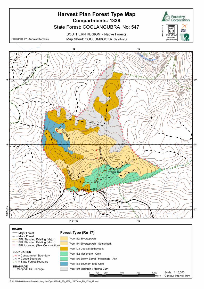
Harvest Plan Forest Type Map
State Forest: COOLANGUBRA No: 547
Andrew KemsleyPrepared By:
Scale: 1:15,000Contour Interval 10m
SOUTHERN REGION - Native Forests
Mapped LIC DrainageDRAINAGE
ROADSMajor ForestMinor Forest
EPL Standard Existing (Minor)EPL Licenced (New Construction)
EPL Standard Existing (Major)
BOUNDARIESCompartment BoundaryCoupe Boundary
Forest Type (Rn 17)Type 112 Silvertop Ash
Type 114 Silvertop Ash - Stringybark
Type 123 Coastal Stringybark
Type 152 Messmate - Gum
Type 156 Brown Barrel / Messmate - Ash
Type 158 Southern Blue Gum
Type 159 Mountain / Manna Gum0 250 500 750 1,000125
Meters
On FCNSWunsealed
gravel roads
23>
State Forest Boundary

11
22331338/2 Rd
15
715000E
16
16
07
08 08
09 09
Map Sheet: COOLUMBOOKA 8724-2S
Compartments: 1338
G:\PLANNING\HarvestPlans\Coolangubra\Cpt-1338\HP_ED_1338_12\FTMap_ED_1338_12.mxd
Harvest Plan Habitat Class Map (Indicative)
State Forest: COOLANGUBRA No: 547
Andrew KemsleyPrepared By:
Scale: 1:15,000Contour Interval 10m
SOUTHERN REGION - Native Forests
HABITAT CLASS
LowModerateHigh Unknown
Mapped LIC DrainageDRAINAGE
ROADSMajor ForestMinor Forest
EPL Standard Existing (Minor)EPL Licenced (New Construction)
EPL Standard Existing (Major)
BOUNDARIESCompartment BoundaryCoupe Boundary
0 250 500 750 1,000125Meters
On FCNSWunsealed
gravel roads
23>
State Forest Boundary

Southern Region – Compartment 1338, Coolangubra State Forest, Eden Management Area
HP_ED_1338_12 28-03-13 1
HARDWOOD FORESTS- SOUTHERN REGIONHARVESTING PLAN
Coolangubra State Forest - Compartment 1338
CertificationThis plan has been prepared in accordance with the Integrated Forestry Operations Approval issuedunder the Forestry and National Park Estate Act 1998. The Standard Harvest Plan Conditions for NativeForest Operations in Southern Region, Eden apply to this operation.Prepared By:HarvestPlanner
AndrewKemsley
Endorsed By:Harvest PlanningTeam Leader
KateHalton
Approved By:RegionalManager
DanielTuan
Signature AndrewKemsley
Signature KateHalton
Signature DanielTuan
Date 28.03.2013 Date 28.03.2013 Date 28.03.2013
Note: Approval includes the Harvest Plan Operational Map (HPOM) and Burning OperationsMap (BOM) with the corresponding approval date displayed on the map, verifying finalapproved version.Other maps included with this plan are locality, forest type, cultural heritage (limiteddistribution), and habitat quality class (SFO and Indicative).
Description of Proposal
Harvesting of native forest(a) Integrated Harvesting of Native Forest:Mixed-age stands dominated by a commercially mature overstorey will be harvested to createregeneration opportunities through integrated harvesting of sawlogs and pulpwood with theretention of trees for future sawlogs, fauna habitat, seed trees, visual maintenance and soiland water protection.
This operation will be licensed under the EPL with notification sent to the regulatory authoritiesas per clause 23 of Integrated Forestry Operations Approval (IFOA).
Attachment 1: Site Safety Plan prescribes safety requirements and Medical EmergencyEvacuation Plan for this harvesting operation.
Attachment 2: Roading plan prescribes roading requirements for this harvesting operation.Attachment 3: Burning Plan prescribes burning requirements for this harvesting operation.Post-harvest burning should be confined as far as practicable to the Net Harvest Area. Sitespecific burning exclusions associated with other tenures, regrowth patches, and exclusions(flora, fauna, cultural heritage and other exclusion zones) are explained within the relevantsections of this harvest plan, in the critical boundaries section of the burning plan andindicated on the HPOM and BOM.The BOM and critical boundaries section of the burning plan also considers exclusion zones incompartments surrounding the planned compartment. If the post-log burn escapes thecontainment lines, the burn supervisor should use this information to assess if it is necessaryto extinguish the fire or if it is acceptable to allow fire to burn out to a secondary control line.During the planning stage the location and type of control lines required to contain fire withinthe nha are considered and listed in the control lines section of the burn plan. Snig track

Southern Region – Compartment 1338, Coolangubra State Forest, Eden Management Area
HP_ED_1338_12 28-03-13 2
patterns should be designed to double as bare earth control lines for each of the proposedcontrol lines specified in the burn plan and for any other critical boundaries identified duringthe operation (e.g. nest exclusions, regrowth patches). Where this is not practical, the ContractCoordinator is to assess the need for a bare earth break to be constructed close to harvestingexclusion boundaries and seek advice and approval from the Operations Team Leader for theadditional earth works.The Contract Coordinator/SFO must record the following information in the burn plan and priorto burning use this information and any other relevant information from the CC/SFO notes tobrief the Burning Supervisor:• Any new critical boundaries identified during the operation,• If works required for existing and proposed control lines were carried out,• If proposed control lines were deemed to be unsuitable (e.g. a proposed new road did notget constructed or where a mapped drainage line didn’t occur to the full length as mapped),• If proposed control lines are no longer required (e.g. a section of the net harvest area didnot get harvested) and will therefore not undergo post-log burning.
Area Identification and Yield Estimates
State Forest Compartment/s Coupe/s Region ManagementArea
Certification
Coolangubra 1338 1,2 Southern Eden AS4708:2007ISO 14001
Cpt 1338Plan Compartment ID 20113Gross Area (ha) 180.62Net Harvest Area (ha) 50.13Estimated Yield Pulp (t) 2200 tEstimated Yield Sawlog (m3) 430 m3
Slope Classes (percent of harvest area)
Slope Class
Cpt 1338
% of harvest area0-20º 83.6
20-25 º 14.425-30 º 2.0

Southern Region – Compartment 1338, Coolangubra State Forest, Eden Management Area
HP_ED_1338_12 28-03-13 3
Forestry Corporation NSW – Southern RegionHarvesting Plan HP_ED_1338_12
Compartment 1338
Attachment 1 – Site Safety Plan
SAFETY CONSIDERATIONS
Emergency Plan Information
(a) Mobile Phone reception on work site:Good √ Poor Nil
Nearest reliable reception: Higher points on 1338/1 Rd.
(b) FCNSW Radio from work site: Contractor Radio at work site:Channel No: 247 UHF Channel No:Call to: Eden Base Contractor Radio No:Call sign from: Your name Call to Bush Boss:
(c) Emergency meeting point for ambulance:Junction of Devils Hole Road & Coolangubra Forest Way.1:100000 map sheet: Bombala 8724MGA zone: 55MGA Grid reference: E711864 N5906322.Lat/Long for GPS: 36° 57' 55" S 149° 22' 47" E.
(d) Closest Helicopter Landing Place:Junction of Devils Hole Road & Coolangubra Forest Way.1:100000 map sheet: Bombala 8724MGA zone: 55MGA Grid reference: E711864 N5906322.Lat/Long for GPS: 36° 57' 55" S 149° 22' 47" E.
(e) Procedure for obtaining Ambulance assistance:Dial "000" OR Call 1300 880 548 Batemans Bay Forestry Office for Ambulanceassistance.Dial “112” only as an alternative to “000” if you have a GSM digital mobile phone and youare outside your own provider’s GSM network coverage area.

Southern Region – Compartment 1338, Coolangubra State Forest, Eden Management Area
HP_ED_1338_12 28-03-13 4
"000" Operator Question. Response1. Police , Fire , Ambulance? Ambulance
2. Suburb (State Forest name): Coolangubra (Nearest town or named locality): Cathcart (Nearest Ambulance station): Bombala
3. Address: (Nearest named State forest road): Devils Hole Road.
4. Nearest Road Junction: Devils Hole Road and Coolangubra Forest Way.
5 Local Government Area: Bega Valley Shire Council
6. Nature of the problem: Give details of accident, number and condition ofcasualties.
7. Where is the accident: Work site location – (Centre of Compartments).
MGA Grid reference: Zone 55 E715340 N5908060.
Lat/long for GPS: 36° 56' 56" S 149° 25' 6 " E.
8. Directions to navigate from Ambulance Station to meeting point:
Directions from Bombala:• Head East on Bucky Springs Road for approx. 5.1km to Burrimbucco Road.• Continue onto Burrimbucco Road for approx. 10.4km to Coolangubra Forest Wayjunction.• Turn left onto Coolangubra Forest Way for approx. 1.9km to Devils Hole Roadintersection.
9. Injuries?: Give detailed information about the condition of thecasualty.
10. Call back No.: Give your Mobile Number.or Batemans Bay Office:1300 880 548.
11. Name of Reporter: Give own name.
Site Specific Identified Hazards
Assessment of existing hazards was undertaken at the time of planning. These hazards are inthe attached table and where appropriate, control strategies have been applied. Where nocontrol strategy has been described, the contractor must develop appropriate strategies aspart of the contractors Safety Management Plan. A copy of the hazard assessment and controlstrategies is provided to assist in the development of the contractors Safety Management Planfor this harvesting area.
All additional site hazards identified during harvesting must be assessed and documented inthe SFO and Contractor copies of the site specific plan.

Southern Region – Compartment 1338, Coolangubra State Forest, Eden Management Area
HP_ED_1338_12 28-03-13 5
Identified hazards requiring risk assessment and control strategy in Safety Management PlanIDENTIFIED HAZARD RISK
RATINGSUGGESTED CONTROL STRATEGY
1. Adjoining roads of varioustraffic levels
1 Warning signs at FCNSW intersections, roadclosure on FCNSW roads.Implement Traffic Control plans (where specifiedin this harvest plan).60km/hr speed limit on all State Forest gravelroads unless otherwise signposted.Compliance with FCNSW lights on policy.
2. Cliff lines & rocky very steepterrain
3 Operators to assess work site within two treelengths to identify immediate hazards.Communicate to other operators and mark sites.
3. Hazardous or dead trees 1 Refer to FCNSW safety standard 1.3.9.Assess area within two tree lengths of work site.Assess risk, mark any Distinctly DangerousTrees with the symbol Ø & if necessary removehazard or move work site. Use machinery toassist with hazard removal if possibleContractor is responsible for implementingcontrol strategies during harvesting.
4. Overhead hazardsassociated with dumps
1 Refer to FCNSW safety standard 1.3.9.Assessoverhead hazard within two tree lengths of thedump. Assess risk, & if necessary removehazard or relocate dump site. Contractor isresponsible for implementing controlstrategies during harvesting.
5. Dust from passing vehiclesalong dirt haulage routes
2 Restrict speed to minimise dust generation, slowdown when passing vehicles. Turn on drivingand hazard lights to increase visibility.
6.
7.
Hazard Nos. 1/2/4/5 are shown on the attached HPOM
Traffic management/road closuresThe logging contractor is responsible for traffic control on all roads when felling is within twotree lengths of the tallest tree to be felled of the road, or snigging on roads or loading isoccurring within 10 metres of a road. Warning of trucks entering must be displayed 200metres either side of all State Forest road approaches leading to areas where harvestingoperations are in progress.
Southern Region – Compartment 1338, Coolangubra State Forest, Eden Management Area
HP_ED_1338_12 28-03-13 6
Warning of timber harvesting operations must be displayed 200 metres either side of allthoroughfare State Forest road approaches leading to areas where harvesting operations arein progress.
This harvest plan identifies haulage from the compartment will be north via CoolangubraForest Way turning right onto Mount Darragh Road (100km/hr speed limit) or south viaCoolangubra Forest Way turning left onto Imlay Road (100km/hr speed limit). Bothintersections have been assessed as achieving a minimum of 200m sight distance. Thereforeadditional signage in accordance with a Traffic Control Plan is not required at eitherintersection.
Dust, noise and school bus routesDust and noise – Where log haulage routes pass close to rural housing along naturalsurface/gravel roads dust and noise must be minimised to the greatest extent practicable.Trucks should reduce speed, restrict use to daylight hours and minimise the use of enginebrakes through these areas.
School bus route - Mt Darragh road is used by school buses between the hours of 7:30am to8:30 am and 3:30pm to 4:30pm, or as signposted. On weekdays, to the greatest extentpracticable, log haulage should avoid school bus times on the above roads.

Southern Region – Compartment 1338, Coolangubra State Forest, Eden Management Area
HP_ED_1338_12 28-03-13 7
Silviculture and Harvesting Prescriptions
Year 1954 1980 1991 2002
TSI X X X XHR Burning X X X X
Wildfires Ö Ö X X
Logging m3 0 0 7800 10000
Ö - applies, X – not applicable
Compartment 1338 has been subject to a number of disturbance events with wildfire occurringin 1954 and 1980; Intergrated operations later took place in 1991 and 2002 which covered themajority of the compartment. A thinning operation took place in 2003 to reduce competition onthe regenerated trees from the 1991 Intergrated harvest. This harvest operation seeks toremove the remaining areas which were omitted from past Intergrated harvest events.
Silvertop Ash, Messmate and Monkey Gum are the predominant species present with wattlesand blanket bush becoming increasingly dense in the moist gullies.
Silvicultural PlanningMixed-age stands described above will be harvested in a modified shelter-wood silviculturalsystem in accordance with the Eden IFOA. It is proposed that the mixed-aged stands will nextbe available for commercial thinning operations in approximately 15-20 years time.
Harvesting Prescription
Stand type % ofnetarea
Area (referto HPOM
for details)
Treatment (% INT, THIN)
Mature (mixed aged) 100% Entire NHA • 100% Integrated (modified shelter-wood)• Target sawlogs, pulpwood and other miscellaneous
products as markets allow in line with TSL and EPLrequirements.
• Retain potential sawlog growers.• Refer to Standard Harvest Planning Conditions for
more detail.Note: The area of each silvicultural treatment must be mapped and recorded in the Postlogging information section of this plan.
IFOA LimitsThe integrated harvesting operation is in accordance with IFOA Part 1 Condition 5 (11).
No more than 60% of the net harvestable area within these compartments will be harvestedduring this operation. The next integrated harvesting operation is not permitted within 5 yearsfrom the completion of this harvesting event.
The SFO will ensure that TSL tree retention prescriptions are met concurrent with harvestingoperations.

Southern Region – Compartment 1338, Coolangubra State Forest, Eden Management Area
HP_ED_1338_12 28-03-13 8
Special Requirements
Non-harvest areasThe HPOM indicates the non-harvest areas in the compartments, as detailed in the legend.Harvesting disturbance is not permitted in non-harvest areas unless authorised by theRegional Manager.
Noxious Weeds/Disease/Pests Hygiene RequirementsCompartment 1338 is within Bega Valley Shire Council which is a designated red zone forMyrtle Rust. In order to prevent the spread of Myrtle Rust all harvesting machinery, equipmentand vehicles heading west from Bega Valley Shire Council must be inspected for vegetationcontaining Myrtle Rust and if present be washed down prior to leaving this local governmentarea.
Permanent Growth and Research PlotsAny inventory plots located during the harvesting operation are to be treated the same as thesurrounding area.
Rocky TerrainRocky terrain occurs within the net planned area. During on ground mark up, SFO mustassess all rocky terrain and determine if it meets the definition of a rocky outcrop or cliff andmark buffers accordingly .
National Parks and Nature ReservesNational Park and Nature Reserve form the northern and southeast boundary of thecompartment.
• No harvest disturbance is permitted within National Park or Nature Reserves.
Forest Management Zoning
FMZ 4- General Management (normal harvesting prescriptions apply) occur within thecompartment. Refer to HPOM for more detail.
IFOA Required Approval of Forestry Activities
Stream Exclusion Zones require prior Regional Manager approval before forest harvestingrelated activities (eg: road or snig track construction & reopening) can be undertaken. It is theresponsibility of the SFO to identify any exclusion areas which will need to be crossed duringharvesting. The SFO should then contact the Harvest Planner to obtain the necessaryapproval.

Southern Region – Compartment 1338, Coolangubra State Forest, Eden Management Area
HP_ED_1338_12 19-04-13 9
Cultural Heritage
Cultural Heritage - Due to the confidentiality of the Cultural Heritage sites, a Cultural Heritage site map will only be attached to the specific copies of the plan. During the inspection all sites were marked. Exclusion buffers are hard exclusion zones (i.e. pink & yellow tape) where logging and/or road works are scheduled to be undertaken. All operators must be taken to each site within the planned area before any activities are commenced.
Flora and Fauna
Refer to TSL Booklet for Conditions Mark-Up Conditions During the pre-harvest mark up the SFO must search for and record threatened species habitat features consistent with Conditions 5.2 and 8.6 of the TSL. Searches for threatened species features must be conducted within that portion of the net planned area where harvesting will occur, and within 50 metres outside this area (eg HCVOG, etc) (conditions 5.1, 5.2 of the TSL). Where any of these features are found, the feature must be recorded, the Harvesting Plan, including the HPOM, must be amended accordingly and the appropriate condition applied. Species adequately covered by general prescriptions: The following species have been recorded in or around the compartments and are adequately covered by the general prescriptions. No further protection measures are required for these species: Pink Robin (Petroica rodinogaster) and White-footed Dunnart (Sminthopsis leucopus). Tree Retention-Non-Regrowth Zone
The non-regrowth zone applies to the entire net harvest area. The SFO is to mark as per Condition 5.6 of the TSL, in conjunction with indicative Habitat Quality Class Map and on ground assessment. Where the density of habitat trees specified in the table are not available, retain the existing habitat trees plus additional trees of the largest dbhob to meet the required retention rate.
Habitat Quality
Habitat Trees/ 2ha
TSL Condition
Recruitm
ent Trees/ 2ha
TSL Condition
Protection of R
etained Trees
TSL Condition
Stag Retention
(only if safe)
TSL Condition
Significant Food R
esource
TSL Condition
High 12 5.6g)i 12 5.6h)i √ 5.6l √ 5.6j √ 5.6 k
Medium 8 5.6g)ii 8 5.6 h)ii √ 5.6 l √ 5.6j √ 5.6 k
Low 4 5.6g)iii 4 5.6 h)iii √ 5.6 l √ 5.6j √ 5.6 k

Southern Region – Compartment 1338, Coolangubra State Forest, Eden Management Area
HP_ED_1338_12 28-03-13 10
Ö - Condition applies
General exclusion zonesGeneral exclusions as listed below are shown on the HPOM.
Feature/Condition TSLcond’n
Occurs within Planning Unit
Rainforest 5.4 Has been assessed & is unlikely to occurin the field. May require further
investigation#.Riparian Protection Zones 5.7 YesRidge & Headwater Habitat 5.8 Yes (40m)Wetlands 5.9 Has been assessed & is unlikely to occur
in the field. May require furtherinvestigation#.
Heath and Scrub 5.10 Has been assessed & is unlikely to occurin the field. May require further
investigation#.Rocky Outcrops and Cliffs 5.11 Has been assessed as a risk that it may
occur in the field. May require furtherinvestigation#.
Endangered Ecological Community NA Has been assessed & is unlikely to occurin the field. May require further
investigation#.Harvesting, harvesting machinery and
post harvest burning must beexcluded from all areas of EEC.
#SFO/Contract coordinators will continue to conduct on the ground mark-up &searches and report back to foresters/ecologists any features requiring furtherinvestigation.
General Threatened Flora and Fauna PrescriptionsFeature Records in 1338 Licence conditions
under the TSC ActThreatened Frog General
Protection MeasuresNo 5.12
Bird Nest and Roost SiteProtection
No 5.13
Tree Bat Roost Protection No 5.14.1Subterranean Roost
ProtectionNo 5.14.2
Protection of flying-foxCamps
No 5.14.3
Burning Net planned area 5.16Ground Habitat Protection Net planned area 5.17
Species & Site-Specific Threatened Flora and Fauna Prescriptions

Southern Region – Compartment 1338, Coolangubra State Forest, Eden Management Area
HP_ED_1338_12 28-03-13 11
Contractors and supervisory staff must immediately report any sightings of Schedule 1 and 2species to the Harvesting Team Leader. The Harvesting Plan must be amended to includeadditional prescriptions if necessary. If any species requiring a site specific prescription inaccordance with condition 1.2 of the TSL are detected in or within 100m of the compartmentboundary cease operations immediately & Inform Harvesting Team Leader.
The following species have been recorded within or nearby the area and the associatedprescriptions must be implemented:
Threatened species and habitat featureswithin trigger distance
Recordsin 1338
Licence conditions under theTSC Act or relevant Site-
specific prescriptionScarlet Robin (Petroica boodang) Yes Apply 5.13 a)-50m radius
exclusion around nests. Note nonests have been identified at the
planning stage.Varied Sittella (Daphoenositta chrysoptera) Yes Apply 5.13 a)-20m radius
exclusion around nests. Note nonests have been identified at the
planning stage.Gang-gang Cockatoo (Callocephalonfimbriatum)
Yes Apply 5.13 a)-20m radiusexclusion around nests. Note nonests have been identified at the
planning stage.Masked Owl (Tyto novaehollandie) No 6.3Flame Robin (Petroica phoenicea) No I Apply 5.13 a)-50m radius
exclusion around nests. Note nonests have been identified at the
planning stage.Yellow-bellied Glider Petaurus australis No 6.13
Fisheries Licence Conditions
There are no known records of threatened fish species or class 1 or 2 aquatic habitat relevant to thisoperation. The conditions of the fisheries licence are not triggered for this operation.
Soils and Water Protection
Refer to EPL Booklet & Standard Plan ConditionsSite-specific EPL Conditions
Elements Conditions
Unmapped Drainage Lines EPL applies
Drainage Feature Protection See HPOM for widths
Inherent Hazard Class 2
Dispersible Soils No
Seasonality Harvesting Exclusions No

Southern Region – Compartment 1338, Coolangubra State Forest, Eden Management Area
HP_ED_1338_12 28-03-13 12
Seasonality Burning Exclusions No
Log Dumps Refer relevant conditions for IHL
Snig Tracks Refer relevant conditions for IHL
Roads See Schedule 5 of EPL Booklet
Slope limits for harvesting Refer to Schedule 4B.3 of EPL
Log Dump Location9 log dumps are indicated on the HPOM. Field location of log dumps must utilise the mostlevel site available consistent with the location indicated on the HPOM. Inherent hazard level2 Conditions 26, 27, 28, 30, 31 and 33 of Schedule 4 of the EPL must apply.
Expected Felling/ Extraction & Loading MethodThe expected felling method is mechanical, extraction method by skidder, and loading methodis by excavator.
Drainage Feature CrossingsNo snig track drainage line crossings are approved for use on drainage features.
Mass MovementCompartment 1338 is not in an area identified as having a potential for mass movement. Nospecific prescriptions relating to mass movement/snigging are required.
Suitability of existing log dams and gully stuffersThere are no known log dams or gully stuffers on snig track crossings in the compartments.Condition 47 of Schedule 4 of the EPL must apply.
Road WorksThe HPOM indicates the location of existing roads and crossings.
Feature Length &/or Number Work RequiredExisting Roads 2940m / 4 YesNew Roads 280m / 2 YesExisting Crossings 4 YesNew Crossing Nil N/ABorrow & Gravel Pits Nil N/ARoading and Crossing details are contained within the Roading Plan (Attachment 2 ofthis Plan).The roading and crossing works must be under taken prior to the commencement ofharvesting activity in the area served by the road or crossing. The roading plan specifieswhether the contractor or FCNSW is responsible for carrying out the works.
Within the compartment boundary only roads that are shown on the HPOM as EPL standardor sealed may be used for haulage. Refer to EPL Schedule 5 – Operating Conditions forRoads.Roads within the compartment boundary may be used with SFO approval for snigging orextraction provided they are drained to EPL specifications.

Southern Region – Compartment 1338, Coolangubra State Forest, Eden Management Area
HP_ED_1338_12 28-03-13 13
Legal Conditions
In 1999, the Commonwealth and NSW Governments signed a Eden Regional ForestAgreement which, among other things, allows for the supply of timber for 20 years from publiclands under the following NSW legislation:
• Forestry Act 2012, and• Forestry & National Park Estate Act 1998
The latter Act provides for the Eden Forest Agreement and Eden Integrated Forest OperationsApproval (IFOA), both approved by NSW Government Ministers. This harvest plan is issuedunder the authority provided within the IFOA.
The IFOA also contains three licences issued under:
• Section 55 of the Protection of the Environment Act 1997 (EPL)• Threatened Species Conservation Act 1995 (TSL).• Section 220ZW of the Fisheries Management Act 1994 (FL).
This harvest plan will be managed in the field under:
• Licences issued under the Forestry Act (2012)• Forest Practices Code part 2 (Timber Harvesting in Native Forests - 1999) and part
4 (Forest Roads and Fire Trails - 1999)• Standard Harvest Plan Conditions for Native Forest Operations under the IFOA
• FCNSW Corporate Fuel Management Plan 2008.
Harvesting operations must comply with all of the above Licences and the Code.Further information is available from http://www.environment.nsw.gov.au/

Southern Region – Compartment 1338, Coolangubra State Forest, Eden Management Area
HP_ED_1338_12 28-03-13 14
Pre Operational Briefing
I acknowledge that I have received a copy of the Harvesting Plan for Compartment 1338 inCoolangubra State Forest and that I have been briefed on the conditions of the Plan andunderstand the supervision and operational control requirements as explained to me by theHarvesting Team Leader or his/her delegate.
Position Name Signature Date
Details to Record in SFO Notes
• Dates of commencement and cessation of logging• Record the commencement and completion of harvesting at each dump• Record the occurrence of temporary stopping of harvesting at each dump.• Situations where drainage could not be completed due to saturated soils must be recorded
in SFO Notes.• Record the commencement and completion of each construction, upgrading or
maintenance of drainage feature crossings by snig tracks or extraction tracks.• Bi-weekly checks of road drainage structures during haulage operations.• Record the date of checks, drainage structure compliance and the any repairs required
within the specified time period.• Records of Threatened Flora and Fauna identified during compartment markup.• Minor variations associated with moving or adding dumps.• Daily events of importance eg. Instructions to crew, work activity.
Post Harvest Mapping Features Confirmation Checklist
Feature PlanningUpdates
Reason(Error/New)
GIS updatetoolcompleted?
HarvestingUpdates
Comments
Soil Regolith NoMapped Drainage NoRainforest NoRocky outcrops NoWetlands NoCultural Heritage NoExisting Roads NoNew Roads YesHeath NoPowerlines etc NoOther

Southern Region – Compartment 1338, Coolangubra State Forest, Eden Management Area
HP_ED_1338_12 28-03-13 15
SFO Feature Usage Record
Dates of commencement and cessation of loggingDate of commencement of logging: _____________
Date of cessation of logging: __________________
DUMP USAGE RECORD• Record the commencement and completion of harvesting at each dump
• Record the occurrence of temporary stopping of harvesting at each dump.
Dumpnumber
Startdate
Finishdate
*Trackdrainagecompleted
within 2 days(yes/no)
Date oftemporarycessation
**Temporary trackdrainage completed
within 5 days(yes/no)
Dateresumed
*At completion of snig track/dump, track drainage must be completed within 2 days unless soilis saturated.
*At temporary cessation of snig track use, track drainage must be completed within 5 daysunless soil is saturated.
Situations where drainage could not be completed due to saturated soils must be recorded inSFO Notes.

Southern Region – Compartment 1338, Coolangubra State Forest, Eden Management Area
HP_ED_1338_12 28-03-13 16
Snig/Extraction Track Crossing Record
Record the commencement and completion of each construction, upgrading or maintenance ofwatercourse/drainage line crossings by snig tracks or extraction tracks.
Type and number ofstructure
Start date Finishdate
Temporarycrossing(yes/no)
* Soilstabilisationcompleted
within 5 days(yes/no)
** Clearingbeyond 3mupstream ordownstream
(yes/no)
* If soil is not stabilised within 5 days it must be recorded as a non-compliance including thereason why on a Harvest Compliance Issue Report.If soil is saturated, temporary stabilisation must be put in place, and the instance entered intothe compartment diary.
** If track edge clearing exceeds 3 metres, document the reason for field approval inthe compartment diary.

Southern Region – Compartment 1338, Coolangubra State Forest, Eden Management Area
HP_ED_1338_12 28-03-13 17
Weekly and Bi-weekly inspection
Item Insert dates of inspectionInspected Week 1 Week 2 Week 3 Week 4 Week 5 Week 6
1st 2nd 1st 2nd 1st 2nd 1st 2nd 1st 2nd 1st 2ndRoad drainageRoad sedimentcontrolsRoad causewaysRoad gully stuffersSnig gully stuffersSFO initialSFO presenceComments: record the item number in a box above and comment as required.
1.______________________________________________________________________________________________________
2.______________________________________________________________________________________________________
3.______________________________________________________________________________________________________
4.______________________________________________________________________________________________________
5.______________________________________________________________________________________________________
6.______________________________________________________________________________________________________
7.______________________________________________________________________________________________________
8.______________________________________________________________________________________________________
9.______________________________________________________________________________________________________

Southern Region – Compartment 1338, Coolangubra State Forest, Eden Management Area
HP_ED_1338_12 28-03-13 18
Weekly and Bi-weekly inspection
Item Insert dates of inspectionInspected Week 7 Week 8 Week 9 Week 10 Week 11 Week 12
1st 2nd 1st 2nd 1st 2nd 1st 2nd 1st 2nd 1st 2ndRoad drainageRoad sedimentcontrolsRoad causewaysRoad gully stuffersSnig gully stuffersSFO initialSFO presenceComments: record the item number in a box above and comment as required.
1.______________________________________________________________________________________________________
2.______________________________________________________________________________________________________
3.______________________________________________________________________________________________________
4.______________________________________________________________________________________________________
5.______________________________________________________________________________________________________
6.______________________________________________________________________________________________________
7.______________________________________________________________________________________________________
8.______________________________________________________________________________________________________
9.______________________________________________________________________________________________________
Southern Region – Compartment 1338, Coolangubra State Forest, Eden Management Area
HP_ED_1338_12 28-03-13 19
Weekly and Bi-weekly inspection
Item Insert dates of inspectionInspected Week 13 Week 14 Week 15 Week 16 Week 17 Week 18
1st 2nd 1st 2nd 1st 2nd 1st 2nd 1st 2nd 1st 2ndRoad drainageRoad sedimentcontrolsRoad causewaysRoad gully stuffersSnig gully stuffersSFO initialSFO presenceComments: record the item number in a box above and comment as required.
1.______________________________________________________________________________________________________
2.______________________________________________________________________________________________________
3.______________________________________________________________________________________________________
4.______________________________________________________________________________________________________
5.______________________________________________________________________________________________________
6.______________________________________________________________________________________________________
7.______________________________________________________________________________________________________
8.______________________________________________________________________________________________________
9.______________________________________________________________________________________________________

Southern Region – Compartment 1338, Coolangubra State Forest, Eden Management Area
HP_ED_1338_12 28-03-13 20
Weekly and Bi-weekly inspection
Item Insert dates of inspectionInspected Week 19 Week 20 Week 21 Week 22 Week 23 Week 24
1st 2nd 1st 2nd 1st 2nd 1st 2nd 1st 2nd 1st 2ndRoad drainageRoad sedimentcontrolsRoad causewaysRoad gully stuffersSnig gully stuffersSFO initialSFO presenceComments: record the item number in a box above and comment as required.
1.______________________________________________________________________________________________________
2.______________________________________________________________________________________________________
3.______________________________________________________________________________________________________
4.______________________________________________________________________________________________________
5.______________________________________________________________________________________________________
6.______________________________________________________________________________________________________
7.______________________________________________________________________________________________________
8.______________________________________________________________________________________________________
9.______________________________________________________________________________________________________

Southern Region – Compartment 1338, Coolangubra State Forest, Eden Management Area
HP_ED_1338_12 28-03-13 21
SFO Notes
Date Event Signed

Southern Region – Compartment 1338, Coolangubra State Forest, Eden Management Area
HP_ED_1338_12 28-03-13 22
SFO Notes (continued)
Date Event Signed

Southern Region – Compartment 1338, Coolangubra State Forest, Eden Management Area
HP_ED_1338_12 28-03-13 23
SFO Notes (continued)
Date Event Signed

Southern Region – Compartment 1338, Coolangubra State Forest, Eden Management Area
HP_ED_1338_12 28-03-13 24
SFO Notes (continued)
Date Event Signed
Southern Region – Compartment 1338, Coolangubra State Forest, Eden Management Area
HP_ED_1338_12 28-03-13 25
SFO Notes (continued)
Date Event Signed

Southern Region – Compartment 1338, Coolangubra State Forest, Eden Management Area
HP_ED_1338_12 28-03-13 26
Clearance Certificate
COMPARTMENT: 1338
COOLANGUBRA STATE FOREST, SOUTHERN REGION
To ..............................................................................................Supervising Forest Officer
I request approval for me to move my logging crew and all associated machinery from theabove-mentioned area to the next compartment in accordance with Section 3.5 of the ForestPractices Code.
I certify that:(a) all permanent roads, trails and mitre drains have been cleared of harvesting debris;(b) butt damage to retained trees has been kept to acceptable limits;(c) all trees marked for removal have been felled;(d) utilisation limits have been satisfactorily met;(e) stump heights conform to requirements;(f) all hanging trees have been felled and brought down;(g) all log dumpsites have been satisfactorily restored as required;(h) harvesting debris is not accumulated around retained trees;(i) all accumulated litter has been disposed of properly;(j) all filter and buffer strip requirements have been complied with;(k) all snig track, extraction track and temporary logging road drainage has been
installed satisfactorily and other required rehabilitation work has been completed;(l) all necessary repairs to damaged roads, signs, fences and other structures have
been carried out.(m) _______ (insert quantity) rubber flaps have been recovered in a satisfactory
condition and reported to Operations Branch for collection.(n) all machinery, equipment and vehicles have been checked and are free of noxious
weeds, diseases and pests.
I believe that I have met all my obligations under the conditions of the Timber Licence,the EPL and TSL which apply to the compartment just completed, as stated in thisHarvesting Plan.
Signature...................................................Name......………..................Date ..................Contractor
As a result of inspections of the logging operations made in accordance with this HarvestingPlan, I am satisfied that, to the best of my knowledge, the contractor responsible for thisharvesting operation has satisfactorily completed all work and approval is given for her/himto remove her/his machinery and equipment and leave the area/commence operations inanother compartment.
This clearance does not release the contractor from any obligation to undertake anyremedial work if subsequent deficiencies are shown to result from inadequate practicesduring the harvesting operation, which are found during any inspections of the area madewithin 12 months of the date of this post-harvesting inspection.
Last inspection was made on ...........................................................(Date)
Signed .........................................................................(Date)....................Supervising Forest Officer
Southern Region – Compartment 1338, Coolangubra State Forest, Eden Management Area
HP_ED_1338_12 28-03-13 27
Post Logging Information
Record any circumstances of significance relating to the harvesting of this compartment.Please draw or include any annotations on the attached operation scale map.
Summary of silvicultural treatmentTreatment type Area (ha) subject
to treatment(SFO estimate)
Number of AGSgaps created
Comments
Integrated/ModifiedshelterwoodThinningPost Harvest Silviculture
Actual area harvested (record on attached HPOM)
Give reasons for harvestable areas that were not harvested (eg. Too steep, defective timber).Make reference to map.
Post Logging Basal Area sweeps
Dump No# Sweep 1 Sweep 2 Sweep 3 Sweep 4 Average
Post BA Average m2/haPre BA Average m2/ha
Comply with maximum Thinning BA removal of 75%? Y/N
Possible next cut (tick appropriate boxes)
Main product type Anticipated volume Time to next harvestH M L 0 to 5 years
Girders 5 to 10 yearsVeneer 10 to 20 yearsPoles/piles 20 to 30 yearsQuota 30 plus yearsSmalls/ThinningsSalvagePulpwood/chipwood

Southern Region – Compartment 1338, Coolangubra State Forest, Eden Management Area
HP_ED_1338_12 19-04-13 28
ATTACHMENT 2 ROADING PLAN
Summary of Roading Requirements
Length of existing roads/trails to be maintained 2940mLength of new roads to be constructed 280mNumber of existing crossings to be maintained 4Number of new crossings to be constructed NilLength of road >10° 400mMass movement prescriptions apply NoDispersible soil conditions apply NoSeasonality provisions apply No
Note: Maintenance works not completed by Operations must be recorded and passedonto the SFO Harvesting for completion and documentation.
The start and finish dates of all maintenance and construction must be recorded on theindividual roading sheets along with other relevant changes or explanations.
All rubber flaps on minor forest roads must be removed and replaced with trafficablerollover banks on completion of operation.
CHECKLIST OF WORKS REQUIRED ON ROADS & CROSSINGS
Road/CrossingName
Works Required DateStarted
Datefinished
Signature
Kanoonah AccessRd
(Length = 300m)
(FCNSWResponsibility)
Nil works required.
Ops/SFO Comments:
1338/1 Rd
(Length = 1650m)
(ContractorsResponsibility)
Grade pavement where required.
Roadside clearing 3m either side.
Replace rollovers with rubberflaps, installingadditional rubberflaps where required.
Ops/SFO Comments:
1338/2 Rd
(Length = 700m)
(ContractorsResponsibility)
Grade pavement where required.
Roadside clearing 3m either side.
Replace rollovers with rubberflaps, installingadditional rubberflaps where required.
Ops/SFO Comments:

Southern Region – Compartment 1338, Coolangubra State Forest, Eden Management Area
HP_ED_1338_12 28-03-13 29
1338/3 Rd
(Length = 290m)
(ContractorsResponsibility)
Grade pavement where required.
Replace rollovers with rubberflaps, installingadditional rubberflaps where required.
Outside rocky outcrop buffer: Roadside clearing 3meither side.
The section of 1338/3 Rd within rocky outcropbuffer must have the following prescriptionsapplied to roadside clearing:• Roadside clearing must be kept to theminimum required to facilitate truckmovements.• No trees >20cm DBH may be cleared.• Roadside clearing must be done by hand.
Ops/SFO Comments:
C1
(FCNSW
Responsibility)
E 714867
N 5907317
No works required. Crossing form attacheddescribes the state of the crossing which wascompliant at time of assessment.
Ops/SFO Comments:
C2
(FCNSW
Responsibility)
E 715221
N 5907255
No works required. Crossing form attacheddescribes the state of the crossing which wascompliant at time of assessment.
Ops/SFO Comments:
C3
(Contractors
Responsibility)
E 714652
N 5908147
See attached crossing form for works required.
Ops/SFO Comments:

Southern Region – Compartment 1338, Coolangubra State Forest, Eden Management Area
HP_ED_1338_12 28-03-13 30
C4
(Contractors
Responsibility)
E 714815
N 5908300
No works required. Crossing form attacheddescribes the state of the crossing which wascompliant at time of assessment.
Ops/SFO Comments:

Southern Region – Compartment 1338, Coolangubra State Forest, Eden Management Area
HP_ED_1338_12 28-03-13 31
NEW ROAD CONSTRUCTION
Road Specific Conditions:
1338/4 Rd 170m 6m 4º 6º <1m 70m No Temp. Contractor1338/5 Rd 110m 6m 6º 8º Nil N/A No Temp. Contractor
General Instructions for road construction:
Features Road Specifications Additional instructions /Materials
Type of sediment trapping /soil erosion/ sedimentcontrol device to be usedduring construction
Natural surrounding vegetationsupplemented with silt fencing,seed and mulch as required.
SFO to monitor duringroad construction andassess requirements.
Recommended roaddrainage type
Recommend rubber flaps if >5degrees. Rollovers or mitres if < or= 5 degrees. SFO to measure &mark in the field in accordance toSch. 5 Table 1 of the EPL.Trafficable rollovers to be installedupon harvest completion
Rubber flaps duringoperation. Permanenttrafficable rollovers to beinstalled upon completionof use.
Spacing of road structuresto be installed
As per EPL Sch. 5, Section C,Table 1
Soil erosion / sedimentcontrol techniques
Drainage outlets must drain ontostable surface which providesefficient sediment trapping &energy dissipation. Upon harvestcompletion, logging debris is to beremoved from table and mitredrains so they are left in effectiveworking order
Seed & mulch as required
Stabilisation assessmentintervals
As per EPL Sch. 5, Clause 5, 15,17, 19 & 20
Drop down & dissipaterrequired
Required where fill batter >1m asper EPL Schedule 5 Clause 36
SFO to monitor.Mitres with rock dissipaterrecommended.
Soil stabilisation techniquesof disturbed areas
Seed & mulch as required
Note: Maintenance works not completed by Operations must be recorded andpassed on to the SFO.


Southern Region – Compartment 1338, Coolangubra State Forest, Eden Management Area
HP_ED_1338_12 28-03-13 32
ATTACHMENT 3 POST-HARVEST BURNING PLAN
This burn plan will be managed in accordance with the principles detailed in the FCNSW Corporate FuelManagement Plan 2008. All practical measures will be taken to ensure fire is contained within predeterminedcontrol lines and to prevent entry into exclusion areas. However due to the unpredictable nature of fire from time totime fire may escape the containment lines and enter exclusion zones. In these instances the Burn Supervisorshould inform the Operations Team Leader to discuss suitable strategies to manage the escaped fire.
PLANNING INFORMATION
Planned Burn Area: NHA of compartment. The SFAZ area in coupe 1, excluded forest, may also be included inthe burn area, if the timing an frequency of the burn is consistent with the objectives of the SFAZ.
1338, Coolangubra State Forest LGA: Bega
Refer to Area Identification and Yield Estimates section of harvest plan.
Season: autumn / winter / springBush Fire Management Zone: Strategic Fire Advantage Zone (SFAZ) and Land Management Zone (LMZ)
(Refer to BOM for deails).
BURN OBJECTIVES
For LMZ and SFAZ:
• To reduce fine fuel loads to 4-8 tonnes/ha. (assisting future fire suppression)
• A burn coverage between 60-80% of harvested area.
• To contain fire within harvested area.
• To minimise mortality in trees retained under condition 5.6 of TSL (H & R trees and feed trees).
• To minimise defect damage to retained regrowth stems.
CRITICAL AND NON CRITICAL BOUNDARIES
A summary of critical boundaries where burning must be excluded are listed below (refer to harvest plan and
BOM for further details).
Critical boundaries within the planned compartment:
• Exclusions for ridge and headwater and probable rocky outcrop.
Critical boundaries outside the planned compartment:
• Probable EEC & National Park.
Non-Critical Boundaries
Non-critical boundaries are areas within the planned compartment which are outside the nha where fire should
not be deliberately introduced (through lighting patterns or direct ignition). However if fire does enter these areas,
attempts to extinguish the fire are not necessary and it is acceptable to allow fire to burn out to a secondary
containment line.
Snig track patterns should still aim to form a control line around these boundaries, however if this in impractical
(e.g due to steep/rocky terrain) it is not necessary for CC/SFO to seek approval for the construction a bare earth
break.
• Boundary between nha and excluded forest in coupe 1. This area underwent a thinning operation in
2002. The 11 year old regrowth in this area is sufficiently established and will not be adversely affected
by low intensity burning.

Southern Region – Compartment 1338, Coolangubra State Forest, Eden Management Area
HP_ED_1338_12 28-03-13 33
• Boundary between nha and excluded forest in coupe 2. This area underwent a Integrated harvesting
operation in 1991. The 22 year old regrowth in this area is sufficiently established and will not be
adversely affected by low intensity burning.
• Boundary between nha and excluded forest in coupe 3. This area underwent a part thinning and part
integrated harvesting operation in 2002. The 11 year old regrowth in this area is sufficiently established
and will not be adversely affected by low intensity burning.
REGIONAL BURNING GUIDELINES
Max Temp (°C): 25 Min RH (%) : 30 Max Wind Speed (km/h): < 20 Southerly aspect< 15 Northerly aspect
Max BKDI:< 70 Max FDI: 8 ( subject to area assessment). Scorch Height: 0.6 x dominant tree height
Max Fuel Moisture Range: 12-25% Max Rate of Spread: 300m/hr. Average Flame height: up to 4mBURN AREA INFORMATION
Fine Fuel loads: 50-150 tons per hectare of logging slash, 10 – 20 tons per hectare in between tree heads.
Fuel arrangement: Multi-tiered structure (litter, grasses, shrubs, eucalypt regeneration and mature trees)
Terrain (gross area): 0%>30°, <1% @ 25°-30°, 6% @ 20°-25°, 43% @10°-20°, 50% @ 0°-10° slope.
Time since last burn: 1980 (33 years)
IMPORTANT BURNING PRESCRIPTIONS• A small test burn must always be lit prior to main burn. This will assist in determining FIRE BEHAVIOUR and
IGNITION PATTERNS.
• Seek information from Harvesting Contract Coordinator on regrowth excluded burn areas.
• Sections will be lit by drip torch to a determined ignition pattern.
• Areas will generally be burnt from ridge tops down and into the wind to minimise excessive fire behaviour.
• Minimise fire intensity in regrowth stands.
• Where one or more of the parameters detailed in the regional burning guidelines is not met, burning may still be
conducted provided the other parameters will provide favourable conditions for burning to meet the burn
objectives. Any decision to conduct burning outside of the parameters must be fully documented by the Burning
Supervisor in the field copy of the burn plan.
ENVIRONMENTAL PRESCRIPTIONS
FLORA AND FAUNA:
Refer to Flora and Fauna sections of the Harvest plan document.
The burn crew should be aware of and look for any H & R trees, Allocasuarina feed trees, eucalypt feed trees,stags or yellow bellied glider/squirrel glider sap trees where logging debris is stacked >1m high within the 5mradius of the tree. If any are found, minimise damage to these trees by not directly lighting within 5m of the tree.
SOIL, WATER & AQUATIC HABITAT:

Southern Region – Compartment 1338, Coolangubra State Forest, Eden Management Area
HP_ED_1338_12 28-03-13 34
Refer to Soils and Water and Drainage Features sections of the Harvest plan document.
• Preferred months of burn – March to August
• Fuel moisture differentials will be utilised to minimise impacts upon drainage features within the burnarea
ABORIGINAL CULTURAL HERITAGE:
Refer to the cultural heritage section of the Harvest plan document to determine if there are any sites and if sorefer to the cultural heritage map for the location of the sites. Where practical, burning of scattered artefactsshould be avoided.
CONTROL AND STRATEGY
CONTROL LINES:
EXISTINGDescription of each control line
Description of Work Required CompletedYes /No
1338/1 Rd Nil
1338/2 Rd Nil
Drainage lines forming western boundary of cpt
and part southern boundary of coupe 2
Near ground elevated fuel moisture content
>25%
Check for trees that could burn down and fall over any boundary roads and wet down, rake around or remove as necessary
PROPOSEDDescription of each control line
Description of Work Required CompletedYes /No
Boundary between nha and Ridge & Headwater If possible design snig track patterns so they double
as bare earth containment lines.
Where this is not practical, it is NOT necessary to
construct a bare earth break along boundary of the
exclusion; the practice of no direct ignition will be
followed.
Boundary between nha and probable Rocky
Outcrop.
Construction of bare earth break not required.
No direct ignition in exclusion zone.
Scar trees, grinding grooves, nest trees, quality
regrowth discovered during the harvesting
operation.
Design snig track patterns so they double as bare
earth containment lines. Where this is not practical,
CC/SFO to instruct contractor to construct a bare
earth break (drained as per EPL snig track
conditions) along boundary of the exclusion (after
seeking approval from Operations Team Leader).

Southern Region – Compartment 1338, Coolangubra State Forest, Eden Management Area
HP_ED_1338_12 28-03-13 35
SMOKE HAZARD AND MANAGEMENT: http://www.bom.gov.au/general/reg/smoke/nsw/index.shtml
Smoke / Hazard Reduction Signs required?:……….. YES NO ( tick to indicate)Smoke Dispersion Forecasting via BOM utilised?..... YES NO ( tick to indicate)
Safety Considerations (pre-burn) DAY1
DAY2
DAY3
DAY4
DAY5
DAY6
DAY7
Personnel Names of fire crew documented daily.
Visitors on site Visitor on site induction carried out
Neighboursnotified
Documented in plan
Traffic control Traffic control signs to regulate traffic if required
Smoke management: Assessment of prevailing winds at the time of burn. Road side signs warning of smoke hazard.
PRE-BURN PREPARATION ACTIVITIES AND RESPONSIBILITIES
Supervisor to initial
Activity Specifications and tasks Responsibility(inc date)
Signature
Fuel monitoring Regular monitoring prior to burning
Weather monitoring Conducted prior to and during burning operations.
Trail preparation
• Dozer/grader
• Hand tools
Mineral earth control lines prepared prior to burning tocontain fire within designated burning block.
Neighbour liaison Notification and communications documented.
Liaison with fire & emergency authorities
“as above”
Media releases To advise local community of SF burning activities.
Radio station notifications “as above”
Equipment Ensure all required equipment is available.
Communications “as above”
Visitor Safety Burn is sign posted. All visitors to report to burnsupervisor immediately
Burn approval Daily burn approvals given by delegated officers

Southern Region – Compartment 1338, Coolangubra State Forest, Eden Management Area
HP_ED_1338_12 28-03-13 36
NOTIFICATION & RESOURCE REQUIREMENTS
Neighbours……………. Contractors……………. Lessees………………....
Apiarists…………….…. Shire FCO…………….. Govt Agencies………….
Notification Register:RFS (Rural Fire Service)
Name Position Phone Number Notified
FCO
NEIGHBOURS: (Refer to compartment planning folder for details prior to burning)Owner Postal Address Lot / Plan Phone Notification
Letters sentReply
Received
APIARISTS: (Refer to compartment planning folder for details prior to burning)
Name Site Number/s Phone Number Notified

Southern Region – Compartment 1338, Coolangubra State Forest, Eden Management Area
HP_ED_1338_12 28-03-13 37
DAILY CREW SMEACS BRIEFING SHEET
(tick daily when briefed)SITUATION DAY 1 2 3 4 5 6 7
- Burn area to be treated (location, boundaries, control line types and exclusive areas) ...................£££££££- Burn area characteristics (e.g. terrain, forest cover, sensitive areas, etc) ......................................£££££££- Burn area access by road class (checked beforehand, dead ends, watering points etc.) ...............£££££££- Fuel Loadings and fire behaviour prescriptions for the HRB area ................................................... £££££££- Staging areas. ................................................................................................................................. £££££££- Expected weather ........................................................................................................................... £££££££
MISSION- Overall aim of the hazard reduction burn......................................................................................... £££££££- Site specific aims for sections of the HRB (eg, protection of patches of advanced regrowth,
rainforest pockets, buildings, bridges, etc.)...................................................................................... £££££££- Secondary aim/s should the HRB escape ....................................................................................... £££££££
EXECUTION- Plant and manpower resources (FCNSW, RFS, OEH, others)........................................................ £££££££- Division of burn area into ‘Sections’................................................................................................. £££££££- Starting points, starting times, finish times (start ‘down wind’ if possible).......................................£££££££- Safe ‘approved’ lighting patterns and directions .............................................................................. £££££££- Work down-slope, keeping below active fire (except where good fuel breaks occur)......................£££££££- Location and activity of other burning crews.................................................................................... £££££££- Personal and crew safety - buddy system when lighting up ............................................................ £££££££- Progress reports at pre-designated times....................................................................................... £££££££- Maintain awareness of other burning crews (do not light up below other burning crews)................£££££££- Expected fire behaviour, trouble points and contingency plans....................................................... £££££££- Actions to be taken in the event of an escape e.g. to pause the light-up......................................... £££££££- End of burn debrief e.g. reporting areas requiring ‘follow-up’ patrols after burn ..............................£££££££
ADMINISTRATION- Reporting field fire weather to the office at regular times................................................................. £££££££- Receiving forecast weather reports from office ............................................................................... £££££££- Logistical support (fuel, food, water, heavy plant, back-up crews etc.)............................................ £££££££
CONTROL, COMMAND, COMMUNICATIONS- Chain of command (burn supervisor and sector bosses) ................................................................ £££££££- Communications systems for fire-ground and command (UHF & VHF radios, mobile phones) ......£££££££
SAFETY- Medical Emergency Evacuation Plan & Site Safety Plan ................................................................ £££££££- Areas of likely tree or limb falling hazards (methods to identify/mark hazards) ...............................£££££££- Look up and look around procedure (for self and workmates)......................................................... £££££££- Location first aid kits and first aiders................................................................................................ £££££££- Pre-burn safety actions including ‘Smoke Hazard’ sign locations, traffic control plan etc................£££££££- Location of safety zones, and escape routes ................................................................................. £££££££- Safe parking of SF vehicles within the burn area and vehicle speeds during the burn...................£££££££- Crew vehicles to have headlights and flashing beacons on where practicable ...............................£££££££- Schedule adequate rest breaks and set appropriate work pace ..................................................... £££££££- Ensure crews have access to supplies of drinking water................................................................ £££££££- Visitors to the site are inducted into the SSP .................................................................................. £££££££
Day 1 - Burn Supervisor………………………Date………….. Day 2 - Burn Supervisor…………………………Date…………..Day 3 - Burn Supervisor………………………Date………….. Day 4 - Burn Supervisor…………………………Date…………..Day 5 - Burn Supervisor………………………Date………….. Day 6 - Burn Supervisor…………………………Date…………..Day 7 - Burn Supervisor………………………Date………….. Day 8 - Burn Supervisor…………………………Date…………..Day 1 - Burn Supervisor………………………Date………….. Day 2 - Burn Supervisor…………………………Date…………..Day 3 - Burn Supervisor………………………Date………….. Day 4 - Burn Supervisor…………………………Date…………..Day 5 - Burn Supervisor………………………Date………….. Day 6 - Burn Supervisor…………………………Date…………..Day 7 - Burn Supervisor………………………Date………….. Day 8 - Burn Supervisor…………………………Date…………..

Southern Region – Compartment 1338, Coolangubra State Forest, Eden Management Area
HP_ED_1338_12 28-03-13 38
EMPLOYEE IDENTIFICATION
EMPLOYEE NAMEPROOF OF
ACCREDITATION(E.g. FCNSWRECORDS)
DATE SUPERVISOR ORRELEVANTAGENCY
SIGNATUREIncident Controller
Burn Supervisor
Crew Leader
Crew Leader
Crew Member
Crew Member
Crew Member
Crew Member
Crew Member
Crew Member
Crew Member
Crew Member
PERSONNEL AND EQUIPMENT REQUIREMENTS
Resource State Forests NPWS Brigades Contract CoordinatorSignature
Incident Controller
Crew Leaders
Crew Members
Tankers
Slip – on Units 1+
Dozer n/a
Helicopter n/a
Radios – handheld UHF 1 per person
Weather monitoring equip. 1 per crew
BURNING OPERATIONS RECORDForecast Weather and Indices (Obtain from Office)
See attached daily weather forecasts and relevant indices obtained from the Bureau of Meteorology.
Near Ground Fuel Moisture Content ReadingsControl Line/Feature Date Location (Include GPS reading) Fuel Moisture Content (%)

Southern Region – Compartment 1338, Coolangubra State Forest, Eden Management Area
HP_ED_1338_12 28-03-13 39
Burn Site Weather Readings
Take daily on site readings (hourly if possible) and note un-forecast weather changes.
Date Time
Temp
(°C)
RH
(%)
Wind
Direction
Wind Sp.
(km/h)
FDI FMC% COMMENTS
FIRE BEHAVIOURPREDICTED ACTUAL
Date Time (hrs)
Flame Height
(m)
ROS
(m/hr)
Assessment
Method
Flame Height
(average)
ROS
(m/hr)
Comments
Ignition details – DATE (s)………………..Type: Aerial / Ground Method: Contour / Ridge / Road edge / Top disposal Pattern: Line / Spots
Incendiary Capsules used: _______ (aerial ignition only)
Ignition details – DATE (s)………………..Type: Aerial / Ground Method: Contour / Ridge / Road edge / Top disposal Pattern: Line / Spots
Incendiary Capsules used: _______ (aerial ignition only)
Ignition details – DATE (s)………………..Type: Aerial / Ground Method: Contour / Ridge / Road edge / Top disposal Pattern: Line / Spots
Incendiary Capsules used: _______ (aerial ignition only)
Ignition details – DATE/sType: Aerial / Ground Method: Contour / Ridge / Road edge / Top disposal Pattern: Line / Spots
Incendiary Capsules used: _______ (aerial ignition only)

Southern Region – Compartment 1338, Coolangubra State Forest, Eden Management Area
HP_ED_1338_12 28-03-13 40
POST BURN ASSESSMENT
Estimated burn coverage (% of net area):…………………..%
Estimated burn coverage:…………………………………….ha
Fine fuel reduced to an average of :………………………….t/haEstimated area of crown scorch :……………………………. %
OPERATIONAL PERFORMANCE REVIEWBurn complete? Yes/NoFollow up action required ? Yes/NoBurn contained within planned boundaries? Yes/NoBurn coverage objective met? Yes/No
Fine fuel reduction objective met? Yes/NoEnvironmental prescriptions met? Yes/NoThreatened Species License conditions met? Yes/NoFisheries License conditions met? NA fisheries licence not triggered for this operation
Remedial Action required (if any):___________________________________________________________________________________________________________________________________________________________________________________________________________________________________________________________________________________________________________________________________________________________________________________
Remedial works certified complete.
Work Supervisor___________________________________________________________ Date:_______________
Comments:__________________________________________________________________________________________________________________________________________________________________________________________________________________________________________________________________________________________________________________________________________________________________________________________________________________________________________________________________________________________________________________________________________________________________________________________________________________________________________________________________________________________________________________
Attach additional pages as required

Southern Region – Compartment 1338, Coolangubra State Forest, Eden Management Area
HP_ED_1338_12 28-03-13 41