how automated data collection optimizes engineering workflows
TRANSCRIPT
[email protected]© 2020 Cyclomedia Technology, Inc.
4040 Civic Center Dr, #200San Rafael, CA 94903
TELECOMMUNICATIONS
How Automated Data Collection Optimizes Engineering Workflows
Communications network engineering is a highly detailed and complex process that involves
many diverse work activities and requires carefully orchestrated collaboration. When we ask our
customers and colleagues to identify the largest challenges to successfully completing a project,
the overwhelming response is “balancing and trading off time, cost, and quality.” As a result, fiber
engineering projects tend to be besieged by project delays and budget overruns due to unwelcome
“surprises” in the field that require painfully slow rework and remediation. The common thread that
enables these problems is poor information related to field conditions and details, which often stems
from over reliance on historical, traditional methods of manual “boots on the ground” data collection.
With a strategic and tactical focus in addressing and solving these challenges, Cyclomedia began
working with a high profile client in 2018 and has since successfully completed a number of projects.
Cyclomedia’s imagery, LiDAR, and data analytics solutions helped this client reduce the cycle time of
a large-scale fiber back haul engineering project, by 45% and significantly reducing costs and resource
deployments that would normally have been required for manual fielding. The project schedule and
quality improvements also allowed them to over deliver and delight their customer in turn.
TELECOMMUNICATIONS
[email protected]© 2020 Cyclomedia Technology, Inc.
4040 Civic Center Dr, #200San Rafael, CA 94903
Project SummaryIn 2019, a prominent engineering firm that designs, builds and maintains communications networks
across North America solicited Cyclomedia for assistance on a large-scale fiber backhaul and access
project in a major metro area. Our client had an immense amount of design and engineering work
to complete in a dramatically short amount of time. In this industry, and in our world today, time
is everything. Traditionally, fielding-to-scale on a project of this size, approximately 4,000 route-
miles, requires considerable office manpower, field resources, logistics planning and lead time.
Quickly mobilizing on this project as a team was straightforward since the client and Cyclomedia had
previously collaborated on a similar project. Leveraging a mobile, vehicle-based system to collect
imagery and LiDAR data allowed Cyclomedia to cover large geographic areas in a short amount
of time while also capturing ground truth accurate, very high quality data. With a fleet of vehicles
operating in the US, and each vehicle averaging 40-50 miles per day, Cyclomedia was well positioned
to scale the effort to meet the tight timelines and specific project needs. As all network engineering
professionals know, faster field data turnaround accelerates all downstream engineering functions and
workflows.
“Mobilizing on this project as a team was straightforward since this client and Cyclomedia had
previously collaborated on a similar project.”
- Jill Scharbarth, Solution Specialist, Cyclomedia
In addition to compressing the project timeline, another major goal for our client was to reduce the
amount of “boots on the ground” manual fielding. That goal was addressed via Cyclomedia’s up-front
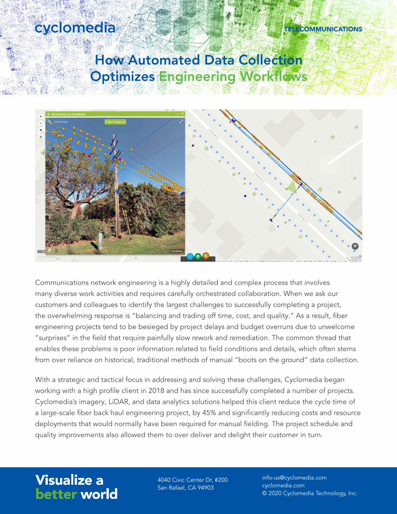
field data capture and online visualization tool, Street Smart™, which allows users to perform remote,
virtual desktop verification on the high-resolution 360° imagery and take real- world measurements
using the 3D depth surface model. The ability to perform remote desktop verification reduced trips
to the field with residual benefits of improving worker safety in addition decreasing transportation
and potential incident costs. With much of the work force now virtual, the ability to perform remote
verification is particularly pertinent both now and in the future. In instances where manual fielding was
absolutely necessary, Street Smart™ was used to assess ground conditions and gain insight into what
workers should expect before they go to the actual site.
ResultsIn addition to the high-resolution street-level imagery, our client required details on key asset locations
and attributes including the road base, surface features, poles, overhead lines, major structures, and
trees. After reviewing the project with our client to fully understand the requirements and workflows,

[email protected]© 2020 Cyclomedia Technology, Inc.
4040 Civic Center Dr, #200San Rafael, CA 94903
TELECOMMUNICATIONS
Cyclomedia committed to running analytics to identify 37 unique feature types within the collected
imagery and LiDAR. Cyclomedia’s ability to extract asset data from the LiDAR is optimized with
advanced AI and machine learning techniques. The high-accuracy and high-resolution of Cyclomedia’s
data quickly elevated the level of confidence within our client’s planning and engineering team.
Though hesitant at first, they gave the thumbs up after they were able to validate the data within the
Street Smart™ online 3D visualization app. Beginning a new project with out of date or inaccurate
data will only exacerbate issues downstream, causing design flaws and requiring additional trips out
to the field for verification or remediation. Building up a reliable source-of-truth dataset of features
from the start, with absolute positional accuracies of ≤ 10 centimeters (<=4 inches), makes the entire
engineering and design process much easier and smoother.
* Field cost as a percentage of the total planning and engineering project costs – “boots on the ground” vs. vehicle data capture and analytics automation.
Cyclomedia’s solution saved our client a tremendous amount of time, money and resources for field
survey, assessment and inventory compared with traditional manual efforts while improving the
quality of source data. In turn this improved the quality of permits and engineering designs. Since the
successful completion of this major project, this client and Cyclomedia have established an innovative
best practice and continue to work on numerous FTTX (fiber to the home, premise, node, etc.) and 5G
backhaul design projects as a team.
Learn more at cyclomedia.com/us