horsham heritage study - hrcc.vic.gov.au
TRANSCRIPT
Horsham Heritage Study (Stage 1) Final Draft: June 2012
Prepared for Rural City of Horsham, Victoria Heritage Victoria

Horsham Heritage Study (Stage 1)
June 2012 2
1� Introduction ................................................................................................... 3�
2� Executive Summary ...................................................................................... 7�
3� Project Brief ................................................................................................. 10�
4� Project Methodology ................................................................................... 12�
5� Outputs ....................................................................................................... 14�
6� Appendix ................................................................................................... 161�

Horsham Heritage Study (Stage 1)
June 2012 3
1 Introduction1.1 Background
The Horsham Heritage Study (Stage 1) was commissioned by Horsham Rural City Council and Heritage Victoria in 2011-12, to understand the heritage values of the Horsham Rural City Council municipal district and to demonstrate the Shire’s commitment to identifying, documenting and protecting its heritage assets.
Horsham Rural City Council is located in Western Victoria, in the Wimmera District and comprises the former local government areas: Arapiles Shire, Wimmera Shire and City of Horsham – which were amalgamated to form Horsham Rural City Council in January 1995.
Horsham has a population of approximately 14 000 people and is 4249sq km in area. It is located on the Western Highway, half way between Adelaide and Melbourne by road. Other smaller, but notable towns in the district include Natimuk, Jung, Dadswell Bridge, Laharum and Pimpinio.
http://www.vec.vic.gov.au/images/maps/Map-stateMunicipalOverviewMap.gif

Horsham Heritage Study (Stage 1)
June 2012 4
http://www.vec.vic.gov.au/images/maps/HorshamMapHR.pdf
Horsham Heritage Study (Stage 1)
June 2012 5
A limited heritage study was undertaken by Andrew Ward in 1998, resulting in the entering of thirteen properties as Heritage Overlays within the Horsham Planning Scheme.
This study encompassed Stage 1 only of the project, including the following:
� Preparation of a Thematic Environmental History of post-contact settlement and development of the study area;
� Identification of all post-contact places of potential cultural significance in the study area; � Estimation of the resources required to appropriately research, document and assess post-
contact places of potential cultural significance
Stage Two of the project will be undertaken at a later date and includes:
� Assessment and documentation of the places of post-contact cultural significance identified as being worthy of future conservation in Stage 1 of the project;
� Review and finalisation of the Thematic Environmental History; and � Recommendations for the conservation of the municipality’s cultural heritage.
1.2 Project Team
The project team included:
� Architects Grieve Gillett Pty Ltd, with heritage assessment assistance from Kelly Wynne and historian, Abby Cooper
� Dr Helen Doyle (author of the Thematic Environmental History) � Edwin Irvine, project officer and Planner; Robin Neilson, Planning and Promotions Services
Manager, Horsham Rural City Council � Ian Wight, Heritage Victoria
1.3 Framework
This report was completed in June 2012 and reflects the Brief requirements and Outcomes for the project. The report has also been undertaken in accordance with the Australia ICOMOS ‘Burra Charter’ 1999 and in conjunction with the Australian Heritage Commission Historic Themes Framework, Victoria Framework of Historical Themes and the Victorian Heritage Council Criteria for Assessing Cultural Heritage Significance. The terminology used in the study is based upon the definitions incorporated in the Australia ICOMOS ‘Burra Charter’ 1999.
It should be noted that (HO) heritage places already identified in the Horsham Planning Scheme, the Victorian Heritage Register or places and items of pre-contact Aboriginal cultural heritage are not included in the Stage 1 study.
Specific definitions include:
Place: site, area, land, landscape, building or other work, group of buildings or other works and may include components, contents, spaces and views. … it is geographically defined and includes it natural and cultural features. Place can be used to refer small things, such as a milestone, and large areas, such as a cultural landscape. A memorial, a tree, the site of an historical event, an urban area or town, an industrial plant, an archaeological site, a stone arrangement, a road or travel route, a site with spiritual and religious connections – all these can fit under this term.
Cultural Significance: aesthetic, historic, scientific, social or spiritual value for past, present or future generations.
Post�contact: the period since first contact between Aboriginal and non�Aboriginal people.

Horsham Heritage Study (Stage 1)
June 2012 6
1.4 Acknowledgements
The Project Team wishes to acknowledge the assistance of the following people in the preparation of this Study, including:
� Horsham Heritage Study Steering Committee � Edwin Irvine, Project Manager and support in identifying places of heritage value around
Natimuk � Horsham and District Historical Society, for support and proof reading � National Trust, West Wimmera, also for support � Arapilies Historical Society, for advice and support � Mr Keith Lockwood, for proofreading and local knowledge � All attendees at Community Consultation workshops � Horsham Branch of the Wimmera Library Corporation � Richard Aitken � Lee Andrews � Peter Cooper � Rod Home, Mueller Correspondence Project � Chris Phelan � Judy Scurfield, State Library of Victoria Map Collection � Christine Worthington, Prahran Mechanics Institute � Councillor Mark Radford � Councillor David Grimble

Horsham Heritage Study (Stage 1)
June 2012 7
2 Executive Summary Purpose: The Horsham Heritage Study (Stage 1) was commissioned to understand the key places and structures of potential heritage value through Horsham Rural City Council, Victoria. The Study has been based upon Heritage Victoria guidelines and has provided a solid foundation for the development of a confirmed list of places of heritage value for the Shire – Stage 2 of the process.
Statement of Cultural Significance for the Shire:
Horsham Rural City is significant for its rich and ongoing tradition of Aboriginal culture, which has existed alongside European settler culture and was recognised in 2005 with a successful native title claim by traditional owners of lands along the Wimmera River.
The municipality is significant for its early pastoral development by Europeans in the 1840s and 1850s, which led to the establishment of wool-growing in the district. Horsham Rural City is significant for its evident patterns of land settlement from the 1860s and 1870s under the land selection acts through to closer settlement in the early 1900s, and two phases of soldier settlement after World War I and World War II. Horsham Rural City is significant for its large contingent of German settlers who arrived from the late 1860s and who have played an important role in the social and cultural life of the district. Horsham Rural City is significant for the development of private irrigation colonies, and the remnants of this settlement that survives today. Horsham Rural City is significant for the extensive Wimmera–Mallee water supply system which was first established within the municipality in the 1880s and which has played a critical role in the economic development of the region through the provision of domestic water supplies to many townships and the creation of irrigated farms and the associated farming techniques that this encouraged. Horsham Rural City is also significant for the experimental ‘village settlements’ of the 1890s.Horsham Rural City is significant for its rural industries, notably wheat-growing and sheep farming, as well as a large range of other forms of primary production, such as fruit-growing, olive growing, and bee-keeping.
Horsham Rural City is significant for the large number of small townships and villages that developed along with land settlement in the 1870s and 1880s. These all contain a range of public buildings to illustrate the extent of their development. Horsham Rural City is significant for the development of the City of Horsham as an important regional centre and the ‘capital of the Wimmera’, evident through the diverse collection of public, private, commercial and industrial structures in the City, and for the ability of the City’s structures and places to demonstrate a rich social and cultural life. Horsham Rural City is particularly significant for its strong collection of interwar structures, both public and private, which taken together reflect a period of peak development and prosperity in the City. Horsham Rural City is significant for its appreciation of both designed and natural environments; this is demonstrated, for example, through its botanic gardens and the survival of the Wail Arboretum and the Little Desert conservation area. Horsham Rural City is significant for the extensive industrial development of the Horsham and Natimuk settlements from the 1870s, particularly with the success of foundries and farm machinery manufacture, as well as textile factories, food processing and other goods.
Horsham Rural City is significant for its demonstration of confronting the challenges of extreme weather, as well as fire and flood.�Horsham Rural City is important for its early development of tourism, which occurred with the promotion of Mt Arapiles and the Grampians as places for holidays and recreation. Horsham Rural City is important for its range of memorials and commemorative structures that pay respect to the past, and especially the ongoing story of settlement.
Some of the key historic themes of value to the district include:
1. Living as first Australians: The Horsham Rural City has a rich and ongoing tradition of Aboriginal culture, which has existed alongside European settler culture and was recognised in 2005 with a successful native title claim by traditional owners along the Wimmera River.
2. Developing pastoralism: The first European settlement in the Horsham Rural City was by pastoral capitalists, who took up vast sheep runs in the 1840s, which led to the establishment of wool-growing in the district.

Horsham Heritage Study (Stage 1)
June 2012 8
3. Settling on the land: There was a steady pattern of closer settlement in the Horsham area from the late 1860s until the 1950s, firstly under the land selection acts, which brought a wave of new settlers in the 1870s, including many German Lutherans; other new settlers took up blocks on newly irrigated estates in the 1880s and 1890s; some joined experimental settlements like the Tucker settlement in the 1890s; and many ex-servicemen were granted blocks under soldier settlement schemes after World War I and World War II.
4. Developing primary industries: Following the land selection acts in the 1870s, Horsham Rural City became a busy centre for primary production, principally grain-growing; this extended to significant research and development in the practice of dry-land farming.
5. Developing a large regional centre and small rural townships: Alongside the development of Horsham as an important regional centre that served a large rural district, was the emergence of a collection of small townships and hamlets which provided for their immediate population with the necessary structures for social, sport, recreational and commercial life; transportation; and local administration.
6. Interwar development: Rural prosperity in the 1920s and 1930s enabled significant development of the city of Horsham during this period, which is evident in the large number of public, private and commercial structures built to a range of interwar styles.
7. Developing manufacturing: From the late nineteenth century, and into the postwar period, Horsham and to a lesser extent Natimuk were developed as centres of manufacturing, with an emphasis on foundries and farm machinery, as well as textiles, food processing and other goods.
8. Establishing irrigation: The development of the Wimmera-Mallee Stock and Domestic Water Supply System led to the successful implementation of irrigation schemes across the municipality, which enabled new farming methods and allowed a variety of new crops to be grown.
9. Facing the challenges of the natural environment: Settlers in Horsham have been subject to extreme and adverse weather conditions, including the ravages of bushfire and to the damage caused by floods, tornadoes and wild storms.
10. Encouraging tourism: The Horsham region has been developed as a centre for tourism, from its early beginnings as a stop-over for visitors between Melbourne and Adelaide, and later with the promotion of the nearby Grampians and Mt Arapiles as places for holidays and recreation.
Some of the more important structures and places of potential heritage value that illustrate these themes include:
� Infrastructure associated with the Wimmera-Mallee Stock and Domestic Water Supply System, essential to the agricultural development of the district
� 1840-1860s settlers dwellings and thatched barns, illustrating the early, but unique way of life in the district – for example the remnant pise huts outside Haven (c1850-60s) and thatched barns through the district (c1850+)
� The late 19th C/ early 20th C hotels, shops and dwellings within the town, illustrating the scale and importance of the town during this period – for example the Royal Hotel (by 1882), Lattanzio's shop in Wilson Street (1880s).
� Commercial buildings such as the T&G Building (1940) and dwellings such as ‘Learmont’, on Natimuk Rd (1926), illustrating the 20th Century inter-war pastoral wealth and economic optimism in the district
� Post WW11 buildings and housing such as St Andrews Church (1963), which illustrate population growth due to decentralisation and manufacturing policies within the State during this period
� Remnants of irrigation colonies and soldier settlement schemes, illustrating late 19th Century closer/ colony type settlement and post WW1 and WW11 soldier settlements within the district
� The 19thC public buildings of Natimuk, illustrating the 19thC scale of surrounding towns, now diminished due to advances in transport
� Silos and railway sidings, reflecting the dominant rural industry in the district – grain farming.
The survey team has selected places of potential heritage value to illustrate the above themes of importance to Horsham. Many places are individual listings, such as churches, homesteads and

Horsham Heritage Study (Stage 1)
June 2012 9
unique houses. Other places are selected as a part of a potential HO precinct, as they collectively contribute to the heritage story of a streetscape. Some places are already entered on the Victorian Heritage Register.
There are 167 individual HO places and 344 contributory places on the list. There are also potential Significant Landscape Overlays (SLOs) and Historic Moveable Objects within the region to be considered.
The HO places selected will be tested in Stage 2 of the project. Further research will be undertaken, the community consulted and ultimately the Planning Scheme amended to reflect the heritage assets of the Horsham region.
Horsham Heritage Study (Stage 1)
June 2012 10
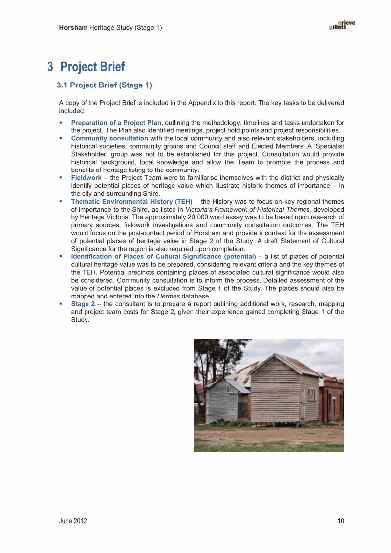
3 Project Brief 3.1 Project Brief (Stage 1)
A copy of the Project Brief is included in the Appendix to this report. The key tasks to be delivered included:
� Preparation of a Project Plan, outlining the methodology, timelines and tasks undertaken for the project. The Plan also identified meetings, project hold points and project responsibilities.
� Community consultation with the local community and also relevant stakeholders, including historical societies, community groups and Council staff and Elected Members. A ‘Specialist Stakeholder’ group was not to be established for this project. Consultation would provide historical background, local knowledge and allow the Team to promote the process and benefits of heritage listing to the community.
� Fieldwork – the Project Team were to familiarise themselves with the district and physically identify potential places of heritage value which illustrate historic themes of importance – in the city and surrounding Shire.
� Thematic Environmental History (TEH) – the History was to focus on key regional themes of importance to the Shire, as listed in Victoria’s Framework of Historical Themes, developed by Heritage Victoria. The approximately 20 000 word essay was to be based upon research of primary sources, fieldwork investigations and community consultation outcomes. The TEH would focus on the post-contact period of Horsham and provide a context for the assessment of potential places of heritage value in Stage 2 of the Study. A draft Statement of Cultural Significance for the region is also required upon completion.
� Identification of Places of Cultural Significance (potential) – a list of places of potential cultural heritage value was to be prepared, considering relevant criteria and the key themes of the TEH. Potential precincts containing places of associated cultural significance would also be considered. Community consultation is to inform the process. Detailed assessment of the value of potential places is excluded from Stage 1 of the Study. The places should also be mapped and entered into the Hermes database.
� Stage 2 – the consultant is to prepare a report outlining additional work, research, mapping and project team costs for Stage 2, given their experience gained completing Stage 1 of the Study.

Horsham Heritage Study (Stage 1)
June 2012 11
3.2 Project plan Horsham Heritage Study (Stage 1) 2011-12
Project Tasks Approx. Project Team date
SteeringCtteeMeeting Date
Progress Payment as % of $50 000
Commencement of study (first steering committee meeting) � adoption of project plan and community consultation plan by steering
committee at inception meeting � discussion of Stage 1 and the generation of an Indicative List and
Thematic Environmental History � obtain letter of introduction from HRCC CEO � meet with HRCC publicity officer to discuss community consultation
plan and book appropriate venues for workshops � submit first press release, submit first newsletter
July and August2011
Thursday 28 July 2011
10%
Community consultation � write to special interest groups to invite members to workshops � submit press release promoting workshops –submit newsletter
advertising public workshops venues / times / dates� conduct x1 special interest group workshop followed by up to 5 public
workshops
22-26 Aug 2011;
19-21 Sept 2011
Develop Thematic Environmental History � create themes framework � create research databases, bibliographies & conduct research
July 2011 – January 2012
10% (Sept)
Steering committee meeting (no. 2) � review community consultation process, discuss places identified
through workshops and findings since commencement of fieldwork and research into thematic environmental history
25 Oct. 2011(1-2pm)
Submit first draft of Indicative Heritage Places List � draft list to be distributed to steering cmttee members by HRCC
November2011
20%
Steering committee meeting (no. 3) � discuss first draft of indicative heritage places list � discuss upcoming submission of Thematic Environmental History and
hand out contents page to discuss proposed themes and content
6 Dec. 2011
Submit draft Thematic Environmental History� draft to be distributed to steering committee members by HRCC � draft to be distributed to local historical societies by HRCC along with
draft indicative list (current version to be submitted), cover letter written by GG.
February 2012
20%
Discussion – Indicative list, technical review no.(4) (HRCC & HVic)� discussion of list, precincts, technical issues
March 2012 10%
Steering committee meeting (no. 5 final) � final meeting presentation of Thematic Environmental History to
steering committee by Dr Helen Doyle � steering committee to discuss the first draft report, including
recommendations for stage two
April 2012 10%
Deadline for all feedback� received from steering committee, historical societies and planning staff
and compiled by HRCC as email.
May 2012
Submission of Stage 1 Final Report June 2012 20%
Grieve Gillett (Project team leader & Heritage Assessment - Michael Queale, Liz Little) Kelly Wynne (Heritage Assessment) Helen Doyle (Historian) Abby Cooper (assist Historian) Janet O’Hehir (horticulture) – occasional advice only.

Horsham Heritage Study (Stage 1)
June 2012 12
4 Project Methodology The project team developed a Project Plan upon commencement of the project, in accordance with the requirements of the Project Brief. A twelve month programme was developed, to set a structure for workshops, consultation and project reporting. The structure was developed to maximise community consultation and information sessions, to foster community support for the project.
Commencement of study (July/ August 2011)
� adoption of Project Plan and community consultation plan by steering committee � met with HRCC publicity officer to discuss community consultation plan and book appropriate
venues for workshops � prepared first press, newsletter and heritage study webpage on HRCC website
Community consultation (August – Oct 2011)
� invited special interest groups to workshops at various locations throughout the Shire to foster community engagement and locate potential heritage places.
� 1 x special interest group workshop with Horsham Historical Society, National Trust � 5 other community workshops – 2 in Horsham, one in Kalkee, Natimuk and Laharum. � Further, an on-line and ‘paper’ version of a questionnaire was developed for community
comment. � An additional newsletter was prepared summarising the outcomes of the community
consultation process.
Thematic Environmental History (TEH) (September 2011-May 2012)
� The History was prepared based upon Heritage Victoria’s Victoria’s Framework of Historical Themes. The essay was based upon research of primary sources, fieldwork investigations and community consultation outcomes.
� The TEH focused on the post-contact period of Horsham and has provided a context for the assessment of potential places of heritage value in Stage 2 of the Study. A draft Statement of Cultural Significance for the region was also prepared.
� The TEH was developed in parallel with the Indicative list of potential HO places. The history and themes informed site investigations and fieldwork discoveries also helped establish further historic themes.
� The TEH was presented to the Steering Committee in early 2012 for comment. � The TEH was also issued to specialist stakeholder groups such as the Horsham Historical
Society and National Trust for review and comment in April 2012.
Indicative HO Places list (August 2011- April 2012)
� A draft list was prepared after several months of desktop and fieldwork, locating places identified in primary resources, past heritage surveys, literature and community consultation sessions. The desktop survey included: - The Victorian Heritage Register, Victorian Heritage Inventory and Victorian Heritage
Database;- The National Trust Register Victoria; - Register of the National Estate; - Horsham Rural City Council Planning Scheme; - Land Conservation Council (LCC) report on the Wimmera area, 1985; - Land Conservation Council (LCC) Historic Places Special Investigation South-Western
Victoria, 1997; - Horsham Heritage Study, Andrew Ward & Associates, 1998. - Primary and secondary material was also examined; including maps and survey plans,
government gazettes, local historical publications, manuscripts and newspapers. � The project team travelled all roads in the district to locate potential indicative HO places,
primarily from the public realm. Potential HO places identified in community consultation, but not easily accessible in the field, were still recorded on the Indicative list, for investigation in Stage 2 of the project.

Horsham Heritage Study (Stage 1)
June 2012 13
� A draft indicative list of potential HO places, HO precincts, Significant Landscape Overlays and archaeological sites was issued to the Steering Committee for comment in late 2011. The list was acknowledged, but not endorsed by Council at the completion of Stage 1 of the Study.
Completion – Stage 1 (June 2012)
� The TEH, Indicative list and supporting documentation was discussed at the final Stakeholder/ Project meeting in May 2012.
� The Stage 1 report was issued to Council by the end of June 2012. � A newsletter detailing the outcomes of the Stage 1 Study; the next stage (Stage 2) and the
Planning Scheme implications of the project was issued.

Horsham Heritage Study (Stage 1)
June 2012 14
5 OutputsThe Horsham Heritage Study (Stage 1) Project Brief includes the following outputs.
5.1 Community Consultation - data gathering and project promotion:
A community consultation plan was adopted by the Steering Committee in July 2011. The plan outlined a programme for engaging and sustaining on-going communication with residents of HRCC for the duration of the study. Communication methods included newsletters, media releases and newspaper articles, an online questionnaire, public workshops and targeted interest group workshops.
A newsletter was distributed over several editions, including: at the commencement of the study, workshop phases and upon completion. A digital copy of each edition of the newsletter was posted on Council’s website and available as a hardcopy at the Civic Centre, planning services desk and the Horsham branch of the Wimmera Regional Library. The first edition of the newsletter also served as a general information brochure about the study. Refer to the appendix for a copy of each edition.
Several media releases were submitted to media outlets during the course of the study. Media releases announced the commencement of study and appointment of consultants; advertised community workshops – dates / venues / times and announced completion of Stage 1 study and provided a summary of outcomes. There were three articles relating to the heritage study published in the Wimmera Mail –Time during the course of the study. A dedicated page on the HRCC website provided general study information and links to documents such as the study newsletter and heritage survey questionnaire.
An initial stakeholder meeting was held at the beginning of the study to formally introduce the study and the consultants to members of the Arapiles Historical Society, Horsham Historical Society and Wimmera branch of the National Trust (Victoria). This workshop generated discussion about potential places of cultural heritage significance and key themes to be explored by the Thematic Environmental History.
Six public workshops were conducted at five locations in the study area. Personal invitations were sent out to members of the community who were identified as having expertise and knowledge of significant local heritage places and historical narratives. Each workshop focused on a particular area, giving residents the opportunity to nominate and discuss the places that they feel best represent the historical identity of their township or settlement. Refer to the appendix for a list of places nominated during community consultation.
A heritage questionnaire was also prepared and distributed at each public meeting, with completed surveys collected. An interactive version was also available online. Refer to the appendix for a copy of this questionnaire.
5.2 Draft Thematic Environmental History (TEH)
The Thematic Environmental History (post-contact settlement) has been prepared in accordance with Heritage Victoria’s Guidelines for Thematic Environmental Histories. The History is thematic, rather than linear in basis, with themes selected which best represent the unique heritage values of the district. The themes were also tested during Community Consultation workshops and have been peer-reviewed by Heritage Victoria.
The TEH serves to assist in the future assessment of the heritage places of the municipality. By linking places to themes, we can better understand the context of particular sites.
A draft Statement of Significance has also been prepared, summarising the key heritage values of the district.
5.3 Indicative HO Places list
The (Stage 1) Indicative HO Places list provides a ‘first cut’ of the places and structures of the district which best illustrate the key TEH themes of importance to Horsham. These places have been tabulated in list and entered into the Hermes database as required by the Project Brief.

Horsham Heritage Study (Stage 1)
June 2012 15
Many potential HO places are clustered in Horsham suburbs or towns of identified heritage value. These places may ultimately form part of a HO precinct, if they illustrate common historic themes. All HO places on the Indicative list will be rigorously assessed to confirm heritage value in Stage 2 of the project. Address information and a brief description is only required as a part of Stage 1 of the project.
Significant Landscape Overlays (SLOs) are also identified, as a means of potentially better managing the remnant heritage fabric or feature within the overall landscape. Some ruinous sites are also of potential archaeological value.
This Study includes an overall list of all potential HO and SLO places, locates them on regional maps and includes a data entry sheet for each place, printed from the entry in the Hermesdatabase.
5.4 Hermes Database list
Each potential HO place has been entered in the Hermes database. A data entry sheet for each HO place has been included in the Study.
5.5 Heritage Study – Stage 2
As required by the Project Brief, the Project Team has provided recommendations for Stage 2 of the Horsham Heritage Study. Estimates of resources, costs and additional tasks required have been provided.
Most importantly, the Project Team has recommended priorities for Stage 2 of the project. We recommend that Stage 2 focuses on
� the assessment of potential HO precincts in Horsham and key potential individual HO places in the city – where development pressure is greater than in rural areas, and
� irrigation infrastructure, to assist in management of significant fabric still extant after the GWM decommissioning project.

Horsham Heritage Study (Stage 1)
June 2012 16
5.1 Community consultation
Between August and November 2011 a series of public workshops were held at 5 locations across the municipality.
The workshops were designed to inform community members about the study and to gather information about the places and stories that best represent and express the cultural heritage of the study area. Prints of historic photographs, paintings and illustrations depicting local scenes and buildings, survey and township maps and a list of potential themes were used to generate discussion.
Topics covered at the meetings ranged from the establishment of towns and community buildings, to the vernacular construction techniques and materials particular to the Wimmera. The development of water infrastructure was also raised as an important theme, with sites and cultural landscapes associated with irrigation colonies, schemes and technologies discussed.
Some examples of the places and themes nominated by community members during public workshops include:
� community places and spaces: public halls, schools (including the sites of former schools), churches (including the sites of former churches), recreation reserves, club rooms, gardens and cemeteries;
� water infrastructure: including reservoirs, lakes, supply channels, weirs and other uses such as sheep washes and for recreation;
� traditional building materials and construction techniques: such as thatched outbuildings, pug and mud brick houses;
� rural settlement: early homesteads, shearing sheds, farmhouses; � urban settlement: townhouses, public housing and the development of suburbs; � settlement schemes: patterns of settlement associated with closer settlement, irrigation
and railway infrastructure and soldier settlement; � cultural routes: Major Mitchell, John Eyre, Cobb & co and Tolmer’s Gold Escort route,
stock routes; � railway infrastructure: railway bridges, railway stations and sidings, silo’s, tram lines; � secondary industries: salt works, wattle barking, beekeeping, charcoal pits, slate
mining, gold mining, sleeper and timber cutting, tobacco growing, brickworks, butter factories, fruit drying, olives, etc;
� extreme weather conditions: droughts, floods, tornados and bushfires.
Horsham Heritage Study (Stage 1)
June 2012 17
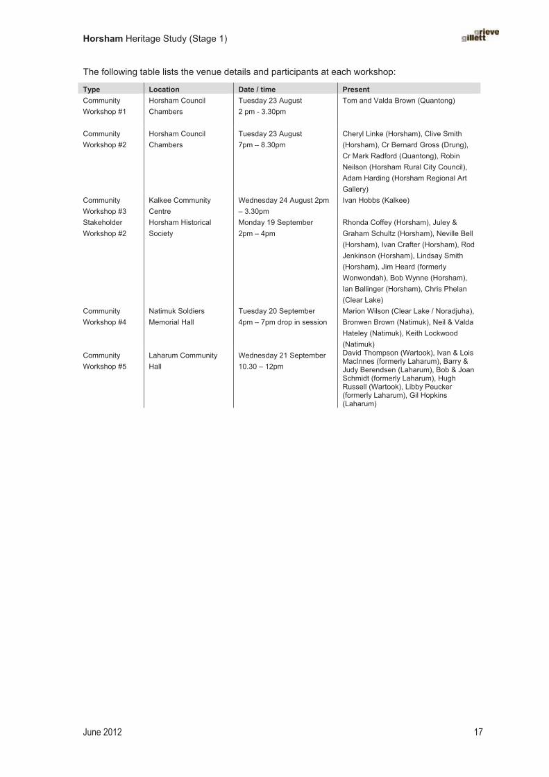
The following table lists the venue details and participants at each workshop:
Type Location Date / time PresentCommunity Workshop #1
Horsham Council Chambers
Tuesday 23 August 2 pm - 3.30pm
Tom and Valda Brown (Quantong)
Community Workshop #2
Horsham Council Chambers
Tuesday 23 August 7pm – 8.30pm
Cheryl Linke (Horsham), Clive Smith (Horsham), Cr Bernard Gross (Drung), Cr Mark Radford (Quantong), Robin Neilson (Horsham Rural City Council), Adam Harding (Horsham Regional Art Gallery)
Community Workshop #3
Kalkee Community Centre
Wednesday 24 August 2pm – 3.30pm
Ivan Hobbs (Kalkee)
StakeholderWorkshop #2
Horsham Historical Society
Monday 19 September 2pm – 4pm
Rhonda Coffey (Horsham), Juley & Graham Schultz (Horsham), Neville Bell (Horsham), Ivan Crafter (Horsham), Rod Jenkinson (Horsham), Lindsay Smith (Horsham), Jim Heard (formerly Wonwondah), Bob Wynne (Horsham), Ian Ballinger (Horsham), Chris Phelan (Clear Lake)
Community Workshop #4
Natimuk Soldiers Memorial Hall
Tuesday 20 September 4pm – 7pm drop in session
Marion Wilson (Clear Lake / Noradjuha), Bronwen Brown (Natimuk), Neil & Valda Hateley (Natimuk), Keith Lockwood (Natimuk)
Community Workshop #5
Laharum Community Hall
Wednesday 21 September 10.30 – 12pm
David Thompson (Wartook), Ivan & Lois MacInnes (formerly Laharum), Barry & Judy Berendsen (Laharum), Bob & Joan Schmidt (formerly Laharum), Hugh Russell (Wartook), Libby Peucker (formerly Laharum), Gil Hopkins (Laharum)

Horsham Heritage Study (Stage 1)
June 2012 18
5.2 Thematic Environmental History – Horsham Rural City Council
Contents
List of illustrations
Abbreviations
Introduction
1. Exploring, surveying and mapping new country
2. Living as first Australians
3. Fighting for land
4. Developing pastoralism
5. Settling on the land
6. Governing and administering
7. Forming townships
8. Developing the Victorian wheat belt
9. Developing a vernacular building style
10. Enforcing law and order
11 Developing primary industries
12. Doing business
13: Promoting scientific endeavours
14. Manufacturing
15. Establishing transport and communications
16. Building rural communities
17. Appreciating and conserving the natural environment
18. Developing social and cultural life
19. Providing social welfare
20. Representing the region in art and literature
21. Making space for parks and gardens
22. Confronting the challenges of the natural environment
23. Building water supply systems
24. Providing education
25. Defending Australia and the Wimmera
26: Attracting tourists and holiday makers
27: Celebrating and commemorating the past
Bibliography

Horsham Heritage Study (Stage 1)
June 2012 19
List of Illustrations 1.1 Early sketch of the Wimmera River, 1845, unknown artist (National Library of Australia)
3.1 Droylsden in Baillie Street, built in 1930, later became the Aboriginal Co-operative, Horsham (National Library of Australia)
4.1 Vectis homestead, built in the early 1860s and demolished for soldier settlement (State Library of Victoria)
4.2 Walmer homestead, 1900 (Museum of Victoria)
4.3 Wonwondah North homestead, painted in 1888 (State Library of Victoria)
5.1 Mott’s Dummy Hut (State Library of Victoria)
5.2 Greenhills homestead, Jung, subdivided from Longerenong estate, photographed by John Collins in 1979 (State Library of Victoria)
6.1 Wimmera Shire Offices, on the corner of Firebrace Street and Roberts Avenue, Horsham, erected in 1875 (Museum of Victoria)
7.1 Horsham Township Reserve, 1855, from detail of James A. Shaw, ‘Plan of Village and Nine Mile Reserve, Horsham’ (National Library of Australia)
7.2 Plan of the ‘Nine Mile Reserve’ at Horsham, 1855 (National Library of Australia)
7.3 Polkemmet station cemetery dates to 1860, photographed in 1979 by John Collins (State Library of Victoria)
7.4 Parish of Quantong, 1895, showing the former Polkemmet station cemetery (State Library of Victoria)
8.1 An early thatched barn at Greenhills, Jung, as photographed by John Collins in 1979 (State Library of Victoria
8.2 Noske Bros. wheat silos, Horsham, from a postcard, c.1910s (State Library of Victoria)
9.1 Sketch of a bark homestead at Noradjuha (from Sutherland, Victoria and Its Metropolis, 1888)
9.2 Simple and unadorned: ‘a typical selector’s house on the Wimmera Plains in the 1870s’ at Garup (Home to Horsham,1929, p. 12)
9.3 Comfortable timber cottage at Green Park, with characteristic bark roof, c.1875 (Museum of Victoria)
10.1 Natimuk Court House, photographed 1970 by John Collins (State Library of Victoria)
10.2 Horsham Court House, c.1907, showing newly planted street (State Library of Victoria)
11.1 Bee hut belonging to Matthew Matthews at Bald Hills, Lah Arum (State Library of Victoria)
12.1 Pimpinio Post Office and General Store, 1901 (National Archives of Australia, Accession No. B5919/1)
12.2 F.E. Sudholz Family Butcher, Natimuk (Museum Victoria)
13.1 West Wail Flora and Fauna Reserve (Australian Heritage Photographic Library)
15.1 Mt Zero from the south-east, sketched by the travelling diarist Edward Snell in 1852 (Griffiths ed., The Diary of Edward Snell, 1988)
15.2 Wimmera River Bridge, c.1955 (State Library of Victoria)
15.3 Postcard view of the Horsham Post Office, built 1883, and water tower (State Library of Victoria)
16.1 German settlers crossing the border into Victoria from South Australia, sketched in 1877 by George Fife Angas (National Library of Australia)
16.2 Lutheran manse, Natimuk, c.1930s (State Library of Victoria)
18.1 Mitre public hall, flanked by Cupresses semprevirens (thomasparkes.wordpress.com)
20.1 Nicholas Chevalier, Mt Arapiles and the Mitre Rock, 1863 (State Library of Victoria)
20.2 A landscape that forms part of Arthur Boyd’s Wimmera Series, painted in the 1950s
20.3 Cover of Nathan Spielvogel’s novel, The Cocky Farmer, published in 1907 (from the collection of the State Library of Victoria)
21.1 Postcard showing the ornamental Bark Hut amidst mature plantings, Horsham Botanic Gardens, c.1925 (State Library of Victoria)

Horsham Heritage Study (Stage 1)
June 2012 20
21.2 Avenue of Canary Island Date Palms (Phoenix canariensis), Horsham Botanic Gardens (State Library of Victoria)
21.3 School garden at Quantong State School, c.1910 (State Library of Victoria)
22.1 Dramatic scenes of flooding at Horsham, Australasian Sketcher, 11 July 1889 (State Library of Victoria)
22.2 Horsham Fire Brigade station and fire tower, c.1900s (State Library of Victoria)
22.3 Wood engraving by Frederick Grosse, from artwork by Nicholas Chevalier, depicting black trackers finding the Duff children who were lost in the bush, 1864 (State Library of Victoria)
23.1 Horse-drawn dray delivering a water tank manufactured in Horsham, 1924 (State Library of Victoria)
23.2 Members of the Wimmera Water Trust at their elaborate Horsham headquarters in 1895 (Museum of Victoria)
24.1 Horsham District High School, c.1912 (State Library of Victoria)
24.2 The former Brigidine Convent, Horsham, opened in 1920 – now demolished (State Library of Victoria)
25.1 Natimuk Memorial Hall, erected in 1909 (National Trust of Australia)
26.1 The new tourist road to Mt Arapiles, completed in 1937; photographed in 1948 (State Library of Victoria)
26.2 The novel attractions of an early motel at Horsham c.1950s (State Library of Victoria)
27.1 ‘Back to Natimuk’ celebrations, 1924 (Museum of Victoria)
27.2 Monument erected to mark the Gold Escort Route of the early 1850s (State Library of Victoria)
27.3 Souvenir of the unveiling of the Mitchell Memorial Tablet at Mt Arapiles, 1913 (State Library of Victoria)
27.4 Millar Drinking Fountain, reinstated in May Park (National Library of Australia)
Abbreviations ANA Australian Natives Association
CWA Country Women’s Association
DSE Department of Sustainability and Environment
GGNSW Government Gazette of New South Wales
LCC Land Conservation Council
MS Manuscript
NLA National Library of Australia
PR Pre-emptive Right
PROV Public Record Office of Victoria
RSL Returned Servicemen’s League
SLV State Library of Victoria
SRWSC State Rivers and Water Supply Commission
S.S. State School
VPRS Victorian Public Record Series
VHM, VHJ Victorian Historical Magazine; Victorian Historical Journal
VGG Victorian Government Gazette
VMD Victorian Municipal Directory
�
�
Horsham Heritage Study (Stage 1)
June 2012 21
Chapter�1�
Exploring,�surveying�and�mapping�new�country��
Discovering ‘Australia Felix’
During the winter of 1836, Major Thomas Livingstone Mitchell, the Scottish-born surveyor-general for the Colony of New South Wales, led an expedition through western Victoria, across country that included what is now Horsham Rural City. Mitchell was under instructions from Governor Richard Bourke to find the junction of the Darling with the Murray, when he decided instead to cross the Murray River and explore the promising country to the south. The newly arrived British colonists had classified this as the Port Phillip District in the Colony of New South Wales. As Mitchell headed south–south-west, he passed the impressive rocky mountain range that he named the Grampians (after a range in his native Scotland) and headed towards the Wimmera plains. The recent high levels of rainfall had left the ground sodden and soft, which caused Mitchell’s oxcarts and heavy whaleboat carriage to leave deep wheel ruts. These ruts, known as the Major’s Line or the Major’s Track, were a known landmark in the district and were still visible many years later.� Marvelling at the grandness of the landscape and the richness of the country he had encountered, Mitchell bestowed the name ‘Australia Felix’, and penned this much-quoted passage:
At length we had discovered a country ready for the immediate reception of civilised man, and destined, perhaps, eventually to become a portion of a great empire. Unencumbered by too much wood, it yet possessed enough for all purposes . . . Of this Eden, I was the first European to explore its mountains and streams, to behold its scenery, to investigate its geological character, and by my survey to develope [sic] those natural advantages, certain to become, at no distant date, of vast importance to a new people.�
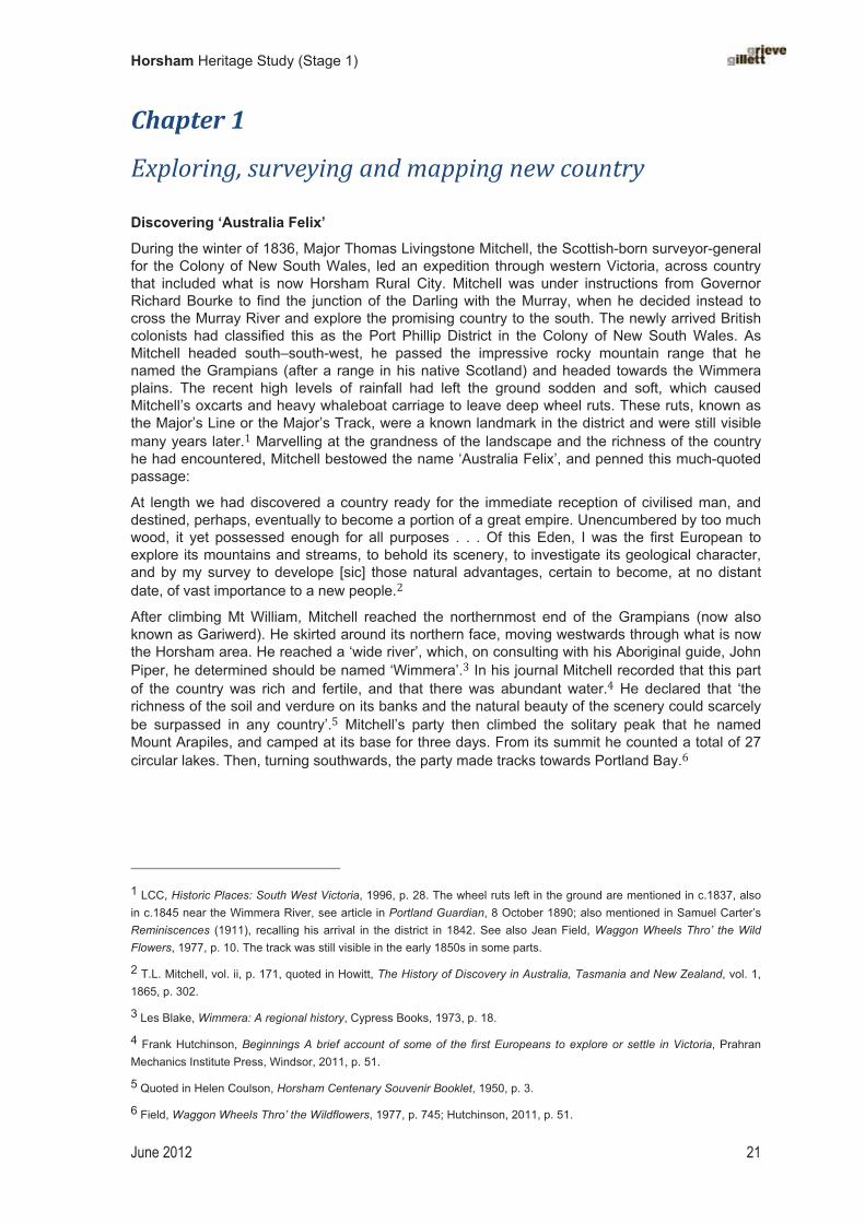
After climbing Mt William, Mitchell reached the northernmost end of the Grampians (now also known as Gariwerd). He skirted around its northern face, moving westwards through what is now the Horsham area. He reached a ‘wide river’, which, on consulting with his Aboriginal guide, John Piper, he determined should be named ‘Wimmera’.� In his journal Mitchell recorded that this part of the country was rich and fertile, and that there was abundant water.� He declared that ‘the richness of the soil and verdure on its banks and the natural beauty of the scenery could scarcely be surpassed in any country’.� Mitchell’s party then climbed the solitary peak that he named Mount Arapiles, and camped at its base for three days. From its summit he counted a total of 27 circular lakes. Then, turning southwards, the party made tracks towards Portland Bay.
� �
1 LCC, Historic Places: South West Victoria, 1996, p. 28. The wheel ruts left in the ground are mentioned in c.1837, also in c.1845 near the Wimmera River, see article in Portland Guardian, 8 October 1890; also mentioned in Samuel Carter’s Reminiscences (1911), recalling his arrival in the district in 1842. See also Jean Field, Waggon Wheels Thro’ the Wild Flowers, 1977, p. 10. The track was still visible in the early 1850s in some parts.
2 T.L. Mitchell, vol. ii, p. 171, quoted in Howitt, The History of Discovery in Australia, Tasmania and New Zealand, vol. 1, 1865, p. 302.
3 Les Blake, Wimmera: A regional history, Cypress Books, 1973, p. 18.
4 Frank Hutchinson, Beginnings A brief account of some of the first Europeans to explore or settle in Victoria, Prahran Mechanics Institute Press, Windsor, 2011, p. 51.
5 Quoted in Helen Coulson, Horsham Centenary Souvenir Booklet, 1950, p. 3.
6 Field, Waggon Wheels Thro’ the Wildflowers, 1977, p. 745; Hutchinson, 2011, p. 51.
Horsham Heritage Study (Stage 1)
June 2012 22
1.1 Sketch of the Wimmera River, 1845, unknown artist (National Library of Australia)
Other exploratory expeditions
In early 1838 another British explorer, Edward John Eyre, led an expedition from Sydney to Adelaide, taking with him 300 head of cattle. He followed the course of the Wimmera River for some time, passing the site of present-day Horsham and finishing up at Lake Hindmarsh.
As settlers became established in the 1840s and 1850s, many took trips into the nearby Grampians and to Mount Arapiles to familiarise themselves with the terrain and to assess any possibilities for timber-cutting or quarrying.
In 1860 the celebrated explorers Robert O’Hara Burke and William John Wills, and their cavalcade of camels passed through Horsham at the beginning of their ill-fated Victorian Expedition to north central Australia. They made camp near the Wimmera Bridge and drew crowds of eager onlookers who flocked to watch them pass through the town.�
Naming places
Major Mitchell, who was responsible for suggesting a great many placenames across western Victoria, had a preference for choosing Aboriginal names for places if and when they could be ascertained. Mitchell was also fond of adopting Old World names, especially where a likeness to an Old World place could be seen. He took some names from the events of the recent Peninsula Wars in Spain, and some from famous or influential Englishmen.� He chose the name Mt Arapiles to mark the anniversary of the Battle of Salamanca that had taken place in July 1812.�
Water features, such as lakes, rivers, swamps and springs, were usually given Aboriginal names — for example, Wimmera, meaning ‘woomera’; Natimuk, meaning ‘little lake’;�� Wartook meaning ‘big swamp’; Brim ‘a spring’; Dooen ‘swamp’;�� Longerenong ‘the dividing of the waters’; Walmer ‘the water of the visitor’; and Bungalally (also a parish name). Aboriginal words were nearly always used for parish names.��
7 Hutchinson, Beginnings, 2011, pp. 51–52; Arapiles.net website: http://www.arapiles.net/history.html
8 Coulson, Horsham Centenary Souvenir Booklet: One hundred years of progress, Horsham, 1950, p. 7.
9 Bassett, The Hentys, 1962 edn, p. 396; see also Home to Horsham,1929.
10 Marcus Clarke, History of the Continent of Australia and Island of Tasmania, Melbourne, 1877, p. 87. See also Calder, 1987, p. 174; see also Keith Lockwood, Arapiles: A million mountains, Skink Press, Natimuk, 2007, p. 21.
11 ‘Natimuk’ refers to Lake Natimuk, which is located just to the north of town.
12 Calder, The Grampians, 1987, pp. 171, 176.
13 See, for example, Robert Brough Smyth, The Aborigines of Victoria, 1878, vol. 2, pp. 177–78, 205, for an extensive listing of Aboriginal place names, and also Aldo Massola, Journey to Aboriginal Victoria, 1969.

Horsham Heritage Study (Stage 1)
June 2012 23
Chapter�2�
Living�as�First�Australians��Maintaining traditional life
When the first Europeans ventured into the Horsham area, the land had been long occupied by Aboriginal people. There are five groups that represent the traditional owners of the Horsham municipality: the Wotjobaluk, Wergaia (to the north), Jupagalk, Jaadwa, and Jardwadjali (Jadawadjali). The Aboriginal people drew on a rich food supply, especially along the Wimmera River and other streams, and relied on seasonal variability to shape their diet of plants, birds and animals. While much of the country could be dry for a large part of the year, and sometimes for several years at a time, Aboriginal people used their intimate knowledge of the country to find water in ‘native wells’. They also built elaborate fish traps — for example at Toolondo.�� The large swamps, such as Dooen Swamp, and seasonal billabongs also provided a variety of food and became important camp sites. To the south-east of the study area, the majestic peaks of Gariwerd–the Grampians dominated the landscape and this was an important place for sourcing food, and for cultural ceremonies. The Wimmera River was the life force of the district, providing not only rich food supply in fish and bird life, but serving as a means of transportation. Aborigines cut bark from the majestic River Red Gums (Eucalyptus camaldulensis) that lined its banks, in order to make canoes. The Wimmera River was a central element to the ancient Dreaming stories which provided the rich cultural and spiritual meanings that wove together the land and its people.
Numerous camp sites have been identified by the discovery of ovens and stone artefacts – the variety and quantity of items revealing the extent of tribal relations, especially regarding trading. Camping sites include the site of Horsham itself, which was a stopping place on the way to Lake Hindmarsh, and the bend in the Wimmera River at Dimboola.
With little tree cover or other natural occurring shelter in parts of the Wimmera plains, Aboriginal people built huts of timber and grass, which they plastered with mud or clay. During the winter of 1836, while camping on the western slope of Mt Arapiles, Major Mitchell had observed ‘bark and grass huts coated with clay’.�� On 26 July 1836, he had noted ‘aboriginal huts’ which he described as ‘superior accommodation’.� Mitchell had noticed similar huts in the vicinity of the Grampians. Other early European visitors observed similar huts around Ararat.
While the Wimmera still remained largely an unknown place to Europeans in the late 1830s, British colonisation was well established in Victoria by that time and the effects of European settlement, although many miles distant, was already being felt. From 1834, when white settlers settled at Portland Bay to the south, the traditional owners of the Wimmera country would have heard about, and possibly anticipated, their arrival. They had also possibly gleaned information from people in the Murray River area to the north about the earlier settlement in Sydney. It is also likely that from as early as the 1820s some Aboriginal people suffered from introduced diseases such as smallpox, which were passed unknowingly along trade routes.�
Cultural survival
In the face of the great onslaught to their traditional way of life, and the massive loss of life amongst them — due to frontier conflict, introduced disease, loss of traditional food sources, and general malaise — many Aboriginal people survived colonisation, holding on to their cultural traditions when and where they could. Some groups managed to continue to live a semi-traditional life by combining traditional food gathering where they could, with rations and other 14 Aldo Massola reported on a fish trap system at Toolondo in the 1970s.
15 http://www.arapiles.net/history.html; accessed 23 July 2011; Keith Lockwood, pers. com., May 2012.
16 Jean Field, Waggon Wheels Thru’ the Wildflowers, 1977.
17 While the claim of smallpox affecting Aborigines in Victoria is accepted by some historians, including Richard Broome, Arriving (1984), the late Diane Barwick disputed this assertion; see ‘Changes in the Aboriginal population in Victoria 1836–1966’ in Mulvaney and Golson (eds), Aboriginal Man and Environment in Australia, ANU Press, Canberra, 1971.

Horsham Heritage Study (Stage 1)
June 2012 24
sources. For example, some could by camping on river reserves or on their traditional land on pastoral estates, and helping themselves to whiteman’s food, by taking the rations offered by local protectors, and employment on stations (but rarely for wages) or in town. In the 1840s the pioneering Horsham shopkeeper George Langlands bartered with local Aborigines for ‘wild game’.��
With time, some Aboriginal people found a way of staying on their traditional land, either by working for a local pastoralist for rations (but rarely for wages) or taking the rations offered by the local protectors, which they supplemented with other food sources.
Aborigines worked as shearers, stockmen and general hands on pastoral stations, or on the railways. They also worked (though possibly with little remuneration) as trackers, most famously in the case of Jungunjinauke (also known as Dick–a-Dick or ‘King Richard’) of Vectis station, who found the three Duff children who were lost in the bush in 1864.�� By the 1880s it was noted that the Aborigines at nearby Ebenezer Station ‘can now make fair wages among the selectors, at fencing, clearing, etc.’.�
2.1 Droylsden in Baillie Street, built in 1930, later became the Goolum Goolum Aboriginal Co-operative (National Library of Australia)
Under the Board for the Protection of the Aborigines established in 1860, locally based protectors were also appointed, who distributed clothes and rations, and kept a register of Aborigines living in particular localities. Local protectors in the 1860s included Charles Wilson of Walmer station and Samuel Carter.
Some sites have retained an association with their Aboriginal owners. Perhaps because the Horsham district was settled relatively late, and that settlement was not dense, stories about a number of places have survived in the folk memory of the settlers. Ashens Station is remembered as having been ‘a camp for 150 blacks’.�� Another site was a group of ‘native pines’ at the ‘pound corner’ at Haven, south of Horsham, which was known as an Aboriginal camping ground. The site was for many years called by its Aboriginal name, Wanpinbolongo, which was thought to mean ‘place of pines’.��
�� �
18 L.J. Blake, ‘Langlands, George (1803–1861)’, Australian Dictionary of Biography: vol. 5, 1974.
19 Jungunjinauke was also a member of the First XI Aboriginal cricket team that toured England in 1868.
20 Victorian Naturalist, vol. 5, 1889–89, p. 38. Ebeneezer Station, located near Lake Hindmarsh, operated between c.1861 and 1904.
21 Coulson, Horsham Centenary, 1950, p. 40.
22 Our Haven, Back to Haven Committee, 1978, p. 45.

Horsham Heritage Study (Stage 1)
June 2012 25
Chapter�3�
Fighting�for�land��When I was passing with the cattle over the Eastern Wimmera, a shepherd came up and entered into conversation with me. He held a carbine in the place of a crook, and an old regulation pistol was stuck in his belt, instead of the more classic pastoral pipe — pastoral pursuits in Australia being attended, at this time, with circumstances more calculated to foster a spirit of war than one of music.
Charles Browning Hall, 6 September 1853.23
Time and civilisation are fast effacing the old landmarks and there are so few of the native tribes left.
Samuel Carter, 1911.24
Dispossession
In laying claim to vast acreages of land in the Wimmera, speculative pastoral capitalists effectively evicted the traditional owners from their land. Few negotiations or agreements are known to have been made. The Jardwadjali suffered grave injustices and inhumane treatment at the hands of white settlers as did Aboriginal people across the newly settled districts of south-eastern Australia. They were pushed aside and forced to exist on the fringes of the new settlements. Their traditional lifestyle, so delicately balanced with nature, was irreparably damaged, and the world they knew so intimately was changed utterly. They lost land and shelter, and their traditional sources of food and water. The means of maintaining many cultural traditions was jeopardised, on account of their close integration of land with culture, and this contributed to a breakdown in cultural life. The Aborigines also suffered from introduced diseases for which they had no resistance and which led to high mortality rates.
Guerilla warfare
One squatter at Geelong, Thomas Learmonth, claimed that relations with the Aborigines were such in the late 1830s that settlers were ‘afraid to penetrate into the interior to take up runs’. It was not until the early 1840s that intending squatters braved the ‘emptiness’ of the inland of the Port Phillip District.�� As pastoralists penetrated into the Horsham district they met with hostility. Some erected defensive structures, for example on the Brighton run, where the Carters’ ‘fortified hut’ had port holes with sliding doors so that they ‘could shoot from all sides’.�
There were many reported instances of racial conflict during this early contact period, including attacks on stations by Aborigines and numerous reprisals by settlers. Attacks on Aborigines included the murder of an Aboriginal boy at Mount Talbot (presumably Wonwondah) station in 1847 and the attack by Dana on a group of Aborigines near Mount Zero in 1843.� In 1845, when the Native Police were stationed at William Firebrace’s Vectis station, a conflict erupted at Polkemmet station.��
23 Quoted in T.F. Bride (ed.), Letters from Victorian Pioneers, 1983 (1898), p. 269.
24 Samuel Carter, Reminiscences of the Early Days of the Wimmera, Norman Bros, Melbourne, 1911, p. 7.
25 Thomas Learmonth, Buninyong, 11 August 1853, quoted in Bride (ed.), Letters from Victorian Pioneers, 1983 (1898), p.94.
26 Carter, Reminiscences, 1911, p. 14.
27 Ian Clark, Scars in the Landscape, 1991, pp. 161–62, 166.
28 Clark, Scars in the Landscape, 1991, pp. 164–65.

Horsham Heritage Study (Stage 1)
June 2012 26
The hostilities meted out by the Aborigines during this early contact period in the Wimmera have been described as particularly intense.�� They stole sheep, often by breaking their legs so that the animals could not return to the flock. They used Mt Arapiles as a strategic base from which to launch attacks and to harbour stolen sheep.� One squatter’s wife, Thomasina Carter, deterred a potential attack by Aborigines on the homestead while she was home alone with her children by dressing up in a man’s clothing and impersonating her husband.�� The Jardwadjali put up a strong resistance. Local squatter Charles Hall referred to Aboriginal reprisals as producing ‘a sort of guerrilla warfare’.�� Aboriginal attacks on settlers’ stock and shepherds were, in turn, often followed by harsh retaliatory measures.
The Chief Protector of Aborigines, George Augustus Robinson, visited the Wimmera in the mid 1840s in order to file an official report to the Government on the situation of the Aborigines. He appointed an Assistant Protector, Charles Sievwright, to oversee the situation in the Western and Wimmera districts. The Native Police Corps was also brought in to help to try to prevent further attacks. The Native Police Corps was an adjunct police force based in Melbourne which was made up of Aboriginal men from across Victoria, but with a large proportion of Wurundjeri (from the Yarra River and Port Phillip Bay area) and also men from western Victoria. The task of the Native Police was to help to locate and sometimes conciliate the Aborigines involved in attacks on settlers. Historian Ian Clark explains that it was the deployment of detachments of the Native Police Corps to the Jardwadjali country in the mid-1840s that ‘was instrumental to ending this resistance’.��
The early settlers’ active and on-going conflict with Aborigines in the 1840s was to some extent rewarded by the government, as Graeme Davison has pointed out: ‘James Kirby, a pioneer of the Wimmera district in the 1840s, dwelt on the special hazards of warfare against the Aborigines, which had entitled him to an old age pension, as compared with the relatively easy life of those who arrived in the 1850s. “I cannot call those pioneers who came out to Melbourne to their homes and good situations”, he insisted.’��
Native title agreements
In 1970 the first case of Aboriginal land title was granted to the Gunditjmara in western Victoria by the State of Victoria. The historic Mabo decision by the High Court of Australia in 1992 paved the way for effective legislation machinery, at both state and federal levels, to recognise Indigenous rights to land. In a historic decision by the Victorian Federal Court in 2005, the traditional owners were granted native title to land mainly along the Wimmera River, including fishing rights. This was the first successful native title claim in Victoria.
�
� �
29 James Jupp, The Australian People, 1988, p. 11.
30 Edward Bell, in T.F. Bride (ed.), 1898, p. 179.
31 Carter, Reminiscences, 1911, pp. 30–31.
32 Bride (ed.), Letters from Victorian Pioneers, 1983 edition (1898), p. 274.
33 Clark, Scars in the Landscape, 1991, p. 141.
34 Graeme Davison, ‘Our Youth is Spent, Our Backs Are Bent’, Australian Cultural History, no. 14, 1995, p. 51; FN47: possibly quoting the Royal Commission into the old age pension at which Kirby gave evidence; was he also the author of Old Times in the Bush of Australia, 1895?]

Horsham Heritage Study (Stage 1)
June 2012 27
Chapter�4�
Developing�pastoralism�
It was like a vast open park, no fences outside the horse paddock to impede progress in any direction.
John Wallace, Stawell Times, 1888–90
There are not many of the old squatters left, and soon the old landmarks will be effaced.
Samuel Carter, Reminiscences, 1911
Establishing pastoral runs
When Europeans first settled in what was then known as the Port Phillip District of the Colony of New South Wales, the district of Horsham — as yet unnamed by the newcomers — was far distant from the known world. Small settlements had emerged along Victoria’s south-western coast by the 1830s, but Horsham and the wider Wimmera district was as yet unoccupied by Europeans. Like the fertile Western District, which was laid claim by pastoralists from the late 1830s, the drier Wimmera plains were also looked on as potential grazing country. The imperial notion of this extensive country as ‘unoccupied’, which conveniently suited pastoral ventures, provided the basis for the expansion of Britain’s colonial territories.
Intending squatters, who were keen to stake out a claim on suitable grazing land, arrived in the Wimmera with their stock from the early 1840s, accompanied by labourers and servants, and sometimes joined by their wives and children. Some travelled the 300 or so kilometres from Melbourne; others headed south from New South Wales. Some of these settlers, such as James Monckton Darlot, had already happened to pass through the district in the late 1830s on overlanding trips between Portland and New South Wales, and had liked what they had seen.
The first to take up a pastoral run in the area was Charles Carter, acting for James Darlot, who took up a pastoral run on the Wimmera River in the vicinity of present-day Horsham in 1842.��Darlot himself arrived in 1844 and occupied the Brighton pastoral run until 1851.� Others followed, including Dugald McPherson, Splatt and Pynsent (Wonwondah), William Taylor (Longerenong), Wilson brothers (Walmer), Charles Carter (Brim Springs), the Calder family (Polkemmet), and Captain Robert Firebrace (Vectis). Many of the squatters were Scottish or Protestant Northern Irish, with some English.
The land taken up by squatters remained Crown land, which was occupied on the basis of a leasehold under license from the Crown. This part of Victoria was classified as ‘unsettled country’, which meant that leases were only available for a 14-year period.� Tenure was insecure and runs frequently changed hands. Nevertheless, some pastoral ventures were successful, and squatters had built up large profitable estates by the early 1860s.
Pastoral place names
The settlement of Horsham and its first pastoral run, Brighton, were given English place names by early settler James Darlot — thus creating an association with the places of the Old World.�� It was, however, more common in the study area for Indigenous placenames to be used. There are countless examples, including Brim, Dooen, Drung Drung, Jerro, Jung Jung, Longerenong,
35 Darlot, VHM, July 1940, p. 77; Carter, Reminiscences, 1911, pp. 10, 12.
36 Darlot, VHM, July 1940, p. 77.
37 Blake and Lovett, Wimmera Shire Centenary, 1962, p. 25.
38 Horsham was named after a town in West Sussex, England, the home town of James Darlot, The town of Horsham in England is also sited near a river.

Horsham Heritage Study (Stage 1)
June 2012 28
Natimuk, Noradjuha, Walmer, Wartook, Wonwondah, Quantong, Pimpinio, Tooan, and Lah Arum. The Aboriginal name for the site of Horsham was recorded as Bongambilor or Wopet-Bungindilar.�� Some pastoral stations also took local Aboriginal names, such as Longerenong and Wonwondah.� Charles Carter’s Brimpaen (originally Brim Springs) was unusual as a composite name of Indigenous and Old World origins — the Aboriginal word ‘brim’ meaning spring and the word ‘paen’ taken from Glenpaen in Scotland.��
Building large pastoral estates
The colonial government issued settlers with a Pre-emptive Right from 1852 onwards. For a minimal fee, this gave the successful applicant freehold title to an area of 640 acre (1 square mile) around the home station. These blocks usually comprised the best land of the run and generally fronted a watercourse; several were along the Wimmera River, including Polkemmet, Brighton and Vectis.
Initially, the home station was usually a rough-built hut of timber with an earthen floor and a bark roof, held down with logs. Mud or clay was often used as plaster to seal the walls. Once a Pre-Emptive Right was granted, squatters erected more permanent and substantial homesteads. Most of these were erected in the 1860s. An architect was sometimes employed — the firm of Crouch and Wilson erected a fine villa residence at Vectis for Alexander Wilson in 1861 and another for his brother Samuel at Longerenong the following year.�� Margaret Emily Brown visited the newly completed house that superseded the ‘old bush homestead’ and described it as ‘a splendid large two-storey bluestone [sic.] house, newly furnished’.�� Internally, there was a cedar staircase, marble fireplaces, stained glass windows and Italian tiles on the verandah.�� Local historian C.E. Sayers more accurately states that the house was built of red brick, which were fired on the property.�� Stone was rarely used in the construction of early homesteads in the district. An exception was Mount Talbot homestead (1866) (VHR H0468).
�
4.1 Vectis homestead, built in 1864 and demolished after Vectis was subdivided for soldier settlement (fromhttp://users.sa.chariot.net.au/~djenkins/Vectis%20Station.htm)
�
39 Coulson, Horsham Centenary, 1950, p. 6. Robert P. Whitworth records the Indigenous name as ‘Wopet-Bungindilar’, meaning ‘house of feathers’, in Bailliere’s Victorian Gazetteer, 1879, p. 245.
40 ‘Wonwondah’ was recorded as being an Aboriginal word for small shrub; from Calder, The Grampians, 1987, p. 176.
41 Calder, The Grampians, 1987, p. 171.
42 Argus, 12 December 1861; Heritage Victoria, citation for ‘Longerenong’ [VHR H0290].
43 Brown, ‘Memoirs’, MS 11619./P0000/134, SLV, p. 48.
44 Sayers, Lost in the Bush, 1964, p. 6.
45 Sayers, Lost in the Bush, 1964, p. 6.

Horsham Heritage Study (Stage 1)
June 2012 29
4.2 Walmer homestead, 1900 (Museum of Victoria)
In addition to the main house at the home station, there were various other buildings, including huts, or out-stations, for the single male workers (sometimes married quarters were also provided), accommodation for the station cook, store house, stables, and woolshed. At Polkemmet the gardener also had his own hut, and at Rutherford’s station there was a separate school house. The station workers’ huts were built of rough logs with a bark roof and a floor of trampled (i.e. compressed) earth.�
The large pastoral estates were greatly diminished following land selection and closer settlement (discussed in Chapter 5), but even into the early twentieth century there remained some large holdings where pastoral pursuits continued to generate wealth. Wool and fat lambs remained a lucrative market.
�
4.3 Wonwondah North homestead, painted in 1888 (State Library of Victoria)
� �
46 Sayers, Lost in the Bush, 1964, p. 9.

Horsham Heritage Study (Stage 1)
June 2012 30
�

Horsham Heritage Study (Stage 1)
June 2012 31
�
�

Horsham Heritage Study (Stage 1)
June 2012 32
Chapter�5�
Settling�on�the�land�
It became known that the treeless plains of this district were easy to work and fruitful in crop. Population thronged hither, and thousands now occupy the land once in the possession of a few squatters.
‘The Vagabond’, Leader, 17 February 1894.
It is wonderful to note the changes than have taken place in our midst since 1874 when the selectors first wended their weary way to this then waterless plain. The land has changed hands and there are very few of the original settlers left. Where calico houses once stood and water tanks in waggon or dray told all 'too plainly' of long journeys for water, now are good homes, underground tanks and every convenience. We old hands often speak of the terrible experiences we had, but pluck and perseverance won the day. We were met by men who told us that we were mad going to the Wimmera plains — no water and no feed for man or beast — but we had no time for such talk, our cry was excelsior, but at times their words would come to our minds with such terrible force.
‘Kalkee’, Horsham Times, 22 February 1910.
Selecting land
Following the gold rushes in Victoria, a large population of ex-miners, most of them still recent immigrants, were eager for the opportunity to take up land for farming. There were mounting calls for the Government to ‘unlock the lands’ from the squatters’ stronghold, and growing support for the ‘yeoman ideal’, whereby each man and his family would farm a small block. The democratic reforms introduced in Victoria during the 1850s, such as male suffrage and the secret ballot, were part of a larger push for change that sought to create a fairer and more equitable society. The cause for land reform was enthusiastically taken up by the Minister of Lands, James Macpherson Grant.
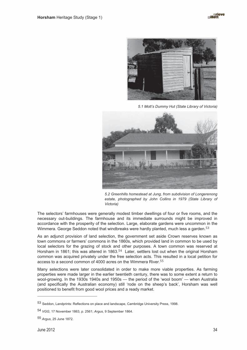
The first land selection acts in Victoria were passed in 1860, 1862 and 1865, but these were largely ineffective in achieving the objective of settling a large number of people on the land. The intention of the legislation was thwarted by the shrewd practices of the squatters, who took advantage of various loopholes in these acts to maximise their acquisition of freehold land. Some squatters employed professional agents to acquire blocks on their behalf. As one of the critical requirements for selection was for occupation of the land, wily advertisers spruiked mobile ‘dummy huts’, which could be wheeled from block to block to fool local government inspectors that a selector was bonafide. A local example of such a structure was Mott’s dummy hut at Natimuk, which is now in decay.
It was not until the passage of revised and improved legislation in 1869, drafted by James Macpherson Grant and duly namely the Grant Act, that a large number of settlers could successfully take up selections in the study area. Under the Grant Act, Crown land was sold for £1 per acre. The requirements of the selectors were residence, cultivation and improvement of the land, with a yearly rent paid to the government of 2 shillings per acre. Selections could be up to 320 acres in size (equivalent to half a square mile), and were available both to men (married or single) and to unmarried women.
Hopeful farmers eagerly anticipated the passage of the new acts. In 1860 it was reported that ‘several families from South Australia have already crossed the border, and have squatted down in the neighbourhood of Horsham, in order to await the passing of our Land Bill, and then to select
Horsham Heritage Study (Stage 1)
June 2012 33
farms under its provisions’.� Streams of covered wagons that arrived in the district from the late 1860s presented something of a land rush.
Relations between selectors and the local squatters became tense and acrimonious. The squatting class, who sought to retain as much of their holdings as possible, derided the selectors, sometimes dubbing them as ‘cockys’, and expressed strong doubts that the Wimmera could indeed support a large agricultural population, as the government hoped. The squatters countered the positive message of land selection promoted by the colonial government, declaring that the country was best suited to sheep and was in fact too arid to support a large population. At a gathering of ‘squatters and principal residents of the district’ in 1873, for example, the speakers all defended the pastoral interest and argued that ‘the prospects of agriculture did not meet with very glowing treatment’.�� Some squatters took positive, indeed radical, action to deter selectors. In one locality, squatters purchased numerous blocks themselves, including a block where a selector has built a flour mill. They demolished the mill, thus destroying any immediate plans for successful cereal cropping in the area. There were other such stories — the stuff of rumour and hearsay. As Garnet Walch observed:
for many years, popular belief set down this neighbourhood as a howling wilderness, an impression fostered by the first squatter resident here, who reported that his run would not carry a single sheep to fifty acres. Whether it is true that sheep were occasionally slaughtered and shown to intending selectors as having died of starvation, and whether, also, “neat” grog was really served round as proof of the waterless condition of the estate, are questions not within our power to settle . . .��
Squatters were quietly disgruntled. The Calder family of Polkemmet returned home from a visit to Scotland in 1873 to find that ‘nearly all their best land had been taken up by selectors, leaving only an area of 3000 acres to go with the homestead’.50 Alexander Wilson’s family fared better, selecting numerous blocks themselves of the original Vectis station between 1869 and 1876.���Despite their best efforts, it was impossible for squatters to do much to prevent the large number of selectors arriving to peg out land. A local land office was established in Horsham in the early 1870s to administer and regulate the process of land selection. Disputes between parties, and cases of non-compliance with the legislation, were heard through a local Land Board.
The many small selections were regimented in squares and rectangles, and were mapped onto a landscape of only mild undulations. There was a flatness and monotony in this new land-use pattern. In some parts, such as around Laharum, the land available for selection was heavily timbered, as the more sparsely timbered country had been deftly retained by the squatters.�� As farmers cleared the land of trees, they left an even more featureless landscape. With the dramatic change in land usage over a period of around twenty years, the pastoral interest was largely eroded, and as a result there are only a few examples of intact early pastoral buildings that survive in the study area; Walmer and Mount Talbot [VHR H0468] are rare examples.
47 Argus, 21 August 1860.
48 Argus, 6 March 1873.
49 Walch, Victoria in 1880, 1881, p. 109.
50 Coulson, Horsham Centenary, 1950, p. 4. See also Miss Calder’s Memoirs in the Argus, June 1933.
51 See ‘Quantong, County of Borung’, 1895 (SLV Map Collection).
52 Lah Arum, 1987.
Horsham Heritage Study (Stage 1)
June 2012 34
�
5.1 Mott’s Dummy Hut (State Library of Victoria)
�
5.2 Greenhills homestead at Jung, from subdivision of Longerenong estate, photographed by John Collins in 1979 (State Library of Victoria)
The selectors’ farmhouses were generally modest timber dwellings of four or five rooms, and the necessary out-buildings. The farmhouse and its immediate surrounds might be improved in accordance with the prosperity of the selection. Large, elaborate gardens were uncommon in the Wimmera. George Seddon noted that windbreaks were hardly planted, much less a garden.��
As an adjunct provision of land selection, the government set aside Crown reserves known as town commons or farmers’ commons in the 1860s, which provided land in common to be used by local selectors for the grazing of stock and other purposes. A town common was reserved at Horsham in 1861; this was altered in 1863.�� Later, settlers lost out when the original Horsham common was acquired privately under the free selection acts. This resulted in a local petition for access to a second common of 4000 acres on the Wimmera River.��
Many selections were later consolidated in order to make more viable properties. As farming properties were made larger in the earlier twentieth century, there was to some extent a return to wool-growing. In the 1930s 1940s and 1950s — the period of the ‘wool boom’ — when Australia (and specifically the Australian economy) still ‘rode on the sheep’s back’, Horsham was well positioned to benefit from good wool prices and a ready market.� 53 Seddon, Landprints: Reflections on place and landscape, Cambridge University Press, 1998.
54 VGG, 17 November 1863, p. 2561; Argus, 9 September 1864.
55 Argus, 25 June 1872.
Horsham Heritage Study (Stage 1)
June 2012 35
Closer settlement
As part of the Victorian Government’s push to further develop the land for its maximum potential for economic productivity, legislation was passed in 1904, which enabled the government’s compulsory purchase of large and poorly utilised pastoral estates for the purpose of creating smaller, more productive holdings.� This coincided with dramatic improvements to wheat production, namely super-phosphate and the new Federation strain. Large estates in the study area that were subdivided under the Closer Settlement Act included Walmer; South Brighton; North Brighton; Vectis; Pimpinio; and Noradjuha.� The Closer Settlement Board, which administered the Act, built rudimentary timber cottages on the blocks, according to the Board’s own pattern-book designs, fenced the holdings, and provided expert advice.�� As a result, there was a broad uniformity in the design of settlers’ homes across an estate. By the early 1900s, farmers in the district generally had larger and more comfortable homesteads.�� For the wider Wimmera district, it was reported in 1908 that ‘… during the past few years 20 estates, aggregating nearly 150,000 acres, occupied by 20 owners, or say 100 people, have been subdivided into 192 farms, with an average of 700 acres, on which are settled 192 farmers, or about 960 persons.’60
Soldier settlement
The Closer Settlement Board made blocks available to ex-soldiers under the Discharged Serviceman’s Act of 1917. It was desirable for applicants to have some farming experience.�Mostly, it was single farming blocks that were made available to individual soldiers in the study area. One large estate comprised over 5000 acres at Drung (on a property known as Ballyglunin Park estate). By 1921 the estate was ‘fairly well established’ with soldier settlers.�
Soldier settlement blocks were also made available in the study area after World War II. Some examples were: Farley’s, Laharum, 8 blocks; Monterenz, Horsham, 1 block; former Quantong college reserve, 1 block.� On Farley’s estate, the houses were designed by Geelong architects, Buchan Laird and Buchan. Other estates that were cut up following World War II included Kanagulk (former Fulham estate), and the Wilson’s Vectis station (here, the homestead was demolished following subdivision for soldier settlement blocks).�
A large soldier settlement in the Drung area (Parishes of Horsham and Bungalaly) was established after World War II. This had previously been a wheat-growing area, but was planned as an irrigated settlement that would support dairying. A comprehensive soil assessment was carried out in 1953 to ensure its suitability for intense farming.� This became a highly productive area for several decades, but water shortages later posed a problem. Remnants of former soldier settlement blocks around Drung are evident today.
56 Dingle, Settling, 1984.
57 Horsham Times, 28 August 1908.
58 SRWSC, The Irrigated Areas, Government Printer, Melbourne [1910], p. 16.
59 Horsham Times, 28 August 1908.
60 Horsham Times, 28 August 1908.
61 See A.V. Jochinke & Co.: http://www.jochinke.com.au/location.htm
62 Blake and Lovett, Wimmera Shire Centenary, 1962, p. 100.
63 Rosalind Small, Hard to Go Bung, 1992, pp. 244–47; Farley’s was settled in 1956 (Lah Arum,1987, p. 25). 64 For Fulham, see National Trust of Australia (Vic.), ‘Fulham Homestead’; for Vectis Station, see http://users.sa.chariot.net.au/~djenkins/Vectis%20Station.htm, extract from George Gates, ‘The Early Colourful History’, [Wimmera Mail?], 6 May 1948.
65 J.K.M. Skene, ‘Report on Soils of the Horsham Soldier Settlement Project’, 1959.
66 Blake and Lovett, Wimmera Shire Centenary, 1962, pp. 100–101.

Horsham Heritage Study (Stage 1)
June 2012 36
Establishing Village Settlements
A number of ‘village settlements’ were established in the Wimmera in the early 1890s in accordance with the Village Settlements Act 1893. This legislation was passed in Victoria in response to a shift in interest towards co-operative rural settlement and the urgent need for unemployment relief for large numbers of men in Melbourne. Other colonies passed similar legislation.
The Reverend Horace Finn Tucker, Anglican minister at Christ Church, South Yarra, founded several village settlements in the Horsham district, including those at Wonwondah East, Moora Moora, and Dooen. The object of these settlements was to provide a means of living with a view towards settlers acquiring their own blocks and becoming independent rural settlers. Tucker established the village settlement at Wonwondah in 1892, a year before the Village Settlements Act was passed. The applicants were selected from the inner-city working-class suburbs of Melbourne. Settlers lived in huts in close proximity in a ‘village’ arrangement, but farmed on designated blocks outside of this village. A newspaper report of 1893 described the rudimentary construction of the dwellings:
The houses completed, which in comparison with the cold tents are paradises of comfort, have been built at a minimum of costs with the labor of the settlers and of masterial produced by that labor. One of the most comfortable of the cottages is thatched: with reeds brought by their occupier from a considerable distance close to Wartook, we understand, and is plastered inside and out with mud from the bed of the creek hard by.68
Yet despite the initial enthusiasm for these settlements, they were founded on an idealised, even a romantic, utopian notion, and ultimately they were not sustainable. Life on the settlements was primitive and involved long hours of hard labour, and few settlers were able to make a success of it. In some cases the land proved unsuitable for small-scale farming.� There is scant evidence remaining today of the group of village settlements established near Horsham.
Establishing irrigation colonies
In the early 1890s a number of irrigation colonies were established in the study area. Prominent local stock and station agent Thomas Young, developed Young’s Irrigation Colony on Dooen Road as a successful private venture in a bid to produce fat lambs and fruit on blocks close to Horsham. The water engineer John Dickson Derry, who had previously designed the Lake Wartook reservoir water supply scheme, applied his talents to the development of irrigated blocks for intensive food production. Derry joined a private syndicate that developed the Burnlea estate in c.1891–93. The estate covered 500 acres south of the Wimmera River, and provided villa allotments of one-half an acre to willing settlers. Young, Derry and Brake Streets are remnants of this development.�
Another entrepreneurial irrigator was Abel F. Spawn, a former president of the American Colonizing Company and an expert in the dehydrating of fruit. Spawn organised the RiversideIrrigation Company project upstream from the Burnlea Irrigation Company. This company had sold 430 acres by 1892 (in 10-acre lots), and had planted out 150 acres with fruit trees and vines. The names of the original streets laid out at Riverside — for example, Citrus, Vine, and Walnut Streets — are a vestige of this development. Some years later, Spawn recruited 100 people in
67 Blake and Lovett, Wimmera Shire Centenary, 1962, p. 96.
68 Horsham Times, 26 May 1893.
69 Blake, Wimmera, 1973; see also ‘Co-operative settlements’ in Graeme Davison et al. (eds), Oxford Companion to Australian History (1998), p. 159.
70 Reynolds, Naming Horsham’s Streets, 2003, p. 106; Horsham�Times������������������
71 Horsham & District Historical Society, Memories of Green Park, 1992, p. 2.
Horsham Heritage Study (Stage 1)
June 2012 37
Britain for the purpose of forming an irrigation colony at Mt Arapiles. Remnant almond trees and building footings mark the site of this former settlement.�
An area of 3000 acres of the Vectis pastoral property was acquired for a fruit-growing colony named Quantong, which was established by the Co-operative Irrigation Company in 1892. A variety of crops were planned, including a large quantity of fruit. By May 1892 it was reported that extensive clearing had been carried out and that ‘already six or seven comfortable houses have been erected and others are in course of erection’.� Quantong became a thriving fruit-growing community from the early 1900s, with 80 growers operating at its peak. Here, apples were grown for export.� Fruit-growing ceased on account of the drought in the 1990s, when the channel stopped operating.
The optimistically named settlement of Haven (occupying the former town common that was once the haven of rabbits) was commenced in the early 1900s with promises that blocks would be irrigated. Here, orchard and vines were planted, and other crops grown. Growers enjoyed some seasonal success but also faced periodic water shortages and restrictions, and ongoing negotiations with the SRWSC over water rates.�
Settlers at the various irrigation colonies relied on an irrigation permit from the Wimmera Shire Waterworks Trust, which allowed them to draw an allocated amount of water from the various channels. There were periodic problems for growers with the water supply being inadequate, for example in the drought of 1914–15, and again in 1929–30. Much later, following World War II, an irrigation colony near Drung, was developed for soldier settlers. The promise of increased water supply with the completion of new water storages (eg Rocklands Dam) no doubt contributed to its success. Arapiles Shire Councillor Harrie Walter Wade proposed another irrigation scheme around Lake Natimuk for returned soldiers in 1945, but this did not eventuate.
Fruit-growers gradually left the industry and in the 1990s the irrigation system ceased operating as a result of the drought.
�
� �
72 Reynolds, Naming Horsham’s Streets, 2003, p. 91; Keith Lockwood, pers. com., May 2012.
73 Horsham Times, 24 May 1892; see also ‘A Trip to Quantong’, Horsham Times, 6 February 1894�
74 Young, Pioneer Station Owners of the Wimmera, 1926, p. 9.
75 See, for example, Horsham Times, 26 January 1915.
76 See Kathleen Dermody ‘Wade, Harrie Walter (1905–1964)’, in Australian Dictionary of Biography: vol. 16 (MUP, 2002).
77 Laura Poole, ‘Irrigation in the Wimmera: An old industry remembered’, ABC Rural, 13 July 2010: http://www.abc.net.au/rural/content/2010/s2952110.htm

Horsham Heritage Study (Stage 1)
June 2012 38
Chapter�6�
Governing�and�administering�If a borough is formed, the rates locally raised will be expended locally and then no bickerings or jealousy can be engendered by rivalry or clash of interest between town and country.
Horsham Times, 11 August 1882
Regulating Aboriginal lives
The often unjust and unchecked treatment of Aborigines by early settlers prompted the colonial government to establish the Central Board for the Protection of the Aborigines in 1861. This system relied on locally appointed ‘protectors’ who provided rations of food and clothing to Aborigines in their locality and who maintained a register of the local Indigenous population. Local pastoralist Charles Wilson of Walmer was named as an honorary correspondent to the Board in 1861.� Walmer again served as an honorary correspondent in 1868 and distributed rations provided by the Board.�
Establishing Horsham as a regional centre
Horsham developed from its early beginnings into an important town centre in the Wimmera. The Wimmera had been a recognised pastoral and electoral district since the 1840s and 1850s, and Horsham quickly emerged as the central base for that activity. It represented the central administration of various regional government functions, such as police, postal services, and land settlement — hence its tag, ‘the capital of the Wimmera’. In the mid-twentieth century Horsham was the seat of several state government agencies, including the Soldier Settlement Commission.�
Geographical and other factors influenced this development. In the 1850s Horsham was the only sizeable town west of the Pleasant Creek (Stawell) diggings. It was relatively isolated from the other Western District towns to the south, such as Dunkeld and Hamilton, due to the Grampians, which posed as a physical obstruction to traffic heading south. Its mid-way position on the Melbourne–Adelaide transport route was also a key factor in Horsham’s development. Its role as a service town for an extensive agricultural district, and as an important stock-selling centre, ensured the town’s commercial viability. The government operated a land survey office at Horsham from the 1870s. Horsham was also a springboard for settlement of the Mallee in the early 1900s, during which time Horsham benefited as a trade and supply centre.��
Local government
The Horsham Road District was declared in 1862, and this area was later designated as the Shire of Wimmera in 1864.�� The Shire grew rapidly from the 1870s due to the large area thrown open for selection. Commodious shire offices were erected in Horsham in 1875, probably to a design by the Public Works Department (see illustration below). Soon after, Horsham town residents and business owners moved to have township area severed from the Shire of Wimmera to form a separate borough, as this they felt would better serve their interests. As a result, the new Borough of Horsham was constituted in 1882 and a town hall erected soon after was described as ‘a lofty structure’.�� The Wimmera Shire offices were demolished in 1936. The Wimmera Shire, which 78 First Report of the Central Board Appointed to Watch Over the Interests of the Aborigines in the Colony of Victoria,Government Printer, Melbourne, 1861, p. 34.
79 Argus, 21 August 1868.
80 Osmar White, Guide to Australia, 1968, p. 162.
81 Blake, Wimmera, 1973, pp. 54–55.
82 VGG, 7 March 1862, p. 428; VGG, 4 March 1864, p. 524.
83 Garran, Picturesque Australasia, vol. 1: Victoria, 1886–88, p. 276.

Horsham Heritage Study (Stage 1)
June 2012 39
now surrounded the new Borough of Horsham, nevertheless continued to occupy shire offices located within the Borough.
The Shire of Arapiles was formed in the 1880s, taking with it the towns of Natimuk and Noradjuha. From the late 1890s until after the 1950s, the Shire of Arapiles council chambers was located at the small town of Noradjuha, which supported only about one-quarter the population of Natimuk.�� The Arapiles Shire later moved its headquarters to Natimuk, where the former shire office still stands. In 1994, as part of the restructure of Victorian local government areas, the former shires of Wimmera and Arapiles were merged to create the new Horsham Rural City.
6.1 Wimmera Shire Offices, on the corner of Firebrace Street and Roberts Avenue, Horsham, erected in 1875 (Museum of Victoria)
Lands Office
The first local meeting of the Lands Board took place at Darlot’s Brighton station in c.1847, when the boundaries of the various runs were drawn up. Local lands offices were established across Victoria in the 1860s to help process and administer the new land selection acts. A local Land Board sat regularly at the Horsham court house from the late 1860s to resolve disputes between parties arising from the selection of land in the district, and to enforce the compliance of selectors with the requirements of the selection acts. The first lands officer to serve the Horsham district was based some distance away in Ararat / Ballarat.�� Stuart Bolton was appointed the first land officer at Horsham in 1866.� He served an extensive area to the north and west, extending past Warracknabeal in the north.� The first Lands and Survey Office was situated in Firebrace Street, Horsham and described in 1883 as a ‘fine building’.��
�
� � 84 VMD, 1898, p. 276; VMD, 1930, p. 302.
85 Lah Arum, 1987.
86 VGG, 27 February 1866, p. 477.
87 Keith Hofmaier, Brimful of Memories: Some folk and oral history of Brim and district, p. 10.
88 Home to Horsham, 1929, pp. 10, 26; South Australian Register, 18 January 1883.

Horsham Heritage Study (Stage 1)
June 2012 40
Chapter�7�
Forming�townships�
Horsham proper, a town of a few years’ growth, … is a bustling little go-ahead town at certain seasons of the year . . .
Garnet Walch, Life in Victoria, 1881, p. 108.
Horsham is the natural hub and capital of the Wimmera. Attractive homes flanking well-made roads, numerous modern business houses, and excellent hotels are concrete evidence of the prosperity of the district.
Horsham Times, 31 January 1930
Creating new towns
A site for a village at Horsham in the Port Phillip District, then part of the Colony of New South Wales, was selected in May 1850.�� The colonial authorities recognised the makeshift efforts at a village already in evidence on Darlot’s North Brighton run, and sought to make this permanent. Darlot’s son, Philip Firebrace Darlot, later claimed that his father selected site of the Aborigines’ corroboree ground as the spot for a village.� The first town plan, dated 1850, shows a handful of pre-existing buildings, including a police station, a store, an inn, and a pound. One visitor to Horsham in 1852 found ‘One Publick House smithy store and 3 or 4 stone huts’.�� The 1850 plan largely disregarded any claims these early buildings had to the sites on which they stood, but it did permit the foundational Langlands store a block of its own. Local historian Vivian Reynolds suggests that the new survey of 1850 may have been shaped around existing roads or tracks.��There is a rough track shown, for example, that approximate the path of today’s Henty Highway.
�
7.1 Horsham Township Reserve, 1855, from detail of James A. Shaw, ‘Plan of Village and Nine Mile Reserve, Horsham’ (National Library of Australia)
� 89 VGG, 14 May 1850, p. 763; Reynolds, Naming Horsham’s Streets, 2003, p. ix.
90 Blake, Wimmera, 1973, p. 54.
91 Cornish in Victoria: http://www.cornishvic.org.au/overlandgold/downloads/Luke-Trip_text.pdf
92 Reynolds, Naming Horsham’s Streets, 2003, p. vii.
Horsham Heritage Study (Stage 1)
June 2012 41
The village was officially surveyed by Assistant Surveyor James A. Shaw. His ‘Plan of Village and Nine Mile Reserve, Horsham’ is dated 1855. This shows a central grid of streets that formed the village centre, which was surrounded on all sides by larger allotments for farming. The roads are named after early settlers, for example ‘Darlot Street’. The larger area sits within a nine mile block, which defined the extent of projected town development at that time. This measured nine square miles (i.e. three miles north–south by three miles east–west). The Nine Mile Reserve incorporated the existing ‘Police Paddock’ and provided a burial ground on the northern boundary.�� The boundary of the reserve correlates to the area that is currently bounded by Cameron Road, Rasmussen Road, Curran Road, and Kenny Road.
In its early years, the village was home to only a small population of settlers, including bullock drivers and hoteliers. Through the 1850s and 1860s, the township slowly took shape, with town allotments sold off, and subdivided for commercial and residential purposes. The usual reservations were proclaimed for public buildings, public recreation grounds, churches and schools. In 1860, for example, a 5-acre site at Horsham was set aside for public buildings.��
The rush to select land in the 1870s led to dramatic growth in Horsham itself and the development of other smaller centres in the district. By 1881, the broad Horsham district had reached a population of over 1600 people, which was five times greater than the population of 1871.�� As the farming population grew and prospered, Horsham had become a much larger, well serviced and established town by the late 1880s and 1890s. In 1889, it was described as ‘a well laid out and well built town’.� When American novelist Mark Twain visited Horsham in 1895 he described it as ‘peaceful, inviting, full of snug homes, with garden plots and plenty of shrubbery and flowers'.�
The town of Natimuk, west of Horsham, was surveyed in 1874 by Eastone Johnstone, but this plan was never laid out. An alternate site was selected the following year and a second survey prepared by Johnstone owing to the pre-existance of a store.�� Within five years it was described as a ‘pretty prosperous village’.�� The township area was extended several times in the 1880s, and the extent of its commercial, retail and manufacturing activity expanded accordingly.
In the buoyant mood fuelled by land selection and the prospects of lucrative cereal-growing, a number of other new townships were gazetted in the early 1870s, including Arapiles, Kewell, Pimpinio, Wail and Jung. Some failed to prosper. Vectis, in the parish of Quantong on the Wimmera River, for example, was reserved in 1886, but experienced only limited growth.� Another unnamed ‘township’ was surveyed just south-east of Vectis and reserved in 1893.� �
93 Jean Field, Waggon Wheels Thru’ the Wildflowers, 1977, p. 65; also Coulson, Horsham Centenary, 1950, p. 7; see ‘Plan of Village and Nine Mile Reserve, Horsham’, 1855, Nan Kivell Collection, held NLA.
94 VGG, 18 September 1860, p. 1749.
95 Susan Priestley, Making Their Mark, 1984, p. 75.
96 Andrew Garran (ed.), Picturesque Atlas of Australasia, vol. 1: Victoria, p. 278, Archive CD Books, Disk 1, 2008 (first published in Sydney, 1886–88).
97 Mark Twain, Following the Equator: A journey around the world, vol. 1, details, p. 242.
98 Allan Lockwood, Natimuk: The first 100 years, 1972, no pages [p. 16].
99 Walch, Victoria in 1880, 1881, p. 109.
100 VGG, 5 February 1886, p. 287; see Quantong Parish Plan, 1895 (SLV Map Collection).
101 Quantong Parish Plan, County of Borung’, 1895 (SLV Map Collection).
Horsham Heritage Study (Stage 1)
June 2012 42
Gazettal dates of new townships Wail 1873
Arapiles 1873
Kewell 1873
Pimpinio 1873
Jung 1874
Kewell East, parish of (village)
1874
Natimuk 1874
Noradjuha c.1880 or 1885
Wonwondah (village) 1884
Vectis 1886
Toolondo 1887
Nurrabiel 1889
Wonwondah East 1907
Dooen 1907
Haven [1912]
�
Many of the smaller hamlets survived, for example Laharum, Dooen and Noradjuha, but these failed to develop into little more than modest concerns. Many small towns supported a small and scattered population, and generally provided little more than the basic services, such as a store, hotel, and state school; other slightly larger towns might also support a public hall, and one or two churches. The township of Jung, north of Horsham, supported a modest number of public buildings in the 1930s, including a public hall (known as the Federal Hall), a state school, a church, and post office, and was important on account of its railway reservoir.� � Nearby, there is little left to distinguish the former town of Jerro, except for the town cemetery.� � At both towns a number of buildings have been demolished, relocated, or left derelict.
Horsham continued to develop through the late-nineteenth century and into the twentieth. The original village layout was soon enlarged, making way for new residential and commercial developments. The southern entrance to the town, along O’Callaghan’s Parade, for example, was subdivided for shops and houses in 1881–82.� � The arrival of the railway in 1879 was a major boost to the town, improving the marketing of primary produce, but also reinforcing Horsham’s role as a central transport hub and, with this, bringing new commercial activity and a diverse range of services. The population of the town had grown dramatically over the ten-year period from 1881 to 1891, increasing from 294 to 2678.� �
Town buildings
Some of Horsham’s large public buildings and bank buildings were built of bluestone in the late nineteenth century, but in general building stone remained rare commodity. Where a stronger construction was required, and one probably more fire resistant, other materials were used. Commercial brickworks were operating in Horsham from the 1870s. The Sawyer family established brickworks at Green Park in 1874, in anticipation of winning considerable future contracts erecting public buildings in the growing township. They dug clay pits close to the river
102 VMD, 1930, p. 745.
103 ‘Jung’: http://www.repertoire.com.au/tree/jung.htm; accessed October 2011.
104 See Plan of Horsham, 1882, NLA.
105 Blake, Wimmera, 1973, p. 73.

Horsham Heritage Study (Stage 1)
June 2012 43
and built large kilns. Up until the introduction of new machinery in the 1930s, the Sawyer bricks were hand-moulded and hand-fired.� Bricks were used in the construction of public buildings, commercial buildings and better quality homes, but were rarely used in the construction of farm buildings. In 1870, the Langlands family built a large (17-room) private residence in Darlot Street, Horsham, constructed of concrete, which they named ‘Wotonga’.�
Interwar development
Horsham grew prodigiously following the First World War and up until the Depression, owing largely to rural prosperity. The town ‘extended in every direction in a manner unparalleled in Victorian town development. Here, bare paddocks had given way to populous quarters, built over with handsome residences, suggestive of metropolitan suburban style and opulence’.� � Anumber of subdivisions in the 1920s further enlarged the town. These were largely residential, including Kalimna Park on the Natimuk Road.� � The greatest spread of new development has been to the north and west, which could be partly explained by the fact that the areas to the south and east of town had richer soil. The river formed a natural boundary to the original (‘Nine Mile’) village reserve, though later development encroached across the river. By 1930, Horsham boasted a cement works, two plaster factories and three brick kilns, which indicates a significant level of local building activity at that time.��
As well as general agricultural prosperity through the interwar period, Horsham was thriving as a service centre for the wider district and as probably the most important stopping place on the Melbourne–Adelaide road. It was a bustling place on a Friday when farmers would come to town for the weekly shopping trip. Horsham was a progressive town, with a great array of stores, businesses and services.111 Its growth between the wars is reflected in the rich collection of Art Deco buildings in the town, and to a lesser extent in the smaller hamlets — for example, the radio wireless station at Dooen (demolished), the former Wimmera Stock Bazaar (1936), the Twentieth Century Picture Theatre, the imposing new Horsham Masonic Lodge (1937), the ‘T and G’ Building (1940), and a number of individual shops. In 1939, a new concrete bridge was built over the Wimmera River and the new Horsham Town Hall was opened. The Langlands illuminated beacon stood as a symbol of prosperity. In 1949, amidst the flurry of postwar growth and rural prosperity, Horsham celebrated its centenary. Its continued growth in the second half of the twentieth century came at the cost of many small centres. As transport improved and commercial interests were consolidated at Horsham, the offerings of the smaller hamlets were generally insufficient to sustain much of a population.
Essential services
Critical to improving life in the towns was through the provision of essential services. The local council carried the main burden of this work, but private organisations also contributed. A chief responsibility of the local council was the maintenance of roads, footpaths and drains. By the late 1880s stone for road-making was brought to Horsham by tramway from the Mackenzie Creek Quarries.��� The footpaths were paved in asphalt in the early 1880s. [Horsham Times, c.1882]
�
106 James Cowell, ‘Pioneers of Brickmaking: History of Horsham Works – 94 year old industry’, Horsham Times, 23 June 1936, cited in Horsham & District Historical Society, Memories of Green Park, 1992, pp. 96–97.
107 Reynolds, Naming Horsham’s Streets, 2003, p. 105.
108 Home to Horsham, 1929, p. 12.
109 Home to Horsham, 1929, p. 14. Additional examples of 1920s subdivisions are given in Reynolds, Naming Horsham’s Streets, 2003.
110 VMD, 1930, p. 388.
111 See chapter on shops in Brooke and Finch, Horsham, 1982.
112 Home to Horsham, 1929.
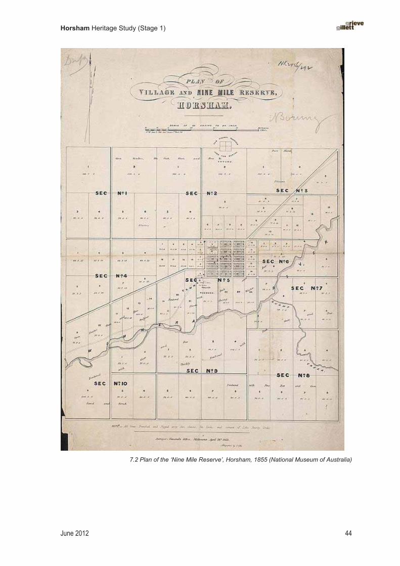
Horsham Heritage Study (Stage 1)
June 2012 44
�
7.2 Plan of the ‘Nine Mile Reserve’, Horsham, 1855 (National Museum of Australia)

Horsham Heritage Study (Stage 1)
June 2012 45
The Horsham Gas Company operated the Horsham gasworks from 1882, which enabled the lighting of street lamps at night.��� Horsham later introduced electric lighting. Electric street lights arrived in Natimuk in 1927. The Natimuk Electric Supply joined with the SEC in late 1956. [www.arapiles.net]
By 1929 a sewerage scheme had been passed by the Borough Council and surveys prepared. The Horsham Sewerage Authority was formed in 1934. It was charged with the task of compulsorily acquiring land and to build channels, sluices, drains, treatment tanks, filters and water service for the treatment of sewerage.���
Promoting public health
The first health services were provided by family and friends in the early isolated settlements within the study area. Medical doctors, and possibly midwives, were operating in the area by the 1860s.��� An early hospital was owned by Richard Spry, probably in the 1860s; this is thought to have been on the south-eastern corner of Baillie and McPherson Streets.�� A site was set aside for a public hospital in 1874, and tenders were called for brick and stone work at the site the following year.�� The hospital was extended with a new wing in 1881,��� and extensive private gardens, and the building was gradually added to over the years. The Horsham Hospital opened new buildings in 1927 and in 1938 was re-named the Wimmera Base Hospital.��� There were also several private hospitals in Horsham (numbering five in the 1920s), including nursing (maternity) hospitals.�� There were also small private hospitals at Natimuk and at Green Park, where a maternity hospital opened in 1909.��� Health services for mothers and babies included the provision of midwives and by the 1920s of ‘nursing hospitals’ in Horsham. An infant welfare centre was opened in Horsham in 1936, followed by several others.���
Horsham and the wider district suffered a number of epidemics through the late-nineteenth and into the twentieth century. Typhoid was prevalent in the 1880s and 1890s, and into the first decade of the 1900s. The Horsham District Hospital trialled a special cold bath treatment for its typhoid patients in 1902.��� An epidemic of diphtheria also struck at Horsham between July 1898 and July 1899. While Horsham was thought to have had a reasonably satisfactory water supply at this time, it was found to be drawn from an increasingly polluted river and therefore its quality was dubious. Following World War I, with the Spanish ’Flu raging, the Natimuk Court House was briefly used as a makeshift hospital.���� In 1920, the Horsham Hospital had an isolated ward for infectious diseases, which was possibly also established on account of the Spanish ’Flu.����The
113 Australasian Sketcher with Pen and Pencil, 18 November 1882.
114 Home to Horsham, 1929, p. 12; VGG, 12 December 1934.
115 Finch, Since Adam Was the Man, 1974, p. 5.
116 Reynolds, Naming Horsham’s Streets, 2003, p. 91.
117 VGG, 24 July 1874, p. 1387; Argus, 12 January 1875, p. 3 (tenders called for stone and brick work at the Horsham Hospital).
118 Whitworth, Official Handbook and Guide to Victoria, 1881, p. 266.
119 Finch, Since Adam Was the Man, 1974, p. 27.
120 Memories of Wonwondah, c.1998, p.??; VMD, 1920, p. 317.
121 Horsham & District Historical Society, Memories of Green Park, pp. 5, 20, 46-47 (the Green Park maternity hospital was situated at 84 Stawell Road).
122 Memories of Wonwondah, c.1998, p.??; Brooke and Finch, 1982, p. ?
123 Camperdown Chronicle, 16 June 1883; Argus, 29 April 1898; Adelaide Advertiser, 8 December 1902; other newspaper references from the 1900s.
124 www.arapiles.net website; accessed August 2011.
125 VMD, 1920, p. 317.

Horsham Heritage Study (Stage 1)
June 2012 46
risk of water-borne diseases fell considerably after 1934, with the introduction of a safer and more reliable town water supply from Mt Zero. Tuberculosis remained a serious problem and the hospital erected a TB Chalet in 1948.126 A polio epidemic struck the town in 1949, with the result that the Horsham centenary celebrations had to be post-phoned until the following year.
Establishing cemeteries
The first burials took place when the country was occupied by vast pastoral stations. Some of the deaths of members of the squatters’ families have been recorded, but countless others, such as station employees or itinerant workers, no doubt lie in unmarked graves. At the private burial ground on Polkemmet station, an grave was dated 1846.�� The Carters’ first family burial was of their last child Sarah, born in 1841, whom they buried on the banks of the Wimmera River near Dooen.���
In T.J. Shaw’s ‘Plan for a Nine Mile Reserve and Village of Horsham’, dated 1855, a square site on the northern boundary of the ‘Nine Mile Reserve’ is marked with the notation ‘For church purposes / used for burial’. This plan shows an 8-acre site for a burial ground, laid out as a square and divided into four quarters. While this site concurs with the location of the present-day cemetery, it is unclear whether this burial ground was pre-existing; it had possibly been established earlier as part Darlot’s Brighton Station but it was not reserved as such in the 1850s. Four cemetery trustees were appointed in 1864, most likely chosen to represent the four chief denominations at that time (Anglican, Catholic, Presbyterian and Methodist); the site was permanently reserved the following year.��� Another early cemetery was at Green Lake, which was in use from 1870 as a churchyard cemetery for the Bethlehem Lutheran Church.��
A large number of small cemeteries were set aside as permanent Crown reserves in the study area in the 1870s and 1880s. A small cemetery of 1 rood in the Parish of Quantong near the Polkemmet PR was temporarily reserved in 1876.��� This had been a private burial ground for Polkemmet station from 1860.��� A larger 5-acre cemetery, also in the Parish of Quantong, was gazetted in 1879.��� 5-acre cemetery reserves were also set aside at Drung in 1872, at Natimuk by 1875, and Tooan in 1877.��� A cemetery was established at Pimpinio by 1876.��� The Nurrabiel Cemetery was gazetted in 1881,�� and the Vectis East and Quantong Cemetery established the following year.��
The small district cemeteries were managed as funding and manpower permitted. Most sites were allocated a fencing grant and some received donations of plants from the Melbourne Botanic Gardens or the State Nursery; in 1896, for example, the State Nursery supplied the borough
126 Coulson, Horsham Centenary, 1950, p. 17.
127 E.D. Calder, ‘Early Days in the Wimmera: A pioneer looks back’, Argus, 24 June 1933.
128 ‘Notes of a talk given by Dr. Jeff C. Jenkinson at Brim Springs on Sunday 5th April 2009’; http://home.vicnet.net.au/~hhs/BrimSpringsTalk_DrJeffJenkinson.pdf; accessed 16 July 2011.
129 VGG, 15 July 1864, p. 1525; VGG, 17 October 1865, p. 2402.
130 Ian Marr, ‘Cemeteries of South West Victoria’ website: http://home.vicnet.net.au/~marr/GREENLK.HTM
131 VGG, 28 July 1876, p. 1381.
132 Ian Marr, ‘Cemeteries of South West Victoria’ website: http://home.vicnet.net.au/~marr/POLKEMM.HTM; accessed May 2012. Burials were discontinued here in 1963 (VGG, 6 November 1963).
133 VGG, 4 July 1879, p. 1717.
134 VGG, 1 March 1872, p. 472; VGG, 26 November 1875, p. 2211; a fencing grant was applied for at Natimuk in 1876 (Argus, 12 May 1876); VGG, 13 July 1877, p. 1338.
135 Ian Marr, ‘Cemeteries of South West Victoria’ website: http://home.vicnet.net.au/~marr/PIMPINI.HTM
136 VGG, 25 February 1881, p. 583.
137 Horsham Times, 1 May 1883.
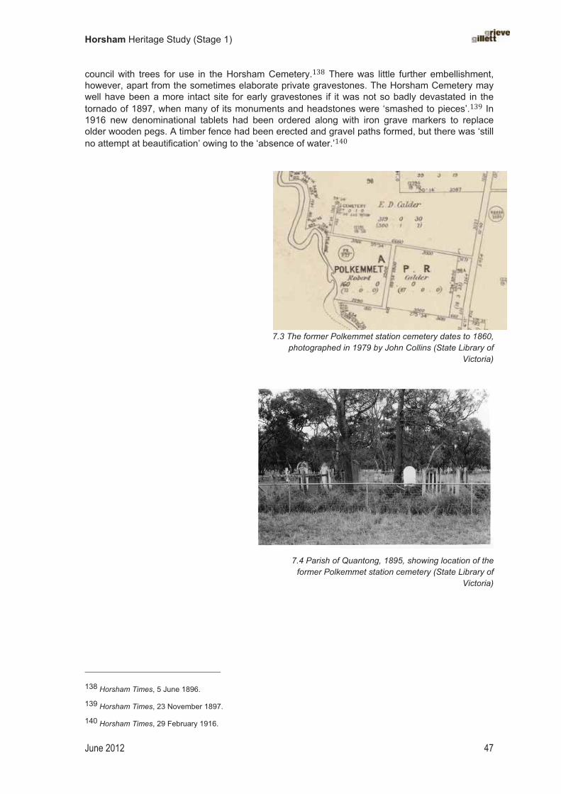
Horsham Heritage Study (Stage 1)
June 2012 47
council with trees for use in the Horsham Cemetery.��� There was little further embellishment, however, apart from the sometimes elaborate private gravestones. The Horsham Cemetery may well have been a more intact site for early gravestones if it was not so badly devastated in the tornado of 1897, when many of its monuments and headstones were ‘smashed to pieces’.��� In 1916 new denominational tablets had been ordered along with iron grave markers to replace older wooden pegs. A timber fence had been erected and gravel paths formed, but there was ‘still no attempt at beautification’ owing to the ‘absence of water.’��
7.3 The former Polkemmet station cemetery dates to 1860, photographed in 1979 by John Collins (State Library of
Victoria)
�
7.4 Parish of Quantong, 1895, showing location of the former Polkemmet station cemetery (State Library of
Victoria)
�
138 Horsham Times, 5 June 1896.
139 Horsham Times, 23 November 1897.
140 Horsham Times, 29 February 1916.
Horsham Heritage Study (Stage 1)
June 2012 48
Town beautification
In the initial survey of the village of Horsham of 1855, the grid for the town centre sat at some distance from the Wimmera River; it did not embrace the river but remained separate from it. There was a problem with periodic inundation, which may have initially deterred town planners from incorporating the river into the town design. Planners were nevertheless mindful to retain as much river frontage as possible for public purposes — both utilitarian and recreational. In 1881, the south side of the Wimmera River, south-west of the township, was permanently reserved for public purposes.
The town itself grew rapidly through the 1870s and 1880s, allowing little time to consider broader planning issues. Some efforts were made to beautify the town, notably the provision of a botanic gardens reserve in 1878. Early photographs show evidence of early street tree plantings. A photograph taken of Firebrace Street in c.1870s, for example, shows young street trees, possibly Plane trees or Silver Poplars, protected by tree guards.��� There were also Elms planted in Bowden Street, which was formed in 1880.��� A row of Sugar Gums (Eucalyptus cladocalyx) was planted ‘about the middle of’ the Stawell Road (Western Highway) near Green Park, probably as much a precaution for dust as for ornamentation.143 In 1882 the Horsham Council advocated a system of street-tree planting whereby property owners were responsible for the tree outside their property.144� ��� ������������������������ ��!"�##���$������%��!��&��������!����������'�������&!(�������)#�!��!��"��)���!��!�������� ������*�������! late nineteenth century (and into the early twentieth century) the curator of the Horsham Botanic Gardens, Thomas Brown, took on the responsibility for managing the Borough street trees.�� In 1896, the Horsham Borough Council was given a disbursement of 400 trees from the Macedon State Nursery, a portion of which could be allocated to street planting.�� In 1897, there were reports (somewhat disparaging) of Silver Poplars being planted along the main thoroughfares.��� In 1901, Councillor John Langlands donated trees for planting along the Natimuk Road within the Horsham Borough; the Racecourse Sub-Committee assisted, with pepper trees (sic. Peppercorn tree; Shinus molle) selected.��� By 1904, efforts at street tree planting were being rewarded with the trees’ vigorous growth and pleasing appearance: ‘We have only got to look at some of the principal streets in Horsham to see what an improvement has been made by planting trees … The desire should be, however, to carry on the tree-planting in the town more extensively than in the past …150 There were difficulties, as curator Brown reported — for example, the loss of a number of Moreton Bay Figs in Pynsent Street in 1908.151��
At Natimuk, the Main Street median was fenced and beautified in the early twentieth century. An avenue of pines was planted along the Natimuk Creek, between Natimuk township and Lake Natimuk; some of these trees survive.����
141 With grateful thanks to Lee Andrews for assistance with tree identification.
142 See Home to Horsham, 1929. For Bowden Street, see photo in Reynolds, Naming Horsham’s Streets, 2003, p. 10.
143 Horsham & District Historical Society, Memories of Green Park, 1992, p. 12.
144 Horsham Times, 28 July 1882.
145 See obituary to Thomas Young, Horsham Times, 29 March 1935.
146 Brooke and Finch, A Story of Horsham, 1982.
147 Horsham Times, 5 June 1896.
148 Horsham Times, 11 June 1897.
149 Horsham Times, 16 August 1901.
150 Horsham Times, 29 April 1904.
151 Horsham Times, 14 February 1908.
152 Keith Lockwood, pers. com., May 2012.

Horsham Heritage Study (Stage 1)
June 2012 49
Chapter�8�
Developing�the�Victorian�wheat�belt�
The Prairie city, as its citizens delight to call it — the plains fenced off into large fields, are covered in wheat and several strippers are at work… the almost level road between fields of wheat stretching as far as the eye can reach …
Garnet Walch, Victoria in 1880, 1881.153
A great many wheat-growers in the Wimmera district are immigrants from tracts of arable country that were settled upon twenty or thirty years ago.
A.C. Garran (ed.), Picturesque Atlas of Australasia, 1886.
Increasing wheat production
Small crops of grains had been trialled by squatters in the Horsham district in the 1840s and 1850s, but it was not until the arrival of large numbers of selectors in the 1870s that grain-growing became a large-scale industry. Horsham quickly became the self-proclaimed centre of the vast wheat belt of the Wimmera. By 1881, the journalist Robert Whitworth noted:
The district is principally a grazing one, although of late large tracts have been taken up by selection for agricultural purposes, especially on the plains to the north-east, between the Wimmera River and the Yarriambiac [sic.] Creek, where agricultural pursuits (cereals chiefly) are rapidly spreading.154
The success of wheat-growing in the Horsham district relied on a favourable climate and suitable soil, but also benefitted from innovations in the design and production of agricultural implements and machinery. Another key component in the development of wheat farming in the area was the reliance on work horses, the Scottish Clydesdales. Much of the harvesting process was arduous and labour intensive, and relied on horse-power. As well as pulling the ploughs and operating the strippers, horses were also used to load the bags of grain onto carts for transportation to the nearest railhead. Farmers and farm hands also put in long hours of hard physical labour. Even the final task of filling the requisite four-bushel hessian bags and stitching up the opening was a slow and tedious task. Particular credit in the development of wheat growing in the Wimmera has been given to the large number of German settlers who travelled across from South Australia, bringing with them valuable skills in dryland farming, such as bare fallowing, as well as useful implements — most importantly, the stripper.���
Many selectors of the 1870s had struggled with the unviability of their 320-acre blocks, and gradually increased their holdings through the acquisition of neighbouring selections. Often family members would select adjoining blocks to ensure that a farm was large enough to be viable — i.e. 640 acres or 960 acres. Evidence of this land use — and particularly in the large acreages — can be seen in the settlement patterns visible in the landscape.
Between 1871 and 1891 the volume of wheat grown in Victoria tripled. In the 1890s there was a slight decline in the rural population around Horsham owing to the greater efficiency of farming and the consolidation of farms. The demand for farm labour also declined. Some settlers moved to the Mallee which had been thrown open to selection.��
153 Garnet Walch, Victoria in 1880, 1881, pp. 108, 109.
154 Whitworth, 1881, p. 266.
155 See ‘Amongst the Selectors’, Argus, 11 May 1880.
156 Blainey, Our Side of the Country, 1984, p. 73.

Horsham Heritage Study (Stage 1)
June 2012 50
Significant improvements to wheat-growing came in the early 1900s, with the introduction of superphosphate in 1903 and of William Farrer’s ‘Federation’ strain in 1904.�� Around this time, the Wimmera District took pride in its claim on being ‘the Granary of Victoria’.��� As the number of wheat growers and the area under crop became greater, local foundries kept apace with the demand for machinery, such as strippers, and many prospered.
Storing grain
Cropping itself required few built structures save perhaps a generic type of farm building for the purpose of storing grain. Once the wheat was threshed it needed to be carefully stored to prevent any damage from weather or pests. Early grain sheds were generally modest structures built using rough forked bush poles for uprights, with three closed sides, and often had a thatched roof.
�
8.1 An early thatched barn at Greenhills, Jung, as photographed by John Collins in 1979 (State Library of Victoria)
A means of large-scale grain storage was also needed. +,� ����� ���� ����!� �������� &����-)�"��.� ��������''�"��!�#,� #����� /�����.����!��#������ � ������#�� �!����0���� ������#.�
1�-��!�������������!�������&!���)(�'������������!���'�����!.159 2�������"�����.��''�"�������#����,����#���!�������"3�#�!�.�&�������!3��!.�)#�"�!����"������������.160 The first grain silos were built in Horsham in the mid-1870s by local flour miller Traugott Noske. Noske relocated his flour mill and silos to a site at the Horsham Railway Station in 1902; he rebuilt his silos in concrete. The first concrete silo was erected in Horsham in 1919; two additional silos were built in 1928 and 1929.161 Noske’s silos were burnt down in 1920.
In response to the establishment of the Grain Elevators Board in 1939, which promoted communal grain storage for more effective marketing, a�!�&�"�!"�������#��&����#������#�����������3����#&�,� ������!� �!� "���� ����Concrete was a superior material, being impervious to water and pests. In the postwar period, concrete silos stood as proud sentinels of rural prosperity at every railway station across the district.�
157 A.V. Jochinke & Co.: http://www.jochinke.com.au/location.htm; accessed September 2011.
158 Horsham Times, 4 July 1905.
159 Argus, 16 December 1874.
160 Horsham Times, 24 February 1885.
161 Coulson, Horsham Centenary, 1950, p. 12.
162 www.arapiles.net

Horsham Heritage Study (Stage 1)
June 2012 51
�
8.2 Noske Bros. wheat silos, Horsham, postcard c.1910s (State Library of Victoria)
�
� �

Horsham Heritage Study (Stage 1)
June 2012 52
Chapter�9�
Developing�a�vernacular�building�style�
Dwellings were very cheaply constructed in the Wimmera, and there were fewer outbuildings than in other districts. There was a general lack of timber, and slab and bark huts were consequently far less numerous than in the eastern half of the Colony. Local clays made excellent bricks when dried in the sun…With only three years to complete sizeable improvements, most selectors were forced to concentrate upon preparing the land itself. Mud, straw and thatch were the usual building materials, and the typical frontier home consisted of two, or occasionally four rooms, built over a frame of bulloke poles and sometimes a few pine slabs, with mud plastered liberally inside and out. Mutton fat is worked into the exterior of the building, and until corrugated iron slowly became popular in the later seventies, a few strips of bark made a serviceable roof. The odd holes could be plugged in with sods and straw and the interior might from time to time be adorned with layer upon layer of colonial newspapers.’
J.M. Powell, The Public Lands of Australia Felix,1970
The architecture of making-do
The first habitations built by Europeans in the Horsham district were mostly simple shelters made of timber with a roof of thatch or of bark weighted down with logs. One pioneer recalled that on arriving in the Wimmera he made �!.�1��������������"��.����������4��"�5�'���������!��!.������������ �!.� ������!� ����(���� At the new settlement of Horsham in the 1850s the majority of buildings were log and bark huts. The frame was typically built of rough bush poles until sawn timber became available and affordable. There were timber mills in the district by the 1860s but many settlers would presumably have salvaged local timber, such as bull-oak and box, in order to minimise costs. External cladding was often horizontal rows of rough logs, otherwise bark and canvas might also be used. Margaret Emily Brown, who was governess at Polkemmet in the early 1860s, described one of the station huts as ‘a very little abode, a regular bush hut, [with] earthen floor and furnished with homemade furniture and fitted with curtained bunks fixed to the sides of the wall’.��
�
9.1 Sketch of a bark homestead at Noradjuha (from Sutherland, Victoria and Its Metropolis, 1888) 163 Calder?
164 Brown, ‘Memoirs’, p. 55 (MS 11619, Box 1833/4, SLV).

Horsham Heritage Study (Stage 1)
June 2012 53
With land selection came the introduction of small-scale farming to the Wimmera. The large pastoral holdings that remained viable continued to run sheep, but the selectors operated mixed farming. Some kept a few cows or pigs; some ran a paddock of sheep; but most also began to plant cereal crops. Whereas the pastoral estates in the district had been developed in a manner typical across western Victoria — that is, a substantial homestead, woolshed, men’s huts, stables, etc. — the small selectors built more rudimentary quarters and embraced a more rough-and-ready, vernacular style of farm building.
Selectors’ homes varied considerably but many followed a typical pattern — that being, a small, single-storey, Victorian-style timber cottage with a hipped or gabled roof, and sometimes with no verandah, exposing a façade bare to the elements. The roof was often thatched. An example of such a cottage is shown below at Garup, located north of Horsham. Here, the exterior appears to have been covered with mud or clay. Many of these simple homes were further developed over the years, with additions and improvements made in line with the material prosperity of the owners.
9.2 Simple and unadorned: ‘a typical selector’s house on the Wimmera Plains in the 1870s’ at Garup (Home to Horsham, 1929, p. 12)
An impressive range of vernacular building techniques were employed in the study area, which settlers drew on in constructing their homes and farm buildings. The availability and affordability of building materials determined these building methods. Timber was readily available and there was no shortage of grasses suitable for thatching, such as Broombush (Melaleuca uncinata).There was less readily available building stone on the Wimmera plains, than in the neighbouring Western District, where volcanic surface stone could be collected for fencing and rough-built rubble structures. In Natimuk, however, settlers utilised Mt Arapiles stone and limestone for building, and established quarries for this purposes.��
Settlers used a variety of earth-based materials. The use of clay and ‘pug’ were common, as was mud-brick, wattle-and-daub, and variations of adobe and pisé building methods. The English-born Barnetts, who selected land at Natimuk in 1879, built a ‘dwelling of adobe and iron, [and] a shed of rough timber straw’.� Where settlements were close to a watercourse, clay pits were dug for the making of conventional bricks, often fired by hand, and ‘sun-dried’ bricks, which were made on site and left to dry in the sun. A published history of Jung provides several good descriptions of construction of houses and farm sheds, including thatched sheds, mud brick houses, wattle and
165 Keith Lockwood, pers. com., May 2012.
166 Horsham & District Historical Society, Memories of Green Park, 1992, p. 11.

Horsham Heritage Study (Stage 1)
June 2012 54
daub cottages, and dwellings with earthen floors and external timber walls sealed with tar.� One property where mud structures have survived is Greenhills, Jung. on the Yarriambiack Creek.
Farm sheds or barns were built of rough timber uprights, sourced from local timbers such as bull-oak (Casuarina sp.) or box (Eucalyptus sp.), with a system of cross pieces to form the roof. The roof was thatched with local vegetation, and was gabled at a low pitch so to prevent the roof straw from sliding off.�� This technique continued well into the twentieth century, testifying to its success and effectiveness. There are a number of surviving thatched farm buildings in the study area, for example at Kalkee. These may have multi-purpose uses today, but many were often originally built to store grain or as stables for the work horses.
A reliance on make-do building methods using locally sourced materials has been an ongoing practice in the study area and characterises many of the surviving vernacular buildings in the study area. ‘Making-do’ was no doubt the best option for newly settled farmers, who were often working a small block with a limited and often unpredictable income. That these vernacular, or primitive, methods persisted in farming communities well into the twentieth century indicates the need for structures that were cheap and easy to build, but also points to significant local ingenuity, and the persistence of and necessity for thrift and frugality. These building methods were used for a longer period in the construction of farm buildings than they were for farmhouses, but not exclusively. On the small acreages in Haven, for example, the practice of building homes of sun-dried bricks continued into the 1930s.�� Some examples of these mud brick buildings survive.
9.3 timber cottage at Green Park, near Horsham, with characteristic bark roof, c.1875 (Museum of Victoria)
A German influence?
There were large numbers of Germans in several localities within the study area, to whom particular building styles have sometimes been attributed. To what extent was pise used in these areas and was this a direct influence of the district’s German settlers? German settlers, who arrived in the district from the 1870s, no doubt played a part in the development and maintenance of these vernacular building traditions, but they were not a singular influence. Germans certainly used earth-based building methods, though perhaps not pise in the strictest definition of the term. Germans elsewhere in the colonies — for example, at Hahndorf in South Australia — used pise between exposed timber framing. However, it is likely that a German background was not a singular influence on local building styles. Architectural historian Miles Lewis argues that the local ‘pisé’-style derived more from British vernacular building methods rather than from German traditions.� The popular perception of German settlers in the Horsham district was as thrifty and
167 Memories of Jung Jung, 1991, pp. ?
168 Miles Lewis, Australian Building: http://mileslewis.net/australian-building/pdf/02-timber-grass/timber-grass-thatch.pdf. See pp. 2.06.12 – 2.06.13.
169 Our Haven, Back to Haven Committee, 1978.
170 Heritage Victoria, ‘German Heritage Study’, citing Miles Lewis, Victoria Primitive, 1977.

Horsham Heritage Study (Stage 1)
June 2012 55
frugal, and to have a dislike of being in debt; their preference for simple and affordable building methods certainly fits with this stereotype.��
Descriptions of the early development of the Natimuk area, where German settlers were numerous, indicate a predominance of earth-based building blocks for construction purposes. The Schmidt House in Natimuk, which was probably built in the 1870s, was constructed using a pug-and-thatch construction method favoured by German settlers.�� A newspaper report in 1887 noted that many of the farmers at Natimuk who had recently arrived from South Australia (and presumably of German background) were ‘erecting substantial houses of stone or brick’.�� The reference to ‘stone’ here is most likely a misnomer and refers to a pise or adobe methods of earth-based building. Another description of Natimuk in 1872 claims that ‘fifty-six selectors had settled in homesteads built of bulloak poles and mud, thatched with grass or reeds.’�� In 1874 a��!����,� 6�"���� ��� &��� ��)����.� ����� 17����!� ����#���!�� ��� ����� )��.���!�!��� $���
��������.��������!���##,�"��'�����#��)�8��4��"�5���������&����������#.�!�����������)�#�!�����
&�����������.��&�������.�!�����"3�.�&����'������������!.��������#���(����
In Peter Monteith’s recent study, Germans (2011) he notes that thatched cottages of the German communities in South Australia. While this style of roofing may have been common elsewhere in the colonies and not restricted to German settlers, the German settlers perhaps readily embraced this style in the Wimmera on account of the availability of suitable grasses and the relative scarcity of other building materials, the cost-effectiveness of this building material, and their familiarity with the technique.
� �
171 See, for example, Argus, 16 December 1874.
172 ‘German Heritage of the Wimmera’, Heritage Victoria, 1999, p. 107.
173 South Australian Advertiser, 18 July 1887.
174 Blake, Wimmera, 1973, p. 28.
175 Argus, 16 December 1874.
Horsham Heritage Study (Stage 1)
June 2012 56
Chapter�10�
Enforcing�law�and�order�
Imposing white man’s law
One of the chief concerns in the early settlement period was the imposing the white man’s law on the newly acquired country — in taking possession of the land and utilising it for production, and forcing the Aborigines to be compliant in this. British law was imposed, in blanket style, on the traditional occupants of the area, who were uninitiated about British legal process. The first case heard in the Horsham police court in 1847 involved a local Aboriginal man; the case was later taken to a higher court in Melbourne and the defendant, found guilty, was sentenced to imprisonment at the Port Arthur Penal Colony in Tasmania.�
Early policing�
When George Langlands and his family arrived in Horsham in 1849 there was already a police station established. In 1847 Thomas (Teddy) Halfpenny had been appointed by the NSW Colonial Secretary’s Office as chief constable for the Wimmera District.� The first police station was situated on the site of the present Lutheran Church.�� In addition, an extensive police paddock (for the police horses) was also set aside on the north side of the Wimmera River, on a site that would later become part of the Horsham Botanic Gardens.��
The first buildings erected at Horsham, dating to c.1849, were police buildings, including a hut with garden, a court house, and a pound for stray stock. By 1851 the colonial government had defined a Police District of Horsham.�� The local police court served to settle disputes between squatters, and between squatters and station workers, and also to manage the problem of stray stock. Other common grievances that came before the court were horse-stealing; petty thieving, especially of stock; and robberies.
Bushrangers were active in the Wimmera area in the 1850s, including Captain Melville and the notorious Daniel ‘Mad Dog’ Morgan, who worked for a time at nearby Longerenong station. Some allegedly had their ‘hide-outs’ in the strategic high-points, such as Mt Arapiles and Roses Gap, and from here they would ‘raid’ passing travellers. A police camp was set up at Roses Gap for this reason. Pastoralists were often targetted. In one incident in the early 1850s, for example, bushrangers made an early morning raid on Wonwondah station.��� In his reminiscences of the early settlement period, Samuel Carter recalled many of exploits of bushrangers in the area.���
As settlements grew and developed, new police buildings were built and older ones improved or replaced. A site for a police station was set aside in Natimuk in 1880, and a limestone building erected there shortly after.��� A new police station was erected at Horsham in 1922–23.��� �
176 Helen Coulson (1950) provides an account of this first trial.
177 NSWGG, 27 July 1847, p. 1.
178 Home to Horsham, 1929, p. 9; Darlot, ‘Reminiscences’, in VHM, 3 July 1940, p. 77.
179 VGG, 7 August 1968, p. 2821.
180 Blake and Lovett, Wimmera Shire Centenary, 1962, p. 28.
181 Calder, 1987, p. 174; Walch, 1881, p. 109; The Pinnacle, September 1923, p. 24; Blake, Wimmera, 1973.
182 Carter, Reminiscences, 1911, pp. 30–42.
183 VGG, 23 July 1880, p. 1896.
184 LCC, Historic Places: South East Study, p. 100; What to See in Horsham, 1964; this was later used as a VicRail office.

Horsham Heritage Study (Stage 1)
June 2012 57
Incarceration
Criminal offenders were only held prisoner in the larger towns where a police station was established. A police lock-up was built at Horsham in 1862, constructed of rough logs; this was elevated to the status of a gaol in 1864. This building was later relocated to private land near Harrow.��� At Natimuk, prisoners were held in a shed at the back of the police station.��
Courts of justice
A court of petty sessions (or police court) was established at Horsham (‘a place to be so called’) on Darlot’s station in 1847; this appears to be the first use of the name ‘Horsham’.�� The court was presided over by the local police officer Teddy Halfpenny and local squatters were appointed magistrates; the first magistrates were William Taylor, Robert Firebrace and J.M. Darlot.���Storeman George Langlands had been a magistrate in his home town of Dundee but did not sit on the Horsham bench. A new building for the court of petty sessions was built in 1860.���
A County Court was appointed in Horsham in 1875 (by the 1860s?)�� A double-storey court house was erected in Horsham in 1877. Sittings of the Supreme Court were held here from at least the late 1880s. This building was demolished and replaced in the late 1960s.
A court of petty sessions was established at Natimuk in 1883.��� A new Natimuk Court House was built in 1891 (1889–90), to an ornate design by Public Works Department architect Samuel E. Bindley.��� This building was used as a court house until around the 1950s.
�10.1 Natimuk Court House, photographed in 1970 by John Collins (State Library of Victoria)
185 VGG, 27 May 1862, p.925; VGG, 30 September 1864, p. 2144. In 1872 its standing as a gaol was rescinded (VGG,26 July 1872, p. 1377); What to See in Horsham, 1966, p.10. See also Brooke and Finch, A Story of Horsham, 1982, ch. 1.
186 www.arapiles.net
187 Argus, 14 May 1847.
188 Darlot, ‘Reminiscences’, 3 July 1940, p. 77.
189 VGG, 21 August 1860, p. 1574.
190 VGG, 24 September 1875, p. 1819.
191 VGG, 15 June 1883, p. 1437.
192 LCC, Historic Places: South East, 1997, p. 47; VHR; Blairs Guide, 1987, p. 209. Bindley designed seven court houses in Victoria in this style between 1887 and 1892.

Horsham Heritage Study (Stage 1)
June 2012 58
Customs and border control
In order to avoid paying a landing tax, hopeful Chinese miners disembarked at Guichen Bay (Robe), South Australia, and trekked across on foot to the diggings, passing close to Horsham. Border police patrolled the area between Horsham and South Australia. Other settlers sought to evade paying customs duties at the border.
�
10.2 Horsham Court House, c.1907, showing newly planted street trees (State Library of Victoria)
��
Horsham Heritage Study (Stage 1)
June 2012 59
Chapter�11�
Developing�primary�industries�
Wheat farming and its extraordinary success measured in bushels per acre overshadows all else in the popular conception of the Wimmera. But wool growing, fat-stock raising and horse-breeding have a prominent place in the life of this wonderfully productive district.
Horsham Times, 31 January 1936
Boiling-down works
In the early 1840s, not long after pastoralists had begun to establish themselves in Victoria, the price of wool plummeted. As a result, pastoral settlers needed to dispose of large quantities of stock, which was earning them no income. Boiling-down establishments, which essentially extracted anything of value from animal carcasses, were established on several pastoral stations, such as North Brighton, and in this way settlers recouped a small amount.���
Gold-prospecting
The impact of gold-mining in towns to the east of the study area, notably Ararat and Stawell, but also in smaller nearby hamlets, such as Moyston, had important side-effects on the development of Horsham and district. The gold rush was in full swing by the mid-1850s, which brought travellers and trade through Horsham and elsewhere in the study area. Some Chinese who arrived to prospect for gold on the goldfields of central Victoria later settled in the Horsham area and worked as market gardeners.
There was only limited prospecting for gold in the study area itself, and presumably only small yields. In 1852 the diarist Edward Snell noted there was gold-mining going on near Horsham.���There were short-lived mining stints near the west side of the Grampians (in the south of the municipality) by Chinese miners who had arrived overland from South Australia.��� In the 1870s, keen prospectors were also working the ground near Noradjuha.��
Quarrying
Granite from the Mackenzie Quarry, at Mackenzie Creek, was transported to Horsham via a timber tramway (built in the late 1880s) that ran for seven miles. Here there was ‘an inexhaustible supply of excellent building or road-making stone’.�� Heatherlie Quarry was also used. Sandstone was also quarried near the Grampians for the purpose of building walls for the reservoirs in the area — for example, Lake Wartook.��� Stone was also extracted from Mt Arapiles and used for building; an example of this use is the former shop building at 96 Main Street, Natimuk.��� Gravel for road-making was also extracted from Mount Zero.
193 Blake, Wimmera, 1973, p. 39.
194 Griffiths, Edward Snell, 1987.
195 Lah Arum, 1987.
196 Whitworth, Bailliere’s Victorian Gazeteer, 1879, p. 363.
197 Sutherland, Victorian and Its Metropolis, 1888, vol. 2, p. 94; see also LCC, Historic Places: South West Victoria.[check]
198 Lah Arum, 1987. 199 www.arapiles.net

Horsham Heritage Study (Stage 1)
June 2012 60
Timber-cutting
Timber was needed to build the structures of many residential and commercial buildings, as well as farm buildings. Timber was hauled from the Grampians by horse teams and bullocks.� Saw mills were established at many locations, for example at Green Park in the 1880s.201 The government set aside many timber reserves in the district to ensure a local supply of timber.
Wattle-stripping was also carried out in the Grampians and in the bush on the west side of the Grampians near Lah Arum. The Chinese were involved in this work.� � Wattle bark was used in the process of tanning leather, which in the nineteenth century was an important industry.
Apiculture
Apiculture, or bee-keeping, has been an important industry in the study area, especially in the area close to the Grampians, where Yellow Box grows well, such as Lah Arum and the Wartook Apiary.� � Bee-keeping was also carried out at Haven.204
�
11.1 Timber bee-keeper’s hut belonging to Matthew Matthews at Bald Hills, Laharum (State Library of Victoria)
Trapping
The vast plains of the Wimmera were a favourite haunt of the trapper, who hunted small animals for their skins, for which there was a ready market in Melbourne. In the 1860s possums, native cats and other small marsupials were favoured by trappers. A newspaper reporter in 1861 noted that after passing Horsham there could be seen ‘the solitary tents of these wandering tents of Nimrod … at intervals of several miles’.� � From the 1870s and 1880s rabbit trapping was sufficiently lucrative to provide the chief source of income for many workers.
Horse-breeding
Horses have been integral to the sporting life and the working life of the district. The Scottish Clydesdales, or draught horses, performed most of the heavy farm work before the advent of farm machinery. In 1929 the district was ‘famed for its draught horses’ and in 1932 the Wimmera was recognised as the ‘headquarters in Victoria for draught horse breeding’.206 An important legacy of
200 LCC, ‘South Western Area: District 2: Final Recommendations’, May 1982.
201 Horsham & District Historical Society, Memories of Green Park, 1992, p. 3.
202 Lah Arum, 1987, p. 24.
203 LCC, ‘South Western Area: District 2: Final Recommendations’, May 1982; Lah Arum, 1987, pp. 27, 33.
204 Back to Haven Committee, Our Haven, 1978, p. 60.
205 Ballarat Star, 13 April 1861.
206 Home to Horsham, 1929, p. 11; Townsville Daily Bulletin, 17 November 1932.
Horsham Heritage Study (Stage 1)
June 2012 61
this industry is the former Wimmera Stock Bazaar, rebuilt in 1936 (VHR H1985). Although the breeding of work horses suffered a downturn in the late 1920s with the advent of motorised vehicles, the industry experienced a brief resurgence in the 1930s as the cost of motorised trucks proved too high for many people. Remnants of this industry can be found in stable buildings. The Horsham Modern Dairy continued to use its three half-draught horses for its local milk delivery service until 1981.207
Charcoal-burning
Charcoal-burning involved placing timber under grass in a deep pit and leaving it to burn and smoulder for a period of time. This was a technique practised in several locations within the municipality, for example at Lah Arum. There are remnant pits and mounds associated with charcoal-burning, including the River Tracks Charcoal Pits in Wail Forest (VHI 7324-0005). Charcoal-burning was carried out up until the 1930s.
Salt extraction
This industry took place near Mitre Dam. [see Lockwood, Arapiles]
Lime pits
Lime was extracted near Mt Arapiles in the 1920s and limekilns operated at Mitre Lake.� �
Fruit-growing and vineyards
The first orchards and vineyards were established by the first wave of European settlers who arrived in the 1840s and 1850s; they were planted where there was ready access to water, such as on the fertile river flats. Orchards were also established on pastoral stations, especially where it was possible to devise a rudimentary irrigation system. There were fruit trees growing on Walmer station, for example, in the 1860s.� �
Some important fruit-growing initiatives were developed in the 1890s. The Riverside irrigation settlement, to the east of Horsham, was promoted and developed as a fruit-growing colony. The choice of street names — for example, Citrus, Vine and Walnut Streets — are testament to these beginnings. When part of the Vectis pastoral property was sold off in c.1892, an area of 3000 acres was acquired for the Quantong fruit-growing colony. Other growers were providing fruit for export by the early 1900s.�� Fruit grown at Quantong in the 1940s included apples, pears, peaches, apricots and grapes. Leading Melbourne nurserymen, Mr R. Cheeseman, provided advice as to which varieties of fruit should be grown.���
Thriving fruit-growing communities developed at Quantong and Dooen from the early 1900s, with 80 growers at Quantong during its peak. The growers operated with an irrigation permit from the Wimmera Waterworks Trust, which allowed them to draw off an allocated amount of water from the various channels. Growers gradually left the industry and then in the 1990s the irrigation system ceased operating.���
Olive-growing
The Grampians Olive Plantation was established in 1942.��� Some of the European immigrants who settled in the Horsham district in the 1950s and 1960s took up olive-growing with varying
207 Horsham & District Historical Society, Memories of Green Park, 1992, p. 87.
208 VMD, 1920, p. 345; see Lockwood, Arapiles, 2007.
209 Brown, ‘Memoirs’.
210 Young, Pioneer Station Owners of the Wimmera, 1926, p. 9; Horsham�Times�����9�������� ��
211 Horsham Times, 7 July 1942.
212 Laura Poole, ‘Irrigation in the Wimmera: An old industry remembered’, ABC Rural, 13 July 2010: http://www.abc.net.au/rural/content/2010/s2952110.htm
213 Lah Arum, 1987, p. 35.

Horsham Heritage Study (Stage 1)
June 2012 62
success. The Mt Zero Olive plantation at the northern end of the Grampians was established in 1953.��� Olive Plantation Road also refers to this development.
Tobacco-growing
There were periods of successful tobacco-growing in the study area, for example by grower Walter Kuehne at Burnt Creek.��� A tobacco drying kiln from this period survives here. Italian migrants at Green Lake attempted growing tobacco plants but this proved unsuccessful.��Tobacco-growing was also commenced at Haven in 1931, where some growers employed local Italian labourers. Growers also trialled tobacco crops in the irrigated areas such as Quantong. For a brief time there was a large number of growers but disease ultimately spelled the end of this brief industry.��
Dairy Industry
Many settlers in the late nineteenth century had milking cows and some had small herds which grazed on the Horsham town common.��� With the invention of the mechanised separator, there was dramatic growth in dairying in Victoria from 1889, principally with the establishment of co-operative butter factories. With the introduction of irrigation, thoughts turned to larger scale dairying operations in the Wimmera.
Somewhat optimistically buoyed by the seemingly fool-proof promise of water, a number of dairy factories and co-operative butter factories were established in the study area in the 1890s. There were hopes that dairying would become ‘highly prosperous’.��� Steps were taken in planning to erect a creamery at Dooen in 1890 and also at Green Park (1891), in preference to building butter factories, [HT, 6 January 1891] but these do not appear to have succeeded. In 1892 it was observed that: ‘in the Wimmera the butter factory and the creamery are conspicuous only by their absence. The only creamery in the Horsham district, that at Dooen, has now suspended operations, and is likely, we are informed,' to remain closed for some months to come.’�� The Natimuk Dairy Factory established a butter factory at Natimuk in 1893.��� In 1893 creameries were opened at Natimuk, Pimpinio and at Mackenzie Creek (former Dooen creamery), and at the Tucker Village Settlement at Wonwondah.���
The co-operative butter factories benefitted from the efficiencies gained by farmers sharing a cream separator. During periods of drought however, the herds struggled to produce sufficient cream. For this reason the Pimpinio Butter Factory was forced to close down by the late 1890s.��� The Horsham butter factory closed down in the 1920s.
A later development in dairying was at the Drung soldier settlement, established in the 1950s, where irrigated blocks supported small dairy herds; at that time milk was being brought in from as field afield as Gippsland.��� Any deficiencies in the water supply adversely affected milk production. Dairying proved too difficult and from the 1950s butter was supplied from elsewhere such as Stawell.
214 Photo in Jane Calder, Grampians, p. 99.
215 Horsham Historian, no. 221, May–July 2008, p. 7. 216 See Memories of Green Park, 1992�
217 Our Haven, 1978, pp. 59–60.
218 Brooke and Finch, 1982, p. 93.
219 Horsham Times, 8 November 1892.
220 Horsham Times, 19 January 1892.
221 VGG, 28 April 1893, p. 1912; Horsham Times, 1893.
222 Horsham Times, 1893.
223 Blake and Lovett, Wimmera Shire Centenary, 1962, p. 70.
224 Blake and Lovett, Wimmera Shire Centenary, 1962, p. 101.

Horsham Heritage Study (Stage 1)
June 2012 63
Chapter 12
Doing�business�
Certainly Mr Langlands’ fortunes were bound up in the success or otherwise of those battling selectors. He gave them the goods and left the repayment in the hands of a beneficent Providence.
A Century of Trading in Horsham, 1949.225
Early trade
Horsham began its existence as a small outpost of settlement on the Wimmera River. A small village had begun to emerge at the river crossing on Darlot’s North Brighton run. Enticed by Darlot, George Langlands took a gamble and set up a shop and post office here in 1849.�� His store served the needs of the local pastoralists and pastoral workers, and the regular passers-through. Langlands is celebrated as one of the town’s founders; his establishment of the first store pre-dated the township proper and helped to galvanise the early settlement.�� An inn was established later that same year, and there followed a smattering of other settlers.���
As with other small settlements in colonial Victoria, early settlers at Horsham quickly established the necessary services associated with transport, lodgings and provisions. The town marked the mid-way point for travellers between Melbourne and Adelaide, and so became an important, albeit isolated, centre of trade and commerce. The town was located at a convenient crossing place on Wimmera River where horses could be watered, rested and re-shod. Other shopkeepers followed, as well as those who opened up hotels and boarding houses. Branch outlets of Langlands store were opened at Toolondo and Pimpinio in the 1860s.���
From around 1870, Horsham became the centre of a more closely settled farming community. Land selection in the neighbouring rural areas stimulated town settlement, and the number of shops and business houses in Horsham grew markedly through the 1870s. Later in the 1880s, when Horsham was connected by rail to Melbourne, and to the port of Portland, more stores were opened that sold a diverse range of provisions.
In the early 1880s Horsham’s hotels were described as ‘numerous and good’. They included the Victoria, Wimmera, Commercial, Shamrock and others. The first double-storey hotel was erected for John Gillies in 1882, adding a welcome solidity to the town.�� In addition to licensed premises, there were two temperance hotels.���
Other smaller towns also established the necessary hotels and small supply stores. For example, there were two hotels in Green Park by the mid-1870s.��� Natimuk became a busy centre, but was never large enough to threaten Horsham’s primacy in the region. One of the most successful
225 J. Langlands & Sons Pty Ltd, A Century of Trading in Horsham: A story of pioneering achievement 1849–1949, 1949, p. 18.
226 Blake and Lovett, Wimmera Shire Centenary, 1962, p. 18.
227 Blake, ‘Langlands, George (1803–1861)’, Australian Dictionary of Biography: vol. 5, 1974; J. Langlands & Sons Pty Ltd., A Century of Trading in Horsham, 1949.
228 Blake and Lovett, Wimmera Shire Centenary, 1962, p. 63.
229 Langlands, A Century of Trading in Horsham, 1949, p. 18.
230 Horsham Times, 23 June 1882.
231 Whitworth, 1881, p. 265.
232 Horsham & District Historical Society, Memories of Green Park, 1992, p. 22.
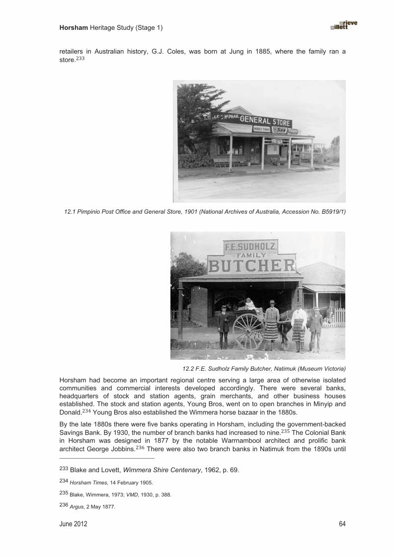
Horsham Heritage Study (Stage 1)
June 2012 64
retailers in Australian history, G.J. Coles, was born at Jung in 1885, where the family ran a store.���
�
12.1 Pimpinio Post Office and General Store, 1901 (National Archives of Australia, Accession No. B5919/1)
�
�
12.2 F.E. Sudholz Family Butcher, Natimuk (Museum Victoria)
Horsham had become an important regional centre serving a large area of otherwise isolated communities and commercial interests developed accordingly. There were several banks, headquarters of stock and station agents, grain merchants, and other business houses established. The stock and station agents, Young Bros, went on to open branches in Minyip and Donald.��� Young Bros also established the Wimmera horse bazaar in the 1880s.
By the late 1880s there were five banks operating in Horsham, including the government-backed Savings Bank. By 1930, the number of branch banks had increased to nine.��� The Colonial Bank in Horsham was designed in 1877 by the notable Warrnambool architect and prolific bank architect George Jobbins.�� There were also two branch banks in Natimuk from the 1890s until 233 Blake and Lovett, Wimmera Shire Centenary, 1962, p. 69. 234 Horsham Times, 14 February 1905.
235 Blake, Wimmera, 1973; VMD, 1930, p. 388.
236 Argus, 2 May 1877.

Horsham Heritage Study (Stage 1)
June 2012 65
the 1920s: the National Bank (built c.1920s?) and the Colonial Bank, built in c.1889 and also designed by Jobbins.�� There were also two banks operating at Noradjuha in the 1920s.���
Residents made commercial decisions, and even took political action, to ensure that Horsham was recognised and then maintained its position as the ‘capital of the Wimmera’. At various times there was a threat to this much coveted title — for example, the decisions being made in the 1870s about the route of particular railway lines��� — and each time, residents staunchly defended Horsham’s primacy in the Wimmera region.
After World War II, many small specialist stores were gradually forced to close. Other small stores could not compete with new larger franchises. Langlands continued under the ownership of Georges (Australia), until they closed the store in 1976.�� With the relentless march of ‘progress’ in the town, particularly with the commercial pressures involved in establishing a regional centre, coupled with the occasional destructive effects of fire, there are few nineteenth-century shopfronts remaining in Horsham. What was once a late nineteenth-century commercial zone has been largely built over.
Hawking wares
Through the nineteenth century and into the early decades of the twentieth century there were a number of hawkers in Horsham and surrounding areas, mostly of Indian and Middle Eastern background, who pedalled their wares from town to town. They provided a much needed and welcome service, and in remote areas were also a means of communication with the surrounding district.��� Langlands also employed hawkers to improve the reach of their retail and other services.��� There was some hostility shown towards hawkers, probably on account of religious bigotry towards their Moslem faith.��� As part of a move to control the practice of hawking, the Victorian government introduced legislation that governed the issuing of hawking licences.
237 VMD, 1898, p. 276; a photo of the National Bank at Natimuk is in the SLV Picture Collection. For the Colonial Bank, see Horsham Times, 19 November 1889.
238 VMD, 1920, p. 345.
239 Brooke and Finch, A Story of Horsham, 1982, ch 4-5.
240 Blair’s Guide: Travel Guide to Victoria and Melbourne, 1987/88, Melbourne, 1987, p. 130.
241 Blake, Wimmera, 1973; Memories of Jung Jung, 1991.
242 Blake and Lovett, Wimmera Shire Centenary, 1962, p. 64.
243 See, for example, Blake, Wimmera, 1973, p. 27.

Horsham Heritage Study (Stage 1)
June 2012 66
Chapter�13�
Promoting�scientific�endeavours�
Advancing botanical and horticultural understanding
From the early period of settlement in Victoria, the Wimmera was recognised as an area with its own distinctive geography and weather patterns. The earliest known collecting of local specimens for scientific purposes in the study area was carried out by the botanical collector, John Richardson, and his fellow bird collector, John Roach, both of whom accompanied Mitchell on his ‘Australia Felix’ expedition of 1836.��� The area was rich in vegetation and bird life, which attracted scientific collectors. In 1860 the curator of the Melbourne Botanic Gardens, John Dallachy, collected many plant specimens in the Wimmera, with assistance from local pastoralist Alexander Wilson of Vectis station.��� Dallachy, described as ‘a meticulous collector of native species’, took a trip to the Wimmera River and Lake Hindmarsh in 1860, investigating local botanical species.��
The assiduous Irish-born naturalist St Eloy D’Alton was a keen botanical collector, who gathered specimens from the northern fringes of the Grampians, Mount Arapiles, and the broader Wimmera, and Little Desert area from the 1880s until after World War I. From his home in Dimboola, D’Alton sent specimens to Ferdinand Mueller in Melbourne and also provided regular specimens to the Field Naturalists’ Club of Victoria.�� Daniel Sullivan, a school teacher from Moyston, also collected local specimens for Mueller.��� In return, Mueller provided many seeds and seedlings of exotic plants to places in the Wimmera.��� In the mid-1870s Mueller also sent a number of plant displays to many institutions, including the Horsham Mechanics Institute.��
On account of its isolation and large expanses of sparsely settled country, the Horsham region has provided the opportunity for bird-lovers and others to study nature. A local field naturalists group was established by the 1960s, but the collection of specimens of flora and fauna in the Wimmera region by members of the Field Naturalists’ Club of Victoria began in the 1880s and 1890s.��� Some early collections of plant specimens are displayed in the museum of the Horsham & District Historical Society (at the Horsham Mechanics Institute). Cliff Beaglehole has also made a significant contribution to the study of botany in the district.
Promoting acclimatisation
Samuel Wilson of Longerenong station (outside the study area) was a leading figure of the acclimatisation movement in Victoria in the 1860s. He was a member of the Acclimatization Society of Victoria formed in Melbourne in 1863. While Wilson’s large pastoral estate lay outside the study area, his brothers’ properties were also used for acclimatisation purposes. Some exotic
244 Blake and Lovett, Wimmera Shire Centenary, 1962, p. 13.
245 Argus, 11 February 1861.
246 Alan Gross, ‘Dallachy, John (1808?–1871)’, Australian Dictionary of Biography, vol. 4, MUP, 1972.
247 St Eloy D’Alton (1847–1930) also wrote a number of scientific papers on his botanical discoveries in the Wimmera region; see J.H. Willis, ‘Botanical Pioneers in Victoria’, vol. III, Victorian Naturalist 66, pp. 123–128; taken from http://www.anbg.gov.au/biography/dalton-st-eloy.html
248 Jane Calder, The Grampians: A noble range, 1987, p. 145.
249 Andrew May and Sara Maroske, ‘Horticultural embellishments’, Australian Garden History, 4:4, Jan/Feb 1993, pp. 8–14.
250 Rod Home, Mueller Correspondence Project, pers. com., August 2011.
251 See Victorian Naturalist, various refs.

Horsham Heritage Study (Stage 1)
June 2012 67
animals introduced by Wilson were kept at Green Lake.��� The Acclimatization Society, with Wilson at the helm, introduced fallow deer and axis deer to the Wimmera.��� In 1867 it was reported that the Wilson brothers had released Murray cod into the Wimmera River ‘a considerable time since’.��� Much later, English trout were released into the Wartook Reservoir.��� Another local settler, Dr Macdonald of Horsham, donated animals to the Acclimatization Society’s headquarters in Parkville in 1863 and 1866.�� Various exotic animal and fish species can be found in the region today, including deer and trout, which are descendants of the specimens introduced for the purpose of acclimatisation.
In 1859, twenty-six camels imported from Afghanistan and Egypt for use on the Burke and Wills expedition of 1860 were acclimatised at Alexander Wilson’s Vectis station for about eighteen months.�� In 1862, following the expedition, the surviving camels were moved to Charles Wilson’s Walmer station, until his brother Samuel Wilson of Longerenong was ready to take them. In Horsham local school children lined the street to watch the arrival of the celebrated camels.���Camel handler, Esau Khan, accompanied the camels on their voyage out from India, and also travelled with them on their trek from Royal Park to Walmer in September 1862; he remained with them until 19 January 1864.���
Keeping weather records
Some of the earliest weather records in the district were kept at Longerenong station. These date to 1863 and were presumably maintained by Samuel Wilson. Although outside the study area, the development of Longerenong station played an influential part in the development of the wider district. Rainfall records, using a rain gauge, were taken at Polkemmet Road, Horsham, from 1873 and at Natimuk from 1889. Records were also kept at Wartook Reservoir from 1890, soon after construction was complete. Rainfall was also recorded at Jung from 1886, possibly because this was important as the location of a railway reservoir that serviced the Melbourne–Adelaide line.� Temperature records were also maintained for the district.
Wail Forest Nursery
The Forestry Commission of Victoria first planted forest trees at Wail as an experimental plantation in 1911 to test for which timbers would grow best in the Wimmera.�� Historian Les Blake claims that the first trees had been planted by Eskin two years earlier in 1909. A large number of Sugar Gums (Eucalyptus cladocalxy) were planted, and by the early 1930s these were
252 Young, Pioneer Station Owners of the Wimmera, 1926, p. 7.
253 Whitworth, Bailliere’s Victorian Gazetteer, 1879, p. 482.
254 Argus, 27 September 1867.
255 Argus, 18 October 1912.
256 Argus, 1863, 1866.
257 See Arapiles.net: http://www.arapiles.net/history.html; Young, Pioneer Station Owners of the Wimmera, 1926, p. 9.
258 Candy, Reminiscences of the Early Mallee and Wimmera, 1927, p. 2, cited in Donna Bourke, ‘What Happened to the Camels of the Burke and Wills Exhibition?’, Journal of Public Record Office Victoria, September 2010, no. 9, no page numbers.
259 Donna Burke, 2010.
260 NASA (NGDC), ‘Global Historic Climate Network Precipitation Stations’, listed at http://www.ngdc.noaa.gov/nndc/struts/results?fn_0=poly.continent&type_0=Exact&query_0=Australia&fn_1=poly.region&type_1=Exact&query_1=Australia/New%20Zealand&fn_2=poly.cntry_name&type_2=Exact&query_2=&fn_3=poly.admin_name&type_3=Exact&query_3=&query=&dataset=101243&search_look=1&group_id=NONE&display_look=30&submit_all=Select+Data; accessed 26.7.07.261 Blake and Lovett, Wimmera Shire Centenary, 1962, p. 101, Horsham Times, 3 October 1911.

Horsham Heritage Study (Stage 1)
June 2012 68
used to supply telephone poles to the Government.�� Other species were planted, along with an experimental orchard. Then in 1946 the Wail Forestry Nursery was established. Under the careful management of Mr Gray the enterprise at Wail developed into the leading nursery in Australia for native shrubs.�� Wail has also been valued as an important habitat for indigenous flora and fauna. Bill Middleton worked as the forester at Wail for many years. His father introduced other ornithologists to the Wimmera — for example, Crosbie Morrison. Other flora and fauna reserves were later established in the study area, including the Nurcuong Flora Reserve, north-west of Arapiles.
13.1 West Wail Flora and Fauna Reserve (Australian Heritage Photographic Database)
Agricultural research and development
Horsham has developed as the centre of an important agricultural district, and for most of its settlement history, farmers have endeavoured to apply scientific principles to farming methods in order to improve yields and quality of produce. A number of research centres, both government and private, have been established to promote agricultural development. Various state government departments have built research facilities to advance local agricultural endeavours, with a particular emphasis on grain-growing.
The Department of Agriculture established the Wheat Research Institute in Horsham in 1968. This was later known as the Victorian Crop Research Institute from c.1989 and the Victorian Institute for Dryland Farming in the early 1990s. This is now known as the Grains Innovation Park, which is located on the Natimuk Rd, Horsham and attracts international scientists and is the leading wheat research institute in Australia. Private firms seeking to promote agricultural machinery and other commercial products have run field trials in the study area. The farm machinery manufacturer H.V. McKay, for example, ran field trials at Natimuk in the 1930s (series of photos held by Museum Victoria; see image below).
Longerenong Agricultural College, established in the 1880s, has played a key role in agricultural education and innovation in the district.
13.1 H.V. McKay field trials at Natimuk in 1938 (Museum Victoria) 262 Horsham Times, 19 August 193; Blake, 1962, p. 592.
263 Horsham Times, 4 September 1953; Blake and Lovett, Wimmera Shire Centenary, 1962, pp. 101–02.

Horsham Heritage Study (Stage 1)
June 2012 69
Chapter 14
Manufacturing�
While primary activities have made the Wimmera famous; several thriving manufactories have been established in Horsham. The flour milling, industry has become a feature of the town. A large mill operates continuously and uses only wheat grown in the Wimmera. Among the other secondary activities established in Horsham are workshops producing farming implements, plaster sheet works, cement works, cordial factories, brick works and an ice factory.
Horsham Times, 31 January 1930.
Grain, food and beverage processing
In addition to the primary industry of the district, Horsham also supported a number of important secondary industries. One of the first industries to commence was milling. From the 1870s there were two flour mills.�� The first flour mill was built by John Gillies, who sold out to Traugott Noske, who became the largest miller in the district.
In the 1870s there was also a cordial factory and two breweries to supply the growing number of hotels.�� The popular Stevens and Sons brewery produced ‘good Horsham beer’.� By 1920 there were three cordial factories, a butter factory, a flour mill, and a brewery.�
Agricultural machinery, farm equipment and transport
As well as flour mills and other food processing plants that were typical of most colonial centres, Horsham and Natimuk became important for the manufacture of agricultural machinery, farm equipment, and carriages. From the 1870s, a number of manufacturing establishments had been in operation, including a fellmongery and a foundry.�� The expansion of farming in the surrounding plains and the relative isolation of the Wimmera encouraged the development of Horsham and Natimuk as sites of agricultural industry. There were several foundries and engineering works for agricultural equipment and implements. The most prominent foundry was that of May and Millar. Samuel May and James Millar had first established a blacksmith’s shop in Horsham in 1874.��
Several manufacturing operations were also established at Natimuk. In Main Street, Natimuk, there is a remnant shed from the extensive operations of Beard and Sisson engineering works, established in 1879. Formerly occupying a site of 2 acres, this was once the largest agricultural works in Victoria, employing 105 people in 1894.� This factory closed down in 1910. Smaller operations were underway at Noradjuha, where blacksmith James Treadwell produced agricultural implements; one example of his three-furrow ploughs is preserved at the Pioneer Museum, Jeparit.��
264 Whitworth, Bailliere’s Victorian Gazetteer, 1879, p. 244; Whitworth, 1881.
265 Whitworth, Bailliere’s Victorian Gazetteer, 1879, p. 244; Whitworth, 1881.
266 Leader, February 1894, reproduced in Michael Cannon (ed.), Vagabond Country, p. 204.
267 VMD, 1920, p. 317.
268 Whitworth, Bailliere’s Victorian Gazetteer, 1879, p. 244; Whitworth, 1881.
269 Home to Horsham, 1929, p. 16.
270 www.arapiles.net; VMD, c.1889.
271 Blake, Wimmera, 1973, p. 56.

Horsham Heritage Study (Stage 1)
June 2012 70
The increased mechanisation of farming, especially cropping, through the early twentieth century was supported by the many foundries and factories in Horsham. After the First World War, May and Millar had an annual output of 100 wagons and 700 tons of farm machinery. In 1920 Horsham boasted three coach factories and two foundries.�� May and Millar’s was later taken over by Qualcast who closed it down in 1957. A year later it was reinvented by Mackay Convair, a subsidiary of Vulcan.��
Building industry
Rudimentary brick-making first began in Horsham in the 1840s. Other manufacturing also supported the building industry. Horsham underwent extensive development in the 1920s. The building activity was supported by a number of factories. In 1920 there were three brick kilns, taking advantage of good local clays. In 1929 there was Concrete Products Ltd, Sawyer’s brick yards, and Carine and Duncan’s Plaster Works.��
Textile industry
In 1920 Horsham business interests decided ‘to push for the development of Portland as a port for marketing Wimmera produce, and a move was made for the establishment of a woollen mills or “any other industry” in Horsham’.�� A wool factory was built, which was probably established as part of the move towards decentralisation in the 1930s and this later became, a sheltered workshop. The Prestige Hosiery factory was established in 1946, as part of decentralisation policy. This factory employed 125 local girls, but was short-lived.� The former Prestige factory was later operated by Holeproof until 1996, when manufacturing operations were relocated to China. There was also a clothing factory in Natimuk, for which the building survives.�
� �
272 Blake, Wimmera, 1973, p. 47; VMD, 1920, p. 317.
273 Blairs’ Guide, 1987, p. 130.
274 VMD, 1920, p. 317; Home to Horsham, 1929, pp. 14, 16.
275 Coulson, 1950, p. 48.
276 Coulson, Horsham Centenary, 1950, p. 13
277 Keith Lockwood, pers. com., May 2012.

Horsham Heritage Study (Stage 1)
June 2012 71
Chapter�15�
Establishing�transport�and�communications�
Early transport routes
�!�������� ���!��������'����9.�#��.���������6�"�����!���#.�.����!���'�##�&�.������"3���������
����:�������)#��!���)����!��;��<��,(��*�3���!.�<��!��9��)�#�����!.�)����!������!������!�
��.�����������$����'�##�&�.������#,�������!�������������.���"���!������&���&��.���������3�!�
�,��-)#�����<�=���<��"��##��!�>�#,�������!�������� �������������&������,�&����)���)�"�����
��!����� &��� "��)�.� �#�!�� ���� &�,� ��� ���,�.� ����!����� ��� ���� �������� )������#� ������!���
?�������@.&��.�;!�##����3���������"3��!�����&�,��������.����!����!��������!.����!����������
����"#������)����.�&�������;�����9�����#��!���#.���"�����&��"�����!�)����.�6�"�����!���#.����
9.�#��.��� ���� ��������� '���� ����A���� $���� �!=�"���!� �'� &��#��� �!��� 9.�#��.�� �''�"����#,�
����.�����"��,�'������!3��)�",�����
�
�
15.1 Mt Arapiles and Mitre Rock, sketched by the travelling diarist Edward Snell in 1852 [Griffiths, 1987]
In the decades following the rush for gold, Horsham remained a ‘half-way house’ between Adelaide and Melbourne. As James Smith pointed out, ‘It was a scene of great activity before the days of railways, and the place of meeting for the various coach lines, which then provided the only means (besides riding or walking) of intercommunication between the different inland towns.’�� Later, in the 1870s and 1880s, ‘sundowners’ (or swagmen) also took the same route and again their numbers were often great. Journalist Garnet Walch claimed that ‘as many as a hundred of these gentry have been known to assemble on a station at the close of a single day. Special huts had to be provided for them, where they enjoyed ... rations of mutton, damper and [station tea]’.280
Horsham was also well-placed as a stop-over for north–south travellers. On his journey to Portland Bay in 1836 Major Mitchell had followed the Glenelg River southwards, from a starting point not far from Mt Arapiles. The route from Horsham to the port of Portland later became an important channel for trade. This was the route of the bullock drivers, based in Horsham, who carted wool to Portland and returned laden with supplies for the stations and the town’s stores. They also made a similar return trip to Geelong.���
278 Tom Griffiths makes this point in The Diaries of Edward Snell, 1988.
279 James Smith (ed.), Cyclopedia of Victoria, 1905, vol. ??, p. 206.
280 Walch, Victoria in 1880, 1881, p. 113.
281 Blake, Lost in the Bush, 1964, p. 2.

Horsham Heritage Study (Stage 1)
June 2012 72
Before the railway was extended to Horsham in 1879, passengers disembarked at the Stawell railhead and took a connecting coach to Horsham. Likewise, before 1879, farmers from the Horsham district carted their produce to the Stawell railway station. Coach services, including those of Cobb & Co., provided links between smaller towns.���
Roads and bridges
The road from Horsham to Dimboola apparently derived from an existing Aboriginal track.���Other new roads that were formed followed the routes of earlier expeditions — for example the path of gold-seekers in the 1850s who beat a track across the South Australian border, crossing at Serviceton. Some gold miners from Adelaide headed east a long way south of Horsham, crossing the Grampians from Roses Gap. There is a road known as the Old Adelaide Road in Brimpaen, which refers to this route.
Following land selection and subsequent population growth in the 1870s and 1880s, the roads were heavily relied on for transporting farm produce and many roads were improved. The road between Horsham and Natimuk was widened by the Wimmera Shire Council in 1876.��� Metal for road-making came from Mackenzie Creek Quarry. A municipal reserve adjoining the showgrounds on their north side, facing McPherson Street, was used as a Metal Depot.��� The advent of motorised cars and trucks also saw improvements to the roads.
Reliable bridges were also needed. The local council received government funding in 1883 to erect a bridge over the Wimmera River. A contribution of 800 pounds was to be made by both parties and the bridge completed in 1886.286 The original timber bridge at Green Park was replaced in 1939 with a new concrete bridge when a new entrance to town was developed.��
15.2 The new Bridge over the Wimmera River, completed in 1939 (State Library of Victoria)
Major roads in and out of Horsham to the surrounding towns have developed into important transport routes. There are now three major highways — namely, the Henty Highway, the Western Highway and the Wimmera Highway — that intersect at Horsham.
282 Whitworth, Bailliere’s Gazeteer, 1879.
283 Blake, Wimmera, 1973, chapter 2.
284 Plan of Horsham, 1887, held NLA.
285 See 1882 plan of Horsham, NLA; this site is now the velodrome.
286 VGG, 7 December 1883, p. 2779; Blake, Wimmera, 1973, p. 55
287 Horsham & District Historical Society, Memories of Green Park, 1992, pp. 13, 51.

Horsham Heritage Study (Stage 1)
June 2012 73
Building railways
In the 1870s settlers in the Horsham district waged a strong campaign for a railway, which they argued would put an end to their isolation.��� Before 1879, the nearest railway station was at Stawell. The first train from Melbourne to Horsham arrived in 1879. From Stawell it stopped at stations at Jung Jung and Dooen before arriving at Horsham. The railway was extended from Horsham to Pimpinio in 1882.��� By 1887 there were new rail lines out to the west. The line was extended 20 miles to Noradjuha, which was gratefully welcomed by the farmers and traders, particularly around harvest time, ’owing to the want of metalled roads’.��
By the 1890s the railway had been extended to the South Australian border. The Overland,connecting Melbourne and Adelaide, passed through Horsham three times a week. Formerly this was known as the Adelaide Express.��� Horsham Railway Station quickly became a major terminal for passengers and produce, and a busy centre of activity, and the station buildings were developed accordingly. The station operated licensed refreshment rooms (Robinson was in charge from 1899 to 1913).���
The station at Jung Jung was also an important stopover for trains travelling between Melbourne and Adelaide. Engines were replenished with water here, with the ‘railway reservoir’ which drew its supply from the nearby Yarriambiack Creek.���
The Natimuk railway station, which opened in 1890, also serviced a large farming population and commercial interests. Alongside the concrete wheat silo built next to the railway station, there was once ‘a busy railway yard, bag stacks, a goods shed, station masters home and three other houses’.���
The railway has since declined, and several stations and sidings have been removed, including Jung.
Tramway
Land for a cable tramway that ran from the Mackenzie Creek Quarry to Horsham was first reserved in 1884.��� The tramway was not built until the late 1880s. The railway has since been removed.
Establishing communications
The remoteness of Horsham, and particularly its outlying settlements and distant pastoral stations, meant that communications have played a critical role in the development of the region. Significant in this respect was that a postal service, established in 1848, pre-dated the township at Horsham. At one pastoral station, an early private telephone line was installed and a remnant porcelain fixture attached to a tree remained in evidence for many years.��
A wireless radio station was established at Dooen in an Art Deco building erected in 1937. This later became the local ABC Radio station, and operated as such for many years. It was demolished in the 1960s. 288 L.J. Blake, ‘Stephens, Edward James (1846–1931)’, Australian Dictionary of Biography: vol. 6, MUP, 1976.
289 Horsham Times, 21 January 1882.
290 South Australian Advertiser, 18 July 1887.
291 Lorck, 1910, p. 121.
292 Reynolds, 2003, p. 84.
293 VMD, 1898, p. 571.
294 www.arapiles.net
295 VGG, 6 June 1884, p. 1593.
296 Brooke and Finch, 1982, see also http://www.dpi.vic.gov.au/CA256F310024B628/0/1C4E84B00F5A140ACA2573E1001A9557/$File/2008_2_Cultural_Heritage_Draft_Report.pdf; accessed September 2011.

Horsham Heritage Study (Stage 1)
June 2012 74
Airport
The Horsham Council operates the airport that is located north-west of the city. The airport commenced in 1937 with a daily service to Melbourne provided by Ansett Airlines.�� The illuminated beacon on Langlands Store in Firebrace Street, marked H.S. for Horsham, was used for airport safety.���
Postal and telegraph services
A post office was first established at Horsham in 1848.���. In 1865 the town was still only served by a post office, with the nearest telegraph office located some distance away at Stawell.� In 1877, it was proposed to erect new public buildings in Horsham, including a post and telegraph office, at a cost of £10,000; the post and telegraph function may have been shared with the new council building that was erected in 1878.� � The new post office was an imposing double-storied Italianate building with a central clock tower. This was demolished in 1970 and a new modern post office erected in 1972.� �
�
15.3 Postcard view of the Horsham Post Office, built 1883, and water tower (State Library of Victoria)
Other post office and telegraph offices were established as needed in the smaller towns, such as Pimpinio. At Natimuk a private building was used as a post and telegraph office from 1874 until a purpose-built office was erected in 1890.� �
�
297 Blake, Wimmera, 1973, p. 55.
298 Horsham in Focus, 1999, p. 13.
299 VGG, 19 July 1848, p. 281.
300 Whitworth, Bailliere’s Victorian Directory, 1865, p. 187.
301 Argus, 23 November 1877, p. 5.
302 Horsham�in�Focus��))������
303 VGG, 15 November 1889, p. 3887; Horsham Times, 3 April 1885; Argus, 26 June 1884; www.arapiles.net
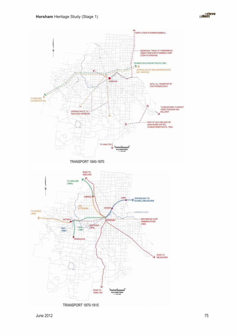
Horsham Heritage Study (Stage 1)
June 2012 75
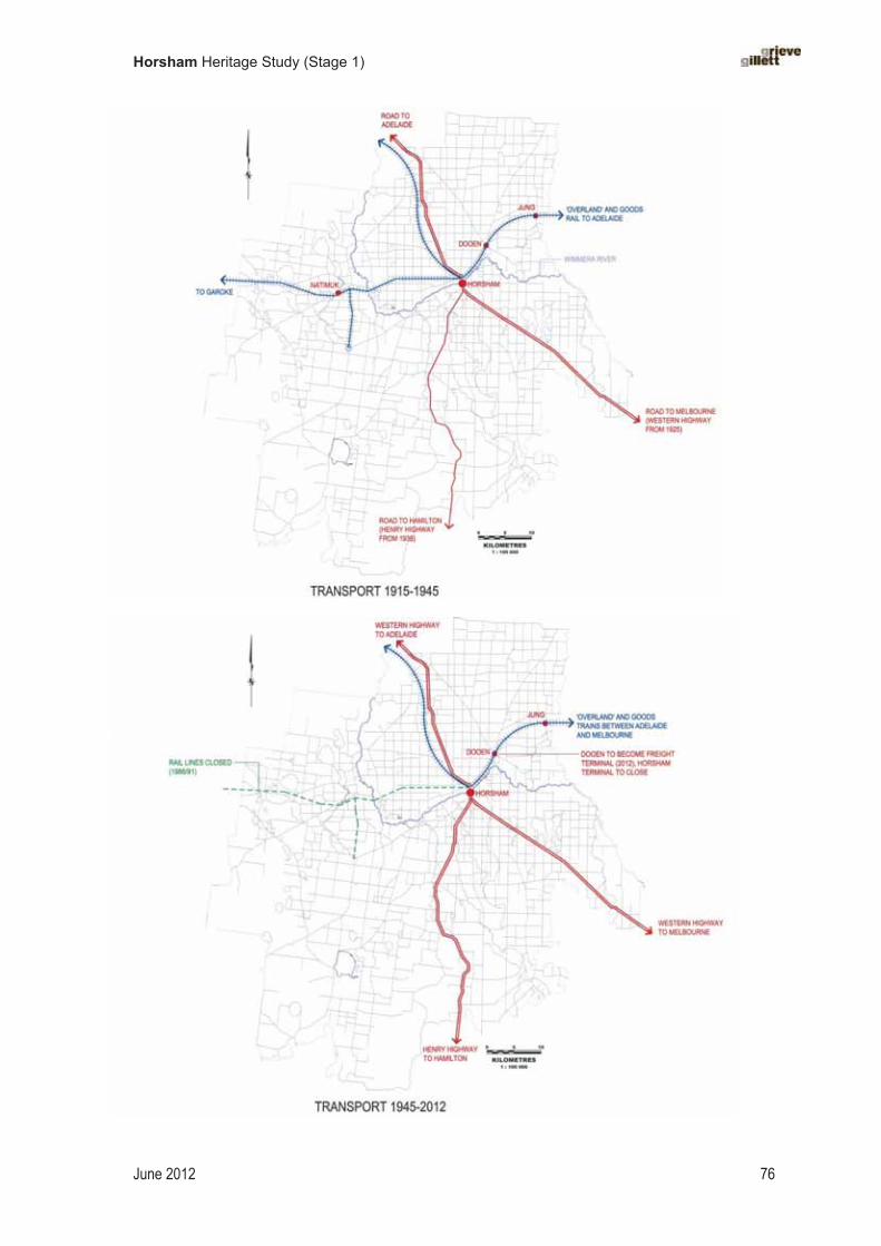
Horsham Heritage Study (Stage 1)
June 2012 76
Horsham Heritage Study (Stage 1)
June 2012 77
Chapter�16�
Building�rural�communities�
Chinese communities�
Many Chinese arrived in Victoria in the 1850s in search of gold. After the introduction of a £10 landing tax in Victoria, many landed at Robe, South Australia, to avoid the tax and traipsed through the Brimpaen area en route to the diggings. After trying their luck at Stawell and Fiery Creek (Ararat), some settled in the study area, working as hut-keepers and shearers on the large pastoral stations.� �
Some Chinese ex-miners later moved to Horsham and other surrounding townships, where they worked as market gardeners or shopkeepers.� � Many worked as market gardeners on the banks of the nearest watercourse. They carted water on their backs, using buckets suspended on a bamboo rod, and filled makeshift wooden dams.� At Green Park, a number of Chinese operated market gardens near the Wimmera River; some leased land for this purpose from the local water trust.� Few Chinese appear to have taken up selections, but they contributed significantly to the economic development of the region in other ways. It is claimed, for example, that Chinese were employed on the construction of the Lake Wartook reservoir in 1887.� � Others stripped wattle. Some place names have Chinese associations, such as Chinaman Track and Chinaman Creek at Laharum.� �
German communities�
German settlers moved into the Horsham area from the late 1860s when large areas of Crown land was thrown open for selection. Many of these Germans had previously settled around Hamilton and Hochkirck in western Victoria in the 1850s, while others had come across from South Australia, lured by the more attractive terms of land selection offered by the Victorian Government. The majority of this group had immigrated from northern Germany, and from the Brandenburg, Silesia–Saxony, and Pomeranian parts of Prussia.�� From South Australia and the Western District of Victoria they made their way to the Wimmera in cavalcades of covered wagons, often in family groups.��� From around 1869 sizeable German communities settled at Green Lake, Lake Natimuk and Vectis.���
An overwhelming number of German settlers came to take up land for agriculture and many succeeded in this; they were generally regarded as ‘good farmers’.��� The success of the German selectors was noted in contemporary accounts, and this was put down to their thrift and 304 Argus, 6 March 1854; Brooke and Finch, A Story of Horsham, 1982, ch 1.
305 See Blake, Wimmera, 1973, p. ??, Memories of Jung Jung, 1991, p. ??, Horsham & District Historical Society, Memories of Green Park, 1992, pp. ??
306 Blake, Wimmera, 1973, p. ? Horsham & District Historical Society, Memories of Green Park, 1992, p. 19.
307 Horsham & District Historical Society, Memories of Green Park, 1992, p. 2.
308 Calder, The Grampians, 1987, p. 176. 309 Lah Arum, 1987, p. 24.
310 Jupp, The Australian People, 1988, p. 367.
311 For example, Argus, 9 April 1869; see also Argus article of 1870 in which Ron Falla stated that they could be ‘the first true pioneers of Horsham’ [Falla, ‘Land selection in the Wimmera’, VHJ, 2000].
312 ‘German Heritage of the Wimmera’, Heritage Victoria, 1999, p. 107; see Arapiles.net: http://www.arapiles.net/history.html; accessed 23 July 2011. ‘Green Lake Cemetery’ in Ian Marr, Cemeteries of South West Victoria website; accessed September 2011.
313 Cited in George Seddon, Landprints, 1998.

Horsham Heritage Study (Stage 1)
June 2012 78
industriousness.��� Regarded somewhat as skilled farmers and model citizens, these Germans were in the main accepted by the British-Australian settlers at a time when racial sentiment was more often the norm than the exception.
�
16.1 German settlers crossing the border into Victoria from South Australia, sketched by George Fife Angas in 1877 (National Library of Australia)
The Germans who settled at Natimuk and elsewhere in the district have been described as ‘refugees’, fleeing from religious persecution. These groups established their own churches and schools, and readily embraced civic life. Lutheran congregations were formed at Green Lake (1871), Natimuk (1874), Horsham (1890), and Drung Drung,��� while Lutheran schools opened at Natimuk, Vectis East (1909), Kewell,�� and Horsham, It was most likely due to the significant German influence at Natimuk that the town boasted a ‘wine saloon’ in 1930; this building survives today.��
Many Germans settled in groups and maintained some degree of cultural identity. The Lutheran schools and churches retained their use of German language. In the 1880s the Horsham Timesregularly published ‘Our German Column’, which covered the news from Europe and was ‘translated specially’ for the paper.��� A Horsham Liedertafal was established in 1885.��� Yet while German settlers generally kept their Lutheran faith, and their language to some extent, other signs of German identity gradually became lost or eroded.��
At Natimuk and Vectis, there are subtle signs of a German heritage — for example, the Lutheran churches and schools themselves, and the neat and practical elements to individual homes. In one district, the roads were formerly named after the various German families who had settled there.��� Several cemeteries had significant Lutheran burials and retain early headstones to German families, for example at Kornheim Cemetery (just outside the study area). At Green Lake Cemetery, there is a memorial stone dedicated to the pioneering German families of the area, including the Kroker, Uebergang, Peucker, Starick, Winderlich and Gormann families, who were
314 See ‘Amongst the Selectors’, Argus, 11 May 1880.
315 Ian Marr, Cemeteries of South-West Victoria website – ‘Green Lake’; Whitworth, Bailliere’s Victorian Gazetteer, 1879, p. 164; for Horsham Lutheran Church jubilee, see Horsham Times, 16 April 1940.
316 Pinnacle, October 1924, p. 24.
317 VMD, 1930, p. 415.
318 See, for example, Horsham Times, 3 February 1882.
319 Horsham Times, 24 March 1885.
320 See, for example, ‘Amongst the Selectors’, Argus, 11 May 1880.
321 Mr Bob Schmidt, at Community Workshop, Laharum, 21 September 2011; these road names have since been changed.

Horsham Heritage Study (Stage 1)
June 2012 79
interred in the 1870s.322 There is little in the physical layout of the settlements that alludes to German-style townships, unlike the case in South Australia, where in Hahndorf, for example, the ‘Huffendorf’ and then ‘Strassendorf’ layout followed aspects of German town layouts. In the Wimmera in the 1870s, however, there were standard British surveying models to adhere to. And the degree of ‘German-ness’ among the settlers was becoming diluted with the amount of time they had spent in the colonies and the influences of other non-German settlers.
There were obvious difficulties experienced by German settlers during the First World War. Some German families felt pressured to send their sons to war. One local claim was that some German families received letters from ‘authorities’, threatening to send them to internment camps near Adelaide and Sydney if their sons did not enlist.��� At Natimuk there were instances of hostility towards Germans. Whereas in other states Germans had indeed been placed in internment camps, this was not the case in Victoria. Yet the Victorian Government nevertheless fed this anti-German feeling to some extent — for example, in prohibiting the use of the German language in Lutheran churches in 1914 and in Lutheran schools in 1916.��� It is also became preferable for German settlers to become naturalised.��� The majority of German settlers sought anonymity. In August 1914, in order to dispel any suspicions of disloyalty, the Lutheran congregations of Horsham, Natimuk and Vectis East declared their loyalty to the British Empire.��
Italian community
A significant number of immigrant Italians have settled in the Horsham area. Several families who settled at Green Park originated from Treschè Conca in the Veneto region of northern Italy; the first arrived in the 1920s and more joined them after World War II. These families have contributed greatly to the development of the timber, concrete and plastering industries in Green Park, and have also been involved in growing olives. At Green Park they are recognised as ‘really stamping their design influence on the town with terrazzo, concrete tanks, [and] chimneys’.��One descendant explained:
Green�Park�was�the�first�place�a�lot�of�Italians�came�to�and�you�still�find�after�all�these�years� .� .� .� the� Italians�are� still�at�Green�Park.�That� is� their�home.� It� is� their�little�bit�of�Treschè�Conca�you�could�say,�their�little�bit�of�Italy.328��
Others came from other parts of Italy, for example the Manserra family from Naples, who worked in the concrete industry.��� Italians also settled in the irrigation areas in the early twentieth century and were involved in growing fruit and vegetables, and tobacco. An Italian Club was established in the 1960s in the former butter works in Harriet Street, Horsham, adjacent to the railway line. It became a lively centre for a variety of social events and a venue for the game of bocce. The club continues today.��
Establishing church communities
The Christian denominations that predominated in the small settlements of the new wheat frontier were the Lutherans, Methodists and the minor Protestant sects, notably the Bible Christians. These were all reformed churches, with strong chapel communities, intent on doing ‘God’s work’ — in the practical sense of the word — and driven by a strong sense of the Protestant work ethic.
322 Ian Marr, ‘Cemeteries of South West Victoria’; accessed September 2011.
323 Lah Arum, 1987, p. 119.
324 Jupp, The Australian People, 1988, p. 373; Argus, 3 May 1916.
325 Lah Arum, 1987, p. 119.
326 South Australian Advertiser, 9 August 1914.
327 Horsham & District Historical Society, Memories of Green Park, 1992, pp. 1, 4, 8, 14.
328 Horsham & District Historical Society, Memories of Green Park, 1992, p. 75.
329 Reynolds, Naming Horsham’s Streets, 2003, p. 97.
330 Horsham & District Historical Society, Memories of Green Park, 1992, p. 72.

Horsham Heritage Study (Stage 1)
June 2012 80
Selecting, like gold-mining, required faith in Providence and a personal mantra of industry, frugality and plain living, in order to get on. Anglicans, Catholics and Presbyterians were also represented in sizable communities, but with a different pattern and spread across the study area.
The lynchpin of the small emerging towns and villages was the local church and school. Initially, with limited resources, a public hall might be used for multiple purposes until a stand-alone church or school could be erected. As was the case elsewhere in Victoria, the earliest churches reflected the financial or moral will of particular religious affiliates. In the Horsham district, Scots Presbyterians, figured largely amongst the pastoral license holders and their adherent communities of station workers. Some ex-station workers went on to select land in their own right and formed new Scottish communities of selectors. Many of the station workers also followed the Presbyterian faith. St Andrew’s Presbyterian Church was established in Horsham in 1858 and its first church building erected the following year; a manse was established by the early 1860s.���This early development was influenced by the fact that a Presbyterian minister had come out from Scotland to stay with Carter family.��� Presbyterian affiliation also dominated in several of the smaller townships. At Dooen, where the population amounted to only 20 in the 1870s, the Presbyterian ministry provided the only church service and this was held in the schoolhouse.���The Presbyterian church at Dooen was later moved to Natimuk.��� At Green Park there was a well-attended Presbyterian church and Sunday school (now demolished).���
By the 1870s, amidst a great influx of new settlers, other denominations were more properly established in Horsham. The Catholics and Anglicans were well established in Horsham by the end of the nineteenth century. St John’s Anglican Church was built in 1877, after a year of regular services being held in the Mechanics Institute. Rebuilt in the 1950s, this church physically dominates the view as you head north along Firebrace Street.
The Catholic parish in Horsham gradually developed and extended their buildings. A Catholic church reserve was set aside in 1861 and the first Mass celebrated in 1876.�� A timber church dedicated to St Michael and St John was built in 1879, and this was replaced in 1913 with an elegant red brick design by Ballarat architects Clegg, Miller and Riley (Riley was a Horsham resident).�� A more recent Catholic church was built in 1987 to an award-winning design by architect Greg Burgess. A presbytery was also erected. The Brigidine Sisters, an Irish teaching order, who were already established at nearby Ararat, opened a convent and St Brigid’s College in Horsham in 1920. The double-storey brick convent designed by Ballarat-based architect Bart Moriarty, educated girls to secondary level and boys to primary level; this has recently been demolished.���
A Methodist congregation was established in Horsham in 1874 and has rebuilt their house of worship three times. A Salvation Army barracks was also established in 1885.��� Smaller church groups were the Lutherans and the Church of Christ.��
331 Home to Horsham, 1929, p. 12; Brown, ‘Memoirs’.
332 Coulson, Horsham Centenary, 1950.
333 Whitworth, Bailliere’s Victorian Gazetteer, 1879, p. 161.
334 Memories of Dooen, c.1990.
335 Horsham & District Historical Society, Memories of Green Park, 1992, p. 17.
336 VGG, 27 September 1861, p. 1826.
337 See Miles Lewis, Victorian Churches, 1991, p. 127; see also From the Fruits of Fifty Years … (1897); Horsham Catholic Parish Centenary, 1976, p. 22
338 Horsham Catholic Parish Centenary, 1976, p. 22. Bart Moriarty, in the mould of A.A. Fritsch of Melbourne, was a prolific architect to the Catholic Church.
339 The Salvation Army Horsham Corps, 1885–1975, 1975, p. 2.
340 Whitworth, Official Handbook and Guide to Victoria, 1881, p. 266.

Horsham Heritage Study (Stage 1)
June 2012 81
In many small townships in the study area the first churches were minor Protestant denominations, but few were Anglican or Catholic. The minor Nonconformist Protestant denomination, the Bible Christians, worked tirelessly to establish congregations in several of the small towns in the 1870s, including Noradjuha, Pimpinio, Jung, Wail and Wonwondah.��� They opened a church in Horsham in 1881.��� By 1892, the population at the Quantong Irrigation Colony was sufficient to justify the erection of a Bible Christian church.���
The first congregation of Wesleyan Methodists in the Horsham district was at Pimpinio in the 1870s. Another early group was at Noradjuha. A Wesleyan Methodist church was erected at Kalkee in 1884 — a timber structure built to a gothic design with stained-glass windows — but for which only an historical marker now survives.��� The Primitive Methodists were established at Jung in the 1870s.��� The Salvation Army also established chapels at Natimuk and Polkemmet.��
Often, one building, such as a school or a hall, was initially shared between denominations. Quite likely, both the small population and the lack available local funds could not justify the expense of church-building. At Tooan, the services of the Anglican and Wesleyan churches alternated at the local state school.�� The ‘Union Church’ at Pimpinio was open to several denominations, while the Bible Christian church at Quantong was rented to the Education Department during the week for school purposes.���
16.2 Lutheran manse, Natimuk, c.1930s (State Library of Victoria)
341 Whitworth, Bailliere’s Victorian Gazetteer, 1879, pp. 364, 379, Blake and Lovett, Wimmera Shire Centenary, 1962, p. 59; Memories of Jung Jung, 1991, p. ?, add Wonwondah ref
342 Whitworth, Official Handbook and Guide to Victoria, 1881, p. 266.
343 Horsham Times, 28 October 1892.
344 Horsham Times, 21 October 1884.
345 Coulson, 1950; Bailliere’s 1879, p. 364; Memories of Jung Jung, 1991.
346 The Salvation Army Horsham Corps, 1975, p. 3
347 Whitworth, Bailliere’s Victorian Gazetteer, 1879, p. 468.
348 Horsham Times, 6 February 1894.
Horsham Heritage Study (Stage 1)
June 2012 82
German Lutherans formed the dominant religious community at Natimuk, with services commencing in 1872. At one time the town supported two Lutheran churches, as well as a manse and a primary school. Nearby, the Zion Lutheran Church served the Vectis community while another Lutheran church operated at Vectis South.��� In Natimuk, Catholic Mass was celebrated in various buildings from 1876, before St John’s Catholic Church was eventually built and consecrated in 1889. This church was damaged in the 1897 tornado and was rebuilt in 1915.�� Anglican services were held at Natimuk from the 1880s, with St Aidan’s Church of England built in 1890.��� At one time there was a total of seven churches in Natimuk.���
�
349 ‘German Heritage of the Wimmera’, Heritage Victoria, c.1999, p. 109; www.arapiles.net; accessed August 2011.
350 www.arapiles.net; accessed August 2011; information from historical sign at St John’s Catholic Church, Natimuk.
351 Horsham Times, 23 June 1885.
352 www.arapiles.net; see Lockwood, Natimuk: The first 100 years, 1982.

Horsham Heritage Study (Stage 1)
June 2012 83
Chapter�17�
Appreciating�and�conserving�the�natural�environment�
… the isolated peak of Arapiles, only 1176 feet high, but nevertheless more remarkable perhaps than any other mountain of the whole series ... The view from its summit can scarcely be surpassed in Victoria, the whole of the variegated scenery of the west being visible from it. Eastward, the horizon is bounded by the serrated chains of the Grampians; to the north and west stretch vast plains, unbroken by the smallest elevation; southward, the numerous lakes of the Wimmera country dot the surface in the foreground, while beyond, the rugged outlines of Pandas contrast strongly with rounded volcanic hills in the far distance.
Victorian Naturalist, 1885.353
We had favourite spots. We had the river. In those days, if you had the river, you had everything.
Ray Pummeroy (settler at Green Park), 1992.354
Attitudes towards the Wimmera landscape
The Wimmera has long been recognised as a regional area with a distinctive natural environment. Early settlers marvelled at the natural beauty of the place and efforts to conserve its distinct character have been part of the story of settlement. Settlers observed the many distinctive features of this new country, particularly the Wimmera River and the Grampians, which rises spectacularly from the plains and dominates the south-east of the study area. Mt Zero, at 300-odd metres, is part of this formation. The Grampians was formed thousands of years ago due to uplift of layers of sandstone, which as they have eroded have left jagged ‘teeth’ effect. The formation became an island when the area was submerged by an inland freshwater lake, and later when the sea encroached over south-west Victoria. Evidence of sand dunes remains in evidence near Laharum from this period.��� There are seasonal streams and billabongs across the Wimmera plains. A chain of swamps and small seasonal lakes extends in a rough arc from north to south, passing through Tooan and loosely following the Tooan–Mitre Road and then the Clear Lake – Sherwoods Dam Road. These circular lakes are both freshwater and salt.��
The Wimmera country brought mixed reactions from early settlers. On the one hand, it was a promised land, a new ‘El Dorado’.�� Many celebrated Major Mitchell’s vision of the place as fertile and rich farming country. The country did, for some, satisfy these early hopes of productivity as it proved to be an excellent producer of fine wool and, later became the granary of the state. For many too, captivated by views of the majestic Grampians and the monumental Mt Arapiles, the scenic beauty of the area was unsurpassed. Observers played on the romance and drama of the landscape. The author and dramatist Garnet Walch, for example, described Mt Arapiles as ‘a grand and awe-inspiring mass of sandstone and quartz — [which] starts abruptly
353 The full reference is J. Dennant, ‘Geological Sketch of South-Western Victoria’, Victorian Naturalist, vol. 2, 1885, p. 115.
354 Horsham & District Historical Society, Memories of Green Park, 1992, p. 62.
355 Lah Arum, 1987, p.10–11.
356 Blake, Lost in the Bush, 1964, p. 6.
357 Quoted in J.M. Powell, The Public Lands of Australia Felix, 1970.
Horsham Heritage Study (Stage 1)
June 2012 84
from the surrounding plains … corrugated columns, towering aloft like the ruins of some monstrous structure, fused together in the crucible of Time’.���
On the other hand, however, this country was regarded as a monotonous plain, flat and unremarkable. It could be dry for prolonged periods, which prompted questions about its usefulness. The visiting American novelist Mark Twain made the somewhat unflattering observation in the 1890s that Horsham sits on a plain which is as level as a floor’.��� The monotony could be disturbing, as James Smith’s ponderings in the early 1900s attest:
$���'����)���.�!���!.���!���!����.��.�#���#������&��"�������,�������#���!��##�
.���"���!�� '�.��� �&�,� �!��� �� �#��� ��8�� �!� ���� �-������ .����!"��� �!.� �����
��)��������)�!�������!.���&���.��!.��#�����)��!'�#���!����'��##������#���)�"���
�!.�"�!�� �� )�"�#���� ���.� �'� ��!.� &��"�� ��� ��� .�''�"�#�� ��� �-)����� ��� ���
�!.�����!.�� ��
To others the Wimmera was feared and hostile. In hot dry summers it could be a harsh and disturbing place. In the 1880s there were few substantial trees in many parts.�� One journalist lamented: ‘A district which has been rainless for a year or two years is a pitiful spectacle of desolation. The grass disappears; the wind carries with it whirling columns of dust; the trees of the dreary plain become more sombre and mournful than ever ...’362
Yet the natural ebb and flow of water also plays its part in the drama of the landscape. There are seasonal streams and billabongs across the Wimmera plains. To early observers like Major Mitchell, the sight of a well-watered Wimmera landscape was pleasing and reassuring in 1836.
Conserving the natural environment
Efforts to conserve the natural environment of the Wimmera began in the nineteenth century but gathered force by the mid-twentieth century with the influence of the conservation movement. A heated campaign to prevent settlement in the Little Desert area was waged in the 1960s, which polarised the local community. This significant environmental campaign resulted in the formation of the Land Conservation Council and led to the area being gazetted as a national park in 1968.��
Other areas have since been protected as National Parks, including Black Range. Other areas of natural heritage significance are protected as flora and fauna reserves, including Wail Flora and Fauna Reserve, created in the 1960s, and the Nurcuong Flora Reserve, north-west of Arapiles.
358 Walch, Victoria in 1880, 1881, p. 109.
359 The Cornish in Victoria: http://www.cornishvic.org.au/overlandgold/downloads/Luke-Trip_text.pdf; find original quote]
360 James Smith (ed.), Cyclopedia of Victoria, vol. ?, Melbourne, 1903, p. 207.
361 A.C. Garran (ed.), Picturesque Atlas of Australasia, Picturesque Atlas Publishing Co., Sydney, 1886 (facsimile edition, Ure Smith, Sydney, 1974), vol. 2, p. 279.
362 Willoughby, Drawn with Pen and Pencil, 1886, p. 24.
363 This area was extended in 1969. See Libby Robin, Defending the Little Desert: The rise of ecological consciousness in Australia, Melbourne University Press, Carlton, 1998.

Horsham Heritage Study (Stage 1)
June 2012 85
Chapter�18�
Developing�social�and�cultural�life�
The weather was very unfavourable, the roads bad, and the night dark, but notwithstanding all these drawbacks there was a good attendance, including a fair proportion of ladies, who braved the inclement conditions.
Quantong Public Hall, Horsham Times, 29 May 1906.
Building public halls
In Horsham a mechanics institute and free library was built on a site that was set aside in 1872, which provided a range of educational needs.�� Horsham lost this valuable resource in 1908, when the building and its library of rare books were lost in a fire.��
The residents of the many smaller towns in the district also relied on a public hall for the majority of their social activities. It was the standard venue for annual balls, musical events, local political meetings, private parties, and a host of other events. Most towns managed to erect a public hall on some kind, for example, a mechanics institute (as at Pimpinio, Noradjuha 1880s, and Dooen), a soldiers’ memorial hall, or even a church hall, and this generally constituted a modest gabled-roofed timber-framed design. A kitchen annexe was often added at the rear or to one side, as funds permitted, and this might be connected to the supper room via a servery window. Local committees of management oversaw the upkeep and use of these buildings.
18.1 The stark façade of the Mitre public hall, flanked by Cupresses
semprevirens (thomasparkes.wordpress.com)
Forming social organisations
As Horsham developed into a large regional centre, its social and cultural life developed accordingly. Social clubs, fraternities and service clubs were well represented in Horsham, including the Horsham Agricultural Society, and branches of the Australian Natives Association (ANA) and the Country Women’s Association (CWA). The Protestant-dominated masonic lodge was an important institution in the area, with active lodges in Horsham and Natimuk. A masonic
364 VGG, 9 August 1872, p. 1491.
365 Horsham Times, 23 October 1908.

Horsham Heritage Study (Stage 1)
June 2012 86
lodge was established in Horsham in 1882 and an impressive new Masonic Temple in Horsham was completed in 1937; this was designed by L.H. Vernon in association with Melbourne architects Ballantyne and Sneddon.� The Catholics formed branches of the Hibernian Australasian Catholic Benefit Society (HACBS).
The work of local lodges, fraternities, service clubs and, later, sporting organisations also ensured there was an active social life in many towns. The ANA, for example, was also active in Pimpinio, where it held a popular annual ball. The various service clubs and fraternities often resorted to borrowing a meeting place, such as a public hall, until they could afford to build their own hall. The CWA, a branch of which was formed in Horsham in 1937, did not build their own hall until 1968.� The Horsham Agricultural Society ran a successful annual show, and developed the Horsham Showgrounds accordingly with a large number of show buildings. Natimuk also held an annual show.
The temperance and total abstinence societies were closely aligned with the Christian churches. There was a Total Abstinence Society in Horsham as early as 1870,368 but the movement gained greater popularity in the 1880s and 1890s, and into the early twentieth century.� A drinking fountain, which was donated by civic leader and Methodist churchman James Millar, was erected at the main city intersection in 1901; this was later removed to May Park (without its decorative curved roof)
Entertainment
As Horsham took shape as a large regional centre, its social and cultural life developed accordingly and was enriched with a growing population. Dances, dramatic performances, concerts, and other musical events were a regular part of town life. In the twentieth century new attractions included the excitement of ‘moving pictures’ that were screened at the Horsham Theatre (built 1926). There was an open-air picture theatre in Firebrace Street by 1930.�� The Horsham Regional Art Gallery took over the former Horsham Town Hall (VHR H2279) in the c.1980s.
Sport and recreation
Organised sport was long been a central focus of town life in Horsham and surrounding district, both for those participating and spectating, and included a range of additional activities surrounding the sporting calendar, such as fund-raising events. Horsham and district has been the springboard for many local people to be launched into successful sporting careers, both amateur and professional. One of the first notable sports teams was the first Australian cricket team to tour overseas in 1868; this group included a large number of Aboriginal players from the Horsham district, including Jungunjinauke (‘King Richard’).
At Horsham, a large sports ground known as Central Park was developed from the 1870s. Over the years this Crown reserve has incorporated a racecourse, a cricket ground and football ground, and other facilities. The Botanic Gardens was also a site for sporting activities, including lawn tennis from 1882. In the 1880s there were many sporting clubs and organisations, including rowing, shooting, and athletics clubs. By the early twentieth century, many of the smaller townships and hamlets had a football and / or cricket ground, along with tennis courts and bowling green. At Natimuk a site of 5 acres for show yards and public recreation was reserved in 1887.� Some also had a golf course, including Natimuk and Pimpinio. The Wimmera river and various lakes also provided for popular recreational pursuits, such as swimming, rowing and fishing, and later water ski-ing. A swimming area was set aside at the Natimuk recreation reserve, while at Horsham a public swimming pool was built in the 1950s.
366 Horsham Times, 14 September 1937; see also Miles Lewis, Australian Arch Index.
367 Brooke and Finch, 1982, p. 237.
368 Argus, 25 April 1870.
369 VMD, 1930, p. 388.
370 VGG, 11 November 1889, p. 3274.

Horsham Heritage Study (Stage 1)
June 2012 87
Chapter�19�
Providing�social�welfare�Unemployment relief
The Horsham district has accommodated the unemployed, the itinerant and the homeless since swagmen began a common sight in the 1850s. In times of economic trouble, the area has provided means of support. The village settlements of the 1890s were a form of unemployment relief; many of the men who settled at these experimental camps were not in full employment.
During the Depression of the 1930s, unemployed men were taken on to carry out specified public works, such as road-making. In the late 1940s and early 1950s displaced persons from war-torn Europe were employed to work at the Wonwondah camp of the State Rivers and Water Supply Commission.�� In more recent times, the major welfare agencies in Horsham, particularly the Salvation Army, St Vincent De Paul, Wimmera Uniting Care and the Christian Emergency Food Centre, have provided assistance to the unemployed and homeless.
Subsidised housing
Subsidised housing was provided under various government schemes. In George Street, Horsham, houses were built in the c.1920s with government assistance and financed by the State Bank of Victoria for men who had returned from serving in the First World War.372 Such was the need for cheap housing in Horsham that two estates were built by the Housing Commission of Victoria in the immediate postwar period.
The Housing Commission of Victoria was established by the Victorian Government in 1938 with the principal aim of alleviating the problems of poor housing by ordering evictions and repairs to sub-standard houses, and providing new public housing. Housing Commission estates were initially developed in Melbourne, but by 1940 the problem of sub-standard housing in country areas had come under the notice of the Housing Commission. These houses were owned by the Commission, to which tenants would pay a minimum rent. The Commission generally attempted to acquire land via Crown grant or through gifts from the local municipality. For many years the entire Housing Commission estates at Horsham remained under the control of the Commission, but some individual units have since been sold to private individuals.��
The first Housing Commission estate built in Horsham was erected in 1946, which was relatively early for a regional area of Victoria.�� Renate Howe claims that this was built for the factory employees of Simpsons Textiles.�� Another estate south-west of the city, between Natimuk and Bennett Road, was commenced in 1948. This comprised 50 simple single-storey detached homes, designed by Melbourne architects A.V. Jennings; most were timber but some were built using the relatively new material ‘Conite’. The estate was laid out in keeping with the ideals of the ‘garden city’ estate, with curved roadways and a shared recreation reserve in the vicinity of Sinclair and Pearl Streets. Later that year Jennings commenced another estate of 75 houses on Jenkinson’s paddock, north of the city.�
371 Memories of Wonwondah, c.1998, p.??
372 Reynolds, Naming Horsham’s Streets, 2003, p. 42.
373 Adapted from Helen Doyle, ‘Warrnambool Housing Commission Estate: Ocean and Wattle Groves: Assessment of Significance’, prepared for Warrnambool City Council, 2001.
374 See Doyle, ‘Ocean and Wattle Groves, Warrnambool’, 2001.
375 B�!������&���New�Houses�for�Old��������)����
376 Horsham Times, 6 February 1948; 3 September 1948.

Horsham Heritage Study (Stage 1)
June 2012 88
Another housing commission estate in Horsham, built in the early 1950s, took its street names from flora, and included Rose and Gardenia Streets.� The Housing Commission houses to the north of Horsham were built by P & A Coutts.378
�
Typical�1950s�Housing�Commission�dwelling,�2011,�north�Horsham�
�
�
�
�
377 Reynolds, Naming Horsham’s Streets, 2003; Horsham Times, 9 January 1951.
378 Horsham & District Historical Society, Memories of Green Park, 1992, p. 73.

Horsham Heritage Study (Stage 1)
June 2012 89
Chapter�20�
Representing�the�region�in�art�and�literature�
… and then the Wimmera country is introduced, thoroughly true to nature. The doings of the rural community, their loves and hates, the school picnic, the drought, the hero ..
Extract from a review of Spielvogel’s novel, The Cocky Farmer,1907.379
The distinctive physical characteristics of the Wimmera landscape have made it a dramatic and desirable subject for writers and artists. In the popular mind it was remote, arid, vast but at the same time promised abundance, and fitted the myth of man struggling against the harsh Australian environment.
Several places in the study area have been represented in Australian art. The best known examples are the landscape works of the prominent nineteenth-century Romantics, Nicholas Chevalier and Eugène von Guérard, who captured the spectacle of the Grampians, Mt Arapiles and Mitre Rock. These artists were concerned to accurately record the landscape they encountered in western Victoria. Their finely executed works provide detailed records of the geology, and plant and animal life of the area. What is striking is the way in which their works celebrate the grandeur and monumentality of nature.��
�
20.1 Nicholas Chevalier, Mt Arapiles and the Mitre Rock, 1863 (State Library of Victoria)
The more modern work of Arthur Boyd in his Wimmera Series, painted in the 1950s, captures the routine interaction between the working man and the dry grassy plains of the Wimmera landscape. A number of other significant artists have produced important works on local subjects. The Horsham Art Gallery holds a number of important local works, such as works by Duncan Cooper, and others that form part of the Mack Jost bequest.
�
�
379 Launceston Examiner, 27 September 1907. 380 Elizabeth Johns, New Worlds from Old, 1998.

Horsham Heritage Study (Stage 1)
June 2012 90
�
�
20.2 A landscape painting that forms part of Arthur Boyd’s Wimmera Series, painted in the 1950s�
The story of the young heroine, Jane Duff, and her brothers in the ‘Lost in the Bush’ story was first serialised in the widely read School Paper in 1908, and from the 1920s was published in the Fourth Book of the Victorian School Readers. The story also inspired the ballad ‘Babes in the Wood’, which appeared in an English newspaper.��� A feature film, Lost in the Bush (1973), was filmed in the Natimuk district and premiered at the Horsham Theatre.
In Nathan Spielvogel’s popular novel of 1907, The Cocky Farmer, the settlement of Pimpinio becomes the archetypal small town in the bush. Here the story follows the struggle of the small-time farmer against the harsh environment and sometimes against the squatter. Peter Carey’s novel Illywhacker makes many references to the Wimmera, and captures something of that popular but double-pronged notion of the Wimmera as harsh and challenging, but at the same time promising bountiful harvests and a vision of ‘smiling cottages’ that stirred the romantic imagination of Sir Robert Menzies in the rapidly changing postwar period.���
�
20.3 Cover of Nathan Spielvogel’s novel, The Cocky Farmer, published in 1907 (photographed from the collection of the State Library of Victoria)
381 Blake, Lost in the Bush, 1964, p. 24–29.
382 The reference to ‘smiling cottages’ was made by former Prime Minister Sir Robert Menzies, who grew up at Jeparit and wrote of the Wimmera in 1949 as a place of comfort and stability. The quote appears in C.M.H Clark, A History of Australia, 1987, vol. 6, p. 484.

Horsham Heritage Study (Stage 1)
June 2012 91
Celebrating the arts
Both Horsham and Natimuk have established successful arts festivals which continue a long tradition of artistic, theatrical and musical pursuits in the study area.
The 'Art Is' festival began in Horsham in 1996 as a broad, broad-ended exploration of innovative ways of presenting and appreciating the arts.
The Nati Frinj art festival began in 2001 as a tongue in cheek affair in response to Horsham’s Art Is … Festival. Initially a low key event, it grew to be a three-day festival in 2002 as interest in the festival and financial support grew. In 2003 Nati Frinj moved to the Melbourne Cup Weekend in November and became a biennial festival largely driven by the artistic endeavours of those who called Natimuk their home. The event features the incredibly successful Silo shows, Lake Shows, Rotunda events, and the Hay and Thespian Mardigras Street Parade. It is a very successful event, increasing the town’s population from 500 to around 5000; most of whom came from Melbourne or Adelaide, with tents sprouting up everywhere and the Caravan and Arapiles campground are full.
Wimmera Uniting Care’s ‘Awakenings’ Festival is held in Horsham every October and is noted as the largest disability festival in Australia.
�
�
� �
Horsham Heritage Study (Stage 1)
June 2012 92
Chapter�21
Making�space�for�parks�and�gardens�
Bleak lands may be made habitable, and comparatively barren tracts of country, incapable of producing cereals and the more exacting vegetables of commerce may be made a source of wealth to the country by the judicious selection and culture of trees appropriate to climatic and other conditions.
Horsham Times, 26 June 1906
Private gardens
The first Europeans to settle in Horsham required gardens for the purpose of food growing. Early gardens were planted around the home station of the large pastoral estates in the 1850s and 1860s, providing both the necessary food requirements and fashionable ornamentation. A gardener was sometimes employed on the staff to tend to the large kitchen garden. The Calders’ large garden at Polkemmet was described in the early 1860s by their children’s resident governess, Margaret Emily Brown, as producing ‘the most beautiful flowers and vegetables and such fruit as the climate permitted to grow — peaches, nectarines and above all, grapes which grew in great profusion’.��� There was also a conservatory and a green house, and the gardener occupied his own hut. The Polkemmet homestead garden was watered with an irrigation system that was fed from the Wimmera River using a hand pump.��� When a grand new homestead was built at Vectis in 1864, the garden was developed accordingly, and planted with lilacs, olives, mulberries, oleanders, honey-suckles and grapes.��� This was developed into a vast ten-acre garden surrounding the homestead.��
Gardens in the town were usually smaller but no less productive. The site of a ‘garden’ (most likely a productive one) is marked on an 1849 plan of the first Horsham police station.�� Well-tended private gardens were developed from the 1880s when a reliable town water supply was established. In residential areas there was typically an ornamental garden at the front of the house and a kitchen garden and fruit trees at the back. In the 1880s, a much admired garden of rare blooms belonged to Mr D. McCalman.��� Gardens became increasingly grander through the early decades of the twentieth century; the range of horticultural categories in the Horsham Show attests to the extent of local gardening activity.��� Some private gardens were laid out by prominent landscape designers; Edna Walling, for example, provided a plan for Dr G.R. Felstead’s garden in Baillie Street.�� Walling had found inspiration in the natural bush landscape around Mt Arapiles, and photographed the area in the c.1940s.
As land-use patterns in the Horsham district shifted from large pastoral estates to smaller agricultural holdings, gardens changed accordingly. Farmers who took up 320-acre selection blocks generally lacked the means to establish large, ornamental gardens. The requirements of a
383 Brown, ‘Memoirs’, p. 52.
384 E.D. Calder, ‘Early Days in the Wimmera: A pioneer looks back’, Argus, 24 June 1933.
385 Blake and Lovett, Wimmera Shire Centenary, 1962, p. 40.
386 Blake and Lovett, Wimmera Shire Centenary, 1962, p. 40.
387 Brooke and Finch, A Story of Horsham, 1982, p. 1A.
388 South Australian Register, 18 January 1883.
389 Keith Lockwood, pers. com., May 2012.
390 Edna Walling garden for Dr G.R. Felsted in Ballarat Street, Horsham (plan held by SLV H97.270/125).

Horsham Heritage Study (Stage 1)
June 2012 93
kitchen garden would have taken priority. Other garden elements were most likely governed by a ’make-do’ approach. Private gardens on the dry plains of the Wimmera were comparatively unadorned and often lacked even a windbreak for protection.���
Horsham Botanic Gardens
By the late 1870s, when the growth and prosperity of farming around Horsham was having a positive effect on the development of the township, the Wimmera Shire Council saw fit to embellish the town with a botanic gardens. A large Crown reserve extending over 40 acres, and adjoining the Wimmera River at its southern boundary, was temporarily reserved for ‘Botanical Gardens’ in 1878.��� This site had previously formed part of the Horsham police paddock. This was the only botanic gardens site set aside in the Wimmera region. At least one early planting was provided by the former director of the Botanic Gardens, Ferdinand Mueller. This was the seed of a Bunya Bunya (Araucaria bidwilli), which was planted at the gardens’ entrance.393
In 1881 the site was to be elaborately remodelled. A plan was drawn up by the prominent landscape designer and director of the Melbourne Botanic Gardens, William Guilfoyle, with assistance from Robert P. Whitworth.394 Whitworth had travelled with Guilfoyle to western Victorian to assist him in preparing designs for other notable Western District gardens, including the Koroit Botanic Gardens, and had also been responsible, possibly under Guilfoyle’s guidance, for the extensive Stawell Hospital Gardens (c.1880) and Horsham Hospital Gardens in 1880–81.395
21.1 Postcard showing the ornamental Bark Hut (fernery?) amidst mature plantings, Horsham Botanic Gardens, c.1925 (State Library of Victoria)
�
�
391 Dingle, Settling, 1984, p. 200.
392 VGG, 6 December 1878, p. 3052; see also 1881 reservations, Rs file 4161.
393 Brooke and Finch, A Story of Horsham, 1982.
394 Roger Cousens, ‘Horsham Botanic Gardens’, http://home.vicnet.net.au/~horbotgd/; Jill Orr-Young, ‘Horsham Botanic Gardens: Master Plan’, prepared for Horsham Shire Council, 2003; Whitworth, 1881, p. 266. 395 Whitworth, 1881, pp. 264, 266, 304; Helen Doyle, ‘Whitworth, Robert Percy’, in Aitken and Looker (eds), Oxford Companion to Australian Gardens, 2000, p. 642.

Horsham Heritage Study (Stage 1)
June 2012 94
Within a few years, the garden was being commended:
$�����������+���!�"�#�7��.�!������)����!��!�������,���,��))����!"��=����!�&��
�!.���'#�"��������"��.����!�����"�������'���3��)�!��������!���"�����.�"�!.����!�
�#���� ���� #�!�� )����.� �'� .�,!���� �-)����!"�.�� $��� �������� "�#���.�
"��,��!��������� ���� ����!������ �!.� ���� "�"3�"����� ��� )����!�� ���� ���� "���'�
'#�&�����!��#�������
The Horsham Botanic Gardens was developed as funds permitted. Local fund-raising events for the gardens’ development were a regular occurrence through the 1880s. By 1888, a ‘portion’ of this large riverside reserve had been laid out as an ornamental garden; this was described as ‘a considerable portion … planted with trees, shrubs, &c. tastefully laid out by William Guifoyle’.��There were avenues of trees and a fernery, as well as a curator’s cottage. The gardens were embellished with a diverse range of features and structures through the late nineteenth and early twentieth centuries, including an ornamental lake (as designated in the original plan), a collection of caged animals and birds (known as the Horsham zoo), a pond designed in the shape of Australia (early 1900s), a rotunda, a fountain, and a children’s playground area with timber play equipment.398 There was also a rough-built ‘bush hut’ or ‘mia mia’ built on the site with a bark-roof, which later became a ‘summer house’.399 Trees were provided by fellow botanic gardens, by private donation, and by the Macedon State Nursery; in 1896, for example, the borough council received 400 trees from the State Nursery suitable for planting in the botanic gardens.400 The official reservation of the site was later altered to include ‘public recreation’, which allowed the development of various recreational facilities at the site, including lawn tennis courts and a croquet lawn. The gardens enjoyed a period of rejuvenation during the expert curatorship of Ernest E. Lord (1935–41), who implemented more of the Guilfoyle plan, and who prepared an amended layout for the site.401 In 1948 the town council provided a public camping ground at the gardens, and the reservation was once again re-gazetted to incorporate ‘tourist camping’. By 1950, a children’s playground had been added.402
21.2 Avenue of Canary Island Date Palms (Phoenix canariensis), Horsham Botanic Gardens (State Library of Victoria)
396 Horsham Times, 4 May 1883. 397 Sutherland, 1888, p. 94; VMD, 1898, p. 233; VMD, c.1889?, p. 173.
398 Brooke and Finch, A Story of Horsham, 1982. The playground is shown in an early postcard, c.1910s (source: flickr 2012).
399 See Cassell’s, 1890. In 1925 the building survived – see Museum of Victoria Picture Collection.
400 Horsham Times, 5 June 1896.
401 Richard Aitken, ‘Lord, Ernest Edward (1899–1970)’ in Aitken and Looker (eds), Oxford Companion to Australian Gardens, 2000, p. 377; Layout dated 1936, cited in Roger Cousins, ‘Horsham Botanic Gardens’ website – ‘Map Library’.
402 Roger Cousens, ‘Horsham Botanic Gardens’, http://home.vicnet.net.au/~horbotgd/; Coulson, Horsham Centenary,1950, p. 49.

Horsham Heritage Study (Stage 1)
June 2012 95
Other public parks and gardens
Other public parks and gardens in Horsham include Central Park, which was set aside in 1873 as a Crown reserve for the purposes of public recreation.403 This extensive 300-acre site on the Wimmera River was developed for a multitude of purposes, including a racecourse, a trotting track, a fire brigade training track, tennis courts, bowling greens, and softball and hockey grounds.404 Another 12-acre government reserve was also set aside in 1873 for public recreation.� � May Park in Horsham was officially opened in 1920 on a former ‘wasteland’ that had been provided by local blacksmith and benefactor Samuel May.406 Iron entrance gates for the park were donated by Mr and Mrs Berry; seats were also donated.
Other small townships were also provided with recreation reserves in the 1870s and 1880s, for example Natimuk. At Mt Arapiles, a recreation reserve named Centenary Park was opened in 1936 to honour the arrival of Major Mitchell one hundred years earlier. The site was developed as a camping site and picnic ground.
School gardens and school forest plantations
A keen interest in school gardens, and in teaching about horticulture and forestry in state schools, was fostered by the Victorian Education Department in the early decades of the twentieth century. This was part of a broader push for national expression through hard work, productivity, and indirectly on encouraging sustainable living on the land. Within the study area, many state schools established school gardens and school plantations. Arbor Day was keenly celebrated in the early 1900s.�
21.3 School garden at Quantong State School,c.1910s (State Library of Victoria)
�
�
403 VGG, 18 July 1873, p. 1267.
404 Reynolds, Naming Horsham’s Streets, 2003, p. 74.
405 VGG, 28 November 1873, p. 2087.
406 A.E. Carthew, Souvenir of Home to Horsham, … 1849–1929 (1929), p. 16 and p ?? Horsham Times, 9 November 1920
407 For example, at Pimpinio State School, Horsham Times, 26 June 1906.
Horsham Heritage Study (Stage 1)
June 2012 96
The State School Forest Endowment Plantation Scheme, instigated in 1923, was an arrangement made between the Education Department and the Forestry Commission, whereby government schools were allocated a small plot on which to grow forest trees, principally Radiata Pine (Pinusradiate). Schools would benefit at harvest time with the income earned from the sale of timber. The Horsham Elementary and High Schools shared an endowment plantation at Mackenzie Creek from the late 1920s.� � State school children at Natimuk and Pimpinio also developed plantations from the late 1920s, and students at Dooen (North Brighton S.S.) established a plantation in the 1960s.� � To promote school gardening, the ANA awarded annual district prizes for the ‘Best School Garden’ of which Natimuk, Pimpinio and North Wonwondah state schools were recipients.��
Railway plantations
In 1883 the Inspector of State Forests, William Ferguson, recommended that the railway reserves in the Horsham be planted with wattles. A double line of wattles were planned for the route from Jung Jung to Dooen.��� Railway stations were also embellished with ornamental plantings, including beds and specimen trees. These were proudly tended by the resident station masters.
�
408 Horsham Times, 29 May 1931.
409 Home to Horsham, 1929, 1929, p. 19. For Natimuk State School No. 1548 Aboretum and Plantation (c.June 1929), see RNE Rs file 10385 and LCC, Historic Places: South-West Victoria, 1996. Dooen reference from DSE portal; Margaret Blake, 120 Years On: Pimpinio Primary School 1874–1994, 1994, p. 37; Horsham Times, 9 November 1926.
410 Margaret Blake, 120 Years On: Pimpinio Primary School 1874–1994, 1994, p. 47; Horsham Times, 22 September 1931.
411 Horsham Times, 21 August 1883.
Horsham Heritage Study (Stage 1)
June 2012 97
Chapter�22
Confronting�the�challenges�of�the�natural�environment�
The climate … is uncertain, droughts of more or less severity and duration have been experienced in the past, and their recurrence must be expected in the future, when it is hoped that provision shall have been made beforehand to tide over these periods of difficulty and danger
Surveyor-General A.J. Skene, 1874.412
… productive as the country near Horsham undoubtedly is, barrenness and drouth [sic.] are certainly characteristic of many outlying portions of this extensive region
Garnet Walch, Victoria in 1880, 1881.413
Enduring droughts and floods
Early settlers quickly learned that the Wimmera district was subject to extremes in the weather and in rainfall. It was the dry spells that caused the most difficulties in the early period. There were droughts in the late 1870s, then again in the 1890s and into the early 1900s. There was a severe water shortage in 1914-15, and again in 1929. The drought of 1944 caused considerable difficulty and prompted improvements to the Wimmera–Mallee water supply. The most severe drought was the most recent of the early 2000s.
Part of the city of Horsham lies on the extensive floodplain of the Wimmera River and has been inundated on numerous occasions as a result. Natimuk is also subject to inundation, owing to the high water levels of the Natimuk Creek. There was significant flooding in 1870, in 1882 and in 1889 (see illustration below).��� A report in 1889 observed that ‘<�"�� �!"�!��!��!"�� &���"����.��������&����.������������#.�����'����������$��,�&�������)�����#,��""����.���.�
�!� ����$�&!���##� �!.�<�"��!�"��� �!��������� �!.� ������&�!��� ����!.�.� ��� �,� ������,���(���
There was also extensive and damaging floods in 1909, and again in 1942, 1964 and 2011.
Controlling pests
The hardships faced by early settlers included warding off a range of pests. Dingoes or wild dogs were a menace to the early settlers because of their tendency to attack and kill sheep.�� As settlement developed, however, the numbers of dingoes declined and they ceased to be a problem. There have been several plagues of mice and locusts in the Wimmera, which have been detrimental to crops.�� Snakes are a problem around the Wimmera River, especially after rain.
Rabbits emerged as a major pest for farmers by the late 1870s. Making their way north to the Wimmera Plains from the Western District, rabbits sheltered in the customary brush fences that divided properties. Soon it was evident that the Horsham Town Common was ‘a breeding ground’ where ‘they could be seen in [their] thousands’.��� In 1879 the Horsham Times bemoaned that
412 Argus, 16 December 1874.
413 Walch, Victoria in 1880, 1881, p. 109.
414 Calder, Grampians, p. 91; Australasian Sketcher, 1882.
415 South Australian Advertiser, 11 July 1889.
416 For example, at Natimuk (Horsham Times, 5 May 1885).
417 See Victorian Naturalist, vol. III, 1887.
418 Horsham Times, 7 March 1884.

Horsham Heritage Study (Stage 1)
June 2012 98
‘the damage done by the rabbits is incalculable’.��� Despite the Rabbit Suppression Act of 1880, rabbits continued to be a problem. A rabbit-proof fence was built to the north (outside the study area).
�
22.1 Dramatic scenes of flooding at Horsham, Australasian Sketcher, 11 July 1889 (State Library of Victoria)
419 Quoted in the Australian Sketcher, 26 February 1881.

Horsham Heritage Study (Stage 1)
June 2012 99
Tornadoes and severe storms
A powerful tornado (this is often wrongly termed a cyclone) struck Horsham in November 1897. A number of buildings were badly damaged as a result, with the churches faring particularly badly. Many buildings were damaged beyond repair.�� Severe storms have also caused damage. A dust storm occurred in 1902, for example, following several years of drought.���
Earthquakes
The first known recorded earthquake to affect the area was in September 1879, when ‘a shock of earthquake was experienced … by the farmers and others residing at the northern end of the Grampians, in the vicinity of Mount Zero. The earth was observed to tremble violently, and the doors and windows of the houses were shaken in a remarkable manner, during a period of time extending over five minutes.’���� Several years later, in May 1897, Victoria experienced the strongest earthquake recorded to that time, which was felt in Horsham and surrounding area. This caused no serious damage����
Fighting fires
Fire has posed an ongoing threat to settlers, property and stock, especially in particularly dry summers. The early settlers witnessed the widespread bushfires of Black Thursday in 1851, when fires flared to the south and north of Horsham.424 A fire on 13 January 1876 destroyed much of the township.�����
22.2 Horsham Fire Brigade station and fire tower, c.1900s (State Library of Victoria)
420 Horsham Times, 23 November 1897.
421 Lah Arum, 1987, p. 23.
422 Australasian Sketcher with Pen and Pencil, 27 September 1879; Horsham Times, 14 May 1897.
423 Horsham Times, 14 May 1897.
424 Blake and Lovett, Wimmera Shire Centenary, 1962.
425 Australian Sketcher with Pen and Pencil, 19 February 1876.

Horsham Heritage Study (Stage 1)
June 2012 100
The regular threat of fire prompted settlers to establish organised fire-fighting procedures. A fire brigade was formed at Horsham by 1881. In 1883 a site was reserved for a fire brigade building in Horsham, situated conveniently next to the town water reserve.�� Here a fire tower was erected. The firemen drilled at the fire brigade training track at Central Park.��
The Horsham Rural Fire Brigade, which was responsible for a wider area, was formed in 1917.���A fire brigade at Natimuk was formed in 1890 and the Natimuk Bush Fire Brigade was formed by 1941. There was a fire brigade training track in Main Street, Natimuk. A fire station was also formed at Green Park.��� There were devastating fires across the district in 1944 and a serious fire in 2009. Later aids to fire-fighting included a fire spotting tower at Mt Arapiles.��
Getting lost in the bush
Early settler Edward Bell recalled in 1853 the constant risk of getting lost in the bush: ‘I recollect nothing particular about the country we passed through, except that the bush was very thick, and that I was always afraid of losing myself if I left the road, or was out of sight of my companions for a moment.’��� The account of the Duff children’s misadventure in 1864 has become part of the district’s heritage. Indeed, the story of the ordeal of 9-year-old Jane Duff and her brothers Frank and Isaac, when they became lost in the dense bush near Mt Arapiles in 1864 gained international prominence. The story has inspired poetry, stories, artwork and a memorial. It was particularly popular with school children and was read by generations of children in the SchoolReader. Jane was funded to attend a private boarding school in Horsham as a reward for her heroism. The street where she later lived was named Duff Street in her honour. The railway siding close to where the children were found was named Duffholme (outside the study area).��� In the 1960s the Duff family hut had long since gone, but some remnant chimney stones remained at this site.���
�
22.3 Wood engraving by Frederick Grosse, from artwork by Nicholas Chevalier, showing black trackers finding the Duff children lost in the bush in 1864 (State Library of Victoria)
426 Whitworth, 1881, p. 266; VGG, 14 December 1883, p. 3055.
427 Reynolds, 2003, p. 74.
428 Ian Maroske, A History of the Horsham Agricultural Society, 1978, pp. 41-42.
429 See ‘Wade, Harrie Walter’, ADB, 2002; Memories of Green Park, p. 5.
430 Resources Survey: Wimmera Region, 1961.
431 Bride (ed.), Letters from Victorian Pioneers, 1983 edition (first published 1898), pp. 283–84.
432 Blake, Lost in the Bush, 1964.
433 Blake, Lost in the Bush, 1964, p. 9.
Horsham Heritage Study (Stage 1)
June 2012 101
�Chapter�23�
Building�water�supply�systems�
With the passing of this measure the thin end of the wedge "Irrigation" will be in, and there cannot be the slightest possible doubt in the minds of any who have experienced in the Wimmera what good results may be achieved by irrigation that, as time progresses the wedge will be driven home, irrigation will be resorted to in all the dry districts, and the agricultural interest at present languishing in those districts will be placed on a more equal footing with the portions of the colony more favored by nature in the matter of moisture, and the full value of the benefits conferred on the whole colony will be simply incalculable.
Horsham Times, 10 December 1886
Devising early means of water supply
In the winter of 1836, shortly before the great pastoral expansion of western Victoria, there had been an unusually heavy soaking of rain, which resulted in a much wetter looking country than it otherwise was. Hence Major Mitchell, waxing lyrical about the prospect of the Wimmera plains, was perhaps more admiring of the country’s potential for ‘the reception of civilised man’ than he might otherwise have been.
The first group of European settlers, the squatters, settled mostly along the Wimmera River and neighbouring watercourses. They relied on local knowledge of the Jardwadjali and other clans, who showed them the locations of freshwater springs and ‘native wells’, and quickly realised that many of the lakes and swamps, especially south and west of Horsham, were only ‘seasonal’ and that some of the lakes were salt water. Once established, squatters dug wells, which gave fresh water at a depth of between 80 and 140 feet.��� They also built dams and ‘soaks’. Outlying shepherds’ huts were located at close proximity to water sources, when and where possible. Some shepherds’ huts were served by an adjacent in-ground tank, lined with native ‘pine’.���
The scarcity of water through the district, as well as the sparseness of settlement, made travel difficult. Water needed to be carried in canvas bags. The Government set aside numerous water and camping reserves along major transport routes to ensure that stock had ready access to water. Settlements sprang up near fresh water. Mitre Dam, near Mt Arapiles, provided water for a sheep wash as well as washing clothes and for drinking water.��
A rush of selectors to the Horsham district in the 1870s, and the subsequent growth of small townships, increased the demand for a reliable water supply, both in the towns and rural districts. The meagre rainfall and hot summers, the remote nature of settlement, and the problem that many of the lakes were only seasonal, together must have presented a serious disincentive to prospective selectors; these challenges proved to be the final blow for others who gave up after too many hard seasons.
Those selectors who braved the arid plains carted water from the nearest watercourse or built dams, which were covered with brush to prevent evaporation. Other rudimentary means of water supply were water tanks built on a high platform of bush logs.�� Many settlers were short of
434 Whitworth, Bailliere’s Victorian Gazetteer, 1879, p. 507.
435 Field, Waggons Thro’ the Wildflowers, 1977.
436 Lockwood, Arapiles: A million mountains, 2007, p. 34.
437 Lah Arum, 1987.

Horsham Heritage Study (Stage 1)
June 2012 102
water during the hot summer months when rainfall was low. At the Noradjuha State School the water supply was an ongoing problem. With inadequate rainwater tanks and a contaminated dam, the school dug its own underground tank.��� Pimpinio suffered a serious ‘water famine’ in 1882 that was only partially relieved by the water-train.���
The extension of the steam railway network through the study area in the 1870s and 1880s necessitated the erection of water tanks at many railway stations. In Pimpinio, a reserve for water tank is adjacent to the station ground, and so presumably was set aside for railway use.�� At Jung, fresh water was pumped from the Yarriambiack Creek to the railway tank.���
�
23.1 Horse-drawn dray delivering a water tank manufactured in Horsham, 1924 (State Library of Victoria)
Building local water supply schemes�
Growing townships needed a permanent supply of fresh water. One proposal by the Anglo-Irish settler St Eloy D’Alton in 1875 was for the construction of a water supply scheme from the Grampians to Stawell.��� At Horsham, a reserve for town water supply purposes was set aside in 1878 on the Wimmera River.
Settlers enjoyed a few good years before suffering a period of severe drought between 1877 and 1881. In response, the Victorian Government passed the Water Conservation Act in 1881, which enabled the establishment of local water trusts.��� The new legislation enabled towns, boroughs or councils to set up waterworks trusts, which were then entitled to government assistance to construct a water supply and reticulation system. At Natimuk a township dam operated from the 1880s.��� The Borough of Horsham managed the storage of town water, the reticulation of water through the town (completed by the 1880s), and the rating of properties for water use. To supply the town, the Borough Council erected a water tower with elevated tanks in the early 1880s, which was fed from by a steam-driven pumping engine situated near the river.��� A weir was also constructed to form a dam on the river, and this ensured an adequate storage for the town supply.
438 Noradjuha Primary School 1877–1996, c.1996, p. 7.
439 Horsham Times, 24 March 1882.
440 Pimpinio parish plan, reproduced in Memories of Pimpinio, 1993.
441 VMD, 1898, p. 571. 442 Blake, Wimmera, 1973. 443 See Powell, Watering the Garden State, 1989.
444 Horsham Times, 12 July 1887.
445 Horsham Times, 20 September 1922; Garran (ed.), Picturesque Atlas of Australasia, vol. 1: Victoria, 1886–88, p. 278; South Australian Register, 18 January 1883.

Horsham Heritage Study (Stage 1)
June 2012 103
The Shire of Wimmera Water Trust, formed in 1880–81, was one of the earliest water trusts.��Its headquarters was the elaborate former residence of Mr Clark, a Victorian polychromatic brick villa erected in the 1870s.
23.2 Members of the Wimmera Water Trust at their impressive Horsham headquarters in 1895 (Museum of Victoria)
There were initially two separate water supply authorities serving the Horsham district: the Shire of Wimmera and the Wimmera United Waterworks Trust, established in 1882. These two organisations merged in 1887 to form the Shire of Wimmera Waterworks Trust. Then, in 1890, the Shire of Wimmera Waterworks Trust merged with the Western Wimmera Irrigation and Water Supply Trust.
By the late 1920s a new water supply scheme from Mount Zero was devised for Horsham township as the Wimmera River water had become an increasingly polluted source.��
Irrigation
From the 1850s, early settlers had devised various means of directing water to their crops and gardens. Squatter Samuel Wilson of Longerenong harnessed the Yarriambiack Creek (near its junction with the Wimmera River) by building a dam and re-directing the water to flow from the Wimmera River back into its tributary, so forming a notable early irrigation channel that enabled the growing of fruit and crops.��� Other squatters close to a watercourse rigged up pumps to provide fresh water for their homes and irrigation for their gardens. At Polkemmet in the early 1860s, water was pumped from the river to supply the kitchen and bathrooms of the homestead.���
Early settler James Darlot hoped to see the day when Horsham was settled with many streams flowing through the country.�� Ambitious and fantastic schemes were put forward in the 1860s and 1870s, which proposed novel ways to irrigate the dry north-west of the colony. One proposal by prize-winning essayist Frederick Acheson in 1861 was to convert Lake Corangamite into an enormous dam, and to use this storage to pipe water to the Wimmera and Mallee.��� Another proposal by the Grand North West Channel Company in 1871 sought to construct a giant pipeline 446 Smith (ed.), Cyclopedia of Victoria, 1903, p. 229. See also Helen Doyle, ‘Wimmera water supply’, paper presented at the Heritage Council conference, Murtoa, April 2008.
447 Home to Horsham, 1929.
448 See HV citation,‘Longerenong’ [VHR H0290}; Jean Field, Waggons Thru the Wildflowers, 1977.
449 Brown, Memoirs, p. 52.
450 Home to Horsham, 1929, pp. 9, 10, 11?
451 Frederick Acheson, Essay on the Collection and Storage of Water in Victoria, Government Printer, Melbourne, 1861.
Horsham Heritage Study (Stage 1)
June 2012 104
across north-west Victoria, which fed a series of irrigation pipes.��� While these promises of abundant water failed to materialise, hopeful new selectors nonetheless continued to peg out claims in dry country.
By the mid-1880s, new schemes for irrigation promised new productivity and prosperity in Victoria, and especially in the Wimmera. Politicians like Alfred Deakin, Minister for Water Supply, led the way in devising the best strategies and models for improving rural water supplies and introducing irrigation schemes. The Victorian Government was committed to the development of an elaborate water supply scheme, which it regarded as essential for the future economic development of the Wimmera and the State. Local settlers demonstrated what could be achieved. When pastoralist William J. Carter experimented with irrigation at the garden and paddock at his North Brighton estate in 1885, the results far exceeded his expectations. Drawing water from the Wimmera River using a centrifugal pump, his apple and pear trees, quinces and orange trees flourished.���
Building the Wimmera–Mallee Water Supply System�
A Royal Commission into Victoria’s water supply in 1884, headed by Deakin, investigated various options for supplying water to the north-west of the colony. The most promising proposal was that suggested by Samuel Carter of Glenisla (outside the study area) who pointed to the suitability of developing Lake Wartook as a water storage that captured the flow of the Mackenzie Creek in the Grampians. Deakin adopted this scheme with support from the local councils. The new reservoir was constructed by engineer John Dickson Derry (who had accompanied to Deakin to America). The sand, stone and gravel required for the dam’s construction were all sourced on site. The embankment had stone capping and the channels were also lined in stone blocks. A caretaker’s cottage was also built. Completed in 1887, Lake Wartook was the first major storage of the extensive Wimmera–Mallee Stock and Domestic Water Supply System and the first large rural reservoir in Victoria. It was managed locally by the Wimmera Shire Waterworks Trust.
The new Wimmera water supply scheme relied on the natural watercourses to the north of Wartook — the Wimmera River, the Yarriambiack and Dunmunkle Creeks, and the Richardson River — as its main distribution channels.��� A series of open channels, operating on gravitational supply, were constructed to carry water to different parts of the Wimmera. Natimuk was the first to be supplied after its ‘wretched supply of drinking water had been strongly condemned by the Central Board of Health’.��� The Wartook to Natimuk/Arapiles channel, which came on line on 15 January 1888, was the first government irrigation channel system in Australia.�� Other components in the scheme included weirs, tanks, and pumping equipment at Dooen, and the Longerenong weir and channels. The Wimmera United Waterworks Trust and the Wimmera Shire had constructed the Longerenong weir to facilitate diversion of water into Yarriambiack Creek.��
In 1903 the Wimmera–Mallee Water Supply System came under the jurisdiction of the newly formed government authority, the State Rivers and Water Supply Commission (SRWSC), which was responsible for the building and maintenance of the various channels and other components of the system. An office of the SRWSC was established in Horsham. This system in its entirety, which brought water from a consolidated supply based around the Grampians, was known as the Wimmera–Mallee Stock and Domestic Water Supply System and was claimed to be the largest of its kind in the world.
452 Context Pty Ltd, ‘Victorian Water Supply Heritage Study’, 2007.
453 Horsham Times, 21 April 1885.
454 Powell, Watering the Garden State, 1989, p. 170.
455 Horsham Times, 2 July 1886.
456 www.arapiles.net
457 Wimmera–Mallee Water website; Dingle, Settling, 1984.\; Horsham Times, 12 October 1886; Blake and Lovett, 1962, p. 94.

Horsham Heritage Study (Stage 1)
June 2012 105
Shortfalls in water supply made new storages necessary. After the drought in 1914 new reservoirs were constructed at Fyans Lake and Taylors Lake. Pine Lake reservoir was planned in 1919.���The outflow channel from Lake Taylor was further enlarged in the late 1930s, with unemployed men carrying out the work.��� A new pumping station was built at Pimpinio in the 1940s to supply water to the northern districts (outside the study area); this replaced the original Jung pumping station.� Lake Toolondo was completed in 1953.
The severe drought of 1944 highlighted the need for further storages. The Wimmera supply was later augmented with flows from the Glenelg River and later again from the Waranga Western Channel. Additional storages were also built outside the study area, including Lake Lonsdale, Lake Bellfield, and Rocklands Dam (1954). The SRWCS were responsible for the ongoing maintenance of this extensive system. In the late 1940s and early 1950s there was a State Rivers camp at Wonwondah.��
�
Extract from Australian Army Survey, 1940, showing the channel system to Natimuk and Arapiles (National Library of Australia)
458 Blake and Lovett, Wimmera Shire Centenary, 1962, p. 96.
459 Jenny Keating, The Drought Walked Through, 1992, p. 127.
460 SRWSC, Administration and Development of Water Supply, Irrigation, Drainage, Flood Protection and Sewerage in Victoria, 1935–43, Government Printer, Melbourne, 1943. 461 Memories of Wonwondah, c.1998.

Horsham Heritage Study (Stage 1)
June 2012 106
�
Extract from Australian Army Survey, 1940, showing the pipe line from Mt Zero to Horsham, installed in the late 1920s (National Library of Australia)
Irrigation colonies
Several irrigation colonies were also developed from the early 1890s (discussed in Chapter 5), which relied on water supplied and metered by the WMSDWSC. These included Riverside, Dooen, Young’s, Quantong and Burnlea, where settlers successfully took up fruit-growing and dairying. Those on irrigated blocks operated with a permit from the Wimmera Waterworks Trust allocating them with water use from the various channels. A new irrigation colony at Drung was commenced after the Second World War, which was based on cropping and dairying. Growers slowly left the industry and by the 1990s the irrigation system had ceased operating on account of the drought.��
462 Laura Poole, ‘Irrigation in the Wimmera: An old industry remembered’, ABC Rural, 13 July 2010: http://www.abc.net.au/rural/content/2010/s2952110.htm

Horsham Heritage Study (Stage 1)
June 2012 107

Horsham Heritage Study (Stage 1)
June 2012 108
Horsham Heritage Study (Stage 1)
June 2012 109
Chapter�24�
Providing�education�
Although the petition was signed by every parent interested in the [Arapiles] school, and the immediate construction was absolutely necessary, the regular official routine must be gone through, an inspector must visit the place and submit a report on the site, and the usual thousand and one formalities must 'be observed before the building is commenced; and all this at a serious loss and inconvenience to the people.
Horsham Times, 3 November 1882
Providing elementary education
The earliest government school in the district was Horsham National School No. 278, which opened in 1857, but other small private ventures were in operation before that. On account of the isolation of many settlers in outlying areas, there were also private boarding schools operating in Horsham by the mid-1860s. It was one of these schools that the bush heroine Jane Duff attended, the funds for school fees having been raised by public subscription.��
On some of the large pastoral stations, employees’ children were educated with a makeshift school. At South Wonwondah station in 1865, John Rutherford employed a teacher to run a school at the home station, where 19 children from four families lived during the week, returning to their own families several miles away for the weekends.�� Small schools also operated at Kewell station and Vectis station, and at the Calder’s Polkemmet station, where Margaret Emily Brown worked as a governess in the early 1860s.��
Following the Grant Act of 1869, there was a great influx of selectors into the district and a dramatic growth in population in the 1870s and 1880s. Establishing a new school was one of the chief concerns of settlers in new localities. The land selection acts coincided with the passage of the Education Act of 1872, which established the notion of a ‘state school’ as free, secular and compulsory, and was the basis for the Victorian government erecting hundreds of new schools across the colony. This has been identified as a key reason for large-scale immigration from South Australia.� At Natimuk, where no school had previously existed, there were 170 students attending during the first year the new state school opened in 1875.� Whereas there was only one government school in the study area in 1872, ten years later there were over fifty small rural schools in operation. Only a few survive from this period, including Dooen No. 1782,�� Vectis East,�� Quantong,� and Natimuk No. 1548 (added to in 1890–91).��
463 Argus, 9 September 1867.
464 Argus, 24 July 1867.
465 Brown, ‘Memoirs’; it is unclear exactly which year Brown arrived at Polkemmet station but it was certain to be sometime after 1858; see Coulson, Horsham Centenary, 1950.
466 Powell, The Public Lands of Australia Felix, 1970, p. 246.
467 www.arapiles.net; accessed August 2011.
468 LCC, Historic Places: South-West Victoria, 1996.
469 VGG, 1876; VGG, 1882.
470 Horsham Historian, issue no.?? 2009.
471 Burchell, Victorian Schools, 1980, p. 175.

Horsham Heritage Study (Stage 1)
June 2012 110
In the rural districts schools drew children from a wide area. At Pimpinio, where the average school attendance numbered 60 in the late 1870s, the town itself was only sparsely settled, and students travelled each day from up to five miles away.��
In addition to new schools being built in the 1870s, some older existing structures were also replaced. In 1876–77 the original Horsham National School built in 1858 was replaced with a new state school building costing over £1500. This incorporated an adaptation of the verandah for the first time, represented a significant new design for the Education Department’s standard school buildings types.�� This ‘Horsham type’ state school, as it became known, was later reproduced at twenty-five other locations across Victoria.�� The smaller rural type state schools were improved over the years, such as Pimpinio which gained two lattice-work timber shelters in the early 1900s.��
Some of the new state schools, mostly being small rural school buildings, did not survive long into the twentieth century. The demands of a changing population saw the schools in larger towns grow, and even multiply in the case of Horsham and Natimuk, where a new state school was opened in 1962.� The number of state schools in the study area probably reached a peak in around in 1910, but this number had declined significantly by 1970. Many small schools were closed due to falling populations in the smaller settlements, and the availability of improved transport the larger towns.
The various local churches also made their buildings available for schooling. The Catholic and Lutheran Churches were the main providers of church-based primary education, but the smaller Protestant denominations also made their buildings available for school lessons. The Union Church at Pimpinio, for example which was a multiple denomination church building, was the venue for school lessons from the 1870s.� Likewise, many small church communities made use of the local state school building on Sundays. At Tooan, where the population was only 15 in 1879, the Anglicans and Wesleyans held services on alternate Sundays.��
The Lutheran Church operated a number of primary schools at a number of small settlements in the district, including Vectis (built in 1909) and Kewell (this probably operated in the Kewell church building, which was built in 1905).��
Many state schools were closed in the early 1900s because of low enrolments; children grew fewer because holdings were consolidated. Motor transport in the mid-twentieth century meant that children could travel further to school; it also meant that they could go on to the High School in Horsham. Despite this many more small schools were forced to close in the 1930s, 1940s, and 1950s. The sites of a number of former school sites are recorded by historic markers or indicated by surviving road names.
Secondary Schools
The Horsham District High School (now Horsham College) was established in 1912. Classes began in the former Working Men’s College, which had by that time ceased operating.�� A new high school building was erected in 1926 to a design by Education Department architect J.E.
472 Whitworth (ed.), Bailliere’s Gazetteer for 1879, 1879, p. 374.
473 VGG, 22 September 1876, p. 1756; Burchell, Victorian Schools, 1980, p. 165.
474 Jane Lennon, Our Inheritance, 1992, p. 61. 475 Blake, 120 Years On, 1994, p. 16.
476 www.arapiles.net; accessed August 2011.
477 Blake, 120 Years On, 1994, p. ?
478 Whitworth, Bailliere’s Guide, 1879, p. 468.
479 ‘German Heritage Study’, 1999, p. ?, Pinnacle, 1927?; Adelaide Advertiser, 11 December 1905.
480 Coulson, Horsham Centenary, 1950, p. ??

Horsham Heritage Study (Stage 1)
June 2012 111
Smith.��� Two private schools were also established in Horsham, which included the Catholic convent school, run by the Brigidine order.
�
24.1 Horsham District High School, c.1912 (State Library of Victoria)�
24.2 Brigidine Convent, Horsham, opened in 1920 – now demolished (State Library of Victoria)
Horsham Working Men’s College
Several early technical colleges were established in Victoria the period from 1887 to 1891: the Melbourne Working Men’s College, first proposed in 1882, was opened in 1887; the Gordon Institute of Technology opened in 1885 (1887), an amalgamation of the Geelong Technological School and the School of Art and Design;��� and the Horsham Working Men’s College, was established in 1890. The period of the 1890s was something of a ‘golden age of technical education’ that saw a dramatic rise in government funding, which grew more than three-fold from 1887–88 to 1890–91.��� A new art school building was completed at Horsham in 1894. In the early 1900s the college at Horsham was designated as a technical school and later a farm course was introduced.
481 Horsham Times, 23 February 1926,
482 Kiddle, Men of Yesterday, 1969, p. 456. Australian Encyclopedia. says 1885, as does Victorian Year Book, 1973, p. 501.
483 Blake (ed.), Vision and Realisation, vol. 1, 1973, p. 621.

Horsham Heritage Study (Stage 1)
June 2012 112
Longerenong Agricultural College
In 1884 the Agricultural Colleges Act was passed in the Victorian Parliament. Under this Act, ‘thousands of acres were excised from state forests and timber reserves for agricultural college purposes. The first college was Dookie College, which opened in 1885. The second was established in 1889 at Longerenong, eight miles east of Horsham, and in the heart of the rapidly developing Wimmera farmlands.484 Longerenong incorporated an experimental farm, covering 2386 acres. In 1925 Longerenong accommodated 60 resident students.��� Longerenong has played an important part in the development of Horsham and in the development of agriculture in the wider district.
There was an additional reserve in the district set aside for ‘agricultural college’ purposes. This was located just south of Polkemmet PR on the Wimmera River; this measured over 495 acres. There was possibly the reserve for ‘agriculture college’ purposes that was turned over for soldier settlement after World War II.��
Ex-servicemen’s Vocational College
This was established after the First World War as a way of providing re-training to ex-servicemen. [See Reynolds, Naming Horsham’s Streets, 2003]
Better Farming Train
The Better Farming Train was a State government initiative of the 1930s. The train was designed as an educational facility, with each carriage teaching an important aspect of farm life, including cooking and infant welfare. It was instrumental in reaching out to settlers in isolated areas and providing them with expert advice.
484 Ray Wright, The Bureaucrats’ Domain, 1989, p. 238.
485 Australian Encyclopedia, vol. 1, 1925, p. 40.
486 Small, Hard to Go Bung, 1992.
Horsham Heritage Study (Stage 1)
June 2012 113
Chapter�25�
Defending�Australia�and�the�Wimmera�
Frontier warfare
In the early settlement period settlers waged a bitter and violent war on the traditional occupants of the country, the Wotjobaluk, Wergaia, Jupagalk, Jaadwa, and Jardwadjali. It has been estimated that hundreds, and probably thousands of people had once populated this land. The Aboriginal population was drastically reduced, partly on account of reprisals against them by European settlers for sheep stealing, and partly through introduced European diseases and a resultant decline in fertility. It is unknown exactly how many Aborigines were killed but it was no doubt a large number.
This conflict, which was often clandestine and went unacknowledged at the time, is not remembered in any tangible way through memorials or monuments. Descendants of the traditional owners of the Wimmera country remember these killings and the broader ramifications of this loss of life on their cultural identity.
Colonial defence
In the 1850s the seaports of the south-western coastline erected batteries and installed long-range cannon in anticipation of a sea-based attack by Russian vessels. While inland settlements like Horsham were not required to take such precautions, there was nevertheless enthusiasm for the local rifle club.�� By the 1890s a detachment of rangers was also active.���
Participation in overseas operations
Hundreds of local men have participated in Australia’s major military campaigns, including the South African Wars, World Wars I and II, and the Vietnam War. Some of the horses bred in the district were also enlisted in the Light Horse in World War I. The mixed ethnic origins of settlers in the Horsham area — in particular the sizeable German community and the large number of Irish (Catholic) settlers, who were not always inclined to want to fight alongside the British — possibly led to some diffidence about Australia’s involvement in South African Wars (1899–1902) and World War I (1914–18). In Nathan Spielvogel’s novel The Cocky Farmer (1907), with its loosely masked setting of Pimpinio, the central character prefers not to go off to South Africa to fight the Boers, but instead to stay home and fight the drought.
Fighting the threat of communism
Political feelings impacted on the social life of the district at various times. Through the 1920s small farming communities in the Horsham district became alarmed at the growth of communism and the threat this posed to conservative values of hearth and home. To the rural communities of the Wimmera many settlers — including many small farmers — felt their livelihoods were threatened by communism. This fear of communism encouraged local involvement in the White Army, a conservative, nationalist, quasi-military organisation that was convinced that the Bolsheviks were poised ready to take control of Melbourne and Victoria. To counter the anticipated attack on Melbourne on 6 March 1931 by the ‘Red Army’ — a Bolshevik army of unemployed radicals — local men were mobilised into local brigades of the newly formed ‘White Army’ in Horsham and in many other towns across north-western Victoria.��� While the attack on Melbourne proved to be pure imagining, this incident nevertheless served to polarise feelings between the employed or self-employed conservatives (small farmers, townsfolk) on the one hand, and the unemployed or disgruntled workers on the other.
487 For Horsham Rifle Club, see Coulson, 1950; Home to Horsham, 1929.
488 VMD, 1898, p. 233.
489 Judith Brett, Robert Menzies’ Forgotten People, 1992, pp. 86, 89; Michael Cathcart, Defending the National Tuckshop: Australia’s secret army intrique of 1931, 1989, see, for example, p. 13.

Horsham Heritage Study (Stage 1)
June 2012 114
�
War memorials
The various memorials that mark Australia’s involvement in the various theatres of war are important elements of the civic townscape as sites that represent private and collective grieving, as well as commemoration and quiet reflection. The larger towns organise a soldiers’ march and gathering at the local war memorial each Anzac Day and Remembrance Day. Three avenues of honour have been planted in Horsham, including one in Roberts Avenue to remember the Boer War soldiers, and memorial drives in McPherson Street (WWI) and Dooen Road (WW2).�� In McPherson Street (Western Highway), a bronze and granite monument survives, but most of the trees have died or been removed.��� The central Horsham cenotaph has been recently redeveloped.
�
25.1 Natimuk Memorial Hall erected in 1909 (National Trust of Australia)
25.2 Horsham Memorial Swimming Pool, opened in 1958 (State Library of Victoria)
� �
490 Reynolds, Naming Horsham’s Streets, 2003, p. ?, ‘Listing of War Memorials in Victoria, as at 26.4.2004’, c.2004, t.s.; see also Smith (ed.), Cyclopedia of Victoria, 1903.
491 ‘Horsham and District World War I Memorial Drive’ in War Memorials in Australia:http://pandora.nla.gov.au/pan/14043/20010729-0000/www.skp.com.au/memorials/30009.htm; accessed 7 October 2011.

Horsham Heritage Study (Stage 1)
June 2012 115
Other structures have also been dedicated as memorials. There were memorial soldiers’ halls built at Horsham (RSL hall, McLachlan Street),��� Haven (1940s?), Kanagulk (c.1930s?) and Noradjuha (1953). The Natimuk soldiers’ memorial hall (built in 1909) would appear to have been re-named and dedicated as a memorial after one of the two major conflicts. At Natimuk there is also a memorial bandstand (1921) and memorial seats (WW2), while Horsham opened a Memorial Swimming Pool in 1958. The offer of government funding for public buildings dedicated as war memorials after World War II no doubt provided an incentive for some of these projects.
War trophies could be considered as memorials of sorts. In the years following World War I, when captured enemy guns were distributed across Victoria by the War Trophies Committee, the small township of Jung was allocated a German machine gun.��� A large gun also ornaments the Main Street of Natimuk.
�
�
492 See Home to Horsham, 1929, 1929.
493 Horsham Times, 20 December 1921.
Horsham Heritage Study (Stage 1)
June 2012 116
Chapter�26�
Attracting�tourists�and�holiday�makers�
Those who interested themselves to secure Mark [Twain]’s visit to Horsham have placed their fellow townsmen under a debt of gratitude …
Horsham Times, 18 October 1895.
Hosting notable visitors
As a major stopping point between the two colonial cities, Melbourne and Adelaide, Horsham has long played host to travellers and has drawn a number of notable visitors. Ironically, it was indirectly a result of Horsham’s isolation that it has from time to time attracted important visitors. The Governor of Victoria George Bowen visited in 1875, when the town was enjoying the sudden boost in population and economic activity as a result of the 1869 land selection act. Probably its most famous visitor was the celebrated American novelist Mark Twain (Mr Clemens) in 1895. Clemens and his wife and daughter stopped at Horsham from Adelaide en route by rail to Melbourne and stayed at the White Hart Hotel.��� In the 1920s Horsham provided a landing site for the celebrated aviator Charles Kingsford Smith and his trimotor aeroplane the Southern Cross.
Tourist attractions
The Horsham region benefitted from a number of significant local travel destinations, notably Mount Arapiles and the Grampians. These places were popular with local people from the early settlement period, when picnic parties were popular.��� Popular spots on the Horsham side of the Grampians were Roses Gap, Zumsteins and Lake Wartook.��
Increasingly, motor transport enabled tourists to come from further afield. The Royal Hotel in Horsham offered patrons the chance to visit Wartook Reservoir and could arrange ‘a most charming drive in this direction through interesting and characteristic country scenery’.�� Both the Grampians and Mount Arapiles were further developed as tourist attractions in the 1920s and 1930s, with major new tourist roads and tourist infrastructure built. [for example, Mt William Picnic Ground, by 1927] The completion of a new tourist road to the Grampians from the western side in the 1920s meant that locals could ‘motor through to Hall’s Gap in a few hours, instead of having to skirt the ranges as they do now’.��� The opening of a new road to the top of Mount Arapiles in 1937 was marked with a local celebration.���
Taking holidays
Modern recreational tourism was initially reserved for the wealthy leisured class. Few ordinary settlers could afford the time or money to take lengthy holidays, particularly farmers. Staying with relatives or friends in another part of Victoria or interstate was more typical. As farmers became more prosperous, many enjoyed extended family holidays at Portland or Port Fairy, usually over January after the harvest. The squatting class had enjoyed these quiet summer resorts since the 1850s.
494 Twain, Following the Equator (1895), quoted in Peter Pierce (ed.), A Literary Guide to Australia, 1987, p. 327; What to See: Horsham and District, September 1966, p. 1.
495 Lah Arum, 1987; VMD, 1898, p. 276.
496 See, for example, ‘A Trip to Roses Gap’, Pinnacle, October 1925, p. 3.
497 Lorck, Victoria Illustrated, 1909, p. 122.
498 Pinnacle, September 1923, p. 16.
499 Argus, 1 November 1937.
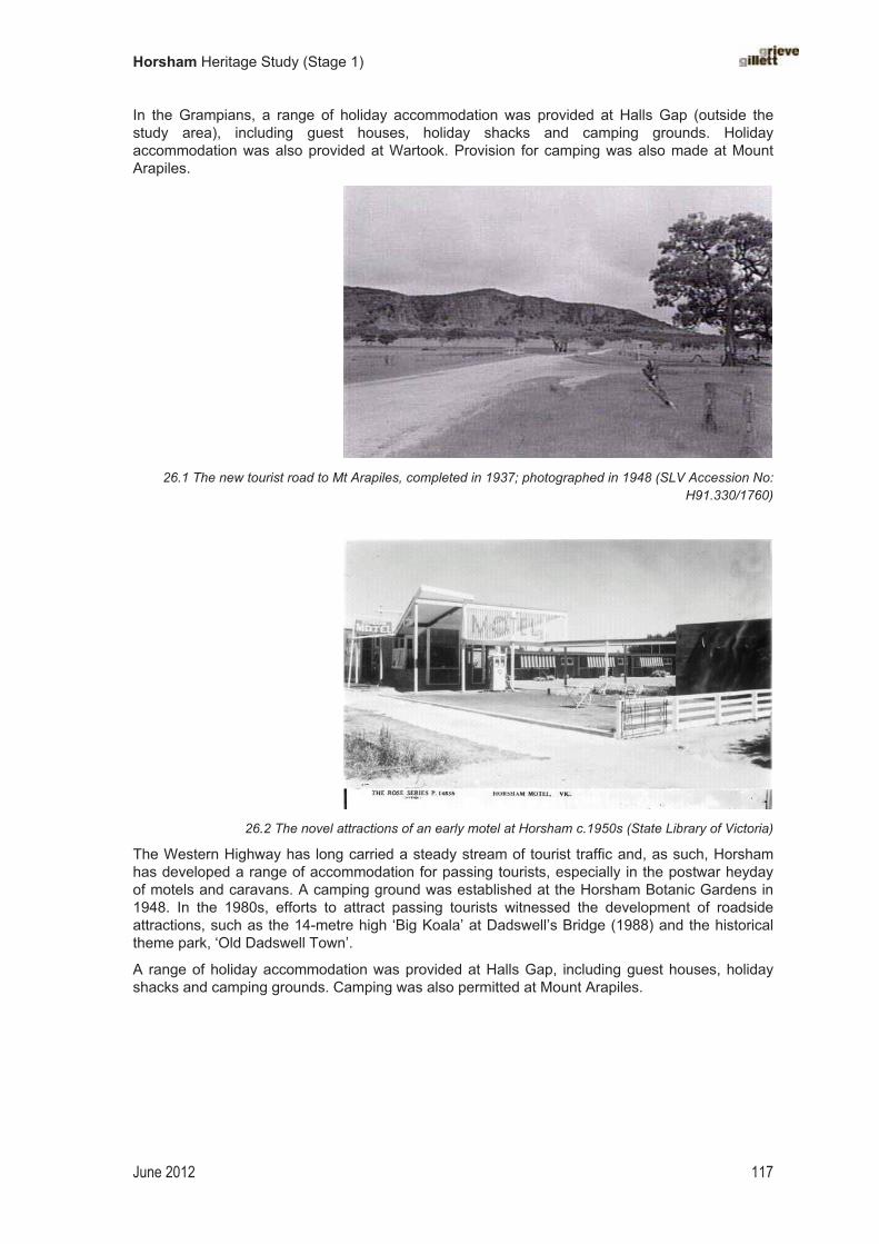
Horsham Heritage Study (Stage 1)
June 2012 117
In the Grampians, a range of holiday accommodation was provided at Halls Gap (outside the study area), including guest houses, holiday shacks and camping grounds. Holiday accommodation was also provided at Wartook. Provision for camping was also made at Mount Arapiles.
26.1 The new tourist road to Mt Arapiles, completed in 1937; photographed in 1948 (SLV Accession No: H91.330/1760)
�
�
26.2 The novel attractions of an early motel at Horsham c.1950s (State Library of Victoria)
The Western Highway has long carried a steady stream of tourist traffic and, as such, Horsham has developed a range of accommodation for passing tourists, especially in the postwar heyday of motels and caravans. A camping ground was established at the Horsham Botanic Gardens in 1948. In the 1980s, efforts to attract passing tourists witnessed the development of roadside attractions, such as the 14-metre high ‘Big Koala’ at Dadswell’s Bridge (1988) and the historical theme park, ‘Old Dadswell Town’.
A range of holiday accommodation was provided at Halls Gap, including guest houses, holiday shacks and camping grounds. Camping was also permitted at Mount Arapiles.
�

Horsham Heritage Study (Stage 1)
June 2012 118
Rock-climbing500
Mount Arapiles continued to be a popular spot for picnics, and early settlers in the area may well have explored some of its climbing possibilities. More recently, the sport of rock-climbing draws people to Natimuk and Mount Arapiles from Australia and overseas. There is scarce information on exactly when rock-climbing first began at Mt Arapiles, but it is likely to have started, almost by accident, in September 1963. After having seen a picture of Mitre Rock on a railway poster, Bob and Steve Craddock drove out from Melbourne to investigate the potential for rock-climbing, only to discover the sprawling mass of Mt Arapiles across the road. The late 1960s could be considered the golden era of climbing at Mt Arapiles, with most of the great lines being done during this period. A house at 117 Main Street, Natimuk, was the home of the town’s first climbing business and equipment shop.� � The mid 1970s saw Mt Arapiles become Australia’s premiere location for the development climbing style and difficulty. The high-point in this period of development was the 1975 visit by American Henry Barber. This was a pivotal moment in the development of climbing in Australia, as Henry Barber introduced a new style of climbing to Australia, and established at degrees of difficulty not yet seen. Climbing at Mt Arapiles, and indeed across Australia, was never to be the same again.
The introduction of this new style, known as ‘Free climbing’ kindled renewed interest in climbing at Mt Arapiles, and through the rest of the 1970s and into the 1980s, Mt Arapiles continued to be the climbing area that led the way in Australia for developing ever higher degrees of difficulty, culminating in the 1985 ascent of ‘Punks in the Gym’ grade 32 by German climber Wolfgang Gullich. This route remains the hardest climb in the world for about the next ten years. This ascent put Mt Arapiles at the forefront of world climbing.
Though other harder climbs exist throughout the world, Mt Arapiles is still considered to be one of the best locations for rock-climbing in the world. The unique qualities of the quartzite rock, both incredibly hard and multi-faceted, makes Mt Arapiles a climbing area that is accessible to people of all climbing abilities, with some visitors staying for months at a time. The warm weather, accessibility, and quantity and quality of climbs have helped to maintain the popularity of Arapiles with locals, Australians and international travellers.
�
�
�
�
�
� �
500 This section was contributed by Edwin Irvine, with grateful thanks.
501 www.arapiles.net; accessed August 2011.

Horsham Heritage Study (Stage 1)
June 2012 119
Chapter�27�
Celebrating�and�commemorating�the�past�
… all eyes turned to the road leading to the picnic reserve, where, to the crack of whips, “Major Mitchell”, garbed in riding attire and wearing a blue shirt “ribbed” with white stripes, led the caravan. “Aborigines” led the horses, which bore marks of having come through miles of Wimmera mud, while the riders, all dressed in red shirts and wearing flowing moustaches, carried rifles of ancient make. There was a covered waggon, at the front of which sat two gaunt-looking “explorers” smoking huge amber colored pipes. Mr Frank Woolcock, of Natimuk, made a good “Major Mitchell” and at the memorial gates, he named the mount and three cheers were given for the King. Those assembled then sang the National Anthem, after which the pageant passed through the gates and up the slopes to the clicking of many Press and private cameras.
Horsham Times, 24 July 1936.
Recording and celebrating local history
The story of European settlement in the Horsham and surrounding district has provided subject matter for various monuments and memorials that form part of the physical fabric of the area. At certain periods in the district’s history there was greater interest in the local past. The 1920s and 1930s saw a newfound popular interest in the recognition and preservation of local settlement history across Victoria. In 1922, Victorian state schools penned their local histories as part of a state-wide history project and three of these valuable school records survive for the study area: Lah Arum, Vectis East and Walmer.502
Jubilees and centenaries of major historical events provided a reason to celebrate. Various events were organised to celebrate the centennial anniversary of Mitchell’s ‘Australia Felix’ expedition, for example, including the official opening of the suitably named ‘Centenary Park’ and memorial gates at Mt Arapiles in 1936��On this occasion, 3000 people turned out to enjoy an historical pageant and to hear an address by A.S. Kenyon on the special significance of Mitchell’s camp at Mt Arapiles�� �� In 1949, Horsham residents proudly celebrated the centenary of Langlands store. The following year, Horsham celebrated its centenary with a grand procession that depicted the history of commerce, agriculture and industry�� ��
‘Back-to celebrations’ became enormously popular in Victoria in the 1920s and 1930s. There was a ‘back-to’ held at Natimuk in 1924, followed by a ‘Home to Horsham’ in 1929, and subsequent celebrations at Natimuk in 1947 and at Horsham in 1950, to coincide with the town’s centenary. There was also a ‘Back to Haven’ in 1978 and a ‘Back to Dadswell’s Bridge’ in 1980. These celebrations incorporated various events organised around the return ‘home’ of many former older residents. Back-to-school days, church meetings, cemetery visits, and dressing in period costume were among the popular activities on offer. Private reunions were also celebrated, especially family reunions, which celebrated the success of a particular local family.505 Local historical societies were also established, with Horsham forming the first society in the district in 1959. The
502 See Education Department, Collection of histories of state schools and school districts, 1922, MS 3241–3983, SLV.
503 Horsham Times, 24 July 1936.
504 Horsham Times, 3 October 1950.
505 See, for example, ‘Family reunion: Pioneers of the Wimmera’, Weekly Times, 10 September 1921, p. 9.

Horsham Heritage Study (Stage 1)
June 2012 120
Arapiles Historical Society, based at Natimuk, was established in the 1980s (1968) and has established an historical museum at the former Natimuk Court House building (1891).�
27.1 ‘Back to Natimuk’ celebrations, 1924 (Museum of Victoria)
Historic monuments and memorials
Monuments and memorials provided tangible reminders of major moments and events in local history. Explorers and early settlers were the first to be honoured in this way. A cairn that records the name of early squatter James Monckton Darlot was erected on the road near Longerenong.507 The route of the South Australian Gold Escort of 1852–53 that carted gold to Adelaide, and an important element of Horsham’s early history, is also remembered with an historical marker.508
�
27.2 Monument erected to mark the Gold Escort Route of the early 1850s (State Library of Victoria)
�
506 Neither the Horsham or Arapiles historical collections appear to have been studied as part of a Significance Assessment, but this would be highly recommended in order to ascertain the potential heritage significance of items held in these collections.
507 What to See: Horsham and district, 1966.
508 What to See: Horsham and district, 1966, p. 4.

Horsham Heritage Study (Stage 1)
June 2012 121
A surge in interest in local history in Victoria in the 1920s and 1930s led to a state-wide program to erect cairns to important explorers, one whom the most prominent was Major Thomas Mitchell.� � These cairns were built locally, possibly with advice concerning a suitable location being provided by the Royal Historical Society of Victoria, where members such as Charles Long and A.S. Kenyon had mapped the routes of the explorers as accurately as possible. Within the study area, a simple rough-built stone cairn was erected at Green Park to mark the route of Mitchell’s expedition. An earlier memorial to Mitchell had been unveiled at Mt Arapiles in 1913. The text on the Mt Arapiles cairn declared: ‘This plaque commemorates the passing by of Major Thomas Mitchell on 22 July 1836.’�� Another memorial to Major Mitchell was unveiled at Mt Arapiles in c.1929 before 1500 people, many of whom had made the trip by special chartered train.511
�
27.3 Souvenir of the unveiling of the Major Mitchell Memorial Tablet at Mt Arapiles, 1913 (State Library of Victoria)
Civic leaders are also honoured with monuments and memorials. The J. Weldon Power Memorial Gates, for example, were installed at the Horsham showgrounds.��� The first woman councillor and mayor is remembered through the Veta Landt Memorial Park, created in 1973 on the site of the former pumping station on Baillie Street Horsham. The Horsham branch of the CWA (after 1937) built a holiday shack on leased land in the Grampians to serve as a memorial to pioneer women.��� There is a plaque at Wartook Reservoir and an obelisk at Natimuk to honour the water engineer John Dickson Derry, who promoted the development of the Wimmera through water supply and irrigation, and who was responsible for building the Wartook Reservoir, and the Natimuk and Arapiles Channels in the late 1880s.���
509 Tom Griffiths, ‘In Search of Classical Soil’, VHM, November 1988, pp. 21–38.
510 Arapiles website: www.arapiles.net; accessed September 2011.
511 Home to Horsham, 1929, p. 14.
512 Reynolds, Naming Horsham’s Streets, 2003, p. 101.
513 Coulson, 1950, p. 51.
514 www.arapiles.net; Rhona Van Veldhuisen, Pipe Dreams, 2001, p. 73.
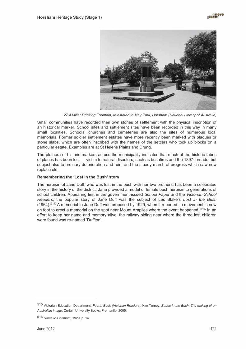
Horsham Heritage Study (Stage 1)
June 2012 122
�
27.4 Millar Drinking Fountain, reinstated in May Park, Horsham (National Library of Australia)
Small communities have recorded their own stories of settlement with the physical inscription of an historical marker. School sites and settlement sites have been recorded in this way in many small localities. Schools, churches and cemeteries are also the sites of numerous local memorials. Former soldier settlement estates have more recently been marked with plaques or stone slabs, which are often inscribed with the names of the settlers who took up blocks on a particular estate. Examples are at St Helens Plains and Drung.
The plethora of historic markers across the municipality indicates that much of the historic fabric of places has been lost — victim to natural disasters, such as bushfires and the 1897 tornado; but subject also to ordinary deterioration and ruin; and the steady march of progress which saw new replace old.
Remembering the ‘Lost in the Bush’ story
The heroism of Jane Duff, who was lost in the bush with her two brothers, has been a celebrated story in the history of the district. Jane provided a model of female bush heroism to generations of school children. Appearing first in the government-issued School Paper and the Victorian School Readers, the popular story of Jane Duff was the subject of Les Blake’s Lost in the Bush (1964).��� A memorial to Jane Duff was proposed by 1929, when it reported: ‘a movement is now on foot to erect a memorial on the spot near Mount Arapiles where the event happened.’516 In an effort to keep her name and memory alive, the railway siding near where the three lost children were found was re-named ‘Duffton’.
515 Victorian Education Department, Fourth Book (Victorian Readers); Kim Torney, Babes in the Bush: The making of an Australian image, Curtain University Books, Fremantle, 2005.
516 Home to Horsham, 1929, p. 14.
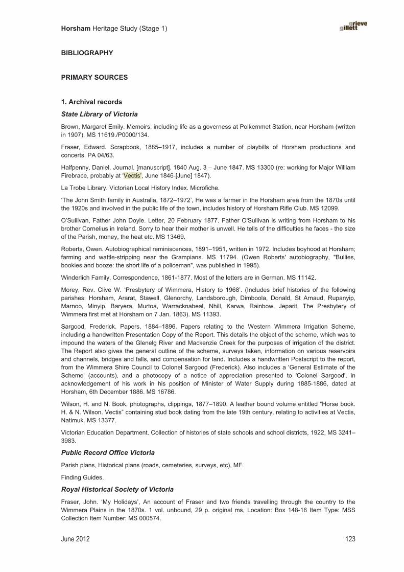
Horsham Heritage Study (Stage 1)
June 2012 123
BIBLIOGRAPHY
PRIMARY SOURCES
1. Archival records
State Library of Victoria
Brown, Margaret Emily. Memoirs, including life as a governess at Polkemmet Station, near Horsham (written in 1907), MS 11619./P0000/134.
Fraser, Edward. Scrapbook, 1885–1917, includes a number of playbills of Horsham productions and concerts. PA 04/63.
Halfpenny, Daniel. Journal, [manuscript]. 1840 Aug. 3 – June 1847. MS 13300 (re: working for Major William Firebrace, probably at ‘Vectis’, June 1846-[June] 1847).
La Trobe Library. Victorian Local History Index. Microfiche.
‘The John Smith family in Australia, 1872–1972’, He was a farmer in the Horsham area from the 1870s until the 1920s and involved in the public life of the town, includes history of Horsham Rifle Club. MS 12099.
O’Sullivan, Father John Doyle. Letter, 20 February 1877. Father O'Sullivan is writing from Horsham to his brother Cornelius in Ireland. Sorry to hear their mother is unwell. He tells of the difficulties he faces - the size of the Parish, money, the heat etc. MS 13469.
Roberts, Owen. Autobiographical reminiscences, 1891–1951, written in 1972. Includes boyhood at Horsham; farming and wattle-stripping near the Grampians. MS 11794. (Owen Roberts' autobiography, "Bullies, bookies and booze: the short life of a policeman", was published in 1995).
Winderlich Family. Correspondence, 1861-1877. Most of the letters are in German. MS 11142.
Morey, Rev. Clive W. ‘Presbytery of Wimmera, History to 1968’. (Includes brief histories of the following parishes: Horsham, Ararat, Stawell, Glenorchy, Landsborough, Dimboola, Donald, St Arnaud, Rupanyip, Marnoo, Minyip, Baryera, Murtoa, Warracknabeal, Nhill, Karwa, Rainbow, Jeparit, The Presbytery of Wimmera first met at Horsham on 7 Jan. 1863). MS 11393.
Sargood, Frederick. Papers, 1884–1896. Papers relating to the Western Wimmera Irrigation Scheme, including a handwritten Presentation Copy of the Report. This details the object of the scheme, which was to impound the waters of the Glenelg River and Mackenzie Creek for the purposes of irrigation of the district. The Report also gives the general outline of the scheme, surveys taken, information on various reservoirs and channels, bridges and falls, and compensation for land. Includes a handwritten Postscript to the report, from the Wimmera Shire Council to Colonel Sargood (Frederick). Also includes a 'General Estimate of the Scheme' (accounts), and a photocopy of a notice of appreciation presented to 'Colonel Sargood', in acknowledgement of his work in his position of Minister of Water Supply during 1885-1886, dated at Horsham, 6th December 1886. MS 16786.
Wilson, H. and N. Book, photographs, clippings, 1877–1890. A leather bound volume entitled “Horse book. H. & N. Wilson. Vectis” containing stud book dating from the late 19th century, relating to activities at Vectis, Natimuk. MS 13377.
Victorian Education Department. Collection of histories of state schools and school districts, 1922, MS 3241–3983.
Public Record Office Victoria
Parish plans, Historical plans (roads, cemeteries, surveys, etc), MF.
Finding Guides.
Royal Historical Society of Victoria
Fraser, John. ‘My Holidays’, An account of Fraser and two friends travelling through the country to the Wimmera Plains in the 1870s. 1 vol. unbound, 29 p. original ms, Location: Box 148-16 Item Type: MSS Collection Item Number: MS 000574.

Horsham Heritage Study (Stage 1)
June 2012 124
Maddern, I T. Papers on the history of Horsham . 2 vols. unbound, 17 p. and 21 p. typescript and map.
Location: Box 68-3 Item Type: MSS Collection Item Number: MS 000212 RHSV. Papers include, "The early days of Horsham", "The father of Horsham", "Yat Nat Station at Rocklands" (1958), and "The foundation of Horsham" (essay, 1961).
Maddern, I T. ‘The Story of Horsham State School’. Classification: PAM 1557 Location: Pamphlet filing cabinet , Item Type: Pamphlet , Item Number: 026686.
Collection of photographs of Horsham and District.
Horsham Municipal Library
Wimmera Shire Rate Books, MF 1863 – 1941.
Ephemera file, local history.
Horsham and District Historical Society
Large photographic collection.
Borough of Horsham Rate Books
Wimmera Waterworks Trust rate books
Files on people, buildings, businesses, and organisations.
National Library of Australia, Canberra
Wimmera, Victoria: Geographic ephemera collected by the National Library of Australia. Folders of miscellaneous pieces.
Lange, L.H. ‘A Short History of Polkemmet Station and Cemetery’. 1967. MS. NLA MS 2150.
Melbourne University Archives
Records of Horsham Gas
2. Newspapers and periodicals
Argus.
Argus, 11 May 1880. ‘Among the Free Selector (by our special reporter): Part VI The Wimmera’.
Australian Sketcher with Pen and Pencil.
Education Magazine, 1964.
Horsham Historian (quarterly), from 1969.
Horsham Times (1886–1999). [including a series of articles in 1935]
Horsham Times Almanac and Weather Guide, annual, various holdings in SLV, from 1891 – 1935.
Leader. ‘At Horsham’, 17 February 1894.
Pinnacle: Stawell inspectorate school magazine, 1923–28.
Portland Guardian.
South Australian Advertiser.
South Australian Register.
Wimmera Mail–Times [indexed by HHS], SLV holdings 1959-
Wimmera Quarterly.
Wimmera Star.
Victorian Naturalist.
Journal of the Royal Historical Society of Victoria (later title: Victorian Historical Journal)
Melbourne Walker, 1976 [The Wimmera River p.57]

Horsham Heritage Study (Stage 1)
June 2012 125
3. Government publications
Register of Squatting Licences, 1852. [copy on CD]
First Report of the Central Board Appointed to Watch Over the Interests of the Aborigines in the Colony of Victoria. Melbourne, 1861.
Statistical Register for Victoria. Government Printer, Melbourne, 1879-1920.
Victorian Government Gazette.
Victorian Municipal Directories, [1898, 1920, 1883, 1905, 1910, 1921, 1930]
Victorian Government. Reserves: A return giving particulars of Lands (exclusive of sites for Churches, Schools, and Public Buildings) permanently and temporarily reserved in the various Electoral Districts throughout the Colony. 29 Sept. 1881, printed in Votes and Proceedings of the Legislative Assembly,Session 1881 (1). [see my copy]
4. Published works - General
Blair, David. Cyclopaedia of Australasia. Fergusson and Moore, Melbourne, 1881.
Brady, E.J. Australia Unlimited. Sydney, 1918.
Bride, T.F. (ed.). Letters from Victorian Pioneers. Melbourne, 1898.
Candy, W. Reminiscences of the Early Mallee and Wimmera. Warracknabeal Herald Print, Warracknabeal, 1927.
Cannon, Michael (ed.). Vagabond Country. Hyland House, Melbourne, 1981.
Carter, Samuel. Reminiscences of the Early Days of the Wimmera. 1911.
Clarke, Marcus. History of the Continent of Australia and Island of Tasmania. Melbourne, 1877.
Crerar, William McL. History of the Wimmera. Horsham Times, Horsham, 1941.
D’Alton, St Eloy. Pioneers of the Wimmera: Notes on the early settlement of the Wimmera district. Printed at Banner Printing, Dimboola, [19--?].
Everard, George and Gould, Horace Walter. Pioneering Days: Journal of George Everard [1892, this edition reprinted 1977]. [PM - borrowed]
Falla, R.P. (ed.). Knocking About: The East Wimmera and Lower Avoca 1874–1876 with the “Travelling Correspondent”. Publication No. 6 of the History and Natural History Group – Donald MLA Society, Donald, 1976.
Garran, Andrew (ed.). Picturesque Atlas of Australasia. Archive CD Books Australia Pty Ltd, 3 disks, 2008 (first published in Sydney, 1886–88).
Also online at http://trove.nla.gov.au/work/6036967
Griffiths, Tom and Alan Platt (ed.), The Life and Adventures of Edward Snell. Angus & Robertson and the Library Council of Victoria, North Ryde, 1988.
Hamilton, J.C. Pioneering Days in Western Victoria
Henry, Thomas, Guide for Excursionists from Melbourne, Melbourne, 1888 (SLV holds 1879 edition).
Horsham Illustrated. Horsham Times, Horsham, [c.1920s].
Horsham Times Wimmera Almanac and Weather Guide for 1886. Horsham Times, Horsham, 1886.
Kirby, James. Old Times in the Bush of Australia, 1895.
Lorck, Walter. Victoria Illustrated. 1909.
McDonald, Mrs. C.W.S. ‘Quotations and Remembrances, “Innisvale”, Noradjuha, President Noradjuha Branch’. Horsham Times, Horsham, 1942. [UniMelb]
Mitchell, T.L. Three Expeditions into the Interior of Eastern Australia, with Descriptions of the Recently Explored Region of Australia Felix and the Present Colony of NSW, 2nd ed., Vol 11, London 1939 (Public Library of South Australia Facsimile, 1965), pp. 171 and 183.
Horsham Heritage Study (Stage 1)
June 2012 126
Morris, EE. Cassell’s Picturesque Australia vol 3. 1890?
Morton, William L. Notes of a Tour in the Wimmera District (June and July 1861) by "An old bushman".Yeoman and Australian Acclimatiser, 5 October 1861. Republished by National Parks Authority, Melbourne, [196-?]
Smith, James (ed.). Cyclopedia of Victoria. The Cyclopedia Company Ltd, Melbourne, 1903–05.
Spielvogel, Nathan. The Cocky Farmer. Angus & Robertson, Melbourne, 1907.
Stainthorpe, Robert H. and William Candy. Early Reminiscences of the Wimmera and Mallee and Reminiscences of the Early Mallee and Wimmera. Lowden Publishing Co., 2009.
Sutherland, Alexander (ed.). Victoria and its Metropolis: Past and present. 2 volumes. McCarron, Bird and Cameron, Melbourne, 1888. [for James Fry, see vol. II, p. 562, etc]
Townsend, Edward. The Townsend Memories: A journey through the Wimmera in the 1860s. N.d. Nhill, c.2000.
Turner, Henry Gyles. A History of the Colony of Victoria, 2 vols. Longmans Green & Co., Melbourne, 1904 (facsimile ed. Heritage Publications, 1973).
Twain, Mark. Following the Equator 1895.
Walch, Garnet. Victoria in 1880. George Robertson, Melbourne, 1881.
Welch, L.N. Domestic and Stock Water Supply from Channels or Pipe Lines: Evidence to State Development Committee. State Rivers and Water Supply Commission, Melbourne, 1947. [Monash Uni Library]
Willoughby, Australian Sketches with Pen and Pencil. 1886.
Wilson, Samuel. The Angora Goat: With an account of its introduction into Victoria, and a report on the flock belonging to the Zoological and Acclimatisation Society of Victoria, now running at Longerenong, in the Wimmera district. Stillwell and Knight, Melbourne, printers, 1873.
Young, Thomas. Pioneer Station Owners of the Wimmera. Horsham, 1926.
5. Gazeteers, Guide Books and Almanacs
Australian Handbook 1890. Gordon and Gotch, London, 1890.
The Railways Guide to Victoria. Victorian Railways, Melbourne, 1885, 1888, 1892.
Victorian Railways. Picturesque Victoria. Melbourne, 1905.
Victorian Railways. Picturesque Victoria and How to Get There: A Handbook for Tourists. Melbourne, 1912.
Victorian Railways. Railways Guide to Victoria. Melbourne, 1885; 1888.
Westgarth, William. Australia Felix. 1848. Whitworth, Robert Percy. Official Handbook and Guide to Victoria. Melbourne, 1881.
Whitworth. Bailliere’s Victorian Gazetteer and Road Guide. Melbourne, 1865
Whitworth. Bailliere’s Victorian Gazetteer and Road Guide. Melbourne, 1879.
6. Later tourist guidebooks
Blair’s Travel Guide to Victoria and Melbourne Australia, 1987/8 edition. Blair’s Guides, Melbourne, 1987.
Herald Camping Guides, Melbourne, 1930s. White, Osmar. Guide to Australia. William Heinemann, Melbourne, 1968.
Winser, Keith. Australian Caravans and Touring, Book 6. Keith Winser, Melbourne, 1954.
7. Maps and plans
Shaw, James. ‘Plan of the Nine Mile Reserve and Village, Horsham’. 1855.
1887 Plan of Horsham, NLA MAP RM 2741/68.
1882 Plan of Horsham, NLA MAP RM 2740/18.

Horsham Heritage Study (Stage 1)
June 2012 127
Australian Army Ordnance maps
Wimmera Water Supply. Plan showing existing districts and sites of works [cartographic material]: to accompany report of the State Rivers and Water Supply Commission of Feb. 1907. Stuart Murray, 28-2-07.Stuart Murray, Melbourne, 1907.
Map of part of Parish of Vectis East [cartographic material] drawn and reproduced at the Dept. of Lands and Survey, Melbourne, Victoria. Melbourne : T. Rider, Govt. Printer, 1940.
Historical maps and plans, Pre-emptive rights. PR V4, Vectia [sic.] [microform]. 1858. Crown Lands and Survey historical plan. Map shows: Cadastral features; Buildings plotted ; Soil and/or vegetation described. Surveyor: Shaw. [MAPMF Historical plans collection PR V4]
Vectis Estate, Parish of Quantong, County of Borung [microform]. Collection of parish maps of Victoria on aperture card. [MAPMF 820 BJE 1837 - 3436 Q36(B1)]
Ham’s Map of Squatting Runs 1848, 1849.
Hiscock maps of pastoral stations in Victoria.
Historic Plans Collection, Central Plans Office, Department of Sustainability and Environment.
Australian Army. Military Survey Maps, c.1941–46.
SECONDARY SOURCES
1. General publications Blainey, Geoffrey. Our Side of the Country: The story of Victoria. Methuen Haynes, North Ryde, 1984.
Blake, Les. Places Names of Victoria. Rigby, Adelaide, 1976.
Bonyhady, Tim. The Colonial Earth. The Miegunyah Press at Melbourne University Press, Carlton, 2000.
Brewer, Kevin. ‘A bit of land this is the very thing keeping a man poor: Grasslands and other imaginary places on the western plains of Victoria 1839–1880’. MA thesis, Department of Geography and Environment Studies, University of Melbourne, 1998.
Broome, Richard. Arriving. Fairfax, Syme & Weldon Associates, McMahon’s Point, 1984.
Cabena, Peter et al. The Lands Manual. Royal Historical Society of Victoria, Melbourne, 1
Cannon, Michael. Life in the Country: Australia in the Victorian age 2. Nelson Aust., West Melbourne, 1978.
Cathcart, Michael. Defending the National Tuckshop: The secret army intrigue of 1931. Penguin, Ringwood, 1989.
Dingle, Tony. Settling. Fairfax, Syme and Weldon, McMahon’s Point, 1984.
Fahey, Charles. ‘Families and Selection in Colonial Horsham’, in Patricia Grimshaw et al (eds), Families in Colonial Australia. Allen & Unwin, Sydney, 1985, pp. 118-??
Faigan, Julian. Colonial Art of the Western District. City of Hamilton Art Gallery, Hamilton, 1984.
Forth, Gordon (ed.). The Biographical Dictionary of the Western District of Victoria. Hyland House, South Melbourne, 1998.
Gregory, J.W. Geography of Victoria. Revised edition, 1912.
Griffiths, Tom. Hunters and Collectors: The antiquarian imagination in Australia. Cambridge University Press,
Grimshaw, Patricia. ‘Man’s Own Country: Women in colonial Australian history’, in Australian Women: New Feminist Perspectives, 1986, pp. 182–209.
Gross, Alan. ‘Dallachy, John (1808?–1871)’ Australian Dictionary of Biography, vol. 4, 1972: http://adb.anu.edu.au/biography/dallachy-john-3355
Hutchinson, Frank. Beginnings: A brief account of some of the first Europeans to explore or settle in Victoria.Prahran Mechanics Institute Press, Windsor, 2011.
Jupp, James (ed.). The Australian People. 1988.

Horsham Heritage Study (Stage 1)
June 2012 128
Kiddle, Margaret. Men of Yesterday: A social history of the Western District of Victoria 1834–1890.Melbourne University Press, Carlton, 1967 (first published 1961).
McIntyre, A.J. and J.J. Country Towns of Victoria, A social survey, Melbourne University Press, MeIbourne, 1944.
McKay, John. St. Eloy D'Alton: A Wimmera Pioneer and His Family (1850–1930). Cavendish, 1999.
Monteith, Peter. Germans. 2011.
Priestley, Susan. Making Their Mark. Fairfax, Syme and Weldon, Sydney, 1984.
Robin, Libby. Defending the Little Desert: The rise of ecological consciousness in Australia, Melbourne University Press, Carlton, 1998.
Seddon, George. Landprints: Reflections on place and landscape. Cambridge University Press, Cambridge, 1998.
Serle, Geoffrey. The Golden Age: A history of the Colony of Victoria 1851–1861. Melbourne University Press, Carlton, 1963.
Serle, Geoffrey. The Rush to Be Rich.
Shaw, A.G.L. The Port Phillip District: Victoria before Separation. Melbourne University Press, Carlton, 1996.
The Western Horizon of Victoria, Australia: A pictorial presentation of the resources and development of Victoria's Western District. Australian Publicity Council, Melbourne, 1958.
Watson. Angus B. Lost and Almost Vanished Towns of Victoria: A comprehensive analysis of Census
results for Victoria 1841–1901. The author and Andrew McMillan Art and Design, 2003.
2. Sources for particular themes NATURAL LANDSCAPE
Cross, Berly. Wimmera–Mallee Vegetation: The trees and shrubs for our farms, roadsides and reserves. B. Cross, Warracknabeal, c.1983.
Douglas, M.H. and L. O’Brien (eds). The Natural History of Western Victoria: Proceedings of the symposium.Western Victorian Sub-branch, Australian Institute of Agricultural Science, Horsham, 1974. Conley David and Claire Dennis (ed.). The Western Plains: A natural and social history. The Australian Institute of Agricultural Science, Parkville, 1984. [PM - borrowed]
DSE, Climate Change in the Wimmera, c.2009. PDF.
Lunt, I.D., Tim Barlow, James Ross, Victorian National Parks Association, Trust for Nature (Victoria). Plains Wandering: Exploring the grassy plains of south-eastern Australia. Victorian National Parks Association, 1998.
Morcom, Lisa A. and Martin E. Westbrooke. ‘The Pre-Settlement Vegetation of the Western and Central Wimmera Plains of Victoria, Australia’, Australian Geographical Studies, 1998, vol. 36(3), pp. 273–288.
Welch, L.N. Enquiry into the conservation and use of the waters of the Wimmera River and its tributaries: Evidence for the Parliamentary Public Works Committee. 1960.
EXPLORATION
Bird, Juliet. ‘Thomas Mitchell’s Route in North Western Victoria’, Victorian Historical Magazine, vol. 43, no. 1, 1972, pp. 741–48.
Andrews, Alan (ed.). Stapleton: With Major Mitchell’s Australia Felix expedition 1836. 1986. pp. 172–73.
Cumpston, J.H.L. Thomas Mitchell: Surveyor general and explorer. Oxford University Press, Melbourne, 1954.
Eccleston, Gregory C. Major Mitchell’s 1836 ‘Australia Felix’ Expedition: A re-evaluation. Department of Geography and Environmental Science, Monash University, Melbourne, 1992.
The Major Mitchell Trail: Exploring Australia Felix. Community Education and Information Branch and National Parks and Wildlife Division, Department of Conservation and Environment, Melbourne, 1990. pp. 82–83.

Horsham Heritage Study (Stage 1)
June 2012 129
ABORIGINAL CONTACT HISTORY
Broome, Richard (ed.). The Colonial Experience: The Port Phillip District 1834-1850. Department of History, La Trobe University, Bundoora, 1997.
Clark, Ian D. Aboriginal Languages and Clans: An historical atlas of western and central Victoria, 1800–1900.Monash Publications in Geography, No. 37, Clayton, 1990.
Clark, Ian D. Scars in the Landscape: A register of massacre sites in Western Victoria, 1803–1859. Australian Institute of Aboriginal and Torres Strait Islander Studies, Canberra, 1995.
Clark, Ian D. Place Names and Land Tenure: Windows into Aboriginal landscapes: Essays in Victorian Aboriginal history. Heritage Matters, Clarendon, 1998.
Clark, Ian D. ‘That’s My Country Belonging to Me’: Aboriginal land tenure and dispossession in nineteenth century Western Victoria. Heritage Matters, Clarendon, 1998.
Clark, C.M.H. et al. Australia Felix: The Chap Wurrung and Major Mitchell. Dunkeld and District Historical Society, Dunkeld, 1987.
Christie, M.F. Aborigines in Colonial Victoria 1835-86. Sydney University Press, Sydney, 1979.
Corris, Peter. Aborigines and Europeans in Western Victoria, Occasional Papers in Aboriginal Studies No. 12, Ethnohistory Series No. 1, Australian Institute of Aboriginal Studies, Canberra, 1968, pp. 153-157.
Fels, Marie Hansen. Good Men and True: The Aboriginal Police of the Port Phillip District, 1837-1853. Melbourne University Press, 1988, pp. l5l-l53. The record of this man’s exploits ‘are many, and dispersed’. (Fels, Good Men and True, Footnote 59, p 275). Perhaps this is a starting point for a scholar in future to reconstruct the frontier violence in the Wimmera.
Kenny, Robert. The Lamb Enters the Dreaming: Nathanael Pepper and the ruptured world. Scribe Publications, Carlton North, 2007.
Massola, Aldo. Journey to Aboriginal Victoria. Rigby Ltd, Melbourne, 1969.
Reynolds, Henry. The Other Side of the Frontier: Aboriginal resistance to the European invasion of Australia.Penguin, Ringwood, 1983 (first published 1981).
PASTORALISM
Darlot, James M. ‘Reminiscences communicated to his son Philip Firebrace Darlot’, Victorian Historical Magazine, vol. xviii, no. 3, July 1940, pp. 67–77.
Billis, R.V. and Kenyon, A.S. Pastoral Pioneers of Port Phillip. Stockland Press, Melbourne, 1974.
Senyard, J.E. ‘Pattern of Pastoral Settlement in the Wimmera, 1843–1883’. PhD thesis, University of Melbourne, Dept. of History, 1973.
Spreadborough, Robert and Anderson, Hugh. Victorian Squatters. Red Rooster Press, Ascot Vale, 1983.
ACCLIMATISATION
Bourke, Donna. ‘What Happened to the Camels of the Burke and Wills Exhibition’, Journal of Public Record Office Victoria, September 2010, no. 9.
LAND SETTLEMENT
Blake, Les. ‘Village Settlements’, Educational Magazine, 9, 10, 11, 1964.
Falla, Ron. ‘Land Selection in the Wimmera’, Victorian Historical Magazine, September 2000, pp. 94–101.
Skene, J.K.M. ‘Report on Soils of the Horsham Soldier Settlement Project’, 1959.
Powell, J.M. The Public Lands of Australia Felix: Settlement and land appraisal in western Victoria 1834–1891 with special mention of the western plains. Oxford University Press, Melbourne, 1970.
Smallwood, Rosalind. Hard to Go Bung: World World II soldier settlement in Victoria 1945-62. Hyland House, Melbourne, 1992
Wright, Ray. The Bureaucrats’ Domain: Space and the Public Interest in Victoria, 1834–86. Oxford University Press, Melbourne, 1989.

Horsham Heritage Study (Stage 1)
June 2012 130
WATER SUPPLY AND IRRIGATION
Boorman, H.L. Irrigation and Water Supply Development in Victoria. State Rivers and Water Supply Commission of Victoria, Melbourne, 1942.
Cabena, Peter. ‘Victoria’s Water-front Reserves: An historical review and resource appreciation’, 1983. [http://www.southwestnrm.org.au/sites/default/files/uploads/ihub/victorias-water-frontage-reserves.pdf]
City of Horsham. Horsham Water Supply: Source to tap: May 1989.
East, Sir Ronald. ‘Water in the Mallee’, Victorian Historical Magazine, no. 150, vol. 38, no. 4. November, 1967, pp. ??
Keating, Jenny. The Drought Ran Through: A history of water shortage in Victoria. Department of Water Resources, Melbourne, 1992.
McIlvena, Bob. Articles in the Wimmera Mail–Times on the subject of local water supply, 2011.
McKinnon, Malcolm, John Martin & Juli Cathcart (ed.). Dam Fine Yarns: Watery tales from the Victorian Wimmera and Mallee. Horsham Regional Arts Association, Horsham, c.2005
McNab, R.F. The Early Settlement and Water Supply of the Wimmera and Mallee. State Rivers and Water Supply Commission, 1944.
Powell, J.M. Watering the Garden State: Water, land and community in Victoria, 1834–1988. Sydney, 1989.
Spawn, A.F. Riverside Irrigation Colony, Horsham, Victoria. Printers & Bookbinders Co-operative, Melbourne, [189-?]
SRWSC. The Irrigated Areas. Government Printer, Melbourne [1910].
SRWSC. Administration and Development of Water Supply, Irrigation, Drainage, Flood Protection and Sewerage in Victoria, 1935–43. Government Printer, Melbourne, 1943.
Van Veldhuisen, Rhona. Pipe Dreams: A history of water supply in the Wimmera–Mallee. Wimmera–Mallee Water, Horsham, 2001.
FARMING AND AGRICULTURE
Lomas, L.G. ‘The Western District Farmer 1914–27’, PhD thesis, Monash University, 1979.
Maroske, Ian O. A History of the Horsham Agricultural Society: A hundred Horsham shows. Horsham Agricultural Society, Horsham. 1978.
Maroske, Sara. ‘Wives, Housewives and Mothers? Wimmera farm women in the 1930s’. Paper delivered at the biennial conference of the Oral History Association of Australia, held at the University of Melbourne on 7–9 June 1985, Oral History Association of Australia Journal, no.7, 1985, pp. 101-107.
Powell, J.M. ‘Farming Conditions in Victoria, 1857–1865: A prelude to selection’, Australian Geographer, vol.x, no. 5, March 1968, pp. 346–54.
WHEAT-GROWING
Holt, Alan J. Wheat Farms of Victoria: A sociological survey. School of Agriculture, University of Melbourne, Parkville, 1946.
Milner, Peter. ‘On some rectangular wheat storage buildings in the Wimmera and Mallee’, University of Melbourne, Dept. of Mechanical and Manufacturing Engineering, 1989.
Tucker, Frank. Early Development of the Wheat Industry in the Wimmera and Mallee: A photographic record.Pioneer Settlement Press, Swan Hill, 1985.
The History of Smith’s Mill [DVD]. Horsham Historical Society, Horsham, 2005.

Horsham Heritage Study (Stage 1)
June 2012 131
ARCHITECTURE AND BUILDING
Doyle, Helen. ‘The Homestead’, in Richard Aitken (ed.), Farm Buildings in Victoria to 1938. Monash Public History Group and La Trobe University of Northern Victoria, report prepared for AHC, Canberra, 1992, pp. 17–31.
Lewis, Miles. Victoria Primitive. Greenhouse Publications, Carlton, 1977.
Milner, Peter. ‘On some rectangular wheat storage buildings in the Wimmera and Mallee’, University of Melbourne, Dept. of Mechanical and Manufacturing Engineering, 1989.
Nattrass, John A.H. ‘Straw thatched farm buildings of the Wimmera’, Thesis, Faculty of Architecture, Building and Planning, University of Melbourne.
TOWN DEVELOPMENT
Barrett, Bernard. The Civic Frontier: The origins of local communities and local government in Victoria. Melbourne University Press, Carlton, 1979.
O’Neill, Frances. ‘The Visible State’. M.A. in Public History thesis, Department of History, Monash University, 1993.
LAW AND ORDER
Building Services Agency, ‘Police Buildings in Victoria: A survey of types of police buildings’, 1997.
Legal History of Horsham.
Haldane, The People’s Force. 1986.
Lennon, Jane. Our Inheritance (1992), p. 59.
WIMMERA RIVER
Oates, John, The Wimmera River. 1985.
Tacon, Gill. ‘The River and the Town’ in Marc Brodie and Graeme Davison (eds), Struggle Country: The rural ideal in twentieth-century Australia, Monash University ePress, Clayton, 2005.
Tacon, Jillian. ‘Historical Perspectives of the Wimmera River’, submitted in fulfilment of the requirements for the degree of Master of Arts, School of Historical Studies, Monash University, 2004.
RAILWAY
Brooke, Brian J. Horsham Express. Horsham Railway Centenary Committee, 1979.
RELIGIOUS COMMUNITIES
Coulson, Helen. Parish of Horsham: Centenary celebrations, St. Andrew’s Presbyterian Church 1858–1958.Horsham, 1958.
Huf, Elizabeth. Courage, Patience and Persistence: 150 years of German settlement in Western Victoria.Sesquicentenary Committee, St Michael’s Lutheran Church, Tarrington, 2003.
Lewis, Miles (ed.). Victorian Churches. National Trust of Australia (Vic.), Melbourne, 1991.
Meyer, Charles. Nurseries of the Church.
Noack, J.F. Jubilee of the Lutheran Church in the Wimmera District of Victoria 1874–1924. J.F. Noack, Natimuk, 1924] (Hunkin, Ellis & King Printers, Adelaide).
Some of the Fruits of Fifty Years. A.H. Massina & Co., Melbourne, 1897.
Horsham Presbyterian Church: Seventieth anniversary celebrations, 1858–1928. [Pamphlet] PAM 1555 - Pamphlet filing cabinet (031027), RHSV.
Historical Record of the Horsham Presbyterian Church: Published in connection with seventieth anniversary, April 1928. The Church, 1928.
Coughlin, John F. The Catholics of the Wimmera. Catholic Church, Horsham, 1976.

Horsham Heritage Study (Stage 1)
June 2012 132
O’Leary, Leo (ed.). Horsham Catholic Church Centenary, 1876–1976.
Sturrock, Morna. Women of Strength, Women of Gentleness: Brigidine Sisters, Victorian Province. David Lovell Publishing, Melbourne, 1995. [Horsham, p. 74]
Young, Rona. The Eagle’s Vision: St John’s Anglican Church Horsham 1876–1996. St John’s Anglican Church, Horsham, 1996.
Midst Golden Grain: Celebrating the centenary of Methodism in the Wimmera, April 23rd, 1972 (Horsham Circuit) [Horsham, 1972] (Horsham, Mail-Times Print).
ETHNIC COMMUNITIES
German Heritage of the Wimmera. Horsham Art Gallery, 1991. Plazzer, Mario. Making Our Home in Horsham. Horsham, 1998.
(The stories of Italians and their families who migrated to Horsham. The book is written in English and Italian, depending on the storytellers preference. Includes photographs, maps.)
[O.V. Carter] Walter Zumstein: Pioneer. Horsham, The Society, 1967.
Jupp, James. The Australian People. 1988.
EDUCATION
Blake, Les (ed.). Vision and Realisation. Victorian Government Printing Office, Melbourne, 1973, volume 2, book 14 ‘Wimmera Region’.
Burchell, Lawrence. Victorian Schools: A study in colonial government architecture 1837–1900. Melbourne University Press, in association with the Victorian Education Department, Carlton, 1980.
Doyle, Helen. ‘Establishing Schools and Places of Higher Education: A Cultural Sites Network Study’, prepared for Historic Places Branch, DRNE, Melbourne, May 2000.
Maddern, I.T. ‘The Story of School No. 298, Horsham’, Educational Magazine, vol. 17, no. 1–8 (Feb. 1960–Sept. 1960) Maddern, I.T. ‘History of the Horsham High School, 1912–1950’.
Elizabeth and Robyn Gulline. Longerenong: Early schools and pioneers. Elizabeth & Robyn Gulline, Horsham, 1999. 120 Years On: Pimpinio Primary School. 1874–1994. Pimpinio School Reunion Committee, Pimpinio, 1994.
HOUSING
Howe, Renate. New Houses for Old: Fifty years of public housing in Victoria, 1938–88. Ministry of Housing and Construction, Melbourne, 1988.
SPORT AND RECREATION
Horsham Golf Club: Centenary 1898–1998. The Club, Haven, c1998.
Doyle, Helen. ‘Organising Recreation: A cultural sites network study’. Prepared for DSE, Melbourne, 1999.
ART AND LITERATURE
Hay, Peter (ed.). Meeting of Sighs: The folk verse of Victoria’s Western District. Warrnambool Institute Press, Warrnambool, 1981.
Hunter, Philip and Sidney Nolan; guest curator, Peter Haynes. The Plains: Wimmera and the imaging of Australian landscape. Ian Potter Museum of Art, University of Melbourne, Parkville, 2001.
Pierce, Peter (ed.). The Oxford Literary Guide to Australia. Oxford University Press, Melbourne, 1987.
HEALTH CARE
Finch, Alan. Since Adam Was the Man. Wimmera Base Hospital, Horsham, 1974.
Sutherland, Rod. ‘Bush nursing hospitals’, Horsham Historian, February 1910, pp. 5-8.

Horsham Heritage Study (Stage 1)
June 2012 133
TOURISM
Spearitt, Peter and Jim Davidson. Holiday Business. Melbourne University Press, Melbourne, 2000.
Winser, Keith. Camping and caravanning guides, 1950s.
Why You’ll Like Horsham, Capital of the Wimmera.
What to See: Horsham and District. Horsham District Historical Society and Horsham Field Naturalists Club, 1966.
LOCAL ORGANISATIONS AND SOCIETIES
Murphy, William J. Wimmera Masonic Lodge. Wimmera Lodge, Horsham, 1977.
Temperance Hall, McLachlan St, Horsham: Horsham Library now on this site, built 1968. (Photocopied articles on Temperance Society in Horsham which occupied site of Wimmera Regional Library Service).
REMEMBRANCE AND COMMEMORATION
Torney, Kim. Babes in the Bush: The making of an Australian image. Curtin University Books, Fremantle, 2005.
CEMETERIES
LP Planning. ‘Cemeteries of Victoria: A National Estate Study for the Ministry of Planning’. 1982.
Marr, Ian. ‘Cemeteries of South West Victoria’, 2007.
Sagazio, Celestina (ed.). Cemeteries: Our heritage. National Trust of Australia (Vic.), Melbourne, 1992.
TRADE AND COMMERCE
‘Wimmera Stock Bazaar’, Trust News, June 2002, p. 6.
A Century of Trading in Horsham: A story of pioneering achievement 1849–1949. J. Langlands & Sons Pty Ltd, Horsham, 1949.
WAR
Breed, Florence. From Gallipoli with Love 1915: Letters from the Anzacs of the Wimmera. History and Natural History Group of the M.L.A. Society, Donald, 1993.
Inglis. Ken. Sacred Places.
McIlvena, Ercil. Wimmera–Mallee Volunteers to the Boer War: 1899–1902. Horsham & District Historical Society, 2001.
Thomson, Barry. ‘The Mighty Dead: The celebration and meaning of Anzac Day in Horsham 1916–46’, typed MS. The author, 1992.
‘Listing of war memorials in Victoria: As at 26.4.2004’. t.s., c.2004 (copy in author’s possession).
GARDENS AND TREES
Aitken, Richard and Michael Looker (eds). Oxford Companion to Australian Gardens. Oxford University Press, Melbourne, 2000.
Cousins, Roger. ‘Horsham Botanic Gardens’, http://home.vicnet.net.au/~horbotgd/
Gilfedder, Francine. [Victoria’s Provincial Botanic Gardens’] in VHJ, 1996.
Orr-Young, Jill. ‘Horsham Botanic Gardens: Master Plan’. 2003.
Watts, Peter with Margaret Barrett, Historic Gardens of Victoria: A reconnaissance, Oxford University Press, MeIbourne, 1983.
May, Andrew and Sara Maroske. ‘“Horticultural Embellishments”: Public conferment from the Melbourne Botanic Garden, 1870’, Australian Garden History 4:4, Jan/Feb 1993, pp. 8–14.
Whitehead, Georgina (ed.). Planting the Nation. Australian Garden History Society, Melbourne, 2001.

Horsham Heritage Study (Stage 1)
June 2012 134
3. Local history publications
GENERAL (HORSHAM AND WIMMERA REGION)
Bechervaise, John. Old Victorian Country Pubs sketchbook , Rigby Limited Melbourne: 1976.
Blake, Les. Lost in the Bush: The story of Jane Duff. Whitcombe and Tombs, Melbourne, 1964.
Blake, Les, Wimmera: A regional history. Cypress Books, Melbourne, 1973.
Blake, L.J. and K.H. Lovett. Wimmera Shire Centenary: An historical account. Horsham, 1962.
Blake, L. J. ‘Langlands, George (1803–1861)’, Australian Dictionary of Biography: vol. 5, National Centre of Biography, Australian National University, http://adb.anu.edu.au/biography/langlands-george-3988/text6305, accessed 11 July 2011.
Blake, L. J. ‘Stephens, Edward James (1846–1931)’, Australian Dictionary of Biography, National Centre of Biography, Australian National University, http://adb.anu.edu.au/biography/stephens-edward-james-4640/text7657, accessed 11 July 2011.
Brooke, Brian and Alan Finch. A Story of Horsham: A municipal century. City of Horsham, Horsham, 1982.
Calder, Jane. The Grampians: A noble range. Victorian National Parks Association, Melbourne, 1987.
Carthew. A.E. Souvenir of Home to Horsham, 19th to 26th October, 1929: 1849–1929. Published with the official authority of the Committee of the Home to Horsham Celebrations, 1929 (printed in conjunction by the Horsham Times and the Wimmera Star).
Central Planning Authority in collaboration with the Wimmera Regional Committee. Resources Survey: Wimmera region. Government Printer, Melbourne, 1961.
Coulson, Helen. Horsham Centenary Souvenir Booklet: One hundred years of progress. Executive Council of the Centenary Celebrations, Horsham Times Print, Horsham, 1949.
Dermody, Kathleen. ‘Wade, Harrie Walter (1905–1964)’, Australian Dictionary of Biography, National Centre of Biography, Australian National University, http://adb.anu.edu.au/biography/wade-harrie-walter-11929/text21373, accessed 11 July 2011.
Field, Jean. Waggon Wheels thro’ the Wild Flowers. Hawthorn Press, Melbourne, 1977.
Heard, James B. Our Fifth Decade: 1997–2007. Horsham Historical Society, Horsham, 2007.
Jenkinson, Noelene M. Horsham Historical Society Inc.: Our first 40 years, 1957–1997. Horsham Historical Society, Horsham, [1997]
Jenkinson, Noelene M. Horsham in Focus: 1849–1999. Compiled by Noelene M. Jenkinson and Marie P. Foley for Horsham Historical Society Inc. Horsham Historical Society, Horsham, 1999.
Kenyon, A.S. ‘First Settlement of the Wimmera: Address on the occasion of the 100th anniversary of Major Mitchell’s discovery of Arapiles, July 23, 1936. A.S. Kenyon 1936, Horsham Times, 24 July 1936. Kenyon, A.S. Early Days in the Wimmera. c.1960s. Sawyer, Katie I. The Sawyer Family in Australia. Katie Sawyer, 1973.
Slyfield, Brian. ‘James Monckton Darlot and the Naming of Horsham’. Horsham, 2001.
Starr, Joan and Alan Berry (eds). The Wimmera Story. Research Publications, Blackburn, 1983.
Henderson, Alexander (ed.). Early Pioneer Families of Victoria and Riverina. McCarron Bird, Melbourne, 1936. ‘The Young family of Horsham, Hamilton & Nhill’, pp. 367-372.
Horsham Learning Centre. Women of the Wimmera. HUB, Horsham, 1986.
Tin Toys and Tea Parties: A social history exhibition examining childhood in the Wimmera up to the 1950s: May 30 – July 9, 1995. Horsham Art Gallery, [1995].
Reid, John, Keith H. Lovett and Les J. Blake. Road Board to Restructure: The history of the Shire of Wimmera, 1862–1995. Joval Publications, Bacchus Marsh, 1996.
Horsham Heritage Study (Stage 1)
June 2012 135
Reynolds, E. Vivian. Naming Horsham’s Streets: 1849–1998. Horsham Historical Society Inc., Horsham, 2003.
Thomson, Barry W. ‘The provision of unemployment relief in Horsham 1928–42’. The author, 1990.
The Western Horizon, c.1950s
Wimmera Walkabout. Ministry of Tourism, Melbourne, [1970?] 1 folded sheet: 22 x 9 cm. [SLV?]
Sharp, Nonie. ‘Three Lost Children: Revisiting a heroic legend’, Meanjin, vol. 69, no.3, Sep 2010, pp. 132–141.
NATIMUK AND ARAPILES
A Historical Review of Natimuk and District: Compiled in connection with the Back to Natimuk celebrations, April 5 to 12, 1947. Natimuk Progress Association, 1947. [check]
Lockwood, Allan. Our Home Among a Caring Community: Natimuk ... now 125. Back to Natimuk Committee, Natimuk, 1997.
Lockwood, Allan. Olive Shoots in Natimuk. Wimmera Mail Times, Horsham, 1989.
Lockwood, Allan. Natimuk — Spans a Century. Mail–Times Print, Horsham, [1972]
Lockwood, Keith. Arapiles: A million mountains. Skink Press, Natimuk, 2007.
Meagher, Beverley. Women of Arapiles: Past and present. Shire of Arapiles, Natimuk, [1984]
Natimuk on Show: History of Natimuk Agricultural and Pastoral Society: 1887-1992.
OTHER SMALL LOCALITIES
Back to Dadswells Bridge Committee. From Ledcourt Crossing to Dadswells Bridge. The Committee, 1980.
Blake, Margaret. 120 Years On: Pimpinio Primary School 1874–1994. Pimpinio School Reunion Committee, 1994.
Driscoll, Eulalie. The Barkly Story, 1859–1985. E. Driscoll, Barkly, 1985.
Edmonds, John Wilson Eadie. ‘Social development of a small rural community’. Thesis (M.Agr.Sc.), University of Melbourne, Dept. of Agriculture and Forestry, 1973.
Lah Arum: Told by the people of Lah Arum and district. Lah Arum Back To and School Centenary Committee, Horsham, 1987.
Memories of Pimpinio. Horsham & District Historical Society, Horsham, 1993.
Memories of Green Park. Horsham & District Historical Society. Horsham, 1992.
Memories of Jung Jung. Horsham & District Historical Society. The Society, Horsham, 1991.
Memories of Dooen. Horsham and District Historical Society. Wartook Professional Computing, c.1990.
Memories of Wonwondah. Horsham Historical Society Oral History Series, Horsham Historical Society Oral History Series; No. 6, The Society, c.1998.
Memories of Quantong. Horsham Historical Society Oral History Series. The Society, Horsham, 1991.
Noradjuha Primary School 1876–1996. C.1996.
Back to Haven Committee, Our Haven. Back to Haven Committee, Haven, 1978.
Smith, Joan A. The Greenaways of Kalkee: A social history. J. Smith, Hamilton, 1992?
3. Heritage / conservation reports
Aitken, Richard (ed.). ‘Farm Buildings in Victoria: 1835–1939’. Monash Public History Group and La Trobe University Bendigo. 1994.
Marr, Ian. Cemeteries of South-West Victoria. DVD.
Context Pty Ltd. ‘Victorian water supply heritage study’. Prepared for Heritage Victoria, 2007.
Doyle, Helen. ‘Wimmera water supply’ paper presented at Heritage Council conference, Murtoa, April 2008.

Horsham Heritage Study (Stage 1)
June 2012 136
Land Conservation Council. ‘South Western Area: District 2: Final Recommendations’. May 1982. http://www.veac.vic.gov.au/documents/368-South-Western-Study-Area-District-2-LCC-.pdf
Land Conservation Council. Report on the Wimmera Area. Melbourne, 1985.
Land Conservation Council. Wimmera Area: final recommendations, November 1986. The Council, Melbourne, 1986. [UniMelb; online http://www.veac.vic.gov.au/reports/369-Wimmera-Study-Area-LCC-.pdf]
Land Conservation Council. Historic Places: Special Investigation: South-Western Victoria. Proposed Recommendations. Land Conservation Council, Melbourne, June 1996.
Land Conservation Council. Historic Places: Special Investigation: South-Western Victoria. Final Recommendations. Land Conservation Council, Melbourne, January 1997.
Milner, Peter. ‘On some rectangular wheat storage buildings in the Wimmera and Mallee’, University of Melbourne, Dept. of Mechanical and Manufacturing Engineering, 1989.
Nattrass, John A.H. ‘Straw thatched farm buildings of the Wimmera’, Thesis (Undergrad)--University of Melbourne, Faculty of Architecture, Building and Planning, date?.
Ward, Andrew. ‘Limited Heritage Study for the Rural City of Horsham’. Horsham Rural City Council, 1998.
Burne, Janet. ‘Zumsteins Cottages, Grampians National Park: Conservation analysis and conservation policy’. Horsham and District Historical Society, Horsham, 1993.
Report to Illuka, Geotechnical Drilling Echo Project. Cultural Heritage Assessment, January 2008. [www.dpi.vic.gov.au/CA256F310024B628/0/1C4E84B00F5A140ACA2573E1001A9557/$File/2008_2_Cultural_Heritage_Draft_Report.pdf]
4. Digital resources
Rainfall data website.
Arapiles.net: http://www.arapiles.net/history.html; accessed 22 July 2011.
German Heritage Study. Heritage Victoria, 1999: http://pandora.nla.gov.au/pan/20707/20030707-0000/heritage.vic.gov.au/german_heritage.html
Poole, Laura. ‘Irrigation in the Wimmera: An old industry remembered’, ABC Rural, 13 July 2010: http://www.abc.net.au/rural/content/2010/s2952110.htm; accessed 23 September 2011.
Horsham Botanic Gardens: http://home.vicnet.net.au/~horbotgd/; accessed July 2011.
Horsham Rural City Council: http://www.hrcc.vic.gov.au; accessed July 2011.
Horsham and District Historical Society: http://home.vicnet.net.au/~hhs/; accessed August 2011.
Lewis, Miles, Australian Building, Section 2.6 Thatch: http://mileslewis.net/australian-building/pdf/02-timber-grass/timber-grass-thatch.pdf
Lewis, Miles, Australian Building, Section -, Pise: http://www.mileslewis.net/australian-building/#seven
Lewis, Miles (ed.). Australian Architecture Index: http://fmpro.abp.unimelb.edu.au/fmi/iwp/cgi?-db=Australian%20Architectural%20index&-loadframes
Monument Australia: http://monumentaustralia.org.au/monument_display.php?id=32646&image=0
‘Natimuk – Culture and History’: http://www.smh.com.au/travel/travel-factsheet/natimuk--culture-and-history-20081118-69mh.html; accessed 23 July 2011.
‘Vectis Station’: http://users.sa.chariot.net.au/~djenkins/Vectis%20Station.htm; accessed 22 July 2011.
Wimmera Catchment Management Authority: wcma.vic.gov.au
Wimmera–Mallee Water website: http://www.gwmwater.org.au/; accessed November 2011.
Wimmera Association for Genealogy Inc.: http://home.vicnet.net.au/~wafg/index.htm
Encyclopedia of Australian Science: http://www.eoas.info/biogs/P003174b.htm
Barry Thomson website