hornsby shire (082) - home - valuer general of new south …€¦ · · 2017-01-17hornsby shire...
TRANSCRIPT

Hornsby LGA Final Report 2015 1
Hornsby Shire (082) Final Report 2015
Date: 11th November 2015
Hornsby LGA Final Report 2015 2
EXECUTIVE SUMMARY
LGA OVERVIEW
Hornsby Local Government Area
Hornsby Shire is located in Sydney's northern suburbs - about 25 kilometres north-west from the Sydney CBD comprising a land area of approximately 510 square kilometres, of which two-thirds is National Park and reserves. The Hornsby Shire is bounded by The Hawkesbury River (Gosford and Hawkesbury LGAs) in the north and north-west, Cowan Creek in the east, the Kuring-gai Council area, the City of Ryde and Parramatta City in the South and The Hills Shire in the West.
Number of properties valued this year and the total land value in dollars
The City of Hornsby Shire comprises 46,743 properties which were valued. The Total Land Value as at 01/07/2015 is $38,634,255,765.
The Total Land Value from the previous Land Tax Valuation Period (01/07/2014) was $30,055,196,492. This has increased by 28.54% or $8,579,059,273, to the Total Land Value for this Valuation Period (01/07/2015) of $38,634,255,765.
Valuation changes in the Local Government Area and percentage changes over the past year are as follows:

Hornsby LGA Final Report 2015 3
Properties Valued and Total Land Value
Zone Zone Code
No. of Entries
2015 Total Land Value
Prior Annual Valuation (2014)
% Change
Prior Local Government
Valuation (2014)
% Change
Residential R2, R3, R4
41,711 $33,286,912,285 $25,911,205,412 28.47% $25,911,205,412 28.47%
Rural RU1, RU2, RU4, RU5
2,278 $2,679,392,970 $2,184,211,840 22.67% $2,184,211,840 22.67%
Commercial B1, B2, B3, B4, B5, B6
707 $1,582,293,650 $973,298,300
62.57% $973,298,300
62.57%
Industrial IN1, IN2, IN4
264 $317,224,080 $297,602,140 6.59% $297,602,140 6.59%
Infrastructure SP2, SP3
162 $145,453,070 $126,174,810 15.28% $126,174,810 15.28%
Environmental E1, E2, E3, E4
917 $374,287,820 $362,304,820
3.31% $362,304,820
3.31%
Public Recreation
RE1, RE2
640 $245,017,640 $196,789,920 24.51% $196,789,920 24.51%
Waterways W2 10 $3,674,240 $3,609,250 1.08% $3,609,250 1.08%
Total $38,634,255,765 $30,055,196,492 28.54% $30,055,196,492 28.54%
STATE & LOCAL GOVERNMENT LEGISLATION FOR LGA
The Hornsby LEP 2013 was gazetted on 27 September 2013 and came into effect on 11 October 2013, replacing the former Hornsby Shire LEP 1994, resulting in a number of changes to zonings in the LGA.
Hornsby LGA Final Report 2015 4
MARKET OVERVIEW AND SALES OF PARTICULAR INTEREST
QVA have undertaken significant analysis of the Hornsby district property market to provide an accurate and reliable basis of valuation. 514 sales have been analysed to enable the establishment and verification of land values as at 1 July 2015. These analysed sales also support the grading across components. Analysed sales reports are provided to Land and Property Information on a consistent basis throughout the year. The added value of improvements are also analysed to enable the accurate deduction of land values. QVA undertake this process using the Paired Sales Approach and the Replacement Cost Approach.
In analysing sales before or after 1 July it is necessary to adjust the contract price in terms of market movement. In the Hornsby District this year, sales and resales of properties indicated high variance in values throughout the year with some market movement from August 2014 to 1 July 2015 for properties zoned residential and rural. Market movement of 1% per month has been adopted apart from those sales around Wisemans Ferry where the sales showed a relatively static market. Rental and commercial rental analysis demonstrated a very small increase in values since last year and feasibility studies that were carried out also reflected this.
SIGNIFICANT ISSUES AND DEVELOPMENTS
EPPING TOWN CENTRE
Epping Town Centre has been declared a Priority Precinct by the NSW Government. Consultation is underway as to the types of development that will be embarked on but changes to zones, heights and densities are going to change the face of this area and will most likely have a knock on effects to other areas.
NORTH WEST RAIL LINK
The North West Rail Link is Sydney's largest transport infrastructure project since work commenced on the Sydney Harbour Bridge. The 23 kilometre rail link will cater for future growth in the booming North West region – more than 200,000 people will move into this growth centre over the next 40 years.
The master plan includes eight new railway stations, 4,000 commuter car parking spaces and a four kilometre sky train; delivering frequent, reliable and direct rail services between the North West and Macquarie Park, Chatswood, North Sydney and the city, and will connect the existing line at Epping to the North West at Cudgegong Road via Norwest Business Park and Rouse Hill Town Centre.

Hornsby LGA Final Report 2015 5
NORTHCONNEX
The Roads and Maritime Service is building a motorway that will link the M1 and M2 motorways, taking much of the traffic off Pennant Hills Road.
The new motorway will remove a lot of trucks and other traffic from Pennant Hills Road, making it less congested and safer. Local residents will benefit from less noise and pollution, as the planning conditions include new and extensive safeguards on the operation of the tunnel and air quality.
HORNSBY WEST SIDE
Plans are currently under way to rejuvenate Hornsby's west side, returning it to its place as the "heart of Hornsby".
In December 2014 Hornsby Shire Council approved amendments to the Hornsby Local Environmental Plan (HLEP) that are designed to increase residential and employment opportunities while preserving the heritage character of the area. The most significant change is that development of buildings between 8 and 25 storeys is now permitted in the precinct.
SIGNIFICANT VALUE CHANGES
Summary of Valuation Changes to Residential Land
Changes since previous General Valuation (2014)
Overall Hornsby has shown strong residential land value growth across the district with all areas increasing on average by 28.54% since the 2014 Local Government valuation base date.
R2 Low Density zoned properties showed strong demand with land value increases between 8% to 45% in all suburbs, with an average of 28%. The strongest growth areas include Westleigh, Epping, Cherrybrook South, Castle Hill and Carlingford which all show average land value increases of over 30%. Areas with a somewhat lower level of growth include Cowan, Galston, Glenourie, Mt Colah and Mt Ku-Ring-Gai.
The two residential density zones have seen significant land value increases, with the R3 Medium Density zoned properties increasing on average by 40% over the past twelve months. R4 High Density zoned properties have also indicated strong demand, with an average land value increase of 35% over the past year. Demand for these density sites has been strong, with the under construction North West railway line being one of the factors in this rise in demand.

Hornsby LGA Final Report 2015 6
Summary of Valuation Changes to Rural Land
Changes since previous General Valuation (2014) The rural land in Hornsby LGA comprises primarily rural lifestyle/hobby blocks with most being less than 2.5 hectares in size. The area is handily located to Sydney metro. The larger parcels of farm land are mainly located north of Glenorie and generally carry sheep and beef, but most are regarded as being uneconomic given their size. Many have a large proportion of bush cover. These larger blocks are intermingled with rural lifestyle/hobby blocks. There are a limited number of horticultural properties.
Rural properties have generally seen good increases in the 2015 valuation year, with turnover of rural properties remaining steady with good buyer interest. Rural properties increased on average by 23% over the last year. Those properties located further out (Canoelands and Wisemans Ferry) generally saw lower increases.
Summary of Valuation Changes to Commercial Land
Changes since previous General Valuation (2014)
Commercial land has moved at varying rates across the Hornsby LGA for the 1st of July 2015
base date reflecting a number of factors.
Within this base year, there have been 21 business sales analysed, being spread throughout the district as well as throughout all six business components, though almost half from B2. Epping Town Centre was declared as a Priority Precinct and after much study new zonings and densities were gazetted. As a result of this and supported by sales the values in this Precinct have risen by over 4 times.
On average, commercial properties across the District have increased by 63% over the last year.
Summary of Valuation Changes to Industrial Land
Changes since previous General Valuation (2014) There have been a limited number of industrial sales in the industrial market, with the sales contracted showing values have increased slightly. Overall, since the last Valuation in 2014 there has been a moderate increase in industrial land values up to and including the current 2015 base date
On average, industrial properties across the District have increased by 6.59% over the last year.

Hornsby LGA Final Report 2015 7
CONTENTS
Executive Summary ........................................................................................................................................................ 2
Contents ............................................................................................................................................................................. 7
Disclaimer – Purpose of this Report ......................................................................................................................... 8
LGA Overview ................................................................................................................................................................... 9
State & Local Government Legislation for LGA ................................................................................................ 11
Market Overview & Sales of Particular Interest ................................................................................................ 20
Significant Issues and Developments ................................................................................................................... 23
Significant Value Changes ........................................................................................................................................ 24
Overview of the Quality Assurance Process ....................................................................................................... 25
Author............................................................................................................................................................................... 25
Hornsby LGA Final Report 2015 8
DISCLAIMER – PURPOSE OF THIS REPORT
The purpose of this report is to describe the process and considerations for the 1 July 2015 Valuation of Hornsby Shire. The report has been produced on behalf of the Valuer General.
The land values have been specifically made for rating and taxing purposes. Land values produced as part of this process should not be used for any other purpose without the specific agreement of the Valuer General.
Land values must have regard to specific requirements and assumptions in rating and taxing legislation. Consequently these valuations may vary from market levels.
The land values have been determined using a methodology prescribed by the Rating and Taxing Valuation Procedures Manual. The Manual allows mass valuation methodologies that involve assessing large numbers of properties as a group to be utilised where appropriate. Mass valuation methodologies are by their nature likely to be less accurate than individually assessed valuations, however are utilised worldwide for rating and taxing purposes to deliver valuations within an acceptable market range.
Town planning, land use and other market information contained in this report has been compiled based on enquiries undertaken during the valuation process. Third parties should make their own inquiries into these details and should not rely on the contents of this report.
The Valuer General disclaims any liability to any person who acts or omits to act on the basis of the information contained in this report.
More information on the valuation process is available from the Land and Property Information website at www.lpi.nsw.gov.au/valuation

Hornsby LGA Final Report 2015 9
LGA OVERVIEW
LOCATION OF THE DISTRICT
Hornsby Shire is located in Sydney's northern suburbs - about 25 kilometres north-west from the Sydney CBD comprising a land area of approximately 510 square kilometres, of which two-thirds is National Park and reserves. The Hornsby Shire is bounded by The Hawkesbury River (Gosford and Hawkesbury LGAs) in the north and north-west, Cowan Creek in the east, the Kuring-gai Council area, the City of Ryde and Parramatta City in the South and The Hills Shire in the West.
PRINCIPAL TOWNS
Hornsby Shire includes the suburbs and rural localities of Arcadia, Asquith, Beecroft, Berowra, Berowra Creek, Berowra Heights, Berowra Waters, Berrilee, Brooklyn, Canoelands, Carlingford (part), Castle Hill (part), Cheltenham, Cherrybrook, Cowan, Dangar Island, Epping (part), Fiddletown, Forest Glen, Galston, Glenhaven (part), Glenorie (part), Hornsby, Hornsby Heights, Laughtondale, Middle Dural, Milsons Passage, Mount Colah, Mount Kuring-gai, Normanhurst, North Epping, Pennant Hills, Singletons Mill, Thornleigh, Wahroonga (part), Waitara, Westleigh, West Pennant Hills (part) and Wisemans Ferry (part).
MAIN INDUSTRIES
Hornsby Shire is a predominantly residential and rural area, with some commercial and industrial land use. Most of the land in the northern section is rural. The Shire has three major centres, with Hornsby being the major centre and Epping and Pennant Hills being secondary centres. There are also many suburbs, villages, islands and river communities. Most residential areas are established suburbs, except for Castle Hill, Cherrybrook and Dural, which have developed in more recent decades.

Hornsby LGA Final Report 2015 10
SIGNIFICANT RETAIL CENTRES
The Hornsby Shire’s most notable retail centre is Westfield Hornsby Shopping Centre. Westfield Hornsby is considered to be regional in size. There are a total of 11 major tenants, over 320 specialty stores, across a total of over 99,900m² lettable area. Other local centres include Carlingford, with Carlingford Court the main shopping centre which features three major retailers, 107 specialty stores over 33,000m2 of lettable area; and Epping Town Centre, which is undergoing major changes with the development of medium to high density residential buildings around Epping Railway Station and the construction of the North West Rail Link.
TYPE OF RESIDENTIAL DEVELOPMENT
The majority of development in Hornsby Shire consists of typical established single dwelling residential settlements situated predominately in the southern suburbs. The northern suburbs are predominantly undulating mountain-side and river-side settlements fronting the Hawkesbury River and nature reserves.
The district contains a range of residential development, with the majority being low density single residential dwellings in typical suburban fashion established during the 1970’s through to the 1990’s. Newer properties constructed after 2000’s have been developed particularly in suburbs such as Asquith, Hornsby, Thornleigh and Epping which benefit from close proximity to the transport lines. The new Hornsby LEP 2013 allows for a number of medium and high density residential areas throughout the district and developers are already utilising this zoning with a number of multi unit developments underway in areas such as Asquith, Carlingford and Hornsby.
Hornsby LGA Final Report 2015 11
STATE & LOCAL GOVERNMENT LEGISLATION FOR LGA
THE HORNSBY SHIRE LEP 2013
The State Government made Council's new principal local environmental plan, The Hornsby LEP 2013 was gazetted on 27 September 2013 and came into effect on 11 October 2013.
HORNSBY DEVELOPMENT CONTROL PLAN 2013
This Development Control Plan (DCP) applies to all land within the Hornsby Local Government Area. The plan is called the Hornsby Development Control Plan 2013.
Commencement Date: This DCP was adopted by Council on 19 December 2012 and came into effect on 11 October 2013. It is subject to amendments, which are listed in the Schedule of Amendments at the end of this part. The objectives of this DCP are to: Provide a comprehensive document that provides a framework for development of land in the Hornsby Local Government Area, clearly set out the processes, procedures and responsibilities for the involvement of the community and key stakeholders in the development of land, promote development that is consistent with Council’s vision of creating a living environment, protect and enhance the natural and built environment, and ensure that satisfactory measures are incorporated to ameliorate any impacts arising from development, encourage high quality development that contributes to the existing or desired future character of the area, with particular emphasis on the integration of buildings with a landscaped setting, protect and enhance the public domain, minimise risk to the community, and ensure that development incorporates the principles of Ecologically Sustainable Development (ESD)
Note: For further information on Council’s vision of creating a living environment, refer to Hornsby Shire 2020 - Framework for a Sustainable Future available on Council’s website hornsby.nsw.gov.au
HORNSBY WEST SIDE
Plans are currently under way to rejuvenate Hornsby's west side, returning it to its place as the "heart of Hornsby".
In December 2014 Hornsby Shire Council approved amendments to the Hornsby Local Environmental Plan (HLEP) that are designed to increase residential and employment opportunities while preserving the heritage character of the area. The most significant change is that development of buildings between 8 and 25 storeys is now permitted in the precinct.
Other elements of the new plan include:

Hornsby LGA Final Report 2015 12
• A pedestrian plaza and park connecting the existing War Memorial Park to Station Street and the station;
• A new four-way intersection at High Street and the Pacific Highway; • The closure of Station Street at the Pacific Highway to improve pedestrian access to
Hornsby Station; • New street tree planting and spaces for outdoor dining, along with a potential market
space; • New building controls to encourage residential development above shops and offices; • Retention and preservation of the heritage character of the precinct.
EPPING TOWN CENTRE
State Environmental Planning Policy Amendment (Epping Town Centre) 2013
Epping Town Centre To implement the recommendations of the Epping Town Centre Urban
Activation Precinct project to facilitate new homes in a precinct containing a mix of residential,
retail and commercial buildings. Publication date & Notification no. 14 March 2014 (2014 No.
112) In force date: 14 March 2014
Executive summary
This planning report has been prepared in support of the rezoning of parts of the Epping Town Centre Urban Activation Precinct. It is proposed to rezone approximately 165 hectares of land within the precinct out of a total of 247ha.
The NSW Government has endorsed the precinct as an Urban Activation Precinct. The Urban Activation Precinct program was announced as part of the 2012-13 Budget and applies to important areas that the Minister for Planning and Infrastructure considers have a wider social, economic or environmental significance for the community or have redevelopment significance of a scale that is important to implementing the state’s planning objectives. Identifying redevelopment opportunities within the precinct is important in responding to the housing pressures in Sydney by locating new homes in close proximity to public transport with excellent access to employment opportunities. This approach is consistent with the strategic directions of the Metropolitan Plan for Sydney 2036.
The proposal:
The rezoning process seeks the establishment of a site specific planning regime for the precinct by way of amendment to the Parramatta Local Environmental Plan 2011 (LEP 2011) and the Hornsby Local Environmental Plan 1994 (LEP 1994).
In addition the structure plan contains a suite of site specific development controls that are recommended to be adopted by the respective councils.

Hornsby LGA Final Report 2015 13
The Urban Activation Precinct process will establish land use zones, building height, and floor space ratios to facilitate the ultimate redevelopment of parts of the precinct for a mix of residential,
commercial, retail and community uses. The process will also revise and strengthen the heritage conservation of large areas of traditional low
scale residential development located in the precinct. Detailed analysis of site opportunities and constraints has been undertaken to establish a proposed planning structure for the site. In summary we propose:
• Land use zones – the majority of the precinct is proposed to remain as low density residential R2 with some new area of R3 Medium Density Residential (within the Hornsby LGA). Within the town centre core areas there are several small areas to be to be zoned for residential land use (R4 High Density Residential) with the vast majority of the core to be rezoned for mixed uses (B2 Local Centre).
• Heights – areas of new medium density residential will range from three to six storeys in height. Within the town centre core maximum building heights will range from five storeys up to a maximum of 22 storeys (72 metres). The taller buildings are located closer to the railway corridor and Beecroft Road to reduce potential visual and overshadowing impacts.
Overshadowing and visual impact – built form controls cap development heights well below the level that would have any significant overshadowing impacts. Taller buildings will have minimal visual impact from the existing low density residential areas due to topography and the significant amount of mature tree cover in the low density residential areas.
• Economic impacts – the structure plan will guide development to meet demand for additional and more diverse dwelling types. Development controls have taken into account the financial viability of development. Additional population that comes from residential growth will increase demand for, and the financial viability of, retail activity in the town centre core which will benefit both existing and future residents.
Floor space ratio
Floor space ratio (FSR) is expressed as the quantity of floor area that can be provided as a ratio of the area of a site. The higher the FSR, the greater the amount of building floor area to site area.
One of the aims of Urban Activation Precincts is to plan for growth. This requires that built form controls can provide for an appropriate scale of development that is also financially viable. This includes the consideration of development expenses such as demolition and construction costs, and revenue from sale prices.
The maximum FSRs within the precinct have been selected after considering a range of issues including:
Hornsby LGA Final Report 2015 14
• maximum size or density of a building after consideration of design factors
• minimum amount of floor space required to allow feasible development to occur.
The FSR allocated to the residential intensification areas ranges from 1.0:1 to 1.5:1. The FSR allocated within the town centre core ranges from 4.5:1 or 6.0:1
The structure plan allocates the highest FSRs in the precinct to the town centre core, which is generally consistent with the allocation of FSR in
the 2011 study and the study review. This is the most appropriate location for higher density development, particularly to benefit from the proximity to the railway station and retail centre.
Building height
The maximum building heights for the precinct have been selected after considering a range of issues including:
• the most appropriate built form to accommodate the floor space ratio
• impacts on amenity including overshadowing. The highest buildings will be permitted in the town centre core, transitioning to lower heights closest to the areas of low density, two storey dwellings.
Proposed building heights ranging from 8.5 up to 72metres.
TOWN PLANNING AND ZONING
The Hornsby LEP 2013 was gazetted on 27 September 2013 and came into effect on 11 October 2013, replacing the former Hornsby Shire LEP 1994, resulting in a number of changes to zonings in the LGA.
The implementation of the new LEP necessitated the creation of new zone and component codes across the LGA prior for the 2014 revaluation. Notable changes were a number of properties within the suburb of Hornsby which were previously zoned Industrial, and have now been rezoned to B5 Business Development. Consequently, this has resulted in some substantial increases in value levels to reflect the new development potential created by the rezoning.
Hornsby LGA Final Report 2015 15
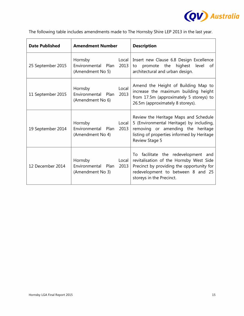
The following table includes amendments made to The Hornsby Shire LEP 2013 in the last year.
Date Published Amendment Number Description
25 September 2015 Hornsby Local Environmental Plan 2013 (Amendment No 5)
Insert new Clause 6.8 Design Excellence to promote the highest level of architectural and urban design.
11 September 2015 Hornsby Local Environmental Plan 2013 (Amendment No 6)
Amend the Height of Building Map to increase the maximum building height from 17.5m (approximately 5 storeys) to 26.5m (approximately 8 storeys).
19 September 2014 Hornsby Local Environmental Plan 2013 (Amendment No 4)
Review the Heritage Maps and Schedule 5 (Environmental Heritage) by including, removing or amending the heritage listing of properties informed by Heritage Review Stage 5
12 December 2014 Hornsby Local Environmental Plan 2013 (Amendment No 3)
To facilitate the redevelopment and revitalisation of the Hornsby West Side Precinct by providing the opportunity for redevelopment to between 8 and 25 storeys in the Precinct.

Hornsby LGA Final Report 2015 16
Zoning
The following land use zones within Hornsby Shire are shown on the Hornsby Shire Maps:
Residential
R2 – Low Density Residential
R3 – Medium Density Residential
R4 – High Density Residential
Business
B1 – Neighbourhood Centre
B2 – Local Centre
B4 – Mixed Use
B5 – Business Development
B6 – Enterprise Corridor
Industrial
IN1 General Industrial
IN2 – Light Industrial
IN4 – Working Waterfront
Recreation RE1 – Public Recreation
RE2 – Private Recreation
Environmental
E1 – National Parks and Nature Reserves
E2 – Environmental Conservation
E3 – Environmental Management
E4 – Environmental Living
Special Purpose SP2 – Infrastructure
SP3 - Tourist
Rural
RU1 – Primary Production
RU2 – Rural Landscape
RU4 – Primary Production Small Lots
RU5 – Village
Waterways W1 – Natural Waterways
W2 – Recreational Waterways
Hornsby LGA Final Report 2015 17
THE HORNSBY DEVELOPMENT CONTROL PLAN 2013
The Hornsby Development Control Plan 2013 was adopted by Council on 19 December 2012 and came into effect on 11 October 2013.
The HDCP 2013 comprises 9 parts and annexure. The DCP structure incorporates general environmental controls for all applications in one part (Part 1 - General), while the remaining 8 parts provide land use and area based controls.
State Environmental Planning Policy (Exempt and Complying Development Codes) 2008 (the Codes SEPP) specifies exempt and complying development under that Policy. The Codes SEPP has state-wide application and commenced on 27 February 2009.
Planning Instruments:
Hornsby Local Environmental Plan 2013 and the Hornsby Development Control Plan 2013.
The localities specified under the HLEP 2013 are:
RU1 Primary Production RU2 Rural Landscape RU4 Primary Production Small Lots RU5 Village R2 Low Density Residential R3 Medium Density Residential R4 High Density Residential B1 Neighbourhood Centre B2 Local Centre B3 Commercial Core B4 Mixed Use B4 Business Development B6 Enterprise Corridor IN1 General Industrial IN2 Light Industrial IN4 Working Waterfront SP2 Infrastructure SP3 Tourist RE1 Public Recreation RE2 Private Recreation E1 National Parks and Nature Reserves E2 Environmental Conservation E3 Environmental Management E4 Environmental Living W1 Natural Waterways W2 Recreational Waterways

Hornsby LGA Final Report 2015 18
Part 1 - General
Part 1 provides general controls that apply to all Development Applications.
Part 1A explains the purpose of the DCP. Part 1B provides administrative provisions including how to use the DCP, Notification and Exhibition requirements and Tree and Vegetation preservation controls pursuant to Clause 5.9 of the HLEP. Part 1C establishes the general development controls for all development, including controls for the natural environment, built environment and hazards.
Part 2 - Rural
Part 2 provides general controls for development of land in the Rural area. Section 2.1 provides controls for Rural Buildings within defined zones. Section 2.2 provides controls for certain rural land uses. Section 2.3 provides Village Master plans within the rural area. Section 2.4 provides controls for land zoned RU5 in Dural Village. Section 2.5 provides controls for Extractive Industries.
Part 3 – Residential
Part 3 provides controls for development of prescribed residential land uses within prescribed residential localities identified by the HELP zone and HELP height map.
Part 4 – Business
Part 4 provides controls for development of land in a Business Zone.
Part 5 – Industrial
Part 5 provides controls for development of land in Industrial Zones IN1 and IN2.
Part 6 – Subdivision
Part 6 provides specific additional controls for the subdivision of land.
Part 7 – Community
Part 7 provides specific controls for certain types of developments such as: childcare centres, schools, places of public worship, community housing, telecommunications, temporary events and health service facilities.
Part 8 – River Settlements
Part 8 provides controls for development of land in the River Settlements.
Section 8.1 provides controls for buildings within defined zones. Section 8.2 provides controls for certain types of River Settlement Land uses, such as boat sheds, jetties and seawalls. Section 8.3 provides Master plans for Berowra Waters and Kangaroo Point.

Hornsby LGA Final Report 2015 19
Part 9 – Heritage
Part 9 provides administrative controls for development involving heritage. Section 9.2 provides controls for development involving listed heritage items. Section 9.3 applies to Heritage Conservation Areas. Section 9.4 applies to land in the vicinity of heritage. Section 9.5 applies to development of land (including undisturbed land) that may contain an Aboriginal relic or place. Section 9.6 provides specific controls for the Beecroft Heritage Precinct (redevelopment area).
Annexures
Contains detailed information referenced throughout the DCP.

Hornsby LGA Final Report 2015 20
MARKET OVERVIEW & SALES OF PARTICULAR INTEREST
RESIDENTIAL
The majority of development in Hornsby Shire consists of typical established single dwelling residential settlements situated predominately in the southern suburbs. The northern suburbs including Brooklyn, Cowan, Berowra, Mt Kuring-gai, and Hornsby Heights are predominantly mountain-side and river-side settlements fronting the Hawkesbury River and nature reserves.
Approximately 80% of properties in the region are owner occupied, 18% are owned by investors and 2% are government owned dwellings.
All residential suburbs all have full utility services availability including a reticulated town water supply, reticulated sewerage, electrical and telecommunication services. Hornsby Council also has an extensive range of Government services including a number of schools both government and private, the Northern Sydney Institute of TAFE college, emergency services including Police, NSW Fire Brigade, Rural Fire Service, Ambulance Service of NSW Northern Sydney, various public and private Hospitals (predominately situated within East Hornsby and Asquith), Council Chambers and administrative offices for various Government Agencies.
Additional community based facilities available within the LGA include various denominational churches, five public libraries (at Hornsby, Pennant Hills, Epping, Berowra and Galston, three public swimming pools (aquatic centres), and a range of other sporting and community facilities.
The rezoning proposal for the Epping Town Centre Urban Activation Precinct was finalised in March 2014. Epping Town Centre has been planned to accommodate new homes and jobs, and improved public spaces, close to transport. Growth in the precinct is financially viable with strong demand for residential development.
Sales of residential properties across Hornsby Shire have generally shown a strong level of growth from the last General Valuation in 2014, with especially strong increases in Epping, Carlingford, Castle Hill, Cherrybrook and Westleigh, which all went up on average at rate of over 30%. This can be attributed in part to both the historically low interest rates in recent times, upgrades in Hornsby infrastructure, and the overall affordability of northern properties in the Hornsby Shire compared to many other districts of Sydney. The steady growth of population in Hornsby has also contributed the strong demand for residential land.
Not all areas had such rapid rises though, with Mt Colah, Mt Ku-Ring-Gai, Galston, Glenorie, Cowan and Dural all racking up rates of growth of 18% or under, which is still a healthy rate, just on the low side for Hornsby Shire this year, which is attributable to their less sought after location, being further out of the way and with fewer amenities.
Hornsby LGA Final Report 2015 21
VILLAGES
There are residential dwellings located in various towns within the rural area of Hornsby Shire. The main rural townships are Galston and Glenorie which showed a 17.4% increase over the past year. These townships are located further out from Sydney metro surrounded by rural lifestyle blocks. On the north/north western boundary of the shire is The Hawkesbury River. The main settlements fronting the river here are Brooklyn, Dangar Island, Berowa Waters and Milsons Passage. Brooklyn has a mix of zones and has good road access with values generally increasing by up to 20% from July 2014. But the other settlements (most with water access only plus some have limited services) are zoned Environmental Living. Value levels here were static to falling in the more isolated settlements since July 2014. Overall the Environmental Living zoned properties decreased by 8.75%.
COMMERCIAL
The business areas for Hornsby are scattered throughout the district, with many suburbs having a small commercial/retail area. The main commercial area is located at Hornsby the other areas located at: Pennant Hills, West Pennant Hills, Dural, Beecroft and Carlingford, with both Hornsby and Carlingford both having large shopping centres.
The six business components which cover the Hornsby Shire have indicated a variety of component factors, with the majority of business components increasing from 20% to 40% over the preceding 12 months.
Within this base year, there have been 29 business sales, spread throughout the district as well as throughout all six business components. The largest increases were noted within the B2 Local Centre - Epping Town Centre component followed by B6 Enterprise Corridor.
On average, commercial properties have increased by 63% over the past 12 months, helped out a lot by the B2 Epping Town Centre Component.
Sales of Interest:
20-28 Cambridge St Epping. Sold 29/6/2015 $110,0000,000 Land 8,314m2. Development site. Zoned B2 Local Centre – Epping Town Centre
12-22 Langston St Epping. Sold 13/10/2014 $83,250,000. Land 6,898m2 Development site. Zoned B2 Local Centre – Epping Town Centre.
30-42 Oxford St Epping. Sold 1/10/2014 $56,500,000 (reported sale). Land 5,170m2. Development site. Zoned B2 Local Centre – Epping Town Centre. Purchaser Grocon.

Hornsby LGA Final Report 2015 22
87-91 Beecroft Rd Beecroft. Sold19/01/2015 $25,000,000. Land 5,821m2. Development site. Zoned B2 Local Centre.
11-15 Florence St Hornsby. Sold 27/3/2015 $6,600,000 Land: 443 m2 Zoned B3 Commercial Core Improved property.
INDUSTRIAL
Much like most of the Sydney metropolitan area, the Hornsby industrial sales have indicated a fairly stagnant market between the 2014 and 2015 base dates. This can be attributed to a general lack of demand, made apparent by a relatively high number of vacancies and extended marketing periods.
On average, industrial properties have increased by 6.59% over the last year.
Sales of Interest:
7-15 Gundah Rd Mount Ku-Ring-Gai. Sold 17/12/2014 $44,250,000 Land 5.832ha Zoned IN1 General Industrial – Improved property.
1 Pioneer Ave Thornleigh. Sold 1/4/2015 $3,800,000 Land 1.973ha. Zoned IN1 General Industrial – Improved property.
248-250 New Line Rd Dural. Sold 19/12/2014 $24,380,000 Land 3.1529ha. IN2 Light Industrial – Improved property. Bunnings Warehouse.
RURAL
The rural land in Hornsby LGA comprises primarily rural lifestyle/hobby blocks with most being less than 2.5 hectares in size. The area is handily located to Sydney metro. The larger parcels of farm land are mainly located north of Glenorie and generally carry sheep and beef, but most are regarded as being uneconomic given their size. Many have a large proportion of bush cover. These larger blocks are intermingled with rural lifestyle/hobby blocks. There are a limited number of horticultural properties.
Rural properties have generally seen good increases in the 2015 valuation year, with turnover of rural properties remaining steady with good buyer interest. Rural properties increased on average 23% over the last year. Those properties located further out (Canoelands and Wisemans Ferry) generally saw lower increases.

Hornsby LGA Final Report 2015 23
RURAL LOCATIONS WITHIN THE LGA
Land values vary throughout the LGA according to location, views, contour and cover. The following are general descriptions of some localities within Hornsby Shire: Dural/Galston/Glenorie/Fiddletown These localities are on the northern periphery of the residential areas of the shire. Contour is variable, ranging from flat to undulating land that is predominantly cleared in pasture with some hill land, much of which is in bush. Property types are nearly all rural lifestyle block being less than 2.5 hectares in size. These properties have higher land values than those other areas located further afield. Dural which adjoins Sydney metro, has higher land values than the other three localities.
Forest Glen/Canoelands
These properties are located further from Sydney proper. Land is generally undulating to hill with various cover with much bush clad land. Properties in these areas are generally at lower levels than Dural, Galston, Glenorie and Fiddletown.
Wisemans Ferry/Laughtondale
Properties here are generally close to Hawkesbury River with some fronting it. Land is generally undulating to hill with various cover with much bush clad land. Some properties have river flats adjoining The Hawkesbury River in variable pasture. Properties in these areas are generally at lower levels than Forest Glen and Canoelands, although those on the river sell at a premium.
SIGNIFICANT ISSUES AND DEVELOPMENTS
SIGNIFICANT DEVELOPMENT ISSUES OVER THE YEAR
SOUTH DURAL PLANNING PROPOSAL
A proposal has been submitted to Council by a consultant on behalf of the South Dural Residents and Ratepayers Group in 2014. It seeks to rezone land known as South Dural (bounded by New Line Road, Old Northern Road and Hastings Road, Dural) to allow residential subdivision as well as schools and shops. Council resolved to investigate the rezoning and sent a planning proposal to the NSW Government seeking its position on the matter. The Government has issued a Gateway Determination, which authorises the rezoning investigation to begin.
Hornsby LGA Final Report 2015 24
SIGNIFICANT DEVELOPMENTS – FROM PRIOR TO CURRENT ANNUAL VALUATION
Below is a summary of significant Development Applications. Most of these Development Applications are for developments permissible within the current zoning therefore no special consideration is required.
New residential developments in discussion or underway include:
Approval for a new multi unit residential flat building comprising of 88 units at Cliff Rd, Epping.
Approval for a new multi unit residential flat building comprising of 36 units at Cowan Rd, Mt Colah.
Approval for the demolition, and strata subdivision of two lots on Essex St, Epping for a new multi unit residential flat building comprising of 30 units.
SIGNIFICANT VALUE CHANGES
SIGNIFICANT VALUE CHANGES – FROM PRIOR TO CURRENT ANNUAL VALUATION
Commercial
There were a number of significant value changes in the Hornsby area over the last year in a variety of areas, for a number of reasons. B2 ETC (Epping Town Centre) Component. These properties zoning had changed and as a consequence a new component was created for Base Date 2015, with changes in FSR’s & Building Heights resulting in significant increases in value with an overall 432.24% component increase. Handcrafting was carried out as part of the 2015 program. The B4- BMU component also had a number of sites that were identified during the year as requiring a significant change in value, with the B6 – BEC component being much the same. Residential
Most of the significant changes in the R2 zoned properties were done mainly on larger sites to better reflect their potential for subdivision, with a few site specific changes that also had to be changed to better reflect surroundings.

Hornsby LGA Final Report 2015 25
Residential Density
There has been increased demand for R3 and R4 zoned development land, with the average increase of R3 Development Land being 57.44% above the 2014 values and the average increase of R4 Development Land of 35%. The majority of the properties are in the suburbs of Hornsby, Epping, Wahroonga, Asquith, Thornleigh and Mount Colah all having railway stations.
OVERVIEW OF THE QUALITY ASSURANCE PROCESS
LPI has been provided with a detailed Valuation Analysis Report, which details the Quality Assurance Process of QVA and outlines that the Verification process and certifies that Land Values meet all Statistical Measures and Component Data Analysis. In addition, a Quality Statement and lists of high value and high risk properties is also provided in the Valuation Analysis Report. Checks have been undertaken to ensure that all properties have been valued, land values are consistent with each other, land value basis have been correctly determined and all concessions and allowances have been supplied. Additionally, properties that had land values amended through the objection or reascertainment process were individually examined to reconcile surrounding land values and ensure accuracy of the grading of surrounding land values. Benchmarks and Reference Benchmarks are core elements of the quality assurance processes and are identified and individually valued in accordance with the Rating and Taxing Procedures Manual Version 6.2.2. Worksheets have been maintained on all properties where calculations are required. We have also ensured that adjustments and assumptions within the market analysis have been based on market evidence and have been fully documented and rationalised.
AUTHOR
Vicky Watson AAPI CPV
Contract Services Manager
11th
November 2015

Hornsby LGA Final Report 2015 26