hopewellian occupations at the gehring site …...zimmermann et al. 81 detailed below the waist,...
TRANSCRIPT
Julie A. Zimmermann, Southern Illinois University Edwardsville, Department of Anthropology, Edwardsville, IL 62026–1451, [email protected]
©2018 Illinois Archaeological Survey, Inc., Illinois Archaeology, vol. 30, pp.80–119
80
Hopewellian Occupations at the Gehring Site (11MS99) in the American Bottom
Julie A. Zimmermann, Ashley Cisneros, Luke Haun, Katie Leslie, Kaitlin Roberts, Austin Sandberg, Kelly Sopek
The Gehring site (11MS99) is a multicomponent site in the northern American Bottom. Surface collections and excavations by the SIUE archaeology field school suggest use of the site throughout the Middle Woodland period. Evidence including Hopewell ceramics, a figurine, mica, obsidian, copper, and a drilled bear canine might suggest that Middle Woodland occupants of the Gehring site were more active in the Hopewell Interaction Sphere and Hopewellian rituals than were their peers at other sites in the American Bot-tom. Although a possible mound at the site (Munson and Harn 1971) might suggest that Gehring was a center for ritual, previous test excavations suggest this might have been a natural landform (Maher 1996).
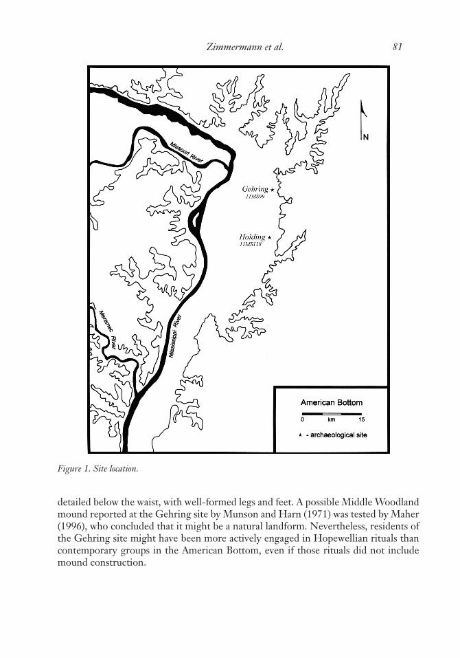
The Gehring site (11MS99) is located near the base of the bluff on the campus of Southern Illinois University Edwardsville (SIUE) in the northern American Bottom (Figure 1). The SIUE archaeology field school has taken place at the Gehring site since 2009. The site is multicomponent, and although our primary research interests lie in the Middle Woodland occupation of the site, we have also encountered numer-ous Mississippian features during our excavations. Although excavations are ongoing, here we provide a summary of what is currently understood of the Middle Woodland occupation at Gehring. The density of cultural remains and evidence for ties with the Illinois Valley support the identification of the site by Munson and Harn (1971) as a Havana village, and it appears that Gehring was used throughout the Middle Woodland period. Artifacts and exotic materials such as Hopewell pottery, mica, obsidian, copper, and a drilled bear canine indicate engagement in the Hopewell Interaction Sphere, perhaps to a greater degree than usually observed in the American Bottom. A Middle Woodland figurine has also been recovered during our excavations. It suggests a unique, hybrid form that is in the simple Casper the Ghost style from the waist up, but more
Zimmermann et al. 81
detailed below the waist, with well-formed legs and feet. A possible Middle Woodland mound reported at the Gehring site by Munson and Harn (1971) was tested by Maher (1996), who concluded that it might be a natural landform. Nevertheless, residents of the Gehring site might have been more actively engaged in Hopewellian rituals than contemporary groups in the American Bottom, even if those rituals did not include mound construction.
Figure 1. Site location.

Illinois Archaeology Vol. 30, 201882
Site Setting and Prior Research
The area around the SIUE campus is typical of the American Bottom in the rich-ness of its natural resources and in the corresponding richness of its archaeological record. The Gehring site is situated on the terrace just east of Cahokia Creek near the base of the bluff, just south of where Cahokia and Indian creeks exit the uplands and then merge (Figure 2). Cahokia Creek would have meandered along the base of the bluff on its way south to Cahokia, a distance of just 16 km, and from there on to the Mississippi River beyond. The gentle slope of the bluff in this area would have given Gehring site inhabitants easy access to both floodplain and upland resources. The 1815
Figure 2. 11MS99 (Gehring site), with excavation location at south end in yellow. From the Illinois Iventory of Archaeological Sites http://maps.dnr.illinois.gov/archaeology.

Zimmermann et al. 83
GLO map shows that the Gehring site was forested at that time, although prairie was located nearby in the uplands and even on the floodplain (Illinois Secretary of State 2018). The presence of prairie in the floodplain might indicate intentional burning by Native Americans. In the early 1800s, a backwater lake was located in the American Bottom just 6 km west of the bluff, and the Mississippi River itself was approximately twice that distance. Through time the boundaries of forest and prairie would have shifted, the river and creeks would have meandered, and floodplain lakes would have swelled and shrunk. Regardless of these fluctuations, local resources would have been abundant for people living at the Gehring site.
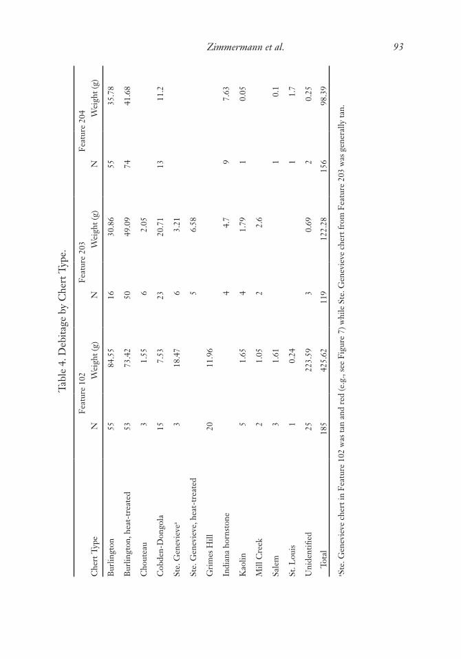
Along with many other sites in the area, Munson and Harn (1971) first reported 11MS99 in 1963 during their survey of the American Bottom and Wood River ter-race. 11MS99 was one of the larger sites in the vicinity, covering at least 40 acres, and apparently it featured a relatively dense concentration of artifacts. Munson and Harn described 11MS99 as a Havana village and mound (MSV266 and MSO267 in the number system used at the time), and also a Bluff camp yielding Late Bluff rim sherds (Munson and Harn 1971:7, 13). Additionally, on the site form Munson indicated a Mississippian presence at the site; other artifacts he reported included one Early Woodland Marion Thick sherd and both straight- and expanding-stemmed points. On the site form Mun-son also noted that Middle Woodland artifacts were found across the site, whereas Late Woodland and Mississippian artifacts were found only in the central part of the site. In terms of Middle Woodland diagnostics, Munson and Harn (1971) reported mostly Havana Cordmarked and Havana Plain pottery, but also several Havana Zoned sherds and one “terminal Havana” sherd. Other Middle Woodland pottery types they collected included Naples Dentate and/or Naples Stamped; Hopewell Rocker Dentate and/or Pike Rocker Stamped; Crab Orchard Fabric Marked; and Crab Orchard Cordmarked. Whereas most Middle Woodland pottery Munson and Harn collected indicates ties with the Illinois Valley, the Crab Orchard pottery indicates ties with southern Illinois. Other evidence of “inter-regional trade” they reported included Dongola chert from southern Illinois and Crescent Quarry lamellar blades and flakes from across the Mis-sissippi River, south of St. Louis.
In the early 1970s, SIUE professor Sid Denny conducted field school excavations at 11MS99 for two or three seasons. Apparently no report of Denny’s excavation was ever written. Zimmermann reviewed Denny’s field notes and interviewed him on-site on May 20 of 2009. Excavating in the central part of the site, Denny found a structure and several pit features which probably dated to the Mississippian period. He also found a pit feature containing Havana pottery. Denny’s notes suggest the presence of one or two living surfaces below the plow zone containing Mississippian pottery. As part of his dissertation investigating the Hopewell occupation of the American Bot-tom, Maher (1996) examined artifacts from Denny’s excavation and surface collection. Maher (1996:Tables D.5 and D.6) provides a list of the Middle Woodland ceramics he identified in Denny’s collection; he suggests that there was an equal number of Missis-sippian sherds in the assemblage (apparently dating to the late Stirling phase), as well as
Illinois Archaeology Vol. 30, 201884
a “substantial collection of Early Woodland Marion Thick pottery” (1996:640). Maher notes that Middle Woodland ceramics collected by Denny were diverse, but mostly included Havana Cordmarked and Havana Plain jars; also present were a few small Hopewell jars with zoned and crosshatched designs. Maher suggests an early Middle Woodland Cement Hollow phase occupation was indicated by “a trace of early Middle Woodland types such as Naples Ovoid, Neteler Stamped, and Havana Zoned, var. Dentate Stamped” (Maher 1996:644; also see Maher 1996:104). Maher also writes that a late Middle Woodland Hill Lake phase occupation was indicated by a “surprisingly large” number of limestone-tempered Pike Brushed jars and a smaller number of Pike Rocker Stamped sherds (Maher 1996:644; also see Maher 1996:126). Other Middle Woodland types listed in Maher’s Tables D.5 and D.6 include Baehr Zoned Brushed, Hopewell Plain, Montezuma Punctate, Naples Stamped, and Crab Orchard. Of more than 600 Middle Woodland sherds collected by Denny and examined by Maher (Maher 1996:Tables A.4, A.5, D.5, and D.6), only one grit-tempered fabric marked Crab Or-chard sherd was identified, again suggesting much stronger ties with the Illinois Valley than with southern Illinois.
For his dissertation, Maher (1996) also conducted limited excavations at 11MS99, focusing on the landform thought to be a Middle Woodland mound. Site forms com-pleted by Munson in 1969 indicate that this “mound” was 80 feet in diameter and 3 feet high, and as Maher notes, the site forms also indicate that previous owner Wilbur (or Wilber) Gehring dug a hole in the landform “many years ago [before 1969], but never found anything.” The site forms indicate that a notched hoe was found near the possible mound, but was not necessarily associated with it. Terry Norris (personal communica-tion, eptember 2016) reports that he and Ken Williams found a stone pipe fragment on the possible mound during a surface collection prior to Denny’s first field school on the site in 1970. Norris states that the pipe fragment was approximately 10–12 cm long and 5–6 cm wide, larger and bulkier than a Middle Woodland style platform pipe and more similar to a Mississippian style pipe. Norris also recalls that the stone was dark in color, possibly a fine-grained sandstone. Fortier (2006:331; citing T. Pauketat, personal communication) makes reference to what is surely this same pipe fragment; however, Fortier apparently believes it was a Middle Woodland pipe, given that he mentions it in a list of Middle Woodland platform pipes from the American Bottom.
Maher (1996) excavated in the possible mound at Gehring to determine its cultural affiliation. He notes that at the time of his excavation in 1994, the purported mound was only 50 cm high and difficult to locate due to decades of plowing since it was first reported. Maher recovered only a few nondiagnostic artifacts from the plow zone. Further, he reports that the stratigraphy in the excavation units was often disturbed and gave no indication of mound construction techniques such as basket loading. Flota-tion samples were taken from supposed mound fill, but produced few plant remains. A hazelnut shell was submitted for radiocarbon dating and produced a date of 2475 ± 45 RCYBP, lab number AA-15571 (Maher 1996:576, 659), too early for the Middle Woodland period. Maher concludes that “the mound at Gehring remains an enigma”
Zimmermann et al. 85
(1996:659). That is, the near absence of artifacts and lack of definitive evidence for mound construction might indicate that this was not a mound at all but instead was a natural geomorphological feature.
The observations and collections of one avocational archaeologist are probably as important as those of professional archaeologists in understanding 11MS99. This indi-vidual, who wishes to remain anonymous, collected the Gehring site extensively during the 1970s. Examination of his collection from 11MS99 confirms that it is predominantly composed of Middle Woodland artifacts. Middle Woodland lithic artifacts identified in his collection by Brad Koldehoff include blades, blade cores, Snyders points (several of which were reworked into scrapers), North points, Manker points, a Norton point, celts, and a hoe. Middle Woodland ceramic types identified by Ken Farnsworth include Havana Plain, Hopewell Rocker Stamped, Netler Stamped, and Sisters Creek Fingernail Punctate. A drilled bear canine from the site is also surely Middle Woodland, and a galena fragment and a quartz crystal are probably Middle Woodland. During multiple revisits to 11MS99 during our excavations, the collector stressed that the majority of the Middle Woodland artifacts he collected came to the surface only after the sand ridge in the southern part of the site was first deep plowed for horseradish production in the 1970s. His observations indicate that prior to deep plowing, the southern end of the site was stratified, and he further claims that approximately 5 ft of sediment have been removed from this ridge due to plowing and erosion since the early 1970s. Our excavations at the southern end of the site support this claim.
Current Investigations
The SIUE archaeology field school has taken place at the Gehring site since 2009, under the direction of Julie Zimmermann in 2009, 2013–2014, 2016, and 2018; and under the direction of Gregory Vogel from 2010 to 2012. In 2009, Zimmermann directed a surface collection in an agricultural field on the SIUE campus; this area of some 85 acres included the southern and central portions of the Gehring site, and also ground east and south of the previously recorded site boundaries (Zimmermann Holt and Belknap 2010). We did not collect the northern part of the Gehring site, which lies north of an old trolley line now serving as a utility access road, because it is heavily disturbed due to the installation there of utilities for the SIUE campus. A concentration of Middle Woodland pottery was found at the southern end of the site during our 2009 surface collection, and Zimmermann’s excavations since then have been concentrated in this area because her primary research interest is in the Middle Woodland occupa-tion of the American Bottom (Zimmermann 2016, 2017, 2018; Zimmermann Holt 2013, 2015; Zimmermann Holt and Belknap 2010; Zimmermann Holt et al. 2010). Our excavations in this area have revealed both Middle Woodland and Mississippian features, including two wall-trench structures (Figure 3). Vogel conducted extensive remote sensing at Gehring, and his excavations focused on ground-proofing geophysical survey results in the central portion of the site (Vogel and Clemons 2011; Vogel et al.

Illinois Archaeology Vol. 30, 201886
Figure 3. Gehring site, excavation block at south end, feature plan. Middle Woodland pits and possible Middle Woodland posts in red. Mississippian features in blue.

Zimmermann et al. 87
2013). Pit features excavated by Vogel dated to the Middle Woodland, Late Woodland, Emergent Mississippian, and Mississippian periods. Vogel also excavated a Mississip-pian wall-trench structure and a small historic structure. A Mississippian burial prob-ably dating to the Moorehead phase was identified by Vogel in the central portion of Gehring in the summer of 2012; it was reported to the IHPA and reburied without further excavation (Vogel 2012).
Middle Woodland artifacts and features excavated at the southern end of the site by Zimmermann and students are the focus of this paper (Figure 2). During our excava-tions (Zimmermann 2017, 2018; Zimmermann Holt 2013, 2015; Zimmermann Holt and Belknap 2010), all sediments were removed by shovel and trowel and described using standard nomenclature (Munsell colors and USDA textures). The plow zone was typically removed in one natural level. At the base of the plow zone, the subsoil was troweled to identify features, which were drawn and photographed in plan view and then bisected. The first half of each feature was excavated, and then the profile of the feature was photographed and drawn. Any distinct strata visible in profile were excavated separately in the second half of the feature, with flotation samples taken from each. After feature excavation, we typically excavated at least 10 cm of subsoil below the base of the plow zone to determine whether it contained cultural deposits. In the 2009 field season, we further excavated several 1-x-1-m units to depths of 110–130 cm to check for buried living surfaces, and in 2018, we excavated several 1-m-wide trenches to depths of approximately 80 cm to do the same. All excavated sediments were screened through quarter-inch mesh, except for those feature sediments sampled for flotation processing. The standard size of our flotation samples was 10 liters, but smaller samples were taken from feature strata too small to yield 10 liters.
Ceramics collected through quarter-inch mesh were examined to determine temper and surface treatment. Diagnostic Middle Woodland sherds were categorized using the typology for the Illinois Valley presented by Griffin (1952), and later modified for the lower Illinois Valley by Morgan (1985, 1986) and for the American Bottom by Maher (1989, 1996). Lithic artifacts collected through quarter-inch mesh were examined to determine chert type using the chert comparative collection of the SIUE Anthropol-ogy Lab prepared by Larry Kinsella, and also aided by published sources such as Ray (2007). Flakes were examined to determine stage of reduction and evidence of use; utilized flakes and formal tools were further classified using typologies suggested by Koldehoff (2002), Reber et al. (2017), and Williams (1989). Animal bones collected through quarter-inch mesh were identified to taxon and element using the compara-tive collection of the SIUE Anthropology Lab. Plant remains from flotation samples were identified to taxon by Marjorie Schroeder using the comparative collection at the Research and Collections Center of the Illinois State Museum.
Results of our excavations indicate that the plow zone at the southern end of Geh-ring typically ranges between 20 and 30 cm deep, and is described as a 10YR 3/3 dark brown sandy loam (Zimmermann 2017, 2018; Zimmermann Holt 2013, 2015; Zim-mermann Holt and Belknap 2010). According to the USDA (2018), the soil is classified

Illinois Archaeology Vol. 30, 201888
as an Onarga sandy loam. The subsoil immediately below the plow zone at the southern end of Gehring typically appears to be redeposited loess, and is generally described as a 10YR 4/6 dark yellowish brown sandy loam or clay loam. Deeper excavation units have revealed strata of possible redeposited loess alternating with strata of loamy sands and sandy loams, which suggest flooding. Although some evidence of stratification is found in the features located immediately below the plow zone, no cultural materials or buried living surfaces have been found in deeper strata (Zimmermann 2018; Zim-mermann Holt and Belknap 2010).
Features encountered at the base of the plow zone at the southern end of Gehring include both Middle Woodland and Mississippian features; other features encountered in this area are probably Late Woodland (Figure 3). Mississippian features, including pits and wall-trench structures, are extremely shallow because they have been severely truncated by plowing and erosion. (The basins of two Mississippian wall-trench struc-tures identified are plowed away, leaving only the trenches visible; and Mississippian pits located outside the structures range between 100 and 160 cm wide but are typically just 10 cm deep.) The severe truncation of Mississippian features supports the claims of a local collector (see above) that as many as 5 ft of topsoil have been lost from the southern end of the site since the 1970s. Middle Woodland pit features identified at the base of the plow zone are significantly deeper (50 to 70 cm deep), indicating that they are less severely truncated and eroded than Mississippian features. If the southern end of the site had been excavated prior to the 1970s, an unplowed Middle Woodland living surface would have been encountered stratigraphically at some depth below a Mississippian living surface. Indeed, this living surface might have been present until relatively recently, but there is no evidence of it now.
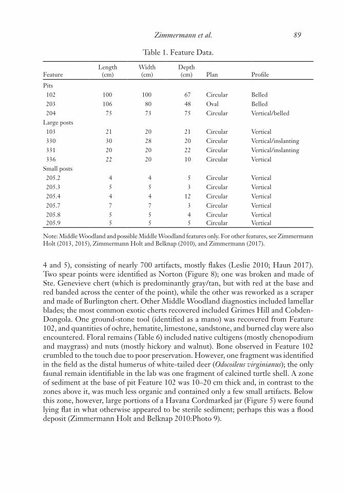
Three Middle Woodland pit features (Features 102, 203, and 204) and several pos-sible Middle Woodland postholes (including Features 103, 330, 331, and 336) have been excavated at the south end of the site (Figure 3; Table 1). Feature 102 was identified at the base of the plow zone. It was a large circular pit feature, approximately 100 cm in diameter and 70 cm deep below the base of the plow zone (Zimmermann Holt and Belknap 2010). It contained multiple zones, most of which were organic and artifact rich (Figure 4). Over 600 pottery sherds (Tables 2 and 3) were recovered from Fea-ture 102 (Roberts 2014). Identified types (Cisneros 2010; Haun 2017; Roberts 2014) included Havana Cordmarked (Figure 5), Hopewell Zoned Red (Figure 6), Hopewell Zoned var. Grigsby rocker dentate stamped, and Montezuma Punctate (Figure 7). One Early Woodland Marion Thick sherd was also identified from Feature 102. When comparing the quantity of these types in Table 3, it should be noted that certain types (e.g., Hopewell Zoned and Montezuma Punctate) were identified from both rim sherds and body sherds, whereas others (e.g., Havana Cordmarked and Havana Plain) were identified only from rim sherds. As a result, Havana types are under-represented ac-cording to these numbers. Notably, nearly 100 body sherds identified as cordmarked were probably Havana Cordmarked and over 300 body sherds identified as plain were probably Havana Plain. The lithic sample from Feature 102 was also large (Tables
Zimmermann et al. 89
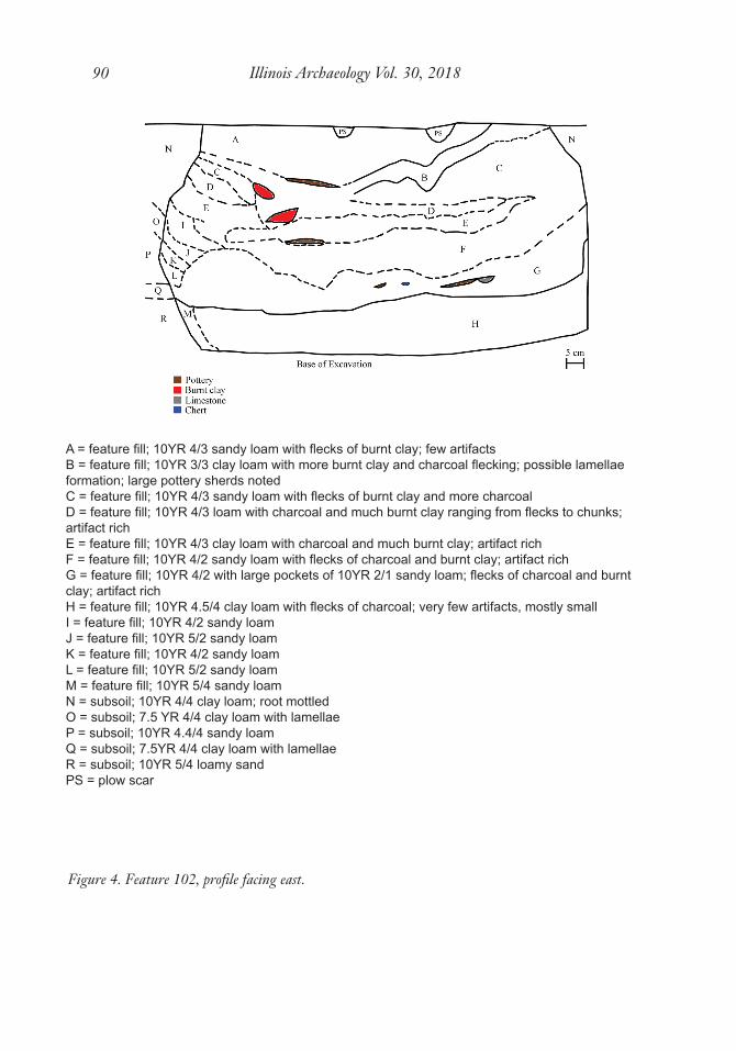
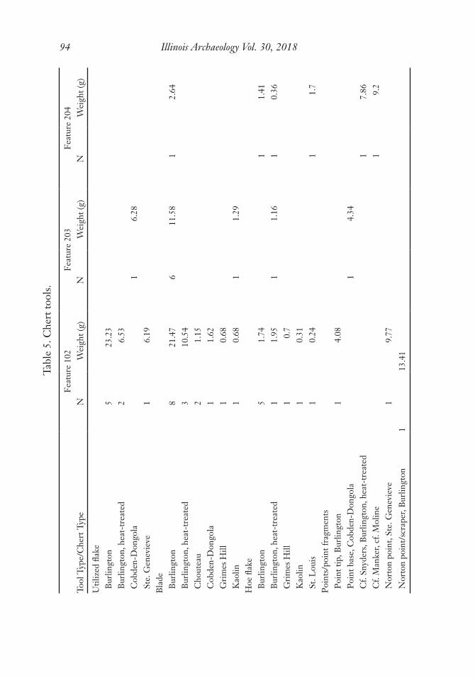
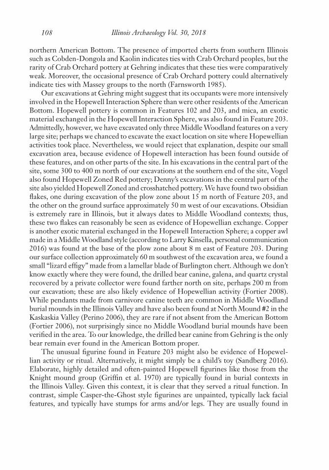
4 and 5), consisting of nearly 700 artifacts, mostly flakes (Leslie 2010; Haun 2017). Two spear points were identified as Norton (Figure 8); one was broken and made of Ste. Genevieve chert (which is predominantly gray/tan, but with red at the base and red banded across the center of the point), while the other was reworked as a scraper and made of Burlington chert. Other Middle Woodland diagnostics included lamellar blades; the most common exotic cherts recovered included Grimes Hill and Cobden-Dongola. One ground-stone tool (identified as a mano) was recovered from Feature 102, and quantities of ochre, hematite, limestone, sandstone, and burned clay were also encountered. Floral remains (Table 6) included native cultigens (mostly chenopodium and maygrass) and nuts (mostly hickory and walnut). Bone observed in Feature 102 crumbled to the touch due to poor preservation. However, one fragment was identified in the field as the distal humerus of white-tailed deer (Odocoileus virginianus); the only faunal remain identifiable in the lab was one fragment of calcined turtle shell. A zone of sediment at the base of pit Feature 102 was 10–20 cm thick and, in contrast to the zones above it, was much less organic and contained only a few small artifacts. Below this zone, however, large portions of a Havana Cordmarked jar (Figure 5) were found lying flat in what otherwise appeared to be sterile sediment; perhaps this was a flood deposit (Zimmermann Holt and Belknap 2010:Photo 9).
Table 1. Feature Data.
FeatureLength
(cm)Width(cm)
Depth (cm) Plan Profile
Pits102 100 100 67 Circular Belled203 106 80 48 Oval Belled204 75 73 75 Circular Vertical/belled
Large posts103 21 20 21 Circular Vertical330 30 28 20 Circular Vertical/inslanting331 20 20 22 Circular Vertical/inslanting336 22 20 10 Circular Vertical
Small posts205.2 4 4 5 Circular Vertical205.3 5 5 3 Circular Vertical205.4 4 4 12 Circular Vertical205.7 7 7 3 Circular Vertical205.8 5 5 4 Circular Vertical205.9 5 5 5 Circular Vertical
Note: Middle Woodland and possible Middle Woodland features only. For other features, see Zimmermann Holt (2013, 2015), Zimmermann Holt and Belknap (2010), and Zimmermann (2017).
Illinois Archaeology Vol. 30, 201890
Figure 4. Feature 102, profile facing east.
$� �IHDWXUH�¿OO����<5�����VDQG\�ORDP�ZLWK�ÀHFNV�RI�EXUQW�FOD\��IHZ�DUWLIDFWV%� �IHDWXUH�¿OO����<5�����FOD\�ORDP�ZLWK�PRUH�EXUQW�FOD\�DQG�FKDUFRDO�ÀHFNLQJ��SRVVLEOH�ODPHOODH�IRUPDWLRQ��ODUJH�SRWWHU\�VKHUGV�QRWHG&� �IHDWXUH�¿OO����<5�����VDQG\�ORDP�ZLWK�ÀHFNV�RI�EXUQW�FOD\�DQG�PRUH�FKDUFRDO'� �IHDWXUH�¿OO����<5�����ORDP�ZLWK�FKDUFRDO�DQG�PXFK�EXUQW�FOD\�UDQJLQJ�IURP�ÀHFNV�WR�FKXQNV��DUWLIDFW�ULFK(� �IHDWXUH�¿OO����<5�����FOD\�ORDP�ZLWK�FKDUFRDO�DQG�PXFK�EXUQW�FOD\��DUWLIDFW�ULFK�)� �IHDWXUH�¿OO����<5�����VDQG\�ORDP�ZLWK�ÀHFNV�RI�FKDUFRDO�DQG�EXUQW�FOD\��DUWLIDFW�ULFK*� �IHDWXUH�¿OO����<5�����ZLWK�ODUJH�SRFNHWV�RI���<5�����VDQG\�ORDP��ÀHFNV�RI�FKDUFRDO�DQG�EXUQW�FOD\��DUWLIDFW�ULFK+� �IHDWXUH�¿OO����<5�������FOD\�ORDP�ZLWK�ÀHFNV�RI�FKDUFRDO��YHU\�IHZ�DUWLIDFWV��PRVWO\�VPDOO,� �IHDWXUH�¿OO����<5�����VDQG\�ORDP-� �IHDWXUH�¿OO����<5�����VDQG\�ORDP.� �IHDWXUH�¿OO����<5�����VDQG\�ORDP/� �IHDWXUH�¿OO����<5�����VDQG\�ORDP0� �IHDWXUH�¿OO����<5�����VDQG\�ORDP1� �VXEVRLO����<5�����FOD\�ORDP��URRW�PRWWOHG2� �VXEVRLO������<5�����FOD\�ORDP�ZLWK�ODPHOODH3� �VXEVRLO����<5�������VDQG\�ORDP4� �VXEVRLO�����<5�����FOD\�ORDP�ZLWK�ODPHOODH5� �VXEVRLO����<5�����ORDP\�VDQG36� �SORZ�VFDU

Zimmermann et al. 91
Table 2. Sherd Count by Feature.
Sherds Unidentified Identified Total
Body sherdsFeature 203 56 8 64Feature 204 156 156Feature 102 514 54 568Total 726 62 788
Rim sherdsFeature 203 2 7 9Feature 204 3 7 10Feature 102 18 22 40Total 23 36 59Total 749 98 847
Figure 5. Havana Cordmarked rim, Feature 102.

Illinois Archaeology Vol. 30, 201892
Feature 203 was identified at the base of the plow zone. It was a pit, oval in plan view (106 cm long and 80 cm wide), and belled in profile at 48 cm deep (Table 1; see also Zimmermann Holt 2013). Its profile suggests three episodes of deposition; more likely, however, the pit was filled in two episodes, and subsequent lamellae formation mimicked the appearance of stratigraphy (Figure 9). Feature 203 contained a rich as-semblage of Middle Woodland artifacts, most notably a small clay anthropoid figurine (Figure 10; Sandberg 2016). Although the figurine is in the simple “Casper the Ghost” style (e.g., Fortier et al. 1989:266) from the waist up, it is very detailed from the waist down, with well-defined feet and buttocks. The feature also contained perhaps 25percent of a Hopewell jar, var. Bluffdale rocker-stamped (Figure 11). Other ceramic types identified (Table 3) included Pike-Baehr (Figure 12), Hopewell Plain (rims from two different
Table 3. Count of Ceramic Types Identified.
Ceramic Type F102 F203 F204 Total
Hopewell wares Hopewell Plain Bowl 2 2Hopewell Plain 1 1Hopewell Zoned 5 5Hopewell Zoned Bowl, Redslip 3 3Hopewell Zoned Stamped 3 3Hopewell Zoned Incised, var. Fulton 1 1Hopewell Zoned, var. Grigbsy Rocker Dentate Stamped 1 1Hopewell Redslip 31 31Montezuma Punctate 4 4Bluffdale Rocker Stamp 4 4Hopewell type unspecified 14 14Total 61 7 1 69
Havana wares Havana Plain 1 1Havana Cordmark 14 1 15Havana Plain, var. Collinsville 1 1Havana Cordmark, var. Bottoms 3 3Havana type unspecified 3 3Total 18 1 4 23
Pike-Baehr ware Wide-swing rocker stamp 7 7Total 7 7
Early Woodland types Marion Thick 1 2 3Total 1 2 3
Zimmermann et al. 93Ta
ble
4. D
ebita
ge b
y C
hert
Typ
e.
Feat
ure
102
Feat
ure
203
Feat
ure
204
Che
rt T
ype
NW
eigh
t (g)
NW
eigh
t (g)
NW
eigh
t (g)
Burl
ingt
on55
84.5
516
30.8
655
35.7
8
Burl
ingt
on, h
eat-
trea
ted
5373
.42
5049
.09
7441
.68
Cho
utea
u3
1.55
62.
05
Cob
den-
Don
gola
157.
5323
20.7
113
11.2
Ste.
Gen
evie
vea
318
.47
63.
21
Ste.
Gen
evie
ve, h
eat-
trea
ted
56.
58
Gri
mes
Hill
2011
.96
Indi
ana
horn
ston
e4
4.7
97.
63
Kao
lin5
1.65
41.
791
0.05
Mill
Cre
ek2
1.05
22.
6
Sale
m3
1.61
10.
1
St. L
ouis
10.
241
1.7
Uni
dent
ified
2522
3.59
30.
692
0.25
Tota
l18
542
5.62
119
122.
2815
698
.39
a Ste
. Gen
evie
ve c
hert
in F
eatu
re 1
02 w
as ta
n an
d re
d (e
.g.,
see
Figu
re 7
) whi
le S
te. G
enev
ieve
che
rt fr
om F
eatu
re 2
03 w
as g
ener
ally
tan.
Illinois Archaeology Vol. 30, 201894Ta
ble
5. C
hert
tool
s.
Feat
ure
102
Feat
ure
203
Feat
ure
204
Tool
Typ
e/C
hert
Typ
eN
Wei
ght (
g)N
Wei
ght (
g)N
Wei
ght (
g)
Util
ized
flak
eBu
rlin
gton
523
.23
Burl
ingt
on, h
eat-
trea
ted
26.
53C
obde
n-D
ongo
la1
6.28
Ste.
Gen
evie
ve1
6.19
Blad
eBu
rlin
gton
821
.47
611
.58
12.
64Bu
rlin
gton
, hea
t-tr
eate
d3
10.5
4C
hout
eau
21.
15C
obde
n-D
ongo
la1
1.62
Gri
mes
Hill
10.
68K
aolin
10.
681
1.29
Hoe
flak
eBu
rlin
gton
51.
741
1.41
Burl
ingt
on, h
eat-
trea
ted
11.
951
1.16
10.
36G
rim
es H
ill1
0.7
Kao
lin1
0.31
St. L
ouis
10.
241
1.7
Poin
ts/p
oint
frag
men
tsPo
int t
ip, B
urlin
gton
14.
08Po
int b
ase,
Cob
den-
Don
gola
14.
34C
f. Sn
yder
s, Bu
rlin
gton
, hea
t-tr
eate
d1
7.86
Cf.
Man
ker,
cf. M
olin
e1
9.2
Nor
ton
poin
t, St
e. G
enev
ieve
19.
77N
orto
n po
int/
scra
per,
Burl
ingt
on1
13.4
1
Zimmermann et al. 95
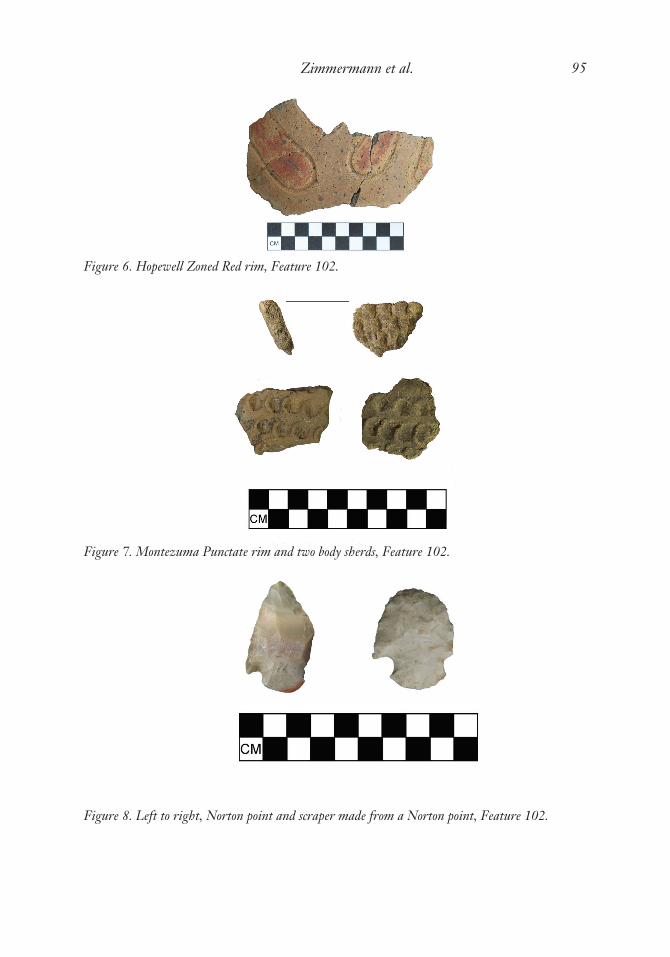
Figure 6. Hopewell Zoned Red rim, Feature 102.
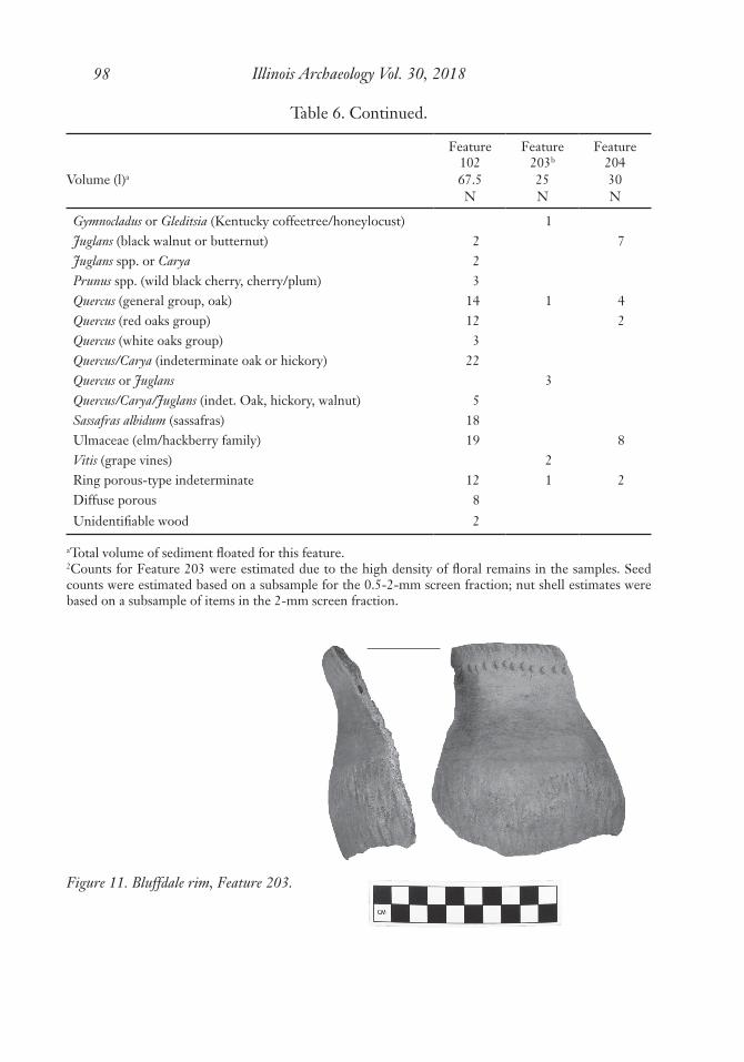
Figure 7. Montezuma Punctate rim and two body sherds, Feature 102.
Figure 8. Left to right, Norton point and scraper made from a Norton point, Feature 102.

Illinois Archaeology Vol. 30, 201896
Figure 10. Figurine, Feature 203.
Figure 9. Feature 203, profile facing north by northwest.
$� �IHDWXUH�¿OO����<5�������GDUN�EURZQ�GDUN�\HOORZLVK�EURZQ�VDQG\�ORDP�%� �IHDWXUH�¿OO����<5�������GDUN�EURZQ�GDUN�\HOORZLVK�EURZQ�VDQG\�ORDP�&� �IHDWXUH�¿OO����<5�����EODFN�VDQG\�ORDP�'� �VXEVRLO����<5�������GDUN�\HOORZLVK�EURZQ�FOD\�ORDP�¨� �ERQH;� �FKDUFRDO2� �EXUQW�FOD\

Zimmermann et al. 97
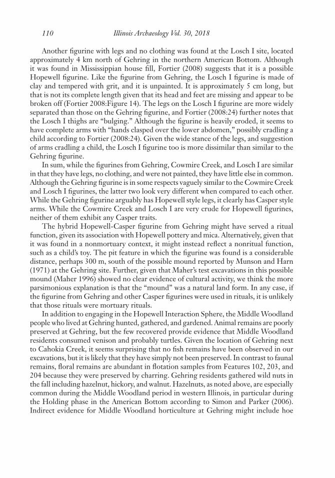
Table 6. Floral Remains.
Feature102
Feature203b
Feature204
Volume (l)a 67.5 25 30N N N
SeedsChenopodium berlandieri (chenopod) 26Chenopodium sp. 3,879 17Chenopodium or Polygonum (perisperm) 1 247Fabaceae (cotyledon frags) 2Galium spp. (bedstraw) 3 39Helianthus annuus (sunflower) 1Hordeum pusillum (wild little barley) 2 122Phalaris caroliniana (maygrass) 19 1,462 5Phytolacca americana (pokeweed) 2Poaceae (unidentified grass) 1Polygonum erectum (knotweed) 5 236 1Portulaca oleraceae (purslane) 1Rhus spp. (sumac) 4 111 1Rubus sp. (raspberries) 4 1Vitis spp. (grape) 5 106 3Vitaceae (grape, fox grape, etc) 2Unidentifiable seed fragments 26 204 16
Cucurbit rind (squash) 1NutshellCarya spp., thick (nonspecific thick-shelled hickory nuts) 71 46 40Corylus americana (American Hazelnut) 36 76 59Juglandaceae (family of hickory and black walnut) 54 21 40Juglandaceae-Corylus(hickory/walnut family or Am. Hazelnut) 14 14 15Juglans nigra (black walnut) 71 96 33Juglans cinerea (butternut) 1Quercus (oak acorns) 4 12 27
Wood subsampleAcer (boxelder or maple) 9Carya (hickory wood) 2 1Carya/Quercus (hickory or oak wood) 1 4Fraxinus sp. (ash) 13Fraxinus or Carya (ash or hickory) 2Gleditsia tricanthos (honeylocust) 5Gleditsia/Sassafras 21Gleditsia or Ulmaceae 7 1
Illinois Archaeology Vol. 30, 201898
Feature102
Feature203b
Feature204
Volume (l)a 67.5 25 30N N N
Gymnocladus or Gleditsia (Kentucky coffeetree/honeylocust) 1Juglans (black walnut or butternut) 2 7Juglans spp. or Carya 2Prunus spp. (wild black cherry, cherry/plum) 3Quercus (general group, oak) 14 1 4Quercus (red oaks group) 12 2Quercus (white oaks group) 3Quercus/Carya (indeterminate oak or hickory) 22Quercus or Juglans 3Quercus/Carya/Juglans (indet. Oak, hickory, walnut) 5Sassafras albidum (sassafras) 18Ulmaceae (elm/hackberry family) 19 8Vitis (grape vines) 2Ring porous-type indeterminate 12 1 2Diffuse porous 8Unidentifiable wood 2
aTotal volume of sediment floated for this feature.2Counts for Feature 203 were estimated due to the high density of floral remains in the samples. Seed counts were estimated based on a subsample for the 0.5-2-mm screen fraction; nut shell estimates were based on a subsample of items in the 2-mm screen fraction.
Table 6. Continued.
Figure 11. Bluffdale rim, Feature 203.

Zimmermann et al. 99
Figure 12. Pike-Baher body sherd, Feature 203.
Figure 13. Hopewell Zoned var. Fulton, Feature 203.

Illinois Archaeology Vol. 30, 2018100
bowls were identified), Hopewell Zoned var. Fulton (Figure 13), and Havana Plain var. Collinsville (Figure 14; Holding Plain var. Collinsville according to Maher 1989). A rim from a small pinch pot was also recovered. Other artifacts recovered from Feature 203 included blades, the base of a spear point made from Cobden-Dongola chert, exotic cherts (most commonly Cobden-Dongola; see Table 4), mica, bone, and mud dauber nests. Identified faunal remains were limited to two white-tailed deer incisors and seven fragments of turtle shell. Identified floral remains (Table 6) included native cultigens (notably, very large quantities of chenopodium and maygrass) and nuts (most com-monly black walnut, hazelnut, and hickory). All strata were artifact rich, but the density of artifacts was highest toward the bottom of the feature, possibly in association with Stratum C. The mica (0.33 g) was found at the bottom of the feature, in both Strata B and C; the figurine was also found near the bottom of the feature, in Stratum B.
Feature 204 was also identified at the base of the plow zone. It was a deeper pit (75 cm), circular in plan view (75 cm in diameter), with a profile that was belled in some wall sections and vertical in others (Table 1; see also Zimmermann Holt 2013). At the time of excavation in 2013, the profile was interpreted to indicate two deposi-tional episodes which were labelled Stratum A and Stratum B (Figure 15). However, we realized during our 2016 excavation that the deposit encountered at the top of the feature and labelled Stratum A was actually a Mississippian wall trench (part of Feature 257) superimposing Feature 204 (Figure 3; see Zimmermann 2017:31). Stratum B was described as extending from the top to the bottom of Feature 204, and lamellae cut through Stratum B into the subsoil matrix. Although the disturbance created by the wall trench was observed during excavation, it is unfortunately not possible to quantify or compare precisely the cultural materials between the wall trench and the pit feature because materials screened from the two deposits were combined during excavation;
Figure 14. Havana Plain var. Collinsville, Feature 203.

Zimmermann et al. 101
flotation samples, however, were taken from each deposit separately. Both deposits (wall trench Feature 257 and pit Feature 204) were described as containing notable amounts of bone and burned earth or clay. Pottery seemed to increase in quantity toward the bottom of the pit, with thin-walled pottery noted near the top, presumably in associa-tion with Feature 257, the Mississippian wall trench, and thicker-walled pottery noted toward the bottom of the pit. Most pottery (Table 3) appears to be Middle Woodland Havana, specifically including Havana Cordmarked var. Bottoms (Figure 16; Holding Cordmarked var. Bottoms according to Maher 1989). Two sherds were identified as Early Woodland Marion Thick. The pottery indicates a Middle Woodland age, but probably younger than Middle Woodland pit Feature 203, which lay 1.65 m north-northwest of Feature 204, and Middle Woodland pit Feature 102, which lay approximately 1.1 m west-northwest of Feature 204 (Zimmermann Holt 2013: Figure 5). Exotic cherts recovered from the pit were mostly Cobden-Dongola and Indiana hornstone (Table 4). Two spear points were found in Feature 204; one is tentatively identified as a Manker
Figure 15. Feature 204, profile facing west.
$� �)HDWXUH�����6WUDWXP�$�����<5�����EURZQ�VLOW�ORDP�%� �)HDWXUH�����6WUDWXP�%����<5�������GDUN�EURZQ�GDUN�\HOORZLVK�EURZQ�VLOW�ORDP�&� �ODPHOODH'� �VXEVRLO����<5�����GDUN�\HOORZLVK�EURZQ�FOD\�ORDP�(� �)HDWXUH���������<5�����GDUN�EURZQ�FOD\�ORDP�)� �ELRWXUEDWLRQ;� �EXUQW�FOD\<� �¿UH�FUDFNHG�URFN=� �FKDUFRDO¨� �FKHUWƑ� �FHUDPLFż� �ERQH

Illinois Archaeology Vol. 30, 2018102
point and the other is tentatively identified as a heavily reworked Snyders point (Figure 17; Table 5). The possible Manker point is made of a high-quality dark chert, probably Moline (Larry Kinsella, personal communication 2017). The possible Snyders point is made of heat-treated Burlington which looks like it might have come from a lower Illinois Valley source (Larry Kinsella, personal communication 2017). Floral remains identified in Feature 204 (Table 6) included native cultigens (mostly maygrass) and nuts (including hazelnut, hickory, and walnut). Bone recovered from pit Feature 204 included a human toe bone (a middle phalanx from digit 2, 3, or 4). The human bone seemed well preserved compared to nonhuman bone from Feature 204. As with Feature 203, identified faunal remains from Feature 204 were limited to remains of white-tailed deer and turtle. White-tailed deer remains included a proximal radius fragment, a first phalanx, and two molars; three calcined turtle shell fragments were identified. Again similar to Feature 203, a fragment of a mud dauber nest was found in Feature 204; it appeared to be baked or burned.
In addition to the Middle Woodland pit features, possible Middle Woodland posts have been identified at the south end of the Gehring site. These were identified as posts because they were circular in plan view and had vertical or inslanting profiles. Feature 103 was identified at the base of the plow zone. It was identified as possibly Middle Woodland based upon its proximity to Middle Woodland pit Feature 102, and also because it is comparable in width to posts observed in structures at other Middle Woodland sites in the American Bottom (e.g., Fortier 1993). Features 330, 331, and 336 were located 5–10 cm below the possible floor of a Mississippian wall-trench structure
Figure 16. Havana Cordmarked var. Bottoms, Feature 204.

Zimmermann et al. 103
Figure 17. Left to right, possible Manker and Snyders points, Feature 204.
Feature 257, or about 10–15 cm below the base of the plow zone. These possible posts were apparently truncated by the construction of Feature 257 during the Mississippian period. Thus, stratigraphy indicates they are older than the Mississippian period, and parsimony suggests that they date to the Middle Woodland period. We will describe each of these posts.
Feature 103 was a possible Middle Woodland post located at the base of the plow zone approximately 60 cm south-southeast of Feature 102 (Figures 3 and 18; see Zim-mermann Holt and Belknap 2010). Feature 103 was circular in plan view with verti-cal/inslanting walls, approximately 20 cm across and 20 cm deep (Table 1). Its fill was organic rich, but it contained no artifacts. Some mottling of burned clay similar to that found in Feature 102 was found in the fill of Feature 103, with a concentration at the very base of the feature. All of Feature 103 was saved as a flotation sample; it contained trace amounts of nutshell (hazelnut and hickory or walnut) and wood charcoal (oak). Its proximity to pit Feature 102 and similarity in feature matrix supports the hypothesis that post Feature 103 also dates to the Middle Woodland period. The presence of hazelnut in Feature 103 also supports this hypothesis, given the predominance of hazelnut in Middle Woodland paleoethnobotanical samples, especially those from the American Bottom dating to the Holding phase (Simon and Parker 2006).
Feature 330 was a possible Middle Woodland post encountered underneath Missis-sippian wall-trench structure Feature 257 (Zimmermann 2018). It was approximately 30 cm in diameter and circular in plan view, and about 20 cm deep and vertical to inslanting in profile (Table 1; Figures 3 and 18). In profile, two zones were suggested. It was not clear if the outer zone was actually part of the feature, or if the outer zone was nonfeature sediment developing (leaching) in reaction with the feature. Flecks and concentration of orange clay suggest iron accumulation within the leached zone.

Illinois Archaeology Vol. 30, 2018104
The fill in Feature 330 is similar to the fill observed in Feature 225, a possible Missis-sippian post encountered at the base of the plow zone in the north half of Feature 257 (Zimmermann Holt 2015). Similar “leached” sediment was found below one posthole in the east wall trench of Feature 257 (Zimmermann 2018), but there were patches of similar sediment in the north half of Feature 257 that were clearly bioturbation. Thus, sediments of this type were observed in both bioturbation and in cultural features. No artifacts were recovered during excavation of Feature 330; the flotation sample taken from it has not yet been analyzed since it was excavated shortly before this article went to press.
Feature 331 was another possible Middle Woodland post identified underneath Mississippian Feature 257, located approximately 55 cm west-northwest of Feature 330 and 2.5 m east-northeast of Feature 103 (Zimmermann 2018). The plan view suggests two circular features overlapping one another, one approximately 14 cm and one 20 cm in diameter (Table 1; Figure 3). In the profile that was drawn (Figure 18), the smaller circle to the southwest is not shown, and there is no mention of it in the excavators’ notes. However, in a photograph of the feature, the smaller of the two circles appears to have been about 5 cm deep. The larger circle was about 22 cm deep with a vertical to inslanting profile. Very much like Feature 330, it appears to have two zones, of which the outer zone is leached and contains orange flecks suggesting iron accumulation. Again, it’s not clear whether the outer “leached” zone is really part of the feature, or if it is non-feature matrix developing in reaction to the feature. In the photograph taken, the shallower feature appears to have had fill similar to the inner zone of Feature 331. Feature 331 as profiled (Figure 18) suggests a posthole, so perhaps the shallower circle was a shallower post. One small shatter fragment of burned chert was recovered from Feature 331; the flotation sample taken from it hasn’t yet been analyzed.
Feature 336 was a possible Middle Woodland post identified underneath Missis-sippian pit Feature 232 and Mississippian wall-trench structure Feature 257 (Zimmer-mann 2018). Feature 336 was circular in plan view, approximately 22 cm in diameter and approximately 10 cm deep with vertical sides (Table 1, Figures 3 and 18). Feature 336 contained one small pottery sherd and one very small, unidentifiable calcined bone fragment. The sherd was a grit-tempered, cordmarked body sherd; its interior surface is missing so that its thickness can’t be determined. The flotation sample taken from Feature 336 hasn’t yet been analyzed.
It should also be noted that a protrusion from the south end of post Feature 103 appeared to contain a mix of sterile subsoil and feature fill, so it was interpreted to be a disturbance at the time of excavation. However, it appears to line up with a semi-circle of smaller posts identified to the east in a later field season; these were identified as Feature 205 (Figure 3; see Zimmermann Holt 2013). The posts in Feature 205 were typically about 5 cm in diameter and ranged between 3 and 12 cm deep below the plow zone (Table 1). The profile drawn for Feature 103 (Figure 18) suggests that the smaller post that aligns with Feature 205 is superimposed by and thus older than the larger post, Feature 103. Feature 205 also appeared to be superimposed by and was thus older

Zimmermann et al. 105
Figure 18. Profiles of possible Middle Woodland posts F. 103, 330, 331, and 336.
)HDWXUH����$� �IHDWXUH�¿OO����<5�����GDUN�JUD\LVK�EURZQ�VDQG\�ORDP�ZLWK�RFKUH�DW�EDVH%� �PL[�RI�$�DQG�&&� �VXEVRLO����<5�����GDUN�\HOORZLVK�EURZQ�VDQG\�ORDP
)HDWXUH����$� �IHDWXUH�¿OO������<�����GDUN�\HOORZ�EURZQ�ROLYH�EURZQ�VLOW�ORDP%� �IHDWXUH�¿OO�RU�VXEVRLO�����<�����EURZQ�FOD\�ORDP�ZLWK�ÀHFNV�RI����<5�����VWURQJ�EURZQ�FOD\&� �VXEVRLO������<5�����VWURQJ�EURZQ�GDUN�\HOORZLVK�EURZQ�FOD\�ORDP)HDWXUH����
$� �IHDWXUH�¿OO������<�����GDUN�\HOORZ�EURZQ�ROLYH�EURZQ�VLOW�ORDP%� �IHDWXUH�¿OO�RU�VXEVRLO�����<�����EURZQ�FOD\�ORDP�ZLWK�ÀHFNV�RI����<5�����VWURQJ�EURZQ�FOD\&� �VXEVRLO����<5�����GDUN�\HOORZLVK�EURZQ�FOD\�ORDP
)HDWXUH����$� �IHDWXUH�¿OO����<5�����GDUN�EURZQ�VDQG\�ORDP%� �VXEVRLO����<5�����EURZQ�FOD\�ORDP

Illinois Archaeology Vol. 30, 2018106
than Middle Woodland pit Features 203 and 204 (Figures 5 and 8 and Photos 11–13 in Zimmermann Holt 2013). (Although a possible post, Feature 205.5, was noted at the top of Feature 204, upon excavation this appeared to be bioturbation; small, crossed-out circles on the feature map indicate soil stains that were investigated but determined not to be posts.) Assuming Feature 205 is the east half of a circular post structure, the west half of the structure was missed during the 2009 excavation, except for the post attached to larger post, Feature 103 (Figures 5 and 7 in Zimmermann Holt and Belknap 2010). However, any missed posts should still be intact in unexcavated subsoil, and we plan to reopen this area to look for missed posts in a future field season. In any case, determining the age of possible post structure Feature 205 is problematic, given that the posts did not contain artifacts. Because Middle Woodland pit Features 203 and 204 and probable Middle Woodland post Feature 103 appear to superimpose Feature 205, Feature 205 might date to earlier in the Middle Woodland period, or it might predate the Middle Woodland period.
Discussion
Fortier (2006) presents a model for Middle Woodland origins and life ways in the American Bottom that we can test with data from the Gehring site. Fortier suggests that the American Bottom was settled ca. 150 B.C. by people migrating from the lower Illinois Valley. He writes, “Although these people originated from northern Havana traditions, after cal A.D. 50 they became a unique blend of northern Havana/Hopewell traditions and southern Illinois Crab Orchard traditions, and arguably were in the process of developing their own identity in the region” (Fortier 2006:328). One distinguishing feature of Middle Woodland culture in the American Bottom is that inhabitants of the region were less intensively, perhaps peripherally, involved in the Hopewell Interac-tion Sphere compared to their neighbors and probable relatives to the north (Havana tradition peoples in the Illinois Valley) and neighbors to the south (Crab Orchard tradition peoples). Evidence of this is found in the relative scarcity of Hopewell ritual objects and trade goods, and in the rarity if not absence of Middle Woodland burial mounds in the American Bottom. Finally, Fortier suggests that the American Bottom was abandoned at the end of the Middle Woodland period, with inhabitants returning to the Illinois Valley. In his dissertation on the Hopewell occupation of the American Bottom, Maher (1996) suggests a similar model, although he questions where people went when they abandoned the American Bottom at the end of the Middle Woodland period. Maher argues that there are no sites in the lower Illinois Valley dating to this time (ca. AD 350), and suggests instead that perhaps people leaving the American Bot-tom at the end of the Middle Woodland period migrated west up the Missouri River (Maher 1996: 185–187).
Because our excavated data set from Gehring is relatively small at this time, in this discussion we will also consider evidence obtained from our surface collections, and also from previous investigations at the site (see prior research above). Evidence from

Zimmermann et al. 107
Gehring is useful in testing models of Middle Woodland occupation in the American Bottom because it was occupied throughout the Middle Woodland period, and indeed also provides evidence of occupation before and after the Middle Woodland period. In his dissertation, Maher (1996) observed that ceramics collected by Denny from the Gehring site indicate occupation during the Cement Hollow phase (early Middle Woodland) and also during the Hill Lake phase (late Middle Woodland). Further evi-dence of occupation during the early Middle Woodland period is found in the ceram-ics we collected from Feature 102, which were exclusively Illinois Valley Havana and Hopewell styles. While the presence of Montezuma Punctate and other Illinois Valley styles in Feature 102 might provide further evidence of a Cement Hollow occupation, the abundance of Hopewell Zoned Red ceramics and lamellar blades suggests a Holding phase occupation (middle Middle Woodland), according to Fortier (2006:Figure 18.2). Occupation during the Holding phase might also be indicated by ceramics from Feature 203, with its figurine, mica, and mix of Havana and Hopewell ceramics (Fortier 2006). However, distinct differences in ceramics between Features 102 and 203 indicate that they are not contemporary; both Illinois Valley (e.g., Bluffdale) and local styles (e.g., Havana Plain var. Collinsville) were found in Feature 203, suggesting that it was filled later in time than Feature 102. Feature 204 also contained a mix of Middle Woodland styles, but the rarity of Hopewell pottery and exotic materials, and the commonality of local styles (e.g., Havana Cordmarked var. Bottoms), suggest that it is later still, possibly providing further evidence of occupation during the Hill Lake phase. Regardless of the specific phases they date to, the diversity in the pottery recovered from pit Features 102, 203, and 204 clearly indicates that although they are all Middle Woodland, no two of these pits were contemporary, or at least they were filled with refuse at different times. Diverse Middle Woodland point styles (Snyders, North, Norton, and Manker) found in our excavation and in surface collections support the notion that Gehring was occupied throughout the Middle Woodland period.
The scarcity of Early Woodland ceramics compared to the abundance of Illinois Valley style Havana and Hopewell pottery at Gehring might support the notion that people migrated to the American Bottom from the Illinois Valley at the beginning of the Middle Woodland period. Indeed, when examining Havana and Hopewell ceramics from Feature 102, Ken Farnsworth (personal communication 2010) stressed that most (if not all) sherds from this feature appear to have been made in the Illinois River val-ley. Farnsworth (personal communication 2014) noted that some of the pottery from Feature 203 also appears to have been made in the lower Illinois Valley, in particular the Bluffdale jar and one Hopewell Plain bowl. The presence of “Holding” style pottery (Havana Plain var. Collinsville in Feature 203 and Havana Cordmarked var. Bottoms in Feature 204), with its thinner walls and sandier pastes, might in turn be seen as evidence of the development of a localized American Bottom identity hypothesized by Fortier (2006). The influence of the Havana tradition in this American Bottom transforma-tion, however, is quite clear. In contrast, there seems to have been little influence from Crab Orchard groups, which is probably not surprising given that Gehring is in the
Illinois Archaeology Vol. 30, 2018108
northern American Bottom. The presence of imported cherts from southern Illinois such as Cobden-Dongola and Kaolin indicates ties with Crab Orchard peoples, but the rarity of Crab Orchard pottery at Gehring indicates that these ties were comparatively weak. Moreover, the occasional presence of Crab Orchard pottery could alternatively indicate ties with Massey groups to the north (Farnsworth 1985).
Our excavations at Gehring might suggest that its occupants were more intensively involved in the Hopewell Interaction Sphere than were other residents of the American Bottom. Hopewell pottery is common in Features 102 and 203, and mica, an exotic material exchanged in the Hopewell Interaction Sphere, was also found in Feature 203. Admittedly, however, we have excavated only three Middle Woodland features on a very large site; perhaps we chanced to excavate the exact location on site where Hopewellian activities took place. Nevertheless, we would reject that explanation, despite our small excavation area, because evidence of Hopewell interaction has been found outside of these features, and on other parts of the site. In his excavations in the central part of the site, some 300 to 400 m north of our excavations at the southern end of the site, Vogel also found Hopewell Zoned Red pottery; Denny’s excavations in the central part of the site also yielded Hopewell Zoned and crosshatched pottery. We have found two obsidian flakes, one during excavation of the plow zone about 15 m north of Feature 203, and the other on the ground surface approximately 50 m west of our excavations. Obsidian is extremely rare in Illinois, but it always dates to Middle Woodland contexts; thus, these two flakes can reasonably be seen as evidence of Hopewellian exchange. Copper is another exotic material exchanged in the Hopewell Interaction Sphere; a copper awl made in a Middle Woodland style (according to Larry Kinsella, personal communication 2016) was found at the base of the plow zone about 8 m east of Feature 203. During our surface collection approximately 60 m southwest of the excavation area, we found a small “lizard effigy” made from a lamellar blade of Burlington chert. Although we don’t know exactly where they were found, the drilled bear canine, galena, and quartz crystal recovered by a private collector were found farther north on site, perhaps 200 m from our excavation; these are also likely evidence of Hopewellian activity (Fortier 2008). While pendants made from carnivore canine teeth are common in Middle Woodland burial mounds in the Illinois Valley and have also been found at North Mound #2 in the Kaskaskia Valley (Perino 2006), they are rare if not absent from the American Bottom (Fortier 2006), not surprisingly since no Middle Woodland burial mounds have been verified in the area. To our knowledge, the drilled bear canine from Gehring is the only bear remain ever found in the American Bottom proper.
The unusual figurine found in Feature 203 might also be evidence of Hopewel-lian activity or ritual. Alternatively, it might simply be a child’s toy (Sandberg 2016). Elaborate, highly detailed and often-painted Hopewell figurines like those from the Knight mound group (Griffin et al. 1970) are typically found in burial contexts in the Illinois Valley. Given this context, it is clear that they served a ritual function. In contrast, simple Casper-the-Ghost style figurines are unpainted, typically lack facial features, and typically have stumps for arms and/or legs. They are usually found in

Zimmermann et al. 109
habitation contexts; one known exception is a Casper figurine found in the burial of a child at the Knight site (Griffin et al. 1970). That figurine is also unusual because it has facial features; nevertheless, it might be classified as a Casper figurine because it has no arms or legs. Casper figurines could have served a ritual function, but they might best be interpreted as children’s toys, given their simplicity, and given that they are usu-ally found in habitation sites, except for the one found in a mound at the Knight site. The fact that it was found in a child’s burial could support either hypothesis, that the figurine served a ritual function or that it was a child’s toy. Given that Casper figurines are usually found in habitation contexts while elaborate Hopewell figurines are usually found in burials, and given the rarity if not absence of Middle Woodland burials in the American Bottom, it’s not surprising that Casper figurines are more common in the American Bottom than elaborate Hopewell figurines (Fortier 2006, 2008; Fortier et al. 1989; Koldehoff 2006).
The figurine from Feature 203 at Gehring is made of clay with a small amount of grit temper. A dowel or stick impression is visible on the top-rear of its left shoulder, and it is unpainted. It is approximately 7 cm in length. The Gehring figurine is unusual because it seems to present a hybrid Middle Woodland style: it is in the simple Casper-the-Ghost style from the waist up, but more detailed and suggestive of a Hopewell style from the waist down (Figure 10). The Gehring figurine has stumps for arms and a pointed head; whether or not it had facial features is unknown because of prehistoric damage to the facial area. From the waist down, the Gehring figurine is very detailed, with well-defined feet and buttocks. Its legs are elevated at an angle of approximately 45 degrees, and one foot is flexed more than the other. While the detail of the legs and especially the feet might suggest a Hopewell style, Hopewell figurines typically wear skirts or loincloths. In contrast, the Gehring figurine would seem to be naked, given the clear depiction of buttocks, although no breasts or genitalia are apparent.
The most similar Middle Woodland figurine we are aware of was found in a pit feature at the Cowmire Creek site in the lower Missouri River valley, approximately 30 km west of Gehring (Craig and Vorreyer 2004). This clay figurine has no visible temper, and it is approximately 6 cm in length. It has legs reminiscent of those on the Gehring figurine, but they are less elevated and lack detailed feet and buttocks (Craig and Vorreyer 2004:Plate 7.2b). Whereas the Gehring figurine has stumps for arms, the Cowmire Creek figurine has arms parallel to its body but again lacking details such as hands. Whereas the facial area of the Gehring figurine is missing, the Cowmire Creek figurine has intact facial features; from the published photograph it appears that eyes are represented by slits and a nose by a pinched bump (Craig and Vorreyer 2004:Plate 7.2b). Although the Cowmire Creek figurine is crude, lacking in ornamentation, and unpainted, Craig and Vorreyer (2004: 155–156) refer to it as a Hopewell style figurine, presumably because it has facial features and full length limbs. All things considered, it is more dissimilar than similar to the Gehring figurine; however, the general shape of the heads and legs of the two figurines are vaguely similar, they are similar in size, and they both lack ornamentation and clothing.
Illinois Archaeology Vol. 30, 2018110
Another figurine with legs and no clothing was found at the Losch I site, located approximately 4 km north of Gehring in the northern American Bottom. Although it was found in Mississippian house fill, Fortier (2008) suggests that it is a possible Hopewell figurine. Like the figurine from Gehring, the Losch I figurine is made of clay and tempered with grit, and it is unpainted. It is approximately 5 cm long, but that is not its complete length given that its head and feet are missing and appear to be broken off (Fortier 2008:Figure 14). The legs on the Losch I figurine are more widely separated than those on the Gehring figurine, and Fortier (2008:24) further notes that the Losch I thighs are “bulging.” Although the figurine is heavily eroded, it seems to have complete arms with “hands clasped over the lower abdomen,” possibly cradling a child according to Fortier (2008:24). Given the wide stance of the legs, and suggestion of arms cradling a child, the Losch I figurine too is more dissimilar than similar to the Gehring figurine.
In sum, while the figurines from Gehring, Cowmire Creek, and Losch I are similar in that they have legs, no clothing, and were not painted, they have little else in common. Although the Gehring figurine is in some respects vaguely similar to the Cowmire Creek and Losch I figurines, the latter two look very different when compared to each other. While the Gehring figurine arguably has Hopewell style legs, it clearly has Casper style arms. While the Cowmire Creek and Losch I are very crude for Hopewell figurines, neither of them exhibit any Casper traits.
The hybrid Hopewell-Casper figurine from Gehring might have served a ritual function, given its association with Hopewell pottery and mica. Alternatively, given that it was found in a nonmortuary context, it might instead reflect a nonritual function, such as a child’s toy. The pit feature in which the figurine was found is a considerable distance, perhaps 300 m, south of the possible mound reported by Munson and Harn (1971) at the Gehring site. Further, given that Maher’s test excavations in this possible mound (Maher 1996) showed no clear evidence of cultural activity, we think the more parsimonious explanation is that the “mound” was a natural land form. In any case, if the figurine from Gehring and other Casper figurines were used in rituals, it is unlikely that those rituals were mortuary rituals.
In addition to engaging in the Hopewell Interaction Sphere, the Middle Woodland people who lived at Gehring hunted, gathered, and gardened. Animal remains are poorly preserved at Gehring, but the few recovered provide evidence that Middle Woodland residents consumed venison and probably turtles. Given the location of Gehring next to Cahokia Creek, it seems surprising that no fish remains have been observed in our excavations, but it is likely that they have simply not been preserved. In contrast to faunal remains, floral remains are abundant in flotation samples from Features 102, 203, and 204 because they were preserved by charring. Gehring residents gathered wild nuts in the fall including hazelnut, hickory, and walnut. Hazelnuts, as noted above, are especially common during the Middle Woodland period in western Illinois, in particular during the Holding phase in the American Bottom according to Simon and Parker (2006). Indirect evidence for Middle Woodland horticulture at Gehring might include hoe

Zimmermann et al. 111
flakes, most commonly found in Feature 102; however, gloss on these flakes could be from other forms of use such as woodworking. Direct evidence of horticulture includes seeds of native cultigens, with chenopodium and maygrass in greatest abundance. Other native cultigens identified were erect knotweed, little barley, and sunflower. With the exception of maygrass, which is harvested in the spring, the rest of these native cultigens were harvested in the fall. The presence of gardens at Gehring suggests long-term oc-cupation at the site, minimally during seasons when those gardens would need to be planted, tended, and harvested.
Long-term occupation at the site, or perhaps very intensive short-term occupa-tion, might be indicated by the large number of sherds recovered from the features we have excavated, especially Feature 102. We might compare the density of sherds in features at Gehring to features at the Holding site (Fortier et al. 1989), which has the best evidence for long-term or intensive occupation at any previously excavated site in the American Bottom. At Gehring, over 600 sherds were recovered from Feature 102, more than 150 sherds were found in Feature 204, and more than 100 sherds were found in Feature 203 (Table 2). Out of 143 Middle Woodland pits excavated at Hold-ing, four pits in the center of the site “stand out as having relatively large quantities of pottery (70 or more sherds)” (Maher 1989:276). The number of sherds in these four pits ranged from 71 to 98. Simply comparing these numbers, it would seem that sherd density is much greater at Gehring than at Holding. However, feature sediments at Gehring were screened through quarter-inch mesh, while feature sediments at Holding were not screened. It is well documented that screening results in higher recovery rates (e.g., Payne 1972), so artifact densities at Holding are underestimated to an unknown extent. Although comparison with sites like Holding is problematic due to differential recovery methods, and this rough comparison does not consider sherd size, number of vessels, or other factors, ceramic density in the pit features we have excavated at Gehring might nevertheless suggest relatively intensive occupation. Middle Woodland people were living at Gehring long enough to break multiple vessels of multiple styles.
Because variation in recovery techniques has less effect on pit size, we might more accurately assess the intensity of occupation at Gehring by comparing pit sizes between sites. Fortier and Ghosh (2000:Table 4) provide summary data for pits excavated at Middle Woodland sites in the American Bottom. The mean depth of pits at floodplain sites is approximately 26 cm, while the mean depth of pits at upland sites is approximately 19 cm. The depth of pits at Gehring is much deeper, with a mean depth of approximately 63 cm. This might suggest more intensive or long-term occupation at Gehring, with greater emphasis on storage. However, we reiterate that the area excavated at Gehring is extremely small, and may not be reflective of the site as a whole. Also, the Middle Woodland pits at the southern end of the Gehring site were probably not truncated by plowing until relatively recently, given that they were located on a buried living surface (e.g., see Zimmermann 2017).
When we compare the diameter of pits at Gehring with those at other Middle Woodland sites (Fortier and Ghosh 2000: Table 4), we get a somewhat different per-

Illinois Archaeology Vol. 30, 2018112
spective. The mean diameter of pits at floodplain sites is approximately 98 cm, while the mean diameter of pits at upland sites is approximately 66 cm. The diameter of pits at Gehring is between these, with a mean diameter of approximately 89 cm. The mean diameter of pits at Holding (at approximately 95 cm) was comparable to Gehring, but the mean depth of pits at Holding (at just 27 cm) was considerably less than Gehring (Fortier and Ghosh 2000:Table 4). These figures again might suggest intensive occupa-tion at Gehring, with an emphasis on storage.
Long-term occupation would also be indicated by structures, although evidence for Middle Woodland structures at Gehring is slim based on excavations to date. The presence of mud dauber nests in Features 203 and 204 suggests that there was at least one Middle Woodland structure present when each of those pits was filled. Mud daubers build their nests on walls during the summer, but this does not necessarily indicate summer occupation by humans, because people could have removed the nests from a structure and discarded them in Features 203 and 204 during any season. Post Features 103, 330, 331, and 336 are similar in diameter to posts in Middle Woodland structures at other sites in the American Bottom; these could represent part of one or more Middle Woodland structures. If Feature 205, the semi-circle of smaller posts, represents a structure from a very early Middle Woodland occupation, the structure was considerably smaller than later circular post structures at other American Bottom sites, and the posts in it were also smaller. However, as Fortier (1993:263) notes, “there are no architectural examples from the early Middle Woodland Cement Hollow phase,” so we can’t know if the size of the structure and the size of its posts are unusual for the earliest Middle Woodland settlement of the American Bottom.
The best evidence of long-term occupation on a Middle Woodland site would argu-ably be midden formation (Fortier 2006). Although Munson and Harn (1971) found no evidence of deep middens at Gehring or any other Middle Woodland sites in the American Bottom during their survey, the vast majority of artifacts recovered during excavations at the Holding site, for example, were recovered from midden deposits (Fortier et al. 1989). We have not identified a midden at Gehring; however, we have not actively searched for one. The extensive erosion that has taken place at Gehring as a result of four decades of horseradish production has potentially resulted in loss of any midden that was present; alternatively, sediments eroding from the main part of the site might have deeply buried midden deposits at the edge of the site, which is lower in elevation. Identification of midden deposits is potentially a goal of future excavations.
We might reconsider whether it is appropriate to refer to Gehring as a “Havana village” with associated mound, as initially reported by Munson and Harn (1971). Smith (1992) has questioned whether the term “village” is appropriate to describe Middle Woodland sites, given that they rarely contain evidence for multiple households. Af-ter several decades of Middle Woodland research in the American Bottom, however, Fortier and Ghosh (2000:49) hypothesize that the “Hopewellian settlement system in the American Bottom appears to consist of large multi-family villages (Holding, Dash Reeves, Meridian Hills, Nochta, etc.), specialized household units (Truck #7), and small

Zimmermann et al. 113
forager camps, such as Bosque Medio, Willoughby and Widman.” The Holding site featured at least seven structures (Fortier et al. 1989), and while it is unknown which of those (if any) were contemporaneous (e.g., see Maher 1991), we might accept that the term village seems appropriate to describe Holding, at least in relative terms. That is, if a village is defined simply by the presence of multiple households, then Hold-ing is arguably what a village looked like during the Middle Woodland period in the American Bottom.
Although we haven’t yet confirmed the presence of structures at Gehring, Munson and Harn (1971) thought Gehring was a village based on its size and on the density and diversity of Middle Woodland artifacts found there. Their identification of Gehring as a village was also presumably in relative terms—Gehring appeared to them to be what a Middle Woodland village in the American Bottom looked like, relative to other Middle Woodland sites they observed in their extensive survey of the American Bot-tom and Wood River terrace. Notably, the Munson and Harn survey included the area where Holding, Nochta, and Willoughby were located along the Edelhardt meander scar (Farnsworth 1990), some 12 km south of Gehring. Whereas Munson and Harn identified Gehring as a Havana village, they recorded only a “small scatter of remains” at Holding (Fortier et al. 1989:24). Comparison of excavation data now available sup-ports the suggestion by Munson and Harn that the Middle Woodland occupation of Gehring was intensive. Ceramic density is greater in the few pits excavated at Gehring compared to those at Holding, and pits are deeper at Gehring compared to Holding. Gehring is more than four times larger than Holding—Middle Woodland materials were found across the entire Gehring site, which is about 32 acres, whereas Holding is only about 7 acres. These comparisons, albeit crude because they are based on the limited data available, might suggest that if Holding is considered a Middle Woodland village, then Gehring was also a village. While it appears that Gehring was occupied throughout the Middle Woodland period, however, Holding was occupied primarily during the Holding phase, and also during the Hill Lake phase (Fortier et al. 1989).
The presence of a mound at Gehring is debatable (Maher 1996). As noted by Fortier (2006), there are no Middle Woodland mound centers verified in the American Bot-tom, although Middle Woodland mounds have been documented on the west side of the Mississippi River in the St. Louis area (e.g., Martin 2009). Nevertheless, we might posit that although Gehring was probably not a mound center, its inhabitants engaged in Hopewellian rituals, if we assume that Hopewellian materials are evidence of ritual. Fortier (2006:328) reports that there are “only a handful of Hopewell Interaction Sphere exotics excavated from villages or campsites” in the American Bottom, but at Gehring exotics recovered to date include mica (0.33 grams), obsidian (two flakes), and copper (one awl). Although Fortier (2006:331) indicates that drilled animal canines are “ab-sent” from the American Bottom, a drilled bear canine has been found at Gehring, and Fortier (2006:331) suggests that “a possible pipe fragment” was also found at Gehring near the possible mound. If Hopewell ceramics were primarily used in rituals, then the high percentage of Hopewell pottery might suggest that Gehring was a center of

Illinois Archaeology Vol. 30, 2018114
ritual. In particular, we would note that Hopewell Zoned Red pottery is common at Gehring, particularly in Feature 102, while it is rare in the American Bottom (Maher 1989:195). Fortier (2008:28) notes that “Typically red slipping occurs only on elaborately decorated serving bowls, presumably utilized in special ritual or social contexts.” This interpretation would suggest that if Gehring wasn’t a ritual site of some sort, then it was a location for some other specialized “social” activity.
Whatever rituals were taking place at Gehring, they apparently were not mortuary rituals. Since all verified Middle Woodland mounds in the area lie west of the Missis-sippi, not in the American Bottom, perhaps we should think of the northern American Bottom as part of the Greater Lower Missouri Valley during the Middle Woodland period. Ken Farnsworth (personal communication 2018) notes that there are several Middle Woodland settlements (Cowmire Creek, Little Hills, and the O’Fallon site) lying near the confluence of the Mississippi and Missouri rivers between 30 and 55 km west of Gehring; these sites have probable ties to the Illinois Valley, as does Gehring (Craig and Vorreyer 2004; Lopinot 1991; Nixon et al. 1984). Farnsworth suggests that those sites and Gehring might have been settlements that linked Illinois Valley Havana/Hopewell societies to the north with American Bottom and St. Louis area communi-ties to the south. We would further note that Gehring is located approximately 4 km south of the Indian Creek site, which was reported as a Middle Woodland village in association with possible mounds (Munson and Harn 1971:25). Situated where they are in the northern American Bottom, sites such as Gehring and Indian Creek could have been integral in the expansion of Havana peoples out of the lower Illinois Valley.
Finally, evidence from Gehring might support the hypothesis that the American Bottom was abandoned at the end of the Middle Woodland period for some time, per-haps 50 years or longer (e.g., Fortier 2006). That is, while there is abundant evidence of Middle Woodland occupation at Gehring, we have found no evidence of occupation during the early Late Woodland period. We should mention, however, that Munson and Harn (1971: 8–9) report that they collected a small sample of pottery very similar to Weaver ware from Gehring and several other American Bottom sites, materials which they termed “Terminal Havana.” We have recovered Late Woodland cultural materials from Gehring, but these appear to date to the latter half of the Late Woodland period.
Conclusion
Given its size, seeming intensity of occupation, and clear ties with the Illinois Val-ley in the early part of the Middle Woodland period, it seems appropriate to refer to the Gehring site as a Havana village (Munson and Harn 1971). Ceramics from the site might provide evidence that Gehring was settled by Havana immigrants from the lower Illinois Valley. However, as time went by, at some point later in the Middle Woodland people living at Gehring weren’t so “Havana” any longer (cf. Fortier 2006). We can see this, for example, in the appearance of “Holding” style pottery at Gehring (Maher 1989, 1996). The presence of a mound at Gehring hasn’t been verified (Maher 1996;

Zimmermann et al. 115
Munson and Harn 1971); in fact, none of the possible Middle Woodland mounds identified by Munson and Harn (1971) in the northern American Bottom have been verified (Fortier 2006:355). Nevertheless, the relative frequency of Hopewell Interac-tion Sphere items (ranging from Hopewell ceramics to exotic imports) at Gehring compared to other American Bottom sites might suggest that it was possibly a center for Hopewellian rituals, even if those rituals weren’t focused on mortuary activities. If so, this could suggest a new type of site for the American Bottom, given that settlement systems previously proposed for the American Bottom during the Middle Woodland period have not included ritual centers (e.g., Fortier and Ghosh 2000; also see Farn-sworth 1990). However, we would reiterate and caution that this suggestion is based on excavation of an extremely small portion of the site; it is a very tentative hypothesis that most certainly needs further testing. If Gehring was not a center for ritual, then at the very least it would seem that people at Gehring were more actively engaged in the Hopewell Interaction Sphere than those at other communities in the American Bottom.
As always, further research is needed to explore these ideas. The SIUE archaeol-ogy field school will continue to investigate the Gehring site with the goal of better understanding the Middle Woodland people who lived there. Further research by SIUE faculty and students will focus on clarifying the role of the Gehring site in the settlement system of the American Bottom during the Middle Woodland period. We will seek to better understand relationships with Havana groups to the north, Crab Orchard to the south, and also Middle Woodland groups to the west (Martin 2009). In addition to shedding light on the particular culture history of the American Bottom, this research also has potential more generally to shed light on how societies become more complex, and how human-environment interactions become more complex (Kintigh et al. 2014).
Acknowledgments
This paper is dedicated to the late Kenn Neher, friend and longtime Vice Chancel-lor of SIUE, who encouraged and supported our excavations on campus at the Gehring site in so many ways. Thanks also to Lori Belknap, Greg Budzban, Ken Farnsworth, Henry Holt, John Kelly, Larry Kinsella, Brad Koldehoff, Sheryl Lauth, Keith Probst, Jennifer Rehg, Marge Schroeder, Rich Walker, and Miranda Yancey for their help with this research. Thanks to Aslin Fanning, Joseph Gackstetter, Maudie Knicley, Nigel Knutzen, and many other SIUE anthropology students for their dedicated assistance with both lab and field work. Thanks to Ken Farnsworth and Andrew Fortier for their very helpful comments on an earlier draft of this paper. It is an honor to consider all of these individuals as colleagues, but please don’t blame them for any inadequacies in this research!
Illinois Archaeology Vol. 30, 2018116
References Cited
Cisneros, Ashley2010 Middle Woodland Interaction in the American Bottom: Ceramic Analysis
at the Gehring Site. Unpublished senior project, Department of Anthropology, Southern Illinois University Edwardsville.
Craig, Joseph and Susan Vorreyer2004 The Cowmire Creek Site: A Havana Tradition Middle Woodland Period Habita-
tion Site in St. Louis County, Missouri (23SC1056). Environmental Compliance Consultants, Inc., Springfield, Illinois.
Farnsworth, Kenneth B.1985 Massey and Archie: A Study of Two Hopewellian Homesteads in the Western Il-
linois Uplands. Research Series/Kampsville Archeological Center, Vol. 3. Center for American Archeology, Kampsville.
1990 The Evidence for Specialized Middle Woodland Camps in Western Illinois. Illinois Archaeology 2:109–132.
Fortier, Andrew C.1993 American Bottom House Types of the Archaic and Woodland Periods: An
Overview. Illinois Archaeology 5:260–275.2006 The Land Between Two Traditions: Middle Woodland Societies of the
American Bottom. In Recreating Hopewell, edited by Douglas K. Charles and Jane E. Buikstra, pp. 328–338. University Press of Florida, Gainesville.
2008 The Archaeological Contexts and Themes of Middle Woodland Symbolic Representation in the American Bottom. Illinois Archaeology 20:1–47.
Fortier, Andrew C. and Swastika Ghosh2000 The Bosque Medio Site: A Hopewellian Campsite in the American Bottom
Uplands. Illinois Archaeology 12:1–56.Fortier, Andrew C., Thomas O. Maher, Joyce A. Williams, Michael C. Meinkoth, Kathryn E. Parker, and Lucretia S. Kelly
1989 The Holding Site: A Hopewell Community in the American Bottom. American Bottom Archaeology FAI-270 Site Reports Vol. 19. University of Illinois Press, Urbana.
Griffin, James B.1952 Some Early and Middle Woodland Pottery Types in Illinois. In Hopewellian
Communities in Illinois, edited by Thorne Deuel, pp. 93–130. Scientific Papers Vol. 5. Illinois State Museum, Springfield.
Griffin, James B., Richard E. Flanders, and Paul F. Titterington1970 The Burial Complexes of the Knight and Norton Mounds in Illinois and Michigan.
University of Michigan Press.Haun, Luke
2017 Finding Tradition: An Analysis of Middle Woodland Features at the Gehring Site. Unpublished senior project, Department of Anthropology, Southern Illinois
Zimmermann et al. 117
University Edwardsville.Illinois Secretary of State
2018 Federal Township Plats of Illinois (1804–1891). http://landplats.ilsos.net/FTP_Illinois.html. Accessed August 16, 2018.
Kintigh, Keith W., Jeffrey H. Altschul, Mary C. Beaudry, Robert D. Drennan, Ann P. Kinzig, Timothy A. Kohler, W. Fredrick Limp, Herbert D. G. Maschner, William K. Michener, Timothy R. Pauketat, Peter Peregrine, Jeremy A. Sabloff, Tony J. Wilkinson, Henry T. Wright, and Melinda A. Zeder
2014 Grand Challenges for Archaeology. American Antiquity 79:5–24.Koldehoff, Brad
2002 The Woodland Ridge Site and Late Woodland Land Use in the Southern American Bottom. Transportation Archaeological Research Reports No.15. Illinois Transpor-tation Archaeological Research Program, Illinois Department of Transportation, University of Illinois Press, Urbana-Champaign.
2006 Hopewellian Figurines from the Southern American Bottom. Illinois Archae-ology 18:185–193.
Leslie, Katie2010 The Gehring Site: An Analysis of Middle Woodland Lithic Assemblages in
the American Bottom. Unpublished senior project, Department of Anthropology, Southern Illinois University Edwardsville.
Lopinot, Neil1991 Archaeology of the Little Hills Expressway Site (23SC572), St. Charles County,
Missouri. Archaeology Program Research Report No. 6. Contract Archaeology Program, Southern Illinois University Edwardsville.
Maher, Thomas O.1989 The Middle Woodland Ceramics Assemblage. In The Holding Site: A Hopewell
Community in the American Bottom, by Andrew C. Fortier, Thomas O. Maher, Joyce A. Williams, Michael C. Meinkoth, Kathryn E. Parker, and Lucretia S. Kelly, pp. 125–318. American Bottom Archaeology FAI-270 Site Reports Vol. 19. Illinois Department of Transportation, University of Illinois Press, Urbana and Chicago.
1991 Time and Community Patterns at Holding, a Middle Woodland Site in the American Bottom. Southeastern Archaeology 10:114–133.
1996 Time, Space, and Social Dynamics during the Hopewell Occupation of the American Bottom. Unpublished Ph.D. Dissertation, Department of Anthropol-ogy, University of North Carolina at Chapel Hill.
Martin, Terrell2009 Middle Woodland Settlement Patterns in the St. Louis Vicinity. The Missouri
Archaeologist 70:89–112.Morgan, David T.
1985 Ceramic Analysis. In Smiling Dan: Structure and Function at a Middle Wood-land Settlement in the Lower Illinois Valley, edited by Barbara D. Stafford and Mark B. Sant, pp. 183–257. Kampsville Archeological Center Research Series Vol. 2.

Illinois Archaeology Vol. 30, 2018118
Center for American Archeology Press, Kampsville, Illinois.1986 Ceramics. In Woodland Period Occupations of the Napoleon Hollow Site in the
Lower Illinois Valley, by Michael D. Wiant and Charles R. McGimsey, pp. 364–426. Kampsville Archeological Center Research Series Vol. 6. Center for American Archeology Press, Kampsville, Illinois.
Munson, Patrick J. and Alan D. Harn1971 An Archaeological Survey of the American Bottoms and Wood River Terrace. Re-
ports of Investigations, No. 21. Illinois State Museum, Springfield.Nixon, Joseph M., M. Colleen Hamilton, Neal H. Lopinot, and Joseph L. Harl
1984 Report of Ancillary Investigations at the O’Fallon Site (23SC556), Northcentral St. Charles County, Missouri. Research Report #18. Archaeological Survey, University of Missouri St. Louis.
Payne, Sebastian1972 Partial Recovery and Sample Bias: The Results of Some Sieving Experiments.
In Papers in Economic Prehistory, edited by E.S. Higgs, pp. 49–64. Cambridge University Press.
Perino, Gregory2006 Illinois Hopewell and Late Woodland Mounds. Studies in Archaeology No. 4,
Illinois Transportation Archaeological Research Program. University of Illinois, Urbana.
Ray, Jack2007 Ozarks Chipped-Stone Resources: A Guide to the Identification, Distribution, and
Prehistoric Use of Cherts and Other Siliceous Raw Materials. Missouri Archaeological Society, Springfield.
Reber, Robert J., Steven L. Boles, Thomas E. Emerson, Madeleine G. Evans, Thomas J. Loebel, Dale L. McElrath, and David J. Nolan
2017 Projectile Points and the Illinois Landscape: People, Time, and Place. Illinois State Archaeological Survey, Urbana.
Roberts, Kaitlin2014 The Gehring Site: A Ceramic Analysis. Unpublished senior project, Depart-
ment of Anthropology, Southern Illinois University Edwardsville.Sandberg, Austin
2016 Casper the Ghost Figurine Analysis. Unpublished senior project, Depart-ment of Anthropology, Southern Illinois University Edwardsville.
Simon, Mary L. and Kathryn E. Parker2006 Prehistoric Plant Use in the American Bottom: New Thoughts and Inter-
pretations. Southeastern Archaeology 25(2):212–257.Smith, Bruce
1992 Rivers of Change: Essays on Early Agriculture in Eastern North America. Smith-sonian Institution Press, Washington, D.C.
USDA2018 Web Soil Survey. United States Department of Agriculture Natural Resources

Zimmermann et al. 119
Conservation Service. https://websoilsurvey.nrcs.usda.gov/app/. Accessed August 16, 2018.
Vogel, Gregory2012 Summary of Human Burial (Feature 197) Encountered During the Southern
Illinois University Edwardsville Field School, 2012. Reported submitted to the IHPA.
Vogel, Gregory and Bryan Clemons2011 SIUE 2010 Archaeological Field School Investigations at the Gehring Site
(11MS99). Report submitted to the IHPA.Vogel, Gregory, Anna Marie Wright, Don Crumley, and Melody Chester
2013 SIUE 2011 and 2012 Archaeological Field School Investigations at the Gehring Site (11MS99). Reported submitted to the IHPA.
Williams, Joyce1989 Lithic Analysis. In The Holding Site: A Hopewell Community in the American
Bottom, edited by C.J. Bareis and J.A. Walthall, pp. 319–428. Illinois Transporta-tion Archaeological Research Reports, No. 19. University of Illinois, Urbana-Champaign.
Zimmermann, Julie A.2016 Four Years of Excavation and 10,000 Years of Occupation at the Gehring
Site. Paper presented at the 60th Annual Midwest Archaeological Conference in Iowa City, Iowa, October 8, 2016.
2017 SIUE 2016 Field School Investigations at 11MS99. Report on file at the Il-linois Historic Preservation Agency in Springfield; also available online at http://www.siue.edu/artsandsciences/anthropology/.
2018 SIUE 2018 Field School Investigations at 11MS99. Manuscript in prepara-tion for submission to the Illinois Historic Preservation Agency in Springfield.
Zimmermann Holt, Julie 2013 SIUE 2013 Field School Investigations at 11MS99. Report on file at the Il-
linois Historic Preservation Agency in Springfield; also available online at http://www.siue.edu/artsandsciences/anthropology/.
2015 SIUE 2014 Field School Investigations at 11MS99. Report on file at the Il-linois Historic Preservation Agency in Springfield; also available online at http://www.siue.edu/artsandsciences/anthropology/.
Zimmermann Holt, Julie and Lori Belknap2010 SIUE Field School Investigations in the Locale of 11MS99 and 11MS157.
Report on file at the Illinois Historic Preservation Agency in Springfield; also available online at http://www.siue.edu/artsandsciences/anthropology/.
Zimmermann Holt, Julie, Ashley Cisneros, Katie Leslie, Jessica Robart, and Lori Belknap.
2010 SIUE Field School Investigations at the Gehring Site (11MS99) in the American Bottom. Paper presented at the 75th Annual Meeting of the Society for American Archaeology in St. Louis, Missouri, April 15, 2010.