holocene core logs and site statistics for modern patch ... holocene core logs and site statistics...
TRANSCRIPT

U.S. Department of the InteriorU.S. Geological Survey
Holocene Core Logs and Site Statistics for Modern Patch-Reef Cores: Biscayne National Park, Florida
Open-File Report 2009–1246


Holocene Core Logs and Site Statistics for Modern Patch-Reef Cores: Biscayne National Park, Florida
By Christopher D. Reich, T. Don Hickey, Kristine L. DeLong, Richard Z. Poore, and John C. Brock
Open-File Report 2009–1246
U.S. Department of the InteriorU.S. Geological Survey

U.S. Department of the InteriorKEN SALAZAR, Secretary
U.S. Geological SurveyMarcia K. McNutt, Director
U.S. Geological Survey, Reston, Virginia: 2009
For more information on the USGS—the Federal source for science about the Earth, its natural and living resources, natural hazards, and the environment, visit http://www.usgs.gov or call 1-888-ASK-USGS
For an overview of USGS information products, including maps, imagery, and publications, visit http://www.usgs.gov/pubprod
To order this and other USGS information products, visit http://store.usgs.gov
Any use of trade, product, or firm names is for descriptive purposes only and does not imply endorsement by the U.S. Government.
Although this report is in the public domain, permission must be secured from the individual copyright owners to reproduce any copyrighted materials contained within this report.
Suggested citation:Reich, C.D., Hickey, T.D., DeLong, K.L., Poore, R.Z., and Brock, J.C., 2009, Holocene core logs and site statistics for modern patch-reef cores—Biscayne National Park, Florida: U.S. Geological Survey Open-File Report 2009–1246, 26 p.
All photographs are from U.S. Geological Survey files.

iii
ContentsIntroduction.....................................................................................................................................................1Methods...........................................................................................................................................................1
Coring ....................................................................................................................................................1Core Location Elevation Survey .........................................................................................................4
Results and Summary....................................................................................................................................5Coral Cores.............................................................................................................................................5Wireline Cores .......................................................................................................................................5X-Ray Diffraction and Carbon-14 Analyses ......................................................................................5
Acknowledgments .........................................................................................................................................7References Cited............................................................................................................................................7Appendix A. Photographs of coral heads after drilling, Biscayne National Park .............................10Appendix B. Core logs and photographs of the cores at each location,
Biscayne National Park .................................................................................................................15
Figures 1. Annotated Landsat 7 false-color thematic mapper (1999) image denoting wireline
and head-coral coring locations in Florida ..............................................................................2 2. High-resolution Lidar bathymetry and location of sites drilled near Alina’s Reef .............3 3. Photograph of a SCUBA diver using the underwater coral coring drill ..............................4 4. Photograph of tripod and underwater wireline coring system .............................................5 5. X-ray diffraction plot showing results of coral powder from Holocene sample
08BNP-Site 2-LS1 ..........................................................................................................................6
Tables 1. Information on head coral cores collected in Biscayne National Park in May 2008 ........3 2. Information on Holocene wireline cores collected in Biscayne National Park
in May 2008 ....................................................................................................................................4 3. Radiocarbon ages and corrected 14C dates for Holocene wireline core samples
from Biscayne National Park ......................................................................................................6

iv
Conversion Factors
Inch/Pound to SIMultiply By To obtain
Length
inch (in.) 2.54 centimeter (cm)foot (ft) 0.3048 meter (m)mile (mi) 1.609 kilometer (km)mile, nautical (nmi) 1.852 kilometer (km)
Area
acre 4,047 square meter (m2)
square foot (ft2) 929.0 square centimeter (cm2)
square inch (in2) 6.452 square centimeter (cm2)section (640 acres or 1 square mile) 259.0 square hectometer (hm2)
square mile (mi2) 2.590 square kilometer (km2) mile per hour (mi/h) 1.609 kilometer per hour (km/h)
SI to Inch/PoundMultiply By To obtain
Length
centimeter (cm) 0.3937 centimeter (cm)meter (m) 3.281 foot (ft)kilometer (km) 0.6214 mile (mi)kilometer (km) 0.5400 mile, nautical (nmi)
Area
square kilometer (km2) 0.3861 square mile (mi2)
Temperature in degrees Celsius (°C) may be converted to degrees Fahrenheit (°F) as follows:
°F = (1.8 × °C) + 32
Temperature in degrees Fahrenheit (°F) may be converted to degrees Celsius (°C) as follows:
°C = (°F – 32) / 1.8
Vertical coordinate information is referenced to the North American Vertical Datum of 1988 (NAVD 88).

Introduction
The bedrock in Biscayne National Park (BNP), a 1,730-square kilometer (km2) region off southeast Florida, consists of Pleistocene (1.8 million years ago (Ma) to 10,000 years ago (ka)) and Holocene (10 ka to present) carbonate rocks (Enos and Perkins, 1977; Halley and others, 1997; Multer and others, 2002). Most of the surficial limestone in BNP, including the islands of the Florida Keys, was formed at ~125 ka during the highstand of marine oxygen-isotope substage 5e, when sea level was approximately 6 meters (m) higher than today (Chappell and Shackleton, 1986; Multer and others, 2002; Lidz and others, 2003; Siddall and others, 2003; Balsillie and Donoghue, 2004). During the substage-5e regres-sion, the entire Florida Platform became exposed. Subaerial exposure lasted for approximately 115,000 years (kyr), which resulted in erosion and enhancement of karst-like features (Lidz and others, 2006). As the Holocene transgression began to flood the Florida shelf ~7 to 6 ka, the bedrock depression under Biscayne Bay began to flood, and Holocene coral and reef debris laid the foundation for the present reef system (Enos and Perkins, 1977; Lighty and others, 1982; Toscano and Macintyre, 2003; Lidz and others, 2006).
More than 3,000 patch reefs exist within the BNP boundary. Most contain hermatypic corals of various species such as those belonging to Montastrea, Diploria, Siderastrea, Porites, Acropora, and Agaricia. Patch reefs within BNP have two morphologies: pinnacle and flat top. Experimental Advanced Airborne Research Lidar (EAARL) data collected along the offshore BNP coral reef tract show that these two morphologies are clearly defined both in the high-resolution bathymetry maps produced by the Lidar data and by statistical analyses of the Lidar dataset (Brock and others, 2008). Brock and others (2008) also show that the pinnacle patch reefs are deeper than the more shallow, broad, and flat patch reefs. The control for these two patch-reef morphologies is unclear; however, their shapes may be due to a slightly lowered sea level or a stillstand in the middle-Holocene around 4 ka that caused erosion of the shallower reefs and allowed the deeper
reefs to remain unaffected. Lidz and others (2006) have suggested a stillstand around 4 ka that carved a 2.5-kilometer (km)-wide nearshore rock ledge into the seaward side of every island in the Florida Keys.
The objectives of this study were to sample living corals to understand the more recent (<200 years) changes in climate and environmental conditions of the area and to investigate the Holocene (in this case, <8,000 years in the Florida Keys) depositional history at progressively deeper patch-reef sites. This report provides statistics for the cores and core sites and a basic lithologic description of these Holocene cores.
Methods
Coring
Core samples were obtained from the carbonate platform and head corals in BNP using the U.S. Geological Survey (USGS) rotary hydraulic coring system (Macintyre, 1975; Shinn and others, 1994; Reich and others, 2006). Holocene wireline (WL) cores were collected at four locations, and head coral (HC) samples were collected at three locations (figs. 1 and 2; tables 1 and 2). Drilling equipment consisted of a hydraulic-powered submersible drill, a 4-inch (in.)-diameter by 24-in.-long core barrel with surface-set diamond bit, and a hydraulic-power unit operated from the surface supply boat. A tripod was used in the shallow water to suspend the hydraulic drill and to help maintain vertical position during coring (fig. 3). Corals were drilled where the growth axis was presumed to be vertical. In many cases, the core barrel had to be inserted multiple times to collect the full length of coral growth on top of bedrock. After core extraction from the coral, the cores were placed on an onboard drying table prior to being wrapped in plastic and secured for travel. Coral cores were then placed in wood boxes and archived at the USGS-St. Petersburg, FL, facility. A pre-cast concrete plug was inserted into the 4-in. open hole left in the head coral. The plug provides a substratum that will be overgrown by the coral.
Holocene Core Logs and Site Statistics for Modern Patch-Reef Cores: Biscayne National Park, Florida
By Christopher D. Reich, T. Don Hickey, Kristine L. DeLong, Richard Z. Poore, and John C. Brock

2 Holocene Core Logs and Site Statistics for Modern Patch-Reef Cores: Biscayne National Park, Florida
Figure 1. Annotated Landsat 7 false-color thematic mapper (1999) image denoting wireline (WL; circle) and head-coral (HC; triangle) coring locations in Florida. Inset shows Biscayne National Park (BNP) study area.
80°0'0"W
80°10'0"W
80°10'0"W
80°20'0"W
80°20'0"W
80°30'0"W
80°30'0"W
25°4
0'0"
N
25°4
0'0"
N
25°3
0'0"
N
25°3
0'0"
N
25°2
0'0"
N
25°2
0'0"
N
0 3 6 9 121.5Kilometers
Atlantic Ocean
Biscayne Bay
MiamiKey Biscayne
Homestead
Key L
argo
approximate position ofBiscayne National Park boundary Head coral sites
Wireline core sites
80°0'0"W
80°0'0"W
85°0'0"W
85°0'0"W
30°0
'0"N
30°0
'0"N
25°0
'0"N
25°0
'0"N
G u l f o f M e x i c o
A t l a n t i c O c e a n
Study location
HC-2
HC-3
HC-1
see fig. 2
Adams KeyGPS base station

Figure 2. High-resolution Lidar bathymetry and location of sites drilled near Alina’s Reef. Circles represent wireline (WL) core sites that were drilled to the top of the Pleistocene surface. Triangle at Anniversary Reef is the site where Diploria strigosa and Montastrea faveolata head corals (HC-3A and HC-3B, respectively) were cored. White area indicates that no Lidar data are available. Note that shallow sites near Alina’s Reef and Anniversary Reef are broad and flat, and sites farther offshore are pinnacle shaped. See appendix B for cores and core logs from Sites WL-1A, WL-1B, WL-2, and WL-3.
Table 1. Information on head coral (HC) cores collected in Biscayne National Park (BNP) in May 2008.
Date collected
Site nameLatitude
(N.)Longitude
(W.)Core length
(centimeters)
Water depth
(meters)Coral species Notes
May 2, 2008 HC-1A 25.47097 –80.17342 38 ~3 Siderastrea sidereaMay 2, 2008 HC-1B 25.47097 –80.17342 51 ~3 Montastrea faveolataMay 4, 2008 HC-2 25.35806 –80.19036 47 ~2.5 Montastrea faveolata Used tripod to suspend
drill headMay 5, 2008 HC-3A 25.38832 –80.16266 43
(section 1)~2.5 Diploria strigosa Used tripod to suspend
drill headHC-3A 25.38832 –80.16266 18
(section 2)~2.5 Diploria strigosa
May 5, 2008 HC-3B 25.38832 –80.16266 43 (section 1)
~2.5 Montastrea faveolata Cored completely through to bedrock
HC-3B 25.38832 –80.16266 47 (section 2)
~2.5 Montastrea faveolata
HC-3B 25.38832 –80.16266 17 (section 3)
~2.5 Montastrea faveolata
Alina’s Reef
WL-1A WL-1B
WL-2
WL-3
Anniversary Reef
HC-3A and HC-3B
High : 0
Low : -15
Depth in Meters
80°9'30"W
80°9'30"W
80°9'45"W
80°9'45"W
25°2
3'15
"N
25°2
3'15
"N
25°2
3'0"
N
25°2
3'0"
N
0 90 180 27045Meters
Methods 3

4 Holocene Core Logs and Site Statistics for Modern Patch-Reef Cores: Biscayne National Park, Florida
Table 2. Information on Holocene wireline (WL) cores collected in Biscayne National Park (BNP) in May 2008.
[NAVD 88, North American Vertical Datum of 1988]
Date collected
Site nameLatitude
(N.)Longitude
(W.)
Total depth drilled (feet)
Approximate water depth
(meters)
Seafloor elevation
(meters NAVD 88)
May 5–6, 2008 WL-1A 25.38617 –80.16299 14.0 2.5 –2.837*May 6–7, 2008 WL-1B 25.38603 –80.16235 30.0 4.0 –4.321May 7–8, 2008 WL-2 25.38380 –80.15910 26.5 5.5 –5.680May 9, 2008 WL-3 25.38226 –80.15535 30.0 6.5 –6.479
*Approximate depth, located near pre-existing site (see Reich and others, 2006).
Figure 3. A SCUBA diver using the underwater coral coring drill.
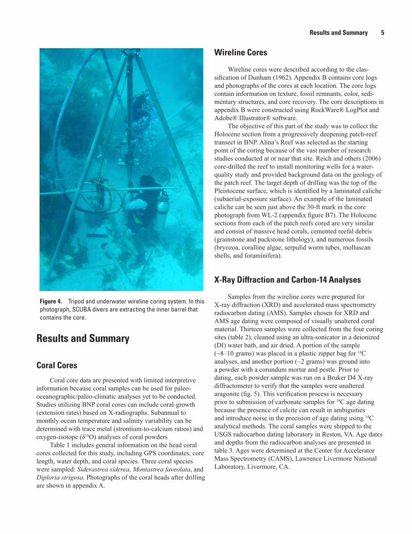
Coring the Holocene seafloor was accomplished using an NQ-2 wireline system (Boart Longyear), a high-speed and low-torque hydraulic motor, and a gear pump that circulated water as drilling fluid (fig. 4). The NQ-2 wireline system contains an inner barrel that retains a 2-in.-diameter core and is extracted at 5-foot (ft) intervals by using an overshot tool attached to a rope (or wire) that runs through a pulley to a capstan mounted on the tripod. Core barrels are 5 ft long; core extraction was made at those intervals. After extraction, the core barrel with core was taken to the boat, where the core was removed, placed in a wood box, and allowed to air dry before being placed in a cardboard core box for archiving. All cores were eventually archived at the USGS-St. Petersburg facility.
Core Location Elevation Survey
Proper elevation control for each core was critical for allowing accurate cross-borehole core correlations. To main-tain comparable elevations (bathymetry) for the top of each core, a kinematic Global Positioning System (GPS) was used at each site where wireline cores were collected. Ashtech high-precision, dual-frequency GPS receivers coupled with Thales choke-ring antennas were used for this survey. The antenna was mounted to the coring tripod using SECO GPS poles and leveled using a hand level. A base station was established on Adams Key (south end of Elliott Key) over a previously established benchmark (fig. 1). In order to keep GPS errors to a minimum, each site only needed to be occupied for 30 min-utes because core locations were less than 15 km from the base station. All reported root-mean-square errors in position (horizontal and vertical) were less than 3 centimeters (cm). The elevations were corrected to the GEOID03, and results are provided in the North American Vertical Datum of 1988 (NAVD 88) datum (table 2). Sample collection period data were processed using the Novatel GrafNet program.
Results and Summary 5
Results and Summary
Coral Cores
Coral core data are presented with limited interpretive information because coral samples can be used for paleo-oceanographic/paleo-climatic analyses yet to be conducted. Studies utilizing BNP coral cores can include coral-growth (extension rates) based on X-radiographs. Subannual to monthly ocean temperature and salinity variability can be determined with trace metal (strontium-to-calcium ratios) and oxygen-isotope (δ18O) analyses of coral powders
Table 1 includes general information on the head coral cores collected for this study, including GPS coordinates, core length, water depth, and coral species. Three coral species were sampled: Siderastrea siderea, Montastrea faveolata, and Diploria strigosa. Photographs of the coral heads after drilling are shown in appendix A.
Wireline Cores
Wireline cores were described according to the clas-sification of Dunham (1962). Appendix B contains core logs and photographs of the cores at each location. The core logs contain information on texture, fossil remnants, color, sedi-mentary structures, and core recovery. The core descriptions in appendix B were constructed using RockWare® LogPlot and Adobe® Illustrator® software.
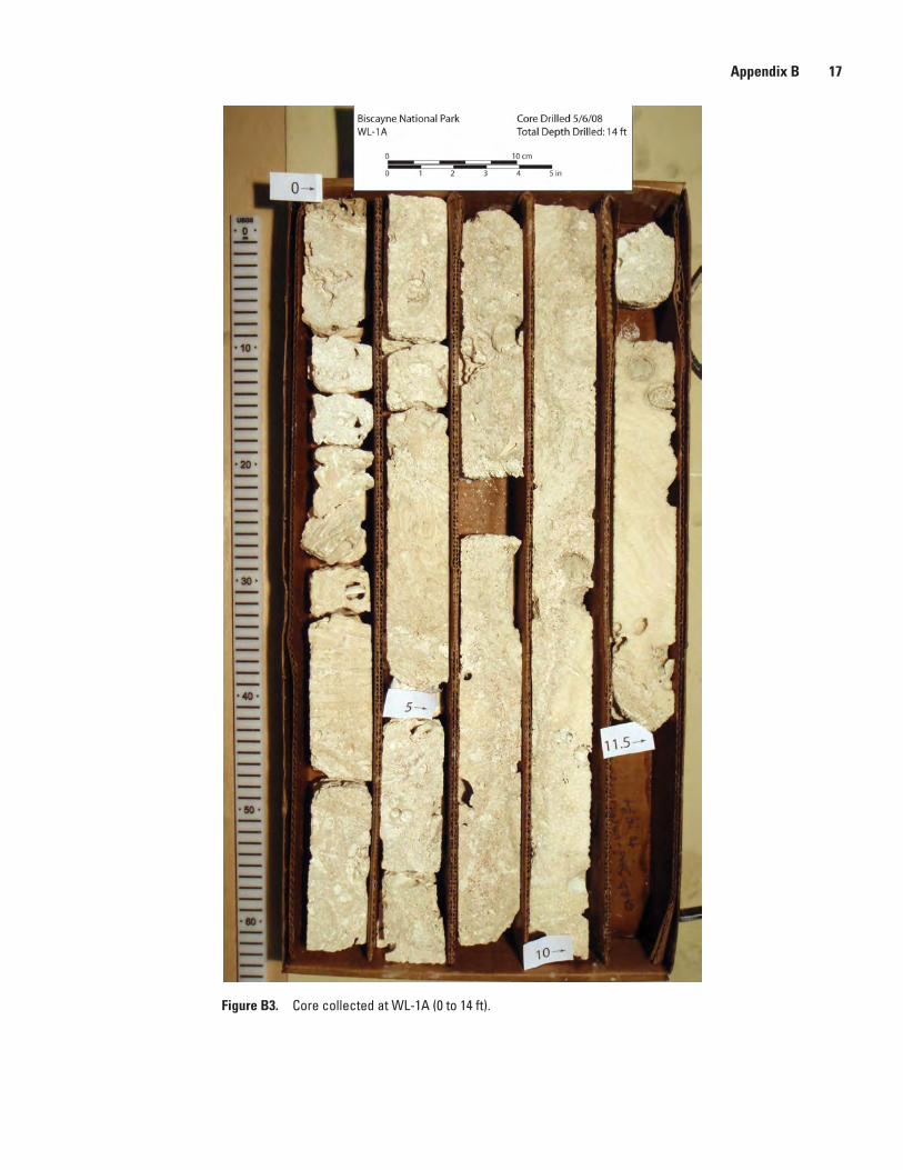
The objective of this part of the study was to collect the Holocene section from a progressively deepening patch-reef transect in BNP. Alina’s Reef was selected as the starting point of the coring because of the vast number of research studies conducted at or near that site. Reich and others (2006) core-drilled the reef to install monitoring wells for a water-quality study and provided background data on the geology of the patch reef. The target depth of drilling was the top of the Pleistocene surface, which is identified by a laminated caliche (subaerial-exposure surface). An example of the laminated caliche can be seen just above the 30-ft mark in the core photograph from WL-2 (appendix figure B7). The Holocene sections from each of the patch reefs cored are very similar and consist of massive head corals, cemented reefal debris (grainstone and packstone lithology), and numerous fossils (bryozoa, coralline algae, serpulid worm tubes, molluscan shells, and foraminifera).
X-Ray Diffraction and Carbon-14 Analyses
Samples from the wireline cores were prepared for X-ray diffraction (XRD) and accelerated mass spectrometry radiocarbon dating (AMS). Samples chosen for XRD and AMS age dating were composed of visually unaltered coral material. Thirteen samples were collected from the four coring sites (table 2), cleaned using an ultra-sonicator in a deionized (DI) water bath, and air dried. A portion of the sample (~8–10 grams) was placed in a plastic zipper bag for 14C analyses, and another portion (~2 grams) was ground into a powder with a corundum mortar and pestle. Prior to dating, each powder sample was run on a Bruker D4 X-ray diffractometer to verify that the samples were unaltered aragonite (fig. 5). This verification process is necessary prior to submission of carbonate samples for 14C age dating because the presence of calcite can result in ambiguities and introduce noise in the precision of age dating using 14C analytical methods. The coral samples were shipped to the USGS radiocarbon dating laboratory in Reston, VA. Age dates and depths from the radiocarbon analyses are presented in table 3. Ages were determined at the Center for Accelerator Mass Spectrometry (CAMS), Lawrence Livermore National Laboratory, Livermore, CA.
Figure 4. Tripod and underwater wireline coring system. In this photograph, SCUBA divers are extracting the inner barrel that contains the core.

6 Holocene Core Logs and Site Statistics for Modern Patch-Reef Cores: Biscayne National Park, Florida
Figure 5. X-ray diffraction (XRD) plot showing results of coral powder (black line) from Holocene sample 08BNP-Site 2-LS1. Sample is nearly 100 percent aragonite, as shown by the red marker lines (aragonite standard peaks).
Table 3. Radiocarbon ages and corrected 14C dates for Holocene wireline core samples from Biscayne National Park.
[In all cases, material dated was fossilized coral. Sample ID corresponds to site and sample number (for example, 08BNP-Site1A-LS1 represents site WL-1A and limestone sample number 1) and is also denoted in appendix B lithologic description logs. NAVD 88, North American Vertical Datum of 1988; ±, plus or minus; σ, 1 standard deviation]
Sample ID Lab ID
Sample depth
(feet below sea floor)
Depth (meters
NAVD 88)
Radiocarbon age and error
Calibrated age (cal yr BP)†
14C age ± median from to σ
08BNP-Site1A-LS1 WW7188 1 –3.142 4530 35 4736 4818 4624 5408BNP-Site 1A-LS2 WW7189 4.5 –4.209 4890 35 5216 5294 5067 6408BNP- Site 1A-LS3 WW7190 9 –5.580 5130 35 5504 5577 5434 4108BNP- Site 1A-LS4 WW7191 11 –6.190 5185 35 5548 5602 5467 3708BNP- Site 1B-LS1 WW7192 5 –5.845 4160 35 4225 4346 4126 5608BNP- Site 1B-LS2 WW7193 10 –7.369 4285 30 4396 4490 4307 4208BNP- Site 1B-LS3 WW7194 13 –8.283 5445 35 5816 5895 5731 4508BNP- Site 1B-LS4 WW7195 19 –10.112 5440 35 5812 5890 5728 4508BNP-Site2-LS1 WW7196 0.4 –5.802 4335 35 4459 4546 4380 4108BNP-Site3-LS1 WW7197 0.1 –6.509 5140 35 5511 5577 5445 3808BNP-Site3-LS2 WW7198 7 –8.613 5625 40 6010 6150 5915 5708BNP-Site3-LS3 WW7199 12 –10.137 5975 35 6375 6455 6296 4108BNP-Site3-LS4 WW7200 19.5 –12.423 6065 40 6478 6593 6391 51
†Calibrated ages obtained using OxCal v. 4.1 (Bronk, 1994) and marine reservoir correction value of 405+18 (cal yr BP=calibrated years before present (1950)).
Coun
ts pe
r sec
ond
100
200
300
400
500
450
350
250
150
50
0
550
2-Theta (degrees)20 21 22 23 24 25 26 27 28 29 30 31 32 33 34 35 36 37 38 39 40 41 42 43 44 45 46 47 48 49 50

References Cited 7
AcknowledgmentsWe thank Richard Curry at Biscayne National Park for
access to the park, permission to core, and on-site logistical support. Thanks to Jordan Sanford and B.J. Reynolds of the USGS and Michèle LaVigne of Rutgers University for assistance in the collection of core samples. Appreciation is extended to John Haines and the USGS Coastal and Marine Geology Program for continued funding support. We also thank John Lisle, Ilsa Kuffner, Barbara Lidz, and John Watson for their comments and reviews.
References Cited
Balsillie, J.H., and Donoghue, J.F., 2004, High resolution sea-level history for the Gulf of Mexico since the last glacial maximum: Florida Geological Survey, Report of Investiga-tions Number 103, Tallahassee, Florida, 66 p.
Brock, J.C., Palaseanu-Lovejoy, M., Wright, C.W., and Nayegandhi, A., 2008, Patch-reef morphology as a proxy for Holocene sea-level variability, northern Florida Keys, USA: Coral Reefs, v. 27, p. 555–568.
Bronk, R.C., 1994, Analysis of chronological information and radiocarbon calibration —The program OxCal: Archaeologi-cal Computing Newsletter, v. 41, p. 11–16.
Chappell, J., and Shackleton, N.J., 1986, Oxygen isotopes and sea level: Nature, v. 324, p. 137–140.
Dunham, R.J., 1962, Classification of carbonate rocks accord-ing to depositional texture, in Ham, W.E., ed., Classification of carbonate rocks: American Association of Petroleum Geologists Memoir 1, p. 108–121.
Enos, P., and Perkins, R.D., 1977, Quaternary sedimentation in south Florida: Geological Society of America Memoir 147, 198 p.
Halley, R.B., Vacher, H.L., and Shinn, E.A., 1997, Geology and hydrogeology of the Florida Keys, in Vacher, H.L., and Quinn, T.M., eds., Geology and hydrogeology of carbonate islands: New York, Elsevier, p. 217–248.
Lidz, B.H., Reich, C.D., Peterson, R.L., and Shinn, E.A., 2006, New maps, new information—Coral reefs of the Florida Keys: Journal of Coastal Research, v. 22, no. 2, p. 260–282.
Lidz, B.H., Reich, C.D., and Shinn, E.A., 2003, Regional Quaternary submarine geomorphology in the Florida Keys: Bulletin of the Geological Society of America, v. 115, no. 7, p. 845–866.
Lighty, R.G., Macintyre, I.G., and Stuckenrath, R., 1982, Acropora palmata reef framework—A reliable indicator of sea level in the western Atlantic for the past 10,000 years: Coral Reefs, v. 1, p. 125–130.
Macintyre, I.G., 1975, A diver-operated hydraulic drill for coring submerged substrates: Atoll Research Bulle-tin, v. 185, p. 21–26.
Multer, H.G., Gischler, E., Lundberg, J., Simmons, K.R., and Shinn, E.A., 2002, Key Largo Limestone revisited—Pleis-tocene shelf-edge facies, Florida Keys, USA: Facies, v. 46, no. 1, p. 229–272.
Reich, C.D., Halley, R.B., Hickey, T.D., and Swarzenski, P.W., 2006, Groundwater characterization and assessment in marine areas of Biscayne National Park, National Park Service. Water Resources Division, Technical Report/NPS/NRWRD/NRTR–2006/356, 157 p.
Shinn, E.A., Reese, R.S., and Reich, C.D., 1994, Fate and pathways of injection-well effluent in the Florida Keys: U.S. Geological Survey Open-File Report 94–276, 116 p.
Siddall, M., Rohling, E.J., Almogi-Labin, A., Hemleben, C., Meischner, D., Schmelzer, I., and Smeed, D.A., 2003, Sea-level fluctuations during the last glacial cycle: Nature, v. 423, p. 853–858.
Toscano, M.A., and Macintyre, I.G., 2003, Corrected western Atlantic sea-level curve for the last 11,000 years based on calibrated 14C dates from Acropora palmata framework and intertidal mangrove peat: Coral Reefs, v. 22, p. 257–270.


Appendixes
Appendix A. Photographs of coral heads after drilling, Biscayne National Park.
Appendix B. Core logs and photographs of the cores at each location, Biscayne National Park.

10 Holocene Core Logs and Site Statistics for Modern Patch-Reef Cores: Biscayne National Park, Florida
Figure A1. Site HC-1A, Siderastrea siderea. Note cement plug in core hole in top of coral head.

Appendix A 11
Figure A2. Site HC-1B, Montastrea faveolata. Note cement plug in core hole in top of coral head.

12 Holocene Core Logs and Site Statistics for Modern Patch-Reef Cores: Biscayne National Park, Florida
Figure A3. Site HC-2, Montastrea faveolata. Note diver’s hand for scale.
Appendix A 13
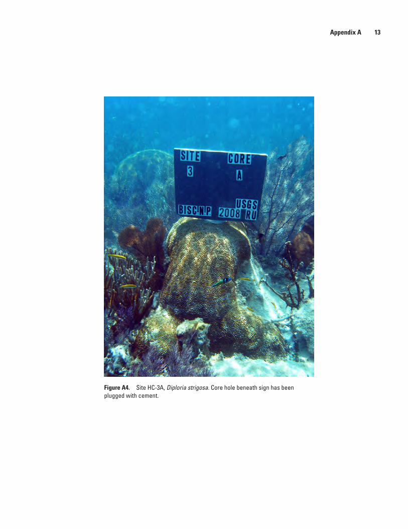
Figure A4. Site HC-3A, Diploria strigosa. Core hole beneath sign has been plugged with cement.
14 Holocene Core Logs and Site Statistics for Modern Patch-Reef Cores: Biscayne National Park, Florida
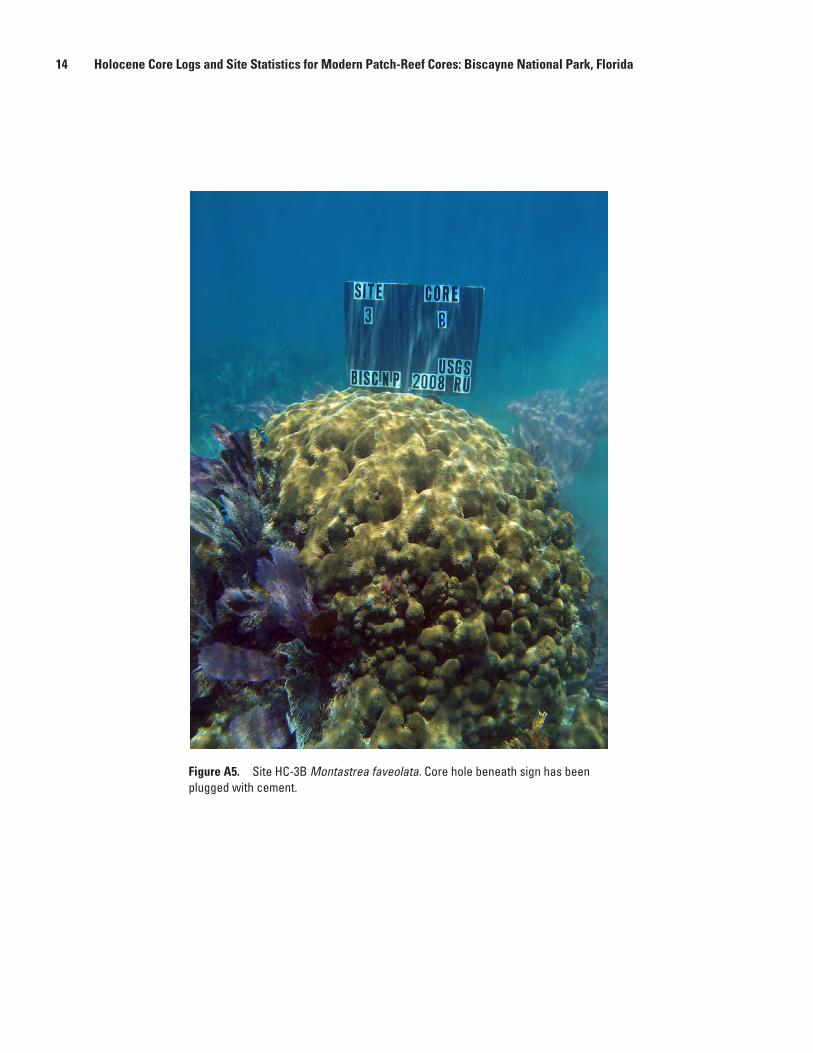
Figure A5. Site HC-3B Montastrea faveolata. Core hole beneath sign has been plugged with cement.

Appendix B 15
Figure B1. Log legend and lithologic patterns used in appendix B wireline core logs (modified from Dunham, 1962).
DEPOSITIONAL TEXTURE RECOGNIZABLE DEPOSITIONAL TEXTURENOT RECOGNIZABLE
Crystalline Carbonate
(Subdivide according toclassi�cations designed to bear
on physical texture or diagenesis.)
Original Components not Bound Together During Deposition Original Componentswere bound togetherduring deposition. . .
as shown by intergrownskeletal matter,
lamination contrary to gravityor sediment-�oored cavities that
are roofed over by organic matter andare too large to be interstices.
Boundstone
Lacks mudand is
grain-supported
PackstoneWackestoneMudstone Grainstone
Grain-supported
Contains mud(particles of clay and �ne silt size)
Mud-supportedMore than
10 percent grainsLess than
10 percent grains
Classi�cation of Carbonate Rocks According to Depositional Texture (after Dunham, 1962)
Laminated crust
Root structure
Soilstone clasts
Skeletal debris
Head corals
Branching corals
Oyster
Pelecypods
Gastropods
HalimedaH H
HH H
Coralline algae
Homatrema
Ooids
Peloids
Quartz sand
Burrows
Oyster (Spondylus)
Echinoids
Bryozoan (Schizoporella)
No recovery
Calcareous worm tube
Ø in heading of core description denotes porosity (decimal units)
Patterns Used in Well Logs and Their Corresponding Lithologies

16 Holocene Core Logs and Site Statistics for Modern Patch-Reef Cores: Biscayne National Park, Florida
Figure B2. Core description for WL-1A.
Dep
th (m
)
Dep
th (f
t)
LITHOLOGIC DESCRIPTION
CoreRecovery
25 75
%
CORE LOCATION NAME: WL-1A
Logged by: C.D. ReichDrilling Participants: Reich, CD; Hickey, TD; Sanford; J, Reynolds, BJ Location: Alina’s Reef, Biscayne National Park, Florida
Date cored: May 6, 2008
Project No.: 8-2090-C9G04Elevation: -2.837 mNAVD88
Company Name: USGS, St. Petersburg
Project Name: Holocene Sea Level in South Florida
Location: Biscayne National Park, Florida
0
-5
-10
-15
0
-1
-2
-3
-4
Car
bon-
14 S
ampl
e
Sedi
men
tary
Stru
ctur
e
Drilling System: USGS Hydraulic Rotary Drill NQ2 Wireline
Latitude: 25.38617 NLongitude: 80.16299 W
Grainstone/Packstone: Tan-colored. Homotrema, pelecypod shells and pholad bore holes. Secondary infilling of fine-grained sediment (micrite?). Coralline algae, 1-2 mm thick, on surface of grainstone (gs). {14C sample: 08BNP-1A-LS1}
Coral Boundstone: Small pieces of eroded coral. Montastrea sp. with serpulid worm tubes and minor secondary infilling. Diploria sp. with secondary infilling. Brown fibrous organic material in vugs and on surfaces.Grainstone/Packstone: Occasional coral (Montastrea sp.?) and Lithothamnion. Fine-grained material infilling pores. Molluscan shells and serpulid worm tubes. Bryozoa (@2.5 ft).Coral Boundstone: Diploria sp. (clean section with no fine-grained infilling). Near base (4.9 ft) Diploria sp. transition into grainstone with mollusc shells, bryozoa (?) and fine-grained infilling. {14C sample: 08BNP-1A-LS2}
Packstone: Bryozoa and gastropods in skeletal matrix. Numerous fossils: Porites sp. (coral), echinoderm spine, molluscan shells. Coralline algae (approx. 7ft) and coral (Montastrea sp). Lithothamnion associated with multiple areas of banded coralline algae.
{14C sample: 08BNP-1A-LS3}
Coral Boundstone: Montastrea sp. Pholad boreholes and pelecypod shells. Small zone of grainstone and then transition into Montastrea sp. with large pholad boreholes that are completely infilled with micritic material. Coral is clean, no sediment in interstices. Porites sp. and gastropod at base of core in grainstone/packstone. {14C sample: 08BNP-1A-LS4}
No recovery (unconsolidated sand and mud)
Appendix B 17
Figure B3. Core collected at WL-1A (0 to 14 ft).

18 Holocene Core Logs and Site Statistics for Modern Patch-Reef Cores: Biscayne National Park, Florida
Figure B4. Core description for WL-1B.
0
-5
-10
-15
-20
-25
-30
0
-1
-2
-3
-4
-5
-6
-7
-8
-9
Dep
th (m
)
Dep
th (f
t)LITHOLOGIC DESCRIPTION
CoreRecovery
25 75
%
CORE LOCATION NAME: WL-1B
Logged by: C.D. ReichDrilling Participants: Reich, CD; Hickey, TD; Sanford; J, Reynolds, BJ Location: Alina’s Reef, Biscayne National Park, Florida
Date cored: May 7, 2008
Project No.: 8-2090-C9G04Elevation: -4.321 mNAVD88
Company Name: USGS, St. Petersburg
Project Name: Holocene Sea Level in South Florida
Location: Biscayne National Park, Florida
Carb
on-1
4 Sa
mpl
e
Sedi
men
tary
Stru
ctur
e
Drilling System: USGS Hydraulic Rotary Drill NQ2 Wireline
Latitude: 25.38603 NLongitude: 80.16235 W
Grainstone/Packstone: Cream-colored with molluscan shells (pelecypods) infilled completely with fine-grained micritic material. Branching coral (Porites sp. ?) in packstone matrix.
Coralline algae (sp?), banded. Lithothanmnion and pholad boreholes and shells.Echinoid spines.
{14C sample: 08BNP-1B-LS1}
Grainstone: Calcareous worm tubes, lime mud infilling pores. Highly bored Montastrea sp. with pholad boreholes completely infilled with lime mud.
Montastrea sp., coralline algae (banded).Infilling of pores with lime mud.Bryozoa and molluscan shells.
Less muddy with numerous shell fragments and other skeletal debris. Oculina sp. sticks (branching corals).Calcareous serpulid worm tubes. Shell fragments {storm deposit??}
Packstone clasts. Mollusc shells. Gastropods.
Skeletal debris in lime mud. Recovered approximately 2 ft of unconsolidated lime sand and mud. Numerous shell fragments and other skeletal debris.
Soilstone crust (Pleistocene surface). Black to dark-gray caliche on top of chalky-white grainstone. Rubble.
Rubble zone: Entire fingers of Porites sp. coral, packstone clasts, calcareous worm tubes, mollusc shells, Homotrema, Montastrea sp.
Packstone: Numerous pholad shells infilled with lime mud and skeletal material. {14C sample: 08BNP-1B-LS4}
Montastrea sp., no sediment in intersticies.Grainstone with Lithothamnion and Porites sp.? (~12.5 ft) {14C sample: 08BNP-1B-LS3}Montastrea sp., pholad boreholes and shells. Grainstone infilled pores. Gastropod shells.
Chalky-white grainstone rubble zone at 4 ft.
Coral Boundstone: Montastrea sp. with lime mud infilling intersticies. Pholad boreholes.Diploria sp., slight infilling.BryozoaDiploria sp. and Siderastrea sp. (??). Skeletal material between coral species.Diploria sp.Thin zone of mollusc shells.Colpophyllia sp., clean with no infilling. Very lightweight, possibly somewhat leached. {14C sample: 08BNP-1B-LS2}

Appendix B 19
Figure B5. Core (1 of 2) collected at WL-1B (0 to 15 ft).

20 Holocene Core Logs and Site Statistics for Modern Patch-Reef Cores: Biscayne National Park, Florida
Figure B6. Core (2 of 2) collected at WL-1B (15 to 30 ft).

Appendix B 21
Figure B7. Core description for WL-2.
0
-5
-10
-15
-20
-25
0
-1
-2
-3
-4
-5
-6
-7
-8
Dep
th (m
)
Dep
th (f
t)
LITHOLOGIC DESCRIPTION
CoreRecovery
25 75
%
CORE LOCATION NAME: WL-2
Logged by: C.D. ReichDrilling Participants: Reich, CD; Hickey, TD; Sanford; J, Reynolds, BJ Location: Biscayne National Park, Florida
Date cored: May 8, 2008
Project No.: 8-2090-C9G04Elevation: -5.680 mNAVD88
Company Name: USGS, St. Petersburg
Project Name: Holocene Sea Level in South Florida
Location: Biscayne National Park, Florida
Carb
on-1
4 Sa
mpl
e
Sedi
men
tary
Stru
ctur
e
Drilling System: USGS Hydraulic Rotary Drill NQ2 Wireline
Latitude: 25.38380 NLongitude: 80.15910 W
Coral Boundstone:Grainstone rubble. Finger coral (Porites sp. ?) and mollusc shells. {14C sample: 08BNP-Site2-LS1}Montastrea sp. and Siderastrea sp. (?) with grainstone/packstone infilling.Packstone with mollusc shells, infilled with skeletal debris and organic hair-like material.Diploria sp., infilled with packstone material. Pholad boreholes and shells.Montastrea sp. conformable on top of packstone/skeletal material.
No recovery.
Packstone: Gray, dense micrite in cream-colored packstone (ps). Possible Porites sp. in micrite material (indistinguishable structure). Diploria sp. infilled with lime mud. Serpulid worm tubes. Large vugs from pholad boreholes. Presence of pholads, infilled with lime mud. Homotrema and hair-like organic material in pores. Bryozoa.Large pholads (shells intact).
Muddy section: Recovered only 2-inch-long section of mud and large shell (pholad).
Grainstone/Packstone: Numerous shells/pholads, bryozoa, serpulid worm tubes (calcareous), skeletal debris and small coral fragments (Montastrea sp. ?).
Unconsolidated lime mud and sand with mollusc and gastropod shells.
(Void between 15 and 19 ft): zone of unconsolidated sand and mud unrecover-able by drilling methods.
Grainstone: Shell debris. Small coral (Montastrea sp.). Pholads infilled with fine-grained material. Small fragments of finger corals (Oculina sp.?), and moon snail shell.
No recovery.
Mudstone: Cream-colored with micro-fissures. Imbedded shell fragments or Halimeda. Gastropod shells. Small lithoclasts (brown) of caliche. Rubble.Laminated brown caliche (soilstone crust). Black lithoclast pebbles (semi-rounded).
H

22 Holocene Core Logs and Site Statistics for Modern Patch-Reef Cores: Biscayne National Park, Florida
Figure B8. Core collected at WL-2 (0 to 30 ft).

Appendix B 23
Figure B9. Core description for WL-3.
0
-5
-10
-15
-20
-25
-30
0
-1
-2
-3
-4
-5
-6
-7
-8
-9
Dep
th (m
)
Dep
th (f
t)
LITHOLOGIC DESCRIPTION
CoreRecovery
25 75
%
CORE LOCATION NAME: WL-3
Logged by: C.D. ReichDrilling Participants: Reich, CD; Hickey, TD; Sanford; J, Reynolds, BJ Location: Biscayne National Park, Florida
Date cored: May 8, 2008
Project No.: 8-2090-C9G04Elevation: -6.479 mNAVD88
Company Name: USGS., St. Petersburg
Project Name: Holocene Sea Level in South Florida
Location: Biscayne National Park, Florida
Car
bon-
14 S
ampl
e
Sedi
men
tary
Stru
ctur
e
Drilling System: USGS Hydraulic Rotary Drill NQ2 Wireline
Latitude: 25.38226 NLongitude: 80.15535 W
Montastrea sp. (top 2 inches). {14C sample: 08BNP-Site3-LS1}Packstone: Bryozoa. Homotrema. Minor lime mud infilling coral and other pore spaces.Porites sp. in packstone matrix (1.6 ft). Pholads.Gastropods, Homotrema in packstone (ps).
Possible leached area: knobby structure (precipitated carbonate or coral-algal). Organic hair-like filament material. Bryozoa. Porites sp.? Coralline algae along wall of large cavity (vug). Gastro-pods. Shell debris. Homotrema.Mollusc shell. Diploria sp. in packstone matrix.
Coral boundstone: Diploria sp. Pholad bore holes. {14C sample: 08BNP-Site3-LS2}
Packstone: Skeletal debris and Homotrema.
Packstone/Grainstone: White-cream to tan in color, coralline algae, fragments of coral (Montastrea sp.?).Diploria sp. Geopetal structures in pholad bore holes. Calcareous worm tubes. Gray material (?) infilling pore spaces. {14C sample: 08BNP-Site3-LS3}
Coral Boundstone: Diploria sp., clean with no infilling of fine-grained material. Pholad bore holes at base of Diploria sp. section (~ 13 inches long). Porites sp. Calcareous worm tubes (serpulid).
Packstone: Dense. Pholad bore holes.Montastrea sp. (3-inch-long) infilled with fine-grained material.Gray material (?). Skeletal debris.Bryozoa.
No recovery.
Coral Boundstone: Diploria sp. Homotrema. {14C sample: 08BNP-Site3-LS4}
Porites rubble. Bryozoa. Mollusc shells.Grainstone: cream color with brown-gray grainstone infilling pores.
Grainstone: white-chalky.Vertical fissures filled with brown caliche.Grainstone with mollusc shells and vertical burrows (?) infilled with caliche.
Laminated caliche (soilstone crust), brown-black. Caliche in vertical cracks and fissures.

24 Holocene Core Logs and Site Statistics for Modern Patch-Reef Cores: Biscayne National Park, Florida
Figure B10. Core (1 of 3) collected at WL-3 (0 to 11.5 ft).
Appendix B 25
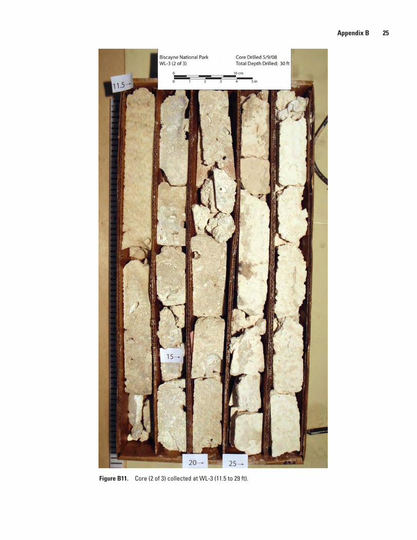
Figure B11. Core (2 of 3) collected at WL-3 (11.5 to 29 ft).

26 Holocene Core Logs and Site Statistics for Modern Patch-Reef Cores: Biscayne National Park, Florida
Figure B12. Core (3 of 3) collected at WL-3 (29 to 30 ft).

Prepared by:USGS Enterprise Publishing NetworkRaleigh Publishing Service Center3916 Sunset Ridge RoadRaleigh, NC 27607
For additional information regarding this publication, contact:Christopher D. Reich, GeologistSt. Petersburg Science Center600 Fourth Street SouthSt. Petersburg, FL 33701-4846phone: 727-803-8747 ext. 3032email: [email protected]
Or visit the St. Petersburg Science Center Web site at:http://coastal.er.usgs.gov/
This publication is available online at:http://pubs.usgs.gov/of/2009/1246/

Reich and others—H
olocene Core Logs and Site Statistics for Modern Patch-Reef Cores: B
iscayne National Park, Florida—
Open-File Report 2009–1246