hoboken terminal & yard
TRANSCRIPT

Redevelopment Study for the
of the City of Hoboken
Hoboken Terminal & Yard
Prepared for the City of Hoboken Planning Board
Phillips Preiss Shapiro Associates, Inc.
Planning & Real Estate Consultants
November 2006

i
TABLE OF CONTENTS
1 Introduction…………………………………………………………………………...….1
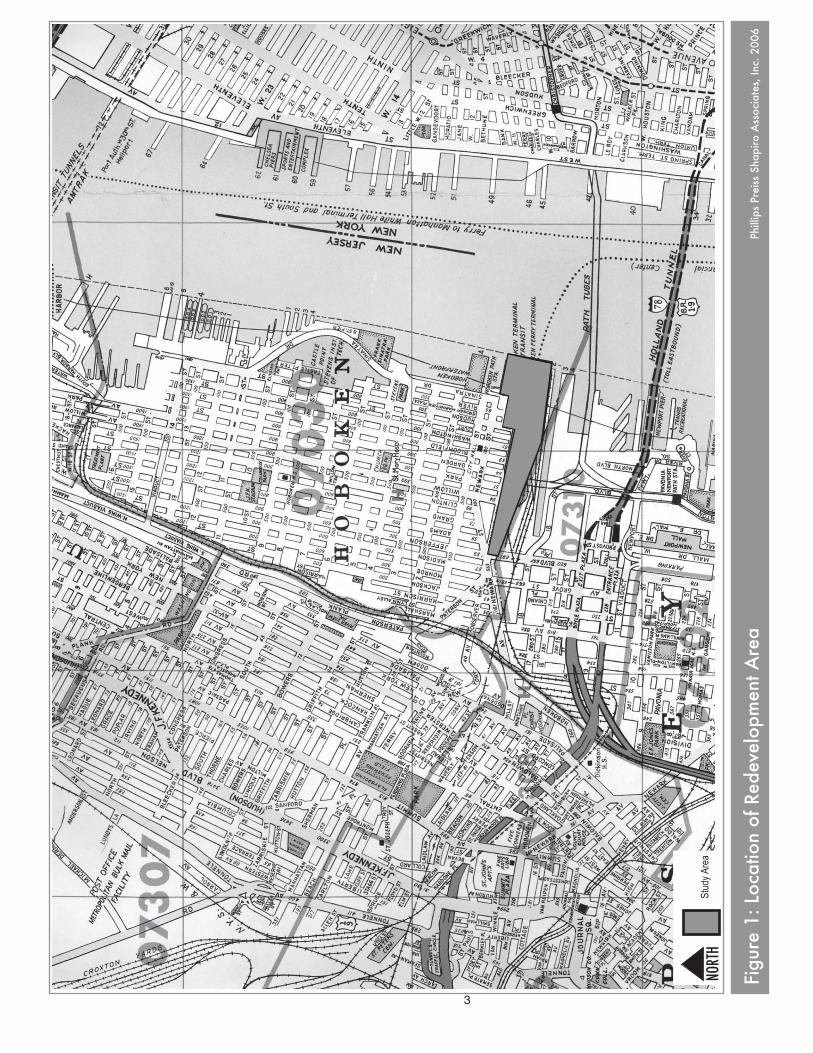
2 Description of Study Area and Locational Context………………………………..…2
3 Study Area Master Plan and Zoning Designations..………………………………...9
3.1 Master Plan…………………………………….…………………………..……9
3.2 Zoning………………………….………………………………………………..13
3.3 Redevelopment Context…….……………..………………………………….14
3.4 Municipal Actions.…………….………………………………………………..18
4 Statutory Criteria for An Area In Need of Redevelopment and Application to the Study Area…………………………………………………………...………………………..19
5 Study Area Evaluation……………………………………………………………...….22
5.1 Property Overview……………………………………………………………..22
5.2 Property Evaluation..…………….……………………………...…………….23
5.3 Consideration of a Redevelopment Area Designation for the Study
Area…………………………………………………………………………...38
6 Conclusions…………………………………………………………………………….42
7 Appendix—Photo Images…………………………………………………………….43

ii
LIST OF TABLES
Table 1: Use and Bulk Requirements of the I-1 Zone……………………….………15
Table 2: Use and Bulk Requirements of the W(H) Zone…...……………….………16
LIST OF FIGURES
Figure 1: Location of Redevelopment Study Area……………………….…………….3
Figure 2: Study Area Boundary…………………………………………………………..4
Figure 3: Study Area Master Plan Designations………..…………….……………….12
Figure 4: Study Area and Surrounding Zoning……..…………………..……………..17
Figure 5: Application of Area in Need of Redevelopment Criteria…………………..39

1
1 INTRODUCTION
The purpose of this study is to determine whether an area located in the southeastern portion of
the City of Hoboken commonly known as the “Hoboken Terminal and Yard” meets the require-
ments for designation as an “area in need of redevelopment” as established under NJSA 40A:12A.
The study was authorized by City Council of the City of Hoboken and was prepared for the Hobo-
ken Planning Board.
In the preparation of the study, we reviewed the following City records and documents:
• Official tax maps of the City of Hoboken. • Tax records for each block and lot within the study area. • Aerial photos of the study area • Recent building department and property management records for the study area (i.e.,
building/construction permits, code violation). • Recent development applications and approvals • 2004 Master Plan of the City of Hoboken. • Zoning Ordinance and Map of the City of Hoboken. • Redevelopment plan for area adjacent to the study area, known as the Public Works Mu-
nicipal Garage Site. In addition to the above, we also physically inspected the various buildings/structures and grounds
with representatives of the property owner (i.e., New Jersey Transit). This analysis included both
exterior and interior inspections of buildings. Further, we attended two meetings with representa-
tives of NJ Transit to obtain additional information on property conditions as well as the status of
capital improvement projects at the Terminal. Finally, we reviewed a number of documents and
reports prepared for New Jersey Transit over the years which provided not only a historical per-
spective of the property, but also information regarding conditions and functions of the various
components of the Terminal.
The remainder of this report is divided into six chapters. Chapter 2 provides a description of the
study area and its locational context. Chapter 3 provides an analysis of the applicable zoning,
master plan and redevelopment activities affecting the study area. Chapter 4 discusses the criteria
specified at N.J.S.A. 40A:12A-5 for an “area in need of redevelopment.” Chapter 5 applies these
criteria to the study area to determine whether or not an area in need of redevelopment determina-
tion is warranted. Chapter 6 summarizes the overall conclusions of the report. Lastly, the report
appendix provides photographic images of the Terminal property.
2
2 DESCRIPTION OF STUDY AREA AND LOCATIONAL CONTEXT
The area that is under consideration for redevelopment area designation encompasses a large
tract of land that comprises the Hoboken Terminal and Rail Yards. The study area consists of a
number of parcels owned by New Jersey Transit (NJ Transit) that are proximate to the Hudson
River in the southeastern portion of the City of Hoboken. The NJ Transit Terminal complex extends
into Jersey City, where there are an additional ±30 additional acres of rail yards and transit facili-
ties.
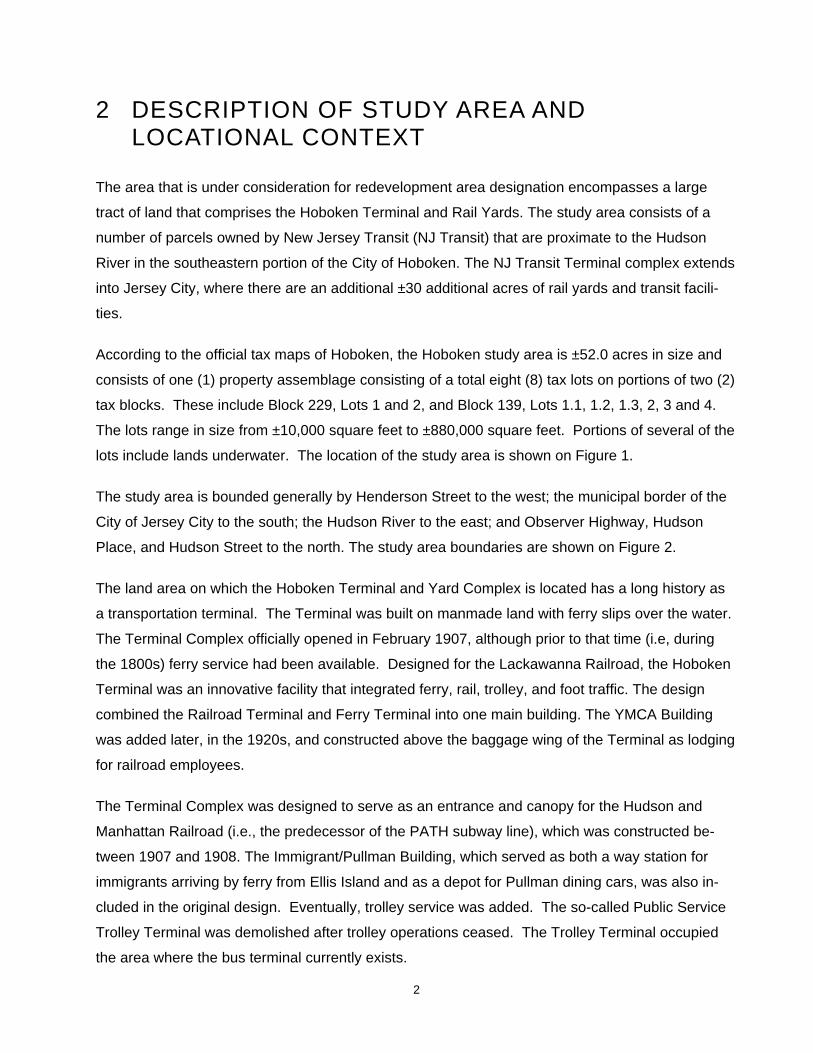
According to the official tax maps of Hoboken, the Hoboken study area is ±52.0 acres in size and
consists of one (1) property assemblage consisting of a total eight (8) tax lots on portions of two (2)
tax blocks. These include Block 229, Lots 1 and 2, and Block 139, Lots 1.1, 1.2, 1.3, 2, 3 and 4.
The lots range in size from ±10,000 square feet to ±880,000 square feet. Portions of several of the
lots include lands underwater. The location of the study area is shown on Figure 1.
The study area is bounded generally by Henderson Street to the west; the municipal border of the
City of Jersey City to the south; the Hudson River to the east; and Observer Highway, Hudson
Place, and Hudson Street to the north. The study area boundaries are shown on Figure 2.
The land area on which the Hoboken Terminal and Yard Complex is located has a long history as
a transportation terminal. The Terminal was built on manmade land with ferry slips over the water.
The Terminal Complex officially opened in February 1907, although prior to that time (i.e, during
the 1800s) ferry service had been available. Designed for the Lackawanna Railroad, the Hoboken
Terminal was an innovative facility that integrated ferry, rail, trolley, and foot traffic. The design
combined the Railroad Terminal and Ferry Terminal into one main building. The YMCA Building
was added later, in the 1920s, and constructed above the baggage wing of the Terminal as lodging
for railroad employees.
The Terminal Complex was designed to serve as an entrance and canopy for the Hudson and
Manhattan Railroad (i.e., the predecessor of the PATH subway line), which was constructed be-
tween 1907 and 1908. The Immigrant/Pullman Building, which served as both a way station for
immigrants arriving by ferry from Ellis Island and as a depot for Pullman dining cars, was also in-
cluded in the original design. Eventually, trolley service was added. The so-called Public Service
Trolley Terminal was demolished after trolley operations ceased. The Trolley Terminal occupied
the area where the bus terminal currently exists.
NORT
H
Figu
re 1
: Loc
atio
n of
Red
evel
opm
ent A
rea
Phill
ips
Prei
ss S
hapi
ro A
ssoc
iate
s, In
c. 2
006
Stud
y Ar
ea
3

4
FRANK SINATRA DRIVE
RIVER STREET
COURT STREET
WASHINGTON STREET
BLOOMFIELD STREET
PARK AVENUE
GARDEN STREET
CLINTON STREET
GRAND STREET
ADAMS STREET
JEFFERSON STREET
WILLOW AVENUE
NEW
ARK
STR
EET
OBS
ERVE
R H
IGH
WAY
1ST
STR
EET
2ND
STR
EET
HU
DSO
N P
LAC
E
Jers
ey C
ity
Hud
son
Rive
r
Blo
ck 1
39,
Lot 1
.2
Blo
ck 1
39,
Lot 1
.1
Blo
ck 1
39,
Lot 2
Blo
ck 1
39,
Lot 1
.3
Blo
ck 1
39,
Lot 4
Blo
ck 1
39,
Lot 3
Blo
ck 2
29,
Lot 1
Blo
ck 2
29,
Lot 2
0
2
50ʼ
500ʼ
NORT
H
Figu
re 2
: St
udy
Are
a Bo
unda
ryPh
illip
s Pr
eiss
Sha
piro
Ass
ocia
tes,
Inc.
200
6
Stud
y Ar
ea

5
Today, the subject property continues to function as an integrated transportation facility, where
several modes of transportation coalesce. These include:
• Seven NJ Transit commuter rail lines • The Hudson-Bergen Light Rail (HBLR) line • The Port Authority Trans-Hudson (PATH) subway line to Manhattan • Trans-Hudson ferries • Local buses.
The Hoboken Terminal serves as a transfer point for many commuters. According to the 2004 Ho-
boken Master Plan, approximately 30,000 commuters pass through Hoboken Terminal on a typical
weekday morning, with most switching modes of transit at the Terminal.
The PATH has 13 stations in its system and provides a transportation link between Hoboken and
New York City, Jersey City, Harrison, and Newark. The Hoboken Terminal PATH station is pre-
dominantly used by commuters to and from New York City, with the heaviest usage occurring on
weekday mornings and weekday evenings. The 2004 Master Plan estimated that the PATH was
utilized by approximately 8,300 weekday riders, with approximately one-third using commuter rail
and one-third walking to and from the Hoboken station.
The recently constructed Hudson-Bergen Light Rail line connects Hoboken Terminal to locations in
Jersey City and Bayonne. Two stations on the west side of Hoboken have opened at Second and
Ninth Street, as well as stops in Weekhawken, Union City and North Bergen. Bus service is also
provided from Hoboken Terminal.
Ferry transportation is provided by New York Waterway which operates service from the piers
south of the Main Terminal to three Manhattan destinations: World Financial Center, Pier 11 on
Wall Street, and West 39th Street.
The facility also comprises various buildings utilized by NJ Transit and the Port Authority of New
York & New Jersey. The Hoboken portion of the complex includes the following buildings and
structures:
• Main and Ferry Terminal Complex • YMCA Building • Bus Terminal • PATH Track and Structures Building

6
• Records Building • Engine House • Maintenance of Way (MOW) Building/ Hoboken Shop • Terminal Tower • Train Shed • Immigrant/Pullman Building
In addition, the complex includes six ferry slips, a pedestrian plaza, catenary-electrified track, and
light maintenance facilities.
Office and employee facilities are predominantly located in the Main and Ferry Terminals, YMCA
Building, and Maintenance of Way Building, with NY Waterways ticket sales and track maintainers’
facilities located in the Immigrant/Pullman Building. There are also a few commercial tenants in-
cluding food vendors, florists, newsstands, etc., on the site primarily located in the Main Terminal
area.
Several of the buildings are designated on the National Register of Historic Places, including the
Main and Ferry Terminal and Plaza, the Immigrant/Pullman Building, the YMCA Building, the Train
Shed, and the Records Building. The property is located within portions of the Southern Hoboken
and Old Main D L & W Historic Districts. The Southern Hoboken Historic District includes the area
south of Fourth Street to the Ferry Terminal. The Old Main Delaware Lackawanna & Western Rail-
road Historic District includes lands south of Observer Highway to the City line, between Hender-
son Street and the Hudson River.
Over the last ten years or so, NJ Transit has undertaken a number of improvements to the Termi-
nal property, many of which were set forth as part of an overall master plan for the complex. The
Hoboken Terminal & Yard Master Plan was prepared for NJ Transit by Beyer Blinder Belle, Archi-
tects and Planners LLP with STV Incorporated with the intent “to provide a development framework
for the future growth of the Hoboken Terminal and Yard Complex.” The most recent versions of
the Master Plan reviewed for the purposes of this report were from July 28, 1999 and March 9,
2005. In general, the Hoboken Terminal & Yard Master Plan makes recommendations for im-
provements in four areas which were considered critical to the property’s growth and development
potential:
• Transportation • Public and Commercial Space • NJ Transit Facilities

7
• Infrastructure. In regard to implementation, the updated 2005 Master Plan indicates that NJ Transit has com-
pleted Phase I of the plan, which included $120 million in improvements. The following compo-
nents of Phase I were completed in the years between 1995 and 2003:
• Ferry Terminal Roof replacement and skylight repair (1995) • Construction of new food court in Main Concourse and Concourse roof repair (1996) • Electric and sewer upgrades to meet current codes (1996) • Plaza canopy, Train Shed Steel, North Wall substructure (2003) • New Maintenance of Way/Hoboken Shop (1998) • Restoration of Main Waiting Room (1999) • HBLRT Station at Hoboken (2001) • New Rail Operation Center located at NJ Transit’s Meadows Maintenance Facility in
Kearny, NJ (2003) • Yard B construction of nine train storage tracks, train fueling, sanding, and washing facilities
(2003).
The Phase II portion is currently underway. Based on discussions with NJ Transit, the current
status of the Phase II improvements is as follows:
• Ferry Terminal substructure repairs and first floor superstructure at the Team Concourse (ongoing; near completion)
• Restoration of Ferry Service into original Ferry Slips (ongoing) • New Clock Tower construction (ongoing) • Bus Terminal Roof repairs (completed)
Plans for Phase III include the following:
• Filling in of Long Slip Canal to create an area approximately 100 feet wide by 2,000 feet long, joining the southerly 90 feet of Hoboken Yard with the balance of the yard.
• South Yard construction of new car wash, inspection pit, wheel truing and running repair fa-cilities, as well as additional platforms and train storage positions.
• Station Personnel Building/Access Road/Utilities to be constructed for NJ Transit Station and Transportation Department’s staff, currently located in the existing Rail/Ferry Terminal building complex. Includes a two-story building with parking underneath.
• Train Shed rehabilitation, with the lighting and signage modernized. Increase the level of platforms to allow for the physically challenged to access trains. The historic fabric of the train shed will be maintained and restored.
• Restoration of Record Building. • Restoration of Immigrant Building.

8
According to NJ Transit officials, future plans for Phase III are essentially on hold due to funding
constraints.
In terms of the study area’s locational context, to the immediate north and northeast is Hoboken’s
downtown commercial core. Observer Highway and Hudson Place run along the northern bound-
ary of the study area. The north side of Observer Highway is characterized by a mix of uses, in-
cluding commercial, residential, and office buildings which range in height from three to fifteen sto-
ries. The properties on the blocks immediately to the northwest of Observer Highway are primarily
characterized by relatively high-density residential use. The Neumann Leather factory complex,
located on a triangular property where Observer Highway and Newark Street connect, includes
light industrial and commercial tenants as well as artists’ studios. The character of the surrounding
area is primarily mixed-use.
Directly across from the study area along Observer Highway is a redevelopment area known as the
Public Works Municipal Garage Site. The Redevelopment Plan calls for multi-family residential use
with first floor commercial space along Observer Highway.
Across the street from the Hoboken Terminal at the eastern end of Hudson Place is the site of the
recently-approved, 25-story W Hotel, which will be built adjacent to Lackawanna Plaza. The South
Waterfront Redevelopment Area is located to the north of the Terminal in the area east of River
Street.
9
3 STUDY AREA MASTER PLAN AND ZONING DESIGNATIONS
3.1 MASTER PLAN
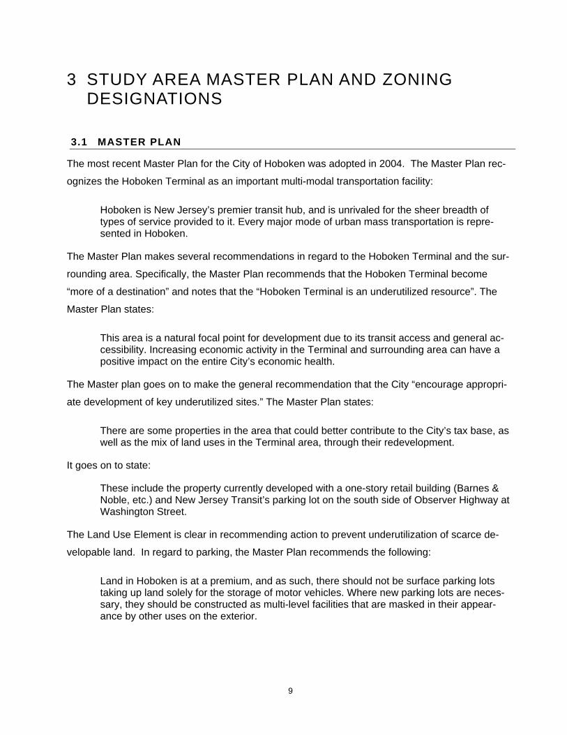
The most recent Master Plan for the City of Hoboken was adopted in 2004. The Master Plan rec-
ognizes the Hoboken Terminal as an important multi-modal transportation facility:
Hoboken is New Jersey’s premier transit hub, and is unrivaled for the sheer breadth of types of service provided to it. Every major mode of urban mass transportation is repre-sented in Hoboken.
The Master Plan makes several recommendations in regard to the Hoboken Terminal and the sur-
rounding area. Specifically, the Master Plan recommends that the Hoboken Terminal become
“more of a destination” and notes that the “Hoboken Terminal is an underutilized resource”. The
Master Plan states:
This area is a natural focal point for development due to its transit access and general ac-cessibility. Increasing economic activity in the Terminal and surrounding area can have a positive impact on the entire City’s economic health.
The Master plan goes on to make the general recommendation that the City “encourage appropri-
ate development of key underutilized sites.” The Master Plan states:
There are some properties in the area that could better contribute to the City’s tax base, as well as the mix of land uses in the Terminal area, through their redevelopment.
It goes on to state:
These include the property currently developed with a one-story retail building (Barnes & Noble, etc.) and New Jersey Transit’s parking lot on the south side of Observer Highway at Washington Street.
The Land Use Element is clear in recommending action to prevent underutilization of scarce de-
velopable land. In regard to parking, the Master Plan recommends the following:
Land in Hoboken is at a premium, and as such, there should not be surface parking lots taking up land solely for the storage of motor vehicles. Where new parking lots are neces-sary, they should be constructed as multi-level facilities that are masked in their appear-ance by other uses on the exterior.
10
The Master Plan further envisions Observer Highway as a “boulevard” with “the potential to be a
defining gateway to Hoboken.” The following are several of the Master Plan’s recommendations
for defining the gateway:
• Improve its appearance to make it a more attractive gateway to Hoboken • Improve pedestrian safety while still accommodating high volumes of traffic
Many of the recommendations for the areas surrounding the Hoboken Terminal to the north relate
to the enhancement of the area’s appearance as well as the improvement of vehicular and pedes-
trian circulation. In relation to the Terminal, the Master Plan states:
For the thousands of pedestrians who walk to and from Hoboken Terminal, the trip can be a harrowing experience.
It further states:
Any improvements made to Hoboken Terminal should include provision of better pedestrian access to all areas of the Terminal and all modes of transportation within it.
The Master Plan also envisions the Hoboken Terminal Plaza as an attractive public open space.
The Master Plan states the following:
In addition, Lackawanna Plaza, which has been taken over by New Jersey Transit as a se-cured parking lot, should be returned to its use as a public open space as soon as possible.
The Master Plan identifies the Hoboken Terminal as an important community resource that with
redevelopment can be improved and rehabilitated. However, the Master Plan does state:
Urban renewal-style ideas—such as massive buildings or rail yard development—are not supported.
The Master Plan proposes that the area encompassing the bulk of the existing I-1 Industrial zone,
including the subject properties, be placed within three new zoning districts. For the Railroad and
Ferry Terminal and its ancillary buildings and structures, the Master Plan recommends that a new
HT Hoboken Terminal zone be designated. For most of the remainder of the NJ Transit property,
the plan recommends that a RR Railroad designation cover the remainder of the property, exclu-
sive of the main Hoboken Terminal buildings to the east. The boundaries of the RR zone would run
the distance from Hudson Street on the eastern side to Henderson Street at the westernmost
boundary and include the NJ Transit property south of Observer Highway until the Jersey City bor-
der. Finally, a portion of the property, largely in the area bordered by Hudson Place and Hudson
11
Street, has been placed within a B-1 district. The zoning boundaries designated in the Master
Plan’s Land Use Plan are displayed in Figure 3.
The Master Plan describes the HT zone as follows:
The historic main buildings of the Hoboken Terminal should be preserved and reused. The use regulations for this area should remain somewhat flexible, but provide certain parame-ters to ensure that redevelopment is consistent with a general vision of uses that generate economic activity as well as provide public benefits.
In reference to the RR designation, the Master Plan states:
This area is currently zoned for industrial use, which is no longer consistent with the charac-ter of surrounding areas. Limited redevelopment should be permitted in this area.
The Plan further notes that any new buildings should be oriented to Observer Highway and that
building should not be permitted in the airspace above the railyards.
According to the recommended zoning map, the areas adjacent to the Hoboken Terminal are
zoned as B-1 Business 1 and B-3 Business 3 districts. The B-1 designation coincides with the ex-
isting CBD zone and the B-3 zone includes those properties located to the west of Hoboken Ter-
minal along Observer Highway. Permitted uses in the B-1 zone are predominantly office and retail
development and permitted uses in the B-3 zone include a mix of land uses. In the B-3 zone the
Master Plan makes the following statement:
Relatively intense development in terms of height or density should be permitted only as a part of comprehensive redevelopment that includes public benefits, such as provision of public open space, preservation of historic buildings, and/or creation of transportation im-provements.
The Master Plan recognizes that there are pressures for reuse of the area given the premium price
of land, and that redevelopment has the ability to eliminate underutilized land uses while creating
opportunities to serve a public benefit especially in regard to the Master Plan objectives.

12
II
Map 15: Land Use Plan
WEEHAWKEN
UN
ION
CIT
Y
JER
SEY
CIT
Y
JERSEY CITY
WAS
HIN
GTO
N S
TREE
T
Public Use
Map prepared by Phillips Preiss Shapiro Associates, Inc.March 2004Base map source: Wilbur Smith Associates
Feet
0 500 1,000 2,000
HU
DS
ON
RIV
ER
M A S T E R P L A NHobokenCity of
UED
R-3
W-1
IT
B-4
IT
ED
W-2
W-2
W-3
HTRR
B-2
B-1
B-3
R-2
B-4
R-2
R-2 B-4
R-1
R-1
R-1 Residential 1
R-2 Residential 2
R-3 Residential 3
W-1 Northern Waterfront
W-2 Central Waterfront
W-3 Southern Waterfront
HT Hoboken Terminal
B-1 Business 1
B-2 Business 2
B-3 Business 3
B-4 Business 4
ED Education
UED
IT Industrial Transition
RR Railroad
Underbridge EconomicDevelopment
Figure 3: Study Area Master Plan Designation Phillips Preiss Shapiro Associates, Inc. 2006
HU
DSO
N S
TREE
T
CAS
TLE
POIN
T TE
RR
ACE
FRAN
K SI
NATR
A D
RIV
E
RIVE
R S
TREE
T
CO
URT
STR
EET
WAS
HIN
GTO
N S
TREE
T
BLO
OM
FIEL
D S
TREE
T
GAR
DEN
STR
EET
PAR
K AV
ENU
E
CLIN
TON
STR
EET
GR
AND
STR
EET
ADAM
S ST
REE
T
JEFF
ERSO
N S
TREE
T
MAD
ISO
N S
TREE
T
MO
NRO
E ST
REE
T
MAR
SHAL
L ST
.
HAR
RIS
ON
STR
EET
JAC
KSO
N S
TREE
T
WIL
LOW
AVE
NU
E
NEWARK STREET
OBSERVER HIGHWAY
PATERSON AVENUE
1ST STREET
2ND STREET
3RD STREET
4TH STREET
5TH STREET
6TH STREET
8TH STREET
9TH STREET
10TH STREET
11TH STREET
12TH STREET
13TH STREET
14TH STREET
15TH STREET
16TH STREET
17TH STREET
7TH STREET
FRAN
K S
INAT
RA
DRIV
E
HUDSON PLACE
Study Area

13
3.2 ZONING
Under the current zone plan, the study area lies partially in the I-2 Industrial zoning district and par-
tially in the W (H) Waterfront Historic Subdistrict. The I-2 zone encompasses the westerly portion
of the study area south of Observer Highway extending to the Jersey City border, and the extreme
southerly portion of the Hoboken Railroad and Ferry Terminal, including the Main Piers. The W (H)
Subdistrict zone encompasses the following: the area south of Hudson Place; the area east of
Hudson Street, including the Train Shed and the Railroad and Ferry Terminal building; and the
area south of Pier A at the Hudson River and First Street.
Permitted uses in the I-2 zone include food processing and distribution; manufacturing, processing
and fabricating operations in fully enclosed buildings and pursuant to ordinance performance stan-
dards; retail businesses; public uses; parks and playgrounds. Permitted conditional uses include
manufacturing and processing operations pursuant to ordinance performance standards (with no
requirement to be in fully enclosed buildings); automotive sales, service stations, garages; and
public parking facilities and accessory uses not located on the same lot as the principal use. Ac-
cessory uses include off-street parking and loading; uses customarily incidental to principal permit-
ted uses on the same tract; signs; and wireless telecommunications antennas.
Bulk standards in the I-2 zone for non-residential uses require a minimum lot area of 5,000 square
feet, minimum lot width of 50 feet and minimum lot depth of 100 feet. The required minimum front
setback is 5 feet, the minimum rear setback is 15 feet, and the minimum side yard setbacks are 5
feet for each side. The maximum building height is 2 stories or 40 feet. Maximum lot coverage is
60% and the maximum FAR is 1.25.
Ordinance “performance standards” referenced above include the requirement for buffer areas
along street and lot lines for new industrial uses where the I-2 zone abuts residential and special
districts, and specifically indicates buffers are required along Park Avenue, Willow Avenue and
Observer Highway.
The W (H) Waterfront Historic Subdistrict is a subdistrict within the W Waterfront District that was
created to promote comprehensive mixed-use development “at varying densities, with visual and
physical access to the Hudson River waterfront and linking other commercial and residential areas
of the city to the waterfront.” The W(H) district is subject to review procedures of the Historic Com-
mission.

14
Permitted uses in the W(H) zone include a range of public and water-oriented uses, including edu-
cational, public recreation, and marina facilities and water-oriented light commercial, recreational or
passenger uses. Permitted accessory uses include uses customarily incidental to a principal use.
Permitted conditional uses include transportation terminal facilities.
Bulk standards in the W(H) zone for all permitted and conditional uses require a minimum lot area
of 40,000 square feet, minimum lot width of 400 feet and minimum lot depth of 400 feet. The
maximum lot coverage is 30 percent for principal buildings and 10 percent for accessory buildings.
The maximum building height is 2 stories or 35 feet.
The study area is adjacent to several zoning districts which permit a range of uses. The CBD Dis-
trict is a narrow band approximately three blocks wide that abuts the northeastern portion of the
property and is bounded by Observer Highway and Hudson Place to the south, Garden Street and
Bloomfield Street to the west, Fourth Street to the north, and Terminal Plaza and River Street to
the east. The extensive R-3 Residential and R-1 Residential zoning districts abut the I-2 zone to
the northwest; they are roughly bounded to the south by Newark Street and extend northward. The
lots to the north of the property along Observer Highway, located to the west of Garden Street and
south of Newark Street are also included in the I-2 zone.
The relevant zoning is described in Tables 1 and 2 and the study area and surrounding zoning is
shown in Figure 4.
3.3 REDEVELOPMENT CONTEXT
As previously stated, the Terminal and Rail Yards Complex is partially located in Hoboken and par-
tially located in Jersey City. The Jersey City portion of the rail yards is contained within the Newport
Redevelopment Area. The Newport Redevelopment Plan, dated February 1985, was amended by
the Jersey City Council on September 22, 1988. The boundaries of the Newport Redevelopment
Area are as follows: the Hoboken border to the north, Luis Munoz Marin Boulevard to the west,
Sixth Street to the south, and the Hudson River to the east. The entirety of the Jersey City Termi-
nal Rail yards is included in the Redevelopment Area. The Redevelopment Plan calls for commer-
cial, residential, and office development in the area as well as the revitalization of the Jersey City
waterfront. The rail yards per se are designated for rail-related uses.

15
Table 1: I-2 Industrial Zone Requirements
Principal Permitted Uses • Food processing and related storage and distributive activities • Manufacturing, processing, producing or fabricating operations • Retail business or service • Public buildings and uses, such as equipment garages • Wireless telecommunications towers
Permitted Conditional Uses
• Automobile service stations • Automotive sales • Automotive laundries • Bars • Commercial garages • Public Parking facilities • Railroad-related shipping terminals
Bulk Standards
• Minimum lot area 5,000 sq.ft. • Minimum lot width 50 feet • Minimum lot depth 100 feet • Minimum front yard 5 feet • Minimum side yard 5 feet • Minimum rear yard 15 feet • Maximum Lot Coverage Principal Building: 60%; Accessory Building: 10% • Maximum Building Height Principal building 2 stories/40 feet; Accessory build-
ings: 1½ stories/30 feet

16
Table 2: W (H) Subdistrict Zone Requirements
Principal Permitted Uses • Educational uses • Public recreational uses • Marina facilities, fishing piers and water-oriented light commercial, recreational or passenger
uses • Interim uses pending the completion of a development, limited to temporary uses such as
parking, concessions, commercial passenger excursion operations and special events • Essential utility and public services • Wireless telecommunications towers
Permitted Conditional Uses
• Transportation terminal facilities Bulk Standards
• Minimum lot area 40,000 sq.ft. • Minimum lot width 400 feet • Minimum lot depth 400 feet • Minimum front yard 10 feet • Minimum side yard 10 feet • Minimum rear yard 20 feet • Maximum Lot Coverage Principal Building: 30%; Accessory Building: 10% • Maximum Building Height Principal Building: 2 stories/35 feet
Source: City of Hoboken Zoning Ordinance

17
FRANK SINATRA DRIVE
RIVER STREET
COURT STREET
WASHINGTON STREET
BLOOMFIELD STREET
PARK AVENUE
GARDEN STREET
CLINTON STREET
GRAND STREET
ADAMS STREET
JEFFERSON STREET
WILLOW AVENUE
NEW
ARK
STR
EET
OBS
ERVE
R H
IGH
WAY
1ST
STR
EET
2ND
STR
EET
HU
DSO
N P
LAC
E
Jers
ey C
ity
Hud
son
Rive
r
0
2
50ʼ
500ʼ
NORT
H
Figu
re 4
: St
udy
Are
a an
d Su
rrou
ndin
g Zo
ning
Phill
ips
Prei
ss S
hapi
ro A
ssoc
iate
s, In
c. 2
006
Stud
y Ar
eaC
BD (W
) Ove
rlay
Dis
trict
Zoni
ng B
ound
ary
R-1
CBD
W (H
)
W (R
DV)
R-3
R-2
I-2
18
In Hoboken, along Observer Highway and across from the subject property, there is a designated
redevelopment area known as the Public Works Municipal Garage site. A redevelopment plan has
been approved for the area permitting up to 240 multi-family residential units. Among the key ob-
jectives of the Redevelopment Plan are the following:
• Replace the low-intensity, unattractive, municipal public works facility with a high-quality residential development that complements the neighborhood. Permit up to 240 multifamily units.
• Along Observer Highway and Willow and Park Avenues, allow up to 10,000 to 15,000 square feet of ground floor retail, community services, artists’ studios, or certain other uses, to provide convenient shopping and services to the surrounding community.
• Minimize height and building bulk through ground floor setbacks, upper-story setbacks, and variations in building massing;
• Encourage creative design and architecture, particularly a pedestrian-friendly and visually-interesting street-level presence through ground-floor treatments, architectural detail, and ground-floor entrances.
Principal permitted uses include multi-family residential units on all levels of buildings, inclusive of a
full range of dwelling unit sizes from studios to three-bedrooms and facilities associated with resi-
dential buildings. Secondary permitted uses on first level of buildings include retail and business
services, restaurants and cafes, artist work studios, clubs community centers and meeting rooms.
The South Waterfront Redevelopment Plan was adopted on November 17, 1989. The South Wa-
terfront Redevelopment Area incorporates the three blocks located between Hudson, River, First,
and Fourth Streets, as well as the public lands to the east. An office development known as the
“Waterfront Corporate Center” is located on the southernmost parcel of the Redevelopment Area.
The development includes approximately one million square feet of office space. A residential
building is located at 333 River Street, with ground level commercial space, and the aforemen-
tioned W Hotel is also proposed in the South Waterfront Redevelopment Area.
3.4 MUNICIPAL ACTIONS
Municipal records were requested from the City regarding development applications, development
approvals and zoning variances, the issuance of zoning, building and construction permits, and
property management and building code violations for the properties in the study area. According
to the City of Hoboken, there are no approvals, permits or code violations on file for the referenced
block and lots.
19
4 STATUTORY CRITERIA FOR AN AREA IN NEED OF REDEVELOPMENT AND APPLICATION TO THE STUDY AREA
The laws governing redevelopment by municipalities in New Jersey are set forth in the Local Re-
development and Housing Law, which is codified at N.J.S.A. 40A:12A et seq. This statute grants
the governing body of the municipality the power to authorize the Planning Board to conduct a
study to determine whether an area is in need of redevelopment; to make such a determination
following the completion of the study; and to adopt a redevelopment plan for the designated area.
Such area may be determined to be in need of redevelopment only if, after an investigation by the
Planning Board and a public hearing for which notice has been given, it is found to meet one or
more of the following conditions.
a. The generality of buildings are substandard, unsafe, unsanitary, dilapidated or obsolescent,
or possess any of such characteristics, or are so lacking in light, air or space, as to be con-
ducive to unwholesome working or living conditions.
b. The discontinuance of the use of buildings previously used for commercial, manufacturing
or industrial purposes; the abandonment of such buildings; or the same being allowed to fall
into so great a state of disrepair as to be untenantable.
c. Land that is owned by the municipality, the county, a local housing authority, redevelopment
agency or redevelopment entity, or unimproved vacant land that has remained so for a pe-
riod of ten years prior to adoption of the resolution, and that by reason of its location, re-
moteness, lack of means of access to developed sections or portions of the municipality, or
topography, or nature of the soil, is not likely to be developed through the instrumentality of
private capital.
d. Areas with buildings or improvements which, by reason of dilapidation, obsolescence, over-
crowding, faulty arrangement or design, lack of ventilation, light and sanitary facilities, ex-
cessive land coverage, deleterious land use or obsolete layout, or any combination of these
or other factors, are detrimental to the safety, health, morals or welfare of the community.
e. A growing lack or total lack of proper utilization of areas caused by the condition of the title,
diverse ownership of the real property therein or other conditions, resulting in a stagnant or

20
not fully productive condition of land potentially useful and valuable for contributing to and
serving the public health, safety and welfare.
f. Areas, in excess of five contiguous acres, whereon buildings or other improvements have
been destroyed, consumed by fire, demolished or altered by the action of storm, fire, cy-
clone, tornado, earthquake or other casualty in such a way that the aggregate assessed
value of the areas has been materially depreciated.
g. In any municipality in which an enterprise zone has been designated pursuant to the “New
Jersey Enterprise Zones Act,” P.L. 1983, c.303 (C.52:27H-60 et seq.) the execution of the
actions prescribed in that act for the adoption by the municipality and approval by the New
Jersey Urban Enterprise Zone Authority of the zone development plan for the area of the
enterprise zone shall be considered sufficient for the determination that the area is in need
of redevelopment pursuant to sections 5 and 6 of P.L. 1992, c.79 (C.40A:12A-5 and 40A-
12A-6) for the purpose of granting tax exemptions within the enterprise zone district pursu-
ant to the provisions of P.L. 1991, c.431 (C.40A:20-1 et seq.) or the adoption of a tax
abatement and exemption ordinance pursuant to the provisions of P.L. 1991, c.441
(C.40A:21-1 et seq.). The municipality shall not utilize any other redevelopment powers
within the urban enterprise zone unless the municipal governing body and planning board
have also taken the actions and fulfilled the requirements prescribed in P.L. 1992, c.79 (C.
40A:12A-1 et al.) for determining that the area is in need of redevelopment or an area in
need of rehabilitation and the municipal governing body has adopted a redevelopment plan
ordinance including the area of the enterprise zone.
h. The designation of the delineated area is consistent with smart growth planning principles
adopted pursuant to law or regulation.
In evaluating the above-referenced statutory criteria, it should be recognized that a redevelopment
area determination cannot be made until all of the properties within the study area are evaluated
against all of the conditions cited above, such that an overall conclusion can be made with respect
to the area. For purposes of this particular “area in need of redevelopment” investigation, it should
be emphasized that the eight-block study area is unique in that it does not consist of individual
properties with separate and/or disparate uses. Rather, the study area consists of a transportation
hub that, despite numerous buildings and functions, effectively operates as an integrated whole.
Importantly, the property is under the common ownership of New Jersey Transit, and there is no
apparent rationale as to how the various block and lot boundaries have been delineated on the tax

21
maps. Moreover, a portion of the overall complex is physically located in Jersey City, and the mu-
nicipal boundary line which separates Hoboken and Jersey City runs diagonally across numerous
rows of track, such that the large majority of tracks which serve the Terminal Complex are partially
located in Hoboken and partially located in Jersey City. Furthermore, as noted, the Jersey City
portion of the rail yards is already located within a designated redevelopment area.
For all of these reasons, the only logical way to evaluate the study area and apply the statutory cri-
teria is to consider the property as a whole and ultimately render under a determination as to
whether one or more of the conditions are prevalent. Such an analysis is provided in the ensuing
chapter.
22
5 STUDY AREA EVALUATION
5.1 PROPERTY OVERVIEW
The study area consists of the Hoboken portion of the NJ Transit Terminal property. The Hoboken
Terminal is improved with nine buildings, in addition to the train shed, rail yards, platforms, ferry
slips, parking lots, and PATH train entrances and tracks. The study area has a long history as a
transportation center, but it has also undergone significant changes since its original construction.
In addition to ownership changes, structures have been demolished, modes of transportation have
been eliminated, certain improvements have been made, facilities have been relocated, etc. As a
result, there are portions of the overall complex that function effectively and others that are dys-
functional, underutilized, and/or in need of repair. Further, a number of improvements have re-
cently been made on the Jersey City portion of the property that affect the Hoboken sections of the
Terminal site.
The following provides an evaluation of the study area and considers whether it meets the statutory
criteria for an “area in need of redevelopment”. The analysis was based on surveys of use, condi-
tions and occupancy, as well as physical inspection of the exteriors and interior of existing build-
ings/structures and a reconnaissance of the entire rail yard complex. In addition, a number of rele-
vant documents were reviewed and considered as part of the investigation, including the following:
• Redevelopment plan for area encompassing the Jersey City portion of the rail-yards, known as the “Newport Redevelopment Plan”, prepared for the City of Jersey City, dated February 1985 and amended July 12, 1988
• Hoboken Terminal Investigation, Plaza Investigation, prepared by Meuser Rutledge, dated November 30, 1995
• Hoboken Terminal & Yard Master Plan, prepared by Beyer Blinder Belle and STV, Inc., dated July 28, 1999
• Hoboken Ferry Terminal: Historical Background Report, prepared by Beyer Blinder Belle, dated October 2002
• NJ Transit Request for Proposals RFP No. 03-165, dated June 25, 2003 • Solicitation for Master Developer for NJ Transit’s Hoboken Terminal & Yard, dated May 13,
2004 • Hoboken Terminal & Yard Master Plan Revision, prepared by Beyer Blinder Belle and STV,
Inc., dated March 9, 2005
23
Finally, two meetings were held with representatives of NJ Transit to update the status of these
reports as well as ongoing improvements at the Terminal.
5.2 PROPERTY EVALUATION
Block 139, Lots 1.1, 1.2, 1.3, 2, 3 and 4; Block 229, Lots 1 and 2
Location: 1 Hudson Place
Owner: New Jersey Transit
Size: 52.37 acres
Current Use: Transportation Terminal
Description: The area under evaluation consists of one transportation terminal property, with sev-
eral types of improvements, including rail yards, subway infrastructure, ferry piers, a bus terminal,
railroad tracks and platforms, ferry slips, and several additional buildings and improvements. The
buildings and improvements include:
• Main and Ferry Terminal and Plaza • YMCA Building • Bus Terminal • PATH Track and Structures Building • Records Building • Engine House and parking lot • Maintenance of Way Building and parking lot • Terminal Tower • Train Shed • Rail Yards • Immigrant/Pullman Building • HBLR station.
The property consists of eight tax lots on two tax blocks under common ownership. It is irregular in
shape and occupies the southeastern most corner of the City of Hoboken along the Hudson River.
Roughly thirty percent of the acreage is underwater. The property is ±3,960 feet in length and its
width varies from ±990 feet on the east side to ±160 feet on the west side. The property has
±2,358 feet of frontage on Observer Highway, ±202 feet of frontage on Hudson Street, and ±600
feet of frontage on Hudson Place.
24
The NJ Transit rail yard facility spans the Hoboken and Jersey City municipal border. The descrip-
tion herein emphasizes the Hoboken portion of the facility; however, the Hoboken rail yards directly
connect to the Jersey City rail yards, and therefore function as an integrated unit.
Since its construction in 1907, there have been numerous alterations and modifications that have
changed the function of the Terminal over time. According to the Historical Background Report,
several important spaces have been altered from their original form. Although many of the struc-
tures have historic character, they are nevertheless in deteriorated physical condition and/or in
need of repair.
One of the primary objectives of the NJ Transit Hoboken Terminal & Yard Master Plan is the pres-
ervation of its most significant buildings and structures. In fact, the recent renovation of the Main
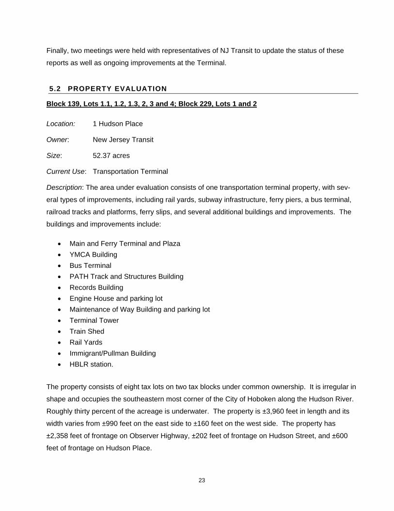
Terminal waiting room is the result of master planning efforts and capital improvement expendi-
tures by NJ Transit, which included renovation of the wooden benches, skylights, and bronze
chandeliers. The waiting room is now in good, if not stellar condition. The Main and Ferry Termi-
nal is recognized by the National Register as historically significant and worthy of preservation.
Renovated Conditions of the Main Terminal Waiting Room.
Our investigation did reveal, however, that numerous other portions of the complex are in need of
repair and/or significant renovation. Further, the overall layout of the Hoboken Terminal as an inte-
grated complex is less than optimal. The Terminal is the nexus of several modes of transportation,
yet transfers from one mode of transport to another and pedestrian flows are indirect and espe-
cially congested during peak hours, with primarily one corridor available for access from Hoboken.
Beginning with the Main and Ferry Terminals and proceeding along the property’s westerly bound-
ary, our study findings are as follows. First, the former Ferry Terminal is now largely underutilized.
All ferry service currently operates from the ferry slips to the south of the Terminal building and

25
Pullman building, not from the historic Ferry Terminal. The gradual demise of ferry service dates
back to the 1930s. By 1937, three new trans-Hudson rail crossings connecting New Jersey to New
York had been completed, making the subway the preferable mode of transportation. Many of the
spaces designed for ferry use have subsequently fallen into disrepair and/or disuse after decades
of neglect. In the years since 1967 when ferry service effectively ceased at the Ferry Terminal, the
mammoth second floor of the Ferry Terminal, known as the Ferry Concourse, has been essentially
vacant, as it is today (and no longer available for public use as it was intended).
Repairs are currently being made to the first-floor ferry slips and substructures (i.e., in order reiniti-
ate service from the building) as the ferries used today are called “one level” ferries and board from
the bow or stern at ground level. It is important to note that the Ferry Terminal is essentially lo-
cated over the Hudson River on riparian land. At this time, NJ Transit is only renovating the first
floor of the Ferry Terminal for future ferry use. There are currently no appropriations committed to
the second floor Ferry Terminal’s renovation.
A small portion of the Ferry Terminal, which was formerly the restaurant located to the south of the
Ferry Concourse, is used as NJ Transit offices. In order to reach the offices, NJ Transit employees
must traverse the open and expansive Ferry Concourse. The Historical Background Report docu-
ments the conditions:
No evidence of the large ferry waiting room remains, except for the ghost of the perimeter walls.
Other conditions within the Concourse include open storage of materials, peeling paint, and pre-
dominantly blackened skylights. The grand room is now unoccupied and largely obsolete.

26
Interior conditions of the Ferry Concourse.
Located on the western side of the Ferry Concourse is a lengthy and narrow double-loaded corri-
dor which provides access to a number of NJ Transit offices (e.g., NJ Transit police and mechani-
cal department), as well as a training area. Some of the offices are functional and others are not.
According to NJ Transit, the roof is in deteriorated condition and presently leaks.
Interior conditions of the Long Hallway in the Ferry Terminal Building.
Interior conditions of former Lunch Room and view of Ferry Slips.

27
Over the years, the overall amount of retail space in the complex has been reduced to little more
than the original square footage total from 1907. The decrease is mainly due to the closing of the
large second floor restaurant that is now used as NJ Transit office space. Further, the original first-
floor Lunch Room is currently used for purposes of storage. The Historical Background Report
summarizes the conditions of the Terminal Complex in the following manner:
Large portions of the Terminal are unused or underutilized. The amount of space in the Terminal accessible to the public has decreased dramatically from the original 1907 total. The public no longer uses any portion of the second floor, including the monumental Ferry Concourse space.
The exterior façade of the Ferry Buildings is also in need of repair in several locations. For exam-
ple, the copper cladding outside the former restaurant section of the Terminal is in need of re-
placement. Meanwhile, the main wooden pier, located directly to the south of the Terminal build-
ing, is in very poor repair and currently fenced off in recognition of its unsafe condition. Despite
incredible views of the Manhattan skyline, the pier has fallen into complete disuse.
Southern exterior façade of Ferry Terminal and abandoned Pier.
Ceiling of Stepped Concourse.
28
The stepped concourse which connects the YMCA Building to the Ferry Concourse is also largely
obsolete and in deteriorated condition. The area has not been maintained and the corridor now
serves as a connector to the NJ Transit offices as well as the A/C plant and storage located on the
second story of the YMCA Building. The stepped concourse is an example of a grand corridor that
has fallen into disrepair and disuse.
The YMCA Building, which is physically attached to the Ferry Terminal, was originally constructed
in 1922 by adding upper floors to the previously existing Terminal baggage building. The YMCA
was utilized by train crews as a temporary residence, with eating facilities on the second floor and
sleeping quarters on the upper floors. Although portions of it are still used by conductors during
layovers, large portions of the building are now unoccupied. Rail operations previously conducted
here have been relocated to the Rail Operations Center in the Meadowlands.
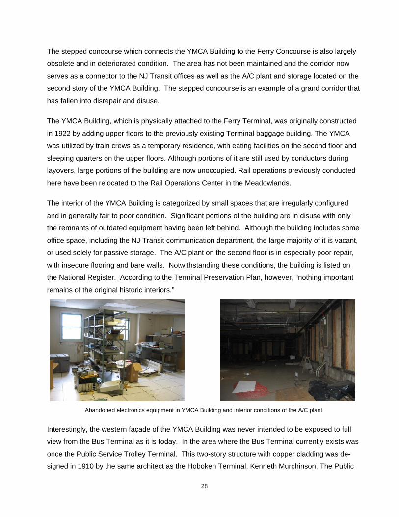
The interior of the YMCA Building is categorized by small spaces that are irregularly configured
and in generally fair to poor condition. Significant portions of the building are in disuse with only
the remnants of outdated equipment having been left behind. Although the building includes some
office space, including the NJ Transit communication department, the large majority of it is vacant,
or used solely for passive storage. The A/C plant on the second floor is in especially poor repair,
with insecure flooring and bare walls. Notwithstanding these conditions, the building is listed on
the National Register. According to the Terminal Preservation Plan, however, “nothing important
remains of the original historic interiors.”
Abandoned electronics equipment in YMCA Building and interior conditions of the A/C plant.
Interestingly, the western façade of the YMCA Building was never intended to be exposed to full
view from the Bus Terminal as it is today. In the area where the Bus Terminal currently exists was
once the Public Service Trolley Terminal. This two-story structure with copper cladding was de-
signed in 1910 by the same architect as the Hoboken Terminal, Kenneth Murchinson. The Public

29
Service Trolley Terminal was removed in the early 1950s. According to the Historical Background
Report, “the only evidence of the Trolley structure consists of the east loop trolley steel tracks and
the reused steel columns located in the contemporary bus shelter.”
The elimination of the trolley as a primary mode of transportation directly impacted the circulation
of the Terminal complex, a situation which till this day has not been resolved. The former Public
Service Trolley Terminal had a direct ramp connecting to the Ferry Terminal which effectively facili-
tated pedestrian circulation. The current Bus Terminal configuration, meanwhile, forces commut-
ers to cross over several lanes of bus traffic in order to get to the Main Terminal or PATH trains.
The Hoboken Terminal & Yard Master Plan explains:
The demolition of many of the original two- and four-story structures along Hudson Place and Observer Highway, which served both as a buffer zone between the railyards and the town, has resulted in an excess of underused open space and inhospitable paved surfaces.
It goes on to state:
Until the end of 1949 the Public Service Trolley building formed the southern edge of Hud-son Place, delineating the street edge and providing a transition zone between pedestrian and rail traffic. With the demolition of this structure, the replacement of bus for trolley ser-vice in 1949, and the elimination of ferry service in the 1960’s, the urban design of the area began to unravel.
The Bus Terminal effectively consists of an open shed with six lanes for buses, and no benches for
waiting passengers. The location of the Bus Terminal and bus lanes block the pedestrian entrance
to the Terminal from Observer Highway and Hudson Place. Although a walkway for pedestrians
(with yellow markings) was recently delineated between the Bus Terminal and the Main Terminal, it
crosses over all six lanes of bus traffic.
Buses enter the Terminal Shed from Observer Highway or Hudson Street and travel past the PATH
Track and Structures building. The bus lanes are long, essentially spanning the entire length of the
Main Terminal’s entrance. The design impedes the circulation flow to the Terminal and makes the
Bus Terminal itself function inefficiently and unsafely. The Terminal Master Plan states and makes
the following comments regarding the facility:
Never adequately planned for the service it handles today, the Bus Terminal has many op-erational problems. Among these are:
• Inadequate queuing areas, weather protected passenger waiting space, and poor lighting

30
• Excessive amounts of paved vehicular areas with unsafe pedestrian crossing conditions
• Poorly located PATH entry structures • Lack of passenger amenities (benches, trash receptacles, retail space) • Poorly planned bus turn around and layover area • Existing PATH Hoboken Shops building, which will be demolished, constricts en-
try from Observer Highway
Birds-eye view of Bus Terminal and exposed western façade of YMCA Building from the Bus Terminal.
The Ferry Terminal Plaza is located to the west of the Ferry Terminal building at the terminus of
Hudson Place. It is currently used as a parking area, which was not the original intent. Under the
original Terminal configuration, the Ferry Plaza served as a public square and the “gateway” to the
Terminal Complex. Today, the area is underutilized and inaccessible to the public. This affects
circulation within the remainder of the Terminal complex, as the Plaza no longer serves as a transi-
tion zone for pedestrians entering the Terminal area. The Plaza was also built above the Hudson
River and over time the substructure has deteriorated, producing periodic sinkholes which under-
mine the cobblestone paving. According to NJ Transit, the Plaza is in need of significant substruc-
tural repairs.

31
Ferry Terminal Plaza utilized for parking and western exterior façade of Ferry Building.
The PATH Track and Structures Building is two-and-a-half stories high and of brick construction. It
is located on the highly visible corner of Hudson Place and Hudson Street, behind a parking lot
which fronts Hudson Place immediately west of the Bus Terminal. In order to access the building
from the Terminal, employees must walk across lanes of bus traffic. The building, which is in
largely deteriorated condition, is highly visible from the adjacent commercial district on the northern
side of Hudson Place and along Hudson Street.
The majority of the building’s windows are covered with plywood or filled in with concrete, thereby
keeping natural light from illuminating the interior space. According to NJ Transit, the overwhelming
majority of the space is no longer used, other than for an electrical substation and a seldom-used
equipment and supplies access point to the PATH tracks below. These functions are estimated by
NJ Transit to represent no more than about 5 percent of the space of the structure. There is also a
small parking lot located just north of the PATH Track and Structures Building.
Interior conditions and eastern façade of the PATH Track and Structures Building.
The Records Building is a three-story brick structure located at the terminus of Hudson Street, with
frontage on Observer Highway. In the early twentieth century, it was designed and built to accom-

32
modate records storage requirements. Notwithstanding its historic status, the building is currently
vacant and in deteriorated condition. Its windows are covered or filled such that no light penetrates
through to the interior space. The building is currently utilized for storage of unused items by NJ
Transit. There are also no sidewalks along the northern side of the building fronting Observer
Highway.
Interior and exterior conditions of the Records Building.
Included in this span along Observer Highway is the Engine House, which was designed so that
trains could travel directly from the rail yard into and through the building for repairs. Currently,
there are few repairs completed at this location as NJ Transit built the Yard B facility several years
ago to perform train maintenance. In addition, operations that once took place in the Engine
House have been relocated to either Yard B (within the Jersey City portion of the Complex) or the
Meadowlands Maintenance Complex (MMC). According to NJ Transit, the building is no longer
essential to the operation of the rail yards. The Hoboken Terminal and Yard Master Plan, dated

33
March 2005, recommended that the Engine House be demolished. According to NJ Transit, once
the Engine House is demolished, the ancillary rails leading to and from the facility will no longer be
needed as part of the overall rail operation.
Engine House exterior and interior.
Located just east of the Engine House is an employee parking lot that currently accommodates a
number of construction trailers. The parking lot fronts on Observer Highway. The Hoboken Master
Plan identified this site as a potential redevelopment site. The Master Plan states:
There are some properties in the area that could better contribute to the City’s tax base, as well as the mix of land uses in the Terminal area, through their redevelopment. These in-clude the property currently developed with a one-story retail building (Barnes & Noble, etc.) and New Jersey Transit’s parking lot on the south side of Observer Highway at Wash-ington Street.
At the northwestern corner of the study area is the Maintenance of Way building, located at 369
Observer Highway. The building was constructed in 1998 and contains offices on the second floor
and engineering and maintenance workshop facilities on the first floor. The building is fully utilized.
Another maintenance and employee facility, known as Yard B, was recently constructed within the
Jersey City portion of the Terminal Complex. This new facility includes additional tracks for stor-
age, as well as fueling, sanding, and train washing facilities. A large new Employee Welfare Build-
ing was also included in the expansion and contains modern facilities for NJ Transit employees.
The Yard B facility is largely removed from Observer Highway and the core of Hoboken. The con-
struction of this facility has rendered several areas within the Hoboken Terminal Complex obsolete
(i.e., as many of the repair and maintenance activities that were formerly completed in Hoboken
are now performed in Jersey City).

34
The Hoboken facility is also no longer the command and control center for NJ Transit trains, as it
had been at one time. In fact, many of the rail operations and controls have been relocated from
Hoboken to the Meadows Maintenance Complex, including the Dispatch Center, Traction Power
Center and Signals Center. This is indicative of the changing nature of the Hoboken Terminal from
a command and control center to a transportation hub, with command and control operations oc-
curring off-site.
The bulk of the active Terminal rail yards are located to the south of the buildings and parking lots
which border Observer Highway. There are, however, several tracks proximate to Observer High-
way that have limited use and function; specifically, the three northernmost tracks of the so-called
Days Yard. They are currently used for train storage. According to NJ Transit, these tracks have
been replaced within Yard B in Jersey City. NJ Transit has further indicated that they are no longer
critical to the operation of the Yard as a whole.
The remainder of the Yard, however, is essential to NJ Transit’s Terminal operations. The yards
which are located in Hoboken are the Days Yard Tracks and portions of the main tracks which ter-
minate at the Train Shed. The majority of the rail yard land area is physically located in Jersey
City, however, and includes Yard B, the majority of the expansive Pullman Yards and the Hill Yard.
Mainline tracks and rail yards.
The Terminal Tower structure is located to the east of the Days Yard in the middle of the main
tracks. This structure is situated within Hoboken proper. It comprises four stories and has a bird‘s
eye view of the tracks to the north, west and south. It was formerly used as an operations tower to
direct trains. Today this function is performed in the Meadowlands Rail Operations Center. The
crew signal maintenance and equipment is currently housed within the Terminal Tower, with the
top story utilized as an office. It has one stairway which serves as the only entrance and exit to the
interior space.

35
Former track configuration map in Terminal Tower and view of exterior.
The Train Shed is located to the east of the Terminal Tower, and it serves as the terminus of the
railroad tracks in Hoboken. When first designed, the so-called “Bush Train Shed” was considered
an innovation. Unlike the conventional arched-roofed train sheds, the Bush Train Shed provided
ventilation above the engines, while also allowing for natural light penetration.1 Although the Train
Shed is listed on the National Register, the structure has been altered from its original design.
Most significantly, the shed no longer allows light to penetrate through to the platforms. According
to the Preservation Plan, its architectural integrity has been challenged by modifications out of step
with the original design.
Views of Platform Tracks and Train Shed.
The tracks located under the Train Shed and adjacent to the platforms are referred to as the Plat-
form Tracks. The Platform Tracks run adjacent to the constructed raised platforms used by pas-
sengers to board the NJ Transit passenger cars. Currently, the platforms are not ADA compliant,
notwithstanding the fact that they are heavily used by New Jersey commuters. Further, according
1 Hoboken. Patricia Florio Colrick, 1999. Acadia Publishing.

36
to the March 2005 Hoboken Terminal & Yard Master Plan, the existing station tracks are “often too
short for the lengths of trainsets planned for the future”, and will need to be modified. It should also
be noted that the existing train operations room, located at the end of the platform tracks, is unable
to comfortably accommodate NJ Transit staff during peak use.
The Immigrant/Pullman Building is located to the south of the Train Shed and the Hoboken Main
Terminal. It was formerly used to process immigrants arriving in New Jersey from Ellis Island. It is
currently in a state of disrepair, but for the easternmost portion which has been renovated and is
presently used as a waiting area and corridor for passengers in route to the NJ Waterways ferry
pier located to the south of the building. This section also contains small tables and convenience
food services. From this area, the deteriorated condition of the wooden piers and the dissolution of
portions of southern façade of the Ferry Terminal are clearly visible.
The majority of the Immigrant/Pullman Building is in poor condition. The second level of the build-
ing is no longer used and the first floor is primarily used as a locker room and eating area for NJ
Transit employees. The eating area has broken windows which are covered with cardboard, plastic
and duct tape. The entire western façade of the building is not weatherproofed and was recently
covered with a temporary plastic covering.
Interior conditions of the employee break area in the Immigrant/Pullman Building.
37
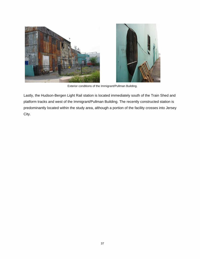
Exterior conditions of the Immigrant/Pullman Building.
Lastly, the Hudson-Bergen Light Rail station is located immediately south of the Train Shed and
platform tracks and west of the Immigrant/Pullman Building. The recently constructed station is
predominantly located within the study area, although a portion of the facility crosses into Jersey
City.

38
5.3 CONSIDERATION OF A REDEVELOPMENT AREA DESIGNATION FOR THE STUDY AREA
While the Main Terminal Waiting Room has recently been renovated and efforts are currently un-
derway to redevelop the ferry slips and reinitiate service, there are significant portions of the study
area that clearly meet one or more of the “area in need of redevelopment” criteria; and more spe-
cifically, the “b,” “d” and “e” criteria. This is graphically depicted in Figure 5.
In summary, significant portions of the Main and Ferry Terminal complex are now largely obsolete
or in dilapidated condition. The gargantuan second-story Ferry Concourse, which accounts for a
significant portion of the total floor area of the Ferry Terminal, is unused and unproductive. The
interior office space within this structure is poorly designed and/or underutilized and the roof is de-
teriorated. The exterior façade of the Ferry Building is also in need of repair, as is the wooden pier
to the south of the Terminal Building. Improvements to the ferry slips will solely affect the ground
level of the Ferry Terminal.
The Terminal Plaza area exhibits unsafe conditions, with periodic sinkholes and an unsound sub-
structure. It is also underutilized and inaccessible to the public. The Terminal complex as a whole
has an awkward pedestrian circulation design due to modifications from the original layout, as well
as the relocation, elimination, and addition of modes of transit over the years. Additional and/or
better passenger interconnections between trains, buses, PATH trains, ferries, and light-rail are
needed to improve pedestrian flow and better serve the traveling public.
Large portions of the YMCA building are now vacant or storing largely obsolete equipment. Rail
operations which were formerly conducted here have since been relocated to the Meadowlands
Maintenance Complex. The floor plan is awkwardly laid out, with small interior spaces along narrow
corridors that do not comport with modern office standards that call for larger floor plates and more
flexible design alternatives.
The Bus Terminal structure and circulation are very poorly designed, and the overall layout is
largely obsolete for purposes of safe and efficient public transport. The Bus Terminal itself is es-
sentially a shed created from the pilings of the former Public Service Trolley Building. Passengers
must also cross over bus lanes to enter the Main Terminal, posing a clear public safety concern.

Figu
re 5
: App
licat
ion
of A
rea
in N
eed
of R
edev
elop
men
t Crit
eria
Phill
ips
Prei
ss S
hapi
ro A
ssoc
iate
s, In
c. 2
006
New
port
Red
evel
opm
ent A
rea
- Je
rsey
City
Nor
th D
ays
Yard
Stor
age
Trac
ks
e
Trai
n Sh
ed &
Plat
form
Tra
cks
d
Mai
n Te
rmin
al
dIm
mig
rant
Bui
ldin
g
d
Pier
s
d, e
Rec
ords
Bui
ldin
g
b, d
, e
PATH
Tra
ck/
Stru
ctur
es B
uild
ing
b, d
, e
Bus
Term
inal
d
YMC
AB
uild
ing
d, e
Ferr
yTe
rmin
al
d, e
Ferr
y Te
rmin
al P
laza
d, e
Engi
ne H
ouse
Park
ing
Lot
e
Engi
ne H
ouse
& A
ncill
ary
Rai
l
d, e
City
of H
obok
enCi
ty o
f Jer
sey
City
39

40
The Immigrant/Pullman Building is another example of a building in dilapidated condition. It is not
weatherproofed, with temporary plastic covering the building façade and temporary cardboard in-
sulation on windows in the employee break room. The second story is entirely unutilized, and the
rear of the building is covered with rusted metal cladding that appears to be structurally unstable.
The PATH Track and Structures building is unoccupied, largely dilapidated, and clearly underuti-
lized given its location at a primary intersection in Hoboken. The Records building, situated along
Observer Highway in a prominent location close to downtown Hoboken, is similarly vacant, largely
obsolete and in poor repair.
The rail platforms, meanwhile, are neither ADA-compliant nor of optimum length to accommodate
future service. Further, large portions of the property which were previously designed for produc-
tive use have become empty storage facilities, underutilized structures/parking lots, and/or obso-
lete spaces.
Due to the recent construction of Yard B within the Jersey City portion of the complex, the Engine
House has become a largely obsolete facility. The facility is no longer essential to rail yard opera-
tions, and NJ Transit has plans to demolish the structure. The parking lots adjacent to the Engine
House are also largely underutilized and unproductive within an area that is envisioned by the Ho-
boken Master Plan as a key redevelopment site that can better contribute to the City’s tax base.
In light of Hoboken’s walkable, dense urban character, these obsolete and/or underutilized railroad
facilities along Observer Highway and Hudson Place have a pronounced negative impact on the
commercial core of Hoboken. The land uses which comprise the downtown abruptly stop at the
Terminal, where industrial facades, dilapidated structures, and parking lots predominate in an oth-
erwise mixed-use district. Several of the dilapidated structures along Observer Highway, especially
the Records Building, Engine House, and PATH Track Structures Buildings severely conflict with
the vitality of the mixed-use core of Hoboken and represent a stagnant and unproductive condition
of property that is potentially valuable in contributing to the economic vitality and overall welfare of
the City.
As noted, the Yard B facility and the Meadowlands Maintenance Complex have replaced several
facilities that were previously located within the Hoboken portion of the Terminal, thereby rendering
select areas within the complex largely obsolete and/or less than fully productive. NJ Transit has
stated that the three northernmost tracks that comprise the Days Yard Tracks are no longer
needed, as they have been replaced by the new storage tracks in Yard B. Given their proximity to

41
other transit facilities along Observer Highway that are vacant and/or obsolete, these lands have
the potential to more appropriately contribute to the overall welfare as envisioned in the 2004 Ho-
boken Master Plan.
In fact, the 2004 Hoboken Master Plan supports the redevelopment and adaptive reuse of the Ho-
boken Terminal area into a facility that better serves the City and expands commercial opportuni-
ties. The Master Plan cites it as a natural focal point for development, and recommends making
“Hoboken Terminal into more of a destination for residents and visitors.” The Master Plan refers to
the Hoboken Terminal as an underutilized resource, and further recommends reducing pedestrian
conflicts with vehicular traffic in the Hoboken Terminal area; improving connections between the
Terminal and the rest of the City; and improving pedestrian access to and within the Terminal
proper.
Notwithstanding the fact that portions of the Hoboken Terminal and Yard are in good condition and
fully productive (i.e., Main Terminal waiting room, Yard B, Maintenance of Way Building, HBLR sta-
tion), much of the complex is comprised of facilities which exhibit obsolete layouts and/or deterio-
rated conditions which are detrimental to the health, safety and public welfare. Additionally, when
considering that the study area (i.e., entire Hoboken Terminal and yard) is under common owner-
ship (i.e., NJ Transit) and operates as an integrated whole despite its multiple functions, and un-
derstanding further that the Jersey City portion of the facility has been previously designated as an
area in need of redevelopment and that the various facilities and tracks cross City lines without
discretion, there is a sound and legitimate basis to declare the study area in its entirety as an “area
in need of redevelopment.”
For all the reasons expressly set forth in this report, we conclude that the study area qualifies as
“an area in need of redevelopment” in accordance with N.J.S.A. 40:12A.

42
6 CONCLUSIONS
The foregoing study was prepared on behalf of the City of Hoboken Planning Board to determine
whether an area commonly referred to as the Hoboken Terminal and Yard qualifies as “an area in
need of redevelopment,“ in accordance with N.J.S.A. 40:12A-5.
Based on the foregoing analysis, the referenced area meets the statutory criteria for designation as
“an area in need of redevelopment.”

43
7 APPENDIX—PHOTO IMAGES
7.1 STUDY AREA
7.2 MAIN TERMINAL WAITING ROOM
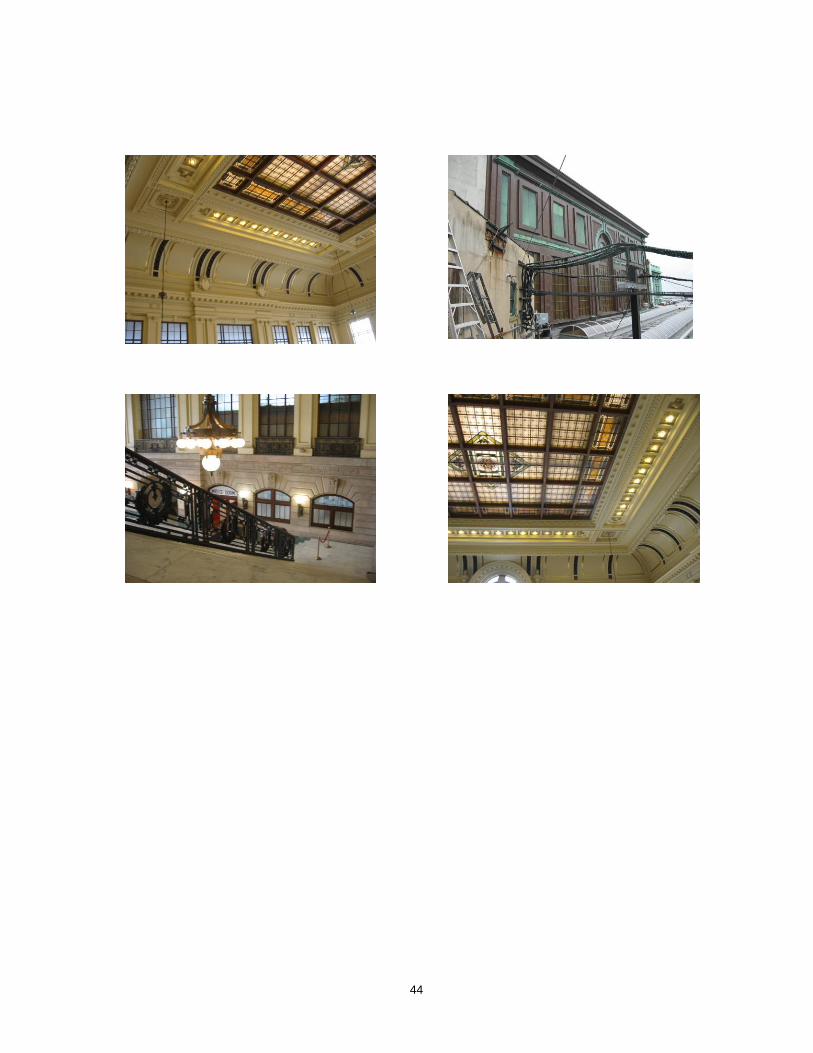
44

45
7.3 FERRY TERMINAL & PLAZA

46

47

48

49
7.4 YMCA BUILDING
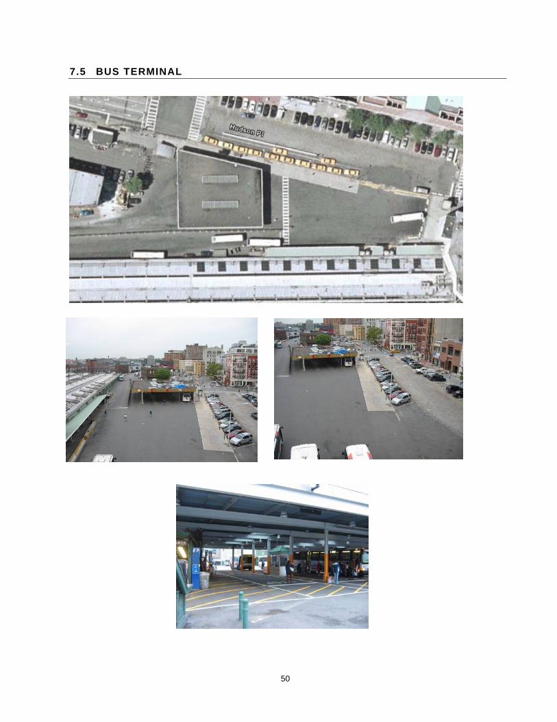
50
7.5 BUS TERMINAL

51
7.6 PATH TRACK AND STRUCTURES BUILDING
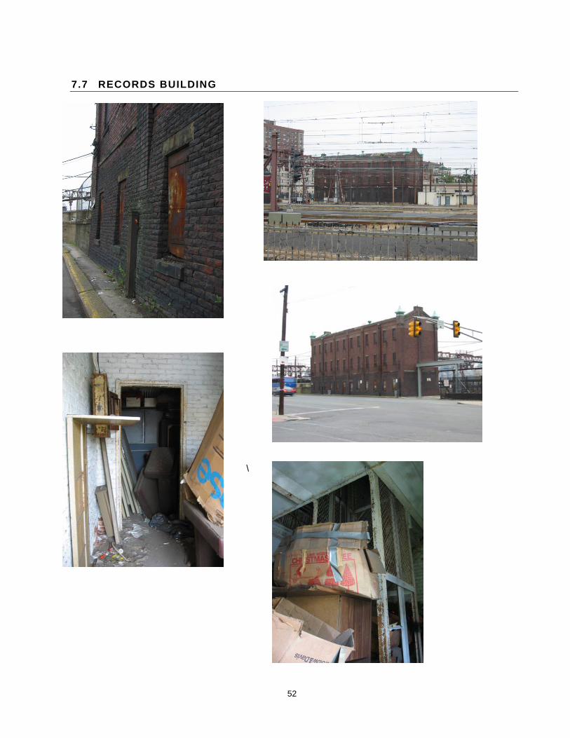
52
7.7 RECORDS BUILDING
\

53
7.8 ENGINE HOUSE
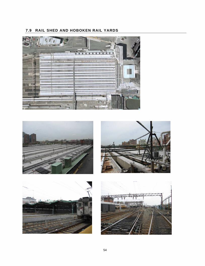
54
7.9 RAIL SHED AND HOBOKEN RAIL YARDS
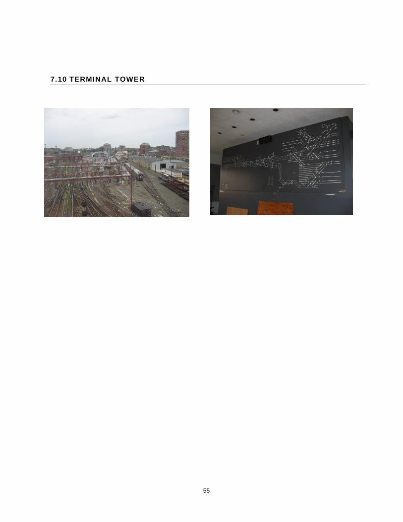
55
7.10 TERMINAL TOWER

56
7.11 IMMIGRANT/PULLMAN BUILDING AND FERRY SLIP
.