historic mcleod plantation james island - … · to military encounters during the revolutionary...
TRANSCRIPT

FfO1 lIIE HISlORIC CHARIESlON FOUNDATION lO WILLIS J KEITH JAMES IS SC - 12 APRIL 19~I HISTORIC S~Y
FOR McLEOD PLANTATION
JAMES ISLAND sa
1 ~ bullbull
McLEOD PLANTATION
Suoznitted By
Fi11~ore G Wi1son Me~dors Construction Corpor~tion
Apr i 1 1 6 1 993
---------
t
OWNERSHIP CHAIN
_-_ shy
OWNERSHIP CHAIN McLEOD PLANTATION
Thornton-Morden map South Carolina Historical Society Charleston SC James P Hayes James and Related Sea Islands (Charleston Walker Evans amp Cogswell Company 1978) 7
Royal Grants 0002shy005-0038-02 South Carolina Archives
Charleston Deeds 0007-001-00S0shy00435-00 1737-1739 South Carolina Department of Archives and History Columbia SC
) shy
The Thornton-Morden map of 1695 shows the property on which the McLeod Plantation would be situated as belonging to Morris The Morris on the map is probably Morgan Morris who came to James Island from Virginia in December 1671
In 1703 Captain Davis received a grant from the Lords Proprietors for a plot of land on James island containing 617 acres by
The land was bounded generally
N Wappoo Creek and the Ashley River
the marsh of
S Partly by New Town Creek and partly by the land laid out to Richard Simpson
W Lands of M Shabishere
E The marsh of New Town Creek
In 1706 Captain Davis and his wife Ann sold their land to William Wilkins William Wilkins sold the land several times and repurchased it each time until 1741
1
Charleston Deeds Vol V page 323shy324 1740-1741 South Carolina Archives
Will Book Vol 7 page 431 South Carolina Archives
Will Book Vol 12 page 439 South Carolina Departmentof Archives and History Columbia SC
On April 14 1741 William Wilkins and his wife Sarah sold 617 acres of land to Samuel Perronneau The land was bounded generally by
N Wappo Creek and the marsh of ---tne -Ashley- RiVer- - _
S Partly on New Town Creek and partly by lands formerly of Richard Simpson deceased now of Gregory Sisson
W Lands formerly of Robert Gibbs deceased and heretofore in the possession of Mr Shabishere deceased and now of Beltelhazer Lambright
E The marsh of New Town Creek and the Ashley River
In a will dated February 26 1750 Samuel Perronneau bequeathed his Plantation on James Island to be worked until his oldest child was twenty-one years of age or was married The plantation was then to be sold and the money divided equally among his children The plat of the property left in the bequest was recorded February 5 1756
In a will dated February 201767 Samuel Perronneau Jr left his estate to his sisters Sarah Perronneau (later Sarah Scott) and Elizabeth Perronneau (later Elizabeth Lightwood) According to the will the property was left to his sisters because his wife had eloped with another man The executors of the estate were Henry Perronneau John Parker and Arthur Perronneau The will was provedOctober 12 1768
Elizabeth Perronneau sister to Samuel Perronneau Jr married Edward LightwoodII on January 1 1770
A map dated 1771 shows 250 acres of what appears to be part of the original 617 sold to Samuel Perronneau as belonging to Edward Lightwood
2
1787 Plan of the siege of Charlestown in South Carolina south Carolina Historical Society Charleston SC
Will of Edward Lightwood II Will Bookvolume27page 689 1793-1800 South Carolina Department of Archives and History Columbia South Carolina
Will of Elizabeth Lightwood Will Book volume 37 1826shy1818 page 250 South Carolina Department of Archives and History Columbia South Carolina
Deed Book volume Y 9 pp 221-223 RMC Charleston south Carolina Plat Book C page 63 RMC Charleston South Carolina
Another map dated 1787 and showing liThe Plan of the Siege of Charlestown shows the Lightwood property in the same location as the 1771 map and also shows the location of a main house and outbuildings in the area of present day-McLeod J ---- --_ __-shy
Edward and Elizabeth Lightwoods daughter Sarah married William McKenzie Parker II in 1796
In 1798 Edward Lightwood II died and in his will dated April 2 1788 he left his estate equally to his wife and their issue
Elizabeth Lightwood continued to operate the plantation with her son-in-law William Parker until her death
Elizabeth Perronneau Lightwoods will was proved on July 7 1826
In 1829 the property on James Island was purchased from the estate of Elizabeth Lightwood by her son-in-law William McKenzie Parker II The plantation had increased to 769 12 acres The land was bounded generally by
N Wappo Creekmiddot E The Ashley River S New Town Creek and the lands of
Buckner Mrs S Rodgers and Anne McCant
W Lands of B F Minott
3
Deed Book 12 page 340 R M C Charleston South Carolina
Will Book Vol 50 page 374 RMC Charleston South Carolina
Deed Book L-17 page 440 Plat Book D page 2 2 R M C Charleston South Carolina
Plat Book B page12 R M C Charleston South Carolina
On January 20 1851 William McKenzie Parker andEdward Parker sold to William W McLeod 914 12 acres of land and 779 acres of marsh on James Island The land ~was_ boundedgenerally PY L
N Wappo Creek E The Ashley River S New Town Creek W Lands of John B F Minott and
Mrs M Taylor and Sarah Rodgers
In a Will dated August 27 1861 William W McLeod bequeathed that the Plantation upon which I now reside shall remain as property of some member of the family namely son William Wallace McLeod II The will stated that the plantation was purchased by William W McLeod from William McKenzie Parker and Edward Parker The Executors were Joseph T Dill and Richard H Colcok
William W McLeod died in the service during the war of 186165 His 1861 will was not probated because of the war The heirs including William Wallace McLeod II Anna Mikell Frampton and Regina L McLeod applied to the South Carolina State court of Equity in 1866 to settle the estate and partition the land The Court stated that the partition plan was not practical and the heirs were enjoined from selling any of the property On February 25 1879 the issue was finally settled with the heirs settling the partition problem among themselves
William Wallace McLeod II received 27792 Acres and the main house bounded generally by
N Wappo Creek E The Ashley River S The lands of Anna W Frampton W The lands of H W Kinsman
4
Plat Book B page 85 R M C Charleston South Carolina
Plat Book B page 85 R M C Charleston South Carolina
Deed Book K-20 page 372 R M C Charleston South Carolina
Real Property Record T M 424shy00-00-03 County Tax Office Charleston South Carolina
Will File 851-32 Charleston County Probate Court Records Office North Charleston South Carolina
Will File 83ES10shy00030 Charleston County Probate Court Records Office North Charleston South Carolina
Anna Mikell Frampton received 17845 acres of land bounded generally by
N E
The lands of The AshleyIsland Cut
Regina L McLeod river and James
S JJamesIs1and cutmiddot and the l~Uidsshy
W of Regina L The lands of
McLeod Regina L McLeod
Regina L McLeod received 57323 acres of land bounded generally by
N The lands of W W McLeod and Anna M Frampton
E The lands of W W McLeod and Anna Frampton and partly by James Island Cut
S The lands of Solomon Legare and H W Kinsman
W
In a will dated January 221887 William Wallace McLeod II left a life time interest in the tract of land totaling449 acres on James Island known as the McLeod Plantation to his wife Hattie Ellis McLeod and upon her death the land was to go to their children
The three children of William Wallace McLeod and Hattie Ellis McLeod that were left an interest in the McLeod Plantation were William Ellis Mcleod Rose McLeod Barnwell and Wilhelmina W McLeod
Wilhelmina McLeod died on January 29 1952 and left Rose Barnwell and William E McLeod a life interest in her interest in the property Upon their deaths Wilhelminas interest was to be distributed among several organizations
Rose Barnwell died on December 19 1982 She left her interest in the McLeod Plantation to several organizations and charitable institutions
5
Will File- 90ES10shy00134 Charleston County Probate Court Records Office North Charleston South Carolina
On January 19 1990 William Ellis McLeod _ died In his will dated July 11 1985 he left his interest in the McLeod Plantation which included the property upon which his house was situated to the Historic Charleston Foundation 51
-Meeting Street CharlestonSouth J
Carolina 29401
6
-- _-shy
HISTORIC SUMMARY
HISTORIC SUMMARY OF THB MeLBOD PLANTATION
This brief history of the property on James Island South Carolina
known as the McLeod Plantation will attempt to show the importance of the property to the history of the Sea Islands of South Carolina and particularly James Island The plantation has been part of the island since the late seventeenth century and has participated in many aspects of the islandls history from agriculture development to military encounters during the Revolutionary and Civil wars to
emancipation and reconstruction to the changing patterns of race relations and suburbanization of the rural landscape in the
twentieth century
This essay while not ignoring all these facets looks more to the part the property played in telling the story of James Islandls African-American residents The story of James Island is in truth largely a story of black colonists and white planters
slavery emancipation and freedmen as citizens of their community The McLeod Plantation while a property owned by whites since
before 1695 is the only extant complex on James Island which can help tell this story through its particular history
Early History of the Area
The first permanent settlement in South Carolina occurred in 167D
at Charles Town at a site on the Ashley River north of James Island In 1671 the Council of the Province ordered a town to be
established on James Island The town was settled somewhere on New Town Creek By the mid 1670 1 s James Island had scattered settlements located along the navigable waterways The 1695
Thornton-Morden map showed plantations on the stono River aud Wappoo Creek at the site of the present day McLeod property
People who received grants for lands on the island also received lots in Charles Town Many planters were absentee land owners who
engaged in agricultural activities on the island but lived in town
1
This practice of dual residency which survived for aver two hundred years was influenced by a fear of country fever
(malaria) as well as a desire for the social amenities of town 1
)
The eighteenth and nineteenth century history of James Island and its people is a history of agriculture and slavery During the colonial period and well into the twentieth century most of the
popUlation of James Island was black Almost all of South
Carolinas black colonists were slaves and the majority of them were agricultural workers whose homelands in West Africa were the Windward coast (Ghana and Sierra Leone) the Senegal-Gambia region and the Congo-Angola region 2 In 1737 a new arrival from switzerland Samuel Dyssli stated that the colony IIlooks more like
3a negro country than like a country settled by white people Population figures from 1720 show that in st Andrews Parish of which James Island was a part there were 210 white taxpayers and 2493 slaves
African slaves brought their own customs and language to the sea islands Gullah the language of the black Sea Islanders is a language which combines West African languages with English Because of the isolation many of these customs and the Gullah language survived on the islands into the twentieth century such customs as the dirt yard which was swept often to prevent the growth of grass can still be observed today West Africans also brought-skills to James Island Knowledge of cattle raising and rice cultivation were valuable assets to slave owners Skills as boatmen were also highly prized as water was the main means of transportation for people and goods to and from the island Occupation as a boatman afforded a maximum of independence to island slaves 5
During the early colonial period the ra1s1ng of livestock for beef and pork was the main activity on the islands This meat was salted and shipped to the West Indies In 1692 one James Island plantation was appraised as having 134 head of cattle and one negra
man
2
Historian Peter Wood stated that the term cowboy was used during
this period to refer to the men who were stationed at cow pens to tend the cattle Hany of these cowboys were black slaves who as J - ------------ -
early as the 1670s were given much responsibility and freedom to 7develop the herds for absentee land owners The islands lent
themselves to open grazing of cattle something the Europeans had little practice in Their African slaves however especially those from the Gambia River region were expert horsemen and cattle herders Herding and dairy processing practices on the Sea Islands followed the practices brought by the African slaves who oversaw the herds 8 Slavery and agriculture on the island thus dated from the late seventeenth century
The major cash crop from the early colonial period was indigo
valued by England as a source of blue dye South Carolina was the major source of the plant and it was widely grown on the Sea Islands In 1748 England put a six pence per pound bounty on indigo thus increasing its profitability Cultivation of the crop was largely developed ~y African slaves and they supplied the
labor to make it profitable There is evidence that the McLeod property saw the CUltivation of indigo but it is undetermined at what period and under whos ownership this occurred
HcLeod and the Colonial Period
Little middotis known of the Mcleod property from this early colonial period but it was owned and apparently worked by 1695 The Thornton-Morden map of that year shows the property on which the McLeod Plantation would be situated as belonging to ~orris The Morris on the map is probably Morgan Morris who came to James
Island from Virginia in December 1671 10
Six hundred seventeen acres of land in the area owned by Hr Morris
was laid out by James Witter in 1701 and became a Royal Grant to Captain David Davis in 1703 11 In 1706 Captain Davis sold this
land to William Wilkins 12 William Wilkins sold the land several times and repurchased it each time until 1741 It appears that
3
J-
Davis and Wilkins may have engaged more in land speculation than in agriculture In 1741 Wilkins sold the property to Samuel
Perronneau The parcel still contained 617 acres and the description of the boundaries was the same as Captain Davis 1703 Royal Grant 13 The property appears to have remained intact through thirty-eight years of transactions
Samuel Perronneau is the first person whose actual cultivation of the property can be documented Perronneau owned land on James and Edisto Islands and appears to have cultivated his land on both He actively bought and sold slaves for labor in these agricultural endeavors perronneau also had real estate holdings in the city of Charleston and it is doubtful that he ever lived at the James Island plantation l In his will dated February 21 1753 he left instructions that his executors were to purchase out of his estate IIsuch a number of slaves as to enable them to settle plant and occupy my plantation and lands at James Island1S It is unknown if Samuel Perronneau I s widow or his son ever lived on the James
Island property but the slaves that worked it surely did
Samuel Perronneaus daughter Elizabeth married Edward Lightwood II on January 1 1770 li Part of the James Island property thus passed into the Lightwood family A map dated 1771 shows 250 acres of what appears to be part of the original 617 sold to Samuel Perronneau as belonging to Edward Lightwood 17 Another map dated 1787 and showing liThe Plan of the Siege of Charlestown shows
the Lightwood property in the same location as the 1771 map and also shows the location of a main house and outbuildings in the area of present day McLeod The map further shows that the house was approached from the south by a tree lined allee that extended on northward to Wappoo Creek There is another road which runs
east-west (in the same area as the present east-west allee) from the house towards the stono River This configuration is much like the pattern which existed on the property during the nineteenth
century McLeod occupation and the foundation of the Lightwood house is near the present plantation house 1S
4
The 1790 Federal Census showed that Bdward Lightwood owned fiftyshythree slaves who lived in St Andrew Parish and as the Lightwoods seem to have owned no other agricultural property in the parish but the James Islaild -site these slaves -most likely- resided - at-and worked on this property 19 Slavery was nothing new to Bdward
Lightwood He owned ships and was involved in the slave trade with Thomas Everleigh from 1762 until 1774 as an owner in the firm of
Lightwood and Ever1eigh 20
A Sea Island cotton Plantation and Slavery
By the 1790 I S another cash crop had become popular on the Sea Islands This crop was long staple Sea Island cotton First grown as a cash crop in 1791 the long staple cotton brought a price up to six times as high as upland cotton The crop brought prosperity
to the white land owners of James Island It also made land on the Sea Islands the most valuable in the state Raising the crop however was labor intensive and this increased the need for slave
labor 21
The Lightwoods cultivated long staple cotton with slave labor but apparently were less successful than some of their neighbors By the time the McLeods acquired the plantation it had gained a reputation of being unprofitable to farm It was called a pickpocket place because previous owners had lost money cultivating it The problem was drainage a problem that would be addressed by the McLeods 22
Edward and ~lizabeth Light~ood I s daughter Sarah married William McKenzie Parker II in 1796 The Parker family was from the Hayes Plantation on Goose Creek The Parkers were part of the ea~ly
settlement in South Carolina which centered around Goose Creek in the 1670 t s 23 These Goose Creek Men were notorious for their opposition to the Lord Proprietors and for their dealings in the
Indian and African slave trade William McKenzie Parker II was active in this nefarious enterprise and owned several vessels that traded out of Charleston
5
In 1829 after the death of Elizabeth Perronneau Lightwood the property on James Island was purchased from her estate by her sonshyin-law William McKenzie Parker 1124 The Parker family worked the
bull -_ - - 4 bull J _- ~ --shyplantation w~th slave labor grow~ng predom~nately long staple cotton until 1851 In that year they sold it to William Wallace McLeod The property had increased to 914 12 acres of land and 779 acres of marsh 25 The McLeods built the extant plantation house between 1854 and 1856 the LightwoodParker house being
either already destroyed or pulled down to make room for the new
structure
William Wallace McLeod came from a family which traced its roots in the low country to the early 1700s He had been a long staple cotton planter on Edisto Island before acquiring the James Island plantation and continued this endeavor at the new property The demand for labor to cultivate the cotton was high and the McLeods owned as many as orie hundred slaves The 1860 South Carolina census shows seventy-four black slaves and twenty-three slave cabins associated with the property26 It is possible that more
-than the remaining six cabins once were situated close by the main house Some family recollections place a second row of cabins on the south side of the eas~-west oak allee and other c~bins may have existed between the existing cabins and the kitchen house Other cabins could have been situated remote from the house and closer to the fields Five of the six extant slave cabins and the dairy and kitchen buildings are believed to date from the LightwoodParker period
The McLeod property was typical of antebellum low country and James Island plantations It was situated on a river and originally had two water accesses one on the Stono River and a second on Wapp~o
Creek This water access allowed convenient movement of plantation production to market and movement of supplies to the plantation The Wappoo landing appears to have been the main avenue of ingress and egress to the plantation The trip to Charleston from McLeod was still commonly accomplished by water at the end of the nineteenth century
6
The layout of the property with its oak allees and slave street close to the main house was common to larger low country plantations The landing at Wappoo Creek had a general store which originally catered -to-the ~whitemiddotmiddotpopulation -of -the island but after the Civil War was frequented by freedmen usually buying on credit up to the limit of their weekly pay The plantation owner often kept the newly freed workers indebted to him through the use of credit at the store The McLeod landing store survived well into the twentieth century
William Wallace McLeod took the pickpocket place and made it more profitable by installing drainage systems in the fields around the house This not only improved cotton production but also made the property healthier for its human inhabitants 27 Later after the turn of the twentieth century tile drainage systems were
installed 28
The Civil War and Reconstruction
The Mcleod Plantation was like all of James Island inextricably caught up in the Civil War In 1861 William Wallace McLeod joined the Charleston Light Dragoons and died in 1864 while in the service of the Confederacy The occupation of Folly Island located seaward of James Island by Federal forces in 1861 forced the
evacuation of many planters and their families from James Island William McLeod moved his family from James Island to Greenwood
South Carolina where he felt they would be safer McLeod then left a slave Steven Forrest in charge of the plantation and the other slaves 30
James Island and the McLeod Plantation saw much action during the war In order to protect the approaches to Charleston the Confederates constructed defenses across James Island Battery Means was constructed on the McLeod Plantation as pa~t of this
defense system J1 The plantation house was used as late as April 30 1863 as the headquarters for General Grist I s Brigade and remained a Confederate unit headquarters commissary and field
7
hospital until the island fell to the Federals After Union occupation of the Island the house was used as a Federal officers quarters and a hospital The 55th Massachusetts Volunteers a black unit with white officdrswas stationed~ ~at~--the --Mcreoa~---
property The main house was used as unit headquarters and as a field hospital In 1930 a retired surgeon with the 55th Dr Bert J Wilder returned to the plantation and informed Mr W B McLeod that the drawing room had been his operating room 37 The grave yard on the property is said to hold the remains of war casualties who died at the property when it was used as a hospital 33
Most structures on James Island were destroyed during the war William B McLeod stated that there were only six houses standing on the island atthe wars end One of these six was the McLeod house3(
After the war the McLeod property continued to figure prominently in the history of the island and its black inhabitants The house was used as the headquarters of the Freedmens Bureau 35 At one time there were said to have been hundreds of freed slaves camped in the field to the south of the main house The location put the newly freed slaves close to the source of food and help provided by the Freedmens Bureau Archeological artifacts have been found which date to this freedmens encampment 3 The house also served as home to several black families and as headquarters for a white school teacher who came south after the war to educate the freed
slaves of James Island The teacher died of malaria in the 1870s and is reported to be buried in the slave cemetery on the property
This cemetery located on the property near the Wappoo Creek landing was a traditional burial ground for the slaves and freedmen of McLeod and also for the black inhabitants of surrounding properties Island blacks used the site from at least the Lightwood period until the 1930s
With emancipation and the end of the war the labor system on the islands had to be altered The work force was now free but still
8
dependant on white landowners for work and wages The Freedmens Bureau helped to negotiate work contracts between groups of wageshy
earning freedmen and planters On the islands however the freedmen preferred to work individually for wages and soon rejected the group contract system The group system too closely resembled the work gangs of slavery
By 1870 an alternative system had been developed Under this
system known as tenant farming the landowners rented land to black farmers for a cash payment This system unlike share cropping allowed the black farmer to earn cash for his crop and control what and how he planted On the Sea Islands unlike most of the state and the south in general tenancy was preferred to share cropping because it gave black farmers freedom from white supervision and the hope of accumulating capital to purchase their own land 37 Some were successful and during the 1880s about ten percent of the island was owned by black farmers 38 By 1900 in Charleston County 428 of all black farmers owned their land as
opposed to 224 statewide 39
The Mcleod Plantation after its time associated with the freedmen came back into the hands of its previous owners In 1879 William Wallace McLeod II gained possession of the land on which the main house and outbuildings were situated to
After its return to the McLeods the plantation followed a course similar to the rest of the islands farms The land was farmed by paid black labor and tenants Long staple cotton was the crop of choice and the HcLeods were successful at its CUltivation for some time The slave cabins on the property were rented to freed slaves who worked the land
The McLeods were active in the James Island Agricultural Society which was formed in 1871 The society was organized to coordinate
labor policy between planters and freedmen The society also worked to improve long staple cotton in the face of competition from improving cheaper short staple upland cotton The society
9
often met at the McLeod house and its social events and picnics were generally held at the plantation 41
The property J was also associated ~with the white -military organizations which grew up after the war to counter the military organizations of the freedmen The blacks of James Island formed the Hunter Volunteers a militia unit under the command of Captain Isaac Ferguson The HaskelJ Rifles was a corresponding white
calvary unit which kept an armory and drill field on Fort Johnson Road The drill and tilt contest and associated parties organized by the Haskel Rifles were generally held at McLeod The largest wi th over four hundred people in attendance was held on the property in April 1883(2
The Twentieth Century
Sea Island cotton continued to prove profitable until about 1917 In that year the boll weevil which had spread eastward from the Rio Grand since 1892 reached James Island Within a few years recalled Herbert Ravenel Sass Sea Island cotton vanished as though some evil magician had waved his wand and conjured it out of existence It U
The McLeod Plantation at that time under its last McLeod owner William Ellis McLeod planted its last cotton crop in 1918 The boll weevil had killed long staple cotton Like the rest of the
Sea Island planters McLeod turned to crops less susceptible to the boll weevil Truck farming was growing on the island The small farms owned by black farmers were especially suited to this undertaking With the demise of cotton these small truck farms coexisted with large commercially managed truck farms run by whites and worked by black wage laborers At McLeod the land was planted in potatoes asparagus and cucumbers Dairy cattle were also raised but none of these endeavors proved as proiitable as cotton had been
In addition to the boll weevil another factor was affecting the
10
course of agriculture The Black population of James Island was declining Blacks were leaving the rural areas for urban centers and many were traveling north seeking better wages and living
conditions This migration caused a labor shortage ) In -1919--St- John Alison Lawton of Lawton Plantation on James Island a cousin of William McLeod wrote in a letter
My plantation has been used by me years past as a cotton
and truck plantation Owing to the boll weevil the cotton will be abandoned and because of the shortage of negro labor we are moving out of the truck business U
In 1940 William E McLeod decided to give up farming altogether He continued to rent land to black tenants and other white farmers The old slave cabins were occupied by black tenants and migrant farm workers until 1990 when Mr McLeod died just short of his 105th birthday
The changes that the McLeod Plantation underwent in the last half of the nineteenth and the first half of the twentieth century are typical of the Sea Islands in general Writing in 1944 W E McLeod stated that
Up until 1914 James Island was a real country community of approximately one hundred and fifty white people and four thousand negroes now the white population has been doubled many times by an influx of suburban residents while a considerable number of the colored population have moved away
The McLeod property now reduced to about fifty acres is the o~ly extant antebellum plantation complex left on the island It represents the history of James Island and its people both European and African from the founding of the area ih the late 1600s to the present day It is a living record of agriculture development slavery war emancipation race relations and 6uburbanization This record should not be lost
11
EHDlfOTES
___ _ - __------__ - _bullshy
1 Preservation Consultants Inc Survey Report James and Johns Island Historical and Architectural Inventory Prepared for the South Carolina Department of Archives and History the City of Charleston and Charleston County (Summer 1989)8
2 Peter Wood Black Majority Negroes in Colonial South Carolina From 1670 through the Stono Rebellion (New York W W Norton amp Company 1975) 43-49
3 Ibid 132
4 Ibid 146
5 Preservation Consultants Inc Survey Report James and Johns Island 14
6 Wood Black Maiority 30-33
7 Ibid 28-31
8 Ibid 30-31
9 Preservation Consultants Inc Survey Report James and Johns Island 11
10 James P Hayes James and Related Sea Islands (CharlestonWalker Evans amp Cogswell Company 1978) 7 Michael O Hartley The Ashley River A Survey of Seventeenth Century Sites (Columbia South Carolina Institute of Archeology and AnthropologyUniversity of South Carolina 1984) 46-47
11 Royal Grants 0002-005-0038-02 South Carolina Department of Archive~ and History Columbia South Carolina
12 Charleston Deeds 0007-001-00S0-00435-00 1737-1739 South Carolina Department of Archives and History Columbia South Carolina
13 Charleston Deeds 0007-001-00VO-00323-00 1740-1741 South Carolina Department of Archives and History Columbia South Carolina
14 Charleston Deeds 10007-001 Transactions for Perronneau passim South Carolina Department of Archives and HistoryColumbia South Carolina
15 Will of Samuel Perronneau Will Book volume 7 1752-1756 page 435 south Carolina Department of Archives and History Columbia south Carolina
12
16 JaegerPyburn Inc Conservation and Development Plan McLeod Plantation James Island South Carolina Prepared for the Historic Charleston Foundation (October 1991) 6
17 Ibid 5 - ~-- ~- - --~-------
18 1787 Plan of the Siege of Charlestown in South Carolina South Carolina Historical Society Charleston South Carolina
19 JaegerPyburn Conservation and Development Plan McLeod 3
20 Ibid
21 Preservation Consultants Inc Survey Reportlaquo James and Johns Island 18
22 William B McLeod Planter Last Survivor an interview by Thomas R Waring Charleston News ampCourier 25 October 1981 2B
23 Parker Family History South Carolina Historical Society Charleston South Carolina
24 Deed Book volume Y 9 pp 221-223 RMC Charleston South Carolinai Plat Book C page 63 RMC Charleston South Carolina
25 Deed Book 12 page 340 RMC Charleston South Carolina
26 South Carolina Census Slave Inhabitants in Saint Andrew in the County of Charleston June 1860 Schedule 2 by C H Rivers Assistant Marshal
27 William E McLeod Planter Last Survivor
28 JaegerPyburn Inc Conservation and Development Plan McLeod 60
29 Preservation Consultants Inc Survey Report James and Johns Island 23
30 Creighton Frampton an interview interviewer unknown 19 January 1993 McLeod Plantation file Historic Charleston Foundation Charleston South Carolina
31 Preservation Consultants Inc Survey Report James and Johns Island 25
32 Frampton Interview JaegerPyburn Inc Conservation and Development Plan McLeod 13
33 Frampton Interview Interview with Ms Pope caretaker of the McLeod property and housekeeper to Mr William B McLeod (Charleston South Carolina March 1993)
13
34 W E McLeod An Outline of the History of James Island SCII in James Island Exchange Club Program Dedicating theRoll of Honor Erected by the Exchange Club of James Island in Honor of James Islanders Serving in the Armed Forces ~( Charleston 1944 L ) __
35 W E McLeod An Outline of the History of James Island SC
36 JaegerPyburn Inc Conservation and Development Plan McLeod 13-14
37 Preservation Consultants Inc Survey Report James and Johns Island 28 Debi Hacker and Martha Zeirden Initial Archaeological Survey of the Dill Wildlife Refuqe (Charleston 1986) 9 39 Jack Bass ampThomas E Terrill ed The American South Comes of Age (New York McGraw-Hill Inc 1986) Chap 1 passim
38 Hayes James and Related Sea Islands 131
39 Preservation Consultants Inc Historical Overview Historical And Architectural Survey Charleston County South Carolina (Charleston August 1992) 39
40 Deed Book L-17 p440 RMC Charleston SC Plat Book D p22 RMC Charleston SC
41 Hayes James and Related Sea Islands 84-89 JaegerPyburn 14
42 Hayes James and Related Sea Islands 86-87 Preservation Consultants Inc Survey Report James and Johns Island 27
43 Preservation Consultants Inc Survey Reportlaquo James and Johns Island 25
44 Preservation Consultants Inc Survey Report James and Johns Island 28 Thomas R Waring Planter Last Survivor
45 Clyde Bresee Sea Island Yankee (Chapel Hill North Carolina Algonquin Books 1986) 2
46 McLeod An Outline of the History of James Island
14
FRl-1 HE HISroRiC CHARLESroN FClJN[)ATION ro WILLIS J KEITH JAMES ISIAID SC
DAlE 12 APRIL 1996MCLEOD PLANTATION Plantation complex 1854middot1858 James Isand
) --_
Mcleod Plantation on James Island is an excellent example of Lowcountry plantashytion arcrutecrure and development Noted for its extensive collection of auxiliary buildings which illustrate the division of labor social hierarchy and Southern agriCUltural development the site is also imponanr for its role during the War Between the States and Post-war Reconshystruction Southern agricultural history and the effects of sub urbanization on the rural landscape are two significant factors in the evolving history of the site
Established as a plantation in the late seventeenth century the site would serve from the 1670s until the I 860s as one of seventeen large plantation holding on J ames Island English settlement is
~ ~ recorded on a 1695 map which identifies a i617 acre plantation along the Wappoo and S[ono rivers belonging to Morris This Morris is believed to be Morgan Morris who came to James Island in 1671 from Virginia In 1703 the land fwas deeded as a Royal Grant to Captain David Davis Irn 1741 William Wilkins who purchased the plantation from Captain Davis sold the property to Samuel
Perroneau Perroneau is the first person whose J
Map from nineteenth cenrury Charleston Yearbook showing proximity 0McLeod to the Charleston penninsuJa Charleston Library Society
cultivation of the land can be documented Upon his death in 1753 the land passed to this wife and son but by 1771 a ponion of the land had passed into the Lightwood family through the marriage of Perroneaus daughter Elizabeth to Edward Lightwood II
Edward Lightwood besides being a painter was involved in the slave trade with Thomas Everleigh in their finn Lightwood and Everleigh According to the 1790 census figures Lightwood owned fiftyshythree slaves in St Andrews Parish Since no other property in the parish is known to have belonged to him it is believed all fifty-three slaves lived on the James Island property In 1796 Sarah Lightwood Edward and Elizabeths daughter married William McKenzie Parker II of Goose
View of the main house at McLeod Planration HCF
287
f I i I
View of the McLeod Slave Quarters Photo by Willie Graham Colonial WiUiamsburg Foundation
Creek Parker purchased the Sea Island cotton a highly profitable long staple cotton which was introduced to the islands in the 17~ Poor drainage and the effects of cotton cultivation quickly depleted the soil and the property became known as a pickpocket place due to its low profitability In 1851 Parker sold the plantashytion which had increased in size to 914 12 acres of land and 779 acres of marsh to William Wallace McLeod whose name it now bears The plantation would remain in the Mcleod family for the next 139 years
William Wallace McLeod was a cotton planter on Edisto Island before purchasing the James Island plantation He quickly began making improvements to the land and building complex In 1854 the present house was raised but it is unclear whether the Lightwood-Parker house existed at this time According to the South Carolina census of 1860 seventy-four slaves and twenty-six slave dwellings were on the property Within a few shon years of the Mcleod purchase the Civil War consumed James Island Federal forces occupied many of the barrier islands which prompted William Wallace Mcleod to move his family to Greenwood South Carolina for safety leaving Steven Forrest one of slaves in charge of the plantation McLeod joined the Charleston Light Dragoons in 1861 and was monally wounded in 1864 while in the service of the Confedshyeracy
Confederate forces immediately began to fortify James Island erecting breastworks to prorect Charleston Harbor Battery Means was erected near the confluence of Wappoo Creek and the Ashley River The main house served as the headquarrers for General Grists Brigade as 1are as Apri130 1863 and later served as Confederate unit headquarrers a commissary and field hospital until the island fell to the invading Federal army in the spring of 1865 A hand-sketched Sign denoting the Confederate AdjutantS Office is still visible on the second floor
After the evacuation of Charleston Union forces used the plantation as a field hospital and officers quarters The 54th and 55th Massachusetts Volunteers 54th New York as well as African American Union regiments were camped on the property George Smothers of Fannland Indiana a soldier with the 55th Massachusetts which was headquartered at McLeod signed his name on the chimney mass where it rises through the third floor of the house In 1930 Dr Ben 1 Wilder a former surgeon with the Federal forces returned to James Island and to McLeod where he identified the front parlor as a wanime surgical theater Many of Union and confederate dead were buried at Battery Means and in the slave cemetery
After the Civil War Mcleod became headqllllrters for me Freedmans Bureau for the James Island district
Freedmen camped by the hundreds in the fields awaiting food woric and land grants from the government Abolitionists were assigned to McLeod and some are believed to be buried in the river front graveyard With the emancipation of the slaves resulting in a free work force the Freedmans Bureau served a crucial role as an arbitrator between African-American workers and white landowners to establish fair contracts and wages for the freedmen Through their efforts the agricultural economy was successfully transfonned from a slave based economy to that of wage based labor
By the mid-l 870s many freedmen were dissatisfied with the group contract system developed by the Freedmens Bureau due to its resemblance to old gang system of slave labor and began [0 directly negotiate land rental (tenant) contracts with landowners This differed from sharecropping where a ponion of harvest was given as rent because tenants rented the land and cultivated it as they desired independent of the landshyowner and they kept all profits The system was beneficial to the freedmen and by 1880 ten percent (10) of lames Island was owned by African-Americans By 1900428 of blacks in Charleston County owned their own land compared to 224 statewide
In 1879 William Wallace McLeod II regained the plantation propeny He became active in the Agricultural Society which had been established eight years earlier to negotiate contracts between landowners and workers and also develop improved methods for Sea Island cotton cultivation which was being threatened by Upland cotton production Sea Island cotton continued to be planted but profits dropped sharply bringing a record low of fifty cents per pound in 1910 Society events were often held at McLeod including picnics and demonstrashytion projects The most notable of these projects was in conjunction with the United States Department of Agriculture in 1911 to install tile drainage systems in the fields to improve the lands productivity In 1917 the bali weevil decimated the cotton crop and production ceased shortly thereafter
In 1918 William Ellis McLeod the last of the McLeod family owners took possession of the propeny Irish pota[Qes asparagus cucumbers and dairy cattle were raised as alternatives to cotton but none proved as successful In 1925 a large tract of the plantation along the Wappoo Creek and Ashley River marshes was sold to the Country Oub of Charleston where they planned to relocate TIlis process of subdivision which continued through the 1970s proved to be one of the last profitable ventures for McLeod In 1940 William Ellis McLeod retired from fanning choosing to rent his land to other fanners The plantation continued to be cultivated until his death in 1990 just shon of his 105th binhday Mr McLeod left his 13 interest in the property to Historic Charleston Foundation which purchased the remaining two-thirds of the estate from various beneficiaries
Historical views of McLeod Plantation look very similar to the contemporary building and landscape configushyrations The 1787 map entitled The Siege of Charleston shows that the main house was approached from the south by an oak allee which extended northward to Wappoo Creek An east-west oak allee approached from the Stono River Both were located on or near the present oak allees The slave dweUings (5) Kitchen dairy and storage shed are the earliest buildings on the propeny dating from the mid-nineteenth century The cabins which measure approximately 20 x 12 are of wood-frame construction on raised masonry pier foundations with endmiddotgable roofs and an exterior end chinmey One double dwelling of uncertain date is located at the eastern tenninus of the row but was moved to the site when the land across Folly Road was subdivided and sold
The dairy building also of frame construction with a gable roof is unique because the eastern half of the building is on piers while the western half has an enclosed roof cellar which was used for storage for dairy products The roof of the dairy has been recently restored by Historic Charleston Foundations Preservation Building Crafts Training Program using white cypress shingles with a comb along the roof ridge The kitchen building features a central chinmey which divides the building into two rooms with fireplaces in each A small passageway to the rear allows access between the two rooms It has been speculated that one side may have been the laundry while the other was used for cooking the kitchen building is unique from the other outbuildings around it in that the roof has a closed pedimented gable The storage building on the eastern side of the main house is of a similar consauction method to the kitchen It is uncertain what purpose this building served In the second quarter of the twentieth century shed additions were placed on either end of the building
Two other buildings complete the plantation complex The bam is wood-frame construction with a endshygabled roof possibly dating from the late nineteenth century The gin house a two-story masonry and wood building has several stages of building evolution present The eastern half is believed to date to the ninemiddot
290
middot leenth cenrury and has a masonry column lower level with a wood-frame second floor The western half of the building has a poured cement slab floor which dates to the early 19305 A flat-roof shed addition located on the south side upon which cotton was loaded before ginning has been removed When viewed as a unit the entire auxiliary building complex richly displays the evolution and development of Southern agricultural history and rural social history from he mid-nineteenth to mid-twentieth century
I
The main house of Mcleod was constructed by William Walleye Mcleod and completed in 1856 The threeshystory wood-frame house has a double pile floor plan wih central stair hall and two interior chimneys Origishynally oriented to he south wih a one story raised porch supponed by square colwnns he principle facade was redesigned to be the rear or nonhem side of the house in 1925 This renovation in the Southern Colonial Revival style included the addition of a projecting portico wih a fan light supponed by four fluted Doric columns on a raised concrete porch base A single story two room kitchen addition was also constructed on the eastern side of the house during the renovation
Floor plon ofdouble slave quaner Measured and drawn by MWC
29t
Plat Book B page 85 R M C Charleston South Carolina
Plat Book B page 85 R M C Charleston South Carolina
Deed Book K-20 page 372 R M C Charleston South Carolina
Real Property Record T M 424shy00-00-03 County Tax Office Charleston South Carolina
Will File 851-32 Charleston County Probate Court Records Office North Charleston South Carolina
Will File 83ES10shy00030 Charleston County Probate Court Records Office North Charleston South Carolina
Anna Mikell Frampton received 17845 acres of land bounded generally by
N E
The lands of The AshleyIsland Cut
Regina L McLeod river and James
S JJamesIs1and cutmiddot and the l~Uidsshy
W of Regina L The lands of
McLeod Regina L McLeod
Regina L McLeod received 57323 acres of land bounded generally by
N The lands of W W McLeod and Anna M Frampton
E The lands of W W McLeod and Anna Frampton and partly by James Island Cut
S The lands of Solomon Legare and H W Kinsman
W
In a will dated January 221887 William Wallace McLeod II left a life time interest in the tract of land totaling449 acres on James Island known as the McLeod Plantation to his wife Hattie Ellis McLeod and upon her death the land was to go to their children
The three children of William Wallace McLeod and Hattie Ellis McLeod that were left an interest in the McLeod Plantation were William Ellis Mcleod Rose McLeod Barnwell and Wilhelmina W McLeod
Wilhelmina McLeod died on January 29 1952 and left Rose Barnwell and William E McLeod a life interest in her interest in the property Upon their deaths Wilhelminas interest was to be distributed among several organizations
Rose Barnwell died on December 19 1982 She left her interest in the McLeod Plantation to several organizations and charitable institutions
5
Will File- 90ES10shy00134 Charleston County Probate Court Records Office North Charleston South Carolina
On January 19 1990 William Ellis McLeod _ died In his will dated July 11 1985 he left his interest in the McLeod Plantation which included the property upon which his house was situated to the Historic Charleston Foundation 51
-Meeting Street CharlestonSouth J
Carolina 29401
6
-- _-shy
HISTORIC SUMMARY
HISTORIC SUMMARY OF THB MeLBOD PLANTATION
This brief history of the property on James Island South Carolina
known as the McLeod Plantation will attempt to show the importance of the property to the history of the Sea Islands of South Carolina and particularly James Island The plantation has been part of the island since the late seventeenth century and has participated in many aspects of the islandls history from agriculture development to military encounters during the Revolutionary and Civil wars to
emancipation and reconstruction to the changing patterns of race relations and suburbanization of the rural landscape in the
twentieth century
This essay while not ignoring all these facets looks more to the part the property played in telling the story of James Islandls African-American residents The story of James Island is in truth largely a story of black colonists and white planters
slavery emancipation and freedmen as citizens of their community The McLeod Plantation while a property owned by whites since
before 1695 is the only extant complex on James Island which can help tell this story through its particular history
Early History of the Area
The first permanent settlement in South Carolina occurred in 167D
at Charles Town at a site on the Ashley River north of James Island In 1671 the Council of the Province ordered a town to be
established on James Island The town was settled somewhere on New Town Creek By the mid 1670 1 s James Island had scattered settlements located along the navigable waterways The 1695
Thornton-Morden map showed plantations on the stono River aud Wappoo Creek at the site of the present day McLeod property
People who received grants for lands on the island also received lots in Charles Town Many planters were absentee land owners who
engaged in agricultural activities on the island but lived in town
1
This practice of dual residency which survived for aver two hundred years was influenced by a fear of country fever
(malaria) as well as a desire for the social amenities of town 1
)
The eighteenth and nineteenth century history of James Island and its people is a history of agriculture and slavery During the colonial period and well into the twentieth century most of the
popUlation of James Island was black Almost all of South
Carolinas black colonists were slaves and the majority of them were agricultural workers whose homelands in West Africa were the Windward coast (Ghana and Sierra Leone) the Senegal-Gambia region and the Congo-Angola region 2 In 1737 a new arrival from switzerland Samuel Dyssli stated that the colony IIlooks more like
3a negro country than like a country settled by white people Population figures from 1720 show that in st Andrews Parish of which James Island was a part there were 210 white taxpayers and 2493 slaves
African slaves brought their own customs and language to the sea islands Gullah the language of the black Sea Islanders is a language which combines West African languages with English Because of the isolation many of these customs and the Gullah language survived on the islands into the twentieth century such customs as the dirt yard which was swept often to prevent the growth of grass can still be observed today West Africans also brought-skills to James Island Knowledge of cattle raising and rice cultivation were valuable assets to slave owners Skills as boatmen were also highly prized as water was the main means of transportation for people and goods to and from the island Occupation as a boatman afforded a maximum of independence to island slaves 5
During the early colonial period the ra1s1ng of livestock for beef and pork was the main activity on the islands This meat was salted and shipped to the West Indies In 1692 one James Island plantation was appraised as having 134 head of cattle and one negra
man
2
Historian Peter Wood stated that the term cowboy was used during
this period to refer to the men who were stationed at cow pens to tend the cattle Hany of these cowboys were black slaves who as J - ------------ -
early as the 1670s were given much responsibility and freedom to 7develop the herds for absentee land owners The islands lent
themselves to open grazing of cattle something the Europeans had little practice in Their African slaves however especially those from the Gambia River region were expert horsemen and cattle herders Herding and dairy processing practices on the Sea Islands followed the practices brought by the African slaves who oversaw the herds 8 Slavery and agriculture on the island thus dated from the late seventeenth century
The major cash crop from the early colonial period was indigo
valued by England as a source of blue dye South Carolina was the major source of the plant and it was widely grown on the Sea Islands In 1748 England put a six pence per pound bounty on indigo thus increasing its profitability Cultivation of the crop was largely developed ~y African slaves and they supplied the
labor to make it profitable There is evidence that the McLeod property saw the CUltivation of indigo but it is undetermined at what period and under whos ownership this occurred
HcLeod and the Colonial Period
Little middotis known of the Mcleod property from this early colonial period but it was owned and apparently worked by 1695 The Thornton-Morden map of that year shows the property on which the McLeod Plantation would be situated as belonging to ~orris The Morris on the map is probably Morgan Morris who came to James
Island from Virginia in December 1671 10
Six hundred seventeen acres of land in the area owned by Hr Morris
was laid out by James Witter in 1701 and became a Royal Grant to Captain David Davis in 1703 11 In 1706 Captain Davis sold this
land to William Wilkins 12 William Wilkins sold the land several times and repurchased it each time until 1741 It appears that
3
J-
Davis and Wilkins may have engaged more in land speculation than in agriculture In 1741 Wilkins sold the property to Samuel
Perronneau The parcel still contained 617 acres and the description of the boundaries was the same as Captain Davis 1703 Royal Grant 13 The property appears to have remained intact through thirty-eight years of transactions
Samuel Perronneau is the first person whose actual cultivation of the property can be documented Perronneau owned land on James and Edisto Islands and appears to have cultivated his land on both He actively bought and sold slaves for labor in these agricultural endeavors perronneau also had real estate holdings in the city of Charleston and it is doubtful that he ever lived at the James Island plantation l In his will dated February 21 1753 he left instructions that his executors were to purchase out of his estate IIsuch a number of slaves as to enable them to settle plant and occupy my plantation and lands at James Island1S It is unknown if Samuel Perronneau I s widow or his son ever lived on the James
Island property but the slaves that worked it surely did
Samuel Perronneaus daughter Elizabeth married Edward Lightwood II on January 1 1770 li Part of the James Island property thus passed into the Lightwood family A map dated 1771 shows 250 acres of what appears to be part of the original 617 sold to Samuel Perronneau as belonging to Edward Lightwood 17 Another map dated 1787 and showing liThe Plan of the Siege of Charlestown shows
the Lightwood property in the same location as the 1771 map and also shows the location of a main house and outbuildings in the area of present day McLeod The map further shows that the house was approached from the south by a tree lined allee that extended on northward to Wappoo Creek There is another road which runs
east-west (in the same area as the present east-west allee) from the house towards the stono River This configuration is much like the pattern which existed on the property during the nineteenth
century McLeod occupation and the foundation of the Lightwood house is near the present plantation house 1S
4
The 1790 Federal Census showed that Bdward Lightwood owned fiftyshythree slaves who lived in St Andrew Parish and as the Lightwoods seem to have owned no other agricultural property in the parish but the James Islaild -site these slaves -most likely- resided - at-and worked on this property 19 Slavery was nothing new to Bdward
Lightwood He owned ships and was involved in the slave trade with Thomas Everleigh from 1762 until 1774 as an owner in the firm of
Lightwood and Ever1eigh 20
A Sea Island cotton Plantation and Slavery
By the 1790 I S another cash crop had become popular on the Sea Islands This crop was long staple Sea Island cotton First grown as a cash crop in 1791 the long staple cotton brought a price up to six times as high as upland cotton The crop brought prosperity
to the white land owners of James Island It also made land on the Sea Islands the most valuable in the state Raising the crop however was labor intensive and this increased the need for slave
labor 21
The Lightwoods cultivated long staple cotton with slave labor but apparently were less successful than some of their neighbors By the time the McLeods acquired the plantation it had gained a reputation of being unprofitable to farm It was called a pickpocket place because previous owners had lost money cultivating it The problem was drainage a problem that would be addressed by the McLeods 22
Edward and ~lizabeth Light~ood I s daughter Sarah married William McKenzie Parker II in 1796 The Parker family was from the Hayes Plantation on Goose Creek The Parkers were part of the ea~ly
settlement in South Carolina which centered around Goose Creek in the 1670 t s 23 These Goose Creek Men were notorious for their opposition to the Lord Proprietors and for their dealings in the
Indian and African slave trade William McKenzie Parker II was active in this nefarious enterprise and owned several vessels that traded out of Charleston
5
In 1829 after the death of Elizabeth Perronneau Lightwood the property on James Island was purchased from her estate by her sonshyin-law William McKenzie Parker 1124 The Parker family worked the
bull -_ - - 4 bull J _- ~ --shyplantation w~th slave labor grow~ng predom~nately long staple cotton until 1851 In that year they sold it to William Wallace McLeod The property had increased to 914 12 acres of land and 779 acres of marsh 25 The McLeods built the extant plantation house between 1854 and 1856 the LightwoodParker house being
either already destroyed or pulled down to make room for the new
structure
William Wallace McLeod came from a family which traced its roots in the low country to the early 1700s He had been a long staple cotton planter on Edisto Island before acquiring the James Island plantation and continued this endeavor at the new property The demand for labor to cultivate the cotton was high and the McLeods owned as many as orie hundred slaves The 1860 South Carolina census shows seventy-four black slaves and twenty-three slave cabins associated with the property26 It is possible that more
-than the remaining six cabins once were situated close by the main house Some family recollections place a second row of cabins on the south side of the eas~-west oak allee and other c~bins may have existed between the existing cabins and the kitchen house Other cabins could have been situated remote from the house and closer to the fields Five of the six extant slave cabins and the dairy and kitchen buildings are believed to date from the LightwoodParker period
The McLeod property was typical of antebellum low country and James Island plantations It was situated on a river and originally had two water accesses one on the Stono River and a second on Wapp~o
Creek This water access allowed convenient movement of plantation production to market and movement of supplies to the plantation The Wappoo landing appears to have been the main avenue of ingress and egress to the plantation The trip to Charleston from McLeod was still commonly accomplished by water at the end of the nineteenth century
6
The layout of the property with its oak allees and slave street close to the main house was common to larger low country plantations The landing at Wappoo Creek had a general store which originally catered -to-the ~whitemiddotmiddotpopulation -of -the island but after the Civil War was frequented by freedmen usually buying on credit up to the limit of their weekly pay The plantation owner often kept the newly freed workers indebted to him through the use of credit at the store The McLeod landing store survived well into the twentieth century
William Wallace McLeod took the pickpocket place and made it more profitable by installing drainage systems in the fields around the house This not only improved cotton production but also made the property healthier for its human inhabitants 27 Later after the turn of the twentieth century tile drainage systems were
installed 28
The Civil War and Reconstruction
The Mcleod Plantation was like all of James Island inextricably caught up in the Civil War In 1861 William Wallace McLeod joined the Charleston Light Dragoons and died in 1864 while in the service of the Confederacy The occupation of Folly Island located seaward of James Island by Federal forces in 1861 forced the
evacuation of many planters and their families from James Island William McLeod moved his family from James Island to Greenwood
South Carolina where he felt they would be safer McLeod then left a slave Steven Forrest in charge of the plantation and the other slaves 30
James Island and the McLeod Plantation saw much action during the war In order to protect the approaches to Charleston the Confederates constructed defenses across James Island Battery Means was constructed on the McLeod Plantation as pa~t of this
defense system J1 The plantation house was used as late as April 30 1863 as the headquarters for General Grist I s Brigade and remained a Confederate unit headquarters commissary and field
7
hospital until the island fell to the Federals After Union occupation of the Island the house was used as a Federal officers quarters and a hospital The 55th Massachusetts Volunteers a black unit with white officdrswas stationed~ ~at~--the --Mcreoa~---
property The main house was used as unit headquarters and as a field hospital In 1930 a retired surgeon with the 55th Dr Bert J Wilder returned to the plantation and informed Mr W B McLeod that the drawing room had been his operating room 37 The grave yard on the property is said to hold the remains of war casualties who died at the property when it was used as a hospital 33
Most structures on James Island were destroyed during the war William B McLeod stated that there were only six houses standing on the island atthe wars end One of these six was the McLeod house3(
After the war the McLeod property continued to figure prominently in the history of the island and its black inhabitants The house was used as the headquarters of the Freedmens Bureau 35 At one time there were said to have been hundreds of freed slaves camped in the field to the south of the main house The location put the newly freed slaves close to the source of food and help provided by the Freedmens Bureau Archeological artifacts have been found which date to this freedmens encampment 3 The house also served as home to several black families and as headquarters for a white school teacher who came south after the war to educate the freed
slaves of James Island The teacher died of malaria in the 1870s and is reported to be buried in the slave cemetery on the property
This cemetery located on the property near the Wappoo Creek landing was a traditional burial ground for the slaves and freedmen of McLeod and also for the black inhabitants of surrounding properties Island blacks used the site from at least the Lightwood period until the 1930s
With emancipation and the end of the war the labor system on the islands had to be altered The work force was now free but still
8
dependant on white landowners for work and wages The Freedmens Bureau helped to negotiate work contracts between groups of wageshy
earning freedmen and planters On the islands however the freedmen preferred to work individually for wages and soon rejected the group contract system The group system too closely resembled the work gangs of slavery
By 1870 an alternative system had been developed Under this
system known as tenant farming the landowners rented land to black farmers for a cash payment This system unlike share cropping allowed the black farmer to earn cash for his crop and control what and how he planted On the Sea Islands unlike most of the state and the south in general tenancy was preferred to share cropping because it gave black farmers freedom from white supervision and the hope of accumulating capital to purchase their own land 37 Some were successful and during the 1880s about ten percent of the island was owned by black farmers 38 By 1900 in Charleston County 428 of all black farmers owned their land as
opposed to 224 statewide 39
The Mcleod Plantation after its time associated with the freedmen came back into the hands of its previous owners In 1879 William Wallace McLeod II gained possession of the land on which the main house and outbuildings were situated to
After its return to the McLeods the plantation followed a course similar to the rest of the islands farms The land was farmed by paid black labor and tenants Long staple cotton was the crop of choice and the HcLeods were successful at its CUltivation for some time The slave cabins on the property were rented to freed slaves who worked the land
The McLeods were active in the James Island Agricultural Society which was formed in 1871 The society was organized to coordinate
labor policy between planters and freedmen The society also worked to improve long staple cotton in the face of competition from improving cheaper short staple upland cotton The society
9
often met at the McLeod house and its social events and picnics were generally held at the plantation 41
The property J was also associated ~with the white -military organizations which grew up after the war to counter the military organizations of the freedmen The blacks of James Island formed the Hunter Volunteers a militia unit under the command of Captain Isaac Ferguson The HaskelJ Rifles was a corresponding white
calvary unit which kept an armory and drill field on Fort Johnson Road The drill and tilt contest and associated parties organized by the Haskel Rifles were generally held at McLeod The largest wi th over four hundred people in attendance was held on the property in April 1883(2
The Twentieth Century
Sea Island cotton continued to prove profitable until about 1917 In that year the boll weevil which had spread eastward from the Rio Grand since 1892 reached James Island Within a few years recalled Herbert Ravenel Sass Sea Island cotton vanished as though some evil magician had waved his wand and conjured it out of existence It U
The McLeod Plantation at that time under its last McLeod owner William Ellis McLeod planted its last cotton crop in 1918 The boll weevil had killed long staple cotton Like the rest of the
Sea Island planters McLeod turned to crops less susceptible to the boll weevil Truck farming was growing on the island The small farms owned by black farmers were especially suited to this undertaking With the demise of cotton these small truck farms coexisted with large commercially managed truck farms run by whites and worked by black wage laborers At McLeod the land was planted in potatoes asparagus and cucumbers Dairy cattle were also raised but none of these endeavors proved as proiitable as cotton had been
In addition to the boll weevil another factor was affecting the
10
course of agriculture The Black population of James Island was declining Blacks were leaving the rural areas for urban centers and many were traveling north seeking better wages and living
conditions This migration caused a labor shortage ) In -1919--St- John Alison Lawton of Lawton Plantation on James Island a cousin of William McLeod wrote in a letter
My plantation has been used by me years past as a cotton
and truck plantation Owing to the boll weevil the cotton will be abandoned and because of the shortage of negro labor we are moving out of the truck business U
In 1940 William E McLeod decided to give up farming altogether He continued to rent land to black tenants and other white farmers The old slave cabins were occupied by black tenants and migrant farm workers until 1990 when Mr McLeod died just short of his 105th birthday
The changes that the McLeod Plantation underwent in the last half of the nineteenth and the first half of the twentieth century are typical of the Sea Islands in general Writing in 1944 W E McLeod stated that
Up until 1914 James Island was a real country community of approximately one hundred and fifty white people and four thousand negroes now the white population has been doubled many times by an influx of suburban residents while a considerable number of the colored population have moved away
The McLeod property now reduced to about fifty acres is the o~ly extant antebellum plantation complex left on the island It represents the history of James Island and its people both European and African from the founding of the area ih the late 1600s to the present day It is a living record of agriculture development slavery war emancipation race relations and 6uburbanization This record should not be lost
11
EHDlfOTES
___ _ - __------__ - _bullshy
1 Preservation Consultants Inc Survey Report James and Johns Island Historical and Architectural Inventory Prepared for the South Carolina Department of Archives and History the City of Charleston and Charleston County (Summer 1989)8
2 Peter Wood Black Majority Negroes in Colonial South Carolina From 1670 through the Stono Rebellion (New York W W Norton amp Company 1975) 43-49
3 Ibid 132
4 Ibid 146
5 Preservation Consultants Inc Survey Report James and Johns Island 14
6 Wood Black Maiority 30-33
7 Ibid 28-31
8 Ibid 30-31
9 Preservation Consultants Inc Survey Report James and Johns Island 11
10 James P Hayes James and Related Sea Islands (CharlestonWalker Evans amp Cogswell Company 1978) 7 Michael O Hartley The Ashley River A Survey of Seventeenth Century Sites (Columbia South Carolina Institute of Archeology and AnthropologyUniversity of South Carolina 1984) 46-47
11 Royal Grants 0002-005-0038-02 South Carolina Department of Archive~ and History Columbia South Carolina
12 Charleston Deeds 0007-001-00S0-00435-00 1737-1739 South Carolina Department of Archives and History Columbia South Carolina
13 Charleston Deeds 0007-001-00VO-00323-00 1740-1741 South Carolina Department of Archives and History Columbia South Carolina
14 Charleston Deeds 10007-001 Transactions for Perronneau passim South Carolina Department of Archives and HistoryColumbia South Carolina
15 Will of Samuel Perronneau Will Book volume 7 1752-1756 page 435 south Carolina Department of Archives and History Columbia south Carolina
12
16 JaegerPyburn Inc Conservation and Development Plan McLeod Plantation James Island South Carolina Prepared for the Historic Charleston Foundation (October 1991) 6
17 Ibid 5 - ~-- ~- - --~-------
18 1787 Plan of the Siege of Charlestown in South Carolina South Carolina Historical Society Charleston South Carolina
19 JaegerPyburn Conservation and Development Plan McLeod 3
20 Ibid
21 Preservation Consultants Inc Survey Reportlaquo James and Johns Island 18
22 William B McLeod Planter Last Survivor an interview by Thomas R Waring Charleston News ampCourier 25 October 1981 2B
23 Parker Family History South Carolina Historical Society Charleston South Carolina
24 Deed Book volume Y 9 pp 221-223 RMC Charleston South Carolinai Plat Book C page 63 RMC Charleston South Carolina
25 Deed Book 12 page 340 RMC Charleston South Carolina
26 South Carolina Census Slave Inhabitants in Saint Andrew in the County of Charleston June 1860 Schedule 2 by C H Rivers Assistant Marshal
27 William E McLeod Planter Last Survivor
28 JaegerPyburn Inc Conservation and Development Plan McLeod 60
29 Preservation Consultants Inc Survey Report James and Johns Island 23
30 Creighton Frampton an interview interviewer unknown 19 January 1993 McLeod Plantation file Historic Charleston Foundation Charleston South Carolina
31 Preservation Consultants Inc Survey Report James and Johns Island 25
32 Frampton Interview JaegerPyburn Inc Conservation and Development Plan McLeod 13
33 Frampton Interview Interview with Ms Pope caretaker of the McLeod property and housekeeper to Mr William B McLeod (Charleston South Carolina March 1993)
13
34 W E McLeod An Outline of the History of James Island SCII in James Island Exchange Club Program Dedicating theRoll of Honor Erected by the Exchange Club of James Island in Honor of James Islanders Serving in the Armed Forces ~( Charleston 1944 L ) __
35 W E McLeod An Outline of the History of James Island SC
36 JaegerPyburn Inc Conservation and Development Plan McLeod 13-14
37 Preservation Consultants Inc Survey Report James and Johns Island 28 Debi Hacker and Martha Zeirden Initial Archaeological Survey of the Dill Wildlife Refuqe (Charleston 1986) 9 39 Jack Bass ampThomas E Terrill ed The American South Comes of Age (New York McGraw-Hill Inc 1986) Chap 1 passim
38 Hayes James and Related Sea Islands 131
39 Preservation Consultants Inc Historical Overview Historical And Architectural Survey Charleston County South Carolina (Charleston August 1992) 39
40 Deed Book L-17 p440 RMC Charleston SC Plat Book D p22 RMC Charleston SC
41 Hayes James and Related Sea Islands 84-89 JaegerPyburn 14
42 Hayes James and Related Sea Islands 86-87 Preservation Consultants Inc Survey Report James and Johns Island 27
43 Preservation Consultants Inc Survey Reportlaquo James and Johns Island 25
44 Preservation Consultants Inc Survey Report James and Johns Island 28 Thomas R Waring Planter Last Survivor
45 Clyde Bresee Sea Island Yankee (Chapel Hill North Carolina Algonquin Books 1986) 2
46 McLeod An Outline of the History of James Island
14
FRl-1 HE HISroRiC CHARLESroN FClJN[)ATION ro WILLIS J KEITH JAMES ISIAID SC
DAlE 12 APRIL 1996MCLEOD PLANTATION Plantation complex 1854middot1858 James Isand
) --_
Mcleod Plantation on James Island is an excellent example of Lowcountry plantashytion arcrutecrure and development Noted for its extensive collection of auxiliary buildings which illustrate the division of labor social hierarchy and Southern agriCUltural development the site is also imponanr for its role during the War Between the States and Post-war Reconshystruction Southern agricultural history and the effects of sub urbanization on the rural landscape are two significant factors in the evolving history of the site
Established as a plantation in the late seventeenth century the site would serve from the 1670s until the I 860s as one of seventeen large plantation holding on J ames Island English settlement is
~ ~ recorded on a 1695 map which identifies a i617 acre plantation along the Wappoo and S[ono rivers belonging to Morris This Morris is believed to be Morgan Morris who came to James Island in 1671 from Virginia In 1703 the land fwas deeded as a Royal Grant to Captain David Davis Irn 1741 William Wilkins who purchased the plantation from Captain Davis sold the property to Samuel
Perroneau Perroneau is the first person whose J
Map from nineteenth cenrury Charleston Yearbook showing proximity 0McLeod to the Charleston penninsuJa Charleston Library Society
cultivation of the land can be documented Upon his death in 1753 the land passed to this wife and son but by 1771 a ponion of the land had passed into the Lightwood family through the marriage of Perroneaus daughter Elizabeth to Edward Lightwood II
Edward Lightwood besides being a painter was involved in the slave trade with Thomas Everleigh in their finn Lightwood and Everleigh According to the 1790 census figures Lightwood owned fiftyshythree slaves in St Andrews Parish Since no other property in the parish is known to have belonged to him it is believed all fifty-three slaves lived on the James Island property In 1796 Sarah Lightwood Edward and Elizabeths daughter married William McKenzie Parker II of Goose
View of the main house at McLeod Planration HCF
287
f I i I
View of the McLeod Slave Quarters Photo by Willie Graham Colonial WiUiamsburg Foundation
Creek Parker purchased the Sea Island cotton a highly profitable long staple cotton which was introduced to the islands in the 17~ Poor drainage and the effects of cotton cultivation quickly depleted the soil and the property became known as a pickpocket place due to its low profitability In 1851 Parker sold the plantashytion which had increased in size to 914 12 acres of land and 779 acres of marsh to William Wallace McLeod whose name it now bears The plantation would remain in the Mcleod family for the next 139 years
William Wallace McLeod was a cotton planter on Edisto Island before purchasing the James Island plantation He quickly began making improvements to the land and building complex In 1854 the present house was raised but it is unclear whether the Lightwood-Parker house existed at this time According to the South Carolina census of 1860 seventy-four slaves and twenty-six slave dwellings were on the property Within a few shon years of the Mcleod purchase the Civil War consumed James Island Federal forces occupied many of the barrier islands which prompted William Wallace Mcleod to move his family to Greenwood South Carolina for safety leaving Steven Forrest one of slaves in charge of the plantation McLeod joined the Charleston Light Dragoons in 1861 and was monally wounded in 1864 while in the service of the Confedshyeracy
Confederate forces immediately began to fortify James Island erecting breastworks to prorect Charleston Harbor Battery Means was erected near the confluence of Wappoo Creek and the Ashley River The main house served as the headquarrers for General Grists Brigade as 1are as Apri130 1863 and later served as Confederate unit headquarrers a commissary and field hospital until the island fell to the invading Federal army in the spring of 1865 A hand-sketched Sign denoting the Confederate AdjutantS Office is still visible on the second floor
After the evacuation of Charleston Union forces used the plantation as a field hospital and officers quarters The 54th and 55th Massachusetts Volunteers 54th New York as well as African American Union regiments were camped on the property George Smothers of Fannland Indiana a soldier with the 55th Massachusetts which was headquartered at McLeod signed his name on the chimney mass where it rises through the third floor of the house In 1930 Dr Ben 1 Wilder a former surgeon with the Federal forces returned to James Island and to McLeod where he identified the front parlor as a wanime surgical theater Many of Union and confederate dead were buried at Battery Means and in the slave cemetery
After the Civil War Mcleod became headqllllrters for me Freedmans Bureau for the James Island district
Freedmen camped by the hundreds in the fields awaiting food woric and land grants from the government Abolitionists were assigned to McLeod and some are believed to be buried in the river front graveyard With the emancipation of the slaves resulting in a free work force the Freedmans Bureau served a crucial role as an arbitrator between African-American workers and white landowners to establish fair contracts and wages for the freedmen Through their efforts the agricultural economy was successfully transfonned from a slave based economy to that of wage based labor
By the mid-l 870s many freedmen were dissatisfied with the group contract system developed by the Freedmens Bureau due to its resemblance to old gang system of slave labor and began [0 directly negotiate land rental (tenant) contracts with landowners This differed from sharecropping where a ponion of harvest was given as rent because tenants rented the land and cultivated it as they desired independent of the landshyowner and they kept all profits The system was beneficial to the freedmen and by 1880 ten percent (10) of lames Island was owned by African-Americans By 1900428 of blacks in Charleston County owned their own land compared to 224 statewide
In 1879 William Wallace McLeod II regained the plantation propeny He became active in the Agricultural Society which had been established eight years earlier to negotiate contracts between landowners and workers and also develop improved methods for Sea Island cotton cultivation which was being threatened by Upland cotton production Sea Island cotton continued to be planted but profits dropped sharply bringing a record low of fifty cents per pound in 1910 Society events were often held at McLeod including picnics and demonstrashytion projects The most notable of these projects was in conjunction with the United States Department of Agriculture in 1911 to install tile drainage systems in the fields to improve the lands productivity In 1917 the bali weevil decimated the cotton crop and production ceased shortly thereafter
In 1918 William Ellis McLeod the last of the McLeod family owners took possession of the propeny Irish pota[Qes asparagus cucumbers and dairy cattle were raised as alternatives to cotton but none proved as successful In 1925 a large tract of the plantation along the Wappoo Creek and Ashley River marshes was sold to the Country Oub of Charleston where they planned to relocate TIlis process of subdivision which continued through the 1970s proved to be one of the last profitable ventures for McLeod In 1940 William Ellis McLeod retired from fanning choosing to rent his land to other fanners The plantation continued to be cultivated until his death in 1990 just shon of his 105th binhday Mr McLeod left his 13 interest in the property to Historic Charleston Foundation which purchased the remaining two-thirds of the estate from various beneficiaries
Historical views of McLeod Plantation look very similar to the contemporary building and landscape configushyrations The 1787 map entitled The Siege of Charleston shows that the main house was approached from the south by an oak allee which extended northward to Wappoo Creek An east-west oak allee approached from the Stono River Both were located on or near the present oak allees The slave dweUings (5) Kitchen dairy and storage shed are the earliest buildings on the propeny dating from the mid-nineteenth century The cabins which measure approximately 20 x 12 are of wood-frame construction on raised masonry pier foundations with endmiddotgable roofs and an exterior end chinmey One double dwelling of uncertain date is located at the eastern tenninus of the row but was moved to the site when the land across Folly Road was subdivided and sold
The dairy building also of frame construction with a gable roof is unique because the eastern half of the building is on piers while the western half has an enclosed roof cellar which was used for storage for dairy products The roof of the dairy has been recently restored by Historic Charleston Foundations Preservation Building Crafts Training Program using white cypress shingles with a comb along the roof ridge The kitchen building features a central chinmey which divides the building into two rooms with fireplaces in each A small passageway to the rear allows access between the two rooms It has been speculated that one side may have been the laundry while the other was used for cooking the kitchen building is unique from the other outbuildings around it in that the roof has a closed pedimented gable The storage building on the eastern side of the main house is of a similar consauction method to the kitchen It is uncertain what purpose this building served In the second quarter of the twentieth century shed additions were placed on either end of the building
Two other buildings complete the plantation complex The bam is wood-frame construction with a endshygabled roof possibly dating from the late nineteenth century The gin house a two-story masonry and wood building has several stages of building evolution present The eastern half is believed to date to the ninemiddot
290
middot leenth cenrury and has a masonry column lower level with a wood-frame second floor The western half of the building has a poured cement slab floor which dates to the early 19305 A flat-roof shed addition located on the south side upon which cotton was loaded before ginning has been removed When viewed as a unit the entire auxiliary building complex richly displays the evolution and development of Southern agricultural history and rural social history from he mid-nineteenth to mid-twentieth century
I
The main house of Mcleod was constructed by William Walleye Mcleod and completed in 1856 The threeshystory wood-frame house has a double pile floor plan wih central stair hall and two interior chimneys Origishynally oriented to he south wih a one story raised porch supponed by square colwnns he principle facade was redesigned to be the rear or nonhem side of the house in 1925 This renovation in the Southern Colonial Revival style included the addition of a projecting portico wih a fan light supponed by four fluted Doric columns on a raised concrete porch base A single story two room kitchen addition was also constructed on the eastern side of the house during the renovation
Floor plon ofdouble slave quaner Measured and drawn by MWC
29t
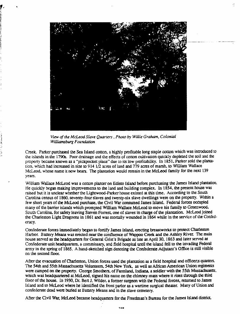