highway construction costs - vtpi.org · 2 are wsdot’s highway construction costs in line with...
TRANSCRIPT

1
Highway Construction Costs
Are WSDOT’s highwayconstruction costs in linewith national experience?
July 12, 2004

2
Are WSDOT’s highway construction costs in line with national experience?
WSDOT has assembled information from around the state and around the country to answer the frequently-heard comment thathighway construction costs in this state are typically higher than in other states. This is not true. Washington State’s costsfor typical roadway projects are very much in line with comparable projects from other states. However, when it comes tovery large, complicated projects, the significant variations in scope and setting for each project limit the usefulness of state-to-state comparisons. The important problem of cost control on these projects must be addressed on a case-by-case basis.
For this study we reviewed 15 projects from 12 different states. We also looked at 21 projects from Washington State. Thisreport takes a graphical approach in an attempt to show what a given project may look like for a given cost per lane mile.
The biggest factors in variations in costs per lane mile are:• Structures and interchanges: Projects that have structures and interchanges have a much higher cost per lane mile.• Right of way: If a project can be built within existing right of way, then its cost per lane mile is much less than a project that
needs additional right of way.• Environmental impacts: Mitigation costs for environmental impacts have a dramatic affect on cost per lane mile.• Existing soil and site conditions: Differing soil and site conditions also have an impact on the cost per lane mile.
What states include in their project costs also varies. Some states only report construction costs. Other costs that need to beincluded are right of way and design and construction engineering. Delivery methods may also affect project costs. Forexample, design-build may generate a higher initial cost, but it accelerates delivery of the project
The information in this report is organized by reference to the following questions:• What are the actual costs for typical completed roadway projects around the nation?• What are the costs of typical completed roadway projects in Washington State?• How do costs for large complicated projects in Washington compare to other states?• What other information provides insight into the cost of projects?

3
What is a lane mile?The case studies in this report have brought up the question of what should be credited as a lane mile. Most of these improvement
projects revise the horizontal and vertical alignment of the existing roadway. Therefore, they are rebuilding the existing lanes,as well as adding new ones. For the purpose of this study, we will credit lane miles to a project if they are adding additionallanes, or are replacing the entire roadway structure of the existing lanes.
What is included in the cost per lane mile?This report uses the total project cost, including administration, engineering, right of way, environmental mitigation, construction
costs, and applicable sales tax when calculating the cost per lane mile.
Where did this information come from?The information for projects from other states came from their states’ Department of Transportation web sites. Follow-up calls to
some of the states were required for verification or to collect additional information.
Are there similar reports available?The Washington State Department of Transportation published a report dated January 2003. An exhaustive search has not found
reports from any other states. FHWA does not have a current report or benchmark on cost per lane mile. FHWA is currentlyworking on a similar report, but it will not be available until late 2004. Some states have planning level estimates posted on theirweb sites.
For example, the Arkansas Department of Transportation has the following costs posted on their website:http://www.arkansashighways.com/about/facts2000.htmlTypical Construction Costs Per Mile
• Widening 2-4 Lanes Urban...................$2.6 M• New Rural 2-Lane Mountain Terrain.....$2.3 M• Rural Interstate Reconstruction............$3.6 M• New Interstate Construction.........$6.5-$8.5 M• New Interstate Total Costs...........$7.2-$9.4 M
The problem with planning level estimates is that they only include construction costs. They fail to take development costs intoaccount or project-specific issues such as right of way, environmental mitigation, or soil and site conditions.
The Florida Department of Transportation website includes the following disclaimer:Costs of intersections/interchanges/structures over 20 feet, preliminary engineering, right-of-way, and construction engineering inspection are
not included. The cost-per-centerline mile figures are based on general, statewide averages. They are not to be used for Work Programestimating because they are not job specific.

40 10 20 30 40 50 60 70 80
Rt. 123 widening # 3 - Fairfax, VA
I-4 Reconstruction - Tampa, FL
US 7 Shelburne Rd. - Burlington, VT
Sunset Hwy - Portland, OR.
M6 South Beltline - Grand Rapids, MI
SC 170 Widening - Beaufort, SC
Route 288 - Richmand, VA
Katy Freeway - Houston, TX
SR 125 - San Diego, CA
Third Ave. Extension Ketchikan, AL
Route 87 - San Jose, CA
T-REX - Denver, CO
Troup Howell Br. Rochester, NY
Oakland Bay Bridge - Oakland, CA
Big Dig - Boston, MA
Cost per Lane Mile in millions $
Lane Miles
188
What are the actual costs for projects around the nation?Of the 15 projects studied from around the country the cost per lane mile varied from $1.9 million per lane mile for simple wideningproject in Virginia without interchanges and large structures to $188 million per lane mile for the Big Dig in Boston that wasconstructed in a high density urban area with a considerable amount of tunnels and bridges These projects are currently underconstruction or have been recently been completed.

50 10 20 30 40 50 60 70 80
US 12 Widening, Walla Walla
I-90 Argon to Sullivan, Spokane
SR 14 SE 192nd Ave, Camas
SR 270 Pullman to Idaho, Pullman
I-5 Maytow n to 93rd, Tumw ater
SR 16 HOV Olympic Dr. to Union, Tacoma
SR 527 164th to 132nd, Everett
SR 18 180th to Maple Valley, Auburn
SR 525 Widening & Safety, Mukilteo
SR 161 176th to 234th, Tacoma
I-5 NE 78th to Burnt Bridge Cr., Vancouver
SR 202 - SR 520 to Sahalee Way, Redmond
SR 18 Maple Valley to Issaquah Hobart, Auburn
US 395 North Spokane Freew ay, Spokane
I-5 w idening, Salmon CR to I-205 - Vancouver
I-5 Everett HOV, SR 525 to US 2 , Everett
Tacoma Narrow s Bridge, Tacoma
SR 509/ I-5 Freight & Congestion Relief, Sea-Tac
SR 520 Bridge replacement & HOV, Seattle
I-405 Congestion Relief & Bus Rapid Transit, Seattle
SR 99 Alaskan Way Viaduct & Seaw all, Seattle
Cost per Lane Mile in millions $
Lane Miles
0 10 20 30 40 50 60 70 80
US 12 Widening, Walla Walla
I-90 Argon to Sullivan, Spokane
SR 14 SE 192nd Ave, Camas
SR 270 Pullman to Idaho, Pullman
I-5 Maytow n to 93rd, Tumw ater
SR 16 HOV Olympic Dr. to Union, Tacoma
SR 527 164th to 132nd, Everett
SR 18 180th to Maple Valley, Auburn
SR 525 Widening & Safety, Mukilteo
SR 161 176th to 234th, Tacoma
I-5 NE 78th to Burnt Bridge Cr., Vancouver
SR 202 - SR 520 to Sahalee Way, Redmond
SR 18 Maple Valley to Issaquah Hobart, Auburn
US 395 North Spokane Freew ay, Spokane
I-5 w idening, Salmon CR to I-205 - Vancouver
I-5 Everett HOV, SR 525 to US 2 , Everett
Tacoma Narrow s Bridge, Tacoma
SR 509/ I-5 Freight & Congestion Relief, Sea-Tac
SR 520 Bridge replacement & HOV, Seattle
I-405 Congestion Relief & Bus Rapid Transit, Seattle
SR 99 Alaskan Way Viaduct & Seaw all, Seattle
Cost per Lane Mile in millions $
Lane Miles
What are the costs for typical projects in Washington State?Of the 21 projects studied in Washington State, the cost per lane mile varied from $1 million per lane mile for a rural wideningproject near Walla Walla to in excess of $180 million per lane mile for the Alaskan Way Viaduct and sea wall replacement in a highdensity urban area of Seattle. Some of the projects studied are still in the development stages and therefore show a range for totalproject cost estimates.
202
167
180-267

6
How do costs for large projects in Washington State compare to other states?Of the 36 projects studied, 13 of them had costs in excess of $10 million per lane mile. The common denominator for theseprojects was that they included interchanges, major structures, expensive right of way, and/or complex soil and site conditions.Seven of these large projects studied are in Washington State. The costs per lane mile for the Washington projects arecomparable to similar projects around the nation.
0 20 40 60 80 100 120 140 160 180 200 220 240 260 280
Third Ave. Extension Ketchikan, AL
Route 87 - San Jose, CA
* I-5 Everett HOV, SR 525 to US 2 - Everett, WA
T-REX - Denver, CO
* Tacoma Narrow s Bridge - Tacoma, WA
* SR 509/ I-5 Freight & Congestion Relief - Sea-Tac, WA
Troup How ell Br. - Rochester, NY
* SR 520 Bridge Replacement & HOV - Seattle, WA
Oakland Bay Bridge - Oakland, CA
* I-405 Congestion Relief & Bus Rapid Transit - Seattle
Big Dig - Boston, MA
* SR 99 Alaskan Way Viaduct & Seaw all - Seattle, WA
Cost per Lane Mile inmillions $Lane Miles
Alternative Range

7
What other information provides insight into the cost of projects?As a part of this study, we also looked at interchange and bridge costs. As one can see from this report, interchanges andstructures are major contributors to highway construction costs.
$24.6M/Mile(Bridge only $67.2M/Mile)Tacoma Narrows Bridge -Tacoma, WA
$64.2-$82.6M/MileOakland Bay Bridge -Oakland, CA
$45.6-$52.9M/MileSR 520 Bridge Replacement &HOV - Seattle, WA
$8.9M/MileSR 125 -San Diego, CA
$9M/MileUS 395 North SpokaneFreeway - Spokane, WA
SR 125 in San Diego and US 395 inSpokane both have very complex andexpensive interchanges included in theircosts per lane mile. The cost per lane milefor these two projects are very similar.
An example is the Tacoma Narrows Bridge project inWashington. The total project cost is $24.6 million per lane mile.However, if you look at just the bridge costs, it equates to $67.2million per lane mile. The bridge cost is comparable to thecontractor’s bid for a suspension bridge in Oakland, California.
Another example is the SR 520 Bridgereplacement and HOV in Seattle, whichhas a proposed cost per lane mile of $49.7-$55.1 million due to a long span floatingbridge.

8
$180-$267M/MileSR 99 Alaskan WayViaduct & Seawall -Seattle, WA
$188M/MileBig Dig -Boston, MA
$64.2-$82.6M/MileOakland Bay Bridge -Oakland, CA
$45.6-$52.9M/MileSR 520 Bridge Replacement &HOV - Seattle, WA
$27.8M/MileTroup Howell Br. -Rochester, NY
$22.3-$25M/MileSR 509/ I-5 Freight &Congestion Relief -Sea-Tac, WA
$24.6M/MileTacoma Narrows Bridge -Tacoma, WA
Summary of Projects
$61.4-69.3 M/MileI-405 Congestion Relief& Bus Rapid Transit -Seattle, WA

9
$21.4M/MileT-REX -Denver, CO $12.1M/Mile
Route 87 -San Jose, CA $11.5M/Mile
Third Ave. Extension -Ketchikan, AL
$9M/MileUS 395 North Spokane Freeway -Spokane, WA
$8.9M/MileSR 125 -San Diego, CA
Summary of Projects
$14.25M/MileI-5 Everett HOV -Everett, WA
$9.3M/MileI-5 Widening SalmonCreek to 205 -Vancouver, WA

10
$8.2M/MileSR 18 Maple V alley toIssaquah Hobart -Auburn, WA
$7.5M/MileKaty Freeway -Houston, TX
$5.6M/MileSR 202 - SR 520 toSahalee Way -Redmond, WA
$4.8M/MileI-5 NE 78th toBurnt Bridge Cr. -Vancouver, WA
$4.6M/MileRoute 288 -Richmond, VA
$4.5M/MileSR 161 176th to 234th -Tacoma, WA
$4.4M/MileSC 170 Widening -Beaufort, SC
$4.0M/MileM6 South Beltline -Grand Rapids, MI
Summary of Projects

11
$3.9M/MileSunset Hwy -Portland, OR
$3.8M/MileSR 525 Widening & Safety -Mukilteo, WA
$3.5M/MileSR 18 180th to Maple Valley -Auburn, WA
$3.2M/MileSR 527 164th to 132nd -Everett, WA
$3.0M/MileSR 16 HOV Olympic Dr.to Union -Tacoma, WA
$2.8M/MileI-5 Maytown to 93rd -Tumwater, WA
$2.7M/MileI-4 Reconstruction -Tampa, Fl
$2.3M/MileUS 7 Shelburne Rd. -Burlington, VT
Summary of Projects
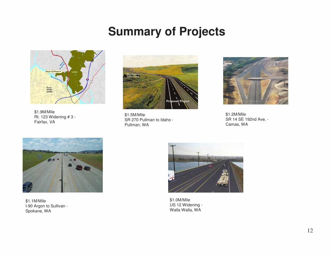
12
$1.0M/MileUS 12 Widening -Walla Walla, WA
$1.9M/MileRt. 123 Widening # 3 -Fairfax, VA
$1.5M/MileSR 270 Pullman to Idaho -Pullman, WA
$1.2M/MileSR 14 SE 192nd Ave, -Camas, WA
$1.1M/MileI-90 Argon to Sullivan -Spokane, WA
Summary of Projects

13
T-Rex, Denver, CO
Katy Freeway, Huston, TX
Big Dig, Boston, MAOakland Bay Bridge, Oakland, CA
Route 87, San Jose, CA
Sunset Highway, Portland , OR
SR 125, San Diego, CA
SC 170, Beaufort, SC
Route 123 Widening #3, Fairfax, VA.
US 7 Shelburne Rd, Burlington, VT
I-4 Reconstruction- Tampa, FL
M6 South Beltline, Grand Rapids, MI
Route 288, Richmond, VA.
3rd Ave Extension – Ketchikan, AK
Troup Howell Br., Rochester, NY
Legend
$1 M-$3 M per lane mile
$3 M-$6 M per lane mile
$6 M-$10M per lane mile
$10 M-$15 M per lane mile
Over $15 M per lane mile
Projects from around the country, under construction or completed

14
Route 123 Widening – Phase 3, Fairfax, Virginia
This is the third of several contracts to widenRoute 123 in Fairfax and Prince WilliamCounties to a four lane divided highway foreight miles between Burke Lake Road andthe Occoquan River.
$1.9M7.6
(1.9 miles x4 lanes)
$14.6M
Route 123 will have:
•Two 12-foot lanes in each direction
•A 41-foot-wide median and pedestrian trails
•Signals added at Henderson Road, Silverbrook Road, Crosspointe Drive, Hampton Road,Davis Drive, Furnace Road, Hooes Road, Hooes Road and Furnace Road, and Vulcan/OccoquanRegional Park
Cost perLane Mile
Lane MilesProject Cost in2004 Dollars
Description

15
U.S. Route 7 Shelburne Rd Reconstruction, SouthBurlington/Shelburne, Vermont
U.S. Route 7, also known as Shelburne Road, serves as the southern gateway to Chittenden County. The Vermont Agency ofTransportation (VTrans) is at work to improve a portion of U.S. Route 7, which will be extended 3½ miles from Imperial Drivein South Burlington to the recently completed LaPlatte River Crossing in Shelburne. The result will be a landscaped four-laneboulevard, with a planted median island, bike lanes, sidewalks, bus stops and shelters, street lighting, and a coordinatedsignal system. These features have the ability to reduce congestion and improve mobility, while providing for the needs ofbicyclists and pedestrians. Median u-turn breaks will be provided at five locations.
$2.3M14
(3.5miles x
4 lanes)
$32M
•South Burlington: Population 15814
•Shelburne: Population 6944
Cost perLane Mile
Lane MilesProject Cost in2004 Dollars
Description

16
Interstate 4 Reconstruction, Tampa Bay, FloridaThis segment, known as Segment 1, is completed. The projectinvolved completely reconstructing Interstate 4 from four to six lanesin eastern Hillsborough County, part of a $350 million dollar corridorreconstruction effort stretching from 50th Street in Tampa to the PolkCounty line.
On this particular segment of the corridor, interchange ramps weremodified, with new bridges at Dr. Martin Luther King, Jr. Boulevard,Orient Road, Hillsborough Avenue, U.S. Highway 92, and U.S.Highway 301. The Chelsea Road overpass was removed and will notbe replaced. A new road (Sligh Avenue) was built across fromBreckenridge Office Park to connect U.S. Highway 301 to MapleLane, providing access to the area north of I-4 and east of the TampaBypass Canal. Eureka Springs Road was converted into a two-wayroad across the Tampa Bypass Canal to provide access to theEureka Springs area and Vandenberg Airport. The existing access toEureka Springs Road from U.S. Highway 92 and I-4 eastbound (Exit6C) was permanently removed.
$2.7M30.6
(5.1 miles x6 lanes)
$82.7M•Five bridges•Start Date: October 13, 1997
•Completed: March 2002
Cost perLane Mile
Lane MilesProject Cost in2004 Dollars
Description
17
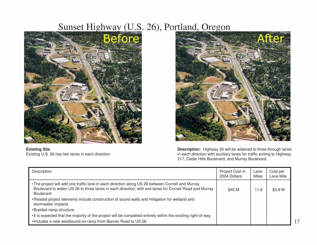
Sunset Highway (U.S. 26), Portland, Oregon
Existing SiteExisting U.S. 26 has two lanes in each direction.
Description: Highway 26 will be widened to three through lanesin each direction with auxiliary lanes for traffic exiting to Highway217, Cedar Hills Boulevard, and Murray Boulevard.
$3.9 M11.6$45 M
•The project will add one traffic lane in each direction along US 26 between Cornell and MurrayBoulevard to widen US 26 to three lanes in each direction, with exit lanes for Cornell Road and MurrayBoulevard
•Related project elements include construction of sound walls and mitigation for wetland andstormwater impacts
•Braided ramp structure
• It is expected that the majority of the project will be completed entirely within the existing right-of-way
•Includes a new westbound on-ramp from Barnes Road to US 26
Cost perLane Mile
LaneMiles
Project Cost in2004 Dollars
Description

18
M6 South Beltline, Grand Rapids, Michigan
The Michigan Department of Transportation is undertaking a $160 million project to construct the new M-6 (South Beltline/PaulB. Henry Freeway) interchange with US-131. The project entails construction of a freeway-to-freeway interchange, andconstruction of M-6 from Clyde Park Avenue to Division Avenue. This project includes 27 new bridges and 14 new ramps.Also, MDOT will be reconstructing and widening 4.2 miles of US-131 from 76th Street to 44th Street in the city of Wyoming,and Byron and Gaines townships.
$4 M40$160 M•Phase 1: 5.7 miles (I-96 to M-37), 2 Interchanges - Opened in 2001•Phase 2: 7.4 miles (M-37 west to US-131), 2 Interchanges - Open in 2005
•Phase 3: 6.9 miles (US-131 west to I-196), 4 Interchanges - Open in 2005
Cost perLane Mile
LaneMiles
Project Cost in2004 Dollars
Description
M6/US 131 Interchange

19
SC 170 Widening, Beaufort, South Carolina
������������� � �������������������������������������������������������������������� ��������������� � �������� �!��������!������� ������������ �������������!� ���������"��������#���"������� ���������� � ������������$�#����
$4.4M23.8$105M%&���� '�������������
%��� �!�������������������� � �������������� ����� ��
%$������!� �������� ���������� $�#����������(�)�!������� �*
%$������!� ���������������$�#����������(����!������� �*
Cost perLane Mile
LaneMiles
Project Cost in2004 Dollars
Description

20
Route 288, Virginia
The entire Route 288 corridor from the Powhite Parkway in Chesterfield County to I-64 in Goochland County is expected toopen to traffic early fall 2004. Route 288 will be a four lane interstate-style highway with 10 interchanges and a bridge overthe James River.
$4.5M70
(17.5 miles x4 lanes)
$319M
•10 Interchanges
•One bridge over the James River
•The project is expected to be completed in sections throughout 2004
Cost perLane Mile
Lane MilesProject Cost in2004 Dollars
Description

21
Katy Freeway – Houston, Texas
Katy Freeway at Fry Road afterKaty Freeway at Fry Road before
$7.54M27.6$208M
•I-10 East of Grand Parkway to West of SH 6
•Reconstruction of 6.91 miles of Interstate Freeway while under traffic
•Reconstruction of three Grade-Separated Intersections at Mason, Fry and Barker Cypress
•Construction of three New Grade-Separated Intersections at S. Greenhouse, Westgreen & Park Ten•$208 Million Low Bid Received: May 6, 2003
•35 Months Duration (June 2003 to May 2006)
•Construction Officially Began: June 21, 2003
Cost perLane Mile
LaneMiles
Project Cost in2004 Dollars
Description
The project will widen the main lanes to four or five lanes in each direction and add a third continuous lane to the frontage roads. The diamondlane will be maintained and shoulders will be added on each side of it, although its beginning and ending points will be moved about one mile tothe East. A continuous auxiliary lane will be added on each side of the freeway. The existing access roads will be converted to 2-way localaccess roads. Both frontage roads will be widened at their approaches to the three major crossroads (Barker Cypress Rd, Fry Rd, and MasonRd) to allow for turning lanes. U-turn lanes will be built on both sides of all six crossings.

22
������������ �����������
Description: This project includes construction of approximately5.2 miles of a six lane freeway, a flood control facility, interchanges,plus right of way for future carpool lanes.
Existing SiteSCENIC HIGHWAY, 2 miles long, San Diego County, residential andcommercial.
$8.88 M31.2$277.1M���������������� �������������������������������������� !� ���
Cost perLane Mile
LaneMiles
Project Cost in2004 Dollars
Description
23
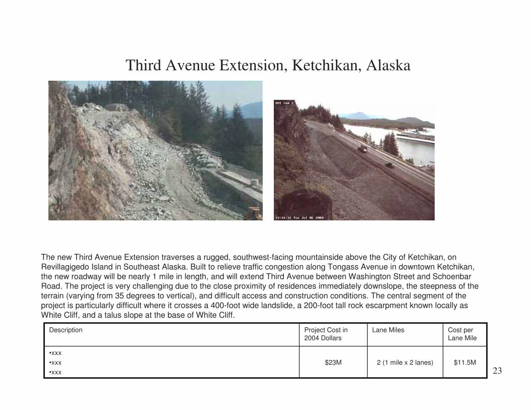
Third Avenue Extension, Ketchikan, Alaska
The new Third Avenue Extension traverses a rugged, southwest-facing mountainside above the City of Ketchikan, onRevillagigedo Island in Southeast Alaska. Built to relieve traffic congestion along Tongass Avenue in downtown Ketchikan,the new roadway will be nearly 1 mile in length, and will extend Third Avenue between Washington Street and SchoenbarRoad. The project is very challenging due to the close proximity of residences immediately downslope, the steepness of theterrain (varying from 35 degrees to vertical), and difficult access and construction conditions. The central segment of theproject is particularly difficult where it crosses a 400-foot wide landslide, a 200-foot tall rock escarpment known locally asWhite Cliff, and a talus slope at the base of White Cliff.
$11.5M2 (1 mile x 2 lanes)$23M
•xxx
•xxx
•xxx
Cost perLane Mile
Lane MilesProject Cost in2004 Dollars
Description

24
Route 87, San Jose, California
Completed projectSix lanes in each direction
Existing SiteFour lanes in each direction
$12.1M18.6$225M•Six lanes total, two of which will be diamond lanes (High Occupancy Vehicles, or HOV)•Two interchanges, one at Taylor Street and the other at Skyport Drive
•Undercrossings at Coleman Avenue, Hedding Street, and Airport Parkway
•Upgraded Route 87 structure over Interstate 880; the two highways will continue to remain separate
•Riparian mitigation planting along the Guadalupe River in roughly a 2-to-1 ratio to replace andenhance the natural habitat
Cost perLane Mile
LaneMiles
Project Cost in2004 Dollars
Description
In the next few years, construction improvements along State Route 87 will complete the corridor from South San Jose, greatly ease congestion to andfrom the San Jose International Airport, and provide easier access from downtown San Jose to U.S. 101. This improves the existing Guadalupe Parkwayby converting it from a four-lane road with four signalized intersections into a six-lane freeway.
This multi-million dollar project, jointly funded by Caltrans and the City of San Jose, involves several phases of major construction activities, which beganin 1998.

25
T-REX, Denver, Colorado
Sample interchange and roadway widening
Description: This simulation depicts the additional I-25lanes and the new LRT alignment located to the South(right) of I-25. This area was nicknamed " the narrows"because of the limited right-of-way and close proximity ofBuchtel Road. Retaining walls allowed the most efficientuse of the available space. On the right, a replacementaccess ramp carries traffic over the top of LRT lines toreach Buchtel.
Existing SiteExisting view of I-25 and Washington Street looking southeast atthe Washington Street access ramps.
$21.45M78$1.67B
•Located in open suburban area
•New right of way required in some parts of corridor; median widening in other parts of corridor
•Cost includes “Light Rail element” (approximately $800 million)
Cost perLane Mile
LaneMiles
Project Cost in2004 Dollars
Description

26
Troup Howell Bridge, Rochester, New York
$37 million multi-year project to replace the 8-span I-490 bridge over the Genesee River in downtown Rochester, New York,is the third phase of the State's commitment to improve I-490 between the Erie Canal west of Rochester and the GeneseeRiver, also known as the Western Gateway Project.
$27.8M1.33$37M•Most of the structure will be replaced including all of the original 1955 structure: however, the newereastern spans will be retained and rehabilitated
•xxx
•xxx
Cost perLane Mile
LaneMiles
Project Cost in2004 Dollars
Description

27
Oakland Bay Bridge, San Francisco, California
Existing SiteEarthquake damage on the east span of theexisting Oakland Bay Bridge.
Description: Design visualization of the new suspension bridge.The new bridge will carry 5 lanes in each direction. Theengineers’ estimate was $740 million. The sole bid was offeredMay 26 at $1.4B with use of foreign steel and $1.8B usingdomestic steel. Record steel prices are the key factor in the hugedifferential, but the span’s unique design, tough schedule, andstrict specifications also played a factor in ratcheting up the bidcontingencies.
$64.2M -$82.6M
21.8$1.4B- $1.8B•11,525’ east span•Five lanes in each direction
Cost perLane Mile
LaneMiles
Project Cost in2004 Dollars
Description

28
The Big Dig - Facts
Who: United States Department of Transportation, Federal HighwayAdministration & The Massachusetts Turnpike AuthorityWhat: The largest civil works project in U.S. historyWhere: Boston: 8 miles of Interstate highway construction,approximately 4 miles of I-93 between Roxbury and Somerville, andapproximately 4 miles of I-90 between Chinatown and East BostonWhen: Federal legislation passed 1987, ground broken in Boston1991, completion 2005Why: To reconnect the city and to alleviate traffic bottlenecksCost: $14,700,000,000
Big Dig, Boston, Massachusetts
$188.46M78$14.7B•Located in urban area•Mix of elevated roadway, tunnels and bridges over waterways
•Replaces and or rehabilitates existing freeway
Cost perLane Mile
LaneMiles
Project Cost in2004 Dollars
Description

29
Legend
$1 M-$3 M per lane mile
$3 M-$6 M per lane mile
$6 M-$10M per lane mile
$10 M-$15 M per lane mile
Over $15 M per lane mile
US 12 Widening SR 124to Wall Walla River
I-90 - Build lanes fromArgonne to Sullivan Road
SR 14, SE 192nd AvenueInterchange, Camas
I-5 Maytown to 93rd Ave. 5th &6th Lanes, Tumwater
SR 16 HOV Improvements - OlympicDrive to Union Avenue, Tacoma
SR 527 Widening - 164th St.SE to 132nd St. SE, Everett
SR 18 – 180th to Maple Valley, Auburn
State Route 525 Widening & SafetyImprovements, Mukilteo
SR 161, Corridor Improvements - 176th to 234th , Tacoma
I-5 Corridor, NE 78th Street in HazelDell to Burnt Bridge Creek in
Vancouver
SR 202- SR 520 to Sahalee Way, Redmond
SR 18 - Maple Valley to Issaquah Hobart Road, Auburn
US 395/North SpokaneCorridor
SR 270/Pullman to Idaho St Line
SR 16 Tacoma Narrows Bridge, Tacoma
SR-509/I-5 Freight and Congestion ReliefProject, Sea-Tac
SR 99 - Alaskan Way Viaduct & SeawallReplacement Project, Seattle SR 405 Congestion Relief, Bellevue
SR 520 Bridge Replacement and HOV Project, Seattle
Projects in Washington State
I-5 – Everett, SR526 to US 2 HOV Lanes
I-5 Widen Salmon Creek to 205Vancouver

30
US 12 - Widening From SR 124 to the Walla Walla River, Washington
This five-phase project consists of four construction phases and a planning phase. The construction portion will widen theUS 12 corridor to four lanes from the SR 124 junction to the Walla Walla River. The planning phase will determine thepreferred alignment for Highway 12 from the Wallula Junction near the Walla Walla River to Walla Walla.
$1M48
(12 miles x4 lanes)
$50.8M• Under construction: The first construction project in the corridor, McNary Pool to Attalia, will be open to
traffic by late fall 2004• Design and environmental work is in progress on Phases 2 and 3
Cost perLane Mile
Lane MilesProject Cost in2004 Dollars
Description
31
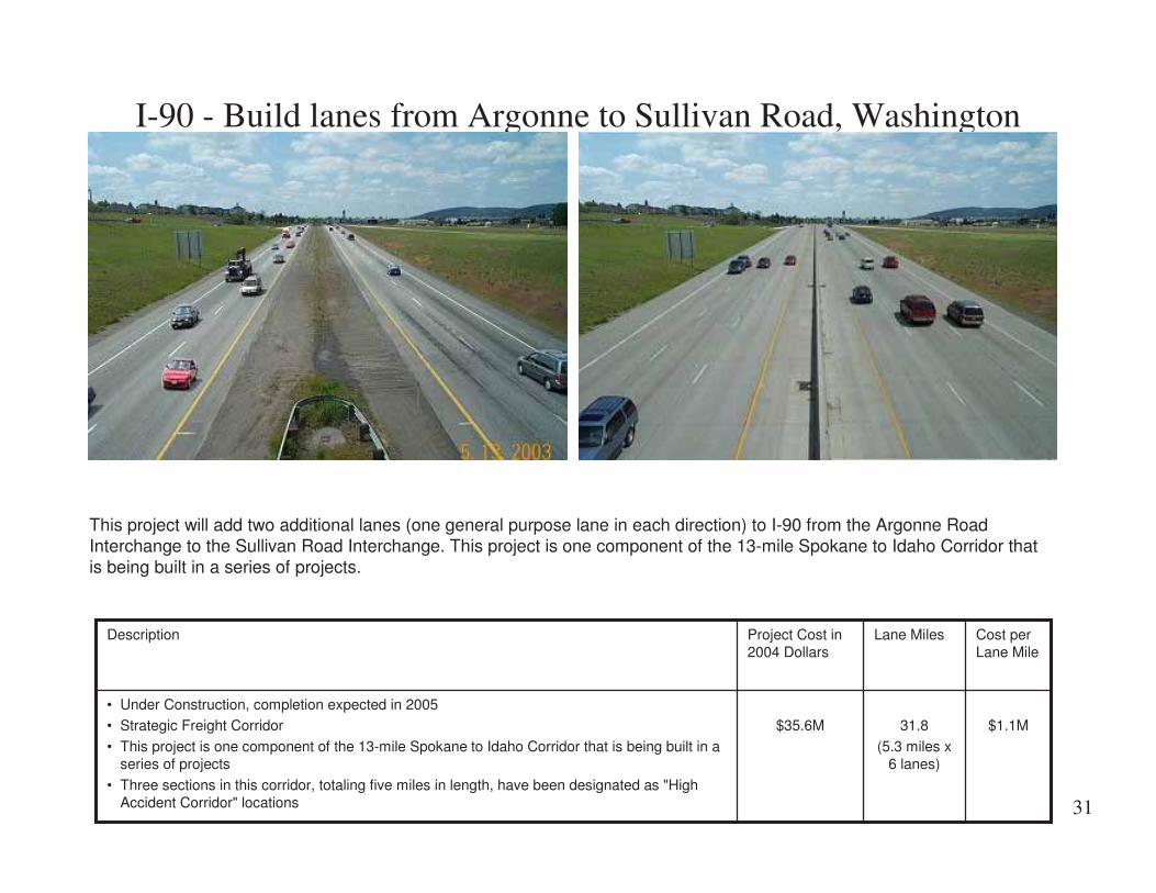
I-90 - Build lanes from Argonne to Sullivan Road, Washington
This project will add two additional lanes (one general purpose lane in each direction) to I-90 from the Argonne RoadInterchange to the Sullivan Road Interchange. This project is one component of the 13-mile Spokane to Idaho Corridor thatis being built in a series of projects.
$1.1M31.8
(5.3 miles x6 lanes)
$35.6M• Under Construction, completion expected in 2005• Strategic Freight Corridor
• This project is one component of the 13-mile Spokane to Idaho Corridor that is being built in aseries of projects
• Three sections in this corridor, totaling five miles in length, have been designated as "HighAccident Corridor" locations
Cost perLane Mile
Lane MilesProject Cost in2004 Dollars
Description

32
SR 14, SE 192nd Avenue Interchange, Camas, Washington
This project constructed a new interchange on State Route 14 between the SE 164th Avenue Interchange and just west ofCamas (near Brady Road). This project provides a future connection to a major north/south city street off of SR 14. TheBrady Road intersection with SR 14 was moved to meet SE 192nd Avenue at a signalized intersection 500 feet north of thenew interchange. Also, the interchange is helping to preserve mobility and increased safety for motorists who travel the SR14 corridor.
$1.2M16.8
(4.2 miles x4 lanes)
$19.8M•Project Completed: October 2002•A diamond interchange at SR 14 and SE 192nd Avenue
•A new Brady Road intersection at SE 192nd Avenue
•A new alignment of Brady Road leading to SE 192nd Avenue
•A 1,000 foot section of SE 192nd Avenue
•The elimination of the existing intersection of Brady Road and SR 14•An access road from SE 192nd Avenue to the Pacific Rock Products facility
•An additional lane on the eastbound SR 14 off-ramp to SE 164th Avenue
•Additional lane on SR 14 from just east of SE 164th Avenue to SE 192nd Avenue
•New pavement from east of SE 164th Avenue Interchange to Camas
Cost perLane Mile
Lane MilesProject Cost in2004 Dollars
Description

33
SR 270/Pullman to Idaho St Line - Additional Lanes, Washington
This project will add a general-purpose lane in each direction and will provide five miles of 60-foot wide median to separateopposing traffic. Access control will be established along SR 270. The highway will be realigned to the north near theAvista Utilities property and at the Airport Road East vicinity. This will allow the existing SR 270 alignment at theselocations to be used as a frontage road system for local businesses, farms, and residents. The frontage road system, incombination with access control will reduce the number of approaches to SR 270, which in turn will improve traffic flow andsafety.
$1.5M20
(5 miles x4 lanes)
$30.6M•Drilling and soil testing began in mid-December 2003; completed at the end of February 2004•JARPA was submitted for approval March 1, 2004; right-of way acquisitions began in July 2003
•Construction is scheduled to start in 2005, with probable completion in 2007
•Frontage roads on the south side of the existing trail consolidate crossing points and conflicts;improving safety.
•Additional wetlands will be established and Paradise Creek will be improved in an effort toenhance the corridor
Cost perLane Mile
Lane MilesProject Cost in2004 Dollars
Description

34
I-5 Maytown to 93rd Ave. - 5th & 6th Lanes, Tumwater, Washington
This project is located in a rural area south of Tumwater; it widened the existing four lane interstate to six lanes forapproximately two miles. It added four lane miles, a wider shoulder, and a median barrier. Since a portion of thestormwater was treated in the existing grassy median, a new stormwater treatment facility was constructed to treat for thenew roadway and replace what was lost by filling in the median.
$2.8M4$11.2M•Project completed in September 2002
•An additional 12.76 acres of right of way was purchased outside of the roadway to accommodatestormwater treatment facilities
Cost perLane Mile
LaneMiles
Project Cost in2004 Dollars
Description

35
SR 16 HOV Improvements - Olympic Drive to Union Avenue
This project completes the original design concept for SR 16 started in the early 1980’s, but never completed due to lack offunding. Portions of the ultimate westbound lanes were never completed. Consequently, all traffic on SR 16 between Pearland 12th Street has been traveling on what was intended to be the ultimate eastbound lanes. Completing the ultimatewestbound lanes will make this section of roadway safer and much more comfortable to drive.
$3M29.4$90.5M•Construction will begin in early 2004 and will last for three years, ending in conjunction with theopening of the new Tacoma Narrows Bridge in 2007
•Total estimated project cost, including design, engineering, right of way acquisition and construction:$90.5 million
•Four new bridges are constructed
•Two bridges are widened
•One tunnel is constructed•10 miles of HOV lanes are constructed (MP 0.8 to MP 8.2 = 7.4 miles, minus the TNB portion of 2.5miles equals 5 miles, times 2 lanes equals 10)
•5 miles of multi-use trail are constructed (same distance as the HOV lanes)
•5 new stormwater ponds are constructed (four on Union to Jackson and one on 36th to Olympic)
•Four noise walls are constructed
Cost perLane Mile
LaneMiles
Project Cost in2004 Dollars
Description

36
SR 527 Widening - 164th Street SE to 132nd Street SE, Washington
To increase safety and increase traffic flow on this heavily traveledroute, it needs to be widened. This project will widen more than twomiles between 164th and 132nd Streets southeast through the City ofMill Creek. When construction is finished, the Bothell-Everett Highwaywill have two lanes in both directions and a center area that will be alandscaped median in some sections and left-turns in other sections.This project also builds sidewalks, curbs, gutters, and bike lanes.
$3.2M8(2 miles x4 lanes)
$25.6M•Under construction: The Final Phase Erosion and Planting Fall 2004•The project installs new sidewalks and bike lanes, making it safer for pedestrians and bicyclists
•A new "fish-friendly" culvert crossing for Mill Creek
Cost perLane Mile
Lane MilesProject Cost in2004 Dollars
Description

37
SR 18 - 180th to Maple Valley, Washington
This project, a portion of a larger project to widen SR 18 from Auburn to North Bend, is a 2.7-mile stretch of highwaylocated between Covington and Maple Valley.
$3.5M10.8(2.7 Miles x
4 lanes)
$37.7M•Project Completed: October 2002•2 new two-lane bridges
•Six detention Ponds, five infiltration Ponds, stream re-vegetation, 8-acre wetland created
•Widened 256th Street, replaced two culverts, restoration of a nearby wetland
•Noise wall
Cost perLane Mile
Lane MilesProject Cost in2004 Dollars
Description

38
State Route 525 Widening & Safety Improvements
State Route 525 (SR 525), commonly known as the Mukilteo Speedway, runs from Interstate 5, past State Route 99 (SR99), through the City of Mukilteo, to the ferry dock and then continues as SR 525 on Whidbey Island in Island County. Thiscongested route is used by residents, area businesses, commuters, and ferry traffic. Widening the highway from a two-lanehighway to a four-lane, divided highway to help increase traffic flow, decrease congestion, and increase safety is a toppriority of WSDOT.
$3.8M24( 6 miles x4 lanes)
$91.3M•Under construction: Final paving will be complete by the end of summer 2004•Widens SR 525 to four lanes
•Adds new sidewalks and bike lanes
•Upgrades lighting for improved safety
•Contractor: KLB Construction
•New interchange at SR 525 and SR 99•18 underground stormwater storage tanks
Cost perLane Mile
Lane MilesProject Cost in2004 Dollars
Description

39
SR 161, Corridor Improvements - 176th to 234th- Tacoma, WashingtonThis project will widen SR161 (Meridian South) inEast Pierce County fromtwo lanes to four lanes,with a two-way left turnlane. The project iscomprised of twosegments - 176th to 204thand 204th to 234th.
$4.5M7.6(1.9 miles x
4 lanes)
$33.9•Construction on the segment between 204th to 234th streets will begin in the early spring 2004:Construction on the northern segment, 176th to 234th, will begin in 2005.
• Install new traffic signals at the intersections of 200th Street, 204th Street and Eustis Hunt Road
•Modify traffic signals at 224th, 194th, 187th, and 176th streets
• Improve channelization and illumination at 234th, 232nd, 229th, 224th, 213th, 204th, 200th, 194th,187th and 176th streets; also at Eustis Hunt and County Dump roads.
•The 176th Street intersection will have two lanes going through in each direction on both 176thStreet and SR 161, and it will have double left turn lanes in all four directions.
•The 200th Street intersection will have a double left turn from southbound SR 161 to eastbound200th Street
•Stormwater detention ponds in the vicinity of 234th, 229th, 204th, 200th and 194th streets, andCounty Dump Road
•Sidewalk, curb and gutter along the south side of 176th Street and along SR 161 in the northeastquadrant of the intersection; sidewalk, gravel walkways, curb, and curb and gutter between 229thStreet and vicinity of 224th Street.
•Closed storm sewer system between County Dump Road and 176th Street and between 229thStreet and the vicinity 224th Street.
•Railroad crossing signal and gate system at the Tacoma Eastern Railroad crossing.
•Wetlands mitigation site
Cost perLane Mile
Lane MilesProject Cost in2004 Dollars
Description

40
I-5 Corridor, NE 78th Street in Hazel Dell to Burnt Bridge Creek inVancouver, Washington
This Clark County project widened I-5 to three lanes in eachdirection from Burnt Bridge Creek in Vancouver to NE 78th Streetin Hazel Dell. Construction began in August 1999 and wascompleted the first week of November 2002.
$4.8M13.8(2.3 miles x
6 lanes)
$65.7M•Completed November 2002•Widened a 2.3-mile section of I-5 (northbound and southbound) to three lanes, with a fourthacceleration/deceleration lane added at Main Street and NE 78th Street
•Replaced bridges at Main Street, NE 63rd Street, and NE 78th Street
•Replaced the Clark County railroad crossing just south of NE 63rd Street
•Rebuilt the existing interchange at NE 78th Street
• Installed a traffic signal at Hazel Dell Avenue and Main Street•Added sound walls
•Added a stormwater detention pond near the Ellen Davis Trail
•Connected the east and west sides of the Discovery Trail by adding a pedestrian bridge andpedestrian tunnel
Cost perLane Mile
Lane MilesProject Cost in2004 Dollars
Description

41
SR 202- SR 520 to Sahalee Way, Washington
Stage 1 - SR 520 to East Lake Sammamish Parkway vicinity:The first stage of this project adds an additional lane in each direction between SR 520 and East Lake SammamishParkway and improves the intersection of SR 202 and East Lake Sammamish Parkway. Other work includes bicycle lanes,sidewalks, drainage, landscaped median, signing upgrades, and signal revisions at the SR 520 off-ramp and at NE 70thStreet.
Stage 2 - East Lake Sammamish Parkway to Sahalee Way:The second stage includes two new lanes, retaining walls, noise walls, bicycle lanes, sidewalks, and replacement of thebridges at 196th Avenue NE and at Evans Creek. From 196th Avenue NE to Sahalee Way, crews will raise the roadway 14feet to accommodate an existing landslide.
$5.6M11.2(2.8 miles x
4 lanes)
$63.2M•Construction to begin Fall 2004•Stage one is scheduled for completion at the end of 2005: Stage two is scheduled for completionin fall 2007
Cost perLane Mile
Lane MilesProject Cost in2004 Dollars
Description

42
SR 18 - Maple Valley to Issaquah Hobart Road, Washington
This project is the latest phase in WSDOT's plan to reduce congestion and enhance safety on SR 18 by widening thehighway to a four-lane divided highway between Auburn and I-90. The widening is being done in segments, from west toeast, and is complete all the way to Maple Valley.
The three-mile section extending to Issaquah Hobart Road is a two-lane undivided highway with the potential for highspeed collisions. More than 23,000 vehicles use SR 18 through the construction zone on an average day.
$8.2M12(3 miles x4 lanes)
$97.9•Under Construction; schedule calls for opening all four lanes of Highway 18 in fall of 2005•Widens the existing two lane highway to four lanes with a 48-foot median
•Constructs a new interchange at 244th Avenue Southeast and Removes at-grade intersections at236th Avenue SE, 244th Avenue SE, and at SE 200th Street
•Replaces existing bridges over SR 169 and the Cedar River and builds a new bridge over SR18at Southeast 200th Street
Cost perLane Mile
Lane MilesProject Cost in2004 Dollars
Description

43
US 395/North Spokane Corridor
When completed, the North Spokane Corridor will be a 60-mile-per-hour, limited access highway with a direct connection to I-90, just west of the existing Thor/Freya Interchange. Other interchanges will be placed at locations such as Trent Avenue (SR290), Wellesley Avenue, Francis/Freya Street, Parksmith Drive, US 2, and US 395 at Wandermere. This project will bedeveloped in two major phases:• Phase 1 - Spokane River North to establish the corridor from the River to US 395 at Wandermere.• Phase 2 - Spokane River South to extend the corridor between I-90 and the Spokane River. Phase 2 will also include a
Collector/Distributor (C/D) system (of six lanes) along I-90 between the Liberty Park and Sprague Avenue Interchanges.
$9M167$1.5B•Under Construction. On August 22, 2001, construction began on the first construction element, agrading and drainage contract, from the vicinity of Parksmith Drive to US 2. The project wascompleted in July, 2002. In July 2003, $189 million was appropriated through a nickel increase ingasoline tax. Two projects to be built, Francis Avenue to Farwell Road and US 2 to Wandermere andUS 2 Lowering.
•Seven interchanges
•About 3.5 miles of I-90, centered around the NSC/I-90 Interchange connection, will require newconstruction
•The corridor includes the construction of over 10 miles of pedestrian/bicycle trails
Cost perLane Mile
LaneMiles
Project Cost in2004 Dollars
Description

44
Widen I-5 Each Direction from Salmon Creek to I-205 – Vancouver, WA
$9.3M4$37.1MThe End ResultWidening this section of I-5 will increase capacity and allow motorists to move more safely and efficientlythrough the I-5 corridor. In addition to widening 2 miles of I-5 from approximately the NE 99th Streetinterchange (Salmon Creek) to the I-205 junction, the project will:•Replace the northbound and southbound bridges that cross over Salmon Creek (near Salmon Creek Park)
•Build a new bridge at NE 129th Street
•Add an additional lane and a second left-turn lane at the northbound I-5 off ramp to NE 134th Street
•Revise the signal at NE 134th Street to accommodate the second left-turn lane
Cost perLane Mile
LaneMiles
ProjectCost in2004Dollars
Description
Project Benefits•Safety: New bridges meeting current design and seismicstandards will replace existing bridges. The project also willincrease capacity and allow motorists to move more safelyand efficiently through the I-5 corridor.
• Congestion Relief: Traffic flow in the I-5 corridor betweenthe Main Street interchange in Vancouver and the I-205junction will be improved. Through computer modeling, it isestimated that if this project wasn't built, afternoon travelspeeds in 2010 and 2020 would be 42 and 26 mph,respectively. Once completed, average travel speeds in 2010and 2020 are projected to increase to 60 and 51.

45
I-5 –Everett, SR 526 to US 2 HOV Lanes - Everett, Washington
$14.25M16.6$236.6MThe $220 million project will unclog a notorious I-5 traffic chokepoint and improvesafety through Everett by:• Adding six miles of northbound carpool lanes from Highway 526 to US 2• Adding 4.6 miles of southbound carpool lanes from Marine View Drive to HWY 526• Adding a northbound and southbound lane from 41st Street to US 2• Widening or replacing 19 bridges• Improving freeway on- and off-ramps• Adding noise walls at certain locations and holding and filtering dirty water that runs
off the freeway
Cost perLane Mile
LaneMiles
Project Cost in2004 Dollars
Description
Adds a new carpool lane in each direction on I-5 between Highway 526and Marine View Drive.Adds a new merge lane in both directions on I-5 between 41st Street andUS 2.WSDOT will install retaining walls and a detainment and treatment areafor freeway water run-off.
Project Benefits• Safety: Accidents will be decreased by reducing back-ups on thehighway and ramps, and providing wider shoulders.
• Environment: WSDOT will install noise walls where warranted andbuild water quality facilities for treatment of freeway water run off.
• Congestion Relief : The new lanes for carpools, vanpools, and buseswill reduce congestion. View the 2010 and 2020 graphs of forecastedproject benefits. (pdf, 8 KB). To learn more about WSDOT's congestionrelief efforts, visit the WSDOT Congestion Relief site.
46
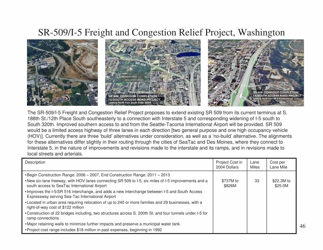
SR-509/I-5 Freight and Congestion Relief Project, Washington
The SR-509/I-5 Freight and Congestion Relief Project proposes to extend existing SR 509 from its current terminus at S.188th St./12th Place South southeasterly to a connection with Interstate 5 and corresponding widening of I-5 south toSouth 320th. Improved southern access to and from the Seattle-Tacoma International Airport will be provided. SR 509would be a limited access highway of three lanes in each direction [two general purpose and one high occupancy vehicle(HOV)]. Currently there are three ‘build’ alternatives under consideration, as well as a ‘no-build’ alternative. The alignmentsfor these alternatives differ slightly in their routing through the cities of SeaTac and Des Moines, where they connect toInterstate 5, in the nature of improvements and revisions made to the interstate and its ramps, and in revisions made tolocal streets and arterials.
$22.3M to$25.0M
33$737M to$826M
•Begin Construction Range: 2006 – 2007, End Construction Range: 2011 – 2013
•New six-lane freeway, with HOV lanes connecting SR 509 to I-5, six miles of I-5 improvements and asouth access to SeaTac International Airport
• Improves the I-5/SR 516 interchange, and adds a new interchange between I-5 and South AccessExpressway serving Sea-Tac International Airport
•Located in urban area requiring relocation of up to 240 or more families and 29 businesses, with aright-of-way cost of $122 million
•Construction of 22 bridges including, two structures across S. 200th St. and four tunnels under I-5 forramp connections
•Major retaining walls to minimize further impacts and preserve a municipal water tank
•Project cost range includes $18 million in past expenses, beginning in 1992
Cost perLane Mile
LaneMiles
Project Cost in2004 Dollars
Description

47
Tacoma Narrows Bridge, Tacoma, Washington
Existing SiteExisting Tacoma Narrows bridge currently has two narrowlanes in each direction without shoulders
Description: Design visualization of the new parallel suspension bridge. Thenew bridge will carry three lanes with shoulders and the old bridge will beremodeled to carry three lanes with shoulders . The project also includes 3.5miles of roadway and and an associated toll plaza.
$24.6MBridge Only
$67.2 M
25(BridgeOnly 6)
$615 M
•Adds new 1-mile-long suspension bridge and remodels existing bridge
•Constructs 3.5 miles of roadway and associated toll plaza•Design Build project so the cost per lane mile includes the cost to design the project, as well asconstruct it
Cost perLane Mile
LaneMiles
Project Cost in2004 Dollars
Description
48
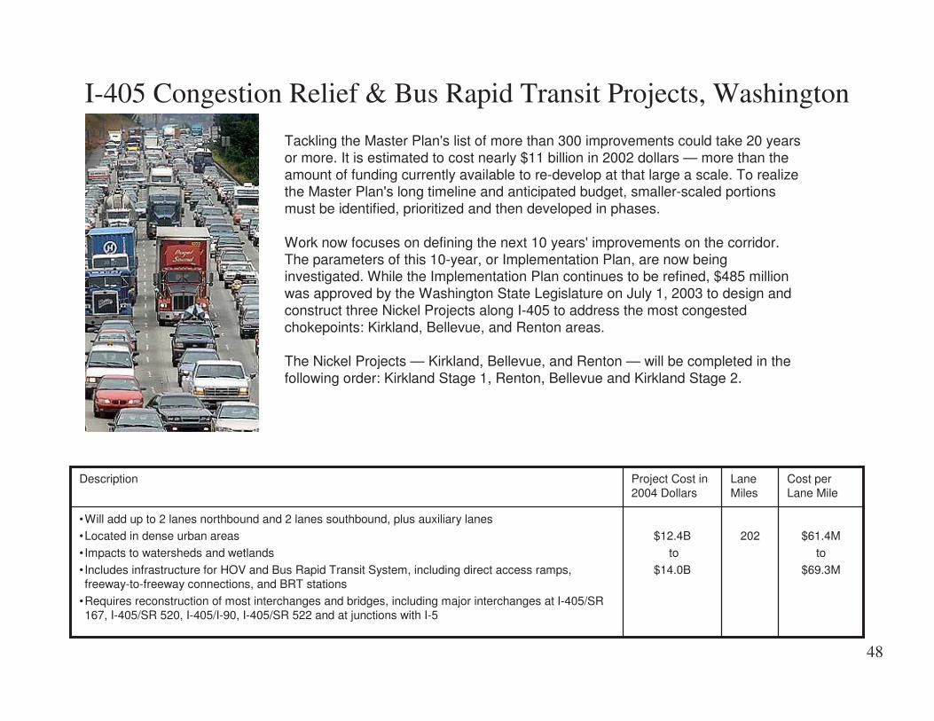
I-405 Congestion Relief & Bus Rapid Transit Projects, Washington
Tackling the Master Plan's list of more than 300 improvements could take 20 yearsor more. It is estimated to cost nearly $11 billion in 2002 dollars — more than theamount of funding currently available to re-develop at that large a scale. To realizethe Master Plan's long timeline and anticipated budget, smaller-scaled portionsmust be identified, prioritized and then developed in phases.
Work now focuses on defining the next 10 years' improvements on the corridor.The parameters of this 10-year, or Implementation Plan, are now beinginvestigated. While the Implementation Plan continues to be refined, $485 millionwas approved by the Washington State Legislature on July 1, 2003 to design andconstruct three Nickel Projects along I-405 to address the most congestedchokepoints: Kirkland, Bellevue, and Renton areas.
The Nickel Projects — Kirkland, Bellevue, and Renton — will be completed in thefollowing order: Kirkland Stage 1, Renton, Bellevue and Kirkland Stage 2.
$61.4M
to
$69.3M
202$12.4B
to
$14.0B
•Will add up to 2 lanes northbound and 2 lanes southbound, plus auxiliary lanes•Located in dense urban areas
• Impacts to watersheds and wetlands
• Includes infrastructure for HOV and Bus Rapid Transit System, including direct access ramps,freeway-to-freeway connections, and BRT stations
•Requires reconstruction of most interchanges and bridges, including major interchanges at I-405/SR167, I-405/SR 520, I-405/I-90, I-405/SR 522 and at junctions with I-5
Cost perLane Mile
LaneMiles
Project Cost in2004 Dollars
Description

49
SR 520 Bridge Replacement and HOV Project, Seattle, Washington
The 4-Lane Alternative would have four lanes, 4-foot inside shoulder and 10-foot outside shoulder. SR 520 would be rebuiltfrom I-5 to Bellevue Way. Both the Portage Bay and Evergreen Point bridges would be replaced. Bridges over SR 520would also be rebuilt. Sound walls would be built along much of SR 520 in Seattle and the Eastside. This alternativeincludes stormwater treatment and electronic toll collection.
The 6-Lane Alternative would include six lanes (two outer general purpose lanes and one inside HOV lane in eachdirection), 10-foot inside shoulder and 10-foot outside shoulder. SR 520 would be rebuilt from I-5 to 108th AvenueNortheast in Bellevue, with an auxiliary lane added on SR 520 eastbound east of I-405 to 124th Avenue Northeast. Boththe Portage Bay and Evergreen Point bridges would be replaced. Overpasses along SR 520 would also be rebuilt. Soundwalls would be built along much of SR 520 in Seattle and the Eastside. This alternative would include stormwater treatmentand electronic toll collection. This alternative would also add five 500-foot-long lids to be built across SR 520 to reconnectcommunities along SR 520: Roanoke, North Capitol Hill, Portage Bay, Montlake, Medina, Hunts Point, Clyde Hill, andYarrow Point. The lids are located at 10th Avenue East and Delmar Drive East, Montlake Boulevard, Evergreen PointRoad, 84th Avenue Northeast, and 92nd Avenue Northeast.
$46.4M to$52.9M
or
$45.6M to$51.4M
30.2
or45.4
$1.4B to $2.3B•Construction to begin 2008•A 14-foot-wide bicycle/pedestrian path would be built along the north side of SR 520 through Montlakeand the Evergreen Point Bridge and along the south side of SR 520 through the Eastside to 96thAvenue Northeast
Cost perLane Mile
LaneMiles
Project Cost in2004 Dollars
Description

50
SR 99 - Alaskan Way Viaduct & Seawall Replacement Project,Seattle, Washington
Replacement of the viaduct and seawall. Five alternatives are being considered:1. Rebuild - Rebuilds existing viaduct and seawall2. Aerial - Replaces viaduct with new, wider viaduct and rebuilds seawall3. Tunnel - Replaces viaduct and seawall with 6-lane tunnel on central waterfront4. Bypass Tunnel - Replaces viaduct and seawall with a 4-lane tunnel on central waterfront and expands Alaskan Way
to 6-lanes5. Surface - Replaces viaduct with a 6-to-8 lane Alaskan Way and rebuilds seawall
$180M to267M
15$2.7B to 4.0B•Five Alternatives Proposed•Late summer-2004 – Select a preferred alternative
•2006 – Environmental approval
•2008 – Begin construction, assuming funds are available
Cost perLane Mile
LaneMiles
Project Cost in2004 Dollars
Description

51
Interchanges
$15.2MSR 16, BurleyOlalla Interchange -Washington
$16.2MI-90 Evergreen Rd. Interchange -Spokane, Washington
$19MI-40 Louisiana Reconstruction Project -New Mexico
$26.8MSR 500, Thurston WayInterchange -Vancouver, Washington
$28MThe Sunnybrook BoulevardInterchange -Clackamas County, Oregon
$116.6MI-90, Sunset Interchange -Issaquah, Washington
$145MReconstruction of the I-70/75interchange near Dayton, Ohio
$810MMarquette Interchange -Milwaukee, Wisconsin
As one can see, interchange costs vary dramatically. Projects that include interchanges have a much higher cost per lane mile.

52
SR 16, Burley Olalla Interchange, Washington
The end result will be a gradeseparated interchange. Anoverpass will be provided forthrough-traffic on Burley-OlallaRoad, and all movementsbetween SR 16 and Burley-Olalla Road will beaccommodated.
N/A
Cost perInterchange
$15.2M
N/A$15.2M•Construction will begin in 2008. Funding is not available to begin construction earlier. In the interim,WSDOT will make some improvements to the intersection to improve safety. The interim project isscheduled for construction in 2004.
•Safety - The project replaces the existing at-grade intersection of Burley-Olalla Road and SR 16 withan overpass. When completed, traffic on Burley-Olalla Road will cross over SR 16.
•Burley Creek and various wetlands occur within project limits.
Cost perLane Mile
LaneMiles
Project Cost in2004 Dollars
Description

53
I-90 Evergreen Rd. Interchange, Spokane, Washington
This project, located in an urban area of Spokane, included a new interchange, bridge, ramps, and auxiliary lanes.
N/A
Cost perInterchange
$16.2 M
N/A$16.2•Project Completed ?•New bridge, ramps, and intersections
•Stormwater treatment incorporated into permits, design, and construction
•Noise wall
Cost perLane Mile
LaneMiles
Project Cost in2004 Dollars
Description

54
I-40 Louisiana Reconstruction Project, New Mexico
Existing SiteExisting Interchange of I-40 and Louisiana Boulevard.
Description: The entire interchange will be replaced with a Single PointUrban Interchange.
N/A
Cost perInterchange
$19 M
N/A$19 M•The westbound I-40 exit ramp and on-ramp loop will be modified to connect directly to the UptownLoop Road
•A bridge crossing over the westbound I-40 exit ramp will be constructed to provide access fromWinrock Mall to I-40
•The bridge structure over I-40 will be reconstructed to consist of three through lanes, two left turnlanes, and a right turn lane for northbound Louisiana Blvd. and three through lanes and a dual left turnlanes for southbound Louisiana Boulevard
•Adequate vertical and horizontal clearances will be provided for future I-40 widening
•The project also includes drainage improvements, construction of retaining walls, lighting,signalization, and signing; a bicycle/pedestrian crossing structure under Louisiana Blvd. will also beconstructed as part of this project and will conform to current ADA guidelines
Cost perLane Mile
LaneMiles
Project Cost in2004 Dollars
Description

55
SR 500, Thurston Way Interchange – Vancouver, WA
Description: Motorists on SR 500 now travel over ThurstonWay without stopping, and motorists traveling from SR 500 toThurston Way can exit smoothly off SR 500. The newinterchange has improved safety; created better connections toexisting roads; improved pedestrian and bicycle connections;and increased capacity and decreased congestion
Existing SiteAt grade intersection
$26.8 M forthe
Interchange
N/A$26.8 M•The Thurston Way Interchange project is the first transportation design-build project in the state ofWashington.
•As a design-build project, the project timeline was nearly one year shorter than usual, which resultedin less impact to drivers, businesses and neighborhoods.
Cost perLane Mile
LaneMiles
Project Cost in2004 Dollars
Description

56
The Sunnybrook Boulevard Interchange, Clackamas County, Oregon
A new, six-lane interchange structure will be built across I-205 connecting the Sunnybrook Boulevard east and westextension roadway improvements. The new structure provides for two east and two west-bound travel lanes with a dualleft-turn lane for on-ramp and collector/distributor road access.
N/A
Cost perInterchange
$28M
N/A$28M•Under Construction: Construction began 2001 - completion date 2004•Reconfiguration of on- and off-ramps
•Construction of collector/distributor (C/D) roads and auxiliary lanes
•Retaining wall
•Sound wall
•Bicycle/pedestrian path reconstruction
Cost perLane Mile
LaneMiles
Project Cost in2004 Dollars
Description

57
I-90, Sunset Interchange, Issaquah, Washington
The new interchange opened to traffic on Friday, August 29. Drivers now have a new way to get to Issaquah and theSammamish Plateau from Interstate 90. The project improves traffic in the Issaquah area by reducing congestion fromnearby city and county streets, and taking the burden off crowded I-90 interchanges at Front Street and SR 900. Projectfeatures updated guardrail and illumination, improved bike/pedestrian trail that crosses I-90 and a new electronic messagesign on eastbound freeway.
N/A
Cost perInterchange$116.6 M
N/A$116.6M•Project nearly Complete, opened to traffic August 2003•Installed new traffic cameras to let drivers see conditions before they make their trip
•Added nearly a mile of new bike and pedestrian lanes to link trail systems; the Mountains to SoundGreenway provided leadership and assistance in establishing the bike network
•Build detention ponds and wetlands to capture and clean freeway runoff
Cost perLane Mile
LaneMiles
Project Cost in2004 Dollars
Description
58
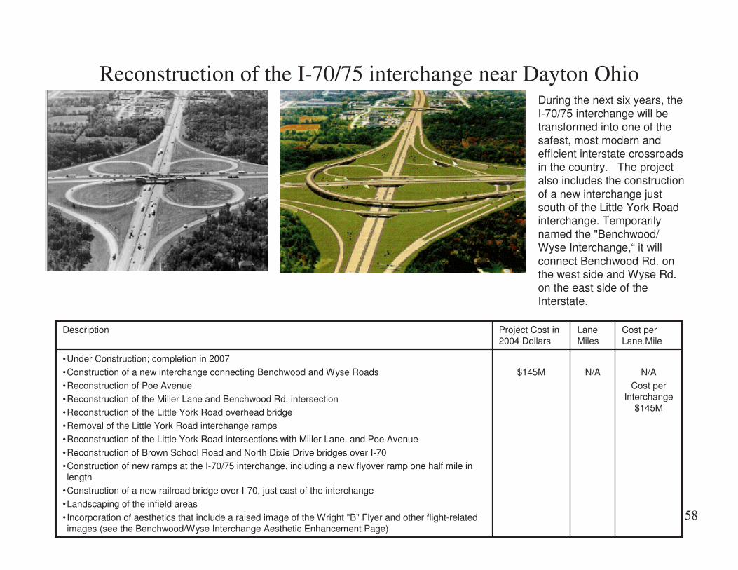
Reconstruction of the I-70/75 interchange near Dayton OhioDuring the next six years, theI-70/75 interchange will betransformed into one of thesafest, most modern andefficient interstate crossroadsin the country. The projectalso includes the constructionof a new interchange justsouth of the Little York Roadinterchange. Temporarilynamed the "Benchwood/Wyse Interchange,“ it willconnect Benchwood Rd. onthe west side and Wyse Rd.on the east side of theInterstate.
N/A
Cost perInterchange
$145M
N/A$145M
•Under Construction; completion in 2007
•Construction of a new interchange connecting Benchwood and Wyse Roads
•Reconstruction of Poe Avenue
•Reconstruction of the Miller Lane and Benchwood Rd. intersection•Reconstruction of the Little York Road overhead bridge
•Removal of the Little York Road interchange ramps
•Reconstruction of the Little York Road intersections with Miller Lane. and Poe Avenue
•Reconstruction of Brown School Road and North Dixie Drive bridges over I-70•Construction of new ramps at the I-70/75 interchange, including a new flyover ramp one half mile inlength
•Construction of a new railroad bridge over I-70, just east of the interchange
•Landscaping of the infield areas
• Incorporation of aesthetics that include a raised image of the Wright "B" Flyer and other flight-relatedimages (see the Benchwood/Wyse Interchange Aesthetic Enhancement Page)
Cost perLane Mile
LaneMiles
Project Cost in2004 Dollars
Description

59
Marquette Interchange, Milwaukee, Wisconsin
To improve safety and traffic flow, the new interchange will place ramps on the right side and improve ramp spacing andcurvature. The design maintains the same number of lanes in and out of the interchange from each direction. It alsopotentially frees land for development and incorporates many aesthetic improvements.
N/A
Cost perInterchange $810 M
N/A$810M•The project will be constructed in four years from 2004 to 2008•Placing entrance ramps and exit ramps on the right
•Improving the spacing of ramps
•Architectural retaining wall treatments
•Integral details on parapet walls
•Pedestrian-friendly lighting•Dramatic bridge piers
•Ornamental rails
Cost perLane Mile
LaneMiles
Project Cost in2004 Dollars
Description

60
Major Bridges
$12.7M /MileSR 433, Lewis and Clark Bridge DeckReplacement –Longview, Washington
$27.8M/MileTroup Howell Bridge -Rochester, New York
$45.8M/MileSR 104 Hood Canal Bridge East-halfReplacement and West-half Retrofit Project,Washington
$67.2M/MileTacoma Narrows Bridge –Tacoma, Washington
$64.2-$82.6 M/MileOakland Bay Bridge -San Francisco, California
$278M/MileCooper River Bridge Project -Charleston, South Carolina
Projects with structures have a high cost per lane mile

61
SR 433, Lewis and Clark Bridge Deck Replacement, Longview,Washington
The entire bridge will have a new drivingsurface and the roadway and shoulder widthswill be consistent all the way across thebridge. This includes a five-foot shoulder ineach direction.Installation of a new bridge deck will extendthe life of the Lewis and Clark Bridge foranother 25 years. The new roadway willeliminate the existing raised sidewalks,providing wider shoulders for bicyclists andpedestrians, as well as additional room fortraffic to maneuver around disabled vehicles.
$12.7M2$25.4M•The existing Washington bridge approach to the overhead main span will be widened; this will involveremoval of the existing raised sidewalks and installation of precast concrete panels at road level onboth sides of the bridge
•The existing concrete bridge deck and sidewalks through the overhead main span and most of theOregon approach span will be completely removed and replaced with full width precast concrete deckpanels
•The existing dip on the Oregon-side approach will be reduced by raising and widening the last bridgespan
•The existing raised three-foot wide sidewalks will be replaced with five-foot wide shoulders at roadlevel
•Steel guardrail will be bolted to the top of one-foot-high curb on each side of the bridge; new railing,designed to replicate the appearance of the existing railing, will be installed on top of the guardrail(see proposed design drawing)
•Additional lighting designed to reflect the historic nature of the bridge will be installed along the entirelength of the bridge
•Seismic retrofitting work will be completed on the bridge supports
•The aerial and shipping navigation lighting system on the bridge will be upgraded
•A new drainage system will be installed that will allow stormwater to be discharged through the bridgedeck and into new vegetated areas on the Oregon and Washington sides of the bridge
Cost perLane Mile
LaneMiles
Project Cost in2004 Dollars
Description

62
Troup Howell Bridge, Rochester, New York
$37 million multi-year project to replace the 8-span I-490 bridge over the Genesee River in downtown Rochester, New York isthe third phase of the State's commitment to improve I-490 between the Erie Canal west of Rochester and the GeneseeRiver, also known as the Western Gateway Project.
$27.8M1.33$37M•Most of the structure will be replaced, including all of the original 1955 structure; however, the newereastern spans will be retained and rehabilitated•xxx
•Xxx
Cost perLane Mile
LaneMiles
Project Cost in2004 Dollars
Description

63
SR 104 Hood Canal Bridge East-half Replacement and West-halfRetrofit Project, Washington
When finished, the Hood Canal Bridge willhave a new wider east-half floatingsection, new approach sections andtransition trusses on the east and westends. In addition, the west half will bewidened to allow for continuous 8-footshoulders across the entire length of thebridge -- matching the new east half. Viewthe future look of the bridge in the designvisualization photograph.
$45.8M6(1.5 miles x
4 lanes)
$274.7M•Under Construction; new pontoons will be floated into place in spring 2007•Replaces the east half floating portion of the bridge
•Replaces the east and west approach spans
•Replaces the east and west transition truss spans
Cost perLane Mile
Lane MilesProject Cost in2004 Dollars
Description

64
Tacoma Narrows Bridge, Tacoma, Washington
Existing SiteExisting Tacoma Narrows bridge currently has two narrowlanes in each direction without shoulders.
Description: Design visualization of the new parallel suspension bridge. Thenew bridge will carry three lanes with shoulders and the old bridge will beremodeled to carry three lanes with shoulders. The project also includes 3.5miles of roadway and and an associated toll plaza.
$24.6M
Bridge Only$ 67.2 M
25
(Bridgeonly 6)
$615 M•Adds new 1 mile long suspension bridge and remodels existing bridge• Constructs 3.5 miles of roadway and associated toll plaza
•Design Build project so the cost per lane mile includes the cost to design the project as well asconstruct it.
Cost perLane Mile
LaneMiles
Project Cost in2004 Dollars
Description

65
San Francisco -Oakland Bay Bridge, California
Existing SiteEarthquake damage on the east span of the he existingOakland Bay bridge
Description: Design visualization of the new suspension bridge. The newbridge will carry 5 lanes in each direction. The engineers estimate was $740million. The sole bid was offered May 26 of $1.4B with use of foreign steel and$1.8B using domestic steel. Record steel prices are the key factor in the hugedifferential, but the span’s unique design, tough schedule and strictspecifications also played a factor in ratcheting up the bid contingencies.
$64.2M-$82.6M
21.8$1.4B- $1.8B•11,525’ east span•Five lanes in each direction
Cost perLane Mile
LaneMiles
Project Cost in2004 Dollars
Description

66
Cooper River Bridge Project, Charleston, South Carolina
������"��+���������� ��� ������!��������!� ������������������ ����������,-.��������� ��/���� ��������� ������������������ ������ ����������������������#���,�,����� � ������������ ��������������������0���!����1�������"�#������!���� �����������!��0���������������������� �������������!��� �����������#�������� ������������������� ������� ��� ��!�� �� � ���
$278M2.34$650M
•Design Build Project scheduled to open in the summer of 2005; completion July 2006
•The mainline structure accommodates eight lanes of traffic – four in each direction – separated by acenter barrier
•Unlike the existing Grace Bridge, which has 10-foot lanes, the new bridge will have twelve-foot trafficlanes
•Two primary interchanges
Cost perLane Mile
LaneMiles
Project Cost in2004 Dollars
Description