herndon avenue interchange improvements - caltrans avenue interchange improvements 5 table 1.2 shows...
TRANSCRIPT

Herndon Avenue Interchange Improvements
Fresno, California Project ID 06-0002-0131
EA# 06-0L0300 06-FRE-99 PM 30.0/30.8
Initial Study with Proposed Mitigated Negative Declaration
Prepared by the
State of California Department of Transportation
October 2011

General Information about This Document
What’s in this document?
The California Department of Transportation (Caltrans), the California Environmental Quality Act
(CEQA) lead for this project, has prepared this Initial Study with Proposed Mitigated Negative
Declaration, which examines the potential environmental impacts of alternatives being considered for
the proposed project in the City and County of Fresno, California. The document describes why the
project is being proposed, alternatives for the project, the existing environment that could be affected
by the project, potential impacts from each of the alternatives, and proposed avoidance, minimization,
and/or mitigation measures.
What you should do?
• Please read the document.
• Additional copies of the document and related technical studies and memorandums are
available for review at the Caltrans District 6 office at 1352 West Olive Avenue, Fresno,
CA 93778 and at the Fresno County Public Library at 2420 Mariposa Street, Fresno, CA
93721.
• Attend the public hearing on November 3, 2011.
• Tell us what you think. If you have any comments on the proposed project, please attend
the public hearing and/or send your written comments to the Caltrans by the deadline.
• Submit comments via U.S. mail to:
G. William “Trais” Norris III, Senior Environmental Planner Sierra Pacific Environmental Analysis Branch Caltrans District 6 855 M Street, Suite 200 Fresno, CA 93721
• Submit comments via email to: [email protected]
• Be sure to submit comments by the deadline: November 28, 2011
What happens next?
After comments are received from the public and reviewing agencies, Caltrans may 1) give
environmental approval to the proposed project, 2) do additional environmental studies, or 3) abandon
the project. If the project is given environmental approval and funding is appropriated, Caltrans could
design and build all or part of the project.
Printing this document: To save paper, this document has been set up for two-sided printing (to print the front
and back of a page). Blank pages (or diamond pages) occur where needed throughout the document to maintain
proper layout of the chapters and appendices.
For individuals with sensory disabilities, this document is available in Braille, in large print, on audio cassette, or on computer disk. To obtain a copy in one of these alternate formats, please call or write to Caltrans, Attn: G. William “Trais” Norris III, Sierra Pacific Environmental Analysis Branch, 855 M Street, Suite 200, Fresno, CA 93721, 559-445-6447 Voice, or use the California Relay Service TTY number, 1-800-375-2929 or 711.


Herndon Avenue Interchange Improvements � i
Proposed Mitigated Negative Declaration Pursuant to: Division 6, Public Resources Code
Project Description
The California Department of Transportation (Caltrans) in cooperation with the City of Fresno proposes to make
improvements to Herndon Avenue at State Route 99 including installing signals, widening the roadway and ramps, and
removing the southbound off-ramp (Grantland exit).
Determination
This proposed Mitigated Negative Declaration is included to give notice to interested agencies and the public that it is
Caltrans’ intent to adopt a Mitigated Negative Declaration for this project. This does not mean that Caltrans’ decision on
the project is final. This Mitigated Negative Declaration is subject to change based on comments received by interested
agencies and the public.
Caltrans has prepared an Initial Study for this project and, pending public review, expects to determine from this study that
the proposed project would not have a significant effect on the environment for the following reasons:
The project would have no effect on: wild and scenic rivers, parks and recreation, farmlands/timberlands, utilities and
emergency services, visual/aesthetics, water quality, geology/soils/seismic/topography, hydrology/floodplains, noise,
natural communities, plant communities, threatened and endangered species, or wetlands and other waters.
The project would have no significant effect on land use, community impacts, growth, traffic/transportation, hazardous
waste, or air quality.
In addition, the project would have no significant impact on cultural resources, paleontology, or animal species because the
following mitigation measures would reduce potential effects to insignificance:
• Native American monitoring would be coordinated by the City of Fresno with local tribal communities based on
previous involvement with highway and development projects in the area, with guidance from the Native American
Heritage Commission.
• Implementation of and compliance with the Paleontological Mitigation Plan.
• Biological impacts caused by the removal of two eucalyptus trees would be mitigated by compliance with the measures
stated in this document. The eucalyptus trees would be replaced by this project in accordance with current setback
standards.
________________________________ ______________________ Jennifer H. Taylor, Office Chief, South Date Central Region Environmental Division California Department of Transportation


Herndon Avenue Interchange Improvements � iii
Table of Contents
Proposed Mitigated Negative Declaration ............................................................................................... i Table of Contents .................................................................................................................................. iii List of Abbreviated Terms..................................................................................................................... iv
Chapter 1 Proposed Project ......................................................................................................... 1
1.1 INTRODUCTION ............................................................................................................. 1
1.2 PURPOSE AND NEED .................................................................................................... 1
1.2.1 Purpose of the Project ............................................................................................ 1
1.2.2 Need for the Project ............................................................................................... 1
1.3 ALTERNATIVES ............................................................................................................. 7
1.3.1 Build Alternative ................................................................................................... 7
1.3.2 No-Build Alternative ............................................................................................. 8
1.3.3 Comparison of Alternatives ................................................................................... 8
1.4 PERMITS AND APPROVALS NEEDED ....................................................................... 9
Chapter 2 Affected Environment, Environmental Consequences, and Avoidance,
Minimization, and/or Mitigation Measures ............................................................................. 11
2.1 HUMAN ENVIRONMENT ............................................................................................ 12
2.1.1 Land Use .............................................................................................................. 12
2.1.1.1 Existing and Future Land Use ...................................................................................... 12
2.1.2 Growth ................................................................................................................. 14
2.1.3 Community Impacts ............................................................................................ 17
2.1.4 Utilities and Emergency Services ........................................................................ 18
2.1.5 Traffic and Transportation/Pedestrian and Bicycle Facilities .............................. 19
2.1.6 Cultural Resources ............................................................................................... 25
2.2 PHYSICAL ENVIRONMENT ....................................................................................... 26
2.2.1 Paleontology ........................................................................................................ 26
2.2.2 Hazardous Materials ............................................................................................ 28
2.2.3 Air Quality ........................................................................................................... 32
2.2.4 Animal Species .................................................................................................... 44
2.3 CLIMATE CHANGE UNDER THE CALIFORNIA ENVIRONMENTAL QUALITY ACT ........................................................................................................................ 45
Chapter 3 Comments and Coordination .................................................................................... 61
Chapter 4 List of Preparers ....................................................................................................... 63
Appendix A CEQA Checklist ................................................................................................... 67
Appendix B Title VI Policy Statement ..................................................................................... 77
Appendix C Minimization and/or Mitigation Summary ........................................................... 79
Appendix D Federal and State Species Lists ............................................................................ 83
Appendix E Regulatory Settings .............................................................................................. 91
List of Technical Studies that are Bound Separately ............................................................................ 97

Herndon Avenue Interchange Improvements � iv
List of Figures
Figure 1-1 Project Vicinity Map ............................................................................................................ 3
Figure 1-2 Project Location Map .......................................................................................................... 4
Figure 2-1 Possible Effect of Traffic Operation Strategies in Reducing On-road CO2 Emission .................................................................................................................................. 46
Figure 2-2 California Greenhouse Gas Forecast ................................................................................. 51
Figure 2-3 Possible Effect of Traffic Operation Strategies in Reducing On-road CO2 ....................... 52
Figure 2-4 Mobility Pyramid ............................................................................................................... 54
List of Tables
Table 1.1 Existing and Predicted Annual Average Daily Traffic Without Project ............................... 2
Table 1.2 Existing and Predicted Levels of Service Without the Project .............................................. 5
Table 1.3 Comparison of Alternatives ................................................................................................... 9
Table 2.1 Development Projects .......................................................................................................... 13
Table 2.2 Preliminary Growth Analysis .............................................................................................. 16
Table 2.3 Existing and Predicted Annual Average Daily Traffic With and Without Project .............. 20
Table 2.4 Levels of Service for Intersections With and Without Project ............................................ 22
Table 2.5 State and Federal Criteria Air Pollutant Standards, Effects, and Sources ........................... 34
Table 2.6 Carbon Monoxide Measurements at the Fresno Monitoring Station .................................. 39
Table 2.7 Carbon Monoxide Analysis ................................................................................................. 40
Table 2.8 Construction Emissions ....................................................................................................... 43
Table 2.9 Climate Change Strategies ................................................................................................... 56
List of Abbreviated Terms
Caltrans California Department of Transportation CEQA California Environmental Quality Act PM2.5 Particulate matter (ambient) 2.5 microns or less in size PM10 Particulate matter less than 10 microns in size

Herndon Avenue Interchange Improvements � 1
Chapter 1 Proposed Project
1.1 Introduction
The California Department of Transportation (Caltrans) in cooperation with the City of
Fresno proposes to make improvements to Herndon Avenue at State Route 99, including
installing signals, widening the roadway and ramps, and removing the southbound off-ramp.
The project location and vicinity maps are shown in Figures 1-1 and 1-2.
The City of Fresno is the project sponsor for this project, and Caltrans is the lead agency
under the California Environmental Quality Act. Funding for the project is being provided by
private developer fees.
A Caltrans project currently under construction—the North Fresno Six-Lane project—is
widening State Route 99 through the project area. The Grantland Avenue Overcrossing
bridges have been widened by decking the inside median to accommodate three lanes in each
direction.
A new interchange is proposed by the City of Fresno one mile south of the Herndon
interchange on State Route 99. The Veterans Boulevard Interchange is planned to open in
2017.
1.2 Purpose and Need
1.2.1 Purpose of the Project
The purpose of the proposed project is to improve traffic operations and relieve congestion at
the existing Herndon Avenue interchange intersections and at the Herndon Avenue/Parkway
Drive intersection.
1.2.2 Need for the Project
Improve Traffic Operations and Relieve Congestion
The five intersections that are part of or adjacent to the Herndon Avenue interchange are
experiencing rapidly increasing traffic volumes.
Average traffic volume per year at an intersection can be measured by dividing the total
traffic for one year by 365 days to obtain the “annual average daily traffic” count. Table 1.1
shows the annual average daily traffic counts for intersections within and adjacent to the
project for existing conditions, for 2013 (the proposed construction year), and for 2035
(future conditions).

Chapter 1 � Proposed Project
Herndon Avenue Interchange Improvements � 2
Table 1.1 Existing and Predicted Annual Average Daily Traffic Without Project
Intersection
Annual Average Daily Traffic Counts
(Existing) 2013 2035
Grantland Avenue/Parkway Drive/State Route 99 southbound on-ramp
8,600 21,700 23,100
Herndon Avenue/Parkway Drive 9,100 21,900 23,700
Southbound off-ramp (Grantland Avenue exit)/Herndon Avenue
9,700 22,693 24,600
State Route 99 northbound off-ramp/Herndon Avenue
13,600 32,000 30,800
Golden State Boulevard/Herndon Avenue
22,800 49,100 52,000
Source: Traffic Memo prepared for this project (September 2011).
In 2013, traffic is projected to increase by 13,100 daily vehicles from the existing traffic
volume at the Grantland Avenue/Parkway Drive/State Route 99 southbound on-ramp
intersection. At the Herndon Avenue/Parkway Drive intersection, traffic is expected to more
than double by 2013. Traffic volumes are expected to increase on the State Route 99
northbound off-ramp/Herndon Avenue intersection from 13,600 vehicles a day to 18,400
vehicles a day by 2013. If the State Route 99 southbound off-ramp (the Grantland Avenue
exit onto Herndon Avenue) is still in use in 2013, the annual average daily traffic count is
projected to increase from 9,700 vehicles to 22,693 vehicles.
Intersection operation is described in terms of “level of service.” Six levels are defined,
ranging from level of service A (the best operating conditions) to level of service F (the worst
operating conditions). Level of service for intersections is determined by how many seconds
a vehicle must wait at a stoplight or stop sign before turning or driving through the
intersection. Caltrans’ goal is to maintain the level of service on its facilities at the transition
between level of service C and level of service D. For signalized intersections and ramp
terminals, the transition is at 35 seconds of delay per vehicle passing through the intersection.

Chapter 1 � Proposed Project
Herndon Avenue Interchange Improvements � 3
Figure 1-1 Project Vicinity Map

Chapter 1 � Proposed Project
Herndon Avenue Interchange Improvements � 4
Figure 1-2 Project Location Map

Chapter 1 � Proposed Project
Herndon Avenue Interchange Improvements � 5
Table 1.2 shows the existing and predicted level of service at intersections within the
project area if the proposed project is not built. Traffic analysis indicates that by 2013 all of
the interchange intersections would operate at level of service F.
Table 1.2 Existing and Predicted Levels of Service Without the Project
Intersection Control
(Existing) 2013 2035
Morning Level of Service
Afternoon Level of Service
Morning Level of Service
Afternoon Level of Service
Morning Level of Service
Afternoon Level of Service
Grantland Avenue/ Parkway Drive/ State Route 99 southbound on-ramp
Stop sign
C B F F F F
Herndon Avenue/ Parkway Drive
Stop sign
F E F F F F
State Route 99 southbound off-ramp (Grantland Avenue exit)/Herndon Avenue
Stop sign
D C F F F F
State Route 99 northbound off-ramp/ Herndon Avenue
Stop sign
E F F F F F
Golden State Boulevard/ Herndon Avenue
Signal C C C D E F
Source: Traffic Memo prepared for this project (September 2011).
The State Route 99 northbound off-ramp exiting onto Herndon Avenue is now a “T”
intersection controlled by a stop sign for left turns and a yield sign for right turns; traffic on
Herndon Avenue does not stop. Currently, this intersection operates at level of service E
during the morning peak traffic hour and level of service F during the afternoon peak traffic
hour. This is below the Caltrans minimum level of service for intersections explained
above. The operation of this intersection is predicted to decline to level of service F in 2013
during both the morning and afternoon peak traffic hours.
At the Herndon Avenue/Parkway Drive “T” intersection, vehicles cross through an
intersection controlled by three stop signs. During the morning peak traffic hour, the level
of service for this intersection is F; for the afternoon peak hour, the level of service is E.
This is below level of service D, the minimum acceptable to the City of Fresno for
intersections on major arterial streets. Traffic conditions are expected to deteriorate further

Chapter 1 � Proposed Project
Herndon Avenue Interchange Improvements � 6
so that in 2013, the level of service would be F during both the morning and the afternoon
peak traffic hours.
Vehicles travelling north on Grantland Avenue must stop at the “T” intersection before
turning left across an uncontrolled southbound Parkway Drive or right onto the southbound
on-ramp. Under existing conditions, this intersection operates satisfactorily with levels of
service C and B during the morning and afternoon peak hours, respectively; however, in
2013, increasing traffic is expected to result in level of service F during both the morning
and the afternoon peak traffic hours.
At the State Route 99 southbound off-ramp/Herndon Avenue intersection (Grantland exit),
both the nearness of the ramp to the Herndon Avenue/Parkway Drive intersection and
backed-up traffic along westbound Herndon Avenue make access to Herndon Avenue from
the southbound off-ramp extremely difficult for motorists turning left. This results in an
unsatisfactory level of service D in the morning peak hour. In the afternoon peak hour, the
southbound off-ramp operates at level of service C. In 2013, congestion is projected to
increase to the point that the level of service would be F during both the morning and the
afternoon peak traffic hours at this intersection.
According to Caltrans Traffic Operations, the Grantland exit is underused. Under existing
conditions, the levels of service for the ramp were D (in the morning peak) and C (in the
afternoon peak) due to the heavier morning peak volume along Herndon Avenue. Roughly
11 percent (morning peak) and 13.3 percent (afternoon peak) of the southbound traffic
accessing Herndon Avenue use the existing southbound Herndon Avenue off-ramp. In
addition, 89 percent of southbound traffic uses the Golden State Boulevard exit to reach
Herndon Avenue during the morning peak, and 86.7 percent of vehicles exiting use it
instead of the Grantland Avenue exit during the afternoon peak hour. Roughly 24 percent of
the vehicles are trucks.
Future Needs
Near the Herndon Avenue/State Route 99 interchange, the City of Fresno has projects
(approved and pending) that consist of the following: 537 units of residential development
west of State Route 99; 447 units of residential development and about 225,000 square feet
of commercial development east of State Route 99. These projects are either not fully
occupied or built at this time.
In addition, the first phase of a new 238-acre mixed-use development (the El Paseo project)
just east of State Route 99 and south of Herndon Avenue was approved on December 17,
2010 by the Fresno City Council. The Marketplace at El Paseo will be a large retail
shopping center that includes big box stores. Future phases planned by the developer are a

Chapter 1 � Proposed Project
Herndon Avenue Interchange Improvements � 7
lifestyle center or town center project with a 132-room hotel, a mid-rise office park, a light-
industrial business park with a 120-room hotel, and a neighborhood retail/commercial
center.
1.3 Alternatives
1.3.1 Build Alternative
The Build Alternative would remove the southbound State Route 99/Herndon Avenue off-
ramp (the Grantland Avenue exit). Existing pavement (traveled lane and shoulders) along
the southbound off-ramp would be removed. With the removal of the southbound Herndon
Avenue off-ramp, all vehicles accessing Herndon Avenue would have to exit State Route
99 at the Golden State Boulevard off-ramp, toward the North Golden State Boulevard/
Herndon Avenue intersection.
Herndon Avenue (between Parkway Drive and the northbound off-ramp) would include
shoulder improvements, with restriping for two westbound lanes and one eastbound lane
and a sidewalk on the north side.
The westbound approach at the Herndon Avenue/Parkway Drive intersection would have
dual left-turn lanes and a single right-turn lane. Parkway Drive would be improved to have
two southbound lanes and a single right-turn lane (to Grantland Avenue) and one
northbound lane with a right-turn lane (to Herndon Avenue). The southbound on-ramp
would be improved to two lanes with ramp metering.
Traffic signals would be installed at the intersections of Herndon Avenue/northbound off-
ramp, Herndon Avenue/Parkway Drive, and Grantland Avenue/Parkway Drive/southbound
on-ramp. The Herndon Avenue/northbound off-ramp signal would be synchronized with
the Golden State Boulevard/Herndon Avenue signal just east of the interchange. The
northbound off-ramp would be improved to accommodate a single left-turn lane and dual
right-turn lanes.
Improvements would include making road cuts extending to a depth of 4 feet, importing
embankment fill, building the signal pile foundation to a depth of 16 feet, trenching and
placing signal interconnect conduit to a depth of 2 feet, placing storm drain lines to a depth
of 5 feet, building roadside ditches, and paving.
Construction of an embankment along the west side of Parkway Drive would encroach into
an existing Fresno Irrigation District easement; a Common Use Agreement between the
City and Fresno Irrigation District would be required to build the embankment.
Construction of the embankment and pavement for a right-turn lane along the east side of
Parkway Drive would encroach into the state right-of-way; a Maintenance Agreement

Chapter 1 � Proposed Project
Herndon Avenue Interchange Improvements � 8
between the State and the City would be required. No right-of-way acquisition would be
needed for the project.
The project is planned by the City of Fresno as mitigation of traffic impacts by the El Paseo
Marketplace development. Although 2013 is the planned construction year, the project may
be built in two phases depending upon how quickly construction of the El Paseo
Marketplace occurs. Before the first 200,000 square feet of retail space is open for business,
the following would occur:
• The traffic signal at Herndon Avenue/State Route 99 northbound off-ramp would be
installed.
• The northbound off-ramp would be widened.
• The southbound State Route 99/Herndon Avenue off-ramp (the Grantland Avenue exit)
would be removed.
After 200,000 square feet of retail space has been built at the El Paseo Marketplace, but
before the total built area is 300,000 square feet, the rest of the Herndon Avenue
Interchange project would be built as described above.
1.3.2 No-Build Alternative
The No-Build Alternative would keep the current interchange and ramp structure
configurations as they are. The No-Build Alternative would not meet the purpose and need
of this project, and traffic conditions would continue to deteriorate. Under No-Build
conditions (in 2013), all of the study intersections are projected to operate at level of
service F.
1.3.3 Comparison of Alternatives
The No-Build Alternative would keep this segment of the roadway in its current condition.
This alternative would not meet the purpose or need for the project because traffic
conditions would continue to deteriorate with future development of the area. Table 1.3
compares the Build Alternative to the No-Build Alternative.

Chapter 1 � Proposed Project
Herndon Avenue Interchange Improvements � 9
Table 1.3 Comparison of Alternatives
Evaluation Criteria Build Alternative No-Build Alternative
Reduces Congestion
Morning and afternoon levels of service would improve from level of service F to levels of service B and D for opening day.
There would be no reduction in congestion, and level of service would continue to deteriorate.
Improves Traffic Operations
Elimination of the off-ramp would improve intersection spacing, which would improve operations and eliminate conflicting traffic movements.
There would be no improvement to traffic operations.
Minimizes Environmental Impacts
Improved operations would improve air quality. Other impacts are less than significant.
There would be no additional effect on the environment.
Meets Purpose and Need Yes No
1.4 Permits and Approvals Needed
The following permits/approvals would be required for project construction:
Agency Permit/Approval Status
Caltrans Encroachment Permit Pending
Caltrans, City of Fresno, County of Fresno
Freeway Agreement* Pending
Caltrans, City of Fresno, County of Fresno
Maintenance Agreement Would be completed during Project Specifications and Estimate phase of project
Caltrans National Pollutant Discharge Elimination System (NPDES) Permit
City of Fresno to submit application in each project phase
City of Fresno and Fresno Irrigation District
Common Use Agreement Would be completed during Project Specifications and Estimate phase of project
* Pending Freeway Agreement is for the Veterans Boulevard project, which includes the Herndon Avenue improvements.


Herndon Avenue Interchange Improvements � 11
Chapter 2 Affected Environment, Environmental Consequences, and Avoidance, Minimization, and/or Mitigation Measures
This chapter explains the impacts that the project would have on the human, physical, and
biological environments in the project area. It describes the existing environment that could
be affected by the project, potential impacts from the alternatives, and proposed avoidance,
minimization, and/or mitigation measures. Any indirect impacts are included in the general
impacts analysis and discussions that follow. Related regulatory information—the laws,
regulations, and governmental and regulatory agencies involved for each impact area—is
provided in Appendix E.
As part of the scoping and environmental analysis done for the project, the following
environmental issues were considered, but no adverse impacts were identified.
Consequently, there is no further discussion of these issues in this document.
• Wild and Scenic Rivers—No rivers classified as Wild and Scenic were identified in the
proposed project area (Field Visit, February 4, 2011).
• Parks and Recreation—No parks or recreation facilities were identified in the proposed
project limits (Field Visit, February 4, 2011).
• Farmlands/Timberlands—There is no farmland or timberland in the project footprint
(Community Impact Assessment memo, March 2011).
• Visual/Aesthetics—Removal of two eucalyptus trees would have minor visual impacts
for the travelers along this corridor (Emails from Caltrans Landscape Architect, August
24, 2011).
• Water Quality and Storm Water Runoff—With the incorporation of best management
practices and proper and accepted engineering practices, the project would not have
adverse effects on surface or groundwater runoff (Island Park Water Quality Report,
March 2010).
• Hydrology and Floodplain—Roadway runoff would be collected in gutters, drains, and
open ditches and conveyed to existing drainage systems. The additional runoff
generated by the increased paving, combined with removal of paving for the
southbound off-ramp, would not create any net new impervious surfaces. No additional
storm water runoff capacity is necessary. The proposed project would not result in
Chapter 2 � Affected Environment, Environmental Consequences, and Avoidance, Minimization and/or Mitigation Measures
Herndon Avenue Interchange Improvements � 12
either longitudinal or transverse encroachment of a floodplain. Since the project is in
Zone X, the floodplain impact is not an issue for the project (Island Park Location
Hydraulic Study, 2008).
• Geology/Soils/Seismic/Topography—No known faults exist in the project area. The
project would not result in soil erosion or landslides. The project is not located on a
geologic unit or soil that is unstable or that would become unstable as a result of the
project (Island Park Geotech Memo, April 2008).
• Noise—No adverse noise impacts from construction equipment are anticipated due to
compliance with Caltrans specifications. Construction would be short term, intermittent,
and overshadowed by local traffic noise. No sensitive receptors in the project area
would experience substantial long-term noise impacts (Noise Memo, September 2011).
• Natural Communities—No natural communities were identified in the project area
(Biological Compliance Memo, September 2011).
• Wetlands and other Waters—No wetlands or other waters were identified in the project
area (Biological Compliance Memo, September 2011).
• Plant Species—No special-status plant species were identified in the project area
(Biological Compliance Memo, September 2011).
• Threatened and Endangered Species—No threatened or endangered species were found
in the project area (Biological Compliance Memo, September 2011).
2.1 Human Environment
2.1.1 Land Use
This section of the environmental document discusses the project’s impacts on land use and
is based on the March 2011 Community Impact Memo and additional research.
2.1.1.1 Existing and Future Land Use
Affected Environment
Land use designations in the project area were identified using the City of Fresno’s General
Plan 2025. These land uses consist of single-family residential, light industrial and
commercial. Along Golden State Boulevard south of Herndon Avenue, the parcels
approved by the City for the El Paseo Marketplace development are now zoned regional
commercial.
On the west side of State Route 99, E-Z Trip service station sits along Herndon Avenue
between Parkway Drive and the Herndon Avenue southbound off-ramp (Grantland exit).
The west side of Parkway Drive/Herndon Avenue is a fallow field. Residential homes in a
neighborhood setting sit to the west and south; Menlo Avenue and Grantland Avenue

Chapter 2 � Affected Environment, Environmental Consequences, and Avoidance, Minimization and/or Mitigation Measures
Herndon Avenue Interchange Improvements � 13
provide access to these neighborhoods. On the east side of State Route 99 along Golden
State Boulevard (both north and south of Herndon Avenue) are various commercial and
industrial uses: hotels, restaurant, coffee shop, fast food, service station, truck stop. One
service station, northeast of the State Route 99 northbound off-ramp, has driveway access
on the south side of Herndon Avenue.
The project area is within the City of Fresno’s sphere of influence, although the area west
of the State Route 99 freeway has not yet been incorporated into the city limits. Current and
proposed commercial and residential developments within 1 mile of the project location are
shown in Table 2.1.
Table 2.1 Development Projects
Name Location Jurisdiction Proposed Uses Status
El Paseo
Phase 1 Marketplace
Between Herndon, Golden State, and Bryant Avenues
City of Fresno
Shopping center, including retail and restaurants, discount superstore, discount store, and home improvement store.
City approved Environmental Impact Report December 16, 2010
Development Agreement July 2011
El Paseo
Phases 2-5 (Master Plan)
Bounded by Herndon Avenue, Golden State Avenue, Bryant Avenue, Carnegie Avenue and Bullard Avenue
City of Fresno
Phase 2: shopping center, office park, health/fitness center, multiplex theater, business hotel, discount story, shopping center
City required these phases to be conditioned on the completion of the Veterans Boulevard interchange project. Project-level environmental analysis of future phases required (December 16, 2010)
Phase 3: business hotel, business part, shopping center
Phase 4: shopping center
Phase 5: general office
Bounded by Herndon Avenue, Golden State Avenue, and State Route 99
City of Fresno
Phased construction of:
94-room Hampton Inn hotel, 88-room Holiday Inn Express hotel, 3 fast food restaurants, a gas station and mini mart, and 34,800 square feet of retail
Holiday Inn Express, Starbucks, and Yukon Jack’s are open. Hampton Inn has not yet opened.
Aquarius Aquarium Institute
West of State Route 99 and south of the San Joaquin River
City of Fresno Business/recreation and tourism
Still in early planning stages

Chapter 2 � Affected Environment, Environmental Consequences, and Avoidance, Minimization and/or Mitigation Measures
Herndon Avenue Interchange Improvements � 14
Environmental Consequences
The Build Alternative would not require or encourage a change in land use. The proposed
project would not conflict with current land use designations.
Avoidance, Minimization, and/or Mitigation Measures
No avoidance, minimization, and/or mitigations measures are required.
2.1.1.2 Consistency with State, Regional, and Local Plans
Affected Environment
Fresno County Regional Transportation Plan 2011
The components of this project are in the Final Regional Transportation Plan that was
issued July 29, 2010.
City of Fresno General Plan 2025
The Public Facilities Element states that it is the City’s policy to minimize vehicular and
vehicle-pedestrian conflicts on major streets and adjacent land uses through use of traffic
design and control measures that reduce congestion and increase safety.
West Area Community Plan
The City of Fresno’s West Area Community Plan covers a triangular area extending
westward from the Union Pacific Railroad tracks to Garfield Avenue in the vicinity of this
project, including State Route 99 northward to the San Joaquin River. The West Area
Community Plan promotes compatibility between areas planned for, or dedicated to, active
farming operations and areas planned for urban development. The plan supports, through
policy, the establishment of a service area and urban growth management fee for design and
construction of planned overcrossings of State Route 99 and for north-south traffic flow
improvements within the West Area.
Environmental Consequences
The project is consistent with the 2011 Fresno County Regional Transportation Plan, City
of Fresno General Plan 2025, and the West Area Community Plan.
Avoidance, Minimization, and/or Mitigation Measures
None required.
2.1.2 Growth
This section of the environmental document discusses the project’s impacts on growth and
is based on the March 2011 Growth Memo.

Chapter 2 � Affected Environment, Environmental Consequences, and Avoidance, Minimization and/or Mitigation Measures
Herndon Avenue Interchange Improvements � 15
Affected Environment
The revised Central California Futures Institute report titled “Population Forecast for
Fresno County to 2025” (dated April 2000) provides a forecast for a modest average annual
population growth rate of 1.9 percent between 2000 and 2025. This growth forecast,
prepared for and accepted by the Council of Fresno County Governments, indicates that the
county population would increase by 479,407 people (58 percent) from a population of
821,797 to a population of 1,301,204 by December 31, 2025. This is consistent with the
actual average annual population growth rate of 1.8 percent between 2000 and 2009
estimated by the State of California Department of Finance (Department of Finance, 2009).
Based on historical development and growth trends that have occurred over the past several
decades, the city’s population is expected to make up approximately 61 percent of the
county’s population. The 2025 Fresno General Plan is, therefore, intended to serve a
population of about 790,000 people over the 25-year planning horizon.
Environmental Consequences
A preliminary analysis was done to determine whether there would be a potential for
project-related growth. Factors such as accessibility, project type, project location, and
growth pressure were considered. Table 2.2 lists the screening factors used to determine the
likely growth potential of the project.

Chapter 2 � Affected Environment, Environmental Consequences, and Avoidance, Minimization and/or Mitigation Measures
Herndon Avenue Interchange Improvements � 16
Table 2.2 Preliminary Growth Analysis
Screening Factor Analysis Discussion
Accessibility The proposed project would remove an off-ramp (the southbound State Route 99 off-ramp) due to existing intersection spacing concerns on Herndon Avenue, but would not increase access or provide new access to other parts of the project area (i.e., non-roadway uses/lands), extend infrastructure, or increase capacity. With the off-ramp removed, southbound State Route 99 motorists wanting to exit State Route 99 at Herndon Avenue would have to use the existing southbound Golden State Boulevard off-ramp, which intersects with Herndon Avenue east of State Route 99. Consequently, access to Herndon Avenue for southbound State Route 99 motorists would continue to be provided, but without the redundant access that now occurs. Access is available now under the existing condition, but would be reduced with the proposed interchange changes. The proposed project would not increase access.
Project type, location, and growth pressure
The project type involves changes to an existing interchange to improve traffic operations. Surrounding the existing Herndon Avenue interchange is a combination of developed and undeveloped lands in a suburban setting. Typically, transportation projects in urban areas surrounded by rural land uses have a higher potential to cause growth-related impacts as population density and economic activity generate higher demands for conversion of undisturbed lands to developed uses. However, for the immediate project area, the City’s General Plan land use plan and the recently approved Fresno Marketplace at El Paseo are expected to generate more traffic, thus triggering the changes needed at the Herndon Avenue interchange, surrounding roadway improvements, and ultimately construction of the planned Veterans Boulevard/State Route 99 interchange project. Influencing growth are the surrounding land use circumstances and development project approvals—not the proposed Herndon Avenue interchange improvements. No land use changes would occur as a result of implementing the proposed interchange improvements.
Foreseeable growth The proposed project was initiated to address existing operational deficiencies at the interchange, as a response to traffic forecasts based on local plans and growth projections. The modified interchange would support current planned land use within the City of Fresno, including the recently approved Fresno Marketplace at El Paseo planned development.
Growth and its impact on resources
The future growth potential in the vicinity of the proposed interchange is a consequence of actions taken by the City of Fresno on approving local development and General Plan land use. The proposed project would have a potential to affect cultural resources, paleontological resources, and biological resources within the project area, but the project is not expected to affect resources outside the project area.
Based on the results of the screening factors above, the proposed project would not induce
growth, and therefore no further analysis is required.
Avoidance, Minimization, and/or Mitigation Measures
No new growth in anticipated as a result of the project improvements. No avoidance,
minimization, and/or mitigation measures are proposed because growth impacts would be
less than significant.

Chapter 2 � Affected Environment, Environmental Consequences, and Avoidance, Minimization and/or Mitigation Measures
Herndon Avenue Interchange Improvements � 17
2.1.3 Community Impacts
This section discusses the project’s impacts on community impacts and is based on the
March 2011 Community Impact Memo.
Affected Environment
Under the existing conditions, a partial interchange exists at Herndon Avenue and State
Route 99 in the northern Fresno area. Southbound and northbound diamond off-ramps are
provided, in addition to a southbound on-ramp that reflects a continuation of Parkway
Drive. North of the Herndon Avenue interchange is the partial Golden State Boulevard
interchange that provides an additional southbound off-ramp providing access to Herndon
Avenue, as well as a northbound on-ramp to State Route 99. Together, these two
interchanges provide all on- and off-ramp movements from State Route 99 to access either
Herndon Avenue or Golden State Boulevard. Some redundancy occurs by both
interchanges providing southbound off-ramp improvements.
Surrounding the existing Herndon Avenue interchange are developed and undeveloped
lands. On the west side of State Route 99, E-Z Trip service station sits between the
Grantland Avenue southbound off-ramp, Herndon Avenue, and Parkway Drive. Traffic
exiting the freeway at this location can access the service station by turning right onto
Herndon Avenue, right onto Parkway Drive and then right into the station. Motorists can
return to State Route 99 via the existing southbound on-ramp, or go elsewhere via Herndon
Avenue. West of Parkway Drive (west of the interchange) is a vacant field, and beyond that
are residential homes developed in a neighborhood setting. From Parkway Drive, access to
these subdivisions is via West Menlo Avenue.
On the east side of State Route 99 are various commercial and industrial uses (hotels,
restaurant, coffee shop, fast food, service station, truck stop). Except for the service station
and fast food restaurants with driveway access on the south side of Herndon Avenue, all
other uses are along Golden State Boulevard (both north and south of Herndon Avenue).
Environmental Consequences
The existing roadways, which establish the area roadway network, would be widened or
refined; no new roadways would be built. Therefore, the proposed improvements would not
divide an existing neighborhood or cause a breakdown in community cohesion.
No residential neighborhoods in the project area would be adversely affected by the
proposed improvements. The existing neighborhood would remain intact and unaffected by
the project. West Menlo Avenue currently “T” intersects at Parkway Drive, providing
access to the residential neighborhood. While minor widening is proposed along Parkway

Chapter 2 � Affected Environment, Environmental Consequences, and Avoidance, Minimization and/or Mitigation Measures
Herndon Avenue Interchange Improvements � 18
Drive and a southbound left-turn lane would be installed at Herndon Avenue, the West
Menlo Avenue “T” intersection and access would remain as they are now.
With the elimination of the Grantland Avenue southbound off-ramp, the convenience for
motorists accessing the E-Z Trip service station would be affected. However, access to the
service station from State Route 99 would continue to be provided from the Golden State
Boulevard off-ramp. Drivers would still make three right turns to enter the station,
travelling 0.6 mile from the ramp. Once motorists were at the service station, their return to
the freeway or local roadway network would remain unchanged and unaffected by the
project.
Southbound drivers must make left turns to enter and exit the service station on Golden
State Boulevard north of Herndon Avenue and also the service station on the south side of
Herndon Avenue between Golden State Boulevard and the northbound State Route 99 off-
ramp. With all right-turn access, the service station at 6639 Parkway Drive would still be
easier to get to than those stations. Therefore, this station should not experience a loss in
business volume, and business should actually improve in the near-term as traffic increases
in the area.
Truckers wishing to use the truck stop at 6725 Golden State Boulevard would continue to
make all right turns to access the facility. Traffic movement would not be affected for
patrons of the truck stop.
Agricultural uses would not be adversely affected (directly or indirectly) with
implementation of the proposed improvements.
Avoidance, Minimization, and/or Mitigation Measures
None required.
2.1.4 Utilities and Emergency Services
This section discusses the project’s impacts on utilities and emergency services.
Affected Environment
Both above- and below-ground utilities are located throughout the project corridor. PG&E
owns power poles and lines that extend across and along Herndon Avenue and along
Parkway Drive. Within the project area, PG&E also owns an underground high-pressure
gas line. The gas line runs along Grantland Avenue where it crosses Parkway Drive and
continues into the State Route 99 median. The gas line then runs north where it meets
Herndon Avenue and travels east toward Golden State Boulevard. An underground
communication line belonging to AT&T runs along the west side of Parkway Drive, and an

Chapter 2 � Affected Environment, Environmental Consequences, and Avoidance, Minimization and/or Mitigation Measures
Herndon Avenue Interchange Improvements � 19
overhead communication line crosses the north side of the Herndon Avenue/Parkway
Avenue intersection. An underground fiber optics line owned by Sebastian Fiber Optics
extends along the south side of Herndon Avenue, crosses Parkway Drive on the southern
side of the intersection, then turns southward along Parkway Drive. The Fresno Irrigation
District has a 48-inch culvert within an easement along the west side of Parkway Drive.
Water and sewer lines belonging to the City of Fresno also extend along Herndon Avenue
and Parkway Drive. Caltrans-owned traffic control devices exist at the southeast corner of
the Herndon Avenue/Parkway Drive intersection.
The Fresno Police Department, Fresno County Sheriffs, Fresno Fire Department and other
emergency services use Herndon Avenue and connecting roadways to access surrounding
areas. Currently, no constraints prevent access through the project area.
Environmental Consequences
The project would have no temporary or permanent impact to utilities. No utilities would
require relocation as a result of the project improvements.
Light grading at the edge of the new pavement on the west shoulder of Parkway Drive
would extend into the Fresno Irrigation District easement. During the project design phase,
PG&E, AT&T, Sebastian Fiber Optics, the Fresno Irrigation District, and the City
Department of Public Utilities would be consulted to ensure the project is designed to avoid
any impacts to these facilities.
Avoidance, Minimization, and/or Mitigation Measures
A Transportation Management Plan would be in place to ensure timely access for first
responders. Response time would be improved on completion of the proposed project.
2.1.5 Traffic and Transportation/Pedestrian and Bicycle Facilities
This section discusses the project’s impacts on traffic and circulation, both during
construction and after completion of the project, based on the September 2011 Traffic
Memorandum.
Affected Environment
A partial interchange exists at Herndon Avenue and State Route 99 in the northern Fresno
area. Southbound and northbound diamond off-ramps are provided, in addition to a
southbound on-ramp that reflects a continuation of Parkway Drive. North of the Herndon
Avenue interchange is the partial Golden State Boulevard interchange, which provides an
additional southbound off-ramp providing access to Herndon Avenue, as well as a
northbound on-ramp to State Route 99. Together, these two interchanges provide all on-
and off-ramp movements from State Route 99 to access either Herndon Avenue or Golden
Chapter 2 � Affected Environment, Environmental Consequences, and Avoidance, Minimization and/or Mitigation Measures
Herndon Avenue Interchange Improvements � 20
State Boulevard. Some redundancy occurs by both interchanges providing southbound off-
ramps.
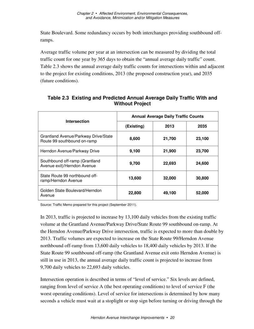
Average traffic volume per year at an intersection can be measured by dividing the total
traffic count for one year by 365 days to obtain the “annual average daily traffic” count.
Table 2.3 shows the annual average daily traffic counts for intersections within and adjacent
to the project for existing conditions, 2013 (the proposed construction year), and 2035
(future conditions).
Table 2.3 Existing and Predicted Annual Average Daily Traffic With and Without Project
Intersection
Annual Average Daily Traffic Counts
(Existing) 2013 2035
Grantland Avenue/Parkway Drive/State Route 99 southbound on-ramp
8,600 21,700 23,100
Herndon Avenue/Parkway Drive 9,100 21,900 23,700
Southbound off-ramp (Grantland Avenue exit)/Herndon Avenue
9,700 22,693 24,600
State Route 99 northbound off-ramp/Herndon Avenue
13,600 32,000 30,800
Golden State Boulevard/Herndon Avenue
22,800 49,100 52,000
Source: Traffic Memo prepared for this project (September 2011).
In 2013, traffic is projected to increase by 13,100 daily vehicles from the existing traffic
volume at the Grantland Avenue/Parkway Drive/State Route 99 southbound on-ramp. At
the Herndon Avenue/Parkway Drive intersection, traffic is expected to more than double by
2013. Traffic volumes are expected to increase on the State Route 99/Herndon Avenue
northbound off-ramp from 13,600 daily vehicles to 18,400 daily vehicles by 2013. If the
State Route 99 southbound off-ramp (the Grantland Avenue exit onto Herndon Avenue) is
still in use in 2013, the annual average daily traffic count is projected to increase from
9,700 daily vehicles to 22,693 daily vehicles.
Intersection operation is described in terms of “level of service.” Six levels are defined,
ranging from level of service A (the best operating conditions) to level of service F (the
worst operating conditions). Level of service for intersections is determined by how many
seconds a vehicle must wait at a stoplight or stop sign before turning or driving through the
Chapter 2 � Affected Environment, Environmental Consequences, and Avoidance, Minimization and/or Mitigation Measures
Herndon Avenue Interchange Improvements � 21
intersection. Caltrans’ goal is to maintain the level of service on its facilities at the
transition between level of service C and level of service D. For signalized intersections and
ramp terminals, the transition is at 35 seconds of delay per vehicle passing through the
intersection.
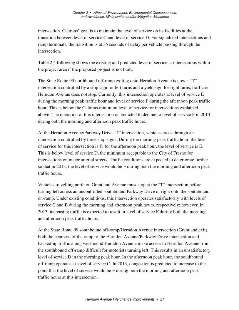
Table 2.4 following shows the existing and predicted level of service at intersections within
the project area if the proposed project is not built.
The State Route 99 northbound off-ramp exiting onto Herndon Avenue is now a “T”
intersection controlled by a stop sign for left turns and a yield sign for right turns; traffic on
Herndon Avenue does not stop. Currently, this intersection operates at level of service E
during the morning peak traffic hour and level of service F during the afternoon peak traffic
hour. This is below the Caltrans minimum level of service for intersections explained
above. The operation of this intersection is predicted to decline to level of service F in 2013
during both the morning and afternoon peak traffic hours.
At the Herndon Avenue/Parkway Drive “T” intersection, vehicles cross through an
intersection controlled by three stop signs. During the morning peak traffic hour, the level
of service for this intersection is F; for the afternoon peak hour, the level of service is E.
This is below level of service D, the minimum acceptable to the City of Fresno for
intersections on major arterial streets. Traffic conditions are expected to deteriorate further
so that in 2013, the level of service would be F during both the morning and afternoon peak
traffic hours.
Vehicles travelling north on Grantland Avenue must stop at the “T” intersection before
turning left across an uncontrolled southbound Parkway Drive or right onto the southbound
on-ramp. Under existing conditions, this intersection operates satisfactorily with levels of
service C and B during the morning and afternoon peak hours, respectively; however, in
2013, increasing traffic is expected to result in level of service F during both the morning
and afternoon peak traffic hours.
At the State Route 99 southbound off-ramp/Herndon Avenue intersection (Grantland exit),
both the nearness of the ramp to the Herndon Avenue/Parkway Drive intersection and
backed-up traffic along westbound Herndon Avenue make access to Herndon Avenue from
the southbound off-ramp difficult for motorists turning left. This results in an unsatisfactory
level of service D in the morning peak hour. In the afternoon peak hour, the southbound
off-ramp operates at level of service C. In 2013, congestion is predicted to increase to the
point that the level of service would be F during both the morning and afternoon peak
traffic hours at this intersection.

Herndon Avenue Interchange Improvements � 22
Table 2.4 Levels of Service for Intersections With and Without Project
Intersection Control
Existing 2013
No-Build 2013
Build Opening Day 2035
No-Build 2035
Build
Morning Level of Service
Afternoon Level of Service
Morning Level of Service
Afternoon Level of Service
Morning Level of Service
Afternoon Level of Service
Morning Level of Service
Afternoon Level of Service
Morning Level of Service
Afternoon Level of Service
Grantland Avenue/ Parkway Drive/State Route 99 southbound on-ramp
Signal(1)
C B F F B B F F
E B
Herndon Avenue/ Parkway Drive
Signal(1)
F E F F B B F F C A
State Route 99 southbound off-ramp (Grantland Avenue exit)/Herndon Avenue
Stop sign
D C F F - - F F - -
State Route 99 northbound off-ramp/ Herndon Avenue
Signal(1)
E F F F B D F F D B
Golden State Boulevard/Herndon Avenue
Signal C C C D C D E F E F
Source: Traffic Memo prepared for this project (September 2011).

Chapter 2 � Affected Environment, Environmental Consequences, and Avoidance, Minimization and/or Mitigation Measures
Herndon Avenue Interchange Improvements � 23
Under existing conditions, the levels of service for the ramp were D (in the morning peak)
and C (in the afternoon peak) due to the heavier morning peak volume along Herndon
Avenue. Roughly 11 percent (morning peak) and 13.3 percent (afternoon peak) of the
southbound traffic accessing Herndon Avenue use the existing southbound Herndon
Avenue off-ramp. In addition, 89 percent of southbound traffic uses the Golden State
Boulevard exit to reach Herndon Avenue during the morning peak, and 86.7 percent of
vehicles exiting use it instead of the Grantland Avenue exit during the afternoon peak hour.
Roughly 24 percent of the vehicles are trucks. According to Caltrans Traffic Operations, the
Grantland exit is underused.
In 2010, a local project by the City of Fresno rebuilt the Golden State Boulevard/Herndon
Avenue intersection. Now Golden State Boulevard has two through lanes, dual left-turn
lanes, and right-turn lane in each direction. Herndon Avenue has two through lanes, a left-
turn lane and a right-turn lane in the eastbound direction. It has three through lanes, dual
left-turn lanes, and a right-turn lane in the westbound direction. The three westbound
through lanes merge into one lane as they approach the undercrossing at State Route 99.
Currently, there are no sidewalks or bicycle lanes within the project footprint.
Environmental Consequences
Improvements to the Herndon Avenue interchange (road/ramp widening, signals, etc.)
would resolve current operational issues and help improve traffic operations over the long
term. Most of the proposed improvements require changes to existing facilities. No new
facilities are proposed. The project would not add capacity to the state highway system or to
local streets.
Table 2.3 above (which contains the same information as Table 1.1) shows that opening day
(2013) volumes of traffic at the interchange intersections are expected to be more than
double the existing conditions. By 2035, as development continues in the area, it is
expected that traffic volumes at the interchange intersections would be slightly higher than
the 2013 opening day volumes.
Table 2.4 shows that the proposed improvements at the Herndon Avenue interchange would
result in better operations at the interchange intersections on opening day (2013). The
intersection levels of service are expected to be as follows:
• B for both morning and afternoon peak for the Grantland Avenue/Parkway Drive/State
Route 99 southbound on-ramp intersection

Chapter 2 � Affected Environment, Environmental Consequences, and Avoidance, Minimization and/or Mitigation Measures
Herndon Avenue Interchange Improvements � 24
• B for both morning and afternoon peak for the Herndon Avenue/Parkway Drive
intersection
• B for the morning peak and D for the afternoon peak for the northbound off-
ramp/Herndon Avenue intersection
• C for the morning peak and D for the afternoon peak for the Golden State
Boulevard/Herndon Avenue intersection
By 2035, the Herndon interchange intersections are expected to experience a decrease in
level of service, indicating that future improvements may be needed. Levels of service are
expected to be as follows:
• E for the morning peak and B for the afternoon peak for the Grantland Avenue/Parkway
Drive/State Route 99 southbound on-ramp intersection
• C for the morning peak and A for the afternoon peak for the Herndon Avenue/Parkway
Drive intersection
• D for the morning peak and B for the afternoon peak for the northbound off-
ramp/Herndon Avenue intersection
• E for the morning peak and F for the afternoon peak for the Golden State
Boulevard/Herndon Avenue intersection
Except for the closure of the Herndon Avenue southbound off-ramp, all other
improvements (roadway and ramp widening, signal and ramp metering installation, and
application of turn lanes) were proposed for the El Paseo development project to improve
traffic operations. These improvements are intended to resolve the issues involving current
traffic operations, which would be exacerbated by the El Paseo development. Removal of
the southbound Herndon Avenue off-ramp was assumed in the El Paseo project traffic
analysis and therefore is reflected in all delay and level of service calculations; it also
factors into mitigation measure requirements proposed for that project. So, the traffic
conclusions in the El Paseo Environmental Impact Report and traffic study apply as well to
the proposed project.
Traffic would be maintained during construction activities. A minimum of one lane in each
direction for Herndon Avenue, Grantland Avenue, and Parkway Drive would be open to the
public. A minimum of one lane would be open to the public for the northbound off-ramp.
Temporary road and ramp closures may be required during non-peak hours. All staging
would occur within the public right-of-way.
Chapter 2 � Affected Environment, Environmental Consequences, and Avoidance, Minimization and/or Mitigation Measures
Herndon Avenue Interchange Improvements � 25
In addition, the project would build a 5-foot-wide sidewalk along the north side of Herndon
Avenue under the Grantland Avenue undercrossing, extending to Parkway Drive.
Avoidance, Minimization, and/or Mitigation Measures
A Traffic Management Plan would be developed to minimize delays and maximize safety
for motorists during construction. The Traffic Management Plan would include, but is not
limited to:
• The Caltrans Public Information Office issuing press releases and media alerts,
advertisements, and posting planned lane closures on the Caltrans District 6 website
• Use of portable changeable message signs
• Construction staging
• Local road closures
• Night work
• Incident management through a Construction Zone Enhancement Enforcement Program
2.1.6 Cultural Resources
Affected Environment
A Historical Resources Compliance Report was completed by Caltrans for the project on
November 30, 2010.
This project falls partially within two Caltrans projects: the Island Park Six-Lane project
(06-FRE-99 post miles 30.3/31.6 and 06-MAD-99 post miles 0.0/1.6) and the North Fresno
Six-Lane project (06-FRE-99 post miles 26.6/30.7). No previously recorded archeological
sites or historical architectural resources were reported within or adjacent to the project area
by those studies.
The area within the project area limits, determined by consultation between the Caltrans
project manager and archaeologist, was evaluated by Caltrans archaeologists and an
architectural historian. Two small areas not included in the Island Park Six-Lane or the
North Fresno Six-Lane projects were surveyed for archaeological resources, and no
archaeological sites were recorded.
Consultation with local tribes and the Native American Heritage Commission about the
Island Park Six-Lane and the North Fresno Six-Lane projects identified previously recorded
cultural resources close to the project. Caltrans Cultural Resources staff determined the area

Chapter 2 � Affected Environment, Environmental Consequences, and Avoidance, Minimization and/or Mitigation Measures
Herndon Avenue Interchange Improvements � 26
to be culturally sensitive and made recommendations that both Native American and
archaeological monitors be considered when working in this area.
Environmental Consequences
Caltrans has determined that a finding of no impact under the California Environmental
Quality Act is appropriate because there were no historical resources identified within the
project area limits. However, Caltrans Cultural Resources staff determined the area to be
culturally sensitive.
Avoidance, Minimization, and/or Mitigation Measures
Archaeological and Native American monitoring has been proposed for both Caltrans
projects in the area, and for the adjacent El Paseo development project. Native American
monitoring efforts would be coordinated by the City of Fresno with local tribal
communities based on previous study participation, with guidance from the Native
American Heritage Commission.
If cultural materials were discovered during construction, all earth-moving activity within
and around the immediate discovery area would be diverted until a qualified archaeologist
could assess the nature and significance of the find.
If human remains are discovered, State Health and Safety Code Section 7050.5 states that
further disturbances and activities shall stop in any area or nearby area suspected to overlie
remains, and the County Coroner contacted. Pursuant to Public Resources Code Section
5097.98, if the remains were thought to be Native American, the coroner would notify the
Native American Heritage Commission, who would then notify the Most Likely
Descendent. Further provisions of Public Resources Code Section 5097.98 are to be
followed as applicable.
2.2 Physical Environment
2.2.1 Paleontology
This section is based on a Preliminary Paleontological Mitigation Plan that was prepared
for this project (February 2011).
Affected Environment
The project area lies near the eastern margin of the San Joaquin Valley, near the
westernmost foothills of the Sierra Nevada and just south of the geographic center of the
state of California. The San Joaquin Valley makes up roughly the southern two-thirds of the
larger north-northwest-oriented valley called by such various names as the Valle Grande,
Great Valley, Central Valley, Great Central Valley, or California Trough. The Central

Chapter 2 � Affected Environment, Environmental Consequences, and Avoidance, Minimization and/or Mitigation Measures
Herndon Avenue Interchange Improvements � 27
Valley lies between the Sierra Nevada on the east and the Coast Ranges on the west. In the
general project vicinity, Cenozoic strata occur as alluvial deposits lain down mainly during
Plio-Pleistocene time by the streams that drain the adjacent uplands of the Sierra Nevada.
The gravel, sand and silt that compose these alluvial deposits have in the past produced
significant fossils, mainly large land mammals such as mammoths, mastodons, camels,
bison, and horses.
Environmental Consequences
Stratigraphic units within the project area include the Early to Middle Pleistocene Turlock
Lake Formation, Middle Pleistocene Riverbank Formation, and Quaternary Alluvium. Both
the Turlock Lake Formation and the Riverbank Formation have produced vertebrate and
invertebrate fossils in the project vicinity in the past. Strata indicating environments
favorable for the preservation of fossils are present in the Riverbank and Turlock Lake
formations in the project vicinity.
The Turlock Lake and Riverbank formations have been assigned a high sensitivity rating
for potentially yielding scientifically significant fossils, as both formations have produced
scientifically significant vertebrate fossils in the past.
Project construction activities, including grading, trenching and drilling, could encounter
the formations containing paleontologically sensitive resources.
Avoidance, Minimization, and/or Mitigation Measures
Implementation of and compliance with the Paleontological Mitigation Plan would ensure
that impacts to paleontological resources would be less than significant. These measures
include the following:
• Doing a pre-excavation site survey, literature review, repository review
• Conducting a project managers and personnel meeting/training program
• Developing and implementing a safety program
• Monitoring and salvaging fossils uncovered by earth-moving activities
• Recording associated specimen/sample data and corresponding geologic and geographic
site data
• Collecting sediment samples for microfossil analysis
• Processing sediment samples to salvage microfossils
• Preparing fossils to the point of identification

Chapter 2 � Affected Environment, Environmental Consequences, and Avoidance, Minimization and/or Mitigation Measures
Herndon Avenue Interchange Improvements � 28
• Identifying fossils to the lowest taxonomic level possible
• Accessioning and curating fossil specimens into the designated repository
• Archiving associated specimen and site data at the fossil repository
• Preparing the final paleontological mitigation report
2.2.2 Hazardous Materials
This section is based on an Initial Site Assessment prepared for the project (April 2011).
Affected Environment
The purpose of this study was to determine whether the improvement activities associated
with the project could be affected by any recorded or visible hazardous waste problems
within and adjacent to the interchange right-of-way, and to recommend any additional
studies, as appropriate.
Various tasks were completed for the Initial Site Assessment. A governmental records
search obtained a listing of properties or known incidents shown on federal and state
databases for hazardous waste sites within the project area. The records search included the
following databases and regulatory agencies:
• Environmental Data Resources Database
• Orphan Summary/Unmapped Sites Report
• Fresno County Assessor’s Office
• City of Fresno Building and Safety Services
• Fresno County Building Department
• Fresno County Environmental Health Services
• CERCLIS Database
• National Priorities List
• Resource Conservation and Recovery Act Facilities Database
• Emergency Responses Notification System
• Cal-Sites List
• Regional Water Quality Control Board
• State Water Resources Control Board
• Office of Environmental Protection

Chapter 2 � Affected Environment, Environmental Consequences, and Avoidance, Minimization and/or Mitigation Measures
Herndon Avenue Interchange Improvements � 29
• California Integrated Waste Management Board
In addition, historical records were examined. The following historical information was
reviewed:
• Aerial photographs
• Topographic maps
• Sanborn Fire Insurance maps
• City directories
• Interview/Questionnaire
A site visit was done in May 2010 to identify any visible exterior areas of potential
contamination that could potentially affect the project.
Physical Site Inspection
During the site visit, environmental concerns were noted. Both pad-mounted and pole-
mounted transformers were seen. Additionally, a monitoring well was observed at the
southeast corner of the intersection of Herndon Avenue and Parkway Drive. Finally, a gas
pipeline marker was noted along southbound State Route 99, south of Herndon Avenue.
Database and Regulatory Reviews
Environmental regulatory databases were searched for proposed projects and surrounding
properties to determine the potential incidents at the project site or surrounding properties.
Properties identified in the search were evaluated with respect to their potential to adversely
affect the project. Three main criteria were used to evaluate whether the sites warranted
further consideration: (1) proximity to the proposed project (less than 200 meters from edge
of existing right-of-way); (2) groundwater flow from a site to the proposed project; and (3)
surface-water flow or storm water runoff from a site to the proposed project.
The Regional Water Quality Control Board maintains records of reported leaking
underground storage tank incidents. This list identified three properties in the project
vicinity:
• A service station at 6639 North Parkway Drive has had a leaking underground storage
tank in the past. A monitoring well was drilled in 1999 at the site to monitor petroleum
hydrocarbons in the groundwater from an underground storage tank release. Based on a
statistical analysis of soil, the generated soil is not expected to be classified as a
California hazardous waste.

Chapter 2 � Affected Environment, Environmental Consequences, and Avoidance, Minimization and/or Mitigation Measures
Herndon Avenue Interchange Improvements � 30
• A truck stop facility at 6725 North Golden State Boulevard is listed as an open site
assessment, as of November 2007. Impacts to groundwater have been reported, but the
extent of impact has been identified within the property boundary. The truck stop
facility is not expected to pose an adverse impact to the site due to the limited extent of
impact to groundwater, regulatory status and the direction of groundwater flow. An
adverse impact to soil at this site is not expected.
• A service station at 6735 North Golden State Boulevard had a leaking underground
storage tank, but the Environmental Data Report indicates that this facility has been
issued a case closure letter dated January 2008. The facility is not expected to pose an
adverse impact to the site due to its regulatory status and its down-gradient position
with respect to the site.
Two other facilities—Curtis Towing Facility and Riverside Golf Course—were listed. Both
facilities are 0.4-0.5 mile from the project site and are not expected to pose an adverse
impact to the site due to the distance from the site and the regulatory status of the facilities.
Aerially Deposited Lead
Herndon and Grantland Avenues have existed since at least 1923, and State Route 99,
Parkway Drive, and Golden State Boulevard have existed since at least 1964 in their current
locations. Commercial distribution and use of leaded gasoline was common before 1973,
but has been restricted in use by the U.S. Environmental Protection Agency since the mid-
1970s. Aerially deposited lead, generated from the emissions of vehicles fueled by leaded
gasoline, commonly affects soil next to roadways.
A study was done in October 2000 along State Route 99 between post miles 19.5 and 30.5
in Fresno County and included the area of the site. The study included collection and
analysis of 606 soil samples. Based on the total lead and Soluble Threshhold Limit
Concentration levels, soil in the Caltrans right-of-way is considered non-hazardous for lead.
A variance issued to Caltrans by the California Environmental Protection Agency
Department of Toxic Substances Control allows for the reuse of lead-contaminated soil in
the Caltrans right-of-way in roadway corridor boundaries under certain conditions. Based
on statistical analysis of soil, the generated soil is not expected to be classified as a
California hazardous waste. If the soil cannot be managed to comply within conditions of
the variance, it would need to be handled in units. It may be necessary to analyze the off-
site disposal choices based on additional analysis of soil samples.

Chapter 2 � Affected Environment, Environmental Consequences, and Avoidance, Minimization and/or Mitigation Measures
Herndon Avenue Interchange Improvements � 31
Natural Gas
A gas pipeline parallels southbound State Route 99 at the site. Although a release from the
pipeline was not identified in the regulatory agency database search or any of the regulatory
agency documents reviewed for the Initial Site Assessment, undocumented releases from
petroleum pipelines are common.
Environmental Consequences
As stated above, three service station facilities within the project vicinity were identified in
the Initial Site Assessment. However, these sites are not expected to pose an adverse impact
on the proposed project site. Impacts to groundwater from the gasoline leak at the service
station at 6639 North Parkway Drive may have occurred beneath the western portion of the
site near the intersection of Parkway Drive and Herndon Avenue. Appropriate site controls
to protect worker safety are recommended.
For aerially deposited lead, based on statistical analysis of soil, the generated soil is not
expected to be classified as a California hazardous waste. It may be necessary to analyze
the off-site disposal choices based on additional analysis of soil samples.
Project construction is not expected to have an effect on the gas pipeline at the site.
Standard pre-construction coordination is required with Underground Service Alert to
ensure pipeline avoidance.
Avoidance, Minimization, and/or Mitigation Measures
• Review of the groundwater monitoring and soil analytical data (as they become
available) of the gasoline plume at 6639 North Parkway Drive during the life of the
project is required. In addition, appropriate site controls to protect worker safety during
construction activities are required.
• Lead in soil adjacent to roadways crossing the site should be assessed. A Lead
Compliance Plan would be required.
• The Underground Service Alert would be contacted before starting ground-disturbing
activities.

Chapter 2 � Affected Environment, Environmental Consequences, and Avoidance, Minimization and/or Mitigation Measures
Herndon Avenue Interchange Improvements � 32
2.2.3 Air Quality
This section is based on an Air Quality Impact Memo prepared for the project in September
2011.
Affected Environment
Air quality is a function of both local climate and local sources of air pollution. The amount
of a given pollutant in the atmosphere is determined by the amount of the pollutant released
and the atmosphere’s ability to transport and dilute the pollutant.
The project is located in the San Joaquin Valley Air Basin, which is composed of about
25,000 square miles and covers all of seven counties including Fresno, Kings, Madera,
Merced, San Joaquin, Stanislaus and Tulare, and the western portion of an eighth, Kern.
The San Joaquin Valley Air Basin is defined by the Sierra Nevada mountains in the east,
the Coast Ranges in the west, and the Tehachapi mountains in the south. The valley opens
to the sea at the Carquinez Straits where the San Joaquin-Sacramento Delta empties into
San Francisco Bay. An aerial view of the air basin would simulate a “bowl” opening to the
north. These topographic features restrict air movement through and out of the basin. Local
climatological effects, including wind speed and direction, temperature, inversion layers,
precipitation and fog, can adversely affect air quality.
Environmental Consequences
Regional Air Quality Conformity
The project is fully funded and is in the 2011 Regional Transportation Plan that was found
to conform by the Council of Fresno County Governments in 2007. The Federal Highway
Administration and Federal Transit Administration adopted the air quality conformity
finding July 29, 2010. The design concept and scope of the proposed project are consistent
with the 2011 Regional Transportation Plan and the assumptions in the Council of Fresno
County Governments regional emissions analysis.
Air pollutant emissions associated with the project would occur over the short term from
construction, such as fugitive dust from grading/site preparation and equipment exhaust.
Long-term emissions would improve from the enhanced traffic flow that would result from
reconfiguration of the interchange and installation of traffic signals. The aim of the project
is to improve traffic operations at the project intersections and lessen backed-up traffic at
the northbound off-ramp. The proposed interchange improvements are not expected to
generate any additional traffic. Regional trips would remain similar to what they are now.
Therefore, no new long-term regional emissions would result from implementation of the

Chapter 2 � Affected Environment, Environmental Consequences, and Avoidance, Minimization and/or Mitigation Measures
Herndon Avenue Interchange Improvements � 33
project. The project would improve traffic movement in the project vicinity, thereby
lowering the total regional pollutants emitted by motor vehicles.
Project-level Conformity
As noted in 2.5, the project sits in a nonattainment area for the federal particulate matter
(PM2.5) standard and a maintenance area for the federal particulate matter (PM10) standard.
It is in a nonattainment area for the state particulate matter (PM10 and 2.5) standards.
Table 2.5 also shows that the proposed improvements are in a nonattainment area for the
federal and state 8-hour ozone standards. Ozone is considered a regional pollutant.
Currently, there are no project-level analysis tools or approved guidelines. When projects
are listed in an approved Regional Transportation Plan and associated conformity analysis,
the projects are considered to be conforming to the State Implementation Plan for ozone.
Air quality thresholds, health effects and sources are also shown in Table 2.5.
Particulate Matter (PM10 and PM2.5) Analysis
The project is within a nonattainment area for federal PM2.5 standards and a maintenance
area for federal PM10 standards. Therefore, analyses are required for conformity purposes
per 40 Code of Federal Regulations Part 93. However, the Environmental Protection
Agency does not require hot spot analyses, qualitative or quantitative, for projects that are
not listed in section 93.123(b)(1) as an air quality concern.

Chapter 2 � Affected Environment, Environmental Consequences, and Avoidance, Minimization and/or Mitigation Measures
Herndon Avenue Interchange Improvements � 34
Table 2.5 State and Federal Criteria Air Pollutant Standards, Effects, and Sources
Pollutant Averaging
Time
State 9
Standard
Federal 9
Standard
Principal Health and
Atmospheric Effects Typical Sources
Attainment Status
Federal
Attainment Status State
Ozone (O3) 2 1 hour
8 hours
0.09 ppm
0.070 ppm
---
--- 4
0.075 ppm 6
0.08 ppm
(4th highest in 3 years)
High concentrations irritate lungs. Long-term exposure may cause lung tissue damage and cancer. Long-term exposure damages plant materials and reduces crop productivity. Precursor organic compounds include many known toxic air contaminants. Biogenic VOC may also contribute.
Low-altitude ozone is almost entirely formed from reactive organic gases/volatile organic compounds (ROG or VOC) and nitrogen oxides (NOx) in the presence of sunlight and heat. Major sources include motor vehicles and other mobile sources, solvent evaporation, and industrial and other combustion processes.
1 hour No Federal Standard 8 hours - Nonattainment/ Extreme
1 hour – Nonattainment/ Severe 8 hours– Nonattainment
Carbon Monoxide (CO)
1 hour
8 hours
20 ppm
9.0 ppm 1
35 ppm
9 ppm
CO interferes with the transfer of oxygen to the blood and deprives sensitive tissues of oxygen. CO also is a minor precursor for photochemical ozone.
Combustion sources, especially gasoline-powered engines and motor vehicles. CO is the traditional signature pollutant for on-road mobile sources at the local and neighborhood scale.
Attainment/Unclassified Attainment/Unclassified
Respirable Particulate Matter (PM10)
2
24 hours
Annual
50 µg/m3
20 µg/m3
150 µg/m3
--- 2
Irritates eyes and respiratory tract. Decreases lung capacity. Associated with increased cancer and mortality. Contributes to haze and reduced visibility. Includes some toxic air contaminants. Many aerosol and solid compounds are part of PM10.
Dust- and fume-producing industrial and agricultural operations; combustion smoke; atmospheric chemical reactions; construction and other dust-producing activities; unpaved road dust and re-entrained paved road dust; natural sources (wind-blown dust, ocean spray).
Attainment Nonattainment

Chapter 2 � Affected Environment, Environmental Consequences, and Avoidance, Minimization and/or Mitigation Measures
Herndon Avenue Interchange Improvements � 35
Pollutant Averaging
Time
State 9
Standard
Federal 9
Standard
Principal Health and
Atmospheric Effects Typical Sources
Attainment Status
Federal
Attainment Status State
Fine Particulate Matter (PM2.5)
2 24 hours
Annual
24 hours (conformity process 5)
---
12 µg/m3
---
35 µg/m3
15.0 µg/m3
65 µg/m3
(4th highest in 3 years)
Increases respiratory disease, lung damage, cancer, and premature death. Reduces visibility and produces surface soiling. Most diesel exhaust particulate matter – a toxic air contaminant – is in the PM2.5 size range. Many aerosol and solid compounds are part of PM2.5.
Combustion including motor vehicles, other mobile sources, and industrial activities; residential and agricultural burning; also formed through atmospheric chemical (including photochemical) reactions involving other pollutants including NOx, sulfur oxides (SOx), ammonia, and ROG.
Nonattainment Nonattainment
Nitrogen Dioxide (NO2)
1 hour
Annual
0.18 ppm
0.030 ppm
0.100 ppm 7
(98th percentile over 3 years)
0.053 ppm
Irritating to eyes and respiratory tract. Colors atmosphere reddish-brown. Contributes to acid rain. Part of the “NOx” group of ozone precursors.
Motor vehicles and other mobile sources; refineries; industrial operations. Attainment/Unclassified Attainment
Sulfur Dioxide (SO2)
1 hour
3 hours
24 hours
Annual
0.25 ppm
---
0.04 ppm
---
0.075 ppm 8
(98th percentile over 3 years)
0.5 ppm
0.14 ppm
0.030 ppm
Irritates respiratory tract; injures lung tissue. Can yellow plant leaves. Destructive to marble, iron, steel. Contributes to acid rain. Limits visibility.
Fuel combustion (especially coal and high-sulfur oil), chemical plants, sulfur recovery plants, metal processing; some natural sources like active volcanoes. Limited contribution possible from heavy-duty diesel vehicles if ultra-low sulfur fuel not used.
Attainment/Unclassified Attainment
Lead (Pb)3 Monthly
Quarterly
Rolling 3-month average
1.5 µg/m3
---
---
---
1.5 µg/m3
0.15 µg/m3
Disturbs gastrointestinal system. Causes anemia, kidney disease, and neuromuscular and neurological dysfunction.
Lead-based industrial processes like battery production and smelters. Lead paint, leaded gasoline. Aerially
No Designation/ Classification
Attainment

Chapter 2 � Affected Environment, Environmental Consequences, and Avoidance, Minimization and/or Mitigation Measures
Herndon Avenue Interchange Improvements � 36
Pollutant Averaging
Time
State 9
Standard
Federal 9
Standard
Principal Health and
Atmospheric Effects Typical Sources
Attainment Status
Federal
Attainment Status State
Also a toxic air contaminant and water pollutant.
deposited lead from gasoline may exist in soils along major roads.
Sulfate 24 hours 25 µg/m3 --- Premature mortality and respiratory effects. Contributes to acid rain. Some toxic air contaminants attach to sulfate aerosol particles.
Industrial processes, refineries and oil fields, mines, natural sources like volcanic areas, salt-covered dry lakes, and large sulfide rock areas.
No Federal Standard Attainment
Hydrogen Sulfide (H2S)
1 hour 0.03 ppm --- Colorless, flammable, poisonous. Respiratory irritant. Neurological damage and premature death. Headache, nausea.
Industrial processes such as: refineries and oil fields, asphalt plants, livestock operations, sewage treatment plants, and mines. Some natural sources like volcanic areas and hot springs.
No Federal Standard Unclassified
Visibility Reducing Particles (VRP)
8 hours Visibility of 10 miles or more (Tahoe: 30 miles) at relative humidity less than 70%
--- Reduces visibility. Produces haze.
NOTE: not related to the Regional Haze program under the Federal Clean Air Act, which is oriented primarily toward visibility issues in National Parks and other “Class I” areas.
See particulate matter above.
No Federal Standard Unclassified
Vinyl Chloride3 24 hours 0.01 ppm --- Neurological effects, liver damage, cancer.
Also considered a toxic air contaminant.
Industrial processes
No Federal Standard Attainment
Based on the California Air Resources Board Air Quality Standards chart (http://www.arb.ca.gov/research/aaqs/aaqs2.pdf).

Chapter 2 � Affected Environment, Environmental Consequences, and Avoidance, Minimization and/or Mitigation Measures
Herndon Avenue Interchange Improvements � 37
Notes: ppm = parts per million; µg/m3 = micrograms per cubic meter; ppb=parts per billion (thousand million)
1 Rounding to an integer value is not allowed for the State 8-hour CO standard. Violation occurs at or above 9.05 ppm. Violation of the Federal standard occurs at 9.5 ppm due to integer rounding.
2 Annual PM10 National Ambient Air Quality Standard (NAAQS) revoked October 2006; was 50 µg/m3. 24-hr. PM2.5 NAAQS tightened October 2006; was 65 µg/m3. In 9/09 the U.S. Environmental Protection Agency (U.S. EPA) began reconsidering the PM2.5 NAAQS; the 2006 action was partially vacated by a court decision.
3 The Air Resources Board has identified vinyl chloride and the particulate matter fraction of diesel exhaust as toxic air contaminants. Diesel exhaust particulate matter is part of PM10 and, in larger proportion, PM2.5. Both the Air Resources Board and U.S. EPA have identified lead and various organic compounds that are precursors to ozone and PM2.5 as toxic air contaminants. There are no exposure criteria for adverse health effect due to toxic air contaminants, and control requirements may apply at ambient concentrations below any criteria levels specified above for these pollutants or the general categories of pollutants to which they belong. Lead NAAQS are not required to be considered in Transportation Conformity analysis.
4 Prior to 6/2005, the 1-hour NAAQS was 0.12 ppm. The 1-hour NAAQS is still used only in 8-hour ozone early action compact areas, of which there are none in California. However, emission budgets for 1-hour ozone may still be in use in some areas where 8-hour ozone emission budgets have not been developed.
5 The 65 µg/m3 PM2.5 (24-hr) NAAQS was not revoked when the 35 µg/m3 NAAQS was promulgated in 2006. Conformity requirements apply for all NAAQS, including revoked NAAQS, until emission budgets for the newer NAAQS are found adequate or State Implementation Plan amendments for the newer NAAQS are completed.
6 As of 9/16/09, U.S. EPA is reconsidering the 2008 8-hour ozone NAAQS (0.075 ppm); U.S. EPA is expected to tighten the primary NAAQS to somewhere in the range of 60-70 ppb and to add a secondary NAAQS. U.S. EPA plans to finalize reconsideration and promulgate a revised standard by August 2010.
7 Final 1-hour NO2 NAAQS published in the Federal Register on 2/9/2010, effective 3/9/2010. Initial nonattainment area designations should occur in 2012 with conformity requirements effective in 2013. Project-level hot spot analysis requirements, while not yet required for conformity purposes, are expected.
8 U.S. EPA finalized a 1-hour SO2 standard of 75 ppb in June 2010. 9 State standards are “not to exceed” unless stated otherwise. Federal standards are “not to exceed more than once a year” or as noted above.

Herndon Avenue Interchange Improvements � 38
The proposed project does not qualify as a project of air quality concern for the following
reasons:
• This interchange reconstruction and intersection project would not increase the capacity
of State Route 99. Mainline State Route 99 had about a 61,000 average daily traffic
count in 2008 with a maximum of 21 percent diesel vehicles (Caltrans, 2009, Annual
Average Daily Truck Traffic on the California State Highway System, September). The
average daily traffic count near the Herndon Avenue interchange was about 14,337 in
2006 (Omni-Means, 2008; Fresno County Regional Traffic Monitoring Report, April
4). Based on the traffic data, the Herndon Avenue average daily traffic count would not
exceed the 125,000 average daily trips threshold for a project of air quality concern. The
project would increase the operational capacity of Herndon Avenue, but it would not
increase the traffic volumes or truck percentages along the roadways within the project
vicinity. Therefore, the project would not result in a significant increase in the number
of diesel vehicles.
• The project would not affect intersections that are at level of service D, E, or F with a
significant number of diesel vehicles. As indicated in Table 2.4 (from Section 2.1.5,
Traffic and Transportation/Pedestrian and Bicycle Facilities), the project would improve
level of service at intersections in the study area and would not increase the average
daily traffic or result in an increase in the number of diesel vehicles.
• The project would not include construction of a new bus or rail terminal.
• The project would not expand an existing bus or rail terminal.
• The project is not in or affecting locations, areas, or categories of sites that are
identified in the PM2.5 and PM10 applicable implementation plan or implementation plan
submission, as appropriate, as sites of violation or possible violation.
According to the Environmental Protection Agency Transportation Conformity Guidance,
an “interchange configuration project that involves either turn lanes or slots, or lanes or
movements that are physically separated” is not a project of air quality concern. These
kinds of projects improve operations by smoothing traffic flow and vehicle speeds by
improving weave and merge operations, which would not be expected to create or worsen
PM2.5 or PM10 violations. In addition, the guidance indicates that “interchange
reconfiguration projects that are designed to improve traffic flow and vehicle speeds, and
do not involve any increases in idling,” are also not considered projects of air quality
concern.

Herndon Avenue Interchange Improvements � 39
Therefore, the proposed project meets the Clean Air Act requirements and 40 Code of
Federal Regulations 93.116 without any explicit hot spot analysis. The project would not
create a new, or worsen an existing, PM2.5 or PM10 violation.
Carbon Monoxide Hot Spot Analysis
Historical air quality data show that existing carbon monoxide levels for the project area
and the general vicinity do not exceed either the state or federal ambient air quality
standards (see Table 2.6). The project would help to improve traffic flow and reduce
congestion at the interchange and on local roadways in the project vicinity. The project is in
a maintenance area for federal carbon monoxide standards.
Table 2.6 Carbon Monoxide Measurements at the Fresno Monitoring Station
Year or Standard
Carbon Monoxide Measurements at the Fresno (Sierra Skypark)
Monitoring Station (in parts per million)
1-Hour 8-Hour
1st
High
2nd
High
1st
High
2nd
High
2008 3.8 3.3 1.03 0.99
2009 N/A N/A 1.40 1.07
2010 N/A N/A 0.90 0.78
State Standards 20.0 20.0 9.0 9.0
Federal Standards 35.0 35.0 9.0 9.0
One-hour CO data is not currently available from the Environmental Protection Agency or the California Air Resources Board. Source: Air Quality Memo (September 2011)
Localized air quality impacts—carbon monoxide concentrations (carbon monoxide hot
spots) in the project area—would be affected due to improved traffic flow from interchange
improvements. Hot spots are typically produced at intersections, where traffic congestion is
highest because vehicles get backed up and must reduce speed.
The percentages of vehicles operating in cold-start mode are the same or lower for the
intersection under study compared to those used for the intersection in the attainment plan.
Traffic volumes on Herndon Avenue and the northbound on-ramp do not change as a result
of the project. The project is an interchange reconstruction project that does not increase the
capacity or average daily traffic count on State Route 99. There is no reduction in average
speeds. The project would improve the traffic flow by improving the level of service at key
intersections in the project area.

Herndon Avenue Interchange Improvements � 40
Carbon Monoxide Hot Spot Conclusion
The carbon monoxide protocol indicates that further analysis is not necessary. Therefore, a
detailed hot spot analysis is not required. To provide further evidence that there would not
be an expected impact from the project, CALINE4 air quality modeling was done for four
of the intersections in the project area. Table 2.7 shows the 1-hour and 8-hour carbon
monoxide concentrations that would occur at the Herndon interchange with the proposed
project in 2025, the projected full build-out year (completion) of the El Paseo development.
Table 2.7 Carbon Monoxide Analysis
Intersection
Distance from Road Centerline to
Maximum Concentration
1-Hour ppm
8-Hour ppm
Exceeds State
Standards? 1-Hour
standard 20 ppm
Exceeds State
Standards? 8-Hour
standard 9 ppm
Grantland Avenue/Parkway Drive/ State Route 99 southbound on-ramp
12 4.1 1.6 No No
7 4.0 1.6 No No
7 4.0 1.6 No No
14 4.0 1.6 No No
Herndon Avenue/Parkway Drive
7 4.2 1.7 No No
7 4.1 1.6 No No
12 4.1 1.6 No No
10 3.9 1.5 No No
State Route 99 northbound off-ramp/Herndon Avenue
14 4.3 1.8 No No
7 4.2 1.7 No No
7 4.2 1.7 No No
12 4.2 1.7 No No
Golden State Boulevard/Herndon Avenue
19 4.3 1.8 No No
19 4.3 1.8 No No
19 4.3 1.8 No No
19 4.3 1.8 No No
Notes: Carbon monoxide concentrations measured in parts per million Includes ambient 1-hour concentration of 3.3 parts per million and ambient 8-hour concentration of 1.1 parts per million. Source: Air Quality Memo (September 2011).

Herndon Avenue Interchange Improvements � 41
Table 2.7 shows that traffic is not expected to exceed any of the state 1-hour or 8-hour
carbon monoxide ambient air quality standards at these intersections. Localized air quality
impacts related to mobile source emissions would therefore be less than significant for the
project.
Naturally Occurring Asbestos
The project is in Fresno County, which is among the counties listed as containing
serpentine and ultramafic rock. However, the project is not within the area of the county
containing known deposits of serpentine or ultramafic rock. Therefore, the impact from
naturally occurring asbestos during project construction would be minimal to none.
Qualitative Project-Level Mobile Source Air Toxics Discussion
In addition to the criteria air pollutants for which there are National Ambient Air Quality
Standards, the Environmental Protection Agency also regulates air toxics. Most air toxics
originate from human-made sources, including on-road mobile sources, non-road mobile
sources (such as airplanes), area sources (such as dry cleaners), and stationary sources (such
as factories or refineries).
Mobile source air toxics are a subset of the 188 air toxics defined by the Clean Air Act.
Mobile source air toxics are compounds emitted from highway vehicles and non-road
equipment. Some toxic compounds are present in fuel and are emitted to the air when the
fuel evaporates or passes through an engine unburned. Other toxics are emitted from the
incomplete combustion of fuels or as secondary combustion products. Metal air toxics also
result from engine wear or from impurities in oil or gasoline.
Between 2000 and 2020, the Federal Highway Administration projects that even with a 64
percent increase in vehicle miles traveled, these programs would reduce on-highway
emissions of benzene, formaldehyde, 1, 3 butadiene, and acetaldehyde by 57 to 65 percent
and would reduce on-highway diesel particulate emissions by 87 percent. In February 2007,
the Environmental Protection Agency issued a final rule to reduce hazardous air pollutants
from mobile sources. The final standards would significantly lower emissions of benzene
and the other air toxics in three ways: (1) by lowering benzene content in gasoline; (2) by
reducing exhaust emissions from passenger vehicles operated at cold temperatures (under
75 degrees); and (3) by reducing emissions that evaporate from, and permeate through,
portable fuel containers.
For each of the project alternatives (No-Build and Build), the amount of mobile source air
toxics emitted would be proportional to the vehicle miles traveled, assuming that other
variables such as fleet mix are the same for each alternative. The project would reduce the

Herndon Avenue Interchange Improvements � 42
delay and either improve the level of service or maintain the level of service at the same
level as without the project. For all of the future alternatives (No-Build and Build),
emissions would be expected to be lower than present levels in the design year as a result of
the Environmental Protection Agency’s national control programs, which are projected to
reduce mobile source air toxics emissions by 57 to 87 percent from 2000 to 2020. Local
conditions may differ from these national projections in terms of fleet mix and turnover,
vehicle miles traveled growth rates, and local control measures. However, the magnitude of
the Environmental Protection Agency-projected reductions is so great (even after
accounting for vehicle miles traveled growth) that mobile source air toxics emissions in the
study area are likely to be lower in the future than they are today.
Construction Impacts
During construction, short-term degradation of air quality may occur due to the release of
particulate emissions generated by excavation, grading, hauling, and other activities related
to construction. Emissions from construction equipment also are anticipated and would
include carbon monoxide, nitrogen dioxide, reactive organic gasses, PM2.5, PM10, and toxic
air contaminants such as diesel exhaust particulate matter.
Site preparation and construction would involve clearing, cut-and-fill activities, grading,
and paving roadway surfaces. Construction-related effects on air quality from most
highway projects would be greatest during the site preparation phase because most engine
emissions are associated with the excavation, handling, and transport of soils to and from
the site. These activities would temporarily generate PM10, PM2.5, and small amounts of
carbon monoxide, oxides of nitrogen, and reactive organic gasses. Sources of fugitive dust
would include disturbed soils at the construction site and trucks carrying uncovered loads of
soils. Unless properly controlled, vehicles leaving the site would deposit mud on local
streets, which could be an additional source of airborne dust after it dries. PM10 emissions
would vary from day to day, depending on the nature and magnitude of construction
activity and local weather conditions. PM10 emissions would depend on soil moisture, silt
content of soil, wind speed, and the amount of equipment operating. Larger dust particles
would settle near the source, while fine particles would be dispersed over greater distances
from the construction site.
In addition to dust-related PM10 emissions, heavy trucks and construction equipment
powered by gasoline and diesel engines would generate carbon monoxide, oxides of
nitrogen, reactive organic gasses and some soot particulate (PM2.5 and PM10) in exhaust
emissions. If construction activities were to increase traffic congestion in the area, carbon
monoxide and other emissions from traffic would increase slightly while those vehicles are

Herndon Avenue Interchange Improvements � 43
delayed. These emissions would be temporary and limited to the immediate area
surrounding the construction site.
The San Joaquin Valley Air Pollution Control District does not provide a model for
calculating construction emissions; however, construction emissions were estimated for the
project using the Sacramento Metropolitan Air Quality Management District’s Road
Construction Emissions Model, Version 6.3.2, which can also be used for projects in the
San Joaquin Valley. The recommended thresholds of significance for CEQA analysis of
construction emissions were 10 tons per year of reactive organic gasses oxides of nitrogen,
and 15 tons per year of PM10. As shown in Table 2.8, none of the criteria pollutants is
expected to exceed the annual emissions thresholds.
Table 2.8 Construction Emissions
Project Phases
Reactive Organic Gasses (lbs/day)
Carbon Monoxide (lbs/day)
Oxides of
Nitrogen (lbs/day)
PM10 (lbs/day)
Exhaust PM10
(lbs/day)
Fugitive Dust PM10
(lbs/day)
Grubbing/Land Clearing 8.6 39.0 72.0 55.6 3.1 52.5
Grading/Excavation 8.2 35.8 61.2 55.8 3.3 52.5
Drainage/Utilities/Sub-Grade 5.7 22.5 38.3 54.8 2.3 52.5
Paving 6.3 21.5 32.9 2.9 2.9 -
Maximum (pounds/day) 8.6 39.0 72.0 55.8 3.3 52.5
Total (tons/construction project) 0.5 2.0 3.5 3.1 0.2 2.9
Note: Total PM10 emissions are the sum of exhaust and fugitive dust emissions.
As noted in Table 2.8, construction emissions for reactive organic gasses, oxides of
nitrogen, and PM10 would not exceed the tons per year thresholds as recommended by San
Joaquin Valley Air Pollution Control District staff. Initial estimates indicate that the Rule
9510 (indirect source review rule) threshold of 2 tons per year for nitrogen dioxide may be
exceeded; however, detailed construction schedules and equipment use are not available at
this time. Therefore, precise calculations cannot be made at this time, and it is uncertain if
the project would exceed the thresholds established in the indirect source review rule.
As more detailed information becomes available, the project applicant would reevaluate the
estimates of construction-related emissions, and if necessary, submit an application to the
Air Pollution Control District to comply with Rule 9510. Should it be determined that the
project must comply with Rule 9510, the project may be required to use special provisions
during construction, such as use of reduced emission construction vehicles as a condition of
the permit.

Herndon Avenue Interchange Improvements � 44
Avoidance, Minimization, and/or Abatement Measures
The project would be subject to a Dust Control Permit from the San Joaquin Unified Air
Pollution Control District. Observing the District’s Regulation VIII requirements and the
Caltrans Non-Standard Provisions for Dust should minimize the effect of dust during
construction. Additionally, Caltrans Standard Specifications pertaining to dust control and
dust palliative requirements are a required part of all construction contracts and should
effectively reduce and control emission impacts during construction. The provisions of
Caltrans Standard Specifications, Section 7-1.01F “Air Pollution Control” and Section 10
“Dust Control” require the contractor to comply with the San Joaquin Valley Air Pollution
Control District rules, ordinances, and regulations.
2.2.4 Animal Species
Affected Environment
A Biology Memo was completed for the project in September 2011. The project area sits
within the study area for the Island Park Six-Lane project Natural Environment Study,
prepared by Caltrans and dated March 2009.
The project sits along State Route 99 and adjacent roadways at the north end of the City of
Fresno in Fresno County. Vegetation in the project area consists of ruderal species
including ripgut brome (Bromus diandrus), wild oats (Avena sp.), perennial rye grass
(Lolium perenne), red-stemmed filaree (Erodium cicutarium), horseweed (Conyza
canadensis), field mustard (Brassica sp.), and winter vetch (Vicia villosa). No natural
communities are present. However, several mature eucalyptus trees (Eucalyptus sp.) within
the existing interchange provide suitable nesting habitat for raptors and other birds.
Due to the low biological sensitivity associated with project, the evaluation of biological
resources in the project area was done through review of aerial and site photographs; a field
study was not done. The Department of Fish and Game’s California Natural Diversity
Database, the U.S. Fish and Wildlife Service, and the California Native Plant Society
websites were queried referencing the Herndon, Fresno North, Gregg, and Lanes Bridge
7.5-minute U.S. Geological Survey quadrangles. Species lists from the database searches
and a map showing California Natural Diversity Database records within a 5-mile radius
around the project site are reproduced in Appendix D.
Environmental Consequences
The biological sensitivity of the project area is low. The project area consists of ruderal
vegetation and developed lands. The existing highway and surrounding development has
altered the natural landscape by removing natural habitat and introducing non-native plant
species.
Herndon Avenue Interchange Improvements � 45
Potential impacts to biological resources would be limited to widening of the existing State
Route 99 northbound off-ramp and widening of Parkway Drive/existing State Route 99
southbound on-ramp. Construction activities would remove ruderal vegetation; this would
not result in impacts to biological resources. However, removal of eucalyptus trees could
affect nesting birds, which are protected under the Migratory Bird Treaty Act and the
California Fish and Game Code.
Avoidance, Minimization, and/or Abatement Measures
Two eucalyptus trees in the project footprint would need to be removed. This should be
done during the non-nesting season, between September 1 and February 15. If the
eucalyptus trees cannot be removed during the non-nesting season, preconstruction surveys
for nesting birds would be done by a qualified biologist no more than 14 days before tree
removal. If nesting is identified, the tree would not be removed until any young have
fledged or the nest has failed, as determined by a qualified biologist. If no nesting is
identified, tree removal would proceed. The eucalyptus trees would be replaced by this
project in accordance with current setback standards.
2.3 Climate Change under the California Environmental Quality Act
Climate change refers to long-term changes in temperature, precipitation, wind patterns,
and other elements of the earth’s climate system. An ever-increasing body of scientific
research attributes these climatological changes to greenhouse gases, particularly those
generated from the production and use of fossil fuels.
While climate change has been a concern for several decades, the establishment of the
Intergovernmental Panel on Climate Change (IPCC) by the United Nations and World
Meteorological Organization in 1988, has led to increased efforts devoted to greenhouse
gas emissions reduction and climate change research and policy. These efforts are mainly
concerned with the emissions of greenhouse gas related to human activity that include
carbon dioxide (CO2), methane, nitrous oxide, tetrafluoromethane, hexafluoroethane, sulfur
hexafluoride, HFC-23 (fluoroform), HFC-134a (s, s, s, 2 – tetrafluoroethane), and HFC-
152a (difluoroethane).
Typically, two terms are used when discussing the impacts of climate change. “Greenhouse
Gas Mitigation” is a term for reducing greenhouse gas emissions to reduce or “mitigate” the
impacts of climate change. The term “adaptation” refers to the effort of planning for and
adapting to impacts due to climate change (such as adjusting transportation design

Herndon Avenue Interchange Improvements � 46
standards to withstand more intense storms and higher sea levels)
(http://climatechange.transportation.org/ghg_mitigation/).
Transportation sources (passenger cars, light-duty trucks, other trucks, buses and
motorcycles) in the state of California make up the largest source (second to electricity
generation) of greenhouse gas-emitting sources. Conversely, the main source of greenhouse
gas emissions in the United States is electricity generation, followed by transportation. The
dominant greenhouse gas emitted is CO2, mostly from fossil fuel combustion.
There are four main strategies for reducing greenhouse gas emissions from transportation
sources: 1) improve system and operation efficiencies, 2) reduce growth of vehicle miles
traveled 3) transition to lower greenhouse gas fuels, and 4) improve vehicle technologies.
To be most effective, all four should be pursued collectively.
One of the main strategies in the Department’s Climate Action Program to reduce
greenhouse gas emissions is to make California’s transportation system more efficient. The
highest levels of carbon dioxide from mobile sources, such as automobiles, occur at stop-
and-go speeds (0-25 miles per hour) and speeds over 55 miles per hour; the most severe
emissions occur from 0-25 miles per hour (see Figure 2-1).
To the extent that a project relieves congestion by enhancing operations and improving
travel times in high congestion travel corridors, greenhouse gas emissions, particularly
carbon dioxide, may be reduced.
Figure 2-1 Possible Effect of Traffic Operation Strategies in Reducing On-road CO2 Emission
Herndon Avenue Interchange Improvements � 47
Regulatory Setting
State
With the passage of several pieces of legislation including State Senate and Assembly Bills
and Executive Orders, California launched an innovative and proactive approach to dealing
with greenhouse gas emissions and climate change at the state level.
Assembly Bill 1493 (AB 1493), Pavley. Vehicular Emissions: Greenhouse Gases (AB
1493), 2002: requires the California Air Resources Board (ARB) to develop and implement
regulations to reduce automobile and light truck greenhouse gas emissions. These stricter
emissions standards were designed to apply to automobiles and light trucks beginning with
the 2009-model year. In June 2009, the U.S. Environmental Protection Agency (U.S. EPA)
Administrator granted a Clean Air Act waiver of preemption to California. This waiver
allowed California to implement its own greenhouse gas emission standards for motor
vehicles beginning with model year 2009. California agencies will be working with Federal
agencies to conduct joint rulemaking to reduce greenhouse gas emissions for passenger cars
model years 2017-2025.
Executive Order S-3-05: (signed on June 1, 2005, by Governor Arnold Schwarzenegger)
the goal of this Executive Order is to reduce California’s greenhouse gas emissions to: 1)
2000 levels by 2010, 2) 1990 levels by the 2020 and 3) 80 percent below the 1990 levels by
the year 2050. In 2006, this goal was further reinforced with the passage of Assembly Bill
32.
AB32 (AB 32), the Global Warming Solutions Act of 2006: AB 32 sets the same overall
greenhouse gas emissions reduction goals as outlined in Executive Order S-3-05, while
further mandating that the California Air Resources Board create a plan, which includes
market mechanisms, and implement rules to achieve “real, quantifiable, cost-effective
reductions of greenhouse gases.” Executive Order S-20-06 further directs state agencies to
begin implementing AB 32, including the recommendations made by the State’s Climate
Action Team.
Executive Order S-01-07: Governor Schwarzenegger set forth the low carbon fuel standard
for California. Under this Executive Order, the carbon intensity of California’s
transportation fuels is to be reduced by at least ten percent by 2020.
Senate Bill 97 (Chapter 185, 2007): required the Governor's Office of Planning and
Research (OPR) to develop recommended amendments to the State CEQA Guidelines for
addressing greenhouse gas emissions. The Amendments became effective on March 18,
2010.

Herndon Avenue Interchange Improvements � 48
Federal
Although climate change and greenhouse gas reduction is a concern at the federal level;
currently there are, no regulations or legislation that have been enacted specifically
addressing greenhouse gas emissions reductions and climate change at the project level.
Neither the United States Environmental Protection Agency nor Federal Highway
Administration (FHWA) has promulgated explicit guidance or methodology to conduct
project-level greenhouse gas analysis. As stated on the Federal Highway Administration’s
climate change website (http://www.fhwa.dot.gov/hep/climate/index.htm), climate change
considerations should be integrated throughout the transportation decision-making process–
from planning through project development and delivery. Addressing climate change
mitigation and adaptation up front in the planning process will facilitate decision-making
and improve efficiency at the program level, and will inform the analysis and stewardship
needs of project level decision-making. Climate change considerations can easily be
integrated into many planning factors, such as supporting economic vitality and global
efficiency, increasing safety and mobility, enhancing the environment, promoting energy
conservation, and improving the quality of life.
The four strategies set forth by the Federal Highway Administration to lessen climate
change impacts do correlate with efforts that the State has undertaken and is undertaking to
deal with transportation and climate change; the strategies include improved transportation
system efficiency, cleaner fuels, cleaner vehicles, and reduction in the growth of vehicle
hours travelled.
Climate change and its associated effects are also being addressed through various efforts at
the federal level to improve fuel economy and energy efficiency, such as the “National
Clean Car Program” and Executive Order 13514- Federal Leadership in Environmental,
Energy and Economic Performance.
Executive Order 13514 is focused on reducing greenhouse gases internally in federal
agency missions, programs and operations, but also direct federal agencies to participate in
the interagency Climate Change Adaptation Task Force, which is engaged in developing a
U.S. strategy for adaptation to climate change.
On April 2, 2007, in Massachusetts v. EPA, 549 U.S. 497 (2007), the Supreme Court found
that greenhouse gases are air pollutants covered by the Clean Air Act and that the U.S. EPA
has the authority to regulate greenhouse gas. The Court held that the U.S. EPA
Administrator must determine whether or not emissions of greenhouse gases from new
motor vehicles cause or contribute to air pollution which may reasonably be anticipated to

Herndon Avenue Interchange Improvements � 49
endanger public health or welfare, or whether the science is too uncertain to make a
reasoned decision.
On December 7, 2009, the U.S. EPA Administrator signed two distinct findings regarding
greenhouse gases under section 202(a) of the Clean Air Act:
• Endangerment Finding: The Administrator found that the current and projected
concentrations of the six key well-mixed greenhouse gases--carbon dioxide (CO2),
methane (CH4), nitrous oxide (N2O), hydrofluorocarbons (HFCs), perfluorocarbons
(PFCs), and sulfur hexafluoride (SF6)--in the atmosphere threaten the public health and
welfare of current and future generations.
• Cause or Contribute Finding: The Administrator found that the combined emissions
of these well-mixed greenhouse gases from new motor vehicles and new motor vehicle
engines contribute to the greenhouse gas pollution which threatens public health and
welfare.
Although these findings did not themselves impose any requirements on industry or other
entities, this action was a prerequisite to finalizing the U.S. EPA’s Proposed Greenhouse
Gas Emission Standards for Light-Duty Vehicles, which was published on September 15,
20091. On May 7, 2010 the final Light-Duty Vehicle Greenhouse Gas Emissions Standards
and Corporate Average Fuel Economy Standards was published in the Federal Register.
U.S. EPA and the National Highway Traffic Safety Administration (NHTSA) are taking
coordinated steps to enable the production of a new generation of clean vehicles with
reduced greenhouse gas emissions and improved fuel efficiency from on-road vehicles and
engines. These next steps include developing the first-ever greenhouse gas regulations for
heavy-duty engines and vehicles, as well as additional light-duty vehicle greenhouse gas
regulations. These steps were outlined by President Obama in a memorandum on May 21,
2010.2
The final combined U.S. EPA and NHTSA standards that make up the first phase of this
national program apply to passenger cars, light-duty trucks, and medium-duty passenger
vehicles, covering model years 2012 through 2016. The standards require these vehicles to
meet an estimated combined average emissions level of 250 grams of carbon dioxide per
mile, equivalent to 35.5 miles per gallon (MPG) if the automobile industry were to meet
this carbon dioxide level solely through fuel economy improvements. Together, these
1 http://www.epa.gov/climatechange/endangerment.html 2 http://epa.gov/otaq/climate/regulations.htm
Herndon Avenue Interchange Improvements � 50
standards will cut greenhouse gas emissions by an estimated 960 million metric tons and
1.8 billion barrels of oil over the lifetime of the vehicles sold under the program (model
years 2012-2016).
On January 24, 2011, the U.S. EPA along with the U.S. Department of Transportation and
the State of California announced a single timeframe for proposing fuel economy and
greenhouse gas standards for model years 2017-2025 cars and light-trucks. Proposing the
new standards in the same timeframe (September 1, 2011) signals continued collaboration
that could lead to an extension of the current National Clean Car Program.
Project Analysis
An individual project does not generate enough greenhouse gas emissions to significantly
influence global climate change. Rather, global climate change is a cumulative impact. This
means that a project may participate in a potential impact through its incremental
contribution combined with the contributions of all other sources of greenhouse gas.1 In
assessing cumulative impacts, it must be determined if a project’s incremental effect is
“cumulatively considerable.” See California Environmental Quality Act (CEQA)
Guidelines sections 15064(h)(1) and 15130. To make this determination the incremental
impacts of the project must be compared with the effects of past, current, and probable
future projects. To gather sufficient information on a global scale of all past, current, and
future projects in order to make this determination is a difficult if not impossible task.
The AB 32 Scoping Plan contains the main strategies California will use to reduce
greenhouse gas. As part of its supporting documentation for the Draft Scoping Plan, the Air
Resources Board released the greenhouse gas inventory for California (Forecast last
updated: 28 October 2010). The forecast is an estimate of the emissions expected to occur
in the year 2020 if none of the foreseeable measures included in the Scoping Plan were
implemented. The base year used for forecasting emissions is the average of statewide
emissions in the greenhouse gas inventory for 2006, 2007, and 2008. See Figure 2-2.
1 This approach is supported by the AEP: Recommendations by the Association of Environmental Professionals on How to Analyze GHG Emissions and Global Climate Change in CEQA Documents (March 5, 2007), as well as the SCAQMD ( Chapter 6: : The CEQA Guide, April 2011) and the US Forest Service (Climate Change Considerations in Project Level NEPA Analysis, July 13, 2009).

Herndon Avenue Interchange Improvements � 51
Source: http://www.arb.ca.gov/cc/inventory/data/forecast.htm
Figure 2-2 California Greenhouse Gas Forecast
Caltrans and its parent agency, the Business, Transportation, and Housing Agency, have
taken an active role in addressing greenhouse gas emission reduction and climate change.
Recognizing that 98 percent of California’s greenhouse gas emissions are from the burning
of fossil fuels and 40 percent of all human made greenhouse gas emissions are from
transportation, the Department has created and is implementing the Climate Action
Program at Caltrans that was published in December 2006 (see Climate Action Program at
Caltrans (December 2006).1
One of the main strategies in Caltrans’ Climate Action Program to reduce greenhouse gas
emissions is to make California’s transportation system more efficient. The highest levels
of carbon dioxide from mobile sources, such as automobiles, occur at stop-and-go speeds
(0-25 miles per hour) and speeds over 55 miles per hour; the most severe emissions occur
from 0-25 miles per hour (see Figure 2-3).To the extent that a project relieves congestion by
enhancing operations and improving travel times in high congestion travel corridors
greenhouse gas emissions, particularly carbon monoxide, may be reduced.
1 Caltrans Climate Action Program is located at the following web address: http://www.dot.ca.gov/hq/tpp/offices/ogm/key_reports_files/State_Wide_Strategy/Caltrans_Climate_Action_Program.pdf

Herndon Avenue Interchange Improvements � 52
Source: Traffic Congestion and Greenhouse Gases: Matthew Barth and Kanok Boriboonsomsin(TR News 268 May-June 2010)<http://onlinepubs.trb.org/onlinepubs/trnews/trnews268.pdf
Figure 2-3 Possible Effect of Traffic Operation Strategies in Reducing On-road CO2
Qualitative Analysis
Improvements to the Herndon Avenue interchange (road/ramp widening, signals, and ramp
closure) are proposed to resolve current operational issues and to assist in improving traffic
operations over the long term. Most of the proposed improvements require changes to
existing facilities. No new facilities are proposed. This project would not add capacity to
the state highway system or to local streets.
Table 2.3 in the Traffic section of this document shows that opening day (2013) volumes of
traffic at the interchange intersections are expected to be more than double the existing
conditions. By 2035, as development continues in the area, it is anticipated that traffic
volumes at the interchange intersections would be slightly higher than the 2013 opening
day volumes.
Table 2.4 in the Traffic section shows that the proposed improvements at the Herndon
Avenue interchange would result in better operations (improved level of service) at the
interchange intersections on opening day (2013) as well as the future build year (2035)
when compared to the future no-build conditions.
Although greenhouse gas emissions are expected to increase when comparing existing
conditions to future conditions, overall greenhouse gas emissions are predicted to be lower
in the future if the project is built than if it is not constructed.

Herndon Avenue Interchange Improvements � 53
Construction Emissions
Greenhouse gas emissions for transportation projects can be divided into those produced
during construction and those produced during operations. Construction greenhouse gas
emissions include emissions produced as a result of material processing, emissions
produced by on-site construction equipment, and emissions arising from traffic delays due
to construction. These emissions would be produced at different levels throughout the
construction phase; their frequency and occurrence can be reduced through innovations in
plans and specifications and by implementing better traffic management during
construction phases. In addition, with innovations such as longer pavement lives, improved
traffic management plans, and changes in materials, the greenhouse gas emissions produced
during construction can be mitigated to some degree by longer intervals between
maintenance and rehabilitation events.
The project would be subject to a Dust Control Permit from the San Joaquin Unified Air
Pollution Control District and Caltrans Standard Specifications pertaining to dust control
and dust palliative requirements.
California Environmental Quality Act Conclusion
While there would be unavoidable construction-related greenhouse gas emissions, Caltrans
does anticipate that the project would not result in any increases in operational greenhouse
gas emissions. It is Caltrans’ determination that in the absence of further regulatory or
scientific information related to greenhouse gas emissions and California Environmental
Quality Act significance, it contains a level of uncertainty to make a determination
regarding significance of the project’s direct impact and its contribution on the cumulative
scale to climate change. However, Caltrans is firmly committed to implementing measures
to help reduce the potential effects of the project. These measures are outlined in the
following sections.
AB 32 Compliance
Caltrans continues to be actively involved on the Governor’s Climate Action Team as the
California Air Resources Board works to implement the Governor’s Executive Orders and
help achieve the targets set forth in Assembly Bill 32. Many of the strategies Caltrans is
using to help meet the targets in AB 32 come from the California Strategic Growth Plan,
which is updated each year. Then-Governor Arnold Schwarzenegger’s Strategic Growth
Plan calls for a $222 billion infrastructure improvement program to fortify the state’s
transportation system, education, housing, and waterways, including $100.7 billion in
transportation funding during the next decade.

Herndon Avenue Interchange Improvements � 54
As shown in Figure 2-4, the Strategic Growth Plan targets a significant decrease in traffic
congestion below today’s level and a corresponding reduction in greenhouse gas emissions.
The Strategic Growth Plan proposes to do this while accommodating growth in population
and the economy. A suite of investment options has been created that combined together
yield the promised reduction in congestion. The Strategic Growth Plan relies on a complete
systems approach of a variety of strategies: system monitoring and evaluation, maintenance
and preservation, smart land use and demand management, and operational improvements.
Figure 2-4 Mobility Pyramid
As part of the Climate Action Program at Caltrans (December 2006,
http://www.dot.ca.gov/docs/ClimateReport.pdf), Caltrans is supporting efforts to reduce
vehicle miles traveled by planning and implementing smart land use strategies: job/housing
proximity, developing transit-oriented communities, and high-density housing along transit
corridors. Caltrans is working closely with local jurisdictions on planning activities;
however, Caltrans does not have local land use planning authority.
Caltrans is also supporting efforts to improve the energy efficiency of the transportation
sector by increasing vehicle fuel economy in new cars, light- and heavy-duty trucks;
Caltrans is doing this by supporting ongoing research efforts at universities, by supporting
legislative efforts to increase fuel economy, and by its participation on the Climate Action

Herndon Avenue Interchange Improvements � 55
Team. It is important to note, however, that the control of the fuel economy standards is
held by Environmental Planning Agency and California Air Resources Board.
Lastly, the use of alternative fuels is also being considered; the Department is participating
in funding for alternative fuel research at the University of California at Davis.
Table 2.9 summarizes the department and statewide efforts that Caltrans is implementing to
reduce greenhouse gas emissions. For more detailed information about each strategy, please
see Climate Action Program at Caltrans (December 2006), available at
http://www.dot.ca.gov/docs/ClimateReport.pdf.
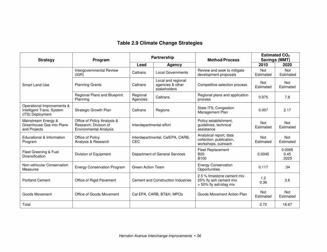
Herndon Avenue Interchange Improvements � 56
Table 2.9 Climate Change Strategies
Strategy Program Partnership
Method/Process Estimated CO2 Savings (MMT)
Lead Agency 2010 2020
Smart Land Use
Intergovernmental Review (IGR)
Caltrans Local Governments Review and seek to mitigate development proposals
Not Estimated
Not Estimated
Planning Grants Caltrans Local and regional agencies & other stakeholders
Competitive selection process Not
Estimated Not
Estimated
Regional Plans and Blueprint Planning
Regional Agencies
Caltrans Regional plans and application process
0.975 7.8
Operational Improvements & Intelligent Trans. System (ITS) Deployment
Strategic Growth Plan Caltrans Regions State ITS; Congestion Management Plan
0.007 2.17
Mainstream Energy & Greenhouse Gas into Plans and Projects
Office of Policy Analysis & Research; Division of Environmental Analysis
Interdepartmental effort Policy establishment, guidelines, technical assistance
Not Estimated
Not Estimated
Educational & Information Program
Office of Policy Analysis & Research
Interdepartmental, CalEPA, CARB, CEC
Analytical report, data collection, publication, workshops, outreach
Not Estimated
Not Estimated
Fleet Greening & Fuel Diversification
Division of Equipment Department of General Services Fleet Replacement B20 B100
0.0045 0.0065 0.45
.0225
Non-vehicular Conservation Measures
Energy Conservation Program Green Action Team Energy Conservation Opportunities
0.117 .34
Portland Cement Office of Rigid Pavement Cement and Construction Industries 2.5 % limestone cement mix 25% fly ash cement mix > 50% fly ash/slag mix
1.2 0.36
3.6
Goods Movement Office of Goods Movement Cal EPA, CARB, BT&H, MPOs Goods Movement Action Plan Not
Estimated Not
Estimated
Total 2.72 18.67

Chapter 2 � Affected Environment, Environmental Consequences, and Avoidance, Minimization and/or Mitigation Measures
Herndon Avenue Interchange Improvements � 57
Adaptation Strategies
“Adaptation strategies” refer to how Caltrans and others can plan for the effects of climate
change on the state’s transportation infrastructure and strengthen or protect the facilities from
damage. Climate change is expected to produce increased variability in precipitation, rising
temperatures, rising sea levels, storm surges and intensity, and the frequency and intensity of
wildfires. These changes may affect the transportation infrastructure in various ways, such as
damaging roadbeds by longer periods of intense heat; increasing storm damage from flooding
and erosion; and inundation from rising sea levels. These effects would vary by location and
may, in the most extreme cases, require that a facility be relocated or redesigned. There may
also be economic and strategic ramifications as a result of these types of impacts to the
transportation infrastructure.
Climate change adaptation must also involve the natural environment as well. Efforts are
underway on a statewide level to develop strategies to cope with impacts to habitat and
biodiversity through planning and conservation. The results of these efforts would help
California agencies plan and implement mitigation strategies for programs and projects.
On November 14, 2008, then-Governor Schwarzenegger signed Executive Order S-13-08,
which directed a number of state agencies to address California’s vulnerability to sea level
rise caused by climate change.
The California Resources Agency (now the Natural Resources Agency), through the
interagency Climate Action Team, was directed to coordinate with local, regional, state and
federal public and private entities to develop a state Climate Adaptation Strategy. The
Climate Adaptation Strategy would summarize the best-known science on climate change
impacts to California, assess California’s vulnerability to the identified impacts and then
outline solutions that can be implemented within and across state agencies to promote
resiliency.
As part of its development of the Climate Adaptation Strategy, the Resources Agency was
directed to request the National Academy of Science to prepare a Sea Level Rise Assessment
Report by December 2010 to advise how California should plan for future sea level rise. The
report is to include the following:
• Relative sea level rise projections for California, taking into account coastal erosion rates,
tidal impacts, El Niño and La Niña events, storm surge and land subsidence rates
• The range of uncertainty in selected sea level rise projections

Chapter 2 � Affected Environment, Environmental Consequences, and Avoidance, Minimization and/or Mitigation Measures
Herndon Avenue Interchange Improvements � 58
• A synthesis of existing information on projected sea level rise impacts to state
infrastructure (such as roads, public facilities and beaches), natural areas, and coastal and
marine ecosystems
• A discussion of future research needs regarding sea level rise for California
Furthermore, Executive Order S-13-08 directed the Business, Transportation, and Housing
Agency to prepare a report to assess vulnerability of transportation systems to sea level rise
affecting safety, maintenance and operational improvements of the system and economy of
the state. The Department continues to work on assessing the transportation system
vulnerability to climate change, including the effect of sea level rise.
Before the release of the final Sea Level Rise Assessment Report, all state agencies that are
planning to build projects in areas vulnerable to future sea level rise were directed to consider
a range of sea level rise scenarios for the years 2050 and 2100 to assess project vulnerability
and, to the extent feasible, reduce expected risks and increase resiliency to sea level rise.
However, all projects that have filed a Notice of Preparation, and/or are programmed for
construction funding from 2008 through 2013, or are routine maintenance projects as of the
date of Executive Order S-13-08 may, but are not required to, consider these planning
guidelines. This project is programmed for construction in 2013.
Sea level rise estimates should also be used in conjunction with information on local uplift
and subsidence, coastal erosion rates, predicted higher high water levels, storm surge and
storm wave data. (Executive Order S-13-08 allows some exceptions to this planning
requirement.) The proposed project is not near a coastal area and is at an elevation where it is
not anticipated to be affected by a rise in sea level.
Climate change adaptation for transportation infrastructure involves long-term planning and
risk management to address vulnerabilities in the transportation system from increased
precipitation and flooding; the increased frequency and intensity of storms and wildfires;
rising temperatures; and rising sea levels. Caltrans is an active participant in the efforts being
made as part of then-Governor Schwarzenegger’s Executive Order on Sea Level Rise and is
mobilizing to be able to respond to the National Academy of Science report on Sea Level
Rise Assessment, which was due for release by December 2010.
On August 3, 2009, the Natural Resources Agency in cooperation and partnership with
multiple state agencies released the 2009 California Climate Adaptation Strategy Discussion
Draft, which summarizes the best-known science on climate change impacts in seven specific
sectors and provides recommendations on how to manage against those threats. The release

Chapter 2 � Affected Environment, Environmental Consequences, and Avoidance, Minimization and/or Mitigation Measures
Herndon Avenue Interchange Improvements � 59
of the draft document set in motion a 45-day public comment period. Led by the California
Natural Resources Agency, numerous other state agencies were involved in the creation of
the discussion draft, including the Environmental Protection Agency; Business,
Transportation and Housing; Health and Human Services; and the Department of
Agriculture.
The discussion draft focuses on sectors that include: Public Health; Biodiversity and Habitat;
Ocean and Coastal Resources; Water Management; Agriculture; Forestry; and Transportation
and Energy Infrastructure. The strategy is in direct response to then-Governor
Schwarzenegger’s November 2008 Executive Order S-13-08 that specifically asked the
Natural Resources Agency to identify how state agencies could respond to rising
temperatures, changing precipitation patterns, sea level rise, and extreme natural events.
As data continues to be developed and collected, the state’s adaptation strategy will be
updated to reflect current findings. A revised version of the report was posted on the Natural
Resources Agency website on December 2, 2009; the report can be viewed at:
http://www.energy.ca.gov/2009publications/CNRA-1000-2009-027/CNRA-1000-2009-027-
F.PDF.
Currently, Caltrans is working to assess which transportation facilities are at greatest risk
from climate change effects. However, without statewide planning scenarios for relative sea
level rise and other climate change impacts, Caltrans has not been able to determine what
change, if any, may be made to its design standards for its transportation facilities. Once
statewide planning scenarios become available, Caltrans would be able review its current
design standards to determine what changes, if any, may be warranted to protect the
transportation system from sea level rise.

Herndon Avenue Interchange Improvements � 60

Herndon Avenue Interchange Improvements � 61
Chapter 3 Comments and Coordination
Early and continuing coordination with the general public and appropriate public agencies is
an essential part of the environmental process to determine the scope of environmental
documentation, the level of analysis, potential impacts and mitigation measures, and related
environmental requirements. Agency consultation and public participation for this project
have been accomplished through a variety of formal and informal methods, including project
development team meetings and Native American consultation. This chapter summarizes the
results of Caltrans’ efforts to identify, address, and resolve project-related issues through
early and continuing coordination.
Coordination with Public Agencies
The project is within the City of Fresno’s jurisdiction. The City’s Public Works Department
has consistently provided input to ensure there are minimal impacts to local residents and
business owners. The City has coordinated and had meetings with the County of Fresno
regarding the removal of the Grantland Avenue off-ramp. Coordination has also taken place
with the Fresno Metropolitan Flood Control District.
Coordination with Native American Heritage Commission
On October 19, 2010, Mandy Marine, District 06 Native American Coordinator, received an
updated list of Native American contacts for the project area.
Coordination with Native American Groups
The following groups and individuals were contacted about the project on October 25, 2010.
No responses were received as of November 30, 2010.
Mr. Lawrence Bill, Chairperson, Sierra Nevada Native American Coalition
Mr. Bob Pennell, Cultural Resources Director, Table Mountain Rancheria
Ms. Lee Ann Walker-Grant, Chairperson, Table Mountain Rancheria
Mr. Frank Marquez of Friant, California
The Honorable Liz Hutchins Kipp, Big Sandy Rancheria
Ms. Lorrie Planas, Choinumni Tribe
Mr. Jerry Brown, Chowchilla Tribe of Yokuts
The Honorable Robert Marquez, Cold Springs Rancheria
Mr. Keith F. Turner, Representative, Dumna Tribal Council Heritage Committee
Mr. Jim Redmoon, Cultural Resources, Dumna Wo-Wah Tribal Governments

Chapter 3 � Comments and Coordination
Herndon Avenue Interchange Improvements � 62
Mr. Kenneth Woodrow, Eshom Valley Band of Indians
Mr. John Davis, Chairman, Kings River Choinumni Farm
The Honorable J. Elaine Fink, North Fork Mono Rancheria
The Honorable Morris Reed, Picayune Rancheria
The Honorable Ruben Barrios, Santa Rosa Rancheria
A letter was also sent to the Dunlap Band of Mono Indians.

Herndon Avenue Interchange Improvements � 63
Chapter 4 List of Preparers
This document was prepared by the following individuals:
Caltrans
Abdulrahim Chafi, Transportation Engineer. Ph.D., Environmental Engineering, California
Coast University, Santa Ana; B.S., M.S., Chemistry and M.S., Civil/Environmental
Engineering, California State University, Fresno; 14 years of environmental technical
studies experience. Contribution: Review of noise and air quality studies.
Susan Greenwood, Associate Environmental Planner. B.S., Environmental Health Science,
California State University, Fresno; 19 years of environmental health, hazardous
waste, and hazardous material management experience. Contribution: Review of
Initial Site Assessment.
Wendy Kronman, Associate Environmental Planner. M.A., Linguistics, California State
University, Fresno; Certificate in Horticulture, Merritt College, Oakland; B.A.,
Anthropology, Sonoma State University; 5 years of environmental planning
experience. Contribution: Oversight of environmental document preparation.
David Lanner, Associate Environmental Planner. B.F.A., Art, Utah State University; 14 years
of cultural resources experience. Contribution: Prepared Historical Resources
Compliance Report and provided oversight of cultural resources analysis.
G. William “Trais” Norris, III, Senior Environmental Planner. B.S., Urban Regional
Planning, California State Polytechnic University, Pomona; 11 years of land use,
housing, redevelopment, and environmental planning experience. Contribution:
Senior Environmental Planner providing oversight for project.
Sarah Paulson, Biologist. B.S., Molecular Environmental Biology, University of California at
Berkeley; 4 years of biological science and natural resource assessment experience.
Contribution: Oversight of biological resources analysis.
Richard C. Stewart, Engineering Geologist, P.G. B.S., Geology, California State University,
Fresno; 21 years of hazardous waste and water quality experience; 4 years of
paleontology/geology experience. Contribution: Oversight of paleontological
resources analysis. Reviewed Paleontological Mitigation Plan.

Chapter 4 � List of Preparers
Herndon Avenue Interchange Improvements � 64
Jane Sellers, Research Writer. B.A., Journalism, California State University, Fresno; more
than 25 years of writing/editing experience, 11 years at Caltrans. Contribution: Edited
Initial Study.
Consulting Staff
LSA Associates, Rocklin, California
Bill Mayer, Principal Environmental Planner. B.S., Urban Planning, California State
Polytechnic University, Pomona; 35 years of environmental planning experience.
Contribution: Project management and project coordination.
Edward Heming, Senior Environmental Planner. M.S., Environmental Planning, California
State University, Fullerton; 8 years of environmental planning and environmental
science experience. Contribution: Environmental Analysis.
Amberly Morgan, Assistant Environmental Planner. B.A., Environmental Studies, California
State University, Sacramento; 3 years of environmental planning experience.
Contribution: Environmental Analysis.
Neal Kaptain, Senior Cultural Resources Manager (Archaeologist). M.A., Master of Arts in
Archaeology and Heritage, University of Leicester, England; 14+ years of cultural
resource experience. Contribution: Paleontological Analysis.
Steve Conkling, Principal/Director, Archaeology/Paleontology, B.A., Biological Sciences,
North Texas State University, Denton; 29 years of cultural resource experience.
Contribution: Paleontology Review.
Alexandra Greenwald, Archaeologist. B.A., Anthropology/Archaeology, Mills College,
Oakland; 7 years of cultural resource experience. Contribution: Paleontological
Analysis.
Jeff Bray, Associate Biologist. B.S., Wildlife Biology, Humboldt State University, Arcata; 16
years of wildlife biology experience. Contribution: Biological resources analysis.
Amy Fischer, Senior Planner. B.S., Environmental Policy Analysis, minor in Geography,
University of Nevada, Reno; 10+ years of environmental planning, air quality and
noise experience. Contribution: Air Quality Analysis/Global Climate Change.

Chapter 4 � List of Preparers
Herndon Avenue Interchange Improvements � 65
Phil Ault, Noise/Air Specialist. M.S., Advanced Environmental and Energy Studies for
Architecture, University of East London at CAT, Wales, U.K; 7+ years of noise and
air quality experience. Contribution: Noise Analysis.
Jason Paukovits, Air Quality Specialist. M.A., Masters of Environmental Management, Duke
University, 2001; 13 years of experience in air quality planning, policy and impact
analysis, global climate change policy, and transportation planning. Contribution: Air
Quality Analysis.
Mark Thomas & Company, Inc.
Ed Noriega, P.E., Division Manager. B.S., Civil Engineering, University of Toledo, Ohio: 16
years of transportation engineering experience. Contribution: Project Manager,
Traffic memo review and input.
Kleinfelder West, Inc.
Richard Fink, Principal Geologist. M.S., Geology, University of Nevada, Reno; B.S., Earth
Science, University of California at Santa Cruz; 32 years of geology experience.
Contribution: Project geology review and seismic input.
Jason Paul, Regional Delivery Manager. B.S., Geology, California State University, Fresno;
23 years of geology experience. Contribution: ISA Project Management, document
review.
Kathlien Childers, Assistant Project Manager. 11 years of environmental experience.
Contribution: ISA author.


Herndon Avenue Interchange Improvements � 67
Appendix A CEQA Checklist
Supporting documentation of all California Environmental Quality Act checklist
determinations is provided in Chapter 2 of this Initial Study. Documentation of “No Impact”
determinations is provided at the beginning of Chapter 2. Discussion of all impacts,
avoidance, minimization, and/or compensation measures under the appropriate topic
headings in Chapter 2.
Potentially Significant Impact
Less Than Significant with Mitigation
Less Than Significant Impact
No Impact
I. AESTHETICS: Would the project:
a) Have a substantial adverse effect on a scenic vista
b) Substantially damage scenic resources, including, but not limited to, trees, rock outcroppings, and historic buildings within a state scenic highway
c) Substantially degrade the existing visual character or quality of the site and its surroundings?
d) Create a new source of substantial light or glare which would adversely affect day or nighttime views in the area?
II. AGRICULTURE AND FOREST RESOURCES: In determining whether impacts to agricultural resources are significant environmental effects, lead agencies may refer to the California Agricultural Land Evaluation and Site Assessment Model (1997) prepared by the California Dept. of Conservation as an optional model to use in assessing impacts on agriculture and farmland. In determining whether impacts to forest resources, including timberland, are significant environmental effects, lead agencies may refer to information compiled by the California Department of Forestry and Fire Protection regarding the state’s inventory of forest land, including the Forest and Range Assessment Project and the Forest Legacy Assessment Project; and the forest carbon measurement methodology provided in Forest Protocols adopted by the California Air Resources Board. Would the project:
a) Convert Prime Farmland, Unique Farmland, or Farmland of Statewide Importance (Farmland), as shown on the maps prepared pursuant to the Farmland Mapping and Monitoring Program of the California Resources Agency, to non-agricultural use?
b) Conflict with existing zoning for agricultural use, or a Williamson Act contract?

Appendix A � CEQA Checklist
Herndon Avenue Interchange Improvements � 68
Potentially Significant Impact
Less Than Significant with Mitigation
Less Than Significant Impact
No Impact
c) Conflict with existing zoning for, or cause rezoning of, forest land (as defined in Public Resources Code section 12220(g)), timberland (as defined by Public Resources Code section 4526), or timberland zoned Timberland Production (as defined by Government Code section 51104(g))?
d) Result in the loss of forest land or conversion of forest land to non-forest use?
e) Involve other changes in the existing environment which, due to their location or nature, could result in conversion of Farmland, to non-agricultural use or conversion of forest land to non-forest use?
III. AIR QUALITY: Where available, the significance criteria established by the applicable air quality management or air pollution control district may be relied upon to make the following determinations. Would the project:
a) Conflict with or obstruct implementation of the applicable air quality plan?
b) Violate any air quality standard or contribute substantially to an existing or projected air quality violation?
c) Result in a cumulatively considerable net increase of any criteria pollutant for which the project region is non- attainment under an applicable federal or state ambient air quality standard (including releasing emissions which exceed quantitative thresholds for ozone precursors)?
d) Expose sensitive receptors to substantial pollutant concentrations?
e) Create objectionable odors affecting a substantial number of people?
IV. BIOLOGICAL RESOURCES: Would the project:
a) Have a substantial adverse effect, either directly or through habitat modifications, on any species identified as a candidate, sensitive, or special status species in local or regional plans, policies, or regulations, or by the California Department of Fish and Game or U.S. Fish and Wildlife Service?
b) Have a substantial adverse effect on any riparian habitat or other sensitive natural community identified in local or regional plans, policies, regulations or by the California Department of Fish and Game or US Fish and Wildlife Service?

Appendix A � CEQA Checklist
Herndon Avenue Interchange Improvements � 69
Potentially Significant Impact
Less Than Significant with Mitigation
Less Than Significant Impact
No Impact
c) Have a substantial adverse effect on federally protected wetlands as defined by Section 404 of the Clean Water Act (including, but not limited to, marsh, vernal pool, coastal, etc.) through direct removal, filling, hydrological interruption, or other means?
d) Interfere substantially with the movement of any native resident or migratory fish or wildlife species or with established native resident or migratory wildlife corridors, or impede the use of native wildlife nursery sites?
e) Conflict with any local policies or ordinances protecting biological resources, such as a tree preservation policy or ordinance?
f) Conflict with the provisions of an adopted Habitat Conservation Plan, Natural Community Conservation Plan, or other approved local, regional, or state habitat conservation plan?
V. CULTURAL RESOURCES: Would the project:
a) Cause a substantial adverse change in the significance of a historical resource as defined in §15064.5?
b) Cause a substantial adverse change in the significance of an archaeological resource pursuant to §15064.5?
c) Directly or indirectly destroy a unique paleontological resource or site or unique geologic feature?
d) Disturb any human remains, including those interred outside of formal cemeteries?
VI. GEOLOGY AND SOILS: Would the project:
a) Expose people or structures to potential substantial adverse effects, including the risk of loss, injury, or death involving:
i) Rupture of a known earthquake fault, as delineated on the most recent Alquist-Priolo Earthquake Fault Zoning Map issued by the State Geologist for the area or based on other substantial evidence of a known fault? Refer to Division of Mines and Geology Special Publication 42?
ii) Strong seismic ground shaking?
iii) Seismic-related ground failure, including liquefaction?

Appendix A � CEQA Checklist
Herndon Avenue Interchange Improvements � 70
Potentially Significant Impact
Less Than Significant with Mitigation
Less Than Significant Impact
No Impact
iv) Landslides?
b) Result in substantial soil erosion or the loss of topsoil?
c) Be located on a geologic unit or soil that is unstable, or that would become unstable as a result of the project, and potentially result in on- or off-site landslide, lateral spreading, subsidence, liquefaction or collapse?
d) Be located on expansive soil, as defined in Table 18-1-B of the Uniform Building Code (1994), creating substantial risks to life or property?
e) Have soils incapable of adequately supporting the use of septic tanks or alternative waste water disposal systems where sewers are not available for the disposal of waste water?
VII. GREENHOUSE GAS EMISSIONS: Would the project:
a) Generate greenhouse gas emissions, either directly or indirectly, that may have a significant impact on the environment?
An assessment of the greenhouse gas emissions and climate change is included in the body of environmental document. While Caltrans has included this good faith effort in order to provide the public and decision-makers as much information as possible about the project, it is Caltrans determination that in the absence of further regulatory or scientific information related to Greenhouse Gas emissions and CEQA significance, it is too speculative to make a significance determination regarding the project’s direct and indirect impact with respect to climate change. Caltrans does remain firmly committed to implementing measures to help reduce the potential effects of the project. These measures are outlined in the body of the environmental document.
b) Conflict with an applicable plan, policy or regulation adopted for the purpose of reducing the emissions of greenhouse gases?
VIII. HAZARDS AND HAZARDOUS MATERIALS: Would the project:
a) Create a significant hazard to the public or the environment through the routine transport, use, or disposal of hazardous materials?
b) Create a significant hazard to the public or the environment through reasonably foreseeable upset and accident conditions involving the release of hazardous materials into the environment?
c) Emit hazardous emissions or handle hazardous or acutely hazardous materials, substances, or waste within one-quarter mile of an existing or proposed school?

Appendix A � CEQA Checklist
Herndon Avenue Interchange Improvements � 71
Potentially Significant Impact
Less Than Significant with Mitigation
Less Than Significant Impact
No Impact
d) Be located on a site which is included on a list of hazardous materials sites compiled pursuant to Government Code Section 65962.5 and, as a result, would it create a significant hazard to the public or the environment?
e) For a project located within an airport land use plan or, where such a plan has not been adopted, within two miles of a public airport or public use airport, would the project result in a safety hazard for people residing or working in the project area?
f) For a project within the vicinity of a private airstrip, would the project result in a safety hazard for people residing or working in the project area?
g) Impair implementation of or physically interfere with an adopted emergency response plan or emergency evacuation plan?
h) Expose people or structures to a significant risk of loss, injury or death involving wildland fires, including where wildlands are adjacent to urbanized areas or where residences are intermixed with wildlands?
IX. HYDROLOGY AND WATER QUALITY: Would the project:
a) Violate any water quality standards or waste discharge requirements?
b) Substantially deplete groundwater supplies or interfere substantially with groundwater recharge such that there would be a net deficit in aquifer volume or a lowering of the local groundwater table level (e.g., the production rate of pre-existing nearby wells would drop to a level which would not support existing land uses or planned uses for which permits have been granted)?
c) Substantially alter the existing drainage pattern of the site or area, including through the alteration of the course of a stream or river, in a manner which would result in substantial erosion or siltation on- or off-site?
d) Substantially alter the existing drainage pattern of the site or area, including through the alteration of the course of a stream or river, or substantially increase the rate or amount of surface runoff in a manner which would result in flooding on- or off-site?
e) Create or contribute runoff water which would exceed the capacity of existing or planned stormwater drainage systems or provide substantial additional sources of polluted runoff?
f) Otherwise substantially degrade water quality?

Appendix A � CEQA Checklist
Herndon Avenue Interchange Improvements � 72
Potentially Significant Impact
Less Than Significant with Mitigation
Less Than Significant Impact
No Impact
g) Place housing within a 100-year flood hazard area as mapped on a federal Flood Hazard Boundary or Flood Insurance Rate Map or other flood hazard delineation map?
h) Place within a 100-year flood hazard area structures which would impede or redirect flood flows?
i) Expose people or structures to a significant risk of loss, injury or death involving flooding, including flooding as a result of the failure of a levee or dam?
j) Inundation by seiche, tsunami, or mudflow
X. LAND USE AND PLANNING: Would the project:
a) Physically divide an established community?
b)Conflict with any applicable land use plan, policy, or regulation of an agency with jurisdiction over the project (including, but not limited to the general plan, specific plan, local coastal program, or zoning ordinance) adopted for the purpose of avoiding or mitigating an environmental effect?
c) Conflict with any applicable habitat conservation plan or natural community conservation plan?
XI. MINERAL RESOURCES: Would the project:
a) Result in the loss of availability of a known mineral resource that would be of value to the region and the residents of the state?
b) Result in the loss of availability of a locally-important mineral resource recovery site delineated on a local general plan, specific plan or other land use plan?
XII. NOISE: Would the project result in:
a) Exposure of persons to or generation of noise levels in excess of standards established in the local general plan or noise ordinance, or applicable standards of other agencies?
b) Exposure of persons to or generation of excessive groundborne vibration or groundborne noise levels?
c) A substantial permanent increase in ambient noise levels in the project vicinity above levels existing without the project?

Appendix A � CEQA Checklist
Herndon Avenue Interchange Improvements � 73
Potentially Significant Impact
Less Than Significant with Mitigation
Less Than Significant Impact
No Impact
d) A substantial temporary or periodic increase in ambient noise levels in the project vicinity above levels existing without the project?
e) For a project located within an airport land use plan or, where such a plan has not been adopted, within two miles of a public airport or public use airport, would the project expose people residing or working in the project area to excessive noise levels?
f) For a project within the vicinity of a private airstrip, would the project expose people residing or working in the project area to excessive noise levels?
XIII. POPULATION AND HOUSING: Would the project:
a) Induce substantial population growth in an area, either directly (for example, by proposing new homes and businesses) or indirectly (for example, through extension of roads or other infrastructure)?
b) Displace substantial numbers of existing housing, necessitating the construction of replacement housing elsewhere?
c) Displace substantial numbers of people, necessitating the construction of replacement housing elsewhere?
XIV. PUBLIC SERVICES:
a) Would the project result in substantial adverse physical impacts associated with the provision of new or physically altered governmental facilities, need for new or physically altered governmental facilities, the construction of which could cause significant environmental impacts, in order to maintain acceptable service ratios, response times or other performance objectives for any of the public services:
Fire protection?
Police protection?
Schools?
Parks?
Other public facilities?

Appendix A � CEQA Checklist
Herndon Avenue Interchange Improvements � 74
Potentially Significant Impact
Less Than Significant with Mitigation
Less Than Significant Impact
No Impact
XV. RECREATION:
a) Would the project increase the use of existing neighborhood and regional parks or other recreational facilities such that substantial physical deterioration of the facility would occur or be accelerated?
b) Does the project include recreational facilities or require the construction or expansion of recreational facilities which might have an adverse physical effect on the environment?
XVI. TRANSPORTATION/TRAFFIC: Would the project:
a) Conflict with an applicable plan, ordinance or policy establishing measures of effectiveness for the performance of the circulation system, taking into account all modes of transportation including mass transit and non-motorized travel and relevant components of the circulation system, including but not limited to intersections, streets, highways and freeways, pedestrian and bicycle paths, and mass transit?
b) Conflict with an applicable congestion management program, including, but not limited to level of service standards and travel demand measures, or other standards established by the county congestion management agency for designated roads or highways?
c) Result in a change in air traffic patterns, including either an increase in traffic levels or a change in location that results in substantial safety risks?
d) Substantially increase hazards due to a design feature (e.g., sharp curves or dangerous intersections) or incompatible uses (e.g., farm equipment)?
e) Result in inadequate emergency access?
f) Conflict with adopted policies, plans or programs regarding public transit, bicycle, or pedestrian facilities, or otherwise decrease the performance or safety of such facilities?
XVII. UTILITIES AND SERVICE SYSTEMS: Would the project:
a) Exceed wastewater treatment requirements of the applicable Regional Water Quality Control Board?
b) Require or result in the construction of new water or wastewater treatment facilities or expansion of existing facilities, the construction of which could cause significant environmental effects?

Appendix A � CEQA Checklist
Herndon Avenue Interchange Improvements � 75
Potentially Significant Impact
Less Than Significant with Mitigation
Less Than Significant Impact
No Impact
c) Require or result in the construction of new storm water drainage facilities or expansion of existing facilities, the construction of which could cause significant environmental effects?
d) Have sufficient water supplies available to serve the project from existing entitlements and resources, or are new or expanded entitlements needed?
e) Result in a determination by the wastewater treatment provider which serves or may serve the project that it has adequate capacity to serve the project’s projected demand in addition to the provider’s existing commitments?
f) Be served by a landfill with sufficient permitted capacity to accommodate the project’s solid waste disposal needs?
g) Comply with federal, state, and local statutes and regulations related to solid waste?
XVIII. MANDATORY FINDINGS OF SIGNIFICANCE
a) Does the project have the potential to degrade the quality of the environment, substantially reduce the habitat of a fish or wildlife species, cause a fish or wildlife population to drop below self-sustaining levels, threaten to eliminate a plant or animal community, substantially reduce the number or restrict the range of a rare or endangered plant or animal or eliminate important examples of the major periods of California history or prehistory?
b) Does the project have impacts that are individually limited, but cumulatively considerable? ("Cumulatively considerable" means that the incremental effects of a project are considerable when viewed in connection with the effects of past projects, the effects of other current projects, and the effects of probable future projects)?
c) Does the project have environmental effects which would cause substantial adverse effects on human beings, either directly or indirectly?

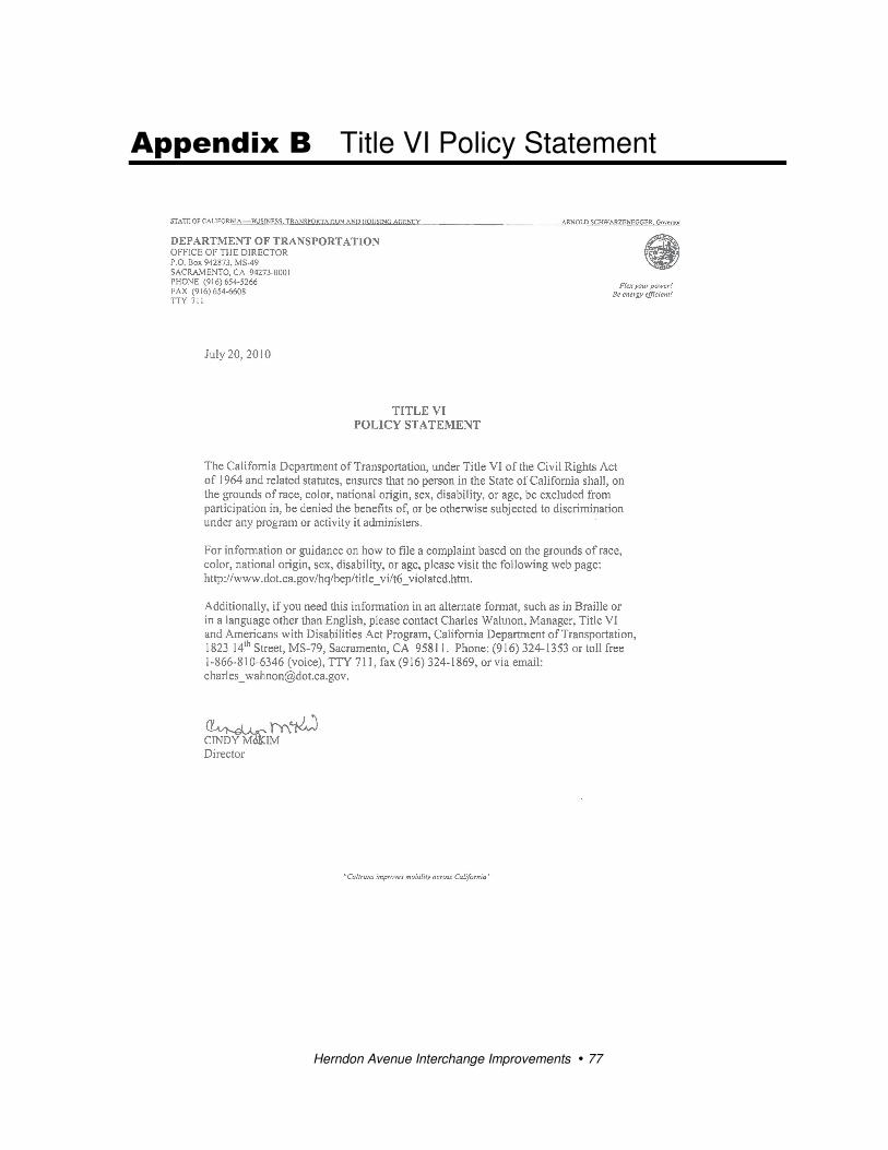
Herndon Avenue Interchange Improvements � 77
Appendix B Title VI Policy Statement

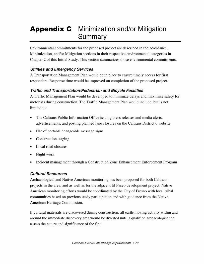
Herndon Avenue Interchange Improvements � 79
Appendix C Minimization and/or Mitigation Summary
Environmental commitments for the proposed project are described in the Avoidance,
Minimization, and/or Mitigation sections in their respective environmental categories in
Chapter 2 of this Initial Study. This section summarizes those environmental commitments.
Utilities and Emergency Services
A Transportation Management Plan would be in place to ensure timely access for first
responders. Response time would be improved on completion of the proposed project.
Traffic and Transportation/Pedestrian and Bicycle Facilities
A Traffic Management Plan would be developed to minimize delays and maximize safety for
motorists during construction. The Traffic Management Plan would include, but is not
limited to:
• The Caltrans Public Information Office issuing press releases and media alerts,
advertisements, and posting planned lane closures on the Caltrans District 6 website
• Use of portable changeable message signs
• Construction staging
• Local road closures
• Night work
• Incident management through a Construction Zone Enhancement Enforcement Program
Cultural Resources
Archaeological and Native American monitoring has been proposed for both Caltrans
projects in the area, and as well as for the adjacent El Paseo development project. Native
American monitoring efforts would be coordinated by the City of Fresno with local tribal
communities based on previous study participation and with guidance from the Native
American Heritage Commission.
If cultural materials are discovered during construction, all earth-moving activity within and
around the immediate discovery area would be diverted until a qualified archaeologist can
assess the nature and significance of the find.

Appendix C � Minimization and/or Mitigation Summary
Herndon Avenue Interchange Improvements � 80
If human remains are discovered, State Health and Safety Code Section 7050.5 states that
further disturbances and activities shall cease in any area or nearby area suspected to overlie
remains, and the County Coroner contacted. Pursuant to Public Resources Code Section
5097.98, if the remains are thought to be Native American, the coroner would notify the
Native American Heritage Commission who would then notify the Most Likely Descendent.
At this time, the person who discovered the remains would contact the District 6 Heritage
Resources Coordinator so that he or she can work with the Most Likely Descendent on the
respectful treatment and disposition of the remains. Further provisions of Public Resources
Code 5097.98 are to be followed as applicable.
Paleontological Resources
Implementation of and compliance with the Paleontological Mitigation Plan would ensure
that impacts to paleontological resources would be less than significant. These measures
include the following:
• Doing a pre-excavation site survey, literature review, repository review
• Conducting a project managers and personnel meeting/training program
• Developing and implementing a safety program
• Monitoring and salvage of fossils uncovered by earth-moving activities
• Recording associated specimen/sample data and corresponding geologic and geographic
site data
• Collecting sediment samples for microfossil analysis
• Processing sediment samples to salvage microfossils
• Preparing fossils to the point of identification
• Identifying fossils to the lowest taxonomic level possible
• Accessioning and curating fossil specimens into the designated repository
• Archiving associated specimen and site data at the fossil repository
• Preparing the final paleontological mitigation report
Hazardous Materials
Measures for hazardous materials include the following:
• Review of the groundwater monitoring and soil analytical data (as they become available)
for the gasoline plume at 6639 North Parkway Drive during the life of the project is

Appendix C � Minimization and/or Mitigation Summary
Herndon Avenue Interchange Improvements � 81
required. In addition, appropriate site controls to protect worker safety during
construction activities are required.
• Lead in soil adjacent to roadways crossing the site should be assessed. A lead compliance
plan would be required.
• The Underground Service Alert would be contacted before initiating ground-disturbing
activities.
Air Quality
The project would be subject to a Dust Control Permit from the San Joaquin Unified Air
Pollution Control District. Observing the District’s Regulation VIII requirements and the
Caltrans Non-Standard Provisions for Dust should minimize the effect of dust during
construction. Additionally, Caltrans Standard Specifications pertaining to dust control and
dust palliative requirements are a required part of all construction contracts and should
effectively reduce and control emission impacts during construction. The provisions of
Caltrans Standard Specifications, Section 7-1.01F “Air Pollution Control” and Section 10
“Dust Control,” require the contractor to comply with the San Joaquin Valley Air Pollution
Control District rules, ordinances, and regulations.
Biology
To avoid affecting nesting birds, the following measures would be implemented:
• Eucalyptus trees in the project footprint should be removed during the non-nesting
season, between September 1 and February 15.
• If the eucalyptus trees cannot be removed during the non-nesting season, preconstruction
surveys for nesting birds should be done by a qualified biologist no more than 14 days
before tree removal.
• If nesting is identified, the tree should not be removed until any young have fledged or
the nest has failed, as determined by a qualified biologist.
• If no nesting is identified, tree removal can proceed.
• The eucalyptus trees would be replaced by this project in accordance with current setback
standards.


Herndon Avenue Interchange Improvements � 83
Appendix D Federal and State Species Lists

Appendix D � Federal and State Species Lists
Herndon Avenue Interchange Improvements � 84

Appendix D � Federal and State Species Lists
Herndon Avenue Interchange Improvements � 85

Appendix D � Federal and State Species Lists
Herndon Avenue Interchange Improvements � 86

Appendix D � Federal and State Species Lists
Herndon Avenue Interchange Improvements � 87

Appendix D � Federal and State Species Lists
Herndon Avenue Interchange Improvements � 88
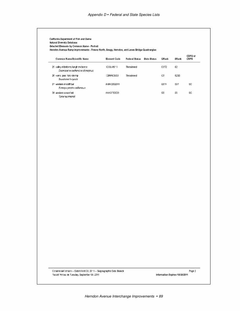
Appendix D � Federal and State Species Lists
Herndon Avenue Interchange Improvements � 89
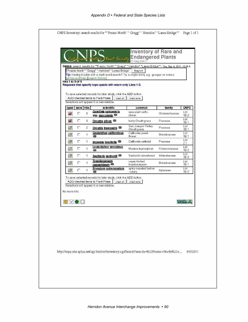
Appendix D � Federal and State Species Lists
Herndon Avenue Interchange Improvements � 90

Herndon Avenue Interchange Improvements � 91
Appendix E Regulatory Settings
Community Character and Cohesion
The National Environmental Policy Act of 1969 as amended, established that the federal
government use all practicable means to ensure for all Americans safe, healthful, productive,
and aesthetically and culturally pleasing surroundings (42 U.S.C. 4331[b][2]). The Federal
Highway Administration in its implementation of National Environmental Policy Act (23
U.S.C. 109[h]) directs that final decisions on projects are to be made in the best overall
public interest. This requires taking into account adverse environmental impacts, such as
destruction or disruption of human-made resources, community cohesion and the availability
of public facilities and services.
Under the California Environmental Quality Act, an economic or social change by itself is
not to be considered a significant effect on the environment. However, if a social or
economic change is related to a physical change, then social or economic change may be
considered in determining whether the physical change is significant. Since this project
would result in physical change to the environment, it is appropriate to consider changes to
community character and cohesion in assessing the significance of the project’s effects.
Growth
The Council on Environmental Quality regulations, which established the steps necessary to
comply with the National Environmental Policy Act of 1969, require evaluation of the
potential environmental consequences of all proposed federal activities and programs. This
provision includes a requirement to examine indirect consequences that may occur in areas
beyond the immediate influence of a proposed action and at some time in the future. The
regulations, 40 Code of Federal Regulations 1508.8, refer to these consequences as
secondary impacts. Secondary impacts may include changes in land use, economic vitality,
and population density, which are all elements of growth.
The California Environmental Quality Act also requires the analysis of a project’s potential
to induce growth. California Environmental Quality Act guidelines, Section 15126.2(d),
require that environmental documents “…discuss the ways in which the proposed project
could foster economic or population growth, or the construction of additional housing, either
directly or indirectly, in the surrounding environment…”
Appendix E � Regulatory Settings
Herndon Avenue Interchange Improvements � 92
Traffic
Caltrans, as assigned by the Federal Highway Administration, directs that full consideration
should be given to the safe accommodation of pedestrians and bicyclists during the
development of federal-aid highway projects (see 23 Code of Federal Regulations 652). It
further directs that the special needs of the elderly and the disabled must be considered in all
federal-aid projects that include pedestrian facilities. When current or anticipated pedestrian
and/or bicycle traffic presents a potential conflict with motor vehicle traffic, every effort
must be made to minimize the detrimental effects on all highway users who share the facility.
The Department is committed to carrying out the 1990 Americans with Disabilities Act
(ADA) by building transportation facilities that provide equal access for all persons. The
same degree of convenience, accessibility, and safety available to the general public will be
provided to persons with disabilities.
Hazardous Materials
Hazardous materials and hazardous wastes are regulated by many state and federal laws.
These include not only specific statutes governing hazardous waste, but also a variety of laws
regulating air and water quality, human health and land use.
The main federal laws regulating hazardous wastes/materials are the Resource Conservation
and Recovery Act of 1976 and the Comprehensive Environmental Response, Compensation
and Liability Act of 1980. The Resource Conservation and Recovery Act provides for “cradle
to grave” regulation of hazardous wastes. The purpose of the Comprehensive Environmental
Response, Compensation and Liability Act, often referred to as Superfund, is to clean up
contaminated sites so that public health and welfare are not compromised. Other federal laws
include the following:
• Community Environmental Response Facilitation Act of 1992
• Clean Water Act
• Clean Air Act
• Safe Drinking Water Act
• Occupational Safety and Health Act (OSHA)
• Atomic Energy Act
• Toxic Substances Control Act
• Federal Insecticide, Fungicide, and Rodenticide Act
Appendix E � Regulatory Settings
Herndon Avenue Interchange Improvements � 93
In addition to the acts listed above, Executive Order 12088, Federal Compliance with
Pollution Control, mandates that necessary actions be taken to prevent and control
environmental pollution when federal activities or federal facilities are involved.
Hazardous waste in California is regulated mainly under the authority of the federal Resource
Conservation and Recovery Act of 1976 and the California Health and Safety Code. Other
California laws that affect hazardous waste are specific to handling, storage, transportation,
disposal, treatment, reduction, cleanup and emergency planning.
Worker health and safety and public safety are concerns when dealing with hazardous
materials that may affect human health and the environment. Proper disposal of hazardous
material is vital if it is disturbed during project construction.
Air Quality
The Federal Clean Air Act as amended in 1990 is the federal law that governs air quality.
The California Clean Air Act of 1988 is its companion state law. These laws, and related
regulations by the U.S. Environmental Protection Agency (U.S. EPA) and California Air
Resources Board, set standards for the quantity of pollutants that can be in the air. At the
federal level, these standards are called National Ambient Air Quality Standards. National
Ambient Air Quality Standards and State Ambient Air Quality Standards have been
established for six transportation-related criteria pollutants that have been linked to potential
health concerns. The criteria pollutants are carbon monoxide (CO), nitrogen dioxide (NO2),
ozone (O3), particulate matter (PM, broken down for regulatory purposes into particles of 10
micrometers or smaller – PM10 and particles of 2.5 micrometers and smaller – PM2.5), lead
(Pb), and sulfur dioxide (SO2). In addition, state standards exist for visibility reducing
particles, sulfates, hydrogen sulfide (H2S), and vinyl chloride.
The national and state standards are set at a level that protects public health with a margin of
safety and are subject to periodic review and revision. Both state and federal regulatory
schemes also cover toxic air contaminants (air toxics); some criteria pollutants are also air
toxics or may include certain air toxics within their general definition.
Federal and state air quality standards and regulations provide the basic scheme for project-
level air quality analysis under the National Environmental Policy Act and the California
Environmental Quality Act. In addition to this type of environmental analysis, a parallel
“conformity” requirement under the Federal Clean Air Act also applies.
Federal Clean Air Act Section 176(c) prohibits the U.S. Department of Transportation and
other federal agencies from funding, authorizing, or approving plans, programs or projects
that are not first found to conform to State Implementation Plan for achieving the goals of
Appendix E � Regulatory Settings
Herndon Avenue Interchange Improvements � 94
Clean Air Act requirements related to the National Ambient Air Quality Standards.
“Transportation conformity” takes place on two levels: the regional, or planning and
programming, level, and the project level. The proposed project must conform at both levels
to be approved. Conformity requirements apply only in nonattainment and “maintenance”
(former nonattainment) areas for the National Ambient Air Quality Standards, and only for
the specific National Ambient Air Quality Standards that are or were violated. U.S.
Environmental Protection Agency regulations at 40 Code of Federal Regulations 93 govern
the conformity process.
Regional conformity is concerned with how well the regional transportation system supports
plans for attaining the standards set for carbon monoxide (CO), nitrogen dioxide (NO2),
ozone (O3), particulate matter (PM10 and PM2.5), and in some areas sulfur dioxide (SO2).
California has attainment or maintenance areas for all of these transportation-related “criteria
pollutants” except SO2, and also has a nonattainment area for lead (Pb). However, lead is not
currently required by the Federal Clean Air Act to be covered in transportation conformity
analysis.
Regional conformity is based on Regional Transportation Plans and Federal Transportation
Improvement Programs that include all of the transportation projects planned for a region
over a period of at least 20 years (for the Regional Transportation Plan) and 4 years (for the
Federal Transportation Improvement Program). Regional Transportation Plan and Federal
Transportation Improvement Program conformity is based on use of travel demand and air
quality models to determine whether or not the implementation of those projects would
conform to emission budgets or other tests showing that requirements of the Clean Air Act
and the State Implementation Plan are met.
If the conformity analysis is successful, the Metropolitan Planning Organization, Federal
Highway Administration, and Federal Transit Administration, make determinations that the
Regional Transportation Plan and Federal Transportation Improvement Program are in
conformity with the State Implementation Plan for achieving the goals of the Federal Clean
Air Act. Otherwise, the projects in the Regional Transportation Plan and/or Federal
Transportation Improvement Program must be modified until conformity is attained. If the
design concept, scope, and “open to traffic” schedule of a proposed transportation project are
the same as described in the Regional Transportation Plan and Federal Transportation
Improvement Program, then the proposed project is deemed to meet regional conformity
requirements for purposes of project-level analysis.
Conformity at the project-level also requires “hot spot” analysis if an area is in
“nonattainment” or “maintenance” for carbon monoxide (CO) and/or particulate matter
(PM10 or PM2.5). A region is in “nonattainment” if one or more of the monitoring stations in

Appendix E � Regulatory Settings
Herndon Avenue Interchange Improvements � 95
the region measures violation of the relevant standard, and U.S. Environmental Protection
Agency officially designates the area nonattainment. Areas that were previously designated
as nonattainment areas but subsequently meet the standard may be officially redesignated to
attainment by U.S. Environmental Protection Agency and are then called “maintenance”
areas.
“Hot spot” analysis is essentially the same, for technical purposes, as carbon monoxide or
particulate matter analysis performed for National Environmental Policy Act purposes.
Conformity does include some specific procedural and documentation standards for projects
that require a hot spot analysis. In general, projects must not cause the hot spot-related
standard to be violated and must not cause any increase in the number and severity of
violations in nonattainment areas. If a known carbon monoxide or particulate matter violation
is located in the project vicinity, the project must include measures to reduce or eliminate the
existing violation(s).
Paleontology
Paleontology is the study of life in past geologic time based on fossil plants and animals. A
number of federal statutes specifically address paleontological resources, their treatment, and
funding for mitigation as a part of federally authorized or funded projects: Antiquities Act of
1906 (16 United States Code 431-433), Federal-Aid Highway Act of 1960 (23 United States
Code 305), and the Omnibus Public Land Management Act of 2009 (16 United States Code
470aaa). Under California law, paleontological resources are protected by the California
Environmental Quality Act.
Cultural Resources
The term “Cultural resources” as used in this document refers to all historical and
archaeological resources, regardless of significance. Laws and regulations dealing with
cultural resources include the following.
The National Historic Preservation Act of 1966, as amended, sets forth national policy and
procedures for historic properties, defined as districts, sites, buildings, structures, and objects
included in or eligible for the National Register of Historic Places. Section 106 of the
National Historic Preservation Act requires federal agencies to take into account the effects
of their undertakings on such properties and to allow the Advisory Council on Historic
Preservation the opportunity to comment on those undertakings, following regulations issued
by the Advisory Council on Historic Preservation (36 Code of Federal Regulations 800).
On January 1, 2004, a Section 106 Programmatic Agreement between the Advisory Council,
the Federal Highway Administration, State Historic Preservation Officer, and Caltrans went
into effect for Caltrans projects, both state and local, with Federal Highway Administration
Appendix E � Regulatory Settings
Herndon Avenue Interchange Improvements � 96
involvement. The Programmatic Agreement implements the Advisory Council’s regulations,
36 Code of Federal Regulations 800, streamlining the Section 106 process and delegating
certain responsibilities to Caltrans. The Federal Highway Administration’s responsibilities
under the Programmatic Agreement have been assigned to Caltrans as part of the Surface
Transportation Project Delivery Pilot Program (23 Code of Federal Regulations 327) (July 1,
2007).
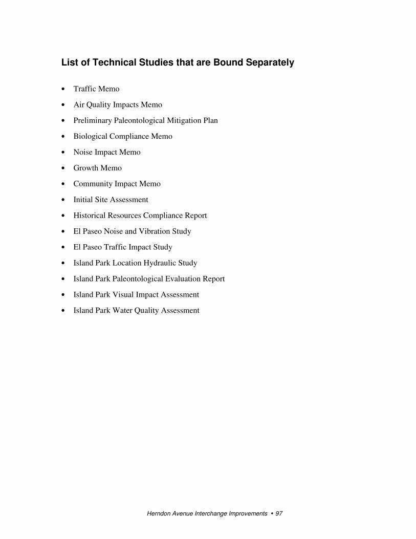
Herndon Avenue Interchange Improvements � 97
List of Technical Studies that are Bound Separately
• Traffic Memo
• Air Quality Impacts Memo
• Preliminary Paleontological Mitigation Plan
• Biological Compliance Memo
• Noise Impact Memo
• Growth Memo
• Community Impact Memo
• Initial Site Assessment
• Historical Resources Compliance Report
• El Paseo Noise and Vibration Study
• El Paseo Traffic Impact Study
• Island Park Location Hydraulic Study
• Island Park Paleontological Evaluation Report
• Island Park Visual Impact Assessment
• Island Park Water Quality Assessment