hartley wintney - hampshiredocuments.hants.gov.uk/landscape/historic-settlement/hartley... ·...
TRANSCRIPT

Hartley Wintney with Hartley Row
Hartley Wintney with Hartley Row
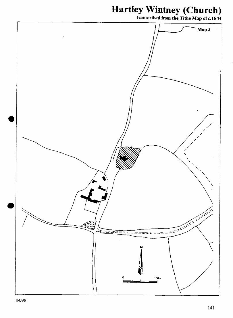
1.0 PARISH Hartley Wintney 2.0 HUNDRED Odiham 3.0 NGR SU 47690 15700 4.0 GEOLOGY Church and farm: Bracklesham Beds; Hartley Row: Lower Bagshot (sand). 5.0 SITE CONTEXT Hartley Wintney comprises two principal settlements and in this survey they are described separately. 5.1 The Church of St Mary is situated at the south end of a north / south ridge at c. 85m AOD. From the north, it is approached by a straight road which begins at Causeway Farm, 1km distant. The road passes the church on the west side. The Church would once have had commanding views in all directions except north, and this advantage would have included inter-visibility with Wintney Farm, the site of a Cistercian nunnery (17.2). Within 200m southwards and down slope of the church is Church House Farm, which stands at a cross-roads. Church and farm represent the site of the medieval settlement of Hartley Wintney. 5.2 The main population centre of Hartley Wintney was once known as Hartley Row (6.2). It is 200m north of the Church of St Mary (5.1), and generally lies within the range of 65-70m AOD. The River Hart lies 1.5 km north-east. Today, this settlement might be regarded as a small town. The commercial centre is linear, the properties being arranged either side of the south-west / north-east route of the A30 London road (High Street). Greens and commons are plentiful. At the south-west end of the High Street there is a large oak-planted green, bounded by the High Street itself (north), New Road (south-west) and Fleet Road (east). Effectively, this area of open space continues onto the east side of Fleet Road, behind the properties on the south side of the High Street where it becomes Cricket Green. Moving further north-eastwards, Cricket Green becomes Causeway Green and then a golf course. At the north-east end of the High Street the road forks: right is a continuation of the A30, left is Hare’s Lane. The triangle of land between these routes is Hunt’s Common. 6.0 PLAN TYPE & DESCRIPTION Two separate elements: Church and farmstead Common edge / agglomeration / manor house 6.1 Hartley Wintney Church and farmstead 6.1.1 The Church of St Mary and Church House Farm was probably never a significant population centre. However, the second element of the place-name, Wintney, is said to translate as Winta’s Island and this would be a fitting description of the location. The ridge upon which the church and farm stand sets these buildings above the
H/HSN 9 IH/98
130

Hartley Wintney with Hartley Row
Hartley Wintney with Hartley Row
watersheds of the River Hart (east) and the River Whitewater (west). From St Mary, Church Lane heads south past the farm before turning east to reach Wintney Farm and the site of the nunnery; within 1km. The present Church of St Mary is said to have been built by the nuns of Wintney in 1234, but it probably replaced an earlier building. 6.1.2 Ploughed fields immediately east and west of the church were hastily inspected during the field visit. A handful of post-medieval and Modern potsherds was identified (and left in situ) but nothing earlier. Fragments of brick were more numerous. This is consistent with the name Brick Field, north-west of Taplin’s Farm (476600 155500), which has been identified as a part of a medieval open field system (HTS 3: 63) but no evidence of this feature could be identified. 6.1.3 Church House Farm is C18-C19 but might occupy the site of earlier agricultural buildings associated with the church. 6.2 Hartley Row (now known as Hartley Wintney) 6.2.1 Common edge / agglomeration The present population centre of Hartley Wintney (5.2) was known as Hartley Row as late as 1875 (OS, 1875: Sheet 12). More recently, the name Hartley Row has been applied to a smaller area at the south-east of the settlement which includes minor (late) Georgian houses (Pevsner and Lloyd, 1967: 275). The growth of this settlement (which is quite separate to the church and farm) can be attributed to the C18 coaching trade along the A30 London road. The Tithe Map (c. 1844) shows a row of plots, with buildings, extending almost the length of the north-west side of the High Street and into Hare’s Lane. Opposite, on the south-east side of the road, other properties were located within islands of various sizes, claimed from the common. Other islands were unoccupied; merely enclosures. This row and island arrangement is typical of common edge settlement though together they form an agglomeration. Further confirmation of the development of Hartley ‘Row’ is provided by the dates of listed buildings in the High Street, all but one of which fit within the range late C18 to mid C19. 6.2.2 The origin of Hartley Row is obscure. According to Gorky, the only building along the High Street up to 1760 was the Lamb Inn, now The Lamb Hotel (1973: 18). This statement cannot be accurate. The Lamb (strangely unlisted) is of box frame construction on the north elevation of the north wing. It is probably of C17 or earlier date (9.0). Immediately opposite the Lamb, on the south side of the High Street stands a building which contains late medieval fabric (10.0 no. 46). John Speed’s map of Hampshire of 1610 (qv) shows the location of Hertley Row and this is most unlikely to be a reference to the church and farmstead. Row suggests a line of properties and it is probable that The Lamb Hotel was one of these 1610 roadside buildings, but clearly not the only one. 6.2.3 Causeway Farmhouse is C18 / C19 but there is a granary which dates to C16 (9.0). The farm buildings front onto Causeway Green (5.2) behind the buildings on the south-east side of the High Street (NGR 477100 156930). The antiquity of the barn suggests that the farm was at least contemporary with the Hartley Row of Speed’s map (6.2.1). The farm complex is linked to the Church of St. Mary (1km south) by Church Lane (the causeway).
H/HSN 9 IH/98
131

Hartley Wintney with Hartley Row
Hartley Wintney with Hartley Row
6.3.4 The Lamb Inn (High Street; NGR 476870 157050) and the building opposite pre-date all other extant buildings in Hartley Row (6.2.2 & 9.0). They might have originated as a farmstead group, The Lamb becoming an inn with the development of the coach road (A30). 6.3.5 The Old Manor House (C16, C17) is on the west side of Hare’s Lane c 0.5km north of its junction with the A30 in Hartley ‘Row’ (NGR 476900 157400). It lies 1.5km north of the Church of St Mary and might occupy the site of older buildings. 6.4 Synthesis The evidence of Speed’s map (1610) and of the extant buildings at Hartley Row (now Hartley Wintney) suggest a late medieval or early post-medieval origin for this settlement. The Lamb Hotel, The Manor House and Causeway Farm all have C17 features. The presence of one late medieval structure (10.0 no. 46) indicates that there might have been other earlier buildings. A feasible model is that Hartley Row developed as a common edge settlement between the Church of St.Mary and the Manor House in Hare’s Lane, incorporating at least two single farmsteads in the process. Further expansion occurred with the increasing importance of the adjacent road route in C18. 6.5 Site visit conditions Hartley Wintney (Church of St Mary): strong, low sun; dry (moist, sticky
soil). Hartley Wintney (Hartley Row): strong, low sun; dry. 7.0 ARCHAEOLOGICAL POTENTIAL 7.1 AsAP 7.1.1 Church of St. Mary / Church House Farm The Church and churchyard and Church House Farm; the area has been extended in order to amalgamate the two sites and to allow for unrecorded settlement features along Church Lane. This is the focal point of medieval Hartley Wintney and proposed development within 0.5km² of the church (as centre) would need to be treated with extreme caution (Map 5, page 43) . 7.1.2 Hartley Wintney (formerly Hartley Row) The fringe of properties on the north side of the High Street. Historical evidence suggests that this is a late C18 development. However, reasonable caution should be exercised in view of the possible medieval date for the development of the High Street settlement (6.2.2 and 6.4). The medieval date ascribed to the building opposite The Lamb (10.0 no. 46) indicates archaeological potential on the south side of the High Street which is therefore included in the AAP Map 11, page 49). 7.1.3 Causeway Farm The C16 barn suggests that the C18 farmhouse occupies the site of an older building. It is within its own AAP (Map 11). 7.1.4 The Old Manor House C16, C17 but possibly on an older site linked to the Church of St Mary via Church Lane (The Causeway) and Hare’s Lane via the High Street (NGR 476700 157450. Map 1, page 39).
H/HSN 9 IH/98
132

Hartley Wintney with Hartley Row
Hartley Wintney with Hartley Row
7.2 AsHAP 7.2.1 The medieval Church of St Mary and churchyard (Map 5). 7.1.2 Church House Farm and immediate surrounds (Map 5). 7.2.3 An area of the High Street which includes the Lamb Hotel and associated plot as defined by the Tithe Map. The C17 (?) north wing of this property is one of the two oldest buildings in the High Street. It has possible medieval antecedents. The medieval building opposite The Lamb Hotel (10.0 no. 46) is also within this AHAP (Map 11). 7.2.4 Causeway Farm as in 7.1.3. 8.0 CHURCH & CHURCHYARD 8.1 St Mary served as the parish church until 1870; now redundant. medieval wall paintings discovered during recent restorations C13 / early C14: Nave and chancel. C19 brick transepts and flint tower but west door and minor windows original. Churchyard: up-turned font (trans-Norman?) north of chancel. Foundation trenching has separated the church from the churchyard context. 8.2 St. John the Evangelist, Hartley Row (now known as Hartley Wintney) 1969-70; chancel enlarged 1897. Polychrome brickwork around the windows. 9.0 BUILDINGS (see also Elvetham) There is a particular problem with the listed buildings in Hartley Wintney High Street (Hartley ‘Row’). Many of the shops have been identified by name of firm because the premises are not numbered. Several of these firms have ceased to trade since listing. Current names have been added in brackets [ ] wherever identification has been possible. A photographic survey might solve the problem. In cases where the identification of a listed building has been subject to doubt, it has not been shaded on the appropriate map. PRN Details Dates Grade 269 Dipley Grange, Dipley C17, 18, 20 II 3900 Dipley Grange: barn N of C18 II 1163 Dipley Mill, Dipley C18, 20 II 3901 Old Mill Inn, Dipley early C19 II 3924 Hare’s Farmhouse, Hare’s Lane late C17, 18 II 3925 Hare’s Farmhouse: large barn W of C18 II 3926 Hare’s Farm: small barn C18 II 936 The Lodge, Hare’s Lane early C19 II 3927/8 Nos 1, 2 (Fern Cottage) Hare’s Lane C17, 18, 20 II 3929 Old Manor House (Manor House School) C16, 17, 1900 II 3931 The Whyte Lion, Hartford Bridge C18, 19 II 3932 Causeway Farmhouse, Hartley Row C18, 19 II 3933 Causeway Farmhouse: barn SW of C16, 17 II 3934 Causeway Farm: cartshed S of barn early C18 II 3935 White House, Cricket Green early C19 II 3936 Holmewood, Hartley Row early C19 II
H/HSN 9 IH/98
133

Hartley Wintney with Hartley Row
Hartley Wintney with Hartley Row
3937 Avon House, Hartley Row early C19 II 3938 Crown House (Crown), Hunt’s Common Road late C18 II 3939 Council Offices (Menachus House), High Street (N) early C19 II 3940 & 2 David Lazarus & Abbey National Building Soc., High Street (N) [Abbey Nat. not trading; now part of D Lazarus] C19 II 3943 NatWest Bank, High Street (N) late C18 II 3944 The Limes, High Street (N) late C18, 19 II 3945 Hartley Green House (Bracknell’s Lodge) High Street (N) early C19 II NB this building is probably later than the date given in the listing. It was not present at the time of the Tithe Map survey (c. 1844) 3946 Poole & Sons, High Street (N) mid C19 II [not trading] 3947 Park Corner, High Street (S) late C18 II 1324 Baptist Church, High Street (S) 1807 II 3948 Kenward House, High Street (S) early C19 II 3949/50/1 AW Porter, Porter Antiques, CA Porter High Street (S) [Porter Antiques & Village Gossip] early C19 II 3952/3 Belinda Cook, J McVey, High Street (S) [neither is trading] early C 19 II 5415 Cresta Cleaners, HJ Baldwin, High Street (S) [Clean Images & Four Seasons Double Glazing] early C19 II 3956 Grange Cottage, Phoenix Green mid C19 II 3957 Hatch House, Phoenix Green c. 1840 II 3958 Thackhams C17, 19 II 1412 Rosemary, Phoenix Green 1908 II 3959 Mayfield, Phoenix Green 1908 II 3960 The Barn (now a house), Phoenix Green C17 II 3961 The Cottage, Phoenix Green early C19 II 3963 Phoenix House, Thackham’s Lane C19 II 3963 Phoenix Inn, Phoenix Green C17, c. 1900 II 3964 Barn adjacent to 3963, Phoenix Green C18 II 3965 Four Acre House, Thackham’s Lane (N) 1901 II* 3966 Thackham’s Cottage and barn, Thackham’s Lane C16, c. 1900 II 3967/8/9 Nos 1, 2, 3, The Willows, Phoenix Green C18 II 3970 York House, Phoenix Green early 1900 II 3974 Cowslade Farmhouse, West Green C17 & later II 3975 Cowslade Farmhouse: barn N of, West Green C17 II 3976 Damale’s House, West Green C16, 18, 20 II 3977 Dutch House, West Green Road C18, 19 II 3978 The Homestead, West Green, C17, 1900 II 3979 Homestead: barn to W of C16, 17 II
H/HSN 9 IH/98
134

Hartley Wintney with Hartley Row
Hartley Wintney with Hartley Row
3980 Post Cottage, West Green C17 II 3981 West Green House, West Green (National Trust) early C18 II* 3982 White Knight’s Farmhouse, West Green C17 & later II 3983 Inholmes, West Green Road (N) 1889-1901 II 1413 Church of St Mary C13, 19 II* 3984 Arlot’s Farmhouse C17, 19 II 3985 Arlot’s Farmhouse: barn W of C18 II 3986 Church House Farmhouse C18, 19 II 3987 Church House Farm: granary early C19 II 3988 Church House Farmhouse: barn W of C18 II 3989 Church House Farmhouse: barn SW of c. 1800 II 3990 Church House Farmhouse: barn N of C18 II 3991 Church House Farmhouse: cartshed N of C18 II 3992 Belswood House early C19 II 3993 Hazeley House C18, 1908 II 3994/5 Nos 5, 6, Street End C17, 18 II 3996 Taplin’s Farmhouse early C18 II 3997 Taplin’s Farmhouse: granary mid C19 II 3998 Taplin’s Farmhouse: barn NE of C17, 18 II 1161 Wintney Farm: barn W of farmhouse (Priory site) C16, 17 II* 3999 Wintney Farmhouse (Priory site) C18 II 14511 Nos 1-5 Hartley Grange, Grange La. (W) C17, 18 II unlisted The Lamb Hotel (Inn), High Street (N), north wing C17? unlisted Nero Brewery, Brew House Lane (fine group of industrial buildings) late C19, C20 10.0 SMR DATA SW 47600 15500, NE 47750 15750 SU75NE No. 2 47763 15520 Medieval nunnery founded before AD 1200. Cistercian order, dedicated to Blessed Virgin and St. Mary Magdalene. Dissolved 1538. No extant remains but rubble foundations found in garden on south side of farmhouse (1956). 3 47762 15522 Medieval barn. 4 47677 15587 Medieval. Parish church of St. Mary C13. 8 47672 15664 C19. Parish church of St. John the Evangelist. 39 47732 15659 Undated. Linear feature (HCC AP ref.: run 5e248). 42 47683 15552 Undated. Oval enclosure. 46 47689 15740 Medieval. Rectangular timber building C16, C17, c. 1900. 47 47711 15697 Medieval. Barn C16, C17.
H/HSN 9 IH/98
135

Hartley Wintney with Hartley Row
Hartley Wintney with Hartley Row
11.0 ADDITIONAL SITES / FEATURES Small farmstead cluster (Church of St. Mary) 1 476900 155750 Brickfields (approximate centre). Brick kiln site? 2 476740 155820 (Spot point) Church Lane; former hollow-way (causeway) 3 476870 157050 The Lamb Hotel; C17 or earlier farmstead 12.0 CARTOGRAPHIC SOURCES Tithe Map 21M65/F7/109/2 (*/1844) GSGB 284 Basingstoke OS 1:2500, SW 47646 15544, NE 47706 15634 SW 47617 15648, NE 47702 15702 OS 1: 25000 Pathfinder 1204 (SU 65/75), Basingstoke OS 6 inch First Edition 1875, Sheet 12 13.0 BIBLIOGRAPHY Gorky D 1973 The Old Village of Hartley Wintney (3rd edn). Hartley Wintney Preservation Society. 14.0 PRIMARY HISTORIC SOURCES 14.1 Domesday Book Not mentioned specifically. VCH (4: 79) suggests that it was included in Odiham. 14.2 Subsidy Rolls 1334 £1. 8.10¾ 1524 1st survey: Not listed. 2nd survey: £4. 0.10 (47 taxpayers) 14.3 Manorial Documents Hartley Wintney was a single manor. 14.4 Hearth Tax 1665 192 hearths chargeable (44 houses), 49 hearths not chargeable (34 houses). Total: 78 houses. 15.0 PLACE NAME 1218 Hertlega; 1228 Hurtlegh. OE /ME ‘hart wood’. 1236 Minechenherteleye ‘nuns’ Hartley’, 1270 Hurtle Monialum ‘clerical Hartley’ from the nunnery Wintney Priory in the same parish. 1139 x 1161 Winteneia Winta’s island.
H/HSN 9 IH/98
136

Hartley Wintney with Hartley Row
Hartley Wintney with Hartley Row
16.0 PHOTOGRAPHS 17.0 OTHER PROJECT ELEMENTS 17.1 Commons: Dipley Green 47400 15700 Stoken Green 47400 15700 West Green 47400 15600 Phoenix Green 47600 15700 Hunts Common 47700 15800 Hartley Wintney Common 47700 15700 Causeway Green 47700 15600 Cricket Green 47700 15700 Hazeley Heath 47500 15800 Yateley Common 48100 15900 17.2 Other parish settlements include: Bear’s Green 1327, atte Bere (associated with the family of Rich atte Bere) Dipley 47440 15750 1337 (or 1327?), Dupeleia (Deep Clearing or Wood) Hartfordbidge 47770 15880 1327, Hertfordbridge (Hart-frequented Ford or tautologous reference to a crossing point on the R. Hart) Pont Hill 1327, Pontenhull (old stream name) Wintney Priory 47763 15520 1218, Winteneya. Priory founded late C12. In 1538 the King granted the House and site to Richard Hill (VCH 2: 151).
H/HSN 9 IH/98
137

Hartley Wintney with Hartley Row
Hartley Wintney with Hartley Row
H/HSN 9 IH/98
138
18 ILLUSTRATIONS 1 Location map at 1: 25000 2 Map: Overview of Church of St Mary & Hartley Row (south) at 1: 10000. 3 Tithe Map transcription at 1: 2500; Church of St Mary / Church House
Farm 4 Map: Development and Archaeological Features at 1: 2500; Church of St
Mary / Church House Farm 5 Map: Areas of Archaeological Potential at 1: 2500; Church of St Mary /
Church House Farm 6 Map: Overview of Hartley Wintney ‘Row’ at 1: 10000 7 Tithe Map transcriptions at 1: 2500; Hartley Wintney ‘Row’ (west) 8 Tithe Map transcriptions at 1: 2500; Hartley Wintney ‘Row’ (east) 9 Map: Development and Archaeological Features at 1: 2500; Hartley
Wintney ‘Row’ (west) 10 Map: Development and Archaeological Features at 1: 2500; Hartley
Wintney ‘Row’ (east) 11 Map: Areas of Archaeological Potential at 1: 2500; Hartley
Wintney ‘Row’12 12 John Speed’s Map of Hampshire, 1610 (Hart).