hannibal’s trek across the alps: …maajournal.com/issues/2008/fulltextmahaney.pdf11department of...
TRANSCRIPT
39
Mediterranean Archaeology and Archaeometry, Vol. 8, No. 2, pp. 39-54 Copyright © 2008 MAA
Printed in Greece. All rights reserved.
HANNIBAL’S TREK ACROSS THE ALPS: GEOMORPHOLOGICAL ANALYSIS OF SITES
OF GEOARCHAEOLOGICAL INTEREST William C. Mahaney1*, Volli Kalm2, Randy W. Dirszowsky3, Michael W.
Milner1, Rana Sodhi4, Roelf Beukens5, Ron Dorn6, Pierre Tricart7, Stéphane Schwartz8, Eva Chamorro-Perez9, Sal Boccia10, René W. Barendregt11, D.H.
Krinsley12, E. R. Seaquist13, David Merrick14 and Barbara Kapran1 1Quaternary Surveys, 26 Thornhill Ave., Thornhill, Ontario, Canada, L4J 1J4, 2Institute of Geology, Tartu University, Tartu, Estonia, 51014, 3Departments of Geography and Biology, Laurentian University, Sudbury, Ontario, Canada, P3E 2C6, 4Surface Interface Ontario and Department of Chemical Engineering, University of Toronto, Toronto, Ontario, Canada, M5S 3E5, 5IsoTrace Lab, Department of Physics, University of Toronto, Toronto, Ontario, Canada, M5S 1A7, 6Department of Geography, Arizona State University, Tempe, Arizona, 85287-0104, 7Laboratoire de Géodynamique des Chaînes alpines, University of Grenoble, Observatoire des Sciences de l’Univers, 38041 Grenoble, France, 8Laboratoire de Géophysique interne et de Tectonophysique, Observatoire des Sciences de l’Univers, 38041 Grenoble, France, 9Laboratoire des Sciences de la Terre, Ecole Normale Supérieure, 69364 Lyon, France, 10University of Toronto, Department of Materials Science, Toronto, Ontario, Canada, M5S 3E4, 11Department of Geography, Lethbridge University, Lethbridge, Alberta, Canada, T1K 3M4, 12Department of Geological Sciences, University of Oregon, Eugene, Or., 97403-1272, 13Department of Astronomy and Astrophysics, University of Toronto, Toronto, Ontario, Canada, M5S 3H4, 14Business Economics Ltd., Beaconsfield, UK, HP9 1Q2
Received: 19/5/2008 Accepted: 12/7/2008
*To whom correspondence should be addressed: W.C. Mahaney<[email protected]>
ABSTRACT A ~2200 year-old question related to Hannibal’s invasion route across the Alps
into Italia, has been argued by classicists without recovery of material evidence. A comparison of topographical descriptions in the ancient literature with environmental parameters in the Alps, attempted here for the first time, provides a database against which various pathways can be assessed. Identification of sites using geological, geomorphological, astronomical, chemical and petrological methods leads to the exclusion of certain transit points and targeting of others where geoarchaeological excavation might yield important evidence related to the military culture of ancient Carthage.
KEYWORDS: Hannibalic invasion of Italia, 218 BC; fired rock controversy; geomorphology, geoarchaeology, Alps
WILLIAM C. MAHANEY et al
40
HISTORICAL-TOPOGRAPHICAL BACKGROUND
Controversy over the exact alpine route Hannibal followed from the Rhône Basin into Italia has raged amongst classicists and ancient historians for over two millennia (Mommsen, 2006; Wilkinson, 1911; Dodge, 1891; Strabo, 1999; Proctor, 1971). Numerous authorities (de Beer, 1974; Lancel, 1999; Prevas, 1998; Walbank, 1957), after studying the two main sources of information on the invasion, Polybius (trans. 1979) and Livy (trans. 1965), have arrived at different conclusions regarding the approach route and final col transited by the Punic Army on its historic entry upon the Po River Plains of northern Italia. The invasion, one of the most ambitious mountain military operations of all time, is important because it shifted Roman attention from North Africa to the northern frontier of the Roman Republic and resulted in the near collapse of Rome (Goldsworthy, 2001). Since the last known written record of the invasion, compiled by Silenus, Hannibal’s historiographer, was lost at some point after Livy (1965) wrote his history of the Hannibalic Wars, historians have endeavoured to re-discover the invasion route from secondary accounts, which are open to considerable interpretation. As pointed out by Jourdain-Annequin (1999) the lack of primary investigators actually visiting the approach route and possible cols of passage has created a certain ‘myth’ about Hannibal and the Punic invasion of Italia that can only be
demystified by ground-truth investigations similar to what de Beer (1967, 1969) and Prevas (1998) attempted in the mid-Twentieth Century. Our motivation for identifying the route through the Alps followed by the Punic Army, albeit considering the route itself is of minor historic consequence (Walbank, 1957), lies in the potential for scientific identification of sites of geoarchaeological significance. Recovery of artifacts from alpine sites occupied during the invasion would provide new and important information on the military culture of ancient Carthage heretofore known only from material items recovered in North Africa (Lancel, 1999; Mahaney, 2004).
Three main approach routes (Healy, 1994; Hart, 1967; Lazenby, 1998; de Montholon, 1905) with various cols identified as the actual transit points into Cisalpine Gaul (northern Italy) have been debated and discussed by historians (Fig. 1) and archaeologists. These are variously referred to as the southern, northern and intermediate routes. (Connolly, 1981; de Beer, 1967). The southern route follows the lower Rhône River valley northward to the Drôme River, thence across the Col de Grîmone (1318 m; Alpes du Dauphiné) to the Durance Basin, through the Queyras (Guil River) to the Col de la Traversette, finally exiting into the upper Po River catchment; the northern route parallels the Rhône River to the Isère River, past present-day Grenoble along the Arc River to either the Col du Mont Cenis (2083 m)
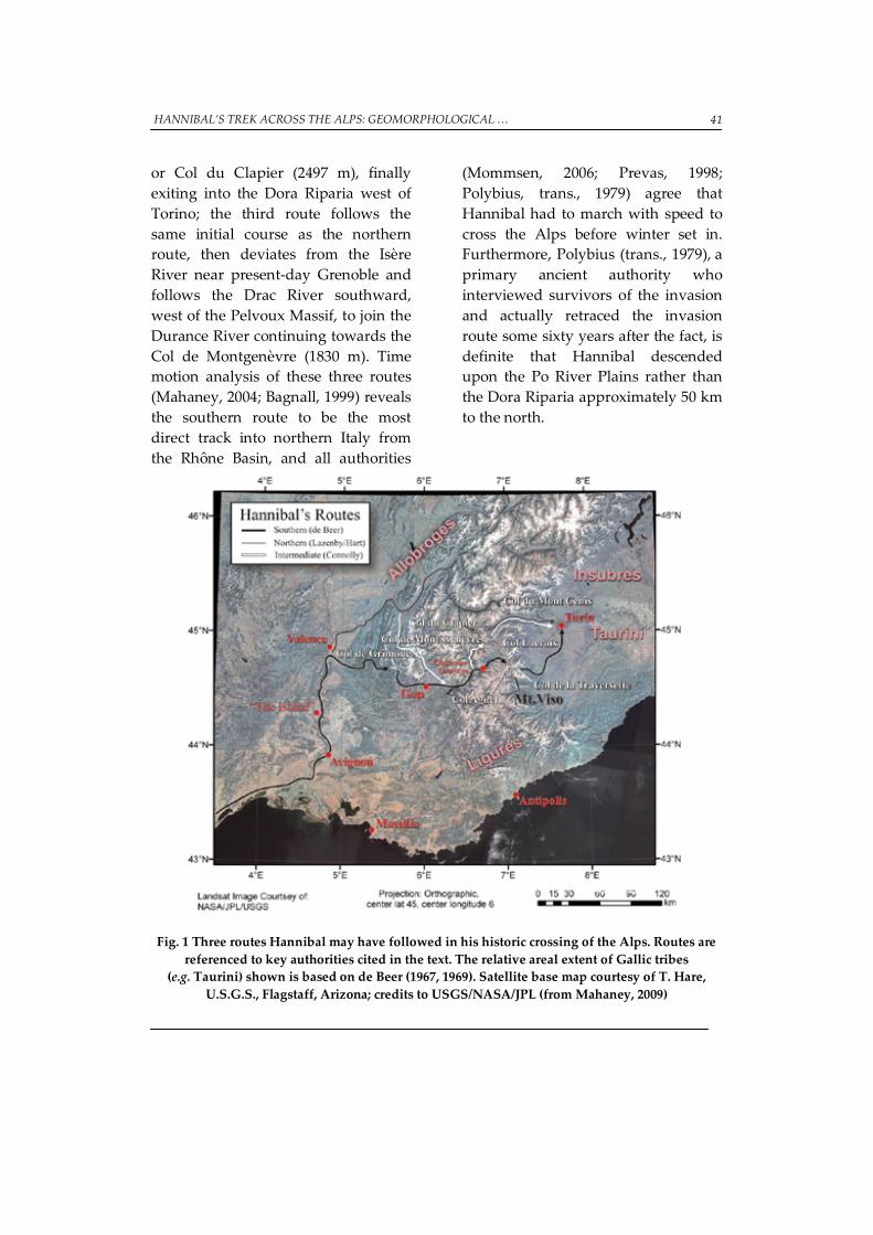
HANNIBAL’S TREK ACROSS THE ALPS: GEOMORPHOLOGICAL … 41
or Col du Clapier (2497 m), finally exiting into the Dora Riparia west of Torino; the third route follows the same initial course as the northern route, then deviates from the Isère River near present-day Grenoble and follows the Drac River southward, west of the Pelvoux Massif, to join the Durance River continuing towards the Col de Montgenèvre (1830 m). Time motion analysis of these three routes (Mahaney, 2004; Bagnall, 1999) reveals the southern route to be the most direct track into northern Italy from the Rhône Basin, and all authorities
(Mommsen, 2006; Prevas, 1998; Polybius, trans., 1979) agree that Hannibal had to march with speed to cross the Alps before winter set in. Furthermore, Polybius (trans., 1979), a primary ancient authority who interviewed survivors of the invasion and actually retraced the invasion route some sixty years after the fact, is definite that Hannibal descended upon the Po River Plains rather than the Dora Riparia approximately 50 km to the north.
Fig. 1 Three routes Hannibal may have followed in his historic crossing of the Alps. Routes are referenced to key authorities cited in the text. The relative areal extent of Gallic tribes
(e.g. Taurini) shown is based on de Beer (1967, 1969). Satellite base map courtesy of T. Hare, U.S.G.S., Flagstaff, Arizona; credits to USGS/NASA/JPL (from Mahaney, 2009)
WILLIAM C. MAHANEY et al
42
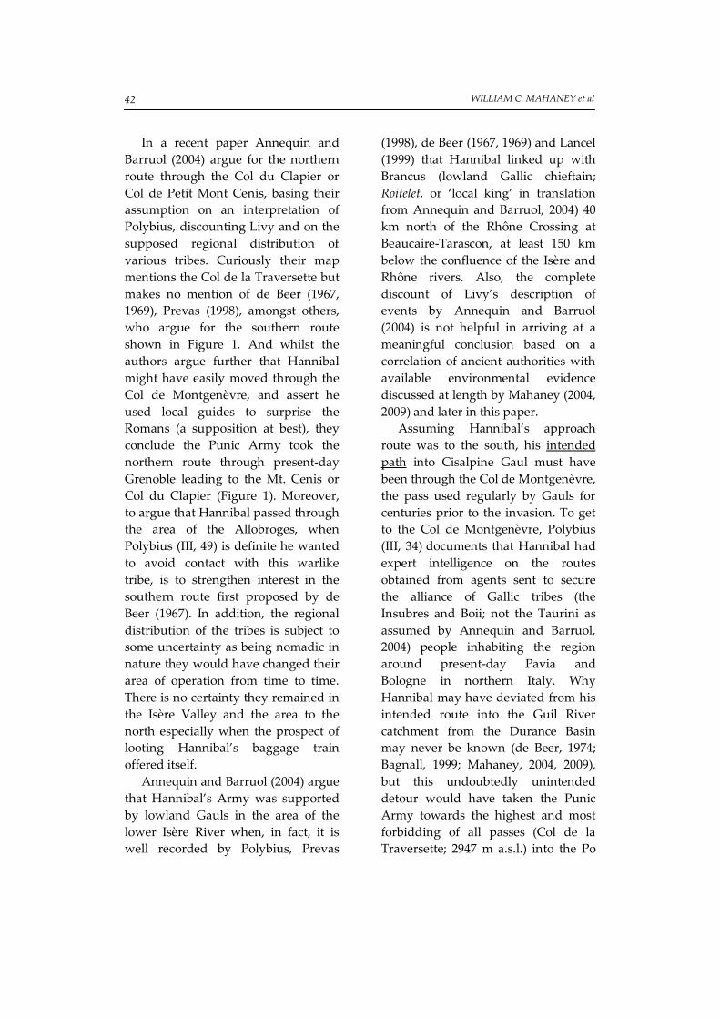
In a recent paper Annequin and Barruol (2004) argue for the northern route through the Col du Clapier or Col de Petit Mont Cenis, basing their assumption on an interpretation of Polybius, discounting Livy and on the supposed regional distribution of various tribes. Curiously their map mentions the Col de la Traversette but makes no mention of de Beer (1967, 1969), Prevas (1998), amongst others, who argue for the southern route shown in Figure 1. And whilst the authors argue further that Hannibal might have easily moved through the Col de Montgenèvre, and assert he used local guides to surprise the Romans (a supposition at best), they conclude the Punic Army took the northern route through present-day Grenoble leading to the Mt. Cenis or Col du Clapier (Figure 1). Moreover, to argue that Hannibal passed through the area of the Allobroges, when Polybius (III, 49) is definite he wanted to avoid contact with this warlike tribe, is to strengthen interest in the southern route first proposed by de Beer (1967). In addition, the regional distribution of the tribes is subject to some uncertainty as being nomadic in nature they would have changed their area of operation from time to time. There is no certainty they remained in the Isère Valley and the area to the north especially when the prospect of looting Hannibal’s baggage train offered itself.
Annequin and Barruol (2004) argue that Hannibal’s Army was supported by lowland Gauls in the area of the lower Isère River when, in fact, it is well recorded by Polybius, Prevas
(1998), de Beer (1967, 1969) and Lancel (1999) that Hannibal linked up with Brancus (lowland Gallic chieftain; Roitelet, or ‘local king’ in translation from Annequin and Barruol, 2004) 40 km north of the Rhône Crossing at Beaucaire-Tarascon, at least 150 km below the confluence of the Isère and Rhône rivers. Also, the complete discount of Livy’s description of events by Annequin and Barruol (2004) is not helpful in arriving at a meaningful conclusion based on a correlation of ancient authorities with available environmental evidence discussed at length by Mahaney (2004, 2009) and later in this paper.
Assuming Hannibal’s approach route was to the south, his intended path into Cisalpine Gaul must have been through the Col de Montgenèvre, the pass used regularly by Gauls for centuries prior to the invasion. To get to the Col de Montgenèvre, Polybius (III, 34) documents that Hannibal had expert intelligence on the routes obtained from agents sent to secure the alliance of Gallic tribes (the Insubres and Boii; not the Taurini as assumed by Annequin and Barruol, 2004) people inhabiting the region around present-day Pavia and Bologne in northern Italy. Why Hannibal may have deviated from his intended route into the Guil River catchment from the Durance Basin may never be known (de Beer, 1974; Bagnall, 1999; Mahaney, 2004, 2009), but this undoubtedly unintended detour would have taken the Punic Army towards the highest and most forbidding of all passes (Col de la Traversette; 2947 m a.s.l.) into the Po
HANNIBAL’S TREK ACROSS THE ALPS: GEOMORPHOLOGICAL … 43
River basin. Two hundred years after the invasion the Roman historian Varro (Proctor, 1971) referred to a major col south of Col de Montgenèvre as Hannibal’s Col. The only major col that fits the environmental descriptions provided by Polybius and Livy is the Col de la Traversette.
ENVIRONMENTAL TIME/MOTION PARAMETERS
A recent reconnaissance of the possible approach routes and transit cols in the Alps confirms the southern route as the only approach route that best matches the topographical descriptions provided by Polybius (1979) and Livy (1965). Because Polybius actually followed the invasion route in developing his account, whereas Livy did not, Polybius is the preferred early source
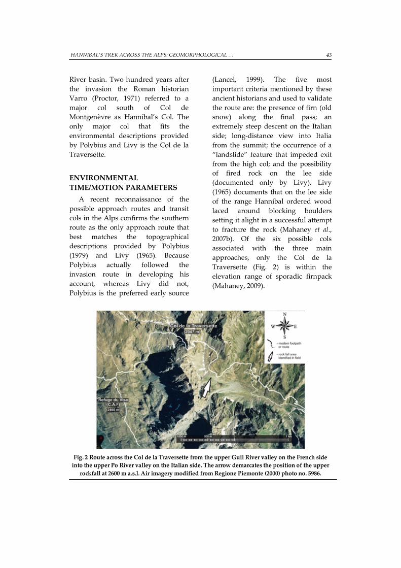
(Lancel, 1999). The five most important criteria mentioned by these ancient historians and used to validate the route are: the presence of firn (old snow) along the final pass; an extremely steep descent on the Italian side; long-distance view into Italia from the summit; the occurrence of a “landslide” feature that impeded exit from the high col; and the possibility of fired rock on the lee side (documented only by Livy). Livy (1965) documents that on the lee side of the range Hannibal ordered wood laced around blocking boulders setting it alight in a successful attempt to fracture the rock (Mahaney et al., 2007b). Of the six possible cols associated with the three main approaches, only the Col de la Traversette (Fig. 2) is within the elevation range of sporadic firnpack (Mahaney, 2009).
Fig. 2 Route across the Col de la Traversette from the upper Guil River valley on the French side into the upper Po River valley on the Italian side. The arrow demarcates the position of the upper
rockfall at 2600 m a.s.l. Air imagery modified from Regione Piemonte (2000) photo no. 5986.
WILLIAM C. MAHANEY et al
44
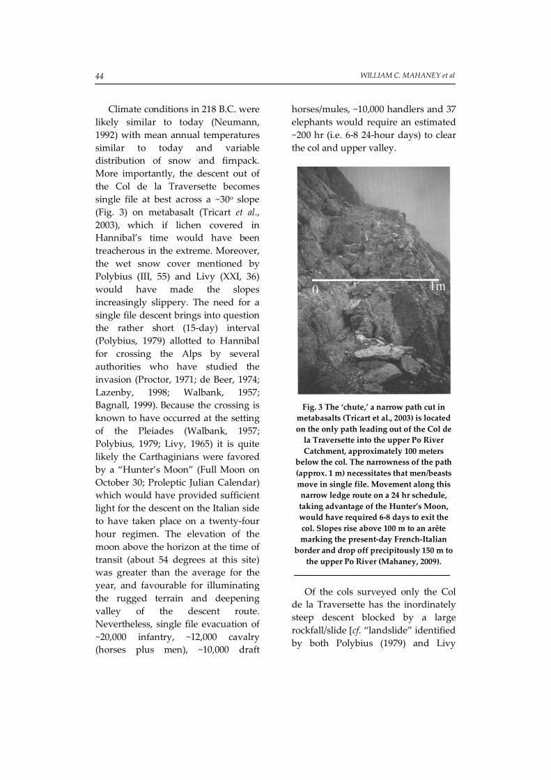
Climate conditions in 218 B.C. were likely similar to today (Neumann, 1992) with mean annual temperatures similar to today and variable distribution of snow and firnpack. More importantly, the descent out of the Col de la Traversette becomes single file at best across a ~30o slope (Fig. 3) on metabasalt (Tricart et al., 2003), which if lichen covered in Hannibal’s time would have been treacherous in the extreme. Moreover, the wet snow cover mentioned by Polybius (III, 55) and Livy (XXI, 36) would have made the slopes increasingly slippery. The need for a single file descent brings into question the rather short (15-day) interval (Polybius, 1979) allotted to Hannibal for crossing the Alps by several authorities who have studied the invasion (Proctor, 1971; de Beer, 1974; Lazenby, 1998; Walbank, 1957; Bagnall, 1999). Because the crossing is known to have occurred at the setting of the Pleiades (Walbank, 1957; Polybius, 1979; Livy, 1965) it is quite likely the Carthaginians were favored by a “Hunter’s Moon” (Full Moon on October 30; Proleptic Julian Calendar) which would have provided sufficient light for the descent on the Italian side to have taken place on a twenty-four hour regimen. The elevation of the moon above the horizon at the time of transit (about 54 degrees at this site) was greater than the average for the year, and favourable for illuminating the rugged terrain and deepening valley of the descent route. Nevertheless, single file evacuation of ~20,000 infantry, ~12,000 cavalry (horses plus men), ~10,000 draft
horses/mules, ~10,000 handlers and 37 elephants would require an estimated ~200 hr (i.e. 6-8 24-hour days) to clear the col and upper valley.
Fig. 3 The ‘chute,’ a narrow path cut in
metabasalts (Tricart et al., 2003) is located on the only path leading out of the Col de
la Traversette into the upper Po River Catchment, approximately 100 meters
below the col. The narrowness of the path (approx. 1 m) necessitates that men/beasts move in single file. Movement along this narrow ledge route on a 24 hr schedule, taking advantage of the Hunter’s Moon, would have required 6-8 days to exit the col. Slopes rise above 100 m to an arête marking the present-day French-Italian
border and drop off precipitously 150 m to the upper Po River (Mahaney, 2009).
Of the cols surveyed only the Col
de la Traversette has the inordinately steep descent blocked by a large rockfall/slide [cf. “landslide” identified by both Polybius (1979) and Livy

HANNIBAL’S TREK ACROSS THE ALPS: GEOMORPHOLOGICAL … 45
(1965)]. Polybius (1979) specifically mentions a two-tier blocking rock mass, a doublet of one mass superposed on another, an example of which is found at 2600 m a.s.l. in the Upper Po catchment below the Col de la Traversette (Fig. 2). All other cols (Agnel and de la Croix), immediately south and north of the Traversette respectively, and Montgenèvre, Clapier and Mont Cenis further north, lack sufficiently large rockfall/slide masses of any age that might have blocked the Punic Army. The Traversette blocking deposit, 250 m long, consists of boulders, cobbles and pebbles that wasted away from a prominent bedrock bar approximately 100 m above. The arête to the north is a spur trending northwest towards the present boundary between France and Italy. The lower part of the deposit is the oldest and probably dates from the Late Glacial when receding ice of the Würm/Weichselian Glaciation (cf. Mahaney, 1990, for definition of glacial stages) first exposed the steep slopes of the continental divide to intense frost action and to chemical weathering. The upper deposit, much smaller in size and with a near complete lichen cover, probably dates from the Neoglacial (<5000 yr BP). Use of lichenometry to date these materials is limited by the lack of an appropriate growth curve for the area; however, individual thalli of Rhizocarpon section Rhizocarpon up to 110 mm in diameter at this elevation would suggest an advanced age of >2000 years (Mahaney, 1990).
Soil stratigraphic age dating relationships are unknown in the
Western Alps (Egli et al., 2003) but the soil resident in the upper Traversette rockfall deposit is an Entisol (suborder: Cryorthent; Soil Survey Staff, 1999) with an Ah/Cox/Cu horizon complex, a pedologic entity that could represent weathering over an interval of 1000 to 3000 years. This soil bears a certain similarity in terms of particle size, organic carbon content and minor clay mineral alteration to soils of similar age studied on the Mont Blanc Massif (Mahaney, 1991), 110 km to the north. The rockfall/slide complex below the Col de la Traversette consists of schist and metabasalt completely devoid of calcined surfaces and hence is unfired.
FIRED ROCK CONTROVERSY In contrast, 50 km to the north of the
Col de la Traversette, a 125-m long outcrop of amphibolite schist with quartz intrusions located below the Col du Clapier was fired at some time in the past (Sodhi et al., 2006; Beyssac et al., 2002). Because some authorities believe Hannibal crossed the Alps by way of the Col du Clapier (Lazenby, 1998; Lancel, 1999; Dion, 1962; Huss, 1985), the presence of fired rock at ~1693 m a.s.l., ~800 m below the col begs the question as to its age and whether or not it relates to Hannibal’s crossing. Documented by both Polybius (1979) and Livy (1965) the exit pathway from the high col was blocked by a ‘landslide,’ an obstacle sufficiently large through which the Carthaginians could not pass with their baggage train, horses and elephants. There are no landslides present above timberline
WILLIAM C. MAHANEY et al 46
below any of the cols, only rockfall and rockslides and combinations thereof. According to Livy, Hannibal is said to have ordered timber laced around boulders and set alight thus fracturing large clasts into smaller pieces that could be easily removed. The only pass in the Western Alps with fired rock outcrops is the Col du Clapier, the exit pathway lying within the timberline, a source of dead timber close to hand. Because Polybius (1979) who actually visited the site is mute on the subject of the firing event it may be a complete fabrication concocted by Silenus (Hannibal’s historiographer) and further related by historians writing after the fact (i.e. Livy, 1965). The fired rock outcrop is precisely along the pathway leading down out of the Col du Clapier, and most certainly would have been encountered by the Carthaginians as they made their way to lower elevations had they entered Italia from the north, and therefore, it needs to be investigated as to its composition and age (Sodhi et al., 2006).
Attempts to date the carbonized crust of the fired outcrops using AMS radiocarbon dating so far have failed because insufficient carbon was recovered from samples following pre-treatment. Neither carboxyl compounds from soot nor hexane fragments from the conflagration survived the standard digestion process. However, ToF-SIMS (Time of Flight, Secondary Ion Mass Spectrometry) analysis of the burnt versus fresh unfired country rock revealed the presence of elements expected to arise from the combustion
of wood. Elevated concentrations of K and the presence of CO3 provide a clear signal of wood ash resulting from burned timber (Sodhi et al., 2006).
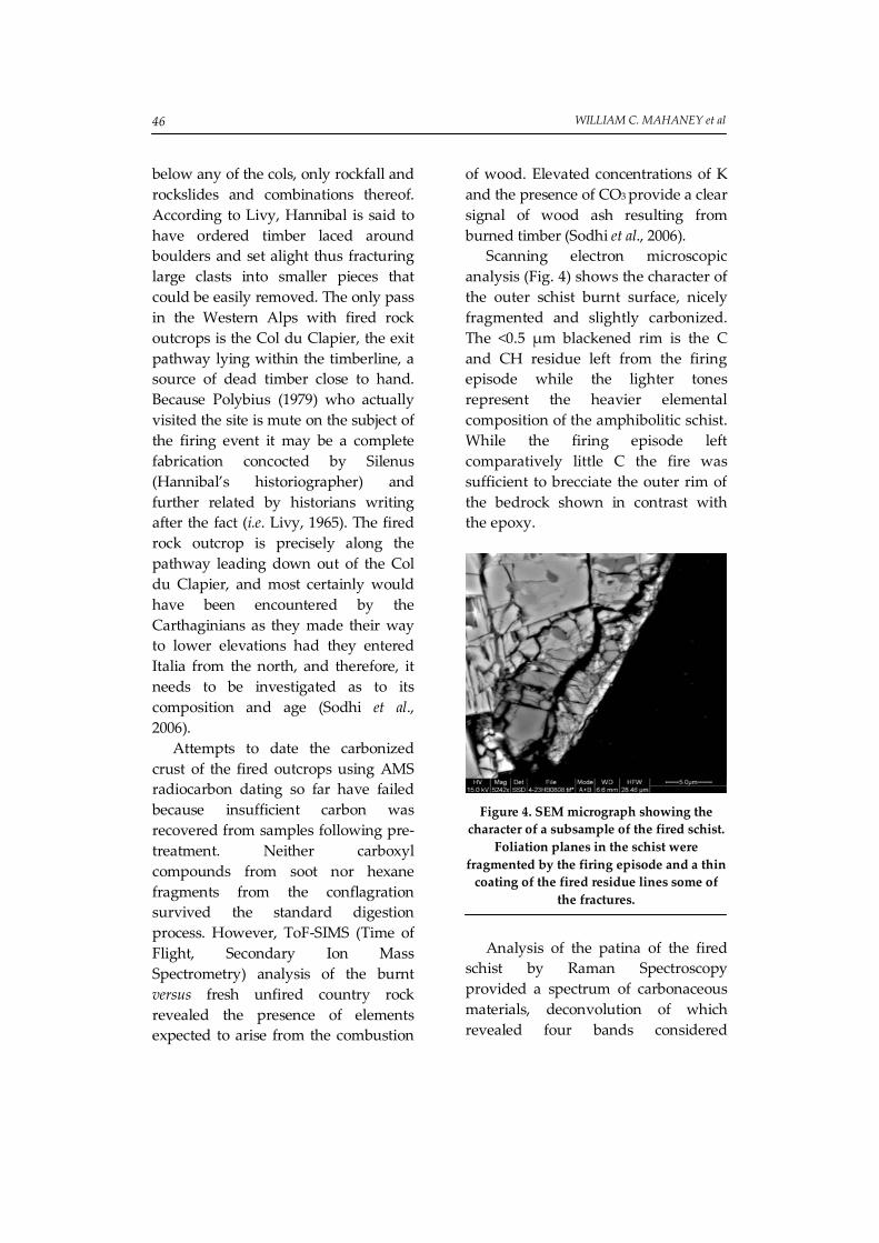
Scanning electron microscopic analysis (Fig. 4) shows the character of the outer schist burnt surface, nicely fragmented and slightly carbonized. The <0.5 µm blackened rim is the C and CH residue left from the firing episode while the lighter tones represent the heavier elemental composition of the amphibolitic schist. While the firing episode left comparatively little C the fire was sufficient to brecciate the outer rim of the bedrock shown in contrast with the epoxy.
Figure 4. SEM micrograph showing the
character of a subsample of the fired schist. Foliation planes in the schist were
fragmented by the firing episode and a thin coating of the fired residue lines some of
the fractures.
Analysis of the patina of the fired
schist by Raman Spectroscopy provided a spectrum of carbonaceous materials, deconvolution of which revealed four bands considered

HANNIBAL’S TREK ACROSS THE ALPS: GEOMORPHOLOGICAL … 47
significant for disordered graphite resulting from the conflagration. The Raman spectra (Fig. 5) provide a geothermometer of the maximal temperatures suffered by metamorphic rocks in the range 330-650oC (Beyssac et al., 2002); the area ratio of different characteristic bands yielding a firing temperature of 363oC with an intrinsic error of ± 50oC. This result should be considered with caution since Beyssac’s Method is used to determine the peak temperature reached during regional metamorphism, which implies a slow transformation when compared to the instantaneous heating that occurs with a forest fire.
Figure 5. Raman spectra of carbon-rich
material in the fired graphitized patina of the burnt amphibolite schist. The non-
deconvolved spectra is shown in (a); deconvolved spectra in (b) with four
distinct characteristic bands of carbonaceous material (From Mahaney
et al., 2007a).
The presence of strong red
coloration in the fired rock below the Col du Clapier, suggestive of hematization caused by lightning, led us to investigate the magnetization of the fired and unfired rock at the site (Maki, 2005; Verrier & Rochette, 2002). Koenigsberger Ratios (remanant magnetization / induced magnetiza-tion) failed to reach the threshold levels that would indicate lightning impact. However, the absence of
fulgurite minerals in the fired bedrock and disrupted rubble may simply indicate a low-energy lightning strike with minor transport of rock fragments (Barnett, 1911; Grapes, 2006). Because the fired bedrock site is located across a wide drainage way that would channel surface runoff into the lower valley it may well act as a conduit for electrical discharge during a storm. However, the data do not negate the possibility of a lightning induced conflagration.
Unfortunately, contrary to the hypothesis advanced by Annequin and Barruol (2004) that Hannibal took the northern route, there is little to recommend the Col du Clapier as Hannibal’s entrance point to Cisalpine Gaul. There is no firnpack (accumulations of old dense snow) present that is one of the prime prerequisites for the correct col and entrance route into Italia. The view into Italia, considered by most authorities (de Beer, 1969; Lazenby, 1998 for example) to be a prime criterion for the correct col, from the Col du Clapier is restricted to no more than 5-6 km reaching to the far end of the Val Clarea. The blocking rockfall below the entrance col to Italia, described both by Livy and Polybius, is missing below the Col du Clapier. The rockfall, which exists at the fired rock site is too small in volume and of insufficient size to block an army. Most clasts are less than 0.5 m diameter, small enough to be moved easily even by starving soldiers (Polybius, 1979; Livy, 1965). A major unanswered question about the fired rock outcrop is the expected age of fired rock in general, its longevity

WILLIAM C. MAHANEY et al 48
determined pretty much on the strength of relative-age dating methods (see for example, Mahaney, 1990). Lichen encrustation on the fired material is nil which suggests a young age, perhaps little more than a century or two. Rock weathering and ultimate erosion which would remove the carbonized rock is unknown with any exactitude but weathering rinds on the fired rock suggest fired rock might persist for at least a millennium or longer.
KEY GEOARCHAEOLOGICAL SITES
According to Polybius (1979) it took three days for the Punic Army to forge a path through the blocking rockfall wide enough to accommodate horses and elephants. A field survey of the six likely passes used by the Carthaginians revealed that the only mass wasted deposit of sufficient size to block an army is located in the upper Po River at 2600 m elevation below the Col de la Traversette. The path ballast at the Traversette rockfall site is two meters thick in most places giving the impression that down slope movement in the rockfall has necessitated reinforcement of the exit pathway many times, possibly even prior to Hannibal’s egress from the high col. Beyond the main (250 m long) rockfall is another, smaller slide mass about 50 meters in length that may have added to the difficulty of clearing an exit to the lower valley.
Once beyond the rockfall/slide barrier, Hannibal is said to have regrouped for two days in the lower
valley (Polybius, 1979; Livy, 1965). At the 1900 m elevation below the Col de la Traversette a vast plain of alpine grass and sedge with plentiful water supply provides a site correlating well with the ancient literature. Stonewalls (Fig. 5) lacing part of the meadow and now partially buried in the alpine soil have probably been used as bivouacs for centuries if not millennia. Boulders in these interconnecting walls support lichen cover similar to the rockfall in the upper valley and may be of similar age. Exploratory archaeological excavation of these stonewalls might eventually lead to the recovery of artifacts that could provide important information on the military culture of ancient Carthage. An army, consisting of 26,000 men, several thousand horses and handlers and 37 elephants (Polybius, 1979) could be expected to leave behind numerous personal items, which have never been found by the researchers who have visited but not explored the prospective sites from Mt. Cenis (final col favored by Napoleon, de Montholon, 1905) and Col du Clapier (Annequin and Barruol, 2004) in the north to the Col Agnel in the south.
While the numbers of troops and animals involved are hypothetical, the 26,000 figure documented by Polybius from the bronze tablet in the Temple of Hera at Cape Lacinium (Polybius, III, 33) is considered correct by most modern workers (de Beer, 1969; Lazenby, 1998; Lancel, 1999). Thus with this number of Carthaginian infantry and cavalry and 37 elephants it is reasonable to assume his baggage train contained at least 10,000 and

HANNIBAL’S TREK ACROSS THE ALPS: GEOMORPHOLOGICAL … 49
most probably as many as 15,000 horses and mules for which a minimum of 5000 handlers would be needed. Adding in cooks, artificers, armourers and engineers, the entire army probably numbered in excess of 50,000 humans and beasts of all description as it lumbered over the Col de la Traversette into Italia.
DISCUSSION
Were it not for the fired rock outcrop at the Clapier the entrance to Italia would be rather easy to determine provided one visited and studied the topography and geomorphology at all possible sites. As Jourdain-Annequin (1999) points out ‘the myth of Hannibal’ or the controversy over the invasion route fuelled by many ancient and modern historians mostly stemming from inadequate field research and the tendency for many authors to quote previous sources without actually visiting and working at the various localities. The only workers to visit all the sites are de Beer (1967, 1969), Seibert (1993), Prevas (1998), Lazenby (1998) Lancel (1999) and Hunt (quoted in Boser, 2007) and the only workers to rely on detailed topographic and natural historical investigations are de Beer (1967, 1969) and Mahaney (2004, 2007). As illustrated here Earth scientific investigations have much to offer in the way of determining the exact route Hannibal followed during the invasion of Italia in 218 BC.
On the topographic side the oft-quoted criterion that Hannibal stopped at the high pass and
motioned off in the direction of the plains of the Po, if indeed this ever happened, the most likely candidate is the Traversette as documented by de Beer (1967, 1969). Further, if one considers the steep slopes described by Livy and Polybius on the lee side of the range, one is forced to consider the Traversette as the main candidate because it is the only route into Italia that contains sufficient sheer cliffs one might topple over. None of the other approach routes offer the same topographic obstacle on a scale compatible with what Polybius describes. And nowhere are there cliffs that reach the height described by Livy (XXI, 36) reaching a thousand foot (~300 m) drop. Only the Col de la Croix comes close but then the slopes are so heavily wooded one would have to be overly creative to fail to grab a tree upon loosing footing. All ancient sources stipulate that Hannibal debouched from the Alps onto the plains of the Po topographically distinct from the plains of the Dora Riparia, the latter catchment draining both the Col de Mt. Cenis and the Col du Clapier. If one accepts this topographic distinction, and assuming the place names have been in vogue for at least the last two millennia as indicated by de Beer (1967, 1969), it supports the southerly route not the northern one.
On the environmental side the main criteria include: presence of firnpack (heavy dense perennial snow) described by both key ancient authorities; extreme height of the ultimate col of passage; sheer cliffs on the lee side; two-tier rockfall on the lee

WILLIAM C. MAHANEY et al 50
side; and grassy regrouping area below the rockfall. These criteria are crucial to picking the right approach route and ultimate col of passage. The only candidate possible would have to be situated in and around the 3000-meter contour and with sufficient high rock buttresses off to the south to provide a microclimate sufficient to allow the ground to remain frozen during the summer months (see Mahaney et al., 2007b for a discussion of permafrost in the western Alps). The Traversette is the only col within the right elevation range to qualify for passage by the Punic Army; all other cols are ~500 meters lower or in the case of the Col Agnel lacking the correct microclimate. As discussed above what we consider to be the strongest evidence pointing towards the Traversette as the entrance to Italia is the presence of the two-tier rockfall detailed by Polybius as the rubble sheet that stopped Hannibal’s descent into the Po River plains. All the possible entrance points into Italia have rubble sheets in places but only the Traversette at 2600 m elevation contains the surficial feature described so accurately by Polybius. Moreover this suggests that Polybius actually passed over the Traversette some 70 years after the invasion as how else could he have observed and known the blocking rubble was a two-time event. It would take an astute observer to pick out the two deposits and to correctly interpret them as separate events.
The regrouping area below the blocking rockfall might be identified at one of several places. A close read
of Polybius (III, 56) suggests the refitting area was close-by, perhaps within eyesight of the rockfall. This could include the area below the Col du Clapier, the Col Agnel and the Col de la Croix but these areas would not accommodate the number of troops and animals involved. Below the Col de la Traversette the grassy area below the 2000-meter contour and just up-valley from Crissolo could accommodate the ~50,000 humans and beasts populating the invasion force. More than this the water discharge in the Upper Po River below the Traversette is fed from three main streams approximately twice to three times the volume one might expect at the other sites. And water must surely have been a key item to prevent dehydration and necessary for the preparation of whatever food supplies remained with the baggage train.
The presence of an intricate network of sunken walls in the upper Po River Valley suggests the area has been used as a bivouac for well over a millennium and possibly much longer (Fig. 6). This, together with the reinforced thick ballast underlying the roadway through the upper rockfall, further indicates the roadway has been rebuilt and strengthened many times over the centuries. Lichen diameters and total cover on moved boulders suggest parts of the roadway and the wall network date from antiquity. If one assumes from what is known from lichen growth in high mid-latitude alpine localities (Benedict, 1967, 1968; Birkeland, 1973; Mahaney, 1990, 1991; Mahaney and Spence, 1984) similar in kind to the
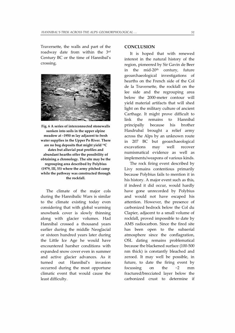
HANNIBAL’S TREK ACROSS THE ALPS: GEOMORPHOLOGICAL … 51
Traversette, the walls and part of the roadway date from within the 3rd Century BC or the time of Hannibal’s crossing.
Fig. 6 A series of interconnected stonewalls sunken into soils in the upper alpine
meadow at ~1950 m lay adjacent to fresh water supplies in the Upper Po River. There
are no bog deposits that might yield 14C dates but alluvial peat profiles and
abundant hearths offer the possibility of obtaining a chronology. The site may be the
regrouping area described by Polybius (1979, III, 55) where the army pitched camp while the pathway was constructed through
the rockfall.
The climate of the major cols
during the Hannibalic Wars is similar to the climate existing today even considering that with global warming snowbank cover is slowly thinning along with glacier volumes. Had Hannibal crossed a thousand years earlier during the middle Neoglacial or sixteen hundred years later during the Little Ice Age he would have encountered harsher conditions with expanded snow cover even in summer and active glacier advances. As it turned out Hannibal’s invasion occurred during the most opportune climatic event that would cause the least difficulty.
CONCLUSION It is hoped that with renewed
interest in the natural history of the region, pioneered by Sir Gavin de Beer in the mid-20th century, future geoarchaeological investigations of hearths on the French side of the Col de la Traversette, the rockfall on the lee side and the regrouping area below the 2000-meter contour will yield material artifacts that will shed light on the military culture of ancient Carthage. It might prove difficult to link the remains to Hannibal principally because his brother Hasdrubal brought a relief army across the Alps by an unknown route in 207 BC but geoarchaeological excavations may well recover numismatical evidence as well as implements/weapons of various kinds.
The rock firing event described by Livy remains contentious primarily because Polybius fails to mention it in his history. A major event such as this, if indeed it did occur, would hardly have gone unrecorded by Polybius and would not have escaped his attention. However, the presence of carbonized bedrock below the Col du Clapier, adjacent to a small volume of rockfall, proved impossible to date by AMS radiocarbon. Since the fired site has been open to the subaerial atmosphere since the conflagration, OSL dating remains problematical because the blackened surface (100-500 nm thick) is constantly bleached and zeroed. It may well be possible, in future, to date the firing event by focussing on the ~2 mm fractured/brecciated layer below the carbonized crust to determine if
WILLIAM C. MAHANEY et al 52
electron capture might provide an age compatible with relative-age dating which suggests the firing event is recent, i.e. within the last century or two. While not conclusive, the available evidence indicates the firing event is likely anecdotal, possibly the product of hubris invented by an ancient author (s), recounted by Livy, and unrelated to the Hannibalic
invasion of Italia. In any case, if the firing was intended to forge a path through an ancient rockfall, as recounted by Livy, the low volume of rubble present at the site and small diameter of clasts that could easily be removed by hand would not have required the extreme measure of gathering timber to set the site aflame.
Acknowledgements This research was carried out with funding from Quaternary Surveys to WCM,
VK and RWD, and grants from the Natural Sciences and Engineering Research Council of Canada to RB and RWB. Establishment of Surface Interface–Ontario (RS) was made possible by the Canadian Foundation for Innovation and matching contributors (www.si-ontario.utoronto.ca).
REFERENCES Connolly, P. (1981) Greece and Rome at War, MacDonald and Co. Bagnall, General Sir N. (1999) The Punic Wars, Oxford, Oxford, UK, 347 p. Barnett, V.H. (1911) An example of disruption of rock by lightning on one of the
lucite hills in Wyoming, Journal of Geology 16 (6), 568-571. Benedict, J.B. (1967) Recent glacial history of an alpine area in the Colorado Front
Range, U.S.A. I, Establishing a lichen growth-curve. Journal of Glaciology 6, 817-832.
Benedict, J.B. (1968) Recent glacial history of an alpine area in the Colorado Front Range, U.S.A. II, Dating the glacial deposits. Journal of Glaciology 7, 77-87.
Beyssac, O., Goffé, B., Chopin, C. & Rouzaud, and N. (2002) Raman spectra of carbonaceous material in metasediments: a new geothermometer, Journal of Metamorphic Geology 20, 859-871.
Birkeland, P.W., (1973) Use of relative age dating methods in a study of rock glacier deposits, Mt. Sopris, Colorado. Arctic and Alpine Research, 5, 401-416.
Boser, U. (2007) Hiking with Hannibal. Archaeology 60, 36-41. de Beer, Sir G. (1967) Hannibal’s March, Sidgwick & Jackson, London, UK, 164 p. de Beer, Sir G. (1969) Hannibal: Challenging Rome’s Supremacy, Viking Press, N.Y., 320 p. de Beer, G. (1974) Hannibal: the Struggle for power in the Mediterranean, Book Club
Assoc., London, UK. 320 p. de Montholon, J.F.T. (1905) Memories of Sainte Hélène, vol. IV, pp. 277-28. Paris :
Garnier. Dion, R. (1962) La voie héracléenne et l’itinéraire transalpine d’Hannibal. In:
Mélanges à A. Grenier (coll. Latomus), LVIII, Brussels, 132-147
HANNIBAL’S TREK ACROSS THE ALPS: GEOMORPHOLOGICAL … 53
Dodge, T.A. (1891) Hannibal, Houghton Mifflin, N.Y.682 p. Egli, M., Mirabella, A., Sartori, G., & Fitze, P. (2003) Weathering rates as a function of
climate: results from a climosequence of the Val Genova (Trentino) Italian Alps, Geoderma 111, 99-121.
Goldsworthy, A. (2001) Cannae, Cassell, London, UK, 200 p. Grapes, R. (2006) Pyrometamorphism, Springer, NY, 276 p. Hart, B.H.L. (1967) Strategy, Faber and Faber, London, UK. 420 p. Healy, M. (1994 Cannae 216 BC, Osprey, London, UK, 96 p. Huss, W. (1985) Geschichte der Karthager, Handbuch des Altertumwissenschaft.
Munich, III, 8. Jourdain-Annequin, C., (1999) L’image de la montagne ou la géographie à l’épreuve
du mythe et de l’histoire: l’exemple de la traversée des Alpes par Hannibal, Dialogues d’Histoire Ancienne 25, 101-127.
Annequin, C. & Barruol, G. (2004) Les grandes traversées des Alpes: l’itinéraire d’Hannibal, In, Annequin, C., & Le Berre, M , Atlas Culturel des Alpes Occidentales: de la Préhistoire à la fin du Moyen Age, Picard, Paris, 100-101.
Lancel, S. (1999) Hannibal, Blackwell, London, 243 p. Lazenby, J.F. (1998) Hannibal’s War, U. Oklahoma Press, Norman, Okla., 340 p. Livy (1965) trans., A. de Selincourt. The War with Hannibal, Penguin, 709 p. Mahaney, W.C. (1990) Ice on the Equator, Wm Caxton, Ellison Bay, Wisc. 386 p. Mahaney, W.C. (1991) Late Pleistocene and Holocene glacial chronology at
Chamonix and Argentière, French Alps, Zeitschrift für Geomorphologie 35, 225-237.
Mahaney, W.C., and Spence, J.R. (1984) Glacial and periglacial sequence and floristics in Jaw Cirque, central Teton Range, western Wyoming, American Journal of Science, 284, 56-81.
Mahaney, W.C. (2004) Hannibal’s invasion of Italia in 218 BC: geological reconnaissance of the alpine route. In., Caldwell, D.R., et al. eds. Studies in Military Geography and Geology, Kluwer, 67-78.
Mahaney, W.C., Milner, M.W., Sodhi, Rana, Dorn, R.I., Boccia, S., Beukens, R.P., Tricart, P., Schwartz, S., Chamorro-Perez, Eva, Barendregt, R.W., Kalm, V., & Dirszowsky, R.W. (2007a) Analysis of burnt schist outcrops in the Alps: relation to historical archaeology and Hannibal’s crossing in 218 BC. Geoarchaeology, 22, 799-818.
Mahaney, W.C., Miyamoto, H., Dohm, J., Baker, V., Cabrol, N., Grin, E., & Berman, D.J. (2007b) Rock glaciers on Mars: Earth-based clues to Mars’ recent paleoclimatic history. Journal of Planetary and Space Sciences 55, (1-2), 181-192.
Mahaney, W.C. (2009), Hannibal’s Odyssey: environmental background to the invasion of Italia, Gorgias Press, Piscataway, N.J., in press.
Maki, D. (2005) Lightning strikes and prehistoric ovens: determining the source of magnetic anomalies using techniques of environmental magnetism, Geoarchaeology 20, 449-459.
WILLIAM C. MAHANEY et al 54
Mommsen, T.A. (2006) A History of Rome, Folio Soc., London, UK, 771 p. Neumann, J., (1992) Climatic conditions in the Alps in the years about the year of
Hannibal’s crossing (218 BC). Climatic Change 22, 139-150.. Polybius, (1979) trans. I. Scott-Kilvert. The Rise of the Roman Republic, Penguin, 574 p. Prevas, J. (1998) Hannibal crosses the Alps, Sarpedon, Rockville Centre, NY, 232 p. Proctor, D. (1971) Hannibal’s March in History, Oxford U. Press, UK, 229 p. Seibert, J. (1993) Hannibal, Wissenschaftliche Buchgesellschaft, Darmstadt, p. 75-134. Sodhi, R.N.S., Mahaney, W.C. & Milner, M.W. (2006) ToF-SIMS applied to historical
archaeology in the Alps, Applied Surface Science 252, 7140-7143. Soil Survey Staff, (1999), Soil Taxonomy, a Basic System of Soil Classification for making
and interpreting soil Surveys, U.S. Government Printing Office, Pittsburgh, Pa., 871 p.
Strabo (1999) trans. H. Jones, Geography, Loeb Classical Library. Tricart, P. et al., (2003) Aiguilles-Col Saint-Martin, Carte Géologique de la France.
1:50000. Verrier, V., Rochette, P. (2002) Estimating peak currents at ground lightning impacts
using remanent magnetisation. Geophysical Research Letters 29, 14-1 - 14-4. Walbank, F.W. (1957) A Historical Commentary on Polybius, Vol. 1., Commentary on
Books I-VI, Clarendon Press, Oxford, UK. Wilkinson, S. (1911) Hannibal’s march through the Alps, Oxford, Clarendon.