guzzetti landslide cartography hazard riskgeomorphology.irpi.cnr.it/publications/repository/... ·...
TRANSCRIPT
1
Landslide Cartography, Hazard Assessment and Risk Evaluation: Overview,Limits and Prospective
Fausto GuzzettiCNR – IRPI, via della Madonna Alta 126, 06128 Perugia, Italy, [email protected]
ABSTRACT: Landslides occur every year, causing casualties and large economic damage. Landslidecartography, including landslide inventory, density and hazards maps, and landslide hazards assessment and riskevaluation are important goals for scientists, planners, decision makers and land developers. In this report Ioutline the main characteristics and principal limitations of the methods and techniques currently used to mapslope failures, ascertain landslide hazards and estimate the associated risks. Examples and recommendations aregiven on the basis of the experience gained in studies conducted mostly in central and northern Italy.
1 INTRODUCTION
Many different triggers cause landslides, including intense or prolonged rainfall, earthquakesand rapid snow melting. On Earth the volume of mass movements spans 15 orders ofmagnitude; and landslide velocity extends over 14 orders of magnitude, from millimetres peryear to hundreds of kilometres per hour. Mass movements can occur singularly or in groupsof up to several thousands. Multiple landslides occur almost simultaneously when slopes areshaken by an earthquake, or over a period of hours or days when failures are triggered byintense rainfall or snow melting. Landslides can involve flowing, sliding, toppling or fallingmovements, and many landslides exhibit a combination of these types of movements (Varnes,1978). The extraordinary breadth of the spectrum of landslide phenomena makes it difficult todefine a single methodology to ascertain landslide hazards and to evaluate the associated risk.
Landslides are reported in all continents and their economical and societal impact can betremendous and widespread. In many Countries casualties and economic losses caused bylandslides are larger than those produced by others damaging natural events, including floodsand earthquakes. In Italy, a Country for which the information is available, in the 20th centurylandslides have caused 7,799 casualties, comprising 5,831 deaths, 108 missing persons and1,860 injured people. This represents an average of 59.4 deaths or missing persons each year.Limiting the analysis to the post War period (1950-2000), slope failures have caused at least4,408 deaths or missing persons, in 521 landslide events. This figure is much larger than theestimated number of 1,040 deaths and missing persons caused by floods, and larger than thenumber of 4,160 deaths and missing persons caused by earthquakes, during the same period(Guzzetti, 2000).
The main causes and effects of landslides have long been known and several differentmethods and techniques have been proposed to identify and map slope failures (Rib andLiang, 1978; Turner and Schuster, 1996), to evaluate landslide hazards (Guzzetti et al., 1999;Soeters and van Westen, 1996; Carrara et al., 1995, van Westen, 1994) and to ascertainlandslide risk (Cruden and Fell, 1997; Einstein, 1988). However, no general agreement hasbeen reached on how to accomplish these tasks effectively.
In this report I will outline some of what I consider to be the inadequacies of the existingapproaches to landslides mapping, hazard assessment and risk evaluation, and I will offer

2
some recommendations on the basis of experience gained in landslide studies carried out inCentral and Northern Italy.
2 LANDSLIDE IDENTIFICATION AND MAPPING
Any landslide hazard or risk assessment must begin with the collection of information onwhere landslides are located. This is the goal of landslide mapping. A landslide inventory isthe simplest form of landslide map. It records the location and, where known, the date ofoccurrence and types of landslides that have left discernable traces in an area (Hansen, 1984;Wieczorek, 1984). Inventory maps can be prepared by different techniques, depending ontheir scope, the extent of the study area, the scales of base maps and aerial photographs, andthe resources available to carry out the work.
Small-scale inventories (<1:200,000) are compiled mostly from data captured from theliterature, through inquires to public organisations and private consultants, by searchingchronicles, journals, technical and scientific reports, or by interviewing landslide experts(archive inventories). Small-scale landslide maps can also be obtained through the analysis ofaerial photographs. Medium-scale landslide inventories (1:25,000 to 1:200,000) are preparedthrough the systematic interpretation of aerial photographs at print scales which range from1:60,000 to 1:20,000 and by integrating local field checks with historical information. Large-scale inventories (>1:25,000) are prepared, usually for limited areas, using both theinterpretation of aerial photographs at scales greater than 1:20,000 and extensive fieldinvestigations, which make use of a variety of techniques and tools that pertain togeomorphology, engineering geology and geotechnical engineering (Guzzetti et al., 2000).
Figure 1 shows a portion of a large scale geomorphological landslide inventory mapprepared through the interpretation of two sets of medium- and large-scale aerial photographsin the Umbria Region, in central Italy. The original map was prepared at 1:10,000 scale for anarea of 8,456 km2, and shows more than 47,000 landslides, for a total landslide area of 712km2. Landslides are classified based on the type of movement, the estimated depth, velocity,and age, and the degree of certainty (AA.VV., 2002).
Landslide inventory maps may show all the slope failures triggered by a single event, suchas an earthquake, rainstorm or snowmelt (event inventories), or they may show thecumulative effects of many events over a period of hundreds or even thousands of years(geomorphological inventories). By interpreting multiple sets of aerial photographs ofdifferent ages, multi-temporal inventory maps can be prepared.
As they are prepared by interpreting one or more sets of aerial photographs and correctingthe results by field mapping, landslide inventory maps tend to be subjective. Reliability,completeness and resolution are issues to consider when preparing and using an inventorymap. An incomplete or unreliable inventory may result in erroneous hazard or riskassessments. Many factors affect the reliability, completeness and resolution of an inventorymap, including: (a) landslide freshness and age, (b) the quality and scale of aerial photographsand base maps, (c) the morphological and geological complexity of the study area, (d) landuse types and alterations, and (e) the degree of experience of the geomorphologist whocompletes the inventory.
Good quality event inventories should be reasonably complete, at least in the areas forwhich aerial photographs were available and where it was possible to perform fieldwork. As adrawback, event inventories often cover only a part of the total geographic area associatedwith a landslide triggering event. Geomorphological inventories are never complete. Evidence

3
for the existence of landslides is rapidly removed by erosion, growth of vegetation and humanactivity, and with time landslide boundaries become fuzzy, making it difficult to map thelandslide precisely. Multi-temporal inventory maps can be prepared only where multiple setsof aerial photographs are available, i.e., only for the last 50 to 60 years in Europe. Despite thenumerous published works dealing with landslide inventory maps, very few attempts havebeen made to assess their reliability and completeness quantitatively (Carrara et al., 1992;Ardizzone et al., 2002). Where this has been accomplished, results have shown that landslideidentification needs to be carried out by experienced geomorphologists, and that landslidemapping still lacks clearly defined standards. Landslide identification and mapping is both ascience and an art, and efforts should be made to make it more objective, reproducible andscientific.
Figure 1. Umbria region, central Italy. Portion of a geomorphological landslide inventorymap. Legend: Grey, landslide deposits of slide, slide earth-flow and complex failures; verticalpattern, deposits of flow slides; dark grey, crown area of deep-seated landslides. Thick blackline shows an area where landslide risk was determined (see Figure 3). Original map scale is
1:10,000.
The limitations of landslide inventories refer to their subjectivity and to the difficulty ofmeasuring their reliability. The reliability of archive inventories depends largely on thequality and abundance of the information sources (Glade, 1998; Cruden, 1997; Guzzetti et al.,1994). For geomorphological maps, the experience gained from surveys carried out indifferent parts of the world has shown that trained investigators can reliably detect landslidesby standard photo-interpretation techniques coupled with systematic checks in the field(Turner and Schuster, 1996; Rib and Liang, 1978). However, the reliability ofgeomorphological inventories depends on the type and scale of the aerial photographs used,the experience and skill of the interpreter, the scale of the final map, the complexity of thegeological, morphological and land-use setting, and the persistence of landslide morphologywithin the landscape (Carrara et al., 1992; Fookes et al., 1991, Hansen, 1984).

4
Landslide inventories are easy for both experts (e.g., geomorphologists) and non-experts(planners and policy-makers) to understand. Trained geomorphologists can easily preparesuch maps without the need for large investments in costly equipment. Despite the ease withwhich they can be prepared, their immediateness and their low cost, landslide inventories arestill not very popular, particularly among regional and national agencies. The reasons for thisinclude: (a) lack of resolve in preparing such maps for large regions, (b) unwillingness toknow where landslides are located (often lack of knowledge represents more freedom), (c)inability to understand the value of regional inventories for planning purposes, and (d) thesubjectivity of landslide inventory maps (Guzzetti et al., 2000).
2.1 Recommendations
I propose the following recommendations for the preparation and use of landslide inventorymaps. Landslide cartography should be increasingly pursued, and landslide inventory mapsshould be prepared for large areas (i.e., entire provinces or regions) using consistent andreproducible methods. Geomorphological inventory maps can be used to study therelationships between the lithological and structural settings and the landslide types andpattern. Despite the fact that this information can prove extremely valuable for landslidehazards assessment, review of the literature shows that such studies are rare, mostly becausegeographical databases containing landslides, lithological, and structural information with therequired accuracy are not readily available.
Landslide inventory maps should be prepared after each landslide-triggering event (e.g., arainstorm, a snowmelt event, or an earthquake), covering the entire territory affected by theevent. Such maps allow determining the full extent of landslide events on the structures andthe infrastructure. They can also provide valuable information for evaluating the types, extentand severity of damage caused by slope failures. Frequency-size (i.e., area, volume) statisticsof landslides can be used to describe quantitatively the extent and magnitude of the landslidestriggered by the extreme events. This information may be used to compare the ground effectsproduced by different triggers and by preparing regional landslide scenarios.
Regional and national Geological Surveys, planning agencies, and other concernedorganizations should keep records of the landslides and the landslide events that haveoccurred in historical times in any given area. This information can be used to determine thefrequency of landslide phenomena, mandatory information to properly assess landslidehazards. Where multiple sets of aerial photographs are available, multi-temporal landslideinventory maps should be completed to estimate the local landslide recurrence and toinvestigate the spatial relationships between failures of different ages and types.
Completeness, resolution and reliability (i.e., quality) of the landslide inventory mapsshould be ascertained. When preparing a landslide inventory map, the techniques, methodsand tools used to complete the inventory, including type of stereoscope, type and scale ofaerial photographs and base maps, and level of experience of the investigators, should alwaysbe specified. Without this information an inventory map may be used by others for scopes forwhich the map was not originally prepared.
3 LANDSLIDE HAZARD ASSESSMENT
In a very well-known report, Varnes and the IAEG Commission on Landslides and otherMass–Movements (1984) proposed that the definition adopted by UNDRO for all natural

5
hazards be applied to landslide hazards. Landslide hazard is therefore “the probability ofoccurrence within a specified period of time and within a given area of a potentially damagingphenomenon”. Guzzetti et al. (1999) preferred the definition to include the magnitude of theevent, i.e. the area, volume and velocity or momentum of the expected landslide.
This definition of landslide hazard is widely accepted. However it poses problems, largelyas a result of the peculiarities of landslides when compared to other natural hazards, chieflyearthquakes, for which the UNDRO definition is best adapted. Even when they are caused bya single triggering event (e.g., intense rainfall, earthquake or rapid snowmelt), landslidesaffect any given geographical area in a way that differs from that of other natural hazards.Landslides are localised (“point”) events controlled by the intensity, duration and extent of thetriggering mechanism, and by the local morphological, lithological, hydrological, structuraland land-use settings. Moreover, some of these factors vary with time. The definition oflandslide hazard incorporates the concepts of location (where a landslide will occur), time(when, or how frequently a landslide will occur) and magnitude (how large, or how fast thelandslide will be).
In conceptual terms, confusion may arise from the use of the term landslide to addressboth the landslide deposit and the movement of slope material or remobilisation of an existingmass movement deposit. Thus, hazard models cannot predict when a landslide will occurbased on where landslides have occurred in the past. Information on frequency is evaluated bystudying historical records or through a multi-temporal analysis of various sets of aerialphotographs. This information is difficult, costly and time consuming to obtain. In addition,each time a landslide occurs, the topographical, geological and hydrological settings of theslope change, giving rise to different conditions of instability. Due to the variety of landslidetypes and the possibility that the landslide will evolve abruptly from one type of movement toanother (e.g., when a soil slip is transformed into a debris flow), the magnitude of theexpected mass movement is also difficult to predict.
Many methods have been proposed to evaluate landslide hazard spatially (Guzzetti et al.,1999; Soeters and van Westen, 1996; Carrara et al., 1995; van Westen, 1994). Twoapproaches are the most promising: methods based on the statistical analysis of geo-environmental factors related to the occurrence of landslides; and deterministic modellingbased on simple mechanical laws that control slope instability. Multivariate statistical modelsprovide the best results for large areas and where the relationships between determiningfactors and landslide occurrence are complex. These models provide a quantitative, objectiveand reproducible way of ascertaining the spatial pattern of landslides. Good multivariatemodels perform better than the original inventory map in predicting the occurrence oflandslides but do not explicitly incorporate the temporal aspect of movement (Ardizzone etal., 2002). Physically-based models perform well for landslides whose behaviour is easilypredicted by simple mechanical laws (e.g., soil slips and rock falls), but they too lackconsideration of the temporal aspect of landslides. Attempts to introduce the time componentinto hazard models have been proposed by Agostoni et al. (2000), who incorporated historicallandslide events in a multivariate discriminant model. Coe et al. (2000) proposed aprobabilistic model of landslide occurrence based on a catalogue of historical landslides.Guzzetti et al. (2002a), who used a physical model to study rockfall hazard, simulated thetime effect by launching a large number of boulders from each rockfall source area.
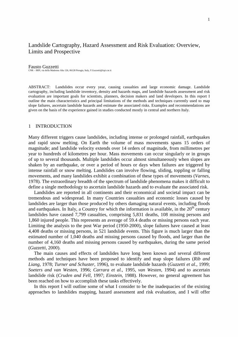
Figure 2 shows an example of a landslide hazard map for the same area portrayed inFigure 1. Landslide hazard was defined for the Upper Tiber River basin, in central Italy, asthe probability of spatial occurrence of landslides in the terrain units into which the study area
6
is partitioned (Cardinali et al., 2002a). The probability of occurrence was ascertained througha multivariate statistical analysis (discriminant analysis) of a large set of lithological,structural, morphological and land use information. The geo-environmental information wasobtained through photo-geological interpretation of aerial photographs, field surveys,bibliographical and historical studies, and spatial information analysis using GIS technology.The study area was partitioned into hydro-morpho-lithological terrain units. These are areasbounded by hydrological (drainage line), morphological (divide line) or lithologicalboundaries (Cardinali et al., 2002a).
The map can be used to assess landslide hazards and to evaluate landslide risk at the basinscale. Combined with a landslide inventory map (Cardinali et al., 2001) and with the resultsof recent investigations aimed at determining landslide risk in the Umbria region (Cardinali etal., 2002b), the hazard map provides the basis for establishing planning regulations aimed atdefending the land and the population against landslide hazards.
Figure 2. Umbria region, central Italy. Portion of a statistically-based landslide hazardmap (Cardinali et al., 2002a), for the same area shown in Figure 1. Hazard levels are shownby shades of grey, from stable (light grey) to unstable (dark grey) slopes. Light brick pattern,
landslide deposits; dark pattern, landslide crown areas.
The experience gained in numerous hazard investigations completed by various teams indifferent areas of the World has shown that, although quantitative, indirect methods ofassessing landslide hazards are preferable, no single method has proved to be superior inevery area and for all types of landslide (Guzzetti et al., 1999; van Westen et al., 1999).Selection of the statistical technique and the type of deterministic model appears lessimportant than the availability, quality, resolution and abundance of input data, includingthose derived from inventory maps. Equally important is the ability of the geomorphologist tointerpret the model results and to design appropriate forms of protection for the differenthazard zones.

7
3.1 Recommendations
The quality and reliability of a landslide hazard assessment depend more on the quality,resolution, completeness and reliability of the thematic information used to ascertain thehazards, than the type or method used to complete the hazard assessment. More resourcesshould be invested in the acquisition of high-quality information that is relevant to thedistribution and characteristics of landslides in the study area. Unreliable, badly formulated,low-quality data should not be used to ascertain the magnitude of landslide hazards.Unfortunately, review of the literature suggests that this is often the case.
Landslide hazard models and maps should be prepared for large areas (i.e., entire provincesor regions) using consistent, scientifically-based, and reproducible methods. Selection of themodelling techniques should be aided by the type of landslides to be investigated and theavailability of relevant thematic information, and not by the GIS, statistical or modellingsoftware at hand. Statistical (i.e., functional) and deterministic (i.e., physically-based)methods should be preferred. Experiences obtained by different teams in manyphysiographical environments proved that these methods provide the most reliable,quantitative results.
The quality, reliability and sensitivity of landslide hazard models and maps should alwaysbe carefully verified. This should be accomplished by checking the model results against goodquality inventory maps and reliable historical catalogues of landslide events. Since the maingoal of landslide hazard maps is to provide planners, decision makers and land developerswith information aimed at defending the land and the population against landslide hazards, themaps should be reliable and robust, both spatially and in time. The time aspect of hazardassessment (i.e., when or how frequently a landslide will occur in any given area) remains acrucial, still largely unresolved problem. Efforts should be made to incorporate time intospatially distributed (statistical or deterministic) hazard models. Where this is not possible, theestimated time-frame for the validity of hazard models and maps should be provided.
Lastly, new approaches should be attempted to the portrayal of landslide hazards, and newmeans of transferring scientific and quantitative information on landslide hazards to decisionmakers, land-use planners, consultants and concerned citizens should be experimented.Geomorphologists interested in the application of landslide hazard assessments should helpdecision makers design land-use regulations and policies that properly incorporate landslidehazard zoning, fully exploiting the available knowledge on landslide phenomena and theassociated hazards.
4 LANDSLIDE RISK ASSESSMENT
Landslide risk evaluation aims to determine the “expected degree of loss due to a landslide(specific risk) and the expected number of live lost, people injured, damage to property anddisruption of economic activity (total risk)” (Varnes and the IAEG Commission on Landslidesand other Mass–Movements, 1984). Quantitative (probabilistic) and qualitative approachesare possible. Quantitative risk assessment aims to establish the probability of occurrence of acatastrophic event, e.g., the probability of live losses, or the probability of a landslide causingN or more casualties (Fell and Hartford, 1997). The method requires a catalogue of landslidesand their consequences. A few of such lists have been prepared for landslides with human
8
consequences, i.e., deaths, missing people, and injuries (Evans, 1997; Guzzetti, 2000; Kong,2002). To compile accurate and complete lists of landslides that have caused other types ofdamage is more difficult, due to the lack of relevant information. When this information isavailable, frequency vs. consequences (F-n or F-N) plots can be prepared and the probabilityestimated. Acceptable risk levels are determined by comparison with natural or human-induced hazards for which acceptable risk levels have already been established (Fell andHartford, 1997). The completeness and time span of the landslide catalogue greatly affect thereliability of such quantitative risk assessments.
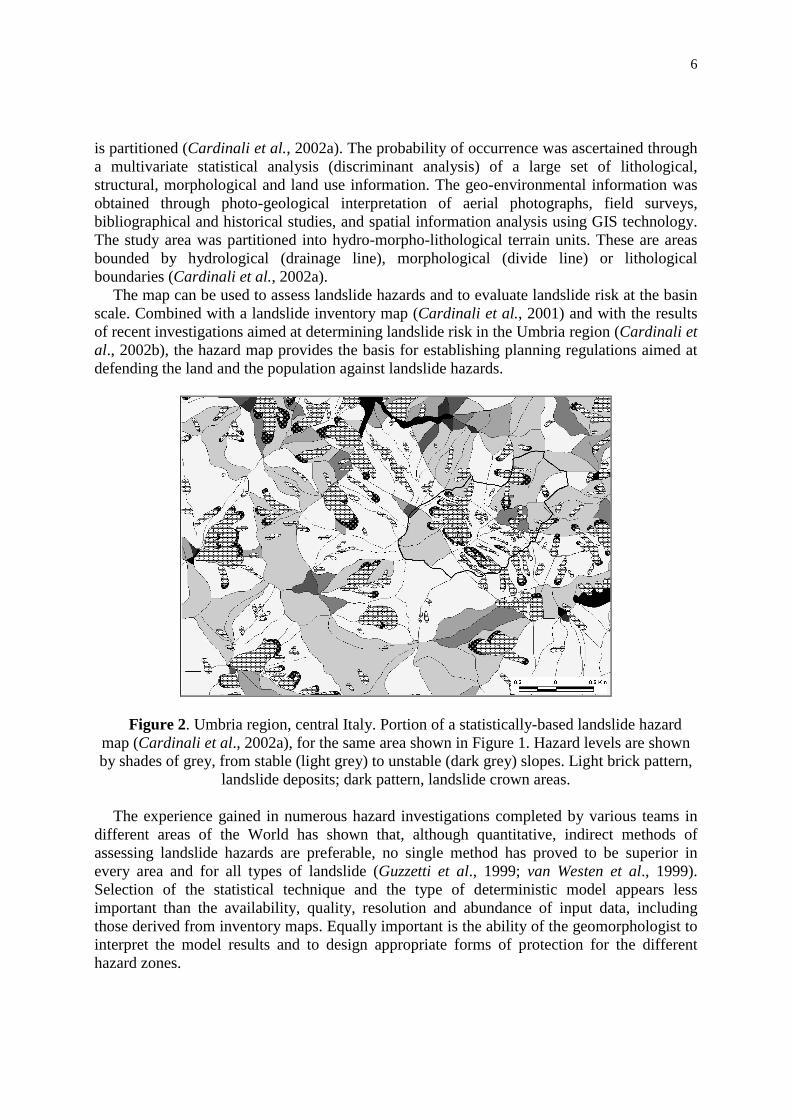
When attempting to evaluate specific and total risk for a site or region where landslides arelikely to take various forms or pose various types of threat, the quantitative approach oftenbecomes impracticable. It may not be easy to ascertain the magnitude, frequency and forms ofevolution of landslides in the area, and a detailed and reasonably complete catalogue ofhistorical events may not be readily available. In some areas a qualitative approached can bepursued in such a way as to establish qualitative levels of landslide risk. This involvesdesigning landslide scenarios. Cardinali et al. (2002) described an attempt to determinequalitative risk levels based on the geomorphological interpretation of several sets of aerialphotographs of different ages (a process of multi-temporal landslide mapping), combined withthe analysis of historical information on past landslide events. Figure 3 shows an example forthe village of Moranno Madonnuccia (Perugia province), where total landslide risk wasdetermined for deep-seated and shallow landslides.
A BA B
Figure 3. Umbria region, central Italy. Maps showing total landslide risk near the village ofMorano Madonnuccia, Perugia province. Total landslide risk is ranked in four classes, two ofwhich are shown here: R2, where landslide risk is moderate, and R3, where landslide risk ishigh. A) Risk for shallow landslides; B) Risk for deep-seated landslides. See also Figure 1.
A reasonable alternative to qualitative risk assessment is the analysis of the impact thatslope failures have had, or may have, in a given area. This can be accomplished in two ways.First, where a historical catalogue of landslides and their consequences is available, the sitesrepeatedly affected by catastrophic events can be determined and the vulnerability of theelements at risk ascertained (Kong, 2002). Alternatively, where a detailed landslide inventorymap and a map of structures (houses, buildings, etc.) and infrastructure (roads, railways,lifelines, etc.) at risk are available in GIS form, simple geographical operations allow one todetermine where landslides may interfere with the elements at risk. Despite the relative
9
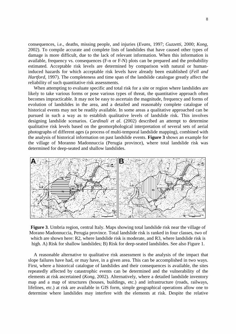
simplicity –and effectiveness– of such analyses, they are not commonly performed. Figure 4shows an example of a recent attempt aimed at ascertain the possible impact of landslidephenomena on the built-up areas and the transportation network in the Umbria region. Theintersection in a GIS of the geomorphological landslide inventory map (Guzzetti et al., 2002b)with maps of the built-up areas and of the transportation network, revealed 6,119 sites whereknown landslides intersect (i.e., may interfere) with built-up areas, and 4,115 sites wherelandslide intersect roads or railways. At these localities damage due to landslides can beexpected, particularly during major landslide triggering events (e.g., prolonged rainfall,snowmelt events, etc.).
BA
10 0 10 km
### ####### ##### ## # #### ## ## ###### ##
# ##### ### ##
# ## # ## ### ## ## # ## # # ## ## ## ### ## ### ## ## ### ## ##### #### # ### ### ## # ##### ### #### ###### #### ## ### ## ## # ## ## ### #### ### ## ## ###### ## #### ### ## ### # ### ## ### ### # ### ### #### ## # # #### ## ## ## ## # ### ### ## # ###### ## #### ###### # ### # #### # ### ##### ###### ##### # ##### # ## ### ######## # ### #### ## ##### ## ## ## ###### ## ## # ## ## #### ####### # # ##### # # ### ## ### ### ## ### ## ## # ## ## ## ## #### ## ### #### ### ### ## #### #### ## ## #### #### ## ## # # ######### # #### # ## ### ## ### ##### #### # ## ### ## ### ## ## # ##### ## ### ## #### # #### ## ###### ## ## ### #### ## # ## ## ## #### # ## ##### ### # ####### ## # ### ## ## ## ## # #### ## ## ### # ##### # ##### #### # # ###### ## # ## ### ## # # ## ##### ## #### # ### ### # #### ## ##### ### # ## ##### ## ## ### ##### ### #### ## ### ## ### ### #### ## # ## ### ### ## ## ## # #### # ### ### ### ## ## ### ## ### # ### # ##### ## #### # ### # ### ## # ### # ## ## ## ### ### ### # ## ## ## # # # #### ###### ##### ### ### ## # ### # ## # ## ## ### ### ### ###### ### ### ### ### # #### ## # #### ##### ## ## #### ### ## # ##### #### ## ## # # ## #### ## #### ## ## ### ## # ## ## # ## ## # ##### # ## ## ### ## ## ## ## ### # # ### # ## #### # ## ## ### # ###### #### ## ## ### ### ##### #### # # # ### ## # # ### ### ## ### #### # ##### ### # ## ## # # ## # #### #### ## ####### ##### ### ## ## ### ## ### ## ### ## ## # ### ##### ## # ## ## ##### ## ### ## # ### # ### # ## ##### # #### ######## ### ## # ##### ### ## ### ### ### #### ## # ## ## ## ### ## ### # # ## ## ##### ## ## ### ## ## ### # # # ## ### #### # ## ## # ## #### # ### #### ## ##### ## # # ###### ### # ##### ## ### ### ## # ### ## # # ## # ## ### # ### ### # ## ## #### ### ### # ## ## # ### ##### ## #### # ### ## ### ## ## ### #### ## ## # ### ### # ## ### ## ## ## ## ## ### ## #### #### ## ##### # ### #### ### # # ## ### # ## # ### ## #### ## ### # ### # # ### # ## ## ## #### # # #### # ### ## ### ##### # ## ##### ### ## # # # ### # ## # ## ## ## ### # ## ### #### ### ## ## ## ### ## # ## #### ##### # ### # ## # ## # ### #### # ## # #### ## ## ## ### #### ## # # ### ### ## #### ## ### ###### # ## ##### ## ### ##### ## ## ### ##### ##### ####### ## ## ### ### # ### ### #### ### # ## # ## # ### # ## ## ##### ## ##### #### ## ### ### # ##### # #### ##### ### #### ## #### ## # ## # # ## #### ## # ## ## ###### ## ###### ### # # ### # ###### ## #### ## #### ####### # ## ## ## ### ##### ## # ### ## ## #### # # ## ## #### ### # ##### ## ## ## ###### ## # ### ### #### ## ### ### # ## ### ## # ### ## #### ### #### #### ### ## ## ### ## ## ### #### # ######## ### ##### ## ### ## #### ## ## ### ## ##### ### # ##### ## ## ### ## #### ## ## ## ##### ## #### # # ### ### ## ## ## ### ## # ## ## #### #### ###### ###### # ### ### #### # ### # #### ### ## ## ### ### ## # ### ## ### ##### #### ########################### ### ####### ### ## ###### ### #### ### ## ####### ## ### ########### ## ## ## # # ##### # # ###### ## ## ##### # #### ### ## ## ### ## ## ## ## ## # ### ## # ##### ## #### # #### # ## # # ## ## ## # ## ###### ## ### ## ### ## # ### # ### #### # #### ### ## ##### ### ## # # ### ## # # ## #### # ## ## ## # ### #### #### ## ### # ## ### # # ### ## #### # ###### ### ### # ### ## # ## ## ### # # ## ## ## # ## ## # ### #### ##### ## ## ##### ##### # # ##### ## # ## ## # # ### ## ## ## ### ## #### ##### ## ### ## # #### #### ##### ### # ### ## ## ### ### ###### ###### ## #### ## # ### ### ##### ## ### #### # ## ## ### # # ### # ## ## #### ##### # ### ## ## ### ## # # ##### # # ## ## ##### ## ### ## ### ### ## ###### #### #### ##### ### ##### #### ## ##### # ## ## ## #### ### ### ###### ##### ## ### ## ## ## ## ##### #### # ##### ### ## # ##### ##### ### ## ### ## #### ## #### ## ####### ## #### #### ###### ######### ## ### ## ####### ###### ### ###### ## ## ## ## #### ### # ### # ## ## #### ### ## ## ## # # ### # ### ## ### # # ## #### #### ## ##### ## #### # #### ##### ## ## ### ###### ### ## #### ## ## ## # ### ### ## # # ## #### #### ### # # # ## #### ##### ## ## ## #### # ### ## ### #### ## ### # # ### ## # ### ### ### # #### # ######### # ### ### ## ### # ## ## # ## ### # # ### ## ## # ###### ## #### #### # ## # ## ## ### ## ## ## #### # ### ## ## # ## ## ## ## # ## #### ## # #### ### ## ### ## ### ## ## ### ## ## ### ### ### ### #### ###### ### ## #### ## #### # ## # ##### # ## # ### ## # ###### #### #### ## ## #### # #### ###### ## ## # ### ## #### ## ### ### ####### ### # ### ## ### ## ## ######## ## #### ## ## ### ### # ## ### # ### ## # ##### ##### ## ####### ## ### ### ##### ###### ## ## ###### ## # ### # ### # # # ###### ### # # ### ### ### ## ## ## ### ### ### ### # ###### #### ### # # ##### ## # ##### ### # ### ## ## ## ### # # # #### ## ### ### ### ## # # # ### ## ## ### ### ## # ## #### #### ## ##### # ## ### ## # ## ###### # ###### ## # ## ## ## ### ## #### # ### ## ## # ## ## ## ### ## ## ## ### ### ## ### # # # ## ## ## #### # ###### #### ## ##### ## ## ## # ##### ## ### ## ## # ## ## ## ## ## #### ## # ## ## # # ## ### # ## ##### # # ### #### ### ### ### # #### ## # #### ## # ## ### # ### ## #### #### #### ## #### # ### ## ### ### # #### # ### ## # ## ## #### ### ## ## ## # # #### # # ### ## ### # ### # ### ### ## # # # #### # ### # # ## # ### # # #### ## ## # #### # ###### # ## # ### # ## ## ## ## ## ### # ##### # ## ### #### # ##### ## # ## ### ## ### ### ## ### # # ## # # ## ### ## ## ## # ##### # ### ## # # #### # ####### ## # #### ####### # ### ######## # ## # ### ## ## ###### # #### # ## ## ##### ####### ##### # # #### # #### ## ### ####### # ## # ## ####### ## ## ## ## #### ### #### ### ## ### ## ##### ## ## ## ### ## # ## ## # #### ### # #### ##### ### # ## ### ### # #### # ### #### # ### ## ### ##### ### # #### ## # ## ### ## ## ##### # ### # # # ##### #### # ## ### ### # #### ## ##### # # ### ### ## ## ## # ### ## ##### # ## ## ##### ### # ## ### # ### ## ### ### # ### ## ### ## # ##### ###### ### ### ## #### #### ## ####### ## # ## ## ### ### ## ## #### ######## # ### ### ## ## ### ## ## #### # # ## ### #### # ## # ### ### ### ### # ## ### # ##### ## # # ### ### # ## ## ## # ### # ##### ## ### ## ## ## ### # #### ## #### #### ###### # #### ### # #### ### ## ### # ### ## ## ### # #### #### ## ## # ## ### # ##### ## ## ## ### # ### ## ##### # ## #### # ## # ###### # ### ## ###### ### ## # ## ### # ### ### ### # ### ## ## ### # ## # ### ### # # ## ### #### ### # ### ##### ## ## ### # ### # ### # ### ### # # #### ## #### # ###### ### ### ### ### ## # ## ### ### ## # ## ## ### #### # ### ### ### # ### # ### # #### #### # ### ## ### ## ## ## ### ## ## ## ############ #### #### ###### ### ## ### #### ## ## ### ## #### ## #### ## ##### ## ## ### ### ## ### ## ####### ### #### # ## # ### ## # ## ### ## ### # ## ##### ##### # ## ##### # ##### # ### ###### ### ## # # ### ### ## ## #### ### ##### ## ####### ### ##### ## ##### ##### #### # ## ## ### ###### ## ##### # ## # #### # ## #### #### #### # ####### ##### # #### ### ## ###### ##### ## ################ ## # ### #### ## ##### ### ### ## #### ##### ## #### ############ ### # ###### #### # ### #### ## ### ### ## ## ### ### ### ## ### # ##### ## # ## ## ## # ## # ## ## ## #### ### ##### # ### # ##### ## ## ### #### # # ## ## ##### #### # ##### ### ## ######## ####### # ## # ## # ### ## # # ## ### ## # #### ### # # ### ## # # ###### # #### ### ### ## ## # #### ####### ###### ## #### ## ## #### ## ##### # # ####### ## # #### ### #### ###### ###### # ### # ##### #### ###### # ## ### ## #### ## ## ##### ### ## #### #### ## # ### ##### ## ## ### # ## ### ### ### # ## ## ### ### ## ##### #### # # # ### #### ## ## #### ###### ## ##### #### #### ###### ## ##### # ## ## ## ### # ## # #### ### ### ### ## ### ##### ### ## ### ##### ## # ###### ## ## # ## #### ######## ## # ######## # ### ## ## ####### # ## ######## # # ### ###### #### #### # ## ## ## ## ### #### ## ### # ### ## # ##### ### ### ## # ##### ### ## ## ### #### ###### ### ### #### # ## # ## ###### ###### ## ## ### ## #### ##### ### ## ### ## ## ### ######## # #### # # # ## ###### ### ## ## ######### ## ## ####### ########## ### ##### # ###### ## ############ #### ### # ### ### #### #### ## #### ########### #### ######### ## # ## #### # ## ## #
####################################
## ## ####
### ######### ####### ## ### ### ## #### ## ##### #### #### ## ##### ###### ### ## ## ########### ### ## ##### ## ############ ## #### ######### ###### ## ## ###### # ####### #### ### # ##### ## ### #### # ###### ### ## #### ## #### # ### # ## #### ###### #### ### ## # # ### ####### ### #### ## ## # ## # ## ## ## ## ## ### ### ## #### ### # ## #### # #### ## # #### ##### ## ### ## # #### #### # ## #### # ## ##### # ### #### ## ###### ### ##### ####### ### ###### # ### ### ## #### ## # ### ## ## ### # ## # #### #### # ## # ## ##### ## ### ### ### ## # ### ### # ## ## ###### ### ########## ## ### # # ## #### ### ### ### # # ### ## ##### ##### ########### ## ############## ###### #### #### ## #### #### ## ## #### ## #### ## ## ### ## ### ### ## # ###### ## #### ## ### ##### # ## # ## ### # ### # # #### ### ## #### # ## ### ########### ### ## # ## #### ### ###### ######## # ## ### ### # # ## ### ## ##### ### ### ### ## ## #### ## # ## # #### # ### ## ## ## ######## ##### ### ## ##### # ##### #### ## ##### ## #### ## # ### ## ## # ##### #### ## # ## ### #### # ## #### ############## ####### ### # ### #### #### ## ## #### ### ## ### ### ## ## ## ### #### # ## ### # ##### ### # # ## ##### ###### ### #### ## # ### #### ##### ### # ## ## # ## ### # ### # ###### ### #### ## ### ## ##### ##### # ## ## # ##### # ## ## #### ### ## ## ### ### ## # ### ### ######### ## ### #### ### ##### #### ### ## ### # ## ## # # ## ### # ### ##### ### ### ##### ## ## ## ### ## ### ### ########## ### ## ## # ## ### ##### # ###### # ## ##### # ### # ## ## ###### ## ## ### #### # ## ### # ##### ##### ## ## ### ## ##### # # # ### ## ########### #### ## # #### ### # #### ## # # #### ### ## ## #### ## ## ### ## #### #### ## ## #### ### ## # ## #### ## ### #### # ### # ### #### #### ## ####### ###### ## ## ## # #### ### ### ##### # ###### #### ### # ### ##### ### ## ### # ## ###### ### ## # #### ### ##### ### # ####### # # ##### ########## ## #### ###### ###### # ### ## ## # # ### ##### # # ## ## ### ## ## ## ###### ##### ### ## ## ###### ### ## ### ## ##### ##### ##### #### ### # ## ####### #### #### # ## ## ## ## ## ############### # ##### # ### ## # ### #### #### # #### # ####### #### #### ## ### ## ##### ## ###### ## ## ## ## #### ## ## # ### ### # ## ### ## ## # ### ### ### ## # #### ### ### ## #### ### # ###### ####### ##### ### # ## ###### ## ## ### ####### ### # ##### #### ## ## ## ## ## # ## ## ### ## ####### #### ### ### ### ### ### ## # ### # ### # ##### ## # ## ## ##### # ### ## ## ## ## ### ## ## ## ## ## # ### ### ## ### #### #### ## ## ## ## #### ## ## ### ## ## ### ## ## ## # ### ### ### # ### ## #### # ######## ### ### ### ### #### # # #### # ## ### #### ### ## ## # ## # ## ### ### ##### # #### ## ## ### ## ## # ## # ##### ### # # ### ## ## ## # ## ## ### ### ## ## # ## ## ## ### #### #### ## ## ### ## ## ## # #### ## # ### ## ####### ## #### ### ### ## #### ### #### ### ### ### #### ### ## ## ###### ### #### ### ### ## # ## ## ### ### ## ## ### # ## ### ## # ## ## ##### # ### #### ### # #### ### ## ### ## ### ### ## #### ## # ## #### ##### # ## ### ### # ### # ## #### # #### # ## ## # #### # #### ### ### # #### # # ### ### ### ##### #### # ## ### ### ## ## # ## #### ## ## ## ### # ###### # ## # #### #### ##### # #### #### # ### ### # # # # ## # ## ## # ### ## # ### ## # ### # ### ## ### # ## ##### # ### #### ### # ### ##### ## #### ## # ## #### ### ## ## ## # ### ## # ## # # #### ## #### ## ## ### # ### ## ## ###### #### ### # # ## #### #### # ### # # ## ### ### ### # ## # ### ### # # # ## ## # # ### #### ### ## ### ## ## ## ## ## ## ## ### ## ### ### ### # ## ##### ### # #### ##### ## # ## # ### ######## # ## # ## # ### ## ### ### # ##### # ### # #### ## ## ## ##### ##### ### ## ### # ### #### #### ### # #### ## ### ### ##### # # #### # ## #### ## # #### ##### ## ##### ## # ### ## #### # ##### ### ## ###### ## ###### ### # ## #### # ## ##### ##### #### ## # # #### ## #### ##### # ### ### ##### ######## ### # #### # ## ## ### #### # ### ##### #### ### ## ## #### ### # ### ## # ### # #### ## ##### ##### ## ## #### ### ## ## ## ## ## #### # ## # ## # ## # ###### ##### # ### # ## ### ## ### ## # ### ## # ### # ## ### ## # ## ## ## #### ##### ### ## ## ####### ### #### ### ###### # #### ### ### # #### #### ## #### # ### ### #### ## # ##### #### ### ## #### ###### ### ## ### ## # ###### ### ######## ## ############ # ### ##### ##### # #### # ### ## ### ## ## ### # # ### #### ###### ################## ########## ### ######### ##### ## ##### ###### #### ## ### ### #### ### ## ##### ## # ### ## # #### ## ###### ## ### # ## ##### ##### ### ##### ##### ### ##### #### ########## #### # ## #### ### ## ####### ### ###### ## ## ########### ## ### ## ## # ### ## ## ### ## ### ## # ### ####### ### ##### ## # ##### ###### ### ## ##### #### ########## #### ## ## ## # ### #### # ## ####### ##### ## #### ### ##### # ### ## ## ### ##### ########### ## #### ### ### #### ## ####### ##### #### ####### ## ### #### ## ######## ### ############ ########
#####
###
#
#####
######
#
# ### #
##
##
#
###
#####
##
### ###
#######
# #####
##########
#
##
#
##
###### ### ########################
#
#########
#
#
#
### ##
#### ###### ###### #### ## ######
###
########
#####
###############
#### ## ### ########### #####
####### ########
##
####### ###########
####
######
### ### #######
Figure 4. Umbria region, central Italy. Expected impact of landslides on the built-up areasand the transportation network. Left: location of 4,115 sites where landslides intersect roads
or railways. Right: location of 6,119 sites where landslides intersect built-up areas.
4.1 Recommendations
The following recommendations are intended to help improve the quality of landslide riskassessments. Specific and total landslide risk assessments should be increasingly performedquantitatively and qualitatively at local and regional scales. Not enough examples of regionaland local landslide risk assessments are available to perform a critical evaluation of thetechniques and methods currently used to ascertain landslide risk. Data should be collectedand efforts should be made to critically compare the outcomes of qualitative and quantitativerisk assessment procedures.
Any serious attempt to ascertain landslide risk relays on the availability of reliableinformation on the frequency of landslide phenomena, and the type and severity of thedamage caused by landslides (i.e., the vulnerability). Catalogues and archives of historicallandslide events are rare, difficult to construct and expensive. More resources should beallocated to the construction of historical catalogues of landslide events. The catalogues

10
should contain information on all types of landslide consequence (including the population),an important information for determining the vulnerability of the various elements at risk toslope failures.
The general accessibility to GIS software and the increasing availability of geo-environmental databases containing geomorphological, lithological, structural, land-useinformation, facilitates the attempts at determining the impact of landslide phenomena.Efforts to ascertain quantitatively the impact of slope failures on the population, the built-upenvironment, the transportation network and the other lifelines should be encouraged at theregional and local scale. When performing such exercises care must be taken in assessing thequality, reliability and consistency of all the thematic datasets, including those showing thelocation and types of vulnerable elements.
Geomorphologists and other landslide experts should spend more time working incooperation with economists, decision makers, land developers and concerned citizens toperform landslide risk analyses. This is most important when attempting to determine totalrisk, a process that includes the comparison and integration of landslide risk assessment withassessments for other natural and man-made hazards. It should be understood that establishingrisk levels is a political as much as a technical decision-making process.
5 FINAL REMARKS
The growing population and the expansion of settlements and life–lines over hazardous areashave largely increased the impact of landslides (and other natural hazards) in Europe. Due tothe generalized scarcity of economic resources, European Countries are reluctant to investmoney in structural measures that can reduce natural risks. Hence, the new issue is toimplement warning systems and land utilisation regulations aimed at minimising the loss oflives and property without investing in long–term, costly projects of ground stabilisation. Inthis framework, landslide identification and mapping, landslide hazard assessments and riskevaluations are a great challenge for scientists, planners, decision makers and land developers.
The European Union faces increasingly complex problems of planning and policy making.These are different from the traditional problems of both pure and applied science. As regardsto landslide hazards evaluation and risk determination, on one side geomorphology is unableto provide well-founded theories for hazard assessment, and on the other side environmentalissues and policy decisions challenge geomorphologists with very difficult questions. Due tothe uncertainties in data acquisition and handling, and in model selection and calibration,landslide hazard evaluation and risk-zoning appear out of the reach of the traditional puzzle-solving scientific approach, based on experiments and on a generalised consensus amongexperts. Solutions to these challenging problems may come from a new scientific practicecapable to cope with large uncertainties, varying expert judgements, and societal issues raisedby hazard and risk evaluations. Increasing efforts are needed to make methods for landslidehazards assessment and risk determination more quantitative, better documented and morereproducible, and more resources are required to transfer the scientific information onlandslide hazards and risk into planning regulations, building codes and civil defence plans.
Acknowledgements. David Alexander reviewed an early version of the text. I am grateful toFrancesca Ardizzone, Mauro Cardinali and Paola Reichenbach for the discussions and thefigures. This is CNR – GNDCI publication n. 25XX.

11
6 REFERENCES
AA.VV. (2002) “Rapporto Conclusivo. Protocollo d’Intesa fra la Regione dell'Umbria ed il CNR-IRPIdi Perugia per l'acquisizione di nuove informazioni sui fenomeni franosi nella regione dell'Umbria,la realizzazione di una nuova carta inventario dei movimenti franosi e dei siti colpiti da dissesto,l'individuazione e la perimetrazione delle aree a rischio da frana di particolare rilevanza, el'aggiornamento delle stime sull’incidenza dei fenomeni di dissesto sul tessuto insediativo,infrastrutturale e produttivo regionale”. CNR-IRPI, Perugia, May 2002, 140 pp., (in Italian).
Agostoni, S., Cardinali, M., Carrara, A., Crosta, G., Fossati, D., Frattini, P., Guzzetti, F., Laffi, R. andReichenbach, P., (2000) “Assessment of landslide hazard of the Staffora basin (northern Italy) byintegrating geomorphological and historical data within a multivariate model”. 25th EGS GeneralAssembly Abstract Volume, April 2000, Nice (abstract).
Ardizzone, F., Cardinali, M., Carrara, A., Guzzetti, F. and Reichenbach, P. (2002) “Uncertainty anderrors in landslide mapping and landslide hazard assessment”. NHESS, 2:1-2, 3-14.
Cardinali, M., Antonini, G., Reichenbach, P. and Guzzetti, F. (2001) “Photo geological and landslideinventory map for the Upper Tiber River basin”. CNR-GNDCI Pub. N. 2154, map at 1:100,000scale.
Cardinali, M., Carrara, A., Guzzetti, F. and Reichenbach, P. (2002a) “Landslide hazard map for theUpper Tiber River basin”. CNR-GNDCI Pub. N. 2116, map at 1:100,000 scale.
Cardinali, M., Reichenbach, P., Guzzetti, F., Ardizzone, F., Antonini, G., Galli, M., Cacciano, M.,Castellani, M. and Salvati, P. (2002b) “A geomorphological approach to estimate landslide hazardand risk in urban and rural areas in Umbria, central Italy”. NHESS, 2:1-2, 57-72.
Carrara, A., Cardinali, M. and Guzzetti, F. (1992) “Uncertainty in assessing landslide hazard and risk”.ITC Journal, The Netherlands, 2, 172–183.
Carrara, A., Cardinali, M., Guzzetti, F. and Reichenbach, P. (1995) “GIS technology in mappinglandslide hazard”. In: Carrara, A. and Guzzetti, F. (eds.), Geographycal Information Systems inAssessing Natural Hazards. Kluwer Ac. Pub., Dordrecht, The Netherlands, 135-175.
Coe, J.A., Michael, J.A., Crovelli, R.A. and Savage, W.Z. (2000) “Preliminary map showing landslidedensities, mean recurrence intervals, and exceedance probabilities as determined from historicrecords, Seattle, Washington”. U.S.G.S. Open File Report 00-303.
Cruden, D.M. (1997) “Estimating the risks from landslides using historical data”. In: Cruden, D.M.and Fell, R. (eds.), Landslide risk assessment, Balkema Pub., Rotterdam, 177-184.
Cruden, D.M. and Fell, R., eds. (1997) “Landslide risk assessment”. Proc. Int. Workshop on LandslideRisk Assessment, Honolulu, February 1997, Balkema Pub., Rotterdam, 371 p.
Einstein, H.H. (1988) “Landslide risk assessment procedure”. Proc. 5th Int. Symp. Landslides,Lausanne, Vol. 2, 1075-1090.
Evans, S.G. (1997) “Fatal landslide and landslide risk in Canada”. In: Cruden, D.M. and Fell, R.(eds.), Landslide risk assessment, Balkema Pub., Rotterdam, 185-196.
Fell, R., and Hartford, D. (1997) “Landslide risk management”. In: Cruden, D.M. and Fell, R. (eds.),Landslide Risk Assessment, Balkema Pub., Rotterdam, 51-109.
Fookes, P.G., Dale, S.G. and Land, J.M. (1991) “Some observations on a comparative aerialphotography interpretation of a landslipped area”. Quart. J. Eng. Geology, 24, 249-265
Glade, T. (1998) “Establishing the frequency and magnitude of landslide-triggering rainstorm eventsin New Zealand”. Environ. Geology, 35:2-3, 160-174.
Guzzetti, F. (2000) “Landslide fatalities and evaluation of landslide risk in Italy”. Eng. Geology, 58,89-107.
Guzzetti, F., Cardinali, M. and Reichenbach, P. (1994) “The AVI Project: A bibliographical andarchive inventory of landslides and floods in Italy”. Env. Management, 18:4, 623-633.
12
Guzzetti, F., Cardinali, M., Reichenbach, P. and Carrara, A. (2000) “Comparing landslide maps: Acase study in the upper Tiber River Basin, central Italy”. Env. Management, 25:3 247-363.
Guzzetti, F., Carrara, A., Cardinali, M. and Reichenbach, P. (1999) “Landslide hazard evaluation: anaid to a sustainable development”. Geomorphology, 31, 181-216.
Guzzetti, F., Crosta, G., Detti, R. and Agliardi, F. (2002a) “STONE: a computer program for the three-dimensional simulation of rock-falls”. Computers & Geosciences, 28:9, 1079-1093.
Guzzetti, F., Reichenbach, P., Cardinali, M., Ardizzone, F. and Galli, M. (2002b) “Impact oflandslides in the Umbria Region, Central Italy”. Submitted to NHESS.
Hansen, A. (1984) “Landslide hazard analysis”. In: Brunsden, D. and Prior, D.B. (eds.), SlopeInstability, John Wiley and Sons, New York, 523–602.
Kong, W.K. (2002) “Risk assessment of slopes”. Quart. J. Engin. Geol. Hydrogeol., 35: 213-222.Rib, H.T. and Liang, T., (1978) “Recognition and identification”. In: Schuster R.L. and Krizek R.J.
(eds.), Landslide Analysis and Control, Transportation Research Board Special Report 176, NAS,Washington, 34-80.
Soeters, R. and van Westen, C.J., (1996) “Slope instability recognition, analysis and zonation”. In:Turner, A.K. and Schuster, R.L. (eds.), Landslide investigation and mitigation. NRC,Transportation Research Board Special Report 247, Washington, 129-177.
Turner, A.K., and Schuster, R.L., eds., (1996) “Landslides: Investigation and Mitigation”.Washington, D.C., NRC, Transportation Research Board Special Report 247, 675 pp.
van Westen, C.J., (1994) “GIS in landslide hazard zonation: A review with examples from theColombian Andes”. In: Price, M.F. and Heywood, D.I. (eds.), Taylor and Francis, London, 135-165.
van Westen, C.J, Seijmonsbergen, A.C. and Mantovani, F. (1999) “Comparing landslide hazardmaps”. Natural Hazards, 20:2-3, 137-158.
Varnes, D.J. (1978) “Slope movements, type and processes”. In: Schuster R.L. and Krizek R.J. (eds.),Landslide analysis and control, NAS, Transportation Research Board, Special Report 176,Washington, 11-33.
Varnes, D.J., and IAEG Commission on Landslides and other Mass–Movements (1984) “Landslidehazard zonation: a review of principles and practice”. UNESCO Press, Paris, 63 p.
Wieczorek, G.F. (1984) “Preparing a detailed landslide-inventory map for hazard evaluation andreduction”. Bull. Assoc. Eng. Geologists, 21:3, 337-342.