guyana’s coastal vulnerability and risk assessment
TRANSCRIPT
FINAL DRAFT DO NOT QUOTE OR DISTRIBUTE
Caribbean Planning for Adaptation to Global Climate Change Project
C6: Component 6Coastal Vulnerability and Risk Assessment
(Barbados, Grenada and Guyana)
Guyana’s Coastal Vulnerability and Risk Assessment
January 2002
Technical Report 5C/CPACC-02-01-1
Copyright © 2014 by Caribbean Community Climate Change Centre Published by Caribbean Community Climate Change Centre, Belmopan, Belize
Digital Edition (January 2014)
No use of this publication may be made for resale or for any other commercial purpose whatsoever. It may be reproduced in whole or in part and in any form for educational or non-profit purposes without special permission from the copyright holder, provided acknowledgement of the source is made. The Caribbean Community Climate Change Centre (CCCCC) would appreciate a copy of any publication that uses this report as a source.
Caribbean Community Climate Change Centre, Ring Road, P.O. Box 563, Belmopan, Belize
Visit our website at http://www.caribbeanclimate.bz
Guyana’s National Vulnerability Assessment to Sea Level Rise
ii
Guyana’s Initial Coastal Vulnerability and Risk Assessment
Editor – Rawleston Moore
With contributions from:
Ms. Pauline Franklin-Arjoon Guyana Sewerage & Water CommissionMr. Rovin Bhookmohan PEU, Guyana Sea & River DefenceMr. John Campbell Guyana Forestry CommissionMs. Naomi Collins National Drainage & Irrigation BoardMr. Lennox Cornette Conservation InternationalMs. Agnes Dalrymple PEU, Guyana Sea & River DefenceMr. Phillip Da Silva University of Guyana (Chairman)Mr. Julian Evans Guyana Forestry CommissionMs. Heather Francis Guyana Water AuthorityMr. Forbes July Ministry of Foreign AffairsMs. Suzy Lewis Guyana Natural Resources AgencyMr. Surujpaul Makardajh Transport & Harbours DepartmentMs. Andrea Marie Environmental Protection Agency (Secretariat)Ms. Deborah Montouth Ministry of Housing & WaterMs. Dawn Maison Fisheries DepartmentMr. Zainool Rahaman Hydromet. Service
Guyana’s National Vulnerability Assessment to Sea Level Rise
iii
Guyana’s National Vulnerability Assessment to Sea Level Rise
iv
EXECUTIVE SUMMARY
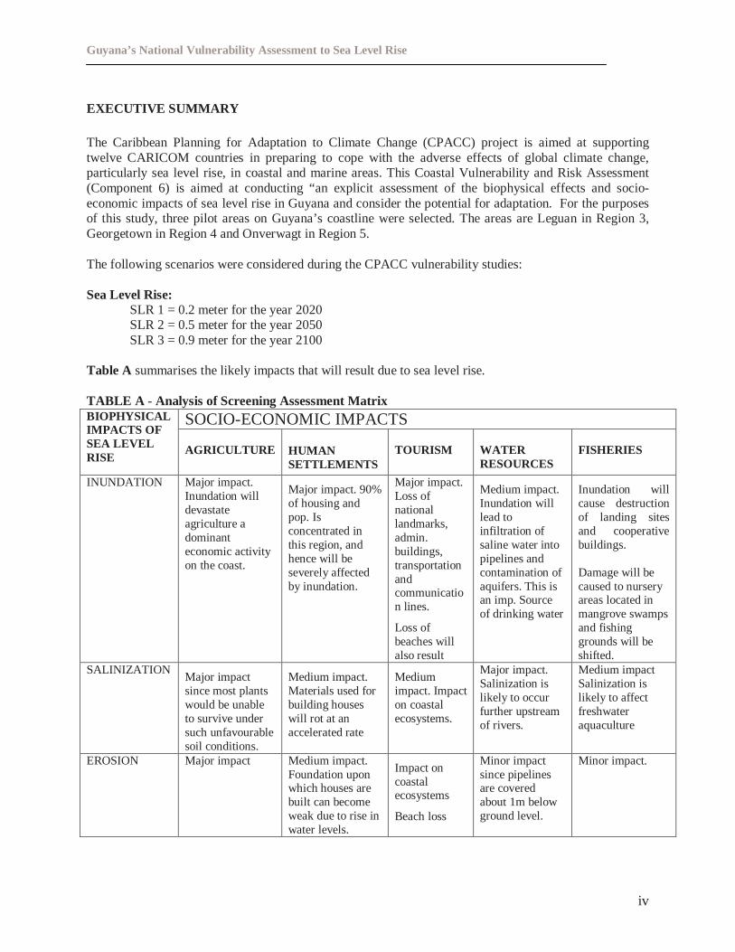
The Caribbean Planning for Adaptation to Climate Change (CPACC) project is aimed at supportingtwelve CARICOM countries in preparing to cope with the adverse effects of global climate change,particularly sea level rise, in coastal and marine areas. This Coastal Vulnerability and Risk Assessment(Component 6) is aimed at conducting “an explicit assessment of the biophysical effects and socio-economic impacts of sea level rise in Guyana and consider the potential for adaptation. For the purposesof this study, three pilot areas on Guyana’s coastline were selected. The areas are Leguan in Region 3,Georgetown in Region 4 and Onverwagt in Region 5.
The following scenarios were considered during the CPACC vulnerability studies:
Sea Level Rise:SLR 1 = 0.2 meter for the year 2020SLR 2 = 0.5 meter for the year 2050SLR 3 = 0.9 meter for the year 2100
Table A summarises the likely impacts that will result due to sea level rise.
TABLE A - Analysis of Screening Assessment Matrix
SOCIO-ECONOMIC IMPACTSBIOPHYSICALIMPACTS OFSEA LEVELRISE
AGRICULTURE HUMANSETTLEMENTS
TOURISM WATERRESOURCES
FISHERIES
INUNDATION Major impact.Inundation willdevastateagriculture adominanteconomic activityon the coast.
Major impact. 90%of housing andpop. Isconcentrated inthis region, andhence will beseverely affectedby inundation.
Major impact.Loss ofnationallandmarks,admin.buildings,transportationandcommunication lines.
Loss ofbeaches willalso result
Medium impact.Inundation willlead toinfiltration ofsaline water intopipelines andcontamination ofaquifers. This isan imp. Sourceof drinking water
Inundation willcause destructionof landing sitesand cooperativebuildings.
Damage will becaused to nurseryareas located inmangrove swampsand fishinggrounds will beshifted.
SALINIZATIONMajor impactsince most plantswould be unableto survive undersuch unfavourablesoil conditions.
Medium impact.Materials used forbuilding houseswill rot at anaccelerated rate
Mediumimpact. Impacton coastalecosystems.
Major impact.Salinization islikely to occurfurther upstreamof rivers.
Medium impactSalinization islikely to affectfreshwateraquaculture
EROSION Major impact Medium impact.Foundation uponwhich houses arebuilt can becomeweak due to rise inwater levels.
Impact oncoastalecosystems
Beach loss
Minor impactsince pipelinesare coveredabout 1m belowground level.
Minor impact.
Guyana’s National Vulnerability Assessment to Sea Level Rise
v
ASSESSMENT OF ADEQUACY OF LAWS TO COPE WITH THE POTENTIAL EFFECTS OFSEA LEVEL RISE
The assessment of the existing environmental land use and building laws indicate that while generally,statutory powers are established in existing legislation to respond to the potential or likely effects of sealevel rise, there are some gaps and weaknesses that need to be addressed in order to make them useful tothe impacts of sea level rise.
The legislative framework is generally too outdated to offer any significant influence. This is reflectedvividly in the inadequacy of fines and penalties legislation, the lack of coordination among agencies,inadequate institutional arrangements, the absence of modern day principles such as the precautionaryprinciple and reliance upon alternative enforcement and compliance methods. More importantly, thelegislative process has not kept pace by passing the required implementing legislation. And in theisolated circumstances where regulations were made, they have become rigid and inflexible and theirapplication to the issues presented by sea level rise and climate change is generally inadequate.
Given Guyana’s early stage of development of integrated coastal zone management policy and itsdifficulty in implementing extensive legislation which is already in place, a comprehensive review of therelevant legislation to fill the existing gaps for effective monitoring, implementation and enforcement isrecommended.
BIO-GEOPHYSICAL ASSESSMENT
The bio-geophysical analyses were applied to the Mahaica, Demerara and Essequibo rivers. Given theextremely flat nature of the terrain, these rivers are tidal for great distances, ranging from in excess offifty kilometers for the larger creeks to more than one hundred and fifty kilometers for the bigger rivers.These rivers are therefore very much susceptible to salt water intrusion.
During the dry season brackish water has been known to penetrate into the Mahaica River for more thansixty kilometers. With sea level rise the situation will be further aggravated. Sensitivity analyses done fora range of low flows indicate that intrusion can be up to four times as great as for the mean conditionsanalyzed.
Large numbers of coastal aquifers are already experiencing salt-water intrusion caused by both naturaland man-induced processes. Sea level rise will only aggravate such situations. The coastal plain ofGuyana, which lies below high tide level of the Atlantic Ocean, will be subjected to severe adverseconsequences as a result of sea level rise. The high level of dependence on the coastal aquifers fordomestic water supply renders the population extremely vulnerable to the effects of salt-water intrusion asa result of sea level rise.
Based on data extracted from the beach profiles for Georgetown and Onverwagt, the analyses show thatshoreline retreat will be quite significant ranging from 10m – 150m using the three sea level scenarios.Most of the settlements on coastal rivers are located within a few tens of kilometers from the coast andwithin a few hundreds of meters from the edges of the rivers. Also the vast agricultural areas of thecountry are adjacent to coastal rivers. From the previous results obtained, these areas are well within thedomain likely to be affected by salt/brackish water intrusion.
Projected sea level rise will affect specific agricultural crops - sugar cane, rice, and coconuts. Landsidentified for aquaculture development along the coast will also be adversely impacted. Physical damageand productivity are two of the main areas of anticipated impact.
Guyana’s National Vulnerability Assessment to Sea Level Rise
vi
Computations done indicate that backwater will extend from about five to ten kilometers upstream ofrivers for a one meter rise in sea level. This will result in inundation of about one to five kilometers ofareas bordering the ocean and rivers.
Based on the results of the analyses done, adaptation may not be an option for the Guyana situation.Certainly, a more aggressive approach to combat the disastrous effects of sea level rise as a result ofclimate change is necessary.
SOCIOECONOMIC ASSESSMENT
It would appear that sea level rise is likely to affect entire households, more so, those within the workingage. It is imperative that a holistic approach be taken when looking at sea level rise that should include theeffects on all age cohorts, as partial consideration can lead to insufficient awareness to the issues involvedand incomplete planning for these.
The building up of profiles on social and economic characteristics helps us to estimate the vulnerability ofthe coast of Guyana to sea level rise. It is clear that with such high percentages of residents beingdependent on freshwater supplied from ground water sources, i.e., 88 percent; a number of households arelikely to have their supplies contaminated with greater saline concentrations. Additionally, since thepreferred method of disposal of waste, especially in the city, is via landfill sites, the potentialcontamination from this source can also be immense.
Since a high number of individuals indicated that they have never heard of the issues related to sea levelrise from all three areas, it is therefore questionable whether their responses actually demonstrate anunderstanding of the extent of the challenge that faces the coastland of Guyana. This therefore points tothe need for a concerted public awareness and sensitising campaign, involving all stakeholders, if theinputs from various sectors are to be garnered and constructive suggestions elicited.
It is pellucid from responses that given the social and cultural attachments to their properties, respondentsfeel strongly about moving. Any programme the authorities may therefore have to lobby seriously withthese individuals, all the time, trying to convince them that remain close to the sea is both futile anduneconomical. However, until adequate baseline data are collected and analysed, it will be virtuallyimpossible to present sensible alternatives.
According to responses given by those surveyed, the Government and people of Guyana can take thefollowing actions in an effort to minimise this latest threat to human habitation:
• Build better sea defence structures• Implement improved sea defence management strategies• Promote greater community participation/partnerships in coastal resource management• Ensure better drainage and irrigation systems on the coast• Eliminate the use of aerosol sprays• Minimise the destruction of mangroves and implement the Mangrove Management Plan
From the study that was undertaken, the potential socio-economic impacts of sea level rise on Guyana’scoast can be summarised as follows:
• The Guyana coast is undoubtedly very susceptible to climate change and sea level rise.• Loss of good land/ loss of living and non-living resources that are utilised by the Guyanese society
Guyana’s National Vulnerability Assessment to Sea Level Rise
vii
• Loss of businesses and income would be a significant impact if relocation is not considered as anoption, since the coast provides Guyanese with many economic opportunities and social andenvironmental amenities.
• Significant monetary costs would be incurred by relocation in terms of physical and socialinfrastructure.
• Increased incidence of water borne diseases due to poor sanitary facilities and practices• Security risks to large percentage of population if the headquarters of the Guyana Defense Force and
the Guyana Police Force army and police force are to be relocated.
• Costs incurred by damage prevention, for example building seawalls that will withstand the potentialeffects of sea level rise.
CONCLUSION
The fact that most of the population and all the major agricultural and industrial activities take place onthe coastland, put Guyana in a “high risk” situation as far as the effects of sea level rise resulting fromclimate change is concerned.
The major effects of sea level rise for Guyana under the scenarios considered will be inundation andflooding on the coastal areas. This means that the entire fabric of Guyanese society – population,agriculture, industry and infrastructure- is vulnerable to even slight increases in sea level rises, rainfallintensities, salt water intrusion and droughts, all of which parameters are expected to increase withclimate change. The consequences of these changes can be disastrous, the major one of which will belarge-scale disruption of population centers. Movement of people will be inevitable, as increasinginundation and flooding will result in destabilization of infra-structural works, including buildings, roads,bridges, dams. Floodwaters will remain stagnant for longer periods over land, which will increase thepossibility of spread of diseases. Agriculture will suffer irreversible damages because of salt-waterintrusion and inundation. Coastal ecosystems will disappear.
A major source of concern for Guyana is the lack of awareness of the general population of theconsequences of sea level rise. At this point in time it is of utmost importance that a program ofawareness be implemented so that the population may become aware of the consequences they are facingand what will be their role in implementing adaptation measures.
Guyana will need to establish and maintain a number of management mechanisms for integratedadaptation planning and management to become a reality. These mechanisms cannot all be developedsimultaneously and in almost all instances substantial human, technical, and financial resources will berequired to establish and maintain the policy, legal, and institutional structures that are necessary tosuccessfully deal with Guyana’s vulnerability to sea level rise.
Recent policies and practices in Guyana are leading to the building of a tradition in support ofparticipatory decision–making and establishment of a policy to conserve and sustainably use the country’snatural resource. In keeping with this, Cabinet recently approved a National Environmental Action Planand the Integrated Coastal Zone Management Action Plan. Given the long lead-time for implementingadaptation, it is significant to incorporate it with the other issues, in particular to the framework ofsustainable development and Integrated Coastal Zone Management (ICZM) and to the objectives of theNational Development Strategy. In addition, the continued strengthening of the Environmental ProtectionAgency is seen as a concerted effort to ensure the sustainable development of Guyana.
Adaptation mechanisms will differ and is dependent on the level of vulnerability and the region that isaffected. The paramount importance of the coastal plain to Guyana’s economy and socio-economic
Guyana’s National Vulnerability Assessment to Sea Level Rise
viii
situation indicates that adaptive responses to the vulnerability assessment will be required to cope withthe impacts of climate change. It is therefore necessary to firstly ensure that the capacity – todetect,plan and respond– exists in all relevant sectors. Hence, it is imperative that capacity building be givenprecedence at all levels of Government and in the sectors.
Adaptation responses will also have to include public awareness, education and training and must focuson sensitizing the local communities on the impacts of anthropogenic climate change and the responsemechanisms to be used to address local vulnerabilities.
An important aspect for realizing the necessity for adaptation is to incorporate its options to other sectoraland national policies, such as economic development policy, disaster prevention and management, andenvironmental management plans. Guyana already has immediate and pressing concerns, and climatechange should therefore be considered in the national agenda since it will certainly impede socio-economic progress.
While it is true that the Government of Guyana may be in no position to address many of the issuessimultaneously, putting them on the agenda should sensitise stakeholders to the issues involved.Additionally, it may be useful for the Government of Guyana, possibly through the Bureau of Statistics toundertake a comprehensive study looking at the demographics of the coast, identifying levels ofvulnerability, and prioritising areas/categories to be addressed.
Guyana’s National Vulnerability Assessment to Sea Level Rise
ix
ACKNOWLEDGEMENT
The following members of the Integrated Coastal Zone Management Committeecontributed to and edited this National Vulnerability Assessment:
Ms. Pauline Franklin-Arjoon Guyana Sewerage & Water CommissionMr. Rovin Bhookmohan PEU, Guyana Sea & River DefenceMr. John Campbell Guyana Forestry CommissionMs. Naomi Collins National Drainage & Irrigation BoardMr. Lennox Cornette Conservation InternationalMs. Agnes Dalrymple PEU, Guyana Sea & River DefenceMr. Phillip Da Silva University of Guyana (Chairman)Mr. Julian Evans Guyana Forestry CommissionMs. Heather Francis Guyana Water AuthorityMr. Forbes July Ministry of Foreign AffairsMs. Suzy Lewis Guyana Natural Resources AgencyMr. Surujpaul Makardajh Transport & Harbours DepartmentMs. Andrea Marie Environmental Protection Agency (Secretariat)Ms. Deborah Montouth Ministry of Housing & WaterMs. Dawn Maison Fisheries DepartmentMr. Zainool Rahaman Hydromet. Service
Guyana’s National Vulnerability Assessment to Sea Level Rise
x
EXECUTIVE SUMMARY .................................................................................................................. ivACKNOWLEDGEMENT.................................................................................................................... ixOVERVIEW OF GUYANA’S COASTAL ZONE ............................................................................ xiii
1.0 INTRODUCTION .................................................................................................................... 11.1 Caribbean Planning for Adaptation to Global Climate Change (CPACC) ........................ 11.2 Importance of the Coastal Zone....................................................................................... 21.3 Methodologies For Vulnerability Assessment.................................................................. 3
2.0 CLIMATE CHANGE AND SEA LEVEL RISE...................................................................... 42.1 Brief Introduction About The Science Of Climate Change .............................................. 42.2 National Research On Climate Change And Sea Level Rise ........................................ 5
2.2.1 Observed Climate........................................................................................... 52.2.1.1 Temperature .................................................................................................... 62.2.1.2 Rainfall............................................................................................................ 72.2.1.3 Sea Level Rise ................................................................................................. 8
2.2.2 Future Climate Change.................................................................................. 82.2.2.4 Temperature Change........................................................................................ 92.2.2.5 Rainfall.......................................................................................................... 112.2.2.6 Sea Level Rise ............................................................................................... 12
2.3 Other Extreme Climate Events That May Result........................................................ 132.3.1 Evaporation And Water Deficit................................................................. 132.3.2 Extreme High Temperature And Precipitation........................................ 132.3.3 Extremes Of Sea Level – Storm Surges And Waves............................. 13
3.0 COASTAL ASSETS AND ECONOMIC ACTIVITIES........................................................ 133.1 Sectors ...................................................................................................................... 14
3.1.1 Agriculture..................................................................................................... 143.1.2 Human Settlement And Infrastructure...................................................... 143.1.3 Water Resources........................................................................................... 163.1.4 Tourism........................................................................................................... 22
3.1.4.1 Georgetown....................................................................................................... 223.1.4.2 Beaches........................................................................................................... 22
3.1.5 Fisheries ............................................................................................................ 233.1.5.1 Aquaculture ................................................................................................... 23
3.2 Ecosystems ............................................................................................................... 243.2.1 Mangroves........................................................................................................... 243.2.2 Shore types/Beaches..................................................................................... 25
3.2.5.1 Mud/Clay Accretionary Coasts ...................................................................... 253.2.5.2 Sand/Shell Accretionary Coasts ..................................................................... 263.2.2.3 Erosional Coasts ............................................................................................... 27
3.3 The Future Of Coastal Assets And Economic Activities ............................................ 273.3.1 Population Size And Density...................................................................... 273.3.2 Housing........................................................................................................... 273.3.3 Other Infrastructure.......................................................................................... 283.3.4 Water Resources........................................................................................... 28
Guyana’s National Vulnerability Assessment to Sea Level Rise
xi
3.3.4.1 Drainage and Irrigation .................................................................................. 283.3.5 Agriculture..................................................................................................... 28
3.3.5.1 Rice................................................................................................................... 303.3.5.2 Sugar................................................................................................................ 30
3.3.6 Fisheries.......................................................................................................... 304.0 METHODOLOGY FOR VULNERABILITY ASSESSMENT............................................. 31
4.1 More about UNEP’s handbook and Nicholls Paper.................................................... 315.0 IMPACT ASSESSMENT OF SEA LEVEL RISE ON COASTAL ASSETS........................ 37
5.1 Description of the Pilot Areas.................................................................................... 375.2 Bio-Geophysical Impacts .......................................................................................... 33
5.2.1 Projected Impacts of Sea Level Rise on Guyana’s Coast..................... 335.2.1.1 Salt Water Intrusion ................................................................................... 33
5.2.1.1.1 Rivers.................................................................................................. 345.2.1.1.2 Aquifers................................................................................................ 35
5.2.1.3 Shoreline Retreat ........................................................................................... 385.2.1.4 Consequences of Sea Level Rise.................................................................... 39
5.3 Socio Economic Impacts ........................................................................................... 405.3.1 Georgetown.................................................................................................... 40
5.3.1.1 Flooding ........................................................................................................ 415.3.1.2 Water Supply................................................................................................... 415.3.1.3 The Sewerage System..................................................................................... 425.3.1.4 Infrastructure Displacement ........................................................................... 42
5.3.2 Awareness Of Sea Level Rise And Possibility Of Re-locating............. 435.3.3 Leguan............................................................................................................ 44
5.3.3.1 Flooding ........................................................................................................ 445.3.4 Awareness Of Sea Level Rise And Possibility Of Relocation............... 455.3.5 Onverwagt...................................................................................................... 46
5.3.5.1 Flooding .......................................................................................................... 465.3.6 Awareness Of Sea Level Rise And Possibility Of Relocation.............. 47
5.4 Adequacy Of Legal Framework To Cope With Sea Level Rise.................................. 475.4.1 Gaps and Weaknesses.................................................................................. 475.4.2 Establishment of an Adequate Legal Framework for Sea level Rise.. 48
5.5 Economic Importance................................................................................................ 486.0 ADAPTATION OPTIONS PROGRAMME .......................................................................... 50
6.1 Response Strategies................................................................................................... 506.1.1 Retreat............................................................................................................. 506.1.2 Accommodation............................................................................................ 516.1.3 Protection....................................................................................................... 516.1.4 Discussion...................................................................................................... 51
6.2 Adaptation Issues ...................................................................................................... 516.3 Linkages with CPACC’s Component 4...................................................................... 53
6.3.1 Appropriates Mechanisms to give effect to the National Policy....... 536.3.1.1 Integrated Coastal Zone Management ............................................................ 536.3.1.2 Environmental Impact Assessments............................................................... 54
Guyana’s National Vulnerability Assessment to Sea Level Rise
xii
6.3.1.3 Disaster Contingency Planning and Management........................................... 546.3.1.4 Economic Instruments ................................................................................... 556.3.1.5 Building Codes and Standards ....................................................................... 556.3.1.6 Environmental Management Regimes............................................................. 556.4 Key Issues, Adaptation Planning and Management Mechanisms........................ 566.4.1 Adaptation Strategy ....................................................................................... 57
7.0 RECOMMENDATIONS............................................................................................................ 628.0 CONCLUSIONS............................................................................................................................ 659.0 BIBLIOGRAPHY.......................................................................................................................... 66
Guyana’s National Vulnerability Assessment to Sea Level Rise
xiii
OVERVIEW OF GUYANA’S COASTAL ZONE
Today, the coastal zone of Guyana is considered one of the most important natural regions in the countrysince ninety per cent of the population as well as economic and administrative activities are concentratedin this area.
There is no single description of the coastal zone for the Integrated Coastal Zone Management process;boundaries are delineated based on the particular problems that integrated coastal zone managementattempts to solve. However, the commonly used definition of the coastal zone is“The area of dry landand adjacent ocean space (water and submerged land) in which terrestrial processes and land usedirectly affect oceanic processes and uses and vice versa”1.
As such, Guyana’s coastal zone can be described as occupyingapproximately 7 per cent of the total land area of the country(216,000km2), and extending along the entire 430km of theAtlantic coast (Map A ). It varies in width from 26km to 77kmand is as much as 1m below mean high tide levels in someareas. The geology and geomorphology of the Guyana coast isthat of coastal ‘Amazon clay’ deposits2. These extend underthe continental shelf and have reached an average thickness of20m over the last 6,000 years, producing a flat, low-lying,coastal plain. They were laid down due to several geologicalformations. The coastal plain consists of natural and man-madesea defences, mud banks, mangroves and sand flats, all ofwhich serve to protect the coast from inundation and flooding.The country is divided into ten (10) administrative regions,with regions one (1) to six (6) lying within the coastal zone(Map B).
Guyana’s colonial experience and post-colonial modernizationprojects have transformed the coastal environment. The coastalmangrove swamps have been drained, and in many places thewood extracted and replaced by sea walls, irrigation canals,polders and human settlements3.
Recently through public consultations a proposed definition of Guyana’s coastal zone has evolved, whichincorporates the concept of Guyana’s Exclusive Economic Zone (EEZ).
1 Ketchum, 19722 Abernethy, 1980
3Bynoe, 1996; Williams, 1997; FAO, 1990
Map A -Settlement Distribution
Guyana’s National Vulnerability Assessment to Sea Level Rise
xiv
AtlanticOcean
7
9
6
8
1
10
2
5
34
40 0 40 80 120 KilometersScale 1:1,600,000
Environmental Protection Agency
Area below sea level wasderived from a USGS1km resolution DEM
Administrative Map of GuyanaS
N
EW
Base map providedby NRMP
Border
Administrative RegionsBARIMA / WAINICUYUNI / MAZARUNIDEMERARA / MAHAICAEAST BERBICE / CORENTYNEESSEQUIBO ISLANDS / WEST DEMERARAMAHAICA / BERBICEPOMEROON / SUPENAMPOTARO / SIPARUNIUPPER DEMERARA / BERBICEUPPER TAKUTU / UPPER ESSEQUIBO
Major RiversMain RiversIslands
Areas affected by 1m rise in Sea Level
Map 3Map A

Guyana’s National Vulnerability Assessment to Sea Level Rise
xv
Guyana’s National Vulnerability Assessment to Sea Level Rise
1
1.0 INTRODUCTION
The Caribbean Planning for Adaptation to Global Climate Change (CPACC) has its genesis inthe Global Conference on Sustainable Development of Small Island Developing States, whichtook place in Barbados in April/May 1994. During this conference the small island states and thelow-lying countries of the English speaking Caribbean approached the Organization of theAmerican States for assistance in preparing a project on adaptation to climate change. A numberof regional consultations took place with CARICOM and the GEF Council approved the projectin May 1995.
1.1 Caribbean Planning for Adaptation to Global Climate Change (CPACC)
The overall objective of CPACC is to support Caribbean countries in preparing to cope with theadverse impacts of climate change particularly sea level rise, in coastal and marine areas throughvulnerability assessments, adaptation planning and capacity building linked to adaptationplanning.
The CPACC has been designed to assist national governments and the University of the WestIndies Centre for Environment to:
ÿ Strengthen the regional capability for monitoring and analyzing climate and sea leveldynamics and trends, seeking to determine the immediate and potential impacts of globalclimate change.
ÿ Identify areas particularly vulnerable to the adverse effects of climate change and sea levelrise.
ÿ Develop an integrated management and planning framework for cost effective response andadaptation to the impacts of climate change on coastal and marine areas.
ÿ Enhance regional and national capabilities for preparing for the advent of climate changethrough institutional strengthening and human resource development.
ÿ Identify and assess policy options and instruments that may help initiate the implementationof a long-term programme of adaptation to climate change in vulnerable coastal areas.
The twelve CARICOM countries participating in CPACC include Antigua and Barbuda, theCommonwealth of Bahamas, Barbados, Belize, the Commonwealth of Dominica, Grenada,Guyana, Jamaica, St. Christopher and Nevis, St. Lucia, and the Republic of Trinidad andTobago. All of the participating countries have signed and ratified the United NationsFramework Convention on Climate Change (UNFCCC).
Guyana’s National Vulnerability Assessment to Sea Level Rise
2
The CPACC project comprises of nine components, four regional components and five pilotcomponents.
The four regional components included:
1. Design and Establishment of Sea Level Climate Data/Climate Monitoring Network
2. Establishment of Databases and Information Systems
3. Inventory of Coastal Resources and Use
4. Formulation of a Policy Framework for Integrated Adaptation Planning and Management
The five pilot projects included:
5. Coral Reef Monitoring for Climate Change
6. Coastal Vulnerability and Risk Assessment
7. Economic Valuation of Coastal and Marine Resources
8. Formulation of Economic and Regulatory Proposals
9. Greenhouse Gas Inventory.
Guyana, Barbados and Grenada were the pilot countries for Coastal Vulnerability and RiskAssessment.
1.2 Importance of the Coastal Zone
The Coastal Zone in many Caribbean countries is of extreme importance. In Guyana, Barbadosand Grenada the majority of the populations are located within the coastal zone. The coastalzones are responsible for vast amounts of the economic activity within the countries and are vitalto the economy. Within the coastal zones tourism and agriculture and other activities are amongthe main sources of economic activity. Often critical infrastructure such as hospitals, hotels,schools, and the seat of Government are located within the coastal zone. The coastal zone alsowill have major industrial plants located within in it. The coastal zone supports a wide variety ofbiological diversity and thus is a highly productive biological area. Coastal zones often containcoral reefs, wetlands, sea grass beds, and mangroves. These ecosystems are very fragile and thusare adversely affected with the ongoing and increasing economic activity, which is ongoingwithin the coastal zone.
With predictions of increasing sea level rise the coastal zone with its economic activities,infrastructure, and natural ecosystems are increasingly vulnerable.Vulnerability can be definedas‘the degree to which an exposure unit is disrupted or adversely affected as a result of climateeffects’, while assessmentrefers to ‘the scientific appraisal of effects on the exposure unit’
Guyana’s National Vulnerability Assessment to Sea Level Rise
3
(IPCC 1994). Avulnerability assessmentcan therefore be defined as‘a scientific appraisal ofthe degree to which an exposure unit is disrupted or adversely impacted as a result of climateeffects’. Vulnerability can be distinguished into natural system vulnerability to climate changeand socio-economic system vulnerability. These types of vulnerability are clearly related and areinterdependent, as one cannot analyze socio economic vulnerability without an understanding ofhow the natural system will be affected.
Adaptation refers to ‘all those responses to climate change that may be used to reducevulnerability’ (UNEP 1998). Adaptation can be autonomous or planned. Autonomousadaptation represents a systems natural response to climatic change, while planned adaptationcan reduce a systems natural vulnerability by enhancing the systems resilience and/or resistanceand thus enhancing the effectiveness of autonomous adaptation (Nicholls 1998). Decision11CP/1 of the UNFCCC refers to adaptation in the following staged process:
Stage I: Planning - which includes studies of possible impacts of climate change, to identifyparticularly vulnerable countries or regions and policy options for adaptation and appropriatecapacity building;
In the medium and long term, the following stages are envisaged for the particularly vulnerablecountries or regions identified in Stage I:
Stage II: Measures- including further capacity building, which may be taken to prepare foradaptation, as envisaged by Article 4.1(e)1;
Stage III: Measures- to facilitate adequate adaptation, including insurance, and other adaptationmeasures as envisaged by Article 4.1(b) and 4.42.
1.3 Methodologies For Vulnerability Assessment
There are number of methodologies for vulnerability assessment, which have been utilized forexamining the impacts of sea level rise. These include the IPCC common methodology, the UScountry study program methodology, the South Pacific islands methodology, the CaribbeanDisaster Mitigation Project methodology, the UNEP methodology and the RIKS decision supportmethodology. For this assessment the UNEP methodology has been applied. A furtherdiscussion on methodologies will occur inChapter 4.
Guyana’s National Vulnerability Assessment to Sea Level Rise
4
2.0 CLIMATE CHANGE AND SEA LEVEL RISE
2.1 Brief Introduction About The Science Of Climate ChangeChanges in the earth’s climate have occurred throughout the historical evolution of the earth.For example, the onset of the ice age caused the gradual decline of the dinosaurs, as they couldnot adjust to the climate changes around them. The concept of changing climate is thus not new,however in recent years there have been a growing concern of the effects that the changingclimate will have on human life.
In the last decade there has been increasing scientific evidence suggesting that the continualpollution of the atmosphere with green house gases (GHGs), particularly via the combination offossil fuels, has been lending to global warming.
The primary cause of global warming is due to the increase in the production of greenhousegases as a result of human activity. Greenhouse gases are those gases, which are important inglobal climate change, namely methane (CH4), Nitrous Oxide (N2O), Ozone (O3),Chlorofluorocarbons and Carbon Dioxide (CO2). Increases in Nitrous Oxides (N2O) levels haveresulted from the increase in the utilization of nitrogen fertilizers, while the sources of methane(CH4) are from the rice paddy fields, solid waste disposal sites and ruminant cattle. Ozonecomes from unburnt hydrocarbons reacting with oxides of nitrogen, while chloroflorocarbons arefound in aerosol propellants and refrigeration units.
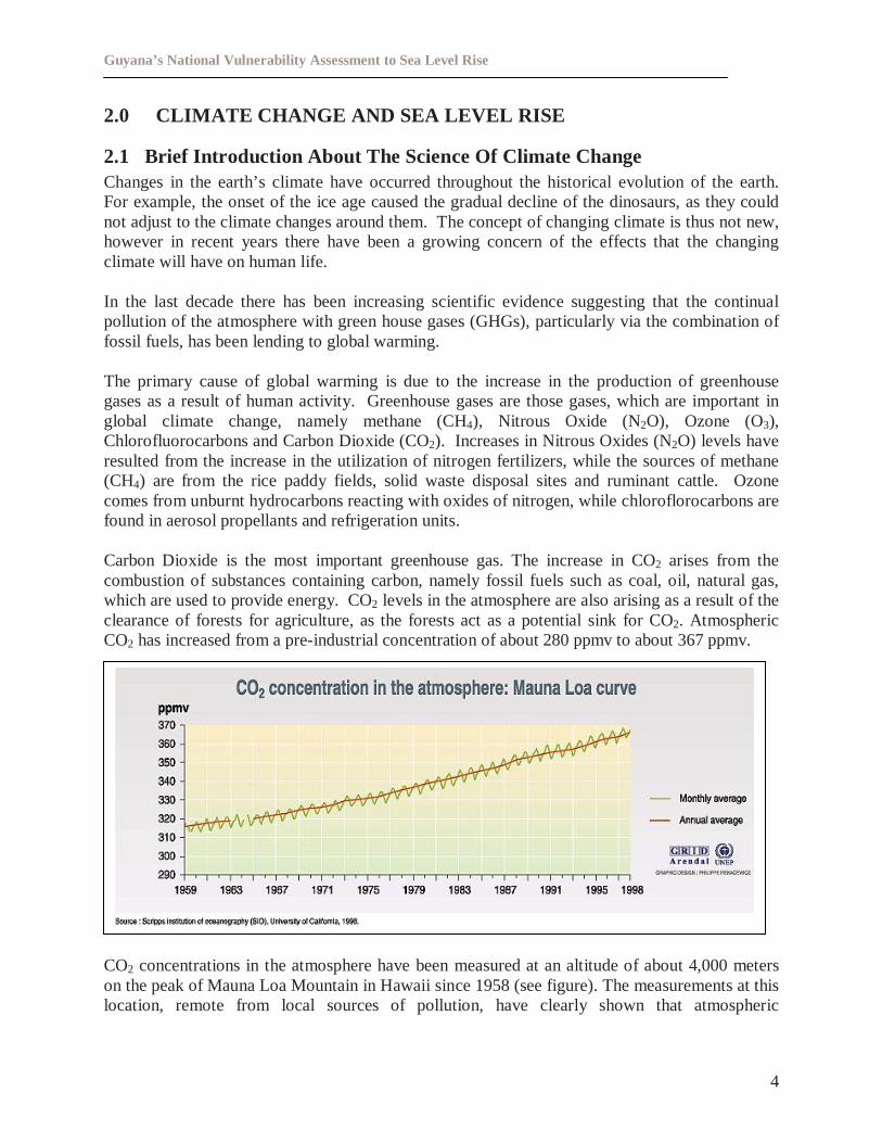
Carbon Dioxide is the most important greenhouse gas. The increase in CO2 arises from thecombustion of substances containing carbon, namely fossil fuels such as coal, oil, natural gas,which are used to provide energy. CO2 levels in the atmosphere are also arising as a result of theclearance of forests for agriculture, as the forests act as a potential sink for CO2. AtmosphericCO2 has increased from a pre-industrial concentration of about 280 ppmv to about 367 ppmv.
CO2 concentrations in the atmosphere have been measured at an altitude of about 4,000 meterson the peak of Mauna Loa Mountain in Hawaii since 1958 (see figure). The measurements at thislocation, remote from local sources of pollution, have clearly shown that atmospheric
Guyana’s National Vulnerability Assessment to Sea Level Rise
5
concentrations of CO2 are increasing. In 1958 the mean concentration was approximately 316parts per million by volume (ppmv), it rose to approximately 369 ppmv in 1998.
Global temperatures have been increasing along with the increasing carbon dioxideconcentrations in the atmosphere and there is now considerable evidence that carbon dioxideemissions along with other greenhouse gases such as methane are responsible for the phenomenaof global warming, through the greenhouse effect
The developed countries of the world have are responsible for over 50% of the world’sgreenhouse gas emissions, with the United States of America the major emitter of greenhousegas emissions. Developing countries collectively emit less than 25% of the world’s greenhousegases. The IPCC has noted that it will take a 60 % reduction in greenhouse gas emissions inorder to stabilize the atmosphere, however with the developed countries are continuing toincrease their greenhouse gas emissions it is clear that the problems of global climate change willcontinue well into the next century.
The IPCC has noted in its third assessment report that the global average surface temperature hasincreased since 1861. Over the 20th century the increase has been 0.6+/-0.2oC. The IPCC hasalso noted that tidal gauge data has shown that the sea level has risen between 0.1m and 0.2mduring the 20th century. Further the IPCC notes in the third assessment report there is new andstronger evidence that most of the warming observed over the last 50 years is attributed to humanactivities, with predictions of the global surface temperature to increase by 1.4 to 5.8oC over theperiod 1990 to 2100 and global mean sea level projected to rise by 0.09m to 0.88m during theperiod between 1990 and 2100.
2.2 National Research On Climate Change And Sea Level Rise
Data and research on climate change in the following section was extracted from “Guyana’sInitial National Communication to The United Nation’s Framework Convention on ClimateChange (June 2000)”.
2.2.1 Observed Climate
For this analysis, the temperatures and rainfall data used are for the Botanical Gardens in theCapital City, Georgetown. Available temperature data span close to eighty-nine (89) years, 1909- 1998 and rainfall data coverage exceeds one hundred (100) years, 1884 - 1998.
Data used for sea level rise is based on available tide gauge data for Port Georgetown over aperiod of close to twenty-eight (28) years, 1951 – 1979.
Georgetown is located at 60 47' North Latitude, 580 09' West Longitude, on the mouth ofDemerara River in the Coastal Plain.
Guyana’s National Vulnerability Assessment to Sea Level Rise
6
2.2.1.1 Temperature
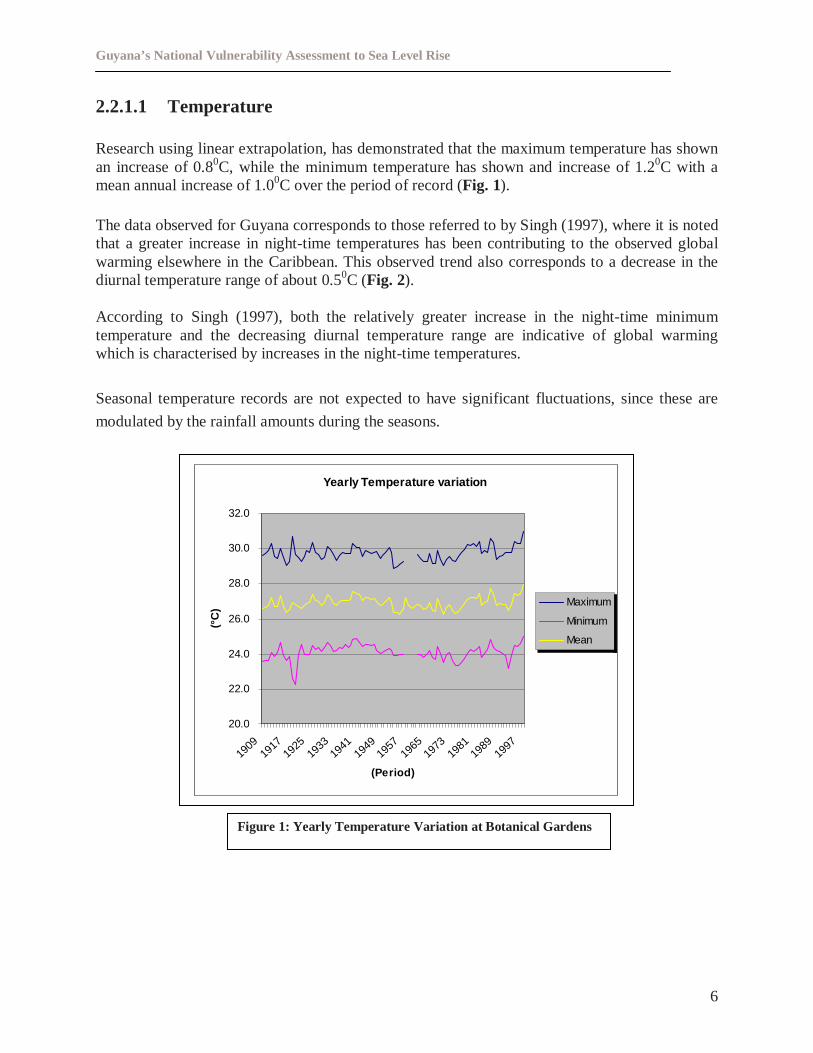
Research using linear extrapolation, has demonstrated that the maximum temperature has shownan increase of 0.80C, while the minimum temperature has shown and increase of 1.20C with amean annual increase of 1.00C over the period of record (Fig. 1).
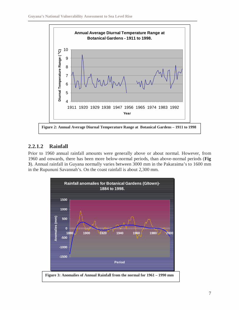
The data observed for Guyana corresponds to those referred to by Singh (1997), where it is notedthat a greater increase in night-time temperatures has been contributing to the observed globalwarming elsewhere in the Caribbean. This observed trend also corresponds to a decrease in thediurnal temperature range of about 0.50C (Fig. 2).
According to Singh (1997), both the relatively greater increase in the night-time minimumtemperature and the decreasing diurnal temperature range are indicative of global warmingwhich is characterised by increases in the night-time temperatures.
Seasonal temperature records are not expected to have significant fluctuations, since these are
modulated by the rainfall amounts during the seasons.
Figure 1: Yearly Temperature Variation at Botanical Gardens
Yearly Temperature variation
20.0
22.0
24.0
26.0
28.0
30.0
32.0
1909
1917
1925
1933
1941
1949
1957
1965
1973
1981
1989
1997
(Period)
(°C
)
Maximum
Minimum
Mean
Guyana’s National Vulnerability Assessment to Sea Level Rise
7
2.2.1.2 RainfallPrior to 1960 annual rainfall amounts were generally above or about normal. However, from1960 and onwards, there has been more below-normal periods, than above-normal periods (Fig3). Annual rainfall in Guyana normally varies between 3000 mm in the Pakaraima’s to 1600 mmin the Rupununi Savannah’s. On the coast rainfall is about 2,300 mm.
Figure 2: Annual Average Diurnal Temperature Range at Botanical Gardens – 1911 to 1998
Figure 3: Anomalies of Annual Rainfall from the normal for 1961 – 1990 mm
Rainfall anomalies for Botanical Gardens (G/town)-1884 to 1998.
-1500
-1000
-500
0
500
1000
1500
1880 1900 1920 1940 1960 1980 2000
Period
Ano
mal
ies
(mm
)
Annual Average Diurnal Temperature Range atBotanical Gardens - 1911 to 1998.
4
5
6
7
8
9
10
1911 1920 1929 1938 1947 1956 1965 1974 1983 1992Year
Diu
rnal
Tem
pera
ture
Ran
ge(
oC
)
Guyana’s National Vulnerability Assessment to Sea Level Rise
8
2.2.1.3 Sea Level Rise
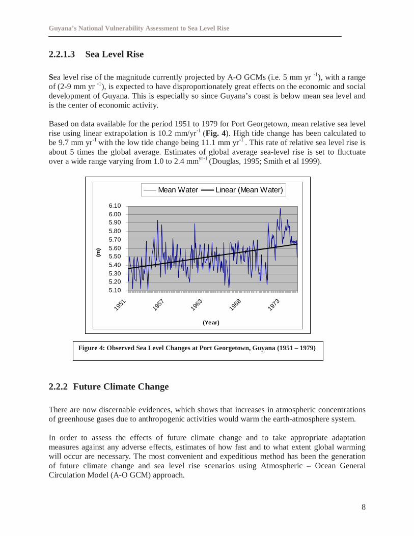
Sea level rise of the magnitude currently projected by A-O GCMs (i.e. 5 mm yr-1), with a rangeof (2-9 mm yr-1), is expected to have disproportionately great effects on the economic and socialdevelopment of Guyana. This is especially so since Guyana’s coast is below mean sea level andis the center of economic activity.
Based on data available for the period 1951 to 1979 for Port Georgetown, mean relative sea levelrise using linear extrapolation is 10.2 mm/yr-1 (Fig. 4). High tide change has been calculated tobe 9.7 mm yr-1 with the low tide change being 11.1 mm yr-1 . This rate of relative sea level rise isabout 5 times the global average. Estimates of global average sea-level rise is set to fluctuateover a wide range varying from 1.0 to 2.4 mmyr-1 (Douglas, 1995; Smith et al 1999).
2.2.2 Future Climate Change
There are now discernable evidences, which shows that increases in atmospheric concentrationsof greenhouse gases due to anthropogenic activities would warm the earth-atmosphere system.
In order to assess the effects of future climate change and to take appropriate adaptationmeasures against any adverse effects, estimates of how fast and to what extent global warmingwill occur are necessary. The most convenient and expeditious method has been the generationof future climate change and sea level rise scenarios using Atmospheric – Ocean GeneralCirculation Model (A-O GCM) approach.
Figure 4: Observed Sea Level Changes at Port Georgetown, Guyana (1951 – 1979)
5.105.205.305.405.505.605.705.805.906.006.10
1951
1957
1963
1968
1973
(Year)
(m)
Mean Water Linear (Mean Water)
Guyana’s National Vulnerability Assessment to Sea Level Rise
9
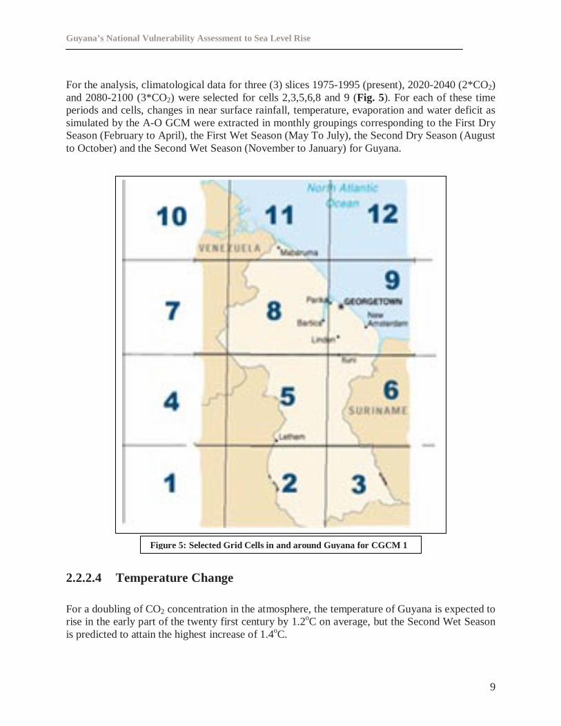
For the analysis, climatological data for three (3) slices 1975-1995 (present), 2020-2040 (2*CO2)and 2080-2100 (3*CO2) were selected for cells 2,3,5,6,8 and 9 (Fig. 5). For each of these timeperiods and cells, changes in near surface rainfall, temperature, evaporation and water deficit assimulated by the A-O GCM were extracted in monthly groupings corresponding to the First DrySeason (February to April), the First Wet Season (May To July), the Second Dry Season (Augustto October) and the Second Wet Season (November to January) for Guyana.
2.2.2.4 Temperature Change
For a doubling of CO2 concentration in the atmosphere, the temperature of Guyana is expected torise in the early part of the twenty first century by 1.2oC on average, but the Second Wet Seasonis predicted to attain the highest increase of 1.4oC.
Figure 5: Selected Grid Cells in and around Guyana for CGCM 1
Guyana’s National Vulnerability Assessment to Sea Level Rise
10
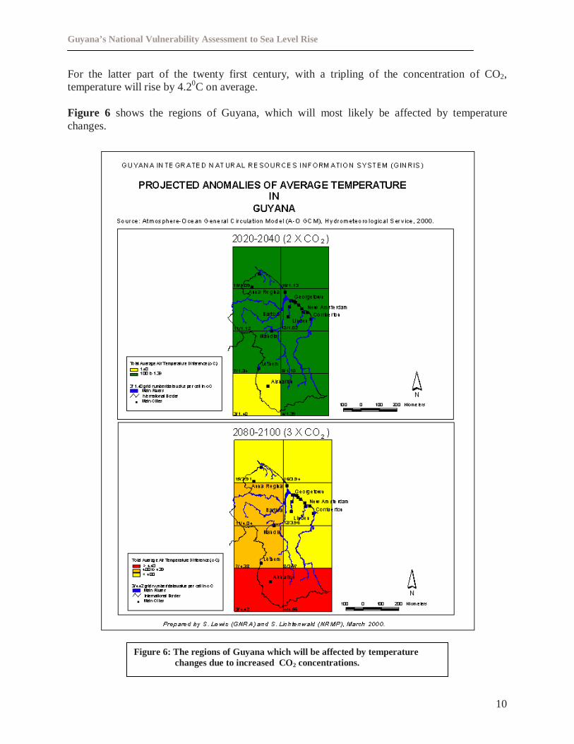
For the latter part of the twenty first century, with a tripling of the concentration of CO2,temperature will rise by 4.20C on average.
Figure 6 shows the regions of Guyana, which will most likely be affected by temperaturechanges.
Figure 6: The regions of Guyana which will be affected by temperaturechanges due to increased CO2 concentrations.
Guyana’s National Vulnerability Assessment to Sea Level Rise
11
2.2.2.5 Rainfall
Figure 7: The regions of Guyana which will be affected by rainfallchanges due to increased CO2 concentrations.
Guyana’s National Vulnerability Assessment to Sea Level Rise
12
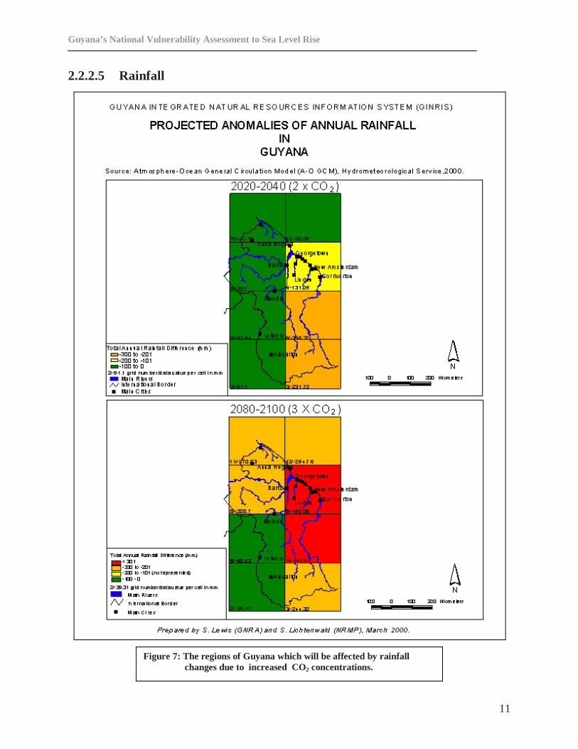
A doubling of CO2, is expected to result in a decrease in rainfall by an average of 0.34mm/dy-1 or10mm/month. The decrease appears to be higher, 17 mm per month and 12 mm per month in theFirst Wet Season (FWS) and the Second Dry Season (SDS) respectively.
For a tripling of the concentration of CO2, the average decrease is expected to be 0.69mm/dy-1 or21 mm per month. As before, the FWS and the SDS will experience decreases higher than 1 mmdy–1 or 30 mm per month.
Figure 7 shows the regions of Guyana, which will most likely be affected by rainfall decreases.
2.2.2.6 Sea Level Rise
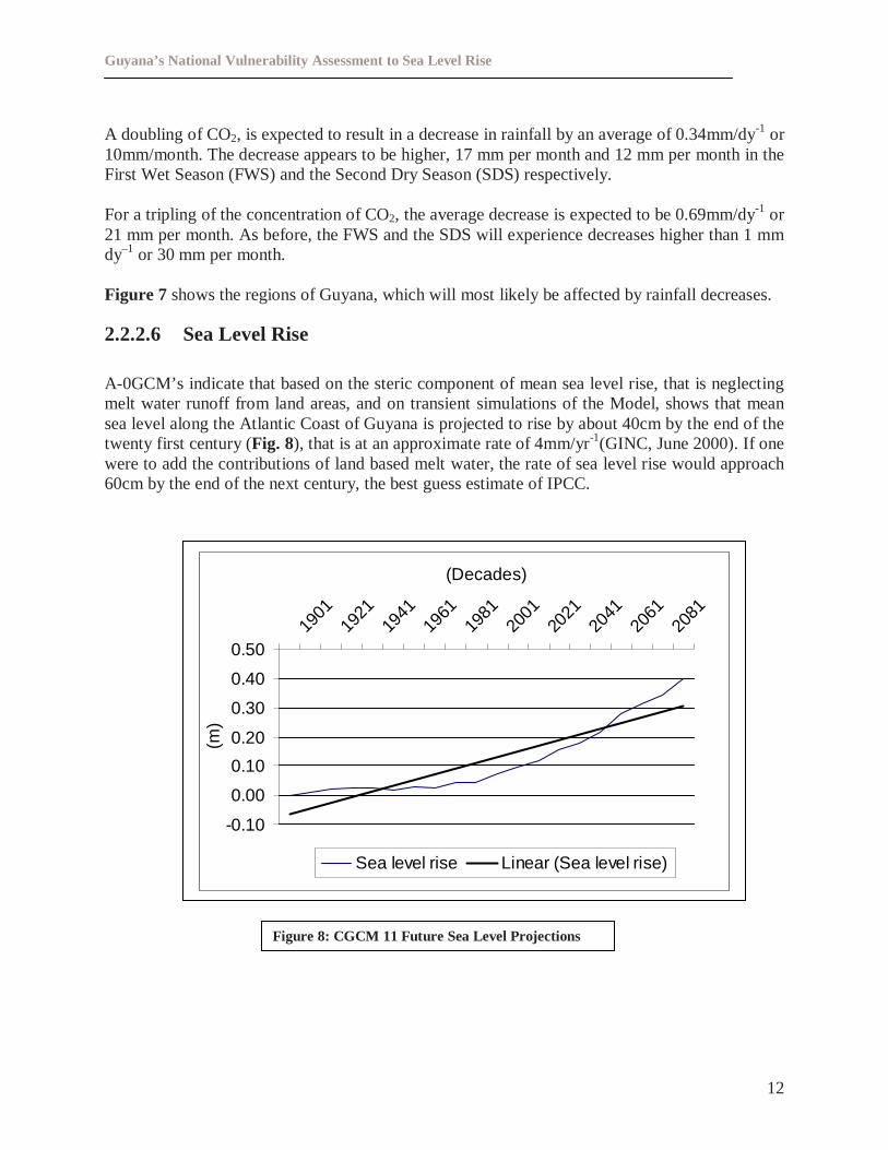
A-0GCM’s indicate that based on the steric component of mean sea level rise, that is neglectingmelt water runoff from land areas, and on transient simulations of the Model, shows that meansea level along the Atlantic Coast of Guyana is projected to rise by about 40cm by the end of thetwenty first century (Fig. 8), that is at an approximate rate of 4mm/yr-1(GINC, June 2000). If onewere to add the contributions of land based melt water, the rate of sea level rise would approach60cm by the end of the next century, the best guess estimate of IPCC.
Figure 8: CGCM 11 Future Sea Level Projections
-0.10
0.00
0.10
0.20
0.30
0.40
0.5019
0119
2119
4119
6119
8120
0120
2120
4120
6120
81
(Decades)
(m)
Sea level rise Linear (Sea level rise)
Guyana’s National Vulnerability Assessment to Sea Level Rise
13
2.3 Other Extreme Climate Events That May Result
2.3.1 Evaporation And Water Deficit
As for the change in evaporation rate, the slight (1oC) average increase in temperature, as aconsequence of CO2 doubling does not translate into significant evaporation (less than 0.1mm/dy-1). However, for a tripling of the CO2 concentration, evaporation generally increases, inresponse to higher temperature increase to about 0.11mm/dy-1.
2.3.2 Extreme High Temperature And Precipitation
An analysis of model-simulated daily temperature and precipitation data for present dayatmosphere and for the two future time periods (2050’s and 2080’s) suggests that the frequencyof extreme temperatures are likely to be enhanced thereby increasing the probability of thermalstress conditions during the 2050’s and more so during the 2080’s. Similarly, there is a lessernumber of rainy days in a year, although an increase in the daily intensity is expected. Thissuggests that an increase in the probability of occurrence of more frequent droughts as well asfloods for the future.
2.3.3 Extremes Of Sea Level – Storm Surges And Waves
Changes in the highest sea levels at a given locality will result from the change in mean sea levelat that location and changes in storm surge heights. If mean sea level rises, the present extremelevels will be attained more frequently all else being equal. Changes in storm surge heights resultfrom alterations to the occurrence of strong winds and low pressure.
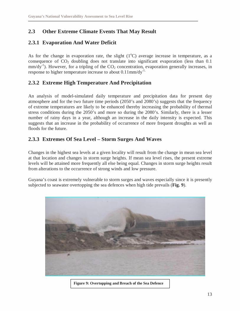
Guyana’s coast is extremely vulnerable to storm surges and waves especially since it is presentlysubjected to seawater overtopping the sea defences when high tide prevails (Fig. 9).
Figure 9: Overtopping and Breach of the Sea Defence
Guyana’s National Vulnerability Assessment to Sea Level Rise
14
3.0 COASTAL ASSETS AND ECONOMIC ACTIVITIES
3.1 Sectors
3.1.1 Agriculture
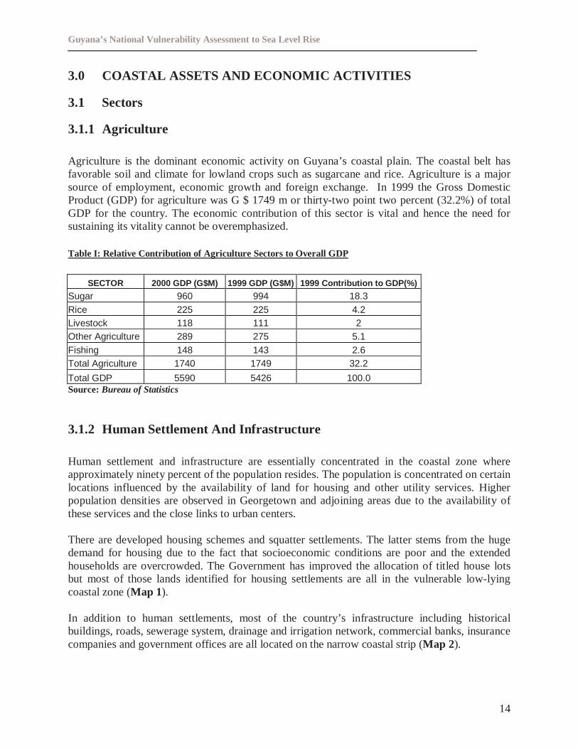
Agriculture is the dominant economic activity on Guyana’s coastal plain. The coastal belt hasfavorable soil and climate for lowland crops such as sugarcane and rice. Agriculture is a majorsource of employment, economic growth and foreign exchange. In 1999 the Gross DomesticProduct (GDP) for agriculture was G $ 1749 m or thirty-two point two percent (32.2%) of totalGDP for the country. The economic contribution of this sector is vital and hence the need forsustaining its vitality cannot be overemphasized.
Table I: Relative Contribution of Agriculture Sectors to Overall GDP
SECTOR 2000 GDP (G$M) 1999 GDP (G$M) 1999 Contribution to GDP(%)
Sugar 960 994 18.3Rice 225 225 4.2Livestock 118 111 2Other Agriculture 289 275 5.1Fishing 148 143 2.6Total Agriculture 1740 1749 32.2
Total GDP 5590 5426 100.0Source:Bureau of Statistics
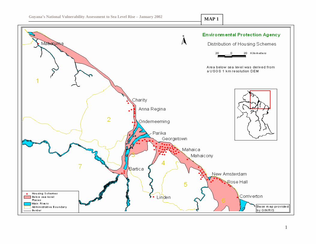
3.1.2 Human Settlement And Infrastructure
Human settlement and infrastructure are essentially concentrated in the coastal zone whereapproximately ninety percent of the population resides. The population is concentrated on certainlocations influenced by the availability of land for housing and other utility services. Higherpopulation densities are observed in Georgetown and adjoining areas due to the availability ofthese services and the close links to urban centers.
There are developed housing schemes and squatter settlements. The latter stems from the hugedemand for housing due to the fact that socioeconomic conditions are poor and the extendedhouseholds are overcrowded. The Government has improved the allocation of titled house lotsbut most of those lands identified for housing settlements are all in the vulnerable low-lyingcoastal zone (Map 1).
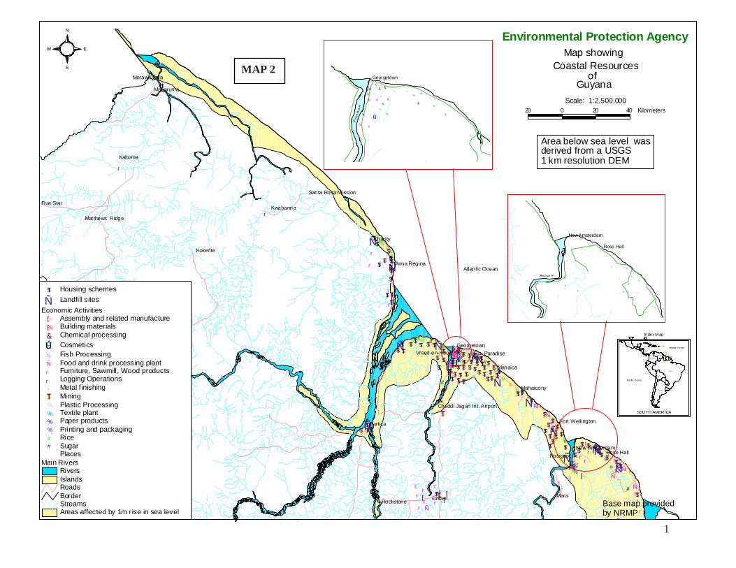
In addition to human settlements, most of the country’s infrastructure including historicalbuildings, roads, sewerage system, drainage and irrigation network, commercial banks, insurancecompanies and government offices are all located on the narrow coastal strip (Map 2).
Guyana’s National Vulnerability Assessment to Sea Level Rise – January 2002
1
MAP 1
1
###
##
###
#
#
#
#
#
#
r
r
r
r
r
r
r
ÑÑÑ
ÑÑÑ
$T
;;;;&&&
&
##
# ##
##
#
#
#
##
##
#
Ñ
$T
%%
%
%
;
%[
%[
%[
%[
%[
%[%[%[
&ÊÚ
%
%
rr
rr
r
r
r
rr
r
r
r
rrr
r rrr
rr r
r r r
rrrr
%%Ñ
Ñ
Ñ
ÑÑ
ÑÑ
ÑÑ
Ñ
Ñ
Ñ
Ñ
ÑÑ Ñ
Ñ
Ñ
Ñ
Ñ
Ñ
Ñ
ÑÑ
Ñ
Ñ
$T
$T
$T
$T$T
$T
$T
$T
$T$T$T$T
$T$T $T
$T
$T$T
$T
$T$T$T$T$T$T
$T $T $T $T
$T$T
$T$T$T$T
$T$T
$T$T$T$T$T$T $T $T$T $T $T $T
$T
$T $T$T$T$T $T
$T
$T $T
$T
$T
$T
$T$T$T
$T
$T$T$T
$T$T
$T
$T$T
$T $T $T$T$T $T
$T$T
$T$T
$T
$T$T
MaraLinden
Bartica
Charity
Kaituma
Mahaica
Kokerite
Kwabanna
Mabaruma
Paradise
Rosignol
Five Star
Mahaicony
Rockstone
Rose Hall
Georgetown
Morawhanna
Anna Regina
Corriverton
New Amsterdam
Vreed-en-Hoop
Fort Wellington
Matthews ' Ridge
Santa Rosa Mission
Cheddi Jagan Int. Airport
20 0 20 40 Kilometers
Scale: 1:2,500,000
ofGuyana
Coastal ResourcesMap showing
Environmental Protection Agency
##
#
#
#
Ñ
Ñ
Ñ
Ñ
ÑÑ
;
;
;;& & &
#
#
#
% %
%
%[
%[
%[
&
ÊÚ
%
r
%
%Ñ
Georgetown
Dem
era
raR
.
#
#
#
#
#
Ñ
%
%[
%[
%
r
r
r
r
r
r
r
r
r
r
r
r
r
r
r
r
Ñ
Ñ
Ñ
Ñ
Ñ
Ñ
Ñ
Ñ
NewAmsterdam
Berb ice R .
Rose Hall
S
N
EW
Areas affected by 1m rise in sea levelStreamsBorderRoads
Main RiversRiversIslands
Places
Economic Activities%[ Assembly and related manufacture%[ Building materials& Chemical processing
ÊÚ Cosmetics
Ñ Fish ProcessingÑ Food and drink processing plantr Furniture, Sawmill, Wood productsr Logging Operations; Metal f inishing$T Mining% Plastic Processing% Textile plant% Paper products% Printing and packaging# Rice# Sugar
Ñ Landfill sites$T Housing schemes
Atlantic Ocean
Br azi l
Ar genti na
Per u
Bol ivia
Mexico
Chil e
Col ombi a
Venezuela
Parag uay
Ecuador
Guyana
Ur uguay
Cuba
Sur iname
N icaragua
Panama
Hait i
Jam aica Puer to Rico
Tri nidad
Index Map
SOUTH AMERICA
Pacific Ocean
Atlantic Ocean
Base map providedby NRMP
Area below sea level wasderived from a USGS1 km resolution DEM
MAP 2
Guyana’s National Vulnerability Assessment to Sea Level Rise – First Draft May 2001
16
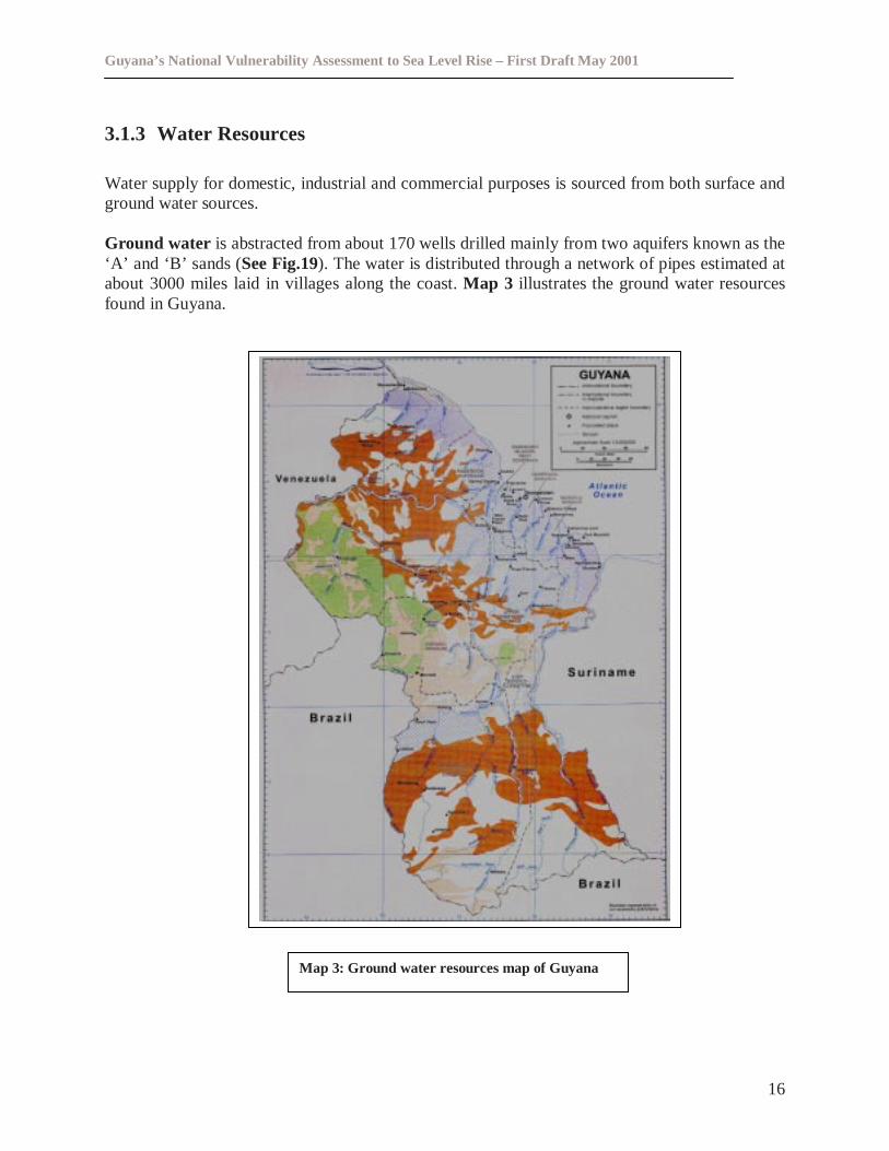
3.1.3 Water Resources
Water supply for domestic, industrial and commercial purposes is sourced from both surface andground water sources.
Ground water is abstracted from about 170 wells drilled mainly from two aquifers known as the‘A’ and ‘B’ sands (See Fig.19). The water is distributed through a network of pipes estimated atabout 3000miles laid in villages along the coast.Map 3 illustrates the ground water resourcesfound in Guyana.
Map 3: Ground water resources map of Guyana
Guyana’s National Vulnerability Assessment to Sea Level Rise – First Draft May 2001
17
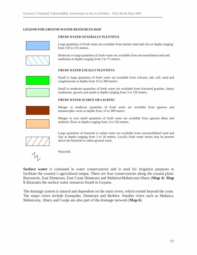
LEGEND FOR GROUND WATER RESOURCES MAP
FRESH WATER GENERALLY PLENTIFUL
Large quantities of fresh water are available from marine sand and clay at depths rangingfrom 150 to 215 meters.
Moderate to large quantities of fresh water are available from unconsolidated sand andsandstone at depths ranging from 3 to 75 meters.
FRESH WATER LOCALLY PLENTIFUL
Small to large quantities of fresh water are available from volcanic ash, tuff, sand andconglomerate at depths from 10 to 300 meters.
Small to moderate quantities of fresh water are available from fractured granites, chertymudstones, gravels and sands at depths ranging from 3 to 150 meters.
FRESH WATER SCARCE OR LACKING
Meager to moderate quantities of fresh water are available from igneous andmetamorphic rocks at depths from 10 to 300 meters.
Meager to very small quantities of fresh water are available from igneous dikes andandesitic flows at depths ranging from 3 to 150 meters.
Large quantities of brackish to saline water are available from unconsolidated sand andclay at depths ranging from 3 to 30 meters. Locally fresh water lenses may be presentabove the brackish to saline ground water.
Waterfall.
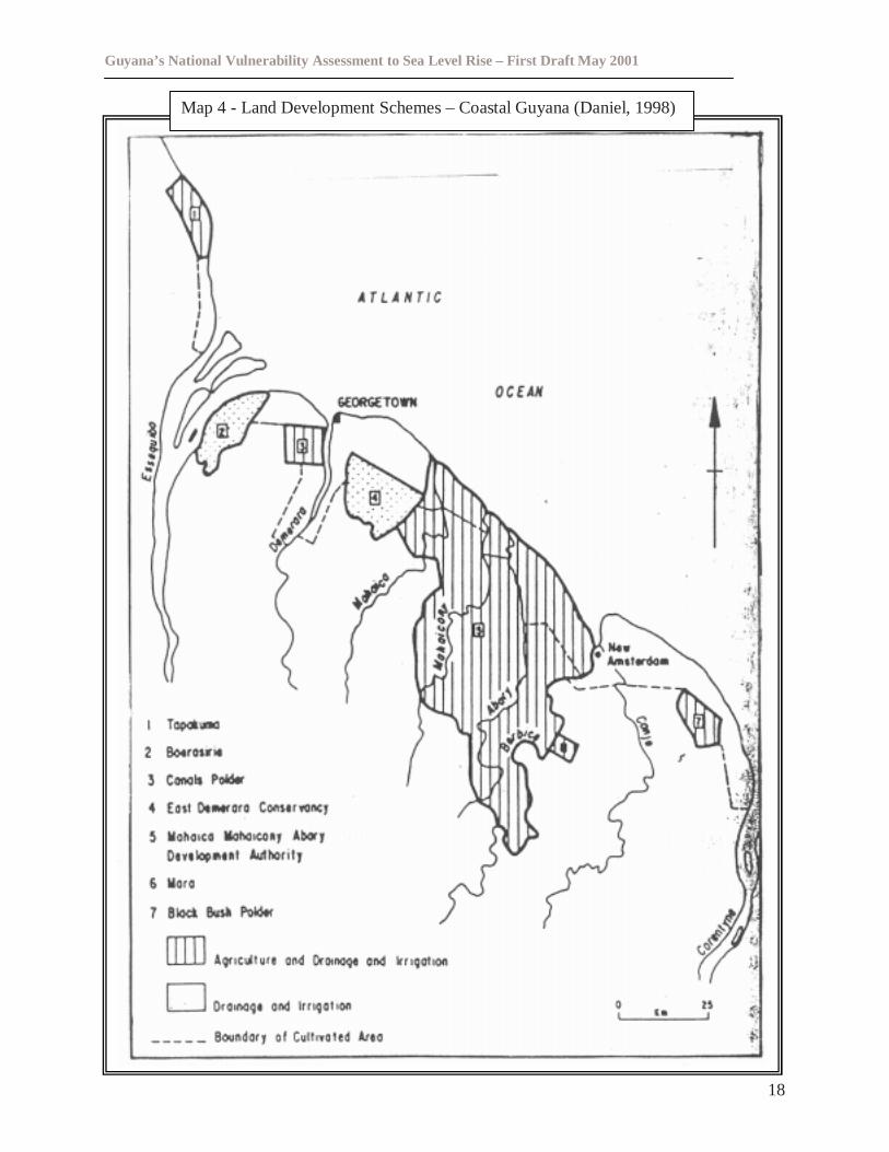
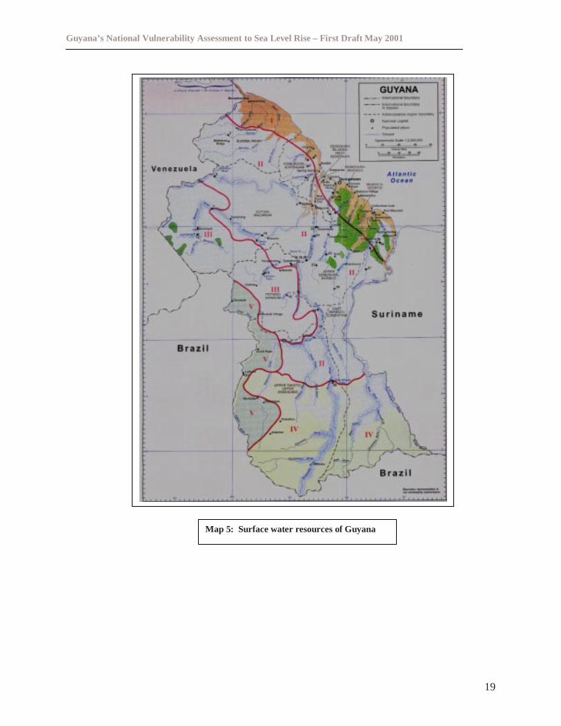
Surface water is contained in water conservancies and is used for irrigation purposes tofacilitate the country’s agricultural output. There are four conservancies along the coastal plain:Boeraserie, East Demerara, East Coast Demerara and Mahaica/Mahaicony/Abary (Map 4). Map5 illustrates the surface water resources found in Guyana.
The drainage system is natural and dependent on the main rivers, which extend beyond the coast.The major rivers include Essequibo, Demerara and Berbice. Smaller rivers such as Mahaica,Mahaicony, Abary and Canjie are also part of the drainage network (Map 6).
Guyana’s National Vulnerability Assessment to Sea Level Rise – First Draft May 2001
18
Map 4 - Land Development Schemes – Coastal Guyana (Daniel, 1998)
Guyana’s National Vulnerability Assessment to Sea Level Rise – First Draft May 2001
19
Map 5: Surface water resources of Guyana
Guyana’s National Vulnerability Assessment to Sea Level Rise – First Draft May 2001
20
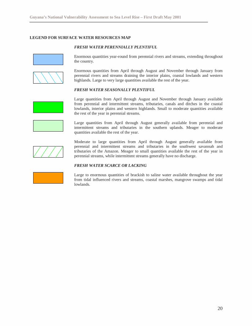
LEGEND FOR SURFACE WATER RESOURCES MAP
FRESH WATER PERENNIALLY PLENTIFUL
Enormous quantities year-round from perennial rivers and streams, extending throughoutthe country.
Enormous quantities from April through August and November through January fromperennial rivers and streams draining the interior plains, coastal lowlands and westernhighlands. Large to very large quantities available the rest of the year.
FRESH WATER SEASONALLY PLENTIFUL
Large quantities from April through August and November through January availablefrom perennial and intermittent streams, tributaries, canals and ditches in the coastallowlands, interior plains and western highlands. Small to moderate quantities availablethe rest of the year in perennial streams.
Large quantities from April through August generally available from perennial andintermittent streams and tributaries in the southern uplands. Meager to moderatequantities available the rest of the year.
Moderate to large quantities from April through August generally available fromperennial and intermittent streams and tributaries in the southwest savannah andtributaries of the Amazon. Meager to small quantities available the rest of the year inperennial streams, while intermittent streams generally have no discharge.
FRESH WATER SCARCE OR LACKING
Large to enormous quantities of brackish to saline water available throughout the yearfrom tidal influenced rivers and streams, coastal marshes, mangrove swamps and tidallowlands.
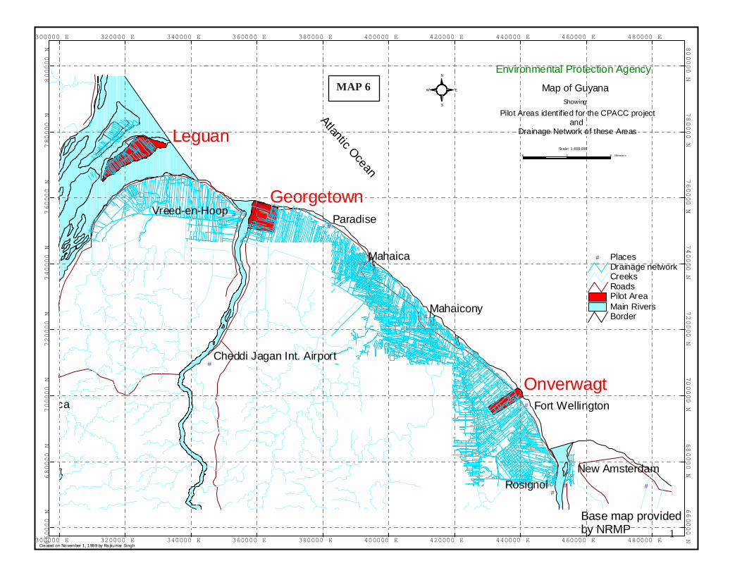
1
Base map providedby NRMP
AtlanticOcean
Created on Novem ber 1, 1999 by Rajkumar Singh
S
N
EW
# #
#
#
#
#
#
#
#
#
ca
Mahaica
Rosignol
Paradise
Mahaicony
New Amsterdam
Vreed-en-Hoop
Fort Wellington
Cheddi Jagan Int. Airport
Georgetown
Onverwagt
Leguan
BorderMain RiversPilot AreaRoadsCreeksDrainage network
# Places
300000 E
300000 E
320000 E
320000 E
340000 E
340000 E
360000 E
360000 E
380000 E
380000 E
400000 E
400000 E
420000 E
420000 E
440000 E
440000 E
460000 E
460000 E
480000 E
480000 E66
00
00
N6
600
00
N6
800
00
N6
800
00
N7
00
00
0N
70
00
00
N7
20
00
0N
72
00
00
N7
40
00
0N
74
00
00
N7
60
00
0N
76
00
00
N7
80
000
N78
000
0N
800
000
N80
000
0N
Showing
Map of Guyana
Environmental Protection Agency
Scale: 1:600,000
Pilot Areas identified for the CPACC projectand
Drainage Network of these Areas
10 0 10 Kilometer s
MAP 6
Guyana’s National Vulnerability Assessment to Sea Level Rise – First Draft May 2001
22
3.1.4 Tourism
Since Guyana’s tourism industry is not as developed as its Caribbean neighbours and is mainlycentered on eco-tourism in the hinterland of Guyana, tourism is considered to be a minorcontributor to foreign exchange. Tourist attractions on the coast of Guyana include Georgetownand it’s many historical sites, and a few beaches located throughout the length of the coast.
3.1.4.1 Georgetown
Georgetown is situated on the right bank of the Demerara River. Most of the city’s historicalbuildings and wooden structures reflecting the unique 18th and 19th century architecture are majortourist attractions. Further, the major administrative facilities, commercial banks, hotels andshopping centers are located within Georgetown.
3.1.4.2 Beaches
Shell Beach is one of the country’s major tourist attractions. This area stretches from Waini pointto the mouth of the Pomeroon River on Guyana’s Northern Shore. This is the only beach in theworld where four species of sea turtles nest: Leatherback (Dermochelys coriacea), Green(Chelonia mydas), Olive Ridley (Lepidochelys olivacea), which are Endangered, and Hawksbill(Eretmochelys imbricata), which is Critically Endangered (IUCN, 1997). Other nesting beachesin the world have only one or two species.
In addition, Shell Beach is an important habitat for a large number of animal species, some ofwhich are now endangered. Blue and Gold (Ara ararauna) and Red Bellied (Ara manilata)Macaws frequent the forests at Shell Beach and the mudflats and mangroves lining the shores arehome to an impressive number of flocks of Scarlet Ibis (Eudocimus ruber). Other birds includeegrets, herons, Roseate spoonbills (Platalea spp.) and Caribbean Flamingos (Phoenicopteridaespp.). Many of Guyana’s mammal species can also be found there such as manatees (Trichechusspp.), jaguars (Panthera onca), tapirs (Tapirus spp.), deer (Mazama spp.), and several species ofmonkeys(eg. Cebus spp., Saimiri spp.).
Other beaches include the Number 63 Village Beach located on the Corentyne Coast, Hope,Parika, Bushy Park, and Unity Beach. These Beaches are used for both religious and recreationalactivities. A major part of the Guyanese religious community is Hindus for whom cremation ofthe dead is a part of their funeral rites. Hindus conduct cremation exercises on many of thesebeaches. They also perform ceremonial rituals on the beach since they hold the ocean to besacred. These beaches are also used for picnics and playing sports especially during weekendsand on public holidays.
Guyana’s National Vulnerability Assessment to Sea Level Rise – First Draft May 2001
23
3.1.5 Fisheries
Fisheries may be considered the second most important economic activity along the coast. About6.5 million tonnes of fish were exported in 1998 comprising about 6% of the nation’s GDP. In1999, fish export contributed to 6.4% of the nation’s GDP. Fisheries provide a livelihood forover 10,000 persons in Guyana. These include fishermen and their families, boat builders, trapand net makers, packers, distributors, retailers and processors. The value of fish and fishproducts for local needs has also been recognised by the Government. The fishing industry hasfive subcomponents: industrial, artisanal, inland and aquaculture, and ornamental.
Vulnerable resources to sea level include the fish resource itself, wharves/landing sites, co-operative buildings, fishers and mangroves.
More severe and frequent flooding will cause the potential destruction of landing sites andcooperative buildings that are situated along the coast. Fishers must have a place to land theircatch for market purposes and this must be a place that is clean and healthy since most of the fishand shrimp caught in Guyana are exported.
The readjustment of mangroves will also affect the fish resources since some of the speciescaught have nursery areas in the mangroves. If the mangrove forest has to re-establish itself at anew location then valuable fish resources will be lost. At the local level, persons living in ruralareas also depend heavily on fish as their source of protein. Hence, a decrease in fish productioncan see many persons not having this essential nutrient since other alternative sources of proteincan be too expensive.
Disruption of coastal and marine ecosystems will also have an effect on species being caught.The Chinese seine fishers will have to move their fish pens nearer to the shore since most of thetarget species will be closer to the shore. This will include building new fish pens since the olderones will be lost to more frequent flooding or permanent inundation. Biological studies should beconducted to assess the differences, if any, on the biology of the fisheries, checking for growthpatterns for example.
3.1.5.1 Aquaculture
This is a growing industry in Guyana. There are basically two types of aquaculture practiced hereand these include the brackish water and fresh water cultures. Properly managed aquaculture canco-exist in an environmentally friendly manner with other coastal uses.
Freshwater aquaculture will be impacted from salt-water intrusion. While some species are salttolerant to some degree (i.e., various Tilapine species) others are not (i.e., hassar). In addition tofreshwater species, flooding and erosion caused by sea-level rise will also impact on brackishspecies. Pond banks will erode away and cultured fish will escape. Extensive flooding of soilwill leach away nutrients, resulting in poor carrying capacity of ponds under extensive and semiextensive production. The introduction of predacious species via flooding into culture operationswill result in the inability to practice aquaculture unless painstaking drying and removal
Guyana’s National Vulnerability Assessment to Sea Level Rise – First Draft May 2001
24
activities are carried out. Aquaculture will no longer be a financial viable operation if theintroduction of predators cannot be controlled.
3.2 Ecosystems
Of the various coastal ecosystem types in Guyana, the mangrove ecosystem is predominant.
3.2.1 Mangroves
The mangrove forests in Guyana are found along large sections of the Atlantic Coast from theCorentyne River to the Waini River. Mangrove forests are also found at the interface between theterrestrial and marine eco-systems, in estuarine wetlands and in tidal reaches of riverain areas. Themain species of mangroves found in Guyana includeAvicennia germinans(Black mangrove),Rhizophora mangle(Red mangrove), andLaguncularia racemosa(White mangrove).Avicenniagerminansis accepted as the predominant species in Guyana, it is known locally as ‘courida’.
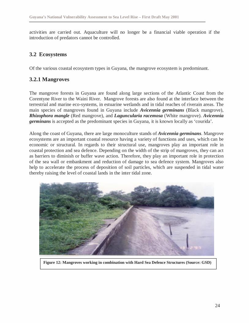
Along the coast of Guyana, there are large monoculture stands ofAvicennia germinans. Mangroveecosystems are an important coastal resource having a variety of functions and uses, which can beeconomic or structural. In regards to their structural use, mangroves play an important role incoastal protection and sea defence. Depending on the width of the strip of mangroves, they can actas barriers to diminish or buffer wave action. Therefore, they play an important role in protectionof the sea wall or embankment and reduction of damage to sea defence system. Mangroves alsohelp to accelerate the process of deposition of soil particles, which are suspended in tidal waterthereby raising the level of coastal lands in the inter tidal zone.
Figure 12: Mangroves working in combination with Hard Sea Defence Structures (Source: GSD)
Guyana’s National Vulnerability Assessment to Sea Level Rise – First Draft May 2001
25
The economic role of mangroves include:
� Bee Keeping -Approximately 75% of the honey produced in the country is from mangroveareas.
� Fisheries -The mangrove swamps are natural breeding and nursery grounds for someshrimp and finfish species.
� Wood -This is one of the most important uses of mangroves because it provides an easysource of fuel wood. It is used for a number of domestic related purposes - daily cooking,wedding preparations and religious activities. The wood is also used to make fences, tentsand arbor for gardens and as poles/stakes for fishing nets.
� Habitat - Mangroves also provide a habitat for a number of different species ofmacroinvertebrates (shrimps, crabs) and avian fauna.
3.2.2 Shore types/Beaches
In Guyana, there are three major shore types. These include mud accretionary coast, sand/shellaccretionary coast and erosional coast.
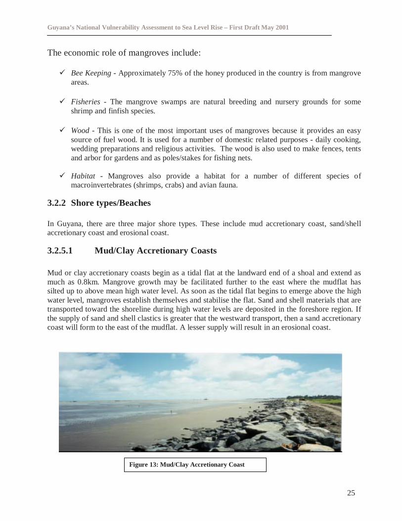
3.2.5.1 Mud/Clay Accretionary Coasts
Mud or clay accretionary coasts begin as a tidal flat at the landward end of a shoal and extend asmuch as 0.8km. Mangrove growth may be facilitated further to the east where the mudflat hassilted up to above mean high water level. As soon as the tidal flat begins to emerge above the highwater level, mangroves establish themselves and stabilise the flat. Sand and shell materials that aretransported toward the shoreline during high water levels are deposited in the foreshore region. Ifthe supply of sand and shell clastics is greater that the westward transport, then a sand accretionarycoast will form to the east of the mudflat. A lesser supply will result in an erosional coast.
Figure 13: Mud/Clay Accretionary Coast
Guyana’s National Vulnerability Assessment to Sea Level Rise – First Draft May 2001
26
3.2.5.2 Sand/Shell Accretionary Coasts
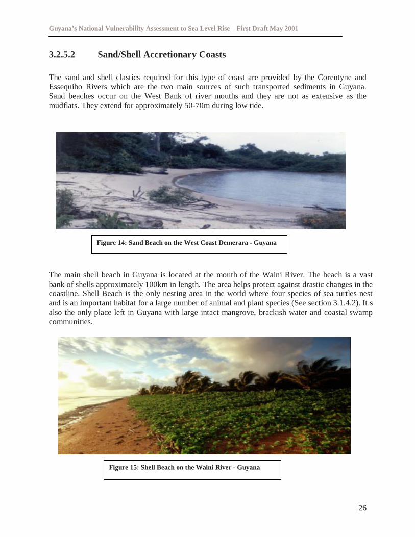
The sand and shell clastics required for this type of coast are provided by the Corentyne andEssequibo Rivers which are the two main sources of such transported sediments in Guyana.Sand beaches occur on the West Bank of river mouths and they are not as extensive as themudflats. They extend for approximately 50-70m during low tide.
The main shell beach in Guyana is located at the mouth of the Waini River. The beach is a vastbank of shells approximately 100km in length. The area helps protect against drastic changes in thecoastline. Shell Beach is the only nesting area in the world where four species of sea turtles nestand is an important habitat for a large number of animal and plant species (See section 3.1.4.2). It salso the only place left in Guyana with large intact mangrove, brackish water and coastal swampcommunities.
Figure 15: Shell Beach on the Waini River - Guyana
Figure 14: Sand Beach on the West Coast Demerara - Guyana
Guyana’s National Vulnerability Assessment to Sea Level Rise – First Draft May 2001
27
3.2.2.3 Erosional Coasts
These can be either of two types:
� A straight erosion coast
� An indented erosion coast (‘Happen-coast’)
A number of common features characterise these coasts. Uprooted tree stumps can be seen piledup against the chenier or mangrove. Wash-over fans and deltas are present on the landward sideof the chenier. Another feature is that any mangroves attempting to become established on thelandward side of the chenier more or less experiences total death.
In Guyana, the ‘Happen type erosion coast’, is the more common of the two.
3.3 The Future Of Coastal Assets And Economic Activities
3.3.1 Population Size And Density
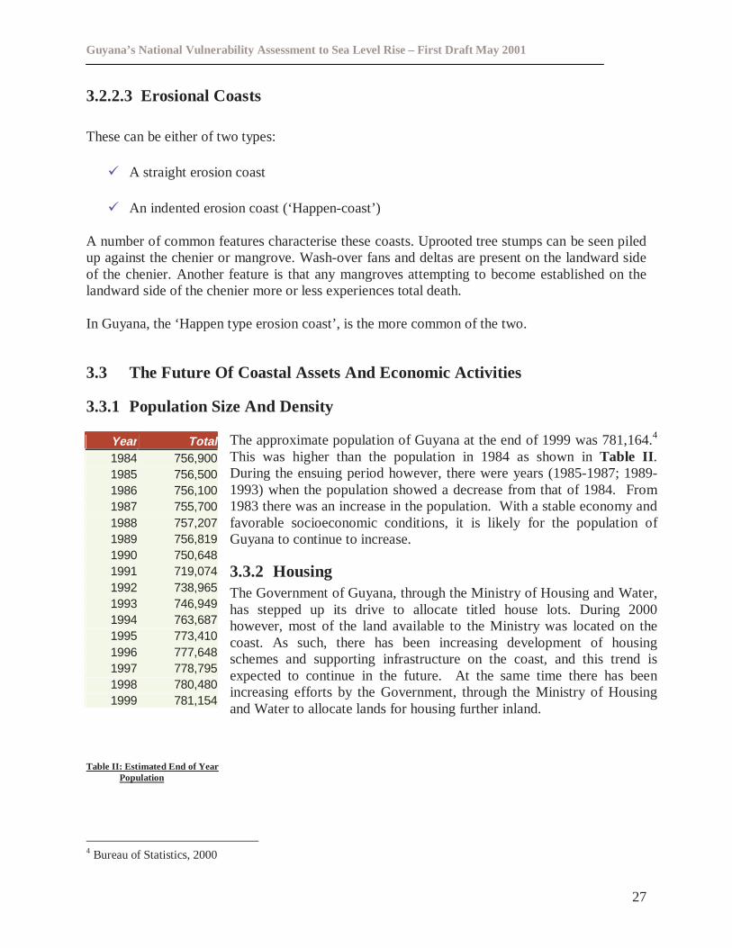
The approximate population of Guyana at the end of 1999 was 781,164.4
This was higher than the population in 1984 as shown inTable II .During the ensuing period however, there were years (1985-1987; 1989-1993) when the population showed a decrease from that of 1984. From1983 there was an increase in the population. With a stable economy andfavorable socioeconomic conditions, it is likely for the population ofGuyana to continue to increase.
3.3.2 HousingThe Government of Guyana, through the Ministry of Housing and Water,has stepped up its drive to allocate titled house lots. During 2000however, most of the land available to the Ministry was located on thecoast. As such, there has been increasing development of housingschemes and supporting infrastructure on the coast, and this trend isexpected to continue in the future. At the same time there has beenincreasing efforts by the Government, through the Ministry of Housingand Water to allocate lands for housing further inland.
Table II: Estimated End of YearPopulation
4 Bureau of Statistics, 2000
Year Total1984 756,9001985 756,5001986 756,1001987 755,7001988 757,2071989 756,8191990 750,6481991 719,0741992 738,9651993 746,9491994 763,6871995 773,4101996 777,6481997 778,7951998 780,4801999 781,154
Guyana’s National Vulnerability Assessment to Sea Level Rise – First Draft May 2001
28
3.3.3 Other Infrastructure
Many commercial, industrial, educational and health infrastructures are located on the coast. Thegovernment has been involved and has planned to continue to build and rehabilitate schools,hospitals and roads along the coast (Refer to Map 2). This present trend serves to emphasise theimportance of the coastal zone.
3.3.4 Water Resources
Major investments are ongoing to upgrade the existing water supply network including sinking ofnew wells and installation of pipelines, not only on the coast but also in and around the entirecountry. These investments are likely to be affected by any major flooding along the coast sincethe country’s water supply lines are below ground level and wells are 0.4m above ground level.
3.3.4.1 Drainage and Irrigation
The Drainage and Irrigation Board has plans to upgrade a total of approximately 560,531 acres ofcultivable area of the drainage and irrigation network. This planned upgrade will serve to relieveflooding due to excess rainfall; however in the long term will be unable to cope with 0.2m, 0.5m or0.9m rise in sea level. This is because gravity drains some areas and pumps drain other areas. Thepressure of the water coming in will certainly exceed that going out.
3.3.5 Agriculture
The agriculture sector is the single most important sector of Guyana's economy, both in terms offoreign exchange generation and the number of persons employed. In 1998, this sectorcontributed approximately twenty-one percent (21%) of the gross domestic product (GDP) (Fig.16), whereas in 1999, the sector recorded thirty point two percent (30.2%) of the total GDP. Thisimprovement reflected the recovery of sugar output and the expansion of rice, timber and othercrop production.
The country produces its own rice and sugar to supplement local needs as well as for export. Thegovernment has major plans to expand both the rice and sugar industry, which are found, only onthe coast.
With regard to its trade contribution, the traditional agricultural sector (rice and sugar)contributed approximately forty-three percent (43%) of export earnings in 1998 (Figure 17).Most of the rice and sugar exports went to fill preferential market arrangements negotiated withsome North American countries and the European Union. A small percentage, i.e., three percent(3%) was exported to neighbouring Caribbean countries.
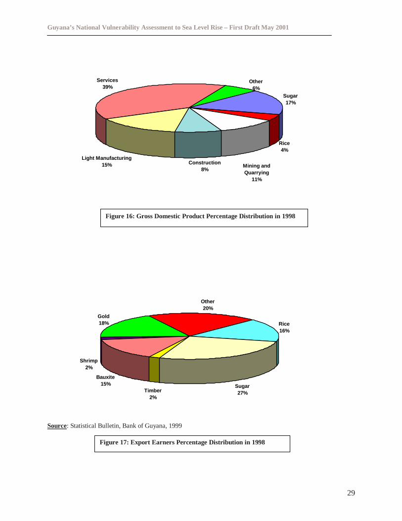
Guyana’s National Vulnerability Assessment to Sea Level Rise – First Draft May 2001
29
Sugar17%
Rice4%
Construction8%
Light Manufacturing15%
Services39%
Mining andQuarrying
11%
Other6%
Rice16%
Sugar27%
Bauxite15%
Shrimp2%
Gold18%
Other20%
Timber2%
Source: Statistical Bulletin, Bank of Guyana, 1999
Figure 17: Export Earners Percentage Distribution in 1998
Figure 16: Gross Domestic Product Percentage Distribution in 1998
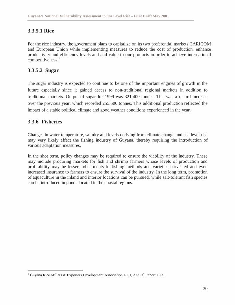
Guyana’s National Vulnerability Assessment to Sea Level Rise – First Draft May 2001
30
3.3.5.1 Rice
For the rice industry, the government plans to capitalize on its two preferential markets CARICOMand European Union while implementing measures to reduce the cost of production, enhanceproductivity and efficiency levels and add value to our products in order to achieve internationalcompetitiveness.5
3.3.5.2 Sugar
The sugar industry is expected to continue to be one of the important engines of growth in the
future especially since it gained access to non-traditional regional markets in addition to
traditional markets. Output of sugar for 1999 was 321.400 tonnes. This was a record increase
over the previous year, which recorded 255.500 tonnes. This additional production reflected the
impact of a stable political climate and good weather conditions experienced in the year.
3.3.6 Fisheries
Changes in water temperature, salinity and levels deriving from climate change and sea level risemay very likely affect the fishing industry of Guyana, thereby requiring the introduction ofvarious adaptation measures.
In the shot term, policy changes may be required to ensure the viability of the industry. Thesemay include procuring markets for fish and shrimp farmers whose levels of production andprofitability may be lesser, adjustments to fishing methods and varieties harvested and evenincreased insurance to farmers to ensure the survival of the industry. In the long term, promotionof aquaculture in the inland and interior locations can be pursued, while salt-tolerant fish speciescan be introduced in ponds located in the coastal regions.
5 Guyana Rice Millers & Exporters Development Association LTD, Annual Report 1999.
Guyana’s National Vulnerability Assessment to Sea Level Rise – First Draft May 2001
31
4.0 METHODOLOGY FOR VULNERABILITY ASSESSMENT
4.1 Methodological Options
The overall objective of component six of CPACC is to assist countries with initial adaptationplanning for sea level rise through a vulnerability assessment. Of specific concern given thepilot nature of the vulnerability assessments is the methodology and approach, which wasutilized for the vulnerability assessment.
Initially five potential vulnerability assessment methodologies and approaches were examinedand critically assessed in terms of their utility for the Caribbean. The methodologies examinedwere:
i. The IPCC common methodology (IPCC 1992)ii. The US country studies program methodology (Leatherman and Yohe 1995)
iii. The South Pacific Island Methodology (Yamada et al 1995)iv. The Research Institute for Knowledge Systems (RIKS) decision-support methodologyv. The UNEP Handbook Methodology (Burton et al 1998)
Table III below examines the advantages and disadvantages of the various methodologies(Nicholls 1998). It was also necessary to distinguish between a vulnerability assessmentframework and a vulnerability tool. A framework could be considered as a set of fundamentalquestions or steps whose answer assist the Vulnerability assessment and collectively constitutesome overview of coastal area’s vulnerability to sea level rise, while a vulnerability assessmenttool is a method or a step within a vulnerability assessment framework (Nicholls 1998). Thevulnerability assessment methodologies were also analyzed in the context of the Klein andNicholls (1998) definition of coastal vulnerability. Klein and Nicholls (1998) defined coastalvulnerability assessment using a conceptual framework (see figure one below)
The IPCC common methodology while being the first methodology, which was proposed forvulnerability studies, it was found that applications of the common methodology to be quiteinflexible with adaptation options insufficiently developed. The IPCC common methodologyhowever is logically set out and has been utilized widely. The South Pacific methodology, whileuseful, has been formulated for countries, which have limited data, and thus is not suitable forCaribbean countries where there is more comprehensive data available.
The US country studies, while utilizing the experience of the IPCC methodology the US countrystudy program methodology was found to confuse vulnerability frameworks and tools. The UScountry study programme was also found to address mainly land loss impacts. The ResearchInstitute for Knowledge Systems (RIKS) decision-support methodology proceeds in a stepwiselogical manner, and comprehensively provides the framework for detailed vulnerability studies.The RIKS methodology however requires a high level of detailed data, which may not beavailable in the Caribbean. However with the development of capacity in the region the RIKSdecision-support system methodology could be applied in the region.
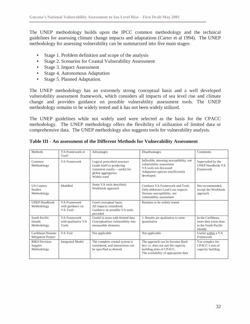
Guyana’s National Vulnerability Assessment to Sea Level Rise – First Draft May 2001
32
The UNEP methodology builds upon the IPCC common methodology and the technicalguidelines for assessing climate change impacts and adaptations (Carter et al 1994). The UNEPmethodology for assessing vulnerability can be summarized into five main stages:
• Stage 1. Problem definition and scope of the analysis• Stage 2. Scenarios for Coastal Vulnerability Assessment• Stage 3. Impact Assessment• Stage 4. Autonomous Adaptation• Stage 5. Planned Adaptation.
The UNEP methodology has an extremely strong conceptual basis and a well developedvulnerability assessment framework, which considers all impacts of sea level rise and climatechange and provides guidance on possible vulnerability assessment tools. The UNEPmethodology remains to be widely tested and it has not been widely utilized.
The UNEP guidelines while not widely used were selected as the basis for the CPACCmethodology. The UNEP methodology offers the flexibility of utilization of limited data orcomprehensive data. The UNEP methodology also suggests tools for vulnerability analysis.
Table III - An assessment of the Different Methods for Vulnerability Assessment
Methods VA Framework orTool?
Advantages Disadvantages Comments
CommonMethodology
VA Framework Logical prescribed structureLends itself to producingconsistent results -- useful forglobal aggregationWidely used
Inflexible, stressing susceptibility, notvulnerability assessmentVA tools not discussedAdaptation options insufficientlydeveloped.
Superseded by theUNEP Handbook VAFramework
US CountryStudiesMethodology
Muddled Some VA tools described.Workbook approach
Confuses VA Framework and ToolsOnly addresses Land Loss impactsStresses susceptibility, notvulnerability assessment
Not recommended,except the Workbookapproach
UNEP HandbookMethodology
VA Frameworkwith guidance onVA Tools
Good conceptual basis.All impacts considered.Guidance on possible VA toolsprovided
Remains to be widely tested.
South PacificIslandsMethodology
VA Frameworkwith qualitative VATools
Useful in areas with limited dataConceptualizes vulnerability intomeasurable elements
1. Results are qualitative to semi-quantitative
In the Caribbean,more data exists thanin the South PacificIslands.
Caribbean DisasterMitigation Project
VA Tool Not applicable Not applicable Useful withina VAFramework
RIKS DecisionSupportMethodology
Integrated Model The complete coastal system isconsidered, and interactions canbe specified as desired.
The approach can be become blackbox i.e. does not suit the capacitybuilding aims of CPACC.The availability of appropriate data
Too complex forCPACC’s aim ofcapacity building
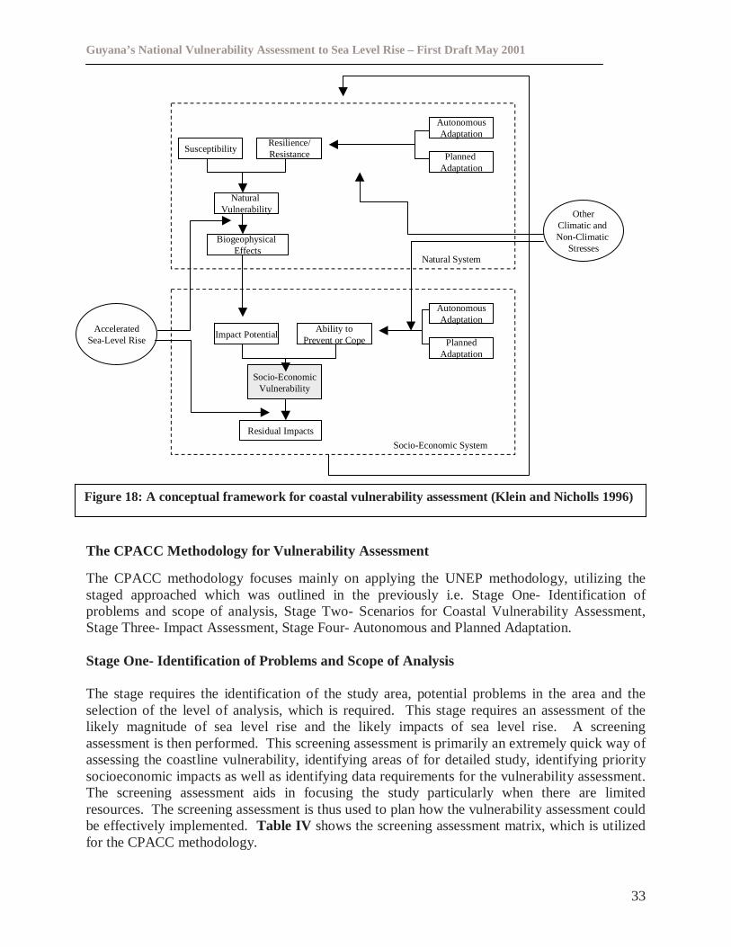
Guyana’s National Vulnerability Assessment to Sea Level Rise – First Draft May 2001
33
The CPACC Methodology for Vulnerability Assessment
The CPACC methodology focuses mainly on applying the UNEP methodology, utilizing thestaged approached which was outlined in the previously i.e. Stage One- Identification ofproblems and scope of analysis, Stage Two- Scenarios for Coastal Vulnerability Assessment,Stage Three- Impact Assessment, Stage Four- Autonomous and Planned Adaptation.
Stage One- Identification of Problems and Scope of Analysis
The stage requires the identification of the study area, potential problems in the area and theselection of the level of analysis, which is required. This stage requires an assessment of thelikely magnitude of sea level rise and the likely impacts of sea level rise. A screeningassessment is then performed. This screening assessment is primarily an extremely quick way ofassessing the coastline vulnerability, identifying areas of for detailed study, identifying prioritysocioeconomic impacts as well as identifying data requirements for the vulnerability assessment.The screening assessment aids in focusing the study particularly when there are limitedresources. The screening assessment is thus used to plan how the vulnerability assessment couldbe effectively implemented.Table IV shows the screening assessment matrix, which is utilizedfor the CPACC methodology.
SusceptibilityResilience/Resistance
AutonomousAdaptation
PlannedAdaptation
NaturalVulnerability
BiogeophysicalEffects
Impact PotentialAbility to
Prevent or Cope
AutonomousAdaptation
PlannedAdaptation
Socio-EconomicVulnerability
Residual Impacts
AcceleratedSea-Level Rise
OtherClimatic andNon-Climatic
Stresses
Socio-Economic System
Natural System
Figure 18: A conceptual framework for coastal vulnerability assessment (Klein and Nicholls 1996)
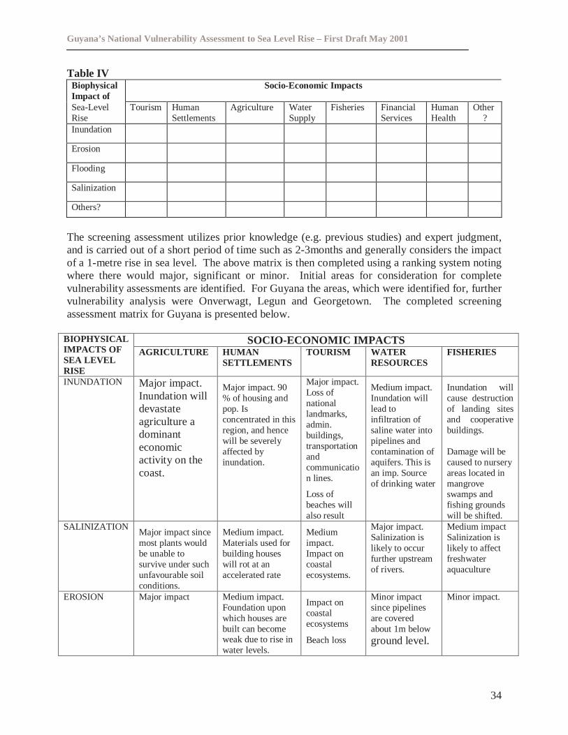
Guyana’s National Vulnerability Assessment to Sea Level Rise – First Draft May 2001
34
Table IVBiophysicalImpact of
Socio-Economic Impacts
Sea-LevelRise
Tourism HumanSettlements
Agriculture WaterSupply
Fisheries FinancialServices
HumanHealth
Other?
Inundation
Erosion
Flooding
Salinization
Others?
The screening assessment utilizes prior knowledge (e.g. previous studies) and expert judgment,and is carried out of a short period of time such as 2-3months and generally considers the impactof a 1-metre rise in sea level. The above matrix is then completed using a ranking system notingwhere there would major, significant or minor. Initial areas for consideration for completevulnerability assessments are identified. For Guyana the areas, which were identified for, furthervulnerability analysis were Onverwagt, Legun and Georgetown. The completed screeningassessment matrix for Guyana is presented below.
SOCIO-ECONOMIC IMPACTSBIOPHYSICALIMPACTS OFSEA LEVELRISE
AGRICULTURE HUMANSETTLEMENTS
TOURISM WATERRESOURCES
FISHERIES
INUNDATION Major impact.Inundation willdevastateagriculture adominanteconomicactivity on thecoast.
Major impact. 90% of housing andpop. Isconcentrated in thisregion, and hencewill be severelyaffected byinundation.
Major impact.Loss ofnationallandmarks,admin.buildings,transportationandcommunication lines.
Loss ofbeaches willalso result
Medium impact.Inundation willlead toinfiltration ofsaline water intopipelines andcontamination ofaquifers. This isan imp. Sourceof drinking water
Inundation willcause destructionof landing sitesand cooperativebuildings.
Damage will becaused to nurseryareas located inmangroveswamps andfishing groundswill be shifted.
SALINIZATIONMajor impact sincemost plants wouldbe unable tosurvive under suchunfavourable soilconditions.
Medium impact.Materials used forbuilding houseswill rot at anaccelerated rate
Mediumimpact.Impact oncoastalecosystems.
Major impact.Salinization islikely to occurfurther upstreamof rivers.
Medium impactSalinization islikely to affectfreshwateraquaculture
EROSION Major impact Medium impact.Foundation uponwhich houses arebuilt can becomeweak due to rise inwater levels.
Impact oncoastalecosystems
Beach loss
Minor impactsince pipelinesare coveredabout 1m belowground level.
Minor impact.
Guyana’s National Vulnerability Assessment to Sea Level Rise – First Draft May 2001
35
Stage Two- Scenarios for Coastal Vulnerability Assessment
With regards to sea level rise the following scenarios were selected for Guyana for thevulnerability assessment: 0.2m by 2020, 0.5m y 2050 and 0.9m by 2100 with the year 2000 as abase year. These scenarios are consistent with the predictions for sea level rise in the IPCCsecond assessment report.
Stage Three-Impact Assessment
The screening assessment would have aided in understanding what data need to be acquired.Table V below gives an idea of the type of data, which would be required for the vulnerabilityassessment. The main biogeophysical effects such as erosion are assessed using models such asthe Bruun Rule, while hydrological issues such as salt-water intrusion are analyzed usinghydrological software such as SUTRA. Potential socio economic impacts are also examined,particularly the affect on the population in terms of displacement and the possible effect onmarket goods and services.
Stage Four- Autonomous and Planned Adaptation
Stage four involves an assessment of adaptation options, which are feasible. Autonomousadaptation refers to responses that will happen spontaneously without policy intervention forexample the moving inland of coastal wetlands. Planned adaptation refers to policy suggestions,which could be put in place as a result of the outputs vulnerability studies, for example setbacksfor buildings or new building codes.
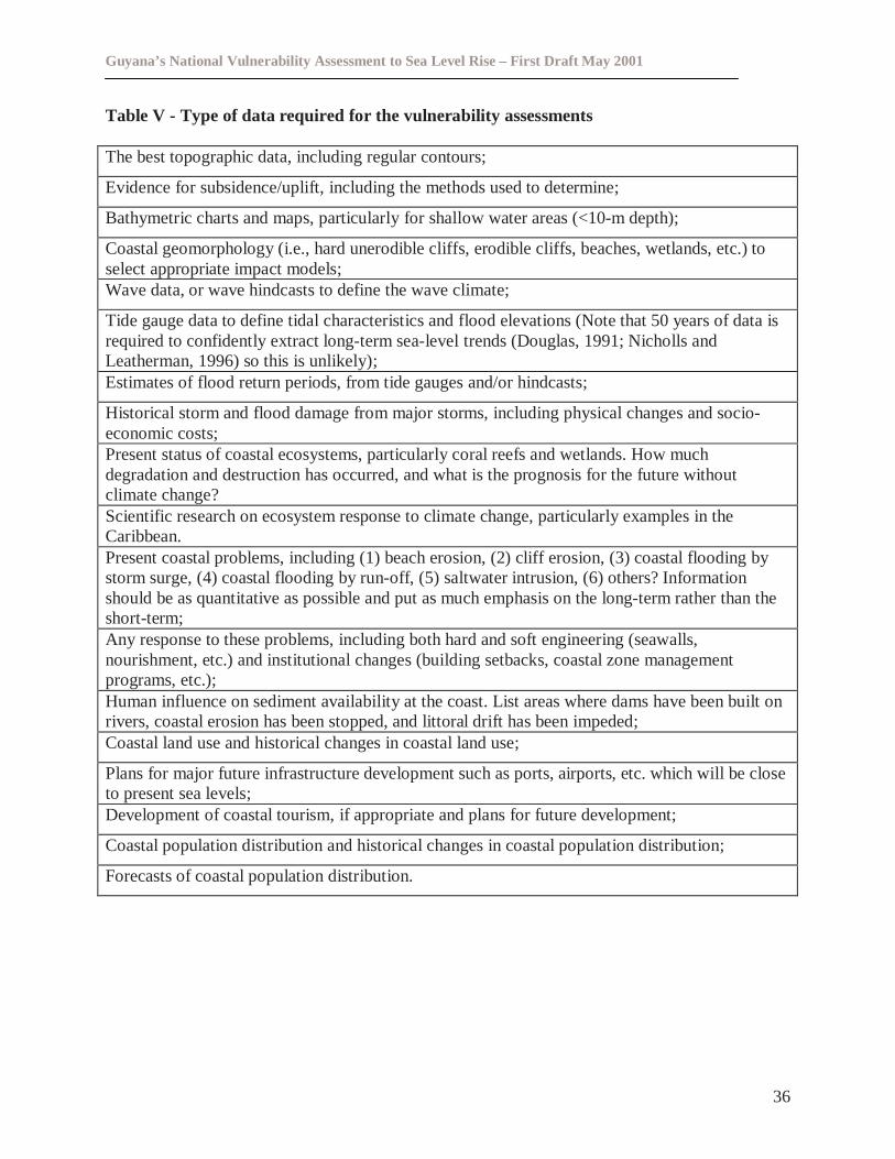
Guyana’s National Vulnerability Assessment to Sea Level Rise – First Draft May 2001
36
Table V - Type of data required for the vulnerability assessments
The best topographic data, including regular contours;
Evidence for subsidence/uplift, including the methods used to determine;
Bathymetric charts and maps, particularly for shallow water areas (<10-m depth);
Coastal geomorphology (i.e., hard unerodible cliffs, erodible cliffs, beaches, wetlands, etc.) toselect appropriate impact models;Wave data, or wave hindcasts to define the wave climate;
Tide gauge data to define tidal characteristics and flood elevations (Note that 50 years of data isrequired to confidently extract long-term sea-level trends (Douglas, 1991; Nicholls andLeatherman, 1996) so this is unlikely);Estimates of flood return periods, from tide gauges and/or hindcasts;
Historical storm and flood damage from major storms, including physical changes and socio-economic costs;Present status of coastal ecosystems, particularly coral reefs and wetlands. How muchdegradation and destruction has occurred, and what is the prognosis for the future withoutclimate change?Scientific research on ecosystem response to climate change, particularly examples in theCaribbean.Present coastal problems, including (1) beach erosion, (2) cliff erosion, (3) coastal flooding bystorm surge, (4) coastal flooding by run-off, (5) saltwater intrusion, (6) others? Informationshould be as quantitative as possible and put as much emphasis on the long-term rather than theshort-term;Any response to these problems, including both hard and soft engineering (seawalls,nourishment, etc.) and institutional changes (building setbacks, coastal zone managementprograms, etc.);Human influence on sediment availability at the coast. List areas where dams have been built onrivers, coastal erosion has been stopped, and littoral drift has been impeded;Coastal land use and historical changes in coastal land use;
Plans for major future infrastructure development such as ports, airports, etc. which will be closeto present sea levels;Development of coastal tourism, if appropriate and plans for future development;
Coastal population distribution and historical changes in coastal population distribution;
Forecasts of coastal population distribution.
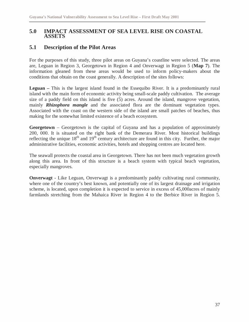
Guyana’s National Vulnerability Assessment to Sea Level Rise – First Draft May 2001
37
5.0 IMPACT ASSESSMENT OF SEA LEVEL RISE ON COASTALASSETS
5.1 Description of the Pilot Areas
For the purposes of this study, three pilot areas on Guyana’s coastline were selected. The areasare, Leguan in Region 3, Georgetown in Region 4 and Onverwagt in Region 5 (Map 7). Theinformation gleaned from these areas would be used to inform policy-makers about theconditions that obtain on the coast generally. A description of the sites follows:
Leguan – This is the largest island found in the Essequibo River. It is a predominantly ruralisland with the main form of economic activity being small-scale paddy cultivation. The averagesize of a paddy field on this island is five (5) acres. Around the island, mangrove vegetation,mainly Rhizophora mangleand the associated flora are the dominant vegetation types.Associated with the coast on the western side of the island are small patches of beaches, thusmaking for the somewhat limited existence of a beach ecosystem.
Georgetown – Georgetown is the capital of Guyana and has a population of approximately200, 000. It is situated on the right bank of the Demerara River. Most historical buildingsreflecting the unique 18th and 19th century architecture are found in this city. Further, the majoradministrative facilities, economic activities, hotels and shopping centres are located here.
The seawall protects the coastal area in Georgetown. There has not been much vegetation growthalong this area. In front of this structure is a beach system with typical beach vegetation,especially mangroves.
Onverwagt - Like Leguan, Onverwagt is a predominantly paddy cultivating rural community,where one of the country’s best known, and potentially one of its largest drainage and irrigationscheme, is located, upon completion it is expected to service in excess of 45,000acres of mainlyfarmlands stretching from the Mahaica River in Region 4 to the Berbice River in Region 5.
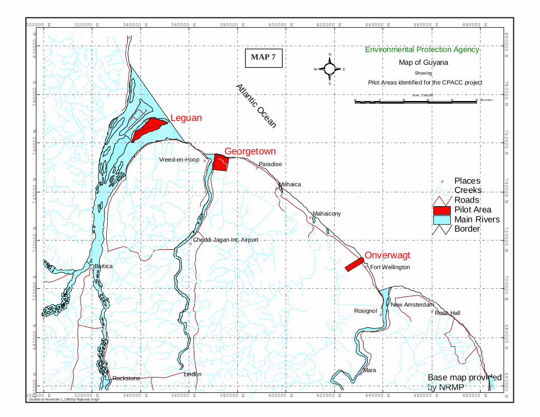
1Base map providedby NRMP
AtlanticOcean
Created on November 1, 1999 by Rajkumar Singh
S
N
EW
# #
#
#
#
#
#
#
#
#
#
#
#
#
MaraLinden
Bartica
Mahaica
Rosignol
Paradise
Rose Hall
Mahaicony
Rockstone
New Amsterdam
Vreed-en-Hoop
Fort Wellington
Cheddi Jagan Int. Airport
Georgetown
Onverwagt
Leguan
BorderMain RiversPilot AreaRoadsCreeks
# Places
300000 E
300000 E
320000 E
320000 E
340000 E
340000 E
360000 E
360000 E
380000 E
380000 E
400000 E
400000 E
420000 E
420000 E
440000 E
440000 E
460000 E
460000 E
480000 E
480000 E66
00
00
N6
60
00
0N
68
00
00
N6
80
00
0N
70
00
00
N7
000
00
N7
20
00
0N
72
00
00
N7
40
00
0N
74
00
00
N7
600
00
N7
60
00
0N
78
00
00
N78
00
00
N8
000
00
N8
00
00
0N
Showing
Map of Guyana
Environmental Protection Agency
Scale: 1:800,000
Pilot Areas identified for the CPACC project
10 0 10 20 30 40 Kilometers
MAP 7
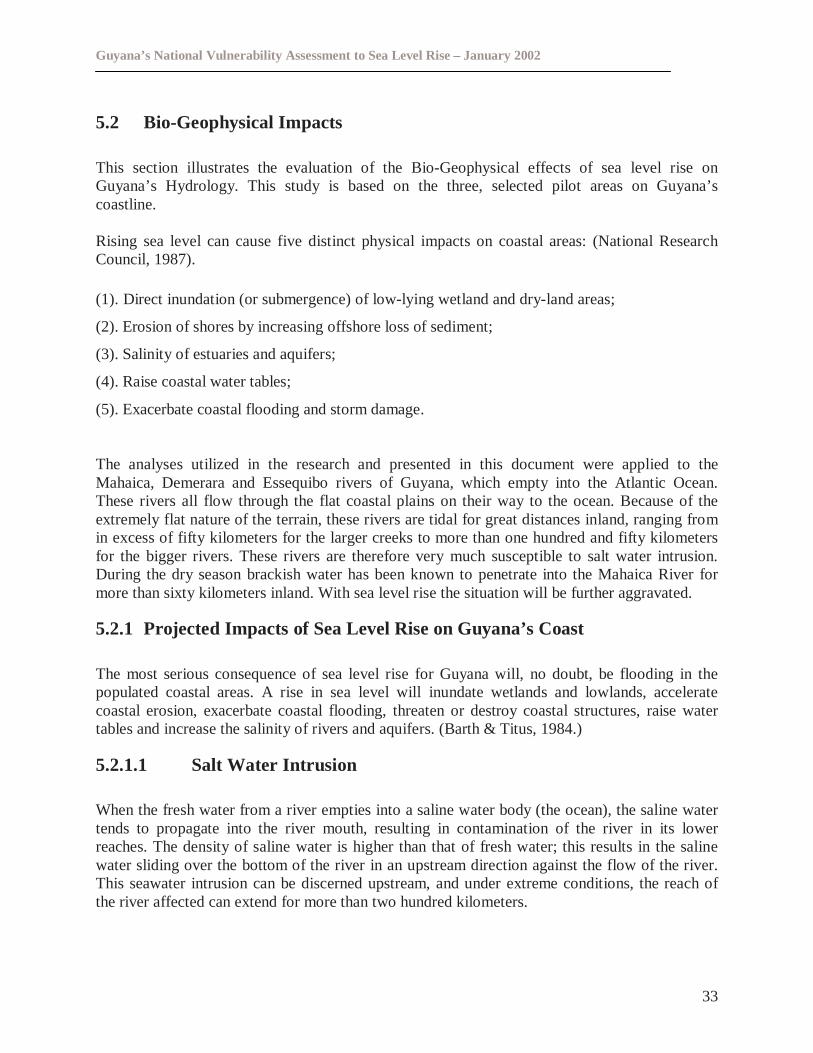
Guyana’s National Vulnerability Assessment to Sea Level Rise – January 2002
33
5.2 Bio-Geophysical Impacts
This section illustrates the evaluation of the Bio-Geophysical effects of sea level rise onGuyana’s Hydrology. This study is based on the three, selected pilot areas on Guyana’scoastline.
Rising sea level can cause five distinct physical impacts on coastal areas: (National ResearchCouncil, 1987).
(1). Direct inundation (or submergence) of low-lying wetland and dry-land areas;
(2). Erosion of shores by increasing offshore loss of sediment;
(3). Salinity of estuaries and aquifers;
(4). Raise coastal water tables;
(5). Exacerbate coastal flooding and storm damage.
The analyses utilized in the research and presented in this document were applied to theMahaica, Demerara and Essequibo rivers of Guyana, which empty into the Atlantic Ocean.These rivers all flow through the flat coastal plains on their way to the ocean. Because of theextremely flat nature of the terrain, these rivers are tidal for great distances inland, ranging fromin excess of fifty kilometers for the larger creeks to more than one hundred and fifty kilometersfor the bigger rivers. These rivers are therefore very much susceptible to salt water intrusion.During the dry season brackish water has been known to penetrate into the Mahaica River formore than sixty kilometers inland. With sea level rise the situation will be further aggravated.
5.2.1 Projected Impacts of Sea Level Rise on Guyana’s Coast
The most serious consequence of sea level rise for Guyana will, no doubt, be flooding in thepopulated coastal areas. A rise in sea level will inundate wetlands and lowlands, acceleratecoastal erosion, exacerbate coastal flooding, threaten or destroy coastal structures, raise watertables and increase the salinity of rivers and aquifers. (Barth & Titus, 1984.)
5.2.1.1 Salt Water Intrusion
When the fresh water from a river empties into a saline water body (the ocean), the saline watertends to propagate into the river mouth, resulting in contamination of the river in its lowerreaches. The density of saline water is higher than that of fresh water; this results in the salinewater sliding over the bottom of the river in an upstream direction against the flow of the river.This seawater intrusion can be discerned upstream, and under extreme conditions, the reach ofthe river affected can extend for more than two hundred kilometers.
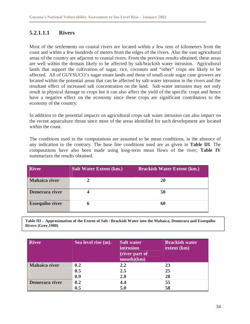
Guyana’s National Vulnerability Assessment to Sea Level Rise – January 2002
34
5.2.1.1.1 Rivers
Most of the settlements on coastal rivers are located within a few tens of kilometers from thecoast and within a few hundreds of meters from the edges of the rivers. Also the vast agriculturalareas of the country are adjacent to coastal rivers. From the previous results obtained, these areasare well within the domain likely to be affected by salt/brackish water intrusion. Agriculturallands that support the cultivation of sugar, rice, coconuts and “other” crops are likely to beaffected. All of GUYSUCO’s sugar estate lands and those of small-scale sugar cane growers arelocated within the potential areas that can be affected by salt-water intrusion in the rivers and theresultant effect of increased salt concentration on the land. Salt-water intrusion may not onlyresult in physical damage to crops but it can also affect the yield of the specific crops and hencehave a negative effect on the economy since these crops are significant contributors to theeconomy of the country.
In addition to the potential impacts on agricultural crops salt water intrusion can also impact onthe recent aquaculture thrust since most of the areas identified for such development are locatedwithin the coast.
The conditions used in the computations are assumed to be mean conditions, in the absence ofany indication to the contrary. The base line conditions used are as given inTable III . Thecomputations have also been made using long-term mean flows of the river;Table IVsummarizes the results obtained.
River Salt Water Extent (km.) Brackish Water Extent (km.)
Mahaica river 2 20
Demerara river 4 50
Essequibo river 6 60
River Sea level rise (m). Salt waterintrusion(river part ofmouth)(km)
Brackish waterextent (km)
Mahaica river 0.2 2.2 230.5 2.5 250.9 2.8 28
Demerara river 0.2 4.4 550.5 5.0 58
Table III – Approximation of the Extent of Salt / Brackish Water into the Mahaica, Demerara and EssequiboRivers (Geer,1980)
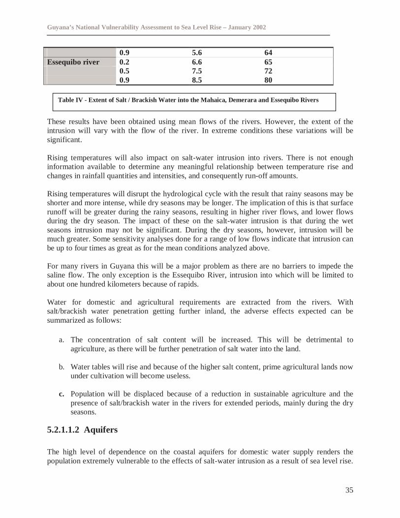
Guyana’s National Vulnerability Assessment to Sea Level Rise – January 2002
35
0.9 5.6 64Essequibo river 0.2 6.6 65
0.5 7.5 720.9 8.5 80
These results have been obtained using mean flows of the rivers. However, the extent of theintrusion will vary with the flow of the river. In extreme conditions these variations will besignificant.
Rising temperatures will also impact on salt-water intrusion into rivers. There is not enoughinformation available to determine any meaningful relationship between temperature rise andchanges in rainfall quantities and intensities, and consequently run-off amounts.
Rising temperatures will disrupt the hydrological cycle with the result that rainy seasons may beshorter and more intense, while dry seasons may be longer. The implication of this is that surfacerunoff will be greater during the rainy seasons, resulting in higher river flows, and lower flowsduring the dry season. The impact of these on the salt-water intrusion is that during the wetseasons intrusion may not be significant. During the dry seasons, however, intrusion will bemuch greater. Some sensitivity analyses done for a range of low flows indicate that intrusion canbe up to four times as great as for the mean conditions analyzed above.
For many rivers in Guyana this will be a major problem as there are no barriers to impede thesaline flow. The only exception is the Essequibo River, intrusion into which will be limited toabout one hundred kilometers because of rapids.
Water for domestic and agricultural requirements are extracted from the rivers. Withsalt/brackish water penetration getting further inland, the adverse effects expected can besummarized as follows:
a. The concentration of salt content will be increased. This will be detrimental toagriculture, as there will be further penetration of salt water into the land.
b. Water tables will rise and because of the higher salt content, prime agricultural lands nowunder cultivation will become useless.
c. Population will be displaced because of a reduction in sustainable agriculture and thepresence of salt/brackish water in the rivers for extended periods, mainly during the dryseasons.
5.2.1.1.2 Aquifers
The high level of dependence on the coastal aquifers for domestic water supply renders thepopulation extremely vulnerable to the effects of salt-water intrusion as a result of sea level rise.
Table IV - Extent of Salt / Brackish Water into the Mahaica, Demerara and Essequibo Rivers
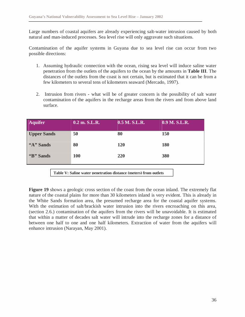
Guyana’s National Vulnerability Assessment to Sea Level Rise – January 2002
36
Large numbers of coastal aquifers are already experiencing salt-water intrusion caused by bothnatural and man-induced processes. Sea level rise will only aggravate such situations.
Contamination of the aquifer systems in Guyana due to sea level rise can occur from twopossible directions:
1. Assuming hydraulic connection with the ocean, rising sea level will induce saline waterpenetration from the outlets of the aquifers to the ocean by the amounts inTable III . Thedistances of the outlets from the coast is not certain, but is estimated that it can be from afew kilometers to several tens of kilometers seaward (Mercado, 1997).
2. Intrusion from rivers - what will be of greater concern is the possibility of salt watercontamination of the aquifers in the recharge areas from the rivers and from above landsurface.
Aquifer 0.2 m. S.L.R. 0.5 M. S.L.R. 0.9 M. S.L.R.
Upper Sands 50 80 150
“A” Sands 80 120 180
“B” Sands 100 220 380
Figure 19 shows a geologic cross section of the coast from the ocean inland. The extremely flatnature of the coastal plains for more than 30 kilometers inland is very evident. This is already inthe White Sands formation area, the presumed recharge area for the coastal aquifer systems.With the estimation of salt/brackish water intrusion into the rivers encroaching on this area,(section 2.6.) contamination of the aquifers from the rivers will be unavoidable. It is estimatedthat within a matter of decades salt water will intrude into the recharge zones for a distance ofbetween one half to one and one half kilometers. Extraction of water from the aquifers willenhance intrusion (Narayan, May 2001).
Table V: Saline waterpenetration distance(meters) from outlets
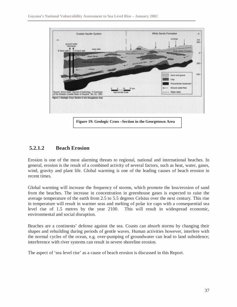
Guyana’s National Vulnerability Assessment to Sea Level Rise – January 2002
37
5.2.1.2 Beach Erosion
Erosion is one of the most alarming threats to regional, national and international beaches. Ingeneral, erosion is the result of a combined activity of several factors, such as heat, water, gases,wind, gravity and plant life. Global warming is one of the leading causes of beach erosion inrecent times.
Global warming will increase the frequency of storms, which promote the loss/erosion of sandfrom the beaches. The increase in concentration in greenhouse gases is expected to raise theaverage temperature of the earth from 2.5 to 5.5 degrees Celsius over the next century. This risein temperature will result in warmer seas and melting of polar ice caps with a consequential sealevel rise of 1.5 metres by the year 2100. This will result in widespread economic,environmental and social disruption.
Beaches are a continents’ defense against the sea. Coasts can absorb storms by changing theirshapes and rebuilding during periods of gentle waves. Human activities however, interfere withthe normal cycles of the ocean, e.g. over-pumping of groundwater can lead to land subsidence;interference with river systems can result in severe shoreline erosion.
The aspect of ‘sea level rise’ as a cause of beach erosion is discussed in this Report.
Figure 19: Geologic Cross –Section in the Georgetown Area
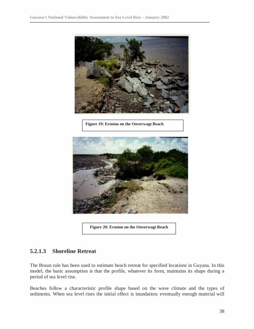
Guyana’s National Vulnerability Assessment to Sea Level Rise – January 2002
38
5.2.1.3 Shoreline Retreat
The Bruun rule has been used to estimate beach retreat for specified locations in Guyana. In thismodel, the basic assumption is that the profile, whatever its form, maintains its shape during aperiod of sea level rise.
Beaches follow a characteristic profile shape based on the wave climate and the types ofsediments. When sea level rises the initial effect is inundation; eventually enough material will
Figure 19: Erosion on the Onverwagt Beach
Figure 20: Erosion on the Onverwagt Beach
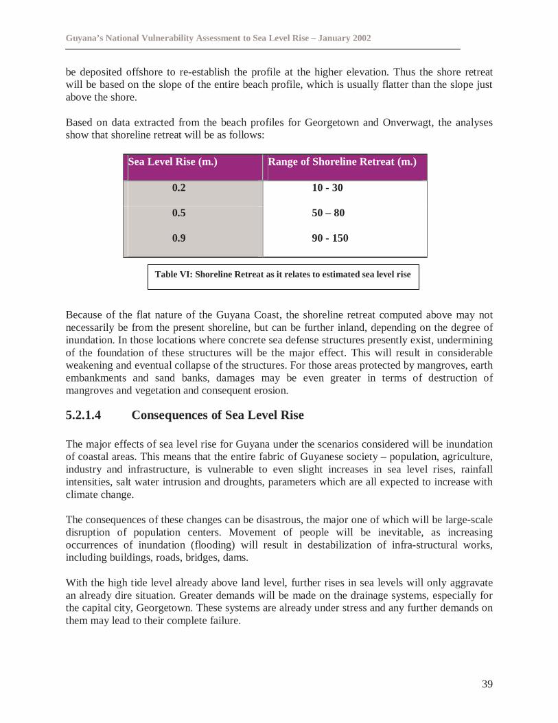
Guyana’s National Vulnerability Assessment to Sea Level Rise – January 2002
39
be deposited offshore to re-establish the profile at the higher elevation. Thus the shore retreatwill be based on the slope of the entire beach profile, which is usually flatter than the slope justabove the shore.
Based on data extracted from the beach profiles for Georgetown and Onverwagt, the analysesshow that shoreline retreat will be as follows:
Sea Level Rise (m.) Range of Shoreline Retreat (m.)
0.2 10 - 30
0.5 50 – 80
0.9 90 - 150
Because of the flat nature of the Guyana Coast, the shoreline retreat computed above may notnecessarily be from the present shoreline, but can be further inland, depending on the degree ofinundation. In those locations where concrete sea defense structures presently exist, underminingof the foundation of these structures will be the major effect. This will result in considerableweakening and eventual collapse of the structures. For those areas protected by mangroves, earthembankments and sand banks, damages may be even greater in terms of destruction ofmangroves and vegetation and consequent erosion.
5.2.1.4 Consequences of Sea Level Rise
The major effects of sea level rise for Guyana under the scenarios considered will be inundationof coastal areas. This means that the entire fabric of Guyanese society – population, agriculture,industry and infrastructure, is vulnerable to even slight increases in sea level rises, rainfallintensities, salt water intrusion and droughts, parameters which are all expected to increase withclimate change.
The consequences of these changes can be disastrous, the major one of which will be large-scaledisruption of population centers. Movement of people will be inevitable, as increasingoccurrences of inundation (flooding) will result in destabilization of infra-structural works,including buildings, roads, bridges, dams.
With the high tide level already above land level, further rises in sea levels will only aggravatean already dire situation. Greater demands will be made on the drainage systems, especially forthe capital city, Georgetown. These systems are already under stress and any further demands onthem may lead to their complete failure.
Table VI: Shoreline Retreat as it relates to estimated sea level rise
Guyana’s National Vulnerability Assessment to Sea Level Rise – January 2002
40
Floodwaters will remain stagnant for longer periods over land, which will increase the possibilityof the spread of diseases. Agriculture will suffer irreversible damages because of salt-waterintrusion, both over-land and underground. Some ecosystems may disappear.
It is perceived therefore, that adaptation measures, where they are “fitted in” as part of ongoingprojects, may not be enough. A more aggressive approach to combat the onslaught of climatechange and sea level rise will be necessary if the catastrophic consequences of these phenomenaare to be avoided.
Much of this aggressive approach will depend on policy makers, their willingness to understandand appreciate the seriousness of the problems associated with sea level rise and theircommitment to seriously address the issues. Currently some efforts are ongoing and includeinstallation and operation of drainage and irrigation pumps. Consideration should be given to theundertaking of economic assessments and the determination of the cost of proposed adaptationoptions. Research possibilities into salt resistant/tolerant crops should also be pursued.
5.3 Socio Economic Impacts
In an effort to illustrate the potential socioeconomic impacts that could result from thebiophysical impacts of sea level rise, three pilot areas were examined. The three areas are uniquein their own ways and show how people, goods and services will be displaced by sea level rise.The discussion below is based on information obtained from the survey of the three pilot sites.
5.3.1 Georgetown
Georgetown, the capital of Guyana is situated on the Eastern right bank of the Demerara River.Over ninety percent (90%) of land in Georgetown is used for residential purposes, while the restis used for institutional/administrative, social and commercial purposes, state owned enterprises,private businesses and security entities.
Georgetown has a population of approximately 200,000. The median monthly household incomewas $25,500 (US $ 141.67). The Socioeconomic Survey (conducted between February - March2000), revealed that ninety-seven percent (97%) of the respondents in the city had attained atleast primary education and 54 percent secondary education. This high educational attainmentmay be correlated with the greater prevalence of institutions of higher learning in and aroundGeorgetown6.
It would appear therefore that sea level rise is likely to affect entire households, more so theworking age. If this becomes a reality, it may provide the impetus for development projects to beundertaken further inland and or may result in greater migrants out of Guyana.7
6 Final Report on A Socio-Economic Assessment of the Vulnerability of Guyana’s Coast to Sea Level Rise’Paulette Bynoe and Mark Bynoe, 20007 Final Report on A Socio-Economic Assessment of the Vulnerability of Guyana’s Coast to Sea Level Rise’Paulette Bynoe and mark Bynoe, 2000
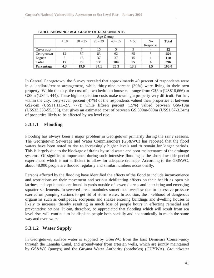
Guyana’s National Vulnerability Assessment to Sea Level Rise – January 2002
41
TABLE SHOWING: AGE GROUP OF RESPONDENTSAge Group
< 18 18 – 25 26 - 39 40 - 55 > 55 NoResponse
Total
Onverwagt - 7 15 5 5 - 32Georgetown 12 57 83 62 35 5 254Leguan 5 15 37 37 15 1 110Total 17 79 135 104 55 6 396Percentage 4.3 19.9 34.1 26.3 13.9 1.5 100.0
In Central Georgetown, the Survey revealed that approximately 40 percent of respondents werein a landlord/tenant arrangement, while thirty-nine percent (39%) were living in their ownproperty. Within the city, the cost of a two bedroom house can range from G$3m (US$16,666) toG$8m (US44, 444). These high acquisition costs make owning a property very difficult. Further,within the city, forty-seven percent (47%) of the respondents valued their properties at betweenG$2-5m (US$11,111–27, 777); while fifteen percent (15%) valued between G$6-10m(US$33,333-55,555), that gives an estimated cost of between G$ 300m-600m (US$1.67-3.34m)of properties likely to be affected by sea level rise.
5.3.1.1 Flooding
Flooding has always been a major problem in Georgetown primarily during the rainy seasons.The Georgetown Sewerage and Water Commissioners (GS&WC) has reported that the floodwaters have been noted to rise to increasingly higher levels and to remain for longer periods.This is largely due to the blockage of drains by solid waste and poor maintenance of the drainagesystems. Of significant importance during such intensive flooding is the short low tide periodexperienced which is not sufficient to allow for adequate drainage. According to the GS&WC,about 48,000 people are flooded regularly and similar numbers occasionally.
Persons affected by the flooding have identified the effects of the flood to include inconvenienceand restrictions on their movement and serious debilitating effects on their health as open pitlatrines and septic tanks are found in yards outside of sewered areas and in existing and emergingsquatter settlements. In sewered areas manholes sometimes overflow due to excessive pressureexerted on pumping stations to get rid of storm water. In addition, the likelihood of dangerousorganisms such as centipedes, scorpions and snakes entering buildings and dwelling houses islikely to increase, thereby resulting in much loss of people hours in effecting remedial andpreventative actions. It can, therefore, be appreciated that flooding which will result from sealevel rise, will continue to be displace people both socially and economically in much the sameway and even worse.
5.3.1.2 Water Supply
In Georgetown, surface water is supplied by GS&WC from the East Demerara Conservancythrough the Lamaha Canal, and groundwater from artesian wells, which are jointly maintainedby GS&WC (pumps) and the Guyana Water Authority (boreholes) (GUYWA). Groundwater
Guyana’s National Vulnerability Assessment to Sea Level Rise – January 2002
42
supplies approximately fifty percent (50%) of public demand (domestic and commercial) inGeorgetown.
A 0.2m rise in sea level is likely to affect the quality of the conservancy water, which is thesource of twenty-four percent (24%) of the drinking water in Georgetown. This is because thewater level of Mahaica and Demerara rivers will rise and may enter the conservancy via leakagethrough the sluices at Land of Canaan, Lama and Maduni.
This would result in greater demand for groundwater from the aquifers and there is a possibilitythat these aquifers may also be infiltrated by seawater, thereby putting the entire population ofGeorgetown at risk from contaminated drinking water and associated diseases.
5.3.1.3 The Sewerage System
In Georgetown (Central), there are twenty-four (24) sewerage basins each assigned to a specificpumping station. Built between 1924 and 1929 there has been little or no maintenance worksresulting in them being in a poor condition. To assist the greater Georgetown area the TucvilleSewerage Works was built in 1969 to serve a population of 3,500, which has since increased.This sewerage system has seen its share of operational problems. This coupled with the threatsposed by septic tanks and pit latrines most of which are not properly maintained will pose aserious health hazard in the event of flooding caused by sea level rise under all three sea levelrise scenarios since many effluent drains are currently blocked with solid waste and are alsobroken in many areas.
Moreover, if there is saturation of the groundwater as a result of sea level rise the effectivenessof gravity drainage systems could be severely limited thereby making mechanical pumpingnecessary.
To date rehabilitative works have been done on all twenty-four sewerage stations under the‘Remedial Maintenance Programme’ (1995–2001) with the aim of ensuring that efficiency ismaintained. A special device to reduce the size of solids that may become trapped in the systemhas been installed to allow for free flow to the outfall. Plans are also on stream to modify theTucville Sewerage Works to improve its functioning.
Drainage trenches in Georgetown receive liquids from various sources including rainfall, stormwater runoff, effluent from septic tanks, household waste water, raw sewage from several failedemergency overflows, from sewerage systems and pit latrines, untreated industrial effluent andleakage from potable water system. They may pose a serious health hazard to those who swim,fish, and collect aquatic flowers and snails in these waters. Under sea level rise scenarios thehazard will increase.
5.3.1.4 Infrastructure Displacement
Institutional and administrative buildings located in Georgetown will be affected along with therespective sectors. These include Government Offices, Police Stations, Guyana Defence Force,
Guyana’s National Vulnerability Assessment to Sea Level Rise – January 2002
43
Regional and International Agencies, Organisations, Schools, places of worship and theGeorgetown Prisons, among others.
Similarly, utility services will be affected. These include hospitals, post offices, funeral parlours,commercial banks and financial companies.
Areas in which there is multiple land use e.g. warehouses, cottage industries, retail shops,restaurants, cinema, light manufacturing, agro processing industries, auto repair shops andwelding shops will be affected. Recreation grounds will also be affected these include theNational Park, Botanical Gardens, Zoo and Promenade Gardens among others. These areas willbe under threat from 0.2 m sea level rise due to inundation. This will result in damage to propertyworth billions of dollars.
The impacts on infrastructure can be addressed through the adaptation options that will beconsidered.
5.3.2 Awareness Of Sea Level Rise And Possibility Of Re-locating
In an effort to address the potential threat of sea level rise; it is useful to examine the level ofawareness among residents about this phenomenon. From the Survey conducted by Bynoe andBynoe, 2000 it was found that of the survey population, approximately fifty percent (50 %) ofthe respondents were aware of the issue of sea level rise.
The Survey revealed that seventy percent (70%) of the persons said that they were not preparedto relocate, while fifteen percent (15%) said they would if given government assistance to so.This reluctance seems to be rooted in the fact that persons may have grown comfortable with theamenities found in the city, many of which may have acted as pull factors for them in the firstinstance, and so are reluctant to sacrifice these or wait until they are developed someplace else.Of those willing to relocate, sixty-seven percent (67%) are prepared to move to greater than5km* inland. Additionally, for them to move seventy-nine percent (79%) identified the need forphysical infrastructure.
The Survey examined the willingness of business firms in Georgetown including state ownedenterprises, public corporations, joint venture, private and others to relocate. According to theSurvey, approximately forty-four percent (44 %) felt that there was no reason to move/no placeto go, or that they were not losing much in monetary terms currently. This seems to support thepoint made earlier that while flooding may have affected productivity, it only did so marginallyas costs associated with flooding are relatively small. Other reasons cited for not wanting tomove included ownership or attachment to land, economic costs incurred by relocating andsocial conditions of place of relocation.
*As Map 7 indicates, there will be the need to move more than 5km inland to avoid the impactsof sea level rise.
Guyana’s National Vulnerability Assessment to Sea Level Rise – January 2002
44
5.3.3 Leguan
Leguan is the largest island in the Essequibo River, with an area of 28.8 km2. The island is flatand low-lying with a coastline of 38km. It has a population of approximately 6,500. The maineconomic activity of the island is agriculture with rice, vegetables and ground provision beingthe main crops cultivated. Private persons own approximately ninety-seven percent (97%) of theland (Pie chart No. 1).
Physical infrastructure on the island includesindustrial structures i.e. stelling, rice mills, andhardware stores; commercial structures i.e.including district council, regionaladministrative building, police station, postoffice, community center, schools and healthstructure, religious buildings, roads, electricitysupply and water supply and revetmentstructures ie. Sea Defences.
The total value of common property including commercial and industrial facilities, roads, burialgrounds, electricity supply, water supply, telephone, medical services and community buildingswas G $ 1,053m. The value of household property was $493m including houses, kitchen gardensand farmlands and animals8.
5.3.3.1 Flooding
The Socioeconomic Survey of the Vulnerability of Guyana’s Coast to Sea Level Rise revealedthat ninety-one percent (91%) of the respondents indicated that floods usually affect themadversely9. These floods are largely as a result of poor drainage, heavy rainfall, breaches in thesea defence and overtopping. According to the Survey, sixty-seven percent (67%) of therespondents said that the major concentration of these floods tend to be 1 mile inland. Thepercentage distribution of losses is shown inPie chart No. 2 below. Major setbacks due to thefloods would include loss of income and inconvenience caused. This relatively high percentageof those whose incomes are affected is quite plausible when notice is taken of the fact thatagriculture remains the main economic activity of the island.
8 Feasibility Study by IDB/SwedePlan, 19949 Final Report on A Socio-Economic Assessment of the Vulnerability of Guyana’s Coast to Sea Level Rise’Paulette Bynoe and Mark Bynoe, 2000
Piechart No. 1: illustrating LandTenure
Freehold owneroccupied
Governmentleased
State owned
Private leased
Squatting
Guyana’s National Vulnerability Assessment to Sea Level Rise – January 2002
45
Other social indicators thatidentified how residents arelikely to be affected by sealevel rise came fromlooking at the facilities theycurrently use.
Eighty-five percent (85%) of respondents obtained their freshwater supply from piped watermainly from artesian wells, while eighty-eight percent (88%) use open pit latrines and elevenpercent (11%) have constructed their own septic tanks to dispose of human excrement. Further,seventy-seven percent (77%) burn their garbage while fifteen percent (15%) disposed of them bydumping in the waterways. Therefore the health problems that could result from sea level risewith this current practice has the potential to be very significant.
5.3.4 Awareness Of Sea Level Rise And Possibility Of Relocation
In Leguan, fifty-two percent (52%) of respondents indicated that they have heard about sea levelrise, and eighty-eight percent (88%) thought that it was either very important or importantenough to warrant discussion and plans to deal with it. Of this, eighty-eight percent (88%),seventy-one percent (71%) felt that the main issues to be considered relating to sea level risewould be land denudation; translation into loss of earnings, while eight percent (8%) alluded tothe possibility of direst loss of income.
Pie Chart No. 2: Percentage Distribution Of Losses In The PastKitchen Garden
Rice Production
Cash Crops
Animals
ResidentialBuildings
Farmland
Pie Chart No. 3: Facilities presentlyused
85%
88%
11%
77%
15%
Water Supply
Sewage Disposal- Pit Latrines
Sewage Disposal- Septic Tanks
GarbageDisposal -Burning
Garbage
Guyana’s National Vulnerability Assessment to Sea Level Rise – January 2002
46
Sixty-one percent (61%) of persons said that they would be willing to relocate, while thirty-fivepercent (35%) said that they had no desire to leave. Of those who indicated their willingness tobe relocated, fifty-seven percent (57%) alluded to the need for land titles as the main pull factorfor them to relocate. Further thirty-seven percent (37%) of these respondents were willing torelocate to areas greater than 5km inland. This could possibly be reflected in the fact that theyrequire some stability in their lives and would prefer to move only once.
Unfortunately, Leguan is a flat island and therefore moving further inland will not resolve theimpacts of sea level rise. The best possible option for relocation would be off the island.
5.3.5 Onverwagt
Onverwagt is a housing scheme located in the West Coast of the Berbice River. There areapproximately eighty (80) houses, offices, a sports club and playground. The main economicactivities in Onverwagt are rice cultivation, cattle and livestock production. The total land areafor rice cultivation and cattle production is approximately 5,000 acres. The area is an importantcontributor to the national economy through rice production. The foreign exchange earning from5000 acres of rice cultivation is approximately half a million US dollars.10
Almost everyone have his or her own property in Onverwagt. Most of the property could bevalued at G$ 2m (US $ 11, 111) giving an estimated economic value of properties at G $ 32-50m(US $17,777-22,777) (Bynoe and Bynoe, 2000)
5.3.5.1 Flooding
Eight one percent (81 %) of the respondents in the Survey indicated that floods affected themfairly often, with floodwaters usually less than an estimated one foot high and one mile inland.fifty percent (50%) of the respondents felt that the floods were as a result of poor drainage andinsufficient maintenance of the drainage canals, twenty-eight percent (28%) felt that the genesisof the problem lie with the Mahaica-Mahaicony-Abary Agricultural Development Authority(MMA-ADA) not having enough financial resources to carry out their tasks. The major effect ofthese floods were said to be loss of income and restriction of movement.
Eighty-four percent (84%) of the respondents obtained their freshwater supply from piped waterthrough artesian wells while forty-four percent (44%) used open pit latrines and fifty-threepercent (53%) have constructed their own septic tanks to dispose of their human excrement.Therefore the health problems that could result from sea level rise with this current practice isvery grave.
It is clear that sea level rise is likely to result in agricultural lands becoming inundated bysaltwater, thereby affecting the national economy. Freshwater supplies are also likely to becomecontaminated from saline intrusion and sewage.
10 Data collected by Gobind Rameshwar, December1999.
Guyana’s National Vulnerability Assessment to Sea Level Rise – January 2002
47
5.3.6 Awareness Of Sea Level Rise And Possibility Of Relocation
Within Onverwagt, fifty-nine percent (59%) of the respondents had heard about sea level risewhile forty-one percent (41%) had not. Person’s felt that the major threat that sea level rise posedwas preventing drainage of water from the land. Since most of the excess water in Guyana isdrained into the Atlantic Ocean via gravity flow, they felt this process would be compromised.Persons felt that to assuage the threat of sea level rise, it is important that communities maintainthe drainage system and improve the sea defence structures. Additionally other persons felt thatfor the problem to be addressed, the government needs to make greater financial allocation to therespective bodies.
In terms of relocating, seventy-eight percent (78%) of the respondents indicated theirunwillingness to do so, while twenty percent (20%) said that they would be willing to. Thisreluctance could be based on the attachment persons feel to where they were currently living. Ofthose who expressed their willingness to be relocated, seventy-two percent (72%) identified thatfor them to move, the necessary infrastructure must first be in place.
5.4 Adequacy Of Legal Framework To Cope With Sea Level Rise
The assessment of existing environmental land use and building laws indicate that whilegenerally, statutory powers are established in existing legislation to respond to the potential orlikely effects of sea level rise, there are some gaps and weaknesses that need to be addressed inorder to make them useful to lessen the biophysical and socioeconomic impacts of sea levelrise.11
Although there are in excess of thirty (30) pieces of environmental, land use and buildinglegislation only a limited number of Acts are relevant to the type of impacts that will result fromsea level rise in Guyana. The legislative framework is generally too outdated to offer anysignificant influence. This is reflected vividly in the adequacy of fines and penalties, legislation,the lack of coordination among agencies, inadequate institutional arrangements, the absence ofmodern day principles such as the precautionary principle and reliance upon alternativeenforcement and compliance methods. More importantly, the legislative process has not keptpace by passing the required implementing legislation. Further, in isolated circumstances whereregulations were made, they have become too rigid and inflexible and their application to theissues presented by sea level rise and climate change.
5.4.1 Gaps and Weaknesses
The legislative regime presents a fragmented regulatory framework in which the coastal zone ismanaged in a piecemeal fashion in response to specific problems.
11 An Assessment Of The Adequacy Of The Legal Framework To Cope With The Potential Effects Of Sea LevelRise In Guyana, Judy Daniel – Julien, 2000
Guyana’s National Vulnerability Assessment to Sea Level Rise – January 2002
48
The major gaps and weaknesses are identified as follows:
� Absence of guidelines and standards to prevent inundation as it pertains to developmentactivities including mining, forestry and agriculture;
� Absence of emergency preparedness plan and a legal institutional framework for disastermanagement;
� Planning legislation needs to be strengthened to include the establishment of building codesand design and construction standards. At the institutional level the relationship with otherrelevant agencies such as Ministry of Housing and Water, District and Municipal Councilsand Public Health needs to be strengthened to promote enforcement efforts and avoidduplication of effort; Squatter settlements and housing schemes should be consideredseparately.
� Drainage and irrigation legislation pertaining to navigation and the protection of waterresources should be strengthened to include provisions that have the potential to causepollution; salinization and flooding;
� Harmonization of legislation to avoid overlap and duplication of the functions is lackingthroughout the legislative instruments that impact on climate change.
5.4.2 Establishment of an Adequate Legal Framework for Sea level Rise
The assessment of the legislation identified the need to strengthen the legislative framework toaddress the impacts of sea level rise in Guyana. This should address the issues of land titles andcompensation for losses in the event of relocation due to sea level rise.
As such, an appropriate national policy, strategy, management plan and programme foraddressing the impacts of climate change in Guyana, should be developed, implemented andenforced. An adequate institutional arrangement among relevant agencies and authorities shouldalso be established.
This approach is recommended since duties in relation to inundation, erosion and salinisation aredivided among civil service-based institutions and statutorily independent authorities and alegislative response could prove too difficult to implement. Such a comprehensive policy willensure that consistent approaches are adopted with regard to such issues as location of criticalservices, types of development, application of planning regimes to the land-water interface,including areas seaward of the high-water mark standards and conditions that are permissible,taking into account the impacts of sea level rise.
5.5 Economic Importance
It is clear that the coastal zone where most of the population and economic activities are locatedwould be most vulnerable to the impacts of sea level rise. One of the major likely impacts of sea
Guyana’s National Vulnerability Assessment to Sea Level Rise – January 2002
49
level rise in the coastal zone of Guyana would be the loss of coastal wetlands that serve asprotective barrier to the inland coastal area.
Based on current estimates used by the Sea and River Defence Division, the cost of sea defencesconstruction and maintenance in Guyana is approximately $3.5 x 10⁶ US per km. A more rapidrise in sea level would increase the costs of shore protection. In the short term therefore there isthe need for anticipatory adaptation action in response to rising sea levels in Guyana.
Where communities are likely to adapt to erosion, anticipation can be important. The cost andfeasibility of moving a house back depend on design decisions made when the house is built. Thewillingness of people to abandon properties depends in part on whether they bought land on theassumption that it would eventually erode away or had assumed that the government wouldprotect it indefinitely. Less anticipation is necessary if the shore will be protected. Nevertheless,some advanced planning may be necessary for communities to know whether retreat ordefending the shore would be most cost-effective. In addition it may be necessary to alsoconsider the value of the benefits which would accrue from having coastal lands in an effort todetermine the most appropriate adaptation option.
Guyana’s National Vulnerability Assessment to Sea Level Rise – January 2002
50
6.0 ADAPTATION OPTIONS PROGRAMME
While a likely sea level rise could have significant impacts on Guyana’s low lying coastline, themagnitude of such potential impacts may be lessened if adequate planning for this phenomenonis done. One of the outputs of CPACC’s vulnerability assessment is the recommendation of themost suitable adaptation strategy for sea level rise. Adaptation can be either Autonomous orPlanned.
Autonomous Adaptation
Autonomous adjustments are biogeophysical or socio-economic adaptive responses that willhappen spontaneously without any decision being made by policy makers.
Planned Adaptation
Planned Adaptation to sea-level rise is normally expressed as three possible technical options:
1) Retreat (Planned), e.g. Building setbacks2) Accommodation, e.g. Raise buildings on pilings above flood levels3) Protection, e.g. protect areas with sea walls, or nourish beaches
Adaptation can also be anticipatory (proactive), or reactive. According to Klein and Nicholls(1997), most adaptation options would need planning, and planned retreat and accommodationwould be most cost effective if implemented in an anticipatory manner, while protection can beboth reactive and anticipatory.
The cost and feasibility of different responses to the impacts identified should be evaluated. Forinstance, In Guyana, reducing the magnitude of anthropogenically-induced subsidence could bean important part of a response to sea level rise.
6.1 Response Strategies
Several options in planning for sea level rise exist. In addition to doing nothing, three distinctresponse strategies to sea level rise have been identified (IPCC CZMS, 1990). These include:
1. (Managed) Retreat2. Accommodation3. Protection
6.1.1 Retreat
The first strategy involves progressively giving up threatened land by strategic retreat from thecoast or prevention of future major developments in those areas that may be impacted by sealevel rise.
Guyana’s National Vulnerability Assessment to Sea Level Rise – January 2002
51
6.1.2 Accommodation
The second involves continued but altered usage of the land, including adaptive responses suchas elevation of buildings above flood levels e.g. building on stilts, modification of drainagesystems and land use changes.
6.1.3 Protection
The third strategy involves defensive measures and seeks to maintain shorelines in their presentprotection by either building or strengthening protective structures or by artificially nourishing ormaintaining beaches and dunes. It includes strengthening and possibly heightening sea defensestructures.
6.1.4 Discussion
The first two strategies are based on the premise that increases in land loss and coastal floodingwill be allowed to occur and that some coastal functions and values will change and be lost. Onthe other hand these strategies help to maintain the dynamic nature of coastal ecosystems andthus allow them to adapt naturally. It basically is a more environmentally friendly option.
The third strategy, which has been widely applied in industrialized countries to protect humansettlement and productive land against existing coastal hazards, such as storm surges, ofteninvolves the loss of natural functions and values including natural resilience and resistance.
Therefore, the selection of appropriate adaptation options involves important trade offs, whichneed to be evaluated carefully.
Clearly, the optimal option or mix of options for a given coastal zone strongly depends on thelocal biogeophysical and socio-economic circumstances within a specific location (i.e the socialand economic importance of coastal assets and activities) including the anticipated effects of sealevel rise.
The range of evaluation techniques exists to assist us to decide which option (s) are best toimplement. The most important of them include cost benefits analysis, cost effectiveness analysisand multi criteria analysis.
A likely sea level rise is a very real phenomenon that could have dire consequences for our entirecoastline if proper planning to cater for it is not done now.
6.2 Adaptation Issues
Adapting to the impacts of sea level rise will require substantial financial and technicalassistance. The overall goals of adaptation are to promote sustainable development and toreduce vulnerability. Sustainable development will entail ensuring economic development of alladministrative regions, protection of the environment and equitable distribution of the wealth of
Guyana’s National Vulnerability Assessment to Sea Level Rise – January 2002
52
the nation. Reduction of vulnerability will require minimizing of the risks of the impacts,reducing economic losses and alleviating hardships while building the institutional responsemechanisms for detecting and warning of the signals of the impacts and for responding toemergencies and other activities required to address vulnerable ecosystems.
The impacts of sea level rise is likely to exacerbate an already “stressed” situation where coastaland estuarine defences are being eroded by the sea, human settlements are being established inlow lying areas, health services needs major strengthening and droughts and floods affect partsof Guyana on an annual basis. It is therefore imperative that adaptation measures beincorporated into the National Development Strategy.
The response options will obviously depend on the level of vulnerability and the region, or partof a region, which is affected. It is first necessary to ensure that the capacity to detect, plan andrespond exists in all relevant sectors. Hence, it becomes a priority that capacity building beaddressed at all levels of government and in the relevant sectors. Another necessity is foradaptation options to be incorporated into national and sectoral policies such as economicdevelopment policy, disaster prevention and management, and environmental management plans.
The governmental capacity to deal with climate-related issues needs to be strengthened. Surveysdone indicate (Paulette and Mark Bynoe, 2000), that there was limited awareness by localcommunities of their vulnerability to the effects of global warming. The business community hasalso not shown any trepidation even though some components of business are cognisant of theproblem.
The uncertainties in the predictions and impacts often create a resistance towards policydevelopment and the development of the capacity to deal with future vulnerable situations.Currently, the response mechanism is a reactive one where the problem is dealt with when theeffects are felt. A proactive response is certainly required. This can be reflected in theimplementation of a comprehensive research, planning, implementation and monitoringprogramme which will provide signals on erosion, inundation, changes in pest abundance, healthproblems, changes in fisheries, rice and sugar yields.
The capacity to identify options must be in place as is the capacity to respond to the adverseimpacts of sea level rise. Disaster-prevention agencies such as the Civil Defence Commission,the military, non-governmental organisations (NGO’s) and local communities must be preparedto respond effectively to abrupt and prolonged adverse conditions. Communication with localcommunities is a necessity for timely adaptation responses.
The adaptation strategy must consider, on the basis of analyses of data, precautionary actions toprevent loss. A controlled programme of actions to protect, retreat and/or accommodate the risein sea level and to respond to other impacts will be necessary.
It is recommended that response options be considered in terms of short term (2000-2005),medium term (2006-2020) and long term (2021 and beyond)12. Options are recommended foreach sector. However, many of these options can also be said to be options for sustainable
12 Guyana’s Initial National Communication in Response to its Commitments under the UNFCCC, June 2001
Guyana’s National Vulnerability Assessment to Sea Level Rise – January 2002
53
development and can therefore be addressed as national efforts within the framework of theNational Development Strategy (NDS). However, the coastal zone will demand urgentnecessary actions since it is here that the impacts will be most severe. Anticipatory actions willhave to be a major part of the strategy to minimize the effects of rising temperatures and seas.
In the medium term, adaptation to sea level rise in the coastal zone of Guyana may involve thefurther fortifying of sea defences and the introduction of legislation relating to setback limits soas to reduce the vulnerability of the peoples and structures.
In the long term however, Guyana may have to choose between further fortifications of seadefences or a more drastic population policy whereby peoples and infrastructures will be movedinland, where even at 40 km the land is at 22.6 m above mean sea level (GD). Guyana'spopulation is relatively small and land space in the hinterland is abundant, although soils aremainly sandy. Therefore, land use planning will prove very crucial, especially since there will bethe need to identify any possible fertile lands further inland.
6.3 Linkages with CPACC’s Component 413
6.3.1 Appropriates Mechanisms to give effect to the National Policy
In formulating the National Climate Change Policy, CPACC countries are encouraged to developshort, medium, and long-term strategies and approaches to be used for adaptation planning andmanagement. The National Policy should give effect to the formulation of Integrated CoastalZone Management, the use of Environmental Impact Assessments, Disaster ContingencyPlanning Management, Economic Instruments, Building Codes and Standards andEnvironmental Management Regimes.
6.3.1.1 Integrated Coastal Zone Management
The management of the coastal resource systems requires a holistic and comprehensive approachif they are to remain productive. A multi-sector management programme must be in place sothat all stakeholders and affected government agencies are involved along with broad publicsupport.
As part of this effort the Environmental Protection Agency, which has the mandate for integratedcoastal zone management, established an Integrated Coastal Zone Management Committee. ThisCommittee comprises several other agencies and institutions which have some responsibility forcoastal zone management and related issues. The Committee worked assiduously to develop anIntegrated Coastal Zone Management Action Plan, which was accepted and approved by Cabineton the 29th May 2001. The Action Plan is intended to guide the work of stakeholders involved inintegrated coastal zone management either directly or indirectly in an effort to foster a morecoordinated and integrated approach to management and development of the coastal zone.
Objectives
13 Draft National Climate Change Adaptation Policy and Implementation Plan, March 2001
Guyana’s National Vulnerability Assessment to Sea Level Rise – January 2002
54
The objectives of the Plan are:
• To strengthen the capacity of key national institutions to execute effective integrated coastalzone management programmes.
• To promote and support sustainable development of coastal resources.
• To increase public awareness, education and hearings.
• To improve coastal data compilation, management and sharing.
• To facilitate research and training.
• To provide a guideline towards alleviating the adverse impacts of coastal zone with specialreference to sea level rise.
6.3.1.2 Environmental Impact Assessments
Of equal importance to the Integrated Coastal Zone Management Plan are EnvironmentalImpacts Assessments (EIAs). This is a very capable tool of addressing changing climaticconditions, and, utilises limited human, financial, and technical resources.
The Environmental Protection Agency in Guyana presently requires that an EnvironmentalImpact Assessment be carried out on certain development activities, before they can proceedwith plans to construct or invest in infrastructure development. This should be expanded toinclude specific areas of the coastal zone where the effects of seal-level rise most likely willaffect.
The results of an Environmental Impact Assessment can be used as an informal decision makingtool, the result of which will indicate where monitoring and protection planning can beestablished to eliminate or mitigate environmental impacts. The EIA process should combineadaptation planning and management as an integral part of the enforcement process.
6.3.1.3 Disaster Contingency Planning and Management
Disaster Contingency Planning and Management has been identified as one of the option toprevent loss arising out of changing climatic conditions. A thorough regime for disastercontingency planning and management planning will involve the following elements:
• Risk Management-This includes the identification, assessment, and cumulative impacts ofmajor hazards
Guyana’s National Vulnerability Assessment to Sea Level Rise – January 2002
55
• Risk Mitigation- This includes long term planning to prevent, avoid, or the reduction ofhazards before, during and after the occurrence of a hazard. It includes warehousing of food ,building materials, clothing etc.
• Preparedness-This short-term activity is undertaken after warnings of an eminent disaster,e.g., Evacuation of affected population.
• Response-This is short term emergency aid and assistance immediately following a disaster,e.g., Search and rescue, provision of food, shelter, medical facilities, restoration of services,and elimination of health hazards.
• Recovery-This includes the instantaneous support needed to restore operating conditions andlong-term actions to return affected communities to normalcy.
The Government needs to consider the establishment of National Disaster Management Councilto provide co-ordination between the various agencies and individuals concerned, in dealing withmatters of concern. This should involve the identification of impact zones to be declared asDisaster Areas during the declaration of the State of Emergency and the initiation, preparation,and implementation of special management practices in the event of disasters.
6.3.1.4 Economic Instruments
Economic instruments, principally insurance institutions, should be used as a mechanism to sharein the loss of revenue or to support restoration activities. These institutions are best suited to aidthe recovery process from natural disasters. Presently in Guyana there is no insurance coveragefor damages due to natural disasters/events. The Government of Guyana should consider theestablishment of economic instruments to cover activities that may not presently be covered byinsurance. This must be backed by appropriate legislation. Insurance companies should alsoinclude this issue in their coverage plans.
6.3.1.5 Building Codes and Standards
Studies carried out internationally, have shown that strict adherence to engineering buildingcodes and standards has reduced the destruction caused by natural disasters. Thus, all buildingcoded presently in place should, be revised to adapt to the anticipated changes of climate change,and here specifically, sea levels rise.
6.3.1.6 Environmental Management Regimes
One of the more intricate attitudes to adaptation planning and management contains mechanismsaimed at tolerating loss through the establishment and maintenance of standards throughenforcement of quality standards in the coastal and marine environment which ensure thatreceiving waters can better tolerate some of the impacts of climate change, principally pollutioncaused or intensified by severe climate events.
Guyana’s National Vulnerability Assessment to Sea Level Rise – January 2002
56
It is the role of the Government of Guyana to set policy objectives and provide a regulatoryframework for sound and sustainable industrial development. In Guyana, this process has alreadystarted and an industrial effluent standard is in its final stage. This is a joint effort between theEnvironmental Protection Agency and the Guyana Bureau of Standards, and industrialcompanies in Guyana.
Proper Environmental Management Regimes can be established and maintained by followingfour steps, namely, policy formation, policy implementation, policy verification, andenforcement. The specifics of the Environmental Management Regime are now summarized:
• The Environmental Protection Agency has been founded and legislation drafted to give thisagency authority where the environment is concerned.
• The Environmental Protection Agency and the Bureau of Standards are working together todraft and implement standards for hazardous substances.
• The Private Sector Commission in Guyana has voluntarily begun the implementation ofinternational environmental standards.
None of the above mentioned standards have specifically targeted the coastal zone and marinewaters in their legislation. This action is pertinent and should be incorporated into existingenvironmental standards. This process is already started by the Environmental ProtectionAgency, in its studies on Integrated Coastal Zone Management.
6.4 Key Issues, Adaptation Planning and Management Mechanisms
To fully implement and sustain a National Policy on Adaptation in Guyana, several issues mustbe addressed. These include the availability of finance, human resource, training, and the necessary equipment for institutional strengthening and capacity building. This scenario is a majorhandicap of all agencies in Guyana and will have to be addressed as an initial programmetowards adapting to climate change impacts, including sea level rise.However, important roles forclimate change issues should be addressed by or are beingaddressed by theMinistry of Finance, theMinistry of Public Works, Ministry of Agriculture, Office of the President, the Ministry ofHousing and Water, they Ministry of Health and the Coast Guard.
Adaptation responses will also have to include public awareness, education and training andmust focus on sensitizing the local communities on the impacts of anthropogenic climate changeand the response mechanisms to be used to address local vulnerabilities.
“Successful adaptation depends upon technological advances, institutional arrangements,availability of financing, and information exchange,” (IPCC, 1995). This IPCC statement is thekey towards having Guyana address its vulnerability to climate change successfully. Guyanawill be unable to do so unless the necessary financial and technical assistance is provided.
Guyana’s National Vulnerability Assessment to Sea Level Rise – January 2002
57
Depending on the level of vulnerability and the region that is affected, the adaptation mechanismmay not be the same. However, the vulnerability assessment reveals that adaptive responses willbe required to cope with the impacts of climate change especially on the coastal zone. It istherefore necessary to firstly ensure that the capacity to detect, plan and respond exists in allrelevant sectors. Hence, a necessity is that capacity building be a priority activity to be addressedat all levels of government and in the sectors.
An important aspect for realizing the necessity for adaptation is to incorporate its options to othersectoral and national policies, such as economic development policy, disaster prevention andmanagement, and environmental management plans. Guyana already has immediate and pressingconcerns, and climate change should therefore be considered in the national agenda since it willcertainly impede socio-economic progress. Given the long lead-time for implementingadaptation, it is important to incorporate it with the other issues, in particular to the framework ofsustainable development and integrated coastal zone management.
6.4.1 Adaptation Strategy
The IPCC (1995) provides the following types of response strategies, which can be consideredfor Guyana. They are:
� Prevention Of Loss:Taking precautionary actions to reduce the intensity of the hardship. Acontrolled programme of actions to protect sections of the coast, retreat from very vulnerableareas or accommodate the rise in sea level in some areas will be required.
� Tolerating Loss: Using crop types, which can minimize losses and accepting short-termchanges, which will not result in serious long-term losses.
� Spreading Or Sharing Loss:Take actions to distribute the burden of losses over a regionrather than having the area, within the region, bear the full loss. National and/or regionalrelief measures can be effective here.
� Changing Use Or Activity:The main activity or activities in an area may have to changebecause it will no longer be viable to continue with it.
� Changing Location: When an activity is very important to the country, it may be wise tomove it to a more friendly location.
� Restoration: A damaged system can be restored to its original condition. An example herecan be flooded housing schemes.
The aims of these adaptation recommendations are the overall promotion of sustainabledevelopment and the reduction of coastal and marine vulnerability. Sustainable development willensure the protection of the environment, and therefore guarantee the economic development ofthe country, while the mitigation of coastal and marine adverse effects will reduce the risks ofimpacts, economic losses the hardships while building the institutional response mechanisms for
Guyana’s National Vulnerability Assessment to Sea Level Rise – January 2002
58
the detection and warning of the signals of the impacts and for responding to emergencies andother activities required to address vulnerable ecosystems.
To further plan for the response to the socio-economic and environmental impacts, a prioritisedset of activities must be put in place. This should include the access to information and publicawareness, formulation of plans for adaptation, the implementation of these plans, and lastly, theevaluation of the implemented plans, to measure the extent of success.
Information- Access to information is crucial for coastal adaptation. The more thorough andprecise the information that is available, the more capable and successful adaptation strategiescan be developed. It is expected that such required information will be gleaned through Guyana’sVulnerability Assessments.
Planning - Planning for adaptation must start before all uncertainties are reduced to a minimum.Adaptation is a continuous process and the information, planning, implementation, andevaluation cycle will continue many times over as new information becomes available. To caterfor this iterative cycle of adaptation to new knowledge, the implementation strategies must bedesigned and executed in such a way that flexibility must be incorporated so that there isadjustment to new knowledge and technologies. Public awareness, participation, and educationshould be an important component of this planning. Planning involved deciding which actioncould best be taken, who is responsible, what should be done, where an activity should be done,when these activities should be done, and how this could be implemented.
Implementation- Implementation occurs after an adaptation strategy has been selected.Generally, an adaptation strategy contains three parts, namely,retreat (i.e. Building setbacks),accommodation(raise buildings on piles above sea level) andprotection(seawalls). However,what must be considered is the context in which these technical measures are implemented.Technical options therefore, can only be realised where appropriate legal, economic, andinstitutional framework exists.
Evaluation- Evaluation of the performance of any implemented measures against the statedgoals is a key step in any management strategy. This comparison can yield new insights andinformation, which can allow for the management process to be improved. Therefore, thecontinuous need for evaluation implies that coastal adaptation assessment should includeconsiderations of how the performance of suggested adaptation can be measured. This processshould be continuous at all levels of implementation.
Adaptation mechanisms will differ and is dependent on the level of vulnerability and the regionthat is affected. The paramount importance of the coastal plain to Guyana’s economy and socio-economic situation indicates that adaptive responses to the vulnerability assessment will berequired to cope with the impacts of climate change. It is therefore necessary to firstly ensurethat the capacity – todetect, plan and respond– exists in all relevant sectors. Hence, it isimperative that capacity building be given precedence at all levels of Government and in thesectors.
Guyana’s National Vulnerability Assessment to Sea Level Rise – January 2002
59
Recent policies and practices in Guyana are leading to the building of a tradition in support ofparticipatory decision–making and establishment of a policy to conserve and sustainably use thecountry’s natural resources. This is a significant aspect for realising the necessity for adaptationoptions to be integrated into other sectors and into national policies, such as economicdevelopment policy, disaster prevention and management, and environmental management plans.These policies are reflected at the international level in the signing of a number of internationaland regional treaties, conventions and other instruments relating to the conservation andsustainable use of natural resources. In keeping with this, Cabinet recently approved a NationalEnvironmental Action Plan and the Integrated Coastal Zone Management Action Plan. Given thelong lead-time for implementing adaptation, it is significant to incorporate it with the otherissues, in particular to the framework of sustainable development and Integrated Coastal ZoneManagement (ICZM) and to the objectives of the National Development Strategy. In addition,the continued strengthening of the Environmental Protection Agency is seen as a concerted effortto ensure the sustainable development of Guyana.
The vulnerability of the coastal plain will have to be identified in sections in terms of intensity,extent and human and material losses. Given the large uncertainties in the climate changeprojections, there may be two main categories of adaptation strategy: low cost, no-regretsresponsesandhigh cost, reactive measures. For Guyana, with inadequate financial and technicalcapacity, a narrow resource base and low flexibility, the implementation of a low cost, no-regretsadaptation would appear to be an appropriate approach to adopt. While this strategyacknowledges that there is uncertainty regarding climate change and its impacts, it howeverseeks to minimise exposure to future risks, that may be intensified by sea level rise and climatechange14.
Table VI below (Nicholls and Leatherman, 1966) best exemplifies these changes and type ofadaptations recommended.Table VII lists some priority issues to be considered for Guyana.
14 Draft National Climate Change Adaptation Policy and Implementation Plan, March 2001
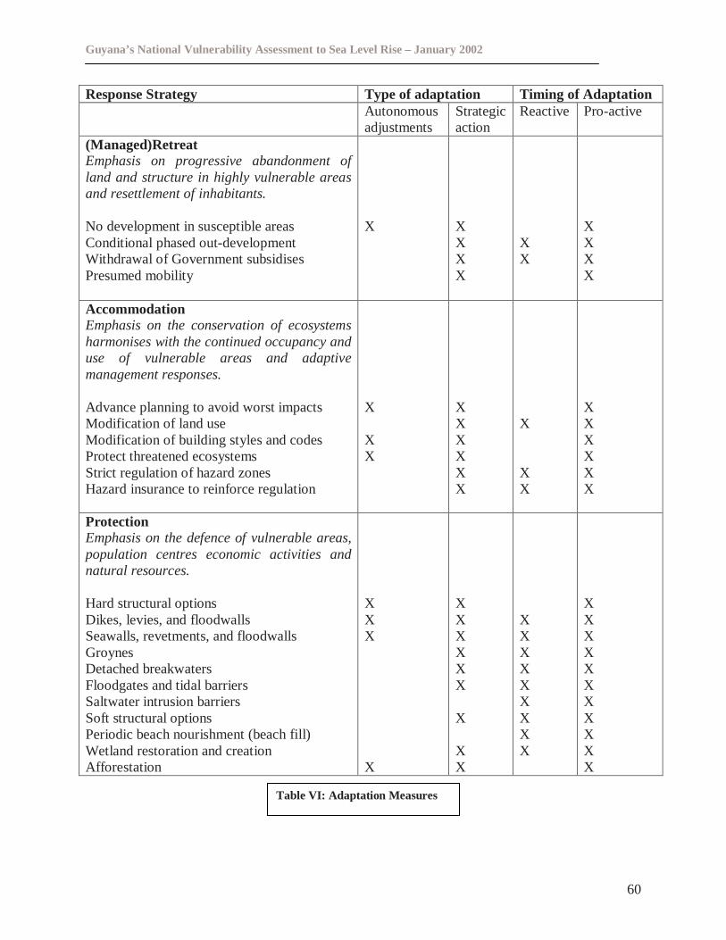
Guyana’s National Vulnerability Assessment to Sea Level Rise – January 2002
60
Response Strategy Type of adaptation Timing of AdaptationAutonomousadjustments
Strategicaction
Reactive Pro-active
(Managed)RetreatEmphasis on progressive abandonment ofland and structure in highly vulnerable areasand resettlement of inhabitants.
No development in susceptible areasConditional phased out-developmentWithdrawal of Government subsidisesPresumed mobility
X XXXX
XX
XXXX
AccommodationEmphasis on the conservation of ecosystemsharmonises with the continued occupancy anduse of vulnerable areas and adaptivemanagement responses.
Advance planning to avoid worst impactsModification of land useModification of building styles and codesProtect threatened ecosystemsStrict regulation of hazard zonesHazard insurance to reinforce regulation
X
XX
XXXXXX
X
XX
XXXXXX
ProtectionEmphasis on the defence of vulnerable areas,population centres economic activities andnatural resources.
Hard structural optionsDikes, levies, and floodwallsSeawalls, revetments, and floodwallsGroynesDetached breakwatersFloodgates and tidal barriersSaltwater intrusion barriersSoft structural optionsPeriodic beach nourishment (beach fill)Wetland restoration and creationAfforestation
XXX
X
XXXXXX
X
XX
XXXXXXXXX
XXXXXXXXXXX
Table VI: Adaptation Measures
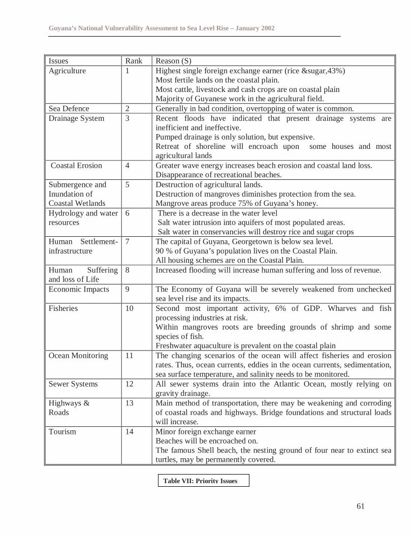
Guyana’s National Vulnerability Assessment to Sea Level Rise – January 2002
61
Issues Rank Reason (S)Agriculture 1 Highest single foreign exchange earner (rice &sugar,43%)
Most fertile lands on the coastal plain.Most cattle, livestock and cash crops are on coastal plainMajority of Guyanese work in the agricultural field.
Sea Defence 2 Generally in bad condition, overtopping of water is common.Drainage System 3 Recent floods have indicated that present drainage systems are
inefficient and ineffective.Pumped drainage is only solution, but expensive.Retreat of shoreline will encroach upon some houses and mostagricultural lands
Coastal Erosion 4 Greater wave energy increases beach erosion and coastal land loss.Disappearance of recreational beaches.
Submergence andInundation ofCoastal Wetlands
5 Destruction of agricultural lands.Destruction of mangroves diminishes protection from the sea.Mangrove areas produce 75% of Guyana’s honey.
Hydrology and waterresources
6 There is a decrease in the water levelSalt water intrusion into aquifers of most populated areas.Salt water in conservancies will destroy rice and sugar crops
Human Settlement-infrastructure
7 The capital of Guyana, Georgetown is below sea level.90 % of Guyana’s population lives on the Coastal Plain.All housing schemes are on the Coastal Plain.
Human Sufferingand loss of Life
8 Increased flooding will increase human suffering and loss of revenue.
Economic Impacts 9 The Economy of Guyana will be severely weakened from uncheckedsea level rise and its impacts.
Fisheries 10 Second most important activity, 6% of GDP. Wharves and fishprocessing industries at risk.Within mangroves roots are breeding grounds of shrimp and somespecies of fish.Freshwater aquaculture is prevalent on the coastal plain
Ocean Monitoring 11 The changing scenarios of the ocean will affect fisheries and erosionrates. Thus, ocean currents, eddies in the ocean currents, sedimentation,sea surface temperature, and salinity needs to be monitored.
Sewer Systems 12 All sewer systems drain into the Atlantic Ocean, mostly relying ongravity drainage.
Highways &Roads
13 Main method of transportation, there may be weakening and corrodingof coastal roads and highways. Bridge foundations and structural loadswill increase.
Tourism 14 Minor foreign exchange earnerBeaches will be encroached on.The famous Shell beach, the nesting ground of four near to extinct seaturtles, may be permanently covered.
Table VII: Priorit y Issues
Guyana’s National Vulnerability Assessment to Sea Level Rise – January 2002
62
7.0 RECOMMENDATIONS
1. Maintain existing sea defence structures and restrict new development on the coastas aconsequence of the seriousness of the impacts and vulnerabilities predicted for this region,promote development, and encourage migration of part of the population, in suitable interiorlocations.
2. Undertake a comprehensive study looking at the demographicsof the coast, identifyinglevels of vulnerability, and prioritising areas/categories to be addressed.
3. Carry out a detailed inventory of coastal assets and quantify in terms of monetaryvalues, and identify areas of great threat to the sea and future sea-level rise.Uponcompletion of this survey, carry out sea defence work on chosen areas that are mostvulnerable to the sea and have substantial values in terms of assets for possible protectionwhile discouraging major development in coastal areas that already has little or no value inassets and no sea defence.
4. There is a need to consider various modelingscenarios that can provide inputs in decisionmaking. To undertake scenario modeling there is a need for accurate data to be acquired.Detailed inventories are currently not a part of CPACC Component 3 - Coastal ResourcesInformation Systems (CRIS). However, CRIS contains monitoring data that can be used inmodeling scenarios for CPACC Component 6. The possibility also exists where informationmay be available from Sea Defence Management Information Systems (SDMIS) and fromthe mangrove management mechanisms soon to be implemented.
5. Carry out research in the agriculture sector to develop or acquire plants species that willadapt to the predicted sea level rise, or to acquire the most appropriate technologies that willfoster adaptation in all sectors of Guyana’s economy, most importantly the agriculture,forestry, energy, water resources and buildings sectors.
6. Develop programmes to foster education, public awareness and trainingin the field ofclimate change related issues, especially sea level rise.
7. Finalize the National Land Use Planto address the issues of suitable lands for agriculturalexpansion and potential settlement areas in the hinterland.
8. Accelerate the development of a policy on the implementation of GeographicalInformation System and training to strengthen the capacity, within the natural resourcessector, to provide reliable and timely technical information to the government.
9. Develop emergency programmes for civil defence and rescuein response to emergencies,which may arise, from sea level rise, floods and droughts. In this regard the Civil DefenceCommission (CDC) can engage in dialogue with appropriate Regional organisations involvedin disaster relief and preparedness management to determine the specific needs and theresources that may be available to assist the country in the preparation of such strategies anddocuments.
Guyana’s National Vulnerability Assessment to Sea Level Rise – January 2002
63
10.Address the need for data gathering and analysison natural systems and processes andtheir economic value with respect to Guyana’s coast.
11. Develop regulatory mechanismsto ensure that zoning of future land uses; also introductionof building codes, particularly for sea defence structures and for preventing certain kinds ofdevelopment in areas near the coast.
12.The existing EP Act should be amendedto expressly include provision for theconsideration of inundation, salinization and erosion impacts as among the considerationsthat should be taken into account in the preparation of EIA’s for projects.
13.Efforts should be taken to ensurethat the banking and insurance industry take account ofthe effects of climate change in the delivery of their services.
14.A significant portion of the rainfall over the “White Sands” recharge area is lost by run-offto streams, both directly and from underground. Consideration will have to be given to theidea of extraction closer to the recharge zone with the possibility of intercepting this water.Extensive planning and modeling of the entire system, incorporating the aquifers, streamsand recharge will be required. This should be considered as a priority for immediateimplementation.
15.Flood plain mapping of the entire coastal area should be considered with some priority andimplementation of such a project should commence in the near future.
16. A range of data is required for both bio-geophysical and socio-economic impactassessment. The type of data required depends on the impacts being evaluated.
17.Relevant guidelines and standards must be developedto help prevent inundation that canresult from certain development activities such as mining, forestry and agriculture.
18.Research Unitscould be created in the various agencies to assist with data collection andmanagement relating to relevant aspects of climate change.
19.Strengthening of planning legislation to include the establishment of building codes anddesign construction standards should be considered as a priority. At the institutional level therelationship with other relevant agencies such as Ministry of Housing and Water, District andMunicipal Councils and Public Health needs to be strengthened to promote enforcementefforts and avoid duplication of effort. It is also recommended that in this regard squattersettlements and housing schemes be considered separately as the legislative and planningrequirements will be different.
20.Harmonization of legislation to avoid overlap and duplication of the functions is a criticalneed throughout the legislative instruments that impact on climate change. This should beaddressed urgently.
21.Drainage and irrigation legislation pertaining to navigation and the protection of waterresources should be strengthened to include provisions that have the potential to cause
Guyana’s National Vulnerability Assessment to Sea Level Rise – January 2002
64
pollution; salinization and flooding.
22. The possible rise in sea level should be simulated, examining how far inland flood watersare likely to reach, and then, through a social benefit cost analysis (SBCA), look at thevarious alternatives such as erecting further sea defence protection, rehabilitating existingones, relocating residents, or a combination of these, to combat the threat of sea level rise.
Guyana’s National Vulnerability Assessment to Sea Level Rise – January 2002
65
8.0 CONCLUSION
It will not be easy for Guyana to take actions to mitigate and adapt to the impacts of climatechange, especially sea level rise, while at the same time, the country has to deal with currentpressing issues which confront the people of Guyana. However, with international assistance,the Government and the people of Guyana can work towards playing a meaningful role inaddressing these issues.
Guyana low coastland, the many rivers traversing and seasonally overflowing this coastland, thefact that most of the population and all the major agricultural and industrial activities take placeon the coastland, put Guyana in a “high risk” situation as far as the effects of sea level riseresulting from climate change is concerned.
A major source of concern for Guyana is the lack of awareness of the general population of theconsequences of sea level rise. This may be due to factors over which the responsible authoritieshave little or no control. However, at this point in time it is of utmost importance that a programof awareness be implemented so that the population may become aware of the consequences theyare facing and what will be their role in implementing adaptation measures.
Guyana will need to establish and maintain a number of management mechanisms for integratedadaptation planning and management to become a reality. These mechanisms cannot all bedeveloped simultaneously and in almost all instances substantial human, technical, and financialresources will be required to establish and maintain the policy, legal, and institutional structuresthat are necessary to successfully deal with Guyana’s vulnerability to sea level rise.
Guyana’s National Vulnerability Assessment to Sea Level Rise – January 2002
66
9.0 BIBLIOGRAPHY
1. Bynoe, Paulette and Bynoe, Mark. 1999.‘Final Report on a Socio- Economic Assessmentof the Vulnerability of Guyana’s Coast to Sea Level Rise’.
2. Daniel – Julien, Judy. 2000.‘An Assessment Of The Adequacy Of The Legal FrameworkTo Cope With The Potential Effects Of Sea Level Rise In Guyana’.
3. Khan, Marlon. March 2001.‘Draft National Climate Change Adaptation Policy andImplementation Plan’.
4. Narayan, Kailas. June 2001.‘Final Report on the Bio-Geophysical Assessment of theVulnerability of Guyana’s Coast to Sea Level Rise’.
5. Environmental Protection Agency. December 2000.‘ Action Plan for Integrated CoastalZone Management in Guyana’.
6. June 2001.‘Guyana’s Initial National Communication in Response to its Commitmentsunder the UNFCCC’.
7. Guyana Rice Millers & Exporters Development Association LTD, Annual Report 1999.
8. 1999. Government of Guyana ‘Statistical Bulletin’, Bureau of Statistics, Georgetown.