gulf stream and kuroshio current are synchronized
TRANSCRIPT

GEOPHYSICAL RESEARCH LETTERS, VOL. ???, XXXX, DOI:10.1029/,
Gulf Stream and Kuroshio Current are synchronized
Tsubasa Kohyama1, Hiroaki Miura2, and Shoichiro Kido2
Key points:• Temperatures of two major ocean currents, one in the Atlantic and the other in the Pacific, are synchronized
for decadal time scale• This synchronization is covariability shared by the Pacific Decadal Oscillation and the Northern Annular
Mode• The existence of an oceanic annular mode is hypothesized, which has some implications for midlatitude
extreme weather and climate change
Abstract. Sea surface temperatures (SSTs) of the GulfStream and the Kuroshio are shown to be synchronized forthe decadal time scale. This synchronization, which we referto as the Boundary Current Synchronization (BCS), is as-sociated with meridional migrations of the atmospheric jetstream. The singular value decomposition (SVD) betweenSST and zonal wind shows that, within the context of knownclimate modes, BCS can be understood as the covariabilityshared by the Pacific Decadal Oscillation and the North-ern Annular Mode. Nevertheless, because the SVD timeseries exhibit high correlations with the zonal-mean merid-ional SST difference between the subtropics and the midlat-itudes, BCS can be understood more simply as an oceanicannular mode. Air temperature regressed on the BCS indexexhibits a similar spatial pattern to temperature observedin July 2018.
Index terms: 3339 Ocean/atmosphere interactions
Keywords: Western Boundary Current, Jet Stream
1. Introduction
The two warm ocean currents, the Gulf Stream and theKuroshio, are located in the western boundaries of the At-lantic and the Pacific Oceans, respectively, so they are re-ferred to as the western boundary currents (WBCs) [Hoggand Johns, 1995]. Meanderings of WBCs and the associatedsea surface temperature (SST) variations have long beenknown to affect local weather and climate in the coastalmetropolitan areas, mainly because WBCs transport heatfrom the tropics to the extratropics and modulate cycloge-nesis [Sanders, 1986] and low cloud formation [Young andSikora, 2003]. More recently, high-resolution satellite obser-vations helped reveal that heat released from WBCs haveprofound impacts on the entire troposphere [Minobe et al.,2008; Nakamura et al., 2015; Masunaga et al., 2018]. TheGulf Stream and the Kuroshio also serve as surface fin-gerprints of low-frequency natural climate variability (e.g.,
1Department of Information Sciences, OchanomizuUniversity, Tokyo, Japan.
2Department of Earth and Planetary Science, TheUniversity of Tokyo, Tokyo, Japan.
Copyright 2019 by the American Geophysical Union.0094-8276/19/$5.00
Atlantic Meridional Overturning Circulation [Zhang , 2008],Pacific Decadal Oscillation (PDO) [Mantua et al., 1997]),and thus, understanding WBCs have major implications forpaleoclimatology [Yamamoto et al., 2004], climate model-ing [Paul and Schafer-Neth, 2003], and disentangling natu-ral variability from the anthropogenic climate change [Willset al., 2018].
The tight linkage between the Gulf Stream and theKuroshio has never been discovered, however. More thana decade ago, a monograph by Kelly and Dong [2004] founda hint of the WBC covariability in the upper ocean heatcontent data. They estimated that 26% of heat contentvariations over the entire North Atlantic and Pacific werein phase. Nevertheless, because the data length and thespatial resolutions were limited at that time, it was difficultto detect a fine structure or a strong coherence of the twoWBCs. Though some climatologists mentioned this poten-tial WBC covariability as an outstanding issue [Kwon et al.,2010], their monograph is, to the best of our knowledge, theonly observational effort that was taken to explore a possiblelinkage between the Gulf Stream and the Kuroshio.
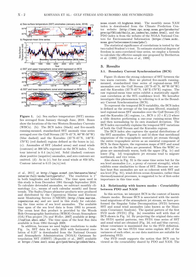
In the present day, satellite-based high-resolution SSTdata records [Reynolds et al., 2007; Dee et al., 2011] havebecome long enough to begin thorough analyses in this vein.The SST distribution in early 2018 may initiate speculationsabout a linkage between the two WBCs (Fig. 1a). Duringthis time span, SSTs near both of the WBC regions arewarmer by about 3-5 ◦C than the temporal mean over thepast four decades, which corresponds to 2-3 standard devia-tions. This simultaneous warm event would be rarely experi-enced by random chance. One could attribute these record-breaking warm currents partly to the increasing greenhousegas forcing, but this explanation appears not to be the wholestory as we shall see.
In this study, we identify that the regional-mean SSTsover the two ocean currents are synchronized for interannualto decadal time scales. Data and methods are described inthe next section. In section 3, the synchronization of theWBCs is demonstrated based on observational data anal-ysis, and the physical mechanism is investigated from twodifferent viewpoints. In this section, we also discuss someimplications for the northern hemispheric weather and cli-mate. Concluding remarks are presented in section 4.
2. Data and Methods
Observed SST, 2-meter air temperature (July only),and zonal wind fields at 300 and 800 hPa are fromthe European Center for Medium range Weather Fore-casting (ECMWF) ERA-Interim reanalysis data [Dee
1
X - 2 KOHYAMA ET AL.: GULF STREAM AND KUROSHIO ARE SYNCHRONIZED
120 150 180 210 240 270 300 330 360 39020
40
60
−0.8−0.6667−0.5333−0.4−0.2667−0.133300.13330.26670.40.53330.66670.8
120 150 180 210 240 270 300 330 360 39020
40
60
−0.8−0.6667−0.5333−0.4−0.2667−0.133300.13330.26670.40.53330.66670.8
c) SST and upper tropospheric zonal wind regressed on BCS
(°C/std)0.8
-0.8
0
60°N
40°N
20°N
60°N
40°N
20°N120°E 180° 120°W 60°W 0°
120°E 180° 120°W 60°W 0°
b) Regional-mean time series4
2
0
-2
-4 1985 1990 1995 2000 2005 2010 2015
Sea
Surfa
ce T
empe
ratu
re (s
td)
Year
Kuroshio SST Gulf Stream SST
Boundary Current Synchronization (BCS) index
a) Sea surface temperature (SST) anomalies (January-June, 2018)
120°E 180° 120°W 60°W
50°N
30°N
Gulf StreamKuroshio3
-3
0
(°C)
d) SST and lower tropospheric zonal wind regressed on BCS
Figure 1. (a): Sea surface temperature (SST) anoma-lies averaged from January through June, 2018. Boxesshow the locations of the twoWestern Boundary Currents(WBCs). (b): The BCS index (black) and five-monthrunning-meaned, standardized SST anomaly time seriesaveraged over the Gulf Stream (35◦N-45◦N, 80◦W-50◦W)(blue dashed) and the Kuroshio (35◦N-45◦N, 140◦E-170◦E) (red dashed) regions defined as the boxes in (a).(c): Anomalies of SST (shaded areas) and zonal winds(contours) at 300 hPa regressed on the BCS index. Con-tour interval is 0.4 (m/s)/std. Solid (dashed) contoursshow positive (negative) anomalies, and zero contours areomitted. (d): As in (c), but for zonal winds at 850 hPa.Contour interval is 0.15 (m/s)/std.
et al., 2011] at http://apps.ecmwf.int/datasets/data/interim-full-moda/levtype=sfc/. The resolution is 1◦
in both longitudes and latitudes. The time span used inthis study is from December 1981 through September 2018.To calculate detrended anomalies, we subtract monthly cli-matology (i.e., means of each calendar month) and lineartrends. The Ssalto/Duacs altimeter products were producedand distributed by the Copernicus Marine and Environ-ment Monitoring Service (CMEMS) (http://www.marine.copernicus.eu) and are used in this study for calculat-ing the time series of sea level anomalies. The availabletime span of the sea level data is from 1993 to present.The ocean heat flux product is provided by the WoodsHole Oceanographic Institution (WHOI) Ocean-Atmosphere(OA) Flux project [Yu and Weller , 2007] available at http://oaflux.whoi.edu/. The time span of the heat flux dataavailable is from 1984 through 2009.
In addition, because we need higher resolutions to makeFig. 1a, SST data for early 2018 with horizontal reso-lution of 0.25◦ is downloaded from the National Oceanicand Atmospheric Administration (NOAA) Optimum In-terpolation SST (OISST) [Reynolds et al., 2007] availableat https://www.esrl.noaa.gov/psd/data/gridded/data.
noaa.oisst.v2.highres.html. The monthly mean NAMindex is downloaded from the Climate Prediction Cen-ter website (http://www.cpc.ncep.noaa.gov/products/precip/CWlink/daily_ao_index/ao_index.html), and thePDO index is from the website of the NOAA National Cen-ters for Environmental Information (https://www.ncdc.noaa.gov/teleconnections/pdo/).
The statistical significance of correlations is tested by thetwo-tailed Student’s t-test. To estimate statistical degrees offreedom in auto-correlated time series, we employ a formulato calculate the effective sample size proposed by Brethertonet al. (1999) [Bretherton et al., 1999].
3. Results
3.1. Boundary Current Synchronization (BCS)
Figure 1b shows the strong coherence of SST between thetwo warm currents. Here we plotted five-month running-meaned, standardized time series of regional-mean SSTanomalies over the Gulf Stream (35◦N-45◦N, 80◦W-50◦W)and the Kuroshio (35◦N-45◦N, 140◦E-170◦E) regions. Theraw regional-mean time series exhibit a statistically signifi-cant correlation at the 95% confidence level. We hereafterinvestigate this phenomenon by referring to it as the Bound-ary Current Synchronization (BCS).
To represent the temporal BCS variability, the BCS indexis defined as the average of the low-pass filtered, standard-ized regional-mean SST anomalies over the Gulf Stream (G)and the Kuroshio (K) regions, i.e., BCS ≡ (G+K)/2 wherea tilde denotes performing a one-year running-mean filterand then normalizing by its own standard deviation. TheBCS index successfully explains the temporal SST variationsof both the Gulf Stream and the Kuroshio regions.
The BCS index also captures the spatial distributions ofthe SST anomalies. Figures 1c and 1d show that meridionalmigrations of the tropospheric westerly jet stream throughthe entire troposphere serves as an essential component ofBCS. In these figures, the regression maps of SST and zonalwinds on the BCS index are presented. When the WBC re-gions are anomalously warm, both the upper (Fig. 1c) andlower (Fig. 1d) tropospheric jet streams tend to migratenorthward, and vice versa.
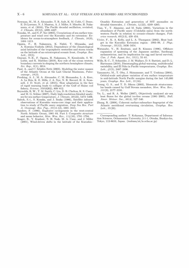
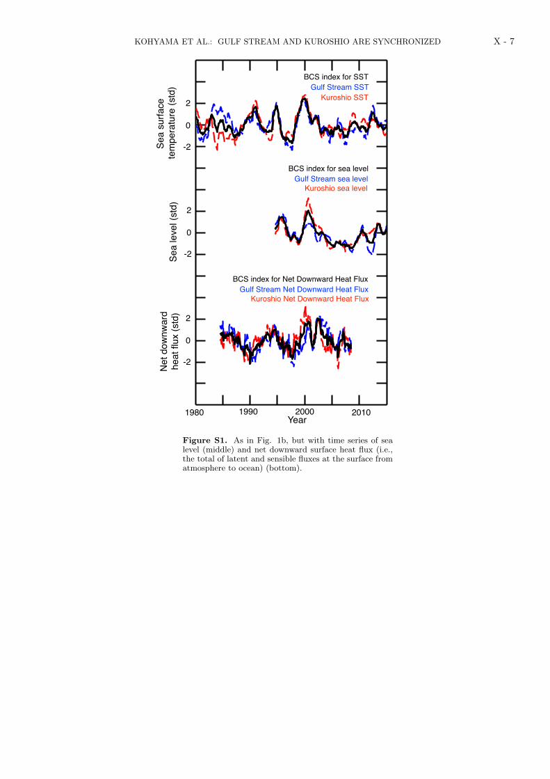
Also shown in Fig. S1 is the same time series but for thesea level anomalies (i.e., a proxy of current strength), whichexhibits some similarities to those of SST. Because net sur-face heat flux anomalies are not so coherent with SST andsea level (Fig. S1), wind-driven ocean dynamics, rather thanthermodynamical processes, is suggested to be of first-orderimportance in this time scale.
3.2. Relationship with known modes - Covariabilitybetween PDO and NAM
In this section, we interpret BCS in the context of knownclimate modes. Because BCS is associated with the merid-ional migrations of the atmospheric jet stream, we have per-formed the Singular Value Decomposition (SVD) betweenSST and zonal wind anomalies (also known as the Maxi-mum Covariance Analysis). The spatial pattern of the firstSVD mode (SVD1) (Fig. 2a) resembles well with that ofBCS shown in Fig. 1d. By projecting the original data ontothe SVD1 spatial patterns, two SVD1 time series of SSTand zonal wind are obtained (Fig. 2d, red and blue curves),whose covariance is maximized due to the SVD definition.In our case, the two SVD1 time series explain 46% of thevariances of each other, so our data matrices are suitable forperforming SVD.
Our SVD result supports the notion that BCS can beviewed as the covariability shared by PDO and NAM. The

KOHYAMA ET AL.: GULF STREAM AND KUROSHIO ARE SYNCHRONIZED X - 3
120 150 180 210 240 270 300 330 36020
40
60
−0.8−0.6667−0.5333−0.4−0.2667−0.133300.13330.26670.40.53330.66670.8
a) SST and wind (U850) homogeneously regressed on SVD1
b) SST and wind (U850) regressed on the conventional PDO
c) SST and wind (U850) regressed on the conventional NAM
120 150 180 210 240 270 300 330 36020
40
60
−0.4−0.3333−0.2667−0.2−0.1333−0.066700.06670.13330.20.26670.33330.4
60°N
40°N
20°N120°E 180° 120°W 60°W 0°
60°N
40°N
20°N120°E 180° 120°W 60°W 0°
(°C/std)0.8
-0.8
0
120 150 180 210 240 270 300 330 36020
40
60
−0.8−0.6667−0.5333−0.4−0.2667−0.133300.13330.26670.40.53330.66670.8
60°N
40°N
20°N120°E 180° 120°W 60°W 0°
(°C/std)0.8
-0.8
0
(°C/std)0.4
-0.4
0
1985 1990 1995 2000 2005 2010 2015-10-9-8-7-6-5-4-3-2-1012345678910
BCS index
SVD1 (SST)conventional -PDO
SVD1 (Wind)conventional NAM
d) Time Series
0-1
1
0-1
1
0-1
1
Clim
ate
Indi
ces
(std
)
Correlation = 0.70 (95%)
Correlation = 0.73 (95%)
1985 1990 20001995 2005 2010 2015Year
0.59 (95%)
0.68 (95%)
Figure 2. (a): As in Fig. 1d, but homogeneously regressed on the SVD1 time series. (b): As in Fig. 1d, but for theconventional PDO index. (c): As in Fig. 1d, but for the conventional NAM index. (d): Black, As in the black curve inFig. 1b, but 1-year running meaned. Red solid, SST time series of the first mode of the Singular Value Decomponsition(SVD1) calculated between SST and zonal wind at 850 hPa. Red dashed, The 1-year running meaned, conventional PacificDecadal Oscillation (PDO) index. Blue solid, As in red solid, but for zonal wind at 850 hPa. Blue dashed, The 1-yearrunning meaned, conventional Northern Annular Mode (NAM) index.
SVD1 time series of SST exhibits a correlation of 0.70 withthe conventional PDO index (Fig. 2d, red). The SST com-ponent of SVD1 explains the low frequency of PDO butalso has high covariance with SST at the Gulf Stream (Fig.2b). On the other hand, the SVD1 time series of zonal windexhibits a correlation of 0.73 with the conventional NAMindex, which is statically significant at the 95 % confidencelevel (Fig. 2d, blue). The zonal wind component of SVD1explains the low frequency of NAM but also exhibits highcovariance with the midlatitude SST (Fig. 2c).
PDO and NAM are conventionally defined as the firstmode of the Empirical Orthogonal Function (EOF) per-formed for SST and geopotential height, respectively. Thesedefinitions purely capture the statistical properties of the cli-mate variables and do not necessarily reflect their physics.Therefore, some arbitrariness remains in how to define thesephysical modes. Our analysis shows that physically simi-lar modes of climate variability can also be extracted us-ing SVD, and they explain as much as 46% of variances ofeach other. Based on this evidence, we could speculate thatPDO and NAM are related more than previously thought,and that BCS may serve as the key to uncover the relation-ship of the two conventional climate modes. This view isconsistent with previous studies [e.g., Newman et al., 2016]that suggest that the internal PDO variability in the NorthPacific are physically separable from the PDO variabilityforced by the tropical teleconnections.
3.3. Alternative view - the Oceanic Annular Mode
In this section, we further interpret the physical meaningof SVD1 obtained in the previous section. First, it is robustthat the SVD1 time series of zonal wind physically meansthe meridional migrations of the atmospheric jet stream. Ifwe define an index to represent the meridional difference ofthe regional-mean zonal wind in the manner of the subtrop-ics (45◦N-55◦N, 120◦E-0◦W) minus the extratropics (45◦N-55◦N, 120◦E-0◦W), this index exhibit a correlation of 0.84(significant at 95 %) with the SVD1 time series of zonalwind (Fig 3a, bottom). This result is consistent with the
physical interpretation that NAM is a mode that representsmeridional migrations of the atmospheric jet stream. In thesame manner, if we also define an index to represent themeridional SST difference for the same regions, this indexexhibit a correlation of 0.79 (significant at 95 %) with theSVD1 time series of SST (Fig 3a, top). Therefore, SVD1 ofSST also describes meridional migrations of SST anomalies.
This SVD result serves as an observational evidence thatmeridional migrations of the atmospheric jet stream andSST tend to be in phase over the northern hemispheric mid-lattitudes. Hence, compared to the conventional view, it issimpler to understand that BCS is an annular mode in theocean, which we refer to as the Northern Oceanic Annu-lar Mode (NOAM). In other words, there exists a zonally-symmetric midlatitude SST variability that strides over theNorth American continent. This variability is observableeven in the raw SST data, particularly clearly in the west-ern boundaries of the basins, where regional-scale degrees offreedom remains due to the Earth’s rotation. The regres-sion map of SST and zonal wind on the NOAM index alsocaptures the BCS variability (Fig. 3b).
If BCS is an oceanic annular mode, it is natural to lookfor a similar mode in the southern hemisphere. In fact, theBrazil current and the Agulhas return current are also syn-chronized (Fig. S2), and we could refer to it as the SouthernOceanic Annular Mode (SOAM). Nevertheless, if we per-form the same SVD analysis for the southern hemisphere,SOAM is found to be inseparable from the tropical variabil-ity, which is in contrast to NOAM, whose signal is confinedto the midlatitudes. The evidence that NOAM exhibits themidlatitude internal variability and that SOAM is associ-ated with the tropical forcings is consistent with the featurethat SOAM has 3-8 year time scales analogous to the ElNino Southern Oscillation.
A major open question about NOAM is the relationshipwith NAM. Specifically, it is uncertain whether (i) NOAM ispurely a forced response to NAM or (ii) NOAM and NAMform an air-sea coupled mode. Our traditional view is toassume that midlatitude ocean is mostly passive to the at-mosphere, but we should not rule out the existence of an

X - 4 KOHYAMA ET AL.: GULF STREAM AND KUROSHIO ARE SYNCHRONIZED
air-sea coupled system for the global and decadal scales.For example, even some early efforts found a hint of air-seacouplings between the storm track and the northern hemi-spheric WBCs [e.g., Hoskins and Valdes, 1990]. Based onmore recent evidence, according to Ogawa et al. [2012], themeridional position of the eddy-driven jet can be locked bythe SST front. Using semi-idealized atmospheric generalcirculation models, Omrani et al. [2019] also showed thatforcings from both Kuroshio and Gulf Stream are necessaryto maintain the wintertime hemispheric circulation and theNAM variability. Furthermore, many previous studies onPDO suggests that oceanic internal variability play an ac-tive role at least for decadal time scales. It will be an im-portant next step to investigate whether our climate systemforms the “interactive Annular Mode (iAM)” by combiningNAM and NOAM.
3.4. Implications for the midlatitude extreme weatherand climate change
If BCS plays an active role to determine the low-frequencybehavior of the atmospheric jet stream, BCS have some im-plications for the midlatitude extreme weather. In this sec-tion, we take an example from the northern hemispheric hotsummer in July 2018 and investigate the relationship withthe high SST in the Gulf Stream and the Kuroshio regions.
The spatial pattern of surface temperature anomalies ob-served in July 2018 (Fig. 4a) corresponds well to the re-gression map of 2-meter air temperature anomalies on theBCS index calculated using the July-only data (Fig. 4b).East Asia, the west and east coasts of North America, Eu-rope, and Northwest Africa have experienced a hot summer
a) Meridional Difference and SVD time series
b) SST and zonal wind at 850 hPa regressed on NOAM1985 1990 1995 2000 2005 2010 2015
-7
-5
-3
-1
1
3
5
7
U850 Meridional Difference (NAM)
SVD1 (SST)
SVD1 (Wind)
SST Meridional Difference (NOAM)
(°C/std)0.8
-0.8
0
120 150 180 210 240 270 300 330 36020
40
60
−0.8−0.6667−0.5333−0.4−0.2667−0.133300.13330.26670.40.53330.66670.8
0
2
-2
0
2
-2
60°N
40°N
20°N120°E 180° 120°W 60°W 0°
Correlation = 0.84 (95%)
Correlation = 0.79 (95%)
Figure 3. (a): Top black, NOAM index defined as themeridional difference of the regional-mean SSTs calcu-lated in the manner of the subtropics (45◦N-55◦N, 120◦E-0◦W) minus the extratropics (45◦N-55◦N, 120◦E-0◦W).5-month running mean is performed. Red, As in Fig. 2dred solid, but 5-month running-meaned time series. Bot-tom black, NAM index defined as in top black, but forzonal wind at 850 hPa. Blue, As in Fig. 2d blue solid, but5-month running-meaned time series. (b) As in Fig. 1d,but for the NOAM index.
in 2018, and the BCS index explains these features. Asmentioned in the previous section, we have two possible in-terpretations for this figure. The first interpretation, basedon the traditional view that midlatitude ocean is mostly pas-sive to the atmosphere, is that the position of the jet streamdetermined both the SST and air temperature patterns. Inthis case, NAM is the cause and NOAM is the effect. Asan alternative hypothesis, however, we could also interpretthat the position of the jet stream and SST (i.e., NAM andNOAM) has chosen this particular spatial pattern by form-ing an air-sea coupled mode.
Though more work is needed to confirm the robustness,if this alternative view is plausible, our understanding onthe midlatitude jet, and thereby the midlatitude extremeweather and climate change, will be improved by investi-gating BCS and NOAM. In fact, BCS also gives a consis-tent explanation for two typical global warming responses:the western boundary currents warm faster than the globalmean, and the atmospheric jet stream shifts poleward.
In Fig. 4c, the synchronization between NOAM and 2-meter temperature is also shown in the form of time series.Here, the NOAM index is defined as the SST meridionaldifference following the previous section, and the 2-metertemperature time series is defined as the projection onto theNOAM regression map of 2-meter temperature. Moreover,these time series also synchronize with the surface temper-ature projected onto its pattern of July 2018, which meansthat the extent to which the spatial temperature pattern is
1985 1990 1995 2000 2005 2010 2015-10
-8
-6
-4
-2
0
2
4
6
8
10NOAM
NOAM (2-meter air temperature in July)
2-meter air temperature in 2018 July“Similar” to 2018 July
“Opposite” to2018 July
“Similar” to thepositive NOAM
“Similar” to thenegative NOAM
Warm WBCsJet shiftedtoward north
Cold WBCsJet shiftedtoward south
1985 1990 20001995 2005 2010 2015Year
0
2
-2
0
2
-2
0
2
-2
60 90 120 150 180 210 240 270 300 330 360 390 4202030405060
−1−0.8333−0.6667−0.5−0.3333−0.166700.16670.33330.50.66670.83331
a) 2-meter air temperature anomalies (July, 2018)
50°N
30°N0°180° 90°W90°E
3
-30
(°C)
50°N30°N
0°180° 90°W90°E
b) 2-meter air temperature in July regressed on the BCS index1
-1
0
(°C/std)
60 90 120 150 180 210 240 270 300 330 360 390 4202030405060
−3−2.5−2−1.5−1−0.500.511.522.53
c) Projected time series
Figure 4. (a): Monthly-mean surface temperatureanomalies for July 2018. (b): 2-meter air temperatureanomalies in July regressed on the BCS index calculatedusing the July-only data. (c): Black, As in the top blackcurve in Fig. 3a. Blue, 2-meter temperature projectedon the NOAM spatial pattern (the regression map of 2-meter temperature on the NOAM index). Red, 2-meterair temperature projected on (a).

KOHYAMA ET AL.: GULF STREAM AND KUROSHIO ARE SYNCHRONIZED X - 5
similar to July 2018 is explained well by NOAM. Consideringthe short memory of the atmosphere, it appears reasonableto suspect the existence of the air-sea coupled mechanismsto explain the synchronization for interannual time scale.
Our preliminary analysis shows that the result describedin the previous paragraph is also true for July 2018 precip-itation. This evidence also raises two possible hypotheses:the position of the atmospheric jet stream determines SSTand the precipitation pattern, or the atmospheric jet streamand SST form an air-sea coupled system that favors this pre-cipitation pattern. This uncertainty is another reason whywe should determine whether NAM and NOAM are coupled.
4. Concluding Remarks
Our view of BCS hypothesizes the existence of an air-seacoupled annular mode, which is analogous to well-knownNAM driven by the atmospheric intrinsic variability. How-ever, though many previous studies convincingly showedpossible physical processes of interactions between large-scale tropospheric winds and WBCs [Nakamura et al., 2015;Seager et al., 2001; Nonaka and Xie, 2003; Kelly et al., 2010;Ma et al., 2016], our understanding about the mechanismof BCS is limited. Further theoretical considerations, casestudies, statistical analyses, and climate model simulationsare needed to determine whether our hypothetical view isplausible. In particular, high resolution ocean models willhelp reveal essential processes of BCS, because they simu-late latent heat release from the WBCs better than modelswith coarser ocean.
At the beginning of this century, a possibly-related the-oretical work was presented by Gallego and Cessi [2001].They developed an idealized model of two ocean basins,each having its own WBC, whose stream function is de-termined through the time-dependent Sverdrup-balance. Intheir model, the two WBCs are coupled to each other onlythrough the zonally-symmetric atmosphere. Their model il-lustrates possible mechanisms of decadal WBC variabilityvia wind-driven torques and heat fluxes, and theoreticallypredicts the existence of three possible regimes regardingdecadal WBC variability. In particular, it is notable thattheir “chaos” regime exhibits BCS-like variability, but inlonger time scale.
As to data analyses, revisiting earlier works on theso-called “Aleutian and Icelandic Lows (AL-IL) Seesaw”[Honda and Nakamura, 2001] may facilitate beginning fur-ther investigations of the atmospheric signatures of BCS.To understand the energetic constraints of BCS, relativeimportance of wind-driven oceanic advections and surfaceheat fluxes should be throughly assessed, following previousstudies that investigated the individual WBCs and their ex-tension regions [Vivier et al., 2002; Dong and Kelly , 2004].
Understanding BCS have immediate implications for hu-man lives because BCS modulates the probability of extremeweather events [Sanders, 1986; Young and Sikora, 2003; Mi-nobe et al., 2008] and fisheries productions [Pershing et al.,2015; Watanabe et al., 1996; Saitoh et al., 1986; Tian et al.,2003]. The hot summer experienced in 2018 is a good exam-ple of extreme weather associated with BCS. In particular,because other prominent climate modes (e.g., the El NinoSouthern Oscillation) were relatively inactive in 2018, theBCS signature may have clearly emerged in the observedair temperature over the entire northern hemispheric extra-tropics (Fig. 4). As to the fisheries productions, warm SSTassociated with a northward shift of the Gulf Stream in-creases the mortality of Atlantic cod (Gadus morhua) [Per-shing et al., 2015], while migrations of pelagic fish, suchas Japanese sardine (Sardinops melanostictus) [Watanabeet al., 1996] and Pacific saury (Cololabis sairai) [Saitoh et al.,1986; Tian et al., 2003], are influenced by the Kuroshio vari-ability because they use the Kuroshio region as spawningand nursery grounds [Kuroda et al., 2016].
Acknowledgments. This work is supported by the JapanSociety for the Promotion of Science (JSPS)-Kakenhi Grant Num-ber 19K23460. The second author is supported by JSPS-KakenhiGrant Number 16H04048. The third author is supported byJSPS-Kakenhi Grant Number 17J04384. We would like to thankShoshiro Minobe, Yukio Masumoto, Tomoki Tozuka, MasahiroWatanabe, and Yoko Yamagami for useful discussion.
References
Bretherton, C. S., M. Widmann, V. P. Dymnikov, J. M. Wallace,and I. Blade (1999), The effective number of spatial degrees offreedom of a time-varying field, J. Climate, 12 (7), 1990–2009.
Dee, D. P., S. M. Uppala, A. Simmons, P. Berrisford, P. Poli,S. Kobayashi, U. Andrae, M. Balmaseda, G. Balsamo, d. P.Bauer, et al. (2011), The ERA-Interim reanalysis: Configura-tion and performance of the data assimilation system, Quart.J. Roy. Meteor. Soc., 137 (656), 553–597.
Dong, S., and K. A. Kelly (2004), Heat budget in the Gulf Streamregion: The importance of heat storage and advection, J. Phys.Oceanogr., 34 (5), 1214–1231.
Gallego, B., and P. Cessi (2001), Decadal variability of two oceansand an atmosphere, J. Climate, 14 (13), 2815–2832.
Hogg, N. G., and W. E. Johns (1995), Western boundary cur-rents, Rev. Geophys., 33 (S2), 1311–1334.
Honda, M., and H. Nakamura (2001), Interannual seesaw betweenthe Aleutian and Icelandic lows. Part II: Its significance inthe interannual variability over the wintertime Northern Hemi-sphere, J. Climate, 14 (24), 4512–4529.
Hoskins, B. J., and P. J. Valdes (1990), On the existence of storm-tracks, J. Atmos. Sci., 47 (15), 1854–1864.
Kelly, K. A., and S. Dong (2004), The relationship of westernboundary current heat transport and storage to midlatitudeocean-atmosphere interaction, Earth ’s Climate: The Ocean-Atmosphere Interaction, Geophys. Monogr, 147, 347–363.
Kelly, K. A., R. J. Small, R. Samelson, B. Qiu, T. M. Joyce, Y.-O.Kwon, and M. F. Cronin (2010), Western boundary currentsand frontal air–sea interaction: Gulf Stream and Kuroshio Ex-tension, J. Climate, 23 (21), 5644–5667.
Kuroda, H., T. Setou, S. Kakehi, S.-i. Ito, T. Taneda, T. Azu-maya, D. Inagake, Y. Hiroe, K. Morinaga, M. Okazaki, et al.(2016), Recent advances in Japanese fisheries science in theKuroshio-Oyashio region through development of the FRA-ROMS ocean forecast system: Overview of the reproducibilityof reanalysis products, Open J. Marine Sci., 7 (01), 62.
Kwon, Y.-O., M. A. Alexander, N. A. Bond, C. Frankignoul,H. Nakamura, B. Qiu, and L. A. Thompson (2010), Role ofthe Gulf Stream and Kuroshio–Oyashio systems in large-scaleatmosphere–ocean interaction: A review, J. Climate, 23 (12),3249–3281.
Ma, X., Z. Jing, P. Chang, X. Liu, R. Montuoro, R. J. Small,F. O. Bryan, R. J. Greatbatch, P. Brandt, D. Wu, et al. (2016),Western boundary currents regulated by interaction betweenocean eddies and the atmosphere, Nature, 535 (7613), 533.
Mantua, N. J., S. R. Hare, Y. Zhang, J. M. Wallace, and R. C.Francis (1997), A Pacific interdecadal climate oscillation withimpacts on salmon production, Bull. Amer. Meteor. Soc.,78 (6), 1069–1080.
Masunaga, R., H. Nakamura, H. Kamahori, K. Onogi, and S. Oka-jima (2018), JRA-55CHS: An Atmospheric Reanalysis Pro-duced with High-Resolution SST, SOLA, 14, 6–13.
Minobe, S., A. Kuwano-Yoshida, N. Komori, S.-P. Xie, and R. J.Small (2008), Influence of the Gulf Stream on the troposphere,Nature, 452 (7184), 206.
Nakamura, H., A. Isobe, S. Minobe, H. Mitsudera, M. Nonaka,and T. Suga (2015),“Hot Spots” in the climate system―new developments in the extratropical ocean–atmosphere in-teraction research: a short review and an introduction, J.Oceanogr., 71 (5), 463–467.
X - 6 KOHYAMA ET AL.: GULF STREAM AND KUROSHIO ARE SYNCHRONIZED
Newman, M., M. A. Alexander, T. R. Ault, K. M. Cobb, C. Deser,E. Di Lorenzo, N. J. Mantua, A. J. Miller, S. Minobe, H. Naka-mura, et al. (2016), The Pacific decadal oscillation, revisited,J. Climate, 29 (12), 4399–4427.
Nonaka, M., and S.-P. Xie (2003), Covariations of sea surface tem-perature and wind over the Kuroshio and its extension: Ev-idence for ocean-to-atmosphere feedback, J. Climate, 16 (9),1404–1413.
Ogawa, F., H. Nakamura, K. Nishii, T. Miyasaka, andA. Kuwano-Yoshida (2012), Dependence of the climatologicalaxial latitudes of the tropospheric westerlies and storm trackson the latitude of an extratropical oceanic front, Geophys. Res.Lett., 39 (5).
Omrani, N.-E., F. Ogawa, H. Nakamura, N. Keenlyside, S. W.Lubis, and K. Matthes (2019), Key role of the ocean westernboundary currents in shaping the northern hemisphere climate,Sci. Rep., 9 (1), 3014.
Paul, A., and C. Schafer-Neth (2003), Modeling the water massesof the Atlantic Ocean at the Last Glacial Maximum, Paleo-ceanogr., 18 (3).
Pershing, A. J., M. A. Alexander, C. M. Hernandez, L. A. Kerr,A. Le Bris, K. E. Mills, J. A. Nye, N. R. Record, H. A. Scan-nell, J. D. Scott, et al. (2015), Slow adaptation in the faceof rapid warming leads to collapse of the Gulf of Maine codfishery, Science, 350 (6262), 809–812.
Reynolds, R. W., T. M. Smith, C. Liu, D. B. Chelton, K. S. Casey,and M. G. Schlax (2007), Daily high-resolution-blended analy-ses for sea surface temperature, J. Climate, 20 (22), 5473–5496.
Saitoh, S.-i., S. Kosaka, and J. Iisaka (1986), Satellite infraredobservations of Kuroshio warm-core rings and their applica-tion to study of Pacific saury migration, Deep Sea Res. PartA. Oceanogr. Res. Pap., 33 (11-12), 1601–1615.
Sanders, F. (1986), Explosive cyclogenesis in the west-centralNorth Atlantic Ocean, 1981–84. Part I: Composite structureand mean behavior, Mon. Wea. Rev., 114 (10), 1781–1794.
Seager, R., Y. Kushnir, N. H. Naik, M. A. Cane, and J. Miller(2001), Wind-driven shifts in the latitude of the Kuroshio–
Oyashio Extension and generation of SST anomalies ondecadal timescales, J. Climate, 14 (22), 4249–4265.
Tian, Y., T. Akamine, and M. Suda (2003), Variations in theabundance of Pacific saury (Cololabis saira) from the north-western Pacific in relation to oceanic-climate changes, Fish-eries research, 60 (2-3), 439–454.
Vivier, F., K. A. Kelly, and L. A. Thompson (2002), Heat bud-get in the Kuroshio Extension region: 1993–99, J. Phys.Oceanogr., 32 (12), 3436–3454.
Watanabe, Y., H. Zenitani, and R. Kimura (1996), Offshoreexpansion of spawning of the Japanese sardine, Sardinopsmelanostictus, and its implication for egg and larval survival,Can. J. Fish. Aquat. Sci., 53 (1), 55–61.
Wills, R. C., T. Schneider, J. M. Wallace, D. S. Battisti, and D. L.Hartmann (2018), Disentangling global warming, multidecadalvariability, and El Nino in Pacific temperatures, Geophys. Res.Lett., 45 (5), 2487–2496.
Yamamoto, M., T. Oba, J. Shimamune, and T. Ueshima (2004),Orbital-scale anti-phase variation of sea surface temperaturein mid-latitude North Pacific margins during the last 145,000years, Geophys. Res. Lett., 31 (16).
Young, G. S., and T. D. Sikora (2003), Mesoscale stratocumu-lus bands caused by Gulf Stream meanders, Mon. Wea. Rev.,131 (9), 2177–2191.
Yu, L., and R. A. Weller (2007), Objectively analyzed air–seaheat fluxes for the global ice-free oceans (1981–2005), Bull.Amer. Meteor. Soc., 88 (4), 527–540.
Zhang, R. (2008), Coherent surface-subsurface fingerprint of theAtlantic meridional overturning circulation, Geophys. Res.Lett., 35 (20).
Corresponding author: T. Kohyama, Department of Informa-tion Sciences, Ochanomizu University, 2-1-1, Otsuka, Bunkyo-ku,Tokyo, 112-8610, Japan. (tsubasa/at/is.ocha.ac.jp)
KOHYAMA ET AL.: GULF STREAM AND KUROSHIO ARE SYNCHRONIZED X - 7
0
2
-2
Kuroshio SSTGulf Stream SST
BCS index for SST
BCS index for Net Downward Heat Flux
Kuroshio Net Downward Heat FluxGulf Stream Net Downward Heat Flux
BCS index for sea level
Kuroshio sea levelGulf Stream sea level
1980 1990 2000 2010Year
Net
dow
nwar
dhe
at fl
ux (s
td)
Sea
surfa
ce te
mpe
ratu
re (s
td)
0
2
-2
0
2
-2Sea
leve
l (st
d)
Figure S1. As in Fig. 1b, but with time series of sealevel (middle) and net downward surface heat flux (i.e.,the total of latent and sensible fluxes at the surface fromatmosphere to ocean) (bottom).

X - 8 KOHYAMA ET AL.: GULF STREAM AND KUROSHIO ARE SYNCHRONIZED
270 300 330 360 390 420 450−90−80−70−60−50−40−30−20−100
−0.6−0.5−0.4−0.3−0.2−0.100.10.20.30.40.50.6
60°S
40°S
20°S
0°
80°S
60°E0°60°W
Agulhas Return CurrentBrazil Current
(°C/std)0.6
-0.6
0
1980 1990 2000 2010Year
Sea
Surfa
ce T
empe
ratu
re (s
td)
0
2
-2Agulhas Return Current SST
Brazil Current SST
Southern Hemispheric BCS index
a) Regional-Mean Time Series
0 30 60 90 120 150 180 210 240 270 300 330 360
020406080
−0.8−0.6667−0.5333−0.4−0.2667−0.133300.13330.26670.40.53330.66670.8
0 30 60 90 120 150 180 210 240 270 300 330 360
020406080
−0.4−0.3333−0.2667−0.2−0.1333−0.066700.06670.13330.20.26670.33330.4
90°E 180° 90°W
EQ
40°N
80°N
40°S
80°S
EQ
40°N
80°N
40°S
80°S90°E 180° 90°W
(°C/std)0.8
-0.8
0
(°C/std)0.4
-0.4
0
c) SST and wind (U850) homogeneously regressed on SVD1 calculated for the northern hemispheric midlatitude
d) SST and wind (U850) homogeneously regressed on SVD1 calculated for the southern hemispheric midlatitude
b) SST regressed on the Southern Hemispheric BCS index
Figure S2. (a): As in Fig. 1b, but for the South-ern Hemispheric Midlatitude SST (70◦S-30◦S, all longi-tudes). Boxes show the locations of the two southernhemispheric WBCs. (b): As in the shaded area in Fig. 1c,but for the Brazil Current (35◦S-45◦S, 70◦W-40◦W) andthe Agulhas Return Current (35◦S-45◦S, 20◦E-50◦E). (c):As in Fig. 2a, but the global map is shown. (d): As in(c), but for the southern hemisphere.