guidelines for jsa assessment - ctara.iitb.ac.in · c) identify the farmers and interview them...
TRANSCRIPT

1
Guidelines for JSA Assessment
Prepared by
Technology and Development Solutions Cell
Centre for Technology Alternatives for Rural Areas
Indian Institute of Technology Bombay
Powai, Mumbai 400076
2
1 Background
1.1 About the Jalyukt Shivar Abhiyan
The Jalyukt Shivar Abhiyan (JSA) is a flagship program of Govt. of Maharashtra (GoM) launched in 2015, as
per the Government Resolution (G.R.) dated 5th December, 2014. The program aims to tackle the question
of recurring droughts and make Maharashtra drought-free by the year 2019. The program is being
implemented at village level and is supposed to cover all the villages in five years in a phased manner. Every
year few villages in each taluka are selected for the implementation based on pre-defined criteria (i.e.
existing incomplete projects, drinking water scarcity, low agricultural productivity, groundwater
exploitation etc.). Around 5000 villages are selected each year.
JSA is watershed program with main focus on soil and water conservation activities like trenches, gabions,
percolation tanks, cement bunds, nala-deepening, farm level soil conservation activities and so on. Through
these activities the program strives to conserve and harvest as much rain-water within village boundary as
possible and resolve the problems of water stress during dry spells in monsoon season, shortage of water
during rabbi season and drinking water scarcity, especially during summer season.
Expected outcomes of the program are to increase in availability of drinking water in the village, increase
in level of ground water, increase in area under irrigation, increase in area under fodder crops, Reduction
in area under dry land crops and increase in area under irrigated crops, increase in agricultural productivity,
increase in moisture protection of land, public participation, environmental improvement etc.
The planning and implementation of the above works is done through convergence of funds from all
existing state and center-level watershed programs as well as from MP, MLA and CSR funds. The planning
at the village level has to be carried out in coordinated manner i.e. with the help of all concerned
departments (Agriculture, Forest, Minor Irrigation, GSDA, RWS and so on) and the plan is to be discussed
in the Gram Sabha. The District Collector is supposed to oversee the implementation of the program at the
district-level.
1.2 About the Assessment
One of the requirements of the program is that all the villages should be assessed after the completion of
works in the village. This assessment is to be done by third-party and is supposed to be overseen by the
District Collector.
This document outlines the process followed by Technology and Development Solutions Cell (TDSC), CTARA
IIT Bombay for Third Party Technical Evaluation of watershed works under Jalyukt Shivar Abhiyan in Palghar
District. This methodology is a work in progress and is updated as more data, experience and inputs from
experts is obtained.
It consists of methodology for assessment, survey formats, planning and steps to be followed, post- visit
analysis and finally report writing.
3
2 Methodology
The components of the assessment are prepared by aiming to satisfy habitation level and structural level
needs. Thus, assessment is categorized under three main heads;
2.1 Components of the assessment
1. Rapid assessment of village plans – the major deviations in the preparation of village plan are assessed
with intervention planning.
Concept and background: To study JSA Village plan and understand whole JSA process. Each JSA village
will have a village plan or DPR prepared by the Krushi Sahayak which contains village profile, baseline
study, water budget, details of existing interventions and proposed interventions, financial details,
revenue map with interventions marked on it, consent letter signed by Sarpanch, Krushi Sahayak, Gram
Sevak, TAO etc. This document is an account of the whole planning process and each planning step
needs to be understood and assessed in detail before visiting the village.
2. Structure level assessment – the structure level assessment is further divided in two aspects named
under heads of structural assessment and utility assessment
Concept and background:
Structural assessment – To assess the location and quality of works done under JSA.
The on-field assessment is intervention-centered. All the soil and water conservation works need to be
visited in the village and need to be geo-tagged. The quality of works need to be assessed (dimensions,
construction quality, engineering appropriateness, locational suitability, adherence to watershed
principles etc.). The assessment of works on above criteria needs to be done through simple
measurements, primary investigation, visual inspection and farmer/resident interviews.
Utility assessment – To understand the utility of works.
Along with the quality check, it is important to assess the utility of the work done and benefits accrued.
The benefits can be in terms of increased groundwater availability or reduction in soil erosion or
increase in farm incomes or increase in drinking water availability. This needs to be assessed through
visual inspection and farmer/resident interviews.
3. Village level assessment
– To pay special attention to areas which were not addressed and solution for the same.
Along with the assessment of individual works, it is important to understand the impacts of JSA on the
village as a whole. For this, basic knowledge about the village, its terrain, soils, land use, rainfall patterns,
demographics etc. should be acquired through secondary data analysis (before village visit) and through
discussions with the villagers during the visit. Based on this understanding, the vulnerable zones (i.e. areas
4
where soils are poor, groundwater availability is poor etc.) should be identified and visited. Interviews of
few farmers in these zones must be carried out to understand their problems, proposed solutions and
reasons for which these were not taken up under JSA.
Key interviews with different government officials (Krushi Sahayak, Gram Sevak, TAO, DSAO and officials of
other departments) as well as with Sarpanch, members of Village Watershed Committee, Village Water
Supply and Sanitation Committee etc. can help in understanding issues faced by them during planning or
implementation.
2.2 Steps of assessment
Steps of assessment consisting of data procurement, desk assessment of JSA plan, preparation for
assessment, field visit assessment, post-visit analysis, report writing. All the steps are described below in
detailed. A general schedule of assessment work for a village could be as follows:
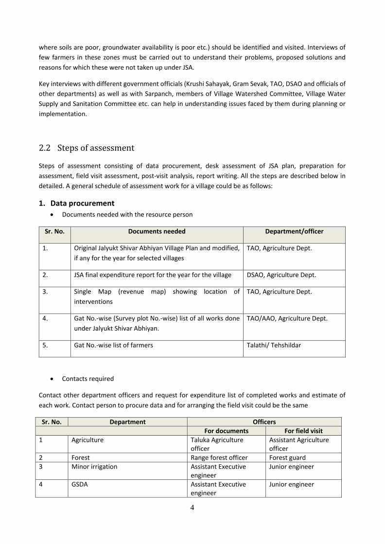
1. Data procurement
Documents needed with the resource person
Sr. No. Documents needed Department/officer
1. Original Jalyukt Shivar Abhiyan Village Plan and modified,
if any for the year for selected villages
TAO, Agriculture Dept.
2. JSA final expenditure report for the year for the village DSAO, Agriculture Dept.
3. Single Map (revenue map) showing location of
interventions
TAO, Agriculture Dept.
4. Gat No.-wise (Survey plot No.-wise) list of all works done
under Jalyukt Shivar Abhiyan.
TAO/AAO, Agriculture Dept.
5. Gat No.-wise list of farmers Talathi/ Tehshildar
Contacts required
Contact other department officers and request for expenditure list of completed works and estimate of
each work. Contact person to procure data and for arranging the field visit could be the same
Sr. No. Department Officers
For documents For field visit
1 Agriculture Taluka Agriculture officer
Assistant Agriculture officer
2 Forest Range forest officer Forest guard
3 Minor irrigation Assistant Executive engineer
Junior engineer
4 GSDA Assistant Executive engineer
Junior engineer
5
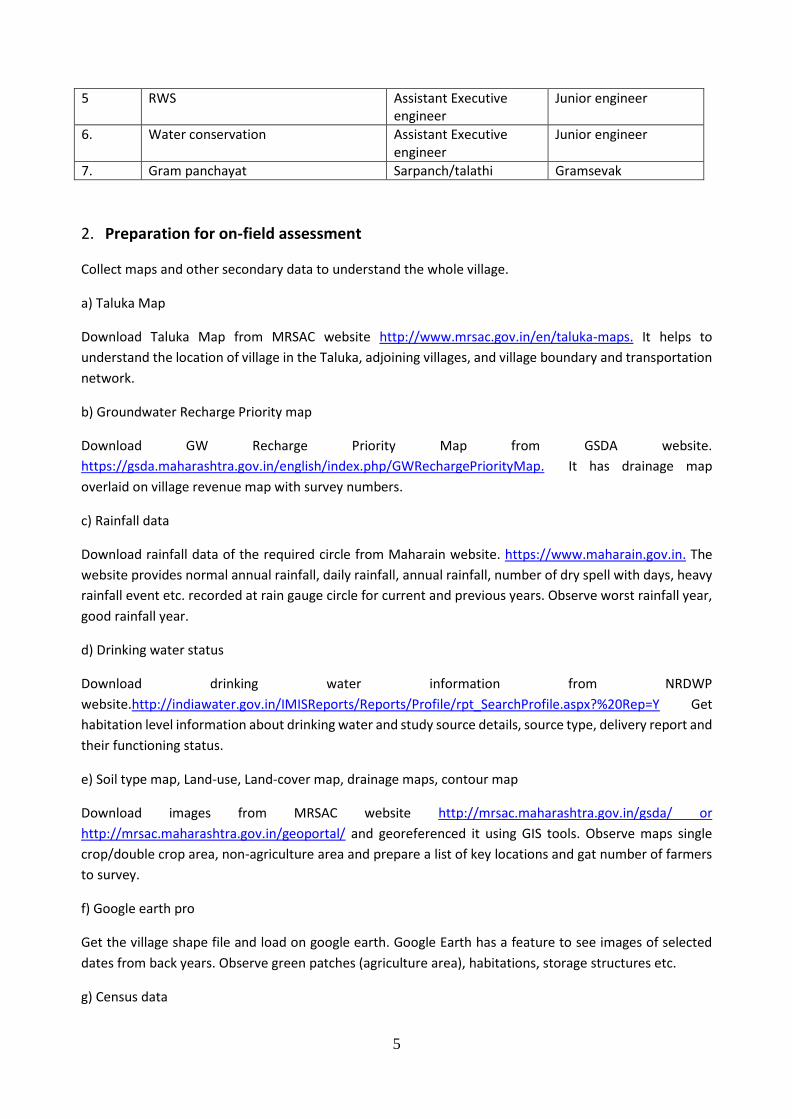
5 RWS Assistant Executive engineer
Junior engineer
6. Water conservation Assistant Executive engineer
Junior engineer
7. Gram panchayat Sarpanch/talathi Gramsevak
2. Preparation for on-field assessment
Collect maps and other secondary data to understand the whole village.
a) Taluka Map
Download Taluka Map from MRSAC website http://www.mrsac.gov.in/en/taluka-maps. It helps to
understand the location of village in the Taluka, adjoining villages, and village boundary and transportation
network.
b) Groundwater Recharge Priority map
Download GW Recharge Priority Map from GSDA website.
https://gsda.maharashtra.gov.in/english/index.php/GWRechargePriorityMap. It has drainage map
overlaid on village revenue map with survey numbers.
c) Rainfall data
Download rainfall data of the required circle from Maharain website. https://www.maharain.gov.in. The
website provides normal annual rainfall, daily rainfall, annual rainfall, number of dry spell with days, heavy
rainfall event etc. recorded at rain gauge circle for current and previous years. Observe worst rainfall year,
good rainfall year.
d) Drinking water status
Download drinking water information from NRDWP
website.http://indiawater.gov.in/IMISReports/Reports/Profile/rpt_SearchProfile.aspx?%20Rep=Y Get
habitation level information about drinking water and study source details, source type, delivery report and
their functioning status.
e) Soil type map, Land-use, Land-cover map, drainage maps, contour map
Download images from MRSAC website http://mrsac.maharashtra.gov.in/gsda/ or
http://mrsac.maharashtra.gov.in/geoportal/ and georeferenced it using GIS tools. Observe maps single
crop/double crop area, non-agriculture area and prepare a list of key locations and gat number of farmers
to survey.
f) Google earth pro
Get the village shape file and load on google earth. Google Earth has a feature to see images of selected
dates from back years. Observe green patches (agriculture area), habitations, storage structures etc.
g) Census data
6
Download census data from website http://censusindia.gov.in
h) Treatment Potential Map
If the assessed village is one selected in 2017-18 or later, there is a treatment-potential map generated for
the village by the WCD which should be available at District Agriculture or Taluka Agriculture office. This
map contains most of the above-mentioned attributes (such as contour, streams, stream order, land use
etc.) and also contains possible locations for soil and water conservation works. Study this map in order to
have some idea of the village micro-watershed and possible locations for interventions. The map can also
found at https://wcd.maharashtra.gov.in/capacity-treatments
Arrange with TAO and fix date and schedule of village visit. Write formal letter and also request to
TAO to arrange for presence of concerned line department officials along with estimates.
Go through the assessment formats and take printouts-based on summary sheet of structures in
the village. Prepare check list of survey numbers of beneficiary farmers (2 on either side for each
structure) and non-beneficiary farmers to interview during field visit.
3. On-field Assessment
1. List of equipment for field work a) Data collection tool: ODK software or hard copy formats
b) Rebound Hammer
c) Measuring Tape (preferably 30 meters)
d) Laser Tape
e) Spirit Level
f) A GPS device or smartphone.
Note:
(For Palghar assessment of JSA works TDSC has used a mobile-based application (android app called ODK
or open data kit) was used for data collection)
2. Structure level assessment Protocol for JSA Interventions/Works In order to accomplish above two objectives, intervention-wise survey formats have been designed which
are to be used as guides for recording observations (Annexure B1).
Sample protocols for the assessment are as follows-
1. Earthen Nala Bund
a) Identify all the ENBs constructed and code them.
b) Visit each ENB and fill corresponding form-
• Using smartphone or GPS device capture geo location
• Fill answers in the form for suitability of location- order of stream, bed slope etc.
• Check structural soundness and fill answers in the form- Dimension, spillways provided, pitching,
compaction etc.
• Check utility- Identify at-least two farm plots on either side of the ENB which are possibly
equidistant and belong to different farmers
7
c) Identify the farmers and interview them using Farmer Interview form (Annexure-B2)
• Plot area, gat number, cropping area and yield for last 2-3 years.
• Effect of JSA - increase in water level in dug well, bore well, soil moisture increased, negative
effect like water logging
• Benefit of the JSA works in increase in yield, cropping area
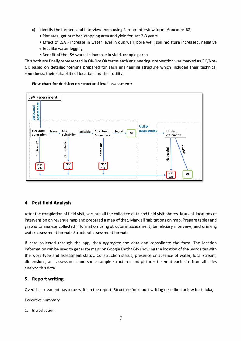
This both are finally represented in OK-Not OK terms each engineering intervention was marked as OK/Not-
OK based on detailed formats prepared for each engineering structure which included their technical
soundness, their suitability of location and their utility.
Flow chart for decision on structural level assessment:
4. Post field Analysis
After the completion of field visit, sort out all the collected data and field visit photos. Mark all locations of
intervention on revenue map and prepared a map of that. Mark all habitations on map. Prepare tables and
graphs to analyze collected information using structural assessment, beneficiary interview, and drinking
water assessment formats Structural assessment formats
If data collected through the app, then aggregate the data and consolidate the form. The location
information can be used to generate maps on Google Earth/ GIS showing the location of the work sites with
the work type and assessment status. Construction status, presence or absence of water, local stream,
dimensions, and assessment and some sample structures and pictures taken at each site from all sides
analyze this data.
5. Report writing
Overall assessment has to be write in the report. Structure for report writing described below for taluka,
Executive summary
1. Introduction

8
2. Assessment methodology
3. Work details and summary of taluka expenditure
4. Rapid assessment of JSA village plan - verification of water budget, selection criteria, cropping pattern,
proposed interventions and discrepancies if any.
5. Findings and recommendations - observations about JSA planning and implementation, Analysis-
intervention assessment summary table (ok-not ok), list of farmers benefited (yes-no), graphs for
farmers perspective on effect and benefit due to JSA works, area and drain line treatment works, fallow
land utilization. Recommendations- Suitable alteration in existing process, planning and
implementation, assessment. Action to be taken, reasons thereof.
6. Village level report
7. Annexure
9
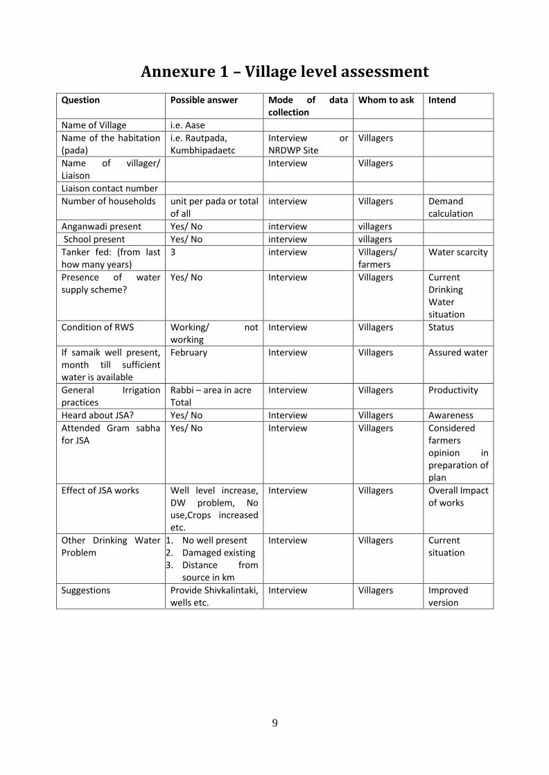
Annexure 1 – Village level assessment
Question Possible answer Mode of data collection
Whom to ask Intend
Name of Village i.e. Aase
Name of the habitation (pada)
i.e. Rautpada, Kumbhipadaetc
Interview or NRDWP Site
Villagers
Name of villager/ Liaison
Interview Villagers
Liaison contact number
Number of households unit per pada or total of all
interview Villagers Demand calculation
Anganwadi present Yes/ No interview villagers
School present Yes/ No interview villagers
Tanker fed: (from last how many years)
3 interview Villagers/ farmers
Water scarcity
Presence of water supply scheme?
Yes/ No Interview Villagers Current Drinking Water situation
Condition of RWS Working/ not working
Interview Villagers Status
If samaik well present, month till sufficient water is available
February Interview Villagers Assured water
General Irrigation practices
Rabbi – area in acre Total
Interview Villagers Productivity
Heard about JSA? Yes/ No Interview Villagers Awareness
Attended Gram sabha for JSA
Yes/ No Interview Villagers Considered farmers opinion in preparation of plan
Effect of JSA works Well level increase, DW problem, No use,Crops increased etc.
Interview Villagers Overall Impact of works
Other Drinking Water Problem
1. No well present 2. Damaged existing 3. Distance from
source in km
Interview Villagers Current situation
Suggestions Provide Shivkalintaki, wells etc.
Interview Villagers Improved version
10
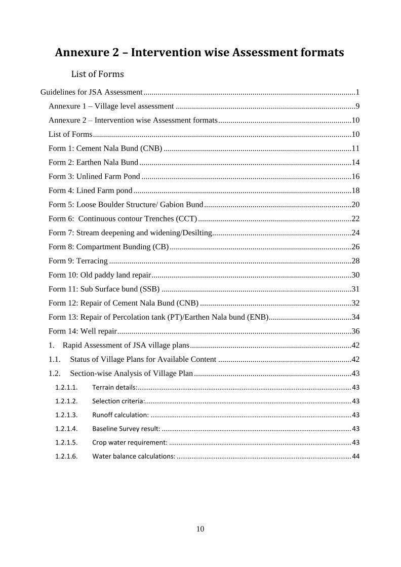
Annexure 2 – Intervention wise Assessment formats
List of Forms
Guidelines for JSA Assessment .........................................................................................................1
Annexure 1 – Village level assessment .........................................................................................9
Annexure 2 – Intervention wise Assessment formats ..................................................................10
List of Forms ................................................................................................................................10
Form 1: Cement Nala Bund (CNB) .............................................................................................11
Form 2: Earthen Nala Bund .........................................................................................................14
Form 3: Unlined Farm Pond ........................................................................................................16
Form 4: Lined Farm pond ............................................................................................................18
Form 5: Loose Boulder Structure/ Gabion Bund .........................................................................20
Form 6: Continuous contour Trenches (CCT) ............................................................................22
Form 7: Stream deepening and widening/Desilting.....................................................................24
Form 8: Compartment Bunding (CB) ..........................................................................................26
Form 9: Terracing ........................................................................................................................28
Form 10: Old paddy land repair ...................................................................................................30
Form 11: Sub Surface bund (SSB) ..............................................................................................31
Form 12: Repair of Cement Nala Bund (CNB) ...........................................................................32
Form 13: Repair of Percolation tank (PT)/Earthen Nala bund (ENB) .........................................34
Form 14: Well repair ....................................................................................................................36
1. Rapid Assessment of JSA village plans ................................................................................42
1.1. Status of Village Plans for Available Content ..................................................................42
1.2. Section-wise Analysis of Village Plan ..............................................................................43
1.2.1.1. Terrain details: ................................................................................................................... 43
1.2.1.2. Selection criteria:............................................................................................................... 43
1.2.1.3. Runoff calculation: ............................................................................................................ 43
1.2.1.4. Baseline Survey result: ...................................................................................................... 43
1.2.1.5. Crop water requirement: .................................................................................................. 43
1.2.1.6. Water balance calculations: .............................................................................................. 44
11
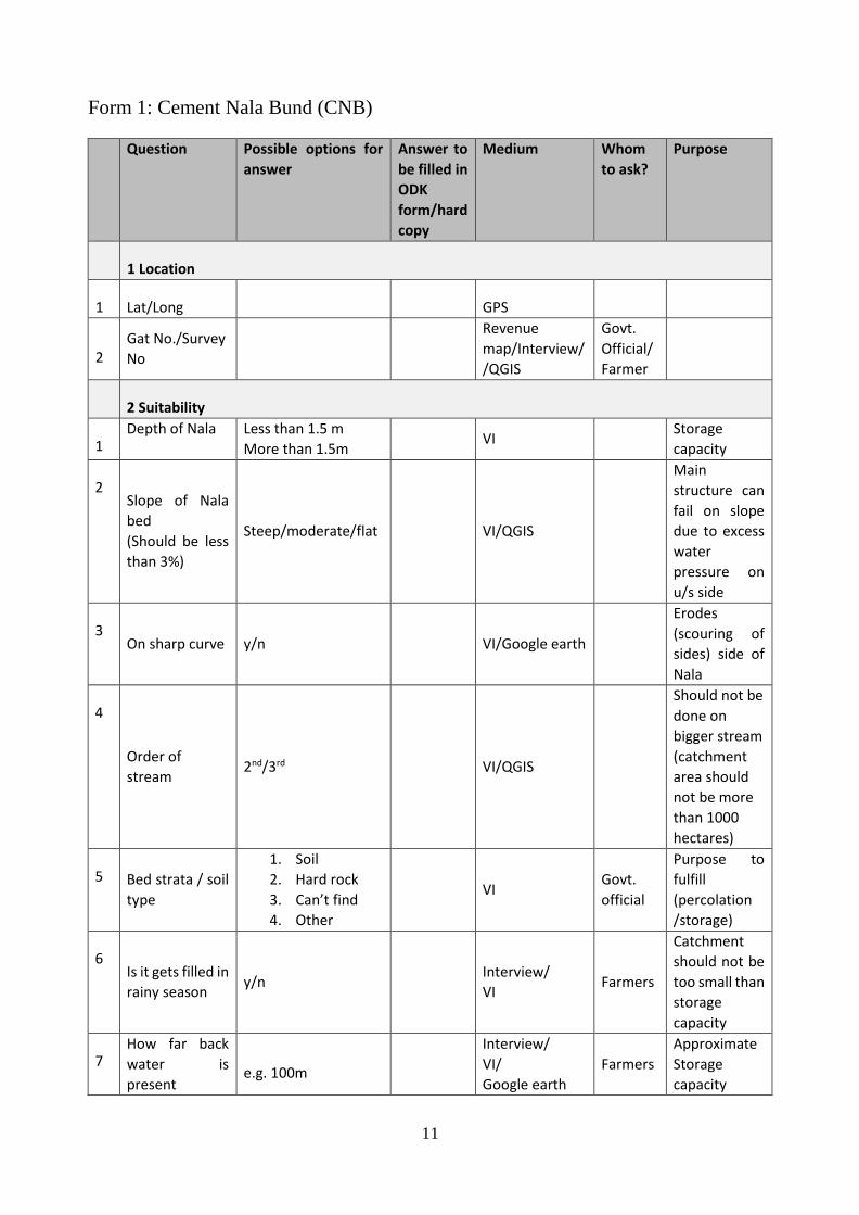
Form 1: Cement Nala Bund (CNB)
Question Possible options for
answer
Answer to
be filled in
ODK
form/hard
copy
Medium Whom
to ask?
Purpose
1 Location
1 Lat/Long
GPS
2 Gat No./Survey
No
Revenue
map/Interview/
/QGIS
Govt.
Official/
Farmer
2 Suitability
1 Depth of Nala
Less than 1.5 m
More than 1.5m VI
Storage
capacity
2 Slope of Nala
bed
(Should be less
than 3%)
Steep/moderate/flat VI/QGIS
Main
structure can
fail on slope
due to excess
water
pressure on
u/s side
3 On sharp curve y/n VI/Google earth
Erodes
(scouring of
sides) side of
Nala
4
Order of
stream 2nd/3rd VI/QGIS
Should not be
done on
bigger stream
(catchment
area should
not be more
than 1000
hectares)
5 Bed strata / soil
type
1. Soil
2. Hard rock
3. Can’t find
4. Other
VI Govt.
official
Purpose to
fulfill
(percolation
/storage)
6 Is it gets filled in
rainy season y/n
Interview/
VI Farmers
Catchment
should not be
too small than
storage
capacity
7 How far back
water is
present e.g. 100m
Interview/
VI/
Google earth
Farmers
Approximate
Storage
capacity
12
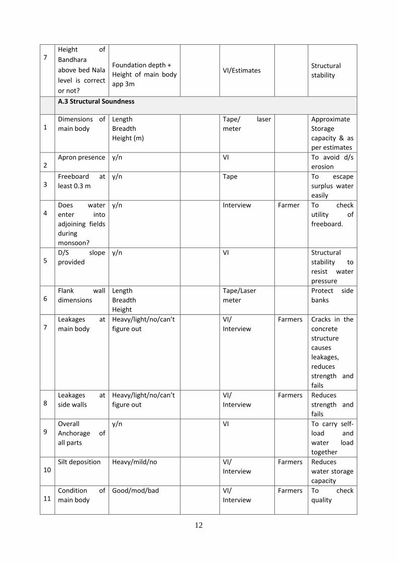
7 Height of
Bandhara
above bed Nala
level is correct
or not?
Foundation depth +
Height of main body
app 3m
VI/Estimates Structural
stability
A.3 Structural Soundness
1 Dimensions of
main body
Length
Breadth
Height (m)
Tape/ laser
meter
Approximate
Storage
capacity & as
per estimates
2 Apron presence y/n VI To avoid d/s
erosion
3 Freeboard at
least 0.3 m
y/n Tape To escape
surplus water
easily
4 Does water
enter into
adjoining fields
during
monsoon?
y/n Interview Farmer To check
utility of
freeboard.
5 D/S slope
provided
y/n VI Structural
stability to
resist water
pressure
6 Flank wall
dimensions
Length
Breadth
Height
Tape/Laser
meter
Protect side
banks
7 Leakages at
main body
Heavy/light/no/can’t
figure out
VI/
Interview
Farmers Cracks in the
concrete
structure
causes
leakages,
reduces
strength and
fails
8 Leakages at
side walls
Heavy/light/no/can’t
figure out
VI/
Interview
Farmers Reduces
strength and
fails
9 Overall
Anchorage of
all parts
y/n VI To carry self-
load and
water load
together
10 Silt deposition Heavy/mild/no VI/
Interview
Farmers Reduces
water storage
capacity
11 Condition of
main body
Good/mod/bad VI/
Interview
Farmers To check
quality
13
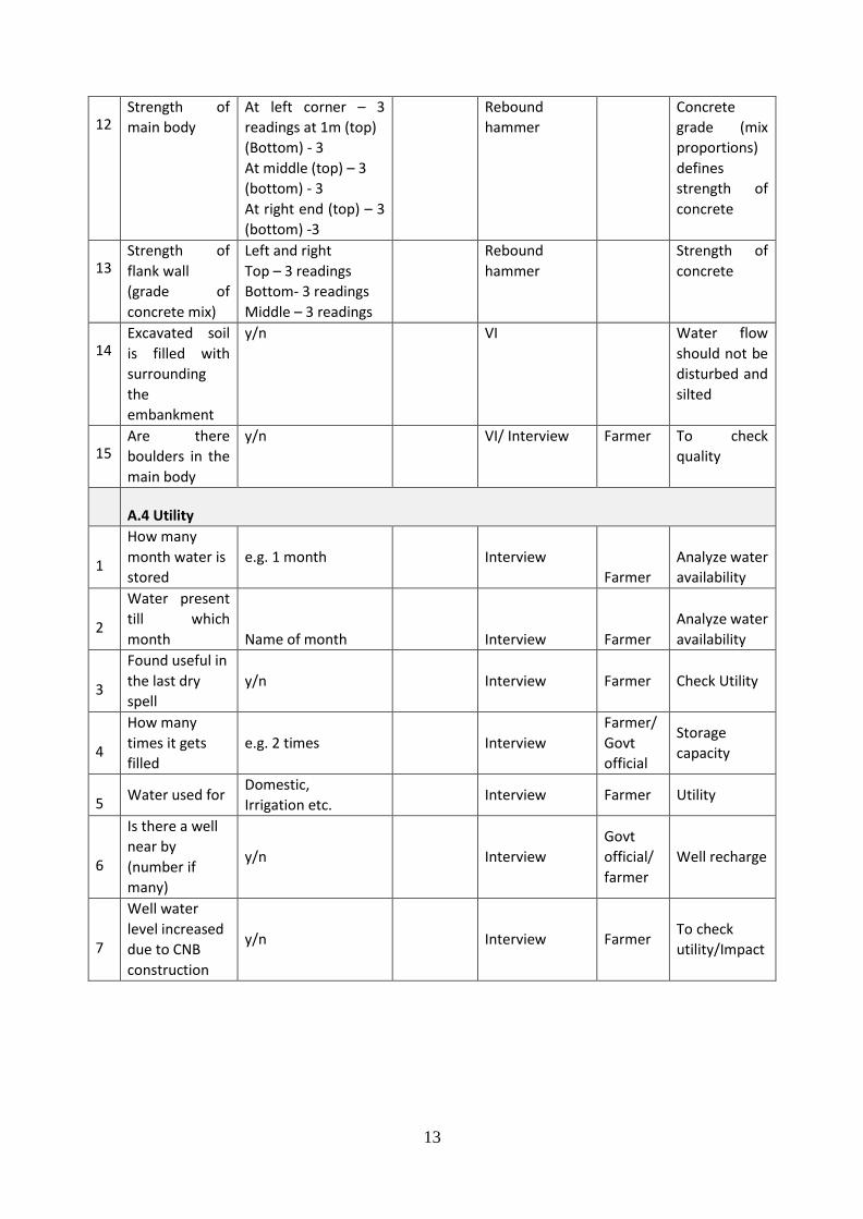
12 Strength of
main body
At left corner – 3
readings at 1m (top)
(Bottom) - 3
At middle (top) – 3
(bottom) - 3
At right end (top) – 3
(bottom) -3
Rebound
hammer
Concrete
grade (mix
proportions)
defines
strength of
concrete
13 Strength of
flank wall
(grade of
concrete mix)
Left and right
Top – 3 readings
Bottom- 3 readings
Middle – 3 readings
Rebound
hammer
Strength of
concrete
14 Excavated soil
is filled with
surrounding
the
embankment
y/n VI Water flow
should not be
disturbed and
silted
15 Are there
boulders in the
main body
y/n VI/ Interview Farmer To check
quality
A.4 Utility
1
How many
month water is
stored
e.g. 1 month Interview
Farmer
Analyze water
availability
2
Water present
till which
month Name of month
Interview Farmer
Analyze water
availability
3
Found useful in
the last dry
spell
y/n Interview Farmer Check Utility
4
How many
times it gets
filled
e.g. 2 times Interview
Farmer/
Govt
official
Storage
capacity
5 Water used for
Domestic,
Irrigation etc. Interview Farmer Utility
6
Is there a well
near by
(number if
many)
y/n Interview
Govt
official/
farmer
Well recharge
7
Well water
level increased
due to CNB
construction
y/n Interview Farmer To check
utility/Impact
14
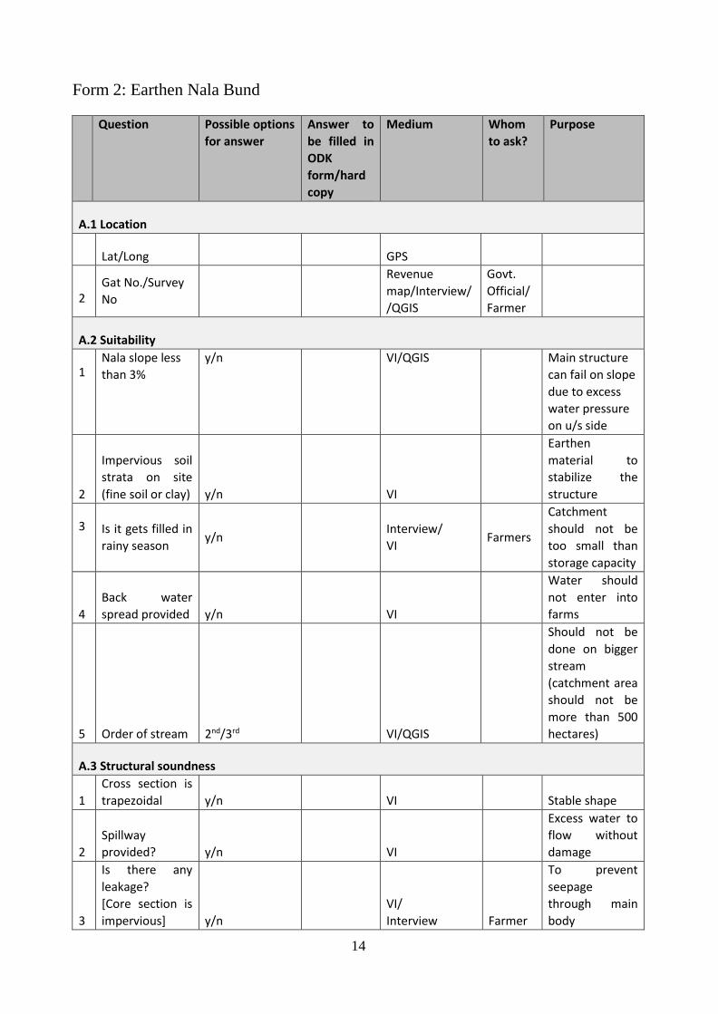
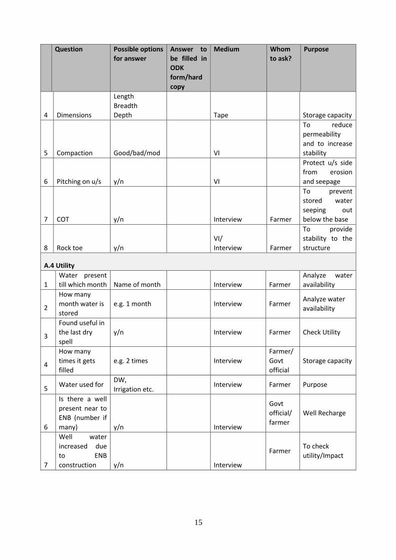
Form 2: Earthen Nala Bund
Question Possible options
for answer
Answer to
be filled in
ODK
form/hard
copy
Medium Whom
to ask?
Purpose
A.1 Location
Lat/Long
GPS
2 Gat No./Survey
No
Revenue
map/Interview/
/QGIS
Govt.
Official/
Farmer
A.2 Suitability
1 Nala slope less
than 3%
y/n VI/QGIS Main structure
can fail on slope
due to excess
water pressure
on u/s side
2
Impervious soil
strata on site
(fine soil or clay) y/n
VI
Earthen
material to
stabilize the
structure
3 Is it gets filled in
rainy season y/n
Interview/
VI Farmers
Catchment
should not be
too small than
storage capacity
4
Back water
spread provided y/n
VI
Water should
not enter into
farms
5 Order of stream 2nd/3rd
VI/QGIS
Should not be
done on bigger
stream
(catchment area
should not be
more than 500
hectares)
A.3 Structural soundness
1
Cross section is
trapezoidal y/n
VI Stable shape
2
Spillway
provided? y/n
VI
Excess water to
flow without
damage
3
Is there any
leakage?
[Core section is
impervious] y/n
VI/
Interview Farmer
To prevent
seepage
through main
body
15
Question Possible options
for answer
Answer to
be filled in
ODK
form/hard
copy
Medium Whom
to ask?
Purpose
4 Dimensions
Length
Breadth
Depth
Tape Storage capacity
5 Compaction Good/bad/mod
VI
To reduce
permeability
and to increase
stability
6 Pitching on u/s y/n
VI
Protect u/s side
from erosion
and seepage
7 COT y/n
Interview Farmer
To prevent
stored water
seeping out
below the base
8 Rock toe y/n
VI/
Interview Farmer
To provide
stability to the
structure
A.4 Utility
1
Water present
till which month Name of month
Interview Farmer
Analyze water
availability
2
How many
month water is
stored
e.g. 1 month Interview Farmer Analyze water
availability
3
Found useful in
the last dry
spell
y/n Interview Farmer Check Utility
4
How many
times it gets
filled
e.g. 2 times Interview
Farmer/
Govt
official
Storage capacity
5 Water used for
DW,
Irrigation etc. Interview Farmer Purpose
6
Is there a well
present near to
ENB (number if
many) y/n
Interview
Govt
official/
farmer
Well Recharge
7
Well water
increased due
to ENB
construction y/n
Interview
Farmer To check
utility/Impact
16
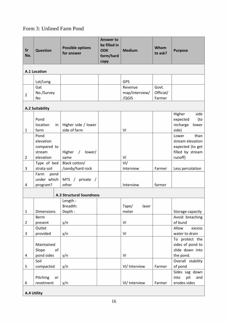
Form 3: Unlined Farm Pond
Sr
No. Question
Possible options
for answer
Answer to
be filled in
ODK
form/hard
copy
Medium Whom
to ask? Purpose
A.1 Location
Lat/Long
GPS
2
Gat
No./Survey
No
Revenue
map/Interview/
/QGIS
Govt.
Official/
Farmer
A.2 Suitability
1
Pond
location in
farm
Higher side / lower
side of farm
VI
Higher side
expected (to
recharge lower
side)
2
Pond
elevation
compared to
stream
elevation
Higher / lower/
same
VI
Lower than
stream elevation
expected (to get
filled by stream
runoff)
3
Type of bed
strata soil
Black cotton/
/sandy/hard rock
VI/
Interview Farmer Less percolation
4
Farm pond
under which
program?
MTS / private /
other
Interview farmer
A.3 Structural Soundness
1 Dimensions
Length :
Breadth:
Depth :
Tape/ laser
meter Storage capacity
2
Berm
present y/n
VI
Avoid breaching
of bund
3
Outlet
provided y/n
VI
Allow excess
water to drain
4
Maintained
Slope of
pond sides y/n
VI
To protect the
sides of pond to
slide down into
the pond.
5
Soil
compacted y/n
VI/ Interview Farmer
Overall stability
of pond
6
Pitching or
revetment y/n
VI/ Interview Farmer
Sides sag down
into pit and
erodes sides
A.4 Utility
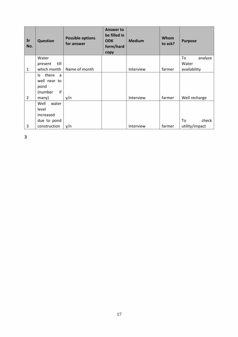
17
Sr
No. Question
Possible options
for answer
Answer to
be filled in
ODK
form/hard
copy
Medium Whom
to ask? Purpose
1
Water
present till
which month Name of month
Interview farmer
To analyze
Water
availability
2
Is there a
well near to
pond
(number if
many) y/n
Interview farmer Well recharge
3
Well water
level
increased
due to pond
construction y/n
Interview farmer
To check
utility/impact
3
18
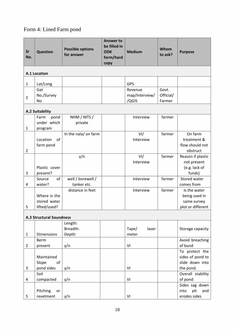
Form 4: Lined Farm pond
Sr
No. Question
Possible options
for answer
Answer to
be filled in
ODK
form/hard
copy
Medium Whom
to ask? Purpose
A.1 Location
1 Lat/Long
GPS
2
Gat
No./Survey
No
Revenue
map/Interview/
/QGIS
Govt.
Official/
Farmer
A.2 Suitability
1
Farm pond
under which
program
NHM / MTS /
private
Interview farmer
2
Location of
farm pond
In the nala/ on farm VI/
Interview
farmer On farm
treatment &
flow should not
obstruct
3
Plastic cover
present?
y/n VI/
Interview
farmer Reason if plastic
not present
(e.g. lack of
funds)
4
Source of
water?
well / borewell /
tanker etc.
Interview farmer Stored water
comes from
5
Where is the
stored water
lifted/used?
distance in feet Interview farmer Is the water
being used in
same survey
plot or different
A.3 Structural Soundness
1 Dimensions
Length:
Breadth:
Depth:
Tape/ laser
meter
Storage capacity
2
Berm
present y/n
VI
Avoid breaching
of bund
3
Maintained
Slope of
pond sides y/n
VI
To protect the
sides of pond to
slide down into
the pond.
4
Soil
compacted y/n
VI
Overall stability
of pond
5
Pitching or
revetment y/n
VI
Sides sag down
into pit and
erodes sides
19
Sr
No. Question
Possible options
for answer
Answer to
be filled in
ODK
form/hard
copy
Medium Whom
to ask? Purpose
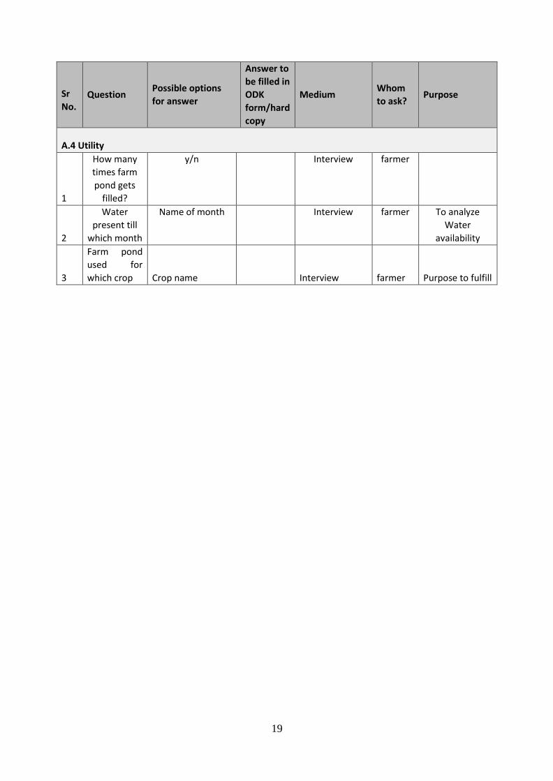
A.4 Utility
1
How many
times farm
pond gets
filled?
y/n Interview farmer
2
Water
present till
which month
Name of month Interview farmer To analyze
Water
availability
3
Farm pond
used for
which crop Crop name
Interview farmer Purpose to fulfill
20
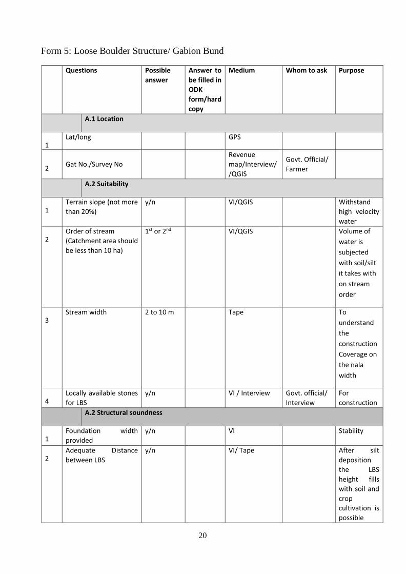
Form 5: Loose Boulder Structure/ Gabion Bund
Questions Possible
answer
Answer to
be filled in
ODK
form/hard
copy
Medium Whom to ask Purpose
A.1 Location
1 Lat/long GPS
2 Gat No./Survey No
Revenue
map/Interview/
/QGIS
Govt. Official/
Farmer
A.2 Suitability
1 Terrain slope (not more
than 20%)
y/n VI/QGIS Withstand
high velocity
water
2 Order of stream
(Catchment area should
be less than 10 ha)
1st or 2nd VI/QGIS Volume of
water is
subjected
with soil/silt
it takes with
on stream
order
3 Stream width 2 to 10 m Tape To
understand
the
construction
Coverage on
the nala
width
4 Locally available stones
for LBS
y/n VI / Interview Govt. official/
Interview
For
construction
A.2 Structural soundness
1 Foundation width
provided
y/n VI Stability
2 Adequate Distance
between LBS
y/n VI/ Tape After silt
deposition
the LBS
height fills
with soil and
crop
cultivation is
possible

21
Questions Possible
answer
Answer to
be filled in
ODK
form/hard
copy
Medium Whom to ask Purpose
3 Provision of dip in the
middle
y/n VI Stability
4 If no dip provided, are
side embankments
provided?
y/n VI Stability
5 Dimension Length
Width
Depth
Tape Verification
6 Tapered or trapezoidal
Shape of LBS
y/n VI Stable or not
7 Max. height should be 1
m
y/n Tape Withstand
high velocity
water
8 Arrangement of stones/ Good/ bad VI Reduce Soil
erosion
9 Covers entire stream
width and 1m extra on
both sides.
y/n VI Proper
anchorage
A3. Utility
1 Soil erosion stopped y/n VI / Interview Purpose to
fulfill
2 Suggestions
22
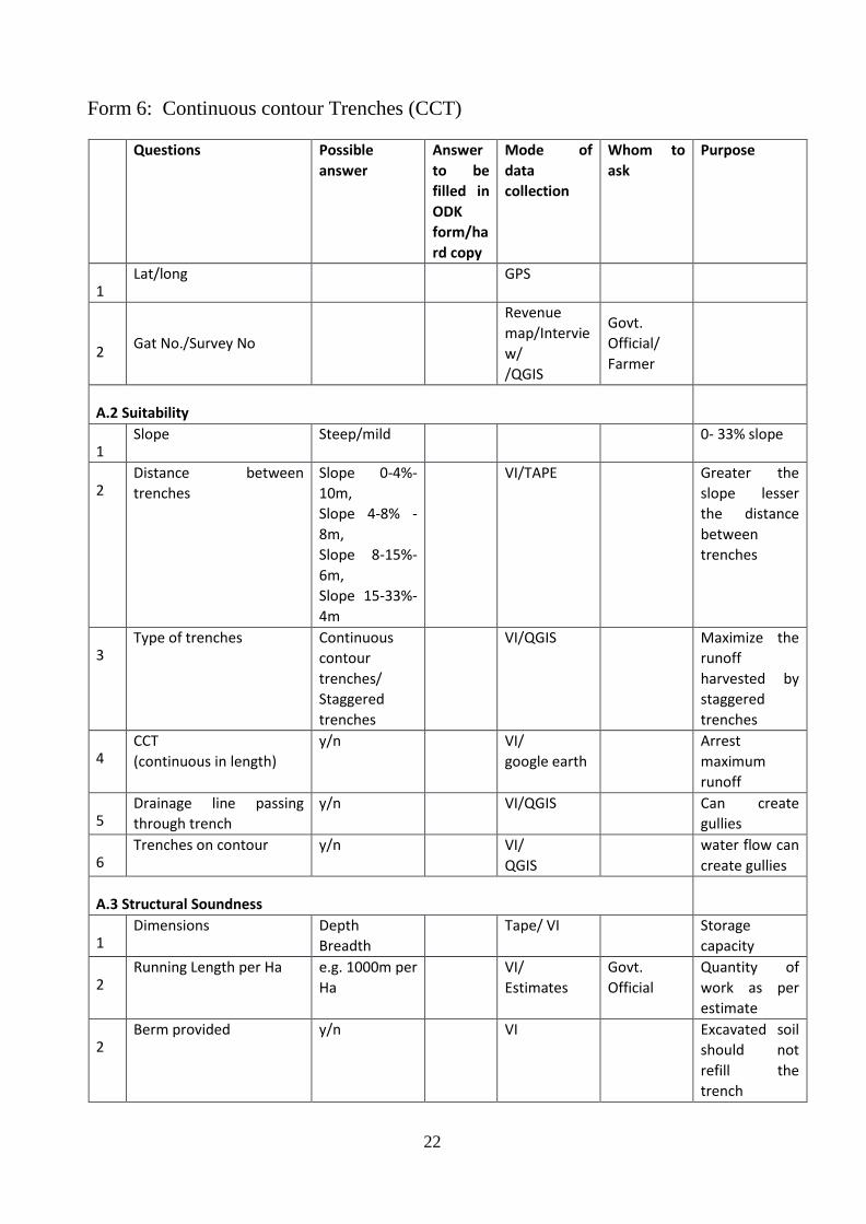
Form 6: Continuous contour Trenches (CCT)
Questions Possible
answer
Answer
to be
filled in
ODK
form/ha
rd copy
Mode of
data
collection
Whom to
ask
Purpose
1 Lat/long GPS
2 Gat No./Survey No
Revenue
map/Intervie
w/
/QGIS
Govt.
Official/
Farmer
A.2 Suitability
1 Slope Steep/mild 0- 33% slope
2 Distance between
trenches
Slope 0-4%-
10m,
Slope 4-8% -
8m,
Slope 8-15%-
6m,
Slope 15-33%-
4m
VI/TAPE Greater the
slope lesser
the distance
between
trenches
3 Type of trenches Continuous
contour
trenches/
Staggered
trenches
VI/QGIS Maximize the
runoff
harvested by
staggered
trenches
4 CCT
(continuous in length)
y/n VI/
google earth
Arrest
maximum
runoff
5 Drainage line passing
through trench
y/n VI/QGIS Can create
gullies
6 Trenches on contour y/n VI/
QGIS
water flow can
create gullies
A.3 Structural Soundness
1 Dimensions Depth
Breadth
Tape/ VI Storage
capacity
2 Running Length per Ha e.g. 1000m per
Ha
VI/
Estimates
Govt.
Official
Quantity of
work as per
estimate
2 Berm provided y/n VI Excavated soil
should not
refill the
trench
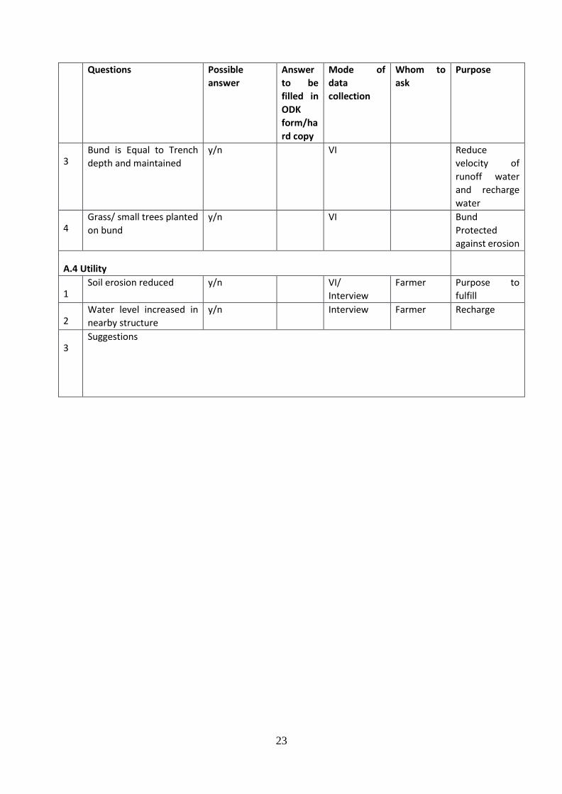
23
Questions Possible
answer
Answer
to be
filled in
ODK
form/ha
rd copy
Mode of
data
collection
Whom to
ask
Purpose
3 Bund is Equal to Trench
depth and maintained
y/n VI Reduce
velocity of
runoff water
and recharge
water
4 Grass/ small trees planted
on bund
y/n VI Bund
Protected
against erosion
A.4 Utility
1 Soil erosion reduced y/n VI/
Interview
Farmer Purpose to
fulfill
2 Water level increased in
nearby structure
y/n Interview Farmer Recharge
3 Suggestions

24
Form 7: Stream deepening and widening/Desilting
Question Possible options for
answer
Answer to
be filled in
ODK
form/hard
copy
Medium Whom
to ask?
Purpose
A.1 Location
1 Lat/Long
GPS
2
Gat
No./Survey
No
Revenue
map/Interview/
/QGIS
Govt.
Official/
Farmer
A.2 Suitability
1 Order of
stream
1st/2nd /3rd/.4th. QGIS/VI
Should be
done on
2nd/3rd
2 Whether
upstream of
Bandhara?
y/n VI Should be
preferred
3 Bed strata /
soil type
1. Hard rock
2. Soil/Alluvium
3. Can’t found
4. other
VI Govt.
official
Purpose to
fulfill
(percolation
/storage)
4 Whether
location
certified by
Sub-divisional
Agriculture
office?
y/n Interview
Govt.
official
Should be
done
A.3 Structural Soundness
1 Dimensions
Before
Excavation
Length
Breadth
Height (m)
Tape/ laser
meter
Quantity of
work as per
estimate
2 Dimensions
after
Excavation
Length
Breadth
Height (m)
Tape/ laser
meter
Quantity of
work as per
estimate
3 Depth below
stream bed?
In m Tape/
Interview
Govt.
official
Less than 3 m
or till hard
rock
4 Volume of silt
excavated?
In m3
Above
dimensions/
Estimates
Quantity of
work as per
estimate
5 Silt Used for? Farmer/Berm Interview/
VI
Farmer/
Govt.
official
Identify
beneficiary
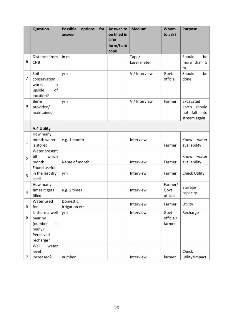
25
Question Possible options for
answer
Answer to
be filled in
ODK
form/hard
copy
Medium Whom
to ask?
Purpose
6 Distance from
CNB
In m Tape/
Laser meter
Should be
more than 5
m
7 Soil
conservation
works in
upside of
location?
y/n VI/ Interview Govt.
official
Should be
done
8 Berm
provided/
maintained
y/n VI/ Interview Farmer Excavated
earth should
not fall into
stream again
A.4 Utility
1
How many
month water
is stored
e.g. 1 month Interview
Farmer
Know water
availability
2
Water present
till which
month Name of month
Interview Farmer
Know water
availability
3
Found useful
in the last dry
spell
y/n Interview Farmer Check Utility
4
How many
times it gets
filled
e.g. 2 times Interview
Farmer/
Govt
official
Storage
capacity
5 Water used
for
Domestic,
Irrigation etc. Interview Farmer Utility
6 Is there a well
near by
(number if
many)
Perceived
recharge?
y/n Interview Govt
official/
farmer
Recharge
7
Well water
level
increased? number
Interview farmer
Check
utility/Impact
26
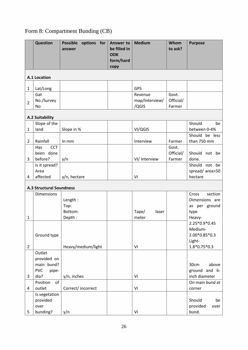
Form 8: Compartment Bunding (CB)
Question Possible options for
answer
Answer to
be filled in
ODK
form/hard
copy
Medium Whom
to ask?
Purpose
A.1 Location
1 Lat/Long
GPS
2
Gat
No./Survey
No
Revenue
map/Interview/
/QGIS
Govt.
Official/
Farmer
A.2 Suitability
1
Slope of the
land Slope in %
VI/QGIS
Should be
between 0-4%
2 Rainfall In mm
Interview Farmer
Should be less
than 750 mm
3
Has CCT
been done
before? y/n
VI/ Interview
Govt.
Official/
Farmer
Should not be
done.
4
Is it spread?
Area
affected y/n, hectare
VI
Should not be
spread/ area>50
hectare
A.3 Structural Soundness
1
Dimensions
Length :
Top:
Bottom:
Depth :
Tape/ laser
meter
Cross section
Dimensions are
as per ground
type
Heavy-
2.25*0.9*0.45
Medium-
2.00*0.85*0.3
Light-
1.8*0.75*0.3 2
Ground type
Heavy/medium/light
VI
3
Outlet
provided on
main bund?
PVC pipe-
dia? y/n, inches
VI
30cm above
ground and 6-
inch diameter
4
Position of
outlet Correct/ incorrect
VI
On main bund at
corner
5
Is vegetation
provided
over
bunding? y/n
VI
Should be
provided over
bund.
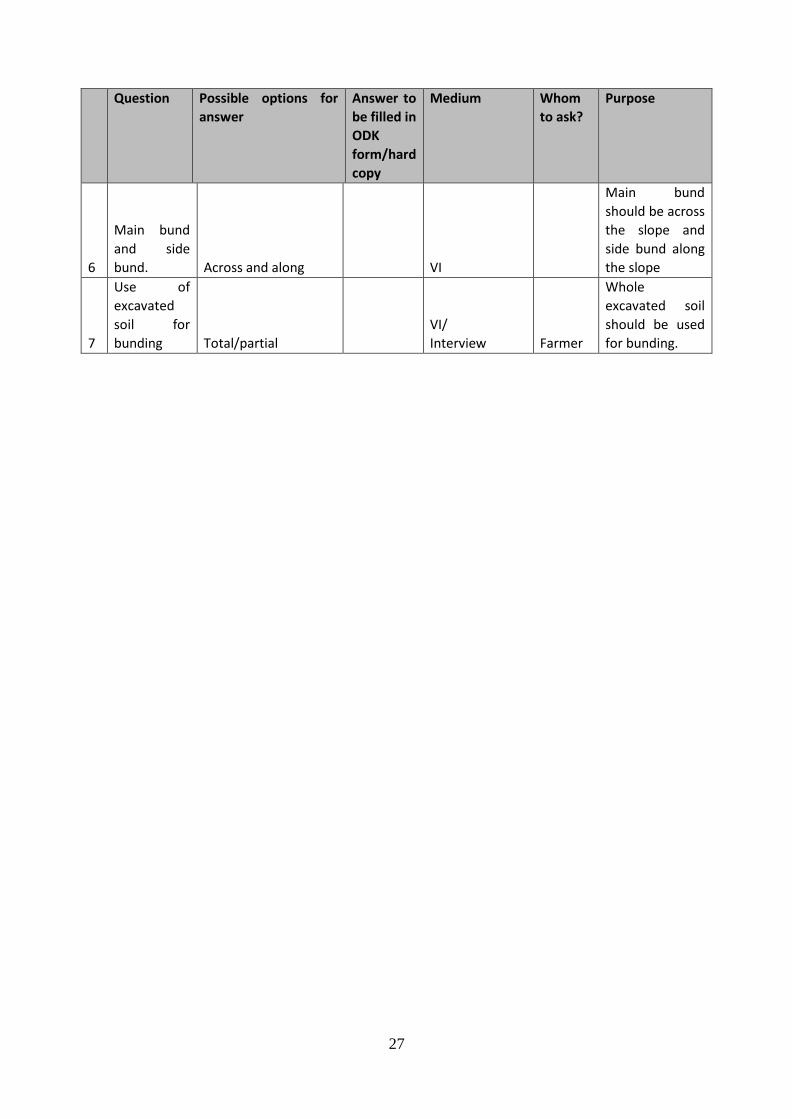
27
Question Possible options for
answer
Answer to
be filled in
ODK
form/hard
copy
Medium Whom
to ask?
Purpose
6
Main bund
and side
bund. Across and along
VI
Main bund
should be across
the slope and
side bund along
the slope
7
Use of
excavated
soil for
bunding Total/partial
VI/
Interview Farmer
Whole
excavated soil
should be used
for bunding.
28
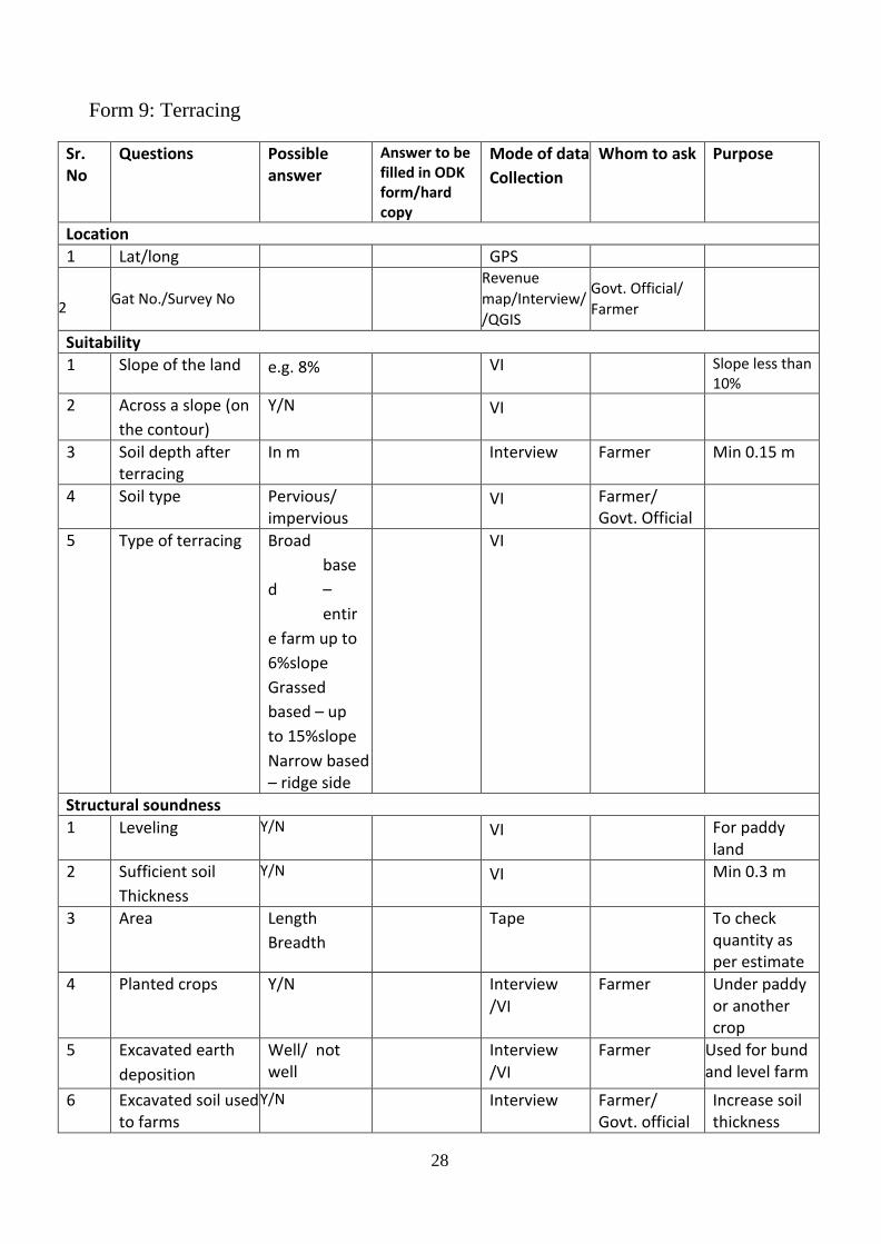
Form 9: Terracing
Sr. No
Questions Possible answer
Answer to be filled in ODK form/hard copy
Mode of data
Collection
Whom to ask Purpose
Location 1 Lat/long GPS
2 Gat No./Survey No
Revenue
map/Interview/
/QGIS
Govt. Official/
Farmer
Suitability
1 Slope of the land e.g. 8% VI Slope less than 10%
2 Across a slope (on
the contour)
Y/N VI
3 Soil depth after terracing
In m Interview Farmer Min 0.15 m
4 Soil type Pervious/ impervious
VI Farmer/ Govt. Official
5 Type of terracing Broad
base
d –
entir
e farm up to
6%slope
Grassed
based – up
to 15%slope
Narrow based – ridge side
VI
Structural soundness
1 Leveling Y/N VI For paddy land
2 Sufficient soil
Thickness
Y/N VI Min 0.3 m
3 Area Length
Breadth
Tape To check quantity as per estimate
4 Planted crops Y/N Interview
/VI
Farmer Under paddy or another crop
5 Excavated earth
deposition
Well/ not well
Interview
/VI
Farmer Used for bund and level farm
6 Excavated soil used to farms
Y/N Interview Farmer/ Govt. official
Increase soil thickness
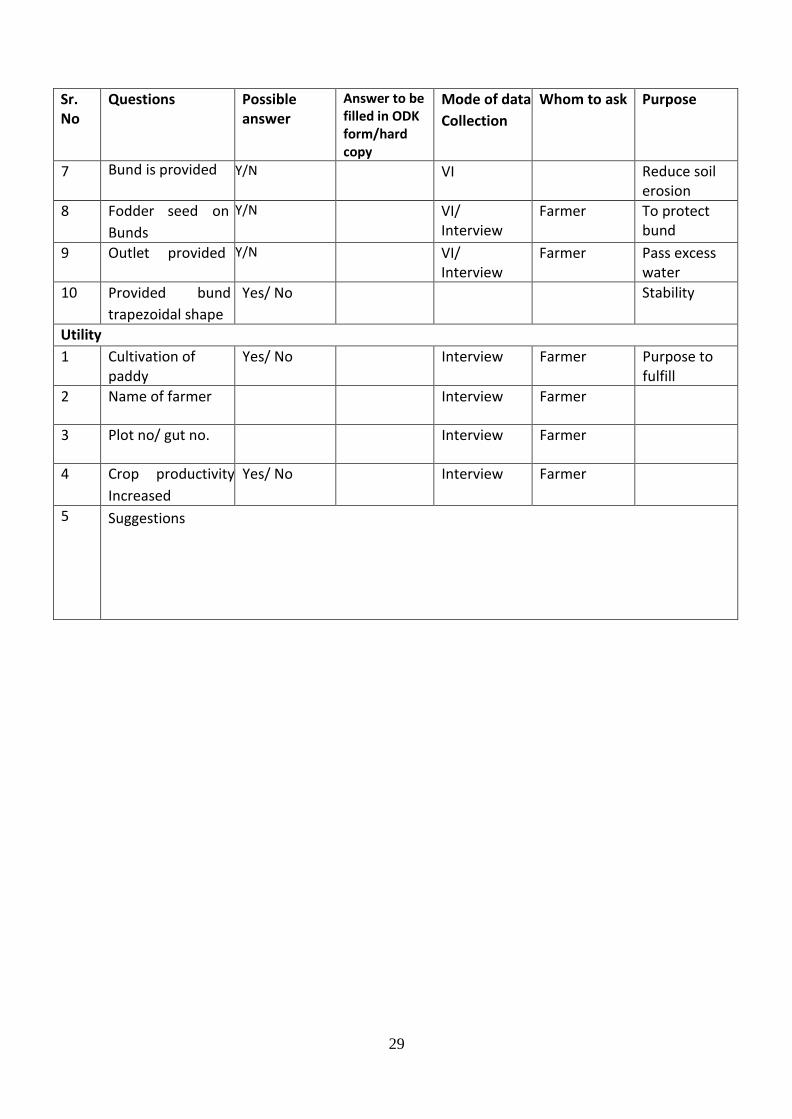
29
Sr. No
Questions Possible answer
Answer to be filled in ODK form/hard copy
Mode of data
Collection
Whom to ask Purpose
7 Bund is provided Y/N VI Reduce soil erosion
8 Fodder seed on
Bunds
Y/N VI/ Interview
Farmer To protect bund
9 Outlet provided Y/N VI/ Interview
Farmer Pass excess water
10 Provided bund
trapezoidal shape
Yes/ No Stability
Utility
1 Cultivation of paddy
Yes/ No Interview Farmer Purpose to fulfill
2 Name of farmer Interview Farmer
3 Plot no/ gut no. Interview Farmer
4 Crop productivity
Increased
Yes/ No Interview Farmer
5 Suggestions
30
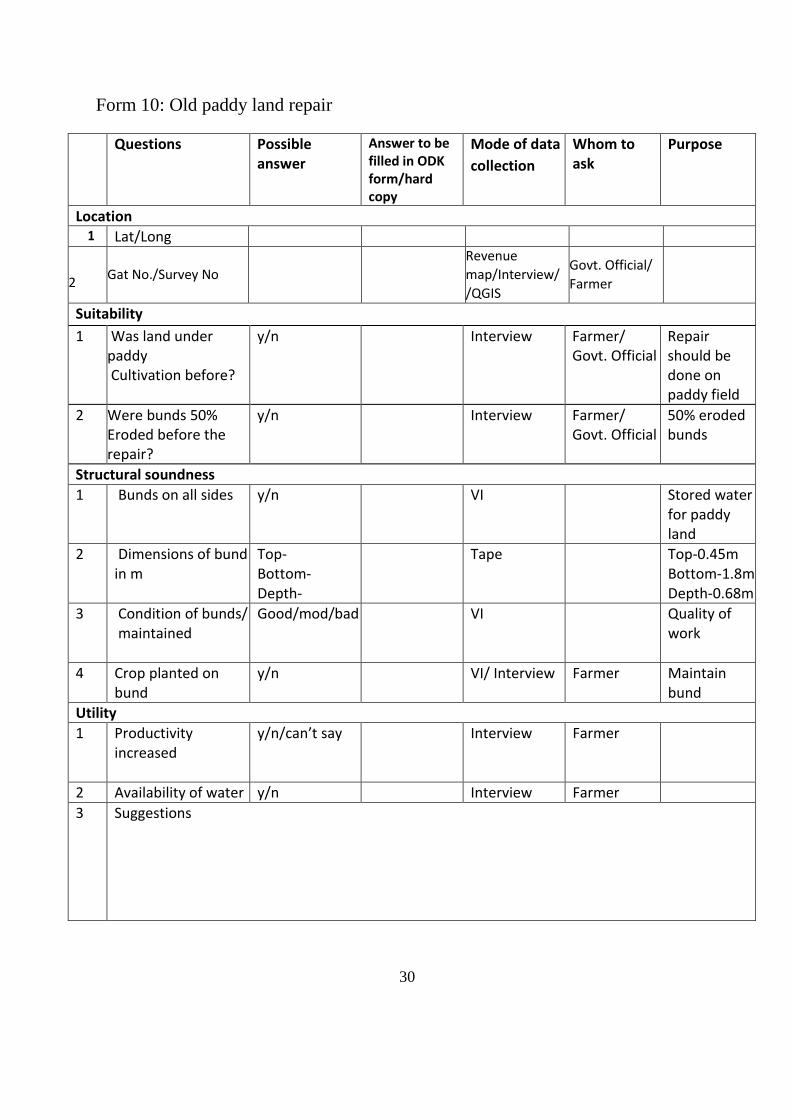
Form 10: Old paddy land repair
Questions Possible answer
Answer to be filled in ODK form/hard copy
Mode of data
collection
Whom to ask
Purpose
Location 1 Lat/Long
2 Gat No./Survey No
Revenue
map/Interview/
/QGIS
Govt. Official/
Farmer
Suitability
1 Was land under paddy Cultivation before?
y/n Interview Farmer/ Govt. Official
Repair should be done on paddy field
2 Were bunds 50% Eroded before the repair?
y/n Interview Farmer/ Govt. Official
50% eroded bunds
Structural soundness
1 Bunds on all sides
y/n VI Stored water for paddy land
2 Dimensions of bund in m
Top- Bottom- Depth-
Tape Top-0.45m Bottom-1.8m Depth-0.68m
3 Condition of bunds/ maintained
Good/mod/bad VI Quality of work
4 Crop planted on bund
y/n VI/ Interview Farmer Maintain bund
Utility
1 Productivity increased
y/n/can’t say Interview Farmer
2 Availability of water y/n Interview Farmer
3 Suggestions

31
Form 11: Sub Surface bund (SSB)
Questions Possible answer
Answer Mode of data collection
Whom to ask
Purpose
Location
1 Lat/long GPS
2 Gat No./Survey No
Revenue
map/Interview/
/QGIS
Govt.
Official/
Farmer
Suitability
1 30-75cm below the ground level
y/n VI
/Interview
Farmer farms are above SSB
2 In the vicinity of wells/handpump
y/n VI/
Interview
Farmer Drinking water source strengthening
3 Constructed in nala/stream
y/n VI/
Interview
Farmer Make sub surface flow available
Structural soundness
1 Dimensions In m
Length Breadth Depth
Tape/
las
er meter
2 Constructed upto hard rock
y/n Interview Farmer/
Govt.
official
Otherwise water percolates below
3 Perpendicular to direction of flow
y/n VI/
Interview
Farmer Obstruct the flow
4 Provided boulder check/recharge trench on u/s
y/n Interview Govt.
official/
Farmer
Percolate surface flow underground
5 Drains on both sides
y/n VI/ Interview
Farmer Check percolation
6 Maintained y/n VI Quality of work
Utility
1 Increased Recharge to well
y/n Interview Farmer Purpose to fulfill
2 Suggestions
32
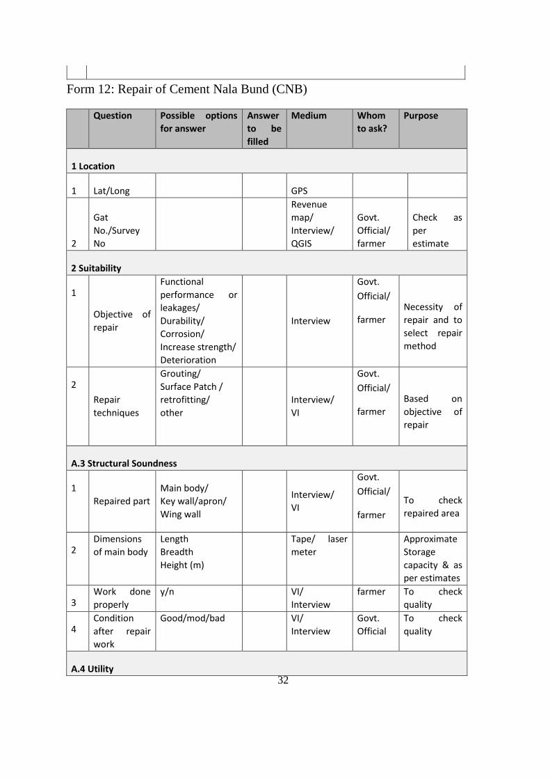
Form 12: Repair of Cement Nala Bund (CNB)
Question Possible options
for answer
Answer
to be
filled
Medium Whom
to ask?
Purpose
1 Location
1 Lat/Long
GPS
2
Gat
No./Survey
No
Revenue
map/
Interview/
QGIS
Govt.
Official/
farmer
Check as
per
estimate
2 Suitability
1
Objective of
repair
Functional
performance or
leakages/
Durability/
Corrosion/
Increase strength/
Deterioration
Interview
Govt.
Official/
farmer Necessity of
repair and to
select repair
method
2
Repair
techniques
Grouting/
Surface Patch /
retrofitting/
other
Interview/
VI
Govt.
Official/
farmer
Based on
objective of
repair
A.3 Structural Soundness
1
Repaired part
Main body/
Key wall/apron/
Wing wall
Interview/
VI
Govt.
Official/
farmer
To check
repaired area
2 Dimensions
of main body
Length
Breadth
Height (m)
Tape/ laser
meter
Approximate
Storage
capacity & as
per estimates
3 Work done
properly
y/n VI/
Interview
farmer To check
quality
4 Condition
after repair
work
Good/mod/bad VI/
Interview
Govt.
Official
To check
quality
A.4 Utility
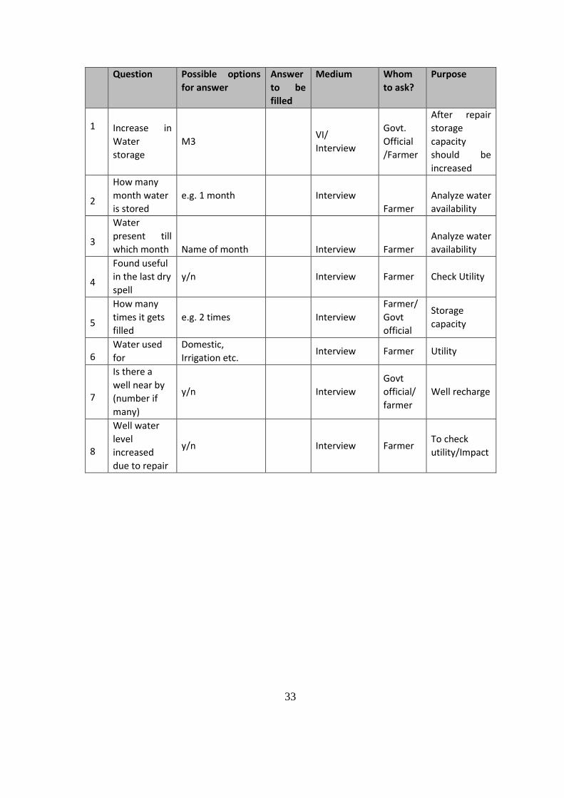
33
Question Possible options
for answer
Answer
to be
filled
Medium Whom
to ask?
Purpose
1 Increase in
Water
storage
M3 VI/
Interview
Govt.
Official
/Farmer
After repair
storage
capacity
should be
increased
2
How many
month water
is stored
e.g. 1 month Interview
Farmer
Analyze water
availability
3
Water
present till
which month Name of month
Interview Farmer
Analyze water
availability
4
Found useful
in the last dry
spell
y/n Interview Farmer Check Utility
5
How many
times it gets
filled
e.g. 2 times Interview
Farmer/
Govt
official
Storage
capacity
6 Water used
for
Domestic,
Irrigation etc. Interview Farmer Utility
7
Is there a
well near by
(number if
many)
y/n Interview
Govt
official/
farmer
Well recharge
8
Well water
level
increased
due to repair
y/n Interview Farmer To check
utility/Impact
34
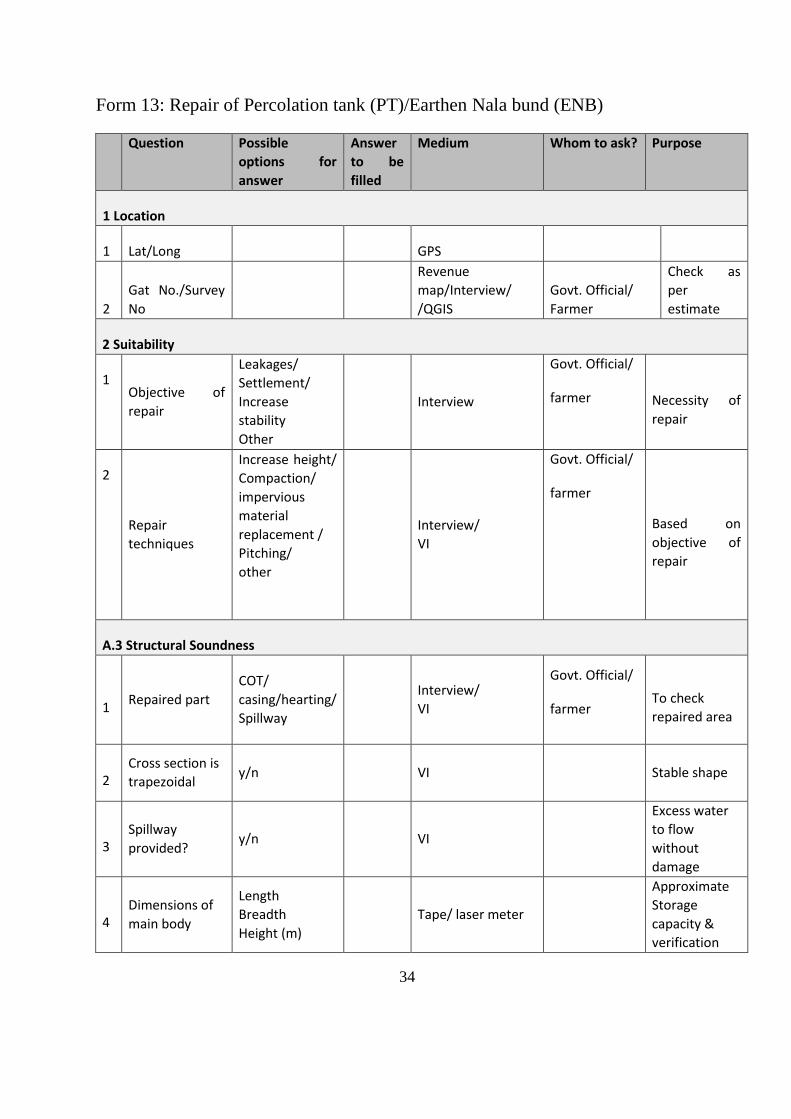
Form 13: Repair of Percolation tank (PT)/Earthen Nala bund (ENB)
Question Possible
options for
answer
Answer
to be
filled
Medium Whom to ask? Purpose
1 Location
1 Lat/Long
GPS
2
Gat No./Survey
No
Revenue
map/Interview/
/QGIS
Govt. Official/
Farmer
Check as
per
estimate
2 Suitability
1 Objective of
repair
Leakages/
Settlement/
Increase
stability
Other
Interview
Govt. Official/
farmer Necessity of
repair
2
Repair
techniques
Increase height/
Compaction/
impervious
material
replacement /
Pitching/
other
Interview/
VI
Govt. Official/
farmer
Based on
objective of
repair
A.3 Structural Soundness
1 Repaired part
COT/
casing/hearting/
Spillway
Interview/
VI
Govt. Official/
farmer To check
repaired area
2 Cross section is
trapezoidal y/n VI Stable shape
3 Spillway
provided? y/n VI
Excess water
to flow
without
damage
4 Dimensions of
main body
Length
Breadth
Height (m)
Tape/ laser meter
Approximate
Storage
capacity &
verification
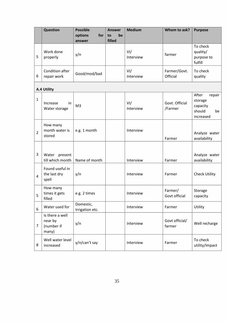
35
Question Possible
options for
answer
Answer
to be
filled
Medium Whom to ask? Purpose
5 Work done
properly y/n
VI/
Interview farmer
To check
quality/
purpose to
fulfill
6 Condition after
repair work Good/mod/bad
VI/
Interview
Farmer/Govt.
Official
To check
quality
A.4 Utility
1 Increase in
Water storage M3
VI/
Interview
Govt. Official
/Farmer
After repair
storage
capacity
should be
increased
2
How many
month water is
stored
e.g. 1 month Interview
Farmer
Analyze water
availability
3 Water present
till which month Name of month
Interview Farmer
Analyze water
availability
4
Found useful in
the last dry
spell
y/n Interview Farmer Check Utility
5
How many
times it gets
filled
e.g. 2 times Interview Farmer/
Govt official
Storage
capacity
6 Water used for
Domestic,
Irrigation etc. Interview Farmer Utility
7
Is there a well
near by
(number if
many)
y/n Interview Govt official/
farmer Well recharge
8 Well water level
increased y/n/can’t say Interview Farmer
To check
utility/Impact
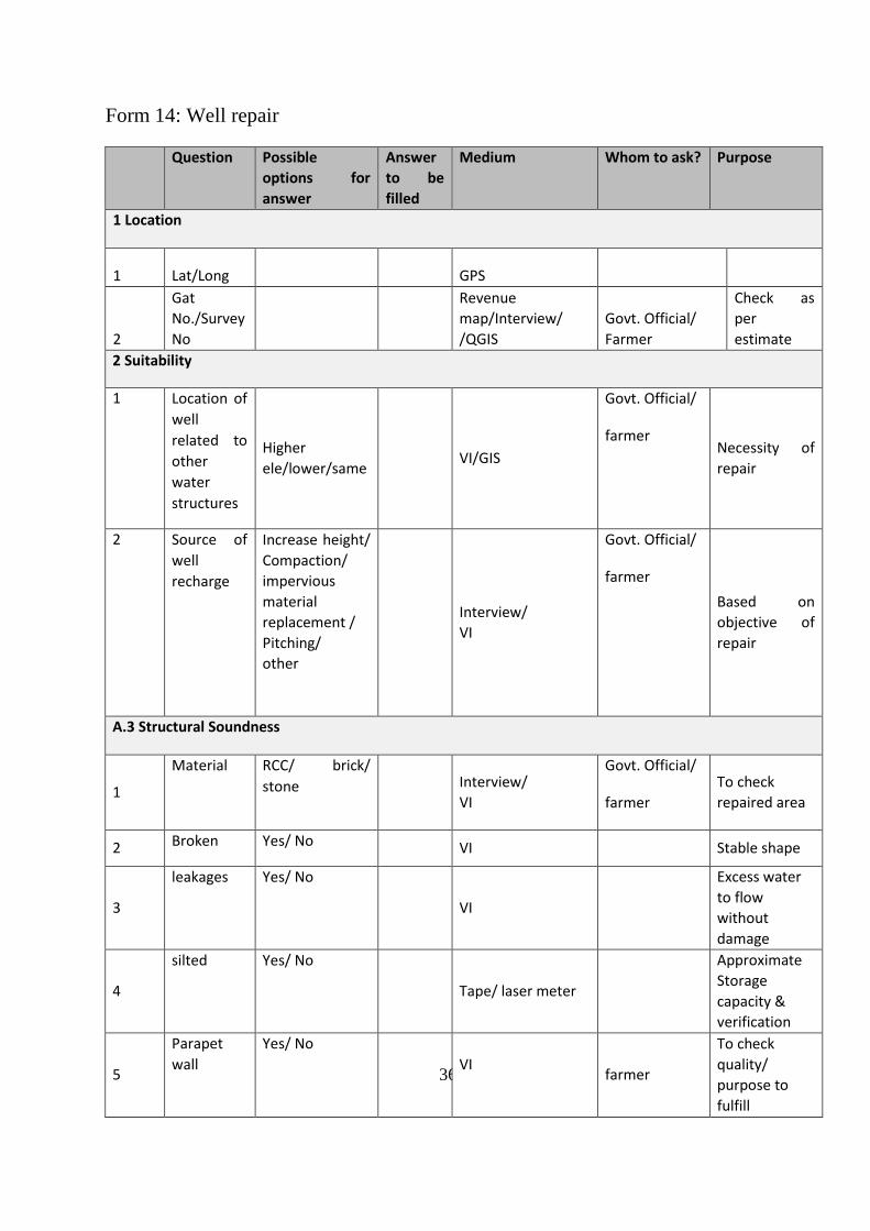
36
Form 14: Well repair
Question Possible
options for
answer
Answer
to be
filled
Medium Whom to ask? Purpose
1 Location
1 Lat/Long
GPS
2
Gat
No./Survey
No
Revenue
map/Interview/
/QGIS
Govt. Official/
Farmer
Check as
per
estimate
2 Suitability
1 Location of
well
related to
other
water
structures
Higher
ele/lower/same VI/GIS
Govt. Official/
farmer Necessity of
repair
2 Source of
well
recharge
Increase height/
Compaction/
impervious
material
replacement /
Pitching/
other
Interview/
VI
Govt. Official/
farmer
Based on
objective of
repair
A.3 Structural Soundness
1
Material RCC/ brick/
stone
Interview/
VI
Govt. Official/
farmer
To check
repaired area
2 Broken Yes/ No VI Stable shape
3
leakages Yes/ No
VI
Excess water
to flow
without
damage
4
silted Yes/ No
Tape/ laser meter
Approximate
Storage
capacity &
verification
5
Parapet
wall
Yes/ No
VI
farmer
To check
quality/
purpose to
fulfill
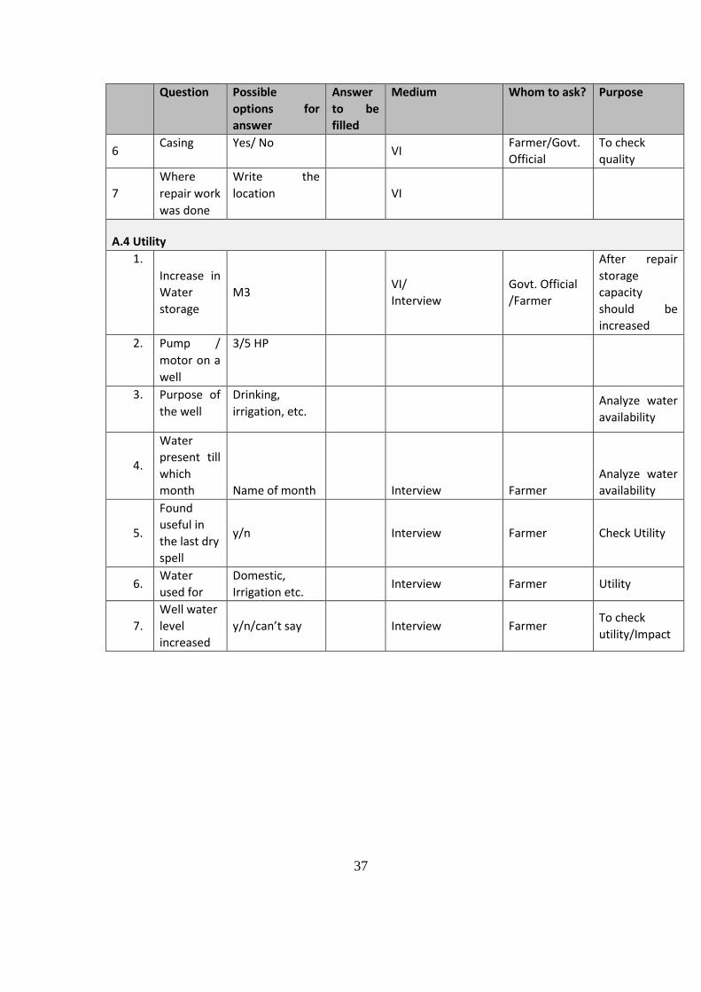
37
Question Possible
options for
answer
Answer
to be
filled
Medium Whom to ask? Purpose
6 Casing Yes/ No
VI Farmer/Govt.
Official
To check
quality
7
Where
repair work
was done
Write the
location
VI
A.4 Utility
1.
Increase in
Water
storage
M3 VI/
Interview
Govt. Official
/Farmer
After repair
storage
capacity
should be
increased
2. Pump /
motor on a
well
3/5 HP
3. Purpose of
the well
Drinking,
irrigation, etc. Analyze water
availability
4.
Water
present till
which
month Name of month
Interview Farmer
Analyze water
availability
5.
Found
useful in
the last dry
spell
y/n Interview Farmer Check Utility
6. Water
used for
Domestic,
Irrigation etc. Interview Farmer Utility
7.
Well water
level
increased
y/n/can’t say Interview Farmer To check
utility/Impact
38
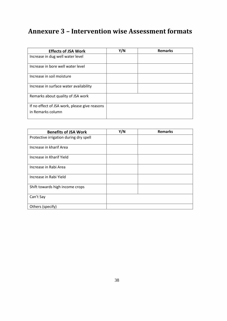
Annexure 3 – Intervention wise Assessment formats
Effects of JSA Work Y/N Remarks
Increase in dug well water level
Increase in bore well water level
Increase in soil moisture
Increase in surface water availability
Remarks about quality of JSA work
If no effect of JSA work, please give reasons
in Remarks column
Benefits of JSA Work Y/N Remarks
Protective irrigation during dry spell
Increase in kharif Area
Increase in Kharif Yield
Increase in Rabi Area
Increase in Rabi Yield
Shift towards high income crops
Can’t Say
Others (specify)
39
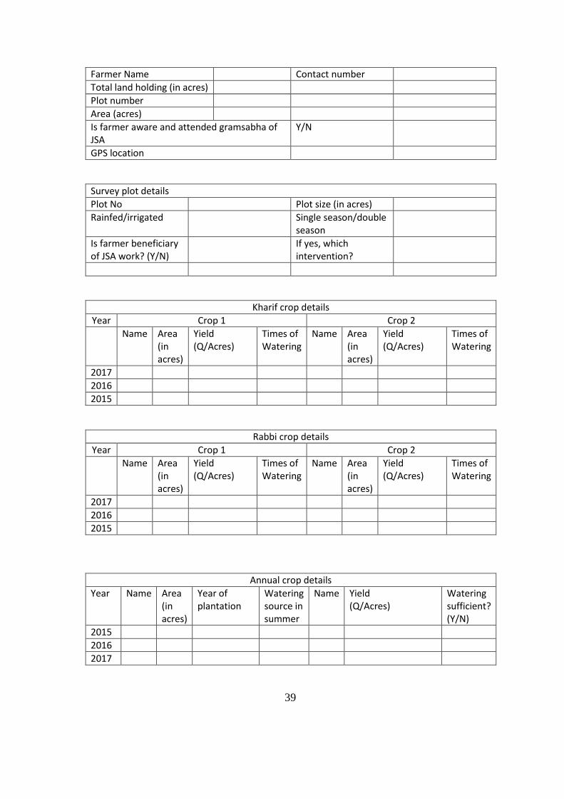
Farmer Name Contact number
Total land holding (in acres)
Plot number
Area (acres)
Is farmer aware and attended gramsabha of JSA
Y/N
GPS location
Survey plot details
Plot No Plot size (in acres)
Rainfed/irrigated Single season/double season
Is farmer beneficiary of JSA work? (Y/N)
If yes, which intervention?
Kharif crop details
Year Crop 1 Crop 2
Name Area (in acres)
Yield (Q/Acres)
Times of Watering
Name Area (in acres)
Yield (Q/Acres)
Times of Watering
2017
2016
2015
Rabbi crop details
Year Crop 1 Crop 2
Name Area (in acres)
Yield (Q/Acres)
Times of Watering
Name Area (in acres)
Yield (Q/Acres)
Times of Watering
2017
2016
2015
Annual crop details
Year Name Area (in acres)
Year of plantation
Watering source in summer
Name Yield (Q/Acres)
Watering sufficient? (Y/N)
2015
2016
2017
40
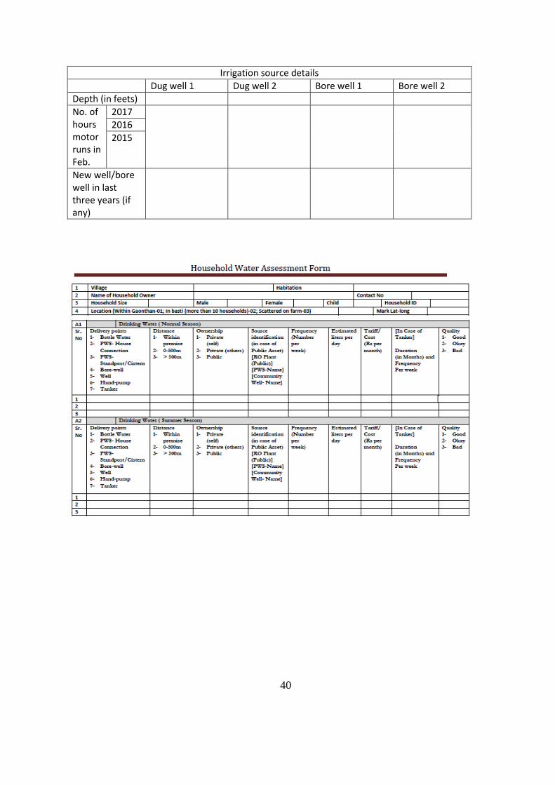
Irrigation source details
Dug well 1 Dug well 2 Bore well 1 Bore well 2
Depth (in feets)
No. of hours motor runs in Feb.
2017
2016
2015
New well/bore well in last three years (if any)
41
42
Annexure 4 – Intervention wise Assessment formats
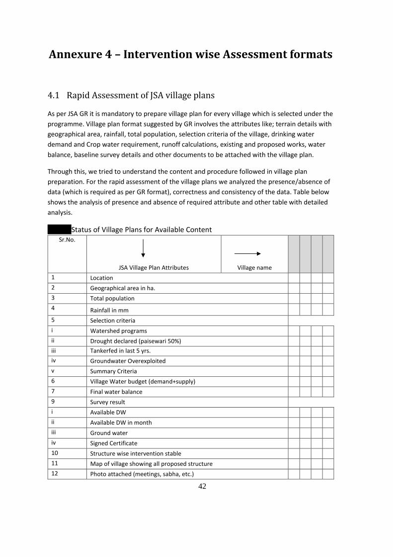
4.1 Rapid Assessment of JSA village plans
As per JSA GR it is mandatory to prepare village plan for every village which is selected under the
programme. Village plan format suggested by GR involves the attributes like; terrain details with
geographical area, rainfall, total population, selection criteria of the village, drinking water
demand and Crop water requirement, runoff calculations, existing and proposed works, water
balance, baseline survey details and other documents to be attached with the village plan.
Through this, we tried to understand the content and procedure followed in village plan
preparation. For the rapid assessment of the village plans we analyzed the presence/absence of
data (which is required as per GR format), correctness and consistency of the data. Table below
shows the analysis of presence and absence of required attribute and other table with detailed
analysis.
Status of Village Plans for Available Content Sr.No.
JSA Village Plan Attributes Village name
1 Location
2 Geographical area in ha.
3 Total population
4 Rainfall in mm
5 Selection criteria
i Watershed programs
ii Drought declared (paisewari 50%)
iii Tankerfed in last 5 yrs.
iv Groundwater Overexploited
v Summary Criteria
6 Village Water budget (demand+supply)
7 Final water balance
9 Survey result
i Available DW
ii Available DW in month
iii Ground water
iv Signed Certificate
10 Structure wise intervention stable
11 Map of village showing all proposed structure
12 Photo attached (meetings, sabha, etc.)
43
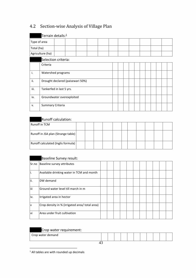
4.2 Section-wise Analysis of Village Plan
Terrain details:1
Type of area
Total (ha)
Agriculture (ha)
Selection criteria:
Criteria
i. Watershed programs
ii. Drought declared (paisewari 50%)
iii. Tankerfed in last 5 yrs.
iv. Groundwater overexploited
v. Summary Criteria
Runoff calculation: Runoff in TCM
Runoff in JSA plan (Strange table)
Runoff calculated (Inglis formula)
Baseline Survey result:
Sr.no Baseline survey attributes
i. Available drinking water in TCM and month
ii. DW demand
iii Ground water level till march in m
iv. Irrigated area in hector
v Crop density in % (irrigated area/ total area)
vi Area under fruit cultivation
Crop water requirement: Crop water demand
1 All tables are with rounded up decimals
44
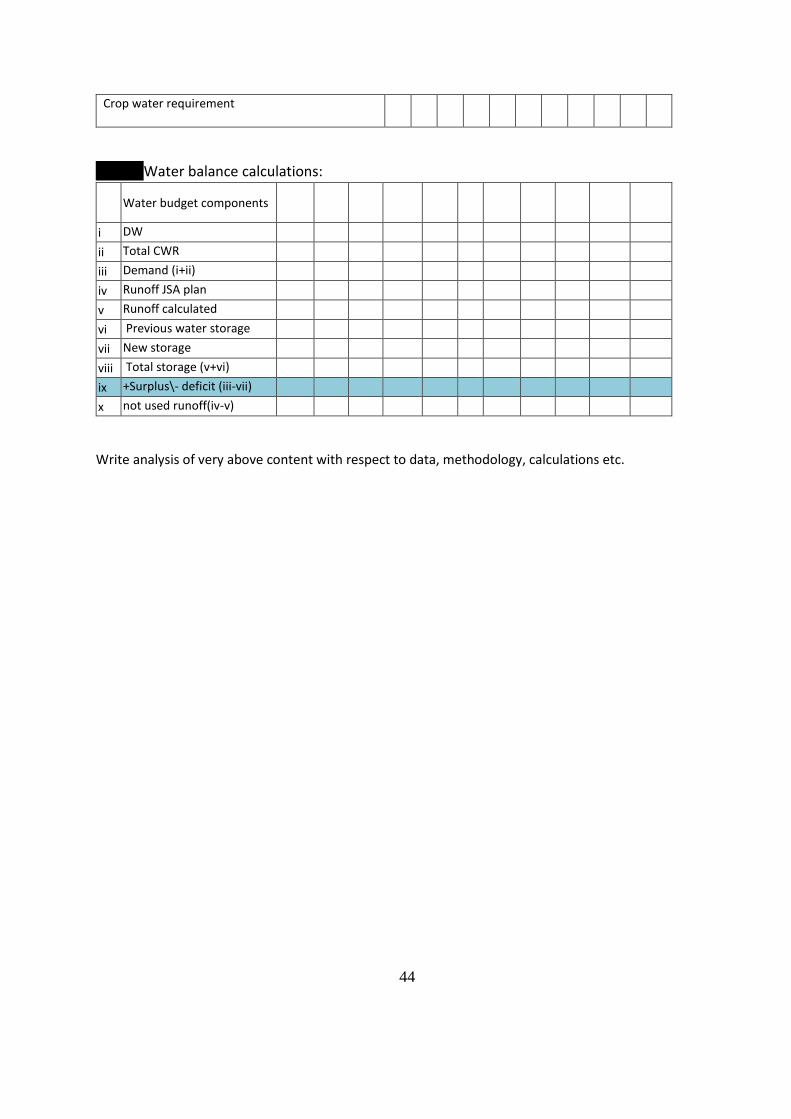
Crop water requirement
Water balance calculations:
Water budget components
i DW
ii Total CWR
iii Demand (i+ii)
iv Runoff JSA plan
v Runoff calculated
vi Previous water storage
vii New storage
viii Total storage (v+vi)
ix +Surplus\- deficit (iii-vii)
x not used runoff(iv-v)
Write analysis of very above content with respect to data, methodology, calculations etc.