guideline document for the evaluation of … · i guideline document for the evaluation of the...
TRANSCRIPT
i
GUIDELINE DOCUMENT FOR THE EVALUATION
OF THE QUANTUM OF CLOSURE-RELATED FINANCIAL PROVISION PROVIDED
BY A MINE
ii
January 2005
Department of Minerals and EnergyPrivate Bag X 59Pretoria0001
Official guideline as contemplated in Regulation 54(1) to the Mineral and Petroleum Resources Development Act, 2002 (Act 28 of 2002)
Acknowledgements: A special word of thanks to Messrs H.D. Naudé and Mr H.S. Cornelissen from the Department of Minerals and Energy, Golder and Associates who managed the development of this document, and to officials from other Government Depart- ments, as well as other environmental consultants and the mining industry at large for their contributions. Design and print by Media Lab in cooperation with the CSIR.

iii
STRUCTURE
• Executive Summary . . . . . . . . . . . . . . . . . . . . . . . . . . . . . . iv
• Section A: Background details and supporting information covers the introduction and background to the guideline document. . . . . . . . . . . . . . . . . . . . . . . . . . . . . . 1
• Section B: Working manual for the assessment of the quantum covers the procedures that the DME Regional Office personnel will use on a day-to-day basis to calculate the quantum. . . . . . . . . . . 6
• Section C: Appendices provides additional information on various aspects of rehabilitation and closure, including generally accepted closure methods. . . . . . . . . .27

iv
EXECUTIVE SUMMARY
The Mineral and Petroleum Resources Development Act (MPRDA), (Act No. 28 of 2002) and its Regulations was promulgated on 1 May 2004. Financial provision for environmental rehabilitation and closure requirements of mining operations forms an integral part of the MPRDA, as was the case with the now repealed Minerals Act, 1991 (Act 50 of 1991). Section 41 of the MPRDA and regulations 53 and 54 promulgated in terms of the MPRDA deal with financial provision for mine rehabilitation and closure.The holder of a right as described in the relevant sections of the MPRDA and its regulations must provide the Department of Minerals and Energy (DME) with sufficient financial provision. Officials in the DME Regional Offices are required to assess, review and approve the quantum of financial provision submitted (that is, the monetary value of the financial provision that has been computed by the holder of a prospecting right, mining right or mining permit during the annual review) as being sufficient to cover the environmental liability at that time and for closure of the mine at that time.
OBJECTIVES
The objectives of this guideline document are to:
• Improve the understanding of the financial and legal aspects pertaining to the costing of remediation measures as a result of prospecting and/or mining operations.
• Enable the DME to adequately evaluate/review the quantum for financial provision submitted by the mining industry. This review will cover both the financial provision for premature closure at any time (the current environmental liability) and the financial provision for end-of-mining closure (the future environmental liability).
• Provide the DME Regional Office personnel with a comprehensive and useful guideline on the generally accepted closure methods.
PRINCIPLES
The principles that have been adopted for this guideline document are as follows:
• Legal standing: The guideline document is to be used by the Regional Office personnel as a tool to assess the appropriateness of the quantum of financial provision submitted to the DME by the mining industry.

v
Only Section B of this document constitutes a guideline document as contemplated in regulation 54(1) promulgated in terms of the MPRDA, 2002. This guideline document does not, therefore, obviate in any way the holder of a prospecting right, mining right or mining permit from the legal requirement to annually assess his or her environmental liability and adjust his or her financial provision to the satisfaction of the Minister.
• Generic nature: The guideline document is generic in nature and cannot answer all possible questions or deal with all situations relating to financial provision, rehabilitation and mine closure. Further advice and/or experience may be required, based on circumstances that prevail at specific mine sites, to fully assess the quantum for financial provision.
• Standardised approach: The guideline document provides a generic approach to the determination of the quantum for financial provision by the DME. This approach aims to avoid a situation of applying non-aligned empirical approaches and interpretations between DME Regional Offices. The document propagates 3 methods or “routes” for the calculation of the quantum. Where this assessment (Route 1) differs substantially from an estimate made by the DME, or in cases where no independent assessment exists, Route 2 will be used and/or the DME will communicate with a mine to obtain clarity on differences in calculations.
• Complete picture: The guideline document covers the most essential closure components that are generally required for the closure of a mine site. Site-specific conditions must also be considered and under these circumstances, specialist studies (and related closure costs) on aspects such as surface and groundwater pollution and remediation may be required. The outcome of these studies must be considered in the determination of the quantum to arrive at a “complete picture” of the quantum for financial provision.
• The methodology for computing the quantum is based on the assumption that a third party will be employed by the DME to undertake the necessary rehabilitation and remedial work, should the mining operation close prematurely. This assumption is in line with the adopted international approach.
• With the determination of the quantum for closure it must be assumed that the mine infrastructure has no salvage value. This is necessary as it is often difficult to determine the salvage value of the infrastructure. However, salvage value can be offset if the mine can demonstrate that a formal arrangement exists that will cover demolition of the mine infrastructure and payment to be received for it.
vi
• Limitations: The document has certain specific limitations or instances where some sectors of the very diverse spectrum of the mining industry in South Africa are not catered for. The subsistence-mining sector (pick-and-shovel operations) is a particular example. For prospecting using boreholes only, Route 3 (flat rate per hectare) for calculation of the quantum will be used as outlined in this document, with the firm understanding that Route 1 (detailed independent assessment) is still preferable. These categories could be the subject of a future guideline but specifically with reference to the subsistence-mining sector mentioned here, the current standard practice of a low flat rate cash deposit would remain in use for the time being.
1
SECTION A
BACKGROUND DETAILS AND SUPPORTING INFORMATION
A. 1 INTRODUCTION AND BACKGROUND
1.1 Introduction
The Mineral and Petroleum Resources Development Act 28 of 2002 (MPRDA) places the financial provision into context with respect to relevant constitutional considerations and the overall government policy currently prevailing in South Africa, as well as within a broader environmental legal framework. This guideline serves as a guide to the interpretation and application of the provision of the MPRDA, 2002 (Act 28 of 2002) and its Regulations, specifically as they relate to financial provision for the mining industry. This document is an official guideline in terms of regulation 54(1) promulgated in terms of the MPRDA, 2002 (Act 28 of 2002) and serves the specific objectives stated above.
The Department of Minerals and Energy will update this document as follows:
1.2 DOCUMENT APPLICABILITY
• The Master Rates in Section B will be updated on an annual basis, based on CPIX or a similar approved method. The first of these updates will take place during 2005, and
• the overall document will be reviewed and updated whenever necessary.
1.3 GLOSSARY OF TERMS
Unless stated otherwise, all terms used in this document will have the same meaning and interpretation as defined in Chapters 1 of the MPRDA, 2002 (Act 28 of 2002) and the Regulations promulgated in terms of the said Act.
2
1.4 FINANCIAL PROVISION
The Mineral and Petroleum Resources Development Act, 2002 (Act 28 of 2002)The relevant sections within the MPRDA (Act 28 of 2002) that deal with the financial provision are as follows:
• Section 41(1), requires that an applicant for a prospecting right, mining right or mining permit must, before the Minister approves the environmental management plan or environmental management programme (EMP) in terms of Section 39(4), make the prescribed “financial provision” for the rehabilitation or management of negative environmental impacts,
• Section 41(2) provides that, if the holder of a prospecting right, mining right or mining permit fails to rehabilitate or manage, or is unable to undertake such rehabilitation or to manage, any negative impact on the environment, the Minister may, upon written notice to such holder, use all or part of the financial provision to rehabilitate or manage the negative environmental impact in question,
• Section 41(3) requires the holder of a prospecting right, mining right or mining permit to annually assess his or her environmental liability and increase his or her financial provision to the satisfaction of the Minister, and
• Section 45, allows the Minister to recover costs in the event of urgent remedial measures.
Regulations promulgated in terms of the MPRDA (Act 28 of 2002)
The financial provision required to be submitted by the holder of a prospecting right, mining right or mining permit (in terms of Regulation 53) to achieve the total quantum for rehabilitation and remediation of environmental impacts and associated damage as well as close-out must be provided for by one or more of the following methods:
• Approved contribution(s) to a dedicated trust fund as provided for in terms of Section 10(1)(cH) of the Income Tax Act, 1962;
• A financial guarantee from a South African registered bank or any other bank or financial institution approved by the Director-General, guaranteeing the financial provision relating to implement the EMP in the format approved by the Director-General from time to time;

3
• A deposit into the account specified by the Director-General in the format as approved by the Director-General from time to time; or
• Any other method as the Director-General may determine.Regulation 54 requires that the quantum of financial provision, to be approved by the Minister, must be based on the requirements of the approved EMP and shall include a detailed itemisation of all actual costs required for;
Pre-mature closure regarding:- the rehabilitation of the surface of the area;- the prevention and management of pollution of the atmosphere;- the prevention and management of pollution of water and the soil; and- the prevention of leakage of water and minerals between subsurface
formations and the surface.
Decommissioning and final closure of the operation; and
Post closure management of residual and latent environmental impacts.
A. 2 USE OF THE GUIDELINE DOCUMENT
It is recognised that there may be many variations of the conceptual perspective, depending on the nature of the mining operation. This perspective is however necessary to aid with the application of the guideline document. The key aspects of the perspective are as follows:
• The overall quantum of environmental liability will:- increase rapidly in the early stages of mining, as the mining operation is
established, since during these stages the most notable environmental impact is incurred,
- increase, remain static or decrease during the on-going mining operation, depending on the nature of mining and the nature of rehabilitation that is undertaken concurrently with the mine operations,
- decrease in the final years of mining to point where mining is discontinued and the environmental liability is limited to those closure components that could not be undertaken during the operational period of mining, as defined in the EMP, and
- decreases over the care and maintenance period as the closure components are gradually addressed.
• A large number of the bigger mining operations opted (since 1994) for the Trust Fund as method for financial provision, which caused a shortfall in
4
overall liability in case of premature closure. This shortfall was, in most cases, not covered by any of the other methods. The annual contributions to a trust fund are tailored for funding the final mine closure over the life of a mine. These contributions are calculated annually as (A-B+C)/D, where:
“A” represents the amount determined by a person designated by the Minister of Minerals and Energy of the estimated costs to be incurred at the time that or after operations on the mine or part of the mine are discontinued in order to discharge the obligations imposed in terms of any law which relates to mining operations (other than costs which were required in terms of any law to be incurred on an ongoing basis during the life of that mine or part of that mine);
“B” means the market value of the assets held by the company, society, association or trust in respect of that mine on the date of the determination of the estimated costs in symbol “A”;
“C” means the amount paid in cash by that taxpayer to such company, association company, society or trust at any time before the date contemplated in symbol “B” which has not been allowed as a deduction in terms of this paragraph in any year of assessment; and
“D” represents the estimated remaining life of that mine in number of years as determined by a person contemplated in symbol “A”.
The holder of a prospecting right, mining right or mining permit is required to annually assess the total quantum of environmental liability for the mining operation and ensure that financial provision are sufficient to cover the current liability (in the event of premature closure) as well as the end-of-mine liability. This is referred to as the “window in time or snapshot in time approach” as each assessment provides an indication of the environmental liability at that time only. The holder will also provide, on an annual basis, an indication of the end-of-life environmental liability. The DME Regional Office will then, on an annual basis:
• Use this guideline document (and in particular the Working Manual in Section B) to review and approve both:- the quantum for financial provision that is applicable at that time, as
calculated by the relevant holder, and- the quantum for final closure of the mine.
• Assess the relevant current market value of assets held in the trust fund, if applicable, and

5
• Determine the portion of the quantum that must be covered by one of the other financial methods (such as a financial guarantee, cash deposit or other approved method).
6
SECTION B
WORKING MANUAL FOR THE DETERMINATION OF THE QUANTUM
B. 1 PROCESS TO BE FOLLOWED
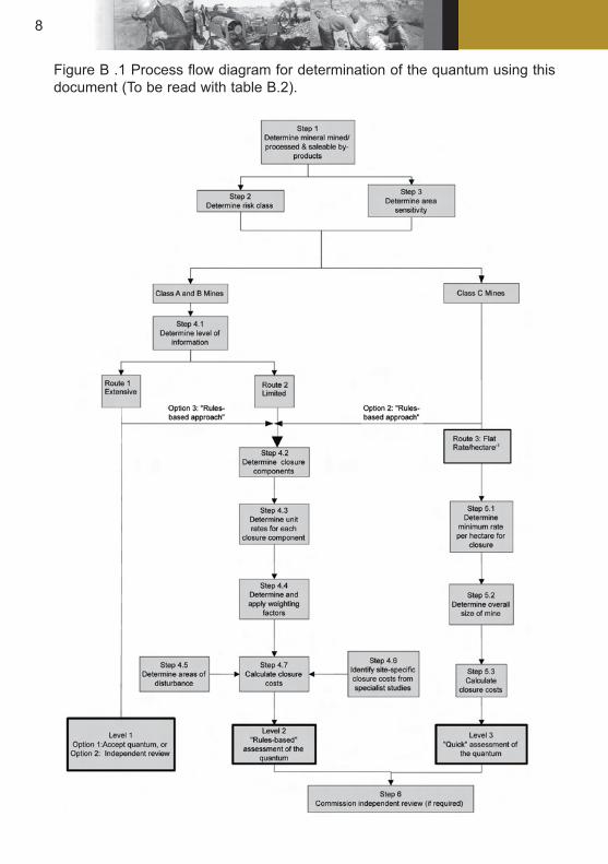
Figure B.1 indicates the process and possible “routes” to be followed in the assessment of the quantum for financial provision for closure. Table B.2 is a summary of the procedural steps to be taken to calculate the quantum of financial provision required.
1.1 Summary of procedural steps to calculate the quantum
Table B.2: Recommended procedure to determine the quantum for financial provision
Step No. Description Supporting information1 Determine mineral mined and
saleable by-products
Tables B.12, B.13 and B.14
2A Determine primary risk class:• Class A (High risk),• Class B (Medium risk), or• Class C (Low risk)
Either Table B.12 or B.13
2B Revise primary risk class (if applicable) based on saleable by-products
Table B.14
3 Determine environmental sensitivity of mine area:• Low sensitivity• Medium sensitivity• High sensitivity
Table B.4
4 For Class A or B mining operations
4.1 Determine level of information available:• Extensive, or• Limited
See section 1.4.1

7
For extensive information, either:• Option 1: Accept the quan-
tum determined, • Option 2: Commission an
independent review by a competent person, or
• Option 3: Follow a “rules-based” approach and pro-ceed to step No. 4.2
For limited information, follow a “rules-based” approach and proceed to step No. 4.2
4.2 Identify closure components Section 1.4.2 and Table B.5
4.3 Identify unit rates for closure components
Table B.6
4.4 Identify and apply weighting factors
Tables B.7 and B.8
4.5 Identify areas of disturbance Topographical plans and/or site visits
4.6 Identify closure costs from specialist studies
Table B.9 for recommended studies
4.7 Calculate closure costs Table B.10
5 For Class C Mining opera-tions
5.1 Identify minimum rates per hectare for closure
Table B.11
5.2 Determine overall size of the mine (in hectares)
Topographical plans and/or site visits
5.3 Calculate closure cost Overall mining area and minimum rate (per hectare)Alternatively, follow “rules-
based” approach: Step 4.1 to 4.6.
6 Independent review by com-petent person
Commission independent review should there be non-agreement on the quantum for financial provision deter-mined from steps 4 or 5 above.
8
Figure B .1 Process flow diagram for determination of the quantum using this document (To be read with table B.2).

9
1.2 Input to the process
Table B.2 and Figure B.1 indicate the input required to enable determining of the quantum of financial provision. Each of the input data requirements is described in more detail in the relevant part of paragraph B.3: Procedure to determine the quantum for financial provision.
Table B.2: Summary of input data required to determine the quantum
No. Input data Reference
1 Risk ranking for mine type and mineral by-product Step
2 Environmental sensitivity of the mining area Step 3
3 Level of information available to the Regional Office personnel Step 4.1
4 Type of mining operation Table B12
5 Geographic location of the mine Table B7
6 Areas of disturbance: Class A and B mines Step 4.5
7 Closure costs from specialist studies Step 4.6
8 Overall size of mine: Class C mines Table B11
B.3 Procedure to determine the quantum for financial provisionThe sections below provide step-by-step details on the procedure to follow.
Step 1: Determine primary mineral and saleable mineral by-products
Identify the type of mineral mined or quarried and the saleable mineral by-products (not trace elements), using the information in Table B.3.
Table B.3: Mineral mined/processed and saleable by-products
Information required Source of informationMineral mined/processed Table B.12
Minerals related to quarrying Table B.13
Minerals that typically occur as saleable by-products
Table B.14

10
Step 2: Determine risk class
Identify the risk class of the mineral using Tables B.12, B.13 and B.14. The risk class will be either:
Class A (High risk): a high probability of the occurrence of the impact with a severe consequence,
Class B (Medium risk): a moderate probability of occurrence of the impact with a manageable consequence,
Class C (Low risk): a low probability of occurrence of the impact with a negligible consequence.
The primary risk class is determined from either Table B.12 (for the type of mineral mined/processed) or B.13 (for mineral related to quarrying). The primary risk class can be adapted upwards based on the nature of saleable mineral by-products as reflected in Table B.14. This step thus involves the following:
• Identify the primary risk class based on either the type of mineral mined/processed (Table B.12) or the mineral related to quarrying (Table B.13),
• Identify what saleable by-products (if any) are produced, using Table B.14 as a guide, and
• Adapt the primary risk class (if required) based on the above.
Step 3: Determine the area sensitivity
The mining operation can be located in a Low, Medium or High sensitivity area based on the biophysical, social and economic situation. Table B.4 provides criteria to aid with the determination of the sensitivity of the area within which the mine is located. This step thus involves the following:
• Assess and rank the sensitivity of the area by individually assessing the biophysical situation, then the social situation and then the economic situation,
• Establish the overall sensitivity of the area, by accepting the most sensitive of the three individual assessments, e.g. if the area has a Medium biophysical sensitivity, a High social sensitivity and a Low economic sensitivity, the overall sensitivity will be High.

11
Table B.4: Criteria used to determine the area sensitivity
Sensitivity Sensitivity criteriaBiophysical Social Economic
Low • Largely disturbed from natural state.
• Limited natural fauna and flora remains.
• Exotic plant spe-cies evident.
• Unplanned devel-opment.
• Water resources disturbed and impaired.
• The local com-munities are not within sighting distance of the mining operation.
• Lightly inhabited area (rural).
• The area is insen-sitive to develop-ment.
• The area is not a major source of income to the local communities.
Medium • Mix of natural and exotic fauna and flora.
• Development is a mix of disturbed and undisturbed areas, within an overall planned framework.
• Water resources are well controlled.
• The local com-munities are in the proximity of the mining operation (within sighting distance).
• Peri-urban area with den-sity aligned with a development framework.
• Area developed with an estab-lished infrastruc-ture.
• The area has a balanced econom-ic development where a degree of income for the local communities is derived from the area.
• The economic activity could be influenced by indiscriminate development.

12
High • Largely in natural state.
• Vibrant fauna and flora, with species diversity and abundance matching the nature of the area.
• Well planned development.
• Area forms part of an overall ecologi-cal regime of con-servation value.
• Water resources emulate their original state.
• The local commu-nities are in close proximity of the mining operation (on the boundary of the mine).
• Densely inhabited area (urban/dense settlements).
• Developed and well-established communities.
• The local com-munities derive the bulk of their income directly from the area.
• The area is sensi-tive to develop-ment that could compromise the existing economic activity.
Step 4: For Class A or B mines and preferred route for Class C mines
Step 4.1: Determine level of information
Identify the information that is available for the mining operation. This will be either extensive or limited, as follows:
a) Extensive information will include the following:- An approved EMP as contemplated in Section 39 of the MPRDA, or an
EMP that is in the process of being approved or amended,- A detailed Closure Plan, based on the EMP, that covers all aspects of
rehabilitation and closure of the mining operation, and- A detailed breakdown of the costs envisaged for rehabilitation and
closure, signed off by a competent person.
b) Limited information is a level of information that is less comprehensive, in any way, than that given above. Extensive information must be provided by the mine and must be signed-off by a competent person. In instances where extensive information is available, the following three options are available:
Option 1: Accept the quantum provided for the financial provision, or
Option 2: Commission an independent review of the quantum of financial provision provided, using a competent person, or
13
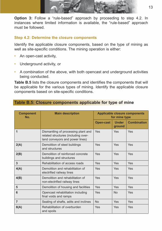
Option 3: Follow a “rule-based” approach by proceeding to step 4.2. In instances where limited information is available, the “rule-based” approach must be followed.
Step 4.2: Determine the closure components
Identify the applicable closure components, based on the type of mining as well as site-specific conditions. The mining operation is either:
• An open-cast activity,
• Underground activity, or
• A combination of the above, with both opencast and underground activities being conducted.
Table B.5 lists the closure components and identifies the components that will be applicable for the various types of mining. Identify the applicable closure components based on site-specific conditions.
Table B.5: Closure components applicable for type of mine
Component No.
Main description Applicable closure components for mine type
Open-cast Underground
Combination
1 Dismantling of processing plant and related structures (including over-land conveyors and power lines)
Yes Yes Yes
2(A) Demolition of steel buildings and structures
Yes Yes Yes
2(B) Demolition of reinforced concrete buildings and structures
Yes Yes Yes
3 Rehabilitation of access roads Yes Yes Yes
4(A) Demolition and rehabilitation of electrified railway lines
Yes Yes Yes
4(B) Demolition and rehabilitation of non-electrified railway lines
Yes Yes Yes
5 Demolition of housing and facilities Yes Yes Yes
6 Opencast rehabilitation including final voids and ramps
Yes No Yes
7 Sealing of shafts, adits and inclines No Yes Yes
8(A) Rehabilitation of overburden and spoils
Yes Yes Yes

14
8(B) Rehabilitation of processing waste deposits and evaporation ponds (basic, salt-producing waste)
Yes Yes Yes
8(C) Rehabilitation of processing waste deposits and evaporation ponds (acidic, metal-rich waste)
Yes Yes Yes
9 Rehabilitation of subsided areas Yes Yes Yes
10 General surface rehabilitation, including grassing of all denuded areas
Yes Yes Yes
11 River diversions Yes Yes Yes
12 Fencing Yes Yes Yes
13 Water management (Separating clean and dirty water, managing polluted water and managing the impact on groundwater, including treatment, when required)
Yes Yes Yes
14 2 to 3 years of maintenance and aftercare
Yes Yes Yes
Step 4.3: Determine the unit rates for closure components
Use the risk class (Class A, B or C) from Step 2 and the sensitivity of the area where the mine is located (Low, Medium or High) from Step 3 to determine the unit rates for the applicable closure components identified in Step 4.2. Table B.6 provides the unit rates for the closure components listed in Table B.4. More specifically:
• A Master Rate for each closure component is provided, and
• A multiplication factor to apply to the Master Rate is provided in each table, depending on the risk class and the area sensitivity.
The Master Rate for each closure component is based on the “generally accep- ted closure methods” (Section C) for each of the closure components listed in Table B.4. In instances where these closure methods will not be applied (e.g. where in the approved EMP indicates different closure methods) then the costs for this closure component must be determined by a specialist study.

15
Table B.6: Unit rates for closure components
COMPONENT 1
PROCESSING PLANT and related structures
(including overland conveyors and power
lines)Unit Master rate
m3 6.82
Multiplication factor
Risk Class(A, B or C) 1.00
Environmental Sensitivity
(High, Medium or Low)
COMPONENT 2 (A)
STEEL BUILDINGS AND
STRUCTURES (including floor slabs)
Unit Master rate
m2 95.00
Multiplication factor
Risk Class(A, B or C) 1.00
Environmental Sensitivity
(High, Medium or Low)
COMPONENT 2 (B)
REINFORCED CONCRETE
BUILDINGS & STRUCTURES
Unit Master rate
m2 140.00
Multiplication factor
Risk Class(A, B or C) 1.00
Environmental Sensitivity
(High, Medium or Low)
COMPONENT 3 ACCESS ROADS
Unit Master rate
m2 17.00
Multiplication factor
Risk Class(A, B or C) 1.00
Environmental Sensitivity
(High, Medium or Low)
COMPONENT 4 (A)
ELECTRIFIED RAILWAY LINES
Unit Master rate
m 165.00
Multiplication factor
Risk Class(A, B or C) 1.00
Environmental Sensitivity
(High, Medium or Low)
COMPONENT 4 (B)
NON - ELECTRIFIED RAILWAY LINES
Unit Master rate
m 90.00
Multiplication factor
Risk Class(A, B or C) 1.00
Environmental Sensitivity
(High, Medium or Low)
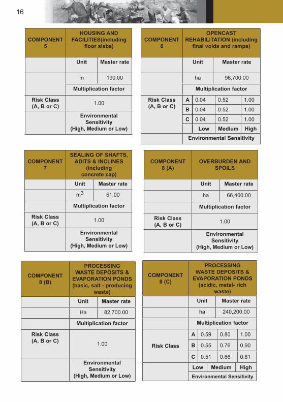
16
COMPONENT 8 (A)
OVERBURDEN AND SPOILS
Unit Master rate
ha 66,400.00
Multiplication factor
Risk Class(A, B or C) 1.00
Environmental Sensitivity
(High, Medium or Low)
COMPONENT6
OPENCAST REHABILITATION (including
final voids and ramps)
Unit Master rate
ha 96,700.00
Multiplication factor
Risk Class(A, B or C)
A 0.04 0.52 1.00
B 0.04 0.52 1.00
C 0.04 0.52 1.00
Low Medium HighEnvironmental Sensitivity
COMPONENT5
HOUSING AND FACILITIES(including
floor slabs)
Unit Master rate
m 190.00
Multiplication factor
Risk Class(A, B or C) 1.00
Environmental Sensitivity
(High, Medium or Low)
COMPONENT 7
SEALING OF SHAFTS,ADITS & INCLINES
(including concrete cap)
Unit Master rate
m3 51.00
Multiplication factor
Risk Class(A, B or C) 1.00
Environmental Sensitivity
(High, Medium or Low)
COMPONENT 8 (B)
PROCESSING WASTE DEPOSITS &
EVAPORATION PONDS(basic, salt - producing
waste)Unit Master rate
Ha 82,700.00
Multiplication factor
Risk Class(A, B or C) 1.00
Environmental Sensitivity
(High, Medium or Low)
COMPONENT 8 (C)
PROCESSING WASTE DEPOSITS &
EVAPORATION PONDS(acidic, metal- rich
waste)Unit Master rate
ha 240,200.00
Multiplication factor
Risk Class
A 0.59 0.80 1.00
B 0.55 0.76 0.90
C 0.51 0.66 0.81
Low Medium HighEnvironmental Sensitivity
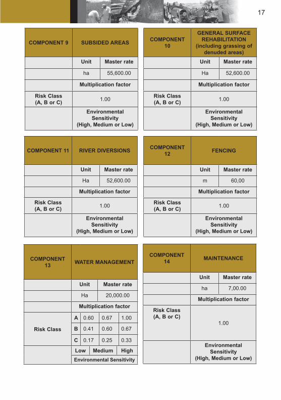
17
COMPONENT 9 SUBSIDED AREAS
Unit Master rate
ha 55,600.00
Multiplication factor
Risk Class(A, B or C) 1.00
Environmental Sensitivity
(High, Medium or Low)
COMPONENT 10
GENERAL SURFACEREHABILITATION
(including grassing of denuded areas)
Unit Master rate
Ha 52,600.00
Multiplication factor
Risk Class(A, B or C) 1.00
Environmental Sensitivity
(High, Medium or Low)
COMPONENT 11 RIVER DIVERSIONS
Unit Master rate
Ha 52,600.00
Multiplication factor
Risk Class(A, B or C) 1.00
Environmental Sensitivity
(High, Medium or Low)
COMPONENT 12 FENCING
Unit Master rate
m 60,00
Multiplication factor
Risk Class(A, B or C) 1.00
Environmental Sensitivity
(High, Medium or Low)
COMPONENT 14 MAINTENANCE
Unit Master rate
ha 7,00.00
Multiplication factor
Risk Class(A, B or C)
1.00
Environmental Sensitivity
(High, Medium or Low)
COMPONENT 13 WATER MANAGEMENT
Unit Master rate
Ha 20,000.00
Multiplication factor
Risk Class
A 0.60 0.67 1.00
B 0.41 0.60 0.67
C 0.17 0.25 0.33
Low Medium HighEnvironmental Sensitivity

18
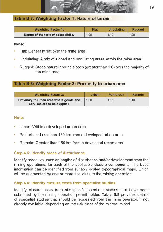
Step 4.4: Determine and apply the weighting factors
Identify the applicable weighting factors, based on the specific mine location. The two applicable weighting factors are as follows:
Weighting Factor 1: The nature of the terrain where the mine is located (see Table B.7). This factor is applicable as it is more difficult (and hence more costly) to undertake work related to mine closure in areas that are undulating or rugged. Weighting Factor 1 is applied to each of the closure components.
Weighting Factor 2: The proximity of the mine to an urban centre (see Table B.8). This factor is applicable as there will be increased costs to transport machinery, goods and personnel to more remote mine sites. Weighting Factor 2 is applied to the Preliminary and General items only.
19
Table B.7: Weighting Factor 1: Nature of terrain
Weighting Factor 1: Flat Undulating RuggedNature of the terrain/ accessibility 1.00 1.10 1.20
Note:
• Flat: Generally flat over the mine area
• Undulating: A mix of sloped and undulating areas within the mine area
• Rugged: Steep natural ground slopes (greater than 1:6) over the majority of the mine area
Table B.8: Weighting Factor 2: Proximity to urban area
Weighting Factor 2: Urban Peri-urban RemoteProximity to urban area where goods and
services are to be supplied1.00 1.05 1.10
Note:
• Urban: Within a developed urban area
• Peri-urban: Less than 150 km from a developed urban area
• Remote: Greater than 150 km from a developed urban area
Step 4.5: Identify areas of disturbance
Identify areas, volumes or lengths of disturbance and/or development from the mining operations, for each of the applicable closure components. The base information can be identified from suitably scaled topographical maps, which will be augmented by one or more site visits to the mining operation.
Step 4.6: Identify closure costs from specialist studies
Identify closure costs from site-specific specialist studies that have been submitted by the mining operation permit holder. Table B.9 provides details of specialist studies that should be requested from the mine operator, if not already available, depending on the risk class of the mineral mined.
20
Table B.9: Specialist studies that should be requested
Risk Class Specialist studies to requestClass A (High risk) • Water pollution potential studies
• Overall quantified risk assessment
Class B (Medium risk) • Screening level risk assessmentClass C (Low risk)
Step 4.7: Calculate closure costs
Calculate two sets of quantum figures for financial provision, using the “rules-based” approach and the applicable closure components, unit rates, areas of disturbance and closure costs from specialist studies. Table B.10 provides a template for calculating the quantum under the “rules-based” approach. The quantum figures to calculate include:
A quantum for financial provision to cover the current environmental liability. The “Grand Total” in Table B.10 will be used for this calculation, as this assumes that the work will be done by a Third Party (as the mining operation will be in premature closure), and
The quantum for financial provision to cover final closure of the mine. The “Sub-Total 1” in Table B.10 will be used for this calculation, which assumes that the mine does the closure and rehabilitation work themselves.
Table B.10: Template for Level 2: “Rules-based” assessment of the quantum for financial provision
CALCULATION OF THE QUANTUMMine: Location:
Evaluators: Date:
No Description Unit AQuantity
BMaster Rate
CMultip- lication factor
DWeighting
factor 1 E=A*B*C*D
Amount (rands)
Step 4.5 Step 4.3
Step 4.3 Step 4.4
1 Dismantling of pro-cessing plant and related structures (Including overland conveyors and power lines)
m3 R

21
2(A) Demolition of steel buildings and struc-tures
m2 R
2(B) Demolition of rein-forced concrete buildings and struc-tures
m2 R
3 Rehabilitation of access roads
m2 R
4(A) Demolition and rehabilitation of electrified railway lines
m R
4(B) Demolition and rehabilitation of non-electrified rail-way lines
m R
5 Demolition of hous-ing and/or adminis-tration facilities
m2 R
6 Opencast reha-bilitation including final voids and ramps
ha R
7 Sealing of shafts, adits and inclines
m3 R
8(A) Rehabilitation of overburden and spoils
ha R
8(B) Rehabilitation of processing waste deposits and evaporation ponds (basic, salt-produc-ing waste)
ha R
8(C) Rehabilitation of processing waste deposits and evaporation ponds (acidic, metal-rich waste)
ha R
9 Rehabilitation of subsided areas
ha R
10 General surface rehabilitation
ha R
11 River diversions ha R
12 Fencing ha R
R

22
13 Water management ha R
14 2 to 3 years of maintenance and aftercare
ha R
15 (A)
Specialist study Sum R
15 (B)
Specialist study Sum R
(Sum * of items 1 to 15 above) R *Multiply Sum * of 1 – 15 by Weighting factor 2
(Step 4.4)
(WF2) = R R(Subtotal 1)
1 Preliminary and General
Add 6% of Subtotal 1 if Subtotal 1 R 100,000,000.00
R
Add 12% of Subtotal 1 if Subtotal 1 R 100,000,000.00
R
2 Contingencies Add 10% of Subtotal 1 R
Sub Total 2(Subtotal 1 plus sum of management
and contingency)
R
Sub Total 3 R
VAT @ 14 % of Subtotal 3 R
GRAND TOTAL(Subtotal 3 plus VAT)
R
Step 5: Optional route for Class C mines
Step 5.1: Determine minimum rate per hectare for closure
Identify the rate per hectare for closure of the mining operations, using information on the environmental sensitivity of the mine location (see Table B.4). Table B.11 provides details on the rates (per hectare) that are applicable. This optional route will only apply if the mining proponent does not provide an itemised calculation of intended costs.
23
Table B.11: Rates (per hectare) to determine the quantum for financial provision (Class C mines)
Environmental sensitivity of mine areaLow Medium High
Rate per hectare to determine the quantum (rands)
20 000.00 50 000.00 80 000.00
Minimum amount R 10 000.00
Step 5.2: Determine overall area of mining operation
Identify the overall area of the mining operation (in hectares) from suitably scaled topographical maps and/or site visits to the mining operation.
Step 5.3: Calculate closure costs
Prepare a “quick” calculation of the quantum for financial provision, using the minimum rate per hectare identified in Step 5.1 and the overall size of the mining operation from Step 5.2.
Step 6: Commission independent review (if required)
An independent review of the quantum for financial provision, undertaken by a competent person, should be commissioned if there is a non-agreement between the DME and the mining operation on the quantum determined from either the Level 2: “Rules-based approach” or the Level 3: “Quick assessment”.
Table B.12: Primary risk class for type of mineral mined/processed
Mineral Ore Size: large if > than (tpm)
Primary risk class
Large mine Small mineMine and
Mine wasteMine, mine
waste, plant and
plant waste
Mine and Mine waste
Mine, mine waste,
plant and plant waste
Antimony 1000 A A C C
Asbestos 0 A A A A

24
Base metals (Copper, Cadmium, Cobalt, Iron ore, Molyb- denum, Nickel, Tin, Vana- dium)
Sulphide 10 000 A A C A
Oxide 10 000 C A C A
Coal 0 A A A A
Chrome 10 000 C A C C
Diamonds and precious stones
10 000 C B C C
Gold, silver, uranium
10 000 B A B A
Phos- phate
10 000 C B C C
Platinum 10 000 C B C B
Mineral sands (Ilmenite, Titanium, Rutile, Zircon)
10 000 C B C C
Zinc and Lead
10 000 C A C A
Industrial Minerals (Anda- lusite, Barite, Bauxite, Cryolite, Fluor- spar)
10 000 C C C C
Note: Underground mines have a minimum risk ranking of B (Medium risk).
25
Table B.13: Primary risk class for minerals related to quarrying
Mineral type Primary risk class
Mineral type Primary risk class
Mineral type Primary risk class
Attapulgite (Special clays)
C Bentonite (Special clays)
C Calcite C
Calcrete C CaC03 C Cement lime-stone
B
Clays C Diato- maceous Earth
C Dolomite
Dolerite C Feldspar C Fullers Earth C
Granite B Graphite C Kaolin B
Kyanite C Lime (Produced from lime-stone)
C Limestone C
Mica C Mineral Aggregates
C Mont- morillonite
C
Norite (Dimension stone)
C Phosphate Rock
C Pumice C
Pyrophyllite C Quartz C Quartzite C
Mineral Impact on primary risk
class
Mineral Impact on primary risk
class
Mineral Impact on primary risk
classAmmonia-silicates
N/A Iodine N/A Scheelite No additional impact
Arsenic Risk class C and B to A
Kyanite No additional impact
Selenium Risk class C and B to A
Beryllium N/A Lithium N/A Silicon N/A
Bismuth N/A Magnesite No additional impact
Sillmanite No additional impact
Boron N/A Magnesium N/A Slag N/A
Bromine N/A Manganese N/A Soda ash N/A
Caustic Soda Cesium (Natural non-radioactive)
N/A Mercury Risk class C and B to A
Sodium suphate
N/A
Ferrochrome N/A Monazite Risk class C to B
Sodium (metal)
N/A

26
Quartzite (Dimension Stone and abrasive)
C Rare earths C Salt C
Sand and Gravel
C Shale C Siltstone (Dimension Stone)
C
Siltstone Fines
C Silica C Slate B
Soil C Talc C Vermiculite C
Table B.14: Adapting primary risk class based on the nature of saleable by-products
Mineral Impact on primary risk
class
Mineral Impact on primary risk
class
Mineral Impact on primary risk
class
Ferro- manganese
N/A Natural gas N/A Stainless steel (Ferro- chrome)
N/A
Ferro- vandium
N/A Niobium Risk class C to B
Strontium N/A
Ferrosilicon N/A Nitrate N/A Sulphur Risk class C to B
Fluorine Risk class C and B to A
Oil Risk class C to B
Sulphuric acid
No additional impact
Fluoro- carbons
N/A Petroleum crude
N/A Tantalite N/A
Fly Ash N/A Phlogopite No additional impact
Tantalum N/A
Gallium N/A Phosphoric acid
N/A Tellurium No additional impact
Germanium N/A Phosphorous N/A Thallium No additional impact
Glass N/A Potassum (non-metallic form)
N/A Tungsten (Scheelite)
N/A
Gypsum No additional impact
Potash (KOH)
No additional impact
Wollastonite No additional impact
Halogens N/A Pyrochlore N/A N/A
Hydrocarbon fuels
N/A Pyrite Risk class C and B to A
Yttrium N/A

27
Hydrofluoric acid
N/A Rhenium No additional impact
Zeolite N/A
Iceland spar No additional impact
Rubidium No additional impact
Zirconium N/A
Indium N/A Scandium N/A
Key :
N/A : Not applicable; the mineral is not a saleable by-productNo additional impact: The mineral is a saleable by-product but its presence
does not change the primary risk rankingImpact: The mineral is a saleable by-product and its presence
does change the primary risk ranking

28
SECTION C
GENERALLY ACCEPTED CLOSURE METHODS
INTRODUCTION
Generally accepted closure methods, based on experience in the field, have been used as the basis for determining the Master Rates for the various closure components in the “rules-based” approach. The details enclosed in the approved EMP will however take precedence over these generally accepted closure methods.
Section 2 of this appendix covers the generally accepted closure methods used to determine the Master Rate.
The Master Rate is in all cases applicable to a Class A (high risk) mine in a high environmental sensitivity area. Section 3 details the multiplication factors to be applied to the Master Rate for other mine risk classes and environmental sensitivities.
Appendix 1 includes details of the costing that was undertaken to determine the Master Rate and multiplication factor for certain of the closure components.
This section does not negate Section 44 of the MPRDA, 2002.
GENERALLY ACCEPTED CLOSURE METHODS USED TO DETERMINE THE Master Rate
Component 1: Processing plant
The common method of valuation to determine the Master Rate for processing plants is that:
• All infrastructure and concrete buildings should be broken down to natural ground level and buried adjacent to the plant site,
• Foundations, structures and conveyors should be broken down to natural ground level,
• The areas are to be covered with 1,0m subsoil, topsoiled with 300mm of topsoil and vegetation established, or as noted in the relevant EMP,
• The monitoring and maintenance of these areas has been costed under the appropriate areas,

29
• The concrete hardstand is the area between the plant buildings,
• Top soiling and vegetation for the areas are included under general surface rehabilitation, and
• No credits are allowed for scrap steel and equipment that can be re-used or sold.
Components 2 (A), 2 (B) and 5: Steel and reinforced concrete structures and housing, facilities and services
The common method of valuation to determine the Master Rate for steel and reinforced concrete buildings and structures and for housing facilities and services is that:
• All structures should be demolished to 1m below ground level,
• The rubble is to be buried adjacent to the sites, provided this adheres to the National Waste Management Strategy,
• Silos should be imploded and buried,
• The areas should be shaped, top soiled with 300mm of topsoil and vegetated or as stated in the relevant EMP document,
• Monitoring and maintenance is costed in the relevant areas, and
• The concrete hardstand is the area between buildings such as workshops, offices, etc.
Component 4 (A) and 4 (B): Railways
The valuation of the removal of railway lines is based on:
• The removal of the ballast, sleepers and rail,
• All culverts, bridges and structures are to remain,
• No rehabilitation to the general earthworks, neither cut nor fill,
• Removal of the electrification of the railway lines, including sub-stations and signalling,
• General clean up and making certain of adequate drainage, and
• No credit is allowed for second-hand rail and ballast.
30
2.4 Component 6: Opencast rehabilitation
Some form of beneficial land use is desirable after mining. Hence, in-filling of opencast pits is advocated in order to facilitate post-mining beneficial land use. In-filling normally constitutes the following modes of action:
• Concurrent in-filling and subsequent spoils rehabilitation as routinely conducted for opencast pits on collieries.
• In-filling by obtaining material from adjacent opencast pits and/or other parts of the same opencast pit as routinely conducted on iron ore mines.
Difficulties could be experienced with concurrent in-filling in those cases where the ore body is limited to a single opencast pit and various grades of ore need to be sourced from the pit. This requires access to the full pit and in-filling could sterilise ore reserves. In these cases rehabilitation should be facilitated as follows:
• Excess material from the opencast pit is deposited in close proximity to the pit for in-filling of the opencast pit once the ore body has been removed.
• Excess material is deposited in such a manner in relation to the opencast pit that mine residue deposit rehabilitation as outlined in Section 2.6 can be conducted with respect to this material. In this case the opencast pit perimeter walls must still be rendered safe for humans and domestic animals. This is normally achieved by means of the following:
• Sloping the perimeter walls of the opencast pit at 1:3 (18°) to the pit floor or to the stable groundwater level that could establish within a reasonable period within the opencast pit.
• Providing enviro berms and ditches along the opencast pit perimeter when perimeter wall flattening is not feasible as in those cases where opencast mining has been conducted on steep mountainsides.
Notwithstanding the above, owing to removal of the mined product off-site, notably less material remains on site for pit in-filling than was originally removed from the opencast pit. This could be despite bulking of the removed material. Hence final voids with respect to most opencast pits would be unavoidable. These voids should be addressed in the same manner as making the opencast pit safe and pollution free.
Unit cost determination for the Master Rate is based on making the opencast pit safe for humans and domestic animals. For calculation purposes, the Master Rate is based on an opencast pit having a surface area of about 150 ha and is 30 m deep to the pit floor. A typical opencast dimension of 2500 m

31
length and 600 m width has been assumed. Mining has been conducted in relatively stable/hard rock material, resulting in steep (near vertical) opencast perimeter walls.
It should be noted that the above does not apply for an opencast pit that has already been in-filled, but only for the remaining final voids.
The Master Rate was determined for the closure situation of sloping the opencast perimeter walls, assumed to be 3:1 (70°), to 1:3 and shaping and grassing the sloped area. A 1:1 cut to fill ratio was assumed. In this case the sectional cut-and-fill volume to reduce this slope to 18° would equate to approximately 300 m3/m.
The costs of geotechnical investigations and surveying were fixed at R50 000 and R20 000 respectively. Professional fees were taken at 2,5 % of the rehabilitation cost. Supervision fees were not included.
2.5 Component 7: Sealing of shafts, adits and inclines
The sealing of vertical and incline shafts is primarily a safety consideration and this should be conducted in such a manner that potential safety risks are largely obviated.
Normally, inert building rubble arising from the demolition of surface infrastructure should be deposited into the shafts. A mass concrete cap of 1 000 mm thickness is placed onto the building rubble deposited into the shaft. It should be noted that, in specific circumstances, dedicated engineering design and speci- fication of these caps could be required.
Allowance should also be made for methane venting of the underground mine workings with a methane formation potential by means of strategically placed venting boreholes.
The unit cost is based on filling and capping of both vertical and inclined shaftsof dimensions 12,5 m diameter and 5,5 x 5,5 m respectively. The Master Rate allows for the average cost of rendering both vertical and an incline shafts safe.
The costs of geotechnical investigations and surveying were fixed at R50 000 and R20 000 respectively. Professional fees were taken at 2,5 % of the reha- bilitation cost. Supervision fees were not included.
32
2.6 Components 8 (A), 8 (B) and 8 (C): Overburden and spoils, Process plant waste: basic, salt producing and Process plant waste: acidic, metal-rich.
2.6.1 Component 8A: Overburden and spoils
Overburden and spoils normally have a low pollution potential and hence only need to be shaped to create a stable landform.
The Master Rate thus includes shaping and grassing/vegetation of the overburden and spoils.
2.6.2 Component 8B: Process plant waste: basic, salt- producing
Basic, salt-producing residue deposits are typical of the following mining activities:
• Base metals (copper, cadmium, cobalt, iron-ore, molybdenum, nickel and tin),
• Chrome,
• Diamonds and precious stones,
• Gold, silver and uranium,
• Phosphate,
• Platinum,
• Mineral sands (ilmenite, titanium, rutile and zircon), and
• Industrial sands (andalusite, barite, bauxite, cryolite and fluorspar)The Master Rate for basic, salt-producing process plant waste includes shaping and grassing/vegetation of the dumps as well as establishing an armouredcover on the reshaped surface of the dump, as described in Section 2.6.4 below.
2.6.3 Component 8C: Process plant waste: acidic, metal-rich
Acidic, metal-rich residue deposits are typical of the following mining activities:
• Antimony,
• Asbestos,
• Base metals (vanadium),
33
• Coal,
• Chrome, if there is a smelter present on the mine, and
• Zinc and lead
The Generally accepted closure methods for acidic, metal-rich plant waste are primarily aimed at the following:
• Limiting seepage of contaminants from the processing waste deposit
• Prevention of contaminated seepage entering local surface and groundwater sources.
The Master Rate includes allowances for slope modification, armouring and evaporative covers, lined pollution control dams and lined cut-off trenches, as described in Section 2.6.4 below.
2.6.4 Closure elements
2.6.4.1 Slope modification
Slope modification is enforced by the DME to achieve residue deposit stabilisation. Generally, average modified outer slopes of 1:3 (18°) are required. Although not specifically stated, benches at regular intervals are also required. This should ensure that the modified outer slopes between benches do not exceed 35 to 40 m in order to curb storm water flow velocities on the outer slopes.
Benches should be at least 5 m wide, sloping inwards at a slope of about 1:10. Moreover, the lateral slopes of the benches should be selected with the following in mind:
• 1:2 year flow events should not result in bench flow velocities of less than 0,3m/s. Flow velocities less than 0,3 m/s could cause sediment build-up on the benches and eventual bench overtopping and resultant outer slope damage.
• 1:50 year flow events should not result in bench flow velocities exceeding 1m/s. Flow velocities in excess of 1m/s could cause bench scouring and hence, damage to storm water chutes, resulting in failure of the storm water handling system.
Experience indicates that mine residue deposits are normally formed by end tipping, either by truck and/or overland conveyor. This results in outer slope at the natural angle of repose of the deposited material. This could vary between 25° to 35° and even steeper for more rocky material. Residue deposits normally vary between 10 and 40 m in height. Heights even up to 80 to 120 m are also encountered.
34
The Master Rate was based on a typical ellipse formed dump 30 m high, with unmodified outer slopes of 35°, covering a footprint area of 12 ha. In this case the sectional cut-and-fill volume to reduce this slope to 18° would equate to approximately 170 m3/m. The creation of the required outer slope of 18° would require the movement of about 185 000 m3 of material and would increase the footprint area to approximately 15 ha. The total outer slope area of the shaped residue deposit amounts to about 18 ha.
2.6.4.2 Dedicated covers
Current generally accepted closure methods allows for a dedicated cover to be provided on the modified outer slopes of the residue deposit. The cover has to fulfill the following primary functions:
• Protection of the integrity/stability of the modified outer slope.
• Limiting the ingress of air and water into residue material that has the potential to contaminate local groundwater by means of contaminated seepage arising from the footprint area of the deposit.
• Separation of the deposited residue from uncontaminated surface runoff arising from the outer slopes of the residue deposit.
• Contribution to the aesthetic appeal of the rehabilitated residue deposits.Covers fulfilling the above functions could be of varying nature, comprising of natural and/or synthetic material.If natural materials are to be used, current practice allows for an evaporative cover, varying in thickness between 750 and 1 000 mm, with an outer cover layer of 300 m thickness of armouring or topsoil with vegetation. The armouring also requires vegetation, but this is not essential for the long-term integrity of the outer cover layer. Depending on the nature of the deposited material covered, capillary breaker layers between the evaporative cover and the deposited material could also be required.
Seepage modeling is normally required to optimise cover thickness.The Master Rate allows for an evaporative cover of sandy/loam material.
It has been assumed that material of this nature is available within free haul distance from the residue deposit to be rehabilitated or has been stockpiled in close proximity of the residue deposit. The unit cost allows for the establishment of a borrow-pit to source evaporative cover material. Ideally, the established borrow-pit can be converted into a pollution control dam to collect and evaporate possible contaminated seepage arising from the rehabilitated residue deposit.
The volume of material required to create an evaporative cover of 750 mm thickness on the hypothetical residue deposit with modified outer slopes, amounts to 135 000 m3. The associated armouring material for the outer layer
35
of 300 mm thickness amounts to 55 500 m3. It has also been assumed that the armouring material can be obtained within a reasonable haul distance.
Vegetation will have to be provided over an area of about 18 ha, including the upper surface of the residue deposit to be sloped to 1:100 in a whale back manner and integrated with the modified outer slopes of the residue deposit.
2.6.4.3 Pollution control damCurrent generally accepted closure methods indicates that operational pollution control dams are properly lined to prevent the migration of the contaminated water impounded in the dam to the shallow groundwater or the nearby receiving surface water environment. Mostly, synthetic (HDPE) liners are provided for this purpose. However, these liners have a finite life and eventual failure of these liners would result in the salts and other contaminants that accumulated in the pollution control dam(s) over the years to be dissipated into the receiving water environment.
Hence, from a holistic view the provision of a pollution control dam served a limited function, only postponing the release of contaminants into the receiving water environment. However, contaminant release has been spread-out over a period of about 50 years, starting from mine residue deposit rehabilitation to final disintegration of the liner in the pollution control dam(s). This situation would most likely allow for an acceptable residual impact, with salt/contaminant release into the receiving water environment at a rate that does not exceed the “natural” assimilative capacity of the receiving water resource. The only exception could be extremely sensitive water resources.
Based on the above, the Master Rate allows for a pollution control dam lined with a 1,5 mm thick HDPE liner, located on a prepared bed of 250 mm thickness. Allowance has also been made for geosynthetic layer between the bed and the HDPE liner. The liner would be secured to the outer perimeter of the pollution control dam by means of routine folding-in methods.
The surface area of the dam is based on a nett evaporation of 750 mm. The volume of contaminated seepage arises from the residue deposit that cannot be intercepted by the evaporative cover is estimated at 1 percent MAP (750 mm). A surface area of about 1 500 m2 is required.
2.6.4.4 Water managementStorm water runoff arising from the upper and outer slopes of the rehabilitated residue deposit should be managed for the following primary reasons:
• Prevention of uncontrolled runoff from the residue deposit, thereby creating surface erosion and resultant damage to the cover and under extreme cases exposing the deposited material.

36
• Routing of the runoff arising from the rehabilitated residue deposit into the surrounding surface water drainage regime in a manner that would limit the creation of secondary erosion in the receiving surface water environment and/or possible damage to downstream surface infrastructure.
• Allowing for the control routing of the runoff collected on the rehabilitated residue deposit across cut-off, seepage or solution trenches provided to handle excess contaminated seepage from the residue deposit.
In addition to the above, upslope storm water diversion measures could also be required to route upslope runoff past the residue deposit to prevent possible cover damage and other specific local drainage requirements.
Toe paddocks could also be required along the outer perimeter toe of the rehabilitated residue deposit to capture sediment arising from the cover material whilst vegetation on the cover is still in the process of establishment.Current practice allows for two broad approaches to handle runoff arising from the rehabilitated residue deposit. These are as follows:
• Collection of the runoff arising from the benches in chutes to route this water to the toe of the residue deposit. Chutes must be constructed from concrete or other suitable material to cater for the high flow velocities that could be encountered.
• Collection of runoff arising from the modified outer slopes on the benches itself and allowing this water to evaporate on the benches. Under these circumstances bench width could be wider than the normal 5 m width, with parapet walls provided on the outer edges of the benches. These walls must be designed for at least the 1:200 year rainfall events. The residue deposit material must also be suitable for this type of storm water contaminant and must not be susceptible to slumping under saturated conditions.
The Master Rate allowed for the following:
• Concrete storm water chutes at 200 m spacing along the modified perimeter of the rehabilitated residue deposit.
• Benches to be integrated into the storm water chutes.
• Energy dissipation in the chutes just upslope of chute/bench crossings as well as within the final chutes reach, just before discharge into the receiving surface water environment.
2.6.4.5 Surface and groundwater impact management
In very sensitive environmental situations and/or where the seepage from the residue deposit could be highly contaminated, a dedicated footprint liner system in addition to the dedicated cover could also be required for the residue
37
deposit. This could be required that the residue deposit or portion thereof be relocated onto the footprint liner.
As in the case of the dedicated cover, these liner systems could also vary in nature and be constructed from natural and synthetic material. Current practice would require at least the provision of 3 x 150 mm thick clay layers with an associated drainage layer. A synthetic layer with associated bed and protection layers could be used as an alterative. The relocation of the residue deposit onto a dedicated liner system most likely represents an extreme situation. In most cases the relocation of the residue deposit onto the above liner systems could be avoided by the provision of a cut-off drain around the perimeter of the residue deposit.
Abstraction of the seepage collected in the cut-of drain by means of pumps at predetermined spacing would be required. The collected seepage has to be routed to a pollution control dam for disposal.
The Master Rate allows for a cut-off drain based on the details in Table 1 below.
Table 1: Details of the cut-off drain
Cost related input variablesLength 2 500 m
Depth 5 m
Percentage bedding 40%
Construction period 25 weeks = 4 200 hours
Rate of dewatering 100 R/hr
Duration of dewatering 40%
Cubic meters per meter for battering 8 m3/m
Quantity of aggregate 0.6 m3/m
Area of geotextile 3.3 m2/m
Percentage of length to receive HDPE membrane
100%
Depth of trench to receive HDPE sheeting 3.2 m
Number of pumps 10
Length of rising main 100 m per pump
2.7 Component 10: General surface rehabilitation
Final surface rehabilitation of areas disturbed by mining and related activities should be aligned to the selected final land use.

38
Irrespective of the final land use, general surface rehabilitation normally should ensure the following:
• Surface topography that emulates the surrounding areas and aligned to the general landscape character. Steep slopes in excess of 6 percent should also be avoided if possible.
• Landscaping that would facilitate surface runoff and result in free draining areas. If possible, the drainage lines should be reinstated.
• An area without unnecessary remnants of structures and surface infrastructure to give the rehabilitated area a “neat” appearance. Special attention must be given to shape and/or removal of heaps of excess material being the legacy of prolonged mining and related activity.
• An area suitable for revegetation.The unit cost for general rehabilitation allows for shaping and landscaping of disturbed areas. The Master Rate allows for the shaping of material to a depth/thickness of about 500 mm. An extra over allowance in the unit cost of 50 percent has been made to cover the removal and/or destruction of surface infrastructure remnants and/or other undesirable objects such as trees, foundations, concrete slabs, etc.
2.8 Component 11: River diversions
Although not desirable, river diversions are unavoidable in some cases to allow mining, especially opencast mining, to proceed.
Wetland areas are normally associated with river diversions and during the operational period some form of riparian habitat could most likely have established within the stream diversion area. Hence considerations should be given whether a stream diversion should be changed at mine closure. This could require dedi- cated assessments to guide decision-making in this regard. Moreover, removal of stream diversions could result in stream flow over mined areas that could result in undesirable water quality effects.
In the event that river diversions should be removed at closure, the Master Rate is the same as for general surface rehabilitation.
2.9 Component 13: Water management
Current practice is to provide in-pit evaporation dams for opencast pits. Ideally these dams should coincide with pit final voids. The dams should be sized that groundwater inflow into the pit plus rehabilitated spoils recharge can be evaporated from the dam. The dam perimeter as in the case of opencast pits must be
39
shaped to render it safe. The same approach as for opencast pits is generally followed.
Underground mine workings has the potential to eventually fill up with water and decant. Depending on the decant mode and the type of product mined, this water could be of a poor quality. Hence provision should be made to collect and handle this water to limit degradation of water resources in the vicinity of potential decant. Collection and neutralisation (with associated metal removal) is an established management practice to deal with this water. However, the elevated salt content normally associated with this water is still a matter of concern. Hence, advanced treatment such as desalination of this water is currently considered and in some cases pilot pants have been established to assess feasibility. Treatment technologies not producing brine are currently favoured. However, this is not possible with all types of excess mine water.
It should be noted that the filling of a mine could involve a notable period of time and the required treatment capacity to handle the excess mine water could only be required decades after mine closure. Hence the future implementation of these plants most likely by third parties should also receive consideration.
The Master Rate is based on a hypothetical mine that comprises the following:
• Both opencast and underground mine workings,
• The opencast workings amount is about 800 ha,
• The underground working amount is about 5 500 ha,
• Decant from the mine will occur over periods varying from 15 years to 90 years after mining at a specific mining area has ceased,
• Decant flow is likely to be 840 m3 per hectare per year for the opencast workings (15 percent recharge) and 300 m3 per hectare per year for the underground workings (3 percent recharge)
• Decant flow is treated prior to discharge at a rate of R7-00 per m3,
• Capital costs for the treatment plants are R15 million per 1 000 m3 for the opencast workings (less than 2 500 m3/d per site) and R10 million per 1 000 m3 for the underground workings (about 5 000 m3/d).
Note: Costs associated with brine producing treatment technologies were also assessed. Although the capital costs associated with these technologies could be lower than for non-brine producing technologies, the operating and maintenance costs are notably higher. Hence the overall costs for water management and treatment in the guideline document are not notably different, based on the water treatment method, to warrant distinction.
40
2.10 Component 14: Maintenance and aftercare
Maintenance and aftercare is planned for 2 to 3 years after mine production ceases, and covers:
• Annually fertilising of rehabilitated areas,
• Monitoring of surface and subsurface water quality surface,
• Control of wattle and all other alien plants, and
• General maintenance, including rehabilitation of cracks and subsidence.
3. VARIATION DEPENDING ON RISK CLASS AND AREA SENSITIVITY
3.1 Closure components that exhibit limited variations
Several of the closure components exhibit relatively inelastic variation in cost for a variation in either risk class (Class A, B or C) and/or sensitivity of the area (Low, Medium or High sensitivity). In these instances, the multiplication factor to apply to the Master Rate is 1.0 for all risk classes and sensitivity rankings. This is applicable to the following closure components:
• Component 1: Dismantling of processing plant and related structures (including overland conveyors and power lines),
• Component 2 (A): Demolition of steel buildings and structures,
• Component 2 (B): Demolition of reinforced concrete buildings and structures,
• Component 3: Rehabilitation of access roads,
• Component 4 (A) and 4 (B): Demolition and rehabilitation of electrified and non-electrified railway lines,
• Component 5: Demolition of housing and facilities,
• Component 7: Sealing of shafts, adits and inclines,
• Component 8 (A) and 8 (B): Rehabilitation of overburden and spoils and processing plant waste: basic, salt-producing,
• Component 9: Rehabilitation of subsided areas,
• Component 10: General surface rehabilitation,

41
• Component 11: Rehabilitation of river diversions
• Component 12: Fencing, and
• Component 14: Maintenance and after care.
3.2 Closure components that exhibit variations
3.2.1 Component 6: Opencast rehabilitation including final voids and ramps
A reduced level of earthworks is allowed in a medium environmental sensitivity area, while in a low environmental sensitivity area, costs included for enviro berms being provided along the perimeter of the opencast pit. A typical berm size of 2 m height, 1,5 m top width and 1:1,5 side slopes was used.
3.2.2 Component 8 (C): Processing plant waste: acidic, metal-rich
The lining of the trenches is excluded for lower environmental sensitivity areas, while lower risk mines include only strategically located cut-off trenches. The rate for a Class C mine in a low sensitivity area would thus have fewer, unlined trenches.
3.2.3 Component 13: Water management.
The variations to the Master Rate depends on the need for active treatment of the seepage flow in high sensitivity areas versus the containment and evaporation of the seepage flow in lower risk and/or lower environmental sensitivity areas.