guide to walking trails - princeton universitymlovett/fohvos/2015v9... · guide to walking trails...
TRANSCRIPT

Guide to
Walking Trailsin the Hopewell ValleyExplore Hopewell Valley’s preserved open space by taking a hike — short or long — on one of the valley’s many walking trails.
S E C O N D E D I T I O N
Friends of Hopewell Valley Open Space

Open Space in the Hopewell ValleyThis map cover shows preserved open space in Hopewell Valley including land owned by private and public entities, conservation easements and preserved farms. The dark green preserves with a number have hiking trails described in this guide. The number is keyed to the list of trail sites on the facing page.
Friends of Hopewell Valley Open SpaceThe Hopewell Valley, bordered by the Delaware River to the west and the Sourlands region to the north, is defined by its natural beauty and scenic vistas. The valley’s rolling hills, forests, farms, and streams are valued highly by the area’s residents.
Friends of Hopewell Valley Open Space is a nonprofit land trust that is dedicated to preserving the Valley’s character through open space and farmland preservation, and natural resource protection. Since our inception in 1987, we have partnered with landowners, government, and nonprofit organizations to preserve over 4,000 acres of open space and farmland.
© 2015 Friends of Hopewell Valley Open Space Other data acquired from, NJDEP and NJDOT, but this secondary map product has not been verified or authorized by those agencies.
Properties with trailsOther preserved landEasementsPreserved farmland
0 1 2 miles
�N
W E
S

1
Guide to Walking Trails in the Hopewell Valley
Hopewell Valley is known and appreciated for its wide open spaces, scenic vistas, rural charm, and extensive woodlands. The public can enjoy over 10,000 acres of open space preserved largely through the efforts of local governments and non-profit organizations including Friends of Hopewell Valley Open Space,
D&R Greenway Land Trust, the Stony Brook–Millstone Watershed Association and the New Jersey Conservation Foundation. A major funding source for land preservation has been provided through the State’s Green Acres Program and Mercer County’s open space program.
Today, approximately 90 miles of trails are open to the public at the 22 locations described in this guide. While this preserved land has always been “open to the public,” relatively little of it was been accessible to the public until fairly recently. Since 2007, through volunteer efforts, the number of trails on preserved open space has increased dramatically. Now it’s your turn —the public’s turn—to take advantage of these trails: for personal enjoyment, exercise, and better appreciation of our natural environment.
This guide will show you places to hike throughout the Hopewell Valley. All trails are easy walking with little grade change, except for the Summit Trail on the Ted Stiles Preserve at Baldpate Mountain. Most trails are accessible year round with only a few limitations. So, go take a hike!
Walking trails in the Hopewell Valley (Keyed to Hopewell Valley map. * Indicates new this edition.)
Trail/Site Land Owner/Site Manager
1. Baldpate Mt. trails (Ted Stiles Preserve) Mercer County Park Commission 2. Cedar Ridge Preserve trails D&R Greenway Land Trust 3. Curlis Lake Woods trails Mercer County Park Commission/Friends of Hopewell Valley Open space 4. Eames Preserve trail Friends of Hopewell Valley Open Space 5. Elks Preserve trail Friends of Hopewell Valley Open Space 6. Featherbed Lane trails D&R Greenway 7. Fiddler’s Creek Preserve trails Mercer County Park Commission 8. Heritage Preserve trail Friends of Hopewell Valley Open Space 9. Hopewell Borough trails Hopewell Borough 10. Jacobs Creek Trail Friends of Hopewell Valley Open Space 11. Kate’s Trail D&R Greenway 12. Mercer Meadows trails Mercer County Park Commission (Pole Farm, Reed-Bryan Farm) 13. Mount Rose trails Stony Brook–Millstone Watershed Assn. 14. Nayfield Preserve trail Friends of Hopewell Valley Open Space 15. Pennington Loop Trail D&R Greenway 16. Rosedale Park trails Mercer County Park Commission 17. St. Michaels Preserve trails D&R Greenway 18. Skyview Preserve trail Friends of Hopewell Valley Open Space 19. Stony Brook–Millstone Watershed Stony Brook–Millstone Watershed Assn. Reserve trails 20. Thompson Preserve trail Friends of Hopewell Valley Open Space 21. Washington Crossing State Park trails State of New Jersey 22. Woolsey Brook trails Hopewell Township
*
*
*

2
1 Baldpate Mountain trails
Map symbols used in this guide
Trail
Boundary
Parking
Contour (20 ft; Jacobs Creek Trail 10 ft)
Roads
Forest
Water
Forested Wetland
Wetlands
LocationBordered by Route 29, Fiddler’s Creek Road and Pleasant Valley Road
Trails and DistancesThere are many trails totaling 12 miles
Ted Stiles Preserve Main Trails: there are numerous trails that vary in length from 1 to 4 miles.
Honey Hollow Trails: there are numerous trails that vary in length from 1to 2 miles.
Parking LocationFiddler’s Creek Road parking lot (40 cars); N40.3178, W74.8896
Pleasant Valley road parking lot (40 cars and/or trailers); N40.3345, W74.8948
Washington Crossing Park lot (for Honey Hollow Trails) on Brick Yard Road (10 cars); N40.3186, W74.8662
T he Ted Stiles Preserve at Baldpate Mountain stretches approximately 1,200 acres on a ridge
running roughly east-west between Fiddlers Creek Road to the south and Pleasant Valley Road to the north. Baldpate Mountain offers some of the most challenging hikes in Mercer County. An extensive network of trails, old logging roads and some specially built trails, lace the southern and northern flanks of the ridge, and a 2-mile trail runs along its spine. The most popular trail, the Summit Trail, starts at the Fiddler’s Creek Road parking lot and ascends over 400 feet to the top. A dedicated band of volunteers spent months constructing this trail in 2006. After reaching the top, hikers can enjoy great views of the Delaware River to the south and even a view of the Philadelphia skyline on a clear day.
A large map of trails of Baldpate Mountain can be seen on the kiosks at the start of the Summit Trail off Fiddlers Creed Road and at the Ridge Trail off of Pleasant Valley Road. BUT do check the signs at the entrances for hunting dates. Only hunters are allowed on hunting dates. The dates are also posted on the Hopewell Township website, www.hopewelltwp.org.
The Honey Hollow trails start at Church Road just east of Fiddler’s Creek Road. Look for a very large white oak that is at the trail head. Honey Hollow was the site of a 19th century settlement and is reported to have been occupied by some 50 families before being abandoned. Remnants of foundations and chimneys of houses still exist in the area.
(c) NJ Trails Association, 2011. Cartography and trail data by D&R Greenway Land Trust 5/14/10Other data acquired from, NJDEP and NJDOT, but this secondary map product has not been verified or authorized by those agencies.
Ridge Trail (
whi
te)
Summit Trail (blue)
NW Loop (Red )
Fidd ler's Cr eek Rd
Church Rd
Pleasant Valley Rd
Pleasant Valley Rd
Church Rd
Coppe
r H
ill Tra il ( ora nge)Honey Hollow
Trail
(red)
StrawberryHill
0 0.250.125Miles
Driveway
Ridge Trail
Summit Trail
NW Loop
Pleasant Valley Trail
Creek Spur
Copper Hill Trail
Parking
Roads
<all other values>
Contour Elevation (20 ft)
Boundary
Forest
Water
Wetland
Rt 29
Baldpate Mountain Trails

3
1 Baldpate Mountain trails
(c) NJ Trails Association, 2011. Cartography and trail data by D&R Greenway Land Trust 5/14/10Other data acquired from, NJDEP and NJDOT, but this secondary map product has not been verified or authorized by those agencies.
Ridge Trail (
whi
te)
Summit Trail (blue)
NW Loop (Red )
Fidd ler's Cr eek Rd
Church Rd
Pleasant Valley Rd
Pleasant Valley Rd
Church Rd
Coppe
r H
ill Tra il ( ora nge)Honey Hollow
Trail
(red)
StrawberryHill
0 0.250.125Miles
Driveway
Ridge Trail
Summit Trail
NW Loop
Pleasant Valley Trail
Creek Spur
Copper Hill Trail
Parking
Roads
<all other values>
Contour Elevation (20 ft)
Boundary
Forest
Water
Wetland
Rt 29
Baldpate Mountain Trails
Most of the land was preserved as open space in 1998 by a consortium of Mercer County, the State of New Jersey, Hopewell Township, and Friends of Hopewell Valley Open Space. Ted Stiles, PhD, who died in 2007, was the long time president of FoHVOS who was instrumental in the preservation of Baldpate Mountain.
The top of Baldpate Mountain was home to Strawberry Hill, the country estate of the John Kuser family in the early 20th century. The main house and nearby lodge were restored by Mercer County in 2008.
Friends of Hopewell Valley Open Space, a partner with Mercer County in managing the Ted Stiles Preserve, restored Strawberry Hill’s original walled garden for native plants in 2014 and created a ten acre wildflower meadow at the summit in 2015.
4
Van Dyke Rd
Lambertville Hopewell Rd
Cedar Ridge Trail
Boundary
Trails
Roads
Elevation (20 ft)
NJ Trails Association, 2/3/11Cartography and trail data by D&R Greenway Land Trust.
Other data acquired from NJDEP and NJDOT, but this secondary mapproduct has not been verified or authorized by those agencies.
0 0.1 0.2 0.30.05
Miles
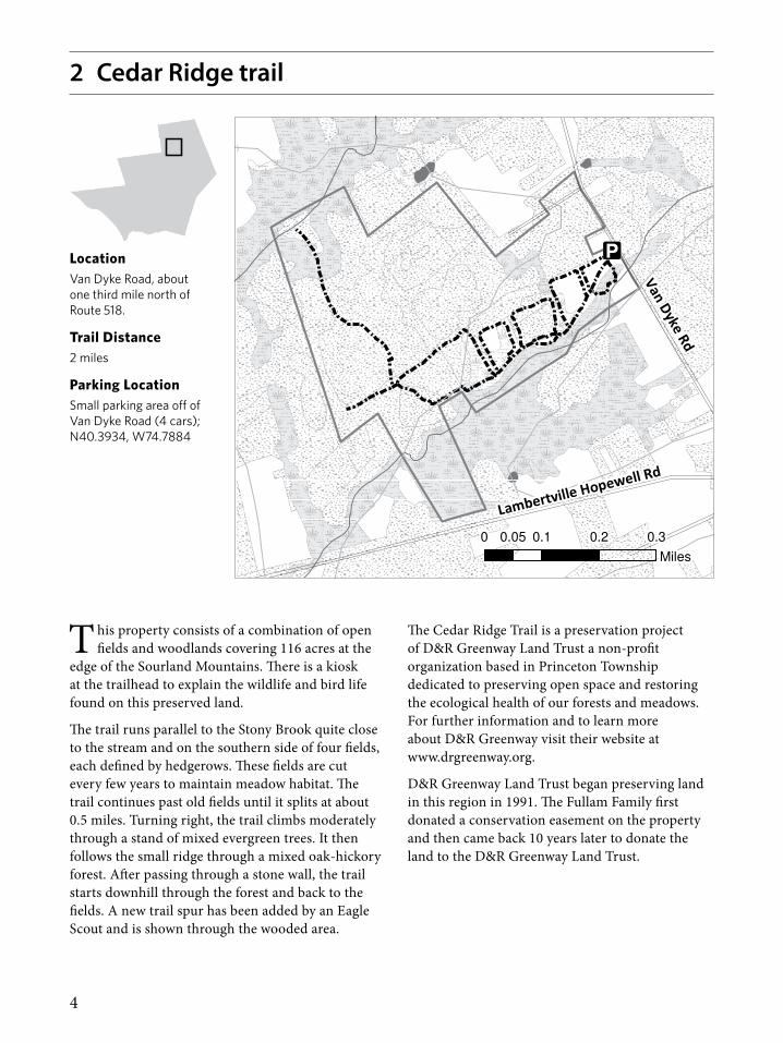
LocationVan Dyke Road, about one third mile north of Route 518.
Trail Distance2 miles
Parking LocationSmall parking area off of Van Dyke Road (4 cars); N40.3934, W74.7884
T his property consists of a combination of open fields and woodlands covering 116 acres at the
edge of the Sourland Mountains. There is a kiosk at the trailhead to explain the wildlife and bird life found on this preserved land.
The trail runs parallel to the Stony Brook quite close to the stream and on the southern side of four fields, each defined by hedgerows. These fields are cut every few years to maintain meadow habitat. The trail continues past old fields until it splits at about 0.5 miles. Turning right, the trail climbs moderately through a stand of mixed evergreen trees. It then follows the small ridge through a mixed oak-hickory forest. After passing through a stone wall, the trail starts downhill through the forest and back to the fields. A new trail spur has been added by an Eagle Scout and is shown through the wooded area.
2 Cedar Ridge trail
The Cedar Ridge Trail is a preservation project of D&R Greenway Land Trust a non-profit organization based in Princeton Township dedicated to preserving open space and restoring the ecological health of our forests and meadows. For further information and to learn more about D&R Greenway visit their website at www.drgreenway.org.
D&R Greenway Land Trust began preserving land in this region in 1991. The Fullam Family first donated a conservation easement on the property and then came back 10 years later to donate the land to the D&R Greenway Land Trust.

5
Curl
is L
ake
Redwood grove
Rhodo-dendron clumps
Parking, Equestrian
center
To Ros
edale
Lake
->
S Main St.
Oak
St
Federal City Rd
Curlis Lake Woods Trails
Trails
Elevation (20 ft)
Boundary
0 1,000 2,000 Feet
(c) NJ Trails Association, 2003.Cartography and trail data by The GIS Center at Stony Brook, 11/13/03.
Other data acquired from NJDEP and NJDOT, but this secondary map producthas not been verified or authorized by those agencies.
3 Curlis Lake Woods trails
LocationJust south and east of Pennington Borough, off S. Main Street (main entrance)
Trails and Distances from the main entrance(all distances are round trip)
Howe’s Lane: 1.3 miles round trip
Howe’s Lane/Redwood Trail: 1.4 miles
Howe’s Lane/Lake Shore Trail: 2.8 miles
Howe’s Lane/Woodland Trails: 3-4 miles
ParkingPull over area on S. Main Street just south of Pennington (5 cars); N40.3154, W74.7877
Mercer County Equestrian Center on Federal City Road (30 cars); N40.3289, W74.7677
T he main entrance to Curlis Lake Woods is off S. Main Street at the southern end of Pennington
Borough. A secondary entrance is at the end of Oak Street to the east of Pennington in Hopewell Township. The main trail, Howe’s Lane, extends from the main entrance to the Oak Street entrance. About 500 feet from the main entrance there is a large color map displaying all trails. Access to Curlis Lake Woods can also be made from the Mercer County Equestrian Center on Federal City Road. Entrances to the Woodland Trails can be found to the right of the fences.
Starting at South Main Street, Howe’s Lane runs through a thicket of rose, shrubs and young trees. The trail is broad and easy to follow. A side trail from Howe’s Lane is the Redwood Trail which passes by a grouping of dawn redwood trees planted by Howe’s Nursery. A nearby bridge was constructed as an Eagle Scout project in 2010. Since then, several additional bridges and boardwalks were constructed as Eagle Scout projects.
Howe’s Lane and the Redwood Trail lead to a small brook which can be crossed on stepping stones. At this point, hikers enter a mature woodland that changes from beech near Curlis Lake to oak and hickory on the slope extending up from the lake. The Lake Shore Trail for the most part hugs the edge of Curlis Lake. The Woodland Trails form a network on the slope up from the lake. One of these trails, the Red Trail, passes by the County Equestrian Center. Hikers can traverse the Equestrian Center and fields beyond to get to Rosedale Park.
Curlis Lake Woods was part of Howe’s Nursery in Pennington. Some of the non-native trees, such as the dawn redwoods, date back to Howe’s Nursery. Mercer County acquired the site in 1993 following a public campaign and the urging of Friends of Hopewell Valley Open Space to save the area once proposed for the “Pennington Bypass.”

6
4 Eames Preserve trail
T his trail is a long narrow loop through open woods and one field. It borders on a pretty section of
Woodsville Brook and winds through a mature grove of American beech trees.
The first section of the trail follows an old road as it passes the site of a former house on the west side of the trail. The woods here are very open with red maple, white ash, some large black cherry trees, sassafras, tulip poplar and hickory. There are scattered stands of dying red cedar indicating that this was once an open field. As the trail continues down a gradual slope you enter a mature forest dominated by American beech, oak and hickory. At the bottom of the slope the trail swings to the west at the end of a meadow. For a short while, it follows along the meandering Woodsville Brook, skirts a slough filled with skunk cabbage and then begins to climb back toward the south uphill through the large stand of climax forest dominated by American beech, oak and hickory.
For many years, this was a farm with a house, animal sheds and a greenhouse. The property was purchased by the State of New Jersey and Friends of Hopewell Valley Open Space in 2007. The entrance to the trail is marked by a Friends of Hopewell Valley Open Space “Nature Preserve” sign. Trail guides are available at the start of the trail and on the website, www.fohvos.org.
FoHVOS conducts a deer management program on the Preserve to improve forest health. Hiking is not allowed when hunting occurs, which includes selected dates from early September through mid-February. Please check the website or the sign at the entrance of the preserve for specific hunting dates. There is no hunting activity on Sundays.
New Road Harbourto
n-
Woodsv
ille R
d
Marshall's Corner -
Woodsville RdWOODSVILL
E BK
STONY BROOK
Eames Preserve Trail
Parking
Elevation (20 ft)
Boundary
Trails
Streams
Roads
Forest
Water
Wetland
NJ Trails Association, 2/3/11.
Cartography and trail data by D&R Greenway Land Trust.Other data acquired from NJDEP, NJDOT, Hopewell Twp, and Hunterdon County,
but this secondary map product has not been verified or authorized by those agencies.
0 1,000500 Feet
LocationOn Harbourton–Woodsville Road, about one mile west of Marshall’s Corner–Woodsville Road
Trail Distance1.5 miles
Parking LocationSmall parking area off of Harbourton-Woodsville Road (3 cars); N40.3646, W74.8226

7
5 Elks Preserve trail
Crusher Rd
To Mt.RoseTrails
#164
Elks Preserve Trail
Parking
Boundary
Elevation (20 ft)
Trail
Roads
Forest
Water
Wetlands
0 400200
Feet
(c) NJ Trails Association, 2008.Cartography and trail data by D&R Greenway Land Trust 1/17/08.
Other data acquired from NJDEP and NJDOT, but this secondary map producthas not been verified or authorized by those agencies.
LocationCrusher Road, one quarter mile east of Route 654, (Pennington-Hopewell Road)
Trail Distance1.2 miles
Parking LocationSmall parking area off of Crusher Road (2–3 cars); N40.3777, W74.7799
T his is an especially pleasant walk in autumn when the red maples and other trees are at their
most colorful states. In early spring when the maples are a haze of red flowers this area is also beautiful, but the trail is likely to be muddy in spots.
The loop trail passes through lowland woods of predominately red maples with elm, white ash, beech and oak scattered throughout. In the southeast section the trail enters a dense stand of red cedar. This stand is so dense that there is no undergrowth or ground cover. Look for muscular, wildly artistic grape vines looping and climbing to the tops of the trees. Near the half way point, the trail crosses a small stream where a bench has been placed. The trail then continues through the lowland forest and returns to the parking area. There is also a connector trail that leads to the Mount Rose Trail system on the Stony Brook-Millstone Watershed Preserve.
The property was farmed until 1973. Since then, the farm fields have succeeded, first to brush and then to the young forest you see. The property was used as a hunting preserve by the Elks Club of Hopewell until 2002 when the Friends of Hopewell Valley Open Space purchased the property. The loop trail was constructed by volunteers in 2007.
The entrance to the trail is marked with a Friends of Hopewell Valley Open Space “Nature Preserve” sign. Trail guides are available at the start of the trail and on the website, www.fohvos.org.
FoHVOS conducts a deer management program on the Preserve to improve forest health. Hiking is not allowed when hunting occurs, which includes selected dates from early September through mid-February. Please check the website or the sign at the entrance for specific hunting dates. There is no hunting activity on Sundays.

8
6 Featherbed Lane trailsFeatherbed Lane Trails
(c) NJ Trails Association, 2011. Cartography and trail data by D&R Greenway Land Trust 2/2/11Other data acquired from, NJDEP and NJDOT, but this secondary map product has not been verified or authorized by those agencies.
So u r l and
Foothills Trail
Dou
b le Cro
ssin
g T
rail
Featherbed Meadow
s West
Featherbed Ln
Hopewell W
ertsville Rd
Mountain Church Rd
0 0.1 0.20.05Miles
Sourland Foothills Trail
Featherbed Meadows West
Double Crossing Trail
Parking
Roads
Elevation 20 ft.
Forest
Water
Wetland
Ston y Br o
ok
LocationFeatherbed Lane one mile north of Hopewell Borough
Trails and DistancesThere are three connecting trails on the South side of the Sourlands.
Featherbed Meadows West Trail: 0.75 miles
Sourlands Foothills Trail: 1.1 miles
Double Crossing Trail: 1.1 miles
Parking Locations: Two parking areas on Featherbed Lane
Featherbed Meadows West Trail: Small lot on Featherbed Lane about ¾ mile west of Hopewell-Wertsville Road (4 cars); N40.4047, W74.7887
Sourlands Foothills Trail: Small lot on Featherbed Lane just east of Hopewell-Wertsville Road (4 cars); N40.4105, W74.7773

9
6 Featherbed Lane trails
T he 90-square-mile Sourland region includes parts of three counties and seven municipalities
in central New Jersey, encompassing a complex ecosystem of forest, wetlands and grasslands. Its mosaic of habitats is home to an incredibly rich diversity of animal and plant species, many rare or endangered. As the surrounding area grows and changes rapidly, the Sourlands are increasingly in jeopardy. The magnificent old forests, boulder fields, and extensive grasslands of the Sourland Mountain region are unique in central New Jersey. Working farms, historic homesteads, and extensive parkland complement its wild abundance. The resulting balance between natural and cultural heritage give this area its special character. The Sourland Mountain is a rich landscape for people and wildlife alike.
The area of the Featherbed Lane Trails is primarily woodland comprised of a mix of mature forest and forested wetlands to the north with areas of younger forest to the south. The preserve also includes areas of early successional wet meadow. A headwater stream corridor to the Stony Brook crosses a portion of the preserve near the meadow. The fields are dominated by goldenrod where they are dry and sedges where they are wet. The forested areas contain a number of mature hardwoods like pin oak and beech. A variety of animal species can be found such as deer and raccoons as well as many bird species including hawks soaring overhead and songbirds in the forest.
Featherbed Meadows West trailThis trail is part of a much larger trail system that begins in Hopewell and continues into Hunterdon County. It goes through a preserve that is co owned by D&R Greenway Land Trust and Friends of Hopewell Valley Open Space. It begins in a wet meadow and takes you into a mature forest of the Sourland Mountains. It then threads through a wet, early successional red cedar/red maple wooded area with little understory. Further north the trail enters slightly older red maple/white ash/pin oak woodland. The trail intersects with the Double Crossing Loop trail at the crossing of the Stony Brook. At this point you can return to the parking area, hike the Double Crossing Loop or get to the Sourlands Foothills trail via Double Crossing.
Sourlands Foothills trailThe Sourlands Foothills Trail starts at the parking area near the intersection of Featherbed Lane and Hopewell–Wertsville Road. It traverses property that is owned by Mercer County, the State of New Jersey, and the D&R Greenway Land Trust. The first section of Sourlands Foothills Trail parallels Hopewell-Wertsville Road. It threads through a wet, early successional red cedar and red maple wooded area. After crossing Hopewell-Wertsville Road, the trail enters slightly older red maple/white ash/pin oak woodland. The trail then enters mature woodlands. The trail crosses and follows a small tributary for a short section where large American beech and shagbark hickory trees grow. The trail then turns north and parallels and sometimes follows an old logging road. There are several sections of old stone walls and the quality of the woods improves as the trail continues further up the Sourland ridge.
Double Crossing trailThis trail gets its name because it crosses the Stony Brook twice along the route. It is primarily in mature forest but you will notice that it surrounds one private residence with ducks, chickens and pigs. Although ATV’s are no longer allowed on the preserve you may notice some trail damage from days past. One of the highlights of the trail is a stunning grove of American beech. The double crossing of Stony Brook via boulders is the fun part of this trail and you’ll find yourself saying, “It doesn’t get any prettier than this”. In spring, look for wood ducks in quiet pools in the brook, and stoneflies on beech tree trunks during the hatch in April. The trail lies on two preserved parcels of land, one is owned by Friends of Hopewell Valley Open Space and the other by D&R Greenway Land Trust. Double crossing ends at Mountain Church Road but you can cross the road and hike the trails of D&R Greenway’s Northern Stony Brook Preserve in Hunterdon County.

10
7 Fiddler’s Creek Preserve trails
T his 121-acre complement to the larger Ted Stiles Preserve offers broad views of the
Baldpate Mountain ridge, stunning views down into the Fiddler’s Creek ravine, idyllic walking along the creek at the bottom of the ravine, and links to the industrial past of the Hopewell Valley a century and more old.
The terrain falls in three categories: (1) scrub woods and open areas along the western side of the property; (2) a central 40-acre area of open fields (undergoing reforestation by Mercer County and Friends of Hopewell Valley Open Space) extending northeast from those scrub woods to Fiddler’s Creek Road; and (3) the Fiddler’s Creek ravine on the east side of the preserve. The open field area is surrounded by a fence to protect young trees from deer, and is crossed by four trail segments, with gates at five points to let walkers through.
There are two trail entrances to this preserve. The Overlook Trail (blue) is accessible from the Baldpate Mt. parking area. From there, signs direct hikers to the trail on the south side of Fiddler’s Creek Road. The trail winds alternately through open grassy areas and scrub woodland to the reforestation area. Beyond the reforestation area it enters the wooded Fiddler’s Creek ravine.
The Ravine Trail (red) entrance, located about a quarter mile south of the Baldpate Mt. parking area, is accessible from a stone driveway which ends at a small parking area. The trail begins just inside the fenced in forest restoration area and heads towards the wooded Fiddler’s Creek ravine.
LocationFiddler’s Creek Road opposite
Ted Stiles Preserve at Baldpate Mt.
Trails and DistancesLoop trails of varying distances
ParkingLarge parking area at the Ted Stiles Preserve at Baldpate Mountain
Secondary parking available on the Fiddler’s Creek Preserve; see stone driveway about .2 mile east of the Baldpate Mt. parking lot

11
EW
ING
CREE
K
(c) NJ Trails Association, 2008.
Cartography and trail data by D&R Greenway Land Trust 6/3/2010Other data acquired from NJDEP and NJDOT, but this secondary map product
has not been verified or authorized by those agencies.
Heritage Preserve Trail
Parking
Trail
Streams
Boundary
Elevation (20 ft)
Roads
Forest
Water
Wetlands
I-95
Reed
Rd
0 500250 Feet
8 Heritage Preserve trail
T his trail is a long narrow loop that begins by going through a former farm field. It continues
through young red maple forest and then a mature beech bottomland forest. This preserve has outstanding spring wildflowers. There are a number of vernal pools, small streams and old farm drainage swales. As the trail meanders through the forest, there may be some wet spots in spring and after rain.
The land of the Heritage Preserve was farmed for many, perhaps hundreds of years. The 1930 aerial photographs show that a little over a third of the land was forested. As you walk the trail you can easily identify the old forest by the large mature trees. About half of the rest of the property in 1930 was fields for crops and the remainder was pasture. Aside from two hayfields, farming ended in the late 1970’s.
At that time the former fields and pastures began to succeed, first to shrub land and then to forest. Friends of Hopewell Valley Open Space purchased the preserve from the Heritage Conservancy in 2008 with State Green Acres funds.
The entrance to the Heritage Preserve is marked with a Friends of Hopewell Valley “Nature Preserve” sign. Trail guides are available at the start of the trail and on www.fohvos.org.
FoHVOS conducts a deer management program on the Preserve to improve forest health. Hiking is not allowed when hunting occurs, which includes selected dates from early September through mid-February. Please check the website or the sign at the entrance for specific hunting dates. There is no hunting activity on Sundays.
LocationReed Road, one quarter mile north of I-95 or one mile south of Washington Crossing–Pennington Road
Trail Distance1.5 miles
Parking LocationSmall parking area off of Reed Road (2-3 cars); N40.2928, W74.7973
12
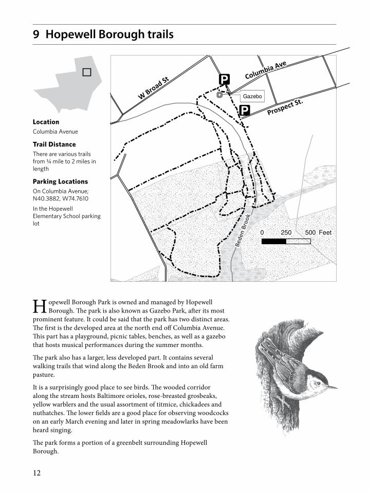
H opewell Borough Park is owned and managed by Hopewell Borough. The park is also known as Gazebo Park, after its most
prominent feature. It could be said that the park has two distinct areas. The first is the developed area at the north end off Columbia Avenue. This part has a playground, picnic tables, benches, as well as a gazebo that hosts musical performances during the summer months.
The park also has a larger, less developed part. It contains several walking trails that wind along the Beden Brook and into an old farm pasture.
It is a surprisingly good place to see birds. The wooded corridor along the stream hosts Baltimore orioles, rose-breasted grosbeaks, yellow warblers and the usual assortment of titmice, chickadees and nuthatches. The lower fields are a good place for observing woodcocks on an early March evening and later in spring meadowlarks have been heard singing.
The park forms a portion of a greenbelt surrounding Hopewell Borough.
LocationColumbia Avenue
Trail DistanceThere are various trails from ¼ mile to 2 miles in length
Parking LocationsOn Columbia Avenue; N40.3882, W74.7610
In the Hopewell Elementary School parking lot
9 Hopewell Borough trails
Hopewell Borough Park Trail
Trails
Roads
Elevation (20 ft)
(c) NJ Trails Association, 2011.
Cartography and trail data by The GIS Center at Stony Brook, 2/19/2004 and D&R Greenway Land Trust, 5/24/2005.
Other data acquired from NJDEP and NJDOT, but this secondary map product
has not been verified or authorized by those agencies.
0 500250 FeetBe
den
Broo
k
W Broad St Columbia Ave
Gazebo
Prospect St.

13
10 Jacobs Creek TrailJacob's Creek Trail
(c) NJ Trails Association, 2011. Cartography and trail data by Friends of Hopewell Valley Open Space, January 21, 2011Other data acquired from, NJDEP and NJDOT, but this secondary map product has not been verified or authorized by those agencies.
Pennington Titusville Rd
Pennington Harbourton Rd
Trail
Parking
Elevation 10 ft
Forest
Water
Wetland
Jaco
b's
Cree
k
0 0.1 0.20.05 Miles
LocationAlong Jacobs Creek, from Pennington-Titusville Road to Pennington-Harbourton Road, and south of Pennington-Titusville Road
Trail Distance1.2 miles each way (northern section)
.25 mile each way (southern section)
ParkingPull over parking is located near trail entrances.
Pennington–Titusville Road (3 cars); N40.3182, W74.8382
Pennington–Harbourton Road (2 cars); N40.3310, W74.8336
F rom the main entrance on Pennington-Titusville Road, the Jacobs Creek Trail extends north to
Pennington-Harbourton Road and south for about a quarter mile. The northern section offers delightful close up views of the creek as well as panoramic views from a ridge high above the creek. The trail traverses mature woods on the ridge and younger successional woods on lowland sections closer to the creek. Much of the area was farmed many years ago and remnants of old farm roads still exist. One historic feature of note along the trail is the ruins of an old dam. A large section of a five foot high stone wall, which once extended across the creek, still exists on both sides of the creek. Nearby is what appears to be a small quarry where stone for the dam was obtained.
A smaller section of the Jacobs Creek Trail continues south of Pennington-Titusville Road. It closely
follows Jacobs Creek along a flood plain. It is proposed that this trail eventually connect with Hopewell Township’s Alliger Park on Washington Crossing-Pennington Road.
Major portions of the northern section of the trail go through private property on which easements for public access are held by Friends of Hopewell Valley Open Space. Hunting activity is variable on the private land in the mid-section of the trail, so please look for signage that indicates changes in hunting activity. On land owned by FoHVOS along the southern section of the trail, bow hunting for deer is allowed on selected days from early September through mid-February. Please check the website for specific hunting dates (look under ‘Nexus Preserve’ at www.fohvos.org). Hunting occurs on portions of private easements from October through February except Sundays.

14
11 Kate’s Trail
Elm Ridge Rd
Alta Vista Rd
Public
Open
Space
Private
Land
KatesParking
Boundary
Roads
Elevation (20 ft)
Trails - 1.1 miles
FOREST
WATER
WETLANDSCentral NJ Trails Association, 1/17/2007.
Cartography and trail data by The GIS Center at Stony Brook.
Other data acquired from NJDEP, NJDOT, Hopewell Twp, and Hunterdon County,
but this secondary map product has not been verified or authorized by those agencies.
Kate's Trail
Stony B
rook
0 0.10.05 Miles
LocationElm Ridge Road, about one half mile west of Carter Road
Trail Distance1.1 miles round trip
Parking LocationPull over on Elm Ridge Road at trail entrance (1 or 2 cars); N40.3430, W74.7358
Park on Alta Vista Drive a short distance west; N40.3428, W74.7377
K ate’s Trail is on a 60-acre conservation easement acquired by D&R Greenway Land Trust in 2000.
The area of the easement with the trail and public access covers 20 acres. The remaining 40-acre easement does not allow public access, but will remain as permanent open space. The distance from the road to the Stony Brook is ¼ mile. Another ¼ mile of the trail closely follows the Stony Brook. Many species of birds in season can be seen along the trail including great blue herons, wood ducks, scarlet tanagers, and Baltimore orioles. Amphibians and reptiles including the Eastern box turtle can also be found along the stream.
The upper part of the trail follows a ridge above the Stony Brook. Large tulip trees, swamp white oak and pin oaks can be found here. The lower section of the trail lies in the Stony Brook floodplain and can be wet at times.
Kate’s Trail is dedicated to the memory of Kate Gorrie. There is a kiosk at the start of the trail with more information about Kate and a map showing the trail route.
15
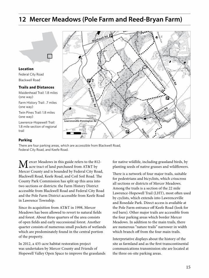
12 Mercer Meadows (Pole Farm and Reed-Bryan Farm)
LocationFederal City Road
Blackwell Road
Trails and DistancesMaidenhead Trail: 1.8 miles (one way)
Farm History Trail: .7 miles (one way)
Twin Pines Trail: 1.8 miles (one way)
Lawrence-Hopewell Trail: 1.8 mile section of regional trail
M ercer Meadows in this guide refers to the 812-acre tract of land purchased from AT&T by
Mercer County and is bounded by Federal City Road, Blackwell Road, Keefe Road, and Coil Soil Road. The County Park Commission has split up this area into two sections or districts: the Farm History District accessible from Blackwell Road and Federal City Road and the Pole Farm District accessible from Keefe Road in Lawrence Township.
Since its acquisition from AT&T in 1998, Mercer Meadows has been allowed to revert to natural fields and forest. About three quarters of the area consists of open fields and early successional forest. Another quarter consists of numerous small pockets of wetlands which are predominately found in the central portion of the property.
In 2012, a 435-acre habitat restoration project was undertaken by Mercer County and Friends of Hopewell Valley Open Space to improve the grasslands
for native wildlife, including grassland birds, by planting seeds of native grasses and wildflowers.
There is a network of four major trails, suitable for pedestrians and bicyclists, which crisscross all sections or districts of Mercer Meadows. Among the trails is a section of the 22 mile Lawrence-Hopewell Trail (LHT), most often used by cyclists, which extends into Lawrenceville and Rosedale Park. Direct access is available at the Pole Farm entrance off Keefe Road (look for red barn). Other major trails are accessible from the four parking areas which border Mercer Meadows. In addition to the main trails, there are numerous “nature trails” narrower in width which branch off from the four main trails.
Interpretative displays about the history of the site as farmland and as the first transcontinental communications transmission site are located at the three on-site parking areas.
ParkingThere are four parking areas, which are accessible from Blackwell Road, Federal City Road, and Keefe Road.

16
Mt. Rose TrailsStony Brook-Millstone Watershed Reserve
(c) NJ Trails Association, 2011. Cartography and trail data by D&R Greenway Land Trust 2/2/11Other data acquired from, NJDEP and NJDOT, but this secondary map product has not been verified or authorized by those agencies.
Elks Preserve Trail
Trail continuesto Rt 654
Crusher Rd
Moores Mill Mt Rose RdTim
berb
rook
e D
rWest Loop
Mt. Rose Ridge Trail
Fo
rest L
oo
p
0 0.1 0.20.05Miles
Forest Loop
Mt. Rose Ridge Trail
West Loop
Parking
Elevation 20 ft.
Forest
Water
Wetland
13 Mount Rose trails
LocationMoore’s Mill-Mt. Rose Road, about ¾ of a mile east of CR654 (Pennington-Hopewell Road)
Trails and DistancesMt. Rose Ridge Trail: 2.1 miles round tripForest Loop Trail: 1.0 mile round tripWest Loop Trail: 1.3 miles round trip
Parking LocationParking area off of Moore’s Mill-Mt. Rose Road; N40.3675, W74.7700
T he Mount Rose trails are on a 240-acre section of the Stony Brook-Millstone Watershed Association
Reserve along Moore’s Mill-Mt. Rose Road. The area consists mostly of early successional fields, but also contains a mature oak-hickory forest, skunk cabbage swamp, vernal pools, the unique geological formations of the Mt. Rose Ridge and the headwaters of the Honey Brook.
All trails are accessed from the Mount Rose trails parking area. Please use caution when crossing the road and keep any dogs on a leash. After parking, walk into the site to the right and access the trailhead to the right of the information kiosk. After crossing the road the Mt. Rose Ridge trail wanders through mature oak-hickory forest. A connection to the Forest Loop on the left is reached at .15 miles. The Forest Loop offers a stroll through the oak-hickory forest with an observation platform overlooking a skunk cabbage swamp. Continuing on the main trail, a meadow is reached at .23 miles. From here the West Loop heads to the left where it meanders through thickets of multiflora rose and Eastern red cedar and then returns to the Mt. Rose Ridge trail.
At the northwest corner of the West Loop there is a short trail that allows access to a trail on the adjacent preserve owned by Friends of Hopewell Valley Open Space. The Mt. Rose Ridge trail passes two more fields on your left before reuniting with the West Loop at .44 miles. From here, the trail heads through younger, denser forest until it crosses Crusher Road at .58 miles. The trail reaches the top of the Mount Rose Ridge at .64 miles. Just beyond the top, a large rocky outcrop offers an overlook of farms in the Hopewell Valley and views of the Sourland Mountains to the left. The trail continues along the ridge and then turns right, heading down the ridge. As the trail levels out, it wanders among towering tulip, oak and ash trees. The trail continues to CR 654 ending just outside Hopewell Borough.
The original 200 acres of the Mt. Rose trails section was added to the Reserve in 1998 through the State’s Green Acres Program. An additional 40 acres was given to the Watershed Association to manage by Mercer County.

17
14 Nayfield Preserve trail
LocationOn the north side of Route 518, about two miles west of Route 31
Trail Distance1.5 miles
Parking LocationSmall parking area off of Route 518 (2-3 cars); N40.3756, W74.8403
T his is a very pleasant walk through many different habitats including farm fields, mature
oak-hickory forest, red maple forest, some red cedar woods, and a pine grove. Parts of the trail may be swampy or muddy in the spring. A portion of the trail runs along a tributary of the Stony Brook which has a bed of large flat rocks. Stream flow is high in the spring and you can watch the water cascading over the rocks at several vistas. Spring woodland flowers include jack-in-the-pulpit, mayapple, dogwood and large areas of trout lily. In summer the forest canopy closes providing abundant cool shade. In fall the preserve hosts a multitude of colors from wildflowers in the wet meadow and trees in the hardwood forest. In winter the meadow provides a valuable source of food for winter resident birds and the snow stands in stark contrast to the dark trees and grapevines.
The land where Nayfield Preserve stands today was used as a dairy farm until the early 1960’s. Thickets and trees started growing in various fields after farming activity was abandoned. The exception was a five acre corn field that was used through the 1970s. Over the years, the field has reverted to a wet meadow and the forest has continued to grow and mature.
Route 518
# 323
Stony Brook
Nayfield Preserve Trail
(c) NJ Trails Association, 2008.
Cartography and trail data by D&R Greenway Land Trust 9/11/08.
Other data acquired from NJDEP and NJDOT, but this secondary map product
has not been verified or authorized by those agencies.
Parking
Boundary
Elevation (20 ft)
Roads
Trails
Forest
Water
Wetland
0 400200
Feet
The preserve was acquired by Friends of Hopewell Valley Open Space and the State of New Jersey in 2005. The entrance to the trail is marked with a Friends of Hopewell Valley Open Space “Nature Preserve” sign. Trails guides are available at the start of the trail and on the website, www.fohvos.org.
FoHVOS conducts a deer management program on the Preserve to improve forest health. Hiking is not allowed when hunting occurs, which includes selected dates from early September through mid-February. Please check the website or the sign at the entrance of the preserve for specific hunting dates. There is no hunting activity on Sundays.

18
Baldwin Lake
Pennview Dr
Murp
hy D
r
Jam
ieso
n D
rHessian Hill Dr
Pie
rson D
r
Lewis Brook Rd
Ma
in S
t
Baldwin Lake Dr
Kunkel Park
Main trailhead
King George RdFranklin Ave
Egla
ntin
e A
ve
Blu
e T
rail
Blu
e T
rail
Orange Trail
Gre
en T
rail
Yello
w T
rail
Lewis Brook
Stony Brook
e
Silo Rd
Pennington Loop Trails
0 0.10.05
Miles
NJ Trails Association, 2/3/11.Cartography and trail data by D&R Greenway Land Trust.
Other data acquired from NJDEP, NJDOT, Hopewell Twp, and Hunterdon County, but this secondary map product has not been verified or authorized by those agencies.
Parking
Elevation (20 ft)
Kunkel Park Connector
Blue Trail
Orange Trail
Green Trail
Yellow Trail
Forest
Water
Wetland
15 Pennington Loop Trail
LocationJust north of Pennington Borough, with access from King George Road and N. Main Street
Trails and DistanceShort Loop Trail: 1.5 miles round trip (from Kunkel Park entrance)
Long Loop Trail: 2.5 miles
Parking LocationKunkel Park parking lot off of King George Road in Pennington (15 cars); N40.3329, W74.7849
T he Pennington Loop Trail extends north of the Borough to Baldwin Lake. Hikers have
a choice of taking a short loop which begins and ends at Kunkel Park in Pennington or a long loop which can be accessed either from Kunkel Park or from N. Main Street where it turns to go over the railroad tracks. Hikers can complete a full circle that connects both ends of the trail at Kunkel Park and N. Main Street by walking along streets in Pennington Borough. A continuous sidewalk can be followed on N. Main Street, E. Franklin Street, Eglantine Street, and King George Road to Kunkel Park.
Starting from Kunkel Park, the trail crosses the Lewis Brook which hikers can usually step across or walk across on two utility poles. The trail closely follows the Stony Brook in mature woodlands on its way to Baldwin Lake. Since the first section of the trail is within the Stony Brook floodplain it
can be wet at times. The upper portion of the trail above the Stony Brook floodplain follows the south shore of Baldwin Lake and traverses a field.
Baldwin Lake was created to impound flood waters in the Stony Brook watershed and is owned by the State’s Division of Fish and Wildlife. Canada geese are the most prevalent wildlife there but large white swans can occasionally be spotted.
This area has been a popular place for hikers for many years. The trails were made by nearby residents before the area was finally preserved. The preserved area is 41 acres, with most of the area having been acquired or protected by D&R Greenway Land Trust in 1995. In 2006, a local Eagle Scout candidate marked the trails. In 2009, Pennington Girl Scout Troop 71853 constructed a bridge over a gully on the lower section of the Short Loop Trail.
N. Main Street just east of R/R overpass—see gap in guardrail (2-3 cars); N40.3367, W74.7932
19
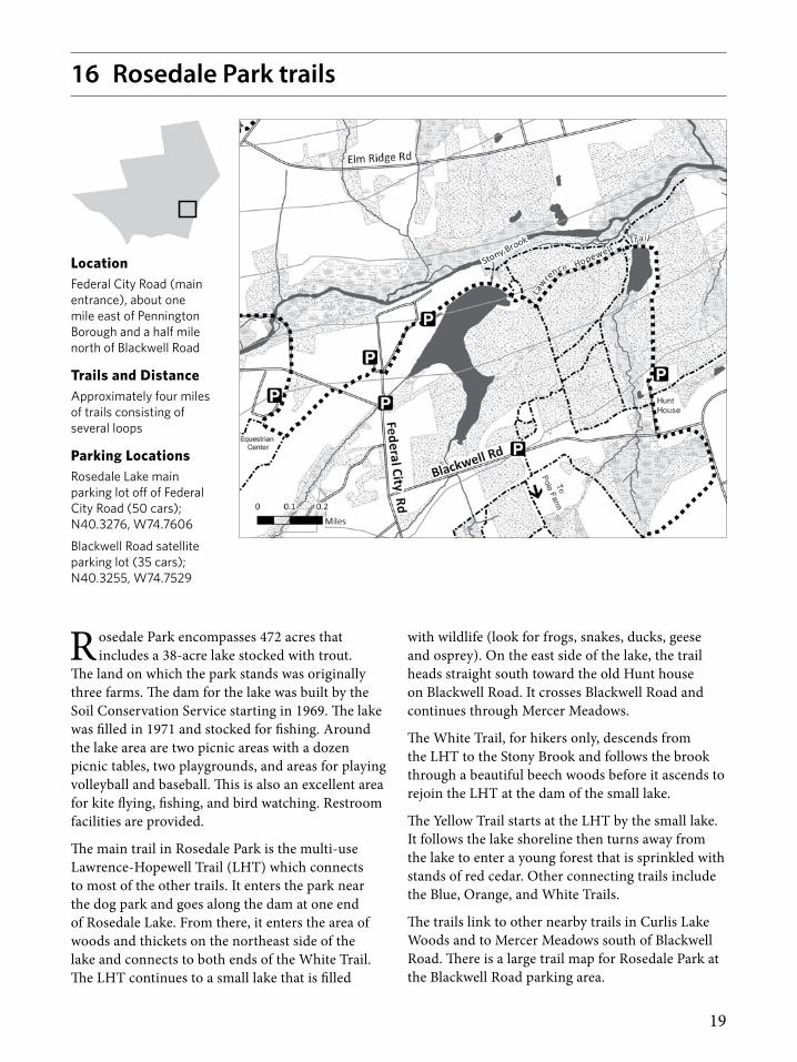
16 Rosedale Park trails
LocationFederal City Road (main entrance), about one mile east of Pennington Borough and a half mile north of Blackwell Road
Trails and DistanceApproximately four miles of trails consisting of several loops
Parking LocationsRosedale Lake main parking lot off of Federal City Road (50 cars); N40.3276, W74.7606
Blackwell Road satellite parking lot (35 cars); N40.3255, W74.7529
R osedale Park encompasses 472 acres that includes a 38-acre lake stocked with trout.
The land on which the park stands was originally three farms. The dam for the lake was built by the Soil Conservation Service starting in 1969. The lake was filled in 1971 and stocked for fishing. Around the lake area are two picnic areas with a dozen picnic tables, two playgrounds, and areas for playing volleyball and baseball. This is also an excellent area for kite flying, fishing, and bird watching. Restroom facilities are provided.
The main trail in Rosedale Park is the multi-use Lawrence-Hopewell Trail (LHT) which connects to most of the other trails. It enters the park near the dog park and goes along the dam at one end of Rosedale Lake. From there, it enters the area of woods and thickets on the northeast side of the lake and connects to both ends of the White Trail. The LHT continues to a small lake that is filled
with wildlife (look for frogs, snakes, ducks, geese and osprey). On the east side of the lake, the trail heads straight south toward the old Hunt house on Blackwell Road. It crosses Blackwell Road and continues through Mercer Meadows.
The White Trail, for hikers only, descends from the LHT to the Stony Brook and follows the brook through a beautiful beech woods before it ascends to rejoin the LHT at the dam of the small lake.
The Yellow Trail starts at the LHT by the small lake. It follows the lake shoreline then turns away from the lake to enter a young forest that is sprinkled with stands of red cedar. Other connecting trails include the Blue, Orange, and White Trails.
The trails link to other nearby trails in Curlis Lake Woods and to Mercer Meadows south of Blackwell Road. There is a large trail map for Rosedale Park at the Blackwell Road parking area.

20
17 St. Michaels Preserve trails
LocationA large preserve between Hopewell–Princeton Road and Aunt Molly Road
Trail DistanceDistances vary by trail
Parking LocationsThere is room for 2 cars on Aunt Molly Road .7 miles from Rt. 518; N40.3843, W74.7407
There is a large parking area on the east side of Hopewell–Princeton Road .5 miles from Rt. 518; N40.3836, W74.7548
T he St. Michaels Farm Preserve is a pioneering example of how to accommodate farming and
public recreation in the same area. The preserve includes a total of 396 acres of preserved land, mostly between Hopewell-Princeton Road and Aunt Molly Road, but a portion of the preserve lies on the east side of Aunt Molly Road. About 200 acres of the preserve are actively farmed under lease from D&R Greenway Land Trust, and the remaining 196 acres are forested. Many trails follow old farm roads or mowed routes along field edges, but east of Aunt Molly Road and in the southern portion of the property, woodland hiking paths have been created. Walks on the preserve offer bucolic open vistas, and from the overlook near Aunt Molly Road a broad view of the preserve, the spires of Hopewell, and the Sourland Ridge to the north can be seen.
The Charles Evans Overlook is a special place for celebrations and for solitary reflection. The overlook is easily accessed from Aunt Molly Road and sits
at a high point of the preserve where a panoramic view of the protected land can be appreciated. The overlook is named after Charles Evans, a visionary and entrepreneur. Mr. Evans recognized the enormous economic and environmental benefits that land preservation provides to communities.
Please visit during daylight hours. Please keep your dog on a leash due to the presence of ground nesting birds. Dogs can and will hurt ground nesting birds. Thank you for your help in protecting the wildlife that exists on the preserve.

21
Skyview Preserve Trail
(c) NJ Trails Association, 2011. Cartography and trail data by Friends of Hopewell Valley Open Space, January 21, 2011Other data acquired from, NJDEP and NJDOT, but this secondary map product has not been verified or authorized by those agencies.
Rt 31
RT 612
Lambertville Hopewell Rd
Marshalls Corner -
Woodsville Rd
WOODSVILLE BK
0 0.10.05Miles
SkyviewTrail
Boundary
Parking
Contour Interval 20 ft.
Forest
Water
Wetland
18 Skyview Preserve trail
LocationMarshall’s Corner–Woodsville Road (CR 612)
Trail Distance1.4 miles
Parking LocationSmall parking area off of Route 612 (2 cars); N40.3756, W74.8222
S tart at the parking area and follow the trail up a slight rise through a wood of cherry, dogwood,
hickory and pin oak. Note the large cedars, a reminder that this was once an open field. As the trail goes east the trees are larger and older. Look for large old grapevines climbing the trees as the trail nears the turn into the meadow. The mowed trail then loops through two meadows separated by an old hedgerow of mature elm, cherry, maple and ash. The field plants include goldenrod (shoulder high in the late autumn) asters, mullein, some young cedars and scattered small islands of multiflora rose. These fields are alive with birds during the fall migration. A variety of sparrows, finches and warblers can be found as well as hawks circling overhead. On the mowed trail, look for signs of deer, fox and woodchuck.
On the far northwest corner of the loop there is a short spur that leads down toward Woodsville
brook. This is an excellent place to look for birds taking shelter in the little valley cut by the brook. The mature trees and vines, along with little thickets of wild rose interspersed with raspberry bushes make good hiding places for the birds and mammals as evidenced by the nests in the trees and bushes.
The entrance to the Skyview Preserve is marked with a Friends of Hopewell Valley “Nature Preserve” sign. Trail guides are available at the start of the trail and on the website, www.fohvos.org.
FoHVOS conducts a deer management program on the Preserve to improve forest health. Hiking is not allowed when hunting occurs, which includes selected dates from early September through mid-February. Please check the website or the sign at the entrance for specific hunting dates. There is no hunting activity on Sundays.

22
Main Campus TrailsStony Brook-Millstone Watershed Reserve
(c) NJ Trails Association, 2010. Cartography and trail data by D&R Greenway Land Trust 5/14/10Other data acquired from, NJDEP and NJDOT, but this secondary map product has not been verified or authorized by those agencies.
Main Entrance
Stony Brook Trail
Circle Trail
Farm Trail
Red Shale Trail
Pond Loop
Four
Sea
sons
Trai
l
Pond Road
Arboretum Trail
Meadow Trail
Titus Mill Rd
War
go R
d
0 0.1 0.20.05Miles
MainTrails
Parking
Boundary
Elevation 10 ft
Forest
Water
Wetland
Stony Brook
19 Stony Brook–Millstone Watershed Reserve trails
Location:Titus Mill Road (main entrance), about one mile west of Pennington-Rocky Hill Road
There are three main trails which can be accessed from the Stony Brook–Millstone Watershed Association’s headquarters building off of Titus Mill Road. Two additional trails are accessed from the small parking area on Wargo Road or by taking the Circle trail from the headquarters area.
Trails, Distances and Access PointFour Seasons Trail: 1.1 miles round trip (Headquarters Building)
Stony Brook Trail: 2.5 miles round trip (Headquarters Building)
Circle Trail: 0.85 miles round trip (Headquarters Building)
Pond Loop Trail: 0.62 miles round trip (Wargo Road)
Red Shale Trail: 0.7 miles round trip (Wargo Road)
Parking LocationsLarge parking lot at headquarters building; N40.3515, W74.7721
Parking on Wargo Road for 2 to 3 cars; N40.3573, W74.7657
A good starting point for any visit to the Watershed Reserve is the new Watershed
Center completed in 2015. The Center houses a number of interpretative displays, a three dimensional map of the reserve, a small shop and restrooms. Maps are available at the front desk of the new Watershed Center. The center is open Monday to Friday, 9 a.m. to 5 p.m., and most Saturdays 10 a.m. to 4 p.m.
The Main Reserve is a well-blended combination of forests, fields, streams, ponds and wetlands allowing for a wide array of plants and animals. The fields are wonderful places for wildflowers and butterflies. The combination of open fields with edges provides habitat for many birds including prairie warblers, field sparrows, bluebirds, and tree swallows. American kestrels, northern harrier and red-tailed hawks are common birds of prey seen visiting the fields during daylight while great horned and screech owls hunt in the evenings. Red fox, white tail deer, woodchucks, and meadow voles are just a few of the mammals that frequent the fields.
The forests of the reserve are predominately oak-hickory, although some of the early successional forests are still dominated by eastern red cedar. Spring beauty, mayapple and cut leaved toothwort blanket the forest floor in early spring and wood thrushes, ovenbirds and scarlet tanagers provide musical background during the summer months
Both the Stony Brook and Four Seasons Trails lead to Stony Brook where great blue and green herons share the brook side feeding with kingfishers. The brook also hosts an abundance of macroinvertebrates. Stoneflies, mayflies, water

23
Main Campus TrailsStony Brook-Millstone Watershed Reserve
(c) NJ Trails Association, 2010. Cartography and trail data by D&R Greenway Land Trust 5/14/10Other data acquired from, NJDEP and NJDOT, but this secondary map product has not been verified or authorized by those agencies.
Main Entrance
Stony Brook Trail
Circle Trail
Farm Trail
Red Shale Trail
Pond Loop
Four
Sea
sons
Trai
l
Pond Road
Arboretum Trail
Meadow Trail
Titus Mill Rd
War
go R
d
0 0.1 0.20.05Miles
MainTrails
Parking
Boundary
Elevation 10 ft
Forest
Water
Wetland
Stony Brook
19 Stony Brook–Millstone Watershed Reserve trails
pennies and hellgrammites all are indicators of excellent water quality. Sunfish, bass, creek chubs and shiners can be found in the riffle areas and the slower moving pools of the brook.
The Pond House area offers outstanding birding from great egrets and great blue herons to kingfishers, Baltimore orioles and a host of waterfowl. Several species of amphibians can be found including spring peepers, bullfrogs, green frogs and pickerel frogs. Painted turtles are often seen basking on logs along the shore and occasionally a snapping turtle can be seen rising to the surface.
The Stony Brook-Millstone Watershed Reserve is owned and managed by the Stony Brook–Millstone Watershed Association. The association is a private, non-profit organization dedicated to protecting and restoring clean water and the environment throughout the 265 square miles of land drained by the Stony Brook and the Millstone River. For further information and to learn more about the Watershed Association, please visit their website at www.thewatershed.org
The Reserve headquarters sits on the site of the former Brookdale Farm. The farmhouse and barns date back to the early 19th century. The reserve is the result of the vision of an extraordinary woman, Dr. Muriel Gardiner Buttinger. Dr. Buttinger purchased the Brookdale farm in 1940 and began buying the surrounding farms as their owners looked to sell. In 1965, Dr. Buttinger made her first gift of 400 acres of land to the Watershed Association, followed by several more gifts of land from 1969-1984. Today, with additional Green Acres purchased made by the Association, the main reserve totals over 900 acres.

24
Thompson Preserve Trail
(c) NJ Trails Association, 2010. Cartography and trail data by Friends of Hopewell Valley Open Space, January 21, 2011Other data acquired from, NJDEP and NJDOT, but this secondary map product has not been verified or authorized by those agencies.
Pennington Hopewell Rd RT 654
0 0.10.05Miles
Trail
Boundary Parking
Elevation 20 ft.
Forest
Water
Wetland
Stony Brook
20 Thompson Preserve trail
LocationPennington–Hopewell Road
Trail Distance1.5 miles
Parking LocationParking along access driveway next to Marshall’s Corner Schoolhouse (2 cars); N40.3628, W74.7939
T he trail is a loop that starts out alongside agricultural fields then splits after about a
quarter mile. The left fork leads through the forest where you will see young hardwood trees like oak, maple and ash. The trail overlooks a tributary of the Stony Brook while in the forest. The trail then enters a wetland that follows the main branch of the Stony Brook and has many views of giant sycamore trees on the banks. Once you leave the wetland, you return to the forest up a small hill. The trail takes you through restored meadows and you will see native wildflowers over 6 feet in height, best seen from a viewing stand. The trail then runs along the northern edge of one of the farm fields and back to the parking area.
The three fields (17 of the 57 acres) in the southwestern portion of the preserve are leased for organic farming and foraging of wild plants. In the summer of 2010, two overgrown fields totaling 8.5 acres were prepared for a restoration project. The
meadows of native wildflowers and grasses that you see are a result of that restoration. Numerous species of animals can be found here, including deer, fox and birds like blue jays, woodpeckers and juncos. Also, amphibians like frogs and toads can be found in the wetlands.
This preserve was purchased by Friends of Hopewell Valley Open Space in 2002. The entrance is marked with a Friends of Hopewell Valley “Nature Preserve” sign. Trail guides for the Thompson Preserve are available at the kiosk at the start of the trail and on www.fohvos.org.
FoHVOS conducts a deer management program on the Preserve to improve forest health. Hiking is not allowed when hunting occurs, which includes selected dates from early September through mid-February. Please check the website or the signs at the entrance for specific hunting dates. There is no hunting activity on Sundays.

25
From Thorns to FlowersA special feature of the Thompson Preserve trail will be an 8-acre wildflower and native grass meadow. Aside from offering a pleasant hiking experience, the wildflower meadow will become critical habitat and foraging areas for many species of birds, butterflies and bees. Planted from seeds in May, 2010, the wildflowers are expected to bloom for the first time in the summer of 2011.
Before the meadow could be planted, a mass of thorny multi-flora rose which covered the entire 8 acres had to be removed, not an easy task. It was accomplished thanks to a staff member of the New Jersey Forest Fire Service who drove a GytroTrac mulching machine through 12-foot-high multi-flora rose thickets. After these tickets were reduced to mulch, the soil was later tilled and the seeds planted. The entire operation was funded with grants from the Natural Resources Conservation Service and the U.S. Fish & Wildlife Service. The Washington Crossing Audubon Society provided additional funding for wildflower planting along the perimeter of 17 acres of nearby farmland on the preserve.
26
Washington Crossing Trails
(c) NJ Trails Association, 2010. Cartography and trail data by D&R Greenway Land Trust 5/14/10Other data acquired from, NJDEP and NJDOT, but this secondary map product has not been verified or authorized by those agencies.
NatureCenter
KnoxGrove
ParkEntrance
Visitor's Center
0 0.250.125Miles
Other Trails
Blue Dot
Continental Trail
Tow Path
Park Rd
Red Dot Trail
Solid Red
Parking
Elevation 20 ft.
Roads
Boundary
Forest
Water
Wetland
Was
hing
ton
Cros
sing -
Penn
ingt
on R
d
Bear Tavern Rd
Rt 579
Route 29
Church Rd
Brick Yard Rd
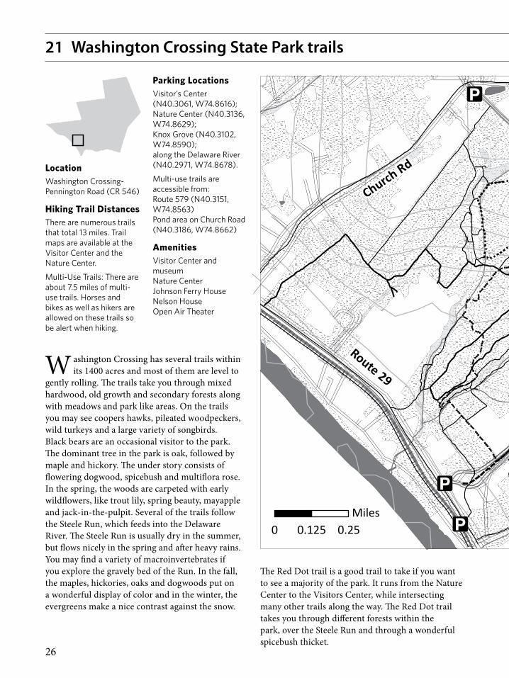
21 Washington Crossing State Park trails
LocationWashington Crossing-Pennington Road (CR 546)
Hiking Trail DistancesThere are numerous trails that total 13 miles. Trail maps are available at the Visitor Center and the Nature Center.
Multi-Use Trails: There are about 7.5 miles of multi-use trails. Horses and bikes as well as hikers are allowed on these trails so be alert when hiking.
Parking LocationsVisitor’s Center (N40.3061, W74.8616); Nature Center (N40.3136, W74.8629); Knox Grove (N40.3102, W74.8590); along the Delaware River (N40.2971, W74.8678).
Multi-use trails are accessible from: Route 579 (N40.3151, W74.8563) Pond area on Church Road (N40.3186, W74.8662)
AmenitiesVisitor Center and museum Nature Center Johnson Ferry House Nelson House Open Air Theater
W ashington Crossing has several trails within its 1400 acres and most of them are level to
gently rolling. The trails take you through mixed hardwood, old growth and secondary forests along with meadows and park like areas. On the trails you may see coopers hawks, pileated woodpeckers, wild turkeys and a large variety of songbirds. Black bears are an occasional visitor to the park. The dominant tree in the park is oak, followed by maple and hickory. The under story consists of flowering dogwood, spicebush and multiflora rose. In the spring, the woods are carpeted with early wildflowers, like trout lily, spring beauty, mayapple and jack-in-the-pulpit. Several of the trails follow the Steele Run, which feeds into the Delaware River. The Steele Run is usually dry in the summer, but flows nicely in the spring and after heavy rains. You may find a variety of macroinvertebrates if you explore the gravely bed of the Run. In the fall, the maples, hickories, oaks and dogwoods put on a wonderful display of color and in the winter, the evergreens make a nice contrast against the snow.
The Red Dot trail is a good trail to take if you want to see a majority of the park. It runs from the Nature Center to the Visitors Center, while intersecting many other trails along the way. The Red Dot trail takes you through different forests within the park, over the Steele Run and through a wonderful spicebush thicket.
27
Washington Crossing Trails
(c) NJ Trails Association, 2010. Cartography and trail data by D&R Greenway Land Trust 5/14/10Other data acquired from, NJDEP and NJDOT, but this secondary map product has not been verified or authorized by those agencies.
NatureCenter
KnoxGrove
ParkEntrance
Visitor's Center
0 0.250.125Miles
Other Trails
Blue Dot
Continental Trail
Tow Path
Park Rd
Red Dot Trail
Solid Red
Parking
Elevation 20 ft.
Roads
Boundary
Forest
Water
Wetland
Was
hing
ton
Cros
sing -
Penn
ingt
on R
d
Bear Tavern Rd
Rt 579
Route 29
Church Rd
Brick Yard Rd
21 Washington Crossing State Park trails
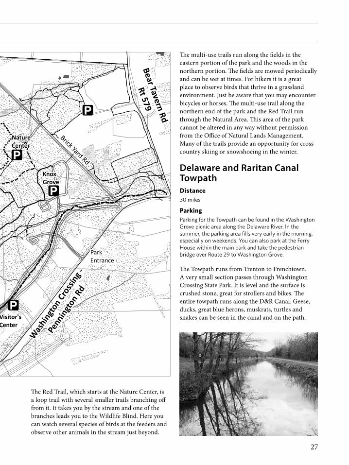
The Red Trail, which starts at the Nature Center, is a loop trail with several smaller trails branching off from it. It takes you by the stream and one of the branches leads you to the Wildlife Blind. Here you can watch several species of birds at the feeders and observe other animals in the stream just beyond.
The multi-use trails run along the fields in the eastern portion of the park and the woods in the northern portion. The fields are mowed periodically and can be wet at times. For hikers it is a great place to observe birds that thrive in a grassland environment. Just be aware that you may encounter bicycles or horses. The multi-use trail along the northern end of the park and the Red Trail run through the Natural Area. This area of the park cannot be altered in any way without permission from the Office of Natural Lands Management. Many of the trails provide an opportunity for cross country skiing or snowshoeing in the winter.
Delaware and Raritan Canal TowpathDistance30 miles
ParkingParking for the Towpath can be found in the Washington Grove picnic area along the Delaware River. In the summer, the parking area fills very early in the morning, especially on weekends. You can also park at the Ferry House within the main park and take the pedestrian bridge over Route 29 to Washington Grove.
The Towpath runs from Trenton to Frenchtown. A very small section passes through Washington Crossing State Park. It is level and the surface is crushed stone, great for strollers and bikes. The entire towpath runs along the D&R Canal. Geese, ducks, great blue herons, muskrats, turtles and snakes can be seen in the canal and on the path.

28
22 Woolsey Brook trails
LocationAt Alliger Park on Washington Crossing-Pennington Road (CR 546) approximately one half mile west of Scotch Road
Trails and DistancesWoolsey Brook Trail: 1 mile from parking area
Osage Ridge Trail: 1.5 miles from parking area
ParkingLarge parking area and near trailhead, veterans memorial and 9-11 memorial.
H opewell Township’s Alliger Park trails offer a varied trail experience: large groves of mature
spruce trees, long rows of Osage orange trees that were used to fence in livestock years ago, up close views of the Woolsey Brook, vistas of deep ravines, and a bit of history. Of historic interest, the trail crosses the Woolsey Brook where a 19th century railroad once crossed overhead. Although the wooden railroad trestle is long gone, the 15 foot high embankments for the trestle, constructed in the 1870’s, are still a prominent sight. The Woolsey Brook is named after Jeremiah Woolsey who first settled this property in the mid 18th century (see site history below).
There are two loop trails, the Woolsey Brook Trail and the Osage Ridge Trail, the latter branching off of the Woolsey Brook Trail. All hikers start out to the right of the kiosk at the parking lot on the Woolsey Brook Trail (watch for yellow blazes). The trail enters a grove of Norway spruce trees just past the Veteran’s Memorial. Shorty after the trail enters the Woolsey Brook ravine, the Woolsey Brook Trail splits at a large wood post to form a loop.

29
22 Woolsey Brook trails
Right after the fork in the trail to the left is an overlook area on the abandoned 19th century railroad embankment. From this point, hikers can view the Woolsey Brook below and see where a wooden railroad trestle once spanned the Woolsey Brook to an embankment on the other side. From the overlook, the Woolsey Brook Trail dips down to the brook where hikers can cross using stepping stones (except during periods of high water).
For a longer hike, hikers can leave the Woolsey Brook Trail at two locations to take the Osage Ridge Trail (see red blazes). This trail crosses a small tributary of the Woolsey Brook and follows a high ridge lined with Osage orange trees (which gives the trail its name). The trail also treads through a densely planted Norway spruce forest.
Two Eagle Scout candidates and adult volunteers constructed the trails in 2014 and 2015 with support from Friends of Hopewell Valley Open Space.
Site historyJeremiah Woolsey, a prominent lawyer, acquired this land and land to the west circa 1768. His Dutch Colonial house, located just west of Jacobs Creek on Washington Crossing–Pennington Road, is a locally designated historic landmark and is listed on the National Register of Historic Places.
The Mercer and Somerset Railway, completed in 1874, went diagonally through the park heading north from where Jacobs Creek Road is located. That road was constructed on the old railroad track bed. The railroad line, leased to the Pennsylvania Railroad, started at the Belvidere and Delaware Railroad tracks, which ran along the Delaware River. Throughout the park, the line followed the Woolsey Brook toward Pennington. A passenger depot for the line still stands south of Pennington-Titusville Road near Route 31. Going further north, the line connected to the Millstone and New Brunswick Railroad en route to New Brunswick. After declaring bankruptcy in 1879, the Mercer and Somerset Railway was sold at a foreclosure auction in 1880 to the Pennsylvania Railroad which removed the tracks that same year.
The short lived railroad line was used by the Pennsylvania Railroad as a connection to New York. Its sole purpose was to serve as an alternative route
to the Delaware and Bound Brook Railroad line connecting Philadelphia and New York (now used by CSX). When that line was able to cross the tracks of the Mercer and Somerset Railway in 1876 near Hopewell Borough following the “frog war,” it became the preferred through route between Philadelphia and New York resulting in the demise of the Mercer and Somerset line.
Mercer-Somerset route through Hopewell.

30
Baldwin Lake on the Pennington Loop Trail

31
While you are hiking, be sure to protect yourself from poison ivy and ticks.
Wear solid, light colored clothing with pants tucked into socks. This will help prevent a tick from attaching to your skin and will also make sighting a tick easier. Examine yourself frequently for ticks while in tick-infested areas and perform a full-body exam on yourself, children, and pets after leaving tick habitat.
For more information on ticks, you can visit the Center for Disease Control (CDC) website: www.cdc.gov/ticks/avoid/index.html
For the protection of both wildlife and people not comfortable with dogs, all organizations that manage the listed preserves require that dogs be kept on a leash at all times while walking the trails. Even the best-behaved dogs, by their canine nature, are impulsive creatures. A dog chasing a squirrel could accidently crush the eggs of ground nesting birds or disrupt the incubation cycle.
The organizations that maintain the preserves listed in this guide have deer management programs to sustain or improve the health of the forest ecosystem. Each organization has rules for use of the preserve during hunting season. Prior to hiking during hunting season you should check the organization’s website to determine when hunting activity is occurring. Even if there is not hunting at the preserve, it is a good idea to wear blaze orange when the statewide deer hunting regulations allow hunting (between early September and mid-February).
This guide is intended to cover hiking trails in Hopewell Valley. With very few exceptions (some trails at Baldpate Mountain and a couple at Washington Crossing State Park) horses and bicycles are not allowed on the trails listed in this guide. Most of the trails are wet in the spring and after heavy rains. Horses and bicycles have a severe impact on the trail
General Trail Use Guidelines
Map symbols used in this guideTrail
Boundary
Parking
Contour (20 ft; Jacobs Creek Trail 10 ft)
Roads
Forest
Water
Forested Wetland
Wetlands
and results in erosion. In general, motorized vehicles (ATVs, dirt bikes, etc.) are not allowed on any of the trails listed in this guide. Please check with the preserve management organization to see their policy regarding motorized vehicles.
New Jersey is one of the most populated states in the union yet we in Hopewell Valley are very fortunate to have preserved 25 percent of the acreage as open space. Heavy use can adversely impact the trails and ecosystems within the preserves. Therefore, all users of the trails should follow “Leave No Trace” practices. As the old saying goes “Take nothing but photographs and leave nothing but footprints.”
A Note on the trail mapsThe parking areas in this guide all have the GPS coordinates as well as their physical location and size. With one exception, the contour intervals for the trail maps in this guide are 20 feet; the Jacobs Creek map has contour intervals of 10 feet.

32
AcknowledgmentsAGuide to Walking Trails in the Hopewell Valley
is a publication of the Friends of Hopewell Valley Open Space. The trail guide was undertaken at the suggestion of Hopewell Valley resident James Vinson who generously contributed to printing costs of both the first and second editions of the Guide. With Mr. Vinson’s passing in late 2014, this second edition is dedicated to his memory.
Additional funding of printing costs for this second edition was provided by a grant from Church & Dwight.
CreditsMuch of the text and trail maps for this guide were taken with permission from the NJ Trails Association whose website, www.njtrails.org, provides a wealth of information for most of the trails in this guide.The illustrations were provided by Heather Lovett and graphic design by Mahlon Lovett.
CatographyCartography and data for the maps on pages 2, 5, 10, 12, 14, 16 and 20 was by the D&R Greenway Land Trust.Cartography and data for the maps on pages 16 and 22 were by the GIS Center.Cartography and data for the maps on pages 6, 11, 13, 17, 21, 24 and 28 were by Friends of Hopewell Valley Open Space.Cartography and data for the map on page 8 were by the GIS Center and D&R Greenway Land Trust.Cartography for the maps on pages 4 and 7 was by the D&R Greenway Land Trust using data provided by Friends of Hopewell Valley Open Space.
Cartography and data for the map on pages 15 and 19 were by the Mercer County Park Commission.
Web LinksFriends of Hopewell Valley Open Space / www.fohvos.org
D&R Greenway Land Trust / www.drgreenway.org
Stony Brook–Millstone Watershed Association / www.thewatershed.org
New Jersey Trails Association / www.njtrails.org
Washington Crossing Audubon Society / www.washingtoncrossingaudubon.org
Mercer County Park Commission / www.mercercountyparks.org
Hopewell Township / www.hopewelltwp.org
The late Jim Vinson and his wife, Rhonda.

Cedar Ridge Preserve trail includes forest and meadowThe Stony Brook near the Pennington Loop Trail
View from the top of Baldpate Mountain looking South to the Delaware River
Friends of Hopewell Valley Open SpaceP.O. Box 395, Pennington, NJ 08534
Tel: (609) 730-1560 • Fax: (609) 730-1561
www.fohvos.org
In every walk with nature one receives far more than he seeks.
—John Muir, Sierra Club founder, 1877