snowshoe & winter walking trails
DESCRIPTION
ÂTRANSCRIPT
SNOWSHOE TRAILS
WINTERWALKING TRAILS
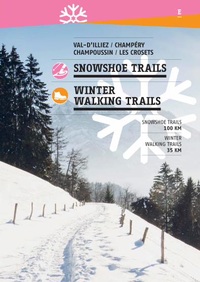
VAL-D’ILLIEZ / CHAMPÉRYCHAMPOUSSIN / LES CROSETS
E
SNOWSHOE TRAILS100 KM
WINTERWALKING TRAILS
35 KM

2
The Illiez Valley is crisscrossed with morethan 100 km of snowshoe trails and 35km of marked winter hiking paths. Thishand guide offers suggestions for thebest winter rambles through forests,meadows and villages for families andexperienced sports lovers alike. Along theway, take a moment to sample the richdiversity of our local «terroir» at one ofthe region’s many mountain refuges, innsand restaurants.


4
SNOWSHOE TRAILS
WINTER WALKING TRAILS
Champoussin
Les Crosets
Val-d’Illiez
Champéry
Round Trip
Loop
Difficulty Easy Medium High
Dénivellation Elevation gain loss
ICON GLOSSARY
— — — — — — — — — — — — — — — — — — — — — — — — — — — — — — — — — — — — — —
— — — — — — — — — — — — — — — — — — — — — — — — — — — — — — — — — — — — — —
Champéry
Val-d’Illiez
Round Trip
Loop
Difficulty Easy Medium High
Dénivellation Elevation gain loss

5
2 Editorial
4 Icon glossary
6 — 11 Trail map
12 — 21 Snowshoe trails Champoussin
22 — 25 Snowshoe trails Les Crosets
26 — 27 Snowshoe trails Val-d’Illiez
28 — 43 Snowshoe trails Champéry
44 — 45 Regional panorama
46 — 53 Winter walking trails Champéry
54 — 55 Winter walking trails Val-d’Illiez
56 — 58 Practical information
59 Gratitude
60 Useful information
To access the detailed maps, please scan the QR Code at the start of the trail or in the guide.
SUMMARY
— — — — — — — — — — — — — — — — — — — — — — — — — — — — — — — — — — — — — —
— — — — — — — — — — — — — — — — — — — — — — — — — — — — — — — — — — — — — —

Snowshoe trail
Snowshoe trail Alternative
Winter walking trail
Winter walking trail
Alternative
Primary road
Secondary road
Railway
Departure (point)
Arrival
Tourist office
Train
Bus/ shuttle bus
Cable-car
Chairlift
Ski lift
Parking (area)
Covered picnic area

Géo
mat
ic
Curling
Ice-skating
Locality
Steep path
Caution skiers
Mountains
Duration
Restaurant
WC
Viewpoint / Panorama
Avalanche danger
Chapel
Cross country skiing
Indoor pool
Thermal baths
Sports shops


Géo
mat
ic


Géo
mat
ic

12
1 Primary trail
CHAMPOUSSIN
via chez Gaby
Duration 2h45Distance 6.3kmDifficulty
Elevation 420m ❘ 420mDeparture point Champoussinparking 1515m Arrival point Same
1.1 Trail (Alternative)
CHAMPOUSSIN
(...) quick return
Duration 1h45Distance 4.1kmDifficulty
Elevation 280m ❘ 280mDeparture point Champoussinparking 1515m Arrival point Same
1.2 Trail (Alternative)
CHAMPOUSSIN
(...) via le Poussin
Duration 2h30Distance 6kmDifficulty
Elevation 350m ❘ 350mDeparture point Champoussinparking 1515m Arrival point Same
CHAMPOUSSIN — FRÂCHETTE
1 SNOWSHOE TRAILCHAMPOUSSIN
0 m 800 m
30’ 50’ 20’ 40’ 25’
1600m 3200m 4000m2400m 4800m 5600m 6300m
2h45
Cham
pouss
in p
ark
ing 1
515 m
1320 m Cham
pouss
in p
ark
ing 1
515 m
Che
z G
aby
La F
erm
e
à G
ab
y
Le P
ouss
in
Le V
irag
e
Frâ
ch
ett
e
Alte
rnativ
e 1
.1*
quic
k re
turn
Le T
ron
ch
ay
Alte
rnativ
e 1
.2**
1440 m
1500 m
1560 m
1620 m
1680 m
1740 m
1380 m
sin
2400m1600m800 m0 m
1320 m
1380 m
1740 m
1680 m
1620 m
1560 m
1500 m
1440 m
q
6300m5600m4800m4000m3200m
Cham
pouss
in p
ark
ing 1
515 m
C
A
— — — — — — — — — — — — — — — — — — — — — — — — — — — — — — — — — — — — — — — — — — — — — — —

13
1 DELICIOUS CHAMPOUSSINThis hike offers magnificent views, alternately traversing silent forests and snowy fields. Departing from the large car park at theentrance to Champoussin, cross the bridge and follow the river tothe right. Walk along the hillside, taking in the spectacular viewsof the Rhone valley and the Vaudoise Alps along the way. Continueon and up to the right, following a relatively steep but lovely pathleading to Frâchette, where you will find a covered picnic area, aWC and one of the region’s best viewpoints of the Dents du Midimountain range. Leaving Frâchette, walk along the ridge to theright; from here, you can turn right and take a path, with morebreathtaking views, that lead back to the Champoussin parking lot(approx. 20 min). Alternatively, continue along the ridge to thepicturesquely-named Gouille aux Sangliers, or Boars’ Pond. Turnright and descend towards Champoussin, crossing a second woodenbridge and a ski slope. From here, you can head up the slope tothe «Chez Gaby Restaurant», or to the «Le Poussin Restaurant» onthe hillside. Return to the car park by skirting the edges of theChampoussin ski slopes.
— — — — — — — — — — — — — — — — — — — — — — — — — — — — — — — — — — — — — — — — — — — — — — — —
— — — — — — — — — — — — — — — — — — — — — — — — — — — — — — — — — — — — — — — — — — — — — — —

14
2 Primary trail
CHAMPOUSSIN loop
Duration 2hDistance 5.3kmDifficulty
Elevation 270m ❘ 270mDeparture point Champoussin parking 1515m Arrival point Same
2.1 Trail (Alternative)
CHAMPOUSSIN —
(...) via U Yeü Tsalé
Duration 2h30Distance 6.5kmDifficulty
Elevation 350m ❘ 350mDeparture point Champoussin parking 1515m Arrival point Same
2.2 Trail (Alternative)
CHAMPOUSSIN —
(...) via les Bochasses
Duration 3hDistance 7.3kmDifficulty
Elevation 500m ❘ 500mDeparture point Champoussin parking 1515m Arrival point Same
CHAMPOUSSIN —U YEÜ TSALÉ — LES BOCHASSES
2 SNOWSHOE TRAILCHAMPOUSSIN
Parking deChampoussin1515 m
0 m 700 m 1400m 2800m 3500m2100m 4200m 4900m 5300m
Cham
pouss
in p
ark
ing 1
515 mLe Virage
1320 m
1400 m
1440 m
1480 m
1520 m
1560 m
1360 m
Alternative 2.3* quick return
Alternative 2.1** U Yeu TsaléAlternative 2.2*** Les Bochasses
Le Tronchay
30’2h
35’ 15’ 30’ 10’Cham
pouss
in p
ark
ing 1
515 m
2100m1400m700 m0 m
1360 m
1560 m
1520 m
1480 m
1440 m
1400 m
1320 m
ng
5300m4900m4200m3500m2800m
Cham
pouss
in p
ark
ing 1
515 m
— — — — — — — — — — — — — — — — — — — — — — — — — — — — — — — — — — — — — — — — — — — — — — —

15
2 AUTHENTICITY This is a pleasant walk along a wide, well-groomed trail (exceptfor the access to the «Bochasses Restaurant»). Leaving from thelarge car park at the entrance to Champoussin, cross the bridgeover the river and follow the river to the right. Walk along thehillside, taking in the spectacular views of the Rhone valley andthe Vaudoise Alps along the way. At the site called «Tronchay»,head downhill, over the Délifrette Bridge and along the road. Atthe fork in the road, you can either turn right and climb uphillfor a lovely meal in a local restaurant, or go straight and headback towards Champoussin. The «U Yeu Tsalé Restaurant» is accessed by passing to the right, under the chairlift departurestation. The «Bochasses Restaurant» can be reached by going upthe slightly steeper slope on the left.
The return to Champoussin follows a pleasant trail with a magnificentview of the valley. This path is also accessible to pedestrians.
— — — — — — — — — — — — — — — — — — — — — — — — — — — — — — — — — — — — — — — — — — — — — — — —
— — — — — — — — — — — — — — — — — — — — — — — — — — — — — — — — — — — — — — — — — — — — — — —

16
3 Primary trail
CHAMPOUSSIN ECOTRACE
Duration 1hDistance 1.7kmDifficulty
Elevation 100m ❘ 100mDeparture point Champoussin parking 1515m Arrivée Same
GAME
While hiking, look for the letter on each sign.Then put the letters together to name a well-knownalpine flower.
CHAMPOUSSIN ECOTRACE
3 SNOWSHOE TRAILCHAMPOUSSIN
0 m 300 m 900m600m 1200m 1500m 1700m
Le Virage
Pont de Socélare
1540 m
1560 m
1500 m
1520 m
1460 m
1480 m
1440 m20’
1h30’ 10’C
ham
pouss
in p
ark
ing 1
515 m
Cham
pouss
in p
ark
ing 1
515 m
s
600m300 m0 m
1440 m
1480 m
1460 m
1520 m
1500 m
1560 m
1540 m
e
1700m1500m1200m900m
Cham
pouss
in p
ark
ing 1
515 m
— — — — — — — — — — — — — — — — — — — — — — — — — — — — — — — — — — — — — — — — — — — — — — —

3 A FAMILY AFFAIRBecome a tracker for the day ! This easy trail, suitable for familieswith children, follows the traces of our shy forest creatures. Depar-ting from the large car park at the entrance to Champoussin, followthe signs for paths 1 and 2 for about 500 meters, then turn leftand cross the river over the Socélare Bridge. Climb through snowyfields by following the information boards along the way, headingtowards the «Virage Restaurant» and then back down towards thestarting point. This walk is also a treasure hunt ; look out for theletters on each panel and have fun putting them in order to findthe name of a well-known alpine flower.
— — — — — — — — — — — — — — — — — — — — — — — — — — — — — — — — — — — — — — — — — — — — — — — —
17
— — — — — — — — — — — — — — — — — — — — — — — — — — — — — — — — — — — — — — — — — — — — — — —

18
6 Primary trail
FRÂCHETTE –
CROIX DE L’AIGUILLE
Duration 3hDistance 5.6kmDifficulty
Elevation 500m ❘ 500mDeparture point Frâchette1586m Arrival point Same
6.1 Trail (Alternative)
(...) via the road
Duration 2h15Distance 5.1kmDifficulty
Elevation 380m ❘ 380mDeparture point Frâchette 1586m Arrival point Same
6.2 Trail (Alternative)
(...) via trail no 15
Duration 3hDistance 6kmDifficulty
Elevation 450m ❘ 450mDeparture point Frâchette 1586m Arrival point Same
FRÂCHETTE – CROIX DE L’AIGUILLE
6 SNOWSHOE TRAILCHAMPOUSSIN
0 m 700 m 1400m 2800m2100m 3500m 4200m 4900m 5600m
Frâ
chett
e 1
586 m
Frâ
chett
e 1
586 m
1470 m
Alternative 6.1
Alternative 6.2
Croix de l’Aiguile
Les Pétis
55’3h
50’ 30’ 45’
1610 m
1680 m
1750 m
1820 m
1890 m
1540 m
Pas-de-Croisette
2100m1400m700 m0 m
1470 m
1540 m
1890 m
1820 m
1750 m
1680 m
1610 m
5600m4900m4200m3500m2800m
Frâ
chett
e 1
586 m
— — — — — — — — — — — — — — — — — — — — — — — — — — — — — — — — — — — — — — — — — — — — — — — —

19
6 NOT FOR THE FAINT OF HEART
This is a long, gorgeous scenic trail that traverses several forestsand follows a ridgeline, offering incredible views of Champoussinand the Rhone Valley. The trail leaves from the Frâchette coveredpicnic area on the road to Champoussin. Take the path along theridgeline towards the Croix de l’Aiguille until you get to theGouille aux Sangliers. At the intersection, turn left and walk downthrough the forest to a place called Pétis. From here, walk uphill,along the edge of the Plagnois Forest until you reach the road.Upon leaving the forest, you can take option «6 by road» and re-turn to Frâchette (approx. 40 min). Otherwise, continue the climbto the Pas de Croisette. From here, you can follow the path alongthe ridge, a slightly technical but beautiful stretch, or take theRöstis Trail n° 15 back down to Frâchette.
— — — — — — — — — — — — — — — — — — — — — — — — — — — — — — — — — — — — — — — — — — — — — — —
— — — — — — — — — — — — — — — — — — — — — — — — — — — — — — — — — — — — — — — — — — — — — — — —

15 Primary trail RÖSTIS TRAIL
Duration 2h30Distance 6.4kmDifficulty
Elevation 420m ❘ 420mDeparture point Frâchette 1586m Arrival point Same
0 m 900 m 1800m 3600m 4500m2700m 5400m 6300m 6400m
Frâ
chett
e 1
586 m
Frâ
chett
e 1
586 m
1500 m
Le Relais Panoramique
1620 m
1680 m
1740 m
1800 m
1860 m
1560 m
Pas-de-Croisette Pas-de-Croisette
60’ 25’ 45’20’2h30
Frâ
2700m1800m900 m0 m1500 m
1560 m
1860 m
1800 m
1740 m
1680 m
1620 m
ggP
arP
amhaC
hC
5m
1551151si
nsssus
ou
po
mp
amhaC
hC
de
g d
ngki
nk
ark
aP
aP
6400m6300m5400m4500m3600m
Frâ
chett
e 1
586 m
— — — — — — — — — — — — — — — — — — — — — — — — — — — — — — — — — — — — — — — — — — — — — — —
LE SENTIER DES RÖSTIS
15 SNOWSHOE TRAILCHAMPOUSSIN
20

21
15 A PANORAMIC PROMENADE This clever trail, dotted with information panels, will teach you alittle bit about one of Switzerland’s most famous dish : Rösti ! Lea-ving from the Frâchette covered picnic area, walk along a wide,well-groomed path towards the Croix de l’Aguille. After a few curvesin the path, you will reach a site called Pas de Croisette. Fromthere, continue through the forest and you will arrive at The «Relais Panoramic Restaurant», a great place to taste an authentic Rösti !The return is via the same route. This path is also accessible to
pedestrians.
— — — — — — — — — — — — — — — — — — — — — — — — — — — — — — — — — — — — — — — — — — — — — — — —
— — — — — — — — — — — — — — — — — — — — — — — — — — — — — — — — — — — — — — — — — — — — — — —
22
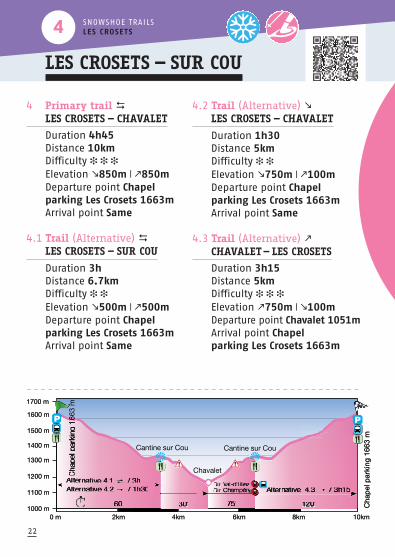
4 Primary trail LES CROSETS — CHAVALET
Duration 4h45Distance 10kmDifficulty
Elevation 850m ❘ 850mDeparture point Chapel parking Les Crosets 1663mArrival point Same
4.1 Trail (Alternative) LES CROSETS — SUR COU
Duration 3hDistance 6.7kmDifficulty
Elevation 500m ❘ 500mDeparture point Chapel parking Les Crosets 1663mArrival point Same
4.2 Trail (Alternative) LES CROSETS — CHAVALET
Duration 1h30Distance 5kmDifficulty
Elevation 750m ❘ 100mDeparture point Chapel parking Les Crosets 1663mArrival point Same
4.3 Trail (Alternative) CHAVALET— LES CROSETS
Duration 3h15Distance 5kmDifficulty
Elevation 750m ❘ 100mDeparture point Chavalet 1051mArrival point Chapel parking Les Crosets 1663m
LES CROSETS — SUR COU
4 SNOWSHOE TRAILSLES CROSETS
0 m 2km 6km4km 8km 10km
60’ 30’ 75’ 120’
1200 m
1300 m
1400 m
1500 m
1600 m
1700 m
1100 m
1000 m
Chap
el p
ark
ing
1663 m
Cantine sur Cou Cantine sur Cou
Alternative 4.1 / 3h
Chavalet
Dir. Val-d’IlliezDir. ChampéryAlternative 4.2 / 1h30 Alternative 4.3 / 3h15
Chap
el p
ark
ing
1663 m
6
4km2km0 m
1000 m
1100 m
1700 m
1600 m
1500 m
1400 m
1300 m
1200 m
10km8km6km
AA
Chap
el p
ark
ing
1663 m
— — — — — — — — — — — — — — — — — — — — — — — — — — — — — — — — — — — — — — — — — — — — — — —

23
4 AFTER EFFORT COMES COMFORT
This trail offers spectacular views of the Dents du Midi and DentsBlanches mountain ranges. Leaving from the chapel at the entranceto Les Crosets, walk about 300 metres along the snowbank on theside of the road in the direction Val-d'Illiez. Turn right in the direction of the Cantine Sur Cou. Follow the path that windsthrough the forest, looking out for quaint alpine chalets, typical ofthe Illiez Valley, along the way. Cross the Poijeur Bridge over theChavalet River and continue along a pleasant path through thesnowy forest to the «Cantine Sur Cou». From here you can turnaround and head back on the same path (approx. 2:00), or conti-nue on to the site called Chavalet. This trail can be rather steep inplaces. At the end of snowshoe trail, you can retrace your steps(approx. 3:30), continue on to Champéry by road (approx. 15min)or head to Val-d'Illiez by a pedestrian path (approx. 45min). To getback to Les Crosets from Champéry or Val d’Illiez, take public trans-port ; the AOMC train from Champéry to Val d’Illiez and the postalbus from Val-d'Illiez to Les Crosets.
— — — — — — — — — — — — — — — — — — — — — — — — — — — — — — — — — — — — — — — — — — — — — — —

24
5 Primary trail
LES CROSETS — CRÊTÉ-BORNEY
Duration 2h15Distance 5kmDifficulty
Elevation 300m ❘ 300mDeparture point Chapel parking Les Crosets 1663mArrival point Same
5.1 Trail (Alternative)
(...) quick return
Duration 1h40Distance 3.8kmDifficulty
Elevation 250m ❘ 250mDeparture point Chapel parking Les Crosets 1663mArrival point Same
LES CROSETS — CRÊTÉ-BORNEY
— — — — — — — — — — — — — — — — — — — — — — — — — — — — — — — — — — — — — — — — — — — — — — —
5 SNOWSHOE TRAILSLES CROSETS
0 m 700 m 1400m 2800m2100m 3500m 4200m 4900m 5000m
Chap
el p
ark
ing 1
663 m
1600 m
Le Relais Panoramique
Pas-de-CroisetteVaillime
Alternative 5.1*quick return
1680 m
1720 m
1760 m
1800 m
1840 m
1880 m
1640 m50’
2h1525’ 20’ 40’ C
hap
el p
ark
ing 1
663 m
ap
2100m1400m700 m0 m
1600 m
1640 m
1880 m
1840 m
1800 m
1760 m
1720 m
1680 m
5000m4900m4200m3500m2800m
Chap
el p
ark
ing 1
663 m

— — — — — — — — — — — — — — — — — — — — — — — — — — — — — — — — — — — — — — — — — — — — — — —
5 DISCOVER LES CROSETSThis is a lovely trail that traverses the upper part of Les Crosets,and the hamlet of Crêté Borney. The trail leaves from the chapel atthe entrance to Les Crosets. Walk uphill along the edge of the skislope to the road, then head left through a residential area of chalets for about 300 meters. Turn right and go up a pretty pathalong the ski slopes. Take a moment to admire the Dents du Midiand the ski area as you walk towards a site called Vaillime. Conti-nue slightly to the left in the direction of the «Relais PanoramicRestaurant». From the restaurant, you can either go straight backto the resort on a groomed path or take a longer route throughthe forest towards Champoussin. At a place called Croisette, turnright and go down to the road to reach Les Crosets.
Do not take this path when the ski slopes are closed.
— — — — — — — — — — — — — — — — — — — — — — — — — — — — — — — — — — — — — — — — — — — — — — — —
— — — — — — — — — — — — — — — — — — — — — — — — — — — — — — — — — — — — — — — — — — — — — — — — — — — — — — — — — — — — — — — — — — — — — — — — — — — — — — — — — — — — — — — — — — — — — —
25
0 m 800 m 1600m 3200m 4000m2400m 4800m 5600m 6500m810 m
Alternative 16>2*** U Yeu Tsalé
Alternative 16>1*** Frâchette
990 m
1080 m
1170 m
1260 m
1350 m
1440 m
900 m
Pla
ce d
u V
illag
e 9
50
m
60’ 45’ 20’ 10’ 30’2h45
Pla
ce d
u V
illag
e 9
50
m
du
2400m1600m800 m0 m810 m
900 m
1440 m
1350 m
1260 m
1170 m
1080 m
990 m
6500m5600m4800m4000m3200m
Pla
ce d
u V
illag
e 9
50
m
26
16 Primary trail
VAL-D’ILLIEZ
Duration 2h45Distance 6.5kmDifficulty
Elevation 550m ❘ 550mDeparture point Place du Village Val-d’Illiez 950m Arrival point Same
16>2 Trail (Alternative)
VAL-D’ILLIEZ
(...) via U Yeü Tsalé
Duration 5hDistance 11.8kmDifficulty
Elevation 900m ❘ 900mDeparture point Place du Village Val-d’Illiez 950m Arrival point Same
16>1 Trail (Alternative)
VAL-D’ILLIEZ
(...) via Frâchette
Duration 4h30Distance 9.7kmDifficulty
Elevation 850m ❘ 850mDeparture point Place du Village Val-d’Illiez 950m Arrival point Same
VAL-D’ILLIEZ — CHAMPOUSSIN
16 SNOWSHOE TRAILSVAL-D’ILLIEZ
— — — — — — — — — — — — — — — — — — — — — — — — — — — — — — — — — — — — — — — — — — — — — — —

— — — — — — — — — — — — — — — — — — — — — — — — — — — — — — — — — — — — — — — — — — — — — — —
16 A PASTORAL RAMBLE This is a mid-altitude trail through beautiful forests with breath-taking views of the Illiez Valley and the Dents du Midi mountainrange. The trail leaves from the village square of Val-d’Illiez, infront of the tourist office. Climb the hill between the historic «ma-zots», which look like miniature chalets. Turn right onto Route dela Carrière towards Champoussin and follow a scenic path throughthe forest lined by lovely stone walls that date from the early 20th
century ; you will pass by an oratory dedicated to St. Therese onthe way. Continue uphill on the Délifrette road for about 300 me-ters. From here you can continue straight on to join Snowshoe TrailNo. 2 which leads to the quaint «U Yeü Tsalé Restaurant» (approx.metres 1:15). Otherwise, turn left to follow a hillside path throughthe forest. At the crossroads, turn right and climb to reach Snows-hoe Trail No. 1 which leads to the Frâchette covered picnic area(approx. 1 h). To go directly back down to the village, turn left infront of the Lisas Chapel. Cross the Les Crosets road twice andcontinue down a nice path that will take you back to Val-d'Illiez.
— — — — — — — — — — — — — — — — — — — — — — — — — — — — — — — — — — — — — — — — — — — — — — — —
27

28
7 Primary trail
CHAMPÉRY — SOUS SCEX
Duration 1h20Distance 2.9kmDifficulty
Elevation 130m ❘ 130mDeparture point Cable-car lower station 1035m Arrival point Same
7.1 Trail (Alternative)
(...) short easy loop
Duration 20min.Distance 800mDifficulty
Elevation 35m ❘ 25mDeparture point Sous Scex 924m Arrival point Same
CHAMPÉRY — SOUS SCEX
7 SNOWSHOE TRAILSCHAMPÉRY
0 m 400 m 800m 1600m 2000m1200m 2400m 2800m 2900m
870 m Cab
le c
ar
low
er
sta
tio
n 1
035 m
Alternative 7.1*
Bêtre
Cab
le c
ar
low
er
sta
tio
n 1
035 m
960 m
990 m
1020 m
1050 m
930 m
900 m 1h2050’30’
st
1200m800m400 m0 m
870 m
900 m
930 m
1050 m
1020 m
990 m
960 m
2900m2800m2400m2000m1600m
Cab
le c
ar
low
er
sta
tio
n 1
035 m
2900m
— — — — — — — — — — — — — — — — — — — — — — — — — — — — — — — — — — — — — — — — — — — — — — —
29
— — — — — — — — — — — — — — — — — — — — — — — — — — — — — — — — — — — — — — — — — — — — — — —
— — — — — — — — — — — — — — — — — — — — — — — — — — — — — — — — — — — — — — — — — — — — — — — —
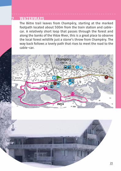
7 WATERWAYS The Bètre trail leaves from Champéry, starting at the markedfootpath located about 500m from the train station and cable-car. A relatively short loop that passes through the forest andalong the banks of the Vièze River, this is a great place to observethe local forest wildlife just a stone’s throw from Champéry. Theway back follows a lovely path that rises to meet the road to thecable-car.

30
8 Primary trail
CHAMPÉRY — VIÈZE
Duration 1h30Distance 3kmDifficulty
Elevation 165m ❘ 165mDeparture point Cable-car lower station 1035m Arrival point Same
CHAMPÉRY — VIÈZE
8 SNOWSHOE TRAILSCHAMPÉRY
0 m 400 m 800m 1600m 2000m1200m 2400m 2800m 3000m
Cab
le c
ar
low
er
sta
tio
n 1
03
5 m
Cab
le c
ar
low
er
sta
tio
n 1
03
5 m
1020 m
1080 m
1050 m
930 m
990 m
960 m
Le Progrès
30’ 60’1h30
r l
1200m800m400 m0 m
960 m
990 m
930 m
1050 m
1080 m
1020 m
Cab
le c
ar
low
er
sta
tio
n 1
03
5 m
3000m2800m2400m2000m1600m
— — — — — — — — — — — — — — — — — — — — — — — — — — — — — — — — — — — — — — — — — — — — — — —

31
— — — — — — — — — — — — — — — — — — — — — — — — — — — — — — — — — — — — — — — — — — — — — — —
— — — — — — — — — — — — — — — — — — — — — — — — — — — — — — — — — — — — — — — — — — — — — — — —
8 WATERWAYS, WITH A CHALLENGEThe Vièze trail leaves from the Champéry cable-car. Walk 500min the direction of Grand Paradis, then turn right to pass underthe bridge, heading downhill in the direction of the Vièze River.Turn right and walk along the river through a lovely forestedarea. For the return journey, walk along the main road back toChampéry or retrace your steps on the same path.

32
9 Primary trail GRAND-PARADIS — LES RIVES
Duration 1h45Distance 3.5kmDifficulty
Elevation 150m ❘ 150mDeparture point Grand-Paradis 1055m Arrival point Same
9.1 Trail (Alternative)
(...) short easy loop
Duration 15min.Distance 800mDifficulty
Elevation 50m ❘ 50mDeparture point Rives Road 1128m Arrival point Same
GRAND-PARADIS — LES RIVES
9 SNOWSHOE TRAILSCHAMPÉRY — GRAND-PARADIS
0 m 500 m 1000m 2000m1500m 2500m 3000m 3500m
Gra
nd
-Para
dis
1055 m
Gra
nd
-Para
dis
1055 m
Cantine des Rives
1080 m
1110 m
1140 m
1170 m
1200 m
1050 m
1020 m
Alternative 9.1* Alternative 6.1 9.1*
35’ 30’ 15’ 25’1h45
d
1500m1000m500 m0 m
1020 m
1050 m
1200 m
1170 m
1140 m
1110 m
1080 m
3500m3000m2500m1500m 2000m
Gra
nd
-Para
dis
1055 m
— — — — — — — — — — — — — — — — — — — — — — — — — — — — — — — — — — — — — — — — — — — — — — —

9 A WALK ON THE WILD SIDEThis route will take you to the area called Les Rives, across the valleyfrom Champéry. This is Champéry’s «wild side», where the onlysigns of civilisation are one narrow road and a few isolated chalets.From the Grand Paradis covered picnic area, follow the road for100m towards the fitness trail, then cross the bridge over the Saufla River. Follow the trail, crossing a field before meeting upwith the Rives Road. Follow the road to the lovely «Cantine desRives Restaurant», then continue along the trail that loops aroundthe large field next to the restaurant and retrace your steps back toGrand Paradis. If you’re lucky, and very quiet, you might even catcha glimpse of some elusive roe deer along the way. This trail is also open to hikers.
— — — — — — — — — — — — — — — — — — — — — — — — — — — — — — — — — — — — — — — — — — — — — — —
33
— — — — — — — — — — — — — — — — — — — — — — — — — — — — — — — — — — — — — — — — — — — — — — —

34
10 Primary trail
GRAND-PARADIS — LA LUI
Duration 1hDistance 2.8kmDifficulty
Elevation 100m ❘ 100mDeparture point Grand-Paradis 1055m Arrival point Same
GRAND-PARADIS — LA LUI
10 SNOWSHOE TRAILSCHAMPÉRY — GRAND-PARADIS
0 m 400 m 800m 1600m 2000m1200m 2400m 2800m
Gra
nd
-Para
dis
1055 m
Gra
nd
-Para
dis
1055 m
1040 m
1060 m
1180 m
1100 m
1120 m
1020 m
Roc Coupé
40’ 40’1h20
ar
1200m800m400 m0 m
1020 m
1120 m
1100 m
1180 m
1060 m
1040 m
2800m2400m1200m 2000m1600m
Gra
nd
-Para
dis
1055 m
— — — — — — — — — — — — — — — — — — — — — — — — — — — — — — — — — — — — — — — — — — — — — — —

35
10 OUTDOOR FUNFrom the Grand Paradis picnic area, walk 200m along the river andthen turn right into the forest, towards the Parcours Vita fitnesstrail. At the intersection, follow the path left in the direction of LaLui before taking the trail (stay right) that climbs upwards in thedirection of Roc Coupé. From here, go back down along the foresttrail, through a large clearing and across a small bridge to join thepath you started on.
— — — — — — — — — — — — — — — — — — — — — — — — — — — — — — — — — — — — — — — — — — — — — — — —
— — — — — — — — — — — — — — — — — — — — — — — — — — — — — — — — — — — — — — — — — — — — — — —

0 m 600 m 1200m 2400m 3000m1800m 3600m 4200m 4500m
Cro
ix-d
e-C
ule
t 1
92
2 m
1770 m
Cro
ix-d
e-C
ule
t 1
92
2 m
Le Chaudron Le Chaudron
Buvette chez Yoyo et Jiby
1830 m
1860 m
1890 m
1920 m
1950 m
1800 m
30’ 20’ 20’ 50’2h
Cu
l
1800m1200m600 m0 m1770 m
1800 m
1950 m
1920 m
1890 m
1860 m
1830 m
Ch
mC m 5mCh
mC m2
mm2
m
gP
arP
amha5
m15
15m 1msi
nsssus
ou
po
mp
amhm
de
dng
kin
kar
ka
Pa
P
4500m4200m3600m3000m2400m
oix
-de-C
ule
t 1
92
2
h 51151ha
Ch
CC
rr
36
11 Primary trail CROIX-DE-CULET — CHAUX PALIN
Duration 2hDistance 4.5kmDifficulty
Elevation 230m ❘ 230mDeparture point Croix-de-Culet 1922m Arrival point Same
CROIX-DE-CULET—CHAUX PALIN
11 SNOWSHOE TRAILSCHAMPÉRY — CROIX-DE-CULET
— — — — — — — — — — — — — — — — — — — — — — — — — — — — — — — — — — — — — — — — — — — — — — —

37
11 SPORT AND TRADITION
From the Croix de Culet, walk downhill towards «Coquoz Restau-rant», then turn right across the flank of the Planachaux hillside.At the «Chaudron Restaurant», the path continues straight on toa place called «Sur le Joueur». At the fork in the path, stay toyour right. Just below a small mountain restaurant called «Yoyoet Jiby», a splendid panorama opens up, with the Ruan Massif(3220m) and the Dents du Midi (3257m) and Dents Blanches(2760m) mountain ranges spread out before you in all theirsnow-capped glory. The trail then continues to the Chaux PalinRestaurant, overlooking the Crosets Valley. The way back followsthe path back up to the Croix de Culet.
— — — — — — — — — — — — — — — — — — — — — — — — — — — — — — — — — — — — — — — — — — — — — — —
— — — — — — — — — — — — — — — — — — — — — — — — — — — — — — — — — — — — — — — — — — — — — — —

0 m 600 m 1200m 2400m 3000m1800m 3600m 4200m 4500m
Cro
ix-d
e-C
ule
t 1
92
2 m
1560 m
Le ToupinLe Toupin
Le ChaudronLe Chaudron
Les Marmottes
1680 m
1740 m
1800 m
1860 m
1920 m
1980 m
1620 m
30’ 10’ 10’ 10’ 25’ 50’2h15
Cro
ix-d
e-C
ule
t 1
92
2 m22
m
1800m1200m600 m0 m
L
1560 m
1620 m
1980 m
1920 m
1860 m
1800 m
1740 m
1680 m
Ch
mh
mCh
mC m2
mmmgg
Par
Pam
mC m5
m1551151
sin
sssuso
up
om
pam
de
g
ngki
nk
ark
aP
aP
4500m4200m3600m3000m2400m
oix
-de-C
ule
t1
92
2haha
Ch
CC
rr
38
CROIX-DE-CULET—LÉCHEREUSE
12 SNOWSHOE TRAILSCHAMPÉRY — CROIX-DE-CULET
12 Primary trail CROIX-DE-CULET — LÉCHEREUSE
Duration 2h15Distance 4.5kmDifficulty
Elevation 320m ❘ 320mDeparture point Croix-de-Culet 1922m Arrival point Same
— — — — — — — — — — — — — — — — — — — — — — — — — — — — — — — — — — — — — — — — — — — — — — —

39
— — — — — — — — — — — — — — — — — — — — — — — — — — — — — — — — — — — — — — — — — — — — — — —
— — — — — — — — — — — — — — — — — — — — — — — — — — — — — — — — — — — — — — — — — — — — — — —
12 AN EPICUREAN ADVENTUREFrom the Croix de Culet, walk downhill towards Planachaux, thenturn right towards the «Chaudron Restaurant». Turn left and headdownhill towards the area called Léchereuse. The view from hereoverlooks the Ripaille ski slope and the infamous Chavanette slope,otherwise known as «The Swiss Wall». At the «Toupin Restaurant»,the trail continues and you will see your destination, the quaintmountain restaurant called «Les Marmottes». Follow the sign-pos-ted trail in a loop back to Champéry.

40
13 Primary trail CROIX-DE-CULET — CHAMPÉRY
Duration 6h15Distance 13.6kmDifficulty ()
Elevation 1155m ❘ 1155mDeparture point Croix-de-Culet 1922m Arrival point Same
13.1 Trail (Alternative) CROIX-DE-CULET — CHAMPÉRY
Duration 2hDistance 6.8kmDifficulty ()
Elevation 135m ❘ 1020mDeparture point Croix-de-Culet 1922m Arrival point Cable-car lower station 1035m
CROIX-DE-CULET—CHAMPÉRY
13 SNOWSHOE TRAILSCHAMPÉRY — CROIX-DE-CULET
0 m 2.3km 4.6km 6.8km 9.1km 11.4km 13.6km
Cable car lower station1035 m
1000 m
1200 m
1400 m
1600 m
1800 m
2000 m
800 m
Alternative 13.1 / 2h
Plein CielPlein Ciel
Chez CoquozChez Coquoz
Alternative 13.2 / 4h15
Cro
ix-d
e-C
ule
t 1
92
2 m
Cro
ix-d
e-C
ule
t 1922 m
6.8km4.6km2.3km0 m800 m
2000 m
1800 m
1600 m
1400 m
1200 m
1000 m
13.6km11.4km9.1km6.8km
oix
-de-C
ule
t 1
92
2 m
Cr
— — — — — — — — — — — — — — — — — — — — — — — — — — — — — — — — — — — — — — — — — — — — — — —
13.2 Trail (Alternative) CHAMPÉRY — CROIX-DE-CULET
Duration 4h15Distance 6.8kmDifficulty ()
Elevation 1020m ❘ 135mDeparture point Cable-car lower station 1035m Arrival point Croix-de-Culet 1922m

13 UP HILL AND DOWN-DALE From the top of the cable-car, take the path to the left of thechairlift and walk downhill alongside the Planachaux ski slope.Just past Coquoz Restaurant, take the path into the forest nearthe bottom station of the Planachaux chairlift and the top of theGrand Paradis chairlift. Turn left and follow the road to the curvein the Grand Paradis chairlift. Admiring the spectacular panoramaof the Ruan Massif and the Dents du Midi and Dents Blanchesmountain ranges before you, continue on your way, following thesign posts for trail no 13. At the junction of trails no 13 and no 14,on the Barmette path, continue to the Chalet du Pont. 200m fur-ther on, under the Grand Paradis chairlift, leave the forest by asteep path and take the Parses Road. From here, take off yoursnowshoes and follow the Rochats path to your right. Take thepedestrian path back to the village.
— — — — — — — — — — — — — — — — — — — — — — — — — — — — — — — — — — — — — — — — — — — — — — —
41
— — — — — — — — — — — — — — — — — — — — — — — — — — — — — — — — — — — — — — — — — — — — — — —

42
14 Primary trail CROIX-DE-CULET — CHAMPÉRY
Duration 6h15Distance 14.2kmDifficulty ()
Elevation 1150m ❘ 1150mDeparture point Croix-de-Culet1922m Arrival point Same
14.1 Trail (Alternative) CROIX-DE-CULET —
LÉCHEREUSE — CHAMPÉRY
Duration 2hDistance 7.1kmDifficulty ()
Elevation 130m ❘ 1020mDeparture point Croix-de-Culet Arrival point Cable-car lower station 1035m
0 m 2.3km 4.6km 7.1km 9.4km 11.7km 14.2km
Cable car lower station1035 m
1000 m
1200 m
1400 m
1600 m
1800 m
2000 m
800 m
Alternative 14.1 / 2h
Le ToupinLe Toupin
Le ChaudronLe Chaudron
Alternative 14.2 / 4h15
Cro
ix-d
e-C
ule
t 1
92
2 m
Cro
ix-d
e-C
ule
t 1922 m
7.1km4.6km2.3km0 m800 m
2000 m
1800 m
1600 m
1400 m
1200 m
1000 m
14.2km11.7km9.4km7.1km
oix
-de-C
ule
t 1
92
2 m
Cr
— — — — — — — — — — — — — — — — — — — — — — — — — — — — — — — — — — — — — — — — — — — — — — —
14.2 Trail (Alternative) CHAMPÉRY — LÉCHEREUSE —
CROIX-DE-CULET
Duration 4h15Distance 7.1kmDifficulty ()
Elevation 1020m ❘ 130mDeparture point Cable-car lower station1035m Arrival point Croix-de-Culet 1922m
CROIX-DE-CULET—LÉCHEREUSE — CHAMPÉRY
14 SNOWSHOE TRAILSCHAMPÉRY — CROIX-DE-CULET
43
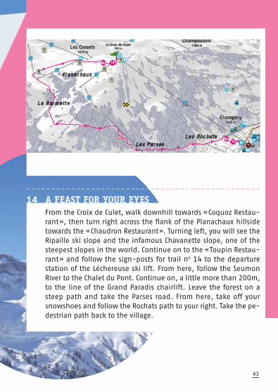
14 A FEAST FOR YOUR EYES
From the Croix de Culet, walk downhill towards «Coquoz Restau-rant», then turn right across the flank of the Planachaux hillsidetowards the «Chaudron Restaurant». Turning left, you will see theRipaille ski slope and the infamous Chavanette slope, one of thesteepest slopes in the world. Continue on to the «Toupin Restau-rant» and follow the sign-posts for trail no 14 to the departurestation of the Léchereuse ski lift. From here, follow the SeumonRiver to the Chalet du Pont. Continue on, a little more than 200m,to the line of the Grand Paradis chairlift. Leave the forest on asteep path and take the Parses road. From here, take off yoursnowshoes and follow the Rochats path to your right. Take the pe-destrian path back to the village.
— — — — — — — — — — — — — — — — — — — — — — — — — — — — — — — — — — — — — — — — — — — — — — —

La Cime de l’Est — 3178m
La Forteresse — 3164m
La Cathédrale — 3160m
L’Éperon — 3114m
La Dent Jaune — 3186m
Les Doigts — 3210m
La Haute Cime — 3257m
LES
DEN
TS
DU
MID
I

Mont-Blanc — 4810m
MA
SSIF
DES
DEN
TS
BLA
NCH
ES

46
A A Primary trail
CHAMPÉRY – CHEMIN DES POUSSETTES
Duration 1hDistance 2.2kmDifficulty
Elevation 130m ❘ 110mDeparture point Cable-car lower station 1035mArrival point Grand-Paradis 1055m
CHAMPÉRY — CHEMIN DES POUSSETTES
WINTER WALKING TRAILS CHAMPÉRYA
0 m 300 m 600m 1200m 1500m900m 1800m 2100m 2200m
980 m
Au
berg
e d
u
Gra
nd
-Para
dis
Gra
nd
-Para
dis
Yurt
Cab
le c
ar
low
er
sta
tio
n 1
03
5 m
Gra
nd
-Para
dis
10
55
m
1020 m
1040 m
1080 m
1060 m
1100 m
1000 m 1h
ar
900m600m300 m0 m
980 m
1000 m
1100 m
1060 m
1080 m
1040 m
1020 m
2200m2100m1800m1500m1200m
Gra
nd
-Para
dis
10
55
m
— — — — — — — — — — — — — — — — — — — — — — — — — — — — — — — — — — — — — — — — — — —— — — — —

— — — — — — — — — — — — — — — — — — — — — — — — — — — — — — — — — — — — — — — — — — — — — — —
47
A FOR BIG AND SMALLLeaving from the Champéry cable-car and finishing in a winterwonderland at Grand Paradis, this trail is a lovely ramble along theChemin des Poussettes, perfect for families with young children.For the way back, retrace your steps on the same path or take theGrand Paradis shuttle bus. Alternatively, take the Grand Paradis –Planachaux – Croix de Culet chairlifts and then come down viathe Champéry cable-car.
— — — — — — — — — — — — — — — — — — — — — — — — — — — — — — — — — — — — — — — — — — — — — — —
48
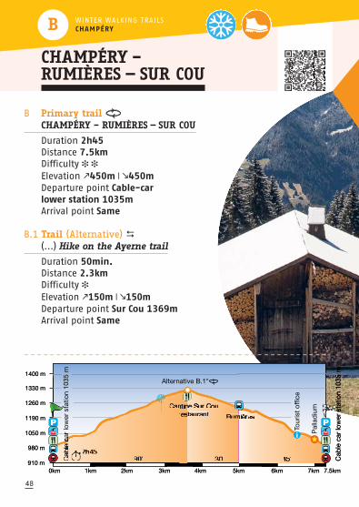
B Primary trail
CHAMPÉRY – RUMIÈRES — SUR COU
Duration 2h45Distance 7.5kmDifficulty
Elevation 450m ❘ 450mDeparture point Cable-car lower station 1035mArrival point Same
B.1 Trail (Alternative) (...) Hike on the Ayerne trail
Duration 50min.Distance 2.3kmDifficulty Elevation 150m ❘ 150mDeparture point Sur Cou 1369m Arrival point Same
CHAMPÉRY – RUMIÈRES — SUR COU
WINTER WALKING TRAILS CHAMPÉRYB
0km 1km 2km 4km 5km3km 6km 7km 7.5km
910 m
Palla
diu
m
Tou
rist
offi
ce
Cab
le c
ar
low
er
sta
tio
n 1
03
5 m
Cab
le c
ar
low
er
sta
tio
n 1
03
5 m
Rumières
Cantine Sur Cou restaurant
1050 m
1190 m
1260 m
1330 m
1400 m
980 m
Alternative B.1*
2h4590’ 30’ 45’
e c
a
3km2km1km0km
910 m
980 m
1400 m
1330 m
1260 m
1190 m
1050 m
7.5km7km6km5km4km
st m
n
Cab
le c
ar
low
er
sta
tio
n 1
03
5 m
— — — — — — — — — — — — — — — — — — — — — — — — — — — — — — — — — — — — — — — — — — — — — — —
49
— — — — — — — — — — — — — — — — — — — — — — — — — — — — — — — — — — — — — — — — — — — — — — —
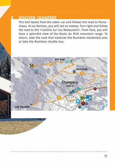
B DISCOVER CHAMPÉRYThis trail leaves from the cable-car and follows the road to Plana-chaux. At Les Rochats, you will see an oratory. Turn right and followthe road to the «Cantine Sur Cou Restaurant». From here, you willhave a splendid view of the Dents du Midi mountain range. Toreturn, take the road that traverses the Rumières residential areaor take the Rumières shuttle bus.
— — — — — — — — — — — — — — — — — — — — — — — — — — — — — — — — — — — — — — — — — — — — — — —
50
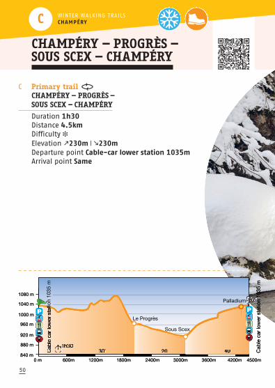
C Primary trail
CHAMPÉRY — PROGRÈS —
SOUS SCEX — CHAMPÉRY
Duration 1h30Distance 4.5kmDifficulty
Elevation 230m ❘ 230mDeparture point Cable-car lower station 1035mArrival point Same
CHAMPÉRY — PROGRÈS —SOUS SCEX — CHAMPÉRY
WINTER WALKING TRAILS CHAMPÉRYC
0 m 600m 1200m 2400m 3000m1800m 4200m3600m 4500m840 m
Palladium
Cab
le c
ar
low
er
sta
tio
n 1
035 m
Cab
le c
ar
low
er
sta
tio
n 1
035 m
Le Progrès
Sous Scex920 m
960 m
1000 m
1040 m
1080 m
880 m 1h3030’ 20’ 40’
ati
1800m1200m600m0 m840 m
880 m
1080 m
1040 m
1000 m
960 m
920 m
4500m3600m 4200m3000m2400m
Cab
le c
ar
low
er
sta
tio
n 1
035 m
— — — — — — — — — — — — — — — — — — — — — — — — — — — — — — — — — — — — — — — — — — — — — — —

51
— — — — — — — — — — — — — — — — — — — — — — — — — — — — — — — — — — — — — — — — — — — — — — —
C BY THE RIVERSIDELeaving from the Champéry cable-car, follow the main road towardsGrand Paradis. 500m past the cable-car, turn right to pass underthe bridge and down towards the Vièze River. The path windsthrough the forest and past a series of trout ponds. At Sous Scex,cross the old stone bridge and climb back up towards Champéry.

52
D Primary trail
CHAMPÉRY— PROGRÈS — SOUS SCEX —
LA COUR — CHAVALET— CHAMPÉRY
Duration 2h30Distance 8.1kmDifficulty
Elevation 330m ❘ 330mDeparture point Cable-car lower station 1035mArrival point Same
D>E Trail (Alternative)
(...) link with the trail E / Val-d’Illiez
Duration 30min.Distance 1.5kmDifficulty Elevation 85m ❘ 30mDeparture point La Cour 900m Arrival point Place du Village Val-d’Illiez 950m
CHAMPÉRY — PROGRÈS —SOUS SCEX — LA COUR —CHAVALET — CHAMPÉRY
WINTER WALKING TRAILS CHAMPÉRYD
0 km 2km 6km4km 8km 8.1km800 m
Alternative D›E* direction Val-d’Illiez
880 m
920 m
960 m
1000 m
1040 m
1080 m
840 m
Palladium
Cab
le c
ar
low
er
sta
tio
n 1
035 m
Cab
le c
ar
low
er
sta
tio
n 1
035 m
Le Progrès
Sous Scex
2h3030’ 20’ 40’ 60’
ti
4km2km0 km800 m
840 m
1080 m
1040 m
1000 m
960 m
920 m
880 m
8.1km8km4km 6km
Cab
le c
ar
low
er
sta
tio
n 1
035 m
— — — — — — — — — — — — — — — — — — — — — — — — — — — — — — — — — — — — — — — — — — — — — — —

53
— — — — — — — — — — — — — — — — — — — — — — — — — — — — — — — — — — — — — — — — — — — — — — —
D OVER THE RIVERAND THROUGH THE WOODSLeaving from the Champéry cable-car, follow the main road 500mtowards Grand Paradis. Turn right to pass under the bridge anddown towards the Vièze River. The path winds through the forestand past a series of trout ponds. From Sous Scex, cross the oldstone bridge and continue along the river to the next bridge.Watch out ; at times the paths can be icy ! Continue in the direc-tion of Val d’Illiez. When you arrive at the old sawmill, turn leftand head back towards Champéry.
The return trip to Champéry may also be made by train from theLa Cour train station (check the AOMC schedules)

54
E Primary trail
RANDONNÉE DES BAINS
Duration 1h45Distance 4.5kmDifficulty
Elevation 260m ❘ 260mDeparture point Place du Village Val-d’Illiez 950mArrival point Same
E.1 Trail (Alternative)
(...) par la route des Champs
Duration 1h30Distance 3.8kmDifficulty
Elevation 260m ❘ 260mDeparture point Place du Village Val-d’Illiez 950m Arrival point Same
RANDONNÉE DES BAINS
WINTER WALKING TRAILS VAL-D’ILLIEZE
0 m 600m 3000m 3600m1200m 1800m 2400m 4200m 4500m720 m
Pla
ce d
u V
illage 9
50 m
Pla
ce d
u V
illag
e 9
50 m
Bain
s d
u v
al d
’Illi
ez
Alternative E.1**
Alternative E›D*direction Champéry
(+5min)
800 m
840 m
880 m
920 m
960 m
760 m 1h4530’ 40’ 15’ 20’
95
0 m 600m 1800m1200m720 m
760 m
960 m
920 m
880 m
840 m
800 m
3600m3000m2400m 4500m4200m
Pla
ce d
u V
illag
e 9
50 m
— — — — — — — — — — — — — — — — — — — — — — — — — — — — — — — — — — — — — — — — — — — — — — —
E>D Trail (Alternative)
(...) link with
the trail D — Champéry
Duration 60 min.Distance 3.3kmDifficulty
Elevation 200m ❘ 60mDeparture point En Play 900m Arrival point Cable-car lower station 1020m
55
— — — — — — — — — — — — — — — — — — — — — — — — — — — — — — — — — — — — — — — — — — — — — — —
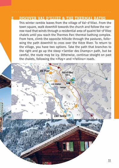
E DISCOVER VAL D’ILLIEZ & THE THERMAL BATHS This winter ramble leaves from the village of Val-d'Illiez. From thetown square, walk downhill towards the church and follow the nar-row road that winds through a residential area of quaint Val-d’Illiezchalets until you reach the Thermes Parc thermal bathing complex.From here, climb the opposite hillside through the pastures, follo-wing the path downhill to cross over the Vièze River. To return tothe village, you have two options. Take the path that branches tothe right and go up the steep «Sentier des Champs» path, but becareful, the route may be icy. Otherwise, continue straight on pastthe chalets, following the «Play» and «Fellina» roads.

SECURITY AND RECOMMENDATIONS
— — — — — — — — — — — — — — — — — — — — — — — — — — — — — — — — — — — — — — — — — — — —
56
SIGNPOSTINGLook for the pink markers along the trail. Maps and informationpanels can be found at important intersections.
ITINERARIESFor detailed maps, scan the QR Code in this guide, on our websiteat www.ski-and-bike.ch or at the trailhead departure point.
SECURITYThese itineraries are not always groomed and are not patrolled.Use these trails at your own risk. Prepare your outing carefullyand make sure you have an alternative plan in case of emergency.Snowshoeing in the mountains means that you need to respectcertain rules for your own safety.
CONDITIONS AND PREPARATIONS• Check the forecast before you leave. In the mountains,
the weather can change dramatically in the blink of an eye ! Sun, heat, wind, rain, fog, snow, cold ; if you want to bravethe elements, you have to account for all of them.
• Avalanche danger is real : Keep to open, marked trails.
• Never go hiking alone !
• Before you leave, tell someone where you’re going anddon’t forget to let them know what time you plan to be back.
• Map out your itinerary before you leave.• Make sure you you choose an appropriate itinerary,
adapted to your ability and level of fitness.• Indicated walking times are approximate.• Public transportation timetables (bus, train, ski lifts)
can be found on our website at www.ski-and-bike.ch

57
CHOOSE APPROPRIATE EQUIPMENT• Wear sturdy, waterproof walking shoes or boots with
good tread on the soles. Hiking gaiters will protect you from the snow.
• Wind chill factor can make it feel 5° to 10° colder than it really is. Layered clothing will help you protect against the cold. Don’t forget to bring a hat, gloves and sunglasses.
• Carry a backpack with snacks and warm drinks.
• It’s also a good idea to bring a first aid kit, a survival blanket
and a cell phone.
— — — — — — — — — — — — — — — — — — — — — — — — — — — — — — — — — — — — — — — — — — — —
— — — — — — — — — — — — — — — — — — — — — — — — — — — — — — — — — — — — — — — — — — — —
RECOMMENDATIONS
RESPECT OTHERS !• Be careful not to damage any enclosures for animals
and respect private property. • Cross-country ski tracks are reserved for skiers.
Please stay on the appropriate trails.
ALONG THE WAY…• Keep an eye on the time. Allow enough time for the return
trip and don’t over-tax yourself.• Stay on the marked trails and respect the safety markings !
— — — — — — — — — — — — — — — — — — — — — — — — — — — — — — — — — — — — — — — — — — — —

58
A FEW «GREEN» RULES
— — — — — — — — — — — — — — — — — — — — — — — — — — — — — — — — — — — — — — — — — — — —
PRESERVE NATURE
• Respect the rules and regulations that apply to protected
natural zones. These wilderness areas are essential to effective cohabitation between people and animals.
• Stay on the marked trails ; they are designed to minimizethe impact of hikers on the local environment.
• Pack your waste out with you. Don’t leave anythingbehind you that might pollute the environment and harm the local plants and animals.
• Don’t smoke. If you must smoke, take your cigarette butts with you !
• Don’t pick the plants, especially if you don’t know what they are. Some of the plants are protected species and picking them may contribute to their eradication from the area and an irreversible change in the local ecosystem.
• Don’t walk through young forest regrowth areas.
The renewal of the forest is essential to the alpine ecosystem.
• Respect the wild animals. Don’t forget that you are just passing through ; they live here all year round !

VAL-D’ILLIEZ – LES CROSETS – CHAMPOUSSIN TOURISM ANDCHAMPÉRY TOURISM WOULD LIKE TO THANK ALL THE PEOPLEWHO CONTRIBUTED TO THE SUCCESS OF THESE GUIDES.
Commune de Val-d'IlliezCommune de Champéry—Leslie Dubosson Bertrand PerrinFabrice PerrinGuy Rouiller
— — — — — — — — — — — — — — — — — — — — — — — — — — — — — — — — — — — — — — — — — — — —
59
MORGINS AND ITS SURROUNDINGS
The resorts of Morgins and the Abondance Valley offer morethan 80 kilometers of trails, all marked and groomed in order to discover the nature’s beauty and glory during the winter months.
www.morgins.ch
©PhotographyVal-d’Illiez–Les Crosets–Champoussin Tourisme / Champéry TourismeJean-Baptiste Bieuville / Hubert Caloz / Christian Perret / Guy Rouiller
©Plans, pictos and profils Géomatic
©DesignSpirale Communication visuelle, Monthey
— — — — — — — — — — — — — — — — — — — — — — — — — — — — — — — — — — — — — — — — — — — —

USEFUL NUMBERS
117 Police 118 Firefighters 144 Ambulance 144 Mountain rescue 163 Road info 162 MeteoSwiss
Public Transports Chablais0900 322 322
Val-d’Illiez – Les Crosets –Champoussin Tourisme1873 Val-d’Illiez — Suisse
Tel. +41 24 477 20 77
Champéry Tourisme1874 Champéry — Suisse
Tel. +41 24 479 05 50
CHF 3.—