growing pains - racv | roadside assist, car loans ... · 2014 regional victoria growing pains...
TRANSCRIPT

2014
Regional VictoriaGrowing PainsKeeping pace with transport needs in regional Victoria.

Victoria’s liveability and economic wellbeing rely heavily on the ability of the transport network to meet the demands of our growing population. For over a decade, RACV has been mapping the transport issues facing Melbourne’s outer metropolitan suburbs, where rapid population growth has outpaced the provision of basic infrastructure like roads, public transport, footpaths and bicycle riding facilities. In 2012, RACV’s ‘Outer Melbourne Growing Pains’ report identified 160 road and public transport projects needed to combat the congested roads and overcrowded public transport occurring daily in these areas.
Looking to the future, Victoria’s population is forecast to grow to over seven million by 2030. Failure to deal with transport infrastructure issues now will leave governments with an unaffordable and insurmountable backlog of projects. Beyond Melbourne’s outer suburbs, Victoria’s regional centres and peri-urban areas are predicted to host a growing share of the state’s population growth, driven by the attraction of lifestyle, open space, job opportunities, affordable housing and services. Current planning strategies recognise the potential for regional cities to take the pressure off Melbourne by housing a concentration of jobs, educational facilities and essential services. However their success relies heavily on the provision of safe, efficient and equitable transport options to keep these communities connected to each other and to metropolitan Melbourne.
Regional Victoria has the opportunity to avoid the magnitude of transport problems being experienced in outer Melbourne by planning for future transport infrastructure needs now. To better understand the transport issues facing regional Victorians, RACV met with many community members at RACV regional shops across the state and we heard from just under 8,000 people through the RACV regional transport needs survey. We also consulted with key stakeholders, including state and local government departments, public transport operators and regional community groups. We used this information to determine the road, public transport, cycling and walking improvements needed to avoid the ‘growing pains’ too often associated with increasing population.
RACV wants to see a balanced and integrated approach to the transport needs for regional Victoria so that our regional cities, smaller rural communities and urban fringe areas
continue to be great places to live. Our ‘Growing Pains in Regional Victoria’ report presents a blueprint of the projects and initiatives needed to address current demand and ensure that regional Victoria’s population growth will be supported by adequate transport infrastructure. The front section of this report outlines the key transport planning policies which will enable regional cities and rural areas to connect to each other and to Melbourne. In the section ‘What RACV wants’ on pages 12 and 13, we outline the integrated transport plan which resulted from our consultation with the regional Victorian community. The regional transport maps on pages 14 to 17 show the major projects needed in regional Victoria that will bring benefits across the State. These include new roads, road duplications and upgrades, town bypasses, road safety upgrades and rail improvements. The more localised road, public transport, cycling and walking projects needed in the ten largest regional cities of Ballarat, Greater Bendigo, Greater Geelong, Horsham, Latrobe, Mildura, Greater Shepparton, Wangaratta, Warrnambool and Wodonga are described on pages 18 to 37. These regional cities have well established economies with the possibility to expand further.
Victoria stands to receive a significant boost in transport funding over coming years, with recent budget allocations towards a number of major projects across the state. However, what is currently a relatively small backlog of transport projects within our regional cities will rapidly escalate as growth occurs unless we act now. The risk is that current funding arrangements will fail to keep pace. On behalf of our two million members, RACV calls on the Federal and State Governments to adopt our blueprint of road, public transport, cycling and walking projects needed in regional Victoria and deliver an accelerated and ongoing program of works over the next decade.
Mr R Herron President and Chairman of the Board
Mr C L Jordan Managing Director and Chief Executive Officer
Foreword
Baranduda Boulevard, Wodonga.
Regional Victoria – the transport challenge that continues to grow 4
The importance of planning 6
The long distance journey 8
Travelling to and within towns and regional cities 11
What RACV wants 12
Key regional transport connections 14
The Australian Road Assessment Program (AusRAP) 16
City of Ballarat 18
City of Greater Bendigo 20
City of Greater Geelong 22
Horsham Rural City Council 24
City of Latrobe 26
Mildura Rural City Council 28
Greater Shepparton City Council 30
Rural City of Wangaratta 32
Warrnambool City Council 34
City of Wodonga 36
2014 REG
ION
AL VIC
TOR
IA G
RO
WIN
G PA
INS
3

1 Victoria in Future, Department of Planning and Community Development (DPCD), 20122 Plan Melbourne, Department of Transport Planning and Local Infrastructure, 2013 3 A Guide to Property Values, Department of Transport Planning and Local Infrastructure
Melbourne (DTPLI), 2012
4 Latrobe City: a great place to work an even better place to live, Latrobe City Council, 20125 Monitoring of the Australian Petroleum Industry, Australian Competition
and Consumer Commission (ACCC), 20136 Census data, Australian Bureau of Statistics (ABS), 2011
Over the next forty years it has been predicted that 800,000 more people will call regional Victoria home, with a majority of the people relocating from Melbourne.1 Victoria’s regional cities and peri-urban areas will therefore need to be prepared to accommodate a greater share of the state’s population growth. To encourage this shift, good transport links and regional economic development will be paramount, with country areas already providing most of Victoria’s agricultural output, food production and processing, energy and mineral resources. The job opportunities associated with these industries, lifestyle, open space, sense of community, affordable housing and cheaper services are all features that will attract more people to country Victoria. However it is important that as people move to regional Victoria the transport problems faced in Melbourne do not follow.
In the ten years to 2011, 86 per cent of Victoria’s population growth occurred in Melbourne’s established suburbs and growth areas.2 In 2012, RACV’s ‘Outer Melbourne Growing Pains’ report identified a massive backlog of 160 road and public transport projects in 16 outer metropolitan municipalities where the transport system has failed to keep pace with population growth. This has resulted in disconnected communities, increasing levels of congestion and very limited transport options beyond the private car. RACV does not want to see the same problems perpetuated in regional Victoria and believes that it is timely to identify the transport projects needed to sustain future demand and maintain liveability.
House prices in regional Victoria are on average $200,000 cheaper than Melbourne.3 Many first home buyers and low income earners who are locked out of owning a home in Melbourne are able to afford to buy in the country. The cost of living in regional Victoria is also considerably lower. For example, the total cost of rent, childcare, transport, education, utilities and leisure in a regional area such as Latrobe City is $1,070 per week compared with $1,525 in Melbourne.4 The cost of transport however, is one of the
few components that is higher in regional areas, with Latrobe City residents spending an additional $10 per week on average, compared to their counterparts in metropolitan Melbourne.
The cost of transport for regional residents is driven up by higher than average petrol prices, dependence on the private vehicle and in many cases the absence of alternatives. Regional Victoria does not have an obvious petrol price cycle like Melbourne and petrol is on average six cents per litre more expensive.5 With 57 per cent of regional Victorians households owning two or more motor vehicles,6 the price of petrol is a significant concern and highlights the need for good transport alternatives.
Regional Victorians want public transport that is reliable, frequent and efficient. A number of rail and bus improvements are required to provide better connections within – and between – regional cities and also to Melbourne. While there has been significant investment in projects such as the Regional Rail Link, it is often difficult to justify investments in major upgrades in many smaller centres because of the low population densities. However, there are a range of lower cost services that can meet the mobility needs in regional communities, including telebus services, flexi cab, community transport, car pool programs, telecommuting and making school bus services available to the general public.
Regional Victoria is heavily reliant on a well-maintained, high quality road network to support the safe and efficient movement of people and goods across the longer distances that are travelled. A number of road improvements are needed, including highway duplications, fundamental safety upgrades and better maintenance of the network. RACV believes that an integrated approach that includes investment in road, rail and public transport service improvements is needed to meet the growing transport challenge in regional Victoria.
Number of motor vehicles owned per dwelling6
Regional Victoria – the transport challenge that continues to grow
Average petrol price (2012/2013)5 150
140
141
142
143
144
145
146
147
148
149
139
Melbourn
e
Ballara
t
Geelong
Horsham
Mildura
Trara
lgon
Wangaratta
Warrnam
bool
WodongaMoe
Shepparton
Bendigo
Melbourne Regional Victoria0 vehicles 9%
0 vehicles 7%
1 vehicle 35%
1 vehicle 34%
2 vehicles 37%
2 vehicles 37%
3 or more vehicles 16%
3 or more vehicles 19%
Not stated 3%
Not stated 3%
Petrol station, corner River Road and West Road, Shepparton.
cent
s/lit
re
2014 REG
ION
AL VIC
TOR
IA G
RO
WIN
G PA
INS
2014 REG
ION
AL VIC
TOR
IA G
RO
WIN
G PA
INS
54

7 Victoria in Future, Department of Planning and Community Development (DPCD), 20128 Victoria the Freight State, Department of Transport Planning and Local Infrastructure (DTPLI), 2013 9 Victoria’s Regional Tourism Strategy 2013–2016, Tourism Victoria, 2013
Victoria’s regional cities already have well-established economies. Clustering jobs and services in key population centres improves communication between businesses, provides access to a skilled local workforce and attracts more suppliers and customers. Increasing the density of development in appropriate places – along transport corridors, in major redevelopments and infill sites and around community facilities and activities within towns – would condense physical space between people and services, hence reducing the need to travel.
Although units, apartments and houses on smaller blocks of land are not for everyone, a greater mix of housing types within a community means that as population profiles and individual housing needs change, people can stay within their community and their circle of family and friends. Smaller residences can cater for singles, couples, elderly people and those seeking low maintenance living. This will become even more important over the next twenty years as the number of family-with-children households is expected to decrease by five per cent resulting in an increase in one person and couple-only households.7
Connections to Melbourne and regional hubs
Whether it is to access employment, education, specialist services such as a medical appointment or attending an AFL match, access to Melbourne is important. Good road connections are critical to ensure those who drive or use coach services can travel safely and efficiently. However, many residents are forced into the car because of a lack of suitable alternatives. Residents want railway stations to be more accessible, with connecting bus services and adequate car parking and they want services that run more efficiently, frequently and over a long span of hours to meet their needs. While Geelong, Bendigo and Ballarat residents can expect improved V/Line services following completion of the Regional Rail Link in 2016, there are many other regional hubs that also need improved public transport.
Decentralising jobs and population growth beyond the metropolitan boundaries has the potential to not only take pressure off Melbourne, but to stimulate the growth of local jobs and services for residents living in regional centres and surrounding rural areas. High quality, efficient and
RACV listened to member views about transport in regional Victoria.
The importance of planning
safe transport links between regional centres and to surrounding population centres will be critical in driving this regional development.
Not everybody can or will want to live in a regional town centre, therefore provision of adequate transport to connect satellite towns and rural areas to regional hubs is vital. Public transport alternatives are particularly important for those groups who may not be able to drive or have access to a vehicle such as the elderly, people with a disability, young people and low-income earners. This can result in social isolation. It can restrict access to work and study opportunities as well as whether someone can attend vital medical appointments. A lack of accessible opportunities is a contributing factor to people relocating to larger towns and cities from rural communities.
Impacts on regional economies
Regional Victoria generates a quarter of Victoria’s economic output and one third of the state’s exports. Future growth in regional Victoria’s export market will result in the regional freight task increasing by an average annual rate of 4.5 per cent, faster than the growth rate in Melbourne.8 The movement of freight efficiently contributes to productivity, particularly for the food manufacturing and processing sectors that are strong pillars of regional economies. There is a need for high quality road and rail links between producers and key locations such as ports and airports. Truck bypasses are important to divert heavy vehicles away from busy town centres. Intermodal freight terminals ensure regional businesses have access to the road and rail networks, helping their competitiveness in regional and global markets.
Regional Victoria is heavily reliant on tourism as it contributes 13.9 per cent of the total gross regional product (GRP) and 12.8 per cent of employment, compared to 3.2 per cent and 4.5 per cent respectively in Melbourne.9 Due to the importance of tourism for country areas, it is important that the increasing popularity of overseas holidays does not deter people visiting regional Victoria. The provision of quality road, public transport and in some instance air access will increase the appeal of holidays close to home. Many parts of regional Victoria experience significant increases in population during their tourist seasons, placing further pressure on local transport networks, especially roads.
We informed our members about this project through …
RoyalAuto magazine
RACV enews
A dedicated campaign website
Social media messaging
Circulated to 2 million members
Emailed to 242,000 subscribers
With over 28,000 views
With 10,000 Facebook fans and 3,000 Twitter followers
We engaged with our members in this project through …
RACV Regional Transport Needs survey
Community consultation at ten RACV shops
The regional Victoria photo competition
With just under 8,000 responses
With over 150 community members
With 60 entries and 700 votes
Bus stop, Burnside Street, Moe.
Malop Street, Geelong.
2014 REG
ION
AL VIC
TOR
IA G
RO
WIN
G PA
INS
2014 REG
ION
AL VIC
TOR
IA G
RO
WIN
G PA
INS
76

Long distance travel is part of life in regional Victoria – often a necessity for residents to access jobs, services, shopping and recreation. People may need to travel from their rural home to their closest town centre, from one regional town to another or to Melbourne. Regardless of the trip that people make or the mode that is used, this travel must be safe, efficient and comfortable.
The regional highway network needs a continuous program to improve safety and capacity. RACV’s key projects that have been promoted for many years include duplication of the Western Highway from Ballarat to Stawell and continuing to the South Australian border, duplication of Princes Highway East from Traralgon to Sale, duplication of Princes Highway West from Geelong to Colac and the construction of the Shepparton Bypass. Continuing works to provide passing lanes and shoulders are also needed.
The journey needs to be safe
A staggering 24 per cent of federally funded highways in Victoria are an unacceptable one or two star safety rating according to RACV’s Australian Road Assessment Program (AusRAP). Of the 2,885 kilometres of Victoria’s national highway network classified from one safety star (least safe) to five safety stars (most safe), just two per cent of the Victorian rural highway network achieved the maximum five star rating. Government needs to act now to improve road safety, particularly in regional Victoria, which is home to 25 per cent of the state’s population, yet 55 per cent of the state’s road fatalities.10 A $580 million investment would achieve a minimum three safety star standard on Victoria’s major highways saving approximately 2,800 people from serious injury or death on these roads over the next 20 years.11 This is attainable through simple measures such as safety barriers along the roadside and in the median, constructing or sealing road shoulders, improved skid resistance of road pavements and rumble strips on highway shoulders and centrelines.
Another major safety risk in regional Victoria for both road users and train commuters is level crossings. There are 1,800 level crossings in Victoria and while it is pleasing that the State Government is undertaking a program to upgrade country level crossings, more needs to be done through Victoria participating in a national effort to ensure its crossings are as safe as possible. Some roads need to be realigned to make it easier for drivers to see approaching trains and decide to proceed or stop. The use of intelligent technology in vehicles being trialled in Melbourne and other states that alerts motorists that a train is approaching could also be part of the solution for crossings on quiet regional roads.
The transport network needs to be well maintained
The current State Government has increased the funding for road maintenance and rehabilitation to more than $500 million over the next three years, arising from an obvious deterioration in the condition of Victoria’s road network highlighted by RACV and community campaigning. Despite this additional investment, the condition and maintenance of our roads remains the top road issue for 48 per cent of regional Victorians.12 RACV community consultation revealed many residents are scared to travel on regional roads and highways. Their rough and potholed state presents a hazard for car drivers, motorcyclists and cyclists and increases the vehicle maintenance burden on regional families and businesses. At present, only about 4 per cent of the state
highway network is being resurfaced each year. RACV estimates that this needs to be increased to over 8 per cent, which will require doubling the funding for road resurfacing and rehabilitation. The State Government has budgeted to spend over $500 million in 2014/15 on road repairs and maintenance, however more funding is desperately required.
Rail maintenance also needs to be given increased priority to improve track condition and to ensure that train speeds can be maintained, particularly on the rail freight network. Rail freight is best suited for certain types of exports, for example grain, where large volumes need be moved and ships loaded quickly. The 2012/13 state budget allocated $30 million over four years for ‘major periodic maintenance of the regional freight network’. This averages to $7.5 million per year, which is half of the $15 million per year that is required.13 To ensure the future success of regional rail freight, the State Government needs to allocate enough funding for regular maintenance to avoid the current 30km/hr speed restrictions and deterioration evident on some sections of the network. Improved maintenance would encourage more freight to travel by rail and benefit the community through a reduction of trucks on the roads.
The journey needs to be comfortable
Rest areas on the regional highway network can ensure long distance journeys in regional Victoria are comfortable and provide opportunities for rest, through providing access to toilets, drinking water, rubbish bins and sheltered seating.
Rest areas must be appropriately spaced along a route, well maintained, have safe entry and exit points and be compliant with the Disability Discrimination Act 1992 (DDA). Fencing between rest areas and highways is vital to keep children and pets safe and to discourage pedestrians crossing the road. Incorporating bike storage at major and minor rest areas could enhance bicycle tourism in regional Victoria. Appropriate facilities can encourage car and truck drivers to stop and sleep at rest areas, which is one approach to reducing fatigue related crashes that account for 20 per cent of road fatalities.14
Public perception about comfort and security at railway stations will influence the community’s willingness to use trains. Currently, satisfaction with railway stations is poor, with RACV’s recent surveys revealing that 86 per cent of regional train users identified a problem with the regional station they use the most.15 Of the ten regional municipalities included in ‘Growing Pains’, 50 percent have railway stations that need to be upgraded. These upgrades include better facilities for passengers and staff such as toilets, DDA compliance, sufficient lighting and appropriate shelter and seating. To access the railway station, the interchange with buses and taxis should be enhanced and there should be adequate car parking. Some railway station car parks, such as Bendigo, are already at capacity and this can deter people from using public transport, resulting in additional cars on the road. Many railway stations have the potential to be focal points and centres of activity, but they must be amenable and easy to access in order to attract people and investor funds.
Regional Victorian’s top transport concerns16
The long distance journey
Regional Victorian’s average transport rating*16
10 Crash location data, Transport Accident Commission (TAC), 201211 Australian Road Assessment Program (AusRAP), RACV, 2014 12 Regional Transport Needs Survey, RACV, 201313 Submission on the Victorian Freight and Logistics Plan,
Alliance of Councils for Rail Freight Development, 2013
14 Victoria’s Road Safety Strategy: Arrive Alive!, VicRoads, 200815 On Track Survey, RACV, 201316 Regional Transport Needs Survey, RACV, 2013
* Note: 1 is poor, 5 is average and 10 is excellent.
V/Line trains: 5.28
V/Line coaches: 5.82
Local buses: 5.26
Freeways/highways: 6.24
Local roads: 5.25
On-road bike paths: 4.70
Off-road bike paths: 5.50
Footpaths: 5.33
Road Public Transport Walking Cycling
Top Concern
Condition and maintenance of roads
V/Line train frequency
Quality of footpaths
Presence of wide sealed shoulders to ride on
Intersection River Road and Archer Road, Shepparton. Princes Freeway (Geelong Ring Road) rest stop, Waurn Ponds.
2014 REG
ION
AL VIC
TOR
IA G
RO
WIN
G PA
INS
2014 REG
ION
AL VIC
TOR
IA G
RO
WIN
G PA
INS
98

Regional cities and towns play an important role in providing services and economic and social links within their region. Their success relies on people being able to travel to and within their local town and in many locations the options are limited to the private vehicle, walking or cycling. In many cases, these will be the only viable options available for some time and it is important that these modes are catered for safely and efficiently.
Larger towns and regional cities are starting to face congestion and parking problems because cars are – and will continue to be – an integral part of people’s lives. Town centres should be easily accessible by private vehicles and as demand grows, councils may need to increase the supply of off-street parking and introduce clearways. The reduction of on street car parking can result in more road space and new facilities like wider footpaths, separated bicycle lanes and bus lanes. Councils and the State Government must work together to fund the necessary transport infrastructure and services to provide people with transport choices.
Traffic through towns contributes to congestion and impacts on local road users, causing frustration and safety concerns for residents and reducing the amenity of shopping precincts along major highways. However, some local businesses become dependent on that passing trade. On major freight routes, bypasses may need to be built and traffic treatments implemented to encourage heavy traffic away from towns to enable urban renewal and improvements in road safety.
Some regional communities have alternatives to access the town centre, like local bus services and taxis. Community consultation has revealed that many people do not use buses because they do not travel when and where people want to go. A hierarchy of service levels needs to be implemented, including shuttle and feeder routes that are direct, reliable, high frequency and for extended hours. Bus timetables must be readily available and eventually, for major stops in key regional centres, real-time travel information should be provided, similar to the increasingly popular Melbourne SmartBus. For taxis to be considered an appealing option,
the booking system needs to be user-friendly and the taxi needs to arrive on time.
Within central business districts (CBDs), connectivity is critical in creating a lively place that people want to visit. Footpaths must provide an even surface for walking and for those using prams or wheelchairs. Wayfinding is vital to assist residents and visitors to navigate the town and direct them to railway stations, bus stops, taxi ranks and safe riding routes. In larger centres, buses have a role in helping people move around the town, by running services along key routes in the CBD.
In the larger regional cities, new subdivisions should implement best practice transport planning. Residents in new estates often face a lack of basic infrastructure and can find that the lifestyle benefits that attracted them to move there are compromised by the limited transport options available. Building sustainable communities requires an emphasis on walkability, public transport provision and riding facilities. Residents of new estates need infrastructure and services as they start to move in, for social reasons and to provide better transport options. Unfortunately buses are currently being introduced – if at all – several years after people have moved in and they have already invested in a second or third car.
Travelling to and within towns and regional cities
59%16%
BALLARAT
own a working bicycle
ONLY
ride at least once a week
60%18%
GREATER GEELONG
own a working bicycle
ONLY
ride at least once a week
74%16%
HORSHAM
own a working bicycle
ONLY
ride at least once a week
46%22%
MILDURA
own a working bicycle
ONLY
ride at least once a week
51%23%
WARRNAMBOOL
own a working bicycle
ONLY
ride at least once a week
60%14%
GREATER BENDIGO
own a working bicycle
ONLY
ride at least once a week
68%28%
GREATER SHEPPARTON
own a working bicycle
ONLY
ride at least once a week
56%27%
LATROBE
own a working bicycle
ONLY
ride at least once a week
70%28%
WANGARATTA
own a working bicycle
ONLY
ride at least once a week
54%18%
WODONGA
own a working bicycle
ONLY
ride at least once a week
Bicycle riding Bike riding has the potential to make up a greater share of trips, with RACV’s surveys showing that 56 per cent of regional Victorians own a working bicycle yet only 20 per cent ride at least once a week.17 Well located bicycle paths and lanes and safe places to cross busy highways and railway lines may encourage people to ride to town centres, school and train stations. Appropriate end-of-trip facilities like secure bike parking are also necessary. More people riding a bike has advantages for the environment, health and decreases the number of cars on the road.
own a working bicycle
ride at least once a week17
56%
20%
17 Regional Transport Needs Survey, RACV, 2013
Moe railway station car park, Moe. Corner Liebig and Lava Street, Warrnambool.
REGIONAL VICTORIA
ONLY
2014 REG
ION
AL VIC
TOR
IA G
RO
WIN
G PA
INS
2014 REG
ION
AL VIC
TOR
IA G
RO
WIN
G PA
INS
1110

The strength of Victoria’s economy and its liveability rely heavily on the connections between Melbourne, the peri-urban areas that surround Melbourne and regional population centres. Projects such as the Regional Rail Link and freeway and highway upgrades have already strengthened the economies of those regional centres closest to Melbourne; however more needs to be done.
Since 2001, some of the fastest growing municipalities in regional Victoria are those located in areas immediately beyond Melbourne’s urban growth boundary. These include Drouin, Gisborne, Warragul, Kilmore and Bacchus Marsh.18 Meeting the growing demand for infrastructure and transport services to connect to Melbourne, whilst managing the mixed-land use and protecting the natural environment in these peri-urban areas, presents a significant planning challenge. These areas continue to attract people who prefer a more rural lifestyle with the benefits of access to employment and opportunity – rich urban centres. The State Government is increasingly recognising the potential for these areas to take some development pressure off Melbourne. The timely provision of transport infrastructure will be critical to ensuring that these communities remain well connected.
As the state’s population grows, Victoria’s regional centres will develop further in their own right as centres of employment, population and activity. RACV has consulted with the regional Victorian community, our members, local government and industry to identify the transport projects needed to strengthen the transport links that connect regional population centres, not just to Melbourne, but to each other and to the communities surrounding them.
On the following pages, RACV presents a blueprint that includes significant road and public transport improvements to address the needs of the ten largest regional cities and other more general issues. The projects identified in ‘Growing Pains in Regional Victoria’ will improve travel to and within regional Victoria and provide greater transport choice for how people travel.
Key connections that affect the whole of regional Victoria are provided on pages 14 and 15. These major projects are necessary to provide safer roads and create the links and capacity to cater for current and future demand in regional Victoria.
Pages 18 to 37 list the road, public transport, cycling and walking projects needed in Ballarat, Greater Bendigo,
Greater Geelong, Horsham, Latrobe, Mildura, Greater Shepparton, Wangaratta, Warrnambool and Wodonga. These ten local government areas are home to the largest regional cities outside metropolitan Melbourne, with well- established economies and the potential to expand further.
While it is difficult to cover local issues in every regional town and community, RACV believes the relevant transport planning principles included in this report should be applied across the state. In all regional areas, roads should be safe and well-maintained and where possible, public transport access to and between towns and railway stations should be provided.
RACV wants to see a balanced and integrated approach to the transport needs for regional Victoria so that our regional cities, smaller rural communities and urban fringe areas continue to be great places to live. We simply cannot rely on the drip-feed of annual budgets to fill the backlog of projects needed in regional Victoria. An ongoing program of works is needed; one that includes the road network, the rail network, the principal bicycle network and the essential public transport services to operate on the infrastructure. Investment in roads should benefit all
road users by providing footpaths, separated cycling facilities, bus stops and space for private and commercial vehicles. Strong bipartisan support is required for the transport vision and projects we have proposed now, rather than developing more plans that result in additional years of delay.
On behalf of our two million members, RACV calls on the Federal and State Governments to adopt our blueprint of road and public transport projects in regional Victoria and deliver an accelerated and ongoing program of works over the next decade. The State Government must work with regional Victorian councils and commit to a pipeline of regional transport projects that will be integrated with the ‘Plan Melbourne’ strategy for metropolitan Melbourne. The Victorian Government, with support from the Federal Government, needs to develop a long-term investment strategy. Innovative funding methods that include borrowing at a state and federal level and engagement of the private sector through public-private partnerships are needed to ensure successful delivery of this plan.
What RACV wants
18 Regional Victoria Trends and Prospects, Department of Planning and Community Development (DPCD), 2010
Geelong railway station, Geelong.
2014 REG
ION
AL VIC
TOR
IA G
RO
WIN
G PA
INS
2014 REG
ION
AL VIC
TOR
IA G
RO
WIN
G PA
INS
1312

B400 MURRAY VALLEY HWY
M80 WESTERN RING ROAD
M1 PRINCES FWY
M1 PRINCES FWY
A1 PRINCES HWY
M3 EASTLINK
M31
HU
ME
FWY
M31 HUME FWY
A300
MID
LAN
D HW
Y
A300 MIDLAN
D HW
Y
M79 CALDER FW
Y
A8 WESTERN HWY
M8 WESTERN FWY
B400 MURRAY VALLEY HWY
A79 CALDER HWY
M39/A39 GOULBURN VALLEY HWY
A20 STURT HWY
M11 MORNINGTON PENINSULA FWY
A1 PRINCES HWY
15
6
4
2
3
MILDURA
OUYEN
SWAN HILL
WYCHEPROOF
BENDIGOHORSHAM
STAWELL
PORTLANDWARRNAMBOOL
COLAC
WINCHELSEA
GEELONG
SEYMOUR
NAGAMBIE
SHEPPARTON WANGARATTA
WODONGA
MELBOURNE
TRARALGON
SALE
BAIRNSDALE
LAKES ENTRANCE
BALLARAT
REGIONAL TRANSPORT PROJECTS
N
Railway station upgradesRailway stations should be well connected to the surrounding transport network, be accessible for all users and have facilities such as adequate lighting, shelter and car parking. The following railway stations are located in one of the municipalities that house Victoria’s ten largest regional centres and require upgrades including additional car parking:
• Ballarat railway station
• Bendigo railway station
• Geelong railway station
• Marshall railway station
• Moe railway station
• Morwell railway station
• North Shore railway station
• Traralgon railway station
• Warrnambool railway station.
Passenger rail line improvementsAlthough completion of the Regional Rail Link will improve regional train line capacity for some V/Line services, it is important that trains are frequent enough so that people have real choice when and how they travel. The following rail lines service the municipalities that house Victoria’s ten largest regional centres and require more frequent services:
• Ballarat rail line
• Bendigo rail line
• Echuca rail line
• Geelong rail line
• Shepparton rail line
• Swan Hill rail line
• Traralgon rail line
• Wodonga rail line.
Avalon Airport needs improved public transport options. This will give people real choice in how they travel to the airport.
This map shows key transport connections for regional Victoria. These major projects include road duplications, new road bypasses, rail line upgrades and public transport projects that will require investment by the State and Federal Governments, as well as the private sector. Although these projects may not reside within the ten municipalities included in ‘Growing Pains in Regional Victoria’, they are critical in providing the additional capacity to the road and rail network to move people and goods more efficiently across the entire state. More localised projects for the ten municipalities are shown on pages 18 to 37, which together with the AusRAP map on pages 16 to 17 and the key upgrades highlighted on this map, form RACV’s transport blueprint for regional Victoria.
Key regional transport connections
Princes Highway East Complete duplication from Traralgon to Sale. This will enhance capacity and have many safety benefits. Note: some sections have been duplicated or have funds committed.
Cost: $325 million
Princes Highway West Complete duplication from Geelong to Colac. This will improve road safety, benefit freight and support connections between neighbouring towns. Note: some sections have been duplicated or have funds committed.
Cost: $350 million
Western Highway Complete duplication from Ballarat to Stawell. This will improve traffic flow and safety for residents, tourists and road freight. Note: some sections have been duplicated or have funds committed.
Cost: $505 million
Shepparton BypassConstruct the Shepparton Bypass on the Goulburn Valley Highway. The Shepparton Bypass is important for safer travel on the Goulburn Valley Highway, and will reduce delays for the movement of freight. It will provide significant relief from through traffic and congestion for the residents of Shepparton.
Cost: $250 million
Traralgon BypassConstruct the Traralgon Bypass on Princes Highway East. The Traralgon Bypass will improve safety and reduce delays for through traffic providing significant congestion relief for residents in town.
Cost: Project in planning phase. Cost to be determined.
North–East LinkConstruct the North–East Link between the Metropolitan Ring Road (Greensborough) and the Eastern Freeway/EastLink. This will complete the critical ‘missing link’ in Melbourne’s freeway network, improving cross town connectivity for both metropolitan Melbourne and regional Victorians.
Cost: $6 billion
PROJECT 1 PROJECT 4PROJECT 2 PROJECT 5PROJECT 3 PROJECT 61 2 3 4 5 6
MAP KEYFreeway/highway
Duplicated freeway/highway
Town centre
Proposed road duplication
Proposed town bypass
Proposed rail line improvement
Proposed road project
2014 REG
ION
AL VIC
TOR
IA G
RO
WIN
G PA
INS
15

M1 PRINCES FWY
M1 PRINCES FWY
A1 PRINCES HWY
M31
HU
ME
FWY
M31 HUME FWY
M79 CALDER FW
Y
A8 WESTERN HWY
M8 WESTERN FWY
A79 CALDER HWY
M39/A39 GOULBURN VALLEY HWY
A20 STURT HWY
A1 PRINCES HWY
M80 WESTERN RING ROAD
MILDURA
OUYEN
SWAN HILL
WYCHEPROOF
BENDIGOHORSHAM
STAWELL
PORTLANDWARRNAMBOOL
COLAC
WINCHELSEA
GEELONG
SEYMOUR
NAGAMBIE
SHEPPARTON WANGARATTA
WODONGA
MELBOURNE
TRARALGON
SALE
BAIRNSDALE
LAKES ENTRANCE
BALLARAT
AUSRAP STAR RATING
N
A20 Sturt HwyKey
M79/A79 Calder Fwy/Hwy
M8/A8 Western Fwy/Hwy
M1/A1 Princes Fwy/Hwy West
M39/A39 Goulburn Valley Hwy
M80 Western Ring Road
M31 Hume Fwy/Hwy
M1/A1 Princes Fwy/Hwy East
Note: ‘Not rated’ occurs when the AusRAP Star Rating is not calculated due to road construction and other activity on the day that the data was collected. ‘Not applicable’ occurs because AusRAP Star Ratings are for rural highways with a speed limit of 90km/h or more. Ratings are based on road data collected from 2010–2013. Percentages in pie graphs may not total 100 per cent due to rounding.
1 Star
2 Star
3 Star
4 Star
5 Star
Not rated
34%
47%
22%
1%
69%
6%
2%
22%15%
6%
56%46%
3%
48%
3%
54%
16% 23%
77%78%
5%17%
AusRAP is part of the International Road Assessment Program (iRAP), a worldwide movement to improve the safety of roads and a proud supporter of the Decade of Action for Road Safety 2011–2020, a global plan to reduce the number of road deaths worldwide.
A safe road systemA safe road system is designed and operated to account for human error. Safe roads minimise the chances of a crash happening and if they do occur, they minimise the severity of the crash.
Simple, cost effective countermeasures to improve safety have the potential to prevent deaths and injuries for decades after they are implemented. We should strive to create a genuinely safe road system where improving the safety of drivers, vehicles and roads is of mutual importance.
A road system where we have five star drivers in five star cars on five star roads should involve no deaths.
Star ratingsAusRAP Star Ratings measure the inherent safety of a road’s infrastructure – that is, the degree to which built-in safety features prevent crashes from occurring and reduce the severity of those crashes that do occur. Roads with a speed limit of 90 kilometres per hour or above are assessed and assigned a Star Rating with one star being the least safe and five stars being the safest. This tells us how safe the road itself is and allows road safety improvements to be identified and costed.
What RACV wantsOf the 2,885 kilometres of Victoria’s national highway network classified from one star (least safe) to five stars (most safe), just two per cent of the Victorian rural highway network achieved the maximum five star rating, with 24 per cent rated at less than three stars. The RACV policy is that all existing sections of the National Highway Network should be upgraded to achieve a minimum AusRAP safety rating of three stars. Newly constructed sections of highway should achieve a safety rating of no less than four stars. RACV proposes that an investment of approximately $580 million would achieve the minimum three star standard on Victoria’s major highways saving at least 2,800 people from serious injury or death on these roads over the next 20 years.
Simple measures such as safety barriers along the roadside and in the median to prevent run-off-road and head-on crashes, improved skid resistance of road surfaces and rumble strips on highway shoulders and centrelines to reduce run-off-road crashes can save lives and reduce injuries from crashes on our roads.
The Australian Road Assessment Program (AusRAP)
AusRAP STAR RATINGSafest
Least safe
Not rated
Not applicable
Town centre
AusRAP is a program run by the Australian Automobile Association (AAA) and state and territory motoring clubs, dedicated to saving lives through safer road infrastructure. This map highlights how Victoria currently rates in terms of the inherent safety of its major regional highways.
55%16%
20%29% 11% 16%
1%
2014 REG
ION
AL VIC
TOR
IA G
RO
WIN
G PA
INS
17
Transport Project Description Est Cost ($m)
A Western Highway Complete duplication of the Western Highway from Ballarat to Stawell with additional improvements (i.e. overtaking lanes and safety upgrades) between Stawell and South Australia. Western Highway should be upgraded to a minimum of three safety stars (AusRAP standard) to South Australia.
$606
B Ballarat Western Link Road(BWLR)
Construct a new arterial link from the Western Highway at Sunraysia Highway to Glenelg Highway then Midland Highway south of Sebastapol (including new railway overpass).
$90
C Ballarat railway station Upgrade facilities at Ballarat railway station, including additional car parks and improve connections to bus services.
$25
D Ballarat C.B.A. StreetNetwork Upgrade
Upgrade Mair Street through increased traffic lanes, bicycle lanes, median strip and streetscaping.
$9
E Ballarat rail line Upgrade the capacity and service standard of the Ballarat rail line. –
“Buses should go through subdivisions to local shopping and education facilities, rather than just one specific bus stop that may be hard to get to for older people or young mothers and children.”Claire aged 55–64
“Better road planning for the growth of Ballarat.”Martha aged 55–64
Transport Project Description Est Cost ($m)
F Ballarat–Buninyong Road Widening and safety upgrades to Ballarat–Buninyong Road. Consider improvements to Yankee Flat Road to supplement Ballarat–Buninyong Road.
$7
* CBD buses Improve bus services in the CBD, through condensing services along common routes.
–
– Service improvements and planning studies have not been costed.* Projects not shown on map
PROJECTS
City of
Ballarat
N
Location: 110 km west of Melbourne
Size: 739 km²
Major centres: Ballarat, Wendouree and Sebastopol
Main industries: Health care, retail and manufacturing
2012 population: 96,972
2031 projected population: 128,847
Forecast average annual growth rate (2011–2031): 1.4%
BALLARAT: KEY FACTS
WENDOUREE
BALLARAT
SEBASTOPOL
A
B
CD
E
F
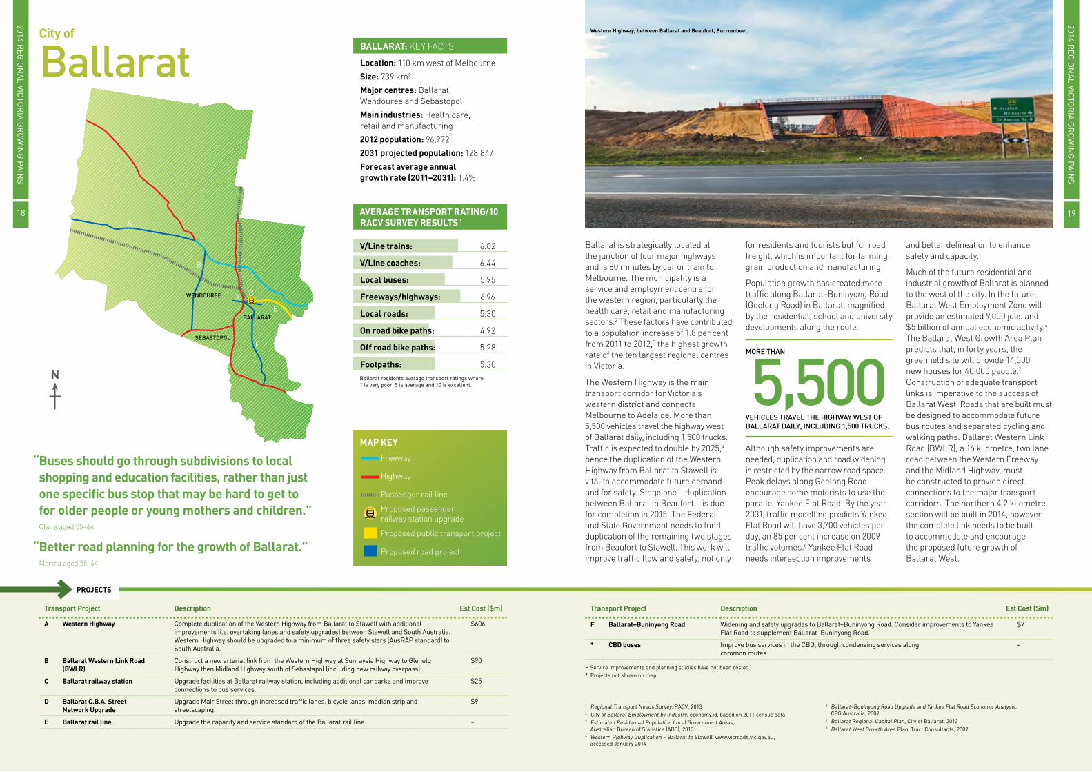
Ballarat is strategically located at the junction of four major highways and is 80 minutes by car or train to Melbourne. The municipality is a service and employment centre for the western region, particularly the health care, retail and manufacturing sectors.2 These factors have contributed to a population increase of 1.8 per cent from 2011 to 2012,3 the highest growth rate of the ten largest regional centres in Victoria.
The Western Highway is the main transport corridor for Victoria’s western district and connects Melbourne to Adelaide. More than 5,500 vehicles travel the highway west of Ballarat daily, including 1,500 trucks. Traffic is expected to double by 2025;4 hence the duplication of the Western Highway from Ballarat to Stawell is vital to accommodate future demand and for safety. Stage one – duplication between Ballarat to Beaufort – is due for completion in 2015. The Federal and State Government needs to fund duplication of the remaining two stages from Beaufort to Stawell. This work will improve traffic flow and safety, not only
for residents and tourists but for road freight, which is important for farming, grain production and manufacturing.
Population growth has created more traffic along Ballarat–Buninyong Road (Geelong Road) in Ballarat, magnified by the residential, school and university developments along the route.
Although safety improvements are needed, duplication and road widening is restricted by the narrow road space. Peak delays along Geelong Road encourage some motorists to use the parallel Yankee Flat Road. By the year 2031, traffic modelling predicts Yankee Flat Road will have 3,700 vehicles per day, an 85 per cent increase on 2009 traffic volumes.5 Yankee Flat Road needs intersection improvements
and better delineation to enhance safety and capacity.
Much of the future residential and industrial growth of Ballarat is planned to the west of the city. In the future, Ballarat West Employment Zone will provide an estimated 9,000 jobs and $5 billion of annual economic activity.6 The Ballarat West Growth Area Plan predicts that, in forty years, the greenfield site will provide 14,000 new houses for 40,000 people.7 Construction of adequate transport links is imperative to the success of Ballarat West. Roads that are built must be designed to accommodate future bus routes and separated cycling and walking paths. Ballarat Western Link Road (BWLR), a 16 kilometre, two lane road between the Western Freeway and the Midland Highway, must be constructed to provide direct connections to the major transport corridors. The northern 4.2 kilometre section will be built in 2014, however the complete link needs to be built to accommodate and encourage the proposed future growth of Ballarat West.
VEHICLES TRAVEL THE HIGHWAY WEST OF BALLARAT DAILY, INCLUDING 1,500 TRUCKS.
MORE THAN
5,500
1 Regional Transport Needs Survey, RACV, 20132 City of Ballarat Employment by Industry, economy.id, based on 2011 census data3 Estimated Residential Population Local Government Areas,
Australian Bureau of Statistics (ABS), 20134 Western Highway Duplication – Ballarat to Stawell, www.vicroads.vic.gov.au,
accessed January 2014
5 Ballarat–Buninyong Road Upgrade and Yankee Flat Road Economic Analysis, CPG Australia, 2009
6 Ballarat Regional Capital Plan, City of Ballarat, 20127 Ballarat West Growth Area Plan, Tract Consultants, 2009
V/Line trains: 6.82
V/Line coaches: 6.44
Local buses: 5.95
Freeways/highways: 6.96
Local roads: 5.30
On road bike paths: 4.92
Off road bike paths: 5.28
Footpaths: 5.30
AVERAGE TRANSPORT RATING/10RACV SURVEY RESULTS 1
Ballarat residents average transport ratings where 1 is very poor, 5 is average and 10 is excellent.
Western Highway, between Ballarat and Beaufort, Burrumbeet.
MAP KEY
Freeway
Highway
Passenger rail line
Proposed passenger railway station upgrade
Proposed public transport project
Proposed road project
2014 REG
ION
AL VIC
TOR
IA G
RO
WIN
G PA
INS
2014 REG
ION
AL VIC
TOR
IA G
RO
WIN
G PA
INS
1918

“There needs to be provision of both roads and public transport options to meet the needs of new communities as they are being established – not decades later.”Jemma aged 55–64
“More frequent trains to Melbourne with direct access to Southern Cross Station.”Hassam aged 65–74
Transport Project Description Est Cost ($m)
A Echuca rail line Upgrade the capacity and service standard of the Echuca rail line. –
B Swan Hill rail line Upgrade the capacity and service standard of the Swan Hill rail line. –
C Outer Arterial Road improvements
Duplicate: McIvor Road and rail bridge, Bendigo–Eaglehawk Road, Midland Highway (White Hills), Marong Road (Calder Highway), Strathfieldsaye Road and Chum Street (West).
$247
D Calder Freeway/Highway Upgrade Calder Freeway/Highway to a minimum of three star AusRAP standard. $157
E North–Western truck route Upgrade the road standard through shoulder sealing and intersection configurations for larger trucks.
$1
F Epsom railway station Construct a new station at Epsom on the Echuca rail line, including adequate car parks. $7
G Bendigo East Link Road Construct a new arterial link between Midland Highway to Strathfieldsaye–White Hills Road. $20
H Integrated Transport Corridor (ITC) Construct an alternative north–south highway corridor to the east of the rail line. $148
I Marong West Truck Bypass Construct a truck bypass along the western boundary of Marong. $26
Transport Project Description Est Cost ($m)
J Outer Box Duplicate: Golden Square to Long Gully Road, Golden Square–Quarry Hill Road, Russel Street and rail bridge and Bendigo–Redesdale Road.
$83
K Bendigo railway station Upgrade facilities at Bendigo railway station including additional car parks. $1
L Bendigo rail line Upgrade the capacity and service standard of the Bendigo rail line. –
M Calder Alternate Highway interchange
Upgrade the intersection of the Calder Highway and Calder Alternate Highway at Ravenswood to a grade separated interchange.
$86
– Service improvements and planning studies have not been costed.
PROJECTS
City of Greater
Bendigo Location: 150 km north of Melbourne
Size: 3,000 km²
Major centres: Bendigo, Eaglehawk and Heathcote
Main industries: Manufacturing, education and finance
2012 population: 62,352
2031 projected population: 103,722
Forecast average annual growth rate (2011–2031): 1.4%
BENDIGO: KEY FACTS
BENDIGO
HEATHCOTE
EAGLEHAWK
C
C
I
A
CF
C
CK
C
CD
D
B
EE
L
M
H
H
H G
JJJ
BENDIGO
HEATHCOTE
EAGLEHAWK
C
C
I
A
CF
C
CK
C
CD
D
B
EE
L
M
H
H
H G
JJJ
Bendigo is a regional centre that attracts visitors from surrounding areas because of the diverse work, study, shopping and medical facilities. A combination of Bendigo’s services and proximity to Melbourne is attracting people to a regional lifestyle that is still close to Melbourne. This growth should increase following completion of Victoria’s largest regional hospital in Bendigo in 2016. However, future development to accommodate the additional residents is restricted to infill, as Bendigo is surrounded by dense parkland that limits opportunities for urban sprawl.
Ensuring people can move in and around the CBD is essential, given the importance of the town centre to Bendigo’s prosperity. The recently completed Inner Box provides a transport route around the CBD and completing the Outer Box would provide a ring route through the inner suburbs.
Bendigo’s rail line is Australia’s fastest growing regional rail route, with patronage increasing by 114 per cent in the last five years.2 In 2006, the Bendigo rail line was upgraded as part
of the Regional Fast Rail project, which included reduction of the track between Kyneton and Bendigo to a single line. However, the 18 daily train services are not enough to meet demand and while the Regional Rail Link will alleviate some pressure on the line, the single track ultimately restricts the number of additional trains that can be added. With steadily
increasing demand for commuter services between Melbourne and Bendigo, planning for the reinstatement of duplicated track between Bendigo and Kyneton is urgently needed.
More demand for Bendigo train services and a lack of alternative transport options to access the station has resulted in overcrowding of the
railway station car park. The 2013 RACV On Track survey revealed 65 per cent of people that use Bendigo railway station experience difficulty finding a car park.3 While expanding the car park is important, appropriate services and infrastructure should be available for people to walk, cycle or catch the bus to the station.
Marong is planned to be an important part of Greater Bendigo’s future growth. The town’s current population is less than 1,000 people, with forecasts it will grow to 8,000 people by 2030.4 At present, creating a strong, regional town centre is difficult as the Calder Freeway travels through the town centre. A bypass is needed to divert freight movement to the west. In Marong, 75 per cent of households have two or more motor vehicles, which is 19 per cent higher than Greater Bendigo.5 It is important to provide transport infrastructure like footpaths, bicycle facilities and bus services early in the growth of the town to encourage the use of alternative transport options and reduce dependence on private vehicles.
1 Regional Transport Needs Survey, RACV, 20132 Railing Ahead: Rail Issues and Opportunities and Future-proofing in the
Loddon Mallee Region of Victoria, E W Russell and Associates, 2011
3 On Track Survey, RACV, 20134 The Marong Plan, City of Greater Bendigo, 20115 Census data, Australian Bureau of Statistics (ABS), 2011
IN THE LAST FIVE YEARS.
BENDIGO’S RAIL LINE IS AUSTRALIA’S FASTEST GROWING REGIONAL RAIL ROUTE, WITH PATRONAGE INCREASING BY
114%
Bendigo bus interchange, Bendigo railway station, Bendigo. Calder Alternate Highway interchange, Calder Freeway, Ravenswood.
V/Line trains: 6.90
V/Line coaches: 6.15
Local buses: 5.70
Freeways/highways: 7.06
Local roads: 5.78
On road bike paths: 5.45
Off road bike paths: 5.28
Footpaths: 5.49Bendigo residents average transport ratings where 1 is very poor, 5 is average and 10 is excellent
AVERAGE TRANSPORT RATING/10RACV SURVEY RESULTS 1
MAP KEY
Highway
Proposed passenger railway station upgrade
Proposed public transport project
Proposed road project
2014 REG
ION
AL VIC
TOR
IA G
RO
WIN
G PA
INS
2014 REG
ION
AL VIC
TOR
IA G
RO
WIN
G PA
INS
2120

“Lack of reliability of Melbourne to Geelong road means I need to stay overnight in eastern suburbs of Melbourne to be confident of making my eastern suburbs appointments.”Rod aged 55–64
“Public transport options that actually work and deter car use are essential.”Lisa aged 45–54
Transport Project Description Est Cost ($m)
A Geelong rail line Increase frequency and service standards on the Geelong rail line. –
B Avalon Airport transport connections Improve public transport options to Avalon Airport. –
C Geelong–Bacchus Marsh Road Duplicate Geelong–Bacchus Marsh Road from Corio–Waurn Ponds Road to Geelong Ring Road. $18
D Midland Highway Plan for duplication of the Midland Highway between Geelong and Bannockburn. –
E North Shore railway station Upgrade facilities at North Shore railway station, including additional car parks. $4
F Geelong to Ballarat coach services Improve frequency and scheduling of coach services between Geelong and Ballarat. –
G Geelong railway station Upgrade facilities at Geelong railway station, including additional car parks. $10
H Drysdale Bypass Road Construct the Drysdale Bypass between Drysdale–Ocean Grove Road to Geelong–Portarlington Road. $100
I Pioneer Road Duplicate Pioneer Road from Waurn Ponds Shopping Centre to Meadowvale Drive. $10
J Marshall railway station Upgrade facilities at Marshall railway station, including additional car parks. $25
K East–West connector Plan for a east–west connector between Surf Coast Highway and Geelong–Portarlington Road. –
Transport Project Description Est Cost ($m)
L Barwon Heads Road Duplicate Barwon Heads Road from Corio–Waurn Ponds Road to Lower Duneed Road. $240
M Anglesea Road Construct capacity and safety improvements along Anglesea Road. $37
* Geelong rail yard Relocate the Geelong rail yards currently on the fringes of the Geelong CBD. $200
* Rail freight connections to Geelong Port and GREP
Plan for rail freight connections for Geelong Ring Road Employment Precinct (GREP)and the Geelong Port. –
* Armstrong Creek bus services Implement five new bus routes that are proposed for the Armstrong Creek Urban Growth Area as development occurs.
–
* Public transport corridor Reserve land for a public transport corridor between the Armstrong Creek development and Torquay. –
1 Regional Transport Needs Survey, RACV, 20132 Regional Rail Link – Benefits for Victorians, Regional Rail Link Authority, 2012 3 Draft Drysdale Urban Design Framework, City of Greater Geelong, 2012
4 Armstrong Creek Civil Interagency Infrastructure Delivery Plan (CIIDP), City of Greater Geelong, 2009
5 Armstrong Creek Bus Planning Study, Public Transport Victoria (PTV), 2012
– Service improvements and planning studies have not been costed.* Projects not shown on map
PROJECTS
City of Greater
Geelong
N
Location: 75 km south-west of Melbourne
Size: 1,248 km²
Major centres: Geelong, Ocean Grove, Lara and Leopold
Main industries: Manufacturing and retail
2012 population: 218,361
2031 projected population: 302,362
Forecast average annual growth rate (2011–2031): 1.5%
GEELONG: KEY FACTS
GEELONG
LARA
LEOPOLD
OCEAN GROVE
H
J
G
F
D
C
E
B
A
I
MLK
E
As Victoria’s second largest city, and being close to Melbourne, Geelong holds a strategically competitive position as the principal service centre for business and industry in the south west as well as having a strong relationship with Melbourne. This also means Geelong experiences many of the same transport problems as outer Melbourne communities, including struggling to provide sufficient transport infrastructure for a growing population, traffic congestion and crowded trains. While some people move to Geelong and work locally, there are many people who live in Geelong and work in Melbourne.
For those that catch the V/Line train to Melbourne, completion of the Regional Rail Link in early 2016 will provide three extra services in the morning and evening peak hour and improve reliability.2 Further efficiency improvements that should be made to the Geelong rail line include a new crossing loop, track duplication between South Geelong and Grovedale and upgrades to North Shore, Marshall and Geelong railway stations.
For those who drive to Melbourne, investment in the Princes Freeway and Geelong Ring Road has added much needed extra road capacity, however there is still the problem of unreliable travel times, with the trip often taking much longer than the expected hour. RACV’s Regional Transport Needs survey revealed Geelong residents are being forced to leave home earlier, reduce work hours or stay in Melbourne overnight to try and avoid travelling to Melbourne during peak hour. The complete East West Link from the Western Ring Road to the Eastern Freeway will alleviate pressure on the M1 corridor and improve the journey between Geelong and Melbourne.
RACV welcomes the Government commitment to fund the complete project, which will have benefits across the state.
Another area that is experiencing increasing congestion is Drysdale and most recent traffic counts reveal over 16,000 vehicles travel along High Street
per day.3 Key intersections along High Street cannot cope with this traffic demand resulting in congestion that will continue to worsen amid nearby residential development. For just under 30 years, the City of Greater Geelong’s planning scheme has incorporated the Drysdale bypass however VicRoads has advised construction is at least ten years from implementation.3
Funding for staged construction of the Drysdale Bypass is needed to benefit not only Drysdale, but the whole Bellarine Peninsula.
To accommodate Geelong’s growing population, Armstrong Creek is being developed as the largest contiguous development in Victoria providing housing for 55,000 people and 22,000 jobs.4 The aim is for Armstrong Creek to be a more sustainable community, with less dependence on the private vehicle. The State Government has committed $25.9 million to construct the Grovedale railway station that will give Armstrong Creek residents more choice in how they travel. Public Transport Victoria has identified five new bus routes for Armstrong Creek5 that RACV believes should be implemented as people begin to move in.
Bus interchange, Geelong railway station, Geelong.
V/Line trains: 5.51
V/Line coaches: 5.43
Local buses: 4.99
Freeways/highways: 6.76
Local roads: 5.21
On road bike paths: 4.73
Off road bike paths: 5.79
Footpaths: 5.05Geelong residents average transport ratings where 1 is very poor, 5 is average and 10 is excellent
AVERAGE TRANSPORT RATING/10RACV SURVEY RESULTS 1
PEOPLE AND 22,000 JOBS.
ARMSTRONG CREEK IS BEING DEVELOPED AS THE LARGEST CONTIGUOUS DEVELOPMENT IN VICTORIA PROVIDING HOUSING FOR
55,000MAP KEYFreeway
Highway
Passenger rail line
Proposed passenger railway station upgrade
Proposed public transport project
Proposed public transport project – indicative corridor
Proposed road project
2014 REG
ION
AL VIC
TOR
IA G
RO
WIN
G PA
INS
2014 REG
ION
AL VIC
TOR
IA G
RO
WIN
G PA
INS
2322

“Public transport options need to be increased, which includes the kinds of public transport available, the frequency of public transport and the hours during which trips may be taken.”Stuart aged 45–54
“Highways need to be made safe to drive on as they are in very poor shape and potholes cause constant damage to vehicles.”Rupert aged 45–54
Transport Project Description Est Cost ($m)
A Western Highway Continue to improve the Western Highway, including complete duplication to Stawell and a minimum of three star AusRAP standard to South Australia.
$606
B Horsham passenger rail service Implement a passenger shuttle rail service that extends from Ararat railway station to Horsham. –
C Melbourne to Adelaide rail line Relocate the railway line away from the centre of Horsham. $79
D Horsham Bypass Construct the Horsham Bypass for the Western Highway. $157
E Alternate road across the Wimmera River
Investigate an alternate road and foot bridge over the Wimmera River. –
1 Regional Transport Needs Survey, RACV, 20132 Western Highway Duplication – Ballarat to Stawell, www.vicroads.vic.gov.au, accessed 20143 Horsham North Urban Design Framework Community Engagement Report, Place Partners, 2010
– Service improvements and planning studies have not been costed.
PROJECTS
HorshamRural City Council
N
Location: 300 km west of Melbourne
Size: 4,267 km²
Major centres: Horsham and Natimuk
Main industries: Agriculture and manufacturing
2012 population: 19,658
2031 projected population: 22,571
Forecast average annual growth rate (2011–2031): 0.5%
HORSHAM: KEY FACTS
NATIMUK
HORSHAM
A
DE
C
B
Horsham provides retail and business services to the predominantly rural farming industry in the Wimmera region. Located between Melbourne and Adelaide, the municipality is at the hub of a state and national highway system, namely the Western Highway, Henty Highway and Wimmera Highway leading to Geelong, Mildura, Portland and Bendigo. Public transport connections between Horsham and Melbourne include the Overland train, operating twice a week, or a V/Line coach that connects with trains at Ararat and Ballarat.
The Western Highway is the principal route between Melbourne and Adelaide. Road freight for livestock, grain production and manufacturing industries, as well as growing local
and tourist traffic, rely on this highway. Everyday, 4,000 private vehicles and 1,500 trucks travel the highway west of Ballarat, with projections that this will double by 2025.2 Further improvements to the Western Highway are needed,
including duplication from Ballarat to Stawell and safety and capacity improvements beyond Stawell to the South Australia border. These safety improvements include skid resistance, roadside barriers and protected turn
lanes that have the potential to reduce serious injuries and fatalities on the Western Highway.
The Western Highway runs through the centre of Horsham, forcing traffic that would otherwise avoid Horsham to travel through the town. This causes issues for both through traffic and residents. Through traffic is forced to decrease speed, drive with local traffic and is confronted with eight sets of traffic lights, resulting in an increase in travel time and a decrease in safety. For locals, high car and truck volumes through the town negatively impacts the town’s amenity. While RACV acknowledges that government is currently planning for the Horsham Bypass no funds have been committed for construction. A bypass is needed for Horsham to improve freight movement, road safety and town amenity and maintain the functionality of the road network.
To remove the need for two grade separations as part of the Western Highway Bypass, the Horsham Rail Bypass should be constructed concurrently. At present, the Melbourne to Adelaide rail line bisects Horsham, causing segregation and disadvantage for Horsham North. Community consultation has revealed that the rail line acts as a physical and mental barrier to entering Horsham North resulting in residents feeling socially isolated from the greater community.3 To reconnect Horsham the rail line should be realigned to the north of Horsham. This will benefit Horsham North residents and will provide significant urban renewal opportunities for the land occupied by the current rail line and yards.
Western Highway, Wimmera River Crossing, Horsham.
PRIVATE VEHICLES AND 1,500 TRUCKS TRAVEL THE HIGHWAY WEST OF BALLARAT.
EVERYDAY
4,000
Horsham railway tracks, Horsham.
V/Line trains: n/a
V/Line coaches: 5.99
Local buses: 5.86
Freeways/highways: 4.32
Local roads: 4.32
On road bike paths: 4.72
Off road bike paths: 5.54
Footpaths: 5.23Horsham residents average transport ratings where 1 is very poor, 5 is average and 10 is excellent
AVERAGE TRANSPORT RATING/10RACV SURVEY RESULTS 1
MAP KEY
Highway
Passenger rail line
Proposed public transport project
Proposed public transport project – indicative corridor
Proposed road project
2014 REG
ION
AL VIC
TOR
IA G
RO
WIN
G PA
INS
2014 REG
ION
AL VIC
TOR
IA G
RO
WIN
G PA
INS
2524

“Better trains and more of them. Standing from Melbourne to Moe due to lack of seats/carriages is silly and dangerous.” Peter aged 55–64
“Duplication of freeway to continue through to Sale, and better road maintenance for flood damaged roads.” Tamara aged 35–44
Transport Project Description Est Cost ($m)
A Princes Highway Complete duplication of the Princes Highway from Traralgon to Sale. Upgrade the highway to at least a minimum of three star AusRAP standard to New South Wales.
$425
B Moe railway station Upgrade facilities at Moe railway station, including additional car parks. $21
C Traralgon railway station Construct a second platform at Traralgon railway station and upgrade facilities, including additional car parks.
$12
D Traralgon rail line Increase frequency and service standards on the Traralgon rail line. –
E Morwell railway station Construct additional car parks at Morwell railway station. $1
Transport Project Description Est Cost ($m)
F Traralgon bypass Construct the Traralgon bypass on Princes Highway East. TBC
G Gippsland logistics precinct Implement a fully integrated industrial estate and transport hub in the Latrobe Valley at Morwell. $10
* Dandenong rail line Implement operational and service level upgrades to the Dandenong rail corridor and plan for the South East Rail Link (SERL).
–
1 Regional Transport Needs Survey, RACV, 20132 National Land Freight Strategy Submission, Latrobe City Council, 20113 A great place to work an even better place to live, Latrobe City Council, 2011
– Service improvements and planning studies have not been costed.* Projects not shown on map
PROJECTS
City of
Latrobe
N
Location: 120 km east of Melbourne
Size: 1,426 km²
Major centres: Traralgon, Moe, Morwell and Churchill
Main industries: Manufacturing and electricity, gas and water supply
2012 population: 73,929
2031 projected population: 90,741
Forecast average annual growth rate (2011–2031): 0.8%
LATROBE: KEY FACTS
CHURCHILL
TRARALGON
MOE
MORWELL
A
G
CF
D
B
E Latrobe City Council is situated in the centre of Gippsland and has four major towns – Moe, Morwell, Traralgon and Churchill. Power generation is a key industry in the Latrobe Valley, which houses four main power stations that produce 90 per cent of the state’s electricity.2 The industry and supporting engineering sectors are key employers in the region. Many people find the lower cost of housing in the area appealing. In 2011, Latrobe was home to Australia’s most affordable real estate market with a median house price of $162,000.3 The Gippsland campus of Monash University also attracts many students from neighbouring regions.
The Princes Highway is the principal route though Latrobe for freight, tourist, local and coach travel between Sydney and Melbourne. This route is vital to the success of the dairy, timber, paper, coal and gas production industries. At present, Princes Highway runs through the centre of Traralgon. Although the Traralgon Bypass has been on the government agenda for many years and land has been reserved, there needs to be funding
commitments from the Federal and State Governments for construction to commence. In addition, Princes Highway needs to be duplicated between Traralgon and Sale. Government funding for Princes Highway upgrades has added capacity
and enhanced safety. The full route between Traralgon and Sale needs to be duplicated for further improvements to travel times, freight movement and road safety.
The current Gippsland Intermodal Freight Terminal (GIFT) is underutilised. Council has acquired a 64 hectare site adjacent to Princes Highway to establish a Gippsland Logistics Precinct (GLP), to facilitate freight movement to and from Gippsland,
primarily through rail. A modal shift of freight from road to rail will become increasingly important, therefore the GLP should continue to be developed to encourage this change.
Low frequency Traralgon trains result in crowded services, especially in peak hour, forcing people to stand for the two hour journey between Moe and Melbourne. Frequency is constrained by the Dandenong Rail Corridor, as it must accommodate metropolitan passenger services, V/Line passenger services and Gippsland freight trains. RACV welcomed the 2014 State Government commitment to upgrade the Dandenong Rail Corridor in partnership with Metro Trains. As a longer term project, the proposed South East Rail Line (SERL) should be implemented, as this would ensure a separate rail connection between Dandenong and Dynon for freight trains to operate independently of metropolitan passenger trains. This will benefit freight trains and improve capacity and reliability for metropolitan and V/Line passengers trains on the Dandenong Rail Corridor.
Princes Highway, Moe. Traralgon railway station, Traralgon.
OF THE STATE’S ELECTRICITY.
LATROBE VALLEY HAS FOUR MAIN POWER STATIONS THAT PRODUCE
90%
V/Line trains: 6.59
V/Line coaches: 5.99
Local buses: 5.99
Freeways/highways: 6.02
Local roads: 5.11
On road bike paths: 3.90
Off road bike paths: 4.33
Footpaths: 5.49Latrobe residents average transport ratings where 1 is very poor, 5 is average and 10 is excellent
AVERAGE TRANSPORT RATING/10RACV SURVEY RESULTS 1
MAP KEY
Freeway
Highway
Proposed passenger railway station upgrade
Proposed public transport project
Proposed road project
2014 REG
ION
AL VIC
TOR
IA G
RO
WIN
G PA
INS
2014 REG
ION
AL VIC
TOR
IA G
RO
WIN
G PA
INS
2726

“My husband and I have missed a number of family occasions (funerals, weddings, etc.) due to lack of affordable transport to Melbourne. If you have to get to the city in a hurry it is too expensive to fly and takes hours by car on substandard roads.”Deanne aged 55–64
Transport Project Description Est Cost ($m)
A Transcontinental Rail Link Plan and construct the Transcontinental Rail Link between Mildura and Menindee connecting to the Sydney–Perth rail line.
$320
B Eleventh Street (East–West sub arterial/collector)
Improve Eleventh Street pedestrian facilities and traffic management. $11
C Sturt Highway Improve the condition of the Sturt Highway, including upgrading to at least a three star standard as determine by AusRAP.
$10
D Sturt Highway Truck Bypass Construct a truck bypass of Mildura on the Sturt Highway. $72
E Mildura Airport bus Implement a new bus connection to Mildura Airport. –
F Mildura intermodal freight hub Relocate the Merbein intermodal freight hub south of Mildura. $20
Transport Project Description Est Cost ($m)
G Calder Highway Duplicate the Calder Highway between Mildura and Red Cliffs. Upgrade the Calder Highway to at least a three star standard, as determined by the AusRAP program.
$323
H Mildura rail line Complete standardisation of the Mildura rail line. Investigate the return of passenger rail services to Mildura.
$220
1 Regional Transport Needs Survey, RACV, 20132 City Council Plan, Mildura Rural City Council, 20133 Australian Road Assessment Program (AusRAP), RACV, 2013
4 Northern Loddon Mallee Regional Strategic Plan, Mildura Rural City Council, 2010 5 Mildura Planning Scheme, Municipal Strategic Statement – Clause 21.03, 2013
– Service improvements and planning studies have not been costed.
PROJECTS
Mildura Rural City Council
N
Location: 500 km north-west of Melbourne
Size: 22,083 km²
Major centres: Mildura, Red Cliffs, Merbein and Ouyen
Main industries: Agriculture and manufacturing
2012 population: 52,204
2031 projected population: 64,288
Forecast average annual growth rate (2011–2031): 1.1%
MILDURA: KEY FACTS
OUYEN
RED CLIFFS
MILDURAMERBEIN
G
G
H
H
F
CC ED
A B
Mildura Rural City Council’s vision is to make it the most liveable, people friendly community in Australia.2 The regional centre sits on the crossroad of major transport routes that connect three capital cities and near the meeting point of Australia’s two largest rivers. This strategic location continues to foster development, but can impose a unique set of transport challenges in the region.
The remote location of Mildura is a defining characteristic. Many residents want to – and need to – visit Melbourne for medical appointments, business meetings or social outings. For those who can drive, the 540 kilometre journey is predominantly along the Calder Highway/Freeway. Although this is the most important road connection from Mildura to Melbourne, it is one of the least safe national highways in Victoria. A staggering 49 per cent of the Calder Freeway obtained an unacceptable one or two star AusRAP safety rating. An investment of $157 million into the Calder Freeway to install crash barriers, rumble strips and widen shoulders would eradicate dangerous one and two star sections of the road.3
For those who cannot drive, transport options to Melbourne are limited. The passenger rail service was discontinued in 1993 and, while Mildura is serviced by Victoria’s third largest airport, with flights costing as much as $400 return it can be too costly for many residents. The only other public transport access to Melbourne is by coach, which can take between seven and a half to nine hours. RACV consultation with Mildura’s residents revealed that people with a disability, children and the elderly find travelling on a coach undesirable and transferring between services difficult and confusing. There
are high levels of community support for passenger train services to Mildura.
The first step to restoring a passenger service is to improve the Mildura line for freight trains. Freight transport is particularly important for Mildura because it produces the majority of Victoria’s wine, dried fruits, citrus and
stone fruits, olives and nuts. It has some of the largest processing and packaging plants in the world.4
RACV’s regional transport survey found that Mildura’s highways were ranked 4.6 out of ten, well below the state average of 6.2. Freight can negatively impact on freeways and highways through additional road
surface wear and tear. Track standardisation, together with construction of the Transcontinental Rail Link and relocation of the Mildura intermodal hub to Mildura South, could result in a shift of freight from road to rail. It is critical that the State Government delivers its commitment from the 2014/15 budget for complete standardisation of the Mildura rail line.
For freight that must be transported on road, an appropriate truck bypass is needed. For now, Mildura’s truck route is along Benetook Avenue and work is needed to divert trucks from Deakin Avenue. Council’s vision is for Deakin Avenue to be “Mildura’s main boulevard, providing residents and visitors a grand entrance to – and exit from – the City”.5 In the long term, a Sturt Highway bypass of Mildura should be planned for, to reduce the impact of trucks on Mildura’s community and to ensure only those needing access to local businesses enter the town.
Existing Mildura rail line.
FAR BELOW THE STATE AVERAGE OF 6.2.
RACV’S REGIONAL TRANSPORT SURVEY RESULTS SHOWED THAT MILDURA’S FREEWAYS/HIGHWAYS RANKED
4.6/10
V/Line trains: n/a
V/Line coaches: 4.50
Local buses: 5.70
Freeways/highways: 4.60
Local roads: 5.40
On road bike paths: 4.70
Off road bike paths: 4.30
Footpaths: 5.40Mildura residents average transport ratings where 1 is very poor, 5 is average and 10 is excellent
AVERAGE TRANSPORT RATING/10RACV SURVEY RESULTS 1
MAP KEY
Highway
Proposed public transport project
Proposed road project
2014 REG
ION
AL VIC
TOR
IA G
RO
WIN
G PA
INS
2014 REG
ION
AL VIC
TOR
IA G
RO
WIN
G PA
INS
2928

“For a regional city that relies on train services just as much as Albury, Bendigo and Ballarat, to have three return services a day is just pathetic.”Toni aged 35–44
“A bypass around Shepparton needs to be completed now, not in 10 or 20 years.”Bao aged 55–64
Transport Project Description Est Cost ($m)
A Goulburn Valley Highway Safety upgrades to the Goulburn Valley Highway from Shepparton to New South Wales, to a minimum of three star AusRAP standard.
$25
B Shepparton Bypass Construct the Shepparton Bypass to a minimum of four star AusRAP standard. This includes construction of the North Shepparton Arterial East–West Link, which is a new arterial road between the Shepparton Bypass and the Shepparton Alternative Route.
$250
C Shepparton bus interchange Construct a new bus interchange on Maude Street, including improved pedestrian access and parking facilities.
$5
D Midland Highway Duplicate the Midland Highway to Shepparton East. $8
Transport Project Description Est Cost ($m)
E GV Link Construct a freight and logistics centre in Shepparton, including an intermodal terminal for rail freight.
$17 (Stage 1)
F Shepparton rail line Improve frequency of passenger rail services between Shepparton and Melbourne. –
1 Regional Transport Needs Survey, RACV, 20132 The Goulburn Region, www.dpi.vic.gov.au, accessed December 20133 Traffic Volume Data for Victoria – Midland Highway Between Mclennan Street and High Street, VicRoads, 2012
– Service improvements and planning studies have not been costed.
PROJECTS
Greater SheppartonCity Council
N
Location: 180 km north of Melbourne
Size: 2,422 km²
Major centres: Shepparton, Mooroopna and Tatura
Main industries: Agriculture, manufacturing and transport
2012 population: 62,352
2031 projected population: 77,797
Forecast average annual growth rate (2011–2031): 1.0%
GREATER SHEPPARTON: KEY FACTS
SHEPPARTON
MOOROOPNA
TATURA
C
A
B
E
D
F
Greater Shepparton is situated in the centre of the Goulburn Valley, which is considered the ‘Food Bowl of Victoria’ generating approximately 20 per cent of Victoria’s agricultural production.2 With an international reputation for quality fruit and dairy products, freight transport is focused on transporting these goods to processing facilities and distribution centres. As a result Greater Shepparton is often referred to as the transport hub of regional Australia, with the largest truck sales and service centre in Victoria.
The Goulburn Valley Highway runs through the centre of Shepparton and is a part of the road link between Melbourne and Brisbane. Construction of the Shepparton Bypass is needed to provide a smoother and more efficient movement of goods between Australia’s eastern capital cities. High quality road links will maximise the value of freight by speeding delivery to markets and reducing damage to fresh produce in transit. The bypass would be beneficial for residents and surrounding communities as it would decrease traffic in the CBD and enable through traffic to safely bypass the town.
Shepparton needs adequate road connections to neighbouring towns such as Benalla and Bendigo via the Midland Highway. Recent duplication of the Highway between Florence Street and Doyles Road has eased congestion. However, to cope with the 27,000 vehicles using the highway each day (of which 10 percent are heavy vehicles)3 and to accommodate future growth, the Midland Highway needs to be duplicated to Shepparton East, including upgrade of the intersection with the Shepparton Alternate route.
Residents need choice in how they travel and they need to be able to easily access public transport services. The redevelopment of the Vaughan Street precinct will enhance the CBD and improve pedestrian access to
Shepparton railway station, the suburban bus network and taxi services. Stage One was completed in December 2013. The full benefits of this project can only be achieved through construction of the final two stages, including redevelopment of Maude Street and relocation of the bus interchange.
RACV community consultation revealed the three Shepparton train services per day are not enough. Residents who want to catch public transport are forced to drive to Melbourne or drive an hour to Seymour railway station, which has resulted in parking issues at Seymour. Shepparton needs a more frequent train service that is on par with similar regional centres like Traralgon. These two areas are a similar population and distance to the Melbourne CBD, however Shepparton receives only one fifth the number of Traralgon services. A more frequent train service would improve access to education facilities in Shepparton, support tourism in the region and provide residents with better transport options.
Broken River Bridge, Shepparton.
OF VICTORIA’S AGRICULTURAL
PRODUCTION.
GOULBURN VALLEY, WHICH IS CONSIDERED THE ‘FOOD BOWL OF VICTORIA’ GENERATES
20%
V/Line trains: 2.98
V/Line coaches: 4.25
Local buses: 5.39
Freeways/highways: 6.52
Local roads: 5.29
On road bike paths: 5.09
Off road bike paths: 5.86
Footpaths: 5.61Greater Shepparton residents average transport ratings where 1 is very poor, 5 is average and 10 is excellent
AVERAGE TRANSPORT RATING/10RACV SURVEY RESULTS 1
MAP KEY
Highway
Proposed public transport project
Proposed road project
2014 REG
ION
AL VIC
TOR
IA G
RO
WIN
G PA
INS
2014 REG
ION
AL VIC
TOR
IA G
RO
WIN
G PA
INS
3130

“Unreliable train service meant I was unable to attend a training course in Melbourne and – further to this – my children have missed out on attending sporting events in Melbourne for the same reason.” Brad aged 45–54
“Reduce road congestion in the CBD of Wangaratta.” Lara aged 45–54
Transport Project Description Est Cost ($m)
A Wangaratta rail line Improve reliability and upgrade the service standard of the Wangaratta rail line. –
B Hume Freeway Improve the Hume Freeway, including upgrading to at least a three star AusRAP standard. $100
* Bus connection to Milawa Implement a regular bus service that connects Milawa and Markwood residents with Wangaratta.
–
– Service improvements and planning studies have not been costed.* Projects not shown on map
PROJECTS
Rural City of
Wangaratta
N
Location: 250 km north-east of Melbourne
Size: 3,645 km²
Major centres: Wangaratta and Glenrowan
Main industries: Manufacturing and agriculture
2012 population: 27,236
2031 projected population: 31,556
Forecast average annual growth rate (2011–2031): 0.4%
WANGARATTA: KEY FACTS
GLENROWAN
WANGARATTA B
A
Wangaratta is located in Victoria’s central north east, in the Hume region. There are over 27,000 residents living in the municipality, of which 17,000 live in urban Wangaratta.2 Future residential growth will predominantly occur in urban Wangaratta, rather than rural towns. It is important that the Central Activities Area (CAA) continues to grow as a key centre providing a mixture of commercial, residential, tourism, educational, civic and recreational land uses. Future residential development should occur around the town centre to provide close access to these key services. For those that choose to live in a rural area or township, there needs to be adequate connections to the Wangaratta CAA.
Car parking is the number one issue in the CAA. It is critical that the road network caters for the movement of traffic through town and RACV supports the removal of on street car parking where competing demands for road space exists. Any additional car parks must be provided off-street and in satellite car parks adjacent to the CAA.
Promotion of alternative transport modes for travel to and within the town centre would reduce the need to provide additional car spaces. Community consultation has revealed cycling is the preferred mode of travel for residents, however cycle connections and facilities must be improved.4
Pedestrian facilities in the CAA should be improved through simple measures such as pedestrian refuges in the centre of wide streets. For public transport to be appealing, it should be better integrated into the town centre.
While improved access to public transport is important, the quality of the service is another key factor contributing to people’s transport choice. At present, the Wangaratta train service is unreliable and this has resulted in community reluctance to use the train. Compared to the ten
municipalities with the largest regional centres, Wangaratta residents ranked their train services the lowest, with a score of 2.53 out of ten.5 In January
2014, only 75 per cent of services on the Albury line were delivered on time.6 The track needs to be appropriately upgraded so that services are reliable and punctual and provide a desirable transport option for residents.
Improved public transport connections to growing satellite towns around Wangaratta are very important. The rural township of Milawa for example, is expecting strong growth driven by its popularity as Australia’s first gourmet region, an increase in local events and commercial activity and closure of a number of nearby rural primary schools. Residents from Milawa commute to Wangaratta for shopping, work and to access the various other services in town. A more regular and timely bus service would ensure that people who do not or cannot drive can still access the services needed in Wangaratta.
1 Regional Transport Needs Survey, RACV, 20132 Annual Report, Rural City of Wangaratta, 20123 Wangaratta Central Activities Area Future Planning, SMEC, 2013
4 Wangaratta Central Activities Area Future Planning, SMEC, 20135 Regional Transport Needs Survey, RACV, 20136 Track Record, Public Transport Victoria (PTV), 2014
Bus stop, bus route to Milawa, Wangaratta.
RESIDENTS LIVING IN THE MUNICIPALITY, OF WHICH 17,000 LIVE IN URBAN WANGARATTA.
THERE ARE OVER
27,000
Wangaratta railway station, Wangaratta.
V/Line trains: 2.53
V/Line coaches: 5.43
Local buses: 5.74
Freeways/highways: 7.52
Local roads: 5.45
On road bike paths: 5.08
Off road bike paths: 6.83
Footpaths: 5.42Wangaratta residents average transport ratings where 1 is very poor, 5 is average and 10 is excellent
AVERAGE TRANSPORT RATING/10RACV SURVEY RESULTS 1
MAP KEY
Highway
Proposed public transport project
Proposed road project
2014 REG
ION
AL VIC
TOR
IA G
RO
WIN
G PA
INS
2014 REG
ION
AL VIC
TOR
IA G
RO
WIN
G PA
INS
3332

“More train services are required daily. It is just not good enough that people who live in the country areas of Victoria are so disadvantaged.”Helen aged 55–64
“Princes Highway needs to be properly maintained and vastly improved due to increased road traffic volumes.”Bevan aged 65–74
Transport Project Description Est Cost ($m)
A Princes Highway West Complete duplication of Princes Highway West from Geelong to Colac and upgrade capacity and safety from Colac to Port Fairy. Upgrade Princes Highway West to a minimum of three star AusRAP standard.
$453
B Princes Highway (Raglan Parade) Improve safety and traffic flow on Princes Highway (Raglan Parade). $3
C Warrnambool railway station Upgrade facilities at Warrnambool railway station, including additional car parks. $4
D Warrnambool rail line Implement shuttle services between Warrnambool and Geelong. –
1 Regional Transport Needs Survey, RACV, 20132 Princes Highway Duplication – Geelong to Colac, www.vicroads.vic.gov.au, accessed 20143 Regional Transport Strategy, Great South Coast, 2013 4 Warrnambool Railway Station Precinct Master Plan, CPG, 2010
– Service improvements and planning studies have not been costed.
PROJECTS
Warrnambool City Council
N
Location: 260 km south-west of Melbourne
Size: 121 km²
Major centres: Warrnambool and Dennington
Main industries: Dairy processing, meat processing and tourism
2012 population: 32,968
2031 projected population: 43,934
Forecast average annual growth rate (2011–2031): 1.3%
WARRNAMBOOL: KEY FACTS
DENNINGTON
WARRNAMBOOL
A
D
ABC
Warrnambool is Victoria’s largest coastal city outside of Port Phillip Bay, and is an important regional centre for the Great Southern Coast. Many people who live in Colac and Port Fairy commute to Warrnambool for employment or to access the health, education and professional services. Warrnambool is also a significant tourist destination as it is the largest town on the Great Ocean Road.
Currently, car use dominates access to the city centre. To encourage alternative travel to and within the city centre, there needs to be a higher priority for cyclists and pedestrians, and better access by bus services. Princes Highway West (Raglan Parade) forms the northern border of Warrnambool’s city centre. Reducing delays along Princes Highway West will benefit the growing local, regional and interstate transport movements. The duplication
of Princes Highway West between Geelong to Winchelsea is due for completion in 2014. State and Federal Governments have committed $362 million in future years to continue the highway duplication beyond Winchelsea to Colac.2 This investment in Princes Highway West is welcome; however more needs to be done.
RACV community consultation revealed that for people that travel to and from Warrnambool, the limited overtaking opportunities on Princes Highway West
near Warrnambool is a safety concern. Duplication of Princes Highway West, from Warrnambool towards Colac and between Port Fairy and Warrnambool is needed to improve road safety, benefit freight and support Warrnambool’s connection to neighbouring towns.
Although Warrnambool traffic volumes are increasing, train patronage is also experiencing growth at 2% per year.3 Warrnambool residents need more than three return train services per day to give people more choice in when and how they travel. Currently, train frequency is constrained by the lack of passing opportunities. A passing loop between Colac and Terang needs to be constructed. Following construction of the passing loop, train frequency should be increased, including implementation of shuttle services that directly connect Warrnambool with Geelong. Having a faster, more direct connection will encourage residents to catch the train to Melbourne and tourists to catch the train to Warrnambool.
Warrnambool railway station is a heritage building that has potential to be a key transport interchange; however improvements need to be implemented. Facilities at the railway station are poor and the current link between the railway station and the city’s retail core is confusing. Railway station upgrades that are needed include improved lighting, seating, shelter and car parking. Better physical integration of the railway station, buses and the city centre is also needed. These upgrades are particularly important as Warrnambool railway station is considered the ‘front door’ to the city centre.4
Warrnambool railway station, Warrnambool.
Raglan Parade, intersection with Simpson Street, Warrnambool.
V/Line trains: 4.80
V/Line coaches: 5.30
Local buses: 6.15
Freeways/highways: 4.35
Local roads: 4.42
On road bike paths: 5.72
Off road bike paths: 5.95
Footpaths: 6.07Warrnambool residents average transport ratings where 1 is very poor, 5 is average and 10 is excellent
AVERAGE TRANSPORT RATING/10RACV SURVEY RESULTS 1
PER YEAR.
WARRNAMBOOL TRAFFIC VOLUMES ARE INCREASING, TRAIN PATRONAGE IS ALSO EXPERIENCING GROWTH AT 2%
MAP KEY
Highway
Proposed passenger railway station upgrade
Proposed public transport project
Proposed road project
2014 REG
ION
AL VIC
TOR
IA G
RO
WIN
G PA
INS
2014 REG
ION
AL VIC
TOR
IA G
RO
WIN
G PA
INS
3534

“I had an appointment in Melbourne at noon, I caught the 6.45 am train from Wodonga, due into Melbourne at 10.35am – I did not arrive until 11.58am.” Ruth aged 65–74
“My aged and unwell parents wanted to catch the train to Melbourne to see a medical specialist; however the trains are extremely unreliable (late and insufficient seating)... so they had to rely on other family members taking the day off work and pay for babysitting to take the time to drive them down.” Hilda aged 35–44
Transport Project Description Est Cost ($m)
A Logic Wodonga Construct a rail freight link to Logic Wodonga. $15
B Murray Valley Highway Duplicate Murray Valley Highway from Logic Boulevard to the Hume Freeway interchange, to support the development of the Logic logistics centre.
$6
C Wodonga rail line Improve reliability and upgrade the service standard of the Wodonga rail line. –
D Hume Freeway Upgrade the safety of Hume Freeway to a minimum of three star AusRAP standard to New South Wales.
$100
E Melrose Drive Investigate appropriate access and funding for the proposed freight terminal. $10
F Kiewa Valley Highway Duplicate Kiewa Valley Highway from Murray Valley Highway to Baranduda, to support planned urban development.
$6
Transport Project Description Est Cost ($m)
G Baranduda Boulevard Plan for the upgrading of road infrastructure to support urban development at Leneva–Baranduda.
–
* Bus service to Wodonga railway station
Implement a bus services that connects to the new Wodonga railway station. –
1 Regional Transport Needs Survey, RACV, 20132 Safety of Rail Operations on the Interstate Rail Line Between Melbourne and Sydney, Australian Safety Transport Bureau, 2013 3 Discussion Draft Leneva–Baranduda Growth Area Framework Plan, City of Wodonga, 2012 4 AUSLINK Strategic Regional Infrastructure Funding Application for Logic Wodonga Container Terminal, City of Wodonga, 2008
– Service improvements and planning studies have not been costed.* Projects not shown on map
PROJECTS
City of
Wodonga
N
Location: 300 km north-east of Melbourne
Size: 433 km²
Major centres: Wodonga and Baranduda
Main industries: Manufacturing and retail
2012 population: 36,626
2031 projected population: 48,435
Forecast average annual growth rate (2011–2031): 1.3%
WODONGA: KEY FACTS
BARANDUDA
WODONGA
G
D
CB
A
E
F
Wodonga is strategically located on the Hume Highway that connects Melbourne and Sydney. The town is a popular tourist stop for people travelling between the two capital cities and for visitors to the Murray River. Wodonga has considerable development planned, including construction of the $60 million Mann’s central retail facility that will begin shortly. Furthermore, land released following relocation of the Wodonga rail line and station will be transformed into a residential, retail and commercial precinct known as Junction Place.
The key transport issue for Wodonga is the poor performance of the rail line. Since 2007, significant work has been completed: the broad gauge track was converted to standard gauge, timber sleepers were replaced with concrete sleepers, the train signalling system was upgraded, passing lanes constructed and platforms built. Despite the significant investment the Albury/Wodonga line remains the most unreliable in the state. Recent treatment will correct most ballast and drainage problems but additional works are required. This will reduce track maintenance and enable temporary service restrictions to be eased2, therefore enhancing quality, reliability and punctuality.
At present, there is no bus service that connects with Wodonga railway station. For those that do not have a car or are unable to walk or cycle because of distance, a bus service that connects to the railway station would ensure equitable transport. Access to the railway station via bus could encourage a mode shift from those that currently drive and reduce demand for car parking at the station.
To accommodate population growth over the next 40 years, the Leneva–
Baranduda growth area will supply enough residential land for 14,000 homes, 35,000 people and 6,000 jobs. The Baranduda town centre will become a secondary centre to the Wodonga CBD.3 Adopting a planning approach that includes major employment and activity centres closer
to where people live is fundamental. When people do need to travel to Wodonga, sufficient transport links are required. Baranduda Boulevard is the main arterial route between Wodonga, Leneva Village and Baranduda. With the associated traffic, this road link should be duplicated before significant development of the growth area to avoid congestion. The design of this new development needs to consider all modes of transport.
The Wodonga Trails Network should be extended into the growth area and roads should be designed to accommodate buses and have separated paths for bicycles and pedestrians.
Another key project for Wodonga is the 610 hectare Logic site. Funding is needed to develop this site as an intermodal distribution hub for southeast Australia. Logic’s strategic location at the intersection of the Hume Freeway and Murray Valley Highway helped secure Woolworths as the largest tenant, with a $90 million distribution centre and over 400 employees. Several other companies have expressed interest in Logic, however a common prerequisite is a rail terminal.4 Construction of an intermodal rail container terminal that adjoins the North East railway line connecting Melbourne to Sydney would provide direct access to the Port of Melbourne, Port Botany and the National Rail Network from Wodonga creating competitive advantage for businesses and encouraging job growth.
Logic, Murray Valley Highway, Barnawartha North.
HOMES, 35,000 PEOPLE AND 6,000 JOBS.
THE LENEVA–BARANDUDA GROWTH AREA WILL SUPPLY ENOUGH RESIDENTIAL LAND FOR
14,000
V/Line trains: 2.54
V/Line coaches: 5.03
Local buses: 6.08
Freeways/highways: 8.08
Local roads: 6.41
On road bike paths: 5.65
Off road bike paths: 7.16
Footpaths: 6.10Wodonga residents average transport ratings where 1 is very poor, 5 is average and 10 is excellent
AVERAGE TRANSPORT RATING/10RACV SURVEY RESULTS 1
MAP KEY
Highway
Proposed public transport project
Proposed road project
2014 REG
ION
AL VIC
TOR
IA G
RO
WIN
G PA
INS
2014 REG
ION
AL VIC
TOR
IA G
RO
WIN
G PA
INS
3736

Geelong railway station, Geelong.
2014 Regional VictoriaGrowing PainsFor further information contact:
Royal Automobile Club of Victoria (RACV) Ltd Public Policy Department, 550 Princes Highway, Noble Park North, Victoria 3174
Telephone (03) 9790 2863 Fax (03) 9790 2629 Email [email protected] www.racvgrowingpains.com.au ABN 44 004 060 833
Graphic design by Struck & Spink Photography by Keren Dobia
© Material in this publication may be reproduced or quoted provided RACV is acknowledged.
This publication is printed on 50% recycled paper.
2014 REG
ION
AL VIC
TOR
IA G
RO
WIN
G PA
INS
38

2014 Regional VictoriaGrowing Pains