groundwater chapter 17. the hydrologic cycle where is the water ? where is the water ? figure 16.2
TRANSCRIPT
GROUNDWATER GROUNDWATER Chapter 17Chapter 17
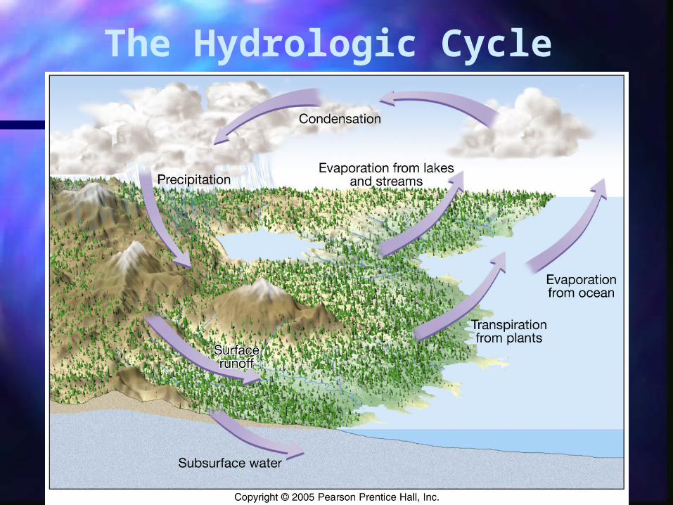
The Hydrologic Cycle
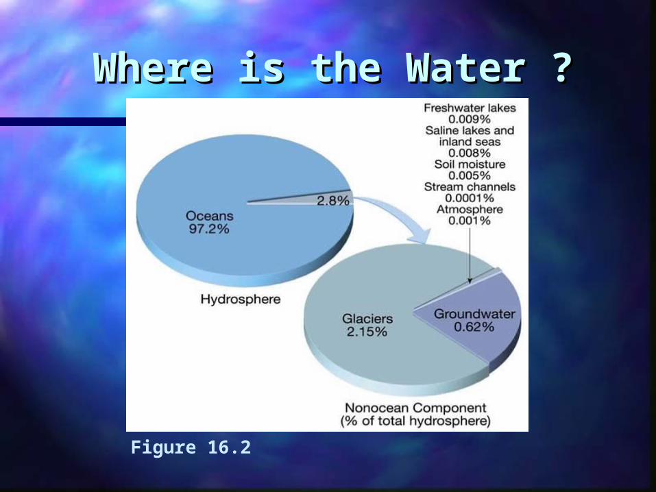
Where is the Water ?Where is the Water ?
Figure 16.2
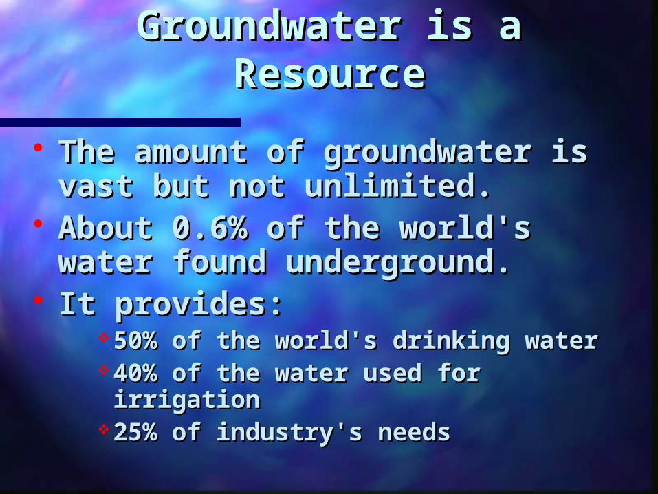
Groundwater is a Groundwater is a ResourceResource
The amount of groundwater is The amount of groundwater is vast but not unlimited. vast but not unlimited.
About 0.6% of the world's About 0.6% of the world's water found underground. water found underground.
It provides: It provides: 50% of the world's drinking water 50% of the world's drinking water 40% of the water used for 40% of the water used for irrigation irrigation
25% of industry's needs 25% of industry's needs
Nevertheless, in many places Nevertheless, in many places overuse and misuse has resulted overuse and misuse has resulted
in:in:
streamflow depletion streamflow depletion land subsidence land subsidence saltwater intrusion saltwater intrusion increased pumping costs increased pumping costs from ever deeper suppliesfrom ever deeper supplies
contamination contamination
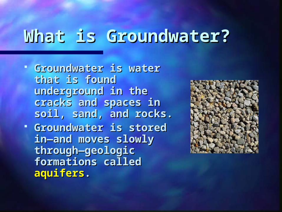
What is Groundwater?What is Groundwater?
Groundwater is water Groundwater is water that is found that is found underground in the underground in the cracks and spaces in cracks and spaces in soil, sand, and rocks.soil, sand, and rocks.
Groundwater is stored Groundwater is stored in—and moves slowly in—and moves slowly through—geologic through—geologic formations called formations called aquifersaquifers..
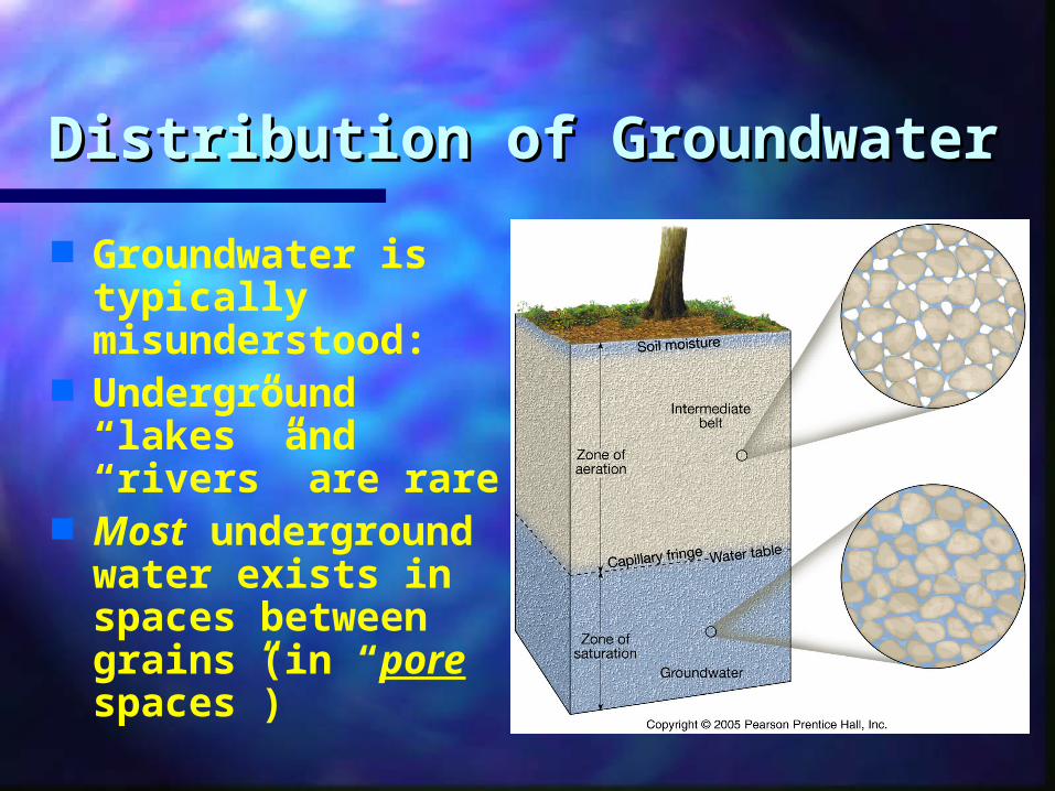
Distribution of GroundwaterDistribution of Groundwater
Groundwater is typically misunderstood:
Underground “lakes” and “rivers” are rare
Most underground water exists in spaces between grains (in “pore spaces”)
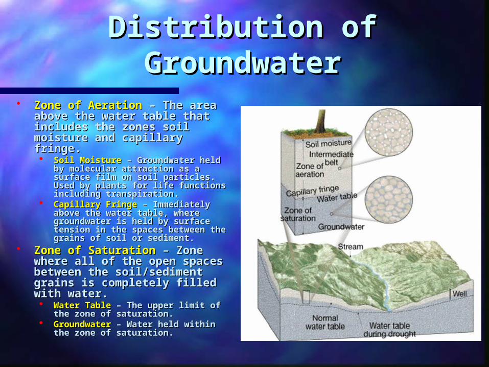
Distribution of Distribution of GroundwaterGroundwater
Zone of AerationZone of Aeration – The area – The area above the water table that above the water table that includes the zones soil includes the zones soil moisture and capillary moisture and capillary fringe.fringe. Soil MoistureSoil Moisture – Groundwater – Groundwater
held by molecular attraction as held by molecular attraction as a surface film on soil particles. a surface film on soil particles. Used by plants for life functions Used by plants for life functions including transpiration.including transpiration.
Capillary FringeCapillary Fringe – Immediately – Immediately above the water table, where above the water table, where groundwater is held by surface groundwater is held by surface tension in the spaces between tension in the spaces between the grains of soil or sediment.the grains of soil or sediment.
Zone of SaturationZone of Saturation – Zone – Zone where all of the open where all of the open spaces between the spaces between the soil/sediment grains is soil/sediment grains is completely filled with water.completely filled with water. Water TableWater Table – The upper limit of – The upper limit of
the zone of saturation.the zone of saturation. GroundwaterGroundwater – Water held – Water held
within the zone of saturation.within the zone of saturation.
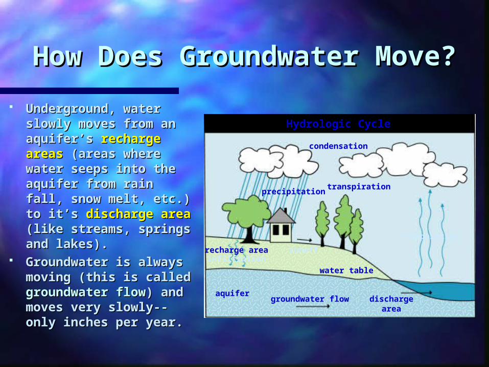
How Does Groundwater Move?How Does Groundwater Move?
Underground, water Underground, water slowly moves from an slowly moves from an aquifer’s aquifer’s recharge recharge areasareas (areas where (areas where water seeps into the water seeps into the aquifer from rain fall, aquifer from rain fall, snow melt, etc.) to snow melt, etc.) to it’s it’s discharge areadischarge area (like streams, springs (like streams, springs and lakes).and lakes).
Groundwater is Groundwater is always moving (this always moving (this is called is called groundwater groundwater flowflow) and moves very ) and moves very slowly--only inches slowly--only inches per year.per year.
groundwater flow discharge area
evaporation
recharge area
precipitation
condensation
runoff
transpiration
aquifer
water tableinfiltration
Hydrologic Cycle

Water Table FormationWater Table Formation
Water Table Formation Animation #95Water Table Formation Animation #95
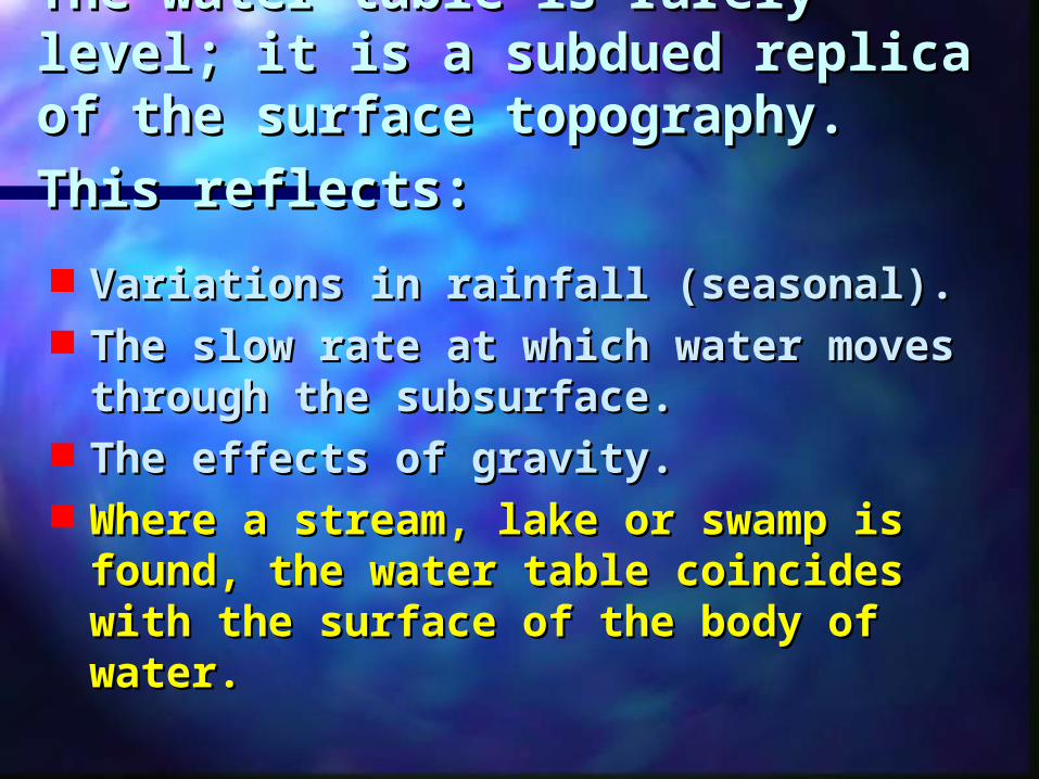
The water table is rarely level; The water table is rarely level; it is a subdued replica of the it is a subdued replica of the surface topography. This surface topography. This
reflects:reflects: Variations in rainfall (seasonal). Variations in rainfall (seasonal). The slow rate at which water The slow rate at which water
moves through the subsurface. moves through the subsurface. The effects of gravity. The effects of gravity. Where a stream, lake or swamp is Where a stream, lake or swamp is
found, the water table coincides found, the water table coincides with the surface of the body of with the surface of the body of water.water.
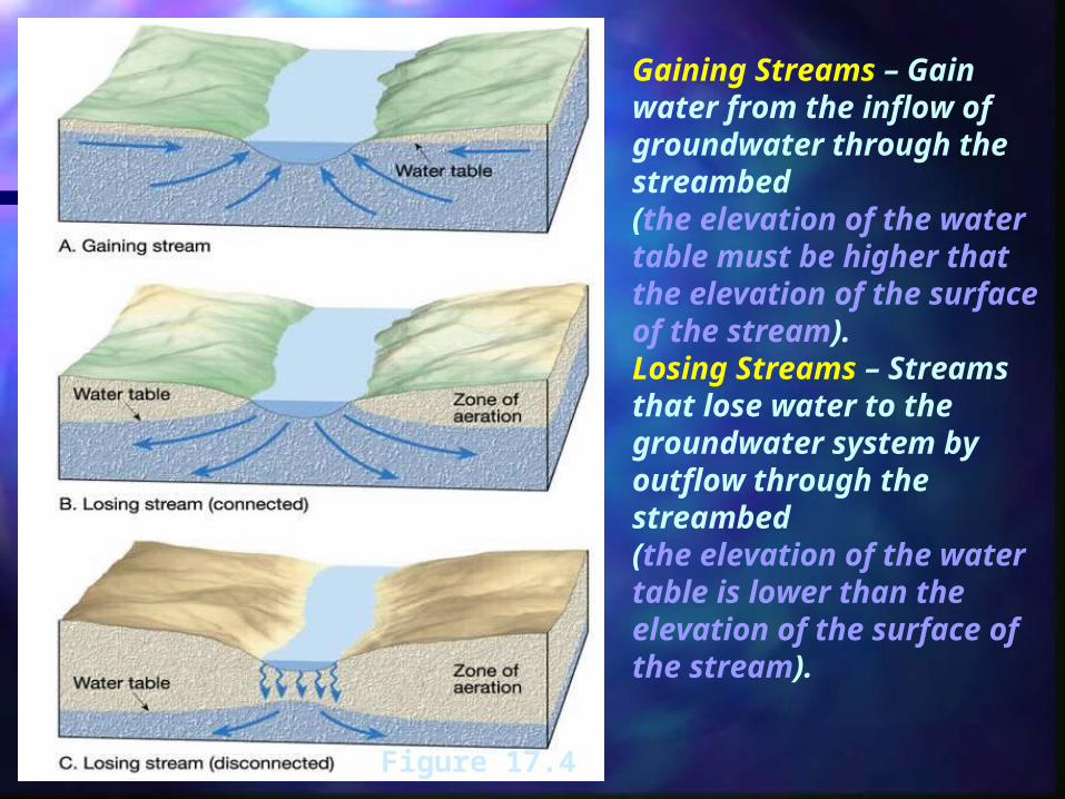
Gaining Streams – Gain water from the inflow of groundwater through the streambed (the elevation of the water table must be higher that the elevation of the surface of the stream).Losing Streams – Streams that lose water to the groundwater system by outflow through the streambed(the elevation of the water table is lower than the elevation of the surface of the stream).Figure 17.4
Factors Influencing the Factors Influencing the Storage and Movement of Storage and Movement of
GroundwaterGroundwater
Rock and sediment contain Rock and sediment contain voids called pore spaces. voids called pore spaces.
The The porosityporosity is the percentage is the percentage of the total volume of rock that of the total volume of rock that consists of pore spaces. The consists of pore spaces. The quantity of water that can be quantity of water that can be stored depends on the stored depends on the porosity. porosity.
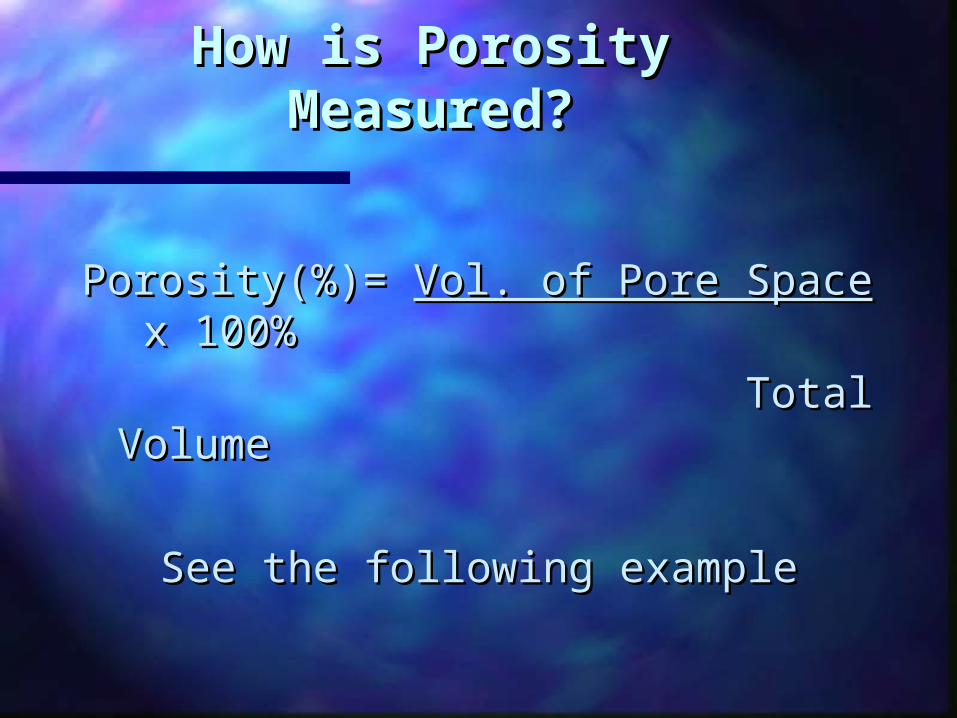
How is Porosity How is Porosity Measured?Measured?
Porosity(%)= Porosity(%)= Vol. of Pore Space Vol. of Pore Space x x 100%100%
Total VolumeTotal Volume
See the following exampleSee the following example
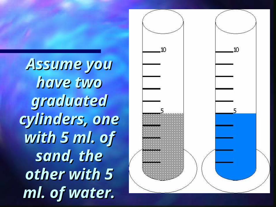
Assume you Assume you have two have two
graduated graduated cylinders, cylinders, one with 5 one with 5
ml. of sand, ml. of sand, the other the other
with 5 ml. of with 5 ml. of water.water.
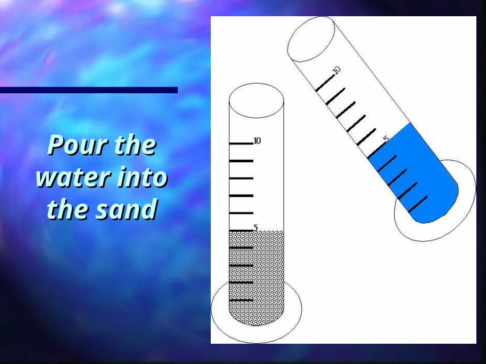
Pour the Pour the water into water into the sandthe sand
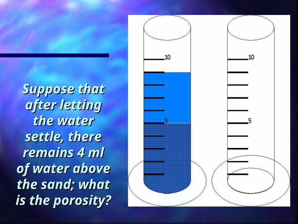
Suppose Suppose that after that after letting the letting the
water settle, water settle, there there
remains 4 remains 4 ml of water ml of water above the above the sand; what sand; what
is the is the porosity?porosity?
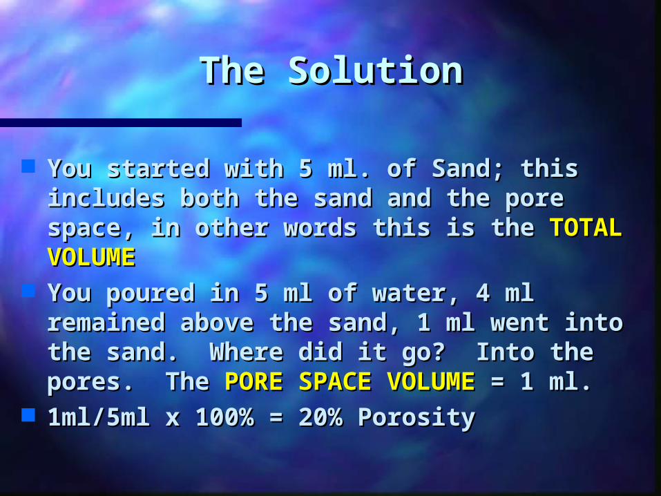
The SolutionThe Solution
You started with 5 ml. of Sand; this You started with 5 ml. of Sand; this includes both the sand and the pore includes both the sand and the pore space, in other words this is the space, in other words this is the TOTAL TOTAL VOLUMEVOLUME
You poured in 5 ml of water, 4 ml You poured in 5 ml of water, 4 ml remained above the sand, 1 ml went remained above the sand, 1 ml went into the sand. Where did it go? Into the into the sand. Where did it go? Into the pores. The pores. The PORE SPACE VOLUMEPORE SPACE VOLUME = 1 = 1 ml.ml.
1ml/5ml x 100% = 20% Porosity1ml/5ml x 100% = 20% Porosity
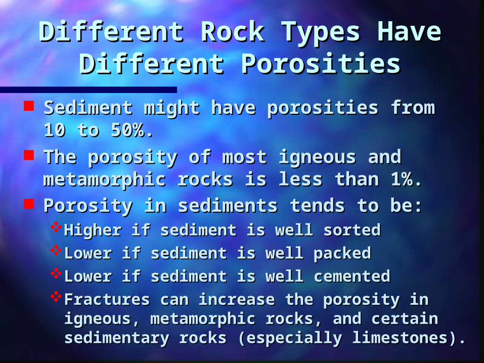
Different Rock Types Have Different Rock Types Have Different PorositiesDifferent Porosities
Sediment might have porosities from Sediment might have porosities from 10 to 50%. 10 to 50%.
The porosity of most igneous and The porosity of most igneous and metamorphic rocks is less than 1%. metamorphic rocks is less than 1%.
Porosity in sediments tends to be:Porosity in sediments tends to be: Higher if sediment is well sorted Higher if sediment is well sorted Lower if sediment is well packed Lower if sediment is well packed Lower if sediment is well cemented Lower if sediment is well cemented Fractures can increase the porosity in Fractures can increase the porosity in
igneous, metamorphic rocks, and certain igneous, metamorphic rocks, and certain sedimentary rocks (especially limestones). sedimentary rocks (especially limestones).
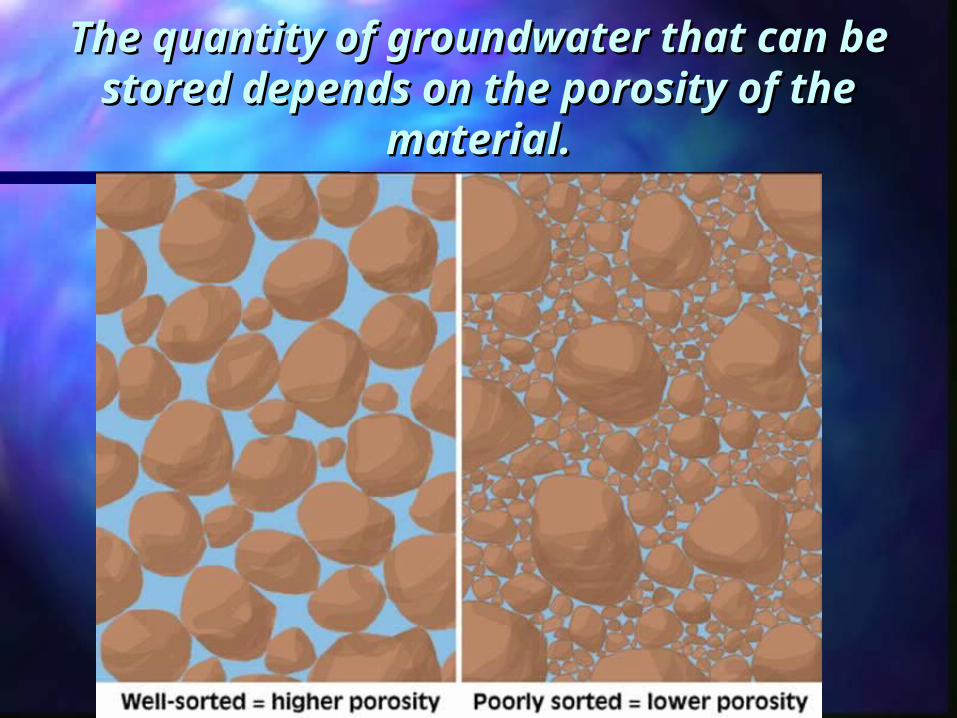
The quantity of groundwater that can The quantity of groundwater that can be stored depends on the porosity of be stored depends on the porosity of
the material.the material.
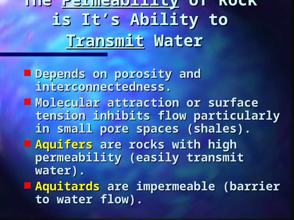
The The PermeabilityPermeability of Rock is of Rock is It’s Ability to It’s Ability to TransmitTransmit
WaterWater
Depends on porosity and Depends on porosity and interconnectedness. interconnectedness.
Molecular attraction or surface Molecular attraction or surface tension inhibits flow particularly tension inhibits flow particularly in small pore spaces (shales). in small pore spaces (shales).
AquifersAquifers are rocks with high are rocks with high permeability (easily transmit permeability (easily transmit water). water).
AquitardsAquitards are impermeable are impermeable (barrier to water flow). (barrier to water flow).
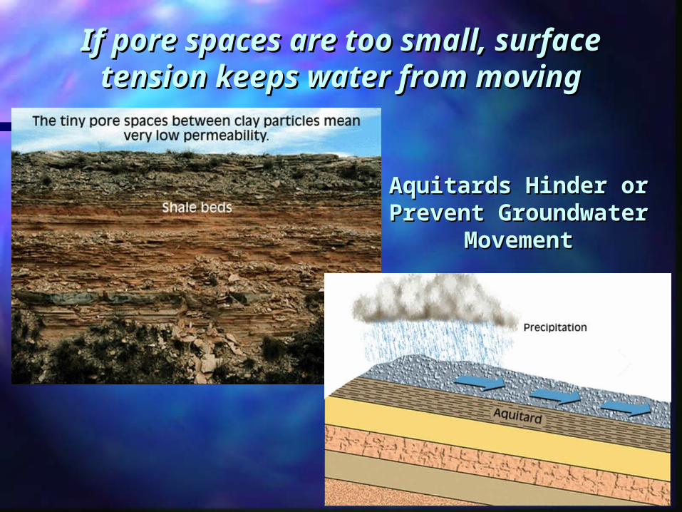
If pore spaces are too small, If pore spaces are too small, surface tension keeps water surface tension keeps water
from movingfrom moving
Aquitards Hinder or Aquitards Hinder or Prevent Prevent
Groundwater Groundwater MovementMovement
Aquifer PermeabilityAquifer Permeability
http://serc.carleton.edu/NAGTWorkshops/visualization/collections/groundwater.html
Aquifer Speed Animation
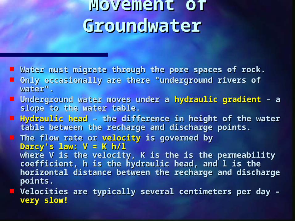
Movement of Movement of GroundwaterGroundwater
Water must migrate through the pore spaces of rock. Water must migrate through the pore spaces of rock. Only occasionally are there "underground rivers of Only occasionally are there "underground rivers of
water". water". Underground water moves under a Underground water moves under a hydraulic gradienthydraulic gradient – –
a slope to the water table. a slope to the water table. Hydraulic headHydraulic head – the difference in height of the water – the difference in height of the water
table between the recharge and discharge points. table between the recharge and discharge points. The flow rate or The flow rate or velocityvelocity is governed by is governed by
Darcy's law: V = K h/lDarcy's law: V = K h/l where V is the velocity, K is the is the permeability where V is the velocity, K is the is the permeability coefficient, h is the hydraulic head, and l is the coefficient, h is the hydraulic head, and l is the horizontal distance between the recharge and horizontal distance between the recharge and discharge points. discharge points.
Velocities are typically several centimeters per day – Velocities are typically several centimeters per day – very slow!very slow!
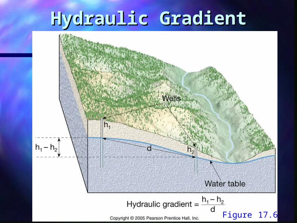
Hydraulic GradientHydraulic Gradient
Figure 17.6
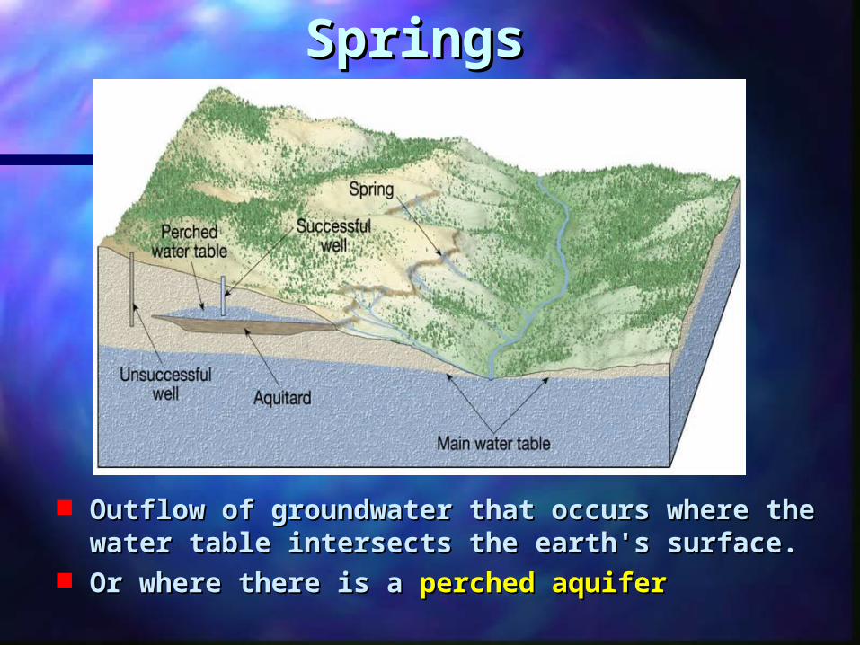
SpringsSprings
Outflow of groundwater that occurs where the Outflow of groundwater that occurs where the water table intersects the earth's surface. water table intersects the earth's surface.
Or where there is a Or where there is a perched aquiferperched aquifer
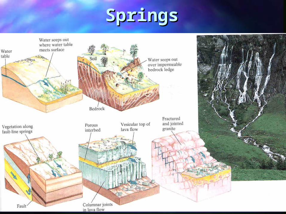
SpringsSprings

Springs: Desert OasesSprings: Desert Oases
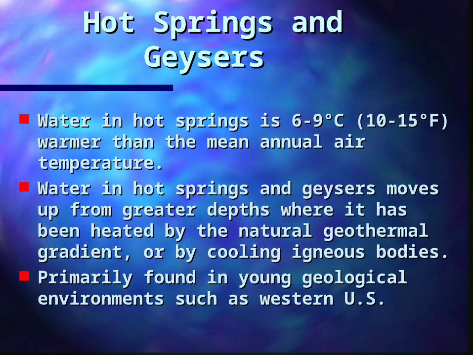
Hot Springs and Hot Springs and GeysersGeysers
Water in hot springs is 6-9°C (10-15°F) Water in hot springs is 6-9°C (10-15°F) warmer than the mean annual air warmer than the mean annual air temperature. temperature.
Water in hot springs and geysers moves Water in hot springs and geysers moves up from greater depths where it has up from greater depths where it has been heated by the natural geothermal been heated by the natural geothermal gradient, or by cooling igneous bodies. gradient, or by cooling igneous bodies.
Primarily found in young geological Primarily found in young geological environments such as western U.S.environments such as western U.S.
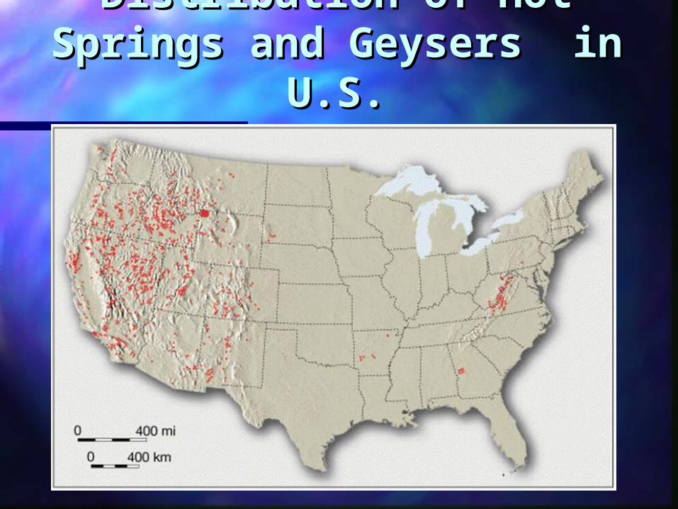
Distribution of Hot Distribution of Hot Springs and GeysersSprings and Geysers in in
U.S.U.S.
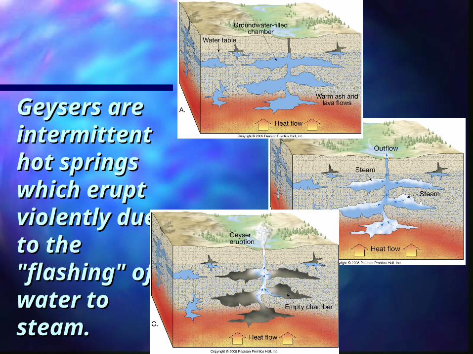
Geysers Geysers are are intermitteintermittent hot nt hot springs springs which which erupt erupt violently violently due to the due to the "flashing" "flashing" of water to of water to steam.steam.

GeysersGeysers
http://serc.carleton.edu/NAGTWorkshops/visualization/collections/groundwater.html
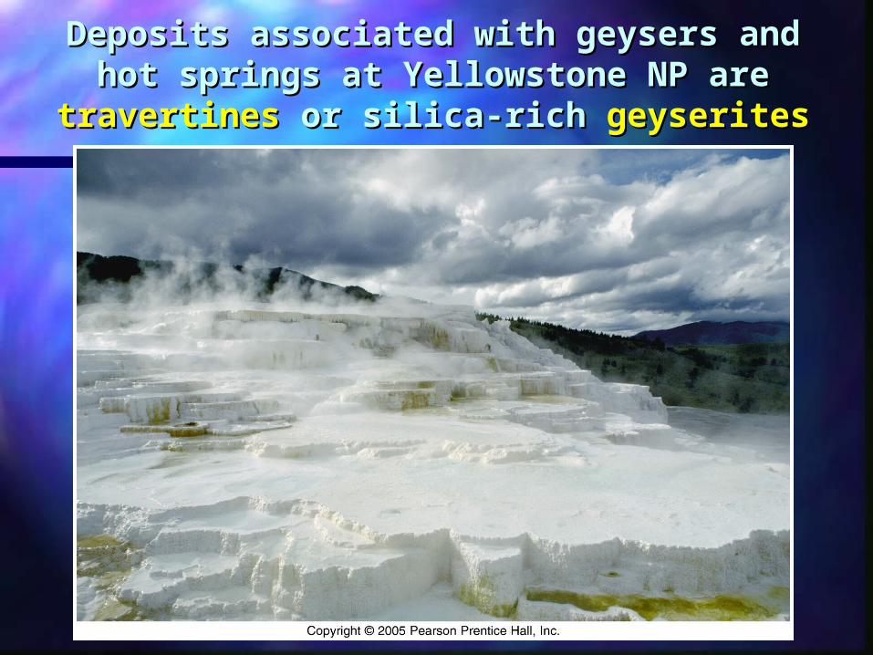
Deposits associated with geysers and hot Deposits associated with geysers and hot springs at Yellowstone NP are springs at Yellowstone NP are travertinestravertines
or silica-rich or silica-rich geyseritesgeyserites

Wells Wells
Where water is artificially withdrawn from the Where water is artificially withdrawn from the earth. earth.
Result in Result in drawdowndrawdown of the water table – a of the water table – a conical depression in the water table known conical depression in the water table known as a as a cone of depressioncone of depression. .
Cone of depression increases the hydraulic Cone of depression increases the hydraulic gradient in the vicinity of the well. This may gradient in the vicinity of the well. This may be good over the short-run, but has long-term be good over the short-run, but has long-term adverse consequences. adverse consequences.
Lowers the water table overall Lowers the water table overall Cone of depression becomes larger Cone of depression becomes larger Reduces the column of water in contact Reduces the column of water in contact
with the well with the well
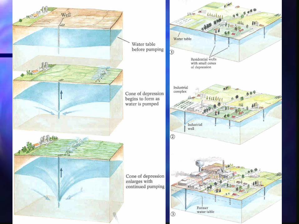

The Cone of DepressionThe Cone of Depression
Cones of Depression Animation #12Cones of Depression Animation #12
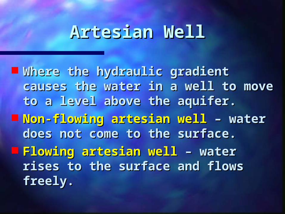
Artesian WellArtesian Well
Where the hydraulic gradient Where the hydraulic gradient causes the water in a well to move causes the water in a well to move to a level above the aquifer. to a level above the aquifer.
Non-flowing artesian wellNon-flowing artesian well – water – water does not come to the surface. does not come to the surface.
Flowing artesian wellFlowing artesian well – water rises – water rises to the surface and flows freely. to the surface and flows freely.
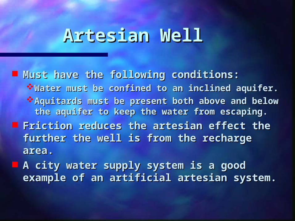
Artesian WellArtesian Well
Must have the following conditions:Must have the following conditions:Water must be confined to an inclined aquifer.Water must be confined to an inclined aquifer.Aquitards must be present both above and below Aquitards must be present both above and below
the aquifer to keep the water from escaping.the aquifer to keep the water from escaping. Friction reduces the artesian effect the Friction reduces the artesian effect the
further the well is from the recharge area.further the well is from the recharge area. A city water supply system is a good A city water supply system is a good
example of an artificial artesian system.example of an artificial artesian system.

Artesian WellsArtesian Wells
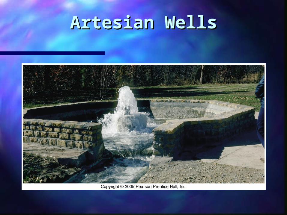
Artesian WellsArtesian Wells
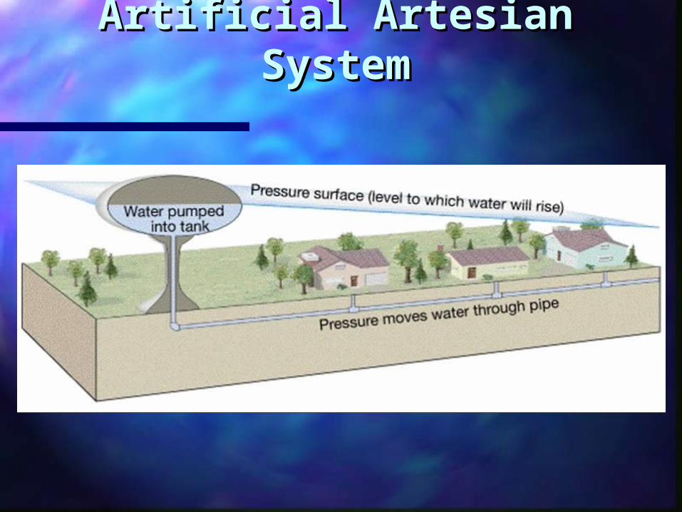
Artificial Artesian SystemArtificial Artesian System
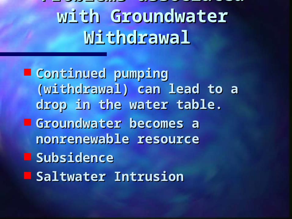
Problems associated Problems associated with Groundwater with Groundwater
WithdrawalWithdrawal
Continued pumping Continued pumping (withdrawal) can lead to a drop (withdrawal) can lead to a drop in the water table. in the water table.
Groundwater becomes a Groundwater becomes a nonrenewable resourcenonrenewable resource
SubsidenceSubsidence Saltwater Intrusion Saltwater Intrusion
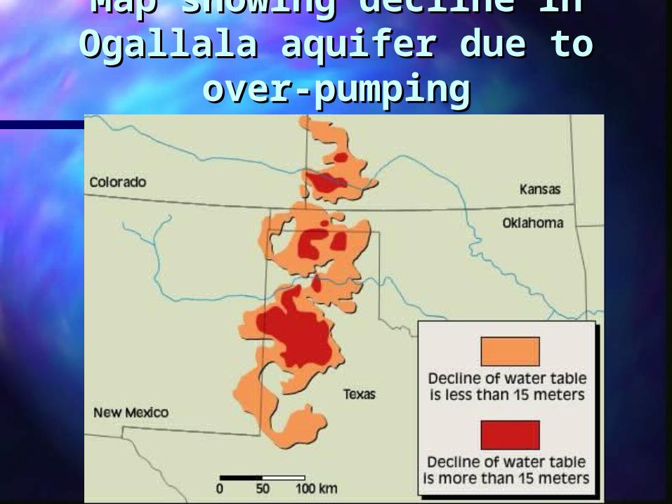
Map showing decline in Map showing decline in Ogallala aquifer due to over-Ogallala aquifer due to over-
pumpingpumping
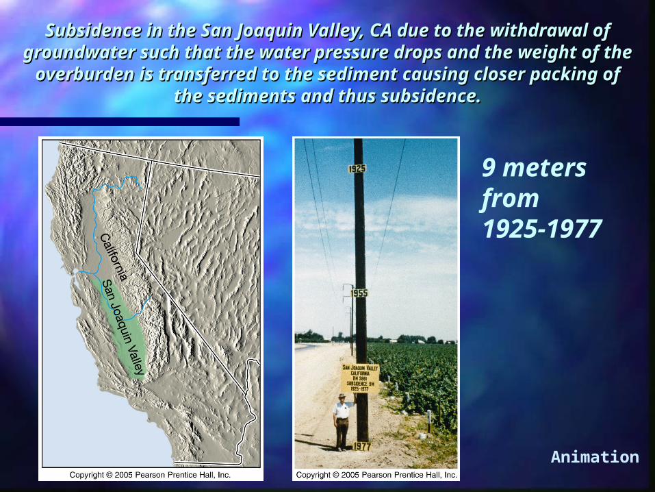
Subsidence in the San Joaquin Valley, CA due to the Subsidence in the San Joaquin Valley, CA due to the withdrawal of groundwater such that the water pressure withdrawal of groundwater such that the water pressure drops and the weight of the overburden is transferred to drops and the weight of the overburden is transferred to
the sediment causing closer packing of the sediments and the sediment causing closer packing of the sediments and thus subsidence.thus subsidence.
9 meters from 1925-1977
Animation
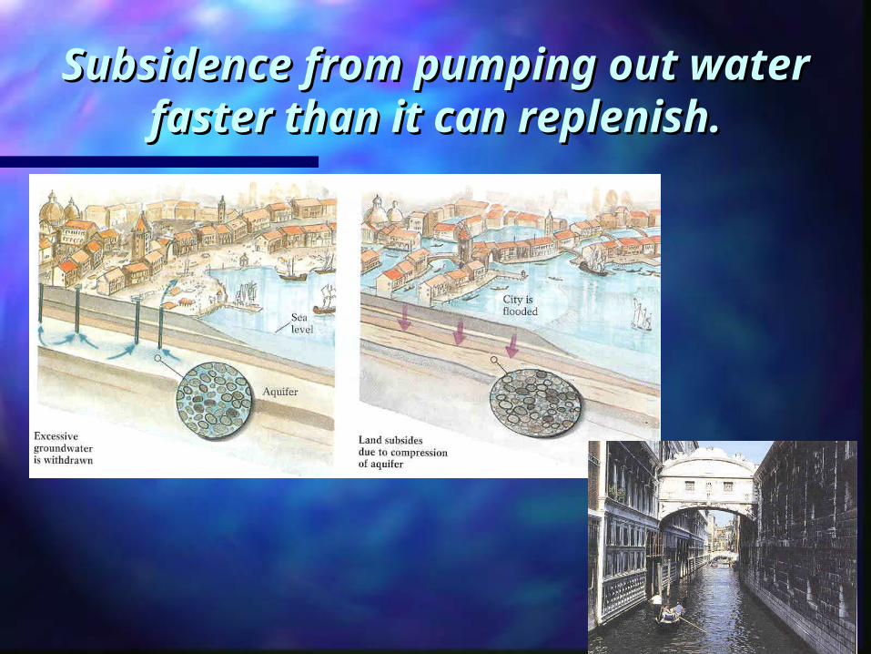
Subsidence from pumping out Subsidence from pumping out water faster than it can water faster than it can
replenish.replenish.
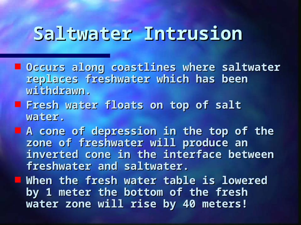
Saltwater Intrusion Saltwater Intrusion
Occurs along coastlines where Occurs along coastlines where saltwater replaces freshwater which saltwater replaces freshwater which has been withdrawn. has been withdrawn.
Fresh water floats on top of salt water. Fresh water floats on top of salt water. A cone of depression in the top of the A cone of depression in the top of the
zone of freshwater will produce an zone of freshwater will produce an inverted cone in the interface between inverted cone in the interface between freshwater and saltwater. freshwater and saltwater.
When the fresh water table is lowered When the fresh water table is lowered by 1 meter the bottom of the fresh by 1 meter the bottom of the fresh water zone will rise by 40 meters! water zone will rise by 40 meters!
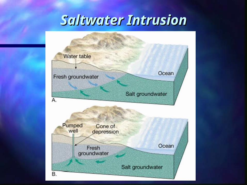
Saltwater IntrusionSaltwater Intrusion
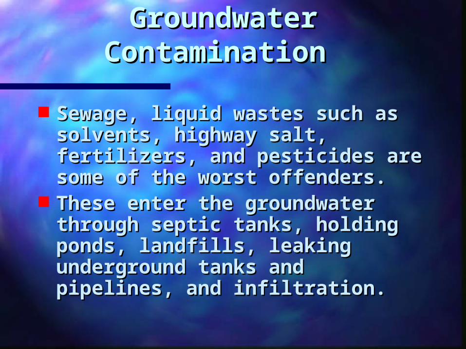
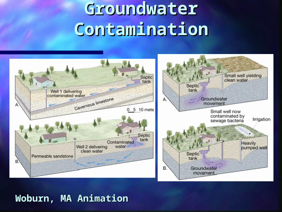
Groundwater Groundwater ContaminationContamination
Sewage, liquid wastes such as Sewage, liquid wastes such as solvents, highway salt, solvents, highway salt, fertilizers, and pesticides are fertilizers, and pesticides are some of the worst offenders. some of the worst offenders.
These enter the groundwater These enter the groundwater through septic tanks, holding through septic tanks, holding ponds, landfills, leaking ponds, landfills, leaking underground tanks and underground tanks and pipelines, and infiltration.pipelines, and infiltration.
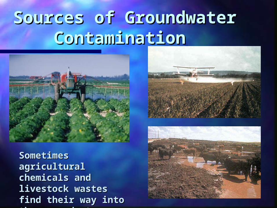
Sources of Sources of Groundwater Groundwater
Contamination Contamination
Sometimes Sometimes agricultural agricultural chemicals and chemicals and livestock wastes find livestock wastes find their way into the their way into the groundwatergroundwater
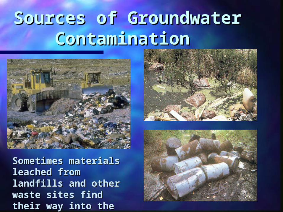
Sources of Sources of Groundwater Groundwater
ContaminationContamination
Sometimes materials Sometimes materials leached from leached from landfills and other landfills and other waste sites find their waste sites find their way into the way into the groundwater.groundwater.
Groundwater Groundwater ContaminationContamination
Woburn, MA AnimationWoburn, MA Animation
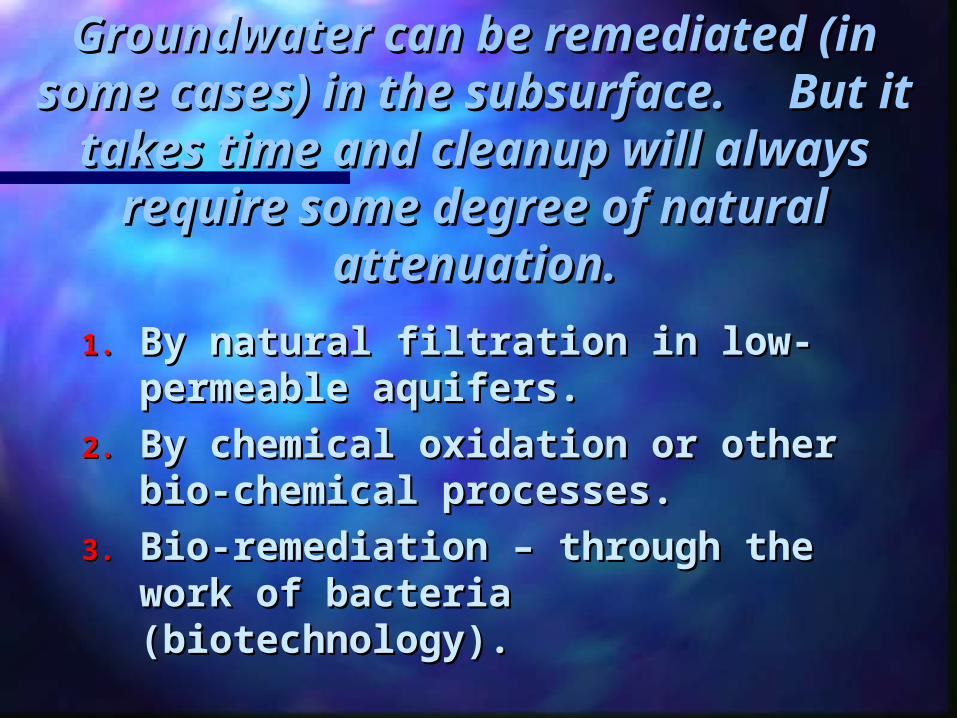
Groundwater can be remediated Groundwater can be remediated (in some cases) in the (in some cases) in the
subsurface. But it takes time subsurface. But it takes time and cleanup will always require and cleanup will always require
some degree of natural some degree of natural attenuation.attenuation.
1.1. By natural filtration in low-By natural filtration in low-permeable aquifers. permeable aquifers.
2.2. By chemical oxidation or other By chemical oxidation or other bio-chemical processes. bio-chemical processes.
3.3. Bio-remediation – through the Bio-remediation – through the work of bacteria work of bacteria (biotechnology). (biotechnology).
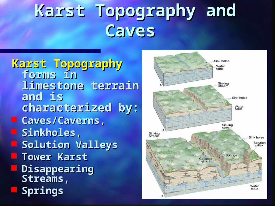
Karst Topography and Karst Topography and CavesCaves
Karst TopographyKarst Topography forms in forms in limestone terrain limestone terrain and is and is characterized by: characterized by:
Caves/Caverns, Caves/Caverns, Sinkholes, Sinkholes, Solution ValleysSolution Valleys Tower KarstTower Karst Disappearing Disappearing
Streams, Streams, Springs Springs
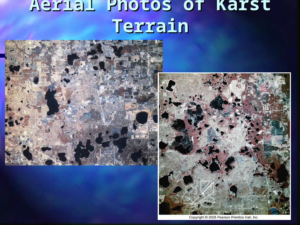
Aerial Photos of Karst Aerial Photos of Karst TerrainTerrain
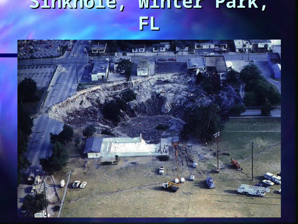
Sinkhole, Winter Park, Sinkhole, Winter Park, FLFL
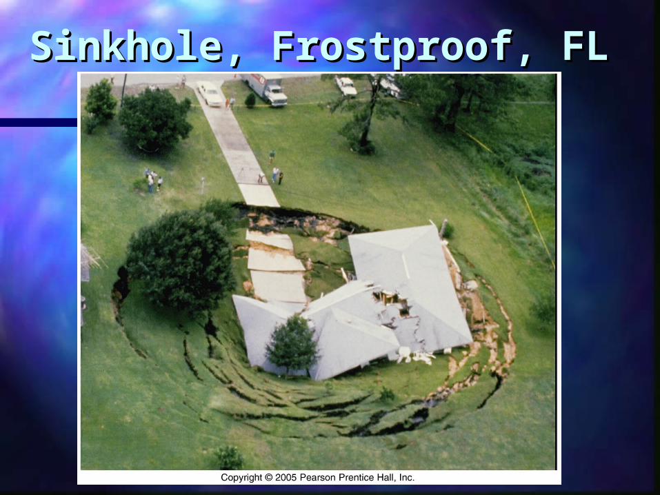
Sinkhole, Frostproof, FLSinkhole, Frostproof, FL
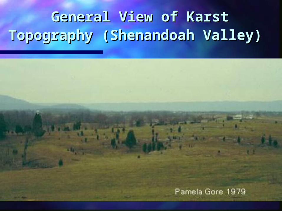
General View of Karst General View of Karst Topography (Shenandoah Topography (Shenandoah
Valley)Valley)
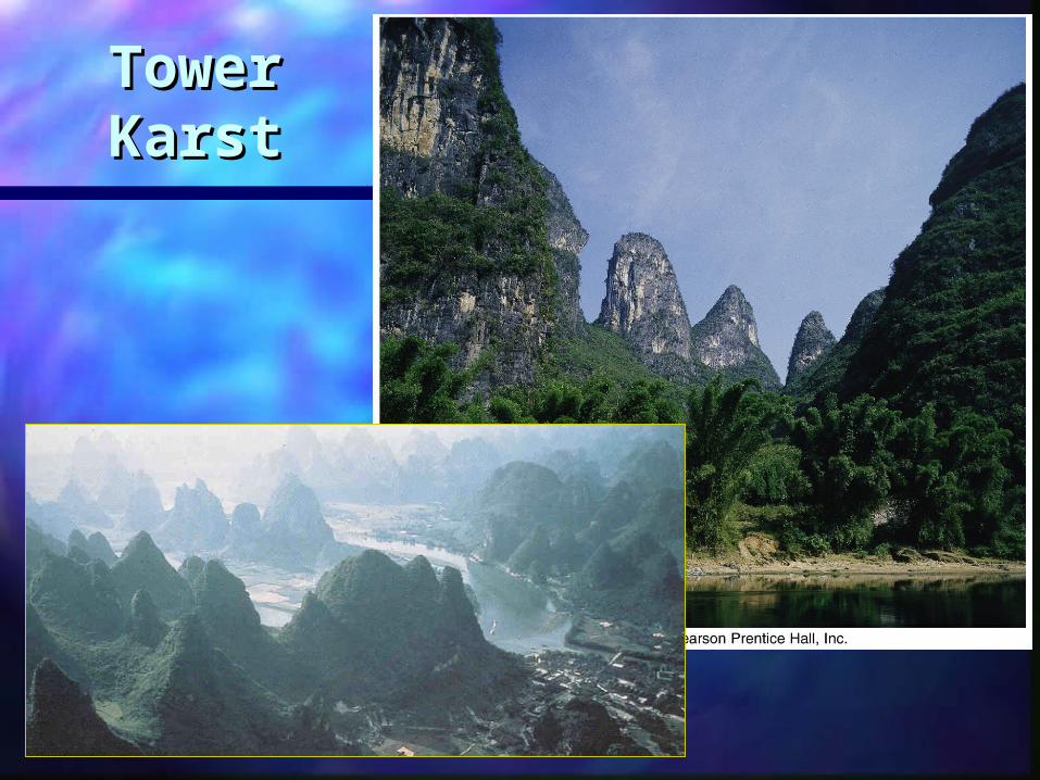
Tower Tower KarstKarst
Caves and caverns Caves and caverns typically form in typically form in
limestone limestone As soon as a chamber is filled with air, As soon as a chamber is filled with air,
the stage is set for the decoration the stage is set for the decoration phase of cavern building to beginphase of cavern building to begin
SpeleothemsSpeleothems are cave formations are cave formations Speleothems are made of calcite Speleothems are made of calcite
Form a rock called travertine – Form a rock called travertine – dripstonedripstone Soda StrawsSoda Straws StalactitesStalactites - hang from ceiling - hang from ceiling StalagmitesStalagmites - on the ground - on the ground ColumnsColumns – joined stalagmites and – joined stalagmites and
stalactitesstalactites
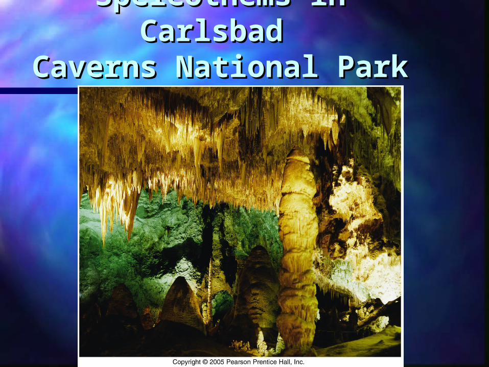
Speleothems in Speleothems in Carlsbad Carlsbad
Caverns National ParkCaverns National Park