green line extension projectgreenlineextension.eot.state.ma.us/documents/... · • green line...
TRANSCRIPT

#1
Community Path Meeting
Advanced Conceptual Design Lowell Street to Inner Belt Road
City of Somerville Somerville, MA
December 11, 2012 6:00 PM – 8:00 PM
Green Line Extension Project

#2
To Talk About GLX Design of the Community Path
• Update on multi-use community path
– Last community path related meeting September 2011
• Q&A at end of presentation
Why Are We Here Tonight?

#3
Somerville Community Path Co
llege
Ave
Ball
Sq
Low
ell S
t
Gilm
an S
q
Was
hing
ton
St
Lech
mer
e
Uni
on S
q
Somerville Community Path Extension
(Green Line Extension Design)
Cedar Street to Lowell Street Community
Path Extension (By City of Somerville)
Scope Terminus Proposed Commuter
Rail Alignment
Existing Minuteman Bike Path
Proposed Green Line Extension Rail Alignment

#4
Somerville Community Path
• Background • Extending current Minute Man
Bike Path towards Cambridge/Boston • Cedar Street to Lowell Street
out to bid Fall 2012 • Green Line Extension project will complete the
engineering to 100% design for the path from Lowell Street to Inner Belt Road
• Location/configuration is dependent upon final location of walls and corridor elements
• Future Connections from Inner Belt Road to Cambridge/Boston has not been precluded and is not within the current scope

#5
Somerville Community Path • Design Criteria Multi- Use Path consistent with path from Cedar to Lowell Streets ADA Accessible Design Speed: 20 mph for bicycles;
30 mph for steep downgrades (> 4%) Pavement width: 12 foot (preferred)
8 feet minimum (at pinch points) Pavement: Bituminous Concrete (thickness to support
maintenance vehicles) Cross slope: < 2% Grades: 5% maximum (4.5% design) Shoulders: 2 feet each side (preferred) (grass or non-paved
material) Drainage: Pitching pavement to grass shoulders along path
or an inlet and conveyance pipe system Clearance overhead: Minimum 8 feet, 10-12 foot preferred

#6
Somerville Community Path
• Community Path Amenities: • Fencing – locations to be determined • Lighting • Wireless Alarm Call Boxes • Bollards (removable and permanent)
Amenities under consideration where possible : • Trash Receptacles • Landscaping • Benches

#7
Standard Community Path Section
* CPX FENCE LOCATIONS
TO BE DETERMINED

#8
Preferred City of Somerville Community Path Section
* CPX FENCE LOCATIONS
TO BE DETERMINED

#9
Typical Section with Community Path

#10
Central Street
Community Path Lowell Street to Sycamore Street
LOWELL STREET CENTRAL STREET
SYCAMORE STREET
SOMERVILLE JUNCTION PARK
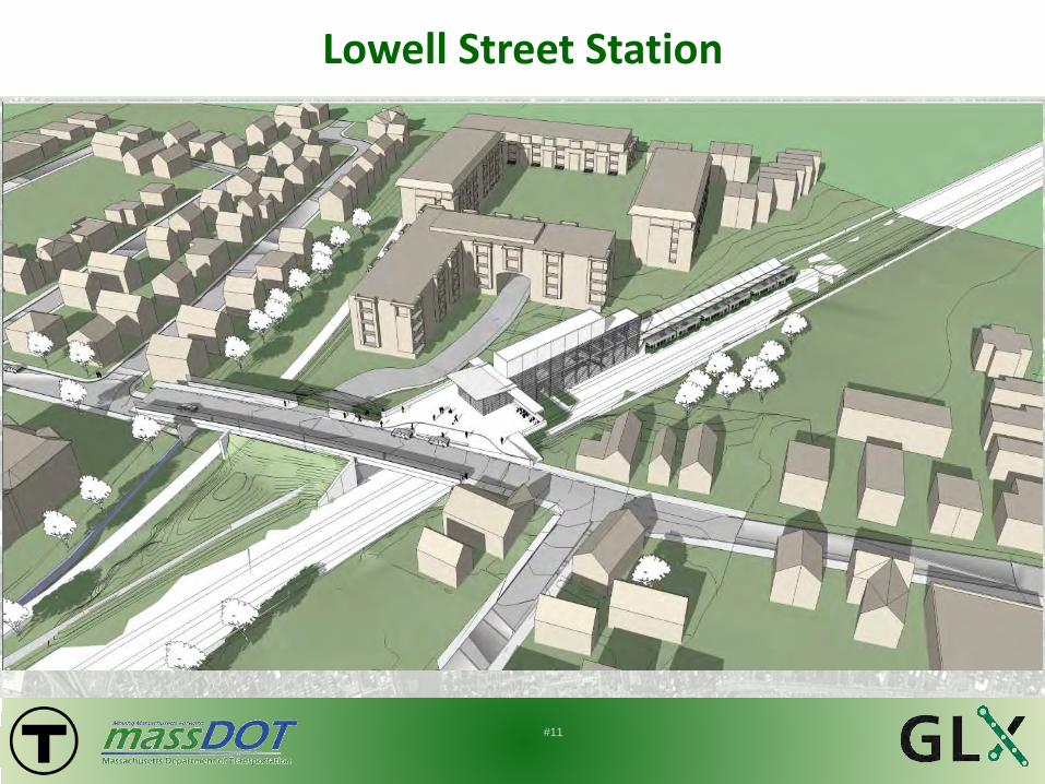
#11
Lowell Street Station

#12
Community Path behind the VNA
SECTION MB-EB 298+00
* CPX FENCE LOCATIONS
TO BE DETERMINED

#13
Community Path West of Central Street at Somerville Junction Park
TRACKWAY SECTION MB-EB 294+00
* CPX FENCE LOCATIONS
TO BE DETERMINED

#14
Community Path West of Central Street at Somerville Junction Park at Parking Lot
TRACKWAY SECTION MB-EB 290+00
PARKING LOT
* CPX FENCE LOCATIONS
TO BE DETERMINED

#15
Community Path at the Central Street Bridge Roadway Crossing

#16
Community Path at the Sycamore Street Bridge Roadway Crossing

#17
Central Street
Community Path Sycamore Street to Walnut Street
SCHOOL STREET SYCAMORE STREET WALNUT
STREET
MEDFORD STREET
SOMERVILLE CIVIC CENTER
GILMAN SQUARE STATION

#18
Gilman Square Station Emergency Egress to Community Path West of School Street
* CPX FENCE LOCATIONS
TO BE DETERMINED

#19
Community Path at the School Street Bridge Roadway Crossing

#20
Gilman Square Station

#21
Community Path from School Street at MBTA Traction Power Substation at Gilman Square Station
TRACKWAY SECTION MB-EB 273+00

#22
Community Path Mainline from School Street with Spur Connection to Medford Street
* CPX FENCE LOCATIONS
TO BE DETERMINED

#23
Community Path at Medford Street

#24
Community Path at the Medford Street Underpass Green Line Catenary Pole Connection
* CPX FENCE LOCATIONS
TO BE DETERMINED

#25
Approach to Medford Street Bridge From Walnut Street
* CPX FENCE LOCATIONS
TO BE DETERMINED

#26
Community Path East of the Medford Street Bridge From Walnut Street
TRACKWAY SECTION MB-EB 266+00
* CPX FENCE LOCATIONS
TO BE DETERMINED

#27
Central Street
Community Path Walnut Street to Washington Street
McGRATH HIGHWAY
CROSS STREET
MEDFORD STREET
HIGHLAND AVENUE
WASHINGTON STREET
McGRATH HIGHWAY
CHESTER AVENUE
WALNUT STREET

#28
Walnut Street Bridge Community Path Roadway Crossing
* CPX FENCE LOCATIONS
TO BE DETERMINED

#29
Approach to McGrath Highway Bridge From Walnut Street
* CPX FENCE LOCATIONS
TO BE DETERMINED

#30
McGrath Highway Bridge Community Path Underpass
* CPX FENCE LOCATIONS
TO BE DETERMINED

#31
Community Path Tiered Path at Chester Avenue between Cross Street and McGrath Highway
CHESTER AVENUE
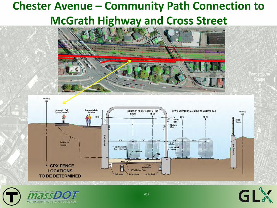
#32
Chester Avenue – Community Path Connection to McGrath Highway and Cross Street
* CPX FENCE LOCATIONS
TO BE DETERMINED

#33 Cross St.
Cross Street Bridge Community Path Underpass

#34
Community Path with Noise Barrier East of Cross Street Bridge
* CPX FENCE LOCATIONS
TO BE DETERMINED

#35
Community Path West of the Washington Street Bridge At Grade with Green Line Tracks

#36
Community Path Washington Street to Inner Belt Road
WASHINGTON STREET
JOY STREET INNER BELT ROAD
WASHINGTON STREET STATION

#37
Washington Street Bridge Community Path Crossing
#38
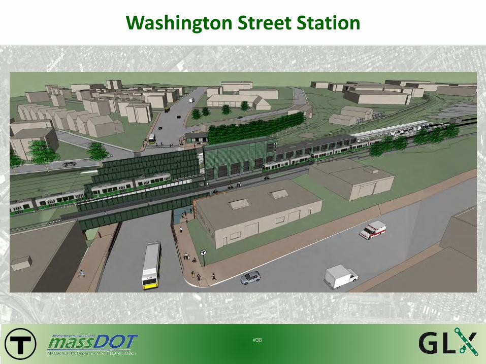
Washington Street Station

#39
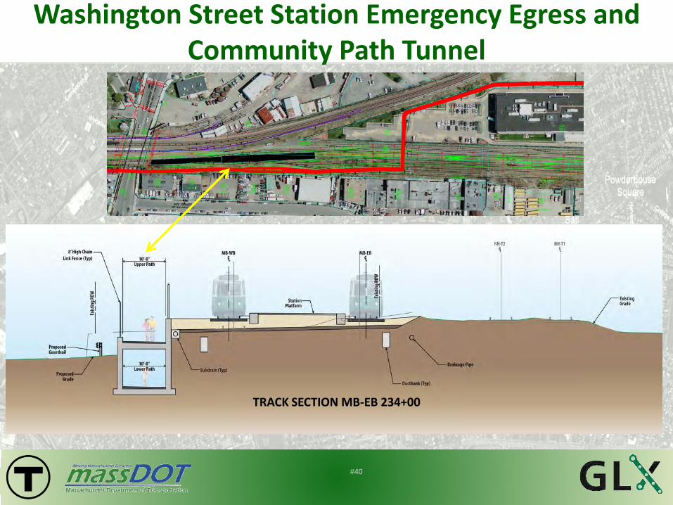
Washington Street Station Emergency Egress and Community Path Tunnel
TRACK SECTION MB-EB 235+75
#40
Washington Street Station Emergency Egress and Community Path Tunnel
TRACK SECTION MB-EB 234+00

#41
Washington Street Station Emergency Egress / Community Path - Switchback Ramp

#42
Washington Street Station Emergency Egress and Community Path ‘Boat Section’
TRACK SECTION MB-EB 231+00
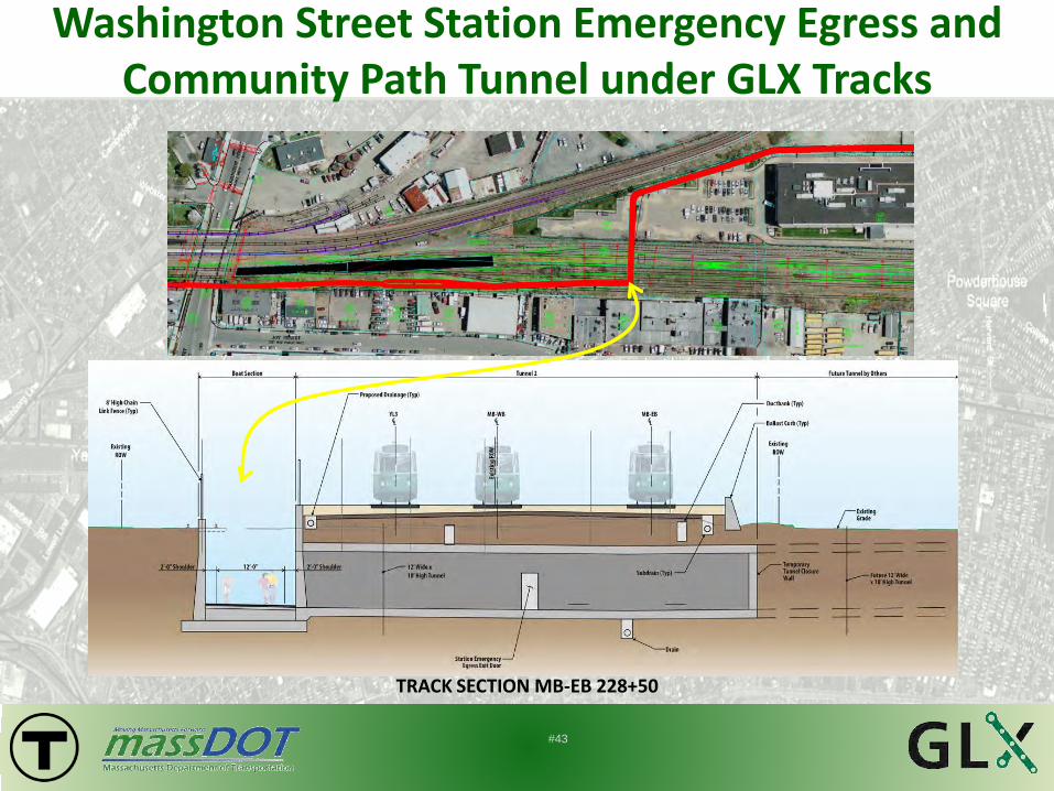
#43
Washington Street Station Emergency Egress and Community Path Tunnel under GLX Tracks
TRACK SECTION MB-EB 228+50

#44
Washington Street Station Alternative: Pedestrian Bridge
EMERGENCY EGRESS PEDESTRIAN BRIDGE CONCEPTUAL LAYOUT - FURTHER DESIGN COORDINATION REQUIRED

#45
Green Line Extension Project
Questions ?