gravity survey of the layang-layang tertiary basin in ... · adalah dipercayai lembangan ini...
TRANSCRIPT

Geol. Soc. Malaysia, Bulletin 26, Apri11990; pp. 55 - 70
Gravity survey of the Layang-Layang Tertiary Basin in Johor, Peninsular Malaysia -
A PreJiminary Report
V.R. VIJAYAN
Geological Survey Malaysia P.O. Box 1015, 30820 Ipoh
Abstract: A gravity survey was carried out in the middle of 1988 to determine the structure of the Layang-LayangTertiary Basin which is the southern most of the known Tertiary basins in Peninsular Malaysia. The survey covered 549 stations over an area of 45 km by 23 km and included the entire area geologically mapped as the Tertiary LayangLayang formation and part of the Pre-Tertiary Tebak, Sedili and Linggiu formations to the east. Measurements over the granitic area surrounding the basin provided regional control.
The results show a prominent negative gravity anomaly with a maximum amplitude of20 mgals covering an area of 165 sq. km which includes the Tebak formation as well as the Layang-Layang formation. The anomaly is centred within the Tebak formation about 2 km from the boundary of the Layang-Layang formation where the Bouguer anomaly value reaches -9 mgals.
It is believed that the basin is a half-graben structure bounded to the north-east by a listric normal fault with a minimum throw of 1 km. The survey shows that the basin· is a closed one comprising both the Tertiary and Pre-Tertiary sediments.
The usually high gravity values over the granites (up to +30 mgals in the south), as compared to the Main Range granitoids and Eastern Belt granitoids are probably due to a combination of factors including thinning of the granite batholith and the occurrence of a denser and more basic upper crust beneath the granite. The strong gravity gradient along the southern edge represents a major structural discontinuity, probably a fault plane, and possibly includes the effect of further thinning of the granite.
Abstrak: Suatu penyiasatangraviti telahdijalankan pada tahun 1988 untukmenentukan struktur Lembangan Tertier Layang-Layang di negeri Johor. Lembangan ini merupakan Lembangan Tertier yang terletak dipaling selatan Semenanjung Malaysia. Penyiasatan ini meliputi kawasan seluas 45 km x 23 km dalam mana sebanyak 549 stesen graviti telah didirikan. Pemetaan geologi kawasan ini telah pun disiap. Sedimen Tertier dikawasan ini dinamakanformasi Layang-Layangmanakala sedimen pra-Tertieryangterdapatdisebelah timur dinamakan formasi-formasi Tebak, Sedili dan Linggiu. Ukuran graviti dibahagian kawasan granit yangmengelilingi Lembangan Tertier ini telah dilakukan untuk memberi kawalan rantau.
Keputusan graviti setakat ini menunjukkan suatu anomali graviti negatif dengan amplitud u;taksimum sebanyak 20 mgal yang meliputi kawasan seluas 200 km persegi dimana terdapat sedimen formasi-formasi Tebakdan Layang-Layang. Anomaliini berpusat diformasi Tebak lebihkurang 2 km ke timur sempadan formasi Layang-Layang dimana nilai anomali Bouguer sampai ke -9 mgal.
Adalah dipercayai lembangan ini berstruktur graben separuh yang berbatas di timur-Iautoleh sesarnormallistrikdenganlemparanminimumsebanyak 1 km. Penyiasatan
Permission to publish this paper is given by the Director-General, Geological Survey Malaysia.
Presented at GSM Annual Geological Conference '89
56 V.R. VIJAYAN
graviti ini menunjukkan lembangan ini tertutup dan mengandungi sedimen berusia Tertier dan pra-Tertier.
Nilai Graviti tinggi yang terdapat di kawasan granit (sampai +30 mgal di selatan) didapati tidak sam8 dengan nilai yang terdapat di kawasan-kawasan Granit Banjaran Titiwangsa dan Granit Jalur Timur. Ini mungkin disebabkan oleh beberapa faktor termasuk kenipisan batolit granit dan kewujudan kerak atas yang tumpat dan berbes dibawah granit. Kecerunan graviti yang curam dipinggir selatan menunjukkan suatu ketakselanjaran struktur major, yang ditafsirkan sebagai satah sesar dan juga oleh kerana kesan kenipisan granit selanjutnya di kawasan ini.
INTRODUCTION
There are a number of known Tertiary sedimentary deposits in Peninsular Malaysia occurring as small basins along the Western Belt. Besides BatuArang in Selangor which is the best known, very little is known about the structure and depth of the other Tertiary basins.
The Tertiary deposits have coal potential as shown in BatuArang (Roe, 1953) and Sarawak (Liaw, 1983). The Layang-Layang Basin was selected as the first target. In addition, Petronas Carigali was also keen to know the basin's structure and depth for possible hydrocarbon potential.
This survey was planned and carried out in the middle of 1988. The survey had the following major objectives: to estimate of the size, structure and depth of the Tertiary Basin; to define the major structural trends; and to provide effective positioning of lines for subsequent seismic survey.
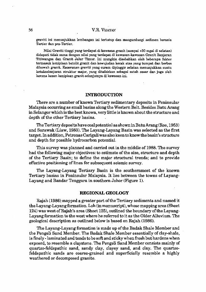
The Layang-Layang Tertiary Basin is the southernmost of the known Tertiary basins in Peninsular Malaysia. It lies between the towns of LayangLayang and Bandar Tenggara in southern Johor (Figure 1).
REGIONAL GEOLOGY
Rajah (1986}mapped a greater part of the Tertiary sediments and named it the Layang-Layang formation. Loh (in manuscript), whose mapping area (Sheet 124) was west of Rajah's area (Sheet 125), outlined the boundary of the LayangLayang formation to the west where he referred to it as the Older Alluvium. The geological description as outlined below is l:>ased on Rajah (1986).
The Layang-Layang formation is made up of the Badak Shale Member and the Pengeli Sand Member. The Badak Shale Member essentially of clay-shale, is finely -laminated and tends to be soft and sticky when fresh but hardens when exposed, to resemble a claystone. The Pengeli Sand Member consists mainly of quartzo-feldspathic sand, sandy clay, clayey sand, and clay. The quartzofeldspathic sands are coarse-grained and superficially resemble a highly weathered or decomposed granite. .

GRAVITY SURVEY OF THE LAYANG-LAYANG TERTIARY BASIN IN JOHOR 57
4·
N
LEGEND
~ LAYANG- LAYANG ~ PROJECT AREA
• OTHER KNOWN TERTIARY BASINS
Vtjoyan feziz
Figure 1: Location map
20 I
PENINSULAR MALAYSIA
o I
20 I
MILES
eKluono
40 I
•
60 I
N
KBM (Gf ) 0 - 05 - 88

58 V.R. VIJAYAN
The possibility of the Layang-Layang sediments being of Tertiary age was first reported by Burton (1964) by analogy with the stratigraphy at KluangNyior and Kepong, Johore. He reported their occurrence as grey to grey-brown partly consolidated clays underlying Quaternary Older Alluvium in the vicinity ofthe railway line south ofKluang, Johore. Rajah (1986) has dated the LayangLayang formation as Pleistocene-Pliocene based on plant fossils found in the Badak Shale Member. However, Loh (in manuscript), from his work on the western edge of the formation, has suggested a Pleistocene age for the same sediments based on lithological and stratigraphic correlation to the Older Alluvium found towards the south (Burton, 1964). However, recent palynological studies on the Badak Shale Member have confirmed a Middle Miocene for parts of the Layang-Layang formation (Ismail Mat Zin, pers. comm.).
Rocks of Early Cretaceous Tebakformation, an unmetamorphosed arenaceous sequence comprising sandstone with minor intercalation of siltstone, mudstone, shale and occasional beds of grit and conglomerate, occupy areas immediately to the east (Figure 2). To the north, south and west of the Layang-Layangformation are granitoids. The age of the granitoids, as indicated from stratigraphic and radiometric evidence, is believed to be Middle Triassic. Minor intermediate to basic rocks are widespread in the south and southwest. To the west in contact with the granitoids is the Gemas formation comprising shales and tuffs of Middle to Late Triassic age.
To the east ofthe Tebak formation lies the Sedili Volcanic formation believed to be Late Permian in age. It is essentially contemporaneous with the Linggiu formation and consists largely of acid to intermediate tuffs and flows. The Linggiu formation consists chiefly of arenaceous strata, though extensive argillaceous beds are common. Lavas and pyroclastic rocks are also associated with these sediments.
Two major faults are indicated within the area surveyed. The Jengeli Fault trends north-south along Sungai Jengeli. At the confluence with Sungai Linggiu, the fault's direction changed to southeast. According to Rajah, the fault forms the boundary between the Tebak formation to the west and the Linggiu formation to the east. This is apparently a near-vertical fault with the Tebak formation down-faulted. The other fault, the Pengeli Fault, trending northwest-southeast, is seen in the upper reaches of Sungai Pengeli and is believed to follow the alignment of this river (Figure 2).
GRAVITY SURVEY
The survey covered an area of 45 km x 23 km and includes the entire area geologically mapped as the Tertiary Layang-Layang formation and the PreTertiary Tebak, Sedili and Linggiu formations to the east. Measurements were also taken over the granitic areas surrounding the basin to gauge the amplitude

LEGEND
'-.2.""'1 Alluvium
k';(.:~ Layang" Layang Formation
I:~~::I Tebak Formation
00 Gemos Formation
&~1~~*:~ Linooiu Formation
Rom Sedili Volcanic formation
f':~11"':1 Dohal Formation
I: ~4 :1 Granitoids
.. Intermediate to bllsie intrusives
1._1 Faulls
Figure 2: Geological map of the Layang-Layang project area
Afler GeOlOGiCOI mop 8tb ediliof\ 1985 KBM IGII 0"201"66
~ < ~ til C ::0 < m -< o "T1
~ r -< > z Cl
t ~ ~
~ ::0 -< I::D > til
Z Z
~ ::0
Ut \0
60 V.R. VYAYAN
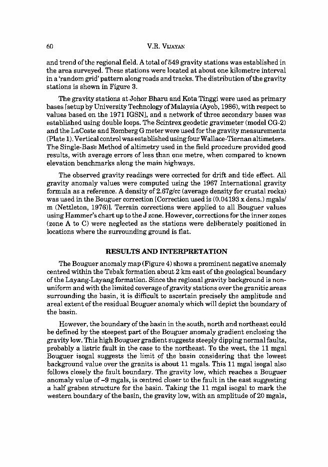
and trend of the regional field. A total of549 gravity stations was established in the area surveyed. These stations were located at about one kilometre interval in a 'random grid' pattern along roads and tracks. The distribution of the gravity stations is shown in Figure 3.
The gravity stations at Johor Bharu and Kota Tinggi were used as primary bases [setup by University Technology of Malaysia (Ayob, 1986), with respect to values based on the 1971 IGSN], and a network of three secondary bases was established using double loops. The Scintrex geodetic gravimeter (model CG-2) and the LaCoste and Romberg G meter were used for the gravity measurements (Plate 1). Vertical control was established using four W allace-Tiernan altimeters. The Single-Bas~ Method of altimetry used in the field procedure provided good results, with average errors of less than one metre, when compared to known elevation benchmarks along the main highways.
The observed gravity readings were corrected for drift and tide effect. All gravity anomaly values were computed using the 1967 International gravity formula as a reference. A density of2.67g/cc (average density for crustal rocks) was used in the Bouguer correction [Correction used is (0.04193 x dens.) mgals/ m (Nettleton, 1976)]. Terrain corrections were applied to all Bouguer values using Hammer's chart up to the J zone. However, corrections for the inner zones (zone A to C) were neglected as the stations were deliberately positioned in locations where the surrounding ground is flat.
RESULTS AND INTERPRETATION
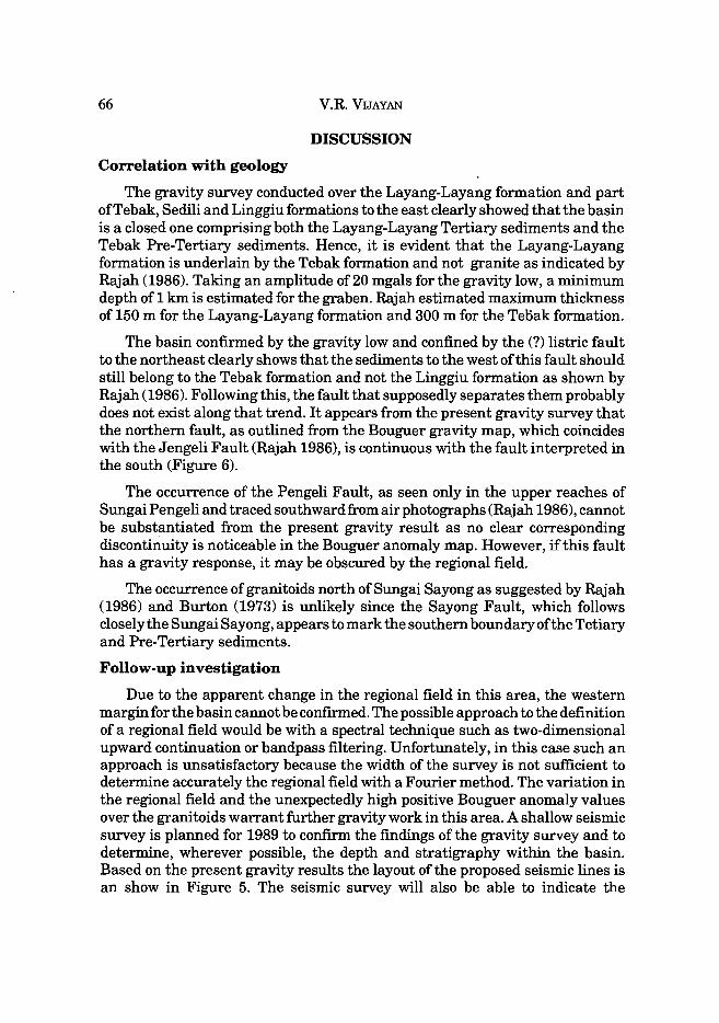
The Bouguer anomaly map (Figure 4) shows a prominent negative anomaly centred within the Tebak formation about 2 km east of the geological boundary of the Layang-Layang formation. Since the regional gravity background is nonuniform and with the limited coverage of gravity stations over the granitic areas surrounding the basin, it is difficult to ascertain precisely the amplitude and areal extent of the residual Bouguer anomaly which will depict the boundary of the basin.
However, the boundary of the basin in the south, north and northeast could be defined by the steepest part of the Bouguer anomaly gradient enclosing the gravity low. This high Bouguer gradient suggests steeply dipping normal faults, probably a listric fault in the case to the northeast. To the west, the 11 mgal Bouguer isogal suggests the limit of the basin considering that the lowest background value over the granits is about 11 mgals. This 11 mgal isogal also follows closely the fault boundary. The gravity low, which reaches a Bouguer anomaly value of -9 mgals, is centred closer to the fault in the east suggesting a half graben structure for the basin. Taking the 11 mgal isogal to mark the western boundary of the basin, the gravity low, with an amplitude of 20 mgals,

GRA V ITY SURVEY OF THE L A YANG-LA YANG TERTIA RY B AS IN IN l OHOR 61
PLATEl
Scintrex Geodetic Gravimeter (Model CG--2)
Lacoste and Romberg-G Meter

I
Rengom
Simpang • Rengam
LEGEND
o SECONDARY GRAVITY BASES t· Kejoro Office,Bondor Tenggora.
2· Kuloi Police Station. 3· Loyong- Loyang Police Station.
:.: GRAVITY STATIONS ~
o 2 ! !
KILOMETRES
3. 8
.LayangLayang
"Sondar • • Tenggara • ,
.'£3
(!I 2 Kulai
Figure 3: Gravity survey index map of the Layang-Layang Project area
I KBMIGrIO-202-88
0'1 tv
<: ~ $ ~
~

Re noom 2 2 Gl
22 · 70
5impono o Renoom
" 2 6 · 57
2 5 18
2 5 93
30 ·07
Conlour Inle r vol is one mo ol
~
g
2 0 · 19
19 ·68
. 3 1 09
• 29 · 58
. 29 7 2
. 30 · 17
. 28 ·58
. 29 · 30
• 29 · 33
" 30 · 73
30 · 52
17 · 53 14 · 30
12 · 55
15 ·27
~ "1943 Gao 25 · 6 1 . 20 ·65
30-4 2
2 7 91 29 ·07
2769 28 ·84
• 25 74
· 29 · 13
33 · 55 . 31 . 71
3 1·07 33 · 71 El 3037 Ku lol
o
~I 648000 590000
j( I LO M£ T A £s
Figure 4: Bouguer gravity ma p of the Layang-Layang Project area
o ;0 :» < =i -< en c: ;0
< tTl -< o "T1 --I :I: tTl
t-< :» -< :» z o r--:» -< :» z o -:l tTl ;0 --I :; ;0
-< to :» en Z Z '--< o :I: o ;0
0\ W

64 V.R. VIJAYAN
covers an area of 200 sq. km, with the longer axis being 27 km and the shorter axis being 11.5 km at its widest (Figure 5).
The eastwest-trending fault occurring in the south extends to about 32 km and appears to follow the Sungai Sayong. The fault, which is named the Sayong Fault here, is indicated by the very steep gradient of up to about 10 mgal/km. This indicates a major density change that probably extends below the basin structure. Although no modelling has been done at this stage, this is supported by the occurrence of high Bouguer anomaly values (up to +30 mgals) immediately to the south of the Sayong Fault, much higher thlim those in the north and northeast.
Slightly to the north of the Sayong Fault in the northeast-southwest direction, the Bouguer gravity anomaly contours appear to swing outwards as they cross over this region, indicating a lowering of density. The occurrence of this feature can be accounted for by the presence of depression, possibly a troughlike feature, in the granite (Figure 5) which could have been filled-up by the less dense sediments. This trough leading to the graben appears to end at the extreme west, where the Sayong Fault appears to 'die-out' in the granitoids in a small gravity low of about 3 mgals amplitude (Figure 5). Such an occurrence could then extend the Layang-Layang formation further to the southwest as a narrow elongated strip as mapped geologically by Loh (in manuscript). A similar but less prominent trough feature is observed in the southeast comer of the basin.
Besides the major faults outlining the basin, two other faults in the north, and one in the south are interpreted. The northern fault towards the east in in line with the fault in the south. Possibly these faults are continuous and transect the centre of the graben (Figure 5).
The unusually high gravity values over the granitoids (up to +30 mgals in the south) are much higher than those over the Main Range granitoids and Eastern Belt granitoids (Ryall, 1982, Loke, Lee and Klinken, 1983), and are probably due to the occurrence of a denser and more basic upper crust beneath the granitoids. There could also be a contribution from intermediate intrusives which have been observed within the granitoids in the south. Burton (1973) believed that these intermediate rocks could have been the result of contamination of the granitic magma with more basic material. Thinning of the granite batholith could also explain the positive Bouguer values over the granite.
As observed over the Mesozoic sediments in the Central Belt area to the north (Loke, Lee and Klinken 1983) the Bouguer gravity values over the Gemas formation to the west ofthe survey area, are equally high (+25 mgals to +30 mgals). The similarity of the Bouguer anomaly values to those over the granitoids in the south probably suggests a similar reasoning, ie. the occurrence of a more basic crustal rock underneath.

~ Simpong I-' Rengam
[d 1/1 EJ
o Rengam
LEGEND
Major fault confining 1 ............... 1 the basin
Layangb Layang
~
Trough axis
\ / .. ·/~~-t-( "-
Bondar 0 C1 \. \
. ",- y--' Minar 1 \
depression •• tJi···· .... .~ .... ~ ......... ...... ... U """"""l'Il'I ................................................ l'Il'Il'Il'I...... \ '>"'''' I .~-' -, -..... ~- , /-/
\ - ~- ~ " -- -~ - ./ -----.;;;::::..-: -- ..,.../ ~--------
\ I \ Fault
1 ~ I Deepest part of the basin I· Major 2· Minor
Probable boundary ~ Proposed seismic lines of basin
!...£..!J:..! 4 2 0 4 ,
KILOMETRES
; Cf.>
~ ~
~ r ~
i I t::O ~ Z z 0' ~
KBM(Gf)O-204-88 0\ Ul
Figure 5: Structural interpretation map with the proposed layout of the seismic lines
66 V.R. VIJAYAN
DISCUSSION
Correlation with geology
The gravity survey conducted over the Layang-Layang formation and part ofTebak, Sedili and Linggiu formations to the east clearly showed that the basin is a closed one comprising both the Layang-Layang Tertiary sediments and the Tebak Pre-Tertiary sediments. Hence, it is evident that the Layang-Layang formation is underlain by the Tebak formation and not granite as indicated by Rajah (1986). Taking an amplitude of20 mgals for the gravity low, a minimum depth of 1 km is estimated for the graben. Rajah estimated maximum thickness of 150 m for the Layang-Layang formation and 300 m for the Teoak formation.
The basin confirmed by the gravity low and confined by the (?) listric fault to the northeast clearly shows that the sediments to the west of this fault should still belong to the Tebak formation and not the Linggiu formation as shown by Rajah (1986). Following this, the fault that supposedly separates them probably does not exist along that trend. It appears from the present gravity survey that the northern fault, as outlined from the Bouguer gravity map, which coincides with the Jengeli Fault (Rajah 1986), is continuous with the fault interpreted in the south (Figure 6).
The occurrence of the Pengeli Fault, as seen only in the upper reaches of Sungai Pengeli and traced southward from air photographs (Rajah 1986), cannot be substantiated from the present gravity result as no clear corresponding discontinuity is noticeable in the Bouguer anomaly map. However, if this fault has a gravity response, it may be obscured by the regional field.
The occurrence of granitoids north of Sungai Sayong as suggested by Rajah (1986) and Burton (1973) is unlikely since the Sayong Fault, which follows closely the Sungai Sayong, appears to mark the southern boundary of the Tetiary and Pre-Tertiary sediments.
Follow-up investigation
Due to the apparent change in the regional field in this area, the western margin for the basin cannot be confirmed. The possible approach to the definition of a regional field would be with a spectral technique such as two-dimensional upward continuation or bandpass filtering. Unfortunately, in this case such an approach is unsatisfactory because the width of the survey is not sufficient to determine accurately the regional field with a Fourier method. The variation in the regional field and the unexpectedly high positive Bouguer anomaly values over the granitoids warrant further gravity work in this area. A shallow seismic survey is planned for 1989 to confirm the findings ofthe gravity survey and to determine, wherever possible, the depth and stratigraphy within the basin. Based on the present gravity results the layout of the proposed seismic lines is an show in Figure 5. The seismic survey will also be able to indicate the

GRAVITY SURVEY OF THE LAYANG-LAYANG TERTIARY BASIN IN JOHOR 67
RECENT TERTIARY
L. CRETACEOUS
TRIASSIC
PERMIAN
L. TERTIARY
I~~I ~ ~ E:l.~ t~if,t:~1 -
KILOMETRES
LEGEND
Alluvium
Sandstones 8 unconsolidated sand 8 cloy (Tabok a Loyono-Layono Farmallon)
Gemas Formation
Volcanic 8 associated sediments (Linoolu, Sedlll Vole. a Dohol Formallon)
intermediate to basic intrusives
TRIASSIC I~ ~4 !I Granitoids
o Faull
Figure 6A: Simplified geological map_
After GeOloGical map al'" edi11Ol\ 1985 KBM IGII 0-201-B8

'" " ~"'" " ........ . Any existence of sediments in this area is not apparently
thick to be defined by the present gravity survey
Aft.r G,olo9l.ol mop 8th odlllcM\ 1985 K8M IG II 0-201-88
Figure 6B: Amended geological map incorporating interpretation of gravity survey
0'\ 00
:<: ~
~ ~ ~

GRAVITY SURVEY OF THE LAYANG-LAYANG TERTIARY BASIN IN JOHOR 69
occurrences of any post-sedimentary faults within the basin provided there is appreciable vertical displacement. Hence the age of the Jengeli and Pengeli fault as post-sedimentary or pre-sedimentary can be determined.
Since the Layang-Layang formation and the Tebak formation are of different ages, it is very likely that the boundary of the Layang-Layang formation and the Tebak formation can be seen as a good reflecting horizon in the seismic record which will indicate the thickness of the respective formations.
CONCLUSION
The gravity survey has outlined the Layang-Layang basin. The Bouguer gravity anomaly indicated a half-graben structure bounded by a near-linear fault to the south and a (?) listric fault to the northeast with an estimated minimum vertical throw of 1 km.
The outline of the basin includes the Tebak formation which suggests that the Layang-Layang Tertiary sediments are underlain by the Tebak formation.
The trough like feature ending with a minor depression (estimated to be of at least 150 m depth) to the southwest near Layang-Layang indicates the possible extension of the basin further to the southwest as a narrow elongated strip.
ACKNOW1EDGEMENTS
The author wishes to express his sincere thanks to Aw Peck Chin, Alan J. Burley, P. Loganathan and Ismail Mat Zin (Petronas Carigali) for their valuable discussions and suggestions throughout the course of this work.
Thanks are also extended to U.W.A Sirisena and the geological assistants (Zainal Ariffin, Liew Wee, Abu Bakar, Palani and Mat Ya) for their contributions in data acquisition and processing and to Hong Thian Send, Soraiya and Zainal Abidin for the assistance in the computer work.
Special thanks are due to Soo Hoo Bee and Haliza for drafting the figures, and to Mary Chan and Halifah for typing the paper.
REFERENCES AYOB, S., 1986. Jaringan Graviti Asas Semenanjung Malaysia. Jabatan Geodesi dan Astronomi,
Universiti Teknologi Malaysia. BURTON, C.K 1984. The Older Alluvium of Johore and Singapore. J. Trop. Geogr., 18, pp 30-42. BURTON, C.K, 1973. Geology and Mineral Resources, Johore Bharu-Kulai Area, South Johore. Map
Bulletin 2, Geological Survey Malaysia.
LlAw, KK, 1983. Preliminary Report on the evaluation of coal resources in the Merit Block, MeritPila area. 1983 Annual Report, Geological Survey Malaysia, pp. 297-300.
LoH, C.H., (In Manuscript). The Geology and Mineral Resources of Kluang, Sheet 124. Geological Survey Malaysia.

70 V.R. VIJAYAN
LaKE, M.H., LEE, C.Y., KLrnKEN, G.V., 1983. Interpretation of regional gravity and magnetic data in Peninsular Malaysia. Bull. Geol. Soc. Malaysia, No. 16, pp. 1-2l.
NETI'LETON, L.C., 1976. Gravity and Magnetic in Oil Prospecting. MCGRAW-HILL, Inc. New York, 464p.
Rajah, 8.8., 1986. Geology and Mineral Resources ofthe Gunung Belumut Area, Johor. Memoir 19, Geological Survey Malaysia.
ROE, F.W., 1953. The Geology and Mineral Resources of the neighbourhood of Kuala 8elangor and Rasa, 8elangor, Federation of Malaya with an account of the Geology of Batu Arang Coal Field Memoir 7. Geological Survey Malaysia, pp. 130-140.
RYALL, J.C., 1982. 80me thoughts on the crustal structure of Peninsular Malaysia - results of a gravity traverse. Bull. Geol. Soc. Malaysia, No. 15, pp. 9-18.
Manuscript received 20 April 1989