grade 12 geography learner homework … 12 . geography . learner homework solutions (c) ... porous...
TRANSCRIPT

The SSIP is supported by
SENIOR SECONDARY IMPROVEMENT PROGRAMME 2013
GRADE 12
GEOGRAPHY
LEARNER HOMEWORK SOLUTIONS
(c) Gauteng Department of Education, 2013
1

TABLE OF CONTENTS
LEARNER HOMEWORK SOLUTIONS
SESSION TOPIC PAGE 1.. Geomorphology consolidation
1. Climatology, Geomorphology and Mapwork Consolidation exercises
(c) Gauteng Department of Education, 2013
Climatology, Geomorphology and GIS: consolidation exercises
Climatology, Geomorphology and Mapwork: consolidation exercises
2
GAUTENG DEPARTMENT OF EDUCATION SENIOR SECONDARY INTERVENTION PROGRAMME
GEOGRAPHY GRADE 12 SESSION 8 (HOMEWORK SOLUTIONS)
QUESTION 1 1.1 (a) Discharge – the volume of water in a river passing at any given point in a certain time – measured in cumecs. [Concept] (1 x 2) (2)
(b) Flood - when peak discharge exceeds channel capacity/More rainfall than the average for the area for a few consecutive years [Concept] (1 x 2) (2) (c) Flood peak – the greatest volume in a river, after rain. [Concept (1 x 2) (2) (d) Hydrograph – graph showing the discharge of a river. [Concept] (1 x 2) (2) (e) Velocity – speed of a river in a certain direction. [Concept] (1 x 2) (2)
1.2 A – Peak discharge B – Lag time C – Rising limb D – Base flow (4 x 2) (8)
1.3 The discharge increases as the amount of rainfall increases – as rainfall decreases so does the discharge decrease (2 x 2) (4) 1.4 Gradient/steep slopes – faster flow
Volume of water – lots of water flow faster Shape of river channel – straight will have faster flow Roughness of river channel – laminar flow is faster Non-porous rocks – faster flow [Accept ANY three] (3 x 2) (6)
1.5 The volume would gradually decrease (1 x 2) (2)
1.6 If the gradient of slopes is gentle, the water will run off slower and infiltrate more
Vegetation cover traps and slows run off down – therefore, more infiltration Permeable surfaces will allow water to infiltrate – therefore, less run off Porous soil allows water to pass through – therefore, more infiltration If there is little water in the soil, more infiltration will take place Gentle, soaking rain leads to more infiltration Gentle slopes will allow for more infiltration [Any FIVE factors] (5 x 2) [10]
[40]
HOMEWORK SOLUTIONS: SESSION 8
TOPIC: GEOMORPHOLOGY CONSOLIDATION
(c) Gauteng Department of Education, 2013
3

GAUTENG DEPARTMENT OF EDUCATION SENIOR SECONDARY INTERVENTION PROGRAMME
GEOGRAPHY GRADE 12 SESSION 8 (HOMEWORK SOLUTIONS)
QUESTION 2 2.1.1 A (2) 2.1.2 D (2) 2.1.3 A (2) 2.1.4 C (2) 2.1.5 B (2) [10] 2.2.1 Longitudinal river profile
One temporary base level / waterfall/dam/ rapid / lake (1 x 2) (2)
One knick point / waterfall/dam/ rapid / lake (1 x 2) (2)
Permanent base level – sea level (1 x 2) (2)
2.2.2 Fluvial characteristics Point X Point Y
Stream width Narrow, ‘V’ shape, steep sides
More open ‘U’ shape, gentle sides
Stream load Large boulders, stones, large-grained sand, mixed
Fine silt (dissolved and in suspension)
Stream volume Less water Far greater discharge
Stream velocity Quite fast Greatest velocity
Type of stream flow Predominantly turbulent Mainly laminar
(10 x 1) (10) 2.2.3 No, profile is ungraded – there are several ‘obstructions’ in the
profile (e.g. Lake Mweru, Lake Bangwuelu, Stanley Pool) , knickpoints present (just below Lake Mweru). A graded profile is perfectly smooth and concave. (3 x 2) (6)
(c) Gauteng Department of Education, 2013
4

GAUTENG DEPARTMENT OF EDUCATION SENIOR SECONDARY INTERVENTION PROGRAMME
GEOGRAPHY GRADE 12 SESSION 8 (HOMEWORK SOLUTIONS)
2.2.4 River braiding (4 x 2) (8) 2.2.5 Written in the form of a report for the Minister of Water Affairs:
Fluvial changes upstream: river velocity will be ‘checked’ (halted/impeded) and the dam will deposit load, silt will build up behind dam wall, water will build up behind dam wall, and river width and depth will increase
Fluvial changes downstream: dam could force river to run dry – river could cease to exist; when water released from dam (or during flood) river will be rejuvenated – velocity will increase, more erosion
Benefits of dam: irrigation for farmers, water for domestic/industrial use, recreation (tourism – fishing, sailing, boating, water skiing, etc. – good income earner), possible energy source (hydro-electricity) (5 x 2) (10)
[50]
(c) Gauteng Department of Education, 2013
5

GAUTENG DEPARTMENT OF EDUCATION SENIOR SECONDARY INTERVENTION PROGRAMME
GEOGRAPHY GRADE 12 SESSION 9 (HOMEWORK SOLUTIONS)
QUESTION 1 1.1
1.1.1 A - Equatorial low pressure√ B - Sub- tropical high pressure√ C - Sub-polar low pressure√ (3 x 1) (3) 1.1.2 It lies north of the equator in July, especially over the landmasses; it lies south of the equator in January√ (1 x 2) (2) 1.1.3 The pressure belts follow the movement of the overhead sun, moving northwards during the northern hemisphere summer when the sun is overhead at the Tropic of Cancer, and southwards in the southern hemisphere summer when the sun is overhead at the Tropic of Capricorn. √√ (1 x 2) (2) 1.1.4 These are large landmasses that are intensely heated in summer, and This results in the low pressure extending further north. √√ (1 x 2) (2) 1.1.5 There is a large high-pressure over the land. √ (1) 1.1.6 It is winter, and the large landmass is cold, causing a thermal high Pressure to coincide with the sub-tropical high pressure that is now in its more southerly position. √√ (1 x 2) (2) 1.1.7 It is summer in the southern hemisphere, and the landmasses are hot, causing low pressures to develop. This restricts the descending air and interrupts the development of the sub-tropical high pressures. √√ (1 x 2) (2) 1.1.8 The horse latitudes√ (1) [15] 1.2 1.2.1 10√ as hurricanes are named alphabetically from the start of the hurricane season. K is the eleventh letter of the alphabet.√ (2 x 1) (2) 1.2.2 The cloud cover indicates an anti-clockwise convergence of air towards the eye √√ (1 x 2) (2) 1.2.3 The sky is clear√; it is warm and calm√. This is because divergence in the upper atmosphere√ causes air to descend in the eye.√ (4 x 1) (4) 1.2.4 The hurricane has come from the south-east. It has therefore moved in a north-westerly direction. It will now begin to veer towards the north-east. √√ (2 x 1) (2) 1.2.5 Hurricane Katrina will start to dissipate as it is no longer supplied with moisture from the ocean√. There is therefore no longer condensation and a supply of latent heat to provide energy for the system√. Friction with the land will also cause the winds to slow down and weaken Coriolis force√. The air will move towards the central low pressure√, and pressure in the centre of the hurricane will start to rise.√ (5) [15]
HOMEWORK SOLUTIONS: SESSION 9
TOPIC: CLIMATOLOGY, GEOMORPHOLOGY AND MAPWORK CONSOLIDATION EXERCISES
(c) Gauteng Department of Education, 2013
6

GAUTENG DEPARTMENT OF EDUCATION SENIOR SECONDARY INTERVENTION PROGRAMME
GEOGRAPHY GRADE 12 SESSION 9 (HOMEWORK SOLUTIONS)
1.3 1.3.1 Two√√ (1 x 2) (2) 1.3.2 Divide the total length of all the streams in the basin by the area of the basin√√ (1 x 2) (2) 1.3.3 F2√ as it has a narrow valley with steep sides√√ (1+1 x 2) (3) 1.3.4 Radial pattern√ as the streams would radiate outwards from the koppie (1+1 x 2) (3) [10] TOTAL: [40] QUESTION 2 2.1 2.1.1 Inter-Tropical Convergence Zone√ (1) 2.1.2 Intense radiational heating and strong convergence of the tropical
easterlies√√ (1 x 2) (2) 2.1.3 Tropical easterlies√ (1) 2.1.4 Cumulonimbus√ (1) 2.1.5 Hadley cell√ (1) 2.1.6 Northern hemisphere√ as it is June and therefore it is summer in the Northern hemisphere. The ITCZ lies over Kano√ (2 x 1) (2) 2.1.7 D has little rain as it lies in the area of the sub-tropical high pressures where air is descending and heating adiabatically√√ (1 x 2) (2) [10] 2.2 2.2.1 A – trough of low pressure(½); B – ridge of high pressure(½); C - warm front(½); D – cold front(½);E – occluded front(½); F – coastal low pressure(½); G – saddle of pressure(½); H – isobar (1016 hPa) (½) (8 x ½) (4) 2.2.2 X – South Indian high pressure√; Y – South Atlantic high pressure√ (2 x 1) (2) 2.2.3 Sub-tropical high-pressure√ (1) 2.2.4 Air subsides in an anti-clockwise direction, and diverges from the high pressure. √√ There will be no cloud cover owing to the adiabatic heating of the air√√ (2 x 2) (4) 2.2.5 Air temperature and dewpoint are both 17ºC(2x½), and so there is fog or mist(½) as the air is saturated; the sky is totally overcast(½); there is a SE wind(½) of 25 knots(½). (6 x ½) (3) 2.2.6 The trough of low pressure over the land√, the southerly position of the South Indian high pressure, and the more southerly position of the frontal depressions√ (2 x 1) (2) 2.2.7 It is a frontal depression or mid-latitude cyclone√. It will move in an easterly direction√ as it is carried by the westerly winds√. (3)
(c) Gauteng Department of Education, 2013
7

GAUTENG DEPARTMENT OF EDUCATION SENIOR SECONDARY INTERVENTION PROGRAMME
GEOGRAPHY GRADE 12 SESSION 9 (HOMEWORK SOLUTIONS)
2.2.8
(5) [24] 2.3 2.3.1 (a) a longitudinal profile shows a section of the river from its source to its mouth. √ (b) Local base level is the temporary limit to the vertical erosion of the river, e.g. Lake Mwera and Lake Bangwuelu. √ It can also be a resistant rock structure across the course of the river. (2 x 1) (2) 2.3.2 A – turbulent flow because of the steep slopes and uneven bed of the river, which are found in the upper course of the river√√ B – laminar flow as the slope is gentle and the bed is more even. There is less friction, and the water flows in layers – fastest in the middle, and slower next to the river bed. √√ (2 x 2) (4) 2.3.3 Steep gradient and, therefore, greater water speeds to drive the turbines√ Constant flow of water, as this is a permanent river. √ (2 x 1) (2)
(c) Gauteng Department of Education, 2013
8
GAUTENG DEPARTMENT OF EDUCATION SENIOR SECONDARY INTERVENTION PROGRAMME
GEOGRAPHY GRADE 12 SESSION 9 (HOMEWORK SOLUTIONS)
The SSIP is supported by
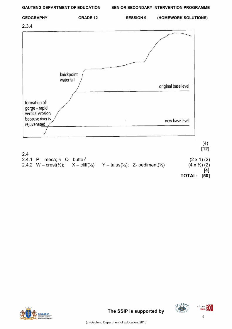
2.3.4
(4)
[12] 2.4 2.4.1 P – mesa; √ Q - butte√ (2 x 1) (2) 2.4.2 W – crest(½); X – cliff(½); Y – talus(½); Z- pediment(½) (4 x ½) (2) [4]
TOTAL: [50]
(c) Gauteng Department of Education, 2013
9

GAUTENG DEPARTMENT OF EDUCATION SENIOR SECONDARY INTERVENTION PROGRAMME
GEOGRAPHY GRADE 12 SESSION (HOMEWORK SOLUTIONS)
QUESTION 1
1.1 1.1.1 The slopes of the valley are warmer at night. The valley floor has frost owing to katabatic airflow and the formation of the temperature inversion. Mid-slope lies in the warm thermal belt.√ √ (1 x 2) (2) 1.1.2 Air close to the valley floor cools at night, reaches dew point temperature, and results in condensation. .√√ Fog mixes with smoke to form smog. √√ (2 x 2) (4) 1.1.3 Factories lie south of Hartsworth.√√ In the afternoon a valley or an anabatic wind causes pollution to be blown northwards.√√ (2 x 2) (4) 1.1.4 These areas lie in the warm thermal belt, and are warmer than the valley floor in winter. √√ The areas are out of the valley, and are not affected by smog.√√ (1 x 2) (2) 1.1.5 Human activities, for example, industry, create heat.√√
Tarred roads absorb heat. .√√ Evaporation cooling occurs in the rural areas.√√ A pollution blanket traps radiation from the earth’s surface. √√ Building cause a multiple reflection of heat.√√ Buildings increase the surface area, which is heated. .√√ [Any THREE] (3 x 2) (6)
[18]
1.2 1.2.1 ITCZ.√√ (1 x 2) (2) 1.2.2 Equatorial low pressure.√√ (1 x 2) (2) 1.2.3 The sub-tropical high pressure.√√ (1 x 2) (2) 1.2.4 The land is cold in winter, but the ocean is warm. √√ This reinforces the existence of the sub-tropical high pressure over the land, but there is a lower pressure over the ocean. .√√ (2 x 2) (4) [10]
HOMEWORK SOLUTIONS: SESSION
TOPIC: CLIMATOLOGY, GEOMORPHOLOGY AND GIS: CONSOLIDATION
EXERCISES
(c) Gauteng Department of Education, 2013
11

GAUTENG DEPARTMENT OF EDUCATION SENIOR SECONDARY INTERVENTION PROGRAMME
GEOGRAPHY GRADE 12 SESSION (HOMEWORK SOLUTIONS)
1.3 1.3.1 A.√√ (1 x 2) (2) 1.3.2
Warm front Cold front
Steepness Gradual√ Steep√
Cloud types Ci, Cs, As, Ns√ Cb√
Rainfall Gentle, over wide area√ Intense, over small area√
(3 x 2) (6)
1.3.3 Warm sector√√ (1 x 2) (2)
1.3.4 Warm front√√ (1 x 2) (2)
1.3.5 E – cool, 9ºC√, cloudy√, gentle rain√
D – warm, 15ºC√, clear√, sunny√ (3 x 2) (6)
1.3.6 The warm sector narrows√. The cold front overtakes the warm front – starting in the LP centre and then moves progressively outwards. √ The cold air wedges in under the warm air and isolates the warm air from the earth’s surface. √ The process is called occlusion and the front which is formed is called an occlusion front. √ (1+ 3) (4) [22] [50] QUESTION 2 2.1.1 Temporary base level: the level to which the stream can erode while the
irregularity across its course still exists. The stream cannot erode below the level of the waterfall until the waterfall has been eroded away and a smooth concave profile is created. √√ Stream braiding: as the stream flows onto its developing floodplain, its velocity decreases and the stream loses energy and deposits its load. Some of this deposition may form islands in the channel, and the stream becomes braided. √√ (2 x 2) (4)
2.1.2 (a)
(4)
(c) Gauteng Department of Education, 2013
12

GAUTENG DEPARTMENT OF EDUCATION SENIOR SECONDARY INTERVENTION PROGRAMME
GEOGRAPHY GRADE 12 SESSION (HOMEWORK SOLUTIONS)
(b) No √√– a graded profile is a smooth concave profile with no irregularities along the course. In this profile the waterfall causes an irregularity. √√ (2 x 2) (4) 2.1.3
(a) Rejuvenation is a revival of a stream’s ability to erode vertically. √√ (1 x 2) (2)
(b)
(2 x 3) (6) [20] 2.2 2.2.1 15h00√√ (1 x 2) (2) 2.2.2 7-8 cumecs√√ (1 x 2) (2) 2.2.3 32 – 33 cumecs √√ (1 x 2) (2) 2.2.4 8 – 9 hours √√ (1 x 2) (2) 2.2.5 12 – 13 hours √√ (1 x 2) (2)
[10] 2.3 2.3.1 Although the gradient is steeper at A, the channel is small and there is little volume. The friction index will be high, and the river will use a lot of its energy to overcome friction. The flow will, therefore, not be fast, and the river will not have a lot of energy to cause erosion of the channel√√ At channel B, the gradient is more gradual, but the channel is larger and probably deeper. There will be more water in the channel as the water from the tributaries has been added to the main stream. There will be less friction, and so the river will have more energy and will flow faster. This will result in erosion of the channel√√ (2 x 2) (4) 2.3.2 There is bare soil at C√√, and sheet flow will carry silt into the river√√ (2 x 2) (4) 2.3.3 The volume will increase downstream of D√√, as the concrete and tar of the urban area will result in less infiltration of rain, and this
water will flow into the river√√ (2 x 2) (4) 2.3.4 Energy will increase if there is deforestation as the volume of the river will increase as there will be greater run-off and less infiltration. √√ (1 x 2) (2) [14] 2.4 2.4.1 Meandering√√ (1 x 2) (2) 2.4.2 The stronger current swings to the outer bend, and erosion is greatest here. Undercutting and the collapse of the river bank from an undercut slope or
river cliff. √√ The water is deepest here, and the flow is fastest√√ (2 x 2) (4) [6] [50]
(c) Gauteng Department of Education, 2013
13

GAUTENG DEPARTMENT OF EDUCATION SENIOR SECONDARY INTERVENTION PROGRAMME
GEOGRAPHY GRADE 12 SESSION (TEACHER NOTES)
QUESTION 1
1.1 1.1.1 D√√ 1.1.2 D √√ 1.1.3 D √√ 1.1.4 B √√ 1.1.5 A √√ (5 x 2) (10) 1.2 1.2.1 A = Crest√ B = Free face√ C= Talus√ D= Pediment√ (4 x 1) (4) 1.2.2 Any ONE Usually at 35º (angle of repose) √√ Consists of shattered rock fragments√√ (1 x 2) (2) 1.2.3 Mass wasting / rock falls√√ (1 x 2) (2)
1.2.4 (a) x = knickpoint 2 1 √√ (2 x 1) (2) (b) Resistant layer of rock resisted erosion√√ / or sea level dropped√√ and level rose√√. (3 x 2) (6)
1.3 1.3.1 C√√ 1.3.2 A√√ 1.3.3 C√√ 1.3.4 B√√ 1.3.5 B√√ 1.3.6 B√√ 1.3.7 D√√ (7 x 2) (14) [40] QUESTION 2
2.1
2.1.1 Abstraction √√
2.1.2 Angle of repose (±34º) √√
2.1.3 Weathering √√
2.1.4 Exotic stream √√
2.1.5 Aquifer√√ (5 x 2) (10)
HOMEWORK SOLUTIONS: SESSION
TOPIC1: CLIMATOLOGY, GEOMORPHOLOGY AND MAPWORK CONSOLIDATION
EXERCISES
(c) Gauteng Department of Education, 2013
14

GAUTENG DEPARTMENT OF EDUCATION SENIOR SECONDARY INTERVENTION PROGRAMME
GEOGRAPHY GRADE 12 SESSION (TEACHER NOTES)
2.2
2.2.1 Main river and its tributaries collectively √√ [Concept] (1 x 2) (2)
2.2.2 (a) Impermeable bedrock
More water flowing/higher run-off because of less infiltration √
(b) Dense vegetation
Less water/less run-off because of more infiltration √ (2)
2.2.3 3rd order √ (1 x 2) (2) 2.2.4 The underlying rocks are inclined while the dendritic pattern is associated with horizontal strata √
Stream flow not determined by underlying rock structure √ Thinning/erosion of underlying rock structure √
River maintained its course √
Accept definition if evidence of superimposed stream is given √
[Any ONE] (1)
2.2.5 About 2,5 to 3,5 hours √ (1)
2.2.6 Lag time reduced/shorter √√ Flood peak higher √√ The hydrograph will change to a sharply rising limb √√ Flood peak will be reached in a shorter space of time √√ Removal of vegetation increases run-off √√ More water will reach the stream much quicker thus reducing lag time √√ Less retention therefore water reaches the stream quicker √√ An urban settlement increases surface run-off compared to the existing landscape where the infiltration is higher √√ Urban development could increase rainfall (more hygroscopic nuclei) √√ The urban settlement has an artificial surface (tar, concrete) which does not retain water √√ More water reaches the stream √√ The flood peak will last for a shorter space of time because of the quick run-off rate √√ Artificial surfaces reduce friction so water flows faster √√
[Any SIX] [If listed and only words/phrases used ONE mark. If full sentences
used TWO marks] (6 x 2) (12)
2.3. 2.3.1 A = dendritic √√ B = trellis√√ (2 x 2) (4) 2.3.2 A – uniform resistant rock, usually flat / horizontal sedimentary rock√√ B – folded sedimentary rock√√ (2 x 2) (4)
(c) Gauteng Department of Education, 2013
15