gold coast surf management plan gold coast surf breaks are home to a number of world-class surfing,...
TRANSCRIPT
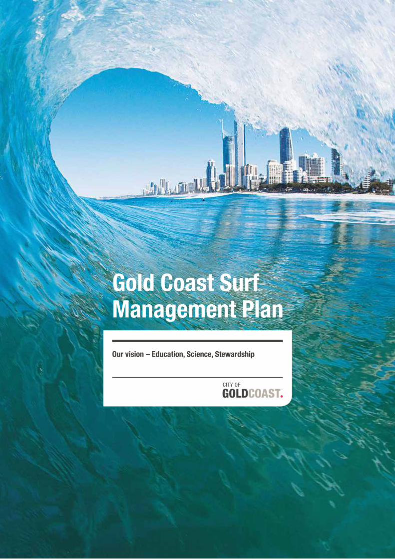
Gold Coast Surf Management Plan
Our vision – Education, Science, Stewardship
Cover and inside cover photo: Andrew Shield
1Gold Coast Surf Management Plan
ContentsMayor’s foreword 2
Gold Coast Surf Management Plan executive summary 3
Our context 4Gold Coast 2020 Vision 4Ocean Beaches Strategy 2013–2023 5
Setting the scene – why does the Gold Coast need a Surf Management Plan? 6Defining issues and finding solutions 6Issue of overcrowding and surf etiquette 8
Our opportunity 10Our vision 10Our objectives 11Objective outcomes 12
Stakeholder consultation 16
Background 16
Defining surf amenity 18Surf Management Plan Advisory Committee
definition of surf amenity 18Definition of surf amenity from a scientific point of view 18
Legislative framework of our coastline 20
Our beaches – natural processes that form surf amenity on the Gold Coast 22Gold Coast wave climate 22Air pressure and wind 23Orientation and exposure of Gold Coast beaches 23Gold Coast swell seasons 24Summer (December – May) 24Winter (May – August) 25Spring (September – November) 25Sediment transport regime on Gold Coast beaches 26Longshore sediment transport 26Cross-shore sediment transport 26Sediment sources and sinks 26Sand bypassing and pumping 27Gold Coast geography and geomorphology 28Beach state classification 28Beach breaks 30Point breaks 30Sand shoals, deltas and reefs 31
1
Photo credit: © Andrew Shield
Location specific surf conditions 32Methodology 32Southern point breaks – Snapper to Greenmount 33Kirra Point 34Bilinga and Tugun 35Currumbin 36Palm Beach 37Burleigh Heads 38Miami to Surfers Paradise including Nobby Beach,
Mermaid Beach, Kurrawa and Broadbeach 39Narrowneck 40The Spit 42South Stradbroke Island 44
Management of our beaches 46Beach nourishment 46Seawall construction 46Dune management 47Basement sand excavation 47Tidal works approvals 47Annual dredging of Tallebudgera and Currumbin Creek
entrances (on-going) 47
Existing coastal management City projects that consider surf amenity 48The Northern Beaches Shoreline Project (on-going) 48The Northern Gold Coast Beach Protection Strategy
(NGCBPS) (1999-2000) 48Sand bypass systems 48Tweed River Entrance Sand Bypassing Project (TRESBP)
and the Gold Coast Seaway bypass (on-going) 49
Coastal monitoring 50Wave data 50Hydrographic survey 50Coastal imaging cameras 50Aerial photography 50
Overview of key actions 52
Where to from here? 53
Conclusion 53
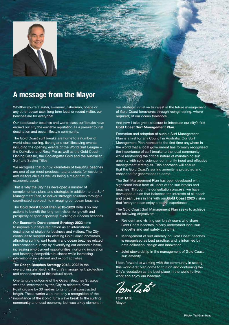
Photo: Ted Grambeau
A message from the MayorWhether you’re a surfer, swimmer, fisherman, boatie or any other ocean user, long term local or recent visitor, our beaches are for everyone!
Our spectacular beaches and world-class surf breaks have earned our city the enviable reputation as a premier tourist destination and ocean lifestyle community.
The Gold Coast surf breaks are home to a number of world-class surfing, fishing and surf lifesaving events, including the opening events of the World Surf League – the Quiksilver and Roxy Pro as well as the Gold Coast Fishing Classic, the Coolangatta Gold and the Australian Surf Life Saving Titles.
We recognise that our 52 kilometres of beautiful beaches are one of our most precious natural assets for residents and visitors alike as well as being a major natural economic asset.
That is why the City has developed a number of complementary plans and strategies in addition to the Surf Management Plan, to deliver strategic solutions through a coordinated approach to managing our ocean beaches.
The Gold Coast Sport Plan 2013–2023 details six key actions to benefit the long term vision for growth and prosperity of sport especially involving our ocean beaches.
Our Economic Development Strategy 2023 aims to improve our city’s reputation as an international destination of choice for business and visitors. The City continues to support our existing Gold Coast innovators, attracting surfing, surf tourism and ocean beaches related businesses to our city by diversifying our economic base, increasing employment opportunities, nurturing innovation and fostering competitive business while increasing international investment and export activities.
The Ocean Beaches Strategy 2013–2023 is the overarching plan guiding the city’s management, protection and enhancement of this natural asset.
One tangible outcome of the Ocean Beaches Strategy was the investment by the City to reinstate Kirra Point groyne by 30 metres to its original constructed length. These works were not only a recognition of the importance of the iconic Kirra wave break to the surfing community and local economy, but was a key element in
our strategic initiative to invest in the future management of Gold Coast foreshores through reengineering, where required, of our ocean foreshore.
And now I take great pleasure to introduce our city’s first Gold Coast Surf Management Plan.
Formation and adoption of such a Surf Management Plan is a first for any Council in Australia. Our Surf Management Plan represents the first time anywhere in the world that a local government has formally recognised the importance of surf breaks to the local community while reinforcing the critical nature of maintaining surf amenity with solid science, community input and effective management strategies. This approach will ensure that the Gold Coast’s surfing amenity is protected and enhanced for generations to come.
The Surf Management Plan has been developed with significant input from all users of the surf breaks and beaches. Through the consultation process, we have developed a plan that balances the interests of all beach and ocean users in line with our Gold Coast 2020 vision that ‘everyone can enjoy a beach experience’.
The Gold Coast Surf Management Plan seeks to achieve the following objectives:
• Resident and visiting surf break users who share Gold Coast beaches, clearly understand local surf etiquette and surf safety customs.
• Management of surf amenity on Gold Coast beaches is recognised as best practice, and is informed by data collection, design and innovation.
• Joint stewardship in the management of Gold Coast surf amenity.
I look forward to working with the community in seeing this world-first plan come to fruition and continuing the City’s reputation as the best place in the world to live, work and enjoy our beaches.
TOM TATE Mayor
3Gold Coast Surf Management Plan
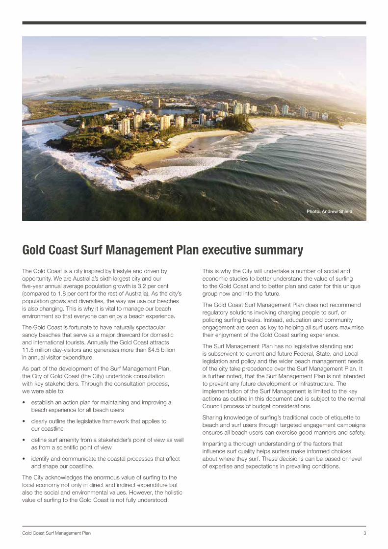
Gold Coast Surf Management Plan executive summaryThe Gold Coast is a city inspired by lifestyle and driven by opportunity. We are Australia’s sixth largest city and our five-year annual average population growth is 3.2 per cent (compared to 1.8 per cent for the rest of Australia). As the city’s population grows and diversifies, the way we use our beaches is also changing. This is why it is vital to manage our beach environment so that everyone can enjoy a beach experience.
The Gold Coast is fortunate to have naturally spectacular sandy beaches that serve as a major drawcard for domestic and international tourists. Annually the Gold Coast attracts 11.5 million day-visitors and generates more than $4.5 billion in annual visitor expenditure.
As part of the development of the Surf Management Plan, the City of Gold Coast (the City) undertook consultation with key stakeholders. Through the consultation process, we were able to:
• establish an action plan for maintaining and improving a beach experience for all beach users
• clearly outline the legislative framework that applies to our coastline
• define surf amenity from a stakeholder’s point of view as well as from a scientific point of view
• identify and communicate the coastal processes that affect and shape our coastline.
The City acknowledges the enormous value of surfing to the local economy not only in direct and indirect expenditure but also the social and environmental values. However, the holistic value of surfing to the Gold Coast is not fully understood.
This is why the City will undertake a number of social and economic studies to better understand the value of surfing to the Gold Coast and to better plan and cater for this unique group now and into the future.
The Gold Coast Surf Management Plan does not recommend regulatory solutions involving charging people to surf, or policing surfing breaks. Instead, education and community engagement are seen as key to helping all surf users maximise their enjoyment of the Gold Coast surfing experience.
The Surf Management Plan has no legislative standing and is subservient to current and future Federal, State, and Local legislation and policy and the wider beach management needs of the city take precedence over the Surf Management Plan. It is further noted, that the Surf Management Plan is not intended to prevent any future development or infrastructure. The implementation of the Surf Management is limited to the key actions as outline in this document and is subject to the normal Council process of budget considerations.
Sharing knowledge of surfing’s traditional code of etiquette to beach and surf users through targeted engagement campaigns ensures all beach users can exercise good manners and safety.
Imparting a thorough understanding of the factors that influence surf quality helps surfers make informed choices about where they surf. These decisions can be based on level of expertise and expectations in prevailing conditions.
Photo: Andrew Shield
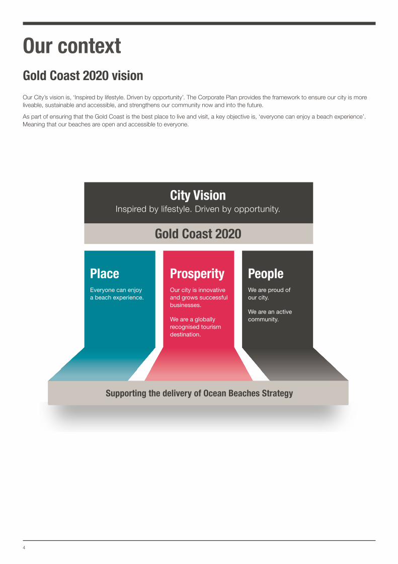
Prosperity PeoplePlace
Gold Coast 2020
Supporting the delivery of Ocean Beaches Strategy
Everyone can enjoy a beach experience.
Our city is innovative and grows successful businesses.
We are a globally recognised tourism destination.
We are proud of our city.
We are an active community.
City VisionInspired by lifestyle. Driven by opportunity.
4
Our contextGold Coast 2020 vision Our City’s vision is, ‘Inspired by lifestyle. Driven by opportunity’. The Corporate Plan provides the framework to ensure our city is more liveable, sustainable and accessible, and strengthens our community now and into the future.
As part of ensuring that the Gold Coast is the best place to live and visit, a key objective is, ‘everyone can enjoy a beach experience’. Meaning that our beaches are open and accessible to everyone.
5Gold Coast Surf Management Plan
Ocean Beaches Strategy hierarchy
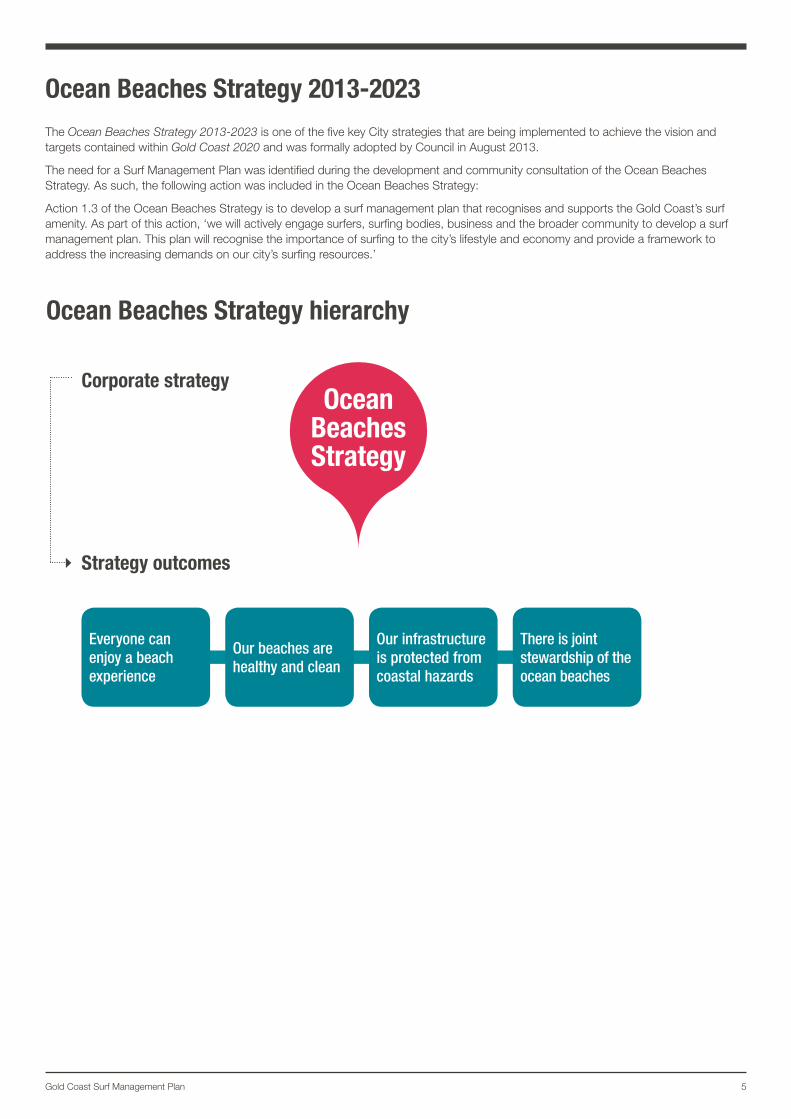
Ocean Beaches Strategy 2013-2023The Ocean Beaches Strategy 2013-2023 is one of the five key City strategies that are being implemented to achieve the vision and targets contained within Gold Coast 2020 and was formally adopted by Council in August 2013.
The need for a Surf Management Plan was identified during the development and community consultation of the Ocean Beaches Strategy. As such, the following action was included in the Ocean Beaches Strategy:
Action 1.3 of the Ocean Beaches Strategy is to develop a surf management plan that recognises and supports the Gold Coast’s surf amenity. As part of this action, ‘we will actively engage surfers, surfing bodies, business and the broader community to develop a surf management plan. This plan will recognise the importance of surfing to the city’s lifestyle and economy and provide a framework to address the increasing demands on our city’s surfing resources.’
Everyone can enjoy a beach experience
Our beaches are healthy and clean
Our infrastructure is protected from coastal hazards
There is joint stewardship of the ocean beaches
Corporate strategy
Strategy outcomes
Ocean Beaches Strategy
6
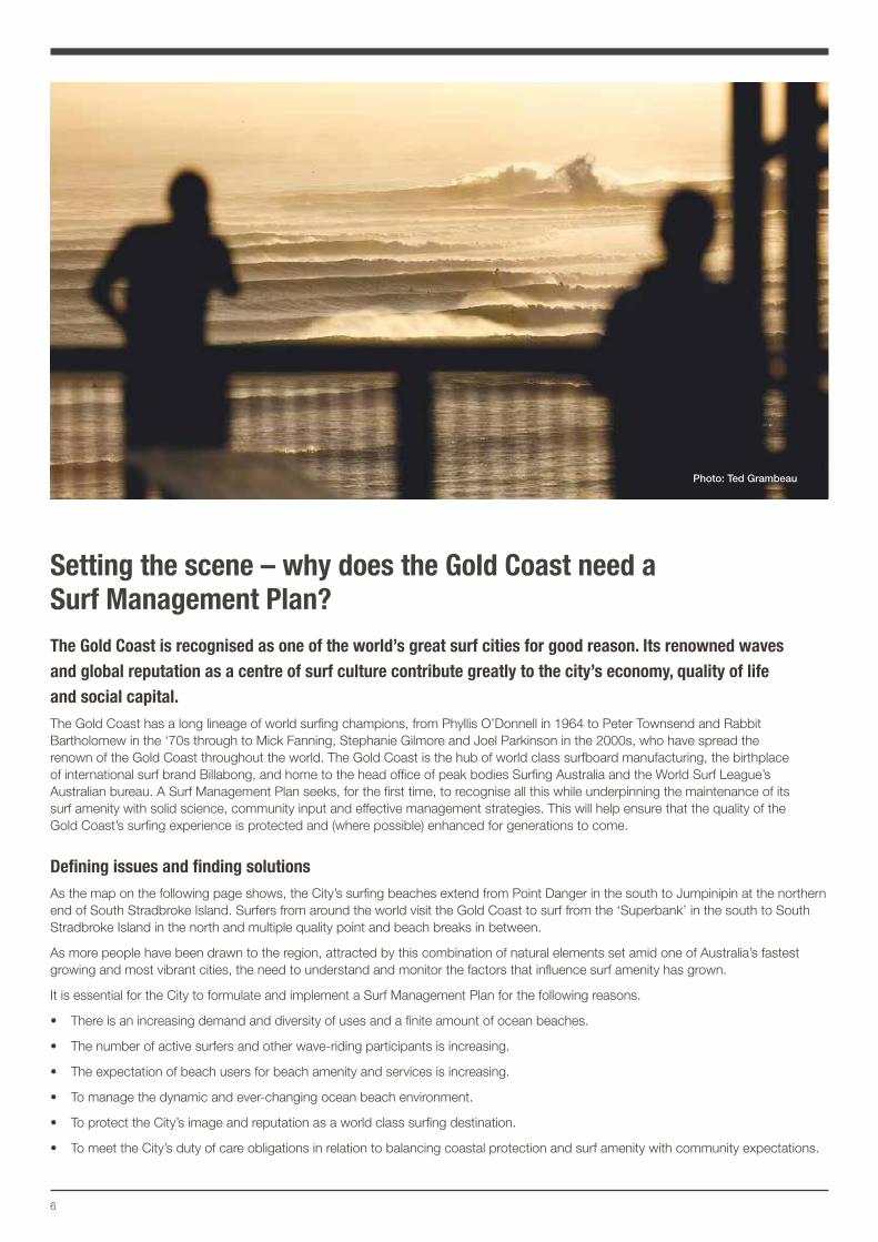
Setting the scene – why does the Gold Coast need a Surf Management Plan?The Gold Coast is recognised as one of the world’s great surf cities for good reason. Its renowned waves and global reputation as a centre of surf culture contribute greatly to the city’s economy, quality of life and social capital. The Gold Coast has a long lineage of world surfing champions, from Phyllis O’Donnell in 1964 to Peter Townsend and Rabbit Bartholomew in the ‘70s through to Mick Fanning, Stephanie Gilmore and Joel Parkinson in the 2000s, who have spread the renown of the Gold Coast throughout the world. The Gold Coast is the hub of world class surfboard manufacturing, the birthplace of international surf brand Billabong, and home to the head office of peak bodies Surfing Australia and the World Surf League’s Australian bureau. A Surf Management Plan seeks, for the first time, to recognise all this while underpinning the maintenance of its surf amenity with solid science, community input and effective management strategies. This will help ensure that the quality of the Gold Coast’s surfing experience is protected and (where possible) enhanced for generations to come.
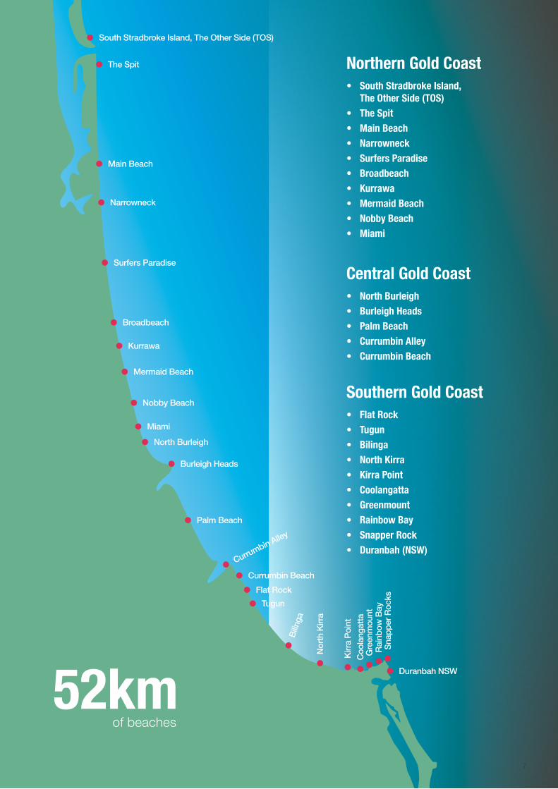
Defining issues and finding solutionsAs the map on the following page shows, the City’s surfing beaches extend from Point Danger in the south to Jumpinipin at the northern end of South Stradbroke Island. Surfers from around the world visit the Gold Coast to surf from the ‘Superbank’ in the south to South Stradbroke Island in the north and multiple quality point and beach breaks in between.
As more people have been drawn to the region, attracted by this combination of natural elements set amid one of Australia’s fastest growing and most vibrant cities, the need to understand and monitor the factors that influence surf amenity has grown.
It is essential for the City to formulate and implement a Surf Management Plan for the following reasons.
• There is an increasing demand and diversity of uses and a finite amount of ocean beaches.
• The number of active surfers and other wave-riding participants is increasing.
• The expectation of beach users for beach amenity and services is increasing.
• To manage the dynamic and ever-changing ocean beach environment.
• To protect the City’s image and reputation as a world class surfing destination.
• To meet the City’s duty of care obligations in relation to balancing coastal protection and surf amenity with community expectations.
Photo: Ted Grambeau
7
● Narrowneck
● Surfers Paradise
● Broadbeach
● Kurrawa
● Mermaid Beach
● Nobby Beach
● Miami
● North Burleigh
● Burleigh Heads
● Palm Beach
● Currumbin Beach
●Currumbin Alley
● Tugun
● Flat Rock
●
Bili
nga
●
Nor
th K
irra
●
Kirr
a P
oint
●
Rai
nbow
Bay
●
Sna
pper
Roc
ks
● Duranbah NSW
●
Gre
enm
ount
●
Coo
lang
atta
52kmof beaches
Northern Gold Coast• South Stradbroke Island,
The Other Side (TOS)• The Spit• Main Beach• Narrowneck• Surfers Paradise• Broadbeach• Kurrawa• Mermaid Beach• Nobby Beach• Miami
Central Gold Coast• North Burleigh• Burleigh Heads• Palm Beach • Currumbin Alley• Currumbin Beach
Southern Gold Coast• Flat Rock• Tugun• Bilinga• North Kirra• Kirra Point• Coolangatta• Greenmount• Rainbow Bay• Snapper Rock• Duranbah (NSW)
● Main Beach
● The Spit
● South Stradbroke Island, The Other Side (TOS)
8
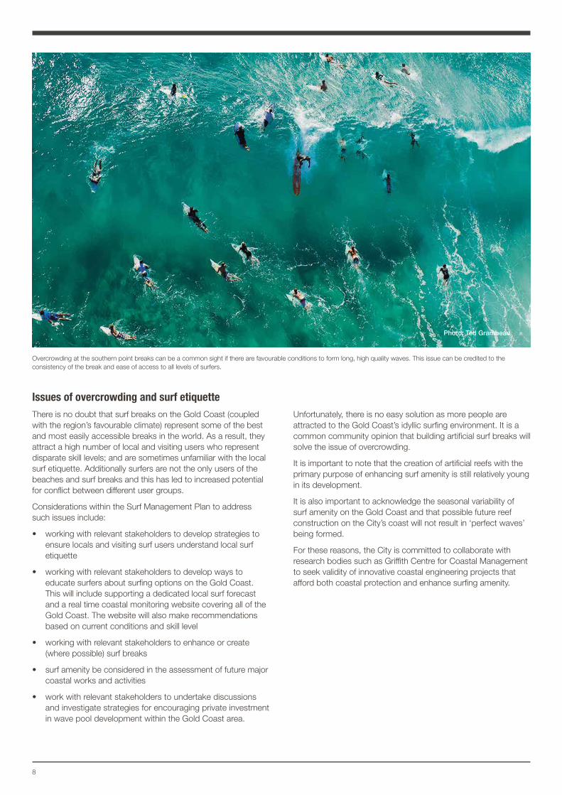
Issues of overcrowding and surf etiquette There is no doubt that surf breaks on the Gold Coast (coupled with the region’s favourable climate) represent some of the best and most easily accessible breaks in the world. As a result, they attract a high number of local and visiting users who represent disparate skill levels; and are sometimes unfamiliar with the local surf etiquette. Additionally surfers are not the only users of the beaches and surf breaks and this has led to increased potential for conflict between different user groups.
Considerations within the Surf Management Plan to address such issues include:
• working with relevant stakeholders to develop strategies to ensure locals and visiting surf users understand local surf etiquette
• working with relevant stakeholders to develop ways to educate surfers about surfing options on the Gold Coast. This will include supporting a dedicated local surf forecast and a real time coastal monitoring website covering all of the Gold Coast. The website will also make recommendations based on current conditions and skill level
• working with relevant stakeholders to enhance or create (where possible) surf breaks
• surf amenity be considered in the assessment of future major coastal works and activities
• work with relevant stakeholders to undertake discussions and investigate strategies for encouraging private investment in wave pool development within the Gold Coast area.
Unfortunately, there is no easy solution as more people are attracted to the Gold Coast’s idyllic surfing environment. It is a common community opinion that building artificial surf breaks will solve the issue of overcrowding.
It is important to note that the creation of artificial reefs with the primary purpose of enhancing surf amenity is still relatively young in its development.
It is also important to acknowledge the seasonal variability of surf amenity on the Gold Coast and that possible future reef construction on the City’s coast will not result in ‘perfect waves’ being formed.
For these reasons, the City is committed to collaborate with research bodies such as Griffith Centre for Coastal Management to seek validity of innovative coastal engineering projects that afford both coastal protection and enhance surfing amenity.
Overcrowding at the southern point breaks can be a common sight if there are favourable conditions to form long, high quality waves. This issue can be credited to the consistency of the break and ease of access to all levels of surfers.
Photo: Ted Grambeau
9Draft Gold Coast Surf Management Plan Technical Document Photo: Andrew Shield
10
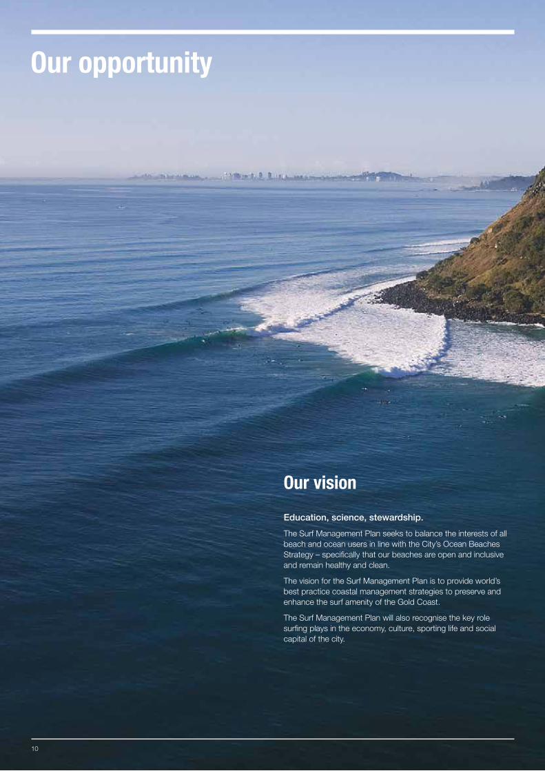
Our vision
Education, science, stewardship.
The Surf Management Plan seeks to balance the interests of all beach and ocean users in line with the City’s Ocean Beaches Strategy – specifically that our beaches are open and inclusive and remain healthy and clean.
The vision for the Surf Management Plan is to provide world’s best practice coastal management strategies to preserve and enhance the surf amenity of the Gold Coast.
The Surf Management Plan will also recognise the key role surfing plays in the economy, culture, sporting life and social capital of the city.
Our opportunity
11Gold Coast Surf Management Plan
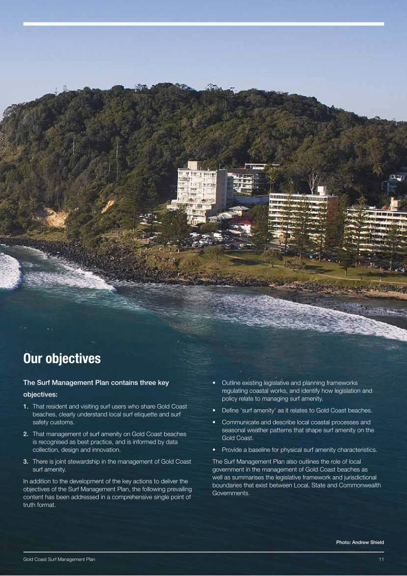
Our objectives
The Surf Management Plan contains three key
objectives:
1. That resident and visiting surf users who share Gold Coast beaches, clearly understand local surf etiquette and surf safety customs.
2. That management of surf amenity on Gold Coast beaches is recognised as best practice, and is informed by data collection, design and innovation.
3. There is joint stewardship in the management of Gold Coast surf amenity.
In addition to the development of the key actions to deliver the objectives of the Surf Management Plan, the following prevailing content has been addressed in a comprehensive single point of truth format.
• Outline existing legislative and planning frameworks regulating coastal works, and identify how legislation and policy relate to managing surf amenity.
• Define ‘surf amenity’ as it relates to Gold Coast beaches.
• Communicate and describe local coastal processes and seasonal weather patterns that shape surf amenity on the Gold Coast.
• Provide a baseline for physical surf amenity characteristics.
The Surf Management Plan also outlines the role of local government in the management of Gold Coast beaches as well as summarises the legislative framework and jurisdictional boundaries that exist between Local, State and Commonwealth Governments.
Photo: Andrew Shield
12
Objective outcomes
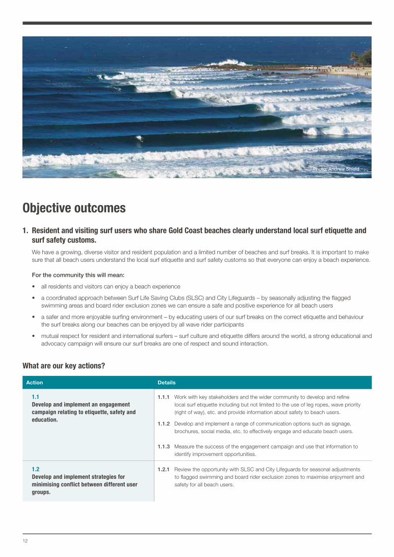
1. Resident and visiting surf users who share Gold Coast beaches clearly understand local surf etiquette and surf safety customs.
We have a growing, diverse visitor and resident population and a limited number of beaches and surf breaks. It is important to make sure that all beach users understand the local surf etiquette and surf safety customs so that everyone can enjoy a beach experience.
For the community this will mean:
• all residents and visitors can enjoy a beach experience
• a coordinated approach between Surf Life Saving Clubs (SLSC) and City Lifeguards – by seasonally adjusting the flagged swimming areas and board rider exclusion zones we can ensure a safe and positive experience for all beach users
• a safer and more enjoyable surfing environment – by educating users of our surf breaks on the correct etiquette and behaviour the surf breaks along our beaches can be enjoyed by all wave rider participants
• mutual respect for resident and international surfers – surf culture and etiquette differs around the world, a strong educational and advocacy campaign will ensure our surf breaks are one of respect and sound interaction.
What are our key actions?
Action Details
1.1 Develop and implement an engagement campaign relating to etiquette, safety and education.
1.1.1 Work with key stakeholders and the wider community to develop and refine local surf etiquette including but not limited to the use of leg ropes, wave priority (right of way), etc. and provide information about safety to beach users.
1.1.2 Develop and implement a range of communication options such as signage, brochures, social media, etc. to effectively engage and educate beach users.
1.1.3 Measure the success of the engagement campaign and use that information to identify improvement opportunities.
1.2 Develop and implement strategies for minimising conflict between different user groups.
1.2.1 Review the opportunity with SLSC and City Lifeguards for seasonal adjustments to flagged swimming and board rider exclusion zones to maximise enjoyment and safety for all beach users.
Photo: Andrew Shield
13Gold Coast Surf Management Plan
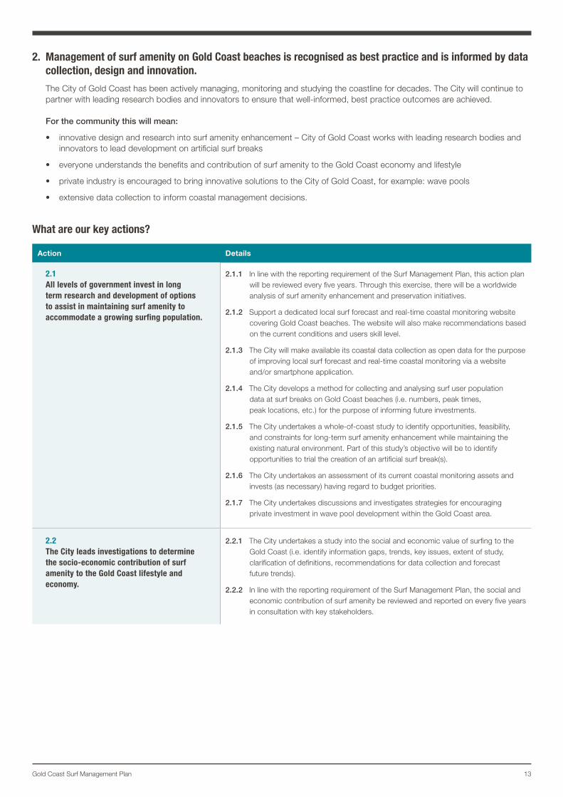
2. Management of surf amenity on Gold Coast beaches is recognised as best practice and is informed by data collection, design and innovation.
The City of Gold Coast has been actively managing, monitoring and studying the coastline for decades. The City will continue to partner with leading research bodies and innovators to ensure that well-informed, best practice outcomes are achieved.
For the community this will mean:
• innovative design and research into surf amenity enhancement – City of Gold Coast works with leading research bodies and innovators to lead development on artificial surf breaks
• everyone understands the benefits and contribution of surf amenity to the Gold Coast economy and lifestyle
• private industry is encouraged to bring innovative solutions to the City of Gold Coast, for example: wave pools
• extensive data collection to inform coastal management decisions.
What are our key actions?
Action Details
2.1 All levels of government invest in long term research and development of options to assist in maintaining surf amenity to accommodate a growing surfing population.
2.1.1 In line with the reporting requirement of the Surf Management Plan, this action plan will be reviewed every five years. Through this exercise, there will be a worldwide analysis of surf amenity enhancement and preservation initiatives.
2.1.2 Support a dedicated local surf forecast and real-time coastal monitoring website covering Gold Coast beaches. The website will also make recommendations based on the current conditions and users skill level.
2.1.3 The City will make available its coastal data collection as open data for the purpose of improving local surf forecast and real-time coastal monitoring via a website and/or smartphone application.
2.1.4 The City develops a method for collecting and analysing surf user population data at surf breaks on Gold Coast beaches (i.e. numbers, peak times, peak locations, etc.) for the purpose of informing future investments.
2.1.5 The City undertakes a whole-of-coast study to identify opportunities, feasibility, and constraints for long-term surf amenity enhancement while maintaining the existing natural environment. Part of this study’s objective will be to identify opportunities to trial the creation of an artificial surf break(s).
2.1.6 The City undertakes an assessment of its current coastal monitoring assets and invests (as necessary) having regard to budget priorities.
2.1.7 The City undertakes discussions and investigates strategies for encouraging private investment in wave pool development within the Gold Coast area.
2.2 The City leads investigations to determine the socio-economic contribution of surf amenity to the Gold Coast lifestyle and economy.
2.2.1 The City undertakes a study into the social and economic value of surfing to the Gold Coast (i.e. identify information gaps, trends, key issues, extent of study, clarification of definitions, recommendations for data collection and forecast future trends).
2.2.2 In line with the reporting requirement of the Surf Management Plan, the social and economic contribution of surf amenity be reviewed and reported on every five years in consultation with key stakeholders.
14
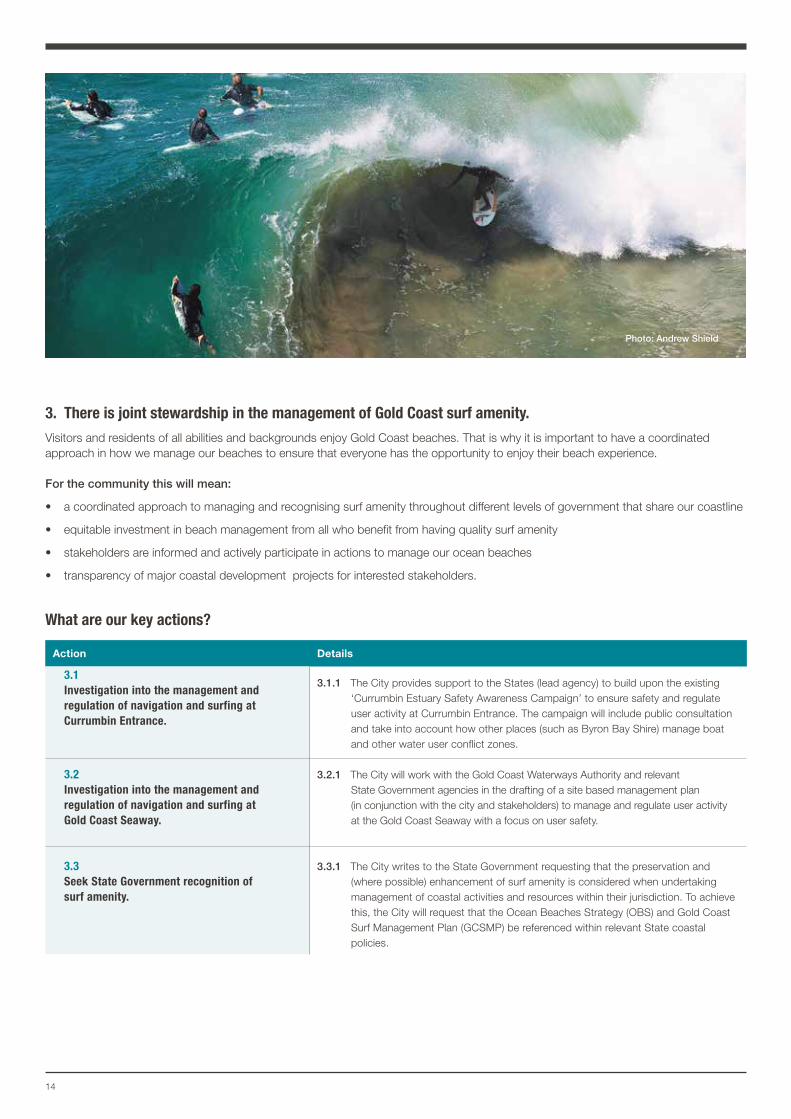
3. There is joint stewardship in the management of Gold Coast surf amenity.Visitors and residents of all abilities and backgrounds enjoy Gold Coast beaches. That is why it is important to have a coordinated approach in how we manage our beaches to ensure that everyone has the opportunity to enjoy their beach experience.
For the community this will mean:
• a coordinated approach to managing and recognising surf amenity throughout different levels of government that share our coastline
• equitable investment in beach management from all who benefit from having quality surf amenity
• stakeholders are informed and actively participate in actions to manage our ocean beaches
• transparency of major coastal development projects for interested stakeholders.
What are our key actions?
Action Details
3.1 Investigation into the management and regulation of navigation and surfing at Currumbin Entrance.
3.1.1 The City provides support to the States (lead agency) to build upon the existing ‘Currumbin Estuary Safety Awareness Campaign’ to ensure safety and regulate user activity at Currumbin Entrance. The campaign will include public consultation and take into account how other places (such as Byron Bay Shire) manage boat and other water user conflict zones.
3.2 Investigation into the management and regulation of navigation and surfing at Gold Coast Seaway.
3.2.1 The City will work with the Gold Coast Waterways Authority and relevant State Government agencies in the drafting of a site based management plan (in conjunction with the city and stakeholders) to manage and regulate user activity at the Gold Coast Seaway with a focus on user safety.
3.3 Seek State Government recognition of surf amenity.
3.3.1 The City writes to the State Government requesting that the preservation and (where possible) enhancement of surf amenity is considered when undertaking management of coastal activities and resources within their jurisdiction. To achieve this, the City will request that the Ocean Beaches Strategy (OBS) and Gold Coast Surf Management Plan (GCSMP) be referenced within relevant State coastal policies.
Photo: Andrew Shield
15Gold Coast Surf Management Plan
Action Details
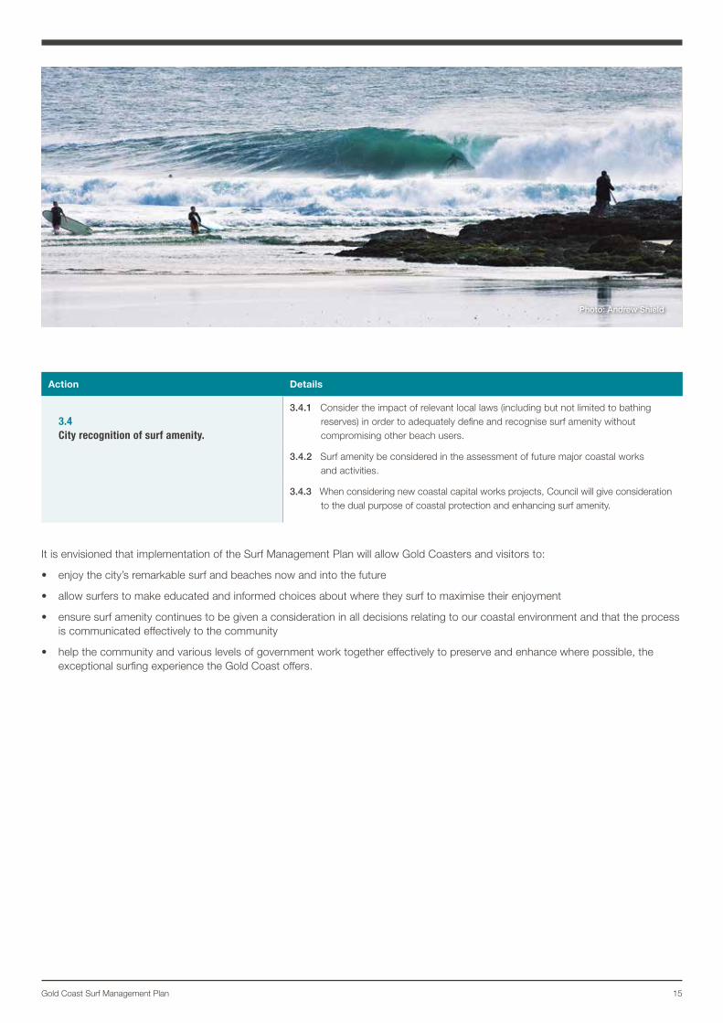
3.4 City recognition of surf amenity.
3.4.1 Consider the impact of relevant local laws (including but not limited to bathing reserves) in order to adequately define and recognise surf amenity without compromising other beach users.
3.4.2 Surf amenity be considered in the assessment of future major coastal works and activities.
3.4.3 When considering new coastal capital works projects, Council will give consideration to the dual purpose of coastal protection and enhancing surf amenity.
It is envisioned that implementation of the Surf Management Plan will allow Gold Coasters and visitors to:
• enjoy the city’s remarkable surf and beaches now and into the future
• allow surfers to make educated and informed choices about where they surf to maximise their enjoyment
• ensure surf amenity continues to be given a consideration in all decisions relating to our coastal environment and that the process is communicated effectively to the community
• help the community and various levels of government work together effectively to preserve and enhance where possible, the exceptional surfing experience the Gold Coast offers.
Photo: Andrew Shield
16
BackgroundThe Gold Coast’s unique surf conditions were recognised early in the City’s history. As far back as 1917, Queensland’s southern coastal strip was being described as a ‘surfer’s paradise’.
The Gold Coast’s orientation and latitude mean it’s perfectly positioned to catch strong southeast swells generated by east coast low pressure systems (typically in the winter months) while tropical cyclones offer large swells from the north and northeast (typically during the summer and autumn months).
The point breaks and headlands have been shaped over millennia and are fed northward flows of sand emanating from the mighty rivers of northern NSW and together these geographic elements play a significant role in shaping the waves the region is famous for.
The growth in popularity of surfing during the 1950s and 1960s went hand-in-hand with development of the Gold Coast. In recent decades, increased migration from southern states and growing
visitor numbers have seen the Gold Coast emerge as Australia’s favourite holiday destination and fastest growing major city.
Nowadays surfing and surf culture is iconic to the region. With the Gold Coast’s growing population, there are more and more surfers (both local and visitor) in the water each year. It is crucial to carefully manage the dynamic ocean beach environment and challenges facing our beaches to ensure sufficient services are in place to meet community expectations.
The Gold Coast is one of the most intensively managed and monitored stretches of coast in Australia. The City has been actively managing, monitoring and studying the coastline for decades and consequently has extensive experience in coastal processes, geomorphology and wave mechanics. A vast store of data has been collected and is being continually added to which allows a carefully considered and coordinated approach to coastal management.
Stakeholder consultationThe Surf Management Plan Advisory Committee (SMPAC) was formed to ensure that relevant stakeholders were consulted and had an opportunity to provide input to the Surf Management Plan.
The SMPAC was a forum of collaboration between the City, State Government agencies, research bodies, surfing organisations, board rider’s clubs, and coastal scientists.
Through the collective knowledge of the SMPAC, fundamental information about Gold Coast surf amenity and stakeholder requirements was captured. The goals of the SMPAC were to define surf amenity, understand the natural processes that influence the quality of the surfing experience on the Gold Coast, and identify the legislative and planning frameworks that relate to managing surf amenity.
In addition, the City facilitated workshops, developed a background paper and online survey for the SMPAC to use when consulting with their wider membership.
This consultation process has assisted in gaining a better understanding of the issues having an impact on surf amenity, in addition to formulating actions and tasks in the Action Plan.
The Surf Management Plan has collated the information to establish useful baseline data that provides a new understanding of the factors that influence our surfing environment. It has helped define local coastal processes and seasonal weather patterns that shape surf amenity on the Gold Coast, and establish physical characteristics specific to individual surf breaks.
The SMPAC brought together local knowledge with coastal science and has allowed community input into forming effective aims and strategies to best manage surf amenity on the Gold Coast.
To assist in developing the Surf Management Plan, the City engaged the Griffith Centre for Coastal Management (GCCM), as the pre-eminent authority on beach science and research on the Gold Coast.
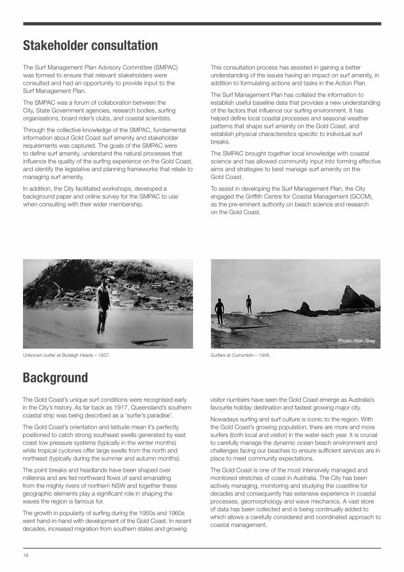
Surfers at Currumbin – 1948. Unknown surfer at Burleigh Heads – 1937.
Photo: Alan Gray
17Gold Coast Surf Management Plan
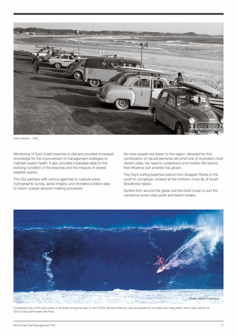
Kirra carpark – 1962.
Considered one of the best surfers in Australia during the early to mid-1970s, Michael Peterson was recognised for his deep tube riding skills, which were refined on Gold Coast point breaks like Kirra.
Photo: Martin Tullemans
Monitoring of Gold Coast beaches is vital and provides increased knowledge for the improvement of management strategies to maintain beach health. It also provides invaluable data for the evolving condition of the beaches and the impacts of severe weather events.
The City partners with various agencies to capture wave, hydrographic survey, aerial imagery and shoreline position data to inform coastal decision-making processes.
As more people are drawn to the region, attracted by this combination of natural elements set amid one of Australia’s most vibrant cities, the need to understand and monitor the factors that influence surf amenity has grown.
The City’s surfing beaches extend from Snapper Rocks in the south to Jumpinpin, located at the northern-most tip of South Stradbroke Island.
Surfers from around the globe visit the Gold Coast to surf the numerous world-class point and beach breaks.
Photo: Mal Sutherland
Wave crest
Wave periodWave height
Wave trough
measured in seconds
18
Defining surf amenity
Definition of surf amenity The Surf Management Plan Advisory Committee (SMPAC) has broadly described surf amenity as:
A series of surf breaks along the coast that afford exceptional experiences for people who ride the waves in all forms and disciplines. These experiences enhance the lifestyle of the user.
The quality of the amenity is characterised by naturally occurring seasonal conditions. It can also be described by the combination of water quality, the dynamic energy of the wave, safety, the natural physical environment and interactions with other surfers.
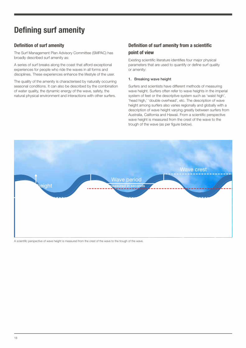
Definition of surf amenity from a scientific point of view Existing scientific literature identifies four major physical parameters that are used to quantify or define surf quality or amenity:
1. Breaking wave height
Surfers and scientists have different methods of measuring wave height. Surfers often refer to wave heights in the imperial system of feet or the descriptive system such as ‘waist high’, ‘head high,’ ‘double overhead’, etc. The description of wave height among surfers also varies regionally and globally with a description of wave height varying greatly between surfers from Australia, California and Hawaii. From a scientific perspective wave height is measured from the crest of the wave to the trough of the wave (as per figure below).
A scientific perspective of wave height is measured from the crest of the wave to the trough of the wave.
19Gold Coast Surf Management Plan
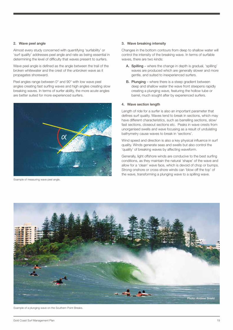
2. Wave peel angle
Almost every study concerned with quantifying ‘surfability’ or ‘surf quality’ addresses peel angle and rate as being essential in determining the level of difficulty that waves present to surfers.
Wave peel angle is defined as the angle between the trail of the broken whitewater and the crest of the unbroken wave as it propagates shoreward.
Peel angles range between 0° and 90° with low wave peel angles creating fast surfing waves and high angles creating slow breaking waves. In terms of surfer ability, the more acute angles are better suited for more experienced surfers.
3. Wave breaking intensity
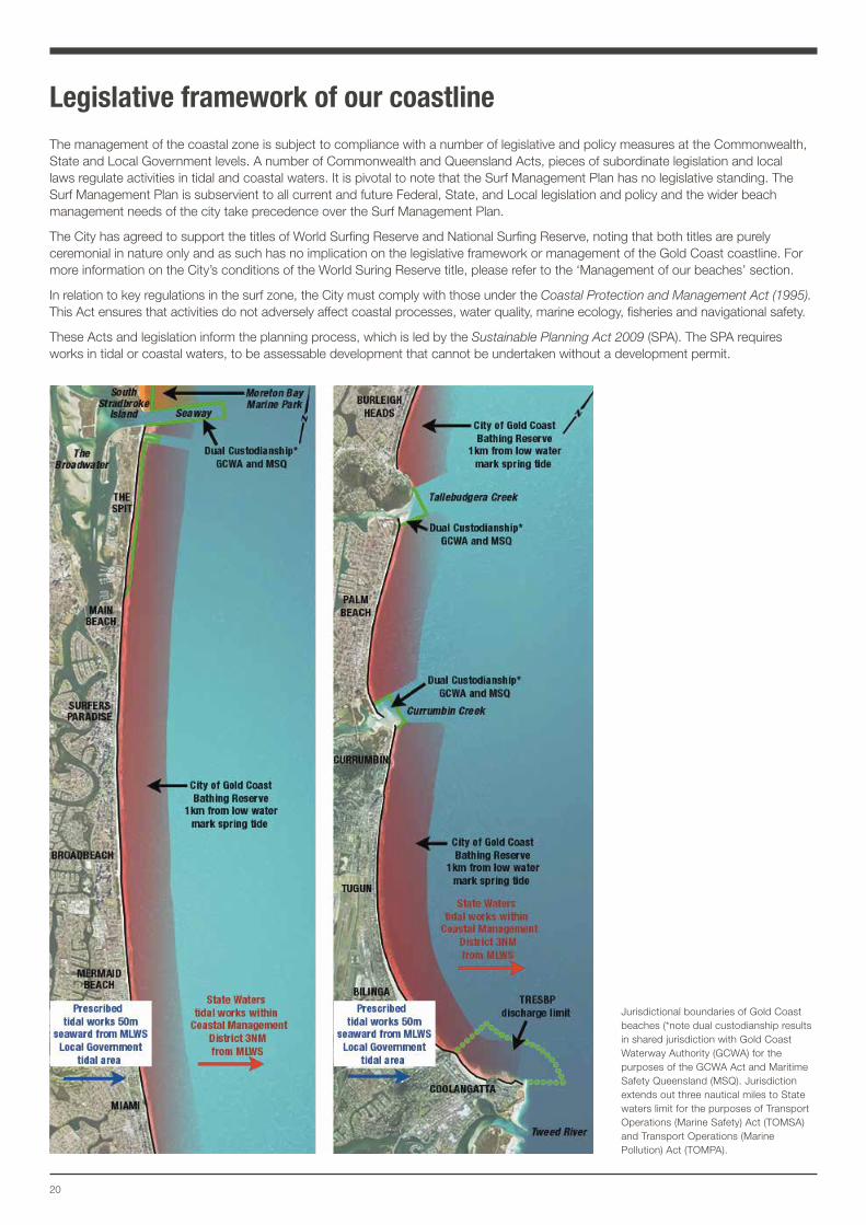
Changes in the bottom contours from deep to shallow water will control the intensity of the breaking wave. In terms of surfable waves, there are two kinds:
A. Spilling – where the change in depth is gradual, ‘spilling’ waves are produced which are generally slower and more gentle, and suited to inexperienced surfers.
B. Plunging – where there is a steep gradient between deep and shallow water the wave front steepens rapidly creating a plunging wave, featuring the hollow tube or barrel, much sought after by experienced surfers.
4. Wave section length
Length of ride for a surfer is also an important parameter that defines surf quality. Waves tend to break in sections, which may have different characteristics, such as barrelling sections, slow/fast sections, closeout sections etc. Peaks in wave crests from unorganised swells and wave focusing as a result of undulating bathymetry cause waves to break in ‘sections’.
Wind speed and direction is also a key physical influence in surf quality. Winds generate seas and swells but also control the ‘quality’ of breaking waves by affecting waveform.
Generally, light offshore winds are conducive to the best surfing conditions, as they maintain the natural ‘shape’ of the wave and allow for a ‘clean’ wave face, which is devoid of chop or bumps. Strong onshore or cross-shore winds can ‘blow off the top’ of the wave, transforming a plunging wave to a spilling wave.
Photo: Andrew Shield
Example of measuring wave peel angle.
Example of a plunging wave on the Southern Point Breaks.
20
Legislative framework of our coastlineThe management of the coastal zone is subject to compliance with a number of legislative and policy measures at the Commonwealth, State and Local Government levels. A number of Commonwealth and Queensland Acts, pieces of subordinate legislation and local laws regulate activities in tidal and coastal waters. It is pivotal to note that the Surf Management Plan has no legislative standing. The Surf Management Plan is subservient to all current and future Federal, State, and Local legislation and policy and the wider beach management needs of the city take precedence over the Surf Management Plan.
The City has agreed to support the titles of World Surfing Reserve and National Surfing Reserve, noting that both titles are purely ceremonial in nature only and as such has no implication on the legislative framework or management of the Gold Coast coastline. For more information on the City’s conditions of the World Suring Reserve title, please refer to the ‘Management of our beaches’ section.
In relation to key regulations in the surf zone, the City must comply with those under the Coastal Protection and Management Act (1995). This Act ensures that activities do not adversely affect coastal processes, water quality, marine ecology, fisheries and navigational safety.
These Acts and legislation inform the planning process, which is led by the Sustainable Planning Act 2009 (SPA). The SPA requires works in tidal or coastal waters, to be assessable development that cannot be undertaken without a development permit.
Jurisdictional boundaries of Gold Coast beaches (*note dual custodianship results in shared jurisdiction with Gold Coast Waterway Authority (GCWA) for the purposes of the GCWA Act and Maritime Safety Queensland (MSQ). Jurisdiction extends out three nautical miles to State waters limit for the purposes of Transport Operations (Marine Safety) Act (TOMSA) and Transport Operations (Marine Pollution) Act (TOMPA).
21Gold Coast Surf Management Plan
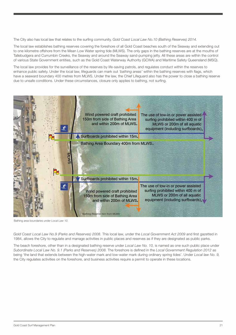
The City also has local law that relates to the surfing community. Gold Coast Local Law No.10 (Bathing Reserves) 2014.
The local law establishes bathing reserves covering the foreshore of all Gold Coast beaches south of the Seaway and extending out to one kilometre offshore from the Mean Low Water spring tide (MLWS). The only gaps in the bathing reserves are at the mouths of Tallebudgera and Currumbin Creeks, the Seaway and around the Seaway sand-pumping jetty. All these areas are within the control of various State Government entities, such as the Gold Coast Waterway Authority (GCWA) and Maritime Safety Queensland (MSQ).
The local law provides for the surveillance of the reserves by life-saving patrols, and regulates conduct within the reserves to enhance public safety. Under the local law, lifeguards can mark out ‘bathing areas’ within the bathing reserves with flags, which have a seaward boundary 400 metres from MLWS. Under the law, the Chief Lifeguard also has the power to close a bathing reserve due to unsafe conditions. Under these circumstances, closure only applies to bathing, not surfing.
Gold Coast Local Law No.9 (Parks and Reserves) 2008. This local law, under the Local Government Act 2009 and first gazetted in 1984, allows the City to regulate and manage activities in public places and reserves as if they are designated as public parks.
The beach foreshore, other than in a designated bathing reserve under Local Law No. 10, is named as one such public place under Subordinate Local Law No. 9.1 (Parks and Reserves) 2008. The foreshore is defined in the Local Government Regulation 2012 as being ‘the land that extends between the high-water mark and low-water mark during ordinary spring tides’. Under Local law No. 9, the City regulates activities on the foreshore, and business activities require a permit to operate in these locations.
Bathing area boundaries under Local Law 10.
*Bathing Reserve 1km from MLWS
22
Our beaches – natural processes that form surf amenity on the Gold CoastAs surf users of Gold Coast beaches, it is important to understand key coastal and seasonal processes that influence surfing conditions on our beaches.
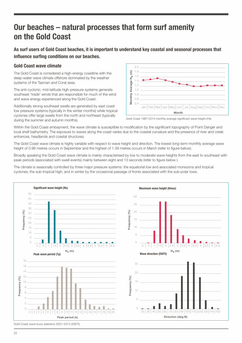
Gold Coast wave climateThe Gold Coast is considered a high-energy coastline with the deep-water wave climate offshore dominated by the weather systems of the Tasman and Coral seas.
The anti-cyclonic, mid-latitude high-pressure systems generate southeast ‘trade’ winds that are responsible for much of the wind and wave energy experienced along the Gold Coast.
Additionally strong southeast swells are generated by east coast low pressure systems (typically in the winter months) while tropical cyclones offer large swells from the north and northeast (typically during the summer and autumn months).
Within the Gold Coast embayment, the wave climate is susceptible to modification by the significant topography of Point Danger and local shelf bathymetry. The exposure to waves along the coast varies due to the coastal curvature and the presence of river and creek entrances, headlands and coastal structures.
The Gold Coast wave climate is highly variable with respect to wave height and direction. The lowest long-term monthly average wave height of 0.96 metres occurs in September and the highest of 1.39 metres occurs in March (refer to figure below).
Broadly speaking the Gold Coast wave climate is mainly characterised by low to moderate wave heights from the east to southeast with peak periods (associated with swell events) mainly between eight and 13 seconds (refer to figure below ).
The climate is seasonally controlled by three major pressure systems: the equatorial low and associated monsoons and tropical cyclones; the sub-tropical high; and in winter by the occasional passage of fronts associated with the sub-polar lows.
Gold Coast 1987-2014 monthly average significant wave height (Hs)
Fre
qu
en
cy
(%)
50
45
40
35
30
25
20
15
10
5
00 .5 1 1.5 2 2.5 3 3.5 4 4.5 5 5.5 6 6.5
Hs (m)
Significant wave height (Hs)
Fre
qu
en
cy
(%)
30
25
20
15
10
5
00 .5 1 1.5 2 2.5 3 3.5 4 4.5 5 5.5 6 6.5
Hs (m)
Maximum wave height (Hmax)
Fre
qu
en
cy
(%)
25
20
15
10
5
020 30 40 50 60 70 80 90 100 110 120 130 140 150
Direction (deg N)
Wave direction (DSITI)
Gold Coast wave buoy statistics 2007–2014 (DSITI).
Fre
qu
en
cy
(%)
18
16
14
12
10
8
6
4
2
00 2 4 5 6 7 8 9 10 11 12 13 14 15 16 17 18 19 20
Peak period (s)
Peak wave period (Tp)
Mo
nth
ly A
vera
ge
Hs
(m)
2.0
1.8
1.6
1.4
1.2
1.0
0.8
0.6
0.4Jan Feb Mar Apr May Jun Jul Aug Sep Oct Nov Dec
Month
23Gold Coast Surf Management Plan
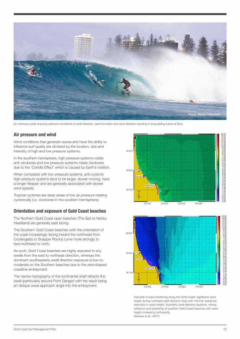
Air pressure and windWind conditions that generate waves and have the ability to influence surf quality are dictated by the location, size and intensity of high and low pressure systems.
In the southern hemisphere, high pressure systems rotate anti-clockwise and low pressure systems rotate clockwise due to the ‘Coriolis Effect’ which is caused by Earth’s rotation.
When compared with low-pressure systems, anti-cyclonic high-pressure systems tend to be larger, slower moving, have a longer lifespan and are generally associated with slower wind speeds.
Tropical cyclones are deep areas of low air pressure rotating cyclonically (i.e. clockwise in the southern hemisphere).
Orientation and exposure of Gold Coast beachesThe Northern Gold Coast open beaches (The Spit to Nobby Headland) are generally east facing.
The Southern Gold Coast beaches (with the orientation of the coast increasingly facing toward the northwest from Coolangatta to Snapper Rocks) curve more strongly to face northeast to north.
As such, Gold Coast beaches are highly exposed to any swells from the east to northeast direction, whereas the dominant southeasterly swell direction exposure is low-to-moderate on the Southern beaches due to the zeta-shaped coastline embayment.
The narrow topography of the continental shelf refracts the swell (particularly around Point Danger) with the result being an oblique wave approach angle into the embayment.
An unknown surfer enjoying optimum conditions of swell direction, sand formation and wind direction resulting in long peeling tubes at Kirra.
Photo: Martin Tulllemans
Example of wave sheltering along the Gold Coast; significant wave height during northeast swell direction (top) with minimal nearshore reduction in wave height. Southerly swell direction (bottom), strong refraction and sheltering of southern Gold Coast beaches with wave height increasing northwards. (Strauss et al., 2007)
24
Gold Coast swell seasonsThe Gold Coast wave climate can be classified into three distinct periods:
• Summer (December – May)
• Winter (June – August)
• Spring (September – November).
Late Summer and Autumn is the coast’s most consistent time of year for swell and waves. This period coincides with increased activity in the Coral Sea that sees regular short and long-range swells crossing our shores.
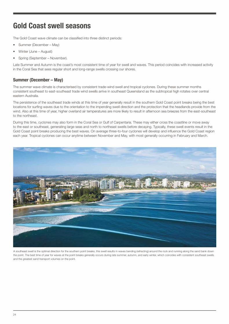
Summer (December – May)The summer wave climate is characterised by consistent trade-wind swell and tropical cyclones. During these summer months consistent southeast to east-southeast trade wind swells arrive in southeast Queensland as the subtropical high rotates over central eastern Australia.
The persistence of the southeast trade winds at this time of year generally result in the southern Gold Coast point breaks being the best locations for surfing waves due to the orientation to the impending swell direction and the protection that the headlands provide from the wind. Also at this time of year, higher overland air temperatures are more likely to result in afternoon sea breezes from the east-southeast to the northeast.
During this time, cyclones may also form in the Coral Sea or Gulf of Carpentaria. These may either cross the coastline or move away to the east or southeast, generating large seas and north to northeast swells before decaying. Typically, these swell events result in the Gold Coast point breaks producing the best waves. On average three-to-four cyclones will develop and influence the Gold Coast region each year. Tropical cyclones can occur anytime between November and May, with most generally occurring in February and March.
A southeast swell is the optimal direction for the southern point breaks, this swell results in waves bending (refracting) around the rock and running along the sand bank down the point. The best time of year for waves at the point breaks generally occurs during late summer, autumn, and early winter, which coincides with consistent southeast swells and the greatest sand transport volumes on the point.
25Gold Coast Surf Management Plan
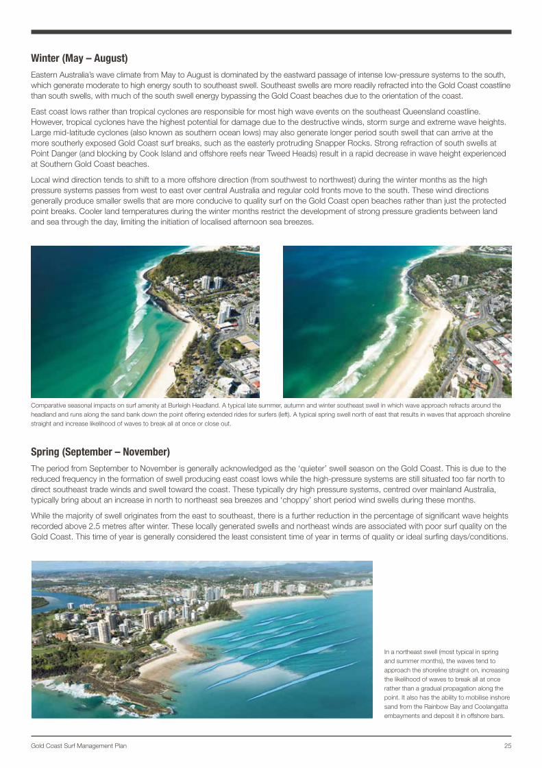
Winter (May – August)Eastern Australia’s wave climate from May to August is dominated by the eastward passage of intense low-pressure systems to the south, which generate moderate to high energy south to southeast swell. Southeast swells are more readily refracted into the Gold Coast coastline than south swells, with much of the south swell energy bypassing the Gold Coast beaches due to the orientation of the coast.
East coast lows rather than tropical cyclones are responsible for most high wave events on the southeast Queensland coastline. However, tropical cyclones have the highest potential for damage due to the destructive winds, storm surge and extreme wave heights. Large mid-latitude cyclones (also known as southern ocean lows) may also generate longer period south swell that can arrive at the more southerly exposed Gold Coast surf breaks, such as the easterly protruding Snapper Rocks. Strong refraction of south swells at Point Danger (and blocking by Cook Island and offshore reefs near Tweed Heads) result in a rapid decrease in wave height experienced at Southern Gold Coast beaches.
Local wind direction tends to shift to a more offshore direction (from southwest to northwest) during the winter months as the high pressure systems passes from west to east over central Australia and regular cold fronts move to the south. These wind directions generally produce smaller swells that are more conducive to quality surf on the Gold Coast open beaches rather than just the protected point breaks. Cooler land temperatures during the winter months restrict the development of strong pressure gradients between land and sea through the day, limiting the initiation of localised afternoon sea breezes.
Spring (September – November)The period from September to November is generally acknowledged as the ‘quieter’ swell season on the Gold Coast. This is due to the reduced frequency in the formation of swell producing east coast lows while the high-pressure systems are still situated too far north to direct southeast trade winds and swell toward the coast. These typically dry high pressure systems, centred over mainland Australia, typically bring about an increase in north to northeast sea breezes and ‘choppy’ short period wind swells during these months.
While the majority of swell originates from the east to southeast, there is a further reduction in the percentage of significant wave heights recorded above 2.5 metres after winter. These locally generated swells and northeast winds are associated with poor surf quality on the Gold Coast. This time of year is generally considered the least consistent time of year in terms of quality or ideal surfing days/conditions.
Comparative seasonal impacts on surf amenity at Burleigh Headland. A typical late summer, autumn and winter southeast swell in which wave approach refracts around the headland and runs along the sand bank down the point offering extended rides for surfers (left). A typical spring swell north of east that results in waves that approach shoreline straight and increase likelihood of waves to break all at once or close out.
In a northeast swell (most typical in spring and summer months), the waves tend to approach the shoreline straight on, increasing the likelihood of waves to break all at once rather than a gradual propagation along the point. It also has the ability to mobilise inshore sand from the Rainbow Bay and Coolangatta embayments and deposit it in offshore bars.
26
Sediment transport regime on Gold Coast beachesCoastal sand transport is a predominately natural process involving the physical movement of sand under wave, wind and tidal action. While constant and dynamic in nature, sand transport is, in no way, a uniform process.
Longshore sediment transportThis process moves sand parallel along a beach or coastline. Due to the dominant southeasterly swell and wind direction, the Gold Coast has an estimated average of 500,000 cubic metres of sediment transported north along the coast each year.
The strong longshore current or ‘sweep’ experienced on the Gold Coast open coastline has the ability to erode transverse bars and fill rip channels with sand. While the inner bar and beach becomes flatter, a uniform longshore trough is restored between the inner and outer bars. This results in a longshore parallel outer bars that tend to favour poor surfing amenity resulting in ‘closeout’ conditions.
The El Niño – Southern Oscillation (ENSO) can affect the overall volume and the spatial distribution of beach sand through changes in inter-annual to decadal wave climate (Bureau of Meterology, 2013).
Cross-shore sediment transportThis process moves sand perpendicular to the coastline. Like all open ocean coastal systems, the Gold Coast coastline naturally cycles through periods of accretion (under lowered wave energy) and erosion (during increased wave activity and storm events).
During erosional conditions, upper beach sediment is deposited offshore in storm bars, reducing the width of the visible upper beach. Conversely, during prolonged calmer wave conditions, the visible beach widens and with enough time, the foredune is restored.
Under accretion conditions sediment is generally transported shoreward with the beach state transitioning downstate from linear (longshore) bar and trough morphology (less desirable for surfing amenity) to rhythmic transverse bar and rip morphology (and then after prolonged periods of low wave energy the rip channels will infill to create a fairly linear terrace beach).
Sustained wave height above a certain threshold generally leads to some erosion of the coastline and rapid ‘resetting’ of the beach state to the higher energy linear (longshore) bar and trough morphology.
Sediment sources and sinksEach of the coastal entrances of the Gold Coast embayment and the Tweed River entrance in NSW act as a sink for beach sand. The sands accumulating in the estuaries are only released naturally during major flood events or artificially through dredging. In absence of nearshore submarine canyons, large sand islands such as South and North Stradbroke Island and Moreton Island have acted as sediment sinks. The overall net northward longshore transport of sediment ends up in these islands, before moving further north to Fraser Island, where it is transported off the edge of the continental shelf.
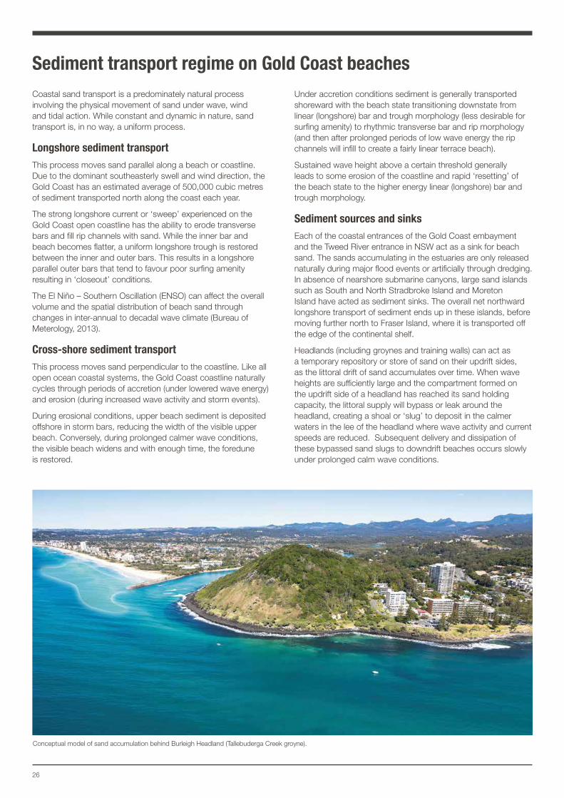
Headlands (including groynes and training walls) can act as a temporary repository or store of sand on their updrift sides, as the littoral drift of sand accumulates over time. When wave heights are sufficiently large and the compartment formed on the updrift side of a headland has reached its sand holding capacity, the littoral supply will bypass or leak around the headland, creating a shoal or ‘slug’ to deposit in the calmer waters in the lee of the headland where wave activity and current speeds are reduced. Subsequent delivery and dissipation of these bypassed sand slugs to downdrift beaches occurs slowly under prolonged calm wave conditions.
Conceptual model of sand accumulation behind Burleigh Headland (Tallebuderga Creek groyne).
27Gold Coast Surf Management Plan
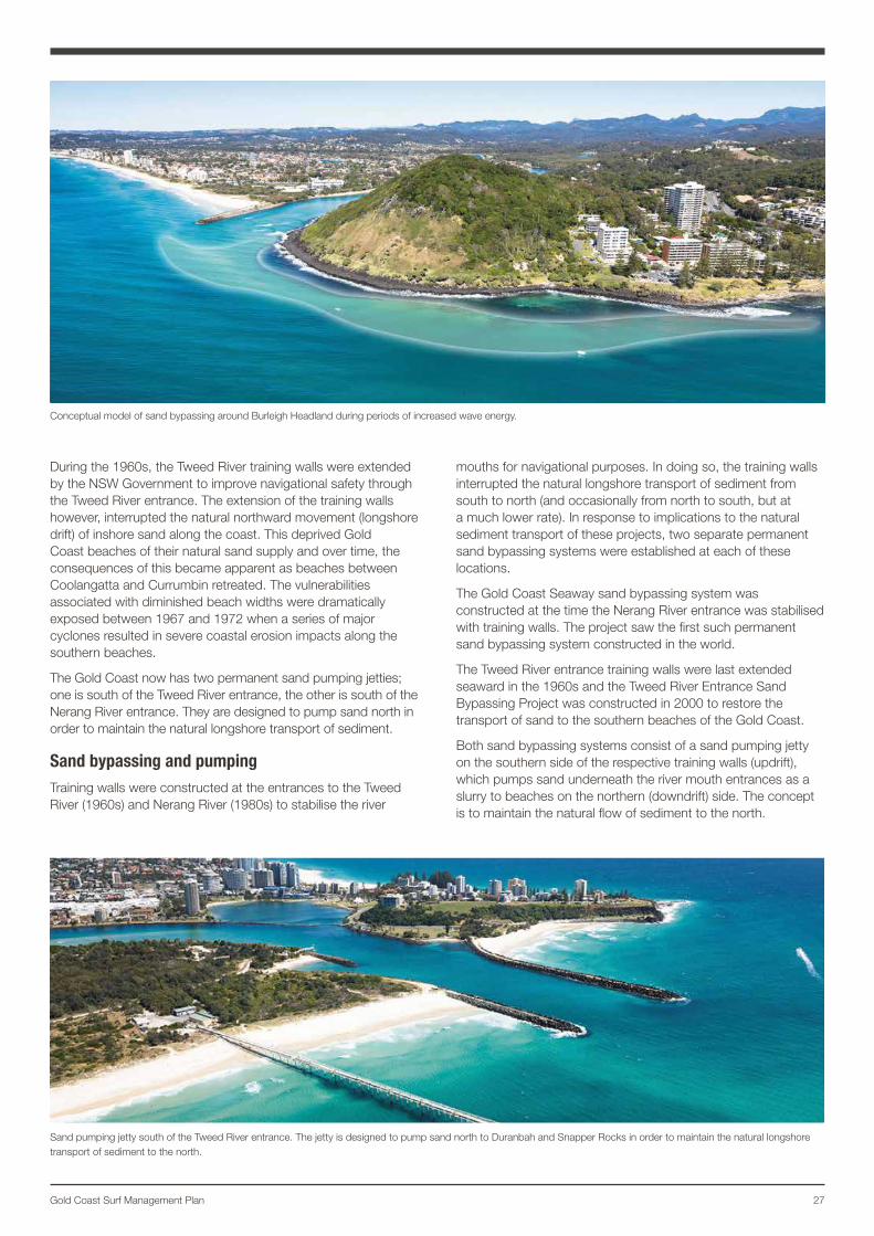
During the 1960s, the Tweed River training walls were extended by the NSW Government to improve navigational safety through the Tweed River entrance. The extension of the training walls however, interrupted the natural northward movement (longshore drift) of inshore sand along the coast. This deprived Gold Coast beaches of their natural sand supply and over time, the consequences of this became apparent as beaches between Coolangatta and Currumbin retreated. The vulnerabilities associated with diminished beach widths were dramatically exposed between 1967 and 1972 when a series of major cyclones resulted in severe coastal erosion impacts along the southern beaches.
The Gold Coast now has two permanent sand pumping jetties; one is south of the Tweed River entrance, the other is south of the Nerang River entrance. They are designed to pump sand north in order to maintain the natural longshore transport of sediment.
Sand bypassing and pumpingTraining walls were constructed at the entrances to the Tweed River (1960s) and Nerang River (1980s) to stabilise the river
mouths for navigational purposes. In doing so, the training walls interrupted the natural longshore transport of sediment from south to north (and occasionally from north to south, but at a much lower rate). In response to implications to the natural sediment transport of these projects, two separate permanent sand bypassing systems were established at each of these locations.
The Gold Coast Seaway sand bypassing system was constructed at the time the Nerang River entrance was stabilised with training walls. The project saw the first such permanent sand bypassing system constructed in the world.
The Tweed River entrance training walls were last extended seaward in the 1960s and the Tweed River Entrance Sand Bypassing Project was constructed in 2000 to restore the transport of sand to the southern beaches of the Gold Coast.
Both sand bypassing systems consist of a sand pumping jetty on the southern side of the respective training walls (updrift), which pumps sand underneath the river mouth entrances as a slurry to beaches on the northern (downdrift) side. The concept is to maintain the natural flow of sediment to the north.
Conceptual model of sand bypassing around Burleigh Headland during periods of increased wave energy.
Sand pumping jetty south of the Tweed River entrance. The jetty is designed to pump sand north to Duranbah and Snapper Rocks in order to maintain the natural longshore transport of sediment to the north.
28
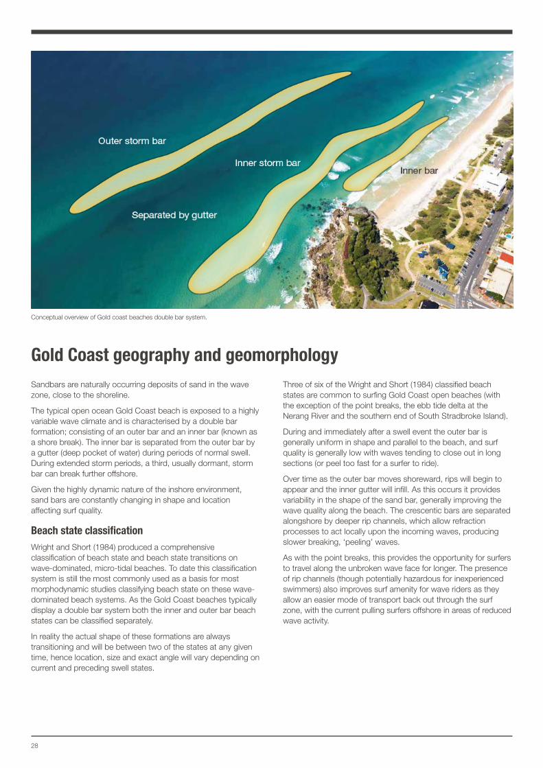
Gold Coast geography and geomorphologySandbars are naturally occurring deposits of sand in the wave zone, close to the shoreline.
The typical open ocean Gold Coast beach is exposed to a highly variable wave climate and is characterised by a double bar formation; consisting of an outer bar and an inner bar (known as a shore break). The inner bar is separated from the outer bar by a gutter (deep pocket of water) during periods of normal swell. During extended storm periods, a third, usually dormant, storm bar can break further offshore.
Given the highly dynamic nature of the inshore environment, sand bars are constantly changing in shape and location affecting surf quality.
Beach state classification Wright and Short (1984) produced a comprehensive classification of beach state and beach state transitions on wave-dominated, micro-tidal beaches. To date this classification system is still the most commonly used as a basis for most morphodynamic studies classifying beach state on these wave-dominated beach systems. As the Gold Coast beaches typically display a double bar system both the inner and outer bar beach states can be classified separately.
In reality the actual shape of these formations are always transitioning and will be between two of the states at any given time, hence location, size and exact angle will vary depending on current and preceding swell states.
Three of six of the Wright and Short (1984) classified beach states are common to surfing Gold Coast open beaches (with the exception of the point breaks, the ebb tide delta at the Nerang River and the southern end of South Stradbroke Island).
During and immediately after a swell event the outer bar is generally uniform in shape and parallel to the beach, and surf quality is generally low with waves tending to close out in long sections (or peel too fast for a surfer to ride).
Over time as the outer bar moves shoreward, rips will begin to appear and the inner gutter will infill. As this occurs it provides variability in the shape of the sand bar, generally improving the wave quality along the beach. The crescentic bars are separated alongshore by deeper rip channels, which allow refraction processes to act locally upon the incoming waves, producing slower breaking, ‘peeling’ waves.
As with the point breaks, this provides the opportunity for surfers to travel along the unbroken wave face for longer. The presence of rip channels (though potentially hazardous for inexperienced swimmers) also improves surf amenity for wave riders as they allow an easier mode of transport back out through the surf zone, with the current pulling surfers offshore in areas of reduced wave activity.
Conceptual overview of Gold coast beaches double bar system.
29Gold Coast Surf Management Plan
(a)
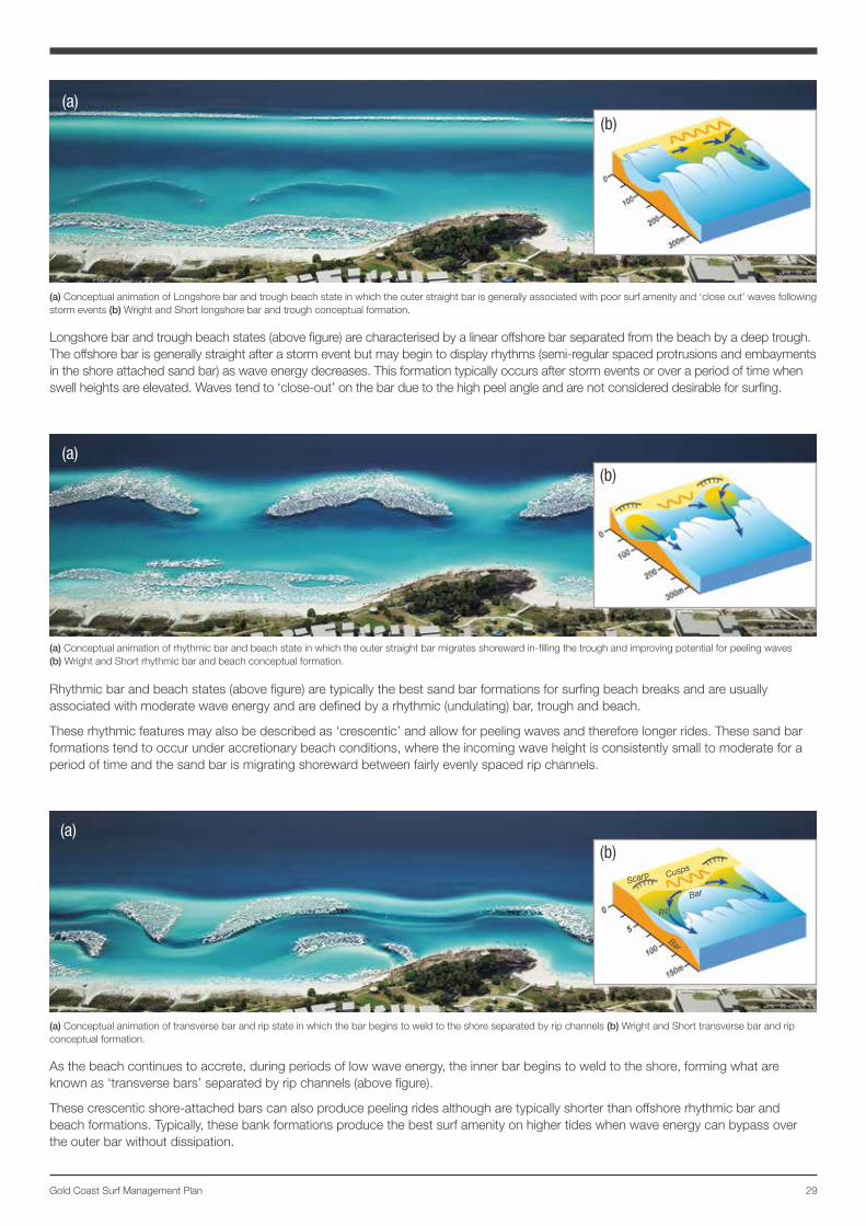
Longshore bar and trough beach states (above figure) are characterised by a linear offshore bar separated from the beach by a deep trough. The offshore bar is generally straight after a storm event but may begin to display rhythms (semi-regular spaced protrusions and embayments in the shore attached sand bar) as wave energy decreases. This formation typically occurs after storm events or over a period of time when swell heights are elevated. Waves tend to ‘close-out’ on the bar due to the high peel angle and are not considered desirable for surfing.
(a) Conceptual animation of Longshore bar and trough beach state in which the outer straight bar is generally associated with poor surf amenity and ‘close out’ waves following storm events (b) Wright and Short longshore bar and trough conceptual formation.
(a) Conceptual animation of transverse bar and rip state in which the bar begins to weld to the shore separated by rip channels (b) Wright and Short transverse bar and rip conceptual formation.
(a) Conceptual animation of rhythmic bar and beach state in which the outer straight bar migrates shoreward in-filling the trough and improving potential for peeling waves (b) Wright and Short rhythmic bar and beach conceptual formation.
(a)
(a)
Rhythmic bar and beach states (above figure) are typically the best sand bar formations for surfing beach breaks and are usually associated with moderate wave energy and are defined by a rhythmic (undulating) bar, trough and beach.
These rhythmic features may also be described as ‘crescentic’ and allow for peeling waves and therefore longer rides. These sand bar formations tend to occur under accretionary beach conditions, where the incoming wave height is consistently small to moderate for a period of time and the sand bar is migrating shoreward between fairly evenly spaced rip channels.
As the beach continues to accrete, during periods of low wave energy, the inner bar begins to weld to the shore, forming what are known as ‘transverse bars’ separated by rip channels (above figure).
These crescentic shore-attached bars can also produce peeling rides although are typically shorter than offshore rhythmic bar and beach formations. Typically, these bank formations produce the best surf amenity on higher tides when wave energy can bypass over the outer bar without dissipation.
(b)
(b)
Scarp Cusp
s
Bar
Bar
Rip
(b)
30
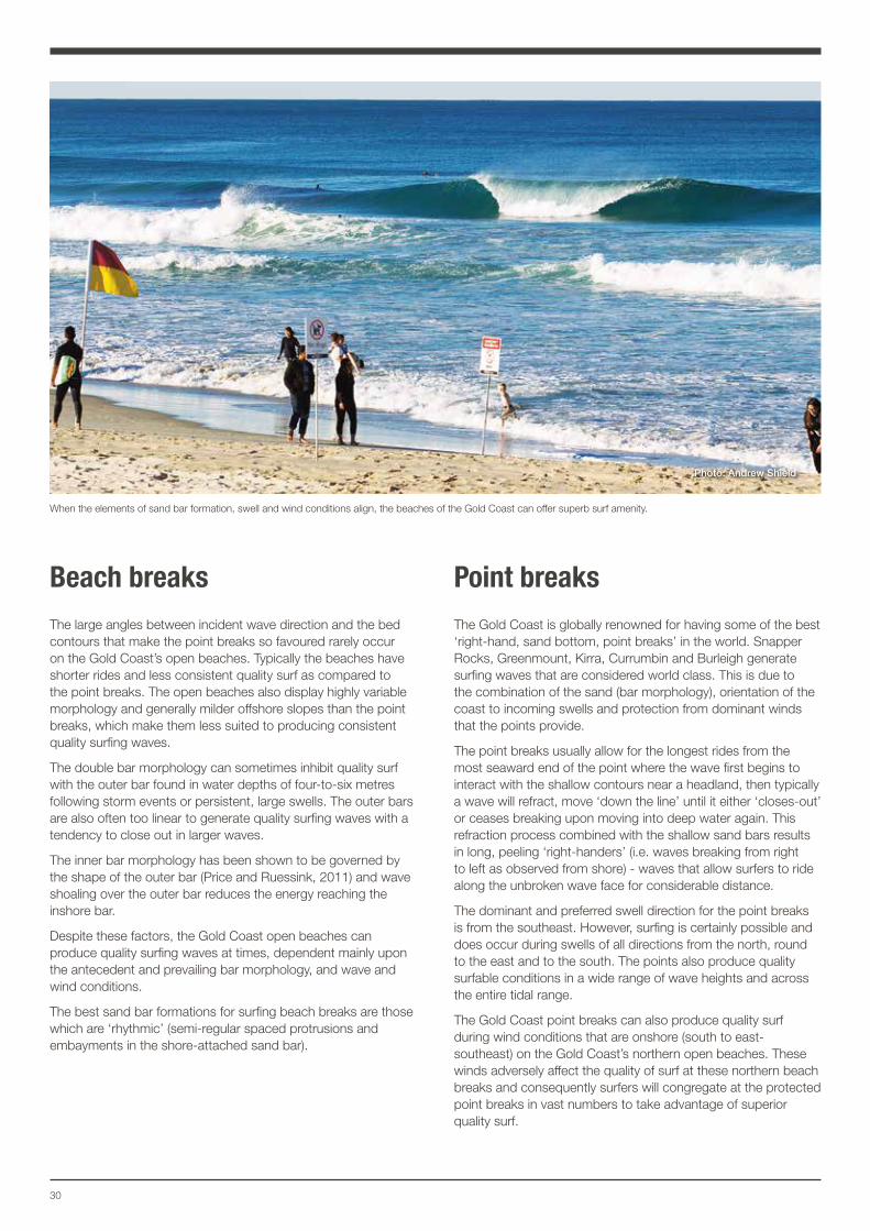
Beach breaksThe large angles between incident wave direction and the bed contours that make the point breaks so favoured rarely occur on the Gold Coast’s open beaches. Typically the beaches have shorter rides and less consistent quality surf as compared to the point breaks. The open beaches also display highly variable morphology and generally milder offshore slopes than the point breaks, which make them less suited to producing consistent quality surfing waves.
The double bar morphology can sometimes inhibit quality surf with the outer bar found in water depths of four-to-six metres following storm events or persistent, large swells. The outer bars are also often too linear to generate quality surfing waves with a tendency to close out in larger waves.
The inner bar morphology has been shown to be governed by the shape of the outer bar (Price and Ruessink, 2011) and wave shoaling over the outer bar reduces the energy reaching the inshore bar.
Despite these factors, the Gold Coast open beaches can produce quality surfing waves at times, dependent mainly upon the antecedent and prevailing bar morphology, and wave and wind conditions.
The best sand bar formations for surfing beach breaks are those which are ‘rhythmic’ (semi-regular spaced protrusions and embayments in the shore-attached sand bar).
Point breaksThe Gold Coast is globally renowned for having some of the best ‘right-hand, sand bottom, point breaks’ in the world. Snapper Rocks, Greenmount, Kirra, Currumbin and Burleigh generate surfing waves that are considered world class. This is due to the combination of the sand (bar morphology), orientation of the coast to incoming swells and protection from dominant winds that the points provide.
The point breaks usually allow for the longest rides from the most seaward end of the point where the wave first begins to interact with the shallow contours near a headland, then typically a wave will refract, move ‘down the line’ until it either ‘closes-out’ or ceases breaking upon moving into deep water again. This refraction process combined with the shallow sand bars results in long, peeling ‘right-handers’ (i.e. waves breaking from right to left as observed from shore) - waves that allow surfers to ride along the unbroken wave face for considerable distance.
The dominant and preferred swell direction for the point breaks is from the southeast. However, surfing is certainly possible and does occur during swells of all directions from the north, round to the east and to the south. The points also produce quality surfable conditions in a wide range of wave heights and across the entire tidal range.
The Gold Coast point breaks can also produce quality surf during wind conditions that are onshore (south to east-southeast) on the Gold Coast’s northern open beaches. These winds adversely affect the quality of surf at these northern beach breaks and consequently surfers will congregate at the protected point breaks in vast numbers to take advantage of superior quality surf.
When the elements of sand bar formation, swell and wind conditions align, the beaches of the Gold Coast can offer superb surf amenity.
Photo: Andrew Shield
31Gold Coast Surf Management Plan
Sand shoals, deltas and reefsThere are a few natural reefs between Snapper Rocks and South Stradbroke Island however none that are regularly surfed, or consistently produce quality surfing waves. Sand shoals and reefs have the ability to ‘focus’ and modify swell to generate peaky, powerful breaking waves in their lee. This is most evident on the Tweed River bar (ebb tide delta) and in the lee of the Seaway ebb tide delta at South Stradbroke Island.
Low to moderate waves usually pass unbroken over the ebb tide delta at the Nerang River entrance and shoal and refract before they encounter the beach at South Stradbroke Island. This shoaling process over the delta continues shoreward as the delta merges with the surf zone at the southern end of South Stradbroke Island.
The single bar morphology is unique here and usually generates bigger and better surfing waves than the double bar system commonly present on the Gold Coast open beaches south of the Seaway. The wave refraction around the ebb tide delta is complex and variable due to the morphology of the delta, resulting in peaky, high energy ‘A-frame’ waves at South Stradbroke Island.
At the time of this report there is only one artificial reef located on the Gold Coast – Narrowneck Reef.
The artificial reef constructed at Narrowneck in 2000 was a part of the broader Northern Gold Coast Beach Protection Strategy (NGCBPS). The primary objective of the NGCBPS was to widen the beach in order to accommodate future storm erosion events along the northern beaches. As a part of the NGCBPS, 1.3 million cubic metres of sediment was deposited on northern Gold Coast beaches and a submerged artificial reef was constructed offshore to extend the life of the nourishment and adjust shoreline position. The reef was designed and built as a ‘multi-purpose’ structure with a primary function to stabilise the beach nourishment and reduce future nourishment needs. The secondary objective of the NGCBPS was to improve surf amenity.
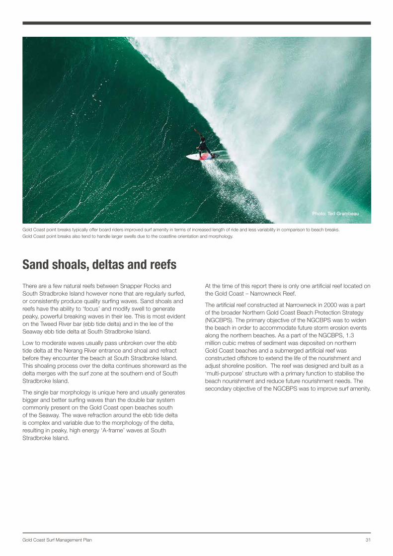
Gold Coast point breaks typically offer board riders improved surf amenity in terms of increased length of ride and less variability in comparison to beach breaks. Gold Coast point breaks also tend to handle larger swells due to the coastline orientation and morphology.
Photo: Ted Grambeau
32
Photo: Ted Grambeau
Location specific surf conditions The Gold Coast Surf Management Plan investigation of specific surf break locations on Gold Coast beaches aims to quantify wave, wind and historic bathymetric conditions in relation to surf amenity.
The City collects data relating to its beaches through a number of historical and ongoing monitoring programs. The data collected by the City on the beach and in the near-shore zone forms the basis of much of the analysis of surf amenity completed in this investigation.
MethodologyThe overall amenity of a surf spot is highly subjective. The methodology applied utilised the analysis of City and State collection data to quantify surf amenity on the Gold Coast beaches within an envelope of physical parameters.
The end result acknowledges:
• location specific surf conditions with a mean significant wave height
• period and dominant wave direction
• percentage of desirable winds for surfing
• an ‘envelope’ of an average beach orientation and peel angle at a given period of time.
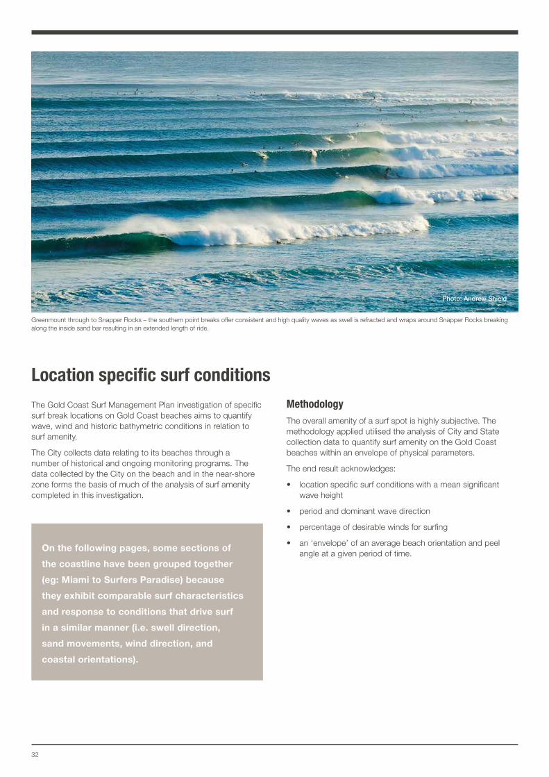
Greenmount through to Snapper Rocks – the southern point breaks offer consistent and high quality waves as swell is refracted and wraps around Snapper Rocks breaking along the inside sand bar resulting in an extended length of ride.
Photo: Andrew Shield
On the following pages, some sections of
the coastline have been grouped together
(eg: Miami to Surfers Paradise) because
they exhibit comparable surf characteristics
and response to conditions that drive surf
in a similar manner (i.e. swell direction,
sand movements, wind direction, and
coastal orientations).
33Gold Coast Surf Management Plan
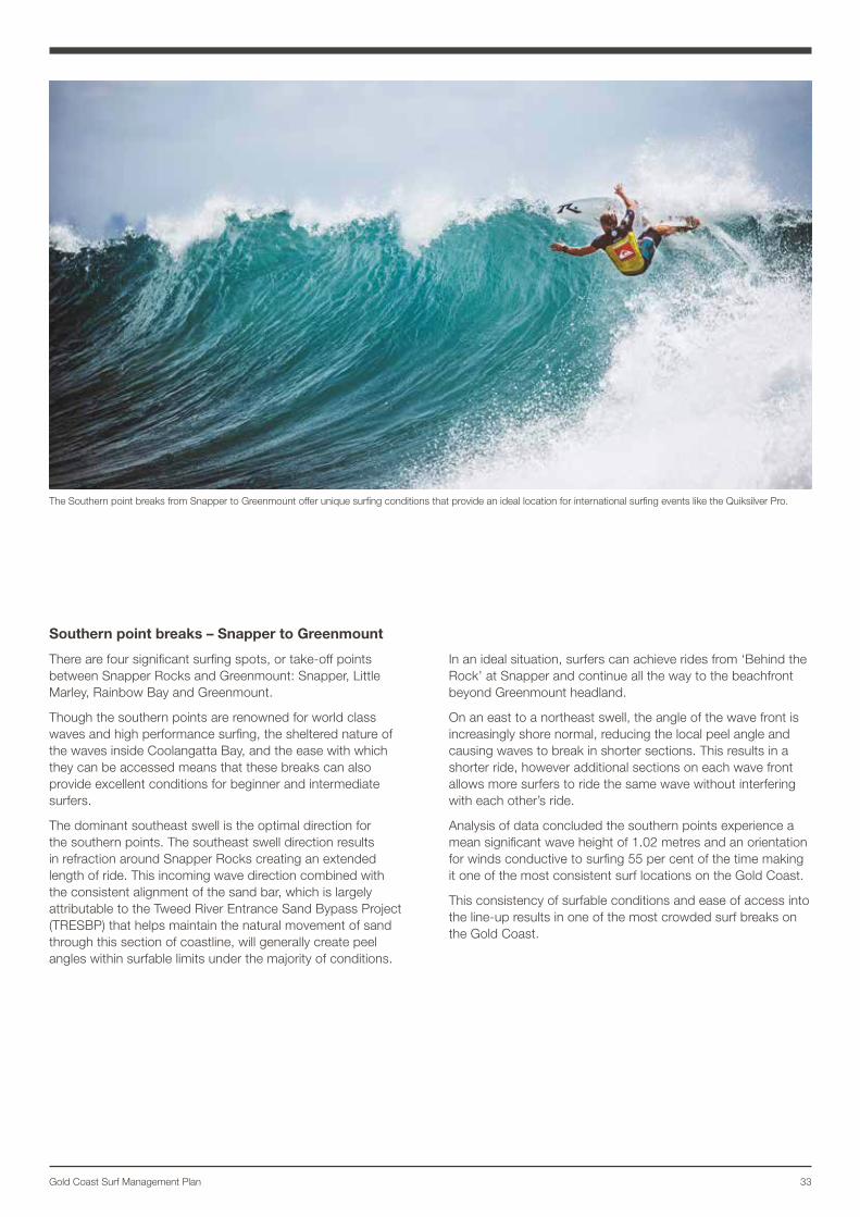
Southern point breaks – Snapper to Greenmount
There are four significant surfing spots, or take-off points between Snapper Rocks and Greenmount: Snapper, Little Marley, Rainbow Bay and Greenmount.
Though the southern points are renowned for world class waves and high performance surfing, the sheltered nature of the waves inside Coolangatta Bay, and the ease with which they can be accessed means that these breaks can also provide excellent conditions for beginner and intermediate surfers.
The dominant southeast swell is the optimal direction for the southern points. The southeast swell direction results in refraction around Snapper Rocks creating an extended length of ride. This incoming wave direction combined with the consistent alignment of the sand bar, which is largely attributable to the Tweed River Entrance Sand Bypass Project (TRESBP) that helps maintain the natural movement of sand through this section of coastline, will generally create peel angles within surfable limits under the majority of conditions.
In an ideal situation, surfers can achieve rides from ‘Behind the Rock’ at Snapper and continue all the way to the beachfront beyond Greenmount headland.
On an east to a northeast swell, the angle of the wave front is increasingly shore normal, reducing the local peel angle and causing waves to break in shorter sections. This results in a shorter ride, however additional sections on each wave front allows more surfers to ride the same wave without interfering with each other’s ride.
Analysis of data concluded the southern points experience a mean significant wave height of 1.02 metres and an orientation for winds conductive to surfing 55 per cent of the time making it one of the most consistent surf locations on the Gold Coast.
This consistency of surfable conditions and ease of access into the line-up results in one of the most crowded surf breaks on the Gold Coast.
The Southern point breaks from Snapper to Greenmount offer unique surfing conditions that provide an ideal location for international surfing events like the Quiksilver Pro.
34
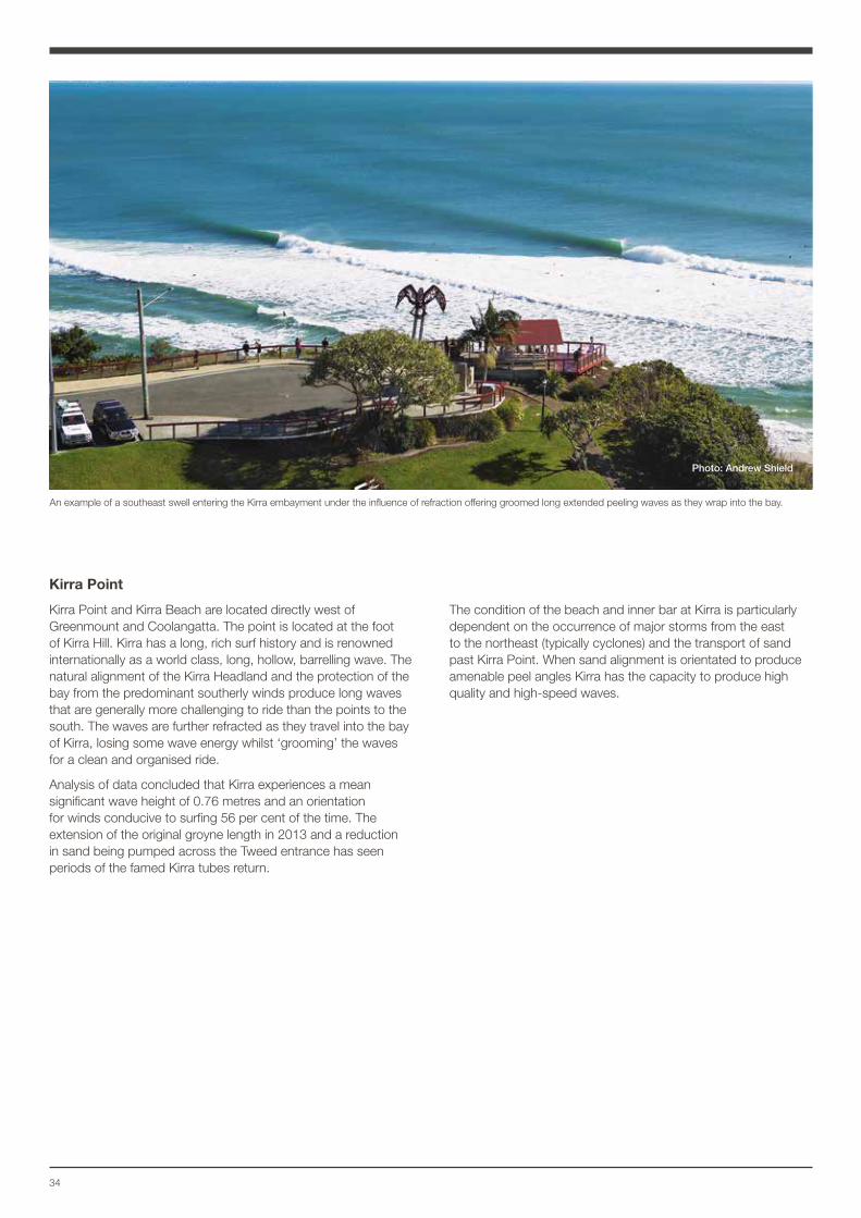
Kirra Point
Kirra Point and Kirra Beach are located directly west of Greenmount and Coolangatta. The point is located at the foot of Kirra Hill. Kirra has a long, rich surf history and is renowned internationally as a world class, long, hollow, barrelling wave. The natural alignment of the Kirra Headland and the protection of the bay from the predominant southerly winds produce long waves that are generally more challenging to ride than the points to the south. The waves are further refracted as they travel into the bay of Kirra, losing some wave energy whilst ‘grooming’ the waves for a clean and organised ride.
Analysis of data concluded that Kirra experiences a mean significant wave height of 0.76 metres and an orientation for winds conducive to surfing 56 per cent of the time. The extension of the original groyne length in 2013 and a reduction in sand being pumped across the Tweed entrance has seen periods of the famed Kirra tubes return.
The condition of the beach and inner bar at Kirra is particularly dependent on the occurrence of major storms from the east to the northeast (typically cyclones) and the transport of sand past Kirra Point. When sand alignment is orientated to produce amenable peel angles Kirra has the capacity to produce high quality and high-speed waves.
An example of a southeast swell entering the Kirra embayment under the influence of refraction offering groomed long extended peeling waves as they wrap into the bay.
Photo: Andrew Shield
35Gold Coast Surf Management Plan
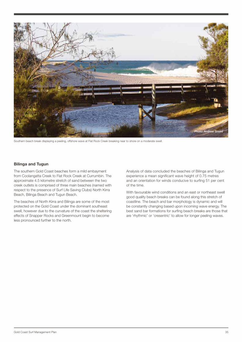
Bilinga and Tugun
The southern Gold Coast beaches form a mild embayment from Coolangatta Creek to Flat Rock Creek at Currumbin. The approximate 4.5 kilometre stretch of sand between the two creek outlets is comprised of three main beaches (named with respect to the presence of Surf Life Saving Clubs) North Kirra Beach, Bilinga Beach and Tugun Beach.
The beaches of North Kirra and Bilinga are some of the most protected on the Gold Coast under the dominant southeast swell, however due to the curvature of the coast the sheltering effects of Snapper Rocks and Greenmount begin to become less pronounced further to the north.
Analysis of data concluded the beaches of Bilinga and Tugun experience a mean significant wave height of 0.75 metres and an orientation for winds conducive to surfing 51 per cent of the time.
With favourable wind conditions and an east or northeast swell good quality beach breaks can be found along this stretch of coastline. The beach and bar morphology is dynamic and will be constantly changing based upon incoming wave energy. The best sand bar formations for surfing beach breaks are those that are ‘rhythmic’ or ‘cresentric’ to allow for longer peeling waves.
Southern beach break displaying a peeling, offshore wave at Flat Rock Creek breaking near to shore on a moderate swell.
Photo: Andrew Shield
36
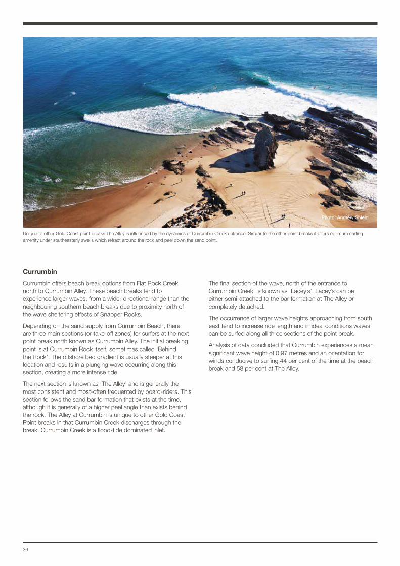
Currumbin
Currumbin offers beach break options from Flat Rock Creek north to Currumbin Alley. These beach breaks tend to experience larger waves, from a wider directional range than the neighbouring southern beach breaks due to proximity north of the wave sheltering effects of Snapper Rocks.
Depending on the sand supply from Currumbin Beach, there are three main sections (or take-off zones) for surfers at the next point break north known as Currumbin Alley. The initial breaking point is at Currumbin Rock itself, sometimes called ‘Behind the Rock’. The offshore bed gradient is usually steeper at this location and results in a plunging wave occurring along this section, creating a more intense ride.
The next section is known as ‘The Alley’ and is generally the most consistent and most-often frequented by board-riders. This section follows the sand bar formation that exists at the time, although it is generally of a higher peel angle than exists behind the rock. The Alley at Currumbin is unique to other Gold Coast Point breaks in that Currumbin Creek discharges through the break. Currumbin Creek is a flood-tide dominated inlet.
The final section of the wave, north of the entrance to Currumbin Creek, is known as ‘Lacey’s’. Lacey’s can be either semi-attached to the bar formation at The Alley or completely detached.
The occurrence of larger wave heights approaching from south east tend to increase ride length and in ideal conditions waves can be surfed along all three sections of the point break.
Analysis of data concluded that Currumbin experiences a mean significant wave height of 0.97 metres and an orientation for winds conducive to surfing 44 per cent of the time at the beach break and 58 per cent at The Alley.
Unique to other Gold Coast point breaks The Alley is influenced by the dynamics of Currumbin Creek entrance. Similar to the other point breaks it offers optimum surfing amenity under southeasterly swells which refract around the rock and peel down the sand point.
Photo: Andrew Shield
37Gold Coast Surf Management Plan
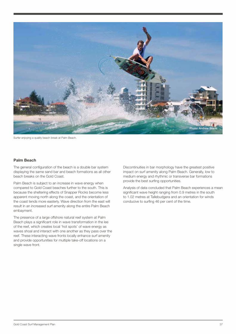
Palm Beach
The general configuration of the beach is a double bar system displaying the same sand bar and beach formations as all other beach breaks on the Gold Coast.
Palm Beach is subject to an increase in wave energy when compared to Gold Coast beaches further to the south. This is because the sheltering effects of Snapper Rocks become less apparent moving north along the coast, and the orientation of the coast tends more easterly. Wave direction from the east will result in an increased surf amenity along the entire Palm Beach embayment.
The presence of a large offshore natural reef system at Palm Beach plays a significant role in wave transformation in the lee of the reef, which creates local ‘hot spots’ of wave energy as waves shoal and interact with one another as they pass over the reef. These interacting wave fronts locally enhance surf amenity and provide opportunities for multiple take-off locations on a single wave front.
Discontinuities in bar morphology have the greatest positive impact on surf amenity along Palm Beach. Generally, low to medium energy and rhythmic or transverse bar formations provide the best surfing opportunities.
Analysis of data concluded that Palm Beach experiences a mean significant wave height ranging from 0.9 metres in the south to 1.02 metres at Tallebudgera and an orientation for winds conducive to surfing 46 per cent of the time.
Surfer enjoying a quality beach break at Palm Beach.
Photo: Andrew Shield
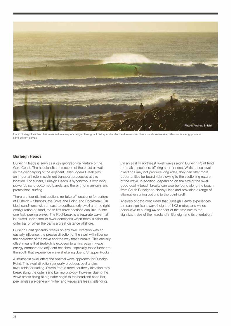
38
Burleigh Heads
Burleigh Heads is seen as a key geographical feature of the Gold Coast. The headland’s intersection of the coast as well as the discharging of the adjacent Tallebudgera Creek play an important role in sediment transport processes at this location. For surfers, Burleigh Heads is synonymous with long, powerful, sand-bottomed barrels and the birth of man-on-man, professional surfing.
There are four distinct sections (or take-off locations) for surfers at Burleigh – Sharkies, the Cove, the Point, and Rockbreak. On ideal conditions, with an east to southeasterly swell and the right configuration of sand, these first three sections can link up into one fast, peeling wave. The Rockbreak is a separate wave that is utilised under smaller swell conditions when there is either no outer bar or when the bar is a great distance offshore.
Burleigh Point generally breaks on any swell direction with an easterly influence; the precise direction of the swell will influence the character of the wave and the way that it breaks. This easterly offset means that Burleigh is exposed to an increase in wave energy compared to adjacent beaches, especially those further to the south that experience wave sheltering due to Snapper Rocks.
A southeast swell offers the optimal wave approach for Burleigh Point. This swell direction generally produces peel angles favourable for surfing. Swells from a more southerly direction may break along the outer sand bar morphology, however due to the wave crests being at a greater angle to the headland sand bar, peel angles are generally higher and waves are less challenging.
On an east or northeast swell waves along Burleigh Point tend to break in sections, offering shorter rides. Whilst these swell directions may not produce long rides, they can offer more opportunities for board riders owing to the sectioning nature of the wave. In addition, depending on the size of the swell, good quality beach breaks can also be found along the beach from South Burleigh to Nobby Headland providing a range of alternative surfing options to the point itself
Analysis of data concluded that Burleigh Heads experiences a mean significant wave height of 1.02 metres and winds conducive to surfing 44 per cent of the time due to the significant size of the headland at Burleigh and its orientation.
Iconic Burleigh Headland has remained relatively unchanged throughout history and under the dominant southeast swells we receive, offers surfers long, powerful sand bottom barrels.
Photo: Andrew Shield
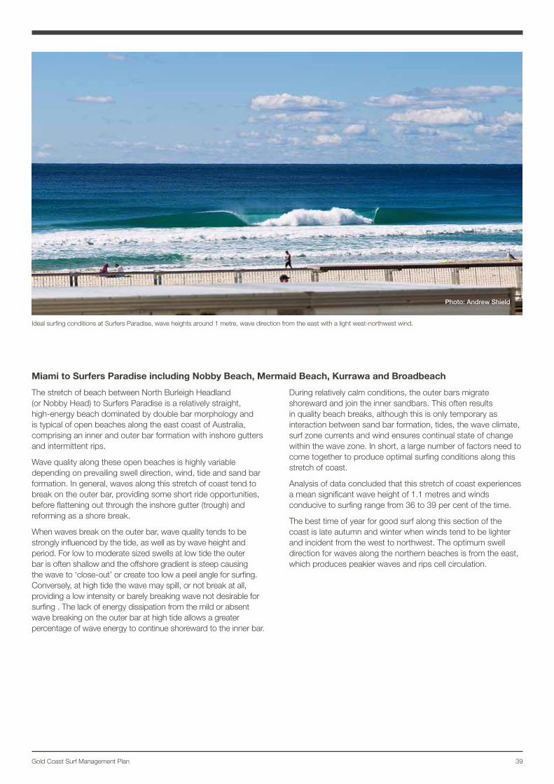
39Gold Coast Surf Management Plan
Miami to Surfers Paradise including Nobby Beach, Mermaid Beach, Kurrawa and Broadbeach
The stretch of beach between North Burleigh Headland (or Nobby Head) to Surfers Paradise is a relatively straight, high-energy beach dominated by double bar morphology and is typical of open beaches along the east coast of Australia, comprising an inner and outer bar formation with inshore gutters and intermittent rips.
Wave quality along these open beaches is highly variable depending on prevailing swell direction, wind, tide and sand bar formation. In general, waves along this stretch of coast tend to break on the outer bar, providing some short ride opportunities, before flattening out through the inshore gutter (trough) and reforming as a shore break.
When waves break on the outer bar, wave quality tends to be strongly influenced by the tide, as well as by wave height and period. For low to moderate sized swells at low tide the outer bar is often shallow and the offshore gradient is steep causing the wave to ‘close-out’ or create too low a peel angle for surfing. Conversely, at high tide the wave may spill, or not break at all, providing a low intensity or barely breaking wave not desirable for surfing . The lack of energy dissipation from the mild or absent wave breaking on the outer bar at high tide allows a greater percentage of wave energy to continue shoreward to the inner bar.
During relatively calm conditions, the outer bars migrate shoreward and join the inner sandbars. This often results in quality beach breaks, although this is only temporary as interaction between sand bar formation, tides, the wave climate, surf zone currents and wind ensures continual state of change within the wave zone. In short, a large number of factors need to come together to produce optimal surfing conditions along this stretch of coast.
Analysis of data concluded that this stretch of coast experiences a mean significant wave height of 1.1 metres and winds conducive to surfing range from 36 to 39 per cent of the time.
The best time of year for good surf along this section of the coast is late autumn and winter when winds tend to be lighter and incident from the west to northwest. The optimum swell direction for waves along the northern beaches is from the east, which produces peakier waves and rips cell circulation.
Ideal surfing conditions at Surfers Paradise, wave heights around 1 metre, wave direction from the east with a light west-northwest wind.
Photo: Andrew Shield
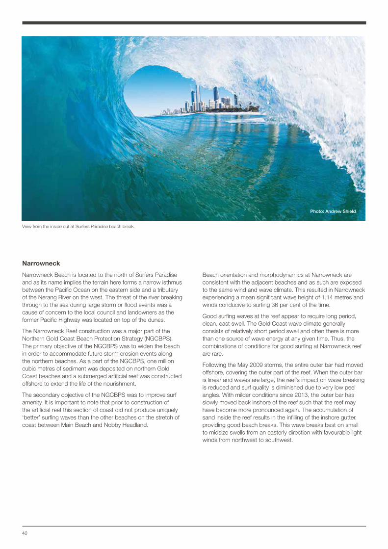
40
Narrowneck
Narrowneck Beach is located to the north of Surfers Paradise and as its name implies the terrain here forms a narrow isthmus between the Pacific Ocean on the eastern side and a tributary of the Nerang River on the west. The threat of the river breaking through to the sea during large storm or flood events was a cause of concern to the local council and landowners as the former Pacific Highway was located on top of the dunes.
The Narrowneck Reef construction was a major part of the Northern Gold Coast Beach Protection Strategy (NGCBPS). The primary objective of the NGCBPS was to widen the beach in order to accommodate future storm erosion events along the northern beaches. As a part of the NGCBPS, one million cubic metres of sediment was deposited on northern Gold Coast beaches and a submerged artificial reef was constructed offshore to extend the life of the nourishment.
The secondary objective of the NGCBPS was to improve surf amenity. It is important to note that prior to construction of the artificial reef this section of coast did not produce uniquely ‘better’ surfing waves than the other beaches on the stretch of coast between Main Beach and Nobby Headland.
Beach orientation and morphodynamics at Narrowneck are consistent with the adjacent beaches and as such are exposed to the same wind and wave climate. This resulted in Narrowneck experiencing a mean significant wave height of 1.14 metres and winds conducive to surfing 36 per cent of the time.
Good surfing waves at the reef appear to require long period, clean, east swell. The Gold Coast wave climate generally consists of relatively short period swell and often there is more than one source of wave energy at any given time. Thus, the combinations of conditions for good surfing at Narrowneck reef are rare.
Following the May 2009 storms, the entire outer bar had moved offshore, covering the outer part of the reef. When the outer bar is linear and waves are large, the reef’s impact on wave breaking is reduced and surf quality is diminished due to very low peel angles. With milder conditions since 2013, the outer bar has slowly moved back inshore of the reef such that the reef may have become more pronounced again. The accumulation of sand inside the reef results in the infilling of the inshore gutter, providing good beach breaks. This wave breaks best on small to midsize swells from an easterly direction with favourable light winds from northwest to southwest.
View from the inside out at Surfers Paradise beach break.
Photo: Andrew Shield
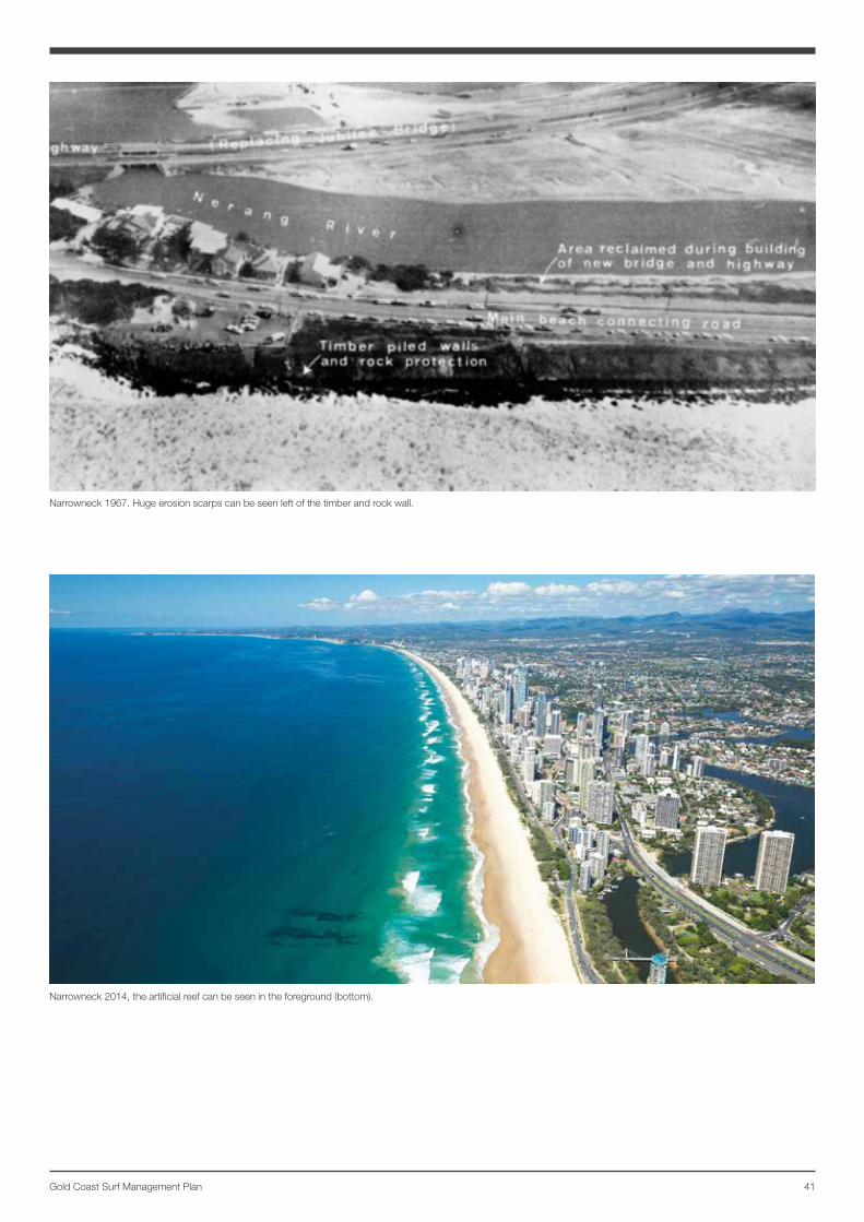
41Gold Coast Surf Management Plan
Narrowneck 1967. Huge erosion scarps can be seen left of the timber and rock wall.
Narrowneck 2014, the artificial reef can be seen in the foreground (bottom).
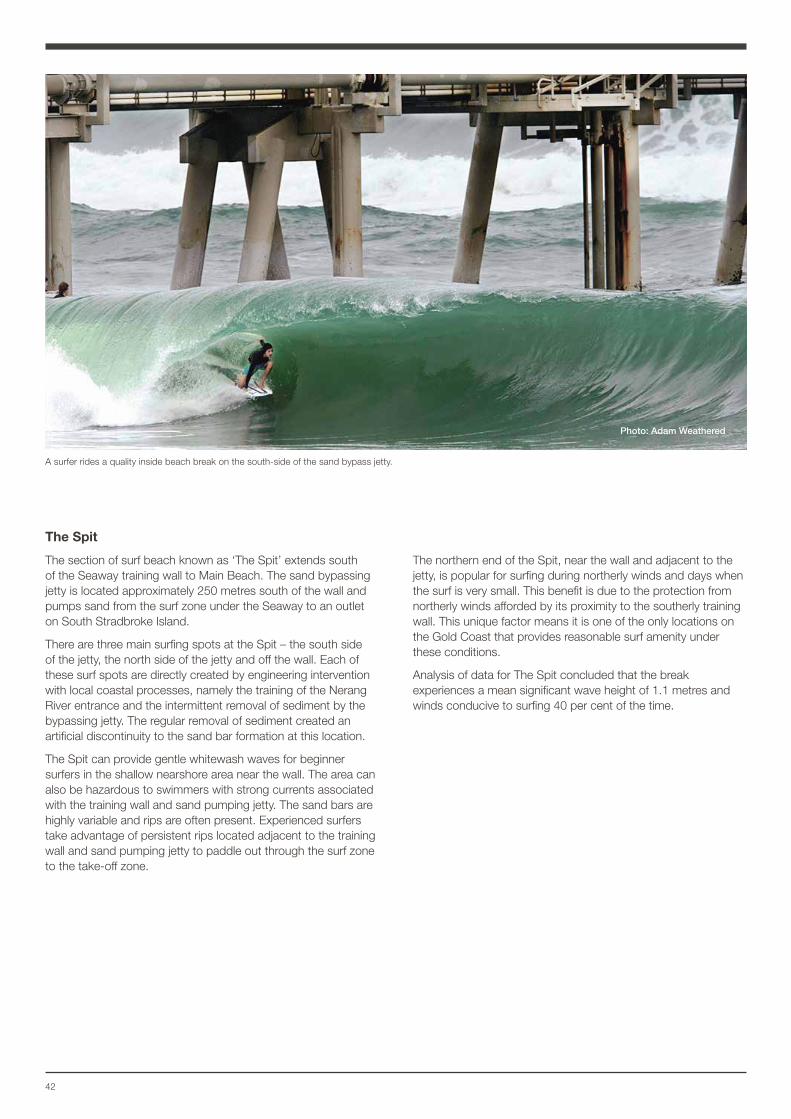
42
The Spit
The section of surf beach known as ‘The Spit’ extends south of the Seaway training wall to Main Beach. The sand bypassing jetty is located approximately 250 metres south of the wall and pumps sand from the surf zone under the Seaway to an outlet on South Stradbroke Island.
There are three main surfing spots at the Spit – the south side of the jetty, the north side of the jetty and off the wall. Each of these surf spots are directly created by engineering intervention with local coastal processes, namely the training of the Nerang River entrance and the intermittent removal of sediment by the bypassing jetty. The regular removal of sediment created an artificial discontinuity to the sand bar formation at this location.
The Spit can provide gentle whitewash waves for beginner surfers in the shallow nearshore area near the wall. The area can also be hazardous to swimmers with strong currents associated with the training wall and sand pumping jetty. The sand bars are highly variable and rips are often present. Experienced surfers take advantage of persistent rips located adjacent to the training wall and sand pumping jetty to paddle out through the surf zone to the take-off zone.
The northern end of the Spit, near the wall and adjacent to the jetty, is popular for surfing during northerly winds and days when the surf is very small. This benefit is due to the protection from northerly winds afforded by its proximity to the southerly training wall. This unique factor means it is one of the only locations on the Gold Coast that provides reasonable surf amenity under these conditions.
Analysis of data for The Spit concluded that the break experiences a mean significant wave height of 1.1 metres and winds conducive to surfing 40 per cent of the time.
Photo: Adam Weathered
A surfer rides a quality inside beach break on the south-side of the sand bypass jetty.
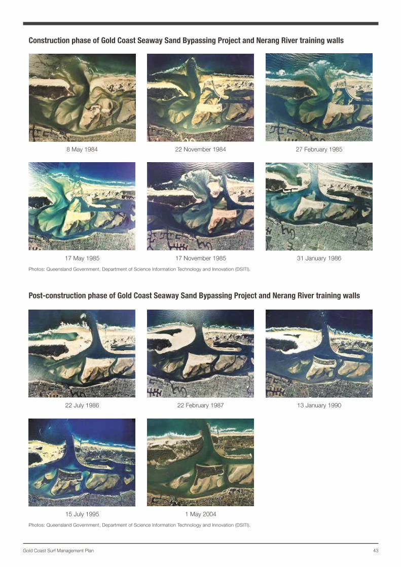
43Gold Coast Surf Management Plan
Construction phase of Gold Coast Seaway Sand Bypassing Project and Nerang River training walls
8 May 1984 22 November 1984 27 February 1985
17 May 1985 17 November 1985 31 January 1986
Photos: Queensland Government, Department of Science Information Technology and Innovation (DSITI).
Post-construction phase of Gold Coast Seaway Sand Bypassing Project and Nerang River training walls
22 July 1986 22 February 1987 13 January 1990
15 July 1995 1 May 2004
Photos: Queensland Government, Department of Science Information Technology and Innovation (DSITI).
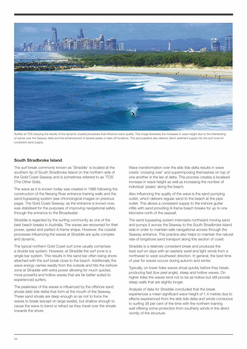
44
South Stradbroke Island
The surf break commonly known as ‘Straddie’ is located at the southern tip of South Stradbroke Island on the northern side of the Gold Coast Seaway and is sometimes referred to as ‘TOS’ (The Other Side).
The wave as it is known today was created in 1986 following the construction of the Nerang River entrance training walls and the sand bypassing system (see chronological images on previous page). The Gold Coast Seaway, as the entrance is known now, was stabilised for the purposes of improving navigational safety through the entrance to the Broadwater.
Straddie is regarded by the surfing community as one of the best beach breaks in Australia. The waves are renowned for their power, speed and perfect A-frame shape. However, the coastal processes influencing the waves at Straddie are quite complex and dynamic.
The typical northern Gold Coast surf zone usually comprises a double bar system. However, at Straddie the surf zone is a single bar system. This results in the sand bar often being shore-attached with the surf break close to the beach. Additionally the wave energy carries readily from the outside and hits the inshore zone at Straddie with extra power allowing for much quicker, more powerful and hollow waves that are far better suited to experienced surfers.
The peakiness of the waves is influenced by the offshore sand shoals (ebb tide delta) that form at the mouth of the Seaway. These sand shoals are deep enough so as not to force the waves to break (except on large swells), but shallow enough to cause the wave to bend or refract as they travel over the shoals towards the shore.
Wave transformation over the ebb tide delta results in wave crests ‘crossing over’ and superimposing themselves on top of one another in the lee of delta. This process creates a localised increase in wave height as well as increasing the number of individual ‘peaks’ along the beach.
Also influencing the quality of the wave is the sand pumping outlet, which delivers regular sand to the beach at the pipe outlet. This allows a consistent supply to the inshore gutter infills with sand providing A-frame beach breaks for up to one kilometre north of the seawall.
The sand bypassing system intercepts northward moving sand and pumps it across the Seaway to the South Stradbroke Island side in order to maintain safe navigational access through the Seaway entrance. This practice also helps to maintain the natural rate of longshore sand transport along this section of coast.
Straddie is a relatively consistent break and produces the best surf on days with an easterly swell and light winds from a northwest to west-southwest direction. In general, the best time of year for waves occurs during autumn and winter.
Typically, on lower tides waves shoal quickly before they break, producing fast (low peel angle), steep and hollow waves. On higher tides the waves tend not to be as hollow but still provide steep walls that are slightly longer.
Analysis of data for Straddie concluded that the break experiences a mean significant wave height of 1.4 metres due to effects experienced from the ebb tide delta and winds conducive to surfing 38 per cent of the time with the northern training wall offering some protection from southerly winds in the direct vicinity of the structure.
Surfers at TOS enjoying the results of the dynamic coastal processes that influence wave quality. This image illustrates the increases in wave height due to the intersecting of waves over the Seaway delta and the enhancement of several peaks or take-off locations. The sand pipeline also delivers direct sediment supply into the surf zone for consistent sand supply.
Photo: Andrew Shield
45Gold Coast Surf Management Plan
46
Management of our beachesCity of Gold Coast is committed to protecting and managing beaches for residents and visitors. The City has a long history of activity to protect the coast from pressures such as storm events and coastal development.
Coastal engineering practices on the Gold Coast have the benefit of over 50 years of research. A suite of innovative policies, research, technologies and beach management techniques have been implemented and subsequently acknowledged and adopted as best practice throughout the world.
Currently, management of the coast is guided by the Ocean Beaches Strategy (OBS) and the Gold Coast Shoreline Management Plan (GCSMP). Both outline best practice for the day-to-day and long-term management of the Gold Coast’s beaches.
The Surf Management Plan recognises the four strategic outcomes of the Ocean Beaches Strategy and aligns with current best practice management of the coast by the City in maintaining surf amenity and (where possible) enhancing surf amenity.
In September 2015, the City agreed to support the World Surfing Reserve, subject to the following:
• The City of Gold Coast Surf Management Plan is the endorsed strategy of the management of the City’s ocean beaches.
• That the World Surfing Reserve status does not fetter the rights and obligations of the City of Gold Coast in exercising its responsibilities.
• That the World Surfing Reserve status does not impinge upon the rights of other users of the beaches including, swimming, surf lifesaving, fishing, recreational boating, and other water craft.
• That the local stewardship committee for the World Surfing Reserve is to be determined by Council and involving members of the City’s Surf Management Plan Advisory Committee.
• That the World Surfing Reserve status will not be used to lobby for any changes in the legislation, either Local, State, or Federal.
• That the City’s endorsement of the World Surfing Reserve nomination is on the basis that the title is purely ceremonial only in nature.
• That the City reserves the right and discretion to withdraw its support for the World Surfing Reserve if any of the above criteria are not met or maintained to satisfaction.
Beach nourishmentBeach nourishment or beach replenishment has formed a fundamental element in the management of the city’s beaches for over the past 40 years. Beach nourishment involves dumping or pumping sand from a sand source external to the active beach system, to widen the beach (and surf zone) that is influenced by waves.
As part of investigations by the State Government in the 1960s to develop an integrated beach management approach for the Gold Coast, the Delft Hydraulics Laboratory recommended extensive nourishment for the immediate improvement of the beaches affected by erosion.
Beach nourishment projects have been implemented along the coastline from Main Beach through to Coolangatta since the early 1970s. The size and scale of each project has varied, however the common purpose of each project has been to assist beaches recover following extended periods of erosion or following the impacts of tropical cyclones.
Typically, dredged sand is placed offshore, allowing wave energy to move the sand toward the shoreline over time. In some instances, the use of temporary pipelines allows sand to be pumped and dispersed on the beach close to the shoreline. Delivery of beach nourishment campaigns aligns with the Ocean Beaches Strategy outcomes – ‘our infrastructure is protected from coastal hazards’, and ‘our beaches are healthy and clean’.
Seawall construction The construction of seawalls forms part of the City’s shoreline management response to coastal erosion. Seawalls are constructed to the State Government’s standard design specification along the seawall planning alignment known as the ‘A-Line’.
Planning controls in the City Plan and the City’s Capital Works Program are delivering a continuous seawall along the Gold Coast beachfront. The completion of seawalls aligns with the Ocean Beaches Strategy outcome - our infrastructure is protected from coastal hazards.
A continuous seawall is necessary to provide protection to property, open space and infrastructure. Currently the seawall extends for the majority from the Sheraton Mirage Resort at Main Beach to Snapper Rocks in Coolangatta. During storm events and/or sustained periods of high-energy ocean swells, seawalls may become exposed, or where incomplete sections of the seawall remain, erosion may occur between and behind adjacent seawalls.
The City’s long-preferred option is to maintain a healthy natural dune system over the seawall, with the seawall only becoming exposed during and after erosion events.
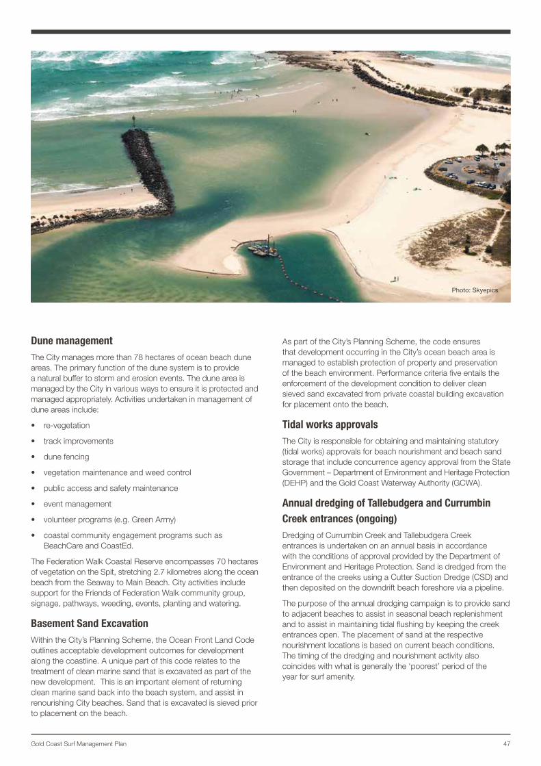
47Gold Coast Surf Management Plan
Dune managementThe City manages more than 78 hectares of ocean beach dune areas. The primary function of the dune system is to provide a natural buffer to storm and erosion events. The dune area is managed by the City in various ways to ensure it is protected and managed appropriately. Activities undertaken in management of dune areas include:
• re-vegetation
• track improvements
• dune fencing
• vegetation maintenance and weed control
• public access and safety maintenance
• event management
• volunteer programs (e.g. Green Army)
• coastal community engagement programs such as BeachCare and CoastEd.
The Federation Walk Coastal Reserve encompasses 70 hectares of vegetation on the Spit, stretching 2.7 kilometres along the ocean beach from the Seaway to Main Beach. City activities include support for the Friends of Federation Walk community group, signage, pathways, weeding, events, planting and watering.
Basement Sand ExcavationWithin the City’s Planning Scheme, the Ocean Front Land Code outlines acceptable development outcomes for development along the coastline. A unique part of this code relates to the treatment of clean marine sand that is excavated as part of the new development. This is an important element of returning clean marine sand back into the beach system, and assist in renourishing City beaches. Sand that is excavated is sieved prior to placement on the beach.
As part of the City’s Planning Scheme, the code ensures that development occurring in the City’s ocean beach area is managed to establish protection of property and preservation of the beach environment. Performance criteria five entails the enforcement of the development condition to deliver clean sieved sand excavated from private coastal building excavation for placement onto the beach.
Tidal works approvals The City is responsible for obtaining and maintaining statutory (tidal works) approvals for beach nourishment and beach sand storage that include concurrence agency approval from the State Government – Department of Environment and Heritage Protection (DEHP) and the Gold Coast Waterway Authority (GCWA).
Annual dredging of Tallebudgera and Currumbin Creek entrances (ongoing)Dredging of Currumbin Creek and Tallebudgera Creek entrances is undertaken on an annual basis in accordance with the conditions of approval provided by the Department of Environment and Heritage Protection. Sand is dredged from the entrance of the creeks using a Cutter Suction Dredge (CSD) and then deposited on the downdrift beach foreshore via a pipeline.
The purpose of the annual dredging campaign is to provide sand to adjacent beaches to assist in seasonal beach replenishment and to assist in maintaining tidal flushing by keeping the creek entrances open. The placement of sand at the respective nourishment locations is based on current beach conditions. The timing of the dredging and nourishment activity also coincides with what is generally the ‘poorest’ period of the year for surf amenity.
Photo: Skyepics
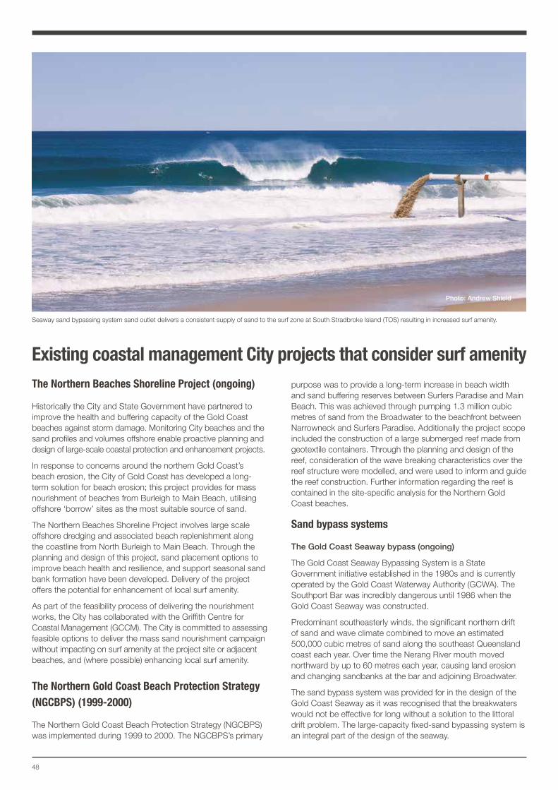
48
Existing coastal management City projects that consider surf amenity The Northern Beaches Shoreline Project (ongoing)
Historically the City and State Government have partnered to improve the health and buffering capacity of the Gold Coast beaches against storm damage. Monitoring City beaches and the sand profiles and volumes offshore enable proactive planning and design of large-scale coastal protection and enhancement projects.
In response to concerns around the northern Gold Coast’s beach erosion, the City of Gold Coast has developed a long-term solution for beach erosion; this project provides for mass nourishment of beaches from Burleigh to Main Beach, utilising offshore ‘borrow’ sites as the most suitable source of sand.
The Northern Beaches Shoreline Project involves large scale offshore dredging and associated beach replenishment along the coastline from North Burleigh to Main Beach. Through the planning and design of this project, sand placement options to improve beach health and resilience, and support seasonal sand bank formation have been developed. Delivery of the project offers the potential for enhancement of local surf amenity.
As part of the feasibility process of delivering the nourishment works, the City has collaborated with the Griffith Centre for Coastal Management (GCCM). The City is committed to assessing feasible options to deliver the mass sand nourishment campaign without impacting on surf amenity at the project site or adjacent beaches, and (where possible) enhancing local surf amenity.
The Northern Gold Coast Beach Protection Strategy (NGCBPS) (1999-2000)
The Northern Gold Coast Beach Protection Strategy (NGCBPS) was implemented during 1999 to 2000. The NGCBPS’s primary
purpose was to provide a long-term increase in beach width and sand buffering reserves between Surfers Paradise and Main Beach. This was achieved through pumping 1.3 million cubic metres of sand from the Broadwater to the beachfront between Narrowneck and Surfers Paradise. Additionally the project scope included the construction of a large submerged reef made from geotextile containers. Through the planning and design of the reef, consideration of the wave breaking characteristics over the reef structure were modelled, and were used to inform and guide the reef construction. Further information regarding the reef is contained in the site-specific analysis for the Northern Gold Coast beaches.
Sand bypass systems
The Gold Coast Seaway bypass (ongoing)
The Gold Coast Seaway Bypassing System is a State Government initiative established in the 1980s and is currently operated by the Gold Coast Waterway Authority (GCWA). The Southport Bar was incredibly dangerous until 1986 when the Gold Coast Seaway was constructed.
Predominant southeasterly winds, the significant northern drift of sand and wave climate combined to move an estimated 500,000 cubic metres of sand along the southeast Queensland coast each year. Over time the Nerang River mouth moved northward by up to 60 metres each year, causing land erosion and changing sandbanks at the bar and adjoining Broadwater.
The sand bypass system was provided for in the design of the Gold Coast Seaway as it was recognised that the breakwaters would not be effective for long without a solution to the littoral drift problem. The large-capacity fixed-sand bypassing system is an integral part of the design of the seaway.
Seaway sand bypassing system sand outlet delivers a consistent supply of sand to the surf zone at South Stradbroke Island (TOS) resulting in increased surf amenity.
Photo: Andrew Shield
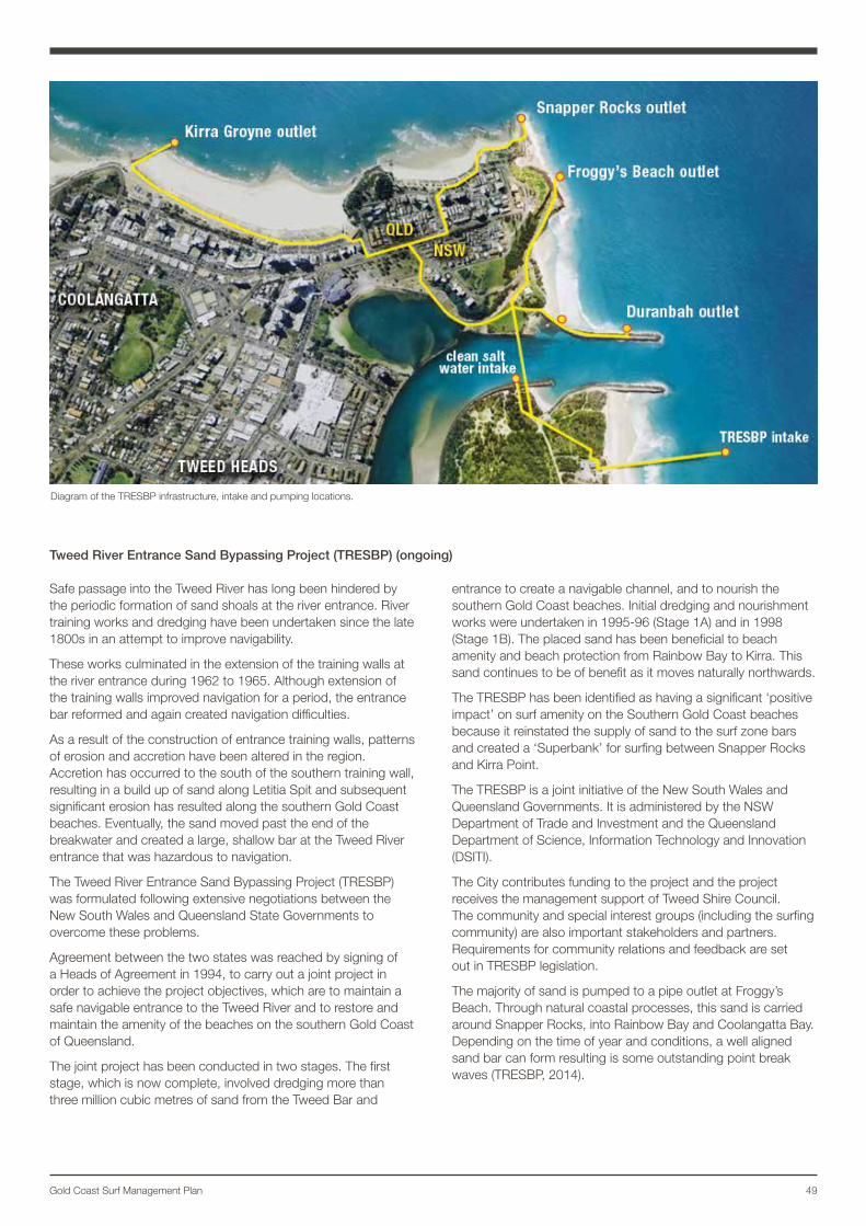
49Gold Coast Surf Management Plan
Tweed River Entrance Sand Bypassing Project (TRESBP) (ongoing)
Safe passage into the Tweed River has long been hindered by the periodic formation of sand shoals at the river entrance. River training works and dredging have been undertaken since the late 1800s in an attempt to improve navigability.
These works culminated in the extension of the training walls at the river entrance during 1962 to 1965. Although extension of the training walls improved navigation for a period, the entrance bar reformed and again created navigation difficulties.
As a result of the construction of entrance training walls, patterns of erosion and accretion have been altered in the region. Accretion has occurred to the south of the southern training wall, resulting in a build up of sand along Letitia Spit and subsequent significant erosion has resulted along the southern Gold Coast beaches. Eventually, the sand moved past the end of the breakwater and created a large, shallow bar at the Tweed River entrance that was hazardous to navigation.
The Tweed River Entrance Sand Bypassing Project (TRESBP) was formulated following extensive negotiations between the New South Wales and Queensland State Governments to overcome these problems.
Agreement between the two states was reached by signing of a Heads of Agreement in 1994, to carry out a joint project in order to achieve the project objectives, which are to maintain a safe navigable entrance to the Tweed River and to restore and maintain the amenity of the beaches on the southern Gold Coast of Queensland.
The joint project has been conducted in two stages. The first stage, which is now complete, involved dredging more than three million cubic metres of sand from the Tweed Bar and
entrance to create a navigable channel, and to nourish the southern Gold Coast beaches. Initial dredging and nourishment works were undertaken in 1995-96 (Stage 1A) and in 1998 (Stage 1B). The placed sand has been beneficial to beach amenity and beach protection from Rainbow Bay to Kirra. This sand continues to be of benefit as it moves naturally northwards.
The TRESBP has been identified as having a significant ‘positive impact’ on surf amenity on the Southern Gold Coast beaches because it reinstated the supply of sand to the surf zone bars and created a ‘Superbank’ for surfing between Snapper Rocks and Kirra Point.
The TRESBP is a joint initiative of the New South Wales and Queensland Governments. It is administered by the NSW Department of Trade and Investment and the Queensland Department of Science, Information Technology and Innovation (DSITI).
The City contributes funding to the project and the project receives the management support of Tweed Shire Council. The community and special interest groups (including the surfing community) are also important stakeholders and partners. Requirements for community relations and feedback are set out in TRESBP legislation.
The majority of sand is pumped to a pipe outlet at Froggy’s Beach. Through natural coastal processes, this sand is carried around Snapper Rocks, into Rainbow Bay and Coolangatta Bay. Depending on the time of year and conditions, a well aligned sand bar can form resulting is some outstanding point break waves (TRESBP, 2014).
Diagram of the TRESBP infrastructure, intake and pumping locations.
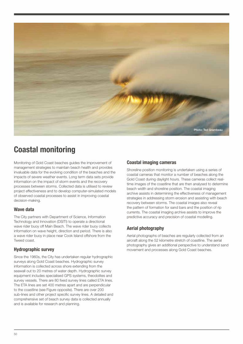
50
Coastal monitoringMonitoring of Gold Coast beaches guides the improvement of management strategies to maintain beach health and provides invaluable data for the evolving condition of the beaches and the impacts of severe weather events. Long term data sets provide information on the impact of storm events and the recovery processes between storms. Collected data is utilised to review project effectiveness and to develop computer-simulated models of observed coastal processes to assist in improving coastal decision-making.
Wave dataThe City partners with Department of Science, Information Technology and Innovation (DSITI) to operate a directional wave rider buoy off Main Beach. The wave rider buoy collects information on wave height, direction and period. There is also a wave rider buoy in place near Cook Island offshore from the Tweed coast.
Hydrographic surveySince the 1960s, the City has undertaken regular hydrographic surveys along Gold Coast beaches. Hydrographic survey information is collected across shore extending from the seawall out to 20 metres of water depth. Hydrographic survey equipment includes specialised GPS systems, theodolites and survey vessels. There are 80 fixed survey lines called ETA lines. The ETA lines are set 400 metres apart and are perpendicular to the coastline (see Figure opposite). There are over 200 sub-lines and other project specific survey lines. A detailed and comprehensive set of beach survey data is collected annually and is available for research and planning.
Coastal imaging camerasShoreline position monitoring is undertaken using a series of coastal cameras that monitor a number of beaches along the Gold Coast during daylight hours. These cameras collect real-time images of the coastline that are then analysed to determine beach width and shoreline position. The coastal imaging archive assists in determining the effectiveness of management strategies in addressing storm erosion and assisting with beach recovery between storms. The coastal images also reveal the pattern of formation for sand bars and the position of rip currents. The coastal imaging archive assists to improve the predictive accuracy and precision of coastal modelling.
Aerial photographyAerial photographs of beaches are regularly collected from an aircraft along the 52 kilometre stretch of coastline. The aerial photography gives an additional perspective to understand sand movement and processes along Gold Coast beaches.
Photo: Ted Grambeau
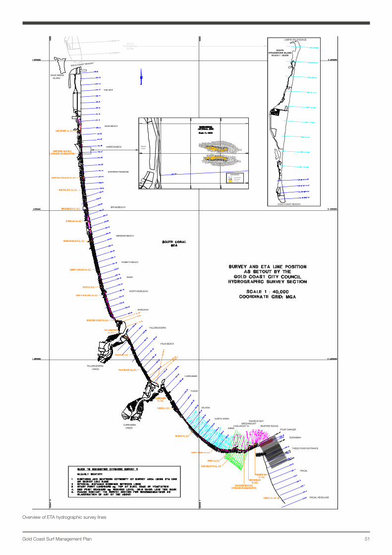
51Gold Coast Surf Management Plan
Overview of ETA hydrographic survey lines
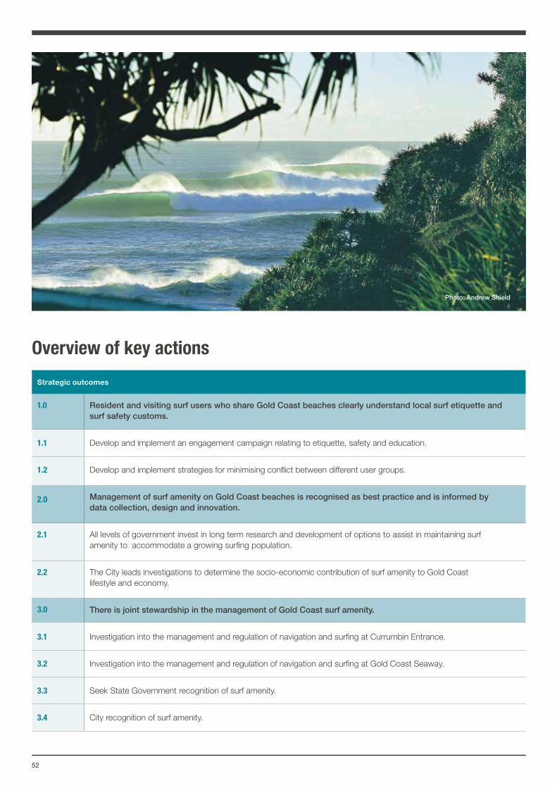
5252
Overview of key actions
Strategic outcomes
1.0 Resident and visiting surf users who share Gold Coast beaches clearly understand local surf etiquette and surf safety customs.
1.1 Develop and implement an engagement campaign relating to etiquette, safety and education.
1.2 Develop and implement strategies for minimising conflict between different user groups.
2.0 Management of surf amenity on Gold Coast beaches is recognised as best practice and is informed by data collection, design and innovation.
2.1 All levels of government invest in long term research and development of options to assist in maintaining surf amenity to accommodate a growing surfing population.
2.2 The City leads investigations to determine the socio-economic contribution of surf amenity to Gold Coast lifestyle and economy.
3.0 There is joint stewardship in the management of Gold Coast surf amenity.
3.1 Investigation into the management and regulation of navigation and surfing at Currumbin Entrance.
3.2 Investigation into the management and regulation of navigation and surfing at Gold Coast Seaway.
3.3 Seek State Government recognition of surf amenity.
3.4 City recognition of surf amenity.
Photo: Andrew Shield
Where to from here? The Surf Management Plan, through the Action Plan will recognise the importance of surfing to the city’s lifestyle and economy, provide a framework to address the increasing demands on our surfing resources, and ensure that everyone can enjoy a beach experience.
The plan will be subject to three levels of review and reporting:
• a publicly available annual report card
• reporting through the City Ocean Beaches Strategy 2013–2023 reporting structure
• major reviews of the plan undertaken in 2020 and in 2025, 2030 and 2035.
Conclusion The development of the Surf Management Plan has been a collective undertaking involving the City, State Government agencies, the general community and interest groups. The City wishes to acknowledge and thank the SMPAC for their input and contribution to the development of the Surf Management Plan. The Surf Management Plan will ensure the surf amenity and the surfing experience on the Gold Coast can be enjoyed now and by future generations.
The Surf Management Plan presents a strategic course of management and research to support the long-term preservation and (where possible) enhancement of surf amenity and the coastal environment with management initiatives for the growing demand on our surf breaks.
Photo: Andrew Shield
Printed on 100% recycled paper
CG
C11
754
For more informationP 1300 GOLDCOAST (1300 465 326) W cityofgoldcoast.com.au
Photo: Andrew Shield
Photo: Andrew ShieldPhoto: Mal Sutherland