goes-r overview · goes-r overview presented by: chris sisko prepared by: matt seybold goes-r data...
TRANSCRIPT
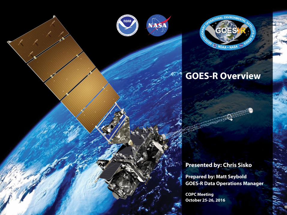
GOES-R Overview
Presented by: Chris Sisko
Prepared by: Matt Seybold GOES-R Data Operations Manager COPC Meeting October 25-26, 2016
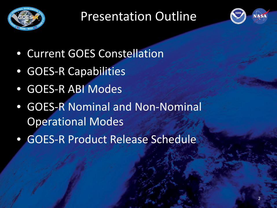
Presentation Outline
• Current GOES Constellation • GOES-R Capabilities • GOES-R ABI Modes • GOES-R Nominal and Non-Nominal
Operational Modes • GOES-R Product Release Schedule
2
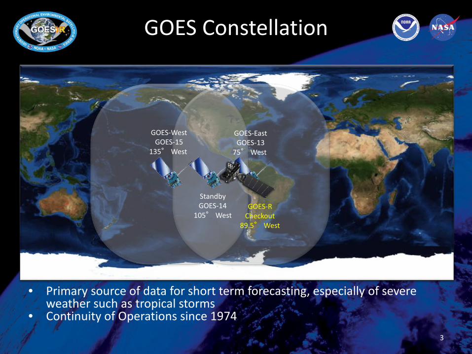
GOES Constellation
3
• Primary source of data for short term forecasting, especially of severe weather such as tropical storms
• Continuity of Operations since 1974
GOES-West GOES-15
135° West
GOES-East GOES-13
75° West
Standby GOES-14
105° West GOES-R
Checkout 89.5° West

GOES-R Series
• GOES R, S, T, U • GOES-R launch
– Most recent update: GOES-R made it through Hurricane Matthew unscathed, but the GVAN rail car which houses the Atlas GSE was tipped on its side. It needs to be checked out and repaired if necessary. Unofficially, GOES-R launch may incur a delay due to this issue.
– Launching from: Cape Canaveral Air Force Station, Florida – Vehicle: United Launch Alliance Atlas V (AV-541) – Pad: Launch Complex 41 – First public images ~Jan. 2017 – First imagery released for
public use ~Feb. 2017 – Assume position at East/West ~Nov. 2017
• GOES-S launch Feb. 2018 • GOES-T launch 2019 • GOES-U launch 2024
4
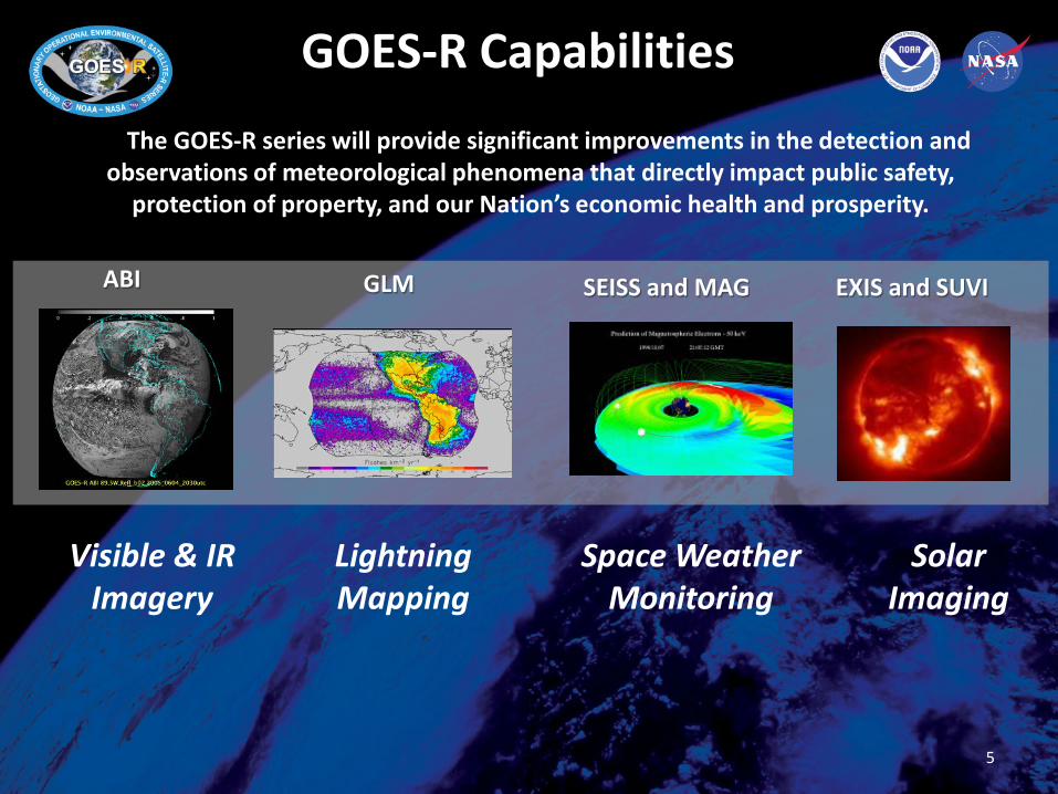
GOES-R Capabilities
Visible & IR Imagery
Lightning Mapping
Space Weather Monitoring
Solar Imaging
The GOES-R series will provide significant improvements in the detection and
observations of meteorological phenomena that directly impact public safety, protection of property, and our Nation’s economic health and prosperity.
ABI GLM SEISS and MAG EXIS and SUVI
5

Assembled GOES-R Spacecraft
6

Trip to Florida
7

Advanced Baseline Imager (ABI)
Primary instrument in GOES-R series
16 channel imager
8

GOES-13/14/15 Spectral Bands GOES-R Spectral Bands
Three Times More Spectral Information
9

Four Times More Spatial Resolution
Spatially: GOES-R Current 0.64 um VIS: 0.5 km 1 km other VIS/NIR: 1 km n/a IR: 2 km 4 km
GOES
Figure courtesy of K. Bedka and W. Feltz 10

Four Times More Spatial Resolution
“ABI” from MODIS
Figure courtesy of K. Bedka and W. Feltz 11
Spatially: GOES-R Current 0.64 um VIS: 0.5 km 1 km other VIS/NIR: 1 km n/a IR: 2 km 4 km
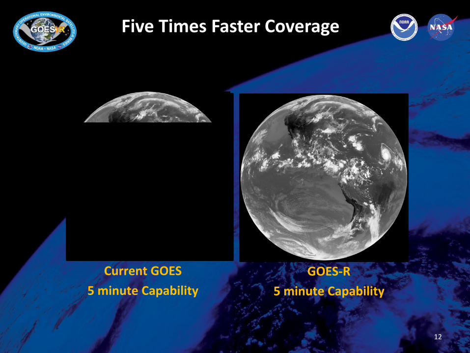
Current GOES 5 minute Capability
GOES-R 5 minute Capability
Five Times Faster Coverage
12

ABI: Temporal
SRSOR (1-min) RSO (5-30 -min) Standard (15-30 -min) Figures courtesy of NOAA
13

Flexibility of the ABI
Two Primary Modes of Operation: • Mode 3: Flex Mode (Default Mode per NWS)
– Full Disk (FD) domain every 15 mins – Contiguous US (CONUS) domain every 5 mins – 2 Mesoscale domains every 1 minute
or – 1 Mesoscale domain every 30 seconds
• Mode 4: Continuous Full Disk (FD) Mode – Full Disk domain every 5 mins
• Mesoscale and mode domain changes are handled by the NCEP/Senior Duty Meteorologist (SDM) - They receive requests for mode and mesoscale location changes from NWS, NCEP, and/or NESDIS requesting entities (like DoD).
14

Flex Mode (mode 3) Courtesy of Tim Schmit and Mat Gunshor
Flex Mode Scanning
15
15 min
Mesoscale box locations are movable
5 min
1 min
1 min

With 2 ABIs (GOES E & W) = 4 Mesoscale Domain Sectors (MDS)
Courtesy of Tim Schmit and Mat Gunshor 16
GOES-16 as GOES East GOES-16 as GOES West

Flex Mode Mesoscale Domain Default Positions
• Commercial airline route corridors shown for both GOES-E and GOES-W
• These will be default Mesoscale Domain Sector (MDS) locations if there are no other requests
Courtesy of Tim Schmit and Mat Gunshor

18
PG* Only GRB (L1b) & Sectorized CMI generation PD* Only GRB delivery to satellite, Sectorized CMI delivery to AWIPS, L0 to LZSS (WCDAS only); delivery only by OE PG** L1b reconstruction, L2+ generation Uplink – Ground to satellite PD** L1b, L2+ delivery to PDA; delivery only by OE Downlink – Satellite to ground
AWIPS NCF
CBU OE
EM
MM
PG*
PD*
WCDAS OE
EM
MM
PG*
PD*
ITE EM
MM
PG*
PD*
DE EM
PG*
PD*
MM
Sectorized CMI Sectorized CMI
NSOF OE
EM
MM
PG**
PD**
ITE EM
MM
PG**
PD**
DE EM
PG**
PD**
PDA L1b, L2+
LZSS L0
GOES-R (S) Satellite West
GOES-S (R) Satellite East
TLM Raw Data GRB
TLM Raw Data GRB
TLM Raw Data GRB
TLM Raw Data GRB
CMD, GRB
CMD, GRB CMD, GRB
GRB GRB

19
Primary Backup Non-GS
Nominal Configuration
AWIPS NCF
CBU MM
EM
PG
PD
WCDAS MM
EM
PG
PD
NSOF
MM
EM
PG
PD
PDA
L1b, L2+
S-CMI
GOES-R
GRB
T&C Raw Data
GRB
WCDAS Outage
CBU MM
EM
PG
PD
WCDAS MM
EM
PG
NSOF
MM
EM
PG
PD
PDA
L1b, L2+
S-CMI
PD
GOES-R
GRB
T&C Raw Data
GRB
Unavailable Primary Backup Non-GS Unavailable
HRIT
/EM
WIN
HRIT/ EMWIN
HRIT
/EM
WIN
HRIT
/EM
WIN
HRIT/ EMWIN
HRIT
/EM
WIN
TLM Raw Data
GRB
HRIT/ EMWIN
Nominal Data Flow
AWIPS NCF
COOP Data Flow (WCDAS Outage)
GRB & AWIPS delivery remains in tact for COOP scenarios

20
WCDAS & NSOF Outage
AWIPS
CBU MM
EM
PG
PD
NSOF
MM
EM
PG
PD
PDA
S-CMI
GOES-R T&C
Raw Data GRB
NSOF Outage
AWIPS
CBU MM
EM
PG
PD
WCDAS MM
EM
PG
PD
NSOF
MM
EM
PG
PD
PDA
S-CMI
GOES-R T&C
Raw Data GRB
Primary Backup Non-GS Unavailable Primary Backup Non-GS Unavailable
HRIT
/EM
WIN
HRIT
/EM
WIN
HRIT/ EMWIN
HRIT
/EM
WIN
HRIT/ EMWIN
TLM Raw Data
GRB
HRIT/ EMWIN
WCDAS MM
EM
PG
PD
HRIT
/EM
WIN
COOP Data Flow (NSOF Outage)
COOP Data Flow (WCDAS and NSOF Outages)
GRB & AWIPS delivery remains in tact for COOP scenarios

Detailed Data Release Strategy
21

Detailed Data Release Strategy
22
First ABI image in Early January, 2017
ABI Imagery Distribution starts in Late February, 2017
Assignment to GOES-East or GOES-West in
November, 2017
For more information visit www.goes-r.gov
www.facebook.com/GOESRsatellite
www.youtube.com/user/NOAASatellites
twitter.com/NOAASatellites
www.flickr.com/photos/noaasatellites
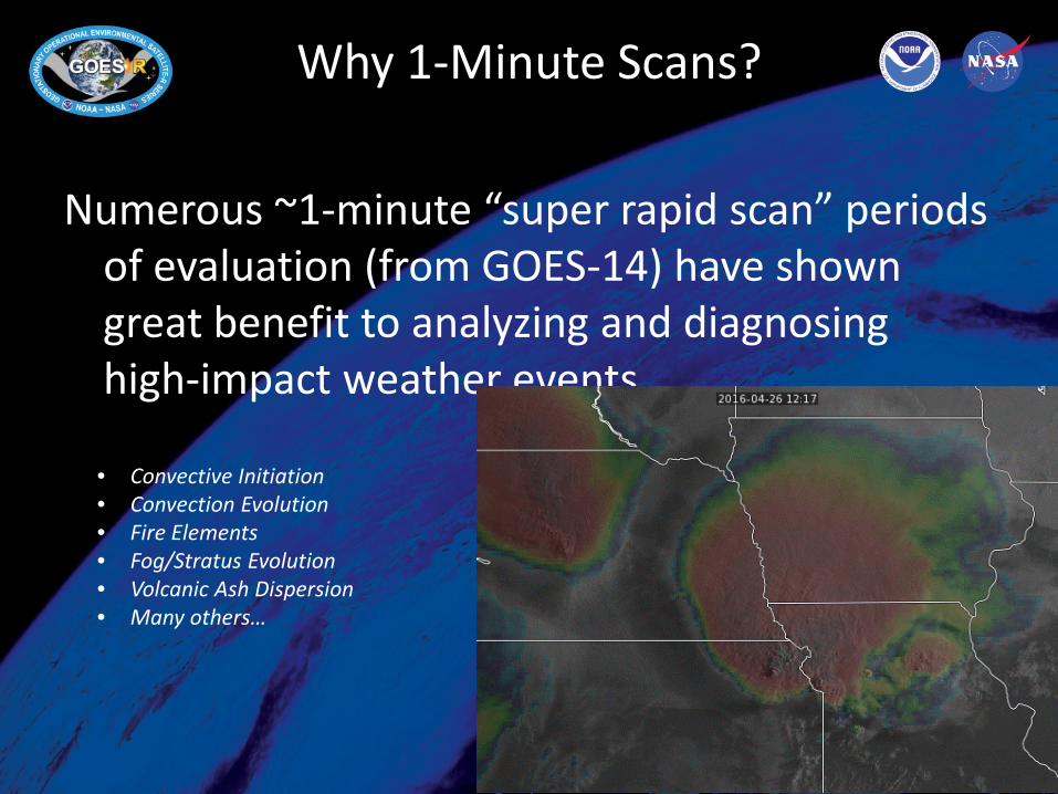
Why 1-Minute Scans?
Numerous ~1-minute “super rapid scan” periods of evaluation (from GOES-14) have shown great benefit to analyzing and diagnosing high-impact weather events.
Courtesy Tim Schmit
• Convective Initiation • Convection Evolution • Fire Elements • Fog/Stratus Evolution • Volcanic Ash Dispersion • Many others…

Priorities for ABI Mesoscale/Mode Change Requests
1. SPC High or Moderate Risk 2. Volcanic ash eruption and plume directly over or approaching
the US or US Territories 3. SPC Enhanced Risk 4. Major Hurricane (CAT 3-5) forecast to make landfall to US or US
Territories Day 1 or 2 5. Event or circumstance with national importance requiring
elevated DSS (e.g… Super Bowl, Olympics, large hazmat event, etc…)
6. Solar Diffuser Scans (will have a window but must occur during that window)
7. Lunar calibration scan (1 MDS, 2x/month, less than 2 minutes) 8. SPC Extreme Fire Weather criteria 9. Hurricane (CAT 1-2) forecast to make landfall to US or US
Territories Day 1 or 2 10. SPC Marginal or Slight Risk or Severe Thunderstorm or Tornado
Warnings 11. SPC Critical Fire Weather or OCONUS Fire Weather Watch with
at least one active wildfire occurring 12. WPC High or Moderate Risk of Excessive Rainfall or WFO
issuance of Flash Flood Watch 13. LIFR Conditions (widespread) at Large and/or Medium FAA Hub
Airports 14. Winter Storm Warning criteria (including blizzard and ice storm
warning criteria) 15. Tropical Storm forecast to make landfall to US or US Territories
Days 1-4 16. Two or more Tropical Storms (or Hurricanes) outside of the
CONUS domain invoking a switch to Mode 4
17. Volcanic ash plume not directly over or approaching the US or US Territories
18. Two or more volcanic eruptions outside of the CONUS domain invoking a switch to Mode 4
19. Blowing dust or sand conditions with ¼ mile or less visibility
20. ABI calibration/validation activities (N/S scans)
21. LIFR or worse conditions (widespread) over small FAA Hub Airports
22. Winter Weather Advisory criteria
23. SPC General Thunder
24. Other NWS requests
25. DoD requests
26. SAB responsibility interests for non-US/non-Canadian high impact conditions
27. SAB responsibility interests for two or more non-US/non-Canadian high impact conditions invoking a switch to Mode 4
28. Canadian Operational Need (requested from Canada per MoU)
29. Operations request from non-US/Canadian interests
30. US research interests (non-operational, and coordinated through the research community)
31. Canadian research interests per MoU
32. Non-US/Canadian research interests (non-operational, and coordinated through the SPSD User Services Coordinators)
Submit to SAB for 24x7 Support: (301) 683-1400 [email protected] For 8x5 Planning contact User Services: [email protected]

GOES-R Data Access
Acronym System Name Description
GRB GOES Rebroadcast One channel of the space data relay service of GOES-R for Level 1b data products (ABI L1b, Space Weather L1b, and GLM L2). These data are available to all users with GRB receivers in view of a GOES-R series satellite at the East or West operational longitudes.
AWIPS Advanced Weather Interactive Processing System
Interactive computer system that integrates meteorological and hydrological data, enabling forecasters to prepare forecasts and issue warnings. GOES-R will provide selected products through AWIPS. Sectorized Cloud and Moisture Imagery will be delivered via NOAAPORT/SBN (Satellite Broadcast Network).
HRIT/ EMWIN
High Rate Information Transmission/ Emergency Managers Weather Information Network
EMWIN is a direct service that provides users with weather forecasts, warnings, graphics and other information directly from the NWS in near real-time. The HRIT service is a new high data rate (400 Kbps) version of today’s LRIT (Low Rate Information Transmission), broadcasting GOES-R satellite imagery and selected products to remotely-located user terminals.
PDA Product Distribution and Access
The Environmental Satellite Processing and Distribution System (ESPDS) is responsible for receiving and storing real-time environmental satellite data and products and making them available to authorized users (ABI L1b and L2+, Space Weather L1b, and GLM L2). PDA will provide real-time distribution and access services for GOES-R users.
CLASS Comprehensive Large Array-data Stewardship System
Web-based data archive and distribution system for NOAA’s environmental data. CLASS will provide retrospective data access and distribution services of GOES-R data to all users. 26

www.goes-r.gov
27