gnss height on airbus a/c - federal aviation administration · 2017-11-13 · agenda 17 october2017...
TRANSCRIPT
GNSS height on Airbus A/CWorkshop ASE
François Tranchet – GNSS & Landing System Leader Nicolas Bordenave - Anemo & Inertial System Engineer 17 October 2017
Agenda
17 October 2017 GNSS height on Airbus A/C
1. In service experience: 5 A320 A/C flagged by Monitoring Agency
2. GNSS (Global Navigation Satellite System) height referential
3. GNSS height accuracy
4. GNSS height output throughADS-B
5. Conclusion

In service experience: 5 A320 A/C flagged by Monitoring Agency
• A/C geometrical height transmitted as:− Either Height above Ellipsoid (HAE)− Or Height above mean sea level (MSL)
• ASE first computed for each assumption• Statistical tests used to determine the correct height reference
• In case of unknown geoid reference (UNK – unable to determine),A/C still considered as monitored if range (of possibleASE)within +/-250ft
• Special consideration is given to any airframes with:− ‘absolute ASE larger than 175 ft’− or ‘absolute ASE plus one standard deviation larger than 200 ft ’.
• 5 A/C were unduly flagged due to incapacity to determine the correct GEO altitudereference Functional check of the ADM accuracy performed on 3 A/C out of 5 NIL findings Computation of ASE with correct hypothesis (HAE): no deviation compared to RVSM Altimetry System Error requirements
17 October 2017 GNSS height on Airbus A/C

GNSS height - referential
• Position solution computed in GNSS receiver is computedin the Earth-Centered Earth Fixes (ECEF) coordinate system
• Height above the ellispoidal (HAE) is obtained by converting the position (x,y,z) in ECEF to the position (Latitude, Longitude, Height) in WGS-84
• Height above the geoid in Mean Sea Level (MSL) is then computed by converting the height in WGS-84 using either:− NATO STANAG 4294 Navstar GPS System Characteristics Appendix 6 (geoid height for every 10° lat/long – used in legacy
receivers)− EGM-96 used on modern receivers
The standard used to convert WGS-84 HAE to MSL geoid height is not the same on all GNSS receivers.
17 October 2017 GNSS height on Airbus A/C
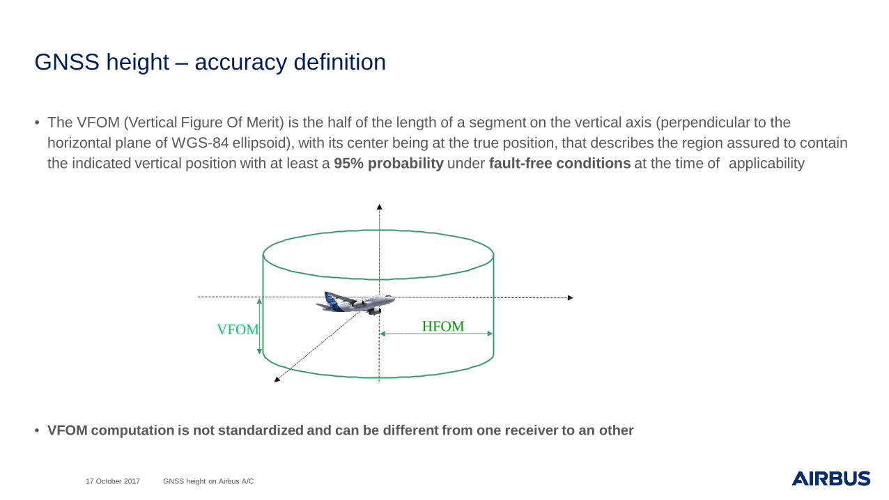
GNSS height – accuracy definition
• The VFOM (Vertical Figure Of Merit) is the half of the length of a segment on the vertical axis (perpendicular to the horizontal plane of WGS-84 ellipsoid), with its center being at the true position, that describes the region assured to contain the indicated vertical position with at least a 95% probability under fault-free conditions at the time of applicability
• VFOM computation is not standardized and can be different from one receiver to an other
HFOMVFOM
17 October 2017 GNSS height on Airbus A/C

GNSS height – accuracy with the hands
• VFOM = 2*VDOP*UERE− VDOP is a geometry factor− DOP : Dilution Of Precision− UERE is the pseudorange error (User Equivalent Range Error)
17 October 2017 GNSS height on Airbus A/C
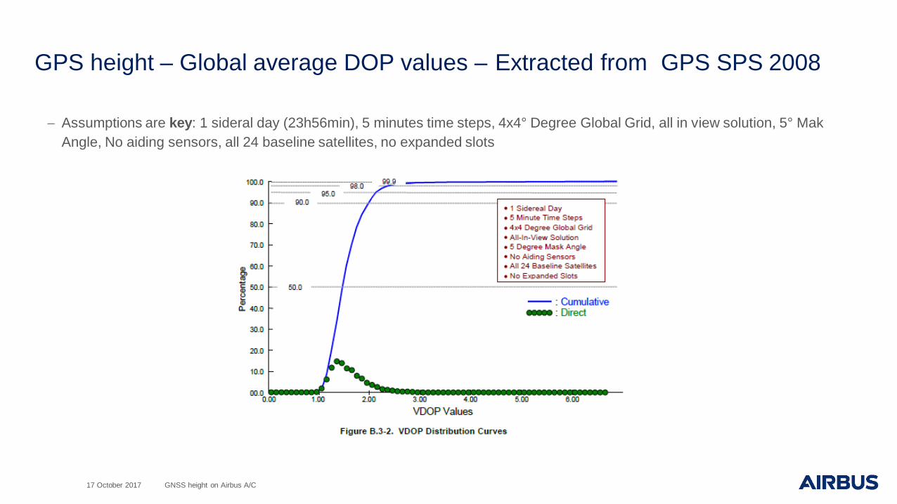
GPS height – Global average DOP values – Extracted from GPS SPS 2008
− Assumptions are key: 1 sideral day (23h56min), 5 minutes time steps, 4x4° Degree Global Grid, all in view solution, 5° Mak Angle, No aiding sensors, all 24 baseline satellites, no expanded slots
17 October 2017 GNSS height on Airbus A/C
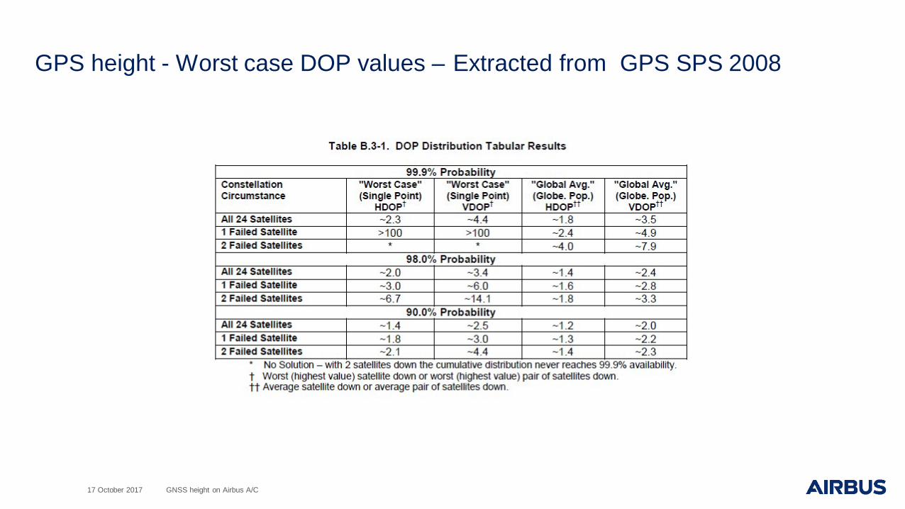
GPS height - Worst case DOP values – Extracted from GPS SPS 2008
17 October 2017 GNSS height on Airbus A/C

GPS height - Sigma UERE values - Extracted from GPS SPS 2008
• 𝑈𝑈𝐸𝐸𝑅𝑅𝐸𝐸 = 𝑈𝑈𝑅𝑅𝐸𝐸2 + 𝑈𝑈𝐸𝐸𝐸𝐸2
− URE is the User Range Error - pseudorange inaccuracy due to the Signal In Space− UEE is the User Equipment Error - pseudorange inaccuracy due to the receiver
17 October 2017 GNSS height on Airbus A/C
GPS height – Selective Availability
17 October 2017 GNSS height on Airbus A/C
• SA is a protection technique employed by DoD to deny full system accuracy. On May 1, 2000, President Clinton announced the discontinuance of SA effective midnight 1 May 2000. The effects of SA went to zero on 2 May 2000.
• SA aware receivers know that SA is OFF. SA not aware receivers don’t know that SA is OFF.
• SA not aware receivers consider an additional measurement error that can be estimated at 30m at 1sigma

GPS height – VFOM values for SA AWARE and SA NOT AWARE
17 October 2017 GNSS height on Airbus A/C
values VFOM SA AWARE VFOM SA NOT AWAREOACI Annex10 amdt 86 –conservative values
73m – 240 ft N/A
SPS average values (0 AOD)
68m (VDOP = 2 / UERE = 17m) – 223 ft
137,6m (VDOP = 2 / UERE = 34,4m) – 451 ft
SPS conservative values (Max AOD)
82,4m (VDOP = 2 / UERE= 20,5m) – 270 ft
144m (VDOP = 2 / UERE= 36m) – 473 ft
− VFOM values can be higher in degraded operational conditions:– Satellites masked– Multipath– Interference
GPS height accuracy is not constant and depends on various factors such as equipment, constellation and environment
GNSS height – Satellite Based Augmentation Systems (SBAS)
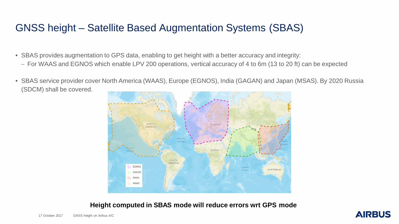
• SBAS provides augmentation to GPS data, enabling to get height with a better accuracy and integrity:− For WAAS and EGNOS which enable LPV 200 operations, vertical accuracy of 4 to 6m (13 to 20 ft) can be expected
• SBAS service provider cover North America (WAAS), Europe (EGNOS), India (GAGAN) and Japan (MSAS). By 2020 Russia (SDCM) shall be covered.
Height computed in SBAS mode will reduce errors wrt GPS mode17 October 2017 GNSS height on Airbus A/C

GNSS height - ADS-B OUT with mode S transponders
17 October 2017 GNSS height on Airbus A/C
• ADS-B: Automatic transmission of surveillance data from A/C to ATC and from A/C to A/C• MODE S: When a Secondary Surveillance Radar interrogates mode S transponder they reply with a large set of surveillance data
(e.g. flight number, 24-bit adress, speeds,heading…)• ADS-B OUT: Capability to broadcast surveillance data. This capability is part of mode S transponders
• Among data broadcasted in flight on Airbus A/C are:− Barometric altitude relative to a standard pressure of 1013.25 millibars− Difference between barometric altitude and GNSS height (HAE WGS-84). GNSS altitude (MSL) may be used.− The resolution is 12,5 feet
• A350 and A380 A/C always broadcast GNSS height HAE
• A320 and A330 family A/C in DO-260B or DO-260A* broadcast GNSS height HAE− * If HAE is unavailable then MSL is output for DO-260A A/C on A320/A330
• A320 and A330 family A/C in DO-260 broadcast GNSS height MSL
GNSS height type is frozen for a given A/CDO-260 version can be determined using ADS-B data

GNSS height - ADS-B OUT with mode S transponders - AccuracyDO-260A
• Accuracy of the GNSS height can be estimated using the following parameters depending on the DO-260 version of thetransponder:
DO-260
17 October 2017 GNSS height on Airbus A/C
DO-260B
Only position with NUCp of 8 or more or NACp of 9 or more GVA of 2 or more may be used

GNSS height - ADS-B OUT with mode S transponders – Airbus architecture
Source of NAV position for ADS-B depends of A/C type
17 October 2017 GNSS height on Airbus A/C
A320/A330

Conclusion
17 October 2017 GNSS height on Airbus A/C
− Current usage of GNSS height broadcasted by ADS-B for ASE monitoring can lead to false alerts (on Region Monitoring Agencies side) in case the GNSS height referential is unknown
− GNSS height type (WGS-84 or MSL) referential can be determined using A/C type and its DO-260 version
− All sources of errors of the GNSS height should be considered when performing ASE monitoring:– Errors due the equipment, GPS constellation and environment– Conversion errors from WGS-84 to MSL– Resolution of data broadcasted byADS-B
− GNSS height (WGS-84 or MSL) can be used considering the broadcasted accuracy of the position
− GNSS Height computed in SBAS mode will reduce errors wrt GPS mode

Thank you