global winds and local winds. the movement of air caused by differences in air pressure is called...
TRANSCRIPT

GLOBAL WINDS
AND
LOCAL WINDS

The movement of air caused by differences in air pressure is called wind.
The greater the pressure difference, the faster the wind moves.

Differences in air pressure are generally caused by the unequal heating of the Earth.
The equator receives more direct solar energy than the longitudes, so the air at the equator is warmer and less dense than the surrounding air.
Warm less dense air rises and creates an area of low pressure.
This warm rising air flows toward the poles.
At the poles, the air is colder and denser than the surrounding air, so it sinks.
As the cold air sinks, it creates areas of high pressure around the poles.
This cold polar air then flows toward the equator.
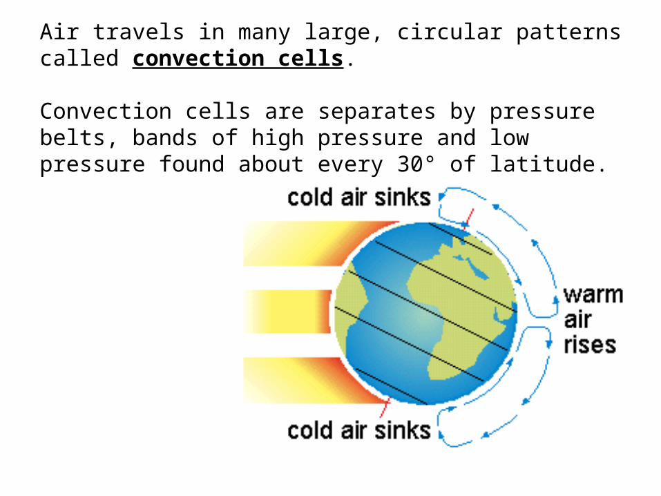
Air travels in many large, circular patterns called convection cells.
Convection cells are separates by pressure belts, bands of high pressure and low pressure found about every 30° of latitude.

As warm air rises over the equator and moves toward the poles, the air begins to cool.
At about 30° north and 30° south latitude, some of the cool air begins to sink.
Cool sinking air causes high pressure belts near the 30° north and 30° south latitude.
This air flows back to the equator, where it warms and rises again.
At the poles, cold air sinks and moves toward the equator.
Air warms as it moves away from the poles.
Around 60° north and 60° south latitude, the warmer air rises, which creates a low pressure belt.
This air flows back to the poles.

Winds do not travel directly north to south because the Earth is rotating.
The apparent curving of the path of winds and ocean currents due to the Earth’s rotation is called the Coriolis effect.
Because of the Coriolis effect in the Northern Hemisphere, winds traveling north curve to the east, and winds traveling south curve to the west.

The Coriolis Effect The rotation of the Earth causes an interesting phenomena
on free moving objects on the Earth. Objects in the Northern Hemisphere are deflected to the right, while objects in the
Southern Hemisphere are deflected to the left.
The Coriolis effect, thus tries to force winds to shift towards the right or left. The Coriolis effect can at times cause winds to blow back up the pressure gradient.

GLOBAL WINDS

Wind belts that extend from the poles to 60° latitude in both hemispheres are called the polar easterlies.
These are formed as cold, sinking air moves from the poles toward 60° north and 60° south latitude.
In the Northern Hemisphere, polar easterlies can carry cold arctic air over the United States, producing snow and freezing weather.

The wind belts found between 30° and 60° latitude in both hemispheres
are called westerlies.
The westerlies flow toward the poles from west to east.
The westerlies can carry moist air over the United States producing snow and freezing
weather.

In both hemispheres, the winds that blow from 30° latitude almost to the equator are called trade winds.
The Coriolis effect causes the trade winds to curve to the west in the Northern Hemisphere and to the east in the Southern Hemisphere.
Early traders used the trade winds to sail from Europe to the Americas.
As a result, the winds became known as “trade winds.”


The trade winds of the Northern and Southern Hemispheres meet in an area around the equator called the doldrums. In the doldrums, there is very little wind because the warm, rising air creates an area of low pressure. The name doldrums means “dull” or “sluggish.”

Nor'easters can occur in the eastern United States any time between October and April, when moisture and cold air are plentiful. They are known for dumping heavy amounts of rain and snow, producing hurricane-force winds, and creating high surfs that cause severe beach erosion and coastal flooding. A Nor'easter is named for the winds that blow in from the northeast and drive the storm up the east coast along the Gulf Stream, a band of warm water that lies off the Atlantic coast.

Along with notorious nor'easters, Alberta Clippers may be the most well-known snowstorm nickname. But there are other: they include the Texas Panhandler, the Siberian Express and the Chattanooga Choo-Choo, so named because of where they come from and how they develop. And while some may sound like names of minor league baseball teams, they are actually specific types of storms with their own characteristics and movement,

At about 30° south latitude, sinking air creates an area of high pressure. The winds at these locations are weak. These areas are called the horse latitudes. According to legend, this name was given to these areas when sailing ships carried horses from Europe to the Americas. When the ships were stuck in this windless area, horses were sometimes thrown overboard to save drinking water for the sailors. Most of the world’s deserts are located in the horse latitudes because the sinking air is very dry.

The flight from Seattle to Boston can be 30 minutes faster than from Boston to Seattle because pilots take advantage of jet streams. Jet streams are narrow belts of high speed winds that blow in the upper troposphere and lower stratosphere. These winds can reach maximum speeds of 250 mph. Unlike other global winds, the jet streams do not follow regular paths around the Earth. Knowing the path of a jet stream is important not only to pilots but also to meteorologists, because jet streams affect the movement of storms. Meteorologists can track a storm if they know the location of a jet stream.

Local winds generally move short distances and can blow from any direction. Local geographic features,
such as a mountain or shoreline, can produce temperature differences that cause local winds.
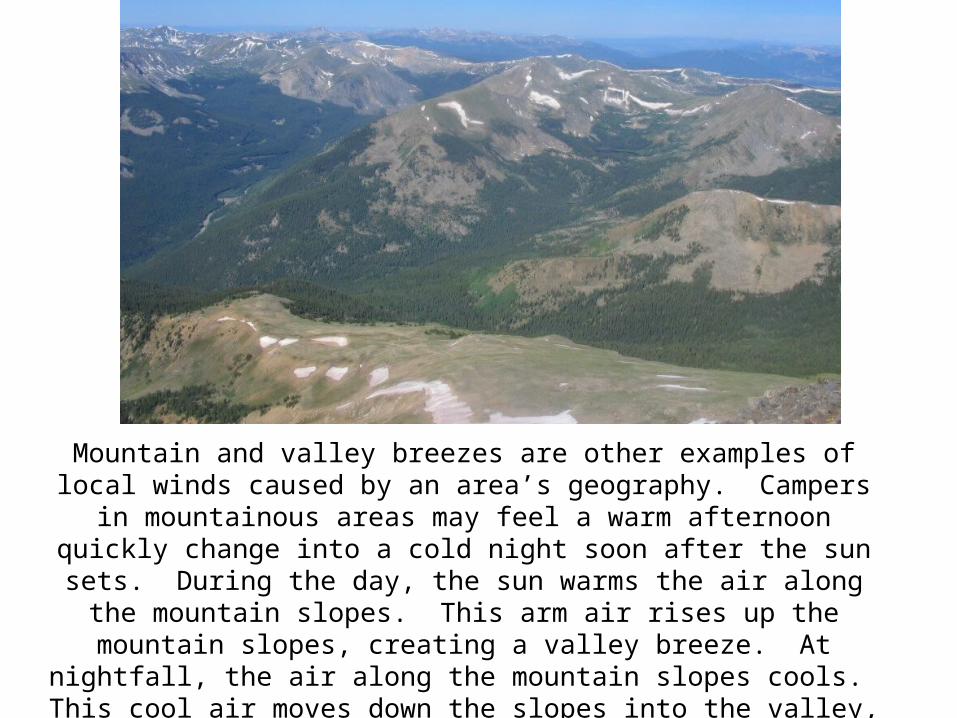
Mountain and valley breezes are other examples of local winds caused by an area’s geography. Campers in mountainous
areas may feel a warm afternoon quickly change into a cold night soon after the sun sets. During the day, the sun warms the air along the mountain slopes. This arm air rises up the
mountain slopes, creating a valley breeze. At nightfall, the air along the mountain slopes cools. This cool air moves down the
slopes into the valley, producing a mountain breeze.

In areas where there are mountains and valleys we see a type of wind pattern known as mountain breezes and valley breezes. During the day, the surface of the mountain heats the air high up in the atmosphere, quicker than the valley floor can. As the warmer air expands a low pressure is created near the top of the mountain. This attracts the air from the valley, creating a breeze that blows from the valley floor up towards the top of the mountain. Often birds known as raptors such as eagles, hawks, condors, and vultures float on these breezes to preserve their energy. This wind pattern is known as a valley breeze.
Mountain and Valley Breezes

During the day, land gets heated by the Sun much quicker than does water. As the land becomes
warmer, it heats the air in the atmosphere above it. This causes the air to expand, becoming less dense,
and thus creating a low pressure.
Sea and Land Breezes