global wave conference report digital sas
DESCRIPTION
ÂTRANSCRIPT

By Dr Tony Butt
Published at

The Global Wave Conference is a major international event focused on the protection of waves, oceans, beaches and surf habitats worldwide. The event brings together the world’s leading enviro-surf NGO’s, academics, oceanographers, environmentalists, grassroots activists, surfers, politicians, the surf industry and the mainstream media to discuss the critical importance of protecting our oceans.
Major issues covered at the conference include the protection & management of natural surfing heritage, the threats to surf spots from marine litter, water pollution and climate change, the importance of ‘blue health’ - human health & wellbeing, and ‘surfonomics’ – the growing impact and importance of the economic value of surfing to coastal communities.
Surfers Against Sewage is delighted to publish this report at the Global Wave Conference IV, highlighting the threats to some of the most important surfing environments in the world. These surf spots are the stadia of the surfing world,
which are unfortunately under extreme and growing environmental pressures. As unique wonders of nature, these sites of special surfing interest are irreplaceable unlike the venues of so many other sports.
The Global Wave Conference 2015 is taking place at a time when the threats to our oceans and surf habitats are at the top of political, news and public agenda. It falls during a key timeframe for protecting our beaches and coastline through the EU Marine Strategy Framework Directive, and from a wider global perspective, the conference will also take place shortly before the UN Climate Change Conference, COP21, in Paris.
Surfers Against Sewage hopes that that the Global Wave Conference will help further engage the world’s surfers with the critical threats that plastic pollution, unabated coastal development and climate change pose to the coastal zones, reefs and surf habitats.
FOREWORD by Hugo Tagholm, Chief Executive Officer Surfers Against Sewage
IMAGE: Russel Ord

Tony Butt is recognised in the surfing world as one of the leading experts in ocean sciences, receiving his a PhD in Physical Oceanography from the University of Plymouth. He went onto work as a research fellow with Plymouth University’s Coastal Processes Research Group for seven years. He has published 16 papers in peer-reviewed scientific journals and over 200 other articles on waves and the coastal environment in non-scientific magazines. He is the author of Surf Science: an Introduction to Waves for Surfing (2004, 2014) and The Surfers Guide to Waves, Coasts and Climates (2009), in addition to numerous chapters, forewords and other contributions.
Tony has been surfing since the early 1970s and has surfed hundreds of different spots around the world.
He now resides, for most of the year on the north west coast of Spain, pioneering big wave surfing on this exposed stretch of coastline. Tony leaves the northern hemisphere summer behind to hunt more significant swells around Cape Town, South Africa. Although he doesn’t compete he has been invited to several international big-wave events including being pre-selected for the 1999 Eddie Aikau at Waimea Bay, Hawaii and the only European among 24 invitees to the 2002 Big Wave Africa at Dungeons.
Tony works with a number of NGOs, focusing on supplying scientific support to protect waves from destructions or deteriorate. He is a Trustee on the Surfers Against Sewage Board, sits on the Advisory Board for Save The Waves and Vision Council for World Surfing Reserves.
The author

contents
P 4
P 5
P 6
P 7
P 8
P 9
P 10
P 1 1
P 12
P 13
P 14
P 15
P 16
P 17
P 18
P20
introduc t ion
Env ironmental thre ats to surf sp ots
Qu iks ilver P ro , G ol d C oast, Austral ia
R ip C url P ro , B e l ls B e ac h , Austral ia
Drug Aware Marg aret R iver P ro , Western Austral ia
O i R io P ro , B arra da T ijuc a , R io de Jane iro , B raz il
F ij i P ro , C l oudb re ak , Tavarua
J-B ay Op en , Je ffrey ' s B ay, S outh Afr ic a
B il l ab ong P ro Tah it i , Te ahup o ' o , Frenc h P olynes ia
Hurl e y P ro , L owe r Trestl es , C al iforn ia
Qu iks ilver P ro , Hosseg or , Franc e
Mo c he R ip C url P ro , P en ic he , P ortug al
P ip e l ine Masters , B anza i P ip e l ine , Hawai i
C onc lus ion
AP P E ND IX 1 : NG O D irec tory
AP P E ND IX 2 : Env iro-surf Rep orts
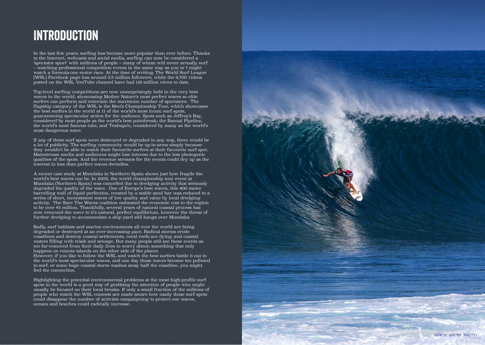
IMAGE: @SURF_PHOTO
IntroductionIn the last few years, surfing has become more popular than ever before. Thanks to the Internet, webcasts and social media, surfing can now be considered a ‘spectator sport’ with millions of people – many of whom will never actually surf – watching professional competition events in the same way as you or I might watch a formula-one motor race. At the time of writing, The World Surf League (WSL) Facebook page has around 3.5 million followers, while the 6,700 videos posted on the WSL YouTube channel have had 116 million views to date.
Top-level surfing competitions are now unsurprisingly held in the very best waves in the world, showcasing Mother Nature’s most perfect waves so elite surfers can perform and entertain the maximum number of spectators. The flagship category of the WSL is the Men’s Championship Tour, which showcases the best surfers in the world at 11 of the world’s most iconic surf spots, guaranteeing spectacular action for the audience. Spots such as Jeffrey's Bay, considered by most people as the world’s best pointbreak; the Banzai Pipeline, the world’s most famous tube, and Teahupo'o, considered by many as the world’s most dangerous wave.
If any of these surf spots were destroyed or degraded in any way, there would be a lot of publicity. The surfing community would be up-in-arms simply because they wouldn’t be able to watch their favourite surfers at their favourite surf spot. Mainstream media and audiences might lose interest due to the less photogenic qualities of the spots. And the revenue streams for the events could dry up as the interest in less than perfect waves dwindles.
A recent case study at Mundaka in Northern Spain shows just how fragile the world’s best waves can be. In 2005, the world championship tour event at Mundaka (Northern Spain) was cancelled due to dredging activity that seriously degraded the quality of the wave. One of Europe’s best waves, this 400 meter barrelling wall of liquid perfection, created by a stable sand bar was reduced to a series of short, inconsistent waves of low quality and value by local dredging activity. The Save The Waves coalition estimated the economic cost to the region to be over $3 million. Thankfully, several years of natural coastal process has now returned the wave to it’s natural, perfect equilibrium, however the threat of further dredging to accommodate a ship yard still hangs over Mundaka
Sadly, surf habitats and marine environments all over the world are being degraded or destroyed at an ever-increasing pace. Radical storms erode coastlines and destroy coastal settlements, coral reefs are dying, and coastal waters filling with trash and sewage. But many people still see these events as too far-removed from their daily lives to worry about; something that only happens on remote islands on the other side of the planet.However, if you like to follow the WSL and watch the best surfers battle it out in the world’s most spectacular waves, and one day those waves become too polluted to surf, or some huge coastal storm washes away half the coastline, you might feel the connection.
Highlighting the potential environmental problems at the most high-profile surf spots in the world is a good way of grabbing the attention of people who might usually be focused on their local breaks. If only a small fraction of the millions of people who watch the WSL contests are made aware how easily those surf spots could disappear the number of activists campaigning to protect our waves, oceans and beaches could radically increase.

Environmental threats to surf spotsThere are various types of threat to surf spots and the coastlines where they exist. Most of these threats are interdependent; for example, climate-change-intensified coastal storms have more severe effects on a highly-urbanized coastline than on a natural one.
First and foremost is climate change. Human activities have altered the chemistry of atmosphere, causing the planet to heat up. This includes the temperature of the oceans and coastal waters as well as the rest of the planet. An immediate consequence of warmer coastal waters is a loss of biodiversity, including the death of coral reefs.
A rise in the temperature means that the water in the oceans will expand. It also means that glaciers and the polar ice will melt and flow into the sea. Both of these factors will lead to a rise in sea level, which, in turn, will increase coastal flooding. In some cases, entire coastal communities and even entire ocean-island states will end up underwater. Surf spots will be affected because the higher sea level will alter the bathymetry and change the way the waves break; and some sandbar or cobblestone points that depend on sedimentation from rivers might cease to work altogether.
A rise in planetary temperature and the melting of the polar ice will result in a greater temperature differential between the poles and the equator, because the melting of the ice robs some of the energy that would otherwise be used to heat up the poles. And a greater pole-to-equator temperature differential means a more active atmosphere – in other words, more storms. Coastlines and surf spots will suffer due to storms like the ones we saw in the North Atlantic in 2013-2014. Moreover, coastlines containing high populations, and where human intervention has already weakened the natural defences, will suffer a lot more.
Apart from climate change, coastal urbanization can affect surf spots independently. For example, the building of some solid structure on top of a surf spot or near it can destroy or seriously alter that spot. The movement of sediment by dredging or artificial beach ‘nourishment’ can affect sensitive surf spots that rely on sandbars, as can some structure such as a breakwater that alters the sediment dynamics.
A highly-populated coastline is also more likely to suffer from problems of human waste, such as sewage and litter, which is typically deposited onto landfill sites, gets washed into rives and lagoons, and finally ends up in the sea. This will be exacerbated by more intense bouts of rainfall as a consequence of climate change. It can seriously affect one’s surfing experience and, in some cases, can be life-threatening. It also contributes to the problem of biodiversity loss, again aggravated by global warming.
Other types of contamination which will seriously affect the coastal population include mining, which releases vast amounts of poisonous chemicals into the environment and, if the mine is anywhere near the coast, into the sea.
The problem of marine litter, specifically plastics, is now ‘globalized’. Any coastline in the world is likely to receive plastic trash from any other part of the world. In a similar way to climate change itself, ocean-island states that contribute the least to the problem are often the biggest sufferers from plastic pollution.
Lastly, in some areas there is the potential threat of radioactive material leaking into the sea from nuclear power stations built near the coast. Although people will tell you that a radioactive leak has a very low statistical probability of happening, the impacts of such an event are catastrophic. Just look at what happened in 2011 at Fukushima in Japan.
This report features the most prominent problems threatening our premiere surf spots. However, it is not an exhaustive list and new and emerging threats means that surf communities will always have to be vigilant.
IMAGE: Greg Dennis

Quiksilver ProGold CoastAustralia
#1
The Quiksilver Pro, on the Gold Coast, Queensland, Australia is the first
venue on the WSL Samsung Galaxy Championship Tour. The competition’s waiting period is towards the end of
February and the beginning of March.
The spotThe principal location of the Quiksilver Pro Gold Coast contest is Snapper Rocks, located in Coolangatta, Queensland, near the border with New South Wales, about 90 km south of Brisbane. The wave is a rock/sand pointbreak with an optimum size of around four to eight feet. It starts with a tricky take-off and then settles into a wall which can go for up to 500 m, thanks to an artificially-produced sandbar called the Superbank.
ClimateThe climate of the Gold Coast is humid subtropical with warm winters and hot, humid summers. Yearly average maximum and minimum temperatures are around 28ºC and 21ºC respectively. Rainfall occurs on average 138 days a year, with most of the rain in summer and in the form of heavy showers or thunderstorms.
Human interventionThe Gold Coast has been heavily modified by humans for many decades. The coastal strip, consisting of a narrow sandbar, contains about 40 km of hotels and holiday resorts, from Snapper Rock to Stradbroke Island. The land inland of the coastal strip has over the years been converted from natural swamp into inland waterways and artificial islands.
The area including Snapper Rocks, Greenmount, Kirra, Burleigh, Currumbin and several other breaks along this coast, was declared a National Surfing Reserve in 2012. The region is also being considered for World Surfing Reserve status, overseen by The Save The Waves coalition.
ThreatsSchemes to mitigate beach erosion pose a threat to the waves along the Gold Coast. The economy of the Gold Coast relies heavily on sandy beaches for money-spending tourists to lie on, but schemes designed to maintain these beaches might interfere with the waves for surfing.
The area has had a lot of erosion problems in the last few decades. Many of these problems can be traced back to the building of two jetties at the mouth of the Tweed River in the early 1960s. The jetties blocked the natural alongshore flow of sediment, which became apparent when the beaches failed to recover after a series of severe erosion events in the late 1960s.
To try to mitigate this problem the Queensland government engaged coastal engineers from Delft University in the Netherlands. They came up with a master plan which included the Tweed River Entrance Sand Bypassing Project (TRESBP) – a scheme where sand is sucked from the New South Wales side of the Tweed River, pumped in giant pipelines under the river, and released at various outlets including Snapper Rocks and about 500 m to the north at Kirra. By bypassing the sand from one side of the river to the other, the system is designed to replace the natural flow of sediment impeded by the jetties.
Put into action in the early 2000s, the scheme had a side effect not predicted by the Dutch engineers: the creation of the Superbank. However, not only did the extra sand help create the Superbank; it also degraded the wave at Kirra. So the coming and going of both Kirra and the Superbank were a by-product of a human intervention scheme nothing to do with surfing. It’s important to understand, before this intervention there was a good wave at Snapper Rocks, made better by the intervention. However, there was also a world-class wave at Kirra that has been significantly degraded by the intervention. The net result of this intervention is the loss of one wave resource, Kirra.
Evidently, our understanding of coastal morphodynamics is good enough to design a scheme that will maintain sand on a beach for the tourists, but not currently good enough to predict the effects of such a scheme on a world-class surf spot.
On the positive side, surfing on the Gold Coast is recognized by politicians as having at least some importance. The Gold Coast surfing population is high enough (around 100,000) for surfers to have a voice, and ex-world champion Rabbit Bartholomew is on the Advisory Committee for the TRESBP.
The other significant threat to the surf on the Gold Coast is coastal development. For example, the recent proposal to build a mega resort complex including super-yacht terminals, bridges, stadiums and giant 50-storey high-rise cruise-ship terminal at Wavebreak Island, very near to the world-class surf break at South Stradbroke. The project was proposed by a group of Chinese construction companies (including a dredging company) that already owns property on the Gold Coast.
The project would mean atmospheric pollution and noise, and the continuous dredging to maintain the shipping channel would change the coastal morphology, which in turn could affect the surf at South Stradbroke. It would also certainly affect the biodiversity of the area; including setting back a recent recovery in numbers of whales, dolphins, turtles and dugongs.
Luckily, in April 2015, the project was shelved by the newly-elected local government. They are promising to bring about changes that will protect the area from any private or commercial development for generations to come. However, many local residents are in favour of the scheme, and another change in local government could be all takes for the threat to surface again.
IMAGE: JASON FEAST

Rip Curl ProBells BeachAustralia
#2
The Rip Curl Pro, at Bells Beach, Victoria, Australia is the second venue
on the WSL Samsung Galaxy Championship Tour and the longest
running surf competition in the world, running ever year since 1961.
The competition’s waiting period is the first half of April.
The spotBell’s Beach, site of the Rip Curl Pro contest, is a rock reef/point situated in Victoria, Australia, about 8 km south of Torquay and about 100 km south of Melbourne. The wave breaks over a gently-sloping rock platform and consists of three sections that can link up in large swells. It is a long, powerful wave with fast, walling sections but not really hollow. It can be ridden as small as three feet but has been surfed at over 15, most notably during the landmark 1981 contest, won by Simon Anderson.
ClimateThe area where Bells Beach is situated has a temperate oceanic climate, with air from the Southern Ocean having a considerable moderating effect on the temperature. Yearly average maximum and minimum temperatures are about 18ºC and 11ºC respectively. Rainfall occurs on average 112 days a year, with rain possible any time of year but most likely in the winter.
Human interventionBells itself is near the town of Torquay, which has a population of just over 10,000. The coastline south of Torquay, along the Great Ocean Road, is relatively unspoilt and well protected. Bells Beach lies within the Point Addis Marine National Park, a protected marine area. The Great Otway National Park, a protected area which extends inland of Bells, contains much of the original ancient rainforest.
Bells Beach is the world’s first surfing reserve, and is recognized worldwide as a surfing sanctuary. It was created in 1973 as a ‘Surfing Recreational Reserve’ under the principle that surfing is the main activity at Bells and that surfers are the most frequent users of the beach.
ThreatsThe environmental threats to Bells are not as serious as at many other surf spots around the world. However, local surfers are constantly struggling to maintain the reserve in its original form, against the pressures of increasing population and tourism.
The reserve is managed by a government entity called the Surf Coast Shire, which has already made some changes that go against the character of the reserve. For example, they recently re-modelled the parking area and removed some of the vegetation to accommodate a number of tourist coaches and minibuses. This increased the tourist capacity by over 500 people and, at the same time, reduced surfers’ car-parking spaces by 30 per cent. Other recent changes include a clause which now allows significant commercial development in the area surrounding the Bells reserve.
Local legend Maurice Cole points out that the legislation behind the Bells reserve is not very strong, and does not really contain anything that gives priority to surfing, as was first envisaged in 1973. The only real protection comes from the action of the local surfers and residents.
Other problems highlighted by Cole include beach erosion caused by an antiquated stormwater
drainage system; inadequate toilet facilities in the reserve, and the growing pressure for bigger and more frequent commercial surfing events at Bells, which cause damage to natural vegetation and generate large amounts of litter.
Perhaps the biggest worry is that, if the reserve is not respected by the surfers themselves, the Surf Coast Shire and the local government will be more inclined to allow changes that give priority to non-surfing activities, which might then further worsen the surfing experience at Bells.
In addition to the Bells Beach Preservation Society, other local groups such as Surfers Appreciating Natural Environment (SANE) are working to maintain the reserve in a pristine condition. The objectives of SANE are to raise awareness on issues aside from surfing in the Bells Reserve, such as biodiversity, invasive species, and the importance of the indigenous Wathaurung people to Bells Beach and the surrounding area.
The other threat, which is, of course, not unique to Bells Beach, is climate change and its consequences. The most important of which are sea-level rise and the increase in episodic storm events. Unlike mediocre or poor-quality surf spots that might just as easily be improved as degraded by physical alterations brought about by climate change, world-class spots like Bells Beach will have a higher chance of being degraded. High-quality surf spots like Bells are the way they are because of a unique combination of circumstances, involving the coastal morphology, the prevailing size and direction of swells, the tides and the wind, among other things. If any of these factors change then the wave could suffer.
IMAGE: Kerry Powell
IMAGE: Kerry Powell

Drug AwareMargaret River Pro
WesternAustralia
#3The spotMargaret River, site of the Drug Aware Margaret River Pro, is located on the highly-exposed southwest tip of Australia, about 250 km south of Perth. The area is extremely consistent and contains a large number of high-quality surf spots. The contest is principally held at ‘The Point’ or ‘Main Break’ – a rock reef about 400 m offshore. It can be surfed as small as three feet but really comes into its own at ten feet or so. There is a left and right, but the right tends to shut down in larger swells, and at sizes somewhat over 15 feet depending on swell direction and quality, the left also starts to close out between The Point and The Box, just to the north.
ClimateThe region around Margaret River enjoys a humid Mediterranean climate, with hot, dry summers and cool, wet winters. Yearly average maximum and minimum temperatures are approximately 21ºC and 11ºC respectively. Rainfall occurs 113 days a year on average, with a lot more rain in winter than in summer. Bush fires are a common occurrence in the summer due to the frequent combination of high temperatures, low humidity and windy conditions.
Human interventionThe coastline around Margaret River is relatively unspoilt, and is on the northern border of the Leeuwin-Naturaliste National Park. The area is famous for its wine industry and also has olive farms and dairies, but the southwest of Australia is also home to the infinitely more aggressive mining industries, including coal, aluminium oxide and mineral sands.
ThreatsThe biggest potential environmental threat to Margaret River is the mining industry. However, at the time of writing, coal mining is currently not allowed in the Margaret River area. The ban came about after a large coal mine was recently proposed by Vasse Coal Management Pty Ltd about 15 km from Margaret River town centre. In 2011 the Western Australian Environmental Protection Authority advised the government that having a mine in the area was environmentally unacceptable, principally due to the high risk of contamination to the water supply. The WA state government rejected the application based on that advice. Then, in 2012, the government went a step further and terminated all coal exploration applications within a 230 km2 area around Margaret River.
Nevertheless, local and state governments are under constant pressure to lift the ban from multinational companies and organizations representing businesses in WA. Needless to say, if a mine were built in the Margaret River area, it would be an environmental disaster; for example:
• The coal beds are situated below the main aquifer that supplies fresh water to Margaret River. A coal mine would have to be drilled straight through the aquifer, most likely contaminating the water supply with poisonous substances such as Arsenic and Cadmium;
• Pollutants from the mine would seriously contaminate the river, threatening biodiversity. The Margaret River contains several critically endangered fish species which would probably be wiped out if there were a mine in the area;
• Native vegetation would have to be destroyed to build the mine, which would affect the biodiversity of the forest, also containing several species of rare and endangered birds. Note that mining companies seem to be freely allowed to clear the native vegetation, although farmers are strictly prohibited from doing this;
• A mine would contaminate the soil and hence interfere with the local grape and other plantations;
• There would be severe local noise and atmospheric contamination, seriously affecting the lives of local residents and visitors, including surfers;
• Burning coal is the worst contributor to greenhouse gas emissions. Even if Australia doesn’t end up building more coal-fired power stations, the coal would be sold, shipping and burned in other countries elsewhere (China, for example). Apart from this, just the act of getting the coal out of the ground releases huge amounts of greenhouse gases.
Even though the waves themselves would not be directly threatened by a nearby mine, the experience of surfing at Margaret River certainly would be seriously degraded, for locals and visitors alike. Also, any activity which contributes to increased greenhouse gas emissions automatically contributes to sea-level rise and increased storminess, which, of course pose a serious threat to most surf spots around the world, including Margaret River.
The Drug Aware Margret River Pro, at Margret River, Western Australia, Australia is the third venue on the
WSL Samsung Galaxy Championship Tour. It’s also Australia’s third and
final WSL Samsung Galaxy Championship Tour event.
The competition’s waiting period is the second half of April.
IMAGE: Russel OrdIMAGE: Russel Ord

Oi Rio ProBarra da TijucaRio de Janeiro
Brazil
#4
The Oi Rio Pro at Barra da Tijuca, Rio de Janerio, Brazil is the forth venue on
the WSL Samsung Galaxy Championship Tour and the only event
in South America. The competition’s waiting period is mid May.
The spotThe main site for the Oi Rio Pro is a beachbreak called Postinho, at Barra da Tijuca, Brazil. Barra da Tijuca is a high-class area of Rio de Janeiro, containing expensive hotels and condominiums, situated about 30 km from downtown Rio. Under the right conditions the beach can produce very good A-frame peaks and tube sections, as well as providing a good platform for spectacular aerial manoeuvres. The optimum size range is from about three to six feet. Shifting peaks and a strong rip make things tricky in larger sizes.
ClimateThe coastline around Rio has a tropical wet climate. The coastline temperature is moderated by sea breezes, with yearly average maximum and minimum temperatures are approximately 27ºC and 21ºC respectively. Rainfall occurs on average 93 days a year, predominantly in the summer, with periods of very heavy rain that can cause significant pollution events, flash floods and mudslides.
Human interventionBarra da Tijuca is a densely-populated urban area containing extreme high-class and extreme low-class accommodation. The high-class area, on the coastal fringe, is an artificial environment designed to be self-contained and provide everything residents need to live their daily lives, including luxury condominiums and giant shopping malls. The low-class areas are located further inland, and are comprised of informal settlements or favelas, where living conditions are extremely poor and basic infrastructure is practically non-existent.
The land underlying Barra da Tijuca was originally swamp. It began to be urbanized around the middle of the twentieth century, and the area now has the highest population expansion rate in Rio, having increased from less than 6,000 in 1970 to over 300,000 in 2015.
ThreatsThe most significant environmental problem in Barra da Tijuca is the quality of the water. The recent unrestrained population growth without sufficient improvements in sewage treatment has resulted in the water being extremely polluted. The whole of Rio de Janeiro, with over 12 million inhabitants, has notoriously bad sewage treatment infrastructure; and much of the sewage from the city ends up in the sea via rivers, canals and lagoons.
The lagoons behind the coastal strip of Barra da Tijuca receive huge amounts of effluent from homes and factories – not only from the favelas but also from the high-class areas. The surrounding area, called the Jacarepaguá lowlands, contains about 650,000 inhabitants all of whose domestic effluents are discharged untreated into the rivers and lagoons. The lagoons are connected to the sea at the eastern end of the Barra, about two kilometres from the main contest site at Postinho, towards downtown Rio. Easterly winds or currents would greatly increase the risk of sewage reaching the line-up at Postinho. And, of course, the heavy, sudden downpours that occur during the summer seriously exacerbate the
problem by causing the already-poor sewerage systems to overflow.
São Conrado beach, about 10 km east of the main contest site and very near the outlet for the lagoons, was going to be a backup venue for the 2015 event, but the organizers decided to rule out that site due to serious sewage problems. Even at the main contest venue, water quality tests just before the event showed that the water was ‘inappropriate for swimming due to the concentration of faecal coliforms’. Reports of surfers regularly falling ill after using the sea are common across all these beaches.
Scientists from the environmental quality programme at Feevale University in southern Brazil recently conducted tests of the water from the Rodrigo de Freitas Lake, about 17 km east of the contest site and a few hundred metres from Brazil’s most famous surf beach, Ipanema. Rodrigo de Freitas is one of the sites for the 2016 Olympics. Results showed that the water contains astronomical levels of viruses called adenovirus, enterovirus and rotavirus. These are known to cause respiratory and digestive illnesses, and can lead to serious heart and brain disorders. The concentrations found were over a million times what would normally be acceptable in California. The levels of faecal coliforms, the traditional marker used for water quality, were also very high but nowhere near as high as the viruses.
The situation at Barra da Tijuca is not looking much better for the future, with a continuing population compounding the effects of climate change. Rising temperatures, rising sea levels and unpredictable weather, including an intensification of those short heavy downpours, will only exacerbate the problem.
IMAGE: Moscatelli/OlhoverdeIMAGE: Ana Catarina Teles
IMAGE: Ana Catarina Teles

Fiji ProCloudbreak
Tavarua
#5
IMAGE: Al Mackinnnon
IMAGE: Al Mackinnnon
The Fiji Pro, at Cloudbreak, Tavarua, is the 5th venue on the WSL Samsung
Galaxy Championship Tour. The competition’s waiting period is
mid June.
The spotCloudbreak, or Thundercloud Reef, the site of the Fiji Pro contest, is a coral reef pass lying about 3 km south of Tavarua Island, Fiji. The shape and positioning of the reef make it one of the most perfect surf spots in the world. It can be surfed as small as four feet and has been ridden a few times at over 20 feet. Rides can be around 200 m long, with spectacular tubes from the middle part of the wave onwards.
ClimateFiji enjoys a tropical marine climate, with a warm season from November to April and a cool season from May to October, but hardly any temperature variation between seasons. Yearly average maximum and minimum temperatures are approximately 30ºC and 21ºC respectively. Rainfall occurs about 132 days a year on average, with much more frequent and heavier bouts of rain during the warm season.
Human interventionTavarua Island contains a surf camp called the Tavarua Island Resort. Until July 2010 when the Fijian government lifted restrictions, access to Cloudbreak and to Restaurants, another one of the many high-quality spots in the area, was prohibited to anyone not staying at the exclusive resort.
ThreatsOcean-island states such as Fiji, often low-lying and typically surrounded by coral reefs, are extremely vulnerable to the effects of climate change. These countries are the smallest contributors to greenhouse gas emissions, and yet they will be the biggest victims of climate change. They will be affected by increased air and sea temperatures, sea-level rise, altered rainfall patterns and storm intensification, caused by the carbon emissions of large, rich countries like the United States and China. Unfortunately ocean-island states like Fiji rarely have the resources or opportunities to adapt to these pressures.
Increased sea-surface temperature will lead to damage and death of the coral through loss of symbiotic micro-organisms which live inside the coral and keep it healthy. If these micro-organisms leave the coral or die, and the coral remains without them for long enough, the coral will die. An early indicator that these organisms are disappearing is a loss of colour in the coral – hence the term ‘coral bleaching’. Bleaching is a good indicator that the coral is suffering from the effects of climate change: not only include abnormally high sea temperatures, but also changes in ocean chemistry and excessive sunlight. If the coral reef at Cloudbreak dies, the reef will be more susceptible to erosion, especially with the intensification of storms expected due to climate change.Increased sea level, itself a consequence of higher global temperatures, will have profound effects on small, low-lying islands such as those of Fiji. This incudes Tavarua Island itself, most of which is less than three metres above sea level. Sea-level rise is expected to accelerate beach erosion and cause damage to natural coastal defence mechanisms such
as mangroves.
In some areas, entire coastal settlements will be inundated and people will have to move to higher ground or even to another island. For example, in January 2014, a 30-home village in Fiji was moved to higher ground under a government scheme to help people with the effects of climate change. The original location of Vunidogoloa, on Vanua Levu Island, is now regularly inundated during high tides, making life impossible.
A higher sea level will change the shape of wave at Cloudbreak. If the wave is already close to perfect, then higher sea levels are more likely to make it worse than better.
Storm intensification will also affect Fiji. Together with sea-level rise, an increase in extreme weather events is expected cause wind damage, coastal flooding and saltwater intrusion, leading to the breakdown of societal infrastructure such as electricity, water supply, health and emergency services. Longer-term secondary consequences include severe coastal erosion and physical damage to the coral reefs.
Storm intensification will manifest itself in Fiji principally as an increase in the intensity of tropical cyclones. More events such as Cyclone Ami, which devastated Fiji in January 2003, are expected. Ami killed 15 people, destroyed over 2,000 homes and left thousands of people without food, water and shelter. Higher sea-surface temperatures will lead to more intense and perhaps more frequent tropical cyclones.
In summary, the waves at Cloudbreak could be altered due to sea-level rise and coral damage, but the disruptions to society in general from the consequences of climate change, including the rebuilding of basic infrastructures, will seriously degrade the overall surfing experience in Fiji.
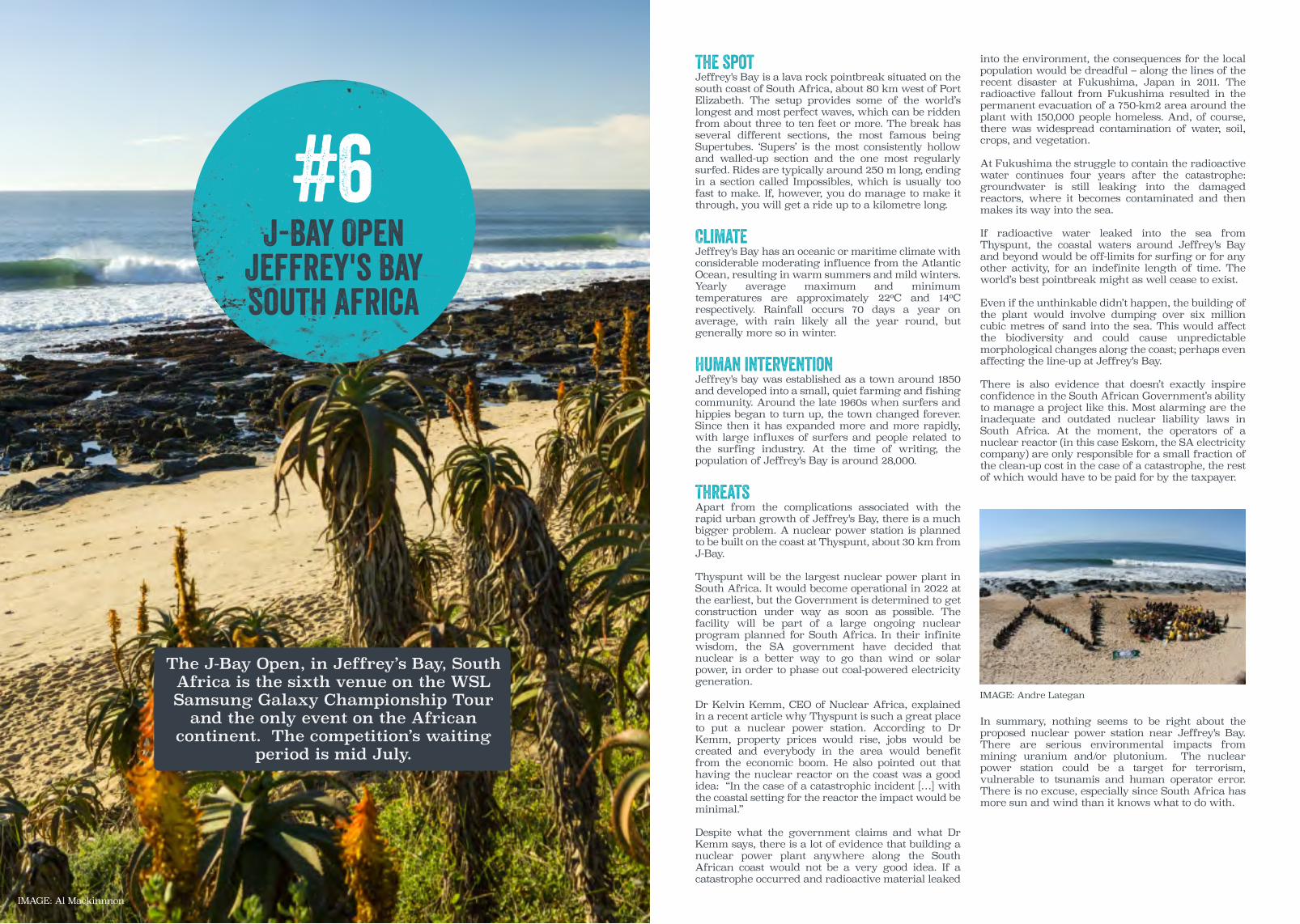
J-Bay OpenJeffrey's BaySouth Africa
#6
The J-Bay Open, in Jeffrey’s Bay, South Africa is the sixth venue on the WSL Samsung Galaxy Championship Tour
and the only event on the African continent. The competition’s waiting
period is mid July.
The spotJeffrey's Bay is a lava rock pointbreak situated on the south coast of South Africa, about 80 km west of Port Elizabeth. The setup provides some of the world’s longest and most perfect waves, which can be ridden from about three to ten feet or more. The break has several different sections, the most famous being Supertubes. ‘Supers’ is the most consistently hollow and walled-up section and the one most regularly surfed. Rides are typically around 250 m long, ending in a section called Impossibles, which is usually too fast to make. If, however, you do manage to make it through, you will get a ride up to a kilometre long.
ClimateJeffrey's Bay has an oceanic or maritime climate with considerable moderating influence from the Atlantic Ocean, resulting in warm summers and mild winters. Yearly average maximum and minimum temperatures are approximately 22ºC and 14ºC respectively. Rainfall occurs 70 days a year on average, with rain likely all the year round, but generally more so in winter.
Human interventionJeffrey's bay was established as a town around 1850 and developed into a small, quiet farming and fishing community. Around the late 1960s when surfers and hippies began to turn up, the town changed forever. Since then it has expanded more and more rapidly, with large influxes of surfers and people related to the surfing industry. At the time of writing, the population of Jeffrey's Bay is around 28,000.
ThreatsApart from the complications associated with the rapid urban growth of Jeffrey's Bay, there is a much bigger problem. A nuclear power station is planned to be built on the coast at Thyspunt, about 30 km from J-Bay.
Thyspunt will be the largest nuclear power plant in South Africa. It would become operational in 2022 at the earliest, but the Government is determined to get construction under way as soon as possible. The facility will be part of a large ongoing nuclear program planned for South Africa. In their infinite wisdom, the SA government have decided that nuclear is a better way to go than wind or solar power, in order to phase out coal-powered electricity generation.
Dr Kelvin Kemm, CEO of Nuclear Africa, explained in a recent article why Thyspunt is such a great place to put a nuclear power station. According to Dr Kemm, property prices would rise, jobs would be created and everybody in the area would benefit from the economic boom. He also pointed out that having the nuclear reactor on the coast was a good idea: “In the case of a catastrophic incident […] with the coastal setting for the reactor the impact would be minimal.”
Despite what the government claims and what Dr Kemm says, there is a lot of evidence that building a nuclear power plant anywhere along the South African coast would not be a very good idea. If a catastrophe occurred and radioactive material leaked
into the environment, the consequences for the local population would be dreadful – along the lines of the recent disaster at Fukushima, Japan in 2011. The radioactive fallout from Fukushima resulted in the permanent evacuation of a 750-km2 area around the plant with 150,000 people homeless. And, of course, there was widespread contamination of water, soil, crops, and vegetation.
At Fukushima the struggle to contain the radioactive water continues four years after the catastrophe: groundwater is still leaking into the damaged reactors, where it becomes contaminated and then makes its way into the sea.
If radioactive water leaked into the sea from Thyspunt, the coastal waters around Jeffrey's Bay and beyond would be off-limits for surfing or for any other activity, for an indefinite length of time. The world’s best pointbreak might as well cease to exist.
Even if the unthinkable didn’t happen, the building of the plant would involve dumping over six million cubic metres of sand into the sea. This would affect the biodiversity and could cause unpredictable morphological changes along the coast; perhaps even affecting the line-up at Jeffrey's Bay. There is also evidence that doesn’t exactly inspire confidence in the South African Government’s ability to manage a project like this. Most alarming are the inadequate and outdated nuclear liability laws in South Africa. At the moment, the operators of a nuclear reactor (in this case Eskom, the SA electricity company) are only responsible for a small fraction of the clean-up cost in the case of a catastrophe, the rest of which would have to be paid for by the taxpayer.
In summary, nothing seems to be right about the proposed nuclear power station near Jeffrey's Bay. There are serious environmental impacts from mining uranium and/or plutonium. The nuclear power station could be a target for terrorism, vulnerable to tsunamis and human operator error. There is no excuse, especially since South Africa has more sun and wind than it knows what to do with.
IMAGE: Al Mackinnnon
IMAGE: Andre Lategan

Billabong Pro TahitiTeahupo'o
FrenchPolynesia
#7
The BillabongPro Tahiti, at Teahupo, Tahiti is the seventh venue on the WSL Samsung Galaxy Championship Tour.
The competition’s waiting period is mid August.
The spotTeahupo'o is a coral reef pass located about 700 m offshore on the south coast of Tahiti, about 70 km from Pape'ete, the capital of French Polynesia. Teahupo'o is one of the most challenging and dangerous surf spots in the world. The wave is relatively short – about 70 m – and it can be surfed from about three or four feet up to well over 15, changing radically as it gets bigger. While a four-foot wave is pretty hollow and perhaps mildly challenging, a ten-foot wave is bordering on suicidal. The reason is the unique local bathymetry. The slope of the sea bed just offshore of the reef is so steep that the wave will break in almost the same depth of water no matter how big the swell. As a result, the wave very quickly becomes thicker, hollower and much more frightening as the size increases.
ClimateTahiti has a tropical monsoonal climate, with a dry season from April to October and a heavy monsoon season from November to March. Yearly average maximum and minimum temperatures are approximately 30ºC and 22ºC respectively. Rainfall occurs about 104 days a year on average, with a significant peak in rainfall during December and January.
Human interventionThe population of Tahiti is steadily growing, now around 185,000, with most people living in or near Pape'ete. Teahupo'o itself is a small village with a population of about 1,400 people. Tourism is a major industry in Tahiti, and has been steadily growing since the early 1960s. The number of visitors to Tahiti every year at the time of writing is around 170,000.
ThreatsFrench Polynesia is an ‘overseas collectivity’ of France, so it is not exactly an ocean-island state like Fiji. However, it will suffer in much the same way from the effects of climate change. Low-lying areas are extremely vulnerable to inundation from sea-level rise and storm intensification, and the coral reefs surrounding the islands are also in danger. The coral reef ecosystem in French Polynesia currently has the highest marine biodiversity anywhere in the world, with many unique native species.
Tahiti is a mountainous island, with ten peaks over 1,500 m high and French Polynesia’s highest mountain, Orohena, at 2,241 m. Therefore, one would assume that global warming and sea-level rise might be less of a problem than at other, low-lying islands. This is true to a certain extent, but much of the inland mountainous regions are uninhabited, with most of the population living on a narrow coastal fringe. For example, most of Pape'ete is on gently-sloping land below 15 metres above sea level. The growing tourist industry is located entirely on that coastal fringe, with hotels and resorts at sea level or a few metres above it. These will be severely affected by shoreline inundation and the flooding of the coastal lagoon.
The coral reefs around Tahiti, including Teahupo'o, are threatened by several factors related to climate change. For example, as already mentioned, increased sea temperatures can affect the symbiotic
polyps that live inside the coral, killing them or forcing them to abandon the coral, leading to the death of the coral itself.
The coral can also be affected by climate change via increased rainfall intensity. Heavy rainfall combined with an overdeveloped coastline that is already vulnerable to erosion, will lead to large amounts of sediment flowing into the sea towards the reefs. The sediment reduces the sunlight that the symbiotic algae inside the coral need to photosynthesize, which can then jeopardize the coral.
In a similar way to Cloudbreak in Fiji, the wave at Teahupo'o will be affected by climate change. Sea-level rise will alter the bathymetry of the reef, and the coral itself will be more susceptible to erosion if it is damaged or if it dies. Of course, if and when climate change affects tourism and society as a whole in Tahiti, then the surfing experience will also be degraded for locals and visitors alike.
Finally, the rapid increase in tourism on Tahiti has resulted in a corresponding increase in waste. At the time of writing, around 60,000 tonnes of non-recyclable waste is generated every year in Tahiti, ending up in landfill sites or, worse, in informal dumping sites. Much of this waste then flows into lagoons, from where it finds its way into the sea and pollutes the coastal waters. Combined with agricultural runoff containing toxic chemicals, exacerbated by heavier bouts of rainfall, this poses a health risk to coastal water users, including us surfers.
IMAGE: JASON FEAST
IMAGE: Al Mackinnnon

Hurley ProLower Trestles
California
#8
The Hurley Pro at Lower Trestles, California is the eight venue on the
WSL Samsung Galaxy Championship Tour and the only event on the North America mainland. The competition’s
waiting period is mid September.
The spotTrestles is a set of cobblestone and sand pointbreaks at San Mateo Point in Southern California, south of Los Angeles on the border between San Diego County and Orange County. Lower Trestles, the site of the Hurley Pro contest, is a long, lined-up right and a shorter left, and is generally the best spot in the area. The wave can be ridden as small as three feet and starts to lose its shape at around eight. It is an easy-to-surf wave that is often described as the best high performance wave on the planet. Trestles is very consistent, often rideable when the rest of the coast is flat.
ClimateThe coastline where Trestles is located enjoys a semi-arid or Mediterranean climate, with warm, dry summers and mild winters. Yearly average maximum and minimum temperatures are approximately 22ºC and 14ºC respectively. Rainfall occurs around 45 days a year on average, with almost all the rain during winter. California is currently suffering one of the worst droughts on record.
Human interventionTrestles has been described as an oasis in the middle of the highly-urbanized coastline of Southern California. Thanks, ironically, to a large military training ground called Camp Pendleton Marine Corps Base, extending southeast from the Trestles area. The region still contains relatively unspoilt marshland with many indigenous species including mountain lions, coyotes and eagles. About 5 km to the south there is a nuclear power station at San Onofre, which is currently inoperative after having been shut down in 2013.
ThreatsTrestles is no different from most surf spots around the world in that it will be affected by climate change. Rising sea levels, increased storminess and intensified rainfall due to climate change will all affect the sensitive bathymetry at Trestles, which will alter the shape of the waves. The surf at Trestles is dependent on sediment which arrives at the San Mateo Point Watershed via a series of creeks. The bathymetry of the break can change with the riverflow, which in turn depends upon the rainfall. After periods of particularly heavy rain the creek outlet at Lower Trestles can split into two separate branches, altering the bathymetry and hence the shape and quality of the wave. Before 1982, Lowers used to be almost exclusively a right-hander, but a left appeared after the extreme rainfall during the El Niño event of 1982-83.
A more specific and ongoing threat to Trestles is the planned building of a 25-km toll road which would encroach on the Trestles surfing area. The road would have several negative effects on the environment: It would destroy San Onofre State Beach, a 12 km2 coastal park and campground; it would probably destroy an ancient Native American village called Panhe; and it would block the San Mateo creek which in turn would restrict sediment flow to the coast and alter the wave at Lower Trestles.
However, there is plenty of opposition to the programme. The Save San Onofre Coalition, which includes the Surfrider Foundation and many other opposition groups, has so far been successful in stopping the project. For example, in 2008, after ten years of protests, the California Coastal Commission voted against it. But then, in 2013, plans were approved to build an 8-km section of the road, which would affect much of the park and make it easier to get approval for the rest of the project in the future. Luckily, in 2015, this was also rejected, this time by the San Diego Regional Water Quality Control Board. It’s an ongoing battle; if local residents and protest groups drop their guard for a moment, Trestles could be changed forever.
There is another potential hazard for Trestles and the surrounding coastline: radioactive waste from the San Onofre nuclear power station. Even though the plant was closed for good in 2013, there is still about 1,600 tonnes of radioactive waste that needs containing and disposing of safely. The material, which is still cooling down, is being transferred into 16-mm thick stainless-steel containers which will be buried underground in a giant concrete ‘monolith’ at San Onofre. The operation is expected to take until 2019, after which the material will then stay there until the Federal Government decides what to do with it.
Local residents are understandably concerned about radioactive waste leaking out. Apparently there is no monitoring system to see if the canisters are damaged – the alarm is only raised after radiation has already leaked out. The containers could easily be punctured if the concrete casing cracks, which could happen as it settles into position over time, and even a microscopic crack could release large amounts of radiation into the environment.
Or, of course, if there is an earthquake. San Onofre is less than 20 km from the famous San Andreas Fault, and it is practically right on top of a smaller fault called the Newport-Inglewood, which runs along the coast. Obviously, if something happened and there was a serious leak of radioactive waste, the entire California coast would be probably a no-go area.
IMAGE: Surfrider
IMAGE: Surfrider
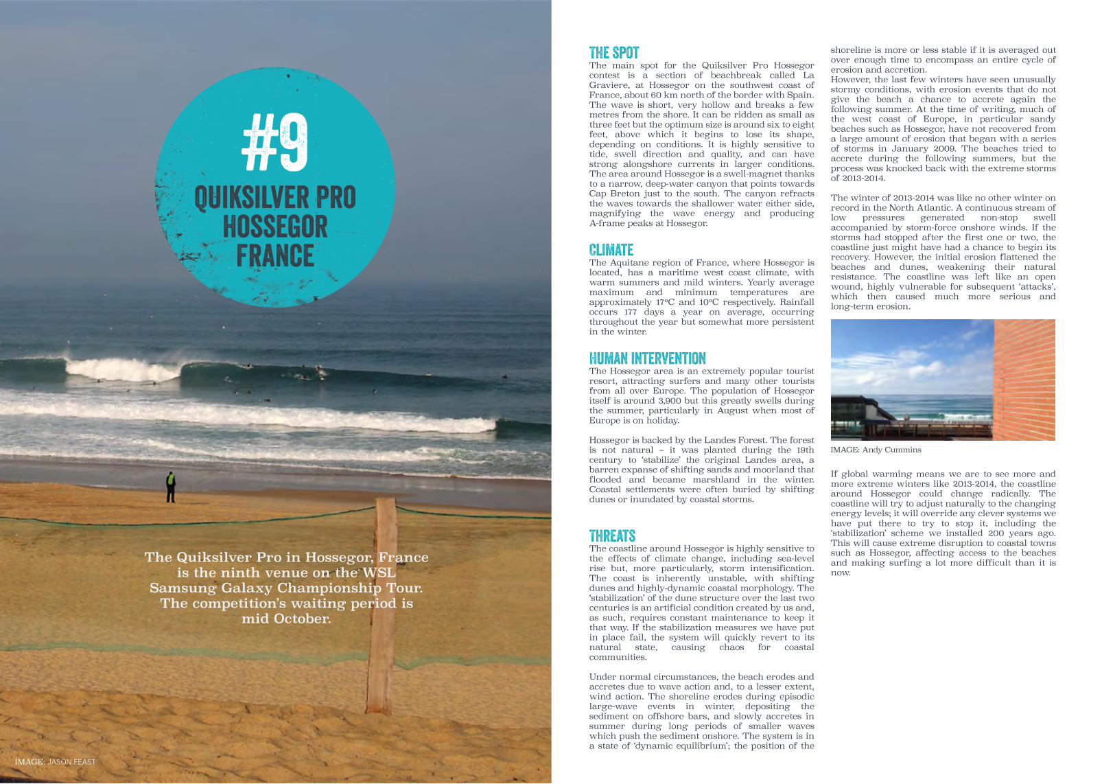
Quiksilver ProHossegor
France
#9
The Quiksilver Pro in Hossegor, France is the ninth venue on the WSL
Samsung Galaxy Championship Tour. The competition’s waiting period is
mid October.
The spotThe main spot for the Quiksilver Pro Hossegor contest is a section of beachbreak called La Graviere, at Hossegor on the southwest coast of France, about 60 km north of the border with Spain. The wave is short, very hollow and breaks a few metres from the shore. It can be ridden as small as three feet but the optimum size is around six to eight feet, above which it begins to lose its shape, depending on conditions. It is highly sensitive to tide, swell direction and quality, and can have strong alongshore currents in larger conditions. The area around Hossegor is a swell-magnet thanks to a narrow, deep-water canyon that points towards Cap Breton just to the south. The canyon refracts the waves towards the shallower water either side, magnifying the wave energy and producing A-frame peaks at Hossegor.
ClimateThe Aquitane region of France, where Hossegor is located, has a maritime west coast climate, with warm summers and mild winters. Yearly average maximum and minimum temperatures are approximately 17ºC and 10ºC respectively. Rainfall occurs 177 days a year on average, occurring throughout the year but somewhat more persistent in the winter.
Human interventionThe Hossegor area is an extremely popular tourist resort, attracting surfers and many other tourists from all over Europe. The population of Hossegor itself is around 3,900 but this greatly swells during the summer, particularly in August when most of Europe is on holiday.
Hossegor is backed by the Landes Forest. The forest is not natural – it was planted during the 19th century to ‘stabilize’ the original Landes area, a barren expanse of shifting sands and moorland that flooded and became marshland in the winter. Coastal settlements were often buried by shifting dunes or inundated by coastal storms.
ThreatsThe coastline around Hossegor is highly sensitive to the effects of climate change, including sea-level rise but, more particularly, storm intensification. The coast is inherently unstable, with shifting dunes and highly-dynamic coastal morphology. The ‘stabilization’ of the dune structure over the last two centuries is an artificial condition created by us and, as such, requires constant maintenance to keep it that way. If the stabilization measures we have put in place fail, the system will quickly revert to its natural state, causing chaos for coastal communities.
Under normal circumstances, the beach erodes and accretes due to wave action and, to a lesser extent, wind action. The shoreline erodes during episodic large-wave events in winter, depositing the sediment on offshore bars, and slowly accretes in summer during long periods of smaller waves which push the sediment onshore. The system is in a state of ‘dynamic equilibrium’; the position of the
shoreline is more or less stable if it is averaged out over enough time to encompass an entire cycle of erosion and accretion. However, the last few winters have seen unusually stormy conditions, with erosion events that do not give the beach a chance to accrete again the following summer. At the time of writing, much of the west coast of Europe, in particular sandy beaches such as Hossegor, have not recovered from a large amount of erosion that began with a series of storms in January 2009. The beaches tried to accrete during the following summers, but the process was knocked back with the extreme storms of 2013-2014.
The winter of 2013-2014 was like no other winter on record in the North Atlantic. A continuous stream of low pressures generated non-stop swell accompanied by storm-force onshore winds. If the storms had stopped after the first one or two, the coastline just might have had a chance to begin its recovery. However, the initial erosion flattened the beaches and dunes, weakening their natural resistance. The coastline was left like an open wound, highly vulnerable for subsequent ‘attacks’, which then caused much more serious and long-term erosion.
If global warming means we are to see more and more extreme winters like 2013-2014, the coastline around Hossegor could change radically. The coastline will try to adjust naturally to the changing energy levels; it will override any clever systems we have put there to try to stop it, including the ‘stabilization’ scheme we installed 200 years ago. This will cause extreme disruption to coastal towns such as Hossegor, affecting access to the beaches and making surfing a lot more difficult than it is now.
IMAGE: JASON FEAST
IMAGE: Andy Cummins

Moche Rip Curl ProPeniche
Portugal
#10
The Moche Rip Curl Pro, Peniche, Portugal is the tenth and penultimate venue on the WSL Samsung Galaxy
Championship Tour. It’s also Europe’s second event. The competition’s waiting
period is towards the end of October.
The spotThe main site for the Moche Rip Curl Pro contest is a beachbreak called Supertubos, in Peniche, about 100 km north of Lisbon, Portugal. The wave breaks close to the shore and is fairly short but extremely hollow. It can be surfed from as small as two or three feet up to well over ten, depending on conditions. Once again, the key to the power and hollowness of Supertubos is the local bathymetry. Just offshore of the break is a shallow sandbar extending about a kilometre offshore, and to the south is a deeper trench. This combination refracts the waves towards Supertubes, concentrating the energy and producing A-frame peaks.
ClimateThe area around Peniche enjoys a Subtropical-Mediterranean climate, with warm, dry summers and mild, wet winters. Yearly average maximum and minimum temperatures are approximately 21ºC and 13ºC respectively. Rainfall occurs about 113 days a year on average, with a lot more rain in winter than summer.
Human interventionApart from a small amount of agriculture and a growing tourist industry, the main industry in Peniche is fishing. It has a large fishing harbour and a notorious fish processing plant. The atmospheric pollution and smell from the plant has been severe at times, particularly on the best days at Supertubos when the wind is offshore.
Supertubos is part of a beach called Praia de Medão Grande, facing west-southwest, with a large peninsula containing the town of Peniche about 2 km to the north. The beach is backed by dunes, with the nearest urbanization about 300 m away.
ThreatsThe biggest hazard to the waves at Supertubos will be from climate change. The most serious threat will come from the intensification of coastal storms, exacerbating an already chronic coastal erosion problem, and changing the morphology. Rising sea levels will also play a part, but a relatively minor one.
The entire coast of Portugal, not just the area around Peniche, has an ongoing coastal erosion problem, with the shoreline retreating at rates of up to seven metres per year. The main reasons for this constant shoreline retreat are:
• The building of coastal structures such as ports and breakwaters without taking into consideration changes in wave dynamics nearby and at other coastal locations;
• Dredging for navigation and sand mining in the past for construction;
• Coastal urbanization resulting in the destruction of dune systems which provide a natural barrier to storms;
• The reduction in sediment supply to the coast due to the damming of rivers.
The importance of reduced sediment supply from rivers, with all the beaches in the area including Supertubos being severely starved of sediment, is probably the major cause of systematic, ongoing erosion. If there is no natural replacement for sediment being washed away by storms, the coast will become more and more vulnerable to further erosion. The rivers that supply sediment to the Peniche area are the Douro and the Mondego to the north and the Tagus to the south. The river Douro, for example, has lost around 85 per cent of its sediment flux due to the building of dams.
Just like most of the west coast of Europe, Portugal was devastated during the extreme winter of 2013-2014. But also during the El Niño of 2009-2010, storms from the west and southwest caused a lot more damage in Portugal than in France, Spain and further north.
At first glance, Supertubos looks like it will be less affected than other parts of Portugal’s west coast. For example, the beach is sheltered from the north by Peniche itself, so large swells from the northwest will be reduced in intensity before they reach Supertubos. However, with storms as intense as in 2013-2014 (expected to be the norm from now on) the amount of wave energy reaching Supertubos will be more than enough to cause severe erosion. Also, if global warming leads to more El Niño events, and, as a result, storms track as far south as they did in 2009-2010, then southwest-facing spots such as Supertubos will in the direct firing line.
In summary, Supertubes is in danger of being affected by the coastal storms that will become more severe with global warming. Erosion will change the morphology of the beach, which could negatively affect the wave. Not only the morphology at the break itself, but the offshore sandbar could also be affected, which will alter the focusing that gives Supertubos its unique power and shape.
IMAGE: @SURF_PHOTO
IMAGE: @SURF_PHOTO

Pipeline MastersBanzai Pipeline
Hawaii
#11
The Pipeline Masters at the Banzai Pipeline, Oahu, Hawaii is the final
venue on the WSL Samsung Galaxy Championship Tour. The competition’s
waiting period is mid December.
The spotThe Banzai Pipeline, site of the most famous surf contest in the world, the Pipeline Masters, is a lava and coral reef on the North Shore of Oahu, Hawaii. Pipeline is one of the most perfect, hollow and photogenic waves in the world, but at the same time one of the most difficult and dangerous. The break consists of two outside reefs and the iconic inside First Reef, which breaks as close as 50 m from the beach. The ride at First Reef is fairly short, and can be a right or left, or both, depending on the incoming swell angle. It can be ridden as small as about four feet up to about ten, at which point the waves start to break on Second Reef.
ClimateThe North Shore of Oahu experiences a tropical marine climate, with not much seasonal temperature variation. Yearly average maximum and minimum temperatures are approximately 29ºC and 21ºC respectively. Rainfall occurs on average 126 days a year, with rain likely throughout the year but considerably heavier in winter.
Human interventionDespite the growth of surfing and the general popularity of Hawaii as a tourist destination, the North Shore of Oahu has remained relatively stable as far as coastal development is concerned. The population has steadily grown from about 9,000 in 1970 to around 15,000 in 2015. Most of the area inland of the North Shore is agricultural land, which the local community is committed to preserving. The main centre of commerce is Haleiwa, an old plantation town with small shops, art galleries and restaurants.
ThreatsJust like every coastline in the world and particularly ocean islands, Hawaii won’t escape climate change. It will suffer from the effects of increased sea surface temperature, storm intensification and rising sea levels. Increasing sea temperatures will affect Hawaii, one major consequence of which will be the death of coral due to the death or abandonment of the symbiotic microorganisms that live inside it. As mentioned before, these organisms give the coral its colour, and when they are not present the coral loses its colour or ‘bleaches’. A colourless coral means a lifeless coral, and a lifeless coral means a damaged ecosystem.
The reef at Pipeline, and the outer reefs that control the complex refraction that determines the way Pipeline breaks on different swells, are principally made of volcanic rock, but they have coral growing on them. Depending on the amount of coral on these reefs, the death of the coral could possibly affect the shape of the reefs and hence the behaviour of the waves at Pipeline.
Increased sea surface temperatures will lead to an increase in the frequency and intensity of hurricanes. Tropical storms get their energy from the sea surface, and if the water temperature underneath the storm stays above about 26ºC, it will
have a much greater chance of spinning up into a hurricane. This will increase the chances of storms that form close to Hawaii developing into serious hurricanes. And, of course, a hurricane making landfall anywhere means utter chaos for the population, not least on ocean islands where storm surges, coastal flooding and mudslides will be more intense than on mainland coasts.
Rising sea levels will have a major effect in Hawaii. In particular, they will exacerbate the already serious ongoing problem of coastal erosion. Results from recent study by scientists at the University of Hawaii have suggested that the effects of sea-level rise will double current shoreline erosion rates.
In the study, historical beach profile data was examined from ten Hawaiian beaches, including Ehukai Beach Park which contains Pipeline. The data was first extrapolated to see what the beaches would look like in 2050, without taking into account climate change. On average, the beaches were expected to erode by about 5 m. Now, separately modelling the erosion due to expected sea-level rise, they found an additional 5 m of erosion.
As far as the beach at Pipeline itself is concerned, the historical data shows that there is considerable systematic erosion just in front and to the north. The massive wave energy in winter causes extreme seasonal variation in the shoreline, with the beach losing up to two-thirds of its width in winter. If this increases it will be a serious problem for the famous beachfront homes opposite pipeline, including the one built by Gerry Lopez and now owned by Volcom.
IMAGE: @SURF_PHOTO
IMAGE: @SURF_PHOTO

Imagine for a moment if the venues for the elite events of tennis, football, athletics and baseball were threatened in a similar way? Fans of these sports would rise up to call for the protection of historic stadia and the homes of so many great athletic performances and memories. This is a reality for the world’s best surf spots and the clock is ticking.
We believe that the Global Wave Conference provides an unprecedented platform to promote the efforts of the enviro-surf community to protect priceless marine environments and natural surf heritage. There are many excellent examples across the globe of the enviro-surf movement implementing creative and effective solutions addressing many of the issues identified in this report. But obviously, more action is urgently needed.
The most urgent environmental issues impacting coastlines worldwide today are truly without borders, from plastic pollution to climate change, so it’s vital that we collaborate to have truly global impact in protecting our oceans. Breaking out of our preconceived work silos and territories, and opening ourselves up to share ideas, strengthen operations, upscale impact and learn from other sectors is vital for us to build on our many successes of the last 30 years, which has seen the rise of the enviro-surf movement.
Surfers’ visceral connection with the ocean can be the catalyst for positive change. Surfers are often the first to identify pollution and humanitarian issues at local spots or far-flung places of the world. Surfers’ travel capability and resilience empowers us to trek to communities in need of help. Surfers’ eyes and ears can be firsthand witnesses to environmental degradation before deskbound legislators trundle into action. Surfers’ youthful energy can fuel grassroots campaigns where other would fail. Surfers can also be a much bigger voice where legislation is failing to protect the wild spaces and communities we love. Surfers Against Sewage call on every surfer to play his or her part in this mission.
Launching local campaigns; Joining local enviro-surf groups; Taking part in a grassroots demo; Organising a community beach clean; Freeing entangled wildlife; Attending public meetings about beach developments; Documenting and reporting pollution; Leading a local environmental group. Taking action to protect your local surf spot; Being the voice of your beach.
Take action. Be part of the new localism.
Conclusion

In response to the growing threats to the world’s waves, oceans, beaches and wildlife there are a growing number of environmental organisations working to protect surf habitats, marine ecosystems and water users at a local, national and international level. This directory is not intended as a comprehensive guide to groups at any level, rather an overview of some of the most effective and well known groups with a proven track record of successful campaigns and community initiatives.
Surfers Against SewageSurfers Against Sewage (SAS) is an environmental charity protecting the UK’s oceans, waves and beaches for all to enjoy safely and sustainably, via community action, campaigning, volunteering, conservation, education and scientific research.
SAS’s projects target coastal environmental issues including marine litter, sewage polluting, climate change, toxic chemicals, shipping, industry and coastal development, with an aim to create measurable improvements in the state of our oceans, waves and beaches through change sin public behaviour, government policy and industry practices.
SAS also believes that waves and surf spots deserve to be seen as part of the UK’s heritage and should be afforded greater recognition through political debate and legislation. SAS is working hard to raise the public awareness of these natural resources, the environment, physical and geological factors that create waves and how they are integral to coastal ecosystems and can help support thriving, sustainable and economically successful coastal communities around the UK.
Surfers Against Sewage represents over 150,000 regular supporters, 10,000 members, 15,000 volunteers and 75 Regional Chapters around the UK. Surfers Against Sewage also run the Protect Our Waves All Party Parliamentary Group in Westminster to discuss and address threats to surfing habitats around the UK.
www.sas.org.uk @sascampaigns www.facebook.com/SurfersAgainstSewage
The Surfrider FoundationThirty one years ago a group of surfers from Malibu, California, were concerned about the health risks associated with environmental threats posed by escalating coastal development at their favourite surf spot. They took action. Since then in 1984, the Surfrider Foundation has evolved into one of the largest non-profit grassroots organisations dedicated to the protection and enjoyment of the world’s oceans, waves and beaches through powerful activist network.
With 84 chapters, 30 high school and college clubs and more than 250,000 supporters, volunteers and activists around the country, The Surfrider Foundation has gone from strength to strength. They work on around 100 different campaigns in four core areas; beach access, clean water, coastal prevention (coastal development) and ocean protection. With these campaigns and armed with a model to defend the coast, they have achieved more than 300 coastal victories since 2006.
www.surfrider.org @Surfrider www.facebook.com/surfrider
Save The WavesSave The Waves vision is a world where waves and coastlines are cherished and protected, and surfing provides a proactive vehicle for long-term coastal conservation. “Our goal is to proactively address the issues that can harm this unique ecosystem, focused on the following: coastal development, water quality and watersheds, sea level rise and coastal erosion, marine debris, reefs and access”.
Save The Waves protects coastal ecosystems around the world through innovative strategies in partnership with local communities. Utilising a unique combination of protected areas, economics and direct action, Save The Waves partners with locals to preserve their coastal resources and in turn strengthen their communities.
www.savethewaves.org @SaveTheWaves www.facebook.com/savethewavescoalition
Appendix 1: NGO Directory World Animal ProtectionWorld Animal Protection (formerly WSPA) seeks to create a world where animal welfare matters and animal cruelty has ended. Active in more than 50 countries, they work directly with animals and with the people and organisations that can ensure animals are treated with respect and compassion. We hold consultative status at the Council of Europe and collaborate with national governments and the United Nations.
WAP’s Sea Change campaign brings together governments, industry and the public to protect marine life from the devastating impact of abandoned, lost or discarded fishing gear, otherwise known as fishing litter or ‘ghost gear’. Ghost gear represents one of the biggest threats to animals in our oceans, entangling, injury and killing millions of animals every year.
www.worldanimalprotection.org.uk @MoveTheWorld www.facebook.com/WorldAnimalProtectionUK
Sustainable SurfSustainable Surf take an integrated “systems thinking” approach with their innovative programmes and campaigns, which engage both individuals and businesses together in partnership to solve the most pressing environmental issues facing our oceans. Specifically, they focus on addressing environmental impacts such as climate change related impacts (ocean acidification, sea level rise and coastal erosion), marine plastic pollution, and water quality issues that threaten our shared “surfing habitat.”
They provide engaging on-ramps for individuals to make lifestyle choices that can lower their negative impacts on the ocean and coastal environment, while boosting their positive impact on their local communities. They also consult with surf-related businesses and organisations to improve their environmental performance, and help communicate their efforts in an authentic and effective way.
sustainablesurf.org @sustainsurf www.facebook.com/pages/Sustainable-Surf/152079374854312
Surfrider Foundation EuropeSurfrider Foundation Europe is a nonprofit organisation dedicated to the sustainable protection and enjoyment of oceans, waves and beaches. It is recognised by and within European Union for its legal, educational and environmental programs and has a consultative status granted by the United Nations Economic and Social Councils (ECOSOC) and Environmental Program (UNEP).
Created in 1990 in Europe (Biarritz, France) by surfers, including 3-time World Surfing Champion Tom Curren, the organisation brings together today about 700 volunteers, 10,000 members, about 40 local chapters and more than 120,000 supporters in Europe.
Their vision is to foster societal change in harmony with nature. To achieve the necessary balance between the development of human activities and environmental protection, we want to carry on with our local conservation efforts on the one hand with lobbying and education provision on the other to prepare the society of tomorrow whilst continuing to expand out environmental expertise.
www.surfrider.eu @surfridereurope www.facebook.com/surfriderfoundationeurope
WILDCOASTWILDCOAST is an international conservation team that conserves coastal and marine ecosystems and wildlife.
It works to preserve key ecosystems by applying conservation tools such as land acquisition, conservation concessions and zoning as well as developing protected areas. WILDCOAST has helped conserve more than 3.2 million acres of globally significant bays, beaches, lagoons, coral reefs and islands.
It has helped helped conserve 1,125 acres of coral reefs in Mexico and helps conserve 17,536 acres of Marine Protected Areas in Southern California.
www.wildcoast.net @wildcoast www.facebook.com/pages/WiLDCOAST/117046548337381
Salvem O SurfSalvem O Surf (Save The Surf) began as a civic movement in Portugal, supported by a technical team, to protect the surfing zones from coastal development. It uses technical solutions, scientific expertise, economic data and other specialist information to help protect surf spots across Portugal.
www.salvemosurf.org www.facebook.com/pages/SOS-Salvem-o-Surf/145404585556836
National Surfing Reserves (Australia)National Surfing Reserves are 'iconic' places of intrinsic environmental, heritage, sporting and cultural value to a nation. NSR embrace all peoples to enjoy, understand and protect special coastal environments of universal value to the surfing world. A Surfing Reserve does not attempt to exclude any user group.
www.surfingreserves.org
Surfbreak Protection SocietySurfbreak Protection Society is a Society dedicated to the conservation of the "treasures" of the New Zealand Surfing Community - our surfbreaks - through the preservation of their natural characteristics, water quality, marine eco systems and low impact access for all. We strive to be Aotearoa's Kaitiaki "Guardians - Trustees" of our surfbreaks and the natural environments that compliment them.
www.surfbreak.org.nz www.facebook.com/Surfbreak-Protection-Society-158580380850950/timeline/
5 Gyres5 Gyres is an organisation aimed at reducing plastics pollution. They have traveling exhibits, and summarise topic relevant research. Their traveling activities include stops at universities and educational discussions.
www.5gyres.org www.facebook.com/5gyres?fref=ts
Sustainable Coastlines HawaiiSustainable Coastlines Hawaii inspires local communities to care for their coastlines through hands on beach clean ups.
sustainablecoastlineshawaii.org www.facebook.com/sustainablecoastlineshawaii/
Project Clean Ulu WatuProject Clean Ulu Watu’s vision is to turn the land and marine environment surrounding Uluwatu into a pristine World Surfing Reserve to benefit the present and future Coastal Community.
www.projectcleanuluwatu.com www.facebook.com/Project-Clean-Uluwatu-479706248784675/timeline/
Supertubes Surfing FoundationThe Supertubes Surfing Foundation was set up in 1999 by the local surfing clubs in Jeffery’s Bay, South Africa. The foundation restored and conserved the natural dune habitat and improved the beach facilities. The foundation is now actively ensuring the community has the opportunity to engage with the consultation on the proposed nuclear power plant at Thyspunt.
www.facebook.com/Supertubes-Surfing-Foundation-133938709965120/timeline/

In response to the growing threats to the world’s waves, oceans, beaches and wildlife there are a growing number of environmental organisations working to protect surf habitats, marine ecosystems and water users at a local, national and international level. This directory is not intended as a comprehensive guide to groups at any level, rather an overview of some of the most effective and well known groups with a proven track record of successful campaigns and community initiatives.
Surfers Against SewageSurfers Against Sewage (SAS) is an environmental charity protecting the UK’s oceans, waves and beaches for all to enjoy safely and sustainably, via community action, campaigning, volunteering, conservation, education and scientific research.
SAS’s projects target coastal environmental issues including marine litter, sewage polluting, climate change, toxic chemicals, shipping, industry and coastal development, with an aim to create measurable improvements in the state of our oceans, waves and beaches through change sin public behaviour, government policy and industry practices.
SAS also believes that waves and surf spots deserve to be seen as part of the UK’s heritage and should be afforded greater recognition through political debate and legislation. SAS is working hard to raise the public awareness of these natural resources, the environment, physical and geological factors that create waves and how they are integral to coastal ecosystems and can help support thriving, sustainable and economically successful coastal communities around the UK.
Surfers Against Sewage represents over 150,000 regular supporters, 10,000 members, 15,000 volunteers and 75 Regional Chapters around the UK. Surfers Against Sewage also run the Protect Our Waves All Party Parliamentary Group in Westminster to discuss and address threats to surfing habitats around the UK.
www.sas.org.uk @sascampaigns www.facebook.com/SurfersAgainstSewage
The Surfrider FoundationThirty one years ago a group of surfers from Malibu, California, were concerned about the health risks associated with environmental threats posed by escalating coastal development at their favourite surf spot. They took action. Since then in 1984, the Surfrider Foundation has evolved into one of the largest non-profit grassroots organisations dedicated to the protection and enjoyment of the world’s oceans, waves and beaches through powerful activist network.
With 84 chapters, 30 high school and college clubs and more than 250,000 supporters, volunteers and activists around the country, The Surfrider Foundation has gone from strength to strength. They work on around 100 different campaigns in four core areas; beach access, clean water, coastal prevention (coastal development) and ocean protection. With these campaigns and armed with a model to defend the coast, they have achieved more than 300 coastal victories since 2006.
www.surfrider.org @Surfrider www.facebook.com/surfrider
Save The WavesSave The Waves vision is a world where waves and coastlines are cherished and protected, and surfing provides a proactive vehicle for long-term coastal conservation. “Our goal is to proactively address the issues that can harm this unique ecosystem, focused on the following: coastal development, water quality and watersheds, sea level rise and coastal erosion, marine debris, reefs and access”.
Save The Waves protects coastal ecosystems around the world through innovative strategies in partnership with local communities. Utilising a unique combination of protected areas, economics and direct action, Save The Waves partners with locals to preserve their coastal resources and in turn strengthen their communities.
www.savethewaves.org @SaveTheWaves www.facebook.com/savethewavescoalition
World Animal ProtectionWorld Animal Protection (formerly WSPA) seeks to create a world where animal welfare matters and animal cruelty has ended. Active in more than 50 countries, they work directly with animals and with the people and organisations that can ensure animals are treated with respect and compassion. We hold consultative status at the Council of Europe and collaborate with national governments and the United Nations.
WAP’s Sea Change campaign brings together governments, industry and the public to protect marine life from the devastating impact of abandoned, lost or discarded fishing gear, otherwise known as fishing litter or ‘ghost gear’. Ghost gear represents one of the biggest threats to animals in our oceans, entangling, injury and killing millions of animals every year.
www.worldanimalprotection.org.uk @MoveTheWorld www.facebook.com/WorldAnimalProtectionUK
Sustainable SurfSustainable Surf take an integrated “systems thinking” approach with their innovative programmes and campaigns, which engage both individuals and businesses together in partnership to solve the most pressing environmental issues facing our oceans. Specifically, they focus on addressing environmental impacts such as climate change related impacts (ocean acidification, sea level rise and coastal erosion), marine plastic pollution, and water quality issues that threaten our shared “surfing habitat.”
They provide engaging on-ramps for individuals to make lifestyle choices that can lower their negative impacts on the ocean and coastal environment, while boosting their positive impact on their local communities. They also consult with surf-related businesses and organisations to improve their environmental performance, and help communicate their efforts in an authentic and effective way.
sustainablesurf.org @sustainsurf www.facebook.com/pages/Sustainable-Surf/152079374854312
Surfrider Foundation EuropeSurfrider Foundation Europe is a nonprofit organisation dedicated to the sustainable protection and enjoyment of oceans, waves and beaches. It is recognised by and within European Union for its legal, educational and environmental programs and has a consultative status granted by the United Nations Economic and Social Councils (ECOSOC) and Environmental Program (UNEP).
Created in 1990 in Europe (Biarritz, France) by surfers, including 3-time World Surfing Champion Tom Curren, the organisation brings together today about 700 volunteers, 10,000 members, about 40 local chapters and more than 120,000 supporters in Europe.
Their vision is to foster societal change in harmony with nature. To achieve the necessary balance between the development of human activities and environmental protection, we want to carry on with our local conservation efforts on the one hand with lobbying and education provision on the other to prepare the society of tomorrow whilst continuing to expand out environmental expertise.
www.surfrider.eu @surfridereurope www.facebook.com/surfriderfoundationeurope
WILDCOASTWILDCOAST is an international conservation team that conserves coastal and marine ecosystems and wildlife.
It works to preserve key ecosystems by applying conservation tools such as land acquisition, conservation concessions and zoning as well as developing protected areas. WILDCOAST has helped conserve more than 3.2 million acres of globally significant bays, beaches, lagoons, coral reefs and islands.
It has helped helped conserve 1,125 acres of coral reefs in Mexico and helps conserve 17,536 acres of Marine Protected Areas in Southern California.
www.wildcoast.net @wildcoast www.facebook.com/pages/WiLDCOAST/117046548337381
Salvem O SurfSalvem O Surf (Save The Surf) began as a civic movement in Portugal, supported by a technical team, to protect the surfing zones from coastal development. It uses technical solutions, scientific expertise, economic data and other specialist information to help protect surf spots across Portugal.
www.salvemosurf.org www.facebook.com/pages/SOS-Salvem-o-Surf/145404585556836
National Surfing Reserves (Australia)National Surfing Reserves are 'iconic' places of intrinsic environmental, heritage, sporting and cultural value to a nation. NSR embrace all peoples to enjoy, understand and protect special coastal environments of universal value to the surfing world. A Surfing Reserve does not attempt to exclude any user group.
www.surfingreserves.org
Surfbreak Protection SocietySurfbreak Protection Society is a Society dedicated to the conservation of the "treasures" of the New Zealand Surfing Community - our surfbreaks - through the preservation of their natural characteristics, water quality, marine eco systems and low impact access for all. We strive to be Aotearoa's Kaitiaki "Guardians - Trustees" of our surfbreaks and the natural environments that compliment them.
www.surfbreak.org.nz www.facebook.com/Surfbreak-Protection-Society-158580380850950/timeline/
5 Gyres5 Gyres is an organisation aimed at reducing plastics pollution. They have traveling exhibits, and summarise topic relevant research. Their traveling activities include stops at universities and educational discussions.
www.5gyres.org www.facebook.com/5gyres?fref=ts
Sustainable Coastlines HawaiiSustainable Coastlines Hawaii inspires local communities to care for their coastlines through hands on beach clean ups.
sustainablecoastlineshawaii.org www.facebook.com/sustainablecoastlineshawaii/
Project Clean Ulu WatuProject Clean Ulu Watu’s vision is to turn the land and marine environment surrounding Uluwatu into a pristine World Surfing Reserve to benefit the present and future Coastal Community.
www.projectcleanuluwatu.com www.facebook.com/Project-Clean-Uluwatu-479706248784675/timeline/
Supertubes Surfing FoundationThe Supertubes Surfing Foundation was set up in 1999 by the local surfing clubs in Jeffery’s Bay, South Africa. The foundation restored and conserved the natural dune habitat and improved the beach facilities. The foundation is now actively ensuring the community has the opportunity to engage with the consultation on the proposed nuclear power plant at Thyspunt.
www.facebook.com/Supertubes-Surfing-Foundation-133938709965120/timeline/

Appendix 2: Enviro-surf ReportsThere are a growing number of scientific reports covering the range of environmental issues featured in this report. These in depth studies are vital tools to help supporters better understand the issues, and are essential campaigning documents to help us influence developers, industry and Government. Below are examples of some of the literature produced by the enviro-surf sector.
Surfers Against Sewage reports include: Additional reports:
The Surfonomics of Trestles. Dr Chad Nelsen. Surfrider www.surfrider.org/coastal-blog/entry/the-economics-of-surfing
There are more reports and documents available from Surfrider www.surfrider.org/publications
Save The Waves coalition has published several surfonomic reports featuring high profile waves under threat, including:
PICHILEMU, CHILE (2014) test.savethewaves.org/wp-content/uploads/SURFONOMIC_PICHILEMU_07_29_15_SPREADS.pdf
San Miguel, Baja, Mexico (2014) http://www.savethewaves.org/programs/surfonomics/surfonomics-sites/san-miguel-baja-mexico-2014/
Huanchaco, Peru, (2014) www.savethewaves.org/programs/surfonomics/surfonomics-sites/huanchaco-peru-20132014/
Uluwatu, Bali, Indonesia (2014) www.savethewaves.org/wp-content/uploads/Bali_Surfonomics_Final%20Report_14_11_28_nm.pdf
Maverick’s California, USA (2009) www.savethewaves.org/wp-content/uploads/Mavs_Study_CREST_only_2-12-10.pdf
Mundaka, Spain (2008) www.savethewaves.org/wp-content/uploads/Mundaka_Final_lock.pdf
Australia’s National Surfing Reserves has an extensive library of resources including
The Rationale and process for recognising iconic surfing locations http://www.surfingreserves.org/pdf/ICS020%20Farmer&Short.pdf
Further NSR reports can be downloaded here: www.surfingreserves.org/resources.php
Surfbreak Protection Society have published Planning approaches for the management of surf breaks in New Zealand www.surfbreak.org.nz/wp-content/uploads/2014/01/Planning-approaches-for-the-management-of-Surf-Breaks-in-New-Zealand_Skellern-et-al-2013.pdf Further Surfbreak Protection Society resources are available here: www.surfbreak.org.nz/library/members-resource-area/
The Marine Litter Report, 2014 - 2020 Vision. (2014)
The economic impact of domestic surfing on the UK (2013)
Protect Our Waves briefing: Calling for official recognition and protection for UK surf spots (2012)
SAS Sustainable Guide To Surfing (2011)
SAS War Report (Waves Are Resources) (2010 )
Guidance On Environmental Impact Assessment Of Offshore Renewable Energy Development On Surfing Resources And Recreation (2009)
Climate Change – A Surfers Perspective (2007)

Published by Surfers Against Sewage
September 2015
Written byDr Tony Butt
SAS contact details:Surfers Against Sewage,Wheal Kitty Workshops,
St. Agnes,Cornwall,TR5 0RD.
www.sas.org.uktel: 01872 553001
email: [email protected]