global and planetary change - core.ac.uk · goon (fig. 1a). the density of settlements increased...
TRANSCRIPT

Contents lists available at ScienceDirect
Global and Planetary Change
journal homepage: www.elsevier.com/locate/gloplacha
Mid to late Holocene environmental changes along the coast of westernSardinia (Mediterranean Sea)
Rita T. Melisa,⁎, Anna Depalmasb, Federico Di Ritac, Francesca Montisa, Matteo Vacchid
a Dipartimento di Scienze Chimiche e Geologiche, Università di Cagliari, Via Trentino 51, 02127 Cagliari, Italyb Dipartimento di Storia, Scienze dell'Uomo e della Formazione, Università di Sassari, Via Zanfarino, 62, 07100 Sassari, Italyc Dipartimento di Biologia Ambientale, Sapienza Università di Roma, Piazzale Aldo Moro 5, 00185 Roma, Italyd Université P. Valéry Montpellier 3, CNRS ASM UMR 5140, Montpellier, France
A R T I C L E I N F O
Keywords:HoloceneCoastal plainsPalaeoenvironmental reconstructionsPollenSardiniaWestern Mediterranean
A B S T R A C T
Multiproxy analysis composed of biostratigraphy and pollen analysis allowed reconstructing the palaeoecolo-gical and palaeoenvironmental evolution of the Tirso river coastal plain in Sardinia (NW Mediterranean) in thelast 6 millennia. We demonstrated that interplay between littoral and fluvial processes have significantly con-trolled the environmental evolution of the area and have played a key role in the pattern of historical andprehistorical settlements of this wide portion of western Sardinian coastline. At the end of Neolithic period (ca.6.0 to 5.5 cal. ka BP) the area close to the shoreline was most likely characterized by large coastal lagoonsintermittently connected to the open sea. Such saltwater influence is corroborated by faunal and pollen as-semblages found in the landward portion of the Tirso coastal plain up to 2 km inland from the modern shoreline.Our data robustly document the end of the transgressive trend at ca. 5.5 cal. ka BP, and a dominant fluvialsedimentation since Final Neolithic period. At this time, a progradational trend started, causing the seawardmigration of shoreline and, consequently, of the barrier-lagoon system. The major landscape modificationtracked along the last 6 millennia may also explain the low density of historical and prehistorical remains in theTirso coastal plain, especially if compared to the nearby rocky area of Sinis Peninsula densely inhabited since theNeolithic. Our data further provide new insights into the Relative Sea Level (RSL) evolution in this sector of theMediterranean. In particular, we improved the mid-Holocene RSL record in Sardinia, where only scarce datawere previously available.
1. Introduction
Mediterranean coast have represented great places for relations andexchanges among peoples, especially in historical and proto-historicalperiods (e.g., Masters and Flemming, 1982; Anzidei et al., 2014;Marriner et al., 2014b). In the last six millennia (i.e. mid to late Ho-locene) the combined effects of the slowing of sea-level rise and theincrease of sediment input caused by both climatic and anthropogenicfactors (e.g., Butzer, 2005; Anthony et al., 2014; Ghilardi et al., 2017)allowed the formation of large Mediterranean coastal plains that wereheavily colonized by civilizations in the different pre-historical andhistorical periods (e.g., Brückner et al., 2006; Fontana et al., 2017;Giaime et al., 2016). Thus, coastal plains represent a very importantarchive of the man-environment interactions along the Mediterraneancoastal landscape especially in mid to late Holocene. However, it is noteasy to identify which of the natural (i.e. changes in climatic
parameters, sea level changes or modification of fluvial regimes) andanthropogenic (i.e. deforestation, fires, agriculture) factors majorlyinfluenced the landscape evolution, especially in the last 6 millennia(e.g., Hooke and Le, 2000; Brückner, 2003; Fontana et al., 2017). Theaim of this study is to reconstruct the mid to late Holocene pa-laeoenvironmental evolution of the Tirso coastal plain, in westernSardinia, the second largest Mediterranean Island.
Sardinia, located in the center of the western Mediterranean, hasalways occupied a strategic position as testified by the large amount ofarchaeological records found along its coasts, especially from theBronze Age to the Late Antiquity (e.g., Lilliu, 1999; Bondì, 2000;Antonioli et al., 2007). Furthermore, despite the continuous changesrelated to marine and fluvial dynamics, several Sardinian coastal plainshave been densely settled since the Neolithic period. However, studieson the Holocene evolution of its coastal plains are seldom reported(e.g., Orrù et al., 2004). In this study, we investigated the evolution of
http://dx.doi.org/10.1016/j.gloplacha.2017.06.001Received 5 January 2017; Received in revised form 31 May 2017; Accepted 6 June 2017
⁎ Corresponding author.E-mail addresses: [email protected] (R.T. Melis), [email protected] (A. Depalmas), [email protected] (F. Di Rita), [email protected] (F. Montis),
[email protected] (M. Vacchi).
Global and Planetary Change 155 (2017) 29–41
Available online 07 June 20170921-8181/ © 2017 Elsevier B.V. All rights reserved.
MARK

the Tirso coastal plain over the last six thousand years and its possibleinfluence on the human settlement in the area. The Tirso coastal plain,the largest of the Island, hosts the Sa Osa archaeological site, an im-portant settlement of the Nuragic period (i.e. 3.6-2.5 cal. ka BP, seeSection 2). Further, the broad Tirso area was densely settled in the past,as testified by the impressive remains of the city of Tharros, founded byPhoenician (ca. 2.6-2.5 cal. ka BP) and subsequently occupied by Ro-mans up to Late Antiquity (ca. 2.3 cal. ka BP, Del Vais et al., 2006).
Here we present an assessment of the environmental evolution ofthis important coastal area based on a multiproxy analysis of a new setof sediment cores that were chronologically constrained by 14C dates.We analysed both morphological and environmental evolution of thelandscape integrating sedimentological, biostratigraphical and palyno-logical data. The results allowed elucidating the major landscapemodifications of the area and their impacts on human societies in thelast 6000 years. Finally, we assessed the sea-level evolution in the areaby producing a new set of relative sea-level (RSL) datapoints.
2. Study area
The study area is located in the Tirso river coastal plain, in thenorthern part of the Oristano Gulf (mid-western Sardinia, Fig. 1a). Thegulf represents the western boundary of the Campidano graben, aPliocene - Quaternary structural depression oriented NW–SE (De Falcoet al., 2015), filled by transitional, marine and continental deposits. Thearea is part of the transitional environment, bounded seaward by sandyshoreline and eastward by the Tirso alluvial plain. Several lagoons, saltand freshwater marshes, abandoned meander and backshore dunescharacterize this coastal environment. Such geomorphological settingmakes the whole area extremely vulnerable to sea-level rise (e.g.,Antonioli et al., 2017). The tidal range is small and does not ex-ceed± 0.2 m (De Falco et al., 2015). In the nearby area of Sinis Pe-ninsula, Late Pleistocene deposits (MIS 5.5, Carboni and Lecca, 1985;Ulzega and Hearty, 1986) were measured at ca. 6 m above presentmean sea-level (msl). This implies negligible (i.e. < 0.05 mm a−1)
tectonic vertical movements in the last ca. 125 ka (Ferranti et al.,2006).
The broad area of the Oristano gulf was intensely settled, especiallyin the last four millennia (Depalmas and Melis, 2010). The first evi-dence of intense frequentation is mainly localized in the nearby SinisPeninsula with traces of Neolithic settlements around the Cabras La-goon (Fig. 1a). The density of settlements increased during the Nuragiccivilization (3.6-2.5 cal. ka BP). Peaks of frequentation are reported inthe Middle Bronze Age (3.6-3.2 cal. ka BP), and from the Final BronzeAge to the Early Iron Age (3.1-2.7 cal. ka BP). The Nuragic age endedwith the establishment of Punic settlements (ca. 2.5 cal. ka BP) alongthe coast and on the Campidano plain. Since the first Roman occupation(ca. 2.2 cal. ka BP) the area experienced a slow Romanization, whichlasted for several centuries. On the contrary, the area was sparselypopulated in the Middle Ages (Tore and Stiglitz, 1987; Stiglitz, 1998)due to the barbarian incursions. The pattern of prehistoric and historicsettlements indicates a significant discrepancy between the Tirsocoastal plain and the surrounding rocky area of Sinis Peninsula (Fig. 1a;Depalmas and Melis, 2010). In fact, the Sa Osa archaeological site re-presents the sole settlement presently found in the coastal plain(Fig. 1b). It represents a particular Nuragic settlement, built withoutexternal walls in the middle of the coastal plain and presently buried byfluvial sediments (Usai et al., 2012).
3. Materials and methods
We drilled 7 boreholes (S1 to S7) down to a maximum depth of10 m, between the shoreline and the Sa Osa archaeological site(Fig. 1b). Elevation of the cores with respect to the current mean sealevel was obtained coupling GPS surveys with high resolution(± 0.5 m) Digital Elevation Model available for the whole area(Regione Sardegna, 2017). The palaeoenvironmental reconstructionwas performed trough a multidisciplinary analysis of sedimentologicalparameters, faunal assemblages and pollen content of the cores, as al-ready carried out on several other cases throughout the central
Fig. 1. a) Location of the study area in the central-west coast Sardinia and distribution of archaeological sites (modified from Depalmas and Melis, 2010). The box shows the location ofthe Tirso coastal plain; b) Schematic geomorphological map (DEM, Regione Sardegna, 2017), location of the cores and Sa Osa site in the Tirso coastal plain. Lat/long are provided inWGS84.
R.T. Melis et al. Global and Planetary Change 155 (2017) 29–41
30

Mediterranean (e.g., Di Rita et al., 2011; Amorosi et al., 2013; Curráset al., 2017). This multiproxy approach provided the framework toidentify major stratigraphic units as well as to define the palaeoecolo-gical and palaeoenvironmental changes across the study area.
3.1. Definition of the stratigraphic units
A preliminary facies description (e.g., colour, lithofacies) was car-ried out under standardized laboratory conditions (see Marriner et al.,2012). Then, the 7 cores were sampled at regular 0.5 m interval. Drysediments were weighed and washed through two mesh sizes, 2 mmand 63 μm, to separate out the gravels (> 2 mm), sands (2 mm to63 μm) and silts and clays (< 63 μm) fractions. Full data are providedin Supplementary Figs. S1, S2, S3, S4, S5, S6 and S7. The differentfractions were plotted against stratigraphic logs in percentages.
A biostratigraphic analysis of mollusc assemblages as well as theidentification of foraminifera and ostracods along the cores was un-dertaken. For the macro and microfauna analysis a total of 21 sampleswere considered. These were collected in the most significant lithos-tratigraphic levels. The fraction ≥ 500 μm of 20 samples of the 7 coreswas used for molluscan analyses while the fraction between 63 and500 μm was observed under a stereoscopic microscope for foraminiferaand ostracods identification.
Molluscs identification and definition of the ecological assemblageswere performed according to the Pérès and Picard (1964), D'Angelo andGargiulo (1978) and Doneddu and Trainito (2005) classification sys-tems. Species determination of foraminifera and ostracods was mainlybased on studies concerning the Mediterranean benthic fauna (e.g.,Sgarrella and Moncharmont Zei, 1993; Fiorini and Vaiani, 2001;Fiorini, 2004). We defined the palaeoenvironmental significance of thedifferent assemblages following the methodology used for several se-dimentary archives along the central Mediterranean coasts (e.g.,Donnici and Serandrei Barbero, 2002; Carboni et al., 2002; Frezza andCarboni, 2009). Full data are provided in Supplementary Tables A, B, Cand D.
3.2. Chronology of the stratigraphic units
The age of the samples was established by a series of new 17 AMS14C radiocarbon dates taken from organic rich sediments and vegetableremains (Table 1). Because the production of atmospheric radiocarbonhas varied through geological time, radiocarbon ages were calibrated toprovide dates in calendar years before present. All samples were cali-brated using CALIB 7.1 (Stuiver et al., 2016). In calibrating the samplesof sediment, we considered that the original depositional environment
was a transitional zone in the back-coastal area, influenced by fluvialprocesses as well as by input of marine water. Therefore for some datesa mixed IntCal13/Marine13 calibration method was applied accordingwith the methodproposed in Di Rita et al. (2011) and Di Rita and Melis(2013). Local deviations of the marine reservoir effect were taken intoaccount by using a ΔR value of 46 ± 40, which is the closest ΔR value(Bastia, Corsica), included in the Marine Reservoir Correction dataset(http://calib.org/marine; Stuiver et al., 2016).
3.3. Pollen analysis
Pollen analysis was carried out on 21 samples, which were selectedas follows: 8 samples between 3.9 and 2.5 m from core S2, 5 samplesbetween 8.22 and 7.2 m from core S5, and 8 samples between 6.78 and6 m from core S7. They were chemically treated with HCl (37%), HF(40%) and NaOH (20%), following standard procedures. Pollen con-centration values were estimated by adding Lycopodium tablets toknown weights of sediment. Pollen grains were identified by means of alight microscope at 400 and 640 magnifications, with the help of bothpollen morphology atlas (e.g., Reille, 1992; Beug, 2004) and the re-ference collection of the Laboratory of Palaeobotany and Palynology ofSapienza University of Rome. The main percentage sum is based onterrestrial pollen excluding pollen of aquatics, spores of ferns and othernon-pollen palynomorphs. The computer program Psimpoll 4.27(Bennett, 2009) was used to plot the percentage pollen diagrams.
3.4. Relative sea-level reconstruction
Results of the palaeoenvironmental reconstructions revealed faciestypical of marine, fluvial and lagoonal environments. Coastal lagoonsrepresent a very common feature along the Sardinian coast (e.g., Di Ritaand Melis, 2013; Orrù et al., 2004; Beffa et al., 2016; Buosi et al., 2017)and water depth seldom exceeds 2 m, consistently with most of thewestern Mediterranean lagoons (e.g., Vacchi et al., 2016). In this study,we produced RSL index points (crf. Shennan, 1986) using samples de-posited in lagoonal facies according to the standard recently proposedfor the Mediterranean region (Vacchi et al., 2016). Notably, the asso-ciated indicative range for samples found open lagoon facies (i.e. highdiversity in micro and meiofaunal assemblages dominated by marineand lagoonal taxa with presence of Cerastoderma glaucum, often asso-ciated with Cerithium vulgatum and Loripes lacteus) is from 0 to−2 m msl (Lambeck et al., 2004, 2011; Vacchi et al., 2016). The in-dicative range decreases from 0 to−1 m msl for those samples found insemi-enclosed lagoon facies (i.e. lower diversity in the micro andmeiofaunal assemblages typical of brackish estuarine and, in minor
Table 1Radiocarbon dating results.
Lab ID Sample Material Depth (m) Depth s.l.m. 14C age δ13Χ0 Calibration dataset % marine cal. BP (2 s)age
DSH5656 S1a Sediment −6.70 −3.60 3247 ± 38 −28 Intcal13 3476 ± 86DSH5661 S1b Sediment −7.10 −4.00 3528 ± 38 −17 Mixed Marine NoHem 32% 3691 ± 127DSH5792 S1c Sediment −8.80 −5.70 4915 ± 52 −8 Mixed Marine NoHem 68% 5216 ± 171DSH6611 S2a Sediment −2.07 −1.0 1187 ± 37 −2 Mixed Marine NoHem 92% 743 ± 105DSH6612 S2b Sediment −3.30 −2.20 947 ± 32 −29 Intcal13 859 ± 66DSH5859 S2c Sediment −2.90 −1.80 851 ± 29 −54 Intcal13 794 ± 102DSH5650 S2d Sediment −6.20 −5.10 5360 ± 47 −13 Mixed Marine NoHem 48% 5883 ± 136DSH5657 S2e Sediment −8.00 −6.90 6698 ± 57 −17 Mixed Marine NoHem 32% 7452 ± 116DSH5659 S2f Sediment −9.85 −8.75 6949 ± 69 −17 Mixed Marine NoHem 32% 7680 ± 121DSH5653 S3 Sediment −3.25 −1.55 2280 ± 31 −23 Mixed Marine NoHem 8% 2249 ± 94DSH5658 S4B Sediment −5.80 −4.70 5556 ± 44 −9 Mixed Marine NoHem 64% 6060 ± 128DSH6610 S5a Sediment −7.20 −5.15 5035 ± 63 −3 Mixed Marine NoHem 88% 5414 ± 159DSH5788 S5b Sediment −8.15 −6.10 4778 ± 35 −51 Intcal13 5463 ± 130DSH6541 S5c Sediment −8.45 −6.40 4995 ± 24 −15 Mixed Marine NoHem 40% 5544 ± 68DSH6995_S S7a Sediment −2.60 −0.4 2662 ± 68 8 Intcal13 2744 ± 205DSH6996_S S7b Sediment −6.05 −3.85 4887 ± 35 −40 Intcal13 5647 ± 63DSH6997_S S7c Sediment −6.80 −4.60 5402 ± 24 −18 Mixed Marine NoHem 28% 6065 ± 112
R.T. Melis et al. Global and Planetary Change 155 (2017) 29–41
31
terms, freshwater environment, Marriner et al., 2014a; Vacchi et al.,2016, 2017). Modern water depth of this type of brackish lagoonsnearby the coring sites (such as Mistras lagoon, Di Rita and Melis, 2013)does not exceed 0.5 m being coherent with the proposed indicativerange. Due to the difficulty in establish a direct relationship with theformer msl, we used samples deposited in marine (i.e. infralittoralsands) or freshwater (fluvial sediments) environment to producemarine and terrestrial limiting points, respectively. Reconstructed RSLmust fall above marine limiting points and below terrestrial limitingpoints (Vacchi et al., 2014).
We further added to each of these index and limiting points anadditional vertical error including: i) error associated with precision incalculating the sample altitude (≤±0.5 m for our surveys) and ii) acoring error (± 0.15 m, Vacchi et al., 2016).
4. Results
4.1. Litho- and bio-stratigraphy
The corings performed on the Tirso coastal plain have elucidatedthe sedimentary sequence. Here we describe the litho- and bio-strati-graphical data based on the cores S1 to S7. The facies have been sub-divided into Units A, B, C, found in the S1 core, Units E, F, G, H, I foundin the S2, S3, S4, S5, S6 and S7 cores. Full data of grain size analyses areprovided in Supplementary Figs. S1, S2, S3, S4, S5, S6 and. S7. Thefaunal assemblage used to define the different units is provided inSupplementary Tables A, B, C and D respectively.
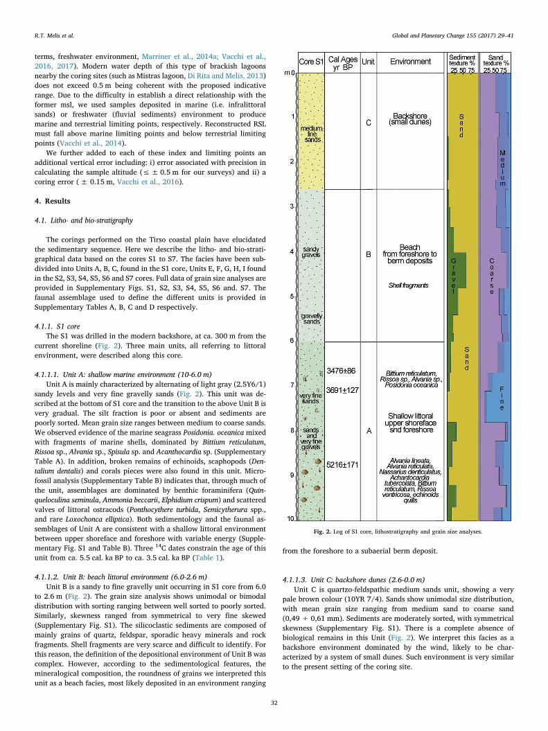
4.1.1. S1 coreThe S1 was drilled in the modern backshore, at ca. 300 m from the
current shoreline (Fig. 2). Three main units, all referring to littoralenvironment, were described along this core.
4.1.1.1. Unit A: shallow marine environment (10-6.0 m)Unit A is mainly characterized by alternating of light gray (2.5Y6/1)
sandy levels and very fine gravelly sands (Fig. 2). This unit was de-scribed at the bottom of S1 core and the transition to the above Unit B isvery gradual. The silt fraction is poor or absent and sediments arepoorly sorted. Mean grain size ranges between medium to coarse sands.We observed evidence of the marine seagrass Posidonia. oceanica mixedwith fragments of marine shells, dominated by Bittium reticulatum,Rissoa sp., Alvania sp., Spisula sp. and Acanthocardia sp. (SupplementaryTable A). In addition, broken remains of echinoids, scaphopods (Den-talium dentalis) and corals pieces were also found in this unit. Micro-fossil analysis (Supplementary Table B) indicates that, through much ofthe unit, assemblages are dominated by benthic foraminifera (Quin-queloculina seminula, Ammonia beccarii, Elphidium crispum) and scatteredvalves of littoral ostracods (Ponthocythere turbida, Semicytherura spp.,and rare Loxochonca elliptica). Both sedimentology and the faunal as-semblages of Unit A are consistent with a shallow littoral environmentbetween upper shoreface and foreshore with variable energy (Supple-mentary Fig. S1 and Table B). Three 14C dates constrain the age of thisunit from ca. 5.5 cal. ka BP to ca. 3.5 cal. ka BP (Table 1).
4.1.1.2. Unit B: beach littoral environment (6.0-2.6 m)Unit B is a sandy to fine gravelly unit occurring in S1 core from 6.0
to 2.6 m (Fig. 2). The grain size analysis shows unimodal or bimodaldistribution with sorting ranging between well sorted to poorly sorted.Similarly, skewness ranged from symmetrical to very fine skewed(Supplementary Fig. S1). The silicoclastic sediments are composed ofmainly grains of quartz, feldspar, sporadic heavy minerals and rockfragments. Shell fragments are very scarce and difficult to identify. Forthis reason, the definition of the depositional environment of Unit B wascomplex. However, according to the sedimentological features, themineralogical composition, the roundness of grains we interpreted thisunit as a beach facies, most likely deposited in an environment ranging
from the foreshore to a subaerial berm deposit.
4.1.1.3. Unit C: backshore dunes (2.6-0.0 m)Unit C is quartzo-feldspathic medium sands unit, showing a very
pale brown colour (10YR 7/4). Sands show unimodal size distribution,with mean grain size ranging from medium sand to coarse sand(0,49 ÷ 0,61 mm). Sediments are moderately sorted, with symmetricalskewness (Supplementary Fig. S1). There is a complete absence ofbiological remains in this Unit (Fig. 2). We interpret this facies as abackshore environment dominated by the wind, likely to be char-acterized by a system of small dunes. Such environment is very similarto the present setting of the coring site.
Fig. 2. Log of S1 core, lithostratigraphy and grain size analyses.
R.T. Melis et al. Global and Planetary Change 155 (2017) 29–41
32

4.1.2. S2 to S7 coresThese cores were placed in the modern coastal plain, between the Sa
Osa archaeological site and the current shoreline (Fig. 1b).
4.1.2.1. Unit H: alluvial plain (10.0-8.9 m, S5)Unit H is a sandy to gravelly unit found at the bottom of S5 core
(Fig. 3). This unit shows light yellowish brown colour (2.5Y 6/4) withmean grain size ranging from very fine gravel to very coarse sand(3,16 ÷ 1,31 mm). The sediments are poorly to very poorly sorted withpositive skewness (Supplementary Fig. S5). No shells fragments, mi-crofossils and plant remains were found in this unit. Coarse sediments,presence of fine matrix and the lack of fossils is characteristic of thedeposition of transported materials in high energy alluvial environ-ment. The sharp contact between the H and E units indicates a strati-graphic discontinuity.
4.1.2.2. Unit I: littoral environment (9.0-6.8 m, S7). This unit is onlypresent at the bottom of core S7 (Fig. 3). Fine sands, partially cementedby calcium carbonate, characterize Unit I. Grains are well rounded andare mainly made of quartz and feldspar. Sparse biosclasts(unidentifiable foraminifera) were also observed. We interpret thisunit as a beachrock (sensu stricto) deposited in a beach environment,most likely near to the shoreline as testified by the grain cementationtypical of the land-sea interface.
4.1.2.3. Unit G: alluvial plain (10.0-8.5 m, 6.0-4.1 m, S3; 10.0-8.7 m,4.60-2.10 m, S4; 7.0-4.0 m, S5; 5.1-4.4 m, S6; 5.8-3.0 m, S7)
Unit G is a coarse light gray and light brownish gray sandy togravelly unit. We found it at various depths in S3, S4, S5 and S7 cores(Figs. 3, 4, 5). Mean grain size range varies from very fine gravel tocoarse sand (2.20 mm÷ 0.83 mm), and sediments are very poorly
Fig. 3. Logs of S5 and S7 cores: lithostratigraphy and grain size analyses.
R.T. Melis et al. Global and Planetary Change 155 (2017) 29–41
33

sorted with positive skewness (Supplementary Figs. S3, S4, S5, S6 andS7). Plant remains and shell fragments are rare or totally absent. Wefurther observed a significant presence of quartz, feldspar and abundantlithic of metamorphic, granitic, and volcanic rocks. The grain-size andcompositional characteristics of unit G, the lack of sedimentary struc-tures (laminations or layers) and the almost total absence of shellfragments, suggest a medium to high-energy fluvial environment (mostlikely a channel fill or a fluvial bar).
Unit G passes gradually upward to unit F (S3, S4, S5, S7 cores), andgenerally overlaps on unit E (S4, S5, S6, S7 cores).
4.1.2.4. Unit E: lagoonal environment with marine and fluvialinfluence. Unit E is a muddy to sandy unit that was present in allcores. The grain size composition and the biogenic component ofsediments show variability. Even if irregularly distributed, both
faunal assemblages and plant remains indicate a brackish lagoonalenvironment with variable marine or river influence. For this reason,we subdivide this unit in three sub-units.
4.1.2.4.1. Sub-Unit E1: brackish lagoonal deposits (3.30-1.85 m, S2;8.9-7.0 m, S5; 6.8-5.8 m, S7)
This sub-unit, found in S2, S5 and S7 cores (Figs. 3, 4) (Supple-mentary Figs. S2, S5 and S7), consists in very dark gray (2.5Y 3/1)sandy mud with plant and wood fragments and remains of bivalve andgastropod shells. The transition with the underlying units is sharp in S5and S7 core. Dominant molluscan species (Supplementary Table C) arethe B. reticulatum (infralittoral sands) and Pavicardium exiguum (la-goonal). Secondary species include Abra sp. and Hydrobia sp. (la-goonal). Microfossil analysis (Supplementary Table D) indicates thatforaminifera assemblages are dominated by Ammonia. tepida and Q.seminula (marine and paralic species) while ostracofauna is mainly
Fig. 4. Logs of S2 and S4 cores: lithostratigraphy and grain size analyses.
R.T. Melis et al. Global and Planetary Change 155 (2017) 29–41
34

composed by brackish littoral species (Cyprideis torosa and rare Lox-ochonca elliptica). The fine-grained sedimentology and the faunal as-semblages evoke a brackish lagoonal environment with intermittentconnection to the open sea.
Six 14C dates constrain the age of this sub-unit between ca. 0.6 and0.9 cal. ka BP in S2 core, between ca. 5.2 to 5.6 cal. ka BP in S5 coreand from ca. 5.4 to 6.0 cal. ka BP in S7 core.
4.1.2.4.2. Sub-unit E2: backshore lagoonal deposits (10.0-3.3 m, S2;8.7-4.6 m, S4)
This sub unit is mainly characterized by gray (Gley 1 5/N) and darkgray (Gley 1 4/N) silty sands alternated with layers of coarser sands(Fig. 4) (Supplementary Figs. S2 and S4). Molluscan species are abun-dant (Supplementary Table C). They are dominated by marine (B. re-ticulatum, Tellina tenuis) and lagoonal taxa as P. exiguum, rare C.glaucum, Loripes lacteus while secondary species are Rissoa ventricosa,Hydrobia sp., Abra sp. Broken pieces of echinoids and scaphopods(Dentalium sp.) were also observed. Microfaunal assemblages (Supple-mentary Table D) are mainly represented by benthic foraminifera
Fig. 5. Logs of S3 and S6 cores: lithostratigraphy and grain size analyses.
R.T. Melis et al. Global and Planetary Change 155 (2017) 29–41
35

(Ammonia sp., Quinqueloculina sp., Elphidium sp.) and poorly preservedvalves of ostracods (C. torosa and few L. elliptica). This sub-unit showshigher species diversity compared to the E1 attesting the increase ofmarine influence in the lagoonal environment. We interpreted thepresence of coarser layers found within this lagoonal sub-unit as stormwashover deposits in the backshore lagoon. Two 14C dates constrain theage of this sub-unit from ca. 7.7 cal. ka BP in S2 core and ca.6.0 cal. ka BP in S4 core.
4.1.2.4.3. Sub-unit E3: brackish lagoonal deposits with fluvial inputs(8.50-6.0 m, S3; 6.0-5.1 m, S6)
This sub-unit, found in S3 and S6 cores (Fig. 5), shows a large grainsize variability ranging from gray (2.5Y 6/1) sandy gravels to siltysands. Sediments show a chaotic pattern, they are very poorly sortedand with skewness varying from positive to negative (SupplementaryFigs. S3 and S6). Shell remains are scarce and mostly fragmented. Weonly observed presence of small Bittium sp. associated to unidentifiableplant remains. Foraminifera and ostracods are mostly scattered, re-worked and broken. The only species identifiable are Ammonia tepida,Ammonia. parkinsoniana, C. torosa (Supplementary Table D) with rarefreshwater ostracod (Candona spp.). This is generally indicative of anoligohaline environment, such as a brackish marsh. However, the lackof a robust faunal assemblage suggests that the depositional environ-ment of this sub-unit was probably a brackish water-body influenced byfluvial inputs.
4.1.2.5. Unit F: floodplain environmentThe Unit F is at the top of the stratigraphic record of S3, S4, S5, S6,
S7 cores (Figs. 3, 4, 5). This unit lacks in faunal assemblages and onlyunidentifiable plant remains were found. We generally interpret thisunit as floodplain deposits. The silty clay and sandy sediments re-presents typical deposits of areas inundated by flood events. However,the variability of the sedimentological parameters allowed defining twosubunits (Supplementary Figs. S3, S4, S5, S6 and S7):
4.1.2.5.1. Sub-unit F2: overbank including crevasse and levee deposits(4.1-1.6 m, S3; 2.1-1.1 m, S4; 4.0-2.1 m, S5; 4.4-1.5 m, S6). This sub-unit mainly consists of medium-coarse pale brown (10YR 6/3) sandsthat gradually decrease upwards to light yellowish brown (2.5Y 6/4)medium-fine silty sands. Sorting ranges between poorly and moderatelywell sorted, whereas skewness is variable according to the content offine matrix or some gravels. We interpreted this subunit as result of anoverbank deposition, including crevasse or levee sands deposits in thelower part of this unit. One 14C date yielded an age of ca. 2.2 cal. ka BPat 3.25 m core depth in S3.
4.1.2.5.2. Sub-unit F1: fine overbank deposits (1.6-0 m, S3; 1.1-0 m,S4; 2.1-0 m, S5; 1.5-0 m, S6; 3.0-0.0 m, S7). This sub-unit is composedof silty-clay sands gradually passing upward to silty clay or clay sandy.The grain size analysis shows sediments with texture from sandy loamto clay loam upwards; the thickness is 1.1 to 3.0 m and the colour variesfrom dark grayish brown (10YR 4/2) to light olive brown (2.5Y 5/3),with the exception of dark gray (10YR 4/1) muddy sands sedimentsat 1.8–3.0 m core depth in S7. Along this unit we found few plantremains in the silty-clay layers. We interpret this sub-unit as the resultof an overbank deposition, corresponding to well drained floodplaindeposits, except for the dark gray sediments in S7, probably related topoorly drained conditions or to the formation of a small swamp in thealluvial plain. The overall succession, in all cores, shows a characteristicfining-upward trend. One 14C date yielded an age for this sub-unit of ca.2.8 cal. ka BP at 2.6 m core depth in S7.
4.2. Pollen analysis
Pollen analysis was successfully performed on 19 out of 21 samples.The results are presented in Fig. 6. Each pollen diagram includes: apercentage pollen record of selected taxa, the Arboreal Pollen (AP)/NonArboreal Pollen (NAP) percentage diagram and the total pollen con-centration. Pollen preservation was generally good, since the number of
indeterminable grains (degraded, corroded and broken) exceed 5% onlyin two samples (7.6 m in core S5 and 3.6 m in core S2). The total pollenconcentration varies between 1000 and 83,000 terrestrial pollengrains/g. On the whole, 54 taxa were identified; they contribute todefine both the vegetation characteristics and the aquatic environ-mental conditions of the Tirso river coastal plain at different time in-tervals.
The pollen record from core S7 (6.78-6 m; ca. 6.0-5.6 cal. ka BP) iscomposed of 8 samples. High frequencies of Alnus (27%) suggest thatthe Tirso river floodplain was covered by riparian forest formations.
The coastal Alnus-dominated forests are of two main types, thefloodplain forests and the alder carrs. Floodplain forests, excludingthose covering the seepage sites, are only periodically flooded wood-lands. Their canopies are characterized by the dominance of hardwoodtree species, above all alders (Alnus glutinosa, A. incana), ashes (Fraxinusangustifolia, F. excelsior), elms (Ulmus laevis, U. minor), poplars (Populusalba, P. nigra), oak (Quercus robur) and willows (Salix spp.) (Brullo andSpampinato, 1999; Douda et al., 2015). Alder carrs, instead, representalmost monospecific forest stands of Alnus glutinosa, occurring atstrongly and permanently waterlogged sites such as lakes, swamps andwaterlogged depressions in floodplains. In large river floodplains, bothfloodplain forests and alder carrs can occur next to each other, formingtemporally variable habitat mosaics (Jurko, 1958). Currently, theranges of these extremely vulnerable woods are very fragmented andreduced in size, being confined in narrow stands behind the dunes andin the interdunal wet environments, but in the past they had a muchwider distribution. Especially between 6.0 and 5.0 cal. ka BP, thecoastal regions of estuarine sites document the development of Alnus-dominated forest formations in the central Mediterranean region (DiRita et al., 2010). This vegetation pattern is the results of more complexenvironmental dynamics triggered by a decrease in the rate of sea levelrise that determined deep geomorphic and sedimentological changes inthe river floodplains, consistent with coastal barrier accumulation, la-goon habitat formations, river mouth modifications, and peat deposi-tion among others (Di Rita et al., 2015). The regional woodlands weremostly composed of evergreen Quercus forests and Ericaceae scrub-lands, rich in other evergreen elements such as Quercus suber, Olea,Pistacia and Arbutus, as also documented in other coastal sites of Sar-dinia and Corsica at that time (Reille, 1992; Beffa et al., 2016; Curráset al., 2017; Poher et al., 2017). Significant frequencies of Chenopo-diaceae (9%), accompanied by occurrences of foraminiferal linings anddinocysts, suggest the local presence of a salt-marsh environment,whose development was influenced by sea water input into the sedi-mentary basin, as also reported in many other coastal sites in the cen-tral Mediterranean region (Bellotti et al., 2011; Di Rita, 2013; Di Ritaand Melis, 2013; Poher et al., 2017). The human impact is documentedby the record of cereal type pollen, possibly revealing cultivation ac-tivities. The record of Olea and Vitis, between ca. 6.0 and 5.6 cal. ka BP,seems more related to the presence of natural populations than to ex-ploitation by humans, although they have represented important eco-nomic plants in the history of the Tirso river coastal region.
The pollen record from core S5 (ca. 8.2-7.2 m; 5.4 cal. ka BP) iscomposed of 5 samples. The AP values, varying between ca. 55% and70%, indicate a semi-forested landscape. This was still locally domi-nated by riparian Alnus formations. The contemporary record ofChenopodiaceae, foraminiferal linings and cysts of dinoflagellates (di-nocysts) still point to the presence of brackish/saline aquatic environ-ment covered by halophilic vegetation communities. In particular, theincreased frequencies in Chenopodiaceae (16%), with respect to thepreceding time-interval, suggest a further spread of salt-marsh vegeta-tion onto the floodplain. The main evidence of human impact is hererepresented by scattered pollen grains of cereal type as possible evi-dence of cultivation in the region.
The pollen record from core S2 (ca. 3.6-2.0 m; ca. 0.91-0.74 cal. ka BP) is composed of 6 samples. It documents a landscapedominated by herbaceous vegetation. The particularly high frequencies
R.T. Melis et al. Global and Planetary Change 155 (2017) 29–41
36

of Chenopodiaceae (46%), accompanied by occurrences of Ruppia andforaminiferal linings, suggest that the main vegetation element of theTirso coastal plain was represented by a particularly vast salt-marsh.Cyperaceae/Juncaceae, Poaceae and Typha point to reeds and sedgescommunities that also formed the marshy vegetation. Asteraceae, bothAsteroideae and Cichorioideae, Apiaceae, Plantago and Brassicaceaewere other floristic components of this patchy open vegetation en-vironment. The few natural woody stands were mostly composed ofevergreen taxa, such as evergreen Quercus, Pistacia and Ericaceae.Conversely, Olea was probably cultivated during the Middle Ages. Therecords of Vitis and Castanea represent another evidence of humanimpact. However, while the record of Vitis may reflect local agriculturalpractices, Castanea seems more related to regional and extra-regionalcultivations. Surprisingly, the pollen sequence of core S2 does not re-cord any cereal pollen, possibly because the combination of marshyenvironment and salty soils discouraged the local development of cerealfields.
4.3. Relative sea-level datapoints
Facies analysis allowed the production of a new set of 12 RSL indexpoints as well as 1 terrestrial and 3 marine RSL limiting points
Fig. 6. Pollen percentage diagram of selected taxa from the S2, S5 and S7 cores.
Fig. 7. RSL reconstructions in the Tirso coastal plain. Index points (boxes) are plotted ascalibrated age against change in sea level relative to present. Limiting points are plottedas terrestrial or marine horizontal lines. Dimensions of boxes and lines for each pointbased on 2 s elevation and age errors.
R.T. Melis et al. Global and Planetary Change 155 (2017) 29–41
37

(Table 1). The totality of index points derived from lagoonal samplesand gave insights into the RSL evolution between ca. 7.6 and5.5 cal. ka BP (mid-Holocene). The remaining part of the Holocene isonly constrained by limiting points and by 3 lagoonal index points(Fig. 7).
We associated an indicative range typical of open lagoon to thesamples dated in the subunit E2 and an indicative meaning typical ofbrackish semi-enclosed lagoon, to all the samples dated in the subunitE1 (see Section 3.4). We further transform in marine limiting pointssamples dated in Unit A (shallow littoral environment) and in terrestriallimiting point the sample dated in subunit F2 (fluvial overbank de-position).
5. Discussions
5.1. Mid to late Holocene landscape evolution of Tirso coastal plain
Biostratigraphical and pollen data coupled by the 14C ages of thesamples extracted from the 7 cores provide novel information on themid to late Holocene landscape evolution of the Tirso coastal plain.However, due to the dating uncertainty of the two oldest dates (seeSection 5.2), we discuss here only the modification occurring in the lastca. 6.0 cal. ka BP.
Our stratigraphic data testify the constant interplay between littoraland fluvial processes in controlling the environmental evolution of thearea. The sole exception is recorded in S1 core (in the modern back-shore) where littoral processes are the major driver of the environ-mental changes.
Between ca. 6.0 and 5.5 cal. ka BP the Tirso coastal plain was oc-cupied by a coastal lagoon connected with the open sea and most likelysubject to frequent storm-related inundation as testified by the marinesands and gravel interbedded with the lagoonal deposits (Fig. 8). This isin agreement with the mid-Holocene increase in the storm activity re-corded in NW Mediterranean (Sabatier et al., 2012). Faunal assem-blages of Subunit E2 clearly indicate the concomitant presence of openmarine and lagoonal species typical of a calm environment with asubstrate of muddy sands (Pérès and Picard, 1964; Carboni et al.,2010). The foraminifera associations suggest shallow marine to paralicenvironments, with some species tolerant to conditions of variablesalinity (Rossi et al., 2011). The age of sub-unit E2 in S4 core (locatedca. 900 m northwest of S2 core; Fig. 4) corroborates the hypothesis thatsea reached its maximal landward influence at ca. 6.0 cal. ka BP. Salt-water influence is also evident in the landward portion of the Tirsocoastal plain (S3, S5, S6, S7 cores). Notably, the faunal and pollenevidence retrieved from a dark gray sandy mud (sub-unit E1) indicatethat between ca. 6.0 and 5.5 cal. ka BP the whole area was character-ized by shallow brackish lagoons and salt-marshes, which extended upto a maximum of 2 km inland from the modern shoreline (Fig. 8). Onthe other hand, microfossils assemblages of sub-unit E1, characterized
by reworked individuals of benthic foraminifera and poorly preservedvalves of euryhaline ostracods, are consistent with a brackish-waterdepositional environments subject to salinity changes (Bellotti et al.,1994; Murray, 2006; Frezza and Carboni, 2009). This environmentalreconstruction is consistent with the pollen records of both S7 and S5cores that document an aquatic environment strongly influenced by theinput of sea-water, as reflected by the significant amounts of salt-tol-erant chenopods and the occurrence of both foraminiferal linings anddinocysts. At the same time, the high frequencies of Alnus (> 33%)indicate that the Tirso plain was also covered by riparian forest for-mations presumably related to the presence of semi-permanent fresh-water ponds, likely formed by complex geomorphological and sedi-mentological processes at the Tirso river mouth. The development ofAlnus-dominated forest formations (both of floodplain forests and aldercarrs) between ca. 6.0 and 5.0 cal. ka BP is a common vegetation fea-ture to other coastal and estuarine regions of the Central and WesternMediterranean (Di Rita et al., 2010; Curràs et al., 2017; Ghilardi et al.,2017).
In the same period a shallow marine environment was present nearthe shoreline (S1 core, Unit A). Since ca. 5.5 cal. ka BP (Final Neolithicperiod) stratigraphical data (S1 core) indicate a seaward migration ofthe least 300 m from the present day shoreline, when the area was mostlikely a protected marine bay.
Between ca. 5.4 and 2.1 cal. ka BP a continuous overbank sedimentdeposition developed in most of the study area (Fig. 8), while near theshoreline a progressive evolution from a shallow marine environmentinto a beach environment (Unit B, S1 core) occurred between ca. 3.6and 3.4 cal. ka BP (Middle Bronze Age). Fluvial sedimentation becamedominant from mid- to late-Holocene (i.e. last 5.5 cal. ka), as indicatedby the development of fluvial and overbank deposits (Unit G and UnitF), according to stratigraphic data of S3, S4, S5, S6 and S7 cores. Theupward transition from fluvial deposits (Unit G) to floodplain deposits(Unit F) documents the formation of an alluvial depositional systemfrom the Final Bronze Age (ca. 2.9 to 2.7 cal. ka BP). Changes in thefluvial dynamics are testified by the sedimentological characteristics ofthe unit F that evokes low-energy alluvial deposition, typical of afloodplain occasionally affected by river floods.
Between ca. 2.2 and 0.7 cal. ka. BP the landscape of the Tirsocoastal plain was characterized by backshore dunes (Unit C, S1 core)that most likely isolated the back-coastal areas and promoted the for-mation of wetlands environments (shallow brackish water environ-ments or marsh areas) as documented by the sub-unit E1 in S2 core.
5.2. Relative Sea-level evolution
The new dataset of 14C data provides new insights on the RSLevolution in this sector of western Sardinia. Submerged archaeologicalstructures (Roman quarry and Phoenicians tombs) near Tharros(Fig. 1a), provided evidence that the total RSL changes was> 1 m since
Fig. 8. Environmental evolution of the Tirsocoastal plain as reconstructed by facies analysisand interpretation. In the left side, the lithos-tratigraphy of the most representative cores ofthis study, namely S1, S2, and S7 cores, is plottedagainst age (cal. ka BP). The Age-depth models ofeach core are based on the linear interpolationamong calibrated dates (see Table 1). In the rightside, we propose a schematic reconstruction ofthe main phases of the Tirso coastal plain evo-lution.
R.T. Melis et al. Global and Planetary Change 155 (2017) 29–41
38

ca. 2.3 cal. ka BP and> 0.79 since ca. 2.0 cal. ka BP (Antonioli et al.,2007; Lambeck et al., 2011). A sample extracted from a core performedin Mistras lagoon placed the RSL above −3.2 m at ca. 4.6 cal. ka (DiRita and Melis, 2013). More recently, lagoonal facies found in off-shorecores in the Gulf of Oristano revealed ca. 28 m of RSL changes in thelast ca.9.4 cal. ka BP (De Falco et al., 2015). Thus, our record sig-nificantly improved the RSL record in the area providing new insightsinto the RSL changes, notably in the mid-Holocene (8.0-4.0 cal. ka BP).In Fig. 7 we plotted the RSL index and limiting points derived from thenew cores performed in the Tirso coastal plain. Oldest index pointsindicate RSL was at −8.0 ± 1.25 m at ca. 7.7 cal. ka BP (S2f)(Table 1) and above −6.2 ± 1.25 m at ca. 7.4 cal. ka BP (S2e). Thesedata seem to conflict with RSL position suggested by early Neolithicburials found in a marine cave in Capo Caccia (NW Sardinia, ca. 80 kmnorthwards the Tirso coastal plain, Lambeck et al., 2004; Palomboet al., 2017). The current position of these burials and the dating of theassociated pottery constrain the RSL position below ca. −11 m at ca.7.3 cal. ka BP (Palombo et al., 2017). Post-depositional uplift can dif-ficulty account for this misfit, being this area considered tectonicallystable since the last interglacial (i.e. last ca. 125 cal. ka BP, Ferrantiet al., 2006). For this reason, caution should be used in the assessmentof the RSL position indicated by the two oldest samples of our dataset.At the moment, we cannot exclude aging effects in this lagoonal se-quence, resulting in apparent older age of these samples (Table 1).Additional coring in adjacent areas revealed lagoonal sequences at si-milar depths. Further 14C dating of both lagoonal shells and organicmatter (currently on-going) could provide additional insights into theRSL position between 8.0 and 7.0. In our opinion, compaction may havea major role in controlling their current elevation. In fact, ca. 7 m ofalluvial sediments overlays these three 14C dates (subunit E1, S5 core,(Fig. 3). For this reason, we do not think that RSL index points from S5core are indicative of the RSL evolution of the area. This is furtherconfirmed by a marine limiting point placing the RSL above −5.7 m atca. 5.3 cal. ka BP (S1c, Table 1). Our data poorly constrain the re-maining part of the Holocene. Two marine limiting points (S1b andS1a) placed the RSL above −4 m at ca. 3.7 cal. ka BP and above−3.6 m at ca. 3.5 cal. ka BP, respectively. At ca. 2.2 cal. ka BP, oneterrestrial limiting point (S7a) constrains the RSL below −0.4 m. Thethree youngest index points show scatter (Fig. 7). The highest (mostlikely less affected by compaction) indicate RSL rose by 0.5 ± 0.7 inthe last ca. 0.7 cal. ka BP.
5.3. Environmental control on the settlements of the Tirso coastal plain
The portion of the Gulf of Oristano comprised between the SinisPeninsula and the S. Giusta lagoon was densely settled since theNeolithic period (Depalmas and Melis, 2010). However, there is a cleardisparity in the concentration of settlements between the rocky Sinispeninsula and the Tirso coastal plain (Fig. 1a). Our results providedevidence that such difference in the density of settlements was stronglyinfluenced by the major environmental changes of the Tirso coastalplain, especially in the last five millennia. We robustly documented theend of the transgressive trend at ca. 6.0-5.5 cal. ka BP, consistent withthe significant slow of sea-level rising rates recorded along the Medi-terranean coasts (e.g., Anthony et al., 2014; Maselli and Trincardi,2013; Amorosi et al., 2017). As a result, during the Eneolithic (ca. 5.5 to4.2 cal. ka BP) and Bronze age (ca. 4.2 to 2.9 cal. ka BP) the fluvialactivity dramatically increased. It triggered intense lateral and verticalsedimentation linked to river channel migration, as documented byaccumulation of coarse-grained sand bodies on the lagoon deposits.Afterward, a progradational trend started, causing the seaward migra-tion of the shoreline and, consequently, of the barrier-lagoon system.
Due to the discontinuity of our pollen record, we cannot establishwhether human activities exerted an indirect influence on the sedi-mentological processes enhancement through clearance and exploita-tion of the local forest cover. The pollen diagrams record two distinct
temporary phases, from ca. 6.1 to 5.4 cal. ka BP (cores S7 and S5), andfrom ca. 0.91 to 0.74 cal. ka BP (core S2), respectively, suggesting thatthe Tirso coastal plain experienced a strong reduction of the forestvegetation. However, there is no information about the local forestdynamics in between these two phases, especially during the Eneolithicand Bronze Age. In western Sardinia, the available palynological re-cords (Di Rita and Melis, 2013; Buosi et al., 2015) and palaeobotanicaldata (Bakels, 2002; Sabato et al., 2015; Ucchesu et al., 2015), con-sidered altogether, indicate that during the Eneolithic and Bronze Agethe impact of agricultural practices was directed towards an alreadysemi-open landscape, and did not produce any further deforestationprocess (Di Rita and Melis, 2013). During the Eneolithic and BronzeAge, the pollen record from Mistras Lagoon, ca. 6 km far from Tirsocoastal plain, shows a semi-open landscape, characterized by a patch ofMediterranean maquis and salt-marsh vegetation communities. Duringthe Nuragic phase (until ca. 2.3 cal. ka BP), the pollen evidence ofagricultural activities suggests a prevailing arable farming economy,mostly based on Vitis and cereal exploitation, subsequently replaced bya prevailing stock rearing economy. Despite this intense human impact,further documented by an increase of fire activity during the Nuragicphase, no clear forest decline is recorded in the pollen diagram ofMistras. Similarly, at Sa Curcurica, on the other side of Sardinia, duringthe Eneolithic and Bronze Age the pollen evidence of agricultural ac-tivities was associated to a phase of marked stability in the forest cover,especially between ca. 5.3 and 3.5 cal. ka BP (Beffa et al., 2016).
This scenario contrasts with the landscape evolution of the Tirsocoastal plain, where a rapid and continuous environmental modifica-tion during the last ca. 6.0 cal. ka BP did not assure suitable conditionsfor the establishment of stable settlements; thus, this may explain thelow density of historical and prehistorical archaeological remains inthis area, especially if compared to the rocky area of Sinis peninsula(Fig. 1a). However, we cannot exclude that the building technique mayalso explain this scarcity of finds. In fact, the structural characteristicsobserved during the Sa-Osa archaeological excavations revealed thesole presence of negative structures without raised stone, which arevery difficult to preserve (Usai et al., 2012).
In the Bronze Age village of Sa Osa, interesting aspects both ofstrong exploitation of local resources (river and sea fishing, farming ofpigs and cattle, hunting deer) and specialized production (e.g., viti-culture, pottery, industry of bone) were recently described (Usai et al.,2012; Sabato et al., 2015; Ucchesu et al., 2015). They indicate thestrong man-environment interaction and the possibility of adaptation ofthe communities of the Bronze Age in critical climatic-environmentalconditions, characterized by instability. Such abundance of resourcesmay have attracted other settlements both in the floodplain and on theborder of the former coastal lagoons. These hypothetic settlements maybe now no longer visible because covered by river sediments. However,none of our cores revealed traces of archaeological remains and furthercoring campaigns are necessary to confirm or not the above-mentionedhypothesis.
6. Conclusions
A multidisciplinary analysis including sedimentology, faunal as-semblages, pollen data and radiocarbon dating allowed reconstructingthe palaeoenvironmental evolution of the largest coastal plain ofSardinia during the last ca. 6.0 cal. ka BP. We robustly demonstratedthat for most of the mid-Holocene, a large portion of the Tirso coastalplain was occupied by a coastal lagoon connected with the open sea andwith frequent storm-related marine inundation. After the maximal seatransgression, recorded at ca. 6.0 cal. ka BP, the river activity becamethe predominant factor in controlling the landscape evolution in theTirso coastal plain. It triggered a seaward migration of the shoreline ofat least 300 m since the Final Neolitic period (ca. 5.5 cal. ka BP).Further, fluvial sediments rapidly filled the shallow lagoons and mar-shes and successively a continuous overbank sediment deposition
R.T. Melis et al. Global and Planetary Change 155 (2017) 29–41
39

occurred in most of the study area until Punic-Roman period (ca.2.1 cal. ka BP). Such major landscape modification recorded in theTirso coastal plain seems to have had a key role in the pattern of his-torical and prehistorical settlements of this wide portion of westernSardinian coastline.
Furthermore, we outlined two distinct temporary phases in the ve-getational evolution of the Tirso coastal plain. The first (from ca. 6.1 to5.4 cal. ka BP) showing a semi-forested landscape dominated by anadmixture of local vegetation formations of saltmarsh and riparianforest, and regional evergreen woodlands. The second (between ca. 0.9and 0.7 cal. ka BP) showing an open landscape characterized by awidespread chenopod-dominated saltmarsh. These data are crucial todefine the past vegetation dynamics in Sardinia, especially if con-sidering the scarcity of natural sedimentary basins suitable for pollenanalysis in this island. Finally, we provide new insights on the RSLevolution in this sector of the Mediterranean. Notably, we improved theRSL record in Sardinia between 6.0 and 5.0 ka BP where only scarcedata were previously available.
Supplementary data to this article can be found online at http://dx.doi.org/10.1016/j.gloplacha.2017.06.001.
Acknowledgments
Thanks are due to the “Soprintendenza Archeologia, Belle Arti ePaesaggio per la città metropolitana di Cagliari e per le province di Oristano,Medio Campidano, Carbonia-Iglesias, Ogliastra” for the support in thecoring activity. This work has been carried out thanks to the support ofthe LR/7 2010 Regione Sardegna project (CRP-27178 Il rapporto uomo-ambiente nella Sardegna centro-occidentale durante l'Olocene: sfruttamentodelle risorse, produttività e impatto antropico). MV contributes to theLABEX ARCHIMEDE funded by the ANR through the program“Investissement d'Avenir” ANR-11-LABX-0032-01. MV further ac-knowledges MOPP-Medflood (INQUA CMP project 1603P) workinggroups for useful discussions. We also thank Donatella Magri for herprecious comments.
References
Amorosi, A., Bini, M., Giacomelli, S., Pappalardo, M., Ribecai, C., Rossi, V., Sammartino,I., Sarti, G., 2013. Middle to late Holocene environmental evolution of the Pisacoastal plain (Tuscany, Italy) and early human settlements. Quat. Int. 303, 93–106.
Amorosi, A., Bruno, L., Campo, B., Morelli, A., Rossi, V., Scarponi, D., Hong, W., Bohacs,K.M., Drexler, T.M., 2017. Global sea-level control on local parasequence architecturefrom the Holocene record of the Po Plain, Italy. Mar. Pet. Geol.
Anthony, E.J., Marriner, N., Morhange, C., 2014. Human influence and the changinggeomorphology of Mediterranean deltas and coasts over the last 6000 years: fromprogradation to destruction phase? Earth-Sci. Rev. 139, 336–361.
Antonioli, F., Anzidei, M., Lambeck, K., Auriemma, R., Gaddi, D., Furlani, S., Orrù, P.,Solinas, E., Gaspari, A., Karinja, S., Kovac, V., Surace, L., 2007. Sea-level changeduring the Holocene in Sardinia and in the northeastern Adriatic (centralMediterranean Sea) from archaeological and geomorphological data. Quat. Sci. Rev.26, 2463–2486.
Antonioli, F., Anzidei, M., Amorosi, A., Presti, V.L., Mastronuzzi, G., Deiana, G., De Falco,G., Fontana, A., Fontolan, G., Lisco, S., Marsico, A., Moretti, M., Orrù, P.E., Sannino,G.M., Serpelloni, E., Vecchio, A., 2017. Sea-level rise and potential drowning of theItalian coastal plains: flooding risk scenarios for 2100. Quat. Sci. Rev. 158, 29–43.
Anzidei, M., Lambeck, K., Antonioli, F., Furlani, S., Mastronuzzi, G., Serpelloni, E.,Vannucci, G., 2014. Coastal structure, sea-level changes and vertical motion of theland in the Mediterranean. Geol. Soc. Lond., Spec. Publ. 388 (1), 453–479.
Bakels, C., 2002. Plant remains from Sardinia, Italy with notes on barley and grape. Veg.Hist. Archaeobotany 11, 3–8.
Beffa, G., Pedrotta, T., Colombaroli, D., Henne, P.D., van Leeuwen, J.F.N., Süsstrunk, P.,Kaltenrieder, P., Adolf, C., Vogel, H., Pasta, S., Anselmetti, F.S., Gobet, E., Tinner, W.,2016. Vegetation and fire history of coastal north-eastern Sardinia (Italy) underchanging Holocene climates and land use. Veg. Hist. Archaeobotany 25, 271–289.
Bellotti, P., Chiocci, F.L., Milli, S., Tortora, P., Valeri, P., 1994. Sequence stratigraphy anddepositional setting of the Tiber delta: integration of high-resolution seismics, welllogs, and archeological data. J. Sediment. Res. 64, 416–432.
Bellotti, P., Calderoni, G., Di Rita, F., D'Orefice, M., D'Amico, C., Esu, D., Magri, D., PreiteMartinez, M., Tortora, P., Valeri, P., 2011. The Tiber river delta plain (central Italy):coastal evolution and implications for the ancient Ostia Roman settlement. TheHolocene 21, 1105–1116.
Bennett, K.D., 2009. Documentation for Psimpoll 4.27 and Pscomb 1.03. In: C Programsfor Plotting Pollen Diagrams and Analysing Pollen Data. Queen's University of Belfast,
Department of Archaeology and Palaeoecology.Beug, H.J., 2004. Leitfaden der Pollenbestimmung fur Mitteleuropa und angrenzende
Gebiete. Verlag Friedrich Pfeil, Munich.Bondì, S.F., 2000. Fenici e Punici nel Mediterraneo occidentale tra il 600 e il 500 aC. In:
Bernardini, P., Spanu, P.G., Zucca, R. (Eds.), Maxe. La battaglia del Mare Sardonio. LaMemoria Storica/Mythos, pp. 57–72 (Cagliari-Oristano).
Brückner, H., 2003. Delta evolution and culture—aspects of geoarchaeological research inMiletos and Priene. In: Wagner, G., Pernicka, E., Uerpmann, H. (Eds.), Troia and theTroad. Springer, Berlin Heidelberg, pp. 121–142.
Brückner, H., Müllenhoff, M., Gehrels, R., Herda, A., Knipping, M., Vött, A., 2006. Fromarchipelago to floodplain–geographical and ecological changes in Miletus and itsenvirons during the past six millennia (western Anatolia, Turkey). Z. Geomorphol.142, 63–83.
Brullo, S., Spampinato, G., 1999. Syntaxonomy of hygrophilous woods of the Alno-Quercion roboris. Ann. Bot. 57, 133–146.
Buosi, C., Pittau, P., Paglietti, G., Scanu, G.G., Serra, M., Ucchesu, M., Tanda, G., 2015. Ahuman occupation cave during the Bronze age: archaeological and palynologicalapplications of a case study in Sardinia (western Mediterranean). Archaeometry 57(S1), 212–231.
Buosi, C., Del Rio, M., Orrù, P., Pittau, P., Scanu, G.G., Solinas, E., 2017. Sea level changesand past vegetation in the Punic period (5th–4th century BC): Archaeological, geo-morphological and palaeobotanical indicators (South Sardinia–West MediterraneanSea). Quat. Int. 439, 141–157.
Butzer, K.W., 2005. Environmental history in the Mediterranean world: cross-disciplinaryinvestigation of cause-and-effect for degradation and soil erosion. J. Archaeol. Sci.32, 1773–1800.
Carboni, S., Lecca, L., 1985. Osservazioni sul Pleistocene Medio-superiore della peniso-ladel Sinis (Sardegna occidentale). Boll. Soc. Geol. Ital. 104, 459–477.
Carboni, M.G., Bergamin, L., Di Bella, L., Iamundo, F., Pugliese, N., 2002.Palaeoecological evidences from foraminifers and ostracods on Late Quaternary sea-level changes in the Ombrone river plain (central Tyrrhenian coast, Italy). Geobios35, 40–50.
Carboni, M.G., Bergamin, L., Di Bella, L., Esu, D., Cerone, E.P., Antonioli, F., Verrubbi, V.,2010. Palaeoenvironmental reconstruction of late Quaternary foraminifera andmolluscs from the ENEA borehole (Versilian plain, Tuscany, Italy). Quat. Res. 74 (2),265–276.
Currás, A., Ghilardi, M., Peche-Quilichini, K., Fagel, N., Vacchi, M., Delanghe, D.,Dussouillez, P., Vella, C., Bontempi, J.M., Ottaviani, J.C., 2017. Reconstructing pastlandscapes of the eastern plain of Corsica (NW Mediterranean) during the last6000 years based on molluscan, sedimentological and palynological analyses. J.Archaeol. Sci. Rep. 12, 755–769.
D'Angelo, G., Gargiulo, S., 1978. Guida alle conchiglie Mediterranee. Fabbri, Milano.De Falco, G., Antonioli, F., Fontolan, G., Lo Presti, V., Simeone, S., Tonielli, R., 2015.
Early cementation and accommodation space dictate the evolution of an oversteppingbarrier system during the Holocene. Mar. Geol. 369, 52–66.
Del Vais, C., Depalmas, A., Fariselli, A.C., Melis, R.T., 2006. Il paesaggio costiero dellaPenisola del Sinis (OR) tra preistoria e storia: aspetti archeologici e ambientali. Attidel I Simposio “Il monitoraggio costiero mediterraneo. Problematiche e tecniche dimisura”. CNR – IBIMET, Sassari, pp. 309–322.
Depalmas, A., Melis, R.T., 2010. The Nuragic people: their settlements, economic activ-ities and use of the land. In: Martini, P.I., Chesworth, W. (Eds.), Landscape andSocieties. Selected Cases, pp. 167–186 (Stuttgard).
Di Rita, F., 2013. A possible solar pacemaker for Holocene fluctuations of a salt-marsh insouthern Italy. Quat. Int. 288, 239–248.
Di Rita, F., Melis, R.T., 2013. The cultural landscape near the ancient city of Tharros(central West Sardinia): vegetation changes and human impact. J. Archaeol. Sci. 40,4271–4282.
Di Rita, F., Celant, A., Magri, D., 2010. Holocene environmental instability in the wetlandnorth of the Tiber delta (Rome, Italy): sea-lake-man interactions. J. Palaeolimnol. 44,51–67.
Di Rita, F., Simone, O., Caldara, M., Gehrels, W.R., Magri, D., 2011. Holocene environ-mental changes in the coastal Tavoliere Plain (Apulia, southern Italy): a multiproxyapproach. Palaeogeogr. Palaeocl. 310, 139–151.
Di Rita, F., Celant, A., Milli, S., Magri, D., 2015. Late glaciale early Holocene vegetationhistory of the Tiber delta (Rome, Italy) under the influence of climate change and sealevel rise. Rev. Palaeobot. Palynol. 218, 204–216.
Doneddu, M., Trainito, E., 2005. Conchiglie del Mediterraneo. Il Castello, Cornaredo (MI).Donnici, S., Serandrei Barbero, R., 2002. The benthic foraminiferal communities of the
northern Adriatic continental shelf. Mar. Micropaleontol. 44, 93–123.Douda, J., Boublik, K., Slezak, M., Biurrun, I., Nociar, J., Havrdova, A., Doudova, J., Aćić,
S., Brisse, H., Brunet, J., Chytry, M., et al., 2015. Vegetation classification and bio-geography of European floodplain forests and alder carrs. Appl. Veg. Sci. 19,147–163.
Ferranti, L., Antonioli, F., Mauz, B., Amorosi, A., Dai Pra, G., Mastronuzzi, G., Monaco, C.,Orrù, P.E., Pappalardo, M., Radtke, U., Renda, P., Romano, P., Sansò, P., Verrubbi, V.,2006. Markers of the last interglacial sea-level high stand along the coast of Italy:tectonic implications. Quat. Int. 145, 30–54.
Fiorini, F., 2004. Benthic foraminiferal associations from Upper Quaternary deposits ofsoutheastern Po Plain, Italy. Micropalaeontology 50, 45–58.
Fiorini, F., Vaiani, S.C., 2001. Benthic foraminifers and transgressive–regressive cycles inthe Late Quaternary subsurface sediments of the Po Plain near Ravenna (NorthernItaly). Boll. Soc. Paleontol. Ital. 40, 357–403.
Fontana, A., Vinci, G., Tasca, G., Mozzi, P., Vacchi, M., Bivi, G., Salvador, S., Rossatto, S.,Antonioli, F., Asioli, A., Bresolin, M., 2017. Lagoonal settlements and relative sealevel during Bronze Age in Northern Adriatic: geoarchaeological evidence and pa-laeogeographic constraints. Quat. Int. http://dx.doi.org/10.1016/j.quaint.2016.12.
R.T. Melis et al. Global and Planetary Change 155 (2017) 29–41
40

038.Frezza, V., Carboni, M.G., 2009. Distribution of recent foraminiferal assemblages near the
Ombrone River mouth (Northern Tyrrhenian Sea, Italy). Rev. Micropaleontol. 52,43–66.
Ghilardi, M., Istria, D., Curras, A., Vacchi, M., Contreras, D., Vella, C., Dussouillez, P.,Crest, Y., Guiter, F., Delanghe, D., 2017. Reconstructing the landscape evolution andthe human occupation of the Lower Sagone River (Western Corsica, France) from theBronze Age to the Medieval period. J. Archaeol. Sci. Rep. 12, 741–754.
Giaime, M., Avnaim-Katav, S., Morhange, C., Marriner, N., Rostek, F., Porotov, A.V.,Baralis, A., Kaniewski, D., Brückner, H., Kelterbaum, D., 2016. Evolution of TamanPeninsula's ancient Bosphorus channels, south-west Russia: deltaic progradation andGreek colonisation. J. Archaeol. Sci. Rep. 5, 327–335.
Hooke, R., Le, B., 2000. On the history of humans as geomorphic agents. Geology 28,843–846.
Jurko, A., 1958. Pôdne ekologické pomery a lesné spoloćenstvá Podunajskej níźiny.Vydavatelstvo Slovenskej akadémie vied, Bratislava, SK.
Lambeck, K., Antonioli, F., Purcell, A., Silenzi, S., 2004. Sea-level change along the Italiancoast for the past 10,000 yr. Quat. Sci. Rev. 23 (14), 1567–1598.
Lambeck, K., Antonioli, F., Anzidei, M., Ferranti, L., Leoni, G., Scicchitano, G., Silenzi, S.,2011. Sea level change along the Italian coast during the Holocene and projectionsfor the future. Quat. Int. 232 (1), 250–257.
Lilliu, G., 1999. La civiltà nuragica. Carlo Delfino, Roma.Marriner, N., Gambin, T., Djamali, M., Morhange, C., Spiteri, M., 2012. Geoarchaeology
of the Burmarrad ria and early Holocene human impacts in western Malta.Palaeogeogr. Palaeocl. 339, 52–65.
Marriner, N., Morhange, C., Faivre, S., Flaux, C., Vacchi, M., Miko, S., Rossi, I.R., 2014a.Post-Roman sea-level changes on Pag Island (Adriatic Sea): dating Croatia's “enig-matic” coastal notch? Geomorphology 221, 83–94.
Marriner, N., Morhange, C., Kaniewski, D., Carayon, N., 2014b. Ancient harbour infra-structure in the Levant: tracking the birth and rise of new forms of anthropogenicpressure. Sci. Rep. 4.
Maselli, V., Trincardi, F., 2013. Man made deltas. Sci. Rep. 3.Masters, P.M., Flemming, N.C., 1982. Quaternary Coastlines and Marine Archaeology.
Academic Press, Incorporated.Murray, J.W., 2006. Ecology and Applications of Benthic Foraminifera. Cambridge
University Press, Cambridge.Orrù, P.E., Antonioli, F., Lambeck, K., Verrubbi, V., 2004. Holocene sea-level change in
the Cagliari coastal plain (southern Sardinia, Italy). Quat. Nova 8, 193–212.Palombo, M.R., Antonioli, F., Presti, V.L., Mannino, M.A., Melis, R.T., Orru, P., Stocchi, P.,
Talamo, S., Quarta, G., Calacagnile, L., Deiana, G., Altamura, S., 2017. The latePleistocene to Holocene palaeogeographic evolution of the Porto Conte area: Cluesfor a better understanding of human colonization of Sardinia and faunal dynamicsduring the last 30 ka. Quat. Int. http://dx.doi.org/10.1016/j.quaint.2016.06.014.
Pérès, J.M., Picard, J., 1964. Noveau manuel de bionomie bentique de la MerMéditerranée. In: Recueil des Travaux de la Station Marine d'Endoume. 14. pp.1–114.
Poher, Y., Ponel, P., Médail, F., Andrieu-Ponel, V., Guiter, F., 2017. Holocene environ-mental history of a small Mediterranean island in response to sea-level changes,
climate and human impact. Palaeogeogr. Palaeocl. 465, 247–263. http://dx.doi.org/10.1016/j.palaeo.2016.10.037.
Regione Sardegna, 2017. Sardegna Geoportale, Digital Elevation Models. www.sardegnageoportale.it/index.html.
Reille, M., 1992. Pollen et spores d'Europe et d'Afrique du Nord. Laboratoire de BotaniqueHistorique et Palynologie, URA CNRS 1152, Marseille.
Rossi, V., Amorosi, A., Sarti, G., Potenza, M., 2011. Influence of inherited topography onthe Holocene sedimentary evolution of coastal systems: an example from Arno coastalplain (Tuscany, Italy). Geomorphology 135, 117–128.
Sabatier, P., Dezileau, L., Colin, C., Briqueu, L., Bouchette, F., Martinez, P., Siani, G.,Reynal, O., Von Grafenstein, U., 2012. 7000 years of palaeostorm activity in the NWMediterranean Sea in response to Holocene climate events. Quat. Res. 77 (1), 1–11.
Sabato, D., Masi, A., Pepe, C., Ucchesu, M., Peña-Chocarro, L., Usai, A., Giachi, G.,Capretti, C., Bacchetta, G., 2015. Archaeobotanical analysis of a Bronze age well fromSardinia: a wealth of knowledge. Plant Biosyst. 149, 205–215.
Sgarrella, F., Moncharmont Zei, M., 1993. Benthic foraminifera of the Gulf of Naples(Italy): systematics and autoecology. Boll. Soc. Paleontol. Ital. 32, 145–264.
Shennan, I., 1986. Flandrian sea-level changes in the Fenland. II: tendencies of sea-le-velmovement, altitudinal changes, and local and regional factors. J. Quat. Sci. 1 (2),155–179.
Stiglitz, A., 1998. Archeologia di un paesaggio: il Sinis (Sardegna centro-occidentale). Attidel 2° convegno di studi “La ceramica nel Sinis dal neolitico ai giorni nostri”.Condaghes, Cagliari, pp. 23–55.
Stuiver, M., Reimer, P.J., Reimer, R.W., 2016. CALIB 7.1. (WWW program) at. http://calib.org.
Tore, G., Stiglitz, A., 1987. Ricerche archeologiche nel Sinis e nell'alto Oristanese(continuità e trasformazione nell'Evo Antico). In: Mastino, A. (Ed.), L'Africa Romana.Atti del IV convegno di studio, Sassari, pp. 633–658.
Ucchesu, M., Peña-Chocarro, L., Sabato, D., Tanda, G., 2015. Bronze age subsistence inSardinia, Italy: cultivated plants and wild resources. Veg. Hist. Archaeobotany 24,343–355.
Ulzega, A., Hearty, P.J., 1986. Geomorphology, stratigraphy and geochronology of LateQuaternary marine deposits in Sardinia. Z. Geomorphol. 62, 119–129.
Usai, A., Sebis, S., Depalmas, A., Melis, R.T., Zedda, M., Carenti, G., Caruso, S., Castangia,G., Chergia, V., Pau, L., Sanna, I., Sechi, S., Serreli, P.F., Soro, L., Vidili, S., Zupancich,A., 2012. L'insediamento nuragico di Sa Osa (Cabras – OR), Atti della XLIV RiunioneScientifica dell'Istituto Italiano di Preistoria e Protostoria La preistoria e la protostoriadella Sardegna, II, Firenze. pp. 771–782.
Vacchi, M., Rovere, A., Chatzipetros, A., Zouros, N., Firpo, M., 2014. An updated databaseof Holocene relative sea level changes in NE Aegean Sea. Quat. Int. 328, 301–310.
Vacchi, M., Marriner, N., Morhange, C., Spada, G., Fontana, A., Rovere, A., 2016.Multiproxy assessment of Holocene relative sea-level changes in the westernMediterranean: sea-level variability and improvements in the definition of the iso-static signal. Earth-Sci. Rev. 155, 172–197.
Vacchi, M., Ghilardi, M., Spada, G., Currás, A., Robresco, S., 2017. New insights into thesea-level evolution in Corsica (NW Mediterranean) since the late Neolithic. J.Archaeol. Sci. Rep. 12, 783–793.
R.T. Melis et al. Global and Planetary Change 155 (2017) 29–41
41