glen iris hilary gv 2 final
TRANSCRIPT

1
‘St Hilary’, formerly ‘Charleville’
2 Hilary Grove, Glen Iris
Place type: Residential Buildings (private), House
Significance level: Local
Recommended protection: Planning Scheme
Architectural style: Victorian period (1851-1901) Georgian & Italianate
Locality history
Glen Iris is a suburb that lies at the northern end of the former City of Malvern. It occupies gently undulating country along the Gardiners Creek valley, and is bounded by Tooronga Road, Wattletree Road and the Monash Freeway. The hamlet of Gardiner now lies within Glen Iris, although this was formerly recognised as a locality of its own. Glen Iris has long straddled two municipalities, with a portion in the former City of Malvern and a portion in the former City of Camberwell (now the City of Boroondara). It was originally bisected by the Gardiners Creek but in the 1960s the South Eastern freeway created a wider barrier between the two sections. York Street, Glen Iris, for example, is now in two disconnected sections.
The first settlement in this area took advantage of the Gardiners Creek, which provided a water source for stock, and for orchards and market gardens. The line of the creek, and the roads that followed it, including Malvern Road, became an eastwards arterial of early settlement. The first land sales in the mid-1850s attracted those seeking an elevated suburban retreat away from the noise and odours of the city, and the early estates operated as small farms. Among the notable early estates were ‘Charleville’ (1857), ‘Viewbank’ (c.1858-59) and ‘Brymawr’ (1859). The area was highly desirable on account of the picturesque countryside and commanding views.
There was some residential development in the area in the late nineteenth century, but this represented a pocket of outlying development, relative to central Malvern, rather than steady linear growth (Whitehead 1989:5). A small number of large Victorian homes survive from this period: examples are 173 and 175 Tooronga Road. Housing development at this time was

2
encouraged by the new railway extension from Burnley to Glen Iris, which opened in 1890, notably the Glen Iris Estate (1888). Later subdivisions in the early 1900s included Arama (1907), the Olives (1911) and Hillside (1912) (Foster and Stefanopolous 2007: 27-28).
Several large Victorian mansions in the area were adapted for use as private schools, including ‘Valentines’ (1891-92), which was acquired by Malvern Grammar School (now Caulfield Grammar School); ‘Brynmawr’ (1859), now part of Sacre Couer; and ‘Ranfurlie’ (1886; demolished), which was acquired for use as Korowa Girls’ School. Kialla Avenue, which was created as part of the Ranfurlie Heights Estate subdivision in 1913, is thought to mark the former carriage drive to ‘Ranfurlie’ (Foster and Stefanopolous 2009: 30).
The area retained a rural character into the early twentieth century and was a popular picnic destination. A local violet farm was a popular place to visit for Sunday drives. In the most elevated section, near the intersection of High Street and Malvern Road, street names, such as Grandview, Valley View and Fair View, were selected to celebrate the views across the creek. The introduction of electric trams in 1910 attracted interest in the area for suburban development (Foster and Stefanopolous 2007:27). The interwar period saw the growth of shopping strips along Burke Road and High Street, and extensive housing development, which is evident from the housing stock today.
The proposed demolition of a large number of houses in Glen Iris and the loss of the creek environs to enable the construction of the South-Eastern Arterial (now Monash Freeway) in the early 1960s triggered long-running community protests (Victorian Places website).
Place history
This property forms part of lots 105 and 106 at Gardiner in the Parish of Prahran, which was first surveyed and offered for sale in 1855. These allotments were purchased by John Fitzgerald, by 1856 (‘Plan of Allotments at Gardiner’, 1857, SLV). The adjoining lots, 107 and 108, were purchased by auctioneer E. Scott, after whom Scott Avenue was named.
John Fitzgerald (c.1817–1865) had arrived in Melbourne with his parents and siblings in c.1841, from County Cork, Ireland (Argus, 11 July 1877:1). He married fellow Irish Catholic immigrant Mary Kirby in Melbourne in 1844, and owned and operated the popular Empire Hotel in North Melbourne from 1852–1857 (‘Descendants of John Fitzgerald’, c.2010: 3). After selling the Empire Hotel he moved with his family to the then rural area of East Malvern, which was a desirable ‘country’ location of rolling hills, small farms and pleasant scenery. He selected a prime location on the ‘Malvern hill’, overlooking the Gardiners Creek valley and floodplain, and offering extensive views to the north and east.
The Parish Plan shows J. Fitzgerald purchased the two lots, measuring approximately 7 acres each (‘Plan of Allotments at Gardiner’, 1857, SLV). The first payment of rates was made on 27 July 1857 (Gardiner Road Board, Rate books, 1857-58). The extent of the property was 15 acres, with Fitzgerald also owning an additional 10 acres nearby (lot 210). The property operated as a small farm with milch cows and an underground dairy on site. The name ‘Charleville’ was adopted after a placename in Fitzgerald’s home county, Cork.

3
Figure 1. Detail from T. Couchman, ‘Suburban Allotments at Gardiner’, 19 May 1857, showing lands purchased by J. Fitzgerald (source: State Library Victoria)
Fitzgerald appointed Melbourne architect Patrick Scanlan to erect a villa residence. Scanlan called for tenders for a villa residence for John Fitzgerald in the first week of January 1857, suggesting that he had probably drawn up the plans in late 1856. The tender notice referred to the ‘erection of a villa in Gardiner (near Toorak) for Cr. Fitzgerald’ (Argus, 8 January 1857: 3; from Miles Lewis Index, ref. 26107). A son, Robert Michael Fitzgerald, was born at ‘Charleville’, Gardiner, in September 1857, indicating that the house was occupied by then (Age, 15 October 1857: 4; Birth record 14006, VBDM).
Architect Patrick Stack Scanlan (1824–1864) of Gore Street, Fitzroy, was active in the 1850s, preparing plans for a number of shops and hotels, for a predominantly Irish Catholic clientele. Scanlan was born in Listowel, Co. Kerry, Ireland, and immigrated to Victoria in the early 1850s (Argus, 25 April 1864: 4) He died prematurely at the age of 40 years. He designed the elegant St Patrick’s College, East Melbourne, for the Jesuits (1854; demolished 1968 with a single bluestone tower remaining), and was also responsible for ‘Tara’, East Melbourne (1856), the Catholic orphanage, South Melbourne (1858); and the Rob Roy Hotel, 51 Brunswick Street, Fitzroy (1859; remodelled 1920s). Scanlan had also prepared the original plans for St Mary’s Catholic Church, St Kilda, but these were abandoned with the arrival of the eminent architect William Wardell in 1858 (Miles Lewis Index).
In 1857-58, John Fitzgerald was rated £175 by the Gardiner Road Board as the owner–occupier of lots 105 and 106, containing a ‘Brick House, 6 Rooms, Stable Kitchen, &c.’. A coachhouse is also mentioned in the property description for the rate books the following year, and the house had been completed with seven rooms in 1858-59 (RB 1858-59).
As one of the early estates in the Glen Iris area, ‘Charleville’ helped to shape the early settlement and occupation of the area. Until 1872, Burke Road was known as Charleville Road, taking its name from John Fitzgerald’s estate (Argus, 18 May 1872:2). This area, now part of Glen Iris, was formerly known as Gardiner. The name Gardiner came from the name of the first pastoral run occupied by squatter John Gardiner on the Kooyong-koot (Gardiner’s) Creek from 1836 (Whitehead, ‘Malvern Urban Character Study’, 1989:1). When the lands south of Gardiners Creek were first surveyed in 1855 the area was given the name Gardiner (Age, 25 May 1935:12). The name Gardiner was also given to the first local government area – the Gardiner Road District, established in 1856, which became the Gardiner Shire Council in 1871. The municipality subsequently became the Shire of Malvern in 1878 and the City of Malvern in 1911.
John Fitzgerald was a notable early settler in Malvern. He was appointed a Justice of the Peace for the Gardiner bench in the late 1850s, and served on the Gardiner Road Board in 1857 and 1860 (Jane Nigro, Index entry to Minutes of Gardiner Road Board and Shire of Gardiner, 1856-1879, MH 7801.51 and 7801.52, digital files, SHC). By the 1860s, he was described as a ‘gentleman’ and was reputed to have obtained a M.A. degree from Trinity College, Dublin

4
(Australasian, 8 July 1865: 8 – i.e. ‘M.A., T.C.D’); this was an achievement not possible for Catholics prior to 1829 unless they denounced their faith.
When John Fitzgerald died in February 1865, he had moved from ‘Charleville’ and was residing in the city (Argus, 4 February 1865:4). B.C. Aspinall Esq. had been leasing the property (Age, 30 October 1865:2). ‘Charleville Villa’ was advertised for sale again later that year. The property at that time was described as ‘a delightful suburban retreat … situated on one of the most charming hills in the vicinity of Gardiner’, and being planted with choice flowers and shrubs and an acre of fruit trees, etc. (Age, 30 October 1865:2).
An auction advertisement in January 1865 provides additional details regarding the house and furnishings of Charleville Villa. It notes that the house comprises a drawing room, dining room, parlour, three bedrooms, servant’s room, dairy, kitchen and bathroom (Argus, 9 January 1865, cited in ‘The Descendants of John Fitzgerald’ c2010:4). The house was advertised for sale again in 1866 (Age, 22 August 1866:1). After 1866, the house is consistently referred to as ‘Charlesville’ rather than ‘Charleville’ – the original association with Co. Cork having been lost with the departure of the Fitzgerald family in 1865.
By 1867, the property at Gardiner had been acquired by John Lydiard, gentleman (Foster, ‘Residence at 2 Hilary Grove, Glen Iris’, research, SHC). During Lydiard’s ownership, two new bedrooms were added, either to the rear or the south side.
From late 1871 the Malvern property was advertised for sale by auctioneers Beauchamp & Co., necessitated by Lydiard’s imminent departure for Scotland (Age, 6 October 1871:8). A sales notice in early 1872 noted the house was situated ‘on a hill’, six and a half miles from Melbourne. Evident additions had been made to the house as there were by this time seven bedrooms, as well as a schoolroom, store room, ‘and every convenience for a large family’ (Argus, 15 March 1872:2). In an advertisement for the contents of the house however, there is reference to ‘the Furniture of Six Bedrooms’ in addition to a ‘Nursery’ (Age, 8 April 1872: 4). The notices of sale, published in 1872, provided considerable detail about the layout of the house at that time, including fixtures and fittings (Argus, 15 March 1872):
The house is substantially built of brick with dressed bluestone foundations, verandah front and back, in a thorough state of repair, containing –
Drawingroom with bay windows, dining room, seven bedrooms, schoolhouse, storeroom, all good size, well ventilated, and lofty; pantries, linen closet, and every convenience for a large family.
An underground dairy and cellar, substantially built in bluestone, perfectly dry and well ventilated.
A large kitchen fitted with patent range and hot water apparatus, and servants room.
In the Yard is
A capital coachhouse, man’s and harness room, three-stall stable; greenhouse and other requisite outbuildings; a never failing supply of pure water in underground cemented tanks, with waterholes for cattles [sic.]
The land is laid out in (16 acres attached to the house) in grass paddocks, orchard, fruit and vegetable garden, trenched and drained (Argus, 15 March 1872:2).
A few weeks later, an advertisement for the contents of the house, published in 1872, provided a detailed description of the contents of the various rooms that John Lydiard sought to divest himself of before his departure for Scotland (Age, 1 April 1872:4).
There is some discrepancy in the number of rooms and bedrooms between 1872 and 1875. In 1872 the number of accountable rooms was stated as nine; this included the drawing room, dining room, nursery, and six other bedrooms (Argus, 15 March 1872:2; Age, 1 April 1872:4). In 1874, the Shire of Malvern rate book entry also described the house as having nine rooms (RB 1874), but a newspaper advertisement for the property the same year cites eight rooms (Leader, 19 September 1874:27). The stated variations in the numbers of rooms may have been partly on account of whether or not the Nursery and Schoolroom were included.

5
After finally selling the property in 1875, Lydiard also sold off his furniture, buggies etc. (Argus, 3 December 1875: 2). The new owner of the nine-room brick residence was Richard Little, tailor and outfitter, who sold the property after only a brief period. According to research notes held by the Stonington History Centre, he was followed by the following subsequent owners:
1877: Thomas Parker, ship’s captain (owner-occupier).
1906: Miss Sarah Robinson, owner
1907: Cecil Heath, manufacturer (Foster, ‘Residence at 2 Hilary Grove’, 1989, SHC)
Various tenants leased the house from Thomas Parker between 1877 and 1905, including Frederick James, 1891, bank inspector; Joseph Hobday, 1893, solicitor; and R.A. Woolcott, 1896, solicitor. This list of tenants doesn’t include Charles Edward Coates who was resident at Charlesville, Malvern, in c.1895 (Argus, 10 June 1895:1).
The house was renamed ‘St Hilary’, probably in the early 1900s during the ownership of the Lloyd family. In 1911, ‘St Hilary’ was purchased by Mr and Mrs Sidney T. Lloyd (Table Talk, 20 April 1911: 30); although in the rate notices for 1909, which notes an 8-roomed residence, the owner is given as Miss Sarah L. Robinson with Sidney Lloyd as the occupant (RB 1909). Sidney Lloyd, was a member of the firm of T.W. Lloyd (Prahran Telegraph, 23 April 1911:3; Argus, 19 April 1913:24).
According to the rate books, from 1911 the property was owned by John Thomas Sidney Lloyd (1875–1926), known as Sidney Lloyd, a Melbourne solicitor and financier. He resided at ‘St Hilary’ with his wife Ruby and their children. The house was described at that time as having 12 rooms (RB 1911, 1912, 1913), but in 1916 and 1917, it is described as having 10 rooms, indicating some inconsistency in how the number of rooms was recorded (RB 1917).
It was probably during the ownership of either Cecil Heath (1907–1910) or (John Thomas) Sidney Lloyd (1910–1923) that the front (west) façade of the house was updated with the installation of an up-to-date front verandah with timber fretwork and a gabled entrance portico. It is likely that the conservatory on the north side was also added at this time, as this is not mentioned in the detailed descriptions of the house in the 1870s but is clearly shown in the MMBW plan of 1919.
Figure 2. Detail of buildings, St Hilary, from MMBW Detail Plan No. 1753, Malvern, 1919 (source: State Library Victoria)
6
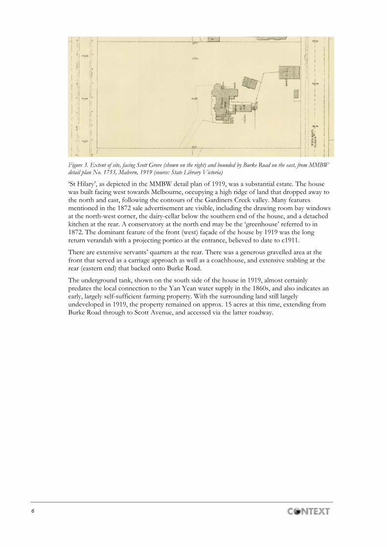
Figure 3. Extent of site, facing Scott Grove (shown on the right) and bounded by Burke Road on the east, from MMBW detail plan No. 1753, Malvern, 1919 (source: State Library Victoria)
‘St Hilary’, as depicted in the MMBW detail plan of 1919, was a substantial estate. The house was built facing west towards Melbourne, occupying a high ridge of land that dropped away to the north and east, following the contours of the Gardiners Creek valley. Many features mentioned in the 1872 sale advertisement are visible, including the drawing room bay windows at the north-west corner, the dairy-cellar below the southern end of the house, and a detached kitchen at the rear. A conservatory at the north end may be the ‘greenhouse’ referred to in 1872. The dominant feature of the front (west) façade of the house by 1919 was the long return verandah with a projecting portico at the entrance, believed to date to c1911.
There are extensive servants’ quarters at the rear. There was a generous gravelled area at the front that served as a carriage approach as well as a coachhouse, and extensive stabling at the rear (eastern end) that backed onto Burke Road.
The underground tank, shown on the south side of the house in 1919, almost certainly predates the local connection to the Yan Yean water supply in the 1860s, and also indicates an early, largely self-sufficient farming property. With the surrounding land still largely undeveloped in 1919, the property remained on approx. 15 acres at this time, extending from Burke Road through to Scott Avenue, and accessed via the latter roadway.

7
Figure 4. Proposed subdivision of St Hilary Estate, East Malvern, 1923 (MH 989, Stonnington History Centre). This shows the extent of the house at that time in relation to the proposed new allotments, and the sections of the house ‘to be demolished’.
Sidney Lloyd sold the property in 1923 and also sold off the contents of the house (Argus, 30 March 1923:2). The land was subdivided later that year to create ‘8 Magnificent Building Lots’ (Argus, 16 June 1923:3). The 1923 subdivision created a new street, to be named Hilary Grove (off Scott Grove), as well as new suburban allotments in Burke Road and Scott Grove. In the subdivision plan, the rear servants’ wing and another rear outbuilding were earmarked ‘to be demolished’ (Proposed subdivision plan, MH 989, SHC). A single mature Canary Island Date Palm (Phoenix canariensis), which stands within the small circular plantation at the end of the cul de sac of Hilary Grove, was possibly originally part of the formerly extensive gardens of St Hilary. This species was particularly popular in residential gardens in the early 1900s.

8
‘St Hilary’, now standing on a smaller parcel of land, was sold again in c.1931. The tennis court, generous entrance drive and large garden were retained. Mr and Mrs G.R. McGowan and family lived at St Hilary from the early 1930s until 1953 (Foster, ‘Residence at 2 Hilary Grove’, 1989, SHC). A photo of c.1930, taken from the roof of the garage, shows the tennis courts (Historic photo, SHC MP 13556). The tennis courts were situated on the north side of the house (see image MP 13526, c.1940s, SHC).
Figure 5. St Hilary, c.1930, showing tennis courts on the north side of the side, and the view beyond (MP 13556, Stonnington History Centre)
Figure 6. St Hilary, showing tennis courts, c.1940s (MP 13526, Stonnington History Centre)
Figure 7. Paul McGowan at St Hilary, 1934 (MH 13524, Stonnington History Centre)

9
Figure 8. St Hilary, Hilary Grove, Glen Iris, showing entrance drive and façade, 1948 (MP 13513, SHC)
Figure 9. St Hilary, Glen Iris, [n.d.], possibly 1960s-70s? (MP 15098, Stonnington History Centre)
The house was advertised for sale in 1976 and again in 1984 (Age, 13 April 1976:29; Age, 18 June 1984, p. 24).
Sources
Age, 8 July 1865, p. 8 (marriage notice, Chalmers–Fitzgerald).
Age, 30 October 1865, p. 2 (advertisement for sale of villa and grounds).
Age, 22 August 1866, p. 1 (sale of Charlesville [sic.], Malvern-hill, Gardiner).
Age, 6 October 1871, p. 8 (sales notice).
Age, 28 December 1871, p. 4 (sales notice).
Age, 1 April 1872, p. 4 (detailed description of furniture and effects for sale, room by room).
Age, 25 May 1935, p. 12 (re: location of John Gardiner’s original homestead).
Age, 8 April 1872, p. 4 (sales notice).
Age, 18 June 1984, p. 24 (sale of house in Hilary Grove, large and unrenovated).
Argus, 4 February 1865, p. 4 (death notice, John Fitzgerald).

10
Argus, 8 April 1870, p. 4 (a son born at Charlesville [sic.], Malvern to Mrs J.S. Lydiard).
Argus, 15 March 1872, p. 2 (sales notice for Charlesville [sic.] with detailed description of property).
Argus, 18 May 1872, p. 2 (change of road name: Charlesville [sic.] Road to Burke Road).
Argus, 11 July 1877, p. 1 (marriage notice, daughter of John Fitzgerald).
Argus, 10 June 1895, p. 1 (Charles Edward Coates of Charlesville, Malvern).
Argus, 19 April 1913, p. 24 (Sidney Lloyd, ‘municipal intelligence’).
Argus, 30 March 1923, p. 2 (auction of furniture, St Hilary).
Argus, 16 June 1923, p. 3 (subdivision of St Hilary).
Australasian, 8 July 1865, p. 8 (refers to John Fitzgerald obtaining an MA degree at T.C., Dublin).
Brown-May, Andrew and Shurlee Swain (eds) 2005, The Encyclopedia of Melbourne, online version: http://www.emelbourne.net.au/
City of Malvern. Land subdivision, 1923. MH 2054, Stonnington History Centre.
City of Malvern. Rate Books, 1909, 1911, 1912, 1916, 1917.
Cooper, J.B. History of Malvern. The Specialty Press, Pty Ltd, Melbourne, 1935.
Couchman, T. ‘Plan of Suburban Allotments at Gardiner, Parish of Prahran, County of Bourke’, Surveyor-General’s Office, Melbourne, 13 March 1855 (State Library Victoria).
Couchman, T. ‘Plan of Suburban Allotments at Gardiner, Parish of Prahran, County of Bourke’, Crown Lands Office, Melbourne, 19 May 1857 (State Library Victoria).
‘Descendants of John Fitzgerald, born about 1791’, n.d. [c.2010]: http://mybloodline.net/documents/Fitzgerald%20John%20b%201791%20narrative%20report.pdf
Foster, Di. ‘Residence at 2 Hilary Grove, Glen Iris: “Charleville” or “St Hilary”’. November 1989, file no. 90 1317.1, Stonnington History Centre.
Foster, Di & Stefanopoulos, Steve 2005, Walks Into History 2: Six more great walks in Stonnington, Malvern Historical Society.
Foster, Di and Steve Stefanopolous 2007. Walks into History 4: More great walks in the City of Stonnington. Malvern History Society, Malvern.
Foster, Di & Stefanopoulos, Steve 2009, Walks Into History 1: More great walks in the City of Stonnington, Malvern Historical Society.
Gardiner, Malvern, Parish of Prahran, map, [c.1930] (source: SLV).
Gardiner Road Board. Rate Books, 1857-58, 1860-61, 1863.
Johnstone & Tait. Proposed subdivision, St Hilary Estate, MH 989, Stonnington History Centre.
Leader, 19 September 1874, p. 27 (sales notice for family residence of 8 rooms in Charlesville Road, Malvern).
Lewis, Miles. Australian Architectural Index. Ref 26107.
MMBW Detail Plan No. 1753, Malvern, 1919 (State Library Victoria).
Nigro, Jane. Index entry to Minutes of Gardiner Road Board and Shire of Gardiner, 1856-1879, MH 7801.51 and 7801.52, digital files, Stonington History Centre.
Prahran Telegraph, 23 April 1911, p. 3 (purchase of St Hilary by Mr and Mrs S Lloyd).
Strahan, Lynne 1989, Public and Private Memory: A history of the City of Malvern, Hargreen Publishing and the City of Malvern.

11
‘St Hilary’ Estate, East Malvern, 1923, MH 274, Stonnington History Centre.
‘St Hilary’, file B6186 (no details given; file only), National Trust of Australia (Vic.).
St Hilary, Hilary Grove, Glen Iris, photograph, 1948, MP 13513, Stonnington History Centre.
St Hilary, Glen Iris, [n.d.], possibly 1960s-70s?. MP 15098, Stonnington History Centre.
Table Talk, 20 April 1911, p. 30 (St Hilary is acquired by Mr and Mrs Sidney Lloyd).
Tenders wanted: erection of a villa in Gardiner (near Toorak) for Cr. Fitzgerald, Argus, 8 January 1857, p. 3; taken from Miles Lewis, Australian Architectural Index, ref 26107.
Victorian Births Deaths & Marriage records, accessed via Ancestry.com.
Victorian Places, www.victorianplaces.com.au, accessed 29 June 2016.
Whitehead, Georgina. ‘Malvern Urban Character Study. Appendix A: Malvern: A physical history’, prepared for the City of Malvern, 1989.
Physical description
‘St Hilary’, formerly ‘Charleville’, is a single-storey rendered masonry dwelling that stands at the east end of Hilary Grove. While it has lost much of its original grounds in the 1920s subdivision, it retains a generous front garden with a curved driveway leading past the house, in the same alignment as seen in the 1930s, and a large side garden to the north. It sits behind a high, reproduction picket fence, but is clearly visible through the front vehicular gates.
The house is large and elongated in plan, running north-south. The roof is hipped with a low pitch and very complex form, reflecting its expansion over time, as well as the decorative massing of the two canted bays and the north-west corner and the rectangular bay at the centre of the front verandah, each of which has a separate hipped roof form. The entire roof is covered in slates, which appear to have been recently renewed. Three chimneys are visible from the public domain, all of which have terracotta pots and are rendered with a heavy run cornice and small brackets framing the central part of the shaft. The wide eaves rest on closely spaced timber modillions with a decorative scrolled profile and chamfered end.
Figure 10. Detail of the eaves modillions. (source: Context, 2016)
Wall are of ruled render, and windows sit within run render architraves. Atop the windows in the two canted bays are cast ornament in the form of an anthemion framed by floral volutes. The windows are one-over-one double-hung sashes, with a blind window for symmetry on the west face of the northern canted bay. The windows to the canted bays have shutters that retain

12
their original hinges and stays. While louvered shutters are visible on the house in photos of the 1930s and ‘40s, these have since been replaced with solid panelled shutters.
Figure 11. The semi-hexagonal bays at the north end of the house. (source: Context, 2016)
The front door is located just to the south of the canted bays, set beneath the north end of the long return verandah. The door retains two fielded panels with bolection mouldings at the bottom, below a large square area of glazing and two small glazed panels that replaced timber panels. Beside it is a round window (c1911), and to the south of that, a pair of French doors with panelling to the lower third, which may be an early survivor.
The verandah is timber framed and retains a tessellated tile floor with bluestone nosing. The posts and fretwork are in keeping with the Federation period, including turned timber posts, a ladder-back frieze and delicate curved brackets. The verandah roof is almost flat, and may have been replaced with this low pitch during the interwar era (as this flat roof with metal decking is visible in a c1930 photo). Below the roof, the curved eave modillions seen on the roof are repeated. The focal point of the verandah is the gabled entrance portico, which has multiple layers of ornament. The gable has a fret bargeboard, in keeping with the Gothic Revival style, a cast ornament in the tympanum similar to that seen above the windows, and below that an arch created by floral openwork in the Art Nouveau style. A second archway of Art Nouveau fretwork sits behind the first.

13
Figure 12. Detail of the gabled entrance portico. (source: Context, 2016)
Apart from the replacement of the shutters, the front façade of the house appears to be unchanged since the interwar period. It also appears to be intact to the c1911 redecoration that resulted in the new verandah, though the verandah roof may have been changed in pitch, and we know that part of the rear wing was demolished as part of the subdivision. Also, a garage wing has been added to the south end of the house, with a similar hipped roof. It is set back and is not visible from Hilary Grove.
Comparative analysis
‘St Hilary’ has grown over time from its 1857 origins, reaching its final size around 1911 when it was given a return verandah with timber fretwork typical of the Edwardian era. For this reason, it is difficult to attribute it a precise architectural style, even though the first stage, at least, was architect designed.
Its most distinctive characteristic, then, is as a very early dwelling both in the context of Glen Iris and Stonnington more generally. As set out in the Stonnington Thematic Environmental History (Context, 2006, rev. 2009:43):
Crown land sales
The early land sales quickly established the importance of the ‘high ground’ along the south banks of the Yarra as the favoured residential domain of many of the most wealthy and influential people in early Melbourne society. This land was the first to be sold and was strategically located close to the city and on the important trade routes to the emerging rural districts in the south and east.
Places associated with this theme, which generally date from prior to 1860 are very rare. Known examples include:
Malvern Hill Hotel [1117-1119 Malvern Road, Toorak, HO274]
Houses and buildings associated with early Crown Allotment estates such as Avoca (8 Gordon Grove, South Yarra), Brynmawr (Now part of Sacre Coeur Catholic Girls School, 172 Burke Road, Glen Iris), and Viewbank, 9 Viewbank Road, Glen Iris.

14
Houses associated with early Crown allotment subdivisions include a group in and around Avoca and Caroline streets, South Yarra including Richmond House (56 Avoca Street), 64 Avoca Street, Caroline House (74 Caroline Street), and 75 & 76 Caroline Street, as well as the houses at 18 Douglas Street, Toorak and 5 George Street, Prahran.
In his 2003 assessment of the former Rosehill Gardner’s House of 1856-7, at 19 Mayfield Avenue, Malvern, Graeme Butler notes that ‘few structures associated with private residential use survive in the City [of Stonnington] from the 1850s’. He provides an additional list of 13 such buildings, two of which have since been demolished. The surviving examples that are additional to those noted in the Context Thematic History (2006, rev. 2009), plus 30 Darling Street, are listed below:
House (former Rosehill Gardner’s House) of 1856-7, 19 Mayfield Avenue, Malvern (HO276)
‘Toorak House’, 21 St Georges Road, Toorak built c1850-51, rebuilt 1875 (VHR H207)
‘Miegunyah’, 641 Orrong Road, Toorak built 1850s, substantially enlarged and rebuilt 1908 (HO88)
‘Tintern’, 10 Tintern Avenue, Toorak built 1855 (VHR H208)
House, 458-460 Punt Road (now 1A-1C Shipley Street), South Yarra built 1855c (not in HO)
House, 30 Darling Street, South Yarra built c1856 (HO33)
House, 30 Macfarlan Street, South Yarra built late 1850s (HO74)
As demonstrated by the list above, of the small number of 1850s houses that survive in Stonnington, more than half are on the western side of the municipality, adjacent to early development in the City of Melbourne. A number of them have been extended and/or remodelled, some to the point that 1850s fabric can only be found upon close examination (e.g., ‘Miegunyah’ and ‘Toorak House’).
Further east, such houses become quite rare, as there was only scattered development in the former City of Malvern in the early decades. In the suburb of Malvern, the earliest surviving dwelling is in fact an outbuilding to the Rosehill mansion, which has since been demolished. The Malvern Hill Hotel, in the eastern part of Toorak, was built c1855, but as a commercial building, later converted to residential use (c1890).
In Glen Iris, only two other 1850s house has been definitively identified: ‘Brynmawr’ and ‘Viewbank’. A third, ‘Highfield’ of 1857, was demolished in 2001. The tiny timber cottage at 1225 Malvern Road, Malvern (not in HO) may also have been built in the 1850s (Pers. Comm., Di Foster, 2017).
‘Brynmawr’, at 172 Burke Road, Glen Iris, was built in 1859 (HO7). It is an architect-designed two-storey mansion with a formal façade, terminating in a parapet with a heavy run cornice, a design feature typical of Regency style dwellings. It was embellished in the 1870s with two-storey portico and a two-storey cast-iron verandah, but its 1850s extent seems clearly delineated. It is a grander and more formal structure than ‘St Hilary’.

15
Figure 13. ‘Bryn Mawr’, 172 Burke Road, Glen Iris (HO7). Built in 1859 to a design by architect George Wharton, two-storey balcony and rendered portico added in the 1870s. (source: National Trust, nd)
In comparison, ‘St Hilary’ was designed with a picturesque informality, to take advantage of its setting. In particular, the two semi-hexagonal bays are only located at the north end of the house to provide light to the drawing room. More rooms were added between the late 1860s and c1911, giving it a sprawling plan form. Like ‘Brynmawr’ and a number of other early (1850s and ‘60s) houses in the Stonnington Heritage Overlay (e.g., 30 Darling Street, 21 St Georges Road (in part)), a new verandah was added to ‘St Hilary’ a number of years after it was built (c1911).
The second pre-1860 house in Glen Iris is ‘Viewbank’, 7-9 Viewbank Road (Significant in HO351). It was constructed in 1859 for Benoni Salway and originally faced Burke Road. Similar to ‘St Hilary’, it was extended over the years from an original seven room to 12 rooms and a conservatory by the 1890s, and 16 rooms by 1928. The large landholdings were gradually subdivided, with the demolition of the 1850s stables and coachhouse, and the side of the house now fronts Viewbank Road (Foster & Stefanopoulos, 2005:31).
The house appears to be early Italianate in style, with bracketed eaves, a low-pitched hipped roof, and a canted bay window with its own roof on the east side elevation. Walls are of rendered brick.
Figure 14. Left: Former front elevation of ‘Viewbank’ with its masonry front porch. Above: east side elevation with a canted bay at far right. (Stonnington History Centre, c1920, MP1269 and MP1270)
16
In comparison, ‘St Hilary’ has a similar low roofline, and the same palette of cladding materials: rendered masonry with a slate roof. The two corner bays of ‘St Hilary’ are larger and project further from the building than the bay window of ‘Viewbank’, giving them a more dramatic appearance. ‘Viewbank’s’ masonry porch creates a more formal appearance than that of ‘St Hilary’. The two houses have been extended over time. It is not clear when ‘Viewbank’s’ verandah was built.
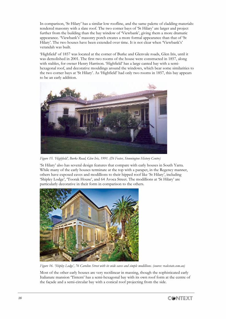
‘Highfield’ of 1857 was located at the corner of Burke and Glenvale roads, Glen Iris, until it was demolished in 2001. The first two rooms of the house were constructed in 1857, along with stables, for owner Henry Harrison. ‘Highfield’ has a large canted bay with a semi-hexagonal roof, and decorative mouldings around the windows, which bear some similarities to the two corner bays at ‘St Hilary’. As ‘Highfield’ had only two rooms in 1857, this bay appears to be an early addition.
Figure 15. ‘Highfield’, Burke Road, Glen Iris, 1991. (Di Foster, Stonnington History Centre)
‘St Hilary’ also has several design features that compare with early houses in South Yarra. While many of the early houses terminate at the top with a parapet, in the Regency manner, others have exposed eaves and modillions to their hipped roof like ‘St Hilary’, including ‘Shipley Lodge’, ‘Toorak House’, and 64 Avoca Street. The modillions at ‘St Hilary’ are particularly decorative in their form in comparison to the others.
Figure 16. ‘Shipley Lodge’, 76 Caroline Street with its wide eaves and simple modillions. (source: realestate.com.au)
Most of the other early houses are very rectilinear in massing, though the sophisticated early Italianate mansion ‘Tintern’ has a semi-hexagonal bay with its own roof form at the centre of the façade and a semi-circular bay with a conical roof projecting from the side.

17
Figure 17. Front façade of ‘Tintern’ with a canted bay at its centre. The verandah iron is c1870s. (source: National Trust, n.d.)
The only other identified residential commission by architect Patrick Scanlan is ‘Tara’ in East Melbourne (demolished). It was a formal city residence, quite similar to ‘Brynmawr’ with its two-storey form, symmetrical façade, and heavy cornice to the parapet. An elaborate cast-iron verandah was added to this house in the 1870s as well. No points of similarity with ‘St Hilary’ are apparent in the surviving photos of this townhouse.
Figure 18. ‘Tara’, 338 Victoria Parade, East Melbourne (demolished). Designed by Patrick Scanlon and built in 1856. The cast-iron verandah was added c1870s. (source: East Melbourne Historical Society)
In comparison to these other houses, the sculpted eave modillions of ‘St Hilary’ and the semi-hexagonal bays at the north-east corner are the most distinctive features that survive from the 1856-58 design. While the modillions are in keeping with the Georgian style, the canted bays are a very early expression of the Italianate style, and quite sophisticated for a country residence. ‘Viewbank’, built two years after ‘St Hilary’ and similarly extended over the years, is the closest comparison in date and form.
18
Thematic context
This place illustrates the following themes, as identified in the Stonnington Thematic Environmental History (Context rev. 2009):
3.5 Immigrating to seek opportunity
The house is of historic interest for its association with John Fitzgerald, a prominent early resident of Gardner (now Glen Iris).
3.3.2 Crown land sales 1854–1879
6.1.1 Farming & market gardens
Assessment against criteria
Assessment of this place was carried out in relation to the HERCON model criteria as set out in the VPP Practice Note ‘Applying the Heritage Overlay’ (2015).
Statement of significance
What is significant? ‘St Hilary’, formerly ‘Charleville’, at 2 Hilary Grove, Glen Iris, is significant. A seven-room house was built in 1857-58 for Irish immigrant John Fitzgerald and designed by architect Patrick Scanlan. The house was subsequently enlarged in the late 1860s with two new bedrooms added, and another two to four rooms (including a conservatory) were built by 1911. Also around 1911, the return verandah was replaced or remodelled with extensive timber fretwork.
The house has masonry walls finished with ruled render, and the low hipped roof is clad in slates. The front (west) elevation is dominated by two semi-hexagonal bays at the north end, and a return verandah to the south.
The house is significant to the extent of its 1857-c1911 fabric, that is the entire envelope of the house including walls, roofscape, and verandah. The southern garage wing and the front picket fence are not significant.
How is it significant? ‘St Hilary’, formerly ‘Charleville’, is of local historical, architectural and aesthetic significance and rarity value to the City of Stonnington.
Why is it significant? It is historically significant and of rarity value as the oldest surviving house in Glen Iris. It is also one of the small number of pre-1860 buildings associated with the early crown land sales, and demonstrates how the early purchasers chose the very desirable high ground. As one of the early estates in the Glen Iris area, John Fitzgerald’s ‘Charleville’ helped to shape the early settlement and occupation of the area; for example, until 1872, Burke Road was known as Charleville Road. (Criteria A & B)
‘St Hilary’ is also significant for its association with Irish immigrant and early Melbourne architect Patrick Stack Scanlan (1824–1864) of Fitzroy. He was active in the 1850s, preparing plans for a number of shops and hotels, for a predominantly Irish Catholic clientele, including prestigious commissions such as St Patrick’s College, East Melbourne (1854, demolished). Little survives of Scalan’s buildings, making ‘St Hilary’ important in understanding his work. (Criterion H)
‘St Hilary’ is architecturally and aesthetically significant as an early house that demonstrates a transition from the Georgian style to the Italianate. Details such as the elegantly curved and chamfered modillions to the eaves are typical of Georgian houses. The asymmetry, low hipped roof, and the semi-hexagonal bays grouped around the north end of the house demonstrate the picturesque qualities of the new Italianate style. The c1911 timber verandah is also of note for the elaborate Art Nouveau fretwork to the entrance portico. (Criteria D & E)
19
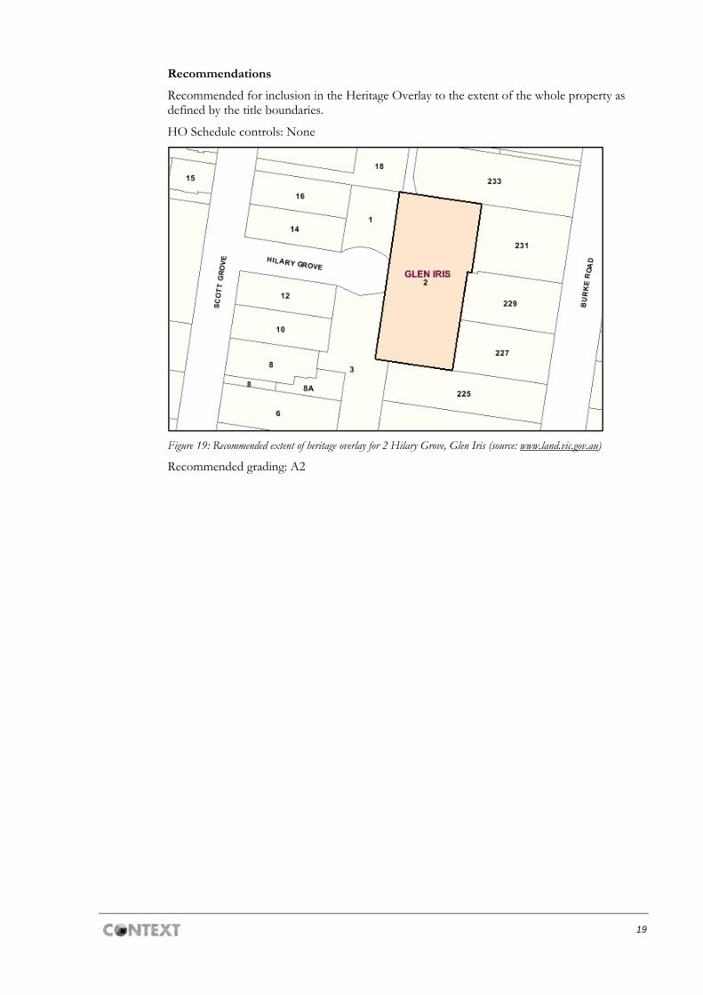
Recommendations
Recommended for inclusion in the Heritage Overlay to the extent of the whole property as defined by the title boundaries.
HO Schedule controls: None
Figure 19: Recommended extent of heritage overlay for 2 Hilary Grove, Glen Iris (source: www.land.vic.gov.au)
Recommended grading: A2