getting started guide - addressbase premium and addressbase … · 2020-04-08 · addressbase...
TRANSCRIPT

OFFICIAL Version 2.0 April 2020
Getting Started Guide - AddressBase Premium and AddressBase Premium Islands

Getting Started Guide: AddressBase Premium and AddressBase Premium Islands April 2020
OFFICIAL
© Ordnance Survey Ltd 2020 Page 1 of 75
Version History
Version Date Description
2.0
08/04/2020 Revised for AddressBase Premium products. Includes ArcGIS Pro.
Purpose of this Document
This is the Getting Started Guide (hereinafter referred to as the ‘Guide') for the AddressBase Premium and AddressBase Premium Islands products. The instructions for AddressBase Premium are also applicable to AddressBase Premium Islands unless mentioned.
The terms and conditions on which the Product is made available to you and your organisation are contained in that customer contract. If you or your organisation has not signed a valid current customer contract, then you are not entitled to use the Product.
We may change the information in this Guide at any time, giving you the notice period specified in the customer contract made between you and Ordnance Survey.
We do not accept responsibility for the content of any third-party websites referenced or accessed in or through this Guide.
This document has been screened in accordance with the requirements set out in Ordnance Survey's Equality Scheme. If you have difficulty reading this information in its current format and would like to find out how to access it in a different format (braille, large print, computer disk or in another language), please contact us on: +44 (0)3456 05 05 05.
Copyright in this Guide
© Ordnance Survey Limited 2020. This Guide, (including for the avoidance of doubt, any mapping images reproduced herein), is protected by copyright and apart from the rights expressly granted herein to use the content, all rights are reserved. Any part of this Guide may be copied for use internally in your organisation or business so that you can use the Product for the purpose for which it is licensed to your organisation or business (but not otherwise).
For the avoidance of doubt, no part of this Guide may be reproduced or transmitted in any form or by any means (including electronically) for commercial exploitation, onward sale or as free promotional materials without the prior written consent of Ordnance Survey.
The data in AddressBase® is provided by GeoPlace®, a limited liability partnership between the Local Government Association and Ordnance Survey.
AddressBase and AddressBase Plus contain data created and maintained by English, Welsh and Scottish Local Government as well as Royal Mail and Valuation Office Agency.
© Local Government Information House Limited copyright and database rights 2020
or
© Hawlfraint a hawliau cronfa ddata cyfyngedig Tŷ Gwybodaeth ar Lywodraeth Leol 2020

Getting Started Guide: AddressBase Premium and AddressBase Premium Islands April 2020
OFFICIAL
© Ordnance Survey Ltd 2020 Page 2 of 75
PAF® data are copyright material of Royal Mail® Group Limited.
Valuation Office Agency data is provided under the Open Government Licence and other data provided under the Open Government Licence v3.0.2.
Elements of the AddressBase Plus Island data are provided by the following authorities:
Northern Ireland data provided by Land & Property Services © Pointer copyright and/or database right 2020.
Channel Island Address information is the intellectual property of The States of Guernsey and / or The States of Jersey. Copyright © 2020 States of Guernsey/Jersey
Address information derived from Isle of Man Government Property Database. © Crown Copyright, Treasury, Isle of Man
Trademarks
Ordnance Survey, OS, the OS Logos, AddressBase and the Product are registered trademarks of Ordnance Survey, Britain’s mapping agency.
PAF, PO Box, Post Office and Royal Mail are registered trademarks of Royal Mail Group Ltd.
Contact Details
https://www.ordnancesurvey.co.uk/contact-us

Getting Started Guide: AddressBase Premium and AddressBase Premium Islands April 2020
OFFICIAL
© Ordnance Survey Ltd 2020 Page 3 of 75
Contents
1. Introduction ....................................................................................................................................... 6
2. Prerequisites ...................................................................................................................................... 7
2.1 System requirements ............................................................................................................................... 7
2.2 Backup provision of the product.............................................................................................................. 7
2.3 Typical data volumes ............................................................................................................................... 7
2.3.1 Unzipped CSV (Comma-Separated Values) .............................................................................................. 7
2.3.2 Unzipped GML (Geography Markup Language) ....................................................................................... 7
3. Data Supply ........................................................................................................................................ 8
3.1 Supply options ......................................................................................................................................... 8
3.1.1 DVD – Area of Interest (AOI) .................................................................................................................... 8
3.1.2 DVD Supply of Managed Great Britain Sets (MGBS) ................................................................................ 8
3.1.3 Secure File Transfer Protocol (SFTP) ........................................................................................................ 8
3.1.4 Download ................................................................................................................................................ 8
3.2 File naming .............................................................................................................................................. 9
3.2.1 Non-geographic chunks ........................................................................................................................... 9
3.2.2 Geographic chunks .................................................................................................................................. 9
3.3 Unzipping the data ................................................................................................................................ 10
3.3.1 Non-geographic chunks ......................................................................................................................... 10
3.3.2 Geographic chunks ................................................................................................................................ 10
4. Preparing the CSV data ..................................................................................................................... 11
4.1 Gawk ...................................................................................................................................................... 11
4.2 Python ................................................................................................................................................... 12
5. Loading CSV into GIS software .......................................................................................................... 14
5.1 ArcGIS Pro .............................................................................................................................................. 14
5.2 ArcGIS Desktop ...................................................................................................................................... 19
5.3 MapInfo® ............................................................................................................................................... 22
5.4 QGIS ....................................................................................................................................................... 23
6. Loading CSV into a database ............................................................................................................. 27
6.1 Considerations ....................................................................................................................................... 27
6.1.1 Software dependencies ......................................................................................................................... 27
6.1.2 UPRN deletions ...................................................................................................................................... 27
6.2 PostGreSQL ............................................................................................................................................ 27
6.2.1 Converting coordinates to geometry ..................................................................................................... 30
6.3 Oracle .................................................................................................................................................... 30
6.4 Microsoft SQL Server ............................................................................................................................. 32
6.4.1 Setting Primary and Foreign Keys .......................................................................................................... 34
6.4.2 Creating the point geometry ................................................................................................................. 35

Getting Started Guide: AddressBase Premium and AddressBase Premium Islands April 2020
OFFICIAL
© Ordnance Survey Ltd 2020 Page 4 of 75
7. Loading GML .................................................................................................................................... 36
8. COU implementation guidance ......................................................................................................... 37
8.1 Introduction ........................................................................................................................................... 37
8.2 Background ............................................................................................................................................ 37
8.3 Types of change ..................................................................................................................................... 37
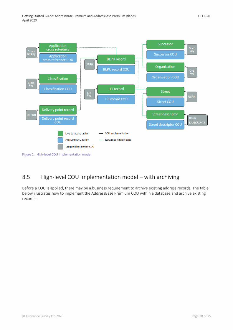
8.4 High-level COU implementation model ................................................................................................. 37
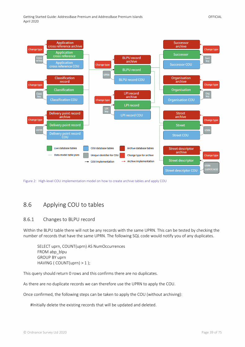
8.5 High-level COU implementation model – with archiving ....................................................................... 38
8.6 Applying COU to tables .......................................................................................................................... 39
8.6.1 Changes to BLPU record ........................................................................................................................ 39
8.6.2 Changes to the Classification table ........................................................................................................ 40
8.6.3 Changes to the organisation table ......................................................................................................... 43
8.6.4 Changes to the Delivery Point Address Table ........................................................................................ 44
8.6.5 Changes to LPI table .............................................................................................................................. 45
8.6.6 Changes to Street table ......................................................................................................................... 47
8.6.7 Changes to Street Descriptor table ........................................................................................................ 48
8.6.8 Changes to the Cross Reference table ................................................................................................... 49
9. Creating a Single-line or Multi-line Address ....................................................................................... 51
9.1 Introduction ........................................................................................................................................... 51
9.2 Background ............................................................................................................................................ 52
9.3 Delivery Point Address (PAF Address) .................................................................................................... 53
9.3.1 Building a single-line Delivery Point Address ......................................................................................... 55
9.3.2 Building a multi-line Delivery Point Address .......................................................................................... 55
9.4 Geographic Address (Local Authority Address) ..................................................................................... 56
9.4.1 Constructing a single address label from the Geographic Address fields .............................................. 56
9.4.2 Linking address components ................................................................................................................. 57
9.4.3 Rendering SAOs and PAOs ..................................................................................................................... 58
9.4.4 Street description, town, locality and administrative area names ......................................................... 59
9.4.5 Building a single-line Geographic Address ............................................................................................. 61
9.4.6 Building a multi-line Geographic Address .............................................................................................. 61
9.5 Creating mailing lists .............................................................................................................................. 63
9.5.1 Address status ....................................................................................................................................... 63
9.5.2 Other filters ........................................................................................................................................... 65
10. Searching for addresses .................................................................................................................... 66
10.1 Free text search ..................................................................................................................................... 66
10.2 Structured component search ............................................................................................................... 66
10.3 Understanding the different addresses available .................................................................................. 67
10.4 The search operation ............................................................................................................................. 68
10.5 Generating a search query from structured user input ......................................................................... 69
10.6 Structuring the query for a structured address search .......................................................................... 70
10.7 Supporting case-insensitive queries and partial matches ...................................................................... 71
10.8 Generating a search query from unstructured user input ..................................................................... 72

Getting Started Guide: AddressBase Premium and AddressBase Premium Islands April 2020
OFFICIAL
© Ordnance Survey Ltd 2020 Page 5 of 75
10.9 Creating a Search Index for addresses ................................................................................................... 72
10.10 Structuring the query for an unstructured address search.................................................................... 72
10.11 Summary ................................................................................................................................................ 74
Appendix 1 – Support links ......................................................................................................................... 75
Getting Started Guide: AddressBase Premium and AddressBase Premium Islands April 2020
OFFICIAL
© Ordnance Survey Ltd 2020 Page 6 of 75
1. Introduction
Overview
AddressBase products are created by bringing together different address sources:
• Local Authority Gazetteers across Great Britain, Northern Ireland, the Channel Islands and the Isle of Man
• Royal Mail PAF data
• References to Valuation Office Agency (VOA) data
• Additional addresses and coordinates from Ordnance Survey
The instructions contained in this document show you how to use AddressBase Premium and AddressBase Premium Islands products. The data is supplied as CSV (Comma-Separated Values) or GML (Geography Markup Language). This guide covers the pre-processing steps required to attach the Header file to the data and how to load into various GIS (Geographic Information System) software application and/or databases (including how to apply a change only update). It is important to note that this is not an extensive list of the applications it can be used it and many other GIS software applications and/or database can be used to load the product.
Advice is given towards the end of this guide on how to create a single line address from the various address sources in the product and how this can be used to create a look-up service for a customer to search for an address.
Resources
Each AddressBase product has the following documents associated to it, which are accessible from our website.
AddressBase Premium Product Guide Getting Started Guide Technical Specification
AddressBase Premium Islands Getting Started Guide Technical Specification
Target Audience
This document is intended for:
• Users with basic technical knowledge of GIS and databases who are comfortable navigating the internet.
Support Links
Throughout this document, we reference files or documents as part of your 'Getting Started' instructions. For ease of reference, we've compiled a list of these in the Appendix 1 – Support Links.
Getting Started Guide: AddressBase Premium and AddressBase Premium Islands April 2020
OFFICIAL
© Ordnance Survey Ltd 2020 Page 7 of 75
2. Prerequisites
2.1 System requirements
AddressBase Premium is an addressing gazetteer offering full lifecycle information of a property that can be used within geographical information systems (GIS) and database systems. For details of Ordnance Survey’s licensed partners, who can incorporate the AddressBase products in their systems, please see the systems/software page on the Ordnance Survey website.
Ordnance Survey does not recommend specific suppliers or software products, as the most appropriate system will depend on many factors; for example, the amount of data being taken, resources available within the organisation, the existing and planned information technology infrastructure and the applications that AddressBase products can be used for.
However, as a minimum, the following elements will be required in any system:
• a means of reading the data, either in its native format, or by translating it into a file format or for storage in a database;
• a means of storing and distributing the data, perhaps in a database or through a web-based service; • a way of visualising and querying the data, typically a GIS.
2.2 Backup provision of the product
You are advised to copy the supplied data to a backup medium.
2.3 Typical data volumes
For reading purposes, it is recommended to store the data on a single hard disc. This will speed up the ability of your computer to read the data.
Unzipped file sizes for the full supply of each product are as follows:
2.3.1 Unzipped CSV (Comma-Separated Values)
• AddressBase Premium 40 Gb • AddressBase Premium Islands 1 Gb
2.3.2 Unzipped GML (Geography Markup Language)
• AddressBase Premium 186 Gb • AddressBase Premium Islands 4 Gb
Getting Started Guide: AddressBase Premium and AddressBase Premium Islands April 2020
OFFICIAL
© Ordnance Survey Ltd 2020 Page 8 of 75
3. Data Supply
3.1 Supply options
3.1.1 DVD – Area of Interest (AOI)
When you receive an order via hard media (DVD), the following files will be supplied if the supply is not a Managed Great Britain Set (MGBS):
• Data • Doc • Order_Details.txt
Within the Data directory, data files will be found in their compressed format.
With the Doc directory is a text file called Label Information. This is a replica of the information on the DVD should you need to reproduce or reprint this.
The Order_Details.txt provides information about the supply including supply type, format and dates of order, currency and change. It also contains a list of all the zipped folders contained in the Data directory.
3.1.2 DVD Supply of Managed Great Britain Sets (MGBS)
When you receive an order of a Managed Great Britain Set (MGBS) via hard media (DVD) the following files will be supplied:
• Data • Doc • Order_Details.txt
Within the Data directory, data files will be found in their compressed format.
With the Doc directory is a text file called Label Information. This is a replica of the information on the DVD should you need to reproduce or reprint this.
The Order_Details.txt provides information about the supply including supply type, format and dates of order, currency and change. It also contains a list of all the zipped folders contained in the Data directory.
3.1.3 Secure File Transfer Protocol (SFTP)
With a SFTP order, the same information is supplied as in section 3.1.1; but the file names will be slightly different, reflecting the SFTP order number.
3.1.4 Download
Public Sector Geospatial Agreement (PSGA) customers can download their geographic chunk data for AddressBase Premium as well as full supply of AddressBase Premium Islands via our download service.
Getting Started Guide: AddressBase Premium and AddressBase Premium Islands April 2020
OFFICIAL
© Ordnance Survey Ltd 2020 Page 9 of 75
One Scotland Mapping Agreement (OSMA) customers can download their geographic chunk data for AddressBase Premium via our download service.
1. When you click Download data you will be required to enter a password to access the PSGA/OSMA members’ area. On successful entry to the download service you will be able to view all your orders in the members’ area and download your data.
2. If you have ordered your data from our online portal you will be sent an email with a link to a download page.
3. Within the PSGA/OSMA members’ area, you can order and download the data that you require, by clicking on Order Data found under the Map Data heading.
4. Once you have selected Order Data you will be presented with the Order page. From here you can manage all your orders including those for AddressBase Premium products.
5. When you have placed an order for a product, the data will become available as a series of zipped data files. To unzip these files, please see Chapter 3.3 below.
3.2 File naming
The data is supplied as chunked files that cover your selected area. These files are named according to the convention shown below.
When you open your data, you will see a series of zip folders:
3.2.1 Non-geographic chunks
For MGBS supply when you receive your download data you will see a single zip folder. On opening the data link folder you will see a series of separate unzipped files
For example:
AddressBasePremium_FULL_2011-07-29_001_csv.zip (Full supply of CSV) or AddressBasePremium_COU_2011-07-29_001_gml.zip (Change-only update supply of GML)
3.2.2 Geographic chunks
When you receive your Geo Chunked download data you will see a series of zipped folders on opening the data
For example:
AddressBasePremium_FULL_2011-07-29_TQ2020_csv.zip (Full supply of CSV) or AddressBasePremium_COU_2011-07-29_TQ2020_gml.zip (Change-only update supply of GML)
Getting Started Guide: AddressBase Premium and AddressBase Premium Islands April 2020
OFFICIAL
© Ordnance Survey Ltd 2020 Page 10 of 75
3.3 Unzipping the data
The GML and CSV data are supplied in a compressed form (zip). Some software can access these files directly, while others will require it to be unzipped.
To unzip the zipped data files (.zip extension), use an unzipping utility found on most PCs, for example, WinZip®. Alternatively, open-source zipping/unzipping software can be downloaded from the Internet, for example, 7-Zip.
When the files are unzipped, they are ready for use and appear as follows:
3.3.1 Non-geographic chunks
AddressBasePremium_FULL_2020-02-11_001.csv
AddressBasePremium_ISL_FULL_2020-02-18_001.csv
3.3.2 Geographic chunks
AddressBasePremium_2011-07-29_NC4040.csv
Getting Started Guide: AddressBase Premium and AddressBase Premium Islands April 2020
OFFICIAL
© Ordnance Survey Ltd 2020 Page 11 of 75
4. Preparing the CSV data
The AddressBase Premium CSV and AddressBase Premium Island CSV are provided with records for various tables incorporated into a single CSV. Depending on the size of the AOI or if a full supply of GB or Islands data, there may be multiple CSV files supplied. These CSV files need to be split into the individual records and tables.
There are multiple methods for splitting AddressBase Premium by the record identifiers. The sections below step through using either Gawk or Python for splitting the data and appending the Header file.
4.1 Gawk
These instructions show you how to use Gawk to split AddressBase Premium and append the Header files.
1. Group all the AddressBase Premium CSV files into a folder with no other CSV files contained within. The folder must contain no spaces in any of the file directory path, for example: C:\AddressBaseData\AddressBase_Premium.
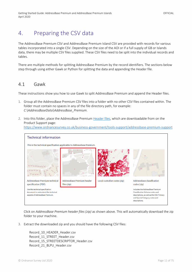
2. Into this folder, place the AddressBase Premium Header files, which are downloadable from on the Product Support page: https://www.ordnancesurvey.co.uk/business-government/tools-support/addressbase-premium-support
Click on AddressBase Premium header files (zip) as shown above. This will automatically download the zip folder to your machine.
3. Extract the downloaded zip and you should have the following CSV files:
Record_10_HEADER_Header.csv Record_11_STREET_Header.csv Record_15_STREETDESCRIPTOR_Header.csv Record_21_BLPU_Header.csv
Getting Started Guide: AddressBase Premium and AddressBase Premium Islands April 2020
OFFICIAL
© Ordnance Survey Ltd 2020 Page 12 of 75
Record_23_XREF_Header.csv Record_24_LPI_Header.csv Record_28_DELIVERYPOINTADDRESS_Header.csv Record_29_METADATA_Header.csv Record_30_SUCCESSOR_Header.csv Record_31_ORGANISATION_Header.csv Record_32_CLASSIFICATION_Header.csv Record_99_TRAILER_Header.csv
4. Go to https://github.com/OrdnanceSurvey/AddressBase/tree/master/Loading_Scripts/Gawk
5. Copy the contents of AddressBasePremium_GawkSplitScript.bat to a text editor such as TextPad or NotePad++ and save as a .bat file in the same folder as your data and Header files.
6. In the same link in Step 4, also download and extract the zip file called gawk-4.0.2-bin.zip.
7. This will extract a file called Gawk.exe. Place this in the same folder as your data and Header files.
8. Double-click on the AddressBasePremium_GawkSplitScript.bat file and an MS-DOS window will appear. Once the process is complete the screen will close automatically, or you will have to press any key to continue.
Note - Running the .bat file creates temporary files and requires extra space in the location you are creating your files. These files can be much larger than the original CSV files. They are deleted once the process has finished, but the space is still required.
9. Running this should create additional files which are similar in their naming convention to the Header files. These should have generated in the same location as the data and headers. For example, looking in the location there should now be an ID24_LPI_RECORDS as well as a Record_24_LPI_Header.
4.2 Python
These instructions show you how to alternatively use Python instead of Gawk to split AddressBase Premium and append the Header files. The current Python tools were designed for use with Python 2.7.
1. Group the AddressBase Premium CSV files into a folder which contains no other files. The folder must contain no spaces in any of the file directory path, for example: C:\AddressBaseData\AddressBase_Premium.
Note - You do not need to download the Header files if you are using Python to split your AddressBase Premium data.
2. Go to https://github.com/OrdnanceSurvey/AddressBase/tree/master/Loading_Scripts/Python
3. Copy the contents of the file called AddressBasePremium_RecordSplitter_v2_7.py to a text editor such as TextPad or NotePad++ and save as a .py to the same folder as your data.
4. Open a Command Prompt window (Windows Start > CMD prompt).
Getting Started Guide: AddressBase Premium and AddressBase Premium Islands April 2020
OFFICIAL
© Ordnance Survey Ltd 2020 Page 13 of 75
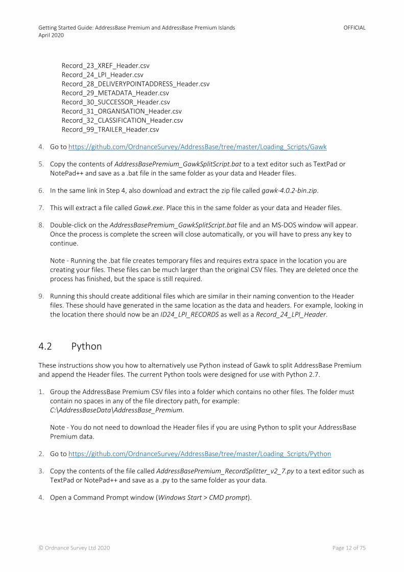
5. Within the Command Prompt, type cd and the directory path where you just placed the AddressBasePremium_RecordSplitter_v2_7.py. Then Enter on your keyboard.
6. Next, type the name AddressBasePremium_RecordSplitter_v2_7.py into it or select it using the Tab key which will display each file within the file directory in turn. Once selected hit the Enter key.
7. The following message should be displayed: This program will split OS AddressBase Premium Zip CSV or extracted CSV files by record identifier into new CSV files. Please type in the full path to the directory of OS AddressBase zip files: Directory Path:
8. Enter the full directory path to where you have stored the AddressBase Premium data (for example, C:\ AddressBaseData\AddressBase_Premium). Hit Enter. The process of splitting the files will then begin.
9. When complete the following message will be displayed: The program will close in 10 seconds. You may still need to close the Command Prompt window afterwards by typing Exit and hitting Enter.
10. If you navigate to the folder which contained the .py file and the AddressBase Premium CSV files, there should be new files similar to the naming conventions of the Header files. These files contain all your AddressBase Premium data split out by record type.

Getting Started Guide: AddressBase Premium and AddressBase Premium Islands April 2020
OFFICIAL
© Ordnance Survey Ltd 2020 Page 14 of 75
5. Loading CSV into GIS software
This chapter describes how to load AddressBase Premium products into commonly used GIS.
These instructions describe how to load the CSV format. It is assumed that the CSV data preparation covered in Chapter 4 data has been followed before attempting to load the data. If this pre-processing is not carried out, there may be errors with loading.
AddressBase Premium data is also available from Ordnance Survey as a supply in GML (Geography Markup Language) format. Loading this format into most GI applications usually requires the use of third-party translation software, which is not covered in this guide. If more information is required for loading GML, please contact Ordnance Survey.
5.1 ArcGIS Pro
There are two methods for loading AddressBase Premium CSV data into ArcGIS Pro. We will only step through the first method in this guide. If you need guidance on the second method, please refer to the ArcGIS Pro instructions in the AddressBase or AddressBase Plus Getting Started Guide.
a. This first method uses the UK Data Loader published by ESRI, which will load the data into a File Geodatabase and automatically relates between the different tables. At the end of the process, you have a fully working dataset ready for use. Below we step through this method in this guide.
b. The second method must have the CSV data prepared as described in Chapter 4. These files are imported into a project File Geodatabase within ArcGIS Pro (see the instructions in the Getting Started Guide for AddressBase or AddressBase Plus). Only the BLPU table will contain geometry which can be mapped by adding XY data. All the other tables will have no geometry, but they can be linked together using the relates function within ArcGIS Pro. Please refer to the AddressBase Premium Technical Specification for which table fields should be linked together.
These instructions are based on ArcGIS Pro version 2.3.3.
Note - Before following these instructions, it is assumed that you have the full data Interoperability Extension installed and that it matches your ArcGIS Pro version.
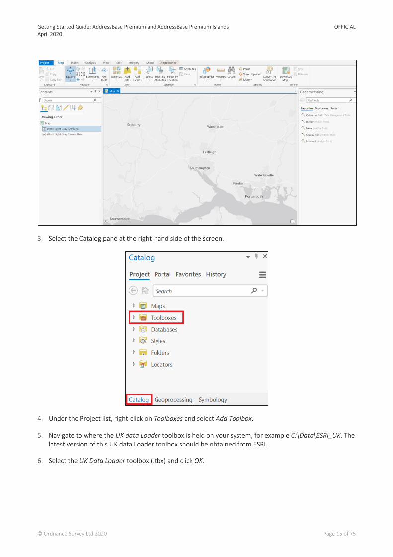
1. Launch ArcGIS Pro and create a new project.
2. Select a location to save the project to, name it and click OK.
If the project is a new map project, it will launch with a default map backdrop supplied by ESRI. You can change this to another ESRI backdrop or use your own.
Getting Started Guide: AddressBase Premium and AddressBase Premium Islands April 2020
OFFICIAL
© Ordnance Survey Ltd 2020 Page 15 of 75
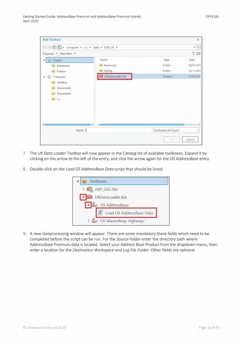
3. Select the Catalog pane at the right-hand side of the screen.
4. Under the Project list, right-click on Toolboxes and select Add Toolbox.
5. Navigate to where the UK data Loader toolbox is held on your system, for example C:\Data\ESRI_UK. The latest version of this UK data Loader toolbox should be obtained from ESRI.
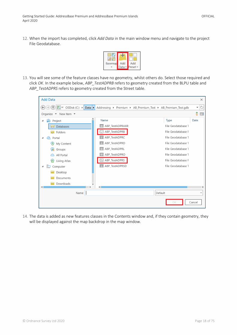
6. Select the UK Data Loader toolbox (.tbx) and click OK.
Getting Started Guide: AddressBase Premium and AddressBase Premium Islands April 2020
OFFICIAL
© Ordnance Survey Ltd 2020 Page 16 of 75
7. The UK Data Loader Toolbox will now appear in the Catalog list of available toolboxes. Expand it by clicking on the arrow to the left of the entry, and click the arrow again for the OS AddressBase entry.
8. Double-click on the Load OS AddressBase Data script that should be listed.
9. A new Geoprocessing window will appear. There are some mandatory blank fields which need to be completed before the script can be run. For the Source Folder enter the directory path where AddressBase Premium data is located. Select your Address Base Product from the dropdown menu, then enter a location for the Destination Workspace and Log File Folder. Other fields are optional.

Getting Started Guide: AddressBase Premium and AddressBase Premium Islands April 2020
OFFICIAL
© Ordnance Survey Ltd 2020 Page 17 of 75
10. When the required fields are completed, click the Run button at the bottom of the window.
11. This can run for some time, depending upon the amount of data being processed. Wait until a message appears saying the files have been imported successfully.
Getting Started Guide: AddressBase Premium and AddressBase Premium Islands April 2020
OFFICIAL
© Ordnance Survey Ltd 2020 Page 18 of 75
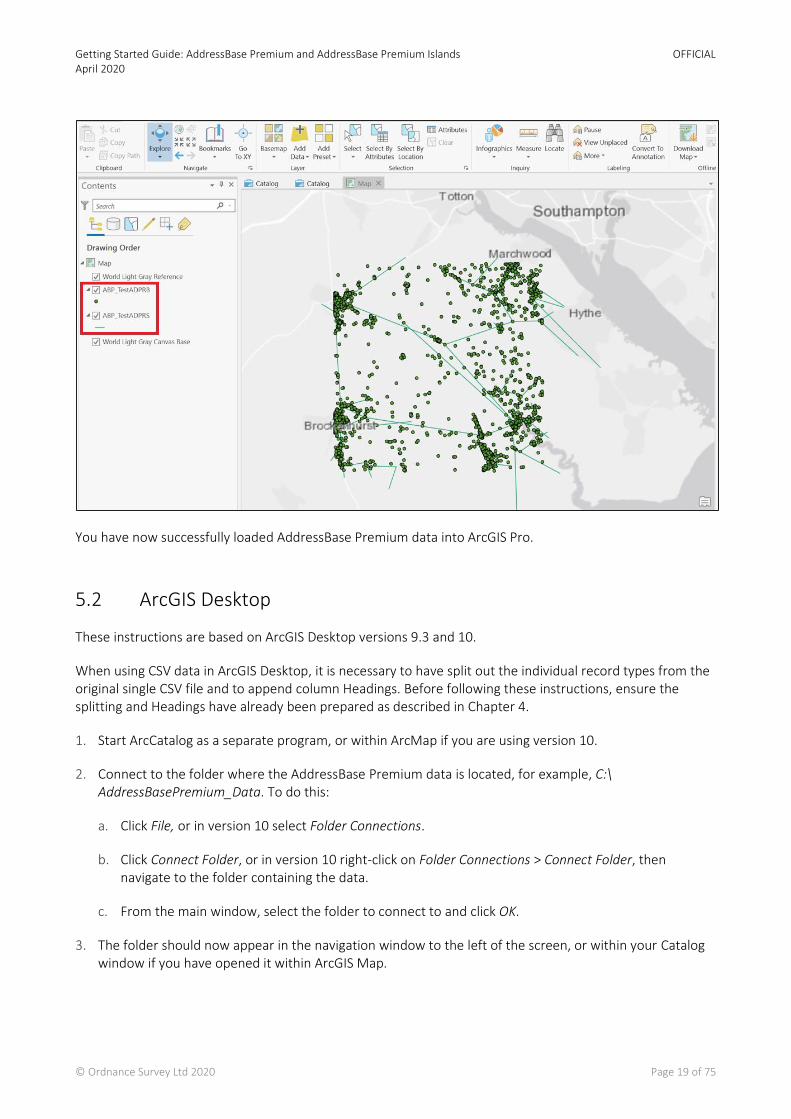
12. When the import has completed, click Add Data in the main window menu and navigate to the project File Geodatabase.
13. You will see some of the feature classes have no geometry, whilst others do. Select those required and click OK. In the example below, ABP_TestADPRB refers to geometry created from the BLPU table and ABP_TestADPRS refers to geometry created from the Street table.
14. The data is added as new features classes in the Contents window and, if they contain geometry, they will be displayed against the map backdrop in the map window.
Getting Started Guide: AddressBase Premium and AddressBase Premium Islands April 2020
OFFICIAL
© Ordnance Survey Ltd 2020 Page 19 of 75
You have now successfully loaded AddressBase Premium data into ArcGIS Pro.
5.2 ArcGIS Desktop
These instructions are based on ArcGIS Desktop versions 9.3 and 10.
When using CSV data in ArcGIS Desktop, it is necessary to have split out the individual record types from the original single CSV file and to append column Headings. Before following these instructions, ensure the splitting and Headings have already been prepared as described in Chapter 4.
1. Start ArcCatalog as a separate program, or within ArcMap if you are using version 10.
2. Connect to the folder where the AddressBase Premium data is located, for example, C:\ AddressBasePremium_Data. To do this:
a. Click File, or in version 10 select Folder Connections.
b. Click Connect Folder, or in version 10 right-click on Folder Connections > Connect Folder, then navigate to the folder containing the data.
c. From the main window, select the folder to connect to and click OK.
3. The folder should now appear in the navigation window to the left of the screen, or within your Catalog window if you have opened it within ArcGIS Map.
Getting Started Guide: AddressBase Premium and AddressBase Premium Islands April 2020
OFFICIAL
© Ordnance Survey Ltd 2020 Page 20 of 75
4. Create a File Geodatabase (.gdb) to store the address data. Using the file tree, go to Folder Connections and navigate to the directory where you wish to create the File Geodatabase, for example: C:\AddressBase_Geodatabase\AddressBase_Premium. This may need to be set up as a new connection.
5. Right-click on the folder where you wish to store the File Geodatabase and select New > File Geodatabase.
6. It will be created and named by default New File Geodatabase. Rename this to a name of your choice.
7. Right-click on your new File Geodatabase and select Import > Table (multiple)…
8. For Input Table, navigate to the location of the CSV files that you wish to open, i.e. the folder that contains the AddressBase Premium data split into individual files by record type.
9. Select the files that you wish to add. Make sure you add the data files (named like ID21_BLPU_Records) and not the Header files (named like Record_21_BLPU_Header).
10. Click Add.
11. The Output Geodatabase option should automatically be populated by the location of the File Geodatabase that is to be updated, this should be the File Geodatabase you created in Step 6 above.
12. Click OK, and once the process is complete, click Close.
Note – The process may take some time, depending on the amount of files and data being added. The window may close before the operation is complete, so if you cannot see all of your expected files under your File Geodatabase this may mean the data is still being loaded.
13. To create a map of the locations of the AddressBase Premium records, they need to be geocoded. To do this, double-click on the Geodatabase that the data was just imported into.
14. Right-click on the Geodatabase table that was created from AddressBase Premium records with a record type of 21 (for example, ID21_BLPU_Records) and select Create Feature Class.
15. In the From XY Table, you can use the dropdowns to change the X Field to either X_COORDINATE or Longitude, and the Y Field to Y_COORDINATE or Latitude. Leave the Z Field as <none>.
16. For Input Coordinates, click on Coordinate System > Select and then navigate to Projected Co-ordinate Systems > National Grids > Europe > British National Grid.
Note - If you selected X and Y as Longitude and Latitude in the step before, then you need to select ETRS89 [EPSG: 4258] for the Coordinate System instead.
17. Double-click on the selected Coordinate System, then click Apply and OK.
18. Click on the folder icon alongside the Output field and navigate to the location where you wish to save the output shapefile or feature class (we recommend that this be within the Geodatabase you created in Step 6).
Note - If you can’t see your Geodatabase, ensure the Save as type box at the bottom of the dialog box is set to File and Personal Geodatabase feature classes.
Getting Started Guide: AddressBase Premium and AddressBase Premium Islands April 2020
OFFICIAL
© Ordnance Survey Ltd 2020 Page 21 of 75
19. Give the file a suitable name (for example, XYID21_BLPU_Records).
20. Click Save, then leave the Configuration keyword as Defaults and click OK.
Note - You may need to right-click on the Personal Geodatabase where it was saved and select Refresh in order to see your new feature class.
21. Now the processing has been done, the data needs to be loaded into ArcMap so that the individual tables can be related. Start ArcMap, unless you have been working within ArcMap version 10 already.
22. Select File > Add Data…
23. Navigate to the folder where the Geodatabase was created.
24. Double-click on the Geodatabase and select all the files inside.
25. Click Add.
26. You need to create the following joins/relates between the tables, as stated in the AddressBase Premium technical specification:
BLPU (spatial data for record identifier 21) (ID21_BLPU_Records): • UPRN – Application Cross Reference (ID23_XREF_Records) UPRN • UPRN – LPI (ID24_LPI_Records) UPRN • UPRN – Delivery Point Address (ID28_DPA_Records) UPRN • UPRN – Successor Record (ID30_Successor_Records) UPRN • UPRN – Organisation (ID31_Org_Records) UPRN • UPRN – Classification (ID32_Class_Records) UPRN
LPI (ID24_LPI_Records): • USRN – Street (ID11_Street_Records) USRN
Street (ID11_Street_Records): • USRN – Street Descriptor (ID15_StreetDesc_Records) USRN
27. To do this, select the Source tab in the left-hand navigation window and right-click on the first table that you wish to relate to another. To create the relevant relates:
a. Click Joins and Relates > Relate
b. From the first dropdown menu, select the Attribute from the first Table that will be used to create the relate between the two Tables. (Apply the relationships as listed in Step 26.)
c. From the second dropdown, select the Table that is going to be related to. (Apply the relationships as listed in Step 26.)
d. From the third dropdown, select the Attribute from the Table that is being related to. (Apply the relationships as listed in Step 26.)
e. In the fourth box, input a relevant name for the relate (for example, BLPU_to_Organisation).
f. Click OK.

Getting Started Guide: AddressBase Premium and AddressBase Premium Islands April 2020
OFFICIAL
© Ordnance Survey Ltd 2020 Page 22 of 75
g. Repeat this process for all of the joins/relates listed in Step 26.
28. Once the data has been loaded into ArcMap, you may wish to display more relevant information in the Info tool than the Esri defined Object ID. To change this:
a. Double-click on the spatial dataset that you wish to change the Primary Display Field of.
b. Select the Fields tab.
c. Change the Primary Display Field to the desired field (for example, UPRN).
5.3 MapInfo®
These instructions are based on MapInfo Professional version 12.
Note - MapInfo has a size limit of 2 Gb on each table. This equates to a maximum number of approximately 4 million AddressBase Premium records.
When using CSV data in MapInfo, it is not a critical requirement to have column Headings. However, for ease of use we recommend using the Headings supplied by Ordnance Survey. Instructions on how to append the Header files can be found in Chapter 4 of this guide.
1. Launch MapInfo.
2. Cancel the Quick Start prompt.
3. Click File > Open and navigate to the folder that contains the AddressBase Premium data.
4. In the Files of Type dropdown menu, select Comma delimited CSV (*.csv), then click on the AddressBase Premium data to be loaded. Click Open.
5. In the next window, tick the box Use First Line for Column Titles and select the character set of INSERT CHARACTER SET. Click OK.
Note - When adding data this way, the field type classifications and field sizes of each column automatically try to fit the type of data that MapInfo believes is contained within the column and the largest value of that classification found within that column. This means the classifications and field sizes of some attributes may not match the field types and sizes stated in the Technical Specification. This guidance includes changing these columns to match those values:
6. Select File > Save Copy As… and select the AddressBase table that was loaded in. Save As… and name the table to be created, then click Save.
7. Open the table that was just created via File > Open. Navigate to and select the copy of the table you just named. Click Open.
8. Navigate to Table > Maintenance > Table Structure and select the table to be edited. Click OK.
9. Here you can change the Type and Width of each attribute to match the ones stated in the AddressBase Premium Technical Specification.

Getting Started Guide: AddressBase Premium and AddressBase Premium Islands April 2020
OFFICIAL
© Ordnance Survey Ltd 2020 Page 23 of 75
10. These should be changed for all attributes, apart from the following, due to software-specific dependencies:
• UPRN, which should be classified as Float
• All attributes that have a Field Type of Date in the Technical Specification, which should be classified as Character with a length of 10.
11. After all changes have been made, click OK.
12. To create a map of the location of the AddressBase Premium records, they need to be geocoded. Ensure the table of records that you wish to geocode is open, then navigate to Table > Create Points.
13. Select the table you wish to geocode from the Create Points for Table dropdown menu.
14. Expand the Get X Coordinates from Column dropdown menu and select either X_Coordinate or Longitude.
15. Expand the Get Y Coordinates from Column dropdown menu and select either Y_Coordinate or Latitude.
16. Click on the Projection icon, then select the British Coordinate Systems option from the Category dropdown menu. Select the British National Grid [EPSG: 27700], or if you selected Longitude and Latitude in the steps above, select ETRS89 [EPSG: 4258].
17. Click OK to close that window and OK again to close the next.
18. Finally, click Window > New Map Window to view the loaded geocoded points.
5.4 QGIS
These instructions are based on QGIS version 2.6.
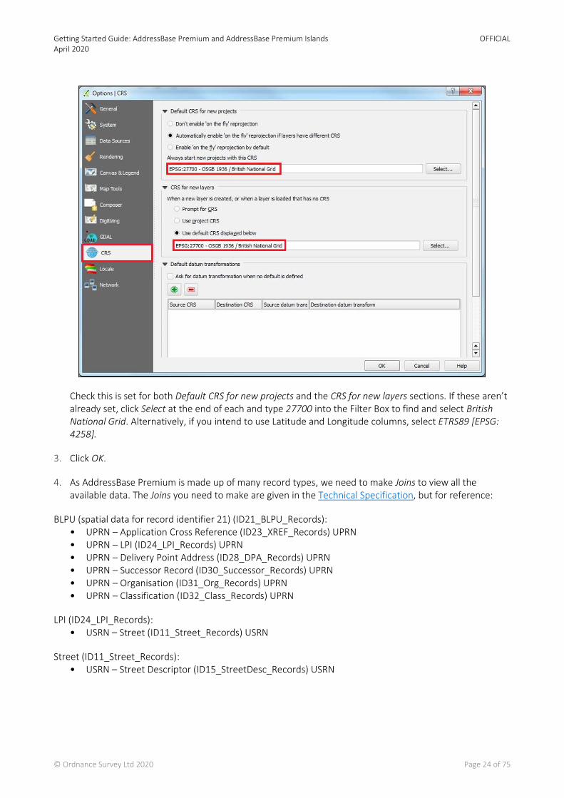
1. Launch QGIS and click Settings > Options.
2. Select CRS from the left-hand menu and check the Coordinate Reference System is set to British National Grid.
Getting Started Guide: AddressBase Premium and AddressBase Premium Islands April 2020
OFFICIAL
© Ordnance Survey Ltd 2020 Page 24 of 75
Check this is set for both Default CRS for new projects and the CRS for new layers sections. If these aren’t already set, click Select at the end of each and type 27700 into the Filter Box to find and select British National Grid. Alternatively, if you intend to use Latitude and Longitude columns, select ETRS89 [EPSG: 4258].
3. Click OK.
4. As AddressBase Premium is made up of many record types, we need to make Joins to view all the available data. The Joins you need to make are given in the Technical Specification, but for reference:
BLPU (spatial data for record identifier 21) (ID21_BLPU_Records): • UPRN – Application Cross Reference (ID23_XREF_Records) UPRN • UPRN – LPI (ID24_LPI_Records) UPRN • UPRN – Delivery Point Address (ID28_DPA_Records) UPRN • UPRN – Successor Record (ID30_Successor_Records) UPRN • UPRN – Organisation (ID31_Org_Records) UPRN • UPRN – Classification (ID32_Class_Records) UPRN
LPI (ID24_LPI_Records): • USRN – Street (ID11_Street_Records) USRN
Street (ID11_Street_Records): • USRN – Street Descriptor (ID15_StreetDesc_Records) USRN

Getting Started Guide: AddressBase Premium and AddressBase Premium Islands April 2020
OFFICIAL
© Ordnance Survey Ltd 2020 Page 25 of 75
Note - The following steps explain how the joins are made for the first relationship given in the list above, i.e. between the BLPU (ID21_BLPU_Records) and the Application Cross Reference (ID23_XREF_Records). This process will need to be repeated for all subsequent joins you make.
5. Back in the QGIS window, go to Layer and select Add Delimited Text Layer.
6. Click Browse next to the filename and locate the CSV file that was created in Chapter 4, named (ID21_ BLPU_Records), not the files named with Record at the start.
7. Select the CSV file and click Open.
8. Accept the default or create a new layer name.
9. Ensure the First record has field names is ticked.
10. For Field Options, select Decimal separator is comma.
11. For Geometry Definition, select Point Coordinates.
12. You should now be able to select the X_Coordinate field for the X Field dropdown and Y_Coordinate for the Y Field dropdown, if this was not done automatically. Alternatively, if you wish to use the Latitude and Longitude columns, Longitude needs to be inserted into X field, and Latitude needs to be inserted into Y field.
13. Click OK. So far you have loaded the BLPU record information and in the next steps we will make the joins.
14. Back in the QGIS window, go to Layer and select Add Delimited Text Layer.
15. Click Browse next to the filename and locate the CSV file that was created in Chapter 4, this time named (ID23_ XREF_Records), not the files named with Record at the start.
16. Select the CSV file and click Open.
17. Accept the default or create a new layer name.
18. Ensure the First record has field names is ticked.
19. For Field Options, select Decimal separator is comma.
20. This time for Geometry definition, choose No Geometry (attribute only table).
21. Click OK. This table will now be added to QGIS but will not be viewable as we have added it as an attribute table only.
22. Next right-click on your BLPU layer and select Properties.
23. Go to the Joins tab found on the left-hand side.
24. Click the Green plus button in the bottom left-hand corner.
25. Select your join layer. For this example, Application Cross reference (ID23_XREF_RECORDS).

Getting Started Guide: AddressBase Premium and AddressBase Premium Islands April 2020
OFFICIAL
© Ordnance Survey Ltd 2020 Page 26 of 75
26. Select the join field. For all BLPU links this will be the UPRN (see the joins listed in Step 4 above).
27. The target field will also be the UPRN, for this example.
28. Click OK. You should now have a join listed in your Joins window.
29. Click OK to return back to your main QGIS mapping screen.
30. If you now select one of your BLPU records in the main mapping window, you will see the BLPU attributes and the relevant Application Cross References for that record.
31. You can now repeat Step 4 - 30 for all the additional joins you wish to make as listed in Step 4.
Getting Started Guide: AddressBase Premium and AddressBase Premium Islands April 2020
OFFICIAL
© Ordnance Survey Ltd 2020 Page 27 of 75
6. Loading CSV into a database
This chapter describes how to load AddressBase Premium products into some common databases.
6.1 Considerations
6.1.1 Software dependencies
It should be noted that ArcMap, ArcGIS Desktop and ArcGIS Server software do not support the BIGINT/NUMBER data type as an Object ID. Bear this in mind if the expectation is to use this data type directly with these ESRI products. An alternative method to facilitate using ESRI software is to store this data as a string and add a new Serial ID to act as the Object ID.
If you are loading AddressBase data directly into a database, you may need to increase the column length to accommodate language characters such as ^. Some databases treat this as an additional character and therefore if you define the column length according to our specification there is a chance the load may fail. Please bear in mind such adjustments may be required depending on the database you use to load the data.
6.1.2 UPRN deletions
It is important to note that primary keys on all tables (for example, UPRN on the BLPU table) are valid upon a data load. If a Delete is issued for a Primary key, this doesn’t mean that Primary Key will not reappear in subsequent supplies.
There are a number of reasons this may happen:
• The record has moved in location more than once, moving it out of your area of interest (therefore the record is deleted) but then back into your area of interest in the future. This would also occur if you alter your area of interest.
• A record has failed data validation upon a change being made. This can result dependent on the change being made in the record being deleted and then reintroduced when the error is fixed by the data supplier.
If a UPRN is deleted it will not be reallocated to a different property and therefore remains the unique identifier for a property.
6.2 PostGreSQL
These steps describe how to load AddressBase Premium into a PostGreSQL database using the text files created using the CSV file merge utility, described in Chapter 4.
These instructions are based on PostGreSQL version 1.12.3 and assume that you have set-up your database with the PostGIS spatial extension. It is recommended that you have a basic understanding of database terminology before following this guide.
Getting Started Guide: AddressBase Premium and AddressBase Premium Islands April 2020
OFFICIAL
© Ordnance Survey Ltd 2020 Page 28 of 75
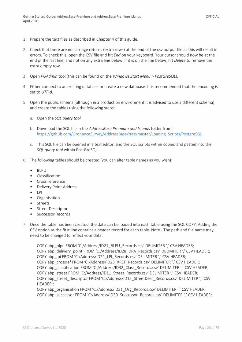
1. Prepare the text files as described in Chapter 4 of this guide.
2. Check that there are no carriage returns (extra rows) at the end of the csv output file as this will result in errors. To check this, open the CSV file and hit End on your keyboard. Your cursor should now be at the end of the last line, and not on any extra line below. If it is on the line below, hit Delete to remove the extra empty row.
3. Open PGAdmin tool (this can be found on the Windows Start Menu > PostGreSQL).
4. Either connect to an existing database or create a new database. It is recommended that the encoding is set to UTF-8.
5. Open the public schema (although in a production environment it is advised to use a different schema) and create the tables using the following steps:
a. Open the SQL query tool
b. Download the SQL file in the AddressBase Premium and Islands folder from: https://github.com/OrdnanceSurvey/AddressBase/tree/master/Loading_Scripts/PostgreSQL
c. This SQL file can be opened in a text editor, and the SQL scripts within copied and pasted into the SQL query tool within PostGreSQL.
6. The following tables should be created (you can alter table names as you wish):
• BLPU • Classification • Cross reference • Delivery Point Address • LPI • Organisation • Streets • Street Descriptor • Successor Records
7. Once the table has been created, the data can be loaded into each table using the SQL COPY. Adding the CSV option as the first line contains a header record for each table. Note - The path and file name may need to be changed to reflect your data:
COPY abp_blpu FROM ‘C:/Address/ID21_BLPU_Records.csv’ DELIMITER ‘,’ CSV HEADER; COPY abp_delivery_point FROM ‘C:/Address/ID28_DPA_Records.csv’ DELIMITER ‘,’ CSV HEADER; COPY abp_lpi FROM ‘C:/Address/ID24_LPI_Records.csv’ DELIMITER ‘,’ CSV HEADER; COPY abp_crossref FROM ‘C:/Address/ID23_XREF_Records.csv’ DELIMITER ‘,’ CSV HEADER; COPY abp_classification FROM ‘C:/Address/ID32_Class_Records.csv’ DELIMITER ‘,’ CSV HEADER; COPY abp_street FROM ‘C:/Address/ID11_Street_Records.csv’ DELIMITER ‘,’ CSV HEADER; COPY abp_street_descriptor FROM ‘C:/Address/ID15_StreetDesc_Records.csv’ DELIMITER ‘,’ CSV HEADER ; COPY abp_organisation FROM ‘C:/Address/ID31_Org_Records.csv’ DELIMITER ‘,’ CSV HEADER; COPY abp_successor FROM ‘C:/Address/ID30_Successor_Records.csv’ DELIMITER ‘,’ CSV HEADER;
Getting Started Guide: AddressBase Premium and AddressBase Premium Islands April 2020
OFFICIAL
© Ordnance Survey Ltd 2020 Page 29 of 75
8. Once loaded you may want to add Primary and Foreign Keys to the data. These can only be added on columns where the data values are unique. Where there are no unique data values an index may be added which will aid searching. For the BLPU table, the UPRN provides a unique value. Primary Keys are added using the following steps:
a. Right-click on the table name and select New Object > New Primary Key.
b. Enter a Name to call the key and select the Columns tab.
c. From the drop-down at the foot of the window select UPRN.
d. Click on Add
e. Click OK
9. Repeat the procedure for the Streets table and USRN.
However, in the other tables these columns may contain duplicate values. In this case, use the table key (for example, LPI_Key as the primary identifier). Alternative Object Identifiers (OID) can be added to each table (these are also required to use the data in some GIS including QGIS and MapInfo.) The following SQL can be used for this:
ALTER TABLE insert_table_name SET WITH OIDS
10. To help performance when querying across multiple tables, a Foreign Key may be added. However, as with a Primary Key only unique data columns can be used.
a. Click on the table you wish to add the key to in pgAdmin.
b. Click on the + sign.
c. Right-click on Constraints and select New Object > New Foreign Key.
d. Under the Properties tab, select the table to join to from the References dropdown.
e. On the same tab enter a name for the key (for example, FKey1).
f. Click on Columns tab
g. Click on the unique field for Local field and the same field from the Referencing dropdown.
h. Click on Add and OK.
i. Click OK.
j. You will need to repeat this for each table that has suitable fields.
11. You can also index the data by following these steps.
a. Click on the table in pgAdmin.
b. Click on the + sign

Getting Started Guide: AddressBase Premium and AddressBase Premium Islands April 2020
OFFICIAL
© Ordnance Survey Ltd 2020 Page 30 of 75
c. Right-click on Indexes > New Index.
d. On the Properties enter a name (for example, Idx1).
e. Click on the Columns tab.
f. Select Column (for example, UPRN or USRN).
g. Click Add and then OK.
6.2.1 Converting coordinates to geometry
A PostGIS extension is required to create geometries. The AddressBase Premium products contain both British National Grid (BNG) and ETRS89 coordinates. The SQL below shows how to create a column for BNG but can be altered to utilise the ETRS89 data.
1. Add a geometry column to make the data usable in a GIS:
SELECT AddGeometryColumn (‘public’, ‘abp_blpu’, ‘geom’, 27700, ‘POINT’, 2);
2. Load the data into your new geometry column:
UPDATE public.abp_blpu SET geom = ST_GeomFromText(‘POINT(‘ || x_coordinate || ‘ ‘ || y_coordinate || ‘)’, 27700 )
This sets the geom column in the BLPU table to equal the values from the X_coordinate and Y_coordinate columns, with the spatial reference defined as 27700.
3. Create a spatial index on the data using:
CREATE INDEX idx_abp_geom ON public.abp_blpu USING gist(geom)
This adds the index name idx_abp_geom to the same table on the geom column.
6.3 Oracle
These instructions assume a basic knowledge of Oracle databases and SQLLDR (the package used to load the CSV files into the database). Other options are available for loading data into Oracle databases.
When using SQLLDR it is not necessary to merge all the AddressBase files into a single file as it can load the data directly from the provided file as long as it has been unzipped first.
The following steps describe one method for loading a full supply of the data. Sections in Italics denote where changes will need to be made to accommodate local file naming.
1. Copy the data files from the disk to an appropriate location. It is worth noting that the files will need to be unzipped and therefore you will need in the region of 40 Gb of free space to load AddressBase Premium and 1 Gb of free space to load AddressBase Premium Islands.
Getting Started Guide: AddressBase Premium and AddressBase Premium Islands April 2020
OFFICIAL
© Ordnance Survey Ltd 2020 Page 31 of 75
2. Once the data is copied, the next stage is to unzip the *.zip files to extract the *.csv files. This can be done using a package such as Winzip or 7Zip. Please see Chapter 3.3 for more information.
3. Now that all the files are unzipped, it will make the latter stages easier to create a file list of all the CSV files to be loaded. This can be done using a batch file that writes all the files out to a text file. Copy the following into a text editor and save it as a .bat file in the same directory as the AddressBase Premium data:
dir *.csv /b/s >filelisting.txt pause
This file will form the basis for loading the control file in a later step.
4. Go to the OS GitHub repository: https://github.com/OrdnanceSurvey/AddressBase/tree/master/Loading_Scripts/Oracle
5. Open the AddressBase Premium and Islands folder. Open the file ending CreateTables.sql in a text editor.
6. Within that SQL there are references to <TablespaceName>, which need to be changed to your tablespace name that is being worked in. When these are changed, copy and paste the SQL into Oracle to create the tables.
7. Next, a SQLLDR control file needs to be created. An example of one of these files is Oracle_AddressBasePremium_Control.ctl, provided in the AddressBase Premium and Islands folder of the GitHub repository linked in Step 4. Open this in a text editor.
8. Populate the INFILE lines with the file listing that was created in Step 3, with one INFILE command for each file. This tells the process to open each of the files and carry out the other tasks listed below it.
9. The rest of the file tells the tool how to interpret the files that it is reading in. The INTO statement at the top of each of the tables tests the first column (01) of the row in the file that it is looking at. If it meets the criteria, the structure of the table that the line is to be loaded into is described below it. Save the completed file with the extension *.ctl.
10. Once this file is created it can be called from a .bat file to run it on the box that holds the database rather than a remote machine. If you wish to run it from a remote machine, contact your Oracle Administrator who will be able to advise on the best way to do this within your environment. The contents of the .bat file should be similar to:
@sqlldr <username>/<password>@<service name> control= <name of ctl file created previously> Pause
11. When the .bat file has been run, the data is loaded. Any records that do not meet the expected structure, or errors with the load, are recorded in the *.bad, and *.log files respectively. These are written out to the same drive location as the control file that is being used to load the data.
It is strongly recommended that the log file is checked once the load is completed, to check that all of the data has loaded correctly before continuing.
12. After loading, the indexes need to be built in order to be able to carry out spatial queries and other queries where the relationship between the tables need to be built.

Getting Started Guide: AddressBase Premium and AddressBase Premium Islands April 2020
OFFICIAL
© Ordnance Survey Ltd 2020 Page 32 of 75
For example, in order to return all the Delivery Point Addresses within a county, there needs to be a spatial index on the BLPU table which contains the geometry, as well as the UPRN in both the BLPU and Delivery Point Address table. The SQL statements to create the indexes can be found in the same Github Repository link, as referenced in Step 4.
13. Again, you can copy and paste the SQL statements from a text editor into Oracle in order to create the rest of the indexes.
Note - The table name provided may be different to yours, and therefore might need changing before use.
14. Once the indexes are complete the data loading process is complete, and the data is ready to use.
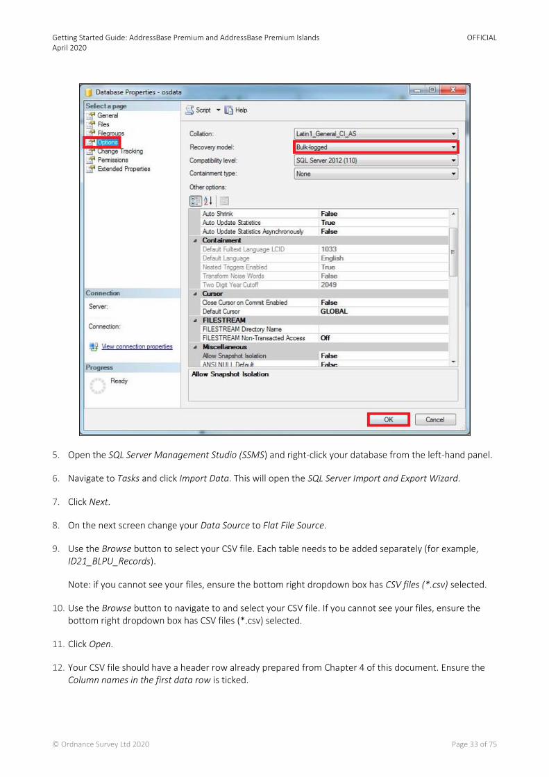
6.4 Microsoft SQL Server
The following instructions assume basic knowledge of Microsoft SQL Server and that the CSV data is already prepared as described in Chapter 4 of this document.
Note - There are many ways to load AddressBase products into Microsoft SQL Server; this is just one suggested method for guidance.
1. Open the SQL Server Management Studio (SSMS).
2. Right-click on the database you are loading into and select Properties.
3. Select Options on the left-hand side.
4. Expand the dropdown box for Recovery Model and select BULK-LOGGED. This minimises the logfile size, otherwise the default logging for Microsoft SQL Server can cause logfiles to grow over 20GB and cause issues with loading.
Getting Started Guide: AddressBase Premium and AddressBase Premium Islands April 2020
OFFICIAL
© Ordnance Survey Ltd 2020 Page 33 of 75
5. Open the SQL Server Management Studio (SSMS) and right-click your database from the left-hand panel.
6. Navigate to Tasks and click Import Data. This will open the SQL Server Import and Export Wizard.
7. Click Next.
8. On the next screen change your Data Source to Flat File Source.
9. Use the Browse button to select your CSV file. Each table needs to be added separately (for example, ID21_BLPU_Records).
Note: if you cannot see your files, ensure the bottom right dropdown box has CSV files (*.csv) selected.
10. Use the Browse button to navigate to and select your CSV file. If you cannot see your files, ensure the bottom right dropdown box has CSV files (*.csv) selected.
11. Click Open.
12. Your CSV file should have a header row already prepared from Chapter 4 of this document. Ensure the Column names in the first data row is ticked.
Getting Started Guide: AddressBase Premium and AddressBase Premium Islands April 2020
OFFICIAL
© Ordnance Survey Ltd 2020 Page 34 of 75
13. Check that the Text Qualifier is set to a double quote (“). This ensures the quotations in the raw data supply are removed upon loading, but that the data remains intact.
14. On the left-hand side of this screen, select Columns and check that the Column delimiter is set to Comma.
15. On the left-hand side of the screen, select Advanced.
16. For each column of data that you are loading, you will need to specify a DataType. The Microsoft SQL Server loader defaults each column to a String. The correct Data Types for each column are given in the AddressBase Premium Technical Specification.
17. Once you have changed the column types to match the Technical Specification, click Next.
18. Check that your table is going to be imported into the correct database and click Next.
19. On this screen, you can edit the default table name that Microsoft SQL Server has chosen by clicking in the destination box. For example, for AddressBase Premium renaming to [dbo].[BLPU_TABLE]
20. Select Edit Mappings in the bottom right-hand corner.
21. In the new window, you must remove the tick in the checkbox against the column which needs to be the Primary Key of the table. The Primary Keys for each table can be found in the AddressBase Premium technical specification.
22. Click Next. On this screen you can check the Source column and the Destination columns are correct.
23. Click Next. A summary of your import will appear. If you want to continue, click Finish.
24. A report will be generated as your data is imported. Success should appear at the top once complete.
25. You may need to right-click on your database and click Refresh to see your new table listed.
6.4.1 Setting Primary and Foreign Keys
To create a Primary Key field you can run an SQL statement, such as below example. (Note that the columns you are creating these constraints on cannot be null or allowed to be null.)
Primary Key
alter table dbo.ID21_BLPU_Records add primary key ([UPRN]);
Foreign Key
alter table dbo.ID32_Class_Records add foreign key (UPRN);

Getting Started Guide: AddressBase Premium and AddressBase Premium Islands April 2020
OFFICIAL
© Ordnance Survey Ltd 2020 Page 35 of 75
6.4.2 Creating the point geometry
You can also create point geometry using the X and Y coordinates or the Latitude and Longitude coordinate values. This is achieved by running the following SQL statement:
alter table dbo.ID21_BLPU_Records add geometry_column as geometry::Point([X_Coordinate],[Y_Coordinate], 27700);
Note - This is using British National Grid coordinates with 27700 representing the spatial reference of the data. To use the Latitude and Longitude coordinate, the spatial reference should be set to 4258 for ETRS89.

Getting Started Guide: AddressBase Premium and AddressBase Premium Islands April 2020
OFFICIAL
© Ordnance Survey Ltd 2020 Page 36 of 75
7. Loading GML
GML (Geography Markup Language) is an XML dialect which can be used to model geographic features. It was designed by the OGC (Open Geospatial Consortium) as a means for people to share information regardless of the applications or technology that they use.
In the first instance, GML was used to overcome the differences between different GIS applications by providing a neutral file format as an alternative to proprietary formats. Because it is independent of applications, it can also be moved between databases or other types of application, which allows a wider application than just GIS data transfer.
• GML data can be viewed using software such as Snowflake GML Viewer:
http://www.snowflakesoftware.com/osmmviewer/
• GML data can be loaded into a database using software such as Snowflake GoLoader:
http://www.snowflakesoftware.com/2012/02/addressbase/

Getting Started Guide: AddressBase Premium and AddressBase Premium Islands April 2020
OFFICIAL
© Ordnance Survey Ltd 2020 Page 37 of 75
8. COU implementation guidance
8.1 Introduction
All the AddressBase products are available as a Full Supply or a Change Only Update. A Change Only update means you will only be supplied with the features which have changed since your last supply. The following sections provide guidance on how you could potentially manage a COU supply of AddressBase Premium data.
Note - If you receive a tile supply, you will receive Change Chunks. This means if a record within your tile has changed all of the records in that tile will be provided to you as Inserts, and no Updates or Deletes will be issued. This is not applicable for AddressBase Premium Island as a tile supply is not available.
8.2 Background
AddressBase Premium is a complex relational dataset that is being used by a variety of customers who are using a variety of methods and software to manage the data. Some of the software solutions take a considerable length of time to load and manage the data, and, therefore, COU is being seen as a simple and effective way to keep data holdings up-to-date without spending considerable time loading and managing a full supply every time the data is refreshed.
8.3 Types of change
At a high-level, there are three types of change found within COU:
1. Deletes (CHANGE_TYPE ‘D’) are objects that have ceased to exist in your area of interest since the last product refresh.
2. Inserts (CHANGE_TYPE ‘I’) are objects that have been newly inserted into your area of interest since the last product refresh.
3. Updates (CHANGE_TYPE ‘U’) are objects that have been updated in your area of interest since the last product refresh.
8.4 High-level COU implementation model
The table below illustrates how to implement the AddressBase Premium COU within a database.
Getting Started Guide: AddressBase Premium and AddressBase Premium Islands April 2020
OFFICIAL
© Ordnance Survey Ltd 2020 Page 38 of 75
Figure 1: High-level COU implementation model
8.5 High-level COU implementation model – with archiving
Before a COU is applied, there may be a business requirement to archive existing address records. The table below illustrates how to implement the AddressBase Premium COU within a database and archive existing records.
Getting Started Guide: AddressBase Premium and AddressBase Premium Islands April 2020
OFFICIAL
© Ordnance Survey Ltd 2020 Page 39 of 75
Figure 2: High-level COU implementation model on how to create archive tables and apply COU
8.6 Applying COU to tables
8.6.1 Changes to BLPU record
Within the BLPU table there will not be any records with the same UPRN. This can be tested by checking the number of records that have the same UPRN. The following SQL code would notify you of any duplicates.
SELECT uprn, COUNT(uprn) AS NumOccurrences FROM abp_blpu GROUP BY uprn HAVING ( COUNT(uprn) > 1 );
This query should return 0 rows and this confirms there are no duplicates.
As there are no duplicate records we can therefore use the UPRN to apply the COU.
Once confirmed, the following steps can be taken to apply the COU (without archiving):
#Initially delete the existing records that will be updated and deleted.
Getting Started Guide: AddressBase Premium and AddressBase Premium Islands April 2020
OFFICIAL
© Ordnance Survey Ltd 2020 Page 40 of 75
DELETE FROM abp_blpu WHERE uprn IN (SELECT distinct uprn FROM abp_blpu_cou WHERE change_type!= ‘I’);
#Insert the new updated records and the new inserted records.
INSERT INTO abp_blpu SELECT * FROM abp_blpu_cou WHERE change_type != ‘D’;
Some of the COU records that are change type ‘U’ (updates) may change the Logical Status Code from ‘1’ to ‘8’, meaning that this address has become ‘Historical’. This means that the BLPU table intrinsically archives historical record.
Where there is a business requirement to keep the records that are being Updated and Deleted in a separate archive table, the following SQL will create an Archive Table and populate it with records that are being Updated and Deleted from the live BLPU table.
#The following command creates an archive table of the records that are being updated and deleted from the existing BLPU table.
#If this table already exists you can simply use INSERT INTO rather than CREATE TABLE.
CREATE TABLE abp_blpu_archive AS SELECT * FROM abp_blpu WHERE uprn IN (SELECT distinct uprn FROM abp_blpu_cou WHERE change_type != ‘I’);
#The following command then deletes the records from the existing table, which are either updates or deletions.
DELETE FROM abp_blpu WHERE uprn IN (SELECT distinct uprn FROM abp_blpu_cou WHERE change_type!= ‘I’);
#The following command then inserts the new insert records and the new updated records into the live BLPU table.
INSERT INTO abp_blpu SELECT * FROM abp_blpu_cou WHERE change_type != ‘D’;
8.6.2 Changes to the Classification table
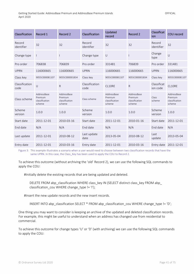
Because there is a one-to-many relationship between the BLPU table and the Classification table, there can be records in the Classification table that share a UPRN. To apply COU to the correct record, users should use the Class_Key to ensure that the correct classification record is updated.
Getting Started Guide: AddressBase Premium and AddressBase Premium Islands April 2020
OFFICIAL
© Ordnance Survey Ltd 2020 Page 41 of 75
Classification Record 1 Record 2 Classification Updated record
Record 2 Classification
COU record
Record identifier
32 32 Record identifier
32 32 Record identifier
32
Change type I I Change type U I Change type
U
Pro order 706838 706839 Pro order 331481 706839 Pro order 331481
UPRN 116000665 116000665 UPRN 116000665 116000665 UPRN 116000665
Class key 9055C000081107 9055C000001834 Class key 9055C000081107 9055C000001834 Class key 9055C000081107
Classification code
U R Classification code
CL10RE R Classification code
CL10RE
Class scheme
AddressBase Premium classification scheme
AddressBase Premium classification scheme
Class scheme
AddressBase Premium classification scheme
AddressBase Premium classification scheme
Class scheme
AddressBase Premium classification scheme
Scheme version
1.0.0 1.0.0 Scheme version
1.0.0 1.0.0 Scheme version
1.0.0
Start date 2011-12-01 2010-03-16 Start date 2011-12-01 2010-01-16 Start date 2011-12-01
End date N/A N/A End date N/A N/A End date N/A
Last update 2011-12-01 2010-08-12 Last update date
2013-05-04 2010-08-12 Last update
2013-05-04
Entry date 2011-12-01 2010-03-16 Entry date 2011-12-01 2010-03-16 Entry date 2011-12-01
Figure 3: This example illustrates a scenario when a user would need to choose between two classification records that have the same UPRN. In this case, the Class_Key has been used to apply the COU to Record 2.
To achieve this outcome (without archiving the ‘old’ Record 2), we can use the following SQL commands to apply the COU:
#Initially delete the existing records that are being updated and deleted.
DELETE FROM abp_classification WHERE class_key IN (SELECT distinct class_key FROM abp_ classification_cou WHERE change_type != ‘I’);
#Insert the new update records and the new insert records.
INSERT INTO abp_classification SELECT * FROM abp_classification_cou WHERE change_type != ‘D’;
One thing you may want to consider is keeping an archive of the updated and deleted classification records. For example, this might be useful to understand when an address has changed use from residential to commercial.
To achieve this outcome for change types ‘U’ or ‘D’ (with archiving) we can use the following SQL commands to apply the COU:
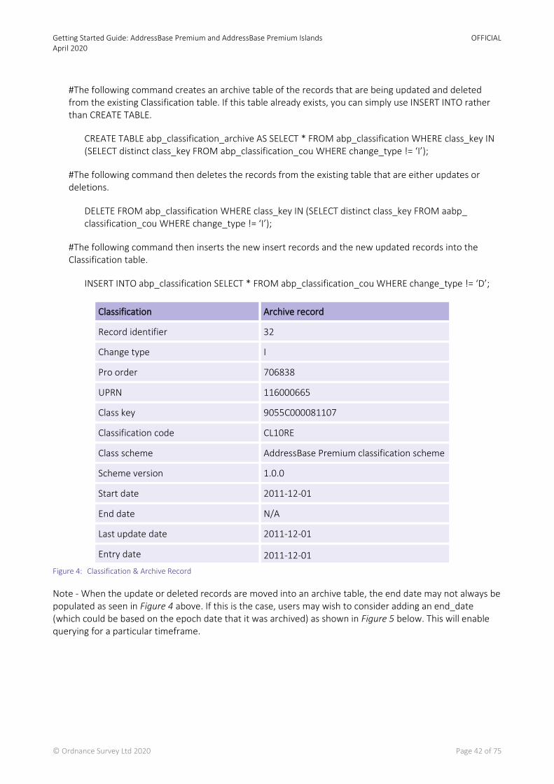
Getting Started Guide: AddressBase Premium and AddressBase Premium Islands April 2020
OFFICIAL
© Ordnance Survey Ltd 2020 Page 42 of 75
#The following command creates an archive table of the records that are being updated and deleted from the existing Classification table. If this table already exists, you can simply use INSERT INTO rather than CREATE TABLE.
CREATE TABLE abp_classification_archive AS SELECT * FROM abp_classification WHERE class_key IN (SELECT distinct class_key FROM abp_classification_cou WHERE change_type != ‘I’);
#The following command then deletes the records from the existing table that are either updates or deletions.
DELETE FROM abp_classification WHERE class_key IN (SELECT distinct class_key FROM aabp_ classification_cou WHERE change_type != ‘I’);
#The following command then inserts the new insert records and the new updated records into the Classification table.
INSERT INTO abp_classification SELECT * FROM abp_classification_cou WHERE change_type != ‘D’;
Figure 4: Classification & Archive Record
Note - When the update or deleted records are moved into an archive table, the end date may not always be populated as seen in Figure 4 above. If this is the case, users may wish to consider adding an end_date (which could be based on the epoch date that it was archived) as shown in Figure 5 below. This will enable querying for a particular timeframe.
Classification Archive record
Record identifier 32
Change type I
Pro order 706838
UPRN 116000665
Class key 9055C000081107
Classification code CL10RE
Class scheme AddressBase Premium classification scheme
Scheme version 1.0.0
Start date 2011-12-01
End date N/A
Last update date 2011-12-01
Entry date 2011-12-01
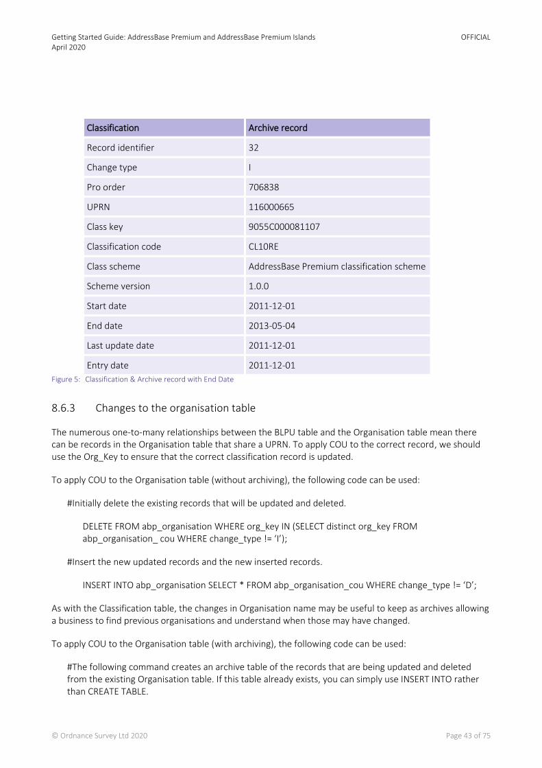
Getting Started Guide: AddressBase Premium and AddressBase Premium Islands April 2020
OFFICIAL
© Ordnance Survey Ltd 2020 Page 43 of 75
Figure 5: Classification & Archive record with End Date
8.6.3 Changes to the organisation table
The numerous one-to-many relationships between the BLPU table and the Organisation table mean there can be records in the Organisation table that share a UPRN. To apply COU to the correct record, we should use the Org_Key to ensure that the correct classification record is updated.
To apply COU to the Organisation table (without archiving), the following code can be used:
#Initially delete the existing records that will be updated and deleted.
DELETE FROM abp_organisation WHERE org_key IN (SELECT distinct org_key FROM abp_organisation_ cou WHERE change_type != ‘I’);
#Insert the new updated records and the new inserted records.
INSERT INTO abp_organisation SELECT * FROM abp_organisation_cou WHERE change_type != ‘D’;
As with the Classification table, the changes in Organisation name may be useful to keep as archives allowing a business to find previous organisations and understand when those may have changed.
To apply COU to the Organisation table (with archiving), the following code can be used:
#The following command creates an archive table of the records that are being updated and deleted from the existing Organisation table. If this table already exists, you can simply use INSERT INTO rather than CREATE TABLE.
Classification Archive record
Record identifier 32
Change type I
Pro order 706838
UPRN 116000665
Class key 9055C000081107
Classification code CL10RE
Class scheme AddressBase Premium classification scheme
Scheme version 1.0.0
Start date 2011-12-01
End date 2013-05-04
Last update date 2011-12-01
Entry date 2011-12-01
Getting Started Guide: AddressBase Premium and AddressBase Premium Islands April 2020
OFFICIAL
© Ordnance Survey Ltd 2020 Page 44 of 75
CREATE TABLE abp_organisation_archive AS SELECT * FROM abp_organisation WHERE org_key IN (SELECT distinct org_key FROM abp_organisation_cou WHERE change_type != ‘I’);
#The following command then deletes the records from the existing table that are either updates or deletions.
DELETE FROM abp_organisation WHERE org_key IN (SELECT distinct org_key FROM aabp_organisation_ cou WHERE change_type != ‘I’);
#The following command then inserts the new insert records and the new updated records into the Organisation table.
INSERT INTO abp_organisation SELECT * FROM abp_organisation_cou WHERE change_type != ‘D’;
8.6.4 Changes to the Delivery Point Address Table
Within the Delivery Point Address table there will not be any records with the same UDPRN. This can be tested by checking the number of records that have the same UDPRN. The following SQL code would notify you of any duplicates.
SELECT udprn, COUNT(udprn) AS NumOccurrences FROM abp_delivery_point GROUP BY udprn HAVING (COUNT(udprn) > 1 );
This query should return 0 rows and this confirms there are no duplicates.
As there are no duplicate records, we can therefore use the UDPRN to apply the COU.
To apply COU to the Delivery Point Address table (without archiving), the following code can be used:
#Initially delete the existing records that will be updated and deleted.
DELETE FROM abp_delivery_point WHERE udprn IN (SELECT distinct udprn FROM abp_delivery_point_cou WHERE change_type != ‘I’);
#Insert the new updated records and the new inserted records.
INSERT INTO abp_delivery_point SELECT * FROM abp_delivery_point_cou WHERE change_type != ‘D’;
The Delivery Point Address table does not have the ability to hold historical records, as it is the current view of the Royal Mail Delivery Point Address File (PAF). Therefore, in order to capture the historical records, you will need to create an archive table that is populated when records are either deleted or updated. The following code will create the archive records:
To apply COU to the Delivery Point Address table (with archiving), the following code can be used:
#The following command creates an archive table of the records that are being updated and deleted from the existing Delivery Point Address table. If this table already exists, you can simply use INSERT INTO rather than CREATE TABLE.
Getting Started Guide: AddressBase Premium and AddressBase Premium Islands April 2020
OFFICIAL
© Ordnance Survey Ltd 2020 Page 45 of 75
CREATE TABLE abp_delivery_point_archive AS SELECT * FROM abp_delivery_point WHERE udprn IN (SELECT distinct udprn FROM abp_delivery_point_cou WHERE change_type != ‘I’);
#The following command then deletes the records from the existing table that are either updates or deletions.
DELETE FROM abp_delivery_point WHERE udprn IN (SELECT distinct udprn FROM abp_delivery_point_cou WHERE change_type != ‘I’);
#The following command then inserts the new insert records and the new updated records into the Delivery Point Address table.
INSERT INTO abp_delivery_point SELECT * FROM abp_delivery_point_cou WHERE change_type != ‘D’;
8.6.5 Changes to LPI table
The numerous one-to-many relationships between the BLPU table and the LPI table mean there can be records in the LPI table that share a UPRN. To apply COU to the correct record, we should use the LPI_Key to ensure that the correct classification record is updated.
To apply COU to the LPI table (without archiving), the following code can be used:
#Initially delete the existing records that will be updated and deleted.
DELETE FROM abp_lpi WHERE lpi_key IN (SELECT distinct lpi_key FROM abp_lpi_cou WHERE change_type != ‘I’);
#Insert the new updated records and the new inserted records.
INSERT INTO abp_lpi SELECT * FROM abp_lpi_cou WHERE change_type != ‘D’;
As with the BLPU table, some of the COU records that are change type ‘U’ (updates) may change the Logical Status Code from ‘1’ to ‘8’, meaning that this address has become ‘historical’. This means that the LPI table intrinsically archives the historical record.
Where there is a business requirement to keep the records that are being updated and deleted in a separate archive table the following SQL will create an archive table and populate it with records that are being updated and deleted from the live LPI table.
To apply COU to the Street table (with archiving) the following code can be used:
#The following command creates an archive table of the records that are being updated and deleted from the existing LPI table. If this table already exists, you can simply use INSERT INTO rather than CREATE TABLE.
CREATE TABLE abp_lpi_archive AS SELECT * FROM abp_lpi WHERE lpi_key IN (SELECT distinct lpi_key FROM abp_ lpi_cou WHERE change_type != ‘I’);
#The following command then deletes the records from the existing table, which are either updates or deletions.
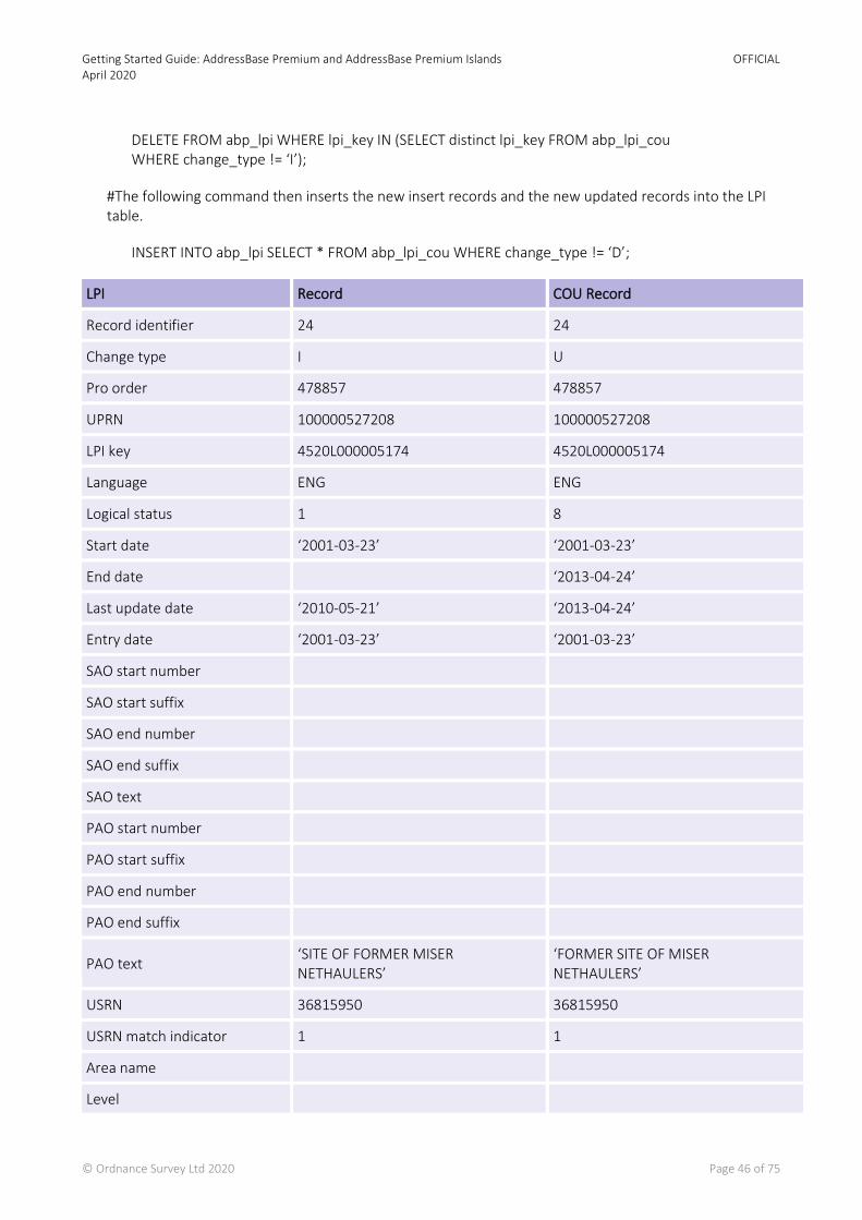
Getting Started Guide: AddressBase Premium and AddressBase Premium Islands April 2020
OFFICIAL
© Ordnance Survey Ltd 2020 Page 46 of 75
DELETE FROM abp_lpi WHERE lpi_key IN (SELECT distinct lpi_key FROM abp_lpi_cou WHERE change_type != ‘I’);
#The following command then inserts the new insert records and the new updated records into the LPI table.
INSERT INTO abp_lpi SELECT * FROM abp_lpi_cou WHERE change_type != ‘D’;
LPI Record COU Record
Record identifier 24 24
Change type I U
Pro order 478857 478857
UPRN 100000527208 100000527208
LPI key 4520L000005174 4520L000005174
Language ENG ENG
Logical status 1 8
Start date ‘2001-03-23’ ‘2001-03-23’
End date ‘2013-04-24’
Last update date ‘2010-05-21’ ‘2013-04-24’
Entry date ‘2001-03-23’ ‘2001-03-23’
SAO start number
SAO start suffix
SAO end number
SAO end suffix
SAO text
PAO start number
PAO start suffix
PAO end number
PAO end suffix
PAO text ‘SITE OF FORMER MISER NETHAULERS’
‘FORMER SITE OF MISER NETHAULERS’
USRN 36815950 36815950
USRN match indicator 1 1
Area name
Level

Getting Started Guide: AddressBase Premium and AddressBase Premium Islands April 2020
OFFICIAL
© Ordnance Survey Ltd 2020 Page 47 of 75
LPI Record COU Record
Official flag
Figure 6: Shows an original LPI record next to a COU record. In this example, the record is being made historical (logical status code: 8) and therefore has a populated end date attribute.
8.6.6 Changes to Street table
Within the Street table there will not be any records with the same USRN. This can be tested by checking the number of records that have the same USRN. The following SQL code would notify you of any duplicates.
SELECT usrn, COUNT(usrn) AS NumOccurrences FROM abp_street GROUP BY usrn HAVING ( COUNT(usrn) > 1 );
This query should return 0 rows and this confirms there are no duplicates.
As there are no duplicate records, we can, therefore, use the USRN to apply the COU.
To apply COU to the Street table (without archiving), the following code can be used:
#Initially delete the existing records that will be updated and deleted.
DELETE FROM abp_street WHERE usrn IN (SELECT distinct usrn FROM abp_street_cou WHERE change_type != ‘I’);
#Insert the new updated records and the new inserted records.
INSERT INTO abp_street SELECT * FROM abp_street_cou WHERE change_type != ‘D’;
The Street table does not have the ability to hold historical records, as it does not have a Logical Status Code attribute. Therefore, in order to capture the historical records, you will need to create an archive table that is populated when records are either deleted or updated.
To apply COU to the Street table (with archiving), the following code can be used:
#The following command creates an archive table of the records that are being updated and deleted from the existing Street table. If this table already exists, you can simply use INSERT INTO rather than CREATE TABLE.
CREATE TABLE abp_street_archive AS SELECT * FROM abp_street WHERE usrn IN (SELECT distinct usrn FROM abp_ street_cou WHERE change_type != ‘I’);
#The following command then deletes the records from the existing table that are either updates or deletions.
DELETE FROM abp_street WHERE usrn IN (SELECT distinct usrn FROM abp_street_cou WHERE change_type != ‘I’);
#The following command then inserts the new insert records and the new updated records into the Street table.
Getting Started Guide: AddressBase Premium and AddressBase Premium Islands April 2020
OFFICIAL
© Ordnance Survey Ltd 2020 Page 48 of 75
INSERT INTO abp_street SELECT * FROM abp_street_cou WHERE change_type != ‘D’;
8.6.7 Changes to Street Descriptor table
Within the Street Descriptor table, there will not be any records with the same USRN and the same language. This is called a compound key, rather than having a single column as a Primary Key. This can be tested by checking the number of records that have the same USRN. The following SQL code would notify you of any duplicates.
SELECT usrn, language, COUNT(usrn) AS NumOccurrences FROM abp_street_descriptor GROUP BY usrn, language HAVING ( COUNT(usrn) > 1 );
This query should return 0 rows and this confirms there are no duplicates using the compound key. As there are no duplicate records, we can therefore use the USRN and LANGUAGE to apply the COU.
To apply COU to the LPI table (without archiving) the following code can be used:
#Initially delete the existing records that will be updated and deleted.
DELETE FROM abp_street_descriptor WHERE EXISTS (SELECT 1 FROM abp_street_descriptor_cou WHERE abp_street_descriptor_cou.usrn = abp_street_descriptor.usrn AND abp_street_descriptor_cou.language = abp_street_descriptor.language AND abp_street_descriptor_cou.change_type != ‘I’ )
#Insert the new updated records and the new inserted records.
INSERT INTO abp_street_descriptor SELECT * FROM abp_street_descriptor_cou WHERE change_type != ‘D’;
The Street Descriptor table does not have the ability to hold historical records, as it does not have a Logical Status Code attribute. Therefore, in order to capture the historical records, you will need to create an archive table that is populated when records are either deleted or updated.
To apply COU to the Street Descriptor table (with archiving) the following code can be used:
#The following command creates an archive table of the records that are being updated and deleted from the existing Street table. If this table already exists, you can simply use INSERT INTO rather than CREATE TABLE.
CREATE TABLE abp_street_descriptor_archive AS SELECT * FROM abp_street_descriptor WHERE EXISTS (SELECT 1 FROM abp_street_descriptor_cou WHERE abp_street_descriptor_cou.usrn = abp_street_descriptor.usrn AND abp_street_descriptor_cou.language = abp_street_descriptor.language AND abp_street_descriptor_cou.change_type != ‘I’ )
#The following command then deletes the records from the existing table that are either updates or deletions.
Getting Started Guide: AddressBase Premium and AddressBase Premium Islands April 2020
OFFICIAL
© Ordnance Survey Ltd 2020 Page 49 of 75
DELETE FROM abp_street_descriptor WHERE usrn IN (SELECT distinct usrn FROM abp_street_descriptor_cou WHERE change_type != ‘I’);
#The following command then inserts the new insert records and the new updated records into the Street table.
INSERT INTO abp_street_descriptor SELECT * FROM abp_street_descriptor_cou WHERE change_type != ‘D’;
8.6.8 Changes to the Cross Reference table
Within the Cross Reference table there will not be any records with the same XREF_KEY. This can be tested by checking the number of records that have the same XREF_KEY. The following SQL code would notify you of any duplicates.
SELECT XREF_KEY, COUNT(XREF_KEY) AS NumOccurences FROM ABP_XREF GROUP BY XREF_KEY HAVING (COUNT(XREF_KEY) > 1);
The query above should return 0 rows and therefore confirm there are no duplicates.
As there are no duplicates we can therefore use the XREF_KEY to apply the COU.
To apply the COU to the Cross Reference Table (without archiving), the following code can be used:
# Initially delete the existing records that will be updated and deleted.
DELETE FROM ABP_XREF WHERE XREF_KEY IN (SELECT distinct XREF_KEY FROM ABP_XREF_COU WHERE CHANGE_TYPE != ‘I’);
# Insert the new records and the updated records.
INSERT INTO ABP_XREF SELECT * FROM ABP_XREF_COU WHERE CHANGE_TYPE != ‘D’;
The Cross Reference table does not have the ability to hold historical records, as it does not have a logical status code attribute. Therefore in order to capture the historical records, you will need to create an archive table which is populated when records are either deleted or updated.
To apply COU to the Cross Reference table (with archiving) the following code can be used:
# The following command creates an archive table of records which are being updated and deleted from the existing Cross Reference table. If this table already exists, you can simply use INSERT INTO rather than CREATE TABLE.
CREATE TABLE ABP_XREF_ARCHIVE AS SELECT * FROM ABP_REF WHERE XREF_KEY IN (SELECT DISTINCT XREF_KEY FROM ABP_XREF_COU WHERE CHANGE_TYPE != ‘I’);
# The following command then deletes the records from the existing table that are either updates or deletes.

Getting Started Guide: AddressBase Premium and AddressBase Premium Islands April 2020
OFFICIAL
© Ordnance Survey Ltd 2020 Page 50 of 75
DELETE FROM ABP_XREF WHERE XREF_KEY IN (SELECT DISTINCT XREF_KEY FROM ABP_XREF_COU WHERE CHANGE_TYPE != ‘I’);
# The following command then inserts the new insert records and the updated records.
INSERT INTO ABP_XREF SELECT * FROM ABP_XREF_COU WHERE CHANGE_TYPE != ‘D’;
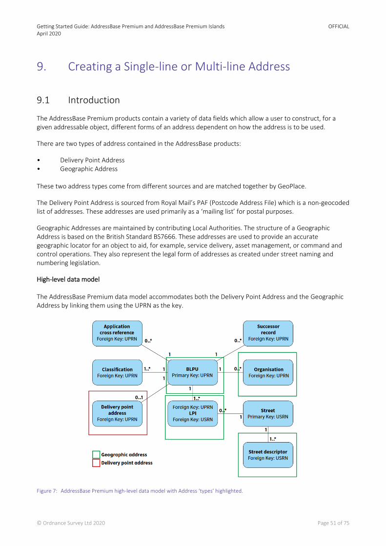
Getting Started Guide: AddressBase Premium and AddressBase Premium Islands April 2020
OFFICIAL
© Ordnance Survey Ltd 2020 Page 51 of 75
9. Creating a Single-line or Multi-line Address
9.1 Introduction
The AddressBase Premium products contain a variety of data fields which allow a user to construct, for a given addressable object, different forms of an address dependent on how the address is to be used.
There are two types of address contained in the AddressBase products:
• Delivery Point Address • Geographic Address These two address types come from different sources and are matched together by GeoPlace.
The Delivery Point Address is sourced from Royal Mail’s PAF (Postcode Address File) which is a non-geocoded list of addresses. These addresses are used primarily as a ‘mailing list’ for postal purposes.
Geographic Addresses are maintained by contributing Local Authorities. The structure of a Geographic Address is based on the British Standard BS7666. These addresses are used to provide an accurate geographic locator for an object to aid, for example, service delivery, asset management, or command and control operations. They also represent the legal form of addresses as created under street naming and numbering legislation.
High-level data model The AddressBase Premium data model accommodates both the Delivery Point Address and the Geographic Address by linking them using the UPRN as the key.
Figure 7: AddressBase Premium high-level data model with Address ‘types’ highlighted.

Getting Started Guide: AddressBase Premium and AddressBase Premium Islands April 2020
OFFICIAL
© Ordnance Survey Ltd 2020 Page 52 of 75
It is important to note the cardinality differences that the Geographic and Delivery Point Address components have with the Basic Land and Property Unit (BLPU):
• The relationship between the DPA (Delivery Point Address) and the BLPU is 0..1 – 1
This means that the DPA is an optional component, so a DPA address will only be created when it has been matched to the Geographic Address. Moreover, only 1 DPA can be matched to a BLPU.
• The relationship between the Land and Property Identifier (LPI) and the BLPU is 1..* – 1
This means that the LPI component is mandatory; therefore at least 1 LPI must exist for each BLPU. Moreover, there can be more than 1 LPI linked to a single BLPU.
Together, these differences mean that there are more Geographic Addresses in the product than there are Delivery Point Addresses, because:
a. Not every BLPU has a Delivery Point (postal) Address, only those that have been matched to the Royal Mail PAF database.
b. A single BLPU can have only one Delivery Point Address.
c. A single BLPU can have more than one Geographic Address (because alternative and historical addresses are available in AddressBase Premium).
9.2 Background
A common requirement for customers using the AddressBase products is to build a single address label from core address elements.
There are two types of address label. The simplest is a full address on a single line with different elements separated by commas and spaces. This type of label is suited for displaying a full address within a tabular display, such as within an on-screen data grid or spreadsheet, or where a single-line printed address is most appropriate (such as within the text, header or footer of a letter):
ROSE COTTAGE, 5 MAIN STREET, ADDRESSVILLE, LONDON, SE99 9EX
The other type of formatted address is a multi-line address label. These are most often used on envelopes or at the tops of letters, where different parts of an address are separated onto different lines:
ROSE COTTAGE
5 MAIN STREET
ADDRESSVILLE
LONDON
SE99 9EX
This document outlines a methodology for structuring and layering a single address label using AddressBase Premium.
Getting Started Guide: AddressBase Premium and AddressBase Premium Islands April 2020
OFFICIAL
© Ordnance Survey Ltd 2020 Page 53 of 75
The rules in this guide are suggestions only and can be used for visual display of full addresses. It is strongly recommended that address components are stored in the format in which they are provided in order to allow maximum flexibility of use and derived value.
9.3 Delivery Point Address (PAF Address)
A Delivery Point Address contains information sourced from Royal Mail (PAF). Stringent rules are used to match these addresses to the Geographic Address and assign a common UPRN to link addresses from the two addressing sources together in the data model.
To construct a single address label based purely on the Royal Mail PAF address fields, the following attributes can be used to build a Delivery Point Address label.
Delivery Point Address Component Type
DEPARTMENT_NAME Character
ORGANISATION_NAME Character
SUB_BUILDING_NAME Character
BUILDING_NAME Character
BUILDING_NUMBER Integer
PO_BOX_NUMBER Integer
DEPENDENT_THOROUGHFARE (or WELSH_DEPENDENT_THOROUGHFARE) Character
THOROUGHFARE (or WELSH_THOROUGHFARE) Character
DOUBLE_DEPENDENT_LOCALITY (or WELSH_DOUBLE_DEPENDENT_LOCALITY) Character
DEPENDENT_LOCALITY (or WELSH_DEPENDENT_LOCALITY) Character
POST_TOWN (or WELSH_POST_TOWN) Character
POSTCODE Character
Table 1 - Delivery Point Address Components
These address components are listed in the correct order in which they should appear on an address label. There may be a business need to replace the thoroughfare, locality and post_town attributes with the Welsh equivalent (listed above). The following examples will use the English version of these attributes.
It should be noted that most of the PAF fields are optional and may contain null values (or zero, in the cases of ‘BUILDING NUMBER’ and ‘PO BOX NUMBER’). In these cases, those fields should be omitted.
The following (entirely fictional) example shows all of the PAF fields filled in (apart from the PO Box number), and how they should be ordered in a single address label.
Getting Started Guide: AddressBase Premium and AddressBase Premium Islands April 2020
OFFICIAL
© Ordnance Survey Ltd 2020 Page 54 of 75
Delivery Point Address Component Example
DEPARTMENT_NAME CUSTOMER SERVICE DEPARTMENT
ORGANISATION_NAME JW SIMPSON LTD.
SUB_BUILDING_NAME UNIT 3
BUILDING_NAME THE OLD FORGE
BUILDING_NUMBER 7
PO_BOX_NUMBER
DEPENDENT_THOROUGHFARE RICHMOND TERRACE
THOROUGHFARE MAIN STREET
DOUBLE_DEPENDENT_LOCALITY HOOK
DEPENDENT_LOCALITY WARSASH
POST_TOWN SOUTHAMPTON
POSTCODE SO99 9ZZ
In cases where a PO BOX NUMBER is present, it will only be described in the data as an integer. In order to properly format these addresses when generating an address label, these integers should be prefixed with the text ‘PO BOX’, as shown in the following example:
Where null or empty string values exist (for character fields) or zeros or nulls (for integer fields), those fields should be entirely omitted from the output. However, the order in which the fields should be concatenated always remains the same.
Delivery Point Address Component Data content Formatted output
DEPARTMENT_NAME null
ORGANISATION_NAME ‘TM MOTORS’ TM MOTORS
SUB_BUILDING_NAME null
BUILDING_NAME ‘THE OLD BARN’ THE OLD BARN
BUILDING_NUMBER 0 (or null)
Delivery Point Address Component Data Content Formatted output
ORGANISATION_NAME ‘JWS CONSULTING’ JWS CONSULTING
PO_BOX_NUMBER 5422 PO BOX 5422
THOROUGHFARE ‘HIGH STREET’ HIGH STREET
POST_TOWN ‘SPRINGFIELD’ SPRINGFIELD
POSTCODE ‘SP77 0SF’ SP77 0SF
Getting Started Guide: AddressBase Premium and AddressBase Premium Islands April 2020
OFFICIAL
© Ordnance Survey Ltd 2020 Page 55 of 75
Delivery Point Address Component Data content Formatted output
PO_BOX_NUMBER 0 (or null)
DEPENDENT_THOROUGHFARE null
THOROUGHFARE ‘HORSHAM LANE’ HORSHAM LANE
DOUBLE_DEPENDENT_LOCALITY null
DEPENDENT_LOCALITY null
POST_TOWN ‘HORSHAM’ HORSHAM
POSTCODE ‘RH12 1EQ’ RH12 1EQ
9.3.1 Building a single-line Delivery Point Address
Building a single-line, formatted address for a Delivery Point is relatively straightforward. All the fields should be checked in the order shown previously in Table 1 – Delivery Point Address Components, and those that have values should be concatenated together into a single line. Generally, address components should be separated by a comma followed by a single space (‘, ’), although sometimes only a space is used between a building number and a thoroughfare name. You can use your preference.
Examples of SQL logic to create a single-line Delivery Point Address are on our GitHub repository https://github.com/OrdnanceSurvey/AddressBase/tree/master/SQL, which incorporates the following elements:
• The SQL operator for concatenating text is a double pipe (‘||’). • CASE blocks have been used to test each of the fields for null values before concatenating its contents
(along with a suitable separator – either ‘, ‘ or ‘ ‘). • The field names and table names used are illustrative and may vary between databases. • Depending on the database schema and data loading method used, it may be necessary to test some
fields for empty strings (‘’) or zero values (for integer fields) instead of, or as well as testing for NULLs. • If you are using PostGres (PostGIS) it might be beneficial to substitute the ‘IS NOT NULL’ with != ‘’. This
should improve the overall appearance of the output.
9.3.2 Building a multi-line Delivery Point Address
Splitting a Delivery Point Address into multiple lines is more complicated. There are several rules to consider in order to avoid having very short lines (for example, just a building number) or very long lines within the formatted address. A summary of these rules is as follows:
• Generally, if there is a building number, it should appear on the same line as the thoroughfare (or dependent thoroughfare). If there is no thoroughfare information, it should appear on the same line as the first locality line.
• In cases where building numbers have been placed in the building name field due to the presence of a letter suffix (for example, ‘11A’) or a number range separator (for example, ‘3-5’), these should be detected and placed on the same line as the thoroughfare in the same way as a building number (or on the first locality line, if no thoroughfare is present).

Getting Started Guide: AddressBase Premium and AddressBase Premium Islands April 2020
OFFICIAL
© Ordnance Survey Ltd 2020 Page 56 of 75
In most other cases, the building name, if present, should appear on a separate line above the thoroughfare name, or dependent thoroughfare, or locality line if no thoroughfare is present.
• Similar tests should be applied to the SUB_BUILDING_NAME field: if this field contains a number, a number with a suffix, or a numeric range, it should precede the building name on the same line. In most other cases, it should appear on a separate line above the building name.
For more information on how to build a multi-line Delivery Point Address, please consult pages 27 - 42 of the PAF Programmers Guide.
9.4 Geographic Address (Local Authority Address)
The structure of a Geographic Address is based on the British Standard BS7666 and is split into a number of components. This means that in order to construct a complete address label, for example, on an envelope, database form or GIS display, the components need to be constructed according to a set of rules.
Within the AddressBase products the core property level address information is stored within the Primary Addressable Object (PAO) and Secondary Addressable Object (SAO) fields of the LPI table. The additional attribution required to build a full address label is maintained in the BLPU (postcode_locator), ORGANISATION (organisation) and STREET_DESCRIPTOR (street_description, locality_name, town_name, administrative_area) tables.
For a full description of PAOs and SAOs, and the complete set of AddressBase fields, please refer to the relevant AddressBase Premium technical specification.
9.4.1 Constructing a single address label from the Geographic Address fields
To construct a single address label based purely on the BS7666 address fields, the following attributes should be used to build a Geographic Address label.
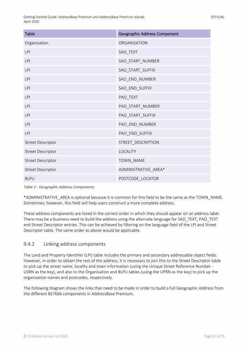
Getting Started Guide: AddressBase Premium and AddressBase Premium Islands April 2020
OFFICIAL
© Ordnance Survey Ltd 2020 Page 57 of 75
Table 2 - Geographic Address Components
*ADMINISTRATIVE_AREA is optional because it is common for this field to be the same as the TOWN_NAME. Sometimes, however, this field will help users construct a more complete address.
These address components are listed in the correct order in which they should appear on an address label. There may be a business need to build the address using the alternate language for SAO_TEXT, PAO_TEXT and Street Descriptor entries. This can be achieved by filtering on the language field of the LPI and Street Descriptor table. The same order as above would be applicable.
9.4.2 Linking address components
The Land and Property Identifier (LPI) table includes the primary and secondary addressable object fields. However, in order to obtain the rest of the address, it is necessary to join this to the Street Descriptor table to pick up the street name, locality and town information (using the Unique Street Reference Number - USRN as the key), and also to the Organisation and BLPU tables (using the UPRN as the key) to pick up the organisation names and postcodes, respectively.
The following diagram shows the links that need to be made in order to build a full Geographic Address from the different BS7666 components in AddressBase Premium.
Table Geographic Address Component
Organisation ORGANISATION
LPI SAO_TEXT
LPI SAO_START_NUMBER
LPI SAO_START_SUFFIX
LPI SAO_END_NUMBER
LPI SAO_END_SUFFIX
LPI PAO_TEXT
LPI PAO_START_NUMBER
LPI PAO_START_SUFFIX
LPI PAO_END_NUMBER
LPI PAO_END_SUFFIX
Street Descriptor STREET_DESCRIPTION
Street Descriptor LOCALITY
Street Descriptor TOWN_NAME
Street Descriptor ADMINISTRATIVE_AREA*
BLPU POSTCODE_LOCATOR
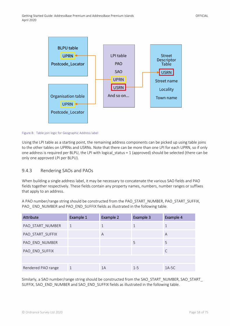
Getting Started Guide: AddressBase Premium and AddressBase Premium Islands April 2020
OFFICIAL
© Ordnance Survey Ltd 2020 Page 58 of 75
Figure 8: Table join logic for Geographic Address label
Using the LPI table as a starting point, the remaining address components can be picked up using table joins to the other tables on UPRNs and USRNs. Note that there can be more than one LPI for each UPRN, so if only one address is required per BLPU, the LPI with logical_status = 1 (approved) should be selected (there can be only one approved LPI per BLPU).
9.4.3 Rendering SAOs and PAOs
When building a single address label, it may be necessary to concatenate the various SAO fields and PAO fields together respectively. These fields contain any property names, numbers, number ranges or suffixes that apply to an address.
A PAO number/range string should be constructed from the PAO_START_NUMBER, PAO_START_SUFFIX, PAO_ END_NUMBER and PAO_END_SUFFIX fields as illustrated in the following table.
Attribute Example 1 Example 2 Example 3 Example 4
PAO_START_NUMBER 1 1 1 1
PAO_START_SUFFIX A A
PAO_END_NUMBER 5 5
PAO_END_SUFFIX C
Rendered PAO range 1 1A 1-5 1A-5C
Similarly, a SAO number/range string should be constructed from the SAO_START_NUMBER, SAO_START_ SUFFIX, SAO_END_NUMBER and SAO_END_SUFFIX fields as illustrated in the following table.

Getting Started Guide: AddressBase Premium and AddressBase Premium Islands April 2020
OFFICIAL
© Ordnance Survey Ltd 2020 Page 59 of 75
In addition to the numeric range fields described above, there are also PAO_text and SAO_text fields. These fields may be populated instead of, or as well as, the numeric range fields. In both cases, if both text and a numeric range string are present, the text should appear before the numeric range in any formatted address.
Note - For primary addressable objects (PAOs), there will always be either a text entry, or a numeric/range entry, or both. This is not the case for secondary addressable objects (SAOs), which may be entirely absent for a given address.
9.4.4 Street description, town, locality and administrative area names
The street description and administrative area names are always present, while the locality name and town name may be empty.
The ADMINISTRATIVE_AREA field always contains a value; however, this value will not always enhance an address, but in some cases it will. In particular, check that it is not the same as the value in the TOWN_NAME field, as is often the case.
Administrative area not included Vs.
Administrative area included (BURY)
34, CROW LANE, RAMSBOTTOM, BL0 9BR 34, CROW LANE, RAMSBOTTOM, BURY, BL0 9BR
In other cases, the administrative area name will simply contain the local authority name, which would not traditionally form part of a single or multi-line address but can be included to add additional information to an address label. Its inclusion is largely down to business requirements or personal preference; however, it may also be useful to “de-duplicate” some Geographic Addresses.
The following (entirely fictional) example shows all of the BS7666 Geographic Address fields filled in, and how they should be ordered in a single address label.
Geographic Address Component Example
ORGANISATION JW SIMPSON LTD
SAO_TEXT THE ANNEXE
SAO (number/range string)* 1A
PAO_TEXT THE OLD MILL
Attribute Example 1 Example 2 Example 3 Example 4
PAO (number string) 1 1A 1A
PAO (text) Rose Cottage Rose Cottage
Rendered PAO (showing street name location)
1 <street> 1A <street>
Rose Cottage, 1A
<street>
Rose Cottage,
<street>
Getting Started Guide: AddressBase Premium and AddressBase Premium Islands April 2020
OFFICIAL
© Ordnance Survey Ltd 2020 Page 60 of 75
Geographic Address Component Example
PAO (number/range string)* 7–9
STREET_DESCRIPTION MAIN STREET
LOCALITY HOOK
TOWN_NAME WARSASH
ADMINISTRATIVE_AREA SOUTHAMPTON
POSTCODE_LOCATOR SO99 9ZZ
Table 3 - Geographic Address Formatting
*The number/range strings are built from the relevant PAO/SAO start_number, start_suffix, end_number and end_suffix fields, as described above, and formatted as character strings.
Where an administrative area matches the town name, it should always be omitted.
Delivery Point Address Component Data content Formatted output
PAO_TEXT ‘HIGHBURY HOUSE’ HIGHBURY HOUSE
STREET_DESCRIPTION ‘HIGH STREET’ HIGH STREET
TOWN_NAME ‘SOUTHAMPTON’ SOUTHAMPTON
ADMINISTRATIVE_AREA ‘SOUTHAMPTON’
POSTCODE_LOCATOR ‘SO77 0SF’ SO77 0SF
Where null or empty string values exist (for character fields) or zeros or nulls (for integer fields), those fields should be entirely omitted from the output; however, the order in which the fields should be concatenated always remains the same.
Delivery Point Address Component Data content Formatted output
ORGANISATION ‘TM MOTORS’ TM MOTORS
SAO_TEXT null
SAO (number/range string)* null
PAO_TEXT ‘THE OLD BARN’ THE OLD BARN
PAO (number/range string)* ‘1’ 1
STREET_DESCRIPTION ‘HORSHAM LANE’ HORSHAM LANE
LOCALITY_NAME null
TOWN_NAME ‘HORSHAM’ HORSHAM
ADMINISTRATIVE_AREA ‘HORSHAM’ * Duplicate name omitted
POSTCODE_LOCATOR ‘RH12 1EQ’ ‘RH12 1EQ’
Getting Started Guide: AddressBase Premium and AddressBase Premium Islands April 2020
OFFICIAL
© Ordnance Survey Ltd 2020 Page 61 of 75
9.4.5 Building a single-line Geographic Address
Building a single-line, formatted address for a Geographic Address is slightly more complicated than for a Delivery Point Address due to the need to pre-format the SAO and PAO number/range strings and join tables together. However, once this is done, the process is largely the same as before: the calculated fields should be checked in the order shown previously in Table 3 – Geographic Address Formatting, and those that have values should be concatenated together into a single line. Generally, address components should be separated by a comma followed by a single space (‘, ’), although sometimes only a space is used between a PAO number/range string and a street description. This is down to personal preference.
Example SQL logic to create a single-line Geographic Address can be found on our GitHub repository https://github.com/OrdnanceSurvey/AddressBase/tree/master/SQL, which incorporates the following elements:
• The SQL operator for concatenating text is a double pipe (‘||’). • CASE blocks have been used to test each of the fields for null values before concatenating its contents
(along with a suitable separator – either ‘, ‘ or ‘ ‘). • The field names and table names used are illustrative and may vary between databases. • Depending on the database schema and data loading method used, it may be necessary to test some
fields for empty strings (‘’) or zero values (for integer fields) instead of, or as well as testing for NULLs. • If you want no duplicate UPRNs to be returned an additional DISTINCT line needs to read
DISTINCT(l.UPRN)
9.4.6 Building a multi-line Geographic Address
Splitting a Geographic Address into multiple lines is more complex. As with Delivery Point Addresses, there are several rules to consider in order to avoid having very short lines (for example, just a building number) or very long lines within the formatted address.
A summary of these rules is as follows:
• Generally, if there is a PAO number/range string, it should appear on the same line as the Street Description.
Example
11A MAIN STREET
• If there is a PAO_text value, it should always appear on the line above the Street Name (or on the line
above the <PAO number string> + <Street Name> where there is a PAO number/range).
PAO_text only PAO_text and PAO number or range
ROSE COTTAGE,
MAIN STREET
ROSE COTTAGE,
11A MAIN STREET
• If there is a SAO_text value, it should appear on a separate line above the PAO_text line (or the PAO
number/range + street line where there is no PAO_text value).
Getting Started Guide: AddressBase Premium and AddressBase Premium Islands April 2020
OFFICIAL
© Ordnance Survey Ltd 2020 Page 62 of 75
SAO_text value only, with PAO_text value only SAO_text value only, with PAO number/range only
THE ANNEXE,
ROSE COURT,
MAIN STREET
THE ANNEXE,
11A MAIN STREET
• If there is a SAO number/range value, it should be inserted either on the same line as the PAO_text (if there is a PAO_text value), or on the same line as the PAO number/range + Street Name (if there is only a PAO number/range value and no PAO_text value). If there are both PAO_text and a PAO number/range, then the SAO number/range should appear on the same line as the PAO_text, and the PAO number/range should appear on the street line.
SAO number/range value only, and PAO_text value only
SAO number/range value only, and PAO number/range value only
SAO number/range value only, and both PAO_text and PAO number/range values
1A ROSE COURT,
MAIN STREET 1-3, 11A MAIN STREET
1A ROSE COURT,
11A MAIN STREET
• If there is a SAO_text value, it should always appear on its own line.
SAO_text value only with PAO_text only SAO_text and SAO number/range and PAO_text and PAO number/range
THE ANNEXE,
ROSE COTTAGE,
MAIN STREET
WARDEN’S FLAT,
1A ROSE COURT,
11A MAIN STREET
• If there is an Organisation Name, it should always appear alone as the top line of the address.
Organisation Name along with all PAO + SAO fields
COTTAGE INDUSTRY LTD,
THE ANNEXE,
1A ROSE COURT,
11A MAIN STREET
• The Locality (if present) should appear on a separate line beneath the Street Description, followed by the
Town Name on the line below it. If there is no Locality, the Town Name should appear alone on the line beneath the Street Description.
Locality and Town Name present Town Name only
[first part of address, formatted as described above]
MAIN STREET,
HIGHFIELD,
SOUTHAMPTON
[first part of address, formatted as described above]
HIGH STREET,
SOUTHAMPTON
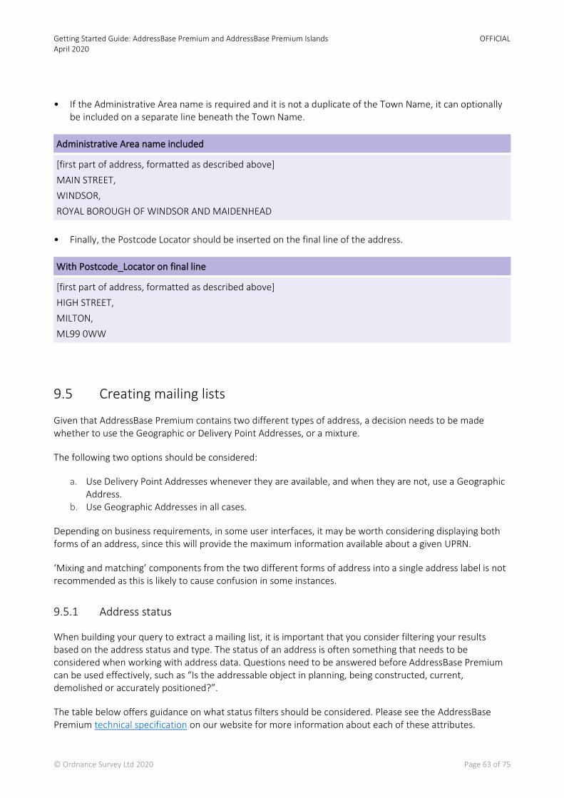
Getting Started Guide: AddressBase Premium and AddressBase Premium Islands April 2020
OFFICIAL
© Ordnance Survey Ltd 2020 Page 63 of 75
• If the Administrative Area name is required and it is not a duplicate of the Town Name, it can optionally
be included on a separate line beneath the Town Name.
Administrative Area name included
[first part of address, formatted as described above]
MAIN STREET,
WINDSOR,
ROYAL BOROUGH OF WINDSOR AND MAIDENHEAD
• Finally, the Postcode Locator should be inserted on the final line of the address.
With Postcode_Locator on final line
[first part of address, formatted as described above]
HIGH STREET,
MILTON,
ML99 0WW
9.5 Creating mailing lists
Given that AddressBase Premium contains two different types of address, a decision needs to be made whether to use the Geographic or Delivery Point Addresses, or a mixture.
The following two options should be considered:
a. Use Delivery Point Addresses whenever they are available, and when they are not, use a Geographic Address.
b. Use Geographic Addresses in all cases.
Depending on business requirements, in some user interfaces, it may be worth considering displaying both forms of an address, since this will provide the maximum information available about a given UPRN.
‘Mixing and matching’ components from the two different forms of address into a single address label is not recommended as this is likely to cause confusion in some instances.
9.5.1 Address status
When building your query to extract a mailing list, it is important that you consider filtering your results based on the address status and type. The status of an address is often something that needs to be considered when working with address data. Questions need to be answered before AddressBase Premium can be used effectively, such as “Is the addressable object in planning, being constructed, current, demolished or accurately positioned?”.
The table below offers guidance on what status filters should be considered. Please see the AddressBase Premium technical specification on our website for more information about each of these attributes.
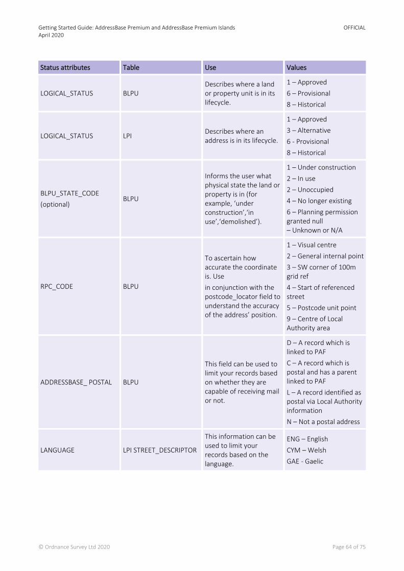
Getting Started Guide: AddressBase Premium and AddressBase Premium Islands April 2020
OFFICIAL
© Ordnance Survey Ltd 2020 Page 64 of 75
Status attributes Table Use Values
LOGICAL_STATUS BLPU Describes where a land or property unit is in its lifecycle.
1 – Approved
6 – Provisional
8 – Historical
LOGICAL_STATUS LPI Describes where an address is in its lifecycle.
1 – Approved
3 – Alternative
6 - Provisional
8 – Historical
BLPU_STATE_CODE
(optional) BLPU
Informs the user what physical state the land or property is in (for example, ‘under construction’,‘in use’,‘demolished’).
1 – Under construction
2 – In use
2 – Unoccupied
4 – No longer existing
6 – Planning permission granted null – Unknown or N/A
RPC_CODE BLPU
To ascertain how accurate the coordinate is. Use
in conjunction with the postcode_locator field to understand the accuracy of the address’ position.
1 – Visual centre
2 – General internal point
3 – SW corner of 100m grid ref
4 – Start of referenced street
5 – Postcode unit point
9 – Centre of Local Authority area
ADDRESSBASE_ POSTAL BLPU
This field can be used to limit your records based on whether they are capable of receiving mail or not.
D – A record which is linked to PAF
C – A record which is postal and has a parent linked to PAF
L – A record identified as postal via Local Authority information
N – Not a postal address
LANGUAGE LPI STREET_DESCRIPTOR
This information can be used to limit your records based on the language.
ENG – English
CYM – Welsh
GAE - Gaelic

Getting Started Guide: AddressBase Premium and AddressBase Premium Islands April 2020
OFFICIAL
© Ordnance Survey Ltd 2020 Page 65 of 75
9.5.2 Other filters
AddressBase Premium is a rich addressing dataset that contains a wealth of other attributes that could be used in conjunction with address labels. For example, classification can be used to target certain types of property; or OS MasterMap® Topography TOID cross references can be used to link address labels to Topographic objects and viewed in a GIS for Great Britain (AddressBase Premium Island does not has OS MasterMap® Topography TOID cross references).
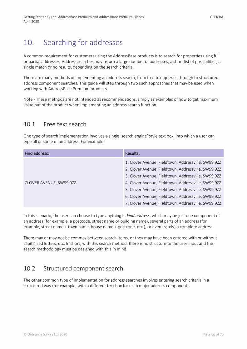
Getting Started Guide: AddressBase Premium and AddressBase Premium Islands April 2020
OFFICIAL
© Ordnance Survey Ltd 2020 Page 66 of 75
10. Searching for addresses
A common requirement for customers using the AddressBase products is to search for properties using full or partial addresses. Address searches may return a large number of addresses, a short list of possibilities, a single match or no results, depending on the search criteria.
There are many methods of implementing an address search, from free text queries through to structured address component searches. This guide will step through two such approaches that may be used when working with AddressBase Premium products.
Note - These methods are not intended as recommendations, simply as examples of how to get maximum value out of the product when implementing an address search function.
10.1 Free text search
One type of search implementation involves a single ‘search engine’ style text box, into which a user can type all or some of an address. For example:
Find address: Results:
CLOVER AVENUE, SW99 9ZZ
1, Clover Avenue, Fieldtown, Addressville, SW99 9ZZ
2, Clover Avenue, Fieldtown, Addressville, SW99 9ZZ
3, Clover Avenue, Fieldtown, Addressville, SW99 9ZZ
4, Clover Avenue, Fieldtown, Addressville, SW99 9ZZ
5, Clover Avenue, Fieldtown, Addressville, SW99 9ZZ
6, Clover Avenue, Fieldtown, Addressville, SW99 9ZZ
7, Clover Avenue, Fieldtown, Addressville, SW99 9ZZ
In this scenario, the user can choose to type anything in Find address, which may be just one component of an address (for example, a postcode, street name or building name), several parts of an address (for example, street name + town name, house name + postcode, etc.), or even (rarely) a complete address. There may or may not be commas between search items, or they may have been entered with or without capitalised letters, etc. In short, with this search method, there is no structure to the user input and the search methodology must be designed with this in mind.
10.2 Structured component search
The other common type of implementation for address searches involves entering search criteria in a structured way (for example, with a different text box for each major address component).
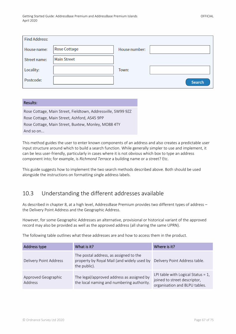
Getting Started Guide: AddressBase Premium and AddressBase Premium Islands April 2020
OFFICIAL
© Ordnance Survey Ltd 2020 Page 67 of 75
Results:
Rose Cottage, Main Street, Fieldtown, Addressville, SW99 9ZZ
Rose Cottage, Main Street, Ashford, AS45 9PP
Rose Cottage, Main Street, Buxtew, Monley, MO88 4TY
And so on...
This method guides the user to enter known components of an address and also creates a predictable user input structure around which to build a search function. While generally simpler to use and implement, it can be less user-friendly, particularly in cases where it is not obvious which box to type an address component into; for example, is Richmond Terrace a building name or a street? Etc. This guide suggests how to implement the two search methods described above. Both should be used alongside the instructions on formatting single address labels.
10.3 Understanding the different addresses available
As described in chapter 8, at a high level, AddressBase Premium provides two different types of address – the Delivery Point Address and the Geographic Address.
However, for some Geographic Addresses an alternative, provisional or historical variant of the approved record may also be provided as well as the approved address (all sharing the same UPRN).
The following table outlines what these addresses are and how to access them in the product.
Address type What is it? Where is it?
Delivery Point Address The postal address, as assigned to the property by Royal Mail (and widely used by the public).
Delivery Point Address table.
Approved Geographic Address
The legal/approved address as assigned by the local naming and numbering authority.
LPI table with Logical Status = 1, joined to street descriptor, organisation and BLPU tables.
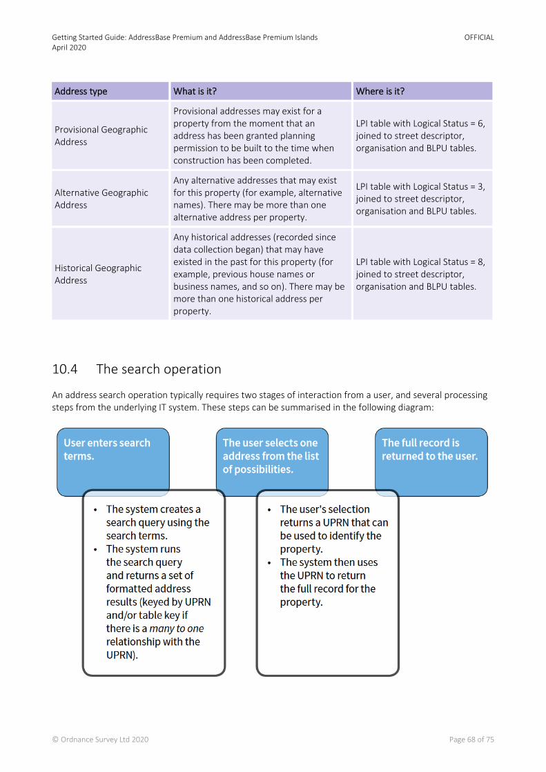
Getting Started Guide: AddressBase Premium and AddressBase Premium Islands April 2020
OFFICIAL
© Ordnance Survey Ltd 2020 Page 68 of 75
Address type What is it? Where is it?
Provisional Geographic Address
Provisional addresses may exist for a property from the moment that an address has been granted planning permission to be built to the time when construction has been completed.
LPI table with Logical Status = 6, joined to street descriptor, organisation and BLPU tables.
Alternative Geographic Address
Any alternative addresses that may exist for this property (for example, alternative names). There may be more than one alternative address per property.
LPI table with Logical Status = 3, joined to street descriptor, organisation and BLPU tables.
Historical Geographic Address
Any historical addresses (recorded since data collection began) that may have existed in the past for this property (for example, previous house names or business names, and so on). There may be more than one historical address per property.
LPI table with Logical Status = 8, joined to street descriptor, organisation and BLPU tables.
10.4 The search operation
An address search operation typically requires two stages of interaction from a user, and several processing steps from the underlying IT system. These steps can be summarised in the following diagram:
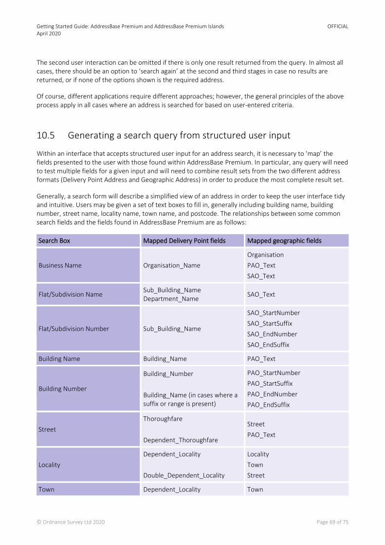
Getting Started Guide: AddressBase Premium and AddressBase Premium Islands April 2020
OFFICIAL
© Ordnance Survey Ltd 2020 Page 69 of 75
The second user interaction can be omitted if there is only one result returned from the query. In almost all cases, there should be an option to ‘search again’ at the second and third stages in case no results are returned, or if none of the options shown is the required address.
Of course, different applications require different approaches; however, the general principles of the above process apply in all cases where an address is searched for based on user-entered criteria.
10.5 Generating a search query from structured user input
Within an interface that accepts structured user input for an address search, it is necessary to ‘map’ the fields presented to the user with those found within AddressBase Premium. In particular, any query will need to test multiple fields for a given input and will need to combine result sets from the two different address formats (Delivery Point Address and Geographic Address) in order to produce the most complete result set.
Generally, a search form will describe a simplified view of an address in order to keep the user interface tidy and intuitive. Users may be given a set of text boxes to fill in, generally including building name, building number, street name, locality name, town name, and postcode. The relationships between some common search fields and the fields found in AddressBase Premium are as follows:
Search Box Mapped Delivery Point fields Mapped geographic fields
Business Name Organisation_Name
Organisation
PAO_Text
SAO_Text
Flat/Subdivision Name Sub_Building_Name Department_Name
SAO_Text
Flat/Subdivision Number Sub_Building_Name
SAO_StartNumber
SAO_StartSuffix
SAO_EndNumber
SAO_EndSuffix
Building Name Building_Name PAO_Text
Building Number
Building_Number
Building_Name (in cases where a suffix or range is present)
PAO_StartNumber
PAO_StartSuffix
PAO_EndNumber
PAO_EndSuffix
Street
Thoroughfare
Dependent_Thoroughfare
Street
PAO_Text
Locality
Dependent_Locality
Double_Dependent_Locality
Locality
Town
Street
Town Dependent_Locality Town
Getting Started Guide: AddressBase Premium and AddressBase Premium Islands April 2020
OFFICIAL
© Ordnance Survey Ltd 2020 Page 70 of 75
Search Box Mapped Delivery Point fields Mapped geographic fields
Post_Town
Locality
Postcode Postcode Postcode_Locator
The above mapping is an example only and it is possible to breakdown the search fields differently, in which case a different mapping would be required. The important thing is to consider all possibilities for how data might be recorded. For example, a business name can sometimes appear as an organisation name or a building/Primary Addressable Object (PAO) name depending on circumstances, so both must be checked when creating a search query.
Numbers need to be handled very carefully due to the presence of suffixes and ranges. There are two options for structuring the search input in these cases: a single ‘number’ box can be used (as shown above), which will then require some string manipulation to split the input into the appropriate numeric range and suffix components in order to search the Geographic Addresses; or four boxes can be provided for each number (start number, start suffix, end number, end suffix), which would then need to be combined into an appropriate string to search the Delivery Point Addresses.
10.6 Structuring the query for a structured address search
The basic rules to follow when generating a search query from structured input are as follows:
1. Ignore any search boxes that are not filled in with values. 2. Where a value is entered, assume that a match on at least one of the mapped fields is essential.
In SQL query terms, this means that each search term should generate a sub-query that searches each of the mapped fields (using OR), and that these sub-queries should then be combined together (using AND) into a single search query. The following SQL code illustrates this (for the Delivery Point Address search only) where a street, locality and town name have been entered by the user:
SELECT dp.UPRN, GetFormattedAddress(dp.*) FROM abp_delivery_point dp
WHERE (dp.thoroughfare = streetsearchtext OR dp.dependent_thoroughfare = streetsearchtext) AND (dp.dependent_locality = localitysearchtext OR dp.double_dependent_locality = localitysearchtext) AND (dp.dependent_locality = townsearchtext OR dp.post_town = townsearchtext)
In the above example, ‘streetsearchtext’, ‘localitysearchtext’, and ‘townsearchtext’ (shown in blue) represent user-entered search terms (which could be parameters within an SQL function) and the GetFormattedAddress(*) function is a hypothetical user-defined function that returns the formatted address as a single string (suitable for display in the user interface). For more information on formatting addresses, please see Chapter 9 of this guide.
On top of this, for a complete query the two different types of addresses should be queried separately (Geographic and Delivery Point Addresses), and the two result sets should be amalgamated into a single set using a UNION. The following example builds upon the previous example to include Geographic Addresses as well as Delivery Point Addresses:

Getting Started Guide: AddressBase Premium and AddressBase Premium Islands April 2020
OFFICIAL
© Ordnance Survey Ltd 2020 Page 71 of 75
SELECT dp.UPRN, GetFormattedAddress(dp.*) FROM abp_delivery_point dp
WHERE (dp.thoroughfare = streetsearchtext OR dp.dependent_thoroughfare = streetsearchtext) AND (dp.dependent_locality = localitysearchtext OR dp.double_dependent_locality = localitysearchtext) AND (dp.dependent_locality = townsearchtext OR dp.post_town = townsearchtext)
UNION
SELECT b.uprn, GetFormattedAddress(b.*, l.*, s.*, o.*) FROM abp.blpu b INNER JOIN abp.lpi l ON l.uprn = b.uprn
INNER JOIN abp.street_descriptor s ON s.usrn = b.usrn LEFT JOIN abp.organisation o ON o.uprn = b.uprn WHERE
(s.street_name = streetsearchtext OR l.pao_text = streetsearchtext) AND
(s.locality = localitysearchtext OR s.town = localitysearchtext OR s.street_name = localitysearchtext) AND (s.town = townsearchtext OR s.locality = townsearchtext)
The geographic query requires four joins between the BLPU, LPI, Street_Descriptor and Organisation tables in order to access all the fields required to build an address.
The SQL UNION operator will combine the two result sets, discarding any exact duplicates (retaining the exact duplicates requires the use of UNION ALL, but that is not desirable in this example).
The resulting output from this query will be a set of search results: formatted addresses along with their UPRN. Exact duplicates will be omitted, but all ‘variations’ of the same address will be outputted (one row for each variation, with the same UPRN repeated more than once potentially). It may be wise to also return the ‘logical status’ and/or ‘postal address flag’ values against each to enable further filtering (that is, to include or exclude historical addresses, for example or to restrict the results to postal addresses only).
10.7 Supporting case-insensitive queries and partial matches
A flaw in the above examples is the use of equality operators. In practice, because people do not tend to be consistent with capitalisation of letters, the SQL ‘LIKE’ operator might work better, and depending on the nature of the application, a ‘%’ wildcard could be appended to the end of each search term to allow only the first few letters of an address component to be entered. For example:
dp.post_town LIKE townsearchtext
dp.post_town LIKE (townsearchtext || ‘%’)
dp.post_town LIKE (‘%’ || townsearchtext || ‘%’)
-- Case insensitive search in some databases
-- Matches post towns that start with the search text
-- Matches post towns that contain the search text
Alternatively, if exact matches are required but case sensitivity is not, then the UPPER() or LOWER() SQL functions can be used on each side of the equals sign in comparisons (a solution that should work in all databases):
UPPER(dp.post_town) = UPPER(townsearchtext) -- Case insensitive equality

Getting Started Guide: AddressBase Premium and AddressBase Premium Islands April 2020
OFFICIAL
© Ordnance Survey Ltd 2020 Page 72 of 75
Finally, to combine all of the approaches, the following would work for maximum flexibility:
UPPER(dp.post_town) LIKE (‘%’ || UPPER(townsearchtext) || ‘%’)
10.8 Generating a search query from unstructured user input
When offering a ‘search engine’ style search feature with just a single text box to enter search terms, a wholly different approach is required. No assumptions can be made about the order, format or style of the user input, and the data will need to be ‘indexed’ in a way that facilitates searches of this type.
10.9 Creating a Search Index for addresses
Search engine style searches are likely to require the creation of an additional index/lookup table for addresses. Such a table is likely to consist of just two main columns: a key value (UPRN) and a formatted address string. Additional columns may be required to allow filtering of results (such as the ‘logical status’ values, which would allow the results to be filtered on ‘approved’, ‘provisional’ and ‘historical’ statuses, for example).
The following table shows a possible Address Index table structure:
UPRN Address Text Statuses (multiple fields)
123456789012 4 THE MEADOWS HIGH STREET WALTHAMSDALE BURRIDGE BU27 9UB Approved
123456789012 FLAT 4 THE MEADOWS HIGH STREET WALTHAMSDALE BURRIDGE BU27 9UB
Alternative + PAF
123456789012 4 HIGH STREET WALTHAMSDALE CLOSE BURRIDGE BU27 9UB Historical
947364758903 ROSE COTTAGE MAIN STREET HAVERSHAM SUDBURY SU45 9TY Approved + PAF
947364758903 ROSE FARMHOUSE MAIN STREET HAVERSHAM SUDBURY Historical
Note how the addresses have been formatted as a single text string with a single space between each word (although leaving commas in would do no harm). All forms of each address (both PAF and geographic, current and historical, approved and alternative) have been added to the index, so there can be several rows with the same UPRN. To speed up complex searching, an appropriate index could be added to the Address Text field, such as a full text search index.
10.10 Structuring the query for an unstructured address search
Once a suitable search index is in place, the query itself can be put together. The basic idea is to split the user input into search terms by removing commas, double spaces, and other unnecessary whitespace and then splitting it at each single space, as follows:

Getting Started Guide: AddressBase Premium and AddressBase Premium Islands April 2020
OFFICIAL
© Ordnance Survey Ltd 2020 Page 73 of 75
User input: 4, High Street, westville, wv17
Capitalised, with commas and double-spaces removed:
4 HIGH STREET WESTVILLE WV17
Split into separate search terms:
• 4 • HIGH • STREET • WESTVILLE • WV17
Once the user input has been pre-processed into separate search terms, a query can be generated. The key assumption in this example will be that ALL search terms must be matched against the index table to be considered as a result. This implies a query where each value is matched using an ‘AND’ operator. In order to search the whole index, the ‘LIKE’ operator will need to be used along with a ‘%’ wildcard on either side of the search text. A suitable search query for the above example would be as follows:
SELECT UPRN, AddressText FROM AddressSearchIndex
WHERE
AddressText LIKE ‘%4%’ AND
AddressText LIKE ‘%HIGH%’ AND
AddressText LIKE ‘%STREET%’ AND
AddressText LIKE ‘%WESTVILLE%’ AND
AddressText LIKE ‘%WV17%’;
This query would return all rows from the index table that contain all of the search terms, along with the appropriate UPRNs. The following table shows how the index table would be used in the above example to return relevant results:
UPRN Address text Statuses (multiple fields)
894756389092 4 HIGH STREET WESTVILLE SUNNYTOWN WV17 7HL Approved + PAF
894756389092 ROSE COTTAGE 4 HIGH STREET WESTVILLE SUNNYTOWN WV17 7HL Alternative
894756389092 ROSE COTTAGE HIGH STREET WESTVILLE SUNNYTOWN WV17 7HL Alternative
274859037849 FLAT 4 HIGHBURY COURT HIGH STREET WESTVILLE SUNNYTOWN WV17 7HL
Approved + PAF
482974769830 MAPS4U LTD HIGH STREET WESTVILLE SUNNYTOWN WV17 7HL Approved
This result set can then be presented to the user, who can select the most appropriate record, which can then be retrieved in full using the UPRN. Of course, in a practical implementation, the above query would need to be dynamically generated, with a separate condition added for each search term. This example is quite a strict search query that requires all

Getting Started Guide: AddressBase Premium and AddressBase Premium Islands April 2020
OFFICIAL
© Ordnance Survey Ltd 2020 Page 74 of 75
search terms to be present. Many layers of complexity could be added to allow partial and ‘fuzzy’ matches, and to return confidence scores, for example, but such enhancements are beyond the scope of this guide.
10.11 Summary
This guide was intended as an introduction to implementing address search functionality using AddressBase Premium products. The following is a summary of the main points:
• A user front-end for an address search may contain a single, search-engine style text box, or multiple text boxes representing different parts of an address.
• A typical address search function takes place in three stages: 1) a user enters search text; 2) a query is run, returning a set of possible matches; and 3) the user selects the address of interest and the full record is then returned.
• With a structured search interface, the addresses can be queried directly by mapping the various address fields to the text boxes supplied.
• For an unstructured (single text box) interface, it is necessary to create an index table with fully formatted address strings against each UPRN. Queries can then be run against this index table by splitting the user input into individual search terms and requiring them all to be present.
• It is possible to filter results by status, for example ‘approved’, ‘alternative’ and ‘historical’, as well as ‘postal’ or ‘non- postal’, etc.
• Any search function should search all forms of an address (both Geographic and Delivery Point Addresses).
• Careful consideration should be given to the use of ‘fuzzy’ search algorithms (such as using wildcard or sound-alike searches).

Getting Started Guide: AddressBase Premium and AddressBase Premium Islands April 2020
OFFICIAL
© Ordnance Survey Ltd 2020 Page 75 of 75
Appendix 1 – Support links
Filename Link
AddressBase Premium technical support documents
https://www.ordnancesurvey.co.uk/business-government/tools-support/addressbase-premium-support
AddressBase Premium Islands technical support documents
https://www.ordnancesurvey.co.uk/business-government/tools-support/addressbase-islands-support

Ordnance Survey Limited Explorer House, Adanac Drive, Nursling, Southampton SO16 0AS +44 (0)3456 050505 (General enquiries) +44 (0)2380 056146 (Textphone)
[email protected] www.os.uk