geotechnical analysis to identify potentially hazardous …
TRANSCRIPT
Final Report
Prepared By: Mike Turley, UBC Sustainability Scholar, 2021
Prepared For: Daniel Martin, Manager of Planning & Development, Bowen Island Municipality
August 2021
GEOTECHNICAL ANALYSIS
TO IDENTIFY POTENTIALLY
HAZARDOUS AREAS FOR
DEVELOPMENT ON
BOWEN ISLAND

1
Disclaimer
This report was produced as part of the UBC Sustainability Scholars Program, a partnership between the
University of British Columbia and various local governments and organisations in support of providing
graduate students with opportunities to do applied research on projects that advance sustainability
across the region.
This project was conducted under the mentorship of Bowen Island Municipality staff. The opinions and
recommendations in this report and any errors are those of the author and do not necessarily reflect the
views of Bowen Island Municipality or the University of British Columbia.
Caution
The author of this report is an Earth Sciences Ph.D. student at the University of British Columbia, and not
a qualified professional (e.g., not a licensed and practicing member of the Association of Professional
Engineers and Geoscientists of British Columbia). The material in this report reflects the judgement of
the author in light of his training and the information available at the time of the report preparation.
Any use of the information in this report is the responsibility of the user and should be verified with a
qualified professional. Neither UBC nor the author accept responsibility for damages or consequences as
a result of decisions or actions taken based on this report.
Acknowledgements
The author acknowledges that the work for this project took place on the unceded ancestral lands of the
Skwxwú7mesh (Squamish) Nation. The original Squamish name for Bowen Island is Xwlíl’xhwm, meaning
“Fast Drumming Ground”. The Squamish People sustainably inhabited Bowen Island for centuries before
the arrival of Europeans.

2
Contents
PURPOSE ...........................................................................................................................................3
1 CONDITIONS ON BOWEN ISLAND .....................................................................................................3
1.1 POTENTIAL HAZARDS .................................................................................................................................... 3
2 HAZARDOUS AREAS DEVELOPMENT PERMIT AREA ...........................................................................4
2.1 EXECUTIVE SUMMARY .................................................................................................................................. 4
2.2 BEST PRACTICES .......................................................................................................................................... 5
2.3 BOWEN ISLAND ANALYSES........................................................................................................................... 12
2.4 DRAFT HAZARDOUS AREAS DEVELOPMENT PERMIT AREA ................................................................................ 19
2.5 REFERENCES.............................................................................................................................................. 21
3 SITE ALTERATION BYLAWS ............................................................................................................. 23
3.1 EXECUTIVE SUMMARY ................................................................................................................................ 23
3.2 BEST PRACTICES ........................................................................................................................................ 23
3.3 DRAFT SITE ALTERATION BYLAW .................................................................................................................. 26
3.4 REFERENCES.............................................................................................................................................. 27
4 RECOMMENDATIONS FOR THE MUNICIPALITY ON FUTURE DATA-GATHERING OR POLICIES ............ 28
APPENDICES .................................................................................................................................... 29
APPENDIX 1 – SUGGESTED DRAFT OF A BLASTING BYLAW (LOEB, 2012) .................................................................. 29
APPENDIX 2 – BLASTING BYLAW: EDUCATION PLAN / INFORMATIVE PAMPHLET (LOEB, 2012) .................................... 34
List of Figures
Figure 1: Proposed Hazardous Areas Development Permit Area Map……………………………………………………15 Figure 2: Modelled and field-verified hazards on Mount Gardner, Bowen Island…………………………………..17 Figure 3: Bluff Creek slide and the modelled shallow landslide susceptibility………………..………………………18
List of Tables
Table 1: Example hazard to people classification……………………………………………………………………………………..7 Table 2: Selected BC flood mapping guidelines………………………………………………………………………………………..7 Table 3: Selected terrain attributes relevant to terrain stability mapping………………………………………………..9 Table 4: Common Slope Classes used in terrain stability assessments……………………………………………………10 Table 5: Indicators of past or potential slope instability…………………………………………………………………………11 Table 6: Variables, their descriptions and assumed values used in equations 1-3………………………………….13 Table 7: Relative landslide susceptibility classes…………………………………………………………………………………….14 Table 8: Suggested stream health thresholds…………………………………………………………………………………………24

3
Purpose This report was prepared for the Bowen Island Municipality (BIM) and is meant to support the creation
of two new bylaws, (i) a Hazardous Areas Development Permit Area, and (ii) a Site Alteration Bylaw.
There are four main components to this report. First, the conditions on Bowen Island relevant to hazard
analyses are noted. Second, hazardous areas DPA best practices are summarized. Analysis methods are
then selected and applied based on the best practices research that are most relevant to the local
conditions identified on Bowen Island. A Hazardous Areas DPA map is presented for review by the BIM
Council. Third, best practices for site alteration bylaws are summarized. Fourth, recommendations for
the municipality on future data gathering or policies are presented.
1 Conditions on Bowen Island Bowen Island is a 50 km2 forested, mountainous island located within Howe Sound, British Columbia.
The island is home to nearly 4000 residents, old growth forests, and fragile ecosystems. Bowen Island is
composed of sedimentary rocks (i.e., argillite, greywacke, conglomerate turbidites) of the Bowen Island
Group, and igneous rocks such as quartz diorite. In most locations, the bedrock is overlain by a
discontinuous thin veneer of soil, with exposed bedrock at higher elevations and on steeper slopes.
Within the lower lying valleys, well data suggests the soil may reach up to 300 metres thick. The island
rises from sea level to a maximum elevation of ~725 metres (Mount Gardner). The mean slope gradient
of the island is ~20°, with local values encompassing the full range of possible values (0-90°).
Bowen Island is within the Coastal Western Hemlock biogeoclimatic zone and receives approximately
1840 mm of precipitation each year. November through January are the wettest months, while July
through September are the driest months. Precipitation data collected at the Bowen Bay weather
station on Bowen Island over the years 1967-1978 and 1992-2014 record a maximum daily precipitation
of *80 mm (*12 years of the 35-year record is incomplete). Precipitation and groundwater maintain
numerous wetlands, lakes, and ponds found within local depressions. Small mountain streams
redistribute water on the island and ultimately flow into the ocean. Many streams are intermittent, only
occupied by flowing water during the wet season. However, none of the streams are gauged, and so
little information is available regarding streamflow. The channel gradients range from 0.5° to just over
30°.
1.1 Potential Hazards Bowen Island’s geographic location, geology, topography, and climate create conditions that may lead to
natural hazards such as flooding of lakes/wetlands, debris flows, stream erosion and flooding, shallow
landslides, and coastal erosion and flooding.
1.1.1 Flooding of Lakes/Wetlands The saturation/water level of Bowen Island’s many wetlands and lakes may rise or fall over time in
response to climate fluctuations and, to a lesser degree, individual storm events. This may lead to
inundation of adjacent low-lying areas and flooding hazards.

4
1.1.2 Stream Erosion and Flooding Debris flows/floods, have the potential to be more hazardous than even the largest clear water floods.
However, clear water floods and bank erosion can still damage nearby infrastructure. Creeks such as
Terminal, Guild, Grafton, and others have steep banks making them more susceptible to bank collapse.
1.1.3 Landslides: Shallow Landslides, Debris Flows, Rockfall Steep soil mantled slopes are the most susceptible to shallow landslides, while rocky cliffs are prone to
rockfall. Shallow landslides that enter steep creeks may mobilize into debris flows (another type of
landslide) and travel great distances. Debris flows/floods are most likely to occur in channels with a
slope of 15° or greater but may travel on slopes as low as 5°. Approximately 1/3rd of the mapped
streams meets these criteria.
Historic landslide runout deposits are visible in bathymetric data to the west of Mount Gardner (Jackson
et al., 2008). These runout deposits originated as either small rockslides or debris flows on the west face
of Mount Gardner, which then travelled to the sea. The date(s) of these events is unclear. They are
thought to have occurred within the last few thousand years, but not within the last century. In a hazard
evaluation on Mount Gardner, van Zeyl (2009) describe the west face of Mount Gardner as a “sagging
mountainside”. In this area, the structure and stratigraphy of the Bowen Island Group Bedrock, and
erosion at the toe of the slope has resulted in (slow) shallow and deep-seated deformation, evidenced
by counterscarps. Historic rockfall and debris flow levees were also noted in this study and will be
discussed further in section 2.3.4. However, van Zeyl (2009) and Jackson et al. (2014) suggest that the
slope does not appear to be actively deforming and found no recent rockfall deposits. A much smaller
landslide occurred in 2017 affecting part of Bluff Creek. This event will also be discussed later in section
2.3.4.
An analysis of air photos for the period 1947-present and recent high-resolution LiDAR also suggests a
recent period of inactivity/relative stability. However, it is not always possible to identify relatively
small/slow events from these data, and they may still occur in the future. Shallow landslide occurrence
is likely limited by soil thickness, or more specifically a lack of soils, on the steeper and higher elevation
slopes.
1.1.4 Coastal Erosion and Flooding Bowen Island’s coastline is primarily bedrock that rises steeply out of the ocean, making it less
susceptible to bluff erosion and sea level rise. However, after accounting for 1-metre of sea level rise by
the year 2100, storms and wave runup could result in flooding of low-lying areas, such as parts of Snug
Cove.
2 Hazardous Areas Development Permit Area
2.1 Executive Summary This report is meant to inform and support the creation of a Hazardous Areas Development Permit Area
for the Bowen Island Municipality. The following section provides an overview of the best practices in
creating a Hazardous Areas Development Permit Area, a summary of the analyses conducted, and the
proposed map. Bowen Island’s densely forested, mountainous terrain and wet, coastal climate create
conditions that may lead to natural hazards such as shallow landsliding, rockfall, debris flows, flooding of

5
lakes and wetlands, stream erosion and flooding, and coastal erosion and flooding. EGBC professional
reports provide the most up-to-date guidelines for hazard mapping in British Columbia. Given the
current conditions on Bowen Island, it is suggested that four different hazard types be mapped
separately given their different controlling mechanisms.
(i) Lakes and Wetlands may be prone to flooding hazards, and a minimum setback distance of
7.5 metres is suggested.
(ii) Small Streams may be prone to bank erosion, flooding, and debris flows (where sufficiently
steep). A minimum setback of 15 metres is suggested.
(iii) Steep Slopes may be prone to landsliding, and a high and moderate category is proposed
based on a coupled slope stability and runout model. Slopes that may become unstable with
80 mm or less of rainfall are categorized as high hazard. Slopes requiring between 80 and
150 mm of rainfall to become unstable are categorized as moderate hazard. The categories
are based on the maximum daily recorded rainfall on Bowen Island. However, model results
should be interpreted as relative first-order estimates, rather than absolute values.
(iv) Coastal erosion and flooding may occur particularly as a result of sea level rise, and it is
suggested that a flood construction reference plane 5.0 metres above the modern-day sea
level plus a setback of 15 metres be adopted.
2.2 Best Practices
2.2.1 Definitions Acceptable Risk: “Acceptable risk is a risk for which, for the purposes of life or work, stakeholders are
prepared to accept ‘as is’, and for which no risk control is needed.”
Consequence: “The effect on human well-being, property, the environment, or other things of value; or
a combination of these. Conceptually, consequence is the change, loss or damage to the elements
caused by the landslide.”
Flood Construction Levels (FCLs): An elevation above the natural boundary. The FCL is generally the
observed or calculated water surface elevation for a flood having a 200-year recurrence interval, unless
already established otherwise.
Setback: “A measured distance from the natural boundary within which development and site alteration
should not occur”.
Hazard: “A source of potential harm, or a situation with a potential for causing harm, in terms of human
injury; damage to property, the environment, and other things of value; or some combination of these.”
Landslide: “A movement of a mass of rock, debris, or earth down a slope.”
Qualified Professional: “A professional engineer, professional geoscientist, or licensee with the
appropriate level of education, training, and experience to conduct hazard assessments, and licensed by
Engineers and Geoscientists BC”.
Risk: “The chance of injury or loss as defined as a measure of the probability and the consequence of an
adverse effect to health, property, the environment, or other things of value.”

6
2.2.2 BC Guidelines and Regulations Within British Columbia, guidelines for terrain stability assessments (TSA; e.g., Landslide) and floodplain
mapping have been published as a collaboration between government and private organizations to
address some of the most significant hazards within the province. These guidelines can be incorporated
into certain stages of the planning process such as, official community plans (OCPs), bylaws and
development permits, and the subdivision approval process (Ministry of Water, Land and Air Protection
[MWLAP], 2004). Regulating land development to keep people out of harm’s way is the most practical
and cost-effective strategy for avoiding and/or mitigating risk to humans and infrastructure (MWLAP,
2004).
Engineers and Geoscientists British Columbia (EGBC) is the business name for the Association of Professional Engineers and Geoscientists of British Columbia (APEGBC) and is the regulating and governing authority of these professions under the Professional Governance Act. EGBC provides the state-of-practice guidance for hazard assessments in British Columbia.
The BC Local Government Act requires local governments to consider provincial management and planning guidelines including those relating to natural hazards. The provincial guidelines are meant as minimum requirements in the absence of site-specific information and studies and may be increased by the decision maker (MWLAP, 2004). To date, there is no provincial legislation that pertains to landslides or other hazards when designating a Development Permit Area or preparing a bylaw (APEGBC, 2010a). However, although not required, the guidelines for legislated landslide and flooding assessments (APEGBC, 2010a; EGBC, 2018), and other provincial guidelines (e.g., APEGBC, 2008; APEGBC, 2010b) are still relevant. Hazard assessments and mapping must be compared to a defined acceptable level of risk (ideally adopted by the approving jurisdiction) to be complete (APEGBC, 2010a). However, there is not an agreed upon standard definition for what constitutes an acceptable level of risk at the federal or provincial level (Ministry of Forests, Lands and Natural Resource Operations [MFLNRO], 2013), and few jurisdictions have addressed this issue.
The provincial best practices guidelines and corresponding guidelines for qualified professionals relevant
to Bowen Island are summarized in the following sections.
Flood Hazard Area mapping The goal of flood hazard area mapping is to “reduce or prevent injury, human trauma and loss of life,
and to minimize property damage during flooding events.” (MWLAP, 2004). Many different types of
flooding may occur (e.g., meteorological, seasonal, etc.), and may affect streams, lakes or ponds,
wetlands, or coastlines.
Small Streams
In BC, standard flood assessments for rivers are typically based on the 200-year flood determined by a
flood frequency analysis (EGBC, 2018). APEGBC (2017) provides an example classification used for flood
hazard mapping where the hazard rating (HR) is the product of the depth of flooding (d; in metres) and
the velocity of the floodwaters (v; in m/s) with an optional debris factor (DF; ranging from 0-1) as seen
below.
𝐻𝑅 = 𝑑 ∗ (𝑣 + 0.5) + 𝐷𝐹
The general hazard rating can then be subjectively related to the hazard it poses to people based on
Table 1 below.

7
Table 1: Example hazard to people classification taken from APEGBC (2017; table 1).
Hazard Rating (HR) Hazard to People Classification
< 0.75 Very Low Hazard (Caution)
0.75 – 1.25 Danger for Some (includes children, the elderly, and the infirm
1.25 – 2.00 Danger for Most (includes the general public)
> 2.00 Danger for All (includes emergency services)
This hazard rating method was implemented by Kerr Wood Leidal (KWL) in 2017 to create an integrated
flood hazard management plan for the District of Squamish, BC.
However, smaller streams, such as those on Bowen Island, are rarely gauged making detailed
assessments impossible. As a result, the most common method used for regulatory purposes (i.e.,
Development Permit Areas) is where inundation mapping is incremented by a freeboard allowance
(generally ranging between 0.3 and 1.0 m) to establish Flood Construction Levels (FCLs; APEGBC, 2017).
In the absence of inundation mapping, an assessed height above the natural boundary of the waterway
or above the natural ground elevation may be used (MWLAP, 2004). Table 2 below summarizes BC
mapping guidelines for floods and related hazards that are relevant to Bowen Island.
Table 2: Selected BC flood mapping guidelines from MWLAP (2004, 2018) relevant to Bowen Island.
Feature Setback Flood Control Level (FCL)
Small Lakes, Ponds, Swamps & Marsh Areas
7.5m from boundary 1.5m above boundary
Bluffs 3 x bluff height NA
Small Streams 15m from boundary 1.5m above boundary
Coastlines 15m from FCRP - flood construction reference plane, (2100 natural boundary) FCRP = FCL - Freeboard
Combination of:
• Global Sea Level Rise (SLR) Allowance (1.0 m for the year 2100)
• Regional Adjustment
• High Tide
• Surge Allowance
• Wave Effect Allowance
• Freeboard (0.6 m) Local Examples:
• East Vancouver Island – 5.0 m
• Squamish River Delta – 5.6 m
• Vancouver Harbour – 5.6 m

8
Coastal Flooding and Erosion
In a report for the city of Vancouver in 2011, Ausenco Sandwell estimated future sea level rise (SLR), and
appropriate FCLs and setbacks for locations in Coastal Southwest British Columbia. Examples of FCLs for
specific locations around Bowen Island are noted in Table 2. Coastline development should be restricted
to the greater of the setback distance from the flood construction reference plane (FCRP) or the FCL for
the year 2100. While the construction of FCRPs and FCLs is a site-specific process, neighboring examples
may provide a first order estimate for Bowen Island while illustrating best practices in the region.
Debris Flows
Debris flows are, by definition, a landslide process but occur in stream channels and so are often
discussed within flood hazard mapping reports. According to APEGBC (2018), “debris flows are most
often triggered by shallow (<1m thickness) debris avalanches on hillslopes that run into channels (> 15°
average channel slope) and lead to fluidization of the channel debris”. A common criterion for initial
identification of drainage basins in British Columbia that may be subject to debris flows is,
𝑀𝑒𝑙𝑡𝑜𝑛 𝑅𝑎𝑡𝑖𝑜 = 𝑅𝑑
√𝐴𝑑
where Rd is the drainage basin relief and Ad is the drainage basin area (Wilford et al., 2004). When
applying this metric, commonly referred to as the Melton Ratio, basins with values: < 0.3 are said to be
flood prone, 0.3 – 0.6 are debris flood prone, and > 0.6 are debris flow prone. While this metric has
proven to be a useful first approach, it should not replace detailed site-specific studies whenever
possible. Bovis and Jakob (1999) found that sediment supply conditions are also fundamental in
predicting debris flow activity. Without sufficient sediment available for mobilization, debris flows likely
will not occur. For additional flood mapping resources, NRCan (2018) provides an overview of the
federal flood mapping guidelines series and a comprehensive list of the materials referenced while
compiling the series.
Landslide and Terrain Stability Mapping Landslides happen every year in BC. They may be caused by heavy rain, human activity, or earthquakes;
and move at speeds that range from being imperceptible to the human eye to greater than 100 km/h. As
development and site alteration activities expand onto steep slopes, landslides become a greater hazard
for both people and infrastructure.
Terrain Attributes
Landslides are complex phenomena that are controlled by many factors. In 1996 the Resources
Inventory Committee of the Government of British Columbia (RIC BC) identified 59 terrain attributes as
influencing landslide occurrence. Ideally, landslide hazard maps should consider all influencing variables.
However, this would result in overly complex maps and methods, and so relatively few variables that
address site-specific conditions may be chosen. Table 3 presents a list of commonly measured terrain
attributes relevant to terrain stability mapping. Data for many of these attributes either does not exist
for Bowen Island, or the quality/resolution is too low to be used in detailed terrain assessments.

9
Table 3: Selected terrain attributes relevant to terrain stability mapping, taken from RIC BC (1996) table 5.3.
Terrain Attribute Examples (not exhaustive) Slope Morphology
Gradient Typical, average or range
Curvature Convex, concave, planar
Elevation Typical, range
Aspect Quadrant with respect to north
Length Slope length with similar features
Surficial Material
Origin Glaciofluvial, fluvial, colluvial, etc.
Texture Gravel, sand, silt, clay, till, etc.
Drainage Rapid, well, moderate, poor
Thickness Typical, average or range
Geomorphic Expression Fan, apron, cone, landslide
Geomorphic Process Gullying, erosion, failing, etc.
Engineering Properties of Soil Strength, consistency, etc.
Bedrock
Geological Classification Granodiorite, mudstone, etc.
Weathering Fresh, slightly weathered, etc.
Structural Features Bedding, faults, folds, other discontinuities
Structural Attitudes Strike, dip, dip direction
Engineering Properties of Rock Mass Strength, fracture roughness, RQD
Water
Stream Order and Status First, second, third… ; permanent vs ephemeral
Channel Gradient Typical, average or range
Channel Processes Flood, debris flood, debris flow, etc.
Channel Width Typical, average or range
Channel Bed Material Inorganic vs wood debris; typical sizes
Precipitation Annual, monthly, extreme daily
Vegetation
Forest Type Hemlock, cedar, alder, etc.
Stand Age <10 years, 10-30 years, 30-100 years, >100 years
Harvest/Fire History Logged, unlogged, forest fire plus years since
Other Vegetation Skunk cabbage, willows, etc.
Human Activity
Type Fill at top of slope, road cut, etc.
Quantity Road Length, logged area, etc.
RIC BC (1996) further reviewed 12 different terrain mapping projects and found slope gradient to be the
only terrain attribute considered in all studies. Table 4 provides a summary of common slope classes
used in terrain assessments.

10
Table 4: Common Slope Classes used in terrain stability assessments. Taken from RIC BC (1996) Table 5.2.
Slope Class Range of Percent Range of Degrees 1 0-5 0-3
2 6-27 4-15
3 28-49 16-26
4 50-70 27-35
5 >70 >35
Available Methods
The BC forestry sector has done a lot of work to define and standardize TSAs in the context of forestry.
APEGBC (2008) outlines terrain stability management models that determine when a TSA should be
carried out, establish risk criteria, define forest development strategies that are consistent with the
risks, and establish a consistent and logical decision-making process. Additionally, APEGBC (2010b)
provides guidelines for qualified professionals to, (i) establish a standard of care for carrying out terrain
stability assessments, (ii) assist a terrain specialist and their client in defining the scope of work, and (iii)
describe the skill sets needed to accomplish the work.
Unlike in the BC forestry sector (MFLNRO, 1999) there is not a set method for terrain stability mapping
for land use/land planning purposes. The method must be chosen based on site specific conditions,
available data and resources, and the desired results. RIC BC (1996) identified 13 different methods for
mapping terrain stability. Many of these methods require a detailed landslide database and given that
no such record exists for Bowen Island, these methods are not applicable.
Selecting a Method
Based on data availability and resources, the “subjective rating analysis” and/or “slope stability method”
are likely the most relevant for terrain mapping on Bowen Island (RIC BC, 1996). A subjective rating
analysis assigns classes based on an algorithm that subjectively weights different relevant terrain
attributes. The criteria for classifying the terrain should be uniform throughout the map area but can
change between map areas due to regional differences such as terrain and climate. In most cases,
terrain attributes such as slope gradient, surficial materials, and geomorphic processes are used.
Additionally, soil drainage, soil depth, and vegetation cover may be used. In a review of terrain hazard
assessments in 2006, BGC suggested that simple algorithms (e.g., subjective rating analysis or slope
stability) combined with an awareness of the limitations of the input data provide the most cost-
effective landslide mapping and can be most effectively communicated with the public.
The slope stability method identifies potentially unstable locations by applying the infinite slope
equation. This equation is a simple representation of the resisting forces, and the driving forces present
on a given slope. The equation incorporates attributes such as slope geometry, material strength
properties, and groundwater conditions when available. In the case of Bowen Island, many of these
variables have not been measured directly or at a proper spatial resolution, and so assumptions would
need to be made for many of these variables and the results would depend on the assumptions.

11
A particularly simple, but useful, application of the slope stability method was outlined by Montgomery
and Dietrich (1994). Their model couples a hydrologic model with a slope stability component to
estimate the daily rainfall required to cause a slope failure. This model identifies the initially unstable
locations, and then must also be coupled with an estimate of landslide runout.
Air Photo Analysis
All of the terrain stability assessment and landslide mapping guidelines reviewed in this report suggest
analyzing historical air photos as part of the mapping process. It is often possible to identify and
delineate historical landslides, surface erosion, and/or other geomorphic processes from a proper air
photo analysis. Table 5 below lists indicators of past and potential slope instability that may be identified
from air photos (RIC BC, 1996; Table 5.6).
Table 5: Indicators of past or potential slope instability that may be identified from air photos.
Indicators of Slope Instability
Recent landslide scars
Revegetated landslide scars or partially revegetated strips
Linear strips or even-aged vegetation or trees
Fresh rock or soil surfaces on steep faces
Fresh rock or soil on lower slopes or at the base of a steep slope
Talus/scattered boulders at base of slope
Bulging in the lower portion of a slope
Hummocky ground, sag ponds
Steeply dipping bedrock discontinuities and/or intersections that parallel the slope
Tension cracks
Crescent shaped or curved scarps or depressions
Shallow, linear depressions
Step-like benches or small scarps
Displaced or disrupted stream channels
Recently scoured gullies
Debris fans or piles at the mouths of gullies or streams
Trim lines, levees along gully
No vegetation or younger vegetation in gully bottoms compared to adjacent forest
Disrupted roads, fences, or other linear features
A review of historical records related to natural hazards should compliment the air photo analysis
whenever possible.
Field Mapping
Field mapping and validation should be completed whenever possible to compliment and extend the
mapping beyond the level of detail possible through remote methods. Many terrain attributes necessary
for a detailed flood assessment or terrain stability map must be measured in the field and cannot be
accurately estimated from remotely sensed data or historical records. For example, bedrock weathering,
engineering properties of rock and soil, channel bed material, water table depth, etc. must be measured
12
in the field (RIC BC, 1996). Publicly available data of this nature is rare and typically exists at coarser
resolutions than is necessary for detailed mapping. Remotely sensed data should also be validated to
ensure data quality standards. MFLNRO (1999) suggests five terrain survey intensity levels, each
representing the extent of field-checking completed, and subsequently the reliability of the mapping.
The levels range from no field checking for confidence at coarser scales (i.e., > 1:20,000), to 75-100% of
the polygons checked in the field for confidence at finer scales (i.e., 1:5000).
Additional Considerations
EGBC (2018) suggests that hazard mapping should be based on historical records where possible, but
also incorporate the modeled effects of future climate change scenarios. Specifically, the report suggests
considering the following changes relevant to flooding and related hazards by the year 2100.
• Average annual precipitation increase of 6-17%.
• More pronounced changes in seasonal flow (i.e., increase in winter, decrease in summer).
• Net sea level rise of 1m.
• Increase in precipitation will likely result in increased shallow landsliding.
Hazard maps designed for the public should include a disclaimer to acknowledge that hazards may occur
outside of mapped areas. An example disclaimer might be, “hazardous conditions may still occur outside
the defined Hazardous Areas Development Permit Area, and the local government does not assume any
liability by reason of the failure to delineate areas on this map” (APEGBC, 2017).
2.3 Bowen Island Analyses
2.3.1 Limitations of the Report M. Turley prepared this report for the Bowen Island Municipality. M. Turley is a Ph.D. student in the
Earth Sciences but not a licensed and practicing member of the Association of Professional Engineers
and Geoscientists of British Columbia. The material in this report reflects the judgment of M. Turley in
light of his training and the information available at the time of report preparation. Any use a User
makes of this report is the responsibility of the User. M. Turley accepts no responsibility for damages if
any suffered by any User as a result of decisions made, or actions, based on this report.
2.3.2 Explanation of the Analyses Conducted
Air Photo Analysis
Air photos have been regularly collected of Bowen Island beginning in the 1940’s. The entire archive of
historical air photos was requested from the UBC Geography Geographic Information Centre (GIC).
Photos were available for the years 1947, 1952, 1957, 1966, 1968, 1979, 1982, 1984, 1990, 1991, 1996,
1999, and 2004. The bulk of the analysis was performed using photos from the years 1957 and 2004
given the quality of the images and complete coverage of the island. However, photos from the other
years were analyzed when needed.
The air photos were analyzed for indicators of past or potential slope instability (Table 5). As mentioned
previously, counterscarps indicating shallow and deep-seated deformation are visible on the west slopes
of Mount Gardner. However, this area appears to have been inactive over the last 70 years. The air
photo analysis revealed no conclusive historical landslide occurrences elsewhere on the island but was
complicated by the amount of development and site alteration that has occurred over the last 70 years.

13
Although no active landslides were identified, the air photo analysis confirmed that conditions exist on
Bowen Island that may lead to slope failures in the future.
Steep Slopes (Landslide Susceptibility) Bowen Island’s wet, coastal climate and mountainous terrain make it potentially susceptible to slope
failures. In British Columbia, most landslides are triggered after an extended period of heavy rain when
the soil reaches saturation. Shallow landslide susceptibility was estimated based on the model proposed
by Montgomery and Dietrich (1994). The model is based on empirical data and is a simple
representation of the affect that topography and hydrology have on slope stability. The model solves for
the critical daily rainfall (Qc) required to cause a slope failure (Equation 1 and Table 6). Equations 2 and 3
identify unconditionally stable, and unconditionally unstable slopes, respectively.
𝑄𝑐 = [𝑇×𝑠𝑖𝑛 𝜃×(
𝜌𝑠𝜌𝑤
)
(𝑎
𝑏)
] × [1 −𝑡𝑎𝑛 𝜃
𝑡𝑎𝑛 ɸ] [1]
𝑡𝑎𝑛 𝜃 ≤ 𝑡𝑎𝑛 ɸ × (1 −𝜌𝑤
𝜌𝑠) [2]
𝑡𝑎𝑛 𝜃 > 𝑡𝑎𝑛 ɸ [3]
Table 6: Variables, their descriptions and assumed values used in equations 1-3.
Symbol Description Assumed Value 𝑎 Upslope Contributing Area (m2) Raster Value
𝑏 Length across flow (m) Raster Value
𝑄𝑐 Critical Rainfall (mm day-1) Calculated
𝑇 Soil Transmissivity (m2 day-1) 65
ɸ Friction Angle of Soil (°) 45
𝜃 Local Slope (radians) Raster value
𝜌𝑤 Water Bulk Density (kg m-3) 1000
𝜌𝑠 Soil Wet Bulk Density (kg m-3) 1800
The values assumed for soil transmissivity, friction angle of soil, and soil bulk density are based on
Montgomery and Dietrich (1994) and other commonly used published values. Due to a lack of available
spatially variable data, these variables were assumed to be constant across Bowen Island. This is a major
limitation of this model. The remaining variables relate to topography and hydrology and were
calculated directly from the elevation data and therefore vary in space. The 1-metre resolution LiDAR
data was rescaled to a 5-metre raster to remove the obscuring effect of micro-topography, which has
little influence on landslide susceptibility. The critical daily rainfall required to cause slope instability can
be related to relative hazard classes when compared to historical rainfall data.
The historical daily precipitation at Bowen Bay was compiled and analyzed to compare to the shallow
landslide model results. Data was available for the periods 1967-1978 and 1992-2014, with 23 years of
the 35-year record being complete. The maximum daily precipitation recorded was 80 mm with 3 years
recording daily precipitation of more than 70mm. Daily rainfall totals up to 80 mm are therefore
considered likely (high hazard; Table 7). However, nearby locations have recorded up to 120 mm in a
single day. This value was conservatively increased to 150 mm to account for any increases in

14
precipitation due to climate change. As a result, daily rainfall values between 80 and 150 mm are
considered unlikely but are physically possible (moderate hazard; Table 7).
Table 7: Relative landslide susceptibility classes based on the Montgomery and Dietrich (1994) model and observed maximum daily precipitation values for Bowen Island.
Relative Hazard Required Precipitation Range (mm)
High < 80
Moderate 80 - 150
Landslide runout was then estimated based on flow routing and a minimum slope. The multiple flow
direction algorithm was selected because it is more realistic on convex hillslopes. Landslides travel
downslope until they reach a slope at which the driving forces are less than the yield strength of the
flowing material, at which point deposition occurs. For debris flows, this typically occurs on slopes
between 3° and 6° (Montgomery and Dietrich, 1994). Here, a slope of 5° was selected.
The Melton ratio, which is a metric that relates to debris flow hazard, was calculated for the 81 sub-
watersheds on Bowen Island. A total of 25 of the 81 sub-watersheds were identified as being debris flow
prone, most of which are along the base of Mount Gardner. An additional 36 sub-watersheds were
identified as debris flood prone. These sub-watersheds and the corresponding streams closely match
with areas identified as being relatively more susceptible to shallow landslide hazards.
Small Streams, Lakes, Wetlands Based on the best practices research, a simple setback distance of 7.5 metres was mapped at all
lake/wetland boundaries. The most prominent streams on Bowen Island were also mapped as well as
the stream banks, with a 15-metre setback.
Coastal Flooding and Erosion The coastal flooding and erosion hazard was mapped based on local examples. A Flood Construction
Reference Plane 5.0 metres above the modern sea level was selected, equivalent to the Squamish and
Vancouver deltas. Although the FCRP should be based on site specific data, given the proximity, this
value is assumed to be a reasonable estimate. An additional setback of 15 metres was added inland of
the FCRP.
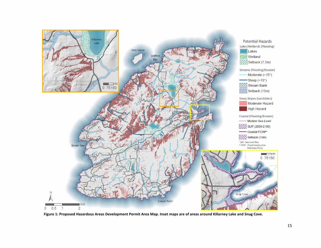
2.3.3 Proposed Map of the Development Permit Area The proposed Hazardous Areas Development Permit Area map can be seen in Figure 1. Two insets,
Killarney Lake and Snug Cove, illustrate the different hazards mapped. For a more detailed view of
mapped hazards on Bowen Island the reader is referred to a separate map book document. The percent
area of the island designated as potentially hazardous for each of the categories is as follows:
lakes/wetlands – 2.9%, streams – 4.9%, steep slopes – 18.7%, and coastal – 2.7%. Some locations were
identified as hazardous based on two or more of these categories, and so a great deal of overlap exists.
The majority of hazardous areas on the island lie within undeveloped Crown Land.
15
Figure 1: Proposed Hazardous Areas Development Permit Area Map. Inset maps are of areas around Killarney Lake and Snug Cove.

16
2.3.4 Comparison of Modelled Hazardous Areas with Historic and Recent Events It is important to evaluate the performance of any model based on relevant, available data. The hazards
on Mount Gardner, mapped and discussed by van Zeyl (2009) and Jackson (2008, 2014), are compared
with the modelled steep slope and small stream hazards in figure 2. The comparison suggests relatively
good performance of the modelled hazards, with nearly all field-mapped rockfall deposits occurring
within areas modelled as hazardous. Additionally, the seafloor landslide deposits occur downslope of
both slopes and streams modelled as hazardous (landslide and debris flow prone).
In 2017, a small landslide occurred affecting part of Bluff Creek. The approximate location of this event
and a comparison with the modelled slope hazards in the area can be seen in figure 3. While the specific
causes of this event are unclear, the location is quite steep and is prone to overland flow during rainfall
events, making it potentially hazardous. The apparent lack of vegetation that might have otherwise
stabilized the soil may have also contributed to the occurrence of this event. It is encouraging that the
modelled hazard captured this small event.

17
Figure 2: Comparison map of modelled and field-verified hazards on Mount Gardner, Bowen Island

18
Figure 3: Comparison map of the 2017 Bluff Creek slide and the modelled shallow landslide susceptibility

19
2.4 Draft Hazardous Areas Development Permit Area
2.4.1 Triggers This section outlines potential conditions or activities that would trigger the development permit
process. Development permit triggers are based on activities that may increase on- or off-site hazards
including but not limited to, increasing or altering surface water runoff, increasing the surface gradient,
decreasing the soil infiltration capacity, decreasing soil cohesion and/or friction angle, increasing
overburden, altering the water table, increasing wave runup, etc. General triggers include conditions or
activities relevant to all hazard categories. Suggested triggers specific to each hazard category are also
listed below.
General (All hazard categories) 1. Structural renovations or new construction of structures/decks >25 m2.
2. Alteration of existing grade over 0.5m at any point.
Lakes and Wetlands Flooding Areas 1. Activities that would alter the natural water table such as but not limited to, ditching, intensive
drawdown from groundwater wells, or impoundment structures.
2. Vegetation removal within the designated setback from the natural boundary.
3. Any construction of structures.
Stream Erosion and Flooding Areas 1. Vegetation removal within the designated setback from the natural boundary.
2. Alteration of bank or overbank materials within the designated setback from the natural
boundary.
3. Any construction of structures.
Coastal Erosion and Flooding Areas 1. Vegetation removal within the designated FCRP.
Steep Slope Hazard Areas
Moderate Hazard Slope
1. Removal of more than 4 trees <30 cm dbh (retaining roots), or 1 tree >30cm dbh within 5
consecutive years.
2. New retaining structures over 1.2 m high.
High Hazard Slope
All activities for moderate hazard slope, plus
1. Development of any impervious surfaces or structures.
2. Removal of 1 tree > 20 cm dbh.
2.4.2 Exemptions 1. Public works and services and maintenance activities carried out by, or on behalf of, Bowen
Island Municipality.
2. Removal of hazard trees.

20
2.4.3 Requirements If any of the above conditions are met, a preliminary assessment, as outlined in the Geotechnical
Assessment Terms of Reference document, including a partial risk assessment or qualitative hazard
assessment should be completed by a Qualified Professional as an initial step to determine whether
risks are broadly acceptable. If the preliminary assessment suggest that risks are broadly acceptable,
then further risk assessment may not be required. Where a preliminary assessment report
demonstrates that risk is not broadly acceptable, a detailed assessment should be required.

21
2.5 References Association of Professional Engineers and Geoscientists of British Columbia. (2008). Guidelines for Management of
Terrain Stability in the Forest Sector. Retrieved from the Engineers and Geoscientists of British Columbia
website: https://www.egbc.ca/app/Practice-Resources/Individual-Practice/Guidelines-
Advisories/Document/01525AMW6P45TR26OGVVCK64IPXCQ5CCSD/Management%20of%20Terrain%20S
tability%20in%20the%20Forest%20Sector
Association of Professional Engineers and Geoscientists of British Columbia. (2010a). Guidelines for Legislated
Landslide Assessments for Proposed Residential Developments in BC. Retrieved from the Engineers and
Geoscientists of British Columbia website: https://www.egbc.ca/getmedia/5d8f3362-7ba7-4cf4-a5b6-
e8252b2ed76c/APEGBC-Guidelines-for-Legislated-Landslide-Assessments.pdf.aspx
Association of Professional Engineers and Geoscientists of British Columbia. (2010b). Guidelines for Professional
Services in the Forest Sector – Terrain Stability Assessments. Retrieved from the Engineers and
Geoscientists of British Columbia website: https://www.egbc.ca/getmedia/684901d7-779e-41dc-8225-
05b024beae4f/APEGBC-Guidelines-for-Terrain-Stability-Assessments.pdf.aspx
Association of Professional Engineers and Geoscientists of British Columbia. (2017). Professional Practice
Guidelines – Flood Mapping in BC. Retrieved from the Engineers and Geoscientists of British Columbia
website: https://www.egbc.ca/app/Practice-Resources/Individual-Practice/Guidelines-
Advisories/Document/01525AMW6CMLNYZOJFZ5AY4MD3UNNDZQWW/Flood%20Mapping%20in%20BC.
Ausenco Sandwell. (2011). Climate Change Adaptation Guidelines for Sea Dikes and Coastal Flood Hazard Land Use,
Guidelines for Management of Coastal Flood Hazard Land Use. Prepared for the BC Ministry of
Environment. Retrieved from:
https://www.env.gov.bc.ca/wsd/public_safety/flood/pdfs_word/guidelines_for_mgr_coastal_flood_land_
use-2012.pdf
BGC Engineering Inc. (2006). Stage 1 Review of Terrain Hazard Assessments and Mapping in Northeast British
Columbia. Retrieved from the official website of the Government of British Columbia:
https://www2.gov.bc.ca/assets/gov/farming-natural-resources-and-industry/natural-gas-oil/petroleum-
geoscience/terrain-hazards/stage_1_terrain_hazard_assess.pdf
Bovis, M. J., & Jakob, M. (1999). The role of debris supply conditions in predicting debris flow activity. Earth Surface
Processes and Landforms, 24(11), 1039–1054. https://doi.org/10.1002/(SICI)1096-
9837(199910)24:11<1039::AID-ESP29>3.0.CO;2-U
Engineers and Geoscientists British Columbia. (2018). Legislated Flood Assessments in a Changing Climate in BC.
Retrieved from the Engineers and Geoscientists of British Columbia website:
https://www.egbc.ca/app/Practice-Resources/Individual-Practice/Guidelines-
Advisories/Document/01525AMW332SPI4ZAIGJB3DXYJEIYYEDUZ/Legislated%20Flood%20Assessments%2
0in%20a%20Changing%20Climate%20in%20BC
Jackson, L. E., Blais-Stevens, A., Hermanns, R. L., & Jermyn, C. E. (2014). Late Glacial and Holocene Sedimentation
and Investigation of Fjord Tsunami Potential in Lower Howe Sound, British Columbia. In Engineering
Geology for Society and Territory (Vol. 4, Issue January, pp. 59–62). https://doi.org/10.1007/978-3-319-
08660-6
Jackson, L.E., Jr., Hermanns, R.L., Jermyn, C.E., Conway, K., and Kung, R. (2008). Annotated images of submarine
landslides and related features generated from swath multibeam bathymetry, Howe Sound, British
Columbia. Geological Survey of Canada, Open File 5662.
22
Kerr Wood Leidal. (2017). Integrated Flood Hazard Management Plan. Prepared for the District of Squamish, BC.
Retrieved from the official website of the District of Squamish:
https://squamish.ca/assets/IFHMP/1117/5dbb51bad9/20171031-FINAL_IFHMP_FinalReport-
compressed.pdf
Ministry of Forests, Lands and Natural Resource Operations. (1999). Forest Practices Code of British Columbia:
Mapping and Assessing Terrain Stability Guidebook. Retrieved from the official website of the
Government of British Columbia:
https://www.for.gov.bc.ca/ftp/hfp/external/!publish/FPC%20archive/old%20web%20site%20contents/fp
c/fpcguide/terrain/zipped/terrain.pdf
Ministry of Forests, Lands and Natural Resource Operations. (2013). Review of Landslide Management in British
Columbia. Retrieved from the official website of the Government of British Columbia:
https://www2.gov.bc.ca/assets/gov/environment/air-land-water/water/integrated-flood-hazard-
mgmt/review_of_landslide_management_in_bc-2013.pdf
Ministry of Water, Land and Air Protection. (2004, sections 3.5 & 3.6 amended in 2018). Flood Hazard Area Land
Use Management Guidelines. Retrieved from the official website of the Government of British Columbia:
https://www2.gov.bc.ca/assets/gov/environment/air-land-water/water/integrated-flood-hazard-
mgmt/flood_hazard_area_land_use_guidelines_2017.pdf
Montgomery, D. R., & Dietrich, W. E. (1994). A physically based model for the topographic control on shallow
landsliding. Water Resources Research, 30(4), 1153–1171. https://doi.org/10.1029/93WR02979
Natural Resources Canada. (2018). Bibliography of Best Practices and References for Flood Mitigation V2.0.
Retrieved from the Natural Resources Canada website:
https://ftp.maps.canada.ca/pub/nrcan_rncan/publications/STPublications_PublicationsST/308/308380/gi
p_115_v2_0_en.pdf
Resources Inventory Committee, Government of British Columbia. (1996). Terrain Stability Mapping in British
Columbia: A Review and Suggested Methods for Landslide Hazard and Risk Mapping. Retrieved from the
official website of the Government of British Columbia:
https://www2.gov.bc.ca/assets/gov/environment/natural-resource-stewardship/nr-laws-
policy/risc/terrain_stability_mapping_in_bc_a_review_and_suggested_methods_for_landslide_hazard_a
nd_risk_mapping_-_final_draft.pdf
van Zeyl D. P. (2009). Evaluation of subaerial landslide hazards in Knight Inlet and Howe Sound, British Columbia.
Unpublish M.Sc. thesis, Department of Earth Sciences, Simon Fraser University, p 184
Wilford, D. J., Sakals, M. E., Innes, J. L., Sidle, R. C., & Bergerud, W. A. (2004). Recognition of debris flow, debris
flood and flood hazard through watershed morphometrics. Landslides, 1(1), 61–66.
https://doi.org/10.1007/s10346-003-0002-0
23
3 Site Alteration Bylaws
3.1 Executive Summary Site Alteration Bylaws may be used to regulate practices that may otherwise present safety concerns
(e.g., increase potential for hazards), reduce ecosystem health, or be a nuisance to the community. The
regulatory scope of Site Alteration bylaws ranges widely. In this report, four different site alteration
practices are considered, (i) grade alteration or rerouting of surface drainage through the removal,
relocation, or deposition of soil or fill; (ii) soil compaction or creation of impervious surfaces; (iii)
vegetation/tree removal; and (iv) rock blasting. Some specifics of each practice are discussed below.
(i) Grade alteration or rerouting of surface drainage has the potential to increase slope stability and
erosion hazards and should generally require the consultation of a Qualified Professional. The removal,
relocation, or deposition of soil or fill may also result in the spread of invasive species. The Ontario
Ministry of Environment, Conservation and Parks provide best management practices for managing
excess soils to limit these hazards.
(ii) Soil compaction and the creation of impervious surfaces has been linked directly to stream system
health. Total impervious coverage should be maintained below 10% of the total land area to avoid
potentially irreversible damage to stream health. Stormwater management BMP’s are most effective as
preventative measures rather than mitigation tools and should be applied immediately.
(iii) Vegetation stabilizes hillslopes through the alteration of the hydrological and mechanical properties
of the soil and helps to maintain ecosystem health. Commonly, vegetation removal is restricted within
riparian zones, environmentally sensitive areas, and areas identified as hazardous or steep. Exemptions
may include the removal of hazard trees, work completed by the city, or forestry practices.
(iv) There are several potentially adverse effects of urban blasting, including vibration, overpressure,
dust, fumes, and potentially flyrock. A detailed synthesis of best practices related to rock blasting was
completed by Loeb in 2012. In this report, a draft blasting bylaw was presented for BC Municipalities
(Appendix 1). It is recommended that the Bowen Island Municipality incorporate a version of this text in
the proposed Site Alteration Bylaw.
The fees for site alteration permits are generally hundreds of dollars, while fines for failing to comply
with the bylaws are generally thousands of dollars.
3.2 Best Practices
3.2.1 Grade Alteration or Rerouting of Surface Drainage through the Removal, Relocation, or
Deposition of Soil or Fill The removal, relocation, or deposition of soil or other fill material alters the surface drainage patterns,
infiltration capacity, and shear strength of the landscape. Grade alteration or the rerouting of surface
drainage has implications for slope instability (e.g., landslides) and erosion, both on- and off-site. The
exact volume of fill that may be safely removed or added and the acceptable degree of grade alteration
and surface drainage rerouting is site specific. As such, it is recommended to consult a Qualified
Professional before undertaking such work. However, it is generally accepted (see local community
bylaws) that small-scale, low-risk modifications can be made without consultation.

24
The Ontario Ministry of Environment, Conservation and Parks (MECP; 2018) provide best management
practices (BMP’s) for managing excess soils. In this guide, which is meant for large-scale or high-risk
work, MECP underscores the importance of considering the soil quality, potential contamination, and
invasive species. The guide then outlines transportation procedures and both a soil management plan
(source site) and a fill management plan (receiving site) as well as dust and noise control measures.
Invasive plants have the capacity to establish quickly and easily, especially on disturbed sites. They can
“cause widespread negative economic, social, and environmental impacts” (MFLNRO, 2013). It is
recommended that equipment is cleaned before and after site alteration work to prevent the spread of
invasive species.
3.2.2 Soil Compaction or Creation of Impervious Surfaces Impervious surfaces are those that resist the absorption of water into the ground. Schueler (1994)
identified several effects of changes to imperviousness. Those include subsequent changes to, runoff
including increased flooding, lowered groundwater level, stream morphology, reduced water quality
(pollutants), stream warming, and a reduction in stream biodiversity and fish health. In most cases, the
impervious surfaces don’t generate pollutants and contaminants themselves. However, they (i) alter the
hydrology causing degradation, (ii) are a component of land uses that do generate pollution, (iii) prevent
natural pollutant processing by preventing percolation, and (iv) efficiently transport pollutants into
waterways (Arnold and Gibbons, 1996). In fact, imperviousness has been correlated directly with
measures of stream health.
Because impervious coverage is easily measured, Arnold and Gibbons (1996) suggest that impervious
coverage may be the most feasible and cost-effective vehicle for addressing water pollution in
community planning. Researchers have suggested simple thresholds that capture changes in stream
system health (Prisloe et al., 2000; Table 8), although it should be remembered that stream health forms
more of a continuum. Guthrie and Deniseger (2001) provide a good example of an impervious surfaces
study within the French Creek Watershed, Vancouver Island. There is ample research to motivate the
reduction of impervious cover, and ideally it should be maintained below 10% total coverage.
Table 8: Suggested threshold relations between impervious coverage and stream system health.
Impervious Coverage
Stream Health
< 10% Protected
10 – 30% Impacted
> 30% Degraded
In a report prepared for the City of Vancouver in 2016, Golder Associates Ltd. set out a BMP’s toolkit for
improving rainwater management which generally aligns with practices to reduce impervious coverage.
The toolkit highlights practices such as, pervious paving, green roofs, daylighting streams, and
constructing wetlands. However, BMP’s are more effective as a preventative measure rather than a
mitigative tool and so should be implemented before reaching the threshold for impacted watersheds
(Guthrie and Deniseger, 2001). Although the total percent impervious coverage on Bowen Island is
expected to be well below 10%, localized effects including increased surface runoff and subsequent

25
slope destabilization are possible. As such, it is recommended to restrict the creation of impervious
surfaces through a site alteration bylaw.
3.2.3 Vegetation / Tree Removal Vegetation strongly affects the mechanical and hydrological properties of soil related to shallow
landsliding. Vegetation increases soil infiltration capacity and reduces soil water content through
interception, transpiration, and evaporation (Mulyono et al., 2018). Roots further stabilize the slope and
reduce erosion through the mechanical reinforcement of soils. The stabilizing effect of vegetation is
quantifiable and significant (Schwarz et al., 2010). In the absence of slope stability and erosion concerns,
vegetation provides habitat for many species, and can help maintain ecosystem health.
The beneficial nature of vegetation warrants its preservation whenever possible. Site alteration bylaws
in communities neighboring Bowen Island vary between the protection of individual trees (District of
Squamish, 2018) to site clearing of up to 30 percent of a parcel depending on other restrictions (City of
Port Moody, 2015). It is common to restrict vegetation removal within riparian zones, environmentally
sensitive areas, and areas identified as hazardous or steep. Common exemptions include the removal of
hazard trees, work completed by the City, or logging with valid permits in active forestry areas.
3.2.4 Rock Blasting There are several potentially adverse effects of urban blasting, including vibration, overpressure, dust,
fumes, and potentially flyrock. A detailed synthesis of rock blasting best practices and current municipal
bylaws (in British Columbia and throughout Canada) was completed by Loeb in 2012. Here only a brief
summary of the results is presented.
After conducting best practices research and interviewing regulators, blasting contractors, and blasting
consultants, Loeb (2012) created a draft blasting bylaw (attached as Appendix 1) to be used by
municipalities within BC. Within this draft bylaw, mitigation practices such as the hours of blasting,
maximum particle velocity, maximum overpressure, etc. are presented. Loeb (2012) also found that
most blasting complaints are the result of a lack of communication or miscommunication with nearby
residents and suggest a pre-blast survey is conducted. As part of this survey, an information pamphlet
(attached as Appendix 2) that is designed to educate and inform homeowners that may be affected by
blasting, is to be distributed. The attached draft bylaw may be modified by Bowen Island Municipality to
form part of the proposed (more comprehensive) Site Alteration Bylaw.
3.2.5 Fees and Fines The fees collected for Site Alteration Permits vary, but are generally a few hundred dollars (e.g., District
of Squamish - $250). Fines for a person who fails to comply with any provision of the Site Alteration
Bylaw generally reach $10,000 or more (e.g., District of Squamish, 2018).

26
3.3 Draft Site Alteration Bylaw
3.3.1 Definitions “Significant Trees” means a tree identified by Council as significant because of its importance to the
community, or as wildlife habit; or a mature tree.
3.3.2 Triggers This section outlines potential activities that would trigger the Site Alteration permit process. Site
Alteration permit triggers are based on activities that may present on- or off-site safety concerns (e.g.,
increase potential for hazards), reduce ecosystem health, or be a nuisance to the community. Some
suggested triggers are presented below.
1. Alteration of existing grade over 1 m at any point.
2. Removal, relocation, or deposition of more than 10 m3 of soil or fill material within a 2-year
period.
3. Creation of impervious surfaces or compaction of soil other than that of a primary driveway no
more than 4 metres in width.
4. Removal of more than 4 trees (not including Significant Trees), or 10 m2 of vegetation within a
period of 5 years.
5. Damage or removal of any vegetation located within a Riparian Zone, an Environmentally
Sensitive Area, or Hazardous Areas Development Permit Area.
6. Triggers relating to rock blasting as presented in Appendix 1.
3.3.3 Exemptions 1. Removal of hazard trees.
2. Site alteration completed by or for the Bowen Island Municipality.
3.3.4 Requirements If any of the above conditions are met, consultation with a Qualified Professional should be required. A
document should be created that outlines the conditions and procedures to apply for a Site Alteration
permit.

27
3.4 References Arnold, C.L. & Gibbons, C. J. (1996). Impervious surface coverage: the emergence of a key environmental indicator.
Journal of the American Planning Association 62(2), pp. 243-258.
City of Port Moody, Bylaw No. 3012, Site Alteration Bylaw (2015).
District of Squamish, Bylaw No. 2640, Tree Management Bylaw (2018).
Guthrie, R., Deniseger, J. (2001). Impervious Surfaces in French Creek. Ministry of Water, Land and Air Protection,
Vancouver Island, British Columbia. https://www.env.gov.bc.ca/van-
island/es/pdf/Impervious%20Surfaces%20technical%20document.pdf
Loeb, J. T. (2012). Regulatory mitigation of the adverse environmental effects of urban blasting. Unpublished
Thesis. University of British Columbia. Retrieved from
https://open.library.ubc.ca/collections/ubctheses/24/items/1.0050876
Ministry of the Environment, Conservation and Parks. (2018). Management of excess soil - a guide for best management practices. Ontario.ca. https://www.ontario.ca/page/management-excess-soil-guide-best-management-practices.
Ministry of Forests, Lands and Natural Resource Operations. (2013). Best Practices for Preventing the Spread of Invasive Plants During Forest Management Activities. Retrieved from the official website of the Government of British Columbia: https://www2.gov.bc.ca/assets/gov/environment/plants-animals-and-ecosystems/invasive-species/publications/forestry-bp-09-11-2013-web.pdf
Mulyono, A., Subardja, A., Ekasari, I., Lailati, M., Sudirja, R., Ningrum W. (2018). The Hydromechanics of Vegetation for Slope Stabilization. IOP Conference Series: Earth and Environmental Science. 118, pp. 012038
Prisloe, S.M., Giannotti, L., Sleavin, W. (2000). Determining Impervious Surfaces for Watershed Modeling Applications. Nonpoint Education for Municipal Officials, University of Connecticut, College of Agriculture and Natural Resources, 17pp.
Schueler, T. (1994). The Importance of Imperviousness. Watershed Protection Techniques 1(3): 100-111.
Schwarz, M., Preti, F., Giadrossich, F., Lehmann, P., Or, D. (2010). Quantifying the role of vegetation in slope stability: A case study in Tuscany (Italy). Ecological Engineering. 36, pp. 285-291

28
4 Recommendations for the Municipality on future data-gathering or policies A key component to any hazard assessment is an archive of past events in the area. It is recommended
that Bowen Island Municipality collect citizen reports on local hazards (e.g., rockfall, excessive soil
erosion, etc.) in an anonymized, location specific way.
In following a report by APEGBC (2017) it is recommended that any hazard related DPA maps and bylaws
should be reassessed every 10 years if there are significant changes to the conditions on the island, data
availability, or infrastructure.
29
Appendices
Appendix 1 – Suggested Draft of a Blasting Bylaw (Loeb, 2012)
[Interested] Regional Municipality By-Law Number [00000]
Respecting Blasting General
Number and Short Title 1. This By-law shall be known as By-law Number [00000] and shall be cited as the “Blasting By-
law.”
Jurisdiction 2. The Blasting By-law contains laws that must be complied with, in addition to those blasting
laws that are regulated by the provincial and federal governments.
Appendices 3. Appendix “A” and Appendix “B” form part of the By-law. Definitions 4. In this By-law:
a) “Affected Community” means all properties within a distance of 150 m from the Blasting Area, unless adjusted by the Consultant;
b) “Air Overpressure” means the airborne disturbance which results from Blasting, which may or may not be audible, measured in linear decibels (dBL);
c) “Applicant” means a person who has applied for a Blasting Permit under this By-law; d) “Blaster” means a person named on a valid Urban Blasting Certificate issued by the
Province of British Columbia; e) “Blasting” means the handling, preparation and use of explosives, but does not include
delivery or storage by a properly qualified person in accordance with Federal and Provincial Law;
f) “Blasting Area” means the zone extending 15 m of all directions from the place in which holes will be loaded with explosives to be detonated;
g) “Consultant” means a Professional Engineer, or a person with other relevant qualifications or reputation acceptable to the Inspector, that has expertise in blasting in urban areas with at least 5 years blast consulting experience, and is independent of the Blaster and the explosives manufacturer or distributor.
h) “Inspector” means the person appointed by the Chief Administrative Officer of the Municipality to be the Inspector of Blasting or their designate;
i) 121 j) “Municipality” means the [Interested] Regional Municipality; k) “Particle Velocity” means the measure of the intensity of ground vibration, measured in
millimeters per second; l) “Qualified Monitor” means a person who is;
i. the Consultant, or a person working under the supervision of a Consultant;

30
ii. trained on the proper use of the monitoring instruments by a representative of the manufacturer or distributor of the monitoring instruments or other competent individual, and;
iii. shall not be the Blaster or the Applicant, or an employee of the Blaster or the Applicant;
Blasting Permit 5. (1) No person shall carry out or cause to be carried out Blasting in the Municipality without a
Blasting Permit first having been obtained from the Inspector. (2) A Blasting Permit shall not be issued to an Applicant unless the Applicant is a Blaster, the
Applicant has a Blaster in his/her employ, or the Applicant has a contract with a Blaster in respect of the work for which the Blasting Permit is intended.
(3) Notwithstanding subsection (1), the inspector may give permission for Blasting without a Blasting Permit in an emergency situation.
Hours of Blasting 6. No person shall carry out or cause to be carried out Blasting on a Saturday, a Sunday,
Remembrance Day, or a holiday as defined in the Interpretation Act, R.S.N.S. 1989, c.35, as amended from time to time.
(2) No person shall carry out or cause to be carried out Blasting outside of daylight hours. (3) Notwithstanding to subsections (1) and (2), the council of the Municipality may allow the . Inspector to issue a Blasting Permit to carry out Blasting on weekends or holidays if such . operation is in the interest of public convenience. In such cases, the hours of Blasting shall be . as per 6 (2).
Limits Particle Velocity 7. No person shall carry out or cause to be carried out Blasting which results in a Particle
Velocity measured at the closest structure to the blast which exceeds the limits set out in Figure 1, unless otherwise specified by the Consultant.
Figure 1: Safe levels of blasting vibration for residential houses (RI 8507, U.S. Bureau of Mines) Maximum Air Overpressure

31
8. No person shall carry out or cause to be carried out Blasting which results in an Air Overpressure measured at the closest inhabited building to the blast which exceeds 128 dB(L), measured on the linear scale, unless otherwise specified by the Consultant and accepted by the Inspector.
Activities During Blasting Pre-Blast Survey 9. (1) No person shall carry out or cause to be carried out Blasting unless a pre-blast survey is
completed on every structure within 65 m of the Blast Area unless adjusted by the Consultant, and which meets the following requirements. a) Notification, containing project description / location, the blasting contractor’s name,
the name of the firm conducting the survey, and an approximate start and completion date for the project, is distributed to all property owners in the area to be surveyed;
b) appointments are made and the survey is carried out in a timely manner and in advance of the commencement of Blasting on the project;
c) each property owner is contacted in person and if the homeowner cannot be contacted, notification is left in the mailbox advising the owner who to contact to schedule an appointment;
d) the survey consists of high quality video photography, unless still photographs are preferred by the property owner, of the structure, in reproducible format, and which provides an overview of the entire structure, interior and exterior, provided consent is given by the property owner or his/her respective representative;
e) the survey shows fences, sidewalks, trees, and other similar features adjoining the property;
f) the video record may be reviewed by the property owner upon request; (2) Notwithstanding subsection (1) a pre-blast survey shall not be required before a Blasting Permit is issued in the event the property owner cannot be contacted after a minimum of four visits to the property, with a maximum of one visit per day, or refuses entry to the property. Notification 10. (1) No person shall carry out or cause to be carried out Blasting unless the pamphlet
(provided in Appendix A) is delivered by hand after the Blasting Permit is issued and at least two days (48 hours) prior to the commencement of Blasting, to every property owner or business within the Affected Community which shall contain: a) the name of the person or company responsible for Blasting, including a contact person
and telephone number; b) the intended date and time when Blasting shall commence and its expected duration,
and; c) the location of Blasting.
(2) No person shall carry out or cause to be carried out Blasting within 300 m of a school, hospital, or other health care facility unless:
a) such notice as required by subsection (1) has been given to the senior administrator of the school, hospital, or other health care facility, and;
b) the senior administrator is also informed at least 2 hours prior to each blast. Blaster Required
32
11. No person shall carry out or cause to be carried out Blasting unless the Blasting is under the care and control of a Blaster.
Drilling Dust Control 12. No person shall carry out or cause to be carried out Blasting without the use of an
acceptable dust collection system as part of the drill machine. Blast Monitoring 13. (1) No person shall carry out or cause to be carried out Blasting unless:
a) a Qualified Monitor monitors every blast; b) blast monitoring equipment and procedures meet the standards of Appendix B that
refers to Appendices D and E of the ISEE Blasters Manual, 18 ed. Hole Size 14. No person shall carry out or cause to be carried out Blasting where blast holes exceed a
diameter of 70 mm, unless adjusted by the Consultant and approved in writing by the Inspector.
Submit Records 15. (1) During the course of blasting, the Consultant shall review the blast records and confirm
to the Blaster and/or Inspector, if requested, that blasting is being carried out in accordance with the specifications of this by-law, and shall immediately report any problems, unusual circumstances or inconsistencies to the Blaster and/or Inspector.
(2) The Consultant will report, within 24 hours to the Blaster and/or Inspector, any instance when, and under what circumstances, vibrations and/or Air Overpressure exceeded the specified maximum limits. This report will include a written explanation for the excessive Air Overpressure and Particle Velocity level(s) as well as a description of corrective actions.
Administration Blasting Permit Application 16. The Applicant for a Blasting permit shall make written application on a form provided by the
Inspector. 17. The application shall contain the following information:
h) the Applicant’s name, address, telephone number, and type of business; i) a contact person’s name, title, and telephone number; j) a description of the scope of work, including purpose for which Blasting is required; k) the date upon which work is proposed to commence and the probable duration; l) a copy of a valid urban blasting certificate issued by the Worker’s Compensation Board
or the BC Ministry of Mines to the blaster who will undertake the work; m) a certificate of insurance on a form acceptable to the Inspector which provides a policy
of commercial general liability for bodily injury and property damage in the amount of $5,000,000 per occurrence which includes the [Interested] Regional Municipality as an additional insured, a cross liability clause and a Blasting endorsement for the full limits of the policy; and

33
n) such other information as the Inspector may require.
Other Rights and Remedies Terms and Conditions, penalties, duration, fees etc. as required by [Interested] Municipalities Done and passed in Council this [#] day of [Month], [Year]
____________________________ MAYOR
____________________________ ACTING MUNICIPAL CLERK
Appendix A of Bylaw Notification – Informative Pamphlet (Appendix 2 below)
Appendix B of Bylaw Standards and Requirements for Monitoring as per ISEE Handbook 18th ed. (ISEE, 2011)

34
Appendix 2 – Blasting Bylaw: Education Plan / Informative Pamphlet (Loeb, 2012)

35