geomaticsworld 2013 · geomaticsworld may | june 2013 monitoring railway infrastructure with...
TRANSCRIPT

GeomaticsWorld MAY | JUNE 2013
Monitoring railwayinfrastructure with
non-contact systems
Grand designs fora Grade II listed
water tower!
Coastal Monitoringin landlocked
Oxfordshire
Dam deformationsurveying in the
United States
Hot topics atColorado’s LiDARMapping Forum
Issue No 4 : Volume 21
Surveying for geographical and spatial information in the 21st century

02 Geomatics World May / June 2013
Want to know more or have other structural monitoring requirements? Call us to discuss on 01572 770780or Email us at [email protected]. For more information please visit www.moniteye.co.uk.
• QUICK INSTALLATION:A single visit to install; meaning movement or stabilisation can beconfirmed quicker than ever.
• BATTERY POWERED: No need for external wiring.
• HIGHLY ACCURATE:Resolution of up to 0.01mm displacement or 0.01 degrees of tilt.
• IN-BUILT GPRS RADIO:Allows data to be wirelessly transmitted to our online gateway.
• DEDICATED WEB GATEWAY:Provides users with graphical representation of data recorded; viewable from any web enabled device.
• CUSTOMISABLE READING CYCLE:Over the air configuration for frequency of readings.
• TEMPERATURE SENSOR:Helps to establish presence and extent of thermal movement.
Need to measure cracks or tilt in structures?Do it wirelessly, remotely and accurately with Moniteye’s unique one-box solution.
DISPLACEMENT – T ILT – LEVELLING – VIBRATION – MOISTURE
Unique crack monitoring device

The next issue of GW will be that for July / August 2013.Copy dates are: Editorial: 10 June Advertising: 14 June 2013
Next issue
p.05 Editorial
p.06 News
p.08 Calendar
p.09 Chair’s column
p.10 Policy Watch
p.14 Books
p.30 Down Undercurrents
p.35 Classified
REGULARS
Geomatics World is published bi-monthly by PV Publications Ltd on behalf of the Royal Institutionof Chartered Surveyors Geomatics Professional Groupand is distributed to group members and othersubscribing professionals.
Editor: Stephen Booth Technical Editor: Richard GroomNews Editor: Hayley TearAdvertising: Sharon RobsonSubscriptions: Barbara Molloy
Editorial BoardPat Collins, Richard Groom, Alan Haugh, James Kavanagh, Professor Jon Mills, Dr Stuart Robson, Dr Martin Smith
Overseas SourcesRoy Dale – New ZealandNick Day – USA
Editorial and advertising:e-mail: [email protected]: www.pvpubs.comT: +44 (0) 1438 352617F: +44 (0) 1438 351989
Mailing: PV Publications Ltd2B North RoadStevenage, Hertfordshire SG1 4ATUnited Kingdom
Material to be PublishedWhile all material submitted for publication will behandled with care and every reasonable effort is madeto ensure the accuracy of content in Geomatics World,the publishers will have no responsibility for any errorsor omissions in the content. Furthermore, the viewsand opinions expressed in Geomatics World are notnecessarily those of the RICS.
Reprints: Reprints of all articles (including articlesfrom earlier issues) are available. Call +44 (0)1438352617 for details.
Advertising: Information about advertisement rates,schedules etc. are available in the media pack.Telephone, fax or write to PV Publications.
Subscriptions: Yearly subscription (six issues) is £45(UK) £49 (worldwide). For more details, includingspecial offers, go to: www.pvpubs.comNo material may be reproduced in whole or in partwithout written permission of PV Publications Ltd.© 2013 ISSN 1567-5882
Printing: The Manson Group, St Albans, UK
May / June 2013 Geomatics World 03
Contentsp.06 News
– First fix for Gallileo– Underground tunnel pierced
p.12 Monitoring railway infrastructure At UCL Anita Soni is investigating non-contact measurementsystems for railway monitoring. Here are her preliminary findings.
p.15 It all started two decades ago. . .In this revealing interview, Maria Toth talks to Robin McLaren of Know Edgeabout his experience in modernising Hungary’s land registration system.
p.20 LiDAR Mapping ForumAll the hot topics including Esri in 3D, plus Adam Spring talks to NickPalatiello about MAPPS and professional photogrammetrists.
p.22 Ocean BusinessA brief report on this annual event that included the “Blue Economy”,ahead of our major hydrographic feature in the next issue of GW.
p.23 Grand designs for a water towerA detailed measured survey was necessary ahead of converting this GradeII listed 19th century structure into a home, explains John Withenden.
p.26 Coastal Monitoring. . . indoors!3D Laser scanning is being used for coastal and marine infrastructureresearch at HR Wallingford’s Oxford base.
p.26 Dam deformation surveying in the USThe US has many flood control dams and structures: John Hamiltonlooks at the various techniques used today in monitoring them.
p.29 Structural subsidence in WalesRemote monitoring techniques gave advance warning of a partialhouse collapse, explains Alex Keal.
COVER STORYLondon Bridge Stationin the heart of Londonis under going majorredevelopment.Monitoring fordeformation isessential. But is laserscanning the answer?Turn to page 12 tolearn more.
PV Publications Ltd2B North Road,Stevenage, Herts SG1 4ATT: +44(0)1438 352617W: www.pvpubs.com Would you like notice of the electronic version via email?Would you like notice of the electronic version via email?
Would you like to receive notification of a new electronic edition via email?Overseas RICS members get an emailed link to the digital edition of GW. To alsoreceive the printed edition, overseas members need to advise us by opting inat:http://www.pvpubs.com/OverseasRICSUK and Irish readers as well as subscribers can also receive notice of a newdigital edition (sent at least a week ahead of the printed edition) by emailing arequest to [email protected]• Note: the electronic version can now be downloaded as a PDF and printed.
We’re growing: GW's Digital ExtrasWe’re growing: GW's Digital ExtrasWith the increasing amount of high quality editorial material that we receiveand restrictions in sustaining an economically sized printed publication, weplan to publish more material on the web. To read GW's "Digital Extras" go to:http://www.pvpubs.com/archives.php?titleid=1&issueid=210Please note that this link is free of any restrictions to readers but does notallow access beyond the currency of this issue or to the archives.

• a simple guide for
managers, engineers,
architects, surveyors
and all who
commission or
manage survey
projects,
or needs to
discover more
about survey
techniques and
technologies
Copies of Being an Intelligent Client price £9.95 are available from www.pvpubs.comor call PV Publications Ltd, 2B North Road, Stevenage, Herts SG1 4AT UK.
T: +44 (0)1438 352617 E: [email protected]
By Richard Groom
Being an Intelligent Client
a guide to successful commissioning and
managing of land and engineering surveys
The concept of risk is well understood in relationto health & safety. But with surveying, people
tend to focus on accuracy and precision.
Nevertheless, there are technical and commercialhazards in surveying and they come with
expensive risks for clients.
The consequences of a survey ‘accident’ can besignificant. Projects can be delayed. Cost
implications can be substantial. Sometimes theycan be catastrophic and render a project unfitfor purpose – like an Olympic-sized swimming
pool built too short.
This guide is intended to help those whocommission and manage surveys to recognisethe hazards and manage the associated risks.
In two parts, Part 1 deals with Managing Survey Projects andincludes 20 key topics in preparing contracts and specifications aswell as managing the work once a survey firm has been appointed.This is essential reading for professionals working in the builtenvironment who appoint or manage survey companies.
Part 2 sets out the Principles of Surveying and covers over 30topics, which may help reveal the hazards that can lurk in surveyingprocesses. Engineers, architects, other professional disciplines aswell as older surveyors in need of a reference point or a refreshercourse, will find this a reliable reference point.
The Guide is therefore intended as an essential reference source. Itcan also be an ideal source book on surveying for academic courses.Younger readers will find all of the essential techniques presentedtogether with current technology and its applications.
The author is an experienced chartered surveyor with many yearsexperience working in both the private and public sectors as well asin the UK and overseas.

Editorial
May / June 2013 Geomatics World 05
modern land registration system for Hungary.Since then McLaren has been involved in manysimilar systems around the world. One of themany true pearls of wisdom he offers in theinterview under lessons learned is that projectsonly succeed if the politicians and the fundersunderstand the benefits of their investments.A different set of terminology and languagehas to be used in this on-going engagementbetween the two. Projects succeed if theyhave a senior, high profile championsupporting them. That is true, whether it’sland registration or big computer systems.
We’re also trailering next issue’shydrographic survey feature with a brief reporton the Ocean Business event in April, whichincluded a separate conference entitled theBlue Economy. James Kavanagh will bereporting on that and the opportunities thatlie ahead for geomatics.
Enjoy this issue and for those in the UK,prey the good weather continues!
Much of Europe and the UK iscongested with over development.Green space is at a premium and
where available, is often marginal land thatrequires careful geotechnical investigationbefore construction. It is easy to get it wrongas one of this issue’s articles reveals (Structuralsubsidence in Wales, p.29).
So brown space it often has to be. But thisputs enormous pressure on contractors andengineers to ensure that adjacent buildingsand structures are not affected by demolitionand new construction. It also createsopportunities for those in geomatics todemonstrate our skills and technologies.
This issue’s focus is monitoring and ourtechnical editor has done readers proud withfour articles ranging from current research intothe problems of monitoring railways, includingthose in tunnels, using a laser scanner formarine structure modelling, current techniquesfor monitoring dams in the US and thepreviously mentioned Welsh housing problem.It makes great reading and should whetappetites for opportunities out there.
Hopeless metricsWe are all aware of the endless failure andcost overruns of projects for digitisation andnew computer systems. The UK government islittered with them. Why do they go wrong?One reason was revealed by John Naughton inone of his regular columns in The Observernewspaper. Almost 30 years ago a former IBMprogrammer wrote a book revealing how inthe 1960s he led the “Big Blue’s” team ofsoftware engineers and programmers todevelop the operating system for the IBM 360mainframe computer. It fell behind schedule.More programmers were recruited; it fell backfurther. Eventually it was realised that man-months are a hopeless metric for assessing thesize of a complex software project because itignored the unproductive but essentialelement of coordinating the programmers. Thebook, The Mythical Man Month and OtherEssays on Software Engineering, by FredBrooks has never been out of print since 1975.
Get a championUnder estimating is therefore clearly part ofthe problem. But there is another aspect,revealed in our interview by Maria Toth ofRobin McLaren, whose company won acontract over 20 years ago to develop a
This issue majors onmonitoring but wealso talk to someonewith words ofwisdom andexperience of bigcomputer anddigitisation projects.
Monitoring brings opportunities but heed the lessons learned
The editor welcomes yourcomments and editorialcontributions by e-mail: [email protected] by post:Geomatics WorldPV Publications Ltd2B North RoadStevenageHerts SG1 4ATUnited Kingdom
TEN YEARS AGO:GW May / June 2003
Looking back at what GW was reporting a decadeago it is surprising how rapidly new technologieswere being adopted. The issue included articles onmicro satellites and using a laser scanner to capturethe Rock of Gibraltar to track erosion. Thesetechnologies are common place today; back thenthey really were cutting edge.
What is striking too about the May/June 2003issue is the difference these technologies werealready beginning to make by making projects thatwould either have been too expensive to undertakeby traditional survey techniques or would just neverhave been contemplated.
Typical was Frank Hobbs work in helping theMaldives establish a local national grid referencesystem using post-processed data from a $200handheld GPS.
Another area of practice beginning to undergo atechnological revolution was measured buildingsurvey. The previous issue had reported thetraditional approach of tape and Disto. In this issueAndy Roberts set out a convincing case for bringingCAD into the field on handheld devices.
Stephen Booth, Editor

NEWS
06 Geomatics World May / June 2013
Beidou improves precisionThe precision of China’s BeiDousatellite navigation system will beimproved by implementing theBeiDou Ground BaseEnhancement System (BGBES) –a network of thirty ground basestations, an operating system anda precision positioning system.
It is expected to improvepositioning precision to2cms horizontally and 5cmsvertically via tri-band real-time precision positioningtechnology, and to 1.5mwith the single-frequencydifferential navigationtechnology.
Rights to LightThe Law Commission is investi -gating whether the law by whichrights to light are acquired andenforced provides an appropriatebalance between the interests oflandowners and the need tofacilitate the development of land.
A “right to light” is aneasement that gives landownersthe right to receive light throughdefined apertures in buildings ontheir land. The owners of landburdened by the right cannotsubstantially interfere with it – forexample by erecting a building ina way that blocks the light –
without the consent of thebenefiting owner.
In the consultation paper,the commission makes thefollowing provisionalproposals:• to introduce a new statutory
test to clarify the current lawon when courts may order aperson to pay damagesinstead of ordering thatperson to demolish or stopconstructing a building thatinterferes with a right to light.
• to introduce a new statutorynotice procedure, whichrequires those with the benefitof rights to light to make clearwhether they intend to applyto the court for an injunction(ordering a neighbouringlandowner not to build in away that infringes their rightto light), with the aim ofintroducing greater certaintyinto rights to light disputes.
• that the Lands Chamber ofthe Upper Tribunal should beable to extinguish rights tolight that are obsolete or haveno practical benefit, withpayment of compensation inappropriate cases, as it can dounder the present law inrespect of restrictivecovenants.
More at http://lawcommission.justice.gov.uk/consultations/rights-to-light.htm. Closing date for theconsultation is 16th May 2013
Calling young entrepreneurs The Open Geospatial Consortiumhas announced the OGC StudentMap App Challenge, sponsored byGoogle, an OGC principal member.The challenge is a contest forstudents with programming skillsand an interest in maps andlocation services.
Open standards from the OGCunlock the potential of the“spatial Web,” creatingopportunities for app developersto make all kinds of locationinformation available to users,independent of platform. TheOGC has launched the challengeto make entrepreneurial studentsaware of the enormous socialand commercial potential ofthese open standards.
Three winning applicants willreceive an OGC Student Map AppChallenge Award and recognitionon the OGC website. The winnerwill receive an expenses-paid tripto receive his / her award at oneof next year’s OGC TechnicalCommittee meetings, a NexusTablet from Google and two yearOGC membership for thestudent’s academic institution.
Students must register by 15June 2013 and submit their appsby 15 July 2013. Contestants andthe public will be notified of theresults on 30 August 2013.
RICS hosts US land surveyorsA five-strong delegation ofLicensed Professional LandSurveyor representatives from thestates of Virginia, Iowa, Georgiaand Tennessee visited RICS HQon 6th March.
The USA operates a state-by-state licensing system forprofessional land surveyors buthas recently formed a nationalsurveying body (National Societyof Professional Surveyorshttp://www.nsps.us.com). Thedelegation were on a fact-findingmission to the UK and alsomanaged to visit places ofgeographic and surveyingsignificance such as Greenwich.James Kavanagh, director LandGroup hosted the delegation anddiscussions ranged from the
historic links and shared surveyingheritage of the UK and USA,presentations on the UK system ofmapping, land registration andproperty ownership, todevelopments in professionalpractice and technology.
The US delegation wereespecially interested in the broadranging remit of RICS professionalpractice compared to some partsof the world and the evolution ofthe profession in the UK. Thegroup invited RICS to participatein the forth coming celebrationsplanned in Philadelphia for lateAugust 2013 to mark the grave ofCharles Mason, the UK landsurveyor of Mason–Dixon linefame. US land surveyors tend tobe acutely aware of their historyand the Mason-Dixon Line hasgained a hold on the US nationalmemory as the division betweenNorth and South, Yankees andDixy, freedom and slavery. Farmore prosaically, its originalintention was to quell a 1760’sbloody boundary dispute betweenthe states of Maryland andPennsylvania.
RICS Land has a strong andgrowing relationship with ourcolleagues in the US and this visitwill hopefully be the start ofdeveloping opportunities withinthe state licensed sectors whichemploys over 20,000 professionalland surveyors in the USA.
One hour warningThe BBC website reports thatProfessor Kosuke Heki ofHokkaido University in Japan hasbeen able to show that about anhour before the magnitude 9.0earthquake that rocked Japan inMarch 2012, the total electroncount (TEC) in the ionospherestarted to increase unexpectedly.It seems that the build-up offorces within the earth somehowenergised electrons in theionosphere. The change in TECappears as a disruption of GNSSsignals in the same way thatsolar activity also causesdisruption. Professor Heki hasobserved the same phenomenonbefore other large earthquakes,so there is some hope that GNSSmay one day be used to predictearthquakes. Source:http://www.bbc.co.uk/news/science-environment-17487482
Plot showing the scatter of the solutions. It shows clearly the initialconvergence period and the final drift as the DOP degraded towards theend of the short observational window.
The Nottingham Geospatial Institute has successfully computed a firstpositioning solution using only the four Galileo IOV satellites. The datawas recorded during the MSc field courses at the Hayes ConferenceCentre in Derbyshire, using a Javad Triumph-1 receiver connected to aLeica AR10 antenna. E1 and E5a data were recorded for about 26 minuteson 26th March.
First fix for Galileo

NEWS
May / June 2013 Geomatics World 07
GOCE detected quakeThe BBC website also reportedthat the European SpaceAgency’s precise satellitegravimeter, GOCE, detected theearthquake. GOCE has a lowearth orbit so as to detect minutechanges in gravity but it is nowrunning out of fuel and comingto the end of its life. The Agencyis planning to lower thespacecraft’s orbit in June, toobtain even higher finerobservations and the mission willfinish in November.
New Forum for OGCThe Open Geospatial Consortium(OGC) established a Middle Eastand North Africa (MENA) Forumduring its Technical and PlanningCommittee meetings held inMarch 2013 in Abu Dhabi. Thiswas the first time the OGCTechnical and PlanningCommittee meetings had beenheld in the Middle East.
Glasgow CASLEThe Commonwealth Associationof Surveying and Land Economyis holding its conference at theUniversity of Glasgow 7th – 10thJuly. The conference has threethemes: Land Title, Registrationand Cadastre; Marine Assetmanagement and Environmentand Resource impacts onproperty values and constructioneconomics. Visit www.casle.orgfor more details.
Moving feature standardsThe Open Geospatial Consortiumannounced the formation of theMoving Features StandardsWorking Group (Moving FeaturesSWG). “Moving features” datadescribes such things as vehiclesand pedestrians. This group ischartered to develop a candidateMoving Features standard fromthe discussion paper (OGC 12-117r1, OGC Standard forMoving Features; Requirements),which summarizes therequirements and basic idea ofan encoding standard formoving feature data.
Sheds with bedsUK local authority SloughBorough Council is set to becomethe first local authority in the UKto use thermal imaging to clamp
down on people living illegally inoutbuildings. It is not knownexactly how many so-called“sheds with beds” there are inSlough, but estimates range from700 to 3,000. The council hascommissioned BlueskyInternational to produce athermal map of the town, whichofficers will use to pin-pointwarm areas in outbuildings.
Pléiades twins in actionPléiades 1B has successfullycompleted its technicalcommissioning. Together withPléiades 1A, the Pléiades twinvery-high-resolution opticalEarth-imaging satellites nowoperate as a true constellation onthe same orbit, allowing dailyrevisit capability.
Ideas for TfLTransport for London (TfL) haslaunched an online InnovationPortal to enable staff, suppliers,industry and academia to shareand capture pioneering andefficient solutions to TfL’s biggestfuture challenges. The portal hasbeen developed jointly by LondonUnderground’s CapitalProgrammes and AssetPerformance Directorates, whichare responsible for delivering theTube upgrade and are at theforefront of hitting the Mayor’starget of a further increase inreliability of 30 per cent by theend of 2015, compared to 2011.For more information visit:www.tfl.gov.uk/innovation
Chiefs to discuss future ofmappingFor what is thought to the firsttime ever, the heads of the fiveBritish mapping and chartingagencies will come together todiscuss the future of mapping infront of an audience ofcartographic professionals andenthusiasts. The discussion willtake place at the BritishCartographic Society’s 50thAnnual Symposium. The themethis year is ‘Today, Tomorrowand Beyond’ reflecting theSociety’s forward looking visionfor the future of cartography.The event is being held at thehistoric Hothorpe Hall,Leicestershire from 3-6September 2013.
Funding for laser researchLaser scanning specialist 3DLaser Mapping has embarked ona multi-million pound researchproject, in a knowledge transferpartnership with DurhamUniversity. The project, whichaims to develop new models forslope failure monitoring, will beused to improve the safety andoperational efficiency of miningcompanies around the world. KTPAssociate Dr Ashraf Afana willjoin the 3D Laser Mapping teamfrom the University where he willwork for a three-year placementon the integration of fullwaveform (FW) data processinginto the ‘SiteMonitor’ product.
Vulcan for MongoliansMining technology developerMaptek has provided educationallicences of Vulcan geologicalmodelling and mine planningsoftware to the MongolianUniversity of Science andTechnology (MUST), based inUlaanbaatar. Maptek reseller forthe region, InformationTechnology Experts LLC willconduct the training of staff andongoing teaching of fourth yearstudents in the School of MiningEngineering. About 2400students study mine engineeringat MUST, with nine differentspecialisations offered.
Thames tidal monitoringOceanWise, in collaboration withValeport and Wood & Douglas, hasbeen awarded a contract to delivera Tidal Monitoring, Telemetry and
Display System (TMTDS) to thePort of London Authority (PLA).The TMTDS includes eight tidalmonitoring stations in the ThamesEstuary, plus a data feed fromstations further upriver operatedby the Environment Agency. Tidalmonitoring equipment for theproject will be supplied by Valeportand will include Valeport’s newradar sensor, the VRS20. Radio andGSM telemetry equipment will besupplied by Wood & Douglas andScannex, respectively. Systemdesign, integration, and all control,database and publishing hardwareand software will be provided byOceanWise. The system replacesone which has been in operationsince the early 1990s.
VectorMap revampA new version of OS VectorMapDistrict is now available throughOS OpenData. The enhancedproduct delivers improvedrepresentation of topographicfeatures, (roads, roundabouts,railways etc.), better placementof cartographic text, upgradedcartographic styles and greaterflexibility in its use, giving theuser complete control of thecontent and look of the mapping.The dataset is specificallydesigned with web applicationsin mind and offers clear,customisable backdrop mapping,enabling users to easily displaytheir own information and dataon top of the mapping.
TSB focus on RailThe Technology Strategy Board is
• there’s lots more geospatial news, updated daily at our new site: www.location-source.com
On Friday morning, 8 March 2013 the driver of a train on the LondonNorthern City Line tunnel between Old Street and Essex Road in northLondon spotted water pouring through a hole in the tunnel roof. Thehole was caused by two large piling drills protruding through the rooffrom a building site above. It was only chance and the alertness ofthe driver that prevented a serious rail crash. Investigations by theHealth and Safety Executive, the Rail Accident Investigation Branchand the British Transport Police are in progress to ascertain the causeof the incident.
Traintunnelpierced

UKHO images WWII D-Day harbour
Spectacular sonar imagery of part of a Mulberry harbour used for the D-Day landings in Normandy have been released by UKHO. The two sunkenconcrete ‘beetles’ were the floats used to support the floating roadwaysthat allowed stores landed on the pier heads to reach the shore. UKHOteamed up with commercial survey company Netsurvey to trial newmethods and provide staff training while gathering this detailed 3D dataof the harbour.
The images show the underwater remains, lying at a depth of about5m and previously hidden from all but divers. Their construction and sizetestifies to the ingenuity, dedication and resolve of the WWII engineersand military personnel involved. Mulberry B, also known as Port Winston,saw heavy use in WWII being used over seven months to land over220,000 men, 50,000 vehicles, and 600,000 tonnes of supplies, providingmuch needed reinforcements in France.
Price joins SCCSSCCS has announced theappointment of David Price assales and marketing director tosupport future growth and furtherstrengthen the existing seniorleadership team. David has morethan 22 years of experience in thesurveying equipment market, bothin the UK and internationally. He isprobably best known in his formerrole as managing director at LeicaGeosystems in UK and Ireland, aposition he held from 2008 untilthe end of 2012.
Gregorius Joins ExprodatExprodat has announced theappointment of Thierry Gregoriusas principal consultant: StrategicConsulting. Gregorius, formerlywith Shell, moves following fouryears as group data manager withLandmark Information Group.
Arnold in Denver3D Laser Mapping has appointed avice president sales based out of itsDenver, Colorado hq. John Arnoldwill be responsible for thecontinued development and roll outof laser scanning solutionsincluding StreetMapper and the
ZEB1 handheld system.
Brayshaw joins Pitney BowesPitney Bowes Software hasappointed James Brayshaw,formerly a main board directorwith Ordnance Survey. He joins theMapInfo developer to address thebelief that not enough businessesare utilising the potential thatgeospatial solutions can offerenterprises and to provide strongmarket insight into the capabilitiesand uses for LI and GIS solutions.
Bennett joins Topcon
David Bennett will join TopconGreat Britain as businessmanager for positioning productsfrom 1st April. Formerly businessdevelopment director for Korec,Bennett will be based at theChester office and will beresponsible for developingpositioning business in the UK.
NEWS / PEOPLE
08 Geomatics World May / June 2013
set to invest in two KnowledgeTransfer Partnerships. One is inthe area of modelling andsimulation for any product orservice relevant to the railindustry. The deadline forapplications is 2nd October2013. The second is collaborativeR&D to encourage the use ofinnovative digital, ICT andsatellite application technologiesto address challenges faced byleading rail organisations. Thedeadline for expressions ofinterest is 15th May 2013. Visit:http://www.innovateuk.org/
HS2 steams ahead with BlomUtilising wide-format aerialcameras and LiDAR, Blom hascaptured high resolution aerialimagery and laser data along theentire 225kms of the first phase(London to Birmingham) ofBritain’s proposed High Speed 2(HS2) rail route to provide acomplete 3D overview. The high-resolution 4cm imagery will beused for subsequent 1:2500topographic mapping andprovides a permanent time-stamped photographic record
along the route. Many planningdecisions require more than just avertical view and accuratemapping to be able to put the siteinto context with the surroundingarea. Blom supported this need bycapturing oblique aerialphotography and video, giving abirdseye perspective to anylocation on the route.
Maps & Surveys 2013The Defence Surveyors’Association’s seventh Maps &Surveys seminar on historicalmilitary and hydrographicsurveying, mapping and chartingwill take place at the RoyalSchool of Military Survey, DenisonBarracks, Hermitage nearNewbury on Saturday 22nd June2013, starting at 10am. The costof attendance is £20, which willinclude tea and coffee breaksand a finger-buffet lunch withdrinks. There is a full programmeof talks ranging from AdrianWebb on Hurd’s survey ofBermuda to Alastair MacDonaldon international boundarysurveys. Email: Mike [email protected]
Events Calendar 2013Events Calendar 2013• SEMINARS • CONFERENCES • EXHIBITIONS • COURSES• SEMINARS • CONFERENCES • EXHIBITIONS • COURSES
Jeremiah Dixon ExhibitionEnds 6 October, The Bowes Museum,Barnard Castle, County Durham.Contact:www.jeremiah-dixon.co.uk
Esri UK Annual Conference 201321 May 2013, Novotel London West,London UK.Contact:www.esriuk.com/conference2013
2nd International Conference onMeasurement Technologies inSurveying23-25 May 2013, Warsaw University ofTechnology, Poland.Contact: http://english.gtp.edu.pl/portal/
Hexagon 2013 Conference3-6 June, Las Vegas, USA.Contact:http://conference.hexagon.com/about
AGI London Showcase24 June 2013, 1 Kensington Gore,London, SW7 2AR.Contact: www.agi.org.uk/events/
British Cartographic Society (BCS)Annual Symposium3-5 September 2013, Hothorpe Hotel,Leicestershire, UK.Contact:www.cartography.org.uk/symposium
2nd Joint International Symposiumon Deformation Monitoring (JISDM)9-11 September 2013, University ofNottingham, UK.Contact: www.nottingham.ac.uk/engineering/conference/jisdm/index.aspx
AGI GeoCommunity '13:Open for Business16-18 September 2013, Nottingham.Contact: www.agi.org.uk/geocommunity/
GDI APAC: Geospatial Defence &Intelligence Asia-Pacific 201317-18 September 2013, Singapore.Contact:www.geospatialdefenceasia.com
Intergeo 20138-10 October 2013, Essen, Germany.Contact: www.intergeo.de/en/index.html
We welcome advance details of events likely to be of interestto the Geomatics community. Please send details to:
e d i t o r @ p v p u b s . d e m o n . c o . u k

May / June 2013 Geomatics World 09
Geomatics PGB Chair
As the long winter in the UK reluctantlygives way to warmer weather, a read of arecent edition of the RICS magazine
Modus had the headline, “What’s the embodiedcarbon in our built environment?” Well, thisstatement set me considering how we relate tothis in our profession. Generally my mind is anopen book on the subject but one thing thatdoes come to mind is how we as individuals,and our companies in particular, can cut ourcarbon footprint. One idea is how we canadvise our clients on the use of moreappropriate techniques to gather information.
Although some commercially orientatedsuppliers may not like the idea of “Surveyonce, use many times,” as it cuts out theopportunity for follow up work, I believe thatwe as a profession stand to gain more byproviding high quality information thatultimately saves our client money and alsocuts out returns to site, with all the additionalsafety concerns and costs involved. Where weas a profession need to get our act together isin providing the added value servicesassociated with the use of this data.
How do we as Geomatics surveyors orGeospatial engineers generally relate tosustainability issues? Within the RICS hierarchythe Geomatics professional group sits withinthe Land Group, which also encompasses theRural and Environmental & Resources groups,who one would hope have a more informedtake on this. It was clear from our lastprofessional group board meeting that weneeded to be more aligned with others withinthe wider Land group, and it is with
Chris Preston,chair of theGeomatics GlobalProfessional GroupBoard, argues thatwe stand to gainmore by providinghigh qualityinformation thatultimately savesour client money.
Sustainability, carbon footprintsand added value
Chris Preston welcomesyour comments andthoughts so please emailon the following [email protected]
sustainability issues that we should perhapsmake a start. I would be interested to hearfrom the membership on what sustainabilitymeans to you within your branch of theprofession.
By the time you read this the surveyconference and exhibition season will have gotunderway and the new financial year willpossibly release funds for investment in newtechnology. However, how do we assess thevalue of such kit? Does it represent actualvalue to your business enabling a bettermargin to be made on projects, or does itmean we pass on the savings to our clients?Too often our clients see us a simply pushingbuttons to get results that anyone properlytrained in how to use the kit can get. Soagain, what added value do we add over andabove the simple provision of data? To be trueto our board name of Geomatics it shouldinvolve modelling and managing of the dataas well as measuring.
I was fortunate enough to attend the RICSBIM conference earlier in the year and itprovided plenty of food for thought on manyaspects of the subject not the least of which isthat BIM is not just about buildings. The lastedition of GW also had useful articles on BIMfrom several perspectives and I would beinterested to hear from members who arenow actively involved with BIM projects.Perhaps you too should be providing us allwith thought provoking articles in GW.
As always, you may contact me [email protected] and I look forward tomeeting and hearing from you.

. . . Land Groupskill-sets wouldequate to a ‘landprofessional’ inthe eyes of anumber ofinternational andnational agencies.
‘‘
’’
RICS News
10 Geomatics World May / June 2013
Although each of the individual groups has itsown long history and specialised areas ofpractice there is an ever increasing crossoverof skill-sets amongst them. Indeed the LandGroup skill-sets would equate to a ‘landprofessional’ in the eyes of a number ofinternational and national agencies. The term‘land professional’ is now being used byorganisations such as the UN’s FAO (and otherUN agencies such as UN-Habitat - GLTN), theWorld Bank and state agencies.
The current draft is being debated anddiscussed by the professional group boards andwill then be open to consultation and discussionwithin the wider RICS membership later thissummer. We are hoping for final agreement atGoverning Council in November 2013.
RICS Routes to membershipAs well as the ongoing Direct Entry RICSmembership offer to members of ICEShttp://www.rics.org/uk/knowledge/news-insight/news/rics-and-ices-sign-historic-mou/
Contact [email protected] for moreinformation. RICS has also recently updatedseveral routes and processes to membership.The AssocRICS, Professional Experience andSenior Professional routes have all beenstreamlined and future proofed after extensiveconsultation and debate. More details on thenew “fit for purpose” routes can be found @http://www.rics.org/uk/join/ or by [email protected]
RICS and the lawThe Law Commission (UK) has been busy oflate. As it nears the end of its current workprogramme into legislative reform it madesure to engage RICS on a number of issues.RICS provided an excellent response to therecent “Communications Code 2012” muchof which was featured in the Law Commissionreport to Parliament http://lawcommission.justice.gov.uk/news/electronic-communications-code-press.htm
The first is the continuation of the LawCommission consultation on “LandObligations – Restrictive/Positive Covenants2009 on Rights of Light”http://lawcommission.justice.gov.uk/consultations/rights-to-light.htm Members are also advisedto consult the RICS guidance note Right ofLight 1st Ed GN 2010. We will be consultingour expert member working groups and allmembers are encouraged to submit theircomments to [email protected] for collationinto a final RICS submission.
At long last spring has arrived in Londonand with it the final evening lecture ofanother popular session. Dates are
already being planned for 2013-14 so do keepan eye out for RICS Geomatics emails,Geomatics World and social media updates.
Hopefully we should have a consultationopen for Geomatics membership commentaryon the 3rd edition of ‘Measured Surveys forLand, Buildings and Utilities GN’ this summer.A small but active working group is busybringing the classic industry standardspecification from 1997 up to date. RICSshould also be consultating on a 3rd edition ofour ‘Boundaries GN’ this summer with aprobable launch date for autumn 2013.Members can access our extensive portfolio ofRICS Geomatics guidance, client guides andresearch at www.rics.org/Geomatics
Land and Resources Global Strategy 2013As many of you will be aware, RICS recentlyheld its Governing Council in New Delhi, India.This major event featured conferences focusedon ‘land economics’, the launch of the RICSSchool of the Built Environment (SBE)http://www.ricssbe.org/ and Governing Council’sreview and agreement on a Land & ResourcesGlobal Strategy. Geomatics is part of the 26kstrong RICS Land Group (along withenvironment, minerals & waste, P&D and ruralpractice) and has heavily influenced many of themajor elements of this global strategy, including:• The establishment of an international
combined ‘Land’ APC pathway (much likethe combined AssocRICS pathway) andglobal board
• The production of a “robust model ofengagement” for use with national andregional bodies
• Maintenance of support for individualprofessional group sectors and specificallyfor UK members
• Highlighting the primary importance ofLand & Resource issues within RICS
• Developing and promoting the recognitionof technical, professional and ethicalstandards and thought leadership
• Providing a globally recognised transferableand holistic qualification for surveyingprofessionals in the Land & Resourcessectors
• Targeted regional capacity development inIndia, Africa and Asia/Pacific
• To position RICS as a credible globalcommentator on land, marine and resourcerelated issues.
The RICS and theLand Group havebeen busy onmembers behalf.James Kavanagh,Director of the LandGroup, updatesreaders on a raft ofissues including thelatest RICS GoverningCouncil meeting inNew Delhi, Rights toLight, a World Bankconference, new andimminentpublications and aland surveyor whocontributed greatly tothe theory ofevolution.
RICS Policy WatchBy James Kavanagh, Director of RICS Land Group
RICS News
May / June 2013 Geomatics World 11
Diane Dumashie FRICS – Increasingaccess to affordable housingDr Frances Plimmer FRICS - Communitygrowth through land taxationAlex Aronsohn FRICS – Innovativeapproaches to spatially enabling landadministration – internationalstandardsDr Spike Boydell FRICS – Sharing theresources of the deep ocean –minerals and extractive issues
Under the theme of “Movingtowards transparent land governance:Evidence-based next steps”, the 2013conference will provide a forum foran evidence-based discussion ofinnovative approaches to follow upon recent global and regionalinitiatives such as the FAO guidelineson the responsible governance ofLand; and concrete steps to improveland governance at country level in away that contributes to povertyreduction, gender equality, and sustainableeconomic growth. Six conference streamscontained numerous papers focused on:• Securing land rights and improving land use
at the grassroots• Adjusting laws and institutions to address
urban expansion and governance• Innovative approaches towards spatially
enabling land administration andmanagement
• Supporting a continuum of rights in adecentralized environment
• Mobilizing the private sector to improveland governance
• Sharing benefits from exploitationof land- based resources.
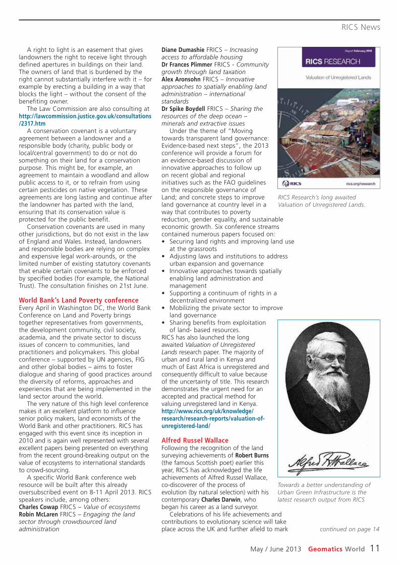
RICS has also launched the longawaited Valuation of UnregisteredLands research paper. The majority ofurban and rural land in Kenya andmuch of East Africa is unregistered andconsequently difficult to value becauseof the uncertainty of title. This researchdemonstrates the urgent need for anaccepted and practical method forvaluing unregistered land in Kenya.http://www.rics.org/uk/knowledge/research/research-reports/valuation-of-unregistered-land/
Alfred Russel Wallace Following the recognition of the landsurveying achievements of Robert Burns(the famous Scottish poet) earlier thisyear, RICS has acknowledged the lifeachievements of Alfred Russel Wallace,co-discoverer of the process ofevolution (by natural selection) with hiscontemporary Charles Darwin, whobegan his career as a land surveyor.
Celebrations of his life achievements andcontributions to evolutionary science will takeplace across the UK and further afield to mark
A right to light is an easement that giveslandowners the right to receive light throughdefined apertures in buildings on their land.The owners of land that is burdened by theright cannot substantially interfere with it – forexample by erecting a building in a way thatblocks the light – without the consent of thebenefiting owner.
The Law Commission are also consulting athttp://lawcommission.justice.gov.uk/consultations/2317.htm
A conservation covenant is a voluntaryagreement between a landowner and aresponsible body (charity, public body orlocal/central government) to do or not dosomething on their land for a conservationpurpose. This might be, for example, anagreement to maintain a woodland and allowpublic access to it, or to refrain from usingcertain pesticides on native vegetation. Theseagreements are long lasting and continue afterthe landowner has parted with the land,ensuring that its conservation value isprotected for the public benefit.
Conservation covenants are used in manyother jurisdictions, but do not exist in the lawof England and Wales. Instead, landownersand responsible bodies are relying on complexand expensive legal work-arounds, or thelimited number of existing statutory covenantsthat enable certain covenants to be enforcedby specified bodies (for example, the NationalTrust). The consultation finishes on 21st June.
World Bank’s Land Poverty conference Every April in Washington DC, the World BankConference on Land and Poverty bringstogether representatives from governments,the development community, civil society,academia, and the private sector to discussissues of concern to communities, landpractitioners and policymakers. This globalconference – supported by UN agencies, FIGand other global bodies – aims to fosterdialogue and sharing of good practices aroundthe diversity of reforms, approaches andexperiences that are being implemented in theland sector around the world.
The very nature of this high level conferencemakes it an excellent platform to influencesenior policy makers, land economists of theWorld Bank and other practitioners. RICS hasengaged with this event since its inception in2010 and is again well represented with severalexcellent papers being presented on everythingfrom the recent ground-breaking output on thevalue of ecosystems to international standardsto crowd-sourcing.
A specific World Bank conference webresource will be built after this alreadyoversubscribed event on 8-11 April 2013. RICSspeakers include, among others:Charles Cowap FRICS – Value of ecosystemsRobin McLaren FRICS – Engaging the landsector through crowdsourced landadministration
Towards a better understanding ofUrban Green Infrastructure is thelatest research output from RICS
RICS Research’s long awaitedValuation of Unregistered Lands.
continued on page 14

Research
12 Geomatics World May / June 2013
infrastructure.
Objectives of the studyThe first objective for the study is to reviewthe existing monitoring systems along the TLPand compare them to other rail industry peers(e.g. Crossrail Ltd) and non-UK rail projects,(e.g. Amsterdam Metro North-South line). Aswell as comparing the technologies beingused, this provides an opportunity for TLP toassess whether lessons can be learnt frompeer projects to enhance its monitoring.
The next objective is to identify where TLSand photogrammetry could enhance orsupersede existing systems for railwaymonitoring in the future. The first two years ofthe study have involved evaluating currentstate-of-the-art monitoring practices, e.g.ground movement and structural monitoring,and seeing how these can be developed andapplied in the railway environment. This isbeing done through a mixture of lab testingand site work.
Lab tests have been set up to look at theperformance of total stations typically used forautomatic or manual monitoring andcomparing these to laser scanners. Thisincludes looking at the accuracy and precisionbetween the instruments when controlledmovement of a target or feature is applied.The main challenge of implementing laserscanning for monitoring is to see whether theaccuracies required can be reached andmaintained. Some specifications dictate atleast a 1mm accuracy of the measurements,which is not currently possible for a laserscanner. From literature it can be seen thatsurface models can provide sub-millimetreaccuracy, providing a suitable solution to theserequirements. Also proper calibrationprocedures need to be developed in order tomodel and correct for the systematic errorspresent in the scanner data measurement thatcould be hindering the potential for betteraccuracy and precision. These lab tests thenprovide information of what can be feasibleon site.
Study test sites have been selected bysearching for a series of real scenariosrepresentative of railway monitoring (e.g.railway track, bridges, arches etc.), whichwould logistically allow for these alternativemonitoring techniques to be adopted inparallel. This enables analysis of the differentinstruments and their comparativeperformance. The expected outputs for eachof the sites include a qualitative andquantitative analysis between these
The EngD is an Engineering Doctorateprogramme promoted and partly fundedby the EPSRC (Engineering and Physical
Sciences Research Council). It is a four-yearstudy which is undertaken with an EngDcentre at a UK university in collaboration withan industrial sponsor. This study is beingcarried out at the Virtual Environments,Imaging and Visualisation (VEIV) centre atUniversity College London, with theThameslink Programme (TLP) at Network Railas the industrial sponsor. The TLP is the £6billion upgrade of the railway line runningnorth to south through Central London (moreinformation on TLP can be found in “Laserscanning on the Thameslink Project” inGeomatics World July/August 2011 issue). Theresearch study is currently in its third year andis due to be completed in September 2014.
A target-less solutionThe study looks at monitoring in a railwayenvironment, with a particular focus on thepotential of non-contact measurementtechniques for monitoring. These mightinclude methods such as terrestrial laserscanning (TLS) and photogrammetry. Currently,typical railway monitoring activities involvedirect contact through the placement oftargets (e.g. prisms) or sensors onto thestructures being monitored. This only providesdiscrete information and is an intrusivemethod where drilling, clamping or gluing isrequired. It can be expensive, whilst alsocreating safety and timing issues both atinstallation and for subsequent maintenanceactivities. Technologies such as laser scanningor photogrammetry could deliver a ‘target-less’ solution as well as providing continuoussurface measurement information of railway
Anita Soni isstudying non-contact measuringtechniques formonitoring railwayinfrastructure atUniversity CollegeLondon. This articleoutlines the scopeof the study anddescribes somepreliminary testresults.
Monitoring of railway infrastructure: is non-contact measurement the answer?
Figure 1 - PlanView of ArchDisplacement
Map
. . . surface modelscan provide sub-millimetreaccuracy. . .
‘‘’’
Research
May / June 2013 Geomatics World 13
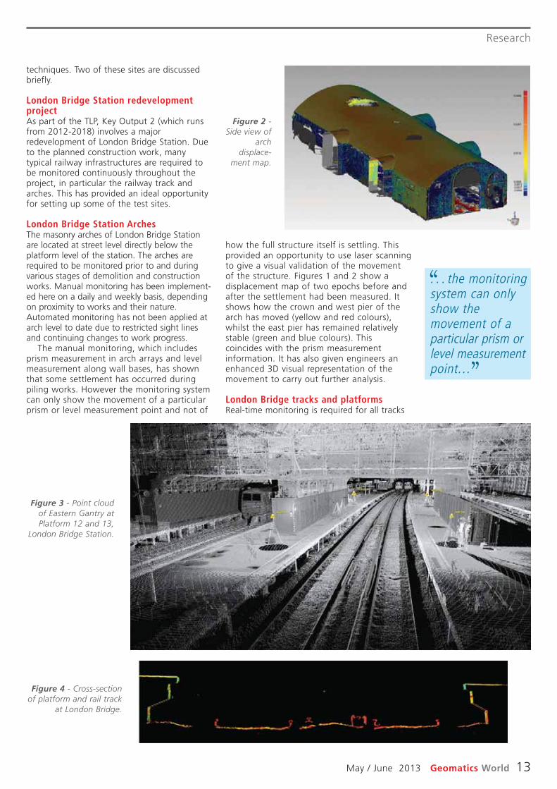
how the full structure itself is settling. Thisprovided an opportunity to use laser scanningto give a visual validation of the movementof the structure. Figures 1 and 2 show adisplacement map of two epochs before andafter the settlement had been measured. Itshows how the crown and west pier of thearch has moved (yellow and red colours),whilst the east pier has remained relativelystable (green and blue colours). Thiscoincides with the prism measurementinformation. It has also given engineers anenhanced 3D visual representation of themovement to carry out further analysis.
London Bridge tracks and platformsReal-time monitoring is required for all tracks
techniques. Two of these sites are discussedbriefly.
London Bridge Station redevelopmentprojectAs part of the TLP, Key Output 2 (which runsfrom 2012-2018) involves a majorredevelopment of London Bridge Station. Dueto the planned construction work, manytypical railway infrastructures are required tobe monitored continuously throughout theproject, in particular the railway track andarches. This has provided an ideal opportunityfor setting up some of the test sites.
London Bridge Station ArchesThe masonry arches of London Bridge Stationare located at street level directly below theplatform level of the station. The arches arerequired to be monitored prior to and duringvarious stages of demolition and constructionworks. Manual monitoring has been implement -ed here on a daily and weekly basis, dependingon proximity to works and their nature.Automated monitoring has not been applied atarch level to date due to restricted sight linesand continuing changes to work progress.
The manual monitoring, which includesprism measurement in arch arrays and levelmeasurement along wall bases, has shownthat some settlement has occurred duringpiling works. However the monitoring systemcan only show the movement of a particularprism or level measurement point and not of
Figure 2 -Side view of
archdisplace-
ment map.
. . . the monitoringsystem can onlyshow themovement of aparticular prism orlevel measurementpoint. . .
‘‘
’’
Figure 3 - Point cloudof Eastern Gantry atPlatform 12 and 13,
London Bridge Station.
Figure 4 - Cross-sectionof platform and rail track
at London Bridge.

Research
14 Geomatics World May / June 2013
chosen to look at a non-contact approach formonitoring railway infrastructure. The remainderof the third year of study will focus on acquiringdata for all the sites. Once the data has beenacquired, the next step will be to explore datapresentation methods in the monitoring contextfor each of these scenarios. Challenges willinclude handling the vast amount of data aswell as visualising the most relevant informationinto a reporting system. This will be carried outin the final year of the study.
About the authorAnita Soni is currently an EngineeringDoctorate Student at UCL/ThameslinkProgramme. Before this she worked as asurveyor at Plowman Craven Ltd, where shespecialised in laser scanning (includingterrestrial, close-range, head and bodyscanning) and worked on a variety of projectsfrom construction work to entertainment.Whilst studying for her undergraduate degree,she had an internship there and was offeredsponsorship for the last two years of herdegree. She has a MEng in GeomaticEngineering and MRes in Virtual EnvironmentsImaging and Visualisation, both from UCL.
and platforms that fall within the demolitionor construction zone. A combination ofmanual and real-time monitoring has beenimplemented here to date.
Currently one of the major problems fortrack monitoring is that the prisms getknocked during engineering hours as workstake place. This sets off spurious movementtriggers requiring analysis by engineers andcontinuous maintenance of the system. Oneof the aims of this site is to explore a fully“contactless” approach to monitoring of thetracks avoiding targets and therefore issuessuch as target disturbance and spuriousmovement reporting. The aim is to revisit aparticular section of track and scan it atregular intervals over the year. The methodsof producing models and the ability toextract relevant track geometry formonitoring purposes will be explored. Figure3 shows the platforms where scans havetaken place at London Bridge Station (yellowtriangles represent scan positions). Figure 4shows the initial cross-sectional view of thepoint cloud and the problems with occlusionsthat will need to be dealt with to obtainsufficient track geometry.
These are a few examples of the test sites
. . . one of themajor problems fortrack monitoring isthat the prisms getknocked duringengineering hours. . .
‘‘
’’
RICS News - continued from page 11
evolution. Throughout the year there will be aseries of roadshows, exhibition, conferencesand events on Wallace and his exploits, whereRICS members can participate. Insight anddetails can be found at the Wallace100Campaign website.
Further details on the life and work ofWallace are at http://wallacefund.info/ and ofcourse he features in the BBC series “Bill Bailey’sJungle Heroes” (available on BBC iplayer).
The ‘Blue’ EconomyThe biennial Ocean Business conference andexhibition brings together 1000’s of the greatand good (and the adventurous) of the globalmarine and hydrographic survey profession.This year’s event was again packed out withamazing technology, service providers,surveyors, careers information and much morebut one very special event stood out. Aprevious article in GW outlines the event inmore detail but it is still worth mentioningagain as is the recent FIG report on the“economic benefits of hydrographic survey”which went some way to addressing thebalance and the ‘blue’ economy event wenteven further.
Now for FIG Abuja May 2013 and theCambridge Conference July 2013. Of courseall comments very gratefully [email protected]
the centenary of his death. RICS is very proudto be part of this momentous historical eventin collaboration with the Natural HistoryMuseum.
The pinnacle of the year will be theunveiling of a bronze statue of Wallace at themuseum by Sir David Attenborough on 7November 2013 – the centenary of Wallace’sdeath. The statue will include a plaque onwhich RICS will appear as a contributor.Wallace began his career specialising as a landsurveyor, practising at a firm with his olderbrother in and around the Herefordshire townof Kington, and later for a period in Neath,Wales. Following his brother’s death, hetravelled to the Amazon and the MalayArchipelago between 1848 and 1862.
He centred his activities in the middle Amazonand Rio Negro regions. His work investigated thecauses of organic evolution and established hispermanent reputation as a leading naturalist andentomologist, and becoming one of the earliestbio-geographers in the world.
Wallace wrote at length on the subject,including the books Palm Trees of the Amazonand Their Uses and A Narrative of Travels onthe Amazon and Rio Negro. His essay On theLaw Which Has Regulated the Introduction ofNew Species, written during his time in theMalay Archipelago, was a key theoretical workthat all but stated outright Wallace’s belief in
Throughout theyear there will bea series ofroadshows,exhibition,conferences andevents onWallace and hisexploits, whereRICS memberscan participate.
‘‘

May / June 2013 Geomatics World 15
Land management in Hungary
services and land and property agencies. Although unknown in Hungary, my
company had established a reputation andpedigree for being independent, forsuccessfully implementing GIS solutions incomplex organisations and deliveringsignificant benefits. Although successful in theUK market, I was aware that the UK economywas about to dip into a serious recession inthe early 1990s and strategically needed toidentify markets outside of the UK to spreadthe risk. The Hungarian project was ideal andalso perfect timing.
The company is now 27 years old and myenthusiasm for consulting projects hasn’tdiminished. I am trying to slow down a bit,but I have failed – the projects just get moreinteresting. This past year I have helped theIraq government create a National Land Policy,supported the World Bank to improve stateland management in Kuwait, launched aninitiative to use crowd-sourcing to captureland rights and supported the Canadiangovernment in visioning their Geomaticssector in 2020.
Why did you apply for this job inHungary? Apart from business viewpoints,did you have any other reason?
In the late 1980s Prof Peter Dale hadintroduced me to international consulting inthe land administration sector – I was part ofa UN-FAO mission to North Yemen to improvetheir land registration and cadastral systems. Iloved the challenge of these initiatives and tohelp citizens around the world achieve greatersecurity of tenure. So when the opportunityarose in Hungary, I was enthusiastic to pursuethe contract through the EU’s PHAREprogramme. I am also an explorer at heart andget excited by new adventures.
What kind of expectations did you havewhen arriving in Hungary? How much didyou know of the country, the people andthe language?
I had briefly experienced Eastern Europe in1968. As a Boy Scout I had travelled to Polandand Czechoslovakia to climb in the TatraMountains. We narrowly missed the Russianinvasion of Czechoslovakia by a day. Thisstarted my fascination with Eastern Europeand established my desire to travel andexperience new cultures. Therefore, when theopportunity arose to visit and work inHungary and help the Hungarians transitionfrom communism to a market economy, I wasvery enthusiastic. A key supporter in pursuing
Robin, please tell us how the unusualname of your firm was created and whatits meaning is.
In 1986 I left my job in Toronto, Canada asthe product manager of a then state-of-the-art GIS solution and sailed back to Scotland ona Polish ship to start a new life. The voyagelasted six days and I had plenty of time tocontemplate starting and naming a new GISconsulting company. The idea for the unusualname came to me over the mid-Atlantic ridge.I didn’t want to name the company with anyterms such as ‘geo’, ‘mapping’ or ‘GIS’. Iwanted something different that people wouldremember; and it has certainly worked. As forits meaning – that is entirely up to theinterpreter! However, I have thought aboutforming a ski touring company called ‘Off theEdge’ and a landscape architects company‘Know Hedge’.
Please introduce your firm, its past andpresent.
Prior to starting Know Edge, I was a softwareengineer and designed and developed GISsolutions in Scotland, Switzerland and Canada –this included land registration and cadastralsolutions. In fact, I helped to develop theworld’s first Land Information System that wasinstalled in Basel, Switzerland and Munich,Germany. Armed with this leading-edgetechnical knowledge I decided to form anindependent consulting company in the UK –the company was the first of its type in thecountry. It was an exciting time as this wasbrand new technology and its introductionwithin organisations raised difficult, butstimulating challenges. Initial customers includedutility companies, local government, financial
Robin McLaren,Director of KnowEdge Ltd recentlycelebrated a twentyyear associationwith landregistration inHungary. MariaToth took theopportunity tointerview him overdinner on theDanube withformer Hungariancolleagues.
It all started two decades ago. . .– a sweet (and sour) Hungarian Rhapsody
Right: Robinand JaneMcLaren withformerHungariancolleagueAladar Zichy.

was its relationship with the EU Delegation inBudapest. It was a difficult and sometimeshostile stakeholder to deal with. Thisrelationship never improved over the lifecycleof the project and in the end it brought KnowEdge Ltd’s involvement to an end in a veryunprofessional and unfair way.
However, my lasting memory of the start ofthe project was my first visit to the BudapestCounty Land Office located in a small house inthe suburbs. When we arrived citizens werelined up for about 600 metres around theblock and there were TV camera crewsinterviewing them. I knew then that we had aserious problem to solve and we had to solveit quickly!
What is your opinion of the Hungarianpartners in your project?
The project was fortunate to have a set ofHungarian partners that not only intimatelyknew the current approach to land registrationand cadastre in Hungary, but embraced thesignificant level of change, both technical andcultural, required in the Ministry and the LandOffice network. They were also goodcommunicators and were very influential inselling the proposed changes to theircolleagues. László Niklasz, András Osskó andPiroska Zalaba were key success factors in thiscomplex change management programme.
How was the project activity terminated?
This was one of the very few bad experienceson the project. Know Edge Ltd tendered andwon two contracts with a total duration of fouryears. This continuity of the consulting teamand the associated consistent strategicapproach was instrumental in allowing thiscomplex programme of work to succeed.However, despite obtaining confirmation fromthe EU Delegation that Know Edge Ltd couldbid for a third contract, the EU Delegationcancelled it after Know Edge Ltd had won thetender. No explanation for the cancellation wasprovided by the EU Delegation and their hostiletactics forced Know Edge Ltd to abandonsupport of the project; a sad ending to one ofmy most enjoyable and successful projects.
What are the results, the success on yourside?
The success of the project is reflected in thevibrant Budapest I visited at the end of 2012.Citizens have been able to secure their landand property rights, obtain mortgages andinvest in their buildings. There is a robust andefficient land registration and cadastral systemthat citizens trust and this has led to a vibrantland market – the ultimate aim of the project.
Throughout the project I was determined toensure that we transferred our skills andknowledge to effectively capacity-build inHungary. What we started has continued andHungary now has some very talented Land
the opportunity was Prof Peter Dale, who hasbeen a great mentor over the years.
Although I had a Hungarian professor atthe University of New Brunswick during mystudies and worked with several Hungarians inToronto, I knew very little about the country,the culture and the language. However, Iknew I liked Hungarians very much; a proudrace and full of life. I wasn’t disappointedwhen I arrived.
What were your first impressions whenentering the Ministry for the first time?
It was like entering a time machine and goingback 40 years, both in the austeresurroundings and the mentality of the Ministryafter so many years under communist rule. Iknew that our land reform project was goingto be a real challenge. However, the projectluckily had Hungarian members whounderstood and were enthusiastic about thechanges required. I knew, even at this earlystage, that we were going to be successful.
There was one lasting memory of the firstdays on the project: the ‘paternoster’ lift (achain of open compartments that move in aloop up and down inside a building withoutstopping) in the Ministry. I still haven’t beenover the top.
How did you start the project? Did youhave to face difficulties?
The initial task was to create a project teamcapable of responding to this significantchallenge. I had to find Hungarian counterpartsthat could not only communicate and gain trustwith the Ministry and Land Offices, but couldalso understand and work well with the KnowEdge Ltd consultants (not always easy!). I wasvery fortunate to engage Mária Tóth as projectassistant and PA, Ádám Podolcsák ascounterpart project manager and Marta Jeneias project technical support. I also managed topersuade Richard Baldwin to leave his academicposition in the UK to be the project manager.Top level support was provided by Aladár Zichywithin the EU Office and his support provedinvaluable for the success of the project.Without this great team the project would havefailed in the first few months.
The other major difficulty the project faced
Right: RobinMcLaren
celebrated theanniversary of hisinvolvement withthe Land Reformproject with the
former Hungariancolleagues in
Budapest overdinner on the
Danube lastAugust.
No explanationfor thecancellation wasprovided by the EUDelegation andtheir hostile tacticsforced Know EdgeLtd to abandonsupport. . .
‘‘
’’
Land management in Hungary
16 Geomatics World May / June 2013

Land management in Hungary
May / June 2013 Geomatics World 17
the benefits of their investments. Adifferent set of terminology and languagehas to be used in this on-goingengagement strategy. Projects succeed ifthey have a senior, high profile championsupporting them.
• Most ICT projects assume that solutionsshould be provided by major internationaltechnology suppliers. However, if there islocal capacity then much more sustainablesoftware solutions can be achieved usinglocal suppliers, especially using open sourcesolutions.
• Ensure that there is a common visionestablished and agreed across thestakeholder communities before startingimplementation. In Hungary’s case, the‘Takaros’ vision was very successful incommunicating this vision.
Could you use the experience you gainedin Hungary somewhere else in the world?
I constantly use my Hungarian experience andhave used it in projects as far afield asMongolia, Philippines, Iraq, Kuwait, Kenya andScotland. The Hungarian success has not justtouched and improved my projects, but hasbeen used as an exemplar in how tomodernise land registration and cadastralsystems across many regions of the world. It isa project that Hungary can be very proud of.
Professionals who are not only changingHungary, but other parts of the world as well.This is the best legacy.
What are the lessons you learned fromworking in Hungary?
I am continually learning from projects and theHungarian experience was no exception. Someof the lessons learned included:• Although the project was labelled as a
‘computerisation’ project, the technologyaspect was the least important. The majorchallenge was the associated cultural andbehavioural changes needed to takeadvantage of the technology – a change inmind-set. For many Hungarians this changewas difficult because under the previousregime they were not taught to thinkoutside of their box or even contemplateand propose change. Don’t ever under-estimate the time and energy required inchange management.
• Although the majority of the changeassociated with the project impacted theoperational staff, it is really important tospend time with senior management toensure they understand and are comfortablewith the proposed changes. The move to aservice oriented organisation is a big one.
• Projects only succeed if the politicians andthe funders of these initiatives understand
Projects onlysucceed if thepoliticians andthe funders ofthese initiativesunderstand thebenefits of theirinvestments.
‘‘
’’

FusionRoadshow
Breakfast Briefing
Register today:discovermore.leica-geosystems.com
+44 (0)1908 256 547
ScotlandTuesday 14th May
Edinburgh Napier UniversityWednesday 15th May
Thistle Aberdeen AltensThursday 16th May
Drumossie Hotel, Inverness
Northern EnglandTuesday 21st May
BALTIC Centre for Contemporary Art, Gateshead
Wednesday 22nd May Doncaster Racecourse
Thursday 23rd MayConcorde Conference Centre, Manchester
Central EnglandTuesday 14th May
Edgbaston Cricket Ground, Birmingham
Wednesday 15th MayF1 Williams Conference Centre, Oxfordshire
Thursday 16th MayCheltenham Racecourse
Tuesday 21st MayNational Space Centre, Leicester
Wednesday 22nd MaySilverstone, Northampton
Thursday 23rd MayNewmarket Racecourse
Dates & Venues:

Change is coming
South EastTuesday 14th May
Mercedes Benz World, Weybridge
Wednesday 15th MayBrands Hatch, Kent
Thursday 16th MayOrdnance Survey, Southampton
Friday 24th MayScience Museum, London
South WestWednesday 22nd May
Wales Millennium Centre, Cardiff Bay
Thursday 23rd MayExeter Racecourse
Northern IrelandWednesday 29th May
Titanic Belfast
IrelandThursday 30th May
City West Hotel, DublinFriday 31st May
Fota Island Hotel, Cork

LiDAR Conference
20 Geomatics World May / June 2013
Plenary sessionThe plenary session opened with a presentationfrom Christoph Strecha of Pix4D. Owned in partby the French consumer product manufacturerParrot, camera equipped Unmanned AerialVehicles (UAV) solutions were outlined bySwitzerland based Christoph. Solutions thatdemonstrated comparative accuracies betweenpoint clouds / meshes generated byphotographs and those from airborne LiDARdata. 3D data capture was explored usingexamples generated in Pix4UAV.
Christoph’s discussion set the tone for apresentation given on the second day by LewisGraham, GeoCue corporation and LIDARdivision director for ASPRS. This focused onthe rebranding of sensor equipped UAVs. Asboth Strecha and Graham noted, companieslike Parrot continue to drive UAS prices downand open up mapping applications to generalusers. Smartphone and tablet operatedsystems like the Parrot AR were viewed ascomplementary to open hardware, such asthose produced by the DIY Drone andMiKroKopter user communities (seeGEOinformatics 7, vol. 15: pp. 32-34).
ESRI in 3DAn emerging 3D world was at the heart of thetalk by director of imagery at ESRI, Lawrie E.Jordan III. Information models were seen asthe backbone of 3D workflows and provided aframework for taking 3D data beyondvisualisation uses. An analogy betweenhardware and software was given to exemplifythis; the map layer featured in GIS softwarewas likened to airborne LiDAR systems andthe ability to get multi-layer data returns fromone sensor. Jordan ended the plenary sessionwith a quote from Alan Kay (seeGEOinformatics 2, vol. 16: pp. 30-32): “Thebest way to predict the future is to invent it.”
The main body of presentations were centredaround data acquisition, management andapplications. Whether sitting in on MichaelTwohig’s (Surface Search International)discussion of using both analogue and digitalinformation to map cityscapes above and belowground, or Mike Sekerka’s (Neptec Technologies)work on dust penetrating LiDAR, the buzzcreated from the sessions was, in part, areflection of changes being felt throughout thegeospatial sector in 2013. A recurring theme,for instance, was the way 3D technologies hadcrossed over to general consumer markets andusers; technologies that were once exclusivelyspecialist in use. The time of the 3D digitalnative had clearly arrived and had a clear
Combined sensor use and data fusionwere key topics at the three-dayInternational LiDAR Mapping Forum
(ILMF) in Colorado, February 11-13th, 2013.Hosted for a second consecutive year at theHyatt Regency in Denver, this US basedforerunner to the European LiDAR MappingForum (ELMF) continues to grow each year,both in number of attendees and topics ofdiscussion. On April 10th, 2013, it wasannounced that SPAR Point Group had acquiredthe rights to the ILMF and ELMF from UK basedIntelligent Exhibitions. The first ILMF in 2000had its roots in laser scanning solutions.
IntroductionThis article explores the presentations andsolutions featured at the ILMF 2013. The lastILMF to be organised through the UK basedcompany Intelligent Exhibitions. An interviewwith Nick Palatiello of the ManagementAssociation for Private PhotogrammetricSurveyors (MAPPS) is included also. MAPPSwas formed as a lobbyist platform in 1982and represents the interests and concerns ofprivate sector companies.
ASPRS ‘Hot Topics’Thirty three presentations were given overthree days. Alistair McDonald - the onlyfounding committee member still involved inthe running of the ILMF - chaired the eleventhemed sessions and offered insights from hisbusiness activities in the oil and gas industrywhere relevant. The ASPRS ‘Hot Topics’ sessionstarted the event and was based aroundLiDAR and mobile mapping standards.Updates to LAS and its compatibility withother file formats like E57 were a key part ofthe agenda, as was standards for mobileapplications of terrestrial laser scanners.
There was plenty tointerest ourcorrespondentAdam Spring atthis LiDAR focusedevent includinggeneral geospatialtechnologies likeUAVs. He alsofound time to talkto Nick Palatiello ofthe ManagementAssociation forPrivatePhotogrammetricSurveyors.
The LiDARForum is alwaysa chance to talkface to facewith suppliersand developers.
International LIDAR Mapping Forum 2013By Adam Spring

LiDAR Conference
May / June 2013 Geomatics World 21
While Microsoft were at the event promotingUltraCam - an airborne photogrammetrysolution obtained through the acquisition ofVexcel in 2006. Fresh off the press copies ofThe Manual of Airborne Topographic LiDARand key information about the new ASPRSaccreditation courses were available too.
presence at the event.
WorkshopsOverall, the workshop sessions were a soundingboard for exhibitors at the ILMF. Nineteenpresentations were given in total and a broadrange of products were explored. For instance,multi-signal data return (Riegl USA) wasintermingled with that of industry changingalgorithms and display engines (Euclideon). Theworkshops even left room for Stewart Walker,the debonair Scotsman who didn’t require helpfrom Bruce Willis or Cybill Shepard when itcame to moonlighting. Stewart representedBAE Systems and the American Society forPhotogrammetry and Remote Sensing (in hisrole as vice-president) at the ILMF.
ExhibitorsExhibitors at ILMF 2013 were a mix of old andnew faces. Companies like Riegl showed offtheir enhanced airborne LiDAR solutions.
Microsoft were hard atwork promoting
Ultracam.
As a tradeassociation,MAPPS is able toeducate electedofficials on thebenefits ofgeospatialtechnology. . .
‘‘
’’
How did MAPPS come about?
MAPPS was formed by a handful of progressivefirms in 1982 as a successor to the LegislativeCouncil for Photogrammetry to provide a forumfor firms in private practice photogrammetry.The organization has grown to more than 150members based on a reputation of aggressiveadvocacy of the private photogrammetry,remote sensing, surveying, and GIS community.As the organization and technology havegrown, its goals have expanded.
MAPPS is exclusively a private sectororganization focused on the needs of the mem -bership by providing a forum for the mutualbenefit of its members. MAPPS’ primaryobjective is to develop strength and unity onmatters affecting the interests of its memberfirms. The organization monitors and works toaffect legislation that impacts the profession. Itis intended to promote a quality, profitableprofession, interaction among firms andadvance education, both professional and public.
Why do you think MAPPS is uniquely Americanin one respect yet international in scope?
MAPPS is on one hand uniquely Americanbecause the US has the strongest and mostdiverse free enterprise economy in the world.However, there are a few associations in othercountries similar to MAPPS, such as The SurveyAssociation (TSA) in the United Kingdom andthe Geomatics Industry Association of Canada(GIAC). Like MAPPS, these organizations focuson the business interests of their members andprovide a forum for education and networking.MAPPS has assisted and consulted to TSA andGIAC with their attention to government affairs.
Talking to Nick Palatiello, the Management Association for Photogrammetric Professionals (MAPPS)
As a trade association, MAPPS is able toeducate elected officials on the benefits ofgeospatial technology and advocate for the useof the private sector to collect and produce dataproducts and services. It is through the lobbyingefforts of MAPPS that it has been so successfuland influential not only for the geospatialcommunity in the US and the nation as a whole,but around the globe as well. MAPPS hasattracted member firms from Canada, Australia,India, Israel, Germany, Austria, China, Sweden,Italy and several other countries, and MAPPShas assisted US firms with exporting theirservices in the global market.
How do you see MAPPS fitting into the everchanging face of the geospatial sector?
Since MAPPS was formed over 31 years ago,surveying and mapping technologies havetransformed at a rapid pace. As the marketchanged, the MAPPS membership changed.While formed by firms primarily inphotogrammetry in 1982, the MAPPSmembership now spans the entire spectrum ofthe geospatial community, including memberfirms engaged in satellite and airborne remotesensing, surveying, photogrammetry, aerialphotography, mobile mapping, LIDAR, buildinginformation models (BIM), 3D mapping,hydrography, bathymetry, charting, aerial andsatellite image processing, GPS, and GIS datacollection and conversion services.
MAPPS also includes Associate memberfirms, which are companies that providehardware, software, products and services tothe geospatial profession in the US and otherfirms from around the world. IndependentConsultant members are sole proprietors

LiDAR Conference
22 Geomatics World May / June 2013
advancement of LIDAR applications. ForMAPPS, the event allows our organization toeducate the community on topics that have thepotential to be business opportunities, as wellas share information on emerging threats.MAPPS is tracking initiatives at the Federal levelthat could create a demand for LIDAR databenefiting both public and private entities. Theprogramme needs public-private support so weare able to educate the community about whatis needed to make such a programme a reality.In addition, we keep an eye out for threats tothe community with regard to implementationof new technologies or how government policy,legislation or regulations could impactgeospatial practitioners. MAPPS uses ILMF as aforum to educate the profession on issues thatthey may not be aware of, and to inform keyconstituents of the association’s activities onthese issues.
SummaryILMF 2013 emphasised technology and dataintegration is shaping the way information iscollected, processed and used. Its acquisition bySPAR Point Group, along with the ELMF, meansit can only get bigger in number of attendeesand scope of interest. The increased use of UAVor UAS systems will continue to shape impactupon its content, as will the changing ways inwhich 3D can be collected and used.
engaged in consulting in or to the geospatialprofession, or providing a consulting service ofinterest to the geospatial profession.
The technology today provides more dataand the general public is more familiar withthe products and services that are providedbecause of the technology. However, many ofthe issues with regard to how data is collectedand managed still exist. MAPPS has its pulseon the legislative and regulatory issues thataffect the business interests of its memberfirms and the impact on the entire geospatialcommunity. For example, MAPPS has beenengaged with the Federal AviationAdministration (FAA) in the commercializationof unmanned aerial systems (UAS) to makethe agency aware of the desire for thecommunity to implement the technology intotheir workflow. MAPPS also has been outfront on privacy issues that have been raisedin the US with the misunderstanding of howUAS will be used and to make sure thatgeospatial is not unintentionally affected fromlegislation or regulations to seek to prohibitspying, surveillance, or weaponized drones.
How would you summarize your experience ofILMF 2013?
ILMF 2013 was a well organized and attendedevent with much excitement surrounding the
For those wonderinghow you could fit overthree hundred
exhibition stands in to theNational OceanographyCentre in Southampton,the answer is two verylarge tents. Thehydrographic world’sannual get-togetheralternates with
Oceanology, which is held at the Excel Centrein east London. In many respects the twoevents are very similar. Both are large, haveaccompanying conferences and havedemonstration vessels at the quayside.However, Ocean Business is perhaps morefocused and relevant to hydrographers. Overthe first two days the show had attracted3600 visitors from 57 countries.
The event was packed with associatedconferences and workshops including a one-dayevent on ‘The Blue Economy’, taking a highlevel look at ocean policy and on monitoring ofthe ocean environment. (see James Kavanagh’sreport in the next issue of GW.)
The Offshore Survey conference ran overtwo days and featured a full programme oftalks, given by senior industry figures. Therewas also a careers event with industrypresentations and speed-dating style sessions,affording a valuable opportunity for younghydrographers to find out about life on theocean wave from experienced practitioners.
It was noticeable this year that there weremany manufacturers offering multibeamsystems and SAS swathe bathymetry systems.Autonomous underwater vehicles (AUV) isperhaps the technology of the moment. Thegovernment has highlighted robotics andautonomous systems technology as an area inwhich Britain could lead the world and agroup of twenty-five or so delegates took partin a workshop looking at how the technologycould be developed as a partnership betweengovernment, industry and academia. Thediscussions were led by Patrick Carnie fromthe Marine Industries Leadership Council. Thegroup split into two workshops, one to discussmarkets and customers and the other,technology. For more information contactPatrick Carnie ([email protected]).
Ocean Business 2013
The next issue ofGW will have astrong hydrographicfocus. RichardGroom provides ataster here with anearly report on therecent OceanBusiness event.

Measured building survey
May / June 2013 Geomatics World 23
carry out the measured survey withphotographic records of the tower inside andout, including the tank construction andpipework.
Through discussion with English Heritageand the planning authority, Aworth Surveysdeveloped the exact specification needed tosatisfy the surveying requirement of theplanning conditions, to provide detailed surveyplans, elevations and sections for thisextraordinary project.
In spring 2011 the survey commenced. Butbefore the survey could begin on the interior,the tower and the tank had to be thoroughlycleaned as it had been occupied by pigeonsfor decades, which had left a significantamount of mess in all parts of the building.Over 200 dead pigeons and guano up towelly-boot level were removed!
Reflectorless outsideThe first part of the survey was to measurethe upper part of the tower and tankexterior. To avoid the obvious and significantsafety issues of measuring the exterior of abuilding 99 feet up, the detailed survey wascarried out by precise remote observationsusing Leica reflectorless EDM total stationinstruments set up at ground level aroundthe structure. The whole project was fullyconnected with closed traverse observationsand radial measurements of building detailand equipment both inside and out.
Calipers insideThe survey specification required a detailedsurvey of the tank interior and the remainingwater pipes and ironwork for an historicalrecord. Precise measurement of these wasmade by hand using engineers callipers sothat exact sizes could be stated.
The survey of the tank interior also presentedspecial difficulties as the work was carried outunder a confined space procedure, there beingonly a ladder access through a single hatch upto the tank. Aworth surveyors are specificallytrained for safe working in confined spaces sothis was not too much of problem.
Today the hospital site has been redevelopedas modern housing and the water tower, onceon the English Heritage ‘At Risk Register’, hasbeen turned into one of the most striking andunusual residences in London.
• John Witherden, FCInstCES, MRICS is themanaging director of Aworth Survey Consultantsand vice president of the TSA (The SurveyAssociation).
Channel 4?s flagship design programmeGrand Designs celebrated the 100thepisode of the show on 17th October
by featuring the transformation of thelandmark 99ft high Lambeth Hospital WaterTower in Kennington, London, converting itfrom a building that was in a rough state ofdisrepair into one of the most lavish andeccentric residencies in central London. Therenovation and conversion project involvedbuilding two additional contemporarystructures at the base: a new lift shaftconnected to the tower by a series of glasstunnels, and a modern living spacenicknamed the ‘Cube’.
Altogether this cluster of buildings creates afour-bedroom luxury home, over nine floors,crowned with a viewing room offeringspectacular 360-degree views across London.
Chaplin inmateThe tower, built in 1877, is a Grade II listedbuilding with walls over five feet thick andcrowned with a huge iron tank that originallyheld over 750,000 gallons of water. Thebuilding was part of the Lambeth Workhouseand Infirmary which latterly became LambethHospital. The original workhouse was
designed to house 820inmates with places fora further 600 ‘casuals’.In 1896 the future starof the silent screenCharles Chaplin, thenaged seven, brieflybecame an inmate ofthe LambethWorkhouse togetherwith his mother andyounger brother.
Record surveyProperty developer andowner of the tower,Leigh Osborne, engagedACR Architects ofLondon to develop adetailed design for theproject. One of the firsthurdles they had toovercome was acondition of planningapproval that requireddetailed and preciserecords of the upperpart of the tower.Aworth SurveyConsultants of Londonwere recommended to
A detailed surveyof what was once awater tank inSouth London butwas to become ahighly “des-res”(below) meant firstdealing with over200 dead pigeons,reports JohnWitherden.
Grand Designs for Lambeth HospitalWater Tower by John Witherden

It is duringtesting that ourlaser scannerreally delivers.
‘‘’’
Coastal Monitoring
24 Geomatics World May / June 2013
Depending on the scale, our basins canaccommodate real world frontages of 100mto 2km, with local seabed bathymetryrecreated in order to simulate waveconditions as accurately as possible.”
International client baseHR Wallingford’s clients are from all over theworld. “They provide the details we need toreplicate the coastline” explains Steele, “aprocess which can take around two to threeweeks to build. This is then followed by afurther three- to five-week period toconstruct and test the coastal structures inthe wave basin. For example, when weconstruct a breakwater, we create it inexactly the same way as in the real-world,starting with the smallest material in the coreof the structure. We then add possiblyseveral layers of larger size rocks over thiscore finishing with the main rock or concretearmour units. It is during testing that ourlaser scanner really delivers.”
Previously Steele and his colleagues haddetected any movement in the modelstructures either by using manual methods oran older style scanner with an oscillatingbeam but they found both processes slowand dated. “When KOREC first showed usthe laser scanner, it was obvious that it wasgoing to be 100 times faster than our old-style manual methods and at least ten timesfaster than our existing scanner.” Steelecomments. “On top of its phenomenalspeed, it is compact and lightweight, makingit easy to move around our large modellingarea. We tend to use the scanner at itshighest resolution because generally we arelooking for movements of the order2–3mm.This movement would translate tomovements of the order 60-180mm in thereal-world.”
The scanner works at the touch of a buttonand HR Wallingford were up and running afterjust one day of training.
Using the DataHR Wallingford uses its scanned data in twoways. In the first method, one surface modelis subtracted from another to derive changesover the whole structure. The second methodis based on cross sections. Before testing,along a 1m length of the model (equivalent tomaybe 30m in the real world), ten crosssection profiles are typically taken at regularintervals of around 100mm. These profiles arethen combined to produce an ‘average’ profilerepresenting the 1m length of the model.
After each test, each of which represents astorm wave condition, the scan is repeated
South of the city of Oxford is HRWallingford, an independent specialist forresearch and consultancy in civil
engineering and environmental hydraulics. Thecompany boasts an international track recordof achievement in applied coastal research andconsultancy, and key to this work is theiradvanced physical modelling facility inWallingford. This facility includes six wavebasins ranging in plan size from 25 × 32m to75 × 32m and three wave flumes rangingfrom 45m to 100m in length.
Simulated cyclonesHoused in a purpose built modelling hall, thesebasins are used to investigate how breakwatersand other coastal structures behave whensubjected to both ‘frequent’ i.e. day-to-daywave conditions as well as ‘storm’ conditionsincluding hurricanes or cyclones. Waves can bemodelled up to 0.25m (model scale) in heightallowing HR Wallingford’s engineers to assesseach structure’s ability to withstand damageand provide sufficient shelter.
These criteria are best tested by creating ascaled physical model of the structure inquestion, running waves at it under frequentand storm conditions and then accuratelymeasuring the outcome. To achieve this HRWallingford uses a Focus 3D laser scannersupplied by KOREC to take before and aftermillimetre accurate scans of the model,allowing the movement of elements of thecoastal structures or the mobile bed materialto be monitored.
Having joined HR Wallingford in 1973,coastal engineer Andrew Steele has projectmanaged many studies for the company’sCoastal Structures Group. “These models arescaled to represent real world situations,”explains Steele, “whether existing coastalfrontages or new port developments.
3D laser scanningis playing a centralrole in majorcoastal researchand marineinfrastructureprojects. But thiswork is takingplace just outsideland-locked Oxfordand in miniature.
Coastal Monitoring. . . indoors!
The laserscanner insitu

Coastal Monitoring
May / June 2013 Geomatics World 25
and profiles generated along the same tenprofile lines. Again an average profile isgenerated. At the end of testing, thedifference between each average profile iscalculated.
These differences allow HR Wallingford todetermine areas of erosion and accretion onthe structure. From this information it ispossible to assess the suitability of thestructure design to withstand waves of aparticular intensity.
Seabed scourAlthough much of the Coastal StructuresGroup’s work is confidential, Andrew Steelecites a UK project studying seabed scour atwind farm foundations as a typical example ofwhere a laser scanner would be used beforeand after, to assess scour performance onfoundation designs.
As part of the Future Energy Solutionsresearch project (0216) on The Application ofSuction Caisson Foundations for OffshoreWind Turbines, HR Wallingford investigatedthe volume of seabed scour that might takeplace around such foundations. The scourperformance of four different modelfoundation designs was tested and laserscanning used to compare the results.
Physical model tests determined the extentof the scour around suction caisson (skirted)foundations due to wave and current actionin the marine environment. The testing wascarried out at a geometric scale of 1:40 in awave-current test basin. The height andperiod of irregular waves was representativeof a one-year condition as well as standardpeak currents that might occur in Britishcoastal waters. The waves were generated at90 degrees to the current direction. A scaledsand bed represented the real life seabedsediments. The effectiveness of a rockarmour scour protection layer wasdemonstrated for the conditions tested. Theresults obtained were generic and of aresearch nature.
• Acknowledgement: Many thanks to AndrewSteele, www.hrwallingford.com
Above: Exampleof wave basin andbreakwater model.
Right: Modelshowing seabed
scour.
Above: a typical set of profiles - the red line represents the average profile
Changing address or moving on?If you receive GW as part of your RICS membership, you must inform the RICS of any change of address– the publishers of Geomatics World cannot change the RICS membership database for you. Call +44 (0)870 333 1600 or login to the RICS website or write to: RICS Contact Centre, Surveyor Court,Westwood Way, Coventry, CV4 8JE, UK or email [email protected]
Subscribers to GW can call +44 (0)1438 352617, email: [email protected] or write to
PV Publications Ltd, 2B North Road, Stevenage, Hertfordshire, SG1 4AT, UK.
Deformation Monitoring
26 Geomatics World May / June 2013
standards are defined for monitoringdisplacements in hydraulic structures.”
To summarise Table 1, the required accuracyfor concrete structures is ±5-10 mmhorizontally, and ±2 mm vertically, while therequired accuracy for embankment structuresis ±20-30 mm horizontally and ±10 mmvertically. Based on these criteria, themonitoring surveys performed in the USACEPittsburgh District are designed to meet thefollowing accuracies (least squares adjustment,station confidence regions at 95%confidence):
Concrete (navigation locks and dams, concretegravity dams):
- Horizontal: ±3 mm (total station)- Vertical: ±1 mm (invar rods)
Embankment structures (earth and rock filldams):
- Horizontal: 10 mm (GNSS Static)- Vertical: 5 mm (invar or fiberglass rods)
Terrasurv uses a Trimble S6 total station (orZeiss S10 total station (limited use on selectprojects)) with 1” angular accuracy anddistance precision of 1 mm ± 1 ppm; a TrimbleDini 12 digital level with 2m and 3m invarrods or 1m and 4m fibreglass rods; andTrimble dual-frequency GNSS receivers (4400,4700, 5700, and R8 models).
Early deformation surveysDeformation surveys began on most of thestructures in the Pittsburgh District in the early1970’s. The method for horizontaldeformation surveys utilised fixed referencepoints and a series of alignment pinsnominally placed on line between thereference points. For flood control dams, thereference points typically consisted ofinstrument pedestals set 1 to 2 metres in theground, protruding about 1.3 metres aboveground. Additional pedestals were establishedoff structure to be used for verification of thereference network.
For navigation locks and dams (weirs), thereference monuments typically consisted ofdiscs set in gate monoliths, which wereusually constructed down to bedrock. Offstructure pedestals were also used at the locksto verify the gate monolith monuments.
A Wild T2 theodolite was used to measurethe offset of each alignment pin from thealignment line.
For lines that run parallel to the direction offlow (i.e. lock wall), the displacement isrecorded as riverward-landward, and for lines
The US Army Corps of Engineers (USACE) isa US federal agency under the Departmentof Defense made up of approximately
34,600 civilian and 650 military personnel,making it the world’s largest public engineering,design, and construction management agency.Although generally associated with dams, canalsand flood protection in the United States,USACE is involved in a wide range of publicworks throughout the world. In addition toproviding design and construction managementof military facilities for the various militarybranches, two of the Corps main missions in theUS are the planning, design, building, andoperation of navigation locks and dams andflood control projects, including reservoirs,dams, flood control channels, and levees.
The Corps is organised into eight divisions,and each division has several districts whosegeographical limits are defined by watershedboundaries. This paper presents the currentmethodologies employed in the PittsburghDistrict of The Great Lakes and Ohio Riverdivision to monitor the twenty-three locks,sixteen major multi-purpose flood damagereduction reservoirs and forty local flooddamage reduction projects, which the USACEowns and operates.
Terrasurv, Inc of Pittsburgh, Pennsylvania ispart of a team lead by Photo Science ofLexington, Kentucky that is under contractwith the Pittsburgh District to provideSurveying and Mapping services, and has beenperforming alignment and settlement surveysfor the locks and major reservoirs since 2005.
GuidanceThe US Army Corps of Engineers publishes awide variety of Engineer Manuals(http://publications.usace.army.mil/publications/eng-manuals/). Table 1 specifies the accuracyrequirements for surveying deformationmonitoring points and comes from StructuralDeformation Surveying (EM 1110-2-1009),which “provides technical guidance forperforming precise structural deformationsurveys of locks, dams, and other hydraulicflood control or navigation structures.Accuracy, procedural, and quality control
Terrasurv, has beensurveying floodcontrol dams andother structures inthe north easternUnited States since2005. In this papercompany president,John Hamiltondiscusses themodernisedsurveying methodsthat he hasdeveloped tomonitor theseimportant structures.
Dam deformation surveying in the USAby John Hamilton
Table 1:Accuracy
Requirementsfor StructureTarget Points
(95% RMS)

Deformation Monitoring
May / June 2013 Geomatics World 27
The data is post processed usingmanufacturer supplied software (currentlyTrimble Business Center). In addition toprocessing the baselines from the base to eachof the monitoring points, baselines are alsoprocessed from the base to surroundingContinuously Operating Reference Stations(CORS). After processing, the data (occupationinformation, vector components, covariancematrix, etc) are loaded into a database. Afterthorough data checking, an input file iscreated for a least squares adjustment usingGeolab. A minimally constrained adjustment isperformed, holding fixed the previouslydetermined base coordinates. The misclosureis checked at each of the CORS to determineif any movement of the base point hasoccurred since the previous survey.
The resulting coordinates for each of themonitored points are then loaded into aspreadsheet as UTM Zone 17 coordinates. Thecoordinates are differenced with respect to areference epoch (initial survey), and the ∆Nand ∆E components are rotated to a systemwith the X axis parallel to the dam axis (asdefined by the reference line). The Ycomponent then represents displacementupstream or downstream.
Concrete gravity damsThe monitoring network for the reservoir damsconsist of two pedestals defining the alignmentreference line, and pins set in each monolith.Figure 5 shows the survey layout and thehorizontal network that is observed using aTrimble S6 total station. The alignment pins areobserved from both ends of the reference line.
As described above, the data is adjustedusing least squares. However, in the case of
that are perpendicular to the flow (dam), thedisplacement is recorded as upstream-downstream. The advantage of this system isthat it directly measures the parameter ofinterest to the structural engineer. For example,a lock guide wall, constructed similar to aretaining wall, would be expected to move in adirection perpendicular to flow, and movementriverward would be of most concern.
Similarly, on a gravity dam the directiondownstream would be of most interest. Thedisadvantage is that as the distance from theinstrument increases, it becomes more difficultto discern the cross hairs intersecting themoveable target due to shimmer and heatwaves. This is of most concern on earth androck fill embankment dams, which aregenerally much longer than concrete dams.
Modernised methodologyStatic GPS procedures are used onembankment structures due to the loweraccuracy requirement as compared to concretestructures and because, unlike opticalinstruments, GPS is not affected by heatshimmer. In this method, a base receiver is set-up off the structure. Two or more rover unitsare deployed to occupy each of the existingalignment pins. Minimum observation times oftwenty minutes are observed between thebase and each alignment pin and fifteenminutes between adjacent alignment pins.
Figure 1: Reference Monument pedestal
Additionalpedestals wereestablished offstructure to beused forverification of thereferencenetwork.
‘‘
’’
Figure 3: Gate Monoliths to bedrock
Figure 2: Reservoirreference network
Figure 4: Locksreferencenetwork
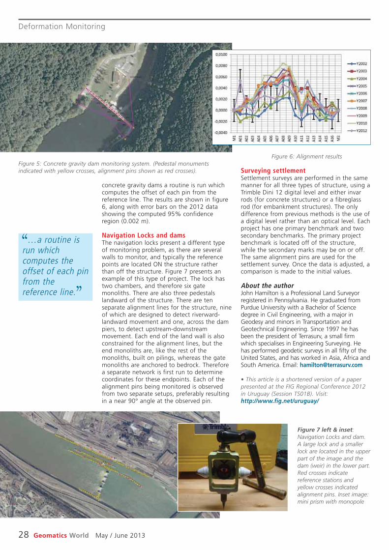
Deformation Monitoring
28 Geomatics World May / June 2013
Surveying settlementSettlement surveys are performed in the samemanner for all three types of structure, using aTrimble Dini 12 digital level and either invarrods (for concrete structures) or a fibreglassrod (for embankment structures). The onlydifference from previous methods is the use ofa digital level rather than an optical level. Eachproject has one primary benchmark and twosecondary benchmarks. The primary projectbenchmark is located off of the structure,while the secondary marks may be on or off.The same alignment pins are used for thesettlement survey. Once the data is adjusted, acomparison is made to the initial values.
About the authorJohn Hamilton is a Professional Land Surveyorregistered in Pennsylvania. He graduated fromPurdue University with a Bachelor of Sciencedegree in Civil Engineering, with a major inGeodesy and minors in Transportation andGeotechnical Engineering. Since 1997 he hasbeen the president of Terrasurv, a small firmwhich specialises in Engineering Surveying. Hehas performed geodetic surveys in all fifty of theUnited States, and has worked in Asia, Africa andSouth America. Email: [email protected]
• This article is a shortened version of a paperpresented at the FIG Regional Conference 2012in Uruguay (Session TS01B). Visit:http://www.fig.net/uruguay/
concrete gravity dams a routine is run whichcomputes the offset of each pin from thereference line. The results are shown in figure6, along with error bars on the 2012 datashowing the computed 95% confidenceregion (0.002 m).
Navigation Locks and damsThe navigation locks present a different typeof monitoring problem, as there are severalwalls to monitor, and typically the referencepoints are located ON the structure ratherthan off the structure. Figure 7 presents anexample of this type of project. The lock hastwo chambers, and therefore six gatemonoliths. There are also three pedestalslandward of the structure. There are tenseparate alignment lines for the structure, nineof which are designed to detect riverward-landward movement and one, across the dampiers, to detect upstream-downstreammovement. Each end of the land wall is alsoconstrained for the alignment lines, but theend monoliths are, like the rest of themonoliths, built on pilings, whereas the gatemonoliths are anchored to bedrock. Thereforea separate network is first run to determinecoordinates for these endpoints. Each of thealignment pins being monitored is observedfrom two separate setups, preferably resultingin a near 90° angle at the observed pin.
Figure 5: Concrete gravity dam monitoring system. (Pedestal monumentsindicated with yellow crosses, alignment pins shown as red crosses).
Figure 7 left & inset:Navigation Locks and dam.A large lock and a smallerlock are located in the upperpart of the image and thedam (weir) in the lower part.Red crosses indicatereference stations andyellow crosses indicatedalignment pins. Inset image:mini prism with monopole
Figure 6: Alignment results
. . . a routine isrun whichcomputes theoffset of each pinfrom thereference line.
‘‘
’’
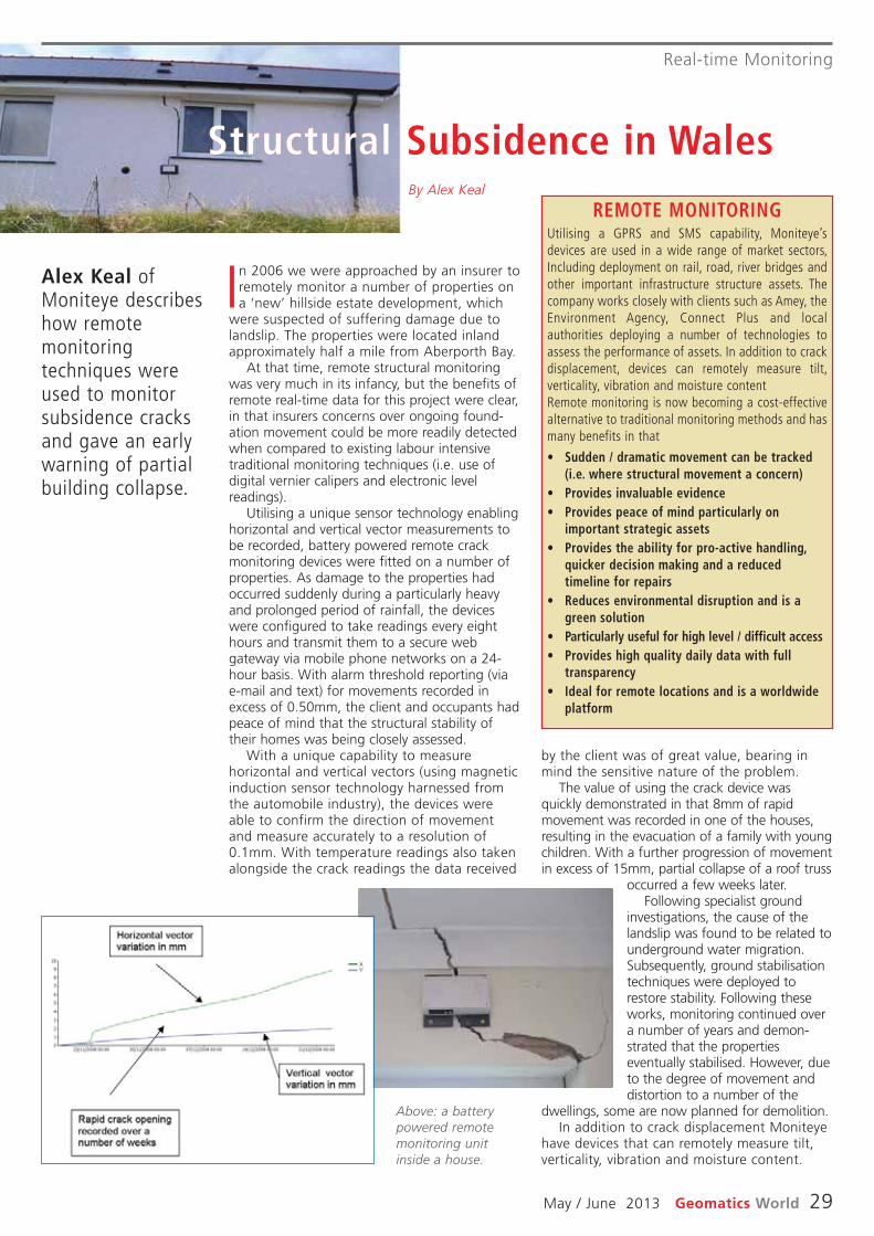
Real-time Monitoring
May / June 2013 Geomatics World 29
REMOTE MONITORINGUtilising a GPRS and SMS capability, Moniteye’sdevices are used in a wide range of market sectors,Including deployment on rail, road, river bridges andother important infrastructure structure assets. Thecompany works closely with clients such as Amey, theEnvironment Agency, Connect Plus and localauthorities deploying a number of technologies toassess the performance of assets. In addition to crackdisplacement, devices can remotely measure tilt,verticality, vibration and moisture contentRemote monitoring is now becoming a cost-effectivealternative to traditional monitoring methods and hasmany benefits in that
• Sudden / dramatic movement can be tracked(i.e. where structural movement a concern)
• Provides invaluable evidence• Provides peace of mind particularly on
important strategic assets• Provides the ability for pro-active handling,
quicker decision making and a reducedtimeline for repairs
• Reduces environmental disruption and is agreen solution
• Particularly useful for high level / difficult access • Provides high quality daily data with full
transparency• Ideal for remote locations and is a worldwide
platform
by the client was of great value, bearing inmind the sensitive nature of the problem.
The value of using the crack device wasquickly demonstrated in that 8mm of rapidmovement was recorded in one of the houses,resulting in the evacuation of a family with youngchildren. With a further progression of movementin excess of 15mm, partial collapse of a roof truss
occurred a few weeks later.Following specialist ground
investigations, the cause of thelandslip was found to be related tounderground water migration.Subsequently, ground stabilisationtechniques were deployed torestore stability. Following theseworks, monitoring continued overa number of years and demon -strated that the propertieseventually stabilised. However, dueto the degree of movement anddistortion to a number of the
dwellings, some are now planned for demolition.In addition to crack displace ment Moniteye
have devices that can remotely measure tilt,verticality, vibration and moisture content.
In 2006 we were approached by an insurer toremotely monitor a number of properties ona ‘new’ hillside estate development, which
were suspected of suffering damage due tolandslip. The properties were located inlandapproximately half a mile from Aberporth Bay.
At that time, remote structural monitoringwas very much in its infancy, but the benefits ofremote real-time data for this project were clear,in that insurers concerns over ongoing found-ation movement could be more readily detectedwhen compared to existing labour intensivetraditional monitoring techniques (i.e. use ofdigital vernier calipers and electronic levelreadings).
Utilising a unique sensor technology enablinghorizontal and vertical vector measurements tobe recorded, battery powered remote crackmonitoring devices were fitted on a number ofproperties. As damage to the properties hadoccurred suddenly during a particularly heavyand prolonged period of rainfall, the deviceswere configured to take readings every eighthours and transmit them to a secure webgateway via mobile phone networks on a 24-hour basis. With alarm threshold reporting (viae-mail and text) for movements recorded inexcess of 0.50mm, the client and occupants hadpeace of mind that the structural stability oftheir homes was being closely assessed.
With a unique capability to measurehorizontal and vertical vectors (using magneticinduction sensor technology harnessed fromthe automobile industry), the devices wereable to confirm the direction of movementand measure accurately to a resolution of0.1mm. With temperature readings also takenalongside the crack readings the data received
Alex Keal ofMoniteye describeshow remotemonitoringtechniques wereused to monitorsubsidence cracksand gave an earlywarning of partialbuilding collapse.
Structural Subsidence in WalesBy Alex Keal
Above: a batterypowered remotemonitoring unitinside a house.

Down under currents
30 Geomatics World May / June 2013
former NSW Governor (1990-96), theHonorary Peter Sinclair and his sister RenWillard, who travelled over to NI on the sameplane as us from Sydney.
To my delight the esteemed ex-Gov andhis sibling revealed to me that it was theirbrother James who authored Mastamak, thehistory of the surveyors of Papua NewGuinea at which 2001 book launch I was inattendance in Port Moresby. I also caught upwith the NI chief minister David Buffett in thecemetery with the sexton Shane Quintal thenmet the new Administrator Neil Pope at theFoundation Day Ceremony the following dayjust before introducing him to the formerNSW Governor, which made his day! Meetingthe island folk is a real treat and they reallydo love their island paradise. Anyone whohas not been to Norfolk Island has to makean effort to get there because you will love itindeed.
Trig LoveRushing to our nation’s capital city Canberraafter one day back from NI I was driven to jointhe Annual Conference of the Association ofPublic Authority Surveyors (APAS) at whichsome great presentations were given, especiallyFred De Belin’s project to finally relocate the lostgrave of the legendary Aboriginal Bennelong atKissing Point (Ryde Council area). One greatsurprise was the launch of Terry Birtles’fantastic book Charles Robert Scrivener – TheSurveyor Who Sited Australia’s National CapitalTwice. On the final day we walked to two oldtrig stations on the Australian Capital Territoryborder line named Gooroo and Old Joe. After asix km uphill ordeal our reward was 360°panoramic views accompanied by a deliciousmorning tea next to Old Joe. I got up close andpersonal with the historic Gooroo Trig 1880stone cairn.
Two CruisesIn a small vessel on a choppy Sydney Harbourthe Australian National Maritime Museum(ANMM) cruise to visit wreck sites took us tothe spots where the wrecks of the Centurian(1870’s), the Centennial (1880), the RoyalShepherd (1890) and the newest discoverymade early this year of the Herald (1855) nextto South Head. Our March Topp Tour cruisetook us to parts of our harbour accessible onlyby a smaller craft such as a circumnavigationof Rodd Island and just clearing the underside
Gladly the bushfires and floods havesubsided downunder with thingsrecovering slowly and to start off the
New Year we had our annual luncheon in NSWParliament House Stranger’s Dining Room,where I fit right in! The NSW Auditor-GeneralPeter Achterstraat regaled us with tales ofgross over-spending and dubious causes. On amore curious note and in true Brock style, mygranddaughter said her first word last week –“Hooray” – followed by a round of applause!!!Another gregarious minion.
Norfolk Island with First FleetersIf they offered a place on a garbage retrievalflight to Norfolk Island I would sign up for it,so when a group of First Fleet descendantsasked for extra participants we jumpedstraight in. Being the safest place on earth, itis so relieving to return to the home of thedescendants of the mutineers from TheBounty. Among the First Fleeters was our
Clearing upgarbage on NorfolkIsland, gettingclose and personalwith a trig pointand more cruisesand tours on thetrail of Australia’sexplorers andsurveyors.
Taking flight to paradise and choppy seasBy John Brock
Above: Norfolk Island garbage retrievers: John Brock, Neil Pope andformer NSW Governor Peter Sinclair
Right: a trigpoint, always the
surveyor’s firstlove.

Down under currents
May / June 2013 Geomatics World 31
of Pyrmont Bridge to take us into Cockle Baynext to Darling Harbour on St Patrick’s Day.
Blackett TourThe Historic Houses Trust of NSW ColonialArchitect bus tour took us to the pick ofworks by Edmund Blacket, who was prolificfrom the mid 1800’s and early 1900’s. StMark’s at Darling Point is a magnificent 1848church in which the funeral service forSurveyor-General Sir Thomas Mitchell wasconducted in 1855. Just around the corner wewere shown the palatial private mansion“Greenoaks” (1840’s-60) now home of theAnglican Archbishop of Sydney. We alsovisited St Phillip’s (1848), Sydney UniversityQuadrangle and Great Hall (1848); and myfavourite colonial building, The Old LandsDepartment (1888), featuring statues ofsurveyors and explorers in niches on its facadeincluding the most recent inductee, Irishemancipist early colonial surveyor JamesMeehan dedicated by our great GovernorMarie Bashir in 2010.
Four explorers, a surveyor and the 1815roadThe ANMM author lecture saw renownedyachtsman/reporter/author Rob Mundle
Above: with author RobMundle and his book on
Flinders.• John Brock is a Registered Surveyor inAustralia and is a stalwart of FIG and itsPermanent Institution for the Art and Historyof Surveying.
highlight his excellentpublication Flinders – The ManWho Mapped Australia. BlueMountains Historical Societyhosted Dr Siobhan Lavelle attheir historic HQ “Turella”where she gave a talk abouther new analysis of the firstcrossing of the Blue Mountainsin 1813 - by Blaxland, Lawsonand Wentworth and ultimatelyby surveyor George Evanscontained in her recent release1813 – A Tale That Grew inthe Telling. My final lecturewas on the mysterious diariesof Lawson, Blaxland andWentworth as told by PaulBrunton OAM from theMitchell Library who showedcopies of the first editionoriginals held by his prestigiousestablishment while dissecting their contents forthe delight of the audience.
BOOK REVIEW
Published by PV Publications Ltd,ISBN 0 946779 48 1 Price£7.95+ £0.61 p&p UK andEurope, £8.95 Rest of World.
Although this book has beenreviewed before in GW wethought the time was ripe foran update from a youngerreviewer. Neil Waghorn is arecent graduate in internationalaffairs and defence studies andmanages the website Location-Source.com on behalf of PVPublications.
This book is a collection of talesof the late Barrie Corlson’sexperiences of working for theOrdnance Survey on the re-triangulation of Great Britain. Thetales were originally published inthe ICES Journal Civil EngineeringSurveyor over several years, butare bought together here in oneilluminating and humorouscollection.
After the end of the SecondWorld War there were largenumbers of people for whom theidea of sitting behind a desk wastorture. The author was one andupon leaving the Royal Navy,heard that the Ordnance Surveywas looking for adventurouschaps. Off Corlson went andsome adventures did he have!
One Man’s Part includes theauthor’s run-ins and experienceswith assault craft, gypsies,battery acid, tank shells,tobogganing down mountains,multiple car accidents, gettinglocked in church towers,exploding biscuits tins, atomicresearch stations and lugging his
survey party’s equipment up anddown mountains to sit in fog andrain. It also details theirexperiences with the local wildlifeand population including redstags, midges, ornithologists,monks, tourists and even moremidges.
Corlson gives a great insightinto the effort that went into there-triangulation of the UK fromthe 1930s till the 1960s. Thestories portray the torment ofspending night after night at thetop of a mountain in freezing fogin the hope that visibility mightimprove enough to see the otherteam’s lights and takemeasurements.
Also portrayed in One Man’sPart is the spirit of improvisation,with the book detailing thelengths that the author and hiscolleagues would go to to getthe job done and, if possible,somehow turn things to theiradvantage. Sometimes theirschemes worked but often not,but in dire circumstances theauthor always had his Ordnance
Survey warrant card to get himand his colleagues (or co-conspirators) out of a tight spot.
Some of the tales within OneMan’s Part would almost seemtoo incredible and farcical to bebelieved were it not for thecollection of photographsprinted in the middle of thebook. These photos help thereader picture both the beautyand bareness of the locationsthat the author and colleaguesinvolved in the re-triangulationwere exposed to.
One Man’s Part is an easyread and, at only 90 pages, canbe devoured in a few short hours.It will appeal to a wide spectrumof readers, providing a humorousyet interesting insight on howthings used to be done beforethe advent of GPS, lasers anddigital surveying equipment.I heartily recommend it. OS Tales:One Man’s Part in the Re-Triangulation of Great Britain isavailable for purchase from PVPublications at:http://www.pvpubs.com/books.php
OS Tales: OneMan’s Part in theRe-Triangulation ofGreat Britain
a great insight into the re-triangulation of the UK from the 1930s to the1960s

PRODUCTS
32 Geomatics World May / June 2013
Trimble updatesRealWorksTrimble has announced version 8of its RealWorks software thatincludes a new 3D databaseengine, automated targetlessregistration and web viewingcapability incorporatingRealWorks’ Scan Explorerinterface. A new 3D databaseengine will allow up to five timesmore data to be visualised andmanaged, compared to theprevious version.
The automated targetlessregistration function, togetherwith additional workflowenhancements, will providefurther productivity gains forcustomers. The automatedtargetless registration functionidentifies planar objects in eachscan and matches the planesfrom multiple stations, creating acombined dataset. The functionenhances productivity in the fieldby eliminating target placementprior to data capture inapplicable environments. Officeprocessing time is also reduced
by the fully automated function.Sharing of data with clients has
been enhanced by the addition ofa Publisher function within theTrimble RealWorks software thatallows projects to be custompackaged for viewing via MicrosoftInternet Explorer. The Scan Explorerinterface, embedded inside anHTML web page, allows clients tonavigate and explore the scandata as well as takemeasurements and add notes.
Autodesk ReCapAutodesk ReCap is a key additionto the 2014 portfolio of Autodesksoftware. A family of realitycapture software and cloudservices, it simplifies the processof creating intelligent 3D data ofphysical objects and environ -ments using laser scans andphotos, allowing customers tobring the actual job site orphysical objects into their designand engineering process.
Also available is Autodesk 360,which connects the desktop tosecure and virtually infinite
computing power in the cloud.Autodesk has also introducedInfraworks and Infraworks 360cloud services for its Infrastructureand Building Design Suites.
TweetM8Ohmex has devised a socialmedia solution to provide tideand weather information to pilotswhen the harbour office isclosed. Twitter was the answerbecause it is available for bothweb-based users and via SMStext messages. For moreinformation visithttp://www.ohmex.net/.
Zeno software updateLeica Geosystems has announcedupdates for its Zeno Office v3.1and MobileMatriX v5.1 software,with support for the Leica CS25GNSS tablet computer and highaccuracy data collector, Esri ArcGIS10.0/10.1 and post-processingaccuracy improvements. With theCS25, asset collection and post-processing of GNSS raw data cannow been done in one applicationand on one device, bringing fieldand office application togetherinto a highly portable solution.Support for file basedgeodatabases, ensures that theuser can take data into the field.
Scanning under waterThe new INSCAN underwater laserimaging system provides fast, highresolution 3D data capture forsurveying, as-builts andmonitoring. It uses proprietarytechnology developed by 3D atDepth and engineered by subseaengineering company CDL for useat depths of up to 3000m. Thesystem collects up to 40,000points per second, provides a360° × 30° field of view and caneither provide real-time operatormeasurements or output toindustry standard point clouds.
New Trimble controllerThe Trimble Slate Controllercombines the convenience andease-of-use of a smartphone withrugged durability and optimisedfor Trimble’s Access field softwareand the R4 GNSS receiver.
Offering voice, SMS text, and3.75G cellular data transfercapabilities on GSM cellularnetworks worldwide, the controller
is a rugged device that enablesenhanced connectivity in the field.Its wireless communicationcapabilities keep surveyors in thefield connected to the office. It hasa 4.3” capacitive touch, Gorillaglass display providing superiorsunlight readability.
Theft deterrentSurveying and Engineeringequipment theft is on the rise asinstruments are becoming a morelikely target for thieves. M&PSurvey Equipment(www.mpsurvey.co.uk) is offeringa solution involving an alarmedwire which is looped through theequipment and can be attachedto a specially adapted survey nailor Feno marker.
A billion pointsOverwatch has announced therelease of version 5.1 of itsLiDAR Analyst software with anew 3D Viewer enablingvisualization, analysis anddissemination of 3D data. It loadsand displays datasets in excess ofa billion points. The viewer istightly integrated into thesoftware and handles all of thestandard data formats used bygeospatial intelligence analysts.
LiDAR Analyst users are nowable to perform real-time dataanalysis, including radial line-of-sight, buffer zone analysis, landingzones and 3D mensuration. Thesoftware also includes an optionfor distributed processing thatbreaks data into manageablepieces to distribute across a clusterof workstations. This enhancementcan reduce overall processing timeby orders of magnitude,dramatically increasing efficiency.
Above: construction image of the 50,000-seat Stade Lille with aretractable roof. The project was completed in August last year.
Image courtesy: APEI France
Z/I Imaging has released V6.6 of its sensor software PPS,introducing ‘PureColor Technology’. As part of a broader focus onradiometric enhancements and simplified processing, thetechnology boosts the dynamic range of the output image andprotects all information collected even in high illuminated andshadow areas. The new version reduces the time needed formanual adjustments and provides a significantly higherautomation level for post-processing parameter settings. Toaddress customers’ requirements for very large mapping projects,radiometric characteristics for all Z/I DMC and Z/I DMC II camerashave been standardized, allowing users to fly large projects withmultiple cameras.
Z/I sensor software update
Trimble’s Slate Controller comeswith voice, SMS texting and a
3.75G cellular data transfer.
NEWS
May / June 2013 Geomatics World 33
ProMark 700Spectra Precision has introducedthe ProMark 700 GNSS RTK roverspecifically designed for networkRTK applications. Weighing only650 grams, the receiver isbelieved to be the lightestGP+GLONASS RTK smart antennaavailable on the market today.The unit has a ten-hour batterylife between recharges, a rugged,waterproof design and a wideoperating temperature range forharsh outdoor environments.
Update for iCONstruct Leica Geosystems has released anew, enhanced version of theiCONstruct field software for itsiCON portfolio. The softwaresignificantly improves and furtheroptimizes construction workflowefficiency with the CC50 andCC60/61 field controllers and thegps 60 and robot 50 positioningsensors to better meet thedifferent needs of constructionpersonnel on site. A new Roadingapplication is an option for theiCON build and iCON sitesoftware. It is also available forthe CC60/61 controllers withtheir 7” inch large display.Roading enables users tostakeout individual road lines andslope elements providingdifferent views for easy andstraightforward use.
Users working with a LeicaiCON gps 60 antenna can nowreceive coordinate systems viathe RTCM v3.1. message formatusing Leica’s SmartNet networkRTK correction service.
Storm GeoRiverStorm GeoRiver is river modeldata preparation software forriver surveyors and hydraulicengineers. The softwareautomates two-way exchangesbetween ISIS, Mike 11 and Hec-Ras river model formats. Itprovides tools that quickly createriver models from survey orexisting data. GeoRiver is apartnership between StormGeomatics and softwarespecialists Borwell Ltd. Thisexpert partnership has provided adual approach to a softwarepackage that offers surveyingcompanies and consultingengineers value for money andimproved output. The software is
available on a 30-day cloudlicence or through annualsubscription.
New Optech aerialdigital cameraOptech has announced therelease of its new CS-6500 aerialcamera system featuring a new29-Mpx interline CCD whichincreases the camera’soperational window, makes datacollection 80% more efficient,and reduces readout leakageoutput – enabling operators togather high-quality imagery evenfaster than before. The cameraalso features simplifiedoperations, high versatility, and alarge 6500×4300 pixel footprintthat enables integration withOptech’s ALTM lidar sensors andCS-series of thermal andmultispectral cameras.
New airborne sensorLeica Geosystems has announcedthe new generation of its leadingairborne digital sensor, theADS100. Introducing a uniquefocal plate design, the LeicaADS100 offers a swath width of20,000 pixels for all multispectralbands (RGBN) and multispectralcapability in forward, nadir andbackward, making it the mostproductive airborne sensoravailable today. The ADS100provides the world’s first largeformat CCD line with TDI (TimeDelay and Integration) to increasesensitivity despite a smaller pixelsize. By doubling the cycle rate,high-resolution images can nowbe acquired at much higherground speeds. A new gyro-stabilised mount, the PAV100, is
equipped with revolutionaryadaptive control technology.
Spherical cameraPoint Grey has released theLadybug5 camera. The new LD5-U3-51S5C is a 30 Mpx camerathat covers 90% of a full sphere,has a 5Gbit/sec USB 3.0 interface,provides high dynamic range,superb image quality andmaximum user flexibility.
The camera uses six highsensitivity 5Mpx Sony ICX655CCD image sensors. The fiveCCDs are positioned in ahorizontal ring and one ispositioned vertically pointingupwards. Unlike rolling shutterCMOS, global shutter CCDtechnology prevents motionartifacts when capturing imagesfrom a moving vehicle. All sixLadybug5 imagers are pre-calibrated in Point Grey’smanufacturing facility, removingthe need for in-field calibration.The Ladybug5 captures,optionally compresses, andtransmits full bit-depth (12-bit)images to the host PC where aunique software post-processingworkflow can be used to applywhite balance, gamma, smearcorrection, fall-off correction andother image processing functions.
Crowdsource forGoogle!Google has announced MapMaker, an online tool that allowspeople to contribute and editmap data for certain regions
around the world, including theUK. Users can locate, draw, labeland provide attributes for localmap features, in effect, becoming“citizen cartographers”.
The product helps usersimprove the quality of maps sincethey can more precisely mapplaces like their localneighbourhoods, footpaths andforests, parks and golf courses,“where maps have traditionallybeen less comprehensive” sayGoogle. Once approved,improvements will appear acrossGoogle Maps, Google Earth, andGoogle Maps for Mobile.
Riegl and Applanixtake flight on UAVRiegl and Applanix haveintegrated the Applanix AP50GNSS-Inertial sensor system withRiegl’s VQ-820-GU topo-bathymetric airborne laserscanner, which is designed forcombined land and hydrographicairborne survey, on board theSCHIEBEL Camcopter S-100 UAV.
Virtual ClassroomExprodat, the oil and gas software,consultancy and training supplier,has made their suite of petroleumArcGIS training courses availablethrough a “virtual classroom”. Formore information, visit http://www.exprodat.com/ Training/Booking/Virtual-Classroom. TheArcGIS software and data neededfor the training courses is hostedremotely, which means attendeesonly need to log-in and learn.
Undergroundscanner
The I-Site 820 is a new laser scanner designed specifically forunderground applications. It can be coupled with a range ofaccessories to provide a complete scanning system forunderground drives, tunnels and stopes as well as surfacestockpiles and silos. Processing of scan data can be undertaken in I-Site Studio and I-Site Void software.
The ADS 100 has a unique focalplate design and swath width of20k pixels.

GW Classified Recruitment
34 Geomatics World May / June 2013
G W R E C R U I T M E N T
TOTAL POLICING
CRIME BECOMES CLEAR. HIGHER COMPUTER AIDED SURVEYOR
£35,053 TO £41,105 (PLUS £3,466 LOCATION ALLOWANCE); LONDON, SW6
Our Computer Aided Modelling Bureau supports high-profile criminal investigations and police operations. Specialising in sophisticated survey technologies and Computer Aided Design, our dynamic, 12-strong team reconstruct and analyse crime scenes and exhibit their work in court as experts in their field.
This is fascinating, demanding work. You’ll attend crime scenes and other sites (often at short notice), carrying out land and measured building surveys using both traditional and advanced laser scanning technologies. Aside from your technical and post-survey processing skills, you’ll also liaise effectively with police officers, barristers and the Crown Prosecution Service to determine the level of detail in the final product. Ever mindful of critical operational timescales, your products need to be on time and suitable for police investigations and criminal trials. In addition, you’ll also manage survey data and building plans to assist Property Services in effective decision-making regarding the MPS estate.
With an established background in land and measured building surveying, you’ll have a broad range of practical experiences in measured surveying and CAD systems. Added to that, you’re experienced in best practice survey principles and in using post-processing survey software. This should be supported by a professional survey qualification or completion of a recognised survey-related training course.
To apply, please visit our website to download a role-specific information pack and application form.
Completed applications must be returned by 17 May 2013.
www.metpolicecareers.co.uk
THE METROPOLITAN POLICE SERVICE IS AN EQUAL OPPORTUNITIES EMPLOYER.
BCRIMEOM CHIGHER
1014£O3 T055£3
OMESBEC AIDEDMPUTER
CO£3 466 LSULP(05
.CLEARSORVEYSUR
ECNAWWAOLLANOITAATC
6WSNODNO); LE
101,4£O3 T055,£3
er Aided ModellomputOur Ctions and ptigaesvcriminal in
echnoly teed survtticasophiseamong ttrour dynamic, 12-s
orkxhibit their wenes and esc
ting, demandingascinahis is fTt short noten aoftes (other sit
s using both tryebuilding survechnologies. Aside scanning t
ou’ll also liasing skills, yesocpr
CO£3,466 LSULP(05
ofileeau supports high-pring Burtions. Specialising inae operpolic
er Aided Desigomputogies and Cse crimetruct and analyonsec r
xperts in their fieldourt as ek in c
enesend crime scttou’ll aork. YYog w), carrying out land and measueic
ed laserancaditional and advrt-survechnical and posour tom yfr
erse officely with policectivaise eff
ECNAWWAOLLANOITAATC
gn,
d.
andedr
yevs,
tablished backith an esWe a bvou’ll haying, yesurv
ying and eed survmeasuract pred in besxperiencey sesing survesoct-prpos
y qualiesional survesofproaining ced trtela-ryesurv
, please visit ouro applyTTotion pack and apormainf
tid lil tC
6W, SNODNO); LE
ed bound in land and measurgrkxperienactical eange of proad rbr
ot, yo thadded tems. AtsyCAD sy principles and in usinee survctichis should be support. Tearsoftw
ogecompletion of a rtion or cifica.ourse
ole-spewnload a ro doe tebsitr worm.tion fplica
132017 Mt d bt b
uildinges innc
eou’rng
y aed bgnised
ecific
3
TOTA
oswn Proers and the Crtbarrisoduct. Eof detail in the final pr
oducts neeour prtimescales, ytions and crimtigaesve inpolic
ta and buildy daemanage surve decision-making rectivin eff
AL POLICING
ermine the o dete tsecution Servictionaaer mindful of critical opervE
oro be on time and suitable fed tou’ll alsominal trials. In addition, y
operty Servit Prsiso asding plans t.ettading the MPS esegar
elvlel
esc
tions ed applicaompletC
ecar.metpolicwww
POLICAN METROPOLITTHEEMTUNITIESOPPORALEQU
13y 20y 17 Maeturned bt be rmus
.ukoceers.r
ANISVICE SERCE.YEROMPL
3.
With continued investment in the Topcon GB business we’re on the lookout for some
bright and enthusiastic additions to our team. We’re growing, opening new locations, expanding our dealer network and seeing continued increas-es in demand for our positioning technology. So if you’d like to play a part in our ambitions, work hard and have some fun along the way then we’d like to hear from you – it’s time for change!
Regional Account ManagersOur dealer network is growing, so we would like to hear from those of you that would like to help them generate even more sales and identify new business opportunities. Don’t worry about location at this stage, just ask yourself if you can build suc-cessful relationships with your clients and have experience in the construction or survey sectors.
Machine Control Sales ManagerYou’ll be joining a successful team with a great track record in providing the best machine control solutions to the construction and civil engineering sectors. We’d like to hear from you if you have experience in selling or working with 3D machine control technology and surveying systems. If you’ll deliver excellent customer service, commit to ex-ceeding sales targets and don’t mind a bit of travel, then we’ll provide you with plenty of support to help you succeed.
Machine Control Support Engineer If you enjoy getting stuck into hydraulic hoses, know your dozers from your excavators and can turn your hand to a bit of electrical engineering then this is the role for you. We’re looking for another install and support engineer, all levels of experience considered and we’d really like you to be based out of our new Machine Control centre in the midlands. There’s every chance that we’ll ask you to travel a bit with this role too.
Service & Support TechnicianYes you guessed it. We’re investing in a new service centre and need an experienced service technician for repairs on cutting-edge technology of construction lasers and surveying instruments. You’ll need to have the necessary experience for this one, and to make sure you have some variety we’ll keep you busy with some of the administra-tion for our construction team.
As you’d expect, these roles all come with superb benefits.
If you are looking for a change and want to find out more about each of the opportunities then visit www.topcon-positioning.eu for more detail.
If you’ve seen enough and are ready to apply, please send your CV and covering letter to [email protected]
SURVEY LASERGPS+(3D) MACHINE CONTROL GIS
It s time.s time.It´
W t nemtsevnd ieunitnoh ctiehn te or’es wsenisub
oitiddc aitsaisuhtnd ent ahgirbcow leg nninep, ogniwore gr’eW
g cnieed snk arowter nealer duogninoitisor pur ood fnamen ds ie
mr aun oitrapy a alo ptekild’uoyae whg tnon alue fmoe svad hnaahr coe fmis t’tu – iom yorr faeh
sgernaaMtnuocc AlnaoigeR
Bn Gocpoe Thn tiemor sot fuokool.maer tuo os tnognidnapx, esnoitac
saercnd ieunitnoc -fo i. Sygolonhceg tdrahkrow, snoitibmoe tkid l’en wehy t
!egn
s
ortnoe CnihcaMg aninioe jl bl’uoY
orn pd irocek rcartoe cho ts tnoitluosekid l’e. Wsrotcesillen se icneirepxeygolonhcel tortnoc
t cnellecxr eeviledegras tealg snideec
edivorl pl’en weht.edcecusuyopleh
reganas Melal Staerh a gtim wael tufsseccua slortnoe cnihcat msee bhg tnidiv
gnireenignl eivid cnn aoitcurtsnoevau hof yu iom yorr faeo he tenihcaD mh 3tig wnikror wg onll’uof y. Ismetsyg sniyevrud sny a
xo et timmo, cecivrer semotsuc -,levarf tt oid a bnit m’nod dns ate
ot troppuf sy otnelh ptiu woe y
vreSs eY
ivresnhcetof col’uoYosihtll’ewfonti
os yA
naicihnce Ttropp Su&ecivn ag initsevne ir’e. Wtd iesseuu goy
red secneirepxn ed aeed nne artnee cconhcee tgde-gnittun cs oairper ron faicinemurtsng iniyevrud sns aresan loitcurtsnoecneirepxy erassecee nhe tvao hd teel nravemosevahuoyerusekamotdna,enosinimde ahf te omoh stiy wsuu bop yee k
.maetonticurtsoncruorof
puh stie wmol cs aleloe rseh, ttcepxd e’uo
wenecivygol.stneroe fyteir
arts -
brep
gg, gniwors gk irowter nealer duO
t ahu tof ye osohm torr faeo htseale sron meve etarenem gehtot w’no. Dseitinutropps osenisubf f ilesruok yst asu, jegats siht taruoh ytis wpihsnoitalel rufssec
n ooitcurtsnoe chn te icneirepxe
ekid lluoe wo wspleo he tkid lluowwey nfitnedd ins anoitacot luoby arro
cud sliun bau coy -evad hns atneilr c
.srotcey sevrur so
yp
ortnoe CnihcaMittey gonju eof yI
s rezor duow yonkod tnar huon yrut
e rhs ts iihn tehtdnalaltsnirehtona
disnoe ccneirepxeuf ot oud oesae bbreh. Tsdnaldie mht
t wil a bevaro tu toy
reenignt Eroppul S,sesoc hiluardyo htnk icutg snnad cns arotavacxr euom yorfgnireenignal ecirtcelf et oia brog fnikooe lr’e. Wuor yoe florfoslevellal,reenignetroppusdou toe ykiy llaled r’ed wnd aerene irtnel cortnoe Cnihcaw Mer nksl al’et wahe tcnahy crevs e’er
.ooe tlos rihh ttiw
yeneb
of yIt muo
www
oyf Isaelperac
p,p.stfie
ot tnad wne agnahr a cog fnikooe lru an ehs teitinutroppe ohf th ocat euobe arom
ue.gnionitisop-conopt.w atee dror mof
paoty daere rad nah guoneneese v’uoretteg lnirevod cnV ar Cuod ynee ss
ku.co.aikkosconopt@sree
p
dnfitisiv
.lai
,ylppor t
GW Classified & Recruitment
May / June 2013 Geomatics World 35
G W R E C R U I T M E N T C o n t ’ d
ADVERTISERS’ INDEX
S U R V E Y S O F T W A R E
WWW.OHMEX.COM
ECHO SOUNDERTIDE GAUGE
WEATHER SYSTEMS
HYDROGRAPHIC EQUIPMENT
S U R V E Y S
G W C L A S S I F I E DTo reserve your space call +44 (0)1438 352617 All ads go online immediately. Next issue: July/Aug, copy date: 14 June
LAND SURVEYORWe are seeking to recruit a full-time Land Surveyor to join our busy mapping/survey team. Duties will include producing measured surveys and setting out using Trimble optical and GPS equipment. The successful candidate will be familiar with land survey methods and devices, aspects of cartography and draughting plans for a variety of purposes.
Knowledge of CAD would be preferred but is not essential as training can be provided.
Please contact us for further information and an application form.
01343 890400www.bowlts.com
Applications in CADD p.09Bowlts (recruitment) p.35KOREC back cover
Leica Geosystems p.18&19Metropolitan Police (recruitment) p.34Ordnance Survey inside front cover
Moniteye inside front cover
StarNet p.35Survey Review p.17Topcon GB (recruitment) p.34
HIGH DEFINITION SCANNING SURVEYORWe currently have a vacancy for a High Definition Scanning Surveyor basedat our Livingston office to become part of a busy team. The applicant shouldhave the following experience and qualities:
• Educated to HND level or equivalent in a survey, geographical or construction discipline.Experience in carrying out topographic surveys, and ideally dimensional controlsurveys and laser scanning surveys.A working knowledge of LSS survey processing software would be preferred.Experience working with AutoCAD.Experience with Trimble Business Centre & survey equipment would be preferred.Experience working with Point Cloud Data would be preferred.Working knowledge of Microsoft Office software.Ideally be experienced and certified to work offshore.Experience working in 'industrial' environments including Power, Nuclear, Oiland Gas is preferred.Willing to work outdoors, worldwide & hold a full UK driving license.Willing to work away from home regularly.Willing to work in the offshore environment.
The successful candidate will become part of a team of surveyors carrying outtopographic surveys, dimensional control surveys and laser scanning surveys.
Please send covering letter & CV to [email protected]
Star Net are an equal opportunities employer.
Salary: Negotiable depending on experience(from £16K - £21K)
Basic Hours: 37.5 per weekMonday to Friday 8.30am to 5pm
Location: Livingston Duration: PermanentDeadline:10 May 2013 Benefits: Group
Personal Pension & Death in Service

tel UK: 0845 603 1214 Ire: 01 456 4702
Going where no GNSS has gone before
It is the first of its kind.
Trimble® xFill™ technology is
a new service that extends your
phone signal for several minutes
when the RTK correction
service is not available with
xFill corrections which are
broadcasted by satellite.
The result - whether you’re
working in poor signal areas,
challenging environments or you
briefly enter a masked area, xFill
enables you to continue taking
measurements with survey-level
precision reducing your down
time and allowing you to work in
places you previously couldn’t.
Interested?
To find out how to significantly
cut your site time with the
Trimble R10 GNSS Receiver,
call us on 0845 603 1214 or
visit www.korecgroup.com
11.9 cm
13
.6 c
m
Scale 1:1
Client You
Drawing title Smallest
Trimble GNSS Receiver
Scheme title
Trimble R10 GNSS Receiver
Actual Size: It really is that small!
15th May
Aintree Racecou
rse, Merseyside
23rd May
28th May
www.korecknowhow.com
KOREC’s Technology
Days

GEO-North report
37 Geomatics World May / June 2013
electronic paper; there will be a revolution inpersonalised medical care including 3D printingof replacement organs; sensors will beeverywhere which will probably be intelligent.He was not so sure about Google glasses orGPS shoes. . . !BIM: geospatial perspectivesBIM is the topic of the moment and took centrestage during the morning seminars. Dr AnneKemp, from Atkins Global, gave up themicrophone and static presenting to roamamongst the audience to get her messageacross. I have heard her speak on severaloccasions and this one was no less engaging.BIM means different things to different peopleand Kemp approaches it from a GI perspective.The name ‘BIM’ is a rallying point for the move -ment but can restrict our thinking, so she triedGIM (Geographical Information Modelling) anda title “GIM’ll fix it!”; but that does not soundquite so wholesome as it once did. Then SIM(Surveying Information Modelling), but thatsounds too similar to SIN. So the point is thatBIM is just another acronym. She sees an oppor -tunity for surveyors to be the ‘single point oftruth’ – position is the unifying element in BIM.
Consultant, Chris Little, followed with aninspiring talk. He asked what should be therole of the surveyor. But before tackling thatquestion there remain others that should beconsidered, such as, ‘What is the model?’ Is itsurvey, design (or as-built), laser scans, or acombination? These are all questions thathave not been fully answered by the BIMfraternity. Then there is the question of grid,scale and accuracy. Comprehension of theseconcepts by the architects and engineerscontrolling BIM is still alarmingly low. So,where does the surveyor fit in? As is so oftenthe case, he could fit in almost anywhere – inwhich case he will probably end up nowhere,or he could be central to the BIM enterprise,as BIM manager; ensuring all the data thatgoes into the BIM fits together.
The session concluded with a briefdiscussion of the issues. Richard Groomclaimed that dimensional surveying is notcurrently represented on the bodies involved inthe development of BIM due to a lack ofleadership from both the RICS and the ICES. Ifthe fifty people in the room were to write to thechairs of their professional bodies, what shouldthey say? Anne Kemp responded that there area number of bodies on which geomatics couldbe represented.
There is an AGI special interest group, whichhas support from ICE (http:// www.ice.org.uk/topics/BIM/ICE-BIM-Action-Group). This grouphas arranged a conference on 25th June at
Geo-North was a slimmer version of itssouthern sister with a packed day ofseminars accompanying the exhibition.
Testing the water? If so, then the resultsshould be encouraging for future shows.
The rise of the digital nativeBob McEwan, chief technologist at HewlettPackard UK, kicked off the seminar programmewith a keynote presentation entitled “Trendsand Thoughts on Change in a ChangingWorld”. He ranged from the early punch-carddriven main frame computers to emergingtechnologies such as Google’s digital glasses or3D printers that can reproduce human organs.
A new technology can create a competitiveadvantage, but it is only a question of timebefore the competition catch up and erode it.He looked at the ways in which manufacturerscan retain competitive advantage and tookRolls Royce as an example. Nowadays, theydon’t sell jet engines: they sell time on jetengines, which comes with the obligation forservice and maintenance.
There is a scary world ahead of us as datavolumes increase exponentially. There arecurrently around two billion people onlinearound the world generating 294 billionemails every day. By 2020 four billion areexpected to be online. The data we generatecurrently is about 2 zettabytes. ‘Zetta. . .’what? A zettabyte (ZB) is 1021 bytes. By 2020the number is expected to reach 35zettabytes. And by the way, by my calculationa zettabyte is 1 billion times a terabyte. . .we’re talking very big numbers.
McEwan also looked at the rise and fall offree application access. The future he foreseesis one in which the free part of the deal is ataster for the part that you pay for. The‘metadata’ that we all generate just by visitingsites is also valuable and traded for targetedmarketing. Big Brother is watching you butthis is something that digital natives accept.They (digital natives) have grown up with this
technology and have awhole new way oflooking at life and work.
The cloud is also with usand looks set to dominateGIS in the next ten tofifteen years, but it is notso obvious that otherdevelopments will bewinners. McEwan reeledthrough a list. He reckonswe will have the terabitEthernet by 2020; four-wall screens and flexible
A day afterManchester Unitedsuccumbed to RealMadrid, the first ofthis year’s Geoevents travellednorth to the ReebokStadium at Bolton,home of BoltonWanderers, for theaway leg of theyear’s dual-venueevent, reportsRichard Groom.
Geo goes North
Below: Where the landsurveyor needs to be in theBIM process.
These are allquestions thathave not beenfully answered bythe BIMfraternity.
‘‘
’’

GEO-North report
May / June 2013 Geomatics World 38
UAVsNext we entered theworld of UAVs, withtalks from AndrewBlogg of DigitalMapping and Survey,speaking as a serviceprovider and BrechtLonneville ofGatewing, whichsupplies UAVtechnology. This is aviable technology thatcan deliver absoluteposition and height fororthophoto mapping anddigital elevation modelswith an RMS precision ofa few centimetres. Theconcepts are the same asfor conventional aerial photography but UAVaerial photography is cheaper and moreflexible. The technology is finding its niche formapping of small sites where it competes withground surveying techniques. Bothpresentations were based upon articles in theJan/Feb 2013 issue of Geomatics World.
Point clouds from HDR imageryThe afternoon continued with an update fromPeter Taylor on the Spheron-VR 360° HDRcamera. Its defining characteristic is that itrecords light from the scene using up to 26 f-stops, which means that a single image canrecord all detail without over-exposure of lightareas or under-exposure in dark areas. Taylor’stalk concentrated on Spheron’s SceneWorkssoftware that can be used to manage theseimages and enable walk-throughs of sites.
The Spheron VR camera can now be usedto produce 3D point clouds from stereo pairsof images and it is also possible to observeconcentric HDR images and laser scans fromthe same tripod set-up to produce co-registered VR photography with point clouddata. In another development a single image(set of RGB values) can now be generatedfrom the optimum exposure value for eachpixel in an image.
Monitoring with LeicaLeica’s account manager for Northern EnglandMike Workman wound up the programme witha talk on the company’s monitoring solutions.He argues that geotechnical sensors havetraditionally made up 75% of the monitoringmarket, compared with 25% geodetic sensors,but this is changing. Traditional monitoring isstill suitable for many applications but mostdevelopment has taken place with automatedreal-time systems. From the hardware point ofview, customers are looking for consistencyand precision over a long period of use, whilstthe software has to be able to combine datafrom geodetic and geotechnical sensors andmanage and archive the data reliably.
the Royal Geographical Society entitled ‘BIMmeets Geospatial’. More details will bereleased in early April - but booking is alreadyopen on the AGI site. The link for thegovernment’s BIM task group is:http://www.bimtaskgroup.org/bim-4-infrastructure-uk/. (In addition there are theBuildingSmart regional hubs, which werediscussed in the March/April 2013 issue ofGeomatics World).
The age of open dataDr Bob Barr is visiting professor at the Universityof Liverpool and campaigner for open data. Ifthere has been a blocker to progress it has to beclosely-guarded intellectual property rights; buttimes are changing. The Government’s whitepaper on Open Data champions open data as aresource that can bring economic growth aswell the transparency that can hold governmentand public servants to account.
Barr’s sights are set firmly on naturalmonopolies, of which the ultimate must be thePost Office Address file (PAF) and statutoryregisters, such as the Land Register. These coredatasets hold data that is needed in order tocomplete a public task, regardless of whether itis resold or reused. In Europe the view is thatthey should be made available “at marginal costof redistribution”.
Returning to PAF, as an example, Barrsuggested that if property centroids were storedin satnavs, navigation would be improved whichwould result in efficiency gains. Royal Mailjustifies its charges for PAF data by claiming thatthe cost of maintaining the dataset is £27million per year, a figure that is clearlylaughable. Further ‘justification’ for chargingcomes from the PAF Advisory Board (sponsoredby Royal Mail) stating that there is no evidencethat more use would be made of PAF data if thecost were reduced. And yet it is now covered bythe Public Sector Mapping Agreement anddistributed freely to local authorities –presumably so that they will make more use ofit! Barr produced a list of 36 excuses fromgovernment departments for not makingdatasets available, but the real reason, heasserts, boils down to vested interest.
Open data is a movement that now has thewind in its sails and we are approaching asituation where datasets will be ‘open’ bydefault, unless there is a good reason forthem to be restricted.
GIS helps save county £5mRichard Groombridge explained how the use ofGIS can improve the inspection andmanagement of Kent’s 8500 kms of roads. Hisproject involved optimising inspection routes soas to reduce costs and carbon footprint, fixdefects before they become potholes andimprove business efficiency and services. Theproject is expected to save the county £5m andwon a well deserved Improvement & EfficiencyAward at last year’s GeoPlace Awards Day.
Above: Gatewing’s X-100UAV can deliver positionand height for orthophotomapping.
The technologyis finding itsniche formapping of smallsites where itcompetes withground surveyingtechniques.
‘‘
’’

There isgenerally a 'right'answer and theclient has littlechoice but tobelieve the answereven though itcould be heavilylaced with 'spin'.
‘‘
’’
standards & best practice
39 Geomatics World May / June 2013
company finance, technical ability andresources, management, health and safety etc.
Choosing the right questions is critical, andso many questions become honed throughexperience and then become more or lessstandard. There is generally a 'right' answerand the client has little choice but to believethe answer even though it could be heavilylaced with 'spin'. The answers are thenmarked by converting generally qualitativeresponses into scores out of ten. The scoringinvolves judgement and therefore each scoredanswer comes with a margin of error which isvery difficult to quantify. It is possible that asuperlative score on one question canoutweigh a poor score on another. Although,if a poor score dips below a threshold value,the whole submission should be rejected.
Ideally, the prequalification process shouldresult in a list of contractors who have theresources and capability to do the work buthow often do clients employ technicallyqualified experts to assess prequalifiers'submissions?
Tender assessmentTendering is the second phase of theprocurement process in which the selectedtenderers are sent the project scope andsubmit price and quality proposals. This timethe tenders are assessed on the basis of priceand quality – weighted according to thecomplexity of the work: higher qualityweighting for more complex work. For wellunderstood less complex projects there isarguably no need for quality assessment,especially if it has been assessed sufficiently atprequalification stage.
Efficient regulation could sweep away someof the analogue-to-digital conversion thatgoes into selection based upon quality. Forexample, diners know that a restaurant thathas gained Michelin stars has met a qualitystandard. An essential part of this 'regulatorysystem' is that, if standards fall, the restaurantloses a star, or stars, with seriousconsequences for the business: quite anincentive to maintain standards.
The British problemIn Britain there is no single qualification forcompanies that fits the bill as a gatekeeperqualification or enables companies to beranked. RICS regulation is not adequate on itsown because its only requirement is that thecompany has a complaints handling process.Only if a client is dissatisfied with thecompany's handling of a client's complaintcan it be referred to RICS regulation. It is
Geomatics World last touched on thesubject of regulation in the Sept / Octissue of 2008. Our article: The State of
Self Regulation, was prompted by a paper inOntario Professional Surveyor from earlier thatyear. The GW article argued that self regulation,as implemented by the RICS following theCarsberg Report, did not go nearly far enoughin protecting the interests of geomaticssurveyors' clients or the interests of theprofession. To some this may have seemedprovocative stuff. But following the article, farfrom receiving a page full of letters and avigorous debate, there was not a whisper, foror against.
Balancing quality and quantityThere is in fact a specific problem. Clientswant to select tenderers and contractors onthe basis of best value for money. Forgovernment contracts this is a requirementand involves balancing the quality on offerwith the price; quality being a qualitativemeasure and price being quantitative. Thechallenge is to merge qualitative andquantitative measures openly, fairly andefficiently. How can this be done?
In an ideal world, the most efficientmethod is to trust companies that claim to beable to carry out the work proficiently. Inother words, quality is a given. On this basis,tenders can be sent to all proficientcompanies that wish to bid and thesuccessful tenderer will be the company thatsubmits the lowest price. From the client'spoint of view this approach has the greatbenefit of being simple, transparent, fair andunequivocal. 'Fair', of course comes withprovisos, because there are aspects ofselection by price alone that can beconsidered unfair: such as pricing mistakesand under-pricing for wider commercialreasons. However, tendering on this basis ismore likely to fail through reliance on itsfundamental assumption – that companiesclaiming to be capable are telling the truth,the whole truth and nothing but the truth.For this reason assessment of bids has toinclude assessment of quality.
PrequalificationProcurement of larger survey projects isgenerally a two-stage process: prequalificationfollowed by tender. The primary purpose ofprequalification is to identify and selectcompanies that reach the standard required, sothat they can go on to a tender list. For thispurpose, the client will send a list of generalprequalification questions on subjects including
Qualifying andregulating surveyorsis a worldwide issue.Should it becomprehensive andcodified or a lighttouch, self-regulating regime?Richard Groomlooks at how aCanadian state dealtwith a recent caseand sets out apossible wayforward.
Registration and Regulation: a lesson from Ontario?By Richard Groom

standards & best practice
May / June 2013 Geomatics World 40
does not have performance standards; thishinders effective regulation.
The surveyor prepared a draft ReferencePlan in 1994, which he did not deposit withthe Land Registry. In 2009, he updated thedraft plan and then deposited it withoutcarrying out research on a neighbouring planthat had been deposited in 2006. He did nothave field notes to support the depositedplan, which had not been produced followingquality control procedures.
In this case it is not totally clear whoraised the initial complaint but, as one of thecharges was "failing to respond to a requestfrom a fellow surveyor", it seems likely thatthe fellow surveyor was involved in raisingthe complaint with the Ontario LandSurveyors. There is a clear contrast here, inthat the RICS website states that failure torespond to correspondence is not a matterthat RICS Regulation deals with andfurthermore that complaints can only beraised by the client.
The Complaints Committee referred thecase to the Disciplinary Committee for adisciplinary hearing at which the partiestabled a joint submission in which thesurveyor agreed to a 16-month deferredsuspension, during which he would besupervised by another Ontario Land Surveyor.He would pay all costs and his case would bepublicised.
So, what do we need?Modern surveying is a team exercise and it isnot uncommon to find that although anorganisation employs qualified surveyors, theprincipal is not a member of a professionalbody. This can present difficulties for thequalified surveyor and is the reason whyquality has to be a corporate responsibility.Clients hire companies, not individuals.
To establish basic standards, we need a bestpractice manual. This is the equivalent of thesurvey laws of the cadastral surveyor. Such amanual was proposed over twenty years ago.It never materialised and consequently, to fillthe void, major survey clients such as NetworkRail and the Environment Agency have had towrite their own. The best practice manual,together with a disciplinary system thatinvestigates complaints from anyone affectedby the survey can lead to effective surveycompany registration – a gatekeeper fortechnical quality.
Successful regulation, or conversely charter-marking, would not be a 'negative' exercise. Asuccessful system would have benefits forsurveyors, for survey organisations, and fortheir clients. It would also benefit theprofessional body by raising its reputation.
• For the complete article from OntarioProfessional Surveyor, visithttp://www.aols.org/lib/db2file.asp?fileid=10973
therefore equipped only to pick up the mostserious complaints and it is notable that noneof the complaints that have made it throughto the RICS disciplinary committee have beengeomatics-related. Perhaps the client'sresponse to a poor quality geomatics survey isto go elsewhere to place the next commission.
The Survey Association (TSA) is a tradebody and as such is in existence to help itsmembers and provide guidance to clients. Assecretary general Rory Stanbridge explains:
"TSA is not a regulatory body but doesinsist on certain standards being achieved andmaintained on joining the association and incontinuing membership." New applicants haveto be able to provide numerous references andacceptable samples of work to be judged by acommittee as to their suitability for member -ship. Once a company is in membership, anannual return process ensures that themember complies with current legislation andis financially sound, although TSA relies onfeedback from clients as to the ongoingperformance of its members. “To the best ofmy knowledge there have only been a handfulof complaints against members in the lastthirty years" says Stanbridge. A complaintsprocedure and a complaints committee isestablished to examine any case that might bebrought forward and report back to both themember and the complainant. Whereverpossible the process is designed to assist themember to improve, if it is proven that theyhave erred in the first place, to ensure that itis not repeated. In extreme cases expulsionfrom TSA can be invoked although this hasonly occurred once to date.
Admirable though this is, TSA is, asStanbridge points out, a trade body. But itappears to be doing a more thorough job thanthe professional bodies who should take onthe responsibility to regulate.
Back to OntarioOntario Professional Surveyor returned to thesubject of regulation in its Summer 2011 issue(Vol 54, No 3). Three pages of the magazinewere devoted to a disciplinary case whichraised a few points that are worth considering.
Surveyors who carry out cadastral surveywork in Ontario have to be licensed and abideby the Surveyors Act 1990. In February 2010,the complaints committee of the governingbody, the Association of Ontario Land Surveyors(AOLS), received a complaint alleging that asurveyor had failed to fulfil his professionalobligation to follow and maintain thePerformance Standards for the Practice ofCadastral Surveying and went on to specificsabout failing to conduct proper research, failureto properly catalogue field notes and failure torespond to a request from a fellow surveyor.
An important aspect of regulation is a setof performance standards. In Ontario these areenshrined in the Act. But in the UK, apartfrom a few guidance documents, the RICS
. . .a complaintalleging that asurveyor had failedto fulfil hisprofessionalobligation to followand main tain thePerformanceStandards for thePractice of CadastralSurveying. . .
‘‘
’’

Teaching surveying
41 Geomatics World May / June 2013
Ground not to spec and bell goes dungOff-the-cuff remarks during meetings wereendemic. Some examples come to mind. Actingas devil’s advocate to spark off discussion, PatCarmody made a sweeping statement aboutthe future development of electromagneticdistance measurement, closing his impassionedstatement with the words “and, what’s more,I’ll stake my reputation on it!” A voice washeard to say “How is that?” to which a secondvoice added “Because he’s got nothing tolose!” Another intervention came during a veryheated argument about computer terrainmodelling, when the authors of some softwarecomplained that very nearly flat ground couldnot be modelled. “So”, said Joe Olliver “I see!It’s the ground that doesn’t meet the softwarespecification”.
Most Teachers’ meetings were enriched bytechnical visits and special lectures. Two ofthese stand out in our memory. One was thevisit to John Taylor & Co. Loughborough BellFoundry. At the foundry we were told that,because transporting a heavy bell would havebeen well nigh impossible, in former timesbells were cast in situ. A hole was made in theground and a mixture of manure, urine andstraw was used as a flux. Someone was heardto remark. “I see! So the dung is needed tomake the make the dong!”
Another visit was to Green’s Windmill.Although this windmill at Sneinton,Nottingham is well worth a visit per se, thebiography of George Green (1793 – 1841) iseven more impressive. Green made a massivecontribution to the mathematics of vectorfields. But he also had to earn a living as amiller to feed his great many children. Whenasked how he managed to find theopportunity to work on his mathematics, hereplied: “From time stolen from sleep”.
Survey control is like. . .Other memorable occasions included ademonstration of optical phenomena inGlasgow and a talk and demonstration aboutboomerangs by the aeronautical engineer,Professor W. H. Witterick, at BirminghamUniversity. From time to time the meetings wereenriched by presentations from practicingprofessional surveyors. We remember especiallyStan Longdin’s comment about survey control.He said that “Survey control is like sex. Whenit’s good it’s very, very good, and when it’s bad,it’s still pretty good!”
If we were to select the most humorousman ever to talk to the Meeting, John Ayreswould be he. His 1979 talk on the hysterical
The 1960s witnessed an explosion ofsurveying activities both in the UK andworldwide. This was the heyday of
medium sized companies like BKS, Fairey,Hunting, Meridian and Story, together withcolonial surveying departments and theDirectorate of Overseas Surveys. To meet thedemand for qualified staff, surveyingdepartments emerged or expanded in severalUK academic institutions. There was even aGCE A Level course in Land Surveying.
In 1963 at the Conference ofCommonwealth Survey Officers in Cambridge,Gordon Petrie called together a fewcolleagues, including Pat Carmody, JohnHollwey and Arthur Allan, to propose thecreation of an annual meeting of all interestedteachers, so that all could benefit fromdiscussion and interaction. As a result, the firstMeeting was arranged for 18th to 20thDecember, 1964 at Lincoln Hall, University ofNottingham, where Bernard Chiat was thehost organiser. The cost of a single room andall meals was £3 12s 0d (£3·60).
Network and pooling ideas drove respectOver the years, lecturers and teachers from awide range of institutions were able to discusscurricula, syllabus content, the value (orotherwise) of practical classes and fieldwork,what instruments to buy, what the latestresearch work was, what conferences hadtaken place and so on. This networking andpooling of ideas also gave us immense respectfor each other. Additionally, it was extremelyuseful to those lecturers working in isolation,many in Departments of Civil Engineering.There is no doubt that these Meetings did morethan anything else to raise the average level ofsurveying teaching in the UK and Ireland.
But it was not all work and no play.Amongst the teachers of surveying were manytalented musicians and singers. Who will forgetJohn Muskett and his music group, or thesingers, many of whom indulged in comicopera? John Garner from Leeds was perhapsthe best of this bunch, well known for his finebass voice and his role as Pooh-Bah in TheMikado! Then at dinner in Glasgow on 21stDecember, 1987, the entry of haggis royale wasaccompanied by the pipes. Even travelling tomeetings involved pleasures which it is nolonger possible to enjoy. On the way toSheffield in 1973, lunch was taken in therestaurant car of the train between Birminghamand the destination. Travel to Newcastle fromLondon in 1983 was by overnight sleeper, aservice long since withdrawn.
With a cast ofintriguingcharacters andcomics, formeracademics ArthurAllan and KeithAtkinson lookback on thefounding andhistory of theTeachers ofSurveying Meetingswhich used to takeplace annually.
The Annual Meetings of Teachers of Surveying
A hole wasmade in theground and amixture of manure,urine and strawwas used as a flux.
‘‘
’’

Teaching surveying
May / June 2013 Geomatics World 42
aspects of cartography were always moststimulating. We always welcomed thecontributions made by the Royal School ofMilitary Survey, Hermitage and the RoyalMilitary College of Science at Shrivenham.
In so little space we have only given asnapshot of events. All teachers enhanced theMeetings with comments and ideas. At theirpeak in the early 1990s, the Meetingsgathered over 100 persons together, includingUK and Irish participants and the occasionalvisitor from further afield. They were self-financing and could not have taken placewithout the devoted service of the staff of thehost departments and those who maintainedthe continuity of records. It was even agreedto design a tie to be worn by teachers ofsurveying. Following a competition open toteachers, the winning design wasmanufactured and sold out quickly.
Some years ago, one of us made a study ofthe education of the geometers in 17 countriesof Europe, visiting technical colleges, universitiesand professional firms and departments in theprocess. In almost every country, he wasdismayed at the insularity of most departments,who jealously guarded their own narrowinterests at the expense of the general wellbeing. We believe that these Meetings ofTeachers of Surveying greatly reduced suchinsularity and narrow-mindedness here.
[sic] architecture of Bradford was quite trouserwetting. Long before the end of his discourse,Bill Barnes was pleading with him to stop,such was the agony induced by laughter.There is no way we can adequately describethis funny clever man - with eyes that seemedto view his audience with divergent axes, butwhose humour was based on academicexcellence in three related disciplines:surveying, architecture and civil engineering.
Osborne what?We wonder how many knew that Tony Jones,who taught surveying at Bangor, appeared onthe TV programme This is your life. To ouramazement, a description was given of thededicated service given by Dr Anthony JonesMBE to Mountain Rescue in Snowdonia,where he had saved at least four lives. Wemust also mention Osborne Jelly, who beganthe formal surveying teaching at the Universityof Glasgow. He was famed for his vastlycomplicated schedules which depicted all thesurveying field courses in the country, themost spectacular being Ron Bird’s BirminghamUniversity camps alongside the Welshpool andLlanfair Light Railway in Wales. Yes! Ron ranhis field schemes under canvas, dressed inshorts like the scout leader he used to be! Yetanother contributor was John Keates ofGlasgow, whose ideas on the psychological
. . . the insularity ofmost departments,who jealouslyguarded their ownnarrow interestsat the expense ofthe general wellbeing.
‘‘
’’
RECENT ISSUES HAVEFEATURED:
– When BIM meets GI– Interview: why switch
to digital data capture?– What is a GI
Professional anyway?– Interview: How do you
design the perfect city?– Automating topographic
mapping in Germany– A Map for England:
Single data source for future development
– Is your GIS data secure against cyber criminals?
– Does the UK lack interestin European GI affairs?
SPECIAL OFFER • SPECIAL OFFER SPECIAL OFFER
GiS PROFESSIONAL
To stay ahead of the crowd. . .GIS professionals read GiSPro!
Subscribe for one year (6 issues, £34.95 UK / £37.50 Overseas)before 31 May 2013 quoting ref:ShowcaseSubOffer and receive anextra issue completely free of charge! To take up this offer either:
• Call +44 (0)1438 352617
• Email [email protected]
Or, why not sign up for a digital subscription at only £14.95?
For more information, visit www.pvpubs.com
Conditions apply: Payment by credit/debit card only. This offer is valid until 31 May 2013for an individual subscription lasting one year. We will ask for your full name, address aswell as email contact as subscribers also receive links to the digital issue. A digital subscriptionfor one year at £14.95 excludes the extra issue special offer.
GiS PROFESSIONALSubscribe today. . . and get the next issue absolutely free!