geology of the beetaloo gba region...the regional geology (section 3 ) and structural and...
TRANSCRIPT

A scientific collaboration between the Department of Agriculture, Water and the Environment, Bureau of Meteorology, CSIRO and Geoscience Australia
Geology of the Beetaloo GBA region Technical appendix for the Geological and Bioregional Assessment: Stage 2
2020

v20200424
The Geological and Bioregional Assessment Program The Geological and Bioregional Assessment Program will provide independent scientific advice on the potential impacts from development of selected unconventional hydrocarbon plays on water and the environment. The geological and environmental data and tools produced by the Program will assist governments, industry, landowners and the community to help inform decision making and enhance the coordinated management of potential impacts.
The Program is funded by the Australian Government Department of the Environment and Energy. The Department of the Environment and Energy, Bureau of Meteorology, CSIRO and Geoscience Australia are collaborating to undertake geological and bioregional assessments. For more information, visit http://www.bioregionalassessments.gov.au.
Department of the Environment and Energy The Department designs and implements Australian Government policy and programs to protect and conserve the environment, water and heritage, promote climate action, and provide adequate, reliable and affordable energy. For more information visit http://www.environment.gov.au.
Bureau of Meteorology
The Bureau of Meteorology is Australia’s national weather, climate and water agency. Under the Water Act 2007, the Bureau is responsible for compiling and disseminating Australia's water information. The Bureau is committed to increasing access to water information to support informed decision making about the management of water resources. For more information, visit http://www.bom.gov.au/water/.
CSIRO Australia is founding its future on science and innovation. Its national science agency, CSIRO, is a powerhouse of ideas, technologies and skills for building prosperity, growth, health and sustainability. It serves governments, industries, business and communities across the nation. For more information, visit http://www.csiro.au.
Geoscience Australia Geoscience Australia is Australia’s national geoscience agency and exists to apply geoscience to Australia’s most important challenges. Geoscience Australia provides geoscientific advice and information to the Australian Government to support current priorities. These include contributing to responsible resource development; cleaner and low emission energy technologies; community safety; and improving marine planning and protection. The outcome of Geoscience Australia’s work is an enhanced potential for the Australian community to obtain economic, social and environmental benefits through the application of first-class research and information. For more information, visit http://www.ga.gov.au.
ISBN-PDF 978-1-76003-272-2
Citation Orr ML, Bernardel G, Owens R, Hall LS, Skeers N, Reese B and Woods M (2020) Geology of the Beetaloo GBA region. Technical appendix for the Geological and Bioregional Assessment: Stage 2. Department of the Environment and Energy, Bureau of Meteorology, CSIRO and Geoscience Australia, Australia.
Authorship is listed in relative order of contribution.
On 1 February 2020 the Department of the Environment and Energy and the Department of Agriculture merged to form the Department of Agriculture, Water and the Environment. Work for this document was carried out under the then Department of the Environment and Energy. Therefore, references to both departments are retained in this report.
Copyright
© Commonwealth of Australia 2020 With the exception of the Commonwealth Coat of Arms and where otherwise noted, all material in this publication is provided under a Creative Commons Attribution 4.0 International Licence https://creativecommons.org/licenses/by/4.0/. The Geological and Bioregional Assessment Program requests attribution as ‘© Commonwealth of Australia (Geological and Bioregional Assessment Program http://www.bioregionalassessments.gov.au)’.
Disclaimer The information contained in this report is based on the best available information at the time of publication. The reader is advised that such information may be incomplete or unable to be used in any specific situation. Therefore, decisions should not be made based solely on this information or without seeking prior expert professional, scientific and technical advice. The Geological and Bioregional Assessment Program is committed to providing web accessible content wherever possible. If you are having difficulties with accessing this document please contact [email protected].
Cover photograph Mataranka Thermal Pools, Beetaloo GBA extended region, October 2018 Credit: Alf Larcher (CSIRO) Element: GBA-BEE-2-381

Geology of the Beetaloo GBA region | i
Executive summary
An understanding of a region’s geology should underpin decisions on unconventional hydrocarbon development. This appendix reviews the geological setting, tectonic evolution, depositional environments and structural and stratigraphic framework of the Beetaloo GBA region as it is currently understood. It presents a geological framework used to assess hydrocarbon prospectivity (Hall et al., 2020) and aquifer distribution and connectivity (Evans et al., 2020) in the Geological and Bioregional Assessment Program.
The Beetaloo GBA region corresponds to the geographical extents of the subsurface Beetaloo Sub-basin. The Beetaloo Sub-basin is a structural component of the Proterozoic greater McArthur Basin. It consists of two discrete subsurface volumes of sedimentary rock, typically bounded by faults, containing the thickest preserved formations that host significant hydrocarbon resources (Department of Primary Industry and Resources (NT), 2017b). The region has the potential to deliver gas to the East Coast Market within five to ten years, a key objective of the GBA Program, contingent on further exploration, assessment and infrastructure development.
Significant thicknesses of Mesoproterozoic sediment accumulated in the Beetaloo Sub-basin relative to adjacent areas (Munson, 2016). The sub-basin lies entirely under the cover of younger basin sediments of the Neoproterozoic Centralian A Superbasin, the Paleozoic Centralian B Superbasin (including the Georgina, Wiso and Daly basins) and the Mesozoic Carpentaria Basin.
A review of existing open-file geological, petroleum and geographic data and information was conducted for the Beetaloo GBA region (Section 2). These include datasets that contain administrative boundaries, infrastructure, topography and surface geology; and data from petroleum wells, seismic surveys and other geophysical survey activities. A range of public domain publications, reports and digital information packages for the Beetaloo GBA region are also utilised to characterise the basin architecture and evolution.
Section 3 reviews the Beetaloo Sub-basin’s geological setting and tectonostratigraphic evolution. A Proterozoic to Cenozoic stratigraphic chart, which integrates lithostratigraphy and hydrostratigraphy, was compiled for this baseline assessment of the Beetaloo GBA region. Drilling within the Beetaloo Sub-basin has not yet intersected sequences below the Mesoproterozoic upper Wilton package. The upper Wilton package (upper Roper Group) is dominantly siliciclastic in composition and consists of siltstones, mudstones and sandstones, with minor carbonate, deposited in shoreline to marine shelf environments. The middle Velkerri Formation represents the deepest and most distal environments with the highest proportion of fine-grained sediments (Munson, 2016).

ii | Geology of the Beetaloo GBA region
Neoproterozoic siliclastic sediments and Paleozoic carbonate and siliciclastic sediments were deposited over the Beetaloo Sub-basin as parts of the Centralian A and B superbasins. Thick and extensive basaltic lavas of the Kalkarindji Suite were emplaced over much of the Beetaloo Sub-basin in the interval between the two superbasins. Mesozoic marine incursion across the Australian continent resulted in Carpentaria Basin sediment deposition over the sub-basin.
Proterozoic and Phanerozoic tectonic events have shaped the Beetaloo Sub-basin as a structural feature defined by the deformation and erosion of the larger basin systems. Sediment sequences are mildly deformed in the eastern and western sub-basin fill, in contrast to the highly structured sub-basin margins.
The regional geological architecture of the Beetaloo Sub-basin is captured in Section 4 by a three-dimensional geological model developed from the integration of available public domain datasets, including recent seismic interpretations published by the NT Geological Survey. Three-dimensional depth converted structure and isochore maps for key Proterozoic and Phanerozoic stratigraphic horizons highlight the architecture of the eastern and western sub-basin fill. The integrated Proterozoic to Cenozoic stratigraphic framework and three-dimensional model presented in this report provides a baseline framework for GBA conceptual models.

Geology of the Beetaloo GBA region | iii
Contents
Executive summary....................................................................................................................... i
Contributors to the Program....................................................................................................... ix
Acknowledgements ..................................................................................................................... x
Abbreviations and acronyms ...................................................................................................... xi
Units.......................................................................................................................................... xii
The Geological and Bioregional Assessment Program ............................................................... xiii 1 Introduction ............................................................................................................................ 1
1.1 Aims and rationale of this appendix ............................................................................ 3 1.2 Beetaloo GBA region .................................................................................................. 5 1.3 Broader area of hydrocarbon potential ....................................................................... 8
2 Data inventory ...................................................................................................................... 11 2.1 Introduction ............................................................................................................. 11 2.2 Culture, hydrography and relief ................................................................................ 11 2.3 Geological datasets .................................................................................................. 14 2.4 Published geological studies ..................................................................................... 23
3 Regional geology ................................................................................................................... 29 3.1 Introduction ............................................................................................................. 29 3.2 Regional geological setting........................................................................................ 31 3.3 Tectonic evolution .................................................................................................... 43 3.4 Stratigraphy and depositional environments ............................................................. 56
4 Beetaloo GBA region structural and stratigraphic framework................................................ 77 4.1 Seismic interpretation .............................................................................................. 77 4.2 Interpretation confidence ......................................................................................... 80 4.3 Geological surfaces and isochore maps ..................................................................... 81 4.4 Regional three-dimensional datasets and schematic sections .................................... 99 4.5 Gaps, limitations and opportunities .........................................................................104
References................................................................................................................................106 Glossary....................................................................................................................................122

iv | Geology of the Beetaloo GBA region
Figures
Figure 1 Location of the Beetaloo Sub-basin and distributions of Mesoproterozoic and Paleoproterozoic rocks of the greater McArthur Basin in the Northern Territory........................ 3
Figure 2 Beetaloo Sub-basin, total sediment thickness from the base of the Mesoproterozoic Roper Group sediments to the surface, and summary fault distribution..................................... 6
Figure 3 Distribution of seismic survey lines and petroleum wells .............................................. 7
Figure 4 Area of hydrocarbon potential in the vicinity of the Beetaloo Sub-basin ....................... 9
Figure 5 Road, railway and pipeline infrastructure................................................................... 12
Figure 6 Surface topography across the Beetaloo Sub-basin and surrounds ............................. 13
Figure 7 Simplified surface geology across the Beetaloo Sub-basin and surrounds ................... 15
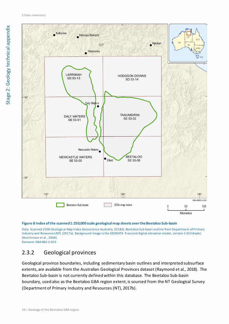
Figure 8 Index of the scanned 1:250,000 scale geological map sheets over the Beetaloo Sub-basin ...................................................................................................................................... 16
Figure 9 Petroleum wells, classified according to their depth of penetration ............................ 18
Figure 10 Two-dimensional seismic data coverage .................................................................. 20
Figure 11 a) Distribution of point gravity data observations; b) Regional Bouguer gravity coverage ................................................................................................................................ 21
Figure 12 a) Distribution of magnetic survey by resolution; b) Regional TMI (total magnetic intensity) coverage ................................................................................................................. 22
Figure 13 Distribution of shallowest McArthur Basin stratigraphic packages (Rawlings, 1999) and faults across the greater McArthur Basin ................................................................................ 25
Figure 14 Three-dimensional perspective view of the greater McArthur Basin SEEBASE® model of economic basement, looking north-west across the Beetaloo Sub-basin .............................. 27
Figure 15 Geological setting of the Beetaloo Sub-basin in the Northern Territory with basins and provinces mentioned in the appendix ..................................................................................... 30
Figure 16 Interpreted basement terranes below the Beetaloo Sub-basin and surrounds .......... 32
Figure 17 Radiogenic heat flow model across the Beetaloo Sub-basin and surrounds ............... 34
Figure 18 greater McArthur Basin extent and distributions of depositional packages ............... 36
Figure 19 Depositional packages of the McArthur Basin by Rawlings (1999) and the corresponding superbasins of Jackson et al. (1999, 2000) ........................................................ 37

Geology of the Beetaloo GBA region | v
Figure 20 Greater McArthur Basin SEEBASE® modelled depth-to-basement image, distribution of the Wilton package and Proterozoic basins and provinces mentioned in the appendix ......... 39
Figure 21 Major tectonic elements surrounding the Beetaloo Sub-basin .................................. 41
Figure 22 West to east gravity model of the western and eastern Beetaloo Sub-basin.............. 42
Figure 23 Regional Qld–NT comparison of tectonic, igneous, thermal and depositional events interpreted to have affected the Isa (northern Lawn Hill Platform) and Beetaloo (Beetaloo Sub-basin) GBA regions from the time of Glyde package deposition to the present......................... 44
Figure 24 Distribution of faults interpreted to be active during the Syn-Isan Orogeny phases after 1580 Ma ........................................................................................................................ 47
Figure 25 Mesoproterozoic to Neoproterozoic tectonic scenarios showing the depositional history of the Roper Group (Wilton package) and overlying Jamison and Hayfield units ........... 49
Figure 26 Distribution of interpreted post-Wilton package faults ............................................. 51
Figure 27 Interpreted original extent of the Carpentaria Basin and sub-basins, ridges and contiguous Mesozoic basins of Queensland and the Gulf of Papua .......................................... 54
Figure 28 Eastern Beetaloo Sub-basin south to north schematic cross-section ......................... 58
Figure 29 Stratigraphy of the greater McArthur Basin (Beetaloo Sub-basin) and overlying basins in the Beetaloo GBA region..................................................................................................... 59
Figure 30 Regional stratigraphic relationships of the Roper Group between the Beetaloo Sub-basin, Urapunga and Bauhinia Downs regions, and with the Tijunna, Renner and South Nicholson groups of other Northern Territory regions ............................................................. 63
Figure 31 Interpreted extent of the Derim Derim Dolerite ....................................................... 68
Figure 32 Subsurface extent of the Kalkarindji Province volcanics in the Beetaloo GBA region and surrounds ........................................................................................................................ 73
Figure 33 Composite seismic section south to north through the Beetaloo GBA region showing published intepretation in the eastern Beetaloo Sub-basin...................................................... 79
Figure 34 Composite seismic section west to east through the Beetaloo GBA region showing published intepretation in the eastern Beetaloo Sub-basin...................................................... 79
Figure 35 Composite seismic section west to east through the Beetaloo GBA region showing published intepretation in the western Beetaloo Sub-basin ..................................................... 80
Figure 36 Map showing seismic lines with interpretation data for the top Kyalla and top Velkerri formations in the Beetaloo GBA region ................................................................................... 81
Figure 37 Roper Group base depth and isochore maps ............................................................ 87
Figure 38 Velkerri Formation top depth and isochore maps ..................................................... 89
Figure 39 Amungee Member top depth and isochore maps ..................................................... 90

vi | Geology of the Beetaloo GBA region
Figure 40 Moroak Sandstone top depth and isochore maps..................................................... 91
Figure 41 Kyalla Formation top depth and isochore maps ........................................................ 92
Figure 42 Undifferentiated Neoproterozoic top depth and isochore maps ............................... 94
Figure 43 Kalkarindji Suite volcanics top depth map ................................................................ 95
Figure 44 Gum Ridge Formation (and equivalents) base depth and isochore maps ................... 97
Figure 45 Anthony Lagoon Formation (and equivalents) base depth and isochore maps........... 98
Figure 46 Walker River Formation base depth and isochore maps ........................................... 99
Figure 47 Oblique view of the regional three-dimensional geological model for the Beetaloo GBA region (looking north) ................................................................................................... 100
Figure 48 Oblique view of the regional three-dimensional geological model for the Beetaloo GBA region (looking west) .................................................................................................... 101
Figure 49 Schematic south to north cross-section through the Beetaloo GBA region generated from the three-dimensional geological model showing the structural architecture of the eastern Beetaloo Sub-basin............................................................................................................... 102
Figure 50 Schematic east to west cross-section through the Beetaloo GBA region generated from the three-dimensional geological model showing the structural architecture of the eastern Beetaloo Sub-basin............................................................................................................... 103
Figure 51 Schematic east to west cross-section through the Beetaloo GBA region generated from the three-dimensional geological model showing the structural architecture of the western Beetaloo Sub-basin ................................................................................................. 104

Geology of the Beetaloo GBA region | vii
Tables
Table 1 Summary table for the Beetaloo Sub-basin ................................................................... 2
Table 2 Surfaces included in the three-dimensional geological model (Geological and Bioregional Assessment Program, 2019) ................................................................................. 85

viii | Geology of the Beetaloo GBA region

Geology of the Beetaloo GBA region | ix
Contributors to the Program
The following individuals have contributed to the Geological and Bioregional Assessment Program.
Role or team Contributor(s)
Program Director Department of the Environment and Energy: Anthony Swirepik
Program Implementation Board Department of the Environment and Energy: Beth Brunoro, Nicholas Post Bureau of Meteorology: Kirsten Garwood, Kate Vinot CSIRO: Jane Coram, Warwick MacDonald Geoscience Australia: Stuart Minchin, Richard Blewett
Basin Leader CSIRO: Kate Holland, Cameron Huddlestone-Holmes, Paul Wilkes Geoscience Australia: Steven Lewis
Program management CSIRO: Karen Barry, Emanuelle Frery, Linda Merrin, Ruth Palmer Department of the Environment and Energy: Mitchell Bouma, Rod Dann, Andrew Stacey, David Thomas, Alex Tomlinson
Product integration and stakeholder engagement
CSIRO: Clare Brandon, Justine Lacey, Michelle Rodriquez, Sally Tetreault-Campbell
Analysis and visualisation CSIRO: Dennis Gonzalez, Steve Marvanek Geoscience Australia: Adrian Dehelean, Chris Evenden, Chris Lawson, Bianca Reese, Nigel Skeers, Murray Woods
Basin geology and prospectivity Geoscience Australia: Lisa Hall (Discipline Leader), Adam Bailey, George Bernardel, Barry Bradshaw, Donna Cathro, Merrie-Ellen Gunning, Amber Jarrett, Megan Lech, Meredith Orr, Ryan Owens, Tehani Palu, Martin Smith, Liuqu Wang
Chemical assessment CSIRO: Jason Kirby (Discipline Leader), Simon Apte, Lisa Golding, Rai Kookana, Dirk Mallants, Michael Williams
Data management and transparency
Bureau of Meteorology: Andre Zerger (Discipline Leader), Derek Chen, Trevor Christie-Taylor, Donna Phillips CSIRO: Nicholas Car, Philip Davies, Stacey Northover, Matt Stenson Geoscience Australia: Matti Peljo
Hydrogeology Geoscience Australia: Tim Ransley (Discipline Leader), Sam Buchanan, Scott Cook, Prachi Dixon-Jain, Bex Dunn, Tim Evans, Éamon Lai, Bruce Radke, Baskaran Sundaram
Impact analysis CSIRO: David Post (Discipline Leader), Brent Henderson, Dane Kasperczyk, James Kear, Regina Sander
Impacts on protected matters CSIRO: Anthony O'Grady (Discipline Leader), Alexander Herr, Craig MacFarlane, Justine Murray, Chris Pavey, Stephen Stewart
Spatial analysis CSIRO: Dennis Gonzalez, Steve Marvanek Geoscience Australia: Adrian Dehelean, Murray Woods, Nigel Skeers
Water quantity CSIRO: Russell Crosbie (Discipline Leader), Jorge Martinez Praveen Kumar Rachakonda, Matthias Raiber, Yongqiang Zhang, Hongxing Zheng

x | Geology of the Beetaloo GBA region
Acknowledgements
This technical product was reviewed by several groups:
• Internal Peer Review Group: Steve Abbott, Adam Bailey, Chris Nicholson, Merrie-Ellen Gunning
• Technical Peer Review Group: Andrew Boulton, Peter McCabe, Catherine Moore, Jenny Stauber
• State and Territory Government Science Technical Review: This group includes scientists from the Northern Territory Government.
Valuable comments were also provided by Tim Munson, Ben Williams (Northern Territory Geological Survey), Andrew Kelman (Geoscience Australia), Todd Hoffman (Pangaea Resources), David Close, Angus McIntyre (Santos), Brenton Richards (Origin Energy) and Andrew Stacey (Department of the Environment and Energy).

Geology of the Beetaloo GBA region | xi
Abbreviations and acronyms
Abbreviation/acronym Definition
AHD Australian Height Datum
Ar-Ar argon-argon
ca circa
C.I. contour interval
DEM digital elevation model
GA Geoscience Australia
GBA Geological and Bioregional Assessment
GEMIS Geoscience Exploration and Mining Information System (NT Geological Survey)
GIS geographic information system
Ma millions of years before the present
mAHD metres with respect to the Australian Height Datum
m MSL metres with respect to mean sea level
MSL mean sea level
NAC North Australian Craton
NT Northern Territory
NTGS Northern Territory Geological Survey
NTGS DIP Northern Territory Geological Survey Digital Information Package
SEEBASE® Structurally Enhanced view of Economic BASEment
SHRIMP Sensitive High-Resolution Ion Microprobe
TMI total magnetic intensity
TVDSS true vertical depth with respect to mean sea level
TWT two-way traveltime
U-Pb uranium–lead

xii | Geology of the Beetaloo GBA region
Units
Unit Description
km kilometre
km2 square kilometre
Ma millions of years before the present
mW/m2 milliwatts per metre squared
nT nanoTesla
W/m2 watts per square metre

Geology of the Beetaloo GBA region | xiii
The Geological and Bioregional Assessment Program The $35.4 million Geological and Bioregional Assessment Program is assessing the potential environmental impacts of shale and tight gas development to inform regulatory frameworks and appropriate management approaches. The geological and environmental knowledge, data and tools produced by the Program will assist governments, industry, landowners and the community by informing decision making and enabling the coordinated management of potential impacts.
In consultation with state and territory governments and industry, three geological basins were selected based on prioritisation and ranking in Stage 1: Cooper Basin, Isa Superbasin and Beetaloo Sub-basin. In Stage 2, geological, hydrological and ecological data were used to define ‘GBA regions’: the Cooper GBA region in Queensland, SA and NSW, the Isa GBA region in Queensland and the Beetaloo GBA region in NT.
The GBA Program will assess the potential impacts of selected shale and tight gas development on water and the environment and provide independent scientific advice to governments, landowners and the community, business and investors to inform decision making. Geoscience Australia and CSIRO are conducting the assessments. The Program is managed by the Department of the Environment and Energy and supported by the Bureau of Meteorology.
The GBA Program aims to:
• inform government and industry and encourage exploration to bring new gas supplies to the East Coast Gas Market within five to ten years
• increase understanding of the potential impacts on water and the environment posed by development of shale and tight gas resources
• increase the efficiency of assessment and ongoing regulation, particularly through improved reporting and data provision/management approaches
• improve community understanding of the industry.
The GBA Program commenced in July 2017 and comprises three stages:
• Stage 1 Rapid regional basin prioritisation identified and prioritised geological basins with the greatest potential to deliver shale and/or tight gas to the East Coast Gas Market within the next five to ten years.
• Stage 2 Geological and environmental baseline assessments is compiling and analysing available data for the three selected regions to form a baseline and identify gaps to guide collection of additional baseline data where needed. This analysis includes a geological basin assessment to define structural and stratigraphic characteristics and an environmental data synthesis.
• Stage 3 Impact analysis and management will analyse the potential impacts to water resources and matters of environmental significance to inform and support Commonwealth and Territory management and compliance activities.
The PDF of this report and the supporting technical appendices are available at https://www.bioregionalassessments.gov.au/geological-and-bioregional-assessment-program.

xiv | Geology of the Beetaloo GBA region
About this report
Presented in this technical appendix is a review of the geology of the Beetaloo GBA region. It provides more detailed information regarding the geological setting, tectonic evolution, depositional environments and structural and stratigraphic framework. The structure and focus of the synthesis report and technical appendices reflect the needs of government, industry, landowners and community groups.
Technical appendices
Other technical appendices that support the geological and environmental baseline assessment for the Beetaloo GBA region are:
• Hall LS, Wang L, Bailey AHE, Orr ML, Owens R, Jarrett, A, Lech ME, Skeers N, Reese B and Woods M (2020) Petroleum prospectivity of the Beetaloo Sub-basin.
• Evans TJ, Radke BM, Martinez J, Buchanan S, Cook SB, Raiber M, Ransley TR, Lai ÉCS, Skeers N, Woods M, Evenden C, Cassel R and Dunn B (2020) Hydrogeology of the Beetaloo GBA region.
• Pavey C, Herr A, MacFarlane CM, Merrin LE and O’Grady AP (2020) Protected matters for the Beetaloo GBA region.
• Kirby JK, Golding L, Williams M, Apte S, Mallants D, King J, Otalega I and Kookana R (2020) Qualitative (screening) environmental risk assessment of drilling and hydraulic fracturing chemicals for the Beetaloo GBA region.
• Kear J and Kasperczyk D (2020) Hydraulic fracturing and well integrity review for the GBA regions.
All maps for the Beetaloo GBA region use the Map Grid of Australia (MGA) projection (zone 53) and the Geocentric Datum of Australia 1994 (GDA 1994)
1 Introduction
Geology of the Beetaloo GBA region | 1
Stage 2: Geology technical appendix
1 Introduction The Beetaloo Sub-basin is a structural component of the greater McArthur Basin in the Northern Territory, located about 500 kilometres south-east of Darwin (Figure 1). The greater McArthur Basin (Close, 2014) is an informal term to capture an extensive series of Proterozoic sedimentary rock formations that stretches across most of the northern part of the Northern Territory from north-east WA to north-west Queensland (Figure 1). It includes the Paleoproterozoic to Mesoproterozoic successions of the McArthur Basin, Birrindudu Basin and the Tomkinson Province, all of which are interpreted to be linked in the subsurface (Munson, 2019). The Beetaloo Sub-basin is part of this greater basin area and it lies entirely under the cover of younger basin sediments. Some of the basin fill has been intersected by petroleum well drilling.
The Beetaloo Sub-basin is prospective for unconventional hydrocarbons. It is estimated to contain technically recoverable shale gas, tight gas and shale oil resources, particularly within the Kyalla and middle Velkerri formations of the Mesoproterozoic Roper Group (Revie, 2017a). Shale gas production is feasible in the Beetaloo Sub-basin within five to ten years with further exploration, resource assessment and infrastructure development (Pepper et al., 2018). Development of unconventional hydrocarbon resources could result in delivery of gas to the East Coast Gas Market over this time frame. Geological data are sufficient for a baseline assessment to be undertaken.
This appendix provides a regional geological analysis of the Beetaloo GBA region. It provides baseline datasets and information that were used for undertaking analyses in the petroleum prospectivity technical appendix (Hall et al., 2020). The stratigraphic and structural background provides input to the analyses of hydrostratigraphy and interconnectivity in the hydrogeology technical appendix (Evans et al., 2020).
1 Introduction
2 | Geology of the Beetaloo GBA region
Stag
e 2:
Geo
logy
tech
nica
l app
endi
x Table 1 Summary table for the Beetaloo Sub-basin
Jurisdiction Northern Territory
Area (km2) 28,000 km2
Maximum sediment thickness Mesoproterozoic Roper Group sediments > 5000 m; total sediments > 10,000 m
Age range Mesoproterozoic (sensu stricto); Paleoproterozoic to Mesoproterozoic (sensu lato)
Basin Overlies Paleoproterozoic (±Archean) crystalline basement
Underlies Georgina Basin, Wiso Basin, Daly Basin, Carpentaria Basin, Kalkarindji Province volcanics
Adjacent basins Birrindudu Basin, Tomkinson Province
Basin type Intra-cratonic
Depositional setting Fluvio-deltaic to nearshore and shallow marine
Regional structure Extensional, strike-slip and compressional events producing fault-bounded sub-basins and highs
Seismic line km 8,818 line km of two-dimensional seismic; no three-dimensional seismic
Number of petroleum wells 20 (within the Beetaloo Sub-basin outline defined by NTGS)

1 Introduction
Geology of the Beetaloo GBA region | 3
Stage 2: Geology technical appendix
Figure 1 Location of the Beetaloo Sub-basin and distributions of Mesoproterozoic and Paleoproterozoic rocks of the greater McArthur Basin in the Northern Territory Data: Beetaloo Sub-basin outline from Department of Primary Industry and Resources (NT) (2017a). Distribution of Mesoproterozoic and Paleoproterozoic rocks adapted from Betts et al. (2015). Background image is the GEODATA 9-second digital elevation model, version 3 (hillshade) (Hutchinson et al., 2008) Element: GBA-BEE-2-098
1.1 Aims and rationale of this appendix A sound scientific understanding of a region’s geology ideally underpins decisions on unconventional resource development. This appendix provides a geological basin review of the

1 Introduction
4 | Geology of the Beetaloo GBA region
Stag
e 2:
Geo
logy
tech
nica
l app
endi
x Beetaloo GBA region and analyses relevant to understanding its structural and stratigraphic characteristics.
The Geological and Bioregional Assessment (GBA) Program is conducted during the exploration phase for shale and tight gas resources. The greater McArthur Basin, including the Beetaloo Sub-basin, is at a frontier stage of petroleum exploration (Hall et al., 2020; Revie and Edgoose, 2015). The sub-basin at this exploration stage contains sufficient, but limited, information from petroleum wells and seismic surveys for an assessment of unconventional hydrocarbon prospectivity (Hall et al., 2020). A comprehensive review of the existing geological knowledge on the Beetaloo Sub-basin has not been previously published.
This appendix collates the current geological knowledge of the Beetaloo GBA region relevant to the depositional and post-depositional history of the sedimentary rocks, and the stratigraphic and structural framework of the region. It begins with an inventory of datasets broadly relevant to the assessment in Section 2. The regional geology (Section 3) and structural and stratigraphic framework (Section 4) sections cover topics outlined in the rationale given below.
Several geological factors affect assessments of hydrocarbon prospectivity, groundwater distribution and aquifer connectivity. Many of these are controlled by the depositional and post-depositional history of the source and reservoir rocks. The depositional environments of shales have a direct influence on the type and amount of organic matter they contain. Depositional environments influence also the capacity of sedimentary rocks to hold hydrocarbons (as reservoirs) or water (as aquifers). Section 3.4 summarises the current geological knowledge on the depositional environments of the rocks within the Beetaloo GBA region. A Proterozoic to Cenozoic stratigraphic chart, which integrates lithostratigraphy and hydrostratigraphy, was compiled for the Beetaloo GBA region and it is presented in Section 3.4.
The post-depositional thermal evolution of the source rocks governs the generation of unconventional hydrocarbons. Sedimentary basins are not timeless and static: thermal evolution is influenced by burial, uplift and erosion in the basin. Temperature changes and generation of hydrocarbons can have occurred in any period since deposition of the organic-rich sediments. In the case of the Beetaloo Sub-basin organic-rich rocks, this could have been at one or more times in the last 1.3 billion years. Section 3.3 reviews the tectonic evolution of the Beetaloo GBA region and surrounds, including interpreted tectonothermal events. The information is used as background for the interpreted timing of hydrocarbon generation and for the burial history modelling component of the prospectivity technical appendix (Hall et al., 2020).
Tectonic evolution affects also the degree of fracture porosity in indurated sedimentary rocks, which refines classifications of aquifers and aquitards in the Beetaloo GBA region (Evans et al., 2020). Secondary porosity produced by fracturing can control the capacity of units to hold or transmit water, particularly where the primary inter-granular porosity has been modified by compaction and cementation (Evans et al., 2020). Structural offsets also affect regional groundwater flow and connectivity. The timing, distribution and degree of tectonic deformation is reviewed in Section 3.3 to the current extent of knowledge, subject to the limitations outlined in Section 4.5.

1 Introduction
Geology of the Beetaloo GBA region | 5
Stage 2: Geology technical appendix
The structural and stratigraphic framework of the Beetaloo Sub-basin is captured in Section 4 by a three-dimensional geological model created for the assessment. Three-dimensional depth and isochore maps for key Proterozoic and Phanerozoic stratigraphic horizons provide an integrated Proterozoic to Cenozoic framework that supports assessment of regional groundwater flow systems and the conceptual model presented in the hydrogeology technical appendix (Evans et al., 2020). In addition, the maps support the criteria to assess hydrocarbon prospectivity in the Beetaloo GBA region (Hall et al., 2020). The mapped depths and thicknesses of key stratigraphic intervals were used to derive input parameter maps for the play fairway maps presented in the prospectivity technical appendix.
1.2 Beetaloo GBA region The Beetaloo GBA region is the focus area for the baseline assessment of the Beetaloo Sub-basin in the NT. The formally defined boundaries of the Beetaloo Sub-basin are the same boundaries used to define the Beetaloo GBA region (Figure 2).
GBA regions are defined where the boundaries ideally enclose the maximum extent of preserved and relatively continuous sedimentary deposits associated with the unconventional hydrocarbon resources. Boundaries defining the GBA regions are ideally defined at the:
• limit for potentially prospective unconventional gas resources, namely where the sedimentary fill becomes extensively folded and faulted, with the potential gas resource intervals either brought closer to the surface, exhumed as outcrop or eroded, or
• sedimentary fill edge as mapped by the relevant geological survey, where seismic data coverage is not sufficient for the interpretation of sedimentary deposit extents and deformation.
The most recent formal definition of the Beetaloo Sub-basin, explained in the Methods snapshot box ahead, is consistent with the requirements of the assessment. The Beetaloo Sub-basin consists of discrete eastern and western subsurface volumes of sedimentary rock, typically bounded by faults, containing the regionally thickest preserved Mesoproterozoic Roper Group formations that host significant hydrocarbon resources (Department of Primary Industry and Resources (NT), 2017b). The sub-basin boundaries enclose the most likely area of the greater McArthur Basin where future development of unconventional hydrocarbon resources could take place. Outside of the margins, uplift and erosion have brought the prospective shales closer to the surface, or they have been eroded away altogether (Department of Primary Industry and Resources (NT), 2017).
Methods snapshot: Defining the Beetaloo Sub-basin
Boundaries that define the Beetaloo Sub-basin are fixed by the NT DPIR at the top of the Kyalla Formation at a depth of 400 m below the topographic surface (Department of Primary Industry and Resources (NT), 2017b).
The sub-basin is typically bounded by faults except at the western margin (Figure 2), where it shallows gently to the west. The top of the Kyalla Formation at a depth of 400 m below the

1 Introduction
6 | Geology of the Beetaloo GBA region
Stag
e 2:
Geo
logy
tech
nica
l app
endi
x surface was used to create a consistent boundary definition between these sub-basin areas (Department of Primary Industry and Resources (NT), 2017b).
Figure 2 Beetaloo Sub-basin, total sediment thickness from the base of the Mesoproterozoic Roper Group sediments to the surface, and summary fault distribution Data: Frogtech Geoscience (2018b). Beetaloo Sub-basin outline from Department of Primary Industry and Resources (NT) (2017a). Background image is the GEODATA 9-second digital elevation model, version 3 (hillshade) (Hutchinson et al., 2008) Element: GBA-BEE-2-202

1 Introduction
Geology of the Beetaloo GBA region | 7
Stage 2: Geology technical appendix
The maps in this appendix display the formally defined Beetaloo Sub-basin boundaries, which are the same boundaries as the Beetaloo GBA region. The defined extent encloses a region of concentrated well and seismic survey data (Figure 3) that is sufficient for an assessment of unconventional hydrocarbon prospectivity (Hall et al., 2020).
Figure 3 Distribution of seismic survey lines and petroleum wells Data: Seismic survey lines from Department of Primary Industry and Resources (NT) (2018f), petroleum well distribution from Department of Primary Industry and Resources (NT) (2018d). Beetaloo Sub-basin outline from Department of Primary Industry and Resources (NT) (2017a). Background image is the GEODATA 9-second digital elevation model, version 3 (hillshade) (Hutchinson et al., 2008) Element: GBA-BEE-2-212
The two subsurface volumes of sedimentary rock are informally termed the western and eastern Beetaloo Sub-basin areas. Although the Beetaloo Sub-basin is defined in relation to the

1 Introduction
8 | Geology of the Beetaloo GBA region
Stag
e 2:
Geo
logy
tech
nica
l app
endi
x Mesoproterozic Roper Group, in other contexts the underlying late Paleoproterozoic groups are included in its scope, for example by Frogtech Geoscience (2018b). For the purposes of this assessment, the underlying late Paleoproterozoic groups are included in structural and stratigraphic reviews of the sub-basin.
1.3 Broader area of hydrocarbon potential Potential exists for hydrocarbon resources to occur across a wider area of the greater McArthur Basin. A broader area based on NT DPIR assessment is here termed the 'area of hydrocarbon potential'. This area of hydrocarbon potential has been outlined by the NT DPIR as the area likely to contain key prospective shales (Pepper et al., 2018). The Beetaloo GBA region is a spatially explicit subset of this broader area of hydrocarbon potential.
The NT is underlain by thick sequences of sedimentary rock and broad areas are underexplored. The Mesoproterozoic Roper Group and Paleoproterozoic McArthur Group contain recognised potential source rocks and prospective shales, though their thicknesses are variable and large areas remain underexplored or untested (Pepper et al., 2018).
Figure 4 indicates the likely extent of prospective source rocks currently identified by the NT DPIR in the region surrounding the Beetaloo Sub-basin (Pepper et al., 2018). Key prospective shales (those with the necessary prerequisites for shale gas occurrence and commercial development) are likely to be present in these areas but their gas-bearing status has not been confirmed over the entire area indicated (Pepper et al., 2018). The most prospective source rocks are shales of the Roper and McArthur Groups, such as the Kyalla and Velkerri formations (Roper Group) and the Barney Creek Formation (McArthur Group). Roper and McArthur group strata are distributed over a broader area of the greater McArthur Basin than the extents of potentially prospective source rocks indicated in Figure 4.

1 Introduction
Geology of the Beetaloo GBA region | 9
Stage 2: Geology technical appendix
Figure 4 Area of hydrocarbon potential in the vicinity of the Beetaloo Sub-basin Approximate areas within which key prospective shales are likely to be present. Areas indicated are the portions of the Velkerri Formation (western polygon) and Barney Creek Formation (eastern polygon) considered to have the necessary conditions for shale gas occurrence. Source: Pepper et al. (2018). Beetaloo Sub-basin outline from Department of Primary Industry and Resources (NT) (2017a). Background image is the GEODATA 9-second digital elevation model, version 3 (hillshade) (Hutchinson et al., 2008) Element: GBA-BEE-2-218

1 Introduction
10 | Geology of the Beetaloo GBA region
Stag
e 2:
Geo
logy
tech
nica
l app
endi
x

2 Data inventory
Geology of the Beetaloo GBA region | 11
Stage 2: Geology technical appendix
2 Data inventory
2.1 Introduction This section reviews the available geological and petroleum data and information for the Beetaloo GBA region. The datasets included in this review are limited to those in the public domain and considered by the authors as fit-for-purpose as of December 2018.
2.2 Culture, hydrography and relief
2.2.1 Administrative boundaries and infrastructure
Centres of population and infrastructure such as road and rail (Figure 5) shown on maps created for the Beetaloo GBA were sourced from the GEODATA TOPO 250K Series 3 dataset (Geoscience Australia, 2017). The dataset is a vector representation of the major features appearing on 1:250,000 scale NATMAPs in Shape file format.
The National Oil and Gas Infrastructure datasets (Petrosys Pty Ltd, 2019) present the spatial locations of onshore pipelines for the transmission of oil and gas within mainland Australia. They also present the location of oil and gas platforms and infrastructure facilities for the extraction, processing and/or storage of oil and natural gas. Existing gas pipelines for the wider region are shown in Figure 5. There are currently no oil or gas processing facilities in the Beetaloo GBA region or surrounds.

2 Data inventory
12 | Geology of the Beetaloo GBA region
Stag
e 2:
Geo
logy
tech
nica
l app
endi
x
Figure 5 Road, railway and pipeline infrastructure Data: GEODATA TOPO 250K Series 3 dataset (Geoscience Australia, 2017). Gas pipeline routes from the GPinfo petroleum database, a Petrosys Pty Ltd product (Petrosys Pty Ltd, 2019). Beetaloo Sub-basin outline from Department of Primary Industry and Resources (NT) (2017a). Background image is the GEODATA 9-second digital elevation model, version 3 (hillshade) (Hutchinson et al., 2008) Element: GBA-BEE-2-190
2.2.2 Topographic and remote sensing data
2.2.2.1 Digital elevation data
The GEODATA 9-second digital elevation model (DEM-9S) Version 3 is a grid of ground level elevation points covering the whole of Australia with a grid spacing of 9 arc-seconds in longitude and latitude (approximately 250 metres) in the GDA94 coordinate system (Hutchinson et al., 2008). An image of the digital elevation data across the Beetaloo Sub-basin is shown in Figure 6.

2 Data inventory
Geology of the Beetaloo GBA region | 13
Stage 2: Geology technical appendix
Figure 6 Surface topography across the Beetaloo Sub-basin and surrounds Data: GEODATA 9 second DEM and D8 (Hutchinson et al., 2008). Beetaloo Sub-basin outline from Department of Primary Industry and Resources (NT) (2017a) Element: GBA-BEE-2-008
2.2.2.2 Remote sensing data
Advanced Spaceborne Thermal Emission and Reflection Radiometer (ASTER) data (CSIRO, 2015) are available across the NT (Cudahy et al., 2012) as mineral index maps, and are downloadable from Northern Territory Government (2018b). Fourteen spectral band images, sensitive to various rock forming minerals, provide broad information on surficial soils and outcrop.
Airborne radiometric and magnetic surveys have been flown with maximum line separation of 400 m across the Beetaloo Sub-basin and surrounds. Airborne magnetic datasets are discussed in Section 2.3.4.3 (Figure 12). Radiometric techniques measure the amount of gamma ray radiation emitted from the decay of potassium, thorium and uranium isotopes in the upper 30 cm

2 Data inventory
14 | Geology of the Beetaloo GBA region
Stag
e 2:
Geo
logy
tech
nica
l app
endi
x (approximate) of the surface rocks and regolith and is used for surface geological and regolith mapping, as well as to trace sediment pathways in the landscape. Radiometric survey data are available as images across the Beetaloo Sub-basin and surrounds (Northern Territory Government, 2018b).
Landsat satellites record reflected and emitted energy from the Earth in various electromagnetic wavelength bands. Spatial and temporal patterns in vegetation, surface water and land use can be interpreted from the data. The data are available as images across the Beetaloo Sub-basin and surrounds (Northern Territory Government, 2018b). An archive of processed Landsat data is available for analysis from the Digital Earth Australia platform, which is utilised and discussed in more detail in the hydrogeology technical appendix (Evans et al., 2020).
2.3 Geological datasets Knowledge of basin architecture and evolution requires the integration of basement, stratigraphic and chronological data (Southgate et al., 2000b). Chronological data, published in the papers cited in this report, inform the stratigraphic chart presented in Section 3.4 (Figure 29). This data inventory describes the basement and stratigraphic datasets relevant to basin analysis and unconventional hydrocarbon prospectivity for the Beetaloo GBA region, and, more broadly, the surface geology datasets relevant to the requirements of the Geological and Bioregional Assessments Program.
2.3.1 Surface geology
The surface geology maps used in this assessment are sourced from either the Surface Geology of Australia 1:1,000,000 scale dataset, 2012 edition (Figure 7) (Geoscience Australia, 2012a), or 1:2,500,000 scale dataset, 2012 edition (Geoscience Australia, 2012b). These are seamless national coverages, which show areas of outcropping bedrock geology and unconsolidated, or poorly consolidated, regolith. Geological units are represented as polygons and lines, and are attributed with information regarding stratigraphic nomenclature and hierarchy, age, lithology, and primary data source. The dataset also contains geological contacts, structural features such as faults and shears, and miscellaneous supporting lines, such as the boundaries of water bodies.
Figure 8 presents the index of the spatial extents of scanned images of the 1:250,000 scale geological maps across the Beetaloo Sub-basin and surrounds from Geoscience Australia’s Web Map Service (Geoscience Australia, 2018d). The service contains information on the edition, publication data and map publisher, and has links to map images. Geological 1:250,000 scale outcrop maps and explanatory notes are available from the NT Geological Survey’s Geoscience Exploration and Mining Information System (GEMIS) portal (Northern Territory Government, 2018c).
The Northern Australia Geochemical Survey (NAGS) project is a sparse geochemical sampling survey designed to determine the regional distribution of chemical elements within soils (Geoscience Australia, 2018c). Data interpretation is aimed to locate “blind” mineral deposits and provide an environmental baseline dataset. An initial data release and interpretation, which covers the area over the eastern Beetaloo Sub-basin, has been published (Bastrakov et al., 2018).

2 Data inventory
Geology of the Beetaloo GBA region | 15
Stage 2: Geology technical appendix
Figure 7 Simplified surface geology across the Beetaloo Sub-basin and surrounds Data: Modified from the Surface Geology of Australia 1:1 million scale dataset 2012 edition (Geoscience Australia, 2012a). Beetaloo Sub-basin outline from Department of Primary Industry and Resources (NT) (2017a) Element: GBA-BEE-2-191
2 Data inventory
16 | Geology of the Beetaloo GBA region
Stag
e 2:
Geo
logy
tech
nica
l app
endi
x
Figure 8 Index of the scanned 1:250,000 scale geological map sheets over the Beetaloo Sub-basin Data: Scanned 250K Geological Map Index (Geoscience Australia, 2018d). Beetaloo Sub-basin outline from Department of Primary Industry and Resources (NT) (2017a). Background image is the GEODATA 9-second digital elevation model, version 3 (hillshade) (Hutchinson et al., 2008) Element: GBA-BEE-2-023
2.3.2 Geological provinces
Geological province boundaries, including sedimentary basin outlines and interpreted subsurface extents, are available from the Australian Geological Provinces dataset (Raymond et al., 2018). The Beetaloo Sub-basin is not currently defined within this database. The Beetaloo Sub-basin boundary, used also as the Beetaloo GBA region extent, is sourced from the NT Geological Survey (Department of Primary Industry and Resources (NT), 2017b).

2 Data inventory
Geology of the Beetaloo GBA region | 17
Stage 2: Geology technical appendix
2.3.3 Well data
A regularly updated and standardised set of petroleum well header data is available from the Northern Territory Government’s STRIKE NT-wide downloadable datasets (Department of Primary Industry and Resources (NT), 2018d, 2019). The petroleum wells dataset contains details of industry exploration and production wells drilled in the Northern Territory and its administered waters since 1959.
Twenty petroleum wells have been drilled within the defined area of the Beetaloo Sub-basin and a further six are located on the periphery of the boundary (Figure 9). The distribution of these and other wells in the surrounding area, classified according to their depth of penetration, is shown in Figure 9. The maximum well depth in the Beetaloo GBA region is 3945 m (true vertical depth) at Tanumbirini 1 (Figure 9).
The exploration history of the Beetaloo Sub-basin is outlined in the prospectivity technical appendix (Hall et al., 2020). Most of the wells targeted the Kyalla Formation, with some extending deeper into the Velkerri Formation.
Open-file well completion reports are available for Beetaloo Sub-basin wells (Northern Territory Government, 2018h). Formation tops and public domain wireline log data were sourced from the Northern Territory Petroleum Wells (PEX Wells) database (Northern Territory Government, 2018h). Open-file digital log data are available for all wells except Balmain 1, Burdo 1, Chanin 1, Elliott 1, Jamison 1, Ronald 1 and Sever 1.
HyLogger™ data refers to the application of non-destructive high-resolution imagery, and associated spectral data, to drillcore to determine mineralogical composition (Schodlok et al., 2016), and can improve the objectivity and efficiency of well log analysis (Smith, 2011). HyLogger™ data reports (as HyLogger Data Packages (HDP)) for hydrocarbon exploration wells in the Beetaloo Sub-basin region are available for the Altree 2, Jamison 1 and Sever 1 wells (Northern Territory Government, 2018f).

2 Data inventory
18 | Geology of the Beetaloo GBA region
Stag
e 2:
Geo
logy
tech
nica
l app
endi
x
Figure 9 Petroleum wells, classified according to their depth of penetration Data: Department of Primary Industry and Resources (NT) (2018d). Beetaloo Sub-basin outline from Department of Primary Industry and Resources (NT) (2017a). Background image is the GEODATA 9-second digital elevation model, version 3 (hillshade) (Hutchinson et al., 2008) Element: GBA-BEE-2-004
2.3.4 Geophysical data
Seismic, gravity and magnetics data provide valuable insight into the subsurface architecture of the Beetaloo Sub-basin. Open-file datasets acquired by companies and the Australian and NT governments are available from the Northern Territory Petroleum Geophysical Surveys (PEX Geophysics) (Northern Territory Government, 2018a) and Geophysical and Remote Sensing Data (Northern Territory Government, 2018g) survey databases.
2 Data inventory
Geology of the Beetaloo GBA region | 19
Stage 2: Geology technical appendix
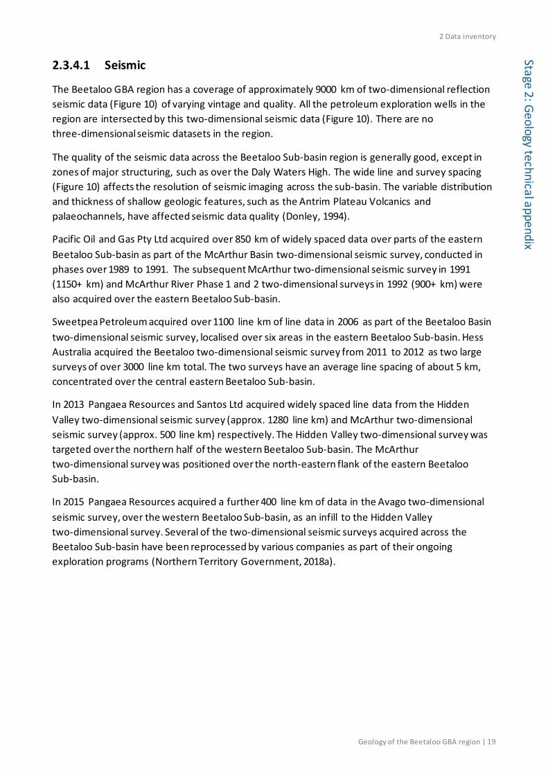
2.3.4.1 Seismic
The Beetaloo GBA region has a coverage of approximately 9000 km of two-dimensional reflection seismic data (Figure 10) of varying vintage and quality. All the petroleum exploration wells in the region are intersected by this two-dimensional seismic data (Figure 10). There are no three-dimensional seismic datasets in the region.
The quality of the seismic data across the Beetaloo Sub-basin region is generally good, except in zones of major structuring, such as over the Daly Waters High. The wide line and survey spacing (Figure 10) affects the resolution of seismic imaging across the sub-basin. The variable distribution and thickness of shallow geologic features, such as the Antrim Plateau Volcanics and palaeochannels, have affected seismic data quality (Donley, 1994).
Pacific Oil and Gas Pty Ltd acquired over 850 km of widely spaced data over parts of the eastern Beetaloo Sub-basin as part of the McArthur Basin two-dimensional seismic survey, conducted in phases over 1989 to 1991. The subsequent McArthur two-dimensional seismic survey in 1991 (1150+ km) and McArthur River Phase 1 and 2 two-dimensional surveys in 1992 (900+ km) were also acquired over the eastern Beetaloo Sub-basin.
Sweetpea Petroleum acquired over 1100 line km of line data in 2006 as part of the Beetaloo Basin two-dimensional seismic survey, localised over six areas in the eastern Beetaloo Sub-basin. Hess Australia acquired the Beetaloo two-dimensional seismic survey from 2011 to 2012 as two large surveys of over 3000 line km total. The two surveys have an average line spacing of about 5 km, concentrated over the central eastern Beetaloo Sub-basin.
In 2013 Pangaea Resources and Santos Ltd acquired widely spaced line data from the Hidden Valley two-dimensional seismic survey (approx. 1280 line km) and McArthur two-dimensional seismic survey (approx. 500 line km) respectively. The Hidden Valley two-dimensional survey was targeted over the northern half of the western Beetaloo Sub-basin. The McArthur two-dimensional survey was positioned over the north-eastern flank of the eastern Beetaloo Sub-basin.
In 2015 Pangaea Resources acquired a further 400 line km of data in the Avago two-dimensional seismic survey, over the western Beetaloo Sub-basin, as an infill to the Hidden Valley two-dimensional survey. Several of the two-dimensional seismic surveys acquired across the Beetaloo Sub-basin have been reprocessed by various companies as part of their ongoing exploration programs (Northern Territory Government, 2018a).

2 Data inventory
20 | Geology of the Beetaloo GBA region
Stag
e 2:
Geo
logy
tech
nica
l app
endi
x
Figure 10 Two-dimensional seismic data coverage Data: Seismic survey lines from Department of Primary Industry and Resources (NT) (2018f), petroleum well distribution from Department of Primary Industry and Resources (NT) (2018d). Beetaloo Sub-basin outline from Department of Primary Industry and Resources (NT) (2017a). Background image is the GEODATA 9-second digital elevation model, version 3 (hillshade) (Hutchinson et al., 2008) Element: GBA-BEE-2-005
2.3.4.2 Gravity
The Australian National Gravity Database contains data from more than 1.5 million point gravity observations on the Australian mainland, over the continental margins, on the Australian Antarctic Territory, and other external territories of Australia. These data have been collected from nearly 1700 gravity surveys dating back to 1937 (Wynne and Bacchin, 2009). A full coverage of ground ground-based gravity is available over the Beetaloo Sub-basin at a relatively sparse 10 km average spacing (Figure 11).

2 Data inventory
Geology of the Beetaloo GBA region | 21
Stage 2: Geology technical appendix
Several filtered gravity images over the Beetaloo Sub-basin are available via the NT Government’s Geophysical Image Web Server (GIWS) portal (Northern Territory Government, 2018b).
Figure 11 a) Distribution of point gravity data observations; b) Regional Bouguer gravity coverage Data: Australian National Gravity Database (Wynne and Bacchin, 2009); Bouguer Gravity Anomaly Grid of Onshore Australia (Nakamura, 2016) Element: GBA-BEE-2-006
2.3.4.3 Magnetics
The sixth edition of the total magnetic intensity (TMI) anomaly grid of Australia with Variable Reduction to Pole (VRTP) covers all of Australia with a grid cell spacing of approximately 3 seconds of arc (approximately 80 m) (Nakamura and Milligan, 2015). Details of the specifications of individual airborne surveys can be found in the Fourteenth Edition of the Index of Airborne Geophysical Surveys (Percival, 2014). Airborne magnetic data are available across the Beetaloo Sub-basin at flight-line spacings of 500 m or less (Figure 12).
Several filtered and derived magnetics images over the Beetaloo Sub-basin are available at the NT Government’s Geophysical Image Web Server (GIWS) portal (Northern Territory Government, 2018b).

2 Data inventory
22 | Geology of the Beetaloo GBA region
Stag
e 2:
Geo
logy
tech
nica
l app
endi
x
Figure 12 a) Distribution of magnetic survey by resolution; b) Regional TMI (total magnetic intensity) coverage Data: ARGUS (Airborne Geophysical Surveys) metadata database (Richardson, 2018); Total Magnetic Intensity (TMI) Anomaly Grid of Australia (Nakamura and Milligan, 2015) Element: GBA-BEE-2-007
2.3.4.4 Other geophysical surveys
The Australian Lithospheric Architecture Magnetotelluric Project (AusLAMP) is a collaborative, national survey that acquires long-period magnetotelluric (MT) data across the Australian landmass (Geoscience Australia, 2018b). The ongoing program, which commenced in 2013, aims to acquire data from portable stations located on a half-degree (about 55 km) grid. AusLAMP, by measuring the electrical conductivity-resistivity structure of the deep subsurface below 10 km, will image broad geological features as three-dimensional structures within the lithosphere and, thereby, provide information on the architecture of the deep crust and upper mantle.
The Australian Airborne Electromagnetic Project (AusAEM) is a series of airborne electromagnetic surveys conducted at a line spacing of 20 km across a large region of northern Australia (Geoscience Australia, 2018a). The analysis of subsurface electrical conductivity to several hundreds of metres will be used to map sedimentary and regolith cover, as well as to assess the potential for groundwater resources.

2 Data inventory
Geology of the Beetaloo GBA region | 23
Stage 2: Geology technical appendix
2.4 Published geological studies Concurrent and previous Australian and NT government research programs have had an emphasis on improving the understanding of the geological framework of the greater McArthur Basin. Outlined in this section are those published studies relevant to the Beetaloo Sub-basin.
2.4.1 Concurrent programs
The NT Government is undertaking the Resourcing the Territory initiative from 2018 to 2022 to underpin the long-term sustainability of the Territory’s resources sector (Northern Territory Government, 2018d). It focusses on partnerships and collaborations with industry, universities and other government agencies to provide pre-competitive geoscience programs that aim to increase exploration activity and success rates, and open up new areas of the Territory for exploration. An upgrade of the magnetic and radiometric geophysical coverage of the Territory is planned as part of the initiative (Northern Territory Government, 2018d).
From 2016 to 2020, Geoscience Australia is undertaking the Exploring for the Future program, in partnership with state and territory government agencies, CSIRO and universities, to better understand the mineral, energy and groundwater potential of northern Australia (Henson et al., 2018). Published work to date includes the geochemical characterisation of greater McArthur Basin source rocks (Jarrett et al., 2018). Magnetotelluric and airborne electromagnetic data and analyses are being released in phases as part of this program (Section 2.3.4.4).
2.4.2 CORE initiative
The Northern Territory Government completed the Creating Opportunities for Resource Exploration, or CORE, initiative of 2014 to 2018. The initiative was undertaken by the NT Geological Survey, which collated, acquired and assessed pre-competitive geoscience information relevant to the petroleum and mineral potential of the Territory’s onshore sedimentary basins (Northern Territory Government, 2018d). The outputs of its programs relevant to the Beetaloo Sub-basin are indicated below.
2.4.2.1 Greater McArthur Basin stratigraphic characterisation
The stratigraphic characterisation program component of CORE investigated the depositional history of the greater McArthur Basin, with a particular focus on defining correlation of units across the NT (Department of Primary Industry and Resources (NT), 2018b). The sedimentary characterisation of the Wilton package was published under this program (Munson, 2016) and release of the Glyde package characterisation is scheduled for 2020. New geochronological data was integrated with existing data and information to correlate Wilton package successions and improve understanding of basin architecture and depositional development during the Mesoproterozoic (Munson, 2016).
A whole rock geochemistry dataset compiled for the greater McArthur Basin stratigraphic characterisation is available online from the NT Geological Survey (Department of Primary Industry and Resources (NT), 2018b).

2 Data inventory
24 | Geology of the Beetaloo GBA region
Stag
e 2:
Geo
logy
tech
nica
l app
endi
x 2.4.2.2 Greater McArthur Basin three-dimensional model
The NT Geological Survey used GOCAD software to build a regional scale three-dimensional structural model of the Wilton package across the greater McArthur Basin (Bruna and Dhu, 2017), over the area indicated in Figure 13. The model was built to improve the understanding of its structural framework and tectonic history (Department of Primary Industry and Resources (NT), 2018c).
The report and GOCAD project files are bundled as Digital Information Package (DIP) 012 and are available from Northern Territory Government (2018e). The work is updated as new data becomes available and resources are allocated.
2.4.2.3 Greater McArthur Basin unconventional hydrocarbon potential
Key datasets targeting prospective shale horizons were systematically compiled and analysed to assess the unconventional hydrocarbon potential of the McArthur Basin succession and correlative units within the Birrindudu Basin and the Tomkinson Province (Department of Primary Industry and Resources (NT), 2018a). The program focused initially on building datasets for assessment of the Beetaloo Sub-basin. Revie (2017a) presented the results and interpretation of the sampling and analysis program and the integration of compiled historical data. Weatherford Laboratories (2017) provided the results of the analytical work and the resource assessment undertaken for the program.
The analyses and reports up until August 2018 have been bundled as DIP014 (Revie and Normington, 2018) and are available from Northern Territory Government (2018e). The outputs of the program are discussed further in the petroleum prospectivity technical appendix (Hall et al., 2020).
2.4.2.4 Petrophysical dataset of the Northern Territory
A territory-wide compilation of historical and new petrophysical data is available as a rock properties dataset (Hallett, 2017). It contains rock property measurements from drill core and outcrop samples on the key properties of magnetic susceptibility, bulk density, grain density, porosity and permeability (Hallett, 2017).
The report and rock properties dataset are bundled as DIP013 (Hallett, 2017) and are available from Northern Territory Government (2018e). The current package has a focus on the greater McArthur Basin.
2.4.2.5 Geophysical and structural interpretation of the greater McArthur Basin
The NT Geological Survey contracted PGN Geoscience to produce a potential field (magnetic and gravity) structural interpretation of the greater McArthur Basin and depth-to-basement estimates using gravity data (Betts et al., 2015). The work focused on understanding the basin architecture and evolution through time and it used the Proterozoic depositional packages as the stratigraphic framework.
The resulting reports and GIS are bundled as DIP015 (Betts et al., 2015) and are available from Northern Territory Government (2018e). An example output is given in Figure 13 as the

2 Data inventory
Geology of the Beetaloo GBA region | 25
Stage 2: Geology technical appendix
interpreted distribution of the depositional packages and faulting across the greater McArthur Basin.
Figure 13 Distribution of shallowest McArthur Basin stratigraphic packages (Rawlings, 1999) and faults across the greater McArthur Basin The lines represent faults and lineaments primarily interpreted from gravity and magnetics data. The extent and nature of these structures in the Beetaloo Sub-basin is uncertain and further work and more detailed mapping using seismic data is required. In addition, it is likely that not all faults intersecting the Beetaloo Sub-basin stratigraphy have yet been mapped and the number of recognised faults in a basin tends to increase substantially as more information (higher resolution seismic and three-dimensional seismic) becomes available over time. Data: NT Geological Survey DIP015 (Betts et al., 2015). Beetaloo Sub-basin outline from Department of Primary Industry and Resources (NT) (2017a). Element: GBA-BEE-2-140

2 Data inventory
26 | Geology of the Beetaloo GBA region
Stag
e 2:
Geo
logy
tech
nica
l app
endi
x 2.4.2.6 Greater McArthur Basin SEEBASE® update
The greater McArthur Basin SEEBASE® (Structurally Enhanced view of Economic BASEment) and GIS data release was recently developed for the NT Geological Survey (Frogtech Geoscience, 2018b, 2018a). A revised depth-to-basement model of the region (Figure 14), which includes the Beetaloo Sub-basin, incorporates new potential field, seismic and other geoscientific datasets that have been acquired since the 2006 OZ SEEBASE™ product was released (de Vries et al., 2007).
The GIS package provides maps of basement terranes, depth-to-basement (SEEBASE® surface), depth-to-base of Wilton package, depth to Moho, basement thickness and total sediment thickness. The GIS package and report outputs are bundled as DIP017 and DIP018 (Frogtech Geoscience, 2018b, 2018a), and are available from Northern Territory Government (2018e). The data release includes an assessment of basement geology and structural evolution of the greater McArthur Basin.

2 Data inventory
Geology of the Beetaloo GBA region | 27
Stage 2: Geology technical appendix
Figure 14 Three-dimensional perspective view of the greater McArthur Basin SEEBASE® model of economic basement, looking north-west across the Beetaloo Sub-basin Source: Frogtech Geoscience (2018b) Element: GBA-BEE-2-057

2 Data inventory
28 | Geology of the Beetaloo GBA region
Stag
e 2:
Geo
logy
tech
nica
l app
endi
x

3 Regional geology
Geology of the Beetaloo GBA region | 29
Stage 2: Geology technical appendix
3 Regional geology
3.1 Introduction The North Australian Craton extends across northern Australia and underlies around 80% of the NT (Ahmad and Scrimgeour, 2013). Paleoproterozoic to Mesoproterozoic sedimentary and igneous rocks overlie the Archean to Paleoproterozoic basement of the North Australian Craton (Ahmad and Scrimgeour, 2013; Withnall and Hutton, 2013). The Beetaloo Sub-basin is a sub-basin of the Paleoproterozoic to Mesoproterozoic greater McArthur Basin.
The greater McArthur Basin (Figure 1) is an informal term used to include the interconnected Paleoproterozoic and Mesoproterozoic succession under cover (Close, 2014; Munson, 2016). The outcropping basins of the NT (Figure 15) are in several cases connected under the cover of younger successions. The Proterozoic sedimentary succession of the McArthur Basin is linked in the subsurface with the Birrindudu Basin and the Tomkinson Province (Figure 20) (Section 3.2.2.2). The Paleozoic successions of the Daly, Wiso and Georgina basins (Figure 15) are also interconnected under Mesozoic Carpentaria Basin cover (Section 3.2.3.1). Revision of the stratigraphic framework of the NT has been ongoing since 2014 to combine understanding of disparate outcropping basins into a uniform basin model system (Close, 2014).

3 Regional geology
30 | Geology of the Beetaloo GBA region
Stag
e 2:
Geo
logy
tech
nica
l app
endi
x
Figure 15 Geological setting of the Beetaloo Sub-basin in the Northern Territory with basins and provinces mentioned in the appendix Data: Department of Primary Industry and Resources (NT) (2018e). Beetaloo Sub-basin outline from Department of Primary Industry and Resources (NT) (2017a). Background image is the GEODATA 9-second digital elevation model, version 3 (hillshade) (Hutchinson et al., 2008) Element: GBA-BEE-2-189

3 Regional geology
Geology of the Beetaloo GBA region | 31
Stage 2: Geology technical appendix
3.2 Regional geological setting Paleoproterozoic and Mesoproterozoic sediments were deposited as part of several large depositional systems in northern Australia, each disrupted and reconfigured by major tectonic events (Section 3.2.2.1). Neoproterozoic and Paleozoic sediments were deposited over the Beetaloo Sub-basin under differently configured central Australian superbasins, the Centralian A and B superbasins (Munson et al., 2013b) (Section 3.2.3.1). Mesozoic marine incursion across the Australian continent resulted in Carpentaria Basin sediment deposition over the sub-basin (Section 3.3.7).
These depositional basins are were further modified by structural changes that resulted from major tectonic events. The Beetaloo Sub-basin is a structural feature defined by the deformation and erosion of the larger basin systems (Section 3.2.2.3). It has evolved to become two concealed subsurface volumes of sedimentary rock that are separated by the Daly Waters High (Section 3.2.2.5).
3.2.1 Archean to Paleoproterozoic basement
In the greater McArthur Basin region metasedimentary rocks of 1900 to 1800 Ma age, and included intrusive rocks, dominate outcrop of the metamorphic basement units (Frogtech Geoscience, 2018b). Exposure of older basement is rare (Frogtech Geoscience, 2018b). Most orogenic deformation, magmatism and low-grade metamorphism associated with Paleoproterozoic basement units occurred in the 1870 to 1800 Ma interval (Ahmad and Scrimgeour, 2013). Basement rocks are not exposed, nor have they been drilled, in the Beetaloo GBA region and its immediate vicinity.
Information on basement terranes is drawn from the SEEBASE® depth-to-basement model study, as the model has recently been upgraded for the greater McArthur Basin (NT Geological Survey DIP017; Frogtech Geoscience (2018b)). Interpretation of basement composition and distribution is largely based on magnetic and gravity data and accounts of outcropping units from publications and geological maps (Frogtech Geoscience, 2018b).
The following basement terranes have been interpreted to underlie the Beetaloo Sub-basin (Frogtech Geoscience, 2018b).
• Micro-cratons of Larrimah and Bauhinia South
• Scarlett Hill terrane
The western Beetaloo Sub-basin area is underlain almost entirely by the competent cratonic basement of the Larrimah terrane (Figure 16). The eastern sub-basin area for the most part overlies competent Bauhinia South cratonic basement (Figure 16). The Larrimah and Bauhinia South terranes form stable blocks with significant faulting localised along their margins (Frogtech Geoscience, 2018b). They are interpreted to be small continental fragments that accreted before or during the ca 1870 to 1850 Ma tectonothermal events that deformed and cratonised the terranes (Frogtech Geoscience, 2018b).

3 Regional geology
32 | Geology of the Beetaloo GBA region
Stag
e 2:
Geo
logy
tech
nica
l app
endi
x
Figure 16 Interpreted basement terranes below the Beetaloo Sub-basin and surrounds Data: Frogtech Geoscience (2018b) Element: GBA-BEE-2-011
Between the eastern and western Beetaloo Sub-basin areas lies the Daly Waters High (see Section 3.2.2.4), which corresponds with the strongly deformed and less competent Scarlett Hill terrane, interpreted as an accretionary complex. The Scarlett Hill terrane represents one of the weakest zones of the basement terranes in the region (Frogtech Geoscience, 2018b). The Daly Waters High is defined at its margins by fault offsets along the reactivated terrane boundaries along this terrane (Frogtech Geoscience, 2018b) and has accommodated much of the deformation during tectonic events. The central eastern and western Beetaloo Sub-basin areas that overlie the

3 Regional geology
Geology of the Beetaloo GBA region | 33
Stage 2: Geology technical appendix
competent basement terranes are more stable, reflected in more uniform uplift and subsidence during the tectonic events outlined in the sections ahead.
Heat flow, which has a direct influence on the temperature profile of the sub-basin sediments, also varies with the Paleoproterozoic basement terranes (Frogtech Geoscience, 2018b). The Bauhinia South terrane is interpreted to be a thick continental block contributing high modelled values of basement heat flow due to radiogenic heat production (Frogtech Geoscience, 2018b) (Figure 17). The highest values, of up to 127 mW per m2 in the eastern Beetaloo Sub-basin (Figure 17), are found where radiogenic crust is thickest, with local variations according to the distribution of heat producing intrusives (Frogtech Geoscience, 2018b). By comparison, basement is thinner in the Larrimah terrane (Frogtech Geoscience, 2018b) and the modelled radiogenic heat flow is lower under the western Beetaloo Sub-basin (Figure 17). The Moho is also regionally shallower beneath the Larrimah terrane (Frogtech Geoscience, 2018b).

3 Regional geology
34 | Geology of the Beetaloo GBA region
Stag
e 2:
Geo
logy
tech
nica
l app
endi
x
Figure 17 Radiogenic heat flow model across the Beetaloo Sub-basin and surrounds Data: Frogtech Geoscience (2018b) Element: GBA-BEE-2-012
3.2.2 Paleoproterozoic to Mesoproterozoic
3.2.2.1 Superbasins and depositional packages
Superbasins and depositional packages have been variably defined across the North Australian Craton to describe the large depositional systems that were once continuous or contiguous during the Paleoproterozoic and Mesoproterozoic eras (Abbott et al., 2001). These systems covered vast areas of the Australian continent between ca 1800 to 1300 Ma (Betts et al., 2015).

3 Regional geology
Geology of the Beetaloo GBA region | 35
Stage 2: Geology technical appendix
Superbasins, after Walter et al. (1995), are interpreted as originally very large depositional systems that have been disrupted internally by later tectonism to form numerous structural basins and other structural features. The Paleoproterozoic to Mesoproterozoic superbasins of the North Australian Craton (Leichhardt, Calvert, Isa and Roper superbasins) were defined by Jackson et al. (2000; 1999), Southgate et al. (2000b) and Abbott and Sweet (2000) as ‘first-order sequences’ (Munson, 2016) on the basis of a sequence stratigraphic disciplinary approach (see the Methods snapshot of Section 3.4).
Tectonism is generally agreed as the predominant control on episodicity in the sedimentary successions (Ahmad et al., 2013; Munson, 2016) and on the subdivision of successions into superbasins and depositional packages.
Depositional packages were defined in the McArthur Basin and are being interpreted across a broader area of the NT. Rawlings (1999) amalgamated existing lithostratigraphic units of the McArthur Basin into five basin-scale discontinuity-bound ‘packages’. The packages contain units that are broadly contemporaneous with related lithofacies, including lateral facies variants or igneous associations (Rawlings, 1999). Each package was formulated to represent depositional and magmatic responses to the regional stress field operating at the time (Rawlings, 1999).
The identified depositional packages are the Paleoproterozoic Redbank (ca 1790 to 1710 Ma), Goyder (ca 1710 to 1670 Ma) and Glyde (ca 1670 to 1600 Ma) packages, and Mesoproterozoic Favenc (ca 1600 to 1570 Ma) and Wilton (ca 1500 to ?1313 Ma) packages (Ahmad et al., 2013; Betts et al., 2015; Rawlings, 1999).

3 Regional geology
36 | Geology of the Beetaloo GBA region
Stag
e 2:
Geo
logy
tech
nica
l app
endi
x
Figure 18 greater McArthur Basin extent and distributions of depositional packages Distributions of depositional packages are based on potential field (gravity and magnetics) interpretation mapping. Data: Betts et al. (2015). Beetaloo Sub-basin outline from Department of Primary Industry and Resources (NT) (2017a). Background image is the GEODATA 9-second digital elevation model, version 3 (hillshade) (Hutchinson et al., 2008) Element: GBA-BEE-2-010
Figure 19 shows the broad correlations between the McArthur Basin depositional packages and the superbasins defined in both Queensland and in parts of the McArthur Basin. The period covered by the Redbank and Goyder packages together correspond to the Paleoproterozoic Leichhardt and Calvert superbasins; the Glyde and Favenc packages together correspond to the Paleoproterozoic to Mesoproterozoic Isa Superbasin; and the Wilton package corresponds to the Mesoproterozoic Roper Superbasin.

3 Regional geology
Geology of the Beetaloo GBA region | 37
Stage 2: Geology technical appendix
Figure 19 Depositional packages of the McArthur Basin by Rawlings (1999) and the corresponding superbasins of Jackson et al. (1999, 2000) Source: Munson (2016), adapted from Abbott et al. (2001) Element: GBA-BEE-2-058
The Beetaloo Sub-basin is in the centre of the Mesoproterozoic Wilton package distribution (Yang et al., 2018). The Wilton package links the outcropping McArthur Basin in the north-east to the Birrindudu Basin in the west and Tomkinson Province in the south (Figure 20) (Munson, 2016; Yang et al., 2018).
Interpretation of regional two-dimensional seismic survey data over the western Beetaloo Sub-basin and the adjacent region to the west (Figure 3) confirmed continuous Paleoproterozoic sequences between the McArthur and Birrindudu basins, supporting the concept of a Paleoproterozoic superbasin system that also includes the Beetaloo Sub-basin (Hoffman, 2014).
3.2.2.2 McArthur Basin and greater McArthur Basin
The McArthur Basin contains a preserved thickness of up to 15 km of unmetamorphosed and relatively undeformed Paleoproterozoic to Mesoproterozoic sedimentary and minor volcanic rocks (Munson, 2014). Historically the extent of the McArthur Basin has been defined on its outcrop area of about 180,000 km2 in the north-eastern Northern Territory (Ahmad et al., 2013) (Figure 15).
By contrast, the term ‘greater McArthur Basin’ is applied to the much broader distribution of Paleoproterozoic to Mesoproterozoic rocks extending across the NT from north-eastern WA to north-western Queensland. The NT distribution of the greater McArthur Basin is shown in Figure 18. The term is used for the sedimentary successions that are included in and interpreted to be linked in the subsurface between the McArthur Basin, Birrindudu Basin and the Tomkinson Province (Figure 20) (Close, 2014; Munson, 2016).

3 Regional geology
38 | Geology of the Beetaloo GBA region
Stag
e 2:
Geo
logy
tech
nica
l app
endi
x Stratigraphic correlations across the greater McArthur Basin are being progressively investigated by the NT Geological Survey (see Section 3.2.2). The depositional and tectonic development of the Wilton package in the greater McArthur Basin was characterised as part of this process by Munson (2016). Updates on the geological frameworks of the Glyde and Favenc packages (together the Isa Superbasin equivalent) and their revised lithostratigraphic relationships and extents in the greater McArthur Basin are provided in Munson (2019).
Although Paleoproterozoic to Mesoproterozoic sedimentary rocks outcrop in the McArthur Basin, much of the greater McArthur Basin has limited outcrop and is sparsly explored. The interpreted extents of the packages are delineated instead by potential field interpretation (Betts et al., 2015).
3.2.2.3 Proterozoic structural basins and depocentres
The NT regions in which the superbasins and depositional packages occur have been categorised into a number of structural basins and intervening structural highs. The basins of the greater McArthur Basin include the McArthur and Birrindudu basins and the Tomkinson Province (Figure 20). The South Nicholson Basin and the Lawn Hill Platform (Figure 15) continue into Queensland and contain correlative successions (Munson, 2016).
Structural highs correspond to fault zones, such as the Urapunga, Batchelor, Walker and Batten fault zones, and to other highs such as the Murphy High (also known as Murphy Tectonic Ridge or Murphy Inlier) and the Daly Waters High (Figure 14).
The structural highs further separate a series of sub-basins. These include the Maiwok, Saint Vidgeon, Broadmere, Borroloola and Beetaloo sub-basins (Figure 20). The Beetaloo Sub-basin includes the historical Gorrie and OT Downs sub-basins, which now relate to depocentres within the Beetaloo Sub-basin (Munson, 2016).
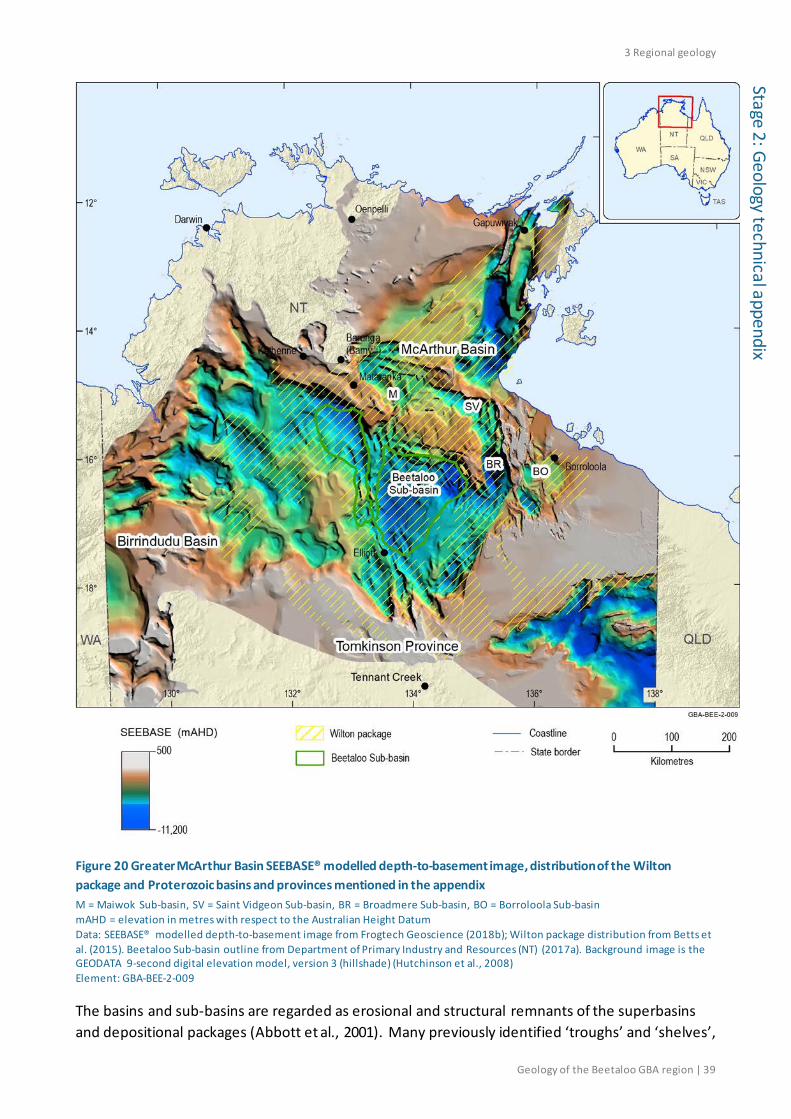
3 Regional geology
Geology of the Beetaloo GBA region | 39
Stage 2: Geology technical appendix
Figure 20 Greater McArthur Basin SEEBASE® modelled depth-to-basement image, distribution of the Wilton package and Proterozoic basins and provinces mentioned in the appendix M = Maiwok Sub-basin, SV = Saint Vidgeon Sub-basin, BR = Broadmere Sub-basin, BO = Borroloola Sub-basin mAHD = elevation in metres with respect to the Australian Height Datum Data: SEEBASE® modelled depth-to-basement image from Frogtech Geoscience (2018b); Wilton package distribution from Betts et al. (2015). Beetaloo Sub-basin outline from Department of Primary Industry and Resources (NT) (2017a). Background image is the GEODATA 9-second digital elevation model, version 3 (hillshade) (Hutchinson et al., 2008) Element: GBA-BEE-2-009
The basins and sub-basins are regarded as erosional and structural remnants of the superbasins and depositional packages (Abbott et al., 2001). Many previously identified ‘troughs’ and ‘shelves’,

3 Regional geology
40 | Geology of the Beetaloo GBA region
Stag
e 2:
Geo
logy
tech
nica
l app
endi
x including the Walker and Batten ‘troughs’, have been found from geophysical data interpretation to represent zones of faulting rather than depositional features (Ahmad et al., 2013; Rawlings et al., 2004). Tectonism, and associated erosion, during and after sedimentation created variability in the development and preservation of original basin depocentres. No sub-basin area has been identified as a depocentre for all of the Proterozoic depositional packages.
The Beetaloo Sub-basin has uplifted erosional margins (Ahmad et al., 2013) with bounding faults in the north, east and south (Department of Primary Industry and Resources (NT), 2017b). The sub-basin as a structural feature contains portions of the broader distributions of the Redbank, Glyde and Favenc packages. As a depositional basin it was the Wilton package depocentre (Munson, 2016). Significantly greater thicknesses of Mesoproterozoic sediment accumulated in the Beetaloo Sub-basin relative to adjacent areas (Munson, 2016). As the Roper Superbasin comprises the Wilton package (Figure 19), the Beetaloo Sub-basin is also both a depocentre and sub-basin of the Roper Superbasin (Abbott and Sweet, 2000).
3.2.2.4 Tectonic elements
The Beetaloo Sub-basin is surrounded by several tectonic elements (Figure 21). The Mallapunyah Fault Zone occurs across the north of the sub-basin and it is associated with a major basement high that in part defines the formal sub-basin boundary (see Section 1.2). It forms a major transverse fault system that lies to the north of the Wilton package depocentre (Betts et al., 2015).
Proterozoic basement highs border the eastern Beetaloo Sub-basin, including the Walton High in the north and Helen Springs High in the south. The Daly Waters High separates the eastern and the western parts of the Beetaloo Sub-basin. The Arnold High is a prominent intra-basinal arch (Silverman et al., 2007).
The western Beetaloo Sub-basin boundary is fault controlled on the northern and eastern sides. Basement on the south-western border of the western Beetaloo Sub-basin is shallow with relatively minor variation in depth (Frogtech Geoscience, 2018b).
The north-trending Batten Fault Zone and the near-perpendicular Urapunga Fault Zone are areas of intense faulting and complex block fault structure. Seismic data interpretation suggests that a fold and thrust belt developed within the Batten Fault Zone after Wilton package deposition (Rawlings et al., 2004) and geophysical modelling further showed that the fault zone developed through several overprinting tectonic events (Blaikie and Kunzmann, 2019). The Urapunga Fault Zone, which has been used as the boundary between the northern and southern McArthur Basin areas, may have developed from an underlying transform boundary between basement terranes, and similarly shows reactivation after Wilton package deposition (Frogtech Geoscience, 2018b).

3 Regional geology
Geology of the Beetaloo GBA region | 41
Stage 2: Geology technical appendix
Figure 21 Major tectonic elements surrounding the Beetaloo Sub-basin Section line indicates the location of the gravity model section shown in Figure 22 Data: Background SEEBASE® modelled depth-to-basement image from Frogtech Geoscience (2018b); tectonic elements from Plumb and Wellman (1987), Silverman et al. (2007) and Munson (2016) Element: GBA-BEE-2-201
The thicknesses of sedimentary packages across the Beetaloo Sub-basin vary in relation to the bounding tectonic elements, as demonstrated in a gravity model (Figure 22) by Frogtech Geoscience (2018b). The model is based on gravity data interpretation constrained by rock sample bulk density values, well log density values and seismic horizon interpretation (Frogtech Geoscience, 2018b).
The preferred gravity model (Figure 22) indicates more than seven kilometres thickness of Wilton and Glyde package sedimentary fill in the eastern Beetaloo Sub-basin. Basement becomes shallower at the Daly Waters High with a corresponding change in sediment thickness. In the

3 Regional geology
42 | Geology of the Beetaloo GBA region
Stag
e 2:
Geo
logy
tech
nica
l app
endi
x western Beetaloo Sub-basin the Wilton package is up to 3500 m thick just west of the Daly Waters High but rapidly thins to 300 m in the west (Frogtech Geoscience, 2018b).
Figure 22 West to east gravity model of the western and eastern Beetaloo Sub-basin The black dashed line indicates the SEEBASE® depth-to-basement model surface. Section location shown in Figure 21. Source: Frogtech Geoscience (2018b) Element: GBA-BEE-2-071
Across the Arnold High (Figure 21) the Wilton package sediment thickness is similar in the OT Downs depocentre of the Beetaloo Sub-basin (Figure 22). The Glyde package thickens eastward from 1 to 1.5 km in the Beetaloo Sub-basin to 4 to 5 km thick in the eastern Broadmere Sub-basin (Frogtech Geoscience, 2018b).
3.2.2.5 Beetaloo Sub-basin: eastern and western
The Beetaloo Sub-basin consists of two subsurface volumes of sedimentary rock (see Section 1.2) that are separated by the Daly Waters High (Figure 21). The Daly Waters High corresponds to an underlying zone of less competent basement terrane (see Section 3.2.1) with boundaries prone to fault reactivation (Frogtech Geoscience, 2018b). It may have acted as a hinge zone between the western and eastern Beetaloo Sub-basin areas (Hoffman, 2014) during tectonic events. It was periodically uplifted during the Mesoproterozoic era (Sections 3.3.2 and 3.3.4).
Mesoproterozoic sedimentary rock units are generally shallower in the western Beetaloo Sub-basin than in the east (Figure 22; see Section 4). Deposition of Mesoproterozoic sediments was ostensibly continuous across the area of the Daly Waters High and the fill initially of similar thickness between the eastern and western Beetaloo Sub-basin areas, but uplift may have contributed to subsequent thinning of sediments west of the high (Frogtech Geoscience, 2018b). More substantial uplift of the Daly Waters High occurred after deposition of Mesoproterozoic sediments (Section 3.3.4), delimiting the western and eastern Beetaloo Sub-basin areas. More information on the differences between the eastern and western Beetaloo Sub-basin areas is provided in Section 4.

3 Regional geology
Geology of the Beetaloo GBA region | 43
Stage 2: Geology technical appendix
3.2.3 Neoproterozoic to Paleozoic
3.2.3.1 Centralian A and B superbasins
The Centralian Superbasin is interpreted as a vast single depositional system that existed across central Australia in Neoproterozoic to Paleozoic times (Munson et al., 2013b; Walter et al., 1995). Sedimentary deposition in the Paleozoic era extended as far northward as the Daly Basin (Figure 15) and over the Beetaloo Sub-basin.
The superbasin was disrupted internally during the Petermann Orogeny (Walter et al., 1995), which reached peak tectonism at ca 570 to 530 Ma (Walsh et al., 2013). Central uplift and associated thrusting formed numerous structural basins in the superbasin (Walter et al., 1995). The Centralian Superbasin up to the time of the Petermann Orogeny is described by Munson et al. (2013b) as the Centralian A Superbasin. The differently configured Paleozoic superbasin after the Petermann Orogeny is termed the Centralian B Superbasin (Munson et al., 2013b).
Sedimentary deposition over the Mesoproterozoic Wilton package in the Beetaloo Sub-basin and adjacent areas includes sediments of both the Centralian A and B superbasins. Neoproterozoic sedimentary rocks of the Bukalara Sandstone and Cox Formation of the Georgina Basin (Section 3.4.6.2; Figure 29), and likely also the Jamison sandstone and Hayfield mudstone (Hoffman, 2016; Lanigan et al., 1994) (Section 3.4.6.1; Figure 29), are associated with the Centralian A Superbasin. Paleozoic sedimentary rocks of the Daly, Wiso and Georgina basins (Figure 15) are associated with the Centralian B Superbasin (Munson et al., 2013b). The Paleozoic successions of the three basins are interconnected under Carpentaria Basin cover (Kruse et al., 2013; Kruse and Munson, 2013b, 2013a).
3.3 Tectonic evolution The following section reviews the tectonic evolution of the Beetaloo GBA region and surrounds, from the late Proterozoic to Cenozoic eras. It uses the depositional package nomenclature of Rawlings (1999), whereas the literature cited may have originally used lithostratigraphic group names. Explanation of the correlations between the depositional packages and lithostratigraphic groups is provided in Section 3.4.
Significant gaps in the Beetaloo Sub-basin stratigraphy (Figure 29) means that spans of geological time during the late Mesoproterozoic, Neoproterozoic and Paleozoic eras are not preserved in the rock record. Tectonic and erosional events during these long gaps are reviewed from regional studies of post-depositional basin deformation and thermochronological analyses of rocks currently at or near the surface.
The events interpreted to have influenced deposition, deformation, burial and erosion of the Beetaloo Sub-basin sequences in the Beetaloo GBA region are shown in the chart of Figure 23. They are used as background for the interpreted timing of hydrocarbon generation and the burial history modelling component of the prospectivity technical appendix (Hall et al., 2020). Figure 23 provides also a regional comparison with the Isa GBA region, as many events impacted both areas of the North Australian Craton.

3 Regional geology
44 | Geology of the Beetaloo GBA region
Stag
e 2:
Geo
logy
tech
nica
l app
endi
x
Figure 23 Regional Qld–NT comparison of tectonic, igneous, thermal and depositional events interpreted to have affected the Isa (northern Lawn Hill Platform) and Beetaloo (Beetaloo Sub-basin) GBA regions from the time of Glyde package deposition to the present LIP = Large Igneous Province, AFTA = Apatite Fission Track Analysis, K-Ar = potassium-argon dating. Colour scheme is for ease of viewing. This figure has been optimised for printing on A3 paper (297 mm x 420 mm) Source: Tectonic and igneous events from Geological Survey of Queensland (2011), Scott and Tarlowski (1999), Jackson and Southgate (2000), Giles et al. (2006), Jackson et al. (1999), Betts et al. (2015), Zhang et al. (2017), Ahmad and Scrimgeour (2013), Walsh et al. (2013), Glass et al. (2013), Marshall et al. (2018), Edgoose and Ahmad (2013); thermal events from Golding et al. (2006), Spikings et al. (2006), Duddy et al. (2003), Delle Piane et al. (2019), Faiz et al. (2016); deposition events from Southgate et al. (2000a), Page et al. (2000), Krassay et al. (2000a), Krassay et al. (2000b), Rawlings (1999), Munson (2016), Betts et al. (2015), Anderson et al. (2019), Munson et al. (2013b), Walter et al. (1995), McConachie et al. (1997), Cook et al. (2013), Cook and Jell (2013), Munson et al. (2013a), Edgoose and Ahmad (2013) Element: GBA-BEE-2-382

3 Regional geology
Geology of the Beetaloo GBA region | 45
Stage 2: Geology technical appendix
3.3.1 Paleoproterozoic to early Mesoproterozoic Redbank to Favenc packages
Late Paleoproterozoic tectonic events are interpreted from Redbank and Glyde package sedimentary rocks exposed in the southern McArthur Basin, including in the Urapunga and Batten fault zones, and from geophysical datasets, such as gravity and magnetic data (Betts et al., 2015) and regional seismic data (Hoffman, 2015).
The Redbank package (ca 1815 to 1710 Ma) represents the basal McArthur Basin succession over Paleoproterozoic-aged crystalline basement. East–west west-trending normal faults were active to the east of the Beetaloo Sub-basin during deposition of the lower Redbank package, reflecting north–south extension (Betts et al., 2015).
A mid-Tawallah compression event occurred between 1755 and 1730 Ma (Jackson et al., 2000) during the time of Redbank package deposition. Uplift associated with east-west compression produced a major gap in the rock record and an erosion surface in the southern McArthur Basin (Jackson et al., 2000). The event terminated marine deposition in the Leichhardt Superbasin (de Vries et al., 2008) and forms the boundary to the Calvert Superbasin (Figure 19). The lower Redbank package (Leichhardt Superbasin) was uplifted along major structures, creating relief, erosion and production of the clastic sediments of the upper Redbank package (Calvert Superbasin) and lower Glyde package (lower Isa Superbasin) (Garven et al., 2001).
The Mid-Tawallah Compression resulted also in folding of the Tawallah Group (de Vries et al., 2008) (Section 3.4.2; Figure 29), the constituent group of the Redbank package in the McArthur Basin. Seismic data in some parts of the eastern Beetaloo Sub-basin indicate folded strata below the Glyde package (see Section 3.2.2.4), suggesting it could be either basement (Frogtech Geoscience, 2018b) or folded strata of the Redbank package, in accordance with the seismic interpretations presented in Hoffman (2015) and Dhu (2018). Calvert Superbasin (upper Redbank package) sedimentation followed the compression event and was accompanied by fault reactivation associated with regional extension (de Vries et al., 2008).
Tectonic quiescence for a period of up to 70 million years followed these events (Garven et al., 2001). Active tectonism resumed during deposition of the medial McArthur Group (Section 3.4.3; Figure 29), the constituent group of the Glyde package. The Glyde package (ca 1670 to 1600 Ma) corresponds to the lower Isa Superbasin (Figure 19). Numerous growth faults in the Barney Creek Formation, and other equivalents of the River Supersequence of the Isa Superbasin, are associated with a period of regional extension and syndepositional faulting (Blaikie and Kunzmann, 2019; Scott and Bradshaw, 1999). South-dipping growth faults and/or transtensional subsidence developed from north–south extension during this time, culminating in deposition of sediments of about 8 km thickness to the east of the Beetaloo GBA region (Garven et al., 2001; Munson, 2016; Rawlings et al., 2004) in the Batten Fault Zone.
In this period the Glyde package depocentre was to the east of the Beetaloo Sub-basin, contributing to the eastward thickening of Glyde package sedimentary rocks evident in the gravity model (Figure 22). The Barney Creek Formation was thickest in sub-basins of the central and southern Batten Fault Zone (Kunzmann and Blaikie, 2019). It was deposited more broadly across

3 Regional geology
46 | Geology of the Beetaloo GBA region
Stag
e 2:
Geo
logy
tech
nica
l app
endi
x an extensive portion of the greater McArthur Basin, with regional seismic interpretation confirming its continuation to the west of the Beetaloo Sub-basin in the Birrindudu Basin (Hoffman, 2015).
Subsidence of the Batten Fault Zone continued to a lesser extent during Favenc package deposition (Jackson et al., 1987). The Favenc package (ca 1610 to ?1570 Ma) corresponds to the upper Isa Superbasin (Figure 19). Episodic gaps in the southern McArthur Basin depositional record of this time, associated with erosion and changes in sediment provenance, are interpreted to represent the early stages of the Isan Orogeny (Jackson and Southgate, 2000), or Early Isan Orogeny of 1600 to 1580 Ma (Geological Survey of Queensland, 2011) (Figure 23).
3.3.2 Early Mesoproterozoic Syn-Isan Orogeny
The Syn-Isan Orogeny (Betts et al., 2015) coincides with a depositional hiatus of 80 to 90 million years (Jackson et al., 1999) between deposition of the Favenc package and that of the Wilton package. The ages of tuff and tuffaceous sediments near the last known sediments of the Isa Superbasin (Favenc package) and initial deposition of the Roper Superbasin (Wilton package) constrain the hiatus to within ca 1580 to 1500 Ma (Betts et al., 2015; Jackson et al., 1999).
The Syn-Isan Orogeny describes the distal (or far-field) effects in the McArthur Basin of the Isan Orogeny, which was centred on the Mount Isa Province to the present-day east. The Isan Orogeny ended Isa Superbasin deposition during the early orogenic phases and culminated in major east–west shortening, ductile and brittle deformation, metamorphism and erosion, interpreted to be the result of collision between Laurentia and Australia on the eastern margin of the continent (Geological Survey of Queensland, 2011).
Syn-Isan Orogeny deformation in the greater McArthur Basin, to the more distant west of the collision zone, was focused in the Batten and Walker fault zones (Betts et al., 2015; Munson, 2016) (Figure 14a). Structural interpretation of magnetic and gravity data indicate that reverse faults dominated in these zones (Betts et al., 2015) (Figure 24). Northwest–southeast and east–west shortening produced dominantly north- to northeast-trending reverse faults, some as inversions of existing Paleoproterozoic faults (Betts et al., 2015). Reverse faulting is also interpreted to have been active along the Daly Waters High (Frogtech Geoscience, 2018b) (Figure 24).
The Syn-Isan Orogeny produced significant uplift in the Batten Fault Zone (Frogtech Geoscience, 2018b), particularly during the later orogenic phases in the northern Batten Fault Zone (Blaikie and Kunzmann, 2019). Compression produced also a broad anticlinal structure in the Broadmere Sub-basin region, between the Batten Fault Zone and the eastern Beetaloo Sub-basin, resulting in erosion that locally removed much of the Favenc package (Lindsay, 2001).
Uplift along reverse faults in the Daly Waters High resulted in the pronounced erosion of the Glyde and Favenc package sediments evident in seismic imagery (Frogtech Geoscience, 2018b). Only minor deformation and erosion is evident in the seismic imagery of the main western and eastern Beetaloo Sub-basin regions, with most deformation occurring at the Daly Waters High (Section 4). The less pronounced erosion (and absence of deposition) suggests more uniform uplift across the basin area (Frogtech Geoscience, 2018b).

3 Regional geology
Geology of the Beetaloo GBA region | 47
Stage 2: Geology technical appendix
Widespread wrench faulting is interpreted to be also associated with the Syn-Isan Orogeny, particularly in the period 1550 to 1540 Ma (Frogtech Geoscience, 2018b) (Figure 24). The difference in orientation between the orogenic shortening and the underlying northwest-striking half-graben of the Broadmere Sub-basin, for example, created an internal strain that produced wrench faults (Lindsay, 2001).
Figure 24 Distribution of faults interpreted to be active during the Syn-Isan Orogeny phases after 1580 Ma The extent and nature of these structures in the Beetaloo Sub-basin is uncertain and further work and more detailed mapping using seismic data is required. In addition, it is likely that not all faults intersecting the Beetaloo Sub-basin stratigraphy have yet been mapped and the number of recognised faults in a basin tends to increase substantially as more information (higher resolution seismic and three-dimensional seismic) becomes available over time. Data: Betts et al. (2015), Frogtech Geoscience (2018b). Beetaloo Sub-basin outline from Department of Primary Industry and Resources (NT) (2017a). Background image is the GEODATA 9-second digital elevation model, version 3 (hillshade) (Hutchinson et al., 2008) Element: GBA-BEE-2-203

3 Regional geology
48 | Geology of the Beetaloo GBA region
Stag
e 2:
Geo
logy
tech
nica
l app
endi
x At the end of the depositional hiatus the first sediments of the Wilton package (Phelp Sandstone, see Section 3.4.5) were drawn from a wide range of Paleoproterozoic sediments and Archean basement terranes, indicating extensive erosional exposure of the units during and after the Syn-Isan Orogeny (Munson, 2016).
3.3.3 Mesoproterozoic Wilton package (Roper Group)
An extended period of cooling and exhumation followed the Syn-Isan Orogeny (de Vries et al., 2008). This cooling, broadly between 1500 and 1400 Ma, is attributed to lithospheric extension (Betts and Giles, 2006; de Vries et al., 2008) that may be associated with the separation of the North Australian Craton from Laurentia (Figure 25a; Yang et al., 2018). Yang et al. (2018) argued that rifting led to Mesoproterozoic basin formation and the creation of the Wilton package depocentre across the Beetaloo Sub-basin region. The Wilton package is stratigraphically the thickest in the Beetaloo Sub-basin (Yang et al., 2018).
Provenance analysis of the Beetaloo Sub-basin Wilton package suggests that the sediments were initially sourced from the Mount Isa Orogen and other regions in the east due to exhumation after the Isan Orogeny (Figure 25a) (Yang et al., 2019). 40Ar-39Ar analyses by Perkins et al. (1999) and Spikings et al. (2002) suggest that the exhumation occurred after 1460 Ma and reached the highest erosion rates between 1440 and 1390 Ma in the Mount Isa region.
Northwest–southeast extension accompanied development of the Wilton package depocentre (Betts et al., 2015). Faults that regionally accommodated the stratal growth of the Wilton package comprise north–south- and northeast-trending normal faults, and northwest-trending transverse normal and strike-slip faults (Betts et al., 2015). Major transverse faults in the Mallapunyah Fault Zone may have contributed to the development of the syn-Wilton package depocentre to the south of the zone (Betts et al., 2015).
In the Beetaloo Sub-basin, north–south-trending normal faults bound the Daly Waters High (Betts et al., 2015). Seismic data interpretation suggests that the lower Wilton package had a similar original thickness across the western and eastern Beetaloo Sub-basin areas, but it is unclear if the upper Wilton package was originally as thick in the west as in the east (Frogtech Geoscience, 2018b).
Recent updates to detrital zircon geochronology combined with hafnium isotope analyses of the Beetaloo Sub-basin units suggest changes in the provenance of sediments during Wilton package deposition that correspond to plate margin events (Yang et al., 2019). Sediments of the ca 1400 Ma Bessie Creek Sandstone (Section 3.4.5.2; Figure 29) of the Wilton package were sourced from the Mount Isa Orogen and other regions in the east (Yang et al., 2019). Provenance change developed through the younger Velkerri Formation, Moroak Sandstone and lower Kyalla Formation (Section 3.4.5.2; Figure 29) in the Beetaloo Sub-basin (Yang et al., 2019). The dominant source area shifted from the Mount Isa Orogen to the southerly Arunta region (Figure 25b) during deposition of the Kyalla Formation (Yang et al., 2019). The change represents swamping of the basin with sediments from southerly sources after ca 1350 to 1300 Ma subduction and closure of the Mirning Ocean and uplift of the southern margin (Yang et al., 2019) (Figure 25b).

3 Regional geology
Geology of the Beetaloo GBA region | 49
Stage 2: Geology technical appendix
Figure 25 Mesoproterozoic to Neoproterozoic tectonic scenarios showing the depositional history of the Roper Group (Wilton package) and overlying Jamison and Hayfield units Source: Yang et al. (2018) Element: GBA-BEE-2-068
The Beetaloo Sub-basin was affected at this time also by events on the northern margin of the craton. The North Australian Craton is interpreted to have separated from the North China Craton (Figure 25a) as part of the final break-up of the Nuna (Columbia) supercontinent (Zhang et al., 2017). The final break-up was associated with the emplacement of dyke swarms between 1300 and 1200 Ma (Goldberg, 2010). These dyke swarms were associated with failed or aborted rift systems, of which the earliest was the Galiwinku Dyke Swarm of ca 1320 Ma that intruded the Wilton package in the northern McArthur Basin and northern offshore region (Goldberg, 2010).
The Galiwinku Dyke Swarm was spatially linked to the Derim Derim Dolerite (Figure 31) and concordant ages have been determined for both (Zhang et al., 2017). The ca 1313 Ma (Collins et al., 2018) Derim Derim Dolerite constitutes a Large Igneous Province, or LIP, of more than 600 km

3 Regional geology
50 | Geology of the Beetaloo GBA region
Stag
e 2:
Geo
logy
tech
nica
l app
endi
x long and 400 km wide (Zhang et al., 2017) that includes the Beetaloo Sub-basin (Figure 31). It intrudes the middle and upper Wilton package units in the Beetaloo Sub-basin and provides a minimum upper age constraint for the Wilton package (Munson, 2016).
The Derim Derim-Galiwinku LIP is considered to be a separated fragment of the same LIP as the Yanliao LIP of the North China Craton, and evidence of uplift in both regions at this time is interpreted as initiation of a passive margin at 1330 to 1300 Ma (Zhang et al., 2017). According to these authors, uplift is indicated by the disconformity between the Wilton package and overlying strata, outlined in the next section.
3.3.4 Middle to late Mesoproterozoic non-deposition and Post-Roper Inversion
The period of non-deposition in the Beetaloo Sub-basin after 1300 Ma may represent uplift after plume-related magmatism (Yang et al., 2019). The non-deposition period lasted for more than 300 million years after the Derim Derim Dolerite intrusion (Yang et al., 2019).
A regionally extensive compressional event occurred also during the period of non-deposition in the Beetaloo Sub-basin. The post-Wilton package ‘Post-Roper Inversion’ (Rawlings et al., 1997) likely occurred during Mesoproterozoic orogenesis that affected large tracts of central Australia between 1300 and 1050 Ma (Betts et al., 2015). Northeast- to southwest-directed crustal shortening occurred after the ca 1313 Ma (Collins et al., 2018) emplacement of the Derim Derim Dolerite dykes and sills (Blaikie and Kunzmann, 2019; Munson, 2016).
The age of the Post-Roper Inversion is not well constrained and it might relate to any of the Mesoproterozoic tectonic events affecting central Australia in this period. These include the 1200 to 1160 Ma Musgrave Orogeny and the 1085 to 1040 Ma extensional Giles Event and Warakuna LIP (Ahmad and Scrimgeour, 2013; Frogtech Geoscience, 2018b).
Structures that formed during the Post-Roper Inversion dominate the architecture of the McArthur Basin (Rawlings, 1999). Many of the large-scale structural features affecting the Redbank and younger packages of the Batten Fault Zone were observed to have formed after deposition of the Wilton package, during a period of north-east to south-west compression (Rogers, 1996). The event has since been recognised as the principal basin inversion event in the McArthur Basin (Rawlings et al., 2004; Rawlings, 1999; Rawlings et al., 1997).
Inversion affected all units of the McArthur Basin and basement domains (Rawlings et al., 2004) and was associated with wrench faulting, steepening of earlier faults and gentle folding (Dutkiewicz et al., 2007). Major zones of movement included the Walker, Urapunga and Batten fault zones (Betts et al., 2015; Frogtech Geoscience, 2018b). Large-scale fault offsets occurred along reactivated terrane boundaries at the Daly Waters High between the eastern and western Beetaloo Sub-basin areas (Frogtech Geoscience, 2018b). Between one to three kilometres of offset occurred along the northern margin of the Beetaloo Sub-basin (Frogtech Geoscience, 2018b) in the Mallapunyah Fault Zone (Figure 21).
Faults underlying the central eastern and western Beetaloo Sub-basin record only minor displacement (Frogtech Geoscience, 2018b). In the western Beetaloo Sub-basin these faults are

3 Regional geology
Geology of the Beetaloo GBA region | 51
Stage 2: Geology technical appendix
northwest-trending oblique transverse faults (Figure 26) (Betts et al., 2015). East–west trending reverse faults were compartmentalised by north–south sidewall faults in the eastern Beetaloo Sub-basin (Figure 26) (Betts et al., 2015).
Figure 26 Distribution of interpreted post-Wilton package faults The extent and nature of these structures in the Beetaloo Sub-basin is uncertain and further work and more detailed mapping using seismic data is required. In addition, it is likely that not all faults intersecting the Beetaloo Sub-basin stratigraphy have yet been mapped and the number of recognised faults in a basin tends to increase substantially as more information (higher resolution seismic and three-dimensional seismic) becomes available over time. Data: Betts et al. (2015), Frogtech Geoscience (2018b). Beetaloo Sub-basin outline from Department of Primary Industry and Resources (NT) (2017a). Background image is the GEODATA 9-second digital elevation model, version 3 (hillshade) (Hutchinson et al., 2008) Element: GBA-BEE-2-204
Dutkiewicz et al. (2007) proposed that extensive oil migration in the Wilton package occurred after both the dolerite emplacement and extensive diagenesis of the Bessie Creek Sandstone and either

3 Regional geology
52 | Geology of the Beetaloo GBA region
Stag
e 2:
Geo
logy
tech
nica
l app
endi
x during or after Post-Roper Inversion. Recently determined ages of heating events in the Wilton package (Velkerri Formation) of the Beetaloo Sub-basin suggests that both hydrocarbon generation and migration occurred close to the end of the 1300 to 1050 Ma period (Delle Piane et al., 2019).
K-Ar dating of diagenetic illite, which forms in shales over the same temperature range as hydrocarbons, relates to the ages at which the thermal maxima were reached in the Velkerri Formation (Delle Piane et al., 2019). These ages were 1017±23 Ma and 980±23 Ma in the eastern Beetaloo Sub-basin in Shenandoah 1A and Tanumbirini 1 respectively, and 1041±24 Ma in the western Beetaloo Sub-basin in Tarlee S3 (Delle Piane et al., 2019). These ages correspond to the late stage of the Rodinia supercontinent amalgamation (Figure 25c).
Fluid flow events, which led to calcite precipitation in fractures, followed the thermal maxima according to U-Pb ages of the calcite (Delle Piane et al., 2019). As the calcites contain oil and gas in fluid inclusions, the dating also indicates the age of hydrocarbon migration (Delle Piane et al., 2019). Ages obtained to date include 923±68 Ma from calcite with gas-bearing inclusions in the Velkerri Formation, from Tarlee S3 in the western Beetaloo Sub-basin, and a younger (Cretaceous) age of calcite with oil-bearing inclusions, outlined in Section 3.3.7 (Delle Piane et al., 2019).
3.3.5 Neoproterozoic Centralian A Superbasin and Petermann Orogeny
The Centralian A Superbasin was initiated in the Neoproterozoic after the amalgamation of the Rodinia supercontinent (Figure 25c) (Munson et al., 2013b). Superbasin initiation probably began by 840 Ma from crustal thinning over a mantle plume in central Australia (Munson et al., 2013b; Walter et al., 1995).
Deposition was renewed in the area of the Beetaloo Sub-basin. Neoproterozoic sediments overlying the sub-basin, including the Jamison sandstone and Hayfield mudstone (Section 3.4.6.1; Figure 29), were sourced from the Musgrave Province of central Australia (Yang et al., 2019) (Figure 25c). The units may represent a new siliciclastic basin that sourced sediments from those regions uplifted by the earlier 1220 to 1150 Ma Musgrave Orogeny (Figure 25c) (Collins et al., 2018; Yang et al., 2018).
Centralian A Superbasin deposition was disrupted during the 580 to 530 Ma interval by the Petermann Orogeny of central Australia. The orogeny fragmented the superbasin into several smaller structural basins (Walter et al., 1995). Uplift of the Musgrave Province and other regions of central Australia generated widespread deposition in the component basins (Munson et al., 2013b). The Petermann Orogeny overlaps with a significant break in the Neoproterozoic record in the Beetaloo Sub-basin (Figure 29).
3.3.6 Paleozoic Centralian B Superbasin and subsequent erosion
Thick and extensive basaltic lavas were emplaced over much of the Beetaloo Sub-basin (Figure 32) late in the early Cambrian as part of widespread volcanic eruptions associated with the Kalkarindji Large Igneous Province (Glass et al., 2013). Doming associated with the LIP likely occurred along a north–northwest-oriented axis that included the Birrindudu Basin, to the west of the Beetaloo

3 Regional geology
Geology of the Beetaloo GBA region | 53
Stage 2: Geology technical appendix
Sub-basin, and eruptions were widespread in north-western Australia (Glass et al., 2013). The doming was followed by broad regional subsidence and marine transgression, leading to the development of the Paleozoic Centralian B Superbasin (Munson et al., 2013b). The lavas demarcate the base of the Cambrian sedimentary fill of the Daly, Wiso and Georgina basins, which constitute the superbasin sediments over the Beetaloo Sub-basin.
Frogtech Geoscience (2018b) stated that there is clear evidence for fault reactivation in the greater McArthur Basin after deposition of the Cambrian sequence, which may be related to the Alice Springs Orogeny of 450 to 300 Ma (Munson et al., 2013b). A series of compressional deformation events associated with the orogeny disrupted the continuity of the Centralian B Superbasin until deposition was finally terminated (Munson et al., 2013b). However deposition continued in some regions during the orogeny (Munson et al., 2013b) and thermochronological analyses suggest that sedimentation the Beetaloo Sub-basin region continued throughout the Paleozoic era (Duddy et al., 2003).
Duddy et al. (2003) interpreted the regional Paleozoic to Mesozoic thermal history of the Wilton package (Roper Group) units in the Broadmere Sub-basin (Figure 20), to the proximal east of the Beetaloo Sub-basin, based on apatite fission track analyses of Broadmere 1 well samples (Figure 20). Most of the Wilton package rocks at the present depths of approximately 450 to 1970 m were at temperatures of more than 105°C during the Triassic period. The elevated temperatures were interpreted, in the absence of other evidence, in the context of deeper burial under normal heat flow conditions. The preferred interpretation was progressive burial and heating of the Roper Group from the Cambrian period until maximum burial was reached before or during the early Triassic; the rocks then cooled from temperatures >105°C after 240 Ma (Duddy et al., 2003).
Proterozoic and Paleozoic maximum burial scenarios were tested by Faiz et al. (2016) for the Beetaloo Sub-basin, using the apatite fission track analysis interpretations as a basis for testing Paleozoic burial scenarios. The modelling, presented also as an example for the well Kalala S1 by Faiz et al. (2018), suggested that maximum burial occurred in the Paleozoic era, and that deep burial in the Paleozoic was of greater magnitude than burial on any of the earlier Proterozoic unconformities (Faiz et al., 2016).
The first Mesozoic period of cooling began during the Triassic period (Duddy et al., 2003). The cooling, within the 240 to 125 Ma interval, was interpreted as the result of uplift and erosion (Duddy et al., 2003). Burial history modelling suggests that more than two kilometres of Proterozoic and Paleozoic section, plus up to another 800 m of Mesozoic section, was eroded during basin uplift (Faiz et al., 2016) during this and a later cooling phase (Section 3.3.8).
3.3.7 Mesozoic Carpentaria Basin
The onshore Carpentaria Basin is the northern Australian component of the Mesozoic sediments deposited during a Cretaceous marine incursion across the Australian continent. Marine transgression commenced in the earliest Cretaceous and reached the maximum extent across more than half of the Australian continent during the Aptian (125 to 113 Ma) (Campbell and Haig, 1999). Associated depositional cycles coincided approximately with global high sea levels, but continental-scale tectonism, including along the Australian eastern margin, contributed to variations in sea level during the 125 to 100 Ma interval (Campbell and Haig, 1999).

3 Regional geology
54 | Geology of the Beetaloo GBA region
Stag
e 2:
Geo
logy
tech
nica
l app
endi
x The offshore portion of the Carpentaria Basin underlies most of the Gulf of Carpentaria and had formed earlier during a period of flexural warping in the Middle Jurassic (McConachie et al., 1997). The Carpentaria Basin experienced only minor extensional tectonism during its evolution, according to seismic interpretation of the Gulf of Carpentaria and Weipa regions (McConachie et al., 1990). Four sub-basins are recognised in the onshore and offshore Carpentaria Basin (Figure 27) based on the provenance and timing of Mesozoic sedimentary fill: the Western Gulf, Weipa, Staaten and Boomarra sub-basins (McConachie et al., 1990). Jurassic sediments are confined primarily to the Weipa and Staaten sub-basins (McConachie et al., 1990).
Figure 27 Interpreted original extent of the Carpentaria Basin and sub-basins, ridges and contiguous Mesozoic basins of Queensland and the Gulf of Papua Carpentaria Basin sub-basins are the Western Gulf, Staaten, Weipa and Boomarra sub-basins. This figure shows the more extensive original distribution of the Carpentaria Basin: the present preserved remnants in the vicinity of the Beetaloo GBA region are shown in Figure 15 Source: McConachie et al. (1997), Munson et al. (2013a) and Cook et al. (2013) Element: GBA-BEE-2-192

3 Regional geology
Geology of the Beetaloo GBA region | 55
Stage 2: Geology technical appendix
The Proterozoic and Paleozoic sedimentary rocks of the Beetaloo GBA region are overlain by Carpentaria Basin sediments of the Western Gulf Sub-basin. Over much of the Beetaloo Sub-basin it forms a veneer up to 132 m thick (Fulton and Knapton, 2015) (see Section 4.3.5) but may have originally been thicker. Deposition is understood to be primarily the result of global high sea levels, rather than tectonic events.
Duddy et al. (2003) interpreted a second Mesozoic thermal event based on apatite fission track analyses of Wilton package units in the Broadmere 1 well (c.f. Section 3.3.6). In an interval spanning the Jurassic to Cretaceous period, the Roper Group units were likely reheated to a palaeo-temperature peak of 80 to 95°C (Duddy et al., 2003). The heating was interpreted, in the absence of other evidence, in the context of deeper burial under normal heat flow conditions. Subsequent cooling, that continued into the Cenozoic era (Section 3.3.8), is interpreted to result from uplift and erosion (Duddy et al., 2003).
A Cretaceous fluid flow event, and apparent oil migration, is indicated by U-Pb dating of calcite filling fractures that precipitated from fluid flow (Delle Piane et al., 2019). A Cretaceous age of 118±14 Ma of calcite with oil-bearing inclusions was obtained from the Borrowdale 2 well, north of the Beetaloo Sub-basin (Delle Piane et al., 2019).
3.3.8 Cenozoic uplift and erosion
The final stage of greater McArthur Basin uplift is interpreted to be related to the Oligocene to Miocene collision between Australia and Indonesia (Frogtech Geoscience, 2018b). Few studies of Cenozoic geology have been undertaken in the greater McArthur Basin and NT generally (Edgoose and Ahmad, 2013) but active erosion, shifts in drainage systems and depocentres, and apparent uplift occurred in central Australia during the Oligocene to early Miocene, ascribed to the beginning of collision on the northern margin (Senior et al., 1994).
Erosion of the Cretaceous Carpentaria Basin sequence is evident across much of the NT. Cretaceous strata in the Urapunga region, to the north of the Beetaloo Sub-basin, are preserved as outliers, remnants of a once extensive area of Mesozoic deposition across the Carpentaria and Bonaparte basins (Abbott et al., 2001). Uplift and erosion formed ‘ruined city’ or runiform relief in Arnhem Land (Jennings 1979, 1983, cited in Abbott et al. (2001) and Migoń et al. (2017)). Much of the original distribution of Carpentaria Basin fill across the NT has been eroded to the present distribution indicated in Figure 15.
The preserved Cretaceous sequence overlying the Beetaloo Sub-basin (Figure 15) is not deeply incised but it is presently elevated above the regional groundwater surface (Fulton and Knapton, 2015). At the Mallapunyah Fault Zone (Figure 21), to the north of the western Beetaloo Sub-basin, Cretaceous rocks are in some locations locally uplifted along faults and folded (Kruse and Munson, 2013b) near the present erosional boundary of the Carpentaria Basin. Cenozoic sediments form a discontinuous surface layer across the Beetaloo Sub-basin, unconformably overlying the Cretaceous sedimentary sequence (Fulton and Knapton, 2015).
Duddy et al. (2003) compiled apatite fission track analysis (AFTA) results across northern Australia, interpreting uplift and erosion that was widely experienced in northern and north-western basin areas in the Cenozoic. Results from the Broadmere 1 well, drilled just east of the Beetaloo Sub-

3 Regional geology
56 | Geology of the Beetaloo GBA region
Stag
e 2:
Geo
logy
tech
nica
l app
endi
x basin in the Broadmere Sub-basin (Figure 20), provide evidence of an Eocene to early Miocene thermal event experienced by the Wilton package units during 50 to 20 Ma (Duddy et al., 2003). Sedimentary rocks at present depths of approximately 450 to 1970 m were nearly 50°C above their present temperatures at around 50 Ma, and subsequently cooled until 20 Ma to their present temperatures of approximately 40°C to 80°C (Duddy et al., 2003). In the absence of other indications (such as elevated heat flow) the temperature changes were interpreted as initially deeper burial under normal heat flow conditions and subsequent uplift and erosion (Duddy et al., 2003).
The Beetaloo Sub-basin has comparatively high present-day geothermal gradients of between 42 and 49°C per kilometre in the western Beetaloo Sub-basin and 35 to 45°C per kilometre in the eastern sub-basin (Pangaea NT Pty Ltd, 2019). Temperatures of the Wilton package and the implications for the depths of circulating fluids are discussed further in the hydrogeology appendix (Evans et al., 2020).
3.4 Stratigraphy and depositional environments The following section describes the stratigraphy and depositional environments of the Proterozoic depositional packages in the Beetaloo GBA region and the overlying sedimentary sequences of the Centralian A and B superbasins (Georgina, Wiso and Daly basins) and the Carpentaria Basin. A stratigraphic chart of the Beetaloo GBA region, including the full interpreted or confirmed section from the Proterozoic depositional packages to Cenozoic sediments, was compiled for GBA purposes and it is shown in Figure 29.
Published stratigraphic frameworks for basins in the Beetaloo GBA region are based on lithostratigraphy. Alternative frameworks are based on sequence stratigraphy (e.g. Abbott and Sweet (2000); Jackson and Southgate (2000)). The following Methods snapshot summarises the difference between these approaches.
Methods snapshot: Sequence stratigraphy vs lithostratigraphy
In sequence stratigraphy, supersequences and sequences are composed of genetically linked strata related in time. Supersequences are controlled by the periodicity of tectonic evolution; third-order sequences encompass conformable lowstand tract to highstand tract sedimentation (that is, sedimentation controlled by relative sea level change from the initial marine flooding surface to the maximum marine flooding surface); and sediment lithologies vary not only temporally but laterally for the sequences to encompass these cycles. The boundaries between sequences are time-correlative. The implication of sequence stratigraphy is that the lithological characteristics of sediments assigned to a sequence in one area may be different from those of the same sequence and age in another area. Accordingly, sequence stratigraphic descriptions include locations and lateral variations in the lithology of sediments within each of the supersequences as well as changes over time.
By contrast, units in lithostratigraphy are defined on mappable units of comparable lithology or similar properties, in which a formation is the unit based on primary lithology. Formations may be subdivided into members or beds or aggregated with other formations into groups.
3 Regional geology
Geology of the Beetaloo GBA region | 57
Stage 2: Geology technical appendix
The descriptions provided in this section refer to the primary lithological characteristics of the formations, beds and groups in the region, and as the classification is based on these characteristics there is not the same requirement to describe lateral variations.
Basin-wide sequence stratigraphic frameworks have yet to be systematically defined in the NT, though efforts towards this have been made by Abbott and Sweet (2000) and Jackson and Southgate (2000), and initially argued for by Jackson et al. (1997). These authors applied sequence stratigraphic interpretations to Paleoproterozoic and Mesoproterozoic sediments in discrete outcrop areas of the NT. An initial chronostratigraphic framework for Paleoproterozoic successions was proposed by Jackson et al. (2000) to establish a basis for further detailed sequence stratigraphic studies. Middle Cambrian sediments of the eastern Georgina Basin were also classified in sequence stratigraphic framework by Southgate and Shergold (1991) and, more recently, medial Glyde package sediments of the Batten Fault Zone were classified into third-order sequences by Kunzmann et al. (2019).
The descriptions provided in this section are based instead on the basin-wide depositional ‘packages’ described in Section 3.2.2.1, due to the ongoing stratigraphic framework revision undertaken by the Northern Territory Geological Survey (Close, 2014). The lithostratigraphic descriptions in this section refer to the primary lithological characteristics of groups, subgroups and formations, and to member beds where relevant. Without a rigorous sequence stratigraphic framework in place there is little discussion of lateral facies variations in a time-equivalent sense.
3.4.1 Interpreted stratigraphy
The Beetaloo Sub-basin lies entirely under cover and only some of the Proterozoic units have been intersected by drilling. The stratigraphy of the Beetaloo GBA region, including the interpreted units below the base of drilling, is shown in Figure 29. A regional comparison of the Roper Group and younger stratigraphic units is shown in Figure 30.
The Paleoproterozoic to Mesoproterozoic lithostratigraphic units of the greater McArthur Basin are being progressively correlated and grouped into the five superbasin-scale packages that were originally defined for the McArthur Basin (Section 3.2.2). Four of these five packages are interpreted to be present under cover in the Beetaloo GBA region: the Proterozoic Redbank and Glyde packages and the Mesoproterozoic Favenc and Wilton packages (Figure 29). The Goyder package has not to date been interpreted as present in this region.
Drilling within the Beetaloo Sub-basin has not yet intersected sequences below the upper Wilton package. The existence and composition of the Redbank, Glyde, Favenc and lower Wilton packages are interpreted from seismic survey data (Dhu, 2018; Hoffman, 2015)(Section 4.1) and from correlative neighbouring basin stratigraphy.
The neighbouring basin stratigraphy is best exposed in the Batten Fault Zone in the east (Figure 14), where fault-controlled inversion has compartmentalised and exposed many of the deeper units at the surface. Four major groups have been identified in the Batten Fault Zone, corresponding to the Redbank, Glyde, Favenc and Wilton packages. In ascending stratigraphic order these are the Tawallah, McArthur, Nathan and Roper groups (Jackson et al., 1987).

3 Regional geology
58 | Geology of the Beetaloo GBA region
Stag
e 2:
Geo
logy
tech
nica
l app
endi
x An example interpretation indicating the potential groups is shown in Figure 28.
Figure 28 Eastern Beetaloo Sub-basin south to north schematic cross-section The presence and distribution of formations below the Bessie Creek Sandstone are interpreted by Altmann et al. (2018) from general seismic reflector trends. Source: Modified from Altmann et al. (2018) Element: GBA-BEE-2-056
An alternative interpretation of the undrilled sequences below the upper Wilton package is provided by gravity modelling (Frogtech Geoscience, 2018b) (Figure 22). The modelling predicts that the Wilton and Glyde packages occur in the Beetaloo Sub-basin, and that below the Glyde package there is a tentative ascription only to the Redbank package (Frogtech Geoscience, 2018b). Seismic data in some parts of the eastern Beetaloo Sub-basin indicate folded strata below the Glyde package, suggesting it could be either folded lower Redbank package strata (see Section 3.3.1) or basement equivalent to the Tomkinson Province in the south, in the form of the Paleoproterozoic Tomkinson Creek Group (Frogtech Geoscience, 2018b) (Figure 22). The presence of volcanics in the Redbank package contributes to poor imaging of the Redbank package in seismic sections (Rawlings et al., 2004) and this may contribute to the uncertainty of interpreting Redbank package rocks under the Beetaloo Sub-basin.
Stratigraphic descriptions in the following sections are regional in nature. Those for the Paleoproterozoic to Mesoproterozoic units draw on the detailed surface geological mapping and descriptions of areas immediately to the north (Urapunga and Roper River areas) and east (Batten Fault Zone area), with local confirmation, and some stratigraphic refinements, based on analyses of Beetaloo Sub-basin petroleum exploration wells. The descriptions from surface exposures are largely based on the work of Jackson et al. (1987), Rawlings (1999) and Abbott et al. (2001), and are synthesised in Ahmad et al. (2013). Refinements and more detailed characterisations, particularly of the upper section (i.e. Roper Group), are based on Munson (2016), Munson and Revie (2018), Munson et al. (2018) and Yang et al. (2018).

3 Regional geology
Geology of the Beetaloo GBA region | 59
Stage 2: Geology technical appendix
Figure 29 Stratigraphy of the greater McArthur Basin (Beetaloo Sub-basin) and overlying basins in the Beetaloo GBA region Anthony Lagoon Formation equivalents are the Jinduckin Formation, Hooker Creek Formation and Point Wakefield beds. Gum Ridge Formation equivalents are the Top Springs Limestone, Tindall Limestone and Montejinni Limestone. The chart breaks at 1300 to 840 Ma and 480 to 120 Ma are for display purposes. This figure has been optimised for printing on A3 paper (297 mm x 420 mm). Source: Munson (2016), Rawlings (1999), Abbott et al. (2001), Munson and Revie (2018), Munson et al. (2013b), Betts et al. (2015), Jackson et al. (2000), Collins et al. (2018), Page et al. (2000), Ahmad et al. (2013), Kruse et al. (2013), Kruse and Munson (2013a), Kruse and Munson (2013b), Munson et al. (2013a), Edgoose and Ahmad (2013), Munson (2014). Element: GBA-BEE-2-053

3 Regional geology
60 | Geology of the Beetaloo GBA region
Stag
e 2:
Geo
logy
tech
nica
l app
endi
x As the Redbank, Glyde and Favenc packages have not to date been intersected in the Beetaloo GBA region, discussion is limited to group level in this section. A more detailed description of stratigraphy to formation level is provided for the Wilton package and the overlying Centralian Superbasin and Carpentaria Basin sequences.
3.4.2 Redbank package
The Redbank package (Rawlings, 1999) overlies the Archean to Paleoproterozoic basement rocks described in Section 3.2.1). The Redbank (1790–1710 Ma) and overlying Goyder (1710–1670 Ma) packages (Betts et al., 2015) are entirely Paleoproterozoic in age and together correspond to the Leichhardt and Calvert superbasins identified in the south-east McArthur Basin and adjoining Mount Isa Province by Jackson et al. (2000) (Figure 19). The Leichhardt and Calvert superbasins, and included hiatuses in sedimentation, formed in the period 1800 to 1690 Ma (Jackson et al., 2000; Jackson et al., 2005; Neumann et al., 2006).
The Redbank package has not been drilled in the Beetaloo GBA region. Sediments overlying basement in the Beetaloo GBA region are expected to consist of the Tawallah Group or equivalents (Figure 28), due to continuous seismic reflectors across the eastern Beetaloo Sub-basin (Dhu, 2018; Hoffman, 2015) (Section 4.1).
The Tawallah Group units and equivalents correspond to the Redbank package (Figure 29). The Tawallah Group is exposed at the surface in the Batten Fault Zone to the east (Figure 14). To the north the rocks of the equivalent Katherine River Group are exposed in the Urapunga Fault Zone (Abbott et al., 2001). It is absent in the Tomkinson Province in the south and may be absent in some areas of the eastern Beetaloo Sub-basin (Frogtech Geoscience, 2018b).
The Tawallah Group consists largely of shallow marine to fluvial quartz-rich sandstones, with minor carbonates, shales, conglomerates and bimodal volcanic rocks. Unit lithologies and depositional settings are fully discussed in Jackson et al. (1987), Rawlings (2002) and Ahmad et al. (2013), while descriptions for Katherine River Group outcrop equivalents, to the north, can be found in Abbott et al. (2001).
Ages derived from volcanic and volcaniclastic material in the Tawallah Group, using U-Pb zircon SHRIMP dating techniques, provide a measure of age control for the group. A pooled age of 1713±7 Ma was derived for the emplacement of a volcanic unit (Tanumbirini Rhyolite) near the top of the Tawallah Group (Page et al., 2000). Volcaniclastic sediments of the Nyanantu Formation, in the upper Tawallah Group, returned a pooled age of 1708±5 Ma (Page et al., 2000). Dates of 1730±3 Ma to 1723±4 Ma for tuffaceous material in the upper Wollogorang Formation (Jackson et al., 1997) mark an age for the middle of the group.
The Tawallah Group is of interest in hosting both conventional and unconventional hydrocarbons. The McDermott and Wollogorang formations have been assessed as potential source rock reservoirs for shale gas (Armour Energy, 2015); the deeper basin areas currently remain untested.
3.4.3 Glyde package
The Glyde package (Rawlings, 1999) is Paleoproterozoic in age and it corresponds to the lower Isa Superbasin identified in the south-east McArthur Basin and adjoining Mount Isa Province by

3 Regional geology
Geology of the Beetaloo GBA region | 61
Stage 2: Geology technical appendix
Jackson et al. (2000) (Figure 19). The Glyde package sediments were deposited in the period 1670 to 1600 Ma (Betts et al., 2015), corresponding to the Gun to Lawn supersequences of the Isa Superbasin (Jackson et al., 2000; Jackson et al., 2005; Neumann et al., 2006).
The Glyde package has not been drilled in the Beetaloo GBA region. It is interpreted from general seismic reflector trends to be present (Dhu, 2018; Hoffman, 2015) (Section 4.1) and to consist of the McArthur Group or equivalents (Figure 29; Figure 28). This group is exposed in the Batten Fault Zone to the east (Figure 14). To the north the rocks of the equivalent Vizard Group are exposed in the Urapunga Fault Zone (Abbott et al., 2001) and in the more distant north as the equivalent Balma and Habgood groups in the Walker Fault Zone (Haines et al., 1999; Rawlings, 1999; Rawlings et al., 1997). In the Birrindudu Basin, to the west, the equivalent units of the McArthur Group (Limbunya Group) were intersected in Hidden Valley S2 (Figure 9), just outside the western boundary of the Beetaloo GBA region, and Manbulloo S1, to the north-west, and also outcrops extensively in the west of the northern NT (Cutovinos et al., 2002).
The Glyde package within the McArthur Basin consists of shallow marine, shoreline-to-emergent, to fluvial deposits of stromatolitic carbonates, evaporitic sediments, mudstones and sandstones. McArthur Group unit lithologies and depositional settings are fully discussed in Jackson et al. (1987) and Ahmad et al. (2013), whereas descriptions for Vizard Group outcrop equivalents, to the north, are found in Abbott et al. (2001). Glyde package successions in the north of the McArthur Basin (Balma and Habgood groups) are described in Rawlings et al. (1997) and Haines et al. (1999). U-Pb SHRIMP zircon ages from tuffaceous rocks, ranging between 1640 ca 1650 Ma and 1600 ca 1610 Ma, constrain the age of the Glyde package and these detrital zircon geochronological studies are summarised in Munson (2019).
The McArthur Group is very prospective for base metals deposits and contains the world-class McArthur River Zn-Pb-Ag deposit, hosted in the Barney Creek Formation. It is also of interest in hosting both conventional and unconventional hydrocarbons. The Barney Creek Formation is known from the Cow Lagoon 1 and Glyde 1 wells to be a source interval in the Batten Fault Zone (Munson, 2014).
3.4.4 Favenc package
The Favenc package (Rawlings, 1999) is Mesoproterozoic in age and it corresponds to the upper Isa Superbasin identified in the south-east McArthur Basin and adjoining Mount Isa Province by Jackson et al. (2000) (Figure 19). The Favenc package sediments were deposited in the period 1600 to 1570 Ma (Betts et al., 2015), corresponding to the Wide and Doom supersequences of the Isa Superbasin (Jackson et al., 2005).
The package has not been drilled in the Beetaloo GBA region. It is interpreted from general seismic reflector trends to be present (Dhu, 2018; Hoffman, 2015) (Section 4.1) and to consist of the Nathan Group or equivalents (Figure 29; Figure 28). The Nathan Group is exposed in the Batten Fault Zone to the east (Figure 14) and in the Urapunga Fault Zone to the north (Abbott et al., 2001). Equivalent Mount Rigg Group units are exposed along the western margin of the northern McArthur Basin (Rawlings et al., 1997).

3 Regional geology
62 | Geology of the Beetaloo GBA region
Stag
e 2:
Geo
logy
tech
nica
l app
endi
x The Nathan Group has an extremely variable thickness of up to 1600 m (Jackson et al., 1987). The succession is dominated by stromatolitic and evaporitic dolostone and sandstone, deposited in a shallow water, marginal marine or continental sabkha (salt flat) environments (Jackson et al., 1987; Rawlings, 1999). Unit lithologies and depositional settings are fully discussed in Jackson et al. (1987), Abbott et al. (2001) and Ahmad et al. (2013), while descriptions for the Mount Rigg Group outcrop equivalents, to the north, are found in Abbott et al. (2001).
The Favenc package is further represented by the Wattie Group in the Birrindudu Basin and by the Namerinni Group in the Tomkinson Province (Munson, 2019). The age of the Favenc package is constrained by a SHRIMP U-Pb zircon age of 1589±3 Ma from a tuffaceous unit in the medial Nathan Group (Jackson and Southgate, 2000; Rawlings, 1999). The Nathan Group is currently not being targeted for either conventional or unconventional hydrocarbons.
3.4.5 Wilton package
The Wilton package is Mesoproterozoic in age and it comprises the Roper Group of the McArthur Basin (Rawlings, 1999), Renner Group of the Tomkinson Province and Tijunna Group of the Birrindudu Basin, which are interpreted to be interconnected under cover (Munson, 2016; Rawlings, 1999). The Wilton package corresponds to the Roper Superbasin of Jackson et al. (1999) and Abbott and Sweet (2000) (Figure 19). Deposition of the Roper Group sediments was within the period 1500 to 1313 Ma (Collins et al., 2018; Munson, 2016).
The Roper Group forms the main component of the Wilton package within the Beetaloo Sub-basin. Widespread exposures of the group in the Urapunga Fault Zone (Urapunga region) and the Batten Fault Zone (Bauhinia Downs region), to the north and east respectively of the Beetaloo Sub-basin (Figure 14), has been the basis for outcrop mapping (Abbott et al., 2001; Jackson et al., 1987; Pietsch et al., 1991). Lithostratigraphic descriptions and depositional environment interpretations are based on work in the Urapunga region (Abbott et al., 2001). A comparison of the Roper Group stratigraphy of the Urapunga, Beetaloo Sub-basin and Bauhinia Downs regions is shown in Figure 30.
The Roper Group is divided into two subgroups: the Collara Subgroup and the overlying Maiwok Subgroup (Abbott et al., 2001). The lower subgroup, the Collara Subgroup, has not been drilled in the Beetaloo GBA region but it is interpreted from seismic survey data to be present in the eastern and western Beetaloo Sub-basin (Section 4).
Most units of the overlying Maiwok Subgroup have been drilled throughout the Beetaloo GBA region and its vicinity. The source and reservoir rocks of the more shale-prone Maiwok Subgroup have been the primary driver for interest in unconventional and conventional petroleum exploration in the Beetaloo Sub-basin region. Drilling has occurred down to the Velkerri Formation and occasionally into the underlying Bessie Creek Sandstone and Corcoran Formation (Figure 29) as these were a focus of exploration (Weatherford Laboratories, 2017; Côté et al., 2018; Revie, 2017a; Sheridan et al., 2018; Warren et al., 1998).
The Roper Group is up to 1500 m thick over much of the greater McArthur Basin, but in the Beetaloo GBA region it is significantly thicker (see Section 4).

3 Regional geology
Geology of the Beetaloo GBA region | 63
Stage 2: Geology technical appendix
Figure 30 Regional stratigraphic relationships of the Roper Group between the Beetaloo Sub-basin, Urapunga and Bauhinia Downs regions, and with the Tijunna, Renner and South Nicholson groups of other Northern Territory regions Relationships of younger strata are also indicated. Source: Munson (2016) Element: GBA-BEE-2-067
3.4.5.1 Lower Wilton package (Collara Subgroup)
Although undrilled in the Beetaloo GBA region, the Collara Subgroup’s stratal units are expected to be, from oldest to youngest, the Phelp Sandstone, Mantungula Formation, Limmen Sandstone, Mainoru Formation, Crawford Formation, Arnold Sandstone, Jalboi Formation and Hodgson Sandstone (or equivalents) (Figure 29; Rawlings (1999)).
A high proportion of tidal platform sandstone is characteristic of the Collara Subgroup (Abbott et al., 2001). The sandstone facies indicate a depositional environment dominated by prograding sands into a shallow-marine setting. The subgroup contains also mudrocks and minor limestone (Abbott et al., 2001; Munson, 2016).
The units are generally deeply buried within the main depocentres of the Beetaloo Sub-basin. The exceptions are the Limmen Sandstone, Mainoru Formation and Arnold Sandstone, which were

3 Regional geology
64 | Geology of the Beetaloo GBA region
Stag
e 2:
Geo
logy
tech
nica
l app
endi
x identified as they shallow into nearby well Hidden Valley S2 (Figure 9). The complete suite of Mainoru Formation to Hodgson Sandstone was identified in the Broadmere Sub-basin, just to the east (Figure 20), in Broadmere 1. Several of the Collara Subgroup units are exposed in outcrop just to the east of the north-eastern extremity of the Beetaloo GBA region (250K sheet Tanumbirini SE 53-02; see Figure 8).
The Mainoru Formation is further subdivided, in the Urapunga region, into several members (Abbott et al., 2001), and has been the subject of detailed HyLogger™ analysis, mostly for wells in the Urapunga region (Smith, 2016). Unit lithologies and depositional settings are fully discussed in Jackson et al. (1987), Abbott et al. (2001) and summarised in Munson (2016).
Absolute SHRIMP U-Pb zircon ages of 1492±4 Ma and 1493±4 Ma from tuffs in the Mainoru Formation (Jackson et al., 1999) provide the best depositional ages for the Collara Subgroup (Munson, 2016). Detrital zircon geochronological analyses presented in Munson et al. (2018) form part of an ongoing effort to determine provenance source areas for the Collara Subgroup and interpret inter- and intra-basinal correlations with other Mesoproterozoic stratigraphic units.
3.4.5.2 Upper Wilton package (Maiwok Subgroup)
The Maiwok Subgroup is commonly separated from the underlying Collara Subgroup by an erosional disconformity (Munson, 2016). It is dominated by mudrock-rich formations that alternate with thinner formations of cross-stratified quartz sandstone (Munson, 2016). The subgroup units are, from oldest to youngest: Corcoran Formation; Bessie Creek Sandstone; Velkerri Formation; Moroak Sandstone; Sherwin Formation; Kyalla Formation; Bukalorkmi Sandstone; and Chambers River Formation. The more detailed descriptions of exposed Roper Group units in the Urapunga region (see Section 3.4.1) are a basis for the lithology and depositional environment summaries provided here.
There are, however, differences in the Maiwok Subgroup units present between the Urapunga and Beetaloo Sub-basin regions (Figure 30). The Sherwin Formation, Bukalorkmi Sandstone and Chambers River Formation of the Urapunga region (Abbott et al., 2001) are interpreted as absent in the Beetaloo Sub-basin (Munson, 2016). More information on the reinterpretation of the Bukalorkmi Sandstone and Chambers River Formation in the Beetaloo Sub-basin is given in Section 3.4.5.2.7.
All units of the Maiwok Subgroup that are interpreted to be present in the Beetaloo Sub-basin (Figure 30), namely the Corcoran Formation, Bessie Creek Sandstone, Velkerri Formation, Moroak Sandstone and Kyalla Formation (Munson, 2016), have been drilled in the Beetaloo GBA region. The presence of Derim Derim Dolerite sills and dykes, intersected variably in the subgroup by Beetaloo Sub-basin wells and dated at 1312.9±0.7 Ma (Collins et al., 2018), places a youngest-most minimum age limit on the Maiwok Subgroup.
The Moroak Sandstone, Sherwin Formation, Kyalla Formation and Bukalorkmi Sandstone of the Urapunga region (Figure 30) were originally described as members of the now-abandoned term ‘McMinn Formation’ (Abbott et al., 2001; Munson, 2016). These members were upgraded to formation status by Abbott et al. (2001), who noted that only the Moroak Sandstone and Kyalla Formation were present in the Beetaloo Sub-basin. The term ‘McMinn Formation’ was accordingly

3 Regional geology
Geology of the Beetaloo GBA region | 65
Stage 2: Geology technical appendix
abandoned (Abbott et al., 2001). However, the term has been used informally in the logging of some wells and the re-assignment of this identification, for the purposes of modelling the Beetaloo Sub-basin stratigraphic framework, is indicated in Section 4.
3.4.5.2.1 Corcoran Formation
The Corcoran Formation is extensively but poorly exposed to the north and east of the Beetaloo Sub-basin. It has been drilled only partially in the vicinity of the Beetaloo GBA region in Altree 2 and Sever 1 (Figure 9), where it lies at well total depth. The equivalent Wiernty Formation (Renner Group, Tomkinson Province) is exposed to the south, near the town of Elliott (250K sheets Newcastle Waters SE 53-05 and Beetaloo SE 53-06; see Figure 8).
The Corcoran Formation is predominantly fine grained and includes interbedded siltstone, mudstone and minor fine-grained sandstone, with a ferruginous sandstone, siltstone and mudstone unit (Munyi Member) lying at its base (Abbott et al., 2001). Upward fining in the Munyi Member indicates marine transgression and a change from fluvial and very shallow marine conditions to deeper water (Munson, 2016). The main part of the Corcoran Formation is interpreted to be deposited in a storm-dominated shallow-marine shelf setting under relatively low-energy subtidal conditions (Munson, 2016).
3.4.5.2.2 Bessie Creek Sandstone
The Bessie Creek Sandstone is extensively exposed to the north and east of the Beetaloo Sub-basin and is intersected in Altree 2, Sever 1, Tanumbirini 1 and Walton 2 (Figure 9) in the Beetalo GBA region and vicinity. The reported maximum thickness is 417 m in Altree 2 (Munson, 2016). The equivalent Jangirulu Formation (Renner Group, Tomkinson Province) is exposed proximally to the south, near the town of Elliott (250K sheets Newcastle Waters SE 53-05 and Beetaloo SE 53-06; see Figure 8). The Bessie Creek Sandstone is concordant on the Corcoran Formation, with the contact being described as sharp, and conformable to locally disconformable (Abbott et al., 2001).
The Bessie Creek Sandstone includes cross-bedded, clean white to grey-weathering quartz sandstone that is mostly fine- to medium-grained and locally coarse-grained (Abbott et al., 2001). It was deposited in a high-energy tide-dominated shoreline to shallow shelf setting (Haines et al., 1993).
The Bessie Creek Sandstone forms one of the known hydrocarbon reservoir units of the Beetaloo Sub-basin, as described in the petroleum prospectivity technical appendix (Hall et al., 2020).
3.4.5.2.3 Velkerri Formation
The Velkerri Formation is poorly exposed to the north and north-east of the Beetaloo Sub-basin, in the Urapunga region. It is recognised as being at its thickest in the Beetaloo Sub-basin (Munson, 2016). The formation is intersected in Amungee NW 1, Altree 2, Beetaloo West 1, Birdum Creek 1, Kalala South 1, McManus 1, Sever 1, Shenandoah 1A, Tanumbirini 1, Tarlee 1, Tarlee 2, Tarlee S3, Walton 2 and Wyworrie 1 (Figure 9) in the Beetalo GBA region and vicinity. A maximum thickness of 1483 m was intersected in Tanumbirini 1. The equivalent of the lower Velkerri Formation is very poorly exposed as the Lake Woods beds (Renner Group, Tomkinson Province) to the south near the town of Elliott (250K sheets Newcastle Waters SE 53-05 and Beetaloo SE 53-06 – see Figure 8).

3 Regional geology
66 | Geology of the Beetaloo GBA region
Stag
e 2:
Geo
logy
tech
nica
l app
endi
x The unit lies conformably on the Bessie Creek Sandstone. In the Beetaloo Sub-basin it is a dominantly fine-grained unit of interbedded claystone and siltstone with minor fine-grained sandstone (Munson, 2016).
The former lower, middle and upper subdivisions of the unit have now been formalised and more rigorously differentiated into three member units (Munson and Revie, 2018). These are, from oldest to youngest, the Kalala Member, Amungee Member and Wyworrie Member. The central Amungee Member is further subdivided informally into a sequence of organofacies, termed A, B and C organofacies (Munson and Revie, 2018), for the purposes of hydrocarbon exploration characterisation. Further information is provided in the prospectivity appendix (Hall et al., 2020).
The facies variations within the Velkerri Formation, coupled with its great thickness, has been the subject of much discussion on the depositional setting (Powell et al., 1987; Donnelly and Crick, 1988; Jackson and Raiswell, 1991; Abbott and Sweet, 2000; Abbott et al., 2001; Jackson et al., 1987; Gorter and Grey, 2012; Johns et al., 2017). The presence of acritarchs and glauconite confirms a marine depositional environment (Grey, 2015).
Munson (2016) synthesised the Velkerri Formation depositional environments from previous interpretations as marine, subtidal, sub-wave base and generally quiet, but affected by regular current activity. The middle Velkerri Formation (Amungee Member) represents the deepest and most distal environments with the highest proportion of fine-grained sediments (Munson, 2016).
Organic-rich shales of the Velkerri Formation in the Urapunga region returned Re-Os dates of 1361±21 Ma and 1417±29 Ma (Kendall et al., 2009). These currently constrain the depositional ages of the Amungee Member C and A organofacies of the Velkerri Formation (Munson and Revie, 2018).
The Velkerri Formation is the primary source facies in the region and it has been the subject of considerable hydrocarbon resource assessments (Close et al., 2016; Revie, 2017a, 2017b; Weatherford Laboratories, 2017) and it is presently the target for stimulated gas production testing (Close et al., 2017). Further information is provided in the petroleum prospectivity appendix (Hall et al., 2020).
3.4.5.2.4 Moroak Sandstone
The Moroak Sandstone is intersected in Amungee NW 1, Beetaloo West 1, Birdum Creek 1, Burdo 1, Chanin 1, Elliott 1, Jamison 1, Kalala South 1, McManus 1, Ronald 1, Shenandoah 1A, Tanumbirini 1, Tarlee 1, Tarlee S3 and Wyworrie 1 in the Beetaloo GBA region and vicinity (Figure 9). Maximum thickness of 498 m was intersected in Kalala South 1. In the Beetaloo Sub-basin peripheral wells, such as Altree 2 and Walton 2, it and the overlying Kyalla Formation is absent due to erosion.
The unit is exposed across the Urapunga Fault Zone and in areas to the east of the Beetaloo Sub-basin, and it rests unconformably, often as a sharp erosional contact, on the underlying Velkerri Formation (Abbott et al., 2001). The Moroak Sandstone in the Urapunga region consists primarily of cross-bedded medium- to fine-grained quartz sandstone with coarser intervals near the base (Abbott et al., 2001). Unweathered samples are silicified (Munson, 2016). The

3 Regional geology
Geology of the Beetaloo GBA region | 67
Stage 2: Geology technical appendix
depositional environment was summarised by Munson (2016) from previous interpretations as a high-energy tide-dominated shoreline to shallow shelf setting.
The Moroak Sandstone is considered a potential tight gas reservoir with potentially recoverable basin-centred gas resources; further information is provided in the petroleum prospectivity appendix (Hall et al., 2020).
3.4.5.2.5 Kyalla Formation
The Kyalla Formation is poorly exposed in the Urapunga region to the north of the Beetaloo Sub-basin. It is intersected by the majority of wells in the Beetaloo GBA region and it has a maximum thickness of 786 m in Beetaloo West 1 (see Section 4). Along the northern margin of the Beetaloo Sub-basin the formation shallows and becomes absent, mostly due to erosion, in Altree 2, Marmbulligan 1, Sever 1 and Walton 2.
The Kyalla Formation includes interbedded siltstone and claystone, with intervals of very fine-grained sandstone (Munson, 2016). The unit has been subdivided informally into upper, middle and lower units (Baruch et al., 2018). A prominent sandstone interval in the lower Kyalla Formation appears to be continuous across the wells of the eastern Beetaloo Sub-basin, and has been informally termed the “Elliot Sandstone member” (Gorter and Grey, 2013). In the Beetaloo GBA region there is a fining-upwards gradation from the underlying Moroak Sandstone to the Kyalla Formation (Munson, 2016).
The interbedded and interlaminated nature of the unit, along with diagnostic sedimentary structures (for example see Abbott et al., 2001), suggests deposition in a storm-dominated marine shelf environment (Munson, 2016).
The Kyalla Formation was recognised as a potential source rock in the mid-1990s (Baruch et al., 2018), and is now considered an unconventional shale-condensate source and reservoir rock play across the wider Beetaloo Sub-basin (Baruch et al., 2018; Altmann et al., 2018). It has been the subject of several hydrocarbon resource assessments (Weatherford Laboratories, 2017; Revie, 2017b).
3.4.5.2.6 Derim Derim Dolerite
Although not a stratigraphic unit, the Derim Derim Dolerite sill and dyke complex (Figure 29 and Figure 31) is widely intruded through northern Australia (Munson, 2016). It is identified in the Maiwok Subgroup of the Beetaloo GBA region in the following wells (in brackets) in the Corcoran Formation (Altree 2), Velkerri Formation (Birdum Creek 1, Sever 1, Tarlee S 3, Walton 2 and Wyworrie 1) and the upper Kyalla Formation (Birdum Creek 1 and Wyworrie 1). The unit is widely exposed in the Urapunga region to the north (Abbott et al., 2001).
The Derim Derim Dolerite has been recently dated at 1312.9±0.7 Ma (Collins et al., 2018). The age provides the absolute minimum depositional age of the Maiwok Subgroup.

3 Regional geology
68 | Geology of the Beetaloo GBA region
Stag
e 2:
Geo
logy
tech
nica
l app
endi
x
Figure 31 Interpreted extent of the Derim Derim Dolerite Data: Frogtech Geoscience (2018b). Beetaloo Sub-basin outline from Department of Primary Industry and Resources (NT) (2017a). Background image is the GEODATA 9-second digital elevation model, version 3 (hillshade) (Hutchinson et al., 2008) Element: GBA-BEE-2-013
3.4.5.2.7 Re-assigned ‘Bukalorkmi Sandstone’ and ‘Chambers River Formation’
Two further Maiwok Subgroup formations, the Bukalorkmi Sandstone and Chambers River Formation, are identified in the Urapunga region but are interpreted to not be present in the Beetaloo Sub-basin (Munson, 2016). The extents and stratigraphic relationships of the Wilton package units were assessed as part of the NT Geological Survey’s 2014-2018 “Creating opportunities for resource exploration” program, or CORE (Munson, 2016). Geochronological data obtained as part of the program indicated the formations were absent in the Beetaloo Sub-basin (Munson, 2016). This section outlines the basis for re-assigning these units to other formations where ascriptions of ‘Bukalorkmi Sandstone’ and ‘Chambers River Formation’ have been made in Beetaloo Sub-basin well logs.

3 Regional geology
Geology of the Beetaloo GBA region | 69
Stage 2: Geology technical appendix
The Bukalorkmi Sandstone of the Maiwok Subgroup is present in the Urapunga region to the north of the Beetaloo Sub-basin and it has a thickness of typically 10 to 20 m (Abbott et al., 2001; Munson, 2016). It is not present in the southern McArthur Basin and geochronology data suggests that it is not present in the Beetaloo Sub-basin (Munson, 2016).
Identification of a ‘Bukalorkmi Sandstone’ unit in the logging of several Beetaloo Sub-basin wells above the Kyalla Formation requires reinterpretation for the purposes of mapping the top Roper Group surface (Section 4). In the absence of diagnostic correlative data, such as detrital zircon provenance groupings, the intersected sand-rich units in the Beetaloo Sub-basin could belong to either the younger Neoproterozoic Jamison sandstone or to a sand-rich component of the uppermost Roper Group (upper Kyalla Formation). A Mesoproterozoic Roper Group age would be indicated if the unit was intruded by the Derim Derim Dolerite. Otherwise, and in the absence of other indications, the unit ascription is re-assigned to the Neoproterozoic Jamison sandstone (Munson, 2016).
The Chambers River Formation is believed, from geochronological analyses, to be absent in the Beetaloo Sub-basin (Munson, 2016). Although the depocentre for the Maiwok Subgroup was in the Beetaloo Sub-basin, the depocentre for the Chambers River Formation was instead to the north of the western Beetaloo Sub-basin (north of the Mallapunyah Fault Zone; see Figure 21) (Munson, 2016).
The provenance of detrital zircons indicate that the units ascribed to the Chambers River Formation in the Beetaloo Sub-basin well logs should be identified instead as the younger (Neoproterozoic) Hayfield mudstone (Munson, 2016). The unit has not been intruded by the Derim Derim Dolerite in the Beetaloo Sub-basin, supporting a younger age ascription (Munson, 2016).
3.4.6 Centralian A Superbasin
The Centralian A Superbasin includes the Neoproterozoic sequences deposited in a large depositional tract over central Australia, including parts of northern Australia, before the Petermann Orogeny of 580 to 530 Ma (Munson et al., 2013b) (Section 3.2.3). It includes the Neoproterozoic Kiana Group of the Georgina Basin and the currently ungrouped Jamison sandstone and Hayfield mudstone units that overlie the Mesoproterozoic strata of the Beetaloo GBA region (Figure 29).
The stratigraphic relationships of the Jamison sandstone, Hayfield mudstone and Kiana Group will likely be revised as part of the NT Geological Survey’s current four-year (2018 to 2022) “Resourcing the Territory” program (Northern Territory Government, 2018d). This program and the previous (2014–2018) “Creating opportunities for resource exploration”, or CORE, initiative have the goal of creating a robust stratigraphic framework over the greater McArthur Basin (Munson, 2019).
3.4.6.1 Ungrouped units
The informal Jamison sandstone and Hayfield mudstone are siliciclastic units that unconformably overlie the Maiwok Subgroup units of the Roper Group. The units mark a change in provenance with respect to the underlying Roper Group (Collins et al., 2018; Yang et al., 2018). They are in turn

3 Regional geology
70 | Geology of the Beetaloo GBA region
Stag
e 2:
Geo
logy
tech
nica
l app
endi
x overlain by either sediments of the Georgina, Wiso or Daly basins or volcanics of the Kalkarindji Province (Munson, 2016).
3.4.6.1.1 Jamison sandstone
The Jamison sandstone is widely intersected in wells across the Beetaloo GBA region (Figure 9), namely in Balmain 1, Birdum Creek 1, Burdo 1, Chanin 1, Elliott 1, Mason 1, Ronald 1, Shenandoah 1, Shortland 1, Tanumbirini 1, Tarlee 1, Tarlee 2 and Wyworrie 1. It is reinterpreted as present in Altree 2, McManus 1 and Walton 2 (Munson, 2016) and it is potentially in Kalala South 1. Thicknesses for these intersections vary in the range of 57 to 162 m; through most of the Beetaloo Sub-basin it is up to about 100 m thick (Munson, 2016). It is absent in the Urapunga and Roper River regions to the north.
The unit includes very fine- to coarse-grained quartz sandstone with minor mudstone interbeds, marked by a thin basal conglomerate (Munson, 2016). A significant quantity (around 20%) of included lithic and feldspathic sand grains indicate it is less mature than the underlying Roper Group sandstones (Munson, 2016).
Deposition was in a high-energy shoreline to shallow-marine shelf setting, indicated by the presence of cross-bedding (Munson, 2016). The shelf was subject to storm deposition and fluctuating salinities (Munson, 2016).
The Jamison sandstone is considered a target economic reservoir in the Beetaloo Sub-basin, with oil and gas shows observed in many wells, as well as the recovery of gas and some free oil in a DST at Jamison 1 (Silverman et al., 2007).
3.4.6.1.2 Hayfield mudstone
The Hayfield mudstone is widely intersected in wells across the Beetaloo GBA region (Figure 9), namely in Amungee NW 1, Balmain 1, Beetaloo West 1, Burdo 1, Chanin 1, Jamison 1, Mason 1, Ronald 1, Shenandoah 1, Shortland 1, Tanumbirini 1, Tarlee 1 and Tarlee 2. It is reinterpreted as present in McManus 1 (Munson, 2016) and it is potentially in Kalala South 1. The unit has a conformable and transitional contact with the underlying Jamison sandstone. Thicknesses for the well intersections vary in the range of 94 to 569 m. It is absent in the Urapunga and Roper River regions to the north.
The Hayfield mudstone is a mudrock-rich unit. It includes claystone with thinly interbedded siltstone and sandstone (Munson, 2016). Sandstone is more common towards the base of the unit. A laterally persistent sandstone interval dominates lower part of the Hayfield mudstone, about 60 m above the base, informally termed the “Hayfield sandstone member” (Munson, 2016). It contains medium- and fine-grained sandstone, siltstone and minor claystone; the sandstone is similar to the Jamison sandstone, with a feldspathic component similarly indicating immaturity relative to the underlying Roper Group (Munson, 2016).
The fine-grained nature of the Hayfield mudstone, and the presence of glauconite and marine palynomorphs, indicate a subtidal shallow-marine shelf setting (Munson, 2016). The thicker sandstone intervals, such as the Hayfield sandstone member, indicate shallowing to a nearshore

3 Regional geology
Geology of the Beetaloo GBA region | 71
Stage 2: Geology technical appendix
environment (Munson, 2016). Both fining- and coarsening-upward sediment cycles indicate variations in water depth through the Hayfield mudstone (Munson, 2016).
The dominant mudstone component of the Hayfield mudstone is not presently considered a viable source rock for unconventional hydrocarbons. However, the Hayfield sandstone member (Figure 29) is associated with many gas and oil shows, and is considered prospective as a tight sandstone play for gas-condensate, and possibly oil, in structural-stratigraphic settings (Côté et al., 2018). DST recoveries in a thin sandstone in Jamison 1, Mason 1 and Shortland 1 were, however, minimal (Silverman et al., 2007).
3.4.6.2 Kiana Group
Neoproterozoic Kiana Group strata intersected by exploration wells in the Beetaloo GBA region and immediate surrounds (Figure 9) include the Bukalara Sandstone and Cox Formation (Figure 29). The Bukalara Sandstone is generally less than 100 m thick in the Beetaloo GBA region wells, except for Tanumbirini 1, where it is 390 m thick. The Cox Formation was identified only at McManus 1 and Tarlee S3, with a reported thickness of 203 and 46 m respectively, however it has since been reinterpreted in McManus 1 as the Hayfield mudstone (Munson, 2016). The Bukalara Sandstone and overlying Cox Formation are identified in outcrop immediately to the north-east of the Beetaloo GBA region (250K sheets Tanumbirini SE 53-02 and Hodgson Downs SD 53-14; see Figure 8).
The Bukalara Sandstone, at the base of the Kiana Group, is a widespread and predominantly coarse-grained sandstone with associated pebble conglomerate (Jackson et al., 1987; Kruse et al., 2013; Rawlings, 2006). The sandstones are variably quartzic, feldspathic or lithic, and are associated with minor interbedded shale (Kruse et al., 2013). The Bukalara Sandstone grades upwards in places into the less widespread, finer grained and thinner Cox Formation.
The Bukalara Sandstone is interpreted to have been deposited in a high-energy braided fluviatile to shallow-marine environment (Rawlings, 2006). The finer grained gradation into the overlying Cox Formation suggests a transition to a deeper subtidal storm-influenced marine setting (Haines et al., 1993).
3.4.7 Kalkarindji Province
The Cambrian Kalkarindji Suite volcanics (Figure 29) and interbedded sediments are embedded within parts of the Centralian B Superbasin (Section 3.4.8) and are present in a large proportion of the Beetaloo GBA region.
The Kalkarindji Province (formerly ‘Kalkarindji Continental Flood Basalt Province’) is a Large Igneous Province, or LIP. It relates to the large spatial extent and small geological time-span of the succession of stratigraphically equivalent early Cambrian sub-aerial basaltic lava flows. There are a number of geographically separate but stratigraphically equivalent volcanic units assigned to the Kalkarindji Province in the NT; these include the Antrim Plateau Volcanics, Nutwood Downs Volcanics, Helen Springs Volcanics and Peaker Piker Volcanics. This diverse suite of volcanics is included within the Kalkarindji Suite (Glass et al., 2013).

3 Regional geology
72 | Geology of the Beetaloo GBA region
Stag
e 2:
Geo
logy
tech
nica
l app
endi
x The Kalkarindji Suite includes basaltic lava flows, minor flow breccia and agglomerate, and minor intercalated sedimentary units of quartz and tuffaceous sandstone, siltstone, chert, and silicified stromatolites (Glass et al., 2013). Recent 40Ar/39Ar dating places the age of the unit in the range of 508.0–498.3±5.5 Ma (Marshall et al., 2018). It lies stratigraphically within the Georgina, Wiso and Daly basins sedimentary hierarchy (Figure 29).
The Antrim Plateau Volcanics (Bultitude, 1976) has been identified in all the exploration wells of the Beetaloo GBA region, except for Elliott 1 and Tanumbirini 1 in the extreme south and east of the region respectively (Figure 32). Kalala South 1 had no drill returns for the relevant portion of the well. The thickness of the unit across these wells ranges from 83 m in Balmain 1 to 440 m in Chanin 1.
The areal extent of the unit has been interpreted using a first-vertical derivative image of aeromagnetic data over the region by Fulton and Knapton (2015). Frogtech Geoscience (2018b) further analysed magnetic data to produce an updated interpretation, confirming the absence of the volcanics at Elliott 1 and Tanumbirini 1 (Figure 32).
Regular northwest-trending linear magnetic anomalies in the west of the Beetaloo GBA region (see the hydrogeology technical appendix (Evans et al., 2020)) have been interpreted to result from small-scale variations in the thickness of the volcanics, consistent with deposition of lavas over the top of sub-aerial dunes (Frogtech Geoscience, 2018b). The presence and extent of any lower Cambrian aeolian sediments in the Beetaloo GBA region, however, is unknown. Aeolian dune sandstones with a conformable contact with overlying basic volcanic rocks have been identified to the west and south of the Beetaloo GBA region, in the southern Victoria River region (Sweet et al., 1974) and Helen Springs districts (Bultitude, 1972) respectively.
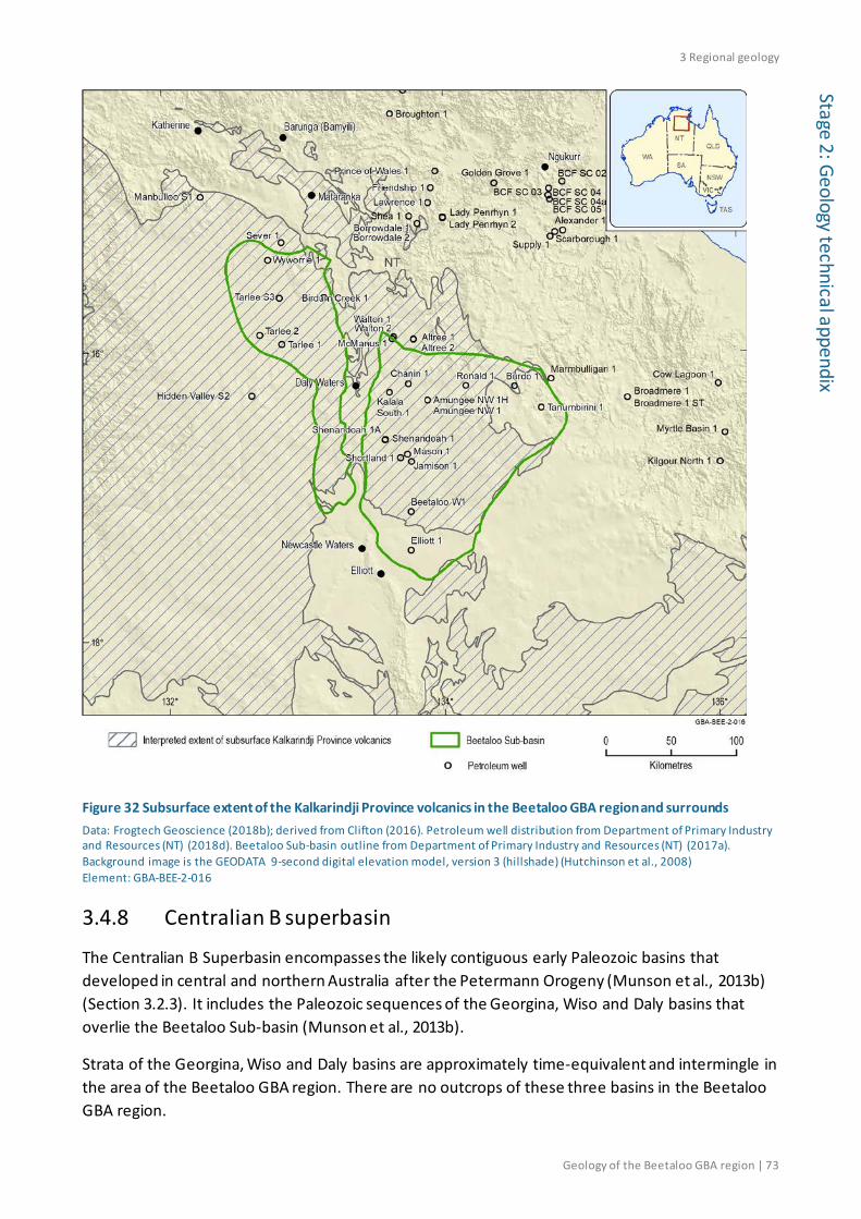
3 Regional geology
Geology of the Beetaloo GBA region | 73
Stage 2: Geology technical appendix
Figure 32 Subsurface extent of the Kalkarindji Province volcanics in the Beetaloo GBA region and surrounds Data: Frogtech Geoscience (2018b); derived from Clifton (2016). Petroleum well distribution from Department of Primary Industry and Resources (NT) (2018d). Beetaloo Sub-basin outline from Department of Primary Industry and Resources (NT) (2017a). Background image is the GEODATA 9-second digital elevation model, version 3 (hillshade) (Hutchinson et al., 2008) Element: GBA-BEE-2-016
3.4.8 Centralian B superbasin
The Centralian B Superbasin encompasses the likely contiguous early Paleozoic basins that developed in central and northern Australia after the Petermann Orogeny (Munson et al., 2013b) (Section 3.2.3). It includes the Paleozoic sequences of the Georgina, Wiso and Daly basins that overlie the Beetaloo Sub-basin (Munson et al., 2013b).
Strata of the Georgina, Wiso and Daly basins are approximately time-equivalent and intermingle in the area of the Beetaloo GBA region. There are no outcrops of these three basins in the Beetaloo GBA region.

3 Regional geology
74 | Geology of the Beetaloo GBA region
Stag
e 2:
Geo
logy
tech
nica
l app
endi
x 3.4.8.1 Georgina Basin
The Georgina Basin contains Neoproterozoic to Paleozoic rocks spread across several sub-basins south-east of the Beetaloo GBA region (Kruse et al., 2013). The northern Georgina Basin extends across most of the eastern Beetaloo Sub-basin. The early Paleozoic strata of the Georgina Basin are considered part of the Centralian B Superbasin (Munson et al., 2013b).
Georgina Basin Paleozoic strata intersected by exploration wells in the Beetaloo GBA region and immediate surrounds (Figure 9) include the Gum Ridge Formation and Anthony Lagoon Formation of the middle Cambrian Barkly Group (Figure 29). These units are widespread over the northern Georgina Basin and unconformably overlie the Kalkarindji Suite or Kiana Group in the Beetaloo GBA region. The constituent units of the basal Gum Ridge Formation and overlying Anthony Lagoon Formation are limestone-rich and form a regional producing aquifer termed the Cambrian Limestone Aquifer, or CLA (Fulton and Knapton, 2015).
The Gum Ridge Formation comprises mostly limestone and mudstone, and is partially dolomitised (Kruse et al., 2013). It is a lateral equivalent to of the Top Springs Limestone, which is prominent to the east. Both correlative units contain a diverse fossil assemblage and were deposited in a restricted marine shelf environment (Kruse et al., 2013).
The conformably overlying Anthony Lagoon Formation includes dolomitic siltstone and sandstone, dolostone and quartz sandstone (Kruse et al., 2013). It is interpreted to have been deposited in a mixed carbonate-siliciclastic tidal flat environment subject to recurring exposure (Hussey et al., 2001).
3.4.8.2 Wiso Basin
The Wiso Basin contains middle Cambrian to Devonian rocks concentrated south and south-west of the Beetaloo GBA region (Kruse and Munson, 2013a). The northern extent of the Wiso Basin covers the southern part of the western Beetaloo Sub-basin.
The only Wiso Basin unit intersected by exploration wells in the Beetaloo GBA region and surrounds is the basal middle Cambrian Montejinni Limestone, in Hidden Valley 1 and Tarlee 2 (Figure 9). The Montejinni Limestone is a correlative of the Gum Ridge Formation and Top Springs Limestone of the Georgina Basin. The Montejinni Limestone forms part of the extensive CLA system.
The unit is mostly limestone, dolostone, siltstone and minor dolomitic quartz sandstone (Kruse and Munson, 2013a). It is interpreted to have been deposited in an extensive, restricted marine platform environment with recurring peritidal sedimentation (Kruse and Munson, 2013a).
The Hooker Creek Formation is interpreted to extend into the Beetaloo GBA region; further details are provided in the hydrogeology technical appendix (Evans et al., 2020). The unit consists of almost entirely of micaceous siltstone and dolomitic mudstone, with minor fossiliferous limestone and quartz sandstone, interpreted to have been deposited in a peritidal to shallow- marine environment with restricted circulation (Kruse and Munson, 2013a). It is an equivalent of the Anthony Lagoon Formation of the Georgina Basin.

3 Regional geology
Geology of the Beetaloo GBA region | 75
Stage 2: Geology technical appendix
3.4.8.3 Daly Basin
The Daly Basin contains middle Cambrian to Early Ordovician rocks centred north-west of the Beetaloo GBA region (Kruse and Munson, 2013b; Tickell et al., 2015). The southern extent of the Daly Basin covers the northern half of the western Beetaloo Sub-basin.
The basal group is the middle Cambrian Daly River Group (Figure 29). It contains, from oldest to youngest, the Tindall Limestone, Jinduckin Formation and Oolloo Dolostone. The Tindall Limestone and Jinduckin Formation are exposed at outcrop over the north-west of the Beetaloo GBA region (250K sheet Larrimah SE 53-13; see Figure 8) are penetrated in several wells and form part of the extensive CLA. The Oolloo Dolostone was not identified in the wells due to restricted sampling of the shallow section, but may be present as it is mapped at outcrop just to the north of 250K sheet Larrimah SD 53-13 (Figure 8).
The Tindall Limestone is predominantly a fossiliferous limestone unit with minor siltstone and mudstone (Kruse and Munson, 2013b). It is a correlative to of the Gum Ridge Formation and Top Springs Limestone (Georgina Basin) and Montejinni Limestone (Wiso Basin). It is interpreted to be an open shelf marine limestone (Kruse and Munson, 2013b).
The Jinduckin Formation includes dolomitic-siliciclastic siltstone with dolomitic sandstone and dolostone (Kruse and Munson, 2013b). It is a correlative to of the Anthony Lagoon Formation of the Georgina Basin. It resulted from peritidal deposition in a prograding mixed carbonate-siliciclastic tidal flat environment (Kruse and Munson, 2013b).
3.4.9 Carpentaria Basin
The Jurassic to Cretaceous Carpentaria Basin underlies most of the Gulf of Carpentaria and extends onshore into Queensland and the Northern Territory (McConachie et al., 1997; Munson et al., 2013a). The Beetaloo Sub-basin lies beneath the Western Gulf Sub-basin of the Carpentaria Basin. The western extension of this sub-basin represents a large-scale marine transgression in the Aptian to early Albian (Munson et al., 2013a). In this region it was formerly termed the (now obsolete) ‘Dunmarra Basin’ and associated ‘Mullaman beds’.
The onshore Western Gulf Sub-basin is a condensed version of the coastal succession with few significant lithological differences (Munson et al., 2013a). On this basis it is considered to consist of the Aptian to Albian Walker River Formation (Figure 29). Three informal units (A–C) of the former ‘Mullaman beds’ can be distinguished in the Walker River Formation across the region, summarised by Munson et al. (2013a). The basal Unit A is predominantly massive cross-bedded quartz sandstone grading upwards to siltstone. Unit B conformably overlies Unit A and contains a lower siltstone overlain by fine-grained sandstone. Unit C disconformably overlies units B and C, is generally thicker, and contains claystone with some small sandy lenses. This fining-up progression of sediments records a marine transgression across the region.
Although most exploration wells in the Beetaloo GBA region provide little stratigraphic and lithological information for the shallow sections drilled, the Cretaceous ‘Mullaman beds’ (now obsolete) were identified in Burdo 1, Chanin 1 and Ronald 1.

3 Regional geology
76 | Geology of the Beetaloo GBA region
Stag
e 2:
Geo
logy
tech
nica
l app
endi
x 3.4.10 Cenozoic cover
For most of the Cenozoic the major depositional centres were located at distance to the south of the Beetaloo GBA region. The wider Beetaloo GBA region remained largely emergent. In the north, apart from undifferentiated Quaternary deposits, several older sedimentary units have been identified and are often sparsely preserved in outcrop, due to their more resistant lithified nature.
The undifferentiated Quaternary sediments include colluvium, alluvium, talus and scree, calcrete, eluvial soils, aeolian sand and lake and playa sediments (Edgoose and Ahmad, 2013). Several outcrops of the early–middle Miocene Golliger beds (informal) are found in the north-east of mapsheet Tanumbirini SE 53-02 (Figure 8). The unit contains limestone, is abundant in gastropods and plant remains, and has an inferred lacustrine origin (Edgoose and Ahmad, 2013).
Outcrops of the middle–late Miocene (informal) Birdum Creek beds are found over the north-west of the Beetaloo GBA region, in the area of mapsheet Larrimah SD 53-13 (Figure 8) (Randal, 1969). This is a chalky limestone, rich in freshwater gastropods (Edgoose and Ahmad, 2013); it is also likely to be lacustrine in origin.
A record of Quaternary mega-lake phases in response to monsoonal climate changes is preserved to the proximal south of the Beetaloo GBA region at Lake Woods (Bowler et al., 1998). Late Pleistocene sediments of these Quaternary lake systems consist of clay and sandy clay lacustrine sediments, and near-lakeshore ostracod sands and limestones grading shorewards to red quartzic sands. Outer shoreline sand ridges mark the high stands of the mega-lakes (Bowler et al., 1998).

4 Beetaloo GBA region structural and stratigraphic framework
Geology of the Beetaloo GBA region | 77
Stage 2: Geology technical appendix
4 Beetaloo GBA region structural and stratigraphic framework
This section presents an account of the structural and stratigraphic framework of the Beetaloo GBA region. Visualisations of the structural and stratigraphic framework of the Beetaloo GBA region are presented as a three-dimensional geological model, extracted representative cross-sections, and interpreted seismic sections along two-dimensional seismic lines. Depth-structure and isochore maps for stratigraphic intervals that are relevant to assessing unconventional gas resource prospectivity and potential impacts associated with their development are also presented.
4.1 Seismic interpretation The Beetaloo GBA region has a moderate coverage of approximately 9000 km of two-dimensional reflection seismic data of varying vintage and quality (see Section 2.3.4.1 for further detail). These data are in general of a good quality, and includes intersections with all wells, allowing delineation of the subsurface extent of the Beetaloo Sub-basin. Seismic data quality is compromised in areas with major structuring and where thick basalt and limestone sections are present in the near-surface geology, as cavernous limestone can generate an increased level of noise in seismic data and basalt can result in a loss of seismic energy. An interpretation-ready seismic project containing over 200 lines of historical seismic data across the Beetaloo Sub-basin and surrounding area is available from the NT Geological Survey (Jason and Frogtech Geoscience, 2018) and also via the GBA data repository (Dataset name: Beetaloo Sub-basin Seismic Project - NTGS DIP019) .
The recent Frogtech Geoscience SEEBASE® study of the greater McArthur Basin contracted by the NT Geological Survey (Frogtech Geoscience, 2018b, 2018a) included an interpretation of available open-file two-dimensional seismic datasets to guide structural interpretations, aid in geophysical modelling and constrain both the SEEBASE® surface but also the base of the Wilton package (i.e. base Roper Group).
Most recently, the NT Geological Survey has published seismic interpretations, using historical seismic data across the Beetaloo Sub-basin, of the base of the McArthur, Nathan and Roper groups, as well as the top of the Velkerri and Kyalla formations, key surfaces for the Beetaloo GBA (Williams, 2019). These interpretations will likely be revised as part of the NT Geological Survey’s current “Resourcing the Territory” program (Northern Territory Government, 2018d) to reflect revised stratigraphic relationships across the Beetaloo Sub-basin. Possible revisions include refinements to the mapping of the Velkerri and Kyalla formations and a major revision to the mapped top Kyalla Formation in the western sub-basin where the ‘McMinn Formation’ interval in well log ascriptions is now interpreted as part of the Kyalla Formation.
Example seismic sections with interpretation are shown below (Figure 33, Figure 34 and Figure 35) and illustrate the structural and stratigraphic architecture of the region. The seismic data shows that away from the highly structured sub-basin margins, the sedimentary sequences remain largely flat-lying and undeformed across much of the eastern and western sub-basin.

4 Beetaloo GBA region structural and stratigraphic framework
78 | Geology of the Beetaloo GBA region
Stag
e 2:
Geo
logy
tech
nica
l app
endi
x In the eastern Beetaloo Sub-basin the data shows an eastward-thickening trend from the Arnold High towards the Tanumbirini High, with the thickest Roper Group successions imaged in the proximity of Tanumbirini 1 (Figure 34). The clear thickening towards the Tanumbirini High suggests syn-depositional movement on the structure. A southward thickening trend is also observed, with a thick Roper Group succession imaged through much of the south-western area of the eastern Beetaloo Sub-basin (Figure 33).
In the western Beetaloo Sub-basin the data shows a gentle thickening of the Roper Group towards the Daly Waters High in the east (Figure 35). There is a noticeable contrast in the depth-to-base and thickness of the Roper Group between the western and eastern and sub-basins. In the west the base Roper sits at approximately 1–1.5 seconds (TWT) and ranges from approximately 0.8 to 1.2 seconds thick to the top Kyalla Formation, while in the east the base lies between approximately 1.75–2.5 seconds and is between 1.3 and 1.9 seconds thick.
Stratigraphic reassignments in this assessment, however, suggest that the Roper Group is thicker in the western Beetaloo Sub-basin than is indicated in the interpreted composite seismic section of Figure 35. As noted in section 3.4.5.2, the term ‘McMinn Formation’ has been abandoned (Abbott et al., 2001) but has been used informally in the logging of some wells; the re-identification of this strata as an upper member of the Kyalla Formation was necessary for the purposes of modelling the Beetaloo Sub-basin stratigraphic framework. The re-identification adds 140–460 ms to the thickness of the Roper Group in the western sub-basin. As there is no seismic interpretation currently available for this revised top of the Kyalla Formation, in the western Beetaloo Sub-basin the top of the Kyalla Formation mapped in the interpretation dataset of Williams (2019) (Figure 35) correlates to an intra-Kyalla Formation pick.

4 Beetaloo GBA region structural and stratigraphic framework
Geology of the Beetaloo GBA region | 79
Stage 2: Geology technical appendix
Figure 33 Composite seismic section south to north through the Beetaloo GBA region showing published intepretation in the eastern Beetaloo Sub-basin Source: Williams (2019) Element: GBA-BEE-2-070
Figure 34 Composite seismic section west to east through the Beetaloo GBA region showing published intepretation in the eastern Beetaloo Sub-basin Source: Williams (2019) Element: GBA-BEE-2-083

4 Beetaloo GBA region structural and stratigraphic framework
80 | Geology of the Beetaloo GBA region
Stag
e 2:
Geo
logy
tech
nica
l app
endi
x
Figure 35 Composite seismic section west to east through the Beetaloo GBA region showing published intepretation in the western Beetaloo Sub-basin Source: Williams (2019) Element: GBA-BEE-2-069
4.2 Interpretation confidence Many areas of the Beetaloo Sub-basin have a good coverage of two-dimensional reflection seismic data, with adequate well control. However, in some areas seismic data are sparse or absent. This is particularly common along the margins of the basin where the prospective units considered in this report are interpreted to be shallow or absent. The absence of well control in some areas also reduces interpretation confidence. In particular, interpretation confidence is low across the Daly Waters High and in the southern limb of the western sub-basin, and moderate in the south-eastern area of the eastern sub-basin. As noted previously, in some areas the seismic signal at depth is severely compromised by the presence of thick volcanic and or limestone units in the Georgina and Carpentaria basins. Despite the limitations, the seismic character of the Paleoproterozoic and Mesoproterozoic stratigraphy has allowed the major horizons to be mapped across the basin with a moderate to high level of confidence, including the top of the Kyalla and Velkerri formations (Figure 36).
Together with well intersections, the seismic interpretation dataset of the Kyalla and Velkerri formations underpins the geometry and depth of underlying Maiwok Subgroup and overlying Neoproterozoic sequence, therefore the variability in interpretation confidence for the Kyalla and Velkerri formations should be kept in mind when considering these model-derived formation depths and thicknesses.

4 Beetaloo GBA region structural and stratigraphic framework
Geology of the Beetaloo GBA region | 81
Stage 2: Geology technical appendix
Figure 36 Map showing seismic lines with interpretation data for the top Kyalla and top Velkerri formations in the Beetaloo GBA region Data: Williams (2019). Beetaloo Sub-basin outline from Department of Primary Industry and Resources (NT) (2017a). Background image is the GEODATA 9-second digital elevation model, version 3 (hillshade) (Hutchinson et al., 2008) Element: GBA-BEE-2-172
4.3 Geological surfaces and isochore maps Depth-structure and isochore maps are an essential component of the geological and bioregional assessment of the Beetaloo GBA region. Of particular importance to this assessment are the shale plays in the Velkerri and Kyalla formations of the Mesoproterozoic Roper Group and the tight gas/condensate play in the Hayfield sandstone member of the Neoproterozoic Hayfield mudstone (Hall et al., 2020). This assessment focuses on the stratigraphic intervals from the Velkerri Formation up.
The depth-structure and isochore maps for prospective Beetaloo Sub-basin stratigraphic intervals are presented below while key surfaces in the overlying Neoproterozoic to Paleozoic basins and the Mesozoic Carpentaria Basin are also provided. The depth-structure and isochore maps used in this assessment are derived from the following sources:
• The SEEBASE® study of the greater McArthur Basin conducted by Frogtech Geoscience for the NT Geological Survey (Frogtech Geoscience, 2018b) for basement and the base of the Wilton package (i.e. base Roper Group);
• The NT Geological Survey seismic interpretations of the Beetaloo Sub-basin (Williams, 2019) for the top of the Velkerri and Kyalla formations of the Mesoproterozoic Roper Group; (see Methods snapshot box Mapping geological surfaces in depth – depth conversion below);

4 Beetaloo GBA region structural and stratigraphic framework
82 | Geology of the Beetaloo GBA region
Stag
e 2:
Geo
logy
tech
nica
l app
endi
x • Department of Environment and Natural Resources (NT) (2018b) for the base and extent of the Cambrian Gum Ridge Formation and the Anthony Lagoon Formation (and their equivalents); and,
• Randal (1973) and Department of Environment and Natural Resources (NT) (2018a) – for the base, thickness and extent of the Cretaceous sediments of the Carpentaria Basin.

4 Beetaloo GBA region structural and stratigraphic framework
Geology of the Beetaloo GBA region | 83
Stage 2: Geology technical appendix
Methods snapshot: Mapping geological surfaces in depth – depth conversion
The depth-structure maps for the top of the Kyalla and Velkerri formations are derived from the two-dimensional seismic interpretation dataset published in two-way time (TWT) by the NT Geological Survey (Williams, 2019). For this data to be utilised in this assessment it was necessary to convert it into depth. The depth conversion was conducted using the software package Petrosys 2018.3 with the following workflow:
Top Kyalla Formation depth conversion
1. Create gridded TWT map for the top Kyalla Formation interpretation, TWTK, of Williams (2019)
2. Derive a time-depth relationship using a linear regression of the time-depth pairs from petroleum wells (Northern Territory Government, 2018h) for the interval from the seismic reference datum to the top Kyalla Formation. Inspection of the data revealed a significantly different time-depth relationship for the top Kyalla Formation between the eastern and western Beetaloo Sub-basin and so these areas were depth converted separately. The time-depth relationships used for the eastern and western Beetaloo Sub-basin are: TVDSS = -1.44 * TWT + 10 and TVDSS = -1.80 * TWT + 343, respectively
3. Apply the time-depth relationships to the TWTK grids for the eastern and western Beetaloo Sub-basin
4. These depth converted grids were then well tied using the Petrosys Well-tie tool and merged to achieve a depth map of the top Kyalla Formation, as interpreted by Williams (2019), across the GBA Beetaloo region
Top Velkerri Formation depth conversion
1. Create gridded TWT map for the top Velkerri Formation interpretation, TWTV, of Williams (2019)
2. Subtract the top Kyalla Formation TWT grid from top Velkerri Formation TWT grid to create a TWT interval grid (iTWTV-K).
3. Derive a time-interval thickness relationship using a linear regression of the time-depth pairs from petroleum wells (Northern Territory Government, 2018h) for the interval from the top Kyalla Formation to the top of the Velkerri Formation. The time-interval thickness relationship used is: Interval thickness = 2.07 * TWT - 17.6
4. Apply the time-interval thickness relationship to the iTWTV-K grid to create a thickness map from the top Kyalla Formation to top Velkerri Formation.
5. Add the thickness map to the top Kyalla Formation depth map to achieve the top Velkerri Formation depth map
6. This depth converted grid was then well tied using the Petrosys Well-tie tool
4 Beetaloo GBA region structural and stratigraphic framework
84 | Geology of the Beetaloo GBA region
Stag
e 2:
Geo
logy
tech
nica
l app
endi
x Additional depth maps required for this assessment and not available from published sources have been derived using a surface modelling workflow (see Methods snapshot box Modelling geological surfaces in depth below) based on depth information from well completion reports (Northern Territory Government, 2018h) and constraints from the published and derived depth surfaces introduced above. Model-derived maps include the:
• top of the undifferentiated Neoproterozoic sediments
• tops of Moroak Sandstone and the Amungee and Kalala members of the Velkerri Formation
• base of the Velkerri Formation.
These modelled surfaces (depth maps) are used to construct a three-dimensional geological model of the Beetaloo Sub-basin and provide a regional picture of the depth of each stratigraphic surface and thickness of the associated stratigraphic units. In comparison to the seismically derived top-Kyalla and -Velkerri formation surfaces these modelled surfaces have a lower level of interpretation confidence, particularly in areas that lack well control or are structurally complex. Faults have not been included in the generation of the depth maps and isochores.
Table 2 provides a summary of all surfaces captured in the three-dimensional geological model (Geological and Bioregional Assessment Program, 2019).
Methods snapshot: Modelling geological surfaces in depth
Regional depth maps for surfaces lacking a published depth map were prepared using the following surface modelling workflow:
1. Compile sets of formation top depths from wells in the Beetaloo GBA region using well completion reports (Northern Territory Government, 2018h)
2. Using the surface modelling module of the Petrosys software package, create gridded surfaces for each of the surfaces using the “phantom gridding” method. “Phantom gridding” is a gridding method that creates a surface (e.g. the depth to the top of a formation) that is tied to point data (e.g. formation depths from wells or depth converted seismic interpretation) while using neighbouring surfaces to control geometry. Depending on the geological relationships and data availability the method can be manipulated to vary the contribution from overlying and underlying surfaces.
3. Verify and refine the modelled surface grids across the assessment area using the three-dimensional geological model to ensure geologically reasonable surface geometries and check for consistency with surface outcrops, formation tops in wells and other modelled and published surfaces.
4. Derive isochore maps for intervals of interest using simple arithmetic.

4 Beetaloo GBA region structural and stratigraphic framework
Geology of the Beetaloo GBA region | 85
Stage 2: Geology technical appendix
Table 2 Surfaces included in the three-dimensional geological model (Geological and Bioregional Assessment Program, 2019)
Model surface Stratigraphic horizon Type Inputs Relative confidence level
Basement Base of the greater McArthur Basin (Beetaloo Sub-basin)
Published depth map
SEEBASE® (Frogtech Geoscience, 2018b) High
Base Roper Group
Base Roper Group-top of the undifferentiated Nathan, McArthur and Tawallah Groups
Published depth map
Base Wilton package (Frogtech Geoscience, 2018b) High
Base Velkerri Formation
Base Velkerri Formation(Kalala Member)-top undifferentiated middle to lower Roper Group
Phantom grid Well completion report formation picks Medium
Top Kalala Member (Velkerri Formation)
Base Amungee Member-top Kalala Member Phantom grid Well completion report
formation picks Medium
Top Amungee Member (Velkerri Formation)
Base Wyworrie Member-top of the Amungee Member
Phantom grid Well completion report formation picks Medium
Top Velkerri Formation Base Moroak Sandstone-top Velkerri Formation
Depth converted seismic interpretation grid
Seismic interpretation supplied by NTGS (Williams, 2019) High
Top Moroak Sandstone Base Kyalla Formation-top Moroak Sandstone Phantom grid Well completion report
formation picks Medium–high
Top Kyalla Formation* [east]
Base Jamison sandstone-top Kyalla Formation*
Depth converted seismic interpretation grid
Seismic interpretation supplied by NTGS (Williams, 2019) High
Top intra-Kyalla Formation# [west]
Intra-Kyalla Formation [west]#
Depth converted seismic interpretation grid
Seismic interpretation supplied by NTGS (Williams, 2019) High
Top Kyalla Formation^ [west]
Base Jamison sandstone-top of the Kyalla Formation^ in the western Beetaloo Sub-basin
Phantom grid Well completion report formation picks Medium
Top Jamison sandstone~
Base Hayfield mudstone-top Jamison sandstone Phantom grid Well completion report
formation picks Medium–low
Top undifferentiated Neoproterozoic
Base of the Kalkarindji Province volcanics–top undifferentiated Neoproterozoic
Phantom grid Well completion report formation picks Low

4 Beetaloo GBA region structural and stratigraphic framework
86 | Geology of the Beetaloo GBA region
Stag
e 2:
Geo
logy
tech
nica
l app
endi
x Model surface Stratigraphic horizon Type Inputs Relative confidence level
Top Kalkarindji Suite Antrim Volcanics
Top Kalkarindji Suite–base Gum Ridge Formation
Modified published map
Base Gum Ridge Formation (and equivalents, see below), interpreted extent the Kalkarindji Province (Frogtech Geoscience, 2018b)
Medium
Base Gum Ridge Formation (and equivalents)
Base Gum Ridge Formation-top Kalkarindji Province volcanics or undifferentiated Neoproterozoic
Modified published map
Contours for the base Gum Ridge Fm and equivalents (Department of Environment and Natural Resources (NT), 2018b). Well completion report formation picks
Medium
Base Anthony Lagoon Formation (and equivalents)
Base Anthony Lagoon Fm-top Gum Ridge Fm
Modified published map
Contours for the Base Anthony Lagoon Fm and equivalents (Department of Environment and Natural Resources (NT), 2018b). Well completion report formation picks
Medium
Walker River Formation and Cenozoic sediments
Base Walker River Fm-top Anthony Lagoon Fm
Modified published map
Contours for the base Mullaman beds (Randal, 1973). Extent of Cretaceous sediments (Department of Environment and Natural Resources (NT), 2018a)
Medium–low
Topographic surface Ground level elevation Published grid Digital Elevation Model grid (Hutchinson et al., 2008) High
*This surface represents the top of the Kyalla Formation in the eastern Beetaloo Sub-basin. #In the western Beetaloo Sub-basin an interval overlying the Kyalla Formation and identified as the McMinnn Formarion in well completion reports is now assigned to the Kyalla Formation. As a result in the western Beetaloo Sub-basin this surface, which is derived from the Top Kyalla Fm as mapped in the NT Geological Survey seismic interpretation, is now assigned as an intra-Kyalla Formation surface. ^The Top Kyalla Formation [west] was derived via phantom gridding above the intra-Kyalla Formation surface using the Top McMinn Formation picks from well completion reports. ~Not published due to lack of constraints and low level confidence.
4.3.1 Mesoproterozoic Beetaloo Sub-basin
4.3.1.1 The Roper Group
The base of the Mesoproterozoic Roper Group presented here is the base of the Wilton package as interpreted by Frogtech Geoscience (2018b). A general eastward deepening and thickening is observed across the Beetaloo Sub-basin (Figure 37).
In the eastern Beetaloo Sub-basin the Roper Group is observed in two major depocentres separated by the Arnold High. In the far east of the sub-basin, bounded by the Tanumbrini High in the vicinity of Tanumbirini 1, the group thickens eastward, with the base of the group interpreted to reach depths of more than 6500 m and attain thicknesses of up to 6000 m. To the west of the Arnold High, another thick (4500–5000 m) Roper Group succession is observed, with multiple wells intersecting the upper Maiwok Subgroup. In this depocentre the Roper Group reaches depths of up to 5800 m. Episodic subsidence is believed to have resulted in the deep and thick Roper Group sequence, observed to deepen and thicken in the two apparent depocentres (Revie, 2017a).

4 Beetaloo GBA region structural and stratigraphic framework
Geology of the Beetaloo GBA region | 87
Stage 2: Geology technical appendix
In the western sub-basin a westward shoaling and thinning is observed, with a thick succession present along the north-eastern margin, abutting the northern Daly Waters High, in the proximity of Birdum Creek 1. Here up to 4000 m of Roper Group is interpreted with the base of the Roper Group reaching 3000–4000 m depth (Figure 37).
Figure 37 Roper Group base depth and isochore maps Contour interval (C.I.) = 500 m. The Roper Group isochore was only calculated in areas where the Kyalla Formation has been mapped by Williams (2019). Data: Base Roper Group grid from Frogtech Geoscience (2018b). Roper Group isochore grid GBA derived dataset (Geological and Bioregional Assessment Program, 2019) Element: GBA-BEE-2-173
The westward thinning away from the Daly Waters High was interpreted by Frogtech Geoscience (2018) to be the result of uplift and erosion, although depositional variations in thickness are also possible. An erosional disconformity separates the lower and upper Roper Group in most regions outside of the Beetaloo Sub-basin (Munson, 2016) and the lower Roper Group may have had a similar thickness in the western sub-basin (Frogtech Geoscience, 2018b) before erosion.
The marked shallowing of the Roper Group units across the Daly Waters High may indicate post-Roper Group displacement, resulting from large-scale fault offsets along reactivated terrane boundaries at the Daly Waters High (Frogtech Geoscience, 2018b) during the ‘Post-Roper Inversion’ (Rawlings et al., 1997) (Section 3.3.4). However, further work would be required to determine if reduced or non- deposition on a pre-existing high contributes to the shallowing of Roper Group units across the Daly Waters High.

4 Beetaloo GBA region structural and stratigraphic framework
88 | Geology of the Beetaloo GBA region
Stag
e 2:
Geo
logy
tech
nica
l app
endi
x 4.3.1.2 Velkerri Formation
The Ectasian Velkerri Formation is present across the Beetaloo GBA region with its depth and thickness broadly mimicking the geometry of the Roper Group (Figure 38). An offset in the depth of the Velkerri Formation of up to one kilometre between the eastern and western Beetaloo Sub-basin is apparent (Figure 38a), with the top of the formation present at approximately 1000–2000 m and 400–1000 m, respectively. Similarly, the Velkerri Formation is, on average, thicker in the eastern Beetaloo Sub-basin (Figure 38b).
In the eastern Beetaloo Sub-basin, the Velkerri Formation reaches its maximum depth and thickness in the eastern most depocentre abutting the Tanumbirini High, where up to 1785 m of strata is interpreted at depths of up to 3400 m (Figure 38). The presence of the Arnold High is apparent in both the depth and isochore maps along the south-eastern margin. A second broad depocentre is interpreted to the west of the Arnold High, bounded by the Daly Waters High to the west, with the formation reaching up to 3200 m depth and 1300 m thickness (Figure 38).
In the western Beetaloo Sub-basin, the Velkerri Formation shows a gradual thinning and shoaling towards the south-west. In the vicinity of Birdum Creek 1, abutting the northern Daly Waters High, the formation reaches its maximum depth and thickness, where up to 1200 m is interpreted at depths of up to 2000 m (Figure 38). The formation is interpreted to be thinnest (<200 m thick) in the far south of the western Beetaloo GBA region, though interpretation confidence in this area is low.
The interpreted top Velkerri Formation surface (Williams, 2019) demonstrates a post-depositional displacement of up to one kilometre across the Daly Waters High between the western and eastern Beetaloo Sub-basin areas. It supports the interpretation of large-scale fault offsets at the Daly Waters High (Frogtech Geoscience, 2018b) during the ‘Post-Roper Inversion’ (Section 3.3.4).
Interpretations of the base Velkerri Formation surface and the Velkerri Formation thicknesses are less certain. The current model suggests that the extensional fault growth accompanying the development of the Wilton package depocentre in the Beetaloo Sub-basin (Betts et al., 2015; Yang et al., 2018) concentrated upper Roper Group deposition in the eastern Beetaloo Sub-basin (Figure 38b).
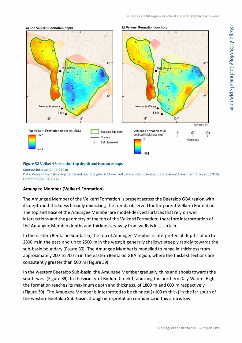
4 Beetaloo GBA region structural and stratigraphic framework
Geology of the Beetaloo GBA region | 89
Stage 2: Geology technical appendix
Figure 38 Velkerri Formation top depth and isochore maps Contour interval (C.I.) = 250 m Data: Velkerri Formation top depth and isochore grids GBA derived dataset (Geological and Bioregional Assessment Program, 2019) Element: GBA-BEE-2-174
Amungee Member (Velkerri Formation)
The Amungee Member of the Velkerri Formation is present across the Beetaloo GBA region with its depth and thickness broadly mimicking the trends observed for the parent Velkerri Formation. The top and base of the Amungee Member are model-derived surfaces that rely on well intersections and the geometry of the top of the Velkerri Formation; therefore interpretation of the Amungee Member depths and thicknesses away from wells is less certain.
In the eastern Beetaloo Sub-basin, the top of Amungee Member is interpreted at depths of up to 2800 m in the east, and up to 2500 m in the west; it generally shallows steeply rapidly towards the sub-basin boundary (Figure 39). The Amungee Member is modelled to range in thickness from approximately 200 to 700 m in the eastern Beetaloo GBA region, where the thickest sections are consistently greater than 500 m (Figure 39).
In the western Beetaloo Sub-basin, the Amungee Member gradually thins and shoals towards the south-west (Figure 39). In the vicinity of Birdum Creek 1, abutting the northern Daly Waters High, the formation reaches its maximum depth and thickness, of 1800 m and 600 m respectively (Figure 39). The Amungee Member is interpreted to be thinnest (<100 m thick) in the far south of the western Beetaloo Sub-basin, though interpretation confidence in this area is low.
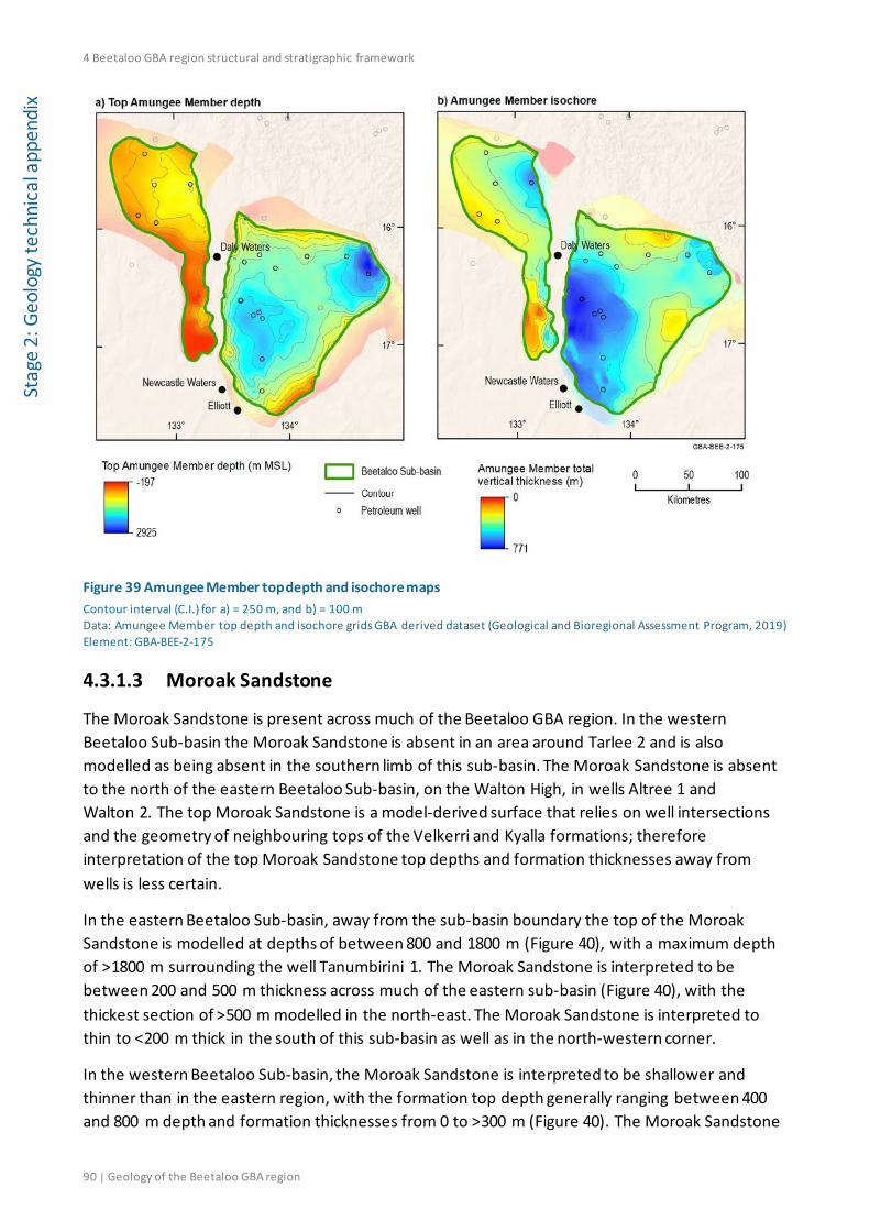
4 Beetaloo GBA region structural and stratigraphic framework
90 | Geology of the Beetaloo GBA region
Stag
e 2:
Geo
logy
tech
nica
l app
endi
x
Figure 39 Amungee Member top depth and isochore maps Contour interval (C.I.) for a) = 250 m, and b) = 100 m Data: Amungee Member top depth and isochore grids GBA derived dataset (Geological and Bioregional Assessment Program, 2019) Element: GBA-BEE-2-175
4.3.1.3 Moroak Sandstone
The Moroak Sandstone is present across much of the Beetaloo GBA region. In the western Beetaloo Sub-basin the Moroak Sandstone is absent in an area around Tarlee 2 and is also modelled as being absent in the southern limb of this sub-basin. The Moroak Sandstone is absent to the north of the eastern Beetaloo Sub-basin, on the Walton High, in wells Altree 1 and Walton 2. The top Moroak Sandstone is a model-derived surface that relies on well intersections and the geometry of neighbouring tops of the Velkerri and Kyalla formations; therefore interpretation of the top Moroak Sandstone top depths and formation thicknesses away from wells is less certain.
In the eastern Beetaloo Sub-basin, away from the sub-basin boundary the top of the Moroak Sandstone is modelled at depths of between 800 and 1800 m (Figure 40), with a maximum depth of >1800 m surrounding the well Tanumbirini 1. The Moroak Sandstone is interpreted to be between 200 and 500 m thickness across much of the eastern sub-basin (Figure 40), with the thickest section of >500 m modelled in the north-east. The Moroak Sandstone is interpreted to thin to <200 m thick in the south of this sub-basin as well as in the north-western corner.
In the western Beetaloo Sub-basin, the Moroak Sandstone is interpreted to be shallower and thinner than in the eastern region, with the formation top depth generally ranging between 400 and 800 m depth and formation thicknesses from 0 to >300 m (Figure 40). The Moroak Sandstone

4 Beetaloo GBA region structural and stratigraphic framework
Geology of the Beetaloo GBA region | 91
Stage 2: Geology technical appendix
is absent in an area around Tarlee 2 and is also modelled as being absent in the southern limb of this sub-basin.
Figure 40 Moroak Sandstone top depth and isochore maps Contour intervals (C.I.) for a) = 250 m, and b) = 100 m Data: Moroak Sandstone top depth and isochore grids GBA derived dataset (Geological and Bioregional Assessment Program, 2019) Element: GBA-BEE-2-176
4.3.1.4 Kyalla Formation
The Kyalla Formation is present across the Beetaloo GBA region (Figure 41) but is shallow or absent in some areas outside of the Beetaloo Sub-basin boundary, for example to the north of the eastern sub-basin on the Walton High in wells Walton 2 and Altree 2, and to the east of the eastern sub-basin in the Marmulligan 2 well.
In the eastern Beetaloo Sub-basin, away from the sub-basin boundary the top of the Kyalla Formation is mostly modelled at depths of between 500 and 900 m (Figure 41), with a maximum depth of >1000 m in the vicinity of well Tanumbirini 1. The Kyalla Formation generally thickens towards two main depocentres (in the north-east and south-west) reaching thicknesses of more than 800 m, while in the north and across the Arnold High the formation thins to between 150 and 400 m (Figure 41).
In the western Beetaloo Sub-basin, the top of the Kyalla Formation is interpreted to be shallower than in the eastern region (Figure 41), generally ranging between 0 and 400 m depth below MSL. This apparent inconsistency with the Beetaloo Sub-basin boundary definition (the top of the Kyalla Formation at 400 m depth; see Section 1.2) is due to the addition in this model of the ‘McMinn

4 Beetaloo GBA region structural and stratigraphic framework
92 | Geology of the Beetaloo GBA region
Stag
e 2:
Geo
logy
tech
nica
l app
endi
x Formation’ interval to the Kyalla Formation in the western Beetaloo Sub-basin. The Kyalla Formation is interpreted to thicken significantly towards the north-east in the western Beetaloo Sub-basin (Figure 41), from approximately 200–300 m thick along the western boundary to 500–700 m along the north-eastern boundary, with maximum thicknesses modelled in the vicinity of Birdum Creek 1. In the far south of the western region the formation is also interpreted to deepen and thicken, to more than 300 m depth and 500 m thick, although interpretation confidence in this area is low due to structural complexities and no well control.
The top Kyalla Formation is the surface affected by the long period (greater than 300 million years) of depositional hiatus and potential erosion in the Beetaloo Sub-basin region (Section 3.3.4). This period includes the apparent large-scale fault offsets at the Daly Waters High during the Post-Roper Inversion. Uplift of the western Beetaloo Sub-basin, relative to the east, may have resulted in erosion of the Kyalla Formation and reduced the height difference in the formation top across the Daly Waters High. The difference in the formation top evident in Figure 41a is approximately half that of the top Velkerri Formation (Figure 38a) and the base Kyalla Formation (top Moroak Sandstone in Figure 40a) across the Daly Waters High. It suggests also that uplift and erosion of the western Beetaloo Sub-basin contributed, at least in part, to the observed change in Roper Group thickness across the high (Figure 37) (Frogtech Geoscience, 2018b).
Figure 41 Kyalla Formation top depth and isochore maps Contour interval (C.I.) = 100 m Data: Kyalla Formation top depth and isochore grids GBA derived dataset (Geological and Bioregional Assessment Program, 2019) Element: GBA-BEE-2-177

4 Beetaloo GBA region structural and stratigraphic framework
Geology of the Beetaloo GBA region | 93
Stage 2: Geology technical appendix
4.3.2 Neoproterozoic Centralian A Superbasin
4.3.2.1 Undifferentiated Neoproterozoic sediments
Neoproterozoic sedimentary rocks of the Bukalara Sandstone and Cox Formation of the Georgina Basin and likely also the Jamison sandstone and Hayfield mudstone are associated with the Centralian A Superbasin (see Section 3.2.3). There is insufficient data available to constrain modelling of the depth and thicknesses of these units away from well intersections, therefore they are presented here as a single undifferentiated Neoproterozoic package. Note that over much of the Beetaloo GBA region the top of this package is constrained by the base of the Kalkarindji Suite volcanics which has a high level of uncertainty away from well intersections. The undifferentiated Neoproterozoic sediments are present across the Beetaloo GBA region.
In the eastern Beetaloo GBA region the top of the Neoproterozoic sediments is modelled at depths of ~0–380 m, with thicknesses largely ranging between 200 and 1000 m (Figure 42). The top of the Neoproterozoic sediments is deepest in the central and western half of the eastern sub-basin, particularly in the vicinity of the wells Ronald 1, Chanin 1 and Beetaloo West 1. However, in the vicinity of each of these wells, as well as in the southernmost part of the eastern sub-basin near Elliott 1, the Neoproterozoic sediments are thin (<400m). The Neoproterozoic sediments are thickest in the far east of the sub-basin, reaching approximately 1100 m in the vicinity of Tanumbirini 1 (Figure 42).
In the western Beetaloo GBA region the top of the Neoproterozoic sediments is modelled at depths of approximately 50 m below to 150 m above MSL and largely range between 50 and 400 m in thickness (Figure 42). The Neoproterozoic sediments are interpreted to be very thin to absent along the north-eastern border in the vicinity of Birdum Creek 1, though this is dependent on the Kyalla Formation top depth which is model dependent.
The stratigraphic relationships of the Jamison sandstone, Hayfield mudstone, Bukalara Sandstone and Cox Formation will likely be revised as part of the NT Geological Survey’s current “Resourcing the Territory” program (Northern Territory Government, 2018d). Revised relationships will enable a consistent structural interpretation of the Neoproterozoic sedimentary rocks across the western and eastern Beetaloo Sub-basin areas.

4 Beetaloo GBA region structural and stratigraphic framework
94 | Geology of the Beetaloo GBA region
Stag
e 2:
Geo
logy
tech
nica
l app
endi
x
Figure 42 Undifferentiated Neoproterozoic top depth and isochore maps Contour interval (C.I.) for a) = 100 m, and b) = 200 m Data: Undifferentiated Neoproterozoic top depth and isochore grids GBA derived dataset (Geological and Bioregional Assessment Program, 2019) Element: GBA-BEE-2-184
4.3.3 Kalkarindji Province
4.3.3.1 Kalkarindji Suite volcanics
The Cambrian Kalkarindji Suite volcanics are present across much of the Beetaloo GBA region. The map presented in Figure 43 shows the interpreted subsurface extent of the volcanics which has been derived from magnetic data by Frogtech Geoscience (2018b). The top depth information for the Kalkarindji Suite volcanics presented in Figure 43 is based on the depth of the base Gum Ridge Formation and equivalents (Figure 44; Department of Environment and Natural Resources (NT) (2018b)), that unconformably overlies the volcanics.
In the eastern Beetaloo GBA region the top of the volcanic succession is mapped at depths of 240 m below to 200 m above MSL (Figure 43). Well intersections indicate the volcanic succession is thickest in the central part of the northern margin (440 and 372 m thick in Chanin 1 and Ronald 1, respectively) and thinnest immediately to the south in the depocentre over Amungee NW 1 (84 m), Balmain 1 (83 m) and Shenandoah 1 (86 m). The volcanics are absent in the southern and easternmost regions of this sub-basin (Figure 43).
In the western Beetaloo GBA region the top of the volcanic succession is mapped at depths of 20 to 170 m above MSL (Figure 43). Well intersections indicate the volcanic succession is thickest in

4 Beetaloo GBA region structural and stratigraphic framework
Geology of the Beetaloo GBA region | 95
Stage 2: Geology technical appendix
the central part of the northern sub-basin with 174 m encountered in Tarlee S3 and thins noticeably to the north and east (to 105 and 101 m thick in Sever 1 and Birdum Creek 1, respectively). The volcanics are interpreted to be absent in a small area in the north-easternmost part of this sub-basin, bordering the Mallapunyah Fault Zone, and also in the southernmost area (Figure 43).
Figure 43 Kalkarindji Suite volcanics top depth map Contour interval (C.I.) = 100 m Data: Top Kalkarindji Suite volcanics depth grid GBA derived dataset (Geological and Bioregional Assessment Program, 2019) based on the base of the Gum Ridge Formation from the Department of Environment and Natural Resources (NT) (2018b), well completion reports Northern Territory Government (2018h) and the interpreted Kalkarindji Suite volcanics extent from Frogtech Geoscience (2018b). Background image is the GEODATA 9-second digital elevation model, version 3 (hillshade) (Hutchinson et al., 2008) Element: GBA-BEE-2-185

4 Beetaloo GBA region structural and stratigraphic framework
96 | Geology of the Beetaloo GBA region
Stag
e 2:
Geo
logy
tech
nica
l app
endi
x 4.3.4 Paleozoic Centralian Superbasin B: the Georgina, Wiso and Daly basins
4.3.4.1 Gum Ridge Formation and equivalents
The Gum Ridge Formation and its equivalents, the Tindall and Montejinni limestones, are present across the Beetaloo GBA region, with minor absences mapped in the north-east along the Beetaloo Sub-basin boundary bordering the Tanumbirini High (Figure 44).
Within the Beetaloo GBA region the base of the Gum Ridge Formation and equivalents is mapped at depths between 290 m below to 200 m above MSL (Figure 44). The Gum Ridge Formation is deepest in the south of the eastern Beetaloo GBA region, in a broad low in the vicinity of well Elliot 1. From this low in the south-east the formation shows a general shoaling towards the north, east and west (Figure 44). In the western sub-basin the shoaling coincides with a high, bounded by the Birdum Fault (Figure 2) to the north-east, over which the formation is of negligible thickness (<25 m) or absent. No depth information is available in the southernmost part of the western sub-basin.
Across the Beetaloo GBA region the Gum Ridge Formation and equivalents ranges between 0 and 285 m thickness (Figure 44). The formation is relatively thick across much of the eastern sub-basin, thinning to <100 m in the north, approaching the sub-basin boundary, and also in the area between wells Beetaloo West 1 and Jamison 1 (Figure 44). In the western Beetaloo Sub-basin the Gum Ridge Formation and equivalents are thin (<100 m), but thicken in the north-east corner, where a thicker sequence is mapped to the east of the Birdum Fault (Figure 2). The Gum Ridge Formation is potentially absent in the north-eastern area, to the west of the Birdum Fault, between wells Birdum Creek 1, Tarlee S3, Wyworrie 1 and Sever 1 (Figure 44).

4 Beetaloo GBA region structural and stratigraphic framework
Geology of the Beetaloo GBA region | 97
Stage 2: Geology technical appendix
Figure 44 Gum Ridge Formation (and equivalents) base depth and isochore maps Contour interval (C.I.) a) = 100 m, and b) = 50 m Data: Gum Ridge Formation base depth and isochore grids GBA derived dataset (Geological and Bioregional Assessment Program, 2019) based on Department of Environment and Natural Resources (NT) (2018b) Element: GBA-BEE-2-180
4.3.4.2 Anthony Lagoon Formation and equivalents
The Anthony Lagoon Formation is present across central and southern areas of the eastern Beetaloo GBA region and extends westward, to the north of the Ashbuton Ranges, into the southern limb of the western Beetaloo GBA region (Figure 45). The Jinduckin Formation, the Daly Basin equivalent of the Anthony Lagoon Formation, is present to the north-west of the Beetaloo GBA region on the north-eastern side of the Birdum Fault (Figure 2).
Within the Beetaloo GBA region, the base of the Anthony Lagoon Formation ranges from 140 m below to 200 m above MSL (Figure 45a), generally shoaling and thinning towards the northern, eastern and western limits of the formation. The formation reaches its deepest and thickest section in the south-central part of the eastern Beetaloo GBA region (Figure 45), where a large area is at depths of more than 50 m below MSL and with thicknesses of up to 270 m.

4 Beetaloo GBA region structural and stratigraphic framework
98 | Geology of the Beetaloo GBA region
Stag
e 2:
Geo
logy
tech
nica
l app
endi
x
Figure 45 Anthony Lagoon Formation (and equivalents) base depth and isochore maps Contour interval (C.I.) = 50 m Data: Anthony Lagoon Formation base depth and isochore grids GBA derived dataset (Geological and Bioregional Assessment Program, 2019) based on Department of Environment and Natural Resources (NT) (2018b) Element: GBA-BEE-2-181
4.3.5 Mesozoic Carpentaria Basin and Cenozoic
4.3.5.1 Walker River Formation and undifferentiated Cenozoic
The Walker River Formation is interpreted to be present across most of the Beetaloo GBA region. The base of the Walker River Formation, until recently known as the ‘Mullaman beds’, shown in Figure 46a is modified from the mapping of Randal (1973). The isochore shown in Figure 46b represents the combined thickness of sediments from the base of the Walker River Formation to the surface, including the Cenozoic section.
Within the Beetaloo GBA region the base of the Walker River Formation ranges from 126 to 215 m above MSL, reaching its deepest in the central to south-eastern area of the eastern Beetaloo Sub-basin (Figure 46a).
Within the Beetaloo GBA region the thickness of the combined Walker River Formation and undifferentiated Cenozoic sequence ranges from 0 to 140 m (Figure 46b). The thickest section is mapped in the central eastern Beetaloo Sub-basin, where a large area shows thicknesses greater than 100 m; away from this section the sequence generally thins. The sequence thins to less than 10 m along parts of the northern boundary of the eastern sub-basin as well as over much of the north-western part of the Beetaloo Sub-basin. The Cretaceous and Cenozoic sequence is mapped

4 Beetaloo GBA region structural and stratigraphic framework
Geology of the Beetaloo GBA region | 99
Stage 2: Geology technical appendix
as absent along watercourses in two areas of the northern-eastern most part of the western sub-basin and two areas of the north-easternmost eastern sub-basin.
Figure 46 Walker River Formation base depth and isochore maps Contour interval (C.I.) = 25 m Data: Walker River Formation base depth and isochore grids GBA derived dataset (Geological and Bioregional Assessment Program, 2019) based on depth and thickness information Randal (1973), extent Department of Environment and Natural Resources (NT) (2018a) Element: GBA-BEE-2-182
4.4 Regional three-dimensional datasets and schematic sections
The depth-structure maps for the Beetaloo Sub-basin and overlying stratigraphy outlined above have been used to generate a three-dimensional geological model for the Beetaloo GBA region (Geological and Bioregional Assessment Program, 2019). Two three-dimensional perspective views of this model are shown in Figure 47 and Figure 48, while example cross-sections are shown in Figure 49, Figure 50 and Figure 51.
The regional three-dimensional geological model for the Beetaloo GBA region underpins the shale gas prospectivity assessment (Hall et al., 2020) and hydrostratigraphic analysis (Evans et al., 2020).

4 Beetaloo GBA region structural and stratigraphic framework
100 | Geology of the Beetaloo GBA region
Stag
e 2:
Geo
logy
tech
nica
l app
endi
x
Figure 47 Oblique view of the regional three-dimensional geological model for the Beetaloo GBA region (looking north) The structural surface shown is the Base Roper Group Data: Base of the Roper Group and basement (SEEBASE®) from Frogtech Geoscience (2018b), top Velkerri and Kyalla formations modified from Williams (2019), base Anthony Lagoon and Gum Ridge formations (and their equivalents) from Department of Environment and Natural Resources (NT) (2018b), base Walker River Formation from Randal (1973). All other surfaces derived from well completion reports (Northern Territory Government, 2018h); see Methods snapshot Modelling geological surfaces in depths and Geological and Bioregional Assessment Program (2019) Element: GBA-BEE-2-072

4 Beetaloo GBA region structural and stratigraphic framework
Geology of the Beetaloo GBA region | 101
Stage 2: Geology technical appendix
Figure 48 Oblique view of the regional three-dimensional geological model for the Beetaloo GBA region (looking west) The structural surface shown is the Base Roper Group. Data: Base of the Roper Group and basement (SEEBASE®) from Frogtech Geoscience (2018b), top Velkerri and Kyalla formations derived from Williams (2019), base Anthony Lagoon and Gum Ridge formations (and their equivalents) from Department of Environment and Natural Resources (NT) (2018b), base Walker River Formation from Randal (1973). All other surfaces derived from well completion reports (Northern Territory Government, 2018h); see Methods snapshot Modelling geological surfaces in depth and Geological and Bioregional Assessment Program (2019) Element: GBA-BEE-2-073

4 Beetaloo GBA region structural and stratigraphic framework
102 | Geology of the Beetaloo GBA region
Stag
e 2:
Geo
logy
tech
nica
l app
endi
x
Figure 49 Schematic south to north cross-section through the Beetaloo GBA region generated from the three-dimensional geological model showing the structural architecture of the eastern Beetaloo Sub-basin Data: Base of the Roper Group and basement (SEEBASE®) from Frogtech Geoscience (2018b), top Velkerri and Kyalla formations derived from Williams (2019), base Anthony Lagoon and Gum Ridge formations (and their equivalents) from Department of Environment and Natural Resources (NT) (2018b), base Walker River Formation from Randal (1973). All other surfaces derived from well completion reports (Northern Territory Government, 2018h); see Methods snapshot Modelling geological surfaces in depth and Geological and Bioregional Assessment Program (2019) Element: GBA-BEE-2-076

4 Beetaloo GBA region structural and stratigraphic framework
Geology of the Beetaloo GBA region | 103
Stage 2: Geology technical appendix
Figure 50 Schematic east to west cross-section through the Beetaloo GBA region generated from the three-dimensional geological model showing the structural architecture of the eastern Beetaloo Sub-basin Data:Base of the Roper Group and basement (SEEBASE®) from Frogtech Geoscience (2018b), top Velkerri and Kyalla formations derived from Williams (2019), base Anthony Lagoon and Gum Ridge formations (and their equivalents) from Department of Environment and Natural Resources (NT) (2018b), base Walker River Formation from Randal (1973). All other surfaces derived from well completion reports (Northern Territory Government, 2018h); see Methods snapshot Modelling geological surfaces in depth and Geological and Bioregional Assessment Program (2019) Element: GBA-BEE-2-075

4 Beetaloo GBA region structural and stratigraphic framework
104 | Geology of the Beetaloo GBA region
Stag
e 2:
Geo
logy
tech
nica
l app
endi
x
Figure 51 Schematic east to west cross-section through the Beetaloo GBA region generated from the three-dimensional geological model showing the structural architecture of the western Beetaloo Sub-basin The Kyalla Formation shown here incorporates the McMinn Formation identified in wells in the western Beetaloo Sub-basin and is now assigned to the Kyalla Formation. The dashed line within the Kyalla Formation represents the depth converted seismic interpretation of the top Kyalla Formation of Williams (2019). Source: Base of the Roper Group and basement (SEEBASE®) from Frogtech Geoscience (2018b), top Velkerri and Kyalla formations derived from Williams (2019), base Anthony Lagoon and Gum Ridge formations (and their equivalents) from Department of Environment and Natural Resources (NT) (2018b), base Walker River Formation from Randal (1973). All other surfaces derived from well completion reports (Northern Territory Government, 2018h); see Methods snapshot Modelling geological surfaces in depth and Geological and Bioregional Assessment Program (2019) Element: GBA-BEE-2-074
4.5 Gaps, limitations and opportunities Data and knowledge gaps were recognised in the construction of the stratigraphic and structural framework, some of which represent potential opportunities for further work.
Full interpretation and mapping of faults using all available seismic data has not been undertaken systematically across the eastern and western Beetaloo Sub-basin volumes, nor is structure comprehensively mapped across and beyond the basin margins. The eastern and western

4 Beetaloo GBA region structural and stratigraphic framework
Geology of the Beetaloo GBA region | 105
Stage 2: Geology technical appendix
sub-basin areas have adequate but variable coverage of two-dimensional reflection seismic data and well data to undertake fault identification. Fault identification and mapping would refine assessments of hydraulic connectivity in the Proterozoic and Phanerozoic sequences. However, the absence of seismic data and well control in most margin areas, and the Daly Waters High, presents a limitation to interpretation in these more highly structured areas. Reliable interpretation is also disadvantaged by widespread thick volcanic and limestone units that compromise the seismic signal at depth.
Mapping of additional stratigraphic horizons in the available seismic data - such as the base of the Velkerri Formation, the constituent members of the Velkerri Formation, the top of the Moroak Sandstone, the tops of the Neoproterozoic Jamison and Hayfield formations, and the Kiana Group - would enhance the stratigraphic and structural framework and permit the development of a more refined depth conversion. This would reduce the uncertainties associated with the depth and thickness of prospective stratigraphic intervals and enable a better assessment of potential hydraulic connectivity.
Wells have not intersected the sequence below the upper Roper Group (Maiwok Subgroup). Current seismic interpretation suggests that the Redbank, Glyde and Favenc packages underlie the Wilton package in the Beetaloo Sub-basin (Dhu, 2018; Hoffman, 2015), but the sedimentary characteristics of the underlying sequence cannot be confirmed unless wells are drilled to these depths in the sub-basin.

References
106 | Geology of the Beetaloo GBA region
Stag
e 2:
Geo
logy
tech
nica
l app
endi
x References Abbott ST and Sweet IP (2000) Tectonic control on third-order sequences in a siliciclastic ramp-
style basin: An example from the Roper Superbasin (Mesoproterozoic), northern Australia. Australian Journal of Earth Sciences 47(3), 637-657. Doi: 10.1046/j.1440-0952.2000.00795.x.
Abbott ST, Sweet IP, Plumb KA, Young DN, Cutovinos A, Ferenczi PA, Brakel A and Pietsch BA (2001) Roper Region: Urapunga and Roper River Special, Northern Territory (Second Edition). 1:250 000 geological map series explanatory notes, SD 53-10, 11. Northern Territory Geological Survey and Geoscience Australia (National Geoscience Mapping Accord), Darwin.
Ahmad M and Scrimgeour IR (2013) Chapter 2: Geological Framework. In: Ahmad M and Munson TJ (eds), Geology and mineral resources of the Northern Territory. Northern Territory Geological Survey, Special Publication 5, Darwin.
Ahmad M, Dunster JN and Munson TJ (2013) Chapter 15: McArthur Basin. In: Ahmad M and Munson TJ (eds), Geology and mineral resources of the Northern Territory. Northern Territory Geological Survey, Special Publication 5, Darwin.
Altmann C, Baruch E, Close D, Mohinudeen FM, Richards B and Côté A (2018) Could the Mesoproterozoic Kyalla Formation emerge as a viable gas condensate source rock reservoir play in the Beetaloo Sub-basin? In: Australasian Exploration Geoscience Conference (AEGC) 2018 Proceedings, Sydney.
Anderson J, Carson C, Lewis C, Kositcin N, Cross A, Carr L and Henson P (2019) Exploring for the Future: new U–Pb geochronology for the South Nicholson region and implications for stratigraphic correlations. In: Australasian Exploration Geoscience Conference (AEGC) 2019 Proceedings, Perth.
Armour Energy (2015) ASX Announcement: 66% increase in Prospective Gas Resources in Northern Australia. Maiden Prospective Gas Resources in the Tawallah Group, McArthur Basin (NT) and in the Riversleigh Shale Formation (QLD). Armour Energy Limited.
Baruch ET, Altmann CM, Close DI, Mohinudeen FM, Richards BA and Côté A (2018) The Kyalla Formation prospectivity from a mineralogical and sedimentological perspective. In: Annual Geoscience Exploration Seminar (AGES) 2018 Proceedings. Northern Territory Geological Survey, 40-48.
Bastrakov EN, Main P, Wygralak AS, Wilford J, Czarnota K and Khan M (2018) Northern Australia Geochemical Survey Data release 1 - Total (fine fraction) and MMITM element contents. Geoscience Australia, Record 2018/06, Doi: 10.11636/Record.2018.006.
Betts P, Armit R and Ailleres L (2015) Geophysical and structural interpretation of the greater McArthur Basin. Northern Territory Geological Survey, Digital Information Package DIP 015 (March 2015). Viewed 12 September 2018, https://geoscience.nt.gov.au/gemis/ntgsjspui/handle/1/81754. GBA data repository GUID: 63EF1068-8F4A-4AC6-84D3-512747596069.

References
Geology of the Beetaloo GBA region | 107
Stage 2: Geology technical appendix
Betts PG and Giles D (2006) The 1800–1100Ma tectonic evolution of Australia. Precambrian Research 144(1), 92-125. Doi: 10.1016/j.precamres.2005.11.006.
Blaikie TN and Kunzmann M (2019) From source to trap. Geophysical insights into base metals mineralisation in the southern McArthur Basin. In: Annual Geoscience Exploration Seminar (AGES) 2019 Proceedings. Northern Territory Geological Survey, 69-75.
Bowler J, Duller G, Perret N, Prescott JR and Wyrwoll KH (1998) Hydrologic changes in monsoonal climates of the last glacial cycle: Stratigraphy and luminescence dating of Lake Woods, N.T., Australia. Palaeoclimates: Data and Modelling 3, 179-207.
Bruna P-O and Dhu T (2017) 3D Model of the greater McArthur Basin, Version 2017.1. Northern Territory Geological Survey, Digital Information Package DIP 012. Viewed 7 September 2018, https://geoscience.nt.gov.au/gemis/ntgsjspui/handle/1/81751. GBA data repository GUID: 51B4A60D-10D7-47A3-B863-E0A5506F50A0.
Bultitude RJ (1972) The geology and petrology of the Helen Springs, Nutwood Downs, and Peaker Piker Volcanics. Bureau of Mineral Resources (BMR) Record 1972/74. Canberra.
Bultitude RJ (1976) Flood basalts of probable early Cambrian age in northern Australia. In: Johnson RW (ed), Volcanism in Australasia. Elsevier, Amsterdam, 1-20.
Campbell RJ and Haig DW (1999) Bathymetric change during Early Cretaceous intracratonic marine transgression across the northeastern Eromanga Basin, Australia. Cretaceous Research 20(4), 403-446. Doi: 10.1006/cres.1999.0161.
Clifton R (2016) Magnetic Map of the Northern Territory, 1:2,500,000 scale. Northern Territory Geological Survey, Darwin.
Close D, Baruch ET, Altmann CM, Côté AJ, Mohinudeen FM, Richards B and Stonier S (2016) Unconventional gas potential in Proterozoic source rocks: Exploring the Beetaloo Sub-basin. In: Annual Geoscience Exploration Seminar (AGES) 2016 Proceedings. Northern Territory Geological Survey, 91-94.
Close D, Côté AJ, Baruch ET, Altmann CM, Mohinudeen FM, Richards B and Ilett R (2017) Proterozoic shale gas plays in the Beetaloo Basin and the Amungee NW-1H discovery. In: Annual Geoscience Exploration Seminar (AGES) 2017 Proceedings. Northern Territory Geological Survey, 91-97.
Close DF (2014) The McArthur Basin: NTGS' approach to a frontier petroleum basin with known base metal prospectivity. In: Annual Geoscience Exploration Seminar (AGES) 2014 Proceedings. Northern Territory Geological Survey, Record 2014-001, 85-89.
Collins AS, Farkas J, Glorie S, Cox G, Blades ML, Yang B, Nixon A, Bullen M, Foden JD, Dosseto A, Payne JL, Denyszyn S, Edgoose CJ, Close D, Munson TJ, Menpes S, Spagnuolo S, Gusterhuber J, Sheridan M, Baruch-Jurado E and Close D (2018) Orogens to oil: government-industry-academia collaboration to better understand the greater McArthur Basin. In: Annual Geoscience Exploration Seminar (AGES) 2018 Proceedings. Northern Territory Geological Survey, 49-51.

References
108 | Geology of the Beetaloo GBA region
Stag
e 2:
Geo
logy
tech
nica
l app
endi
x Cook AG and Jell JS (2013) Chapter 8: Paleogene and Neogene. In: Jell PA (ed), Geology of Queensland. Geological Survey of Queensland, Brisbane, 577–652.
Cook AG, Bryan SE and Draper JJ (2013) Chapter 7: Post-orogenic Mesozoic basins and magmatism. In: Jell PA (ed), Geology of Queensland. Geological Survey of Queensland, Brisbane, 515-576.
Côté A, Richards B, Altmann C, Baruch E and Close D (2018) Australia's premier shale basin: five plays, 1 000 000 000 years in the making. APPEA Journal 58(2), 799-804. Doi: 10.1071/AJ17040.
CSIRO (2015) ASTER Geoscience Map of Australia. CSIRO. Viewed 04 January 2019, https://confluence.csiro.au/public/SpecSens/aster-geoscience-maps.
Cudahy TJ, Caccetta M, Collings S, Thomas M and Laukamp C (2012) ASTER Geoscience Map of the Northern Territory. In: Annual Geoscience Exploration Seminar (AGES) 2012 Proceedings. Northern Territory Geological Survey, Record 2012-002, 44-47.
Cutovinos A, Beier PR, Kruse PD, Abbott ST, Dunster JN and Brescianini RF (2002) Limbunya, Northern Territory (Second Edition). 1:250 000 geological map series explanatory notes, SD 52-07. Northern Territory Geological Survey, Darwin.
de Vries ST, Pryer L, Petrovich S, Fry N and Connors K (2007) OZ SEEBASETM Proterozoic basins. In: Annual Geoscience Exploration Seminar (AGES) 2007 Proceedings. Northern Territory Geological Survey, Record 2007-001, 10-11.
de Vries ST, Pryer LL and Fry N (2008) Evolution of Neoarchaean and Proterozoic basins of Australia. Precambrian Research 166(1), 39-53. Doi: 10.1016/j.precamres.2008.01.005.
Delle Piane C, Uysal T, Pan Z, Bourdet J, Li Z, Raven MD and Dewhurst DN (2019) A multidisciplinary evaluation of the Velkerri Formation in the Beetaloo Sub- Basin: Implications for geological history and reservoir quality. In: Annual Geoscience Exploration Seminar (AGES) 2019 Presentations. Northern Territory Geological Survey. Viewed 01 April 2019, https://dpir.nt.gov.au/__data/assets/pdf_file/0004/669379/940_DellePiane.pdf.
Department of Environment and Natural Resources (NT) (2018a) Cretaceous extent in the Beetaloo GBA region. [ArcGIS shape file]. Viewed 27 March 2020, https://denr.nt.gov.au/land-resource-management/info-systems/natural-resource-maps/spatial-data-requests. GBA data repository GUID: D1AD3D5A-FA13-4F6C-AD1C-5BCDE9167F73.
Department of Environment and Natural Resources (NT) (2018b) Base of the Jinduckin and Tindall Formations. [ArcGIS shape file]. Viewed 27 March 2020, https://denr.nt.gov.au/land-resource-management/info-systems/natural-resource-maps/spatial-data-requests. GBA data repository GUID: F44AB442-944E-40B8-8EEE-06991E0D1184.
Department of Primary Industry and Resources (NT) (2017a) STRIKE tenure and geoscience information - Concealed Geological Boundaries. Viewed 23 April 2018, http://www.ntlis.nt.gov.au/metadata/export_data?type=xml&metadata_id=5EFEB9B61E918

References
Geology of the Beetaloo GBA region | 109
Stage 2: Geology technical appendix
EA1E050CD9B2144457E. GBA data repository GUID: 8DF22E22-0284-4288-9F1A-60683048F1E8.
Department of Primary Industry and Resources (NT) (2017b) Submission 479 to the Scientific Inquiry into Hydraulic Fracturing in the Northern Territory. Northern Territory Government. Viewed 11 January 2019, https://frackinginquiry.nt.gov.au/?a=464723.
Department of Primary Industry and Resources (NT) (2018a) NTGS geoscience projects - Greater McArthur Basin unconventional hydrocarbon and metallogenic potential. Northern Territory Government. Viewed 01 August 2019, https://dpir.nt.gov.au/mining-and-energy/geoscience-projects-and-initiatives/ntgs-geoscience-projects/greater-mcarthur-basin-unconventional-hydrocarbon-and-metallogenic-potential.
Department of Primary Industry and Resources (NT) (2018b) NTGS geoscience projects - Greater McArthur Basin stratigraphic characterisation. Northern Territory Government. Viewed 01 August 2019, https://dpir.nt.gov.au/mining-and-energy/geoscience-projects-and-initiatives/ntgs-geoscience-projects/greater-mcarthur-basin-statigraphic-characterisation.
Department of Primary Industry and Resources (NT) (2018c) NTGS geoscience projects - Greater McArthur Basin 3D model. Northern Territory Government. Viewed 09 January 2019, https://dpir.nt.gov.au/mining-and-energy/geoscience-projects-and-initiatives/ntgs-geoscience-projects/greater-mcarthur-basin-3d-model.
Department of Primary Industry and Resources (NT) (2018d) Northern Territory Statewide Wells and Drillholes. Viewed 15 October 2018, https://dpir.nt.gov.au/mining-and-energy/STRIKE/accessing-nt-datasets/nt-wide-geoscience-datasets. GBA data repository GUID: 89932245-A9F0-41D5-BBFE-889EE85F970D.
Department of Primary Industry and Resources (NT) (2018e) STRIKE tenure and geoscience information - Geology Maps. Viewed 28 October 2018, https://dpir.nt.gov.au/mining-and-energy/STRIKE/accessing-nt-datasets/nt-wide-geoscience-datasets. GBA data repository GUID: 1B01C953-3ADE-4955-A7C4-BA32E2A3C1EF.
Department of Primary Industry and Resources (NT) (2018f) Northern Territory Statewide Geophysics - Seismic Lines. Viewed 06 September 2018, https://dpir.nt.gov.au/mining-and-energy/STRIKE/accessing-nt-datasets/nt-wide-geoscience-datasets. GBA data repository GUID: E5D39C55-CA33-4972-BBFA-C3F54B43933D.
Department of Primary Industry and Resources (NT) (2019) STRIKE tenure and geoscience information - NT wide datasets. Northern Territory Government. Viewed 21 October 2019, http://strike.nt.gov.au/wss.html.
Dhu T (2018) Overview of new geophysical resources in the NT. In: Annual Geoscience Exploration Seminar (AGES) 2018 Proceedings. Northern Territory Geological Survey, Record 2018-002, 107-130.
Donley JA (1994) The effect on seismic data of the Phanerozoic of the Beetaloo Sub-basin, McArthur Basin, Northern Territory. Honours Thesis, University of South Australia. Viewed 21 November 2018, https://asp.adelaide.edu.au/about/theses/donleyja/.

References
110 | Geology of the Beetaloo GBA region
Stag
e 2:
Geo
logy
tech
nica
l app
endi
x Donnelly TH and Crick IH (1988) Depositional environment of the Middle Proterozoic Velkerri Formation in northern Australia: geochemical evidence. Precambrian Research 42, 165-172.
Duddy IR, Green PF, Gibson HJ and Hegarty KA (2003) Regional palaeo-thermal episodes in northern Australia. Proceedings of the Timor Sea Symposium 2003. In: Ellis GK, Baillie PW and Munson TJ (eds), Timor Sea Petroleum Geoscience. Northern Territory Geological Survey, Special Publication 1, 567–591.
Dutkiewicz A, Volk H, Ridley J and George SC (2007) Precambrian inclusion oils in the Roper Group: A review. In: Munson TJ and Ambrose GJ (eds), Proceedings of the Central Australian Basins Symposium (CABS) 2005, Northern Territory Geological Survey, Special Publication 2, 326–334.
Edgoose CJ and Ahmad M (2013) Chapter 42: Cenozoic Geology and Regolith. In: Ahmad M and Munson TJ (eds), Geology and mineral resources of the Northern Territory. Northern Territory Geological Survey, Special Publication 5, Darwin.
Evans TJ, Radke BM, Martinez J, Buchanan S, Cook SB, Raiber M, Ransley TR, Lai ECS, Skeers N, Woods M, Evenden C, Cassel R and Dunn B (2020) Hydrogeology of the Beetaloo GBA region. Technical appendix for the Geological and Bioregional Assessment: Stage 2. Department of the Environment and Energy, Bureau of Meteorology, CSIRO and Geoscience Australia, Australia.
Faiz M, Altmann C, Dunne M, Baruch E, Close D, Côté A, Richards B and Ranasinghe P (2016) Precambrian Organic Matter and Thermal Maturity of the Beetaloo Basin, Northern Territory, Australia. In: Australian Earth Sciences Convention (AESC) 2016 Abstracts, 133.
Faiz MF, Zoitsas A, Altmann C, Baruch E and Close D (2018) Compositional variations and carbon isotope reversal in coal and shale gas reservoirs of the Bowen and Beetaloo basins, Australia. In: Dowey P, Osborne M and Volk H (eds), Application of Analytical Techniques to Petroleum Systems. Geological Society, London, Special Publications 484. Doi: 10.1144/SP484.3.
Frogtech Geoscience (2018a) SEEBASE® study and GIS for greater McArthur Basin: Supplementary Data. Northern Territory Geological Survey, Digital Information Package DIP 018. Viewed 08 May 2019, https://geoscience.nt.gov.au/gemis/ntgsjspui/handle/1/87062. GBA data repository GUID: EC6D7486-30C9-4D19-92C6-57879C00A363.
Frogtech Geoscience (2018b) SEEBASE® study and GIS for greater McArthur Basin. Northern Territory Geological Survey, Digital Information Package DIP 017 (ESRI file format, March 2018). Viewed 25 May 2018, https://geoscience.nt.gov.au/gemis/ntgsjspui/handle/1/87064. GBA data repository GUID: 563A5349-DC7F-42B8-B6CC-892B3B4C3C3F.
Fulton S and Knapton A (2015) Beetaloo Basin Hydrogeological Assessment - Report undertaken for Origin Energy. CloudGMS. Viewed 09 May 2018, https://frackinginquiry.nt.gov.au/?a=410609.
Garven G, Bull SW and Large RR (2001) Hydrothermal fluid flow models of stratiform ore genesis in the McArthur Basin, Northern Territory, Australia. Geofluids 1(4), 289-311. Doi: 10.1046/j.1468-8123.2001.00021.x.

References
Geology of the Beetaloo GBA region | 111
Stage 2: Geology technical appendix
Geological and Bioregional Assessment Program (2019) Regional Three-Dimensional Geological Model for the Beetaloo Sub-basin. Viewed 21 June 2019, https://repo.bioregionalassessments.gov.au/metadata/9F604AFA-40E4-4E5A-91DD-0A695A3465A8. GBA data repository GUID: 9F604AFA-40E4-4E5A-91DD-0A695A3465A8.
Geological Survey of Queensland (2011) North-West Queensland Mineral and Energy Province Report. Queensland Department of Employment, Economic Development and Innovation, Brisbane.
Geoscience Australia (2012a) Surface Geology of Australia 1:1 million scale dataset 2012 edition. Viewed 06 September 2018, http://pid.geoscience.gov.au/dataset/ga/74619. GBA data repository GUID: A74CCABD-CB40-4741-A301-DAC9F53CEAE1.
Geoscience Australia (2012b) Surface Geology of Australia 1:2.5 million scale dataset 2012 edition Viewed 06 September 2018, http://pid.geoscience.gov.au/dataset/ga/73140. GBA data repository GUID: DC10F78B-715F-4EE0-BD42-067E7B975BE6.
Geoscience Australia (2017) GEODATA TOPO 250K Series 3 Topographic Data. Viewed 1 October 2018, http://pid.geoscience.gov.au/dataset/ga/64058. GBA data repository GUID: BCA7C9F6-6639-45C4-ABC8-5027EFA14B40.
Geoscience Australia (2018a) Exploring for the Future - AusAEM. Geoscience Australia. Viewed 07 January 2019, http://www.ga.gov.au/eftf/minerals/nawa/ausaem.
Geoscience Australia (2018b) AusLAMP - Illuminating Australia's deep earth. Geoscience Australia. Viewed 21 November 2018, http://www.ga.gov.au/about/projects/resources/auslamp.
Geoscience Australia (2018c) Northern Australia Geochemical Survey (NAGS) project. Geoscience Australia. Viewed 04 January 2019, http://www.ga.gov.au/eftf/minerals/fis/nags.
Geoscience Australia (2018d) Scanned 250K Geological Map Index. Viewed 10 September 2018, http://services.ga.gov.au/gis/rest/services/Scanned_250k_Geological_Map_Index/MapServer. GBA data repository GUID: 28BC1BC4-F07B-44DC-9943-04FBFAC8EECC.
Giles D, Ailléres L, Jeffries D, Betts P and Lister G (2006) Crustal architecture of basin inversion during the Proterozoic Isan Orogeny, Eastern Mount Isa Inlier, Australia. Precambrian Research 148(1), 67-84. Doi: 10.1016/j.precamres.2006.03.002.
Glass LM, Ahmad M and Dunster JN (2013) Chapter 30: Kalkarindji Province. In: Ahmad M and Munson TJ (eds), Geology and mineral resources of the Northern Territory. Northern Territory Geological Survey, Special Publication 5, Darwin.
Goldberg AS (2010) Dyke swarms as indicators of major extensional events in the 1.9–1.2Ga Columbia supercontinent. Journal of Geodynamics 50(3), 176-190. Doi: 10.1016/j.jog.2010.01.017.
Golding SD, Uysal IT, Glikson M, Baublys KA and Southgate PN (2006) Timing and chemistry of fluid-flow events in the Lawn Hill platform, northern Australia. Economic Geology 101(6), 1231-1250.

References
112 | Geology of the Beetaloo GBA region
Stag
e 2:
Geo
logy
tech
nica
l app
endi
x Gorter J and Grey K (2012) Velkerri Formation Depositional Model - Beetaloo Sub-basin, Northern Territory, Australia: Biostratigraphy and Organic Enrichment. In: Central Australian Basins Symposium (CABS) III Proceedings. Petroleum Exploration Society of Australia.
Gorter JD and Grey K (2013) Middle Proterozoic biostratigraphy and log correlations of the Kyalla and Chambers River Formations Beetaloo Sub-basin, Northern Territory, Australia. West Australian Basins Symposium (WABS) 4 Poster. Petroleum Exploration Society of Australia.
Grey K (2015) Mesoproterozoic biostratigraphic correlation in the Beetaloo Sub-basin, Northern Territory, Australia, and potential for correlation with other northern Australian basins. In: Annual Geoscience Exploration Seminar (AGES) 2015 Proceedings. Northern Territory Geological Survey, Record 2015-002, 33-41.
Haines PW, Pietsch BA, Rawlings DJ, Madigan TLA and Findhammer T (1993) Mount Young, Northern Territory (Second Edition) 1:250 000 geological map series explanatory notes, SD 53-15. Northern Territory Geological Survey, Darwin.
Haines PW, Rawlings DJ, Sweet IP, Pietsch BA, Plumb KA, Madigan TLA and Krassay AA (1999) Blue Mud Bay, Northern Territory. 1:250,000 geological map series explanatory notes, SD 53-07. Northern Territory Geological Survey, Darwin.
Hall LS, Wang L, Bailey AHE, Owens R, Orr ML, Jarrett AJM, Lech ME, Skeers N, Reese B and Woods M (2020) Petroleum prospectivity of the Beetaloo Sub-basin. Technical appendix for the Geological and Bioregional Assessment: Stage 2. Department of the Environment and Energy, Bureau of Meteorology, CSIRO and Geoscience Australia, Australia.
Hallett L (2017) Rock property dataset of the Northern Territory. Northern Territory Geological Survey, Digital Information Package DIP 013. Viewed 7 September 2018, https://geoscience.nt.gov.au/gemis/ntgsjspui/handle/1/81752. GBA data repository GUID: 9F4320AD-FD22-41EC-A7BB-902E31EB6316.
Henson PA, Carr L, Fomin F, Gerner E, Costelloe RS, Southby C, Anderson J, Bailey AHE, Lewis C, Champion D and Huston D (2018) Exploring for the Future - Discovering the South Nicholson Basin region with new seismic data. In: Annual Geoscience Exploration Seminar (AGES) 2018. Northern Territory Geological Survey, 52-54
Hoffman TW (2014) New insights into the expanse of the McArthur Superbasin. In: Annual Geoscience Exploration Seminar (AGES) 2014 Proceedings. Northern Territory Geological Survey, Record 2014-001, 91-93.
Hoffman TW (2015) Recent drilling results provide new insights into the western Palaeoproterozoic to Mesoproterozoic McArthur Basin. In: Annual Geoscience Exploration Seminar (AGES) 2015 Proceedings. Northern Territory Geological Survey, Record 2015-002, 50-55.
Hoffman TW (2016) Roper Basin burial history modelling: Inferences for the timing of hydrocarbon generation. In: Annual Geoscience Exploration Seminar (AGES) 2016 Proceedings. Northern Territory Geological Survey, 100-110.

References
Geology of the Beetaloo GBA region | 113
Stage 2: Geology technical appendix
Hussey KJ, Beier PR, Crispe AJ, Donnellan N and Kruse PD (2001) Helen Springs, Northern Territory (Second Edition) 1:250 000 geological map series explanatory notes, SE 53-10. Northern Territory Geological Survey, Darwin.
Hutchinson MF, Stein JL, Stein JA, Anderson H and Tickle PK (2008) GEODATA 9 second DEM and D8: Digital Elevation Model Version 3 and Flow Direction Grid. Viewed 13 February 2019, http://pid.geoscience.gov.au/dataset/ga/66006. GBA data repository GUID: A9745284-35AC-4AB5-8976-C2F5F1E1B85A, 612D78FB-DAAB-4156-93F7-6CB32F17DF41.
Jackson MJ, Muir MD and Plumb KA (1987) Geology of the southern McArthur Basin, Northern Territory. Bureau of Mineral Resources (BMR) Bulletin 220. Canberra. Viewed 03 December 2018, http://pid.geoscience.gov.au/dataset/ga/18.
Jackson MJ and Raiswell R (1991) Sedimentology and carbon-sulphur geochemistry of the Velkerri Formation, a mid-Proterozoic potential oil source in northern Australia. Precambrian Research 54, 81-108. Doi: 10.1016/0301-9268(91)90070-Q.
Jackson MJ, Page RW, Southgate PN and Scott D (1997) Why sequence stratigraphy and not lithostratigraphy for exploration? AGSO Research Newsletter 26, 20-22.
Jackson MJ, Sweet IP, Page RW and Bradshaw BE (1999) The South Nicholson and Roper Groups: evidence for the early Mesoproterozoic Roper Superbasin. In: Bradshaw BE and Scott DL (eds), Integrated basin analysis of the Isa Superbasin using seismic, well-log and geopotential data: an evaluation of the economic potential of the northern Lawn Hill Platform. Australian Geological Survey Organisation (AGSO) Record 1999/19, 36–45.
Jackson MJ and Southgate PN (2000) Evolution of three unconformity-bounded sandy carbonate successions in the McArthur River region of northern Australia: the Lawn, Wide and Doom Supersequences in a proximal part of the Isa Superbasin. Australian Journal of Earth Sciences 47(3), 625-635. Doi: 10.1046/j.1440-0952.2000.00786.x.
Jackson MJ, Scott DL and Rawlings DJ (2000) Stratigraphic framework for the Leichhardt and Calvert Superbasins: review and correlations of the pre-1700 Ma successions between Mt Isa and McArthur River. Australian Journal of Earth Sciences 47(3), 381-403. Doi: 10.1046/j.1440-0952.2000.00789.x.
Jackson MJ, Southgate PN, Black LP, Blake PR and Domagala J (2005) Overcoming Proterozoic quartzite sand-body miscorrelations: integrated sequence stratigraphy and SHRIMP U-Pb dating of the Surprise Creek Formation, Torpedo Creek and Warrina Park quartzites, Mt Isa Inlier. Australian Journal of Earth Sciences 52(1), 1-25. Doi: 10.1080/08120090500039390.
Jarrett AJM, Cox GM, Southby C, Hong Z, Palatty P, Carr L and Henson P (2018) Source rock geochemistry of the McArthur Basin, northern Australia: Rock-Eval pyrolysis data release. Geoscience Australia Record 2018/024. Geoscience Australia Canberra. Viewed 20 February 2019, http://pid.geoscience.gov.au/dataset/ga/121137.
Jason R and Frogtech Geoscience (2018) Interpretation-ready Kingdom seismic project - Beetaloo Sub-basin. Northern Territory Geological Survey, Digital Information Package DIP 019.

References
114 | Geology of the Beetaloo GBA region
Stag
e 2:
Geo
logy
tech
nica
l app
endi
x Viewed 05 September 2019, https://geoscience.nt.gov.au/gemis/ntgsjspui/handle/1/87096. GBA data repository GUID: D9B3CD87-A9D5-4CC5-AC34-A02854D4B766.
Johns DR, Schoemaker B, Menpes S and Johnson HD (2017) Depositional setting and stratigraphic architecture of the Roper Group (McArthur Basin): insights from a sedimentological analysis of core and well data. In: Annual Geoscience Exploration Seminar (AGES) 2017 Proceedings. Northern Territory Geological Survey, Darwin, 98-99.
Kendall B, Creaser RA, Gordon GW and Anbar AD (2009) Re–Os and Mo isotope systematics of black shales from the Middle Proterozoic Velkerri and Wollogorang Formations, McArthur Basin, northern Australia. Geochimica et Cosmochimica Acta 73(9), 2534-2558. Doi: 10.1016/j.gca.2009.02.013.
Krassay AA, Bradshaw BE, Domagala J and Jackson MJ (2000a) Siliciclastic shoreline to growth-faulted, turbiditic sub-basins: the Proterozoic River Supersequence of the upper McNamara Group on the Lawn Hill Platform, northern Australia. Australian Journal of Earth Sciences 47(3), 533–562. Doi: 10.1046/j.1440-0952.2000.00790.x.
Krassay AA, Domagala J, Bradshaw BE and Southgate PN (2000b) Lowstand ramps, fans and deep-water Palaeoproterozoic and Mesoproterozoic facies of the Lawn Hill Platform: the Term, Lawn, Wide and Doom Supersequences of the Isa Superbasin, northern Australia. Australian Journal of Earth Sciences 47(3), 563–597. Doi: 10.1046/j.1440-0952.2000.00791.x.
Kruse PD and Munson TJ (2013a) Chapter 32: Wiso Basin. In: Ahmad M and Munson TJ (eds), Geology and mineral resources of the Northern Territory. Northern Territory Geological Survey, Special Publication 5, Darwin.
Kruse PD and Munson TJ (2013b) Chapter 31: Daly Basin. In: Ahmad M and Munson TJ (eds), Geology and mineral resources of the Northern Territory. Northern Territory Geological Survey, Special Publication 5, Darwin.
Kruse PD, Dunster JN and Munson TJ (2013) Chapter 28: Georgina Basin. In: Ahmad M and Munson TJ (eds), Geology and mineral resources of the Northern Territory. Northern Territory Geological Survey, Special Publication 5, Darwin.
Kunzmann M and Blaikie TN (2019) The ca 1640 Ma Barney Creek Formation in the McArthur Basin: Targeting diagenetic mineralisation and depocentre shift. In: Annual Geoscience Exploration Seminar (AGES) 2019 Proceedings. Northern Territory Geological Survey, 76-80.
Kunzmann M, Schmid S, Blaikie TN and Halverson GP (2019) Facies analysis, sequence stratigraphy, and carbon isotope chemostratigraphy of a classic Zn-Pb host succession: The Proterozoic middle McArthur Group, McArthur Basin, Australia. Ore Geology Reviews 106, 150-175. Doi: 10.1016/j.oregeorev.2019.01.011.
Lanigan K, Hibbird S, Menpes S and Torkington J (1994) Petroleum Exploration in the Proterozoic Beetaloo Sub-basin, Northern Territory. APEA Journal 34(1), 674-691.

References
Geology of the Beetaloo GBA region | 115
Stage 2: Geology technical appendix
Lindsay JF (2001) Basin dynamics and mineralisation, McArthur Basin, northern Australia. Australian Journal of Earth Sciences 48(5), 703-720. Doi: 10.1046/j.1440-0952.2001.485892.x.
Marshall PE, Halton AM, Kelley SP, Widdowson M and Sherlock SC (2018) New 40Ar/39Ar dating of the Antrim Plateau Volcanics, Australia: clarifying an age for the eruptive phase of the Kalkarindji continental flood basalt province. Journal of the Geological Society 175, 974-985. Doi: 10.1144/jgs2018-035.
McConachie BA, Filatoff J and Senapati N (1990) Stratigraphy and petroleum potential of the onshore Carpentaria Basin, Queensland. APEA Journal 30(1), 149-164.
McConachie BA, Dunster JN, Wellman P, Denaro TJ, Pain CF, Habermehl MA and Draper JJ (1997) Carpentaria Lowlands and Gulf of Carpentaria regions. In: Bain JHC and Draper JJ (eds), North Queensland Geology. AGSO Bulletin 240, Queensland Geology 9. Australian Geological Survey Organisation and Department of Mines and Energy Queensland, Canberra, 365-398.
Migoń P, Duszyński F and Goudie A (2017) Rock cities and runiform relief: Forms – processes – terminology. Earth-Science Reviews 171, 78-104. Doi: 10.1016/j.earscirev.2017.05.012.
Munson TJ, Ahmad M and Dunster JN (2013a) Chapter 39: Carpentaria Basin. In: Ahmad M and Munson TJ (eds), Geology and mineral resources of the Northern Territory. Northern Territory Geological Survey, Special Publication 5, Darwin.
Munson TJ, Kruse PD and Ahmad M (2013b) Chapter 22: Centralian Superbasin. In: Ahmad M and Munson TJ (eds), Geology and mineral resources of the Northern Territory. Northern Territory Geological Survey, Special Publication 5, Darwin, 639-657.
Munson TJ (2014) Petroleum geology and potential of the onshore Northern Territory, 2014. Northern Territory Geological Survey (NTGS) Report 22. Darwin. Viewed 31 August 2018, https://geoscience.nt.gov.au/gemis/ntgsjspui/handle/1/81558.
Munson TJ (2016) Sedimentary characterisation of the Wilton package, greater McArthur Basin, Northern Territory. Northern Territory Geological Survey (NTGS) Record 2016-003. Darwin. Viewed 21 September 2018, https://geoscience.nt.gov.au/gemis/ntgsjspui/handle/1/83806.
Munson TJ, Thompson JM, Zhukova I, Meffre S, Beyer EE and Woodhead JD (2018) Summary of results. NTGS laser ablation ICP–MS U–Pb and Lu–Hf geochronology project: Roper Group (McArthur Basin), overlying ungrouped units (Beetaloo Sub-basin), Renner Group (Tomkinson Province), and Tijunna Group (Birrindudu Basin). Northern Territory Geological Survey (NTGS) Record 2018-007. Darwin. Viewed 28 November 2018, https://geoscience.nt.gov.au/gemis/ntgsjspui/handle/1/87656.
Munson TJ and Revie D (2018) Stratigraphic subdivision of the Velkerri Formation, Roper Group, McArthur Basin, Northern Territory. Northern Territory Geological Survey (NTGS) Record 2018-006. Darwin. Viewed 28 November 2018, https://geoscience.nt.gov.au/gemis/ntgsjspui/handle/1/87322.

References
116 | Geology of the Beetaloo GBA region
Stag
e 2:
Geo
logy
tech
nica
l app
endi
x Munson TJ (2019) Detrital zircon geochronology investigations of the Glyde and Favenc packages: Implications for the geological framework of the greater McArthur Basin, Northern Territory. In: Annual Geoscience Exploration Seminar (AGES) 2019 Proceedings. Northern Territory Geological Survey, 33-43.
Nakamura A and Milligan PR (2015) Total Magnetic Intensity (TMI) Anomaly Grid of Australia with Variable Reduction to Pole (VRTP), sixth edition. Geoscience Australia, Canberra. Viewed 06 September 2018, http://pid.geoscience.gov.au/dataset/89596. GBA data repository GUID: 520F9414-A540-4A25-95DA-179CBAFA1974.
Nakamura A (2016) Complete Bouguer Gravity Anomaly Grid of Onshore Australia 2016. Geoscience Australia, Canberra. Viewed 08 June 2018, http://pid.geoscience.gov.au/dataset/ga/101103. GBA data repository GUID: 90051000-453B-4259-A909-C627C3F2EBE1.
Neumann NL, Southgate PN, Gibson GM and McIntyre A (2006) New SHRIMP geochronology for the Western Fold Belt of the Mt Isa Inlier: Developing a 1800-1650 Ma event framework. Australian Journal of Earth Sciences 53(6), 1023-1039. Doi: 10.1080/08120090600923287.
Northern Territory Government (2018a) Geoscience Exploration and Mining Information System (GEMIS) - Petroleum Geophysical Surveys (PEX Geophysics). Northern Territory Government. Viewed 16 November 2018, https://geoscience.nt.gov.au/gemis/ntgsjspui/handle/1/84324.
Northern Territory Government (2018b) Northern Territory Geological Survey - Geophysical Image Web Server (GIWS). Northern Territory Geological Survey. Viewed 14 November 2018, http://geoscience.nt.gov.au/giws/.
Northern Territory Government (2018c) Geoscience Exploration and Mining Information System (GEMIS) - Maps and Explanatory Notes. Viewed 04 January 2019, https://geoscience.nt.gov.au/gemis/ntgsjspui/handle/1/81430.
Northern Territory Government (2018d) Resourcing the Territory. Northern Territory Government. Viewed 19 November 2018, https://core.nt.gov.au/.
Northern Territory Government (2018e) Geoscience Exploration and Mining Information System (GEMIS). Viewed 07 January 2019, https://geoscience.nt.gov.au/gemis/ntgsjspui/simple-search.
Northern Territory Government (2018f) Geoscience Exploration and Mining Information System (GEMIS) - HyLogger Data. Viewed 16 November 2018, https://geoscience.nt.gov.au/gemis/ntgsjspui/handle/1/81429.
Northern Territory Government (2018g) Geoscience Exploration and Mining Information System (GEMIS) - Geophysical and Remote Sensing Data. Northern Territory Government. Viewed 16 November 2018, https://geoscience.nt.gov.au/gemis/ntgsjspui/handle/1/81428.
Northern Territory Government (2018h) Geoscience Exploration and Mining Information System (GEMIS) - Petroleum Wells (PEX Wells). Viewed 16 November 2018, https://geoscience.nt.gov.au/gemis/ntgsjspui/handle/1/79187.

References
Geology of the Beetaloo GBA region | 117
Stage 2: Geology technical appendix
Page RW, Jackson MJ and Krassay AA (2000) Constraining sequence stratigraphy in north Australian basins: SHRIMP U-Pb zircon geochronology between Mt Isa and McArthur River. Australian Journal of Earth Sciences 47(3), 431-459. Doi: 10.1046/j.1440-0952.2000.00797.x.
Pangaea NT Pty Ltd (2019) Total Organic Carbon, Rock-Eval Pyrolysis, Bottom Hole Temperatures, gas composition, organic petrology for Birdum Creek 1 Wyworrie 1 Tarlee 1, Tarlee 2 and Tarlee S3. https://www.pangaea.net.au/. GBA data repository GUID: 76944BC6-9C2A-4712-A55B-A3FAB58DE914.
Pepper R, Anderson A, Ashworth P, Beck V, Hart B, Jones D, Priestly B, Ritchie D and Smith R (2018) Final report of the scientific inquiry into hydraulic fracturing in the Northern Territory. Viewed 08 March 2019, https://frackinginquiry.nt.gov.au/inquiry-reports/final-report.
Percival PJ (2014) Index of Airborne Geophysical Surveys, 14th edition. Geoscience Australia Record 2014/14. Doi: 10.11636/Record.2014.014.
Perkins C, Heinrich CA and Wyborn LAI (1999) 40 Ar/ 39 Ar geochronology of copper mineralization and regional alteration, Mount Isa, Australia. Economic Geology 94, 23-36. Doi: 10.2113/gsecongeo.94.1.23.
Petrosys Pty Ltd (2019) Oil and gas field outlines and pipeline routes from the GPinfo petroleum database [spatial]. Viewed 05 August 2019, http://www.gpinfo.com.au/. GBA data repository GUID: A7CD2D93-7BDD-40CB-B8D4-D77BB9837A06.
Pietsch BA, D.J. R, Creaser PM, Kruse PD, Ahmad M, Ferenczi PA and Findhammer TLR (1991) Bauhinia Downs, Northern Territory. 1:250 000 geological map series explanatory notes, SE 53-03. Northern Territory Geological Survey, Darwin.
Plumb KA and Wellman P (1987) McArthur Basin, Northern Territory: mapping of deep troughs using gravity and magnetic anomalies. BMR Journal of Australian Geology & Geophysics 10(3), 243-251.
Powell T, Jackson MJ, Sweet IP, Crick I, Boreham C and Summons R (1987) Petroleum geology and geochemistry, middle Proterozoic McArthur Basin. Bureau of Mineral Resources (BMR) Record 1987/048. Canberra. Viewed 17 December 2018, http://pid.geoscience.gov.au/dataset/ga/14176.
Randal MA (1969) Larrimah, Northern Territory. 1:250,000 geological map series explanatory notes, SD/53-13. 1:250,000 Geological Series - Explanatory Notes. Bureau of Mineral Resources, Canberra.
Randal MA (1973) Groundwater in the northern Wiso Basin and environs, Northern Territory. Bureau of Mineral Resources (BMR) Bulletin 123. Canberra.
Rawlings D, Korsch R, Goleby B, Gibson G, Johnstone D and Barlow M (2004) The 2002 southern McArthur Basin seismic reflection survey. Geoscience Australia (GA) Record 2004/17.
Rawlings DJ, Haines PW, Madigan TLA, Pietsch BA, Sweet IP, Plumb KA and Krassay AA (1997) Arnhem Bay–Gove, Northern Territory (Second Edition). 1:250 000 geological map series

References
118 | Geology of the Beetaloo GBA region
Stag
e 2:
Geo
logy
tech
nica
l app
endi
x explanatory notes, SD 53-03, 04. Northern Territory Geological Survey and Australian Geological Survey Organisation (National Geoscience Mapping Accord), Darwin.
Rawlings DJ (1999) Stratigraphic resolution of a multiphase intracratonic basin system: the McArthur Basin, northern Australia. Australian Journal of Earth Sciences 46, 703-723. Doi: 10.1046/j.1440-0952.1999.00739.x.
Rawlings DJ (2002) Sedimentology, volcanology and geodynamics of the Redbank Package, McArthur Basin, Northern Australia. Doctor of Philosophy thesis. University of Tasmania, Hobart. Viewed 14 December 2018, https://eprints.utas.edu.au/11603/5/Chapters-1-3--Rawlings,_D,_PhD,_2002.pdf.
Rawlings DJ (2006) Robinson River, Northern Territory (Second Edition). 1:250 000 geological map series explanatory notes, SE 53-04. Northern Territory Geological Survey, Darwin.
Raymond OL, Totterdell JM, Stewart AJ and Woods MA (2018) Australian Geological Provinces, 2018.01 edition. Viewed 06 May 2018, http://pid.geoscience.gov.au/dataset/ga/116823. GBA data repository GUID: 686747D2-44B0-4ECD-A880-58C8FC7F4110.
Revie D and Edgoose CJ (2015) Unlocking potential for unconventional petroleum resources in the frontier McArthur Basin, Northern Territory. In: Annual Geoscience Exploration Seminar (AGES) 2015 Proceedings. Northern Territory Geological Survey, Record 2015-002, 48-50.
Revie D (2017a) Unconventional petroleum resources of the Roper Group, McArthur Basin. Northern Territory Geological Survey (NTGS) Record 2017-002. Department of Primary Industries and Resources, Darwin.
Revie D (2017b) Volumetric resource assessment of the lower Kyalla and middle Velkerri formations of the McArthur Basin. In: Annual Geoscience Exploration Seminar (AGES) 2017 Proceedings. Northern Territory Geological Survey, 86-90.
Revie D and Normington VJ (2018) Shale resource data from the greater McArthur Basin. Northern Territory Geological Survey, Digital Information Package DIP 014. Viewed 16 November 2018, https://geoscience.nt.gov.au/gemis/ntgsjspui/handle/1/82595. GBA data repository GUID: B79A7C0E-C89B-44DC-8C18-8E6E2C5047E3.
Richardson LM (2018) ARGUS - Airborne Geophysical Surveys Metadata Database. Unpublished. Viewed 21 May 2018, http://www.ga.gov.au/geophysics-argus/. GBA data repository GUID: C3658A33-9EEC-4F1F-AEB3-DE27E78D6972.
Rogers J (1996) Geology and tectonic setting of the Tawallah Group, southern McArthur Basin, Northern Territory. Doctor of Philosophy thesis. University of Tasmania, Hobart.
Schodlok MC, Whitbourn L, Huntington J, Mason P, Green A, Berman M, Coward D, Connor P, Wright W, Jolivet M and Martinez R (2016) HyLogger-3, a visible to shortwave and thermal infrared reflectance spectrometer system for drill core logging: functional description. Australian Journal of Earth Sciences 63(8), 929-940. Doi: 10.1080/08120099.2016.1231133.
Scott DL and Bradshaw BE (1999) Seismic sequence stratigraphy and basin evolution. In: Bradshaw BE and Scott DL (eds), Integrated basin analysis of the Isa Superbasin using seismic, well-log

References
Geology of the Beetaloo GBA region | 119
Stage 2: Geology technical appendix
and geopotential data: an evaluation of the economic potential of the Northern Lawn Hill Platform. Australian Geological Survey Organisation (AGSO) Record 1999/19, 61-85.
Scott DL and Tarlowski C (1999) Structural framework. In: Bradshaw BE and Scott DL (eds), Integrated basin analysis of the Isa Superbasin using seismic, well-log and geophysical data: an evaluation of the economic potential of the Northern Lawn Hill Platform. Australian Geological Survey Organisation (AGSO) Record 1999/19, Canberra, 87-107.
Senior BR, Truswell EM, Idnurm M, Shaw R and Warren RG (1994) Cainozoic sedimentary basins in the Alice Springs region: Records of drilling and reconnaissance geology. Australian Geological Survey Organisation (AGSO) Record 1994/66. Canberra.
Sheridan M, Johns DR, Johnson HD and Menpes S (2018) The stratigraphic architecture, distribution and hydrocarbon potential of the organic-rich Kyalla and Velkerri shales of the Upper Roper Group (McArthur Basin). APPEA Journal 58(2), 858-864. Doi: 10.1071/AJ17224.
Silverman MR, Landon SM, Leaver JS, Mather TJ and Berg E (2007) No fuel like an old fuel: Proterozoic oil and gas potential in the Beetaloo Basin, Northern Territory, Australia. In: Central Australian Basins Symposium (CABS) 2005 Proceedings, Northern Territory Geological Survey (NTGS) Special Publication 2, 205–215.
Smith BR (2011) Insights from the NTGS HyLogger and implications for exploration. In: Annual Geoscience Exploration Seminar (AGES) 2011 Proceedings. Northern Territory Geological Survey (NTGS) Record 2011-003, 29-34.
Smith BR (2016) Stratigraphic analysis of the Mainoru Formation, Roper Group, McArthur Basin using HyLoggerTM. Northern Territory Geological Survey (NTGS) Technical Note 2016-001. Darwin. Viewed 04 January 2019, https://geoscience.nt.gov.au/gemis/ntgsjspui/handle/1/84311.
Southgate PN and Shergold JH (1991) Application of sequence stratigraphic concepts to middle Cambrian phosphogenesis, Georgina Basin. BMR Journal of Australian Geology & Geophysics 12(2), 119-144.
Southgate PN, Scott DL, Sami TT, Domagala J, Jackson MJ, James NP and Kyser TK (2000a) Basin shape and sediment architecture in the Gun Supersequence: A strike-slip model for Pb–Zn–Ag ore genesis at Mt Isa. Australian Journal of Earth Sciences 47(3), 509-531. Doi: 10.1046/j.1440-0952.2000.00792.x.
Southgate PN, Bradshaw BE, Domagala J, Jackson MJ, Idnurm M, Krassay AA, Page RW, Sami TT, Scott DL, Lindsay JF, McConachie BA and Tarlowski C (2000b) Chronostratigraphic basin framework for Palaeoproterozoic rocks (1730–1575 Ma) in northern Australia and implications for base-metal mineralisation. Australian Journal of Earth Sciences 47(3), 461-483. Doi: 10.1046/j.1440-0952.2000.00787.x.
Spikings RA, Foster DA, Kohn BP and Lister GS (2002) Post-orogenic (<1500 Ma) thermal history of the Palaeo-Mesoproterozoic, Mt Isa province, NE Australia. Tectonophysics 349(1), 327-365. Doi: 10.1016/S0040-1951(02)00060-4.

References
120 | Geology of the Beetaloo GBA region
Stag
e 2:
Geo
logy
tech
nica
l app
endi
x Spikings RA, Foster DA and Kohn BP (2006) Low-temperature (<110°C) thermal history of the Mt Isa and Murphy Inliers, northeast Australia: evidence from apatite fission track thermochronology. Australian Journal of Earth Sciences 53(1), 151-165. Doi: 10.1080/08120090500434609.
Sweet IP, Mendum JR, Bultitude RJ and Morgan CM (1974) The geology of the southern Victoria River region, Northern Territory. Bureau of Mineral Resources (BMR) Report 167. Canberra.
Tickell SJ, Kruse PD and Munson TJ (2015) Daly Basin, Northern Territory: lithostratigraphic revision resolves context of incongruous Ordovician fossils. Australian Journal of Earth Sciences 62(6), 743-760. Doi: 10.1080/08120099.2015.1094911.
Walsh AK, Raimondo T, Kelsey DE, Hand M, Pfitzner HL and Clark C (2013) Duration of high-pressure metamorphism and cooling during the intraplate Petermann Orogeny. Gondwana Research 24(3), 969-983. Doi: 10.1016/j.gr.2012.09.006.
Walter MR, Veevers JJ, Calver CR and Grey K (1995) Neoproterozoic stratigraphy of the Centralian Superbasin, Australia. Precambrian Research 73(1), 173-195. Doi: 10.1016/0301-9268(94)00077-5.
Warren JK, George SC, Hamilton PJ and Tingate P (1998) Proterozoic source rocks: Sedimentology and organic characteristics of the Velkerri Formation, Northern Territory, Australia. AAPG Bulletin 82(3), 442-463.
Weatherford Laboratories (2017) Kyalla and middle Velkerri Resource Assessment: Gorrie, Beetaloo, OT Downs, and Broadmere Sub-basins. Study Project No. AB-74329. Northern Territory Geological Survey (NTGS) Record 2017-003. Darwin.
Williams B (2019) Definition of the Beetaloo Sub-basin. Northern Territory Geological Survey (NTGS) Record 2019-015. Darwin.
Withnall IW and Hutton L (2013) Chapter 2: North Australian Craton. In: Jell PA (ed), Geology of Queensland. Geological Survey of Queensland, Brisbane, 23-111.
Wynne P and Bacchin M (2009) Index of gravity surveys (Second Edition). Geoscience Australia (GA) Record 2009/07. Canberra. Viewed 29 October 2018, http://pid.geoscience.gov.au/dataset/ga/68264.
Yang B, Smith TM, Collins AS, Munson TJ, Schoemaker B, Nicholls D, Cox G, Farkas J and Glorie S (2018) Spatial and temporal variation in detrital zircon age provenance of the hydrocarbon-bearing upper Roper Group, Beetaloo Sub-basin, Northern Territory, Australia. Precambrian Research 304, 140-155. Doi: 10.1016/j.precamres.2017.10.025.
Yang B, Collins AS, Blades ML, Capogreco N, Payne JL, Munson TJ, Cox GM and Glorie S (2019) Middle-late Mesoproterozoic tectonic geography of the North Australia Craton: U–Pb and Hf isotopes of detrital zircon grains in the Beetaloo Sub-basin, Northern Territory, Australia. Journal of the Geological Society 176, 771-784. Doi: 10.1144/jgs2018-159 %J.
Zhang S-H, Zhao Y, Li X-H, Ernst RE and Yang Z-Y (2017) The 1.33–1.30 Ga Yanliao large igneous province in the North China Craton: Implications for reconstruction of the Nuna (Columbia)

References
Geology of the Beetaloo GBA region | 121
Stage 2: Geology technical appendix
supercontinent, and specifically with the North Australian Craton. Earth and Planetary Science Letters 465, 112-125. Doi: 10.1016/j.epsl.2017.02.034.

Glossary
122 | Geology of the Beetaloo GBA region
Stag
e 2:
Geo
logy
tech
nica
l app
endi
x Glossary The register of terms and definitions used in the Geological and Bioregional Assessment Program is available online at http://registry.it.csiro.au/def/gba/glossary (note that terms and definitions are respectively listed under the 'Name' and 'Description' columns in this register). This register is a list of terms, which are the preferred descriptors for concepts. Other properties are included for each term, including licence information, source of definition and date of approval. Semantic relationships (such as hierarchical relationships) are formalised for some terms, as well as linkages to other terms in related vocabularies. Many of the definitions for these terms have been sourced from external glossaries – several from international sources; spelling variations have been preserved to maintain authenticity of the source.
accumulation: in petroleum geosciences, an ‘accumulation’ is referred to as an individual body of moveable petroleum
activity: for the purposes of Impact Modes and Effects Analysis (IMEA), a planned event associated with unconventional gas resource development. For example, activities during the exploration life-cycle stage include drilling and coring, ground-based geophysics and surface core testing. Activities are grouped into ten major activities, which can occur at different life-cycle stages.
aeolian: relating to or arising from the action of wind
anticline: an arch-shaped fold in rock in which rock layers are upwardly convex. The oldest rock layers form the core of the fold and, outward from the core, progressively younger rocks occur.
aquifer: rock or sediment in a formation, group of formations, or part of a formation that is saturated and sufficiently permeable to transmit quantities of water to bores and springs
aquitard: a saturated geological unit that is less permeable than an aquifer, and incapable of transmitting useful quantities of water. Aquitards commonly form a confining layer over an artesian aquifer.
artesian aquifer: an aquifer that has enough natural pressure to allow water in a bore to rise to the ground surface
asset: an entity that has value to the community and, for the purposes of geological and bioregional assessments, is associated with a GBA region. An asset is a store of value and may be managed and/or used to maintain and/or produce further value. An asset may have many values associated with it that can be measured from a range of perspectives; for example, the values of a wetland can be measured from ecological, sociocultural and economic perspectives.
barrel: a standard unit of measurement for all production and sales of oil. It has a volume of 42 US gallons [0.16 m3].
basement: the oldest rocks in an area; commonly igneous or metamorphic rocks of Precambrian or Paleozoic age that underlie other sedimentary formations. Basement generally does not contain significant oil or gas, unless it is fractured and in a position to receive these materials from sedimentary strata.

Glossary
Geology of the Beetaloo GBA region | 123
Stage 2: Geology technical appendix
basin-centred gas: a type of tight gas that occurs in distributed basin-centred gas accumulations, where gas is hosted in low-permeability reservoirs which are commonly abnormally overpressured, lack a down dip water contact and are continuously saturated with gas. This is also sometimes referred to as 'continuous' and 'pervasive' gas.
bed: in geosciences, the term 'bed' refers to a layer of sediment or sedimentary rock, or stratum. A bed is the smallest stratigraphic unit, generally a centimetre or more in thickness. To be labeled a bed, the stratum must be distinguishable from adjacent beds.
biogenic gas: hydrocarbon gases (which are overwhelmingly (greater than or equal to 99%) methane) produced as a direct consequence of bacterial activity
bore: a narrow, artificially constructed hole or cavity used to intercept, collect or store water from an aquifer, or to passively observe or collect groundwater information. Also known as a borehole or piezometer.
burial history: the depth of a sedimentary layer versus time, usually corrected for compaction
charge: in petroleum geoscience, a 'charge' refers to the volume of expelled petroleum available for entrapment
clastic: sedimentary rock that consists of fragments or clasts of pre-existing rock, such as sandstone or shale
cleat: the vertical cleavage of coal seams. The main set of joints along which coal breaks when mined.
coal: a rock containing greater than 50 wt.% organic matter
coal seam gas: coal seam gas (CSG) is a form of natural gas (generally 95% to 97% pure methane, CH4) extracted from coal seams, typically at depths of 300 to 1000 m. Also called coal seam methane (CSM) or coalbed methane (CBM).
compression: lateral force or stress (e.g. tectonic) that tends to decrease the volume of, or shorten, a substance
conceptual model: an abstraction or simplification of reality that describes the most important components and processes of natural and/or anthropogenic systems, and their response to interactions with extrinsic activities or stressors. They provide a transparent and general representation of how complex systems work, and identify gaps or differences in understanding. They are often used as the basis for further modelling, form an important backdrop for assessment and evaluation, and typically have a key role in communication. Conceptual models may take many forms, including descriptive, influence diagrams and pictorial representations.
condensate: condensates are a portion of natural gas of such composition that are in the gaseous phase at temperature and pressure of the reservoirs, but that, when produced, are in the liquid phase at surface pressure and temperature

Glossary
124 | Geology of the Beetaloo GBA region
Stag
e 2:
Geo
logy
tech
nica
l app
endi
x confined aquifer: an aquifer saturated with confining layers of low-permeability rock or sediment both above and below it. It is under pressure so that when the aquifer is penetrated by a bore, the water will rise above the top of the aquifer.
conglomerate: a sedimentary rock dominated by rounded pebbles, cobbles, or boulders
consequence: synonym of impact
context: the circumstances that form the setting for an event, statement or idea
conventional gas: conventional gas is obtained from reservoirs that largely consist of porous sandstone formations capped by impermeable rock, with the gas trapped by buoyancy. The gas can often move to the surface through the gas wells without the need to pump.
Cooper Basin: the Cooper Basin geological province is an Upper Carboniferous – Middle Triassic geological sedimentary basin that is up to 2500 m thick and occurs at depths between 1000 and 4400 m. It is overlain completely by the Eromanga and Lake Eyre basins. Most of the Cooper Basin is in south-west Queensland and north-east SA, and includes a small area of NSW at Cameron Corner. It occupies a total area of approximately 130,000 km2, including 95,740 km2 in Queensland, 34,310 km2 in SA and 8 km2 in NSW.
craton: the old, geologically stable interior of a continent. Commonly composed of Precambrian rocks at the surface or covered only thinly by younger sedimentary rocks.
crude oil: the portion of petroleum that exists in the liquid phase in natural underground reservoirs and remains liquid at atmospheric conditions of pressure and temperature. Crude oil may include small amounts of non-hydrocarbons produced with the liquids.
crust: the outer part of the Earth, from the surface to the Mohorovicic discontinuity (Moho)
dataset: a collection of data in files, in databases or delivered by services that comprise a related set of information. Datasets may be spatial (e.g. a shape file or geodatabase or a Web Feature Service) or aspatial (e.g. an Access database, a list of people or a model configuration file).
deep coal gas: gas in coal beds at depths usually below 2000 m are often described as ‘deep coal gas’. Due to the loss of cleat connectivity and fracture permeability with depth, hydraulic fracturing is used to release the free gas held within the organic porosity and fracture system of the coal seam. As dewatering is not needed, this makes deep coal gas exploration and development similar to shale gas reservoirs.
deformation: folding, faulting, shearing, compression or extension of rocks due to the Earth’s forces
depocentre: an area or site of maximum deposition; the thickest part of any specified stratigraphic unit in a depositional basin
deposition: sedimentation of any material, as in the mechanical settling of sediment from suspension in water, precipitation of mineral matter by evaporation from solution, and accumulation of organic material

Glossary
Geology of the Beetaloo GBA region | 125
Stage 2: Geology technical appendix
depositional environment: the area in which, and physical conditions under which, sediments are deposited. This includes sediment source; depositional processes such as deposition by wind, water or ice; and location and climate, such as desert, swamp or river.
development: a phase in which newly discovered oil or gas fields are put into production by drilling and completing production wells
disconformity: see unconformity
discovered: the term applied to a petroleum accumulation/reservoir whose existence has been determined by its actual penetration by a well, which has also clearly demonstrated the existence of moveable petroleum by flow to the surface or at least some recovery of a sample of petroleum. Log and/or core data may suffice for proof of existence of moveable petroleum if an analogous reservoir is available for comparison.
dolomite: a rhombohedral carbonate mineral with the formula CaMg(CO3)2
dolostone: a carbonate sedimentary rock that contains over 50% of the mineral dolomite [CaMg(CO3)2]
dome: a type of anticline where rocks are folded into the shape of an inverted bowl. Strata in a dome dip outward and downward in all directions from a central area.
effect: for the purposes of Impact Modes and Effects Analysis (IMEA), a change to water or the environment, such as changes to the quantity and/or quality of surface water or groundwater, or to the availability of suitable habitat. An effect is a specific type of an impact (any change resulting from prior events).
effective source rock: a source rock that is generating and expelling or has generated and expelled oil and gas
erosion: the wearing away of soil and rock by weathering, mass wasting, and the action of streams, glaciers, waves, wind, and underground water
exploration: the search for new hydrocarbon resources by improving geological and prospectivity understanding of an area and/or play through data acquisition, data analysis and interpretation. Exploration may include desktop studies, field mapping, seismic or other geophysical surveys, and drilling.
exploration approvals: all operational approvals under the Schedule and all environmental approvals under the Petroleum Environment Regulations granted on an exploration permit for an exploration activity
extraction: the removal of water for use from waterways or aquifers (including storages) by pumping or gravity channels. In the oil and gas industry, extraction refers to the removal of oil and gas from its reservoir rock.
facies: the characteristics of a rock unit that reflect the conditions of its depositional environment

Glossary
126 | Geology of the Beetaloo GBA region
Stag
e 2:
Geo
logy
tech
nica
l app
endi
x fairway: a term used in geology to describe a regional trend along which a particular geological feature is likely to occur, such as a hydrocarbon fairway. Understanding and predicting fairways can help geologists explore for various types of resources, such as minerals, oil and gas.
fault: a fracture or zone of fractures in the Earth’s crust along which rocks on one side were displaced relative to those on the other side
field: in petroleum geoscience, a 'field' refers to an accumulation, pool, or group of pools of hydrocarbons or other mineral resources in the subsurface. A hydrocarbon field consists of a reservoir with trapped hydrocarbons covered by an impermeable sealing rock, or trapped by hydrostatic pressure.
fluvial: sediments or other geologic features formed by streams
fold: a curve or bend of a formerly planar structure, such as rock strata or bedding planes, that generally results from deformation
footwall: the underlying side of a fault, below the hanging wall
formation: rock layers that have common physical characteristics (lithology) deposited during a specific period of geological time
fracking: see hydraulic fracturing
fracture: a crack or surface of breakage within rock not related to foliation or cleavage in metamorphic rock along which there has been no movement. A fracture along which there has been displacement is a fault. When walls of a fracture have moved only normal to each other, the fracture is called a joint. Fractures can enhance permeability of rocks greatly by connecting pores together, and for that reason, fractures are induced mechanically in some reservoirs in order to boost hydrocarbon flow. Fractures may also be referred to as natural fractures to distinguish them from fractures induced as part of a reservoir stimulation or drilling operation. In some shale reservoirs, natural fractures improve production by enhancing effective permeability. In other cases, natural fractures can complicate reservoir stimulation.
free gas: the gaseous phase present in a reservoir or other contained area. Gas may be found either dissolved in reservoir fluids or as free gas that tends to form a gas cap beneath the top seal on the reservoir trap. Both free gas and dissolved gas play important roles in the reservoir-drive mechanism.
gas cap: part of a petroleum reservoir that contains free gas
geological formation: stratigraphic unit with distinct rock types, which is able to mapped at surface or in the subsurface, and which formed at a specific period of geological time
geothermal gradient: the rate of increase in temperature with depth in the Earth
groundwater: water occurring naturally below ground level (whether stored in or flowing through aquifers or within low-permeability aquitards), or water occurring at a place below ground that has been pumped, diverted or released to that place for storage there. This does not include water held in underground tanks, pipes or other works.

Glossary
Geology of the Beetaloo GBA region | 127
Stage 2: Geology technical appendix
hanging wall: the overlying side of a fault, above the footwall
hazard: an event, or chain of events, that might result in an effect (change in the quality and/or quantity of surface water or groundwater)
hydraulic fracturing: also known as ‘fracking’, ‘fraccing’ or ‘fracture simulation’. This is a process by which geological formations bearing hydrocarbons (oil and gas) are ‘stimulated’ to increase the flow of hydrocarbons and other fluids towards the well. In most cases, hydraulic fracturing is undertaken where the permeability of the formation is initially insufficient to support sustained flow of gas. The process involves the injection of fluids, proppant and additives under high pressure into a geological formation to create a conductive fracture. The fracture extends from the well into the production interval, creating a pathway through which oil or gas is transported to the well.
hydrocarbons: various organic compounds composed of hydrogen and carbon atoms that can exist as solids, liquids or gases. Sometimes this term is used loosely to refer to petroleum.
hydrogeology: the study of groundwater, including flow in aquifers, groundwater resource evaluation, and the chemistry of interactions between water and rock
hydrostatic pressure: equal pressure in all direction, equivalent to the pressure which is exerted on a portion of a column of water as a result of the weight of the fluid above it
impact: the difference between what could happen as a result of activities and processes associated with extractive industries, such as shale, tight and deep coal gas development, and what would happen without them. Impacts may be changes that occur to the natural environment, community or economy. Impacts can be a direct or indirect result of activities, or a cumulative result of multiple activities or processes.
impact cause: an activity (or aspect of an activity) that initiates a hazardous chain of events
impact mode: the manner in which a hazardous chain of events (initiated by an impact cause) could result in an effect (change in the quality and/or quantity of surface water or groundwater). There might be multiple impact modes for each activity or chain of events.
Impact Modes and Effects Analysis: a systematic hazard identification and prioritisation technique based on Failure Modes and Effects Analysis
injection: the forcing or pumping of substances into a porous and permeable subsurface rock formation. Examples of injected substances can include either gases or liquids.
intrusion: the process of emplacement of magma into pre-existing rock
kerogen: insoluble (in organic solvents) particulate organic matter preserved in sedimentary rocks that consists of various macerals originating from components of plants, animals, and bacteria. Kerogen can be isolated from ground rock by extracting bitumen with solvents and removing most of the rock matrix with hydrochloric and hydrofluoric acids.

Glossary
128 | Geology of the Beetaloo GBA region
Stag
e 2:
Geo
logy
tech
nica
l app
endi
x life-cycle stage: one of five stages of operations in unconventional gas resource development considered as part of the Impact Modes and Effects Analysis (IMEA). These are exploration, appraisal, development, production, and rehabilitation. Each life-cycle stage is further divided into major activities, which are further divided into activities.
likelihood: probability that something might happen
lithology: the description of rocks, especially in hand specimen and in outcrop, on the basis of characteristics such as colour, mineralogic composition and grain size
lithosphere: the outermost shell of the solid Earth, consisting of approximately 100 km of crust and upper mantle
mantle: the region of the Earth composed mainly of solid silicate rock that extends from the base of the crust (Moho) to the core–mantle boundary at a depth of approximately 2900 km
material: pertinent or relevant
mature: a hydrocarbon source rock that has started generating hydrocarbons
metamorphic rock : a rock formed from pre-existing rock due to high temperature and pressure in the Earth’s crust, but without complete melting
methane: a colourless, odourless gas, the simplest parafin hydrocarbon, formula CH4. It is the principal constituent of natural gas and is also found associated with crude oil. Methane is a greenhouse gas in the atmosphere because it absorbs long-wavelength radiation from the Earth's surface.
migration: the process whereby fluids and gases move through rocks. In petroleum geoscience, 'migration' refers to when petroleum moves from source rocks toward reservoirs or seep sites. Primary migration consists of movement of petroleum to exit the source rock. Secondary migration occurs when oil and gas move along a carrier bed from the source to the reservoir or seep. Tertiary migration is where oil and gas move from one trap to another or to a seep.
Moho: the Mohorivicic discontinuity (seismic reflector) at the base of the crust
mudstone: a general term for sedimentary rock made up of clay-sized particles, typically massive and not fissile
natural gas: the portion of petroleum that exists either in the gaseous phase or is in solution in crude oil in natural underground reservoirs, and which is gaseous at atmospheric conditions of pressure and temperature. Natural gas may include amounts of non-hydrocarbons.
normal fault: a fault in which the hanging wall appears to have moved downward relative to the footwall, normally occurring in areas of crustal tension
oil: a mixture of liquid hydrocarbons and other compounds of different molecular weights. Gas is often found in association with oil. Also see petroleum.
oil-prone: organic matter that generates significant quantities of oil at optimal maturity

Glossary
Geology of the Beetaloo GBA region | 129
Stage 2: Geology technical appendix
organic matter: biogenic, carbonaceous materials. Organic matter preserved in rocks includes kerogen, bitumen, oil and gas. Different types of organic matter can have different oil-generative potential.
orogeny: the process of mountain building; the process whereby structures within fold-belt mountainous areas formed
outcrop: a body of rock exposed at the surface of the Earth
overpressure: occurs when the pore pressure is higher than the hydrostatic pressure, caused by an increase in the amount of fluid or gas in the rock, or changes to the rock that reduce the amount of pore space. If the fluid cannot escape, the result is an increase in pore pressure. Overpressure can only occur where there are impermeable layers preventing the vertical flow of water, otherwise the water would flow upwards to equalise back to hydrostatic pressure.
passive margin: a continental boundary formed by rifting and continental rupture and without plate boundary tectonism
permeability: the measure of the ability of a rock, soil or sediment to yield or transmit a fluid. The magnitude of permeability depends largely on the porosity and the interconnectivity of pores and spaces in the ground.
petroleum: a naturally occurring mixture consisting predominantly of hydrocarbons in the gaseous, liquid or solid phase
petroleum system: the genetic relationship between a pod of source rock that is actively producing hydrocarbon, and the resulting oil and gas accumulations. It includes all the essential elements and processes needed for oil and gas accumulations to exist. These include the source, reservoir, seal, and overburden rocks, the trap formation, and the hydrocarbon generation, migration and accumulation processes. All essential elements and processes must occur in the appropriate time and space in order for petroleum to accumulate.
play: a conceptual model for a style of hydrocarbon accumulation used during exploration to develop prospects in a basin, region or trend and used by development personnel to continue exploiting a given trend. A play (or group of interrelated plays) generally occurs in a single petroleum system.
porosity: the proportion of the volume of rock consisting of pores, usually expressed as a percentage of the total rock or soil mass
potential source rock: a gas- or oil-prone, organic-rich rock that has not yet generated petroleum. A potential source rock becomes an effective source rock when it generates microbial gas at low temperatures or when it reaches the level of thermal maturity necessary to generate petroleum.
producing: a well or rock formation from which oil, gas or water is produced
production: in petroleum resource assessments, 'production' refers to the cumulative quantity of oil and natural gas that has been recovered already (by a specified date). This is primarily output from operations that has already been produced.

Glossary
130 | Geology of the Beetaloo GBA region
Stag
e 2:
Geo
logy
tech
nica
l app
endi
x production well: a well used to remove oil or gas from a reservoir
proppant: a component of the hydraulic fracturing fluid system comprising sand, ceramics or other granular material that 'prop' open fractures to prevent them from closing when the injection is stopped
prospectivity assessment: the assessment of an area to determine the likelihood of discovering a given resource (e.g. oil, gas, groundwater) by analysing the spatial patterns of foundation datasets. The key objective is to identify areas of increased likelihood of discovering previously unrecognised potential. Sometimes referred to as ‘chance of success’ or ‘common risk segment’ analysis.
reservoir: a subsurface body of rock having sufficient porosity and permeability to store and transmit fluids and gases. Sedimentary rocks are the most common reservoir rocks because they have more porosity than most igneous and metamorphic rocks and form under temperature conditions at which hydrocarbons can be preserved. A reservoir is a critical component of a complete petroleum system.
reservoir rock: any porous and permeable rock that contains liquids or gases (e.g. petroleum, water, CO2), such as porous sandstone, vuggy carbonate and fractured shale
reverse fault: a fault in which the hanging wall appears to have moved upward relative to the footwall. Common in compressional regimes.
ridge: a narrow, linear geological feature that forms a continuous elevated crest for some distance (e.g. a chain of hills or mountains or a watershed)
risk: the effect of uncertainty on objectives (ASNZ ISO 3100). This involves assessing the potential consequences and likelihood of impacts to environmental and human values that may stem from an action, under the uncertainty caused by variability and incomplete knowledge of the system of interest.
sandstone: a sedimentary rock composed of sand-sized particles (measuring 0.05–2.0 mm in diameter), typically quartz
seal: a relatively impermeable rock, commonly shale, anhydrite or salt, that forms a barrier or cap above and around reservoir rock such that fluids cannot migrate beyond the reservoir. A seal is a critical component of a complete petroleum system.
sediment: various materials deposited by water, wind or glacial ice, or by precipitation from water by chemical or biological action (e.g. clay, sand, carbonate)
sedimentary rock: a rock formed by lithification of sediment transported or precipitated at the Earth’s surface and accumulated in layers. These rocks can contain fragments of older rock transported and deposited by water, air or ice, chemical rocks formed by precipitation from solution, and remains of plants and animals.
sedimentation: the process of deposition and accumulation of sediment (unconsolidated materials) in layers

Glossary
Geology of the Beetaloo GBA region | 131
Stage 2: Geology technical appendix
seismic survey: a method for imaging the subsurface using controlled seismic energy sources and receivers at the surface. Measures the reflection and refraction of seismic energy as it travels through rock.
shale: a fine-grained sedimentary rock formed by lithification of mud that is fissile or fractures easily along bedding planes and is dominated by clay-sized particles
shale gas: generally extracted from a clay-rich sedimentary rock, which has naturally low permeability. The gas it contains is either adsorbed or in a free state in the pores of the rock.
shear: a frictional force that tends to cause contiguous parts of a body to slide relative to each other in a direction parallel to their plane of contact
siliciclastic: clastic, non-carbonate rocks dominated by quartz or silicate minerals
sill: a small body of intrusive igneous rock injected between layers of sedimentary rock
siltstone: a sedimentary rock composed of silt-sized particles (0.004 to 0.063 mm in diameter)
source rock: a rock rich in organic matter which, if heated sufficiently, will generate oil or gas. Typical source rocks, usually shales or limestones, contain about 1% organic matter and at least 0.5% total organic carbon (TOC), although a rich source rock might have as much as 10% organic matter. Rocks of marine origin tend to be oil-prone, whereas terrestrial source rocks (such as coal) tend to be gas-prone. Preservation of organic matter without degradation is critical to creating a good source rock, and necessary for a complete petroleum system. Under the right conditions, source rocks may also be reservoir rocks, as in the case of shale gas reservoirs.
spring: a naturally occurring discharge of groundwater flowing out of the ground, often forming a small stream or pool of water. Typically, it represents the point at which the watertable intersects ground level.
stratigraphy: the study of the history, composition, relative ages and distribution of stratified rock strata, and its interpretation to reveal Earth’s history. However, it has gained broader usage to refer to the sequential order and description of rocks in a region.
stress: the force applied to a body that can result in deformation, or strain, usually described in terms of magnitude per unit of area, or intensity
stressor: chemical or biological agent, environmental condition or external stimulus that might contribute to an impact mode
strike-slip fault: a type of fault whose surface is typically vertical or nearly so. The motion along a strike-slip fault is parallel to the strike of the fault surface, and the fault blocks move sideways past each other. A strike-slip fault in which the block across the fault moves to the right is described as a dextral strike-slip fault. If it moves left, the relative motion is described as sinistral.
structure: a geological feature produced by deformation of the Earth’s crust, such as a fold or a fault; a feature within a rock, such as a fracture or bedding surface; or, more generally, the spatial arrangement of rocks

Glossary
132 | Geology of the Beetaloo GBA region
Stag
e 2:
Geo
logy
tech
nica
l app
endi
x subsidence: the sudden sinking or gradual downward settling of the Earth's surface with little or no horizontal motion. The movement is not restricted in rate, magnitude, or area involved.
surface water: water that flows over land and in watercourses or artificial channels and can be captured, stored and supplemented from dams and reservoirs
terrane: an area of crust with a distinct assemblage of rocks (as opposed to terrain, which implies topography, such as rolling hills or rugged mountains)
thermal maturity: the degree of heating of a source rock in the process of transforming kerogen (derived from organic matter) into hydrocarbon. Thermal maturity is commonly evaluated by measuring vitrinite reflectance or by pyrolysis.
tight gas: tight gas is trapped in reservoirs characterised by very low porosity and permeability. The rock pores that contain the gas are minuscule, and the interconnections between them are so limited that the gas can only migrate through it with great difficulty.
total organic carbon: the quantity of organic matter (kerogen and bitumen) is expressed in terms of the total organic carbon (TOC) content in mass per cent. The TOC value is the most basic measurement for determining the ability of sedimentary rocks to generate and expel hydrocarbons.
transgression: any change (such as rise of sea level or subsidence of land) that brings offshore, typically deep-water environments to areas formerly occupied by nearshore, typically shallow-water conditions, or that shifts the boundary between marine and nonmarine deposition (or between deposition and erosion) outward from the center of a marine basin.
transtension: the simultaneous occurrence of strike-slip faulting and extension, rifting, or divergence of the Earth's crust
trap: a geologic feature that permits an accumulation of liquid or gas (e.g. natural gas, water, oil, injected CO2) and prevents its escape. Traps may be structural (e.g. domes, anticlines), stratigraphic (pinchouts, permeability changes) or combinations of both.
unconfined aquifer: an aquifer whose upper water surface (watertable) is at atmospheric pressure and does not have a confining layer of low-permeability rock or sediment above it
unconformity: a surface of erosion between rock bodies that represents a significant hiatus or gap in the stratigraphic succession. Some kinds of unconformities are (a) angular unconformity – an unconformity in which the bedding planes above and below the unconformity are at an angle to each other; and (b) disconformity – an unconformity in which the bedding planes above and below the stratigraphic break are essentially parallel.
unconventional gas: unconventional gas is generally produced from complex geological systems that prevent or significantly limit the migration of gas and require innovative technological solutions for extraction. There are numerous types of unconventional gas such as coal seam gas, deep coal gas, shale gas and tight gas.

Glossary
Geology of the Beetaloo GBA region | 133
Stage 2: Geology technical appendix
vitrinite: one of the primary components of coal and most sedimentary kerogen. Vitrinite is a type of maceral, where 'macerals' are organic components of coal analogous to the 'minerals' of rocks. It is derived from the cell-wall material or woody tissue of plants.
vitrinite reflectance: a maturation parameter for determining organic matter in fine-grained rocks
watertable: the upper surface of a body of groundwater occurring in an unconfined aquifer. At the watertable, pore water pressure equals atmospheric pressure.
weathering: the breakdown of rocks and other materials at the Earth’s surface caused by mechanical action and reactions with air, water and organisms. Weathering of seep oils or improperly sealed oil samples by exposure to air results in evaporative loss of light hydrocarbons.
well: typically a narrow diameter hole drilled into the earth for the purposes of exploring, evaluating, injecting or recovering various natural resources, such as hydrocarbons (oil and gas), water or carbon dioxide. Wells are sometimes known as a ‘wellbore’.