beetaloo basin drilling, stimulation and well testing
TRANSCRIPT

Environment Management Plan NT-2050-15-MP-025
1
BEETALOO BASIN DRILLING, STIMULATION AND WELL TESTING PROGRAM Environment Management Plan
EP117
Review record
Rev Date Reason for issue Author Reviewer Approver
0 27/04/2018 EMP released for acceptance M.Kernke E.Wong T.Boyes
1 05/08/2019 EMP released for approval M.Kernke E.Wong T.Boyes
Environment Management Plan NT-2050-15-MP-025
1
Table of contents
Executive Summary 7
1 Introduction 1
1.1 Purpose 1 1.2 Background 1 1.3 Project Boundary 2 1.4 Project Proponent 3 1.5 Broader Exploration Project 1
2 Environmental Legislation and other Requirements 1
2.1.1 NT Environmental Assessment Act 6 2.1.2 Commonwealth Environment Protection and Biodiversity Conservation Act 7
2.2 The Inquiry 12 2.3 Alignment with the Principles of Ecologically Sustainable Development (ESD) 12
3 Description of the regulated activity 12
3.1 Site Selection- Kyalla 117-N2 Pad 13 3.2 Exploration well drilling 15
3.2.1 Well design 15 3.2.2 Site Preparation 17 3.2.3 Drilling 17
3.3 Groundwater extraction bore installation 20 3.4 Hydraulic Fracture Stimulation activities 22
3.4.1 Well integrity validation 22 3.4.2 Site Setup 23 3.4.3 Wastewater Tank Set up 23 3.4.4 Stimulation Activities 26
3.5 Chemical Risk Assessment 30 3.5.1 Risk Assessment Methodology 31 3.5.2 Results of Risk Assessment 32
3.6 Well Completion and Test Program 36 3.6.1 Completion and well testing activities 36 3.6.2 Flaring 37 3.6.3 Condensate tanks 38
3.7 Ongoing monitoring and well integrity management 39 3.8 Well suspension and decommissioning 42 3.9 Well Operation Management Plan (WOMP) 42 3.10 Wastewater Management 42
3.10.1 Water balance 42 3.10.2 Drilling fluids 46 3.10.3 Flowback 47 3.10.4 Fauna and bird access 50 3.10.5 Stormwater 51
3.11 Geohazards and Seismicity 52 3.12 GHG Emissions 53 3.13 Naturally Occurring Radioactive Material 54 3.14 Spill Management 55 3.15 Water supply and use 57 3.16 Wet Season Operations 58 3.17 Helicopter operations 59 3.18 Waste Management 59

Environment Management Plan NT-2050-15-MP-025
2
3.19 Weed Management 61 3.20 General chemical and fuel storage 62 3.21 Camps 62 3.22 Traffic 63 3.23 Monitoring 65
3.23.1 Water Sampling Methodology 67 3.24 Rehabilitation Plan 68 3.25 Timeframes 69
4 Description of the existing environment 69
4.1 Physical Environment 69 4.1.1 Climate 69 4.1.2 Geology 70 4.1.3 Soils 70 4.1.4 Seismicity 71 4.1.5 Hydrology 72 4.1.6 Hydrogeology 73
4.2 Biological Environment 76 4.2.1 Bioregions 76 4.2.2 Vegetation Communities 76 4.2.3 Flora 79 4.2.4 Weeds 79 4.2.5 Fauna 80 4.2.6 Significant Fauna 81 4.2.7 Feral and Pest Animals 82
4.3 Fire Regime 82 4.4 Environmental and Cultural Sensitivities 84
4.4.1 Native Title 84 4.4.2 Archaeology Assessment 84 4.4.3 Areas of Cultural Significance 84 4.4.4 Natural Resources 84 4.4.5 Non-Indigenous Heritage 85 4.4.6 Historic Heritage Assessment 85 4.4.7 Protected or Conservation Areas 86
4.5 Social Environment 86 4.5.1 Social Context 86 4.5.2 Pastoral Activity 86 4.5.3 Other Land Uses in the Area 87
5 Stakeholder Engagement 87
5.1 Community Engagement 89 5.2 Public submission on EMP 90
6 Environmental Impact Assessment 90
6.1 Origin’s Risk Management Approach 90 6.2 Risk Acceptance Threshold and ALARP 91 6.3 Assessment of Scientific Uncertainty 94 6.4 Risk Assessment Outcomes 94 6.5 Environmental Risk Management Summary 95
6.5.1 Soils 95 6.5.2 Surface Water 96 6.5.3 Groundwater 98 6.5.4 Vegetation, Flora, Fauna and Habitat 99 6.5.5 Weeds 100 6.5.6 Waste Management 101

Environment Management Plan NT-2050-15-MP-025
3
6.5.7 Air Quality and GHG Emissions– 102 6.5.8 Lighting, noise, vibration and visual amenity 103 6.5.9 Bushfires 104 6.5.10 Cultural Heritage and Sacred Sites 104 6.5.11 Social Environment 105 6.5.12 Traffic 106
7 Implementation Strategy 108
7.1 Corporate Environmental Policy 108 7.2 Environment, Health, and Safety Management Systems 108 7.3 Roles and Responsibility 110 7.4 Training and Awareness 112 7.5 Environmental Commitment Summary 113 7.6 Work instructions 113 7.7 Incident Reporting 115
7.7.1 Reportable Environmental Incident Reporting 115 7.7.2 Recordable incidents 115 7.7.3 Waste Management and Pollution Control Act incident reporting 115
7.8 Monitoring, assurance and non-conformance management 116 7.9 Emergency Response Plan 116 7.10 Reporting 116 7.11 Record Keeping 117 7.12 Management of Change. 118 7.13 EMP Review 118
8 References 119
9 Acronyms & Abbreviations 124
10 Jun 2019 144
Table of figures
Figure 1: Location of Origin Permit Area. 2
Figure 2: Location of proposed activities within Origin’s exploration tenure. 4
Figure 3 Zoomed in site layout of the Kyalla 117 N2 well 1
Figure 4: Conceptual Beetaloo Basin project pathway from exploration to development. 1
Figure 5 Kyalla 117 N2 proximity to sensitive receptors 14
Figure 6: Proposed Kyalla 117 N2-1 well schematic. 16
Figure 7: Proposed well sections - Surface, Intermediate and Production casing strings. 19
Figure 8: Example drilling rig setup in the Beetaloo. 21
Figure 9: Data from pressure testing at Amungee NW-1H prior to HFS. The mechanical integrity of the production casing is confirmed by the extended interval at 10,000 psi. 23
Figure 10 Wastewater tank construction steps 25
Figure 11: Hydraulic Fracture Stimulation Spread. 27
Figure 12: Example of stimulation lease layout. Please note, all wastewater will be stored in enclosed wastewater tanks. 28
Figure 13: Well and wellhead schematic showing the “B Annulus” monitoring process, and an example from Stage 1 of the observed pressure of the B Annulus (0 psi) while high-pressure HFS operations were underway. 29
Figure 14: Modelled Fracture Geometry of Amungee NW-1. 30
Figure 15: Sample well test schematic. 37
Environment Management Plan NT-2050-15-MP-025
4
Figure 16 Example of condensate storage tanks (image provided for indicative purposes only) 39
Figure 17: Well lifecycle with operational phase highlighted where well integrity monitoring is a key activity. 40
Figure 18: Amungee NW-1 Well Testing image provided for reference. Please note, the Kyalla 117 N2 exploration well will use horizontal flares and enclosed tanks 41
Figure 19 Site water balance summary 44
Figure 20: Covered water storage schematic, with stormwater drains and vent. 49
Figure 21: Example of spill containment around HFS equipment. 56
Figure 22: Example of spill mats used to contain drilling additives and under a high-pressure pumping unit. 57
Figure 23: Traffic flows on the Stuart Highway approx. 30km south of the proposed site access point. 64
Figure 24: Earthquakes greater than magnitude 3 from 1987 to 2017 across the NT showing an absence of seismic activity in the Beetaloo area. 72
Figure 25: Anticipated geological cross-section and well conceptualisation. 74
Figure 26: Vegetation communities surrounding the proposed Kyalla 117 N2 lease pad. 78
Figure 27: Fire frequency map of the Beetaloo Basin. 83
Figure 28: Origin’s risk toolkit which describes the approach to identify, assess, control, treat and accept risks. 92
Figure 29: Origin's Risk Matrix. 93
Figure 30: Origin’s HSEMS Structure. 108
Figure 31: Origin’s Health, Safety and Environment (HSE) Policy. 109
Figure 32: Beetaloo Project Organisation Chart. 112
Figure 33: EMP implementation overview flowchart. 114
List of tables
Table 1: Kyalla 117 N2 location. 3
Table 2: Key Legislation. 2
Table 3: Codes of Practice and Relevant Guidelines. 4
Table 4: Relevant agreements and operating consents. 6
Table 5: Assessment against environmental factors and objectives. 8
Table 6: Stimulation Chemical Exposure Pathways. 33
Table 7 Site process water balance by activity 45
Table 8: Anticipated flowback quality based on Amungee NW-1H flowback results. 50
Table 9: Stormwater release and re-use limits. 52
Table 10: Greenhouse Gas summary for the proposed activities. 53
Table 11 Cumulative Greenhouse Gas emission estimates- All NT 2019/20 activities 54
Table 12: Waste and disposal methods. 60
Table 13: Monitoring program summary. 65
Table 14: Monitoring program methodologies. 67
Table 15: Anticipated activity dates. 69
Table 16: Erosion Risk Rating based on average monthly rainfall at Daly Waters. 71
Table 17: Summary of Beetaloo Sub-Basin Hydrostratigraphy. 75
Table 18: Geological prognosis of the CLA aquifers at the Kyalla 117 N2-1 site. 76
Table 19: Kyalla 117 N2-1 Condition Description. 77
Environment Management Plan NT-2050-15-MP-025
5
Table 20: High priority weeds to be managed or prevented within the permit area. 80
Table 21: Native Title and IULA Agreements current for the Permit Areas. 84
Table 22: Natural Resources of Importance in the Permit Areas. 85
Table 23: Pastoral properties in the Permit Area. 86
Table 24: Risk control effectiveness definition. 90
Table 25: Scoring system for Scientific Uncertainty (DEFRA, 2013). 94
Table 26: Count of Residual Environmental Risks for the Drilling and Stimulation Program. 95
Table 27: Environmental Values and Outcomes – Soils. 95
Table 28: Environmental Values and Outcomes – Surface Water. 96
Table 29: Environmental Values and Outcomes – Groundwater. 98
Table 30: Environmental Values and Outcomes – Vegetation, Flora, Fauna and Habitat. 99
Table 31: Environmental Values and Objectives – Weeds (Biosecurity). 100
Table 32: Environmental Values and Objectives – Waste. 101
Table 33: Environmental Values and Objectives – Air Quality (Dust and Emissions). 102
Table 34: Environmental Values and Objectives – Lighting, noise, vibration and visual amenity. 103
Table 35: Environmental Values and Objectives – Bushfire. 104
Table 36: Environmental Values and Objectives – Cultural Heritage and Sacred Sites. 104
Table 37: Environmental Values and Objectives – Community. 105
Table 38 Environmental Values and Objectives - Traffic 106
Table 39: EMP audit schedule. 116
Table 40: EMP Reporting Schedule. 116
Table 41: Groundwater monitoring suite extracted from the Code of Practice for Onshore Petroleum Activities in the northern Territory. 137
Table 42: Wastewater characterisation suite. 137
List of appendices
Appendix A: Engineering Drawings and Layouts 127
Appendix B: Land Condition Assessment 132
Appendix C: Chemical Risk Assessment 133
Appendix D: Spill Management Plan 134
Appendix E: Wastewater Management Plan 135
Appendix F: Erosion and Sediment Control Plan 136
Appendix G: Water Monitoring Suites 137
Appendix H: Heritage Assessment 142
Appendix I: Stakeholder Engagement 143
Appendix J: Drilling, Stimulation, Completion and Testing Program Risk Assessment 151
Appendix K: Weed Management Plan 152
Appendix L: Methane Emission Management Plan 153
Appendix M: Bushfire Management Plan 154
Appendix N: Emergency Response Plan 155

Environment Management Plan NT-2050-15-MP-025
6
Appendix O: Environmental Commitment Register 156
Appendix P: Environmental Work Instruction (Example) 159
Appendix Q Water Extraction Licence 169
Appendix R Response to Public Submissions 170
Appendix S Well Operation Management Plan Requirements 206

Environment Management Plan NT-2050-15-MP-025
7
Executive Summary
The Beetaloo Basin Kyalla 117 N2 Exploration well drilling, stimulation and well testing Environmental Management Plan (EMP) forms the basis of Origin Energy B2 Pty Ltd (Origin’s) application to the Northern Territory (NT) Minister for Environment and Natural Resources for the drilling, hydraulic fracture stimulation (HFS) and well testing of an exploration well.
This EMP has been prepared with reference to the NT Petroleum (Environment) Regulations, Code of Practice for
Petroleum Activities in the Northern Territory and the Exploration Agreements between Origin, Native Title holders
and the Northern Land Council (NLC).
The overall objective of the EMP is to ensure that the activities, the subject of this EMP, are carried out in a
manner by which the environmental impacts and environmental risks will be reduced to a level that is as low as
reasonably practicable and acceptable.
This EMP covers the activities required to enable Origin to drill, stimulate, test, maintain and decommission a horizontal petroleum exploration well within the 2019-2024 period. This includes all ancillary activities required to undertake the exploration activities proposed under this plan.
The activities pertaining to this EMP will occur within the subject land area which has been approved by the
Native Title custodians and the NLC and covered by AAPA Certificate C2019/039 (variation to Certificate
C2019/014). A map of the location of the activity is provided in Figure 2 and Table 1.
These activities include:
- Drilling of an exploration well;
- Hydraulic fracture stimulation of an exploration well;
- Completion and workover maintenance of an exploration well;
- Well testing of an exploration well;
- Well suspension and decommissioning of an exploration well;
- Construction and operation of a temporary camp;
- Installation of up to two water extraction bores;
- Routine maintenance and monitoring activities; and
- Any other minor works ancillary of the above.
No additional land clearing is proposed under this EMP.
For the preparation of this EMP, a Land Condition Assessment was completed in August 2018 to review the
physical, natural and cultural heritage environment of the Kyalla 117 N2 activity area.
The Kyalla 117 N2 lease pad is located within Corymbia low woodland with a tussock grass understorey. This vegetation type is widespread in the tropical savannas of the Northern Territory and may provide habitat for some threatened species such as the Crested Shrike-tit (Falcunculus frontatus whitei) (DoTEE, 2014, Ward, 2008).
Field weed surveys have been completed for the activity with no evidence of weeds observed during the survey. This suggests the primary controls for this program will focus on preventing the introduction of weeds and managing weeds promoted through site disturbance.
The archaeology assessment did not identify culturally-sensitive landforms or artefacts within the vicinity of the Kyalla 117 N2 lease pad. In addition, a sacred site clearance survey coordinated by the Northern Land Council (NLC) and carried out by the Native Title holders in September 2018, was led by their anthropologist and included site visits and consultations with the Native Title holders / custodians. The Sacred Site Avoidance Survey Report / Anthropological Report has been provided to the Aboriginal Areas Protection Authority and informed the issuing of AAPA Certificate C2019/039.
A chemical risk assessment has been completed for all chemicals to be used in hydraulic fracturing. The list of chemicals, as well as the result of the assessment are provided in Section 3.5. All chemicals were considered of low concern when standard chemical handling, storage and disposal practices were utilised.
The environmental, heritage and social risks associated with drilling, stimulation and well testing activities have been assessed utilising the Origin risk assessment framework. The detailed risk assessment presents the range of potential impacts, corresponding mitigation measures and residual risk ratings based on their assessed worst-case consequence and likelihood of occurrence.

Environment Management Plan NT-2050-15-MP-025
8
Key environmental risk mitigation areas covered in the program include:
- - protection of groundwater through sustainable use and zonal isolation
- - the assessment and management of chemicals
- - the generation and management of wastewater, including prevention of spills
- - management of erosion and sediment control
- - managing the risk of bushfire in the area
- - mitigating the introduction and spread of weeds
It was considered that with the appropriate controls implemented to mitigate the impacts, there were no residual risks above a rating of Medium, with 9 out of 78 risks identified as being considered Low. The Medium risks identified were consistent with standard project and pastoral activities completed across the NT, being the potential for the spread of weeds, erosion and sediment control and the ignition of bushfires from the proposed activities. The assessment demonstrates that the risks associated with drilling and stimulation-related activities have been reduced to as low as reasonably practicable and acceptable. This ensures the environmental outcomes, as described in Section 6.5, protect the environmental factors as published by the Northern Territory Environmental Protection Authority (NT EPA).
At completion of activities, and once a determination has been made in relation to decommissioning, a site-
specific rehabilitation plan will be developed for each site. Where the site is not able to be handed over to the
pastoralist for beneficial use, the site will be rehabilitated back to a safe, stable landform consistent with
surrounding land use.
Due to the limited nature of the future exploration activities, community engagement for the 2019/20 exploration
installation project has focused on the host Traditional Owners via the Northern Land Council (NLC) and host
pastoralists directly affected by the proposed activity. Detailed community and stakeholder engagement is
ongoing and covers Origin’s activities on a broader level. Further information on stakeholder engagement is
provided in Section 5.
Environment Management Plan NT-2050-15-MP-025
1
1 Introduction
1.1 Purpose
Origin is required to provide a site-based Environmental Management Plan (EMP) for the Kyalla 117 N2 drilling, stimulation and well testing program to the Department of Environment and Natural Resources (DENR) in accordance with the Petroleum (Environment) Regulations.
This EMP has been prepared with reference to the NT Petroleum (Environment) Regulations, NT Petroleum Codes of Practice and the Exploration Agreement(s) between Origin, Native Title Holders and the Northern Land Council (NLC).
The overall objective of the EMP is to ensure that the activities are carried out in a manner by which the environmental impacts and environmental risks will be reduced to a level that is as low as reasonably practicable and acceptable.
More specifically, this EMP aims to:
• address regulatory requirements
• provide site-specific impact management strategies to assist Origin in maintaining a positive position in
the local community throughout its program
• align with the principles of Ecological Sustainable Development (ESD) through the adoption of
responsible development practices that are designed to maximise social benefit, whilst minimising the
level of impact on the surrounding ecosystems
• provide a description of site-specific aspects of the existing environment (physical, biological, social and
cultural)
• provide site-specific plans for review, monitoring and rehabilitation
• be a practical and usable document, with environmental management principles that are easily
implemented and effective
The ‘site’ is defined as all the work areas including the exploration camps, well pads and access tracks within the cleared subject land area. NOTE: Origin reference Kyalla 117 N2, is referred to by the NLC as Cleared Area 5 (CA5).
1.2 Background
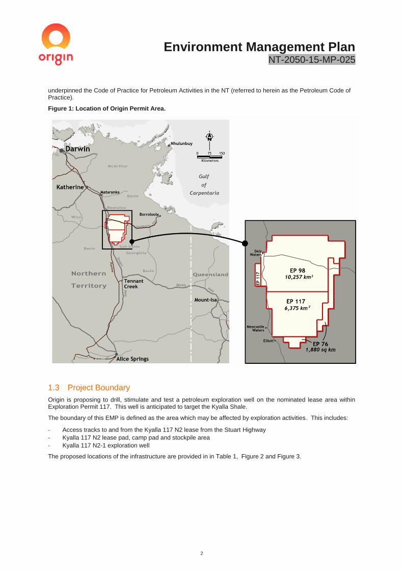
Origin holds three petroleum exploration permits in the Barkly region under the Beetaloo Joint Venture with Falcon Oil and Gas. These permits consist of EP76, EP98 and EP117 which cover 18,512 square kilometres (km2) of largely pastoral leases on the Sturt Plain, part of the Barkly Tableland, within the Northern Territory (Figure 1) and were originally granted by the NT Minister for Mines and Energy under the Petroleum Act.
Since becoming Operator of the exploration permits in 2014, Origin has drilled three vertical wells (Kyalla S-1, Amungee NW-1, Beetaloo W-1) and one horizontal well (Amungee NW-1H). A successful hydraulic fracture stimulation and production test was undertaken on the Amungee NW-1H well in 2016, highlighting the potential of the Beetaloo Sub-Basin as a future unconventional shale gas development. Upon completion of the 2016 work program, Kyalla S-1 and Beetaloo W-1 were suspended and a pressure build up monitoring program commenced at Amungee NW-1H.
New exploration activity was ceased in September 2016 when the Northern Territory Government (NTG) introduced a moratorium on hydraulic fracture stimulation of unconventional reservoirs pending the outcome of an independent scientific inquiry.
The Inquiry handed down its Final Report to the Northern Territory Government (NTG) on Tuesday 27 March 2018. The Inquiry concluded that the risks associated with unconventional onshore shale gas extraction in the NT could be appropriately managed provided all the recommendations were adopted and implemented. The NTG subsequently accepted all 135 recommendations and announced the lifting of the moratorium on 17 April 2018. Of the 135 recommendations, 35 were required to be implemented prior to the commencement of exploration, with the remaining recommendations required to be implemented prior to the commencement of production.
This EMP forms the basis of Origin’s application to the DENR for the drilling, stimulation and well testing of a petroleum exploration well on the Kyalla 117 N2 lease pad within Origin’s exploration permits. The plan provides a detailed description of how Origin proposes to manage the environmental impacts and risks associated with its activities, including how it will address its regulatory obligations and relevant Inquiry recommendations that have
Environment Management Plan NT-2050-15-MP-025
2
underpinned the Code of Practice for Petroleum Activities in the NT (referred to herein as the Petroleum Code of Practice).
Figure 1: Location of Origin Permit Area.
1.3 Project Boundary
Origin is proposing to drill, stimulate and test a petroleum exploration well on the nominated lease area within Exploration Permit 117. This well is anticipated to target the Kyalla Shale.
The boundary of this EMP is defined as the area which may be affected by exploration activities. This includes:
- Access tracks to and from the Kyalla 117 N2 lease from the Stuart Highway
- Kyalla 117 N2 lease pad, camp pad and stockpile area
- Kyalla 117 N2-1 exploration well
The proposed locations of the infrastructure are provided in in Table 1, Figure 2 and Figure 3.

Environment Management Plan NT-2050-15-MP-025
3
Table 1: Kyalla 117 N2 location.
Exploration
Permit
Infrastructure
Name Station Zone*
Approx.
Easting
Approx.
Northing
EP117 Kyalla 117 N2
Exploration well Hayfield/Shenandoah 53 356175 8137500
EP117 Temporary
camp Hayfield/Shenandoah 53 356448 8137813
* Universal Transverse Mercator (UTM) geographic coordinate system is Geocentric Datum of Australia (GDA) 94.
1.4 Project Proponent
The proponent for the project is Origin as the Operator. The key Operator contacts for this plan are provided below. Origin representatives can be contacted on 1800 052 630 or [email protected]
Name Title
Tracey Boyes General Manager- Beetaloo and
Growth Assets
Matthew Hanson Project and Operations Manager
Stephanie Stonier Corporate Affairs Manager
(Northern Australia)
Matt Kernke Environment Specialist

Environment Management Plan NT-2050-15-MP-025
4
Figure 2: Location of proposed activities within Origin’s exploration tenure.

Environment Management Plan NT-2050-15-MP-025
1
Figure 3 Zoomed in site layout of the Kyalla 117 N2 well

Environment Management Plan NT-2050-15-MP-025
1
1.5 Broader Exploration Project
Origin’s Beetaloo Basin Project is in the early stages of exploration and appraisal. Future activities are focused on proving the technical and commercial viability of the resource through the strategic placement of wells within the most prospective areas and / or formations.
As illustrated in Figure 4, Origin is in the early stages of its nine-well exploration program which is intended to better understand the potential of the resource including the technical and commercial viability of the underlying source rocks. The Kyalla 117 N2 lease pad and associated infrastructure will be constructed to enable the drilling, stimulation and well testing of a petroleum exploration well. This well is planned to be drilled in 2019 targeting the Kyalla shale and is referred to as the Kyalla 117 N2-1 well. The drilling of additional exploration wells within Origin’s Beetaloo Exploration tenure will be informed by the well results of the 2019 campaign.
In addition to the potential environmental risks covered under this plan, broader considerations of the cumulative impacts and emergency conditions associated with future drilling and stimulation activities have been included in this assessment.
Figure 4: Conceptual Beetaloo Basin project pathway from exploration to development.
2 Environmental Legislation and other Requirements
In the NT, the granting and administration of exploration permits and associated petroleum activities rests with the Minister for Primary Industry and Resources under the Petroleum Act. In order to commence an activity or a stage of an activity which is carried out, or proposed to be carried out, in connection with a technical work program for a petroleum interest and that has, or will have, an environmental impact or environmental risk (a regulated activity), an Environment Management Plan (EMP) must be approved by the Minister for Environment and Natural Resources in accordance with the Petroleum (Environment) Regulations.
Alongside the EMP assessment and approval process under the Petroleum (Environment) Regulations, the Northern Territory Environment Protection Authority (NT EPA) administers the Environmental Assessment Act 1982; which allows for proposals to be assessed as to whether a proposal has the potential to have a significant effect on the environment and if so, whether assessment by way of Public Environmental Report or Environmental Impact Statement is required.
Key Northern Territory and Commonwealth legislation, agreements, operating consents, guidelines and codes of practice are relevant to the activities described in this EMP are summarised in Table 2, Table 3 and Table 4. This EMP has been prepared having regards to these.

Environment Management Plan NT-2050-15-MP-025
2
Table 2: Key Legislation.
NT Legislation Administered By:
Petroleum Act 1984, Petroleum (Environment) Regulations 2016
- Provides a framework for petroleum exploration and development to occur within
the Territory.
- Requires that petroleum activities are carried out in an ecologically sustainable
manner and the environmental impacts and environmental risks of the activities
are identified and reduced to an acceptable level.
- Sets out the requirements for environmental management plans, which includes
the Code of Practice for Petroleum Activities in the Northern Territory.
- Considered when developing this EMP.
Department of
Primary Industry
and Resources
(Petroleum Act) and
Department of
Environment and
Natural Resources
Petroleum
(Environment)
Regulations
Aboriginal Land Act 1978
- Provides for access to Aboriginal land, certain roads bordered by Aboriginal land
and the seas adjacent to Aboriginal land.
- Provides that a person shall not enter onto or remain on Aboriginal land or use a
road unless he has been issued with a permit to do so in accordance with Part II
Entry onto Aboriginal land of the Act.
- The Land Council for the area in which Aboriginal land or a road is situated may
issue a permit to a person to enter onto and remain on that Aboriginal land or use
that road subject to such conditions as the Land Council thinks fit.
Land Council
established by or
under the Aboriginal
Land Rights
(Northern Territory)
Act 1976 of the
Commonwealth
Biological Control Act 1986
- Provides for the biological control of pests in the NT and related purposes.
Department of
Primary Industry
and Fisheries
Bushfires Management Act 2016 and Associated Regulations
- Provides for the protection of life, property and the environment through the
mitigation, management and suppression of bushfires, and for related purposes.
- Considered when preparing management plans.
Bushfires NT,
Department of
Environment and
Natural Resources
Control of Roads Act 1953
- The use of any road bores or construction within road corridors will require a
permit to work within a road reserve from the Department of Transport.
- The increase in traffic will need to be assessed in accordance with this instrument
to ensure the impacts to the Territory road network are minimised.
Department of
Infrastructure,
Planning and
Logistics
Environmental Assessment Act 1982 and Associated Regulations
- Provides for the assessment of the environmental effects of development
proposals and the environment.
- Ensures to the greatest extent practicable that each matter which could
reasonably have a significant effect on the environment is fully examined and
considered.
- Defines environment as being “all aspects of the surroundings of man including
the physical, biological, economic, cultural and social aspects”.
Northern Territory
Environmental
Protection
Authority,
Department of
Environment and
Natural Resources
Heritage Act 2011 and Associated Regulations
Protects the Northern Territory’s cultural and natural heritage.
- Sets out the process for getting permission to do work to heritage places.
- Declares classes of places and objects of heritage significance to be protected.
- Provides for heritage agreements to encourage the conservation, use and
management of heritage places and objects.
- Regulates work on heritage places and objects.
- Potential heritage places are identified in desktop assessments and field scouting
during site selection.
Heritage Branch,
Department of
Tourism and
Culture
Northern Territory Aboriginal Sacred Sites Act 1989 and Associated Regulations
AAPA certificates for all exploration activities must be obtained prior to approval on an
EMP. The Legislation establishes a procedure for the protection and registration of
sacred sites, through:
Aboriginal Areas
Protection Authority
(AAPA);

Environment Management Plan NT-2050-15-MP-025
3
NT Legislation Administered By:
• providing entry onto sacred sites and the conditions to which such entry is
subject
• procedures for avoidance of sacred sites when developing and using land
• establishing an Authority for the purposes of the Act
• procedures for the review of decisions of the Authority by the Minister, and
for related purposes.
Minister for Environment and Natural Resources
Public and Environmental Health Act 2011 and Associated Regulations
- Outlines requirements for camps, specifically waste and wastewater (sewage and
greywater) management.
- Provides conditions preventing pollution of watercourses and water supplies in the
Northern Territory. Wastewater treatment systems may be subject to requirements
under the Public Health Act and regulations.
Department of
Health
Territory Parks and Wildlife Conservation Act 1976 and Associated Regulations
- Provides for the protection, conservation and sustainable utilisation of wildlife.
- Provides protection of listed threatened species for which Origin must consider
whether its activities have the potential to impact directly or indirectly on a listed
threatened species or place covered under this Act.
Parks Wildlife and
Heritage Division of
the Department of
Tourism Sport and
Culture.
Transport of Dangerous Goods by Road and Rail (National Uniform Legislation)
Regulations 2011
- Regulations stipulating the transportation requirements for dangerous goods by
road and rail.
- Includes licencing, signage, spill management and reporting requirements during
chemical transportation.
- Any chemical transported for drilling and stimulation activities will need to comply
with this instrument.
NT Worksafe,
Department of the
Attorney-General
and Justice
Waste Management and Pollution Control Act 1998 and Associated Regulations
- Provides for the protection of the environment through encouragement of effective
waste management and pollution prevention and control practices and for related
purposes.
- Provides classification of listed wastes under Schedule 2 of the Waste Management and Pollution Control (Administration) Regulations 1998
- Provides for licencing requirements for the transport, storage and disposal of listed
wastes
- The transport and disposal of wastes during drilling and stimulation activities will
be undertaken by licenced transporters and disposed of in accordance with this
Act.
Northern Territory
Environmental
Protection
Authority,
Department of
Environment and
Natural Resources
Water Act 1992
- Provides for the investigation, allocation, use, control, protection, management
and administration of water resources, including extraction of groundwater, waste
water management and water pollution.
- Provides for water allocation plans, beneficial uses within Water Control Districts,
drilling licences, bore construction permits, water extraction licences, waste
discharge licences, fees and charges, and penalties for offences against the Act.
- Prohibits the disposal of petroleum exploration wastewater to surface waters and
reinjection.
- Water extraction licence must be obtained prior to using groundwater for drilling,
stimulation and all other ancillary activities within a water control district.
Water Resources
Division,
Department of
Environment and
Natural Resources
Weeds Management Act 2001
- Protects the Northern Territory's economy, community, industry and environment
from the adverse impact of weeds.
- Identifies declared weeds (those which must be controlled) and provides a
framework for weed management.
Weed Management
Branch, Department
of Environment and
Natural Resources

Environment Management Plan NT-2050-15-MP-025
4
NT Legislation Administered By:
- Weed Management Plan are developed with the reference to this Act.
Work Health and Safety (National Uniform Legislation) Act 2011
- Provides for a balanced and nationally consistent framework to secure the health
and safety of workers and workplaces.
- Includes requirements for hazardous chemical assessments, hazardous chemical
register, access to safety data sheets, labelling, and the use, handling, generation
and storage of hazardous chemicals at a workplace.
NT WorkSafe,
Department of the
Attorney-General
and Justice
Commonwealth Legislation Administered By:
Aboriginal and Torres Strait Islander Heritage Protection Act 1984
- Provides for the preservation and protection of places, areas and objects from
injury or desecration of particular significance to Aboriginal people in accordance
with Aboriginal tradition.
Department of the
Environment and
Energy
Aboriginal Land Rights (Northern Territory) Act 1976
- Provides for the granting of Traditional Aboriginal Land in the Northern Territory for
the benefit of Aboriginal people, and for other purposes.
Department of
Prime Minister and
Cabinet
Environment Protection and Biodiversity Conservation Act 1999
- Provides for the protection of the environment and conservation of biodiversity,
particularly species and places of national significance.
- Invoked only if a development is likely to have impacts on Matters of National
Environmental Significance (MNES).
- During the development of this EMP, an assessment is undertaken to determine
the potential impact on MNES.
Department of the
Environment and
Energy
National Greenhouse and Energy Reporting Act 2007
- An Act to provide for the reporting and dissemination of information related to
greenhouse gas emissions, greenhouse gas projects, energy consumption and
energy productions of corporations.
- All energy consumption and Greenhouse data used/generated as a result of this
activity must be reported in accordance with this act.
Department of the
Environment and
Energy
Native Title Act 1993
- Provides for the recognition and protection of native title for Indigenous peoples.
- Establishes ways in which future dealings affecting native title may proceed and to
set standards for those dealings
- Exploration activities on land subject to Native Title must obtain approval prior to
commencement.
Prime Minister and
Cabinet
Table 3: Codes of Practice and Relevant Guidelines.
Codes of Practice
Code of Practice for on-site Wastewater Management (NT Department of Health, 2014)
Code of Practice stipulating approved sewage and sullage treatment devices and practices within the NT.
Sewage and sullage produced and disposed of from the camps must be undertaken in accordance with the
Code. Code of Practice for Petroleum Activities in the Northern Territory
- Mandatory Code of Practice for the petroleum industry to ensure that petroleum activities in the Northern
Territory are managed according to minimum acceptable standards to ensure that risks to the
environment can be managed to a level that is as low as reasonably practicable (ALARP) and acceptable.
Guidelines

Environment Management Plan NT-2050-15-MP-025
5
API Guidance Document – HF3, Practices for Mitigating Surface Impacts Associated with Hydraulic
Fracturing
- This guidance document promotes practices that minimise — potential impacts on surface water, soils,
wildfire, other surface ecosystems and nearby communities — associated with hydraulic fracturing
operations. associated with drilling and stimulation activities.
API Guidance Document – HF1, Hydraulic Fracturing Operations- Well construction and Integrity
Guidelines
- Guidance document providing recommended industry practices for well construction and integrity for
wells that will be hydraulically fractured so that shallow groundwater aquifers and the environment are
protected.
AS 1940: The storage and handling of flammable and combustible liquids, 2004
- Provides guidance for the operation and handling of flammable and combustible liquids.
Best Practice Erosion and Sediment Control (International Erosion Control Association, 2008)
- Facilitates the identification of those issues that should be considered when formulating and evaluating
strategies for best practice erosion and sediment control.
- Facilitates best practice stormwater management.
- Facilitates active avoidance or minimisation of soil erosion resulting from construction activities.
- Facilitate best practice soil and sediment control management on sites.
- Erosion and sediment Control Plan covering petroleum exploration activities are developed in accordance
with these guidelines.
Bores, drilling and dams
- Provides information on water drilling licences, bore construction permits, licensed drillers and other
information regarding drilling water bores in the N; applicable for the construction of both groundwater
monitoring and extraction bores.
- https://nt.gov.au/environment/waterhttps://nt.gov.au/environment/water/bores-drilling-and-dams/about-
water-drilling-licences
Guideline for Groundwater Monitoring Bores for Exploration Petroleum Wells in the Beetaloo sub-basin
(DENR 2018)
- Technical guidance for the onshore gas industry establishing the minimum expectations in relation to
groundwater monitoring requirements.
- Requires the establishment of control and impact monitoring bores prior to undertaking stimulation
activities.
- Provides requirements to complete monitoring prior to and post stimulation.
- 6 months of groundwater baseline monitoring data prior to commencing stimulation activities.
Commonwealth Workplace Health and Safety Act model Codes of Practice
Various codes of practice covering the use and management of hazards associated with chemical handling.
These provide a minimum level of controls to minimise the exposure of workers to chemicals in the workplace.
These guidelines include:
- Model Code of Practice: Labelling of workplace hazardous chemicals
- Model Code of Practice: Managing risks of hazardous chemicals in the workplace
These codes are referenced in the NT Work Place Health and Safety Legislation.
All Origin’s contractors undertaking drilling and stimulation activities will be required to comply with these
codes of practice.
ISO 31000 Risk management- Principles and guidelines
- This international standard provides a standardised to identify, assess and manage risk.
- Assessment of risk in EMP’s shall be undertaken in alignment with this guideline
ISO 19011: Guidelines for auditing management systems, 2018
- Provides guidance on environmental auditing to a certifiable standard.
Minimum Construction Requirements for Water Bores in Australia (National Water Commission, 2012)
- Developed by the National Uniform Drillers Licensing Committee, this document outlines the minimum
requirements for constructing, maintaining, rehabilitating, and decommissioning water bores in Australia.

Environment Management Plan NT-2050-15-MP-025
6
Northern Territory Land Clearing Guidelines (NRETAS, 2019)
- All clearing for petroleum activities must be carried out in accordance with Land Clearing Guidelines.
Northern Territory Noise Management Framework Guideline (NT EPA, 2018)
- Provides guidance to the community and industry about the noise regulatory framework as it applies in
the NT.
Northern Territory Non-urban water metering code of practice
- Code of practice outlining the requirements for water meters on ground water bores in the Territory.
- All groundwater take must be measured and recorded in accordance with this code of practice
Weed Management Planning Guide - Onshore Shale Gas Development Projects (DENR, 2018)
- Provides guidance to the industry about the weed management planning required to undertake Onshore
Shale Gas Developments in the NT.
Table 4: Relevant agreements and operating consents.
Agreements Administered By:
Native Title Petroleum Exploration Agreement (between the Host Traditional
Owners and Origin Energy [Falcon Oil and Gas])
- Includes clauses for the protection of sacred sites, objects and sensitive areas
related to Aboriginal activities in the area, including cultural, hunting and foraging
activities. Site clearance will occur prior to any on ground activities. The Native Title
Agreement also includes clauses for the protection of the environment and
rehabilitation.
Northern Land
Council
AAPA Certificates
- The most current clearance certificates issued for the Origin exploration program as
referenced within this EMP.
Aboriginal Areas
Protection
Authority
Access Agreement
- A negotiated access agreement formed between a resource company and a private
pastoralist relating to the rights over ‘access land’.
DPIR
Apply for permit to work within a road reserve
- Road bores are usually used for road construction and maintenance work,
however, application to access water in the bores can be made to the Department
of Infrastructure, Planning and Logistics for approval. All take would require a
Water Extraction Licence under the Water Act 1992.
- Approval to access the bore will be dependent on the bore having sufficient
capacity to meet future needs for road construction and maintenance.
Department of
Infrastructure,
Planning and
Logistics (DIPL)
Water Extraction licence
- Under the NT Water Act 1992, a water extraction licence is required for the use of
groundwater for petroleum exploration activities within the Daly Roper Beetaloo
Water Control District.
Department of
environment and
Natural Resources
Water Resources
Division
2.1.1 NT Environmental Assessment Act
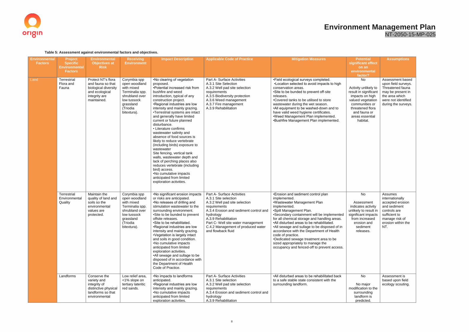
In the NT, proposed actions that have the potential to have a significant effect on the environment require Environmental Impact Assessment (EIA) under the Environmental Assessment Act. In such cases, a Notice of Intent (NOI) is required to be submitted to the NT Environmental Protection Agency outlining the relevant information to allow a decision on whether the proposed action requires a Public Environmental Report (PER) or an Environmental Impact Statement (EIS). Where the environmental impacts of the proposed activity are not significant, a PER or EIS will not be required. An assessment of whether the proposed activity requires a NOI was undertaken in accordance with the NT Referring a Proposal to the NT EPA guideline. A summary of the relevant environmental factors is included in Table 5.

Environment Management Plan NT-2050-15-MP-025
7
No significant impacts on any of the NT environmental factors and objectives are anticipated. Origin does not believe the activity is required to be assessed under the Environmental Assessment Act.
2.1.2 Commonwealth Environment Protection and Biodiversity Conservation Act
Under the Commonwealth Environment Protection and Biodiversity Conservation Act 1997 (EPBC) an action that has, will have or is likely to have a significant impact on Matters of National Environmental Significance (MNES), must be referred to the Australian Government Minister for the Environment (the Minister) for assessment. A self-assessment in accordance with the EPBC Act was undertaken under this EMP. The environment and heritage assessment confirmed that no significant impacts to EPBC-listed threatened species, threatened ecological communities or migratory species were likely. The proposed program will not require referral under the EPBC Act.
Environment Management Plan NT-2050-15-MP-025
8
Table 5: Assessment against environmental factors and objectives.
Environmental Factors
Project Specific
Environmental Factors
Environmental Objectives at
Risk
Receiving Environment
Impact Description Applicable Code of Practice Mitigation Measures Potential significant effect
on an environmental
factor?
Assumptions
Land Terrestrial Flora and Fauna
Protect NT's flora and fauna so that biological diversity and ecological integrity are maintained.
Corymbia spp open woodland with mixed Terminalia spp. shrubland over low tussock grassland (Triodia bitextura).
•No clearing of vegetation proposed. •Potential increased risk from bushfire and weed introduction, typical of any construction project. •Regional industries are low intensity and mainly grazing. •Terrestrial systems are intact and generally have limited current or future planned disturbance. • Literature confirms wastewater salinity and absence of food sources is likely to reduce vertebrate (including birds) exposure to wastewater Site fencing, vertical tank walls, wastewater depth and lack of perching places also reduces vertebrate (including bird) access. •No cumulative impacts anticipated from limited exploration activities.
Part A- Surface Activities A.3.1 Site Selection A.3.2 Well pad site selection requirements A.3.5 Biodiversity protection A.3.6 Weed management A.3.7 Fire management A.3.9 Rehabilitation
•Field ecological surveys completed. •Location selected to avoid impacts to high conservation areas. •Site to be bunded to prevent off-site releases. •Covered tanks to be utilised to store wastewater during the wet season. •All equipment to be washed-down and to have valid weed hygiene certificates. •Weed Management Plan implemented. •Bushfire Management Plan implemented.
No
Activity unlikely to result in significant
impacts on high valued vegetation communities or threatened flora
and fauna or areas essential
habitat.
Assessment based upon field surveys. Threatened fauna may be present in the area which were not identified during the surveys.
Terrestrial Environmental Quality
Maintain the quality of land and soils so the environmental values are protected.
Corymbia spp open woodland with mixed Terminalia spp. shrubland over low tussock grassland (Triodia bitextura).
•No significant erosion impacts or risks are anticipated. •No releases of drilling and stimulation wastewater to the surrounding environment. •Site to be bunded to prevent offsite releases. •Site to be rehabilitated. •Regional industries are low intensity and mainly grazing. •Vegetation is largely intact and soils in good condition. •No cumulative impacts anticipated from limited exploration activities. •All sewage and sullage to be disposed of in accordance with the Department of Health Code of Practice.
Part A- Surface Activities A.3.1 Site selection A.3.2 Well pad site selection requirements A.3.4 Erosion and sediment control and hydrology A.3.9 Rehabilitation Part C- Well site water management C.4.2 Management of produced water and flowback fluid
•Erosion and sediment control plan implemented. •Wastewater Management Plan implemented. •Spill Management Plan. •Secondary containment will be implemented for all chemical storage and handling areas. •All disturbed areas to be rehabilitated. •All sewage and sullage to be disposed of in accordance with the Department of Health code of practice. •Dedicated sewage treatment area to be sized appropriately to manage the occupancy and fenced-off to prevent access.
No
Assessment indicates activity
unlikely to result in significant impacts
from increased erosion and
sediment releases.
Assumes internationally accepted erosion and sediment controls are sufficient to manage risk of erosion within the NT.
Landforms Conserve the variety and integrity of distinctive physical landforms so that environmental
Low relief area, <1% slope on tertiary lateritic red sands.
•No impacts to landforms anticipated. •Regional industries are low intensity and mainly grazing. •No cumulative impacts anticipated from limited exploration activities.
Part A- Surface Activities A.3.1 Site selection A.3.2 Well pad site selection requirements A.3.4 Erosion and sediment control and hydrology A.3.9 Rehabilitation
•All disturbed areas to be rehabilitated back to a safe stable state consistent with the surrounding landform.
No
No major modification to the
surrounding landform is predicted.
Assessment is based upon field ecology scouting.

Environment Management Plan NT-2050-15-MP-025
9
Environmental Factors
Project Specific
Environmental Factors
Environmental Objectives at
Risk
Receiving Environment
Impact Description Applicable Code of Practice Mitigation Measures Potential significant effect
on an environmental
factor?
Assumptions
values are protected.
Water
Aquatic Ecosystems
Protect aquatic ecosystems to maintain the biological diversity of flora and fauna and the ecological functions they perform.
•Located ~200km from any Groundwater Dependent Ecosystems (GDEs). • Activity not located within close proximity to any major flow paths, wetlands or permanent watercourses.
•No significant impacts or risks anticipated. •Regional industries are low intensity and mainly grazing. •Limited pressure on existing systems. • All sewage and sullage to be disposed of in accordance with the Department of Health Code of Practice •Cumulative impacts associated with water extraction assessed by DENR as a part of Water Extraction Licence. No cumulative impacts anticipated from limited exploration activities.
Part A- Surface Activities A.3.1 Site selection A.3.2 Well pad site selection requirements A.3.4 Erosion and sediment control and hydrology Part C- Well site water management C.4.2 Management of produced water and flowback fluid
•Groundwater extraction modelled within sustainable yields. •No surface water extraction. •No surface water discharge. •Location of lease pad away from GDEs, wetlands, permanent streams or major watercourses and flow paths. •Lease pads to be bunded, with secondary containment used on all chemical and waste storages. •Erosion and sediment control plan. •Spill Management Plan. •All sewage and sullage to be disposed of in accordance with the Department of Health Code of Practice. •Dedicated sewage treatment area to be sized appropriately to manage the occupancy and fenced-off to prevent access.
No
Activities are not anticipated to impact on the environmental
factor.
Modelling based on known and assumed properties of aquifer.
Assumes internationally accepted erosion and sediment controls are sufficient to manage risk of erosion within the NT.
Inland Water Environmental Quality
Maintain the quality of groundwater and surface water so that environmental values including ecological health, land uses, and the welfare and amenity of people are protected.
Cambrian Limestone Aquifer- Gum Ridge Formation.
•38ML extraction of groundwater from the Gum Ridge formation. •No significant impacts or risks on pastoralist bores from groundwater extraction anticipated. •Camp sewage and grey water to be irrigated to adjacent areas is accordance with Department of Health Code of Practice. •Regional industries are low intensity and mainly grazing. •Limited pressure on existing systems. •Cumulative impacts associated with water extraction assessed by DENR as a part of Water Extraction Licence. No cumulative impacts anticipated from limited exploration activities.
Part A- Surface Activities A.3.1 Site selection A.3.2 Well pad site selection requirements A.3.8 Containment of contaminants Part B Well operations B.4.1 Well integrity management B4.2 Aquifer protection B.4.3 Well design and barriers B.4.10 Drilling fluids B.4.12 Hydraulic stimulation and flowback operations B.4.17 Groundwater Monitoring B.5 BTEX Limits Part C- Well site water management C.4.2 Management of produced water and flowback fluid C.5 Monitoring mandatory requirements C.7 Mandatory requirements for management plans for wastewater and spills
•All groundwater take to be licenced with yield within sustainable recharge levels. •Groundwater take will be monitored using an approved water flow meter. •Control and impact monitoring bores located surrounding the exploration lease. •All chemical and wastewater storages to have secondary containment. •Spill Management Plan implemented. •Wastewater Management Plan. •Lease pads to be bunded. •All camp sewage and grey water disposal to be undertaken in demarcated irrigation areas in compliance with Department of Health guidelines.
No
Assessment indicates activity
unlikely to result in significant impacts
to groundwater.
Assessment based on hydrological information collected during water bore drilling and assumed transmissivity and storage values.
Hydrological processes
Maintain the hydrologic regimes of groundwater and surface water so that environmental
•Cambrian Limestone Aquifer- Gum Ridge Formation • Activity not located within close proximity
•38ML extraction of groundwater from the Gum Ridge Formation. •No significant impacts or risks anticipated. •Regional industries are low intensity and mainly grazing.
Part A- Surface Activities A.3.1 Site selection A.3.2 Well pad site selection requirements A.3.4 Erosion and sediment control and hydrology A.3.8 Containment of contaminants
•Groundwater extraction modelled within sustainable yields. •All groundwater take to be licenced with yield within sustainable recharge levels. •Groundwater take will be monitored using an approved water flow meter. •No surface water extraction.
No
Assessment indicates activity
unlikely to result in significant impacts
Modelling based on known and assumed properties of aquifer.

Environment Management Plan NT-2050-15-MP-025
10
Environmental Factors
Project Specific
Environmental Factors
Environmental Objectives at
Risk
Receiving Environment
Impact Description Applicable Code of Practice Mitigation Measures Potential significant effect
on an environmental
factor?
Assumptions
values are protected.
to any major flow paths, wetlands or permanent watercourses.
•Cumulative impacts associated with water extraction assessed by DENR as a part of Water Extraction Licence. No cumulative impacts anticipated from limited exploration activities.
B.4.17 Groundwater Monitoring C.4.2 Management of produced water and flowback fluid C.5 Monitoring mandatory requirements C.7 Mandatory requirements for management plans for wastewater and spills
•Location of lease pad away from GDE’s, wetlands, permanent streams or major watercourses and flow paths. •Design of lease pads to avoid impacts to overland flow. •Lease pads to be bunded.
to groundwater or surface water.
Air
Air Quality and Greenhouse Gases
Maintain air quality and minimise emissions and their impact so that environmental values are protected.
Rural environment with minimal industrial or urban inputs.
No significant impacts or risks anticipated with activity specific and cumulative emissions unlikely to materially increase the GHG emissions of the Northern Territory.
Part A- Surface Activities A.3.1 Site selection Part D- Methane emissions monitoring, leak management, detection and reporting D.4 Regional methane monitoring D.5 Emissions detection and management D.6 Reporting
• Activity intensity low, with no local sensitive receptors within 20km. •Dust suppression to be utilised to minimise dust generation. •Equipment to be compliant with relevant pollution control device requirements and maintained to minimise emissions. • A Methane Emissions Management Plan implemented. •A reduced emission completion to be implemented as per NT Code of Practice. •All flaring and venting to be reported as per the National Greenhouse and Energy Reporting Scheme and Petroleum Codes of Practice. •Limited regional sources likely to cause cumulative impacts.
No
Assessment indicates activity
unlikely to result in significant impacts
to air quality of greenhouse gas
generation.
Estimates of greenhouse gas generation using estimates from Transport Authorities Greenhouse Group.
People and communities
Social, economic and cultural surroundings
Protect the social, economic, cultural and heritage values of the Northern Territory.
Rural communities, pastoralists and Traditional Owners.
•Limited impact on regional communities due to limited nature of exploration activities. •NLC and AAPA clearances obtained prior to undertaking activities. •Activities located away from communities, with workers based at camps on-site; limited competition with tourism operators. •Short (days) increased traffic during equipment mobilisation consistent with existing regional transport (freight) and mining industries. •Prioritisation of use of local employment and services. •Labour competition with local pastoralists minimal due to limited activities proposed and specialised nature of drilling and stimulation activities. •Engagement with local accommodation providers to inform them of future work programs and potential accommodation demand.
Part A- Surface Activities A.3.1 Site selection A.3.2 Well pad site selection requirements
• The use of NT businesses and Indigenous employment has been prioritised. •Stakeholder Engagement Plan implemented. • Land access approvals. •NLC clearances and AAPA certificates for activities. •Activity is limited in scope and nature with no booms or busts anticipated. •Traffic impact Assessment Completed and submitted to DIPL.
No
Low intensity activity not
anticipated to have significant impacts to the
local community or tourism.
All relevant Traditional Owners are engaged by NLC.

Environment Management Plan NT-2050-15-MP-025
11
Environmental Factors
Project Specific
Environmental Factors
Environmental Objectives at
Risk
Receiving Environment
Impact Description Applicable Code of Practice Mitigation Measures Potential significant effect
on an environmental
factor?
Assumptions
Human health Ensure the risks to human health are identified, understood and adequately avoided and /or mitigated.
Remote rural environment.
•No impact to human health anticipated from activities from drilling, stimulation and well testing activities. •A reduced emission completion to be used to minimise GHG and pollutant generation. •Limited regional sources unlikely to cause cumulative impacts.
Part D- Methane emissions monitoring, leak management, detection and reporting D.4 Regional methane monitoring D.5 Emissions detection and management D.6 Reporting
•Low intensity activity with nuisance (dust) likely to be the main issue associated with vehicle and equipment movement. •Closest receptor 20km from activity. •Flaring used to reduce pollutants associated with venting. Chemical risk assessment
No
Low intensity activity with limited
receptors.
None
Environment Management Plan NT-2050-15-MP-025
12
2.2 The Inquiry
On 17 April 2018, the NT Government announced the lifting of the moratorium on hydraulic fracturing of onshore unconventional gas reservoirs within the NT. The lifting of the moratorium was made with the endorsement of the 135 recommendations handed down by the Inquiry. Of these recommendations, 35 were required to be implemented before the commencement of further exploration activities. The remainder are required to be implemented prior to production approvals being granted.
One of the key recommendations of the Inquiry was the development of a series of Codes of Practice that prescribe minimum requirements for undertaking onshore unconventional gas activities.
These Petroleum Codes of Practice have been drafted and have been considered in the development of this EMP.
2.3 Alignment with the Principles of Ecologically Sustainable Development (ESD)
This EMP is consistent with the principles of ESD through the adoption of responsible practices that are designed to maximise social benefit, whilst minimising the level of impact on the surrounding ecosystems. The ESD principles as defined in the Petroleum (Environment) Regulations are as follows:
• Decision-making processes should effectively integrate both long-term and short-term economic, environmental, social and equitable considerations;
• If there are threats of serious or irreversible environmental damage, lack of full scientific certainty should not be used as a reason for postponing measures to prevent environmental degradation;
• The principle of inter-generational equity – that the present generation should ensure that the health, diversity and productivity of the environment is maintained or enhanced for the benefit of future generations;
• The conservation of biological diversity and ecological integrity should be a fundamental consideration in decision-making; and,
• Improved valuation, pricing and incentive mechanisms should be promoted.
Origin’s exploration activities align with the principles of ESD through the following:
• The exploration activities are an essential step in defining a potential future commercial resource which
can generate sustainable, long-term benefits to the local community, to the Barkly region generally and
more broadly into the rest of the NT.
• Complying with Petroleum Codes of Practice and industry best practice to reduce any risk to the
environment and communities to an acceptable level. Noting the Inquiry Panel’s Final Report Statement
that “provided that all of the recommendations made in this Report are adopted and implemented in their
entirety, not only should the risks associated with an onshore shale gas industry be minimised to an
acceptable level, in some instances, they can be avoided altogether.” (Scientific Inquiry into Hydraulic
Fracturing in the Northern Territory 2018);
• The activities that are the subject of the EMP do not constitute threats of serious or irreversible
environmental damage and there is no impact on the conservation of biological diversity and ecological
integrity;
• Beyond royalty payments to the NT Government (as owner of the natural resource), and payments to
Native Title Holders (as per Exploration Agreements) and host pastoralists (as per Access and
Compensation Agreements), Origin seeks to maximise broad-based local participation in education,
training, employment and enterprise opportunities engendered by its presence;
• Prioritising the use of local employment to deliver exploration activities;
• Obtaining sacred site clearances from host Traditional Owners through open engagement with
custodians and the Statutory Representative body - the Northern Land Council (NLC); and,
• Obtaining Land Access Agreements with host pastoralists.
3 Description of the regulated activity
The following section provides a description of the activities associated with the drilling, stimulation and well testing of the proposed Kyalla 117 N2 exploration well. This includes:

Environment Management Plan NT-2050-15-MP-025
13
• exploration well drilling
• water bore drilling
• hydraulic fracture stimulation
• well completion and testing
• well suspension and decommissioning
• construction and operation of a temporary camp
• maintenance and monitoring works
Additional land clearing is not proposed under this EMP. All activities will be undertaken in existing disturbed areas approved under the Kyalla 117 N2 Civil Construction EMP NT-2050-15-MP 026.
A description of each of the proposed activities is provided in the following section along with the management strategies for certain environmental aspects.
An overview of the activity schematics and engineering detail is provided in Appendix A.
3.1 Site Selection- Kyalla 117-N2 Pad
The location of the proposed activity (specifically the exploration well lease and camp pads) has been chosen to
minimise any risk associated with the drilling, stimulation and well testing activities. Field ecological and cultural
heritage clearances were obtained for the proposed sites to ensure avoidance of the following areas:
• high conservation value;
• high habitat value;
• water courses or major overland flow paths;
• areas of cultural significance;
• sensitive receptors (homestead and communities);
• existing pastoralist groundwater extraction bores; and,
• major roads.
A copy of the Land Condition Assessment is provided in Appendix B. The site is located in Corymbia low
woodland/Terminalia (mixed) sparse shrubland/Chrysopogon (mixed) low tussock grassland. This vegetation
community is regionally extensive and not threatened.
Approximate separation distances to the nearest environmental and community receptors is illustrated in Figure 5
and includes:
• 16km from the closest pastoralist bore;
• 20km from the Stuart Highway;
• 21km from the nearest homestead;
• 28km from Frew Ponds
• 29km from the nearest community (Dunmarra);
• 71km from the closest conservation area (Bullwaddy Conservation area);
• 50 km from the closest major watercourse (Newcastle Creek).
• 92 km from Lake woods (direct)
Controls:
✓ Land Condition Assessment completed to identify and avoid constraints, including field ecology and cultural heritage surveys.
✓ Infrastructure located to avoid: o Areas of high conservation or habitat value, along with areas of cultural significance. o Interfering with surface water flow pathways, drainage lines and water courses. o Impacts to visual amenity. o Impacts on pastoral leaseholders and Traditional Owners. o Groundwater extraction bores.

Environment Management Plan NT-2050-15-MP-025
14
Figure 5 Kyalla 117 N2 proximity to sensitive receptors
20km
Environment Management Plan NT-2050-15-MP-025
15
3.2 Exploration well drilling
3.2.1 Well design
Well design is the first step in ensuring the integrity for a proposed well. Origin’s subsurface team, (geologists, geophysicists and petroleum engineers) summarise the key information and data required by the drilling engineers to design the well. This forms the Basis of Well Design (BOWD).
Critical inputs into the BOWD include:
• downhole formations that need to be isolated (i.e. aquifers) or hydrocarbon-bearing zones that could be encountered during drilling operations.
• the subsurface well objective (production and / or reservoir evaluation).
• the fracture gradient, which describes how much pressure is required to fracture a specific formation.
• the pore pressure, which is the in-situ fluid pressure within a reservoir.
• other conditions that may affect the integrity of the well (formation fluid composition, stress regime etc.).
The BOWD is used in combination with the requirements outlined in the NT Petroleum CoP, Petroleum Regulations and Origin’s internal standards to develop an appropriate well design that ensures well integrity is maintained throughout the life of the well and addresses all regulatory and risk management requirements.
The design process includes the definition of Well Acceptance Criteria (WAC). WAC are critical thresholds that are tested during well construction and typically form components of the well barrier envelope. The barrier envelope is the combination of one or more well barrier elements that are combined to prevent uncontrolled flow of fluids and hydrocarbons into another formation, or to escape at surface. The WAC must be met or exceeded to confirm well integrity before proceeding to the next phase of well construction or operation. If a well WAC is not achieved, an approved remedy and / or risk assessment must be in place prior to moving forward with operations.
The well design and WAC form a critical part of the Well Operations Management Plan (WOMP) which is a regulatory document that summarises how each well will comply with the required standards from the design to decommissioning of a well. This document is prepared and submitted to DPIR for approval prior to the commencement of any drilling and stimulation activities.
Controls:
✓ Each well is designed in accordance with the NT Petroleum Code of Practice and Origin Standards to ensure well integrity is maintained.
✓ Well Acceptance Criteria is in place to verify all well barriers ✓ Wells are designed to meet the anticipated physical and chemical conditions likely to be encountered. ✓ A WOMP is prepared and submitted to DPIR prior to undertaking drilling activities. The WOMP
summarises how the wells maintain integrity for the life of the well, including aquifer protection. A table of the WOMP drilling requirements and Origin’s implementation summary is provided in Appendix S

Environment Management Plan NT-2050-15-MP-025
16
Figure 6: Proposed Kyalla 117 N2-1 well schematic.

Environment Management Plan NT-2050-15-MP-025
17
3.2.2 Site Preparation
A drilling rig package comprises the main rig, as well as the supporting vehicles, equipment and facilities outlined below:
• Drilling rig, comprising a rig floor, a mast or derrick, rig engine, Blow Out Preventer (BOP) system and
cat walk
• Pipe rack for storing drill pipe and casing and potentially a pipe arm, which is a piece of equipment
designed to bring the pipe and casing up to the drill floor
• Rig fluid system, including tanks (water and mud), shakers, mud treatment system and pipes for storing
and pumping fluids down the drill string
• Storage trailers and racks for equipment
• Bunded chemical storage areas for mud chemicals, diesel and wastes
• Workshop
• Portable on-site offices
• Temporary accommodation housing approximately 60 persons
• Diesel power generators
• Third-party equipment such as cementing trucks, fuel trucks and wireline evaluation units
Throughout the drilling operations there will be ongoing vehicle movements, from the initial rig mobilisation to the regular interchange of drilling support services or delivery of equipment. Drilling operations are generally a 24-hour per day operation.
The rig will be mobilised to a prepared lease pad, which has been cleared, compacted, fenced and all pits and cellars installed ready for the commencement of drilling. The lease preparation scope is covered under the Kyalla 117 N2 Civil Construction EMP NT-2050-15-MP 026. An overview of the Drilling rig lease layout is provided in Appendix A.
3.2.3 Drilling
The drill rig is initially mobilised to site and rigged-up over the cellar with a pre-installed stove pipe (non-pressure rated casing to prevent sloughing of top soil). Once functional, a 22inch top-hole section will be drilled to a depth which isolates the shallow aquifers (undifferentiated cretaceous (if present) and the Cambrian Limestone Aquifer units [Anthony Lagoons & Gum Ridge formations]) in this region. This hole section is then lined with steel casing and cemented in place and is known as the surface casing.
The top-hole section will be split into two separate sections, each individually cased and cemented (with specifically-engineered cement) to seal the aquifer off from the rest of the wellbore to prevent fluid crossflow between formations. The larger top-hole is referred to as the ‘conductor’ and smaller lower hole section is referred to as the ‘surface casing’.
Once the surface casing is cemented in place, the BOP is installed on top of the casing string. A BOP contains a series of rams and elements that may be closed to prevent a release of pressure and isolate the well at surface. Once installed, the BOP is function and pressure tested to confirm its integrity.
Drilling will then progress down to the target reservoir as part of the intermediate hole section. A vertical pilot hole will be drilled down to below the target reservoir to enable coring and wireline logging analysis. Further testing may involve running a series of special tools to measure the various aspects of the reservoir fluids and rocks. These may include Drill Stem Tests (DST) or Modular Formation Dynamics Test (MFDT) used to assess formation permeability. An Open Hole Diagnostic Fracture Injection Test (DFIT) may be run to further investigate the rock properties. This test involves injecting small volumes (<10,000L) of water, with salts (NaCl) and biocide (assessed in the drilling chemical risk assessment Appendix C), into the formation to create small fractures,
Controls:
✓ All equipment is washed-down and certified free of weeds prior to mobilising to site. ✓ A Traffic Impact Assessment has been completed. ✓ Ongoing engagement with DIPL is underway discussing the Stuart Highway intersection and traffic from
the proposed work program.

Environment Management Plan NT-2050-15-MP-025
18
allowing the resulting pressure to fall naturally. The fluid contains no proppant; hence the fracture relaxes and closes naturally when the pressure is released. The pressure decline is monitored on-site and data is analysed to assist reservoir characterisation.
Prior to each new hole section being drilled, a Formation Integrity Test (FIT) or Leak Off Test (LOT) is performed to validate the integrity of each casing shoe and provide an operating envelope for drilling the next hole section. After formation evaluation operations are complete, the pilot hole is plugged back, cemented and side-tracked to commence the horizontal drilling. When the intermediate hole has reached its target depth, intermediate casing is installed and cemented in place to provide isolation between any potential hydrocarbon-bearing zones and the surface. Where cement is not returned to surface, a cement evaluation log is performed to analyse the cement quality in the annulus and determine the appropriate corrective actions.
A low toxicity water-based drilling mud is to be used as the base fluid for drilling, which primarily contain salts and polymers. Drilling mud is required to maintain well control, provide formation stability, lubricate and control the temperature of the drill bit and lift cuttings to the surface. The fluid system consists of water with a sodium or potassium-based salt (to prevent formation swelling) and a viscosifying agent such as bentonite. Other low toxicity chemicals such as barite, citric acid, sodium bicarbonate, and loss circulation material may also be used. The chemicals used for drilling are consistent with those used for water bore drilling. The details associated with the chemical used during drilling have been included in the Chemical Risk Assessment attached in Appendix C.
All waste drilling fluids, muds and cuttings will be managed in the lined drilling sump on-site. All waste drilling fluids within the sump will be managed and disposed of in accordance with section 3.10.1.
The final hole section (referred as the ‘production hole section’) covers the target hydrocarbon reservoir section and is drilled to the well Total Depth (TD). TD is likely to be reached at approximately 2000-3000m below the surface, depending on the stratigraphic depth and thickness of the zone of interest and may extend up to 3000m laterally within the reservoir. This hole section is again cased and cemented in place.
The design of the various casing strings is illustrated in Figure 7. It should be noted that the production casing in this diagram is vertical, whereas the actual production casing orientation is horizontal.
Defining the contact between the Anthony Lagoons formation and Gum Ridge Formation is critical to ensure the appropriate conductor casing setting point to isolate the two units. Data used to identify the conductor casing setting point includes:
• Offset geological data from the control water monitoring bore installed 100m from the proposed exploration well.
• The Gum Ridge Formation will be identified with a gamma ray signature, measured during drilling and correlated with the basin wide Gum Ridge gamma ray signature.
• On-site cutting analysis from the operational geologist on-site.
• Monitoring and verification of drilling parameters such as rate of penetration and torque.
In the event that cementing of either the conductor casing or the surface casing is unsuccessful (i.e. the cement does not return to surface) Origin will undertake the following:
• For the conductor casing: top up cement job will be undertaken. This process involves spotting cement from surface in the annulus of the conductor casing and formation.
• Surface casing: the use of an External Casing Packer (ECP) and a two-stage cement job will be utilised to provide hydraulic isolation between the casing and formation.
Once drilling has ceased, the drill rig and associated temporary infrastructure are demobilised from site.

Environment Management Plan NT-2050-15-MP-025
19
Figure 7: Proposed well sections - Surface, Intermediate and Production casing strings.

Environment Management Plan NT-2050-15-MP-025
20
3.3 Groundwater extraction bore installation
An additional two groundwater water extraction bore may be drilled on the existing lease pad prior to the commencement of stimulation activities. The extraction bores will only be required where the existing supply points (the Impact and control monitoring bores as described in section Water supply3.15) are unable to supply the full drilling and stimulation campaign due to insufficient yield. These bores will target the Gum Ridge Formation.
A bore construction permit will be obtained for each bore and any groundwater take will be licenced in accordance with the NT Water Act 1992 (i.e. a water licence will be obtained prior to use). On completing the construction of each water bore, the relevant statement of bore and gamma log will be provided to DENR.
Once completed, the bore will be ‘developed’ by either purging or airlifting the residual drilling muds and fluids from the borehole.
Controls:
✓ Drilling will be undertaken in accordance with the NT Petroleum CoP, Origin Standards and Well Operation management Plan. A table of the WOMP drilling requirements and Origin’s implementation summary is provided in Appendix S
✓ Multiple barriers are in place to prevent cross-flow of formation fluids between the permeable zones and to isolate any hydrocarbon zones.
✓ The cement is specifically-engineered to ensure compatibility with the anticipated formation fluid composition, temperature and pressure conditions.
✓ Intermediate and production strings will have premium casing connections to ensure redundancy in the unlikely case of a leak from the production casing. Premium casing threads seal metal on metal and provide a positive long-term seal against any leakage.
✓ BOP in place to maintain well control during pressure events. ✓ Low toxicity drilling fluids, with no long-term residual toxicity, will be used. ✓ All drilling fluids will be contained within a lined sump. ✓ A Chemical Risk Assessment covering all drilling fluids is included in Appendix A. ✓ All drilling chemical safety datasheets to be provided to DENR prior to undertaking drilling, with
chemical use figures reported to DPIR. ✓ Drilling activities will have a Spill Management Plan, with secondary containment used for all areas
where chemicals are stored and handled. ✓ All fluids will not contain Benzene, Toluene, Ethylbenzene, and Xylene (BTEX) as per B.5 of the Codes
of Practice . ✓ All drilling fluids will be handled under an approved Wastewater Management Plan. ✓ All waste muds will be tested by a qualified individual and either disposed of on-site or trucked off-site to
a licenced waste disposal facility. ✓ Control and impact monitoring bores will be installed in the vicinity of each exploration well to monitor
ground quality.
Controls:
✓ Bores will be constructed in accordance with the current version of the Minimum Construction Requirements for Water Bores in Australia) and any other guidance provided by the NT Government relating to groundwater extraction and monitoring for onshore gas projects.
✓ In addition to constructing water bores in accordance with the Minimum Construction Requirements for Water Bores in Australia, each water bore must be completed with a self-draining concrete block centred on the bore casing constructed at the surface, with dimensions 1m2 area, 75mm above the final ground surface and 25mm below final ground surface. This provides further protection of the underlying aquifer from any surface spills.
✓ All bores (extraction) will be isolated from overlying aquifers with a cemented casing string. ✓ Drilling will be undertaken with air or mud rotary techniques. If mud rotary techniques are employed, the
circulation fluid will be water-based and will utilise standard water bore drilling polymer or bentonite-based density and viscosity modifying additives.
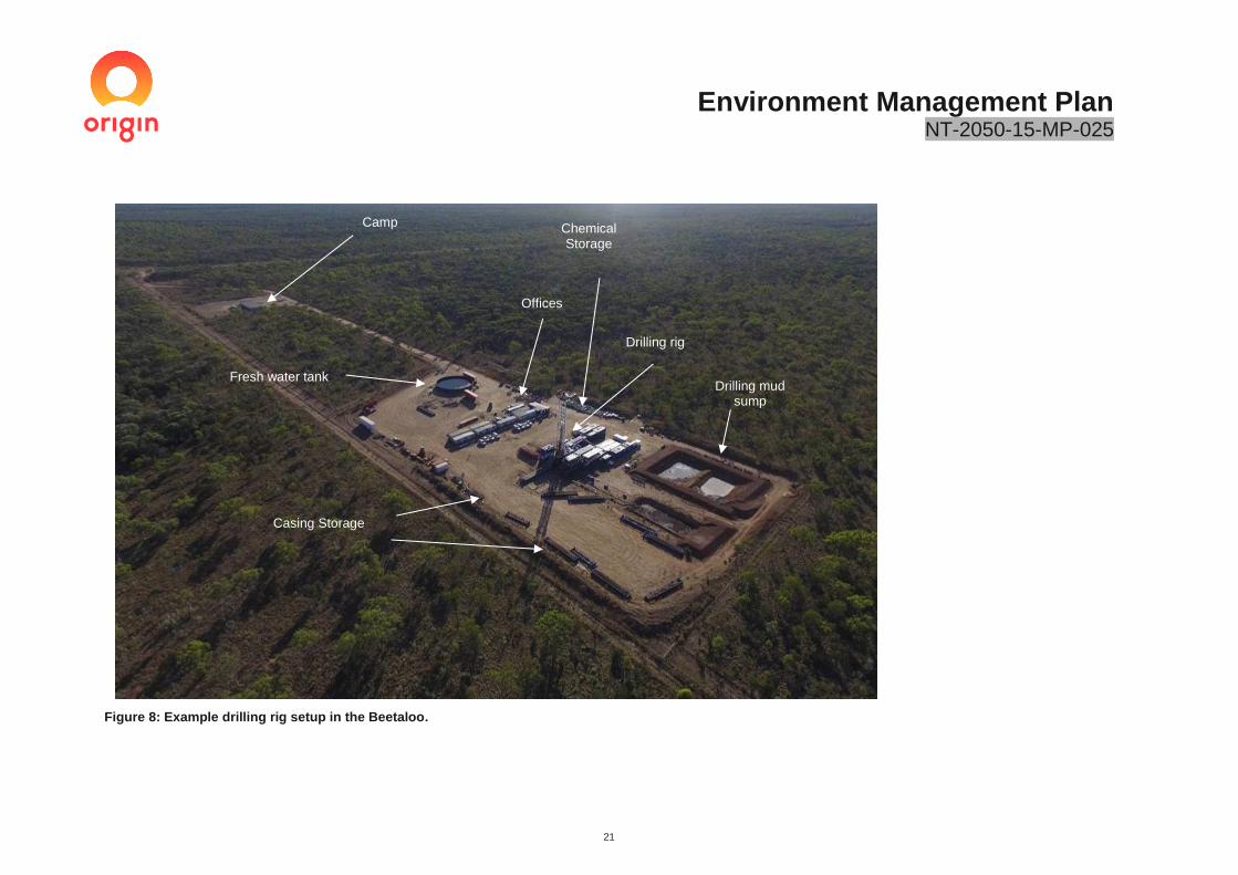
Environment Management Plan NT-2050-15-MP-025
21
Figure 8: Example drilling rig setup in the Beetaloo.
Camp
Drilling rig
Drilling mud sump
Fresh water tank
Offices
Casing Storage
Chemical Storage

Environment Management Plan NT-2050-15-MP-025
22
3.4 Hydraulic Fracture Stimulation activities
Upon completion of drilling operations, the horizontal exploration well will undergo Hydraulic Fracture Stimulation (HFS). The hydraulic fracturing process is a series of operations designed to increase the available surface contact area of the shale formation. This enhances the amount of hydrocarbons that migrate into the wellbore and flow to surface.
The process of a hydraulic fracturing is conducted in the following sequential stages:
i. Well integrity verification ii. Site Setup iii. Stimulation activities
3.4.1 Well integrity validation
Prior to the commencement of any stimulation activity, the wellbore will be assessed to ensure that sufficient well integrity is in place to withstand hydraulic fracturing pressures as per the NT Petroleum CoP.
The assessment will include:
• Cement evaluation logs are run to ensure that at a minimum 150mTVD of good quality cement is present
from the target reservoir to the nearest aquifer to ensure zonal isolation as per Origin Barriers Standard
INT-1000-35-TS-002.
• Confirmation of geological barriers and assessment of geological hazards.
• Mechanical integrity evaluation of the production casing via a casing pressures test to the Maximum
Allowable Operating Pressure (MAOP) of 10,000psi. The pressure test will consist of:
o 10-minute low pressure (300 psi) leak test
o 20-minute high (10,000 psi) pressure strength test
Origin’s pressure test acceptance criteria is 1% pressure drop per 5 minutes over a stabilised test duration with a decreasing dP/dT trend as per Origin Barriers Standard INT-1000-35-TS-002.
Pressure tests will be undertaken using fresh water which will be re-used.
Controls:
✓ Stimulation activities will be undertaken in accordance with the NT Petroleum CoP. ✓ Well barrier integrity tests to be outlined in the WOMP and approved by DPIR prior to stimulation; this
includes confirming the cement evaluation logs and casing pressure tests to verify the integrity of the barrier prior to stimulation.. A table of the WOMP stimulation and integrity validation requirements and Origin’s implementation summary is provided in Appendix S
✓ Stimulation activities will not occur until the integrity of a well has been confirmed.
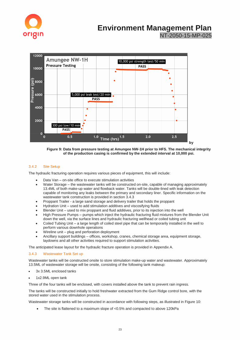
Environment Management Plan NT-2050-15-MP-025
23
by
Figure 9: Data from pressure testing at Amungee NW-1H prior to HFS. The mechanical integrity of the production casing is confirmed by the extended interval at 10,000 psi.
3.4.2 Site Setup
The hydraulic fracturing operation requires various pieces of equipment, this will include:
• Data Van – on-site office to execute stimulation activities
• Water Storage – the wastewater tanks will be constructed on-site, capable of managing approximately 13.4ML of both make-up water and flowback water. Tanks will be double-lined with leak detection capable of monitoring any leaks between the primary and secondary liner. Specific information on the wastewater tank construction is provided in section 3.4.3
• Proppant Trailer - a large sand storage and delivery trailer that holds the proppant
• Hydration Unit – used to add stimulation additives and viscosifying fluids
• Blender Unit – used to mix proppant and fluid additives, prior to its injection into the well
• High Pressure Pumps – pumps which inject the hydraulic fracturing fluid mixtures from the Blender Unit down the well, via the surface lines and hydraulic fracturing wellhead or coiled tubing unit
• Coiled Tubing Unit – a large length of coiled steel pipe that can be temporarily installed in the well to perform various downhole operations
• Wireline unit – plug and perforation deployment
• Ancillary support buildings – offices, workshop, cranes, chemical storage area, equipment storage, laydowns and all other activities required to support stimulation activities.
The anticipated lease layout for the hydraulic fracture operation is provided in Appendix A.
3.4.3 Wastewater Tank Set up
Wastewater tanks will be constructed onsite to store stimulation make-up water and wastewater. Approximately 13.5ML of wastewater storage will be onsite, consisting of the following tank makeup:
• 3x 3.5ML enclosed tanks
• 1x2.9ML open tank
Three of the four tanks will be enclosed, with covers installed above the tank to prevent rain ingress.
The tanks will be constructed initially to hold freshwater extracted from the Gum Ridge control bore, with the stored water used in the stimulation process.
Wastewater storage tanks will be constructed in accordance with following steps, as illustrated in Figure 10:
• The site is flattened to a maximum slope of <0.5% and compacted to above 120kPa
Environment Management Plan NT-2050-15-MP-025
24
• Tank panels are transported to site in flat-packs
• Panels are assembled using a simple pin-type set up, with each tank panel lifted into place using a telehandler. No cranes or suspended overhead loads required.
• Each panel is free standing and capable of withstanding 100km/hr winds on their own. They are connected to the adjacent panel using engineered steel pins, which increase the wind rating to above the cyclonic wind load requirements. The structure is engineered to a level that can withstand up to 70% erosion of the panel length, without causing any structural damage. This means the risk of water erosion during rainfall events is low.
• A geomembrane is installed under the tank to prevent rock/root penetration
• The first 0.5mm HDPE liner is installed and fixed to the structure. Liners are pre-fabricated, welded and tested offsite, preventing the need for onsite welding.
• A moisture and pressure probe is installed between the primary and secondary liner to detect moisture and water pressure.
• The second liner is installed and fixed to the structure.
• Level sensors are installed within the tanks
• For the enclosed tanks, the covers are installed. The covers have built in vents and rainwater collection system as illustrated in Figure 20.
• Tanks are filled with freshwater and are testing for leaks over a 24 hour period. If moisture and pressure is detected via the leak detection system, the tank is drained to an existing storage tank onsite and leakage point repaired.
Controls:
✓ All wastewater tanks will be double lined with real-time leak detection and level monitoring. ✓ Wastewater tank locations will be flattened, compacted and geomembrane liner installed to prevent rock
and root penetrations. ✓ All tanks and liners will be designed and operated to meet the required climatic and environmental
conditions of the Northern Territory. This includes: o Structure Wind rating as per AS1160.2:2011- Designed to withstand cyclonic wind conditions o Structure integrity through deformation caused by tank panel base erosion- Capable of
withstanding base erosion of up to 70% o Liner Temperature- Designed to be operated at temperatures well above expected ( 60
degrees) o Liner tear resistance- 49 newtons (N) o Liner puncture resistance- 120N o Liner seam peel adhesion strength 4.3N/mm
✓ Tanks will be installed with vents to reduce the risk of vapour build up ✓ Liners are pre-fabricated offsite, with QA/QC completed on the seam welds to ensure integrity ✓ Wastewater tanks will be filled with freshwater as a part of the QA/QC program, with any leaks
remedied prior ✓ QA/QC program to be implemented by contractors to ensure each tank has been constructed as per
manufacturers requirements. ✓ Collected rainwater on top of enclosed tank covers will be released from the tank cover as per section
3.10.5

Environment Management Plan NT-2050-15-MP-025
25
Figure 10 Wastewater tank construction steps
1. Panel Transportation
7. secondary liner installation 6. Primary liner installation
5. Geomembrane installation 2. Panel assembly 3. Tank assembly
8. Tank commissioning 8. Cover installation

Environment Management Plan NT-2050-15-MP-025
26
3.4.4 Stimulation Activities
It is anticipated that Hydraulic Fracture Stimulation (HFS) will be undertaken on the Kyalla 117 N2 exploration well. Stimulation is generally conducted during daylight hours, with wireline and coiled tubing support activities operating on a 24-hour basis. HFS involves the injection of a slurry, primarily consisting of water and sand (proppant), plus a small percentage of chemicals at high pressure into the target section of the horizontal wellbore approximately 2000m – 3000m below ground level. Typically, 95% or higher of the total volume in stimulation fluids is a combination of fresh water and sand, with the remainder as fluid-conditioning additives. Chemicals used in HFS are designed to optimise stimulation outcomes and are commonly found in food and other household domestic products. The chemical composition of stimulation fluid is discussed further in Section 3.5.Chemical Risk Assessment. All fluid additives (water and chemicals) and sand is mixed on surface through the hydraulic fracturing equipment. The mixture and pumping schedule (rates, volume and proppant) are based on an HFS model which determines the desired fracture attributes. The HFS model is completed prior to the commencement of stimulation activities and is underpinned by a Mechanical Earth Model (MEM). The MEM is generated from data collected during drilling, wireline logging, core analysis and DFIT tests. The stimulation fluid mixture and pumping schedule is continuously updated during and after each stage to ensure optimal outcomes are achieved. An example of the modelled fracture geometry for the Amungee NW-1 well is illustrated in Figure 14. The stimulation fluid is pressurised by the high-pressure pumping units and directed downhole via a manifold to the discrete target intervals along the horizontal wellbore (referred to as ‘stages’). Up to 20 stages are proposed, with each stage being isolated and perforated using a plug and perforation gun assembly deployed via wireline. As the pressure is sustained, the fractures propagate radially from the well, through the target rock. Once optimal fracture propagation has been achieved, the proppant (sand) is pumped down the well and into the open fractures. This process is repeated for each stage. The final number of stages pumped in each well is dependent on the useable length of the horizontal wellbore and in-situ geological conditions. Once all stages are complete, the well is suspended awaiting completion and well testing activities. It is anticipated that approximately 1.3ML of water and 180 tonnes of proppant (sand) will be used for each stage. Water will be sourced from the Gum Ridge formation, as described in section 3.15. Proppant will be sourced from locations within Australia (such as South Australia) or imported from international sources. Wellbore pressures are monitored during each stimulation, to ensure the operations have not compromised the integrity of the production casing or the cement barriers. A Maximum Allowable Operating Pressure (MAOP) is an important parameter used to define the operating envelope. The maximum allowable pumping pressure (MAPP) is set below the MAOP to allow for uncertainty and provide an additional safety margin. The anticipated MAPP is 9200psi and the MAOP is10,000psi. Two additional safety measures are set in place to ensure treating pressures do not exceed the MAOP of the system:
1. Each HFS pumping unit has an automated high-pressure shut-off control set at the MAPP or lower, and 2. A pressure relief valve will be installed on the surface treating line to instantaneously bleed-down
pressures if the pressure exceeds the MAPP. A coiled tubing unit is on standby on location in the event of contingent wellbore intervention operations, such as a wellbore screen-out. A screen-out occurs when the proppant in the stimulation fluid blocks the perforations or fracture network, creating a sudden and significant restriction to fluid flow, resulting in a premature termination of the stimulation operation.

Environment Management Plan NT-2050-15-MP-025
27
Figure 11: Hydraulic Fracture Stimulation Spread.

Environment Management Plan NT-2050-15-MP-025
28
Figure 12: Example of stimulation lease layout. Please note, all wastewater will be stored in enclosed wastewater tanks.
Coil tubing unit
Exploration well
Freshwater storage
Chemical mixing units
High pressure
pumping units
Wireline unit Office
Amungee NW-1 / 1H Wellsite Fracture Stimulation Operations
2016

Environment Management Plan NT-2050-15-MP-025
29
Figure 13: Well and wellhead schematic showing the “B Annulus” monitoring process, and an example from Stage 1 of the observed pressure of the B Annulus (0 psi) while high-pressure HFS operations were underway.
Controls:
✓ Stimulation activities will be undertaken in accordance with the NT Petroleum CoP and relevant NT and Federal Government legislation and regulations as outlined in Table 2 and Table 3.
✓ Activities will be undertaken in accordance with the WOMP, which will be approved by DPIR. . A table of the WOMP stimulation requirements and Origin’s implementation summary is provided in Appendix S
✓ Chemicals used in the stimulation process are risk assessed and are made public. ✓ A Spill Management Plan will be implemented, with secondary containment used for all chemical
storage and handling areas. ✓ The HFS model is completed prior to the commencement of stimulation activities. Modelling assesses
potential fracture growth, to confirm aquifers (1,600m above the fracture stimulation activity) will not be affected. Typically, fractures no longer than 300m horizontal are expected.
✓ A MAPP and MAOP will be introduced to ensure pumping pressures do not compromise the integrity of a well.
✓ Real-time monitoring of pressure during stimulation to detect anomalous pressure behaviour. ✓ Stimulation operations can be ceased immediately to prevent any potential fluid or proppant migration
into an adjacent formation or aquifer. ✓ Annular pressures are monitored during every HFS stage and subsequent flowback operations. ✓ Well barriers are tested and pressures monitored regularly to ensure their performance over the lifecycle
of the well. ✓ An Emergency Response Plan will be in place.

Environment Management Plan NT-2050-15-MP-025
30
Figure 14: Modelled Fracture Geometry of Amungee NW-1.
3.5 Chemical Risk Assessment
Origin is required to disclose all chemicals that are proposed to be used prior to undertaking any drilling and stimulation activities. The list of chemicals, along with a risk assessment and Safety Data Sheets (SDS) are provided to DPIR and DENR for review and approval. The CAS number of all chemicals, including proprietary chemicals, is included in the risk assessment which is undertaken by an independent third-party consultant. The final chemical risk assessment report, along with each chemical is also provided to DENR as a part of the EMP assessment process. The proprietary chemical CAS numbers are excluded from the final public submission to protect the intellectual property of chemical manufacturers. This approach ensure that all chemicals can be appropriately assessed and protects chemical company reduces from releasing commercially sensitive information. All chemicals added to stimulation fluid perform a specific purpose, including:
• Acids and bases: controls pH and clears perforations prior to stimulation
• Biocides: controls or eliminates bacteria in the fluid to prevent introduction to target formation
• Viscosity regulators: increases or reduces the thickness of a fluid
• Clay control: prevents clays from swelling
• Friction reducers: reduces friction between the stimulation fluid and piping allowing the fluid to be injected further without pressure drop
• Corrosion inhibiters: prevents equipment from rusting
• Chemical inhibitors: such as iron or scale prevention
• Surfactants: reduces surface tension of the hydraulic fracturing fluid
Origin will potentially utilise up to three different stimulation fluid designs which include:
1. Friction-reduced slick water design
2. High-viscosity friction reducer design
3. Hybrid (slick water + cross-linked gel) design
Environment Management Plan NT-2050-15-MP-025
31
All chemicals used in Australia must be approved for use by the Federal Government Department of Health and be listed on the Australian Inventory of Chemical Substances (AICS) which is maintained under the National Industrial Chemicals Notification and Assessment Scheme (NICNAS). In addition, there are a range of other specific regulatory controls governing the transportation, storage, handling and disposal of chemicals with the NT and Australia (as summarised in section 2). These include:
• Transportation: Transport of Dangerous Goods by Road and Rail (National uniform Legislation)
• Storage: NT Dangerous Goods Act, Work Health and Safety Act and NT Petroleum codes of Practice
• Use: NT Dangerous Goods Act, Work Health and Safety Act and NT Petroleum codes of Practice
• Disposal: NT Waste Management and Pollution Control Act 1998. The list of chemicals within the proposed drilling and stimulation fluid mixtures are summarised in Appendix C. This table also contains the following additional information:
1) Name of chemical
2) Chemical purpose
3) Chemical Abstract Services (CAS) number
4) Total mass (in kg)
5) Approximate down-hole concentration for that chemical (expressed in mg/L)
6) Appropriate ecotoxicity (aquatic and oral values) data including for acute LC50/EC50 and chronic No Observable Effects Concentration (NOEC) data
7) Information on the biodegradation and bioaccumulation potential of any organic chemicals 8) Results of the Tier 1 and Tier 2 assessment
Additionally, the full list of chemicals and volumes are also included in the Spill Management Plan (Appendix D). A description of the chemical assessment process is provided in the following sections.
3.5.1 Risk Assessment Methodology
A chemical risk assessment has been completed to evaluate the potential human health and environmental health effects on all compounds to be used during drilling and stimulation. The assessment methodology is based upon the following guidance documents:
• Northern Territory Department of Environmental and Natural Resources - Draft Guideline for the
Preparation of an Environmental Management Plan under the Petroleum (Environment) Regulations, 2019 (herein referred to as NT 2019)
• Department of the Environment and Energy, Exposure Draft - Chemical Risk Assessment Guidance Manual: for chemicals associated with coal seam gas extraction, 2017 (herein referred to as DOE 2017)
• National Industrial Chemicals Notification and Assessment Scheme (NICNAS), National Assessment of Chemicals Associated with Coal Seam Gas Extraction in Australia, 2017 (herein referred to as NICNAS 2017)
• enHealth “Environmental Health Risk Assessment, Guidelines for Assessing Human Health Risks from Environmental Hazards”, 2012
• National Environment Protection (Assessment of Site Contamination) Measure 1999 (ASC NEPM); Schedule B4, Site-specific health risk assessment methodology, 2013
The chemical risk assessment comprised the following tasks:
• Hazard assessment. An evaluation of the environmental and human health hazard of the chemical additives in the hydraulic fracturing fluid, based on their environmental persistence, bioaccumulation and aquatic toxicity properties.
• Exposure assessment. The exposure assessment comprises an evaluation of surface and sub-surface exposure pathways and reviews the effectiveness of the proposed controls in preventing a complete pathway.
• Screening and validation processes via Tier 1 and Tier 2 assessments to determine chemicals known to be of low concern and identify chemicals for further risk assessment.
• Tier 1: Using published information about each chemical proposed to be used in the hydraulic fracturing activity.
• Tier 2: A quantitative evaluation of the risks using toxicity values and quantitative estimates of chemical intake to provide an estimate of potential human health and environmental risk

Environment Management Plan NT-2050-15-MP-025
32
associated with the hydraulic fracturing activities, based on the identification of complete exposure pathways and hazard identification.
3.5.2 Results of Risk Assessment
A chemical hazard and exposure analysis has been completed using the ecotoxicity assessment guidelines (Commonwealth of Australia, 2013). The summary is provided in Appendix C.
A Tier 1 assessment was undertaken on all chemicals with the exception of light petroleum distillate (CAS# 64742-47-8). Certain chemicals (14 from Slick Water, 17 from Hybrid and 15 from High Velocity Friction Reduced) require standard flowback water and wastewater disposal controls to ensure the risk of management is low. These controls are consistent with the requirements outlined in the Petroleum Codes of Practice and summarised in Section 6.4 of this plan. It is to be noted that none of these chemicals were identified to be persistent and bioaccumulative.
An assessment of the potential valid environmental and human health exposure pathways is summarised in Table 6. This pathways exposure assessment considered the:
• properties of the chemicals
• site setting and physical separation distances between receptors (environmental and human) and the activity (Section 3.1)
• lack of protected flora and fauna and high conservation value areas in the vicinity of the activity as outlined in Section 4.2
• description of the activity and summary of controls as provided in Section 3 and Section 6.4
The exposure pathway assessment identified only one partially complete exposure pathway; the on-site release of particulates and vapour during chemical mixing and flowback evaporation. The limited number of valid pathways is consistent with the limited size and duration of the proposed activities.
A Tier 2 assessment was conducted on hydrotreated light petroleum distillate, which was classified as a bioaccumulative and toxic substance. As per NICNAS 2017 and DOE 2017 guidance, the Margin of Exposure (MOE) approach was used to assess the health risk to workers. For each occupational activity scenario (i.e. transport and storage, mixing / blending of hydraulic fracturing chemicals, evaporation of flowback and cleaning and maintenance), an MOE was derived by comparing the point of departure (e.g. No Observed Adverse Effects Level [NOAEL]) for long-term health effects from the critical toxicological study to the estimated total human internal dose from all routes of exposure. Based on the calculated MOEs, the chemical is of low concern for workers (refer to individual toxicity profile for further detail). A summary of the Tier 2 risk assessment is provided in Appendix C.

Environment Management Plan NT-2050-15-MP-025
33
Table 6: Stimulation Chemical Exposure Pathways.
Pathway Controls Regulatory controls/guidelines Effectiveness of controls Scientific certainty Pathway assessment
Off-lease release via spills - water
1. Compliance with the Petroleum Codes of Practice. 2. All chemical storage and handling areas to have appropriate secondary containment. 3. Lease pads are bunded to contain any major spill of flowback chemicals. 4. Offset distances from sensitive receptors (groundwater extraction bores, homesteads, culturally-sensitive areas and communities). 5. Routine inspections are completed to ensure any leaks or spills are prevented or promptly identified. 6. Spill Management Plan.
Petroleum Codes of Practice Part A – Surface Activities A.3.1 Site selection and planning A.3.2 Well pad site selection requirements 3.8 Containment of Contaminants C.7.2 Spill Management Plan American Petroleum institute Standards
API RP Recommended Practice 100-2 Managing Environmental Aspects Associated with Exploration and Production Operations Including Hydraulic Fracturing
Section 13.2: Storage and Management of Fluids and Materials for Hydraulic Fracturing
Australian Standards (AS)
AS/NZS 4452: The storage and handling of toxic substances
AS1940: The storage and handling of flammable and combustible liquids AS AS 3780:2008: The storage and handling of corrosive substances
AS/NZS 3833:1998: The storage and handling of mixed classes of dangerous goods
High - The use of secondary containment and bunding reduces the probability of an off-lease release via a spill down to ‘remote’.
High - The certainty around the use of secondary containment and bunding to prevent spills is well recognised within international spill containment standards and legislation.
Incomplete - Controls in place unlikely to result in any off-site releases.
On-lease release via spill - water
1. Compliance with the Petroleum codes of Practice 2. All chemical storage and handling areas to have appropriate secondary containment. 3. Routine inspections are completed to ensure any leaks or spills are prevented, promptly identified and rectified. 4. Spill Management Plan.
Petroleum Codes of practice Part A – Surface Activities 3.8 Containment of Contaminants C.7.2 Spill Management Plan
American Petroleum institute Standards
API RP Recommended Practice 100-2 Managing Environmental Aspects Associated with Exploration and production Operations Including Hydraulic Fracturing
Section 13.2: Storage and Management of fluids and Materials for Hydraulic Fracturing
Australian Standards (AS)
AS/NZS 4452: The storage and handling of toxic substances
AS1940: The storage and handling of flammable and combustible liquids AS AS 3780:2008: The storage and handling of corrosive substances
AS/NZS 3833:1998: The storage and handling of mixed classes of dangerous goods
High - The use of secondary containment and bunding reduces the probability of releases.
High - The certainty around the use of secondary containment and bunding to prevent spills is well recognised within international spill containment standards and legislation.
Incomplete - Controls in place unlikely to result in any exposure.
Off-lease release via particulate during mixing and flowback evaporation - Air
1. All chemical mixing on-site to comply with the Workplace Health and Safety guidelines for handling of chemicals.
Petroleum Codes of Practice Part A – Surface Activities 3.8 Containment of Contaminants
High - Legislation controlling the handling of chemicals is mature and standardised across Australia to limit exposure to
High - The certainty around the handling of chemicals is mature and standardised across Australia to limit
Incomplete - The deployment of standard chemical handling procedures to minimise

Environment Management Plan NT-2050-15-MP-025
34
Pathway Controls Regulatory controls/guidelines Effectiveness of controls Scientific certainty Pathway assessment
2. Chemical transfer and mixing procedures deployed to avoid the generation of dust. 3. Chemical mixing location away from lease boundary, with a separation distance of 50m. 4. Wind speed and direction sensors deployed with automatic cut-offs to prevent off-site drift from evaporation units.
American Petroleum institute Standards
API RP Recommended Practice 100-2 Managing Environmental Aspects Associated with Exploration and production Operations Including Hydraulic Fracturing
Section 13.2: Storage and Management of fluids and Materials for Hydraulic Fracturing
Managing risks of hazardous chemicals in the workplace Code of Practices 2013 Section 4- Controlling risk Australian Standards (AS)
AS/NZS 4452: The storage and handling of toxic substances
AS1940: The Storage and handling of flammable and combustible liquids AS AS 3780:2008: The storage and handling of corrosive substances
AS/NZS 3833:1998: The storage and handling of mixed classes of dangerous goods
employees and surrounding receptors.
exposure to employees and surrounding receptors.
dust, combined with separation distance from the lease boundary, is likely to limit off-site releases.
On-lease release via particulate - Air
1. All chemical mixing on-site to comply with the NOHSC guidelines for handling of chemicals. 2. Chemical transfer and mixing procedures deployed to avoid the generation of dust. 3. Chemical mixing location away from lease boundary, with a separation distance of at least 50m.
Petroleum Codes of practice Part A – Surface Activities 3.8 Containment of Contaminants American Petroleum institute Standards
API RP Recommended Practice 100-2 Managing Environmental Aspects Associated with Exploration and production Operations Including Hydraulic Fracturing
Section 13.2: Storage and Management of fluids and Materials for Hydraulic Fracturing
Managing risks of hazardous chemicals in the workplace Code of Practices 2013 Section 4- Controlling risk Australian Standards (AS)
AS/NZS 4452: The storage and handling of toxic substances
AS1940: The storage and handling of flammable and combustible liquids AS AS 3780:2008- The storage and handling of corrosive substances
AS/NZS 3833:1998: The storage and handling of mixed classes of dangerous goods
High - Legislation controlling the handling of chemicals is mature and standardised across Australia to limit exposure to employees and surrounding receptors.
High - The certainty around the handling of chemicals is mature and standardised across Australia to limit exposure to employees and surrounding receptors.
Partially complete - On-site release of particulate chemicals during handling is potentially complete with human error.
Off-site release via transport accident
1. All chemicals and waste products to be transported by licenced contractors in accordance with the NT Dangerous Goods (Roads and Rail) Regulations and NT
Petroleum Codes of practice Part A – Surface Activities 3.8 Containment of Contaminants C.7.2 Spill Management Plan
High - Legislation controlling the transportation of chemicals and wastes is mature and standardised across Australia.
High - The certainty around the transportation of chemicals and wastes is mature and well understood across Australia.
Incomplete - The probability of exposure via a transport accident is limited via the mature legislative framework in place.
Environment Management Plan NT-2050-15-MP-025
35
Pathway Controls Regulatory controls/guidelines Effectiveness of controls Scientific certainty Pathway assessment
Waste Management and Pollution Control Act 1998. 2. Legislation, regulations and national standards set out the requirements for the safe transport of chemicals, including for packaging, driver training, safety equipment and vehicle standards. These measures reduce the risk of a spill occurring, or of not being detected and cleaned up if it does occur. 4. Spill Management Plan and Emergency Response Plan
Transport of Dangerous Goods by Road and rail (National Uniform Legislation) regulations 2011
handling of mixed classes of dangerous goods
Subsurface release of chemicals to aquifer
1.Code of Practice requiring multiple strings of casing and cement designed to protect aquifer. 2.Integrity validation of casing and cement barriers prior to completing stimulation. 3. Pressure monitoring during stimulation of both the formation and the B well anulus. 4. Physical separation distance of 1400m between aquifer and target formation prevents any migration of stimulation fluid to aquifer units. 5. 16km separation distance between exploration well and closest extraction bores.
Petroleum Codes of practice Part B Well Operations B.4.2 Aquifer protection B.4.3 Well design and well barriers B.4.6 Casing and tubing B.4.10 Drilling fluids B.4.13 Hydraulic Stimulation and flowback Operations B.4.7 Primary cementing B.4.17 Groundwater Monitoring B.5 BTEX Limit
High - The legislation and guidance notes relating to aquifer protection and well integrity are mature with extensive industry experience.
High - High certainty around the effectiveness of controls around the protection of aquifers using industry standard practice.
Incomplete - The probability of contamination of an aquifer from release of stimulation fluid during stimulation is remote and therefore incomplete.
Surface release of chemicals to aquifer
1. Secondary containment to be used to manage all chemicals and wastes handled on-site. 2. Code of Practice requires double-lined tanks with in-built leak detection. 3. Spill Management Plan and Wastewater Management Plan to be implemented. 4. Routine inspections to identify leaks 5. 70m vertical separation between surface and underlying aquifer. 6. Closest groundwater extraction bore is 16km away.
Part A – Surface Activities 3.8 Containment of Contaminants C.7.2 Spill Management Plan American Petroleum institute Standards
API RP Recommended Practice 100-2 Managing Environmental Aspects Associated with Exploration and production Operations Including Hydraulic Fracturing
Section 13.2: Storage and Management of fluids and Materials for Hydraulic Fracturing
High - The controls managing the storage of chemicals and wastes are mature with secondary containment measures limiting potential pathways to receptors.
High - The certainty around the effectiveness of secondary containment in preventing groundwater contamination is mature.
Incomplete - The probability of contamination of an aquifer from release of stimulation fluid is remote and therefore incomplete.

Environment Management Plan NT-2050-15-MP-025
36
3.6 Well Completion and Test Program
Upon finalisation of stimulation activities, the exploration well will be completed and the well testing phase initiated. The well testing program is used to determine the nature, quality and quantity of petroleum products within exploration licenses held by the Beetaloo Joint Venture.
The completion and well testing program for each exploration well proposed under this EMP consists of:
• Completion activities including:
o Preparing wellbore for downhole completion equipment
o Installation of a production packer and production tubing
o Installation of production wellhead
o Underbalance wellbore to initiate production of hydrocarbons
• Well Test activities including:
o Flowback of fluids and hydrocarbons
o Measurement and management of hydrocarbons
o Ongoing sampling of flowback and hydrocarbons
o Disposal of volatile hydrocarbons via flare
o Disposal of liquid hydrocarbons via flare or off-site transportation (including on-site temporary
storage)
3.6.1 Completion and well testing activities
The well site will consist of an exploration well and associated temporary facilities that will be brought onto site to assist in well completion and testing activities. This will include the following:
• Completion rig and associated equipment - installs the production tubing
• Well testing package including:
• Test separator – separates hydrocarbons from flowback fluid
• Flare - safe and accepted disposal method of hydrocarbons
• Surface pipe work and manifolds
• Emergency Shut Down (ESD) valves
• Workshops / Storerooms
• Communications and generator shacks
• Condensate tanks (if required)
• Bunded diesel and oil storage areas
• Wastewater (flowback) fluid storage (open-top and covered)
• Water transfer equipment
• Camp
The stimulated well will be ‘completed’ to enable the flow of hydrocarbons and fluids. Completion activities involve the installation of downhole and surface completion equipment, including production packers and tubing and a wellhead.
To initiate the well testing phase, the well will be underbalanced to allow hydrocarbon and fluid production. It is anticipated that the wells will produce both gas and liquids / condensate (i.e. Gas C1-C4 and Liquids C5+). Initially, the flowback will primarily contain HFS fluid and sand utilised in the stimulation process. As the fluid and pressure within the reservoir is reduced, it is anticipated that gas rates will increase. To obtain a comprehensive understanding of the fluid recovery and gas production potential of the target reservoir, the well testing phase may extend from three to 12-months.
All flowback fluids and hydrocarbons will be directed through a fully-contained separator on-site. Flowback management is discussed further in Section 3.10.3. The separator will separate out the gases, fluids and solids so that they can be measured and managed.
Any liquid hydrocarbons (condensate) will be separated from the flowback fluid, stored within designated condensate storage tanks and then combusted in the on-site flare as discussed in section 3.6.2 and section 3.6.3. After the well test, the well may be shut-in to complete a pressure build-up test to further characterise the respective reservoirs for a period of up to 12-months. Upon finalisation of the build-up test, the well will be suspended.

Environment Management Plan NT-2050-15-MP-025
37
An overview of the well testing equipment layout is provided in Figure 15 and Figure 18.
Figure 15: Sample well test schematic.
3.6.2 Flaring
During well testing, all produced gas and liquids will be combusted in a horizontal flare located onsite. The horizontal flare will be located in a 20mx 10m clay lined flume. Flares will be located at least 45m from the surrounding vegetation.
The flare will be equipped with a continuous flare pilot burner to ignite any gases and condensate that is sent to the flare during well testing. The pilot flame will be supplied with an independent propane fuel source located at least 45m from the flare.
The flare will have an autoignition system that provides electrical impulses to a spark plug continuously to generate a spark every 1.3 seconds. If a flare was to go out, the spark would ignite the flare within 1.3 seconds.
Controls:
✓ All well testing operations will be undertaken in accordance with the NT Petroleum CoP. ✓ The nearest receptor (homestead) is approximately 20km away from activity. ✓ All produced hydrocarbons will be measured and either flared or transported off-site for sale / disposal. ✓ A ‘Reduced Emission Completion’ will be utilised in accordance with the United States EPA New Source
Performance Standards and NT Petroleum CoP. ✓ A Wastewater Management Plan will be developed and implemented. ✓ All flowback will be sent to hybrid tank systems with leak detection. ✓ Open tanks are to have enough freeboard in accordance with the NT Petroleum Code of Practice. ✓ Covered tanks with sufficient storage volume on location to be utilised during wet season. ✓ All flowback to be transferred to enclosed / covered tanks within 72-hours when a significant rainfall
event is predicted. ✓ Flowback volumes are to be reduced by natural or enhanced evaporation. ✓ Flowback to be transported off-site by a licenced transport operator to an approved facility. ✓ A Spill Management Plan is to be developed and implemented as per Appendix D . ✓ Any waste oil will be stored and transported off-site in accordance with the requirements in the NT
Waste Management and Pollution Control Act. ✓ A Methane Management Plan will be Implemented as per Appendix L.

Environment Management Plan NT-2050-15-MP-025
38
Condensate will be stored onsite and batch flared daily. Based on anticipated condensate production volumes, the flaring of condensate is likely to be restricted to 0.5 hours to 1 hour per day.
During condensate flaring, a water curtain will be utilised to dampen the flare flame and reduce heat radiation. The water curtain water usage is anticipated to be between 7500- 15000L per day. All water collected during this period will be collected in the flare flume and either re-used or periodically transferred into wastewater storage tanks onsite. The flare flume will be designed to overflow into the adjacent drilling sump if necessary.
3.6.3 Condensate tanks
Any produced condensate will be separated and stored in double skinned tanks compliant with Australian Standards 1692 Steel Tanks for flammable and combustible liquids. It is anticipated that 2 x 500Barrel tanks will be utilised to store condensate onsite. All tanks will have vents designed to reduce the risk of over pressurisation.
An example of a condensate tanks is provided in Figure 16.
Controls:
✓ All flares will be designed to meet the requirements of the NT Petroleum CoP including: o Continuous ignition systems. o 98% combustion efficiency as per USEPA standards. o Bushfire risk management plan implemented. o 45m separation distances from sensitive places and combustible material (such as
vegetation). ✓ Flume to be clay lined with a 300mm compacted clay liner. A cement cloth liner under the clay liner may
also be used to prevent water infiltration. ✓ Earthen berm located at the rear of the flare to contain flame and reduce heat radiation ✓ Any waste oil will be skimmed from the flare flume (if present) during condensate flaring will be removed
and stored in waste oil tanks prior to off-site transportation to a licenced waste facility (in accordance with the Waste Management and Pollution control Act)
✓ All wastewater will be collected periodically and sent to an enclosed wastewater tank. ✓ The clay liner will be tested and removed from site and disposed of at a licenced facility This may
include an interstate facility. ✓ The flare flume will be designed to overflow directly into the mud sump to ensure it has sufficient
freeboard to manage a 1:1000 ARI wet season event. The design will not reduce the freeboard of the mud sump.
✓ The Bushfire Management Plan (Appendix M) and Emergency Response Plan (Appendix N) will be implemented.
✓ All water collected from the flare flume will be captured and transferred to the wastewater tanks.

Environment Management Plan NT-2050-15-MP-025
39
Figure 16 Example of condensate storage tanks (image provided for indicative purposes only)
3.7 Ongoing monitoring and well integrity management
Following construction, a well enters its operational phase (Figure 17) and typically an Operations team would take accountability of the well at this point. The Operations Team have a separate, complimentary standard to manage integrity, known as the Well Integrity Management Plan (WIMP). The WIMP defines monitoring, maintenance and integrity testing requirements and frequencies, as well as well integrity assurance activities and ultimately forms a part of the WOMP. Well barriers are tested and pressures monitored regularly to ensure their performance over the lifecycle of the well.
Controls:
✓ Condensate will be stored within designated double-lined storage tanks prior to being flared in batches ✓ Any waste oil will be stored and transported off-site in accordance with the requirements in the NT
Waste Management and Pollution Control Act. ✓ All tanks will be appropriately vented to eliminate over pressurisation ✓ Condensate levels will be monitored through flow meters from the triple phase separator and manually
checked using a dip and site glass ✓ Waste oily water not suitable for flaring will be stored in separate double skinned tanks for offsite
disposal.

Environment Management Plan NT-2050-15-MP-025
40
Figure 17: Well lifecycle with operational phase highlighted where well integrity monitoring is a key activity.
Information from all Origin wells is gathered and stored in a database and made available to key technical staff via a software tool called a Well Integrity Management System (WIMS). WIMS contains information such as wellhead and production valve maintenance results, annular and tubing pressures, well operating windows, key well information and historical well integrity data and maintenance. WIMS is used in the identification and assurance of the integrity of each individual well and also outlines the well integrity status for each well.
Remediation of well integrity anomalies could include well integrity barrier replacements - i.e. valves, tubing, and / or barrier remediation, such as casing patches and cement squeezes to ensure pressure isolation. If remediation does not prove to be a feasible option, plugging and decommissioning operations will be considered to ensure well integrity.
Controls:
✓ Well integrity will be managed in accordance with the WOMP. . A table of the WOMP well integrity requirements and Origin’s implementation summary is provided in Appendix S
✓ All wells are covered under a WIMS. ✓ All well integrity barriers are routinely inspected and verified. ✓ Remediation activities are initiated where the integrity of a barrier is jeopardised.

Environment Management Plan NT-2050-15-MP-025
41
Figure 18: Amungee NW-1 Well Testing image provided for reference. Please note, the Kyalla 117 N2 exploration well will use horizontal flares and enclosed tanks
Flowback wastewater storage tanks with
evaporator
Offices Well testing equipment
Flare

Environment Management Plan NT-2050-15-MP-025
42
3.8 Well suspension and decommissioning
Once all drilling and testing has been completed, the exploration well will either be suspended or plugged and decommissioned. The fundamental difference between the two being that suspended wells can be re-entered later for further down-hole activities. If the well is decommissioned, cement plugs will be installed as permanent barriers to flow prior to cutting off the wellhead. The cement plugs will be set and tested as per Origin Standards and Section B.4.15.2 of the NT Petroleum CoP. If the well is suspended, the barriers are, at a minimum, cemented casing and a wellhead. Whilst the well is suspended, pressures on the well will be continuously monitored as per Origin’s Well Integrity Management System (WIMS) to confirm well integrity is intact.
3.9 Well Operation Management Plan (WOMP)
The WOMP provides a key overview of how Origin plans to design, drill, stimulate, test and decommission the Kyalla 117 N2 exploration well in a manner that ensures all risk to the environment are reduced to As Low As Reasonably Practicable (ALARP). A summary for how Origin proposes to address the relevant requirements of the Code of Practice and WOMP are provided in appendix S.
3.10 Wastewater Management
A project-wide Wastewater Management Plan (WWMP) has been developed to manage wastewater generated under this EMP. The WWMP has been developed in accordance with the NT Petroleum CoP and covers the following wastewater streams:
• Drilling fluids, muds and cuttings
• Stimulation fluids
• Completion and kill fluids
• Produced fluids
The WWMP covers the following information on the management of wastewater during Origin’s exploration activities:
• Storage, handling and disposal requirements for wastewater, including the requirement for flowback tanks
• Spill management and response requirements
• Prohibited reinjection or surface disposal of wastewater
The following section provides an overview of the wastewater management strategy, with further information provided in the Wastewater Management Plan attached in Appendix E.
3.10.1 Water balance
A water balance has been prepared summarising the anticipated volumes of water to be used and volumes of wastewater that is expected to be generated, stored and disposed of offsite. An overview of the water balance is provided in Figure 19 and in Table 7.
The water balance includes the water used for and wastewater generated form the following main processes:
• Drilling
• Stimulation
Controls:
✓ All wells will be suspended and decommissioned in accordance with the Code of Practice and WOMP. A table of the WOMP well suspension and decommissioning requirements and Origin’s implementation summary is provided in Appendix S
✓ All wells are covered under a WIMS. ✓ Cement plugs will be utilised to isolate each aquifer unit as per Section B.4.15.2 of the NT Petroleum
CoP. ✓ Pressure testing will be undertaken to confirm zonal isolation.

Environment Management Plan NT-2050-15-MP-025
43
• Well testing
• Dust suppression; and
• Camps
The water balance has used the observed average monthly rainfall and evaporation rates for the region to calculate the rainfall inputs and evaporation outputs from the open tanks. It also assumes a conservative (high) flowback recovery value of 50%. Based upon Amungee NW-1 results, the expected recovery rates are likely to be closer to 30%.
The water balance indicates that approximately 3.6ML of flowback wastewater will disposed of offsite upon the finalisation of the well testing activities in 2020

Environment Management Plan NT-2050-15-MP-025
44
Figure 19 Site water balance summary

Environment Management Plan NT-2050-15-MP-025
45
Table 7 Site process water balance by activity
SITE PROCESS WATER BALANCE BY ACTIVITY
Groundwater Extraction
Jun July Aug Sep Oct Nov Dec Jan Feb Mar Apr May June July Aug Sep Oct Nov Dec
Drilling ML 1.16 2.57 1.25 0.00 0 0 0 0 0 0 0 0 0 0 0 0 0 0 0
Stimulation ML 0.0 0.0 0.0 15.00 0 0 0 0 0 0 0 0 0 0 0 0 0 0 0
Camp ML 0.84 1.24 1.22 2.00 0.03 0.03 0.03 0.03 0.03 0.03 0.03 0.03 0.03 0.03 0.03 0.03 0.03 0.03 0.03
Dust suppression ML 0.14 0.31 0.31 0.30 0.14 0.0 0.0 0 0 0 0 0 0 0 0 0 0 0 0
Total ML 2.14 4.12 2.78 17.30 0.17 0.03 0.03 0 0 0 0 0 0 0 0 0 0 0 0
Wastewater Generation
Jun July Aug Sep Oct Nov Dec Jan Feb Mar Apr May June July Aug Sep Oct Nov Dec
Drilling ML 0.46 1.03 0.50 0 0 0 0 0 0 0 0 0 0 0 0 0 0 0 0
Stimulation (Well Testing flowback) ML 0 0 0 0 6.00 0.12 0.12 0.12 0.12 0.12 0.12 0.12 0.12 0.12 0.12 0.12 0.12 0.12 0
Camp ML 0.840 1.240 1.220 2.000 0.031 0.030 0.029 0.029 0.029 0.029 0.029 0.029 0.029 0.029 0.029 0.029 0.029 0.029 0.029
Wastewater Storage (onsite)
Jun July Aug Sep Oct Nov Dec Jan Feb Mar Apr May June July Aug Sep Oct Nov Dec
Mud Sumps Free water ML 0.3 1.1 1.4 1.1 0.8 0.6 0.5 0.5 0.6 0.6 0.4 0.2 0.0 0.0 0.0 0.0 0.0 0.0 0.0
Wastewater Tanks ML 0.0 0.0 0.0 5.6 5.3 5.1 5.1 5.2 5.4 5.5 5.3 5.1 5.0 4.8 4.6 4.3 4.0 3.6 0.0
Total Wastewater kept onsite ML 0.3 1.1 1.4 6.7 6.2 5.7 5.6 5.8 6.0 6.1 5.7 5.3 5.0 4.8 4.6 4.3 4.0 3.6 0.0
Wastewater Disposal (Offsite
Jun July Aug Sep Oct Nov Dec Jan Feb Mar Apr May June July Aug Sep Oct Nov Dec
Wastewater treatment facility
(Jackson) ML 0 0 0 0 0 0 0 0 0 0 0 0 0 0 0 0 0 3.6 0.0

Environment Management Plan NT-2050-15-MP-025
46
3.10.2 Drilling fluids
All drilling fluids, including cuttings and muds, will be directed to the mud sumps on-site, constructed under the Kyalla 117 N2 Civil Construction EMP NT-2050-15-MP-026.
It is anticipated that approximately 2400m3 of waste drilling solids and fluids will be generated from each exploration well. Of this, approximately 750m3 is anticipated to be solids (cuttings, sand and muds) and the remainder fluid. Drilling fluids are saline, with sodium and potassium-based salts used as a weighting agent and formation inhibitor. Hydrocarbons and metals from the encountered formation may also be present.
Drilling muds and cuttings will be allowed to settle, with the fluid allowed to evaporate.
An overview of the anticipated mud sump design is provided in Appendix A. The sump surface will be rolled and compacted, with a Coletanche liner installed. Coletanche is a composite liner consisting of five different layers composing of:
• A highly-resistant anti-root film able to withstand puncturing by vegetation or rough substrates
• Glass fleece which ensures dimensional stability
• A non-woven geotextile reinforced structure which is highly-resistant to tearing, and puncturing
• An elastomeric bitumen binder ensures that the geotextile is waterproof and resistant to ageing
• A coating of sand ensures that workers can move on the surface in all weather conditions in order to carry out maintenance work. It also provides a rough surface which allows coverage of the membrane by soil
The Coletanche liner product data sheet is provided in Appendix A. Coletanche was selected based upon the following:
• Easily installed and shaped to fit sump geometry
• High resistance to tearing / puncturing and to hydrostatic pressures
• Low water permeability, with a 6.10-14 m/s permeability
• Can withstand high temperature fluctuations
Upon the completion of drilling activities for each proposed well, the material within the sump will be dried out and disposed of prior to the onset of the wet season. The solid material will be tested and a suitably qualified third-party will determine whether the material is suitable to be disposed of on the lease pad using a ‘mix-bury-cover’ approach (as per the NT Petroleum CoP, NT Waste Management and Pollution Control Act 1998 and National Environment Protection Site Contamination Assessment) measure. ‘Mix, bury and cover’ involves the mixing of dried drilling waste material with the soil located within the drilling sump batters, to reduce the concentration of any potential contaminants. The material is then track-rolled and approximately 300mm of clean material placed over the top. An additional 150mm of topsoil is added to the sump upon remediation of the entire lease site. DENR will be consulted if onsite disposal is proposed.
If the material is unsuitable for on-site disposal (such as the moisture content is too high or the material is incompatible with surrounding soils), the material may be left in-situ across the wet season to allow for the material to dry during the subsequent dry season or be transported off-site. Off-site disposal will be undertaken in accordance with the NT Waste Management and Pollution Control Act 1998. It is anticipated that if on-site disposal is not feasible, that all material will be transported off-site to a licenced facility prior to the 2020 wet season.
All fluids collected in the sumps will be evaporated to reduce the volume down to as low as possible. The residual concentrated liquid waste stream will be disposed of off-site at a licenced facility in accordance with the NT Waste Management and Pollution Control Act 1998.
The sumps will be operated with sufficient freeboard available to accommodate the total rainfall anticipated based on a 1:1000-year Average Recurrence Interval (ARI) for the duration the sump is in operation. As per the calculations within the WWMP (Appendix E), this equates to a 1.3M freeboard level. Any rainwater that has come into contact with contaminants in the sump will be collected and disposed of in accordance with the WWMP.
Wastewater volumes within the mud sumps will be monitored daily during operations. Once drilling has finished, sump levels will be monitored weekly dry the dry season and daily during the wet season. The wastewater balance and storage curves will be updated to ensure sufficient freeboard in compliance with the Codes of Practice.
Environment Management Plan NT-2050-15-MP-025
47
3.10.3 Flowback
Production from the Kyalla formation is anticipated to be composed of formation reservoir hydrocarbons only, with an absence of movable indigenous water from the reservoir due to a combination of the extremely low reservoir permeabilities and clay adsorption effects. Origin anticipates that a potential load fluid recovery of between 20-80% of injected stimulation fluid over the well testing duration. For each of the proposed wells, this may equate to 4-16 ML of flowback fluid to be recovered.
Given the geological similarities between the Kyalla and Velkerri shale, the quality of flowback is expected to be similar to that encountered during the Amungee NW-1 well test. It is likely the flowback will be saline, with beneficial reuse of the fluid not considered feasible during exploration. A summary of the anticipated parameters is provided in Table 8.
All flowback fluids will be stored in above-ground tanks and managed in accordance with the NT Petroleum CoP and the Beetaloo Wastewater Management Plan (WWMP). All flowback wastewater will be stored in enclosed tanks, with enough enclosed storage capacity onsite to manage all predicted wastewater volumes. Open treatment tanks will be used in addition to enclosed storage tanks. Open treatment tanks will allow for wastewater to evaporate, to reduce the volumes of wastewater requiring offsite transportation and disposal. As the volume of wastewater onsite reduces, enclosed tanks may be converted to treatment tanks to increase the level of wastewater evaporation. This will only occur when the available enclosed wastewater tank capacity allows for such a conversion. Additional information on the wastewater tanks is provided in section 3.4.3.
For enclosed tanks, a cover will be installed with stormwater diversion and collection points. All clean stormwater will be removed from the top of the liner and discharge to grade or re-used. To reduce the risk of vapour build up, T-vents will be used to allow any entrained gas to escape. A schematic of the proposed pond covers and vent is provided in Figure 20.
Mechanical enhanced evaporators will be utilised in each wastewater treatment tank to enhance natural evaporation. It is anticipated that up three evaporator units will be deployed on each tank, with a combined water treatment rate of up to 550L/minute. An estimated diesel consumption of 13L/hour will be required whilst in operation. To mitigate the drift of wastewater outside of the tank, the units will have an automated wind speed and direction cut-off mechanism to stop operations during periods of moderate wind. The exact wind speed cut-off will be determined during the installation of the units and tested with fresh water. This proposed approach was used successfully utilised during the flowback operations at the Amungee NW-1H well.
Where a significant rainfall event is predicted (defined as a 300m rainfall event predicted over 4 days as per the WWMP), the total volume of flowback stored on-site will be transferred to the covered storage tanks 8 hours prior to the onset of the event. The 7 day Bureau of Meteorology 4 day total rain forecast (http://www.bom.gov.au/jsp/watl/rainfall/pme.jsp) will be reviewed daily to identify periods of significant rainfall. This type of rainfall level is consistent with that from a significant rainfall event; such as a monsoonal trough, tropical low or a cyclone.
Origin will have up to six (6) x 6-inch transfer pumps onsite capable of transferring up to 23Ml/day each. The onsite pumping capacity is significantly more than the total worst case volume of wastewater that will be stored onsite. Commencement time to begin transfer the flowback fluid will be selected to ensure that it is completed at least 8 hours prior to the predicted commencement of the significant rainfall event.
Controls:
✓ Mud sumps will be lined with coletanche – an impermeable liner ✓ Drilling fluids will be segregated from drilling muds and cuttings to reduce chloride levels. ✓ Residual muds will be tested and mixed, buried and covered if deemed safe to do so by an independent
third party. ✓ Testing of the drilling muds and cuttings will be undertaken in accordance with the Code of Practice as
per section 3.23. this includes NORMs. ✓ Mud sumps will be designed and operated with sufficient freeboard to accommodate the total rainfall
anticipated for the duration it is open (based on a 1:1000-year ARI over that period). ✓ Mud sumps will have the 1:1000 ARI freeboard levels clearly marked and have daily level inspections ✓ When not in use and storing waste, mud sumps will be fenced using 1.2m high cattle panels that have a
rigid mesh to prevent fauna access ✓ Fence located at the top of an embankment making it difficult for fauna to jump ✓ Colentanche surface is rough, allowing fauna to climb walls in the event they became trapped
(preventing the need for fauna ladders

Environment Management Plan NT-2050-15-MP-025
48
Monitoring of wastewater levels within sumps and tanks will be undertaken least daily during drilling and well testing, with wastewater pond storage curves compiled and updated to track wastewater volumes onsite. Each wastewater tank will be equipped with level sensors to monitor the fluid volumes real time. Automated cut off sensors will also be deployed to ensure wastewater tank levels do not exceed the safe operating level and 1:1000 ARI freeboard requirements. Where freeboard requirements are exceeded, well operations will cease in accordance with the response criteria outlined in the WWMP.
Monitoring of flowback and gas samples will be undertaken in accordance with Section 3.23. It is also anticipated that independent external testing will also be undertaken by CSIRO and the Australian Government’s Geological and Bioregional Assessment program. When the tanks are decommissioned, the associated residual solids, brines and liners are removed and disposed of at an appropriately-licensed waste disposal facility. Any remaining flowback fluid will be transported by road to a licenced disposal facility. It is anticipated that all flowback will be sent interstate, with a number of providers available to manage the waste (such as Westrex in Jackson, Qld). All interstate transfers of controlled wastes will require an interstate / territory consignment authority to authorise the movement of waste between administration boundaries. It is anticipated that all flowback will be transported off-site prior to the commencement of the 2020 wet season.
Controls:
✓ Flowback will be managed in accordance with the Wastewater Management Plan (refer Appendix E). ✓ Flowback to be stored in double-lined tanks. ✓ Tanks to have leak detection capable of detecting leaks through the primary barrier. ✓ Covered tanks will be used to store all wastewater. Sufficient storage will be available at all times to
house all flowback fluids on location. ✓ Open treatment tanks will be used to reduce wastewater volumes ✓ All open tanks will be operated with a minimum freeboard in accordance with the NT Petroleum CoP. ✓ Clean stormwater water (EC <1000us/cm) collected in any empty open-top tanks or on the covers of
enclosed tanks will be used for dust suppression on roads or lease pads or released to grade in a controlled manner.
✓ Level testing of on-site wastewater storage will be undertaken daily, with the well test operations being manned during the day.
✓ To mitigate risk of overtopping open-top tanks, flowback activities will be suspended to reduce the volumes of flowback production once the total volume of flowback stored on-site exceeds 95% of the available usable covered tank storage capacity.
✓ Mechanical evaporation activities will be undertaken in a manner that minimises off-site drift, including locating the units with regards to the prevailing wind direction, the site being constantly manned and the use of wind direction and speed auto cut-offs.
✓ All residual wastewater will be removed from site and disposed of at an approved waste disposal facility. ✓ All off-site listed waste disposal will occur via licenced contractors with the volume of waste tracked as
per the NT Waste Management and Pollution Control Act.
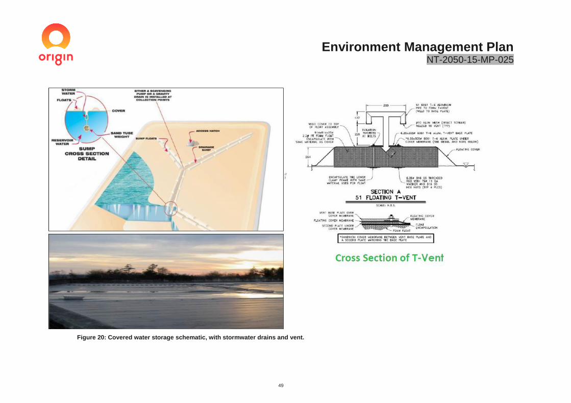
Environment Management Plan NT-2050-15-MP-025
49
Figure 20: Covered water storage schematic, with stormwater drains and vent.

Environment Management Plan NT-2050-15-MP-025
50
Table 8: Anticipated flowback quality based on Amungee NW-1H flowback results.
Parameter Flow back levels
BTEX compounds BTEX levels are anticipated to be low. Total BTEX levels in the Amungee NW-1Hflowback ranged between 2 and 15 µg/L.
Total nitrogen (as N) Maximum value of 62.1mg/l observed within flowback.
Salinity (TDS) Saline with total dissolved solids level exceeding 49,000mg/L.
pH Slightly acidic with a median value of 6.74.
Major ions Amungee NW-1H flowback predominantly Na and Cl dominated.
Dissolved metals All detected dissolved metal concentrations within the Amungee NW-1H well were low with the exception of Barium and Boron which were reported at a maximum level of 54.5mg/l and 80.1 mg/l respectively.
Polycyclic Aromatic Hydrocarbons
All values in Amungee NW-1H flowback below laboratory Limit of Detection (LOD).
Petroleum Hydrocarbons
All fractions of TPH are anticipated to be elevated.
Phenolic Compounds Low level of phenolic compounds detected in Amungee NW-1H flowback.
Radionuclides Maximum Gross Alpha Activity and Gross Beta Activity of 12.4Bq/L and 18.3Bq/L encountered in the flowback. The primary component being Radium-226.
3.10.4 Fauna and bird access
The use of open top working evaporation tanks could, if consumed, represent a risk to fauna (including birds). The potential risk of exposure to fauna, including birds, is considered low based on the following factors:
• The salinity of the water is the main deterrent, with the salinity of the water beyond the limit of most vertebrates
• Sodium chloride (NaCl) is the dominant salt, with heavy metals, organics and biocides likely to be reduced through oxidation and precipitation, UV degradation, and microbial degradation.
• The wastewater is abiotic, with an absence of food sources for birds and fauna;
• The wastewater tanks and sumps are unlikely to contain free oil, which is the main cause of bird deaths in oil fields;
• Noise and light from flaring and equipment operation likely to deter bird and bat activity in the immediate vicinity of the lease pad
• The lease pad is fenced to prevent livestock and fauna access to site
• Tanks have vertical walls with no clear access points for fauna
• wastewater depth prevents wading bird access
• an absence of perches or beaches to facilitate bird access
• Site will be manned during well testing operations with personnel capable of detecting fauna interactions. The Hypersalinity of the Beetaloo flow back water is likely to be the main factor that reduces the potential exposure to birds and fauna. The wastewater is hypersaline, with total dissolved solids (TDS) > 49,000 mg/L. It is well documented that birds, insects and mammals are unable to drink hypersaline water greater than 46,000 mg/L TDS (Bartholomew and Cade 1963; Ohmart and Smith, 1970; ANZECC, 1992; Griffiths et al, 2009). The TDS of the wastewater is likely to reduce the palatability of the wastewater, thus reducing the potential exposure of fauna, including birds to wastewater. This has been documented within the Gold industry, where studies have identified links between the hypersalinity of wastewater with reduced bird mortality associated with cyanide ecotoxicity (Adams et al 2013, Adams et al 2008, Griffiths et al 2009a and Griffiths et al 2009b) The wastewater is also abiotic, with no aquatic macroinvertebrate food source present. This lack of aquatic food source is understood to be a protective mechanism by reducing wildlife foraging in hypersaline environments (Griffiths et al, 2009a). Other food sources, such as insects flying over the and flow back tanks may attract insectivorous bats and some birds, which then feed upon in the insects in the airspace above the flow back tanks.
Environment Management Plan NT-2050-15-MP-025
51
However, as stated above, it is considered extremely unlikely that insectivorous bats and birds will drink from hypersaline wastewater (Smith et al, 2007; Adams et al, 2008; Griffiths et al, 2009a). Furthermore, it is unlikely that flying insects will drink from the flow back water, given the expected salinity, which reduces the potential for any food-chain transfer effects between the insects and insectivorous birds and bats.
Monitoring of flowback storages and surrounding areas will be implemented to document the interaction of fauna with wastewater and identify any mortalities within the wastewater storages and the area surrounding the area immediately within the lease pad (within 50m). These programs include:
• Remote motion cameras to detect fauna movements; The program is designed to demonstrate the risk to fauna associated with wastewater storage is low. The program will involve the installation of up to 12 remote cameras surrounding the permitter of the lease to detect fauna passage onto the site stimulation and wastewater storage activities (up to 12 months). The program will be designed in consultation with DENR and in alignment with a guide for the use of remote cameras for wildlife survey in northern Australia (Gillespie et al 2015)
• Fauna (including bird) interactions and mortalities will be recorded as per the following:
o Ad hoc bird and fauna observations to be taken around wastewater storages
o Daily checks for fauna mortality
o Weekly checks for fauna mortalities immediately surrounding the lease pad (within 50m)
o Fauna remains present during tank emptying and decommissioning.
Where ongoing bird or fauna mortalities are identified, additional controls shall be implemented in consultation with DENR. These may include the use of bird deterrents and netting to prevent wastewater interaction. Ongoing bird or fauna mortality is defined as >7 per week for 2 consecutive weeks or >1 endangered fauna species.
3.10.5 Stormwater
Stormwater will be managed in accordance with the following:
• The lease pad will be designed to divert stormwater around the lease pad to prevent contamination.
• Stormwater falling on the lease site will be segregated from drilling and stimulation chemical storage and handling areas to minimise contamination.
• Stormwater collected in bunds will be visibly inspected for contamination post rainfall events and discharged to the lease surface if uncontaminated. If signs of contamination are present, stormwater will be removed from the bunds and either recycled within the drilling and stimulation process or stored in a wastewater tank and removed from site in accordance with Table 12.
• A sediment basin will be installed to capture all stormwater falling on the lease pad.
• During drilling and stimulation activities where the risk of off-site release of wastewater is low (due to the low volume of drilling and stimulation fluids retained onsite during these activities), a ‘first flush’ system will be implemented where the first 20mm of run-off is retained. This run-off is most likely to contain any contaminants from the site. The additional rainfall above 20mm will be allowed to be diverted off-site via a dedicated spill point.
• When flowback is being stored on-site, all stormwater will be retained with the water backing up into the lease rather than flowing off-site. This is to ensure the system can retain any flowback tank failure event.
• Stormwater collected in the sediment basin during drilling, stimulation and well testing will be tested prior to release / re-use in accordance with Section 3.16.
• Clean stormwater that meets the quality outlined in Table 9 will be discharged off-site or re-used for dust suppression.
• Where the water is visibly turbid, a sediment sock will be used to remove sediment from the release.
• All stormwater above the specified limit will be captured and either recycled within the drilling and stimulation process or disposed of in accordance with Table 12.
• Once all work on the site has ceased and all contaminant sources have been removed from the lease pad, the stormwater system will be:
o Where the well is to be suspended and well pad kept in place: turned into a passive system with the primary purpose of reducing sediment loads. The first flush (20mm) of stormwater run-off will be retained and allowed to naturally evaporate. The remaining stormwater will be directed off-site.

Environment Management Plan NT-2050-15-MP-025
52
o Well and lease pad is to be rehabilitated: the retention system is to be removed and rehabilitated in accordance with Section 3.24
Table 9: Stormwater release and re-use limits.
Monitoring Parameter Release limit Limit basis
Off-site release
Electrical conductivity 650us/cm ANZEC Guidelines: irrigation water salinity ratings for sensitive crops.
pH 6.5-9.5 Background surface water quality data.
Dust Suppression
Electrical conductivity 1300us/cm ANZEC Guidelines: irrigation water salinity ratings for moderately sensitive crops. The higher limit is reflective of the lower sensitivity of the road as a receptor.
3.11 Geohazards and Seismicity
Operators are incentivised to avoid major faults as they can represent hazards to both drilling and stimulation operations. Geohazards are assessed via the following steps:
• Locating exploration wells: Origin has more than 9500km of 2D data available which is used to screen for large scale, regional faults or structures prior to the finalisation of any exploration well location. The data for Origin’s broader Beetaloo exploration area indicates there are very few major faults present and that the strata within the Basin (i.e. away from the steep flanks) are relatively gently dipping.
• Geohazard assessment post drilling: Prior to completing stimulation, geological data is analysed to determine the presence of minor and major faults which may pose a hazard to stimulation activities. Where faulting is encountered during the drilling of the horizontal section of the well, a risk assessment is undertaken to determine whether stimulation activities can occur safely. In some instances, location of stimulation stages along the wellbore may need to be moved / removed, to isolate the feature encountered.
• Real-time monitoring of pressure during stimulation: Pressure data provides a tool to prevent fault activation and fluid / pressure communication out of the target interval. If anomalous pressure behaviour is observed, stimulation operations can be ceased immediately. This prevents any substantial volume of fluid or proppant from being pumped into an open geological structure.
Monitoring of seismic events will be undertaken using the Geoscience Australia’s Waramungu seismic array located approximately 300km of the proposed Kyalla 117 N2 well pad. It is likely that any material seismic events will be detected via this array if they occur.
An additional traffic light system is currently being developed by the NT in response to the NT Inquiry recommendation. This system is likely to be in place, prior to any full-scale development occurs.
Controls:
✓ Wells are located away from known geohazards. ✓ Geohazards encountered during drilling are risk assessed to ensure stimulation activities can occur
safely. ✓ location of stimulation stages will avoid any geohazards encountered ✓ Monitoring of stimulation pressure to detect and respond to anomalies which may indicate fluid being
pumped to an open geological structure.

Environment Management Plan NT-2050-15-MP-025
53
3.12 GHG Emissions
Total Greenhouse Gas (GHG) emissions generated during exploration activities are summarised in Table 11. Emissions from the activities covered under this EMP anticipated to be approximately 77,501.6tCO2
e (tonnes of Carbon Dioxide equivalent) for the duration of the activity; assuming a worst case well testing period of 12-months. This is small in comparison to the total Greenhouse Gas emissions for the NT of 16,500,000 tonnes (Department of Environment and Energy 2018).
Approximately 85% of the anticipated emissions are associated with flaring. Flaring of produced hydrocarbons is required under exploration tenure to evaluate the commercial viability of a resource. Flaring in a development scenario is likely to be significantly less, as all development wells will be flowed inline, negating the need to undertake flaring activities at the wellhead.
From a cumulative perspective, the total emissions for Origin’s 2019/20 activities (including the Velkerri 76 S2 exploration well and all civil construction activities covered outside of this EMP) are estimated at 156,757tCO2
e. This cumulative value is extremely conservative, as it assumes both the Kyalla and Velkerri exploration wells are successful and an extended 12 months of well testing occurs
Based on Origin’s current approved tenure commitments, it is anticipated that this level of emission will be consistent for the next 2-3 years. This level may increase or decrease based upon the exploration success of the 2019/20 program, with emission forward looking estimates reflected in subsequent approvals.
Although a full scale shale development is beyond the scope of this EMP, if shale develop were to occur in the future post the exploration phase, the emissions intensity per well is likely to be several order of magnitude lower than during exploration. Based upon the life cycle assessment analysis of a similar (but different) unconventional gas development in Australia completed by the Gas Industry Social and Environmental Research Alliance (GISERA)(Heinz 2019), the net climate benefits of using natural gas in replacing coal for electricity generation is up to 50% less emissions (Heinz 2019). It is anticipated that any future shale gas development would utilise world’s best practice emission reduction technology and would offer a similar, if not higher emission reduction potential.
Greenhouse Gas emissions generation will be mitigated through adoption of the NT Petroleum CoP. This code requires Origin to utilise a Reduced Emissions Completion (REC) and undertake routine monitoring for leaks. RECs involve the capture and combustion of hydrocarbons in a flare; a standard practice that has been utilised by Origin for all exploration activities. The combustion of gasses produced will reduce the emissions generated by flaring by 85% when compared to venting.
In addition to monitoring emissions from drilling, stimulation and well testing activities, baseline assessments have been completed by CSIRO in the vicinity of the lease pad as per the Petroleum Codes of Practice.
Table 10: Greenhouse Gas summary for the proposed activities.
Activity Approximate volume
Approximate tCO2e^
Estimate methodology and assumptions
Diesel combustion - horizontal and vertical drilling
700KL of diesel 1,904 Diesel estimated using historic drilling data multiplied by NGERS emission factor. This includes all vehicle, generator, pump and equipment fuel use.
Diesel Combustion Stimulation
200Kl of diesel 544 Diesel estimated using historic stimulation data multiplied by NGERS emission factor. This includes all vehicle, generator, pump and equipment fuel use.
Fugitive methane emissions - drilling
0.189 tonnes of methane
4.71 Available Kyalla gas saturation combined with anticipated shale cutting volume and NGERS emission factor (25 tCO2
e/tCH4).
Fugitive emissions - stimulation
259 tonnes of methane
7,976 NGERS completion factor of 25.9 tonnes per day multiple by 25 tCO2
e/tCH4.
Fugitive emission- wastewater storage
3.6ML of flowback
30.6
Conservative API^^ emission factor of 0.39tCH4/ML and NGERS methane conversion factor 25 tCO2
e/tCH4.

Environment Management Plan NT-2050-15-MP-025
54
Flared emissions 2.5Tj/day of natural gas and 37.5 barrels of condensate / day
66,049 NGERS emission factor based on 2.5 TJ/day (conservative success case) and 37.5 barrels / day condensate flaring for 12-months (worst case).
Well testing 365,000L of diesel
993 Diesel estimate using historic well testing data of 1000L/day for evaporators, generators, pumps and vehicles.
Total 77,501.6
^ Based on Global Warming Potential (GWP) of 25tCO2e/tCH4 (Clean Energy Regulator 2016)
^^https://www.api.org/~/media/files/ehs/climate-change/2009_ghg_compendium.ashx
Table 11 Cumulative Greenhouse Gas emission estimates- All NT 2019/20 activities
Activity Approximate tCO2e^
Emissions from drilling, stimulation and well testing of Kyalla 117 N2 production well
77,501
Emissions from drilling, stimulation and well testing of Velkerri 76 S2 production well
77,504
Emissions from civil construction program and vegetation clearing for both Kyalla 117 N2 and Velkerri 76 S2
1752
2019/2020 Activity Total GHG 156,757
3.13 Naturally Occurring Radioactive Material
A detailed assessment of Naturally Occurring Radioactive Material (NORM’s) was undertaken during the Amungee NW-1H well drilling and testing in 2016. The assessment collected data on the drill cuttings, gas and flowback water, with the results considered applicable to the Velkerri 76 S2 exploration program.
The observed radionuclide level within flowback and gas samples observed from Amungee NW-1H are at the lower end of those observed in the USA shale developments (Kibble et al. 2013).
The analysis concluded the following:
• Drill cuttings: X-Ray Fluorescence (XRF) data was collected at regular intervals (average 5m), providing an estimate of up to 48 elements (including uranium, thorium and potassium) present in the formations being drilled. This data was analysed by a third-party contractor. Analysis determined that the
Controls:
✓ Baseline methane monitoring was completed by CSIRO prior to commencing stimulation as per the Code of Practice for Petroleum Activities.
✓ A reduced emission completion will be utilised to reduce the GHG intensity of the activity. ✓ All flaring will be measured using flow meters compliant with NGERS. ✓ A Methane emissions monitoring program (MEMP) will be implemented. The MEMP is provided in
Appendix L . ✓ All wells will be tested every six months for any leaks as per the NT Petroleum CoP. ✓ Emissions will be reported in accordance with the NGERS.

Environment Management Plan NT-2050-15-MP-025
55
Uranium and Thorium (primary sources for mineral contained NORM’s) content of the geological formations drilled was well within the ranges of normal geological rocks. In addition a study commissioned by Origin Energy in 2016 with the company ‘Radiation Professionals’ analysed drill cuttings samples from four wells drilled by Origin Energy (Kalala S-1, Amungee NW-1, Amungee NW-1H, Beetaloo W-1). Results concluded that none of the samples provided exceeded limits provided in the ‘Radiation Protection Regulations, 2012 (NT) Regulations 7’ or the ‘National Directory for Radiation Protection, Part B, section 3.2’. Given the distribution of the wells across the tenure and the geological continuality of the Roper Group formations, the risk of NORM’s is considered low. The assessment of NORMs potential will be able to be accurately assessed and screened using a combination of wellsite wireline natural gamma and post drilling XRF analysis on cuttings samples to detected analogous samples with high radioactive producing elements such as Uranium and Thorium. If levels approaching the Radiation Protection Regulations are detected, a more thorough evaluation will be conducted. Furthermore, NORMs assessments of drilling muds are required under the Petroleum Codes of Practice and will be completed as per Section 3.10.1.
• Flowback: NORMS samples of flowback were collected weekly during the well testing of Amungee NW-1H. An assessment of the results indicated that for the flowback to breach the regulatory limit of 1 mSv/year, a person would have to consume greater than 80 litres of flowback fluid. Given fluid is strictly managed in accordance with the Codes of Practice and correlating Waste Water Management Plan, this scenario is considered highly unlikely.
• Gas: Results for the raw gas analysis from Amungee NW 1 indicated that at the observed radon level of 225 Bq/m3. An exposure above 1mSv/m3 from raw natural gas is considered remote, as a person would need to be continuously exposed to raw gas on a long-term basis (years). This exposure scenario is not deemed a credible pathway, as there are stringent requirements within the Petroleum Code of Practice which prohibits unnecessary venting and requires operators to conduct ongoing leak detection and repair program. Furthermore the observed levels of radon are:
o well below the maximum radon level limit for natural gas of 600Bq/m3. These limits are imposed by the Australian Energy Market Operation (AEMO) and outlined in the Australian Standard AS4564 Specification for general purpose natural gas (AEMO 2017) to protect the safety of the end domestic user of gas.
o An order of magnitude lower than many shale radon level in the US; including the Marcellus (Cassman et al 2016) which has been deemed safe to use for domestic purposes.
o Consistent with the Australian Radiation Protection and Nuclear Safety Agency (arpansa) recommendation that radon levels should not exceed 200 Bq/m3 in households and 1000Bq/m3 in workplaces (ARPANSA 2019). The exposure of a pastoralist to unventilated gas is considered remote, based on the separation distance between the well and the inherent controls that limit venting. The potential exposure to workers is also considered a low risk, based upon the Radon levels being within the ARPANSA workplace guidelines and code of Practice controls.
The risk of exposure from NORMs generated during shale exploration activities is considered low. Testing of the drilling cuttings, gas and flowback water will be undertaken during this campaign, as described in Section 3.23.
Further information on the NORM’s level encountered was provided to the Inquiry as part of Origin’s submission.
3.14 Spill Management
The use of secondary containment to prevent spills during drilling and stimulation activities is a regulatory requirement embedded in national and state chemical handling legislation and guidelines. These requirements have been further covered in the NT Petroleum CoP.
A Spill Management Plan has been developed covering Origin’s proposed exploration activities. This SPMP is provided in Appendix D.

Environment Management Plan NT-2050-15-MP-025
56
An example of bunding used for drilling and stimulation activities is provided in Figure 21.
Figure 21: Example of spill containment around HFS equipment.
Controls:
✓ All chemicals and wastes generated during civil activities, drilling, stimulation and maintenance will be stored in designated areas with secondary containment.
✓ Tanks used to store wastewater or hydrocarbons, will be double-lined with procedures in place to detect leaks through the primary containment barrier.
✓ Covered tanks will be used to prevent rainwater ingress during the wet season. ✓ Open-top tanks will have freeboard provision that comply with the NT Wastewater CoP. ✓ Tank manifolds will be designed to isolate each tank preventing multiple tank failures. ✓ The lease pad will be bunded, with the minimum height required to contain the largest volume of the
largest wastewater tank stored onsite. ✓ All transportation of chemicals will comply with the NT Dangerous Goods Act and associated
legislation. ✓ All contractors will be required to comply with the Spill Management Plan and have procedures in place
to outline how spills will be prevented, identified and rectified. ✓ Spill kits and emergency response measures will be deployed at site where chemicals are stored and
handled. ✓ Any spills will be cleaned up immediately in accordance with the SPMP provided in Appendix D. ✓ Chemicals and wastewater will not be transported within the wet season unless a risk assessment
determines the risks are as low as reasonably practicable and acceptable. ✓ All hazardous chemicals storage will be covered in the wet season

Environment Management Plan NT-2050-15-MP-025
57
Figure 22: Example of spill mats used to contain drilling additives and under a high-pressure pumping unit.
3.15 Water supply and use
The extraction of water for all activities associated with stimulation activities is approved under the Water Extraction Licence (WEL) number GRF10285. This approval allows for an extraction of up to 175ML/year from the Gum Ridge formation to cover all of its proposed exploration for the next 3 years.
It is estimated that up to 38ML of water will be extracted from the Gum ridge Formation to support the Kyalla 117 N2 drilling, stimulation and well testing exploration program. A water balance for the activity is provided in Table 7Table 7. The breakdown of groundwater take for the drilling, stimulation and well testing campaign consists of the following:
• 1ML Monitoring and extraction bore drilling
• 5ML Drilling activities
• 27ML Stimulation and well testing activities
• 5ML Camp Activities
Water sourced for the drilling and stimulation operations will be extracted from the Gum Ridge control and impact monitoring bores that will have been installed prior to the commencement of drilling and / or stimulation activities. These bores
All groundwater take metered with continuous flow meters and reported to DENR as per the Water Extraction Licence. Water take records will be kept and updated weekly during operations, to ensure the water take volumes are not exceeded.
Groundwater will be used to supply potable water, with on-site water treatment used to provide water in accordance with the Australian Drinking Water Guidelines.
The cumulative impact associated with Origins current and future groundwater take were addressed in the water Extraction Licence GRF 10285 statement of reason provided in Appendix Q. This includes water used for the civil construction, drilling, stimulation and well testing of 2 exploration wells (the Kyalla 117 N2 and potential Velkerri 76 S2 well)The following information indicates that the future use of groundwater is within the sustainable yield of the Gum Ridge aquifer and will not impact on current and future users:

Environment Management Plan NT-2050-15-MP-025
58
• The sustainable yield of the Gum Ridge Formation is between 1,412,800,000 and 2,2825,600,000Ml/year
• The total groundwater take for Origin’s 2019/20 program (all activities associated with the proposed 2 exploration wells) is anticipated to be 132ML; well below the total annual licenced value of 175ML.
• The predicted 3-year water use for Origin’s exploration use is conservatively assumed to be consistent with the total WEL level of 525ML.
• One other extraction licence from the Gum Ridge Formation exists, which authorises a total maximum extraction of 967.5ML over the May 2019 to December 2023 period.
• 300ML of groundwater per year is estimated for domestic use.
• Total extraction from the licenced and domestic extraction is 1,792.5ML; well below the lowest sustainable yield value of 1,412,800,000ML.
• DENR modelling of the Impacts to the Bitter and Rainbow Springs conclude that then proposed extraction would have no change to the reliability of the spring flows.
• DENR modelling of Roper River at Elsey National Park and red rock indicated there would be no change in reliability of surface water flows as a result of the activity.
• A maximum reduction in groundwater level of 0.12m after 58 years of continuous extraction was estimated at the closest registered bore from the nominated extraction point.
• Due to the remote location of and pastoral land use, tin the area future domestic demand is unlikely to change significantly.
3.16 Wet Season Operations
Wet season operations are currently anticipated to be restricted to well testing activities. Where wet season operations are undertaken the following risk controls will be implemented:
• All chemicals, fuels, equipment, tanks and materials required for ongoing operations will be stored onsite prior to the onset of the wet season.
• All equipment required to respond to emergency situations will be onsite; this include earth moving equipment, vacuum trucks, wireline rigs, cementing equipment etc. This includes equipment and material to deal with well control issues, spills and other emergency events.
• All chemicals storage areas will be bunded, with covers used (where safe and appropriate) to prevent rain ingress and bund overflows
• Enclosed tanks will be utilised as the primary measure to store wastewater.
• Enclosed wastewater storage volume will be sufficient to manage all wastewater stored onsite
• Open working evaporation tanks and mud sumps will have enough freeboard to manage an entire 1:1000 ARI wet season event
• Helicopters will be used to transport people and supplies in and out of site when access is restricted.
Controls:
✓ Water use will be minimised to only cover what is needed to perform the activity. ✓ A water Extraction Licence GRF 10285 has been granted which covers all activities under this EMP ✓ Cumulative impacts from groundwater extraction volumes have been assessed as a part of the
granting of the water licence GRF10285 (Appendix Q) ✓ Surface water will not be used during exploration activities. ✓ Rainwater collected on-site will be re-used were possible. ✓ All water take will be monitored using a continuous flow meter, as per the WEL. ✓ Water will not be extracted within 1km of an existing landholder bore. ✓ Impacts on landholder bores are modelled to ensure any predicted impacts can be mitigated. ✓ A conceptual water balance has been developed. ✓ A fine tank scale water balance model will be implemented during drilling, stimulation and well testing
to track water volumes live.

Environment Management Plan NT-2050-15-MP-025
59
• No transportation of wastewater or chemicals will be undertaken during the wet season, unless a risk assessment is undertaken that demonstrates the risk is ALARP and acceptable (as per the Codes of Practice)
• Lease pad is bunded, which will prevent all offsite releases of chemicals and stormwater;
• All stormwater will be retained onsite via the sediment retention pond prior to release.
• Overland flow will be diverted around lease pads
3.17 Helicopter operations
In the event that access to the site was prevented during operations, helicopters will be utilised to move people and supplies into and out of site. This ensures the site can be manned during all activities, regardless of the season.
The use of helicopters in the NT for transportation is a standard activity. The use of helicopters ensures that personnel can be evacuated in an emergency as well as ensuring access to the site during period of wet weather.
3.18 Waste Management
Waste management methods for the proposed exploration program are summarised in Table 12.
Waste are managed in accordance with the internationally-accepted guide for prioritising waste management practices with the objective of achieving optimal environmental outcomes. Waste will be managed in accordance with the following hierarchy principals:
1. Avoid: eliminate the generation of wastes through design modification 2. Reduce: reduce unnecessary resource use or substitute a less resource intensive product or service. 3. Re-use: reuse a waste without further processing 4. Recycle: recover resources from a waste 5. Treatment: treat the waste to reduce the hazard of the waste prior to disposal 6. Disposal: disposal of waste if there is no viable alternative
Waste transfer certificates will be retained and provided to DENR upon completion of the project.
Drilling, stimulation and well testing wastewater is managed in accordance with Section 3.9
Controls:
✓ Leases are designed to address wet season operations ✓ Chemical storage areas to have covers preventing rain ingress ✓ Wastewater management plan to comply with Codes of Practice requirements for wet season
operation; this includes the use of enclosed tanks and freeboard requirements. ✓ All stormwater collected and tested onsite during well testing ✓ No transportation of chemicals and wastewater unless safe to do so ✓ Helicopters to be used for moving people and supplies in and out of site if access is restricted.
Controls:
✓ Pastoralists to be notified during helicopter movements ✓ Helicopter flight path to avoid pastoralist homes and cattle yards ✓ Helicopter flight height appropriate to avoid spooking cattle and wildlife ✓ All field storages for helicopters undertaken in accordance with AS 1940: The storage and handling of
flammable and combustible liquids.

Environment Management Plan NT-2050-15-MP-025
60
Table 12: Waste and disposal methods.
Activity Disposal Method
Sewage, grey and stormwater Treatment:
Grey water and sewage treated and disposed of on-site in an approved, portable treatment system accordance with Department of Health Code of Practice for small on-site sewage and sullage treatment systems and disposal for reuse of sewage effluent.
Sewage treated will be surface irrigated to a dedicated, fenced area. The area will be left vegetated, with no clearing required.
Sludge removed from site and disposed of at an appropriately licenced facility.
Uncontaminated stormwater will be tested (refer Sections 3.12 and 3.16) and either released off-site or re-used for dust suppression.
Food waste, paper and plastic Disposal: Collected in dedicated waste bins for back-loading to an approved landfill.
Glass and cans Recycled: Collected in separate waste bins for recycling at an off-site facility.
Chemical bags and cardboard packaging materials
Recycled: Compacted and collected at rig site for transport to a licenced recycling centre.
Scrap metals Recycled: Collected in designated skip for recycling at an approved location.
Used chemical and fuel drums Recycled: Collected in designated skip for recycling at an approved location.
Chemical wastes Re-use / disposal Collected in approved containers for disposal at approved landfill or returned to supplier or recycled.
Timber pallets (skids) Recycled: Recycled at an approved facility.
Vehicle tyres Disposal: Disposed of at an approved landfill.
Oily rags, oil-contaminated material, filters and any hydrocarbon material
Recycled / Disposal: Oil from machinery or encountered during drilling. Collected in suitable containers for disposal at approved landfill or recycled at an approved recycling facility.
Flowback Treatment and Disposal: Managed in accordance with Section 3.8.2. Highly-saline wastewater collected in a series of open and closed tanks. Evaporated on-site using mechanical evaporators and then disposed of off-site at a licenced facility interstate.
Exploration well drill cuttings, muds and fluids
Treatment and Disposal Managed in accordance with Section 3.10.1. Saline fluids and solids stored within a lined sump. Fluids segregated from muds and cuttings. Solids dried out, with liquids evaporated. Solids tested and disposed of on-site or off-site
Controls:
✓ Waste will be managed in accordance with the NT Waste Management and Pollution Control Act. ✓ Listed wastes will be tracked and disposed of at a licenced facility by approved transporters. ✓ Origin will follow the waste management hierarchy to prioritise the prevention of creating wastes.

Environment Management Plan NT-2050-15-MP-025
61
Activity Disposal Method
depending on hazard. Fluids transported offsite to a licenced facility interstate.
Extraction bore drilling cutting and muds (cuttings mixed with drilling fluids)
Disposal Freshwater cuttings and drilling mud with low hazard. Disposed of on-site in accordance with the Minimum Construction Requirements for Waters bores in Australia for water bore drilling practices.
Spill contaminated soils and water Disposal All contaminated material (solids and liquids) will be disposed of off-site at a licenced facility.
Stormwater Discharged / recycled / disposed: All stormwater will be collected on-site in a designated sediment retention system as described in Section 3.10.5. Stormwater will be tested and either released off-site or recovered and either recycled within the drilling process or disposed of at a licenced wastewater treatment facility in accordance with the NT Waste Management and Pollution Control Act 1998.
Waste sand Re-use / Disposal: Waste and returned sand from stimulation activities will be re-used or disposed of in the drilling sumps with the residual cuttings and muds.
3.19 Weed Management
Exploration activities are undertaken in accordance with Origin’s Beetaloo Weed Management Plan (NT-2050-PLN-019). This plan has been developed in accordance with the Weed Management Planning Guide: Onshore Shale Gas Developments Project.
Weed surveys have confirmed the proposed area of activity has an extremely low presence of weeds. Efforts will therefore focus on both eliminating the potential introduction of weeds into the region and preventing the spread of existing weeds.
From a cumulative impact perspective, the risks of increasing weed pressure in the area is reduced through the mandated use of weed hygiene inspections/certification for all equipment and vehicles and routine weed monitoring and maintenance. Any weeds that are introduced into the activity areas will be promptly identified and managed, reducing the potential additional stress to the region.
Controls:
Weed control strategies will include:
✓ A Weed Management Plan has been developed and submitted to DENR. The Weed Management Plan will be implemented.
✓ Selection of equipment from local suppliers, with equipment sourced from Queensland the least preferred option.
✓ All equipment brought onto the exploration permit shall be washed-down and certified ‘clean’ prior to entry.
✓ Equipment will be inspected and certified where movements are proposed from ‘dirty’ to ‘clean’ areas.
✓ Monitoring and maintenance activities will be undertaken pre- and post- wet season to identify and treat weed infestations.
✓ Any declared weed outbreaks will be notified to DENR.

Environment Management Plan NT-2050-15-MP-025
62
3.20 General chemical and fuel storage
Other fuels and chemicals are anticipated to be utilised during the activities. These include:
• Diesel storage up to 100,000L at a time.
• Typical workshop and maintenance chemicals including hydraulic oil, coolant, greases, paints, solvents and engine oils (minor field storage volumes up to 250L each).
• Degreasers and domestic cleaning chemicals (<50L of each).
3.21 Camps
The temporary drilling camps will be constructed to house approximately 40-60 people, composed of two crews that will work 12-hour shifts, plus the camp staff, supervisory staff and service company personnel on an as-required basis. The camp includes:
• accommodation
• ablutions and septic(s) waste treatment
• recreation room
• kitchen and mess
• freezer unit
• site office
• generator and diesel storage
• water tank.
The main camp will be located on a designated camp pad located within 500m of the main lease pad. This camp will house between 40-60 people and will be used through the project to accommodate personnel during drilling, stimulation and well testing. A separate mini-camp will be set up on the exploration well lease during activities. The mini-camp will house up to eight people and will support the 24-hour drilling activities.
Each camp will have its own sewage treatment plant. Treated water will be dispersed via drainage away from the camp to a designated irrigation area in accordance with the Code of Practice for Small On-site Sewage and Sullage Treatment Systems and the Disposal or Reuse of Sewage Effluent, issued by the NT Department of Health. Designated irrigation areas will be fenced adjacent to the camp pad and exploration lease pad. These areas will not require clearing and will be fenced to exclude livestock access.
Under the above Code of Practice, any septic systems releasing to the environment must not be within minimum separation distance to a potable groundwater supply bore.
All camps will be managed in compliance with the NT Environmental Health Fact Sheet No 700, Requirements for mining and construction projects and “Health requirements for mining and construction camps” available at https://nt.gov.au/property/building-and-development/health-and-safety/health-requirements-mining-construction-projects
Controls:
✓ Any refuelling or field servicing to have spill containment. ✓ All waste oils, coolant, chemicals and contaminated material to be removed from site and disposed of
at an approved facility by a licenced waste contractor in accordance with the NT Waste Management and Pollution Control Act.
✓ Double-lined diesel storage tanks to be used as per AS 1940: The storage and handling of flammable and combustible liquids.
✓ All chemical storages to have secondary containment. ✓ Chemical storage areas to be inspected routinely, with uncontaminated stormwater removed from site
to be disposed of at a licenced facility.

Environment Management Plan NT-2050-15-MP-025
63
All camp infrastructure will be temporary and portable and powered by diesel generators. The potable water supply for the camps is to be sourced from groundwater bores established for drilling activities and treated to the appropriate drinking water standards.
It is likely the domestic solid waste generated by camp activities will be removed by a waste contractor, or where practicable, using local waste disposal arrangements in accordance with the NT waste management regulations.
3.22 Traffic
Traffic associated with exploration activities is generally small and of short duration. To assess the potential impact on pastoralist and tourism amenity and experience, a Traffic Impact Assessment (TIA) has been completed to determine the potential additional traffic during the drilling, stimulation and well testing activity.
The TIA involved the following steps:
• Identification of project traffic movements; including approach and departure direction
• Existing traffic levels and road Level of Service
• Assessment of total traffic levels and potential impacts
• Determine required impact-mitigating treatments.
The results of the TIA are discussed below.
Identification of project traffic movements
The access to Kyalla 117 N2 site is via the Stuart Highway, approximately 23km south of the town of Dunmarra as illustrated in Figure 2. The Highway has a 130km/h posted speed limit in the vicinity of the project and is generally a two-lane, two-way road with a sealed width of 7-metres and unsealed or grassed shoulders varying between 2.5 and 5-metres in width.
The TIA identified that the peak maximum anticipated traffic flow increase associated with the activity will be approximately 44 vehicles per day. The duration of the activity will extend over a 12-month period, with the peak movements restricted to a week period during the initial rig mobilisation and final rig demobilisation. Average daily traffic additions during the remainder of the period are likely to be 10-15 movements per day for the first three-months, reducing down to three-four movements for the remainder of the period.
There will not be a dominant flow direction resulting from the activity, with 60% of movements into / out of the project area originating from Darwin, and the remaining from either Queensland or South Australia via Tennant Creek.
Existing traffic levels, road capacity and level of service
Existing traffic figures were obtained from the DIPL Annual Traffic Report 2017 showing Average Annual Daily Traffic (AADT) figures for the Stuart Highway roughly 30km south of the proposed access location. This station is approximately 65km north of the access point to the Kyalla 117 access track and it can be assumed that the traffic figures at the site will be similar.
The total daily traffic flows from the 2017 annual survey data are in the order of 551 vehicles; effectively split evenly between north and south-bound (refer Figure 23). Traffic rates during the dry season are likely to be substantially higher than the average figures, with peak dry season traffic observed to be up to 50% higher than the average volumes (GHD 2013). Therefore, a revised figure of 827 vehicles/day is considered a representative worst-case traffic volume.
Controls:
✓ An oil-water separator / interceptor trap for kitchen wastewater will be used to enable efficient working of the septic system.
✓ Waste will be recycled where possible; including aluminium cans, cooking oil, glass etc. ✓ Domestic waste will be stored so as to not attract feral pests and wildlife. ✓ Any releases of grey water and treated effluent will be undertaken in accordance with the Code of
Practice for Small On-site Sewage and Sullage Treatment Systems and the Disposal or Reuse of Sewage Effluent, issued by the NT Department of Health.

Environment Management Plan NT-2050-15-MP-025
64
AUSTROADS guidelines (Austroads 2017) were used to determine the typical capacity that would be expected by traffic on the Stuart Highway to maintain a free-flow level of service (LOS). The Stuart Highway in the project location is a two-lane, two-way road. The capacity of roads is based on the maximum rate at which persons or vehicles can reasonably be expected to traverse a point or uniform section of lane or roadway during a given time period. The Level of Service relates to the operating conditions encountered by traffic as defined in the AUSTROADS guidelines (Austroads 2017). This data was then used to determine the capacity of the Stuart Highway to maintain a Category A (free flowing) LOS for the site. A conservative 700 – 1000 vehicle/hr/lane figure was used to determine the vehicle movement capacity of the Stuart Highway.
In an urban situation it can be assumed that the peak hour volumes will be about 10% of the daily traffic volumes. However, the remoteness of this site means that a peak hour is not realistic and has not been considered. Due to the low anticipated volumes that are likely to be spread over the duration of the day, this is considered appropriate.
Figure 23: Traffic flows on the Stuart Highway approx. 30km south of the proposed site access point.
Assessment of total traffic levels and reduction to road capacity and level of service
The total anticipated peak traffic volume for the project has been determined at 871 vehicles per day. This consists of an additional peak project vehicle movement level of 44 vehicles/day in addition to the existing peak dry season traffic volumes of 827 vehicles/day.
The total volume of traffic is considerably lower than the capacity of the Stuart Highway, with any reduction in LOS from the volume of project traffic considered extremely unlikely.
Traffic LOS may also be impacted through changes in traffic compositions, with the volume of trucks affecting the road capacity greater than light vehicles. To assess the changes in traffic composition, vehicle category data obtained from the DIPL Annual Traffic Report 2017 were assessed against expected total project traffic figures. These figures were increased by 50% to represent peak dry season traffic volumes. The assessment is provided below.
1. Short (light vehicles) 603 vpd (72.9%) 2. Medium (heavy vehicles or short towing) 76 vpd (9.2%) 3. Long (heavy vehicles) 53 vpd (6.4%) 4. Medium combination (heavy vehicles) 27 vpd (3.3%) 5. Large combination (heavy vehicles) 68 vpd (8.2%) Allocating the projected 44 additional trips to the measured daily flows we get:

Environment Management Plan NT-2050-15-MP-025
65
1. Short - 12 additional vehicles 615 (70.6%) 2. Medium - 0 additional vehicles 76 (8.7%) 3. Long - 5 additional vehicles 58 (6.7%) 4. Medium combination - 0 additional vehicles 27 (3.1%) 5. Large combination - 27 additional vehicles 95 (10.9%)
The results demonstrate that there are minimal changes in traffic composition associated with the project, with an additional 1.2% of large combination vehicles when compared to the total volume composition. This percentage is unlikely to significantly impact upon the road’s capacity and LOS.
Other potential risks and controls associated with traffic are discussed further in section 6.5.12.
3.23 Monitoring
A series of monitoring programs has been developed under this EMP to:
• Monitor and detect changes in environmental values associated with Origin’s activities.
• Characterise waste streams to understand the nature of the waste and determine the disposal requirements.
• Characterise the quality of the produced hydrocarbons.
• Report on rehabilitation progress. An overview of each of the monitoring programs is provided in Table 13. Six-months of groundwater monitoring data (level and quality) is required prior to commencing stimulation activities to establish a baseline against which any material impact on Environmental Objectives can be assessed.
Adequate monitoring data will be obtained from the control groundwater monitoring bores prior to the commencement of stimulation activities. All monitoring sample data will continue to be submitted to DENR periodically to ensure an adequate baseline has been achieved prior to stimulation.
Table 13: Monitoring program summary.
Monitoring Program
Purpose Parameters Monitoring Points
Frequency Reference document
Flowback Monitoring
Characterise flowback quality.
Field chemistry.
Field Chemistry pH, Dissolved Oxygen, Oxygen reduction potential, temperature and electrical conductivity.
Post separator before entering into flowback tank.
Field Chemistry Daily during the first four weeks and weekly thereafter.
Analytical Suite: Weekly for the first 12-weeks of flowback and monthly thereafter.
Petroleum Codes of Practice
Characterise stimulation fluid- Laboratory analysis.
Field Chemistry pH, Dissolved Oxygen, Oxygen reduction potential, temperature and electrical conductivity.
Pre- injection.
Each fluid system used during injection (one of each in total).
Petroleum Codes of Practice

Environment Management Plan NT-2050-15-MP-025
66
Monitoring Program
Purpose Parameters Monitoring Points
Frequency Reference document
Analytical suite- Appendix G. including NORMS.
Drill fluid, mud and cutting characterisation
Characterise the quality of drill cuttings, fluids and muds to determine disposal options.
Table 10 of the Petroleum Codes of Practice (NORMs), Particle size distribution, Bulk density.
Drilling sump - as determined by a suitably qualified third-party.
Prior to disposal.
Petroleum Codes of Practice
Gas composition and isotopes
Characterise produced gas.
Gas composition (Nitrogen, Oxygen, Carbon Dioxide, C1-C10+, H2S) Isotopes (C13
(CO2 and CH4) and H2 (CH4, C2H6
+). Radon and radioactivity.
Post-separator.
Monthly- internal characterisation program.
N/A
Groundwater Monitoring
Detect changes in groundwater as a result of drilling and stimulation activities.
Level, temperature, electrical conductivity, pH.
Control and impact monitoring bores.
Quarterly-six months prior and three-months after stimulation and then annually until the end of life of the well
Petroleum Codes of Practice
Appendix G. Control and impact monitoring bores.
Quarterly-six months prior and three-months after stimulation.
Level, temperature, electrical conductivity, pH, Appendix G
Landholder bores within 10km of an exploration well.
Baseline collected three-months prior to stimulation.
Groundwater Take
Groundwater volume.
Litres. Each groundwater extraction bore.
Continuous flow meter.
NT Water Act
Stormwater Manage stormwater collected during activities.
Field EC and pH. Sediment basin release point.
Prior to release. N/A
Erosion and sediment control
To detect the presence of erosion and sedimentation from infrastructure
Visual inspection of infrastructure and erosion and sediment controls.
Inspection of all disturbed areas, including lease pads, access tracks, gravel pits, laydown
Visual inspections pre and post wet season.
Origin’s Erosion and Sediment Control Plan NT-2050-15-MP-0019
Environment Management Plan NT-2050-15-MP-025
67
Monitoring Program
Purpose Parameters Monitoring Points
Frequency Reference document
yards, camp pads etc.
Fauna- photographic
Collect data on fauna presence
Photographic records
12 locations surrounding the lease pad
During stimulation and well testing (~12 months)
A guide for the use of remote cameras for wildlife survey in northern Australia
Weeds Identify weeds potentially introduced or spread by Origin’s activities.
Visual inspection. Inspection of all disturbed areas, including lease pads, access tracks, gravel pits, laydown yards, camp pads etc.
Visual inspections pre and post wet season.
Origin’s Weed Management Plan NT-2050-15-MP-0016.
Post rehabilitation
Monitor ongoing rehabilitation success.
Visual inspections. Inspection of all rehabilitated areas, including lease pads, access tracks, gravel pits and camp pads.
Annually. Section 3.24
3.23.1 Water Sampling Methodology
Water samples will be collected in accordance with Table 14. All samples will be collected by appropriately qualified personnel, with all meters calibrated in accordance with the manufacturer’s instructions. Samples will be collected in laboratory-supplied sampling containers and placed in chilled eskies and transported under Chain of Custody (COC) procedures. Analysis will be performed by laboratories with National Association of Testing Authorities (NATA)-accredited analysis methodology. Each sample will have a unique identifier that would be cross-referenced to the monitoring location and time of sampling. Table 14: Monitoring program methodologies.
Program Sampling Methodology
Drilling sump characterisation
• National Environment Protection (Assessment of Site Contamination) Measure
• AS4482.1- 2005 guide to the investigation and sampling of sites with potentially contaminated soil
Flowback Monitoring • Australian and New Zealand Guidelines for Fresh and Marine Water Quality 2000 (ANZECC Guidelines).
• AS/NZ5667.1: 1998. Water Quality Sampling Part 1: Guidance on the design of sampling programs, sampling techniques and the preservation and handling of samples

Environment Management Plan NT-2050-15-MP-025
68
Groundwater Monitoring AS/NZ5667.11: 1998. Water Quality Sampling Part 11: Guidance on Sampling of Groundwaters
• AS/NZ5667.1: 1998. Water Quality Sampling Part 1: Guidance on the design of sampling programs, sampling techniques and the preservation and handling of samples
• Geoscience Australia 2009: Groundwater Sampling and Analysis
3.24 Rehabilitation Plan
The proposed drilling and stimulation leases will form part of Origin’s ongoing exploration program.
Once a determination has been made to decommission an asset, each petroleum well will be plugged and decommissioned in accordance with the Petroleum Codes of Practice. All tanks, surface infrastructure and wastes will be removed from site and disposed of in accordance with the Waste Management and Pollution Control Act 1998.
All remaining assets with a residual beneficial use (such as water bores, laydown yards, gates, fences, fresh water tanks etc.) will be transferred to pastoralists Before considering a transfer of ownership, Origin will:
- Undertake an assessment of the current status of the asset and whether it can be beneficially used by the local pastoralist. Where a beneficial use is anticipated, identify works required to be undertaken to ready the asset for transfer (i.e. any repairs, site remediation, equipment removal etc.).
- Obtain written agreement from the pastoralist to take ownership of the asset and document any stipulated liabilities.
Where an asset cannot be beneficially utilised, the site will be rehabilitated using assisted natural regeneration
back to a safe, stable landform consistent with surrounding land use. This will include:
• Removal of all surface facilities.
• Removal of all weeds and contaminated materials / wastes.
• Re-spreading of stockpiled topsoil.
• Backfilling of all open sumps.
• Reshaping the site to as close to natural form as possible.
• Ripping or scarifying any compacted surface.
• Spreading of stockpiled vegetation to aid in surface water flow control.
• Spreading seed of suitable local native species which has been determined through analogue sites
representative surrounding vegetation communities.
- Any seed supply and rehabilitation services will be sourced using Indigenous suppliers (where available).
- Where rehabilitation is required, rehabilitation success criteria will be developed and submitted to DENR for
approval prior to the commencement of rehabilitation
- Rehabilitation site success criteria will be based upon adjacent-impacted vegetation sites with the same pre-
disturbed vegetation and soil units.
- Where a site is rehabilitated, monitoring will be undertaken annually to assess the rehabilitation success and
determine where additional remedial works are required.
- Success criteria for areas requiring rehabilitation will be submitted to DENR prior to the commencement of
rehabilitation activities. It is anticipated that the success criteria shall be measured with regards to the
following measurement criteria (as agreed with DENR):
• Landholder and DENR agree in writing that the land supports the pre-disturbance land use.
• Soil suitability and stability is equivalent to the surrounding soil unit.
• No subsidence, erosion or weeds evident for at least five years.

Environment Management Plan NT-2050-15-MP-025
69
• A minimum of 80% foliage cover and diversity of analogue sites is maintained in the rehabilitated sites
for at least three years.
• Maintain a density of habitat structures (litter cover, fallen woody material and hollow logs etc.) similar
to analogue sites.
• Maintenance is no greater than that required for the land prior to its disturbance.
A rehabilitation plan will be submitted within 3 months of approval of this EMP.
3.25 Timeframes
The anticipated key activity dates for the drilling, stimulation and well testing program are detailed in Table 15. These dates are designed to provide a guide and the actual dates are subject to change depending on weather, commercial and other considerations.
Table 15: Anticipated activity dates.
Activity Estimated Dates
Work instruction finalised and issued to contractors Mid-July 2019
Site establishment End July2019
Exploration well drilling August - September 2019
Extraction bore and impact monitoring bore drilling July - September 2019
Stimulation September - November 2019
Well testing October 2019 to January 2020
Well suspension December 2020
Well decommissioning December 2024 - Depending on the
success of the exploration well.
Rehabilitation of site December 2024 - Contingent on well
decommissioning.
4 Description of the existing environment
4.1 Physical Environment
A Land Condition Assessment (LCA) was completed in August 2018 to gather baseline information on the current physical environment within the proposed activity area. This was included in the previous Kyalla 117 N2 Civil Construction EMP NT-2050-15-MP 026.
A summary of the LCA is provided as follows, with the full LCA included in Appendix B.
4.1.1 Climate
The climate of the permit areas is arid to semi-arid, with rainfall decreasing in frequency and quantity from north to south. The climate is monsoon influenced, with a distinctive wet and dry season experienced through the year.
Rainfall in the north of the permit area is recorded at 681 mm at Daly Waters. The southern portion of the permit area records an average annual rainfall of 536 mm at Newcastle Waters and 602 mm at Elliott. Approximately 90% of the rainfall occurs during the wet season between the months of December and March.
The area is characterised by a net precipitation deficit of between -1800 to -2150mm per year.

Environment Management Plan NT-2050-15-MP-025
70
4.1.2 Geology
The Beetaloo Sub-Basin comprises a thick sequence of mudstone and sandstone formations (Roper Group) that were deposited approximately 1,500 - 1,300 million years ago (Ma) (Table 17). The Roper Group is estimated to reach 5,000m in thickness in the centre of the sub-basin and estimated to be thinner outside the formally defined Beetaloo Sub-Basin. The Roper Group is overlain unconformably by the yet to be formally defined Neoproterozoic Group. Unconformably overlying the Neoproterozoic group is the Georgina Basin (Cambrian) sedimentary package, which includes widespread extrusive flood basalts and a thick limestone sequence that forms the Cambrian Limestone Aquifer (CLA), a significant water supply aquifer. The Georgina Basin is capped unconformably by a thin section of Cretaceous mudstone and sandstone (Albian aged ~100-113 Ma) and recent alluvial and laterite deposits.
The Kyalla Formation, dominated by grey and black siltstone and shale, is separated from the Velkerri Formation by the Moroak Sandstone. The Kyalla and Velkerri formations share some similar basic lithological characteristics, although the current Kyalla Formation exploration targets are not as enriched in organic carbon as those within the Velkerri Formation. Organic richness within the Kyalla Formation is generally confined to three discrete intervals (informally named by Origin as the lower, middle and upper SRR), with the deepest of these (lower Kyalla SRR); being the primary target of the 2019 Kyalla 117 N2-1 exploration well. The thick overlying mudstone and siltstones of the Kyalla Formation provide an effective geological barrier to any HFS in the organic rich lower Kyalla SRR target. The effectiveness of geological barriers to fracture height growth can be assessed with geomechanical data from core analysis, wireline log data and modelling.
4.1.3 Soils
The Sturt Plateau bioregion covers an area of 103,857 km and comprises undulating plains on sandstones, with mostly neutral sandy red and yellow earth soils (ANRA, 2008).
The soil types located within the plateau range from the very strongly leached lateritic soils of the Tertiary land surface to the calcareous desert soils and desert loams in the southern drier areas.
The lateritic plains, located within EP98 and the northern part of EP117, are classed as very strongly leached soils of the Tertiary land surface. The three main soil types located within the permit area, include:
Tertiary Lateritic Red Earths, which occur on the gently undulating topography. The soil profile can be
described as:
• A-Horizon Grey-brown sandy loam
• B-Horizon Reddish brown sandy clay loam
• C-Horizon Red-brown to red light clay, overlying heavy ferruginous gravel and massive laterite
Tertiary Lateritic Red Sands, which occur on gently undulating to undulating topography of the Tertiary Lateritic
Plain, formed from sandstones and complex parent materials of the deep sandy soils. The soil profile can be
described as:
• A-Horizon Grey-brown to brown sand
• B-Horizon Brown sand
• C-Horizon Red-brown to yellow-brown sand overlying pisolitic ferruginous gravel and massive laterite. Altered colouring of highly siliceous parent sandstone is only evident in the mottled and pallid zones
Tertiary Lateritic Podzolic Soils, formed on the gently undulating topography over a variety of rocks. These
soils are located in the northern section of the Barkly Basin. The soil profile can be described as:
• A-Horizon Grey sand
• B-Horizon Yellowish-grey sand
• C-Horizon Yellow-grey sandy loam with ferruginous gravel overlying massive laterite, mottled and pallid zones
Other areas of Black Soil Plains are located within the Barkly Tablelands, including EP76, the southern part of EP117 and a small section of EP98.
Environment Management Plan NT-2050-15-MP-025
71
Geotechnical investigations have confirmed the proposed lease sites consist of red silty sand with some gravel pieces. The surface soils collected during the field survey indicated the soils were slightly acidic (pH range of 5.0 to 6.2) across the permit area. A dispersion test was also undertaken on the samples which indicated that the soils were non-dispersive and maintained their shape when submerged in water.
Table 16 presents the erosion risk rating based on average monthly rainfall using the rating system provided in the IECA (2008) Table 4.4.2 for Daly Waters. The construction activities are anticipated to commence following the wet season from April 2019 onwards. The overall risk of erosion is considered very low.
Table 16: Erosion Risk Rating based on average monthly rainfall at Daly Waters.
-Item Jan Feb Mar Apr May June Jul Aug Sep Oct Nov Dec
Rainfall
(mm)
165.4 165.4 120.1 23.6 5.0 5.6 1.5 1.7 4.9 22.5 59.4 110
Erosion
Risk*
H H H VL VL VL VL VL VL VL M H
* E = Extreme (>225 mm); H = High (100+ to 225 mm); M = Moderate (45+ to 100 mm); L = Low (30+ to 45 mm); VL = Very Low (0 to 30 mm)
4.1.4 Seismicity
Large earthquakes are relatively rare in Australia with an earthquake exceeding magnitude 7 on the Richter scale occurring somewhere in Australia every 100 years (SRC 2017). Earthquakes are comparably rare in the NT, aside from limited areas around Tenant Creek and west of Alice Springs (refer Figure 24) where several earthquakes).Earthquakes with a magnitude of 6.2-6.4 occurred in a 12-hour period. Thousands of aftershocks have occurred since and whilst the rate has decreased, it has not yet returned to its pre-1987 level (McCue 2013).
In the Beetaloo, there have been no earthquakes over magnitude 3 measured since records began. The area is not prone to seismic activity and there is no evidence of recent earthquake activity as most faults and the major subsurface structure are confined to Cambrian or older strata.
The issue of induced seismicity from HFS activities has gained increasing exposure due to some high magnitude events in Oklahoma. However, the United States Geological Survey has stated very clearly that HFS is not causing most of the induced earthquakes and has pointed out that wastewater disposal via reinjection is the primary cause of recent earthquakes in the Central USA (USGS 2017b). Davies eta al (2013) illustrates that induced seismicity directly attributed to HFS operations is of such low occurrence that the documented cases are statistical anomalies rather than commonly occurring phenomena.

Environment Management Plan NT-2050-15-MP-025
72
Figure 24: Earthquakes greater than magnitude 3 from 1987 to 2017 across the NT showing an absence of seismic activity in the Beetaloo area.
4.1.5 Hydrology
The proposed Kyalla 117 N2 lease sites all fall within the Wiso River Basin. The Wiso River Basin covers the southern half of EP98 (south of the Carpentaria Highway) and the majority of EP76 and EP117 and is internally drained by Newcastle Creek and a number of small ephemeral creeks. Newcastle Creek is approximately 60km to the south of the lease pad and ultimately flows into Lake Woods, which is located south of Newcastle Waters Station. Lake Woods covers an area of inundation of approximately 50,000 ha in normal rainfall years, extending to 80,000 ha in exceptionally wet years, after which it can retain water for several years (HLA, 2005). Lake Woods is described as a major quasi-permanent surface water body in the region, although some semi-permanent and many ephemeral waterholes are located across the permit area (HLA, 2006b).
There are no major creeks in the proposed area that are likely to be potentially impacted by the proposed activities. A number of small ephemeral streams (Stream Order 1 and 2) are located along the existing access tracks. The streams are overland flow paths that only flow for a short period during the wet season. During heavy wet seasons, large areas of the internal drainage systems are flooded, with the proposed area likely to remain dry as it is higher than the surrounding areas.
During the wet season, it is likely the broader region could experience widespread periodic surface flooding, to a depth of 30cm, which has previously been identified by debris being collected on fence lines (HLA, 2005).

Environment Management Plan NT-2050-15-MP-025
73
4.1.6 Hydrogeology
Within the project boundary, groundwater use is primarily from the Cambrian Limestone Aquifer (CLA) with minor, localised use from other formations where shallower groundwater is intersected or where the CLA is not saturated. This includes;
• overlying Cretaceous sediments where it is saturated in the central-south of the Beetaloo Sub-Basin;
• the Antrim Plateau Volcanics in the north-west, and;
• the Bukalara Sandstone in the north-east.
Table 17 and Figure 25 summarises the hydrostratigraphy of the Beetaloo Sub-Basin. The Geological prognosis for the Kyalla 117 N2 exploration well is provided in Table 18.
Across parts of the Beetaloo Sub-Basin, undifferentiated Cretaceous deposits form the uppermost aquifer are targeted for stock use. Notably, a basal sandstone unit immediately overlying the CLA produces yields of up to 5 L/s. Shallow, perched groundwater has also been recorded in the laterised zone within the permit area with groundwater levels recorded between 1 and 6 mbgl. These systems are dynamic with periodic saturation resulting from recharge during the wet season with no documented groundwater use. The CLA, comprising the Gum Ridge Formation and the Anthony Lagoon Formation, is an extensive regional aquifer system that forms the principal water resource in the Beetaloo Sub-Basin. In the vicinity of the Kyalla 117 N2 site, both aquifer units have a standing water level of approximately 114m below top of casing. The limestone in the CLA is commonly fractured and cavernous; regionally bore yields of up to 100 l/s have been recorded from this aquifer. Approximately 80% of groundwater bores drilled in the basin screen the CLA and the aquifer supplies water for the pastoral industry and local communities including Elliot, Daly Waters, Larrimah and Newcastle Waters. The CLA contains a significant but largely undeveloped groundwater resource with the sustainable yield from the Georgina Basin estimated to be in the order of 100,000 ML/year (NALWTF, 2009). Existing groundwater use in the Beetaloo Sub-Basin is estimated at 6,000 ML/year, primarily used for agricultural production (Foulton and Knapton 2015) .
The Antrim Plateau Volcanics conformably underlies the CLA in the north and central part of the Beetaloo Sub-Basin. Across much of the Basin, it consists of sequences of massive basalt flows with negligible primary porosity. In the north-west of the Basin, where the formation is shallow and fractured, it forms a marginal aquifer, however, reported use is primarily from a sandstone sequence at the contact with the Gum Ridge Formation. There is no reported use within the three petroleum exploration permits held by Origin.
The Bukalara Sandstone forms a fractured and weathered aquifer where it outcrops beyond the north-east margin of the Beetaloo Sub-Basin. The formation consists of quartz sandstone with shale interbeds and probable enhanced permeability in these areas due to jointing within the sandstone. No use is reported from the formation away from the north-east margin of the Beetaloo Sub-Basin where it is at considerable depth. This unit, if present, will be protected through intermediate casing and cement.
The regional groundwater flow direction in the CLA is north-west toward Mataranka, where the aquifer discharges into the Roper River and supports significant groundwater dependent ecosystems including the Roper River at Elsey National Park and Red Lily/57 Mile Waterhole. These discharge features occur around 100 km north-west of the Beetaloo Sub-Basin. Dry season flow in the Roper River has been gauged at 95,000 – 126,000 ML/yr and provides an estimate of the magnitude groundwater discharge from the CLA. Large decadal changes in the discharge to the Roper River suggest that most recharge input occurs close to the discharge zone (i.e. beyond the Beetaloo Sub-Basin region). Groundwater recharge mechanisms to the CLA are poorly characterised but are likely to be dominated by infiltration through sinkholes and preferential recharge through soil cavities.
Limited information exists on the hydrogeological characteristics of the Roper Group and undefined Neoproterozoic group sequence is available as it occurs at depth within the Beetaloo Sub-Basin. Sandstone dominated formations may behave as aquifers, however, drilling results suggest these formations have limited potential as groundwater resources due to their depth, low permeability and high salinity. Groundwater in the Roper Group and undefined Neoproterozoic group is highly saline and contrasts with the shallower, utilised aquifers in which groundwater is generally of drinking water quality.
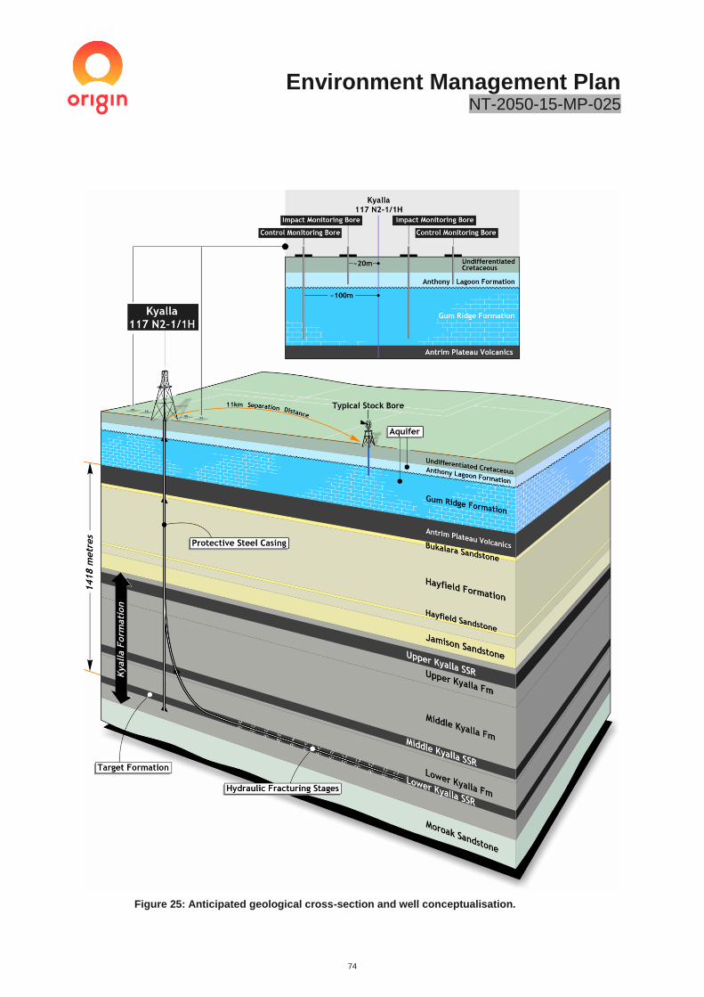
Environment Management Plan NT-2050-15-MP-025
74
Figure 25: Anticipated geological cross-section and well conceptualisation.

Environment Management Plan NT-2050-15-MP-025
75
Table 17: Summary of Beetaloo Sub-Basin Hydrostratigraphy.
Province Period/Age Formation Aquifer
Status
Thickness
(m)
Yield
(L/s)
Ave EC
( s/cm)
CARPENTARIA BASIN
CRETACEOUS
ALBIAN (100-113Ma) Undifferentiated
Local Aquifer
0 - 130 0.3 -
4 1,800
GEORGINA BASIN
CAMBRIAN
Cambrian
Limestone
Aquifer
(CLA)
Anthony
Lagoon
Formation
Regional aquifer
0 – 200 1 - 10
1,600
Gum
Ridge
Formation
Regional aquifer
0 – 300 0.3 - >20
1,400
Antrim Plateau
Volcanics Regional aquitard
0 – 440 0.3 -
5 900
Bukalara Sandstone Regional Aquifer
0 – 75 0.3 -
5 1,000
Undefined –
Under NTGS
Review
NEOPROTEROZOIC
Hayfield formation Regional aquifer
0 – 450 - 32,000
Jamison sandstone Local Saline Unit
0 – 150 - 138,000
BEETALOO
SUB-BASIN (ROPER GROUP)
MESOPROTEROZOIC
1,300-1,500 Ma
Kyalla Formation Regional aquitard
0 – 800 - -
Moroak Sandstone Local saline unit
0 – 500 0.5 -
5 131,000
Velkerri Formation Regional aquitard
700 – 900 - -
Bessie Creek Sandstone
Local Aquifer (not regionally
connected)
450 0.5 -
5 -

Environment Management Plan NT-2050-15-MP-025
76
Table 18: Geological prognosis of the CLA aquifers at the Kyalla 117 N2-1 site.
4.2 Biological Environment
A Land Condition Assessment (LCA) was completed in August 2018 to gather baseline information on the current biological environment within the proposed activity area. This was included in the previous Kyalla 117 N2 Civil Construction EMP NT-2050-15-MP 026 and summarised in the following section.
A summary of the LCA is provided as follows, with the full LCA included in Appendix B.
4.2.1 Bioregions
Two bioregions occur within the Origin permit areas:
• Sturt Plateau bioregion
• Mitchell Grass Downs bioregion
The 2019 proposed lease sites all fall within the Sturt Plateau Bioregion which comprises undulating plains on sandstone, with predominantly neutral sandy red and yellow earth soils. Dominant vegetation associations included extensive areas of Lancewood (Acacia shirleyi) - Bullwaddy (Macropteranthes kekwickii) vegetation and associated fauna, including the Spectacled Hare-Wallaby (Lagorchestes conspicillatus). Land condition in the bioregion is moderate to good but is threatened by impacts from weeds, feral animals, pastoralism and changed fire regimes.
4.2.2 Vegetation Communities
Vegetation communities within the permit areas have been ground-truthed during baseline assessments in 2004, 2006 (HLA, 2006; 2006c), 2010, 2014, 2016 (AECOM, 2011; 2014; 2016) and more recently in August 2018. The August 2018 survey focused on the full extent of areas to be impacted by Origin’s proposed exploration activities.
Vegetation communities within the permit areas have been ground-truthed during baseline assessments in 2004, 2006 (HLA, 2006; 2006c), 2010, 2014, 2016 (AECOM, 2011; 2014; 2016) and more recently in August 2018. The August 2018 survey focused on the full extent of areas to be impacted by Origin’s proposed exploration activities.
The proposed infrastructure location has been evaluated through detailed habitat assessments which included identification of vegetation community, dominant flora species at each strata, habitat condition, disturbance factors (fire, weeds, erosion, feral fauna species), and fauna attributes (e.g. tree hollows, logs, grass cover, mistletoe abundance). The area of the proposed activity is largely characterised as Corymbia low woodland/Terminalia (mixed)sparse shrubland/Chrysopogon (mixed) low tussock grassland. The access track to the lease pad is characterised with the same vegetation unit, with patches of Bullwaddy and Lancewood. The vegetation communities are considered regionally extensive and not subjected to extensive clearing. A summary of the survey of the proposed site is shown in Table 19.

Environment Management Plan NT-2050-15-MP-025
77
Table 19: Kyalla 117 N2-1 Condition Description.
Site ID Kyalla 117 N2-1 Habitat photos at central point of survey site (August 2018)
Location -16°50' 29.01, 133°39' 0.16
Landform and soil
Plains and rises associated with deeply weathered profiles (laterite) including sand sheets and other depositional products; sandy and earth soils
Habitat type
Corymbia low woodland
Vegetation Community
Corymbia low woodland/Terminalia (mixed) sparse shrubland/Chrysopogon (mixed) low tussock grassland This vegetation community is considered regionally extensive and not subjected to extensive clearing.
Dominant flora species
Canopy dominated by Corymbia dichromophloia, Eucalyptus setosa. Shrub layer including Acacia ancistrocarpa, Alphitonia pomaderroides, Brachychiton paradoxus. Ground layer species include Triodia bitextura
Habitat condition
Good condition with evidence of recent grazing. Vegetation appeared to have been heavily burnt in recent years. No evidence of hollow bearing trees and logs. The habitat contained moderate to high refuge opportunities in the form of dense leaf litter, tussock grass cover, and woody debris. Good continuous cover adjoining adjacent woodland habitat and regionally extensive. No evidence of weeds or feral animals.
Potential Listed Threatened Species
Grey Falcon, Northern Shrike-tit, Plains Death Adder, Gouldian Finch.
Weeds No Weeds of National Significance present

Environment Management Plan NT-2050-15-MP-025
78
Figure 26: Vegetation communities surrounding the proposed Kyalla 117 N2 lease pad.

Environment Management Plan NT-2050-15-MP-025
79
4.2.3 Flora
A total of 805 plant species have been recorded within the wider region, and during the August 2018 survey, 28 dominant flora species were identified. As the survey was conducted during the late dry season, grasses and other annual species were difficult or impossible to identify due to the lack of inflorescence or because they had already died-back.
No Commonwealth or NT threatened plant species were identified as occurring by the Protected Matters Searches or NRM Infonet search. One species, the prostrate, herbaceous vine Ipomoea argillicola, is listed as Near Threatened under Section 29 of the Territory Parks and Wildlife Conservation Act 2000 (TPWC Act) and could potentially occur in the project sites, although has not been reported in previous and current surveys. The NT flora database shows that this species has been recorded from the Bullwaddy Conservation Reserve and at locations surrounding the area in previous searches (AECOM, 2015).
The region supports fragmented stands of Bullwaddy, which is listed under the TPWC Act as ‘Least Concern’, which refers to species that are either widespread or common and cannot be categorised as Critically Endangered, Endangered, Vulnerable, Near Threatened or Data Deficient. However, Bullwaddy is significant in terms of the habitat it provides for a range of native species. The extent of Bullwaddy in the permit area is far more extensive than that indicated by the NT Herbarium records.
4.2.4 Weeds
Regional Weed Management Plans (RWMP) have been developed for areas of the NT, with the Barkly and the Katherine RWMP overlapping Origin’s Beetaloo exploration tenure.
The weeds species of high risk of introduction or spread through Origin’s activities are listed in Table 20. These high-risk weeds have been determined through consideration of the following criteria:
• weed species that has been confirmed in the area within the relevant RWMP or through field surveys.
• weed species listed in a RWMP that is in close proximity to Origin tenure.
• weed species is at risk of introduction through the use of machinery sourced from other regions in the NT or from other states.
Weed baseline surveys were completed by AECOM in August 2018 covering all proposed access tracks and lease pad areas. These surveys were completed with the DENR Weed Officer. A summary of the weed surveys is provided in the Land Condition Assessment - Appendix B.
No weeds were identified along the existing access track or proposed infrastructure areas. Parkinsonia aculeata (Parkinsonia) and Calotropis procera (Rubber Bush) has been previously identified along / in close proximity to the Beetaloo W1 exploration well access track, which is approximately 30km south of the proposed areas. Parkinsonia is considered a Weed of National Significance (WoNS), which are weed species that are the focus of national management programs for the purpose of restricting their spread and / or eradicating them from parts of Australia.
The absence of weeds suggests good habitat condition in the areas of the proposed activity. Primary controls for this program will therefore be focused on preventing the introduction of weeds and managing any weeds promoted through site disturbance.
Additional information on the full list of weeds and control measures for the development are provided in the Beetaloo Weed Management Plan.
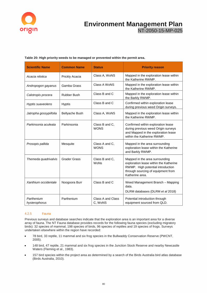
Environment Management Plan NT-2050-15-MP-025
80
Table 20: High priority weeds to be managed or prevented within the permit area.
Scientific Name Common Name Status Priority reason
Acacia nilotica Prickly Acacia Class A, WoNS Mapped in the exploration lease within
the Katherine RWMP.
Andropogon gayanus Gamba Grass Class A WoNS Mapped in the exploration lease within
the Katherine RWMP.
Calotropis procera Rubber Bush Class B and C Mapped in the exploration lease within
the Barkly RWMP.
Hyptis suaveolens Hyptis Class B and C Confirmed within exploration lease
during previous weed Origin surveys.
Jatropha gossypiifolia Bellyache Bush Class A, WoNS Mapped in the exploration lease within
the Katherine RWMP.
Parkinsonia aculeata Parkinsonia Class B and C,
WONS
Confirmed within exploration lease
during previous weed Origin surveys
and Mapped in the exploration lease
within the Katherine RWMP.
Prosopis pallida Mesquite Class A and C,
WONS
Mapped in the area surrounding
exploration lease within the Katherine
and Barkly RWMP.
Themeda quadrivalvis Grader Grass Class B and C,
WoNs
Mapped in the area surrounding
exploration lease within the Katherine
RWMP. High potential introduction
through sourcing of equipment from
Katherine area.
Xanthium occidentale Noogoora Burr Class B and C Weed Management Branch – Mapping
data.
DLRM databases (DLRM et al 2018)
Parthenium
hysterophorus
Parthenium Class A and Class
C, WoNS
Potential introduction through
equipment sourced from QLD.
4.2.5 Fauna
Previous surveys and database searches indicate that the exploration area is an important area for a diverse array of fauna. The NT Fauna database provides records for the following fauna species (excluding migratory birds): 32 species of mammal, 198 species of birds, 96 species of reptiles and 19 species of frogs. Surveys undertaken elsewhere within the region have recorded:
• 78 bird, 33 reptile, 11 mammal and six frog species in the Bullwaddy Conservation Reserve (PWCNT, 2005).
• 148 bird, 47 reptile, 21 mammal and six frog species in the Junction Stock Reserve and nearby Newcastle Waters (Fleming et al., 1983).
• 157 bird species within the project area as determined by a search of the Birds Australia bird atlas database (Birds Australia, 2010).

Environment Management Plan NT-2050-15-MP-025
81
The Eucalypt/Corymbia woodland at these proposed locations provides habitat for a range of species. The areas have high native grass cover and include numerous species suitable for granivorous birds (seed eaters). Dense leaf litter and numerous logs provide suitable refuge and foraging sites for fauna such as reptiles. Many of the sites have a high density of hollow-bearing trees that provide important habitat for many fauna species. Although most of the species found in this vegetation type are widespread in the tropical savannas of the Northern Territory, some such as the threatened Crested Shrike-tit (Falcunculus frontatus whitei) are rare and known to utilise this habitat (DoTEE, 2014, Ward, 2008).
In the broader area, Savanna grasslands and open woodland provide suitable habitat for species such as Emu (Dromaius novaehollandiae) and Australian Bush Turkey (Ardeotis australis. Drainage lines and seasonally inundated grasslands may also provide habitat for migratory species during the wet season and are breeding areas for frogs. The proposed activity will have limited disturbances in these areas.
The location of the infrastructure has been selected to minimise the clearing on areas of high value habitat (such as large hollow-bearing trees) to reduce any impact to native wildlife within the permit area. Due to the regional extensiveness of the vegetation communities and limited scale of disturbance, impacts to fauna have been assessed as unlikely.
4.2.6 Significant Fauna
A search of the DotEE Protected Matters database of nationally significant fauna (PMST), the NT Government fauna database (NRM Infonet), and records from the Atlas of Living Australia (ALA) was undertaken for the proposed lease areas and access tracks. The search results indicate the potential presence of 20 fauna species listed as threatened under the EPBC Act and/or the TPWC Act. These included ten birds, eight mammals and two reptiles.
The likelihood assessment of species occurrence is based on the availability of suitable habitat within the permit area, records in the vicinity and distributional data. Therefore, many of the threatened and migratory fauna species indicated in databases as ‘occurring’ or ‘likely to occur’ have been assessed as ‘unlikely to occur’ within the proposed lease areas. As some areas in the proposed lease area have not been subject to intensive survey and some species are very cryptic, a conservative approach has been taken to assess species presence. A full description of each species, their distribution and habitat associations is outlined in the AECOM Land Condition Report (Appendix B).
No core habitat for threatened fauna was identified at the sites. However, some species may possibly occur and are known to occur in the wider landscape. Threatened species that may possibly occur include:
• Gouldian Finch Erythrura gouldiae (E-EPBC Act, VU-TPWC Act)
• Crested Shrike-tit (northern) Falcunculus frontatus whitei (VU-EPBC Act, NT-TPWC Act)
Research has shown that critical components of suitable habitat for the Gouldian Finch include suitable nesting trees during the breeding season (particularly E. tintinnans, E. brevifolia or E. leucophloia), a water source and a diverse range of favoured annual and perennial grasses (DoE, 2015). No nesting habitat was recorded during the surveys and it is unlikely this species breeds in close vicinity of the sites. During the wet season, Gouldian Finches move from breeding habitat on hillsides with suitable trees down to lower lying areas where they forage on perennial grasses such as Triodia sp., Alloteropsis semialata, and Chrysopogon fallax (Palmer et al. 2012). Some of the perennial grasses were recorded during recent surveys so potential foraging habitat is present; however, there are limited records in the vicinity of the sites suggesting it is not an important area for this species.
The Crested Shrike-tit lives in dry Eucalypt forests and woodland where it feeds on insects from the canopy and also under bark (Ward, 2008). It has been recorded in wet Melaleuca open woodlands, woodlands dominated by Nutwood (Terminalia arostrata), Bloodwoods with flaky bark and Ironwood (DoE, 2014, Ward, 2008). In the NT, nesting has been recorded from September through to January and nests are built in terminal branches at the top of trees (Ward et al., 2009). The stronghold of this species is north of this location and only one old record exists near Borroloola. Although it is possible this species may be present in the area, it is unlikely to represent an important area for this species and the impact of the proposed activities, given their size, would be small.
The Grey Falcon (Falco hypoleucus) is a widespread species listed as Vulnerable in the NT that is considered possibly to be present in the study area. The Painted Honeyeater (Grantiella picta) has been known to occur in the study area, however, given it does not breed in the NT it would only be present intermittently for foraging. Based on the field assessment there was no breeding habitat recorded, and depending on grass seed and water availability, it is unlikely the study area comprises core habitat for this species.
Environment Management Plan NT-2050-15-MP-025
82
4.2.7 Feral and Pest Animals
Feral animals known to occur within the region include:
• Pig (Sus scrofa)
• Wild Dog (Canis lupus familiaris)
• Feral Cat (Felis catus)
• Cane Toad (Bufo marinus)
• Horse (Equus caballus)
• Donkey (Equus asinus)
• Water Buffalo (Bubalus bubalis)
• Camel (Camelus dromedarius)
• Black Rat (Rattus rattus)
• Domestic Cattle (Bos Taurus)
During the August 2018 survey, evidence of cattle grazing being present, or 1-2 years previously, was recorded and in previous surveys of the permit area, cat tracks were observed as the only non-native species recorded, but based on records many species, especially Dogs / Dingo, Pigs and Cane Toads will be present in permit area. The disturbance from cattle within the proposed sites was considered to have resulted in less than 5% damage or no damage at all.
4.3 Fire Regime
Fire is a natural occurrence in most Australian ecosystems and plays an important role in their ecology. Fire is generally excluded from Mitchell grasslands by pastoral management in order to maintain forage throughout the dry season (HLA, 2005) whereas fire is more frequent in the Sturt Plateau.
Fire disturbance was evident at Kyalla 117 N2 during the ecological surveys, with evidence of an Intensity 4 (some trees and shrubs killed) and Height 1-4 m fire present 1-2 years previously. It was noted that the site showed evidence of fire disturbance and was showing signs of regrowth and recovery.

Environment Management Plan NT-2050-15-MP-025
83
Figure 27: Fire frequency map of the Beetaloo Basin.

Environment Management Plan NT-2050-15-MP-025
84
4.4 Environmental and Cultural Sensitivities
4.4.1 Native Title
Two Native Title claims have been determined as non-exclusive and one Indigenous Land Use Agreement (ILUA) are current over the permit areas (see Table 21).
Table 21: Native Title and IULA Agreements current for the Permit Areas.
Type Well Name Summary
Native Title Kyalla 117 N2-
1
NTD21/2010
Shenandoah
Pastoral Lease
Native Title exists in parts of the determination
area and is held by the Kinbininggu and
Bamarrngganja groups
Indigenous
Land Use
Agreement
All Sites D12004/014
Jingaloo CLA ILUA
Registered for Community Living Area and
Tenure resolution
The Native Title Petroleum Exploration Agreement between Origin and the NLC includes clauses for the protection of sacred sites, objects and sensitive areas related to Aboriginal activities in the area, including cultural, hunting and foraging activities. Site clearance will occur prior to any on ground activities. The Native Title Agreement also includes clauses for the protection of the environment and site rehabilitation.
4.4.2 Archaeology Assessment
An archaeological assessment, involving searches of the NT Heritage Register and Australia Heritage Database and a field survey, have been carried out by AECOM archaeologist, Luke Kirkwood, for the exploration sites and associated tracks. It should be noted that this survey covers additional sites that are not in the scope of this EMP.
A search of the NT Heritage Register identified 41 Aboriginal archaeological sites within a 125 km by 125 km area that encompasses the full Proposal area. No archaeological sites are recorded within 15 km of the proposed 2019 lease areas.
A search of the Australia Heritage Database identified that no statutory listed heritage places within the proposed impact areas.
The field survey involved a combination of both pedestrian and helicopter survey of the proposed disturbance areas. During the inspections, notes were taken on landform, ground surface visibility and areas of exposure. The aim of the field survey was to identify any surface expressions of Aboriginal archaeological and cultural heritage values within the exploration area. Photographic records were taken at each proposed location.
No culturally sensitive landforms or artefacts were identified during field surveys of the lease sites covered under this EMP.
The archaeological assessment is provided in Appendix H.
4.4.3 Areas of Cultural Significance
Sacred sites in the study area are primarily associated with drainage lines; natural landform features and stock routes, but there are also concentrations of sites nearby to old homesteads. The distribution of these sites may reflect historical patterns of Indigenous movements along drainage lines and subsequent development of stock routes on old Indigenous walking trails, or they may merely be indicative of the site clearance work undertaken along roads and tracks in the area. It is suspected that there will be a range of other sites also within the area, either not yet recorded, or known but not reported for cultural reasons.
AAPA clearance certificate RA2019/014 have been granted covering all activities covered under this EMP. There are no Restricted Work Areas within the immediate vicinity of Origin’s proposed activity.
Other restricted works areas are identified across the entire permit area. Origin has committed to comply with conditions as prescribed by AAPA for the duration of the program.
4.4.4 Natural Resources
In addition, previous cultural heritage surveys of the permit areas were undertaken with representatives of the Traditional Owners who identified a number of natural resources of importance to Aboriginal people of the area (Table 22).

Environment Management Plan NT-2050-15-MP-025
85
Table 22: Natural Resources of Importance in the Permit Areas.
Scientific Name Common Name Usage
Grewia retusifolia Emu-berry/Dog’s Balls,
Turkey Bush and Diddle
Diddle
Fruit eaten. Leaves can be boiled, and body bathed in the
liquid for treatment of a number of ailments
Marsdenia
australis
Bush Banana/Gillibi Bush ‘fruit’ eaten when young, as it matures ‘fruit’ seeds
becomes feathery for dispersal in the wind and are not
eaten
Pterocaulon sp. Used for treating flu
Acacia sp. Acacia Leaves boiled and used to treat the flu
Acacia
holosericea
Soapbush Wattle or strap
wattle
Leaves used for washing
Termite (unknown species) Mounds pulverised and mixed with water, used to treat
diarrhoea
4.4.5 Non-Indigenous Heritage
In 1860, explorer John McDougall Stuart was the first European to penetrate the area now known as the ‘Centre’. The first written descriptions of the area come from Stuart during his second attempt to cross the continent from south to north (HLA, 2005).
Development in the area began as pastoral lands with an increased interest in land settlement following the completion of the Overland Telegraph Line in 1873. Most attempts were unsuccessful with the Lancewood-Bullwaddy vegetation found to be impenetrable and the lack of surface water making the land unsuitable for cattle. Daly Waters was thus recognised as one of the last watering stops on the Murranji Stock Route.
It wasn’t until the 1930s to 1950s, that the area saw regional economic growth with Daly Waters becoming a significant hub of air and mail services into the Northern Territory. The wartime years saw this role increase with Daly Waters again playing a major role in cross country transport and communication. This role continued until the early 1970s when the airport was closed to commercial traffic. The town and surrounding areas subsequently reverted to a primarily agriculture-based existence following the decline of air travel, but in recent times has seen commercial interest from the exploration for gas in the Beetaloo Sub-Basin and the growth of the ‘grey nomad’ tourism market.
4.4.6 Historic Heritage Assessment
A search of relevant historic heritage registers identified a number of historic heritage sites within a 125 km by 125 km area that encompasses the full proposal area. Frew Ponds, a reserve paying tribute to the building and joining of the Overland Telegraph Line is located 28km west south-west of the Velkerri Lease pad and approximately 16km south of the access track turn in from the Stuart Highway.

Environment Management Plan NT-2050-15-MP-025
86
4.4.7 Protected or Conservation Areas
There are no conservation reserves, national parks, world heritage places, Commonwealth land, heritage places or critical habitat areas listed under the EPBC Act located within or adjacent to the proposed exploration area.
4.5 Social Environment
4.5.1 Social Context
The proposed 2019 work programme will occur within the Barkly Regional Council area, which covers 323,514 km2. The approximate population is estimated for the Barkly Region of 8,137 people (Barkly Regional Council, 2018).
The potential social and economic effects associated with the proposed exploration activities is considered to be minor and predominantly positive.
The closest neighbouring regional towns and communities identified as being within proximity to Origin’s activities include:
• Dunmarra (~30kms)
• Tennant Creek (~290kms)
• Elliott (~80kms)
• Daly Waters (~70kms)
• Newcastle Waters (~60kms); and
• neighbouring pastoral leases of Amungee Mungee and Beetaloo.
In 2014, the Tennant Creek Regional Economic Development Committee (REDC) released the Tennant Creek and Barkly Region Strategic Action Plan (2014-2016) identified social and economic development within the region, including mineral and gas development. Origin has met with the REDC annually with its most recent project update meeting taking place in Tennant Creek on 27 September 2018. Origin also met with the Mayor and Councillors of the Barky Regional Council (27 September 2018) and Roper Gulf Regional Council (19 December 2018).
4.5.2 Pastoral Activity
The current land use in the project area is pastoral with varying stocking rates and varying management practices. Within the permit area there are nine pastoral properties as shown in Table 23. All of the land within the permit area is Leasehold Land. There is one small area of Aboriginal Freehold land known as Jingaloo on EP117.
Table 23: Pastoral properties in the Permit Area.
Pastoral Property Permit Areas
EP76 EP98 EP117
Amungee Mungee
Kalala
Tanumbirini
Beetaloo
Hayfield/Shenandoah
Ucharonidge
Tandyidgee
Nutwood Downs
Newcastle Waters
The project area has been subject to pastoral activities for over 150 years (AECOM, 20). The average size of a Station in the Barkly Region is 8,186 km2 (Bubb, 2004), which is large by global standards.
The proposed Kyalla 117 N2 exploration site is located on the Hayfield/Shenandoah Station.

Environment Management Plan NT-2050-15-MP-025
87
4.5.3 Other Land Uses in the Area
A range of other land-uses exist in the permit area or in the larger region, including a range of public utilities and facilities. These include the following:
• Tourism – Tourism is an important regional industry with the Sturt Highway being a major thoroughfare for tourists travelling in the area during the dry season. The local townships of Daily Waters, Dunmarra and Elliot provide consumables (food, fuel etc.) and accommodation. A number of heritage areas of importance to regional tourism are located in the broader region, including Elliott, Newcastle Waters and other heritage listed homesteads.
• Road networks – The Stuart Highway and Carpentaria Highway will be used to access the sites. In addition, there are numerous gravel roads connecting properties, and internal property tracks. All properties also have firebreaks on their boundaries and internally.
• Gas pipeline – A gas pipeline runs to the west of the Stuart Highway, along the eastern boundary of EP117 and crosses the boundary of one part of EP98. It also runs parallel with the Carpentaria Highway to the Gulf of Carpentaria, through EP98 and EP76.
• Alice Springs to Darwin Railway – The railway line runs to the west of the gas pipeline and Stuart Highway, and does not cross into any of the permit areas.
• Townships – The townships of Daly Waters and Dunmarra neighbour EP98 to the West.
• Conservation areas – including the Bullwaddy Conservation Reserve, which lies within EP98 and Lake Woods and the Junction Stock Reserve just outside the permit area.
• Heritage – There are seven heritage sites within the exploration permit area and a number of heritage areas of importance to regional tourism located in the broader region, including Elliott, Newcastle Waters and heritage-listed homesteads.
• Archaeological sites – The permit areas have a long history of Aboriginal association and 41 archaeological sites have previously been recorded within the permit areas, as well as registered sacred sites and areas of significance which are shown in the AAPA Abstract of Record.
5 Stakeholder Engagement
The NT Petroleum (Environment) Regulations define ‘stakeholder’ as meaning:
(a) a person or body whose rights or activities may be directly affected by the environmental impacts or environmental risks of the regulated activity proposed to be carried out; or
(b) an agent or representative of a person or body mentioned in this paragraph (a).
Origin’s directly impacted / affected stakeholders have, and continue to be, consulted in a respectful, open and consistent manner. This has been the case since 2014, when Origin assumed operatorship of EP98, EP117 and EP76.
Origin’s consistent approach to stakeholder engagement has been to ensure that those persons and / or groups directly impacted / affected and / or influenced by permit commitments, have received Origin’s full attention. Origin views the understanding of these consenting stakeholders and their informed consent of critical importance and relevance during these early stages of limited small-scale exploration activities.
For the purpose of this EMP, Origin identifies its stakeholders, in compliance with the Petroleum (Environment) Regulations as:
• host Traditional Owners recognised as the Native Title holders and / or claimants in and their representative the Northern Land Council as described in Exploration Agreements between the parties for EPs 117, 76 and 98;
• host Pastoralists recognised as the nine Pastoral Lease Stations in Table 23 above.
Origin also recognises and engages, where appropriate and acceptable, with the following list of stakeholders:
• Northern Territory community and residents

Environment Management Plan NT-2050-15-MP-025
88
• Federal Government; Departments, Members of Parliament and Opposition Spokespersons
• Northern Territory Government; Departments; Members of Parliament and Opposition Spokespersons
• Local Government Agencies
Katherine Town Council
Barkly Regional Council
Roper Gulf Regional Council
Regional Economic Development Committees
• Northern and Central Land Councils
• Environment Protection Authority
• Aboriginal Areas Protection Authority (AAPA)
• National, State and Local Media (Print, TV and Radio)
• Australian Petroleum, Production and Exploration Association (APPEA)
• Northern Australia Development Office (NADO)
• Northern Territory Cattlemen’s Association (NTCA)
• Industry Capability Network (ICN)
• Chamber of Commerce NT
• Business Council of Australia
• Minerals Council
• CSIRO / GISERA
• NGOs
• Darwin Major Business Group (DMBG)
• Energy Club Northern Territory (ECNT)
• Indigenous Business Network NT (NTIBN)
• Katherine Mining Services Association (KMSA)
During engagement to date, Origin has shared information and data in relation to the four existing wells and Origin’s plan to complete an additional five wells in order to comply with the work program commitment to the Northern Territory Government (NTG).
All activities to date have had the written consent of the pastoral leaseholders who, as with Origin, do not hold exclusive rights of over shared land.
Land Access Agreements (LAAs) with the host pastoralists for the activities contained in this EMP has been
obtained for the 2019 work program.
Origin has not received objections from leaseholders or Native Title claimants in the area of the planned exploration activity.
In accordance with Schedule 1, Part 3, Section 9(1)(a) of the Petroleum (Environment) Regulations, a list of directly impacted stakeholders and their engagement is summarised in Appendix I. It should be noted that this engagement summary is restricted to the engagement scope of works carried out under this EMP. Broader formal and informal information is provided to host pastoralists at various frequencies.
Origin recognises the growing community interest in ensuring onshore natural gas exploration takes place in a safe and environmentally-sound way. Stakeholder engagement levels are reflective of the current stage of the resource assessment, with increased engagement occurring if the commercial and technical viability of an onshore gas resource is confirmed.

Environment Management Plan NT-2050-15-MP-025
89
For the purposed of the activities covered under this EMP, Origin’s ongoing stakeholder engagement is:
• Pastoral Lease holders (Host Pastoralists) - Frequency and type of engagement as per Access Agreements including but not limited to:
o Monthly check in and update (email and telephone) o Face-to-face meetings (minimum six monthly) or as required pending activity o Provision of formal documentation and information as required and / or requested (also as per
notifications clauses within the Access Agreement)
• Native Title Holders (host Traditional Owners) - Frequency and type of engagement as per Exploration Agreements including but not limited to:
o Annual work plan meetings (x7) April 2019 o Provision of 2020 potential programme (June 2019) o Sacred Site Clearance and Avoidance Field Surveys (September 2019)
5.1 Community Engagement
Stakeholder (directly impacted) and community engagement for the 2019 work program has been held with
Native Title holders (host Traditional Owners) and host pastoralists directly affected by the proposed activity.
Origin’s proposed exploration program has been clearly communicated to interested parties, with several written
submissions and video presentations prepared for the NT Inquiry. Information included in Origin’s submission to
the NT Inquiry is publicly available at https://frackinginquiry.nt.gov.au/submission-library
Native Title holders / custodians completed Sacred Site Clearance and Avoidance Surveys in September 2018 for
nine potential locations where Origin is proposing to undertake activities covered under this EMP. The formal
NLC Sacred Site Avoidance Report / Anthropological Report dated 15 November 2018 was provided to the
Aboriginal Areas Protection Authority in order for it to process Origin’s AAPA applications for the Kyalla 117 N2
exploration areas and associated infrastructure. AAPA certificate C2019/039 (variation to C2019/014) covering all
activities under this EMP has been granted.
Broader engagement has occurred with local and regional business within Daly Water, Elliot, Katherine and the NT. Northern Territory businesses have been engaged on the scope of Origin’s activities through tender opportunities covering a range of material supply and support services, such as:
• People transport and logistics
• Accommodation and food
• Provision of temporary camps and camp services
• Civil construction work
• Freight and transport
• Water bore drilling
• Water carting and waste management
• Site maintenance and inspections
• Weed management and control
• Equipment and materials storage
• Oil country tubular goods
• Environmental and civil consulting
• Surveying and geotechnical assessments; and
• General provisions of goods and services (such as personal protective equipment, hire cars, food, etc.)

Environment Management Plan NT-2050-15-MP-025
90
5.2 Public submission on EMP
The Kyalla 117 N2 Drilling, stimulation and well Testing EMP was released for public comment on the 3-30 May 2019. The EMP received 6311 public submission, with 27 formal submissions and 6284 form letters from internet campaigns.
Origin’s response to these comments is provided in Appendix R.
6 Environmental Impact Assessment
6.1 Origin’s Risk Management Approach
Origin utilises a robust risk management process for all its activities to achieve the following key outcomes:
- Risks are understood, eliminated or reduced and controlled to an acceptable level,
- Controls are owned, assured and continuously reviewed for effectiveness,
- All activities are compliant with regulatory standards and are guided by best practice,
- Origin and its stakeholders are confident in the way activities are conducted to manage risks, and
- The approach aligns with the findings of the NT Inquiry Final Report and associated recommendations (as
implemented via the Petroleum Codes of Practice or legislation).
Risk management processes are mandated through the Origin Risk Management Policy and Directive, which includes a risk rating toolkit that is utilised from the Board through to frontline activity owners (Figure 28). The toolkit considers the requirements of ISO 31000 and addresses risk identification, assessment and management.
Assessment of risk is completed using Origin’s Risk Matrix (Figure 29) to assess and rate risks by assessing the combination of frequency of occurrence and the severity of the outcome of a potential event, including a worst-case scenario event. This allows quantification of a risk and determination can then be made about whether the risk can be accepted, or whether further mitigation is required.
Origin risk management processes requires regular assessment of underlying (unmitigated) risk from an activity, the residual risk once controls are applied, the effectiveness of controls (provided in Table 24) and the likelihood and consequence of a risk event. A risk is either accepted in accordance with strict delegations of authority or the activity does not proceed.
In addition, the risks associated with unconventional gas developments activities have been thoroughly investigated and reported by the NT Inquiry. A series of risks and recommended mitigation measures were outlined to reduce the likelihood of any impacts to an acceptable level. These recommendations have been incorporated into the Petroleum Codes of Practice and changes in legislation to ensure a high level of environment protection across the industry. This ensures risks are assessed and mitigated in a consistent manner, to provide greater certainty to the community that the risks associated with exploration activities are being reduced to an acceptable level.
Table 24: Risk control effectiveness definition.
Rating Explanation
Effective
• Controls are well designed and address the root cause(s) of the risk. • Controls are recognised industry best practice. • All controls operate at the required level. • All controls are within the power of Origin, with few external factors beyond control. • Ongoing monitoring required.
Can Be Improved
• Majority of controls are well designed and address the root cause(s) of the risk. • Majority of controls operate at the required level. • Some controls are outside the power of Origin, with multiple external factors beyond
control. • Ongoing monitoring required. • Certain controls can be improved or have elements below industry best practice.
Must Be Improved • Most controls are not well designed and do not address the root cause(s) of the
risk. • Most controls are not operating to the required level.

Environment Management Plan NT-2050-15-MP-025
91
Rating Explanation
• A large number of controls are outside the power of Origin, with multiple external factors.
• The majority of controls require improvement and are well below industry best practice.
6.2 Risk Acceptance Threshold and ALARP
A risk can be considered to have been reduced to ‘as low as reasonably practicable’ (ALARP) when all reasonably practicable control measures (both preventative and mitigative) have been identified and implemented to reduce the risk of identified events. A key element of demonstrating ALARP is that good practice is followed, where good practice is defined as the recognised risk management practices and measures that are used by competent organisations to manage well understood hazards arising from their activities. This definition incorporates good practice as defined in codes and standards, and a consensus of good practice within the industry. ALARP is not a final position over the life of an asset or project.
The practicability and the reasonability of control measures can change over time due to changes in technology (that can make measures more readily available), industry standards (that can commoditise once-cutting-edge technology) and the socio-technical landscape (that can modify societal expectations).
In the NT context, ALARP and the definition of acceptable risk levels was a key feature of the NT Inquiry Final Report. For each aspect, acceptability criteria were defined, with recommendations outlined to reduce the potential risk to below the acceptable level. With the adoption of all recommendations by the NTG, the new Petroleum Codes of Practice and associated regulatory changes provides a high level of inherent protection to ensure activities are undertaken in a safe and consistent manner.
Through adoption of the recommendations of the NT Inquiry (along with other risk management and legislative requirements), Origin can demonstrate all environmental impacts and environmental risks associated with its activities will be reduced to a level that is as low as reasonably practicable and acceptable.

Environment Management Plan NT-2050-15-MP-025
92
Figure 28: Origin’s risk toolkit which describes the approach to identify, assess, control, treat and accept risks.
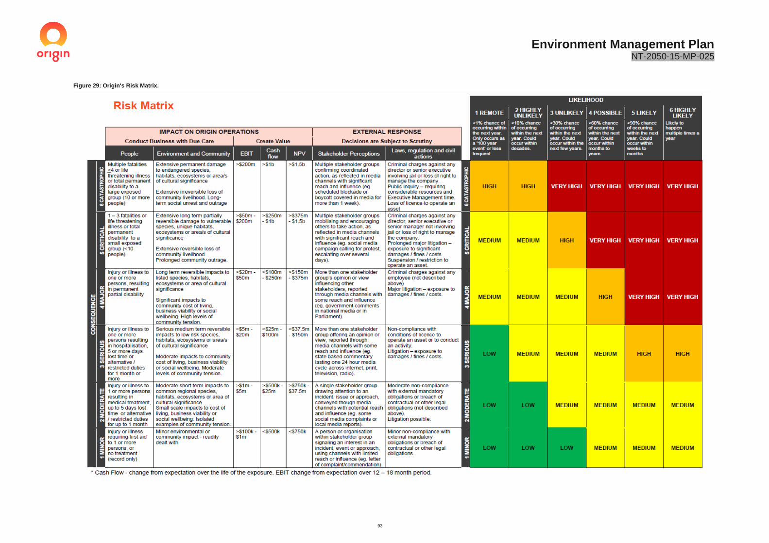
Environment Management Plan NT-2050-15-MP-025
93
Figure 29: Origin's Risk Matrix.

Environment Management Plan NT-2050-15-MP-025
94
6.3 Assessment of Scientific Uncertainty
The draft NT Petroleum Environmental Management Plan Guidelines (EMP Guidelines) requires an assessment of uncertainty as a part of the risk assessment process. The assessment of potential impacts and effectiveness of controls must demonstrate that the activities are carried out in a manner consistent with the Principles of Ecologically Sustainable Development (ESD) and the Precautionary Principle.
Impact and risk identification must include consideration of uncertainty regarding impacts and risks for the activity where a precautionary approach is appropriate. Uncertainty is high where confidence in the available information is low in identifying risk or the effectiveness of a management control. Additional baseline studies or other safeguards may be required to increase the accuracy of an assessment to determine the acceptability of a risk.
As per the Draft EMP Guidelines, scientific certainty is qualitatively assessed using a generic means of ranking the data available in accordance with Table 25 below. Considerations of uncertainty have been included in the risk assessment discussed in Section 6.4.
Table 25: Scoring system for Scientific Uncertainty (DEFRA, 2013).
Ranking Scientific Uncertainty
Score Description
Low (1) • Comprehensive data with strong evidence in multiple peer reviewed data
• Little disagreement between authors or experts
• Considerable and consistent on-ground experience and/or monitoring
Medium (2) • Some or incomplete data available
• Evidence provided based on a small number of references
• Authors or experts conclusions vary
• Limited on-ground experience and/or monitoring
High (3) • Scarce or no data available; evidence provided in unpublished reports
• Few on-ground observations
• Authors and experts conclusions vary considerably
6.4 Risk Assessment Outcomes
The environmental, heritage and social risks associated with the activities covered under this EMP have been assessed utilising the Origin risk assessment framework described in Section 6.1. The detailed risk assessment presents the range of potential impact-causing activities, corresponding mitigation measures and residual risk ratings based on their assessed worst-case consequence and likelihood of occurrence. The assessment also cross-referenced the various risk assessment outcomes in the NT Inquiry Final Report, to ensure consistency.
Site specific conditions and cumulative impacts have also been considered during the assessment. Cumulative impacts have included the following:
• An additional five (5) future Origin exploration wells as per the current approved tenure work plan.
• Existing land users are predominantly agriculture.
There were no residual risks above a ‘Medium’ risk ranking, with 18 risk scenarios. Within these risk groups, the assessment considered 78 risk sources which may potentially result in a risk occurring. Of the 78 risk sources, nine were ranked as ‘Moderate’ with the remaining ranked as ‘Low’. The ‘Medium’ risks identified were consistent with standard construction or pastoralist activities carried out across the NT, being the potential spread of weeds, erosion and sediment control, and ignition of bushfires from the proposed activities. The reduced risk profile

Environment Management Plan NT-2050-15-MP-025
95
associated with stimulation activities (such as potential spills and groundwater contamination) is reflective of the stringent regulatory requirements within the Petroleum Codes of Practice.
The level of uncertainty for each risk was assessed. There was no uncertainty level above ‘Low’, which is consistent with the knowledge of impacts associated with shale exploration activities demonstrated in the Inquiry Final Report and through the various reports published by the US EPA.
Table 26 provides a count of the post-treatment environmental risks associated with this EMP. A copy of the risk assessment is provided in Appendix J.
Table 26: Count of Residual Environmental Risks for the Drilling and Stimulation Program.
Residual Environmental Risk Level
Low Medium High Very High
Total 78 69 9 0 0
6.5 Environmental Risk Management Summary
The following section provides a summary of how the environmental impacts and environmental risks will be managed. The assessment has been based upon the findings of the NT Inquiry Final Report, with the assessment also including consideration of site-specific hazards. For aspects with multiple individual risks, these are summarised in the relevant aspect table with the highest residual risk being used. The risk assessment provided in Appendix H should be consulted where an overview of each individual risk is required.
The following section provides a summary of how any environmental impacts risks will be managed. The management summary tables are designed to tie the contents of this EMP together into one table to summarise how risks and impacts will be managed. These tables include an overview of the environmental values, outcomes, potential risks and impacts, along with the performance standards, measurement criteria and records for each environmental aspect. For aspects with multiple individual risks, these are summarised in the relevant aspect table with the highest residual risk being used.
Each table includes a statement of the residual risk, scientific uncertainty and ALARP. This is designed to provide certainty that the risks are being reduced to as low as reasonably practicable.
The risk assessment provided in Appendix J should be consulted where an overview of each individual risk is required.
6.5.1 Soils
Table 27: Environmental Values and Outcomes – Soils.
Environmental Values • Suitability and stability of land for existing uses (erosion and sediment controls implemented)
• Stability of land to preserve existing water quality, landscapes and ecosystems
Environmental Outcomes
• Avoid, minimise and control soil erosion and discharge of sediment or soil into waterways or established drainage systems
• Minimise disturbance of soil, vegetation and drainage during site activities • Minimise the creation of dust • Prevent the contamination of soil to maintain the viability of soil resources
Activity Environmental impacts and environmental risks
Key control summary
• Drilling, stimulation and well testing
• Soil erosion and sedimentation
• Soil contamination from chemical and waste handling, storages and spills
•Field surveys completed to identify high risk soils •Land Condition Assessment completed •Location selected to avoid impacts to high risk soil types •Erosion and sediment control plan implemented (Appendix F) •Wastewater Management Plan (Appendix E) implemented •Spill Management Plan (Appendix D) implemented
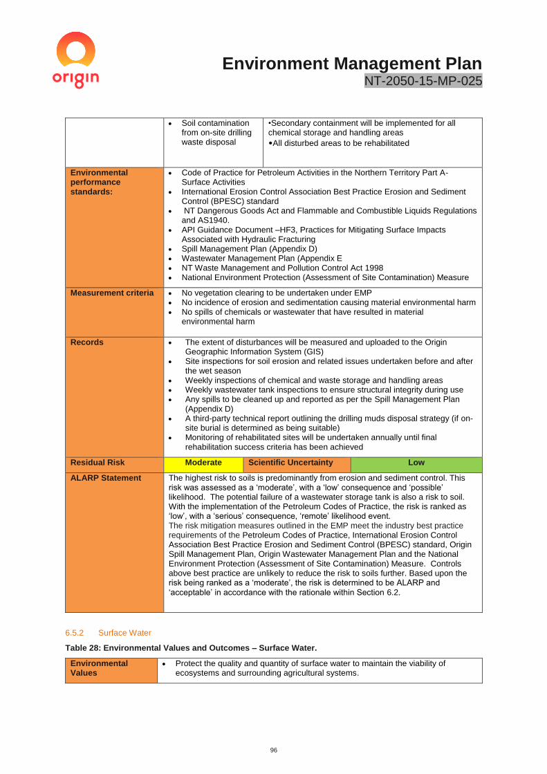
Environment Management Plan NT-2050-15-MP-025
96
• Soil contamination from on-site drilling waste disposal
•Secondary containment will be implemented for all chemical storage and handling areas
•All disturbed areas to be rehabilitated
Environmental performance standards:
• Code of Practice for Petroleum Activities in the Northern Territory Part A- Surface Activities
• International Erosion Control Association Best Practice Erosion and Sediment Control (BPESC) standard
• NT Dangerous Goods Act and Flammable and Combustible Liquids Regulations and AS1940.
• API Guidance Document –HF3, Practices for Mitigating Surface Impacts Associated with Hydraulic Fracturing
• Spill Management Plan (Appendix D) • Wastewater Management Plan (Appendix E • NT Waste Management and Pollution Control Act 1998 • National Environment Protection (Assessment of Site Contamination) Measure
Measurement criteria • No vegetation clearing to be undertaken under EMP • No incidence of erosion and sedimentation causing material environmental harm • No spills of chemicals or wastewater that have resulted in material
environmental harm
Records • The extent of disturbances will be measured and uploaded to the Origin Geographic Information System (GIS)
• Site inspections for soil erosion and related issues undertaken before and after the wet season
• Weekly inspections of chemical and waste storage and handling areas • Weekly wastewater tank inspections to ensure structural integrity during use • Any spills to be cleaned up and reported as per the Spill Management Plan
(Appendix D) • A third-party technical report outlining the drilling muds disposal strategy (if on-
site burial is determined as being suitable) • Monitoring of rehabilitated sites will be undertaken annually until final
rehabilitation success criteria has been achieved
Residual Risk Moderate Scientific Uncertainty Low
ALARP Statement The highest risk to soils is predominantly from erosion and sediment control. This risk was assessed as a ‘moderate’, with a ‘low’ consequence and ‘possible’ likelihood. The potential failure of a wastewater storage tank is also a risk to soil. With the implementation of the Petroleum Codes of Practice, the risk is ranked as ‘low’, with a ‘serious’ consequence, ‘remote’ likelihood event. The risk mitigation measures outlined in the EMP meet the industry best practice requirements of the Petroleum Codes of Practice, International Erosion Control Association Best Practice Erosion and Sediment Control (BPESC) standard, Origin Spill Management Plan, Origin Wastewater Management Plan and the National Environment Protection (Assessment of Site Contamination) Measure. Controls above best practice are unlikely to reduce the risk to soils further. Based upon the risk being ranked as a ‘moderate’, the risk is determined to be ALARP and
‘acceptable’ in accordance with the rationale within Section 6.2.
6.5.2 Surface Water
Table 28: Environmental Values and Outcomes – Surface Water.
Environmental Values
• Protect the quality and quantity of surface water to maintain the viability of ecosystems and surrounding agricultural systems.
Environment Management Plan NT-2050-15-MP-025
97
Environmental Outcomes
• Avoid and minimise the potential contamination caused by the discharge of sediment or contaminated storm water to waterways or established drainage systems.
• Contain any potential contaminants for treatment or disposal.
Activity Environmental impacts and environmental risks
Key control summary
• All drilling, stimulation and well testing activities
• Activity altering natural drainage lines or sinks
• Access tracks and site pads create ponding and or erosion
• Contamination or pollution of surface waters through hydrocarbon, chemical or wastewater spill or leak
• Impacts associated with soil erosion such as increased water turbidity
• Separation distance from surface waters • No use of surface water or discharge to surface waters • Erosion and Sediment Control Plan (Appendix F) • Spill Management Plan • Wastewater Management Plan • Routine site inspection to ensure erosion and sediment
controls are functioning • No additional clearing proposed • Secondary containment used during the storage and
handling of wastewater and chemicals • Site bunded eliminating the risk off off-site spills • Site rehabilitation to a safe, stable and non-polluting
form consistent with the surrounding land use
Environmental performance standards
• Code of Practice for Petroleum Activities in the Northern Territory Part A- Surface Activities
• International Erosion Control Association Best Practice Erosion and Sediment Control (BPESC) standard
• Dangerous goods will be stored, handled, separated and signed as required by the NT Dangerous Goods Act and Flammable and Combustible Liquids Regulations and AS1940
• Spill Management Plan • Wastewater Management Plan • NT Waste Management and Pollution Control Act 1998
Measurement Criteria
• No use of surface water • No release of drilling and stimulation wastewater to watercourses or areas
surrounding the lease pad • No spills or releases of sediment to watercourses causing material environmental
harm
Records • Records of any spills or off-site releases as per the Spill and Wastewater Management Plans
• Monitoring for soil erosion and related issues will be undertaken before and after the wet season, with records retained
Residual Risk Low Scientific Uncertainty Low
ALARP Statement The risk to surface water is predominantly from soil erosion during construction and is assessed as “low”. This is ranked as a ‘minor’ consequence, ‘unlikely’ likelihood event. The potential failure of a wastewater storage tank is also a risk to surface water. With the implementation of the Petroleum Codes of Practice, the risk is ranked as ‘low’, with a ‘serious’ consequence, ‘remote’ likelihood event. The risk mitigation measures outlined in the EMP meet the industry best practice requirements of the NT Petroleum Codes of Practice, NT Land Clearing Guidelines and International Erosion Control Association Best Practice Erosion and Sediment Control (BPESC) standard. Controls above best practice are unlikely to reduce the risk associated with erosion and sediment control or offsite release of wastewater further. Based upon the risk being ranked as a ‘low’, the risk is determined to be
ALARP and ‘acceptable’ in accordance with the rationale within Section 6.2.
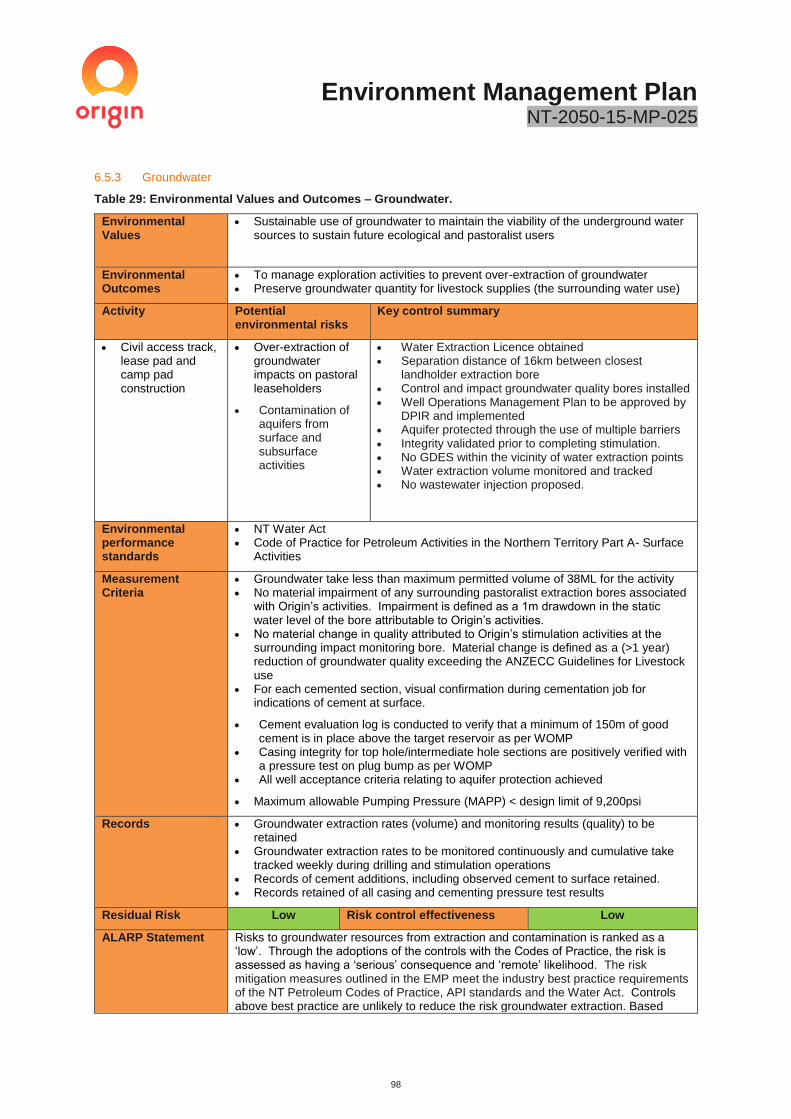
Environment Management Plan NT-2050-15-MP-025
98
6.5.3 Groundwater
Table 29: Environmental Values and Outcomes – Groundwater.
Environmental Values
• Sustainable use of groundwater to maintain the viability of the underground water sources to sustain future ecological and pastoralist users
Environmental Outcomes
• To manage exploration activities to prevent over-extraction of groundwater • Preserve groundwater quantity for livestock supplies (the surrounding water use)
Activity Potential environmental risks
Key control summary
• Civil access track, lease pad and camp pad construction
• Over-extraction of groundwater impacts on pastoral leaseholders
• Contamination of aquifers from surface and subsurface activities
• Water Extraction Licence obtained • Separation distance of 16km between closest
landholder extraction bore • Control and impact groundwater quality bores installed • Well Operations Management Plan to be approved by
DPIR and implemented • Aquifer protected through the use of multiple barriers • Integrity validated prior to completing stimulation. • No GDES within the vicinity of water extraction points • Water extraction volume monitored and tracked • No wastewater injection proposed.
Environmental performance standards
• NT Water Act • Code of Practice for Petroleum Activities in the Northern Territory Part A- Surface
Activities
Measurement Criteria
• Groundwater take less than maximum permitted volume of 38ML for the activity • No material impairment of any surrounding pastoralist extraction bores associated
with Origin’s activities. Impairment is defined as a 1m drawdown in the static water level of the bore attributable to Origin’s activities.
• No material change in quality attributed to Origin’s stimulation activities at the surrounding impact monitoring bore. Material change is defined as a (>1 year) reduction of groundwater quality exceeding the ANZECC Guidelines for Livestock use
• For each cemented section, visual confirmation during cementation job for indications of cement at surface.
• Cement evaluation log is conducted to verify that a minimum of 150m of good cement is in place above the target reservoir as per WOMP
• Casing integrity for top hole/intermediate hole sections are positively verified with a pressure test on plug bump as per WOMP
• All well acceptance criteria relating to aquifer protection achieved
• Maximum allowable Pumping Pressure (MAPP) < design limit of 9,200psi
Records • Groundwater extraction rates (volume) and monitoring results (quality) to be retained
• Groundwater extraction rates to be monitored continuously and cumulative take tracked weekly during drilling and stimulation operations
• Records of cement additions, including observed cement to surface retained. • Records retained of all casing and cementing pressure test results
Residual Risk Low Risk control effectiveness Low
ALARP Statement Risks to groundwater resources from extraction and contamination is ranked as a ‘low’. Through the adoptions of the controls with the Codes of Practice, the risk is assessed as having a ‘serious’ consequence and ‘remote’ likelihood. The risk mitigation measures outlined in the EMP meet the industry best practice requirements of the NT Petroleum Codes of Practice, API standards and the Water Act. Controls above best practice are unlikely to reduce the risk groundwater extraction. Based

Environment Management Plan NT-2050-15-MP-025
99
upon the risk being ranked as a ‘low’, the risk is determined to be ALARP and ‘acceptable’ in accordance with the rationale within Section 6.2, with no further risk reduction warranted.
6.5.4 Vegetation, Flora, Fauna and Habitat
Table 30: Environmental Values and Outcomes – Vegetation, Flora, Fauna and Habitat.
Environmental Values
• Maintain the integrity of significant ecosystems • Maintain habitat elements for native flora and fauna, including species protected
by EPBC Act and TPWC Act • Avoid impacts on high value habitat
Environmental Outcomes
• Minimise additional disturbance to flora and fauna • No disturbance to high conservation areas
Activity Environmental impacts and environmental risks
Key control summary
• Vehicle movements
• Drilling, stimulation and well testing
• Rehabilitation
• Disturbance to environmentally sensitive areas and / or flora and fauna species
• Loss or endangerment of threatened species
• Loss of habitat • Vehicle collisions
with fauna – fauna mortality causing mortality
• No additional clearing proposed under EMP • Field ecological surveys completed • Location selected to avoid impacts to high
conservation areas • Site to be bunded to prevent off-site releases • Covered tanks to be utilised to store wastewater
during the wet season. • All equipment to be washed-down and to have valid
weed hygiene certificates • Weed are a couple of items that Management Plan
implemented (Appendix L) to prevent, detect and respond to weed infestations
• Bushfire Management Plan implemented (Appendix N) to prevent and respond to bushfire
• Chemicals handled in accordance with Section 13.2 – API RP 100-2 - Managing Environmental Aspects Associated with Exploration and Production Operations
• Site fencing and tank wall design to prevent fauna access.
• Onsite flaring will create noise and light that deters fauna and birds
• Wastewater is highly saline- birds are unlikely to drink. • Routine inspections of wastewater tanks and adjacent
to the lease pads to identify fauna mortality associated with site activities.
• Additional fauna and bird deterrents to be deployed to minimise access to wastewater ponds.
Environmental performance standards
• Code of Practice for Petroleum Activities in the Northern Territory Part A- Surface Activities
Measurement criteria
• No unauthorised clearing of vegetation • No native flora or fauna impacts due to wastewater or chemical exposure
• No impacts to endangered birds
Records • Records of disturbance will be maintained within Origin’s GIS • Records of inspections will be maintained • All incidents will be reported in Origin’s incident reporting tool OCIS and
corrective action initiated
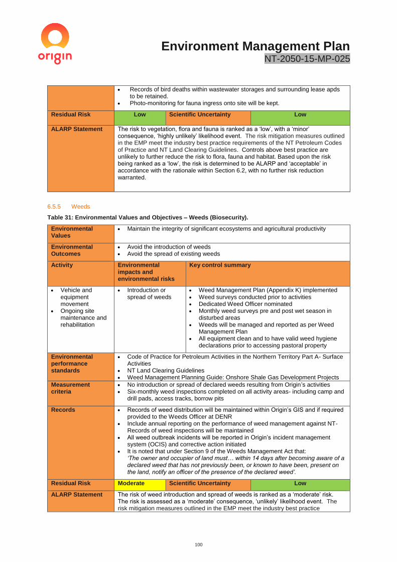
Environment Management Plan NT-2050-15-MP-025
100
• Records of bird deaths within wastewater storages and surrounding lease apds to be retained.
• Photo-monitoring for fauna ingress onto site will be kept.
Residual Risk Low Scientific Uncertainty Low
ALARP Statement The risk to vegetation, flora and fauna is ranked as a ‘low’, with a ‘minor’ consequence, ‘highly unlikely’ likelihood event. The risk mitigation measures outlined in the EMP meet the industry best practice requirements of the NT Petroleum Codes of Practice and NT Land Clearing Guidelines. Controls above best practice are unlikely to further reduce the risk to flora, fauna and habitat. Based upon the risk being ranked as a ‘low’, the risk is determined to be ALARP and ‘acceptable’ in accordance with the rationale within Section 6.2, with no further risk reduction warranted.
6.5.5 Weeds
Table 31: Environmental Values and Objectives – Weeds (Biosecurity).
Environmental Values
• Maintain the integrity of significant ecosystems and agricultural productivity
Environmental Outcomes
• Avoid the introduction of weeds • Avoid the spread of existing weeds
Activity Environmental impacts and environmental risks
Key control summary
• Vehicle and equipment movement
• Ongoing site maintenance and rehabilitation
• Introduction or spread of weeds
• Weed Management Plan (Appendix K) implemented • Weed surveys conducted prior to activities • Dedicated Weed Officer nominated • Monthly weed surveys pre and post wet season in
disturbed areas • Weeds will be managed and reported as per Weed
Management Plan • All equipment clean and to have valid weed hygiene
declarations prior to accessing pastoral property
Environmental performance standards
• Code of Practice for Petroleum Activities in the Northern Territory Part A- Surface Activities
• NT Land Clearing Guidelines • Weed Management Planning Guide: Onshore Shale Gas Development Projects
Measurement criteria
• No introduction or spread of declared weeds resulting from Origin’s activities • Six-monthly weed inspections completed on all activity areas- including camp and
drill pads, access tracks, borrow pits
Records • Records of weed distribution will be maintained within Origin’s GIS and if required provided to the Weeds Officer at DENR
• Include annual reporting on the performance of weed management against NT-Records of weed inspections will be maintained
• All weed outbreak incidents will be reported in Origin’s incident management system (OCIS) and corrective action initiated
• It is noted that under Section 9 of the Weeds Management Act that: ‘The owner and occupier of land must… within 14 days after becoming aware of a declared weed that has not previously been, or known to have been, present on the land, notify an officer of the presence of the declared weed’.
Residual Risk Moderate Scientific Uncertainty Low
ALARP Statement The risk of weed introduction and spread of weeds is ranked as a ‘moderate’ risk. The risk is assessed as a ‘moderate’ consequence, ‘unlikely’ likelihood event. The risk mitigation measures outlined in the EMP meet the industry best practice

Environment Management Plan NT-2050-15-MP-025
101
requirements of the NT Petroleum Codes of Practice and NT Land Clearing Guidelines. Controls above best practice are unlikely to further reduce the risk of introduction or spread of weeds. Based upon the risk being ranked as a ‘moderate’ and consistent with standard civil or pastoral activities (regardless of industry), the risk is determined to be ALARP and ‘acceptable’ in accordance with the rationale within Section 6.2, with no further risk reduction warranted.
6.5.6 Waste Management
Table 32: Environmental Values and Objectives – Waste.
Environmental Values
• Maintain the integrity of ecosystems and agricultural productivity • Minimise the amount of waste generated on-site and disposed of off-site
Environmental Outcomes
• Minimise impacts on soil, surface water, groundwater, sensitive habitat and air quality
• Minimise creation of food sources or habitat for pest species • Minimise waste generation through reduce, reuse, recycle programs
Activity Environmental impacts and environmental risks
Key control summary
• Drilling, stimulation, completion and well testing activities
• Contaminated land • Encouragement of
pest species to waste sites
• The Wastewater Management Plan (Appendix E) will be implemented
• The Spill Management Plan (Appendix D) will be implemented
• All wastes will be managed in accordance with the NT Waste Management and Pollution Control Act
• Sewage and grey water from camps will be treated on-site and irrigated as per the Department of Health Code of Practice for On-site Wastewater Management
• Drill cuttings will be managed in accordance with the NT Petroleum Code of Practice, with on-site disposal used where a third-party assessment confirms it is safe to do so. DENR will be consulted where onsite disposal is proposed.
Environmental performance standards
• Code of Practice for Petroleum Activities in the Northern Territory Part A- Surface Activities
• Origin’s Wastewater Management Plan • Origin Spill Management Plan • NT Waste Management and Pollution Control Act 1998
Measurement criteria
• All waste volumes tracked whilst on-site and in transport • Waste transport certificates available for all wastes generated • No off-site releases of wastewater or waste products
Records • Waste disposal records (tracking and disposal certificated) to be maintained and kept for audit purposes and provided to DPIR/DENR
Residual Risk Low Scientific Uncertainty Low
ALARP Statement The risk from waste is ranked as a ‘low’. The risk was assessed as being a ‘minor’ consequence, ‘unlikely’ likelihood event. The risk mitigation measures outlined in the EMP meet the industry best practice requirements of the NT Petroleum Codes of Practice and NT Waste Management and Pollution Control Act 1998. Controls above best practice are unlikely to further reduce the risk associated with waste management. Based upon the risk being ranked as a ‘low’, the risk is determined to be ALARP and ‘acceptable’ in accordance with the rationale within Section 6.2, with no further risk reduction warranted.

Environment Management Plan NT-2050-15-MP-025
102
6.5.7 Air Quality and GHG Emissions–
Table 33: Environmental Values and Objectives – Air Quality (Dust and Emissions).
Environmental Values
• Rural air environment with qualities conducive to suitability for the life, health and wellbeing of humans
Environmental Outcome
• Minimise environmental nuisance at sensitive receptors • Minimise greenhouse gas emissions
Activity Environmental impacts and environmental risks
Key control summary
• Drilling, stimulation, completion and well testing (faring) activities
• Vehicle movements
• Dust emissions • Release of
atmospheric contaminants from exhausts, venting and flaring
• Wellhead leaks
• A Methane Management Plan will be implemented as per Appendix L
• A reduced emission completion will be used to reduce Volatile Organic Compound and GHG emissions
• A leak detection and repair program will be implemented
• Dust suppression will be utilised near sensitive receptors
• Equipment will be maintained in good working order to minimise emissions
• All pollutant emissions, including unplanned events and emissions from wastewater storage tanks will be reported via the National Pollutant Inventory (NPI) Emission Estimation Technique Manual for Oil and Gas Extraction and Production Version 2.0
• All Greenhouse gas emissions shall be measured and reported in accordance with the National Greenhouse and Energy Reporting Scheme (NGERS) National Greenhouse and Energy Reporting (Measurement) Determination 2008
Environmental performance standards
• Code of Practice for Petroleum Activities in the Northern Territory Part A- Methane Emissions
• Code of Practice for Petroleum Activities in the Northern Territory Part B- Well Operations
Measurement criteria
• No valid complaints regarding dust / air quality resulting from Origin’s activities • All complaints responded to and, where appropriate, corrective action taken
Records • All complaints and subsequent actions are to be recorded in Origin’s OCIS incident management system
• All venting and flaring of produced gas to be recorded • All emissions, including unplanned events and emissions from wastewater
storage tanks will be reported via the National Pollutant Inventory (NPI) and National Greenhouse and Energy Reporting Scheme (NGERS);
Residual Risk Low Scientific Uncertainty Low
ALARP Statement The risk from dust, equipment emissions and flaring on air quality is ranked as ‘low’. The risk is assessed as being a ‘minor’ consequence, ‘unlikely’ likelihood event. The risk mitigation measures outlined in the EMP meet the industry best practice requirements of the NT Petroleum Codes of Practice; with site selection being the primary control. Controls above best practice are unlikely to further reduce the risk to air quality. Based upon the risk being ranked as a ‘low’, the risk is determined to be ALARP and ‘acceptable’ in accordance with the rationale within Section 6.2, with no further risk reduction warranted.

Environment Management Plan NT-2050-15-MP-025
103
6.5.8 Lighting, noise, vibration and visual amenity
Table 34: Environmental Values and Objectives – Lighting, noise, vibration and visual amenity.
Environmental Values
• A rural acoustic, lighting, vibration and visual amenity environment conducive to the wellbeing of the community, including its social and economic amenity, and an individual, including the opportunity to have sleep, relaxation and conversation without unreasonable interference from civil works and water bore drilling operations
Environmental Outcomes
• Manage activities in accordance with occupational health and safety guidelines for noise, vibration and light exposure
• Minimise nuisance noise and vibration impacts on surrounding communities or exploration workers
• Minimise disruption to fauna and stock
Activity Environmental impacts and environmental risks
Key control summary
• Drilling, stimulation, completion and well testing (faring) activities
• Vehicle movements
• Nuisance noise impacts on surrounding communities or exploration workers through use of mechanical equipment
• Disrupting or altering fauna feeding, breeding or other activities through noise, vibration and lighting from use of mechanical equipment
• Interference with pastoral activities if noise, vibration and lighting affects behaviour of stock
• Site separation distance from closest receptors is 20km+ and activity will not be directly visible
• Adjacent area not high conservation areas • Short duration of drilling and stimulation activities
Environmental performance standards
• Code of Practice for Petroleum Activities in the Northern Territory Part A- Surface Activities
Measurement Criteria
• No valid nuisance-related complaints received from sensitive receptors • All complaints responded to and, where appropriate, corrective action taken
Records • All complaints and subsequent actions are to be recorded in Origin’s incident reporting tool OCIS
Residual risk Low Scientific Uncertainty Effective
ALARP Statement The risk of the activity on local amenity is ranked as ‘low’. The risk is assessed as having a ‘minor’ consequence, ‘unlikely’ likelihood event. The risk mitigation measures outlined in the EMP meet the industry best practice requirements of the NT Petroleum Codes of Practice; with the location of the activity being the primary control. Controls above best practice are unlikely to further reduce the risk to aesthetics. Based upon the risk being ranked as a ‘low’, the risk is determined to be ALARP and ‘acceptable’ in accordance with the rationale within Section 6.2, with no further risk reduction warranted.

Environment Management Plan NT-2050-15-MP-025
104
6.5.9 Bushfires
Table 35: Environmental Values and Objectives – Bushfire.
Environmental Values
• Maintain a natural fire regime of the region • Protection of public, private infrastructure and equipment
Environmental Outcomes
• Minimise the risk of causing bushfires from Origin’s activities • Minimise impacts on environmental habitat and fauna, impacts on stakeholders,
impacts on culturally-significant sites, public infrastructure and community lands • Ensure proper health and safety plan for activities • Prevent accidental fire risk and ensure safe storage of chemicals to prevent fire
damage
Activity Environmental impacts and environmental risks
Key control summary
• Drilling, stimulation and well testing (flaring) activities
• Ongoing site access
• Vegetation degradation
• Loss of fauna and habitat
• Increased erosion and impacts upon soil and surface water as a result of vegetation loss
• Damage to or loss of public infrastructure, private infrastructure and equipment or community lands
• Damage to or loss of culturally significant sites
• Loss of life
• Bushfire Management Plan (Appendix M) implemented • Firebreaks to be implemented around the lease • Flaring to have an appropriate buffer • Emergency Response Plan (Appendix N) implemented
Environmental performance standards
• Code of Practice for Petroleum Activities in the Northern Territory Part A- Surface Activities
• NT Bushfire Management Act • Origin’s Bushfire Management Plan
Measurement criteria
• No uncontrolled fires occurring as a result of civil works
Records • All incidents of fire to be recorded in Origin’s incident reporting tool OCIS
Residual Risk Medium Scientific Uncertainty Low
The risk of fire introduction ranked as a ‘moderate’. The risk is assessed as a ‘severe’ consequence, ‘highly unlikely’ likelihood event. The area is frequented by fire, with risk mitigation measures outlined in the EMP that meet the Petroleum Codes of Practice, NT Bushfire Management Act and Origin’s Bushfire Management Plan. Controls above best practice are unlikely to further reduce the risk of introduction of bushfire. Based upon the risk being ranked as a ‘moderate’ and consistent with standard civil and pastoral activities (regardless of industry), the risk is determined to be ALARP and ‘acceptable’ in accordance with the rationale within Section 6.2, with no further risk reduction warranted.
6.5.10 Cultural Heritage and Sacred Sites
Table 36: Environmental Values and Objectives – Cultural Heritage and Sacred Sites.

Environment Management Plan NT-2050-15-MP-025
105
Environmental Values
• Maintain both Indigenous and non-Indigenous cultural heritage values of the region
Environmental Outcomes
• Avoid disturbance or damage to Aboriginal cultural heritage artefacts or sacred sites
• Minimise impacts and disruption to activities of Indigenous stakeholders in culturally-significant areas
• Ensure adequate background information and training is provided to employees and contractors working in culturally-significant areas
• Ensure that the health and safety of employees, contractors and the community is not compromised through management of cultural and environmental awareness
Activity Environmental impacts and environmental risks
Critical control summary
• Drilling, completion, stimulation and well testing activities
• Damage to or loss of Indigenous and non-Indigenous cultural heritage artefacts or sacred sites
• Disruption of activities of Indigenous and non-Indigenous stakeholders
• Heritage assessment completed, including site surveys • NLC site clearances completed and AAPA certificates
obtained; consent with relevant Traditional Owners obtained
• Area located away from any RWA’s • All contractors made aware of RWA’s and conditions
within AAPA Certificates. • Training and awareness to cover cultural heritage
awareness
Environmental performance standards
• AAPA Certificates • NT Bushfire Management Act
Measurement criteria
• No unauthorised activities within or access to a Restricted Work Area • No non-compliances with AAPA certificate conditions
Records • A register will be kept of all occurrences of archaeological sites identified during the Project for provision to the NLC, the AAPA and Heritage Branch within DLPE
• Ensure that site personnel and contractors report all new discoveries of archaeological or cultural artefacts. All work must cease and protection measures implemented until the area can be assessed
Residual Risk Low Scientific Uncertainty Effective
ALARP Statement The risk to community from the activity is ranked as ‘low’. The risk is assed as having a ‘minor’ consequence, ‘remote’ likelihood event. This is reflective of the absence of restricted work areas and implementation of risk mitigation measures outlined in the EMP meet the Native Title Act and Sacred Sites Act requirements. Due to the limited nature of the activity and approvals granted (NLC Clearances and AAPA), additional controls are not required. Based upon the risk being ranked as a ‘low’, the risk is determined to be ALARP and ‘acceptable’ in accordance with the rationale within Section 6.2, with no further risk reduction warranted.
6.5.11 Social Environment
Table 37: Environmental Values and Objectives – Community.
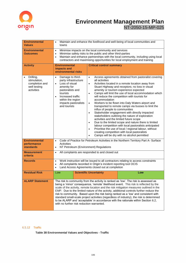
Environment Management Plan NT-2050-15-MP-025
106
Environmental Values
• Maintain and enhance the livelihood and well-being of local communities and towns
Environmental Outcomes
• Minimise impacts on the local community and services • Minimise safety risks to the public and other third-parties • Maintain and enhance partnerships with the local community, including using local
contractors and maximising opportunities for local employment and training
Activity Environmental impacts and environmental risks
Critical control summary
• Drilling, stimulation, completion and well testing activities
• Damage to third-party infrastructure
• Loss of visual amenity for pastoralists and tourists
• Increased traffic within the region impacts pastoralists and tourists
• Access agreements obtained from pastoralist covering all activities
• Activities located in a remote location away from Stuart Highway and receptors; no loss in visual amenity or tourism experience expected
• Camps will limit the use of local accommodation which will reduce the competition with tourists for accommodation
• Workers to be flown into Daly Waters airport and transported to remote camps via busses to limit the influx of people to communities
• Stakeholder engagement with directly impacted stakeholders outlining the nature of exploration activities and the limited future scope
• Due to the limited scope and nature there is limited labour competition with local pastoralists anticipated
• Prioritise the use of local / regional labour, without creating competition with local pastoralists
• Camps will be dry with no alcohol permitted
Environmental performance standards
• Code of Practice for Petroleum Activities in the Northern Territory Part A- Surface Activities
• NT Petroleum (Environment) Regulations
Measurement criteria
• All complaints are responded to and closed out
Records • Work instruction will be issued to all contractors relating to access constraints • All complaints recorded in Origin’s incident reporting tool OCIS • Land Access Agreements closed out at completion
Residual Risk Low Scientific Uncertainty Low
ALARP Statement The risk to community from the activity is ranked as ‘low’. The risk is assessed as being a ‘minor’ consequence, ‘remote’ likelihood event. This risk is reflected by the scale of the activity, remote location and the risk mitigation measures outlined in the EMP. Due to the limited nature of the activity, additional controls further reduce the risk to community. Based upon the risk being ranked as a ‘low’ and consistent with standard small-scale project activities (regardless of industry), the risk is determined to be ALARP and ‘acceptable’ in accordance with the rationale within Section 6.2, with no further risk reduction warranted.
6.5.12 Traffic
Table 38 Environmental Values and Objectives - Traffic
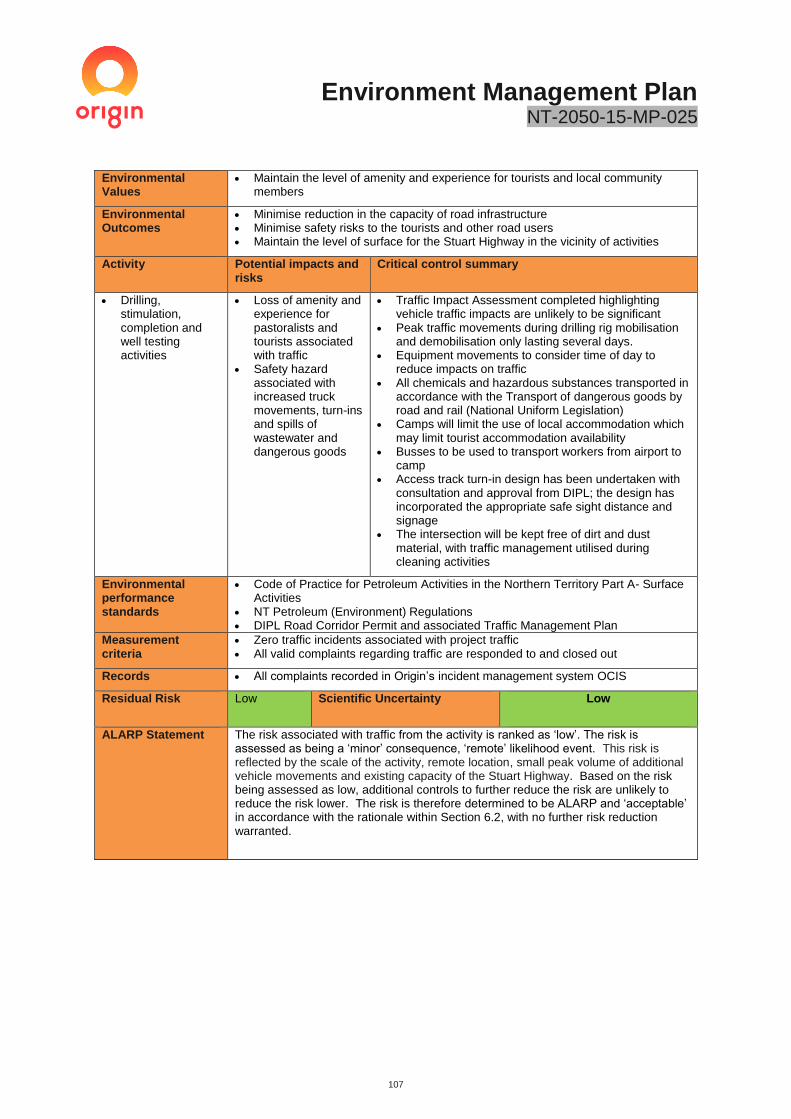
Environment Management Plan NT-2050-15-MP-025
107
Environmental Values
• Maintain the level of amenity and experience for tourists and local community members
Environmental Outcomes
• Minimise reduction in the capacity of road infrastructure • Minimise safety risks to the tourists and other road users • Maintain the level of surface for the Stuart Highway in the vicinity of activities
Activity Potential impacts and risks
Critical control summary
• Drilling, stimulation, completion and well testing activities
• Loss of amenity and experience for pastoralists and tourists associated with traffic
• Safety hazard associated with increased truck movements, turn-ins and spills of wastewater and dangerous goods
• Traffic Impact Assessment completed highlighting vehicle traffic impacts are unlikely to be significant
• Peak traffic movements during drilling rig mobilisation and demobilisation only lasting several days.
• Equipment movements to consider time of day to reduce impacts on traffic
• All chemicals and hazardous substances transported in accordance with the Transport of dangerous goods by road and rail (National Uniform Legislation)
• Camps will limit the use of local accommodation which may limit tourist accommodation availability
• Busses to be used to transport workers from airport to camp
• Access track turn-in design has been undertaken with consultation and approval from DIPL; the design has incorporated the appropriate safe sight distance and signage
• The intersection will be kept free of dirt and dust material, with traffic management utilised during cleaning activities
Environmental performance standards
• Code of Practice for Petroleum Activities in the Northern Territory Part A- Surface Activities
• NT Petroleum (Environment) Regulations • DIPL Road Corridor Permit and associated Traffic Management Plan
Measurement criteria
• Zero traffic incidents associated with project traffic • All valid complaints regarding traffic are responded to and closed out
Records • All complaints recorded in Origin’s incident management system OCIS
Residual Risk Low Scientific Uncertainty Low
ALARP Statement The risk associated with traffic from the activity is ranked as ‘low’. The risk is assessed as being a ‘minor’ consequence, ‘remote’ likelihood event. This risk is reflected by the scale of the activity, remote location, small peak volume of additional vehicle movements and existing capacity of the Stuart Highway. Based on the risk being assessed as low, additional controls to further reduce the risk are unlikely to reduce the risk lower. The risk is therefore determined to be ALARP and ‘acceptable’ in accordance with the rationale within Section 6.2, with no further risk reduction warranted.

Environment Management Plan NT-2050-15-MP-025
108
7 Implementation Strategy
7.1 Corporate Environmental Policy
Origin’s activities are governed by the Origin Health, Safety and Environment Management System (HSEMS). This system is underpinned by Origin’s Health, Safety and Environment (HSE) Policy (Figure 31) which is designed to:
“Conduct our business in a way that causes no harm to the health and safety of people and has no unforeseen impacts to the environment”.
7.2 Environment, Health, and Safety Management Systems
Origin has a mature HSEMS which contains the policies and procedures that Origin has in place to manage and minimise the impact from its activities. In addition to meeting legal requirements, Origin’s activities are also governed by several additional internal directives and risk control directives designed to ensure best practice in environmental risk management.
An overview of the Origin HSEMS and the associated directives is provided in Figure 30.
Figure 30: Origin’s HSEMS Structure.
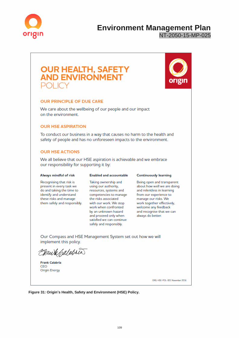
Environment Management Plan NT-2050-15-MP-025
109
Figure 31: Origin’s Health, Safety and Environment (HSE) Policy.

Environment Management Plan NT-2050-15-MP-025
110
7.3 Roles and Responsibility
The following sections describe in detail the management strategies for specific components of the landscape, such as soil, ground water and vegetation, and the cultural and social environment, in relation to the different impact-causing activities that may occur.
The management hierarchy is illustrated in Figure 32. Each management area has been assigned to specific
positions within the exploration team as follows:
- Asset Manager – Responsible for the overall operations in the Origin’s activities in the exploration permit
area.
- Project Manager – Oversees the whole planning and execution of the exploration program and is the
person ultimately responsible for ensuring all other parties are working within the HSE guidelines. The
Project Manager’s role is predominantly office-based. The Project Manager will be responsible for notifying
the Minister, the occupier of the land on which the activity is to be carried out and the owner of the land on
which the activity is to be carried out (unless the owner is also the occupier).
- Civil Construction Superintendent – Person based in the field responsible for ensuring all areas of
operations and construction are carried out in accordance with the EMP and Origin’s HSE Policy. All
contractors report to this position, who is responsible to the Project Manager.
This role will also cover the role of the Weeds Officer, who will be responsible for:
• Planning and execution of weed monitoring requirements, including baseline weed assessments
and ongoing monitoring both during periods of gas-related activities as well as during the target
identification period of February to May.
• Facilitate training all workers (including contractors) in weed management requirements, with
support from the Northern Territory Government Regional Weed Officer - Onshore Shale Gas
Development.
• Oversight of implementation of weed control mechanisms including but not limited to wash-downs
and proactive weed control programs.
• Ensuring all reporting requirements are met.
• Act as the designated point of contact for, and rapidly responding to, any civil-related complaints
and incidents in accordance with the pre-determined strategies in this EMP or relevant ERP.
• Review and update of WMPs to remain effective in communication with relevant landholders and
Regional Weed Officer - Onshore Shale Gas Development in consideration of monitoring results
and emerging weed issues for both gas and pastoral operations.
Drilling and Completions Lead – Person responsible for ensuring the drilling, stimulation and well testing
activities are designed and implemented in accordance with the NT legislation and Codes of Practice.
• Ensures all drilling, completion and stimulation activities are undertaken in accordance with the NT
Petroleum Code of Practice.
• Selection and design of equipment and practices to manage environmental risk.
• Responsible for selecting and engaging drilling, stimulation and well testing contractors.
• Ensuring all contractors comply with the contract terms including compliance with the EMP requirements.
Drilling and Completions Superintendent – Person responsible for ensuring the drilling, stimulation and well
testing activities are executed in accordance with the works program, EMP and Origin’s HSE Policy. This role
reports to the Growth Assets Drilling and Completions Lead.
• Ensures all drilling, completion and stimulation activities are undertaken in accordance with the NT
Petroleum Code of Practice.
• Selection and design of equipment and practices to manage environmental risk.
• Responsible for selecting and engaging drilling, stimulation and well testing contractors.
• Ensuring all contractors comply with the contract terms including compliance with the EMP requirements.

Environment Management Plan NT-2050-15-MP-025
111
Well Site Representative – Person based at the well pad responsible for ensuring all areas of drilling, completion
and well testing are carried out in accordance with the EMP and Origin’s HSE Policy. All drilling, stimulation and
well testing contractors report to this position, who reports to the Drilling and Completions Superintendent.
This role will also cover the role of the Weeds Officer, who will be responsible for:
• Planning and execution of the drilling, stimulation and well testing activities when on-site,
including understanding and communicating the environmental requirements of this plan.
• Facilitate training of all workers (including contractors) in accordance with the management of
weeds, spills, waste, emissions and other aspects.
• Ensuring all reporting requirements are met.
• Act as the designated point of contact for, and rapidly responding to, any drilling, stimulation and
well testing environmental incidents and emergencies in accordance with the pre-determined
strategies in this EMP or relevant ERP.
• Undertake field inspection and assurance activities.
- Lead Contractor – A nominated member within each contracting company (Drilling, Stimulation, Well
Testing service providers) that are responsible for delivering the commitments outlined in this plan. The
Lead Contractor for each service provider will comply with the nominated contractual terms and work
instructions issued under this EMP. The Lead Contractor must ensure all staff are aware of their obligations,
are approximately trained and that procedures and controls are fully implemented and complied with.
- Civil Design Engineer – An individual or organisation that provides professional or expert advice in the field
of civil engineering and design. They determine the best locations, design, materials and construction
techniques for undertaking a project to ensure it meets the needs of the end user.
- Health Safety and Environment Representative (HSE Representative) – Origin representative providing
guidance and advice to site personnel on the day-to-day management of the environment. This role will also
support the nominated Weeds Officer, specifically in the planning and reporting phases.
Field Personnel – All staff including Origin and contractors that are working on in the exploration permit
areas. Responsible for day-to-day management and reporting of environmental aspects.

Environment Management Plan NT-2050-15-MP-025
112
Figure 32: Beetaloo Project Organisation Chart.
7.4 Training and Awareness
Origin’s HSEMS outlines the policies and procedures governing the training and competency of all personnel (staff and contractors) to ensure they can fulfil their obligations under this EMP and the broader Origin HSEMS.
The majority of work undertaken under this will be via contractors under supervision of Origin staff. Assuring the level of training and competency of the selected contractors and supervisors is therefore a major focus of the HSE EMS implementation strategy.
These systems include:
- General Origin HSE induction
- Contractor HSE prequalification process
- Contractor management system
- Site-specific inductions
- Task-specific training, procedures and competency requirements
Contractors will be required to demonstrate they have appropriate systems, procedures and training to manage specific risks covered under this EMP prior to award. The following aspects will be considered during tender award:
- Maturity of HSE systems and process.
- Previous HSE performance
- Existing procedures and training:
• Weed identification and management
• Refuelling procedures

Environment Management Plan NT-2050-15-MP-025
113
• Procedures for avoidance of potential fauna habitat and any identified heritage sites
• Hazardous material and waste management procedures
• Spill management
• Incident notification and management processes
- Internal training programs
- Internal auditing processes
All staff and contractors entering the site will be required to attend a site-specific induction. The induction covers the following aspects:
- Regulatory requirements for the area, including specific conditions on the exploration permits and
agreements with the NLC
- Environmental considerations and special procedures to be used for environment protection, as well as
protection of archaeological and cultural sites within the permit areas
- Safety procedures covering the safe use of vehicles, equipment and explosives first aid and HSE in remote
area operations
- Emergency response training
- Landowner sensitivities, including Aboriginal communities and their specific cultural requirements
- Procedures for handling any culturally or archaeologically-sensitive materials that may be discovered
- Provide training in safe storage and handling of flammable and combustible liquids
7.5 Environmental Commitment Summary
The responsibility for general environmental monitoring rests with all personnel engaged on the project. More specifically, Origin’s Drilling Completion Lead and Well Site Representatives are responsible for delivering the relevant components of this plan.
The program environmental commitments are outlined in Appendix P are sourced from the risk assessment (Appendix J). The implementation and compliance against these risk controls will be assessed as part of the annual environmental report (refer Monitoring, assurance and non-conformance management in Section 7.8).
Specific commitments will be to:
- record of information to track performance, including non-conformances and corrective actions
- inspect and monitor of operational controls on-site via regular environmental monitoring
- assess the level of conformance with objectives and targets detailed in this EMP
The Operating Company Representative will undertake random site inspections and direct such action as may be considered necessary to protect, minimise or rectify any environmental concerns.
The Operating Company Representative will undertake random site inspections and direct such action as may be considered necessary to protect, minimise or rectify any environmental concerns.
7.6 Work instructions
The work covered under this EMP will be executed by external contractors with Origin oversight. Efforts are therefore focused on effective contractor management, to ensure third-parties are compliant with the relevant EMP commitment and contractual requirements. An overview of Origin’s EMP implementation strategy is provided in Figure 33.
An instrument referred to as a ‘work instruction’ is the main mechanism by which Origin cascades the relevant environmental commitments to each contractor. The work instructions are designed to be a contractual document that outlines the minimum compliance requirements for a specific activity. The work instructions contain:
- Key compliance and system documents;

Environment Management Plan NT-2050-15-MP-025
114
- A list of compliance commitments and responsible person for a specific activity;
- A list of inspections, procedures and other tools required to implement the content of the EMP;
- Monitoring and reporting requirements;
- ‘Hold Points’ which require a deliverable to be completed prior to entry into a new activity phase (i.e. prior to mobilisation, operation and demobilisation); and
- Maps illustrating the approved disturbance areas and any restricted work areas.
An example of a work instruction is provided in Appendix P. This work instruction was used for work completed under the Kyalla 117 Civils Construction Environmental Management Plan NT-2050-15-MP026. It should be noted that multiple work instructions will be generated under this EMP covering different aspects and contractors of this program. These will be generated prior to the commencement of drilling, as outlined in Section 3.25.
The work instructions form a critical implementation and assurance tool in that an Origin representative must sign off the ‘Hold Points’ to ensure the various commitments have been achieved. This provides a clear, documented approach to demonstrate compliance which can be audited against.
Figure 33: EMP implementation overview flowchart.

Environment Management Plan NT-2050-15-MP-025
115
7.7 Incident Reporting
Incident reporting and investigation provides the mechanism to prevent a recurrence. All personnel are required to proactively report all incidents, near-misses and identification of potential hazards.
Origin utilises an online incident management and reporting system. Any environmental incident, near miss or observation is reported through the online incident reporting system. All personnel are encouraged to report minor events to act as an alert to environmental risks and to maintain a program of continual improvement.
7.7.1 Reportable Environmental Incident Reporting
The Petroleum (Environment) Regulations define a reportable incident as an incident arising from a regulated activity that has caused, or has the potential to cause, material environmental harm or serious environmental harm as defined under the Petroleum Act.
An interest holder must notify (this may be oral or in writing) DPIR of a reportable incident as soon as practicable but no later than two-hours after the first occurrence of the incident or after the time the interest holder becomes aware of the incident.
DPIR can be notified through the DPIR Operations Term Emergency number 1300 935 250.
Any verbal report to DPIR must be followed up by a written report from the Project Manager within three days in accordance with the Petroleum (Environment) Regulations.
7.7.2 Recordable incidents
The Petroleum (Environment) Regulations define a recordable incident as an incident arising from a regulated activity that:
I. Has resulted in an environmental impact or environmental risk not specified in the current plan for the activity; or
II. Has resulted in a contravention of an environmental performance standard specified in the current plan for the activity; or
III. Is inconsistent with an environmental outcome specified in the current plan for the activity; and
IV. Is not a reportable incident.
An interest holder must notify (this may be oral or in writing) DPIR of a recordable incident as soon as practicable but no later than 15-days after the reporting period (agreed period or each 90-day period after the day on which the EMP is approved).
7.7.3 Waste Management and Pollution Control Act incident reporting
If a contaminant or waste is emitted or discharged from land on which a petroleum exploration activity, or petroleum extraction activity is being undertaken, it will also be considered an incident as defined by the WMPC Act if it threatens or may threaten to cause pollution resulting in material or serious environmental harm.
In accordance with the WMPC Act, the operator has a duty to notify of incidents causing or threatening to cause pollutions as soon as practicable, but no less than 24 hours after becoming aware of the incident.
A notifiable incident is defined as an incident that causes, or is threatening or may threaten to cause, pollution resulting in material environmental harm or serious environmental harm.
A notification must include: (a) the incident causing or threatening to cause pollution; (b) the place where the incident occurred; (c) the date and time of the incident; (d) how the pollution has occurred, is occurring or may occur; (e) the attempts made to prevent, reduce, control, rectify or clean up the pollution or resultant environmental harm caused or threatening to be caused by the incident; and (f) the identity of the person notifying
The notification shall be made to the NT EPA Pollution Hotline 1800 064 567.

Environment Management Plan NT-2050-15-MP-025
116
7.8 Monitoring, assurance and non-conformance management
In addition to regular monitoring as set out in this document, audits assessing compliance with this EMP and associated work instructions will be undertaken by Origin during the commencement of the activity. System deficiencies, adverse or potentially adverse environmental conditions arising from site activities may be subject to the issue of environmental non-conformances or corrective action requests. These non-conformances or corrective actions shall be logged, and remedial actions identified and implemented. The status of corrective actions will be tracked and reported annual in the annual environmental report.
Audits of implementation of the EMP commitments will be completed for each activity or at least annually. The results will be included in the annual environmental report.
Table 39: EMP audit schedule.
Audit Type Scope of Audit Frequency Responsibility
Annual Assurance Compliance against EMP
commitments and risk
management controls
Annually Origin HSE
Representative
7.9 Emergency Response Plan
An Emergency Response Plan has been developed covering the proposed activities within the EMP. The ERP provides a broad framework for managing potential emergency incidents to minimise the potential risk to human safety and the environment.
The ERP covers the following aspects pertinent to the drilling and stimulation activities and associated infrastructure:
- Spills and loss of containment
- Bushfires
- Medical emergencies.
- Flooding
- Emergency incident reporting
The ERP will be reviewed every three years to ensure the content is continually kept up to date. A copy of the
ERP is provided in Appendix O.
7.10 Reporting
Internal and government reporting on performance standards will be carried out by the Origin authorised representative, and distributed to Origin management and the DENR, in accordance with Section 35 of the Petroleum (Environment) Regulations. Quarterly and annual reports will be completed to summarise the compliance with this EMP, whether the environmental outcomes and performance standards in the plan were met and the details of any recordable and reportable incidents.
Table 40: EMP Reporting Schedule.
Frequency Report detail Recipient
Prior to the
commencement
of construction
and drilling
A commencement of construction or drilling activity
notification
a) The Minister for Environment
and Natural Resources
b) The occupier of the land in
which the activity is carried out
c)The owner for the land for
which the activity is to be carried
out
Only if required Incident report summarising reportable incidents DENR and DPIR

Environment Management Plan NT-2050-15-MP-025
117
Frequency Report detail Recipient
Prior to the
commencement
of construction
and drilling
A commencement of construction or drilling activity
notification
a) The Minister for Environment
and Natural Resources
b) The occupier of the land in
which the activity is carried out
c)The owner for the land for
which the activity is to be carried
out
Quarterly Quarterly incident report summarising recordable
incidents during the period (during operational
activities)
DENR and DPIR
Annually An annual environmental report will be prepared and
submitted to the Minister covering the following:
- Summary of the works completed under the EMP
during the reporting period
- Summary of performance against measurement
criteria
- A summary of environmental incidents that
occurred during the year (i.e. reportable and
recordable incidents that occurred)
- Any environmental studies or research associated
with the activity
- Technical improvements
- Consultation undertaken
- Annual weed management performance reporting
against NT-2050-15-MP-0016
- Results of related research or of an ongoing
monitoring program
- The relevant records outlined with Section 6.5
Environmental Risk Management Summary tables
Origin management
DENR
7.11 Record Keeping
The following records will be retained within Origin’s Document Management system for a period of five years
- records linked to measurement criteria, commitments and statutory reporting requirements;
- induction records;
- waste records;
- hazardous goods manifests;
- fuel usage;
- weed inspections;
- non-compliances and corrective action records;
- internal audits and inspection records; and
- management of change records.
To the extent these documents are ‘prescribed records’ for the purpose of the Petroleum (Environment)
Regulations 2016, they will be kept for the longer of five years following the period during which the petroleum
interest is in force and 15 years after the record comes into existence.

Environment Management Plan NT-2050-15-MP-025
118
7.12 Management of Change.
A management of change process will be implemented to ensure any changes to activities are appropriately assessed and communicated to ensure no additional un-intended risks or impacts are introduced. Changes can be implemented to optimise environmental outcomes or to improve operational efficiency. This allows adaptive management and the ability to use appropriate technologies.
Most changes will not change the risk profile of the exploration activities and will continue to comply with the existing EMP condition outcomes. Other changes may introduce a new risk not covered under the approved EMP and will require further notification of the EMP.
Examples requiring external notification under the Petroleum (Environment) Regulations include:
• A change that will introduce a new or increased level of environmental impact or risk
• Changes in activity not covered by the original scope of the EMP
• A major revision to management plans that will materially change the management strategy. volumes or key controls proposed by the plan.
• The addition of a drilling and stimulation chemical requiring a tier 2 and above assessment
7.13 EMP Review
Implementation of this EMP will be continually monitored and revised as required based on monitoring and audit results, complaints, employee and stakeholder feedback, change to the proposed work program or a material increase in risk level.
A formal review, update and resubmission of this EMP will be undertaken every five years.
Environment Management Plan NT-2050-15-MP-025
119
8 References
Adams, M.D., Donato, D.B., Schulz, R.S., Smith, G.B., Gibbons, T., Davies, S and Hillier D., 2013. Hypersaline-Induced Reduction in Cyanide Ecotoxicity at Gold Operations, thereby Obviating Detoxification Plants. Conference Paper, World Gold Conference, Australia, Brisbane.
Adams, M.D., Donato, D.B., Schulz, R.S., Smith, G.B., 2008. Influences of hypersaline tailings on wildlife cyanide toxicosis: MERIWA project M398 (Phase II) cyanide ecotoxicity at hypersaline gold operations. Final Report Volume 2—Definitive Investigation. Minerals and Energy Research Institute of Western Australia, Perth.
AECOM. 2011. Archaeological Assessment – Drill Sites and Access Roads, unpublished for Falcon Oil and Gas Australia.
AECOM. 2012a. EP99 Archaeological Survey, Beetaloo Basin, unpublished report for Falcon Oil and Gas Australia.
AECOM. 2012b. Interim Report Archaeological Surveys 2011, unpublished report for Hess Australia (Beetaloo) Pty Limited
AECOM. 2013. Environmental Closeout Survey, Sweetpea Seismic Survey 2006, Prepared by AECOM for submission to DME, Darwin, NT.
Aldrick JM and Wilson PL. 1990. Land systems of the Southern Gulf Region, Northern Territory, Technical Report No. 42, Conservation Commission of the Northern Territory, Palmerston, NT.
Aumann, T. and Baker-Gabb D. 1991. RAOU Report 75. A Management Plan for the Red Goshawk. RAOU. Royal Australasian Ornithologists Union, Melbourne.
Australian Natural Resources Atlas (ANRA), 2008. Rangelands 2008 Taking the Pulse- Sturt Plateau Bioregion.
Australian Radiation Protection and Nuclear Safety Agency (ARPANSA),2019 Radon exposure and health, website access 06/09/2019,
https://www.arpansa.gov.au/understanding-radiation/radiation-sources/more-radiation-sources/radon
Australian Petroleum Production and Exploration Association Limited (APPEA). 2008. Code of Environmental Practice, Canberra, ACT.
AustRoads 2019, Guide To Traffic Management Part 12: Traffic Impacts of Developments
AustRoads 2017 Guide to Traffic Management Part 3: Traffic Studies and Analysis
Barkly Regional Council, 2018, The Region, website accessed 18 September 2018, https://www.barkly.nt.gov.au/region/demographics
Barrett, G., Silcocks, A., Barry, S., Cunningham, R., and Poulter, R. 2003. The New Atlas of Australian Birds. Royal Australasian Ornithologists Union, Melbourne.
Barkly Regional Council, 2018, The Region, website accessed 18 September 2018, https://www.barkly.nt.gov.au/region/demographics
Bubb, A. (2004). ‘Pastoral industry survey 2004. Tennant Creek’. (Northern Territory Government: Darwin).
Cassman, EA., Griffin WM,. And Mitchell,AL. 2016. Lung Cancer risk from Radon in the Marcellus Shale Gas in Northeast US Home s, Society for Risk Analysis, Volume 36 (11), 2105-2119.
Commonwealth of Australia. 2001. Australian Native Vegetation Assessment 2001, Land and Water Australia, Canberra.
Christian CS, Noakes LC, Perry RA, Slatyer RO, Stewart GA and Traves DM. 1951. Survey of the Barkly Region, Northern Territory and Queensland, 1947-48, Land Research Series No. 3, CSIRO, Melbourne, SA.
Churchill, S. 2008. Australian Bats. Second edition. Jacana Books, Crow’s Nest.
Cogger, H.G. (2000). Reptiles and Amphibians of Australia - 6th edition. Sydney, NSW: Reed New Holland.
Cole, J. and Woinarski, J. 2002. Field Guide to the Rodents and Dasyurids of the Northern Territory. Surrey Beatty and Sons, Chipping Norton, NSW.
Cooney, S.J.N. (2009). Ecological associations of the hooded parrot (Psephotus dissimilis). Ph.D. Thesis, Australian National University.

Environment Management Plan NT-2050-15-MP-025
120
Curtis, Lee K., A. J. Dennis, K. R. McDonald, P. M. Kyne, and Debus S.J.S., Eds. (2012). Queensland’s Threatened Animals. CSIRO Publishing, Collingswood.
Davie, R., Foulger, G., Bindley, A., and Styles,P. 2013. Induced seismicity and Hydraulic Fracturing for the recovery of hydrocarbons. Marine and petroleum geology, V45. Pp171-1785
Debus, S. (2012). Birds of prey of Australia, 2nd edition. CSIRO Publishing, Collingwood.
Department of the Environment (2014). Tyto novaehollandiae kimberli in Species Profile and Threats Database, Department of the Environment, Canberra. Available from: http://www.environment.gov.au/sprat. Accessed Wed, 10 Sep 2014.
Department of the Environment (2014). Dasyurus hallucatus in Species Profile and Threats Database, Department of the Environment, Canberra. Available from: http://www.environment.gov.au/sprat. Accessed Wed, 10 Sep 2014.
Department of Environment and Energy, State and Territory Greenhouse Gas Inventories 2016, published February 2018
Department of the Environment and Energy. 2018. Key threatening processes under the EPBC Act. http://www.environment.gov.au/biodiversity/threatened/key-threatening-processes, accessed14 September 2018.
Department of Environment and Natural Resource. 2018. Daly Roper Beetaloo Water Control District, Northern Territory Government, Darwin, NT.
Department of Natural Resources, Environment, The Arts and Sport (NRETAS) 2019. Land Clearing Guidelines. Northern Territory Government.
Department of Environment and Natural Resource (DENR). 2018a. Listing of “Threatened Animals”, “Plants” and “Weeds”, accessed August and September 2018. https://nt.gov.au/environment/animals/threatened-animals,
Department of Environment and Natural Resource (DENR). 2018b. Northern Territory Stream Order, Strahler stream orders over the Northern Territory, topographic scale data 250k, Spatial Data and Mapping Branch, Water Resources Division, Northern Territory Government, Darwin, NT.
Department of Land Resource Management. 2015. Barkly Regional Weed Management Plan 2015 - 2020.
Department of Land Resource Management and Charles Darwin University. 2018, Guidelines for the Management of the Weeds of Beetaloo 2018.
Department of Primary Industry and Resources. 2016. Partheneum found in the NT. https://dpir.nt.gov.au/news/2016/december/parthenium-found-in-the-nt accessed 14 September 2018.
Department of Natural Resources and Environment. 2018. Weed Management Planning Guide - Onshore Shale Gas Development Projects.
Dickman C.R. 2009. House cats as predators in the Australian environment: impacts and management. Human-Wildlife Conflicts 3:41-48.
Dickman, C. R. 1996. Impact of exotic generalist predators on the native fauna of Australia. Wildlife Biology 2(3):185-195.
Dostine, P.L., and Franklin, D.C. 2002. A comparison of the diet of three finch species in the Yinberrie Hills area, Northern Territory. Emu 102:159-164.
Environment Australia. 1998. Best Practice Environmental Management in Mining - Dust Control, Canberra, ACT.
Environment Protection Agency. 1995. Best Practice Environmental Management in Mining - Environmental Impact Assessment, Canberra, ACT.
Environment Australia. 1997. Best Practice Environmental Management in Mining - Hazardous Materials Management, Storage and Disposal, Canberra, ACT.
Environment Australia. 1998. Best Practice Environmental Management in Mining - Landform Design for Rehabilitation, Canberra, ACT.
Environment Australia. 1998. Best Practice Environmental Management in Mining - Noise, Vibration and Airblast Control, Canberra, ACT.
Environment Protection Agency. 1996. Best Practice Environmental Management in Mining - Onshore Minerals and Petroleum Exploration, Canberra, ACT.

Environment Management Plan NT-2050-15-MP-025
121
Faulks JJ, 2001. Roper River Catchment - An Assessment of the Physical and Ecological Condition of the Roper River and its Major Tributaries, Technical Report No. 36/2001. Natural Resources Division, Department of Lands, Planning and Environment, Katherine, NT.
Fisher, A. and Woinarski, J. 1994. Golden Bandicoot. Australian Natural History 26, 20-21.
Fisher A. 2001. Biogeography and Conservation of Mitchell Grasslands in Northern Australia, PhD Thesis, Faculty of Science, Information Technology and Education, Northern Territory University, Darwin, NT.
Fisher, A., Baker, B., Woinarski, J. 2002 Biodiversity Audit – Bioregional Summaries, Compilation of individual summaries for the National Land and Water Audit, Parks and Wildlife Service, NT.
Fitzsimons, P., Bond, M., and Webber, S. 2010. Creating a participatory adaptive capacity index for climate change adaptation - Report of engagement process in the South-West of Victoria. Department of Primary Industries Victoria (in press)
Fleming MR, Johnson KA, Latz PK and McKean JR. 1983. A Biological Survey of Junction Stock Reserve and Newcastle Waters Pastoral Lease on The Barkly Tablelands, Wildlife Research Section, Conservation Commission of the NT.
Fulton, S. and Knapton, A. (2015) Beetaloo Basin Hydrogeological Assessment. Prepared by CloudGMS
Garnett, S., J. Szabo & G. Dutson. 2011. The Action Plan for Australian Birds 2010. CSIRO Publishing.
GHD 2013, Vista Gold Australia Pty Ltd Mt Todd Gold Project Traffic and Transport Impact Assessment June, available at https://ntepa.nt.gov.au/__data/assets/pdf_file/0005/289625/appendixV_traffic_transport.pdf
Gillespie, G. R., Brennan, K., Gentles, T., Hill, B., Low Choy, J., Mahney, T., Stevens, A., and Stokeld, D. (2015). A guide for the use of remote cameras for wildlife survey in northern Australia. Darwin: Charles Darwin University
Griffiths SR, Smith GB, Donato DB, Gillespie CG 2009a. Factors influencing the risk of wildlife cyanide poisoning on a tailing storage facility in the Eastern Goldfields of Western Australia. Ecotoxicology and Environmental Safety 72 (2009) 1579-1586
Griffiths SR, Smith GB, Donato DB, Lumsden LF, Coulson G., 2009b. Hypersalinity reduces the risk of cyanide toxicosis to insectivorous bats interacting with wastewater impoundments at gold mines. Ecotoxicology and Environmental Safety 99 (2014) 28-34
Groves RH and Williams OB. 1981. Natural grasslands. In Groves RH, (ed.) Australian Vegetation, pp. 293-316. Cambridge University Press, Melbourne.
Heinz Schandl, Tim Baynes, Nawshad Haque, Damian Barrett and Arne Geschke (2019). Final Report for Final Report for GISERA Project G2 - Whole of Life Greenhouse Gas Emissions Assessment of a Coal Seam Gas to Liquefied Natural Gas Project in the Surat Basin, Queensland, Australia. CSIRO, Australia
Heritage Surveys. 1999. Additional archaeological assessments, Daly Waters to McArthur River Gas Pipeline, Northern Territory, unpublished report to Northern Territory Power and Water Authority.
Hermes, M. 1986. Amadeus Basin to Darwin Natural Gas Pipeline – Spread 2: Internal report on archaeological findings, unpublished report to Museums and Art Galleries of the Northern Territory.
Higgins, P.J. & S.J.J.F. Davies, eds. 1996. Handbook of Australian, New Zealand and Antarctic Birds. Volume Three - Snipe to Pigeons. Melbourne, Victoria: Oxford University Press.
Hirano, T., M. Kiyota, et al. 1995. “Physical effects of dust on leaf physiology of cucumber and kidney bean plants.” Environmental Pollution. vol. 89, no. 3, pp. 255-261.
HLA-Envirosciences Pty Ltd (HLA), 2005. Environmental Management Plan: Onshore Petroleum Exploration Beetaloo Basin, NT. Report prepared for Sweetpea Petroleum Pty Ltd.
HLA, 2006a. An Analysis of Available Water Quality Data and Gap Analysis for Beetaloo Basin, Northern Territory. Report prepared for Sweetpea Petroleum Pty Ltd.
HLA, 2006b. Surface Water Quality Investigation, Beetaloo Basin, Northern Territory. Report prepared for Sweetpea Petroleum Pty Ltd.
HLA, 2006c. Sweetpea Petroleum Environmental Program 2006: Baseline Vegetation Assessment. Report prepared for Sweetpea Petroleum Pty Ltd.
HLA, 2006d. Archaeological Assessment 2006 for the Sweetpea Petroleum Seismic Program, Beetaloo Basin, NT, 2006. Report prepared for Sweetpea Petroleum Pty Ltd.

Environment Management Plan NT-2050-15-MP-025
122
HLA, 2006e. Beetaloo Basin: Cooee Hill and 80 Metre Tower Archaeological Assessment. Report prepared for Sweetpea Petroleum Pty Ltd.
HLA. 2006f. Beetaloo Basin: Yaroo, South Martyr’s Tree and Dunmarra Archaeological Assessment, unpublished report for Sweetpea Petroleum.
HLA, 2007a. Supplementary Environmental Management Plan, Drilling Program 2007, Beetaloo Basin, NT. Report prepared for Sweetpea Petroleum Pty Ltd.
HLA, 2007b. 2007 Environmental Works Progress Report 1 (March to May 2007). Letter to Sweetpea Petroleum dated 28 May 2007.
HLA, 2007c. Groundwater Monitoring Program, Sweetpea Petroleum Exploration Program, Beetaloo Basin, NT. Report prepared for Sweetpea Petroleum Pty Ltd.
HLA, 2007d. Archaeological Assessment Newcastle Waters Proposed Drilling Site for the Sweetpea Petroleum Seismic Program, Beetaloo Basin, NT, 2006. Report prepared for Sweetpea Petroleum Pty Ltd.
Land and Water Australia, 2004. Australian Water Resources Assessment. In: National Land and Water Resource Audit, 2004. Canberra, ACT.
De León, L.F. & Castillo, A. 2015. RHINELLA MARINA (Cane Toad). SALINITY TOLERANCE. Herpetological Review 46(2):237-238.
Kerle, J.A., Foulkes, J.N., Kimber, R.G., and Papenfus, D. 1992. The decline of the brushtail possum, Trichosurus vulpecula (Kerr 1798), in arid Australia. Rangelands Journal 14, 107-127.
Land and Water Australia, 2004. Australian Water Resources Assessment. In: National Land and Water Resource Audit, 2004. Canberra, ACT.
Lloyd P., M. Sanders, T. Reis and A. Abbott. 2013. Targeted trapping surveys shed new light on the distribution and habitat characteristics of the Carpentarian pseudantechinus (Pseudantechinus mimulus), a threatened dasyurid marsupial. Australian Mammalogy. 35:220-223.
Mayes, P. J. 2006. The ecology and behaviour of Varanus mertensi (Reptilia: Varanidae). PhD Thesis. Edith Cowan University. Retrieved from http://ro.ecu.edu.au/theses/42.
McCue, K. 2013 Historical earthquakes in the northern Territory, Australian Earthquake Engineering Society, https://aees.org.au/wp-content/uploads/2013/11/McCue_NT_EQs.pdf. Accessed 21 January 2019.
Menkhorst, P. and Knight F. 2011. A Field Guide to the Mammals of Australia. Oxford University Press, Sydney.
Morcombe, M. 2000. Field guide to Australian birds. Steve Parish Publishing.
Noakes LC and Traves DM. 1951. Outline of the Geology of the Barkly Region. In: Survey of the Barkly Region, Northern Territory and Queensland, 1947-48. CSIRO Land Research Series No. 3.
North Australia Fire Information (NAFI), 2018. Fire Maps. http://www.firenorth.org.au Accessed 16 September 2018.
Northern Territory Government. 2015. NT Weed Management Handbook.
Northern Territory of Australia. 2017. Northern Territory Weed ID Deck.
Northern Territory Government. 2018. A – Z List of Weeds in the Northern Territory. https://nt.gov.au/environment/weeds/weeds-in-the-nt/A-Z-list-of-weeds-in-the-NT accessed 13 September 2018.
Northern Territory Government. 2005. Integrated Natural Resource Management Plan for the Northern Territory, Northern Territory Government.
Orr, DM. and Holmes, WE. 1984 'Mitchell Grasslands.' In G.N. Harrington, A.D. Wilson and M.D. Young (eds) Management of Australia's Rangelands, Australia, CSIRO: 241-254.
Palmer, C., Woinarski J., and Ward S. 2012. Threatened Species of the Northern Territory: Gouldian Finch Erythrura gouldiae. Department of Land Resource Management, Northern Territory Government.
Parks and Wildlife Commission of the NT. 2005. Bullwaddy Conservation Reserve Plan of Management, Parks and Wildlife Commission of the NT, Darwin.
Pavey, C. 2006. National Recovery Plan for the Greater Bilby Macrotis lagotis. Northern Territory Department of Natural Resources, Environment and the Arts.

Environment Management Plan NT-2050-15-MP-025
123
Pizzey, G., Knight, F. and Pizzey, S. 2012. The Field Guide to Australian Birds. HarperCollins Publishers, Sydney.
Quaternary Archaeological Surveys. 1998. Archaeological survey of the Stuart Highway to Mataranka Homestead Optic Fibre Cable Corridor, Northern Territory, unpublished report for Telstra.
Randal MA. 1967. Groundwater in the Barkly Tableland, NT, Bulletin 91, Bureau of Mineral Resources, Geology and Geophysics, Canberra, ACT.
Ryder Scott Company (Ryder Scott), 2010. Evaluation of the Unconventional Oil Resource Potential Pertaining to Certain Acreage Interests in the Beetaloo Basin, Northern Territory, Australia. Report prepared for Falcon Oil and Gas Australia Pty Ltd.
Seismology Research Centre (SRC) 2017, Earthquakes in Australia, https://www.src.com.au/earthquakes/seismology-101/earthquakes-in-australia/ Accessed January 21 2019.
Southgate, R. I. & Paltridge, R. 1998. Recovery of the Greater Bilby Macrotis lagotis. Final Report for Project Number 185, Nature Australia, Biodiversity Group, Endangered Species Program and Feral Pests Program.
Smith, J.G., and Phillips, B.L. 2006.Toxic tucker: the potential impact of cane toads on Australian reptiles. Pacific Conservation Biology 12:40-49.
Smith, M.A. 1986. An investigation of possible Pleistocene occupation at Lake Woods, Northern Territory, Australian Archaeology, 22:60-72.
Tennant Creek Regional Economic Development Committee, 2014, Tennant Creek and Barkly Region Strategic & Action Plan 2014-2016, endorsed 28 October 2014, Northern Territory Government, https://nt.gov.au/__data/assets/pdf_file/0007/198340/tennant-creek-and-barkly-region-strategic-and-action-plan.pdf
Tickell S.J. 2003. Water Resource Mapping Barkly Tablelands, Unpublished draft report prepared by the Department of Infrastructure Planning and Environment, Darwin, NT.
Trainor, C.R. 2005. Distribution and Natural History of the Cryptic Dragon Chelosonia Brunnea: A Review of Records. Northern Territory Naturalist 18:24-44.
United States Geological Survey (USGS) 2017 Induced Earthquakes, myths and misconceptions, https://earthquake.usgs.gov/research/induced/myths.php Accessed January 21 2019.
U.S. EPA. Hydraulic Fracturing for Oil and Gas: Impacts from the Hydraulic Fracturing Water Cycle on Drinking Water Resources in the United States (Final Report). U.S. Environment Protection Agency, Washington, DC, EPA/600/R-16/236F, 2016.
Ward, S.J. 2008. Habitat-use, foraging and breeding ecology of the northern shrike-tit Falcunculus frontatus whitei. Report to NHT (Department of Natural Resources, Environment, the Arts and Sport, Darwin).
Ward, S.J., Berghout, M. and Baker, B. 2009. Notes on the form and habitat of nests of the northern shrike-tit. Northern Territory Naturalist 21:54-60.
Wilson, S. And Swan, G. 2010. A Complete Guide to the Reptiles of Australia. 2010. New Holland,Sydney.
Woinarski, J.C.Z. 2004a. National Multi-species Recovery Plan for the Partridge Pigeon Geophaps smithii smithii, Crested Shrike-tit, Falcunculus frontatus whitei, Masked Owl Tyto novaehollandiae kimberli and Masked Owl Tiwi Islands Tyto novaehollandiae melvillensis 2004-2009. Northern Territory Department of Infrastructure Planning and Environment. Available http://www.environment.gov.au/biodiversity/threatened/publications/recovery/smithii-whitei-kimberli-melvillensis/index.html.
Woinarski, J.C.Z. 2004b. National Multi-species Recovery Plan for the Carpentarian Antechinus Pseudantechinus mimulus, Butler's Dunnart Sminthopsis butleri and Northern Hopping-mouse Notomys aquilo, 2004 - 2009. . Northern Territory Department of Infrastructure Planning and Environment.
Woinarski J.C.Z., Pavey C., Kerrigan R., Cowie I. & Ward S. 2007. Lost from our Landscape: Threatened Species of the Northern Territory. Palmerston: Department of Natural Resources, Environment and the Arts.
Woinarski, J.C.Z. and Tidemann, S.C., 1991. The bird fauna of a deciduous woodland in the wet-dry tropics of northern Australia. Wildlife Research 18: 479-500.
Woinarski, J.C.Z and Ward, S. 2012. Threatened Species of the Northern Territory: Crested Shrike-tit Falcunculus (frontatus) whitei. Department of Land Resource Management, Northern Territory Government.

Environment Management Plan NT-2050-15-MP-025
124
9 Acronyms & Abbreviations
Acronym Meaning
oC Degrees Celsius
% Percentage
AAPA Aboriginal Areas Protection Authority
ABS Australian Bureau of Statistics
AICS Australian Inventory of Chemical Substances
ALA Atlas of Living Australia
ALARP As Low As Reasonably Practicable
ANZECC Australian and New Zealand Environment Conservation Council
API American Petroleum Institute
APPEA Australian Petroleum Production and Exploration Association
AS Australian Standard
BMP Bushfire Management Plan
CAS number Chemical Abstracts Services number
CEEVNT Critically Endangered, Endangered, Vulnerable and Near Threatened
CLA Cambrian Limestone Aquifer
CLC Central Land Council
Cth Commonwealth
DoH Department of Health (NT)
DENR Department of Environment and Natural Resources
DOTEE Department of The Environment and Energy (Cmwlth)
DPIR Department of Primary Industries and Resource (NT)
EC Electrical Conductivity
EPA Environment Protection Authority (NT)
EIS Environment Impact Statement
EP Exploration Permit (e.g. EP76, EP98 and EP117)
EMP Environmental Management Plan
EPBC Environment Protection and Biodiversity Conservation Act
ERS Emergency Response Plan
ESCP Erosion and Sediment Control Plan
GPS Global Positioning Device
GDE Groundwater Dependent Ecosystems
GHG Greenhouse Gas
Ha hectare
HFS Hydraulic Fracture Stimulation

Environment Management Plan NT-2050-15-MP-025
125
Acronym Meaning
HSE Health, Safety and Environment
HSEMPs Health, Safety and Environmental Management Plans
HSEMS Health, Safety and Environment Management System
IBA Important Bird Area
ILUA Indigenous Land Use Agreement
ISO International Organisation for Standardisation
JV Joint Venture
Km Kilometre
km2 Square Kilometres
km/hr Kilometres per hour
LAG Local Aboriginal Group
LOS Level of Service
m metre
Ma Millions of years ago
MD Measured Depth
MEMP Methane Management Plan
MNES Matters of National Environmental Significance
MSDS Material Safety Data Sheet
mTVDGL metre True Vertical Depthbelwo ground level
Mm millimetre
NATA National Association of Testing Authorities
NEPM National Environmental Protection Measure
NGERS National Greenhouse and Energy Reporting Scheme
NICNAS National Industrial Chemicals Notification and Assessment Scheme
NLC Northern Land Council
NORMs Naturally Occurring Radioactive Materials
NPI National Pollutant Inventory
NT Northern Territory
OHS Occupational Health and Safety
PER Public Environment Report
RWA Restricted Work Area
SPMP Spill Management Plan
SWL Standing Water Level
TDS Total Dissolved Solids
TIA Traffic Impact Assessment

Environment Management Plan NT-2050-15-MP-025
126
Acronym Meaning
TMP Traffic Management Plan
TO Traditional Owner
TVDSS True Vertical Depth from Surface Sea level
TPWC Act Territory Parks and Wildlife Conservation Act
TRH Total Recoverable Hydrocarbons
TSS Total Suspended Solids
VOCs Volatile Organic Compounds
WEL Water Extraction Licence
WMP Weed management Plan
WoNS Weed of National Significance
WWMP Wastewater Management Plan