geology and ground-water resources of medina … and ground-water resources of medina county texas...
TRANSCRIPT

Geology and Ground-Water Resources of Medina County TexasBy C. L. R. HOLT, JR.
GEOLOGICAL SURVEY WATER-SUPPLY PAPER 1422
Prepared in cooperation with the Texas Board of W^ater Engineers
UNITED STATES GOVERNMENT PRINTING OFFICE, WASHINGTON : 1959

UNITED STATES DEPARTMENT OF THE INTERIOR
FRED A. SEATON, Secretary
GEOLOGICAL SURVEY
Thomas B. Nolan, Director
For sale by the Superintendent of Documents, U. S. Government Printing Office Washington 25, D. C.

CONTENTS
PageAbstract ---__---.-_.--.__--__---___---_.-----.--__.--___---__-_-___-.._____.__--________._____ 1Introduction .--..-.-. -..- -.....--_.-.._.-...._-..-.....-._..-..--..-.___-___..... 2
Purpose and scope of investigation ----------------~ -------------------- 2Location and general features of the area.................................... 3Previous investigations .--...-..-...-...----....-.---...-..--.--.--.-.-.--.--.. 3Acknowledgments ---.-.--...-.--........---..--.-.-..........-.....--. ...--- 4Well-numbering system - .. - ------_-.-_. --. _ .__ __. _. 4
Geography -- .... ..___ 4Surface features --..-..-...-...-..---..-------.-.-...--.-...--..--.....--...-....- 4Drainage .-...-..--..---...--...---....--...-..-.--.--...-..-....--....-..---..-- 5Climate ...-......-. ...-..-......-...- ...........-..................-.......- 10Development -..-...-.---..-.--...----.....-.--..... ...-..-.-.......---.... .. 11
Geology ...................................................................................... 12Rock formations and their water-bearing properties.................... 13
Pre-Cretaceous rocks -..-..-...--.-...-.-...-...-. ...-..-...--..-.-.--- 13Cretaceous system ............................................................ 13
Coahuila series (Mexico) .--.--.-.....-...-..-..-..--.........--.. 13Comanche series ......-.--..--..--...--.-.. ..-...-..-...-.-.... 16
Trinity group .....--....-...-......... ....--..--......-.....--- 16Travis Peak formation .--...-.. ..---.-....-..-...-.... 16Glen Rose limestone --..--..-...--.......--.--..-...-..-..- 16
Fredericksburg group ---......-..-....-...-...--.--..--- ..- 19Walnut clay ..-.................-.......... . .. ...... 19Comanche Peak limestone..--...-.--.----.-..-..--..,-..- 20Edwards limestone ....-.........--....--.---...--..-.----.. 20
Washita group ......-..-.--....-.-.....-...-. .... ....-. .. 22Georgetown limestone -...--. ....--...-.-.....-. -.- 22Grayson shale (Del Rio clay) ...-..---..---. ----- 23Buda limestone -..-.. .-...-..- ...--.--..-.--.. -.--- 24
Gulf series .-..-...... .......... ............... . ......... 25Eagle Ford shale ................ ............... .. .......... 25Austin chalk .....--.. .--..---.---.... ..--..-....-. -.----- 25Anacacho limestone ..--...-...----.. .--..-...... . --- 28Navarro group .--...........-......--......-.-..---.-.--..------- 31
Corsicana marl .......--..--..........--..--......-..-----.- 31Escondido formation .-..---..--.-- ---..----.---.- --- 32
Tertiary system .-...-.-..-.-...-..........-..-...-...-...-..-..-.-.------- 36Paleocene series ..-...--...-.-.......--..-....-..--...-----.-..--.--- 36
Midway group ....................-......-.... -... . 36Kincaid formation ...........-...........-. . . . 37
Eocene series ...---.-.-. ..--..--..-...-..-.--..-..- ------ -- 37Wilcox group ...........-.......-..-.. ... -.-. 37
Indio formation --.-......-..--.--.-............----------- 37Claiborne group ...-......-.----..-.-...-----...---------------- 42
Carrizo sand ...-..-..-..--.........-...--...-----.----- 42Mount Selman formation ...-........-. ..--.- - 43
III

IV CONTENTS
Geology ContinuedRock formations and their water-bearing properties Cortinrcd
Tertiary system Continued PagePl!ocene(?) series .................................................... 45
Uvalde gravel ............-.-...---.......__....-_........_.....-... 45Quaternary system ............................................................ 45
Pleistocene series .---.--.-.-...-....--.........._____^.-__-_____ _.__. 45Leona formation .......-......-..----.-.......-..-...-..---...---- 45
Recent series -.-..--..--..........-....-.-..........._.--.................. 46Alluvium ....................................................___..... 46
Igneous rocks ...._....__..__...__.._____...._..___....__ ,.__.__.___.___ 46Metamorphic rocks .---..--.--...-..-........-..............-.........__..... 47
Structure ..... . ................................................. ______________________ 47Faulting .............................................................................. 48
Balcones fault zone ....._....__.-_._.....-_.___..__.._.___-_.___.___-_______ 48Faulting in northern Medina County ._____....____-__--_____ 48Faulting in southern Medina County ---.....----....---_....---- 50Cause of faulting....................................-.........._........ 50
Folding ................................................................................ 51Culebra anticline .--..--..-..-....-...--...-..-.........---..... _.-_.......-.- 51Other folds ......................................................___............. 51
Occurrence and movement of ground water ..........-.-..-...-.......-------.--- 51General principles .....--.....--...-....-..-....--.....-...-..__.. .____,_______..-. 51Movement of water in aquifers ..-.-........--.--...--.-.-.-.......-.-....--- 53Natural recharge .--...-.--.......-..............-......---.-.......-.....-. -.....- 53
Travis Peak formation ..-_.___.__......__..-....-_.__.-.___.__,_._.__.__- 53General Rose limestone .......-----.....------.---....-.----.-..--..--.---- 53Edwards limestone .-....-..-.......--.-...-.-----.--.-.----...-..-------.--- 53Indio formation .....--...-..-....-..--...-..-...----......---.....-...--.---. 60Carrizo sand .................................................................... 61Leona formation .............................................................. 62
Artificial recharge ......-..-...............---..- .....-......-................ 62Discharge __.-...__..--__.._...____ ____..___ __.-_ _-___-_-______-___-_..--. 63
Discharge from springs -..-.......--......-.-.-.-.-.-.----. ___---..--_--_ 64Springs in Glen Rose limestone ..............-...-....-..-_.---.--.-.- 64Springs in Edwards limestone _--_..--.---.--- ---------------------- 65Springs in Anacacho limestone ......-.-...-.....-...---------..-..-- 66Springs in Leona formation ....-.....---.-..---....__________.-____-..--- 66Discharge from wells ....-.- -.....-....---...-....-....---- _-.---..-.---- 66Evaporation and transpiration ..-.....------.-------------.---..-------- 67
Movement of ground water ..-......--..-... -.-.--...........--..--..---------- 67Capacity of formations to transmit and yield water.--------------- 68Direction of ground-water movement .....-..-----..-.--------------- 71Relation of structure to movement of water. -..-____.____.--_---_ 72
Fluctuations of water levels.-.-------.------------------------------------------ 73Effects of changes in storage ... .-..--..-.. -. -.------------- ---- 75Other changes in water level ...............-...........-.--.--.------_---- 77
Quality of ground water .....-.................-----..------..---.----------.----------- 77Chemical character of the ground water.......--------..-------------_---- 77
Travis Peak formation .......-..----.---....-.----- ---_--__------------ 79Glen Rose limestone ---....---....--.---...--------------------------------- 79Edwards limestone ..-.-... ...... --..------ -. _.---.._------------- 79Austin chalk .........................................-...... ..... .-...- 80

CONTENTS V
Quality of ground water ContinuedChemical character of the ground water Continued
Anacacho limestone __._---..___--.-._.__----_-._-..-..Escondido formation .---......---......----...........Indio formation ---.____--__..______.-__.-._._.._____-..__Carrizo sand ..--.-...-...-----....-..-......--....--......Leona formation ._-_.___-_-._____-__..___.....___._..,__
Relation of chemical character to use...-.--....-----.Contamination of ground water ._._--........-.......-_..
Utilization of ground water .--........._..__......_......._....Domestic and stock --_--___.-_.-__._____.________...___._..._
Page
.. ....... .... 80
..... .......... 80
............... 81.__._ - 81... ........... 81................ 81............... 82... ...... ..... 83................ 83
Public supply .................___._.._.._............___.............._._._.._.__ 84Industry -.______.-.___________________.____._______..._____._____._..____.._ ....... 85Irrigation . . _.___--- - -...._-....._.-....._... ....... ......... .. 86Future development .-------........-.....-.--.-.-..-.-..-......----.--.-----.------ 86
Summary of conclusions .--------.--.....-..............--......---...._.._-..-.-...-.-- 87References .........---........---................................................__---..-.-- 89Index .............................................................. .... .................. 211
ILLUSTRATIONS
[All plates in pocket]
PLATE 1. Geologic and structure-contour map of Medina County, Tex., showing location of water wells.
2. Geologic sections of Medina County.3. Map showing lines of equal pressure in the principal
aquifer, January 1951.4. Map showing lines of equal pressure in the principal
aquifer, September 1952.5. Fluctuation of water level in well J-l-82 in the Edwards
limestone, Castroville, Tex., May 1950 to December 1952.6. Fluctuation of water levels in wells in the Edwards lime
stone and the Escondido formation.
FIGURE 1. Index map of central Texas showing physiographic prov inces and location of Medina County ...........-..... . .
2. Maximum, minimum, and mean monthly precipitation at Hondo, Tex., 1885-1952 ............................................
3. Graphs showing temperature at Hondo and evaporation at Dilley, Tex. ................................................. .....
4. Precipitation at Hondo, Tex., 1885-1952 .............-. ..... 5. Annual precipitation at Rio medina, Tex., 1922-52 --..........-6. North view of Edwards and Comanche Peak limestones,
undifferentiated, capping the Walnut clay and Glen Rose limestone. ...................-...-...-.-............--. ...-....-..---.
7. Partial electric log of well J-4-71 illustrating the electrical properties of the Eagle Ford shale; Buda limestone; Gray- son shale (Del Rio clay); Georgetown limestone; and Edwards and Comanche Peak limestones, undifferentiated
8. Fossil sponges in Edwards limestone 5.1 miles northwest of Riomedina. ........................... ..-......... ...... ..
Page
20
21
23
VI CONTENTS
PageFIGURE 9. Partial electric log of well J-4-49 illustrating the electrical
properties of the Anacacho limestone and the Austin chalk 2610. View of quarry in Austin chalk, looking east, near Verde
Creek. .-... . -__ .._ ._ _ _.______._- _.... _ 2711. Anacacho limestone in west bank of San Geronimo Creek,
1.2 miles south of Riomedina. -..-----...-...--_.-..--.-.....-.--- 3012. Partial electric log of well 1-6-94 illustrating the electrical
properties of the Escondido formation and the Corsicana marl. ... ........._._.___... ...-............-..._.. _..........- 33
13. Limestone bed in upper part of the Escondido formation atRock Crossing on Hondo Creek. ........ ...... ............ 35
14. Sphenodiscus pleurisepta (Conrad) horizon at upper sur face of limestone bed. .-..--...--..-..-. ..-.. -.---.--.. .-- 35
15. Partial electric log of well 1-9-27 illustrating the electricalproperties of the Indio and Kincaid formations .........--- 38
16. Thin- to laminar-bedded silt, sand, and clay of the Indioformation in quarry 10.8 miles south of D'Hanis. ........ 39
17. Lenses of sandstone in the lower part of the Indio forma tion, showing concretionary structure. ........................ 40
18. Electric log of well J-7-22 illustrating the electrical prop erties of the Carrizo sand. ..-...-...-..-.........-.--. --..-.. 44
19. Anacacho limestone at Haby Crossing fault, showing slick-ensides and a hade of 26° from vertical. ..-......---.......---. 49
20. West Bluff of Medina diversion lake north of dam, showinglarge solution holes at waterline. .-... ......-..........-... 58
21. Discharge of water from solution hole in east bluff ofMedina River, 300 feet south of dam _..._..__........_.... .-. 59
22. Pumping test on wells J-7-20 and J-7-21, Medina County 7023. Location of observation wells in Medina County. -------------- 7424. Graphical representation of analyses of ground water in
Medina County. .................--................. . ... 78
TABLES
PageTABLE 1. Precipitation, in inches, at Hondo, Tex. .......................... 10
2. Precipitation, in inches, at Riomedina, Tex. ..___._______..._..-. 113. Geologic formations of Medina County, Tex. .................... 144. Miscellaneous discharge measurements to determine seepage
from streams in Medina County, Tex., in June 1952.-.------ 565. Annual discharge of Medina River, 1922-34 .. .............. 606. Results of pumping tests in southern Medina County......... 697. Source and use of ground water from observed wells and
springs in Medina County .....-.--. . ....... . .........- 838. Daily averages of water pumped at Castroville, Tex... .... 849. Records of wells and springs in Medina County ---------------- 92
10. Drillers' logs of wells in Medina County .---..-.-...-...- ..--- 14611. Water levels in wells in Medina County ---...-...--....----..- -- 19812. Analyses of water from wells and springs in Medina County 206
GEOLOGY AND GROUND-WATER RESOURCES OF MEDINA COUNTY, TEXAS
By C. L. R. HOLT, JR.
ABSTRACTThe Edwards limestone of Cretaceous age is the principal water-bearing
formation in Medina County and makes up the major part of a ground-water reservoir, or aquifier, which in places includes thinner limestone formations both above and below the Edwards. The Glen Rose limestone, also of Cre taceous age, yields moderate amounts of water to wells and springs in the northern part of the county. Other Cretaceous formations, including the Austin chalk, Anacacho limestone, and Escondido formation, yield only small amounts of water, and that of the Austin and Escondido is of generally in ferior quality.
The Carrizo sand and the Indio formation, both of Tertiary age, supply most of the water used in the southern part of the county. The Leona forma tion of Quaternary age supplies water for irrigation and other farm use in areas adjacent to the main streams.
Although the regional southeastward dip of the rocks is at a low angle, the Edwards limestone, which caps the hills in the northern part of the county, is found at a depth of about 2,000 feet below the sea level in the southern part of the county. The formations have been lowered by a series of faults. The faults, which are a part of the Balcones fault system, are mostly normal or tension faults and trend nearly parallel in a northeasterly direction. Thus, belts of rock, successively younger toward the southeast, are found at the surface. Individual faults of the Balcones system are as much as 35 miles long and have a maximum displacement of 700 feet. The Culebra anticline in eastern Medina County and western Bexar County is related to the Balcones fault system.
In all the ground-water reservoirs, water occurs under both water-table and artesian conditions. In the Edwards limestone, recharge occurs mainly where the streams cross the outcrop. The low flow of the streams is supplied by a large number of small springs that issue from the base of the Edwards limestone in the northern part of Medina County and the areas to the north, and from porous beds in the Glen Rose limestone. Most of this flow is absorbed by the Edwards limestone farther south as the streams cross the outcrop of the Edwards near the Balcones fault zone.
The movement of water in the Edwards limestone is generally southward and eastward, but it is locally controlled by faults. Much more water probably enters and leaves the county underground through channels in the Edwards limestone than is withdrawn by wells in the county. The total withdrawal from the Edwards through wells is estimated to be about 1,600,000 gpd. The Edwards limestone supplies water for public use in Castroville and Hondo, and for an air force base at Hondo.
1

Z GROUND-WATER RESOURCES, MEDINA COUNTY, TEXAS
The sands of the Indio formation of Tertiary age supply a cannery near Natalia and numerous domestic and stock wells. Values for the coefficient of transmissibility, in places where the sand is more than 60 feet thick, range from 10,000 to 20,000 gpd per foot.
The Carrizo sand, which overlies the Indio formation, serves the com munities of Natalia and Devine. A coefficient of transmissibility of 134,000 gpd per foot was determined for the Carrizo at Devine. Water from the Carrizo sand and from the Leona formation is used for irrigation and for domestic and stock use.
The water in the Travis Peak formation probably is highly mineralized; the water from the Glen Rose formation generally is very hard, and in most places the water is high in sulfate and dissolved solids. Water from the Edwards limestone is generally hard but of good quality in other respects, except in the southern part of the county. Two analyses of water from the Austin chalk showed moderately high concentration of sulfate; three samples from the Anacacho are of generally satisfactory quality; waters from the Escondido and Indio formations contain moderate to large amounts of dis solved solids and are locally high in chloride content; the water from the Carrizo sand and the Leona formation is hard but of good quality in other respects. The Leona yields high nitrate water locally.
The report contains records of 1,099 wells and 23 springs, logs of 127 wells, periodic measurements of water levels in 54 observation wells, miscellaneous discharge measurements of 3 streams, and chemical analyses of 129 water samples obtained from wells and springs. According to the records, 895 wells are used for domestic and stock purposes, 14 are used for public supply, 35 are used for irrigation, and 4 are used for industrial purposes; about 150 wells, including about 100 oil tests, are not used for water supply.
EDWARDS r 4 PLATEAU ~~| \
FIGURE 1. Index map of central Texas showing physical divisions and location of Medina County.

INTEODUCTION 6
INTRODUCTION
PURPOSE AND SCOPE OF INVESTIGATION
The investigation whose results are given in this report was planned to obtain data on the occurrence of ground water in Medina County. Special consideration was given to the sources, availability, potential development, and chemical character of the ground water; to its direction of movement; to the fluctua tions of water levels in wells; and to the thickness and extent of the water-bearing formations.
The investigation was part of an extensive program of ground- water studies of the western part of the Balcones fault zone (fig. 1), which is being carried on cooperatively by the United States Geological Survey, the Texas State Board of Water Engi neers, and the city of San Antonio. The field work was done between June 1950 and October 1952.
L. W. Stephenson of the U. S. Geological Survey visited the area in the spring of 1951, contributing valuable assistance in the study of the paleontology and stratigraphy of the Upper Cretaceous formations. W. L. Knighten, Gene M. Austin, and George E. Welder of the Texas State Board of Water Engineers ran a series of level lines to establish the altitudes of wells within the county.
LOCATION AND GENERAL FEATURES OF THE AREA
Medina County is in south-central Texas between latitudes 29°05' and 29°41', and longitudes 98°48' and 99°25'. It is bounded on the north by Bandera County, on the east by Bexar and Atascosa Counties, on the south by Frio County, and on the west by Uvalde County. (See fig. 1.) Hondo, which had a population of 4,220 in 1950, is the county seat and is near the geographic center of the county. J. W. Lang, of the Geological Survey, super vised the investigation and made many valuable suggestions during the fieldwork.
The county is rectangular, comprising 1,353 square miles. According to the 1950 census, it had a population of 17,013. The most highly populated areas are in the central and southeastern parts of the county.
Transportation facilities include a number of paved Federal and State highways and an extensive network of paved and graded county highways. The Southern Pacific Railway lines serve
4 GROUND-WATER RESOURCES, MEDINA COUNTY, TEXAS
Lacoste, Hondo, and D'Hanis, and the International and Great Northern Railway system serves Natalia and Devine.
PREVIOUS INVESTIGATIONS
Information on the geology, geography, and ground-water re sources in Medina County is given in several published reports. One of the first publications (Liddle, 1918) includes a general discussion of the geology and geography and a summary of the mineral resources of the county. A. N. Sayre (1936) gave a more detailed account of the ground-water geology and presented rec ords of wells, water levels, and chemical analyses of ground waters. The data presented in Water-Supply Paper 678 (Sayre, 1936) were used in the preparation of this report. J. W. Lang (1954) summarized ground-water conditions in the 6,000-square- mile San Antonio area, which includes Medina County. Pettit and George (1956) discussed the hydrology of the Edwards and asso ciated limestones in the San Antonio area in more detail. These reports and other references are listed at the end of this report.
ACKNOWLEDGMENTS
The writer is indebted to numerous farmers, ranchers, well drillers, and city and county officials who willingly supplied infor mation and aided in the collection of field data.
WELL-NUMBERING SYSTEM
The wells are numbered according to their location. The grid system is part of a state-wide system wherein 30-minute quad rangles were assigned letters in order from west to east. Each of these areas was then subdivided into 10-minute quadrangles and the three rows numbered consecutively from left to right beginning at the upper left-hand corner. Within each 10-minute quadrangle the wells are numbered consecutively starting from the northwest corner. In this way each well is designated by a letter which indicates the 30-minute quadrangles in which the well is located, a number which indicates 10-minute quadrangle, and an individual well number.
GEOGRAPHYSURFACE FEATURES
The area under discussion occupies parts of two major physi cal divisions or provinces, separated by the northeastward- trending Balcones fault zone (fig. 1). A division of the Great Plains, called the Edwards Plateau by Hill and Vaughn (1898,

GEOGEAPHY 0
p. 204), forms the northern part of Medina County. The remain ing two-thirds of the county is referred to as the Gulf Coastal Plain or, more specifically, as the Rio Grande Plain.
The land surface ranges in altitude from about 560 feet, where Bear Creek leaves the southeast corner of the county, to about 2,030 feet on Hackberry Hill in the northwest corner of the area. The total relief in Medina County is, therefore, about 1,470 feet, although locally the relief does not exceed 500 feet.
The Balcones escarpment, which marks the boundary between the two geomorphic provinces, was formed by movement along the fault zone, dropping the area south of the fault in relation to the area north of it by several hundred feet. Numerous streams, eroding headward from the Balcones escarpment, have cut deep valleys into the Edwards Plateau, until only the highest buttes and narrow ridges represent the original plateau. This area, north of the major faults, is rough or rolling and is locally known as the "hill country." Beds of massive limestone alternating with softer marls and shales form steplike terraces which circle the hills.
In contrast to the major relief of the Edwards Plateau is the minor relief of the low plains south of the Balcones escarpment. With local exceptions the alternating generally indurated strata of the different formations dip more rapidly to the south than does the land surface. Erosion of the alternating hard and soft layers has formed cuestas with northward-facing escarpments.
An exception to the cuesta topography is found in the areas occupied by the chert and caliche of the Uvalde gravel. This gravel protects the underlying less resistant formations from erosion.
DRAINAGE
The surface drainage of Medina County is, in general, to the south and southeast, coincident with the regional dip of the strata and the slope of the area. Local structural features have modified the drainage.
Squirrel, Seco, Hondo, Verde, and Quihi Creeks are the princi pal tributaries that drain the northern and western parts of Medina County. These intermittent streams drain into the Frio River, a tributary of the Nueces, in Frio County. The northern and eastern parts of the area are drained by the Medina River, which empties into the San Antonio River. These streams are fed by springs in the Edwards Plateau and lose most of their waters to the outcrops of the Edwards limestone near the Balcones fault system. The Medina River is the only perennial stream in the

6 GROUND-WATER RESOURCES, MEDINA COUNTY, TEXAS
county. Hondo Creek resumes a perennial flow south of U. S. High way 90 but maintains perennial flow for only 8 or 10 miles. The southeastern part of the county is drained by Black, Francisco Perez, and Chacon Creeks, which join the Frio River in McMullen County.
The entire area is subject to torrential rains and floods. In times of flood, those channels that are generally dry are filled and sometimes overflow upon the bordering terraces.
CLIMATEThe average annual precipitation at Hondo during the 67-year
period 1885-1952 was 27.99 inches; the average at Riomedina during the 24-year period 1923-46 was 26.76 inches. Records of the United States Weather Bureau at Hondo show that the maxi mum yearly total, 61.57 inches, was in 1919, and that the minimum yearly total, 21.25 inches, was in 1901. This weather station recorded a maximum monthly rainfall of 21.70 inches for May 1935 (fig. 2).
25
20
O 15z
o 10
1891
JAN
1903
FEE
1941
' '/'''/A
MAR
1926
/ / , '" / / s
'1920s
APR
1935
%%
MAY
1899
;/':>;
JUNE
1932
'^nJULY
19
EXPLANATION
Maximum monthly prec pitation Date indicates year of maximum
,.,,.,
y/ /̂///Mean monthly precipitation
Minimum monthly ( Date indicates year
Dates are omitted w mum was zero in r one year
19
flfAUG
1904
'%
SEPT
1913
<#%OCT
srecipitation of minimum
here mini- nore than
1902
''^^
NOV
1913
'W&DEC
FIGURE 2. Maximum, minimum, and mean monthly precipitation at Hondo, Tex., 1885-1952.

GEOGEAPHY
IUU
1-UJIzUJKI<80
COUJUJcc.(3 UJ 0
z £"60
£EUJQ_
UJ
40
A. \
^
JAN
lean m
X
FEB
mthly t
rfean
A
MAR
smpera
.ajnu
APR
ture at Hondo,1
v\al te
MAY
/~
nperat
JUNE
Texas
--
ire, 69.
JULY
~\
5° F.
AUG
^v
\^̂
SEPT
\
OCT
\
NOV
X
DEC
10B. Evaporation from free water surface at Dilley, Texas.
(Points plotted are 78 percent of observed evaporation from U. S. Weather Bureau class A pan)
FIGURE 3. Graphs showing temperature at Hondo and evaporation at Dilley, Tex.

8 GROUND-WATER RESOURCES, MEDINA COUNTY, TEXAS
The precipitation varies considerably from year to year, and occasional droughts cause much damage to the forage crops and reduce the supply of water available for irrigation. Conversely, unusually heavy rains have caused floods which have damaged parts of the towns of D'Hanis and Hondo. Two local floods oc curred during the spring of 1951. A flood on May 6, 1951, was caused by excessive rainfall in the Quihi area, where as much
20
10
o
Cumulative deviation from mean precipitation for the period 1885-1952
FIGURE 4. Precipitation at Hondo, Tex., 1885-1952.

GEOGRAPHY \)
as 18 inches of rain was reported to have fallen in 4 hours. During a 3-hour storm on May 4, 1951, 10 to 16 inches of rain fell over the southwestern part of the county.
Most of the precipitation occurs during the growing season of 258 days. The average annual rate of evaporation from a free- water surface, as determined at the Texas Experimental Station at Dilley (fig. 35), is approximately 62 inches. Thus, the poten tial annual evaporation is more than twice as great as the annual precipitation of Medina County.
The average annual temperature at Hondo is 69° F. The tem perature is very changeable in winter; daily maximums are rarely below 32° F., and frequent warm periods occur. The average date of the first killing frost is November 23; the average date of the last killing frost is March 10.
Precipitation and temperature records at Hondo and Rio- medina, collected by the United States Weather Bureau, are given in tables 1 and 2 and are shown graphically in figures 2, 3A, 4, and 5.
FIGURE 5. Annual precipitation at Rio Medina, Tex., 1922-52.

10 GROUND-WATER RESOURCES, MEDINA COUNTY, TEXAS
TABLE 1. Precipitation, in inches, at Hondo, Tex.
Year
1880... 1881 1882.. .........1885 1886 1887 1888_... ..... ...1889 1890 1891 1892 1893 1894 1895 1896 1897 1898 1899. _ ........1900 1901 1902 1903 1904 1905 . 1906- - 1907 1908 1909 1910.. ..........1911 1912 1913 1914- _ ......_1915 1916 1917 1918-.. . ------1919 1920 1921. ...........1922 1923- -1924 1925 -1926 1927- -.1928 1929 1930 1931 1932.....---...1933-...---. 1934. .......1935 1936 ..........1937 - 1938 1939 1940 1941 ... 1942 1943 1944 1945 1946 1947 1948 1949 1950 1951 1952
Average...
Jan.
3.50.50
2.003.75
.75
.251.503.50
.005.501.50
.131.501.252.001.25
.25
.003.50
.25
.502.25
.002.13
.00
.00
.25
.00
.00
.32
.00
.77
.001.571.531.02
.073.233 1O
.881.08
.381.69
.482.65
.83
.82
.83
.65 4.711.243.27 3.17
39
1.052.872.33
.375.25
.02
.382.463.072.742.24
.171.902.61
.30
.09
1.44
Feb.
4.001.252.13
.751.13
.752.501.502.251.25.75
1.13.50
3.871.87
.00
.25
.00
.00
.00
.256.50
.751.00
.87
.00
.75
.16
.332.151.731.041.342.44
.00
.54
.301.59
.33
.30
.745.343.05
.07
.002.592.64
.40
.20 3.173.311.81
.342.00
.46
.00
.50
.462.463.151.39.24
1.432.331.55
.351.723.611.191 492.16
1.37
Mar.
2.251.134.253.752.38
.502.252.50
.251.131.502.50
.752.50
.131.25
.87
.002.50
.75
.751.25
.003.25
.131.381.25
.751.642.462.23
.38
.55
.854.03
.07
.401.852.703.092.562.322.57
.354.882.19
.762.522.01 1.80
98.10
1.102.141.262.81
.331.305.20
.55
.863.061 93
.911.28
.493.84
on
2.512.04
1.67
Apr.
4.003.25
.875.502.25
.507.501.255.384.50
.132.002.63
.251.501.002.001.386.38
.131.132.002.50
10.001.872.254.501.444.374.362.86
.643.153.968.07
493.322.32
.123.198.804 73
5.181.08
11.763.14
.95
4.73 5.01
.80 4.50i on
9630
3.6094
2.72
4.841.45
98
3.55.47.60
7.2090
.541.45
2.99
May
3.004.756.758.002.502.504.50
.001.502.38
.753.381.755.501.502.75
.503.753.383.003.751.633.632.756.505.639.254.111.422.201.413.576.491.256.083.641.653.205.694.483.35
.325.866.311.882.446.708.682.63 3.71
3.08 .97
6 192.034.571.806.80
4.584.357 30
2.221.78
.00
.705 07
3.02
3.92
June
2.25.00.13.75
3.501.254.004.755.252.132.751.873.002.002.002.008.25
12.87.00
2.50.00
3.871.637.50
.751.38
.001.06
.92
.207.66
2.25.00.00
4.28.34
8.812.356.233.25
3.891.404.05
1.792.004.59 2.361.171.53
.005 QQ
6 0S
2.811.33
.20
1.761.576.912.58
1.78q on
4 953 97
3.89
3.08
July
6.251.253.006.501.50
.75
.7511.631.50
.75
.00
.87
.631.002.00
.00
.751.633.754.00
.257.633.133.384.503.132.501.611.04
.71
.36
.75
.30
.108.022.611.31
11.785.541.03
.453.15
.001.102.965.971.494.50
.20 5.80
18.61.20
3.179 784.12
.591.534.461.041.082.114.78
nn.46.92.25
6.331.082.86
.12
2.77
Aug.
8.501.133.751.002.753.634.753.501.501.006.13
.758.502.001.001.504.75
.001.87
.00
.001.631.50
.253.00
.257.382.53
.41
.44
.143.977.006.544.96
.00
.759.903.25
.00
.002.55
.007.331.151.253.07
.30
.98 4.113.521.80
.23
.701.13
.20
.472.011.88
.734.27
.027.82
.454.644.68
.434.154.171.10
.01
2.54
Sept.
3.005.759.001.502.131.752.006.134.253.501.00
.131.501.253.501.131.502.00
.001.133.254.25
11.753.878.38
.38
.75
.00
.73
.673.703.662.481.56
.401.702.619.36
.787.36
.305.333.352.09
.972.924.372.122.14
.778.081.84 1.459.816.632.73
.691.98
.587.304.007.62
.357.064.18
.552.262.134.094.414.65
3.17
Oct.
2.254.252.75
.75
.632.131.00
.752.001.501.50
.00
.751.503.633.25
.001.502.13
.001.25
.132.252.381.756.631.75
.165.143.173.827.461.751.932.341.253.257.202.59
.921.684.38
.202.413.691.51
.152.287.21 1.40
.041.51
.001.093.242.23
.892.762.722.894.77
.941.771.374.04
.682.066.38
.23
.53
.00
2.21
Nov.
2.252.001.13
.75
.382.503.752.251.001.001.132.50
.00
.00
.00
.001.75
.871.13
.506.63
.00
.632.632.506.252.002.43
.802.373.365.763.76
.00
.971.032.69
.712.821.621.334.25
.041.422.22
.001.261.812.73 1.67
.79
.49 2.07'.72
2.112.03
.422.272.02
.78
.161.403.10
.551.12.98.80.00.16
1.013.47
1.62
Dec.
0.501.59
.501.50
.252.502.50
.001.504.004.00
.75
.00
.13
.75
.001.001.75
.25
.002.63
.00
.501.001.38
.13
.001.291.861.521.606.171.14
.60
.06
.105.281.62
.10
.00
.003.481.751.202.803.001.323.73
.96 2.941.77
.26 4.043.55
.635.331.401.033.06
.521.052.152.69
.804.451.10
.522.03
.04
.202.32
1.55
Annual
41.7526.7536.2534.2520.1319.0037.0037.7526.6328.6321.8715.6321.5021.0019.8714.1321.8725.7524.8712.2520.3831.1328.2540.1331.6327.3830.3815.5418.6620.5728.8739.1630.2120.8036.4616.7321.9761.5729.3929.1023.5438.8727.5825.2439.0135.2525.3231.8129.04 36.8944.8816.69 21.0459.0034.1222.1119.8320.5727.8635.4429.3131.10
28.5430.6618.1223.9737.9725.8725.3924.56
28.34

GEOGRAPHY 11
TABLE 2. Precipitation, in inches, at Riomedina, Tex.
Year
1922. _____________1923. _____________1924______________1925-_____-____._1926___________.__1927. -____--._-_._1928______-_______1929_.____________1930__ _ ___ __ 1931____________1932_________ ___1933______________1934______________1935__ _____1936__ _____1937_._______ _1938.. ____________1939 _1940 _1!)41____ ___1942__________ __1943___________.__1944__ _ _1945__ ____1946____ __ _1947____ . __1948__________ _1949_________ ____1950______________ 1951______________1952_________
Average.....
Jan.
.00
.87n<;
2.68
.34
.48
.43 3.312.461.655.20
.50
.441.12
.02
.00
3.12
2.671.79
1.31 .57.23
1.54
Feb.
5.842.60
.00
.002.942.49
.43
.00 3.41
.832.30
.44nn
.561 P47.72
Q1
1.561 <;1
.32
1.77 2.111.77
1.82
Mar.
2.912.67
.002.942.102.042.162.53 5.95
00.00
1.392.181.722.742.38
QK
4 7900
1.34.66
1.30
2.43.21
9 151
1.86
Apr.
2.466.09
.908.401.041.23.94
2.35 3.952.72
.743.211.41
.95
.454.37
.851.304.637.882.18
1.909 7K
.202.107.362.48
2.64
May
.354.102.05
.003.204.498.474.17 1.542.642.401.40
12.914.931.662.821.014.172.85
4.75
1.812.822.572.851.103.71 9.672.62
3.40
June
.234.43
.002.686.981.871.943.20 2.20
.574.001.707.86
11.59
1 93.59
7.353.39
4.041.541.753.38
.554.22
"97
1.77
3.28
July
3.60.04.97
1.521.201.634.772.38 3.126.771.754.172.612.562.66
.723.711.532.077.511.652.201.501.37.62
2.251 39""72
2.51
2.58
Aug.
2.161.802.58
.00
.001.32
.23
.00 1.306.053.71
.00
.001.32
.61
.201.81.40.32
.508.14
.608.871.85
2.693.11
.45
.00
1.88
Sept.
1.404.38
.252.86
.001.833.12
.70
.00
.007.841.10
.8211.412.561.642.251.531.224.566.071.28
.985.116.83
9 7K
1.411.85 2.638.99
2.85
Oct.
3.802.24
.312.371.371.081.411.608.88 1.22.00.02.00
1.512.332.91
.47
.505.121.033.18
.391.291.782.58
.342.41
^33
.00
1.82
Nov.
.073.19
.003.141.84
.00
.481.59
.74
.72
.00
.001.27
.001.99
.73
.382.271.72
.42
.342.053.34
.001.64
.62
.88
.21 1.064.54
1.16
Dec.
.003.851.271.362.122.521.231.20
.50 3.761.05
.703.572.581.144.191.281.063.89
.47
.731.023.551.342.03
.00
.192.76
1.93
Annual
5.2731.2124.4316.2823.5524.6621.6524.5125.18 30.4832.5318.9423.5645.2731.5423.1121.3016.0530.0033.1733.1819.2232.9821.8537.1110.1617.6826.0814.65 21.2929.66
26.76
DEVELOPMENT
Farming and stockraising are the principal occupations. The rugged upland area in northern Medina County is limited to the raising of cattle, sheep, and goats, except along stream valleys where feed crops can be raised. The character of the soil and the amount of rainfall has restricted the use of a large part of southwestern Medina County to grazing.
The relatively level country in the central, eastern, and south eastern portions of the county is used for diversified farming. The principal dryland crops are broomcorn, oats, maize, sorghum, corn, peanuts, and cotton. Surface water has been used since 1925 to irrigate truck crops in southeastern Medina County. In recent years, a number of irrigation wells have been developed for sup plemental irrigation of grain crops.
Oil and gas have been produced from the Taylor, Ina, Adams, Chacon, and Bear Creek fields in the southern part of Medina County. Only the Chacon and Ina fields are still active. Industrial plants include pottery and broomcorn processing. Tile and brick are manufactured at D'Hanis, and vegetables from the irrigation district are processed and canned at Natalia. The United States Air Force has a base at Hondo, the county seat.

12 GROUXD-WATER RESOURCES, MEDIXA COUNTY, TEXAS
GEOLOGY
The rocks exposed in Medina County are of sedimentary origin, with the exception of several igneous intrusions north and west of Hondo. Serpentine has been reported in logs of oil tests in the southern part of the county. The sedimentary rocks range in age from Cretaceous to Recent and consist of limestone, chalk, caliche, conglomerate, gravel, sand, silt, shale, and clay.
The geologic formations from which Medina County obtains its water supply are, from oldest to youngest, the Glen Rose lime stone, Edwards limestone and associated limestones, Austin chalk, Anacacho limestone, silts and sands of the Escondido formation, sands of the Indio formation, Carrizo sand, and sands and gravels of the Leona formation. (See table 3.) The formations crop out in belts extending eastward across Medina County, as shown on plate 1. The normal continuity of the belts has been disrupted by faulting. The dip of the beds is generally toward the south and southeast at an angle steeper than the slope of the land surface; thus the land surface bevels the outcrops of the formation. The average normal dip is estimated at 15 to 20 feet to the mile, but deformation along fault lines has caused the strata in some fault blocks to be inclined from the normal position. Toward the south the multiple faulting of the Balcones zone has increased the depths at which the formations are normally encountered.
Toward the north successively older strata crop out, and the formation lowest in the geologic column has the highest topo graphic exposure. Such an arrangement of the rocks, whereby permeable limestone and sandstones are interbedded with rela tively impermeable clays and shales, caused the ground water downdip from the outcrop to be under artesian pressure. Rain falling on the outcrops percolates into the porous beds and is then transmitted down the dip to greater depths below the surface.
Table 3 shows the subdivisions of the geologic formations with their approximate thicknesses, lithologic character, and water bearing properties. The areas of outcrop of the different geologic units are shown on plate 1.
Plate 2, A-A', is a cross section down the dip of the forma tions from Bandera County south along Hondo Creek to Frio County, in which the surface outcrops of the formations are cor related with the structure and subsurface geology. The forma tions of Cretaceous age maintain a generally uniform thickness, whereas the Tertiary formations thicken rapidly downdip to the south. The section illustrates the complicated, multiple faulting of the Balcones zone.

GEOLOGY 13
Plate 2, B-B', is a cross section, approximately parallel to section A-A'. It extends from Medina Lake and Bandera County through Rio Medina and Lacoste to Bexar County. The total ver tical displacement of the six faults in this section is approximately equal to the total displacement of the 25 faults along section A-A'. The Culebra anticline, bounded by the Cliff fault on the north west and the Castroville fault on the southeast, is a southwest- ward-plunging anticline.
BOCK FORMATIONS AND THEIR WATER-BEARING PROPERTIES
PRE-CRETACEOUS ROCKS
The Paleozoic era was long and complex, as shown by the rocks that crop out in Llano County and adjacent counties in central Texas. After the deposition of the Paleozoic rocks the sea re treated from central Texas, and some of the county probably remained as land during the Triassic and Jurassic periods. As yet, too few deep wells have been drilled to ascertain the age of the pre-Cretaceous rocks. The black shale reported at a depth of 5,395 feet in the driller's log of well 1-6-105 is probably of Pennsylvanian age. Sellards (1931, p. 819-827) identified schists of probable Paleozoic age along the Balcones fault zone. No rocks older than those of Cretaceous age crop out in Medina County, No water has been reported from pre-Cretaceous rocks in Medina County.
CRETACEOUS SYSTEM
The Cretaceous rocks of Texas have been divided into the Coahuila (of Mexico), Comanche, and Gulf series. In Early Cre taceous time the sea advanced over this area, depositing sediments upon an eroded surface of Paleozoic rocks. During this period minor fluctuations in the depth of the sea were accompanied by the deposition of limestones, shales, and sandstones. At the close of the Comanche epoch the sea withdrew completely from this region, as indicated by the presence of a disconformity and the absence of the oldest formation of the Gulf series.
COAHUILA SERIES (MEXICO)
The oldest basinward strata of Cretaceous age, extending from Arkansas to Mexico, have been classified by Imlay (1945, p. 1416- 1469) as the Hosston, Sligo, and Pearsall formations, in ascending order. The Pearsall is the subsurface equivalent of the Travis Peak formation of the Comanche series. The Hosston and Sligo formations are correlative with the Nuevo Leon and Durango

TABL
E 3
. G
eolo
gic
form
ati
ons
of
Med
ina
Cou
nty,
Tex
.
Syst
em
Qua
tern
ary
Ter
tiar
y
Cre
tace
ous
Serie
s
Rec
ent
Plei
stoc
ens
Plio
cene
(?)
Eoc
ene
Pale
ocen
e
Gul
f
Gro
up
Cla
ibor
ne
Wilc
ox
Mid
way
Nav
arro
Form
atio
n
Allu
vium
Leo
na f
orm
atio
n
Uva
lde
grav
el
Mou
nt S
elm
an
form
atio
n
Car
rizo
san
d
Indi
o fo
rmat
ion
Kin
caid
fo
rma
tio
n
Esc
ondi
do
form
atio
n
Cor
sica
na m
arl
Tay
lor
mar
l
Ana
cach
o lim
esto
ne
Aus
tin c
halk
Eag
le F
ord
shal
e
App
roxi
mat
e th
ickn
ess
(fee
t)
0-30
0-65
0-30
0-10
0
240-
300
440-
710
80-1
55
550-
740
30-5
5
0-15
0
350-
530
210-
290
20-6
5
Lith
olog
ic c
hara
cter
Silt,
san
d,
clay
, an
d gr
avel
. C
cnfi
ied
to s
trea
m
valle
ys.
Silt,
san
d, a
nd f
ine
grav
el,
occu
rrin
g be
neat
h te
r
race
s al
ong
larg
er s
trea
ms.
Coa
rse
flin
t gr
avel
an
d ca
liche
on
hi
lltop
s an
d di
vide
s.
Sand
ston
e an
d sh
ale
with
lim
onite
an
d ca
lcite
co
ncre
tions
.
Cou
rse-
to
med
ium
-gra
ined
non
mic
aceo
us r
eddi
sh
sand
ston
e. L
ocal
ly c
ross
bedd
ed.
Thi
n-be
dded
san
dsto
ne,
silts
tone
, an
d sh
ale.
Con
ta
ins
ligni
te a
nd c
alca
reou
s no
dule
s.
Mar
ine
limes
tone
, sa
ndst
one,
an
d sh
ale.
L
ower
pa
rt c
onta
ins
glau
coni
te.
Shal
e, s
ands
tone
, and
som
e lim
esto
ne.
Incr
easi
ngly
ar
enac
eous
to
wes
t.
Lim
esto
ne a
nd s
hale
; th
icke
ns t
o ea
st.
Cla
y an
d m
arl;
thic
kens
to
east
.
Foss
ilife
rous
lim
esto
ne, m
arl,
and
clay
. In
crea
sing
ly
cal
cero
us t
o w
est.
Whi
te t
o bu
ff c
halk
, m
arl,
and
limes
tone
.
Bla
ck
shal
e an
d gr
ay
aren
aceo
us
limes
tone
; w
eath
ers
to y
ello
w c
lay
and
brow
n fl
agst
ones
.
Wat
er-b
eari
ng p
rope
rtie
s
Not
kno
wn
to y
ield
lar
ge s
uppl
ies
of w
ater
.
Yie
lds
mod
erat
e to
lar
ge s
uppl
ies
of p
otab
le w
ater
.
Not
kno
wn
to y
ield
wat
er i
n M
edin
a C
ount
y.
Furn
ishe
s la
rge
supp
lies
of g
ood
wat
er i
n Fr
io
Cou
nty.
O
nly
the
low
est
port
ion
crop
s ou
t in
M
edin
a C
ount
y.
Yie
lds
mod
erat
e to
lar
ge s
uppl
ies
of p
otab
le w
ater
.
Yie
lds
mod
erat
e su
pplie
s of
mod
erat
ely
min
eral
ized
w
ater
.
Not
a f
resh
-wat
er a
quif
er i
n M
edin
a C
ount
y.
Yie
lds
mod
erat
e su
pplie
s of
mod
erat
ely
min
eral
ized
w
ater
.
Not
a f
resh
- wat
er a
quif
er i
n M
edin
a C
ount
y.
Do.
Yie
lds
smal
l su
pplie
s of
wat
er l
ocal
ly.
Yie
lds
smal
l su
pplie
s of
wat
er.
Not
kno
wn
to y
ield
wat
er i
n M
edin
a C
ount
y.

Cre
tace
ous
Pre-
Cre
tace
ous
Com
anch
e
Coa
huila
(M
exic
o)
Was
hita
Fred
eric
ksbu
rg
Tri
nity
Nue
vo L
eon
and
Dur
ango
(M
exic
o)
Bud
a lim
esto
ne
Gra
yson
sha
le
(for
mer
ly D
el
Rio
cl
ay)
Geo
rget
own
limes
tone
Edw
ards
lim
e
ston
e
Com
anch
e Pe
ak
limes
tone
Wal
nut
clay
Gle
n R
ose
limes
tone
Tra
vis
Peak
fo
rmat
ion
Slig
o fo
rmat
ion
Hos
ston
fo
rmat
ion
35-1
10
35-9
5
20-7
5
400-
620
25-4
5
12-4
2
800-
1,17
5
220-
650
0-20
8
0-44
0
190+
Den
se,
mas
sive
lim
esto
ne,
light
-yel
low
to
bu
ff.
Vei
ned
calc
ite.
Blu
e cl
ay;
wea
ther
s to
yel
low
. C
ontia
ns t
hin
beds
of
lim
esto
ne.
Har
d w
hite
lim
esto
ne.
Thi
n-bs
dded
lim
esto
ne
and
mar
l ne
ar
top.
Har
d m
assi
ve w
hite
lim
esto
ne w
ith f
lint
nodu
les.
C
aver
nous
in
pl
aces
.
Sand
y m
arl
and
limes
tone
. C
onta
ins
no f
lint.
Foss
ilife
rous
san
dy m
arl
and
limes
tone
.
Alte
rnat
ing
beds
of h
ard
limes
tone
and
sof
ter
mar
l.
Shal
e,
silt,
san
dsto
ne,
and
limes
tone
.
Gra
y lim
esto
ne,
blac
k sh
ale,
and
san
dsto
ne.
Red
san
dsto
ne a
nd s
hale
. So
me
limes
tone
.
Har
d bl
ack
ligni
tic s
hale
. So
me
anhy
drit
e.
Gen
eral
ly n
ot w
ater
bea
ring
.
Yie
lds
no w
ater
to
wel
ls i
n M
edin
a C
ount
y.
May
be
wat
er-b
eari
ng b
ut d
oes
not
furn
ish
enti
re
supp
ly t
o an
y kn
own
wel
l in
Med
ina
Cou
nty.
If
and
whe
re w
ater
-bea
ring
it
form
s a
part
of
the
prin
cipa
l lim
esto
ne
rese
rvoi
r.
Yie
lds
larg
e su
pplie
s of
pot
able
wat
er.
Not
a f
resh
-wat
er a
quif
er i
n M
edin
a C
ount
y.
Not
kno
wn
to y
ield
wat
er i
n M
edin
a C
ount
y.
Yie
lds
mod
erat
e su
pplie
s of
po
tabl
e bu
t ra
ther
ha
rd w
ater
.
Pro
babl
y co
ntai
ns m
oder
ate
supp
lies
of w
ater
of
unde
term
ined
qua
lity.
Not
kno
wn
to y
ield
wat
er i
n M
edin
a C
ount
y.
Do.
Do.

16 GBOUFD-WATEB BESOUBCES, MEDINA COUNTY, TEXAS
groups of the Coahuila series of Mexico. These lowermost Cre taceous formations have been tentatively identified from 4,723 to 5,395 feet in the core log of well 1-6-105. The red sandstone of the Hosston formation rests disconformably upon a black shale of probable Pennsylvanian age. An insufficient number of deep wells have been drilled in Medina County to determine the water bearing properties of the rocks of the Coahuila series. No potable water has been reported from the two wells that penetrate these formations.
COMANCHE SERIES
The Comanche series in Medina County includes rocks of the Trinity, Fredericksburg, and Washita groups. These rocks con sist of limestone, marl, clay, shale, silt, and sandstone and have an aggregate thickness of more than 2,300 feet. They crop out in the northern part of the county.
TRINITY GROUP
TRAVIS PEAK FORMATION
The Travis Peak formation, the lowest formation of the Trinity group, does not crop out in Medina County. The nearest reported exposures are along the Guadalupe River in the northwestern part of Comal County (George, 1952, p. 16).
The Travis Peak has been encountered in only three wells in the county, all of which have been abandoned and completely or partially plugged. Wells 1-1-15, 1-2-67, and J-2-15 entered the Travis Peak formation below 2,500 feet. The logs of these wells (table 10) show a series of fine-grained sandstones, limestones, and varicolored shales. Wells 1-1-15 and 1-2-67 reported water, of undetermined quality, in the formation.
In the past, the cost of drilling to the depth necessary to obtain water from the Travis Peak was prohibitive for ordinary use. An increased demand for water may encourage further explora tion of this formation as an aquifer.
GLEX ROSE LIMESTONE
The oldest formation exposed in Medina County is the Glen Rose limestone, which crops out in the northern part of the county. The base of the formation is not exposed, but well logs and exposures in adjacent counties show that the Glen Rose grades downward into the Travis Peak formation.
A thickness of 1,175 feet of the Glen Rose limestnoe was pene trated in well 1-1-15 in western Medina County. Near the Bandera County line in central Medina County, a thickness of 900 feet has

GEOLOGY 17
been estimated from surface measurements and the log of well C-9-63. The driller's log of well 1-6-105 indicates the Glen Rose to be approximately 1,100 feet thick in the south-central part of the county.
The Glen Rose limestone consists of alternating beds of hard gray limestone and bluish-gray to yellow marl. The limestone is generally dense to finely crystalline, but some beds are granular or composed of reef material. A terrace type of topography has developed on the more easily eroded marl beds in the outcrop area. The marl beds range from a few inches to 15 feet in thick ness, whereas the limestone beds range from a foot to 50 feet. The limestone becomes thicker and more massive in the lower portion of the formation.
The lowest exposure of the Glen Rose is near Bandera County in the bed of Hondo Creek. The total exposed thickness, estimated from the bed of Hondo Creek to the base of the Walnut clay, is approximately 650 feet. The formation is composed of alternating beds of limestone and marl. A well-known fossil zone, the Salenia texana, is approximately 100 feet above the bed of the creek. This zone was used by George (1952, p. 17-21) as marking an arbitrary dividing line between the upper and lower members of the Glen Rose limestone. The following section of the Glen Rose limestone was measured from the bed of Hondo Creek, 0.1 mile south of Bandera County, to the Salenia texana zone, 0.4 mile south of the Bandera County line.
Thickness (feet)
Limestone, dense gray; contains Corbula texana, Whitney on upper surface of bed---------------.-----.---------------------- 0.7
Limestone, light-gray, nodular, chalky, with alternating thin beds of shale; contains Porocystis globularis (Giebel), Orbitolina texana (Roemer), Nerinea sp., and casts of large mollusks---.---.----.--------------------------------- 6.5
Limestone, nodular; contains Salenia texana, Hemiastersp., and large mollusks---... __----_---_------------ -- 3.7
Shale, yellowish-gray; contains Orbitolina texana(Roemer) ..-... .....................-............. ....... ... 4.8
Shale, light-gray; forms flat bench--------------..----- .-- 3.0Limestone, yellowish-white, thick-bedded, dense, with cal-
cite veins ..-...-...-..... .......-.. .--.... .. .-.....---.. 4.1Limestone, yellowish-white, thick-bedded, massive, with
calcite veins ..-..--.--..-.--.--. ......--..--..---..--..-------- 4.8Shale, light-yellow, fossiliferous-------.-----.----------------- 1.0Shale, gray; forms bench ............-.....-..--..-..-.--....---. 5.8Limestone, light-gray, soft....-..--.-.--------.------.-------- 3.0Shale, light-gray, arenaceous-------------------------------- 5.8Marl, yellowish-gray, soft---..-..-...-..---.----.----.----------.--- 17.8

18 GROUND-WATER RESOURCES, MEDINA COUNTY, TEXAS
Thickness(feet)
Shale, light- to dark-gray, calcareous, thin-bedded to laminar-bedded; no fossils. Weathered blue-gray.......... 3.6
Limestone, gray, fine-grained, sandy; argillaceous in bot tom 3 inches.......................................................... .8
Limestone, yellowish-white, fine-grained, sandy, massive 4.1 Limestone, yellowish-gray, nodular; irregular iron nodules
on exposed weathered surface. Contains many fossils.... 3.5Limestone, light-gray, dense, bedded..-.--........----......... .9Shale, light-gray, platy; contains Orbitolina................ 0.2Limestone, light-gray to white, dense, massive; contains
a few pelecypods..-...--.....-....-..-------.---.....-------...-....-. 2.7Limestone, light-gray, arenaceous, dense, massive............ 1.5Limestone, grayish-brown, massive, dense, crystalline,
slightly arenaceous. Top of bed contains tracks of three- toed Tyrannosaurus and five-toed Brontosaurus.......... 2.8
Limestone, white, very fossiliferous, partially coquinal; contains Crassatella, Turritella, and small pelecypods and gastropods ............ .... .................... ...... 7.8
Limestone, light-gray, thin-bedded, and coquina; containsoyster shells ......................................................... 18.2
Total thickness of section measured----------------... 107.1
The Glen Rose limestone contains large numbers of echinoids, rudistids, gastropods, and pelecypods, and a large foraminiferal fauna (Stead, 1951, p. 577), in which the genus Orbitolina is especially abundant. Few fossils have original shell material, most of them being found as casts or moulds of the original shells. The following species were collected from a quarry 0.7 mile south of Bandera County on the Hondo-Tarpley highway and have been identified by members of the U. S. Geological Survey: Salenia texana Credner, Porocystis globularis (Giebel), Porocystis sp., Orbitolina texana (Roemer), Idonearca sp., Enallaster texanus (Roemer), Nerinea sp., Tylostoma sp., Pecten stantoni Hill, Nuculana?, Hemiaster sp.
In the outcrop area of the Glen Rose limestone nearly all the normal or base flow of the streams is supplied by contact springs and seeps which issue from the basal part of the outcropping marl. Some springs issue from solutional openings, but even these are found at definite bedding contacts at the base of a more porous bed. No springs are known to issue along faults in the Glen Rose limestone.
Some water appears to pass from surface streams into the Glen Rose limestone in Medina County, although the volume is probably small compared to losses to the Edwards limestone in the lower reaches of the streams. Surface water has been reported
GEOLOGY 19
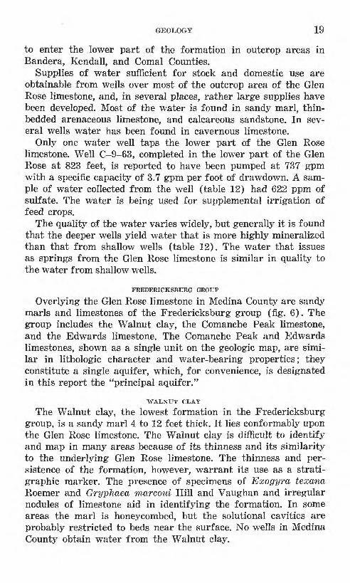
to enter the lower part of the formation in outcrop areas in Bandera, Kendall, and Comal Counties.
Supplies of water sufficient for stock and domestic use are obtainable from wells over most of the outcrop area of the Glen Rose limestone, and, in several places, rather large supplies have been developed. Most of the water is found in sandy marl, thin- bedded arenaceous limestone, and calcareous sandstone. In sev eral wells water has been found in cavernous limestone.
Only one water well taps the lower part of the Glen Rose limestone. Well C-9-63, completed in the lower part of the Glen Rose at 823 feet, is reported to have been pumped at 737 gpm with a specific capacity of 3.7 gpm per foot of drawdown. A sam ple of water collected from the well (table 12) had 622 ppm of sulfate. The water is being used for supplemental irrigation of feed crops.
The quality of the water varies widely, but generally it is found that the deeper wells yield water that is more highly mineralized than that from shallow wells (table 12). The water that issues as springs from the Glen Rose limestone is similar in quality to the water from shallow wells.
FREDERICKSBURG GROUP
Overlying the Glen Rose limestone in Medina County are sandy marls and limestones of the Fredericksburg group (fig. 6). The group includes the Walnut clay, the Comanche Peak limestone, and the Edwards limestone. The Comanche Peak and Edwards limestones, shown as a single unit on the geologic map, are simi lar in lithologic character and water-bearing properties; they constitute a single aquifer, which, for convenience, is designated in this report the "principal aquifer."
WALNUT CLAY
The Walnut clay, the lowest formation in the Fredericksburg group, is a sandy marl 4 to 12 feet thick. It lies conformably upon the Glen Rose limestone. The Walnut clay is difficult to identify and map in many areas because of its thinness and its similarity to the underlying Glen Rose limestone. The thinness and per sistence of the formation, however, warrant its use as a strati- graphic marker. The presence of specimens of Exogyra texana Roemer and Gryphaea marcoui Hill and Vaughan and irregular nodules of limestone aid in identifying the formation. In some areas the marl is honeycombed, but the solutional cavities are probably restricted to beds near the surface. No wells in Medina County obtain water from the Walnut clay.

20 GROUND-WATER RESOURCES, MEDINA COUNTY, TEXAS
FIGURE 6. North view of Edwards and Comanche Peak limestones (Keep), undifferentiated, capping the Walnut clay (Kw) and Glen Rose limestone (Kgr).
COMANCHE PEAK LIMESTONE
The Comanche Peak limestone overlies the Walnut clay con formably and ranges in thickness from 25 to 45 feet. It is a sandy to argillaceous marl grading upward into a light-gray massive limestone. The marl section contains Exogyra texana Roemer, whereas the limestone contains caprinids. The nodular appear ance of the formation is its most distinctive characteristic. It is probable that some water, believed to come from the Edwards limestone, actually comes from the Comanche Peak limestone, but, because the wells are uncased, there is no positive evidence regarding the source of the water.
EDWARDS LIMESTONE
The Edwards limestone lies conformably upon the Comanche Peak limestone and is overlain disconformably by the Washita group. The Comanche Peak limestone and the lower part of the Edwards limestone are very similar in lithologic character, but may be distinguished by their faunas and distinctive weathering.
The Edwards consists of massive beds of light-buff to light- gray hard, dense, fine-grained, brittle limestone, interbedded with occasional layers of marl or thin-bedded limestone. Flint occurs in thin beds, lenticular masses, and nodules at a number of horizons. Siliceous casts and molds of fossils are commonly found in the flint or chert nodules. The flint or chert ranges in color from light-gray to black and has a white spongy, weathered surface,
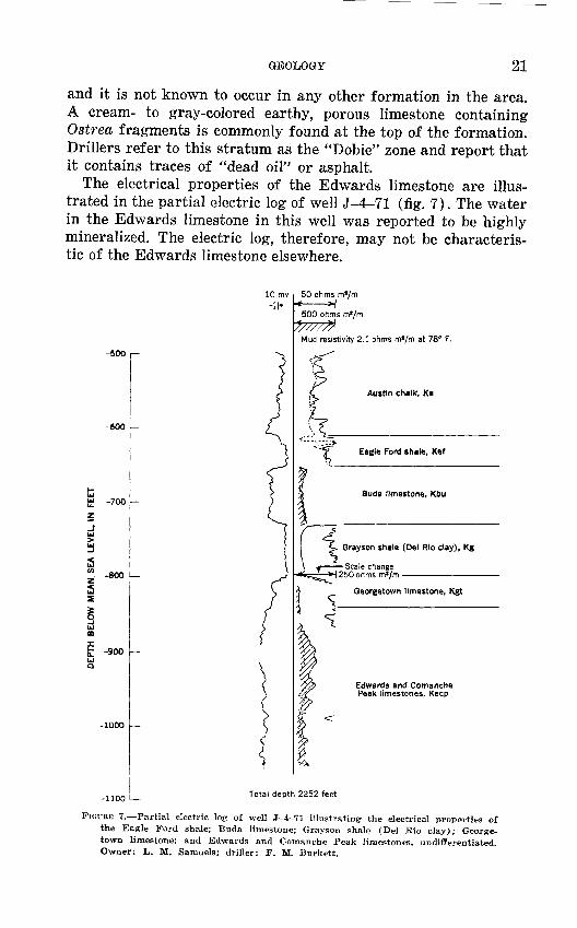
GEOLOGY 21
and it is not known to occur in any other formation in the area. A cream- to gray-colored earthy, porous limestone containing Ostrea fragments is commonly found at the top of the formation. Drillers refer to this stratum as the "Dobie" zone and report that it contains traces of "dead oil" or asphalt.
The electrical properties of the Edwards limestone are illus trated in the partial electric log of well J-4-71 (fig. 7). The water in the Edwards limestone in this well was reported to be highly mineralized. The electric log, therefore, may not be characteris tic of the Edwards limestone elsewhere.
10 mv
-500
-600
-700
-800
-900
-1000
-1100
50 ohms ms/mt H500 ohms ml/m */////$ Mud resistivity 2.1 ohms m«/m at 78° F.
Austin chalk, Ka
Eagle Ford shale. Kef
Buda limestone, Kbu
Grayson shale (Del Rio clay), Kg
-Scale change250 ohms m'/m
Georgetown limestone, Kgt
Edwards and Comanche Peak limestones, Keep
Total depth 2252 feet
FIGURE 7. Partial electric log of well J-4-71 illustrating the electrical properties of the Eagle Ford shale; Buda limestone; Grayson shale (Del Rio clay); George town limestone; and Edwards and Comanche Peak limestones, undiflerentiated. Owner: L. M. Samuels; driller: F. M. Burkett.

22 GROUND-WATER RESOURCES, MEDINA COUNTY, TEXAS
Numerous caves have been foui^d in the outcrop area of theEdwards limestone, especially alor plateau. A striking example is Bat looking the west branch of Verde more levels, the entrance room b< feet and 90 feet high. Woodard vertical entrance or sinkhole about and extends downward a distance entrance and the underlying chamlj tion of the jointing, which is aboiprincipal reservoir probably is ccjntained in caverns and solu-tional channels similar to those n
g the southern margin of the Cave, located on a bluff over- Creek. The cave has four or ing approximately 30 by 180 ve, west of Seco Creek, has a 30 feet long and 18 feet wide f approximately 190 feet. The ers are elongated in the direc- t N. 60° E. The water in the
the surface. Wells 1-1-2,1-1-7, and 1-2-23, which are froih 4 to 6 miles downdip from Woodard Cave, suck and blow air, indicating a cavernous condition.
The Edwards limestone is generally too hard to yield whole specimens of fossils that can be identified, although several dis tinctive types occur in the less indurated thin-bedded limestone and shale members. The most common fossils found are rudistids of the genera Toucasia, Monopleura, and Requienia, and other reef-dwelling fossils such as Caprina, Phacoides, and Pecten. Siliceous sponges (pi. 12) were found in massive Edwards lime stone near well J-l-20.
The Edwards limestone constitutes the principal part of the most important ground-water reservoir in Medina County, desig nated in this report as the "principal aquifer." It supplies water for public supply, industry, irrigation, and domestic and stock use in more than half the county. The recharge, discharge, and move ment of the water in the reservoir and the extent to which it is developed are discussed in more detail under the heading "Occurrence and movement of ground water."
WASHITA GROUP
GEORGETOWN LIMESTONE
The Georgetown limestone disconformably overlies the Edwards limestone. It is similar to the Edwards in lithologic character and topographic expression but can be distinguished by its many fossils. The Georgetown limestone generally contains more detri- tal material than the Edwards limestone. It is easily separated from the overlying Grayson shale (Del Rio clay) by the dif ference in lithologic character and fossil content.
In Medina County, the Georgetown consists of a dense yel lowish-white massive to thick-bedded limestone, 20 to 50 feet thick. The upper section has thin beds of argillaceous limestone and marl containing a characteristic fauna. The following species

GEOLOGY 23
FIGURE 8. Fossil sponges in Edwards limestone 5.1 miles northwest of Rio Medina.
were collected from a yellowish-gray marl 3 feet below the base of the Grayson shale (Del Rio clay) at a locality 16 miles north- northwest of D'Hanis in the bed of Seco Creek, a little more than 1 mile north of the Hondo-Utopia road: Kingena wacoensis (Roemer), Turrilites brazoensis Roemer, Stoliczkaia uddeni Bose, and Hemiaster sp.
Outcrops of the Georgetown limestone are scattered through out northwestern and north-central Medina County. In other areas the Georgetown limestone has been faulted out of sight, as shown on plate 2.
No wells in Medina County obtain their principal water supply from the Georgetown limestone. Drillers have reported small amounts of sulfur water, but no wells have been completed in the formation. The Goergetown may, however, form a part of the prin cipal aquifer in some areas.
URAYSON SH.4LE (DEL RIO CLAY)
The Grayson shale, formerly known as the Del Rio clay, con formably overlies the Georgetown limestone and occurs in the same outcrop areas in the county. It consists of 35 to 95 feet of bluish-green clay which weathers yellow brown. Exogyra arietina Roemer, a fossil shell shaped like a ram's horn, is characteristic

24 GROUND-WATER RESOURCES, MEDINA COUNTY, TEXAS
of the formation and is found in well cuttings and on the sur face. Aggregates of these shells form limestone beds, 3 to 4 inches thick, interspersed in the lower clayey section. The upper clay has fewer fossils and is sandier than the lower section. Thin beds of sandy limestone containing pyrite nodules are common in the upper part of the clay.
The electrical properties of the Grayson shale are illustrated in the partial electric log of well J-4-71. (See fig. 7.) The Grayson is a relatively tight shale containing several thin beds of sand stone and limestone.
The Grayson shale forms a characteristic slope which is arcuate in cross section below the protecting Buda limestone. The brown ish-yellow clay weathers to a dark-brown or black soil. Local ranchers and farmers take advantage of the comparative imper meability of the clay by constructing surface reservoirs in its outcrop area. The Grayson shale is not water bearing in Medina County. Instead, it serves as an upper confining bed in the arte sian area of the principal aquifer.
BUDA LIMESTONE
The Buda limestone, uppermost formation of the Comanche series, lies conformably on the Grayson shale. It is a very fine grained dense massive light-gray to pink limestone. (See table 3.) The limestone breaks with angular or conchoidal fracture when struck with a hammer; fracture surfaces display a porcelaneous texture, red and black specks, and numerous small veinlets of crystalline calcite. In some areas the Buda limestone may be confused with some brittle, porcelaneous buff-colored beds in the Georgetown limestone. The presence of Kingena ivacoensis (Roemer) in the Georgetown limestone aids in distinguishing these beds of similar texture.
The electrical properties of the Buda limestone are illustrated in the partial electric log of well J-4-71. (See fig. 7.)
The Buda limestone is relatively resistant to erosion and crops out in fault scarps, bluffs, and low hills. A few outcrops are honeycombed, but the majority are massive, having nodular sur faces. Several specimens of Budaiceras and Pecten roemeri Hill were identified in the limestone. Although the formation is fos- siliferous, most of the fossils are in the form of casts or are replaced by crystalline calcite.
The thickness of the Buda limestone is between 35 and 55 feet in its outcrop area. Well logs indicate that the formation increases in thickness to the south. Although well drillers have reported that the Buda limestone produces small quantities of water in

GEOLOGY 25
local fracture zones near the major faults, no wells are known to have obtained water from the formation in Medina County.
GULF SERIES
The Gulf series in Medina County is represented by the Eagle Ford shale, the Austin chalk, the Anacacho limestone, the Cor- sicana marl, and the Escondido formation.
EAGLE FORD SHALE
The Eagle Ford shale lies upon the Buda limestone uncon- formably and underlies the Austin chalk. In Medina County there is no appreciable discordance in dip between the Buda limestone and Eagle Ford shale, but there is marked evidence of an uncon formity. In the west bank of Hondo Creek on Jim Anderson's ranch, 6 miles north of Hondo, the basal bed of the Eagle Ford consists of a sandy yellow shale containing rounded pebbles and granules of Buda limestone, resting on an uneven nodular surface of the Buda.
The lower part of the Eagle Ford shale consists of a light- yellow to gray laminated siltstone and sandstone and thin beds of brownish limestone. The overlying beds are increasingly cal careous, the upper part of the formation consisting of a light-buff flaggy limestone. The total thickness of the Eagle Ford shale in the outcrop is between 15 and 30 feet, but logs of wells in the southern part of the county show a thickness of as much as 160 feet.
The limestone part of the formation is very fossiliferous, con taining Acanthoceras stephensoni Adkins, Inoceramus labiatus Schlotheim, Ostrea, Pecten, shark's teeth, and fish scales.
The electrical properties of the Eagle Ford shale are illustrated in the partial electric log of well J-4-71. (See fig. 7.) The Eagle Ford is a dense sandy shale. It is not known to be water bearing in Medina County.
AUSTIN CHALK
In Medina County, the Austin chalk consists of 225 to 350 feet of limestone, chalk, marl, and thin beds of clay. The chalk lies unconformably on the Eagle Ford shale. Stephenson (1929, p. 1323-1334) shows that the unconformity is widespread in Texas. There are many good exposures of the formation, but none shows the complete section (fig. 10).
The lowermost beds of the Austin chalk consist of light-gray to buff dense thin-bedded limstone, very similar in lithologic char acter to the upper beds of the Eagle Ford shale, although the

26 GROUND-WATER RESOURCES, MEDINA COUNTY, TEXAS
Corsicana marl, Kc
Anacacho limestone, Kan
Austin chalk, Ka
Eagle Ford shale, Kef
Buda limestone, Kbj
Total depth 1641 feet
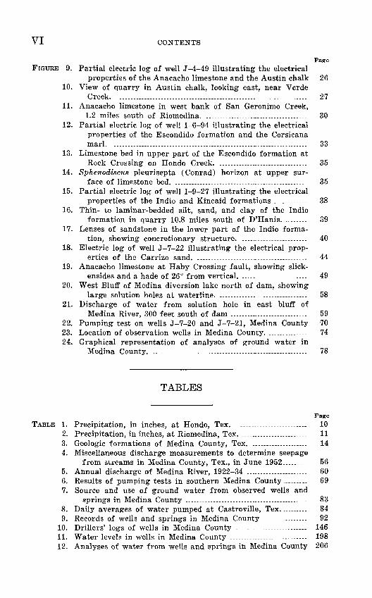
FIGURE 9. Partial electric log of well J-4-49 illustrating the electrical properties of the Anacacho limestone and the Austin chalk. Owner: E. J. Bendele; driller: White Drilling Co.
Austin chalk contains less sand. Inoceramus subquadratus Schluter is commonly found in the lower beds of the Austin. Scattered grains of glauconite are found in the limestone.

FIGURE 10. View of quarry in Austin chalk, looking east, near Verde Creek.
Approximately 75 feet above the base of the Austin chalk, the dense limestone grades into a massive soft, chalky impure light- gray to yellowish-white limestone. There are several beds of marl and clay in this medial section, which is 150 to 200 feet thick and is very fossiliferous. Some of the fossils found in the section are Mortoniceras minutum (Lasswitz), Hemiaster texanus Roemer, Pecten bensoni Kniker, Inoceramus sp., and Gryphaea aucella Roemer. An indurated conglomerate of Gryphaea aucella shells, 3 to 4 feet thick, forms a prominent horizon in the upper part of the Austin chalk. Nodular and dumbbell-shaped concretions of pyrite and marcasite are commonly found in the chalky limestone.
The uppermost part of the Austin chalk consists of massive white chalky limestone and alternating layers of marl and chalk. In most places this part of the formation contains the fossils Exogyra tigrina Stephenson, Parapachydiscus sp., Baculites, Ostrea centerensis Stephenson, and Inoceramus undulato-plicatus Roemer.

28 GEOUND-WATEE EESOUECES, MEDI1STA COUNTY, TEXAS
The electrical properties of the Austin chalk are illustrated in the partial electric log of well J-4-49. (See fig. 9.)
In Medina County, 9 wells are known to obtain water from the Austin chalk. Only 1 of the wells, 1-3-79, produces more than 8 gallons a minute. It is near a zone of faulting and probably obtains most of its water through local recharge from gravel of the overlying Leona formation. Other wells have very small yields of water containing large amounts of hydrogen sulfide. The sulfur probably is derived from the pyrite and marcasite in the forma tion. There is a large solutional cavity or cave east of Hondo Creek, 8 miles north of Hondo, but it is the only known evidence of subsurface solution in the formation in Medina County.
ANACACHO LIMESTONE
The Anacacho limestone overlies the Austin chalk unconform- ably and is equivalent in age to the Taylor marl of Bexar County. Stephenson (1927, p. 9) states, "In eastern Medina County and in western Bexar County, the westward-thinning body of Taylor marl overlaps the eastward-thinning tongue-like extension of the Anacacho limestone." To simplify mapping, the small amount of the Taylor marl in the eastern part of the county was included in the Anacacho limestone.
The Anacacho limestone varies in thickness from 240 feet in eastern Medina County to 450 or 500 feet in the western part of the county. The formation consists of argillaceous light-yellow, blue-gray, or buff thick-bedded limestone; light-gray chalk; light- yellow to blue marl; and sandy yellow clay. The formation is very fossiliferous, the lowermost part consisting of fragments of fos sil shells and many whole shells. This stratum is coarse grained and indurated and suggests near-shore deposition. Several mas sive beds of the coarse-grained detrital limestone are impregnated with asphalt, the most noteworthy exposure being in the bed of Seco Creek, 2 miles north of D'Hanis. The fossils Pycnodonta vesicularis (Lamarck), Hoplitoplacenticeras aff. H. vari, and Nucleolites wilderae Ikens are common in the lower strata.
The following section of the Anacacho limestone was measured along Seco Creek from Haby Crossing fault northward to Fort Lincoln, 1.8 to 2.0 miles north of D'Hanis.
Thickness (feet)
Marl, light-yellow, thin-bedded, glauconitic; contains Plicatula sp. . . . -....... - . . .... ..... - ---. 9.6
Marl, light-gray, thin-bedded, glauconitic; contains Salenia whitneyi Ikins and numerous bryozoa ----------------------- 2.3

GEOLOGY 29
Thickness (feet)
Limestone, light-yellow, marl; contains large numbers ofPycnodonta vssicularis (Lamarck) ......._.. _...-........... 3.0
Limestone, chalky, light-yellow, glauconitic, massive; con tains Pycnodonta vesicularis (Lamarck), Venericardia, and bryozoa ........._.__.-------.-.-._._...... _.. 4.7
Chalk, massive, white, indurated, sparsely fossiliferous-... 5.1Marl, yellow to gray, glauconitic . . . ... . .- .6Limestone, light-gray, thin-bedded, dense; contains Pycno
donta vesicularis (Lamarck) and Exogyra spinifera Stephenson ...._-.-.......... ..................... -........... 2.4
Limestone, light-yellow to light-gray, massive, large- grained; composed of indurated fragments of fossils, predominantly echinoids . _.. ._ . .--- - 4.5
Limestone, gray, massive; weathers light yellow, is in durated, contains traces of asphalt ... ......---.-. ..-.. 4.8
Limestone, white, thin-bedded, hard, contains Nucleoliteswilderae Ikins and a few small baculites .... - .-- -. 2.0
Limestone, light- to dark-gray, massive, indurated; com posed of fossil fragments cemented with asphalt __.. 15.5
Total ....................................................... 54.5
The middle strata of the Anacacho limestone consist of chalky, fine-grained soft white to light-gray limestone and thinner beds of gray marl. The proportion of marl increases from west to east. Fossils in the middle portion of the Anacacho include Parapachy- discus streckeri Adkins, Exogyra ponderosa Roemer, Baculites sp., Inoceramus sp., Bostrychoceras aff. B. polyplocum (Roemer), Sphenodiscus lenticularis Owen, Scaphites, and Cardium (Pachy- cardium) sp.
In eastern Medina County, near Rio Medina, the upper strata of the Anacacho limestone consist of massive- to thin-bedded fine grained light-gray to buff fossiliferous limestone. The marl beds, prevalent in other parts of the county, have merged into lime stone. The limestone is well exposed along San Geronimo Creek near Riomedina. (See fig. 11.) The most common fossils are: Pycnodonta vesicularis (Lamarck), Baculites taylorensis Adkins, Scaphites aricki Adkins, Pseudocompsoceras sp., Inoceramus sp., Anomia sp., Exogyra ponderosa Roemer, Eutrophoceras piano- venter Stephenson, and Exogyra costata spinosa Stephenson.
A dark- to yellowish-gray massively bedded bentonitic clay overlies the Anacacho limestone in the easternmost part of Medina County. The clay probably is a westward extension of the Taylor marl. The fossils Exogyra ponderosa Roemer and Dentalina alternata (Jones). are common. In the western part of the county, the uppermost beds of the Anacacho consist of fine-grained white

30 GROUND-WATER RESOURCES, MEDINA COUNTY, TEXAS
FIGURE 11. Anacacho limestone in west bank of San Geronimo Creek, 1.2 miles south of Riomedina.
to pinkish-gray f ossiliferous chalky limestone and several beds of light-gray marl and darker gray shale.
The following section was measured from the bed of Seco Creek to the north-facing bluff at the James Amberson ranch, 2.7 miles north of D'Hanis.
Thickness (feet)
Corsicana marl:Marl, silty, irregularly bedded, calcareous, yellow to
light-brown; indurated .__ _________-_____---- 13.4 Marl, thin-bedded, soft, silty, light-brown; stained
with iron _.._----- --.....-. _ .._ 2.7 Marl, irregularly bedded, calcareous, dense, silty,
yellowish gray ______ _ _______________- 3.5 Marl, nodular-bedded, calcareous, light-gray to brown,
silty, with iron stains _____- -. -_- - - 2.8 Shale, thin-bedded, variegated gray, yellow, and
bluish-gray, with thin, ferruginous layers -... - - 5.4
Total - ..____ ___... - 27.7

GEOLOGY 31
ThicknessDisconformity. (feet) Anacacho limestone:
Limestone, arenaceous, thin-bedded, light yellow, in durated, with Diploschizia cretacea 'minor Stephen- son, Terebratulina filosa Conrad, Scaphites porchi Adkins, also Turitella, Ostrea, and Lima............ 0.8
Limestone, dense, arenaceous, thin bedded, light yel low to gray, with Echinocorys texanus (Cragin), Pycnodonta vesicularis (Lamarck) and Inoceramus sp. ................................................................ 6.7
Limestone, dense, 5 inches to 2 feet, thick beds, arenaceous, slightly glauconitic, light yellow, with Bostrychoceras polyplocum Roemer and Inoceramus 11.2
Marl, chalky, yellowish-white, irregularly bedded,arenaceous, slightly glauconitic ..-....-.-..--. ..-.--. 1.0
Limestone, dense, light yellow, thin-bedded, glauco nitic, silty ..............--.......-.......-... ... .-..-. . 2.1
Marl, soft, light brown, massive, slightly glauconitic 3.6
Total ........................................................ 25.4
The electrical properties of the Anacacho limestone in well J-4-49 are shown in figure 9. The electric log shows a section of clay near the top grading downward into limestone.
Few wells are known that draw water from the Anacacho lime stone. Sayre (1936, p. 56) found several wells north of Castro- ville producing water from the formation, but all these wells have since been deepened or abandoned. The circulation of water in the limestone part of the formation is restricted to the area of surface drainage.
NAVARRO GROUP
CORSICANA MARL
The Corsicana marl is a relatively thin and well-defined unit cropping out in a narrow belt along the western edge of the south- westward-plunging Culebra anticline. It overlies the Anacacho limestone unconformably. The formation has been concealed by the overlapping Escondido formation and, in the central part of Medina County, by faulting. A silty marl, west of Seco Creek, probably is the equivalent of the Corsicana marl.
Stephenson (1941, p. 23) mapped the Corsicana marl in east ern Medina County and described the fauna at several localities. The fauna can be distinguished from that of the superjacent Escondido by its larger number of species and individuals. The following species were identified by Stephenson in 1951 in the Corsicana marl cropping out along the Medina canal, 2.5 miles northwest of Riomedina: Lima acutilineata texana Stephenson, Exogyra costata Say, Gryphaea mutalibis Morton, Plicatula mul-

32 GEOUND-WATEB KESOUECES, MEDINA COUNTY,, TEXAS
licaensis Weller, Trigonia castrovillensis Stephenson, Crenella serica Conrad, Lima, 1? sayrei Stephenson, Hemiaster bexari Clark, Cardium (Granocardium) tippanum (Conrad), Pecten (Neithea) bexarensis Stephenson, Baculites sp., Indonearca sp., Crassatella sp.
The strata of the Corsicana that crop out north of D'Hanis suggest a deposition nearer to shore than the Corsicana marl near Castroville. A section measured from the bed of Seco Creek to the adjacent north-facing bluff shows calcareous silty marl and thin-bedded shale unconformably overlying the Anacacho lime stone. The following species, which are found in the Corsicana marl near Castroville, have been observed in the outcrops of the Corsicana in the Seco Creek section: Crenella serica Conrad, Trigonia castrovillensis Stephenson, Bellifusus sp., Pecten sp.
Brown (1952, p. 14) found a large foraminiferal fauna of Cor sicana age in the lower strata of the Navarro group of the Seco Creek area.
Beds of shale are intercalated in the Corsicana marl near D'Hanis. The shale is a brackish-water deposit suggestive of the Olmos formation of the Eagle Pass area. It is possible that the Cor sicana passes laterally into the coal-bearing Olmos formation, as both formations occur in the same stratigraphic position that is, they are underlain by equivalents of the Taylor marl and overlain by the Escondido formation.
The electrical properties of the Corsicana marl in well 1-6-94 are shown in figure 12. The Corsicana is a relatively dense arena ceous clay and marl which is not water bearing. No wells are known to produce water from the Corsicana marl in Medina County.
ESCONDIDO FOR3IATION
The highest formation of the Navarro group in Medina County, the Escondido, is exposed at the surface in a broad east-west belt ranges from about 550 feet in the southwestern part of the county in the central part of the county. The thickness of the formation to 900 feet in the southeastern part.
According to Stephenson (1941, p. 23), the Corsicana marl is overlapped and concealed by the Escondido formation. Although the two formations are separated by a sharp change in lithologic character, the only evidence of an unconformity observed is the presence of a phosphatic bed, one-third of an inch thick. This con tact is 2 feet above the bed of Gryphaea mutabilis Morton in the Corsicana marl and is 0.4 mile west of Medina River and 5.6 miles north of Castroville.

ALT
ITU
DE
, IN
FE
ET
rt>
«.
o 5
"
p
w
3 £
CO
C
O

34 GROUND-WATER RESOURCES, MEDINA COUNTY, TEXAS
A major unconformity separates the Escondido from the over lying Kincaid formation (Stephenson, 1915, p. 159). There are no notable irregularities in the upper surface of the Escondido formation, but erosion is indicated by the absence of several beds. A thin layer of sandstone-pebble conglomerate marks the con tact of the formation.
A conspicuous fossil zone in the upper part of the Escondido formation occurs approximately 12 feet below the base of the Kincaid formation. At one locality, Rock Crossing on Hondo Creek, this zone consists of 15 feet of very fossiliferous .siltstone and hard arenaceous limestone (fig. 13). The limestone bed con tains numerous fossils of Sphenodiscus pleurisepta (Conrad), Ostrea sp., and gastropods. The upper surface of the Spheno discus bed is shown in figure 14.
In the western part of Medina County the Escondido consists of flaggy gray calcareous to argillaceous fine-grained sandstone, thin-bedded buff siltstone, gray to bluish-gray shale, and layers or lenses of sandy marl and limestone. The limestone beds con sist of conglomerates of fossil shells cemented with arenaceous limestone.
The following section of the Escondido formation was measured on the west side of the D'Hanis Brick and Tile Co.'s clay pit, 1.1 miles northwest of D'Hanis.
Thickness (feet)
Siltstone, yellow, ferruginous, soft, thin-bedded ------------ 1.1Limestone, silty, yellowish-brown, dense, thin-bedded to
irregularly bedded; contains shark's teeth, Sphenodiscussp., and pelecypod casts .5
Shale, silty, light-gray, thin-bedded .9Sandstone, hard, fine-grained, thin-bedded, reddish-yellow,
ferruginous ___ .. .._ 1.6 Siltstone, yellowish-brown, slightly ferruginous, soft ...-.- 5.0 Shale, silty, yellowish-brown, ferruginous; with selenite 6.7 Siltstone, massive-bedded, slightly ferruginous; with fossil
ripple marks and burrows -- 1.2Shale, silty, yellowish-brown, ferruginous; contains shark's
teeth and Donax .................................................... 2.8Shale, silty, bluish-gray, thin-bedded, slightly indurated 9.0 Shale, silty, massive-bedded, yellowish-brown; with selenite 11.2 Siltstone, light-gray, ferruginous, thin-bedded ---------------- 1.6Shale, bluish-gray, massive-bedded, silty, indurated -------- 15.0
Total .............................................................. 56.6
A lithologic and paleontologic change takes place in the Escon dido between the eastern and western parts of Medina County.

GEOLOGY 35
FIGURE 13. Limestone bed in upper part of the Escondido formation (Kes), approximately 12 feet below the base of the Kincaid formation (Tfc), at Rock Crossing of Hondo Creek.
FIGURE 14. Sphenodiscus pleurisepta (Conrad) horizon at upper surface of limestone bed.

36 GROUND-WATER RESOURCES, MEDINA COUNTY, TEXAS
The formation becomes increasingly arenaceous to the west, whereas the shale and limestone increase in thickness to the east.
The Escondido is equivalent to the Kemp clay in northeastern Bexar County. A gradual lithologic change toward the west merges the two formations. Stephenson (1941, p. 27) has arbi trarily separated the formations in western Bexar County. Compared with the Kemp, the Escondido is a more strongly lithi- fied shaly clay, increasingly arenaceous to the west, and it con tains prominent interbedded strata of dense calcareous sandstone. The lateral change of facies is reflected also in the fauna. The Escondido contains fossils not known in the Kemp and lacks some of the fossils common in the Kemp. i
The electrical properties of the Escondido formation as illus trated by the partial electric log of well 1-6-94 are shown in figure 12. The formation in this area consists of thin beds of fine grained sandstone and thickly to massively bedded clay and shalq.
The water-bearing sands and shales of the Escondido formation generally are not continuous or very thick. The thickest and most persistent sands are in the western part of the county, the thin> nest in the east. The most important supplies of water in the formation are found in the western part of the county. The sand stones are interbedded with clay and shale, and the water is under artesian pressure except at the outcrop.
The waters in the Escondido formation have a considerable range in chemical composition. The water obtained from wells in the outcrops of the lower sandy beds is generally of good quality and suitable for domestic use. Water from the upper beds is generally of poorer quality, containing excessive amounts of chloride and sulfate, and some wells produce small amounts ofasphalt. j
, iTERTIARY SYSTEM J
The close of the Cretaceous period was marked by elevation of the land and retreat of the sea throughout central Texas. Early Tertiary time began with a new transgression of the sea. A prominent unconformity and break in the megafaunal succes sion marks the hiatus between the two periods of deposition.
MIDWAY GROUP PALEOCENE SERIES
The Midway group includes the Kincaid and Wills Point forma tions. Gardner (1933, p. 77) stated that there were no recognizable outcrops of the Wills Point in Medina County.
GEOLOGY 37
KINCAID FORMATION
The Kincaid formation overlies the Escondido formation un- conformably. The base of the Kincaid is marked by phosphate nodules, casts of shells, shark's teeth, and reworked sands and pebbles of the Escondido formation. In Medina County, the ex posed thickness of the Kincaid ranges from 30 to 75 feet. Logs of wells in the southern part of the county indicate that the forma tion thickens in the direction of dip.
Outcrops in eastern Medina County are of a glauconitic, sandy greenish-gray shale overlain by an impure glauconitic, sandy yellowish-gray limestone containing pyrite nodules. Venericardia bulla, Dall, Venericardia crenaea Gardner, Cucullaea macrodonta Whitfield, and Membranipora are the most characteristic fossils of the f acies.
A slightly different facies is exposed in the western part of the county. Here it is an impure gray arenaceous limestone, locally containing small balls of clay, and a yellowish-gray glauconitic, calcareous, sandy clay. Concretions consisting of dense sandy limestone and brown crystalline calcite are common. Fossil shells are often found in the concretions. The most common fossils found in the area are Hercoglossa vaughani Gardner, Venericardia crenaea Gardner, and Cucullaea texana Gardner. On the basis of the facies change, Liddle (1918, p. 74-75) divided the Midway group into the Elstone and Squirrel Creek formations. Gardner (1933, p. 76) stated that both facies belong in the Kincaid formation.
The electrical properties of the Kincaid formation are illus trated in the partial electric log of well 1-9-27 shown in figure 15.
No wells are known that produce water from the Kincaid for mation in Medina County.
EOCENE SERIES
WILCOX GROUP
The Wilcox group overlies the Midway group and is overlain disconformably by the Claiborne group. Inasmuch as the Wills Point formation is missing from the outcrop of the Midway group, the basal Wilcox rests disconformably on the Kincaid formation. The Wilcox group is represented by the Indio formation in Medina County.
INDIO FORMATION
At the present state of knowledge, the various divisions of the Wilcox group recognized elsewhere cannot be distinguished in this area (Stenzel, 1951, p. 2625). Trowbridge (1923, p. 90)
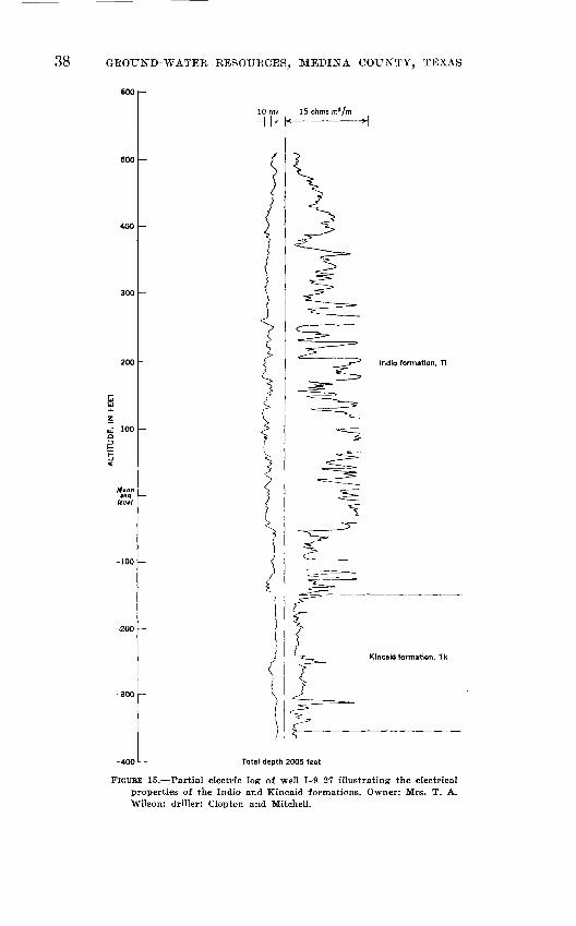
38 GBOTJISrD-WATEE RESOUECES, MEDINA COUNTY, TEXAS
tfilzuJ 100 Q
Mean tea
level
-400
10 mv 15 ohms mz/m-I k k
Indio formation, Ti
KIncald formation, Tk
Total depth 2005 feet
FIGURE 15. Partial electric log of well 1-9-27 illustrating the electrical properties of the Indio and Kincaid formations. Owner: Mrs. T. A. Wilson; driller: Clopton and Mitchell.

GEOLOGY 39
named the sandstones and shales overlying the Midway in Maver ick and Dimmit Counties, Tex., the Indio formation. This name was used by Liddle (1918, p. 75) and Sayre (1936, p. 60) as a formation of Wilcox age overlying the Midway group and under lying the Carrizo sand. The basal strata of the Indio consist of thin-bedded to laminar varicolored fine-grained sandstones, car bonaceous laminar shales, and thin-bedded to laminar siltstones. Thin to laminar beds of silt, sand, and clay are exposed in a quarry 10.8 miles south of D'Hanis near East Squirrel Creek and are shown in figure 16. The Indio formation ranges in thickness from 440 to 710 feet in Medina County.
FIGURE 16. Thin- to laminar-bedded silt, sand, and clay of the Indio formation in quarry 10.8 miles south of D'Hanis.
The Indio formation consists chiefly of thin-bedded argillaceous sandstone and laminated arenaceous shale. Locally it contains thick beds of clay and sandstone and thinner beds of lignite and calcareous sandstone. Many of the shale and sandstone beds are lenticular, and some of the sandstone is crossbedded.

40 GROUND-WATER RESOURCES, MEDINA COUNTY, TEXAS
Calcareous and arenaceous concretions are common in the middle part of the Indio formation (fig. 17). A gray silty lami nated clay, approximately 90 feet above the top of the Kincaid formation, contains dense gray calcareous sandstone lenses 3 to 15 feet long and a few inches to 5 feet thick. The lenses contain pyrite replacements of whole and fragmental parts of leaves, and small clay inclusions. The following species were collected from a standstone lens exposed in a road cut on the Dunlay-Biry high way, 1.5 miles north of Biry, and have been identified by R. W. Brown of the U. S. Geological Survey: Laurus wardiana Knowl- ton, Dinnamomum postnewberryi Berry, Terminated hilgardiana (Lesquereux) Berry, and fragments of other dicotyledonous leaves.
FIGURE 17. Lenses of sandstone in the lower part of the Indio forma tion, showing concretionary structure.
The following section of the lower part of the Indio formation was measured in a west-facing bluff east of East Squirrel Creek, about 10 miles south of D'Hanis.

GEOLOGY 41
Thickness (feet)
Siltstone, dark-yellow, thin-bedded; contains thin layers of limonite .__---.. .......__-._....--___.__..____...__.___..____.._ 5.1
Siltstone, light-gray, laminar-bedded, contains limonite nodules .. .................................................. 2.1
Shale, light-bluish-gray, laminar-bedded, contains lenses of light-gray sandstone 0.5 to 3.0 feet thick ................ 5.6
Sandstone, light-gray, irregular to massively bedded. Con tains round limonite concretions 0.03 to 0.2 foot in diam eter; lenses of dense blue-gray calcareous sandstone, 5 to 7 feet in diameter, occur in the softer sandstone.... 10.4
Shale, drak-bluish-gray, laminar-bedded .-..--......-..-.-..- .3Sandstone, cross-bedded, yellow, white, and blue ........... 2.8Unconformity, angular.Siltstone, light-gray; with alternating laminar-bedded
layers of yellow sandstone ...................................... 4.3Sandstone, yellow; with alternating laminar-bedded layers
of light-gray siltstone .....-...-.......-..-..-..-.-.-...--..-..- 2.2Sandstone, white ...................................................... .1Shale, silty, light-gray and yellow, laminar-bedded ....... .6Shale, dark-blue to dark-gray, bentonitic; contains car
bonaceous seams .-...-.....--......-..--........ ................... .6Siltstone, light-gray, laminar-bedded .....--..-.-.--..-..---..... .5Sandstone, light-orange; thick-bedded ledge former ........ 1.4Sandstone, light-yellow, thin-bedded .. ..... . - . .5Sandstone, light-orange, laminar-bedded ..................... .3Sandstone, light-orange, argillaceous ........................... .15Sandstone, light-orange, laminar-bedded, argillaceous .... .4Sandstone, yellowish-orange, thick-bedded, medium-grained;
very dense, contains hollow iron nodules ------------------ 1.5Sandstone, yellowish-orange; bedding % to 2 inches thick,
dense ....-......-.... ........-.......-.--.. .---..--.-.-..--- -. .8Sandstone, fine-grained, light-gray, dense . - --_ .7 Sandstone, thin-bedded; alternating yellow and white ...... .9Sandstone, white, soft . _ .. - -. .6 Concealed to top of Kincaid formation exposed in East
Squirrel Creek ............ ... .... .-. - 24.5
Total .. . . _ . 66.45
The upper part of the Indio formation consists of a hetero geneous series of thin-bedded sandstones, laminar-bedded silty clays, thin beds and lenses of lignite, and a few limonite concre tions. The proportion of sand increases toward the top of the formation. Drillers identify this section by the presence of lignite and pyrite in the well cuttings and refer to it as the "salt and pepper" formation.
The electrical properties of the Indio formation are illustrated in the partial electric log of well 1-9-27 shown in figure 15. Drillers' logs of wells in this area indicate that the Indio consists

42 GROUND-WATER RESOURCES, MEDINA COUNTY, TEXAS
of fine-grained sandstone, siltstone, shale, and lignite. The water is highly mineralized.
Lignite was mined in 1900 from several surface exposures in the upper part of the Indio formation. These mines have been closed for many years and their workings filled with debris. The following section was measured by Dumble (1903, p. 925) in the Riley mine, 2*4 miles west of Lytle.
Thickness (feet)
Clay, yellow, laminated ...................... . .--.. ....-... 15Sand, gray, micaceous, medium-grained, laminated .......... 20Sand, yellow, micaceous, with ferruginous streaks .......... 20Sand, yellowish-gray, laminated, micaceous with streaks
of black clay or lignite -------------------------------------------- 30Lignite ---..----.-__-._._____._____......____________.____________._____.__. 5-8Clay, gray ................................................................ 10
Ground water obtained from the Indio formation is variable in quality and quantity. Wells yield 2 to 500 gpm (table 9) of water ranging in dissolved-solids content from 348 to 11,200 ppm (table 12).
The varied lithologic character and lenticular shape of many of the sand beds make it difficult to determine the lateral extent of any given aquifer in the Indio formation. In general, however, wells penetrating the upper section of the formation yield more water than those lower in the section.
CLAIBORNE GROUP
CARRIZO SAND
The Carrizo sand crops out in the southern part of Medina County in a belt extending from the Atascosa County line southwest to the Frio County line (pi. 1). The formation lies disconformably upon the underlying Indio formation and is 230 to 330 feet thick.
The Carrizo sand consists chiefly of friable light-gray to dark- red medium-grained quartz sandstone. Clay or shale occur near the middle of the formation as thin lenticular beds or as lumps 2 to 3 inches in diameter. Locally the formation is limonitic and contains several thin beds of ferruginous sandstone. In many outcrops, the formation is massive, and crossbedding is highly developed in some areas. The basal beds of the formation are thin to thick bedded. All ferruginous colors of the Carrizo are due to weathering; the sand is light gray underground.
The sand is, in general, an aggregate of subangular grains of quartz with little or no mica, secondary gypsum, or calcite. Lonsdale (1935, p. 23) gives the petrographic analyses of 13 sam ples of the Carrizo sand in Atascosa and Frio Counties. The re-
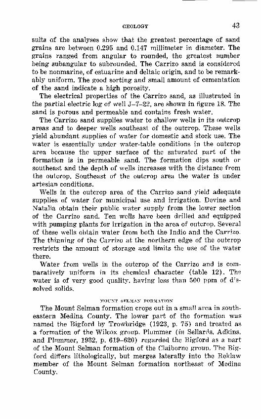
GEOLOGY 43
suits of the analyses show that the greatest percentage of sand grains are between 0.295 and 0.147 millimeter in diameter. The grains ranged from angular to rounded, the greatest number being subangular to subrounded. The Carrizo sand is considered to be nonmarine, of estuarine and deltaic origin, and to be remark ably uniform. The good sorting and small amount of cementation of the sand indicate a high porosity.
The electrical properties of the Carrizo sand, as illustrated in the partial electric log of well 3-7-22, are shown in figure 18. The sand is porous and permeable and contains fresh water.
The Carrizo sand supplies water to shallow wells in its outcrop areas and to deeper wells southeast of the outcrop. These wells yield abundant supplies of water for domestic and stock use. The water is essentially under water-table conditions in the outcrop area because the upper surface of the saturated part of the formation is in permeable sand. The formation dips south or southeast and the depth of wells increases with the distance from the outcrop. Southeast of the outcrop area the water is under artesian conditions.
Wells in the outcrop area of the Carrizo sand yield adequate supplies of water for municipal use and irrigation. Devine and Natalia obtain their public water supply from the lower section of the Carrizo sand. Ten wells have been drilled and equipped with pumping plants for irrigation in the area of outcrop. Several of these wells obtain water from both the Indio and the Carrizo. The thinning of the Carrizo at the northern edge of the outcrop restricts the amount of storage and limits the use of the water there.
Water from wells in the outcrop of the Carrizo and is com paratively uniform in its chemical character (table 12). The water is of very good quality, having less than 500 ppm of d^'s- solved solids.
MOUNT SELMAN FORMATION
The Mount Selman formation crops out in a small area in south eastern Medina County. The lower part of the formation was named the Bigford by Trowbridge (1923, p. 75) and treated as a formation of the Wilcox group. Plummer (in Sellards, Adkins, and Plummer, 1932, p. 619-620) regarded the Bigford as a Dart of the Mount Selman formation of the Claiborne group. The Big- ford differs lithologically, but merges laterally into the Reklaw member of the Mount Selman formation northeast of Medina County.

44 GBOUND-WATER KESOURCES, MEDINA COUNTY, TEXAS
700
600
500
400
< 300
200
100
10 mv70 ohms m2/m
Indio formation, Ti
FIGURE 18. Electric log of well J-7-22 illustrating the electrical properties of the Carrizo sand. Owner: City of Devine; driller: J. R. Johnson.
The basal member of the Mount Selman consists of brown to buff clay, thin sandstones, and very thin limestone beds. Thin lenses of lignite and calcareous concretions also are found. Abundant plant remains, leaves and stems have been recovered along the escarpment formed by the Bigford member in northern Frio County (Lonsdale, 1935, p. 29). The Mount Selman formation is about 100 feet thick in Medina County.

GEOLOGY 45
The Mount Selman formation occurs in too small an area in Medina County to store an appreciable amount of water. No wells are known to obtain water from the Mount Selman in this county.
PLIOCENE (?) SERIES
UVALDE GRAVEL
The Uvalde gravel is the oldest and highest terrace deposit in Medina County and is found in remnants capping hills and form ing stream divides. The gravel consists of coarse rounded flint pebbles and boulders and some limestone pebbles. Reworked fos sils in the gravel indicate that it was derived from the Edwards limestone, probably from the Edwards Plateau. The gravel is cemented by caliche. The thickness of the Uvalde ranges from a thin film over the surface to a layer nearly 20 feet thick. The gravel and caliche in these deposits are mined for road-surfacing material. The formation generally is too thin to hold much water, and its topographic position on hilltops permits most of the water to drain out readily.
QUATERNARY SYSTEMPLEISTOCENE SERIES
LEONA FORMATION
The Leona formation consists of deposits forming broad ter races in the valleys of the present streams. These terraces are topographically lower than those formed by the Uvalde gravel.
The Leona is composed of lenticular beds of sand, gravel, silt, and clay. The pebbles and cobbles of the gravel are predominantly limestone, and some flint. Coarser gravel is found near the base of the formation, the proportion of silt increasing toward the top.
The terraces extend to distances ranging from several hundred feet to 3 or 4 miles on one or both sides of the major streams. As a rule, the formation is thickest near the present stream chan nels or the older abandoned meander channels. The terrace de posits range in thickness from a mere film over the underlying formations to a layer 70 to 80 feet thick.
The outcrop area of the Leona forms broad plains in central and eastern Medina County, and most of the towns in the county are situated on the outcrop. Riomedina, Quihi, and D'Hanis obtain their water supplies from the formation. Private water supplies in Hondo, Castroville, and Lacoste are obtained from the gravel, although the public supplies of those places are obtained from wells tapping the Edwards limestone.
A number of small springs occur in the principal stream val leys where the streams have cut below the water table in the Leona formation. Among the typical springs fed by ground water from the Leoni are nos. 1-5-28 in Seco Creek; 1-3-82 and 1-6-74

46 GEOTJND-WATEE EESOTJRCES, MEDINA COUNTY, TEXAS
in Hondo Creek; 1-3-103, 1-3-104, and 1-3-125 in Verde Creek; and J-l-36 in San Geronimo Creek.
Recharge of the Leona formation is derived from rainfall and storm-water runoff on the surface of the formation. The piezo- metric surfaces of the underlying formations are below the base of the Leona and those formations do not contribute to its re charge. Conversely, the Leona formation contributes to the recharge of the underlying permeable formations.
As a rule, the Leona formation contains little water where the underlying formations are permeable, but it contains large sup plies of water where it overlies less permeable strata, especially where it is thick. The thickest deposits of the Leona are found where the old stream channels have cut deep valleys in the least resistant of the underlying formations. Each stream-terrace de posit is a separate ground-water reservoir.
In most areas of outcrop in the county, the Leona formation furnishes an adequate supply of water for domestic and stock uses. In several areas, notably along Hondo Creek south of U. S. Highway 90, the Leona has the thickness and lateral extent nec essary to store a large supply of water. Wells 1-6-20, 1-6-21, 1-6-76, and 1-6-77 have been withdrawing irrigation water from this reservoir.
RECENT SERIES
ALLUVIUM
The stream valleys of Medina County contain Recent flood-plain deposits of silt and gravel. Several of the larger stream valleys have small terrace deposits which have been formed since Leona time. The deposits are restricted to narrow areas along the streams. A number of wells adjacent to the Medina River obtain their water from the Recent sediments. The water levels in the wells have been observed to fluctuate with the river level.
IG1NTEOUS ROCKS
Several small exposures of igneous rocks have been found in Medina County. A large number of similar igneous masses occur in Uvalde County and have been described by Vaughan (1900, p. 2-3), Lonsdale (1927, p. 15-23), and Sayre (1936, p. 27). The igneous rocks occur in isolated masses in rough alinement with the trend of faulting in the Balcones system.
The igneous rocks in Medina County are in the form of plugs and dikes that crosscut, and form steep contacts with, the ad jacent sedimentary rocks. A small plug of olivine basalt is on the Mumme ranch, 13.7 miles north of Hondo (pi. 1). This plug is about 300 feet in diameter at the surface and is surrounded by

STRUCTURE 47
the Edwards limestone. The limestone near the contact has been altered to a varicolored marble containing veins of serpentine. Another small mass of olivine basalt is found along Cow Creek, IVa miles northeast of West Verde Creek. The exposure is in the form of an elongated plug or dike, striking N. 55° E. A narrow zone of serpentine-bearing marl marks the contact between the dike and the surrounding Glen Rose limestone. A plug of nephelite basalt 3.4 miles south of D'Hanis, east of the D'Hanis-Yancey road, probably intrudes the Escondido formation, but the allu vial materials of the Leona formation obscure the contacts.
The youngest formation intruded by igneous rocks in this area is the Escondido. Lonsdale (1927, p. 44) believes that all the basalts of the Balcones fault region are related in origin and are probably of early Tertiary age. Sayre (1936, p. 27-32) indicates that some igneous masses came into existence in the early part of Late Cretaceous epoch.
METAMORPHIC ROCKS
Serpentine has been recorded in the logs of several wells in Medina County. Leith and Mead (1915, p. 22) stated that ser pentine is an alteration product of basic igneous rocks. The serpentine found in Medina County may be an intermediate prod uct in the hydration of basaltic intrusives. The bodies of serpentine are closely associated with the faulting. The serpentine is reported to range in composition from a relatively pure very fine grained dense dark-green massive rock to an impure dense light-green fragmental rock, interbedded with limestone. In a number of wells near Chacon Lake serpentine was encountered in the upper part of the Austin chalk and lower part of the Anacacho limestone. (See pi. 2.) Serpentine was reported in wells J-4-65 and J-4-71 from 1,385 to 1,771 feet and from 1,441 to 1,580 feet below the surface, respectively. The serpentine mass near Chacon Lake is bounded on the north by the Pearson fault. Wells drilled north of the fault failed to penetrate any serpentine. Another large body of serpentine is found north of the Dunlay fault. Wells 1-6-27 and 1-6-30 (pi. 2) encountered serpentine at 476 and 616 feet, respec tively, in the Anacacho limestone and upper part of the Austin chalk.
No wells are known to produce water from metamorphic rocks in Medina County.
STRUCTURE
The structure of the rocks of Medina County affects the occur rence and movement of ground water. The principal structural

48 GROUND-WATER RESOURCES, MEDINA COUNTY, TEXAS
features are the faults and folds forming the Balcones fault zone. The surface traces of the faults are shown on plate 1. The sub surface position of the faults and folds is indicated by contours drawn on the base of the Grayson shale (Del Rio clay). (See pi. 1.) Cross sections A-A' and B-B', drawn transverse to the general direction of faulting, are shown in plate 2.
FAULTING
BALCONES FAULT ZONE
The Balcones fault zone separates the Gulf Coastal Plain from the Edwards Plateau. (See fig. 1.) This zone, as a structural fea ture, is traceable from Del Rio northeast to Waco. In many places a prominent escarpment marks the location of the trace of the main fault. In some places prominent folds are associated with the fault zone.
The displacement on individual faults in Medina County ranges from a few inches to more than 700 feet and the length from a fraction of a mile to 35 miles. The displacement on most of the faults is greatest near the middle of their length, diminishing toward the ends. Some of the faults die out in monoclinal flexures and are intersected by cross faults or branch faults.
In general, the faults of Medina County have nearly straight traces. In areas of considerable relief this indicates that the fault plane may be nearly vertical. Measurements on many of the faults show that the hade ranges from 12° to 28° from the vertical. Slickensides, fault breccia, and gouge are evident in several ex posures of the fault surfaces. (See fig. 19.)
FAULTING IN NORTHERN MEDINA COUNTY
The most extensive fault of the Balcones zone, the Haby Cross ing fault, enters the eastern part of the county northeast of Cliff, passes through the Haby Crossing on the Medina River, and con tinues southwestward past Kings Waterhole on Hondo Creek to Seco Creek north of D'Hanis. The displacement along the fault is greatest east of Haby Crossing where the upper part of the Austin chalk is in contact with the lower part of the Edwards limestone, indicating a stratigraphic displacement of 600 to 800 feet. The more resistant Edwards limestone on the upthrown side of the fault forms a very prominent escarpment. The displacement of the fault decreases to the west. Several auxiliary faults branch from the major fault in the central part of the county.
The throw of the individual faults decreases west of the Medina River, and escarpments are no longer prominent in the topog raphy. A system of parallel faults in central Medina County has

STRUCTURE 49
FIGURE 19. Anacacho limestone at Haby Crossing fault, showing slicken- sides and a hade of 26° from vertical.
a total displacement equal to the displacement of the larger faults to the east. The faulting in this area is complex and consists of cross faults, branch faults, hinge faults, and scissors faults. The numerous faults have formed wedges or blocks of rocks which are generally downthrown to the south in the form of stairsteps. (See pi. 2.) Horsts, upthrown blocks between downthrown blocks, are found north of the Vandenburg School, Seco Creek, and Ina Field faults, and south of the Fort Lincoln fault. Grabens, downthrown blocks between upthrown blocks, are found north of the Seco Creek and Fort Lincoln faults and south of the Medina Lake and Dunlay faults.
The complicated faulting of central Medina County is partly dis sipated to the west, many of the faults dying out and passing into small monoclinal folds. A relatively narrow zone of highly compli cated faulting is present in the northwestern part of the country. The Woodard Cave fault has a displacement of more than 200 feet, and a parallel fault, 2 miles south, has a displacement of 300 feet. A wedge or graben of the Austin chalk is present where the par allel fault crosses Seco Creek.

50 GKOUND-WATEB EESOTJECES, MEDINA COUNTY, TEXAS
FAULTING IN SOUTHERN MEDINA COUNTY
The Pearson and Biry faults are the southernmost major faults in Medina County. They are probably contemporaneous and are closely related to each other. The Pearson fault crosses Francisco Perez Creek east of Biry and continues northeastward through Pearson to the Bexar County line. The displacement of the fault increases to the northeast. The maximum displacement is about 400 feet at the Bexar County line. The Biry fault, extending south west of Biry, has an average displacement of less than 100 feet. This fault is probably an extension of the Pearson fault, which is possibly associated with the San Antonio structure described by Sellards (1919, p. 82-86). The Adams gas field, southwest of Biry, and the Chacon Lake oil field, south of Pearson, are both closely related to the faults. (See pi. 1).
The Pearson fault appears to act as a barrier to the movement of ground water in the Edwards limestone. North of the fault an adequate supply of water of good chemical quality may be obtained from wells. Oil tests drilled into the Edwards limestone south of the fault failed to reveal water of good quality. Most wells south of the fault system obtain their principal water supply from the Indio formation.
CAUSE OF FAULTING
The faults are generally parallel and are normal tension faults resulting from gravitational settling. They are generally regarded as having been caused by the gradual sinking of the Coastal Plain with reference to the Llano uplift. (See fig. 1.) Stephenson (1928, p. 899) has pointed out, however, that uplift may have occurred as well as sinking. The age of the faulting has not been accurately determined, but faulting may have occurred at intervals from Early Cretaceous to Recent geologic time. Bryan (1933, p. 439- 442; 1936, p. 1357) states that there have been three periods of movement along the Balcones fault zone at Waco, Tex., the first relatively early in Early Cretaceous time, the second during Georgetown time, and the third during Recent time. The youthful appearance of the escarpments in eastern Medina County and the relations of the stream channels to the faults indicate a recent period of movement. Evidence of two directions of movement along a fault plane may be observed where the Seco Creek fault crosses Hondo Creek. Beds of the Eagle Ford shale on the down- thrown side of a normal fault dip toward the fault, indicating a secondary movement or readjustment along the fault plane.

OCCURRENCE AND MOVEMENT OF GROUND WATER 51
FOLDING CULEBRA ANTICLINE
A pronounced structural feature, the Culebra anticline (Sellards 1919, p. 83-84), extends from north-central Bexar County south- westward into Medina County. It is bounded on the northwest by the Cliff fault and on the southeast by the Castroville fault. The principal structure is a broad anticlinal fold, 7 to 9 miles wide, plunging to the southwest. The fold is asymmetrical, the steeper flank being on the southeast side.
Topographically, the anticline consists of a central hill of Austin chalk surrounded successively by bands of the Anacacho limestone, Corsicana marl, and Escondido formation. The Medina River flows around the nose or plunging end of the anticline, and San Ger- onimo Creek flows along the northwest flank. Cross section B-B' (pi. 2), which crosses the Culebra anticline, was prepared from data selected from well logs and from surface geology.
OTHER FOLDS
A large monoclinal fold near Devine in southeastern Medina County has an axis that trends northeast, parallel to the Balcones faulting. This monoclinal fold is possibly associated with the Alta Vista structure, named by Sellards (1919, p. 85-86) for a struc tural trend in southern Bexar County. The Bear Creek oil field in Medina County, south of the fold, is similar in structure to the Somerset field in Atascosa County and the Alta Vista field in Bexar County.
OCCURRENCE AND MOVEMENT OF GROUND WATERGENERAL PRINCIPLES
The fundamental principles governing the occurrence and move ment of ground water have been discussed in detail by Meinzer (1923a, p. 2-192; 1923b, p. 68; 1942, p. 385-497), Tolman (1937, p. 96-380), Wenzel (1942), and others. The section that follows is limited to the principles that are essential in understanding the hydrology of the ground water.
Ground water in Medina County is derived chiefly from water that falls as rain and snow. A part of the precipitation runs off in streams, a part is returned to the atmosphere by evaporation and by transpiration of trees and other plants, and a part enters the soil. Of the part that enters the soil, a small portion sinks into the zone of saturation, in which all the openings of the rocks are filled with water.
In most places ground water is slowly but steadily moving under the influence of gravity from areas of intake to areas of discharge. In the more permeable rocks, such as coarse sand and gravel and

52 GROUND-WATER RESOURCES, MEDINA COUNTY, TEXAS
cavernous limestone, the water moves with comparative freedom, although the movement generally is very slow compared to the flow of a stream. Such rocks are capable of yielding abundant supplies of water to wells. In less permeable rocks, such as fine sand, silt, and shale or clay, molecular attraction retards the move ment of the water so that the water may not move toward a well as fast as it is withdrawn by even a small pump.
Ground water occurs under both water-table and artesian con ditions in Medina County. Under water-table conditions, the water is unconfined and does not rise in wells above the level at which it is encountered. This level is known as the water table. Water-table conditions usually are found to occur in the outcrop of permeable water-bearing beds. Under artesian conditions, the water is con fined by an overlying relatively impermeable bed and the water will rise in wells above the level at which it is encountered.
The water table is not a level surface, but usually slopes from areas of ground-water intake or recharge toward areas of ground- water discharge. Where the land surface is lower than the water table in adjacent areas, some of the ground water will emerge as springs. This condition occurs in several places along Hondo Creek where the stream channel has cut below the level of the water table in the Leona formation, and ground water discharges into the creek.
Artesian conditions are established where beds of permeable rock dip below the ground between less permeable strata. Water in the outcrop area provides a hydraulic head for the water mov ing downdip. If there were no loss in head because of friction, a well drilled into the confined aquifier would find the head of the water equivalent to the height of a column of water having the same altitude as the water in the outcrop area. The artesian aqui fer acts as a closed system, and any change in pressure eventually affects the aquifer as a whole. If there is insufficient recharge from rainfall or streamflow in the outcrop area, the water table will decline and the pressure in the artesian system will decline also. Correspondingly, any natural discharge, such as spring flow, or artificial discharge, such as pumping from wells, will cause a de crease in pressure throughout the aquifer. For these reasons, the pressure in an artesian aquifer may decrease and the water levels in wells may decline, but the aquifer will still be full of water.
The withdrawal of ground water from either a water-table or an artesian aquifer causes a decline in water level at the well, and a hydraulic gradient is developed toward the well from all direc tions. The quantity of water moving toward the well is proper-

OCCURRENCE AND MOVEMENT OF GROUND WATER 53
tional to this gradient. For example, if a pumped well in permeable material will yield 100 gallons a minute when the water level is lowered 10 feet, it will yield about 200 gallons a minute when the water level is lowered 20 feet. This ratio between the drawdown and the yield of the well is called the specific capacity and is gen erally expressed as yield in gallons a minute per foot of drawdown. Drillers generally observe the drawdown as they count the number of bailers of water withdrawn in a given length of time. This is a quick and convenient guide for the selection of a pump. The ratio holds within certain limits and is affected by factors other than permeability, such as the construction and development of the well.
A cone of depression gradually spreads out in all directions from a center of ground-water discharge or pumping. This cone deepens and widens at a rate decreasing with time. The ultimate limits of the cone of depression are the physical boundaries of the aquifer or areas of rejected recharge or discharge (Theis, 1938, p. 889- 902). When the pump is shut off, the water rises again in the well at a rate decreasing with time, and the cone of depression becomes shallower until it nearly vanishes. However, if a large amount of water is taken out of the aquifer, a measurable persistent lowering of the water level may result. This usually is not very serious, and in an extensive aquifer any excessive local decline may be avoided by proper spacing of wells.
MOVEMENT OF WATER IN AQUIFERS
The amount of water moving through an aquifer depends upon the porosity, permeability, and dimensions of the aquifer and the amount of recharge and opportunity for discharge. The topog raphy of the surface of the outcrop, the climate, the type of soil, and the amount and kind of vegetation are important factors in determining the amount of recharge to the aquifer.
The porosity and permeability of a rock formation largely de termine its capacity to take in, store, and transmit water. Porosity is the ratio of total pore space to total volume of a material, and permeability is its capacity to transmit water. The properties are not directly related. Clay and shale may have a high porosity, but, because the individual pore spaces are very small, the per meability is low. Sand and gravel may have less porosity than clay and shale, but the individual pores are large and intercon nected, permitting a more rapid movement of water.
The permeability of most limestones depends upon the proc esses that take place after deposition. Although small openings may remain in the rocks after deposition and consolidation, many limestones are essentially impermeable until solution along frac-

54 GKOinsTD-WATER KESOTJBCES, MEDINA COUNTY, TEXAS
tures enlarges them in places to the size of channels and caverns. A part of the fracturing may take place during the compaction of the limestone, but the major disruption and fracturing occur as a result of faulting and folding. Much faulting has taken place in Medina County, and joints, faults, and other openings have pro vided the passages that were later enlarged and extended by solution.
A minor amount of solution may occur during and immediately after deposition, but the most important solution occurs after the limestone is elevated and exposed to solution by meteoric waters. It is recognized generally that carbon dioxide in solution in meteoric waters greatly increases their solvent action on lime stones. Water acquires carbon dioxide while passing through the air and through soils containing decaying vegetable matter.
The solvent action of ground water on limestone is a continu ing process of enlarging the existing solution channels. The average flow of Comal Springs in New Braunfels, over a period of about 20 years, has been 320 cubic feet per second (cfs). The dissolved solids in the water averaged about 285 ppm. On this basis, George (1952, p. 37) estimated that an average of more than 200 tons of dissolved rock material is carried away daily by the water that issues from these springs.
Time is an important factor when considering solution of limestone. Pressure and temperature also affect the quantity of calcium carbonate that is dissolved by ground water. A change in these factors controlling solution may result in a redeposition of calcium carbonate in the same system of solution channels. Crystals of secondary calcite were recovered from the cuttings of well J-1-44 after the drill penetrated several void spaces at a depth of about 960 feet below the present water level. Travertine, a form of secondary calcite, accumulates along the edges of a subsurface stream in the Woodard Cave or sinkhole.
The solubility of limestone in water is an important factor when studying the hydrology of the limestone aquifers in Medina County. In the study of the silt, sand, and gravel aquifers of the county, the permeabilities are regarded as essentially stable, whereas the limestone aquifers, because of their solubility, are continually changing in porosity and permeability. The changing characteristics of the limestone reservoir may change the amount of recharge, discharge, and movement of water, and may affect the quality of water and its availability. In terms of historic time, however, changes in permeability and porosity caused by solution of the limestone probably would be insignificant.

OCCURRENCE AND MOVEMENT OF GROUND WATER 55
NATURAL EECHAEGE
The recharge or intake area of an aquifer is the outcrop of the aquifer itself, or of a hydraulically connected formation, capable of absorbing water and adding a part of it to the zone of satura tion. An area of recharge may be only a narrow belt on the sur face, but it may be supplied in part by streams which drain a much larger area. Several of the aquifers used in Medina County crop out in the county itself, and a large part of the county, there fore, is a recharge area that receives water by direct penetration of rainfall. The outcrops extend east and west beyond the borders of the county. The catchment area for the streams that cross the aquifers includes the drainage areas of Seco, Hondo, and Verde Creeks and the Medina River, which extend north of Medina County.
TRAVIS PEAK FORMATION
The water of the Travis Peak formation is derived from pre cipitation over a large area north of Medina County. Water enters the sands of the formation in the outcrop area and travels downdip to Medina County. Water in the Travis Peak was en countered in wells 1-1-15, 1-2-67, and J-2-15.
GLEN ROSE LIMESTONE
Limestones and sandy marls of the Glen Rose crop out in northern Medina County and the surrounding counties of Uvalde, Real, Bandera, Kerr, and Kendall. Inasmuch as the outcrop covers only 84 square miles in northern Medina County, the prin cipal recharge to the aquifer must be from rainfall in adjacent counties having larger surface exposures of permeable strata.
In Medina County the limestone beds in the exposed upper part of the Glen Rose are overlain and underlain by marl and shale which retard vertical movement of water. The most permeable zones are found at the base of limestone beds where they are in contact with underlying beds of shale. The solutional openings in the limestone range from minute to cavernous and receive vary ing amounts of water. Beds of sandy marl and fossiliferous zones in the limestone are locally permeable. Numerous caves and springs are found in limestone in the outcrop area of the Glen Rose.
EDWARDS LIMESTONE
The surface exposure of the Edwards limestone forms a broad belt across northern Medina County. The approximately 200 square miles of outcrop in Medina County is an area of recharge. A large amount of water enters the limestone by direct penetra tion of rainfall on this area, and an even larger amount is derived
56 GROUND-WATER RESOURCES,, MEDINA COUNTY, TEXAS
from streams crossing the outcrop carrying runoff from the catchment area on the Edwards Plateau. The streams receive flood flow from the entire drainage area, but their normal or base flow is sustained largely by water from springs in the Glen Rose limestone.
The recharge area of the limestone differs from that of a sand stone in that water must encounter an opening in the limestone caused by solution, jointing, or fracturing before it can move rapidly downward. The openings in the limestone may be large and lead into an extensive network of cavernous solution chan nels. The large openings are in the form of sinkholes, joints or faults enlarged by solution, or zones of smaller interconnected channels. Large quantities of water may enter the openings within a comparatively small area.
A series of discharge measurements were made in June 1952 of the streams crossing the Edwards limestone in Medina County. The discharge of each stream was measured on the upstream and downstream sides of the outcrop. Additional measurements were made along the streams where they cross the outcrop, to determine the sections of greatest recharge. The miscellaneous discharge measurements are shown in table 4. The entire dis charge of Hondo, Seco, and Verde Creeks entered the Edwards limestone in the recharge area.
TABLE 4. Miscellaneous discharge measurements to determine seepage from streams in Medina County, Tex., in June 1952
[Measurements by Surface Water Branch, U. S. Geol. Survey, Austin, Tex.]
Date
June 12 ...
June 12
June 12
June 12
June 12
June 12
June 12
June 13_._.
June 13
Stream
Hondo Creek ..... .
do
do . ....
do
Seeo Creek. _ ....
do_. .............
... do . _
West Verde Creek...
Verde Creek. ......
Location
0.3 mile north of Bob DupuyRanch, 2.5 miles south ofBandera County.
0.2 mile south of M. GarrisonRanch at low-water bridge.
Concrete low-water bridge,9.4 miles north of Hondo.
Concrete slab at Schlentzcrossing, 7.8 miles north ofHondo.
Ford at Patton Ranch, 17.2miles north of D'Hanis.
0 . 1 mile south of concrete damat Woodard Ranch, 13.1miles north of D'Hanis.
Concrete slab, 7.4 miles northof D'Hanis.
Crossing 1 . 0 mile south of J.Short Ranch headquarters,16.4 miles north of Hondo.
Concrete slab at Grodt cross-sing 12.2 miles northwestof Hondo.
Approximate
distance (milesfrominitialpoint)
0
4.4
11.3
14.1
0
5.8
14.8
0
3.3
Length of section(miles)
0
4.4
6.9
2.8
0
5.8
9.0
0
3.3
Discharge(cfs)
34.7
25.5
6.4
0
15.2
0.01
0
1.53
0
Loss in section
. (cfs)
0
9.2
19.1
6.4
0
15.2
0
0
1.53

OCCURRENCE AND MOVEMENT OF GEOTJND WATEE 57
A discharge of 34.7 cfs was measured where Hondo Creek crosses the Glen Rose limestone. After flowing 2 miles the stream crosses the south branch of the Woodard Cave fault and passes onto the Edwards limestone. Several large fractures cross the creek bed just south of the fault. In this locality 9.2 cfs of water entered the limestone. The stream lost an additional 19.1 cfs of water while flowing over 6.9 miles of the Edwards limestone, in cluding losses into four faults and innumerable solution holes in the bed of the creek. The greatest seepage losses were found in this section of the creek. The remaining 6.4 cfs entered the Ed wards limestone before the stream crossed the Medina Lake fault and left the Edwards. There was no flow in the creek a mile south of the fault. Only during and immediately after exceptionally heavy rains do Hondo, Seco, and Verde Creeks flow south of the outcrop area of the Edwards limestone.
Similar stream losses to the Edwards limestone are shown by measurements of Seco and Verde Creeks. (See table 4.) These streams flowed only part of the way across the Edwards outcrop, and it seems likely that if the discharge were sufficient for the streams to flow across the entire outcrop, much additional water would enter the limestone through cracks and solution channels. The stream losses are undoubtedly higher during floods when the greater depth of water and larger water surface would increase the rate of recharge.
The average annual infiltration to the Edwards limestone from Seco, Hondo, and Verde Creeks is estimated to be of the order of 35,000 acre-feet. This estimate is based on the available discharge measurements, rainfall records, and average number of days a year that these streams have been reported to flow along their entire length.
Stream gages on Seco and Hondo Creeks were erected in 1952 above and below the outcrop of the Edwards limestone. The loca tions of these gages are shown on Slate 1. A more accurate esti mate of the recharge to the Edwards limestone may be made from the discharge measurements of these gages after a record of suffi cient length has been established.
Two dams were built across the Medina River in 1912 to im pound water for irrigation. The main dam, used for storage, is 16 miles north of Castroville, and a smaller dam, diverting water to the canal system, is 4 miles below the main dam. The diversion dam is on the outcrop of the Edwards limestone, and, except for a small area of the Glen Rose limestone exposed in the bed of the stream, the reservoir also is on the outcrop of the Edwards lime-

58 GROUND-WATER RESOURCES, MEDINA COUNTY, TEXAS
stone. The diversion dam is a concrete structure 440 feet long and 50 feet above the stream bed. The capacity of the reservoir behind it is about 4,000 acre-feet.
The storage dam upstream from the diversion dam is a con crete structure 1,500 feet long, and the spillway is 152 feet above the stream bed. The original capacity of the storage reservoir was 254,000 acre-feet at the spillway crest. District officials state that the present capacity is about 213,000 acre-feet.
Numerous fractures and solution holes are visible in the walls of the canyon above and below the dams (figs. 20, 21). The frac tures have the same general northeast trend as the Balcones faulting. Grouting of the solution channels and fractures at the diversion dam in 1948 failed to reduce the leakage from the diver sion reservoir. Increasing the stage of the lake increases the hydraulic gradient of the ground water moving from the lake, which, in turn, increases the rate of movement of the water and accelerates the solution of the limestone. Most of the reservoir area of Medina Lake is in the outcrop of the Glen Rose limestone. Movement of water from the Glen Rose limestone to the Edwards limestone is believed to occur along faults.
The United States Geological Survey made discharge measure ments along the Medina River from 1922 to 1934. The results of these measurements are shown in table 5.
FIGURE 20. West bluff of Medina diversion lake north of dam, showing large solution holes at waterline.
OCCURRENCE AND MOVEMENT OF GROUND WATER 59
FIGURE 21. Discharge of water from solution hole in east bluff of Medina River, 300 feet south of dam.
Burleigh (1949, p. 9-15) estimated that the seepage losses from the storage and diversion reservoirs in 1930 were nearly 72,000 acre-feet. The average annual loss may be even larger, inasmuch as the water surface in the storage reservoir probably dropped below many of the outlet conduits along the stream bed in Sep tember 1930.
Livingston, Sayre, and White (1936, p. 76) estimated that the seepage losses in the 3%-mile stretch of the river below the reser voir between the Mico gaging station, about 2,000 feet below the main reservoir, and the diversion dam was about 16,000 acre-feet in 1930. In addition, an average loss of 38,500 acre-feet a year was estimated for the stretch between Pipe Creek and the Mico station, according to 11 years of record from 1923 to 1933. This includes evapotranspiration losses, but these are probably bal anced by tributary inflow, so that the figures represent essen tially recharge to ground water.

60 GROUND-WATER RESOURCES, MEDINA COUNTY, TEXAS
The diversion reservoir was dry and the storage reservoir was at a low stage during 1951 and 1952, preventing the measurement of seepage losses at that time.
Livingston, Sayre, and White (1936, p. 73-83) estimated that the combined annual average recharge of the Edwards limestone from the Nueces, Frio, Dry Frio, Medina, and Sabinal Rivers and Hondo Creek may amount to 150,000 acre-feet. The combined re charge from all streams crossing the outcrop of the Edwards limestone in Medina County only may average 90,000 acre-feet a year. In addition, a considerable quantity of water must enter the formation directly from precipitation.
TABLE 5. Annual discharge of Medina River,1922-34
Calendar year
1922. ____ ..... _ ....1923 _____ ...........1924... _ . _ . _ ......1925 _ . _ .... __ .....1926. _ ......... _ ....1927-- _ . _ . _ ....1928. ____ . ____ ....1929- _______ ......1930 _____________1931....................1932 ____ ..... _ .....1933. _ . ____ . _ ....1934. _ . _ . __ . _ ...
Medina River near Pipe Creek
(acre-feet)
78,90084,10026,50064,20066,20020,50045,20062,900
147,000197,00049,30012,700
Flow over diversion dam at Habys
Crossing (acre-feet)
300500
5,7000
5,30000000
20000
Seepage past diversion dam
(acre-feet)
15,50017,80019,20016,90017,50017,70017,60016,50015,40017,40018,60021,10016,800
Medina Canal near Riomedina
(acre-feet)
18,10022,50016,00032,60011,70017,50015,70020,00021,00021,60021,60032,300
4,900
INDIO FORMATION
The Indio formation crops out over an area of 245 square miles in southern Medina County. A large part of the outcrop consists of clays and shales that have a low permeability. The effective recharge area is only a small part of the total area of outcrop.
Water may enter the Indio formation directly from rainfall on the outcrop, from streams that cross the outcrop, or by downward percolation of water from overlying formations. In all areas in Medina County for which information was obtained the water table in the Indio formation was below the level of the streams. Squirrel, Seco, Tehuacana, Hondo, Black, San Francisco, and Chacon Creeks lose a part of their flow as they cross the outcrop of the Indio formation. In many places, the Indio formation is covered by as much as 60 feet of the Leona formation, through which there may be some downward percolation of ground water. The Leona formation is more permeable than the Indio and may take in the streamflow rapidly and allow it to percolate slowly into the underlying Indio formation. The overlying Carrizo sand is not known to contribute water to the Indio formation. Electric

OCCURRENCE AND MOVEMENT OF GROUND WATER 61
logs and drillers' logs show there is 50 to 100 feet of clay in the upper part of the Indio. A pumping test of the water-bearing sands of the Indio formation and the Carrizo sand was made in September 1952 at the Devine well field. Well J-7-21, penetrating 115 feet of saturated Carrizo sand, was pumped at a uniform rate and the rate of drawdown was observed in two observation wells. One of the observation wells, J-7-23, penetrates approxi mately the same thickness of saturated Carrizo sand as well J-7-21. A rapid drawdown was observed in well J-7-23. Another observation well, J-7-22, penetrated approximately 85 feet of saturated sand in the Indio formation. Although wells J-7-22 and J-7-23 were an equal distance from the pumped well, there was no measurable drawdown of the water in the well tapping the Indio. This indicates that there is little or no movement of water between the two formations in this locality.
CARRIZO SAND
The outcrop of the Carrizo sand in Medina County is a part of the intake area for the water being pumped in the Winter Garden area. A pumping test made of well J-7-21, in the outcrop of the Carrizo sand in Medina County, shows that the sand has a co efficient of transmissibility of more than 100,000 gpd per foot. This rather high transmissibility, which is favorable to recharge, is explained by the high degree of sorting of the sand grains and the lack of cementing material in the outcrop.
Water enters the Carrizo sand directly from rainfall on the outcrop, from streams that cross the outcrop, by downward per colation of water from overlying formations, and in some places by upward movement of water from lower formations.
Chacon, Francisco Perez, Black, Hondo, and Tehuacana Creeks cross the outcrop of the Carrizo sand. The water levels in wells in the Carrizo are below the beds of all these streams. The water levels in wells J-7-24 and J-7-47 rose rapidly after Chacon and Francisco Perez Creeks overflowed their banks in May 1951. Liv- ingston, Sayre, and White (1936, p. 85) noted an apparent loss of 10 second-feet of water from the Leona River in the outcrop of the Carrizo sand in Zavala County in June 1931; measure ments in February 1930, however, showed no apparent loss.
The Carrizo is covered by the Leona formation in a large area near Devine, and during high water there is apparently some stream loss into the permeable gravel of the Leona. Water may percolate through the gravel into the Carrizo sand and thus in crease the amount of recharge to the formation at some distance from the streams.

62 GROUND-WATER RESOURCES, MEDINA COUNTY, TEXAS
LEO1VA FORMATION
The Leona formation consists of terraced deposits of silt, sand, and gravel paralleling the principal streams in Medina County. Each stream terrace represents a separate aquifer confined to a stream valley. As a rule, the greatest thickness of saturated mate rial is found near the present or previous drainage channels. The formation generally thins transverse to the stream channel, although there may be a sufficient thickness of saturated material in the interstream area for partial connection of parallel aquifers. The aquifers are connected at the junctions of the stream valleys.
Ground water occurs in the Leona formation in partially sep arated areas of Medina County. The total area of the surface ex posures of the formation is approximately 218 square miles. Of this area the Leona along Seco Creek covers 23 square miles; along Hondo and Verde Creeks, more than 109 square miles; along the Medina River, 41 square miles; along Chacon Creek, 40 square miles; and along a small stretch on the Frio River, 5 square miles.
Recharge to the Leona formation in Medina County is from precipitation on the outcrops, from discharge of springs, from underlying aquifers, and from streamflow. The principal source of recharge is the floods that intermittently fill the channels and valleys of Seco, Hondo, Verde, and Chacon Creeks and the peren nial flow of the Medina and Frio Rivers. Periodic measurements of water levels in wells in each of the aquifers indicate that the water table fluctuates with the amount of precipitation and the rate of streamflow.
Ground water in the Leona formation generally occurs under water-table conditions. However, locally the water is confined by nearly impermeable lenses of silt or clay. Small bodies of water not connected to the main reservoir may be encountered along the thin flanks of the stream-terrace deposits. The water in these isolated reservoirs may be exhausted rapidly by pumping.
ARTIFICIAL RECHARGE
Artificial recharge is one method by which the yield of an aqui fer may be increased. Artificial recharge is being practiced in several places in the United States and Europe (Meinzer, 1946; Sayre and Stringfield, 1948), but has not been tried in Medina County. It has been considered, however, for several years.
Artificial recharge may be accomplished by one of two meth ods : recharge by "water spreading" on the land surface or through ditches or basins, and injection of water through wells. All the important aquifers in Medina County could be recharged to some

OCCURRENCE AND MOVEMENT OF GROUND WATER 63
extent by surface spreading, allowing water to move downward to the zone of saturation. Under the economic conditions current during this investigation the introduction of water through wells would not be practical.
The principal aquifer, as indicated by the data given in table 5 for the Medina River, takes in a large part of the flow of the creeks and rivers crossing the outcrop. After periods of heavy rainfall, the floodwaters in the streams would be available for artifi cial recharge. Sinkholes, solutionally enlarged joints and faults, and solution caves are found throughout the outcrop of the limestone. Leakage from the Medina storage and diversion lakes shows the effects of impounding water on permeable limestone. (See fig. 20.) Excess floodwaters could be impounded on other streams in the outcrop of the Edwards limestone to increase recharge. Other possible methods of recharge would be to divert the excess stream- flow into large sinkholes such as the Woodard Cave, or to spread the water over a fractured area, an example being the area near well C-9-49. A sinkhole in the bed of the Leona River in Uvalde County was covered by a steel grid to keep out logs and boulders. The county plans to construct a small dam downstream from this opening to increase the head of water and prevent the water from bypassing the sinkhole.
The sandstones of the Indio formation and the relatively un- consolidated Carrizo sand are exposed in the outcrop areas. Excess floodwaters could be spread over areas where the more permeable sands crop out. This method of recharge has many limiting factors. The mud and slime carried by the streams would tend to settle on the surface and restrict the infiltration of water. However, intermittent flooding, followed by drying and scarifica tion or other treatment of the soil, might maintain the infiltration rate satisfactorily.
At the present time artificial recharge is expensive and, there fore, impractical except in areas where water is in high demand.
DISCHARGE
Ground water is discharged from the underground reservoirs in Medina County through springs and seeps, through wells and by evaporation and transpiration. Before any water was pumped from wells in Medina County, the average annual losses of ground water by natural processes was approximately equal to the aver age annual gains. The gains and losses include underground movement of water from and to adjacent counties. This state of approximate equilibrium between average annual recharge and
64 GROUND-WATER RESOURCES, MEDINA COUNTY, TEXAS
discharge was unbalanced by pumping water from the reservoir. As discharge from wells increases, there is a gradual lowering of the water levels in wells and a corresponding decrease in nat ural discharge. However, the amount of water withdrawn annu ally from the ground-water reservoirs in Medina County by pumping from wells is small, so far, compared with the volume of water that moves in and out of the county through under ground channels.
DISCHARGE FROM SPRINGS
Springs in Medina County are of three types: (1) contact springs in which water issues at the surface from permeable material overlying less permeable strata, (2) springs discharg ing water from solutional conduits formed along fractures in limestones, and (3) depression springs developed on the banks of streams which have cut channels below the water table. All the springs issue as flowing water, which locally maintains the low flow of streams. Springs of small, diffused flow are called seeps.
The flow of the springs in Medina County varies with the pre cipitation and, consequently, with the volume of water in storage in the reservoir. Measurements and estimates of the flow of most of the springs and seeps in the county were made in January 1952. The approximate total discharge was 890,000 gallons a day or about 1,000 acre-feet a year. This figure probably represents a below-average discharge, as the estimate was made during a period of low rainfall.
SPRINGS IN GLEN ROSE LIMESTONE
Ground water from the Glen Rose limestone is discharged by springs and seeps into streams that cross its outcrop. The peren nial flow of many of the streams is maintained by this spring flow.
The perennial flow of West Verde Creek is fed by water dis charging from contact springs C-9-3 and C-9-64 and from a spring, C-9-5, issuing from a large solutional opening in lime stone. Contact springs D-7-44 and D-8-4 discharge into San Geronimo Creek. Both streams receive their largest flow from springs north of Medina County.
The Medina River, the largest perennial stream in Medina County, obtains a large part of its normal flow from springs in Bandera County. Older settlers have reported the existence of many large springs now covered by Medina Lake. Indian and Moccasin Springs, C-9-8 and C-9-10, perennially discharge 120 to 450 gallons a minute of water from openings in the Glen Rose

OCCURRENCE AND MOVEMENT OF GROUND WATER 65
limestone west of Medina Lake. East of Medina Lake, contact springs D-7-4, D-7-7, and D-7-9 intermittently discharge 35 to 100 gallons a minute into streams draining into the surface reservoir.
The flow of Seco Creek is augmented by contact springs C-7-1, C-7-7, C-7-8, C-7-9, and C-8-34. The water from these springs flows by gravity from openings near bedding planes in sandy marl and limestone. A number of unrecorded small springs and seeps occur along the same contacts.
The low flow of Hondo Creek is maintained by springs from the Glen Rose limestone in Bandera and Medina Counties, but the largest part of its flow is gained before it enters Medina County. The springs and seeps along Hondo Creek in Medina County discharge less than 700 gallons a minute. A contact spring, C-8-32, discharges into Hondo Creek from a sandy layer in the Glen Rose limestone.
SPRINGS IN EDWARDS LIMESTONE
The hydrostatic level of the water in the Edwards limestone is below the land surface in all but a small area in the southern part of Medina County. The altitude of the water table in the area of outcrop is insufficient to maintain the piezometric sur face above the land surface in the downdip part of the aquifer. Consequently, there is no discharge by springs from the Edwards limestone in Medina County except in the Medina Lake area.
Medina Lake and the diversion lake have increased the re charge to the limestone aquifer in their vicinity. Increasing the head of the surface water in the reservoirs has increased the vol ume of water that may flow to the water table. Numerous frac tures and solution caverns are visible in the walls of the canyons above and below both the dams. (See fig. 20.) The solution cav erns and channels are interconnected both horizontally and ver tically, extending down to the underlying Walnut clay, which is essentially impermeable.
During the periods when the water is at a high stage in the reservoirs, a large volume of water may be seen discharging from joints, openings along bedding planes, and other solution holes in the canyon walls below the dams. (See fig. 21) A spring, D-7-24, near the bed of Medina River 600 feet south of the Medina Lake dam, was flowing approximately 450 gallons a minute in May 1953. The water issues approximately 20 feet above the Walnut clay from a fracture in the Comanche Peak and Edwards limestones. Spring D-7-39 was flowing approxi mately 1,300 gallons a minute in May 1953 from a large solution

66 GROUND-WATER RESOURCES, MEDINA COUNTY, TEXAS
hole in the east wall of the Medina River Canyon, 300 feet south of the diversion dam. (See fig. 21.) At that time the diversion lake's surface was approximately 40 feet above the stream bed. The water discharging into the canyon below the dam probably moves laterally from the diversion reservoir and around the dam through interconnecting solution channels. Spring D-7-39 was dry from September 1952 to March 1953, while the diversion lake was empty.
SPRINGS IN ANACACIIO LIMESTO1VE
Several small springs and seeps are found along the outcrop of the Anacacho limestone. Spring 1-3-82, 4 miles north of Hondo in the bed of Hondo Creek, issues from the intersection of cross joints with a bedding plane. A series of small seeps along San Geronimo Creek intermittently discharge water from a solution- widened bedding-plane fissure.
SPRINGS IN LEO1YA FORMATION
Water is discharged from the sand and gravel of the Leona formation where stream channels have cut below the water table. Most of the ground water does not flow from any individual or definite point of discharge, but seeps from large areas of per meable material and from a few small springs.
Springs 1-3-103, 1-3-104, and 1-3-125 discharge into Quihi Creek near its juncture with Hondo Creek. The total perennial flow of the three springs ranges at different times from 120 gallons a minute to 400 gallons a minute. Another spring, 1-6-74, dis charges 25 to 600 gallons a minute into Hondo Creek, 8 miles south of U. S. Highway 90. The altitude of the water at this spring is approximately equal to the altitude of the water level in well 1-6-76, half a mile west of the river channel.
Depression springs are evident also in the bed of San Geronimo Creek near Riomedina and in the bed of Seco Creek south of D'Hanis. The flow of spring J-l-36 in San Geronimo Creek was approximately 160 gallons a minute in January 1951. Spring 1-5-28 in Seco Creek was flowing approximately 25 gallons a minute in August 1951.
DISCHARGE FROM WELLS
Water is discharged artificially from pumped wells and from wells that penetrate artesian formations containing water under sufficient hydrostatic head to rise above the surface. Only four flowing wells were found in the county in 1952. Pumped wells supply water for nearly all domestic, stock, public-supply, and industrial usage in Medina County. Approximately one-fourth of the irrigation water is supplied by wells.

OCCURRENCE AND MOVEMENT OF GROUND WATER 67
In 1951 the estimated average withdrawal of water from wells in the principal aquifer was 1,480,000 gallons a day; in 1952 it was 1,600,000 gallons a day.
For all formations, the estimated average discharge from wells in 1952 was 4,800,000 gallons a day for the following uses: Do mestic and stock, 1,200,000 gallons a day; public-supply, 1,030,000 gallons a day; industrial, 70,000 gallons a day; and irrigation, 2,500,000 gallons a day.
EVAPORATION AND TRANSPIRATION
Evaporation and plant transpiration discharge considerable ground water in Medina County, particularly where the water "table is shallow in outcrops of the aquifers. Figure 3 shows that the monthly evaporation at Dilley, as determined by the United States Department of Agriculture, Soil Conservation Service, is highest during the summer months. Transpiration from plants also reaches a maximum during the same period. In most areas, evaporation reduces the downward percolation of water from the surface and soil to the water table. The amount of water lost from the water table directly by evaporation is relatively small because the depth to water is generally more than 50 feet below the surface.
The shallow water table in the Leona formation is accessible to many plants that are capable of sending their roots to the capillary fringe or the zone of saturation. Along the lowland bordering the streams in the county, a heavy growth of brush and trees derives most of its supplemental water from the ground- water reservoir. The water table in the outcrops of the other aquifers is generally below the depth normally penetrated by plant roots.
MOVEMENT OF G-KOUND WATEK
In a homogeneous medium, ground water moves in the gen eral direction of the hydraulic gradient that is, from points at which the artesian head or water table is high to points at which it is low. The Edwards and associated limestones do not form a homogeneous aquifer. The water seems to flow in solution channels along fractures generally parallel to the fault pattern. The contours on the piezometric map indicate only the general direction of flow. The water moves from the outcrop areas where the water table is at a relatively high altitude down the dip to the south, where, because of loss of head from friction, the hydrostatic head is progressively lower. The amount of water that can be withdrawn perennially from a ground-water reser voir depends upon the amount of recharge, the capacity of the

68 GROUND-WATER RESOURCES, MEDINA COUNTY, TEXAS
aquifers to serve as conduits from the areas of recharge to the points of discharge, and the amount of water available from storage.
The coefficient of permeability of a water-bearing material is at the rate of flow, in gallons a day, through a cross section of 1 square foot under a hydraulic gradient of 1 foot per foot (or through a section 1 foot thick and 1 mile wide under a gradient of 1 foot per mile) at a temperature of 60° F. The field coefficient of permeability is the same except that it is measured at the prevailing temperature of the water rather than at 60° F. The co efficient of transmissibility of an aquifer is the product of the thickness of the aquifer, in feet, multiplied by the average field coefficient of permeability.
The amount of water that is released from storage when the head in an aquifer declines is called the coefficient of storage. It has been defined as the volume of water released from or taken into storage per unit surface area of the aquifer per unit change in the component of head normal to that surface. For water- table conditions the coefficient of storage is essentially the same as the specific yield, which is defined as volume of water a sample will yield by gravity, after being saturated to its own volume.
CAPACITY OF FORMATIONS TO TRANSMIT AND YIELD WATER
Several pumping tests have been made of the Edwards lime stone and of water-bearing sands of the Indio formation and the Carrizo sand. These tests consisted of pumping a well at a uniform rate and either observing the rate of drawdown in other observation wells or stopping the pump and observing the rate of recovery in the wells. These results were analyzed by means of the nonequilibrium formula developed by Theis (1935) to deter mine the coefficients of transmissibility and storage of the water bearing beds. A discussion of this formula, the assumptions upon which it is based, and the applications are given by Theis (1938, p. 889-902) and Wenzel (1942).
The nonequilibrium formula assumes that the water-bearing formation is infinite in areal extent, that it is homogeneous and isotropic, that its transmissibility is the same at all places, and that it is bounded by impermeable beds above and below. It assumes also that the coefficient of storage is constant and that water is released from storage instantaneously with a decline in head. Although these conditions rarely, if ever, occur in nature, they are reasonably approximated, especially in extensive sand aquifers, and the nonequilibrium formula may be applied with some confidence.

OCCURRENCE AND MOVEMENT OF GROUND WATER 69
The coefficients of transmissibility and storage determined from pumping tests made in wells tapping the Indio formation and Carrizo sand are given in table 6.
Table 6 indicates that the coefficients of transmissibility of the sands of the Indio formation range from 10,000 to 20,000 gpd per foot. This wide range was to be expected because the Indio formation consists of many lenticular bodies of sand, clay, and silt. The saturated material has a wide variation in grain size and percentage of clay. Well J-4-19 penetrated 64 feet of sat urated material. Well 1-6-126 penetrated 270 feet of silt, clay, and sand, and has 80 feet of screen. Well 1-6-127 penetrated 340 feet of the Indio formation and has 72 feet of screen. Study of the available data indicates that the coefficients of transmissibility obtained from the pumping tests may possibly express the range to be expected in the Indio formation where it has a thickness of 60 feet or more.
TABLE 6. Results of pumping tests in southern Medina County
Well observed
J-4-19.............
1-6-126 .
1-6-126 . . .
J-7-23. .... .... .
Well causing interference
J-4-141.. ........
1-6-123...........
1-6-123.... .......
J-7-21 ...
Aquifer penetrated
Indio formation.
Indio formation.
Indio formation. Carrizo sand.. ..-..-
Coefficient of transmissibility
(gpd/ft)
20,000
12,000
134,000
Coefficient of
storage
0.0016
.028
Guyton (1942, p. 6-17) made a series of pumping tests on wells supplying Camp Swift in Bastrop County. The wells obtained water from an interbedded sand and clay zone, approximately 250 feet thick, in the Wilcox group. The coefficients of transmis sibility ranged from 37,000 to 87,000 gpd per foot and the storage coefficients ranged from 0.0003 to 0.0007. These coefficients are in the same order of magnitude as those for the Indio formation in Medina County, if the difference in the saturated thicknesses of the sands is taken into consideration.
The coefficient of transmissibility of the Carrizo sand, as de termined by a pumping test on well J-7-21, is approximately 134,000 gpd per foot (fig. 22). This was determined during a test made on wells in the Devine well field that penetrate approxi mately 115 feet of saturated sand. The wells are on the outcrop of the Carrizo sand. Pumping tests of the Carrizo sand were con ducted in 1948 by D. E. Outlaw (manuscript in preparation) in the Winter Garden district where coefficients of transmissibility ranged between 35,000 and 39,000 gpd per foot.
As stated, the nonequilibrium formula assumes that the water bearing formation is homogeneous and isotropic, that its trans-

70 GROUND-WATER RESOURCES, MEDINA COUNTY, TEXAS
missibility is the same at all places, and that it is infinite in areal extent. These assumptions are even less applicable to the lime stone strata of Medina County than they are to the sands. The solution channels in the limestone are neither homogeneous nor isotropic, and they vary in areal extent. Faults, other fractures, and outcrops constitute hydrologic boundaries within the aquifer, and affect the rate of decline caused by pumping from wells.
10p.m.
FIGURE 22. Pumping test on wells J-7-20 and J-7-21, Medina County, Tex.
The Edwards limestone has a wide variation in porosity and permeability. Water moves in fractures and solution channels of varying size. Drillers have reported caverns as much as 20 feet in depth in wells in the limestone, whereas adjacent wells may be tight that is, they may penetrate only small openings that are not connected. These irregularities in the character of the

OCCURRENCE AND MOVEMENT OF GROUND WATER 71
openings in the limestone restrict the application of the quanti tative formulas.
A pumping test was made in October 1952 of the cavernous limestone in the upper part of the Edwards limestone. The test consisted of pumping municipal well J-l-83 at Castroville at the approximate rate of 510 gallons a minute and observing the rate of drawdown in adjoining well J-l-82. Well J-l-82 is 65 feet south of well J-l-83 and penetrates essentially the same thickness of the Edwards limestone. Both wells are open in the limestone. After pumping 9 hours, the water level in well J-l-83 had dropped 6.1 feet and the water level in well J-l-82 had dropped 0.08 foot. The water level in well J-l-84, 160 feet south of well J-l-82, was not measurably affected by the discharge of well J-l-83. The test indicates a rapid movement of water or a large volume of storage in the immediate vicinity of the pumped well. The results could not be used for computing coefficients of trans- missibility and storage.
DIRECTION OF GROUND-WATER MOVEMENT
The direction in which water is moving in an underground reservoir can be determined if the, shape of the water table or the direction of the artesian-pressure gradient is known. In a ground-water reservoir of fairly homogeneous sand, sandstone, or gravel the direction and amount of slope of the piezometric surface usually can be mapped using data for a moderate num ber of observation wells. In a formation such as the Edwards limestone, the lack of uniformity of porosity and permeability decreases the accuracy of such a piezometric map.
In January 1951 and September 1952 the altitudes of the static levels of water in wells in the Edwards limestone were determined by measurements made below reference points of known altitude. From these data lines of equal altitude of water have been drawn which are shown on plates 3 and 4. The general directions of the movement of water varied but little from January 1951 to1 September 1952. "" -;>
The configuration of the piezometric surface of the principal aquifer in Medina County is controlled chiefly by the hydrologie characteristics of the aquifer and its" confining beds, the topogra phy and drainage of the outcrop area, and the amount of throw of the faults. In general, the piezometric surface of the aquifer slopes from 30 to 60 feet per mile to the south in the area of outcrop. South of the outcrop also, the piezometric surface slopes to the south, but at a rate of 15 to 30 feet per mile. In the south- central part of the county the slope is in an easterly direction and

72 GROUND-WATER RESOURCES, MEDINA COUNTY, TEXAS
ranges from 2 to 15 feet per mile. The gradient of the piezo- metric surface cannot be correlated directly with the amount of movement of the water because of the varying permeability of the limestone in the area.
The altitude of the water table in the outcrop of the Edwards limestone was about 940 feet in September 1952. In the vicinity of D'Hanis, the altitude of the piezometric surface was about 685 feet; in the vicinity of Hondo, about 660 feet; and near Castroville, about 650 feet. The altitude of the surface in the San Antonio area was approximately 630 feet and at Comal Springs at New Braunfels, 623 feet. These differences in alti tude of the piezometric surface are sufficient for water to move to the east from Medina County to the San Antonio area.
The Edwards limestone underlies all of Medina County from the outcrop south; however, in the southern third of the county, the water in the formation is highly mineralized (see pis. 3 and 4) and also the formation lies too deep to be reached economically by water wells. Drillers' logs and core logs of oil tests drilled in this area show that the limestone lacks the high porosity com mon in the formation to the north. (See table 10.) The minerali zation of the water encountered in many of these wells for example, 1-8-3 indicates that very little water moves down the dip. The approximate location of the boundary between the nor mal and more highly mineralized water in the Edwards is shown on plates 3 and 4. The location of the boundary suggests that the Pearson fault and several of the faults southwest of Dunlay retard the circulation of the water from the north to the south side of the faults.
RELATION OF STRUCTURE TO MOVEMENT OF WATER
The movement of water to the south and east in Medina County has been complicated by the Balcones system of faults, which are transverse to the general hydraulic gradient (see pis. 4 and 5). The faults having large displacements may form barriers, divert ing the ground water from its normal course.
Water entering the Edwards limestone from the Medina Lake area moves downdip to the south. The movement of water down the dip is retarded by the Haby Crossing fault, which in the area from Medina River to Cliff has sufficient throw to bring a rela tively impermeable formation opposite the Edwards limestone. Most of the water moves to the southwest, along the fault, to the area north of Quihi where the throw is less than the thickness of the Edwards. Thence the water passes across the fault into the downthrown part of the Edwards. (See pis. 3 and 4.)

OCCUEEENCE AND MOVEMENT OF GEOTJND WATER 73
In the vicinity of Hondo and Verde Creeks, the throw of the faults is not sufficient to offset the Edwards limestone completely. The Medina Lake fault and the fault to its north locally divert the ground water moving in the outcrop area of the limestone. Fault gouge and a relatively impermeable limestone on the down- thrown sides of the faults may prevent the movement of much water across the faults. The faulting between the Medina Lake fault and Hondo does not affect the southward movement of the ground water appreciably.
In the area near Woodard Cave where the Edwards limestone crops out, the faulting is sufficient to affect the movement of the water but does not completely prevent movement across the major fault. Drillers have reported that wells 1-1-1 and C-7-28, south of the fault, did not encounter any porous zones or caverns such as were penetrated by wells drilled north of the fault and several miles to the south. The contours on plate 4 indicate an increase in the hydraulic gradient, probably due to a reduction in the permeability of the limestone. The displacement along the fault south of this area is too small to affect appreciably the movement of the ground water.
As suggested before, the Pearson fault and several of the faults southwest of Dunlay may serve as effective barriers to the down- dip movement of the Edwards water. The highly mineralized water obtained from wells in the area south of the faults is indicative of poor artesian circulation.
The movement of water in the Escondido and Indio forma tions is locally affected by faulting, as shown by the difference in the chemical character of the waters on two sides of a fault (table 12). The movement of water through the Carrizo sand and the Leona formation is not appreciably affected by faulting.
FLUCTUATIONS OF WATER LEVELS
The quantity of water stored in an artesian reservoir varies from day to day, season to season, and year to year, in response to changes in the rates at which water is taken into or discharged from the reservoir. The static or nonpumping level, which is the level to which water will rise in a well under its full pressure head, fluctuates in response to these changing conditions in a reservoir. Fluctuations of the water levels in wells are caused also by changes in atmospheric pressure, interference from nearby wells, earthquakes, and other disturbances. Determination of the fluctuations of the static levels and of the causes of fluctuations are essential to an understanding of the ground-water conditions in the reservoir.

74 GROUND-WATER RESOURCES, MEDINA COUNTY, TEXAS
Fluctuations of ground-water levels in Medina County were observed in 54 wells during the course of this investigation. Periodic measurements of the depth to water in the wells were made by observers using a steel tape chalked to show the water mark. Measurements of many of the same wells were made in 1930 (Sayre, 1936). The records of measurements of the water levels in the observation wells in Medina County are in table 11. The locations of these wells are shown on figure 23. Hydrographs of the water levels of 7 wells in the Edwards limestone and 1 well
EXPLANATION
Well, equipped with recorder
Well with windmill or small power pump
Well with pumping plant of 5 horsepower or larger
/ 'I/D-8
\
i
FIGURE 23. Location of observation wells in Medina County, Tex.

OCCURRENCE AND MOVEMENT OF GROUND WATER 75
in the Escondido formation may be compared in plates 5 and 6. These 8 wells, selected as permanent observation wells, have been measured periodically since 1930, except for well J-l-82, which was first measured, and equipped with a water-level recorder in 1950.
Some of the fluctuations of the static levels in wells penetrat ing the Edwards limestone are attributed to changes of storage affecting the artesian reservoir, but other changes in pressure upon the confined water do not involve changes in storage.
Ground water not discharged by springs and wells or by evap oration and transpiration must be discharged by seepage through the confining beds into other ground-water reservoirs or by sub surface movement in the aquifers into adjacent counties. The county lines do not represent the boundaries of the aquifers. Inasmuch as the discharge from the springs and wells in Medina County is considerably less than the recharge, a large part of the remaining water must seek a point of discharge in other areas. The general direction of ground-water movement is to the south and thence to the east, as shown in plates 3 and 4, into Bexar and Comal Counties.
EFFECTS OF CHANGES IN STORAGE
The amount of water in storage in the principal aquifer is increased by infiltration of rainfall on the outcrop, of ephemeral runoff from nearby hills, and of flow in the streams crossing the outcrop. The storage volume is reduced by discharge from wells in Medina County and by subsurface movement of the water from Medina County toward the areas of natural and artificial dis charge in Bexar and Comal Counties. The fluctuations of the water levels show the net effect of the additions to and subtrac tions from the artesian reservoir.
The relation between recharge by precipitation and change in water level in well J-l-82 is shown in plate 5. Comparison of the highest daily water levels with the precipitation graph shows a rapid rise in the static level immediately after a rainfall that exceeds 3 inches. Infiltration from precipitation may occur in any month of abundant rainfall, but it is most likely to occur in the spring and fall.
Distinction between recharge from precipitation and that from streamflow can be made only on the basis of time of occurrence. The only time when precipitation may be the predominant means of recharge is when the intermittent streams are dry and the perennial stream, the Medina River, is at a low stage. The first inch of rainfall under these conditions does not tend to raise the

76 GEOUND-WATEB KESOUKCES, MEDINA COUNTY, TEXAS
water level appreciably in well J-l-82. Thus an inch may be a measure of the precipitation required to replenish the typical soil-moisture deficiency.
Seepage from streams is a major source of recharge to the principal aquifer. The periods of greatest rise in the static level of well J-l-82 correspond to the periods of greatest rainfall and the maximum flow of the streams crossing the outcrop. Although the well is more than 10 miles south of the recharge area, the effects of recharge from precipitation and streamflow are trans mitted to it almost immediately. The prompt response is an artesian phenomenon that reflects an increase in head at the out crop as well as an addition of water to storage in the reservoir.
The effects of discharge of ground water from the reservoir are not immediately evident in the fluctuation of the static level of well J-l-82. The local pumping from the reservoir does not appreciably affect the static level of the well. The area of great est discharge from the principal aquifer is 30 to 60 miles east and northeast of well J-l-82. If the annual discharge from this area is greater than the annual recharge to the outcrop, the static level in the well will decline. This situation existed in 1951 and 1952, when the recharge from the below-average rainfall was insufficient to balance the discharge from the reservoir. The static level in well J-l-82 declined approximately 1.5 feet a month dur ing this period.
The maximum difference between highest and lowest level re corded in any of the wells in the Glen Rose limestone is 18.4 feet, the minimum is 12.2 feet, and the average is 15.3 feet. This moderate range in fluctuations of the water level is generally typical of wells in the outcrop of the Glen Rose. The water levels in these wells did not decline appreciably during the below-average precipitation of 1951 and 1952.
The difference between the highest and lowest water levels of well J-l-68 in the Escondido formation is 12.23 feet. During the 1951 and 1952 period of below-normal rainfall the water level declined approximately 8 feet. The fluctuation of the water level in this well is typical of wells in the outcrop area of the Escon dido formation.
In observation well 1-6-93 penetrating sediments of Wilcox age, the static water level was 51.9 feet below the land surface in January 1951 and 54.4 feet below the land surface in March 1952. In November 1952 the water level had risen to 32.1 feet below the land surface. The rise in water level reflects the recharge to the outcrop by local precipitation in May and June.
QUALITY OF GROUND WATER 77
The maximum difference between the highest and lowest water levels recorded in any of the wells in the Carrizo sand is 13.3 feet, the minimum is 4.3 feet, and the average is 9.8 feet. The average decline in water level during 1951 and 1952 was 2.9 feet. All the observation wells in the Carrizo sand are in the outcrop area. The water levels in all but two of the wells in the Carrizo were higher in 1952 than the levels recorded for 1930.
OTHER CHANGES IN WATER LEVEL
Artesian wells generally function like barometers the water level in them fluctuates with the atmospheric pressure. When the atmospheric pressure increases, the additional weight of the air column depresses the water level in the well; when the pres sure decreases and the air column is lighter, the water level rises. The fluctuations caused by changes in atmospheric pressure on the water in well J-l-82, as interpreted from the record of a barograph, ranged from 0.2 to 1.7 feet during the period from May 1950 to December 1952.
Fluctuations in atmospheric pressure do not affect water levels in wells tapping unconfined water because the atmospheric-pres sure change is divided between the water and the material form ing the aquifer. However, true water-table wells are rare in this area, and most of them will show some fluctuation due to changes in atmospheric pressure, indicating that the water is under slight confinement.
Fluctuations in water levels caused by earthquakes have been observed in well J-l-82. Each time, after the initial shock, the water in the well fluctuates above and below the static water level and then gradually returns to the static level.
QUALITY OF GROUND WATERCHEMICAL CHARACTER OF THE GROUND WATER
The differences in chemical character of ground waters in Medina County in a general way reflect differences in the geo logic formations. As water moves underground to wells or nat ural outlets of the water-bearing formations, it comes into contact with soluble minerals in the rocks. As a result of this contact two general processes occur. Most important at first is simple solution of the rock minerals, which is limited by the relative solubility of the rocks, time of contact, pressure, and tempera ture. The other process that alters water quality is ion exchange between the ions dissolved in the water and the rock minerals. For example, water may pass through a calcareous zone, taking calcium carbonate into solution in the form of calcium bicar-

78 GROUND-WATER RESOURCES, MEDINA COUNTY, TEXAS
bonate, and then pass through a clay zone in which calcium in the water is exchanged for sodium absorbed in the clay particles. Thus the resulting water may contain considerable dissolved sodium bicarbonate, even though neither the limestone nor the clay contained sodium bicarbonate as such.
«3d S1N31VAH1&3

QUALITY OF GROUND WATER 79
Samples of water were collected from 125 wells penetrating 9 aquifers and from 7 springs, 2 lakes, and a cave. The results of the analyses are given in table 12, and representative analyses are shown graphically in figure 24. The points where the water samples were collected are indicated by bars over the location numbers shown on plate 1. Most of the water samples were col lected in 1952-53, and these analyses were made in the laboratory of the Geological Survey at Austin, Tex. Those made in 1930 were done at Washington, D. C., and were taken from Water- Supply Paper 678 (Sayre, 1936, p. 36-37).
The chemical composition of typical ground waters from the principal aquifers in Medina County is shown graphically in figure 24. The heights of the sections in a block correspond to the quantities, in equivalents per million, of the magnesium, calcium, sodium, and potassium cations, and the bicarbonate, chloride, sul- fate, and nitrate anions.
TRAVIS PEAK FORMATION
The Travis Peak formation yields water to well 1-4-18, a drilled well near the Uvalde-Medina County line south of D'Hanis. This water contained 2,220 parts per million (ppm) of dissolved solids and excessive amounts of sulfate, chloride, and fluoride. Inasmuch as this is the only analysis of water from the Travis Peak forma tion in Medina County, it may not be representative of water contained in the formation in the remainder of the county.
GLEN ROSE LIMESTONE
The Glen Rose limestone yields water containing moderate to large amounts of dissolved solids, the observed range in concen tration being from 223 to 4,100 ppm. The more highly mineral ized waters are high in sulfate content and are very hard. Water from springs and shallow wells in the Glen Rose is lower, gen erally, in dissolved solids than the water from the deeper wells, which is high in dissolved solids. The average content of dis solved solids in analyzed samples from springs and wells was about 1,870 ppm. The deeper wells that are relatively low in sul fate may penetrate interconnected solutional channels that permit free movement of water.
EDWARDS LIMESTONE
Ground water produced from the Edwards limestone gen erally is uniform in quality, containing less than 300 ppm of dissolved solids. The observed range in hardness (as CaC0 3 ) was from 168 to 4,390 ppm. The municipal supplies of Hondo and Castroville are obtained from the principal aquifer. The dis-
80 GROUND-WATER RESOURCES, MEDINA COUNTY, TEXAS
solved solids in the water from the four wells owned by the city of Hondo and the Hondo Air Force Base range from 255 to 275 ppm. The water in the Castroville well, J-l-83, has 240 ppm of dissolved solids.
A few wells penetrating the Edwards limestone yield water containing more than 500 ppm of dissolved solids. The water in well J-l-38 had 110 ppm of sulfate; that from wells J-l-41, J-l-86, and J-2-1 had 298, 345, and 196 ppm of chloride, respec tively; and that from well 1-3-81 had 106 ppm of nitrate. The water from the Edwards in all these wells is believed to have been mixed with water from overlying formations entering the wells through leaky casing.
Plates 3 and 4 show an area in southern Medina County where there is probably little circulation of water in the Edwards lime stone. The drillers of oil tests that have penetrated the Edwards limestone in this area report that water, if present at all, is highly mineralized. Oil test 1-8-3 yielded water containing 6,960 ppm of chloride and dissolved solids of 11,400 ppm.
The water northwest of the Haby Crossing fault is of better quality than the water south of the fault. The fault has been shown to retard the downdip movement of water (see plates 3 and 4), resulting in a decrease in the amount of circulation in the reservoir south of the fault. Where solution has developed a reservoir with a system of connecting passages permitting the free movement of water, the amount of dissolved solids gen erally is comparatively uniform.
AUSTIN CHALK
In general, water in the Austin chalk is highly mineralized, although several wells yield water of good quality. Water from wells 1-2-61 and 1-2-88 was moderately high in sulfate and chloride, and contained 813 and 1,610 ppm of dissolved solids, respectively.
ANACACHO LIMESTONE
The Anacacho limestone locally yields water acceptable for domestic purposes, although it may be very hard. The analyses for well 1-3-78 and spring 1-3-82 show the water to be of ac ceptable quality.
ESCONDIDO FORMATION
The Escondido formation yields water containing moderate to large amounts of dissolved solids, the observed range in concen tration being from 484 to 3,330 ppm. The more highly mineral ized waters are found near old oil and gas fields, which probably

QUALITY OF GROUND WATER 81
contaminate the water locally. In both dilute and concentrated waters chloride and sulfate are usually found in significant amounts. The available analyses show no significant relation be tween the chemical character of the water and the depth of the wells.
INDIO FORMATION
Ground water in the Indio formation is generally of poor qual ity in Medina County. The range in concentration of sulfate, chloride, and dissolved solids is wide. The water in the lower part of the formation is higher generally in dissolved solids than water from wells in the upper part. The water from 1-8-9 is of good quality. The more highly mineralized waters in the Indio forma tion may be the result of contamination by oil-field waters. The wide variation in the composition of the water may also be due in part to the wide variation in type of sediments and to the condition of their deposition.
CARRIZO SAND
The analyses of water from wells show that the water in the Carrizo sand is generally of good quality, although hard. Dissolved solids are generally less than 500 ppm. The wells that supply the city of Devine yield water that has from 350 to 500 ppm of dis solved solids and less than 100 ppm each of sulfate and chloride.
LEONA FORMATION
In chemical quality, the water from the Leona formation is satisfactory for most purposes. The nitrate content of the water is high in many places, the observed range being from 1.5 to 387 ppm. The water generally is very hard; the hardness ranges from a high of 516 ppm in well 1-3-151 to 116 ppm in well J-4-118. Water from the Leona formation is the principal sup ply for the villages of D'Hanis, Quihi, and Lacoste.
RELATION OF CHEMICAL CHARACTER TO USE
Various standards have been proposed from time to time to evaluate a water for drinking. The United States Public Health Service (1946), in setting standards for drinking water used on common carriers in interstate commerce, stated that certain chemical substances in natural or treated waters should not be present in excess of the concentrations listed below. The stand ards have been widely adopted by state and municipal authorities.Constituent ConcentrationIron and manganese
together .... ................. 0.3Magnesium ...................... 125
Constituent ConcentrationSulfate ............................ 250Fluoride ......................... 1.5Chloride ........................... 250

82 GROUND-WATER RESOURCES, MEDINA COUNTY, TEXAS
Total solids should not exceed 500 ppm; however, if water of such concentration is not available, a total-solids content of 1,000 ppm may be permitted.
Use of water that does not meet these suggested standards is common. Consumers accustomed to drinking water containing 1,500 ppm or more of dissolved solids may find an urban supply unpalatable that contains only 200 ppm, at least until they become used to it. Although most of the water sampled is considered by the users to be satisfactory for drinking and cooking purposes, water from a number of wells in Medina County contains objec tionable amounts of sulfate and chloride; water from about half the wells sampled contains more than 500 ppm of dissolved solids.
Hardness, depending principally on the amount of calcium and magnesium in solution, is an important factor in public and industrial supplies. Water having a hardness of less than 60 ppm generally is considered soft. Water having a hardness in excess of 200 ppm is considered very hard and should be softened for most purposes, but such water is widely used without treatment.
The percentage of sodium among the principal cations, or percent sodium as it is commonly termed, is a value obtained by dividing the equivalents per million of sodium by the equivalents per million of calcium, magnesium, sodium, and potassium and multiplying by 100. It has a bearing on the suitability of a water for irrigation and lawn and garden sprinkling. Water in which the percent sodium is more than 60 may be injurious to certain types of soils, particularly if adequate drainage is not provided.
CONTAMINATION OF GROUND WATER
A few of the water wells in Medina County show evidence of contamination and have been abandoned because water from them has become too highly mineralized to use. Wells 1-5-2, J-l-37, and J-l-82 were abandoned when water from the Austin chalk containing hydrogen sulfide entered the wells through im perfect or corroded casing and contaminated the water from lower aquifers.
Some water wells that have been abandoned because they yield highly mineralized water may be restored to use by casing the wells, cementing the space outside the casing, and perforating the casing in the zones known to have fresh water.
During the period from 1925 to 1930 many shallow oil tests were drilled in the southern part of the country. A number of wells in the Indio formation near the old oil tests yield water too highly mineralized for human use. Wells 1-8-1, 1-8-2, and 1-8-7 produce water having 2,840, 4,090, and 3,970 ppm of dissolved

UTILIZATION OF GROUND WATER 83
solids, respectively. These wells are within a mile of oil test 1-8-3, which produces water having 11,400 ppm of dissolved solids. The water in well J-4-50, near oil tests J-4-47 and J-4-48 which flow salt water, has 1,290 ppm of chloride. In many oil fields the salt water is under sufficient pressure to raise it into contact with the shallow fresh-water aquifers, if an opening is provided. If the oil tests are not properly sealed or cased, contamination may occur. Other wells that yield mineralized water, however, such as 1-4-15, 1-5-31, and J-4-75, are too far from oil tests to have been contaminated from such sources. Analyses of water from these wells are not available, and no opinion can be expressed as to the reason for the high degree of mineralization.
UTILIZATION OF GROUND WATER
Records for 1,003 water wells and 26 springs in Medina County are listed in table 9. Of the 1,003 wells 895 are used for domestic or stock purposes, 14 for public supplies, 35 for irrigation, and 4 by industry. Records were obtained from 103 oil tests and 55 domestic and stock, public-supply, and irrigation wells that are not being used. The geologic source of the ground water is shown in table 7.
TABLE 7. Source and use of ground water from observed wells and springs in Medina County
Geologic formation
Leona formation. .. Leona and Indio
Indio formation. --- Escondido formation Anacacho limestone -
Edwards and asso ciated limestones -
Edwards and Glen Rose limestones _
Glen Rose limestone. Glen Rose and
Travis Peak for-
Travis Peak forma-
Total. ......
Number of wells for indicated use
Domestic and stock
178
55166 107
11 11
256
3 107
1
895
Public supply
1
3 3
7
14
Irrigation
7
2 5
13
1
6
1
35
Industry
1 1
2
4
Not used
4
8 87 21
13
1 11
55
Number of
springs
6
1
2
17
26
Total number
196
2 72
191 114
14 13
286
4135
1
1
1,029
DOMESTIC AND STOCK
Most of the water used for domestic and stock purposes is obtained from wells and springs. In the northern part of the county, where there are large cattle ranches, springs and seepage areas are important sources of stock water. In the southern part

84 GBOUND-WATER EESOUKCES, MEDINA COUNTY, TEXAS
of the county wells equipped with windmills or small-capacity electric or gas-driven pumps supply the comparatively small re quirements of domestic and stock users.
PUBLIC SUPPLY
The water supply for Hondo is supplied by four drilled wells that penetrate the Edwards limestone. Two wells near the center of town were drilled in 1906 and 1909. The wells, 1-3-133 and 1-3-134, are 1,500 and 1,600 feet deep, respectively, and are equipped with turbine pumps. Wells 1-3-117 and 1-3-118 were drilled into the Edwards limestone at depths of 1,400 and 1,500 feet, respectively, in 1942 to supply the Hondo Air Force Base with water. These two wells also supplement the water supply of the city of Hondo. The daily average water use at Hondo, includ ing that at the air base, was about 475,000 gallons in 1952; max imum withdrawals were about 900,000 gpd.
Well J-l-82, drilled in 1923, supplied the city of Castroville with water from the Edwards limestone until 1948, when "sulfur" water entered the well through defective casing. Well J-l-83, presently supplying the city, was drilled in 1948. It is 715 feet deep and is equipped with a turbine pump operated by an electric motor. The following pumpage records were furnished by the city of Castroville.
TABLE 8. Daily averages of water pumped at Castroville, Tex.
Month 1951 (gallons)
55,00054,000
69,000
1952 (gallons)
71,000
63,00057,00061,000
102,000
Month
July.............. ....
1951 (gallons)
134,000105,00081,00056,00071,000
1952 (gallons)
79,000134,000
140,00097,00086,000
A number of the residents of Lacoste use water pumped from the Southern Pacific Railway well, J-5-3. During times of drought, local farmers haul water from this well for domestic and stock use. The water is of good quality and is not treated.
Devine obtains its water supply from three wells in the Car- rizo sand and a fourth well in the Indio formation. Wells J-7-20, J-7-21, in the Carrizo sand, and J-7-22, in the Indio formation, are in the well field under the elevated steel tank in the east part of town. Well J-7-41, drilled in the Carrizo sand in 1952, is in the west part of town. All the wells are equipped with electri cally operated turbine pumps. The total pumpage from the four

UTILIZATION OP GEOUZSTD WATER 85
wells during 1952 was 50.29 million gallons. The monthly pump- age in 1952 was as follows :
Month
Total.-.. ...--
Gallons
3,267,5003,447,5003,017,5003,517,000
Month
July... .............
Gallons
3,960,0004,255,0004,560,0005,500,000
Month Gallons
4,400,0004,147,5003,975,0003,850,000
50.291.000
The water supply for Natalia comes from two drilled wells in the Carrizo sand. The wells are equipped with turbine pumps operated by electric motors. The total pumpage in 1951 was 16.98 million gallons and in 1952 was 19.60 million gallons. The total pumpage in 1952, by months, was as follows:
Month
Total.,. __ .
Gallons
1,462,0001,440,0001,333,0001,518,000
Month
July.- . ....... ..
Gallons
1,756,0001,979,0002,323,0002,752,000
Month Gallons
1,837,0001,649,0001,547,0001,480,000
21,076,000
Public water supplies are not provided in D'Hanis, Quihi, Rio- medina, Dunlay and Yancey. Water is obtained from privately owned shallow wells in the Leona formation, except at Yancey where water is obtained from sands in the Indio formation.
INDUSTRYThe principal industrial use of ground water in Medina County
is for cooling and air conditioning. Many private homes and business establishments have shallow wells that supply water for evaporative air conditioners.
The Atlantic Pipeline Co. well (1-3-66), drilled to 1,341 feet, taps the Edwards limestone. It is equipped with a turbine pump powered with an electric motor. The water is used for cooling at the Quihi pumping station. The Humble Refining Co. uses well J-5-18, drilled to a depth of 94 feet in the Carrizo sand, for cooling at the Natalia pumping station. The Natalia Cannery Co. obtains water from well J-4-131, drilled to a depth of 441 feet in the Indio formation. The water is used in canning vegetables grown in the Medina Irrigation District.
The Southern Pacific and the International and Great Northern Railroad lines used ground water from the Edwards limestone for filling locomotive boilers and for depot facilities until the

86 GROUND-WATER RESOURCES, MEDINA COUNTY, TEXAS
advent of diesel engines. The water from the railroad wells is now used principally for public supply.
The Medina Valley State Fish Hatchery drilled a well, J-4-135, 69 feet deep in the Carrizo sand in 1951 to supplement the sur face water supplying the fish ponds.
IRRIGATION
In 1952 there were 35 irrigation wells in Medina County, de scriptions of which are given in table 9. The larger irrigation wells pump water from the Glen Rose limestone, the Edwards limestone, the Indio formation, the Carrizo sand, and the Leona formation. All the wells are equipped with turbine pumps pow ered by electric, gas, gasoline, or diesel motors. The irrigation of crops with ground water in Medina County is comparatively new, although crops have been irrigated with surface water since 1918. The earliest large development of ground water for irri gation began in 1934 when well 1-6-20 was drilled 90 feet into the Leona formation. The well was equipped with a turbine pump and is reported to have yielded 650 gallons a minute. The major irrigation development has been since 1947, the largest number of irrigation wells having been completed in 1952.
FUTURE DEVELOPMENT
In most parts of Medina County the water level in the prin cipal limestone aquifer is more than 100 feet below the surface, thus retarding its use for irrigation. The contour map (pi. 1), showing the depth to the Georgetown limestone, indicates that it would be necessary to drill to a depth of more than 1,200 feet in most of the areas where the water might rise to less than 100 feet from the land surface. Analyses show that the Edwards in a large area in southern Medina County contains highly min eralized water (pis. 3 and 4). The area in the vicinity of Castro- ville is the most favorable for the development of large supplies of ground water of good quality.
The Indio formation yields moderate amounts of water having a wide variation in composition. The more permeable sands of this formation may be developed for supplemental irrigation, provided that the more highly mineralized zones of water are cased off and cemented. The variation in thickness of the water bearing sands and their comparatively low permeability preclude any large development of ground water. Extensive test drilling will be necessary to determine the best localities.
Irrigation in Medina County from the Carrizo sand is limited by the sandy nature of the soil on the outcrop. It is probable that

SUMMARY OF CONCLUSIONS 87
considerable additional land could be irrigated by using proper conservation practices and water sprinklers. The lowering of the water table accompanying an increase in pumping from the area would allow additional amounts of floodwater to enter the forma tion from streams crossing the outcrop. Water levels in wells in the outcrop area have shown an immediate rise after flow in the local streams.
The Leona formation consists of local terrace deposits of silt, sand, and gravel whose principal source of recharge is floodwater. Large supplies of water may be developed from this formation in areas having saturated sands and gravels of sufficient thickness and areal extent. The terraced deposits along Hondo Creek south of U. S. Highway 90 have the thickness and lateral extent neces sary to store a large supply of ground water. Wells 1-6-20 and 1-6-76 in the Leona are used for irrigation.
SUMMARY OF CONCLUSIONS
The principal aquifers in Medina County are the Glen Rose limestone, the Edwards and associated limestones, the Escondido formation, the Indio formation, the Carrizo sand, and the Leona formation. Minor amounts of ground water are obtained from the Travis Peak formation, the Austin chalk, and the Anacacho limestone. The Anacacho limestone merges with the Taylor marl to the east. The Corsicana marl and Escondido formation become increasingly sandy to the west.
The rocks dip gently toward the coast and the movement of water is downdip except as controlled by faults of the Balcones system. Faults having large displacements form local barriers diverting the ground water from its normal course.
The hydraulic gradient of the water in the principal aquifer, shown by the altitudes of the water levels in wells, is southward from the recharge area, thence eastward. The absence of potable water in the aquifer in the southern part of the county indicates that little water moves southward out of the county. The alti tude of the piezometric surface near Castroville is sufficiently high, as compared to the altitude of the water level in wells in San Antonio and at Comal Springs in New Braunfels, to indi cate that water is able to move to these lower points of discharge.
The combined withdrawal of water from the principal aquifer by all wells in 1952 was approximately 1,810 acre-feet. Inasmuch as the estimated recharge to the Edwards limestone in the county is thought to average 90,000 acre-feet a year, the total discharge of water by all wells was only about 2 percent of the total recharge.
88 GROUND-WATER RESOURCES, MEDINA COUNTY, TEXAS
The observed range of coefficients of transmissibility of the lenticular sands of the Indio formation is from 10,000 to 20,000 gpd per foot. The wide variation in chemical composition of the water the amount of dissolved solids ranges from 348 to 11,200 parts per million is due to the variation in type of sediments and the conditions under which they were deposited, to the rate of move ment of ground water in them, and possibly to contamination by oil-field wastes. The wide variation of factors affecting the storage and movement of ground water in the Indio formation suggests that extensive test drilling should precede the develop ment of any large supplies of ground water. Supplies of water adequate for domestic and stock use and for supplemental irriga tion may be obtained where there is more than 60 feet of sat urated sand.
The coefficient of transmissibility of the Carrizo sand in the Devine well field is approximately 134,000 gpd per foot. The water is of uniformly good quality. Additional large quantities of water could be developed from the Carrizo without drastically lowering the water table, providing the wells were adequately spaced.
Water in sufficient quantities for public supply and irrigation can be obtained from wells in the principal aquifer in most parts of Medina County. In the southern part of the county the water is too highly mineralized for most uses, and the aquifer prob ably has a relatively low permeability, also. In the area near Castroville the artesian water will rise to within a hundred feet of the surface.
Large supplies of ground water may be pumped for short periods of time from the Leona formation, but the small areal extent of the terraces and the comparative thinness of saturated sands and gravels limit the amount of ground water held in storage in the reservoirs and exclude nearly all the Leona forma tion in the county from further large-scale development.

KEFEREISTCES 89
REFERENCESAdkins, W. S., 1928, Handbook of Texas Cretaceous fossils: Texas Univ.
Bull. 2838. Brown, N. K., Jr., 1952, Upper Cretaceous Foraminifera from Seco Creek,
Medina County, Tex.: M. A. thesis, Texas Univ. Bryan, Frank, 1933, Recent movement along the fault of the Balcones
system, McLennan County, Tex.: Am. Assoc. Pet. Geologists, Bull., v. 17,p. 439-442.
Burleigh, Harry L., 1949, Extract from report of geologic reconnaissance,Medina Project: typed report, U. S. Bureau of Reclamation, p. 9-15.
1936, Evidence of recent movements along faults of the Balconessystem in central Texas: Am. Assoc. Petroleum Geologists Bull., v. 20,no. 10, p. 1537-1571.
Dumble, E. T., 1903, Geology of southwestern Texas: Am. Inst. Min. Eng.Trans., v. 33.
Gardner, Julia, 1933, The Midway group of Texas: Texas Univ. Bull. 3301,p. 75-77.
George, W. 0., 1952, Geology and ground-water resources of Comal County,Tex.: U. S. Geol. Survey Water-Supply Paper 1138.
Guyton, W. F., 1942, Results of pumping tests on wells at Camp Swift,Tex.: typed open-file report, U. S. Geol. Survey, p. 6-17.
Hill, R. T. and Vaughan, T. W., 1898, Geology of the Edwards Plateauand Rio Grande Plain adjacent to Austin and San Antonio, Tex.: U. S.Geol. Survey 18th Ann. Rept., pt. 2.
Imlay, R. W., 1945, Subsurface Lower Cretaceous formations of south Texas:Am. Assoc. Petroleum Geologists Bull., v. 29, p. 1416-1469.
Leith, C. K. and Mead, W. J., 1915, Metamorphic geology: Holt PublishingCo., New York.
Liddle, R. A., 1918, The geology and mineral resources of Medina County:Texas Univ. Bull. 1860.
Livingston, Penn, 1947, Relationship of ground water to the discharge ofthe Leona River in Uvalde and Zavala Counties, Tex.: Tex. Board WaterEng.
Livingston, Penn, Sayre, A. N., and White, W. N., 1956, Water resources ofthe Edwards limestone in the San Antonio area, Tex.: U. S. Geol. SurveyWater-Supply Paper 773.
Lonsdale, J. T., 1927, Igneous rocks of the Balcones fault regions of Texas:Texas Univ. Bull. 2744.
1935, Geology and ground-water resources of Atascosa and Frio Counties, Tex.: U. S. Geol. Survey Water-Supply Paper 678.
Meinzer, 0. E., 1923a, The occurrence of ground water in the United States, with a discussion of principles: U. S. Geol. Survey Water-Supply Paper 489.
1923b, Outline of ground-water hydrology, with definitions: U. S. Geol.Survey Water-Supply Paper 494.
1942, Physics of the earth, part 9, Hydrology: New York, McGraw-Hill Book Co., Inc.
1946, General principles of artificial ground-water recharge: Econ.Geology, v. 41, p. 191-201.
Sayre, A. N., 1936, Geology and ground-water resources of Uvalde and Medina Counties, Tex.: U. S. Geol. Survey Water-Supply Paper 678.

90 GROUND-WATER RESOURCES, MEDINA COUNTY, TEXAS
Sayre, A. N., and Stringfield, V. T., 1948, Artificial recharge of ground-water reservoirs: Am. Water Works Assoc. Jour., v. 40, p. 1152-1158.
Sellards, E. H., 1919, The geology and mineral resources of Bexar County: Texas Univ. Bull. 1932.
1931, Rocks underlying Cretaceous in Balcones fault zone of central Texas: Am. Assoc. Petroleum Geologists Bull., v. 15, p. 819-827.
Sellards, E. H., Adkins, W. S., and Plummer, F. B., 1932, The geology of Texas: Texas Univ. Bull. 3232.
Stead, F. L., 1951, Foraminifera of the Glen Rose formation (Lower Creta ceous) of central Texas: Texas Jour. Science, v. 3, no. 4, p. 577-605.
Stenzel, H. B., 1951, New observations on the Wilcox group: Am. Assoc. Petroleum Geologists Bull., v. 35, no. 12, abstract, p. 2625.
Stephenson, L. W., 1915, The Cretaceous-Eocene contact in the Atlantic and Gulf Coastal Plain: U. S. Geol. Survey Prof. Paper 90, p. 155-182.
1927, Notes on the stratigraphy of the Upper Cretaceous formations of Texas and Arkansas: Am. Assoc. Petroleum Geologists Bull., v. 11, p. 1-17.
1929, Unconformities in the Upper Cretaceous series of Texas: Am. Assoc. Petroleum Geologists Bull., v. 13, p. 1323-1334.
1941, The larger invertebrate fossils of the Navarro group of Texas: Texas Univ. Bull. 4101.
1953. Probable Reklaw age of a ferruginous conglomerate in easternTexas: U. S. Geol. Survey Prof. Paper 243-C, p. 31-43.
Theis, C. V., 1938, The significance and nature of the cone of depression inground-water bodies: Econ. Geology, v. 33, no. 8, p. 889-902.
Tolman, C. F., 1937, Ground water: New York, McGraw-Hill Book Co.,Inc., p. 96-380.
Trowbridge, A. C., 1923, Tertiary stratigraphy in the lower Rio Granderegion: Geol. Soc. America Bull. 34, No. 1, p. 75.
United States Geological Survey, 1933, Surface-water supply of the UnitedStates, 1930, part 8, Western Gulf of Mexico basins: U. S. Geol. SurveyWater-Supply Paper 748.
United States Public Health Service, 1946, Public Health Service drinkingwater standards: Reprint 2697, p. 13.
Vaughan, T. W., 1900, Description of the Uvalde quadrangle: U. S. Geol.Survey Geol. Atlas, Uvalde folio (no. 64), p. 2-3.
Wenzel, L. K., 1942, Methods of determining permeability of water-bearingmaterials, with special reference to discharging-well methods: U. S. Geol.Survey Water-Supply Paper 887.

WELL RECORDS
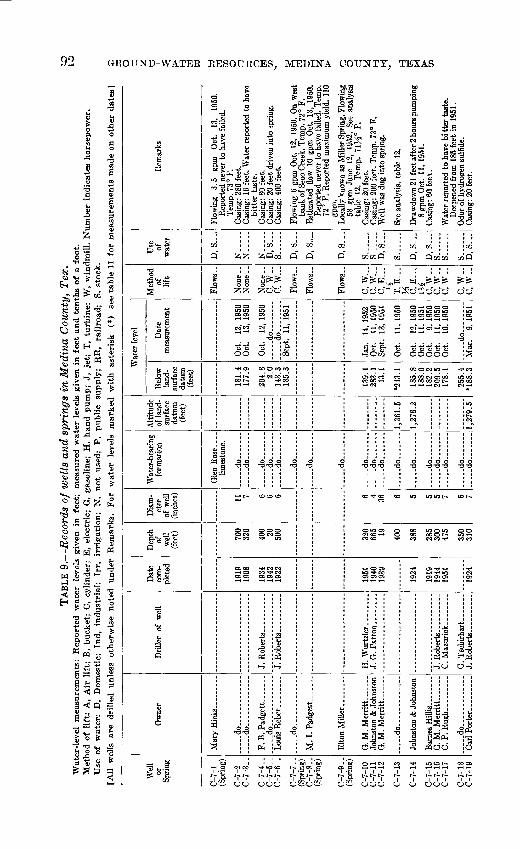
TABL
E 9
. R
ecor
ds o
f w
ells
and
spr
ings
in
Med
ina
Cou
nty,
Tex
.W
ater
-lev
el
mea
sure
men
ts:
Rep
orte
d w
ater
le
vels
giv
en
in
feet
; m
easu
red
wat
er l
evel
s gi
ven
in f
eet
and
ten
ths
of a
foo
t.M
etho
d of
lif
t: A
, A
ir l
ift;
B,
buck
et;
C,
cyli
nder
; E
, el
ectr
ic;
G,
gaso
line
; H
, h
and
pum
p;
J, j
et;
T,
turb
ine;
W
, w
indm
ill.
Nu
mb
er i
ndic
ates
hor
sepo
wer
. U
se o
f w
ater
: D
, D
omes
tic;
In
d,
ind
ust
rial
; Ir
r,
irri
gat
ion
; N
, n
ot
used
; P
, pu
blic
su
pply
; R
R,
rail
road
; S,
sto
ck.
[All
w
ells
ar
e dr
ille
d un
less
oth
erw
ise
note
d under
R
emar
ks.
Fo
r w
ater
le
vels
m
arked
w
ith
aste
risk
(*
) se
e ta
ble
11
for
mea
sure
men
ts m
ade
on o
ther
dat
es]
Wel
l or
Sp
ring
C-7
-1(S
prin
g)
C-7
-2
C-7
-3..
C-7
-4..
C-7
-5-
C-7
-6..
C-7
-7..
(Spr
ing)
C
-7-8
..(S
prin
g)
C-7
-9..
(Spr
ing)
C-7
-10
C-7
-1 1
C-7
-12
C-7
-13
C-7
-14
C-7
-15
C-7
-16
C-7
-17
C-7
-18
C-7
-19
Ow
ner
d
o
_..
._..
...d
o..
....
....
...
F. B
. Pad
get
t...
....
.._.-
do__
_. .........
do
M. I
. P
adge
tt...
_ .
Elto
n M
ille
r.. .
....
.
G. M
. M
erri
tt-
-.-
John
ston
& J
ohns
ton
G. M
. M
erri
tt...
. _
....
.do
....
....
....
.
John
ston
& J
ohns
ton
G. M
. M
err
itt
...
C.P
. R
ugh -
.
....
.do
....
....
....
.C
arl
Port
er ..
.......
Dril
ler
of w
ell
H.
Wur
tzle
r. .......
J. G
. Pat
ton... .
....
J. R
ober
ts.. ___ ..
G. T
sehi
rhar
t ...
....
J.R
obert
s..........
Dat
e co
m
plet
ed
1919
19
08
1934
19
42
1922
1951
19
40
1939
1924
1919
19
44
1951
1924
Dep
th
of
wel
l (f
eet) 700
320
400 20
500
320
665 19 400
388
285
300
475
350
310
Dia
m
eter
of
wel
l (in
ches
)
11 7 6 6 6 6 4 36 6 5 5 5 7 6 7
Wat
er-b
earin
g fo
rmat
ion
limes
tone
,
..d
o.......
.-
do.......
.-..do.......
-...do.......
..d
o..
....
.
d
o
..
do... . .
do
..
do.......
---.d
o
...
do
....
...
... .
.do ..
.
....
.do ..
..
.....d
o.......
.....d
o.......
d
o.......
d
o.......
....
. do...
Alti
tude
of
land
- su
rfac
e da
tum
(fee
t)
1,36
1.5
1,27
8.2
1,27
9.5
Wat
er le
vel
Bel
ow
land
- su
rfac
e da
tum
(fee
t)
181.
4 17
7.9
204.
8 2.
014
3.3
185.
3
139.
1 28
3.1
13.1
*243
.1
185.
8 18
8.0
182.
2 20
9.5
178.
1
255.
4*1
88.3
Dat
e m
easu
rem
ent
Oct
. 12
, 19
50
Oct
. 13
, 19
50
Oct
. 12
, 19
50
....
.do..
....
.. d
o
...
Sept
. 11
, 19
51
Jan.
14
, 19
52
Oct
. 11
, 19
50
Sept
. 13
, 19
51
Oct
. 11
, 19
50
Oct
. 12
, 19
50
Oct
. 11
, 19
51
Oct
. 9,
195
0 O
ct.
11,
1950
O
ct.
10,
1950
..... d
o...
Mar
. 9.
195
1
Met
hod
of
lift
Non
e
Non
e..
Non
e ..
C,
W..
C,
W.
Flo
ws-
C,
W..
C. W
...C,
E
l/2 T, E
...
cV
.U
i C,
W..
C, W
..
C, W
..
c, w
..C.
W-.
Use
of
w
ater
D,
S...
.
N.....
N.....
N....-
D, S
S
D, S
D, S
.
D.S
...
S..
. ...
S ...
D, S
...
S..
....
D, S
...
D, S
S
......
S... .
..
S .
D, S
...
Rem
arks
Flow
ing
3.5
gpm
O
ct.
13,
1950
. R
epor
ted
neve
r to
hav
e fa
iled.
Te
mp.
73°
F.
Cas
ing:
280
fee
t. C
asin
g: 1
6 fe
et.
Wat
er r
epor
ted
to h
ave
bitt
er t
aste
. C
asin
g: 8
0 fe
et.
Cas
ing:
20
feet
driv
en i
nto
sprin
g.
Cas
ing:
400
fee
t.
Flow
ing
6 gp
m O
ct.
12,
1950
. O
n w
est
bank
of S
eco
Cre
ek. T
emp.
72°
F.
Est
imat
ed f
low
10
gpm
Oct
. 13
, 19
50.
Rep
orte
d ne
ver
to h
ave
faile
d. T
emp.
72
° F.
Rep
orte
d m
axim
um y
ield
. 11
0 gp
m.
Loca
lly k
now
n as
Mill
er S
prin
g. F
low
ing
58 g
pm J
une
12,
1952
. Se
e an
alys
is
tabl
e 12
. T
emp.
1\Y
^° F
. C
asin
g: 2
0 fe
et.
Cas
ing:
200
fee
t. T
emp.
73°
F.
Wel
l w
as d
ug i
nto
sprin
g.
See
anal
ysis
, ta
ble
12.
Dra
wdo
wn
21 f
eet a
fter
2 h
ours
pum
ping
8
gpm
Oct
. 11
, 19
51.
Cas
ing:
60
feet
.
Wat
er r
epor
ted
to h
ave
bi tt
er t
aste
. D
eepe
ned
from
185
fee
t in
195
1 .
Odo
r of
hvd
roge
n su
lfide
. C
asin
g: 2
0 fe
et.
to

C-7
-20
C-7
-21
C-7
-22
C-7
-23
C-7
-24
C-7
-25
C-7
-26
C-7
-27
C-7
-28
C-7
-29
C-8
-1
0-8-
2
C-8
-3
C-8
-4
C-8
-5
C-8
-6
C-8
-7
C-8
-8
C-8
-9
C-8
-10
C-8
-11
C-8
-12
C-8
-13
C-8
-14
C-8
-15
C. P. Rugh -
do
...... -
-dO
dO.
_do - .
.. ..
.
dO
-do ._ _.
.... .do
H. Eckhardt .
do
H. E. Rieber
G. Billings ____
.
M. Ney
J. Ulbrich-. ..
...
J. Ulbrich.
dO
E. C.M
arti
n...
....
....
.do ..
... .
... .
.. d
o...
....
....
..
..... do ..
.. ..
.. .
. .do ..
...
- dO ......
dO ......
J.Roberts -.
W. B. Ri
char
ds..
.. .
do ...
....
..
R.Peters.. _ . __ .
R. Pet
ers.
. ___ ..
.
.... .do ..
. ..
....
.
H. Wurtzler...
1949
1910
1922
1946
1946
1946
1945
1935
1942
1940
1920
1928
1928
1921
1946
1935
1934
1933
1924
1940
1932
1920
486
510
475
423
363
347
340
276
1,00
9
200 26 198
250 32 200
320
360
512
240
365
354
350
422
500
7 5 5 6 6 6 6 6 6 38 8 6 35 7 8 6 7 8 7 12 7 10 5
do. .
.. d
o..
....
.
.... .d
o.... ..
.
.....d
o.......
.....d
o.......
limes
tone
(?)
limes
tone
.
limes
tone
(7).
limes
tone
(7).
limes
tone
.
Gle
n R
ose
limes
tone
. .....d
o.......
d
o
..
... d
o
do..
....
...... d
o...... .
..... d
o..
. ....
d
o
..... d
o.... ..
.
d
o ..
.
....
. do ..
.
....
. do
.. -
.
..... d
o
do..
....
......d
o .
...
1,19
1.8
1,27
3.7
1,27
9.6
1,18
6.6
1,40
3.4
208.
1
153.
7
158.
3
232.
2
118.
8
261.
1
195.
9
239.
9
397.
5
52.1
67.6
13
.1
29.5
45.6
13.1
80.7
51.6
67.8
147.
6
45.9
109.
4 18
7.8
83.2
119.
427
7.1
288.
7
Oct
. 10
, 19
50
Oct
. 9,
195
0
Oct
. 10
, 19
50
Oct
. 2,
195
1
Feb.
2,
195
1
__ d
o.... ....
....
-d
o
d
o.
... .
.do
... .
....
Aug
. 17
, 19
50Se
pt.
1, 1
951
Aug
. 15
19
50
....
. do..
. ...
d
o
do..
....
..A
ug.
16,
1950
Sept
. 7,
195
1
Jan.
16
, 19
52
Oct
. 9,
195
0
Aug
. 16
, 19
50Se
pt.
6, 1
951
Aug
. 16
, 19
50
Aug
. 15
, 19
50
dO
Oct
. 9,
195
0... .
.do... .
..
C, W
..
C, G
...
5 C, G
5 T,
E..
.2 T,
E.
2 T, E
...
2 T, E
...
2 J, E
...
2 C, W
..
C, E
...
% C, G
5 T
J
TT
C, W
__
C,E
.1 C
,W__
C.W
..
c,w__
C, G
...
5 C, W
..
C. W
..
C, E
...
1
S......
D, S
...
D, S
S......
S......
S
___
S......
S
S......
D,
S,
N D, S
...
D.....
D.S
...
DS
D,S
S..
.
D, S
...
S
S... .
..N
---.
.D
, S
Wat
er r
epor
ted
to h
ave
bitte
r ta
ste
and
red
colo
r. Se
e an
alys
is,
tabl
e 12
. Pu
mpi
ng 1
8 gp
m O
ct.
9, 1
950.
In U
vald
e C
ount
y. P
umpi
ng 1
1.5
gpm
Feb.
2,
1951
. T
emp.
73°
F.
In U
vald
e C
ount
y.
Cas
ing:
60
feet
. Pu
mp
set
at 3
10 f
eet
Odo
r of
hy
drog
en
sulfi
de.
Loca
lly k
now
n as
St
eam
Pu
mp
wel
l. D
raw
dow
n 8.
2 fe
et
whi
le
pum
ping
14
gpm
Feb
. 2,
19
51.
Tem
p. 7
2° F
.M
uddy
ta
ste,
no
od
er,
milk
y co
lor.
Tem
p. 7
8° F
.
Woo
dard
ca
ve.
Wat
er a
ppro
xim
atel
y 20
0 fe
et b
elow
sur
face
. Se
e an
alys
is,
tabl
e 12
.Se
e an
alys
is,
tabl
e 12
.
Sprin
g cu
rbed
w
ith
20
feet
of
roc
k.
Tem
p. 7
2° F
.
Pum
ping
18
gpm
, Aug
. 15
,195
0.
Pum
pse
t at
92
feet
. C
urbi
ng:
12 f
eet
of ro
ck.
Odo
r of
hyd
roge
n su
lfide
. Se
e an
alys
is,
tabl
e 12
. W
ater
re
port
ed
to
have
bitt
er
tast
e.T
emp.
75°
F.
Cas
ing:
6
feet
. D
raw
dow
n 82
.4 f
eet
afte
r 4
hour
s pu
mpi
ng,
5 gp
m,
Jan.
16,
1952
. C
asin
g: 2
0 fe
et.
Wat
er re
port
ed to
hav
ebi
tter
tast
e.
Cas
ing:
100
fee
t.
Wat
er r
epor
ted
to h
ave
slig
ht o
dor
hy
drog
en s
ulfid
e.
Tem
p. 7
3° F
.C
asin
g: 4
0 fe
et.
Odo
r of
hyd
roge
n su
l fid
e.
Tem
p. 7
3ii°
F.
Aug
. 16
, 19
50.
See
anal
ysis
, tab
le 1
2.Pu
mpi
ng 1
10 g
pm w
hen
drill
ed,
1940
.C
asin
g: 3
fee
t.W
ater
rep
orte
d to
hav
e bi
tter
tast
e.
CD
C
O

Wel
l or
Sp
ring
C-8
-16
C-8
-17
C-8
-18
C-8
-19
C-8
-20
C-8
-21
C-8
-22
C-8
-23
C-8
-24
C-8
-25
C-8
-26
C-8
-27
C-8
-28
C-8
-29
C-8
-30
C-8
-31
C-8
-32
(Spr
ing)
C-8
-33
Ow
ner
E.
C. M
art
in..
....
.
....
.do
....
... ......
..... d
o
_
_
F. D
. G
arri
son ..... .
... ..do ...... ..
.
B.
C. Ja
gg
e
.....
R.
Zu
ber
bu
eler
-.
....
.do ..... -
Bob
Dep
uy__
_ _
_-.
d
o ...
... ...
Dri
ller
of w
ell
J. R
ob
ert
s ...
....
G.
Tsc
hirh
art ...
....
....-do ...
....
..
J. R
oberts
d
o... .
J. J
agge
...
....
..
d
o.
Gab
e T
schi
rhar
t .....
H.
Wur
tzle
r.. .
....
.
J. J
agge
...
.d
o.. ...
... ..
C.
Conw
ay.... .....
C.
Con
way
.. ...
.
Dat
e co
m
plet
ed
1939
1930
1938
1942
1948
1926
1926
1939
1941
1932
1918
19
22
1938
19
20
1934
1951
1949
Dep
th
of
wel
l(f
eet) 40
0
275
400
300
500
300
320
300
175
500
320
300
260
500
400
138
220
Dia
m
eter
of
wel
l (i
nche
s) 6 6 a 5 7 4 12 5 5 7 5 5 6 7 7 8 6
Wat
er-b
eari
ng
form
atio
n
... .
.do.... ...
Edw
ards
lim
esto
ne.
Gle
n R
ose
limes
tone
.
d
o
d
o
do
do-
Edw
ards
an
d G
len
Ros
e lim
esto
nes.
E
dwar
ds
limes
tone
.
..... d
o ...
....
.d
o
d
o ...
....
. do
....
.do
....
...
.....d
o ..
Gle
n R
ose
limes
tone
.
... ..do
do-
Alti
tude
of
land
- su
rfac
e da
tum
(f
eet)
1,18
2.5
1,16
1.8
1,11
9.9
Wat
er l
evel
Bel
ow
land
- su
rfac
e da
tum
(f
eet)
240.
922
8.5
227.
2 22
0.4
200
149.
4
179.
7 18
6.3
174.
2 18
4.5
169.
5 19
5.7
200.
6 20
1.1
167.
6 17
5.4
172.
9 16
4.5
164.
8 17
2.5
173.
3
206.
5 *2
19.1
21
4.5
236.
0
225.
7 25
2.4
16.9
fll.
7
Dat
e m
easu
rem
ent
.....do-
Sept
. 7,
195
1
Aug
. 4,
195
0 Se
pt.
6, 1
951
__
do _
_ ..
Aug
. 4,
195
0
Jan.
9,
195
1 Se
pt.
6, 1
951
Sept
. 3,
195
2 Se
pt.
15,
1951
Jan.
9,
195
1 Se
pt.
6, 1
951
Jan.
9,
195
1 Se
pt.
6, 1
951
Jan.
9,
195
1 Se
pt.
6, 1
951
Jan.
9,
195
1 Se
pt.
6, 1
951
Sept
. 3,
195
2 A
ug.
4, 1
950
Sept
. 6,
195
1
Jan.
9,
195
1 A
ug.
17,
1950
Ja
n.
10,
1951
Ju
ly
28,1
950
Aug
. 28
,195
0 Se
pt.
6, 1
951
Jan.
14
, 19
52
Jan.
8,
195
2
Met
hod
of
lift
C,
W..
J, G
6 C
, W..
C, W
..
T, E
2 T, E
c,2w
._C,
W..
C.W
..
C, W
..
C,E
C, W
..c,
w..
c, w
..c,
w..
c, w
..T,
G
12 C.W
..
C.W
..
Use
of
w
ater
D, S
S
S
D, S
S
.
S
S.-
-
S
S
D, S
D, S
...
D, S
...
S
S.
-
S, I
rr..
D, S
...
S .
Rem
arks
Cas
ing:
80
feet
. T
emp.
72°
F.
Rep
orte
d to
pu
mp
air
afte
r 2
hour
s pu
mpi
ng a
t 6
gpm
. Se
e an
alys
is,
tabl
e 12
. C
asin
g:
20
feet
. P
umpi
ng
12
gpm
. Ja
n. 9
, 19
51.
Wat
er
repo
rted
to
ha
ve
bitt
er
tast
e.
Tem
p. 7
4° F
. C
asin
g: 1
0 fe
et.
Cas
ing:
16
feet
. P
ump
set
at 2
80 f
eet.
Rep
orte
d sm
all
yiel
d.
Pum
ping
76
gpm
Jul
y 19
49.
Tem
p. 7
2°
F.
See
anal
ysis
, ta
ble
12.
Cas
ing:
120
fee
t.
Cas
ing:
80
feet
. W
ater
rep
orte
d fr
om
cave
rnou
s lim
esto
ne a
t 26
5-28
0 fe
et.
Tem
p. 7
1V2°
F. S
ee a
naly
sis,
tab
le 1
2.
Cas
ing:
40
feet
. P
ump
set
at 2
30 f
eet.
Tem
p. 7
2° F
. Se
e an
alys
is,
tabl
e 12
. N
o ca
sing
. N
o ca
sing
. T
emp.
71°
F.
See
anal
ysis
, ta
ble
12.
Tem
p. 7
2° F
.
Cas
ing:
86
fe
et.
Dra
w-d
own
56
feet
w
hile
pum
ping
64
gpm
aft
er 3
hou
rs.
Jan.
14,
195
2.
Cem
ent
rese
rvoi
r bu
ilt
arou
nd s
prin
g.
Flow
ing
16 g
pm J
an.
14,
1952
. Tem
p.
71"
F.
See
anal
ysis
, ta
ble
12.
Pum
p se
t at
210
fee
t. R
epor
ted
to p
ump
air
afte
r 2
hour
s pu
mpi
ng 5
gpm
.

C-8
-34
Sprin
g)
C-8
-35
C-9
-1 ._
C-9
-2..
C-9
-3-.
(Spr
ing)
C
-9-4
..
C-9
-5-.
(Spr
ing)
C
-9-6
-.
C-9
-7..
C-9
-8..
(Spr
ing)
C
-9-9
--
C-9
-10
(Spr
ing)
C
-9-1
1
C-9
-12
C-9
-14
C-9
-15
C-9
-16
C-9
-17
C-9
-1 8
C-9
-19
C-9
-20
C-9
-21
C-9
-22
(Spr
ing)
C
-9-2
3
C-9
-24
Mrs
. B
. C
. Fle
enor
._
____
_ do_
_._
....
.do
.. .
.....
..
S. C
. T
hurm
ond .
....
....
.do..
....
. ......
.....d
o. ..
... ..
..
-d
o..
....
. ..
.
H.G
. H
ay
-d
o.
....
... .
.
..
do.
... .
.do... .
.. ....
W.B
.Ric
hard
s--
....
. do..
-..
do ..
... -
W. F
aulk
...
....
.
W. F
aulk
..... d
o .
..... .
C.N
orte
n. ---
----
1933
1936
1936
1942
1938
1948
1930
1948
1936
1936
1948
1940
1948
1928
1947
1950
1950
1946
1934
1950
197
160
120
400
231
198
238
296
120
340
280
300
300
399
475
475
357
410
160
6 4^
5 12 6 5 5 5 5 6 6 6 5 6 7 8 6 6
d
o
d
o
d
o.
.
d
o
..d
o ..
.
d
o ..
.
d
o
d
o
d
o
.
d
o
.. d
o.
.
d
o..
....
.
d
o ..
.
d
o
limes
tone
(?).
limes
tone
. d
o
dO
.
d
o ..
.
limes
tone
. ... d
o
limes
tone
(?).
Gle
n R
ose
limes
tone
.
d
o ..
.
Gle
n R
ose
limes
tone
s.
d
o
67.0
77.7
80.1
30.7
43.3
99.0
13
7.6
132.
6
245.
024
8.4
4Q
7
219.
9
179.
9
184.
118
1.2
159.
0
213.
3
281.
332
7.5
171.
6
281.
3
227.
8
259.
2
Apr
. 21
, 19
52Ju
ly
23,
1951
d
o..... .
..
Oct
. 23
, 19
51
Feb.
11
, 19
52
Oct
. 23
, 19
50
July
23
, 19
51Se
pt.
6, 1
951
July
23
, 19
51
Dec
. 20
, 19
50
Dec
. 20
, 19
50Se
pt.
6, 1
951
July
23
, 19
51
Nov
. 20
, 19
51
d
o
Nov
20
, 19
51 d
o
Sept
. 10
, 19
50
Nov
. 15
, 19
50
Nov
. 15
, 19
50Se
pt.
11,
1950
N
ov.
15,
1950
Dec
. 20
, 19
50
Jan.
10
, 19
51
d
o
C, W
..C,
E..
.
cS H C, E
y* Fl
ows.
.
C, E
...
J'2 C, W
-J,
G
Flow
s..
C,W
-
C, W
-
C, E
_._
H
C, W
-
C.W
..
C, W
-C
, G
5 C, G
5 C
.W-
C, E
C, E
1A C
,G
4 C.
W._
S
S......
D,S
D, S
...
D, S
D,S
S......
D, S
...
D, S
S......
S .
S
..
S
D, S
S
D, S
...
D, S
...
D, S
S..
....
S......
N
D, S
S......
S.
D, S
...
S
Bar
tz S
prin
g. F
low
ing
6.5
gpm
Mar
. 18
, 19
52.
Tem
p. 7
1Ms°
F.
Cas
ing:
20
feet
. W
ater
rep
orte
d to
hav
e bi
tter t
aste
and
red
colo
r.Tem
p. 7
2° F
. C
asin
g: 1
0 fe
et.
Flow
ing
57.2
gp
m
Oct
. 23
, 19
50.
Tem
p. 7
3.5°
F.
Wat
er
repo
rted
to
ha
ve
bitte
r ta
ste.
See
anal
ysis
, ta
ble
12.
Tem
p. 7
3° F
. Se
e an
alys
is,
tabl
e 12
. Te
mp.
73°
.
Flow
ing
38 g
pm O
ct.
23,
1950
, an
d 10
gpm
M
ar.
30,
1951
. Te
mp.
73
° F.
W
ater
re
port
ed
to
have
bi
tter
tast
edu
ring
dr
y w
eath
er.
80.6
gpm
Oct
. 25
, 19
50.
Tem
p. 7
4° F
.Se
e an
alys
is,
tabl
e 12
. M
occa
sin
Sprin
g. F
low
ing
81 g
pm O
ct.
25,
1950
. Te
mp.
74
° F.
12
gpm
. D
ec.
20,
1950
. T
emp.
74°
F.
Goa
t Spr
ing.
Flo
win
g 12
.4 g
pm D
ec. 2
0,19
50.
Tem
p.
74°
F.
Tem
p. 7
3° F
.
Wat
er
repo
rted
to
ha
ve
bitte
r ta
ste.
Wat
er
repo
rted
to
ha
ve
bitte
r ta
ste.
D
rille
r re
port
ed t
op o
f G
len
Ros
e at
270
feet
. C
asin
g: 8
fee
t. W
ater
rep
orte
d to
hav
ebi
tter
tast
e.
Wat
er r
epor
ted
at 2
47 f
eet.
Nea
r V
erde
Cre
ek.
Cas
ing:
15
feet
. W
ater
rep
orte
d at
337
fe
et.
Dra
wdo
wn
42
feet
af
ter
30
min
uter
pu
mpi
ng 1
0 gp
m D
ec.
9, 1
950.
Afte
s ac
idiz
ing
no
mea
sura
ble
draw
dow
n at
10
gpm
. Te
mp.
74
° F.
Indi
an S
prin
g. E
stim
ated
flo
w 1
20 g
pm
Sept
. 14
, 19
50.
Tem
p. 7
4° F
.
Cas
ing:
360
feet
. Se
e an
alys
is, t
able
12.
^o

Wel
l or
Sp
ring
C-9
-25
C-9
-26
C-9
-27
C-9
-28
C-9
-29
C-9
-30
C-9
-31
C-9
-C2
C-9
-33
C-9
-34
C-9
-35
C-9
-36
C-9
-37
C-9
-38
C-9
-39
C-9
-40
C-9
-41
C-9
-42
C-9
-43
Ow
ner
A.
Saa
thof
f. ........
A.
Win
klie
... _
_ ...
W.
DeG
rodt
.......
d
o
- d
o..
....
...
....
do
A.
Win
kler
. ...
....
.
Dri
ller
of w
ell
.....d
o.... ...
...
C.
Nor
ten.
_ . .....
J. B
ritc
h an
d O
tto W
eim
er
. ....d
o... .
....
....
.
C.G
iUia
m.. .........
Dat
e co
m
plet
ed
1934
1941
1926
1950
1944
1910
1926
1950
1901
1947
1936
1938
19
28
1912
1936
1906
1945
1948
Dep
th
of
wel
l (f
eet) 46
0
521
265
404
275
332
330
585
460
330
300
346
300
300
325
440
360
Dia
m
eter
of
wel
l (i
nche
s) 7 5 6 6 7 6 6 8 8 6 5 6 7 6 6 5 5 6 7
Wat
er-b
eari
ng
form
atio
n
Gle
n R
ose
limes
tone
. .. d
o.......
Edw
ards
lim
esto
ne.
.....d
o.......
....
. do
....
. d). .
Gle
n R
ose
limes
tone
(?).
Gle
n R
ose
limes
tone
, - do ..
Edw
ards
lim
esto
ne.
....
.do.... .
.
....
. do.......
....
.do
....
...
.....d
o.......
.....d
o.......
....
. do-.. .
. .d
o-....,.
Edw
ards
lim
esto
ne (?
) E
dwar
ds
limes
tone
.
Alti
tude
of
land
- su
rfac
e da
tum
(fee
t)
1,16
4.2
1,17
8.4
1,13
1.4
1,10
6.5
1,12
9.1
1,12
5.2
1,15
8.3
Wat
er l
evel
Bel
ow
land
- su
rfac
e da
tum
(fee
t)
181.
3
176.
9 18
9.1
179.
0 15
0.1
199.
7
272.
8
203.
6
157.
7
139.
9
141.
9
228.
5
233.
6
225.
8 1
92.8
259.
0 25
4.2
250.
8 27
2.5
268.
3
291.
9
Dat
e m
easu
rem
ent
Jan.
9,
195
1
Jan.
5,
195
1 Se
pt.
6, 1
951
Mar
. 19
, 19
52
Nov
. 15
, 19
50
Jan.
16
, 19
52
Jan.
5,
195
1
do........
Oct
. 20
, 19
50
Nov
. 6,
195
0
do........
do
Oct
. 30
, 19
50
Nov
. 15
, 19
50
Mar
. 14
, 19
51
Jan.
5,
195
1 M
ar.
19,
1952
Se
pt.
4, 1
952
Jan.
5,
195
1
Jan.
10
, 19
51
Jan.
10
. 19
51
Met
hod
of
lift
C, E
...
14
C
, W
..
C,
W..
Non
e C
, G
5 C
, W
__
C,
W..
C,
W..
C,
G,
W
6 C, E
^
C, E
-.\ / c"
w..
C,
W..
C
, W
..
C, E
...
1H C, E
...
m C, G
5 C
, W
..
C,
W..
Use
of
w
ater
D, S
S
S
N
S -
S
N..
S
D,
S
D, S
...
S
S
S
D, S
...
D, S
D, S
D, S
...
S ..
.
S
Rem
arks
Wat
er
repo
rted
to
ha
ve
bitt
er
tast
e em
p. 7
2° F
. C
asin
g:
123
feet
. W
ater
re
port
ed
to
have
bit
ter
tast
e.
Bla
ck p
reci
pita
te
insi
de d
isch
arge
pip
e.
Tem
p. 7
2° F
.
Rep
orte
d dr
awdo
wn
1.4
feet
af
ter
2 ho
urs
pum
ping
200
ppm
Apr
. 18
, 19
50.
See
anal
ysis
, ta
ble
12.
See
log.
T
emp.
72°
F.
Wat
er r
epor
ted
in s
and
mem
b r
at 5
45-
565
feet
. T
emp.
73°
F.
See
anal
ysis
, ta
ble
12.
Gra
yson
sha
le (
Del
Rio
cla
y) o
n su
rfac
e.
Cas
ing:
10
0 fe
et.
Bud
a lim
esto
ne o
n
Cas
ing:
20
feet
. T
emp.
72°
F.
Wes
t w
ell
of t
wo
wel
ls.
See
anal
ysis
, ta
ble
12.
Cas
ing:
20
feet
.
Cas
ing:
40
feet
.
Pum
ping
35
gpm
Jan
. 10
, 19
51.
Tem
p.
72°
F.
Pum
p se
t at
41
5 fe
et.
Rep
orte
d to
pu
mp
air
afte
r 6
hour
pu
mpi
ng 8
gpm
W
ater
rep
orte
d in
cav
erno
us l
imes
tone
at
348
-360
fee
t.

C-9-
44C-
9-45
C-9-
46
C-9-
47
C-9-
49
C-9-
50
C-9-
51
C-9-
52C_Q_KQ
C-9-
54
f 0
55
C-9-
56C-
9-57
C-9-
58C-
9-59
C_g_
gO
C-9-61
P Q CO
C-9-
63
(Spr
ing)
D-7-
1
D-7-
2D-
7-3
do.-.
W. L.
Saat
hoff
. .... .
.... .do..
J. W.
Weber....... .
do ...
..
do
.... -do ..
.. ......
Mrs. C. Me
Nutt
....
- -
R. Bendele.... _ -.
Whit
esid
e
....
do- -
.....do
.do ...
....
.. .do .... ....
do
do ...
...
....
do
1937
1934
1904
1922
1939
1951
1947
1927
1938
1945
1950
1951
1951
1951
1951
1952
1951
1952
1952
1939
1937
410
310
400
280
350
355
450
268
325
346
425
139
91.4
237
280
423
420
560
800
325
240
220
7 6 6 6 7 7 5 8 6 5 8 6 6 5 6 6 6 8 8 5 6 6
.....d
o.......
do
.....d
o.......
.....d
o.......
.....d
o.......
..d
o.......
d
o ..
..
....
.do... .
...
d
o
d
o
do.
Gle
n R
ose
limes
tone
. -do
do
do.......
..... d
o
...
. d
o
-do... .
...
do
Gle
n R
ose
limes
tone
an
d T
ravi
s Pe
ak f
or-
mat
ion(
?).
Gle
n R
ose
limes
tone
.
d
o
do
d
o
1,02
3.3
-.-.
....
1,07
7.5
1,02
2.1
1,19
8
35
\621
1.1
224.
6 21
1.5
219.
220
6.8
209.
5 26
0.8
252.
2 23
0.4
240.
7 30
5.6
249.
8
254.
027
1.2
227.
418
7.7
215.
2 22
4.7
321.
8
120.
2
26.9
68.6
29.6
30.7
62.0
167.
2
183.
827
1.1
168.
6
124.
2
198.
914
9.4
Jan.
9,
195
1 .d
o
Sept
. 6,
195
1 M
ar.
19,
1952
Ja
n.
9, 1
951
Sept
. 6,
195
1 M
ar.
19,
1952
Ja
n.
4, 1
951
d
o
July
23
,195
1 Se
pt.
16,
1951
A
ug.
10,1
951
Jan.
5,
195
1
Jan.
4,
195
1M
ar.
19,
1952
Ja
n.
4, 1
951
Mar
. 7,
195
0 Se
pt.
4, 1
952
Dec
. 7,
195
1
Dec
. 20
, 19
50
Jan.
11
, 19
52Fe
b.
11,
1952
Nov
. 12
,195
1
Feb.
11
, 19
52..
.. d
o..
. .....
... .
.do
..
..
....
.do
... .
....
Jan.
22
, 19
52
Apr
. 27
, 19
52
Apr
. 27
. 19
52
Sept
. 20
, 19
51
d
o
d
o
C,
W_.
C, E
2 C
.W..
C, W
..
C, G
...
5 C,
W..
c, w_
_C
, W
..
C,
W..
C,
W..
T.E
...
« C,
W..
C,
W..
C,
W..
C,
W-.
T, E
50 C
. E
y* c, w
..C
, W
..
D, S
D
, S
D, S
._-
N S. .....
S
S.
D, S
...
S ...
N S .
N S
D, S
N S .
S
S
S
rr
D, S
D, S
S
S
Tem
p. 7
1° F
.Se
e an
alys
is,
tabl
e 12
.
Edw
ards
lim
esto
ne o
n su
rfac
e.
Wat
er r
epor
ted
to o
ccur
in th
re«
cave
rns
betw
een
281
and
355
feet
. B
uda
limes
tone
on
su
rfac
e.
Tem
p.
Wel
l'was
dry
Sep
t. 11
, 19
51.
Cas
ing:
250
fee
t. C
asin
g: 1
00 f
eet.
Cas
ing:
12
0 fe
et.
Lar
ge s
inkh
ole
300
feet
sou
th o
f w
ell.
See
log.
Cas
ing:
5 fe
et.
Pum
p se
t at 9
2 fe
et.
Cas
ing:
25
feet
. R
epor
ted
to p
ump
air
afte
r 2 h
ours
pum
ping
15
gpm
. D
raw
do
wn
12.4
aft
er 3
0 m
in.
pum
ping
6
gpm
. Te
mp.
76
° F.
Se
e an
alys
is,
tabl
e 12
.C
asin
g: 2
0 fe
et.
See
anal
ysis
, tab
le 1
2.W
ater
rep
orte
d to
hav
e bi
tter
tast
e.C
asin
g: 6
fee
t. W
ater
rep
orte
d to
hav
e bi
tter
tast
e.W
ater
rep
orte
d to
hav
e bi
tter
tast
e.D
raw
dow
n 36
.7 f
eet
afte
r 30
min
utes
pu
mpi
ng 6
gpm
Jan
. 22
, 19
52.
Cas
ing:
691
fee
t. R
epor
ted
draw
dow
n 61
fe
et a
fter
3 h
ours
pum
ping
723
gp
m M
ar 2
2,19
52.
Pum
p se
t at
275
fe
et, p
umpi
ng 4
47 g
pm A
ug.
12,1
952.
Se
e an
alys
is, t
able
12.
Ve-
de S
prin
g.
Flow
ing
17.6
gpm
Apr
. 27
,195
2.
Tem
p. 7
3° F
. Se
e an
alys
is,
tabl
e 12
.W
ater
repo
rted
to h
ave
bitte
r ta
ste.
Do.
Hea
vy c
oatin
g of
min
eral
s on
dis
char
ge
pipe
. T
emp.
74
° F.
Se
e an
alys
is,
tabl
e 12
.

Wel
l or
Sp
ring
D-7
-4
(Spr
ing)
D
-7-5
D
-7-6
.. D
-7-7
(S
prin
g)
D-7
-8
D-7
-9
(Spr
ing)
D
-7-1
0 D
-7-1
1 D
-7-1
2 D
-7-1
3
D-7
-14
D-7
-15
D-7
-16
D-7
-17
D-7
-18
D-7
-19
D-7
-20
D-7
-21
D-7
-22
D-7
-23
D-7
-24
Ow
ner
....
.do
....
....
....
.
.....d
o.............
R. E
. H
aby.
. ...
....
R. E
. H
aby.........
E. S
eekatz
.....d
o... .
....
....
.
....
.do
....
....
....
.
Col.
D.
O'C
onne
ll...
T. J
. F
algo
ut.. .....
Gen
. J.G
. B
rant.
...
d
o
Dril
ler
of w
ell
J. J
agge
............
.....d
o... .
.........
J. J
agge
...
.
Dat
e co
m
plet
ed
1947
19
09
1925
1942
19
35
1945
19
35
1938
19
20
1939
1945
1950
1949
1936
1948
1938
Dep
th
of
wel
l (f
eet) 30
0 42 400
275
148
220
300
340
586
500
500
334
476
495
400
300
760
195
Dia
m
eter
of
wel
l (in
ches
) 5 36 6 5 6 6 5 5 8 8 8 8 7 7 6 7 6 6
Wat
er-b
eari
ng
form
atio
n
do ..
.....d
o.......
d
o
do
.... -d
o... .
.. .
d
o
d
o... .
...
....
. do
......d
o ..
.. d
o
....
.do ..
. . d
o ..
.
....
.do ..
.
.....d
o.......
Edw
ards
lim
esto
ne(T
). G
len
Ros
e lim
esto
ne(?
). G
len
Ros
e lim
esto
ne
Gle
n R
ose
limes
tone
(?).
Edw
ards
lim
esto
ne.
Gle
n R
ose
limes
tone
. E
dwar
ds
Com
anch
e Pe
ak,
and
Gle
n R
ose
limes
tone
s.
Alti
tude
of
land
- su
rfac
e da
tum
(f
eet)
1,15
5.2
1,14
7.0
1,15
2.2
1,09
3.4
Wat
er le
vel
Bel
ow
land
- su
rfac
e da
tum
(f
eet)
227 14
.6
277.
6
115.
4 13
4.7
105.
3 54
.9
102.
7 22
0.4
245.
6 26
2.2
213.
2 25
0.5
246.
8 93
.1
213.
9 21
9.5
127.
1
311.
5
220.
4
207.
3
207.
6 17
7.7
232.
6 20
4.7
Dat
e m
easu
rem
ent
d
o
....
. do ..
..do
d
o..
. ...
..
Dec
. 15
, 19
50
Sept
. 20
, 19
51
__ do
...._
.._
Dec
. 15
, 19
50
Sept
. 15
, 19
51
Sept
. 20
, 19
51
Jan.
8,
193
4 Ja
n.
16,
1952
M
ar.
19,
1952
Ja
n.
8, 19
34
Jan.
16
, 19
52
Mar
. 19
, 19
52
Jan
8, 1
934
Jan.
16
, 19
52
Mar
. 19
, 19
52
Jan.
15
, 19
51
Dec
. 15
, 19
50
Jan.
10
, 19
51
Jan.
10
, 19
51
Jan.
23
, 19
51
Sept
. 12
, 19
51
Mar
. 19
, 19
52
Nov
. 15
, 19
50
Met
hod
of
lift
Flow
s
C, W
..C
, W
-F
low
s
C, W
__
Flow
s..
C, W
-.
C,
W__
C,
W-
C, W
-
C, W
-.
C, W
~
C,
W..
Non
e
C, E
M
C
, W
..
C,
W..
C.W
..
C.W
..
C,E
1 G
.....
Use
of
w
ater
S
S
D, S
S
s....
..S
-
D, S
...
D, S
S
S
D, S
...
S .
S_
N D..
S
S
S
S
D...-
D.....
Rem
arks
Peca
n Sp
rings
. Fl
owin
g 35
gpm
Sep
t. 20
, 19
51.
Tem
p. 7
3° F
. W
ater
rep
orte
d to
hav
e bi
tter
tast
e.
Cas
ing:
12
feet
. D
ug.
Flow
ing
5 gp
m S
ept.
20,
1951
.
Wat
er r
epor
ted
to h
ave
bitte
r ta
ste.
Fl
owin
g 3
gpm
Dec
. 5,
195
0.
Tem
p.
73°
F.
Wat
er r
epor
ted
to h
ave
bitte
r ta
ste.
Cas
ing:
5 f
eet.
Tem
p. 7
2° F
. N
ear
high
wat
er l
ine
of M
edin
a La
ke.
Pum
p se
t at
148
fee
t. W
ater
rep
orte
d to
hav
e bi
tter
tast
e.
Wat
er
repo
rted
to
ha
ve
bitte
r ta
ste.
W
ell
D-7
-4 i
n U
. S.
G
eol.
Surv
ey
Wat
er S
uppl
y Pa
per
678.
W
ell D
-7-3
in U
. S. G
eol.
Surv
ey W
ater
- Su
pply
Pap
er 6
78.
Wel
l D-7
-5 in
U. S
. Geo
l. Su
rvey
Wat
er-
Supp
ly P
aper
678
.
See
log.
Tem
p. 7
7° F
.
Cas
ing:
495
fee
t. T
emp.
74J
-6"
F.
See
anal
ysis
, ta
ble
12.
Wat
er r
epor
ted
to h
ave
bitte
r ta
ste.
Cas
ing:
12
0 fe
et.
Wat
er
repo
rted
to
ha
ve
bitte
r ta
ste
and
hard
. C
asin
g: 4
0 fe
et. F
low
ing
10 g
pm D
ec. 1
3,
1950
. Tem
p. 7
3° F
.
00

r\
7
OK
r\
7 of
t
D-7
-27
rV-7
90
D 7
-30
D-7
-31
T\
7
QO
D-7
-33
D-7
-34
D-7
-35
D-7
-36
Tl-
7-1
7D
-7-3
8
D-7
-39
(Spr
ing)
D
-7-4
0D
-7-4
1
n 7
4.9
D-7
-43
D-7
-44
(Spr
ing)
D
-7-4
5(L
ake)
D-8
-1..
D-8
-2..
D-8
-3
D-8
-4(S
prin
g)
D-8
-5..
J. L
. Dow
d
T. S
. F
alg
out.
.
...d
o.............
M.H
aby...
R.
E. H
aby .
....
.
....
.do
....
....
....
.
Irri
gatio
n D
istr
ict.
F. S
. Gall
e..........
....
.do
....
....
....
...
...d
o..
....
....
...
d
o .......
. ...
.do..
...
....
....
....
.do
....
....
....
.
B
roek
ley _
_ ..
..
.....d
o.............
A. E
. G
ofo
rth
1935
1948
1938
in e
n
1 Q
J.^
1945
1945
1QQ
E
1945
1908
1940
1911
1928
1933
1908
1910
1912
1921
1935
1938
274
282
280
310 48 132
140
480
500
560
400
365
450
200
350
444
600
400
122
360
360 68
6 6 7 6 6 6 5 6 5 6 6 6 6 5 6 6 7 7 5 8 6 6
Edw
ards
limes
tone
. ..
do.......
-...
do..
....
.
Gle
n R
ose
limes
tone
.
limes
tone
. . d
o ._
-
.. d
o..
. ....
do
Edw
ards
lim
es to
ne(?
).
.....d
o .
limes
tone
. .....d
o.......
do
.....d
o.......
.....d
o.......
.....d
o.......
do
d
o.......
do..
....
.
Gle
n R
ose
limes
tone
.
Gle
n an
d R
ose
limes
tone
s.
Gle
n R
ose
limes
tone
, do
..d
o.......
....
. do
_
do
1,08
6.5
1,10
6.6
1,22
7.9
1,19
5.7
1,17
8.4
1,16
8.1
944.
4
928.
5
1,07
8.4
*153
.7
181.
9
183.
621
1.3
24.6
36.4
55.9
84.8
76
.7
258.
732
7.4
367.
2 35
1.9
300.
030
6.4
330.
998
8.8
301.
432
5.2
*309
.677
.7
178
146.
815
1.3
364.
835
9.0
42.5
64.4
54.8
22.0
Dec
. 12
, 19
50
Dee
. 13
, 19
50
Dec
. 12
, 19
50Se
pt.
13,
1951
_ _ d
o. ..
....
Dec
. 13
, 19
50
.....d
o ....
Sept
. 13
, 19
51
Dec
. 13
, 19
50
do- ...
Jan.
23
, 19
51
Sept
. 21
,195
1 M
ar.
19,
1952
Ja
n.
15,
1934
Jan.
23
, 19
51
Mar
. 19
, 19
52
Jan.
23
, 19
51
do........
Mar
. 19
, 19
52
Nov
. 7,
195
0D
ec.
12,
1950
Jan.
23
, 19
50
Sept
. 18
, 19
50Ja
n.
8, 1
934
Jan.
5,
195
2 Se
pt.
13,
1951
Sept
. 4,
195
2
Mar
. 18
,195
2
Sept
. 20
, 19
51
....
.do..
....
....
...d
o..
....
..
....
.do. .
d
o........
C.W
..
C,
E...
12
C, W
..
C, E
1A
C,
E_,
_
C, E
...
U
T" E
_._
l'/2 C.W
..C
, E
2 C.W
..
C, E
iy*
c,w
_.c,
w_.
C, E
-.1 F
low
s
C,W
..C
,W-
C.W
..
C,W
-
C.W
..
C,W
__C
, E
2 C
, E
1A
D.....
D.....
D, S
...
D.....
D.....
S ...
D, S
...
S..
. ...
D, S
D, S
S .
D, S
D, S
D
-...-
S... .
..
S ..
D, S
...
S
S ...
S ...
S
S.
D, S
...
S..
. ...
D, S
...
Cas
ing:
13
feet
. A
t ea
st e
nd o
f M
edin
a La
ke
Dam
. Se
e an
alys
is,
tabl
e 12
.C
asin
g: 6
0 fe
et.
Wat
er r
epor
ted
at 1
25
and
275
feet
.Pu
mp
set
at 2
60 f
eet.
Tem
p. 7
2° F
.
Nea
r ri
ver
bed,
be
low
M
edin
a D
am.
Pum
p se
t at
294
fee
t. C
asin
g: 4
0 fe
et.
Tem
p. 7
1° F
.
Cas
ing:
80
feet
. T
emp.
72°
F.
Cas
ing:
60
feet
. Te
mp.
72°
F.
Cas
ing:
120
fee
t.C
asin
g:
500
feet
. D
raw
dow
n 24
fe
etaf
ter
2 ho
urs
pum
ping
60
gpm
Jan
.23
, 19
51.
Cas
ing:
60
fee
t. W
ell
D-7
-1
in
U.S
.G
eol.
Surv
ey
Wat
er-S
uppl
y Pa
per
678.
Tem
p. 7
2° F
. C
asin
g: 6
fee
t.
Tem
p. 7
3° F
.
Tem
p. 7
2?^°
F. S
ee
anal
ysis
, ta
ble
12.
Cas
ing:
20
feet
. E
ast
bank
of
dive
rsio
nla
ke o
n M
edin
a R
iver
. Fl
owin
g 8
gpm
Jan
. 23
, 19
50.
Tem
p.71
° F.
Wel
l D-7
-2 in
U.S
. Geo
l. Su
rvey
Wat
er-
Supp
ly P
aper
678
.
Wel
l D-7
-6 in
U. S
. Geo
l. Su
rvey
Wat
er-
Supp
ly P
aper
67
8.
Tem
p.
73°
F.B
ear
Sprin
g. F
low
ing
32 g
pm M
ar.
18,
1952
. Te
mp.
72
° F.
Med
ina
Lake
. Se
e an
alys
is,
tabl
e 12
.
Wat
er l
evel
rep
orte
d 31
fee
t be
low
land
surf
ace
as o
f Se
pt.
1950
. W
est
bank
of
Sa
n G
eron
mo
Cre
ek.
Flow
ing
6 gp
m S
ept.
20,
1951
. T
emp.
72
° F.

Wel
l or
'Spr
ing
D-8
-6..
D-8
-7-
D-8
-8-.
D-8
-9-
D-8
-10.
D
-8-1
1.
D-8
-12.
1-1
-1
1-1-
2...
1-1
-3
1-1
-4
I 1
5..
.
1-1
-6
1-1
-7
1-1
-8
1-1
-9
I-1-
10-.
Ow
ner
Mrs
. C
. McN
utt ....
0. W
. S
chuc
hart
....
..d
o.............
A. J
. Sc
huch
art..
. ..
F. L
. Wurz
bac
h.
J. W
oodard
.
..
.. d
o.............
. .d
o.............
.d
o..
....
.......
.....d
o... .
....
.....
E.L
.KeU
ey. .
.,.
.
-do..
... .
......
.
J. W
ooda
rd _
.....
.
E.L
.KeU
ey. .
Dril
ler
of w
ell
-d
o..
..........
.
..... d
o-..
...
...
-- do............ .
....
.do
..
......
.....d
o.............
... -
do ........
---.d
O ..........
. d
o..
....
...
....
Dat
e co
m
plet
ed
1910
1939
1950
1900
Old
1932
1944
1946
1946
1946
1946
1947
1920
1923
1950
Dep
th
of wel
l (f
eet) 244
671
671
520
300±
25
411
410
1,00
9
430
425
415
412
400
500
362
Dia
m
eter
of
wel
l (in
ches
) 7 6 7 6 6 60 6 6 6 6 6 6 6 6 7 6
Wat
er-b
eari
ng
form
atio
n
.....d
o.......
..... d
o
d
o.......
Gle
n R
ose
limes
tone
(?).
Edw
ards
lim
es to
ne (?
). Le
ona
form
a
tion.
E
dwar
ds
limes
tone
. ..... d
o
Gle
n R
ose
limes
tone
.
Edw
ards
lim
esto
ne,
. .d
o.......
d
O .-.
-..-
do.......
.....d
o.......
.....d
o.......
..... d
o
Alti
tude
of
land
- su
rfac
e da
tum
(fee
t)
1,01
5.3
1,17
1.2
1,17
2.7
1,16
7.0
1,19
1.5
Wat
er l
evel
Bel
ow
land
- su
rfac
e da
tum
(fee
t)
25.5
289.
0
374.
1
301+
30
7.6
367.
4
114.
8
24.6
345.
5
342.
1 34
6.7
367.
0 33
7.1
405.
3
388.
7
411.
6
*392
.6
363.
2
390.
1
239
Dat
e m
easu
rem
ent
Sept
. 20
, 19
51
Aug
. 13
, 19
51
... .
.do.. ..
....
Jan.
11
, 19
34
May
18
, 19
51
Sept
. 4,
195
2
June
18
, 19
52
June
19
, 19
52
Feb.
2,
195
1
.....d
o
Mar
. 19
, 19
52
Sept
. 13
, 19
52
Feb.
2,
195
1
Feb.
2,
195
1
Feb.
1,
1951
....d
o........
Mar
. 15
, 19
51
Oct
. 11
, 19
50
Jan.
5,
195
1
Dec
. ,
1950
Met
hod
of
lift
C, E
...
3 C, W
..
C, E
2 C,
W_.
C, W
..
C,
W..
T,E
2 T,
E
2 T, E
2 T
, E
C,
A
T, E
2 T
, E
...
2 C, E
2y
2
C, E
...
5 T, E
...
2 T, E
...
IK
Use
of
w
ater
D, S
...
S......
D, S
...
D, S
...
S......
N ...
D, S
...
S......
D, S
...
S......
S......
S......
S......
S
D, S
...
S ...
S......
Rem
arks
Supp
lies
Gal
lagh
er D
ude
Ran
ch.
Cas
bg:
260
feet
. O
wne
r re
port
s in
su
ffic
ient
yie
ld.
Cas
ing:
20
feet
. Pu
mpi
ng 6
0 gp
m J
une
19,1
952.
T
emp.
72°
F.
See
log.
Se
e an
alys
is,
tabl
e 12
. N
ot c
ased
. W
ell
D-8
-1 i
n U
. S.
Geo
l. Su
rvey
Wat
er-S
uppl
y Pa
per
678.
Dug
. N
o cu
rbin
g.
Supp
lies
Woo
dard
Ran
ch h
eadq
uart
ers
Tem
p. 7
2° F
.
Cas
ing:
60
feet
. A
t jun
ctio
n of
Sec
o an
d Sp
ring
Cre
eks.
Se
e an
alys
is,
tabl
e 12
. Te
mp.
71°
F.
Bud
a lim
esto
ne a
t su
rfac
e.
Pum
p se
t at
418
feet
.
Smal
l yie
ld.
Cas
ing:
412
fee
t. D
rille
r re
port
ed c
av
ern
at 4
08-4
12
feet
. B
low
ing
wel
l. W
ater
tem
p. 7
1° F
. W
ell
deep
ened
fr
om 4
12 t
o 47
6 fe
et i
n 19
52.
See
anal
ysis
, tab
le 1
2.
Cas
ing:
350
fee
t. Ir
riga
tes
2-ac
re g
ar
den.
Te
mp.
72
° F.
Se
e an
alys
is
tabl
e 12
. C
asin
g: 2
10 f
eet.
Cas
ing:
80
feet
. W
ater
rep
orte
d in
cav
er
nous
lim
esto
ne a
t 31
0 fe
et.
o
o

1-1-
11-
1-1
-12
-
1-1
-13-
1-1
-14-
1-1-
15-
1-1-
16-
1-1-
17-
1-1-
18-
1-1
-19-
1-1
-20-
1-1-
21-
1-1-
22..
1-1
-23
-1-1
-24-
1-1-
25
1-1
-26-
1-1-
27..
1-2
-1...
1-2-
2 ...
1-2
-3...
1-2
-4..
.1
-2-5
...
1-2
-6..
.
1-2
-7..
.
Mrs
. Jo
e R
eily
. _ ..
Ten
a R
oth
e.-
-....
Ten
a R
oth
e ...
....
.do
... .
....
....
.
L.
A. H
ab
y......
M.
Tsc
hir
har
t...
. ...
L.
A. H
ab
y
...
..
.....d
o .
...........
A.
L.
Ro
the.
. ......
....
.do
....
....
.....
M.T
. S
chuch
art.
...
R.
D.
HaU
ern. ...
.
H.
Cla
ry.. ...
...
...
Wal
ter
Roth
e... ...
.
A. S
aath
off
.........
F. B
. B
ruck
s .
...
J. U
llri
ch..
.. ...
....
F. R
othe
. .. .
.......
....
.do
....
....
....
.
Gus
Ro
the..
....
...
.
J. W
. H
arpe
r. ...
...
|
J. R
ober
ts. ...
....
..
Oil
Co.
Oil
Co.
Mid
-Kan
sas
Oil
&
Gas
Co.
J. R
ober
ts... _
_ ..
. do .
....
....
...
J. W
. H
arpe
r ...
....
J. R
obert
s..........
.d
o
.....
...-
do.............
J. R
ober
ts...
__
..
B.
Sch
uel
ling.... ...
J. H
arpe
r ___ ..
...
1912
1948
1Q
97
1901
1927
1925
1927
1940
1924
1946
1915
1911
1930
1928
1917
1946
1QS
Q
1907
1929
19
38
1918
1917
1916
435
432
600
500
3,70
5
1,60
5
585
1,40
065
01,
100
1,15
0
1,14
0
1,05
099
5
500
145
485
370
270
400
350
400
400
400
....
.do
....
.do
....
...
.....d
o.......
.....d
o.......
....
.do
....
...
.....d
o.......
.....d
o.......
.....d
o.......
....
.do
....
...
.....d
o .
....
.
....
.do
.
....
.do
....
...
....
.do
....
...
..... d
o.......
Ana
cach
olim
esto
ne.
Esc
ondi
dofc
rmat
ion.
limes
tone
. .....d
o.......
.....d
o.......
....
.do
....
...
....
.do
....
...
....
.do
....
...
....
.do
....
...
,...>
.do ..
.
1,14
0.6
1,06
6.8
1,08
6.7
957
1,03
7.9
1,05
9.3
995.
5
1,10
9.0
1,08
8.0
1,07
7.8
1,05
8.1
........
298
340.
3 36
3.3
396.
3 33
2.8
341.
935
3.9
356.
8 33
5.9
282.
029
8.6
325.
6 36
5.9
330.
6Q
ftfi
-4-
323.
027
8.8
273.
225
4.9
266.
8 12
5.1
91.4
347.
4
302.
2 30
2.8
221
A27
2 A
234.
7
254.
625
9.8
260.
6
228.
0
Jan.
,
1950
Mar
. 1,
195
1 Se
pt.
5, 1
951
May
19
, 19
52
Mar
. 2,
195
1
Mar
. 1,
195
1Se
pt.
5, 1
951
May
20
, 19
52
Feb.
28
, 19
51
Oct
. 3,
193
4M
ar.
2, 1
951
May
13
,195
2 M
ar.
1, 1
951
Mar
. 3,
195
1M
ar.
13,
1951
.....d
o ...
.Se
pt.
6, 1
952
Mar
. 13
, 19
51
Feb.
12
,195
1O
ct.
3, 1
934
Sept
. 8,
195
1 Fe
b.
19,
1930
Mar
. 17
,195
2
May
22
, 19
52
Mar
. 8,
195
1 M
ar.
18,
1952
Ju
ly
28,
1950
Jan.
4,
195
0Ju
ly
28,
1950
July
23
, 19
50Se
pt.
21,
1950
....
.do
....
....
Sept
. 20
, 19
50
C, E
...
4 C,
W..
C,
W..
C,
W..
None.
.
C,
W..
C,
W..
C,
W..
C,
W..
C,
W..
C, E
...
5 C.W
..C
, G
5 C
.W..
C, E
...
H
C.W
-.
T.E
...
1A
C.W
..C,
G...
5 C.W
..C,
E, G
114
C.W
..
C, G
...
5
D, S
...
S-.
S
D, S
...
N..
...
N..
_-
S
D, S
S
_
S .....
D,S
...
S...
S
S.
D, S
...
D, S
s....
..D
, S...
S..
....
D, S
...
D,
...
D, S
S..
.
D, S
...
...|
Not
cas
ed.
Cas
ing:
60
fe
et.
Tem
p.
72°
F.
See
anal
ysis
, ta
ble
12.
Oil
test
con
vert
ed t
o w
ater
wel
l. W
ater
re
port
ed a
t 51
8 fe
et.
Oil
test
plu
gged
bac
k to
677
fee
t. W
ell
1-1-
5 in
U.
S. G
eol.
Surv
ey W
ater
- Su
pply
Pap
er 6
78.
See
log.
tab
le 1
0.O
il te
st.
Tem
p. 7
3° F
. W
ell 1
-1-6
in U
. S.
Geo
l. Su
rvey
Wat
er-S
uppl
y P
aper
678
. Se
e an
alys
is,
tabl
e 12
.
Wat
er r
epor
ted
in c
aver
nous
lim
esto
neat
890
fee
t. C
asin
g:
800
feet
. A
uxili
ary
10-h
orse
-po
wer
eng
ine.
T
emp.
73°
F.
Cas
ing:
1,
000
feet
. P
ump
set
at
320
feet
. Sl
ight
am
ount
of
oil
in w
ater
.T
emp.
74°
F.
See
anal
ysis
, ta
ble
12.
Cas
ing:
960
fee
t. T
emp.
73°
F.
Wel
l 1-
1-7
in U
. S.
Geo
l.Su
rvey
Wat
er-S
uppl
y P
aper
678
. U
nabl
e to
mea
sure
in
1951
. W
ell
1-1-
4in
U.
S. G
eol.
Surv
ey W
ater
-Sup
ply
Cas
ing:
20
feet
.
Cas
ing:
260
fee
t. P
ump
set
at 3
74 f
eet.
Aus
tin c
halk
at
surf
ace.
Pum
p se
t at
320
fee
t. D
raw
dow
n 3.
4 fe
et
afte
r 3
hour
s pu
mpi
ng
8 gp
m
July
28
, 19
50.
Blo
win
g w
e'.l.
Cas
ing:
80
feet
. T
emp.
1\1A
° F.
Wat
er
leve
l re
port
ed
265
feet
be
low
la
nd s
urfa
ce a
s of
Jun
e 19
17.
Tem
p.
72°
F.T
emp.
72°
F,
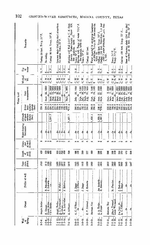
Wel
l "
or
Sprin
g
1-2
-8
1-2
-9
1-2-
10-
1-2-
11..
1-2-
12-
1-2-
13-
1-2-
14-
1-2-
15..
1-2-
16..
1-2-
17-
1-2-
18-
1-2-
19-
1-2-
20-
1-2-
21..
1-2-
22-
1-2-
23.-
1-2-
24
1-2-
251-
2-26
-
1-2-
27-
1-2-
28- .
I-2-2
9-
1-2-
30-
Ow
ner
Fran
k E
othe
____
Glin
t R
oth
e
...
A.
I. D
aven
port
.....
A.
Schl
entz
__ . _
.
A.
C. G
illi
am..
....
. ..... d
o.. .
.........
.
.. d
o..
.. .........
E. A
. R
othe
. ...
....
L. F
inge
r ..
....
...
A.
C.
Gill
iam
....
..
.. d
o............
.
....
.do
....
....
....
.
Dri
ller
of w
ell
... .
.do
.. ..
..
H. H
aby...........
C.
Gill
iam
..........
R. H
ensl
ey. .
.......
.....d
o......... _
.
.d
o..
....
....
...
Dat
e co
m
plet
ed
1910
19 3
19
35
1935
1902
19
34
1912
19
42
1918
1945
19
50
1945
1950
1900
1910
19
34
1910
1940
19
20
1912
19
49
1945
1947
Dep
th
of
wel
l (f
eet) 42
0
320
400
400
400
355
350
430
400
400
436
390
327
450
300
330
500
300
240
258
380
410
508
Dia
m
eter
of
wel
l (in
ches
) 5 6 6 5 6 6 5 7 8 8 8 8 6 5 4 6 6 5 6 4 8 8 8
TVat
er-b
earin
g fo
rmat
ion
.....d
o.......
.. d
o ..
. do
do
. d
o ..
..d
o ....
.. d
o..
....
. ..d
o ....
d
o .
...
....
. do .
...
....
.do... .
...
. d
o
-d
o... .
...
d
o..
. ... .
-d
O
....
-do ... _
. d
o .
.....
do .
.....
d
o... .
...
....
.do
. .
..... d
o
....
. do
- do-
Alti
tude
of
land
- su
rfac
e da
tum
(fee
t)
1,04
1.7
1,02
1.7
1,03
8.1
1,02
6.6
1,06
7.5
Wat
er l
evel
Belo
w
land
- su
rfac
e da
tum
(f
eet)
224.
2
239.
226
8.7
254.
3 27
0.4
277.
9 20
9.6
239.
4 19
2.7
203.
622
8.8
*217
.4
208.
0 29
5.4
321.
8 19
2.4
213.
9 25
4.5
260.
5 26
4.9
249.
6 *2
70.1
250.
4 26
9.3
194.
0 19
5.6
208.
4 19
5.4
223.
8 22
5.2
257.
4 26
6.9
198.
4
Dat
e m
easu
rem
ent
d
o... .
... .
Sept
. 22
, 19
50
d
o ....
Sept
. 21
, 19
50
Mar
. 18
, 19
52
Sept
. 5,
195
2 Se
pt.
20,
1950
Ju
ly
27,
1950
__ do
........
d
o-
Sept
. 6,
195
1 __ d
o- _
_ ..
July
26
, 19
50
.....d
o
Sept
. 6,
195
1 Ju
ly
26,1
950
Sept
. 6,
195
0 A
ug.
31,
1950
Sept
. 6,
195
0 M
ar.
18,
1952
Sept
. 22
, 19
50
Sept
. 22
,195
0
Sept
. 6,
195
0 Se
pt.
7, 1
951
Aug
. 31
, 19
50
Sept
. 7,
195
1 A
ug.
29,
1950
Ju
ly
26,
1950
Se
pt.
26,
1950
Ju
ly
2 \
1950
Se
pt.
6, 1
951
July
26
, 19
50
Met
hod
of
lift
C, G
6 C
.W..
C, W
__C
, W-
C.W
..
C, W
__
C, W
-C
.W..
C, E
2 C
.W..
C,W
-
c,w
..C
, G
5 C
, E
5 C
,W-
C, E
..
1,4
C, W
.
C, W
.
C, G
,W5 C
,W_.
C
.W..
C,W
-
C, W
..
Use
of
w
ater
D, S
S
S
D, S
S
D, S
S
D, S
...
D, S
...
D, S
S
S
S
D, S
D, S
D
, S
S -
D, S
D
, S
D, S
...
D, S
S
S. ..
..
Rem
arks
Cas
ing:
20
feet
. Te
mp.
71°
F.
No
casi
ng.
Cas
ing:
80
feet
. Te
mp.
72°
F.
Gra
yson
sha
le (
Del
Rio
cla
y) a
t sur
face
. N
o ca
sing
. Te
mp.
72°
F.
Blo
win
g w
ell
Wel
l 1-
2-7
in U
. S.
Geo
l. Su
rvey
W
ater
-Sup
ply
Pape
r 67
8.
See
anal
ysis
, ta
ble
12.
Tem
p. 7
2° F
. B
low
ing
wel
l. T
emp,
of
wat
er 7
1^2°
F.
See
anal
ysis
, tab
le 1
2.
Tem
p. 7
2° F
.
Cas
ing:
327
fee
t.
Wat
er r
epor
ted
in c
aver
nous
lim
esto
ne
at 3
50 fe
et. T
emp.
72°
F. S
ee a
naly
sis,
ta
ble
12.
Cas
ing:
100
fee
t. Te
mp.
72°
F.
Cas
ing:
12
0 fe
et.
Dra
wdo
wn
1.3
feet
af
ter
2 ho
urs
pum
ping
30
gpm
, A
ug.
8, 1
951.
Tem
p. 7
1° F
. Te
mp.
71^
2° F
.
Cas
ing:
130
fee
t. Te
mp.
73°
F...
Bas
e of
Gra
yson
sha
le (
Del
Rio
cla
y^
repo
rted
at
62
fe
et.
Tem
p.
72"
F.
o
to
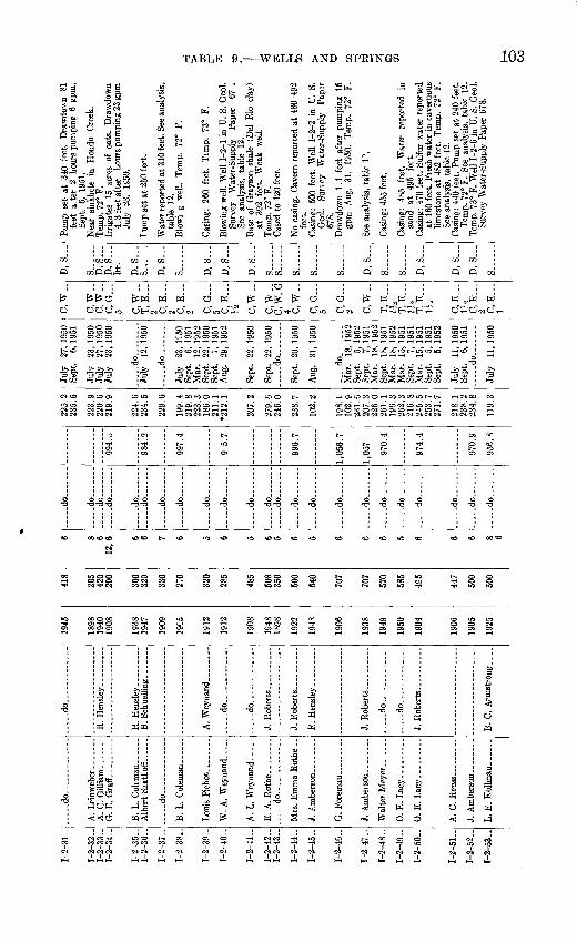
1-2
-31
-
1-2-
32.-
1-2
-33
-1-2
-34-
1-2
-35
-1
-2-3
6-
1-2
-37-
1-2-
38..
1-2
-39-
1-2
-40
-
1-2
-41-
1-2-
42..
1-2
-43-
1-2-
44..
1-2-
45..
1-2-
46..
1-2
-47-
1-2
-48
-
1-2
-49-
1-2
-50
-
1-2
-51
-
1-2-
52..
I-2-5
3-.
... ..
do..
... .
G.
E.
Gra
ft..
Alb
ert
Saa
tLo
ff
.-
....
. do ... ......
B.
L. C
ole
man
......
. .--d
o.... ......
J. A
mbe
rson
. ...
....
J. A
mber
son........
0. E
. L
acy
.. ...
.
0. E
. L
acy
..
J. A
mbe
rson
-. ......
L.
E.
Kol
lman
.. _
_
d
o ...
B.
Schu
ellin
g __.... .
....
. do
..
.
d
o.
.....
J. R
ober
ts _
. _
__ .
R.
Hen
sley
.-..
. __
J. R
ob
erts
... _
_ ..
d
o .....
....
.do
.
...
...
B.
C.
Arm
stro
ng....
1945
1898
1940
1908
1938
1947
1909
19C5
1912
1912
1908
1948
1898
1922
194S
1906
1938
1Q4Q
1950
1904
1 Q
Hfi
1905
1925
418
265
420
290
360
320
330
270
320
285
485
508
350
500
640
707
707
570
585
495
447
500
500
6 8 6 12,6 6 6 7 6 5 6 5 6 5 6 5 6 6 6 5 6 6 6 8 6
.....d
o.......
.....d
o.......
.....d
o.......
.....d
o.......
.....d
o.......
.....d
o.......
.....d
o.......
.....d
o.......
.....d
o.......
.do
d
o
do
.....d
o.......
.....d
o.......
.....d
o.......
.....d
o.......
.....d
o.......
.d
o
d
o _
d
o
do...
.. d
o .
...
. .
do
994.
o
984.
2
997.
4
9 5.
7
996.
7
1,05
6.7
1,05
7
970.
4
974.
4
970.
9
956.
8
225.
223
5.5
223.
922
0.6
219.
9
224.
623
4.5
229.
6
199.
421
9.8
223.
3 18
6.0
211.
1 2
12.1
207.
2
279.
624
6.0
238.
7
102.
2
198.
110
2.9
231.
6 20
7.3
226.
0 26
1.1
196.
3 26
2.3
216.
8 24
5.5
253.
7 27
1.7
218.
123
8.2
234.
8
119.
3
July
27
, 19
50Se
pt.
6, 1
951
July
23
, 19
50Ju
ly
27,
1950
July
23
, 19
50
....
.do
.
-.
July
12
, 19
50
. d
o ..
..
July
23
, 1°
50Se
pt.
6, 1
951
Mar
. 12
, 19
52
Sept
. 22
, 19
50Se
pt.
7, 1
951
Aug
. 29
, 19
52
Sept
. 22
, 19
50
Sept
. 22
, 19
50_ ..
do.. _
_ ..
Sept
. 20
, 19
50
Aug
. 31
, 19
50
d
o-. ...
Mar
. 18
, 19
52
Sept
. 5,
195
2 Se
pt.
7, 1
951
Mar
. 18
, 19
52
Sept
. 18
, 19
51M
ar.
18,
1952
M
ar.
15,
1951
Sept
. 7,
195
1 M
ar.
15,
1951
Sept
. 5,
195
1 Se
pt.
5, 1
952
July
11
, 19
50Se
pt.
6, 1
951
d
o
July
11
, 19
50
C.W
..
C,W
..C
.W..
C, G
...
5 p w
T, E
...
2 C, E
2 C
, E
-..
2 C, G
...
5 CT
?
>/2
P
W
c, w
..C
, W,
G4 C
,W__
C, G
...
5 C/~
»
2 C.W
..
T, E
1?
* T,
E...
Ufc
T, E
1,'i
C,E
1
^2
CT7
1
2 C, E
1
D. S
...
S..
....
D, S
...
D, S
Ir
r.
D, S
S
D, S
S .
.
D, S
DC
D, S
S...
S._
.
DQ
S..
.
DC
DQ
DQ
s..._
._
Pum
p se
t at
340
fee
t. D
raw
dow
n 81
feet
a.
ter
2 ho
urs
pum
ping
6 g
pm,
Sept
. 6,
19
51.
Nea
r si
nkho
le
in
Hon
do
Cre
ek.
Tem
p. 7
2° F
. Ir
riga
tes
15 a
cres
of
oat
s.
Dra
wdo
wn
4.3
feet
aft
er
hour
s pu
mpi
ng 2
3 gp
mJu
ly
23,
1^50
.
I um
p se
t at
250
fee
t.
Wat
er r
epor
ted
at 3
10 f
eet.
See
anal
ysis
,ta
ble
12.
Blo
wi
g w
ell.
Tem
p.
72°
F.
Cas
ing:
26
0 fe
et.
Tem
p.
73°
F.
Blo
win
g w
ell.
Wel
l 1-
2-1
in U
. S.
Geo
l.Su
rvey
W
ater
-Sup
ply
Pap
er
67 .
See
anal
ysis
, ta
ble
12.
Bas
e of
Gra
yson
sha
le (
Del
Rio
cla
y)at
39
2 fe
et.
Wea
k w
ell.
Tem
p. 7
2° F
. C
ased
to
120
feet
.
No
casi
ng.
Cav
ern
repo
rted
at
480-
492
feet
. C
asin
g: 5
00 f
eet.
Wel
l 1-
2-2
in U
. S.
Geo
l. S
ur\e
y W
ater
-Sup
ply
Pap
er67
8.
Dra
wdo
wn
1.1
feet
aft
er p
umpi
ng 1
5gp
m
Aug
. 31
, 19
50.
Tem
p.
72°
F.
See
anal
ysis
, ta
ble
1\
Cas
ing:
455
fee
t.
Cas
ing:
48
5 fe
et.
Wat
er
repo
rted
in
sand
at
49
5 fe
et.
Cas
ing:
470
fee
t. Su
lfur
wat
er r
epor
ted
at 1
60 f
eet.
Fie
sh w
ater
in
cave
rnou
slim
esto
ne a
t 48
2 fe
et.
Tem
p. 7
2° F
.Se
e an
alys
is,
tabl
e 12
. C
asin
g: 4
40 f
eet.
Pum
p se
t at
240
fee
t.T
emp.
72°
F.
See
anal
ysis
, ta
ble
12.
Tem
p. 7
3° F
. W
ell
1-2-
6 in
U.
S. G
eol.
Surv
ey W
ater
-Sup
ply
Pap
er 6
78.
O CO

Wel
l or
Sp
ring
1-2-
54-
1-2-
55-
1-2-
56..
1-2-
57-
1-2-
58..
I 2
59..
1-2-
60..
1-2-
61-
1-2-
62..
1-2-
63..
1-2-
64..
1-2-
65..
1-2-
66..
1-2-
67-
1-2-
68-
I-2-
69-.
1-2-
70-
1-2-
71-
1-2-
72..
Ow
ner
.do
. ....d
o.. ..
....
... .
.
B.
Koe
hler
. ........
.. d
o
F. H
oll
mig
.-.
-
F. X
. Wo
lff.
-...do............
.
do .
d
o..
..
...
Dril
ler
of w
ell
..... d
o... ..
..
..... d
o...
H.
W. M
cCor
mic
k
. .d
o.... . .
do..
Dat
e co
m
plet
ed
1935
1904
1914
1930
1930
i G
OO
1900
1912
1924
1938
1921
1950
1948
1947
1946
1950
1926
1946
1902
Dep
th
of
wel
l (f
eet) 68 47
7 53 65 44 236 52
OQ
K
435 60 802
610
1,60
0
3,40
0
600
100
240 45 54
Dia
m
eter
of
wel
l (in
ches
)
40 6 48 40 48 7 48 6 6 48 7 5 12 10 7 5 48 40
Wat
er-b
eari
ng
form
atio
n
tion.
limes
tone
.
tion.
... -
do
.
....
. do ..
.
(?). tion.
....
. do ..
.
tion.
limes
tone
,
do.
....
. do
.....d
o.......
....
-do.
tion.
tion.
..
... d
o.......
Alti
tude
of
land
- su
rfac
e da
tum
(f
eet)
1,02
7.2
951.
3
956.
31,
020
\V
Bel
ow
land
- su
rfac
e da
tum
(fee
t)
53.9
*193
.420
1.3
44.4
46.4
21.1
143.
6
19.7
177.
824
2.7
199.
8 30
7.1
32.6
209.
5
215.
714
2.4
133.
8 14
9.4
269.
329
0.5
305.
1 38
.3
69.9
40.1
28.1
rate
r le
vel
Dat
e m
easu
rem
ent
....
. do.... ..
..
Aug
. 3,
195
0Se
pt.
5, 1
951
July
11
, 19
50
Oct
. 2,
195
0
Aug
. 14
, 19
50A
ug.
15,1
950
....
. do
.... ..
..
Sept
. 30
, 19
50Se
pt.
5, 1
951
Mar
. 17
,195
2 Se
pt.
30,
1950
Aug
. 29
, 19
50
..... d
o
..... d
o
Aug
. 28
, 19
50Se
pt.
5, 1
951
Mar
. 18
, 19
52
Aug
. 28
, 19
50Se
pt.
5, 1
951
Sept
. 5,
195
2 N
ov.
20,
1950
Aug
. 30
, 19
50A
ug.
29,
1950
Aug
. 25
, 19
50
Met
hod
of
lift
C.W
..
C, E
...
2 C, E
...
1 C, E
H
C,
W_.
C, E
...
2 B, H
-
C.W
-
C, G
...5 C
,W..
C, E
...
1 T, E
...
1 C, E
...
H
C, E
...
1
Use
of
w
ater
S
S
D, S
S
S......
S
D, S
S
D, S
...
D,S
D, S
...
N._
...
N.....
N._
__.
N.....
S..
....
N._
.._
D, S
...
D, S
...
Rem
arl
40gp
m,S
ept.
5, 1
95
Top
of
A
ustin
ch
T
emp
74°
F.
Cas
ing:
30
feet
. B
ase
feet
.
anal
ysis
, ta
ble
12.
Cas
ing :
60
feet
. Bas
e o
Cas
ing:
470
fee
t. W
eG
eol.
Surv
ey
Wat
67
8.
Oil
test
.
yiel
d of
fre
sh w
ater
w
ards
lim
esto
ne.
pum
ping
60
gp
m,
Tem
p. 7
5° F
.
Dug
.

1-2-
73..
1-2-
74-
1-2-
75-
1-2-
76 .
1-2-
77-
1-2-
78-
1-2-
79..
1-2-
80. .
1-2-
81-
1-2-
82-
1-2-
83. .
1-2-
84-
1-2-
85. _
1-2-
86..
1-2-
87..
1-2-
88-
1-2-
89..
1-2-
90..
1-2-
91..
1-2-
92..
1-2-
93..
1-2-
94..
1-2-
95..
W.
Lut
z... ____
..
F. S
. W
olfe
.. ..
....
.
Ed
Weynand
.
0. B
. T
aylo
r
C. G
illia
m.. ..
..... .
R. K
oehl
er.. .......
J. G
. S
chue
ling
_
Fer
dRoc
k...
do .
Ray
mon
d Fi
nger
....
M. J
. Z
err
..
. ..
C. L
angfe
kL
.
E.
Let
cher
__
_ ..
.
C.
Gar
cia _
_ ..
....
C. G
illi
am
...
B.
Sch
uel
ing
........
..... d
o
........
C. G
arci
a ..
......
R.
Fing
er.. ____ .
1920
1902
1912
1946
1910
1940
1934
1908
1934
1920
1941
1938
1951
1950
1926
1944
1926
1934
1922
1920
1900
1928
40 240
190 61 52 196
684 40 280
347 39 56 851 53
3,50
0
400 50 50 95 54 42 60
1,10
0
36 7 6 4 36 9 6 38 6 8 36 40 9 40 8 36 58 6 38 48 52 7
.....d
o.......
limes
tone
.
Aus
tin c
halk
tion.
tion.
limes
tone
.
limes
tone
.
tion.
. d
o.......
form
atio
n.
tion.
E
dwar
ds
limes
tone
.
form
atio
n (?)
. E
dwar
ds
limes
tone
.
tion.
..... d
o...... .
.....d
o.......
.....d
o.......
.....d
o.. .
.....d
o.......
Edw
ards
lim
esto
ne.
934.
5
996.
8
919.
6
958.
1
30.3
63.3
*34.
1
35.3
37.4
69.6
79.7
22
5.2
246.
1 29
.7
25.1
159.
3
34.6
47.4
287.
8 27
9.2
289.
9 47
.2
227.
7
68.2
37.8
37.2
45.7
28.3
34.7
40.1
245.
2 24
4.9
257.
5
Aug
. 28
, 19
50
Aug
. 17
,195
0
Mar
. 13
, 19
51
Sept
. 5,
195
0
Aug
. 17
, 19
50
Aug
. 29
, 19
50Se
pt.
5, 1
951
Aug
. 15
,195
0Se
pt.
5, 1
951
Aug
. 15
. 19
50
..... d
o .....
d
o
....
.do
.. .
..
Feb.
21
, 19
51
Apr
. 2,
195
1 Se
pt.
5. 1
951
Mar
. 12
, 19
52
Aug
. 29
, 19
50
Sept
. 3,
195
2
June
18
,195
2
Aug
. 17
,195
0
....
.do
....
....
Aug
. 28
,195
0
d
o
Aug
. 18
,195
0
Aug
. 18
,195
0M
ar.
21,
1951
Se
pt.
5, 1
951
May
13
, 19
52
C, G
...
5 C, W
__
C.W
..
C, E
...
H
C.W
..
C.W
..
C, G
5 C
,W-
C, E
...
IJi
C,W
_.
C, E
1 C
, E
...
H
T. E
2 C
, E
Vi
. C
. G
5 C
.W..
C, E
...
1 C.W
..
C, E
...
MI C.W
-C
, E
H
C.W
..C
.W..
D.....
D.S
...
S..
D. S
...
D, S
...
D, S
...
S
S..
....
D. S
D. S
...
D. S
...
D, S
D, S
...
D, S
S...
S
D, S
...
D. S
D..
....
D. S
D
, S
D, S
S
...
Cas
ing:
40
fe
et.
Dug
. T
emp.
74
" F.
See
anal
ysis
, ta
ble
12.
Cas
ing:
40
feet
. Pu
mp
set
at 2
10 f
eet.
Rep
orte
d to
pum
p ai
r af
ter
3 ho
urs
pum
ping
6 g
pm,
Aug
. 19
50.
Wat
er
repo
rted
to
ha
ve
bitte
r ta
ste
Wea
k w
ell.
Tem
p. 7
4" F
. C
asin
g:
60
feet
. D
raw
dow
n 0.
8 fo
otaf
ter
1J^
hour
s pu
mpi
ng
7J/2
gp
mSe
pt.
5, 1
950.
D
ug.
Cas
ing:
90
feet
. Pi
pe s
et a
t 16
0 fe
et.
Cas
ing:
61
4 fe
et.
Pum
ping
14
gp
m,
Sept
. 5,
19
51.
Tem
p.
73°
F.
Cas
ing:
40
feet
. D
ug.
Cas
ing:
240
feet
. Wat
er re
port
ed to
hav
ebi
tter
tast
e.
Dra
wdo
wn
61.2
fe
et
afte
r 2
hour
spu
mpi
ng 4
gpm
, A
ug.
15,
1950
. D
ug.
Dug
. C
urbi
ng:
30
feet
of
co
ncre
te
rings
.C
asin
g:
816
feet
. D
raw
dow
n 2.
5 fe
et
afte
r 12
ho
urs
pum
ping
17
5 gp
m,
Apr
. 2,
195
1. T
emp.
72°
F.
See
log.
Dug
. C
urbi
ng:
53 f
eet
of r
ock.
Cas
ing:
80
0 fe
et.
Oil
test
, dr
illed
to
bl
ack
shal
e at
3,
635
feet
, re
port
ed
plug
ged
at 1
,100
fee
t. W
ell
1-2-
9 in
U
. S.
G
eol.
Surv
ey
Wat
er-S
uppl
y Pa
per
678.
Wat
er
repo
rted
to
ha
ve
bitte
r ta
ste.
Se
e an
alys
is,
tabl
e 12
.
Dug
. C
urbi
ng:
40 f
eet
of r
ock.
Tem
p.
74°
F.C
asin
g:
90
feet
. D
raw
dow
n 7.
3 fe
et
afte
r 2l/
2 ho
urs
pum
ping
86
gp
m,
Aug
. 15
, 19
50.
Tem
p. 7
4° F
.D
ug.
Cur
bing
: 50
fee
t of
roc
k.
Use
d as
au
xilia
ry
publ
ic
supp
ly
for
D'H
anis
. T
emp.
72°
F.
See
anal
ysis
, ta
ble
12.

Wel
l or
Sp
ring
1-2
-96-
1-2
-97-
1-2
-98-
1-2
-99
- 1-
2-10
0.
1-2-
101.
1-3-
1 ..
.
1-3
-2
1-3
-3
1-3
-4- .
1-3
-5
1-3
-6
1-3-
7 1-3
-8
1-3
-9
1-3-
10. .
1-3-
1 1-
.1-
3-12
..
1-3-
13
1-3-
14..
1-3
-15-
1-3-
16..
Ow
ner
R.
G.
Can
tu..
......
B.
L.
Rob
inso
n _
...
J. A
mbe
rson
. ---
----
A.
C. G
illi
am
..
Em
ilB
ritc
h
__
-
R.
Lan
gber
n -
J. G
. B
rucks
..
J. W
. F
uoa.
. ...
....
Em
il B
ritc
h..... -.
E. B
ritc
h-.
... .
....
.
.....d
o.......
-- d
o .....-.
d
O
.
Dri
ller
of w
ell
R.
Hen
sley
. .--
.._
-.
R.
Sch
war
tz.
---do --_
_J.
P.
Hei
nen.
. ...
_-.-
dO
....... ..
---do .....
._
J. S
aath
off.
.. -.
-- ..
.
Dat
e co
m
plet
ed
1922
1902
1922
19
20
1948
1952
1935
1924
19
45
1940
18
98
1906
1934
19
39
1946
19
38
1938
19
05
1936
19
30
1951
19
20
Dep
th
of
wel
l(f
eet) 48
40 69
54
040
654
254
322
343
312
325
286
280
310
245
350
368
290
350
350
307
Dia
m
eter
of
wel
l (i
nche
s) 38
36 30
42 5 12 8 9 8 6 6 6 7 5 8 8 8 6 6 6 0
Wat
er-b
eari
ng
form
atio
n
Leo
na f
orm
a
tion,
-.
..d
o..
....
.
.. d
o.......
....
.do
....
..E
dwar
ds
limes
tone
.
....
.do
....
...
d
o
do.
.d
o.... ...
-do
d
o
d
o
d
O
..... d
o......
d
o-
d
o
do
..... d
o- -
do
.. d
o..
....
.
.....d
o.......
.....d
o
Alti
tude
of
land
- su
rfac
e da
tum
(f
eet)
912.
5
934.
4
1,06
5.0
1,01
1.3
950.
8
1,10
3.0
1,08
9.5
Wat
er l
evel
Bel
ow
land
- su
rfac
e da
tum
(f
eet)
32.3
29.4
33.9
34
.4
102.
2 10
2.9
245.
7
230.
9 23
5.3
253.
2 29
2.5
255.
1 25
9.0
237.
4 27
8.8
285.
0 *1
83.5
18
1.7
190.
2 21
1.7
219.
0 26
2.3
261.
8 25
3.9
246.
3
291.
5 30
4.6
301.
7
Dat
e m
easu
rem
ent
Aug
. 18
, 19
50
Aug
. 17
, 19
50
Aug
. 29
, 19
50
Aug
. 31
, 19
50
Mar
. 18
, 19
52
Oct
. 23
, 19
52
June
12
. 19
51
Sept
. 10
. 19
51
July
13
. 19
51
Jan.
4,
195
1
Jan.
9,
195
1 Ja
n.
4, 1
951
Jan.
4,
195
0 M
ar.
19,
1952
Se
pt.
4, 1
952
Oct
. 30
, 19
50
....
. do...
June
12
, 19
51
June
12
, 19
51
Feb.
26
, 19
51
June
12
, 19
51
Sept
. 10
, 19
51
Nov
. 30
, 19
50
Jan.
4,
195
1
Jan.
9,
195
1 M
ar.
19,
1952
Se
nt.
4. 1
052
Met
hod
of
lift
C, W
-
C, E
aw._
C.W
..C
, G
15 T
, G
30 C
. W
-
C, W
-C.
G
5 C,
W .
C
, W
.. C,
W__
C, W
- C,
W..
C,
W-
C, E
...
2 C,
W-
C, W
-.
C, W
__C
, E
-% C
. E
li
Use
of
w
ater
S..
....
D......
D, S
D
, S
S
...
Irr
S
S
D
. S
D, S
...
D, S
D
, S
D, S
D
, S
S
D. S
S ...
S
-
S ...
s s...
...D
. S
...
Rem
arks
Dug
. C
urbi
ng:
30
feet
of
roc
k.
Tem
p. 7
5° F
.
Dug
. C
urbi
ng:
60 f
eet o
f co
ncre
te ri
ngs.
Cas
ing:
50
0 fe
et.
Dra
wdo
wn
6.4
feet
w
hile
pum
pinz
12
gpm
, A
ug.
31,
1950
. T
emp.
72J
/2°
F.
Cas
ing:
110
fee
t. Y
ield
, 20
8 gp
m w
hen
drill
ed.
Aft
er
trea
tmen
t w
ith
3,00
0 ga
llons
of
acid
wel
l w
as p
umpe
d at
1,
100
gpm
. C
asin
g: 1
0 fe
et.
Pum
p se
t at
250
fee
t. T
emp.
72°
F.
Cas
ing:
280
fee
t. C
asin
g:
10 f
eet.
Wat
er l
evel
rep
orte
d 27
5 fe
et b
elow
lan
d su
rfac
e as
of
Apr
. 19
45.
Wel
l dee
pene
d fr
om 3
05 t
o 34
3 fe
et a
fter
goi
ng d
rv i
n 19
51.
Cas
ing:
50
feet
. C
asin
g: 4
0 fe
et.
Tem
p. 7
2° F
. Se
e lo
g.
Cas
ing:
50
feet
. P
ump
set
at 2
85 f
eet.
Cas
ing:
40
feet
. T
emp.
72°
F.
Cas
ing:
60
feet
. C
asin
g: 2
0 fe
et.
Cas
ing:
60
fee
t. G
rays
on
shal
e (D
el
Rio
cla
y) a
t su
rfac
e.
Dra
wdo
wn
2.8
feet
aft
er l
1^ h
ours
pum
ping
10
gpm
, Ju
ne 1
2, 1
951.
T
emp.
72°
F.
Bud
a lim
esto
ne a
t su
rfac
e.
Cas
ing:
40
feet
. Pu
mp
set
at 3
10 f
eet.
Cas
ing:
6 f
eet.
Tem
p. 7
2° F
.
Cas
ing:
10
feet
. Si
nkho
le n
ear
wel
l. C
asin
g: 1
0 fe
et.
Tem
p. 7
2° F
. Se
vera
l si
nkho
les
near
w
ell.
See
anal
ysis
, ta
ble
12.

1-3
-17
- 1
-3-1
8-
1-3
-19-
1-3
-20-
1-3-
21. .
1-3
-22
-
1-3
-23
-
1-3-
24.-
1-3-
25
1-3
-26-
1-3
-27-
1-3-
28 .
1-3
-29
-
1-3
-30
-1-
3-31
..
1-3-
32..
1-3-
33..
1-3-
34. .
1-3-
35..
1-3-
36..
1-3-
37..
1-3-
38..
E.
W.
Bal
zen.
-
W.
Hey
en. .
........
Fri
tz M
arti
n ___ .-
....
. do..... ........
A.
J. R
ust .
Cha
rles
Fol
k.. _
_ ..
A.
Eck
hard
t. ..-
.--.
Cha
rles
Bald
us
...
....
.do
...
....
..
W.
Boe
hle.
...
....
..
Wal
ter
Bru
cks.
.....
J. O
efi
nger.
.........
.....d
o..... .....
J. P
. H
eine
n. ...
....
B.
Sch
uell
ing.
--
S. M
um
me..
....
...
Pete
rs &
Sch
uelli
ng-.
C. G
illi
am- _
_
..... d
o..
....
....
....
.do
....
. ..
J. J
agge
. ...
....
....
Abe
Tsc
hir
har
t ...
....
. do.......... ...
....
. do.. ........
"1939"
1932
1915
1937
1951
1910
1904
1945
1928
1936
1940
1914
1914
1932
1949
1945
1936
1936
1935
325
281
420
325
350
247
372
264
265
260
275
262
320
300
250
300
432
258
233
302
275 70
6 7 7 5 6 5 6 8 4 4 5 6 5 5 6 6 5 7 5 6 6 5
.. d
o.......
. .do
. -do.......
.....d
o _
_..
..
.....d
o.......
....
.do
....
...
do
.....d
o.......
....
.do
....
...._do_......
.. d
o.......
limes
tone
.
....
.do
.
....
.do
....
...
....
.do
....
...
do
....
.do
....
...
..d
o.......
.....d
o ....
.. d
o.......
....
.do
....
...
tion
.
1,00
4.6
1,01
2.7
974.
8
1,03
3.8
1,00
9.3
946.
0
939.
1
915.
2
961.
1
962.
8
240.
221
1.5
276.
8 *2
25.0
223.
7
232.
417
7.1
191.
6 19
8.6
225.
8
221.
021
8.6
226.
5 21
0.2
190.
0
205.
620
3.6
173.
918
9.0
197.
0 20
4.5
200.
519
2.7
209.
3 21
8.3
216.
6
206.
2
*202
.7
207.
521
6.9
260.
728
1.4
269.
3 25
3.7
24.5
Jan.
3,
195
1Ja
n.
10,
1951
Mar
. 19
, 19
51
Dec
. 11
. 19
50
Nov
. 30
, 19
50
.. d
o..
....
..O
ct.
30,
1950
Sept
. 7,
195
1 M
ar.
17,
1952
Fe
b.
26,
1951
-- d
o........
Sept
. 10
, 19
51
Mar
. 12
, 19
52
Oct
. 30
, 19
50
Oct
. ,
1950
Oct
. 30
, 19
50Se
pt.
7, 1
951
Oct
. 30
, 19
50Se
pt.
7, 1
951
Mar
. 17
, 19
52
Oct
. 30
, 19
50
..... d
o .
Nov
. 7,
195
0Se
pt.
6, 1
951
Mar
. 19
, 19
52
Nov
. 7,
195
0
Dec
. 11
, 19
50
Jan.
3,
195
1
Mar
. 14
, 19
51Se
pt.
5, 1
951
Jan.
3,
195
1M
ar.
19,
1952
S
ept.
4, 1
952
Jan.
3,
195
1
Jan.
3,
195
1
C,
W..
C,
W_.
C, G
10 C
, E
J-
2 C, W
-C,
E...
1H C, F
,.-.
2 C. W
..
C, E
1 C,
W..
C, W
..
C, W
-
C, E
1 C.W
..C
.W..
C, G
...
C.W
..
C, E
1A
C.W
..
C,W
..
C, W
..
C, E
...
5*
S ...
S .
D,
S__.
D, S
...
S .
D, S
D, S
S
D,
S_..
D, S
...
D, S
...
S
..
D, S
...
S -
D, S
...
D, S
S
D, S
...
S
D, S
D, S
D, S
...
Cas
ing:
10
feet
. D
o
Cas
ing:
11
0 fe
et.
Dra
wdo
wn
3.6
feet
afte
r 2
hour
s pu
mpi
ng 2
0 gp
m,
Mar
.10
, 19
52.
See
anal
ysis
, ta
ble
12.
Cas
ing:
120
feet
. P
ump
set a
t 28
8 fe
et.
Mar
. 10
, 19
52.
Cas
ing:
20
feet
. C
asin
g:
120
feet
. D
raw
dow
n 0.
8 fo
otw
hile
pum
ping
9 g
pm,
Oct
. 30
, 19
50.
Tem
p. 7
2° F
. C
asin
g:
10 f
eet.
Wel
l de
epen
ed f
rom
250
to
372
feet
af
ter
goin
g dr
y in
1951
. T
emp.
71}
£° F
. Se
e an
alys
is,
tabl
e 12
. C
asin
g: 1
00 f
eet.
Blo
win
g w
ell.
Cas
ing:
180
fee
t.
Cas
ing:
100
fee
t. P
ump
set
at 2
18 f
eet.
Tem
p. 7
2° F
. C
asin
g:
60
feet
. D
raw
dow
n 2.
5 fe
etaf
ter
5 ho
urs
pum
ping
10
gpm
, M
ar.
13,
1952
. C
asin
g: 5
0 fe
et.
Cas
ing:
95
feet
. P
ump
set
at 2
42 f
eet.
Tem
p.F
.
Cas
ing:
30
feet
. W
ater
rep
orte
d at
210
and
290
feet
. C
asin
g:
136
feet
. B
uda
limes
tone
on
surf
ace.
C
asin
g:
50 f
eet.
Dra
wdo
wn
0.4
foot
afte
r 3
hour
s pu
mpi
ng 1
60 g
pm,
Jan.
3, 1
951.
See
log.
See
ana
lysi
s, t
able
12.
C
asin
g: 1
50 f
eet.
Bas
e of
Gra
yson
sha
le(D
el R
io c
lay)
at
160
feet
. Se
e lo
g.
Cas
ing:
75
feet
. B
ase
of G
rays
on s
hale
(D
el
Rio
cl
ay)
at
121
feet
. T
emp
72°
F.
Wat
er
at
240
feet
.C
asin
g:
52
feet
. E
ast
bank
of
Q
uih
Cre
ek.

Wel
l or
Sp
ring
1-3-
39-
1-3-
40..
1-3-
41..
1-3-
42..
1-3-
43-
1-3-
44-
1-3-
45..
1-3-
46..
1-3-
47-
1-3-
48-
1-3-
49-
1-3-
50..
1-3-
51-
1-3-
52-
1-3-
53..
1-3-
54..
1-3-
55-
Ow
ner
H.
H. D
eck
er
Frit»
Nie
tenh
oefe
r ...
H. W
.McC
lain
..
F. E
. B
og
gu
s ..
..
Mrs
. L.
C. D
ecke
r...
F. J
. G
riff
in...
.. ....
H.
H.
Dec
ker. ......
A. E
ckha
rdt. ..
....
.
F. J
. G
riff
in...
. __
.
M.
M. F
ohn......
..
H.
H. D
eck
er
Dril
ler
of w
ell
....
.do
....
....
....
.
B.
Schu
ellin
g... ..
..
C. G
illia
m _
_ ..
...
R. P
eter
s....
...
....
J. R
. Joh
nson
_ . ...
C. G
illi
am..........
Dat
e co
m
plet
ed
1930
1947
1937
1914
1906
1926
1939
19
42
1921
1900
1909
1949
1906
1936
Dep
th
of
wel
l (f
eet) 48
300
322
248
237
300
298
380
360
355
256
278
260
281
342
312
320
Dia
m
eter
of
wel
l (in
ches
) 3 7 7 6 6 6 5 6 6 6 6 6 6 7 7 6 7
Wat
er-b
eari
ng
form
atio
n
.....d
o.......
Edw
ards
lim
esto
ne.
... .
.do..
....
.
.....d
o.......
...-
do..
....
.
.d
o .
.....d
o.......
....
.do
..
.
d
o
d
O
....
. do
....
.do..
. ...
.
.....d
o.......
..... d
o.......
....
.do
..
.
.....d
o.......
..d
o
..
Alti
tude
of
land
- su
rfac
e da
tum
(f
eet)
933.
6
913.
5
944.
2
993.
0
934.
4
947.
7
950.
8
911.
0
Wat
er le
vel
Bel
ow
land
- su
rfac
e da
tum
(f
eet)
19.5
214.
1 23
0.2
141.
2 16
8.8
138.
0 18
2.3
188.
2 20
2.9
195.
7 *2
17.8
191.
0 20
2.9
162.
5
242.
018
9.4
216.
0 22
3.5
227.
5
188.
3 19
4.6
175.
6 23
6.3
251.
0 26
9.3
172.
7 19
4.7
205.
3 17
1.7
Dat
em
easu
rem
ent
... .
.do .
....
Nov
. 7,
195
0 Se
pt.
6, 1
951
Nov
. 7,
195
0 Se
pt.
6, 1
951
Mar
. 19
, 19
52
Nov
. 7,
195
0 Se
pt.
5, 1
951
Sept
. 4,
195
2 M
ar.
19,
1952
Se
pt.
7, 1
951
Nov
. 3,
195
0 O
ct.
30,
1950
Oct
. 16
, 19
50
.....d
o ..
..O
ct.
19,
1950
M
ar.
12,1
952
Sept
. 4,
195
2 N
ov.
3, 1
950
Feb.
20
, 19
30
Sept
. 6,
195
0
Dec
. 11
, 19
50
Mar
. 12
,192
2
Oct
. 16
, 19
50
Sept
. 7,
195
1 O
ct.
20,
1950
Se
pt.
7, 1
951
Mar
. 17
, 19
52
Oct
. 19
, 19
50
Met
hod
of
lift
C, G
4 C
, W-
C.W
..
C, E
H C
, W_.
C,W
- C
, E...
1A
T,E
H
-2
C.W
..C
, E...
2 C,W
..
C, E
...
x C.W
..c,w
__C
.W..
C. E
...
2 C, G
...
6
Use
of
w
ater
S ...
S
D, S
...
D, S
D, S
D, S
D
, S
S
S
D
, S
...
D, S
...
D. S
D, S
...
S
S
D. S
S
Rem
arks
Cas
ing:
48
feet
; sl
otte
d fr
om 2
0 to
48
feet
. C
asin
g: 2
80 f
eet.
Cas
ing:
300
fee
t. Pu
mp
set
at 2
42 f
eet.
Cas
ing:
48
fee
t. T
emp.
72
J^°
F.
Cas
ing:
14
0 fe
et.
Dra
wdo
wn
1.7
feet
af
ter
30
min
utes
pu
mpi
ng
6 gp
m,
Sept
. 7,
19
51.
Wel
l 1-
3-4
in U
. S.
G
eol.
Surv
ey
Wat
er-S
uppl
y Pa
per
678.
T
emp.
72
° F.
C
asin
g: 1
00 f
eet.
Cas
ing:
60
feet
.
Dra
wdo
wn
0.3
foot
af
ter
2 ho
urs
pum
ping
lY
z gp
m, O
ct.
16,
1950
. B
uda
limes
tone
at
surf
ace.
C
asin
g: 3
20 f
eet.
Dra
wdo
wn
0.4
foot
af
ter
l}/2
ho
urs
pum
ping
80
gpm
, M
ay 2
9, 1
951.
C
asin
g:
222
feet
. W
ater
re
port
ed
in
cave
rnou
s lim
esto
ne
at
245
feet
. G
rays
on s
hale
(D
el
Rio
cla
y)
from
16
1 to
221
fee
t. Se
e lo
g.
Wel
l 1-3
-5 in
U. S
. Geo
l. Su
rvey
Wat
er-
Supp
ly P
aper
678
. T
emp.
72°
F.
See
anal
ysis
, ta
ble
12.
Cas
ing:
15
0 fe
et.
Wat
er
leve
l re
port
ed
188
feet
be
low
la
nd
surf
ace
as
of
May
19
35.
Cas
ing:
240
fee
t. A
ustin
cha
lk a
t su
r
face
. C
asin
g: 1
00 f
eet.
Pum
p se
t at
226
fee
t. T
emp.
72°
F.
Cas
ing:
50
feet
.
o 00

1-3-
56-
1-3-
57-
1-3-
58..
1-3-
59-
1-3-
60-
1-3-
61..
1-3-
62..
1-3-
63..
1-3-
64..
1-3-
65..
1-3-
66-
1-3-
67-
1-3-
68-
1-3-
69-
1-3-
70-
1-3-
71-
1-3-
72-
1-3-
73..
1-3-
74..
1-3-
75-
1-3-
76-
I-3-
77-.
1-3-
78..
C.
W. S
chle
ntz-
....
... .
.do.......... ..
.
E. S
aath
off _
__ ..
.
Edw
in S
chul
te.. ..
..
C. E
. Fo
us. .
....
.. .
C. H
. D
aile
y .
....
Co.
J. J
. B
oehle
Rol
f S
aath
off.
-- .
Art
hur
Schl
entz
.....
R.
Dec
ker _
. ......
Mrs
. L.
C.
Dec
ker.
..
H.
H. D
ecker
.......
Gus
Bri
tch.........
R.
A. S
aath
off.
.. ...
R.
L. M
umm
e ..
..
J. H
arpe
r ...........
side
.
... .
.do
..
....
G
ofor
th...
_ ..
.
J. J
agge
............
....................
C. G
iUia
m...
.. _
_
P. L
indh
olm
_ ..
Pete
rs &
Sch
uelli
ng..
..... d
o.. ..
....
R.
Hen
eley
... ..
....
1936
1942
1945
1890
1947
1928
1910
1951
1920
1929
1949
1936
1935
1949
1918
1920
1920
1940
1910
1916
1915
1949
230
400
320
320
101
136 42 80 60 32
1,34
1 27 38 17 45 44 46 700
304
300
500
460
280
fi « fi 7 4 4V4
4? fi fi 42 7 4? 3fi
42 38 48 40 fi fi fi 5 4 8
.....d
o.......
form
atio
n.
.....d
o.......
limes
tone
(?).
form
atio
n.
.....d
o.......
form
atio
n.
form
atio
n.
tion.
.
.do
....
...
Edw
ards
limes
tone
.
tion.
do
....
.do..
....
. do- .
. d
o
...
-do...
limes
tone
. d
o
d
o
d
o
do
limes
tone
.
1,03
8.2
912.
0
933.
5
947.
7
202.
8 11
4.7
155.
6
139.
2
C2.
0
33.2
34.5
42.3
38.2
39.2
26.4
185 21
.3
23.5
13.4
35.4
39.8
32.9
182.
4
173.
0
224
.2
193.
521
2.2
204.
010
2.1
64.8
Dec
. 11
, 19
50M
ar.
17,
1952
N
ov.
7. 1
950
..... d
o..
. .....
Nov
. 8,
195
0
Oct
. 27
, 19
50
Jan.
3,
195
1
d
o .
Mar
. 26
, 19
52Se
pt.
24,
1951
Sept
. 24
, 19
51
d
o..
Nov
. , 1
949
Oct
. 27
, 19
50
. .d
o
Oct
. 27
, 19
50O
ct.
25,
1950
d
o...
July
10
, 19
50O
ct.
16,
1950
Oct
. 19
, 19
50
Sept
. 7,
195
1
Oct
. 16
, 19
50Se
pt.
6, 1
951
Oct
. 3,
193
4Ju
ne
12,
1950
June
12
, 19
50
C, G
...
10
C, E
...
H C,W
._
C.W
-
C, E
y* C
.W..
c,w
..C,
E
1A
C.W
..
c,w
._T,
E...
4 C, G
.W5 C
, G
...
5 C.W
..C
, E
...
#W
C,W
-C
, E
3 C,
E
H
C,W
._
C, E
11A
C,
G...
2 C.W
..
S-
D, S
D. S
...
D, S
D, S
...
D, S
D, S
...
D, S
D, S
...
D, S
D
, Ind
D, S
...
D, S
...
D, S
D
, S
D, S
D, S
D
, S
...
D, S
...
D, S
D, S
D. S
D, S
...
Rep
orte
d to
pu
mp
air
afte
r 3
hour
spu
mpi
ng
12 g
pm,
Dec
. 19
50.
Cas
ing:
100
fee
t. R
epor
ted
to p
ump
air
afte
r 8
hour
s pu
mpi
ng 5
00 g
pm,
Jan.
1942
. Pu
mp
set
at 2
60 f
eet.
Sout
h w
ell
of t
wo
wel
ls.
Cas
ing:
32
0fe
et;
slot
ted
from
27
0 to
32
0 fe
et.
Pum
p se
t at
180
fee
t. C
asin
g:
320
feet
. W
eak
wel
l. A
spha
ltin
wat
er.
Cas
ing:
101
fee
t.
Cas
ing:
13
6 fe
et:
slot
ted
from
96
to
136
feet
. C
asin
g: 3
0 fe
et.
Dug
.
Cas
ing:
40
fee
t. W
ater
lev
el r
epor
ted
40 f
eet
belo
w l
and
surf
ace
as o
f Se
pt.
1951
.C
asin
g: 4
0 fe
et.
Dug
. C
urbi
ng:
30 f
eet
of r
ock.
Cas
ing:
7-
inch
to
1,07
2 fe
et,
4V^-
inch
fr
om 1
,072
to
1,31
9 fe
et.
Dra
wdo
wn
repo
rted
11
0 fe
et
afte
r 24
ho
urs
pum
ping
32
gpm
, N
ov.
1949
. Se
e lo
g.C
asin
g: 2
7 fe
et.
Wel
l rep
orte
d to
hav
e be
en d
ry i
n 19
42.
Dra
wdo
wn
0.2
foot
aft
er 8
hou
rs p
ump
in
g 7
gpm
, May
29,
1951
. Tem
p. 7
4}/i°
F.
Dug
. W
ater
ent
ered
wel
l at
16
feet
. D
o.
Rep
orte
d to
pu
mp
air
afte
r ^
hour
pum
ping
5 g
pm.
Dug
. C
asin
g: 1
00 f
eet.
Tem
p. 7
3° F
.
Cas
ing:
100
fee
t.
Wel
l 1-3
-3 in
U. S
. Geo
l. Su
rvey
Wat
er-
Supp
ly P
aper
678
. C
asin
g: 4
25 f
eet.
Wat
er r
epor
ted
at 4
60fe
et.
Cas
ing:
20
0 fe
et.
Wat
er
repo
rted
in
cave
rnou
s lim
esto
ne
at
445
feet
.W
ell
1-3-
7 in
U
. S.
G
eol.
Surv
eyW
ater
-Sup
ply
Pape
r 67
8.
Cas
ing:
20
fee
t. Sm
all
amou
nt
of o
ilpu
mpe
d w
ith
wat
er.
Tem
p.
75°
F.Se
e an
alys
is,
tabl
e 12
.

Wel
l or
Spri
ng
1-3-
79. .
1-3
-80-
1-3-
81..
1-3-
82- _
(Spr
ing)
1-3-
83 ,
1-3-
84. .
1-3-
85..
1-3-
86..
1-3-
87..
1-3-
88..
1-3-
89..
1-3-
90..
1-3-
91. .
1-3-
92..
1-3-
93..
1-3-
94..
1-3-
95..
1-3
-96
- 1-
3-97
..
Ow
ner
Stan
ley
Mum
me
R.
L.
Mum
me.
. ...
.
W.
Bri
tch.
...
....
..
.....d
o.............
J.G
. B
ritc
h..
....
..
J.G
. B
ritc
h. ...
....
Hen
ry W
inkl
er ..
....
C.
Nie
tenh
oefe
r.. .
..
C.C
.Rog
ers.
...
....
Ehm
e Sa
atho
ff _
...
Geo
rge
Wie
mer
s _ ..
Dri
ller
of w
ell
R.
Hen
sley
. ...
....
.
J. H
arpe
r ___ _
..
Pet
ers
& S
chue
lling
..
C. G
iffi
am
J. H
arp
er.
.........
..... d
o.... .........
Dat
e co
m
plet
ed
1952
1947
1926
1950
1912
1905
19
39
1908
1937
1936
1942
19
15
1916
1908
19
07
1918
1920
19
05
Dep
th
of
wel
l (f
eet) 24
0
525
805
343 68 52 467 45
110
400 42
20
0 58 54
53
32 41
38
Dia
m
eter
of
wel
l (i
nche
s) 8 8 5 5 36 42 8 35 9 8 43 6 38 40
45 24 42
60
Wat
er-b
eari
ng
form
atio
n
Edw
ards
lim
esto
ne(T
). E
dwar
ds
limes
tone
.
Ana
cach
o lim
esto
ne.
Edw
ards
lim
esto
ne.
Leo
na
form
atio
n.
... .
.do
....
...
Aus
tin
chal
k (?
).
Leo
na
form
atio
n.
Esc
ondi
do
form
atio
n .
Ana
cach
o lim
esto
ne.
Esc
ondi
do
form
atio
n.
Leo
na
form
atio
n (?
).
....
.do
....
...
. d
o
.....d
o.......
....
. do.......
Alt
itud
e of
land
- su
rfac
e da
tum
(f
eet)
937.
3
Wat
er l
evel
Bel
ow
land
- su
rfac
e da
tum
(fee
t)
34.7
42 234.
9 20
3.0
197.
9
51.4
39.0
12
0.7
37.0
71.9
163.
6
36.9
70.1
71
.8
42.7
36.6
45
.228
.1
30.2
25.7
Dat
e m
easu
rem
ent
May
16
, 19
52
May
,
1950
Sept
. 10
, 19
51
June
12
, 19
50
Sept
. 12
, 19
50
Oct
. 30
, 19
50
June
10
, 19
50
July
10
, 19
50
..... d
o
d
o
d
o
...
....
.do
...
..Ju
ly
12,
1950
Se
pt.
6, 1
951
July
10
,195
0
Oct
. 25
, 19
50
... ..do...
Oct
. 27
, 19
50
....
.d
o
July
13
.195
1
Met
hod
of
lift
T, G
30 T
. E
J2 C,
W..
T, E
2 N
one
C,
W_-
C
,E
Vi
C, W
-.
C, W
-
C, E
...
1 C, W
-C,
W..
C, W
..
C, W
.. C,
W..
C.E
...
K
C, W
..C,
W..
Use
of
w
ater
Irr.
....
S
D. S
S
S
N-.
.-.
D, S
...
D..
...
D, S
...
D, S
...
S .
D, S
...
DS
_...
D, S
...
D,S
S
..
D, S
D, S
...
D, S
Rem
arks
Cas
ing:
128
fee
t. D
raw
dow
n 11
2 fe
et
afte
r 1 ^
2 ho
urs
pum
ping
68
gpm
, May
16
, 19
52.
Irri
gate
s 42
acr
es.
Tem
p.
76°
F.
Cas
ing:
30
feet
. O
il in
wat
er.
See
log.
Cas
ing:
150
feet
. T
emp.
73°
F.
Wel
l 1-
3-6
in U
. S.
Geo
l. Su
rvey
Wat
er-
Supp
ly
Pap
er
678.
Se
e an
alys
is,
tabl
e 12
. L
ocal
ly k
now
n as
Kin
g's
Wat
er H
ole
Spri
ng.
Wat
er
issu
es
from
la
rge
faul
t an
d en
ters
Leo
na f
orm
atio
n in
be
d of
Hon
do C
reek
. T
emp.
74°
F.
See
anal
ysis
, tab
le 1
2.
Cas
ing:
280
fee
t.
Dug
. Sl
ight
hyd
roge
n su
lfid
e od
or.
Dug
.
Dug
. C
asin
g:
200
feet
; sl
otte
d fr
om
140
to
200
feet
. T
emp.
74°
F.
See
anal
ysis
, ta
ble
12.
Dug
. C
urbi
ng:
45 f
eet o
f con
cret
e ri
ngs.
D
ug.
Cur
bing
: 30
feet
of
conc
rete
ring
s.

1-3-
98. .
1-3
-99
-
1-3-
100.
1-3-
101.
1-3-
102.
1-3-
103.
(Spr
ing)
1-3-
104.
(Spr
ing)
1-3-
105.
1-3-
106.
1-3-
107
1-3-
108
1-3-
109
1-3-
110
1-3-
111
1-3-
112
1-3-
113
1-3-
114
1-3-
115
1-3-
116
1-3-
117
E.B
oeh
le..
...
....
.
Rob
ert
Rif
f ........
A.
W.
Bry
ant.
...
...
0. F
. Sc
hwee
rs _
_ .
F. L
. S
tieg
ler.
___
___
A.
Nie
tenhoef
er.....
W.
G. P
oehle
r......
W.
N.
Bur
gin ..
....
.
Gle
nn G
oodi
ng...
.
Gov
ernm
ent.
0. R
. Fr
ome .
....
...
Pet
ers
& S
chue
llin
g..
.....d
o.............
B.
C.
Arm
gtr
on
g..
..
1934
1935
1947
1934
1938
1920
1930
1910
1932
1905
1936
1930
1900
1949
1949
1920
1934
1942
1,28
3 43 48 34 105 52 41 210 38 35 104 39 32 49 25 650 55
1,51
0
10 7 38 5 48 6 40 42 6 60 42 6 42 38 46 36 16
38 13 10
Edw
ards
limes
tone
.
form
a tio
n(7)
.
form
atio
n.
-do.......
form
atio
n (T
).
....
.do
....
...
-...
do
...
.
form
atio
n.
Esc
ondi
do
form
atio
n.
tion.
..
...d
o..
....
.
form
atio
n.
tion.
..
...d
o..
....
.
.....d
o.......
....
.do
....
...
Edw
ards
lim
es to
ne(?
).
tion.
limes
tone
.
933.
3
933.
3
912.
4
37.3
37.9
26.1
31.9
35.6
35.4
188.
3
29.4
25.5
34.6
29.4
25.4
34.5
16.4
123.
0
38.8
238.
4
Oct
. 27
, 19
50
... ..do........
....
. do
..
.
Oct
. 24
, 19
50
Oct
. 25
, 19
50
. d
o ..
.
....
.do
....
....
.....d
o..
Oct
. 24
, 19
50
.....d
o........
.....d
o........
.....d
o........
July
7,
195
0
July
10
, 19
50
d
o..
..
..... d
o........
June
23
, 19
50
Aug
. 2,
195
1
Sept
. 5,
195
1
C, E
...
M
C, E
...
1 C, W
-
C, E
...
i Flo
ws.
.
C,
W..
C,
W..
Non
e ..
C.W
..
C, G
5 C
, W
..
C, W
..
C, E
...
J-2 C, E
...
Yi
C,E
...H
C,
G...
7Vs
C,W
__
T, E
...
125
N._
__.
D, S
...
D_.
___
D, S
___
D. P
___
D, S
S
D, S
...
D, S
N
S......
D, S
...
D, S
...
D. S
...
D, S
...
D, S
...
D, S
...
D, S
...
D..
...
P..
....
Oil
test
, ab
ando
ned
and
plug
ged.
Wat
erre
port
ed
in
cave
rnou
s lim
esto
ne
at
1,28
3 fe
et.
See
log.
S
ands
tone
fro
m 4
0 to
44
feet
. T
emp.
74°
F.
Cas
ing:
48
feet
; sl
otte
d fr
om 2
8 to
48
feet
. D
ug.
Cur
bing
: 35
fee
t of
roc
k.
Tem
p. 7
3° F
.
Flow
ing
12
gpm
O
ct.
25,
1950
fr
omgr
avel
in
bank
of
Elm
Cre
ek.
Tem
p.
76°
F.
Loc
ally
kn
own
as
Elm
C
reek
Sp
ring
.Fl
owin
g 8
gpm
Oct
. 25
, 19
50.
Tem
p.
76°
F.
Cas
ing:
10
0 fe
et.
Wea
k w
ell.
Cas
ing:
10
4 fe
et;
slot
ted
from
64
to
104
feet
. D
ug.
Cur
bing
: 39
fe
et.
Pum
p se
t at
61
2 fe
et.
Gra
yson
sha
le
(Del
Rio
cla
y) n
ot c
ased
off
. Rep
orte
d to
pum
p ai
r af
ter
3 ho
urs
pum
ping
8
gpm
. T
emp.
73
° F
. Se
e an
alys
is,
tabl
e 12
.
of
Hon
do
and
Hon
do
Air
B
ase.
C
asin
g; 1
3-in
ch t
o 42
2 fe
et,
10-i
nch
from
42
2 to
1,
285
feet
. D
raw
dow
n re
port
ed 2
5 fe
et w
hile
pum
ping
1,0
00
gpm
, Ju
ne 1
942.
E
ight
-sta
ge p
ump
set
at 3
60 f
eet.
See
anal
ysis
, ta
ble
12.

Wel
l or
Sp
ring
1-3-
118
1-3-
119
1-3-
120
1-3-
121
1-3-
122
1-3-
123
1-3-
124
1-3-
125
(Spr
ing)
1-3-
126
1-3-
127
1-3-
128
1-3-
129
1-3-
130
1-3-
131
1-3-
132
1-3-
133
Ow
ner
....do.. ..
..-.
_..
..
L. G
. L
einw
eber
.....
F. W
. G
raft
Fran
k M
uenn
ink.
...
. ....d
o..... .
......
.
E. B
oehl
e...
__
__
F. A
. G
raft
.
F. M
. W
ard.
.
G. S
adle
r.. ..
....
Dril
ler
of w
ell
.....d
o.... ..
..... .
.
J. H
ensl
ey.. _
....
.
C.
Gill
iam
- _ ..
....
d
o
Hum
ble
Oil
&
Ref
inin
g C
o.
W. S
aath
off
......
C. G
illia
m. _
_ ..
..
Dat
e co
m
plet
ed
1942
1900
1932
1941
1950
1947
1875
1934
1946
1945
1938
1900
1890
1906
Dep
th
of
wel
l (f
eet)
1,41
8 32
117 32
80
92
33 44
2,67
2 57
96
100 60
46
1,50
0
Dia
m
eter
of
wel
l (in
ches
)
13
10 32 6 42 6 5 48 48
11 48 6 6 48
42
12
Wat
er-b
eari
ng
form
atio
n
do
Leon
a fo
rma
tio
n.
Esco
ndid
o fo
rmat
ion.
Le
ona
form
a
tion.
Es
cond
ido
form
atio
n,
do
Leon
a fo
rma
tio
n.
Leon
a fo
rma
tio
n.
do .
Esco
ndid
o fo
rmat
ion.
dO
Esco
ndid
o fo
rmat
ion.
Le
ona
form
atio
n,
do
Edw
ards
lim
esto
ne.
Alti
tude
of
land
- su
rfac
e da
tum
(f
eet)
905.
0
887.
8
Wat
er le
vel
Bel
ow
land
- su
rfac
e da
tum
(fee
t)
*229
.9
18.8
60.1
46
.1
24.5
25.5
48.5
14.9
31.0
47.7
48.7
34.0
35.9
26.2
181.
4
Dat
e m
easu
rem
ent
....
-do
....
....
July
6,
195
0
July
7,
195
0 Se
pt.
6. 1
951
July
18
, 19
51
-do..
., ..
..
July
13
, 19
51
July
13
, 19
51
Oct
. 27
, 19
50
June
26
, 19
51
June
26
, 19
51
....
.do..
....
..
June
25
, 19
51
Feb.
20
, 19
30
Met
hod
of
lift
T,
E._
_12
5
C,W
-
C.W
..
C, E
...
H
C, E
...
1A
C, E
...
1A
B, H
-
Flow
s..
C. E
C, E
...
C.E
#B
O,
Hi -
C,
W..
C, E
...
T!E
.. 1
Use
of
w
ater
P
D__
___
D.....
D, S
D,S
S_
D, S
D, S
...
D, S
N
.....
D, S
D, S
D, S
D.....
D,
S
P...
Rem
arks
Hon
do A
ir B
ase
No.
2.
Cas
ing:
13-
inch
to
413
fee
t, 10
-inch
fro
m 4
13 t
o 1,
206
feet
. Pu
mp
set
at 2
80 f
eet
in 1
942.
R
epor
ted
to p
ump
air
whi
le p
umpi
ng
150
gpm
. A
fter
aci
dizi
ng w
ith 3
,000
ga
llons
yie
ld i
ncre
ased
to
920
gpm
. D
raw
dow
n 62
fe
et
whi
le
pum
ping
1,
200
gpm
, Se
pt.
1942
. Se
e lo
g.
See
anal
ysis
, ta
ble
12.
Dug
. C
urbi
ng:
32 f
eet
of c
oncr
ete
rings
.
Cas
ing:
11
7 fe
et;
slot
ted
from
72
to
11
7 fe
et.
Dug
. C
urbi
ng:
32 f
eet
of c
oncr
ete
rings
.
Cas
ing:
80
feet
; sl
otte
d fr
om 6
0 to
80
feet
. Su
pplie
s da
iry
farm
. C
asin
g: 9
2 fe
et;
slot
ted
from
55
to 9
2 fe
et.
Dug
.
Flow
ing
112
gpm
Aug
. 8,
195
1. W
ater
en
ters
Le
ona
form
atio
n in
be
d of
"V
erde
C
reek
. T
emp.
76
° F.
Se
e an
alys
is,
tabl
e 12
. D
ug.
Cur
bing
: 40
fee
t of
con
cret
e rin
gs.
Oil
test
, ab
ando
ned
and
plug
ged.
See
lo
g.
Rep
orte
d to
hav
e bi
tter
tast
e.
Tem
p. 7
5° F
. Se
e an
alys
is,
tabl
e 12
.
See
anal
ysis
, ta
ble
12.
Wel
l 1-3
-1 in
U. S
. Geo
l. Su
rvey
Wat
er-
Supp
ly
Pape
r 67
8.
See
anal
ysis
, ta
ble
12.

1-3-
134
1-3-
135
1-3-
136
1-3-
137
1-3-
138
1-3-
139
1-3-
140
1-3-
141
1-4
-1...
1-4
-2...
1-4
-3..
.
1-4
-4..
.
1-4
-5
1-4
-6
1-4
7..
.
I-4-S
1-4
-9
1-4-
10
1-4-
11..
1-4-
12..
. ....d
o... .
......
..
Wal
ter
Mey
er.. _
_ .
Wal
ter
Saa
thoff
.....
Em
ilG
. R
iff.
..
Gle
nn G
oodin
g..
....
..... d
o..
.
.
A.
W.
N e
ster
. ...
...
C. M
ey
er.
....
....
..
Cur
tis
Whi
te.. ......
.. d
o
...._ ..
C. G
illi
am
.
E.
L.
Pac
e... ...
....
... ..do... .
....
....
.
....
.do
... .
.........
.. d
o..... .
....
. ..
- d
o ..
....
...
.
1909
1950
1949
1950
1949
1951
1952
1952
1940
1948
1946
1948
1948
1915
1909
1,60
0 92 51 57 612
400
720
790
1,60
0 60 60 121
1 ^f\
212
1 J.
f\ft 86 75 450
1,18
5
1,30
3
12 5 6 48 5 6 8 6 8 36 6 8 6 6 8 6 6 7 8
do.......
form
atio
n.
form
atio
n.
form
atio
n.
d
o... .
...
limes
tone
. ..
. -d
o
d
o..
....
.
d
e
form
atio
n.
fonn
atio
n(7)
.
form
atio
n.
....
. do.......
do-
form
atio
n.
d
o
limes
tone
.
limes
tone
.
887.
5
967.
3
950
950.
0
196.
722
6.3
54.6
36.4
47.7
193.
0
223.
3
246.
5
112.
8
259
.0
47.3
46.2
75.6
129.
713
1.1
146.
814
6.9
66.9
52.9
232.
023
8.2
*245
.7
Feb.
20
, 19
30Se
pt.
5, 1
951
Aug
. 10
, 19
50
Oct
. 12
, 19
51
Oct
. 27
, 19
50
Dec
. 28
, 19
51
d
o
...
Oct
. 25
, 19
52
Oct
. 24
, 19
52
Jan.
3,
195
2
Aug
. 6,
195
1
Aug
. 6,
195
1
Aug
. 2,
195
1
Aug
. 7,
195
1N
ov.
15,
1951
N
ov.
15,
1951
Aug
. 7,
195
1
Sept
. 12
, 19
51
Aug
. 7,
195
1M
ay
21,
1930
Jan.
4,
195
1
Dec
. 4,
195
1
T, E
...
125
T, E
U
-2
C, E
...
K
C, E
...
« C,
W..
C, E
...
1 C, E
...
1 C,
G.
W
C,
W..
C,
W..
C. E
...
1 C,
W..
C,
W..
C.
W..
C,
W..
C, E
...
5
P, D
,R
R,
Ind
S, I
rr_.
D, S
D, S
N.....
S... .
..
S...
D,
S,Ir
r D
, S
D, S
...
D. S
D, S
D, S
...
S..
....
N.....
D.S
...
D, S
...
N..
...
N.....
D. S
...
Cas
ing:
1,4
85 f
eet.
Pum
ping
800
gpm
, A
ug.
12,
1950
. Su
pplie
s C
ity
of
Hon
do.
Wel
l 1-
3-2
in U
. S.
G
eol.
Surv
ey
Wat
er-S
uppl
y P
aper
67
8.
Tem
p. 7
3i'2
° F.
Se
e lo
g.
See
anal
ys
is, t
able
12.
Cas
ing:
80
feet
; sl
otte
d fr
om
45 t
o 70
fe
et.
Wat
er-b
eari
ng g
rave
l 48
to
68
feet
; ye
llow
cla
y 68
to
75 f
eet;
and
blue
cla
y 75
to
92 f
eet.
See
log.
Cas
ing:
51
feet
; sl
otte
d fr
om 3
1 to
51
feet
.R
epor
ted
to
pum
p ai
r af
ter
3 ho
urs
pum
ping
4 g
pm.
Cas
ing:
612
fee
t. O
il te
st.
To
be u
sed
for
stoc
k w
ater
. W
ater
rep
orte
d in
sa
nd a
t 40
4 fe
et.
Cas
ing:
100
fee
t. Se
e lo
g.
Plan
s to
irr
igat
e in
195
3.
Wel
l op
en a
t B
uda
limes
tone
.D
raw
dow
n 4.
4 fe
et a
fter
2 h
ours
pum
p
ing
7 gp
m, J
an. 3
,195
2.
Tem
p. 7
3° F
. W
ell
1-4-
18 i
n U
. S.
G
eol.
Surv
ey
Wat
er-S
uppl
y P
aper
678
. Se
e an
aly
si
s, t
able
12.
Dug
.
Cas
ing:
60
feet
; sl
otte
d fr
om 4
0 to
60
feet
.C
asin
g: 1
20 f
eet;
perf
orat
ed f
rom
80
to
116
feet
.C
asin
g:
135
feet
; sl
otte
d an
d sc
reen
ed
from
96
to 1
35 f
eet.
Cas
ing:
200
fee
t. R
epor
ted
to h
ave
bit
te
r ta
ste.
Oil
test
, ab
ando
ned
and
plug
ged.
A
lti
tude
by
Oil
Com
pany
. Se
e lo
g.C
asin
g: 8
6 fe
et;
slot
ted.
Wat
er r
epor
ted
to
be h
ighl
y m
iner
al
ized
. W
ell
1-4-
28 i
n U
. S.
Geo
l. Su
r
vey
Wat
er-S
uppl
y P
aper
67
8.
See
anal
ysis
, tab
le 1
2.O
il te
st,
aban
done
d an
d pl
ugge
d.
See
log.
Form
erly
sup
plie
d Il
linoi
s Pi
pelin
e C
o.
stat
ion.
W
ell
1-4-
29 i
n U
. S.
G
eol.
Surv
ey W
ater
-Sup
ply
Pap
er
678.

Wel
l or
Spri
ng
1-4-
14..
I 4-
15__
I 4-1
6-
1-4
-17-
1-4
-18-
1-4
-19
-
1-5-
1
1-5-
2....
1-5
-3
1-5
-5...
1-5
-6
1-5
-7
1-5
-8..
.
Ow
ner
W.
C. S
cott
.
.-..do............
....
.do..
. ...
A.
L. R
ehm
.
..
Woo
drow
Gla
ssco
ck
Sout
hern
Pac
ific
L
ines
. D
'Han
is C
atho
lic
Scho
ol.
D'H
anis
Hig
h Sc
hool
C.
Ste
urn
thal
er..
....
Dri
ller
of w
ell
Atl
anti
c R
efin
ing
Co.
Dat
e co
m
plet
ed
1950
1942
1936
1938
1933
1933
1900
1936
1897
1924
1942
1945
1928
1951
Dep
th
of
wel
l (f
eet) 16
0
210
333
500
1,22
0
4,20
0
135 66
1,17
1 41 260
39.1 48
48
1,46
2
Dia
m
eter
of
wel
l (i
nche
s) 4 6 7 7 7 7 6 48 8 28 8 72 60
24 8
Wat
er-b
eari
ng
form
atio
n
Esc
ondi
do
form
atio
n.
-.--
do.....
__
...-
do... .
...
- .
do
..
..
Edw
ards
lim
esto
ne.
Tra
vis
Pea
k fo
rmat
ion.
Esc
ondi
do
form
atio
n.
Leo
na f
orm
a
tion.
E
dwar
ds
limes
tone
. L
eona
for
ma
tio
n.
Esc
ondi
do
form
atio
n.
Leo
na f
orm
a
tion.
....
. do
- .
....
.d
o. ..
.
Edw
ards
lim
esto
ne.
Alt
itud
e of
land
- su
rfac
e da
tum
(fee
t)
867.
5
870.
6
886.
0
893.
8
Wat
er l
evel
Bel
ow
land
- su
rfac
e da
tum
(fee
t)
137.
9
78.8
125.
2
195.
9
131.
8 14
7.4
129.
7
25.9
32.0
127.
2
23.8
32
.5
25.1
20
.2
40.9
37
.5
*210
.4
Dat
e m
easu
rem
ent
Sept
. 11
, 19
51
.do.-
-.
Feb.
6,
195
1
d
o
.
Apr
. 30
, 19
30
Oct
. 9,
195
1
Aug
. 7,
195
1
Jan.
19
, 19
52
Jan.
18
, 19
52
d
o..
....
..
Feb.
19
, 19
30
Nov
. 22
, 19
50
Jan.
12
, 19
52
July
27
, 19
51
Feb.
19
, 19
30
Jan.
18
, 19
52
Feb.
3,
195
1
Met
hod
of lift
C.W
..
C, G
.W
C,W
-
C,W
-
Non
e --
C,W
__
12 C, G
...
5 C, E
C,W
..
C, E
...
'4
T, E
k'
T,
E._
. 5
Use
of
w
ater
S......
S-.
S ..
.
S- .
D, S
S, I
rr .
.
P, S
...
D,
P, S
D, S
D, S
D, S
D,
S, I
rr
Rem
arks
Cas
ing:
16
0 fe
et;
slot
ted
from
12
0 to
16
0 fe
et.
Cas
ing:
21
0 fe
et.
Tem
p.
75°
F.
See
anal
ysis
, ta
ble
12.
Cas
ing:
33
0 fe
et.
Odo
r of
hy
drog
en
sulf
ide.
C
asin
g:
500
feet
; ri
pped
fr
om
300
to
500
feet
. D
raw
dow
n 11
0 fe
et a
fter
6
hour
s pu
mpi
ng 2
0 gp
m,
Feb.
7,
1951
. Se
e lo
g.
In U
vald
e C
onnt
y. O
il te
st,
now
use
d as
wat
er w
ell.
Flow
ing
26 g
pm,
Nov
. 28
, 19
51.
Tem
p. 8
6° F
. Se
e an
alys
is,
tabl
e 12
.
Irri
gate
d 20
ac
res
of
oats
in
19
51.
Pum
ping
63
gp
m,
Jan.
19
, 19
52.
Cas
ing:
1,
000
feet
. U
sed
for
publ
ic
supp
ly
unti
l 19
41.
See
log.
D
ug.
Cur
bing
: 40
fe
et
of b
rick
. W
ell
supp
lies
107
peop
le.
See
anal
ysis
, ta
ble
12.
Cas
ing:
260
fee
t; sl
otte
d fr
om
220
to
260
feet
. T
emp.
74
° F.
Su
pplie
s D
'Han
is
Hig
h Sc
hool
. Se
e an
alys
is,
tabl
e 12
. W
ell
1-5-
1 in
U.
S. G
eol.
Surv
ey W
ater
- Su
pply
P
aper
67
8.
See
anal
ysis
, ta
ble
12.
Cas
ing:
50
fee
t.
Cas
ing:
30
fee
t. W
ell
1-2-
4 in
U
. S.
G
eol.
Surv
ey
Wat
er-S
uppl
y P
aper
67
8.
Cas
ing:
1,2
00 f
eet.
Yie
ld 1
5 to
20
gpm
w
hen
drill
ed.
Aft
er
trea
tmen
t w
ith
2,00
0 ga
llons
ac
id
unde
r 80
po
und
pres
sure
wel
l was
pum
ped
at 8
40 g
pm.
Tem
p. 7
6° F
. Se
e lo
g. S
ee a
naly
sis
tabe
l 12
.
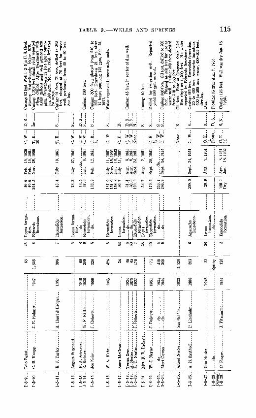
1-5
-9
1-5-
10-
1-5-
11-
1-5-
12. .
1-5-
13-
1-5-
14-
1-5-
15..
1-5-
16-
1-5-
17-
1-5-
18..
1-5-
19-
1-5-
20-
1-5-
21-
1-5-
22-
1-5-
23-
1-5-
24-
1-5-
25-
1-5-
26-
1-5-
27-
1-5-
28-
(Spr
ing)
1-
5-29
-
W. A
. N
eh
r .
....
E T
N es
ter
Mrs
. F.
B. P
adge
tt..
WT
^«
wjt
nr
do
_
do
W. F
Kitt
le. -
.d
o..
.. ..
... .
...
..
do.. ..
.. ..
.
Sun
Oil
Co
...
. ..
1947
1951
1916
IQK
rt
lode
;
1934
1875
1937
1951
1934
1924
1923
1 Qfl
S
1928
63
1 39
*i
395
KA
280
At)
C
oe 45 45 170
175
410
360
1,32
0
cno 33 126
48 8 7 6 8 6 5 8 63 6 60 7 36 10 6 6 6 36 5
ticn.
limes
tone
.
form
atio
n.
tion.
. d
o- .
form
atio
n.
...-
do
... .
form
atio
n.
form
atio
n,
.--do-. .
. d
o
form
atio
n.
form
atio
n.
form
atio
n.
..... d
o..
.
.....d
o
limes
tone
.
form
atio
n.
.... .d
o -
form
atio
n.
49.9
49.9
26
4.5
46.4
33.3
43.5
67.3
108.
9
147.
915
4.0
158.
8 30
.7
31.4
30.3
109.
9
34.7
170.
5
256.
724
8.9
209.
0
28.0
120.
1D
ry
Feb.
19
, 19
30Fe
b.
19,
1951
N
ov.
28,
1950
July
10
, 19
51
July
27
, 19
51
-d
o..
..
.Ja
n.
8, 19
51
Feb.
12
, 19
51
July
11
, 19
51N
ov.
15,
1951
Ja
n.
16,
1952
Ju
ly
11,
1951
Aug
. 8,
1951
Aug
. 6,
195
1Se
pt.
24,
1951
Aug
. 2,
195
1
Sept
. 20
, 19
51
..... d
o ....
Sept
. 24
, 19
51
Sept
. 24
, 19
51
Aug
. 7,
195
1
Apr
. 8,
19£1
Jan.
18
, 19
52
C, W
-
T, E
30 T,
E
1 C,W
-
C,W
-c,
w._
C, E
Yi
C, W
-
C.E
C,
W-.
C,
W-
C, E
1A
C, W
..C
, W
..
Non
e.-
C,
W-.
C, E
...
li
Flow
s..
C, E
H
D,S
Irr.
S-..
S... .
..
D, S
S
S
..
S...
D_-
--_
D, S
D
, S
N
.....
S ...
S
S ...
S..
N.....
S... .
..
S ...
D, S
S, N
...
Cas
ing:
63
feet
. Wel
l 1-2
-5 in
U. S
. Geo
l. Su
rvey
W
ater
-Sup
ply
Pape
r 67
8.C
asin
g: 1
,208
fee
t. Sm
all
yiel
d re
port
ed
whe
n dr
illed
. A
fter
tr
eatm
ent
with
3,
000
gallo
ns a
cid
wel
l pu
mpe
d 62
0 gp
m.
Dra
wdo
wn
22 f
eet
afte
r pu
mp
in
g 50
0 gp
m,
Nov
. 28
, 19
50.
Irri
gate
s 74
acr
es.
Cas
ing:
91
feet
. O
il te
st,
drill
ed t
o 39
5 fe
et,
plug
ged
at
70
feet
fo
r w
ater
w
ell;
perf
orat
ed f
rom
40
to 6
0 fe
et.
See
log.
Cas
ing:
280
fee
t.
Cas
ing:
30
0 fe
et;
slot
ted
from
240
to
300
feet
. D
raw
dow
n 21
fe
et
afte
r 12
hou
rs p
umpi
ng 1
20 g
pm,
Feb.
12,
19
51.
Wat
er r
epor
ted
to h
ave
salty
tas
te.
Cas
ing:
45
feet
, in
cent
er o
f dug
wel
l.
Cas
ing:
40
feet
.
Dril
led
for
irri
gatio
n w
ell.
Rep
orte
d yi
eld
300
gpm
on
test
.
Cas
ing:
360
feet
. O
il te
st, d
rille
d to
700
fe
et.
Plug
ged
at 3
60 f
eet
for
use
as
wat
er w
ell.
Cas
ing:
360
fee
t; sl
otte
d fr
om 3
10 t
o 36
0 fe
et.
Oil
test
. B
ase
of G
rays
on s
hale
(D
el
Rio
cla
y) a
t 1,
290
feet
. N
o w
ater
re
port
ed i
n E
dwar
ds l
imes
tone
.C
asin
g: 4
80 f
eet.
Esco
ndid
o f9
nnat
ion,
20
to
400
feet
; A
naca
cho
limes
tone
, 40
0 to
508
fee
t; w
ater
, 48
8-50
5 fe
et.
See
log.
Dug
.
Flow
ing
25 g
pm A
ug.
7, 1
951.
Cas
ing:
125
fee
t. W
ell w
as d
ry J
an.
18,
1952
.

Wel
l or
Sp
ring
1-5-
30..
1-5-
31..
1-5-
32..
1-5-
33-
1-5-
34-
1-5-
35-
1-5-
36..
1-5-
37-
1-5-
38..
1-5-
39-
1-5-
40..
1-5-
41..
1-5-
42-
Ow
ner
M. J
. Fi
nger
_ .-
...
W.
A. N
ehr
...
..
G.
Woote
n--
...-
J. A
. M
ott
..
. ...
R. J
.Tay
lor.
.......
.....d
o.... ..
........
....
.do..
....
.......
....
.do
....
....
....
.
Dril
ler
of w
ell
J. R
ober
ts. _
_ ..
..
Finn
ell
& W
illia
ms ..
Uni
ted
Nor
th &
Sou
th
Dev
elop
men
t Co.
Pru
itt &
Van
Dei
men
Mid
-Kan
sas
Oil
Co.
E. M
. B
urk
ett.
.....
Dat
eco
m
plet
ed
1934
1940
1928
1946
1926
1927
1926
1936
1928
1951
1930
1945
1930
Dep
th
of
wel
l (f
eet) 454
414
242
418
1,00
8
838
550
1,24
9
1,22
5
306
196
773
196
Dia
m
eter
of
wel
l (in
ches
) 6 8 5 6
4-8M 8 6 10
, 7
12M 12
6 5
Wat
er-b
eari
ng
form
atio
n
Esco
ndid
o fo
rmat
ion
(?).
Esco
ndid
o fo
rmat
ion.
Es
cond
ido
form
atio
n.
.....d
o... .
...
Edw
ards
lim
esto
ne.
Esco
ndid
o fo
rmat
ion
(?).
Esco
ndid
o fo
rmat
ion.
.....d
o.......
Esco
ndid
o fo
rma t
ion(
7).
Alti
tude
of
land
- su
rfac
e da
tum
(fee
t)
851
844.
5
850
940
Wat
er le
vel
Bel
ow
land
- su
rfac
e da
tum
(f
eet)
116.
8 13
4.2
130.
4
142
113.
8
40.3
78.9
130.
9 14
0.5
131.
1
Dat
e m
easu
rem
ent
Aug
. 5,
195
1 Ja
n.
23,
1952
Jan.
17
, 19
52
Sept
. ,
1938
Jan.
23
, 19
52
Feb.
15
,195
1
Feb.
19
, 19
51
Feb.
22
, 19
30
Nov
. 6,
195
1
Nov
. 6,
195
1
Met
hod
of
lift
C, W
..
C,
W__
C,
W__
C.G
.W
5 C,
W..
C, E
V
A
C, W
._
C.W
..
Use
of
w
ater
S
S ...
D, S
S..
. ...
N.....
S..
....
D, S
...
N-
N.....
N--
.-
S......
N..
S ...
Rem
arks
Cas
ing:
400
fee
t. D
raw
dow
n 3.
8 fe
et
afte
r 3
hour
s pu
mpi
ng 3
to
5 gp
m,
Jan.
23,
195
2.
See
log.
C
asin
g: 4
00 f
eet.
Pipe
set
at
210
feet
. T
emp.
74°
F.
See
anal
ysis
, ta
ble
12.
Cas
ing:
700
fee
t. O
il te
st, d
rille
d to
740
fe
et;
plug
ged
at 2
42 f
eet
for
wat
er
supp
ly.
Wat
er
leve
l re
port
ed
142
feet
bel
ow l
and
surf
ace
as o
f Se
pt.
1938
. W
ater
re
port
ed
to b
e sa
lty,
cont
ains
sm
all a
mou
nt o
f oil.
O
il te
st, p
lugg
ed a
nd a
band
oned
. W
ater
re
port
ed i
n E
dwar
ds l
imes
tone
. Se
e lo
g.
Oil
test
, con
verte
d to
wat
er w
ell.
Wat
er
leve
l rep
orte
d 11
8 fe
et b
elow
land
sur
fa
ce a
s of
Jun
e 19
46.
See
log.
O
il te
st,
drill
ed t
o 1,
425
feet
; pl
ugge
d at
550
fee
t in
1926
. C
lean
ed o
ut a
nd
case
d to
550
feet
in 1
950.
W
ell 1
-5-6
in
U.
S. G
eol.
Surv
ey W
ater
-Sup
ply
Pape
r 67
8.
See
log.
Se
e an
alys
is,
tabl
e 12
. O
il te
st,
plug
ged
and
aban
done
d. F
resh
w
ater
rep
orte
d in
Edw
ards
lim
esto
ne.
See
log.
O
il te
st,
plug
ged
and
aban
done
d. F
resh
w
ater
rep
orte
d at
240
and
1,1
93 f
eet.
Wel
l 1-
5-7
in
U.
S.
Geo
l. Su
rvey
W
ater
-Sup
ply
Pape
r 67
8.
Cas
ing:
30
0 fe
et;
slot
ted
228
to 3
00
feet
. W
ater
rep
orte
d to
be
salty
and
co
ntai
n oi
l. C
asin
g: 2
10 f
eet.
Pum
p se
t at
190
fee
t. W
ell
1-5-
5 in
U
. S.
G
eol.
Surv
ey
Wat
er-S
uppl
y Pa
per
678.
O
il te
st,
plug
ged
and
aban
done
d. S
ee
log.
Pu
mp
set
at 1
45 f
eet.
Tem
p. 7
4° F
. Se
e an
alys
is,
tabl
e 12
,

1-5-
43-
1-5-
44..
Iejc
1-5-
46-
1-5-
47..
1-5-
48..
1-5-
49-
1-5-
50- .
1-5-
51-
1-5-
52-
1-5
53..
1-5-
54-
1-5-
55-
1-5-
56. .
I-5-5
7-
1-5-
58-
1-5-
59-
I 5-
60-
1-5-
61..
1-5-
62-
1-6-
63..
- d
o.... .....
.
... .
.do
....... .
.....
Ray
McG
laup
hlin
.
H.
H. W
heel
es...
...
C.
M.
Hoo
d. .......
.....d
o .........
H.
C.
Has
sell
......
J. E
nkhar
dt
_ ..
W.
H. W
ycott
-.
W.
H.
Wyc
ott.
__
L. W
. Bar
rell
....
...
W. G
lass
cock
. ......
F. M
. B
urk
ett
.
W
W W
oodw
orth
J. E
ckhar
dt
......
1941
1942
1941
1930
1928
1926
1936
1938
1949
1936
1926
1946
1926
1938
1Q9Q
1QQ
A
1940
1945
1,72
0
i Q
IA 48 268
1,70
0
840
9Q9
375
320
fifvi 58
2,00
0
2,41
2
275
420
1 96
4
i oo
n
180
700
412
10 8 6 5 5 6 8 6 8, 6 10 6 36 8 6 8 10 10 12 6 0
form
atio
n.
Leon
a fo
rma-
tion(
?).
Esco
ndid
ofo
rmat
ion(
?).
Edw
ards
limes
tone
.
Esco
ndid
ofo
rmat
ion.
..... d
o_ .
form
atio
n...... d
o
form
atio
n(?)
.
tion(
?).
Edw
ards
lim
esto
ne.
limes
tone
(?).
form
atio
n.
form
atio
n.
form
atio
n.
... .
.do
.......
.....d
o.......
845
784.
1
oo ft
792
174.
3
27.9
128.
4
154.
7
179.
9
145.
814
3.0
124.
4
187.
2
42.4
81.
8
23.3
191.
5
168.
7
97.5
131.
727
7.4
Feb.
18
, 19
52
Jan.
18
, 19
52
Jan.
19
, 19
52
Mar
. 17
, 19
52
Jan.
19
, 19
52
Nov
. 6,
195
1N
ov.
6, 1
951
Dec
. 15
, 19
21
Jan.
23
, 19
52
Nov
. 6,
195
1
Jan.
3,
195
2
Jan.
23
, 19
52
d
o
.
Jan.
19
, 19
52
Jan.
23
, 19
52
Jan.
19
. 19
52Ja
n.
22.1
952
Non
e
C, E
i/n c"
w._
C, G
...
10
C.W
..
C,W
-
C,W
..C
.W..
C, W
-
T, E
1H
C, E
...
H
C.W
..
Non
e ..
C.W
..
C,
W..
Non
e
C.
W..
C.
W..
C, G
6
N.....
N..
._.
S ...
D, S
S......
D. S
...
D, S
...
S......
S ...
D, S
S ..
D, S
...
D. S
N-.
-.
S-.
.
D, S
N.....
N.....
D. S
...
S......
S..
....
Oil
test
, pl
ugge
d an
d ab
ando
ned.
See
lo
g.O
il te
st,
plug
ged
and
aban
done
d. W
el
1-5-
4 in
U.
S. G
eol.
Surv
ey W
ater
- Su
pply
Pap
er 6
78.
See
log.
Cas
ing:
328
fee
t; sl
otte
d fr
om 2
80 t
o 32
8 fe
et.
Cas
ing:
48
fee
t; sc
reen
ed f
rom
28
to
48 f
eet.
Dra
wdo
wn
6.8
feet
af
ter
1\4
hour
s pu
mpi
ng 8
gpm
, Ja
n. 1
8, 1
952.
Dra
wdo
wn
0.9
foot
af
ter
8 ho
urs
pum
ping
2 t
o 4
gpm
, Ja
n. 1
9, 1
952.
T
emp.
77°
F.
See
anal
ysis
, ta
ble
12.
Cas
ing:
70
0 fe
et.
Oil
test
, dr
illed
to
84
0 fe
et.
Plug
ged
back
to
fres
h w
ater
sa
nds.
D
raw
dow
n 84
.3 f
eet
afte
r 3
hour
s pu
mpi
ng 2
to
5 gp
m,
Jan.
19,
19
52.
Cas
ing:
8-in
ch t
o 25
0 fe
et a
nd 6
-inch
from
25
0 to
31
0 fe
et.
See
log.
O
il te
st,
drill
ed
to
925
feet
. Pl
ugge
dba
ck
to
325
feet
. W
ater
re
port
edsa
lty.
Tem
p. 7
4" F
W
ater
re
port
ed
salty
. D
raw
dow
n 3.
4fe
et a
fter
pum
ping
12
gpm
, Ja
n. 2
3,19
52.
Dug
.
Dra
wdo
wn
12
feet
af
ter
1J^
hour
s pu
mpi
ng 2
to
4 gp
m,
Jan.
3,
1952
. W
ell
1-4-
30 i
n U
. S.
G
eol.
Surv
ey
Wat
er-S
uppl
y Pa
per
678.
T
emp.
76
° F.
See
ana
lysi
s, t
able
12.
Oil
test
. Se
e lo
g.
Cas
ing:
275
fee
t; sl
otte
d fr
om 2
45 t
o 27
5 fe
et.
See
anal
ysis
, ta
ble
12.
Ow
ner
repo
rts
smal
l yi
eld
of
high
ly
min
eral
ized
wat
er.
Oil
test
, pl
ugge
d an
d ab
ando
ned.
Se
e lo
g.O
il te
st,
plug
ged
and
aban
done
d.
See
log.
W
ell 1
-5-2
in U
. S. G
eol.
Surv
ey
Wat
er-S
uppl
y Pa
per
678.
Cas
ing:
180
fee
t; pe
rfor
ated
. W
ater
re
po
rted
to
be s
alty
. T
emp.
73°
F.
Wat
er r
epor
ted
salty
.

Wel
l or
Sp
ring
1-5-
64. .
1-5-
65.
1-5-
66..
1-5-
67. .
1-5-
68. .
1-5-
69-
1-5
-70
-
1-5
-71
-
I-5-
72__
1-6-
1. __
1-6
-2
1-6
-3
1-6
-4..
.
1-6
-7
1-6
-8
Ow
ner
Tho
mas
Dud
erst
adt.
....
. do
- - .
d
o -
Flo
ydS
chm
idt.
.....
S. I
. D
ubose
-
F. W
. B
ohm
falk
.
H.
G. B
oeh
le..
..
Ed
Saa
tho
ff-
.....
Dri
ller
of w
ell
d
o..
..
Gra
ybur
g O
il C
o. _
_
H.
C. H
ass
ell
....
...
C.G
illi
am
-..
Dat
e co
m
plet
ed
1948
1928
1948
1928
1938
1934
1926
1946
1934
1935
1919
1949
1950
1939
1914
1928
Dep
th
of
wel
l(f
eet) 35
4
171 65 82
58
86
62
92 156
560 63
58 50
1,53
0 78
40
50
52
Dia
m
eter
of
wel
l (i
nche
s) 5 7 52 5 36 6 28 7 6 8 36 72 6 8 28
32
48
Wat
er-b
eari
ng
form
atio
n
-- d
o.......
-.-
do.......
Indi
o fo
rmat
ion.
In
dio
form
atio
n (?
). L
eona
fo
rmat
ion
(?).
Indi
o fo
rmat
ion(
T).
In
dio
form
atio
n .
do
Indi
o fo
rmat
ion
(?).
Indi
o fo
rmat
ion.
L
eona
fo
rmat
ion.
do
_
_
. .d
O-.-..
Edw
ards
lim
esto
ne.
Leo
na
form
atio
n.
_.
do.......
.. d
o_ ...
_
dO
-
Alti
tude
of
lan
d-
surf
ace
datu
m(f
eet)
(f
eet)
851.
4
Wat
er l
evel
Bel
ow
land
- su
rfac
e da
tum
da
tum
(f
eet)
161.
6
92.1
60.7
44.9
34.6
32.7
34.2
35.8
76.8
173.
6
55.9
54
.7
52.6
21.7
175.
0 *1
75.0
41
.4
32.8
38.1
32.4
Dat
e m
easu
rem
ent
....
. d
o-.
-
d
o__. .....
Aug
. 15
, 19
51
Jan.
19
, 19
52
d
o........
d
o--.....
d
o
__.
-do..-.-
-..
do-.
Jan.
19
, 19
52
July
20
, 19
51
Jan.
28
, 19
52
July
20
, 19
51
Jan.
26
, 19
52
Nov
. 2,
195
1 A
ug.
31,
1951
Ja
n.
25,
1952
July
20
, 19
51
.....d
o........
.....d
o........
Met
hod
of lift
C, E
2 C
, W
..C
, W
..
C, E
C,
W__
C,
W..
C,
W__
C,
E._
_>z
C, E
J*
C, W
-
C, E
-_*
2 C, E
1A C
, E
...
fci
T,E
. 2 C
, W
..
C,
W..
C, E
...
C* W
..
Use
of
w
ater
p S..
....
s._
D, S
D, S
D, S
...
S-.
-..
D, S
D,
S___
D,
S.__
D, S
D, S
...
D-.
D,
S,
Irr s...
...D
, S
...
D, S
-..
S... .
..
Rem
arks
Cas
ing:
165
fee
t. O
wne
r re
port
s sm
all
yiel
d of
sal
ty w
ater
. Pu
mpi
ng 8
gpm
Ja
n.
22,
1952
. W
ater
rep
orte
d to
be
high
ly m
iner
aliz
ed.
Dug
. C
urbi
ng:
36 f
eet
of r
ock.
Cas
ing:
82
feet
; sl
otte
d fr
om 5
2 to
82
feet
. C
asin
g:
15 f
eet.
Dug
.
Cas
ing:
86
feet
: sl
otte
d.
Oil
test
, dr
illed
to
2,19
6 fe
et,
plug
ged
belo
w 9
2 fe
et.
Wel
l 1-
5-3
in U
. S.
G
eol.
Surv
ey
Wat
er-S
uppl
y P
aper
67
8.
See
log.
C
asin
g: 1
56 f
eet;
slot
ted
from
110
to 1
56
feet
. W
ater
re
port
ed
to
be
high
ly
min
eral
ized
. W
ater
re
port
ed
to
be
salt
y;
corr
odes
pi
pe.
Dug
.
Cas
ing:
60
fee
t. D
raw
dow
n 0.
2 fe
ot
afte
r 2
hour
s pu
mpi
ng 5
gpm
Jul
y 20
, 19
51.
Cas
ing:
45
feet
; sl
otte
d fr
om 2
0 to
45
feet
. P
ump
set
at 4
3 fe
et.
Rep
orte
d to
pum
p ai
r af
ter
24 h
ours
pum
ping
4
gpm
. Se
e an
alys
is,
tabl
e 12
. C
asin
g: 1
,300
fee
t. T
emp.
75°
F.
See
log.
Se
e an
alys
is, t
able
12.
C
asin
g: 7
2 fe
et.
Cas
ing:
40
feet
. O
wne
r re
port
s sm
a yi
eld.
Cas
ing:
40
feet
. W
ater
rep
orte
d sa
lty.
GO
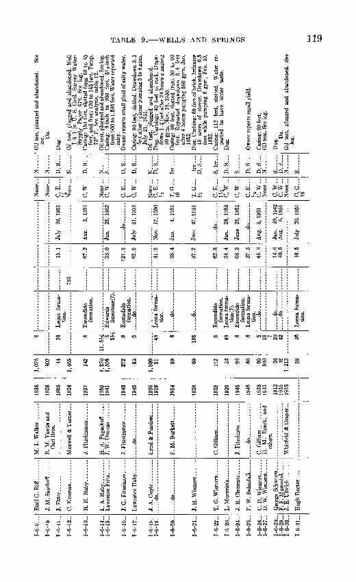
T-A
-Q
1-6
-10
-
1-6-
11..
1-6-
12..
1-6
-13
-
1-6
-14
-1
-6-1
5-
1-6-
16..
1-6-
17..
1-6
-18-
1-6
-19
-
1-6-
20..
1-6
-21
-
1-6-
22..
1-6-
23..
1-6-
24..
1-6-
25..
1-6-
26..
1-6
-27
-
1-6-
28..
1-6-
29..
1-6-
30..
I 6-
31..
J. M
. S
aath
off
...
H.
H.
Hab
y.. ......
L. A
. H
ab
y
Law
renc
e F
ritz
....
..
Law
renc
e H
ab
y..
...
J. A
. C
oyle
do
....
. do
....
.. ..
..
T.
G. W
iem
ers
...
J. R
. C
lem
ents
....
..
C.
D.
Wie
mer
s ...
...
D.
W.
Wie
mer
s
F. F
. M
uenn
ink-
-
- J.
E. U
lbri
ch
M.
L. W
alk
er
R.
M.
Yan
tis a
nd
Car
l B
ros.
J. W
. D
unca
n __ ..
.....d
o... ..
....
....
Lyn
d &
Fun
dren
. ...
F. M
. B
urke
tt. _
..
C.
Gil
liam
.. _ .....
J. F
itzsi
mon
--
----
-
.. d
o ..
....
C. G
illi
am
- -
H.
M.
Roa
rk,
and
othe
rs.
" Wni
tfie
id'&
'Dra
per"
1938
1928
1908
1934
1937
1950
1941
1946
1945
1936
19
19
1934
1936
1938
1920
1945
1946
1938
19
43
1912
1935
19
38
1,07
6
802 44
1,46
8
142
1,27
01,
596
272 95
1,80
0 51 90 112 52 98 60 90 690 36 48
1,21
3
8 36 6
11, 5
^ 8 5M
6 6 48 8
168 6 48 6 6 5 10 7 28 42 36
tion.
form
atio
n.
limes
tone
(7).
form
atio
n.
... ..do... .
...
tion.
....
.d
o ...
d
o.... ...
form
atio
n.
tion(
7).
form
atio
n.
Leo
na f
orm
a
tion.
dO
....
. do ...
....
.d
o ...
tion.
793
........
15.1
67.2
38.0
121.
3
62.9
41.9
38.4
37.2
62.8
34.4
68.3
37.3
46.3
14.6
40.6
46.5
July
20
, 19
51
Aug
. 2,
195
1
Jan.
25
, 19
52
....
.do........
July
21
, 19
51
Nov
. 17
, 19
50
Jan.
4,
195
1
June
27
, 19
51
....
.do..
dO
.
Aug
. 8,
195
1
Jan.
28
, 19
42A
ug.
8, 1
951
July
20
, 19
51
C, E
y*, C
,W_
.
C.W
..
C, E
1 C
.W..
C, E
...
1A
T, G
40
T. G
M
i
C.
E___
P
W
C.W
..
C.E
H
C
.W..
C, W
..C
, W
__
C, G
10
N...-
N._
...
D, S
...
N ..
.
D, S
N......
S......
D, S
...
D, S
N
D, S
...
Irr ..
..
Irr ..
.D
, S
S, I
rr..
D. S
...
s D, S
...
D, S
...
N...._
S......
D, S
...
N.
S.
Oil
test
, pl
ugge
d an
d ab
ando
ned.
Se
e lo
?. Do.
Dug
.
Oil
test
, pl
ugge
d an
d ab
ando
ned.
Wel
l 1-
6-1
in U
. S.
Geo
l. Su
rvey
Wat
er-
Supp
ly
Pap
er
678.
Se
e lo
g.C
asin
g: 1
50 f
eet,
slot
ted
from
60
to 8
5 fe
et,
and
from
120
to
145
feet
. T
emp.
73
° F.
See
ana
lysi
s, t
able
12.
Oil
test
, plu
gged
and
aba
ndon
ed. S
ee lo
g.C
asin
g:
8-in
ch
to
900
feet
, 5^
'2-in
ch
from
900
to 1
,596
fee
t. W
ater
rep
orte
d sa
lty.
Ow
ner
repo
rts
smal
l yie
ld o
f sal
ty w
ater
.
Cas
ing:
90
feet
, sl
otte
d. D
raw
dow
n 3.
1 fe
et a
fter
J-2
hou
r pu
mpi
ng 3
to
4 gp
m,
July
21,
19
51.
Oil
test
, pl
ugge
d an
d ab
ando
ned.
Dug
. C
urbi
ng:
40 f
eet
of r
ock.
Dra
w
dow
n 1.
2 fe
et a
fter
24
hour
s pu
mpi
ng
30 g
pm,
Nov
. 18
, 19
50.
Cas
ing:
90
feet
, sl
otte
d fr
om 5
0 to
90
feet
. R
epor
ted
draw
dow
n 6.
8 fe
et
afte
r 4
hour
s pu
mpi
ng 5
CO g
pm,
Jan.
19
52.
Dug
. C
urbi
ng:
60 f
eet
of b
rick
. Ir
riga
tes
40
acre
s of
cl
over
. D
raw
dow
n 0.
5 fo
ot w
hile
pum
ping
6 g
pm,
Feb.
10,
19
52.
Cas
ing:
11
2 fe
et,
slot
ted.
W
ater
re
po
rted
to
ha
ve
bitt
er
tast
e.D
ug.
Ow
ner
repo
rts
smal
l yie
ld.
Cas
inj?
: 90
fee
t. O
il te
st.
See
log.
Dug
. Do.
O
il te
st,
plug
ged
and
aban
done
d.
See

Wel
l or
Sp
ring
1-6-
32..
1-6-
33..
1-6-
34..
I-6-
35--
1-6-
36..
1-6-
37. .
1-6-
38..
1-6-
39..
1-6-
40..
1-6-
41..
1-6-
42..
1-6-
43.-
1-6-
44..
1-6-
45. .
1-6-
46. .
I-6-
47-.
1-6-
48..
1-6-
49..
Ow
ner
M.
W. K
eel.
........
W. B
. O
dem
....
....
C. W
alk
er.
.........
W. B
. O
dem
.. ......
R.
A.
Hol
low
ay...
..
A. G
. Hol
low
ay...
..
....
.do
....
....
....
.
J. M
. F
usse
lman
....
A. G
. HoU
oway
.....
Rob
ert
Cle
men
ts. .
..
J. M
. Fu
ssel
man
....
Dril
ler
of w
ell
R.
P. W
hitf
ield
......
Circ
le O
il C
o.... _
.
Kir
by P
etro
leum
Co.
J. F
itzs
imm
on
....
..
V.
F. N
euha
us. .
Dat
e co
m
plet
ed
1926
1937
1928
1935
1925
1938
1944
1920
1936
1930
1915
1946
1923
1932
Dep
th
of
wel
l (f
eet) 68
1,43
4 64
465
1,95
0 54
60 102 58
212 45
56
1,95
0 44 85
187
1,81
4 60
Dia
m
eter
of
wel
l (in
ches
) 6 8 7 12 6 7 12 8 40 6 42 6 10
52 6 5 10 48
Wat
er-b
earin
g fo
rmat
ion
.....d
o.......
Leon
a fo
rma
tio
n.
Leon
a fo
rma
tio
n.
. -do .
...
Esco
ndid
o fo
rmat
ion.
Le
ona
form
a
tion.
Es
cond
ido
form
atio
n.
Leon
a fo
rma
tio
n.
.....d
o.......
Leon
a fo
rma
tio
n.
-....d
o.......
Esco
ndid
o fo
rmat
ion.
Leon
a fo
rma
tio
n.
Alti
tude
of
land
- su
rfac
e da
tum
(f
eet)
901
798
888
Wat
er le
vel
Bel
ow
land
- su
rfac
e da
tum
(f
eet)
51.3
47.6
41.4
.. 4
5.8
46.2
50.7
34.4
56.4
41.8
32.9
32.8
64.3
121.
0
47.8
Dat
e m
easu
rem
ent
Jan.
22
, 19
52
Feb.
7,
195
1
Jan.
26
, 19
52
Aug
. 9,
195
1
July
9,
195
1
Aug
. 9,
195
1
Jan.
29
, 19
52
....
.do..
....
..
Aug
. 15
, 19
51
Jan.
29
, 19
52
June
6,
195
1
June
28
, 19
51
Jan.
28
, 19
52
Aug
. 8.
195
1
Met
hod
of
lift
C, E
...
tf C, W
..
C, W
..
C, E
...
1 C,W
-
C,W
-
C,E
,W
C* E
...
k'
T, E
-.
6 C,E
,W3
4 C.W
..
C,W
_-
Use
of
w
ater
D, S
...
N__
.__
S
N.-
N..
D, S
D, S
D, S
...
D, S
N ..
D, S
D, S
N.....
D, S
Ir
r
D.....
S
N.-
...
D.S
Rem
arks
Cas
ing:
68
fe
et.
Dra
wdo
wn
0.3
foot
af
ter
7 ho
urs
pum
ping
6 g
pm, A
pr. 2
2,
1952
. O
il te
st,
plug
ged
and
aban
done
d.
See
log.
Oil
test
, pl
ugge
d an
d ab
ando
ned.
Se
e lo
g.
Cas
ing:
1,9
50 f
eet.
Oil
test
. W
ell
1-6-
4 in
U.
S. G
eol.
Surv
ey W
ater
-Sup
ply
Pape
r 67
8. S
ee l
og.
Cas
ing:
54
feet
, slo
tted
from
35
to 5
4 fe
et
Oil
test
, dr
illed
to
1,68
7 fe
et.
Plug
ged
belo
w 6
0 fe
et.
Cas
ing:
60
feet
, slo
tted
from
35
to 6
0 fe
et.
Cas
ing:
10
2 fe
et,
slot
ted.
Wat
er r
epor
ted
salty
.
Dra
wdo
wn
2.4
feet
af
ter
2 ho
urs
pum
ping
8 g
pm,
Mar
. 12
, 19
52.
Irri
gate
d 20
ac
res
of g
rass
fro
m t
his
wel
l in
19
50.
Oil
test
, pl
ugge
d an
d ab
ando
ned.
Se
e lo
g.
Irri
gate
d 4
acre
s of
oat
s in
195
1. D
raw
do
wn
1.7
feet
aft
er 2
hou
rs p
umpi
ng
28 g
pm, J
une
6, 1
951.
Dra
wdo
wn
8.9
feet
af
ter
6 ho
urs
Pum
ping
3 t
o 5
gpm
, Ja
n. 2
8, 1
952.
te
st,
plug
ged
and
aban
done
d. S
ee
log.
D
ug.
Cur
bing
: 28
fe
et o
f ro
ck.
to
o

1-6-
50-
1-6-
51-
1-6-
52-
1-6-
53-
1-6-
54..
1-6-
55-
1-6-
56..
1-6-
57..
1-6-
58..
1-6-
59-
1-6-
60..
1-6-
61. .
1-6-
62-
1-6-
63-
1-6-
64..
1-6-
65-
1-6-
66. -
1-6-
67-
1-6-
68-
1-6-
69 ~
I-6-7
0-
1-6-
71-
1-6-
72..
1-6-
73-
1-6-
74-
(Spr
ing)
1-
6-75
..
Mur
dry.
A. A
. Mur
reU
.....
..
..d
o ..
....
...
0. W
. H
airr
elL
L. V
. D
oss
...
.
R. H
aas
..
.....
InaO
ilC
o.
Co.
1Q9Q
1951
1Q3Q
1938
1942
1936
1935
1951
1927
1934
1940
1935
1944
1907
1942
IQQ
fi
1905
1900
1924
1926
1900
1938
3,30
2
101 89
1,68
2 55
1,10
0 92 193
189
2,34
3
410 59 220 99 140 94
1,02
0
115 86 211 60
2,00
6
2,04
8 67 45
10 8 6 7 30 10 5 6 6 15 28 12 7 5 5 10 5 6 6 6 42 42 48
tion.
L
eona
for
ma-
.tion
.
tion.
Esc
ondi
dofo
rmat
ion.
.....d
o.......
....
.do......
Esco
ndid
ofo
rmat
ion.
Le
ona
form
atio
n.
form
atio
n.
....
. do
... .
.do
do
Indi
ofo
rmat
ion.
L
eona
form
atio
n.
Indi
ofo
rmat
ion.
form
atio
n.
form
atio
n.
....
.do
... .
...
do .
40.9
34.4
39.6
78.5
159.
2
173.
8
79.8
37.3
159.
315
8.4
160.
8 72
.6
91.3
62.3
83.0
42.3
111.
6
45.0
41.0
42.4
Mar
. 21
, 19
51
Dec
. 12
, 19
50
Jan.
29
, 19
52
Jan.
25
, 19
52
.. d
o _
_
Jan.
26
, 19
52
Feb.
18
, 19
52
Jan.
29
, 19
52
Aug
. 21
, 19
51N
ov.
15,
1951
Ja
n.
16,
1952
Se
pt.
28,
1951
Sept
. 26
, 19
51Se
pt.
27,
1951
Sept
. 27
. 19
51
Jan.
29
, 19
52
Sept
. 19
, 19
51
do-
Sept
. 27
, 19
51
Jan.
15
, 19
52
Sept
, 18
,195
1
Non
e ..
C, E
K C
, W ..
C,W
-
Non
e
C, E
1 C, W
-
C,
W_.
C,
W._
C,
W..
C,
W-.
C,
W-.
C,
W..
Non
e..
C.
W..
Non
e..
C,
W._
C,
W..
N
N.....
N.
N..
D, S
N.....
S .
D, S
N-
N.....
S ...
D, S
...
D, S
D, S
D, S
S
N--
D, S
...
D, S
...
N.....
D, S
N.....
N--
.-
D, S
...
D, S
D, S
...
Oil
test
, pl
ugge
d an
d ab
ando
ned.
Top
of
Edw
ards
lim
esto
ne
repo
rted
at
1,19
0 fe
et.
Oil
test
, pl
ugge
d an
d ab
ando
ned
inM
ay
1951
. Se
e lo
g.
Wel
l use
d by
Illi
nois
Pip
elin
e C
ompa
nyst
atio
n in
19
36.
Cas
ing:
1,
025
feet
. O
il te
st,
plug
ged
and
aban
done
d.
See
log.
D
ug.
Cur
bing
: 30
fee
t.
Cas
ing:
1,1
00 f
eet.
Oil
test
, plu
gged
and
aban
done
d.
Cas
ing:
120
fee
t, sl
otte
d fr
om 8
0 to
120
feet
. W
ater
re
port
ed
to
have
sa
lty
tast
e.W
ell
pum
ps s
mal
l am
ount
of
oil.
Cas
ing:
60
feet
. O
il te
st,
plug
ged
and
aban
done
d.
See
log.
W
ater
rep
orte
d to
hav
e sa
lty t
aste
.
Dug
. C
urbi
ng:
36 f
eet
of c
oncr
ete
rings
.W
est
wel
l of
tw
o w
ells
. C
asin
g: 2
00 f
eet,
slot
ted
from
18
0 to
200
feet
.
Cas
ing:
100
fee
t. D
rille
r rep
orte
d w
ater
at
79
feet
.
Cas
ing:
90
feet
.O
il te
st,
plug
ged
and
aban
done
d.
See
log.
C
asin
g: 1
15 f
eet,
ripp
ed f
rom
95
to 1
15fe
et.
Oil
test
.
Dug
. C
urbi
ng: 6
0 fe
et o
f con
cret
e ri
ngs.
Oil
test
, pl
ugge
d an
d ab
ando
ned.
W
ell
1-6-
2 in
U.
S. G
eol.
Surv
ey W
ater
- Su
pply
Pap
er 6
78.
Oil
test
, pl
ugge
d an
d ab
ando
ned.
Wel
l 1-
6-3
in U
. S.
Geo
l. Su
rvey
Wat
er-
Supp
ly P
aper
678
.D
ug.
Flow
ing
26 g
pm J
an.
15,
1952
. T
emp.
69
F.

Wel
l or
Sp
ring
1-6-
76-
1-6-
77-
1-6-
78-
1-6-
79-
1-6-
80-
1-6-
81..
T-6
-82-
1-6-
83-
1-6-
84-
1-6-
85-
1-6-
86-
1-6-
87. .
1-6-
88-
1-6-
89-
1-6-
90..
1-6-
91-
1-6-
92..
1-6-
93..
1-6-
94-
Ow
ner
C.
Wen
dlan
d &
F.
War
d
Kur
tSch
iaf.
_ ....
Jam
es B
a ile
y . ......
W.
Nie
tenh
oefe
r .
... .
.do.... ........ .
Alb
ert H
offm
an .....
H. E
. M
ofie
ld...
....
....
.do
....
......
Dril
ler
of w
ell
.....d
o.... ..
....
...
A. F
. M
ann.
.. __ .
Sutto
n D
rillin
g C
o...
Mow
inkl
e &
Nes
sley
Dat
e co
m
plet
ed
1952
1912
1947
1940
1936
1937
19
48
1935
1940
1921
19
40
1923
1928
1938
1908
1905
19
23
1940
1949
Dep
th
of
wel
l (f
eet) 66
49 49
44
125
154 75 60
115 62
96
300 44
975 58 33
2,
026
125
1,17
9
Dia
m
eter
of
wel
l (in
ches
)
13
24 7H
36 6 6
W1A 42
8 6 5 5 36 7 38
36 6 8
Wat
er-b
eari
ng
form
atio
n
....
. do.......
.....d
o.......
Indi
o fo
rmat
ion.
Le
ona
form
atio
n.
Indi
o fo
rmat
ion.
.....d
o.......
....
.do..
..
Leon
a fo
rmat
ion.
In
dio
form
atio
n.
.....d
o.......
.....d
o ..
..Es
cond
ido
form
atio
n.
Indi
o fo
rma
tio
n.
Indi
o fo
rma
tio
n,
..d
o
Indi
o fo
rma
tio
n.
Edw
ards
lim
esto
ne.
Alti
tude
of
land
- su
rfac
e da
tum
(fee
t)
........
.-...
756
Wat
er l
evel
Bel
ow
land
- su
rfac
e da
tum
(fee
t)
44.7
35.7
44.7
32.1
78.6
114.
2 40
.4
34.8
45.0
43.7
76
.7
161.
1
39.2
26.6
28.5
52.4
Dat
e m
easu
rem
ent
Jan.
15
, 19
52
Sept
. 19
, 19
51
d
o
....
.do..
....
..
Sept
. 27
, 19
51
.....d
o-..
Aug
. 8,
195
1
d
o .
do .
Jan.
29
, 19
52
Aug
. 20
, 19
51
Aug
. 16
, 19
51
Aug
. 20
, 19
51
Feb.
28
, 19
51
Aug
. 20
, 19
51
Feb.
28
,195
1
Met
hod
of
lift
T, G
60 C
, T,
W,
G,
15 C, E
...
1 C,
W..
C.
W..
C,
W-
C,
G,
W
10 C,
W_.
T, E
...
5 C,
W..
Non
e..
C,
W__
C.W
..
C.W
..
C.W
..
C.W
..
T,E
...
8
Use
of
w
ater
Irr
S, I
rr..
D, S
S-.
D, S
D, S
...
S, I
rr..
D.S
Irr
D.S
N
._
S...
S -
N._
...
D, S
S
N..
._.
S
Irr ..
..
Rem
arks
Cas
ing:
66
feet
, sl
otte
d fr
om 1
2 to
58
feet
. D
raw
dow
n 2.
8 fe
et
afte
r 8
hour
s pum
ping
860
gpm
, Jan
. 15,
195
2.
Pum
ping
72
gpm
May
12,
195
2.
Irri
ga
ted
15 a
cres
in
1950
. O
wne
r re
po
rts
wel
l w
as p
umpe
d at
200
gpm
in
193
9.
Cas
ing:
48
feet
. Su
pplie
s da
iry
farm
. Se
e an
alys
is,
tabl
e 12
.
Cas
ing:
120
fee
t, sl
otte
d fr
om 8
0 to
120
fe
et.
Pum
p se
t at
116
feet
.
Cas
ing:
75
feet
, sl
otte
d fr
om 3
5 to
70
feet
. D
raw
dow
n 6.
9 fe
et
afte
r 2
hour
s pu
mpi
ng 9
gpm
, A
ug.
8, 1
951.
T
emp.
77°
F.
Cas
ing:
50
feet
. D
ug.
Cas
ing:
120
fee
t, sl
otte
d.
Irri
gate
d 22
ac
res
of g
rass
in 1
951.
Wat
er r
epor
ted
salty
. O
il te
st,
conv
erte
d to
wat
er w
ell.
Wat
er
repo
rted
to b
e sa
lty.
Oil
test
, pl
ugge
d an
d ab
ando
ned.
See
lo
g.
Dug
. C
urbi
ng:
28 f
eet
of r
ock.
Oil
test
, pl
ugge
d an
d ab
ando
ned.
See
lo
g.
Cas
ing:
125
fee
t, sl
otte
d fr
om 9
5 to
125
fe
et.
Tem
p.
75°
F.
See
anal
ysis
, ta
ble
1?.
Oil
test
, co
nver
ted
to w
ater
wel
l. W
ater
le
vel
repo
rted
84
fe
et
belo
w
land
su
rfac
e as
of
June
194
9.
to
to

1-6
-95-
1-6
-96
-
I-5-
97-.
I-6-
9R-.
1-6
-99-
1-6-
100
1-6-
101
1-6-
102
1-6-
103
1-6-
104
1-6-
105
1-6-
106
1-6-
107
1-6-
108
1-6-
109
1-6-
110
1-6-
111
1-6-
112
1-6-
113
1-6-
114
1-6-
115
1-6-
116
.....d
o..........
..
.. d
o..
.. ...
....
..
G.
C.
MrA
nell
ey...
.
G.C
. M
cAnel
ley..-
Mam
e M
. A
dam
s. .
W.
W. K
ell
y..
....
..
A.
P. M
ann .
.....
Ral
ph E
. F
air
Inc.
..
L. V
. D
oss.
.. ..
....
.
E.
H. K
eate
r.... .
..
L.
V.
Dos
s__.
_ ......
Co.
R
. H
aas..
.. .
.. ..
InaO
ilC
o. _
_ .....
Sout
hern
Gas
Uti
lity
, In
c.
1951
1926
1941
Old
19
29
1875
1900
1936
1930
1946
1950
1940
1924
1941
1949
1951
1928
1946
1925
1942
1926
394 44 55 79 103 55 130
128
204
5,51
2
1,06
6
365 69 138
2,01
6
1,01
4
152
Q44
12 48 48 5 6 7 5 6 5 7 8
10, 8 12 7, PA
11 9 7, 5 6 5 5 7
Indi
o fo
rma
tio
n.
....
.do
....
...
....
.do
....
...
..
do_......
.....d
o-.
.....
_..
.-d
o-_
..._
.
.. d
o.......
_-.
._d
o-.
._..
_
... ..
do
....
...
....
.do
....
...
form
atio
n.
tion.
tion.
tion.
tion.
..
do
--..
.-.
... .
.do.... ..
.
759
........
732
109.
1
24.6
36.8
52.2
59.4
53.2
89.7
93.7
44.6
107.
6
39.4
74.8
29.4
162.
0
144.
4
113.
8
Aug
. 31
, 19
51
Feb.
28
, 19
51
Sept
. 20
, 19
51
Aug
. 23
, 19
51 - d
o-. -
Aug
. 24
, 19
51
Aug
. 23
, 19
51
Jan.
12
, 19
52
Aug
. 24
, 19
51A
ug.
23,
1951
Jan.
29
, 19
52
Apr
. 24
, 19
51
Apr
. 24
, 19
51
Sept
. 27
, 19
51
do .
Aug
. 24
, 19
51
T, G
-40 C
.W..
C, E
...
k
C,
W,
EC,
W_.
C, E
...
Vi
C.W
..
C,W
-
C, W
-c,
w.
Non
e _.
C, G
12
C, E
...
1 Non
e ..
T,
G.._
60 C, W
..
C,W
-
C, W
..
D,
Irr
D.S
...
D, S
...
D, S
...
S
D, S
...
S..
S .
-S
......
S......
N.._._
N__...
N._
_._
D, S
...
D, S
...
N.-
._
Irr ..
..
N--
._
D, S
...
D,
S..._
D, S
...
N._
.._
Dri
lled
to
supp
ly
wat
er
for
oil
test
.D
raw
dow
n 31
.4 f
eet
whi
le p
umpi
ng58
gpm
, A
ug.
31,
1951
. D
ug.
Cur
bing
: 8
feet
of
roc
k.
Wat
erre
port
ed
from
40
to
44
fe
et.
See
anal
ysis
, ta
ble
12.
Cas
ing:
55
feet
. W
ater
rep
orte
d sa
lty.
Tem
p. 7
4° F
. Se
e an
alys
is,
tabl
e 12
.
Cas
ing:
103
fee
t, pe
rfor
ated
fro
m 7
6 to
100
feet
. Se
e an
alys
is,
tabl
e 12
.
Cas
ing:
140
fee
t. W
ater
rep
orte
d hi
ghly
min
eral
ized
. C
asin
g: 1
30 f
eet,
slot
ted
from
92
to 1
30fe
et.
Rep
orte
d to
pu
mp
air
afte
r 5
hour
spu
mpi
ng 6
gpm
. Wat
er r
epor
ted
salt
y.
Oil
test
, ab
ando
ned.
W
ell
repo
rted
to
have
fl
owed
20
0 gp
m
of
wat
er
at4,
814
feet
Ju
ly
1946
. Se
e lo
g.
Cas
ing:
65
feet
. O
il te
st,
plug
ged
and
aban
done
d.
See
log.
O
il te
st,
plug
ged
and
aban
done
d.
See
log.
C
asin
g:
80
feet
, sl
otte
d.
Dra
wdo
wn
2.5
feet
whi
le p
umpi
ng 8
gpm
, Ja
n.29
, 19
52.
Cas
ing:
7-
inch
to
10
4 fe
et,
5J-£
-inch
from
104
to
138
feet
. P
erfo
rate
d fr
om20
to
138
feet
. Se
e lo
g.
Oil
test
, pl
ugge
d an
d ab
ando
ned.
Se
elo
g.
Cas
ing:
29
2 fe
et.
Oil
test
, dr
illed
to
1,70
0 fe
et,
plug
ged
at 2
60 f
eet
and
conv
erte
d to
wat
er w
ell.
Dra
wdo
wn
46 f
eet
whi
le p
umpi
ng 2
50 g
pm,
Apr
.24
, 19
51.
See
log.
O
il te
st,
plug
ged
and
aban
done
d.
See
log.
Rej
o'te
d
to
pum
p ai
r af
ter
3 ho
urs
jum
ping
6
gpm
. C
asin
g: 1
40 f
eet,
slot
ted
from
92
to 1
40te
et.
Cas
ing:
£05
fee
t. O
il te
st,
plug
ged
and
aban
done
d.
See
log.
CO

Wel
l or
Sp
ring
1-6-
117
1-6-
118
1-6-
119
1-6-
120
1-6-
121
1-6-
122
1-6-
123
I-C
-124
1-6-
125
1-6-
126
1-6-
127
1-7
-1
1-7-
2...
1-7
-3
1-7-
4...
1-7-
5...
1-7-
6...
1-7
-7
Ow
ner
.. ..
.do.. .......... .
.....d
o.............
.....d
o.............
Gilb
ert F
albo.......
.....d
o.............
.....d
o.............
.. ..
.do
...... ...
....
.....d
o.............
.....d
o........
.....
Dril
ler
of w
ell
.. d
o..
.
.
....
.do
....
....
....
.
L.V
. D
oss
.......
L.V
. D
oss
....
....
..
Alfr
ed H
aas.
...
....
....
.do
....
....
....
.
Dat
e co
m
plet
ed
1926
1926
1948
1900
1934
1948
1951
1948
1900
1952
1952
1939
1931
1940
1932
1938
1948
1939
Dep
th
of
wel
(f
eet) 944
910
302 93 96 186
251
183
158
270
340
320 94 400
160
400
220
100
Dia
m
eter
of
wel
l (in
ches
)
10, 7 7 7 6 6 6
13, 8 6 5 8 8 6 36 8 5 8 5 42
Wat
er-b
eari
ng A
ltitu
de
form
atio
n of
land
- su
rfac
e da
tum
(f
eet)
........ ..
....
728
..............
706
tion.
.....d
o...............
....
.do..
....
....
....
......d
o.... ...........
....
.do..
....
....
....
.
....
.do..
....
....
....
.
.....d
o... .
....
....
...
...-
do
....
....
....
...
....
.do..
....
....
....
.
form
atio
n.
tion.
.....d
o...............
.....d
o...............
.....d
o...............
....
.do..
....
....
....
......d
o...............
\\
Bel
ow
land
- su
rfac
e da
tum
(fee
t)
86.2
60.9
60.5
91.1
91.7
72.8
173.
3
122.
6
102.
3
94.5
90.6
51.5
162.
4
69.7
82.6
81.6
79.0
Tate
r le
vel
Dat
e m
easu
rem
ent
Oct
. 13
, 19
52
Sept
. 28
, 19
51
Oct
. 5,
195
1O
ct.
8, 1
951
Oct
. 10
, 195
2
Dec
. 28
, 19
51
Sept
. 28
, 19
51
....
.do..
....
..
Oct
. 10
, 19
52
....
.do..
....
..
....
.do..
....
..
....
.do..
....
..
....
.do..
....
....
...d
o..
....
..
....
.do..
....
....
...d
o..
....
..
Met
hod
of
lift
T, G
30
C,
E..
.1
' aw..
C, E
...
1A
T, E
...
30
C,W
._
J, E
...
H T, G
60 p
w
C.W
..
C.G
.W12
C.W
..C
.W..
C.W
..
Use
of
w
ater
N.....
N._
...
D, S
Ir
r. .
D
, S
S ...
D, S
Irr ..
..
S
D, S
Irr.
....
N.....
D, S
...
S......
S, I
rr..
S......
S
N.....
S-.
Rem
arks
aban
done
d.
See
log.
aban
done
d. S
ee l
og.
gpm
Nov
. 9,
195
1. T
emp.
73°
F.
See
anal
ysis
, ta
ble
12.
from
157
to
217
feet
, an
d 8-
inch
fro
m
198
to 2
51 f
eet.
Perf
orat
ed f
rom
135
to
155
fee
t, 15
8 to
207
fee
t, an
d 20
9 to
24
1 fe
et.
Dra
wdo
wn
34.3
fe
et
afte
r 4
hour
s pu
mpi
ng 4
20 g
pm,
Dec
. 28
, 19
51.
Pum
p se
t at
140
fee
t. Se
e lo
g.
pum
ping
5 g
pm.
265
feet
. Yie
ld: 4
66 g
pm, O
ct. 6
, 195
2.
as i
rrig
atio
n w
ell
385
feet
. Te
mp.
76°
F.
See
anal
ysis
, ta
ble
12.
210
feet
.
Duf
f. C
urbi
ng:
20
feet
of
roc
k.
to

1-7-
8...
1-7-
9...
1-8-
1...
1-8-
2...
1-8
-3
1-8-
4...
1-8-
5...
1-8-
6...
1-8-
7...
1-8-
8...
1-8-
9...
1-8-
10. .
1-8-
11-
1-8-
12..
1-8-
13..
1-8-
14..
1-8-
15..
1-8-
16..
1-8-
1 7.
.
1-8-
18..
1-8-
19..
1-8-
20..
1-8-
21..
1-8-
22..
L.O
. C
arle
... ......
do.. ......
E. F
.Wil
son........
..
do...... ..
....
.
. .d
o..... .
....
...
Mar
vin
Uzz
ell.
.....
M. S
.Koch
.... .....
L. S
. Du
bb
erly
....
..R
.E.W
ilso
n.
-
Joe
War
d. _
_ ..
....
L. S
. Dubber
ly-.
-
A. J
. H
ardt.
..... .
..
Oliv
er H
ard t
-.....-.
Ed
Mar
tin.
.. .......
.... .do...
... .
Jam
es H
eili
gman
.-..
G.
Tsc
hirh
art .......
cock
.
J. R
ober
ts.. .-
--...-
A. F
. Man
n.........
A.
F. M
ann ..
1950
1S38
1946
1826
1935
1951
1934
1920
1910
1800
1950
1947
1945
1949
1947
1948
136
160
300
260
2,164
198
119
107
172
121
159
400±
120 80 300
240
105 98 94 227
190
100
95H
146
5 5 6 6 10 6 5 6 5 5 5 5 6 5 5 5 6 6 6 4 6 6 6 6
.....do.......
....
.do.
....
....
...d
o...
....
.....do.......
lime
ston
e(?)
.
tion
. .....do.......
....
.do.
....
.......do.......
....
.do.
....
..
....
.do.
....
..
....
.do.
....
....
...d
o...
....
.....do.......
.....do.......
....
.do.
....
..
.....do .
...-do.......
. do....
.....do.......
....
.do.
....
..
.....do.......
do
do
........
....
....
56.4
60.0
58.5
106.5
180.9
49.3
113.
9
100.2
38.5
105.3
117.3
79.5
50.2
62.2
79
.588.1
78.5
79.5
55.3
4S.8
48.3
49.8
33.5
42.2
52.7
68.8
84.8
112.8
Apr.
13, 19
30Au
g.
23, 1951
....
.do.
..
. ....do.. ......
Aug.
8,
1951
Feb.
20, 19
52
do ... .
do.,..
Oct.
5,
1951
Feb.
8,
1951
....
. do.. ..
....
Aug.
17, 1951
Feb.
27, 1930
Feb.
8, 1
951
Feb.
27
, 19
30Feb.
8, 1851
Feb.
22, 1930
Aug.
17, 1951
....
. do.
....
. ..
... ..do.. ......
Feb.
18, 19
52
Aug.
17, 1951
Mar.
1, 19
30Aug.
17, 1951
Feb.
22, 19
30Feb.
20, 1952
Aug.
22. 1951
C, W..
c, w
C, W -
C, W-.
C,W-_
C.W..
C, W..
T,E
H
C,W-
C,W-
C,W-
c,w.
C, E.-_
J'4 C.W-.
C, E
C.W.
.
T, E...
C.W..
C,W..
C.W..
C,W~
C.W..
D,S...
s S
S
N..
S
S
S -
S, I
rr.
.
D, S...
D, S
S ...
D, S__.
S...
N..
S .-
S
S -
S...
...
S
D. S..
.
S ..
S -
S...
...
Cas
ing:
14
0 fe
et.
Wel
l 1-
7-1
in U
. S.
G
eol.
Surv
ey
Wat
er-S
uppl
y Pa
per
678.
Cas
ing:
300
fee
t. W
ater
rep
orte
d sa
lty.
Tem
p. 7
6° F
. Se
e an
alys
is,
tabl
e 12
. W
ater
rep
orte
d sa
lty.
Dril
led
to s
uppl
yw
ater
for
oil
test
. Se
e an
alys
is,
tabl
e12
. O
il te
st,
plug
ged
and
aban
done
d. S
eelo
g. S
ee a
naly
sis,
tab
le 1
2.
Cas
ing:
120
fee
t.
Cas
ing:
120
fee
t, sl
otte
d fr
om 8
0 to
120
fe
et.
Pum
p se
t at
116
feet
. Se
e an
alys
is,
tabl
e 12
.C
asin
g: 1
50 fe
et, s
lotte
d. W
ater
repo
rted
sa
lty.
Cas
ing:
16
0 fe
et.
Dra
wdo
wn
2.2
feet
w
hile
pum
ping
4 g
pm,
Feb.
8,
1952
. Se
e an
alys
is,
tabl
e 12
.W
ater
rep
orte
d sa
lty.
Wel
l 1-8
-8 in
U. S
. Geo
l. Su
rvey
Wat
er-
Supp
ly P
aper
678
.W
ell 1
-8-9
in U
. S. G
eol.
Surv
ey W
ater
- Su
pply
Pap
er 6
78.
Wel
l 1-
8-10
in
U
. S.
G
eol.
Surv
ey
Wat
er-S
uppl
y Pa
per
678.
See
ana
ly
sis,
tabl
e 12
.C
asin
z: 1
40 f
eet,
slot
ted
from
85
to 1
30
feet
. W
ater
rep
orte
d at
90
and
120
feet
.W
ater
re
port
ed
high
ly
min
eral
ized
.01
1 on
su
rfac
e of
re
serv
oir.
Wat
er
sand
rep
orte
d fr
om 8
0 to
10
5 fe
et.
Dra
wdo
wn
0.4
foot
aft
er 2
hou
rs p
ump
in
g 3
to 5
gpm
, Aug
. 17
, 19
51.
Tem
p.
75°
F.D
raw
dow
n 2.
7 fe
et
whi
le
pum
ping
12 g
pm
Feb.
18
, 19
52.
Cas
ing:
16
5 fe
et,
slot
ted.
Wel
l 1-8
-4 in
U. S
. Geo
l. Su
rvey
Wat
er-
Supp
ly P
aper
678
.
Wel
l 1-8
-7 in
U. S
. Geo
l. Su
rvey
Wat
er-
Supp
ly P
aper
678
is 1
,500
fee
t so
uth
w
est.
Cav
ed a
nd a
band
oned
.
to Oi

Wel
l or
Sprin
g
1-8-
23..
1-8-
24..
1-8-
25-
1-8-
26..
1-8-
27..
1-8-
28..
1-8-
29-
1-8-
30..
1-8-
31 ..
1-8-
32..
I-8-
33._
1-8-
34-
1-9-
1...
1-9-
2...
1-9-
3...
1-9-
4...
1-9
-5
1-9-
6...
1-9-
7...
1-9-
8...
Ow
ner
Mrs
. E
. E
. Wil
son.
..
....
.do
....
....
.....
. d
o..
.. .........
.... .d
o... .
....... ..
E. E
.Wil
son.
... ..
..
....
.do
....
....
....
.
Salli
eB. L
ittl
e...
...
E. E
. W
ilson
........
E. E
. H
ensl
ey ..-
G.
A. B
lack
alle
r __ .
John
P.
Nix
on...
...
E. B
ohm
falk
_ ..
...
Ed
Eas
ier.
....
. .....
Lero
y F
asel
er...
....
Dril
ler
of w
ell
Co.
E
. H
ensl
ey ..
.......
Uni
ted
Nor
th &
Sout
h D
evel
opm
ent
Co.
Med
-Fri
oOil
Co.
....
Jam
es F
. G
reen
lee .
..
Fritz
Fuch
s...
.. ..
..
Dat
e co
m
plet
ed
1932
1951
1930
1921
1932
1951
1923
1925
Dep
th
of
wel
l (f
eet)
100±
150
100±
150
3,12
6
133
178
4,23
7
141 98
3,50
0
240 51
1,34
0 62 99
1,55
6
121 90
Dia
m
eter
of
wel
l (in
ches
)
52 6 60 6 10 6 8
12H 5 5 6 7 48
10,7 60 6
6,4 6 7
Wat
er-b
eari
ng
form
atio
n
do
...-
do..
....
.
...-
do..
....
.
.....d
o.......
tion.
tion.
tion.
.....d
o.......
tion.
.....d
o
tion.
..
...d
o
Alti
tude
of
lan
d-
surf
ace
datu
m(f
eet)
669.
2
656.
7
697
715.
0
703.
0
W
Bel
ow
land
- su
rfac
e da
tum
(fee
t)
86.2
76.8
32.5
45.6
63
.566
.0
76.9
167.
0
60.7
78.9
35.8
47.4
12
0.5
41.3
39.5
45.7
43.4
53.9
ater
leve
l
Dat
e m
easu
rem
ent
Mar
. 4,
193
0
Aug
. 17
, 19
51
Mar
. 1,
193
0Fe
b.
8, 1
952
Aug
. 17
, 19
51Fe
b.
20,
1952
. d
o........
...-
do........
Feb.
20
, 19
52-..
.do
....
Mar
1,
193
0Fe
b.
20,
1952
A
ug.
16,
1951
. d
o ..
..
Aug
. 23
, 19
51
Feb.
13
, 19
52
Aug
. 23
,195
1
..... d
o ...
.
Met
hod
of lift
C, E
...
C.W
..
C, E
1
, G! G
3 C
.W..
C.W
..
C,W
..
C,W
-
C, E
C.W
..
C, E
...
j* c,w
..c.
w ..
Use
of
w
ater
N.....
D, S
D,S
...
D.....
N.....
D, S
S......
N.....
8......
D, S
.-
N.....
S
S......
D, S
...
N.....
D, S
...
D, S
...
N.....
D, S
S......
Rem
arks
done
d.
WeU
1-
8-5
in
U.
S.
Geo
l. Su
rvey
W
ater
-Sup
ply
Pape
r 67
8.
145
feet
. W
ell 1
-8-6
in U
. S. G
eol.
Surv
ey W
ater
-Su
pply
Pap
er 6
78.
as w
ater
wel
l. Se
e lo
g.
Cas
ing:
135
fee
t, sl
otte
d fr
om 6
0 to
120
feet
.
log.
Wel
l 1-8
-3 in
U. S
. Geo
l. Su
rvey
Wat
er-
Supp
ly P
aper
678
.
wel
l flo
win
g w
ater
in
1930
. Se
e lo
g.
Supp
ly P
aper
678
.
log.
feet
. D
raw
dow
n 1.
1 fo
ot
whi
le
pum
ping
6 g
pm, F
eb.
13, 1
952.
Tem
p.
75°
F.
Wat
er r
epor
ted
from
1,
141
to 1
,176
fe
et. W
ell 1
-9-9
in U
. S. G
eol.
Surv
ey
Wat
er-S
uppl
y Pa
per
678.
Se
e lo
g.
Wat
er re
oort
ed to
be
hieh
lv m
iner
aliz
ed.
to Ci
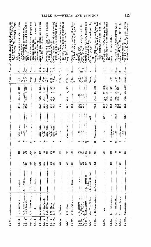
1-9-
9
1-9-
10..
1-9-
11..
1-9-
12..
1-9-
13..
1-9-
14..
1-9
-15
-
1-9
-16-
1-9
-17
-
1-9
-18
-1-
9-19
..
1-9-
20..
1-9-
21..
1-9-
22..
1-9
-23
-1-
9-24
..1-
9-25
..1
-9-2
6-
1-9
-27
-
f_ Q
_ O
Q
1-9
-29
-
1-9
-30-
[-9-3
1-
[-9-3
2-
[-9
-33
..
d
o
..
....
..
E.
E.W
ilso
n..... .
..
E.
B.
Ch
and
ler.
....
.
.....d
o............
E.
Goss
ett.
-. ......
W.
J. H
ardo
astle
...
.F
.H.
Sil
vey.
__
_ ..
J. W
. H
arr
is........
F.H
. S
ilve
y.. .
.....
W.
H.
Du
Bo
se.
__
J. L
. D
uBos
e. _
- _
Mrs
. T
. A
. W
ilso
n...
.....d
o......... ..
..
T.
R.
Lit
tlet
on. _
_ .
P. D
. M
cA
nell
y
C.
P. C
ort
ter.
.. ...
.
B.
C. C
alv
in..
....
..
K.
C.
Has
sell.
......
J. E
. T
hom
as &
B.
Rif
e.
Clo
p ton
& M
itch
elL
.
1938
1946
1941
1940
1948
1912
1932
1940
1942
1936
1949
1936
1938
1936
1939
1951
1934
1936
176
150
200
1,11
0
1,06
1
140 80 168
126 85 220
175
140
180
176
210
3,33
2
2,00
5
210
110
117 86 92 130
6 6 4 11 7 5 36 7 6 6 4 9 8 10 6 10 6 7 60 5 4
tion.
....
. do ..
..... do ..
..
tion.
tion.
tion.
....
. do
....
. do
.
....
_d
o
.....d
o ..
-.-do ...
....
. do...... .
tion.
..
... d
o
tion.
....
. do
645
663.
8
692.
5
664.
4
148.
8
102.
012
6.5
120.
8
49.9
110.
3
98.2
54.3
118.
6
139.
3
90.3
160.
316
1.7
181.
4
94 5
101.
310
7.8
81.7
74.6
80.2
63
.9
43.8
Aug
. 23
, 19
51
.....d
o........
Oct
. 8,
195
1
Oct
. 8,
195
1
Oct
. 5,
195
1..
.. . d
o .
Oct
. 4,
195
1O
ct.
5, 1
951
....
. do
..
.
Oct
. 4,
195
1
.....d
o.. ......
.....d
o........
d
o
...
....
. do... .
....
Feb.
19
, 19
52
Mar
. 11
, 19
30Fe
b.
19,
1952
Oct
. 8,
195
1
Feb.
28
, 19
30O
ct.
8, 1
951
...-
do. ..
Feb.
28
, 19
30
C, E
...
l^
C, W
..C
.W..
J, E
...
1A
C, W
-C
.W..
C.W
.GJ,
E..
.Ji
C, W
, G4 C,
W, G
5 J, G
...
5 C.W
..C
.W..
C, W
-
T, G
-..
C,W
-
C.W
..
C,W
-
N..
...
s...
...s.
..._.
s....
..N
.....
N.-
...
D, S
D, S
...
S..
. ...
D, S
D
. S
D, S
...
D, S
S _
D, S
...
S ...
D,
S--
.N
.....
N...-
Irr
.
D,S
D, S
...
S
S .
N..
...
Oil
test
, pl
ugge
d an
d ab
ando
ned.
N
ow
ater
rep
orte
d.
Wel
l 1-
9-10
in
U.
S.G
eol.
Surv
ey
Wat
er-S
uppl
y P
aper
678.
R
epor
ted
to
pum
p ai
r af
ter
3 ho
urs
pum
ping
8 g
pm.
Wat
er r
epor
ted
to h
ave
iron
col
or.
Cas
ing:
18
0 fe
et,
slot
ted
from
12
0 to
175
feet
. C
asin
g: 6
3 fe
et.
Oil
test
, pl
ugge
d an
dab
ando
ned.
See
log
. C
asin
g: 1
04 f
eet.
Oil
test
, pl
ugge
d an
dab
ando
ned.
See
log
. C
asin
g:
140
feet
, sl
otte
d an
d sc
reen
edfr
om
105
to
140
feet
.
Dra
wdo
wn
0.8
foot
w
hile
pu
mpi
ng5
gpm
, O
ct.
5, 1
951.
Se
e an
alys
is,
tabl
e 12
. C
asin
g:
85
feet
, sl
otte
d an
d sc
reen
edfr
om 4
0 to
85
feet
. P
umpi
ng 1
4 gp
m,
Oct
. 5,
19
51.
Cas
ing:
22
0 fe
et,
slot
ted
from
12
0 to
220
feet
. W
ell
drill
ed i
n bo
ttom
of
dug
wel
l, ca
sed
to
surf
ace.
T
emp.
76°
F.
Cas
ing:
14
0 fe
et,
slot
ted.
D
raw
dow
n 2.
2 fe
et w
hile
pum
ping
11
gpm
Oct
. 4,
19
51.
Cas
ing:
30
feet
.T
emp.
78°
F.
See
anal
ysis
, ta
ble
12.
Cas
ing:
40
feet
.C
asin
g:
63 f
eet.
Oil
test
, pl
ugge
d an
d ab
ando
ned.
See
log.
Oil
test
, pl
ugge
d an
d ab
ando
ned.
Se
e lo
g.C
asin
g:
211
feet
, pe
rfor
ated
fr
om
90
to
210
feet
. D
raw
dow
n 34
.3
feet
w
hile
pu
mpi
ng
460
gpm
, Fe
b.
19,
1952
.W
ell
1-9-
4 in
U.
S. G
eol.
Surv
ey W
ater
- Su
pply
Pap
er 6
78.
See
anal
ysis
, ta
ble
12.
Cas
ing:
12
0 fe
et,
slot
ted.
Wel
l 1-9
-8 in
U.
S. G
eol.
Surv
ey W
ater
- Su
pply
Pap
er 6
78.
Cas
ing:
10
0 fe
et.
Tem
p.
75°
F.
See
anal
ysis
, ta
ble
12.
Wel
l 1-
9-7
in
U.
S.
Geo
l. Su
rvey
W
ater
-Sup
ply
Pap
er 6
78. A
band
oned
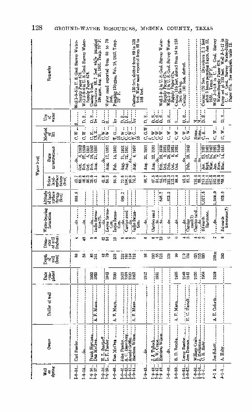
Wel
l or
Sprin
g
1-9-
34..
1-9-
35-
1-9-
36-
1-9-
37-
1-9-
38..
1-9-
39-
1-9-
40-
1-9-
41..
1-9-
42-
1-9-
43-
1-9-
44-
1-9-
45-
1-9-
46-
1-9-
47-
1-9-
48..
1-9-
49-
1-9-
50..
1-9-
51-
1-9-
52..
1-9-
53-
1-9-
54-
J-l-
1..
.
J-l
-2
J-l-
3..
.
Ow
ner
do
H.
L. S
aath
off
..
Arn
old
Grif
fin ..
.....
....
.do
...
....
J. J
. T
ull
och
.. ..
.B
. W. C
rane
.. ......
d
o..
....
....
...
B.
D.B
omba
. ......
Lero
y Fa
selo
r .....
..Je
ss D
unca
n ......
..
Will
iam
Gra
in..
....
.
C.R
.Haby.........
A.
Hab
y.. .
........
Dril
ler
of w
ell
H.
C. H
assd
l...
....
A.
E.
Gofo
rth .
...
Dat
e co
m
plet
ed
1950
19
50
1942
1950
1926
19
28
1939
19
52
1912
1951
1938
1940
19
42
1920
1908
1920
Dep
th
of
wel
l (f
eet) 86
56 89
341 48
70 225
223
160
134
210 96 100 66
12
1
119 99 112
104
123
115
320
190±
260
Dia
m
eter
of
wel
l (in
ches
) 4 48 9 8 42
54 15 6 4 6 7 6 6 4 12 6 6 4 5 4 6 5 7 6
Wat
er-b
eari
ng
form
atio
n
.....d
o.......
.....d
o.......
-....d
o......
Indi
o fo
rma
tio
n (?
). __ do
....
...
Leo
na f
orm
a
tion.
In
dio
form
a
tion,
do
Car
rizo
sand
do
Indi
o fo
rma
tio
n.
do
Car
rizo
sand
..
.. .do
......d
o.......
.....d
o.......
.....d
o.......
..d
o..
....
.C
arriz
o sa
nd(?
) C
arriz
o sa
nd.,
-.
do
Edw
ards
lim
esto
ne.
.....d
o.......
Edw
ards
lim
es to
ne(?
)
Alti
tude
of
land
- su
rfac
e da
tum
(f
eet)
668.
8
689.
7
646.
7
-675
.2
........
1,07
7.5
1,04
4.0
925.
9
Wat
er l
evel
Bel
ow
land
- su
rfac
e da
tum
(fee
t)
43.7
56
.9
46.5
56
.3
35.0
43
.1
41.9
56.3
56.5
72.6
10
4.2
90.0
74.3
66.7
67.5
54
.564
.1
72.9
10
1.3
113.
1 99
.4
96.9
81.8
116.
3 55
.621
3.4
221.
1 22
7.5
193.
5 19
0.9
*65.
9
Dat
e m
easu
rem
ent
do
Oct
. 8,
195
2 Fe
b.
27,
1930
O
ct.
8, 1
951
Feb.
18
, 19
52
Aug
. 21
,195
1
d
o
Aug
. 17
, 19
51
Feb.
18
,195
2
Aug
. 21
, 19
51
Aug
. 22
, 19
51
Aug
. 4,
195
2
Aug
. 21
.195
1
Aug
. 22
,195
1 _
_ do
____
Feb.
28
, 19
30
Oct
. 9,
195
1 Fe
b.
28,
1930
O
ct.
9, 1
951
Oct
. 8,
195
1
..... d
o ...
.Fe
b.
19,1
942
..... d
o
..do-
Jan.
23
, 19
51
Sept
. 12
,195
1 M
ar.
24,1
952
Jan.
29
, 19
51
Nov
. 7.
195
0 M
ar.
14,
1951
Met
hod
of
lift
C.W
..
C.W
-.
C, E
C
f.E
.. IV
i C
,W-
c,w
..T
, G
15
C
,W-
C, G
C
.W..
T, G
15 C
.G.W
5 C
.W..
C
.W..
C,W
-
C.W
..
C,W
-
c,w
._c,
w..
Non
e..
C, E
1 C
, W
..
C,
W..
Use
of
w
ater
S
D,S
...
D, S
Ir
r
D__
S
.
Irr ..
..
D, S
D
, S
S
Irr
D, S
D, S
D
, S
...
D. S
...
D, S
S ..
D, S
S
N-
N-.
..D
. S
S
D, S
Rem
arks
Wel
l 1-9
-5 in
U. S
. Geo
l. Su
rvey
Wat
er-
Supp
ly P
aper
678
. W
ell 1
-9-6
in U
. S. G
eol.
Surv
ey W
ater
- Su
pply
Pap
er 6
78.
Cas
ing:
9 f
eet.
Dra
wdo
wn
88.7
fe
et
whi
le
pum
ping
10
8 gp
m, A
ug. 2
1, 1
951.
Tem
p. 7
6° F
.
Wat
er s
and
repo
rted
fr
om
60
to
70
feet
. Pu
mpi
ng 1
20 g
pm, F
eb.
18, 1
952.
Tem
p.
75°
F.
Cas
ing:
120
fee
t, sl
otte
d fr
om 8
0 to
120
fe
et.
Wat
er s
and
repo
rted
fro
m 8
5 to
10
5 fe
et.
Wel
l 1-9
-2 in
U. S
. Geo
l. Su
rvey
Wat
er-
Supp
ly P
aper
678
. W
ell 1
-9-3
in U
. S. G
eol.
Surv
ey W
ater
-Su
pply
Pap
er 6
78.
Cas
ing:
125
fee
t, sl
otte
d fr
om 9
4 to
125
fe
et.
See
log.
C
asin
g: 1
20 f
eet,
slot
ted.
. ....... ..... . .........-
Cas
ing:
120
fee
t. D
raw
dow
n 2.
1 fe
et
afte
r 3
hour
s pu
mpi
ng 5
gpm
, Jan
. 22,
19
51.
Tem
p. 7
2° F
.
Wat
er-S
uppl
y Pa
per
678.
Pu
mp
set
at 1
10 f
eet.
Wel
l J-
l-17
in
U.
S.
Geo
l. Su
rvey
W
ater
-Sup
ply
Pape
r 67
8.
See
anal
ysis
, ta
ble
12.
to 00

;-i-4
...
J-l
-5
J-l-
6..
.
J-l-
7..
.
J1
B
J-l-
9..
.
J-l-
10 .
J-l-
11 .
J-l-
12 .
J1
1 Q
J-l-
14 .
J-l-
15 .
J-l-
16 .
J-l-
17 .
J-l-
18
J-1-1
Q
J-l
20
J-l-
21
J1
99
R.
E. H
ab
y -
... -
A.
C. W
urz
bac
h _
_
C. J
. S
chott
..-.
.
R.
Hab
y.. .
........
A. E
. G
ofor
th- .
.....
A. E
. G
ofor
th.. __ .
C. J
. Sc
hott.
...
.. -
1935
1915
1947
1915
1904
1918
1934
1926
1889
1922
1890
1930
1920
(?)
1945
1919
1Q
47
1938
1915
70
0±
40 34 769
750
775 65 76 41 44 297
272
275± 260
275± 254
255
350
6 36 4? 8 fi fi fi 48 6 30 36 5 5 8 fi 8+ 7 5 n
limes
tone
.
form
atio
n.
....
.do
Edw
ards
lim
esto
ne.
.....d
o.......
.....d
o.......
form
atio
n.
Leon
afo
rmat
ion.
.....d
o.......
form
atio
n (?
) .....d
o.......
Edw
ards
lim
es to
ne(?
)
do ..
Edw
ards
lim
esto
ne.
..
do..
....
.
.....d
o.......
.....d
o.......
.....d
o.......
.....d
o.......
926.
8
923.
1
974.
2
968.
7
1,00
3.4
1,00
0.3
1,04
2.6
141.
3
31,1
28.4
98.6
17
2.7
235.
8 25
1.2
196.
219
6.2
*233
.7
38.1
60.0
56.7
34.4
35.1
152.
1 17
5.2
171
.9
153.
8 16
1.8
196.
6 16
2.5
187.
6 19
1.3
154.
118
8.0
194.
3 19
5.1
219.
6 23
7.3
217.
823
4.8
239.
1 *2
42.4
Nov
. 24
, 19
50
.d
o........
... .
.do
....
....
Mar
. 19
, 19
52
Jan.
9,
193
4 Fe
b.
13,
1951
M
ar.
11,
1952
...-
do
........
Feb.
13
, 19
51
Sept
. 5,
195
1
Jan.
13
, 19
51
Sept
. 24
, 19
51
Jan.
16
, 19
52N
ov.
28,
1950
.....d
o...
Jan.
10
, 19
34
Jan.
10
, 19
51
Mar
. 14
, 19
51
Jan.
12
, 19
34
Nov
. 28
, 19
50
Apr
. 25
,195
2 N
ov.
28,
1950
Apr
. 25
, 19
52
Sept
. 5,
195
2 Ja
n.
12,
1934
Nov
. 27
, 19
50
Apr
. 25
, 19
52
Nov
. 22
, 19
50A
pr.
25,
1952
Se
pt.
5, 1
952
Nov
. 27
, 19
50A
pr.
24,
1952
Se
pt.
5, 1
952
Sept
. 12
,195
1
C, W
._
C,
W._
C,E
...
}i
C, W
__
C, G
10
C, W
-
C, W
..
C, W
._
c, w
..C
, W
..
T, E
U
C
, W
..
C,
W..
C,
W..
C, G
-..
5 C.W
..2 C
, E
1A
C, E
...
l/2 C.W
..
D, S
...
D, S
...
D, S
D, S
D, S
D, S
S..
....
S..
....
S..
....
D, S
D, S
...
D, S
S
D, S
D, S
D, S
...
D, S
...
D, S
S..... .
No
mea
sura
ble
draw
dow
n af
ter
2 ho
urs
pum
ping
3 t
o 5
gpm
, N
ov.
24,
1950
. T
emp.
72°
F.
Dug
. C
urbi
ng:
40 f
eet o
f roc
k.
Dug
. T
emp.
74°
F.
Pum
p se
t at
280
fee
t. T
emp.
72°
F.
Wel
l J-
l-16
in
U.
S. G
eol.
Surv
ey
Wat
er-S
uppl
y Pa
per
678.
Dra
wdo
wn
4.8
feet
af
ter
\Vz
hour
s pu
mpi
ng 9
gpm
, Feb
. 13,
1951
. Tem
p.
73°
F.C
asin
g: 5
00 f
eet.
Tem
p. 7
2° F
. W
ell
J-l-
15 in
U.
S. G
eol.
Surv
ey W
ater
- Su
pply
Pap
er 6
78.
Cas
ing:
50
feet
, sl
otte
d fr
om 3
5 to
50
feet
. W
ater
-bea
ring
gra
vel
from
35
to 4
9 fe
et;
yello
w c
lay
from
49
to 6
3 fe
et.
Dug
.
Cas
ing:
76
feet
, set
in d
ug w
ell.
Cas
ing:
40
feet
.
Cas
ing:
44
feet
.
Cas
ing:
190
fee
t. T
emp.
72°
F.
Wel
lJ-
l-20
in U
. S.
Geo
l. Su
rvey
Wat
er-
Supp
ly P
aper
678
. Pu
mp
set
at 2
45 f
eet.
Wel
l J-
l-19
in
U.
S.
Geo
l. Su
rvey
W
ater
-Sup
ply
Pape
r 67
8.
Tem
p.
73°
F.
Wel
l J-
l-21
in
U.
S.G
eol.
Surv
ey
Wat
er-S
uppl
y Pa
per
678.
D
raw
dow
n 8.
1 fe
et
afte
r 2J
^ ho
urs
pum
ping
7 g
pm,
Apr
. 25
, 19
52.
Pum
p se
t at
21
0 fe
et.
Tem
p.
72°
F.W
ell
J-l-
22 i
n U
. S.
G
eol.
Surv
eyW
ater
-Sup
ply
Pape
r 67
8.
Cas
ing:
6
feet
. T
emp.
72
° F.
Dra
wdo
wn
1.8
feet
af
ter
6 ho
urs
pum
ping
4
gpm
, A
pr.
24,
1952
. T
emp.
72^
° F.
Wel
l J-
l-25
in
U
. S.
G
eol.
Surv
ey
Wat
er-S
uppl
y Pa
per
678.
See
ana
ly
sis,
ta
ble
12.
fcO

Wel
l or
Sp
ring
J-l-
23
J 1
24
J-l-
25
J-l
26
J-l-
27
J-l-
28
J-l-
29
J-l-
30
T-1
31
T i
qo
J1
33
J 1
34
T 1
31
J-l -
36(S
prin
g)
J-l-
37
J-l-
38
J-l-
39
Ow
ner
S.J
. H
aby .
...
...
C.
W. H
ab
y..
.. .
. ....d
o.....
_.._
Dri
ller
of w
ell
W. H
aby...... _
..
W.
D.
Bac
on
etal
.
Dat
e co
m
plet
ed
1926
1946
1921
1939
1886
1939
1927
1948
1906
1900
1931
1910
1914
1946
1940
Dep
th
of
wel
l (f
eet) 332 36
30 289 45
42
48
880 27
30
60
62
60 300
571
450
Dia
m
eter
of
wel
l (i
nche
s) 6 36
42 6 36
29
36 8,
6 42
36
38
48
38 6 6 10
Wat
er-b
eari
ng
form
atio
n
... ..do.... ..
.
Leo
na f
orm
a
tion.
..
. ..
do
. ...
Aus
tin
chal
k(?)
.
Leo
na f
orm
a
tion.
...-
do.......
.. do .
Edw
ards
lim
esto
ne.
Leo
na f
orm
a-tio
n(?)
...
dO
..
Esc
ondi
do
form
atio
n.
Leo
na f
orm
a
tion.
.....d
o.......
.....d
o.......
Aus
tin c
halk
Edw
ards
lim
esto
ne.
. d
o... .
...
Alti
tude
of
land
- su
rfac
e da
tum
(f
eet)
1,00
2.3
947.
3
Wat
er l
evel
Bel
ow
land
- sn
rfac
e da
tum
(f
eet)
160.
8 11
0.6
245.
5 24
.5
23.8
24.2
18.1
25.0 8.8
259.
8
17.5
17.2
15.7
54.4
33.2
35
.5
234.
7
Dat
e m
easu
rem
ent
Jan.
12
, 19
34
Jan.
23
, 19
51
Apr
. 24
, 19
52
Nov
. 27
, 19
50
d
o........
Nov
. 27
, 19
50
..d
o........
Sept
. 24
, 19
51
Nov
. 27
, 19
50
Sept
. 10
, 19
51
Nov
. 28
, 19
50
do........
Sept
. 21
, 19
51
Sept
. 24
, 19
51
Jan.
25
, 19
51
Sept
. 5,
195
1
Jan.
25
, 19
51
Met
hod
of
lift
C,W
..
C, W
..
C, W
..
C.W
..
C, E
...
gE-
SE
...M>
C,
W._
C, E
...
C, E
...
M
C,W
_.
C,W
..
C.W
..
c,w
..
Use
of
w
ater
D, S
S .
D, S
...
D, S
...
D, S
...
D, S
...
D, S
...
D, S
D, S
...
D, S
...
D, S
D, S
...
D, S
...
D, S
...
N-.
S
N.-
...
Rem
arks
Wel
l J-
l-24
in
U.
S.
Geo
l. Su
rvey
Wat
er-S
nppl
y P
aper
67
8.
Cas
ing:
30
fee
t. B
ase
of g
rave
l at
27
feet
. C
asin
g:
30 f
eet.
Bas
e of
gra
vel
at 2
5 fe
et.
Cas
ing:
26
0 fe
et.
Wat
er
repo
rted
to
ha
ve
bitt
er
tast
e du
ring
dr
ough
t. L
eona
fo
rmat
ion
cont
ribu
tes
wat
er
to
wel
l th
roug
h co
rrod
ed
casi
ng.
Tem
p. 7
5° F
.
Dug
. C
urbi
ng:
48 f
eet
of r
ock.
Cas
ing:
8-i
nch
to 4
00 f
eet,
6-in
ch f
rom
73
0 to
850
fee
t. T
emp.
73°
F.
Wel
l J-
l-23 i
n U
. S.
Geo
l. Su
rvey
Wat
er-
Supp
ly P
aper
678
. Se
e an
alys
is,
tabl
e 12
. D
ug.
Cur
bing
: 27
fee
t of
con
cret
e ri
ngs.
Dug
. W
est
bank
of
Med
ina
Riv
er.
Dug
. C
urbi
ng:
26 f
eet
of r
ock.
Loc
ally
kno
wn
as S
an G
eron
imo
Spri
ng
Flow
ing
160
gpm
, Ja
n.
26,
1951
. T
emp.
74°
F.
Wat
er
repo
rted
to
ha
ve
bitt
er
tast
e.
Wel
l J-
l-13 i
n U
. S.
G
eol.
Surv
ey
Wat
er-S
uppl
y P
aper
67
8.
Cas
ing:
45
0 fe
et.
Tem
p.
73°
F.
See
anal
ysis
, ta
ble
12.
Cas
ing:
450
fee
t. O
il te
st,
plug
ged
and
aban
done
d.
OJ o

J-l-
40
J-l-
41
J-l-
42
J-l-
43J-
l-44
J-l-
45
J-l-
46
J-l-
47J-
l-48
J-l-
49
J-l-
50
J-l-
51
J-l-
52
J-l-
53
J-l-
54
J-l-
55
J-l-
56
J-l-
57
F. C
. S
tinso
n... .
A.
C. S
tein
. ........
.....d
o.. ..
....
.
L. W
. Bu
rrell
._
.
L. H
aby.
. ___ . ...
I. C
. S
tins
on...
__
.
..... d
o ..... .
...
L. W
. Bur
rell
... ..
..
..... d
o
..
. ...
W.P
eter
s-- -
L. W
. Bur
rell
.. .
..... d
o ...
.
..... d
o ..... ---
L. W
. Bu
rrel
l...
....
1940
1929
1900
1900
1951
1924
1920
1936
1907
1930
1914
1930
1947
1946
1925
1910
64 641 38
1,21
6
1,31
5 41 38 180 50 580
501
567
650
562
565
217
48 6 42 36 9, 6 36 36 7 6 48 6 6 12 5 6 5 6
tion.
E
dwar
dslim
esto
ne.
form
atio
n...... d
o ..
.E
dwar
dslim
esto
ne.
-do -.
Leon
afo
rmat
ion.
..
.-d
o..
....
d
o
limes
tone
.
Leon
afo
rmat
ion.
E
dwar
dslim
esto
ne,
do
-do .
do
..... d
o ..
..
- -
do..
. .
Ana
cach
olim
esto
ne.
tion.
E
dwar
ds
limes
tone
.
form
atio
n.
.....d
o.......
Edw
ards
lim
esto
ne.
-do-.
.--.
form
atio
n.
...-
do
.......
..... d
o
limes
tone
.
form
atio
n.
limes
tone
, do
-do ... .
do
..... d
o
- -d
o... -
limes
tone
.
846.
0
875.
4
871.
3
929.
0
930.
1
844.
1
819.
3
52.0
181
.8
21.5
29.5
205.
019
4.7
28.3
34.8
24.0
45.5
71.8
45.9
207.
4
173.
220
9.5
214.
0
250
249.
026
5.9
259.
0 18
3.4
145.
7
Jan.
25
, 19
51
Sept
. 5,
195
1
Sept
. 24
, 19
51
.....d
o ..
.. .
Jan.
1,
1952
M
ay
18,
1951
Sept
. 21
, 19
51
..
do .
.. d
o .....
Feb.
20
, 19
30Ju
ly
15,
1951
Sept
. 21
, 19
51
d
o
Jan.
8,
193
4Se
pt.
5, 1
951
Mar
. 11
, 19
52
Feb.
9,
195
1
Feb.
9,
195
1M
ar.
11,
1952
Se
pt.
6, 1
952
Sept
. 5,
195
1
Feb.
9,
195
1
C.W
.-
C, G
8 C
, W
..
C,
W..
C, E
4 C,
W..
C, E
...
C,
W..
C,
W_.
C,
W-
C, W
..
C, G
6 C,
W..
C, W
..
C, W
-.
C, W
-.
D, S
D, S
S
D,
S___
D.S
N_-
.__
D, S
D, S
...
D.S
...
D, S
S
D, S
S
D, S
D, S
...
D, S
D, S
...
N..
._.
Dug
. C
urbi
ng:
60 f
eet o
f con
cret
e rin
gs.
Tem
p. 7
5° F
. C
asin
g:
58
feet
. D
raw
dow
n 0.
7 fo
otaf
ter
2 ho
urs
pum
ping
24
gpm
, Fe
b.9,
19
51.
Tem
p.
72},2
° F.
Se
e lo
g.W
ell
J-l-
12 i
n U
. S.
G
eol.
Surv
eyW
ater
-Sup
ply
Pape
r 678
. See
ana
lysi
s,ta
ble
12.
Dug
.
Cas
ing:
30
feet
. D
ug.
Cas
ing:
9-in
ch t
o 40
fee
t, 6-
inch
fro
m
40 t
o 1,
150
feet
. D
raw
dow
n 24
.1
feet
aft
er 8
hou
rs p
umpi
ng 8
00 g
pm,
May
18,
195
1.
See
log.
Se
e an
alys
is,
tabl
e 12
.O
il te
st,
plug
ged
and
aban
done
d.
Wel
l J-
l-3 i
n U
. S.
Geo
l. Su
rvey
Wat
er-
Supp
ly P
aper
678
. Se
e lo
g.D
ug. D
o.
Pum
p se
t at
160
fee
t. W
ell r
epor
ted
to
have
sm
all
yiel
d.
Wel
l J-
l-11
in
U
. S.
G
eol.
Surv
ey
Wat
er-S
uppl
y Pa
per
678.
Se
e an
alys
is,
tabl
e 12
.D
ug.
Cur
bing
: 6
feet
of c
oncr
ete.
Cas
ing:
520
feet
.
Bas
e of
Gra
yson
sha
le (
Del
Rio
cla
y)re
port
ed a
t 49
6 fe
et.
Tem
p. 7
3° F
.W
ell
J-l-
14 i
n U
. S.
G
eol.
Surv
eyW
ater
-Sup
ply
Pape
r 67
8.
Cas
ing:
60
feet
. Su
lfur
wat
er c
emen
ted
off
from
300
to
400
feet
. T
emp.
72°
F.
See
log.
C
asin
g: 6
0 fe
et.
Pum
p se
t at
280
fee
t.B
ase
of G
rays
on s
hale
(D
el R
io c
lay)
at 6
28 f
eet.
Cas
ing:
6 f
eet.
Pum
p se
t at
240
fee
t.B
ase
of G
rays
on s
hale
(D
el R
io c
lay)
at 5
06 fe
et.
Wel
l J-l
-10
in U
. S. G
eol.
Surv
ey W
ater
-Sup
ply
Pape
r 67
8.
Tem
p. 7
3° F
. W
ell J
-l-9
in U
. S. G
eol.
Surv
ey
Wat
er-S
uppl
y Pa
per
678.
See
anal
ysis
, ta
ble
12.
Aba
ndon
ed.
Wel
l J-
l-8 in
U.
S. G
eol.
Surv
ey W
ater
-Sup
ply
Pape
r 67
8.

Wel
l or
Sprin
g
J-l-
58
J-l-
59
J-l-
60
J-l-
61
J-l-
62
J-l-
63
J-l-
64
J-l-
65
J-l-
66
J-l-
67
J-l-
68
J-l-
69
J-l-
70
J-l-
71
J-l-
72
J-l-
73
J-l-
74
Ow
ner
Joe
Rif
f.. .
....
....
.
T.
Rei
tzer
__
. .....
0. A
. Sch
mid
t......
S.H
. S
tein
le........
....
.do
....
....
....
.
C.
M.
Got
ham
. .....
Moy
e M
ilita
ry
Aca
dem
y.
Dril
ler
o w
ell
G. P
. O
akes
.... ..
..
.....d
o.............
C.
Hae
gelin
and
F.
San
tos.
Cra
vens
Dril
ling
Co.
Dat
e co
m
plet
ed
1932
1880
1938
1942
1940
1900
1938
1936
1902
1935
1933
1930
1950
1941
1938
1941
1929
Dep
th
of
wel
l (f
eet) 50 62
165 47
1,41
2 99
940 28
100
120
110
282 46
68
42
43 700
Dia
m
eter
of
wel
l (in
ches
)
42 48 5 42 10, 8 5 10, 7 36 6 6 6 8 48 5 42
48 12
Wat
er-b
eari
ng
form
atio
n
Leon
a lim
esto
ne.
.....d
o.......
Esco
ndid
o fo
rmat
ion.
Le
ona
form
atio
n (?
) E
dwar
ds
limes
tone
. Es
cond
ido
form
atio
n.
Leon
a fo
rma
ti
on^)
. E
scon
dido
fo
rmat
ion.
.....d
o.......
.....d
o.......
.....d
o....._
_
Leo
na f
orm
a-
tion(
7).
Esc
ondi
do
form
atio
n.
Leon
a fo
rma-
tio
n(?)
. Le
ona
form
a-
form
atio
n.
Edw
ards
lim
esto
ne.
Alti
tude
of
land
- su
rfac
e da
tum
(f
eet)
986.
1
Wat
er le
vel
Bel
ow
land
- su
rfac
e da
tum
(fee
t)
30.3
49.0
79.1
32.7
47.6
12.9
87.0
63
.9
59.8
*67.
9
85.0
43.9
41.7
36.9
41.6
52.7
77
.5
Dat
e m
easu
rem
ent
July
16
, 19
51
Sept
. 20
, 19
51
July
16
, 19
51
-___
do.._
-___
Sept
. 20
, 19
51
July
16
, 19
51
Feb.
19
, 19
30
Dec
. 27
, 19
51
Dec
. 27
, 19
51
Sept
. 11
, 19
51
July
16
, 19
51
....
.do
....
....
..d
o..
....
..
July
16
, 19
51
....
.do..
....
..
May
18
, 19
50
Sept
. 5,
195
1
Met
hod
of
lift
C,
W..
C,
W-
C,
W-
C,
W-
C, E
...
C.W
..
C, E
...
14
C, E
...
J2 C.W
..
C.W
..
C,E
W aw
..C
.W..
C, E
,..
l/2 T, E
5
Use
of
w
ater
D, S
...
D,
S.-
_
D, S
...
D, S
...
N
D, S
...
N
D, S
...
D, S
...
D, S
...
D, S
...
D, S
...
D, S
...
S..
....
D, S
...
D, S
...
P
.
Rem
arks
Dug
. C
urbi
ng:
38 f
eet
of ro
ck.
Wat
er
leve
l re
port
ed t
o fl
uctu
ate
with
sta
ge
of M
edin
a R
iver
. D
ug.
Cur
bing
: 8
feet
of
bric
k.
See
anal
ysis
, tab
le 1
2.
Cas
ing:
160
feet
, slo
tted
from
115
to 1
60
feet
. D
ug.
Oil
test
, ab
ando
ned
and
plug
ged.
Se
e lo
g.
Cas
ing:
100
fee
t slo
tted.
Oil
test
. Se
e lo
g.
Dug
. C
urbi
ng:
28
feet
of
co
ncre
te
rings
. A
t D
unla
y. W
ell
J-l-
2 i
n U
. S.
Geo
l.Su
rvey
W
ater
-Sup
ply
Pape
r 67
8.
At
Dun
lay.
Wel
l J-
l-1
in
U.
S. G
eol.
Surv
ey W
ater
-Sup
ply
Pape
r 67
8.
At
Dun
lay.
C
asin
g:
110
feet
, sl
otte
d fr
om 4
0 to
60
feet
and
80
to 1
10 f
eet.
Cas
ing:
28
0 fe
et,
low
er
part
slo
tted.
D
raw
dow
n 35
fe
et
afte
r 3
hour
s pu
mpi
ng 5
0 gp
m.
Cor
rosi
on r
epor
ted
to
requ
ire
pipe
re
plac
emen
t ev
ery
two
year
s.
Dug
. C
urbi
ng:
45 f
eet o
f co
ncre
te r
ings
.
Cas
ing:
65
feet
, sl
otte
d fr
om 3
5 to
65
feet
. W
ell
repo
rted
to
fai
l du
ring
dro
ught
.
Wes
t ba
nk
of
Med
ina
Riv
er.
Wat
er
leve
l in
w
ell
repo
rted
to
vary
with
th
e st
age
of t
he r
iver
. C
amp
Cay
uga
wel
l. D
raw
dow
n 1 .
1 fe
et w
hile
pum
ping
120
gpm
for
V£
hour
, Se
pt.
12,
1951
. Su
pplie
s sw
im
min
g po
ol
and
boys
' ca
mp.
CO to

J-l-
75
J-l-
76
J-l-
77
J-l-
78
J-l-
79
J-l-
80
J-l-
81J-
1-82
J-l-
83
J-l-
84 .
J-l-
85 .
J-l-
86 .
J-l-
87 .
J-2-1
...
J-2
-2..
.
J-2-3
...
J-2
-4..
.
L. W
. Bur
rell _ ..
..
Rob
ert H
alty
____
___
F. T
ondr
e. _
_ _ __
U. B
. K
empf
__ ..
....
Dan
Bie
dige
rs _
_ __
-...d
o. . ...-
..._
Moy
e M
ilita
ry
Aca
dem
y
W. J
. H
ab
y
_
W. G
. W
ur.b
ach_
Cra
vens
Dril
ling
Co-
Gol
den
Wes
t Oil
Co.
.
A. E
. Gcf
orth
. ......
1944
1905
1910
1Q19
1947
1944
1936
1923
1948
1946
IQO
ft
1927
1(U
7
1923
1QV
)
1942
1939
650
225 71 75 730 67 39 710
715
740
1,07
0
1,14
7
660
749 28 557
640
10, 5 10 36 42 5 5 48 6 9 10 4 13 7, 5 6 30 6 8
_.__
_do_
____
__
Ana
cach
olim
esto
ne.
Leon
a fo
rma
tion.
Leon
a fo
rma
tion
(?).
Edw
ards
limes
tone
.L
eona
for
ma
tion.
.....d
o.......
Edw
ards
limes
tone
.
-___
_do_
____
__
Edw
ards
limes
tone
.
.. d
o.......
-__.
_do_
____
._
____
_do-
____
__
Edw
ards
limes
tone
.
Leon
afo
rmat
ion.
..d
o.......
. .d
o
757.
8
758.
1
757.
5
922.
0
854.
2
774.
0
966.
7
89.6
110.
1
57.6
68.6
105.
2
29.0
30.1
94.8
73.8
71.6
244.
2
*202
.7
125.
912
6.3
228.
925
8.6
293.
6
23.1
210.
420
5.3
Feb.
19
, 19
30M
ar.
8, 1
951
Mar
. 8,
195
1
Aug
. 12
, 19
51
Oct
. 27
, 19
50
July
16
,195
1
___-
do-_
____
.D
ec.
5, 1
951
June
6,
195
1
July
8,
195
0
Sept
. 28
, 19
34
Nov
. 1,
195
1
June
2,
195
2Se
pt.
5, 1
952
Aug
. 29
, 19
34Ja
n.
2, 1
951
Sept
. 6,
195
1
Jan.
2,
195
1
July
23
, 19
51-...d
o
____
_
C. E
___
1 C,W
_.
H,
B__
C. G
_._
6 C,W
__
C,W
__
C, E
.__
T, E
___
60 T, E
.40 C
. W
..
C,
W_.
C, W
..
C,
W._
C,
W..
C,
W-
C, G
_._
5
D, S
D,
S___
D._
.._
D, S
...
D._
.__
D,
S_._
D, 8
...
N.,_
__
P__.
...
P, D
_._
D, S
D, S
...
S.-
D, S
D. S
S .
D.
S__
Una
ble
to m
easu
re.
Rep
orte
d to
pu
mp
air
afte
r 2
hour
s pu
mpi
ng 6
gpm
. W
ell J
-l-7
in
U.
S.
Geo
l. Su
rvey
W
ater
-Sup
ply
Pape
r67
8.
Form
erly
U.
S. G
eol.
Surv
ey o
bser
va
tion
wel
l X
M-1
.
Cas
ing:
65
feet
, sl
otte
d fr
om 2
5 to
60
feet
. E
ast
bank
of
Med
ina
Riv
er.
Dug
. C
urbi
ng:
40 f
eet o
f co
ncre
te r
ings
.In
C
aste
ovill
e.
Bot
tom
of
G
rays
on
shal
e (D
el
Rio
cl
ay)
at
620
feet
. Sm
all
amou
nt o
f su
lfur
wat
er e
nter
s w
ell
from
Aus
tin c
halk
. W
ell
J-l-
6
in U
. S.
Geo
l. Su
rvey
Wat
er-S
uppl
y Pa
per
678.
Nor
th o
f w
ell
J-1-
82.
Cas
ing:
700
fee
t. D
raw
dow
n 6
feet
af
ter
24
hour
s pu
mpi
ng
500
gpm
, O
ct.
9,
1950
. Te
mp.
751
2° F
. See
ana
lysi
s, ta
ble
12.
Sout
h of
wel
l J-1
-82.
C
asin
g: 6
96 f
eet.
Dra
wdo
wn
1.4
feet
aft
er 2
4 ho
urs
pum
ping
19
2 gp
m,
Oct
. 9,
19
50.
Tem
p. 7
5° F
.A
t T
hree
Poi
nts
Stat
ion.
U
nabl
e to
m
easu
re.
Cas
ing:
1,0
35 f
eet.
Wel
l J-
l-5 i
n U
. S.
Geo
l. Su
rvey
Wat
er-
Supp
ly P
aper
678
.O
il te
st,
com
plet
ed a
s w
ater
wel
l. C
as
ing:
1,1
26 f
eet.
Wel
l J-
l-4
in
U.
S.
Geo
l. Su
rvey
W
ater
-Sup
ply
Pape
r 67
8.
Tem
p. 7
5° F
. Se
e lo
g.
See
anal
ysis
, ta
ble
12.
Cas
ing:
7-in
ch t
o 14
5 fe
et,
5-in
ch f
rom
14
5 to
542
feet
. Pu
mp
set a
t 14
0 fe
et.
Cor
rode
d ca
sing
allo
ws s
ulfu
r wat
er fr
om
Aus
tin
chal
k to
en
ter
wel
l. W
ell
J-2-
6 in
U.
S. G
eol.
Surv
ey W
ater
- Su
pply
Pa
per
678.
Se
e an
alys
is,
tabl
e 12
.E
ast b
ank
of S
an G
eron
imo
Cre
ek.
Blu
e cl
ay a
t 26
feet
.
Cas
ing:
610
feet
. T
emp.
73°
F.
CO
C
O

Wel
l or
Sp
ring
J-2
-5
J-2
-6
Jo
17
J-2-8
T 9-
Q
J-2-
10
J-2-
11
J-2-
12
J-2-
13
J-2-
14
J-2-
15
J-4
-1..
.
J-4
-2..
.
J-4-3
...
J-4-4
...
J-4
-5
J-4
-6..
.
Ow
ner
A.
A. H
aby.
C. T
. Wur
zbac
h...-
.
R.
Z. H
aby... .
.....
Tob
y K
och
....
....
.T
. S. M
cC
lure
...
Dril
ler
of w
ell
A. E
. G
ofo
rth .
.__
A.
E. G
ofo
rth
Fre
dBur
kett
.. ..
...
Jagg
e &
Tsc
hirh
art
Pegg
Bro
s. &
J.
Fitz
sim
on.
F. M
. B
urk
ett.
.....
E. T
.Pet
ers.
.---
--.
Dat
e co
m-
pl-'t
ed
1923
1928
19
46
1928
1950
1900
1926
1947
19
29
1945
1934
1951
1917
1929
Dep
th
of
wel
l (f
eet) 74
0
486
689
445
440
650
225
560
700
1,18
0
3,19
3 96
1,38
5
400
400
1,15
0
1,58
0
Dia
m
eter
of
wel
l (in
ches
) 6 6 6 6 6 6 8 6 8 8 6 10 4 12 4
Wat
er-b
eari
ng
form
atio
n
Edw
ards
lim
esto
ne.
.....d
o
Edw
ards
lim
esto
ne.
--do- -..
-do... .
d
O
_
Ana
cach
o lim
esto
ne(?
)
Edw
ards
lim
esto
ne.
... ..do
...-
do.......
Esco
ndid
o fo
rmat
ion.
E
dwar
ds
limes
tone
.
Esco
ndid
o fo
rmat
ion,
..d
o.......
Edw
ards
lim
esto
ne.
Alti
tude
of
land
- su
rfac
e da
tum
(f
eet)
950.
0
966.
3 1,
072.
4
997.
1
796.
8
766.
8
970.
6
916.
8
Wat
er l
evel
Bel
ow
land
- su
rfac
e da
tum
(f
eet)
267.
2
401.
2 37
8.6
384.
7
383.
0 38
5.4
307.
7 30
7.2
254.
4 25
5.3
95.0
95
.0
119.
0 10
8.9
126.
9 *1
13.2
56.8
289.
4
159.
1
159.
5
121.
5
Dat
e m
easu
rem
ent
Sept
. 5,
195
1
Feb.
12
, 19
51
Jan.
25
, 19
51
Jan.
16
, 19
52
Dec
. 12
, 19
50
July
23
, 19
51
Oct
. 11
, 19
34
July
23
, 19
51
Feb.
9,
195
1 O
ct.
8, 1
952
Jan.
12
, 19
34
Mar
. 14
, 19
51
Jan.
12
, 19
34
Mar
. 14
,195
1
Oct
. 6,
195
0 O
ct.
31,
1951
Jan.
24
, 19
52
Nov
. 16
,195
1
Aug
. 20
, 19
51
d
o_
_
May
, 22
, 19
51
Met
hod
of
lift
C, E
...
C, G
5 C,
G..
. 5 C,
E..
. \ c"
w
C W
C.W
..
C.W
-C,
E
1 C.W
..
C, E
1 C
, W..
c,w__
Non
e ..
Use
of
w
ater
N D, S
S
......
D, S
...
D, S
S......
D, S
...
D,
S_-_
D, S
D
, S
S
D, S
D,
S
D,
S.._
N..
Rem
arks
No
surf
ace
casi
ng.
Bla
ck p
reci
pita
te o
n ta
pe b
elow
220
fee
t, pr
obab
ly f
rom
w
ater
in
Aus
tin c
halk
. W
ell
J-2-
5 in
U.
S. G
eol.
Surv
ey W
ater
-Sup
ply
678.
T
emp.
73°
F.
Cas
ing:
656
fee
t. C
orro
ded
casi
ng r
e
port
ed
to
allo
w
sulf
ur
wat
er
from
A
ustin
cha
lk t
o en
ter
wel
l. C
asin
g: 3
90 f
eet.
Tem
p. 7
2° F
. Se
e an
alys
is, t
able
12.
T
emp.
73°
F.
Wel
l J-2
-4 in
U. S
. Geo
l. Su
rvev
Wat
er-S
uppl
y Pa
per
678.
C
asin
g: 6
20 f
eet.
Pum
p se
t at
280
feet
. O
dor
of h
ydro
gen
sulfi
de.
Wel
l rep
orte
d to
hav
e sm
all y
ield
. W
ell
J-2-
1 in
U.
S. G
eol.
Surv
ey W
ater
- Su
pply
Pap
er 6
78.
Bas
e of
Gra
yson
sha
le
(Del
Rio
cla
y)
at 5
10 fe
et.
Wel
l J-2
-2 in
U. S
. Geo
l. Su
rvey
Wat
er-S
uppl
y Pa
per
678.
Cas
ing:
95
0 fe
et.
Tem
p.
75°
F.
Wel
l J-
2-3
in U
. S.
Geo
l. Su
rvey
Wat
er-
Supp
ly P
aper
678
. Se
e an
alys
is,
tabl
e 12
. O
il te
st,
plug
ged
and
aban
done
d. S
ee
log.
C
asin
g:
110
feet
, sl
otte
d fr
om
80
to
110
feet
. C
asin
g:
1,24
0 fe
et.
Pum
p se
t at
34
0 fe
et.
Ow
ner
plan
s to
irr
igat
e in
195
3.
Tem
p. 7
5J 2
° F.
See
log
. Se
e an
alys
is,
tabl
e 12
. W
ater
enc
ount
ered
at 2
40 fe
et, r
epor
ted
to b
e sa
lty.
WTa
ter
repo
rted
to
be s
alty
. O
il te
st,
plug
ged
and
aban
done
d. S
ee
log.
O
il te
st,
conv
erte
d to
wat
er w
ell.
See
log.
CO

J-4-7
J-4-8...
J-4-
9. ..
J-4-
10
J-4-11
J-4-12
J-4-13
J-4-14
J-4-15
J-4-16
J-4-
17
J-4-18
J-4-19
J-4-
20
J-4-21
J-4-22
J-4-23
J-4-24
J-4-25
J-4-
26
J-4-27
J-4-28
J-4-29
-....do.............
J. 0. Pike. ..
....
...
F. Ech
tle.
.. .......
.
C. Ihnken. ...
....
..
..d
o...
....
....
..
H.V.
Haa
s.. ..
....
.
W. B. King.........
Mrs.
L.
S. Bader....
F. M. Bu
rket
t...
...
F. M. Bu
rket
t.-
_
Sun
Oil Co.
....
....
Grot
he&S
on..
. -
T. W. Ba
in..
....
_
R. Haas.... ..
....
..
W.B.King.........
Bigb
y & Crowder ..
..
1932
1945
1916(7)
1930
1919
1932
1920
1939
1940
1948
1946
1934
1925
1907
1926
1950
1930
1941
1946
1,28
5 28
43
1,50
2
1 W
X 40 155
1,32
6
461 45 240 16 84 46 66 26
1,61
8
156
1,65
0
150
1,67
2
910
1,05
0
5 48
48 8 16 48 4ia 8 24 8 24 8 6 6 42 15
, 7 6 10 5 10 8 10
....
.do
....
...
Leo
na f
orm
a-tio
n(7)
.
tion.
E
dwar
ds
limes
tone
. ..
do.......
tion.
form
atio
n.
limes
tone
.
tion.
form
atio
n.
tion.
form
atio
n.
tion
. .....d
o.......
_-_.
_do_
____
..
form
atio
n.
limes
tone
(7).
form
atio
n.
limes
tone
(?)
form
atio
n.
916.
8
794.
0
851.
8
833.
0
857.
0
775.
0
*169
.1
24.0
25.5
167.
3 19
9.0
184.
0
28.6
38.9
83.4
25.1
111.
0
11.1
29.4
27.0
RR
.813
.8
127.
1
65.4
69.4
Julv
18
, 19
51
July
18
,195
1
-...
.do
....
....
Jan.
5,
193
4 Ju
ly
20,
1951
-.
...d
o........
July
16
, 19
51
....
.do
....
....
... ..do........
July
17
, 19
51
Jan.
27
, 19
52
July
17
. 19
51
Oct
. 16
, 19
52
Jan.
28
, 19
52
Feb.
15
, 19
52Ju
ly
18,
1951
Feb.
13
, 19
51
July
20
, 19
51
Mar
. 26
, 19
51
C, W
C, E
...
H
C.E
...
M
C, W
_.
C, G
...
30
C, E
...
U
C.W
..
J, E
.._
4 C, E
...
U
C, E
...
2 C, E
...
H C, W
-.
c,w
..C
, E
...
l-i c,w
._
c,w
..
C,
W..
D, S
...
D, S
...
D, S
...
D,S
...
Irr.
.._.
D, S
...
D,
S__.
D, S
...
N..
...
D..
..
D, S
...
D-_
...
N-.
...
D, S
...
D, S
...
D, S
...
N._
...
S.-
--_
.
N._
...
D,
S___
N.....
S._
.
N..
...
Cas
ing:
1,1
50 f
eet.
Pum
p se
t at
180
feet
.Se
e an
alys
is,
tabl
e 12
. C
asin
g: 2
8 fe
et,
slot
ted.
Dug
. C
urbi
ng:
36 f
eet
of c
oncr
ete
ring
s.
Wel
l J-4
-9 in
U.
S. G
eol.
Surv
ey W
ater
- Su
pply
Pap
er
678.
Cas
ing:
1,
250
feet
. Pu
mpi
ng 1
58 g
pm,
July
20,
195
1. T
emp.
75°
F.
See
log.
Dug
. C
urbi
ng:
40 f
eet
of r
ock.
Cas
ing:
15
0 fe
et,
slot
ted
from
11
0 to
15
0 fe
et.
Dra
wdo
wn
7.2
feet
af
ter
4 ho
urs
pum
ping
20
gpm
, Ju
ly
16,
1951
.B
otto
m o
f G
rays
on s
hale
(D
el R
io c
lay)
at
1,1
20 f
eet.
Oil
test
, pl
ugge
d an
d ab
ando
ned.
Rep
orte
d to
pum
p ai
r af
ter
11/2
hou
rs
pum
ping
8 g
pm.
Pum
p se
t at
43
feet
.
Cas
ing:
65
feet
. W
ater
rep
orte
d fr
om 7
2 to
80
feet
. Fl
owin
g 24
gpm
, Ju
ly 1
6,19
51.
Use
d fo
r ir
riga
tion
unti
l M
ay19
52.
See
anal
ysis
, ta
ble
12.
Dug
. C
urbi
ng:
25 f
eet
of r
ock.
Cas
ing:
21
fee
t. O
il te
st,
plug
ged
and
aban
done
d.
See
log.
O
wne
r re
port
ed s
mal
l yie
ld.
Cas
ing:
80
fee
t. O
il te
st,
plug
ged
and
aban
done
d.
See
log.
C
asin
g:
150
feet
, pe
rfor
ated
fro
m
115
to
150
feet
. W
ater
re
port
ed
to
behi
ghly
m
iner
aliz
ed.
Oil
test
. W
ell
J-4-
3 in
U.
S. G
eol.
Sur
ve
y W
ater
-Sup
ply
Pap
er
678.
Se
elo
g.
Cas
ing:
400
fee
t. O
il te
st d
rille
d to
910
feet
, plu
gged
at
400
feet
and
con
vert
edto
wat
er w
ell.
Cas
ing:
1,0
00 f
eet.
Oil
test
.
CO
CJi

Wel
l or
Sprin
g
J-4-
30
J-4-
31
J-4-
32
J-4-
33
J-4-
34
J-4-
35
J-4-
36
J-4-
37
J-4-
38
J-4-
39
J-4-
40
J-4-
41
J-4-
42
J-4-
43
J-4-
44
J-4-
45
J-4-
46
J-4-
47
Ow
ner
L. A
. H
aby.
. .......
do .
.....d
o.............
A. W
endl
and.
......
C.K
och..
....
......
D.
F. D
avis
. .....
..
.....d
o...... .......
W. T
. B
rad
y..
..
H.
Mil
ler.
.. ........
..
do
....
....
....
.
Chr
istil
les
Est
ate.
...
Dril
ler
of w
ell
Mid
-Kan
sas
Oil
&
Gas
Co.
....
.do
....
....
....
......d
o.............
M. S
tew
art (
fcSo
ns-..
Cat
heri
ne B
row
n &
C
o.
R. H
aas.
....
....
.. .
John
son
& H
yslo
p ...
Dat
e co
m
plet
ed
1925
1940
1939
19
49
1898
1927
1939
1939
1935
1926
19
51
1934
1939
1928
1943
1926
Dep
th
of
wel
l (f
eet)
1,60
5
1,61
6
180
210
162
188
212
2,08
1
2,04
0
204
111
160
195
153
180
260 55
1,70
0
Dia
m
eter
of
wel
l (in
ches
) 7 4 4 6
12, 6 15 6 6 6 6 6 7 8 12
9 5
Wat
er-b
eari
ng
form
atio
n
Esco
ndid
o fo
rmat
ion.
.....d
o.......
.....d
o.......
.....d
o.......
.....d
o.......
Esco
ndid
o fo
rmat
ion.
In
dio
form
atio
n.
.....d
o.......
Esco
ndid
o fo
rmat
ion
(?)
Indi
o fo
rmat
ion.
Es
cond
ido
form
atio
n,
d
o
...
Leo
na
form
atio
n .
Alti
tude
of
land
- su
rfac
e da
tum
(f
eet)
957.
0
955.
0
Wat
er l
evel
Bel
ow
land
- su
rfac
e da
tum
(fee
t)
52.8
53.7
47.6
160.
2
163.
6
132.
4
73.1
120.
7 16
7.7
118.
6
91 1
79.4
36.8
Dat
em
easu
rem
ent
Jan.
25
, 19
52
d
o...... -
.do
-do... .
....
Jan.
26
, 19
52
Jan.
29
, 19
52
May
22
, 19
51
Aug
. 21
, 19
51
Jan.
29
, 19
52
Aug
. 21
, 19
51
d
o.
...
Aug
. 20
, 19
51
Aug
. 21
, 19
51
Met
hod
of lift
C, G
2 C,
W_.
C,
W-
c, w_
.C,
E
1 C. W
._
C, W
..
C, W
._T,
E
.1H C,
W..
C, W
..
C, W
_.
a w
.
Use
of
w
ater
N--
--
N.....
8
D, S
S
D, S
D, S
N--
N_
.
S
D, S
...
D, S
...
D, S
...
D, S
...
D, S
D, S
N.....
Rem
arks
Oil
test
, pl
ugge
d an
d ab
ando
ned.
W
ell
J-4-
2 in
U.
S. G
eol.
Surv
ey W
ater
- Su
pply
Pap
er 6
78.
See
log.
O
il te
st,
plug
ged
and
aban
done
d.
Wel
l J-
4-1
in U
. S.
Geo
l. Su
rvey
Wat
er-
Supp
ly P
aper
678
. Se
e lo
g.
Cas
ing:
60
feet
.
Cas
ing:
30
feet
. T
emp.
74°
F.
Cas
ing:
50
feet
. W
ell
repo
rted
pum
p
ing
300
gpm
, Ju
ne 1
949.
W
ater
repo
rted
to b
e sa
lty.
Wat
er
repo
rted
to
be
sa
lty.
Smal
l am
ount
of
oil
pum
ped
with
wat
er.
Oil
test
, pl
ugge
d an
d ab
ando
ned.
Se
e lo
g.
Cas
ing:
1,
000
feet
. O
il te
st,
plug
ged
and
aban
done
d.
Bot
tom
of
Gra
yson
sh
ale
(Del
Rio
cla
y) a
t 1 ,
957
fee
t.
Cas
ing:
115
fee
t, sl
otte
d fr
om 7
0 to
115
fe
et.
Tem
p.
74°
F.
See
anal
ysis
, ta
ble
12.
Cas
ing:
85
feet
. C
asin
g: 1
96 f
eet,
slot
ted
from
156
to 1
96
feet
. Pu
mp
set
at
190
feet
. D
raw
do
wn
6.6
feet
whi
le p
umpi
ng 3
0 gp
m,
Jan.
29,
195
2.
Cas
ing:
155
feet
, slo
tted
from
122
to 1
55
feet
. C
asin
g: 1
60 f
eet.
Wat
er r
epor
ted
to b
e sa
lty.
Cas
ing:
250
fee
t. W
ater
rep
orte
d to
be
salty
.
Cas
ing:
100
fee
t. O
il te
st,
plug
ged
and
aban
done
d.
Flow
s w
ater
and
oil.
See
lo
g.
CO 01

J-4-
48
.1-4
-49
J-4-
50
J-4-
51
J-4-
52
J-4-
53
J-4-
54
J-4-
55J-
4-56
J-4-
57
J-4-
58
J-4-
59
J-4-
60
J-4-
61
J-4-
62
J-4-
63
J-4-
64
J-4-
65
J-4-
66
J-4-
67
J-4-
68
J-4-
69
E.J
.Ben
dele
........
-...do..........
...
W.
J. O
ppel
t.. _
_ ..
W.
J. C
on
ger
....
...
E. J
. B
ende
le. _
__
J. T
schi
rhar
t ____
Med
ina
Farm
s In
c...
San
Ant
onio
Tru
st
Co.
Mar
y Ju
ngm
an .....
. d
o.. ..
.. d
o..
.. ..
.......
E.
R.
Thom
as e
t al
__
W. L
. Um
burn
. ...
..
J. H
. L
ynd
&A
. M
. H
eple
r. T
.N.T
. Dril
ling
Co.
Cro
mw
ell.
Cha
s. E
. Wag
ener
...
Sche
rmer
hora
Oil
Co.
Ch
aco
nO
ilC
o..
....
d
o..
....
....
...
1931
1949
1935
1938
1929
1934
1920
1941
1930
1931
1934
1935
1930
1939
1933
1934
1926
1949
1928
1928
1946
1948
600
1,641
145
145
1,78
5
158
648
104
130
2,019
353
2,019
1,700
1,46
0
360
310
1,61
9
1,97
7
571 30 148
7 7 10 9 7,
10 8 8 6 6 6 8, io, 2 6 7
12, 6 8 6 9 6 7 9 6 7,
5
form
atio
n.
form
atio
n.
.....d
o.
tion.
form
atio
n.
.... .d
o .
...
form
a tio
n(?)
.
form
atio
n.
limes
tone
(7).
form
atio
n.
tion.
limes
tone
(?).
limes
tone
(?).
tion.
..
... d
o..
.
784.
0
760.
0
722.
0
731.
0
789.
0
739.
0
80.8
81.6
71.3
123.
3
93.5
94.7
20.5
51.9
16.7
16.5
Aug
. 20
, 19
51
..
do
....
....
Aug
. 21
, 19
51
Sept
. 26
, 19
51
Jan.
28
, 19
52Se
pt.
26,
1951
Sept
. 25
, 19
51
Jan.
12
, 19
52
Sept
. 25
, 19
51
Sept
. 9,
195
1
Flow
s..
C, W
..
C, W
..
C,W
._
C.W
..
C, W
..
C,
E,\V
i
C.W
..
C, E
,V
i C, E
,H C,
E...
C, E
,1
N..
__
.
N..
.._
D, S
D, S
N..
S
S
S
D
, S
N..
S
N..
N.....
N
D Ind.
Ir
r.
Irr ....
N.....
N..
N..
N.....
D, S
...
D, S
...
Cas
ing:
600
fee
t. W
ater
rep
orte
d to
be
salty
, co
ntai
ns o
il.
Est
imat
ed f
low
8gp
m,
Aug
. 20
, 19
51.
Four
adj
acen
tw
ells
als
o flo
w s
alt w
ater
and
oil.
O
il te
st,
plug
ged
and
aban
done
d.
Flow
ssa
lty w
ater
and
oil.
Se
e el
ectri
c lo
gin
file
s of
Boa
rd o
f W
ater
Eng
inee
rs.
Cas
ing:
14
5 fe
et,
slot
ted.
W
ater
re
po
rted
to
be
sa
lty.
See
anal
ysis
,ta
ble
12.
Cas
ing:
140
fee
t. W
ater
rep
orte
d to
be
salty
and
to
have
oil
tast
e.
Cas
ing:
998
fee
t. O
il te
st,
plug
ged
and
aban
done
d.
See
log.
C
asin
g:
160
feet
, sl
otte
d fr
om
138
to16
0 fe
et.
Cas
ing:
168
fee
t. W
ater
rep
orte
d to
be
very
sal
ty.
Oil
on s
urfa
ce o
f wat
er.
Cas
ing:
13
0 fe
et,
slot
ted
from
92
to
118
feet
. C
asin
g: 2
00 f
eet.
Oil
test
, pl
ugge
d an
dab
ando
ned.
C
asin
g: 8
-inch
to
60 f
eet,
6-in
ch fr
om 6
0to
355
fee
t. Se
e lo
g.
Oil
test
, pl
ugge
d an
d ab
ando
ned.
See
log.
C
asin
g: 6
50 f
eet.
Oil
test
, pl
ugge
d an
dab
ando
ned.
Se
e lo
g.
Oil
test
, pl
ugge
d an
d ab
ando
ned.
See
log.
C
asin
g:
100
feet
. O
il te
st,
plug
ged
at10
2 fe
et,
conv
erte
d to
w
ater
w
ell.
Slot
ted
from
90
to 1
00 f
eet.
See
log.
Se
e lo
g.
Cas
ing:
844
fee
t. O
il te
st,
plug
ged
and
aban
done
d. S
ee lo
g.
Cas
ing:
1,
100
feet
. O
il te
at,
plug
ged
and
aban
done
d.
Cas
ing:
1,
550
feet
. O
il te
st,
plug
ged
and
aban
done
d.
Cas
ing:
219
fee
t. O
il te
st,
plug
ged
and
aban
done
d.
See
log.
Cas
ing:
7-in
ch t
o 50
fee
t, 5-
inch
fro
m
40 t
o 13
6 fe
et.
Dra
wdo
wn
26 f
eet
afte
r 8
hour
s pu
mpi
ng
6J-£
gp
m,
Sept
. 9,
195
1. T
emp.
75°
F.
See
log.
Se
e an
alys
is,
tabl
e 12
.C
O

Wel
l or
Spri
ng
J-4-
70
J-4-
71
J-4-
72
J-4-
73
J-4-
74
J-4-
75
J-4-
76
J-4-
77
J-4-
78
J-4-
79
J-4-
80
J-4-
81
J-4-
82
J-4-
83
J-4-
84
J-4-
85
J-4-
86
J-4-
87
J-4-
88
J-4-
89
J-4-
90
J-4-
91
J-4-
92
J-4-
93
Ow
ner
San
Ant
onio
Tru
st
Co.
L. A
. A
llre
d
_.-
E.
H.
Gre
en. .
....
..
Hum
ble
Oil
&
Ref
inin
g C
o.
John
F.
Mil
ler.
.. ...
J. B
. M
cCan
n...
Cla
ra P
oern
er ......
Dri
ller
of w
ell
Sche
rmer
horn
Oil
Co.
R. H
aas..
....
....
..
F. M
. B
urk
ett
...
J. F
. M
ille
r...
...
...
Dat
e co
m
plet
ed
1926
1951
19
44
1949
1947
1941
1948
1928
1948
1949
1951
1951
1951
19
47
1909
1947
1951
19
30
1946
1950
1929
19
26
1932
Dep
th
of wel
l (f
eet)
1,59
7
2,25
2 19 80
52
60 58 42
140
147
142
108 26 30
28
14
0 20 86
140 13 75 114 70
10
0
Dia
m
eter
of
wel
l (i
nche
s)
12JS
, 7 30 8 4 7 8 6 7,
6 6 7,
6 6 42 6 6 6 24 6 30 5 6 4 6
Wat
er-b
eari
ng
form
atio
n
Indi
o fo
rma
tio
n.
d
o.......
d
o
d
o
_
Leo
na a
nd
Indi
o fo
r
mat
ions
. In
dio
form
a
tion.
-do.......
-...
.do
....
...
. .d
o.......
d
o
Leo
na f
orm
a
tion.
....
.do
..... d
o
Indi
o fo
rma
tio
n,
do
....
. do
-...d
o... .
Leo
na f
orm
a
tion.
In
dio
form
a
tion.
..
...d
o..
. ...
. d
o
. -do
Alt
itud
e of
land
- su
rfac
e da
tum
(fee
t)
Wat
er l
evel
Bel
ow
land
- su
rfac
e da
tum
(f
eet)
39.5
13
.3
34.9
12.7
12.0
27.5
27.6
23.8
21.2
18.9
34.4
12.1
18.1
13
.4
55.9
13.6
62.0
76
.3
Dry
34.9
87.3
54 4
Dat
e m
easu
rem
ent
Feb.
15
,195
2 Ju
ly
17,
1951
--..
do
-..
.
.-..
do
.
..
....
.do-
..
_
d
o
Feb.
8,
195
2
Oct
. 29
, 19
52
Aug
. 30
, 19
51
d
o
_
Sept
. 25
, 19
51
d
o
Aug
. 30
, 19
51
Aug
. 28
, 19
51
Sept
. 25
, 19
51
....
. do.....
Aug
. 28
, 19
51
Sept
. 25
, 19
51
Aug
. 28
, 19
51
Sept
. 26
, 19
51
..-.
.do.. ...
- do
_
66.0
L
... .
do- ...
Met
hod
of lift
Non
e .-
Non
e .-
C, E
C,
F.,
L4 C,W
-
C, E
C*E
, 1 C
,W-
C,
E_.
_ }2 C
, E
:i
C
, E
...
H
C, E
.U
C
, G
...
10 C, E
-.B
, H
-.
C, W
-
C, E
cU..
C.W
..
B,H
-
C, E
C.W
-C
,W-
C, G
.._
Use
of
w
ater
N__
-._
N
D.
S-__
D--
...
S
S -
D,
Irr
D, S
...
D,
S...
D, S
...
D..
...
D, S
...
D,
S Ir
r D
-_
D...-
D
, S
D, S
...
D, S
D
, S
...
D, S
...
D....-
D, S
S
...
D,S
Rem
arks
Cas
ing:
1,
593
feet
. O
il te
st,
plug
ged
and
aban
done
d.
See
log.
O
il te
st.
Dug
.
Wat
er r
epor
ted
to b
e sa
lty.
Cas
ing:
52
feet
. W
ater
rep
orte
d to
be
salt
y.
Tem
p. 7
4 iV
F.
See
anal
ysis
, ta
ble
12.
Irri
gate
d 16
ac
res
of
peca
n tr
ees
in
1951
.
Cas
ing:
50
feet
.
Cas
ing:
7-
inch
to
82
fe
et,
51 2
-inch
fr
om 7
6 to
140
fee
t. P
ump
set
at 1
10
feet
. Se
e lo
g.
Cas
ing:
7-i
nch
to 7
8 fe
et,
6-in
ch f
rom
76
to
142
feet
. Se
e lo
g.
Dug
. D
raw
dow
n:
8.3
feet
af
ter
2^2
hour
s pu
mpi
ng 2
8 gp
m S
ept.
25,
1951
. W
ater
rep
orte
d to
be
salt
y.
Dri
lled
to 3
10 f
eet,
plug
ged
at 1
40 f
eet
and
casi
ng r
ippe
d.
No
curb
ing.
See
ana
lysi
s, t
able
12.
Cas
ing:
76
fee
t, sl
otte
d.
CO
00

J-4-
94
J-4-
95
J-4-
96
T-4
-Q7
J-4-
98
T-4
J-4-
100
J-4-
101
J 4-
102
J 4-
103
J-4-
104
J-4-
105
J-4-
106
J-4-
107
J-4-
108
J 4-
109
J-4-
110
J-4-
111
J-4-
112
J-4-
114
J-4-
115
J 4-
116
J-4-
117
J-4-
118
J-4-
119
J-4-
120
J-4-
121
... .
.do.. ..
......
...
M.
A. K
ell
er
Sr.
Will
ieSc
hott.
. ___
___
R. J
. W
add
ell.
......
B
lack
wel
L...
_ .
....
.do
....
....
....
.
R. H
aas.
...........
R.
Lew
is, a
nd
othe
rs.
....
.do
....
....
....
.
A.
F. M
ann... _
_
...-
do..
....
....
...
....
.do
....
....
....
.
1931
1949
1929
1950
1948
1936
1 Q97
1940
1948
1940
1935
1949
1910
1910
1929
1950
1925
1947
1948
1948
1951
1940
1951
102
181
145
104
160
132
138
166
2,37
2
112
200
235 96 168
218
130 85 135
140
100
387 43 106 12 195 92 90
6 6 7 5 12, 8 5 5 16 10 6 6 6 8 6 5 6 5 6 6 6 6 6 96 4
. d
o
..d
o
form
atio
n(?)
tion.
..... d
o
...-
do
...
.d
o..
.....d
o.......
tion.
.....d
o.......
...-
do ..
.....d
o ....
d
o
....
. do _
._ do ..
.
d
o.-
.-.
._...d
o ..
....
.do- ..
do
.....d
o...... .
d
o
.d
o
tion
and
Gra
yson
sh
ale(
?)
(Del
Rio
cl
ay).
tion.
tion.
... .
.do.......
.....d
o ..
.
794.
0
80.6
146.
8
115.
3
86.8
101.
9
88.4
128.
9
109.
5
92.5
131.
210
7.7
43.4
106.
6
53.5
55.1
57.7
60.3
54.5
23.4
54.1
60.3
13.6
79.8 9.2
46.9
22.7
36.2
Aug
. 21
, 19
51
..... d
o
..... d
o
....
Aug
. 21
, 19
51
.... .do
Aug
. 20
, 19
51A
ug.
21,
1951
Aug
. 24
, 19
51
Aug
. 24
, 19
51
Oct
. 5,
195
1Se
pt.
28,
1951
Aug
. 24
, 19
51A
ug.
20,
1951
Sept
. 26
, 19
51 d
o
Aug
. 27
, 19
51A
ug.
20,
1951
.....d
o
Aug
. 24
, 19
51A
ug.
27,
1951
Aug
. 28
, 19
51A
ug.
27,
1951
Aug
. 24
, 19
51
Aug
. 24
, 19
51
d
o
....
.do
..
..
C, W
,E4 C
.W..
C,W
-
C, E
6 C
,E...
1 C.W
..c,
w..
T, G
C, W
-
C, E
C
, E...
C,W
-C,
E..
.1 C
,W..
C, W
-
C,W
-C
,W..
C,W
..C
, E..
.C
, W-
C, W
, EC
, E._
.C,
W..
C, E
...
1 C, E
.-
C, W
..T
, E...
1>S
D,S
S-.
D, S
D, S
D, S
S
D
, S
In....
N..
_..
D, S
...
D.-
...
D, S
D, S
__-
D, S
D, S
D
, S
...
S .
D, S
D, P
...
D, S
...
D, S
...
D, S
D
, S
-..
D, S
D, S
...
D, S
D, S
...
Irr ..
..
Cas
ing:
10
2 fe
et,
slot
ted
from
80
to
10
2 fe
et.
Pum
p se
t at
100
fee
t.C
asin
g:
181
feet
. W
ater
re
port
ed
to
have
oil
tast
e.C
asin
g: 1
45 f
eet.
Cas
ing:
104
fee
t. W
ater
san
d fr
om 8
8 to
104
feet
. C
asin
g: 1
60 f
eet,
slot
ted.
Cas
ing:
135
fee
t, sl
otte
d fr
om 1
16 t
o13
4 fe
et.
Cas
ing:
16
6 fe
et.
Pum
ping
180
gpm
,M
ay 8
,195
1.
Oil
test
, pl
ugge
d an
d ab
ando
ned.
Wel
l J-
4-8
in
U.
S.
Geo
l. Su
rvey
Wat
er-S
uppl
y Pa
per
678.
Se
e lo
g.
Cas
ing:
120
fee
t, Pu
mp
set
at 1
05 f
eet.
See
anal
ysis
, ta
ble
12.
Cas
ing:
96
feet
, slo
tted.
C
asin
g: 1
68 f
eet.
Wat
er re
port
ed to
be
high
ly m
iner
aliz
ed.
See
anal
ysis
, ta
ble
12.
Cas
ing:
130
feet
, slo
tted
from
112
to 1
30fe
et.
Wat
er r
epor
ted
to b
e sa
lty.
Cas
ing:
130
fee
t. C
asin
g: 1
40 f
eet.
Tem
p. 7
4° F
.
Wat
er r
epor
ted
to b
e sa
lty.
Cas
ing:
8 f
eet.
See
anal
ysis
, ta
ble
12.
Rep
orte
d to
pu
mp
air
afte
r 2
hour
s pu
mpi
ng 8
gpm
. Pum
p se
t at
120
feet
. Se
e an
alys
is,
tabl
e 12
.C
asin
g: 1
00 f
eet.
Cas
ing:
90
fe
et,
slot
ted.
D
raw
dow
n 10
.7
feet
af
ter
2 ho
urs
pum
ping
23
gpm
, A
ug.
24,
1951
. T
emp.
76°
F.
CO

Wel
l or
Sp
ring
J-4-
122
J-4-
123
J-4-
124
J-4-
125
J-4-
126
J-4-
127
J-4-
128
J-4-
129
J-4-
130
J-4-
131
J-4-
132
J-4-
133
J-4-
134
J-4-
135
J-4-
136
J-4-
137
J-4-
138
Ow
ner
G. C
. Cla
rk.........
R. E
. All
ison........
C. C
. Sin
esh _ . _
_
Don
Sto
y &
City
of
Nat
alia
.
....
.do
....
....
....
.
Nat
alia
Can
nery
....
San
Ant
onio
Sub
ur
ban
Irri
gatio
n Fa
rms
Co.
Stat
e Fi
sh H
atch
ery
Med
ina
Val
ley
Geo
rge
Mei
er, J
r.....
M.G
.Ru
ssel
l...
....
Dril
ler
of w
ell
W. T
rull
.. .........
J, R
.Joh
nson
_ _
.
A. H
. Dud
enst
adt.
..
.....d
o.............
A. F
. M
ann.
... ..
...
Prec
isio
n D
rillin
g C
o.
Dat
e co
m
plet
ed
1932
19
50
1933
1951
1949
19
47
1944
1940
1950
1934
1951
1942
1951
1949
Dep
th
of
wel
l (f
eet) 18
0 10
0 18 63 85
81
25
86 226
441 75 112 97
69 104 68 210
Dia
m
eter
of
wel
l (in
ches
) 8 6 6 6 12 7 8 6 5 12 4 8 12
Wat
er-b
eari
ng
form
atio
n
.....d
o.......
Leon
a fo
rma
tio
n.
Indi
o fo
rma
tio
n.
.....d
o... .
...
.d
o ...
.....d
o.......
.....d
o.......
.....d
o.......
do
Car
rizo
sand
.....d
o.......
.....d
o.......
Indi
o fo
rma
tio
n.
-do....
do
Alti
tude
of
land
- su
rfac
e da
tum
(f
eet)
751.
0
Wat
er le
vel
Bel
ow
land
- su
rfac
e da
tum
(f
eet)
29.1
35.7 9.3
32.8
17.7
28
.3 2.5
63.3
95.6
94.9
50.7
92.0
58.1
27,4
65.6
17.9
19.6
20.7
Dat
e m
easu
rem
ent
do..
... .
.do...... ..
d
o
Aug
. 27
,195
1
Aug
. 29
. 19
51
Aug
. 30
,195
1 Fe
b.
15,1
952
Feb.
8.
195
2
Oct
. 11
.195
1
Feb.
22
,193
0
Feb.
5,
195
2
Feb.
5,
195
2
Feb.
16
,195
2
Feb.
7.
195
2
Feb.
15
.195
2
....
.do
Oct
. 13
,195
2
Met
hod
of
lift
C.W
..C
, E
Y*
C,W
-
C. E
C, E
...
C.W
..C
, E.._
T
, E
...
7J4
T,
E,
15 T,E
. 5 C
,G,
VA
C
, E
, H
T
, E
,7H C
.W..
T.E
. H T
, G
, 40
Use
of
w
ater
D, S
...
D,
Irr
D, S
S
S.. .
D.....
D, S
...
P, S
. In
d.
P. S
Ind....
N-.
...
S
D, S
...
D, S
...
S..
....
D....,
D,
Irr
Rem
arks
Cas
ing:
180
fee
t. C
asin
g: 1
00 f
eet.
Dug
. O
ffse
t wel
l, ha
ving
a d
epth
of
203
feet
, was
aba
ndon
ed w
hen
casi
ng c
or
rode
d th
roug
h an
d w
ell
beca
me
high
ly
min
eral
ized
. Se
e an
alys
is,
tabl
e 12
.
Supp
lies
dair
y fa
rm.
See
anal
ysis
, ta
ble
12.
Dug
. C
ity
of
Nat
alia
w
ell
no.
1.
Cas
ing:
86
fee
t, sl
otte
d fr
om 5
6 to
86
feet
. D
raw
dow
n 12
fe
et
afte
r 6
hour
s pu
mpi
ng 1
50 g
pm,
Feb.
12,
195
2.
City
of
Nat
alia
wel
l no
2.
Cas
ing:
226
fe
et.
Dra
wdo
wn
123.
3 fe
et a
fter
6
hour
s pu
mpi
ng 1
55 g
pm, F
eb. 8
, 195
2.
Use
d in
can
ning
veg
etab
les.
Wel
l J-4
-7 in
U. S
. Geo
l. Su
rvey
Wat
er-
Supp
ly P
aper
678
.
Dra
wdo
wn
12 f
eet a
fter
4 h
ours
pum
p
ing
85 g
pm,
Feb.
16,
195
2. S
uppl
e
men
ts s
urfa
ce s
uppl
y of
fis
h po
nds.
Cas
ing:
68
feet
, sl
otte
d fr
om 4
0 to
68
feet
. D
raw
dow
n 16
.4 f
eet
afte
r 30
m
inut
es p
umpi
ng
15 g
pm F
eb.
15,
1952
. C
asin
g:
110
feet
, pe
rfor
ated
fro
m
30
to
110
feet
. Ir
riga
ted
35
acre
s of
gr
asse
s in
195
1. P
ump
set
at 6
0 fe
et

J-4-
139
J-4-
140
J-4-
141
J 4
142
(Lak
e)
J-5
-1
T 5-9
J-5
-3...
T f,
i
J 5 5
J 5
-7..
.
JC
_Q
Jr
n
J 5-
10..
J 5
11
-
JK
19
Je
10
JC
_1 A
J-5-
15
T
K
1ft
T *-"
l7
JK
1
Q
JE
1
Q
J 5
20J
»T
1
T <T
o
J. T
. K
irby
Irri
gatio
n D
istr
ict.
T.W
olfe
. -.. . -
lines
.
R. F
arr..
Est
ate.
W
. T.
Gar
nan
d...-
-
Ref
inin
g C
o.
R. H
. S
cott
.
... -
do.. ..
....
..
F. M
. Bur
kett
. .....
F. M
. B
urk
ett
-.
d
o
W. T
rull
... .
.......
A. F
. M
ann
1952
1952
1952
1Q3Q
1875
1946
loin
1939
1948
1920
1951
1945
1<U
Q
1928
1947
1950
1917
1944
1949
1938
1931
1949
149
242 83 83 56
1,45
0 54 56 30 56 42 70 340 80 87 142
1,67
0 94 145 96
2,63
3
161
5 8 12 5 46 42 6 7 5 6 42 8 6 7 4 6 12 5 6 16 6
..... d
o
.....d
o.......
... -
do. ...
tion.
.
do
....
...
limes
tone
.
tion.
d
o
....
. do
.
... -
do
... -
do
... _
_do
limes
tone
(?).
tion.
tion.
do
..... d
o
.. do
... ..d
o
..... d
o.......
d
o
tion.
724.
4
128.
1
90.4
29.4
66.2
51.3
65.
5
45.7
41.7
36.9
35.6
35.3
81.5
83.5
15
.1
31.0
31.1
56.8
76.0
59.1
64.3
65.4
101.
0
Feb.
26
, 19
52
June
2,
195
2
Oct
. 12
, 19
52
Mar
. 19
, 19
52
d
o-
Jan.
21
, 19
52
July
16
, 19
51
Jan.
28
, 19
52
Jan.
28
, 19
52
July
16
, 19
51__ do
__
__
.
Jnly
18
, 19
51Se
pt.
13, 1
951
July
16
, 19
51
....
.do..
....
..
Feb.
16
,195
2
July
17
. 19
51Fe
b.
8, 1
952
July
18
. 19
51
Feb.
8,
195
2
- .
do ....
Feb.
7,
195
2
Oct
. 5,
195
1
C,G
,
T,
G,
12
T, G
,30 C,
E,
C^W
T, E
,15
C.W
..
C,W
..
C.W
..1A C,
E
C,
E,
?W
C, E
,1 C
,W_.
C, E
,
SK % T, E
,m
C.W
-.C
.W-
C.
E,
M
S_ .
.
Irr
.
Irr ..
..
D,S
S ...
P, I
nd
D, S
D,S
D
,S
D.....
S..
.. ..
D,S
N.....
D, S
D.S
S-.
D, S
D
.....
D.....
N.....
D.I
nd
S
D.S
...
N.....
D.....
Dra
wdo
wn:
3,
1 fe
et
whi
le
pum
ping
6
gpm
, Fe
b. 2
6, 1
952.
Dra
wdo
wn:
42
feet
aft
er 3
hou
rs p
ump
in
g 80
gpm
, Ju
ne 2
,195
2. T
emp.
71°
F.
See
ana
lysi
s, t
able
12.
Dra
wdo
wn:
47
fe
et
afte
r 5
hour
s pu
mpi
ng
260
gpm
, O
ct.
14,
1952
. Ir
riga
tes
62 a
cres
of
dair
y fe
ed.
Cha
con
Lak
e. S
ee a
naly
sis,
tab
le 1
2.
Dug
.Su
pplie
s ra
ilroa
d an
d a
port
ion
ofLa
cost
e.
Dra
wdo
wn
6.2
feet
af
ter
45 m
inut
es p
umpi
ng 3
60 g
pm,
Feb.
13,
1951
. W
ell
J-5-
1 in
U.
S. G
eol.
Surv
ey
Wat
er-S
uppl
y Pa
per
678.
D
ug.
Cur
bing
: 31
fee
t of
bri
ck.
Cas
ing:
30
feet
, sl
otte
d fr
om 1
9 to
30
feet
.
Dug
. C
urbi
ng:
40 f
eet
of c
oncr
ete
ring
s.R
epor
ted
to p
ump
air
afte
r 3
hour
spu
mpi
ng 7
.3 g
pm.
Oil
test
.
----
--
Cas
ing:
159
fee
t.
Oil
test
, pl
ugge
d an
d ab
ando
ned.
Cas
ing:
94
fe
et,
slot
ted.
D
raw
dow
n 19
fee
t af
ter
12 h
ours
pum
ping
184
gp
m,
Feb.
8,
1952
. T
emp.
78°
F.
Cas
ing:
145
fee
t.
Oil
test
, pl
ugge
d an
d ab
ando
ned.
Se
e lo
g.

142 GROUND-WATER RESOURCES, MEDINA COUNTY, TEXAS
8
H o0 _^ ,
>ki«^
a
Cfl M Q 1
is . S S
Hill
*^*O |j 2 ̂ -N
<< o W
%a o
II
£
e ^^
i°n
Q § §,
S
3Q
a-a
t-< b£i
O3
«
aS^>"
Bg-Slj^ a*
^TS 3 ^ CO
2 §"3 02 u,
'!'" S-a MSt= &t^t -M'-^ bD-r* O» es^sfig-5 .*~ eig'a<a- *ra
,2 s-S-PS-?
5 J§ c8 Pn(3^^fio b
KOJ
OC
f?C
A^3
£
00.053
IS
0" nix! fr
o>~
"
O »O,-ICJi
i
!
c
ut*-
j^.'< a
me*
SIS Scs
i1
1
;"^
!
^'l
(§.«
2JT'T
i i
!
^«J-. -^s-^i-^ife-^U c£ fff C3 C^l ^Q
l* a- &&&S>>« 1 "'S | . aK^co g, III 1>^ -g * |<» -1 -gf1 ,3 i^0 M CO 03 03 ^ J.g £ 3 § S ^ i^ -j 1
g c ° . -o "o -o -S-g* ° 2 | g1 Jti 0 ^ -S H
ll'lt ilililfel 1 1 ll lf|i 15S^£H T^T^tl'^-3 '^^'^ S-gt2^N* §' §§ MQ
o^ ^ ^ ^ ^^(2^ °Q o 6 at o ''QO 6 ""
' ! 1 ! A 03 i 03 03
55 eS Q 55 55 Q Q~J3 03 Q Q" 55
o w" ; B w o ^ w c4 B550"§ 0-t 55 O'-HS 0 O-O^T 55
«rCT
1>
sfe
«r
oc e«"
I CNI i I O i I O i I O M i I O3
0 -HCO(Mr-lCXl« -H c
"° m ^! jo c -^-g-^-g-^-^ -g -^: (£ ^ (£ofeO(£fe c fe
« t~ ^. OOC^O-CJSOO -NO-
t>J »O»OCO. 'OOOCO COOOtNco eo t -*f oo co o co CN »o oj »r
i i * oo | jI 1 CO CO CO II
! i ! !
1 i TJ' 1 -JCg J S S §
S^o O'° c c c ""d° c gi-j Vi "" "* ^-j'§ ^o >S ! o >S o
'a
aJQ
;^HOH,
i00
c a-g0
COO
00 J>
i
1
ac
0 c
tO
X
Q
- O
cT3
CO
J^
C
mP->
WH-
1
CO
ci-s
Ei
[
[
!
§
!co» « c, co CO g . . fl g . «
cco- -* COCOO-^CO OOCOt- C4 CO-* OJ ^H
(M
gs si § s 51 s sso~
d
1Q
W <
3ja03 0
o'-3 = 186 a
1"°^ «
? f
Oi CJSI CJSOiOiCSOiCJS
i
1 I I53 i J ~£no C ' cd C
i s i w I^ fe j d fc^ <i ! W «:
1 (1 >>
*
»^0S
M
j
| i | g g >. ' ui h i B 0> B O ? 2 *?t a>i-£Oot( ^^ ^ *Cc3^
o05
j
S
§s&.^
i
O C
3 2 S W I'S^o « § S m- ITS rcQSt-J u)S^ ^gO _,^. Si's
=° M « £ S^pq "OS g ^"2 g>.>-iJ * « > M eg --J CJ.^ ^ HOnQHi-; SH^M pc< >H CO
! i i 0 ^H (M CO -* 10 «5 t-00 0
*r i T i i i iri i i i i V1 II 1 1 1 1 III 1 1 1 1 1

J-7-
21
J-7-
22
J-7-
23
J-7-
24
J-7-
25
J-7-
26
J-7-
27
J-7-
28
J-7-
29
J-7-
30
J-7-
31
J-7-
32
J-7-
33
J-7-
34
J-7-
35
J-7-
36
J-7-
37
- d
o .
....
...
d
o..
....
.
-..
..d
o ..
....
....
K.
G.
How
ard...
.
V.
P. H
aas.
......
.
W.
A.
Thom
pso
n....
R.W
. F
oste
r. ......
R.
W.
Fost
er...
C. B
aker
....
C.
A.
Rob
inso
n ..
...
F. H
. S
Uve
y.. .
....
.
J. R
obin
son.
... ...
..J.
J.W
ipff
. .........
Aug
ust
Wio
ff. _
_ ..
J.J.
Wip
ff.......
B. H
ardca
stle
......
.
C. W
eldon .
..
.....d
o ..
....
....
A.
F. M
an
n..
....
...
J. R
. M
cCal
din.
.
Peer
s D
rilli
ng C
o..
..
Edw
in O
il C
o..
. ...
.
A.
F. M
ann.. ......
H.
C. H
assell
... .
do
...
....
..
1940
1946
1936
1951
1951
1950
1938
1900
1950
1930
1947
1949
250
613
182
132
114
3,01
2
136
2,27
5
205
134
237
118
110
114
2,77
4
140
135
12 11 11 8 5 8 4 6 6 5 60, 6 6 6 6
do
Indi
o fo
rma
tio
n.
Car
rizo
sand
..
.....d
o.......
..
do
.. ..
Indi
o fo
rma
tio
n.
Indi
o fo
rma
tio
n
Car
rizo
san
d..
Indi
o fo
rma
ti
on.
Car
rizo
san
d..
..... do.......
....
.do
....
...
Car
rizo
san
d..
d
o..
653.
01
666.
3
696.
0
690.
4
"637
"8"
639.
3
661.
5
79.9
124.
9
75.2
*76.
7
57.4
49.1
177.
6
82.9
89
.2
109.
0
109.
3 96
.0
84.3
94
.6
87.8
92.9
Jan.
16
, 19
52
Oct
. 15
, 19
52
_.
do .____
June
30
, 19
51
Aug
. 30
, 19
51
Aug
. 30
, 19
51
Feb.
17
, 19
52
Feb.
21
, 19
30
Feb.
7,
195
2
Feb.
7,
195
2
.....d
o........
Oct
. 10
, 19
51
Feb.
21
, 19
30
May
29
, 19
52
June
2,
195
2
. do ....
T,
E,
15 T,
E,
15 C,W
-
C.
G,
20 C,
E,
H C,
E,
H C,
E,
H C.W
- C
, E
,
C,
E,
1 C,
E,
4 C,
E,
H
P, S
...
P, S
...
N._
.__
D.
...
D, S
...
N__
_._
D.S
N..
...
D, S
...
D, S
D, S
D, S
D
.S
D. S
N.....
D, S
D, S
...
Cas
ing:
25
0 fe
et,
slot
ted.
D
raw
dow
n 82
fe
et
afte
r 2
hour
s pu
mpi
ng
125
gpm
, Ja
n. 1
6, 1
952.
Tem
p. 7
6° F
. Se
e an
alys
is,
tabl
e 12
.C
asin
g: 4
78 f
eet,
slot
ted
liner
fro
m 4
78
to 5
81 f
eet.
Pum
ping
310
gpm
, Ja
n.
16.
1952
. Se
e an
alys
is,
tabl
e 12
.W
ell
used
for
pub
lic s
uppl
y un
til
Sept
. 19
52.
Tem
p. 7
6° F
.W
ell J
-7-5
in U
. S. G
eol.
Surv
ey W
ater
- Su
pply
P
aper
67
8...
. W
ell J
-7-6
in U
. S.
Geo
l. Su
rvey
Wat
er-
Supp
ly P
aper
678
.O
il te
st,
plug
ged
and
aban
done
d. W
ell
.T-7
-8 i
n U
. S.
Geo
l. Su
rvey
Wat
er-
Supp
ly P
aper
678
. Se
e lo
g.D
rille
d to
su
pply
w
ater
fo
r oi
l te
st.
Pum
ping
11
0 gp
m,
Aug
. 30
, 19
51.
Wat
er
sand
fr
om
50
to
135
feet
.O
il te
st,
plug
ged
and
aban
done
d.
See
log.
Cas
ing:
200
fee
t, 30
0 fe
et w
est
of t
his
wel
l is
the
aban
done
d an
d pl
ugge
d w
ell
J-7-
9 in
U.
S. G
eol.
Surv
ey W
ater
- Su
pply
Pa
per
678.
Wel
l J-
7-10
in
U
. S.
G
eol.
Surv
ey
Wat
er-S
uppl
y P
aper
678
. Se
e an
aly
si
s, t
able
12
.C
asin
g:
240
feet
, sl
otte
d fr
om
190
to
240
feet
. D
raw
dow
n 16
fe
et w
hile
pu
mpi
ng 6
gpm
, Fe
b. 9
, 19
52.
Dug
. C
urbi
ng:
90 f
eet
of r
ock.
Cas
ing:
20
fee
t, sl
otte
d fr
om 9
0 to
110
fee
t. W
ell
J-7-
1S i
n U
. S.
G
eol.
Surv
ey
Wat
er-S
uppl
y Pa
per
678.
Dra
wdo
wn
4.4
feet
af
ter
3 ho
urs
pum
ping
12
gp
m,
May
29
, 19
52.
Wel
l J-
7-17
in
U.
S.
Geo
l. Su
rvey
W
ater
-Sup
ply
Pap
er
678
at
sam
e lo
catio
n ha
s be
en a
band
oned
. T
emp.
.7
1° F
.O
il te
st t
o E
dwar
ds l
imes
tone
. Pl
ugge
d an
d ab
ando
ned.
Cas
ing:
14
0 fe
et,
slot
ted
from
92
to
14
0 fe
et.
Rep
lace
s th
e ab
ando
ned
wel
l J-
7-15
in
U
. S.
G
eol.
Surv
ey
Wat
er-S
uppl
y P
aper
67
8.C
asin
g:
135
feet
, sl
otte
d fr
om
90
to
135
feet
. R
epla
ces
wel
l J-7
-13
in U
. S.
G
eol
Surv
ey
Wat
er-S
uppl
y P
aper
67
8. S
ee a
naly
sis,
tab
le
12.
I i
rf^
CO

Wel
l or
Sp
ring
J-7-
38
J-7-
39
J-7-
40
J-7-
41
J-7-
42
J-7-
43
J-7-
44
J-7-
45
J-7-
46
J-7-
47
J-7-
48
T 7
40
T-7
tjh
J-7-
51
J-7-
52
J-7-
53
Ow
ner
A.A
.Lil
ly..........
J. F
. Nic
odem
us...
.
W. M
cMen
ery.
. __
Dril
ler
of w
ell
J. C
.Web
ster
....
...
Oil
& G
as C
o.
Don
alds
on O
il Co
. ..
W. C
. Cam
pbel
l... .
.
Lew
is P
rodu
ctio
n C
o.
Dat
e co
m
plet
ed
1932
1905
1929
1952
1923
1950
1875
19
46
1940
1936
1941
1939
Dep
th
of wel
l (f
eet)
3,07
4
106
3,12
5
141
148
124 94
11
2 12
0
134
2,89
8
105
105 86
3,23
8
194
Dia
m
eter
of
wel
l (in
ches
)
10 6 6,
10 12 10, 6 8 36 6 6 48 4 8 4 11
12
Wat
er-b
eari
ng
form
atio
n
Car
rizo
sand
-.
do
....
.do
...
.
d
o..
...-
.do
....
...
. d
o ..
.
.....d
o .
Car
rizo
sand
.,
do.
....
.do..
....
.
Alti
tude
of
land
- su
rfac
e da
tum
(f
eet)
654.
5
657.
6
659.
0
661.
1
649.
0
660.
0
640.
0
613.
0
Wat
er l
evel
Bel
ow
land
- su
rfac
e da
tum
(fee
t)
95.9
91.3
*101
.8
95.5
61.5
79.4
10
3.1
118.
1 11
0.0
111.
5 *1
06.6
10
4.0
*95.
5 94
.2
102.
5 10
2.3
75.0
81
.6
81.9
Dat
e m
easu
rem
ent
Oct
. 10
, 19
51
Apr
. 25
, 19
52
Feb.
21
, 19
30
June
30
, 19
51
Feb.
7,
195
2
Oct
. 10
, 19
51
Oct
. 10
, 195
1 Fe
b.
22,1
930
Jan.
3,
195
1 Ja
n.
8, 1
952
Feb.
21
,193
0 Se
pt.
16,
1954
Feb.
22
, 19
30
June
30
, 19
51
Feb.
22
, 19
30
June
2,
195
2 Fe
b.
22,
1930
Ju
ne
2, 1
952
June
2,
195
2
Met
hod
of
lift
C, E
,
T, E
,25 C
,W_.
T,
G,
60 C.W
.E
C.W
..
C.E
...
c,w
._
C.W
..
C, W
..
C.W
..
T,
G,
40
Use
of
w
ater
N D.....
PS
D, S
...
D,
Irr
D, S
-..
D, S
D
, S
D.S
...
N.....
S......
D, S
S-.
.-._
N.-
-
Irr"
"
Rem
arks
Oil
test
, pl
ugge
d an
d ab
ando
ned.
See
lo
g.
Wel
l J-
7-12
in
U
. S.
G
eol.
Surv
ey
Wat
er-S
uppl
y Pa
per
678.
O
il te
st,
plug
ged
and
aban
done
d. W
ell
J-7-
14 i
n U
. S.
Geo
l. Su
rvey
Wat
er-
Supp
ly
Pape
r 67
8.
See
log.
In
D
evin
e.
Cas
ing:
14
1 fe
et,
slot
ted
from
96
to 1
41
feet
. D
raw
dow
n 28
fe
et
afte
r 19
ho
urs
pum
ping
1,
207
gpm
, A
pr.
25,
1952
. Se
e an
alys
is,
tabl
e 12
. C
asin
g:
10-in
ch
to
150
feet
. In
19
42
wel
l w
as r
ecas
ed w
ith 6
-inch
to
150
feet
. W
ell
J-7-
11
in
IT.
S.
Geo
l. Su
rvey
W
ater
-Sup
ply
Pape
r 67
8.
Cas
ing:
125
fee
t, pe
rfor
ated
fro
m 8
0 to
12
5 fe
et.
Rep
orte
d yi
eld
of 8
00 g
pm.
Dra
wdo
wn
42
feet
w
hile
pu
mpi
ng
460
gpm
, Fe
b.
17,
1952
. D
ug.
Cur
bed
with
roc
k.
Wel
l J-
7-19
in
U
. S.
G
eol.
Surv
eyW
ater
-Sup
ply
Pape
r 67
8.
Dug
. C
urbi
ng:
62
feet
of
rock
. W
ell
J-7-
20 in
U.
S. G
eol.
Surv
ey W
ater
- Su
pply
Pa
per
678.
O
il te
st,
plug
ged
and
aban
done
d. S
ee
We°
f"j-
7-21
in
U
. S.
G
eol.
Surv
eyW
ater
-Sup
ply
Pape
r 67
8.
Wel
l J-
7-22
in
U
. S.
G
eol.
Surv
eyW
ater
-Sup
ply
Pape
r 67
8.
Wel
l J-
7-23
in
U
. S.
G
eol.
Surv
eyW
ater
-Sup
ply
Pape
r 67
8. S
ee a
naly
sis
, ta
ble
12.
Oil
test
, pl
ugge
d an
d ab
ando
ned.
See
lo
g.
Cas
ing:
195
fee
t, sl
otte
d fr
om 9
0 to
184
fe
et.
Pum
ping
116
gpm
, Ju
ne 2
, 19
52

J-7-
55J-
7-56
J-7-
57J-
7-58
J-7-
59J-
7-60
J-7-
61
J-7-
62
J-8-1
...
J-8
-2..
.J-
S-3
Ale
x B
ohl.
.... ..
...
C.
T. V
ance
.. ..... .
Bil
lDri
sco
U..
....
.. d
o...... ...
....
I. &
G.
N.
R. E
....
.
W.S
. L
illy
.. .....
..H
. C
. Has
sell
....
...
1945
1919
1930
1940
1933
1946
1920
1936
1939
103 77 107
109
121
184
120
2,45
3
114
112
3,21
9
5 7 6 6 6 12 8 5 6
.....d
o.......
.....d
o.......
.....d
o.... _
.....d
o.......
.....d
o.......
-d
o..
....
.
.....d
o.......
639.
7
623.
0
86.7
73.9
75.6
79.1
83.3
73.8
69.7
92.7
96.6
96.6
Oct
. 10
, 19
51.....d
o.-
.. -
Feb.
7,
195
2..
...d
o..
....
..
.-.-
do .
Feb.
19
, 19
52
Feb.
26
, 19
52
Feb.
22
, 19
30Ju
ne
30,
1951
Oct
. 8,
195
1
C, E
...
C,
W..
C, E
,
C, W
..T,
G,
60 T, E
,15 C,
W..
C, W
..
D, S
...
D, S
...
N..-.
D, S
...
D S
Ir
r.....
Irr
.
N.....
D, S
...
S......
N.....
feet
.
Wel
l rep
orte
d to
hav
e sm
all y
ield
.
gpm
, Fe
b. 7
, 19
52.
Cas
ing:
184
feet
, per
fora
ted
from
112
to17
5 fe
et.
Pum
ping
540
gpm
, Feb
. 19
, 19
52.
Irri
gate
d 80
acr
es o
f oa
ts a
ndcl
over
.C
asin
g:
120
feet
. D
raw
dow
n 32
fee
taf
ter
4 ho
urs
pum
ping
238
gpm
, Fe
b.26
, 19
52.
Pum
p se
t at
104
fee
t. h
Wel
l J-8
-1 in
U. S
. Geo
l. Su
rvey
Wat
er-
tSu
pply
Pap
er 6
78.
t
aban
done
d.
See
log.
t= t t D t t C 0 1 t5 (- !z C 0 h 4 C

146 GROinSTD-WATEB KESOTJKCES, MEDINA COUNTY, TEXAS
TABLE 10. Drillers' logs of wells in Medina County, Tex.
Thickness (feet)
Depth(feet)
Thickness (feet)
Depth(feet)
Well C-9-29 [Owner: W. DeGrodt. Driller: Austin Smith]
Lime, yellow, arenaceous. .40 20 20 40
40 60 80
120
10 60 25 60
130 190 215 275
Well C-9-55 [Owner: E. J. Lcinweber. Driller: Austin Smith]
Sand and water. . _ .115
5 30 45 40
115 120 150 195 235
70 75 40 10
305 380 420 430
Well D-7-18 [Owner: Sunny Blevins. Driller: J.R.Johnson]
Soil..... .................
Lime, white, hard-.-_.
1 29 46
1 30 76
12144 93
197 241 334
Well D-8-8 [Owner: 0. W. Schuehart. Driller: Austin Smith]
Gravel, broken limestone ....Limestone (Edwards), yellow,
dense; contains some flint; no
20
102
20
122
Limestone (Glen Rose), blue; with alternating layers of blue clay, yellow lime, and sand....
Limestone (Glen Rose), blue498
51
620
671

TABLE 10. DRILLERS LOGS 147
Thickness (feet)
Depth (feet)
Thickness (feet)
Depth (feet)
Well 1-1-15, partial log [Owner: Tena Rothe. Driller: California-Medina Oil Co. ]
Shale, blue... ... .
Shale, blue... ..................
Lime, dark; with blue clay and
Lime, white, and dark-gray shale ._ Shale, brown, sandy; water sand..
Lime, white, and sand; water. .___
Lime, gray, sandy. . .... -
Sand; gas show (good) and white
Lime, brown-
Lime, crystalline; with calcite,
Lime, white, crystalline, and gray
Lime, gray, hard, and black shale ..
Lime, dark, sandy, and shale;
156 48 20 27
5
22 22 18 18 12 72
5 8 7
12 10 16 20
7 12 19
4 14
7 10 23 10
6 10 15
9 10 23 11 13 25
4 13
3 32
5 5 5
12 7 8
13
21 15 14
6 10 13 18 13 12 13 25 12 18 10
8 10 10
4
14 27 14 7
12 14
156 204 224 251 256
278 300 318 336 348 420 425 433 440 452 462 478 498 505 517 536 540 554 561 571 594 604
610 620 635 644 654 677 688 701 726 730 743 746 778 783 788 793 805 812 820 833
854 869 883 889 899 912 930 843 955 968 993
1,005 1,023 1,033 1,041 1,051 1,061 1,065
1,079 1,106 1,120 1,127
1,139 1,153
Lime, gray, and brown shale. _.-.
Lime, gray, hard, sticky, and
Sand and very hard gray lime;
Lime, gray; with soft-lime breaks.
Lime, gray, and brown shale _ Lime, gray, hard, and shale..-. -
Lime, brown and brown shale, soft
Lime, sandy, and brown shale; gas
Lime and shale, brown and blue;
Lime, gray, soft and hard-
Lime, gray; gas show --. __-_-
Lime, white, hard._ _ . -.-.Lime, gray, hard; gas show._____
Lime, gray, hard; gas show.----.
4 16 9
12
7 8 6 3
18 11
9 7
11 3 3 4
14 19
36
36 34 11 17 26 34 28 25 26 17 27
7 12 17 13 14 14 19 20 13 30
7 5 7 7 9
13 12
6 13
7 3
12 6 8 5
10 9 6
24 7 6 5 5 8 6 6 6
24 10
3 29
1,157 1,173 1,182
1,194
'1,201 1,209 1,215 1,218 1,236 1,247 1,256 1,263 1,274 1,277 1,280 1,284
1,298 1,317
1,353
1,389 1,423 1,434 1,451 1,477 1,511 1,539 1,564 1,590 1,607 1,634 1,641 1,653 1,670 1,683 1,697 1,711 1,730 1,750 1,763 1,793 1,800 1,805 1,812 1,819 1,828 1,841 1,853 1,859 1,872 1,879 1,882 1,894 1,900 1,908 1,913 1,923 1,932 1,938 1,962 1,969 1,975 1,980 1,985 1,993 1,999 2,005 2,011 2,035 2,045 2,048 2,077

148 GROUND-WATER RESOURCES, MEDINA COUNTY,, TEXAS
Thickness (feet)
Depth (feet)
Thickness (feet)
Depth (feet)
Well 1-1-15, partial log (Continued) [Owner: Tena Rothe. Driller: California-Medina Oil Co.]
Pyrite .
Lime, gray, sandy and shale; oil... Lime, gray, hard and blue shale_._
Lime, blue; sand, gray; shale, blue.
Sand
Sand.........- ... ..... ---Shale- - ----
Shale, red. _
Gnmbo
5 5 4 4 6 5 6 6 7
11 7
10 2 5 2 6
19 10
9 10
7 17
8 6
183 7 4
15 5 3 3 2 3 6 9 4
24 2 2 2 2 6
15 4
10 8 2 3 4 2 2 3 2 1 2 2
13 1 5 2 5 2 1 7
2,082 2,087 2,091 2,095 2,101 2,106 2,112 2,118 2,125 2,142 2,149 2,159 2,161 2,166 2,168 2,174 2,193 2,203 2,212 2,222 2,229 2,246 2,254 2,260 2,443 2,450 2,454 2,469 2,474 2,477 2,480 2,482 2,485 2,491 2,500 2,504 2,528 2,530 2,532 2,534 2,536 2,542 2,557 2,561 2,571 2,579 2,581 2,584 2,588 2,590 2,592 2,595 2,597 2,598 2,600 2,602 2,615 2,616 2,621 2,623 2,628 2,630 2,631 2,638
Gumbo - - _ -
Sand
Sand
Sand, brown; with shale and lime-
Sand
Lime -
Shale, gray, sandy, friable. -_---
Shale, gray, and hard brown ^hale Lime, white and shale, gray - Shale, brown and dark blue. --._ Shale, dark. .... ... Shale--
Shale, light-brown; oil show ___
Total Depth.-...---- __ ....
2 2 6 4
16 10 19
7 1 5 3 2 2
23 11 11 62
S 20 51 10 26
7 10 6 8 7 8 6
16 11 9 2 6 7
10 4 5 1 1 3 2 7 4 2 4 2
23 2
21 11
2 6
15 7
11 3 4 5 1 7 8
2,640 2,642 2,648 2,652 2,668 2,678 2,697 2,704 2,705 2,710 2,713 2,715 2,717 2,740 2,751 2,762 2,824 2,832 2,852 2,903 2,913 2,939 2,946 2,956 2,962 2,970 2,977 2,985 2,991 3,007 3,018 3,027 3,029 3,035 3,042 3,052 3,056 3,061 3,062 3,063 3,066 3,068 3,075 3,079 3,081 3,085 3,087 3,110 3,112 3,133 3,144 3,146 3,152 3,167 3,174 3,185 3,188 3,192 3,197 3,198 3,205 3,213 3,705

TABLE 10. DEILLEES' LOGS 149
Thickness (feet)
Depth (feet)
Thickness (feet)
Depth (feet)
Well 1-2-85 [Owner: Howard Nessley. Driller: Precision Drilling Co. ]
Soil.................... .....
Clay, yellow.
Shale and lime (top Anaeaeho) .... Shale, blue, sandy..... . - . .
4 21 14 31 35 52 22 5
21
4 2539 70
105 157 179 184 205
Shale, dark, sandy; hard streaks ..
Limestone (Edwards); no eircu-
141 290 38 64 67 24
2
20
346 636 674 738 805 829 831
851
Well 1-3-5 [Owner: J. G. Brueks. Driller: R. Sehwartz]
Clay (Grayson shale, formerly Del35 55
35 90
Limestone (Edwards); water .. 75 135 25
165 300 325
Well 1-3-34 [Owner: Walter Brueks. Driller: Cravens Drilling Co.]
Soil............ ..... .. ...
Clay (Grayson shale, formerly Del
2 62
54
2 64
118
Limestone (Edwards); water in47
93
165
258
Well 1-3-36 [Owner: Melvin Balzen. Driller: Abe Tsehirhart ]
Soil, yellow. ._......-..._.. _ ..Clay, blue (Grayson shale, former
ly Del Rio clay).-----...-. ....
Limestone (Edwards) ............
3
5748 22
3
60 108 130
5477 39
2
184 261 300 302
Well 1-3-49 [Owner: 0. Wiemers. Driller: Otto Wiemers]
15 33 61
15 48
109
Clay, blue (Grayson shale, former-58 54 35
167 221 256
Well 1-3-66 [Owner: Atlantic Pipe Line. Driller: J. R. Johnson]
Soil... .........................
Sand, ereen, and shale streaks ....
2 10 33 21
259 22
2 1245 66
325 347
Clay (Grayson shale, formerly
Limestone (Georgetown) ... . .
183 19 64
48 36
905924 988
1,036 1.072

150 GROUND-WATER RESOURCES, MEDINA COUNTY, TEXAS
Thickness(feet)
Depth(feet)
Thickness (feet)
Depth(feet)
Well 1-3-80 [Owner: R. L. Mumme. Driller: J. Harper]
Clay, blue....
Chalk....... .................
9763540
9218
goe
1201601QO
303
Chalk 753760
40
10
378415475
515
525
Well 1-3-98 [Owner: E. Boehle. Driller: 0. R. Frome]
Soil. ....................
Shale shell.. ...................
Shale shell.................. .
375
40
9
16415
165
38140
70
0
101555566566
230245410J97
465605675
Chalk.
Chalk. .
Chalk
65452726
750158015703761
5951
740785812838845895910990
1,0051,0751,1121,173
1,2321,283
Well 1-3-118 [Owner: U. S. Government. Driller: Wiegand Bro
Shale-. .
Shale--.-. _ _ ___
6315
18685
302131
6378
349651782
Chalk-.
Shale.
Shale
6665
1166967
253
848913
1,0291,0981,1651,418
Well 1-3-127 [Owner: J. D. Dodson. Driller: Humble Oil & Refining Co.
Clay and sand-.-----..-----. ..
Shale--..-...-------------....
Rock... .. ... ............Shale-- Rock.... ...................
Rock....--......._...-.-.-....
24<;n662
286
561014
642
3018
253
24741401d9
432578634
658
72679C
758759IT)
1,025
Rock.........................
Rock....
Shale.
Sand...... .
3125
200145765
1261
16011624630364
1546025
1,0281,0401,0451,2451,3901,4661,4711,4831,5441,7041,8202,0662,3692,4332,5872,6472,672

TABLE 10. DRILLERS' LOGS 151
Thickness (feet)
Depth(feet)
Thickness (feet)
Depth (feet)
Well 1-3-134 [Owner: City of Hondo. Driller: P. Lindholm]
Rock and sand-Clay........ ..... ....
Rock.... ...................Shale..........
Gumbo, tough..
2810
448
2503
1720
20013392121381330
28384290
340343360380580593632653674712725755
Rock7555
1657
93254722524425
3972015
100
830885
1,050,057,150,175,222,244,296,340,365,368,465
1,4851,5001,600
Well 1-3-135 [Owner: Walter Meyer. Driller: C. Gilliam]
Soil............Gravel....................... .
30310.5
306161.5
11.525
7398
Well 1-3-139 [Owner: Louis Heyen. Driller: Austin Smith ]
Lime, gray.....
1520607050
153595165215
306045455
245305350395400
Well 1-4-7 [Owner: G. A. Kennedy. Driller: Stover and May]
Soil ...... ...................Gravel.. ___ _____
Rock . ..
Rock, broken . . . .Rock--...-.-.- . . ..._..._.-.Shale. _________________________Rock.---.-..-... ..........Shale... _______ _. . _ __.....RockSand... .................Kock.. ........................Shale... ................Rock... _______ __._._._.......
Rock..........Shale.. .................Rock_.__ ______
Rock.. --_-..__ ............. .
Shale.. ___ .
Rock.... ......................
699
124
4423
211
66464
213
892
19282
23151565
2
61524364084
107109120126132136142146167170259261280282290292315330345410412
Rock...-... ..............
Chalk___.__ . ..........
Chalk_____._ _._._._......__..
Chalk, hard ._ _
234
211458
919
913621711
1182710
51153456346930
125
7528
355
435439460474532541560569582644661672790817827832947981
1,0371,0711,1401,1701,295
1,3701,3981,4011,456

152 GROUND-WATER RESOURCES, MEDINA COUNTY, TEXAS
Thickness (feet)
Depth (feet)
Thickness (feet)
Depth (feet)
Well 1-4-11 [Owner: W. C. Scott. Driller: Sun Oil Co.]
Lime, hard, or chalk _____ ...Marl, firm _ ___ .... .No recovery....... ...... .....Chalk, hard, porous _____ .. _
Marl, firm, hard; with shale at base. Sand, blue, tight, shaly or ashy. . . Shale, blue, sandy, or ash __ ....No recovery.. ______ .......
Chalk, very hard, fossil ... _ ....
ash _____________ .
seams. ____________ ...Ash, sandy...... .. .. _ .....
Sand, limy ___________ ...
Conglomerate, lime, very hard.... Ash, green, friable; with calcite _ . Ash, bluish-gray, firm, brittle. -...
Rock, dark, hard; with calcite and
Vein material vertical rather than the usual horizontal ............
LiTne-dolnTnitfi, hfirdIgneous rock _____ _____
Ash, green crumbly with calcite
Lime, white, hard; with pyrites and vertical split filled with cal-
Lime, white, hard; with verticalfaults and trace of asphalt...-.
Lime, white, hard: fossiliferous.-- .Conglomerate, white, hard; fossil
iferous; gray, hard lime with
hard, ash with fine texture __ .. Chalk, gray, hard; fossiliferous __ Chalk, white, hard; fossiliferous
Chalk, light-gray, hard, sandy,
blue, sandy, compact very hardsandy chalk; fossiliferous with spots of green serpentine __.._--
eous; with grains of green ser-
282014143g
10 11
6588
12
80292
422 4
2733
60
51712
11
g
3
10 10
10 16
10
10
22
12
Qfi
486276798898
109 115120
136
148
228230910241
245247249 253 280311
070
378395407
418
J97
430
440 450
460 476
486
496
518
530
serpentine and large fossil shells; white hard, fossiliferous
Chalk, white, hard; with a few
Shale, dark, very hard, laminated; good gas odor; and white very
Limestone, white, very hard, mas-
Shale, black, firm, fossil; with py-
limestone; 3 feet thick, with
Serpentine, green; gumbo lime-
Limestone, white, hard, dense; blue firm ash; dark-buff, dense
Limestone, buff, very hard, as- phaltic; contains dark nodular
Limestone, buff, hard; slightly
Limestone, buff, hard, porous;
15
10
12
8730
874239
10
33
39
11
1214
1527
1311
55
12
15
15
1512
911
13
545
555
567
654684
771813852
862
895
934
945
957971
9861,013
1,0261,037
1,092
1,104
1,119
1,134
1,1491,161
1,1701,1711,172
1,185

TABLE 10. DRILLERS' LOGS 153
Thickness (feet)
Depth (feet)
Thickness (feet)
Depth (feet)
Well 1-4-17 [Owner: George Rehm. Driller: Stegner]
Shale, yellow, slightly sandy. _ _.Shale and gravel, yellow, calear-
Slate and gravel, orange, calcareous
Shale, dark-blue, calcareous ...
Shale, dark-gray _____
Shale, green, with massive hard limestone__. _ _____
Shale, bluish-green, and white
Limestone, white and gray; with
201010
4010 20101010201010
50
302080
10
20on
40
8090
110120130140160170180
230
260280360
370
gray hard shale with pyrite....
Limestone, earthy, white and
Limestone, brown, hard lami-
gray brown calcareous shale;
Shale, grayish-blue, sticky; with
55
75 10
20
30
80
310
703090
80
425
500 510
530
560
640
950
1,0201,0501,1.0
1,220
Well 1-5-2 [Owner: Southern Pacific Lines. Driller: P. Lindholm]
Clay...... __-.-___ ..____
Limestone.......... -.____
3110060305
202835
429
31
221226246274309738
Slate.... .-. ..- - 32201634
11411813797
770790806840954
1,0721,0851,1641,171
Well 1-5-8, partial log [Owner: C. Steurnthaler. Driller: PeggBros.]
Marl (Taylor)... _ _ 380150200
380530730
Shale (Eagle Ford) .__ 260
6070
342
9901,0501,1201,462
Well 1-5-11 [Owner: R. J. Taylor. Driller: A. Hunt]
153728
1552
62
3816510327
100265368395
Well 1-5-26 [Owner: A. E. Saathofi. Driller: P. Lindholm]
Soil.... ..._ _ _... .
Sand...... . _ . .
2.517.56410618
2.52084190208
1925354820
400405440488508

154 GROUND-WATEK RESOURCES, MEDINA COUNTY, TEXAS
Thickness (feet)
Depth(feet)
Thickness (feet)
Depth (feet)
Well 1-5-30 [Owner: M. J. Finger. Driller: Joe Anderle ]
Clay, yellow--------..Clay.blue... . .
Clay, blue. ....... _
550362
1129535
5559193
205300335
151243256171
350362405430436453454
Well 1-5-34 [Owner: John N. Fohn. Driller: Finnell & Williams]
Gravel................. . .Clay..........................Sand ..... ...................
Shale, sandy; oil show. - _ .
show ...
Shale, hard
Shale, softShale, sandy.-----------.-.--- -Shale and sand with lenses; oil
show _ _. ... .... .
337
4216
105
ISO
555
5015211932
13
34044
260270275465
520525575590611630662
675
209
765
50232012151213351224
7
695704780785835858878890905917930965977
1,0011,008
Well 1-5-35 [Owner: J. A. Mott. Driller: Medina Oi! Co.]
Shale, light __ ....... ... . ..
2285
351035155151515305
230357080115130135150165180210215
255
2551055
15130
233
390
240245270275285290295310440442445448838

TABLE 10. DRILLERS' LOGS 155
Thickness(feet)
Depth(feet)
Thickness (feet)
Depth (feet)
Well 1-5-36 [Owner: Otto Mainz. Driller: United North & South Development Co.]
Soil... ...... ...................Sand__... ......................
Rock.. ........................
Shale, hard... _ . __ _ ......
Rock ............... ........
Shale................ .........
Shale..........................Sand... __ . _ ...... ___ ...Shale. ........................
20101029364461
726
213141811
311
17
102
40108
15
1527
20304069
10514!)210217243245258272290301304315316323333335375483484489504531
Shale.. .._-._.-. - .
Chalk. ___. .................
Chalk....................... -Shale (Eagle Ford). -. ---
109
373
196
59133337
86
55235
3873
767138
31
161627
5
541550587590609615674687720757765771826
1,0611,0991,172
1,2481,3191,3571,3601,3611,3771,3931,4201,425
Well 1-5-37 [Owner: R. J. Taylor. Driller: N. C. Johnson]
Soil . ....._. .................
Gravel
332
935
18255
101857822
33544475270
325335520598620
Chalk... __- _-.-.-_.........Shale (Eagle Ford).. ...........
7258
3252
4176
7056
1
692750753
1,0051,0461,122
1,1921,2481,249
Well 1-5-41 [Owner: A. L. Haegelin. Driller: Sun Oil Co.]
8024341230144
141
167
222
204
80104138150180194198212213229236258260280284
313
33
28122
361066919875013
315318351
379391393429535604623710760773

156 GEOUND-WATEE EESOUECES, MEDINA COUNTY, TEXAS
Thickness (feet)
Depth (feet)
Thickness (feet)
Depth (feet)
Well 1-5-43 [Owner: A. L. Haegelin. Driller: Ben Banner]
Soil__..........................
Sand, gravel.. .. . .... .....
Shale, hard, sandy.. _ -..---... ..
10101014126327
53
391
484
194857
887
1106
495053
145
1020304456
119146151'\u193194242246265313370378465575581630680733878
Chalk.
712
42834
379
7132030158517124129766045
758070
885897901929963966
1,0451,0521,0651,0851,1151,1301,2151,2321,2441,2851,3141,3901,4501,495
1,5701,6501,720
Well 1-5-44 [Owner: A. L. Haegelin. Driller: Medina Oil Co.]
Clay........... ................Rock... ...... _ .............
Gumbo, sandy... ..-.-_-.-_....
1028
420
174173251
3015
255136653
56
593818
10384262
236409660690705960973
1,0391,0921,0971,1031,1621,2001,218
Shale.
1240
3195
297163578
77
3723
4544
1,2301,2701,2731,2921,2971,5941,6101,6451,723
1,800
1,8371,861
1,9061,950
Well 1-5-51 [Owner: T. J. Bendele. Driller: W. H. Wycott]
SoiL........... ........ ........ 519311223201054
524556790110120174
21104555
5065
195205250255260310375

TABLE 10. DRILLERS' LOGS 157
Thickness (feet)
Depth (feet)
Thickness (feet)
Depth (feet)
Well 1-5-56 [Owner: Carle and Nester. Driller: W. Glasscock]
Soil............................
Shale...... .
Sand _ . _ . ____ _ _ . ...
11913960
12415346020
720192246
914
119258
442w?
1,0551,0751,0821,1021,1211,1431,1891,1981,212
Shale.. ..
Shale....... .... .. . ........
Shale... ............. ......
54159
87188
724
20657
62
293217224
1,2661,4251,5121,7001,7071,7311,9371,9942,0002,0022,2952,3162,3882,412
Well 1-5-59 [Owner: Paul Rienhardt. Driller: W. W. Woodworth]
SoD..... ............ ........Rock..........................
Shale..........................
Rock...... __ ........ _ .....
Shale.... ...................Rock.-. .-..-.... ..
325
26483
5512
34
755
753
924
263
174
3283036404851
106118121125
205280283375379405408582
Shale......... .............Sand.... _ .. _ ..............Shale........... ..............Sand. .........................
Del Rio clay) ......
Limestone (Edwards); water .....
4161
111268
26
188615156555
125270109
80
666757
586747748860928930936954
1,0401,0551,0701,1351,1901,3151,5851,6941,774
1,8401,9071,964
WeU 1-5-60 [Owner: Oscar W. Tunder. Driller: Mid-Kansas 051 Co.]
Soil............. ............Clay.... ..... ... ....... ........
Sand... ........................
Rock........ ..................
Shale....... ...................
Shale ___ .. ____ ..... .. _ .
311
422252016
534374045
189
64
31418406585
101106140177217262263352358362
Shale.. -
Shale..... ....... ..........
Shale (Eagle Ford)... _ -------
55338
1122
41916493
3646085
67704650
367420458570572991
1,1551,2481,6121,6721,757
1,8241,8941,9401,990

158 GROUND-WATER RESOURCES, MEDINA COUNTY, TEXAS
Thickness (feet)
Depth(feet)
Thickness (feet)
Depth (feet)
Well 1-5-71 [Owner: Lucian Ward. Driller: Grayburg Oil Co.]
Sand rock. _______________ _ _Clay, surface __ ______________
Sand, packed; boulders _ ______
Shale.. Shale and boulders_-------_-__Rock.. ______________________
Shale____. ___________________Rock___ __ _Shale....-. ..__ _____Shale and boulders... ______...
Sand, broken and light shale; oil show _ -----__---_---___._.
Shale. .................. .......Clay.......... ____.______..._._Shale............ ............Clay____....... ..______...__.__Shale and sand, light; oil show____ Shale and boulders. _.______._Clay_________._____________.__.Shale...... -._.-_.__-.-__-_..Cky______.... _____________
22 8
23 36 95 60
148 3
44 36
4 6
105 5
65 60 30 20 23 25
5 173 139
15 59 13
22 30 53 89
184 244 392 395 439 475 479 485 590 595
660 720 750 770 793 818 823 996
1,135 1,150 1,209 1,222
Clay
Shale- . -
Chalk
Chalk
Shale.. Shale (Eagle Ford)
Clay (Grayson shale, formerly
2 48
2 101
6 12 32 31 78
2 49
155 36 54 33 15 15 46
100 8
63 20 11 16 10 29
1,224 1,272 1,274 1,375 1,381 1,393 1,425 1,456 1,534 1,536 1,585 1,740 1,776 1,830 1,863 1,878 1,893 1,939
2,039 2,047 2,110 2,130 2,141 2,157 2,167 2,196
Well 1-6-4 [Owner: F. W. Bohmfalk. Driller: Pegg Bros.]
Caliche and sand v clay _ -.-...Rock. ___ ....______..__...._.Clay . _________________Rock. ......________..______.
Shale Shale with lime streaks, and ser-
326
363
6006172
54
3293238
641
774
828
Marl (Taylor).. ___ .1281
2204270
6921
187
840921
1,1411,1831,253
1,3221,3431,530
Well 1-6-9 [Owner: Emil G. Riff. Driller: M. L. Walker]
Clay
Shale
65 115 90 2
23 10 43 8
20 7
11 42 24 12 73
65 180 270 272 295 305 348 356 376 383 394 436 460 472 545
59 71 75 4
11 10 4 5 1
50 48 32 135 26
604 675 750 754 765 775 779 784 785 835 883 915
1,050 1,076

TABLE 10. DKILLEKS' LOGS 159
Thickness (feet)
Depth(feet)
Thickness (feet)
Depth (feet)
Well I-6-'10 [Owner: J. M. Saathoff. Driller: R. M. Yantis]
Soil..........................
Gravel...Shale, sticky. ....Shale, sandy ; oil odor ...... ....Shale......Shale, sticky-
Shale......... ....
528
6196
560855
11084
53339
235240300385390500584
Shale.. .......................
Clay (Upson). .................
52148
1220461416
234
636650658670690736750766768802
Well 1-6-12 [Owner: C. Neuman. Driller: Maxwell & Turner]
Chalk (Austin)..... ..........Shale (Eagle Ford). .............
1,1032487
1,1031,1271,214
Del Rio clay).. .............. 6749
138
1,2811,3301,468
Well 1-6-14 [Owner: L. A. Haby. Driller: H. A. Pagenkoff]
Rock......... .. ..........
Shale.. ........................Shale; oil show -... .... ..
Shale......... ................
820527010
1603
24730
82880
150160320323570600
2005
169227
10
581
800805974
1,2011,211
1,2691,270
Well 1-6-27 [Owner: D. W. Wiemers. Drillers: H. M. Roark, and others]
Soil...........................
Shale, brown, sandy; gas odor .... Shale, brown and gray sandy
152642
18920
5814
937
154183
272292
350364373410
Serpentine, dark -green alternat ing hard and soft streaks; oil
20351122
151111614
430465476498
649660676690
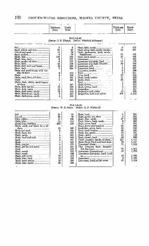
160 GROUND-WATER RESOURCES, MEDINA COUNTY, TEXAS
Thickness (feet)
Depth (feet)
Thickness (feet)
Depth (feet)
Well 1-6-30 [Owner: J. E. Ulbrich. Driller: Whitfield & Draper]
Soil..... ......... .............
Shale and sand lenses with fos-
Shale.. ................... .
Shale.........................Shale; dark, sticky, sand lenses;
2 57 11
6 156
5 6
13 10 2
6 67 7
7 22 13 19 9 5
2 59 70 76
232 237 243 256 266 268
274 280 287 294
301 323 336 355 364 369
Shale, dark-green, hard, sandy,
Rock.. __...__.._-_- _-.- -.
Rock............. .....-.--.-
6 12
23 52
1 15 20
1 8 2 2
33 11 50
1 7 3 1
18 578
375387
410 462 463 478 498 499 507 509 511 544 555 605 606 613 616 617 635
1,213
Well 1-6-33 [Owner: W. B. Odem. Driller: R. P. Whitfield]
SoU ........................
Shale, blue....................
Shale
29601132
208
1051632185298
75151060
2989
100
340
350355356362365367368376381383392400475490500560
Clay (Grayson shale, formerly
Limestone, hard; sulfur water....
14
2766
261540224350
3177071
7636
132
49
561565592598604630645685707750800
1,1171,1871,258
1,3341,370
1,3831,3851,434

TABLE 10. DRILLERS' LOGS 161
Thickness (feet)
Depth (feet)
Thickness (feet)
Depth (feet)
Well 1-6-35 [Owner: W. B. Odem. driller: Gates & Hill]
Sand . ---.-----.-- _- . .
Clay, white-....-. .. . ___-
Shale, black ------ . . . ...Lime, black.. __... .... ...
55
59
17261512392679
243731230
510182332497590102105114140147156180183190193205235
Shale, blue.. ..................
13101218248
4720168314117228
1528
248258270288290294302349369385393396410421428430432440455457465
Well 1-8-38 [Owner: A. L. Haegehn. Driller: Medina Oil Co.]
Clay .......................Rock.........................
Limestone (Anacacho) .-.._-.. ..
1028
410
1841732513015
255136653
56
59381812
10384252
236409660690705960973
1,0391,0921,0971,1031,1621,2001,2181,230
Shale (Eagle Ford). - -
403
195
297163578
77
37
24
12
3344
1,2701,2731,2921,2971,5941,6101,6451,723
1,800
1,837
1,861
1,873
1,9061,950

162 GROUND-WATER RESOURCES, MEDINA COUNTY, TEXAS
Thickness (feet)
Depth(feet)
Thickness (feet)
Depth (feet)
Well 1-6-44 [Owner: J. M. Fusselman. Driller: Kirby Petroleum Co.]
Shale and rock, hard; streaks
Shale.. ................Flint, hard. ............ .... .
Sand_. ........ ........
Sandy rock, green; streaks
show._ .__. ...____.
Gumbo, shale. ...... .
Shale (Anacacho), hard; streaks. . Limestone (Anacacho), hard.____
Chalk................... .
352540
8
129
393
2650
5532
55016
61844
545 30
1202010
3560
100
118
121160
201204230280
335367372422438
1,0561,1001,1051,150 1,180 1,3001,320
Chalk, rock -.
Chalk ........ ..-.. . .
Lime, broken, chert; streaks. ___. Lime, soft and hard; broken
152035
1207565
5
91670
502024
88
141
151
15
2410
1,3451,3651,4001,5201,5951,6601,665
1,6741,6901,760
1,8101,8301,8541,8621,8701,8841,8851,9001,9011,916
1,9401,950
Well 1-6-48 [Owner: J. M. Fusselman. Driller: V. F. Neuhaus]
Clay..........................
Rock........................Shale.......... . .......... .
Shale.......... ............
Gumbo and shale _ ...-Shale...- _______________Rock.... . .... ....
Rock...... _ ..........
Rock........... ...... - --
oil ___ ________ ..__
Gumbo and shale _ ____ _... _
Sand; oil show... __ __ __ .
20201525OK
22148
1075
5
116910
18132
1100
2
8850
32
2720
4
2040KE
157158162
255260
281350360362
512E10
703753756758785805809
Chalk, shaly ____________
411525106537183228
812152748201027
14310
100
5070
5767
2
58
850865890900965
1,0021,0201,0521,0801,0881,1001,1151,1421,1901,2101,2201,2471,3901,4101,510
1,5601,630
1,6871,7541,756
1,814
Well 1-6-51 [Owner: A. A. Murrell. Driller: L. V. Doss ]
Shale, blue....... . .....
2010241110
2030546575
51461
8094100101
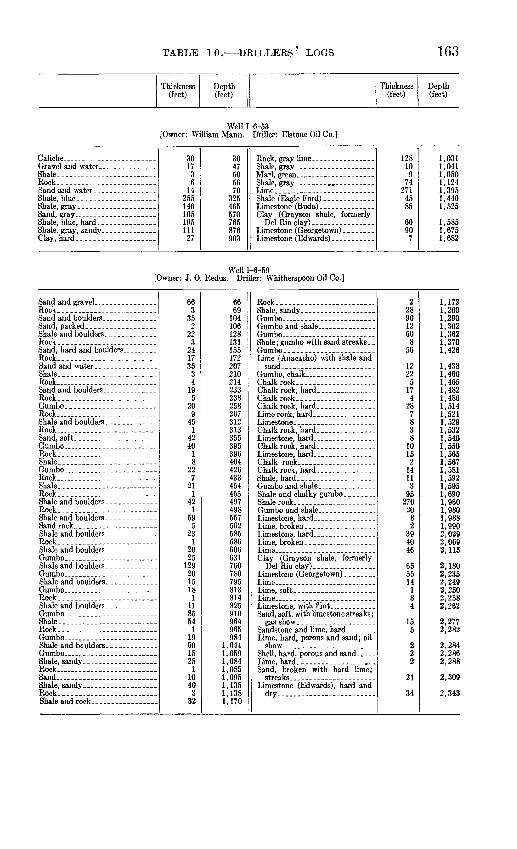
TABLE 10. DBILLEBS' LOGS 163
Thickness (feet)
Depth (feet)
Thickness (feet)
Depth (feet)
Well 1-6-53 [Owner: William Mann. Driller: Elstone Oil Co.]
Shale. ______________ ..........Rock......... ...............
3017
36
14255140105195111
27
3047505670
325465570765876903
Shale (Eagle Ford)... ..........
12810
974
2714585
6090
7
,031,041,050,124,395
1,4401,525
1,5851,6751,682
Well 1-6-59 [Owner: J. 0. Redus. Driller: Whitherspoon Oil Co.]
Rock.........................
Rock............. ----
Rock.. -..--.-.,..---.--.. --.-
Shale........... ...........Rock... ..............
Rock.....--.. ... .....
Rock. . ------------ ---------
Rock-.
Rock-....--.. ... ...... ..Shale..
Rock .- --Shale..... -.--- _ -----
Rock... .......
Rock....
Rock... ......
Shale........ ................Rock.... ... .... .... ...
Rock .... .... ...... .....Sand
Rock.,.. ...... ... ......
663
352
22324173534
195
209
451
424018
227
211
421
595
231
20251292015181
1185541
196015251
10403
32
6669104
128131155172207210214233238258267312313355
396404426433454455497498557562585586606631760780795813814825910964965984
1,0441,0591,0841,0851,0951,1351,1381,170
2289012608
56
12225174
28783810152
14113
952702082
394046
655514184
155
222
21
34
1,1721,2001,2901,3021,3621,3701,426
1,4381,4601,4651,4821,4861,5141,5211,5291,5321,5401,5501,5651,5671,5811,5921,5951,690i ofift1,9801,9881 9902,0292,0692,115
2,1802,2352,2492,2502,258
2,2772,282
2,2842,2862,288
2,309
2,343

164 GBOUND-WATEB BESOURCES, MEDINA COUNTY, TEXAS
Thickness (feet)
Depth (feet)
Thickness (feet)
Depth (feet)
Well 1-6-66 [Owner: F. B. Forrest. Driller: Letro Oil Corp. ]
Soil...-.. . _.. _-.-. _
Shale, blue. _ .... _ .........
51446q
1171243
147
462372262
5196568
185186188192195342343389391428430432438440
Shale.-...... ___._-_ _.__
3011
262
262
441
272
1491
20335225
470471472498500526528572573600602751752955990
1,0151,020
Well 1-6-89 [Owner: Fritz Senne. Driller: A. D. Gaston]
Soil.... ......... ...........
Shale...... - __-- __..____
73335304022on
11835178
225180
74075105145167197315350367375600780
205162
1059
18912141425
800851857859869874883901910922936950975
Well 1-6-92 {Owner: Albert Hoffman. Driller: Ina Oil Co.]
Soil..... ........... ........Clay.... _
Rock. _ ......... ------.. ...
Rock... __ .-.-..-.....-.--..
411151020
133
244
218
515
5751030
711
224
6
415304060619496
140142160165180185260270300307318320344350351
Shale
Chalk (Austin).. ___ ....-...Shale (Eagle Ford). .--------...
Del Rio clay). .......... ....
922
1201
16100128271233505557
161105260
505577
6082
114
360382383584600700828855867900950
1,0051,0621,2231,3281,5881,6381,6931,770
1,8301,9122,026

TABLE 10. DRILLEES' LOGS 165
Thickness (feet)
Depth (feet)
Thickness (feet)
Depth (feet)
Well 1-6-105 [Owner: J. McAnnelley. Driver: R. E. Fair, Inc.]
Sandstone, hard...
Limestone.....
Sand and shale _ ._
Sand.Shale with hard layer of sandstone Sand
Sand . .Shale.........................Shale, sandy .. _
Sand and lime
LimestoneShale.........................
Chalk..Shale.........................
Shale.........................
Del Rio cky). ...............
Lime and clay
flint
Clay..........................
streaks
Shale, hard, sandy
Shale.. ....... ................
813962
742
11826
53116
180113
721885
21314
241491030
8408969354551
1115038
599
5361
3143
318
24101214321022
107
58253182
573
12759
1510152110271533
01
120
189931
349q^EOCA
411427607720709Gin
895C07
910924
1,2141,2241,2541 2621 QAO
1,3911,4601,4951 ^d.fi1,5911,7021 7^19
1,7901,7951,894
1,9472 AAQ
2,0119 flOE
2 O.9Q
2,059
2,091
2 1132,1272^1592,1692,191
2,3562 6092 7Q1
2,869
2,9963,0013,0103,025
3,0503,0713,0813,1083,1233,156
Sandstone, dark, fine-grained,
Shale .-..
Shale, red ___ _ __-_
411033702576
1502218
27810
114
62362
484215531022223290229661
18030
315
153946222317
65761163
222
212121251
62
3118103811
998
25
32
88
3,1973,2073,2403,3103,3353,4133,5633,5853,603
3,8813,891
4,005
4,0114,0344,096
4,1444,1864,2014,2544,2644,2864,3084,3404,4304,4524,5484,6094,6104,6904,7204,7234,738
4,7534,7924,8384,8604,8834,900
4,9655,0415,0525,1155,1175,1395,1425,1535,1655,1775,2285,2345,2365,2675,2855,2955,3335,3445,3535,3625,3705,395
5,427
5,515

166 GROUND-WATER RESOURCES, MEDINA COUNTY, TEXAS
Thickness (feet)
Depth(feet)
Thickness (feet)
Depth (feet)
Well 1-6-106 [Owner: Hartley Howard. Driller: Pegg Bros. ]
Sand and clay __ ....... ..Caliche and gravel _ ...........Shale and lignite. ....Sandstone.--.-.-.-...... . ...Shale.. .. ..... . _
Lignite......... _ ....__Shale....... ..................Rock.....-....-.- _ .Sand and water. _______
1812
1253
22101040
426
1830
155158180190200
244270
Shale..
1108581
24722010
23
11
380465546548
1,0201,0401,0501,0521,0551,066
Well 1-6-107 [Owner: C.Adams. Driller: Carl and Flinders]
Soil ............... ,Clay, brown.. _ .... _ ...
Gravel...-.-- _ -..-.... ...Shale, brown __ -.-..... _ ...
Rock....... ___ ...
Sand....... . ...Rock.. __ . _ ... _Sand.-...-.... _ . ___ .._
Sandstone................. ...
Rock.... _ .... .Shale, blue, sandy.--.. _ ...
52551051827113153
22327
32
53035455068959697100101106109131163170171174176
14302
1514535
1523258
14135
25
190220222237238242247250255270293295300308322335340365
Well 1-6-109 [Owner: Carlton Adams, Jr. Driller: L. V.
Rock, schist,.---.--.... ...Clay, red and gray. ........ ...
r23712
2358
151618
382
45116
18
5658
103114120138
Well 1-6-110 [Owner: Schmidt. Driller: E. H. Keater]
Soil.....
Shale-.- . ...
Shale..- . ...
Sand _ ...
Shale with hard sandy streaks ... Shale Shale; rock, hard----....- ...
Sand ........... _ Shale, sandy....... _ ..... ...
Shale, sandy....--.-.... . _ .
Shale, sandy; oil odor.... . ...
629
672
15715
41124
15181 10
4251
87225130330
72
63541
113270285
300324475556 566570572577578665890
1,0201,3501,422
Chalk
Lime with lime and shale streaks..
Chalk
Shale
8
77109
59979
148
101479407858
91932
1,430
1,5071,6161,6211,6301,6391,6461,6551,6691,677 1,6871,7011,7801,8201,8981,9561,9651,9842,016

TABLE 10. DRILLERS' LOGS 167
Thickness (feet)
Depth(feet)
Thickness (feet)
Depth (feet)
Well 1-6-111 [Owner: Carlton Adams, Jr. Driller: L. V. Doss]
59 49
59 108
r148 256
Well 1-6-112 [Owner: Mame M. Adams. Driller: Mirando Gas Co.]
Rock, hard.. - ___ . _ . . ....
Rock......_ ........ ....
Rock... ......................
Rock...... ......
Rock, hard.. _ __ ....... ...
Rock........ .......... .....
Rock. .--__..._.__. ...........
2 5 3 5
10 33
7 24
1 1 3 1
10 1 3 2 3 1 4 2 9 5 7 2 6
2 7
10 15 25 58 65 89 90 91 84 95
105 106 109 111 114 115 119 121 130 135 142 144 150
Sand... .. -
Rock..... __ .-.-. __ ....Clay Shale. Rock.. .
Shale.-
Shale-.-
2 60
4 4
60 5
65 10 10 30
6 44
3 35 14
228 50 20 50 57 21 10 62 14
152 212 216 220 280 285 350 360 370 400 406 450 453 488 502 730 780 800 850 807 828 838
1,000 1,014
Well 1-6-116 [Owner: Mame M. Adams. Driller: Southern Gas UtiEty Inc.]
Rock.. -....--.. ........ ...
Shale...-- ................
Shale...... ................
Shale-..--.-.. ..........
Sandstone and sand, packed. ..
Shale-- . - RockShale Rock.. .
17 3
10 4 6
110 3
22 5
10 6
84 4 8
36 12 4
36 13
17 20 30 34 40
150 153 175 180 190 196 280 284 292 328 340 344 380 393
Shale-
Shale..
Shale..
Sand and gas show. .. _ .. .
37 3
17 50
3 12 55 30 18
5 57 10 20 10
140 10 35 31
8
430 433 450 500 503 515 570 600 618 623 680 690 710 720 860 870 905 836 944

168 GEOtnSTD-WATER RESOURCES, MEDINA COTHSTTY, TEXAS
Thickness (feet)
Depth(feet)
Thickness (feet)
Depth (feet)
Well 1-6-117 [Owner: Mame M. Adams. Driller: Southern Gas Utility Inc.]
Clay..... .....................
Sand.... __ ..... ___ ......Shells.. . __ .. _ _______ _ ...
Shells........... ..............
Shale.. .......................Limestone and gypsum, hard.... Shale.. ................... ...
Rock.........................
Shale. _ ---..----........ ...
Shale.........................
15 2
72 12 58
3 2 1
45 20 54
1 3 6
16 3
17 2 1
14 13 12
6 1
11 1 4 2
13 2 8
15 17 89
101 159 162 164 165 210 230 284 285 288 294 310 313 330 332 333 347 360 372 378 379 390 391 395 397 410 412 420
Shale. .
Shale ..
Shale... ...................
27 3 1
40 1 8 2
78 3
20 42
3 3
17 10 24 28 12 12
1 20
1 54 10
1 21
1 41 28 12
447 450 451 491 492 500 502 580 583 603 645 648 651 668 678 702 730 742 754 755 775 776 830 840 841 862 863 904 932 944
Well 1-6-118 [Owner: Mame M. Adams. Driller: Southern Gas Utility Inc.
Soil..... .. .......... ...Sand. _____ ...... __ ...Gravel.-. _ .- _ ...... . ...
Sandstone. _ .. ...... _ .
Sandstone... __________
Shale. _ _ ____ .----......
Rock ______ . _ .. .
685
11»M
1363
3015
433
14310403538
261
152
162
105
61419Oft
6465101104134135140183186
213253256261
272298
314316
334344349
Shale. ....._..................Rock..... __ _____________
Rock.... __ .................Shale.
Shale. . Rock...
13251
362105433192
32221523304114202182
153
652
7613
362364369370406408418472505524526558580595618648689703723725743745760763828830906907910

TABLE 10. DRILLERS' LOGS 169
Thickness (feet)
Depth (feet)
Thickness (feet)
Depth (feet)
Well 1-6-123 [Owner: Gilbert Falbo. {killer: L. V. Doss]
Gumbo, black, with pyrite -----
Shale, gray, sandy, with lignite. ..
6
12
4210
2540
6
18
6070
95135
Shale, black, with lignite and
203
492
32
82
155158207209241
249251
Well 1-8-3 [Owner: L. 0. Carle. Driller: Plateau Oil Co.]
Gravel.. ... ... .......... ...
Rock... .. ....................Shale.-
25451550
92113
56
31879
341114192142
53022
151110226644666545
257085
1351441R1
178183189220228235244278289303322343385390420442593703725791835901966
1,011
Rock...... ......... .... ...
Chalk.. Chalk, hard ... ...
Chalk, hard
Shale
Shale..
Shale.-
Clay ....... ... ... ..
2244
2195748
1415404
15445162673041
74
1389
4026484048
544
114
1,0331,0771,3061,3631,3671,3751,3891,4041,4441,4481,4631,5071,5581,6201,6871,7171,7581,7651,7691,7821,7901,7991,8391,8651,913
1,9532,0012,0062,0502,164
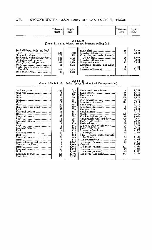
170 GROUND-WATER RESOURCES, MEDINA COUNTY, TEXAS
Thickness (feet)
Depth (feet)
Thickness (feet)
Depth (feet)
Well 1-8-27 [Owner: Mrs. E. E. Wilson. Driller: Robertson Drilling Co.]
Shale............... . .......
Shale (Eagle Ford).... ...
500325550230545
82
52248
500825
1,3751,6052,1502,232
2,7542,802
3894
688013
526
2,8402,834
3,0023,0823,085
3,1003,126
[Owner: Sallie B. Little.Well 1-8-30
Driller: United North & South Development Co.]
Sand. ---..-_-_.._..._.- _ .Shale. ..................... ...
Rock. .................... ...Shale---.----.. .---_._ ......
Rock.... .....................
Rock..................... ..
Rock............. . ... .
Rock.. . _ .................
Rock ....................
Rock....... ............. .....
Rock....... ............... ...
Rock........ ..........._-..__
Rock........... ..............
2555
478
357
49
1991
g27
4124
224
862
430
682
85
266
198480
255
307316351358407KK7
576667676703707831839841865873935939969975
1,0571,0651,0701,0961,1021,3001,780
Shale-...
Shale, limy
Chalk (Austin) . _ ..........Chalk
Shale (Eagle Ford)...
48620
13080
11497
652
712926
1006
2878404055
747939
1813
2026
307
1,7841,8701,8902,0202,1002,2142,3112,3172,3692,3762,5052,5312,6312,6372,6652,7432,7832,8232,878
2,9523,0313,0703,0713,8843,9043,9304,237

TABLE 10. DUELLERS' LOGS 171
Thickness (feet)
Depth (feet)
Thickness (feet)
Depth (feet)
Well 1-8-33, partial log [Owner: G. A. Blackaller. Driller: Med-Frio Oil Co.]
Sand (Wilcox).. ...............
Sand and rock, hard _--.-._ .
Asphalt-_--_--_-----.-_- . .
Rock, flint .. .. ......... ___
Rock, blue __ ............
Limestone and calcite, brown. ..
Rock......... ......... . ...
23
188
211
336802025251583
23171617
2
543
1725
2481518
23949
81010
74
1121
53
1233
191
192222133443
2512 '
303868708184
120200220245270285
395412
445447
456400463480505507555570588580
678686696706713717728749754757769772775794795814816818820822823826829833837840
Rock...... .......
Rock-.-. Shale... ... ...... ..Rock...
Rock.. ._ .__ --
Rock.. .. ................
Rock....... Shale. Rock..- -
Rock
Rock
302534
161219
317
221
216462835
1328
328
324
925
1113
461
281
26173
645
543
294612
484
55867
164
277
441,780
870872877880884900912931934951953974976992996
1,0021,0041,0121,0151,0201,0331,0611,0841,0921,0951,1191,1281,1531,1541,1651,1681,2141,2151,2431,2441,2701,2711,2781,2811,3451,3501,4041,4071,4361,4821,494
1,5421,546
1,6011,6091,6151,6221,6381,6421,6691,6761,7203,500

172 GROUND-WATER RESOURCES, MEDINA COUNTY, TEXAS
Thickness (feet)
Depth (feet)
Thickness (feet)
Depth(feet)
Well 1-9-3 [Owner: John P. Nixon. Driller: James F. Greenlee]
Clay, sand, and gravel......Sand___. ------.._......._.....Clay. _._....__........__Sand, hard, green ..... .Rock. .--__.__......____._.. .
Rock..... .. ................
Rock.... .............. . .Sand.. .....................Rock.. .......................Sand ......Rock....... ..................
Rock.... ..................
Rock.
Rock.... ................
Rock.. - ..Sand, shale streaks, boulders; gas
Rock..................... ..
Rock.. .......... .... .....
644
81210
443
396
9044326
1238
554
115
171
33184
6505870808488Q1
130136226230234237239245257295300354355370371378379
412413421425
Rock........ .... ... .....Sand... ... Rock.... .
Rock...
Sand... ... .... ...
Sand and streaks of shale and oil.. Shale.
603
141
47264
1110
11630
27
1129
94361883
817
18 471645
485488502503550814815925920942972974981992994
1,0031,0971,1001,1061,1071,1151,1231,1261,2071,2141,232 1,2791,2951,340
Well 1-9-6 [Owner: E. Bohmfalk. Driller: Fritz Fuchs]
Clay
Shale..
Rock... . ______
Rock... ...
Rock.. ____ _.__________._..Shale Rock...
Rock.... ........... _..-_.-.._
515
12010505
35229
1527
722
14956722
142
520
140150200205240262271423430502504653709781783925
Rock.... ... _______
Shale.-
Rock-... ... ... -----
Rock... Shale..
Rock... ...... .... -Shale...
219
17025991726
2915
712
332059152
927946
1,1161,1411,1501,1591,1761,1581,18-41,2131,2141,2191,2901,2921,3251,3451,4041,556

TABLE 10. DRILLEES' LOGS 173
Thickness (feet)
Depth(feet)
Thickness (feet)
Depth(feet)
Well 1-9-13 [Owner: E. B. Chandler. Driller: C. P. Cortter]
Soil........... ________________
Shale
Eock. .............. __________
Rock ... . ,___. . .
Shale... _______ _ _ ....
Shale __ . __ -_-
37
28
125
535
514
225135
283
8751
332.6
16.4
2925
143
455
142345
1
3103849507580
115120
135157208243245328
336343348349382384.6401402431433438452455500505519542587588
Shale, black, hard, brittle. ..____.
Shale.. . .
Rock _ _ ...
Shale... ....-._._.. ...........Rock. .......-......--- -.-.
Limestone and sand, crystallized --Rock.... -..._-_-__.-__-_____.
21.1123.891026
8.6
22.435
.612.41.5
26.522
171
22382
13.3.6
11.132
2378113220
9941
51
609.11633643669677677.6700735735.6748749.5776798799806807829832840842855.3855.9867870872895973984
,016,03g,045,054,058,059,110
Well 1-9-14 [Owner: E. B. Chandler. Driller: B. C. Calvin]
Clay __ ... .Shale..... _ __.______ _
Shale... __ ____ _____ ......Shale, black. __ ___ . .......
Rock... __ _ __ _.
Shale... ....... ........
1010302050in180
45
22161
11333
94530491
174
201262
10205070120160240244249250272288289300333336360365395399408409426430450462468470
Shale ___________ _ __ _
Shale. _____________ _Rock __ __-._._.-.___--_.____
Shale, soft. ____________
552
135315
313
1161
5010251
13216145391412
5836.515.5
525527540593594599630633749750800810835836849870876890943952953957958960
1,0181,054.51,055.51,061

174 GROUND-WATER RESOURCES, MEDINA COUNTY, TEXAS
Thickness (feet)
Depth(feet)
Thickness (feet)
Depth (feet)
Well 1-9-26 [Owner: Amelia Zadich. Driller: J. E. Thomas & B. Rife]
Sand--.... . ...Shale..... Sand -Rock.. __ _ ________ .Shale. ...Sand .-.., -.-.. __..Shale.. .......... .Rock...-....-----........Shale.--. ...-.........._.....Rock........................Shale- Rock. --_ __Shale. . Rock...... . .....Shale-.. Rock. .... .Shale.. Rock...... ........ .....
Shale.
Shale.
Shale..
Shale.. .... ....
Shale
Shale. -------- . .
Shale..
37226
1726
584739
2410
220
617
332
263
105167587
848
12
346
1014
6511017
10437
1262346
37263
306007
365412451
863865885891
911Q1J.
916
1,050
1,1411,2281,2361,2401,2481,2601,264
1,3041,314
1,3341,3851,3951,4121,5161,5191,5261,6521,6751,721
Sand
Sand..... - -
QU Q lp
Shale
Chalk, hard- ..
Chalk
Chalk Shale
10173
21515
138
930
330
22337165984
8148711
6251357321222
121103
132552
3.565.566886979
101
1,822
1,8971,9121,9271,9281,9661,9752,0052,0082,038
2,0632,1002,1162,1752,2592,2672,2812,3682 Q7Q
2,3852,4102,4232,4802,5122,524
2,6672,7702,783
2,860
2,863 i2,9292,9953,0833,1523,231

TABLE 10. DEILLBES' LOGS 175
Thickness (feet)
Depth(feet)
Thickness (feet)
Depth (feet)
Well 1-9-27 [Owner: Mrs. T. A. Wilson. Driller: Clopton & Mitchell]
Soil ......... . .............Sand....... ...................
Sand.........................Shale, blue... . . ... .......
Shale, blue... .......Sand .......................
Sand..... _. .
Rock........Shale, hard, sandv
Shale. .... . . ....Boulders ....Shale and boulders, sandy
Sand... . __.__Rock. .......Sand, hard.... . . . ..
Sand . ............. ........Sandstone, hard. ______ _.
Sand .......... ..... .. .Shale.. .. . ... ....... __
Sand.... ......................
Sand ............ ....... .
Sandstone. . ..
Sand ..- .............
Shale--.
Shale. ------------------------
Sand... .......................Shale..... . .............
3321084153640
651
24
382
4720
65
1515
82
676
381
262
3831
36
1015
242
21
52
301
1117364
33545
129144180220226277279283321323370390396401416431439441508514552553579581619650653659669670675676700702723724729731761762773790793799803
Shale....- ..... ........
Sand ......................
Sand ---------- _ ----------Shale--. -
Shale-.
Shale...
Shale...
Shale...
Sand ....... .... ......
Rock..... - -
Shale...
Sand .. ......
Sand . ..... ....... ... ... .
Sand. .... .... .... ..... -
Sand ................ .......
Shale.. Sand................... .......
384054
5131010
72
981
332
2321212340
8133
23232
.55
29.51
201715
796
13.54.54
309
252
37473
2111
4116
841881935940953963973980982
1,0801,0811,1141,1161,1391,1601,1811,2041,2441,2521,2651,2681,5001,5321,532.51,537.51,5671,5681,5881,6051,6201,6271,7231,7241,727.51,7321,7361,7661,7751,8001,8021,8391,843,850,853,874,885,889
2,005
Well 1-9-50 [Owner: B. D. Bomba. Driller: A. F. Mann]
Clay ...... .... ... ....
Shale..-
318
23
313962
628
3
689699

176 GROUND-WATER RESOURCES, MEDINA COUNTY, TEXAS
Thickness (feet)
Depth (feet)
Thickness (feet)
Depth (feet)
Well J-l-41 [Owner: F. C. Stinson. Driller: J. Eogers]
Soil. .......................
Lime, white and gray flint; dolo-
326365020131739
31358
321070
32965
115135148165204207220278
310320390
Shale, blue.... _ . ............
Shale, blue, with limestone and
2048
22510202528
412
112026
410458460485495515540568
572584
595615641
Well J-l-45 [Owner: Anton Burger. Driller: W. Peters]
Escondido, Navarro, Taylor, and Anacacho formations and Austin chalk:
Blue shale and thin sand
341
19029
19
15
2118
359
292
344
ODyl
236245264
265270
272390393452654
Escondido, Navarro, Taylor and Anacacho formations and Austin chalk continued:
marly limestone. . . . .....
Eagle Ford shale: Lignite shale .
Georgetown limestone:
1686
26741
62
60
32
10
15
822828
1,0951,136
1,198
1,285
1,290
1,300
1,315
Well J-l-44 [Owner: Fritz Fuos. Driller: Pegg Bros.]
Soil ........................
Clay
Marl (Taylor).... .............
Shale (Eagle Ford). ............
41225
4748589
24643
41641
515600689935978
Del Rio cky) ____ .........
57
6322123
81
1,035
1,0981,1201,1321,1351,216
Well J-l-53 [Owner: J. Jagge. Driller: J. Jagge]
738
18213836
745
227365401
Clay (Grayson shale, formerlyDel Rio clay).. _ ...........
61
67
38
462
529
567

TABLE 10. DRILLERS' LOGS 177
Thickness (feet)
Depth (feet)
Thickness (feet)
Depth(feet)
Well J-l-62 [Owner: John Nietenhoefer. Driller: G. P. Oakes]
Shale, blue __ __ _.
Rock......... . _
Sand, dark-green ------ .
5071
722
2783
873540101026109
5125
505758130132410413500535575585595621730735860
55257
131055
225405
205
356042
915940947960970975980
1,2051,2451,2501,2701,2751,3101,3701,412
Well J-l-64 [Owner: 0. A. Schmidt. Driller: C. A. Schweers]
SoiL. ______ __ ___ ___ _ _ _
Shale, blue... ____-
Rock, gray _. _-..__
Shale, gray. . ______
2228592
575155
133112
78
24
3291Q^150155170175188191202204282
Shale... ......................
1169
219129308
2018524366830
283452454645674704712732750802806842910940
Well J-l-83 [Owner: City of Castroville. Driller: Cravens Drilling Co.]
Soil...........................
Marl (Taylor)________________._
Chalk (Austin). ........ .....
262
10082
282
2628128210492
3375
9817
525600
698715
Well J-l-86 [Owner: J. Courand. Driller: Golden West Oil Co.]
Shale.. .......... .............
Shale......... ...............
Shale.. .......................
Shale........ .................
10200151723535
4138014051583
10210225397432467580660800805820903
Shale...... ......... . ......
Clay...
Shale.----..-------.----. ....
1712711910201532235
20
920932
1,0031,0221,0321,0521,0671,0991,1221,1271,147

178 GROUND-WATER RESOURCES, MEDINA COUNTY, TEXAS
Thickness (feet)
Depth (feet)
Thickness (feet)
Depth (feet)
Well J-2-15 [Owner: A. J. Wurzbach. Driller: J. I. Moore]
Clay, brown.... . . .....Shale, black.. .................
Shale, blue _
Lime
Gravel.---------------. .
Lime, honeycomb and water... ..
Lime . . ...
Lime, brown, hard _ -----
Lime __ ....- .
9317
4291
572017
5
1217537014
8on
1434
511
4 1660
1 ^1
355
255
10253530
10012
825
110102511
292612
8101063
7401557231070155015
6
93110
300
37839841 K
4334QQ
460477530600614622661675709714725729 745805960995
1,0001,0251,0301,0401,0651,1001,1301,2301,2421,2501,2751,3851,3951,4201,4311,4401,4691,4951,5071,5151,5251,5351,5981,6051,6451,6601,7171,7401,7501,8201,8351,8851,9001,906
Shale
Lime, gray; hole full of water... -
Sand..
1415455
132014
7162
2815
56
442530301312
53025 12
810703035
626
36
1920
515601030
2281516
44
111530
19
1334
1964
261015
268
1,9201,9351,9801,9851,9982,0182,0322,0392,0552,0572,0852,1002,1052,1112,1552,1802,2102,2402,2532,2652,2702,3002,325 2,3372.3452,3552,4252,4552,4902.4962,5222,5252,5312,5502,5702,5752,5902,6502,6602,6902,6922,7202,7352,7512,7552,7592,7702,7852,8152,8162,8252,8382,8412,8452,8642,8702,8742,9002,9102,9253,193

TABLE 10. DRILLERS' LOGS 179
Thickness (feet)
Depth(feet)
Thickness (feet)
Depth (feet)
Well M-4-2 [Owner: E. Krewald. Driller: Pegg Bros.]
Caliche... _ .................. 4584820
1
265
462
110130131175
440
Chalk (Austin)---...--.... _ .310360
3555
6025
100
75<1,11<1,14.1,2(K
1,26(1,28,1,38.
Well J-4-5 [Owner: T. S. McClure. Driller: F. M. Burkett]
Soil..... . _ ._.--.Clay, dark, sandy and limestone
gray very fine grained limy clay.
Clay, bluish-gray, calcareous, and
Clay, bluish-gray, sandy, calca-
Clay, bluish-gray, calcareous _ ..
Clay, gray, plastic, calcareous -. Clay, gray, plastic and fossil-
Clay, gray, calcareous, sandy. ...
Clay, sandy and fine-grained ar-
Clay, gray, hard, massive, calca
reousClay, greenish-gray, hard, mas-
taining fragments of Crenella
Sandstone, brown, fine-grained and glauconitic gray chalky
911
40
40 20
20
2020 9n20
2020 20
20
20
20
80
15
3
12
9n
60
100 120
140
160180 200220
240260 280
300
320
340
420
435
438
450
gray glauconitic limestone. ....
Sandstone, greenish-gray, fine-
Clay, greenish-gray, sandy, glau-
Clay, gray, hard, massive, and
Clay, fine-grained, glauconitic,
Clay, gray, sandy, calcareous- ... Chalk, light-gray and gray cal-
Limestone, gray, hard, sandy ....
Chalk, light-gray, argillaceous ...
Limestone and calcareous shale ...
Chalk, light-gray and gray cal-
Chalk, white... _ .. _Shale (Eagle Ford), dark-gray,
20
20
20
60
20
4050
4020 3298 1416
38191525
1241
40
470
490
510
570
590
630680
720740772870884900
9981,0171,0321,057
1,0691,110
1,150
Well J-4-6 [Owner: R. J. Noonan. Driller: E. T. Peters]
Rock..,. .....................
Rock... -_-_-- . .___-_--_Sand ......................Rock... ......................
Shale.... . ............... ..Rock.... .......... __ ---...-
Rock. ....... __ ..... .......Shale... ........ ... ........
Rock .
3010
83
15313
123
52110
8046
24245
167
30404851666970738588
140250330376378420465466533
Chalk . Shale (Eagle Ford). ____
28776
8104
14198718812
494455
5151
28
820896904
1,0081,0221,2201,2911,3791,391
1,4401,4841,5391,5441,5451,5501,5511,5791,580

180 GBOinSTD-WATER KESOUKCES, MEDINA COUNTY, TEXAS
Thickness (feet)
Depth (feet)
Thickness (feet)
Depth (feet)
Well J-4-11 [Owner: Wm. Edgar. Driller: Sun Oil Co.]
Shale, dark-blue, and sandy lime
Shale, blue. ...................
Shale, blue... .................
3
6
6
913Qfl
10
40
55
12
5
18
22510
55
1052
301033
37
38
56707678
87
1 *?n140
180
190195
212
220
238
240265275280285295300302332342375378385
Shale and boulders, hard, gray..
37
20on
3510
2042
9 29701015
530103045809015
5101095337065
75174
13
388395415435470480EOO
5235«2571 603670680695700730740770815895985
1,0001,005
,015,025,120,153,223,288,295,300,301,303
1,3121,325
Well J-4-15 [Owner: J. 0. Pike. Driller: T. W. Bain]
Soil. _ ... _._
Rock... _ _ ... _ ...Shale.-.
Rock...-
76
1374
79108
33
713
150154233341344347
Shell .
292
232241
276
378401403427428455461
Well J-4-23 [Owner: J. Tschirhart. Driller: Johnson Bros.]
Soil.... ... ..... ..........
Shale.. ............... ........
Shale..........-. .... ... -Sand Shale... .Sand...... Chalk
31348
10414786
29018
45288
128
162028
146224230520538990998
1,0061,0181,026
Rock.... ........... .......
Rock.-..
32
1148
61111
26
2416
1221998
1,0581,1181,2321,2401,3011,4121,4141,4201,4441,4601,5821,6011,6101,618
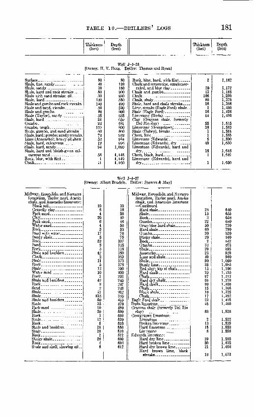
TABLE 10. DRILLERS LOGS 181
Thickness (feet)
Depth(feet)
Thickness (feet)
Depth (feet)
Well [Owner: H. V. Haas. Driller: Thomas and Ryan]
Shale and gumbo and rock streaks.
Shale, hard - ----- -
Chalk-. ...................
8040305030
120140 3080352422
1196072521294
581
11
801201 Krt
200230350490 520600635659681800860932984996
1,090
1,1481,1491,160
Chalk............ ...... .......Chalk, shaly.- ..............Shale, hard and chalk streaks..
Shale (Eagle Ford).......... ...
2
1013
1058028
22664
5538
115
40
181
1
1,162
1,1721,1851,2901,3701,398 1,4001,4261,490
1,5451,5831,5841,5851,5901,630
1,6481,649
1,650
Well J-4-27 [Owner: Albert Bendele. Driller: Stovers & May]
Midway, Eseondido, and Navarro formation, Taylor marl, Austin chalk, and Anacacho hmestone:
Clay... ...................
Rock.----..--..- . .
Rock...-.. .-Sand ---___-_-_ -__Rock..-.- ......... ....
Chalk- ........... ......Shale..Rock............Shale...
Rock............
Sand. ...... ...Shale... ..... .Shale.-
Shale-
Shale.. _ .Rock.....................Shale.. .Rock..... . . .
Shale .Rock....... ...... .... . .
Rock.----..--.-.-... _
1064
20643
175
3283
422
115
1210
342
22
1312350351020
3175
2520
22848
101620404650537075
107115118160162173178190200203245247249262385435470480500503520525550570572600604612
Midway, Eseondido, and Navarro formation, Taylor marl, Austin chalk, and Anacacho limestone
Rock....
Shale..
Shale..
Chalk
Chalk.
Chalk
Hard brown lime, black
2815
32250603020
233202540903515258758801510172345
60
21315
6
295021
16
640655658680730790820840842875895920960
1,0501,0851,1001,1251,2121,2701,3501,3651,3751,3921,4151,460
1,520
1,5221,5351,5501,556
1,5851,6351,656
1,672

182 GROUND-WATER RESOURCES, MEDINA COUNTY, TEXAS
Thickness (feet)
Depth(feet)
Thickness (feet)
Depth(feet)
Well J-4-30 [Owner: L. A. Haby. Driller: Mid-Kansas Oil and Gas Co.]
Shale........... . ...
Shale, sticky........ ...
55330495
124
1601293
55385880
9051,0651,0771,170
Shale (Eagle Ford).
Del Rio clay). ________
137105
7424
3560
1,3071,4121,4861,510
1,5451,605
Wel J-4-31 [Owner: Jake Haby]
Shale, blue, hard-... ... _
Rock..........................
Sand, gray, soft and shale; gas...
1046
20
1015
325508061
22431
1 44666310
10
204044545560
385435
576800831832 876942
1,0051,015
Chalk, hard.. . ..
Clay (Grayson shale, formerly
1727
11638
154673554
60
1642
5015
9
1,0321,0591,0601,0761,1141,2681,3351,3701,424
1,484
1,5001,542
1,5921,6071,616
Well J-4-37 [Owner: D. F. Davis. Driller: M. Stewart & Sons]
Soil-... ... _Clay ._. . Sand . Rock . .Sand
Shale... .
Shale Rock. ...... . . .Shale. Rock... .... Shale-- Rock... ...
q
79n10fin38
110
9
5559Q
9
4213
10
138
o
on
401001381 30
149151156211234236940,
2429 jo
246265266304
Rock-...
Chalk...-....... -.
Chalk Shale (Eagle Ford)
3202
4£26
202047
229215
70247
48797564
373061
307509513839859879926
1,1551,3701,4401,6871,7351,8141,8891,953
1,9902,0202,081
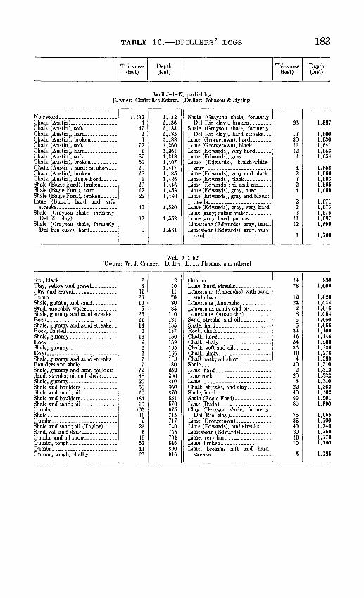
TABLE 10. DRILLEES' LOGS 183
Thickness (feet)
Depth (feet)
Thickness (feet)
Depth(feet)
Well J-4-47, partial log [Owner: Christilles Estate. .Driller: Johnson & Hyslop]
Chalk (Austin).... .............Chalk (Austin), soft... _____
Chalk (Austin), Eagle Ford -
Shale (Eagle Ford), hard..-- ....
Del Rio clay) Shale (Grayson shale, formerly
1,1324
4723
79
187591018
1101222
40
32
9
1,1321,1361,1831,1851,1881,2601,2611,3481,407
1,4351,4361,4461,4581,480
1,520
1,552
1,561Limestone (Edwards), gray, hard_
26
1330
121
42324
223
1112
1
1,587
1,6001,6301,6411,6531,654
1,6581,6601,6631,6651,669
,671,673,676,687,699
1,700
[Owner: W. J. Conger.Well J-4-52
Driller: E. R. Thomas, and others]
Soil, black
Rock.
Rock
Rock... .......................
Shale-.
Shale and sand; oil (Taylor)-..
28
312910
5251114
213
96
77
7238205010
18416
10540
223
549524426
21041708085
110121135137150159165166173180252290310360370554570675715717740 745794846890916
Chalk, hard. ----- .... .Chalk, shaly
Chalk, shaly
Shale-.
Shale (Eagle Ford).. __ _
Del Rio clay)
Lime (Edwards), and streaks..
1478
1224
2866
3446543640
430
220
822409989
753540 201010
5
9301,008
1,0201,0441,0461,0541,0601,0661,1001,1461,2001,2361,2761,2801,3101,3121,3321,3401,3621,4021.5011,590
,665,700,740 ,760,770
1,780
1,785

184 GROUND-WATER RESOURCES, MEDINA COUNTY,, TEXAS
Thickness (feet)
Depth(feet)
Thickness (feet)
Depth (feet)
Well J-4-58 [Owner: Mary E. Jungman. Driller: W. L. Umburn]
Soil...... ..........Clay, yellow.--------.- --.-.
Rock, hard.----. -Sand .._.. ...-.
Shale, blue, sandy... . .
Rock......... _.._
Rock. _ ......
3324229
271010201
291
6303234
708090110
140141
Rock.. _.___-_---_---____._- .-
Rock.--
Shale
71
115
6510373
19204282
148149160165230240277280299319323351353
Well J-4-59 [Owner: Jungman Heirs. Driller: J. H. Lynd and A. M. Hepler]
Rock...........Shale, sandy, and boulders _. .Rock...... __ _Shale and boulders .... _ ...Rock. ___ ...
Rock......... _ __
Rock................ .__..
Shale, sand, and boulders -...
Rock.... .....................
Rock.... ..... __
504558
322
158
302
402
77
27105
34
63
413
5097
5n95
1 W
156178179237238268270Q1A
389QQO
420430A'iK
46947047647Q
520COO
573600
Shale, blue.... ... ..
Shale...... ... .... ......... -.-Rock.-... _ -
Shale.... ... Shell bed....... .... .. ... ..
Chalk .
4743256121235062155
so3960406090
129
2181383272
73
647690715776797820870932947952991
1,0301,0901,1301,1901,2801,4091,4821,7001,8381,8701,942
2,0152,019

TABLE 10. DKILLERS' LOGS 185
Thickness (feet)
Depth (feet)
Thickness (feet)
Depth (feet)
Well J-4-60 [Owner: Von Mangold. Driller: T. N. T. Drilling Co.]
Soil..........................Cky........ ..................
Bock........................
Shale and tough gumbo .._ -----
Shale, hard, sandy, and sandstone
Sand, hard, with shale streaks _ .
Chalk, hard and streaks ........
Shale, hard; streaks and serpen-
44
254
10730
20519
601318
19
6185
7 56678459
616551030755541
812
2
89
3438
145175
381onn4 en
463481
500504565650657 713780864923Q9Q
1,0001,0101,0401,1151,1701,2111,2191,231
1,233
Chalk, hard_____________-_-_-__
Limestone (Buda) and serpentine-
Del Rio clay)- . .......... -
Shale (Dobev). ...- .-.-. .-
27443274
5020
65
2320
18163040
10
485
153
423
122415
29
1,2601,2641,2681,2711,2731,2801,284
1,3341,3541,3601,3651,3881,408
1,4261,4421,4721,512
1,522
1,5701,575
1,5901,5931,6351,6381,6501,6741,6891,6911,700
Well J-4-61 [Owner: J. Tsehirhart. Driller: Cromwell & Cromwell]
Soil . - .......
Shale, dark-grav, hard; oil show..
Clay.... .... ............
g1122
4
2616g
165115
17
281
452
448
61191190
1020
71627dQ
53578384on99
264Q7Q
396410412420421466468512520581Ron611640ccn
670
28
122311QQ
13
1s21
4
5QC
90
166355Q7
252881
40
16
698839851874885918919922935956960
9651,0001,0291,0451,1181,1731,2701,2951,3231,404
1,444
1,460

186 GROUND-WATER RESOURCES, MEDINA COUNTY, TEXAS
Thickness (feet)
Depth(feet)
Thickness (feet)
Depth(feet)
Well J-4-62 [Owner: F. Mangold. Driller: Pearson Oil Co.]
Shale and rock_ ........
53 3
29 5
123
53 56 85 90
213
6942 32
4
282 324 356 360
Well J-4-63 [Owner: Medina Farms, Inc. Driller: Chas. E. Wagener]
Soil.. __ 2 3
51 1
55
2 5
56 57
112
16 64
1117
128 192 303 310
Well J-4-64 [Owner: San Antonio Trust Co. Driller: Schermerhorn Oil Co.]
Soil.
Rock... __ _.____ ..
Rock_____ .._ _________
Shale.. __ ________
Shale..-...---------......Rock___ ____ _________Shale.-- ___________________
Rock... ______ . ___ __ _ ,Shale..... _____________Rock
Shale-----.-..----------.---.
Shale. .
21192
311
2187
11
5912
4641720205
200
28122
26
231
4415104035
21
7074
110112130
148151
211213OKQ
320325400
435463475477503Cfi7KQfl
5315 7f_KQfi
640675
Shale. ------
Shale ---------------
Shale.--- -
Shale----- - ---- - ------Clay.. _ -_
25107185
352550453085
164345203086
382044413838813085107
351
41
700710717735740775800850895925933938954997
1,0421,0621,0921,1001,1061,1441,1641,2081,2491,2871,3251,4061,4361,5211,5311,5381,5731,5741,5781,619

TABLE 10. DRILLERS' LOGS 187
Thickness (feet)
Depth (feet)
Thickness (feet)
Depth(feet)
Well J-4-67 [Owner: Mary Jungman.' Driller: Chacon Oil Co.]
Shale, boulders, and sand string-
Shale... .. .. ...
Rock.........................
Rock.............. _ ........
Shale..... ...... ..- .-..Shale, gummy and gypsum.... ..
54
137572
33
232
119452
11
21113
114
3143512
3759 1
59
22onoj.
4143is4851CO
76788998
102107109112123127129140153154168171185220232235242247256 257
Rock..
Rock...-.
Shale, gummy, with sand lenses. .
Shale... ..................Rock... _ - _. ...
Rock....... .... ..... ......
Rock --
Rock". - .... .
Rock.... __ . _ ..-.---..-.._
Rock.... ____ ...... _ --.-..
Rock......... ................
Rock............ ..........
Shale, gummy, with sand lenses
21
1330
1513
414
1113 15
110
1
129
1571
54236353114
4232
259260273276279294307911312316327340 355356366367371372401402407
415469471474480483488491492493497539571
Well J-4-69 [Owner: John T. Kirby. Driller: W. Lancaster]
Soil...... ..................Clay...... ........ ............
6976855
26
615222836414672
12164
111599
84100104115130139148

188 GBOTJJSTD-WATER BESOUBCES, MEDINA COUNTY, TEXAS
Thickness (feet)
Depth(feet)
Thickness (feet)
Depth (feet)
Well J-4-70 [Owner: San Antonio Trust Co. Driller: Schermerhorn Oil Co.]
Soil-.... ......................
Rock...... __ . _ -. ......
Rock..... ...................
Rock...- __ .........-....
Rock--..-
Rock..-.----..---.--..--....
Rock... __
Rock...
81
2343431
QC
15152
33
1269.1
205
22154
381
21153
264
21
8gqo
75no1 in
1551701851 fi7
344345371one
415420442457461499inn521536539565canion
Chalk.........................Shale-.
Shale.
Clay . _-
172524581
126371
92
831
2015
3919630582
1319515635125
607632656714715841878879971
1,0541,0551,0751,0761,0811,1201,3161,3461,4041,4061,4191,4381,4891,5451,5801,5921,597
Well J-4-78 [Owner: Yancy Russell. Driller: F. M. Burkett]
3252
3072
32830606769
53653
22
74110115118140
Well J-4-80 [Owner: S. E. Schaefer. Driller: F. M. Burkett]
2161032
2189860
Clay ... 8
1262
6880142

TABLE 10. DRILLEES 7 LOGS 189
Thickness (feet)
Depth (feet)
Thickness (feet)
Depth (feet)
Well J-4-102 [Owner: M. A. Keller. Duller: Grayburg Oil Co.]
Shale.......... _ ............
Shale. ........................
Shale.. .........._.......... .
Shale... __ ----- _ ..........Rock. _ ---- _ -.---..---.-.Shale.. . .
Shale...... ................
Rock... _ ............. _ ....
247
343
362
263646
363
73114146485
35210
46
45165
582
7025
24316568
104106132168214217280287318332346410495498550560564570615780838840910912917
Clay............... ...........
Clay...... .................
Shale, black. ......... . ..
Shale ___ . _ ........... ..Chalk.. Shale, black...
21323422143012
25012202066
87092
633524
371679340638030
282
938970
1,0041,0261,0401,0701,0821,0841,1341,1461,1661,1861,2521,2601,3301,422
1,4851,5201,5441,9151,9822,0752,1152,1782,2582,2882,2902,372

190 GROUND-WATER RESOURCES, MEDINA COUNTY, TEXAS
Thickness(feet)
Depth(feet)
Thickness (feet)
Depth (feet)
Well J-7-1 [Owner: J. R. Howard. Driller: National Oil Co.]
Soil, black...... ___ .........
Clay..........................Sandstone. .. -.-....._._._.. .
Shale. _ . Sandstone, hard .......... ....
Shale, black...................
Shale...... ................. .
Shale... ...................
Sand, green, with show of oil ..... Shale....... ..................
131207
61
216
222
13
18
382
18
146
192
33
214
17
5010
2385
5
4028
414
115
193
321111
2
169817
4458646576
861AO
104
1271401 49
160165onq
205206
226240246265267qnnOAO
328345ocn
41041941*490
4284294344351715477485
530 541546
568600611622624
Shale
Shale
Shale... -
Shale..
Shale.-
Cky (Grayson shale, formerly
362
19252438
22142
1661
32732
232
1307029
27817184910
2223240
659914915703518
20737
2654890
665820
126142
37
660662681683688690694697705709731745747763824827854886888920921951
1,021,050,052,130,147,165,214
1,2241,2261,2481,2801,3201,3261,3851,4761,5251,5401,6101,6451,6631,8701,9072,1722,2202,310
2,3762,4342,454
2,5802,5942,5962,633

TABLE 10. DRILLEES' LOGS 191
Thickness (feet)
Depth(feet)
Thickness (feet)
Depth (ieet)
Well J-7-16 [Owner: Flora H. Briscoe. Driller: Kelfar Oil Co.]
Sand and dark shale. _____ . _
Rock... . ____________
Rock.. .....__. _______________
Rock..... .
Rock.._--_____ _______ ...
Shale.. ._ ---------------------Rock
Rock... .
Rock.... _____________________
Rock
29143514562434791728
468264
8416
2624
1376
223
2045
58
28
2053122555
29437892
148172206285302330334402428432516517523549573574577584590612615635680685693700702710730783795820875
Shale-.. -
Shale. ___-__.__-._______. _____
Shale_____ _________________Shell, hard . .. _________Sand....... ___________________
Chalk, hard,... ________________Chalk .
562
82341104055
127148191
14165
1217125
8196
11
2636444426
752
4236612178946
880942950973
1,0141,0301,0701,1251,2521,4001,5911,6051,6061,6121,6171,6291,8001,8251,8332,0292,0302,0312,0572,0932,1372,1812,2072,2142,2662,2702,2932,3592,3712,3882,4772,523
Well J-7-20 [Owner: City of Devine. Driller: A. F. Mann]
3527547529110
355130177229320330
117241
594
5820
447471472531535593613

192 GROUND-WATER RESOURCES, MEDINA COUNTY, TEXAS
Thickness(feet)
Depth(feet)
Thickness (feet)
Depth(feet)
Well J-7-26 [Owner: W. A. Thompson. Driller: J. R. McCaldin]
Rock..... .................Shale and sand _ ... --------Rock..... ...................Sand-...---.... ........... ...
Rock........................
Rock................ ....Shale..
Shale......... .......... Rock _ . _- ____Shale Rock
Rock.. ..... ... ......Shale. Rock...... __ ...............Shale...- ....
Rock. _ .....................
Shale-. -Rock
Shale. Rock.-.-...-.-.......---...
Rock.. ___ ........... __ ..Shale...... .. ..RockShale... - .Rock
Shale. __ .. .
21038
119
216
88
284
106
11142
13366
2675
121540
636
17
105040
51153510
427
2485478
248249268270286294302330334344350
366370372385388394400
433438450465505511547548555565615664
715730765775779806808856861865872880
Shale
Shale.-- . -----
Shale
Shale
Del Rio clay) __________
2549
8231083
136
25
13112
2142
8167
15221310101015471820147213116550493081
25322234
146
5365
104
oni954962985995
1,0781,0791,1151,1171,1221,126
1,1391,2511,2531,3951,4031,5701,5851,6071,6201,6301,6401,6501,6651,7121,7301,7501,7641,8361,8491,8601,9251,9752,0242,0542,1352,3882,6102,6442,790
2,8432,9083,012

TABLE 10. DEILLEPxS' LOGS 193
Thickness (feet)
Depth(feet)
Thickness (feet)
Depth(feet)
Well J-7-28 [Owner: R. W. Foster. Driller: Edwill Oil Co.]
Rock.... _
Shale. ................. .... ...
332
5120
28
313
16190
815
76
146
495
1515
6127
1251432591233
33540
16C162170201204220410415J.9O
440446460466515520535550556568575700714746805817850
Shale---
Rock. . --
Rock. .
Shale Rock. .
Shale-.
Rock................ .........Chalk. Shale
544
9482
282273802
3595
1938342911
2173
310034
12910
1762015
P04908
1,0021,0101,0121,0401,0621,1351,2151,2171,5761,5811,6001,6381,6721,7011,7121,7141,8871,890
2,0252,0542,0642,240
2,275

194 GROUND-WATER RESOURCES, MEDINA COUNTY,, TEXAS
Thickness (feet)
Depth(feet)
Thickness (feet)
Depth (feet)
Well J-7-38 [Owner: W. Adams. Driller: J. C. Webster Oil & Gas Co.]
Sand.
Rock---
Pyrite____ .
Pyrite
Shale and boulders...-. .. ....Shale....- .................Marl, sand, and limestone. .... .Sand rock, hard ...-----.--....Marl, sand, shale, and limestone. _
Shale...... ... ..........
Lime rock....-- _.-. .........Shale-....---- ..........
Shale....... .........
Shale.... .
Lime and shale rock ........
4
151 Q
1Q
201800
10Q
724101556
73
in
99
826
6
1267
4fi
221
564
70
65812173
155
19
354
5710
463
15
175
23353
3
293
11
4
00
365571
93
144151
185200256263
285294316324oen
QCCOR/I
367379QQE
3924004O9
448A tin
471476540543coo
68669871 f\
733
738757
840
901Q90
924nqn
933942950965QR7
984989
1,0121,015
1,0231,0351,038
1,0471,056
1,070
Shale-.... ......
Sand - -
Shale..-
44
6
311
3108162
5550
741
341223
755146113
14
2253
4224
321418
15442385184220.5
19.532
14
10
10
26
2085724
52
5692045
1
1,1141,1181,1241,1261,1361,1391,1501,1531,1631,2441,3061,3551,4101,4601,4611,5351.5E61,5701,5821,6051,6121,6671,6811,7421,7551,7561,7601,7821,835
1,8401,8421,844
1,8801,8941,9121,913
1,9721,995
2,098
2,1602,160.5
2,2122,2802,294
2,440
2,500
2,7342,7912,815
2,934
2,9393,0083,0283,0733,074
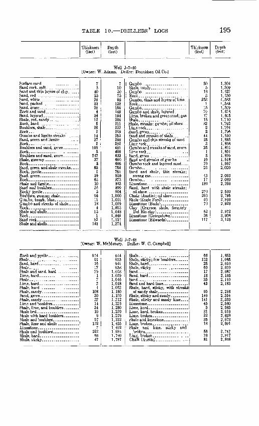
TABLE 10. DKILLEKS LOGS 195
Thickness (feet)
Depth(feet)
Thickness (feet)
Depth(feet)
Well J-7-40 [Owner: W. Adams. Driller: Donaldson Oil Co.]
Sand, red .---_-_-._ . .Sand, white.----.--. .....Sand, packed-.---...-.....-...
Rock... ... ...
Rock......... _ .............
Rock..... _ -.-.-......----..
Rock............. .....
Rock.........................
Rock... ........... . .......
73
4025203328
43412
526
214372
1095
247375
551
59631016
5961118
415
182
143
710507595
128156160194206211237239253290292401406653690695750751810873883899904
1,0001,0111,0291,0331,0481 0491,1311,274
Rock......... ........_....-..
Shale (Eagle Ford)--. ..........
Del Rio cky). ...............
305
183
2531
1579171582
22
4425
325
13
197923
4317
180
270265
5570
5235
117
1,3041,3091,3271,3301,5831,5841,5991,6781,6951,7101,7921,7941,7961,8401,8651,8681,8931,8941,8991,9181,9972,020
2,0632,0802,260
2,5302,7952,8502,920
2,9723.0083,125
Well J-7-48 [Owner: W. McMenery. Driller: W. C. Campbell]
Shale... .. ....................
Shale..... ................ -
Shale.........................
Shale bed.. _____ ......
91411161779
1
24
1083022143410
657
1227
2225647
914925941958
1,0381,0391,0461,0481,0521,1601,HO1,2121,2261,2601,2701,2761,3331,4551,4621,6841,7401,787
Shale... ........ . ....
Sand
Sand... ...... - ... ....
Shale and lime, sticky and
Chalk (Austin).. ...... .........
66132256017183543
6514614145
531223518
567081
1,8531,9852,0102,0702,0872,1052,1402,183
2,2482,3942,5352,5802,5852,6162,6382,6732,691
2,7472,8172,898

196 GROUND-WATER RESOURCES, MEDINA COUNTY, TEXAS
Thickness (feet)
Depth(feet)
Thickness (feet)
Depth (feet)
Well J-7-52 [Owner: Mary Blatz. Driller: Lewis Production Co.]
Clay ......................
Shale. Rock.. _ _ .Shale.-
Shale, sandy and hard sand;
Boulder and hard sandy shale-. -- Shale.. .......................
Shale.. -
Shale..
10 5
325 51 8 3
33 4(50 117
151 263 132
17 75 19 96
140 121
2 2 2 3 5 8
10 15
340 345 346 354 357 SCO 850 967
1,118 1,381 1,513 1,530 1,605 1,624 1,720 1,860 1,981 1,983 1,985 1,987 1,990 1,995 2,003
Shale..
Shale.....
Shale. Shale (Eagle Ford)......
Shale (Gravson shale, formerly
16 40
8 15 26
4 2
40 26 30 40
208 22 33
130 62 67
3 131 94 25 62
88 52 11
2,019 2,059 2,067 2,082 2,108 2,112 2,114 2.154 2,180 2,210 2,2£0 2,458 2,480 2,513 2,643 2,705 2,772 2,775 2,906 3/00 3,025 3,087
3,175 3,227 3,238
Well J-7-62 [Owner: I. & G. N. RR.]
Clay.......... ..........
Clay .......................
Shale..
Shale. _______________
18 91
7 6 2 8 2
33 5
37 48 52
7 10 42 12 69 29 17
9 38
8 51 22
2 37 71 25 31 15
7 11
18 109 116 122 124 132 134 167 172 209 257 309 316 326 368 380 449 478 495 504 542 550 601 623 625 662 733 758 789 804 811 822
Shale..
Shale....... .
Shale........... ......
7 6 7 6
72 6
62 4
48 14 49 31
9 81
2 22
616 50 88 40 33 10
6 4
18 37 10 27
5 8
187 66
829 835 842 848 920 926 988 992
1,040 1,054 1,103 1,134 1,143 1.224 1,226 1,248 1,864 1,914 2,002 2,042 2,075 2,085 2,091 2,095 2,113 2,150 2,160 2,187 2,192 2,200 2,387 2,453

TABLE 10. DRILLERS' LOGS 197
Thickness (feet)
Depth(feet)
Thickness (feet)
Depth (feet)
Well J-8-3 [Owner: W. S. Lilly. Driller: Gilcrease Oil Co.]
Sand....... ...................
Shale... ......................Shale and sand, hard, in streaks .
Shale.........................
33267
402575
335372
8152549
315
12
2502535
2518
57
33300340365440775
1,1471,1551,1701,1951,2441,2471,2621,2631,2651,5151,5401,575 1,8261,8341,891
Sand... __ . _____ .. _ ....
Shale. ........................
Shale, hard...... _ ___--_... .
Chalk.........................Shale........................
Clay (Grayson shale, formerly
4956203450
544616966
5263
514815
34315
6664
4
1,9401,9962,0162,0502,1002,1052,1492,2102,2792,3452,3502,6132,6642,7122,7273,0703,085
3,1513,2153,219

198 GROUND-WATER RESOURCES, MEDINA COUNTY, TEXAS
TABLE 11. Water levels in wells in Medina County, Tex.
Date Water level Date
Water level Date
Water level
Well C-7-13 [Owner: G. M. Merritt. Altitude of land surface: 1,361.5 feet]
Oct. 11, 1950 - __Jan. 2, 1951 - -Mar. 12.. ... ...
243.14 248.29 249.74
Mnv Q 1Q*»1
July 3,--.. Jan. 14, 1952 -
246.90 245.50 253.22
Nov. 5-. --------------255.37 248.41
Well C-7-19 [Owner: Carl Porter. Altitude of land surface: 1,279. 5 feet]
Jan. 9, 1951 Feb. 2... ................Mar. 9 - ..- ...May 9 ................July 6
182.39 185.75 188.29 185.80 187.00
Sept. 11, 1951 . Nov. 6 ...... -Jan. 14, 1952
188.33 200.76 188.54 190.29 180.77
Sept. 3, 1952 -- Nnv %
Aug. 25,1954
186.46 188.38 184.22
Well C-8-27 [Owner: R. Zuberbueler. Altitude of land surface: 1,119. 9 feet]
Aug. 17, 1950- Jan. 9, 1951 Feb. 5. -.Mar. 8-- ..... ...... ...
219.11 222.60 224.18 225.73
July 3 . Sept. 6 .... .Nov. 6 .....
226.45 224.80 213.74 238.44
Jan. 14, 1952. .Mar. 18 -------------Nov. 9, 1954 ------
224.57 228.68 228.27
Well C-9-38 [Owner: B. DeGrodt. Altitude of land surface: 1,129.1 feet]
Nov. 13, 1950 -- ..Jan. 12, 1951 . .Feb. 8 ... ...Mar. 14 -
210.00 210.79 211.36 192.83
May 10, 1951. -.July 9
181.60 191.60 174.07 193.46
Nov. 7 .... .... .-Nov. 8, 1954
168.38 217.21 218.73
±177.10
Well D-7-25 [Owner: R.Murray. Altitude of land surface: 1,086. 5 feet]
Dec. 12, 1950 Jan. 25, 1951 . Mar. 5 ... ... ... ... .
153.71 150.85 136.29
May 11, 1951. Nov. 1
158.77 110.71 114.22
June 10, 1952
Nov. 6. ----------------
103.91 104.73 96.95
Well D-7-37 [Owner: M. Haby. Altitude of land surface: 1,168.1 feet]
Nov. 7, 1950. Sept. 12, 1951.
309.56 308.19
Nov. 1,1951 311.46 313.92
Mar. 26, 1952 . -.. 316.83 293.26
Well 1-1-7 [Owner: E. L. Kelley. Altitude of land surface: 1,167.0 feet]
Jan. 9, 1951 Feb. 5
381.99 387.12 390.56
Sept. 17 ... Nov. 6- _ _ -
395.96 404.69408.60
June 9, 1952---.--....Sept. 3 Nov. 5--- -----
420.82 414.61 417.97

TABLE 11. WATER LEVELS 199
DateWater level Date
Water level Date
Water level
Well 1-2-16 [Owner: A. Schlentz. Altitude of land surface: 1,021. 7 feet]
May 17,1930.............Oct. 22, 1934.... ... .. .July 8,1937.............Aug. 11. .................Sept. 23, 1938.............Apr. 10, 1939-... .. ... .Aug. 1.... ..............
Oct. 25.-.. Jan. 16, 1940.............Feb. 21.. ....... . .. .Mar. 18... .......__.__.._Apr. 23..-.... . ...May 23...... ....June 17, 1940..., ._ _ ..July 22.... . .... ..Aug. 23...... ..Sept. 24. ........ ..... ..Oct. 21...... ........
Jan. 20, 1941..., ..... ..May 26--.. ......... .....Aug. 11..... .....Nov. 12.... ..... .Apr. 6,1942.............Aug. 4..................Nov. SO.-.-.-..,..- .....Apr. 26, 1943.............
244.00 220.35168.82 173.58 189.98204.60 209.30 210.92212.00 216.14 218.02 219.15 217.05 219.04 219.32 216.90 220.23 222.24223.88 225.60 221.26189.38 193.25
198.26 206.10202.24 186.43 196.69
Aug. 31,1943.. -......Dec. 14...,. . May 3,1944- Aug. 19..... . Dec. 19_-_ June 4,1945-. July 2,1947... Nov. 7_. ._ ..Apr. 23, 1948 .. ... .Aug. Z. .................Jan. 6,1949.. Mar. 9. -..-..... ........Apr. 12. ....... __. _Aug. 26....... ..Nov. 2. .... _Dec. 9... __ _ .Jan. 26,1950. Feb. 23.-.-.-.- ._ .....Mar. 28. ..... .......May 1. .-_-. .
July 3 ___ ._._ ..
Oct. 2... .. ..Nov. 1. _... _.Dec. 3. .....-- .......
195.89 203.76 192.88194.32 193.41180.81 192.16 202.25 212.35212.51222.08 218.12 219.75 199.53 202.05 202.12 204.00 200.63 197.95202.13 201.51 202.17 199.33 207.72 207.13 210.36 213.24
Jan. 8, 1951 --..Feb. 5...... ......Mar. 8...-.- . .-.May 9.-- . ___ . __ .
July 3_. ...... ...
Sept. 6.... Oct. 3 _. _ Nov. 1. .................Nov. 6..... ...... ...Dec. 4 ....... .... ..Jan. 3,1952--.- Feb. 5 ... -. Mar. 12..... ...Apr. 27.......
July 2. _.__. Sept. 3... ...... .........
Apr. 9, 1953 ---------Aug. 13 Nov. 23..-. Apr. 16, 1954- July \b.. ................Aug. 24
216.26 221.57 224.62 224.62 217.96 223.48 233.99 228.10 229.47 232.74 231.16 233.42 244.61 245.33 237.49 237.62 236.96 238.50 251.92 244.44 262.39 255.42 247.55 260.76 256.40 257.08 260.35
Well 1-2-23 [Owner: L. Finger. Altitude of land surface: 1,067. 5 feet]
Sept. 22, 1950....... ...
Feb. 2... ........ _. ......Mar. 13. -
270.08 277.30278.74280.36
May 12,1951 - July 6 -----Sept. 11... Nov. 6
280.07 285.20 286.68 289.87
Jan. 14,1952 Mar. 18 -
293.73 297.18 298.05
Well 1-2-40 [Owner: W. A. Weynand. Altitude of land surface: 995. 7 feet]
May 17, 1930. ... ..
July 8, 1937 - Aug. 11
Apr. 10, 1939 Aug. I - ..-.-....
Oct. 25 Jan. 16, 1940 -------Feb. 21. -----------
236.2 195.9 156.23 156.75 169.22 188.11187.72 189.30 190.80 194.05 195.71
June 17, 1940. -------
Aug. 23 _ .Sept. 26 ------------Oct. 21. ---------
Jan. 20, 1941. ......
Nov. 12 ...............
AM. 26. 1943 ... .
198.05 202.28 199.22 200.76201.86 203.77 202.55 184.43 177.20 173.34175.15
Feb. 2,1951 . -Mar. 13 May 9 __ - _ . _ -----Sept. 7 -----Jan. 4, 1952 Mar. 18 ----------June 9.-.--- _.-- _-- -
Sept. 5 _ -Nov. 5 ---. Aug. 24, 1954-.-. . .
213.48 205.92 207.52 210.84 217.19 220.74 222.95 212.10 225.34 227.47 241.57
July Aug.
n iQp;n 258 193
[Owner:
45 39
Well 0. C
1-2-55 . Holloway]
Sept. 1, 1950 ------ Oct. 2 . - _
197 174
42 26
Sept. Aug.
-
5,1951 25, 1954..
201.30 190.69

200 GROUND-WATER RESOURCES, MEDINA COUNTY, TEXAS
DateWater level Date
Water level Date
Water level
Well 1-2-75 [Owner: Ed Weynand. Altitude of land surface: 934.5 feet]
Feb. 2 -32.38 33.22 34.09
July 6 - - Ton 4 10^9
49.72 41.8269.13
Mar. 12, 1952
Aug. 24,1954
67.32 43.53 81.67
Well 1-3-7 [Owner: Emil Britch. Altitude of land surface: 1,01 1.3 feet]
Oct 30, 1950- -------Jan. 10, 1951 Feb. 6 . ..
183.46 191.11 193.09
Mar. 12, 1951
July 9
194.67 198.21 200.32
Nov. 14, 1951 .. .- -Jan. 15, 1952 Mar. 17.. ---------
218.33 220. H) 222.40
Well 1-3-19 [Owner: Milton Heyen. Altitude of land surface: 1,012.7 feet]
Dec. 11, 1950 - Jan. 12, 1951 -------Feb. 1 -....
224.98 238.06 241.35 248.40
May 10, 1951 . . July 9 --------
Jan. 3, 1952
243.27 248.07 250.60 259.41
Mar. 19, 1952
Aug. 23,1954 -
256.89 259.99 276.46
Well 1-3-34 [Owner: Walter Brucks. Altitude of land surface: 915. 2 feet]
Jan. 3,1951-. -. Feb. 1 .-_ _Mar. 14 .
202.70 204.92 206.67
Oct. 31, 1951 Jan. 15, 1952 Mar. 23
217.78 220.27 224.94
June 10,1952 ..-- .. 225.62
Well 1-3-43 [Owner: H. W. McClain. Altitude of land surface: 944.2 feet]
Feb. 20, 1930--. Oct. 18, 1934-..- .-.July 8,1937-.... .-..Aug. 11....... .......Sept. 23, 1938 . Jan. 16, 1940 Feb. 21........ .Mar. 18--- . Apr. 23..... ..May 20.-...-. -------
July 22.-....
Sept. 24... __. . Oct. 21--- - Dec. Z.. ................Jan. 20, 1941.... ......May 26...-- _ ._...._.Aug. 11.-.- Nov. 12-..... Apr. 6,1942-
Nov. 30__-._ Apr. 26, 1943.-. Aug. 27. . . Dec. 14.-.-..-- -.--.
217.30193.05157.83159.62169.10189.03190.85192.06193.15193.65194.45194.04196.32197.89199.10200.53198.94175.71176.41174.58177.30176.28169.99174.79176.70182.15
Apr. 29,1944. Aug. 19- . Dec. 19 -.
Apr. 4,1946.-- July 2,1947.-..
Apr. 24,1948-....
Apr. 13..... Aug. 26..... Nov. Z. .................Dec. 9.. ____ _
Feb. 23 Mar. 28.... . . -....
July 3. ....... ....Aug. 1..... .............Sept. 1. __. _ Oct. 2 ., . . .. .....Nov. 3...... Dec. 4... ....... ........
182.62183.32180.50172.31179.97177.13181.87182.88195.07204.35201.80203.00m an
190.55193.18194.29194.22194 66194.70195.58195.08196.10197.48198.71200.33202.56
Jan. 12,1951. Feb. Z. ..... ............Mar. 14....... ......May 10..--. -
July 9 ---------
Sept. 7-..- - Oct. 3 _. ..... Oct. 31-. .. .. . . Dec. ^.... ..............Jan. 4,1952-.--..-...
Mar. 17. --------------Apr. 27.......... .July Z. ................Aug. 25
Apr. 9,1953... Nov. 23-.... .-... .Apr. 16, 1954
July 15...-.-.-......-.
205.27207.64210.40210.05208.46211.03213.23217.83218.59220.07222.45223.01224.62226.93227.61230.15235.01236.63237.00233.63245.77244.82245.96247.02248.41

TABLE 11. WATER LEVELS 201
DateWater level Date
Water level Date
Water level
Well 1-3-75 [Owner: Gus Britch. Altitude of land surface: 933.5 feet]
Feb. 20,1930.............Oct. 18, 1934.. ...........July 8,1937......... ..Aug. 11.... ...... .. Sept. 22, 1938. .. ....Apr. 10, 1939-- - ..
Sept. 18....... ......Oct. 26.-...... ......Jan. 16, 1940.. - - .Feb. 21.... . .......Mar. 18... ...... .........Apr. 23...... ......
July 22_____ Sept. 24 .. Oct. 21........... ...Dec. 2....... ....... ....Jan. 20, 1941. May 26-----. __Aug. 11..... Nov. 12...... ___ _. ..Apr. 6,1942_ _
Nov. 30-..... .... ...
214.20184.10149.98161.58172.35186.20187.37187.88194.32191.02191.05193.02196.09
194.43192.65198.39200.34202.43196.84146.35170.35168.58174.73171.671S6.40
Apr. 26, 1943...... ..Aug. 27... .. ...Dec. 14- -- Apr. 29, 1944.. -
Dec. 19.. June 4, 1945...... __ .Apr. 4,1946-. July 2, 1947....... ......Nov. 7.- -. . - Apr. 23,1348...
Jan. 6,1949...-- ...Mar. 9... -- -.-Apr. 13....... ......Aug. 26 .. _ __ .......Nov. 2. . .... Dec. 9. .. ...Jan. 26, 1950... .._--...Feb. 23 .- ... ...Mar. 28.. . .... .
July 3....... .... .Aug. 1.... ...... ........Sept. 1... ....... ........
172.25175.60178.69180.61182.13176.77169.61181.69182.98195.28194.51198.28214.96121.94195.76177.52120.59179.31188.34182.60192.40196.43191.16193.59196.57198.38
Oct. 2, 1 50 ... ......Nov. \. ......... .... ....Dec. 3. ....- .......Jan. 10, 1951 . Feb. 2.. .... Mar. 14-. __... ......
June 1. .......... _ _ ..
Sept. 7... Oct. 3.- ._ Oct. 31 -- Dec. 4.. .-..... --
Feb. 5 . Mar. 13 -. -Apr. 27..
Apr. 9, 1953. ___ Aug. 13. . . ...........Nov. 23-... -... Apr. 16, 1954....- -
Nov. 9.. .--
200.75207.11221.20221.46217.66229.94125.17186.40219.83224.16223.11224.46225.69220.28226.09229.01225.14246.00240.16248.97231.91247.04243.51252.75
Well 1-3-118 [Owner: United States Government. Altitude of land surface: 905.0 feet]
Apr. 27, 1950 May 7 ..... ... ....
July 2 .... . ...
Oct. 5 Dec. I.... ...............
205.51209.05208.80211.57215.39217.24218.47
Jan. 25, 1951 Mar. 2 .... May 12.
Sept. 5 Oct. 3 NOT. ^. .................
220.04220.34219.61224.76229.89231.11233.23
Jan. 4, 1952 Mar. 12 ...
238.75235.48245.27240.45254.21

202 GBOtnSTD-WATER RESOURCES, MEDINA COUNTY, TEXAS
DateWater level Date
Water level Date
Water level
Well 1-4-1 [Owner: Ross Kennedy Estate. Altitude of land surface: 967.3 feet]
Feb. 19, 1930_. ...........Oct. 18, 1934._. _____ _ __July 8,1937-.-----..-...Aug. 11. ....._ .-... ...Sept. 26. .................Oct. 19........... ....Nov. 20..... __ _ ____ _Dec. 20...... ...........Feb. 25, 1938-... .....Mar. 16..... ...........Apr. 26....... ........May 27..--.. ............June 28 __ .. _ ___ ._ .July 26....... . ..Aug. 23..................Sept. 23. ........ .........Oct. 26.......... ........Dec. 9- ......- ....Jan. 27, 1939. ...........Mar. 2. ......... ........May 4.... . . ..Oct. 25..... ......... . Jan. 16, 1940- Feb. 24........ ....Mar. 21...... ...........Apr. 23. .................May 20..................
July 22--. Aug. 23..................Sept. 21. ...__ __ Oct. 21..... ....... .Dec. 2.. ........ ........
248.2227.95191.31193.96198.13200.68
202.44202.68
201 94200.15200. 82200.86202.99204.76204.38210.50213.59
220.00223.65 226.40226.76228.35228.72228.40228.31227.34229.63231.08232.42233.23
May 26 ... . ___ ___ ..Aus. 11........ Nov. 12............ Apr. 6,1942-
Aug. 31, 1943.. ....... ....
Nov. 7.- __..-.. --------Apr. 23, 1948 _ .___ ___
Jan. 5,1949---. ..-.
Aug. 26 .... - - ... Nov. 2. ........ ___ Dec 9Jan. 24, 1950. . ___ Feb. 23...... Mar. 28..... .............
July 3. .................
Oct. 2.. ................Nov. 3... ... . .-
229.85199.74199.91192.38201.01205.63198.13211.809J9 41218.16
204.41
212.59220.01230.38236.45243.75
236.87227.59225.31 226.39226.91227.10227.93228.78228.96229.78231.58233.27235.15240.40
Dec. 6, 1950_-_ _ .......Jan. 13, 1951---- Feb. 6. .... Mar. 13-...... May 12.. ..............
Aus;. 1.. _.._
Oct. 3....... . _-
Dec. 4... --_ _
Feb. 5..... Mar. 17-..--.- .---Apr. 27--...-... ___ -__-
July 2. ...... ........Aug. 9. ..__ Sept. 6....... ...Nov. 5. .....-_-_. _______Dec. 22_..-____ _________
Aug. 13. ..............Nov. 24_. ___,-._._______,Apr. 16, 1954-
July 15-.... July 23...
Nov. 12......
242.58242.28244.82245.65246.59246.78248.79249.24255.37254.37256.62257.34259.01260.72261.63264.75266.02261.03266.26268.80268.29267.45 259.08274.00269.82276.43275.34277.25277.97279.73281.40
Well 1-4-12 [Owner: Curtis White. Altitude of land surface: 950.0 feet]
Apr. 21, 1930... ....Oct. 23, 1934___. ___-__.__July 8,1937. Aug. 11-... ._________.._.Sept. 23, 1938_.. _-._______Jan. 16, 1940... __________Feb. 21-..... - .Mar. 21-.- ____ _ . .May 20...... -. -....
July 22-----, _.______-,Oct. 21-. ._. ______._
Jan. 20, 1941. ..________..May 26----- Aug. 13.....- Nov. 12..---- ________Apr. 6, 1942_... ___...___
Dec. 3....... .......Apr. 26, 1943... .. Aug. 31.. ....... _______..Dec. 15...... .- .May 3,1944-.. Aue. 19--- . --
236.7216.75180.92184.00194.28214.70215.99216.13217.24216.85215.93221.24221.26218.16189.29189.38182.95191.07195.47187.82194.78 201.28208.34210.12208.12203.53
June 6, 1945. .-._____ __
Apr. 22, 194S-.. _ . ...
Mar. 7-..--. --------Apr. 12.. ..... _---.Aug. 26... _- - Nov. 2 .__ .....Dec. 9...-- _____________
Feb. 23_. ___ -_Mar. 28. ....... .....
June 2 ---__--,____ __.._July 3 _ _ _____________
Sept. 1...... . . . ._._.Oct. 2.... ..... .... Nov. 3. _..._ Dec. 6. ___ __._ Jan. 8,1951-.. .-- .Feb. 6.-.- . _ ._._-_-
194.06207.52202.15212.08219.41225.33
226.54225. 80216.66214.25215.51216.56216.18217.17217.93218.12220.16224.68222.34223.87 230.94229.19230.81232.57234.63
May 12. ._.._
July 6... ... ...
Sept. 11...... -......Oct. 3......... ...... ..
Dec. 4 ._. Jan. 3, 1962 . __ Feb. 4. .....__._.__.____Mar. 17---- Apr. 27.. --
July 2_____. __.____.__.Ancr Q
Sept. 3. ..... ..
Dec. 22. _.-_____-_.__._Apr. 9, 1953 ____ .......Aug. 13_. ..._____...-____Nov. 23..---. .... .
July 13.....- ..
Nov. 12_.._- ______
236.40234.87236.86239.86244.07242.79245.00245.64246.99248.52249.57250.42
252.29
267.09256.00253.90257.51268.02261.68
263.60265.36268.14
Well 1-5-8 [Owner: C. Steurnthaler. Altitude of land surface: 893.8 feet]
Feb. 3, 1951 . . -
Apr. 2 May 11 . __ ._
210.44206.10205.58202.07206.50
Sept. 5, 1951. -._..-.---_Nov. 15 Jan. 17, 1952__ _ _. ___Mar. 12 .... ... . .... .
210.30210.40214.74214.14215.66
Aug. 9, 1952
Nov. 12 _.._ _. _
216.30

TABLE 11. WATEK LEVELS 203
DateWater level Date
Water level Date
Water level
Well 1-5-55 [Owner: Ray McGlauphlin. Altitude of land surface: 784.1 feet]
Oct. 23, 1934... ..........July 8,1937.-..-----...Aug. 11... ...............Sept. 23, 1938...-. - .Jan. 16, 1940... .- -----Feb. 21_. _.._ _ _ _Mar. IS......-.. ......
May 20........ _ . - ....
July 22 ... .. ..Aug. 23...... . .....Sept. 24 -.-.-.... ........Oct. 21 .. .. ...........Dec. 2.... _ ..........Jan. 20, 1941---.-..-.-...May 26... __ . _ . __Aug. 11----.-......-.--..Nov. 12.......Apr. 6, 1942.... __.. ....
Dec. 3. ...... ...........Apr. 26, 1943... ..Aug. 31........... .._--..Dec. 15..... -
72.9451.5017.0218.8529.3149.2150.7351.9652.1952.0251.6450.7353.2854.7455.7855.9552.8424.2425.3118.1526.0730.4322.6729.7836.4043.20
June 6, 1945...... .......Apr. 3, 1946.............
Nov. 7. _-._.. Apr. 22, 1948 Aug. 2....--,.. ......Jan. 5, 1949-.. Apr. 12-....--.-.-...--..Aug. 26..................
Dec. 9 Jan. 26, I960. ______ __....Feb. 23...--- Mar. 28. ........ .........May 1. ........ .... ..
July 3...... . ........
Sept. 1.. ........ ........
Nov. 3.-.... -----Dec. 6....... ...........
Feb. 6. .-.-.. ......
41.8741.3228.9642.3737.3843.9054.0860.0566.1559.7551.2748.7250.1751.1450.6651.6553.4753.5653.5955.3057.0258.6260.1163.6165.3567.31
Mar. 13, 1651 ..... ....May 12......... .
July 6 Aug. 1... ........... Sept. 11..-- Oct. 3 .. Nov. 2......... ....Dec. 4-... ..... ... ....Jan. 3,1952... Feb. 4... .... Mar. 17..-... .... ..May 27..--..
Sept. 3Nov. 5...... .........Dec. 22__..__ Apr. 9,1953---. Aug. 13..... Nov. 23..---. Apr. 16, 1954.... ....
July 13...-. . . Aug. 24..---..... . Nov -12.-..... ... .
69.4370.2269.5872.1670.7678.2177.6885.7480.3781.8383.2384.1685.0784.4989.1891.9790.8290.7091.20
100.5891.8098.5097.97
101.45102.78103.52
Well 1-6-4 [Owner: F. W. Bohmfalk. Altitude of land surface: 851.4 feet]
Aug. 31, 1951 Nov. 2. ...... .........Jan. 3,1952.
175.03174.97 176.99
Mar. 15, 1952. Nov. 6 _ .. _ -.-Aug. 26, 1954
179.37 182.70 196.85
Nov. 9, 1954.... ........ . 193.33
Well J-l-3 [Owner: A. Haby. Altitude of land surface: 925. 9 feet]
Jan. 8, 1934 ----------Dec. 12, 1950 ------Jan. 29, 1951 Feb. 5 Mar. 14
89.40
62.47 64.29 65.91
A'ay 11, 1951 July 11 Sept. 13. Nov. 1 ..... .
67.91 81.3578.72 75.67 79.94
Mar. 19, 1952-.-.... _ ..
Aug. 25 .Nov. 6 _ . _ . _ - ....Aug. 23, 1954.. -
81.77 81.79 81.87 65.89 99.26
Well J-l-9 [Owner: A. C. Wurzbach. Altitude of land surface: 923.1 feet]
Aug. 29, 1934 . Jan. 7,1951 Feb. 13- Mar. 15
200.30 211.87 213.30 216.81
May 11, 1951 July 11. -------------Sept. 5 .Nov. 1
220.10 235.09 233.70 235.82
Jan. 15, 1952.---..-....Mar. 11 ... ............
Aug. 23, 1954
246.42 237.20 225.01 268.57
Well J-l-16 [Owner: H. F. Haefelin. Altitude of land surface: 968. 7 feet]
Jan. 15, 1934.. Nov. 28, 1950 Jan. 22, 1951 Feb. 1 ..... .
149.45 171.96 172.02 172.25
Mar. 14, 1951 May 11 July 9 _ .
171.89 172.75 182.28 181.43
Jan. 15, 1952 . Mar. 16
224.98 229.82
Well J-l-22 [Owner: Frank Haby. Altitude of land surface: 1,042. 6 feet]
Jan. 12, 1934 Jan. 12, 1951...- Feb. 1 ... .....Mar. 14 ..
219.29 237.02907 Q7
239.14
July 9-. --------------
Oct. 31
241.51 245.72 242.43 224.42
Jan. 15, 1952 Mar. 24-
259.96 264.63 260.54

204 GROUND-WATER RESOURCES, MEDINA COUNTY, TEXAS
DateWater level Date
Water level Date
Water level
Well J-l-41 [Owner: F. C. Stinson. Altitude of land surface: 846.0 feet]
Feb. 20, 1930.............Jan. 8,1934.. ...........Apr. 20...... . ..May 23............ ... .June 21.....Julv 31..................Aug. 24..................Sept. 21. .. ............ .Oct. 8..................Nov. 21...... ..Dec. 21............ .. ..Feb. 3,1935-.. Mar. 2...... __Apr. 9 _______ .... ..May 21...... June 28 ..Aug. 2......-....... .Sept. 27-.-. ...... .......Jan. 20, 1636.. ...........Aug. 27.--.-- - .. Jan. 4, 1937- - Feb. 27, 1938... .... Apr. 26-..--. --May 27--..-.- June 28..---.- .. ___ __
150.00144.24141.99144.92147.55147.31149.96151.43151.50152.57153.32153.38153.55154.44144.28126.72128.75126.68130.00128.11124.80129.62132.78130.66134.50
Aug. 23, 1938...... Dec. 8-----. . -..-
Mar. ^. .................
July 6--.... Aug. 17----.. .._ .......
Feb. 21-...... .. Mar. 18...... . . ... ... _Apr. 26 ---_.-
July 22.--.., .Aug. 23... .- .. Sept. 24..... . . .._..._
Jan. 23,1941..... Nov. 12...... ... .......
137.71141.25142.35138.25145.27147.89148.20151.52148.05
151.15
152.59154.44155.30155.58154.86153.86157.44158.42158.85153.46153.00133.60138.40
Aug. 4,1942.............Nov.30. ...... ...... ..Apr. 26,1943...
Apr. 29, 1944-..
Dec. 19-.---. June 4,1945....... ___Apr. 4,1946-- -Jan. 7,1951. - -Feb 9Mar. 15-..---- .May 11.....-. July 11...... . ..
Nov. 1....... ... .... .
Mar. 11...-.. ..... June 10-..-- ___ . .....
Nov. 6. ........ .........Aug. 23, 1954... .. ------Nov. 11--.-- -
140.73129.40139.62144.50147.04143.61145.53140.50136.4014E.29168. 89170.33171.39171.10176.67181.77181.25181.35182.22183.64191.74186.24199.85195.65
Well J-l-68 [Owner: J. Kremnueller. Altitude of land surface: 986.1 feet]
Aug. 21,1937-. Sept. 26 . - _ _ Oct. 19--....- Nov. 15..... .... ... . ._
Jan. 19, 1938 ...... Feb. 26....... Mar. 16...... ... Apr. 26-..-- ______ ...May 26... . _____ ...
July 26.. .. .Aug. 23 . _. ___ . ...Sept. 23. ...- Oct. 26..--..-.- .. Dec. 9 --...- -. -
Mar. 2... ___ .
Aug. 17--. Sept. 16..... .... -
Jan. 17,1940-- Feb. 21...... Mar. 18..... .Apr. 26.. .. . - -- .
67.8968.6863.8864.5165.6763.3762.8462.4963.0462.3363.9063.9465.0563.2963.9863.87 63.5864.4064.3665.5066.7166.2068.8270.3366.1167.2467.8068.3867.6067.14
July 25, 1940 Sept. 26...--.. . .
Dec. 2 .. . ... ...Jan. 20,1941-
Aug. 11.....
Apr. 8, 1942 ......Dec. 3 .-- . . .
Dec. 14..-..... .-Apr. 29,1944.... Aug. 19 ._._ -Dec. 19 . ._ ._---June 4,1945.- --. July 1,1947..-- -Nov. 7- .__
Aug. 2...... Jan. 5,1949... .. .Apr. 12..-.------. ..Aug. 26 . ___ . ____ Dec. 21. .- ... .......Feb. 23, 1950 __ __ Mar. 28......
July 3.___
68.5969.5068.7068.4767.7661.2962.6962.6962.0860.6364.8965.2062.8064.3960.9861.50 62.2461.4061.3463.7864.1163.4565.6360.0659.3160.4060.3760.5862.4565.34
Sept. 1, 1950 Oct. 2.. ....... .--... Nov. I-.... . Dec. 5..-. -------Jan. 6,1951.-. Feb. 9.--. Mar. 14...... ... .May 11......-.--.
July 10...-...- .. .Aug. 1. .................Sept. 11 -Oct. 3...-.. -------Oct. 31- ..-.. .-Dec. 3..___ .... ... ...Jan. 16, 1952. ....-.--. .. Feb. i_. ....... ..... ... .Mar. 13.. ......Apr. 27..... June 10 .... _ __ ___ .July 2...... .-Aug. 25.--.--.- Nov. 6._ .. _. . _ , ...Apr. 9,1953..--.- Aug. 13-..-. Nov. 24.. _- - .Apr. 16,1954---.-. July 15---..- - Nov. ^.. ................
62.4862.8564.3866.4567.9668.6969.4464.7663.9869.9566.9267.8965.6160.7065.6767.41 73.5266.8067.1566.5468.6772.7168.1569.4370.4468.7270.8474.5669.48
Well J-l-86 [Owner: J Courand. Altitude of land surface: 854.2 feet]
Jan. 3, 1952
193.599H9 73
208.13
Mar. 13, 1952 . 205.36206.42214.29
Nov. 6, 1952 Aug. 28, 1954- Nov. 9 ______ ....
209.79222.36220.75

TABLE 11. WATER LEVELS 205
DateWater level Date
Water level Date
Water level
Well J-2-14 [Owner: M. H. Bippert. Altitude of land surface: 766.8 feet]
Jan. 12, 1934 __ .........
Feb. 2. ..................Mar. 14-. ..............
89.40 98.19 99.34
100.66 103.12
July 11, 1951 -------Sept. 5 Oct. 31 Jan. 16, 1952 -_ Mar. 11 ..
106.43 111.11 113.21 111.51 110.42
Nov. 6 111.72 114.88 127.83
Well J-4-7 [Owner: L.M.Samuels. Altitude of land surface: 916. 8 feet]
July 18, 1951 - Nov. 16- -
167.12 155.24
Jan. 16, 1952 170.74 Mar. 13, 1952 172.68
Well J-5-3 [Owner: Southern Pacific Lines. Altitude of land surface: 724. 4 feet]
Feb. 19, 1930 -----------
Aug. 31- -
Nov. 22, 1935. Jan. 8,1951
49.9032.61 36.8539.06 39.13 19.85 55.44
Feb. 13, 1951 Mar. 14 May 11 .
Nov. 1 ..-... Jan. 21, 1952 Mar. 24 -----------
55.79 56.25 57.64 66.09 70.12 65.51 66.85
May 11, 1952 ---------
Nov. 6-. ---------Aug. 28, 1954
57.64 67.53 76.22 70.06 83.42 78.72
Well J-8-24 [Owner: K.G.Howard. Altitude of land surface: 653.01 feet]
Feb. 21, 1930 .
Nov. 16 -
85.20 76.7478.15
June 24, 1952
July 24, 1953
76.82 76.85 77.40
Nov. 23, 19 r3 . ------Feb. 23, 1954
77.1477.28
Well J-7-42 [Owner: A. A. Lilly. Altitude of land surface: 657.6 feet]
Feb. 21, 1930 June 30. 1951 __ .. .
101.75 95.46 June 24-_---- ..........
95.66 96.20
Nov. 23, 1953 Feb. 23. 1954 -------
97.63 98.06
Well J-7-47 [Owner: W. Cavhart. Altitude of land surface: 661.1 feet]
Feb. 21, 1930 June 30, 1951 Sept. 18.. ..Nov. 15 .
106.55101.26101.4094.46
June 24, 1952. Sept. 24. --------------Apr. 24, 1953 July 24 --- -
102.05101.74102.60103.43
Nov. 23, 1953 Feb. 25, 1954 --.-- ...
102.7102.8104. 3<104.0
Well J-7-49 [Owner: D. J. Bartlett. Altitude of land surface: 649 feet]
Feb. 22, 1930
Nov. 15
95.4794.22
102.32
Jan. 16, 1952-- ------ 107.54
94.78
July 24, 1953 105.21

TABL
E 12
. A
naly
ses
of
wate
r fr
om
wel
ls a
nd s
pri
ngs
in M
edin
a C
ount
y, T
ex.
[Chem
ical
co
nst
itu
ents
, in
part
s per
mil
lio
n]
Wel
l or
sp
ring
C-7
-9(S
prin
g).
C-7
-13
C
-7-2
0
C-7
-29
(Spr
ing
in
cave
).
C-8
-12
C 8
-18
P-8
-93
C-8
-25- -
C 8
-27
- -
p
e_O
Q
C-8
-32
(Spr
ing)
.P
Q
-.1
C-9
-5(S
prin
g).
f
Q-S
(Spr
ing)
. C
-9-2
4 _
P
Q 9
Q
C-9
-38
C-9
-45
C-9
-58
1 ..--
P
Q_f
iQ
(Spr
ing)
. D
7 3
D-7
-20 ..
. -
D-7
-25...-
-D
-7~
37-_
__
Ow
ner
C.
P. R
ug
h..... ...
J.U
lbri
ch- -
-
B.
C.
Jagg
e -.....
-
do -
d
o
.. ...
.
B.
DeG
rodt
....
A.
W.
Sch
ulte
- --
----
-
- .
do
- .
M. H
abv
Dep
th
of
wel
l (f
eet)
400
486
200
200
400
300
500
300
500
400
(?)3
6027
558
534
6O
1 A 91 237
220
495
374
450
Dat
e of
colle
ctio
n
Jan.
14
, 19
52O
ct.
10,
1950
Aug
. 17
, 19
50
Aug
. 16
, 19
50A
ug.
4, 1
950
Jan.
1,
195
1A
ug.
4, 1
950
July
28,
195
0
Nov
. 6,
195
0O
ct.
18,
1951
Dec
. 4,
195
1O
ct.
23,
1951
Mar
. 27
, 19
52 .d
o -
Sept
. 21
, 19
51Ja
n.
10,
1951
Jan.
17
, 19
52N
ov.
7. 1
950
Silic
a (S
iOj)
10 11 12 13 10 13 13 13 10 20 10 12 15 10 12 12 13 9.5
14 12 17 30 1.6
1.4
13 9.5
7.8
14
Iron
(Fe)
in
so
lu
tion
0.00 .0
0.0
0.0
0
2.00 .1
9
.09
.14 9 .01
.62
Cal
ci
um (Ca) 88 186 82 152
363
538
457
176
560 88 70 75 102 69 57 176 84 540 83 76 83 248
476
540 68 74
Mag
ne
sium
(M
g)
11 141 86 7.
0
268
344
267
58 164 14 8.
811 18 9.
4
14 107 6.
343
4 27 5.4
53 157
106
369 23 8.
2
Sodi
um
and
pota
s
sium
(Na +
K
)
5.8
52 18 14 54 54 46 12 12 7.5
4.6
4.3
7.4
3.7
4.8
9.0
6.5
61 10 3.6
21 42 13 97 53 17 8.
72.
2
Bic
ar
bona
te
(HC
Os)
280
350
472
269
298
303
264
244
214
330
239
260
353
238
221
273
280
251
285
222
311
238
143
216
184
238
196
245
Sulf
ate
(S0
4)
16 783
174 33
1,75
02,
480
2,00
046
81,
830 6.
27.
113 23
1,40
0 3.5
11 625 7.
72,
900 88 3.
017
91,
090
622
430
1,50
02,
580 93 4.
1
Chl
o
ride
(C
D
10 37 20 8.0
40 30 26 10 12 14 7.9
9 20 13 9 11 11 8.5
27 9.5
8.5
21 18 65 175 18 16 14 12
Fluo
- ri
de (Fl) 0
5
2.2
4.2 .1
Ni
tr
ate
(NO
s)
21
.5 1.0
212 3.
21.
23.
54.
50 2.
54.
53.
84.
0
9.3
3.5 .8 1.0
4.0
5.5
28.4 .4
14 9 n
0 0 1.5
1.5
Bor
on(B
)
0.18
0.16
Di-
solv
ed
solid
s
314
1,38
068
261
0
2,64
03,
610
2,94
086
22,
690
330
248
273
384
238
223
1,07
026
54,
100
402
262
550
1,78
0
2,26
03,
650
324
248
Har
d
ness
as
C
aCO
*
264
1,04
055
840
8
2,01
02,
760
2,24
067
82,
070
277
211
232
328
211
200
879
236
3,13
031
821
242
51,
260
840
1,62
02,
860
264
218
Per
ce
nt
sodi
um 5 10 7 7 6 4 4 4 1 6 39 5 4 5 2 6 4 6 4 10 7 3 6 7 1 7 2
Spec
i fic
co
n
duct
an
ce
(mic
ro-
mho
s at
25
°C)
520
1,79
01,
030
843
2,94
03,
640
3,10
01,
190
2,82
055
843
445
462
5
2,41
041
6
429
1,41
046
74,
080
622
436
1,73
01
finn
2,49
03,
690
523
431
, 7.6
7.3
7,4
7 5
7 6
7 3
7,4
7 5
7.1
8.2
7.4
7 7
7 7
8 0
7.7
7 4
7 8
6 7
7,5
8 3
8 3
7,6
7,9
7 8
7.0
7.6
7,3
o
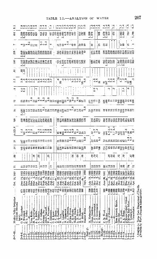
D-7
-45.
D-8
-8 _
1-1-3.
1-1
-7..
..
1-1-
8. ..
1-1
-12..
....
1-1
-17......
1-1
-22..
....
1-2-
16-.
.
I-2-T
87
T..
..
1-2
-21.-
--..
I-2
-37
-
1-2
-40
1-2
-47
I-
2-5
0--
1-
2-51
1-2-
61
1-2-
73 .
1-2-
88. _
____
1-2
-95 -
I-
3-1
6
1
-3-1
9-
1-3-
23
1-3-
34- ..
1-3-
501
-3-7
8
1
-3-8
1..
....
1-
3-82
(S
prin
g).
1-3
-91--
1-
3-11
5
1-3
-11
7
1-
3-11
8
1-3-
125 ......
(Spr
ing)
. 1-
3-13
0 1-
3-13
1
1-3-
133
1-3-
134
. ...
.1
-3-1
34
.
1-4
-12..
....
1-4
-10
1-4
-14
1-4-
18. .
....
1-5-
3.
1-5
-4
1-5-
5
1-5
-8 -
Med
ina
Val
ley
Irri
gati
on
Dis
tric
t (M
edin
a L
ake)
. 0.
W. S
chuchart
...
E.
L.
Kel
ley ...
. ..
-do
Ten
a R
oth
e
M.
Tsc
hirh
art _
__--
___,
_-
A.
Schl
entz
- - -
A.
C.
Gil
liam
_
__
W. A
. W
eyna
nd.-
. ......
R. A
. S
aath
off.
. ........
W. L
utz
...
C. L
angfe
ld.
.
W.
Gla
ssco
ok
....
. ......
L.
H. H
ey
en
W. B
ritc
h... ...
.
U.
S. G
over
nmen
t -.-
..
F. M
. W
ard
... ...
G
. S
adle
r.
..... d
o
...
. ...
...
. ..do
-
W.C
.Sco
tt
D'H
anis
Cat
holic
Sch
ool
D'H
anis
Hig
h S
chool-
..
J. T
sch
irh
art-
----
---.
.-
C.
Ste
urnt
hale
r. -
----
---
671
1,00
9 41
2 40
0 43
2 58
5 1,
140
400
436
450
330
(7)2
85
707
495
447
295 40
40
0 1,
100
307
420
372
258
278
280
805
200
650
1,51
01,
418
100 60
1,50
0 1,
600
1,60
0 1,
600
450
210
4,20
0 41
260 39
1,46
2
Oct
. 19
, 19
51
June
18,
195
2 Ju
ne 2
0, 1
952
Mar
. 15,
195
1 Ju
ne 2
1, 1
951
Mar
. 1,
195
1 M
ar.
2, 1
951
Jan.
19
, 19
52
May
17,
193
0 Ju
ly 2
6, 1
950
Sept
. 6,
195
0 Ju
ly 1
2, 1
950
May
20,
193
0 A
ug.
31,
1951
Ju
ly 1
1, 1
950
..... d
o
O
ct.
16,
1950
A
ug.
17,
1950
Ju
ly 1
7, 1
951
Mar
. 21
, 19
51
Jan.
9,
195
1 Fe
b. 1
9, 1
952
Feb.
26,
195
1 O
ct.
15,
1951
A
pr.
30,
1930
Ju
ne 1
2, 1
950
do
Sept
. 13
, 19
50
July
19,
195
0 N
ov.
8,19
50
May
5,
194
4 M
ay
5, 1
944
Jan.
17
, 19
52
June
26,
195
1_ d
O
Nov
. 2,
194
5 A
pr.
30,
1930
N
ov.
2, 1
945
Jan.
19
, 19
36
May
21,
193
0 A
ug.
21,
1951
N
ov.
20,
1951
M
ay 1
6, 1
930
Jan.
8,
195
2 M
ay 1
5, 1
930
Apr
. 10
, 19
51
11 11
12
13 12
12
12
14 12
12
12 14 23
24
13
11
12
12
12
13
16
15
16
10 14
13
13
15 68 01 14
15
13 44
20 24 "is"
"
.00
.16
.05
.23
.04
.08
.96
.00
.10
.15
.08
.03
.05
.41
.48
.57
.09
58 486
329 65
66
68
66
56
66
67
68
74
74
69 153
134 69
64
68
52
84
56
73
62
124 30 102 68
70
10
6
178
172 66
63
64
73
84
242
137 60
109
128
266
21 347
291 11
10
11
13
28
13
14
10
11
13
13 21
10
65
18
14
9.4
9.0
9.7
11
23
12 5.9
32
15
16 8.3
13
21
16
16
16
12
77
41
67
17 9.8
9.9
41
8.51
3.6
4.4
122 3.
9 8.
4 7.
9 13
31
4.4
6.7
5.1
7.0
3.5
9.0
95
40
445 6.
5 3.
7 5.
4 4.
9 18
8.2
35
18
12 82 6.7
1.4
47 139
248
4.8
|3.4
7.
8 7.
1J4.
4 12
43
1 31
0 53
3 2.6
38
30 5.7
168
230
306
230
230
247
247
261
234
237
238
250
258
258
340
458
585
260
256
197
285
232
266
304
275
116
310
256
254
217
304
356
244
251
255
262
749
344
376
233
301
264
330
2,
1,
93
,320
,860 14 15 14 22 31 18 18 9.
119 20 14 12 14 105 31 278 21 13 5 7.6
10 12 34 21 8.0
51 144 15 16 22 49 44 16 15 14 18 13 183
919 13 44 23 17
13 23 59 10 11 8.8
14 53 9.0
9 8.2
11 9.0
12 13 11 203 21 452 13 8.
210 9.
511 9.
024 37 12 311
114 12 11 124
308
288 18 11 14 18 592
690
358 13 43 48 398
.1
4.0
5.2
0.0 .2 9 .2
2.8
2.2
3.0 .0
5.0
5.5
2.5
1.5 .8
5.6
4.5
4.8
7 3
2.2 .0
30.0 .0 c .5
2.5
3.0
4.2
8.0
5.0
3.5
0 K
36 81 387 3
0
2 Q
o e .75
2.2
3.0
52 146.2
.61
.65
1.30
350
3,310
2,88
0 250
241
258
272
346
258
246
248
264
813
549
1,010
274
246
200
283
235
266
371
526
162
669
264
97<;
465
985
1,37
0
227
255
1,56
71,
680
2,22
022
3484
C1 C
903
235
2,640
2,02
0 20
7
215
254
218
210
230
238
226
468
376
440
234
168
246
180
359 99 386
231
240
298
498
516
230
226
233
772
618
220
312
361
832
7 4 12 4 8.1
13 21 6.1
5 6.2
8 31 6 3.4
4 42 18 23 10 32 25 38 51 47 65 21 1
484
3,530
3,22
0 41
642
642
9451
622
434
423
455
457
436
470
1,350
880
2,68
047
643
644
246
744
9
644
787
255
1,550
1,07
0
895
1,670
2,180
438
3,26
0
762
1.780
8.1
7.9
7.6
7 7
7 7
8,0
7,6
7,8
7,9
7,4
7.9
7.4
7.4
7 4
7 fi
7 8
7.5
8 4
7,5
8 3
7 7
7 7
7 0
7
?:
7,6
7 4
7.fi
7 4
7 4
7 0
7.2!
7.7
7 4
7 8
6.9
1 Ana
lysi
s by
Tex
as S
tate
Dep
artm
ent
of H
ealt
h.
2*A
naly
sis
by W
orks
Pro
gres
s A
dmin
istr
atio
n.
bO
O

'VfTTTTTTTTTTTTTTTi. f T1 T f i ^ i ^ j^ i i iTi iTi iTi iT 3CnCnrf»>k.i-COCOboCoCototO rf- CO CO to C
>r*3ffsSS-'
-§ ! Eg i g'srsrg;"I.1; i P i pr: FE] ! ! ] ill
P S-B a B B B S- P
rf^ to oo CO Cn
£.0
cocnCncnCncncnCTiCoCn Cn Co en CniCncncnCncnCncncncnCocncnCncn »H-I ^H-,^ ̂H-^^Ot^U, tO
5: : 21
il "<JOOO:O1-<IO1O1I 'CD
D-Ol iCrt-^OlOtO
H* C7* CD CD OO I ' OO OO I ' ht* -J rf* 1*- rf* *^> OO frO CD Ujj ^ SO g CD C
-J OO OO OS ______________________________
5C7*C7*OOOCOrf*CDOOC-CnCTiCnci JCntoococ
5 CO -<l I ' frO I ' O5 O5 OS tO
3O OJCW^OOO
CnOOOiWOOOOOO
j^CTi^iSfcOOO^ WCRCW^O 35*t--<IOCD*.CTil 'COOJOCOC^COO-^IOCCShSS^OcD iCO-<rOrf*COOOcDfcOC7*CDOOOOOOOOCOOOOOOOl?OOOOcDH-'O5C7»O
tO bD tO OO tO OO fcO3 tO Ol CO O CD C* OC OO to rf*. -^J C
J2ooooorf» rfi. C7* CD rf*
og§*
W^^wiQoWOIMH-'aS^ooooooooocCnOOO CJs;
OO OO "^J OO <! ~^I ~^I OO <! <! <!-<I <! <!-<T <! -<I <! QC OO Ol -<T -<T OO <! *^ OO CD <! <! OO
svxax ^Aixnoo vxiaaw 'saoanosaa

J-4
-2 ....
J-4-7
... .
J-4
-40
...
J-4-
50- ..
J-4
-75
J-
4-8
6--
-
J-4-1
09 _
.J-
4-1
18 .
.J-
4-1
19-.
.-J-
4-1
24.....
J-4-1
27-
.J-
4-1
40
-...
J-4-
142.
.
J-7-2
1......
J-7-2
2......
J-7-3
0......
J-7
-37 .
_J-
7-4
1..
....
J-7-5
1......
W.
T. B
rady. ..
.__
...
G.C
. C
lark
.. .
....
...
J. R
. G
ayer
... -.-
_--
.. _
J.T
.Kir
by _
....___.
Med
ina
Val
ley
Irri
gati
on
Dis
tric
t (C
hoco
rn R
es
ervo
ir).
-.do- --.
C. W
eldon_. .
.. ._
Jose
phin
e H
aegel
in...
/»1 1
OQ
C
1,28
5 84 111
145
148 60 20
on
n
19
51
Q 81 240
613
(?)1
34i Q
I14
1 86
Nov
. 16
, 19
51Ja
n. 2
3, 1
952
Sept
. 27
, 19
51
Aug
. 20
, 19
51
July
17,
195
1Sp
rrf
9%
1Q
11
Oct
. 5,
195
1O
ct.
19,
1951
Aug
. 24
, 19
51
Feb.
12,
195
2
..d
o..
....
.M
ay 1
6, 1
930
May
20,
193
0
Apr
. 25
, 19
30
6.0
11 43 50 16 oe 47 68 OK
98 60 29 70 72 12
13 11 42 31
.63
.06
.05
.00
.00 no
10
.02
48 flO
294
KQ
OK
00
IfiQ 33 Q
1
7R 38 558 90
63 70 66 16 49 71
15 17 14 27 JQ
91 71 OK
99 8
0
30 10 12 139 23 16 14 8.
622
? 41,
0 ?, ?, 1 1 5 2
W 111 4 6 61
9 K.7
85 69 90 56 19 13 11 W M 17 f8 i3 6
10 15
7 7 2
202
245
222
526
834
366
435
353
qo
o
423
one
446
390
206
346
388
1 9f
ian
no 42
17 13 255
297 15 48 554
103 40 98 120 64 80 915
137 77 76 on 20 34 40
13 18 384
778
132
978
225 61 138 52 58 20 31
1,30
0 46
56 71 127 42 112
126
.6 .3
.6 .6 .4
.54.
813 35 2.
618 2.
5 .2 .547 1.
81.
547 20
.2
.02.
5 .82.
31.
516
2
.70
1.9
).2
2
.21
214
256
1,23
02,
210
2,84
059
52,
730
889
440
786
682
633
452
650
3,76
049
3
498
562
342
131
382
529
182
225
380
844
290
340
1,77
026
230
851
211
635
023
614
41,
960
319
218
240
222 56 140
268
14 8 62 55 88 37 24 63 23 15 78 37 30 73 38 14 51
387
450
2,23
03,
680
4,08
01,
070
4,42
01,
480
833
1,16
01,
030
1,08
066
41,
020
5,67
071
5
953
643
7 R
« 1
7,5
7 4
7,fi
7. ft
7 2
7,4
7.9
8.0
8 3
8 3
8,3
8.3
7.1
7.7
7.7
7.6
7.0
to o ID


INDEX
Abstract ....-.---...---...Acanthoceras stephensoni Acknowledgments --------Air Force base ------------
...-_-.-- 1-2 -. . - 25 .......... 4.......... 11
Anacacho limestone, electrical proper ties ...-_------.----.--.---.-.-----..... 26
fossils _____--------_.-.--.--...-. 28,29faulting -.____............._.._ 49ground water ......._........---...-. 14, 31lithologic character -------- 14, 28-31; pi. 1thickness ................ 14,28,29,30,31
Analyses of ground water ._._.____- 78,206-209Analyses of water from wells and
springs ....._........._..__________ 206-209Anomia sp __.__________________.-_ 29Aquifers, listed _________________________ 12; pi. 1Areas of outcrop __________---_____------ pi. 1Artesian pressure from dipping strata 12Austin chalk, electrical properties ..-_ 26
fossils ___.............._._.-._ 26-27ground water ._-__________.____._.-.. 28lithologic character _____--_ 14, 25-27; pi. 1thickness _-_________--__-__---_------- 14, 25
B Baculites _.__-__,----__._---------___ 27,29
taylorensis ____________________........ 29sp. .................................... 32
Bellifusus sp ........................... 32Bostrychoceras polyplocum .............. 29, 31Brontosaurus tracks .__.------.--.-..----- 18Broomcorn processing ----------_.--..---. 11Bryozoa .............................._.. 28,29Buda limestone, as an aquifer ..-...--.-.. 24-25
electrical properties ----------------- 21fossils ................................ 24lithologic character ......_-.--. 15, 24; pi. 1thickness ............................. 15,24
Budaiceras ........... ------------- . 24
C Canning and processing of vegetables.... 11Caprina ----------------------------------- 22Cardium (Granocardium) tippanum .... 32Cardium (Pachycardium) ............... 29Carrizo sand __._......_.___ 14,42-43,44Claiborne group .......................... 42-45Climate ..._..........---.-....-..--..--. 6-11Coahuila series (Mexico) _... 13, 15, 16; pi. 1 Comanche Peak limestone ...... 15, 20, 21; pi. 1Comanche series _-__.....--. 15, 16-25; pi. 1Contamination of ground water --------- 82-83Corbula texana -...................-------- 17Corsicana marl _______.__._ ._ 14, 31-32, 33Crassatella -------------------------------- 18
sp. _.._.-__-_____..--- - - 32Crenella serica .__-....--------.--.-------. 32Crops, dryland -.......-.---------.-------- 11Cucullaea macrodonta texana ------------ 37Culebra anticline ----.-..--------- ---- 13, 51
D Dentalina alternata, .................... 29Description of the area .-.-.-.-..-....... 3Dicotyledonous leaf fragments .......... 40Dilley, evaporation at ....._._....._ 7, 8-9Dinnamomum postnewberryi ............. 40Dip of the strata ._.............._._ 12Diploschizia cretacea -minor .............. 31Direction of ground-water move
ment --..-------.--._........ 71-72; pis. 3, 4Discharge, from springs, Anacacho lime
stone ---.._--....---..--.._..---.--....-. 66from springs, Edwards limestone...- 65-66
Glen Rose limestone _--_--.-___-- 64-65 Leona formation __----_----_---. 66types of ...._.................. 64
from wells .....-..----..--..--....-... 66-67Donax ------------------------------------- 34Drainage in the area ........--..-.....-.- 5Drillers' logs of wells ................... 146-205
E Eagle Ford shale ........_..... 14, 21, 25; pi. 1Echinocorys texanus --------------------- 31Edwards limestone, caves in ..-.---...... 22
electrical properties ................. 21fossils -_--_-._- - -_ ---- _ - 21,22ground water ......... .....15, 22, 55-60lithologic character ........__ 20-21; pi. 1
Electric logs -.............. . 21,26,33,38,44Electrical properties of rocks-. 21, 26, 33, 38, 44 Enallaster texanus --...-..-........--..... 18Eocene series --__------_--------_----.---- 37-45Escondido formation, electrical proper
ties ---.-....--.-..--.-------------------- 33,36fossils ............................. 32,34,35ground water __-___-------_----_---_-- 14, 36lithologic character ..--....---.-- 14, 34, 36quality of water _.--_-----__---------- 14,36thickness ......................... 14,32,34
Eutrophoceras planoventer ......--...-.. 29Evaporation ---___-.-__._---------- 7, 8-9, 67Exogyra arietina -.-..----_----.---------- 23
costata ____-__-----------------.------- 32costata spinosa, ____----__-----_-----_- 29ponderosa ---------------------------- 29spinifera ......-.-.--...--...-----.-.. 29texana ................................ 19,20tigrina ._--__----._-.-------.------.--- 27
F Farming -...---_----.-------.---..---.---- 11Faulting, cause of ._-____-.----.----___--. 50
in northern Medina County., 48-49; pis. 1, 2 in southern Medina County .... 50; pis. 1, 2
Faulting and artesian conditions ----_---. 50Fish scales ........--..--.-.---..-..-....-- 25Floods in the area --_--_---_-----------_-- 6, 8Folding in Medina County -_._.__--..-.-. 51 Fredericksburg group ...___-. 15, 19-22; pi. 1 Frosts, killing ---.--------.---------..--.- 9
211
212 GROUND-WATER RESOURCES, MEDINA COUNTY, TEXAS
G Gas production ........._-.........._...... 11Gastropods ................................ 34Geologic features of the area .......... 12; pi. 1Geologic formations, listed and described 14 Geologic sections (see also under
names of formations) ............ 12-13; pi. 2Georgetown limestone .......... 21, 22-23; pi. 1Glen Rose limestone, fossils .--.....-..,.. 18
ground water ........_............. 18-19lithologic character .................. 17-18quality of water .................... 15, 19thickness ___._.................... 16-18
Grain crops ..-..........._.............,.. 11Grayson shale (Del Rio clay) __ 21, 23-24; pi. 1 Grazing ................__._____.,_. 11Growing season .-----.........-........... 8Gryphaea aucella ......................... 27
marcoui ............................... 19mutabilis ............................. 32
Gulf series ...................... 14, 25-36; pi. 1
H Hemiaster bexari ......................... 32
texanus ............................... 27sp. ._--._--.__..-_.-__.---..--.__.- 17, 18, 23
Hercoglossa vaughani .................... 37Hondo, precipitation at --___-____.___.__ 6, 8, 10
temperature at ....---.----......._... 7, 9Hoplitoplacenticeras vari ................ 28
I Idonearca sp. .__......._................. 18, 32Igneous rocks _-................_...._.._.. 46-47Indio formation, concretions in ..__.___. 40
electrical properties ................. 38, 41fossils ---.---..--..................... 40ground water ........-.._.........._.. 14, 42lithologic character .............. 14, 39-42quality of water ________-____-_._.... 42
Inoceramus ............................... 31labiatus ._..._................_.._.__.. 25subquadratus ......................... 26undulato-plicatus ......._...._..._.... 27sp. ................................ 27,29,31
Irrigation .-.- -.-.---.---....... ...... 11, 86
KKincaid formation .....--..... .- ..14, 37, 38 Kingena wacoensis ---------------------- 23, 24
L Laurus wardiana ------------------------- 40Leona formation __._-.__---_.-__._.__. 14, 45-46 Lima acutilineata texana ................. 31
sayrei --------------------------------- 32Location of the area ---_--___.-___._-...__ 3
M Membranipora ............................ 37Metamorphic rocks ....-.---..--......._.. 47Midway group ----.-.---.-.-..--...-...... 36-37Monopleura ............................... 22Mortoniceras minutum ................... 27Mount Selman formation ------------ 14, 43-45Movement of ground water ........ 51-84, 07-73
N Navarro group ................_._..... 31-36
Nerinea sp. ...._............--.....-...---. 17, 18Nucleolites wilderae ...................... 28,29Nuculana ..........-....-...--.----...--... 18
OObservation wells, location ...-.---..--.. 74 Oil production ............................ 11Orbitolina ................................. 18
texana ..........................-- . 17, 18Ostrea .................................---- 21,25
centerensis ............................ 27sp. ...........-.-...-...-..-.-..-....-. 34
P Paleocene series ...._....--..---....14, 36-37Parapachydiscus streckeri _--___,_______._ 29
sp. ......-...-.-.. .....-.-..... 27Pecten .... ._-..- . .--.-.___..--__.--_ 22,25
bensoni ............................... 27roemeri .... .......................... 24stantoni --___--___---___.___,._____-_. 18sp. ._____.__._-..__ .__-.._-..._ ._ 32(Neithea) bexarensis ________________ 32
Phacoides ................................. 22Pleistocene series .......................14, 45-46Plicatula mullicaensis .................... 32
sp. .--_..__-._-..._--_.__-..___.___.___ 28 Pliocene series .._____..___..____.________. 45Porocystis globularis ..................... 17, 18
sp. .................................... 18Pottery manufacturing ___.,__....__...___ 11Precipitation, at Hondo -------- -------- 6, 8, 10
at Riomedina ......-.--.--...-.....-.. 9, 11cumulative deviation from mean .... 8
Previous investigations .--.--.-.--.-.-.-. 3-4 Principal aquifer in Medina County -.._ 22 Pseudocompsoceras sp. ................... 29Purpose of investigation ................. 2-3Pycnodonta vesicularis ................ 28, 29, 31
Q Quality of ground water, chemical
character ................_... 77-81,206-209contamination .....---.-.-...--.-.-... 82-83relation to use ----------------------- 81-82
Quaternary system ...........-.-.--.---14, 45-46
R Recent series -...--.--.--.---....---.-...- 14, 46Recharge, artificial ......._------___.. 62-63
natural, Carrizo sand ................ 61-62Edwards limestone .--.-....-.--. 55-60Glen Rose limestone -....-...--.- 55Indio formation ----------------- 60-61Leona formation ..._------------ 62Travis Peak formation ...-..--. 55
Requienia ........---.....,-...--.......... 22Riomedina, precipitation at .-__.--___.-._ 9, 11 Rock formations, listed ._......_......... 12Rudistids .-....-.-...---..-......--..-.. 22
S Salenia texana ---------------------------- 17, 18
whitneyi .............................. 28Scaphites .................................. 29
aricki ._____._-------_-----.-_-----..-. 29porchi ---_-----.------..- -.--..---- 31
Scope of investigation ----..-.....-....--. 3Shark's teeth .. _. ......-- ........ 25

INDEX 213
Siliceous sponges ...._-----_-.----_-._ 22, 23Sphenodiscus lenticularis _.______-___-__-. 29
pleurisepta ........................... 34,35sp. -_._____-_-_-___-.-._._.... 34
Stockraising -----_-_-_-_.-_-___________._. 11Stoliczkaia uddeni -_----_-___.__________-_ 23Storage of ground water, effect of
changes .__-_-_---.-____._-_._.._._ 75-77 Structure, relation to movement of
ground water _--------_._ 72-73; pis. 3, 4Surface features of the area ............. 4-5Surface water in the area, use of........ 11
Temperature at Hondo ........Terebratulina filosa -_-_-_-_._-_ Terminalia hilgardiana .......Tile and brick manufacturing Toucasia -.-----.----._---_-----
. . 7,9-_-__ 31--.- 40---- 11-.--. 22
Transmissibility of water ....._....-..... 68-71Transpiration ._--------_.__....__ 67Travis Peak formation _-_._.__-_-- 15, 16; pi. 1 Trigonia castrovillensis .................. 32Trinity group -------______.. 15, 16-19; pi. 1Turrilites brazoensis ---._-_-_--_---_-___- 23 Turritella ................................. 18
Tylostoma sp. .........Tyrannosaurus tracks
1818
UUtilization of ground water, domestic and
stock _.______._........._.__ 83-84future development ....._......_. 86-87industry ..._-----_....._.___ 85-86public supply ...._---------_..... 84-85
Uvalde gravel ............................ 14, 45
Venericardia .....Venericardia bulla
crenaea -------
293737
WWalnut clay ..................... 15, 19, 20; pi. 1Washita group ..... .......... 15, 22-25; pi. 1Water-level
fluctuations .--...-... 73-77, 198-205; pis. 3, 4 Wells and springs, records -------------- 92-145Well-numbering system .._......--.-.---- 4Wilcox group ..._-.-..-.--.--.-.---------- 37-42
Y Yield of water by formations --------- 68-71