geography, raciology, and the naming of oceania … · geography, raciology, and the naming of...
TRANSCRIPT

Geography, Raciology, and the Naming of Oceania
Journal of The Australian and New Zealand Map Society Inc.
1
GEOGRAPHY, RACIOLOGY, AND THE NAMING OF OCEANIA Bronwen Douglas1
Abstract: This paper revives the original, early nineteenth-century French usage of the term Oceania which encompasses New Holland, Van Diemen’s Land, and the Malay or Indian Archipelago together with the Pacific Islands, New Guinea, and New Zealand. The paper correlates the history of mapping with the history of ideas about human difference and alludes to the imprints on both of encounters with specific places and people during scientific voyages. Focussing on English and especially French materials, I investigate how Europeans’ exploration, mapping, and naming of Oceania and its regions eventually became entangled with racial classifications of the inhabitants as Malay, Papuan, Oceanic Negro, Melanesian, Polynesian, or Micronesian. I then consider cartographic manifestations of the ultimate subsumption of contests over geography and race within the politics of colonial rivalry. By decentring Europe, the approach adopted extends the production zone of geographical, cartographic, anthropological, and colonial knowledge beyond the metropoles and into Oceania itself.
aps, like all texts, not only image the world but are generated in and by it. Their very fabric, content, style, tone, and techniques bear the stamp of time and place through authorship, discourse, convention, technology, and the vagaries of knowledge acquisition or
creation. This paper addresses certain often neglected aspects of the worldliness of maps, particularly their relationships to changing conceptions of human difference, to the texts in which such ideas were expressed, and to the in situ experience or emergent colonial interests which inflected ideas, writings, and maps alike.
IMAGINED ANTIPODES By the end of the fifteenth century, the idea of the Antipodes or terra incognita (‘unknown land’) had been variously imagined or rejected in Europe for two thousand years. They were usually envisaged as necessary counterweight to the great known northern land masses but, after the Portuguese capture of Malacca in 1511, the southern Antipodes, or Antichthon, became an ambiguous, shifting European fact. It was successively called Oceano Oriental (‘Eastern Ocean’); Mar del Sur, Zuyd Zee, Mer du Sud, or South Sea; Mare Pacificum or Pacific Ocean; Terra Australis or Zuytlandt (‘South land’); the ‘cinquième partie du monde’ or ‘fifth part of the world’; le Grand Océan (‘Great Ocean’); and finally, in the early nineteenth century, Océanie or Oceania.1 Terrestrially, this vast area encompasses present-day Island South East Asia, Australia, Papua New Guinea, Aotearoa/New Zealand, the Pacific Islands, and Antarctica. Parts have been occupied for tens of millennia by modern human beings who named themselves and the places they dwelt in and knew of. However, I do not address the important theme of indigenous naming here. Rather, I sketch particular histories of the thinking and naming of that space and its people as an integrated zone of the
1 Bronwen Douglas is a senior fellow in the School of Culture, History and Language, ANU College of Asia and the Pacific, at the Australian National University. Email: [email protected] An initial version of this paper was presented at the ANZMapS conference at the State Library of NSW in May 2011. I thank Brendan Whyte and Maggie Patton for their kind invitation to participate in the conference. I gratefully acknowledge research support received under the Australian Research Council’s Discovery Projects funding scheme (project number DP1094562) and as a Harold White Fellow at the National Library of Australia in 2010. The astonishing richness of the National Library’s collection of historical Oceanic maps can be glimpsed in those reproduced here.
M
The Globe, Number 69, 2011
Journal of The Australian and New Zealand Map Society Inc.
2
world. From this global perspective, Terra Australis, the Pacific Ocean, and Oceania were European inventions until their modern appropriation by indigenous people. Yet after 1511, the practical legacies of direct encounters with places and persons began to complicate European theory and myth. Henceforth, geographical and anthropological knowing of the fifth part of the world, expressed in maps, writings, and pictures, increasingly occurred at the interface of unstable metropolitan ideas, regional or colonial experience, and indigenous agency.2
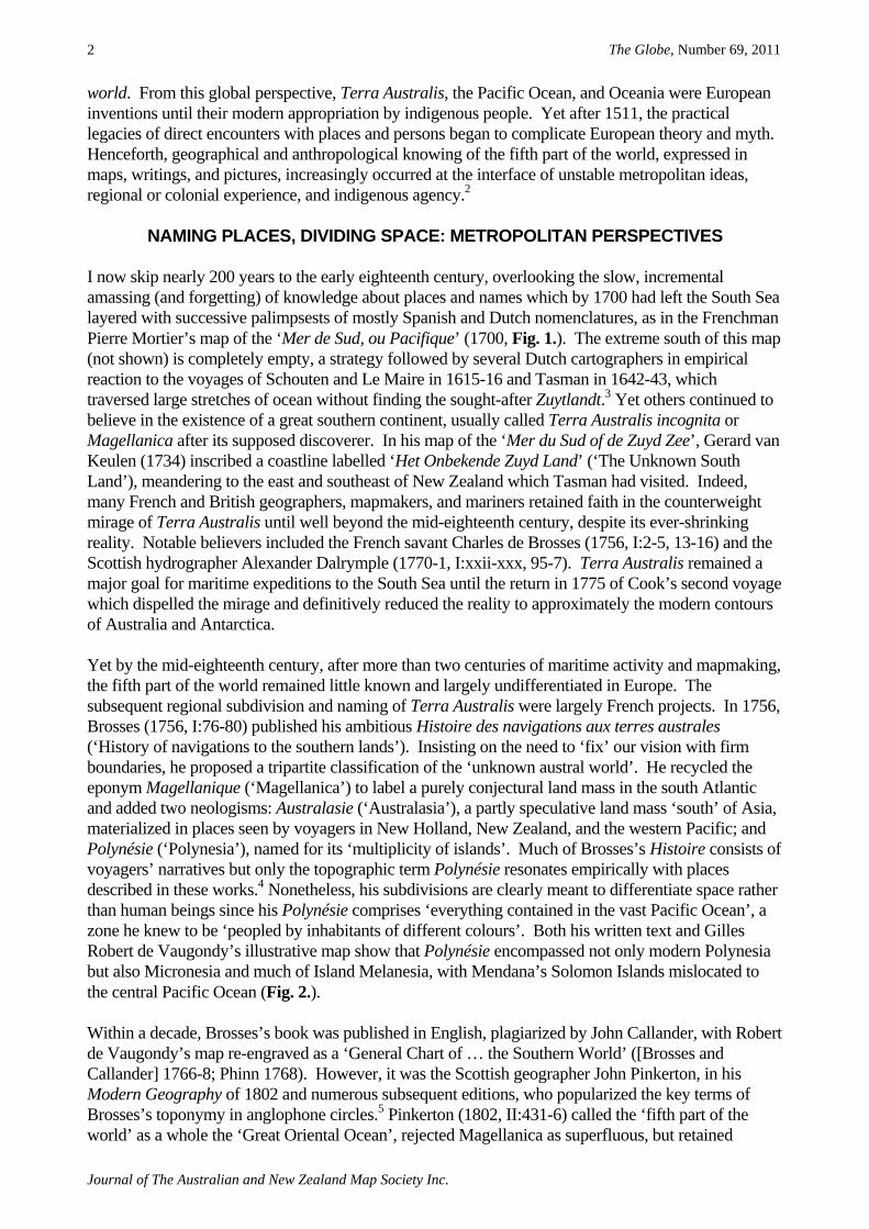
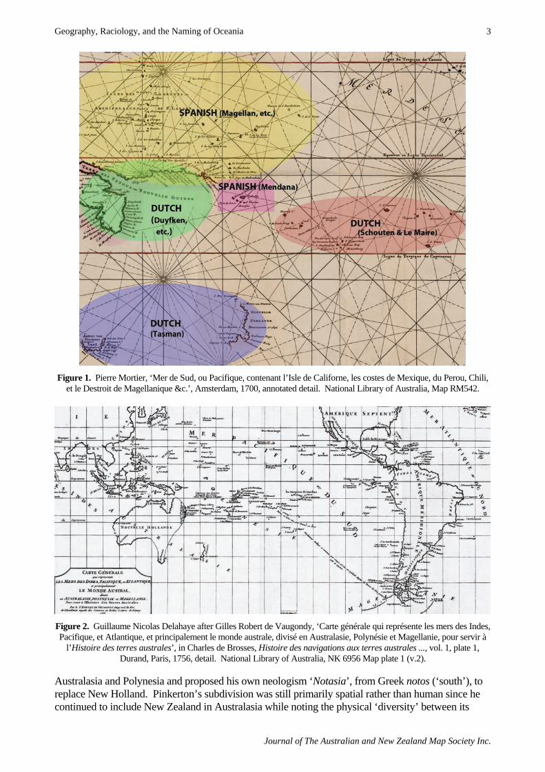
NAMING PLACES, DIVIDING SPACE: METROPOLITAN PERSPECTIVES I now skip nearly 200 years to the early eighteenth century, overlooking the slow, incremental amassing (and forgetting) of knowledge about places and names which by 1700 had left the South Sea layered with successive palimpsests of mostly Spanish and Dutch nomenclatures, as in the Frenchman Pierre Mortier’s map of the ‘Mer de Sud, ou Pacifique’ (1700, Fig. 1.). The extreme south of this map (not shown) is completely empty, a strategy followed by several Dutch cartographers in empirical reaction to the voyages of Schouten and Le Maire in 1615-16 and Tasman in 1642-43, which traversed large stretches of ocean without finding the sought-after Zuytlandt.3 Yet others continued to believe in the existence of a great southern continent, usually called Terra Australis incognita or Magellanica after its supposed discoverer. In his map of the ‘Mer du Sud of de Zuyd Zee’, Gerard van Keulen (1734) inscribed a coastline labelled ‘Het Onbekende Zuyd Land’ (‘The Unknown South Land’), meandering to the east and southeast of New Zealand which Tasman had visited. Indeed, many French and British geographers, mapmakers, and mariners retained faith in the counterweight mirage of Terra Australis until well beyond the mid-eighteenth century, despite its ever-shrinking reality. Notable believers included the French savant Charles de Brosses (1756, I:2-5, 13-16) and the Scottish hydrographer Alexander Dalrymple (1770-1, I:xxii-xxx, 95-7). Terra Australis remained a major goal for maritime expeditions to the South Sea until the return in 1775 of Cook’s second voyage which dispelled the mirage and definitively reduced the reality to approximately the modern contours of Australia and Antarctica. Yet by the mid-eighteenth century, after more than two centuries of maritime activity and mapmaking, the fifth part of the world remained little known and largely undifferentiated in Europe. The subsequent regional subdivision and naming of Terra Australis were largely French projects. In 1756, Brosses (1756, I:76-80) published his ambitious Histoire des navigations aux terres australes (‘History of navigations to the southern lands’). Insisting on the need to ‘fix’ our vision with firm boundaries, he proposed a tripartite classification of the ‘unknown austral world’. He recycled the eponym Magellanique (‘Magellanica’) to label a purely conjectural land mass in the south Atlantic and added two neologisms: Australasie (‘Australasia’), a partly speculative land mass ‘south’ of Asia, materialized in places seen by voyagers in New Holland, New Zealand, and the western Pacific; and Polynésie (‘Polynesia’), named for its ‘multiplicity of islands’. Much of Brosses’s Histoire consists of voyagers’ narratives but only the topographic term Polynésie resonates empirically with places described in these works.4 Nonetheless, his subdivisions are clearly meant to differentiate space rather than human beings since his Polynésie comprises ‘everything contained in the vast Pacific Ocean’, a zone he knew to be ‘peopled by inhabitants of different colours’. Both his written text and Gilles Robert de Vaugondy’s illustrative map show that Polynésie encompassed not only modern Polynesia but also Micronesia and much of Island Melanesia, with Mendana’s Solomon Islands mislocated to the central Pacific Ocean (Fig. 2.). Within a decade, Brosses’s book was published in English, plagiarized by John Callander, with Robert de Vaugondy’s map re-engraved as a ‘General Chart of … the Southern World’ ([Brosses and Callander] 1766-8; Phinn 1768). However, it was the Scottish geographer John Pinkerton, in his Modern Geography of 1802 and numerous subsequent editions, who popularized the key terms of Brosses’s toponymy in anglophone circles.5 Pinkerton (1802, II:431-6) called the ‘fifth part of the world’ as a whole the ‘Great Oriental Ocean’, rejected Magellanica as superfluous, but retained
Geography, Raciology, and the Naming of Oceania
Journal of The Australian and New Zealand Map Society Inc.
3
Figure 1. Pierre Mortier, ‘Mer de Sud, ou Pacifique, contenant l’Isle de Californe, les costes de Mexique, du Perou, Chili, et le Destroit de Magellanique &c.’, Amsterdam, 1700, annotated detail. National Library of Australia, Map RM542.
Figure 2. Guillaume Nicolas Delahaye after Gilles Robert de Vaugondy, ‘Carte générale qui représente les mers des Indes, Pacifique, et Atlantique, et principalement le monde australe, divisé en Australasie, Polynésie et Magellanie, pour servir à
l’Histoire des terres australes’, in Charles de Brosses, Histoire des navigations aux terres australes ..., vol. 1, plate 1, Durand, Paris, 1756, detail. National Library of Australia, NK 6956 Map plate 1 (v.2).
Australasia and Polynesia and proposed his own neologism ‘Notasia’, from Greek notos (‘south’), to replace New Holland. Pinkerton’s subdivision was still primarily spatial rather than human since he continued to include New Zealand in Australasia while noting the physical ‘diversity’ between its

The Globe, Number 69, 2011
Journal of The Australian and New Zealand Map Society Inc.
4
inhabitants and ‘the natives of New Holland, when theory would expect to find them the same race of men’ (1802, II:487). By this stage, the broad contours of the fifth part of the world were better known and Pinkerton’s written text delimits much sharper regional boundaries than did Brosses, explicitly including all of present Island Melanesia, except Fiji, in Australasia (1802, II:463-92). However, this precision is not emulated in the map by Aaron Arrowsmith published with Pinkerton’s work. Much like Robert de Vaugondy, Arrowsmith only implied, rather than marked, a line between Australasia and Polynesia (Fig. 3.). The maps of ‘Australasia’ and ‘Polynesia’ engraved by Samuel Neele (1815) for Pinkerton’s Modern Atlas have no regional names or boundaries inscribed at all. These geographic appellations remained common currency in English usage, especially in the United States, throughout the nineteenth century whereas after mid-century they were less common in French cartography.6
Figure 3. Wilson Lowry after Aaron Arrowsmith, ‘Pacific Ocean’, Cadell and Davies and Longman and Rees, [London], 1802. National Library of Australia, Map T67.
In 1804, in the twelfth volume of their 16-volume global Géographie mathématique, physique et politique (‘Mathematical, physical and political geography’), the Danish geographer Conrad Malte-Brun and his older French colleague Edme Mentelle jettisoned Brosses’s terminology. In a key innovation, they replaced the ‘ancient name Terres-Australes’ (‘Southern lands’) with ‘Terres Océaniques’ (‘Oceanic lands’), adding that ‘perhaps’ the simpler term Océanique (‘Oceanica’) was better by ‘analogy with the names of the other parts of the world’ – specifically, Afrique (‘Africa’) and Amérique (‘America’). They rejected Brosses’s regional geographic labels in favour of a nominalist table of 16 sub-groups, either archipelagos or larger lands with contiguous islands. They kept the topographic toponym Polynésie but restricted it to the ‘small islands of the South Sea’, excepted Hawaii and New Zealand, and divided it at the equator into ‘north’ and ‘south’ sectors (1804:361-3,
Geography, Raciology, and the Naming of Oceania
Journal of The Australian and New Zealand Map Society Inc.
5
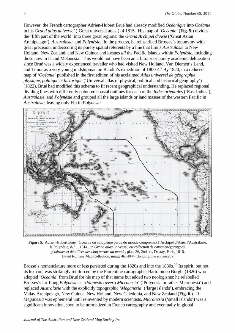
379-82, 463, 473, 494). However, neither Océanique nor the two Polynésies were reflected in Jean-Baptiste Poirson’s map of the ‘Grand Océan’ in the Atlas of this work, though ‘the fifth part of the world’ is inscribed on both hemispheres of his mappa mundi (1804). Indeed, Océanique only appeared on a published map in 1810 (Fig. 4.), included by Pierre Lapie in a preliminary atlas illustrating Malte-Brun’s magnum opus Précis de la géographie universelle (‘Handbook of universal geography’) (1810-29). But here, too, the toponyms are nominalist rather than classificatory, Polynésie is missing entirely, and Océanique limited to the cartouche. Reprinted in an extended atlas in 1812, this map is now complemented by regional maps of western, central, and eastern Océanique delimited along entirely utilitarian geographical lines (Chamouin 1812: plates 61-3).7
Figure 4. Jean-Baptiste-Marie Chamouin after Pierre Lapie, ‘Océanique 1809’, in Conrad Malte-Brun, Précis de la géographie universelle ... Collection de cartes géographiques …, François Buisson, Paris, 1810. National Library of
Australia, Map T841.
With the appearance of an English translation of Malte-Brun’s Universal Geography (1822), Oceanica entered anglophone usage. It was notably adopted by two eminent ethnologists, the Briton James Cowles Prichard (1836-47, V:1-3) and the American Horatio Hale (1846:3). Perhaps following Hale, Oceanica remained a standard term in American cartography until late in the nineteenth century but usually in tandem with Brosses’s Australasia and Polynesia which Malte-Brun had spurned.8 Francis Junius Huntington’s map of the ‘Pacific Ocean: its Islands & Coasts’ (1832) explicitly blends the two nomenclatures: ‘Eastern Oceanica or Polynesia’, ‘Central Oceanica or Australasia’, and ‘N.W. Oceanica or Asiatic Is.’. The persistence here of Brosses’s terminology is ironic, since the map was published in an Atlas, designed to illustrate the Malte-Brun School Geography.
The Globe, Number 69, 2011
Journal of The Australian and New Zealand Map Society Inc.
6
However, the French cartographer Adrien-Hubert Brué had already modified Océanique into Océanie in his Grand atlas universel (‘Great universal atlas’) of 1815. His map of ‘Océanie’ (Fig. 5.) divides the ‘fifth part of the world’ into three great regions: the Grand Archipel d’Asie (‘Great Asian Archipelago’), Australasie, and Polynésie. In the process, he reinscribed Brosses’s toponymy with great precision, underscoring its purely spatial referents by a line that limits Australasie to New Holland, New Zealand, and New Guinea and locates all the Pacific Islands within Polynésie, including those now in Island Melanesia. This would not have been an arbitrary or purely academic delineation since Brué was a widely experienced traveller who had visited New Holland, Van Diemen’s Land, and Timor as a very young midshipman on Baudin’s expedition of 1800-4.9 By 1820, in a reduced map of ‘Océanie’ published in the first edition of his acclaimed Atlas universel de géographie physique, politique et historique (‘Universal atlas of physical, political and historical geography’) (1822), Brué had modified this schema to fit recent geographical understanding. He replaced regional dividing lines with differently coloured coastal outlines for each of the Indes orientales (‘East Indies’), Australasie, and Polynésie and grouped all the large islands or land masses of the western Pacific in Australasie, leaving only Fiji in Polynésie.
Figure 5. Adrien-Hubert Brué, ‘Océanie ou cinquième partie du monde comprenant l’Archipel d’Asie, l’Australasie, la Polynésie, &.a ... 1814’, in Grand atlas universel, ou collection de cartes encyprotypes, générales et détaillées des cinq parties du monde, plate 36, 2nd ed., Desray, Paris, 1816.
David Rumsey Map Collection, image 4614044 (dividing line enhanced).
Brosse’s nomenclature more or less persisted during the 1820s and into the 1830s.10 Its spirit, but not its lexicon, was strikingly reinforced by the Florentine cartographer Bartolomeo Borghi (1826) who adopted ‘Oceania’ from Brué for his map of that name but added two neologisms: he relabelled Brosses’s far-flung Polynésie as ‘Polinesia ovvero Micronesia’ (‘Polynesia or rather Micronesia’) and replaced Australasie with the explicitly topographic ‘Meganesia’ (‘large islands’), embracing the Malay Archipelago, New Guinea, New Holland, New Caledonia, and New Zealand (Fig. 6.). If Meganesia was ephemeral until reinvented by modern scientists, Micronesia (‘small islands’) was a significant innovation, soon to be normalized in French cartography and eventually in global

Geography, Raciology, and the Naming of Oceania
Journal of The Australian and New Zealand Map Society Inc.
7
geopolitics.11 Brué (1828) confirmed his own modification of Brosses’s system in a multi-page map of ‘Océanie’ in the second edition of the Atlas universel, redrawn to accommodate the results of ‘recent voyages’. He abbreviated Australasie to Australie and shifted its borderline with Polynésie north and east to match his 1820 colour scheme (Fig. 7.). Brué’s ‘Carte particulière de la Polynésie’ (‘Specific map of Polynesia’) in this atlas splits ‘north Polynesia’ from ‘south’ at the equator, anticipating and perhaps encouraging the imminent racial separation of Polynesia and Micronesia. Though made with the purely pragmatic goal of achieving ‘the largest possible scale’ for his map, Brué’s ploy recalls the twin Polynésies of Mentelle and Malte-Brun’s 1804 written text. In 1830, Poirson also formally inscribed ‘north’ and ‘south’ Polynésie in his map of ‘Océanie’ in an Atlas illustrating an ‘elementary treatise’ on geography by the now late Malte-Brun (Thierry 1830).12
Figure 6. A. Bartolomeo Borghi, ‘Oceania sulla projezione di Mercatore’ (‘Oceania on Mercator’s projection’), A.B. Borghi, Firenze, 1826. National Library of Australia, MAP RM598.
NAMING AND CLASSIFYING PEOPLE: TOWARDS A RACIAL GEOGRAPHY
I turn now from names for places, toponyms, to consider words applied to label, name, and classify the people inhabiting the fifth part of the world. From the early nineteenth century, such terms registered the growing complicity of the spatial science of geography with a nascent science of race or raciology (Blanckaert 2004). During the preceding three centuries of European encounters, words for people had gradually become more precise, more discriminative, more sweeping, and eventually more categorical. They referenced precedent experience in Africa, Asia, and the Americas, and more and more in the South Sea itself. The word ‘race’ (a genealogical term connoting common ancestry) was hardly used before the mid-eighteenth century and the modern biological sense of ‘a race’ (denoting permanent, innate, collective physical and mental differences) did not emerge in metropolitan thinking until the 1770s.13 The subjects of every expanding European realm took for granted their own ancestral, religious, and civil superiority. Yet before the nineteenth century, bodily differences ranked low in judgments about national characters because such differences were seen as transient products of the effects of climate, humours, lifestyle, and station on a single migrating

The Globe, Number 69, 2011
Journal of The Australian and New Zealand Map Society Inc.
8
human species. In principle, all human beings were thought to share the potential for progress towards civility or for salvation. However, from the mid-sixteenth century, such inclusive values were steadily undermined by the developing association with chattel slavery of so-called ‘barbarous’, ‘heathen’, black Africans or ‘Negroes’ – originally an Iberian descriptive adjective, negro increasingly became a stigmatizing noun.
Figure 7. Adrien-Hubert Brué, ‘Carte générale de l’Océanie ou cinquième partie du monde ... 1827’, in Atlas universel de géographie physique, politique, ancienne & moderne ..., plate 47, 2nd ed., l’Auteur, Paris, 1828.
David Rumsey Map Collection, image 0096047 (dividing line enhanced). When Brosses outlined his pioneer spatial partition of the Terres australes in 1756, he made no attempt to classify their ‘many different peoples’ since taxonomy was not yet common in European thinking about man,14 notwithstanding the global geographical classification of human varieties proposed by Linnaeus in successive editions of Systema Naturæ (‘Natural system’) (e.g., 1735; 1740:33-4; 1748:1-3). Brosses did, however, identify a ‘difference in the human species’ within a single zone, without correlating it with his geographical divisions. He sought to resolve this challenge to orthodox climatic explanations for human diversity by speculating that an ‘old race’ of ‘frizzy-haired blacks’ had been destroyed or displaced by ‘foreign colonies of Malay peoples’ – lighter-skinned people. Represented as the ‘first inhabitants of the torrid zone’, ‘more brutish and fierce’ than their conquerors, these supposed black autochthones remained ‘sole masters of their ancient possessions’ only in New Holland and ‘other unknown southern lands’ (1756, I:16, 77-80; II:375-80). The first formal classification of ‘the Human Species in the South-Sea Isles’ was empirically based, proposed in 1778 by the German naturalist Johann Reinhold Forster who had sailed on Cook’s second voyage. Forster identified ‘two great varieties of people’ he had seen in the South Sea, one ‘more fair’, the other ‘blacker’. He imagined them to have descended from ‘two different races of men’ – like Brosses, using the collective noun race in its old nominalist genealogical sense, regarded as the ‘accidental’, unstable product of external causes. In nominalist usage, an interchangeable suite of

Geography, Raciology, and the Naming of Oceania
Journal of The Australian and New Zealand Map Society Inc.
9
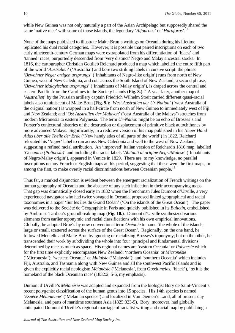
collective nouns – nation, variety, people, kind, tribe, race – are applied to label actual groupings which have their own names. Race in this sense is not necessarily racialist. To explain the ‘evident difference’ between his two varieties, Forster recycled Brosses’s conjectural history to imagine the displacement of an ‘aboriginal black race’ by ‘successive’ migrations of ‘more civilized’, ‘ancient Malays’ (1778:228, 252, 271-284, 353-360). Both men professed belief in a universal human aptitude to progress towards civilization (Brosses 1756, II:380; Forster 1778:285-307). But by identifying darker skin colour with primordiality and lack of civility, they helped fuel the subsequent taxonomic project which would ultimately underwrite colonial racial hierarchies. Produced a quarter century later, Pinkerton’s geographical survey of the inhabitants of the fifth part of the world is both highly derivative and riddled with invidious comparisons: the inhabitants of New Holland were ‘exactly one degree above the brute creation; and, like monkies,… great mimics’; the Papuans were ‘grotesque’, ‘a singular race of horrible appearance, and great ferocity’; whereas the New Zealanders were ‘commonly regular and pleasing’ of feature. Yet his use of the word race remains nominalist and there is no coherent racial system in his discriminations. They reflect, rather, the vagaries of travellers’ reports of indigenous actions, lifestyle, and varied physical appearance: the inhabitants of New Guinea were ‘black, and even said to have the woolly hair of the negroes’, but this would probably turn out, ‘as in New Holland, to proceed from art’; some New Guineans seemed ‘to have the true Malay complexion and features’; the Samoans (who had killed a dozen of La Pérouse’s men) were ‘remarkable for a ferocity of character, scarcely to be observed in any other part of Polynesia’, and so forth (1802, II:473, 480, 483, 487, 514). Brosses’s and Pinkerton’s toponymy and associated cartography were thus racially neutral and their written texts, while often opprobrious, did not systematize human difference. In contrast, Malte-Brun’s geographical term Océanique was racialized from the outset, at least in his writings which make skin colour and physical organization key differentiae in the first regional racial taxonomy. In 1803, he sharply delimited the ‘black race’ from the ‘tanned race’, in space as well as physically and morally. The ‘Oceanic Negroes’ occupied New Holland, Van Diemen’s Land, New Guinea, the several island groups of what is now Island Melanesia, and the interior of the larger Malay islands. They were ‘men as black as the Negroes of Africa, having lips as thick, the nose as flat, and wool instead of hair’. The ‘Polynesian race’ occupied both northern and southern sectors of the vast zone of small islands he called Polynésie, plus Hawaii and New Zealand, and was ‘often whiter than the Spaniards, with an attractive face, a tall, robust build, in sum a very fine race of men’ (1803:548). In 1813, he traced the racial opposition of Polynesian and Negro to two ancestral ‘stocks’, ‘very distinct, as much by their physiognomy as by their language’. He positioned the Oceanic Negroes at ‘the last degree of the savage state’ and thought they might ‘originate in this part of the world’, an insinuation of autochthony that gave credence to the once heterodox but now increasingly plausible idea that human diversity is primordial and organic (1810-29, IV:229, 244, 253). In regionalizing Oceania, Malte-Brun used the word race categorically rather than in its thus far standard nominalist sense. In categorical usage, a race is a taxon in a classification imposed a priori on actual groupings. From the mid-1770s, the unstable varieties of Linnaeus’s early human taxonomy had been rebadged as races by Kant and Blumenbach. They redefined a race as a particular category of stable ‘hereditary differences’ between animals of a ‘single stock’ and positioned it taxonomically between a variety and a species.15 Conceived as taxa, races were nonetheless materialized as real and true in the fixed human hierarchies propounded by the nineteenth-century science of race in which Malte-Brun was a widely-read early practitioner. The global racial classification sketched at the end of his general introduction to the Géographie mathématique was among the first of its kind (1803:540-51). In a review of Brué’s revised map of ‘Océanie’ written shortly before his own death, Malte-Brun (1826:361-2) took issue with Brué’s ‘unfortunate idea’ of conflating New Guinea, New Caledonia, and New Zealand with New Holland under the general name Australie. Malte-Brun did so on the partly racial grounds that the climate and inhabitants of New Zealand were ‘very different’
The Globe, Number 69, 2011
Journal of The Australian and New Zealand Map Society Inc.
10
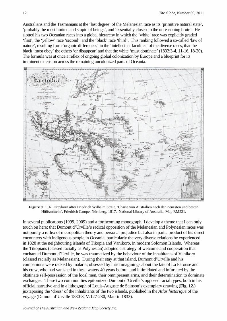
while New Guinea was not only naturally a part of the Asian Archipelago but supposedly shared the same ‘native race’ with some of those islands, the legendary ‘Alfourous’ or ‘Haraforas’.16 None of the maps published to illustrate Malte-Brun’s writings on Oceania during his lifetime replicated his dual racial categories. However, it is possible that paired inscriptions on each of two early nineteenth-century German maps were extrapolated from his differentiation of ‘black’ and ‘tanned’ races, purportedly descended from ‘very distinct’ Negro and Malay ancestral stocks. In 1816, the cartographer Christian Gottlieb Reichard produced a map which labelled the entire fifth part of the world ‘Australien’ (‘Australia’) and bore two striking labels in cursive script: the phrase ‘Bewohner Neger artigen ursprungs’ (‘Inhabitants of Negro-like origin’) runs from north of New Guinea, west of New Caledonia, and cuts across the South Island of New Zealand; a second phrase, ‘Bewohner Malayischen ursprungs’ (‘Inhabitants of Malay origin’), is draped across the central and eastern Pacific from the Carolines to the Society Islands (Fig. 8.).17 A year later, another map of ‘Australien’ by the Prussian artillery captain Friedrich Wilhelm Streit carried different quasi-racial labels also reminiscent of Malte-Brun (Fig. 9.): ‘West Australien der Ur-Nation’ (‘west Australia of the original nation’) is wrapped in a half-circle from north of New Guinea to immediately west of Fiji and New Zealand; and ‘Ost Australien der Malayen’ (‘east Australia of the Malays’) stretches from modern Micronesia to eastern Polynesia. The term Ur-Nation might be an echo of Brosses’s and Forster’s conjectural histories of the destruction or displacement of primitive black autochthones by more advanced Malays. Significantly, in a redrawn version of his map published in his Neuer Hand-Atlas über alle Theile der Erde (‘New handy atlas of all parts of the world’) in 1822, Reichard relocated his ‘Neger’ label to run across New Caledonia and well to the west of New Zealand, suggesting a refined racial attribution. An ‘improved’ Italian version of Reichard's 1816 map, labelled ‘Oceanica (Polinesia)’ and including the racial labels ‘Abitanti di origine Negri/Malese’ (‘Inhabitants of Negro/Malay origin’), appeared in Venice in 1829. There are, to my knowledge, no parallel inscriptions on any French or English maps at this period, suggesting that these were the first maps, or among the first, to make overtly racial discriminations between Oceanian people.18 Thus far, a marked disjunction is evident between the emergent racialization of French writings on the human geography of Oceania and the absence of any such inflection in their accompanying maps. That gap was dramatically closed early in 1832 when the Frenchman Jules Dumont d’Urville, a very experienced navigator who had twice voyaged in Oceania, proposed linked geographical and racial taxonomies in a paper ‘Sur les îles du Grand Océan’ (‘On the islands of the Great Ocean’). The paper was delivered to the Société de Géographie in Paris and quickly published in its Bulletin, embellished by Ambroise Tardieu’s groundbreaking map (Fig. 10.). Dumont d’Urville synthesized various elements from earlier toponymic and racial classifications with his own empirical innovations. Globally, he adopted Brué’s by now conventional term Océanie to name ‘the whole of the islands, large or small, scattered across the surface of the Great Ocean’. Regionally, on the one hand, he followed Mentelle and Malte-Brun by ignoring or racializing Brosses’s toponymy; but on the other, he transcended their work by subdividing the whole into four ‘principal and fundamental divisions’ determined by race as much as space. His regional names are ‘eastern Oceania’ or Polynésie which for the first time explicitly encompasses New Zealand; ‘northern Oceania’ or Micronésie (‘Micronesia’); ‘western Oceania’ or Malaisie (‘Malaysia’); and ‘southern Oceania’ which includes Fiji, Australia, and Tasmania along with New Guinea and all the southwest Pacific Islands and is given the explicitly racial neologism Mélanésie (‘Melanesia’, from Greek melas, ‘black’), ‘as it is the homeland of the black Oceanian race’ (1832:2, 5-6, my emphasis). Dumont d’Urville’s Mélanésie was adapted and expanded from the biologist Bory de Saint-Vincent’s recent polygenist classification of the human genus into 15 species. His 14th species is named ‘Espèce Mélanienne’ (‘Melanian species’) and localized in Van Diemen’s Land, all of present-day Melanesia, and parts of maritime southeast Asia (1825:323-5). Bory, moreover, had globally anticipated Dumont d’Urville’s regional marriage of racialist writing and racial map by publishing a

Geography, Raciology, and the Naming of Oceania
Journal of The Australian and New Zealand Map Society Inc.
11
multicoloured mappa mundi, also engraved by Tardieu and ‘showing the primitive separation of the species of men’ (Fig. 11.). However, Bory’s regional toponyms are a smorgasbord, blending Brué’s Océanie (but attenuated to the islands of modern Micronesia, Island Melanesia, and western Polynesia), with Brosses’s Polynésie (relocated to the Malay Archipelago), and his Australasie (contracted to the ‘fifth continent’). This terminology is more or less that used in a convoluted racial taxonomy proposed by the pharmacist-naturalist René-Primevère Lesson (1826) who had circumnavigated the world with Dumont d’Urville on Duperrey’s expedition of 1822-5.
Figure 8. Christian Gottlieb Reichard, ‘Australien Nach Mercators Projection’, [s.n., Gotha], 1816. National Library of Australia, Map NK1538.
Dumont d’Urville’s seminal paper maps a dual racial classification on to his quadripartite regional geography. In terms very reminiscent of Malte-Brun, he froze the ‘immortal’ Forster’s fluid varieties of South Sea Islanders as ‘two truly distinct races’, one ‘black’, the other ‘copper-coloured’. He devised a novel system of human nomenclature, now classic. ‘Melanesian’ was his general name for the ‘black race’, regarded as the ‘veritable natives’ of Océanie and as a mere ‘branch of the black race of Africa’. The ‘Polynesians’ and ‘Micronesians’ together constituted the ‘tanned or copper-coloured Polynesian race’ which was equally ‘only a branch of the yellow race native to Asia’. The Polynesians were allegedly the progeny of ‘conquerors’ from the west who had expelled, destroyed, colonized, or intermixed with the ‘primitive’ Melanesians to produce the many ‘nuances’ seen in present populations. Dumont d’Urville correlated skin colour and physical appearance with language, institutions, intellect, and morality, as supposedly expressed in the reception given to Europeans. He characterized the Melanesians as ‘hideous’ and ‘disagreeable’ to look at; linguistically ‘very limited’; lacking regular government, laws, or religion; ‘natural enemies of the whites’; and ‘generally very inferior’ in ‘dispositions’ and ‘intelligence’ to the Polynesians, Micronesians, and Malays. He positioned the
The Globe, Number 69, 2011
Journal of The Australian and New Zealand Map Society Inc.
12
Australians and the Tasmanians at the ‘last degree’ of the Melanesian race as its ‘primitive natural state’, ‘probably the most limited and stupid of beings’, and ‘essentially closest to the unreasoning brute’. He slotted his two Oceanian races into a global hierarchy in which the ‘white’ race was explicitly graded ‘first’, the ‘yellow’ race ‘second’, and the ‘black’ race ‘third’. This ranking followed a so-called ‘law of nature’, resulting from ‘organic differences’ in the ‘intellectual faculties’ of the diverse races, that the black ‘must obey’ the others ‘or disappear’ and that the white ‘must dominate’ (1832:3-4, 11-16, 18-20). The formula was at once a reflex of ongoing global colonization by Europe and a blueprint for its imminent extension across the remaining uncolonized parts of Oceania.
Figure 9. C.R. Dreykorn after Friedrich Wilhelm Streit, ‘Charte von Australien nach den neuesten und besten Hülfsmitteln’, Friedrich Campe, Nürnberg, 1817. National Library of Australia, Map RM521.
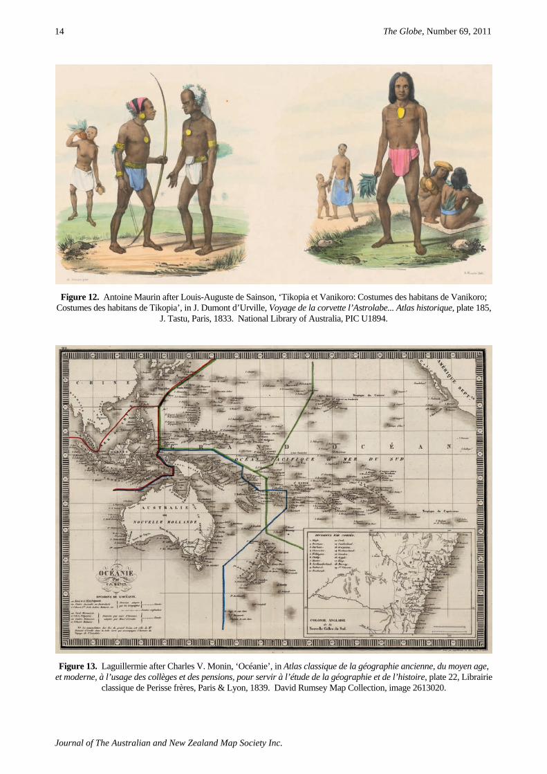
In several publications (1999, 2009) and a forthcoming monograph, I develop a theme that I can only touch on here: that Dumont d’Urville’s radical opposition of the Melanesian and Polynesian races was not purely a reflex of metropolitan theory and personal prejudice but also in part a product of his direct encounters with indigenous people in Oceania, particularly the very diverse relations he experienced in 1828 at the neighbouring islands of Tikopia and Vanikoro, in modern Solomon Islands. Whereas the Tikopians (classed racially as Polynesian) adopted a strategy of welcome and cooperation that enchanted Dumont d’Urville, he was traumatized by the behaviour of the inhabitants of Vanikoro (classed racially as Melanesian). During their stay at that island, Dumont d’Urville and his companions were racked by malaria; obsessed by lurid imaginings about the fate of La Pérouse and his crew, who had vanished in these waters 40 years before; and intimidated and infuriated by the obstinate self-possession of the local men, their omnipresent arms, and their determination to dominate exchanges. These two communities epitomized Dumont d’Urville’s opposed racial types, both in his official narrative and in a lithograph of Louis-Auguste de Sainson’s exemplary drawing (Fig. 12.) juxtaposing the ‘dress’ of the inhabitants of the two islands, published in the Atlas historique of the voyage (Dumont d’Urville 1830-3, V:127-230; Maurin 1833).

Geography, Raciology, and the Naming of Oceania
Journal of The Australian and New Zealand Map Society Inc.
13
Figure 10. Ambroise Tardieu after Jules Dumont d’Urville, ‘Carte pour l’intelligence du mémoire de M. le capitaine d’Urville sur les îles du grand océan (Océanie)’, in J. Dumont d’Urville, Voyage de la corvette l’Astrolabe exécuté pendant
les années 1826-1827-1828-1829 ... Atlas historique, [carte 1], J. Tastu, Paris, 1833. National Library of Australia, Map NK2456-73.
Figure 11. Ambroise Tardieu after Jean-Baptiste-Geneviève-Marcellin Bory de Saint-Vincent, ‘Distribution primitive du genre humain à la surface du globe …’, in Nicolas Desmarest & J.B.G.M. Bory de Saint-Vincent, Atlas encyclopédique
contenant les cartes et les planches relatives à la géographie physique, plate 1, Mme veuve Agasse, Paris, 1827. David Rumsey Map Collection, image 1801001
The Globe, Number 69, 2011
Journal of The Australian and New Zealand Map Society Inc.
14
Figure 12. Antoine Maurin after Louis-Auguste de Sainson, ‘Tikopia et Vanikoro: Costumes des habitans de Vanikoro; Costumes des habitans de Tikopia’, in J. Dumont d’Urville, Voyage de la corvette l’Astrolabe... Atlas historique, plate 185,
J. Tastu, Paris, 1833. National Library of Australia, PIC U1894.
Figure 13. Laguillermie after Charles V. Monin, ‘Océanie’, in Atlas classique de la géographie ancienne, du moyen age, et moderne, à l’usage des collèges et des pensions, pour servir à l’étude de la géographie et de l’histoire, plate 22, Librairie
classique de Perisse frères, Paris & Lyon, 1839. David Rumsey Map Collection, image 2613020.

Geography, Raciology, and the Naming of Oceania
Journal of The Australian and New Zealand Map Society Inc.
15
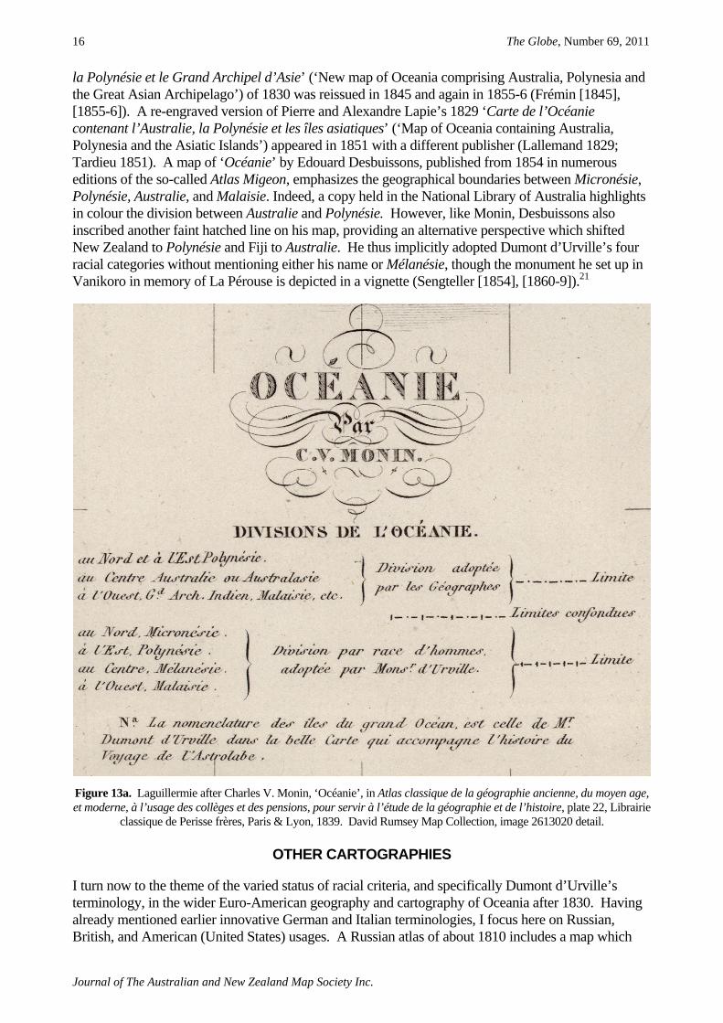
GEOGRAPHY AND RACIOLOGY IN FRANCE: AN ALLIANCE CONSUMMATED Within a year of the publication of Dumont d’Urville’s racial geography of Océanie, his synthesis had been enthusiastically embraced by many French cartographers who rapidly standardized his regional boundaries and terminology. In a map of ‘Océanie’ dated 1832, J. Andriveau-Goujon (1835) faintly inscribed Dumont d’Urville’s boundaries without naming the regions but avowedly adopted his ‘Division of Oceania by peoples’ in a legend, including his conflation of place with race and a synopsis of his unpleasant opinion of the inhabitants of Mélanésie: ‘Black race. Wretched, fierce, stupid peoples’, with ‘no form of government, or laws, or religious cult’. A map of ‘Océanie’ by Antoine-Rémy Frémin, published in 1834 ‘for the use of schools’, explicitly follows and clearly marks Dumont d’Urville’s racial ‘division’ (Moisy 1834). In the same year, an amended version of Brué’s ‘Carte générale de l’Océanie’ (‘General map of Oceania’) (1834) appeared in a revised, posthumous edition of his Atlas universel, marked with four ‘new divisions’ openly attributed to Dumont d’Urville’s racial map.19 The altered map was rehearsed, with minor revisions, in all subsequent editions of Brué’s Atlas until the last in 1875 (e.g., [1842]; Brué and Levasseur 1875). Similarly, a well-known, lavishly illustrated map of ‘Océanie’ on Dumont d’Urville’s principles was a staple in Victor Levasseur’s Atlas national illustré, published in numerous editions from `1845 and during the 1850s (e.g., 1845). Malte-Brun’s scientific heirs, like Brué’s, also adopted Dumont d’Urville’s schema, but at first did so ambiguously. The Atlas complet to the revised edition of the Précis de la géographie universelle (1831-7) includes a ‘Carte de l’Océanie’ and ‘Carte de la Mélanésie ou Nouvelle Hollande’ (‘Map of Oceania’ and ‘Map of Melanesia or New Holland’), both dated 1835 (Thierry 1837). The general map of Oceania tries to have the best of both worlds. Dumont d’Urville’s racial names are inscribed horizontally across each of his four sharply delimited regions. Yet the older physical geography is retained by implication, its names superimposed on the new ones: Polynésie curves across Micronésie and Polynésie while Australie loops across New Holland and New Zealand. The same map with the same inscriptions reappears in the 1843 edition of the Atlas (Thierry 1843) but the purely geographical names vanish in later editions. This tacit marriage of space and race, in the context of the ongoing racialization of Oceanic cartography, geography, and anthropology in France,20 became explicit during the 1830s in the work of Charles Monin who included maps of ‘Océanie’ in several atlases published during this decade. In the process, he shifted from a standard geographical tripartition (1832; Dufour 1836) to a composite position which overlays the ‘Geographers’ division’ (the contemporary version of Brosses’s regional toponyms with Fiji located in Polynésie and New Zealand in Australasie/Australie) on Dumont d’Urville’s four-part ‘Division by race of men’ – and explains the process in a legend (Fig. 13a.). Published in 1836 and 1837 as an engraving by Auguste-François Alès (1837) in a general atlas, Monin’s synthesis was given dramatic graphic realization by Laguillermie (1839) in a school atlas which evidently first appeared in 1837 and was reprised until at least the mid-1840s (Fig. 13.). A copy of this map held by the National Library of Australia bears the date ‘1834’ above the legend. By schematically and verbally differentiating the science of geography from the science of race, Monin in fact acknowledged and normalized their mutual dependence, symbiotically entangled in a now established raciology. Serge Tcherkézoff (2007:354) has claimed that an 1843 version of Monin’s composite map represents the final appearance in French cartography of Brosses’s geographical divisions and of Fiji within Polynésie. However, his reasoning is too categorical and his chronology premature. If Brosses’s regional names and associated boundaries gradually became less common in France, they by no means disappeared entirely, especially as older maps depicting the three geographical regions were repeatedly republished. A few examples make the point, underlining the messiness and ambiguity of apparently sharp historical transitions. Frémin’s ‘Nouvelle carte de l’Océanie comprenant l’Australie,
The Globe, Number 69, 2011
Journal of The Australian and New Zealand Map Society Inc.
16
la Polynésie et le Grand Archipel d’Asie’ (‘New map of Oceania comprising Australia, Polynesia and the Great Asian Archipelago’) of 1830 was reissued in 1845 and again in 1855-6 (Frémin [1845], [1855-6]). A re-engraved version of Pierre and Alexandre Lapie’s 1829 ‘Carte de l’Océanie contenant l’Australie, la Polynésie et les îles asiatiques’ (‘Map of Oceania containing Australia, Polynesia and the Asiatic Islands’) appeared in 1851 with a different publisher (Lallemand 1829; Tardieu 1851). A map of ‘Océanie’ by Edouard Desbuissons, published from 1854 in numerous editions of the so-called Atlas Migeon, emphasizes the geographical boundaries between Micronésie, Polynésie, Australie, and Malaisie. Indeed, a copy held in the National Library of Australia highlights in colour the division between Australie and Polynésie. However, like Monin, Desbuissons also inscribed another faint hatched line on his map, providing an alternative perspective which shifted New Zealand to Polynésie and Fiji to Australie. He thus implicitly adopted Dumont d’Urville’s four racial categories without mentioning either his name or Mélanésie, though the monument he set up in Vanikoro in memory of La Pérouse is depicted in a vignette (Sengteller [1854], [1860-9]).21
Figure 13a. Laguillermie after Charles V. Monin, ‘Océanie’, in Atlas classique de la géographie ancienne, du moyen age, et moderne, à l’usage des collèges et des pensions, pour servir à l’étude de la géographie et de l’histoire, plate 22, Librairie
classique de Perisse frères, Paris & Lyon, 1839. David Rumsey Map Collection, image 2613020 detail.
OTHER CARTOGRAPHIES I turn now to the theme of the varied status of racial criteria, and specifically Dumont d’Urville’s terminology, in the wider Euro-American geography and cartography of Oceania after 1830. Having already mentioned earlier innovative German and Italian terminologies, I focus here on Russian, British, and American (United States) usages. A Russian atlas of about 1810 includes a map which

Geography, Raciology, and the Naming of Oceania
Journal of The Australian and New Zealand Map Society Inc.
17
labels the whole fifth part of the world ‘Avstraliia’ (‘Australia’) but entirely lacks regional names or divisions (Anon. [c. 1810]). A ‘Karta zemnogo shara’ (‘Map of the Globe’) included in the Sobranie kart i risunkov (‘Collection of maps and drawings’) of Iury Fedorovich Lisianskii (1812), who commanded one of the two vessels engaged in the initial Russian global circumnavigation in 1803-6, names only individual islands and the ‘North’ and ‘South Pacific Oceans’. The next year, a similar ‘Merkatorskaia karta vsego sveta ili generalnaia karta k puteshestviiu …’ (‘Mercator Map of the World or General Map of the Voyage’) prefaced some copies of volume 2 of the Atlas of illustrations published by Adam Johann von Krusenstern (1813) who led the expedition.22 This map names the ‘Velikii Okean’ (‘Great Ocean’), many islands, but no regions. An updated version, attributed originally to Fabian Gottlieb von Bellingshausen in 1810, was reissued in the Atlas of Otto von Kotzebue (1821-3) following his own voyage round the world in 1815-18. Bellingshausen, like Kotzebue, had sailed with Krusenstern and would in turn lead his own circumnavigation in 1819-21. In 1824-6, Krusenstern published the first atlas devoted solely to Oceania, in Russian and in French translation. His two-part ‘Generalnaia karta Iuzhnogo moria’ (‘General Map of the South Sea’) (1824-6) is remarkably precise in identifying and sorting out the myriad small islands of the central and eastern Pacific and their European ‘discoverers’ but imposes no regional nomenclature or boundaries. Krusenstern’s nominalist cartographic agenda were entirely historical and physical (geographic or hydrographic), with no ethnological intent. However, by 1846, Dumont d’Urville’s racialized, regionalized Oceania had entered Russian consciousness. A Vseobshchii geograficheskii atlas (‘Universal geographical atlas’) explicitly based on the work of the French cartographer Auguste-Henri Dufour, who had studied with Pierre Lapie, includes a map labelled ‘Avstraliia’ which divides the ‘Velikii Okean’ (‘Great Ocean’) according to Dumont d’Urville’s four racial regions (Fig. 14.).23 British cartographers were slow to accept either the name Oceania or the French racial toponyms and did not do so unequivocally until the early twentieth century. Before 1850, they mostly used the geographical terms Australasia and Polynesia, which Pinkerton had endorsed, or omitted regional names or divisions entirely. Just such an absence is a hallmark of every map of the ‘Pacific Ocean’ published over more than half a century by the celebrated Arrowsmith dynasty of cartographers.24 The former East India Company official and philologist William Marsden, who in 1782 had drawn English attention to the remarkable linguistic affinity shared by the inhabitants of places ‘from Madagascar eastward to the Marquesas’ (1782:155), later strongly recommended the adoption of Brosses’s ‘name of POLYNESIA’ to designate the ‘great insular region’ comprising the East Indies and the South Sea Islands (1812:i). The term used in this sense was ubiquitous in general English usage until late in the nineteenth century, especially amongst Evangelical missionaries who proselytized in the Pacific Islands from 1797 and split ‘Western’ from ‘Eastern’ Polynesia in the late 1830s in anticipation of their imminent encounter with a ‘decidedly distinct’, ‘negro race’ in the islands west of Fiji (Williams 1837:7-8, 503-4). The American Hale (1846:3), who had travelled widely in Oceania as a member of the United States Exploring Expedition to the Pacific in 1838-42, lauded the ‘propriety’ of the mainly French ‘voyagers and geographers’ who had subdivided ‘Oceanica’ into ‘minor departments, distinguished from one another both by their natural features, and by the character of their inhabitants’.25 However, most nineteenth-century American cartographers adhered to the geographical triumvirate Australasia, Polynesia, and Malaysia or Asiatic Islands, with Dumont d’Urville’s regional names sometimes interpolated into this schema. Yet this spatial emphasis did not preclude racial essentialism. For example, the standard three regions dominate a map of ‘Oceania’ in McNally’s System of Geography (Stuart 1870), with ‘Micronesia’ and ‘Polynesia’ (including Fiji) lumped within a single vast zone, delimited by thick borders from ‘Malaysia’ and ‘Melanesia or Australasia’ (including New Zealand). In a long echo of Malte-Brun, a text on the verso assigns the ‘aboriginal inhabitants’ to ‘two distinct races’, ‘the Malays’ and ‘the Papuan or Oriental negroes’. Explicitly hierarchical, the writer grades ‘the Polynesians’ as ‘savages of

The Globe, Number 69, 2011
Journal of The Australian and New Zealand Map Society Inc.
18
Malayan origin’, ‘well formed, robust, and more intelligent than the Papuan negroes’. In Alvin Johnson’s Family Atlas of the World, a map of the ‘World on Mercators Projection’ (1884) reproduces McNally’s boundaries but limits the nomenclature to Malaysia, Australasia, and Polynesia. The Family Atlas also includes a global map by Arnold Henry Guyot ‘...Showing the Distribution of the Principal Races of Man’ (Guyot 1884). This map differentiates the ‘Malayan Races’ – occupants of the vast zone of the eastern and northern Pacific Islands, New Zealand, the Malay Archipelago, peninsular Malaya, and Madagascar – from the ‘Australian Races’ ensconced in much of Australia, the ‘mixed, or intermediate’ races of Papua, and the ‘Indo-Europeans’ of the ‘White, or Normal Race’ settled in southeastern and southwestern Australia. Owing no specific allegiance to Dumont d’Urville, the map evinces an equivalent racial ethos, now standard fare in the era of high colonialism.
RACE, CARTOGRAPHY, AND COLONIALISM In a series of French maps printed in various states between 1840 and 1870 (Fig. 15.), the educators Achille Meissas and Jean Charles Auguste Michelot persistently privileged the geographical tripartition of Océanie into Malaisie ou Notasie (‘Malaysia or Notasia’), Australie (including New Zealand), and Polynésie. They subdivided the latter spatially into Micronésie and Polynésie but placed Fiji in Polynésie and omitted Mélanésie entirely, thus eliding racial distinctions (Moisy 1840, 1865, 1870). The changing content of a small legend on these maps also point to another way of demarcating Oceania and an emergent political dimension. In an 1840 version, a skeletal key promises to index English, Spanish, Dutch, and Portuguese ‘dependent countries’ but the uncoloured map lacks any specific indication of colonial affiliations, In an 1865 version, five coloured bars in the legend and matching coloured outlines around land masses or islands denote ‘dependents’ of Britain, Spain, the Netherlands, Portugal, and France. Two major imperial players, the United States and Germany, were yet to enter the lists and yellow, representing so far uncolonized places, remains the dominant shading of much of this map, though ignored in the key. An 1870 version adds a yellow bar to indicate ‘independent countries’ but the actual number has declined and Australia and Fiji are now totally ‘English’. While by no means the earliest French maps to chart existing colonization and colonial opportunities (e.g., Dumas-Vorzet 1841; Moisy 1834), the systematic emphasis on colonial geography is portentous. By the end of the century, imperial rivalry dominated the cartography of Oceania, subsuming earlier differences over the relative significance or mutual complicity of the sciences of geography and race. Three examples must suffice. The Scottish cartographer Alexander Keith Johnston included a map of ‘Oceania’ in the first edition of his Royal Atlas of Modern Geography (1861). The map has no regional boundaries but features Dumont d’Urville’s four toponyms in blunt horizontal lettering. Melanesia extends from northern Australia to the New Hebrides but the racial import of the term is vitiated by the qualification ‘or Australasia’, encompassing Australia and New Zealand. The subtitle ‘European Possessions in Oceania’ and their denotation by the keyed coloured outlining of lands and islands signal the increasing weight of the factor of colonial competition in the cartographic equation. In subsequent editions of the Atlas, the coloured coastal outlines on the map of Oceania are complemented by a mobile web of fine coloured lines enclosing segments of ocean and islands to mark the changing contours of empire (e.g., 1879, 1893). At the very end of the century, an American map of ‘Oceania and Malaysia’ (Anon. 1897) in Rand, McNally & Co’s Indexed Atlas of the World reflected the growing intricacies of colonial modernity by superimposing political divisions, denoted by colour, on to spatial and racial divisions, delimited by a network of thin white lines. ‘Oceania’ is completely severed from ‘Malaysia’ by the (spatial) ‘Dividing line between Asia and Oceania’, running due west of New Guinea. ‘Polynesia’ is split by the (spatial) ‘Dividing line between Micronesia and Polynesia

Geography, Raciology, and the Naming of Oceania
Journal of The Australian and New Zealand Map Society Inc.
19
Figure 14. Anon., ‘Avstraliia’ (‘Australia’), in Vseobshchii geograficheskii atlas, sostavlennyi po Diufuru …, plate 30, I.I. Glazunov, St Petersburg, 1846, engraving. Trans. in blue by Raphael Kabo.

The Globe, Number 69, 2011
Journal of The Australian and New Zealand Map Society Inc.
20
Figure 15. Alexandre Moisy after Achille Meissas & Jean Charles Auguste Michelot, ‘Océanie’, l’Auteur, Paris, 1865. National Library of Australia, Map T896.

Geography, Raciology, and the Naming of Oceania
Journal of The Australian and New Zealand Map Society Inc.
21
Proper’, which includes Fiji. The (spatial) ‘Dividing line between Australasia and Polynesia’ runs east of New Zealand. But ‘Australasia’ is bisected by the (racial) ‘Dividing line between Australia with New Zealand, and Melanesia’ which is now positioned well north of Australia, stretching from New Guinea to the New Hebrides. The same racial judgement, without the lines, is implied in a colonial map of ‘Oceania’ engraved by L.J. Waddington (1888) and published by the Picturesque Atlas Publishing Company of Sydney and Melbourne. In both these maps, solid imperial colours have supplanted the tracery of coloured coastal outlines and the largest land masses in Oceania are reassuringly red. Waddington’s positioning of the words Melanesia and Australasia is identical to Johnston’s but he made them separate regions by omitting the key linking word ‘or’. The map thereby resolves the tension between the sciences of geography and race by reconstituting Oceania’s three spatial or four racial regions into five colonized regions. As white British settlement colonies, no longer classed with the now mostly subject native races of Oceania, ‘Australia with New Zealand’ simultaneously comprised a geographical unit, a racial unit, and potentially a political unit.
CONCLUSION I conclude that the processes of imposing, negotiating, adopting, rejecting, or altering Oceanic nomenclatures after 1750 may be usefully understood in terms of overlapping phases characterized by shifting emphasis on three dominant agenda. One agenda was primarily empirical as the demands of geography and hydrography sought to mobilize regional experience and local knowledge to produce accurate charts and maps. Another was visceral as the so-called ‘science’ of race erupted unevenly into European consciousness from the early nineteenth century and infiltrated mapmaking and regional praxis alike. A third was political as colonial rivalry burgeoned and new players entered the Oceanic arena, culminating in the alliance of empire with a racialized geography and cartography to serve the interests of colonialism. The phases took shape and the agenda were enacted with different chronologies according to varied national priorities and the particular involvements in Oceania of states and their citizens. The cartographies and classifications considered in this paper were also more or less profoundly shaped by regional experience or imperatives. The geographers Brosses, Pinkerton, Malte-Brun, and their cartographic successors leaned heavily on the often conflicting authority of voyagers’ and colonizers’ charts, maps, narratives, and pictures. The travellers Forster, Brué, Krusenstern, Dumont d’Urville, and Hale drew on similar research but it was given texture, depth, and specificity through their compelling, often ambiguous personal experience of encounters with indigenous places and people.
The Globe, Number 69, 2011
Journal of The Australian and New Zealand Map Society Inc.
22
NOTES
1 See Douglas 2010 for my detailed consideration of the history and historiography of the ideas of the Antipodes and Terra Australis and their gradual materialization in the fifth part of the world after 1511.
2 The term ‘agency’ refers to a general human potential to desire, choose, and act strategically within the limits and possibilities of unstable assemblages of culture, structures, personality, and circumstances.
3 For example, in his Zee-atlas of 1666, Pieter Goos (1668:[7], map 1) rejected the ‘cal[l] for a fifth part of the world Terra Australis or Magellanica’. His world map reduced Tierra del Fuego to ‘a haep of Ilands’; restricted ‘Terra Australis’ to ‘those Countreys in the South of Nova Guinea’ recently visited by Tasman (‘Hollandia Nova and Nova Zelandia’); and left blank the far southern portion of the globe.
4 Australasie is from Latin australis (‘southern’); Polynésie from Greek poly- (‘many’) and nēsos (‘island’). See Jan Tent and Helen Slatyer’s typology of toponyms imposed in Australia by Dutch, English, and French voyagers (2009).
5 New English eds. of Pinkerton’s work appeared in 1807, 1811 & 1817; an abridged version was published in 1803 and 1806 with an Introduction to this work ‘forming a complete juvenile atlas’ issued in 1808 & 1820; US & French editions appeared in 1804, the French translated by the eminent polymath Charles Walckenaer, with an abridged version in 1806.
6 For US examples, see Young 1839; Cornell 1864; Johnson 1884. 7 See also Lapie 1812:9. Both atlases, including Lapie’s maps of Océanique, are available in entirety online at the ODSAS
site, managed by the Centre de Recherche et de Documentation sur l’Océanie (CREDO) in Marseille, www.odsas.fr/index.php?action=collections&action_type=detail&id=10.
8 For example, Johnson 1847; Gray 1874; Mitchell 1884. 9 See La Renaudière’s obituary of Brué (1832). Brué’s journal of the voyage (1800-2) is held in France’s Archives Nationales. 10 For example, Hérisson [1822]; Lallemand 1829; Thierry 1830; Monin 1832. 11 Micronesia is from Greek mikros (‘small’); Meganesia from Greek megas (‘big’). 12 Mentelle and Malte-Brun (1804:463, 473, 494) had used ‘boréale’ for north and both ‘septentrionale’ and ‘australe’ for
south; Brué’s terms are ‘septentrionale’ and ‘méridionale’; Poirson’s are ‘boréale’ and ‘australe’. 13 For my detailed discussion of the history of the concept of ‘race’ and the pivotal discursive shift at the end of the
eighteenth century from holistic, ‘environmental’ explanations for human variety to the hierarchical differentiation of biologically determined races, see Douglas 2008:33-96. See also Blanckaert 2003; Stocking 1968:13-41.
14 While committed in principle to gender-neutral terminology, I rehearse the contemporary encompassing usage of the term ‘man’ to denote ‘humanity’ generally, since to do otherwise is anachronistic.
15 Blumenbach 1797:23; Kant 1777:128-9. 16 Various versions of the word Alfourou or Alfuro recurred from the sixteenth century in stories told by coastal dwellers
about the inhabitants of inland zones in the larger islands of western Oceania. Usually implying paganism, autochthony, primitivity, and blackness, these terms were sometimes deployed as broad racial categories in nineteenth-century anthropology (Ballard 2008:198, n. 15; Lesson 1826:38, 87-8, 102-5; Moore 2007).
17 Two maps labelled ‘Australiens’ in Reichard’s earlier Atlas des ganzen Erdkreises (‘Atlas of the Whole World’) (1803) make a regional differentiation only in terms of the four cardinal points: a map of the ‘west part’ encompasses New Holland, New Guinea & neighbouring islands, & the Solomons; the other, of the ‘north’, ‘east’ & ‘south’ ‘parts’, encompasses the Pacific Islands from New Caledonia & NZ in the SW, to the NW coast of America (1803: plates 2 & 3).
18 I thank Hilary Howes for help in translating the inscriptions on these German maps. 19 Brué 1834. Though Brué had almost certainly attended the session of the Société de Géographie at which Dumont
d’Urville read his paper in January 1832, he died a few months later in a cholera epidemic. It is thus unclear if he or his successor Charles Piquet made the amendment.
20 I use the term ‘anthropology’ as a synonym for raciology, given that its dominant nineteenth-century sense referred to what is now qualified as the sub-discipline of physical anthropology and its major concern was ‘to determine and classify the several human races’ (Institut de France 1835, I:80; 1878, I:77, original emphasis).
21 Desbuissons’s hatched line is labelled ‘Division de Rienzi’ (‘Rienzi’s division’). Grégoire Louis Domeny de Rienzi, who claimed to have travelled widely in western Oceania, was Dumont d’Urville’s defeated rival in the race to classify Oceania and its people. In late 1831, he read a paper to the Société de Géographie outlining a regional and racial taxonomy. The paper was never published but his address galvanized Dumont d’Urville into systematizing his own ideas on the subject which he presented to the Société less than a month later. Domeny de Rienzi subsequently adopted and popularized Dumont d’Urville’s terminology in his derivative but widely-read and translated Océanie ou cinquième partie du monde (1836-8). See Tcherkézoff’s discussion of their competition (2007:206-15, 241-4).
22 This map is included in the handsome copy of Krusenstern’s 1813 Atlas held by the National Library of Australia, presumably presentation volumes. In contrast, the map is lacking from the set of the Atlas in the Russian National Library (Elena Govor, personal communication, 15 June 2011).
23 I thank Elena Govor for finding and translating these Russian atlases and maps and Raphael Kabo for translating the inscriptions on the map in Fig. 14.
24 See, for example, Fig. 3, above; Allen 1803; Neele 1817; Arrowsmith 1838; see also Rapkin 1851. 25 Hale’s ‘Chart of Oceanic Migration’ delimits five ‘departments’: Malaisia, Micronesia, Polynesia, Melanesia, and
Australia (1846: facing 1).

Geography, Raciology, and the Naming of Oceania
Journal of The Australian and New Zealand Map Society Inc.
23
REFERENCES
ALES, Auguste-François, after MONIN, Charles V., 1837 [1836], ‘Océanie’, in Charles V. Monin & Antoine-Rémy Frémin, L’univers: Atlas classique et universel de géographie ancienne et moderne, plate 30, Armand Aubrée, Paris.
ALLEN, George, after ARROWSMITH, Aaron, 1803 [1798], ‘Chart of the Pacific Ocean’, A. Arrowsmith, London. Online at http://nla.gov.au/nla.map-t61-a3, accessed 9 June 2011.
ANDRIVEAU-GOUJON, J., 1835 [1832], ‘Carte de l’Océanie d’après les dernières découvertes’, in J. Andriveau-Goujon, Atlas classique et universel de géographie ancienne et moderne contenant les découvertes et les divisions les plus nouvelles dans les cinq parties du monde pour servir à la lecture des voyages, des ouvrages historiques et les meilleurs traités de géographie, l’Editeur, Paris.
ANON., [c. 1810], ‘Karta Avstraliia’, [Atlas], s.n., s.l. ———, 1846, ‘Avstraliia’, in Vseobshchii geograficheskii atlas, sostavlennyi po Diufuru …, plate 30, I.I.
Glazunov, St Petersburg. ———, 1897 [1892], ‘Oceania and Malaysia’, in Rand, McNally & Co’s Indexed Atlas of the World
Containing large scale Maps of every Country and Civil Division upon the Face of the Globe, together with Historical, Descriptive, and Statistical Matter Relative to each, vol. 1, plates 150-1, Rand, McNally & Co., Chicago & New York.
ARROWSMITH, John, 1838 [1832], ‘Pacific Ocean’, in John Arrowsmith, The London Atlas of Universal Geography, Exhibiting the Physical & Political Divisions of the various Countries of the World, Constructed from Original Materials, plate 38, John Arrowsmith, London.
BALLARD, Chris, 2008, ‘“Oceanic Negroes”': British Anthropology of Papuans, 1820-1869’, in Bronwen Douglas & Chris Ballard (ed.), Foreign Bodies: Oceania and the Science of Race 1750-1940, pp. 157-201, ANU E Press, Canberra; online at http://epress.anu.edu.au/foreign_bodies/pdf/ch03.pdf.
BLANCKAERT, Claude, 2003, ‘Les conditions d’émergence de la science des races au début du XIXe siècle’, in Sarga Moussa (ed.), L’idée de ‘race’ dans les sciences humaines et la littérature (XVIIIe et XIXe siècles), L’Harmattan, Paris, pp. 133-49.
———, 2004, ‘Géographie et anthropologie: une rencontre nécessaire (XVIIIe-XIXe siècle)’, Ethnologie française, vol. 34, no. 4, pp. 661-9.
BLUMENBACH, Johann Friedrich, 1797 [1779], Handbuch der Naturgeschichte, 5th ed., Johann Christian Dieterich, Göttingen.
BORGHI, A. Bartolomeo, 1826, ‘Oceania sulla projezione di Mercatore’, A.B. Borghi, Firenze. Online at http://nla.gov.au/nla.map-rm598, accessed 4 June 2011.
BORY DE SAINT-VINCENT, Jean-Baptiste-Geneviève-Marcellin, 1825, ‘Homme’, in Jean-Baptiste-Geneviève-Marcellin Bory de Saint-Vincent, et al., Dictionnaire classique d’histoire naturelle, vol. 8, pp. 269-346, Rey & Gravier & Baudouin frères, Paris.
BROSSES, Charles de, 1756, Histoire des navigations aux terres australes contenant ce que l’on sçait des mœurs & des productions des contrées découvertes jusqu’à ce jour; & où il est traité de l’utilité d’y faire de plus amples découvertes, & des moyens d’y former un établissement, 2 vols, Durand, Paris.
[BROSSES, Charles de, & CALLANDER, John], 1766-8, Terra Australis Cognita: or, Voyages to the Terra Australis, or Southern Hemisphere, during the Sixteenth, Seventeenth, and Eighteenth Centuries: Containing an Account of the Manners of the People, and the Productions of the Countries, Hitherto Found in the Southern Latitudes; the Advantages that may Result from Further Discoveries on this Great Continent, and the Methods of Establishing Colonies there, to the Advantage of Great Britain, tr. & ed. John Callander, 3 vols, A. Donaldson, Edinburgh.
BRUÉ, Adrien-Hubert, 1800-2. ‘Expédition de découverte commandée par le Citoyen Baudin capitaine de vaisseaux’, manuscript, MAR 5 JJ 57, Archives nationales, Paris.
______, 1816 [1814], ‘Océanie ou cinquième partie du monde comprenant l’Archipel d’Asie, l’Australasie, la Polynésie, &.a’, in Grand atlas universel, ou collection de cartes encyprotypes, générales et détaillées des cinq parties du monde, plate 36, ed.2, Desray, Paris. Online at www.davidrumsey.com/luna/servlet/view/search?q=4614044, accessed 4 June 2011.
———, 1822 [1820], ‘Carte de l’Océanie ou cinquième partie du monde’, in Atlas universel de géographie physique, politique et historique, ancienne et moderne contenant les cartes générales et particulières des cinq parties du monde dressé conformément aux progrès de la science pour servir à la lecture des meilleurs ouvrages de géographie et d'histoire, plate 30, l’Auteur & Chles. Simonneau, Paris. Online at http://nla.gov.au/nla.map-t248, accessed 4 June 2011.

The Globe, Number 69, 2011
Journal of The Australian and New Zealand Map Society Inc.
24
———, 1828 [1827], ‘Carte générale de l’Océanie ou cinquième partie du monde’ & ‘Carte particulière de la Polynésie (partie de l’Océanie)’, in Atlas universel de géographie physique, politique, ancienne & moderne contenant les cartes générales et particulières de toutes les parties du monde: Rédigé conformément aux progrès de la science pour servir à l’intelligence de l’histoire, de la géographie et des voyages, plates 47 & 50, 2nd ed., l’Auteur, Paris. Online at www.davidrumsey.com/luna/servlet/view/search?q=0096047 & www.davidrumsey.com/luna/servlet/view/search?q=0096050, accessed 4 June 2011.
———, 1834 [1827], ‘Carte générale de l’Océanie ou cinquième partie du monde’, Chles. Piquet, Paris. Online at http://nla.gov.au/nla.map-nk2456-75, accessed 1 June 2011.
———, [1842], Atlas universel de géographie physique, politique, ancienne & moderne contenant les cartes générales et particulières de toutes les parties du monde: Rédigé conformément aux progrès de la science pour servir à l’intelligence de l’histoire, de la géographie et des voyages, new ed., Chles. Piquet, Paris.
BRUE, Adrien-Hubert, & LEVASSEUR, Pierre Emile, 1875, Atlas universel de géographie physique, politique, ancienne et moderne, contenant les cartes générales et particulières de toutes les parties du monde mis au courant des progrès de la science pour servir à l’intelligence de l’histoire, de la géographie et des voyages, new ed., Charles Delagrave, Paris.
CHAMOUIN, Jean-Baptiste-Marie, after LAPIE, Pierre M., 1810 [1809], ‘Océanique’, in Conrad Malte-Brun, Précis de la géographie universelle, ou description de toutes les parties du monde, sur un plan nouveau, d’après les grandes divisions naturelles du globe ... Collection de cartes géographiques ..., François Buisson, Paris.
———, 1812, ‘Océanique’, in Pierre M. Lapie, Atlas complet du précis de la géographie universelle de M. Malte-Brun ..., carte 60. Paris: François Buisson.
CORNELL, Sarah S., 1864, ‘Oceania’, in Companion Atlas to Cornell’s High School Geography: Comprising a Complete Set of Maps, Designed for the Student to Memorize, together with Numerous Maps for Reference, etc. New York: D. Appleton & Co.
DALRYMPLE, Alexander, 1770-1, An Historical Collection of the Several Voyages and Discoveries in the South Pacific Ocean, 2 vols, The Author, London.
DELAHAYE, Guillaume Nicolas, after ROBERT DE VAUGONDY, Gilles, 1756, ‘Carte générale qui représente les mers des Indes, Pacifique, et Atlantique, et principalement le monde australe, divisé en Australasie, Polynésie et Magellanie, pour servir à l’Histoire des terres australes’, in Charles de Brosses, Histoire des navigations aux terres australes ..., vol. 1, plate 1, Durand, Paris.
DOMENY DE RIENZI, Grégoire Louis. 1836-8, Océanie ou cinquième partie du monde: revue géographique et ethnographique de la Malaisie, de la Micronésie, de la Polynésie et de la Mélanésie, offrant les résultats des voyages et des découvertes de l'auteur et de ses devanciers, ainsi que ses nouvelles classifications et divisions de ces contrées, 3 vols, Firmin Didot frères, Paris.
DOUGLAS, Bronwen, 1999, ‘Science and the Art of Representing “Savages”: Reading “Race” in Text and Image in South Seas Voyage Literature’, History and Anthropology, vol. 11, no. 2, pp. 157-201.
———, 2008, ‘Climate to Crania: science and the racialization of human difference’, in Bronwen Douglas & Chris Ballard (ed.), Foreign Bodies: Oceania and the Science of Race 1750-1940, ANU E Press, Canberra, pp. 33-96; online at http://epress.anu.edu.au/foreign_bodies/pdf/ch01.pdf.
———, 2009, ‘L’idée de “race” et l’expérience sur le terrain au XIXe siècle: Science, action indigène et vacillations d’un naturaliste français en Océanie, Revue d’Histoire des Sciences humaines, v.21, pp.175-209.
———, 2010, ‘Terra Australis to Oceania: racial geography in the “fifth part of the world”‘, Journal of Pacific History, vol. 45, no. 2, pp. 179-210.
DREYKORN, C.R., after STREIT, Friedrich Wilhelm, 1817, ‘Charte von Australien nach den neuesten und besten Hülfsmitteln’, Friedrich Campe, Nürnberg. Online at http://nla.gov.au/nla.map-rm521, accessed 29 May 2011.
DUFOUR, Auguste-Henri, 1836, ‘Océanie’, in Charles V. Monin & Auguste-Henri Dufour, [Atlas de géographie], Hocquart, Paris, Départment des cartes et plans, Bibliothèque nationale de France, Paris, GE DD 5267.
DUMAS-VORZET, Ed., 1841, ‘Océanie’, Librairie Hachette & Cie., Paris. DUMONT D'URVILLE, Jules, 1830-3, Voyage de la corvette l'Astrolabe exécuté par ordre du Roi pendant les
années 1826-1827-1828-1829, sous le commandement de M. J. Dumont d'Urville, capitaine de vaissea .... Histoire du voyage, 5 vols, J. Tastu, Paris.
———, 1832, ‘Sur les îles du Grand Océan’, Bulletin de la Société de Géographie, vol. 17, no. 105, pp. 1-21. FORSTER, Johann Reinhold, 1778, Observations Made during a Voyage Round the World, on Physical
Geography, Natural History, and Ethic Philosophy, G. Robinson, London. FREMIN, Antoine-Rémy, [1845], ‘Nouvelle carte de l’Océanie comprenant l’Australie, la Polynésie et le Grand
Archipel d’Asie’, Garnier frères, Paris. Online at http://nla.gov.au/nla.map-rm3841, accessed 21 May 2011.

Geography, Raciology, and the Naming of Oceania
Journal of The Australian and New Zealand Map Society Inc.
25
———, [1855-6], ‘Nouvelle carte de l’Océanie comprenant l’Australie, la Polynésie et le Grand Archipel d’Asie’, in [Atlas général], folio 16, Garnier frères, Paris, Départment des cartes et plans, Bibliothèque nationale de France, Paris, GE CC 2275.
GOOS, Pieter, 1668 [1666], The Sea-Atlas or the Watter-World, wherein are Described all the Sea Coasts of the Knowne World, very usefull and necessary for all Shipmasters, Pilots and Seamen, and allso for Marchants and Others, Pieter Goos, Amsterdam.
GRAY, Ormando Willis, 1874 [1873], ‘Oceanica’, in Gray’s Atlas of the United States, with General Maps of the World …, plate 74, Stedman, Brown & Lyon, Philadelphia.
GUYOT, Arnold Henry, 1884, ‘Johnson’s World, Showing the Distribution of the Principal Races of Man’, in Alvin J. Johnson, Johnson’s New Illustrated Family Atlas of the World …, plate 8, IV, A.J. Johnson, N.Y.
HALE, Horatio, 1846, United States Exploring Expedition during the years 1838, 1839, 1840, 1841, 1842, under the Command of Charles Wilkes, U.S.N.: Ethnography and Philology, [Lea & Blanchard], Philadelphia.
HERISSON, Eustache, [1822], ‘Océanie ou Australasie et Polynésie pour servir à l’instruction de la jeunesse’, in Eustache Hérisson & Auguste-Henri Dufour, Atlas classique et universel de géographie, pour servir à l’instruction de la jeunesse, plate 31, Basset, Paris.
HUNTINGTON, Francis Junius, 1832 [1830], ‘Pacific Ocean: its Islands & Coasts’, in S. Griswold Goodrich, Atlas, designed to illustrate the Malte-Brun School Geography, F.J. Huntington, Hartford, CT.
INSTITUT DE FRANCE, 1835, Dictionnaire de l'Académie française, 2 vols, 6th ed., Firmin Didot frères, Paris. ———, 1878, Dictionnaire de l'Académie française, 2 vols, 7th ed., Firmin-Didot, Paris. JOHNSON, Alvin J., 1884, ‘Johnson’s World on Mercators Projection’, in Johnson’s New Illustrated Family
Atlas of the World …, plates 18-19, A.J. Johnson, New York. JOHNSON, D. Griffing, 1847, Johnson’s Illustrated & Embellished Steel Plate Map of The World on Mercator’s
Projection .., D. Griffing Johnson, New York. JOHNSTON, Alexander Keith, 1861, ‘Oceania: European Possessions in Oceania’, in The Royal Atlas of Modern
Geography Exhibiting, in a Series of Entirely Original and Authentic Maps, the present Condition of Geographical Discovery and Research in the Several Countries, Empires, and States of the World, plate 35, William Blackwood & Sons, Edinburgh & London.
———, 1879, ‘Oceania: European Possessions in Oceania’, in The Royal Atlas of Modern Geography …, plate 36, new ed., W. & A.K. Johnston, Edinburgh & London.
JOHNSTON, T.B., 1893, ‘Oceania’, in The Royal Atlas of Modern Geography …, plate 36, new ed., W. & A.K. Johnston, Edinburgh & London.
KANT, Immanuel, 1777, ‘Von den verschiedenen Racen der Menschen’, in Johann Jacob Engel (ed.), Der Philosoph für die Welt, vol. 2, pp. 125-64, Dyk, Leipzig.
KEULEN, Gerard van, 1734, ‘Mer du Sud of de Zuyd Zee’, Gerard van Keulen, Amsterdam. Online at http://nla.gov.au/nla.map-t797, accessed 28 July 2010.
KOTZEBUE, Otto von [Otto Evstafevich Kotsebu], 1821-3 [1813], ‘Merkatorskaia karta vseto sveta ili Generalnaia karta k puteshestviiu kapitana Kruzenshterna s pokazaniem puti korablia Nadezhdy vokrug sveta’, in Atlas k puteshestviiu leitenanta Kotsebu na korable Riurike v Iuzhnoe More i v Beringov Proliv, plate 1, s.n., St Petersburg.
KRUSENSTERN, Adam Johann von [Ivan Fedorovich Kruzenshtern], after BELLINGSHAUSEN, Fabian Gottlieb von, 1813 [1810], ‘Merkatorskaia karta vsego sveta ili Generalnaia karta k puteshestviiu kapitana Kruzenshterna s pokazaniem puti korablia Nadezhdy vokrug sveta’, in Atlas k puteshestviiu vokrug sveta kapitana Kruzenshterna, [vol. 2], frontispiece, Morskaia tipografiia, St Petersburg.
———, 1824-6 [1823 & 1826], ‘Generalnaia karta Iuzhnogo moria, part 1’ & ‘Generalnaia karta Iuzhnogo moria, part 2’, in Atlas Iuzhnogo Moria …, vol. 1, plate 1; vol. 2, plate 16, s.n., St Petersburg.
LAGUILLERMIE after MONIN, Charles V., 1834, ‘Océanie’, s.n., Paris. Online at http://nla.gov.au/nla.map-t913-1, accessed 18 September 2011.
——— after MONIN, Charles V., 1839, ‘Océanie’, in Charles V. Monin, Atlas classique de la géographie ancienne, du moyen age, et moderne, à l’usage des collèges et des pensions, pour servir à l’étude de la géographie et de l’histoire, plate 22, Librairie classique de Perisse frères, Paris & Lyon. Online at http://www.davidrumsey.com/luna/servlet/view/search?q=2613020, accessed 18 October 2010.
LALLEMAND after LAPIE, Pierre M., & LAPIE, Alexandre Emile, 1829, ‘Carte de l’Océanie contenant l’Australie, la Polynésie et les îles asiatiques’, in Pierre M. & Alexandre Emile Lapie, Atlas universel de géographie ancienne et moderne, précédé d’un abrégé de géographie physique et historique, plate 38, Eymery, Fruger et Cie, Paris.
LAPIE, Pierre M., 1812, Atlas complet du précis de la géographie universelle de M. Malte-Brun dressé conformément au texte de cet ouvrage et sous les yeux de l’auteur, Francois Buisson, Paris.
The Globe, Number 69, 2011
Journal of The Australian and New Zealand Map Society Inc.
26
LA RENAUDIERE, Philippe François Lasnon de, 1832, ‘Nécrologie: Mort de M. Brué’, Nouvelles annales des voyages et des sciences géographiques, 2me série, vol. 25, pp. 159-60.
LESSON, René-Primevère, 1826, ‘Des insulaires du Grand-Océan, et de leurs habitudes générales’, in René-Primevère Lesson & Prosper Garnot, Voyage autour du monde ... sur la corvette de Sa Majesté, La Coquille, pendant les années 1822, 1823, 1824 et 1825 ... par L.I. Duperrey ... Zoologie, vol. 1, 1ere partie, pp. 31-113, Arthus Bertrand, Paris.
LEVASSEUR, Victor, 1845, Atlas national illustré des 86 départements et des possessions de la France divisé par arrondissements, cantons et communes avec le tracé de toutes les routes, chemins de fer et canaux, A. Combette, Paris.
LINNAEUS, Carl, 1735, Systema Naturæ, sive Regna tria Naturæ: Systematice proposita per Classes, Ordines, Genera, & Species, Theodorum Haak, Lugduni Batavorum [Leiden].
———, 1740, Systema Naturæ in quo Naturæ Regna tria secondum: Classes, Ordines, Genera, Species, Systematice proponuntur, 2nd ed., Gottfr. Kiesewetter, Stockholmiæ.
———, 1748, Systema Naturæ sistens Regna tria Naturæ, in Classes et Ordines, Genera et Species, 6th ed., Gottfr. Kiesewetter, Stockholmiæ.
LISIANSKII, Iury Fedorovich, 1812, ‘Karta zemnogo shara …’, in Sobranie kart i risunkov …, s.n., St Petersburg. LOWRY, Wilson, after ARROWSMITH, Aaron, 1802, ‘Pacific Ocean’, Cadell & Davies & Longman & Rees,
[London]. Online at http://nla.gov.au/nla.map-t67, accessed 16 October 2010. MALTE-BRUN, Conrad. 1803, ‘Géographie genérale, mathématique et physique’, in Edme Mentelle & Conrad
Malte Brun, Géographie mathématique, physique et politique de toutes les parties du monde: Rédigée d’après ce qui a été publié d’exact et de nouveau par les géographes, les naturalistes, les voyageurs et les auteurs de statistique des nations les plus éclairées, vol. 1, Contenant la géographie générale, mathématique, physique, politique, et quelques traités généraux, 151-552, H. Tardieu & Laporte, Paris.
———, 1810-29, Précis de la géographie universelle, ou description de toutes les parties du monde, sur un plan nouveau, d’après les grandes divisions naturelles du globe; précédée de l’histoire de la géographie chez les peuples anciens et modernes, et d’une théorie générale de la géographie mathématique, physique et politique; et accompagné de cartes, de tableaux analytiques synoptiques et élémentaires, et d’une table alphabétique des noms de lieux, 8 vols, F. Buisson, Paris.
———, 1822, Universal Geography: or, a Description of all the Parts of the World on a New Plan, according to the Great Natural Divisions of the Globe …, vol.3, Containing the Description of India and Oceanica, tr. unknown, Adam Black, Edinburgh.
———, 1826, ‘Carte générale de l’Océanie, par M. Brué, géographe du Roi: En trois parties’, Nouvelles annales des voyages, de la géographie et de l’histoire ..., vol. 30, pp. 356-63.
———, 1831-7, Précis de la géographie universelle, ou description de toutes les parties du monde sur un plan nouveau, d'après les grandes divisions naturelles du globe ..., ed. Jean-Jacques-Nicolas Huot, 12 vols, new revised ed., Aimé André, Paris.
MARSDEN, William, 1782, ‘Remarks on the Sumatran Languages, by Mr. Marsden: In a Letter to Sir Joseph Banks, Bart. President of the Royal Society [22 February 1781]’, Archaeologia: or, Miscellaneous Tracts Relating to Antiquity, vol. 6, pp. 154-8.
———, 1812, A Dictionary of the Malayan Language: to which is Prefixed a Grammar, with an Introduction and Praxis, the Author, London.
MAURIN, Antoine, after SAINSON, Louis-Auguste de, 1833, ‘Tikopia et Vanikoro: Costumes des habitans de Vanikoro; Costumes des habitans de Tikopia’, in Jules Dumont d’Urville, Voyage de la corvette l’Astrolabe exécuté pendant les années 1826-1827-1828-1829 ... Atlas historique, plate 185, J. Tastu, Paris. Online at http://nla.gov.au/nla.pic-an8395367, accessed 18 October 2010.
MENTELLE, Edme, & MALTE-BRUN, Conrad, 1804, Géographie mathématique, physique et politique de toutes les parties du monde: Rédigée d’après ce qui a été publié d’exact et de nouveau par les géographes, les naturalistes, les voyageurs et les auteurs de statistique des nations les plus éclairées, vol. 12, Contenant la suite de l’Asie et les Terres Océaniques ou la cinquième partie du monde, H. Tardieu & Laporte, Paris.
MITCHELL, Samuel Augustus [Jr.], 1884, ‘Map of Oceanica, Exhibiting its various Divisions, Island Groups &c.’, in Mitchell’s New General Atlas, Containing Maps of the Various Countries of the World, Plans of Cities, Etc.…, plate 119, Wm. M. Bradley & Bro., Philadelphia.
MOISY, Alexandre, after ANSART, Félix, after FREMIN, Antoine-Rémy, 1834, ‘Océanie avec sa division suivant Mr. le Commandant Dumont d’Urville,... pour l’usage des collèges’, [Ansart, Paris]. Online at http://nla.gov.au/nla.map-t55, accessed 21 May 2011.

Geography, Raciology, and the Naming of Oceania
Journal of The Australian and New Zealand Map Society Inc.
27
———, after MEISSAS, Achille, & MICHELOT, Jean Charles Auguste, 1851 [1840], ‘Océanie’, in Achille Meissas and Jean Charles Auguste Michelot, Atlas universel pour la nouvelle géographie méthodique, plate 7, L. Hachette et Cie., Paris, Départment des cartes et plans, Bibliothèque nationale de France, Paris, GE DD 1034.
———, after MEISSAS, Achille, & MICHELOT, Jean Charles Auguste, 1865, ‘Océanie’, l’Auteur, Paris. Online at http://nla.gov.au/nla.map-t896, accessed 3 June 2001.
———, after MEISSAS, Achille, & MICHELOT, Jean Charles Auguste, 1870, ‘Océanie’, l’Auteur, Paris. Online at http://nla.gov.au/nla.map-rm3153, accessed 14 October 2011.
MONIN, Charles V., 1832 [1831], ‘Océanie’, in Atlas classique de la géographie ancienne et moderne, à l’usage des collèges et des pensions, pour servir à l’étude de la géographie et de l’histoire, Périsse frères, Lyon & Paris.
MOORE, Gene M., 2007, ‘Who Are the Alfuros?’, Conradiana vol. 39, no. 3, pp. 199-210. MORTIER, Pierre, 1700. ‘Mer de Sud, ou Pacifique, contenant l’Isle de Californe, les costes de Mexique, du
Perou, Chili, et le Destroit de Magellanique &c.’, Pierre Mortier, Amsterdam. Online at http://nla.gov.au/nla.map-rm542, accessed 15 August 2010.
NEELE, Samuel, after HEBERT, L., 1815 [1813], ‘Australasia’ & ‘Polynesia’, in John Pinkerton, A Modern Atlas, from the Latest and Best Authorities, Exhibiting the Various Divisions of the World, with its chief Empires, Kingdoms, and States, pl. 38 & 39, T. Cadell & W. Davies & Longman, Hurst, Rees, Orme, & Brown, London.
———, after THOMSON, John, 1817, ‘Map of the Islands in the Pacific Ocean’, in John Thomson, A New General Atlas consisting of a Series of Geographical Designs, on various Projections, Exhibiting the Form and Component Parts of the Globe; and a Collection of Maps and Charts, Delineating the Natural and Political Divisions of the Empires, Kingdoms, and States in the World …, plate 72, John Thomson & Co., Edinburgh; Baldwin, Cradock, & Joy, London; & John Cumming, Dublin. Online at http://nla.gov.au/nla.map-nk2456-67, accessed 9 June 2011.
PHINN, Thomas, after ROBERT DE VAUGONDY, Gilles, 1768, ‘General Chart of the Indian Pacific and Atlantic Oceans and the Southern World divided into Australasia Polynesia & Magellanica’, in [Charles de Brosses & John Callander], Terra Australis Cognita: or, Voyages to the Terra Australis, or Southern Hemisphere, during the Sixteenth, Seventeenth, and Eighteenth Centuries …, tr. & ed. John Callander, vol. 2, frontispiece, A. Donaldson, Edinburgh.
PINKERTON, John, 1802, Modern Geography: a Description of the Empires, Kingdoms, States, and Colonies; with the Oceans, Seas, and Isles; in all Parts of the World, including the Most Recent Discoveries, and Political Alterations, digested on a New Plan, 2 vols, T. Cadell Jun. & W. Davies & T.N. Longman & O. Rees, London.
POIRSON, Jean-Baptiste, 1804, ‘Mappe-monde’ & ‘Carte réduite du Grand Océan: Partie méridionale’, in Edme Mentelle, Conrad Malte-Brun, & Jean-Baptiste Poirson, Géographie mathématique, physique et politique de toutes les parties du monde ... Atlas, plates 6 & 25, Henry Tardieu & Laporte, Paris.
PRICHARD, James Cowles, 1836-47, Researches into the Physical History of Mankind, 5 vols, 3rd ed., Sherwood, Gilbert and Piper, London.
RAPKIN, John, 1851, ‘Polynesia, or Islands in the Pacific Ocean’, in R. Montgomery Martin (ed.), The Illustrated Atlas, and Modern History of the World Geographical, Political, Commercial & Statistical, plate 56, J. & F. Tallis, London & New York. Online, http://nla.gov.au/nla.map-nk2456-81, accessed 9 June 2011.
REICHARD, Christian Gottlieb, 1803, Atlas des ganzen Erdkreises nach den besten astronomischen Bestimmungen neuesten Entdeckungen und eigenen Untersuchungen in der Central Projection auf sechs Tafeln entworfen, Landes Industrie Comptoirs, Weimar.
———, 1816, ‘Australien Nach Mercators Projection’ (‘Australia on Mercator’s Projection’), [s.n., Gotha]. Online at http://nla.gov.au/nla.map-nk1538, accessed 6 June 2011.
———, 1822, ‘Australien’, in Christian Gottlieb Reichard & Friedrich Haller von Hallerstein, Neuer Hand-Atlas über alle Theile der Erde …, plate 7, Friedrich Campe, Nürnberg.
———, 1829 [1827], ‘Oceanica (Polinesia) projezione di Mercatore’, in Christian Gottlieb & Adolf Stieler, Atlante universale del globo compreso in XVIII carte elegantemente intagliate in rame tratto dall'originale tedesco pubblicato in Gotha da C.G. Reichard ed A. Stieler e perfezionato coll'aggiunta delle più recenti Scoperte, ed. Giuseppe Dembsher Veneziano, plate 7, Tipografia di Alvisopoli, Venecia. National Library of Australia, Map RA106.
SENGTELLER, L.A., after CHARTIER, A.T., after DESBUISSONS, Edouard. [1854]. ‘Océanie’, in Edouard Desbuissons, et al., Géographie universelle: Atlas-Migeon illustré historique, scientifique, industriel et commercial à l'usage des lycées, des séminaires et des familles …, [Migeon,] Bureau central, Paris, Départment des cartes et plans, Bibliothèque nationale de France, Paris, GE DD 5308.

The Globe, Number 69, 2011
Journal of The Australian and New Zealand Map Society Inc.
28
———, after CHARTIER, A.T., after DESBUISSONS, Edouard, [1860-9], ‘Océanie’. Online at http://nla.gov.au/nla.map-rm646, accessed 11 June 2011.
STOCKING, George W., Jr., 1968, Race, Culture and Evolution: Essays in the History of Anthropology, Free Press, New York.
STUART, Oliver J., after WELLS, J., 1870, ‘Oceania’, in Francis McNally, McNally’s System of Geography, plate 33, A.S. Barnes & Co, New York. Online at http://nla.gov.au/nla.map-rm3529, accessed 8 June 2011.
TARDIEU, Ambroise, after BORY DE SAINT-VINCENT, Jean-Baptiste-Geneviève-Marcellin, 1827, ‘Distribution primitive du genre humain à la surface du globe, par Mr. le Colonel Bory de St. Vincent’, in Nicolas Desmarest & Jean-Baptiste-Geneviève-Marcellin Bory de Saint-Vincent, Atlas encyclopédique contenant les cartes et les planches relatives à la géographie physique, plate 1, Mme veuve Agasse, Paris. Online at http://www.davidrumsey.com/luna/servlet/view/search?q=1801001, accessed 21 May 2011.
———, after DUMONT D’URVILLE, Jules, 1833, ‘Carte pour l’intelligence du mémoire de M. le capitaine d’Urville sur les îles du grand océan (Océanie)’, in Jules Dumont d’Urville, Voyage de la corvette l’Astrolabe exécuté pendant les années 1826-1827-1828-1829 ... Atlas historique, [carte 1], J. Tastu, Paris. Online at http://nla.gov.au/nla.map-nk2456-73, accessed 22 September 2009.
TARDIEU, Pierre, after LAPIE, Pierre M., & LAPIE, Alexandre Emile, 1851, ‘Carte de l'Océanie contenant l'Australie, la Polynésie et les îles asiatiques’, in Pierre M. & Alexandre Emile Lapie, Atlas universel de géographie ancienne et moderne, précédé d’un abrégé de géographie physique et historique, plate 38, P.C. Lehuby, Paris. Online at http://nla.gov.au/nla.map-t851, accessed 3 June 2011.
TCHERKEZOFF, Serge, 2007, Polynésie/Mélanésie: l’invention française des “races” et des régions de l’Océanie (XVIe-XXe siècles), Au vent des îles, Pirae, Tahiti.
TENT, Jan, & SLATYER, Helen, 2009, ‘Naming Places on the “Southland”: European place-naming practices from 1606 to 1803’, Australian Historical Studies, vol. 40, no. 1, pp. 5-31.
THIERRY after POIRSON, Jean-Baptiste, 1830, ‘Océanie’, in Atlas du traité élémentaire de géographie de Malte-Brun, dressé conformément au texte de cet ouvrage, plate 12, Aimé André & La Librairie parisienne, Paris & Bruxelles.
——— after HUOT, Jean-Jacques-Nicolas, 1837 [1835], ‘Carte de l’Océanie’ & ‘Carte de la Mélanésie ou Nouvelle Hollande’, in Conrad Malte-Brun, Atlas complet du précis de la géographie universelle de Malte-Brun, dressé conformément au texte de cet ouvrage, ed. Jean-Jacques-Nicolas Huot, plates 70 & 72, Aimé André & Ve. Le Normant, Paris.
———, 1843, ‘Carte de l’Océanie’ & ‘Carte de la Mélanésie ou Nouvelle Hollande’, in Conrad Malte-Brun, Précis de la géographie universelle de Malte-Brun ou description de toutes les parties du monde sur un plan nouveau d’après les grandes divisions naturelles du globe ... Atlas, ed. Jean-Jacques-Nicolas Huot, plates 83-4 & 86, new ed., Bureau des publications illustrées, Paris.
WADDINGTON, L.J., 1888, ‘Oceania’, The Picturesque Atlas Publishing Co., Sydney & Melbourne. WILLIAMS, John, 1837, A Narrative of Missionary Enterprises in the South Sea Islands: with Remarks upon
the Natural History of the Islands, Origin, Languages, Traditions, and Usages of the Inhabitants, John Snow, London.
YOUNG, J.H., after MITCHELL, Samuel Augustus [Sr.], 1839, ‘Map of Oceanica Engraved to Illustrate Mitchell’s School & Family Geography’, in Mitchell’s School Atlas, Drawn and Engraved to Illustrate Mitchell’s School Geography, plate 16, Thomas, Cowperthwait & Co., Philadelphia.

Copyright of Full Text rests with the original copyright owner and, except as permitted under the Copyright Act 1968, copying this copyright material is prohibited without the permission of the owner or its exclusive licensee or agent or by way of a license from Copyright Agency Limited. For information about such licences contact Copyright Agency Limited on (02) 93947600 (ph) or (02) 93947601 (fax)