gateway gas storage project offshore … · gateway gas storage project rev 02 environmental...
TRANSCRIPT

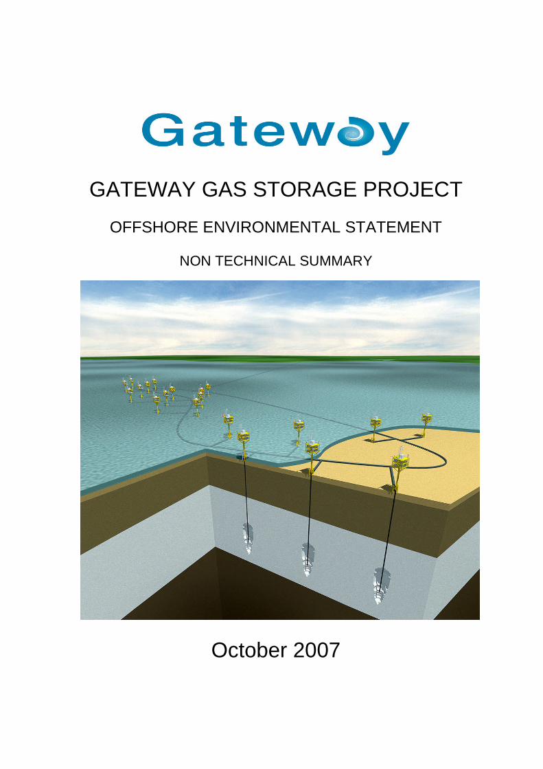
GATEWAY GAS STORAGE PROJECT
OFFSHORE ENVIRONMENTAL STATEMENT
October 2007

GATEWAY GAS STORAGE PROJECT
OFFSHORE ENVIRONMENTAL STATEMENT
NON TECHNICAL SUMMARY
October 2007


Gateway Gas Storage Project
Rev 02 Environmental Statement – Non Technical Summary
1
Introduction
An Environmental Impact Assessment (EIA) has been
undertaken for the proposed Gateway Gas Storage
Project (GGSP). This process analyses the proposed
project in relation to the existing environmental
conditions, using a combination of field surveys,
desktop studies and modeling techniques, to ensure
that all potential impacts are identified and
appropriately assessed.
It examines in detail the need for the project and its
design, construction, operation and
decommissioning. For those impacts that have been
assessed as being unacceptable, appropriate
mitigation measures have been identified. An
integral part of the EIA process has been an
extensive consultation process undertaken with
statutory and non-statutory consultees, interest
parties and the general public. This document is the
Non Technical Summary of the Environmental
Statement (ES), which reports the findings and
conclusions of the EIA process.
The Project
The Developer
Gateway Storage Company Ltd (Gateway) is the
holding entity for the proposed GGSP. The company
was registered in Scotland in 2006.
Stag Energy Development Company Ltd (Stag)
provides the Project Management under a
Management Services Agreement with Gateway.
Stag is an independent UK based company that
specialises in the development and management of
innovative projects in the rapidly evolving gas and
electricity sectors.
Stag has a detailed working knowledge of the
offshore energy sector, its working environment,
regulatory background and associated contracting
industry. Stag organisation includes personnel with
UK and international oil industry experience in the
exploration and production, and asset management
sectors at both senior management and technical
management level. Stag also has considerable
experience in the development of onshore salt cavern
gas storage projects in the UK.
Project Overview
Gateway is proposing to develop an offshore gas
storage facility in the eastern Irish Sea. The objective of
the development is to store natural gas offshore in
underground caverns, created specially in the salt strata
underlying the Irish Sea. For ease of reference
throughout the remainder of this document, the various
components of the Gateway development are referred to
as follows:
Gateway Gas Storage Project (GGSP): refers to all
offshore and onshore parts of the development;
Gateway Gas Storage Facility (GGSF): includes the
gas storage caverns, and associated monopods,
and pipelines/cables;
Offshore GGSP: includes the GGSF plus the
export/import pipelines and cable from the GGSF to
the west coast of Walney Island (low water mark).
Gateway Gas Compression Station (GGCS) refers
to the onshore gas treatment and metering facility
located adjacent to the Barrow Gas Terminals.
Over the past 40 years the UK has become reliant on
gas for a major portion of its energy supply. This
situation evolved as the UK had plentiful, low cost
supplies of gas that were easy to access from the North
Sea and Irish Sea. These reserves are now declining
and the UK is becoming increasingly dependant on gas
imports, principally from countries like Norway and
Russia. This has implications for security of supply,
particularly during periods of peak demand, and it is
envisaged that gas storage facilities will play an
important role in stabilising future energy prices for the
UK.
At present, storage capacity in the UK stands at around
five percent of annual demand, compared with an
average of around twenty percent in other Northern
European countries. The Department for Business
Enterprise and Regulatory Reform (BERR – formerly the
DTI), has acknowledged the need for additional gas
storage in the UK, citing in its 2006 Energy White Paper,
the need for additional gas storage facilities to be
developed. Given this, Gateway see a clear need for the
Gateway Gas Storage Facility (GGSF), which once
commissioned, will help to substantially improve the
security of energy supplies for the UK and Irish markets.
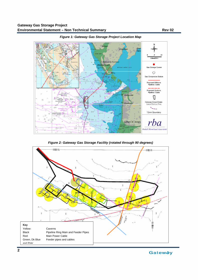
The proposed GGSF will be located approximately 24
kilometres offshore of the Fylde coastline in the eastern
Irish Sea, (Figure 1).
Gateway Gas Storage Project
Environmental Statement – Non Technical Summary Rev 02
2
Figure 1: Gateway Gas Storage Project Location Map
Figure 2: Gateway Gas Storage Facility (rotated through 90 degrees)
Key
Yellow: Caverns
Black Pipeline Ring Main and Feeder Pipes
Red: Main Power Cable
Green, Dk Blue Feeder pipes and cables
and Pink:

Gateway Gas Storage Project
Rev 02 Environmental Statement – Non Technical Summary
3
The GGSF will comprise 20 man-made underground
storage caverns, which will be created by a solution
mining process (leaching) in the salt strata beneath
the Irish Sea. The technology is well proven and salt
caverns have been used for storing gas and liquids for
many years. When completed they will have a working
gas capacity of 1.136 billion cubic metres (BCM). The
caverns will be connected to a ‘ring main’ by a short
pipeline and isolation valve (Figure 2). Two pipelines
and a power cable will connect the offshore ring main
to a new Gateway Gas Compression Station (GGCS),
located onshore at Barrow-in-Furness. A pipeline and
metering system will connect the GGCS to the
National Grid Gas (NGG) National Transmission
System (NTS) adjacent to the GGCS in Barrow-in-
Furness.
The GGSF will be powered by a new power cable that
will be installed at the same time as the offshore
pipelines.
During operation, when demand for gas is low, e.g.
during the summer months, gas will be taken from the
NTS, compressed at the GGCS and injected into the
caverns for storage offshore. When demand for gas is
high, e.g. during winter, the gas will be withdrawn from
the caverns, processed and routed into the NTS. The
gas quality will comply with NGG standards.
Provided that the necessary consents are obtained,
the salt caverns will be constructed between 2009 and
2013, with the first cavern becoming operational in
2011. Installation of the pipelines and power cable
will take place during 2009/2010. Construction of the
onshore gas reception terminal is expected to start in
2008 and be commissioned in early 2010.
Regulation
At present there is no separate regulatory framework
in the UK for the offshore storage of natural gas in
non-hydrocarbon features such as salt caverns. The
Government is in the process of drafting new
regulations as part of the Energy Bill, which will
enable licensing of gas storage under the Petroleum
Act. These regulations, however, are not expected to
come into force until the summer of 2008.
As an interim measure, BERR and the Marine and
Fisheries Agency (MFA) have jointly decided that the
offshore GGSP can be permitted using a combination
of existing legislation, namely the Petroleum Act,
1998, the Food and Environment Protection Act
(FEPA) 1985 (Section 5) and the Coastal Protection
Act (CPA), 1949 (Section 34).
The nature of the proposed GGSF means the project will
require a comprehensive EIA and an ES to support
consent applications.
The onshore component of the GGSP will comprise the
GGCS and the export/import pipelines and power cable
from the lower western shoreline at Walney Island to the
Barrow Gas Terminals (location of the GGCS). These
elements of the project will be consented under the
Town and Country Planning Act (1990) and are the
subject of a separate EIA process.
Site Selection
Selection of a suitable offshore site for the GSF was
initially driven by the following criteria:
Suitable geology,
Access to the NTS,
Health and Safety,
Environment, and
Employment.
Of these, suitable geology was the most fundamental.
Gateway reviewed a number of offshore areas around
the UK concluding that the best geological conditions for
salt cavern gas storage lay within the Preesall Halite
Formation (Triassic) in the East Irish Sea basin. Given
this, two potentially suitable areas were selected:
offshore the Fylde coastline and further to the North,
offshore Walney Island.
The Walney area was rejected on grounds of potential
geological complexity and its proximity to major shipping
lanes and two large potential offshore wind farm (OWF)
developments. The site adjacent to the Fylde coastline
was therefore chosen as the preferred area within which
to locate the project, and a lease area was agreed with
The Crown Estate (Figure 1).
To confirm the suitability of the salt formation Gateway
carried out a test borehole in the centre of the lease
area. Results confirmed that the permeability of the rock
formation in which caverns are to be constructed is very
low, and hence there is an extremely low risk of gas
leakage through the cavern walls. Data acquired for
determination of cavern gas pressures is very high
quality, and therefore provides a high level of confidence
in the design of safe caverns.

Gateway Gas Storage Project
Environmental Statement – Non Technical Summary Rev 02
4
Monopod Offshore Structures
Above each salt cavern there will be a small offshore
structure called a monopod, similar in design to a
small oil and gas platform. These will have a dual
role; initially to house the cavern leaching equipment,
and then on cavern completion, to house the cavern
gas well head and associated equipment (Figure 3).
The monopod substructure will be installed first and
secured to the seabed by piles. It is planned to install
the piles by ‘screwing’ them into the seabed; impact
piling methods will be avoided if at all possible due to
the adverse environmental impact. The monopod
topsides will be installed at a later date, after the
cavern well has been drilled (see below), using a
crane from a jack-up barge.
Figure 3: Illustration of a Gateway Monopod
Monopod Characteristics
Height above seabed: 50m (to top of Weather deck).
Weight: 150-200 tonnes.
Dimensions: 14m x 14m.
Substructure: Central tower (2.1m diameter).
4 smaller piles (1.0 m diameter).
Utilities: Electrical Power, Hydraulic Powerand Nitrogen Generation.
A monopod located over each cavern location allows for
individual brine discharge dispersion units, which will
dramatically improve the dispersion efficiency of the
brine discharges into the sea during cavern construction.
This, together with the relatively deep water at the
GGSF location, will help to mitigate any potential
environmental impact.
Once the cavern has been completed, wellhead
equipment will be located on the monopod rather than
on the seabed. This will allow for simpler and safer
operational maintenance, for example cavern re-entry
‘workover’ operations and equipment repair become
greatly simplified if direct access is possible.
Cavern Creation - Drilling Operations
For the GGSF a total of 20 wells will be drilled into the
salt formation, one for each cavern site. This will form
the initial phase of the cavern leaching process. The
wells will be drilled from a jack-up drilling rig similar to
those used to drill oil and gas wells (Figure 4), and each
well will take approximately 15 days to complete. The
wells will be drilled through the monopod substructures
prior to the installing the monopod topsides.
Figure 4: A Typical Jack-up Drilling Rig

Gateway Gas Storage Project
Rev 02 Environmental Statement – Non Technical Summary
5
Cavern Creation – Leaching Process
Once the vertical well has been drilled into the salt
layers the cavern leaching process can commence.
The caverns will be formed by injecting water under
pressure into the selected halite strata which will form
a cavity in the undersea salt bed. This turns the water
into brine containing about 30 percent salt. The brine
is then discharged to the sea.
Using this process the caverns will slowly be created
over a period of about 2 years. When finished, the
caverns will each have a diameter of approximately 85
metres (280 feet) and a height of between 100 and
260 metres (330 to 850 feet). The cavern roofs will be
at a depth of 750 metres (about 2,500 feet) below the
seabed (Figure 5). The leaching equipment will be
housed on the monopods and will be controlled
remotely from shore.
Figure 5: Illustration of Salt Cavern Evolution
Cavern leaching is programmed to commence in the
third quarter of 2009, and be completed in mid 2013.
At the peak of operations all 20 caverns will be
undergoing the solution mining process; this peak
period will occur in late 2010 to early 2011, lasting
around seven months.
Offshore Pipelines and Power Cables
The main offshore GGSP pipeline will be arranged in the
form of a large loop running to and from the GGCS at
the Barrow Gas Terminals. It will comprise a ‘ring main’
surrounding the GGSF and two 24 kilometre long
offshore import/export lines running from Walney Island
to the ring main. All of these pipelines will have a
diameter of 36 inches. Short lengths of smaller (10 inch
diameter) feeder pipes will connect each cavern to the
ring main (Figure 2).
The pipelines and cables will be installed using
laybarges. The export and import pipelines will be
trenched and allowed to backfill naturally – a method
which has been successfully used for similar pipelines
installed in the area. The majority of the pipeline route
will be trenched using a plough, however, when
necessary, e.g. at cable crossings, sediment jetting will
be employed. The ring main and associated feeder lines
may be buried along all or parts of their route, if so this
will be undertaken by jetting.
There will also be a small 4 inch diameter methanol line
piggy-backed (strapped) to one of the 36 inch pipelines.
The methanol will be injected into the pipelines at the
monopods to inhibit the formation of hydrates in the gas
stream.
In order to supply electricity to the monopods, to power
the cavern leaching pumps and gas well controls, a 66
kilovolt (kV) cable will be laid from shore to monopod No
1 (Figure 2). Power will then be distributed via 11 kV
cables using three circuits with a maximum of eight
monopods per circuit. There will be fibre optic cores
within these cables running between the 19 monopods
to monopod No 1. These will allow for operational
communication and control and remote emergency shut
down. As with the pipeline, the main 66 kV cable will be
trench by ploughing, and allowed to backfill naturally. If
the smaller cables are required to be buried, this will be
undertaken by jetting.
Installation of the offshore pipelines and cable, including
the landfalls, is anticipated to take approximately 20
months. Cable and pipelay and trenching activities are
programmed to take place in 2009 and 2010.

Gateway Gas Storage Project
Environmental Statement – Non Technical Summary Rev 02
6
Cavern Testing and Commissioning
When a cavern has reached the correct size the
leaching process will be halted and the cavern will be
pressure tested using Nitrogen. If the test is
successful, then the cavern is ready to receive gas.
Firstly the leaching tubing and associated equipment
is removed and a gas wellhead is installed on the
monopod. The wellhead is hooked up to the ring main
via the feeder pipeline.
Prior to injecting gas into the cavern the emergency
shut down (ESD) systems on the monopod will be
tested, including links to fire and gas detection
systems. Once all of the systems are ready a de-
brining process will be undertaken to remove the
residual brine from the cavern. This involves
connecting gas, from the ring main, to the wellhead
and using the pressure to displace the brine out of the
cavern. This process is effectively the ‘first fill’ of gas
into a cavern. When all the brine has been removed,
the gas storage cavern will enter normal operation.
The de-brining process for each cavern is likely to
take around three months to complete.
Operation
There will be two operational modes for the GGSF:
Gas Import - when gas is transported from the NTS.
The gas will enter the GGCS at Barrow, where it will
be metered and then compressed before exporting to
the GGSF and injecting via the well heads for storage
in the caverns. When the gas storage capacity of the
caverns has been met, the gas flow from the NTS will
automatically be stopped.
Gas Export - when gas is transported back to the
NTS. Gas will flow from the salt caverns, via the well
heads back to the GGCS. It will then be treated to
control the flow rate, temperature, pressure and water
dew point, thereby making it of a suitable quality for
export back into the NTS. Finally, the gas will be
metered before entering the NTS.
Operations will be monitored and controlled from a
control room in the GGCS. There will be a fibre optic
link between the monopods and the control room that
will run down the centre of the power cable. Each
monopod will be designed with its own independent
ESD system that will be automatically triggered in the
event of a hazardous event (e.g. gas leak, fire etc.)
The monopods are designed for operation as normally
unmanned installations (NUIs) and maintenance
philosophies will be developed to minimise the number
of personnel visits. The equipment associated with the
GGSF will be of high reliability allowing extended
durations between maintenance interventions. It is
presently anticipated that there will be a requirement for
four maintenance visits per monopod per year, each
lasting about a day. Each visit would typically involve
one vessel, therefore, assuming a worst case scenario
this would equate to 80 vessel trips per year.
Decommissioning
The design life for the GGSF has been set at 50 years.
When the beneficial life of the facilities comes to an end
a detailed Decommissioning Plan will be developed in
consultation with the Statutory Authorities that will be
fully compliant with legislation in place at the time.
The four discrete phases of decommissioning typically
entail:
Shut Down of all facilities over an extended period
to minimise any gas being retained within the plant.
Moth-Balling – removal of all residual chemicals,
lubricants etc. and isolation of all services to render
the facilities safe for dismantling and demolition.
Dismantling – any equipment that is still serviceable
will be dismantled and re-used elsewhere.
Demolition – any equipment that is beyond
beneficial use elsewhere will be ultimately
demolished and the materials re-cycled.
Based on current industry practice, on cessation of
operation at the storage site, the caverns will be emptied
of any remaining gas by filling with seawater and then
plugged and abandoned in line with current UKOOA
guidelines for well decommissioning, All surface
obstructions, including the monopods will be removed.
Summary of the Results of theGateway Offshore EIA Process
The Offshore EIA process has identified and assessed a
wide range of potential impacts that the proposed
Project could have on the local and surrounding
physical, biological and socio-economic (human)
environment. A summary of the key findings from this
process is given below.

Gateway Gas Storage Project
Rev 02 Environmental Statement – Non Technical Summary
7
Physical Environment
Sediment and Coastal Process
The proposed offshore GGSP is likely to have a very
localised impact on the waves, currents and the
corresponding sediment transport regime within in the
immediate vicinity of monopods but there is not
anticipated to be any significant or measurable far-
field impacts. Modelling of potential sediment
scouring from the presence of monopod substructures
indicated that scour depths of 1-2 metres could
develop within a few years following installation. It is
anticipated that scouring in the fine muddy sediments
will likely be a gradual, but episodic process and it
was concluded that scour protection is unlikely to be
required around the monopods.
The impact on coastal processes in relation to the
landfall of the pipelines/cable on the west coast of
Walney Island will be discussed in the GGSP Onshore
ES, which is being produced to support the planning
application submitted to Barrow Borough Council
under the Town and Country Planning Act, 1990.
Water Quality
Offshore discharges to sea will include the brine
discharge from the cavern leaching process, drilling
and completion chemicals and various drainage and
personnel wastewater from vessels and the offshore
facilities (e.g. rigs and the monopods).
Of these the brine discharge will be the most
significant. The leaching process at each cavern will
involve cycling large amounts of seawater through the
well; thereby dissolving some of the salt in the deposit
and discharging the resultant brine mixture into the
sea via a disperser unit at a maximum discharged rate
of 386 m3/hour. The maximum anticipated discharge
salinity, which will occur during the cavern
commissioning will be in the order of 7 times that of
seawater (ca. 250 parts per thousand (ppt)), although
it is anticipated to be much less than this during most
of the leaching process. The maximum temperature of
the discharge will also occur during the cavern
commissioning period and is estimated to be 8.68o
Celsius.
In order to assess the impact to the marine
environment from the brine discharge HR Wallingford
(HRW) were commissioned to undertake a modelling
study to determine the dilution and rate of dispersion of
the brine plume around each of the monopods.
The initial dilution (at the point of discharge) was
modelled using the CORMIX model. This indicated that
the brine effluent would be best discharged through two
0.15 metre diameter horizontal ports located at right
angles to the main current direction at about 10 metres
above the seabed. This configuration would be expected
to give at least a 33 times dilution at the point of seabed
impact and a maximum salinity rise at the seabed of less
than 7ppt.
Further dilution and dispersion modelling of the saline
discharge by the tidal currents was then calculated using
the 3D hydrodynamic model TELEMAC-3D. The model
was run for spring and neap tide scenarios.
The saline discharge plume was shown to form a
rotating pattern, with the plume extending southwest
from the monopods at low water. These plumes narrow
and rotate anti-clockwise as the current increases to
peak flood and then broaden and rotate further to stream
northeast at high water. They then narrow and rotate to
stream toward the west at peak ebb before returning to
the original shape at low water.
In conclusion, the TELEMAC-3D modelling results
showed that the dilution and dispersion of the discharge
by the tidal currents would result in a number of
separate plumes from each monopod. It was predicted
that there would be some merging of the plumes, but
only at low salinities (less than about 1ppt above
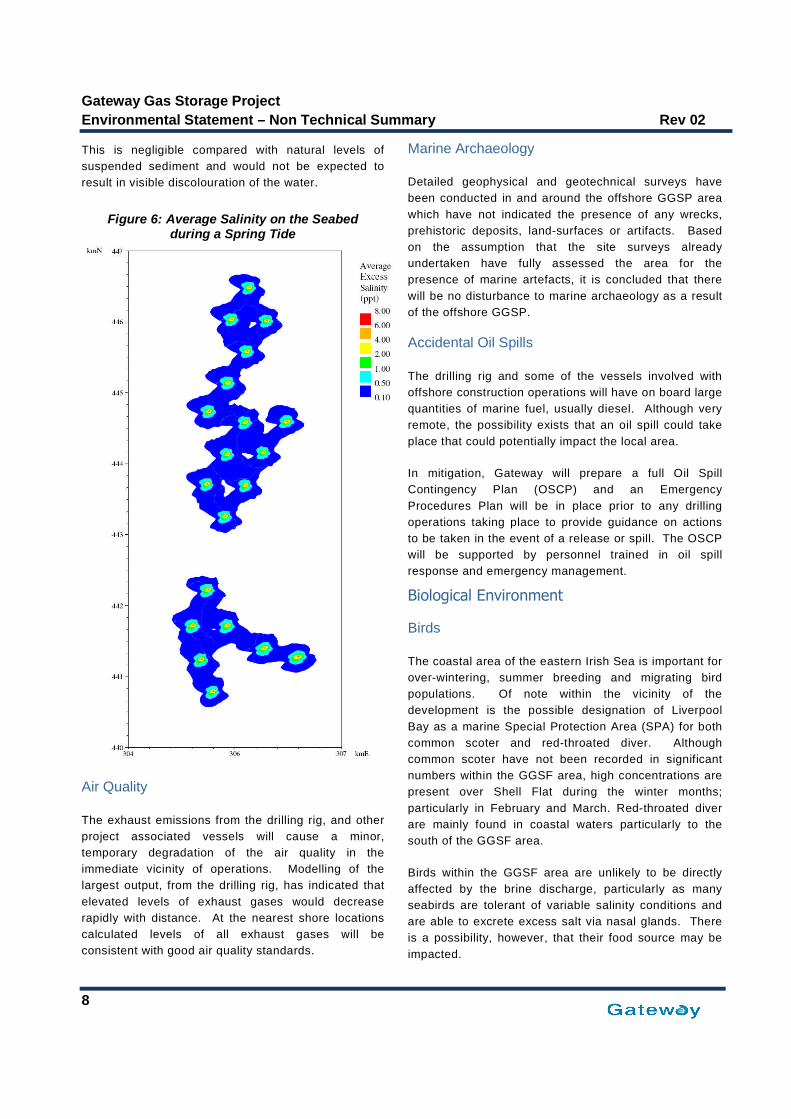
ambient) (Figure 6). The saline plumes are expected to
be confined to the bottom 0.5 to 1.0 metres of the water
column. Central concentrations are about 7ppt,
consistent with the initial dilution (i.e. there is no
significant build-up that would reduce the dilution
efficiency). The average impact at more than 1ppt above
ambient is expected to be confined to an area within
some 100 metres of each monopod during spring tides
and within about 300 metres of each offshore structure
during neap tides.
With respect to discharge temperature, it is anticipated
that the temperature will reduce to about 2o
Celsius
above ambient or less within 1 metre of the point of
discharge. There will also be an insoluble fraction to the
discharge, mainly comprising fine mudstone particles.
Modelling of this fraction found that in all cases the
suspended sediment concentration that results from the
discharge was very low, less than 0.5ppm.
Gateway Gas Storage Project
Environmental Statement – Non Technical Summary Rev 02
8
This is negligible compared with natural levels of
suspended sediment and would not be expected to
result in visible discolouration of the water.
Figure 6: Average Salinity on the Seabedduring a Spring Tide
Air Quality
The exhaust emissions from the drilling rig, and other
project associated vessels will cause a minor,
temporary degradation of the air quality in the
immediate vicinity of operations. Modelling of the
largest output, from the drilling rig, has indicated that
elevated levels of exhaust gases would decrease
rapidly with distance. At the nearest shore locations
calculated levels of all exhaust gases will be
consistent with good air quality standards.
Marine Archaeology
Detailed geophysical and geotechnical surveys have
been conducted in and around the offshore GGSP area
which have not indicated the presence of any wrecks,
prehistoric deposits, land-surfaces or artifacts. Based
on the assumption that the site surveys already
undertaken have fully assessed the area for the
presence of marine artefacts, it is concluded that there
will be no disturbance to marine archaeology as a result
of the offshore GGSP.
Accidental Oil Spills
The drilling rig and some of the vessels involved with
offshore construction operations will have on board large
quantities of marine fuel, usually diesel. Although very
remote, the possibility exists that an oil spill could take
place that could potentially impact the local area.
In mitigation, Gateway will prepare a full Oil Spill
Contingency Plan (OSCP) and an Emergency
Procedures Plan will be in place prior to any drilling
operations taking place to provide guidance on actions
to be taken in the event of a release or spill. The OSCP
will be supported by personnel trained in oil spill
response and emergency management.
Biological Environment
Birds
The coastal area of the eastern Irish Sea is important for
over-wintering, summer breeding and migrating bird
populations. Of note within the vicinity of the
development is the possible designation of Liverpool
Bay as a marine Special Protection Area (SPA) for both
common scoter and red-throated diver. Although
common scoter have not been recorded in significant
numbers within the GGSF area, high concentrations are
present over Shell Flat during the winter months;
particularly in February and March. Red-throated diver
are mainly found in coastal waters particularly to the
south of the GGSF area.
Birds within the GGSF area are unlikely to be directly
affected by the brine discharge, particularly as many
seabirds are tolerant of variable salinity conditions and
are able to excrete excess salt via nasal glands. There
is a possibility, however, that their food source may be
impacted.
Gateway Gas Storage Project
Rev 02 Environmental Statement – Non Technical Summary
9
The main food source of common scoter consists of
small fish and invertebrates. The closest aggregation
of common scoters is approximately 2 kilometres to
the east of the nearest gas storage cavern location.
Modelling has shown that, although the discharge
plume travels towards Shell Flat at certain times
during the tidal cycle, salinity of greater than 1ppt
above ambient is confined to a maximum area of 300
metres from each monopod during neap tides Given
this, any impact on the common scoter’s food source
is likely to be negligible.
Scoter are very nervous birds and are easily disturbed
by passing vessels. The presence of the Project, and
associated vessel activity, are not anticipated to result
in a significant impact as vessels will stay within
existing well marked shipping channels and have no
need to pass over the Shell Flat area on route to the
GGSF.
There is also the potential for local seabird
populations to be impacted if an oil spill were to occur
in the project area. The most likely spill event would
be a small spill of fuel oil (diesel). Impacts from small
spills, i.e. less than one tonne, are likely to be
restricted to the immediate vicinity of the source.
Larger spills, as a result of a catastrophic event, e.g. a
collision, have the potential to impact wider areas.
The worst case would be a large diesel spill during the
winter months (September to March) when there are
very high numbers of overwintering seabirds, notably
common scoter residing on the nearly Shell Flat.
These populations could become significantly
impacted. It should be emphasized, however, that
such an impact is remote and would only be the result
of a significant catastrophic collision incident.
In mitigation, Gateway will prepare a full OSCP and an
Emergency Procedures Plan will be in place prior to
any drilling operations taking place.
Overall, however, the impact to the local bird
populations from all aspects of the offshore GGSP is
considered to be negligible.
Benthic (Seabed) Communities
No benthic species of particular conservation
importance are anticipated within the GGSF area or
along the proposed route of the pipelines and cable.
The most significant GGSP related impacts to benthic
communities will be from:
Discharge of waste cuttings from the drilling of the
20 cavern wells. Modelling indicates that the
benthic communities up to 160 metres from the well
will be impacted, mainly by burial from discharged
cuttings. As the drilling mud associated with these
cuttings will be water based and contain minimal
contaminants, recolonisation of the area is likely to
be rapid.
Loss of some soft sediment habitat, due to
installation of the monopod substructures, estimated
at about 0.2 hectare;
The brines discharged from the leaching process
will sink to the seabed exposing the local benthic
communities around each monopod to rapid
changes in salinity. Modelling has indicated that
this exposure is likely to be transient as a result of
the shallow waters and tidal flow. Nevertheless, it is
likely that there will be some impact on the benthic
communities in the immediate area of the monopods
for the duration that the discharge takes place.
Temporary impact from the installation of the
pipelines and cables. Although this will take place
over a comparatively large area, any disturbance to
the soft sediment faunal communities will be short
lived and recolonisation is again expected to be
rapid.
Introduction of hard substrate (monopod
substructures) plus any ‘hard’ material used for
scour control will attract a new faunal community
thus increasing the overall diversity of the area.
The overall impact on the local benthic communities
within the project area is considered to be minor.
Fish and Shellfish
Within close proximity of the GGSF area there are
spawning areas for a number of fish species including
cod, whiting, sole, sprat and plaice, and the area also
may act as a nursery area for whiting, sole and plaice.
The construction and operation of the GGSP is likely to
result in only minor impacts to fish and shellfish
populations. Possible impact could occur from:
Piling activity. Installation of the monopod
substructure will not employ hydraulic hammer
equipment, if possible, however, this technique may
be required depending on sediments in the area.
Were it to be used a ‘soft-start’ procedure would be
implemented which would slowly increase the level
Gateway Gas Storage Project
Environmental Statement – Non Technical Summary Rev 02
10
of underwater noise prior to piling starting and
thus ensure that fish have the opportunity to move
away from the noise source.
Discharges of drill cuttings and leachate brines
and the disturbance of sediments during pipeline
and cable installation could indirectly impact fish
populations by reducing their local food sources,
i.e. plankton and benthos. Modelling has shown,
however, that impacts to these communities will
be limited to the immediate vicinity of the
operation. Overall, impacts on fish food sources
are therefore considered to be negligible
Electromagnetic emissions from subsea power
cables. Electro-sensitive fish (sharks and rays)
are unlikely to be impacted significantly by the
subsea cable as the electrical field generated by
cables will be minimised by insulation and burial.
Sediment disturbance from pipe and cable laying
operations. Migrating salmon and sea-trout could
potentially be affected by sediment plumes from
inshore pipeline and cable laying and burial
operations. These operations, however, have
been timed to avoid the period when adult
salmonids are migrating to their natal rivers, which
is usually between November and January.
The monopod substructures may result in some form
of artificial reef effect, as fish tend to aggregate
around objects placed in the sea. In the longer term,
this may have a minor beneficial effect leading to an
improved habitat biodiversity in the area.
Marine Mammals
Numbers of marine mammals are generally low within
the GGSF area and therefore any impacts as a result
of the construction and operations are not considered
to be significant. Noise and vibration produced by
vessel movements, drilling and construction activities,
will be similar to those produced by existing offshore
traffic.
It is not planned to install the monopod substructure
piles using a submersible hydraulic hammer, however,
if this is required then mitigation in the form of ‘soft
start’ procedures will be carried out prior to piling
operations.
Socio-Economic (Human) Environment
Employment
During the construction, installation and commissioning
phase of GGSP, it is unlikely that many direct job
opportunities will be created as most work will be
undertaken by specialist contractors. Due to the
technical speciality of the onshore pre-fabrication and
construction work, it is considered unlikely that much of
this work will be undertaken in the Barrow-in-Furness
region.
During offshore installation and construction activities,
the port of Barrow will be used where possible as a
supply base for project associated rigs/vessels. The
project will need to draw on some support services,
which will potentially assist in sustaining employment
levels or increase employment opportunities locally.
Once the facility is operational a small number of people
will be required to operate and maintain the offshore
facilities from the onshore control base located at the
proposed GGCS in Barrow. With the decline in
production from East Irish Sea gas fields, it is
anticipated that existing personnel within the area will be
used for this purpose, which will help sustain long term
employment opportunities at these facilities.
Commercial Fisheries
The East Irish Sea ports have supported a commercial
fishing industry since the early 1800s and although the
industry has been in decline for a number of years there
is still an active local fishery. The GGSF area is
currently not heavily fished; however, it is still important
to the local commercial fishing community in that it forms
part of the wider network of fishing grounds within the
eastern Irish Sea. Vessels fishing within the area are
primarily demersal trawlers from Fleetwood.
During construction and installation of the monopods,
pipelines and cables, and during drilling operations, a
500 metre diameter safety zone will be established
around all vessels associated with these activities.
Once a monopod has been installed a permanent 500
metre safety zone will be set-up around the structure,
creating a total exclusion area of approximately 12
square kilometres (1200 hectares) around all 20
structures. Fishing will therefore not be permitted within
this area for the life time of the project.
Gateway Gas Storage Project
Rev 02 Environmental Statement – Non Technical Summary
11
Given that the GGSF area is not heavily fished, the
EIA concluded that the presence of the facility on its
own will probably not greatly impact the value of
fishery in the area and is therefore unlikely to
significantly impact the local fishing industry. It may,
however, lead to some minor changes in local fishing
patterns, with vessels having to travel around the
exclusion zone in order to fish to the west of the
development, outside of the 12 nautical mile limit.
Navigation and Shipping
A review of existing shipping traffic was undertaken for
the GGSF area and showed that although there were
a number of routes within the general area few would
be directly impacted by the presence of the Gateway
offshore facilities.
Traffic travelling between Heysham and the South
Morecambe gas field will be the route most affected.
These supply vessels will not be able to pass directly
through the gas storage area and will need to re-route,
either to the south-east or to the north-west of the
development. Other vessels travelling North/South
through the East Irish Sea are expected to move to
the west of the GGSF area passing between the
offshore structures and the South Morecambe gas
field. Given the relatively low volumes of traffic
affected, the overall impact on commercial shipping
navigation is not considered to be significant.
In addition, it is anticipated that the project will not
have a significant impact on recreational vessel
activity in the area; given existing routes and the
limited activity in the area.
Using modelling, a collision risk assessment has also
been undertaken for the project. It was assumed that
the worst case collision risk would be during the
construction phase of the project when a jack-up rig,
and attendant vessels, would be operating at several
cavern locations. Assuming that a safety vessel
equipped with standard marine radar would be on-site
during the construction period the highest annual
collision frequency was calculated to be 2.1 x 10⁻³
(corresponding to a return period of 476 years).
In mitigation, all planned offshore activities will be
communicated through the correct notification
procedures e.g. through Notices to mariners.
Navigational aids will be placed on individual
monopods, with additional aids placed on those
monopods lying on the edge of the GGSF area. Trinity
House is currently reviewing these navigation aid
requirements, but it is envisaged that each structure will
be fitted with white lights with 15 nautical mile range,
and other measures e.g. additional lighting and buoys,
are also being considered.
Gateway has committed in principle to contributing to
the overall planned Vessel Traffic Service (VTS) for the
North West area in order to enhance safety of
navigation.
Tourism
Due to its distance from shore, it is considered that the
presence of the GGSF will generate little interest from
either the local population or visitors to the area. From
shore, the monopods will only just be visible on clear
days and should only be of passing interest to people
walking along the seafront.
Civil and Military Aviation
There are no identified impacts from the presence of the
GGSF with regard to low level operational aviation
activities, as none of the proposed offshore sites lie
within the takeoff or landing zones of any aerodromes
within the area. It is considered that the offshore GGSP
will pose no risk to either civil or military radar or high
level flight paths.
Offshore Oil/Gas and Wind Farm Operations
The only significant potential impact from the offshore
GGSP on the existing oil/gas and wind farm
infrastructure will be during construction and installation
operations. There will be a requirement for the Gateway
pipelines and cables to cross existing gas pipelines and
power cables. The exact positioning of these crossings
will be determined during the detailed project design
stage and once established; crossing arrangements will
be agreed with the pipeline /cable owners and operators.
The exact type of crossing that will be used has yet to
be decided and will be the result of discussions,
although the types of crossing method are well defined.
Visual
A detailed assessment has been undertaken to
determine the potential for any significant impact on the
landscape, seascape and visual environment within a 40
kilometre radius of the proposed GGSP.

Gateway Gas Storage Project
Environmental Statement – Non Technical Summary Rev 02
12
The studies included a ‘baseline’ assessment of the
proposed GGSP in relation to the current operating
offshore wind farm (OWF) at Barrow and other existing
offshore gas field infrastructure. Whilst
acknowledging that the proposed GGSF is not an
OWF development, it is nevertheless in the form of an
array of offshore structures therefore, for consistency,
the study methodology for this assessment used
guidance previously employed for other OWF
developments in the East Irish Sea.
The seascape assessments were based on five
Regional Seascape Units from the Duddon Estuary in
the north to the Ribble Estuary and Sefton Coast in
the south. In addition, six landscape character areas
were identified within the study area from the West
Cumbria Coastal Plain in the north to the Lancashire
and Amounderness Plain and Sefton Coast in the
south.
An assessment was made for each seascape and
landscape area based on its visual quality and
sensitivity; and value and capacity to accommodate
change. In summary, the results of the landscape and
seascape assessment concluded that overall the
construction and operation of the offshore elements of
the GGSP development would result in either a small
or negligible magnitude of change on the landscape
and seascape character and consequently, throughout
all areas, the significance of effects were assessed as
being slight.
Following consultations with statutory consultees and
the relevant Local Planning Authorities, a total of 7
viewpoints were selected to represent a range of the
most sensitive viewpoint locations, i.e. those locations
where any potential visual impact was greatest. The
viewpoints included both coastal and inland locations
at low level and elevated locations, ranging from Black
Combe in the north, to St Annes Pier in the south.
In summary the results of the baseline visual impact
assessment, concluded that from all seven viewpoints
together with all other parts of the study area, the
anticipated magnitude of change was assessed to be
either very small or negligible and as a consequence
the resulting significance of visual effect was either
minor or negligible
Cumulative Impacts
Cumulative impacts are those that may result from the
combined or incremental effects of past, present or
future activities. While a single activity may not have a
significant impact when treated in isolation, it may, when
combined with other impacts occurring at the same time
in the same geographical area, result in a cumulative
impact that is significant. The most significant potential
cumulative impacts are summarised below.
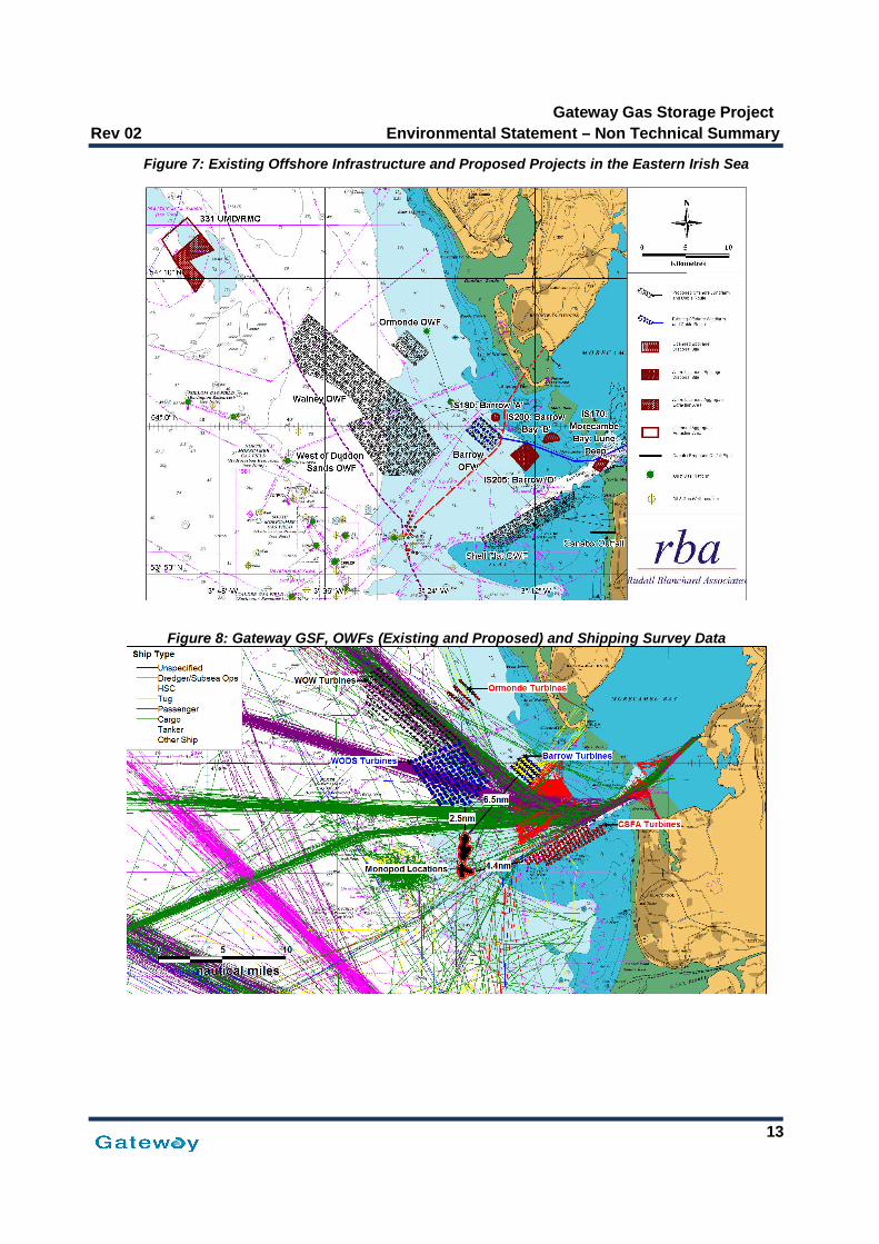
Figure 7 illustrates the past, present, and future
developments that may result in a cumulative impact
with the GGSF. This includes offshore wind farms
(OWF), oil and gas exploration and production activities,
other offshore infrastructure (pipelines and cables),
marine aggregate extraction sites and spoil dumping
sites. Also of note is the proposed Canatxx gas storage
facility, which although based onshore has an outfall
pipe for brine discharge located approximately 2.3
kilometres offshore of Rossall, near Fleetwood.
Shipping and Navigation
The main cumulative impact on shipping and navigation
in the eastern Irish Sea will result from the presence of
the OWFs, particularly if all current applications are
developed. The physical presence of these
developments will result in a cumulative loss of sea-
room and will, therefore, require a significant amount of
vessel traffic to be re-routed.
Figure 8 presents the shipping survey data (one month)
overlaid with the proposed location of the GGSF as well
as existing and proposed locations of the OWFs. It can
be seen that any traffic which is re-routed as a result of
the different OWF developments should not be impacted
by the GGSF as the majority of the OWF sites lie to the
north or east of the GGSF.
Exceptions to this could occur during the construction
phases of the various projects where traffic may be
visiting from ports further afield.
Gateway Gas Storage Project
Rev 02 Environmental Statement – Non Technical Summary
13
Figure 7: Existing Offshore Infrastructure and Proposed Projects in the Eastern Irish Sea
Figure 8: Gateway GSF, OWFs (Existing and Proposed) and Shipping Survey Data

Gateway Gas Storage Project
Environmental Statement – Non Technical Summary Rev 02
14
The majority of construction traffic associated with the
GGSP will be on-site during 2009 and 2010. As such,
given current anticipated construction dates, the only
overlap will be with the Ormonde OWF, which is due
to begin foundation piling, drilling and cable lay
activities in 2009.
With respect to commercial shipping, cumulative
impacts will mainly result from the proposed West of
Duddon Sands OWF and the associated re-routing
which will be required to take place for ferries
travelling between the Isle of Man and Heysham. This
will increase the density of the traffic immediately to
the north of the GGSF. However, these vessels will
follow similar routes to the vessels already routeing to
the north of the GGSF.
It can be seen that whilst the impact of GGSP on
shipping in isolation is not considered to be
significant, should all the proposed developments in
the eastern Irish Sea area proceed, there will be
cumulative impacts based on overall reduced sea
room and re-routeing of shipping
Commercial Fishing
The main cumulative impact to commercial fishing will
be the loss of available fishing grounds as a result of
the GGSF combined with the OWFs and the 500 metre
safety exclusion zones set-up around oil and gas
installations (including the Millom, North and South
Morecambe, Hamilton and Douglas gas fields). The
extent of any cumulative impact will be dependent on
where individual fishermen operate. There will, for
example, be little or no impact on the summer prawn
fishery as none of the proposed OWFs extend into the
Prawn Ground.
With regard to a cumulative impact during construction
of the GGSP (the majority of activity for which is
planned for 2009 and 2010) only one OWF, Ormonde,
is currently scheduled to be constructed during this
period. Drilling activities associated with the Ormonde
South gas field are also likely to occur during this
period.
Any potential cumulative impacts between the two
projects are reduced given that the Ormonde project is
located approximately 19 kilometres to the north-east
of the GGSF and that the two projects lie within or
close-to separate fishing grounds.
In mitigation, Gateway will participate in the ongoing
consultation process between the East Irish Sea
Developers Group (EISDG) and with local and national
fisheries bodies to help minimise any potential
cumulative effects of wind farms and other eastern Irish
Sea developments on fisheries.
Birds
The physical presence of the GGSF is unlikely to add to
the cumulative impact of the OWFs on birds, particularly
as it will not represent a collision risk.
With regard to displacement, it is also anticipated that
the cumulative impact of the GGSF will not be significant
either alone or in combination with the OWF
developments. The combined area of these
developments is approximately 192 square kilometres,
which is considered to be a relatively small area in
relation to the availability of habitat for most species that
may be vulnerable to displacements effects (e.g. gannet,
auks, manx shearwater etc.).
The other key potential cumulative impact on birds is
from Liverpool Bay pSPA, specifically common scoter
and red-throated diver. It is unlikely that the GGSF will
result in additional disturbance to these species over
and above that caused by the Cirrus Shell Flat Area
OWF, particularly as all vessel traffic associated with the
GGSP will be routed around the Shell Flat area.
Visual
A detailed assessment was undertaken of the potential
cumulative visual effects that may arise following the
construction and operation of the GGSP in conjunction
with other operational and proposed developments in
the East Irish Sea. These included offshore and
onshore wind farm developments and existing offshore
gas field infrastructure.
In summary, the results concluded that the relative
significance of the GGSF monopods, given their height
and location, was negligible when compared to the
number and height of turbines at the various operating
and planned OWFs,
From a seascape perspective the visual effect resulting
directly from the GGSP construction would be negligible
when compared to those potential effects resulting from
the closer Round 1, and the more extensive Round 2,
OWFs. Indeed, from certain seascape viewpoints, the

Gateway Gas Storage Project
Rev 02 Environmental Statement – Non Technical Summary
15
view will become dominated by the wind farms and in
effect would become ‘wind farm seascapes’. For
example, four OWFs will be concentrated in the area
to the west and southwest of Walney Island, (Barrow,
Ormonde, Walney and West of Duddon Sands). These
will dominate the seascape to such an extent that the
construction of the GGSP will not detract from their
relative ‘dominance’.
In summary therefore, any magnitude of change and
significance of visual effects in this area are primarily
attributable to the OWF developments proposed in the
Eastern Irish Sea and not to the GGSP.
Marine Discharges
The main potential for cumulative impacts arises from
the brine discharge if solution-mining at the Canatxx
onshore gas storage project occurs at the same time
as the GGSP.
Modelling of the Gateway brine plume however has
shown that salinity of greater than 1ppt above ambient
will be confined to a maximum area of 300 metres
from each offshore structure during neap tides.
Similarly, modelling of the brine plume from the
Canatxx outfall shows that the discharge reaches 10
percent of ambient concentration within 250 metres
from the discharge point. Given the distance between
the GGSF and the Canatxx outfall pipe, approximately
22 kilometres, it is not anticipated that two plumes will
overlap, therefore, there will be no significant
cumulative impacts.
It is recognised that other offshore developments are
likely to reduce water quality from activities such as
marine aggregate extraction, waste disposal and
discharges from oil and gas activities. Given the
distance between projects, however, no significant
cumulative impacts are anticipated.
Quantifying the predicted emissions from drilling the
Gateway cavern wells, combined with knowledge of
previous similar activities within the general area,
allows a simple assessment of the additional or
cumulative ‘loading’ of discharged material into the
marine environment caused by the proposed activity.
Drilling at the 20 cavern locations will take place
within an area covering about 6 kilometres by 2
kilometres, with each cavern typically separated by a
distance no less than 500 metres. Drilling will be a
sequential and continuous operation from Q2 2009 to Q1
2010, with each well taking about 15 days to complete.
Modelling indicated that the majority of the drill cuttings
will fall within 165 metres of each discharge point.
Given that the closest distance between any two drilling
locations is approximately 500 metres, any potential
cumulative local impact on the surrounding sediments is
unlikely.
Regarding the wider cumulative effect within the Irish
Sea, 58 wells were drilled in and around the area
between 2000 and the end of 2006, around three
percent of the total wells drilled on the UK Continental
Shelf. In the case of Gateway, an estimated 335 tonnes
of cuttings are expected to be discharged to the seabed
at each location. Based on the past seven years drilling
history in the Irish Sea, this is likely to form a significant
contribution to the total drill cuttings that will be
discharged to the seabed during the proposed drilling
period. Overall, however, the consequences of the
cumulative impact are anticipated to be negligible,
particularly as previous evidence has shown that any
cuttings will soon become mixed with the natural
sediments and will eventually be dispersed.
Noise
Development of the offshore GGSP will generate noise,
both above and below the sea surface. Significant
sources of noise will be generated from construction and
installation activities, although all such noise will be
restricted to a relatively localised area.
The main potential for cumulative noise impacts arises if
construction activities of nearby developments occur at
the same time as those for the GGSF. The closest
OWFs to the GGSF are West of Duddon Sands,
approximately 4 kilometres to the north and CSFA,
approximately 8 kilometres to the east. Construction of
West of Duddon Sands OWF is anticipated to commence
in 2011, although the project has yet to be officially
consented. The CSFA OWF has been subject to a
planning re-application and, therefore is unlikely to be
built prior to West of Duddon Sands.
Given the above, it is unlikely that there would be
significant overlap with the GGSP as the majority of
construction and installation work is programmed for
2009/2010. In addition, an assessment undertaken for
the CSFA wind farm (Cirrus Energy, 2007) indicated that
anticipated airborne noise from construction and

Gateway Gas Storage Project
Environmental Statement – Non Technical Summary Rev 02
16
installation activities, principally hammer piling
operations, were likely to be rapidly attenuated and
that it was unlikely that noise levels exceeding 60dB
would be experienced more than 2 kilometres from the
noise source.
During construction of the GGSF, the greatest impact
to fish species and marine mammals will be from
percussion piling should that installation method be
used. However, as discussed above it is unlikely that
concurrent piling operations will take place. In
addition, if Gateway is required to employ percussive
piling methods utilise a submersible hydraulic hammer
method to install the monopods this generate
significantly less noise than that associated with the
piling of the larger offshore wind turbine foundations..
Given the above it is anticipated that there will be no
significant cumulative noise impacts during
construction of the GGSF.
Pipeline/cable installation activities are likely to cause
a minimal amount of disturbance to the background
noise level of the area. This is not likely to cause
significant cumulative impacts, however, if Gateway
activities are carried out at the same time as cable lay
activities for the Ormonde OWF increased noise levels
may occur over an extended duration.
No cumulative noise impacts are anticipated from the
operation of the Gateway GSF in relation to other
offshore activities.
Accidental Hydrocarbon Releases
Accidental hydrocarbon releases arising from spills,
collisions etc, will be statistically more likely to occur if
all the proposed offshore developments are
constructed. Each individual development will have
their own emergency response procedures, which will
detail the contingency measures put in place to deal
with any incidents. There are, therefore, not expected
to be any specific cumulative impacts due to
accidental releases.
Environmental Management
Gateway operates under an integrated Business
Management System that includes a comprehensive
Environmental Health and Safety (EH&S)
management system. This system will help to ensure
that the project is undertaken on a sound environmental
basis.
Environmental mitigation and monitoring programmes
together with any conditions attached to the Project
Consents will be compiled into an Environmental
Management Plan and incorporated into the Project
planning process. A system of internal and third party
audits will provide the necessary feedback to ensure
that the process operates correctly.
Overall Conclusions of theGateway Project EIA
In conclusion, it is considered that, providing the
proposed mitigation and monitoring requirements are put
in place, the offshore GGSP will not have a significant
adverse impact on the local and far-field physical,
biological or social-economic environment, and from a
cumulative perspective, is unlikely to comprise a
significant component. Overall, any adverse impacts
should be balanced against the beneficial effects of the
project to the East Irish Sea area including the potential
effects of the local economy, strengthening the region’s
reputation as an energy hub.
Gateway will continue to consult with all interested
parties throughout the development and operational
phases of the Project, keeping local residents and
business informed of progress and addressing any
comments and concerns that may be forthcoming.