gamma l-band sar · o linear rail (length of synthetic aperture: 2-12 m) line-of-sight surface...
TRANSCRIPT
GAMMA L-Band SAR Information v1.3, 20-Aug-2019 page 1
GAMMA Remote Sensing AG, Worbstrasse 225, CH-3073 Gümligen, Switzerland tel: +41-31-951 70 05, fax: +41-31-951 70 08, email: [email protected]
GAMMA L-Band SAR Introduction:
The GAMMA L-band SAR is a compact and versatile FMCW SAR system that supports interferometric (repeat-pass and single-pass), polarimetric, and polarimetric-interferometric SAR data acquisitions from agile sensor platforms. This short document describes the main characteristics of the system hardware, the SAR data processing approach, as well as a few specific use cases including airborne (vertical take-off and landing (VTOL) UAV) and terrestrial (car-borne and rail-based) interferometric repeat-pass SAR acquisitions. Using two repeat-pass SAR images – or a longer time series of repeat-pass SAR measurements – surface displacements in the direction of the line of sight of the radar can be derived. Examples include interferometric measurement of surface displacements due to glacier flow by means of car-borne SAR interferometry and a demonstration of UAV-borne repeat-pass interferometric measurements of a slope of a mountain valley.
Applications and SAR platforms:
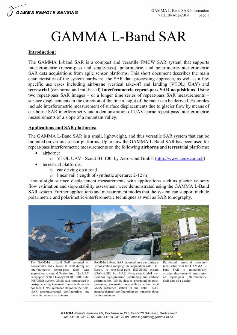
The GAMMA L-Band SAR is a small, lightweight, and thus versatile SAR system that can be mounted on various sensor platforms. Up to now the GAMMA L-Band SAR has been used for repeat-pass interferometric measurements on the following airborne and terrestrial platforms:
• airborne: o VTOL UAV: Scout B1-100, by Aeroscout GmbH (http://www.aeroscout.ch)
• terrestrial platforms: o car driving on a road o linear rail (length of synthetic aperture: 2-12 m)
Line-of-sight surface displacement measurements with applications such as glacier velocity flow estimation and slope stability assessment were demonstrated using the GAMMA L-Band SAR system. Further applications and measurement modes that the system can support include polarimetric and polarimetric-interferometric techniques as well as SAR tomography.
The GAMMA L-band SAR mounted on Aeroscout’s UAV Scout B1-100 during an interferometric repeat-pass SAR data acquisition in central Switzerland. The UAV is equipped with a Honeywell HGUIDE n580 INS/GNSS system. GNSS data is processed in post-processing kinematic mode with an ad-hoc local GNSS reference station in the field. SAR antenna/channel configuration: one transmit/ one receive antenna.
GAMMA L-band SAR mounted on a car during a demonstration campaign in cooperation with ETH Zurich. A ring-laser-gyro INS/GNSS system (iNAV-RQH) by iMAR Navigation GmbH was used for high-precision positioning and attitude determination. GNSS data is processed in post-processing kinematic mode with an ad-hoc local GNSS reference station in the field. SAR antenna/channel configuration: on transmit/ three receive antennas.
Rail-based terrestrial measure-ment setup with the GAMMA L-band SAR to autonomously acquire short-interval time series of repeat-pass interferometric SAR data of a glacier.

GAMMA L-Band SAR Information v1.3, 20-Aug-2019 page 2
GAMMA Remote Sensing AG, Worbstrasse 225, CH-3073 Gümligen, Switzerland tel: +41-31-951 70 05, fax: +41-31-951 70 08, email: [email protected]
L-band Radar Hardware:
In Table 1, a short summary of the specifications of the L-band FMCW SAR system configured for the airborne/car-borne acquisition mode is given. The L-band radar has 4 low-noise receiver channels that can operate simultaneously. A custom designed FPGA 14-bit/channel digitizer records from all four channels simultaneously and streams these data to an SSD. The radar instrument is controlled by a Linux-based computer. Transmitter max. output is 10W (5W used in our experiments) and includes a transmitter output switch (2 alternating transmit channels) that permits fully polarimetric data acquisitions, single-pass cross-track and along-track interferometric data acquisitions, as well as combination of these modes up to a total of 4 simultaneous receive channels. Total power consumption is less than 60W. The compact radar hardware implementation is aimed at UAV-based and ground-based operation.
GAMMA L-band SAR hardware embedded in a Pelicase 1450. The connector plate is shown on the top left with sockets for 2 alternating transmit channels, 4 simultaneous receive channels, a GNSS patch antenna, LAN / Ethernet connection, and power supply (nominal: 24V DC, max. 60W while transmitting). On the lower left, the open Pelicase reveals the instrument computer and the FPGA 14bit/channel digitizer. The specifications of the GAMMA L-band SAR are provided in Table 1 on the right.
SAR Processing:
A CUDA/ANSI C [1] implementation of a time-domain back-projection (TDBP) approach [2,3] adapted to FMCW systems [1,4,5], is used to focus the airborne or car-borne L-band SAR images directly in map coordinates. The CUDA-GPU-based TDBP processing software is available as a separate package of the GAMMA software. We use and recommend the following computer hardware and operating system (OS) configuration to operate the TDBP focusing software: an Ubuntu Linux workstation equipped with an NVIDIA TESLA GPGPU card. While other hardware configurations are possible, in general, this is the recommended hardware/OS configuration that has been used at Gamma Remote Sensing (Ubuntu 18.04, NVIDIA Tesla K20c GPU: CUDA Driver Version / Runtime Version 10.0 / 10.0, CUDA Capability: 3.5, Global GPU memory: 4744 Mbytes, 2496 CUDA Cores). The TDBP processing approach
Table 1: Gamma L-band SAR specifications
Frequency within 1.2 - 1.4 GHz
used center freq. 1.325 GHz
wavelength at center freq. 22.6 cm
Chirp bandwidth 50 - 200 MHz
used bandwidth 100 MHz
range resolution (@ 100 MHz BW) 1.5 m
Azimuth resolution (@ full SA) 0.5 m
Azimuth resolution (@ SA = 250m, R=5km) 2.3 m
Type FMCW
Chirp lengths 250 µs - 8 ms.
Transmit power max. 10 W (used: 5 W)
Transmit channels 2 (alternating)
Receive channels 4 (simultaneous)
Elev. beamwidth (3dB) 40.0 deg
Azim. beamwidth (3dB) 40.0 deg
Elev. pointing angle variable (configu-
ration dependent)
Radar hardware assembly Pelicase 1450
Dimensions l: 406mm
w: 330 mm
h: 174 mm
Weight 7.65 kg<latexit sha1_base64="O9lyL5qwZnideF4kUre4TTZWbvU=">AAAInXicjVVbU9tGFBZpG1z3Bu1T24eelsuYmaLKNoYMM5mBkAQ6JR1iAs4MYpi1dCxp2F0puysc0Oipv7J/ob+iR7Yxlk0S9sGWVuc7+53vXLab8Egbx/l37tFnn3/xeL7yZfWrr7/59ruFxe9PdZwqD0+8mMfqbZdp5JHEExMZjm8ThUx0OXa6l3vF984VKh3F8o25TvBcsEBGvchjhrYuFh//U1150Kq6XQwimRlGrvOzX8151VUose/FQjDpZy5Til1ro9B4YZ7V7WZeBVquh9KgimQwemVJcXTmctZFPvR32CUPx7vt4wQ9ncM+I5dwuF7sAm2Dpv0xaT3yO+aTcqbyjPPh/uBbWOjxodeVVdfge9PtZX+lgzNy150yyV4qfJei9K6hH5kwkpCvQt1uwDr9bsD+wY3rjo0hc0OdMA8zx255Ik81+jCMGnrkx87hbhVumo3WyMUHffTZFXKUgQmBmWlnqwCNhr0Jnph0ke2FkUqgCKgf+SYkxi2HCDccB14d3MAk43sp3yFhehHroZePOVFMBggKdczTIlFQ27mFwbPOWj6OvwVl4rs3kUgp0jK0l3JO2R/jll2O75bBGcE/gT7ehafQaDnid2g/bV2KsZuG3Szj31BbkFYvX+11JrZXsmMmqANlAIoZMmjMCDASfJgmXVQInUc0RbqsSfcnILRdOogE0iIykMR9VGQu2HubFIIO1IoEbEMLOmv3IryQSYmceoMOgRrjVA6SukEGJfs2ehhdYcl8A2qaBOKGSYxTXbJ/wfHKhi7Ni0Heodb0n60NQI7tgI/BtM6fMIYJ+fZVnFL7UuuiX0hTB/GHhplOW8n+LGq7hyoWaFTkwe04I5BjU6cImKWcxJEsogcqOV5YXjEVFZMEal4se1GQrpfrfaae1WCWEO0EpU/ttVbK/SkqQ+OGj8novIhzikub+UxByJTfZwqBaY00eK8HHXpEMI/AUN+gophElZvmeSRQ6sFYIxTfplM2hfgo+ckw+tvQbBIv8VBAuA31rY0yYIpSB6MgNAWdLXuzBZcBTHbrMH8TWXRJwPEYrt6+UVYeerNULxaWqIQGC2Yf6qOHJWu0ji4W5+ZcP/ZSks54nHQ/qzuJOc9YkbXByS41FIV0yQLMBrdkDiuDIdeLaY7Gklqq2K1O2jGh9bXokqVg1NDT34rN+76dpab35DyLZJIaujGGB9HwAhNDceVCyREmmsozr84SrLrPkYJRuK9YEkaebqccMzvxe3Rb5Rn953dveSFafVqi2YfThl2n59eNpZ32SL6K9bP1m1Wz6taWtWMdWEfWieU9/m9+Yf7H+Z8qv1ReVA4rfw9NH82NMD9YpVXp/A9T6mlO</latexit><latexit sha1_base64="O9lyL5qwZnideF4kUre4TTZWbvU=">AAAInXicjVVbU9tGFBZpG1z3Bu1T24eelsuYmaLKNoYMM5mBkAQ6JR1iAs4MYpi1dCxp2F0puysc0Oipv7J/ob+iR7Yxlk0S9sGWVuc7+53vXLab8Egbx/l37tFnn3/xeL7yZfWrr7/59ruFxe9PdZwqD0+8mMfqbZdp5JHEExMZjm8ThUx0OXa6l3vF984VKh3F8o25TvBcsEBGvchjhrYuFh//U1150Kq6XQwimRlGrvOzX8151VUose/FQjDpZy5Til1ro9B4YZ7V7WZeBVquh9KgimQwemVJcXTmctZFPvR32CUPx7vt4wQ9ncM+I5dwuF7sAm2Dpv0xaT3yO+aTcqbyjPPh/uBbWOjxodeVVdfge9PtZX+lgzNy150yyV4qfJei9K6hH5kwkpCvQt1uwDr9bsD+wY3rjo0hc0OdMA8zx255Ik81+jCMGnrkx87hbhVumo3WyMUHffTZFXKUgQmBmWlnqwCNhr0Jnph0ke2FkUqgCKgf+SYkxi2HCDccB14d3MAk43sp3yFhehHroZePOVFMBggKdczTIlFQ27mFwbPOWj6OvwVl4rs3kUgp0jK0l3JO2R/jll2O75bBGcE/gT7ehafQaDnid2g/bV2KsZuG3Szj31BbkFYvX+11JrZXsmMmqANlAIoZMmjMCDASfJgmXVQInUc0RbqsSfcnILRdOogE0iIykMR9VGQu2HubFIIO1IoEbEMLOmv3IryQSYmceoMOgRrjVA6SukEGJfs2ehhdYcl8A2qaBOKGSYxTXbJ/wfHKhi7Ni0Heodb0n60NQI7tgI/BtM6fMIYJ+fZVnFL7UuuiX0hTB/GHhplOW8n+LGq7hyoWaFTkwe04I5BjU6cImKWcxJEsogcqOV5YXjEVFZMEal4se1GQrpfrfaae1WCWEO0EpU/ttVbK/SkqQ+OGj8novIhzikub+UxByJTfZwqBaY00eK8HHXpEMI/AUN+gophElZvmeSRQ6sFYIxTfplM2hfgo+ckw+tvQbBIv8VBAuA31rY0yYIpSB6MgNAWdLXuzBZcBTHbrMH8TWXRJwPEYrt6+UVYeerNULxaWqIQGC2Yf6qOHJWu0ji4W5+ZcP/ZSks54nHQ/qzuJOc9YkbXByS41FIV0yQLMBrdkDiuDIdeLaY7Gklqq2K1O2jGh9bXokqVg1NDT34rN+76dpab35DyLZJIaujGGB9HwAhNDceVCyREmmsozr84SrLrPkYJRuK9YEkaebqccMzvxe3Rb5Rn953dveSFafVqi2YfThl2n59eNpZ32SL6K9bP1m1Wz6taWtWMdWEfWieU9/m9+Yf7H+Z8qv1ReVA4rfw9NH82NMD9YpVXp/A9T6mlO</latexit><latexit sha1_base64="O9lyL5qwZnideF4kUre4TTZWbvU=">AAAInXicjVVbU9tGFBZpG1z3Bu1T24eelsuYmaLKNoYMM5mBkAQ6JR1iAs4MYpi1dCxp2F0puysc0Oipv7J/ob+iR7Yxlk0S9sGWVuc7+53vXLab8Egbx/l37tFnn3/xeL7yZfWrr7/59ruFxe9PdZwqD0+8mMfqbZdp5JHEExMZjm8ThUx0OXa6l3vF984VKh3F8o25TvBcsEBGvchjhrYuFh//U1150Kq6XQwimRlGrvOzX8151VUose/FQjDpZy5Til1ro9B4YZ7V7WZeBVquh9KgimQwemVJcXTmctZFPvR32CUPx7vt4wQ9ncM+I5dwuF7sAm2Dpv0xaT3yO+aTcqbyjPPh/uBbWOjxodeVVdfge9PtZX+lgzNy150yyV4qfJei9K6hH5kwkpCvQt1uwDr9bsD+wY3rjo0hc0OdMA8zx255Ik81+jCMGnrkx87hbhVumo3WyMUHffTZFXKUgQmBmWlnqwCNhr0Jnph0ke2FkUqgCKgf+SYkxi2HCDccB14d3MAk43sp3yFhehHroZePOVFMBggKdczTIlFQ27mFwbPOWj6OvwVl4rs3kUgp0jK0l3JO2R/jll2O75bBGcE/gT7ehafQaDnid2g/bV2KsZuG3Szj31BbkFYvX+11JrZXsmMmqANlAIoZMmjMCDASfJgmXVQInUc0RbqsSfcnILRdOogE0iIykMR9VGQu2HubFIIO1IoEbEMLOmv3IryQSYmceoMOgRrjVA6SukEGJfs2ehhdYcl8A2qaBOKGSYxTXbJ/wfHKhi7Ni0Heodb0n60NQI7tgI/BtM6fMIYJ+fZVnFL7UuuiX0hTB/GHhplOW8n+LGq7hyoWaFTkwe04I5BjU6cImKWcxJEsogcqOV5YXjEVFZMEal4se1GQrpfrfaae1WCWEO0EpU/ttVbK/SkqQ+OGj8novIhzikub+UxByJTfZwqBaY00eK8HHXpEMI/AUN+gophElZvmeSRQ6sFYIxTfplM2hfgo+ckw+tvQbBIv8VBAuA31rY0yYIpSB6MgNAWdLXuzBZcBTHbrMH8TWXRJwPEYrt6+UVYeerNULxaWqIQGC2Yf6qOHJWu0ji4W5+ZcP/ZSks54nHQ/qzuJOc9YkbXByS41FIV0yQLMBrdkDiuDIdeLaY7Gklqq2K1O2jGh9bXokqVg1NDT34rN+76dpab35DyLZJIaujGGB9HwAhNDceVCyREmmsozr84SrLrPkYJRuK9YEkaebqccMzvxe3Rb5Rn953dveSFafVqi2YfThl2n59eNpZ32SL6K9bP1m1Wz6taWtWMdWEfWieU9/m9+Yf7H+Z8qv1ReVA4rfw9NH82NMD9YpVXp/A9T6mlO</latexit><latexit sha1_base64="O9lyL5qwZnideF4kUre4TTZWbvU=">AAAInXicjVVbU9tGFBZpG1z3Bu1T24eelsuYmaLKNoYMM5mBkAQ6JR1iAs4MYpi1dCxp2F0puysc0Oipv7J/ob+iR7Yxlk0S9sGWVuc7+53vXLab8Egbx/l37tFnn3/xeL7yZfWrr7/59ruFxe9PdZwqD0+8mMfqbZdp5JHEExMZjm8ThUx0OXa6l3vF984VKh3F8o25TvBcsEBGvchjhrYuFh//U1150Kq6XQwimRlGrvOzX8151VUose/FQjDpZy5Til1ro9B4YZ7V7WZeBVquh9KgimQwemVJcXTmctZFPvR32CUPx7vt4wQ9ncM+I5dwuF7sAm2Dpv0xaT3yO+aTcqbyjPPh/uBbWOjxodeVVdfge9PtZX+lgzNy150yyV4qfJei9K6hH5kwkpCvQt1uwDr9bsD+wY3rjo0hc0OdMA8zx255Ik81+jCMGnrkx87hbhVumo3WyMUHffTZFXKUgQmBmWlnqwCNhr0Jnph0ke2FkUqgCKgf+SYkxi2HCDccB14d3MAk43sp3yFhehHroZePOVFMBggKdczTIlFQ27mFwbPOWj6OvwVl4rs3kUgp0jK0l3JO2R/jll2O75bBGcE/gT7ehafQaDnid2g/bV2KsZuG3Szj31BbkFYvX+11JrZXsmMmqANlAIoZMmjMCDASfJgmXVQInUc0RbqsSfcnILRdOogE0iIykMR9VGQu2HubFIIO1IoEbEMLOmv3IryQSYmceoMOgRrjVA6SukEGJfs2ehhdYcl8A2qaBOKGSYxTXbJ/wfHKhi7Ni0Heodb0n60NQI7tgI/BtM6fMIYJ+fZVnFL7UuuiX0hTB/GHhplOW8n+LGq7hyoWaFTkwe04I5BjU6cImKWcxJEsogcqOV5YXjEVFZMEal4se1GQrpfrfaae1WCWEO0EpU/ttVbK/SkqQ+OGj8novIhzikub+UxByJTfZwqBaY00eK8HHXpEMI/AUN+gophElZvmeSRQ6sFYIxTfplM2hfgo+ckw+tvQbBIv8VBAuA31rY0yYIpSB6MgNAWdLXuzBZcBTHbrMH8TWXRJwPEYrt6+UVYeerNULxaWqIQGC2Yf6qOHJWu0ji4W5+ZcP/ZSks54nHQ/qzuJOc9YkbXByS41FIV0yQLMBrdkDiuDIdeLaY7Gklqq2K1O2jGh9bXokqVg1NDT34rN+76dpab35DyLZJIaujGGB9HwAhNDceVCyREmmsozr84SrLrPkYJRuK9YEkaebqccMzvxe3Rb5Rn953dveSFafVqi2YfThl2n59eNpZ32SL6K9bP1m1Wz6taWtWMdWEfWieU9/m9+Yf7H+Z8qv1ReVA4rfw9NH82NMD9YpVXp/A9T6mlO</latexit>
GAMMA L-Band SAR Information v1.3, 20-Aug-2019 page 3
GAMMA Remote Sensing AG, Worbstrasse 225, CH-3073 Gümligen, Switzerland tel: +41-31-951 70 05, fax: +41-31-951 70 08, email: [email protected]
allows to handle deviations from linear flight trajectories, and in general, non-linear sensor trajectories in a stringent way given that the sensor trajectory and the topography of the illuminated area are well-known. In this way, focused single-look complex SAR images can be obtained directly in map coordinates. In these SAR images the geometric phase component is already removed which allows to directly compute differential interferograms based these data sets.
Rationale for using L-band SAR for terrestrial repeat-pass interferometry:
While current stationary terrestrial radar systems are bound to relatively high frequencies (many of them operating at Ku- or X-band) to ensure a good cross-range resolution, an L-band SAR system, when operated in car-borne mode (or UAV-borne mode), can still achieve a high cross-range resolution on the order of less than 0.5 m up to few meters. The cross-range resolution mostly depends on whether the full range-varying length of the synthetic aperture is obtained for the entire image, which again depends on geometric constraints imposed by the road (car-borne mode), possible flight tracks (airborne/UAV) and the topography. An important advantage and somewhat complementary property to the high-frequency stationary systems is the reduced temporal decorrelation at L-band. While the sensitivity to line-of-sight displacements is lower, the longer wavelength at L-band permits to acquire longer interferometric time series also in natural terrain, where the decorrelation time at Ku-band can be in the order of minutes or less. A nearly ideal repeatability of the sensor trajectory can be obtained by operating the L-band radar on a rail. An additional advantage of such a rail-based setup is that long time-series with frequent measurements at short intervals can be obtained in an automated way. This comes at the cost of a somewhat reduced range-dependent azimuth resolution which is governed by the length of the rail. Currently, a rail consisting of modular pieces of 2m length is available, which can be mounted and operated with a total length of 12m.
Development:
Through our R&D project in collaboration with ETH Zurich, supported by the Swiss Innovation Agency Innosuisse, we have been performing several car-borne SAR test campaigns to establish, test and integrate the L-band SAR and INS/GNSS instrumentation and to validate the SAR image focusing and the InSAR processing approach. These R&D activities are continuing to establish and demonstrate further applications and use cases.

GAMMA L-Band SAR Information v1.3, 20-Aug-2019 page 4
GAMMA Remote Sensing AG, Worbstrasse 225, CH-3073 Gümligen, Switzerland tel: +41-31-951 70 05, fax: +41-31-951 70 08, email: [email protected]
Demonstration of UAV-borne L-band repeat-pass InSAR VTOL UAVs are agile airborne platforms that allow flexible planning and realization of sensor trajectories that are tailored to a specific application. E.g., linear repeat-pass sensor trajectories within a valley can be flown to assess the line-of-sight displacement of a valley slope, irrespective of the direct accessibility of the terrain on the ground.
A repeat-pass interferometric campaign has been conducted with the GAMMA L-band SAR mounted on the VTOL UAV Scout B1-100 by Aeroscout GmbH.1
GAMMA L-band SAR on Aeroscout’s VTOL UAV Scout B1-100, equipped with a Honeywell HGuide n580 INS/GNSS navigation system, at the test site Wolfenschiessen, Switzerland.
Area of interest on the campaign day. On the lower right, the local GNSS reference station is situated to obtain a highly precise post-processed kinematic GNSS solution of the UAV position.
Google Earth (GE) view of UAV-borne L-band SAR backscatter intensity image with UAV flight trajectories in the foreground.
Google Earth view of UAV-borne L-band differential interferometric phase (left) and coherence (right) for nominally zero spatial baseline and a temporal baseline of 3 minutes. The flight tube of these two repeat-tracks are within 1m radius. With the exception of forested areas in the near range and areas with severe foreshortening a very high coherence is obtained and the interferometric phase is also stable.
1 Note: the demonstration campaign has been conducted in winter with snow cover in the area of interest. This is not recommended for repeat-pass interferometric campaigns with regard to temporal decorrelation. The purpose of this demonstration campaign was to show the technical repeat-pass InSAR capability of the UAV-borne GAMMA L-band SAR data acquisition and TDBP SAR processing system.
GAMMA L-Band SAR Information v1.3, 20-Aug-2019 page 5
GAMMA Remote Sensing AG, Worbstrasse 225, CH-3073 Gümligen, Switzerland tel: +41-31-951 70 05, fax: +41-31-951 70 08, email: [email protected]
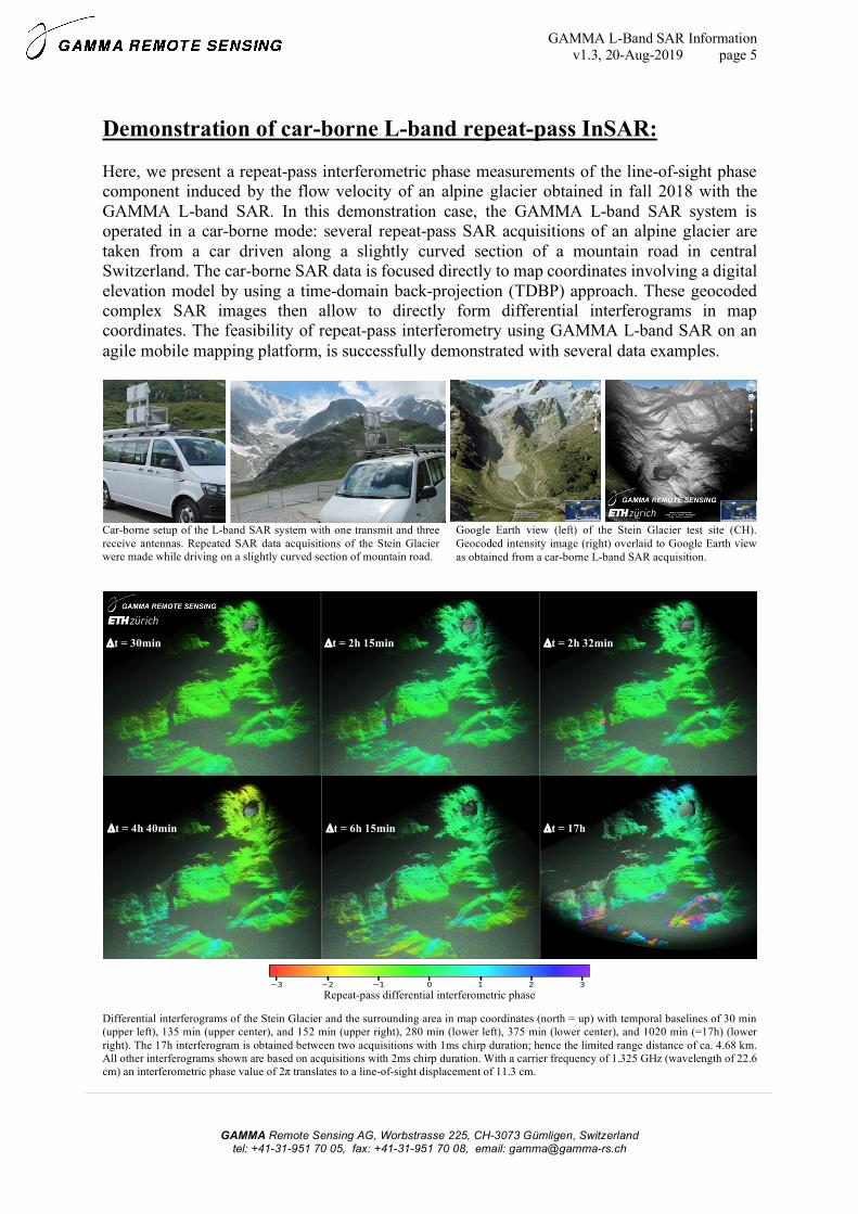
Demonstration of car-borne L-band repeat-pass InSAR:
Here, we present a repeat-pass interferometric phase measurements of the line-of-sight phase component induced by the flow velocity of an alpine glacier obtained in fall 2018 with the GAMMA L-band SAR. In this demonstration case, the GAMMA L-band SAR system is operated in a car-borne mode: several repeat-pass SAR acquisitions of an alpine glacier are taken from a car driven along a slightly curved section of a mountain road in central Switzerland. The car-borne SAR data is focused directly to map coordinates involving a digital elevation model by using a time-domain back-projection (TDBP) approach. These geocoded complex SAR images then allow to directly form differential interferograms in map coordinates. The feasibility of repeat-pass interferometry using GAMMA L-band SAR on an agile mobile mapping platform, is successfully demonstrated with several data examples.
Car-borne setup of the L-band SAR system with one transmit and three receive antennas. Repeated SAR data acquisitions of the Stein Glacier were made while driving on a slightly curved section of mountain road.
Google Earth view (left) of the Stein Glacier test site (CH). Geocoded intensity image (right) overlaid to Google Earth view as obtained from a car-borne L-band SAR acquisition.
Differential interferograms of the Stein Glacier and the surrounding area in map coordinates (north = up) with temporal baselines of 30 min (upper left), 135 min (upper center), and 152 min (upper right), 280 min (lower left), 375 min (lower center), and 1020 min (=17h) (lower right). The 17h interferogram is obtained between two acquisitions with 1ms chirp duration; hence the limited range distance of ca. 4.68 km. All other interferograms shown are based on acquisitions with 2ms chirp duration. With a carrier frequency of 1.325 GHz (wavelength of 22.6 cm) an interferometric phase value of 2π translates to a line-of-sight displacement of 11.3 cm.
Repeat-pass differential interferometric phase
Dt = 30min Dt = 2h 15min Dt = 2h 32min
Dt = 17h Dt = 6h 15min Dt = 4h 40min
GAMMA L-Band SAR Information v1.3, 20-Aug-2019 page 6
GAMMA Remote Sensing AG, Worbstrasse 225, CH-3073 Gümligen, Switzerland tel: +41-31-951 70 05, fax: +41-31-951 70 08, email: [email protected]
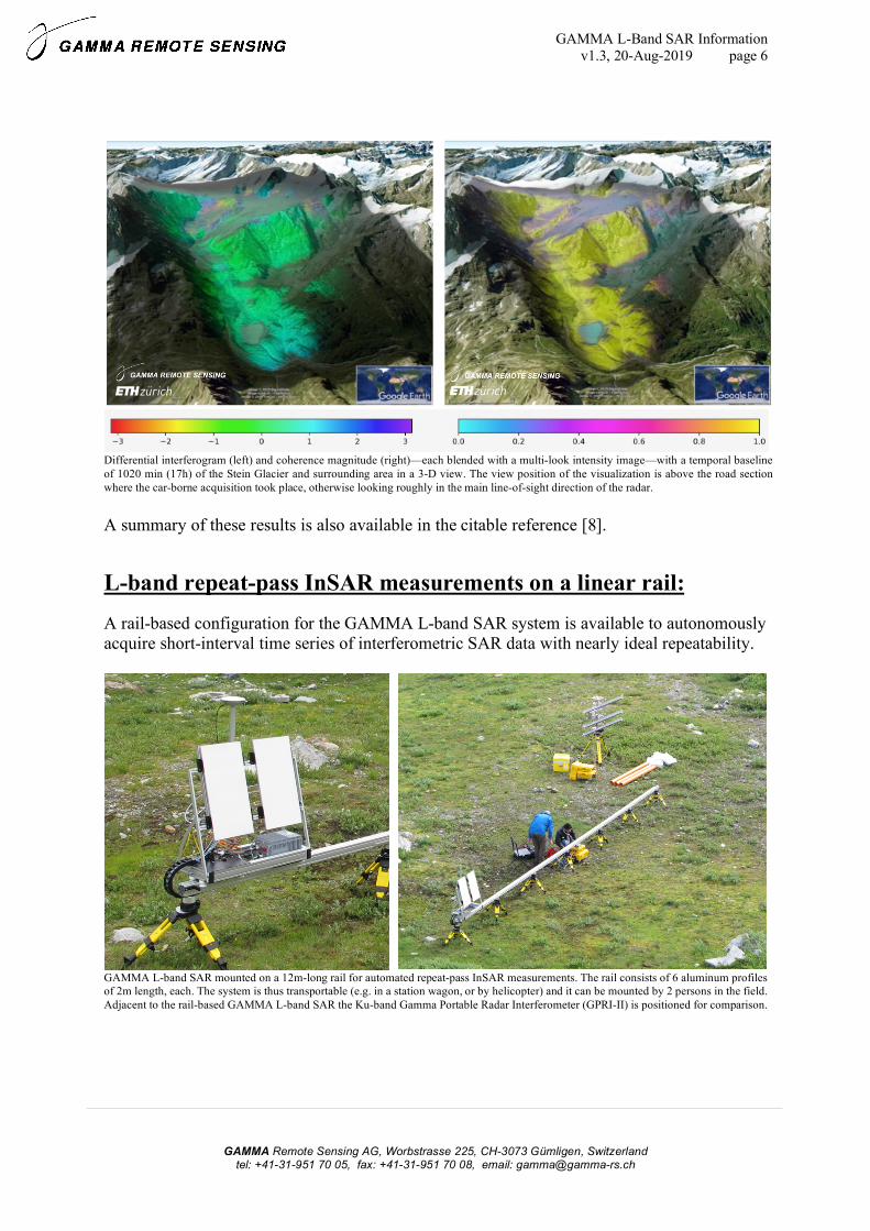
Differential interferogram (left) and coherence magnitude (right)—each blended with a multi-look intensity image—with a temporal baseline of 1020 min (17h) of the Stein Glacier and surrounding area in a 3-D view. The view position of the visualization is above the road section where the car-borne acquisition took place, otherwise looking roughly in the main line-of-sight direction of the radar.
A summary of these results is also available in the citable reference [8].
L-band repeat-pass InSAR measurements on a linear rail: A rail-based configuration for the GAMMA L-band SAR system is available to autonomously acquire short-interval time series of interferometric SAR data with nearly ideal repeatability.
GAMMA L-band SAR mounted on a 12m-long rail for automated repeat-pass InSAR measurements. The rail consists of 6 aluminum profiles of 2m length, each. The system is thus transportable (e.g. in a station wagon, or by helicopter) and it can be mounted by 2 persons in the field. Adjacent to the rail-based GAMMA L-band SAR the Ku-band Gamma Portable Radar Interferometer (GPRI-II) is positioned for comparison.

GAMMA L-Band SAR Information v1.3, 20-Aug-2019 page 7
GAMMA Remote Sensing AG, Worbstrasse 225, CH-3073 Gümligen, Switzerland tel: +41-31-951 70 05, fax: +41-31-951 70 08, email: [email protected]
References:
[1] Frey, O., Werner, C. L., and Wegmuller, U.: “GPU-based parallelized time-domain back-projection processing for agile SAR platforms,” in Proc. IEEE Int. Geosci. Remote Sens. Symp., July 2014, pp. 1132–1135. [Online]. Available: https://ieeexplore.ieee.org/document/6946629
[2] Frey, O., Magnard, C., Rüegg, M., and Meier, E.: “Focusing of airborne synthetic aperture radar data from highly nonlinear flight tracks,” IEEE Trans. Geosci. Remote Sens., vol. 47, no. 6, pp. 1844–1858, June 2009. [Online]. Available: https://ieeexplore.ieee.org/document/4812049
[3] Frey, O., Meier, E., and Nüesch, D.: “Processing SAR data of rugged terrain by time-domain back-projection,” in SPIE Vol. 5980: SAR Image Analysis, Modeling, and Techniques X, 2005. DOI: https://doi.org/10.1117/12.627647
[4] Ribalta, A.: “Time-domain reconstruction algorithms for FMCW- SAR,” IEEE Geoscience and Remote Sensing Letters, vol. 8, no. 3, pp. 396–400, May 2011.
[5] Stringham, C. and Long, D. G.: “GPU processing for UAS-based LFM-CW stripmap SAR,” Photogrammetric Engineering & Remote Sensing, vol. 80, no. 12, pp. 1107–1115, 2014.
[6] Frey, O., Werner, C. L., Wegmuller, U., Wiesmann, A., Henke, D., and Magnard, C.: “A car-borne SAR and InSAR experiment,” in Proc. IEEE Int. Geosci. Remote Sens. Symp., 2013, pp. 93–96 [Online]. Available: https://ieeexplore.ieee.org/document/6721100 [7] Frey, O., Werner, C. L., Hajnsek, I., and Coscione, R.: “A car-borne SAR system for interferometric measurements: development status and system enhancements,” in Proc. IEEE Int. Geosci. Remote Sens. Symp., 2018, pp. 6508–6511. [Online]. Available: https://ieeexplore.ieee.org/document/8518840 [8] Frey, O., Werner, C. L., Coscione, R.: “Car-borne and UAV-borne mobile mapping of surface displacements with a compact repeat-pass interferometric SAR system at L-band,” Proc. IEEE Int. Geosci. Remote Sens. Symp., July/Aug 2019, pp. 274-277.
GAMMA L-Band SAR Information v1.3, 20-Aug-2019 page 8
GAMMA Remote Sensing AG, Worbstrasse 225, CH-3073 Gümligen, Switzerland tel: +41-31-951 70 05, fax: +41-31-951 70 08, email: [email protected]
Further information:
Additional information is available at http://www.gamma-rs.ch.
To obtain a price list or a specific offer please contact: [email protected]
References:
There exist a number of technical reports, conference and journal papers that document a specific element or functionality of the GAMMA L-band SAR and the TDBP SAR processing approach. A list of these documents with links to download the individual pdf files is available at: https://www.gamma-rs.ch/uploads/media/GAMMA_L_Band_SAR_References.pdf.