formation and destruction of pastoral and irrigation landscapes on
TRANSCRIPT

Formation and Destruction of Pastoraland Irrigation Landscapes on the
Mughan Steppe, North-Western IranThe Harvard community has made this
article openly available. Please share howthis access benefits you. Your story matters
Citation Alizadeh, Karim and Jason A. Ur. 2007. Formation and destructionof pastoral irrigation landscapes on the Mughan Steppe, north-western Iran. Antiquity 81(311): 148–160.
Published Version http://antiquity.ac.uk/ant/081/ant0810148.htm
Citable link http://nrs.harvard.edu/urn-3:HUL.InstRepos:4269028
Terms of Use This article was downloaded from Harvard University’s DASHrepository, and is made available under the terms and conditionsapplicable to Other Posted Material, as set forth at http://nrs.harvard.edu/urn-3:HUL.InstRepos:dash.current.terms-of-use#LAA

Formation and destruction of pastoraland irrigation landscapes on theMughan Steppe, north-western IranKarim Alizadeh1 & Jason A. Ur2
CORONA satellite photography taken in the 1960s continues to reveal buried ancient landscapesand sequences of landscapes – some of them no longer visible. In this new survey of the MughanSteppe in north-western Iran, the authors map a ‘signature landscape’ belonging to Sasanianirrigators, and discover that the traces of the nomadic peoples that succeeded them also show upon CORONA – in the form of scoops for animal shelters. The remains of these highly significantpastoralists have been virtually obliterated since the CORONA surveys by a new wave of irrigationfarming. Such archaeological evaluation of a landscape has grave implications for the heritage ofgrassland nomads and the appreciation of their impact on history.
Keywords: Sasanian, Iran, aerial survey, archaeological formation process, CORONA satellitesurvey, landscape evaluation
IntroductionThe palimpsest model of archaeological landscapes describes how natural and culturalprocesses will damage or erase some early features but allow others to survive to somedegree (Crawford 1953: 51). In a brief statement, Christopher Taylor observed that inthe case of Britain, these processes are not random but patterned into what he called‘Zones of Survival and Zones of Destruction’, roughly divided into the preserved uplands,where post-Saxon settlement and cultivation were uncommon, and the heavily damagedlowlands, which had been the locus of most medieval and later activities (Taylor 1972).Tom Williamson expanded Taylor’s concept, demonstrating that the ‘complex kaleidoscope ofpatterned creation and structured destruction’ could be related to soil conditions and potentialagricultural productivity within regionally specific historical trajectories (Williamson 1998:6). The pattern of Roman sites in marginal chalk downland and upland moors tells us lessabout settlement and land use in the Roman period than it does about the archaeologicalconsequences of later agricultural expansion.
The palimpsest model is particularly appropriate in the Near East, where settlement histor-ies extending back eight millennia or more make the unravelling of the surviving features animposing task. In an authoritative synthesis of landscape processes and histories throughout
1 Iranian Center for Archaeological Research, Baharestan Sq-Ekbatan Ave., Emarate Masoudieh, 11416, Tehran,Iran (Email: [email protected])
2 Department of Anthropology, Peabody Museum, Harvard University, 11 Divinity Ave., Cambridge, MA 02138,USA (Email: [email protected])
Received: 29 July 2005; Accepted 27 February 2006; Revised: 4 March 2006
antiquity 81 (2007): 148–160
148

Met
hod
Karim Alizadeh & Jason A. Ur
the region, T.J. Wilkinson (2003) has extended the work of Taylor and Williamson.Wilkinson’s landscape taphonomy concept (2003: 41-3) describes the processes by whichancient landscapes are erased, recycled, or retained; in particular, he demonstrates thatpatterns of survival and destruction can be generally associated with certain environmentsand ‘signature landscapes’. Features in desert and highland environments, for example, areless likely to be effaced because the marginality of these regions does not encourage humanresettlement. On the other hand, due to their inherent agricultural productivity, lowlandsare likely to be the focus of long-term settlement which will remove earlier landscapes.Wilkinson’s ‘signature landscapes’ concept (Wilkinson 2003: 11, 214-15) emphasises thehuman aspect of landscape taphonomy, referring to general classes of cultural landscapes thatwere so profoundly inscribed, through either large-scale intentional action or via long-termpersistence, that they structured subsequent landscapes and were more likely to remainvisible to the present.
Signature landscapes are the most likely to survive and to continue to structure thelandscape, but they also remove more lightly inscribed features. The signature landscapepar excellence for lowland areas of the Near East is composed of nucleated settlements andassociated irrigation canals. Irrigation is an intensive land use strategy designed to increase ag-ricultural yields and reduce risk, and is particularly associated with urban settlement patternsand high population densities (Wilkinson 2003: 71-2). At the opposite end of the continuumof land-use-intensity resides another classic Near Eastern pattern: pastoral nomadism. Thiseconomic adaptation stresses resilience over maximisation of yields and is successful underconditions of low population densities; it uses mobility as a response to economic adversity(Salzman 2004; Abdi 2003). The landscape history of the Near East is to a great extent thecyclical waning of one of these strategies and the corresponding waxing of the other.
Under the often antagonistic relationships between pastoral nomads and sedentaryagriculturalists, the former will have their phases of political dominance, but in the largersweep of landscape evolution, it is the remains of the latter that persevere. Nomad campsitesare notoriously difficult to identify (Cribb 1991); more often, what we know of themis derived from the written accounts of their sedentary neighbours, and these can reflectthe mistrust and prejudices that exist between farmers and pastoralists (Buccellati 1966).When the archaeological remains of nomadic groups can be found, the question of howrepresentative they are of the larger landscape is rarely resolvable.
This study will examine the taphonomic processes which result in the patterned creationand structured destruction of these two dramatically different landscape signatures onthe Mughan Steppe in Ardebil Province, north-western Iran, a region that has beensimultaneously blessed by a striking oscillation between these strategies and cursed bythe rapid increase in the pace of the most destructive taphonomic processes in recent times.Using historical CORONA satellite photography (see most recently Fowler 2004; Gheyleet al. 2004), field survey and the ethnohistoric record, we show how the expansion ofirrigation selectively removed some traces of pastoral nomads and left a pattern that couldeasily be misinterpreted. Rather than being a new phenomenon related to modern industrialsociety, we suggest that the removal of nomadic remains by the recent expansion of irrigationagriculture is only a technologically amplified version of a taphonomic process which existedin antiquity as well.
149

Pastoral and irrigation landscapes on the Mughan Steppe
Figure 1. The Mughan Steppe, north-western Iran.
The Mughan SteppeThe Mughan Steppe is a broad low plain along the south bank of the Aras (Araxes) river,toward the end of its course where it meets with the Kura and flows into the Caspian Sea(Figure 1). Since the delineation of the Russian-Iranian frontier in 1813, the south-westernthird of the steppe lies in the Islamic Republic of Iran; the majority is now part of theRepublic of Azerbaijan. The Aras floodplain today is heavily incised in some places: on itssouth bank, the steppe terrace stands some 15m above it. To the south of the steppe, theterrain rises to undulating highlands (occasionally reaching 700m) and ultimately to theSabalan mountain range near Ardebil (Tapper 1979: 23-7; Schweizer 1970). The soils ofthe steppe are well developed with good agricultural potential, as are several intermontaineplains near Ardebil and the basin of Sarab.
The influence of the Caspian Sea results in relatively mild winters, reaching a low of3!-5!C in January. Rainfall is seasonal, mostly falling in the late fall and early spring. Theaverage yearly rainfall is just under 300mm, which means that dry farming is possible ifbiennial fallow is practiced; however, it is risky and the various state-sponsored attempts inthe twentieth century were not considered successful (Schweizer 1974).
These climatic and geographic considerations make the steppe particularly well-suitedfor use as pasture, the dominant mode of land use for the last millennium. Because of itslocation close to water sources and within close migratory distance to upland pasture, thelarge grassy plain has served as winter pasture ground for Kurds, Ghuzz Turks, Mongolsand most recently the Shahsevan tribal confederation, about whom we are particularlyknowledgeable from the work of the anthropologist Richard Tapper (1979; 1997). In thelast century, the pendulum has swung toward the dominance of agriculture, in particular,
150

Met
hod
Karim Alizadeh & Jason A. Ur
a series of state-sponsored irrigation schemes (Schweizer 1970; 1974). The correspondingreduction in pasture, along with varying degrees of pressure from the Iranian government,has resulted in the almost complete settlement of the Shahsevan.
The Mughan Steppe Archaeological Project (MSAP) aims to investigate the processesby which land use on the plain oscillated between such poles of intensity. Archaeologicalwork began in 2004 with soundings at Ultan Qalasi, a fortified site on the Aras terrace edge(Alizadeh 2004). In January of 2005, an initial season of survey was undertaken, duringwhich we conducted low intensity reconnaissance throughout the steppe and targeted severaldiscrete zones for more intensive observation, including walking transects. Our intentionswere to develop a general understanding of the characteristics of the archaeological landscape,assess the extent of transformations by recent development, and to gain ground control forthe interpretation of the CORONA satellite photographs which serve as our primary meansof site and feature identification. This short season revealed the general outlines of widelyfluctuating land-use practices over several millennia and their taphonomic impacts, uponwhich we report here.
Irrigation on the Mughan SteppeThe earliest occupation of the region is as yet poorly understood, being composed of scattersof worn stone tools in the uplands. Sites of the Early Bronze and Iron Ages appear to beof the classic Near Eastern tepe (Persian) or tell (Arabic) morphology: nucleated mounds ofsuperimposed settlement debris, suggesting long-term continuous settlement or preferentialreoccupation, exemplified by the site of Nader Tepesi near Aslandouz (Mohammadi 2004).Several mounds show the distinct ceramics of the Kura-Araxes culture, which extendedacross a broad area of the northern fertile crescent (Sagona 1984). These sites are clusteredalong the edge of the Aras River terrace; thus far we have recovered little evidence for theuse at this time of the broader steppe to the south.
At present, the earliest coherent signature landscape in the Mughan Steppe can beattributed to the Sasanian period (AD 224-642). From their ancestral homeland in theFars region of southern Iran, this dynasty overthrew the Parthian rulers of Iran to form anempire stretching from Syria to the Indus (Frye 1983). In western historical sources, theyare best known as the greatest rivals of Rome and Byzantium (Dodgeon & Lieu 1991).Accounts by Arab historians (al-Tabari 1999) contain equal parts of historical informationand fanciful anecdotes. Unfortunately, contemporary Sasanian sources tend to be limited toshort inscriptions on seals and coins (Gyselen 2002) and a few longer texts on monuments(Huyse 1999).
Although broader syntheses are beginning to appear (Simpson 1996; 2000),archaeological studies have generally focused on two aspects of the Sasanian empire. Arthistorical topics have received much scholarly attention, especially rock reliefs, seals andmetalwork, much of the latter unprovenanced (Curtis et al. 1998). On the other hand,Sasanian settlement and state-sponsored irrigation projects in southern Iraq and south-western Iran have attracted the attention of archaeologists. Adams (1965) argued that theenormous Nahrawan canal exploited the entire flow of the Diyala River, a left bank tributaryof the Tigris at Baghdad. Building on Adams’ earlier work, surveys in Khuzistan and
151

Pastoral and irrigation landscapes on the Mughan Steppe
Figure 2. CORONA photographs of fortified settlement complexes of the Sasanian period. a. Ultan Qalasi (1110-1154DA065, 30 May 1970); b. Nadir Tepesi (1103-1057DF074, 5 May 1968); c. Qara Tavara (1103-1057DF074,5 May 1968); d. Qishlaq Qaravol (1110-1154DA065, 30 May 1970). All photographs courtesy of the USGS.
Deh Luran have demonstrated dense population and elaborate irrigation systems (Neely1974; Wenke 1989; Alizadeh et al. 2004). Tax revenue data recorded by later Islamic writersattest to the high productivity of these systems (Christensen 1993), and the combinedlandscape data shows an intensity of irrigation unrivalled in pre-modern times.
A similar agricultural landscape was created on the Mughan Steppe. The Sasaniansettlement system on the Mughan Steppe was dominated by a series of rectangular fortifiedsites, of which Ultan Qalasi (28ha) is the largest. The rectilinear fortified componentsotherwise range from 100 " 100m down to 30 " 30m. On the surface, they stand up to 5mhigh, with flat or slightly concave tops which give them a walled appearance on CORONAphotographs (Figure 2). In all cases extensive extramural settlement surrounded them; theirsignatures on CORONA photographs have the mottled appearance of low undulatingtopography, known to be typical of late settlement elsewhere in the Near East (Ur 2003).
152

Met
hod
Karim Alizadeh & Jason A. Ur
Figure 3. Sasanian settlements and canals along the foothill edge. Contour intervals at 10m. See also Figure 2b-d.
However, levelling and irrigation over the last 30 years have removed most of the ancienttopography; all that remains are sherd scatters.
Figure 4. Irrigation networks on the Mughan Steppe.CORONA 1103-1057DF074 (5 May 1968) courtesy ofthe USGS.
These sites were positioned at regularintervals along the edge of the Aras Riverterrace or at the interface of the steppe and thefoothills to the south. This distribution wasnot coincidental; in all cases they are foundin close association with large feeder canals.Those canals associated with the Aras terracesites are preserved in small segments, themajority having been removed by twentieth-century agricultural projects. The sites at thefoothill edge, however, are strung along asubstantial canal which is in many places stillin use as a drain; segments no longer visibleon the ground can be reconstructed fromthe satellite photographs (Figure 3). Severalof these settlement complexes must haveoverseen major weirs which fed distributarycanals, which in turn must have fed elaboratenetworks of small canals. The latter arepreserved on CORONA photographs butentirely erased on the ground (Figure 4).
Although our research is at an early stage, itis tempting to equate this type of settlement
153

Pastoral and irrigation landscapes on the Mughan Steppe
complex with the Persian dastkart. The term originally described a small household and itsassociated land, but by the fifth century AD, it signified a rural estate, including a residence(often fortified), various outbuildings and irrigation infrastructure as well as the land itcultivated (Pigulevskaja 1963: 151-3). The term could apply at a number of scales, fromthe estates of lesser nobles to the rural domain of the Sasanian ruler. The relatively modestfortified rural complexes on the Mughan Steppe might have been the domain of dehqans,members of a class of landed minor nobles that emerged from the land reforms of the lateSasanian king, Khusrau I in the sixth century AD (Tafazzoli 2000: 38-48). If these werenon-local nobles granted land by the king, they may have been part of a strategy to exploitunderused agricultural land while solidifying the Persian presence in a non-Persian part ofthe empire. At the same time, these settlements would have served as an additional line ofdefence against nomadic intrusions via the Caspian littoral, a region historically susceptibleto such invasions from north of the Caucasus mountains (Frye 1977).
Mughan as a pastoral zoneAt some point after the seventh century AD, most of the elaborate settlement system wasabandoned and its irrigation infrastructure went out of use. The chronology of this collapseis unclear; certainly the settlement at Ultan Qalasi (ancient Warthan) remained a functioningurban centre into the tenth century (Le Strange 1905: 175-6), and the intensively surveyedsample area east of Aslandouz suggests that a few small villages may have clung to theterrace edge throughout the Islamic period. It is possible that abandonment coincided withthe Islamic conquest and the collapse of the Sasanian state in the mid-seventh century;the absence of Islamic sherds on the fortified settlements along the canals at the southernfoothills appears to support this possibility. The irrigation system had certainly collapsed bythe late ninth century, however, when the traveller Abu Dulaf noted that ‘In this plain thereare 5000 villages or more, all in ruins, although their walls and buildings stand upright withoutdecay in view of the goodness of the soil’ (Abu Dulaf 1955: 36). Mughan was the domain ofKurdish and, starting in the eleventh century, Ghuzz Turkish pastoral nomads prior to thearrival in the thirteenth century of the Mongol Ilkhans. The latter used Mughan as winterquarters (Smith 1999), as did Timur (Tamerlane) a century later.
The various Kurdish and Turkish groups coalesced into the Shahsevan tribal confederacyearly in the eighteenth century (see Tapper 1997 for a detailed history). Shahsevantribes spent the summers on the slopes of Mount Sabalan near Ardebil and undertooka short migration to their winter grazing grounds on the Mughan Steppe (Tapper 1979;Schweizer 1970). In 1870, a Russian observer estimated that the tribes included over 12 000households, with 30 000 horses, 30 000 camels and almost 2 000 000 sheep (cited in Tapper1997: 175).
The remains of many Shahsevan nomadic campsites survive today in certain parts ofthe steppe. In the 1960s, the Shahsevan wintered in camps of 10-15 closely relatedhouseholds, although in earlier times these camps had been much larger. The Shahsevan tent(Op’t Land 1966) is of the rounded Central Asian type and leaves little trace when packedup for migration. However, the Mughan winter can be very cold, so long and narrow semi-subterranean shelters were constructed for the animals (Schweizer 1970: 128; Tapper 1979:
154

Met
hod
Karim Alizadeh & Jason A. Ur
Figure 5. Abandoned Shahsevan campsites in the Mughan uplands. Light lines represent modern tracks. CORONA 1110-1057DA111 (24 May 1970) courtesy of the USGS. Inset: GPS-based field plan of Site 40.
85-86). The abandoned campsites visited by the survey featured little in the way of surfaceartefacts, but the remains of the animal shelters, in the form of shallow depressions borderedby low spoil heaps (backdirt piles), were easily recognisable from the ground and especiallyfrom a vertical perspective.
At the time the CORONA photographs used in this study were taken (May 1968 & May1970), the spoil heaps had neither eroded nor been recolonised by vegetation; as a result, theyare highly reflective and appear distinctly lighter than the surrounding terrain (Figure 5).In the case of some of the larger animal shelters, the depressed centre had collected moistureand was hosting denser growth; these footings appear as light ovals. Although highly variable,these excavated shelters were arranged in a circular pattern, often with open space to oneside.
It became clear that despite their ubiquity across the steppe in historical CORONAphotographs, today campsites survive disproportionately in the uplands. Our upland surveywas limited to two sample areas in our first season, because our primary goal was to gainground control for these distinctive signatures on the imagery. Armed with such interpretiveability, we have been able to map the distribution of campsites well beyond our limited areasof ground survey. We arbitrarily selected a sample area 10km wide and 26km long, extending
155

Pastoral and irrigation landscapes on the Mughan Steppe
Figure 6. Nomad campsites derived from CORONA photographs. a. Location of 267km2 sample area; b. distribution ofcampsites. For elevation profile along the south-west edge of the sample area, see Figure 7.
perpendicularly from the Aras (Figure 6). Within this 267km2 area, 261 campsites could beidentified for a density of 0.98 campsites per square kilometre. However, the distribution isuneven; the majority of the campsites appear to cling to the edges of the larger drainages,probably for ease of access to water from wells sunk into their bottoms.
Given that our observations were limited to the low density surface material, thechronological placement of the campsites remains unclear. It is certain that the distributionin Figure 6 represents many non-contemporary camps. However, the late history of theShahsevan offers some hints toward a general dating of our campsite distribution. TheShahsevan’s pastoral economy suffered from the closure of the Russian frontier in 1884,which cost them access to almost two-thirds of their former grazing grounds (Tapper 1983;Tapper 1997: Maps 6-7). Prior to this time, the best grazing was along the Aras and Kurriver banks to the north-east; the central part of the plain and the foothills to the southwere considered inferior grazing. With the border closure, some 2 000 000 animals hadto be accommodated on a third of the former pasture. The new situation necessitated aradical transformation of the system of pasture rights, including a more intensive use of theuplands. Although the most weathered campsites might substantially predate the Shahsevan,we suspect that the majority of the abandoned campsites post-date the 1884 border closure.Still, they are not recent: local villagers, the descendants of former nomads themselves, told
156
Met
hod
Karim Alizadeh & Jason A. Ur
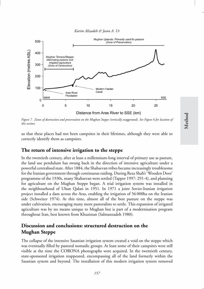
Figure 7. Zones of destruction and preservation on the Mughan Steppe (vertically exaggerated). See Figure 6 for location ofthis section.
us that these places had not been campsites in their lifetimes, although they were able tocorrectly identify them as campsites.
The return of intensive irrigation to the steppeIn the twentieth century, after at least a millennium-long interval of primary use as pasture,the land use pendulum has swung back in the direction of intensive agriculture under apowerful centralised state. After 1884, the Shahsevan tribes became increasingly troublesomefor the Iranian government through continuous raiding. During Reza Shah’s ‘Wooden Door’programme of the 1930s, many Shahsevan were settled (Tapper 1997: 291-4), and planningfor agriculture on the Mughan Steppe began. A trial irrigation system was installed inthe neighbourhood of Ultan Qalasi in 1951. In 1971 a joint Soviet-Iranian irrigationproject installed a dam across the Aras, enabling the irrigation of 56 000ha on the Iranianside (Schweizer 1974). At this time, almost all of the best pasture on the steppe wasunder cultivation, encouraging many more pastoralists to settle. This expansion of irrigatedagriculture was by no means unique to Mughan but is part of a modernisation programthroughout Iran, best known from Khuzistan (Salmanzadeh 1980).
Discussion and conclusions: structured destruction on theMughan Steppe
The collapse of the intensive Sasanian irrigation system created a void on the steppe whichwas eventually filled by pastoral nomadic groups. At least some of their campsites were stillvisible at the time the CORONA photographs were acquired. In the twentieth century,state-sponsored irrigation reappeared, encompassing all of the land formerly within theSasanian system and beyond. The installation of this modern irrigation system removed
157

Pastoral and irrigation landscapes on the Mughan Steppe
almost all traces of the nomadic pastoral occupation. The agricultural development of theMughan Steppe has thus resulted in a non-random removal of earlier landscapes that, if notrecognised, could mislead any interpretation of the surviving remains.
Using geo-referenced CORONA photographs and GPS receivers as guides, we visitedthe former locations of several campsites within the irrigated zone. None preserved any ofthe microtopography which was so visible in the highlands. The surface assemblage at eachof these ploughed campsites was limited to two or three sherds. Without these historicalsatellite photographs, such densities would require intensive field walking transects at verysmall intervals to be detected, and even then, their correct interpretation as campsites wouldbe difficult.
A ground-based survey, without the benefit of the historical imagery, would thus producea deceptive pattern: dense pastoral occupation of the uplands and apparent avoidance of, orexclusion from, the lower parts of the steppe. Our study of CORONA photographs showsthat this was hardly the case. The long-term density of campsites in the uplands above theirrigated zone (1.02 per km2) was nearly identical to the density on the now-irrigated lowersteppe (0.86 per km2). Qualitative ethnographic and historical data confirm this assessment(Tapper 1979; 1997).
On the Mughan Steppe, fortuitously timed remote sensing data allow us to demonstratethe structured destruction which the Taylor-Williamson taphonomic model supposed for theEnglish landscape. Although presently we can only document the most recent instance of thisprocess, we strongly suspect that similar processes may have accompanied earlier agriculturalexpansion events as well. In our brief first season, we have found some tantalising evidenceof pre-Sasanian settlement in the central part of the steppe which was heavily irrigated underthe Sasanians and is once more today. It is likely that they were part of much more elaboratelandscapes which were transformed already by the Sasanian irrigation; this would explain whyCORONA photographs of the steppe show impressively coherent traces of a large irrigationsystem but none of the other landscape features known from CORONA elsewhere (Ur 2003;2005). Just as the remains of Shahsevan camps have vanished under modern irrigation, thecampsites of earlier nomadic peoples (for example, the Trialeti; Rubinson 1977) may havebeen erased by Sasanian irrigation. These are issues to be investigated in our future fieldseasons.
Although broad landscape transformations may not be unique to the modern era,mechanised agricultural and earthmoving technologies now allow their scale to exceedany earlier transformations. We have focused on the impact on the relatively ephemeralremains of nomadic campsites, but such technologies permit the transformation of elementsof Wilkinson’s more robust signature landscapes as well. In Mughan, for example, twentieth-century development has not only removed campsites but also substantial canals andmounded settlements. In some cases, all that survives of impressive ancient landscapesis what has been captured by CORONA and aerial photography.
AcknowledgementsThe 2005 Mughan Steppe Archaeological Project gratefully acknowledges the encouragement and support ofDr Massoud Azarnoush, director of the Iranian Center for Archaeological Research; Mr K. Hadjizadeh, directorof the Ardebil branch of the Iranian Cultural Heritage and Tourism Organization; and Mr M. Mohammadzadeh,
158

Met
hod
Karim Alizadeh & Jason A. Ur
deputy governor of Parsabad. Our team members also included Mr Mohammad Feizkhah, Mr Mir RouhollahMohammadi, Mr Mohammad Reza Ghadri and Mr Mir Ne’mat Behboudi. GIS research assistance was providedby Christopher Yudelson, Stony Brook University. This text benefited from critical comments by Abbas Alizadeh,St John Simpson, Richard Tapper and two anonymous referees; the authors are solely responsible for anyremaining shortcomings.
ReferencesAbdi, K. 2003. The Early Development of Pastoralism
in the Central Zagros Mountains. Journal of WorldPrehistory 17: 395-448.
Abu Dulaf. 1955. Travels in Iran (circa AD 950).Translated by V. Minorsky. Cairo: Cairo UniversityPress.
Adams, R.M. 1965. Land Behind Baghdad. Chicago:University of Chicago Press.
Al-Tabari. 1999. The Sasanids, the Byzantines, theLakhmids, and Yemen. Translated by C.E. Bosworth.Albany: State University of New York Press.
Alizadeh, A., N. Kouchoukos, T.J. Wilkinson,A.M. Bauer & M. Mashkour. 2004.Human-Environment Interactions on the UpperKhuzestan Plains, Southwest Iran: RecentInvestigations. Paleorient 30: 69-88.
Alizadeh, K. 2004. First Preliminary Report ofExcavations in Ultan Qalasi, Mughan Steppe, 1382.Unpublished report, Iranian Center forArchaeological Research (in Persian).
Buccellati, G. 1966. The Amorites of the Ur III Period.Naples: Istituto Orientale di Napoli.
Christensen, P. 1993. The Decline of Iranshahr:Irrigation and Environments in the History of theMiddle East, 500 BC to AD 1500. Copenhagen:Museum Tusculanum Press.
Crawford, O.G.S. 1953. Archaeology in the Field.London: Phoenix House Ltd.
Cribb, R. 1991. Nomads in Archaeology. Cambridge:Cambridge University Press.
Curtis, V.S., R. Hillenbrand & J.M. Rogers (ed.).1998. The Art and Archaeology of Ancient Persia:New Light on the Parthian and SasanianEmpires. London: I.B. Taurus.
Dodgeon, M.H. & S.N.C. Lieu. 1991. The RomanEastern Frontier and the Persian Wars AD 226-363:A Documentary History. London & New York:Routledge.
Fowler, M.J.F. 2004. Archaeology through theKeyhole: The Serendipity Effect of AerialReconnaissance Revisited. Interdisciplinary ScienceReviews 29: 118-34.
Frye, R.N. 1977. The Sasanian System of Walls forDefense, in M. Rosen-Ayalon (ed.) Studies inMemory of Gaston Wiet: 7-15. Jerusalem: HebrewUniversity.
–1983. The Political History of Iran under theSasanians, in E. Yarshater (ed.) The CambridgeHistory of Iran, Vol. 3(1): The Seleucid, Parthianand Sasanian Periods: 116-80. Cambridge:Cambridge University Press.
Gheyle, W., R. Trommelmans, J. Bourgeois,R. Goossens, I. Bourgeois, A. De Wulf &T. Willems. 2004. Evaluating CORONA: a casestudy in the Altai Republic (South Siberia).Antiquity 78: 391-403.
Gyselen, R. 2002. Nouveaux materiaux pour lageographie historique de l’empire sassanide: sceauxadministratifs de la collection Ahmad Saeedi. Paris:Association pour l’avancement des etudesiraniennes.
Huyse, P. 1999. Die dreisprachige Inschrift Sabuhrs I. ander Ka’ba-i Zardust (SKZ). London: CorpusInscriptionum Iranicarum.
Le Strange, G. 1905. The Lands of the EasternCaliphate: Mesopotamia, Persia, and Central Asiafrom the Moslem Conquest to the Time of Timur.Cambridge: Cambridge University Press.
Mohammadi, M.R. 2004. Parthian and SassanidPeriods in Mughan Steppe: Based on Nader Tepe(Nadir Tepesi), Aslandouz. Unpublished MA thesis,University of Tehran (in Persian).
Neely, J.A. 1974. Sassanian and Early IslamicWater-Control and Irrigation Systems on the DehLuran Plain, Iran, in T.E. Downing & M. Gibson(ed.) Irrigation’s Impact on Society: 21-42. Tucson:University of Arizona.
Op’t Land, C. 1966. The Admirable Tents of the ShahSevan. Internationales Archiv fur Ethnographie 50:237-43.
Pigulevskaja, N. 1963. Les villes de l’etat Iranien auxepoques parthe et sassanide. Paris: Mouton.
Rubinson, K.S. 1977. The Chronology of the MiddleBronze Age Kurgans at Trialeti, in L.D. Levine &T.C. Young (ed.) Mountains and Lowlands: Essays inthe Archaeology of Greater Mesopotamia: 235-49.Malibu: Undena.
Sagona, A.G. 1984. The Caucasian Region in the EarlyBronze Age. BAR International Series 214. Oxford:Archaeopress.
Salmanzadeh, C. 1980. Agricultural Change and RuralSociety in Southern Iran. Cambridge: Middle East &North African Studies.
159

Pastoral and irrigation landscapes on the Mughan Steppe
Salzman, P.C. 2004. Pastoralists: Equality, Hierarchy,and the State. Boulder: Westview Press.
Schweizer, G. 1970. Nordost-Azerbaidschan undShah Sevan-Nomaden, in E. Ehlers, F. Scholz &G. Schweizer (ed.) Strukturwandlungen imnomadisch-bauerlichen Lebensraum des Orients:81-148. Wiesbaden: Franz Steiner Verlag.
–1974. The Aras-Moghan Development Project inNorthwest Iran and the Problem of NomadSettlement. Applied Sciences and Development 4:134-48.
Simpson, St.J. 1996. From Tekrit to the Jaghjagh:Sasanian Sites, Settlement Patterns and MaterialCulture in Northern Mesopotamia, in K. Bartl &S.R. Hauser (ed.) Continuity and Change inNorthern Mesopotamia from the Hellenistic to theEarly Islamic Period : 87-126. Berlin: DietrichReimer.
–2000. Mesopotamia in the Sasanian Period:Settlement Patterns, Arts and Crafts, in J. Curtis(ed.) Mesopotamia and Iran in the Parthian andSasanian Periods: Rejection and Revival c. 238BC-AD 642: 57-80. London: British Museum.
Smith, J.M. 1999. Mongol Nomadism and MiddleEastern Geography: Qishlaqs and Tumens, in R.Amitai-Preiss & D.O. Morgan (ed.) The MongolEmpire and its Legacy: 39-56. Leiden: Brill.
Tafazzoli, A. 2000. Sasanian Society. New York:Bibliotheca Persica Press.
Tapper, R. 1979. Pasture and Politics: Economics,Conflict and Ritual among Shahsevan Nomads ofNorthwestern Iran. London & New York: AcademicPress.
–1983. Nomads and Commissars in the MughanSteppe: The Shahsevan Tribes in the Great Game,in R. Tapper (ed.) The Conflict of Tribe and State inIran and Afghanistan: 401-35. New York:St. Martin’s Press.
–1997. Frontier Nomads of Iran. Cambridge:Cambridge University Press.
Taylor, C.C. 1972. The Study of Settlement Patternsin Pre-Saxon Britain, in P.J. Ucko, R. Tringham &G.W. Dimbleby (ed.) Man, Settlement andUrbanism: 109-13. London: Duckworth.
Ur, J.A. 2003. CORONA satellite photography andancient road networks: a northern Mesopotamiancase study. Antiquity 77: 102-15.
–2005. Sennacherib’s Northern Assyrian Canals:New Insights from Satellite Imagery and AerialPhotography. Iraq 67: 317-45.
Wenke, R.J. 1989. Western Iran in the Partho-SasanianPeriod: The Imperial Transformation, in F. Hole(ed.) The Archaeology of Western Iran: 251-81.Washington DC & London: SmithsonianInstitution Press.
Wilkinson, T.J. 2003. Archaeological Landscapes of theNear East. Tucson: University of Arizona Press.
Williamson, T. 1998. Questions of Preservation andDestruction, in P. Everson & T. Williamson (ed.)The Archaeology of Landscape: Studies Presented toChristopher Taylor: 1-24. Manchester & New York:Manchester University Press.
160