foreshore plan illustrations - regional district of ... illustrations.pdfforeshore plan...
TRANSCRIPT
Foreshore Plan Illustrations
1. INTRODUCTION
Okanagan Lake is the most significant natural feature in the Regional District of Central Okanagan (RDCO). The lake attracted native people to the valley, and their descendants stayed and used the resources in the lake, streams, and adjacent lands for millennia. Likewise, the first white settlement grew on the shores of Okanagan Lake, and today the lake continues to be a dominant attraction for people choosing to live in the region. Since the 1960s, population growth within the RDCO has been substantial. From 1966 to 2006, the area population grew from 34,000 to 170,000 (BC Stats) with no abatement in sight. The region’s rapid growth is responsible for an increase and diversification of activities that impact Okanagan Lake. The lake is used for water supply, treated wastewater disposal, recreational activities (including swimming, fishing, and water sports), and transportation (by water and air). A wide variety of private and public residential, commercial, and industrial activities also occur along the foreshore area. The current uses of the lake foreshore differ considerably from traditional uses and are associated with increased noise, pollution, and traffic. The many activities that take place in, on, and near the lake limit its ability to maintain natural ecosystem processes and sustain the local flora and fauna. In the spring of 1986, recognizing the growing threat to water quality and the increasing impact on public use and access to Okanagan Lake, the Regional Board, along with other local government organizations with land abutting Okanagan Lake, recommended the adoption of foreshore plans to address the issues associated with development and recreational use of the shoreline. As a result of this recommendation, the RDCO prepared a Foreshore Plan for the Central Okanagan, which was completed in the summer of 1990 (Woodroffe Consulting). The Regional District of the Central Okanagan is currently in the process of updating its Foreshore Plan. In accordance with the Foreshore Plan update, the following is an overview of the ecosystems present along the foreshore of Okanagan Lake and also illustrates some best practices for sustainable foreshore development.
Regional District of the Central Okanagan – Foreshore Plan Illustrations Page 2 of 16
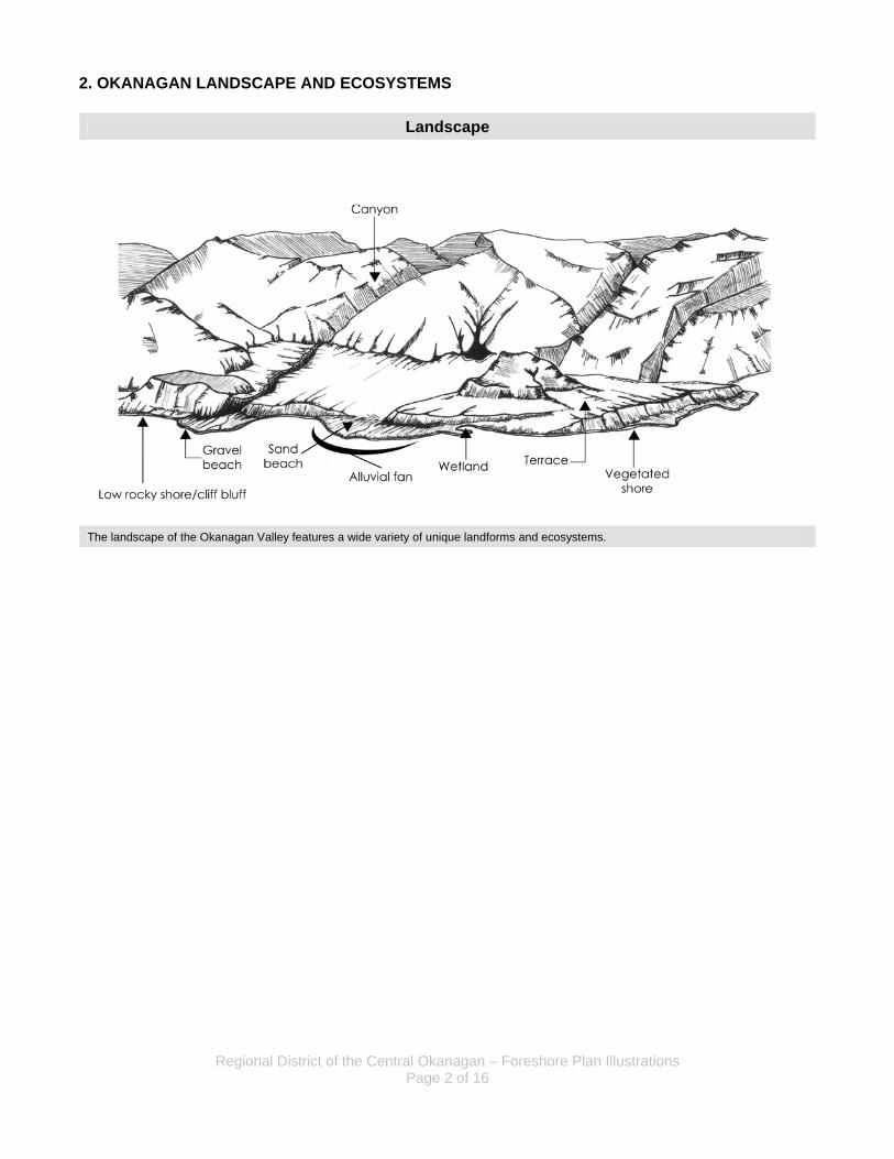
2. OKANAGAN LANDSCAPE AND ECOSYSTEMS
Landscape
The landscape of the Okanagan Valley features a wide variety of unique landforms and ecosystems.
Regional District of the Central Okanagan – Foreshore Plan Illustrations Page 3 of 16
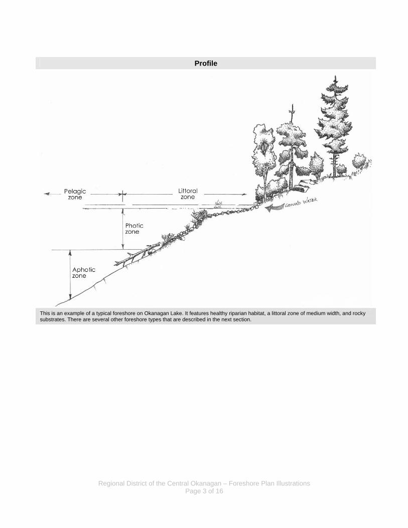
Profile
This is an example of a typical foreshore on Okanagan Lake. It features healthy riparian habitat, a littoral zone of medium width, and rocky substrates. There are several other foreshore types that are described in the next section.
Regional District of the Central Okanagan – Foreshore Plan Illustrations Page 4 of 16
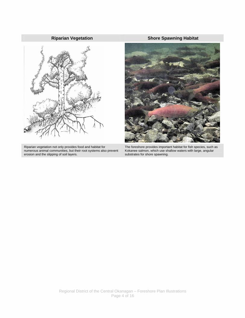
Riparian Vegetation Shore Spawning Habitat
Riparian vegetation not only provides food and habitat for numerous animal communities, but their root systems also prevent erosion and the slipping of soil layers.
The foreshore provides important habitat for fish species, such as Kokanee salmon, which use shallow waters with large, angular substrates for shore spawning.
Regional District of the Central Okanagan – Foreshore Plan Illustrations Page 5 of 16
3. SHORE TYPES
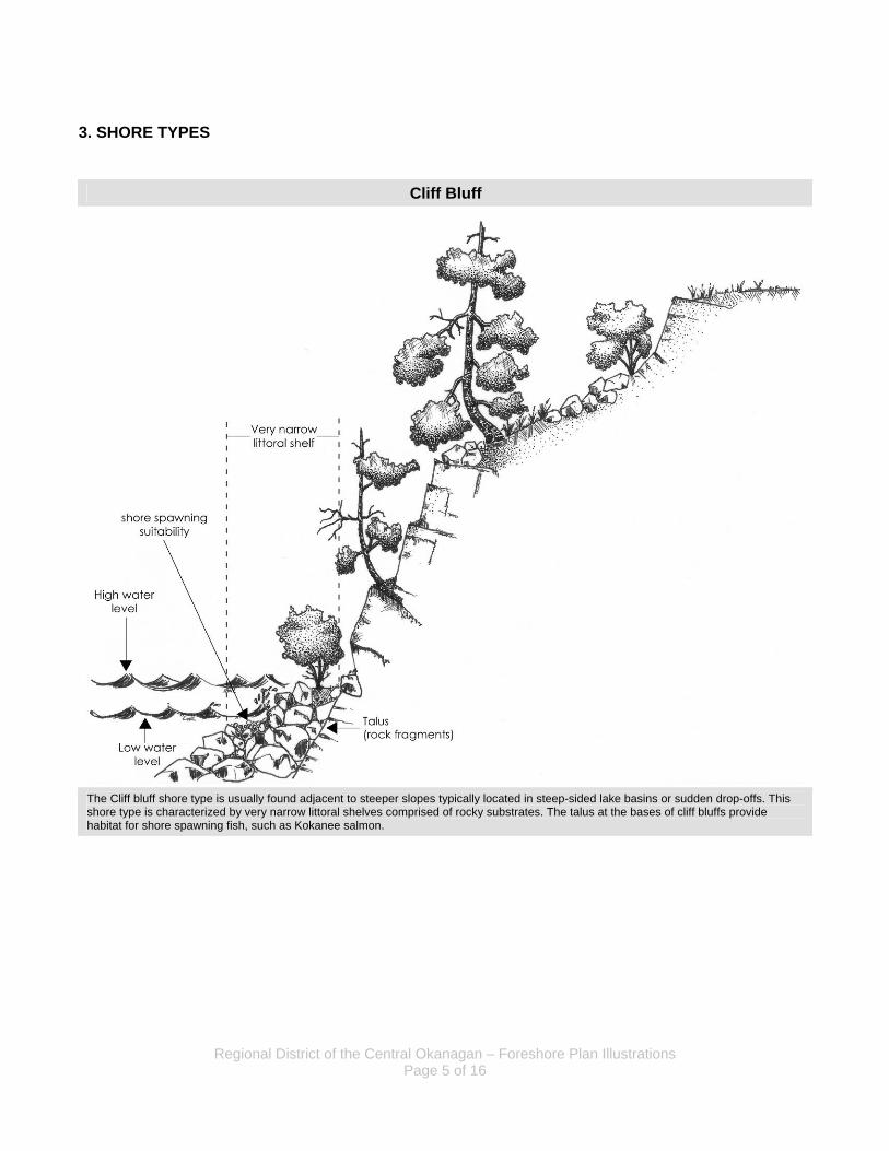
Cliff Bluff
The Cliff bluff shore type is usually found adjacent to steeper slopes typically located in steep-sided lake basins or sudden drop-offs. This shore type is characterized by very narrow littoral shelves comprised of rocky substrates. The talus at the bases of cliff bluffs provide habitat for shore spawning fish, such as Kokanee salmon.
Regional District of the Central Okanagan – Foreshore Plan Illustrations Page 6 of 16
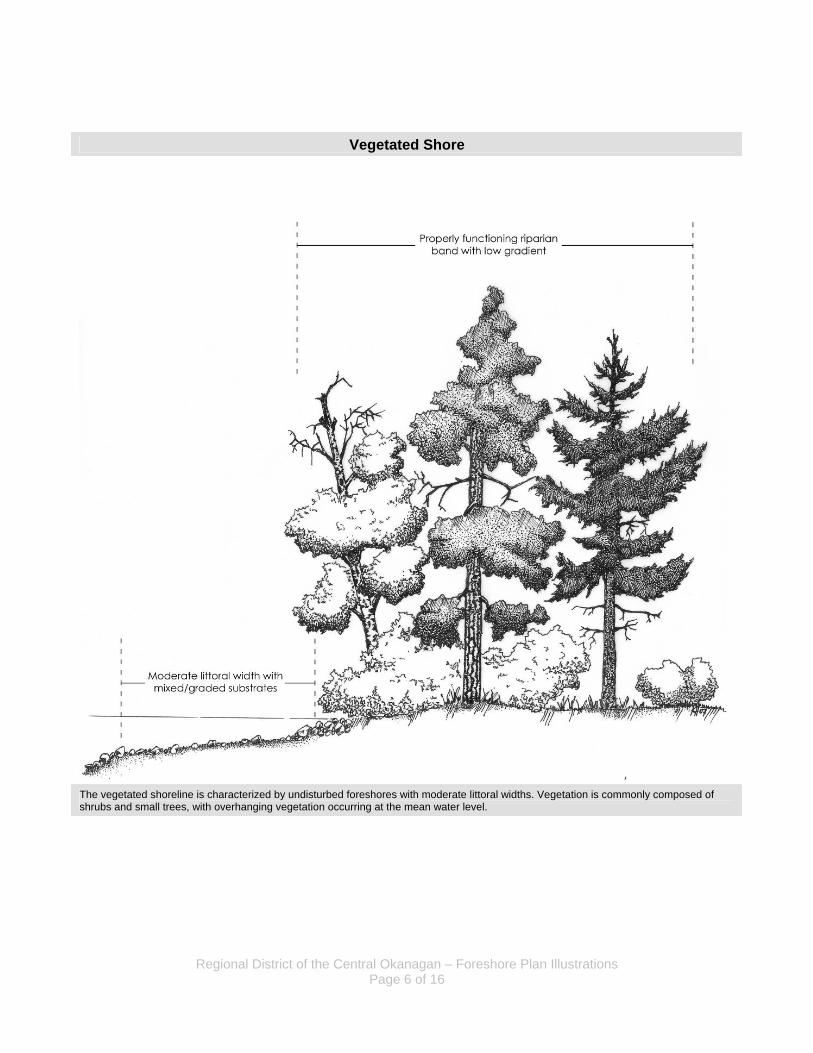
Vegetated Shore
The vegetated shoreline is characterized by undisturbed foreshores with moderate littoral widths. Vegetation is commonly composed of shrubs and small trees, with overhanging vegetation occurring at the mean water level.
Regional District of the Central Okanagan – Foreshore Plan Illustrations Page 7 of 16
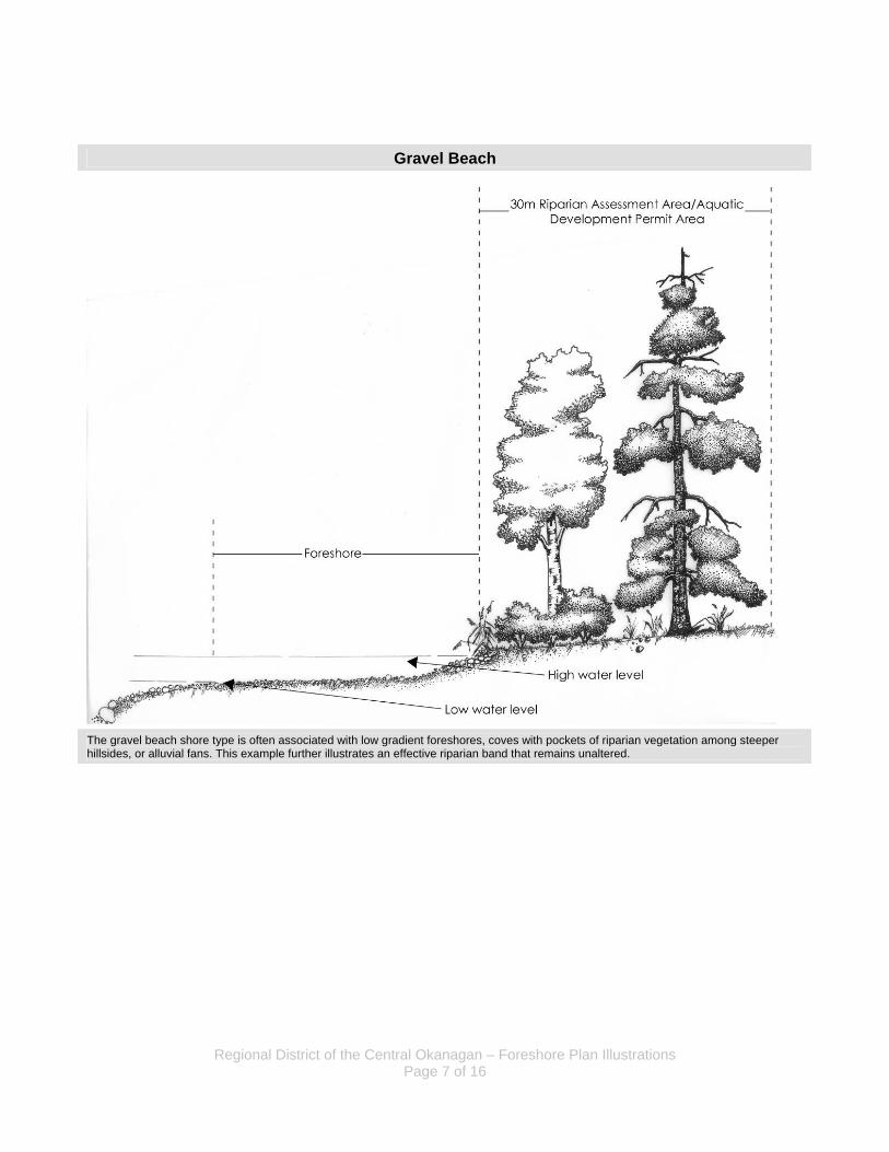
Gravel Beach
The gravel beach shore type is often associated with low gradient foreshores, coves with pockets of riparian vegetation among steeper hillsides, or alluvial fans. This example further illustrates an effective riparian band that remains unaltered.
Regional District of the Central Okanagan – Foreshore Plan Illustrations Page 8 of 16
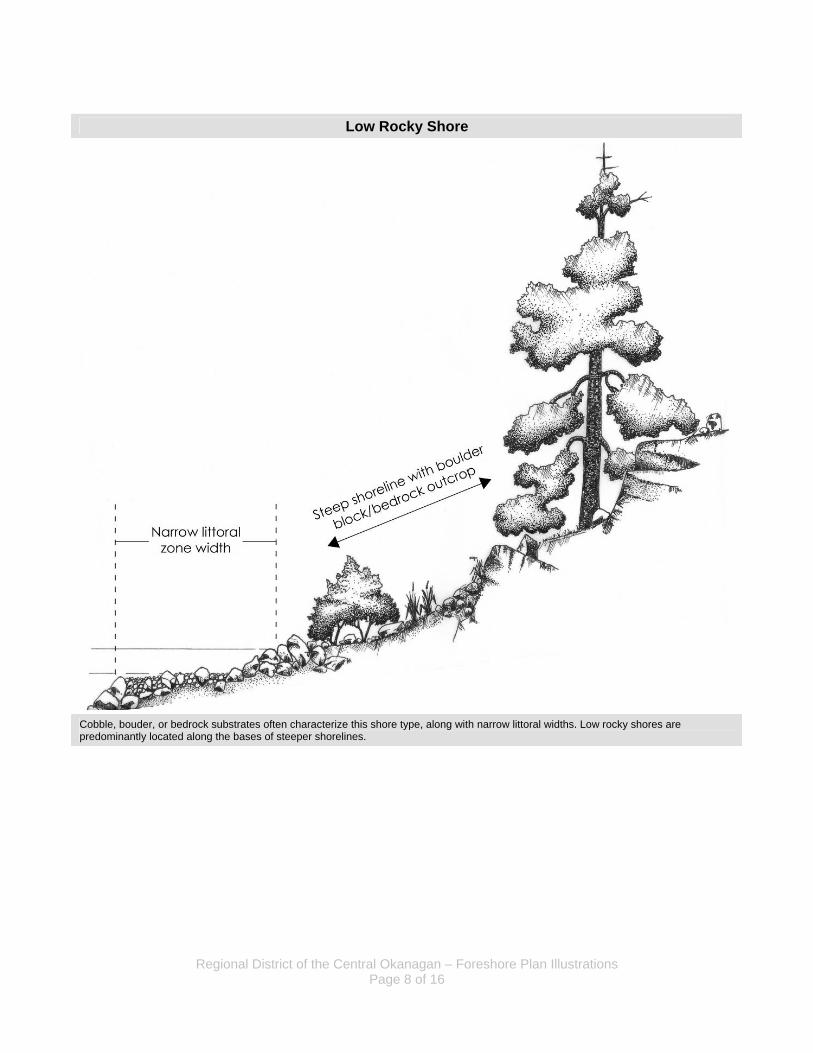
Low Rocky Shore
Cobble, bouder, or bedrock substrates often characterize this shore type, along with narrow littoral widths. Low rocky shores are predominantly located along the bases of steeper shorelines.
Regional District of the Central Okanagan – Foreshore Plan Illustrations Page 9 of 16
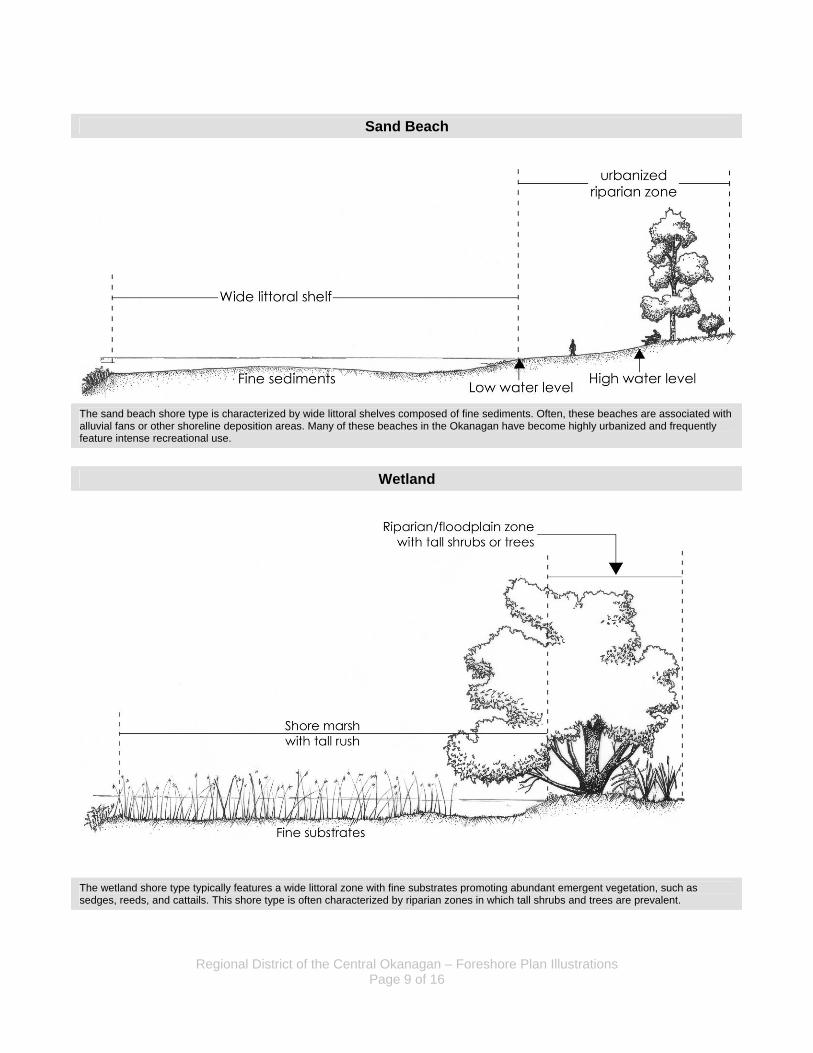
Sand Beach
The sand beach shore type is characterized by wide littoral shelves composed of fine sediments. Often, these beaches are associated with alluvial fans or other shoreline deposition areas. Many of these beaches in the Okanagan have become highly urbanized and frequently feature intense recreational use.
Wetland
The wetland shore type typically features a wide littoral zone with fine substrates promoting abundant emergent vegetation, such as sedges, reeds, and cattails. This shore type is often characterized by riparian zones in which tall shrubs and trees are prevalent.
Regional District of the Central Okanagan – Foreshore Plan Illustrations Page 10 of 16
4. DEVELOPMENT SCENARIOS
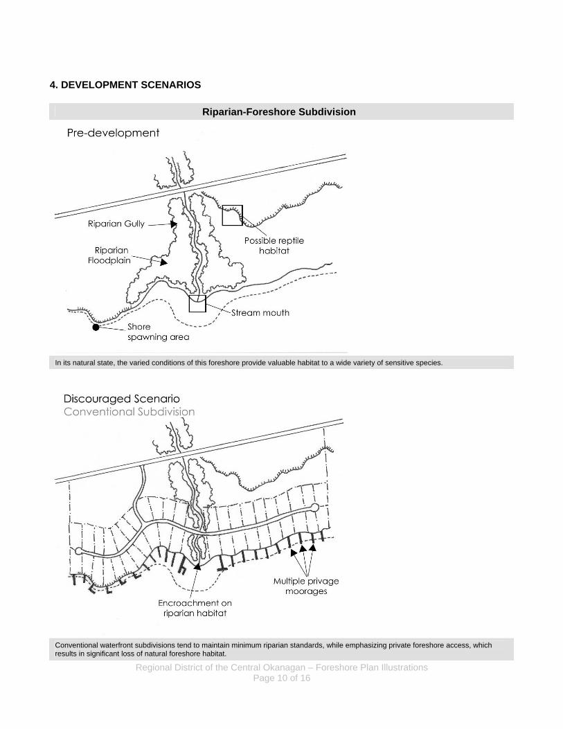
Riparian-Foreshore Subdivision
In its natural state, the varied conditions of this foreshore provide valuable habitat to a wide variety of sensitive species.
Conventional waterfront subdivisions tend to maintain minimum riparian standards, while emphasizing private foreshore access, which results in significant loss of natural foreshore habitat.
Regional District of the Central Okanagan – Foreshore Plan Illustrations Page 11 of 16
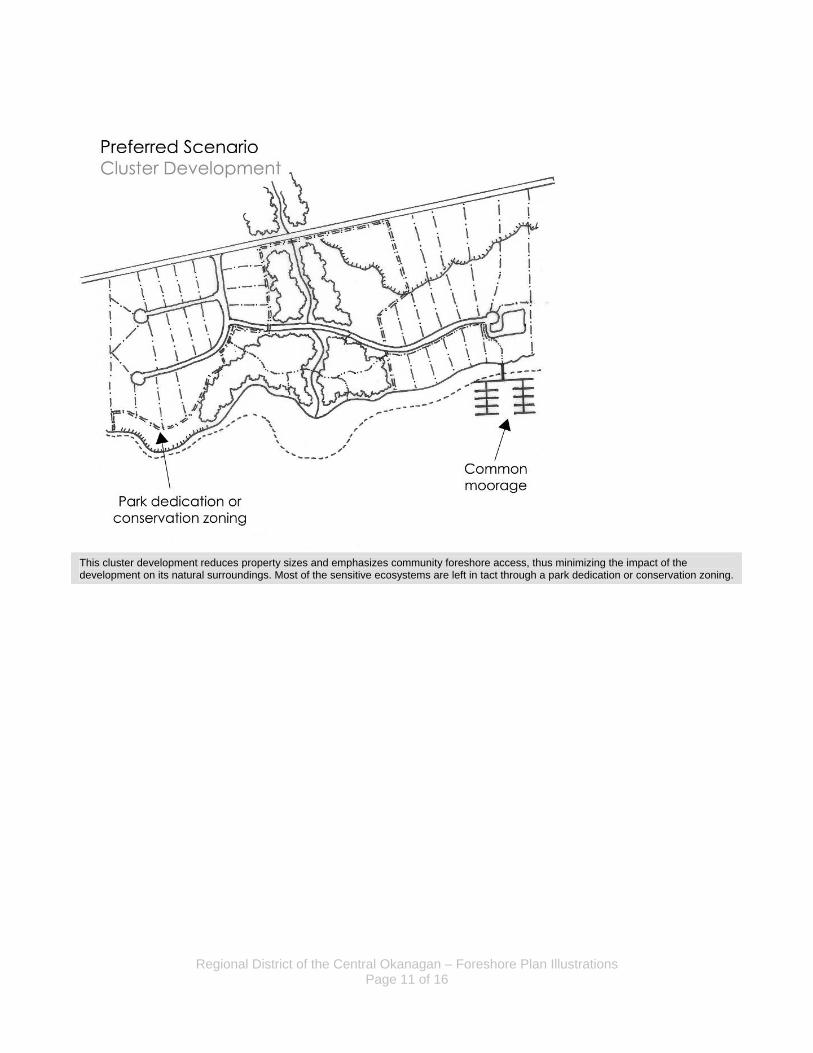
This cluster development reduces property sizes and emphasizes community foreshore access, thus minimizing the impact of the development on its natural surroundings. Most of the sensitive ecosystems are left in tact through a park dedication or conservation zoning.
Regional District of the Central Okanagan – Foreshore Plan Illustrations Page 12 of 16
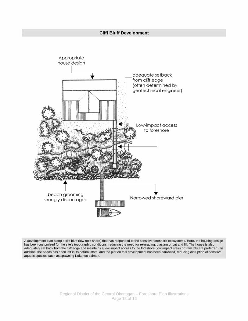
Cliff Bluff Development
A development plan along a cliff bluff (low rock shore) that has responded to the sensitive foreshore ecosystems. Here, the housing design has been customized for the site’s topographic conditions, reducing the need for re-grading, blasting or cut and fill. The house is also adequately set back from the cliff edge and maintains a low-impact access to the foreshore (low-impact stairs or tram lifts are preferred). In addition, the beach has been left in its natural state, and the pier on this development has been narrowed, reducing disruption of sensitive aquatic species, such as spawning Kokanee salmon.
Regional District of the Central Okanagan – Foreshore Plan Illustrations Page 13 of 16
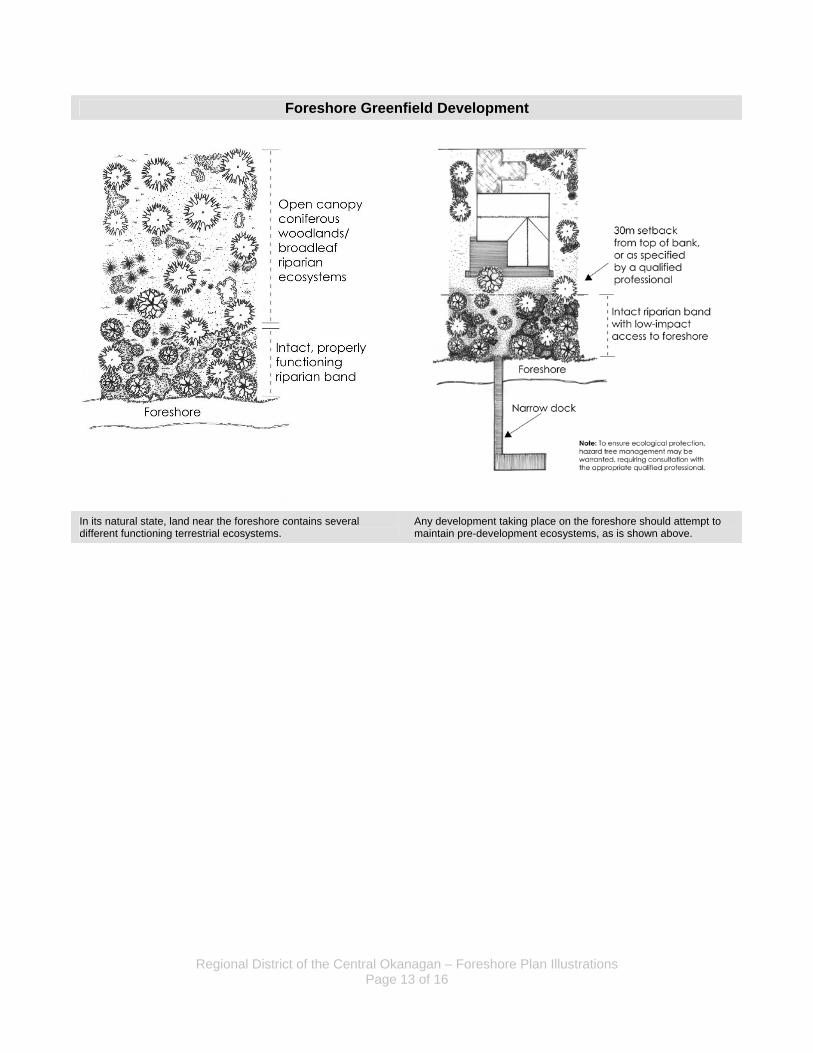
Foreshore Greenfield Development
In its natural state, land near the foreshore contains several different functioning terrestrial ecosystems.
Any development taking place on the foreshore should attempt to maintain pre-development ecosystems, as is shown above.
Regional District of the Central Okanagan – Foreshore Plan Illustrations Page 14 of 16
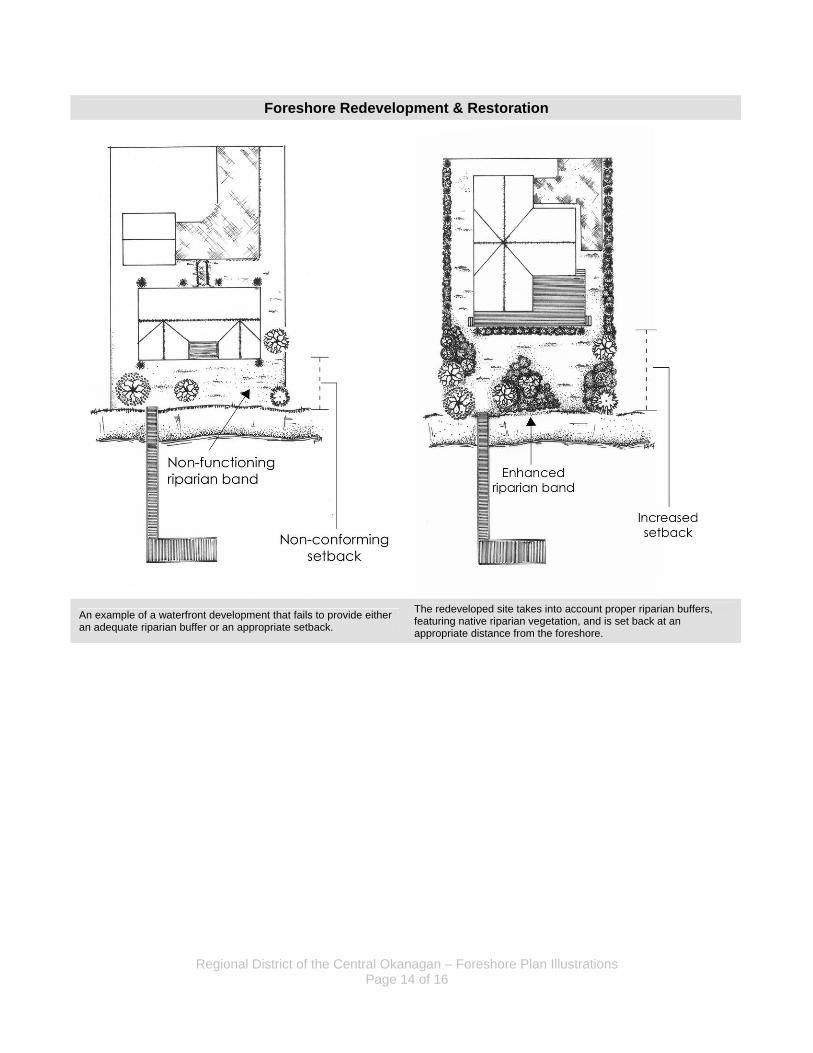
Foreshore Redevelopment & Restoration
An example of a waterfront development that fails to provide either an adequate riparian buffer or an appropriate setback.
The redeveloped site takes into account proper riparian buffers, featuring native riparian vegetation, and is set back at an appropriate distance from the foreshore.
Regional District of the Central Okanagan – Foreshore Plan Illustrations Page 15 of 16
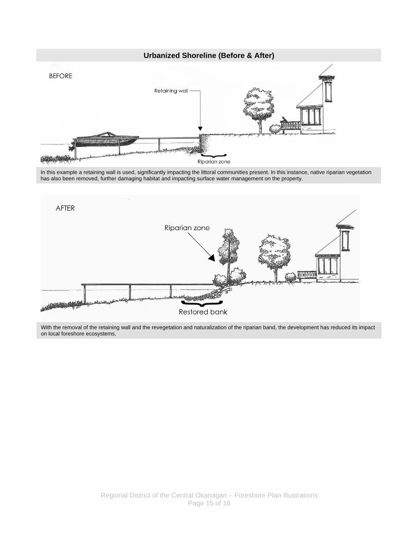
Urbanized Shoreline (Before & After)
In this example a retaining wall is used, significantly impacting the littoral communities present. In this instance, native riparian vegetation has also been removed, further damaging habitat and impacting surface water management on the property.
With the removal of the retaining wall and the revegetation and naturalization of the riparian band, the development has reduced its impact on local foreshore ecosystems.
Regional District of the Central Okanagan – Foreshore Plan Illustrations Page 16 of 16
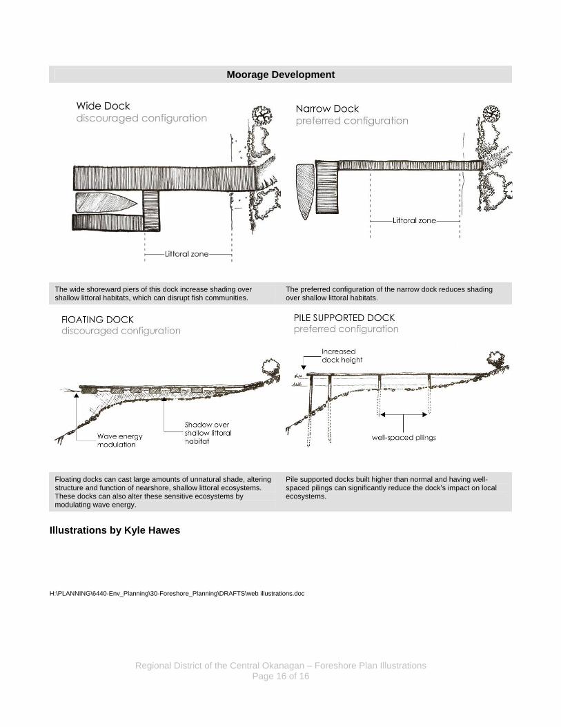
Moorage Development
The wide shoreward piers of this dock increase shading over shallow littoral habitats, which can disrupt fish communities.
The preferred configuration of the narrow dock reduces shading over shallow littoral habitats.
Floating docks can cast large amounts of unnatural shade, altering structure and function of nearshore, shallow littoral ecosystems. These docks can also alter these sensitive ecosystems by modulating wave energy.
Pile supported docks built higher than normal and having well-spaced pilings can significantly reduce the dock’s impact on local ecosystems.
Illustrations by Kyle Hawes H:\PLANNING\6440-Env_Planning\30-Foreshore_Planning\DRAFTS\web illustrations.doc