salter point and waterford foreshore management plan
TRANSCRIPT
SALTER POINT AND
WATERFORD
FORESHORE MANAGEMENT PLAN
An integral part of the Canning River Wetlands
Prepared on behalf of the City of South Perth
By NICOLE SIEMON
ECOSYSTEM MANAGEMENT SERVICES
FEBRUARY 2000

1
ISBN
Published by: City of South Perth
Sandgate Street
SOUTH PERTH 6151
2
Acknowledgments Nicole Siemon, Principal Consultant of Ecosystem Management Services wishes to thank the following people for their invaluable contributions, which have enabled the preparation of this report. Peter May, who assisted with proofing, mapping and collating the documents.
Jacqui Milne, a post-graduate student, contributed to much of the community involvement process. Thank you to Janet McCreddin from CSIRO who volunteered her time, resources and effort to facilitate the two community meetings.
Thank you to the officers from City of South Perth, particularly Bethan Lloyd for sharing information and ensuring the details have been documented correctly. Further, we wish to thank her for helping set up and arranging the community workshops.
Mark Taylor, the former Environmental Officer from the City of South Perth for his input into recognition of past works and practices.
Thank you to all the community members who have provided submissions to date and attended the public meetings, and to those who will aim to comment on this report during the formal public comments period.
3
Table of contents
ACKNOWLEDGMENTS............................................................................................................................... 2
TABLE OF CONTENTS ................................................................................................................................ 3
FOREWORD.................................................................................................................................................. 5
IMPLEMENTATION SUMMARY TABLE .................................................................................................. 6
1.0 INTRODUCTION ............................................................................................................................. 18
1.1 NEED FOR THE STUDY....................................................................................................................... 18 1.2 THE VISION AND VALUES.................................................................................................................. 18 1.3 AIMS AND OBJECTIVES...................................................................................................................... 18 1.4 RELATED ENVIRONMENTAL POLICIES AND STUDIES............................................................................ 19
1.4.1 Local government policies........................................................................................................ 19 1.4.2 State Government policies........................................................................................................ 20 1.4.3 Federal Government policies............................................................................................... 21
1.5 COMMUNITY INVOLVEMENT PROCESS............................................................................................... 21
2.0 STUDY AREA................................................................................................................................... 22
2.1 DEFINITION OF BOUNDARIES............................................................................................................. 22 2.2 PHYSICAL ENVIRONMENT ................................................................................................................. 22
2.2.1 Climate.................................................................................................................................... 22 2.2.2 Geomorphology / soils............................................................................................................. 24 2.2.3 Hydrology................................................................................................................................ 24
2.3 BIOLOGICAL ENVIRONMENT.............................................................................................................. 28 2.3.1 Flora ....................................................................................................................................... 28 2.3.2 Fauna...................................................................................................................................... 35
2.4 SOCIAL ENVIRONMENT ..................................................................................................................... 39 2.5 LAND TENURE AND ZONING.............................................................................................................. 39 2.6 ROLES AND RESPONSIBILITIES........................................................................................................... 39
3.0 GENERAL MANAGEMENT ISSUES AND RECOMMENDATIONS .......................................... 41
3.1 VESTING AND LEASE OF LAND........................................................................................................... 41 3.2 MANAGEMENT OF THE PHYSICAL ENVIRONMENT............................................................................... 41
3.2.1 Erosion control ........................................................................................................................ 41 3.2.2 Water quality management....................................................................................................... 42 3.2.3 Sewerage overflows.................................................................................................................. 45
3.3 PESTICIDE USE BY COUNCIL.............................................................................................................. 46 3.4 ORGANIC NUTRIENT CONTAMINATION............................................................................................... 47 3.5 MANAGEMENT OF THE BIOLOGICAL ENVIRONMENT........................................................................... 48
3.5.1 Vegetation................................................................................................................................ 48 3.5.2 Weed control............................................................................................................................ 51 3.5.3 Turf management..................................................................................................................... 53 3.5.4 Fire management..................................................................................................................... 54
3.6 NATIVE FAUNA................................................................................................................................. 55 3.7 PEST MANAGEMENT AND PET CONTROL............................................................................................. 57
3.7.1 Pest management..................................................................................................................... 57 3.7.2 Domestic animals..................................................................................................................... 60
3.8 MANAGING RECREATION AND INFRASTRUCTURE.............................................................................. 64 3.8.1 Amenities ................................................................................................................................ 64 3.8.2 Water based recreation facilities................................................................................................71
3.9 RESERVE ACCESS................................................................................................................................... 72 3.10 PUBLIC AWARENESS, EDUCATION AND TRAINING............................................................................... 73 3.11 VIEWS ............................................................................................................................................. 76
3.11.1 Underground power................................................................................................................. 76 3.11.2 Bodkin Park lakes .................................................................................................................... 77
3.12 MAINTENANCE............................................................................................................................ 77 3.12.1 Infrastructure maintenance...................................................................................................... 77
4
3.12.2 Parkland maintenance.............................................................................................................. 78 3.12.3 Litter Collection............................................................................................................................ 78 3.12.4 Irrigation...................................................................................................................................... 78 3.12.5 Graffiti and wilful damage ............................................................................................................ 79
3.13 MANAGEMENT AND IMPLEMENTATION ................................................................................ 79
4.0 SITE SPECIFIC MANAGEMENT ISSUES AND RECOMMENDATIONS ...................... 81
4.1 REDMOND STREET TO TURNABOUT AT END OF SALTER POINT PARADE.................................. 84 4.2 SALTER POINT LAGOON............................................................................................................... 86 4.3 SALTER POINT PARADE – SANDON PARK ................................................................................... 88 4.4 MELALEUCA GROVE – MANNING ROAD MAIN DRAIN.............................................................. 91 4.5 SCOUT HALL TO FAIRVIEW GARDENS......................................................................................... 94 4.5 BODKIN PARK AND THE WATERFORD CONSERVATION AREA .................................................. 97 4.6 WATERFORD CONSERVATION AREA TO BOARDWALK ............................................................ 100
5.0 REVIEW PERIOD.......................................................................................................................... 101
6.0 REFERENCE LISTS AND RELEVANT SOURCES OF INFORMATION ................................. 101
APPENDIX 1: FLORA SPECIES LIST
APPENDIX 2: FAUNA SPECIES LIST
APPENDIX 3: ROLES AND RESPONSIBLITIES
APPENDIX 4: SUITABLE SPECIES FOR REHABILITATION WORKS
APPENDIX 5: SUGGESTED WEED CONTROL TECHNIQUES FOR COMMON WEEDS
APPENDIX 6: ISSUES RAISED WHICH ARE BEYOND THE SCOPE OF THIS DOCUMENT
APPENDIX 7: CONTACT DETAILS
APPENDIX 8: PREVIOUS SUMMARY OF RECOMMENDATIONS AND IMPLEMENTATION STATUS
LIST OF TABLES
TABLE 1: RESERVE SIZE, TENURE AND PURPOSE
LIST OF FIGURES
FIGURE 1: 1944 AERIAL PHOTOGRAPH FIGURE 2: 1994 AERIAL PHOTOGRAPH FIGURE 3: FRESHWATER VEGETATION PROFILE FIGURE 4: SALTWATER AND LIMESTONE VEGETATION PROFILE FIGURE 5: ROLES AND RESPONSIBILITIES
LIST OF MAPS
MAP 1: STUDY AREA WITH RESERVE NUMBERS MAP 2: HYDROLOGY, EROSION AND ACCRETION MAP 3: VEGETATION COMMUNITIES MAP 4: SITE SPECIFIC RECOMMENDATIONS LOCALITY MAP MAP 5: REDMOND AVENUE TO TURNABOUT AT SALTER POINT PARADE MAP 6: SALTER POINT LAGOON MAP 7: SALTER POINT PARADE – SCOUT HALL MAP 8: FAIRVIEW GARDENS MAP 9: BODKIN PARK AND THE WATERFORD CONSERVATION AREA MAP 10: WATERFORD CONSERVATION AREA TO BROTHER KEANEY’S GARDENS
5
Foreword
The foreshore areas from Salter Point through to Waterford are known as the Canning River wetlands. These estuarine wetlands are the most extensive wetlands in the lower reaches of the Swan and Canning Rivers, providing the largest habitat area for many wildlife species.
Wetlands are biologically the most productive areas of the Swan Coastal Plain. Such areas have not been highly regarded in the past, and the majority of wetlands on the Swan Coastal Plain have been filled in for development in some form.
Wetlands are important areas for water balance and drainage, assisting in filtering nutrients and pollutants from the ground and surface water, protecting the river banks from erosion and supporting flora and fauna on which the health of the rivers depends.
The Salter Point and Waterford wetlands region (Orr 1987) is particularly important because:
♦ It is a link in a chain of wetlands on the Canning River from Mount Henry to the Canning River Regional Park;
♦ Its condition is relatively undisturbed compared with other foreshore wetlands;
♦ It is wide and therefore provides protection for the river embayments;
♦ It provides habitat for insects, frogs, reptiles, birds and mammals that are part of the food chain that links with the river;
♦ Over 74 species of land and water bird, 12 reptiles and 6 amphibian species (Perth’s Bushplan 1998) have been observed in this area, including 14 significant bird species;
♦ It supports several vegetation associations:
- few fringing forests have such significant understorey vegetation
- there are several paperbark species including one (Melaleuca pauciflora) which is uncommon
- there are numerous rush and sedge associations; and
- the salt marshes form a mosaic of vegetation and mudflats.
“There is no similar foreshore vegetation elsewhere along the Swan and Canning Rivers”, (System 6 Report 1983).
In recognition of these values, the City of South Perth commissioned a management plan in 1986/87 for the two areas. In 1994, these plans were reviewed and updated. In 1999, the plans were due for review again, and this plan is the result of the amalgamation and assessment of the two previous reports.
As such, the consultant has retained some of the text and content in its original form, with amendments and additions as required. Text prepared by the previous authors K. Orr (1986/1987) and J. Brooker (1993/1994) is recognised at this point of the document.

6
IMPLEMENTATION SUMMARY TABLE
IMPLEMENTATION SCHEDULEResources required
GENERAL RECOMMENDATIONS
CSP
En
v.
Stra
tPr
evio
us
plan
s 1999
-20
00
2000
- 20
02
2002
–
2005
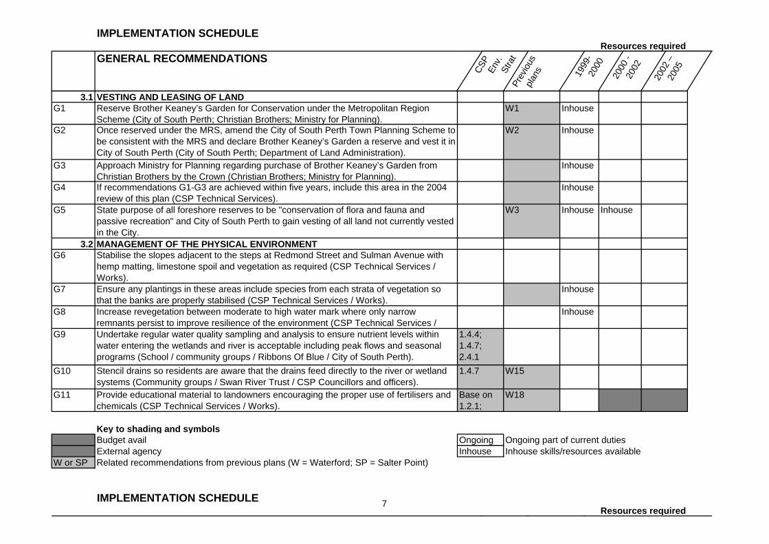
3.1 VESTING AND LEASING OF LANDG1 Reserve Brother Keaney’s Garden for Conservation under the Metropolitan Region
Scheme (City of South Perth; Christian Brothers; Ministry for Planning).W1 Inhouse
G2 Once reserved under the MRS, amend the City of South Perth Town Planning Scheme to be consistent with the MRS and declare Brother Keaney’s Garden a reserve and vest it in City of South Perth (City of South Perth; Department of Land Administration).
W2 Inhouse
G3 Approach Ministry for Planning regarding purchase of Brother Keaney’s Garden from Christian Brothers by the Crown (Christian Brothers; Ministry for Planning).
Inhouse
G4 If recommendations G1-G3 are achieved within five years, include this area in the 2004 review of this plan (CSP Technical Services).
Inhouse
G5 State purpose of all foreshore reserves to be "conservation of flora and fauna and passive recreation" and City of South Perth to gain vesting of all land not currently vested in the City.
W3 Inhouse Inhouse
3.2 MANAGEMENT OF THE PHYSICAL ENVIRONMENTG6 Stabilise the slopes adjacent to the steps at Redmond Street and Sulman Avenue with
hemp matting, limestone spoil and vegetation as required (CSP Technical Services / Works).
G7 Ensure any plantings in these areas include species from each strata of vegetation so that the banks are properly stabilised (CSP Technical Services / Works).
Inhouse
G8 Increase revegetation between moderate to high water mark where only narrow remnants persist to improve resilience of the environment (CSP Technical Services /
Inhouse
G9 Undertake regular water quality sampling and analysis to ensure nutrient levels within water entering the wetlands and river is acceptable including peak flows and seasonal programs (School / community groups / Ribbons Of Blue / City of South Perth).
1.4.4; 1.4.7; 2.4.1
G10 Stencil drains so residents are aware that the drains feed directly to the river or wetland systems (Community groups / Swan River Trust / CSP Councillors and officers).
1.4.7 W15
G11 Provide educational material to landowners encouraging the proper use of fertilisers and chemicals (CSP Technical Services / Works).
Base on 1.2.1;
W18
Key to shading and symbolsBudget avail Ongoing Ongoing part of current dutiesExternal agency Inhouse Inhouse skills/resources available
W or SP Related recommendations from previous plans (W = Waterford; SP = Salter Point)
IMPLEMENTATION SCHEDULEResources required
7
GENERAL RECOMMENDATIONS
CSP
En
v.
Stra
tPr
evio
us
plan
s 1999
-20
00
2000
- 20
02
2002
–
2005
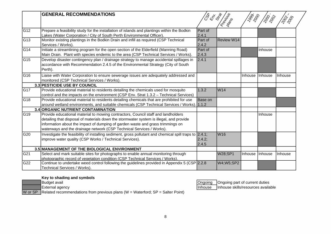
G12 Prepare a feasibility study for the installation of islands and plantings within the Bodkin Lakes (Water Corporation / City of South Perth Environmental Officer).
Part of 2.4.1
G13 Monitor existing plantings in the Bodkin Drain and infill as required (CSP Technical Services / Works).
Part of 2.4.2
Review W14
G14 Initiate a streamlining program for the open section of the Elderfield (Manning Road) Main Drain. Plant with species endemic to the area (CSP Technical Services / Works).
Part of 2.4.3
Inhouse
G15 Develop disaster contingency plan / drainage strategy to manage accidental spillages in accordance with Recommendation 2.4.5 of the Environmental Strategy (City of South Perth).
2.4.1
G16 Liaise with Water Corporation to ensure sewerage issues are adequately addressed and monitored (CSP Technical Services / Works).
Inhouse Inhouse Inhouse
3.3 PESTICIDE USE BY COUNCILG17 Provide educational material to residents detailing the chemicals used for mosquito
control and the impacts on the environment (CSP Env. Strat 1.3.2 – Technical Services)1.3.2 W14
G18 Provide educational material to residents detailing chemicals that are prohibited for use around wetland environments, and suitable chemicals (CSP Technical Services / Works).
Base on 1.1.2
3.4 ORGANIC NUTRIENT CONTAMINATIONG19 Provide educational material to mowing contractors, Council staff and landholders
detailing that disposal of materials down the stormwater system is illegal, and provide information about the impact of dumping of garden waste and grass trimmings on waterways and the drainage network (CSP Technical Services / Works).
Inhouse
G20 Investigate the feasibility of installing sediment, gross pollutant and chemical spill traps to improve water quality (CSP Works / Technical Services).
2.4.1; 2.4.2; 2.4.5
W16
3.5 MANAGEMENT OF THE BIOLOGICAL ENVIRONMENTG21 Select and mark suitable sites for photographs to enable annual monitoring through
photographic record of vegetation condition (CSP Technical Services / Works).W28;SP1 Inhouse Inhouse Inhouse
G22 Continue to undertake weed control following the guidelines provided in Appendix 5 (CSP Technical Services / Works).
2.2.8 W4;W5;SP2
Key to shading and symbolsBudget avail Ongoing Ongoing part of current dutiesExternal agency Inhouse Inhouse skills/resources available
W or SP Related recommendations from previous plans (W = Waterford; SP = Salter Point)
8
IMPLEMENTATION SCHEDULEResources required
GENERAL RECOMMENDATIONS
CSP
En
v.
Stra
tPr
evio
us
plan
s 1999
-20
00
2000
- 20
02
2002
–
2005
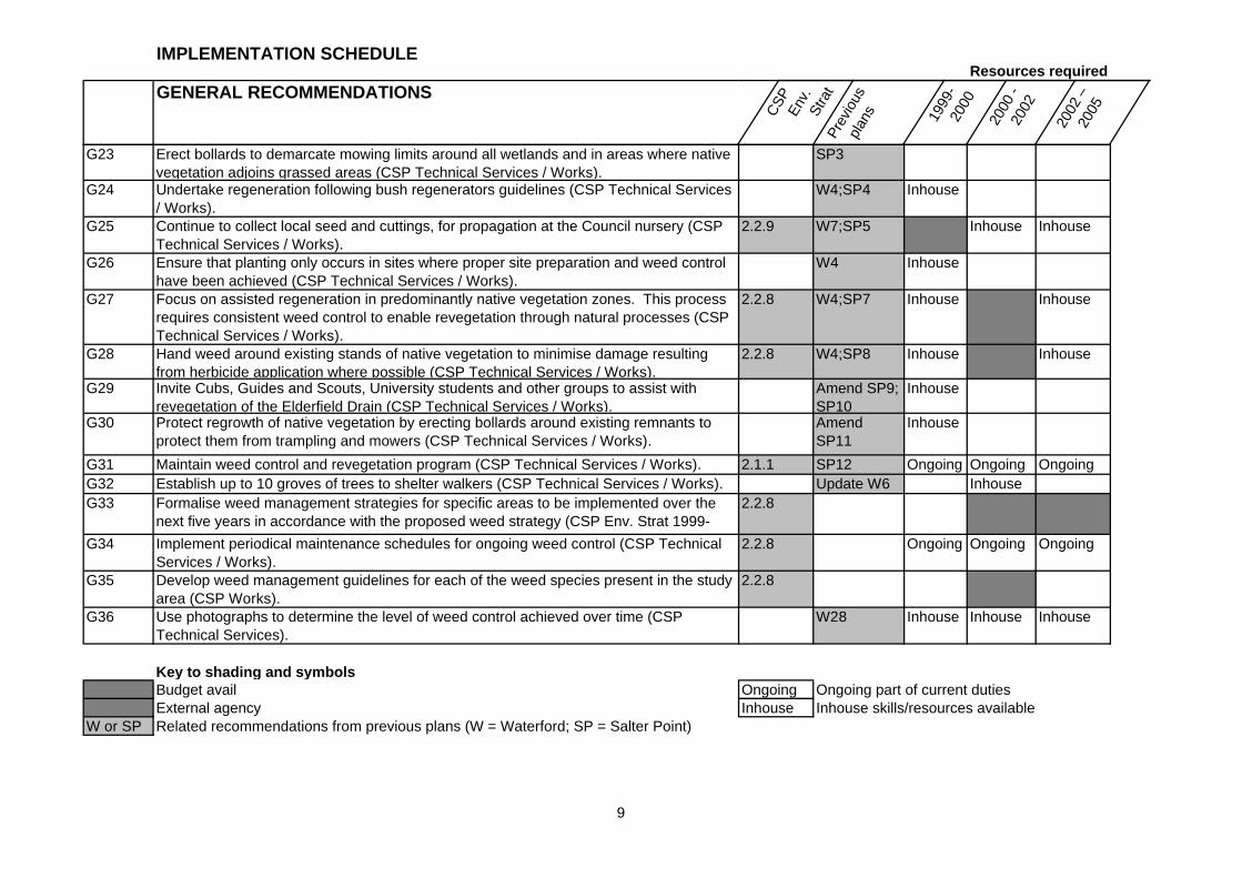
G23 Erect bollards to demarcate mowing limits around all wetlands and in areas where native vegetation adjoins grassed areas (CSP Technical Services / Works).
SP3
G24 Undertake regeneration following bush regenerators guidelines (CSP Technical Services / Works).
W4;SP4 Inhouse
G25 Continue to collect local seed and cuttings, for propagation at the Council nursery (CSP Technical Services / Works).
2.2.9 W7;SP5 Inhouse Inhouse
G26 Ensure that planting only occurs in sites where proper site preparation and weed control have been achieved (CSP Technical Services / Works).
W4 Inhouse
G27 Focus on assisted regeneration in predominantly native vegetation zones. This process requires consistent weed control to enable revegetation through natural processes (CSP Technical Services / Works).
2.2.8 W4;SP7 Inhouse Inhouse
G28 Hand weed around existing stands of native vegetation to minimise damage resulting from herbicide application where possible (CSP Technical Services / Works).
2.2.8 W4;SP8 Inhouse Inhouse
G29 Invite Cubs, Guides and Scouts, University students and other groups to assist with revegetation of the Elderfield Drain (CSP Technical Services / Works).
Amend SP9; SP10
Inhouse
G30 Protect regrowth of native vegetation by erecting bollards around existing remnants to protect them from trampling and mowers (CSP Technical Services / Works).
Amend SP11
Inhouse
G31 Maintain weed control and revegetation program (CSP Technical Services / Works). 2.1.1 SP12 Ongoing Ongoing OngoingG32 Establish up to 10 groves of trees to shelter walkers (CSP Technical Services / Works). Update W6 InhouseG33 Formalise weed management strategies for specific areas to be implemented over the
next five years in accordance with the proposed weed strategy (CSP Env. Strat 1999-2002).
2.2.8
G34 Implement periodical maintenance schedules for ongoing weed control (CSP Technical Services / Works).
2.2.8 Ongoing Ongoing Ongoing
G35 Develop weed management guidelines for each of the weed species present in the study area (CSP Works).
2.2.8
G36 Use photographs to determine the level of weed control achieved over time (CSP Technical Services).
W28 Inhouse Inhouse Inhouse
Key to shading and symbolsBudget avail Ongoing Ongoing part of current dutiesExternal agency Inhouse Inhouse skills/resources available
W or SP Related recommendations from previous plans (W = Waterford; SP = Salter Point)
9
IMPLEMENTATION SCHEDULEResources required
GENERAL RECOMMENDATIONS
CSP
En
v.
Stra
tPr
evio
us
plan
s 1999
-20
00
2000
- 20
02
2002
–
2005
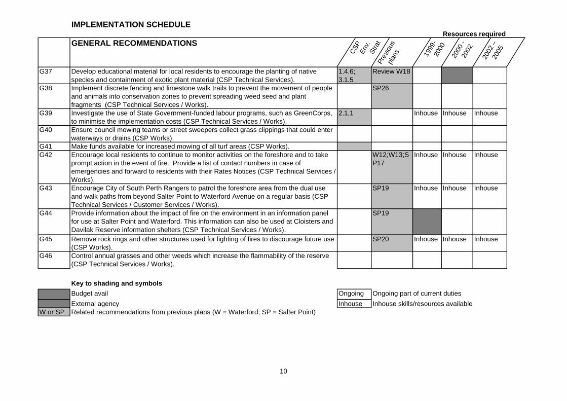
G37 Develop educational material for local residents to encourage the planting of native species and containment of exotic plant material (CSP Technical Services).
1.4.6; 3.1.5
Review W18
G38 Implement discrete fencing and limestone walk trails to prevent the movement of people and animals into conservation zones to prevent spreading weed seed and plant fragments (CSP Technical Services / Works).
SP26
G39 Investigate the use of State Government-funded labour programs, such as GreenCorps, to minimise the implementation costs (CSP Technical Services / Works).
2.1.1 Inhouse Inhouse Inhouse
G40 Ensure council mowing teams or street sweepers collect grass clippings that could enter waterways or drains (CSP Works).
G41 Make funds available for increased mowing of all turf areas (CSP Works).G42 Encourage local residents to continue to monitor activities on the foreshore and to take
prompt action in the event of fire. Provide a list of contact numbers in case of emergencies and forward to residents with their Rates Notices (CSP Technical Services / Works).
W12;W13;SP17
Inhouse Inhouse Inhouse
G43 Encourage City of South Perth Rangers to patrol the foreshore area from the dual use and walk paths from beyond Salter Point to Waterford Avenue on a regular basis (CSP Technical Services / Customer Services / Works).
SP19 Inhouse Inhouse Inhouse
G44 Provide information about the impact of fire on the environment in an information panel for use at Salter Point and Waterford. This information can also be used at Cloisters and Davilak Reserve information shelters (CSP Technical Services / Works).
SP19
G45 Remove rock rings and other structures used for lighting of fires to discourage future use (CSP Works).
SP20 Inhouse Inhouse Inhouse
G46 Control annual grasses and other weeds which increase the flammability of the reserve (CSP Technical Services / Works).
Key to shading and symbols
Budget avail Ongoing Ongoing part of current duties
External agency Inhouse Inhouse skills/resources availableW or SP Related recommendations from previous plans (W = Waterford; SP = Salter Point)
10
IMPLEMENTATION SCHEDULEResources required
GENERAL RECOMMENDATIONS
CSP
En
v.
Stra
tPr
evio
us
plan
s 1999
-20
00
2000
- 20
02
2002
–
2005
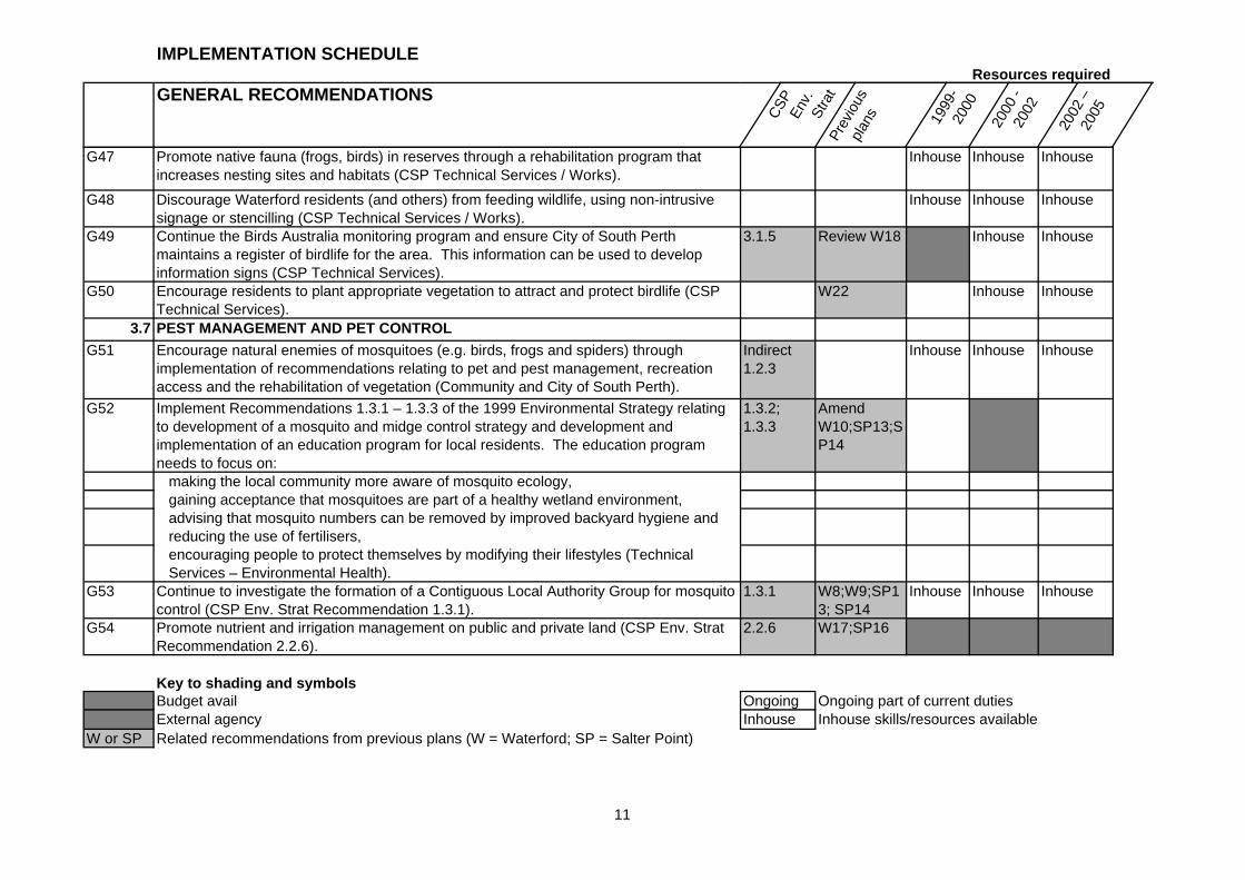
G47 Promote native fauna (frogs, birds) in reserves through a rehabilitation program that increases nesting sites and habitats (CSP Technical Services / Works).
Inhouse Inhouse Inhouse
G48 Discourage Waterford residents (and others) from feeding wildlife, using non-intrusive signage or stencilling (CSP Technical Services / Works).
Inhouse Inhouse Inhouse
G49 Continue the Birds Australia monitoring program and ensure City of South Perth maintains a register of birdlife for the area. This information can be used to develop information signs (CSP Technical Services).
3.1.5 Review W18 Inhouse Inhouse
G50 Encourage residents to plant appropriate vegetation to attract and protect birdlife (CSP Technical Services).
W22 Inhouse Inhouse
3.7 PEST MANAGEMENT AND PET CONTROL
G51 Encourage natural enemies of mosquitoes (e.g. birds, frogs and spiders) through implementation of recommendations relating to pet and pest management, recreation access and the rehabilitation of vegetation (Community and City of South Perth).
Indirect 1.2.3
Inhouse Inhouse Inhouse
G52 Implement Recommendations 1.3.1 – 1.3.3 of the 1999 Environmental Strategy relating to development of a mosquito and midge control strategy and development and implementation of an education program for local residents. The education program needs to focus on:
1.3.2; 1.3.3
Amend W10;SP13;SP14
making the local community more aware of mosquito ecology,gaining acceptance that mosquitoes are part of a healthy wetland environment,advising that mosquito numbers can be removed by improved backyard hygiene and reducing the use of fertilisers,encouraging people to protect themselves by modifying their lifestyles (Technical Services – Environmental Health).
G53 Continue to investigate the formation of a Contiguous Local Authority Group for mosquito control (CSP Env. Strat Recommendation 1.3.1).
1.3.1 W8;W9;SP13; SP14
Inhouse Inhouse Inhouse
G54 Promote nutrient and irrigation management on public and private land (CSP Env. Strat Recommendation 2.2.6).
2.2.6 W17;SP16
Key to shading and symbolsBudget avail Ongoing Ongoing part of current dutiesExternal agency Inhouse Inhouse skills/resources available
W or SP Related recommendations from previous plans (W = Waterford; SP = Salter Point)
11
IMPLEMENTATION SCHEDULEResources required
GENERAL RECOMMENDATIONS
CSP
En
v.
Stra
tPr
evio
us
plan
s 1999
-20
00
2000
- 20
02
2002
–
2005
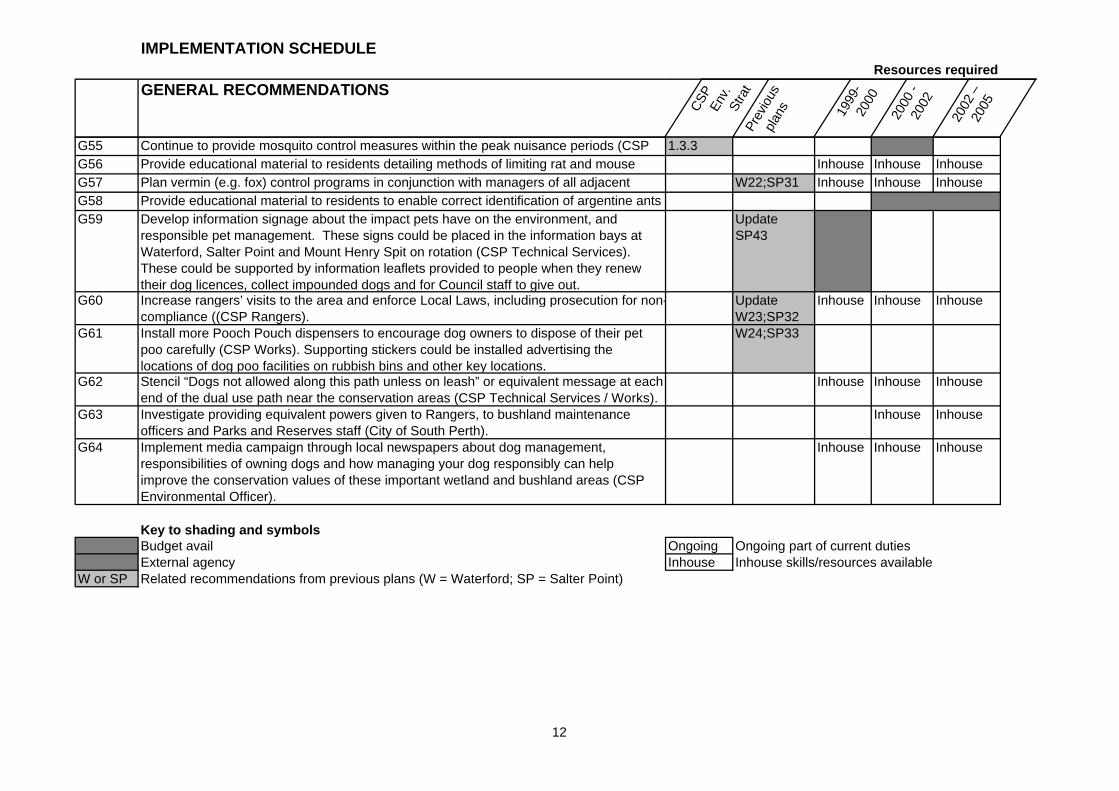
G55 Continue to provide mosquito control measures within the peak nuisance periods (CSP Environmental Health Services).
1.3.3G56 Provide educational material to residents detailing methods of limiting rat and mouse
populations (Agriculture WA; Department of Conservation and Land Management).Inhouse Inhouse Inhouse
G57 Plan vermin (e.g. fox) control programs in conjunction with managers of all adjacent bushland and wetland areas including the Canning River Regional Park (CALM) and
W22;SP31 Inhouse Inhouse InhouseG58 Provide educational material to residents to enable correct identification of argentine ants
and contact details for control officers (Agriculture WA).G59 Develop information signage about the impact pets have on the environment, and responsible pet management. These signs could be placed in the information bays at Waterford, Salter Point and Mount Henry Spit on rotation (CSP Technical Services). These could be supported by information leaflets provided to people when they renew their dog licences, collect impounded dogs and for Council staff to give out.
Update SP43
G60 Increase rangers’ visits to the area and enforce Local Laws, including prosecution for non-compliance ((CSP Rangers).
Update W23;SP32
Inhouse Inhouse Inhouse
G61 Install more Pooch Pouch dispensers to encourage dog owners to dispose of their pet poo carefully (CSP Works). Supporting stickers could be installed advertising the locations of dog poo facilities on rubbish bins and other key locations.
W24;SP33
G62 Stencil “Dogs not allowed along this path unless on leash” or equivalent message at each end of the dual use path near the conservation areas (CSP Technical Services / Works).
Inhouse Inhouse Inhouse
G63 Investigate providing equivalent powers given to Rangers, to bushland maintenance officers and Parks and Reserves staff (City of South Perth).
Inhouse Inhouse
G64 Implement media campaign through local newspapers about dog management, responsibilities of owning dogs and how managing your dog responsibly can help improve the conservation values of these important wetland and bushland areas (CSP Environmental Officer).
Inhouse Inhouse Inhouse
Key to shading and symbolsBudget avail Ongoing Ongoing part of current dutiesExternal agency Inhouse Inhouse skills/resources available
W or SP Related recommendations from previous plans (W = Waterford; SP = Salter Point)
12
IMPLEMENTATION SCHEDULEResources required
GENERAL RECOMMENDATIONS
CSP
En
v.
Stra
tPr
evio
us
plan
s 1999
-20
00
2000
- 20
02
2002
–
2005
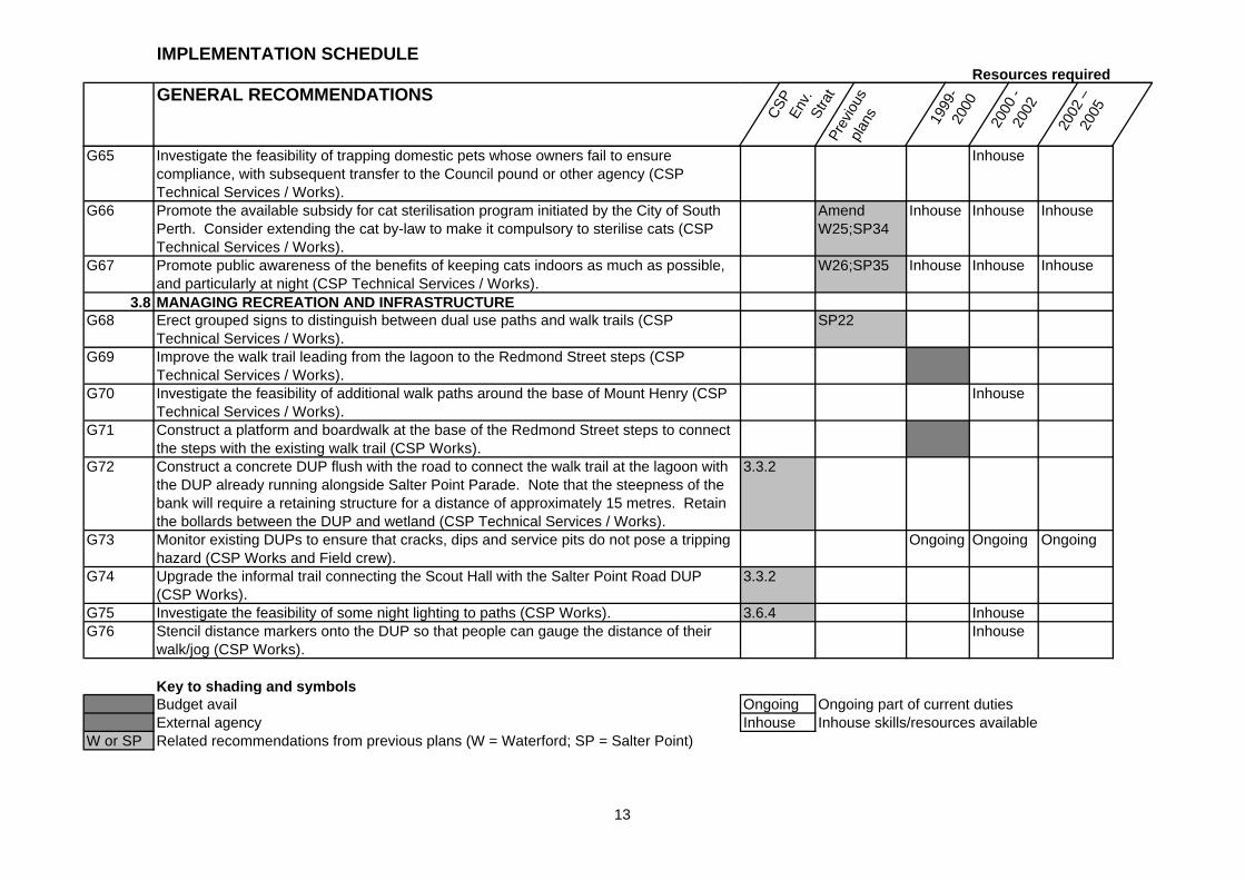
G65 Investigate the feasibility of trapping domestic pets whose owners fail to ensure compliance, with subsequent transfer to the Council pound or other agency (CSP Technical Services / Works).
Inhouse
G66 Promote the available subsidy for cat sterilisation program initiated by the City of South Perth. Consider extending the cat by-law to make it compulsory to sterilise cats (CSP Technical Services / Works).
Amend W25;SP34
Inhouse Inhouse Inhouse
G67 Promote public awareness of the benefits of keeping cats indoors as much as possible, and particularly at night (CSP Technical Services / Works).
W26;SP35 Inhouse Inhouse Inhouse
3.8 MANAGING RECREATION AND INFRASTRUCTUREG68 Erect grouped signs to distinguish between dual use paths and walk trails (CSP
Technical Services / Works).SP22
G69 Improve the walk trail leading from the lagoon to the Redmond Street steps (CSP Technical Services / Works).
G70 Investigate the feasibility of additional walk paths around the base of Mount Henry (CSP Technical Services / Works).
Inhouse
G71 Construct a platform and boardwalk at the base of the Redmond Street steps to connect the steps with the existing walk trail (CSP Works).
G72 Construct a concrete DUP flush with the road to connect the walk trail at the lagoon with the DUP already running alongside Salter Point Parade. Note that the steepness of the bank will require a retaining structure for a distance of approximately 15 metres. Retain the bollards between the DUP and wetland (CSP Technical Services / Works).
3.3.2
G73 Monitor existing DUPs to ensure that cracks, dips and service pits do not pose a tripping hazard (CSP Works and Field crew).
Ongoing Ongoing Ongoing
G74 Upgrade the informal trail connecting the Scout Hall with the Salter Point Road DUP (CSP Works).
3.3.2
G75 Investigate the feasibility of some night lighting to paths (CSP Works). 3.6.4 InhouseG76 Stencil distance markers onto the DUP so that people can gauge the distance of their
walk/jog (CSP Works).Inhouse
Key to shading and symbolsBudget avail Ongoing Ongoing part of current dutiesExternal agency Inhouse Inhouse skills/resources available
W or SP Related recommendations from previous plans (W = Waterford; SP = Salter Point)
13
IMPLEMENTATION SCHEDULEResources required
GENERAL RECOMMENDATIONS
CSP
Env
. St
rat
Prev
ious
pl
ans 1999
-20
00
2000
- 20
02
2002
–
2005
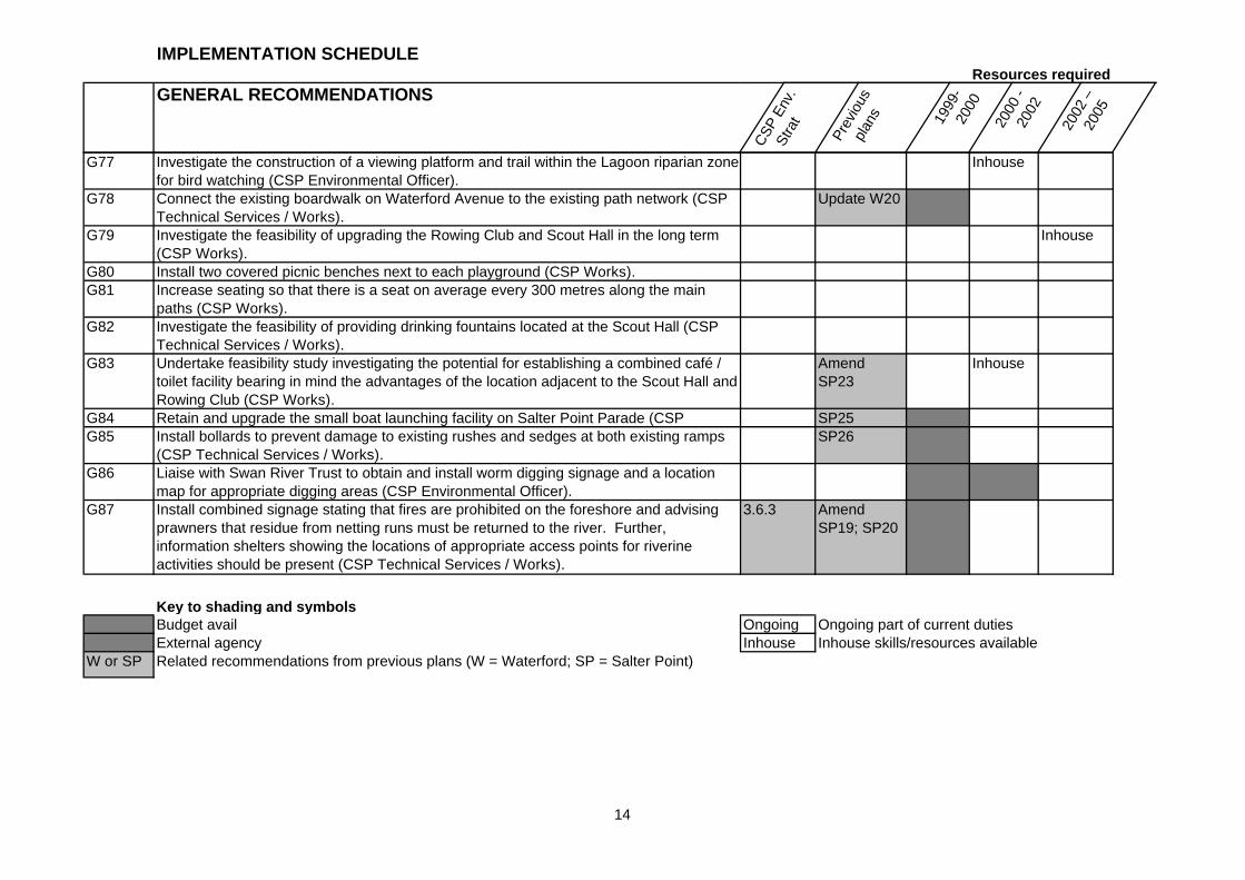
G77 Investigate the construction of a viewing platform and trail within the Lagoon riparian zone for bird watching (CSP Environmental Officer).
Inhouse
G78 Connect the existing boardwalk on Waterford Avenue to the existing path network (CSP Technical Services / Works).
Update W20
G79 Investigate the feasibility of upgrading the Rowing Club and Scout Hall in the long term (CSP Works).
Inhouse
G80 Install two covered picnic benches next to each playground (CSP Works).G81 Increase seating so that there is a seat on average every 300 metres along the main
paths (CSP Works).G82 Investigate the feasibility of providing drinking fountains located at the Scout Hall (CSP
Technical Services / Works).G83 Undertake feasibility study investigating the potential for establishing a combined café /
toilet facility bearing in mind the advantages of the location adjacent to the Scout Hall and Rowing Club (CSP Works).
Amend SP23
Inhouse
G84 Retain and upgrade the small boat launching facility on Salter Point Parade (CSP SP25G85 Install bollards to prevent damage to existing rushes and sedges at both existing ramps
(CSP Technical Services / Works).SP26
G86 Liaise with Swan River Trust to obtain and install worm digging signage and a location map for appropriate digging areas (CSP Environmental Officer).
G87 Install combined signage stating that fires are prohibited on the foreshore and advising prawners that residue from netting runs must be returned to the river. Further, information shelters showing the locations of appropriate access points for riverine activities should be present (CSP Technical Services / Works).
3.6.3 Amend SP19; SP20
Key to shading and symbolsBudget avail Ongoing Ongoing part of current dutiesExternal agency Inhouse Inhouse skills/resources available
W or SP Related recommendations from previous plans (W = Waterford; SP = Salter Point)
14
IMPLEMENTATION SCHEDULEResources required
GENERAL RECOMMENDATIONS
CSP
Env
. St
rat
Prev
ious
pl
ans
1999
-200
0
2000
- 20
02
2002
–
2005
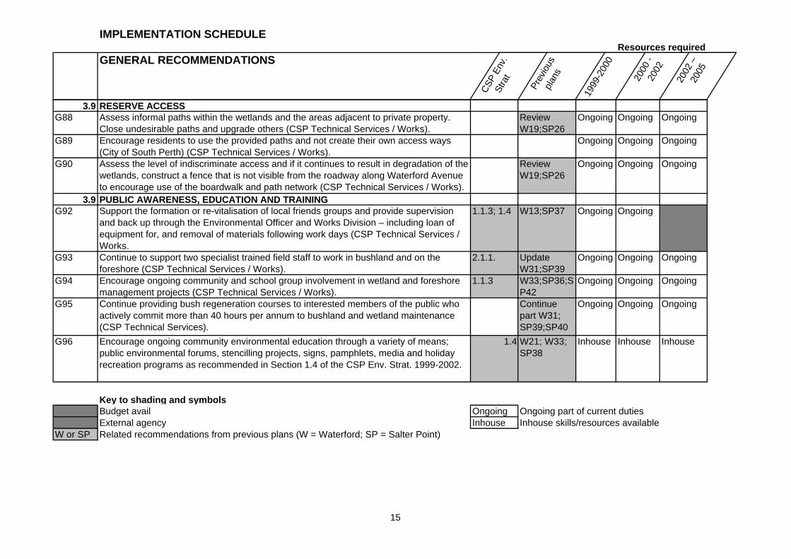
3.9 RESERVE ACCESSG88 Assess informal paths within the wetlands and the areas adjacent to private property.
Close undesirable paths and upgrade others (CSP Technical Services / Works).Review W19;SP26
Ongoing Ongoing Ongoing
G89 Encourage residents to use the provided paths and not create their own access ways (City of South Perth) (CSP Technical Services / Works).
Ongoing Ongoing Ongoing
G90 Assess the level of indiscriminate access and if it continues to result in degradation of the wetlands, construct a fence that is not visible from the roadway along Waterford Avenue to encourage use of the boardwalk and path network (CSP Technical Services / Works).
Review W19;SP26
Ongoing Ongoing Ongoing
3.9 PUBLIC AWARENESS, EDUCATION AND TRAININGG92 Support the formation or re-vitalisation of local friends groups and provide supervision
and back up through the Environmental Officer and Works Division – including loan of equipment for, and removal of materials following work days (CSP Technical Services / Works.
1.1.3; 1.4 W13;SP37 Ongoing Ongoing
G93 Continue to support two specialist trained field staff to work in bushland and on the foreshore (CSP Technical Services / Works).
2.1.1. Update W31;SP39
Ongoing Ongoing Ongoing
G94 Encourage ongoing community and school group involvement in wetland and foreshore management projects (CSP Technical Services / Works).
1.1.3 W33;SP36;SP42
Ongoing Ongoing Ongoing
G95 Continue providing bush regeneration courses to interested members of the public who actively commit more than 40 hours per annum to bushland and wetland maintenance (CSP Technical Services).
Continue part W31; SP39;SP40
Ongoing Ongoing Ongoing
G96 Encourage ongoing community environmental education through a variety of means; public environmental forums, stencilling projects, signs, pamphlets, media and holiday recreation programs as recommended in Section 1.4 of the CSP Env. Strat. 1999-2002.
1.4 W21; W33; SP38
Inhouse Inhouse Inhouse
Key to shading and symbolsBudget avail Ongoing Ongoing part of current dutiesExternal agency Inhouse Inhouse skills/resources available
W or SP Related recommendations from previous plans (W = Waterford; SP = Salter Point)
15
IMPLEMENTATION SCHEDULEResources required
GENERAL RECOMMENDATIONS
CSP
En
v.
Stra
tPr
evio
us
plan
s 1999
-20
00
2000
- 20
02
2002
–
2005
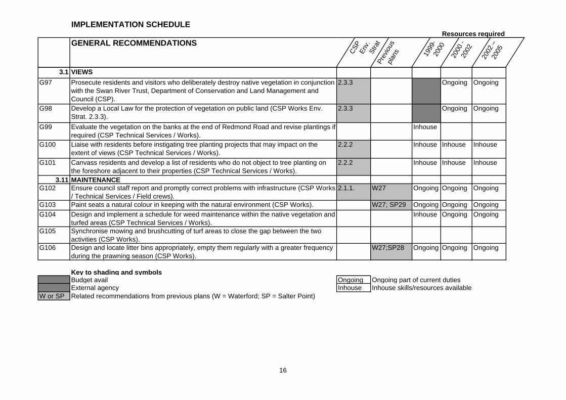
3.1 VIEWS
G97 Prosecute residents and visitors who deliberately destroy native vegetation in conjunction with the Swan River Trust, Department of Conservation and Land Management and Council (CSP).
2.3.3 Ongoing Ongoing
G98 Develop a Local Law for the protection of vegetation on public land (CSP Works Env. Strat. 2.3.3).
2.3.3 Ongoing Ongoing
G99 Evaluate the vegetation on the banks at the end of Redmond Road and revise plantings if required (CSP Technical Services / Works).
Inhouse
G100 Liaise with residents before instigating tree planting projects that may impact on the extent of views (CSP Technical Services / Works).
2.2.2 Inhouse Inhouse Inhouse
G101 Canvass residents and develop a list of residents who do not object to tree planting on the foreshore adjacent to their properties (CSP Technical Services / Works).
2.2.2 Inhouse Inhouse Inhouse
3.11 MAINTENANCE G102 Ensure council staff report and promptly correct problems with infrastructure (CSP Works
/ Technical Services / Field crews).2.1.1. W27 Ongoing Ongoing Ongoing
G103 Paint seats a natural colour in keeping with the natural environment (CSP Works). W27; SP29 Ongoing Ongoing Ongoing
G104 Design and implement a schedule for weed maintenance within the native vegetation and turfed areas (CSP Technical Services / Works).
Inhouse Ongoing Ongoing
G105 Synchronise mowing and brushcutting of turf areas to close the gap between the two activities (CSP Works).
G106 Design and locate litter bins appropriately, empty them regularly with a greater frequency during the prawning season (CSP Works).
W27;SP28 Ongoing Ongoing Ongoing
Key to shading and symbolsBudget avail Ongoing Ongoing part of current dutiesExternal agency Inhouse Inhouse skills/resources available
W or SP Related recommendations from previous plans (W = Waterford; SP = Salter Point)
16
IMPLEMENTATION SCHEDULEResources required
GENERAL RECOMMENDATIONS
CSP
En
v.
Stra
tPr
evio
us
plan
s 1999
-20
00
2000
- 20
02
2002
–
2005
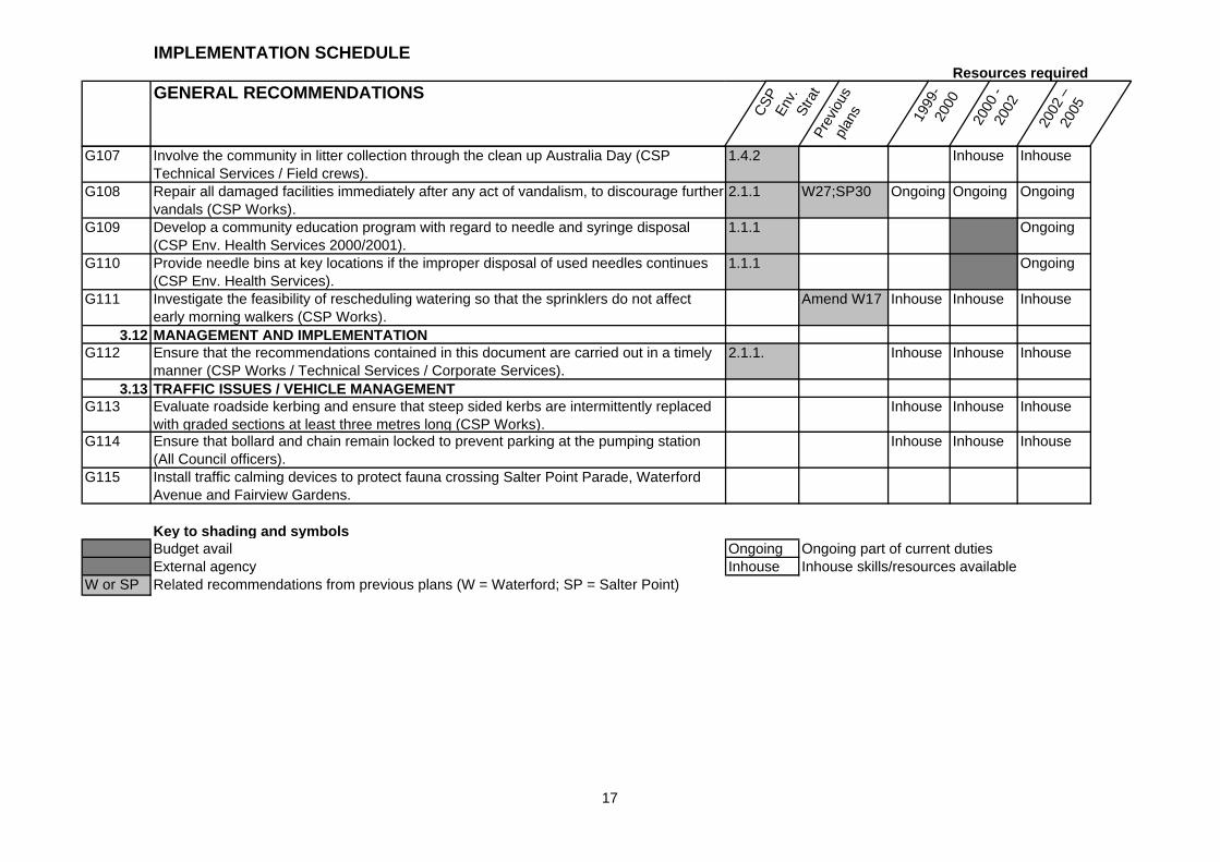
G107 Involve the community in litter collection through the clean up Australia Day (CSP Technical Services / Field crews).
1.4.2 Inhouse Inhouse
G108 Repair all damaged facilities immediately after any act of vandalism, to discourage further vandals (CSP Works).
2.1.1 W27;SP30 Ongoing Ongoing Ongoing
G109 Develop a community education program with regard to needle and syringe disposal (CSP Env. Health Services 2000/2001).
1.1.1 Ongoing
G110 Provide needle bins at key locations if the improper disposal of used needles continues (CSP Env. Health Services).
1.1.1 Ongoing
G111 Investigate the feasibility of rescheduling watering so that the sprinklers do not affect early morning walkers (CSP Works).
Amend W17 Inhouse Inhouse Inhouse
3.12 MANAGEMENT AND IMPLEMENTATION G112 Ensure that the recommendations contained in this document are carried out in a timely
manner (CSP Works / Technical Services / Corporate Services).2.1.1. Inhouse Inhouse Inhouse
3.13 TRAFFIC ISSUES / VEHICLE MANAGEMENTG113 Evaluate roadside kerbing and ensure that steep sided kerbs are intermittently replaced
with graded sections at least three metres long (CSP Works).Inhouse Inhouse Inhouse
G114 Ensure that bollard and chain remain locked to prevent parking at the pumping station (All Council officers).
Inhouse Inhouse Inhouse
G115 Install traffic calming devices to protect fauna crossing Salter Point Parade, Waterford Avenue and Fairview Gardens.
Key to shading and symbolsBudget avail Ongoing Ongoing part of current dutiesExternal agency Inhouse Inhouse skills/resources available
W or SP Related recommendations from previous plans (W = Waterford; SP = Salter Point)
17
18
1.0 INTRODUCTION
1.1 Need for the study
The review of the Salter Point and Waterford Foreshore Management Plans has been undertaken in order to assess the success of the implementation of recommendations from the 1986, 1987 and 1994 Management Plans. Plans for these two areas have been in place since 1986, considerable changes both within the local community and State and local government policies have occurred during this time. This demonstrates the need for review of these plans on a regular basis.
The planning framework that protects these highly valuable conservation areas has been strengthened in the late 1990s, with the Urban Bushland Strategy, Perth’s Bushplan, Swan and Canning Rivers Environmental Protection Policy, A Strategic Plan for Perth’s Greenways and the City of South Perth Environmental Strategy 1999-2002. These documents provide a policy and planning framework, which guide management and activities on the foreshore (Section 1.4 of this document) and the recognition given in these documents further strengthens applications for external funding.
The regional linkage of these areas was recognised in these documents, and as such the City of South Perth Environmental Officer recommended that a combined management planning review be undertaken which has resulted in the development of a single management plan.
The review of the Salter Point and Waterford foreshore management plans was initiated in June 1999, at the City of South Perth Council meeting. The Council resolved to review the two plans and produce an amalgamated plan as part of the review process.
This plan has attempted to strike a balance between the multiple use demands of the region and the protection of flora, fauna and water quality.
1.2 The vision and values The vision for the Salter Point and Waterford foreshores promotes the development of:
“Healthy wetland and bushland areas where people can enjoy the wildlife, its natural heritage, and passive recreational opportunities the parkland provides”.
The values associated with the reserves include: conservation, education, recreation and aesthetic qualities.
1.3 Aims and objectives The aims and objectives of the management plan reviews are:
1. To identify the:
♦ Extent of implementation of the existing plans to date;
♦ Changes in the physical and biological environment since 1986 and 1994;
♦ Impact of additional residential development, recreation and other human use;
♦ Appropriateness of current management practices;
♦ Adequacy of protection from fire, erosion and other human impact; and
♦ Strategies not currently developed or implemented.
2. To assess:
♦ Need to change vesting, use and policies;
19
♦ Results of implemented strategies;
♦ Current appropriateness of strategies not implemented.
3. To recommend management strategies for the next five years.
1.4 Related environmental policies and studies
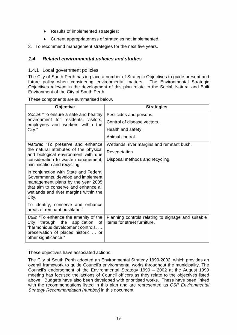
1.4.1 Local government policies The City of South Perth has in place a number of Strategic Objectives to guide present and future policy when considering environmental matters. The Environmental Strategic Objectives relevant in the development of this plan relate to the Social, Natural and Built Environment of the City of South Perth.
These components are summarised below.
Objective Strategies
Social: “To ensure a safe and healthy environment for residents, visitors, employees and workers within the City.”
Pesticides and poisons.
Control of disease vectors.
Health and safety.
Animal control.
Natural: “To preserve and enhance the natural attributes of the physical and biological environment with due consideration to waste management, minimisation and recycling.
In conjunction with State and Federal Governments, develop and implement management plans by the year 2005 that aim to conserve and enhance all wetlands and river margins within the City.
To identify, conserve and enhance areas of remnant bushland.”
Wetlands, river margins and remnant bush.
Revegetation.
Disposal methods and recycling.
Built: “To enhance the amenity of the City through the application of “harmonious development controls, … preservation of places historic … or other significance.”
Planning controls relating to signage and suitable items for street furniture.
These objectives have associated actions.
The City of South Perth adopted an Environmental Strategy 1999-2002, which provides an overall framework to guide Council’s environmental works throughout the municipality. The Council’s endorsement of the Environmental Strategy 1999 – 2002 at the August 1999 meeting has focused the actions of Council officers as they relate to the objectives listed above. Budgets have also been developed with prioritised works. These have been linked with the recommendations listed in this plan and are represented as CSP Environmental Strategy Recommendation (number) in this document.
20
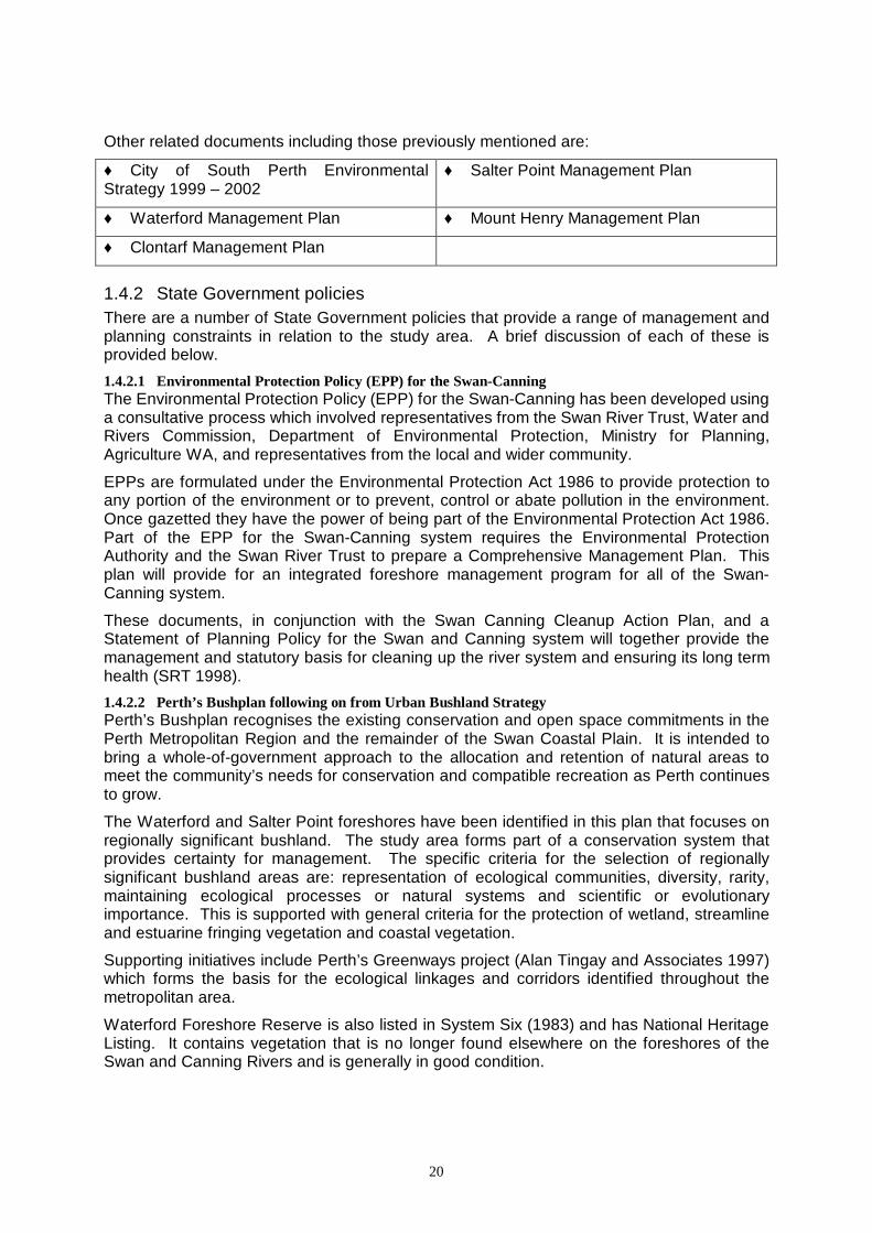
Other related documents including those previously mentioned are:
♦ City of South Perth Environmental Strategy 1999 – 2002
♦ Salter Point Management Plan
♦ Waterford Management Plan ♦ Mount Henry Management Plan
♦ Clontarf Management Plan
1.4.2 State Government policies There are a number of State Government policies that provide a range of management and planning constraints in relation to the study area. A brief discussion of each of these is provided below.
1.4.2.1 Environmental Protection Policy (EPP) for the Swan-Canning The Environmental Protection Policy (EPP) for the Swan-Canning has been developed using a consultative process which involved representatives from the Swan River Trust, Water and Rivers Commission, Department of Environmental Protection, Ministry for Planning, Agriculture WA, and representatives from the local and wider community.
EPPs are formulated under the Environmental Protection Act 1986 to provide protection to any portion of the environment or to prevent, control or abate pollution in the environment. Once gazetted they have the power of being part of the Environmental Protection Act 1986. Part of the EPP for the Swan-Canning system requires the Environmental Protection Authority and the Swan River Trust to prepare a Comprehensive Management Plan. This plan will provide for an integrated foreshore management program for all of the Swan-Canning system.
These documents, in conjunction with the Swan Canning Cleanup Action Plan, and a Statement of Planning Policy for the Swan and Canning system will together provide the management and statutory basis for cleaning up the river system and ensuring its long term health (SRT 1998).
1.4.2.2 Perth’s Bushplan following on from Urban Bushland Strategy Perth’s Bushplan recognises the existing conservation and open space commitments in the Perth Metropolitan Region and the remainder of the Swan Coastal Plain. It is intended to bring a whole-of-government approach to the allocation and retention of natural areas to meet the community’s needs for conservation and compatible recreation as Perth continues to grow.
The Waterford and Salter Point foreshores have been identified in this plan that focuses on regionally significant bushland. The study area forms part of a conservation system that provides certainty for management. The specific criteria for the selection of regionally significant bushland areas are: representation of ecological communities, diversity, rarity, maintaining ecological processes or natural systems and scientific or evolutionary importance. This is supported with general criteria for the protection of wetland, streamline and estuarine fringing vegetation and coastal vegetation.
Supporting initiatives include Perth’s Greenways project (Alan Tingay and Associates 1997) which forms the basis for the ecological linkages and corridors identified throughout the metropolitan area.
Waterford Foreshore Reserve is also listed in System Six (1983) and has National Heritage Listing. It contains vegetation that is no longer found elsewhere on the foreshores of the Swan and Canning Rivers and is generally in good condition.
21
1.4.2.3 Lower Canning River Management Plan The Lower Canning River Management Plan (1995) was also developed using a consultative process by the Swan River Trust, to provide a regional planning strategy for the foreshores of the Canning River below the Canning River Regional Park. This plan includes a vision for the future and guides development in this area. The plan also outlines the Swan River Trust policies and regulations pursuant to the Swan River Trust Act (1986).
1.4.2.4 Swan-Canning Cleanup Draft Action Plan Some of the recommendations contained within the Lower Canning River Management Plan (1995) have been upgraded and strengthened in the Swan-Canning Clean Up Program Draft Action Plan (1998). This plan provides guiding principles and recommendations for protecting all areas of remnant vegetation, increasing revegetation works, managing nutrient and chemical use and managing access to the river and its foreshores. The Action Plan complements the Swan-Canning Environmental Protection Policy and requires the development of a comprehensive management plan.
This management plan will be developed by the Environmental Protection Authority and the Swan River Trust, and will aim to provide an integrated foreshore management program for waterways of the whole Swan-Canning system.
1.4.3 Federal Government policies 1.4.3.1 Register of National Estate The wetlands occurring within the Waterford and Salter Point Reserves are recognised in the Register of National Estate due to their considerable conservation and natural heritage values. They are also included in the Directory for Important Wetlands in Australia (Swan-Canning Estuary). The presence of trans-migratory bird species in these areas indicates their national and international significant.
1.5 Community involvement process
The intention to review these plans was advertised in a number of ways.
Approaches to the local community commenced in July 1999, with a newspaper article in the Southern Gazette advertising the intention to review the management plans, and inviting submissions from the community.
A Mail Drop was implemented to invite local residents to attend a field day. The Field Day was held in August 1999 with Council officers and a post graduate student organising two professional guides to explain the wetland ecosystem and management process during two field walks. A sausage sizzle was also held. Up to 120 people had contact with the process on this day. Issue-scoping forms were completed which formed the majority of submissions received prior to the development of the draft plan.
Leaflets were placed on star pickets adjacent to the dual use paths to try to gain further attention. These leaflets were also placed in the Manning and Civic Centre public libraries, and were provided adjacent to a three panel information display installed at the Village Green Shopping Centre (Karawara) and Dewsons Supermarket (Applecross). These information panels will be placed in the Council libraries until completion of the final document in February 2000.
Subsequent articles in the Southern Gazette invited people to register to attend the meetings. In addition, a letterbox drop was undertaken for all properties within the suburbs of Salter Point and Waterford inviting people to attend either of two public meetings, and providing a brief information sheet about the management planning process and content of the plans.
22
Forty-three people attended the workshop held on Wednesday 1 September and 42 people attended the workshop held on Saturday 4 September 1999. In addition 18 submissions were received prior to finalising the draft management plan.
Issues and solutions raised in the submissions and at the two workshops have been addressed in this review. Some issues were beyond the scope of this study and are provided in Appendix 6 of this document.
This plan was initially presented to Council for endorsement, and released for public comment for a two-month period. Release of the plan was advertised in The West Australian and the Southern Gazette.
Public comments have been analysed and modifications made to the document as required in accordance with the results of additional research. The final plan is to be presented to Council for adoption. Following adoption, the final report will be published as the Salter Point and Waterford Foreshore Management Plan – an integral part of the Canning River Wetlands.
Implementation of the recommendations of the plan will be the responsibility of the City of South Perth, with community involvement playing a pivotal role.
2.0 STUDY AREA
2.1 Definition of boundaries The study area comprises the boundaries from the original management plans and reviews, however, an extension was made to include the foreshore reserve on public land up to the privately managed Aquinas College property. The western boundary is Redmond Street and the eastern boundary is the area known as Brother Keaney’s Gardens.
The southern boundary is the Canning River and the northern boundary is determined by the extent of the foreshore reserves, but excludes the Bodkin Park area.
Management access and responsibilities were the principal determinant in selecting the boundaries (Map 1).
2.2 Physical environment
2.2.1 Climate The reserves are influenced by a Mediterranean climate. Such climates are characterised by wet, mild winters and dry, hot summers. The movement of an anti-cyclonic high, which lies in an east-west direction across the continent over summer and moves northward in winter, controls the weather during the year.
The average mean minimum winter temperatures are 9.3oC and 17.8oC respectively; the average mean minimum and maximum summer temperatures are 17.3oC and 28.9oC respectively. The total average rainfall for the year is 873 mm, of this, 494 mm falls in the winter months of June, July and August, and 34 mm falls in the summer months of December, January and February (Perth Meteorological Station, Western Australian Year Book, 1984).
It is very windy from late winter, through spring to summer. Generally there are dry easterlies in the morning and then cooling moderate to strong south-westerlies in the afternoon. The Salter Point Reserve, particularly at the lagoon, is greatly influenced by winds from many directions, while the Waterford foreshore is predominantly affected by southerly winds. The expanse of the Canning River leading to Salter Point from both the east and the west increases the exposure experienced at the lagoon, when compared to the remainder of the Reserve.

23
Map 1 – Study area
24
The flora and fauna have physical, behavioural or other adaptations to survive the high summer temperatures and low summer rainfall. Other factors such as very high evaporation rates in summer, desiccating winds and the poor fertility and moisture retention of the soil contribute to this area’s harsh environment.
The daily tidal range is very small; with its maximum range involving less than one metre (measured at the Barrack Street Jetty) with only one movement in a twenty-four hour period. The tide is affected by many variables including winds, water temperatures, moon phases and changes in the barometric pressure (Orr 1986). To cope with this, species along the foreshore must be salt tolerant and able to withstand periodic tidal inundation.
2.2.2 Geomorphology / soils Geomorphologically the Reserves lie within the Bassendean Dune System that forms through aeolian processes, i.e. from wind-borne sediment. These soils are composed of grey quartz derived particles, are porous, and are both chemically and physically infertile.
A more detailed geological map, however, describes the soil type present in both the Salter Point and Waterford foreshore reserves as predominantly alluvium, i.e. water-deposited sediment. The alluvium consists of clay, sand and loam and is relatively fertile soil in comparison to other soils of the Swan Coastal Plain.
The presence of alluvium is the result of the areas being predominantly low-lying. Gradual deposition of alluvial sediments causes the river to change course slightly, forming a wetland. Within the wetland sedimentation still continues and serial aerial photographs indicate a reduction in the size of the lakes in the wetland area.
The two elevated areas at the Salter Point Lagoon are exceptions, having the typical Bassendean aeolian soils along with a series of ridges running parallel to the shoreline bounding the wetland in Waterford. This soil type consists of porous, grey, quartz sands that are both physically and chemically infertile and is the predominant soil type north of the reserve. The highest point of elevation of the ridges is 1.1m AHD in Waterford. On a 1944 aerial photograph of the area prior to development, the Bassendean soil type from Mt. Henry can be observed extending through to these lagoon areas (Figure 1).
The steep limestone cliff along River Way is the eastern most part of the Tamala Limestone ridge that forms Mount Henry. The vegetation communities associated with soils derived from this type of limestone are uncommon in this region (Perth’s Bushplan 1998).
Both the Alluvial and Bassendean soil types accumulated less than 2.5 million years ago. The alluvial soils were more recently deposited than the Bassendean soils (deposited in the older Pleistocene period).
Both of the reserves are very low lying and thus, frequently inundated as the tide oscillates. The highest point of elevation is approximately 25 m on the limestone scarp and 2 m at the upper limit of the riparian zone at Salter Point. This 2 m contour line extends in a V-shape on each side of the lagoon. The Waterford foreshore is also low-lying and flat due to the soil type and weathering over time. The suburb of Waterford is built on considerable volumes of landfill, and historically was a wetland. The estuarine reaches of the Canning River show a clear relation between the course of the river and the dune topography. A feature of the wetland is a series of lakes that are tidally connected to the river.
2.2.3 Hydrology Annual rainfall, stormwater runoff and tidal exchange all contribute to the river hydrology. The volume of river inflow and tidal height into the system is the principal factor determining the hydrological status.
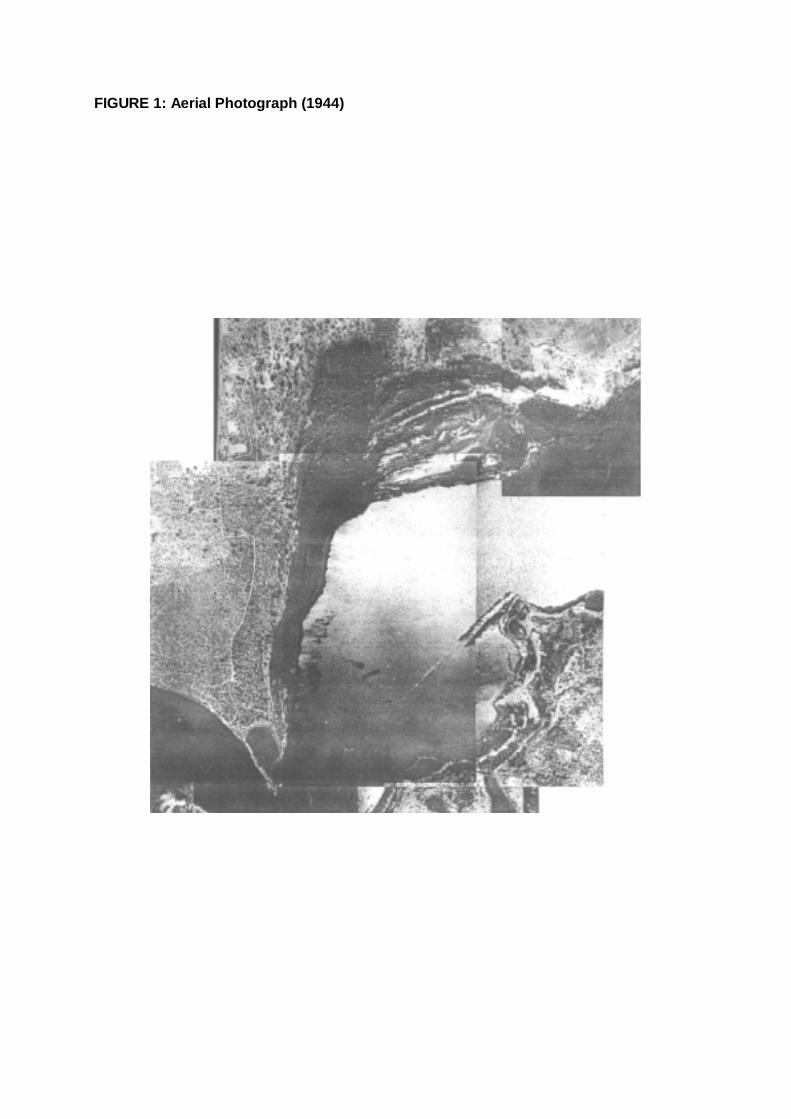
FIGURE 1: Aerial Photograph (1944)
26
The hydrological features of the Salter Point and Waterford foreshore areas are shown in Map 2.
There are a number of features, which need to be noted, as they have an impact on management. There are extensive freshwater and saltwater wetlands and the estuarine river system retains an important function in the natural process of erosion and sedimentation resulting from water movement.
When there is excessive wave action this natural balance can be upset, and a common cause is wash from powerboats. The river banks on the western side of Salter Point and adjacent to the Curtin University of Technology Rowing Club is suffering erosion as a result of water movement. The remainder of the study area remains stable due to the presence of extensive shallow banks surrounding the reserve’s shoreline, which prevent powered vessels from coming close and also dissipate the energy of the waves.
2.2.3.1 Freshwater environments Both natural and man-made water areas are featured throughout this environment.
There are freshwater wetland remnants in the northeastern parts of the Waterford Conservation Area adjoining Bodkin Park. There are also a number of freshwater wetland remnants, including what is referred to as the Melaleuca swamp, and other locations within Sandon Reserve. These are the only remnants of an extremely large wetland system. The water level fluctuates seasonally.
Two State and nine Local Government drainage systems discharge into the Canning River (Map 2). These vary in their frequency and volume of discharge in accordance with the catchment areas. The Water Corporation Drains are the Elderfield Road Drain (Manning Road Main Drain) and the Collier Pines Main Drain that runs through Bodkin Park. Both drains tend to flow all year.
The Collier Pines Main Drain system has an extensive catchment and contributes freshwater into the wetlands system. It is piped to Bodkin Park (Reserve 37648) where it flows through as an open drain with timber side lacing. From here, the water follows a natural course, created by what was originally a spring-fed stream, through the wetland to the river. The fresh water flows directly into saltwater lakes, which detrimentally affects the flora and fauna, which are adapted to conditions of high salinity.
Observations of excessive algal growth in the artificial lakes of Bodkin Park indicate that high levels of nutrients are a problem. From Bodkin Park, algae, nutrients and non-biodegradable materials presently flow into the wetland. The water quality of this drain was monitored quarterly by the Waterways Commission between 1979 and 1988. This historical data cannot be used to extrapolate current levels, so little is known about water quality in these areas.
Some of the local government drains are piped to the river’s edge, while others have been opened and flow through vegetated and un-vegetated channels to the river. One feeds into the Melaleuca swamp near the Manning Road Main Drain.
2.2.3.2 Saltwater environments Tidal intrusion of salt water into the wetlands occurs on a monthly cycle, with greater influx of freshwater during the winter months. The wetlands become hypersaline in summer with higher levels of evaporation associated with strong easterly winds and the sea breeze, and overall higher temperatures. The main estuarine features of the foreshore are described below.
The Lagoon, located at Salter Point is a feature unique to the Canning and Swan River System. The only other estuarine lagoon of this type was at Mill Point, however, this was filled prior to construction of the Narrows Bridge.
The lagoon is shallow and tidally connected to the Canning River by a narrow channel that has deposits of silt and sand which do not appear to impede water flow.

27
Map 2: Hydrology and erosion and accretion
28
In recent times there has been evidence that the water in the lagoon itself is stagnating and releases an odour. Birds continue to be observed feeding in the lagoon which is indicative of reasonable water quality. At low tide the mud flats are exposed and there is a typical river odour.
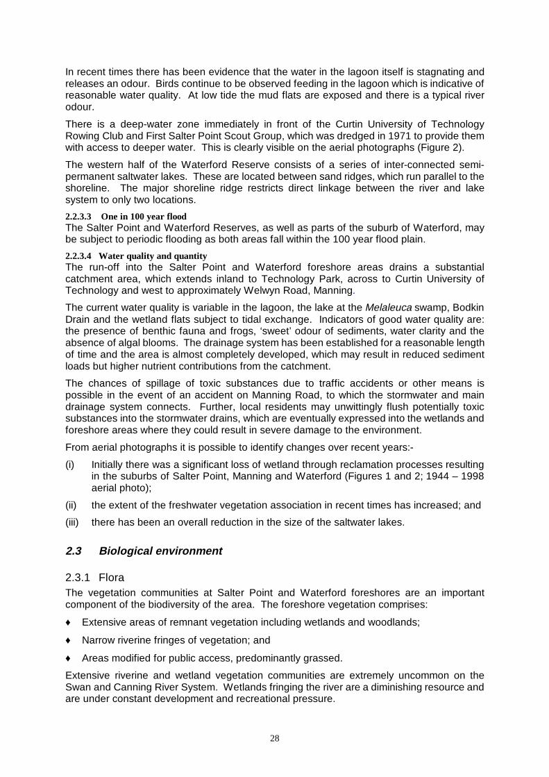
There is a deep-water zone immediately in front of the Curtin University of Technology Rowing Club and First Salter Point Scout Group, which was dredged in 1971 to provide them with access to deeper water. This is clearly visible on the aerial photographs (Figure 2).
The western half of the Waterford Reserve consists of a series of inter-connected semi-permanent saltwater lakes. These are located between sand ridges, which run parallel to the shoreline. The major shoreline ridge restricts direct linkage between the river and lake system to only two locations.
2.2.3.3 One in 100 year flood The Salter Point and Waterford Reserves, as well as parts of the suburb of Waterford, may be subject to periodic flooding as both areas fall within the 100 year flood plain.
2.2.3.4 Water quality and quantity The run-off into the Salter Point and Waterford foreshore areas drains a substantial catchment area, which extends inland to Technology Park, across to Curtin University of Technology and west to approximately Welwyn Road, Manning.
The current water quality is variable in the lagoon, the lake at the Melaleuca swamp, Bodkin Drain and the wetland flats subject to tidal exchange. Indicators of good water quality are: the presence of benthic fauna and frogs, ‘sweet’ odour of sediments, water clarity and the absence of algal blooms. The drainage system has been established for a reasonable length of time and the area is almost completely developed, which may result in reduced sediment loads but higher nutrient contributions from the catchment.
The chances of spillage of toxic substances due to traffic accidents or other means is possible in the event of an accident on Manning Road, to which the stormwater and main drainage system connects. Further, local residents may unwittingly flush potentially toxic substances into the stormwater drains, which are eventually expressed into the wetlands and foreshore areas where they could result in severe damage to the environment.
From aerial photographs it is possible to identify changes over recent years:-
(i) Initially there was a significant loss of wetland through reclamation processes resulting in the suburbs of Salter Point, Manning and Waterford (Figures 1 and 2; 1944 – 1998 aerial photo);
(ii) the extent of the freshwater vegetation association in recent times has increased; and
(iii) there has been an overall reduction in the size of the saltwater lakes.
2.3 Biological environment
2.3.1 Flora The vegetation communities at Salter Point and Waterford foreshores are an important component of the biodiversity of the area. The foreshore vegetation comprises:
♦ Extensive areas of remnant vegetation including wetlands and woodlands;
♦ Narrow riverine fringes of vegetation; and
♦ Areas modified for public access, predominantly grassed.
Extensive riverine and wetland vegetation communities are extremely uncommon on the Swan and Canning River System. Wetlands fringing the river are a diminishing resource and are under constant development and recreational pressure.
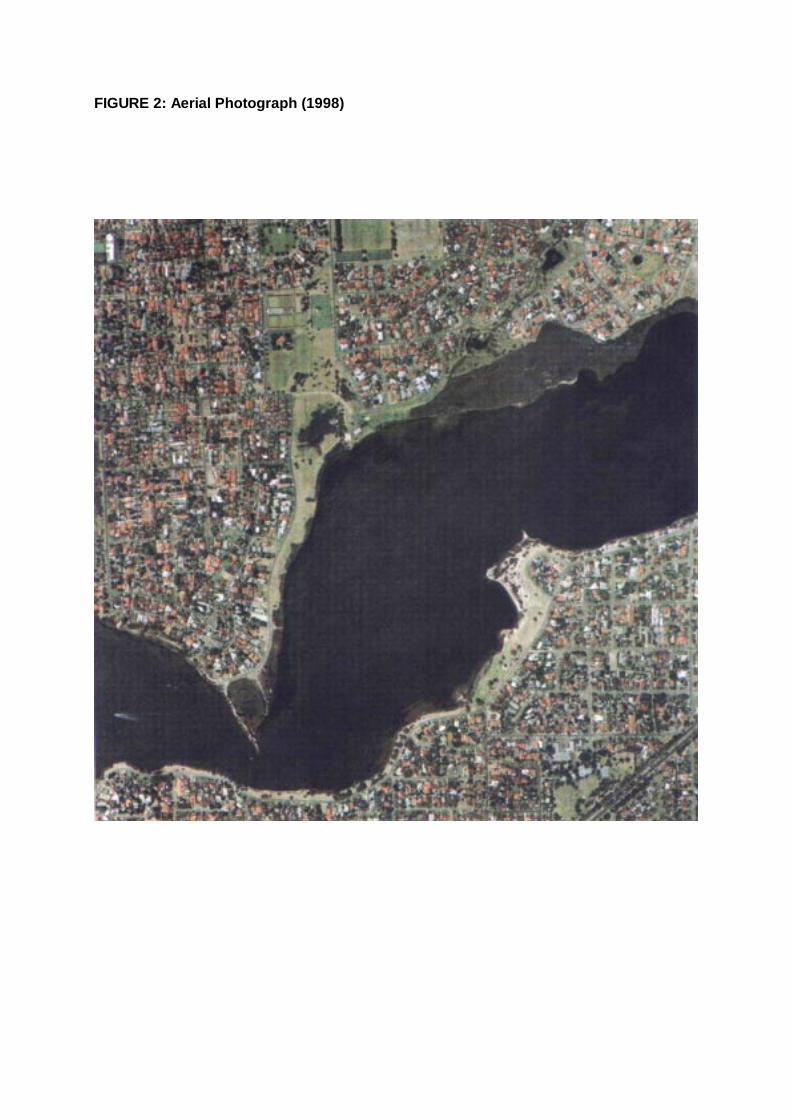
FIGURE 2: Aerial Photograph (1998)

30
Perth’s Bushplan (1998) identified that approximately 75% of the expected flora for these vegetation types remain in the area, including a Priority Three taxa Aotus cordifolia. This area provides a regionally significant contiguous bushland/wetland linkage between larger more intact areas of bushland. Detailed species lists are provided in Appendix 1 which include flora present from Mount Henry Spit to Waterford. There are 184 species noted in previous reports, of which 46 are weeds.
Fringing vegetation is important in stabilising the river bank, providing habitat for animals and slowing water movement during flood situations. Fringing wetlands can trap heavy metals and various hydrocarbons before they reach estuarine and riverine waters. The organic peat that accumulates within these zones can bind pollutants and nutrients, regulating their passage to the river.
From aerial photographs and field studies it is apparent that the extent of the freshwater association is increasing. In addition, the saltwater lakes, particularly in the Waterford Reserve have become less saline due to an increased flow of stormwater run-off.
The peripheral vegetation at these reserves, i.e. vegetation characteristic of the estuarine and riverine landscape, is a diverse ecosystem consisting of both freshwater and saltwater vegetation associations. In comparison to many natural urban reserves, this area has been subject to minimal disturbance and thus the vegetation is in a ‘healthy’ condition.
Seven vegetation community types of variable dominance, understorey composition and level and types of weed invasion characterise the vegetation of the study area:
♦ Aquatic flora
♦ Sarcocornia (samphire) / Bolboschoenus caldwellii (marsh club rush)
♦ Juncus kraussii (shore rush) sedgeland
♦ Casuarina obesa (saltwater sheoak)/ Juncus kraussii (shore rush) open woodland
♦ Melaleuca spp. (paperbark) / Juncus kraussii (shore rush) closed woodland
♦ Eucalyptus rudis (flooded gum) woodland
♦ Banksia / Eucalyptus woodland
These vegetation communities reflect the different soil types found in the area. The first four vegetation communities are alluvial, salt tolerant communities, the next pair is freshwater alluvial communities which can cope with infrequent tidal inundation, and the last vegetation association typically occurs on Bassendean soil type. Vegetation profiles of each area are given in Figures 3 and 4, vegetation communities are shown in Map 3 and a species list is given in Appendix 1.
2.3.1.1 Aquatic flora Aquatic plants and animals form the basis of the food chain and are the food source for larger invertebrates and vertebrates such as fish and birds. The aquatic flora and fauna are subject to increasing pressure from recreational demands and changes to the water quality and quantity both in the river and within the wetlands.
There are two major types of algae:
Microalgae: these are not visible to the naked eye and are divided into planktonic (free floating), epiphytic (attached to plant) and benthic (in the sediment) groups.
Macroalgae: these are the larger, weed type algae that attach to substrates or float freely.
There are important seagrass beds that occur in the shallows between Salter Point and Waterford. These have been subject to some disturbance from increased levels of
31
macroalgae, whose populations have increased dramatically as a result of higher nutrient loads to the Canning River.
Filamentous and other algae occur in the Bodkin Drain. These provide habitat, oxygenate the water when present in low levels and take up nutrients. When the growth becomes excessive, these can result in reduced water quality.
2.3.1.2 Sarcocornia (samphire) / Bolboschoenus caldwellii (marsh club rush) This is a diverse area with the vegetation forming zones correlating to the varying lengths of inundation and salinity levels. These areas typically alternate between shallow water and mudflats and are extremely popular feeding grounds for wading birds.
The Sarcocornia (samphire) / Bolboschoenus caldwellii (marsh club rush) community occurs in the most saline and wet areas and has a limited patchy distribution along the length of the foreshore. The largest stand occurs within the Waterford Conservation Area. This community is quite degraded as a Sarcocornia (samphire) complex. The marsh club rush (Bolboschoenus caldwellii) is becoming dominant. This species is a primary coloniser, which takes advantage of changes to the environment. It has become dominant due to a decrease in salinity caused by freshwater flushing from the stormwater drain.
For this reason it can be regarded as an unnatural community. The marsh club rush (B. caldwellii) grows in water up to 50 cm deep and regenerates annually, becoming a fire hazard during summer when it dries out. This association occurs in limited areas at other locations along the Canning and Swan Rivers.
Reducing the stormwater flow is necessary to ensure the survival of the true salt marsh.
2.1.3.3 Juncus kraussii (shore rush) sedgeland This vegetation community consists of the fringing saltwater (hypersaline) tolerant vegetation edging the lagoon and the Canning River. Generally the vegetation occurs in belts parallel to the shoreline, with shore rush (Juncus kraussii) growing closest to the river.
Juncus (shore rush) is specifically adapted to the frequently inundated, saline environment of the river edge. The Juncus (shore rush) belt increases in width as the slope at the River’s edge decreases. In some areas there has been a temporal succession of samphire plants including samphires (Halosarcia and Sarcocornia), Maireana and Samolus, all highly resilient species with replacement by Juncus (shore rush). This reflects increasing sediment accumulation and natural changes to the vegetation communities. Juncus (shore rush) is often trampled to enable people to gain river access. Given the opportunity, however, this regenerates well and is frequently used in foreshore stabilisation projects. Protection of this vegetation community requires defining access points and discouraging indiscriminate trampling.
The upland community adjoining Juncus kraussii (shore rush) is typically dominated by Baumea juncea (bare twig rush). This species produces limited viable seed and therefore struggles to cope with disturbance. Protecting this species is very important as the cost of re-establishment is very high, due to propagation difficulties.
2.1.3.4 Casuarina obesa (saltwater sheoak) / Juncus kraussii (shore rush) open woodland The vegetation types which occur upslope of the Juncus (shore rush) belts, vary in composition as one moves from north to south. This can be attributed to the degree of:
♦ freshwater flushing, which is greatest at the northern end; and
♦ slope of the shoreline, which is greatest at the western end.
A vegetation complex dominated by saltwater sheoak (Casuarina obesa) with occasional paperbark (Melaleuca spp.), fringes the river on land with a higher elevation and salinity. The predominant co-occurring Melaleuca is the saltwater paperbark (M. cuticularis).
A different species of paperbark (Melaleuca viminea) occurs periodically within and adjacent to the Juncus (shore rush) belt in sheltered areas.

32
Map 3: Vegetation communities
33
The understorey within this vegetation community is still the shore rush (Juncus kraussii).
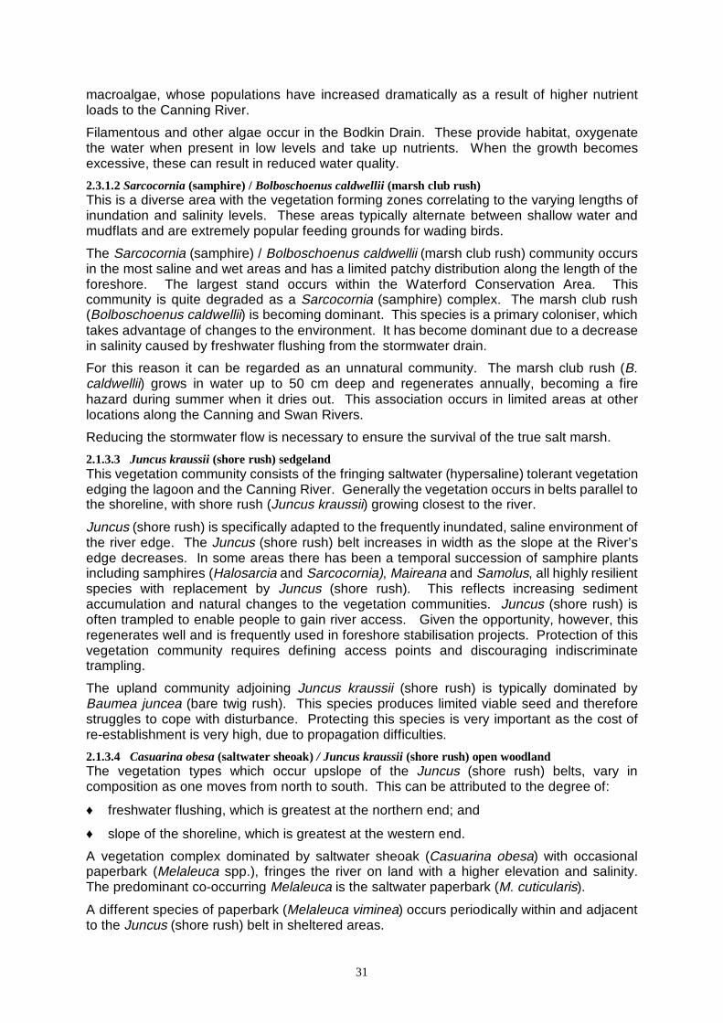
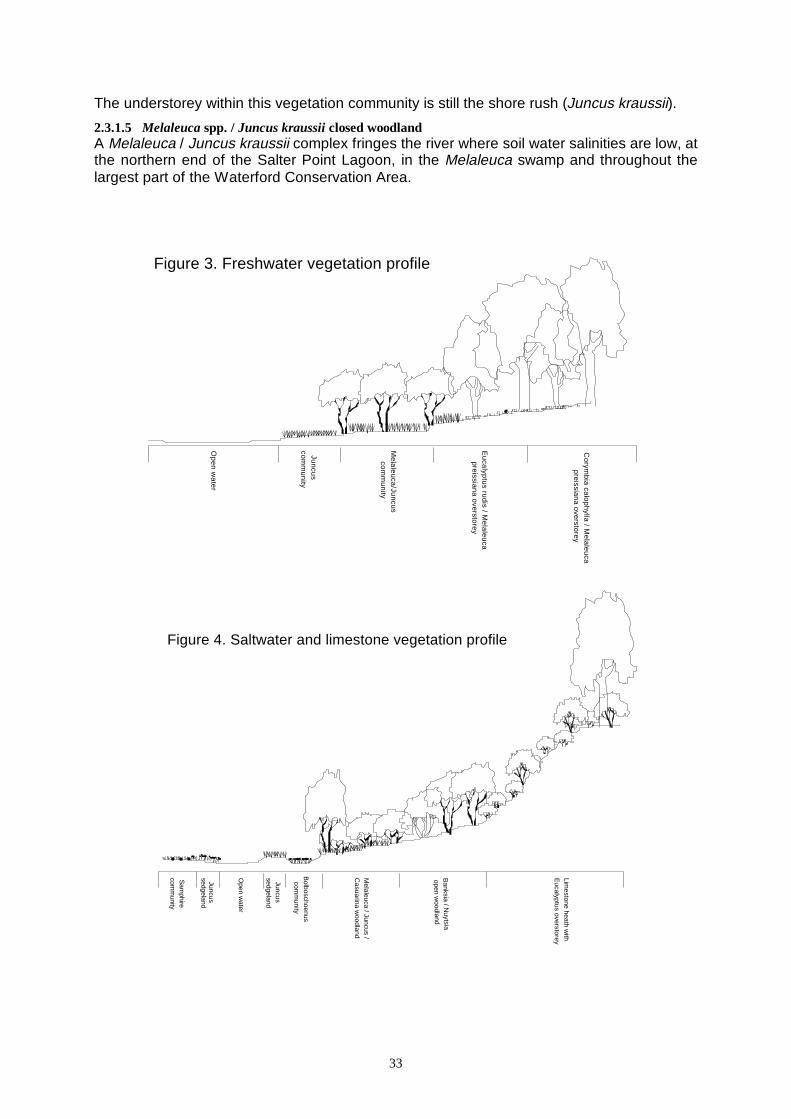
2.3.1.5 Melaleuca spp. / Juncus kraussii closed woodland A Melaleuca / Juncus kraussii complex fringes the river where soil water salinities are low, at the northern end of the Salter Point Lagoon, in the Melaleuca swamp and throughout the largest part of the Waterford Conservation Area.
Figure 3. Freshwater vegetation profile
Op
en
wa
ter
Jun
cus
com
mu
nity
Me
lale
uca
/Jun
cus
com
mu
nity
Eu
calyp
tus ru
dis / M
ela
leu
ca
preissiana overstorey
Co
rymb
ia ca
lop
hylla
/ Me
lale
uca
preissiana overstorey
Figure 4. Saltwater and limestone vegetation profile
Sam
phirecom
munity
Open w
ater
Juncus sedgeland
Juncus sedgeland
Bolboschoenus
comm
unity
Melaleuca / Juncus /
Casuarina w
oodland
Banksia / N
uytsia
open woodland
Limestone heath w
ithE
ucalyptus overstorey
34
The predominant paperbark is the freshwater paperbark (Melaleuca rhaphiophylla). The understorey is the shore rush (Juncus kraussii), grading into the bare twigrush (Baumea juncea) community. There are only a few extensive areas of vegetation along the Swan and Canning Rivers with this association.
There is also the saline form of this vegetation complex, which is characterised by a variable overstorey, including shore rush co-occurring with saltwater paperbark (Melaleuca cuticularis) and mohan (Melaleuca viminea). The mohan (M. viminea) occurs on the highest ground in this zone. The saltwater paperbark (M. cuticularis) is dying in some areas of this zone, indicating that salinity levels are becoming too low for the survival of this species.
The other area supporting a variation of the Melaleuca spp. / Juncus kraussii (shore rush) wetland community is within the Melaleuca swamp. The Melaleuca swamp complex is associated with fresh water and is subject to continuous flushing during winter as a result of fresh groundwater flow and stormwater drainage. Such complexes are found mainly along the Canning River, but a small community remains at Ashfield flats (Bassendean), indicating that it probably had a wider distribution along the Swan River in the past (Pen, 1981).
The floristic composition of different areas of the swamp differs depending on the length of inundation. The most waterlogged areas consist almost entirely of Lepidosperma longitudinale (pithy sword sedge), Baumea rubiginosa (river twig) and Baumea juncea (bare twig rush). The introduced bulrush (Typha orientalis) is located within the lake and along the outlet to the river. Its introduction and distribution is linked to alterations to the natural drainage. Its spread will reduce waterbird habitat and decrease the lakes aesthetic appeal.
The less waterlogged soils have a greater diversity of species. The dominant tree is the freshwater paperbark (Melaleuca rhaphiophylla) which occurs on the northern edge of the swamp and can be seen throughout the Waterford Conservation Area. This species grows in crowded thickets with a dense, nearly continuous canopy, and there is little groundcover. Other paperbark species present include the uncommon Melaleuca pauciflora.
Melaleuca preissiana (modong) would have been a common sight in a drier zone further back from the swamp margin. Due to landfill however, there are only a few specimens remaining.
Parts of the Melaleuca swamp were filled as recently as 1984, and these areas are colonised by weeds.
Due to landfill, approximately half of the floras at Salter Point and the Waterford foreshores have been destroyed. The persisting flora has been further altered by:
♦ introduction of exotics by the dumping of garden refuse, or from natural colonisation;
♦ frequent fires that are either accidentally or deliberately lit;
♦ drains that have been built for stormwater run-off;
♦ trampling of vegetation, especially during the prawning season;
♦ dumping of non-biodegradable litter such as car parts.
2.3.1.6 Eucalyptus rudis woodland The feature of this complex is the large flooded gum (Eucalyptus rudis) with occasional freshwater paperbark (Melaleuca rhaphiophylla), modong (M. preissiana) and occasional marri (Corymbia calophylla) on the inland margins of this vegetation type.
The understorey is predominantly comprised of introduced grasses including kikuyu (Pennisetum clandestinum) and couch (Cynodon dactylon). Generally this complex has a limited resiliency as the environmental conditions and level of disturbance work to help invasion by non-indigenous plant species. Fire frequency also reduces the ability of native vegetation to survive. However, there are some limited areas which are relatively undisturbed which retain a dense understorey of indigenous species dominated by
35
Lepidosperma longitudinale (pithy sword sedge), Baumea juncea (bare twig rush), Juncus pallidus (pale rush), Isolepis setiformis (tufted sedge) and other rushes and sedges.
The upper boundary of this area, which adjoins the dual use path supports a population of bracken fern (Pteridium esculentum) which forms dense thickets. This species is a primary coloniser and occurs in areas where there has been disturbance. It is an effective plant for excluding other non-native weed species, but increases the fire risk of the area. The last fire occurred in about 1986.
2.3.1.7 Banksia / Eucalyptus woodland Lightly timbered jarrah (Eucalyptus marginata) and Banksia woodland with low grass tree (Xanthorrhoea preissii) occurs in the western part of the study area on the high ground adjoining Salter Point Lagoon and along the limestone cliff of River Way. This vegetation community, in a healthy state, has high plant species diversity, in comparison to riparian (riverine) vegetation. Prior to the residential development, this vegetation type commonly occurred throughout the Manning areas (reference 1944 aerial photographs) extending away from the peripheral, wetland vegetation along the river.
Currently there are only three indigenous species of tree present, which are the Christmas tree, (Nuytsia floribunda), jarrah (Eucalyptus marginata) and marri (Corymbia calophylla).
The Christmas tree is very conspicuous in November and December when bright orange-yellow flowers cover the tree. Many suckers were observed, indicating good natural regeneration of this species. These plants are hemi-parasites that connect their roots to neighbouring plants, and harvest the water and nutrients moving through their systems. There are only a small number of these trees persisting.
Due to the sandy nature of the soils, this area can be a particularly fragile environment for the flora to grow in. Further, these plant communities are naturally sparse with areas of bare ground interspersed in the understorey. These gaps encourage access by people who inadvertently disturb the plant understorey. Veldt grass (Ehrharta calycina) thrives in such disturbed zones and also works against the local plants by significantly increasing the fire risk. This weed species dominates more of the understorey.
There are still occasional persistent understorey rushes, sedges and ornamental herbs and small shrubs including Schoenus, Conostylis (cottonheads), Scaevola (fan flowers), Bossiaea (common peas) and Daviesia.
Some indigenous species, for example grey stinkwood (Jacksonia furcellata), are also opportunists, although they are relatively short lived.
2.3.2 Fauna There have been a number of limited fauna surveys across the Salter Point and Waterford foreshores, apart from information collected by Birds Australia volunteers. The first was undertaken in 1986 / 1987 through the information collection phase of the management plans prepared for the reserves (Orr 1986/1987). A consultant zoologist undertook a subsequent survey in 1993, and this information was collated and compared with the results of the 1986/1987 survey. Limited surveys have been undertaken on Mount Henry by the WA Museum.
Details about the results of the surveys are provided in Appendix 2 of this document.
2.3.2.1 Mammals Six mammals were identified using a combination of field observations, trapping and analysis of faecal samples in 1986/1987.
There was evidence and sightings of the Southern Brown Bandicoot and the Mastiff bat in the mid-1980s. These however were not recorded again during the 1993 survey. Such
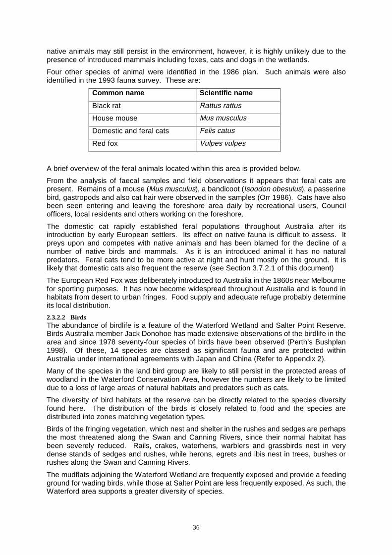
36
native animals may still persist in the environment, however, it is highly unlikely due to the presence of introduced mammals including foxes, cats and dogs in the wetlands.
Four other species of animal were identified in the 1986 plan. Such animals were also identified in the 1993 fauna survey. These are:
Common name Scientific name
Black rat Rattus rattus
House mouse Mus musculus
Domestic and feral cats Felis catus
Red fox Vulpes vulpes
A brief overview of the feral animals located within this area is provided below.
From the analysis of faecal samples and field observations it appears that feral cats are present. Remains of a mouse (Mus musculus), a bandicoot (Isoodon obesulus), a passerine bird, gastropods and also cat hair were observed in the samples (Orr 1986). Cats have also been seen entering and leaving the foreshore area daily by recreational users, Council officers, local residents and others working on the foreshore.
The domestic cat rapidly established feral populations throughout Australia after its introduction by early European settlers. Its effect on native fauna is difficult to assess. It preys upon and competes with native animals and has been blamed for the decline of a number of native birds and mammals. As it is an introduced animal it has no natural predators. Feral cats tend to be more active at night and hunt mostly on the ground. It is likely that domestic cats also frequent the reserve (see Section 3.7.2.1 of this document)
The European Red Fox was deliberately introduced to Australia in the 1860s near Melbourne for sporting purposes. It has now become widespread throughout Australia and is found in habitats from desert to urban fringes. Food supply and adequate refuge probably determine its local distribution.
2.3.2.2 Birds The abundance of birdlife is a feature of the Waterford Wetland and Salter Point Reserve. Birds Australia member Jack Donohoe has made extensive observations of the birdlife in the area and since 1978 seventy-four species of birds have been observed (Perth’s Bushplan 1998). Of these, 14 species are classed as significant fauna and are protected within Australia under international agreements with Japan and China (Refer to Appendix 2).
Many of the species in the land bird group are likely to still persist in the protected areas of woodland in the Waterford Conservation Area, however the numbers are likely to be limited due to a loss of large areas of natural habitats and predators such as cats.
The diversity of bird habitats at the reserve can be directly related to the species diversity found here. The distribution of the birds is closely related to food and the species are distributed into zones matching vegetation types.
Birds of the fringing vegetation, which nest and shelter in the rushes and sedges are perhaps the most threatened along the Swan and Canning Rivers, since their normal habitat has been severely reduced. Rails, crakes, waterhens, warblers and grassbirds nest in very dense stands of sedges and rushes, while herons, egrets and ibis nest in trees, bushes or rushes along the Swan and Canning Rivers.
The mudflats adjoining the Waterford Wetland are frequently exposed and provide a feeding ground for wading birds, while those at Salter Point are less frequently exposed. As such, the Waterford area supports a greater diversity of species.
37
The waders which use both areas can be divided into two groups; trans-equatorial migrants, for example, Grey Plover and Greenshank, and Australian resident species, for example, Red-capped Plover and Black-winged Stilt.
Of the Australian resident species, most make regular movements within Australia, although some breed locally. Their nomadic habit is a reflection on the variability of the Australian climate, which directly influences the food supply.
Most trans-equatorial migrants arrive in September/October and depart March/April. During their four to five month stay the waders build up energy reserves, which are expended during their return flight to the Northern Hemisphere. Some species fly as far north as Siberia, and it is therefore important that during their feeding period there is sufficient food available and that there should be little disturbance of their normal feeding activities. A number of these species are protected under the Australia-Japan Migratory Birds Treaty (Thurlow et al. 1986).
Reclamation and dredging of foreshore areas, swamps and lakes has meant the loss of many habitats for waterbirds of the Swan Coastal Plain. Any further loss of habitats would place even greater pressure on the areas in the metropolitan region.
The birds that are most specialised to live in one habitat, such as a wetland, are the most vulnerable to disturbance and loss of habitat.
The diversity varies at different times of the year as a result of migration of some species.
2.3.2.3 Reptiles/Amphibians Members of the Western Australian Naturalists Club undertook fauna surveys in 1985 and 1986 and this was repeated in 1993 (Brooker 1993). Summaries of available information in Perth’s Bushplan identified 12 reptile species and 6 amphibian species within this area. These included:
♦ One turtle species ♦ One blind snake species
♦ Three frog species ♦ One poisonous snake species (dugite)
♦ One legless lizard species
In addition, local residents also report to have seen tiger snakes in the reserves.
Most of the species represented on this list are common in the Perth region. An exception is Lerista lineata, a lizard that is on the fauna list of species that are ‘rare or otherwise in need of special protection’.
The reptiles and amphibians in the wetland were discovered in a range of locations, from burrows in the sand to beneath bark on dead trees. Their location stresses the importance of not removing dead trees, leaf litter, etc.
Reptiles and amphibians are relics of the distant past. Once present in large numbers, now relatively few remain. They live in both aquatic and terrestrial habitats and have a wide variety of adaptations to suit, for example, the ability to change colour (camouflage).
2.3.2.4 Aquatic macrofauna The majority of commercial and recreational catches are sea mullet, yellow eye mullet and Perth herring.
Some sections of the study area are popular recreational fishing areas. Species caught may include black bream, yellow-eye mullet, cobbler and yellowtail trumpeter. The extent and success of fishing is limited by shallow water, which is the preferred habitat for hatcheries. The most successful locations for fishing are likely to occur at Salter Point where deep water occurs close to shore. Crabs and prawns are also caught throughout the year, although these activities are concentrated in the summer months.
38
2.3.2.5 Invertebrates (terrestrial and aquatic) The aquatic fauna of the lake and wetland systems within the Waterford and Salter Point reserves has not been studied, while the 1993 fauna survey included some work on terrestrial invertebrates.
The types of invertebrates which are likely to utilise the system include crustaceans (barnacles, copepods etc), molluscs (bivalves, gastropods, chitons), annelids (polychaetes and leaches), coelenterates (jellyfish), foraminifers (skeleton-producing protozoans), platyhelminths (flat worms) and bryozoans (plant like animals) (SRT 1995).
Of interest to users of the boardwalk off Waterford Avenue and water users are the two species of jellyfish (Phyllorhiza punctata and Aurelia aurita). Both species are common in the Canning River from spring to autumn, while marine conditions prevail. The population density of both species can become very high, making swimming unpleasant. These species are often dumped on the shoreline from prawners’ nets which also contribute to degradation of the foreshore.
Information about these species can be obtained from the Swan River Trust.
Mosquitoes
Mosquitoes are pests primarily causing discomfort and annoyance, but are also capable of transmitting disease. Wetlands are ideal habitats for certain species of mosquito. When residential developments are close to wetlands they attract a localised mosquito problem which is often amplified as wetlands become degraded. The simple solution in the past has been to landfill and completely destroy the wetland, however, this is not ecologically acceptable.
There are approximately fifty mosquito species in Western Australia (Blair 1978) and of these, twelve have been identified at Waterford and Salter Point Reserves. Some of these species breed in fresh to brackish water and the remainder in saltwater. The mosquitoes were located in various sites ranging from stormwater drains (freshwater species) to tidal flats (saltwater species). They are most active at dawn and dusk. Some species are active and cause distress throughout the day, particularly in cool, damp areas where the adults rest (Blair 1978).
The intensity of breeding varies considerably within and across the wetlands, through the stormwater system, backyards and tidal zones. In 1986, it was claimed that the highest mosquito larvae recordings arose from the wetland system east of Clontarf (Orr 1987).
The life cycle of the mosquito is characterised by complete metamorphosis, with four stages: egg, larva, pupa and adult winged insect. The females can lay up to 200 eggs in one batch and can lay several batches per lifetime. Under optimum conditions incubation occurs within two to three days. The eggs of some species can withstand long periods of cold and/or desiccation. The eggs hatch into larvae, which are aquatic but air breathers. The larvae pass through four moulting stages, known as instars, over four to ten days, depending on conditions. The pupae appear with the fourth stage and during this stage they do not feed. From the pupae, the adult winged insect emerges after two days. The adult female is able to lay eggs immediately. Female mosquitoes prey on birds, mammals (including man) and sometimes on reptiles and amphibians. Males feed on plant nectars (Ehlers 1965).
The City of South Perth has been actively involved in mosquito management since August 1984. The Environmental Health Section of Council deals with mosquito nuisance and coordinates and implements mosquito control.
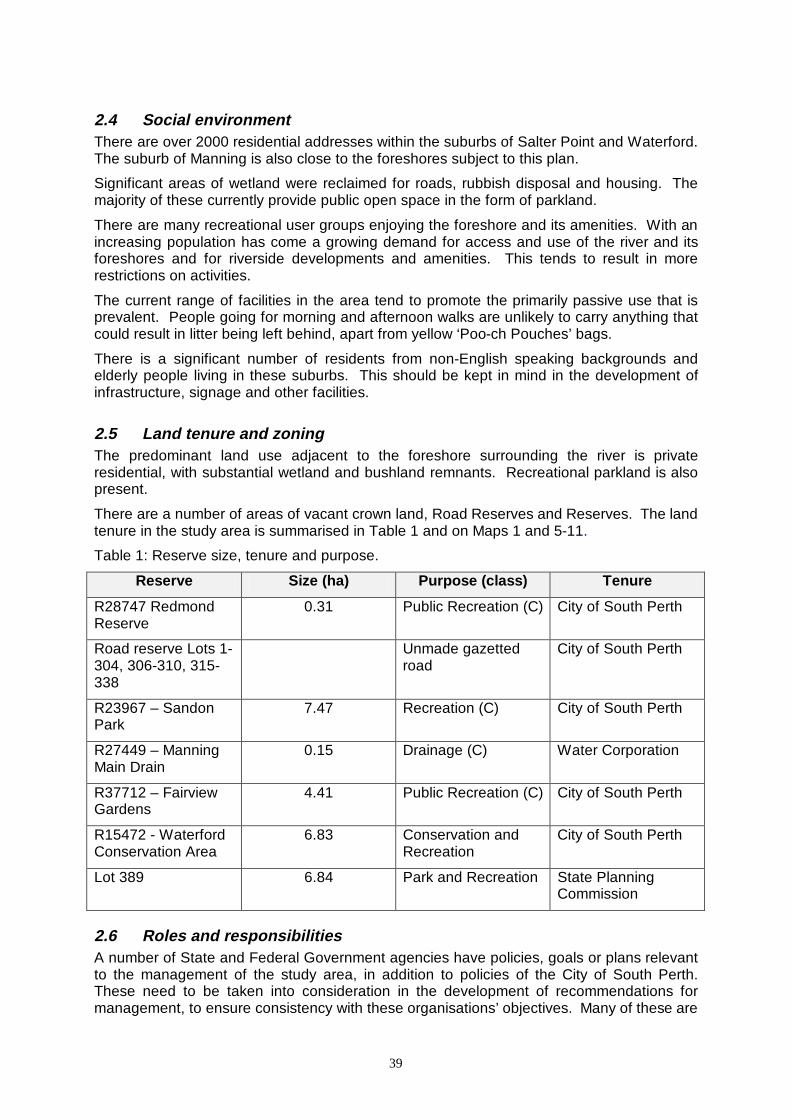
39
2.4 Social environment There are over 2000 residential addresses within the suburbs of Salter Point and Waterford. The suburb of Manning is also close to the foreshores subject to this plan.
Significant areas of wetland were reclaimed for roads, rubbish disposal and housing. The majority of these currently provide public open space in the form of parkland.
There are many recreational user groups enjoying the foreshore and its amenities. With an increasing population has come a growing demand for access and use of the river and its foreshores and for riverside developments and amenities. This tends to result in more restrictions on activities.
The current range of facilities in the area tend to promote the primarily passive use that is prevalent. People going for morning and afternoon walks are unlikely to carry anything that could result in litter being left behind, apart from yellow ‘Poo-ch Pouches’ bags.
There is a significant number of residents from non-English speaking backgrounds and elderly people living in these suburbs. This should be kept in mind in the development of infrastructure, signage and other facilities.
2.5 Land tenure and zoning The predominant land use adjacent to the foreshore surrounding the river is private residential, with substantial wetland and bushland remnants. Recreational parkland is also present.
There are a number of areas of vacant crown land, Road Reserves and Reserves. The land tenure in the study area is summarised in Table 1 and on Maps 1 and 5-11.
Table 1: Reserve size, tenure and purpose.
Reserve Size (ha) Purpose (class) Tenure
R28747 Redmond Reserve
0.31 Public Recreation (C) City of South Perth
Road reserve Lots 1-304, 306-310, 315-338
Unmade gazetted road
City of South Perth
R23967 – Sandon Park
7.47 Recreation (C) City of South Perth
R27449 – Manning Main Drain
0.15 Drainage (C) Water Corporation
R37712 – Fairview Gardens
4.41 Public Recreation (C) City of South Perth
R15472 - Waterford Conservation Area
6.83 Conservation and Recreation
City of South Perth
Lot 389 6.84 Park and Recreation State Planning Commission
2.6 Roles and responsibilities A number of State and Federal Government agencies have policies, goals or plans relevant to the management of the study area, in addition to policies of the City of South Perth. These need to be taken into consideration in the development of recommendations for management, to ensure consistency with these organisations’ objectives. Many of these are
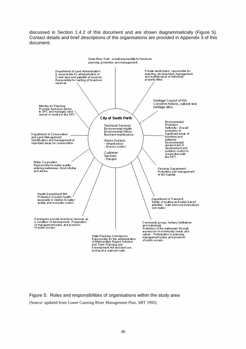
40
discussed in Section 1.4.2 of this document and are shown diagrammatically (Figure 5). Contact details and brief descriptions of the organisations are provided in Appendix 3 of this document.
Figure 5: Roles and responsibilities of organisations within the study area
(Source: updated from Lower Canning River Management Plan, SRT 1995)
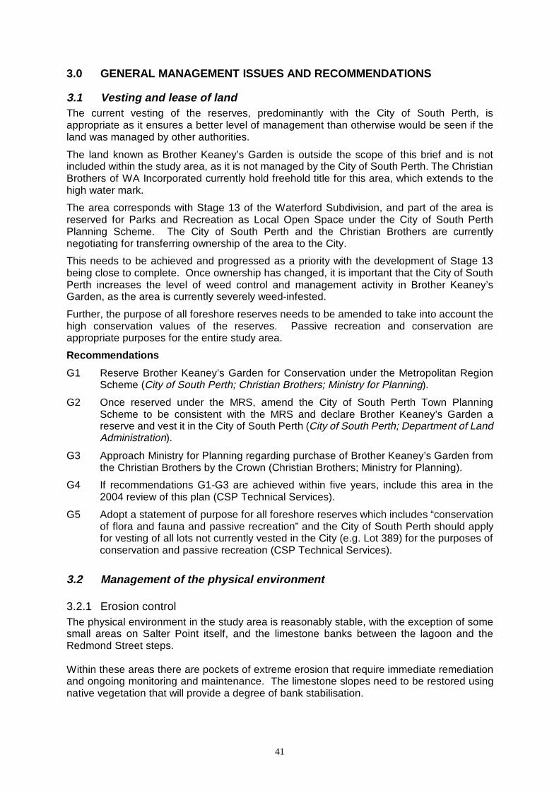
41
3.0 GENERAL MANAGEMENT ISSUES AND RECOMMENDATIONS
3.1 Vesting and lease of land The current vesting of the reserves, predominantly with the City of South Perth, is appropriate as it ensures a better level of management than otherwise would be seen if the land was managed by other authorities.
The land known as Brother Keaney’s Garden is outside the scope of this brief and is not included within the study area, as it is not managed by the City of South Perth. The Christian Brothers of WA Incorporated currently hold freehold title for this area, which extends to the high water mark.
The area corresponds with Stage 13 of the Waterford Subdivision, and part of the area is reserved for Parks and Recreation as Local Open Space under the City of South Perth Planning Scheme. The City of South Perth and the Christian Brothers are currently negotiating for transferring ownership of the area to the City.
This needs to be achieved and progressed as a priority with the development of Stage 13 being close to complete. Once ownership has changed, it is important that the City of South Perth increases the level of weed control and management activity in Brother Keaney’s Garden, as the area is currently severely weed-infested.
Further, the purpose of all foreshore reserves needs to be amended to take into account the high conservation values of the reserves. Passive recreation and conservation are appropriate purposes for the entire study area.
Recommendations
G1 Reserve Brother Keaney’s Garden for Conservation under the Metropolitan Region Scheme (City of South Perth; Christian Brothers; Ministry for Planning).
G2 Once reserved under the MRS, amend the City of South Perth Town Planning Scheme to be consistent with the MRS and declare Brother Keaney’s Garden a reserve and vest it in the City of South Perth (City of South Perth; Department of Land Administration).
G3 Approach Ministry for Planning regarding purchase of Brother Keaney’s Garden from the Christian Brothers by the Crown (Christian Brothers; Ministry for Planning).
G4 If recommendations G1-G3 are achieved within five years, include this area in the 2004 review of this plan (CSP Technical Services).
G5 Adopt a statement of purpose for all foreshore reserves which includes “conservation of flora and fauna and passive recreation” and the City of South Perth should apply for vesting of all lots not currently vested in the City (e.g. Lot 389) for the purposes of conservation and passive recreation (CSP Technical Services).
3.2 Management of the physical environment
3.2.1 Erosion control The physical environment in the study area is reasonably stable, with the exception of some small areas on Salter Point itself, and the limestone banks between the lagoon and the Redmond Street steps. Within these areas there are pockets of extreme erosion that require immediate remediation and ongoing monitoring and maintenance. The limestone slopes need to be restored using native vegetation that will provide a degree of bank stabilisation.
42
Erosion is particularly prevalent around the informal access tracks and also adjacent to the stairways that lead to the river from Redmond Street and Sulman Avenue. These areas require urgent treatment, which could involve the use of hemp matting and intensive planting of dense groundcovers, shrubs and trees. Tuart (Eucalyptus gomphocephala) would be a suitable tree species for these slopes as they are underlain by limestone. All strata of vegetation types are required to improve bank stability. The roots of differing types of vegetation interlock at different levels within the soil profile, and without some components of each stratum, bank stability cannot be readily achieved. There is concern that with the continuing loss of trees and understorey rushes and sedges that the foreshores may become increasingly unstable, and require more intensive hard engineering treatment such as gabions and rock walls. There is considerable concern within the community that such an approach would destroy many of the values inherent to the area. Soft engineering to manage erosion control, such as the installation of hemp matting and revegetation works are the most appropriate mechanisms to work towards controlling erosion on the foreshores. Recommendations G6 Stabilise the slopes adjacent to the steps at Redmond Street and Sulman Avenue
with hemp matting, limestone spoil and vegetation as required (CSP Technical Services / Works).
G7 Ensure any plantings in these areas include species from each strata of vegetation so that the banks are properly stabilised (CSP Technical Services / Works).
G8 Increase revegetation between moderate to high water mark where only narrow remnants persist to improve resilience of the environment (CSP Technical Services / Works).
3.2.2 Water quality management Few studies have been undertaken on the quality and quantity of water feeding into the Salter Point and Waterford wetlands via the Water Corporation and City of South Perth drainage system. The Water Corporation reported on water quality using data that was collected by the Waterways Commission for the Manning Road and Collier Gardens Main Drains (Henderson and Jarvis 1995). This data dates back several years. This provided information on the total nitrogen and total phosphorus present within the two main drains (Refer Section 3.2.2.1). Nutrients and pollutants in stormwater have not been monitored recently in any of the local or state authority drainage systems. Potential involvement by community members, school groups and other interested parties is discussed in Section 3.9. Stencils that can be used to label stormwater drains by explaining where stormwater goes, are available from the Swan River Trust. This is discussed in more detail in Section 3.9, relating to community involvement and actions. Students of Penrhos College have already undertaken some stencilling of drains near the Kilkenny Circle Sewerage Pump Station. The stencil needs to be made available from the Council’s Civic Centre building.
43
3.2.2.1 Manning Road Main Drain and Collier Pines Main Drain The Water and Rivers Commission (formerly Waterways Commission) monitored the water quality of both drains between 1979 and 1988. Advice from the Water Corporation is that the monitoring results for both drainage systems indicate that the levels of nutrients and other pollutants are in the lower range of concentration in comparison to other main drain systems. This data is however barely relevant as land uses, housing densities and other catchment characteristics have changed significantly over the last twelve years. It is important that fresh data is collected for these drainage systems in the near future. The historical monitoring results show that the nitrogen levels periodically exceed 1 mg/L from both drainage systems. One mg/L of total nitrogen is the level set by ANZECC. The mean levels for total nitrogen exceed the level which the Swan Canning CleanUp Program has established as a target for all drainage systems, while total phosphorus is well below the ANZECC Guideline for both drains. It should be noted that the frequency of sampling was comparatively low and may not capture data for peak events and first flush nutrient loads. There has not been an analysis of the sediments in the Main Drains. There may be an accumulation of nutrients bound onto the sediments within the drainage system. Bacterial activity can result in these nutrients being released from sediments during the summer months. As mentioned, there is other evidence of high nutrient levels in water from the Collier Park Main Drain as it enters Bodkin Park. High levels of biological activity, including excessive filamentous algal and other aquatic plant growth in summer, demonstrate ready nutrient availability (particularly available nitrogen). These blooms occur in summer when the drains cease to flow, and remain until the water movement increases. When the blooms become odorous the Water Corporation removes the algae from the drainage system. The nutrients supporting these blooms would be coming from the entire catchment, which extends up through Karawara to Technology Park and across to Curtin University grounds. The golf course, residential areas, shopping centres, main roads, ovals and parklands and other land uses would all contribute nutrients and other compounds to the stormwater system. The shallow basins forming the lakes in Bodkin Park are difficult to manage as they provide the perfect environment for algae to grow. The factors that enhance algal growth include:
• Warm shallow water • Plenty of available nutrients • Ready access to light.
Strategies which can be implemented to improve the water quality include providing educational material to local residents to encourage less use of fertilisers and other chemicals, reviewing the Council’s turf maintenance program and increasing the amount of emergent and aquatic vegetation in the lake system to absorb some nutrients. There is interest in the creation of more islands within the lakes. These islands provide relatively protected habitats for wildlife, but importantly, also allow for increases in vegetation within the lake system. Freshwater entering the Waterford wetland from the Bodkin Park drainage system (Collier Park Main Drain) also creates a level of disturbance to the environment. The principal management concern is the freshwater entering the saline marsh area downstream of the
44
drop structure adjacent to Fairview Gardens. This influx contributes to increased competition from weed species such as the introduced couch grass (Cynodon dactylon) and the introduced bulrush (Typha orientalis). The strategy to line the eastern side of the drain with boards backed by an earth wall, which was put forward in the 1994 review to limit leakage, was rejected by the Swan River Trust. The City of South Perth instead coordinated the removal of the vegetation from the drain and replacement of the vegetation with alternative species. This work was undertaken immediately prior to a period of continuous high tides, which may have adversely affected some of the plantings. The success of this work will need to be monitored and reinforcement plantings implemented if required. There is a drainage overflow pipe from the eastern pond in the Bodkin Park system, which feeds into the flooded gum woodland. There is anecdotal evidence that this area becomes stagnant in summer, and contains at times large amounts of trapped rubbish. There is a need to increase the level of water quality monitoring to obtain background data. Studies could include parts of the City of South Perth stormwater drainage system. This would be a suitable project for interested schools or the local community, via involvement in the Ribbons of Blue program. Monitoring invertebrates as indicators of water quality would be beneficial. 3.2.2.2 Manning Road Main Drain (Elderfield Drain) This Water Corporation Drain is a traditional U-shaped drainage line. It weaves its way beneath an overstorey of paperbarks to the river. Currently, there are only weed species present in the understorey zone. There are localised areas where the banks are slumping. The management program for the Manning Road Main Drain has focused on ensuring that the Drain remains clear of all vegetation. Silt has been scoured out of the drain and naturally deposits at the mouth of the drain, in the river. The City of South Perth committed funds in 1999 to flatten the batters and re-contour the banks of the open section of the Manning Road Main Drain near the Scout Hall. This area should then be extensively planted with sedges to limit the levels of sediments reaching the river. A successful funding application to the Natural Heritage Trust will also result in additional funds becoming available for these restoration works. Streamlining and opening up pipes to re-create living streams is becoming a priority of many local government authorities and State agencies. This involves modifying steep batters to create gentler, more stable banks that can be readily revegetated with native plants. The rushes and sedges will then contribute to increasing the biomass in the area, and provide a biological filter. Should large quantities of silt and other particulates continue to accumulate in the Manning Road Main Drain, the Water Corporation may need to assess the need for a sediment trap at the upstream end of the drainage line. This could be readily dredged with minimal damage to the installed vegetation. Removal and subsequent replacement of rushes may be required to enable sediment removal. There is a very real danger of pollutants entering the wetland and river via the stormwater drainage system, for example with the spillage of toxic chemicals as a result of a traffic accident on Manning Road. The City of South Perth Environmental Strategy recommends developing a drainage strategy that includes a disaster response plan for the entire City of South Perth. This recommendation should be implemented as a high priority.
45
3.2.2.3 Salter Point lagoon There is evidence that the tidal movement within the Salter Point Lagoon has declined over time. There has been an increase in the odour coming from the lagoon due to rotting algae and anaerobic processes occurring in the mud. There have been suggestions that the entrance to the lagoon be dredged to enable increased water movement and improved drainage. This requires further investigation and monitoring to determine how the sediment build up has occurred and whether the accumulation has been greater as the result of human activities. Dredging could be undertaken during summer 1999-2000 to assess the effectiveness of such an action. Dredging would subsequently need to occur on a regular basis, possibly annually. The City of South Perth Environmental Officer, in conjunction with officers from the Swan River Trust and the Department of Conservation and Land Management, may need to develop a monitoring program to assess the lagoon and aid the determination of possible treatments. Recommendations G9 Undertake regular water quality sampling and analysis to ensure that nutrient levels
within water entering the wetlands and river is acceptable, including peak flows and seasonal programs (School / community groups / Ribbons Of Blue / City of South Perth).
G10 Stencil drains so residents are aware that the drains feed directly to the river or wetland systems (Community groups/ School groups / Swan River Trust / CSP Councillors and officers).
G11 Provide educational material to landowners encouraging the proper use of fertilisers and chemicals (CSP Technical Services / Works).
G12 Prepare a feasibility study for the installation of islands and plantings within the Bodkin Lakes, removal of couch between DUPs and water’s edge and tree planting (Water Corporation / City of South Perth Environmental Officer).
G13 Monitor existing plantings in the Bodkin Drain and infill as required (CSP Technical Services / Works).
G14 Implement streamlining program for the open section of the Elderfield (Manning Road) Main Drain. Plant with species endemic to the area in 1999-2000 (CSP Technical Services / Works).
G15 Develop disaster contingency plan / drainage strategy to manage accidental spillages in accordance with Recommendation 2.4.5 of the Environmental Strategy (City of South Perth).
3.2.3 Sewerage overflows There have been reports of sewerage overflows from a pumping station on Kilkenny Circle. There is a second pump station located near Salter Point Parade; however, this has not been known to cause any problems. The overflows from the Kilkenny Pump Station resulted in untreated sewage entering the stormwater drainage system on at least one occasion. The Water Corporation has advised that the pumping equipment has been duplicated to provide an automatic stand-by in the case of machinery failure. The station is equipped with a status/alarm (SCADA) to notify the Corporation’s Operation Control Centre of changes of
46
pump operation, power failure, alarm level conditions etc (24 hours) so that maintenance electricians or fitters can be deployed to investigate and repair problems that develop. The sewerage reticulation has sufficient storage volume to provide sufficient time for a contingency plan to be deployed during times of confirmed incidents. The Water Corporation also has a contingency plan to maintain the service level without overflow during periods of power interruption, machinery failure or other failure. The pumping station has been assessed as having sewerage overflow risk of less than 0.005 per annum (i.e. overflow return periods of greater than one in 200 years). The Water Corporation has advised that there has been ingress of groundwater into pipe work feeding the Kilkenny pump station. This resulted in the formation of stalactites within the pipe work, which on one reported occasion, blocked the pipes and sewerage escaped the system. This problem has been rectified. The sewerage pump station and associated pipe work needs to be monitored to reduce the risk of overflow in the future. Recommendations G16 Liaise with the Water Corporation to ensure sewerage issues are adequately
addressed and monitored (CSP Technical Services / Works).
3.3 Pesticide use by Council Concern exists in relation to the pesticides used in achieving mosquito and weed control, and the possibility of contamination of the wetlands. Many chemicals applied to residential gardens will ultimately enter the foreshore environment, either through movement of topsoil/sediment or stormwater and groundwater intrusion. The degree of movement of such compounds through the environment may not be well understood within the local community. A general education program about common chemicals may help the local community to choose the products used in their gardens and houses more carefully. This program should be extended to some commercial contractors, such as cleaners and roof coating contractors. Council officers have an in-house program to investigate and trial alternatives to toxic pesticides, which is ongoing (CSP Env. Strategy 1.2.3). The City of South Perth has a policy relating to the use of chemicals including a list of prohibited products. The contents of this policy need to become more widely available and understood within the community. Further, the Council has budgeted to develop an internal program of identification, assessment and control of chemical use during 1999-2000. Additional documents to be developed relate to the development of chemical use management practice list, which evaluates and approves chemicals prior to them being used by staff and/or contractors (CSP Env. Strategy1.1.2; 1.2.1). The Council sprays road verges for weeds throughout the year. This program could be reduced if landholders undertook to manage their verges and control the weeds on an ongoing basis. Landholders who undertake to manage their verge weeds will be excluded from the spraying program. Details of how to be exempt from the spraying program are available from the Council.
47
As discussed above in Section 3.2.2 of this document, an education campaign about the use of chemicals and their potential impacts on the environment may be beneficial. Such leaflets already exist and are available from State government authorities and the Swan Catchment Centre. Chemicals used for the control of both larval and adult mosquitos are discussed in more detail in Section 3.7.1.1 of this document. Recommendations G17 Provide educational material to residents detailing the chemicals used for mosquito
control and the impacts on the environment (CSP Env. Strategy 1.3.2 – Technical Services)
G18 Provide educational material to residents detailing chemicals that are prohibited for use around wetland environments, and suitable chemicals (CSP Technical Services / Works).
3.4 Organic nutrient contamination Lawn mowing contractors who fail to properly collect clippings have been identified as a source for contaminants entering the stormwater system. Many professional lawn-mowing contractors use blowers to deliberately dispose of lawn clippings into the stormwater system, and Council mowing practices often also contribute to this form of contamination. Such practices contribute raw organic material into the wetlands and the Canning River, which provides habitat for mosquito larvae in the stormwater drains and can also contribute to blockages within the system causing localised flooding. The City of South Perth Environmental Officer needs to work with State agencies such as the Water and Rivers Commission, to request development of an education program that targets lawn-mowing businesses and ensures that appropriate disposal of clippings. This program would need to encompass the entire metropolitan area, as many contractors are not from this area. Such a program could be extended to other businesses, such as carpet and furniture cleaning companies, mobile car servicing companies and other contractors who dispose of their by-products into the stormwater system. Local residents would also benefit from this information. Sediment and gross pollutant traps could be installed to contribute towards the improvement of water quality. Recommendations G19 Provide educational material to mowing contractors, Council staff and landholders
detailing that disposal of materials down the stormwater system is illegal, and provide information about the impact of dumping of garden waste and grass trimmings on waterways and the drainage network (CSP Technical Services / Works).
G20 Investigate the feasibility of installing sediment and gross pollutant traps to improve water quality (CSP Works / Technical Services).
48
3.5 Management of the biological environment
3.5.1 Vegetation 3.5.1.1 Vegetation function The natural vegetation occurring in the Salter Point and Waterford wetlands forms a continuous corridor around the river’s edge and has an extremely high conservation value. The continuity of vegetation and the biodiversity of the area give these wetlands great regional significance by providing a natural corridor, high aesthetic/landscape appeal and recreational and scientific values. It is imperative that these areas are preserved and enhanced.
Trees on the foreshore stabilise the riverbanks and drainage outlets, protecting them from scouring and other forms of erosion. Plants also function as biological filters that absorb and bind nutrients, other chemicals and sediment.
The vegetation and habitat types present, include open areas of water and mud flats, sedgeland, Melaleuca woodland and flooded gum forest. The drier areas on the western end of the study area support limestone vegetation and Banksia woodland communities. Retaining the balance of different vegetation types is an important aspect of protecting the wetlands and adjoining bushland. Continuity of vegetation through to the Canning River Regional Park would enhance the areas’ habitat values significantly by providing continuous native vegetation from Canning Bridge to Leach Highway. Improving the management of the foreshore from the boundary of this study area to Centenary Park would be of significant benefit. This management should seek to increase the extent of native vegetation and provide for the control of weed species. 3.5.1.2 Threats to remnant vegetation There is evidence of pruning of lower branches, tree removal, ring barking, bark stripping and other forms of disturbance/vandalism to the native vegetation. This occurs most frequently in the areas opposite Fairview Gardens, Salter Point Parade, River Way, Nenagh Grove and Waterford Avenue. The Council Parks and Gardens employees and concerned residents report any damage to vegetation but to date has been unable to catch the culprits red-handed. The Ranger also makes an effort to prevent destruction of native vegetation.
The areas where this vandalism occurs help to guide the level and siting of revegetation works undertaken by the Council. These areas become priority zones for replacement of native species to prevent damage to the banks of the river and the subsequent follow-on effects resulting from the significant loss of vegetation.
Other disturbance factors arise from illegal worm digging activities. Worm digging is only allowed at six sites around the Swan and Canning Rivers. The nearest worm-digging site is immediately upstream of the Canning Bridge. Some worm diggers dump the spoil collected on to the rushes to enable sorting to find the worms. This has an impact on plant health and can result in loss of vegetation along the river. Further, more indiscriminate access through the rushes to the water adversely affects vegetation health through trampling and people also act as vectors for the spread of weed species.
Under the Swan River Trust Act (1993) it is illegal to disturb the bed and banks of the river or impact on the health of the vegetation.
Plants that escape from local gardens can become a weed problem in conservation areas. There is some evidence of this along River Way and in the Waterford Conservation Area. Local residents need further information to encourage planting of either local, indigenous
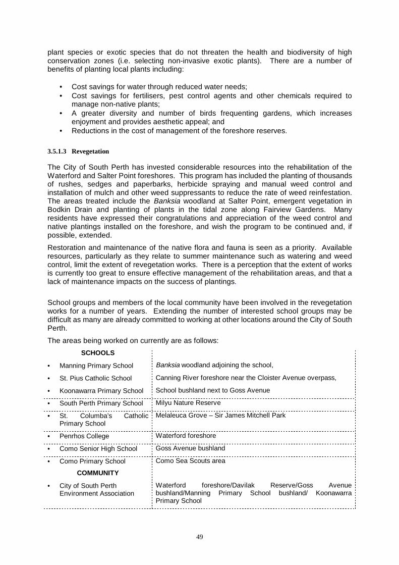
49
plant species or exotic species that do not threaten the health and biodiversity of high conservation zones (i.e. selecting non-invasive exotic plants). There are a number of benefits of planting local plants including:
• Cost savings for water through reduced water needs; • Cost savings for fertilisers, pest control agents and other chemicals required to
manage non-native plants; • A greater diversity and number of birds frequenting gardens, which increases
enjoyment and provides aesthetic appeal; and • Reductions in the cost of management of the foreshore reserves.
3.5.1.3 Revegetation The City of South Perth has invested considerable resources into the rehabilitation of the Waterford and Salter Point foreshores. This program has included the planting of thousands of rushes, sedges and paperbarks, herbicide spraying and manual weed control and installation of mulch and other weed suppressants to reduce the rate of weed reinfestation. The areas treated include the Banksia woodland at Salter Point, emergent vegetation in Bodkin Drain and planting of plants in the tidal zone along Fairview Gardens. Many residents have expressed their congratulations and appreciation of the weed control and native plantings installed on the foreshore, and wish the program to be continued and, if possible, extended.
Restoration and maintenance of the native flora and fauna is seen as a priority. Available resources, particularly as they relate to summer maintenance such as watering and weed control, limit the extent of revegetation works. There is a perception that the extent of works is currently too great to ensure effective management of the rehabilitation areas, and that a lack of maintenance impacts on the success of plantings.
School groups and members of the local community have been involved in the revegetation works for a number of years. Extending the number of interested school groups may be difficult as many are already committed to working at other locations around the City of South Perth.
The areas being worked on currently are as follows:
SCHOOLS
• Manning Primary School Banksia woodland adjoining the school,
• St. Pius Catholic School Canning River foreshore near the Cloister Avenue overpass,
• Koonawarra Primary School School bushland next to Goss Avenue
• South Perth Primary School Milyu Nature Reserve
• St. Columba’s Catholic Primary School
Melaleuca Grove – Sir James Mitchell Park
• Penrhos College Waterford foreshore
• Como Senior High School Goss Avenue bushland
• Como Primary School Como Sea Scouts area
COMMUNITY
• City of South Perth Environment Association
Waterford foreshore/Davilak Reserve/Goss Avenue bushland/Manning Primary School bushland/ Koonawarra Primary School
50
Other groups, such as the Scouts and Girl Guide groups could become involved in seed collection, plant propagation and revegetation. Such groups could possibly be provided with a small area in the Council Nursery for plant propagation. Replanting should be extended to encompass degraded areas of natural bush. The revegetation design needs to be endorsed by the residents in the immediate vicinity of the works to ensure that views are framed and not blocked, therefore reducing the potential for vandalism and associated problems. There are vast grassed areas within the Salter Point and Waterford reserves. Some of these areas, have a level of recreational use which is insufficient to justify the maintenance costs associated with turf. Unfortunately, many of these areas are either above, or in close proximity to, former waste disposal sites. These sites would be difficult to rehabilitate due to the poor substrate and an inability to remove the waste material. The introduction of groves of shade trees may be beneficial if linked with other community facilities such as covered benches and tables. Many residents endorsed the planting of strategically located islands of vegetation to provide shaded resting points for walkers. Small clumps of native vegetation, spaced well apart from each other, could be planted so that they had minimal impact on views from residential properties. Bollards (e.g. pine post fencing) are seen to be an important tool for managing access and defining native vegetation from parkland areas. The bollards ensure that Council mowing teams stay well away from remnant vegetation. The use of bollards to delineate native vegetation from parkland is only effective if a spray line is maintained to prevent the invasion of turf grasses. The Council has established a native plant nursery, which has the capacity to provide plant stock for the foreshores and bushland areas. This stock is grown from seed and cuttings collected in the areas, and plants are returned to the locations where the seed was collected. This self-sufficiency greatly reduces the cost of rehabilitation works, and enables the Council to implement more extensive planting works. The greater the areas of plantings, however, the greater the maintenance. This cost needs to be factored into the yearly budgets. The involvement of community members and school groups can be an effective tool to increase the levels of planting and weed control works. In 1999, approximately 70 students, with the support of teachers and parents, participated in such projects. Their contribution over just three days was substantial and an extension of this project would be beneficial. Recommendations G21 Select and mark suitable sites for photographs to enable annual monitoring through
photographic record of vegetation condition (CSP Technical Services / Works).
G22 Continue to undertake weed control following the guidelines provided in Appendix 5 (CSP Technical Services / Works).
G23 Erect bollards to demarcate mowing limits. (CSP Technical Services / Works).
G24 Undertake regeneration following bush regenerators guidelines (CSP Technical Services / Works).
G25 Continue to collect local seed and cuttings, for propagation at the Council nursery (CSP Technical Services / Works).
51
G26 Ensure that planting only occurs in sites where proper site preparation and weed control have been achieved (CSP Technical Services / Works).
G27 Focus on assisted regeneration in predominantly native vegetation zones. This process requires consistent weed control to enable revegetation through natural processes (CSP Technical Services / Works).
G28 Hand weed around existing stands of native vegetation to minimise damage resulting from herbicide application where possible (CSP Technical Services / Works).
G29 Invite Cubs, Guides and Scouts, University students and other groups to assist with revegetation of the Elderfield Drain (CSP Technical Services / Works).
G30 Protect regrowth of native vegetation by erecting bollards around existing remnants to protect them from trampling and mowers (CSP Technical Services / Works).
G31 Maintain weed control and revegetation program (CSP Technical Services / Works).
G32 Establish up to 10 groups of trees to shelter walkers (CSP Technical Services / Works).
3.5.2 Weed control The City of South Perth has focused considerable resources into the management of the weed populations throughout the study area. These efforts have significantly improved the quality of the vegetation, reduced the fire hazard and enhanced the aesthetic appeal and landscape values of the area. A combination of manual, mechanical and chemical control techniques are used to manage weeds throughout the foreshores. The weed management program needs to be maintained at least at the current level, and increased if possible. Council staff, with the help of members of a LEAP scheme in 1995, have achieved control of many of the large, woody weeds that were noted in the 1986 and 1987 management plans for the areas, and again those that occurred in the area during the 1994 review. Some of these species, including Japanese pepper, are now almost absent from the wetlands. This targeted approach proved to be highly effective. Castor oil trees, however, continue to be a problem probably due to the introduction of seed in fill used for the construction of housing in the area and from the land surrounding Brother Keaney’s Garden. Plants that would have originally escaped from local gardens comprise a significant portion of the weeds requiring control. Again, local residents can contribute to reducing the cost of managing these reserves by planting local species or non-indigenous plants which do not spread readily, or further, by becoming involved in weed management on the foreshores. It may be beneficial to encourage residents to contain their gardens and ask them to assist with weeding of plant species that escape from gardens. It may also be possible to trace the sources of invasion and therefore provide information to the relevant landholders. Dumping of garden waste, including lawn clippings also interferes with vegetation health and can introduce weeds. There are penalties for dumping waste, including garden material, onto the foreshore reserves. A greater ranger presence and a more rapid response by the Council officers when concerned residents report illegal dumping is required. Possibilities for local residents to contribute towards the removal of some weed species occurring along the foreshore areas need to be explored. Designated weeding days could be organised by Council officers in conjunction with members of the City of South Perth Environment Association. Council could provide the bags.
52
Further, information brochures could be developed for specific weeds, which are being targeted by the Council officers. Advertising the priority weeds to the local community could be achieved using a similar process to that used to advertise the public workshops held in early September. This process involved the placement of star pickets with a small bundle of brochures attached for removal by recreational users. The brochure would provide dates for removal of the target weed for the month. Some weeds persisting in the study area are extremely difficult to control without the use of herbicides including Oxalis, the perennial grasses (e.g. kikuyu, buffalo and couch grasses) and some bulbs. Often these species grow alongside the native plants and cannot be removed without a degree of disturbance to the native vegetation. Typha orientalis, the introduced bulrush is still relatively uncommon in the wetlands. Typha orientalis is an excellent indicator of reducing water quality in wetlands. This species occurs in areas, along with the native bulrush Typha domingensis in two locations in the study area. These are the Melaleuca swamp and Bodkin Drain. The City of South Perth has developed and implemented intensive control works for Typha orientalis, immediately replacing this weed with native plants. Work is being continued with any re-shooting bulrush being cut to achieve ongoing control. Managing the boundary between grassed areas and wetland and bushland remnants is very complex, as turf grasses are notoriously difficult to control. City of South Perth uses qualified herbicide operators with skills in bush regeneration to implement these works with high levels of success. The monitoring of regrowth and follow-up treatments are essential characteristics of a perennial grass management program. The maintenance program should be extended until all remnants and native plantings are protected from grass invasion from neighbouring parkland. Many of the dual use paths within the study area are sited close to pockets of native vegetation. In some cases there is a maintained strip of grass between the path and the native vegetation. In this circumstance, the grass should be removed and the extent of native vegetation should be increased to the edge of the path. The dual use path will then become the maintenance strip for the adjacent plantings and is a most useful tool for stopping the encroachment of introduced grasses. The area surrounding the lagoon is weed infested. Veldt grass is the predominant grass weed of this area. This species has a widespread distribution and is difficult to control. The spread of couch from parklands also creates another issue for management. Native couch (Sporobolus virginicus) occurs with the introduced couch (Cynodon dactylon) in some areas. In other areas, the couch present is entirely native, particularly at Salter Point and in the undisturbed areas within Waterford. There have been suggestions that couch be removed from the foreshore, however it is critical that the correct identification occurs prior to treatment. There are other sources of labour available for the implementation of maintenance works such as GreenCorps and Work for the Dole programs. Such programs need to be managed very closely to ensure that works are undertaken in a manner that does not degrade the values of the wetlands i.e. indiscriminate trampling.
53
Recommendations G33 Formalise weed management strategies for specific areas to be implemented over
the next five years in accordance with the proposed weed strategy (CSP Env. Strategy 1999-2002).
G34 Implement periodical maintenance schedules for ongoing weed control (CSP Technical Services / Works).
G35 Develop weed management guidelines for each of the weed species present in the study area and target specific species each year (CSP Works).
G36 Use photographs to determine the level of weed control achieved over time (CSP Technical Services).
G37 Develop educational material for local residents to encourage the planting of native species and containment of exotic plant material (CSP Technical Services).
G38 Implement discrete fencing and limestone walk trails to prevent the illicit movement of people and animals from spreading weed seed and plant fragments into conservation zones (CSP Technical Services / Works).
G39 Investigate the use of State Government-funded labour programs, such as GreenCorps, to minimise the implementation costs (CSP Technical Services / Works).
3.5.3 Turf management There are some concerns about the quality of grassed areas. There may be benefits in working to improve the quality of grassed recreation areas especially with respect to broadleaf weed control and mowing. Much of the existing turf is patchy and infested with broadleaf weed species. Many of these weeds can be controlled with specific herbicides. Currently, Council staff do not use selective herbicides in weed management, and if it became a priority, adequate training to prevent mis-application of chemicals would have to be implemented. Council mowers also spread weed seed with their machinery, which could be reduced with improved plant hygiene practices. Reticulation is currently limited within the grassed parkland areas. There is interest in extending the reticulation to the verges and across all parkland areas. This is not recommended as it contradicts the State Government’s WaterWise campaigns and further, could not be justified by the limited use of the verges and wider parkland. Further, excessive freshwater influx and nutrient leaching will assist the invasion of weeds into the native vegetation zones and can encourage mosquito breeding. There is no regular mowing of Sandon Park, as it is not reticulated. Council staff are directed there when needed. The crew includes a cut-out crew when grass is growing fast. In comparison, the Bodkin Park mowing crew cut the turf on a fortnightly roster with a cut-out crew following within a week. Often, however, there is insufficient time to complete mowing and maintenance works in Bodkin Park. The current maintenance program does not include any fertiliser use. The irregularity of mowing is an issue of concern to the community. Furthermore, the mowing frequency is not considered sufficient to ensure that lawn clippings remain in the reserves. It has been
54
suggested that mowing take place more frequently to minimise the mobility of the resulting clippings (Refer Section 3.3). Synchronising tractor mowers with the manual team would also ensure that mowing is achieved in the more inaccessible areas on a regular basis. The tractor mowers used by Council do not have the facility to collect clippings. More frequent mowing so that the clippings are sufficiently small to be retained on site would obviate the need for collecting clippings. This would prevent clipping being blown into the river or stormwater drainage network i.e. road verges. It may be possible for Council to ensure that street sweeping coincides with mowing, so clippings are collected from the road to prevent them from entering the stormwater system. Recommendations G40 Ensure council mowing teams or street sweepers collect grass clippings that could
enter waterways or drains (CSP Works).
G41 Make funds available for increased mowing of all turf areas (CSP Works).
3.5.4 Fire management Introduced annual grasses are a significant problem in the Salter Point area and the eastern end of Waterford Avenue. These grasses greatly increase the risk of fire in the wetlands. In the event of fire, there can be confusion about who to contact. It may be beneficial to provide information to residents detailing the contact numbers in the event of a fire within the reserve. Reducing the amount of suspended litter (dead branches etc) from wetlands can also contribute to reducing the fire hazard. Not all dead growth represents a significant fire hazard, and therefore not all debris should be removed. This debris provides habitat for lizards, invertebrates and other fauna, and provides twigs and other nest building materials for a wide range of native birds. Debris that increases fire risk is that which occurs between 1.0m and 2.0m off the ground and has dense fine dead branchlets. There is limited suspended debris meeting these criteria within the study area, however, material of this sort should be mulched onsite. Provision of a dual use path from Nenagh Grove along Waterford Avenue will also provide a buffer. Fire access tracks should be provided in areas adjoining the Waterford subdivision - Stage 13. Recommendations G42 Encourage local residents to continue to monitor activities on the foreshore and to
take prompt action in the event of fire. Provide a list of contact numbers in case of emergencies and forward to residents with their Rates Notices (CSP Technical Services / Works).
G43 Encourage City of South Perth Rangers to patrol the foreshore area from the dual use and walk paths from beyond Salter Point to Waterford Avenue on a regular basis (CSP Technical Services / Works).
G44 Provide information about the impact of fire on the environment in an information panel for use at Salter Point and Waterford. This information can also be used at Cloisters and Davilak Reserve information shelters (CSP Technical Services / Works).
55
G45 Remove rock rings and other structures used for lighting of fires to discourage future use (CSP Works).
G46 Control annual grasses and other weeds which increase the flammability of the reserve (CSP Technical Services / Works).
3.6 Native fauna The biodiversity of native fauna persisting in the foreshore areas of Salter Point and Waterford is relatively poor for a remnant of its size (Brooker 1994). The most prolific animals present are birds, with a variety of woodland, wetland and waterbirds using the area at different times of the day. These wetlands comprise the single broadest wetland area on the lower reaches of the Canning River, apart from the Canning River Regional Park, approximately 800 m upstream. The importance of these wetlands for indigenous fauna cannot be emphasised enough. A key feature of the wetlands is the range of bird life that inhabits the area. The diversity of bird life is a significant attraction to local residents and other user groups. Protection of the bird life needs to remain a priority when designing and implementing all works. Birds Australia (formerly Royal Australasian Ornithological Union) has recording sites in the Salter Point and Waterford areas which are assessed by interested local residents on a regular basis. Bird counts include the number and type of birds seen using the area, and the types of activities in which the birds have been engaged. There is a need for more interested community members to become involved in this program. Contact details are provided in Appendix 7 of this document. Increasing the number of nesting sites can lead to an increase in the abundance of fauna. This can be achieved through the implementation of a range of measures including:
• Designating a limited number of access points to minimise vegetation damage and
reduce disturbance to fauna; • Implementing a vermin and feral animal control program; and • Continuing with the weed control and rehabilitation program.
Many of the birds that live in the Melaleuca woodlands require dense foliage and shrubs for protection from predators, for breeding and sourcing sufficient food and nest-building materials. Increasing the extent and density of the wetlands will assist many species to continue to live in the area. Some plants grown in residential gardens produce fruits that are toxic to native parrots, pigeons and other bird life. Examples of this include the Japanese and Chinese peppers. Residents should be encouraged to remove such species from their gardens to help protect native birds, and gain further enjoyment from more use by native birds. FrogWatch is a program established by the Western Australian Museum to provide educational material to the community and to enable scientists to gain more information about the distribution of frogs throughout the State. Workshops are held to help the participants attain the skills required to recognise frog calls and identify frogs found, and further to help people create ‘frog-friendly’ garden environments. Contact details are provided in Appendix 7 of this document.
56
Many residents have expressed concern about snake populations in these wetland areas, and have suggested that the increase in snake numbers can be attributed to increased food availability in the form of rats and mice. Snakes are an integral part of the wetland ecosystem and managing access to limit the contact between humans and snakes, is the most effective management technique. Further, improved hygiene around residential properties (e.g. keeping timber and equipment off the ground) to minimise rodent breeding will encourage snakes to move-on from the area. Many residents and other visitors to the area are often seen feeding bird life, particularly ducks in the Bodkin Park area. Feeding wildlife is inappropriate and can contribute to an increase in nutrient levels in the environment, spreading of disease and attracting large numbers of one species, which excludes other groups. Food left following bird feeding may attract dogs to the area, or rats and mice, assisting the rodents to breed and spread, which further impacts on native fauna. The rehabilitation program is working to provide more extensive and diverse habitats for native fauna, to encourage more species to return to the area. Further, controlling access by people and pets will provide more extensive undisturbed areas that are more attractive to breeding animals. Also, planting flowering species close to the paths may encourage native woodland birds to feed where recreational users can see and enjoy them. The proximity to residential areas, and high degree of disturbance caused by non-indigenous fauna i.e. foxes, rabbits, cats and dogs is likely to be the greatest cause of loss of native fauna. Management of domestic pets (refer Section 3.6.2 of this document) will also contribute to the return of local fauna. Fox control is difficult in urban areas. The Department of Conservation and Land Management is unwilling to undertake poisoning programs in the metropolitan areas because of the risk posed to pets. Experience has shown that foxes can return to an area reasonably quickly following elimination of populations (Brooker 1994). The local government authority can undertake trapping, however, it is still difficult to protect native animals and domestic pets. Should any vermin control program be initiated, it should involve an effort that includes all nearby and adjacent bushland areas, extending to Mount Henry and to the Canning River Regional Park. Recommendations G47 Promote native fauna (frogs, birds) in reserves through a rehabilitation program that
increases nesting sites and habitats (CSP Technical Services / Works).
G48 Discourage residents (and visitors) from feeding wildlife, using non-intrusive signage (CSP Technical Services / Works).
G49 Continue the Birds Australia monitoring program and ensure City of South Perth maintains a register of birdlife for the area. This information can be used to develop information signs (CSP Technical Services).
G50 Encourage residents to plant appropriate vegetation to attract and protect birdlife (CSP Technical Services).

57
3.7 Pest management and pet control
3.7.1 Pest management 3.7.1.1 Mosquitoes Mosquitoes are an integral part of wetland ecosystems, forming an important part of a healthy river system. Numerous invertebrates, including insects and crustaceans, live in the salt marshes, and form part of the diet of waterbirds. The food chains that exist in the wetlands are in a state of balance that may be upset by alteration to any part of it. For example, use of pesticides to manage mosquito larvae may impact on other invertebrate larvae, and nutrients from fertilisers provide a food source that may cause excessive numbers of particular species such as mosquitoes. Mosquitoes have a very short life span, which makes them quite difficult to control. Furthermore, adult mosquitoes can travel up to 50 kilometres to feed. Mosquitoes also breed in backyards, usually in garden receptacles such as pot plants trays, gutters, water holding containers and swimming pools. Improved residential hygiene can help reduce mosquito numbers significantly. The mosquito control program is perceived to have improved since the early 1990s, however, the high numbers of mosquitoes remain a significant issue to many local residents, as it impacts on their enjoyment of both the reserves and their gardens. Mosquitoes often congregate around houses at night due to their attraction to light. There needs to be recognition within the community that it is impossible to eradicate mosquitoes, and complete eradication is not desirable because of the impact it would impose on the wetland ecosystem. The current program implemented by the Environmental Health Services section of the City of South Perth is blanket and reactive, and targets both mosquito larvae and adult mosquitoes. Monitoring of larvae and adult mosquito levels is undertaken weekly during the peak mosquito nuisance period between October and March/April. When mosquito larvae levels reach 1000 larvae per square metre, chemical control of mosquitoes is implemented in the form of granular Temephos (tradename Abate). Fogging using Reslin, is done periodically amongst the vegetation near residential areas to reduce the numbers of adult mosquitoes. This is normally undertaken as a response to complaints from residents. Control of adult mosquitoes is often inefficient as it only results in the death of those mosquitoes present at the time of the treatment. As part of a comprehensive control program, the granular pesticide Temephos is deposited in selected stormwater drains in Waterford. Surveying whether mosquito larvae are present is haphazard because it is not possible to sample all drains. This somewhat indiscriminate method can result in overuse of these chemicals and increases the likelihood of the development of chemical resistance in the mosquito populations. Concern exists amongst the local community that the chemicals used by Council for mosquito control may affect the health of residents and contaminate the wetlands. Requests for information about the effect of these chemicals are common. Both of the chemicals currently used by Council are not the most environmentally sensitive available, however, are considered to be the most cost effective. These chemicals are diluted, or move out from the wetlands in which they have been applied, with tidal movement. By modifying application times, it may be possible for Council to ensure that applications occur in periods of lower tide conditions. This may enable use of less toxic chemicals to achieve a similar level of control.
58
It may be possible to manage some level of the mosquito nuisance by encouraging their natural predators and modifying disturbed areas to remove pools of water, through careful filling of potholes. To successfully achieve this, management of domestic pets and feral animals and disturbance associated with recreational use and indiscriminate access is required (see Sections 3.7 and 3.9 of this document). It has been recommended in the City of South Perth Environmental Strategy 1999-2002 that the City’s officers develop a mosquito control program in conjunction with the State Health Department and Swan River Trust (1999 Draft Environmental Strategy Recommendation 1.3.3). It is critical that this program does not impact on swamps/wetlands. Physical modifications to the environment such as the creation of miniature swale drains (called runneling) have been used effectively in many areas, however, the increased disturbance can result in weed infestation and changes to the hydrology. Because of the large tracts of wetlands in excellent condition that remain in this area, it is important to minimise physical disturbance because of the associated threats to environmental health. This technique is appropriate in the upper reaches of the wetlands, where the level of disturbance is currently high. It is critical that any physical modifications result in minimal changes to the overall hydrology of the area, and that a weed management program is put in place to manage the implications of such work. The Mosquito Control Program will aim to reduce their population by limiting the number of available breeding sites. It will include strategies to identify breeding sites, and the species currently breeding and reducing breeding sites through a range of techniques. In the process of developing the mosquito control strategy, the City of South Perth’s officers intend to liaise with neighbouring local government authorities to ensure that the program developed is based on current best practice. This may involve further negotiations to form a Contiguous Local Authority Group (CLAG). This concept was developed by the Waterways Commission and was raised in the 1994 management plan reviews developed for these areas. There continues to be reluctance on the part of some authorities to become involved in such a group. The City of South Perth should consider co-operating with neighbouring local government authorities by forming a CLAG for cooperative mosquito control over a larger region. There are distinct advantages in becoming part of a CLAG. Mosquito control would be administered over a larger area and therefore would be less likely to be breeding in adjacent locations. Members of the CLAG would share expertise and purchase of chemicals, and the State government would assist with funding and advice through the Health Department of Western Australia. Currently, there is no program to educate residents about mosquito ecology. Recommendation 1.3.2 of the City of South Perth 1999 Draft Environmental Strategy focuses on the development and implementation program to highlight mosquito and midge control methods and the role of mosquito and midge in the food chain i.e. their ecology. There needs to be an education program to advise residents of how they can minimise the difficulties experienced as the result of mosquito nuisance. Having chosen to live adjacent to a wetland, residents must accept that there will be advantages such as views and birds, and disadvantages such as mosquitoes. Modifying behaviour includes: • minimising breeding sites in their own yards, • minimising mosquito food supplies, • planting dense screens of vegetation between the house and wetland; and
59
• wearing appropriate garments and using mosquito repellents.
Reducing exposure to mosquitoes is something that residents throughout Australia need to take seriously, due to the influx and continuing spread of Japanese Encephalitis, Ross River Virus and other mosquito-borne diseases. Mosquitoes can be vectors for the spread of a wide range of diseases, and need to be managed on a whole of Perth Metropolitan area basis. Avoiding areas of dense vegetation and forest will also reduce mosquito contact. 3.7.1.2 Rat and mouse control Anecdotal evidence suggests that the populations of rats and mice in the study area are increasing. These increases may account in part for the more frequent sightings of snakes in the area. Control is difficult, however, limiting food sources and habitats are accepted methods of reducing populations. Residents should be encouraged to take measures to limit food sources and habits i.e. locate wood, tin and other building materials in neat piles off the ground and keep lids on rubbish bins. Ensuring tidy storage and good garden hygiene is of importance for all landholders, however, those with concerns about snakes entering their properties should focus on maintaining a high standard. 3.7.1.3 Foxes Many residents and officers of the City of South Perth have seen foxes in the study area. Foxes are readily able to move within the wetland and bushland environments, and are difficult to control in the metropolitan region.
The Department of Conservation and Land Management is unwilling to bring their Western Shield 1080 baiting program into the metropolitan area, due to the threat posed to pets. It is critical that neighbouring areas are involved in any vermin management program, to reduce the rate of re-location of new populations into any areas where control has been successful.
The Council may continue to put pressure onto CALM to introduce the Western Shield 1080 baiting program to these reserves, however, any program must occur on a regional basis. Such a program may be sufficient to encourage local residents to ensure that their pets are managed effectively, i.e. cats remaining predominantly indoors and dogs kept on leashes.
3.7.1.4 Argentine ants and white footed ants Outbreaks of argentine ants and white footed ants (A. Thomson pers. comm.) continue to occur in the Waterford wetlands. There are currently no available registered chemicals that can achieve eradication, however there are chemicals that achieve a level of control. Agriculture WA often runs trial programs to control these ants using new, unregistered chemicals. Such trials are not held in the metropolitan area.
It is considered the responsibility of the landholder to control these ants.
Recommendations:
G51 Encourage natural enemies of mosquitoes (e.g. birds, frogs and spiders) through implementation of recommendations relating to pet and pest management, recreation access and the rehabilitation of vegetation (Community and City of South Perth).
G52 Implement Recommendations 1.3.1 – 1.3.3 of the 1999 Environmental Strategy relating to development of a mosquito and midge control strategy and development
60
and implementation of an education program for local residents. The education program needs to focus on:
♦ making the local community more aware of mosquito ecology,
♦ gaining acceptance that mosquitoes are part of a healthy wetland environment,
♦ advising that mosquito numbers can be removed by improved backyard hygiene and reducing the use of fertilisers,
♦ encouraging people to protect themselves by modifying their lifestyles (Technical Services – Environmental Health).
G53 Continue to investigate the formation of a Contiguous Local Authority Group for mosquito control (CSP Env. Strategy Recommendation 1.3.1).
G54 Promote nutrient and irrigation management on public and private land (CSP Env. Strategy Recommendation 2.2.6).
G55 Continue to provide mosquito control measures within the peak nuisance periods (CSP Environmental Health Services).
G56 Provide educational material to residents detailing methods of limiting rat and mouse populations (Agriculture WA; Department of Conservation and Land Management).
G57 Plan vermin (e.g. fox) control programs in conjunction with managers of all adjacent bushland and wetland areas including the Canning River Regional Park (CALM) and Aquinas College (CSP Technical Services).
G58 Provide educational material to residents to enable correct identification of argentine ants and white footed ants ensuring contact details for control officers are provided (Agriculture WA).
3.7.2 Domestic animals Uncontrolled movement of domestic cats and dogs throughout the wetland areas is an issue. Domestic animals pose a threat to native animals when mismanaged by their owners. Allowing pets to wander freely through these areas can impact severely on local flora and fauna. These impacts include: • frightening or catching small birds, lizards, frogs and other fauna; • damaging vegetation randomly and spreading weed seed and fragments caught in their
fur or paws; • leaving scents (odour) which can discourage small native mammals; and • contributing disease and nutrients to the environment in their faeces. Management of domestic animals is a critical aspect of protecting wetland and bushland environments. Preventing dogs and cats from entering the conservation areas, and any large areas of natural vegetation, is an important mechanism in minimising their impact. Pet owners need to be made aware of the impact that their pets have on the environment and how they are able to contribute to the protection of the natural values of the Salter Point and Waterford foreshores through careful pet management.
61
3.7.2.1 Cats Domestic cats hunt (especially at night). Their impact on birdlife and other fauna is well documented. The loss of native birds that predate on herbivorous insects may be encouraging the spread of leaf miner and other insects, with a corresponding decline in the trees on the foreshore. To discourage hunting, cat owners should be encouraged to feed cats well and to keep them indoors at night. Well fed domestic cats with bells still prey on wildlife and those living close to the wetlands have unlimited opportunities to hunt in these areas. The City of South Perth has a local law relating to cats. At present the local law limits the number of cats permitted per household to three. It may be prudent to extend the current cat local law to include regulations relating to sterilisation and cat curfews. Local laws need to be supported by education programs, signage and an enforcement program. The Council already offers a sterilisation subsidy and has brochures on the subject. There is a significant budget set aside for the sterilisation project. General consensus from the public meetings and submissions, relating to cat and dog management, is that there should be a strict and enforceable curfew on all domestic pets. There is evidence that cats enter wetlands at night and trapping of feral and domestic cats from within the Waterford and Salter Point conservation areas during the curfew hours was seen by many as an appropriate mechanism for reducing the loss of native wildlife. The Kings Park Board uses a similar program. They advertise in the local newspapers that they will be implementing a cat control program and any cats trapped are taken to the Cat Haven where owners have the option to purchase their cat back. These pet owners are also given information about responsible ownership. This system has worked extremely effectively. Other cat management strategies included limiting the number of cats per household, ensuring sterilisation of cats, and developing and implementing an intensive education program for local residents advising cat owners of the impact that cats have on wildlife. 3.7.2.2 Dogs Controlled access for walking dogs is recognised as an important recreational use of the foreshore environment, however, there are concerns about dogs accessing the natural areas and impacting on the flora and fauna. Access for people walking dogs needs to be maintained along existing dual-use paths and open lawn areas where the impact on native wildlife is minimal. Dogs are currently prohibited in the Conservation areas of Salter Point and Waterford through the Council local laws relating to dogs. These local laws designate areas to exercise dogs on turf including the Salter Point Reserve, the public open space area opposite Fairview Gardens and Bodkin Park. It is a requirement that all dogs be kept on the leash while within these areas. Dogs frequently mark their scent in disturbed areas including rehabilitation zones. This often results in trampling, digging up of plants and other forms of disturbance. It may be necessary to protect rehabilitation works adjacent to dual use paths from indiscriminate trampling by dogs by establishing temporary fencing. If owners ensured that their dogs remained on leads, many of these issues would not arise. There is interest in establishing “restricted dog exercise areas” or conversely “dog-free zones”. A fenced restricted exercise area may be appropriate as it could be developed and
62
designed to provide an area where dogs can run free without posing a threat or nuisance to other recreational users. Conflict could arise as a result of overcrowding along with difficulties associated with owners failing to pick up dog excreta. Some community members have concerns that designated dog exercise areas are unnecessary while others requested that any animal exercise areas include a follow through route and are not an isolated patch of land. There is a further issue in designated children’s playgrounds. Dog owners do not always keep their dogs out of childrens’ sand pits, reducing enjoyment of these areas. There are a number of risks associated with uncontrolled dogs near children including the risk of attack, dog droppings in the sand and injuries sustained from children being knocked over by excited animals. Many recreational users of these reserves are dog owners who exercise their pets regularly along the foreshore. Most dog owners act responsibly on the foreshores and meet Council regulations in ensuring that their dogs are on leashes at all times. Many dog owners also consistently use the ‘Poo-ch Pouches’ to collect their dog’s excreta. The Council has developed rigorous local laws relating to dog exercise areas and management of dogs on the foreshores. The conditions imposed by these local laws are generally recognised and understood within the local community, and the level of acceptance is high. There was considerable concern expressed about the dog owners who fail to comply with the Council regulations relating to control of dogs within the foreshores. Many dogs are often seen on the foreshores without leashes, and on occasions, owners have failed to control their dogs from disturbing other recreational users and local residents. Anecdotal evidence suggests that there needs to be a greater ranger presence and other Council staff monitoring this area to ensure that all dogs are on leashes, and to further encourage dog owners to accept responsibility for removal of their dog’s excreta. Enforcement of the regulations needs to be undertaken more rigorously. Council should investigate providing some Parks and Reserves and bushland staff the same powers as Rangers to fine people for not adhering to the local laws. This would greatly enhance the enforcement aspects. Council provides dog pouches in only two locations between Salter Point and Waterford. These are focused on the periphery of grassed areas, to encourage dog owners to use these areas and to take responsibility for removing their dog’s excreta. There are considerable areas where dog excreta disposal bags are not currently available. It is appropriate, given the high level of use, to provide more pet faeces bags and rubbish bins. Disposal is simple, placing used Poo-ch Pouches in the normal Council green bins. One suggestion presented at the public meetings was that all dog owners should be required to pass a dog ownership test before being issued with a dog licence. These types of systems have been investigated and implemented overseas with variable success. Such a program would need to be initiated through the Western Australian Municipal Association or the Department of Local Government. Signage advising dog owners of their responsibilities relating to removal of dog excreta from the foreshore and ensuring that all dogs must be on leashes could be attached to rubbish bins and located at dog excreta disposal bag collection points.
63
Recommendations G59 Develop information signage about the impact pets have on the environment, and
responsible pet management. These signs could be placed in the information bays at Waterford, Salter Point and Mount Henry Spit on rotation (CSP Technical Services). These could be supported by information leaflets provided to people when they renew their dog licences, collect impounded dogs and for Council staff to give out.
G60 Increase rangers’ visits to the area and enforce Local Laws, including prosecution for non-compliance ((CSP Rangers).
G61 Install more Poo-ch Pouch dispensers to encourage dog owners to dispose of their pet faeces carefully (CSP Works). Supporting stickers could be installed advertising the locations of dispensers on rubbish bins and other key locations.
G62 Stencil “Dogs not allowed along this path unless on leash” or equivalent message at each end of the dual use path at an appropriate distance from the conservation areas (CSP Technical Services / Works).
G63 Investigate providing equivalent powers given to Rangers, to bushland maintenance officers and Parks and Reserves staff (City of South Perth).
G64 Implement media campaign through local newspapers about dog management, responsibilities of owning dogs and advising how managing your dog responsibly can help improve the conservation values of these important wetland and bushland areas (CSP Environmental Officer).
G65 Investigate the feasibility of trapping domestic pets whose owners fail to ensure compliance, with subsequent transfer to the Council pound or other agency (CSP Technical Services / Works).
G66 Promote the available subsidy for cat sterilisation program initiated by the City of South Perth. Consider extending the cat local law to make it compulsory to sterilise cats (CSP Technical Services / Works).
G67 Promote public awareness of the benefits of keeping cats indoors as much as possible, and particularly at night (CSP Technical Services / Works).
64
3.8 Managing recreation and infrastructure A balance between recreational uses and conservation ideals is essential to maintain the values of the reserves. There is a need to keep the foreshore simple and not over developed.
3.8.1 Amenities The Salter Point and Waterford foreshore reserves are reserved for parks and recreation under the metropolitan region scheme. In other words, these areas have been set aside for the benefit of all residents and visitors to Perth. Unlike places reserved under the Town Planning Schemes developed by local government, these areas are deemed to be Regional Open Space, as distinct from Local Open Space. As such they should cater for people from all over the Metropolitan area as well as those living in nearby suburbs. The foreshore reserves are set aside for passive recreation for anyone who wishes to enjoy the foreshore. There is a considerable diversity of recreational uses of the Salter Point and Waterford foreshores. Walkers, dog owners, cyclists, rollerbladers, birdwatchers and fisher people use the foreshore paths throughout the week at many times of day and night. Other recreational users include the rowers (Curtin University of Technology Rowing Club), and Scouts. There are generally two approaches for managing special areas of natural beauty. These are ensuring that the values of the area are widely known and that there is advertising to gain recognition of the extremely high values placed on the area by local residents. Alternatively, you do not tell people about it and hope for the best. Many residents have concerns about non-local residents using the foreshore and wish to restrict use of the reserve to manage impacts. Ultimately, education of the broader public requires an understanding of the values and features that make the areas unique. The most effective way to achieve an understanding is to provide information about the areas, so those visitors develop the same respect and commitment to the area that is demonstrated by local residents. Considerable interest has been expressed by some members of the community to upgrade the available facilities in the reserves. These include:
• providing barbeques in the lakes area of Waterford (Bodkin Park); • installing seats adjacent to walk trails and at key viewing points, some of which would
be shelters; • designating pathways extending to the end of Salter Point Parade; • providing bird hides; • upgrading and improving existing stairways to River Way and nearby areas; and • installing a platform and boardwalk to link the Redmond Street steps to the existing
walk trail. These are discussed separately below. Generally, increasing the level of facilities encourages greater use of an area. The current minimal levels of litter reflect a low level of use for extended periods of time. This needs to be considered in reviewing these suggestions.
65
3.8.1.1 Dual use paths Residents of the Salter Point and Waterford foreshores have expressed considerable gratitude and appreciation of the dual use paths, which have been installed by the City to date. The current Council policy is to install dual use paths, which are utilised by both bicycles and pedestrians. Often there is conflict between these user groups, usually due to commuting cyclists traversing the area at high speed. Recreational cyclists who are not in a hurry pose less of a problem. Non-passive recreational uses are not compatible with the intent of the reserves, and there may need to be an education program to ensure use by recreational groups only. Recreational cyclists have also expressed an interest in extending the cycleway towards Centenary Park and to Mount Henry. The existing dual use path around Waterford is considered dangerous by some cyclists because of its alignment, and high pedestrian use. In some areas the dual use path has been aligned to provide a physical barrier between the wetland and parkland. In some areas the path reduces the potential extent of native vegetation because of its proximity to the river. There are also gravel and unformed paths that have been designed for pedestrian use only on the south and east of the Melaleuca swamp. This path is purposely unsuitable for cycling and does not meet BikeWest guidelines. Provision of signs would clarify correct usage and allow pedestrians to enjoy the paths in peace. Further separation of user groups by installing informal limestone tracks and small boardwalks, which are unsuitable for cycling, may also contribute to reducing conflict. Walk trails should be constructed from materials that blend into the environment, such as limestone. There is an interest in establishing more pedestrian paths around the base of Mount Henry and Aquinas College. It is important that any extension of the cycleways or footpaths do not occur in locations where it may result in damage to the reserve values. The narrowness of the beach and vegetation surrounding the lagoon does not lend itself to a formal dual use path that meets cycling standards. The necessary width would reduce vegetation, risk destabilising the foreshore and also disrupt native fauna. For these reasons, a path is not recommended. There is also an interest in providing measured distances stencilled on the paths to inform joggers and walkers of the distance travelled. The local community recognises that there is considerable indiscriminate access to a wide range of areas throughout the reserves. This understanding demonstrates the need for greater designation of access, bollards to control access and defined paths suitable for particular user groups. Motorbikes, three-wheelers and scooters have been reported on the foreshore, predominantly on the parkland and on occasion, the pathways. These vehicles are prohibited on the foreshore and there is a need to increase ranger patrols and awareness amongst the community, about the regulations prohibiting vehicles on the foreshore. Vehicles represent a significant safety hazard for other recreational users, their dogs and native fauna. The noise can further impact on the feeding and breeding activities of native animals, particularly the more secretive waterbirds such as spoonbills and greater egrets.
66
There are a number of problems with the existing path network. • The steps leading from Redmond Street to the foreshore are steep and many people
have trouble negotiating them. The base of the steps is unstable and at the time of assessment there was a 1.5 metre drop from the last step to the beach.
• There is no path for the first 30 metres between the Redmond Street steps and the informal walk trail along the Salter Point foreshore as the proposed boardwalk linking the two is yet to be constructed.
• The informal limestone walk trail along the Salter Point foreshore is degraded in parts and is not designed for heavy traffic.
• There is no path from the lagoon through to the start of the DUP along Salter Point Parade. Pedestrians are forced onto the road verge to continue walking.
• Some service pits inset into paths (i.e. Telstra) have moved, creating potential tripping hazards.
• There are a number of large cracks and occasional shifting segments of path that could pose a risk to walkers.
• The informal trail from the DUP at the Scout Hall, over the bridge and through to the DUP on Salter Point Parade needs to be upgraded for walkers.
• There is no lighting alongside paths to improve the safety of walkers at night. Any lighting would need to be located away from conservation areas so that fauna remains undisturbed.
3.8.1.2 Playgrounds There are two children’s playgrounds within the study area, one adjacent to the rowing club and one in Bodkin Reserve. The existing playground equipment favours the residents of Waterford, however, it would be difficult to locate into the Salter Point Reserve. Much of the Salter Point Reserve is narrow with the possible playground site being close to the road. The proximity to the Bodkin Park playground reduces the viability of establishing and maintaining a new play area at Salter Point. 3.8.1.3 Boardwalks The City of South Perth installed a boardwalk from Waterford Avenue to the river to increase the enjoyment of the area by local residents and to reduce indiscriminate trampling of native vegetation by people wanting to get to the water’s edge. Local residents frequently use this boardwalk and the expenditure has been justified in a short period of time. The Waterford Avenue boardwalk is not currently connected to the dual use path and walk-trail network. There is a need to extend the dual use path system and link it with a walk trail that leads to the boardwalk, as identified in the two previous studies. There is interest in establishing more boardwalks to help with the continued management of access to key locations. Boardwalks help to protect flora and fauna from uncontrolled disturbance and provide bird-viewing facilities. Council has available funds in the 1999-2000 budget to construct a boardwalk from the end of the Redmond Street stairs to connect with the limestone walk trail leading to Salter Point. This will finish off the stairway more appropriately. This is discussed below.
67
3.8.1.4 Stairways The grade of the Redmond Street and Sulman Avenue stairs is of concern to some users, especially the elderly and infirm. As mentioned above, there are issues relating to the incomplete status of the Redmond Street stairs and the quality of the stairway from Sulman Avenue to the foreshore. The concrete steps at the end of Sulman Avenue down to the foreshore tend to be slippery as a result of a smooth finish, and gum nuts and sand accumulating on them. Further, the steps are angled down slightly, which makes it more difficult for users. During a site visit in September, it was found that the steps were difficult to move on. Remedial strategies could include revegetation and stabilising the banks using a combination of hemp matting and plants to limit sand deposits (refer Section 3.2.1 of this document), reducing the smoothness of the concrete stairs using a grinder to improve friction and reviewing modifying the stairs. Both sets of stairs are due for repair in the 1999-2000 financial year, following which a maintenance routine will be implemented. 3.8.1.5 Scout Hall and Curtin University of Technology Rowing Club The access for rowing and boating needs to be maintained, however, the surrounding vegetation should be protected from trampling and other launching and retrieving damage. Bollards to define the launch area may be sufficient to stop this damage. The facade of the existing buildings is dated and unattractive by today’s standards. Improvements to the buildings would improve the overall aesthetics of the area. Graffiti continues to be a problem and anti-graffiti coating should be investigated. Vandalism is a constant problem and the existing mesh screens are unattractive but necessary for the time being. Improved lighting and higher levels of use of both buildings may help to reduce the level of vandalism. Further, the concrete ramp that is used for down loading the boats has collapsed following the period of high tides during the winter of 1999. The foreshore bank is highly eroded and needs to be re-contoured with an improved concrete ramp structure. Rather than using a ramp, timber steps on pylons may be appropriate to reduce erosion and improve bank stability. Any structure would need to be at least 10 metres wide to enable sculls to be walked down sideways. This could be implemented as maintenance work to obviate the requirement for approval through the Swan River Trust. 3.8.1.6 Seating, shelters and picnic tables Seating should be located along the path system at points of special interest or where vistas are particularly good. Encouraging people to stop and enjoy the landscape may assist in increasing the understanding of the conservation values of the area. It is important that some seats are provided beneath trees or with a shade structure to enable people to rest at these points on hot days. Seating and shelters should be as unobtrusive as possible. Consideration needs to be given to landholders adjoining the reserves. In many instances, seating will be located below existing trees and so views will not be impacted on. Seating should be provided every 300 linear metres in areas where people can sit and enjoy undisturbed peace and quiet. Shelters would only need to be installed when no suitable shaded seating is available within 600m.
68
Thought needs to be given to minimising the impact of any shelters on the views enjoyed by local residents. Picnic tables would allow families to use the foreshores for longer periods of time. These should be provided in a few locations around the foreshore. A limited number of picnic benches around the existing playground equipment may be desirable. A lookout point with picnic facilities at the top of the scarp at Redmond Reserve may be appropriate. Any benches or shade structures need to be anchored extremely well as vandals and thieves frequently remove seats. 3.8.1.7 Bird hide There have been requests for a bird hide at Salter Point lagoon. This may be an attractive idea to bird watchers, however, because of its distance from housing, there is a risk of it being used for inappropriate activities. A boardwalk or viewing platform may be a more suitable option for birdwatching. 3.8.1.8 BMX track Children wishing to create suitable trails for BMX bike riding do considerable damage to the native vegetation. Creating trails usually involves digging substantial holes and compacting the removed soil to construct jumps. This activity coupled with the increased bike traffic, results in mass degradation of the surrounding areas. It is possible that a BMX facility may be provided in the future upgrade and development of George Burnett Park. Should such a facility be provided at George Burnett Park, the Council would need to address safe passage across Manning Road, which is a main arterial route. A crossing of this sort may be appropriate near the Manning Library. Facilities such as an underpass or overpass may be necessary to enable safe crossing. This is beyond the scope of this management plan. 3.8.1.9 Other infrastructure One resident suggested the construction of a small band stand/orchestral shell in one of the parks, to enable components of the South Perth Fiesta to be held in Sandon Park. Such activities are likely to have high noise, which would disturb the natural values of the foreshore. This land use is not compatible with the conservation and passive recreation values. It would be more appropriate to focus such events in parkland areas that are a considerable distance away from the conservation areas. Such events would generate a range of associated management issues, such as an increased need for rubbish bins, parking and other infrastructure requirements. A more suitable location may be George Burnett Park. There is also community interest in building a rotunda with information signage, at the junction of Nenagh Grove with Waterford Avenue. 3.8.1.10 Environment centre There is community interest in developing an environment centre in South Perth to enable people to seek out information, organise walks of bushland and wetland areas and provide a specialised facility for people interested in environmental issues. The nearest similar centre is at Perth Zoological Gardens.

69
Again, such a development may be appropriate integrated into the proposed community facility in George Burnett Park. This is discussed further in Section 3.8.1.12. 3.8.1.11 Drink fountains There is currently one drinking fountain within the study area, near the Scout Hall and Rowing Club. Generally, problems with vandalism result in Councils being reluctant to install such facilities. Further, the prohibitive cost of piping water to the fountains means that these items need to be located close to existing infrastructure.
3.8.1.12 Toilets As discussed in the 1994 review (Brooker 1994), there are few toilets on the foreshore in the municipality of South Perth. The closest public toilets are at Manning Library or Como Beach. The opposite side of the Canning River there are toilets at Deep Water Point, Mount Henry Bridge (both City of Melville) and Beatrice Avenue (City of Canning). These toilets are of little benefit to anyone enjoying the Waterford and Salter Point foreshores for bird watching, picnicking or walking. For residents who live close to this area it is a simple matter to return home. For people from further afield, even from Manning or Como, public toilets are necessary. There has been considerable discussion about whether or not toilets should be installed somewhere within the foreshore. Previous management meetings have discussed the provision of toilets. For the most part the results were that the community strongly opposed toilets on the grounds that they may create social problems, encourage criminal activity and further, that such structures would not be in keeping with the aesthetics of the area. Again it is recommended that a toilet block be provided on or near the Salter Point Foreshore Reserve. The toilets would be locked at night to prevent people from staying in them, or alternatively have the iridescent blue lights installed which discourage people from staying in them for any length of time. These lights are used at City West and other large facilities where there is direct street access. The most suitable location for the toilets requires further consideration. A central point would be adjacent to the Rowing Club, Sea Scout Hall and car park at the junction of Elderfield Road and Fairview Gardens. This location has the advantage that it is central to both foreshore reserves, is close to the dual use path, and is adjacent to a public recreation area with river access. It is also close to existing services so establishment costs would be minimal. An alternative location is within Bodkin Park. There is concern that toilets in their own right may provide facilities for drug abuse and undesirables. To overcome this issue, it may be worth investigating the potential for a small environmental café, which blends in with the environment, with toilets that lead both ways. This could enable recreational users to take advantage of a coffee shop and further provide a facility for local residents, provide a forum for environmental information about the wetlands and pertinent environmental issues to be made available. Any development would need to be undertaken carefully. Kiosk type structures would be considered unsuitable. 3.8.1.13 Signage The placement of well thought out signage that details the merits of the conservation areas and pockets of remnant vegetation is an ideal way to increase awareness and encourage community support for a range of activities.
70
Some residents have expressed concerns that too much signage would be detrimental too the overall area. Educational and interpretive signage can be discretely placed in the conservation area and in pockets within the reserves. This is discussed in more detail in Section 3.8 of this document, relating to raising community awareness and education. 3.8.1.14 Organised events The large areas of open grass lend themselves to organised passive events such as kite flying. The Council could develop a program linked with the South Perth Fiesta for this area. Recommendations G68 Erect grouped signs to distinguish between dual use paths and walk trails (CSP
Technical Services / Works).
G69 Improve the walk trail leading from the lagoon to the Redmond Street steps (CSP Technical Services / Works).
G70 Investigate the feasibility of additional walk paths around the base of Mount Henry (CSP Technical Services / Works).
G71 Construct a platform and boardwalk at the base of the Redmond Street steps to connect the steps with the existing walk trail (CSP Works).
G72 Construct a concrete DUP flush with the road to connect the walk trail at the lagoon with the DUP already running alongside Salter Point Parade. Note that the steepness of the bank will require a retaining structure for a distance of approximately 15 metres. Retain the bollards between the DUP and wetland (CSP Technical Services / Works).
G73 Monitor existing DUPs to ensure that cracks, dips and service pits do not pose a tripping hazard (CSP Works and Field crew).
G74 Upgrade the informal trail connecting the Scout Hall with the Salter Point Road DUP (CSP Works).
G75 Investigate the feasibility of night lighting to paths (CSP Works).
G76 Stencil distance markers onto the DUP so that people can gauge the distance of their walk/jog (CSP Works).
G77 Investigate the construction of a viewing platform and trail within the Lagoon riparian zone for bird watching (CSP Environmental Officer).
G78 Connect the existing boardwalk on Waterford Avenue to the existing path network (CSP Technical Services / Works).
G79 Investigate the feasibility of upgrading the Rowing Club and Scout Hall in the long term (CSP Works).
G80 Install two covered picnic benches next to each playground (CSP Works).
G81 Increase seating so that there is a seat on average every 300 metres along the main paths (CSP Works).
G82 Investigate the feasibility of providing additional drinking fountains (CSP Technical Services / Works).
G83 Undertake feasibility study investigating the potential for establishing a combined café / toilet facility bearing in mind the advantages of the location adjacent to the Scout Hall and Rowing Club (CSP Works).
71
3.8.2 Water based recreation facilities 3.8.2.1 Boats and canoes There are currently two boat-launching areas within the Salter Point and Waterford areas. One ramp is present on Salter Point Parade, which is steep and difficult to access and is only suited to the launching of canoes and kayaks. The other is used by the Curtin Rowing Club, and because of poor vehicle access is also only suited to canoes and kayaks. The Salter Point ramp has limited parking available for boat owners following launching. This ramp should be maintained and the entrance upgraded to a standard befitting the level of use. The upgrade could involve improving the entrance ramp and laying and compacting crushed limestone in the turn-around area. By leaving the actual ramp area in its current state larger boat owners will be deterred from using the ramp. To maintain the low level of use of this ramp, and to ensure that all users understand that the ramp is for non-motorised craft only, it may be necessary to establish a small sign near the entrance. Bollards are also needed to define the launching area, reducing destruction of the riparian vegetation. Access to off-road parking could be provided on the verge by installing areas of flush kerbing. The speed limit for power boats travelling upstream of Salter Point is currently 8 knots. The level of enforcement is minimal due to limited resources within the Department of Transport and Water Police. This agency is dependent on local residents to report people using the river inappropriately. There is a concern that boat wash is contributing to erosion of the foreshores, and therefore boating activities should be monitored more rigorously. Local residents are encouraged to document the registration number of the boats, and forward the information to the Department of Transport. Jet skis are currently prohibited from this area. There are designated jet ski areas around the river, the nearest of which is from Deep Water Point to Mount Henry (launching area only). Noise pollution is perceived as a threat and disturbance factor for wildlife. There is a need to ensure that boating regulations created by Department of Transport are enforced and managed. 3.8.2.2 Jetties There are limited recreational fishing opportunities from the Salter Point and Waterford foreshores. There have been suggestions that small jetties be built for children to fish from. The shallow waters present on this part of the Canning River are favoured by mullet and blowfish, with the more desirable species such as black bream not having suitable habitat (i.e. deep potholes with shade and tree debris) to spend time in the area. Fishing from Salter Point can be more successful as there are deep holes close to the shore. Jetties are expensive to construct. Council could undertake a feasibility study to build one small jetty at Salter Point in a natural gap in vegetation between existing bollards, to trial the usefulness of such a structure. This could be undertaken in the medium to long term. 3.8.2.3 Worm digging and prawning Worm digging is prohibited within the study area under regulations established by the Swan River Trust. The nearest gazetted area for worm digging is at Canning Bridge.
72
The City of South Perth needs to approach the Swan River Trust to request signage for placement at the turnaround point at Salter Point Parade to advise worm diggers that their actions are prohibited, and provide a map with the locations that are acceptable. This would then need to be enforced. Prawners should be made to clean up after their prawning sessions. The dumping of netting spoil leads to pollution of the foreshore area. Illegal fires for cooking prawns can spread to neighbouring vegetation. Previous management plans recommended assessing the success of provision of prawn boilers at Cloister’s Avenue to determine whether such a facility was appropriate for Sandon Park. This needs to be assessed. Recommendations G84 Retain and upgrade the small boat launching facility on Salter Point Parade (CSP
Works).
G85 Install bollards to prevent damage to existing rushes and sedges at both existing ramps (CSP Technical Services / Works).
G86 Liaise with Swan River Trust to obtain and install worm digging signage and a location map for appropriate digging areas (CSP Environmental Officer).
G87 Install combined signage stating that fires are prohibited on the foreshore and advising prawners that residue from netting runs must be returned to the river. Further, information shelters showing the locations of appropriate access points for riverine activities should be present (CSP Technical Services / Works).
G88 Assess success of prawn boiler at Cloisters, support SRT research on prawning and to determine if prawn broiler installation is warranted.
3.9 Reserve access The City of South Perth is committed to providing sufficient infrastructure, such as dual use paths and walkways, to encourage people to keep off vegetated areas. In some instances, past revegetation works have also been designed to close off unnecessary tracks and discourage movement through the reserves. There are occasions when unauthorised motor vehicles including motorcycles move through the reserves, resulting in damage to both flora and fauna, and impacting on other recreational users. Signs prohibiting small vehicles such as childrens’ motorbikes, etc and cars from the foreshore need to be erected where vehicles can periodically gain access. On occasion, the chain gate near the sewerage pumping station is not locked. This needs to be managed more carefully. Some property owners along River Way have extended their gardens into the Reserve. The boundaries between the private and public land are poorly defined and a continuing source of conflict. Some of these people have created paths leading down to the foreshore. Poorly constructed paths can initiate widespread erosion, especially following heavy rain. There are some areas of indiscriminate access at the eastern end of the study area near Waterford Avenue. There is an existing fence east of the boardwalk, which is poorly maintained and needs rewiring if it is to be retained. There has been considerable discussion among the local community about the need for a fence, with the majority of landholders opposed to such a structure. Suggestions to extend the fence using star pickets
73
and wire with no top rail to ensure that the fence was as unobtrusive as possible. This can be re-assessed in the future if monitoring of access to the Waterford Conservation Area shows that there is continuing disturbance to this important area. Access needs to be restricted in some locations along the foreshore, to ensure that the fauna and flora remain undisturbed. Defined access points that extend to the river, like the boardwalk at Waterford Avenue, could be provided for residents to enjoy the foreshore without damaging the environment. The access at Waterford Avenue is considered by residents to be a ‘fabulous facility’ as it keeps people to one track. Informal paths have been created into the bushland at the Bodkin Drain, the conservation area and the swamp at the northern end of the Salter Reserve. These tracks need to be assessed and either closed, or upgraded if it is decided that they are appropriate for the area. There have been suggestions that a boardwalk be created that extends around the river from the existing boardwalk to Fairview Gardens. Such a structure would be prohibitively expensive and unlikely to be endorsed by the Swan River Trust due to the extent of disturbance to the environment. Recommendations G89 Assess informal paths within the wetlands and the areas adjacent to private property.
Close undesirable paths and upgrade others (CSP Technical Services / Works).
G90 Encourage residents to use the provided paths and not create their own access ways (City of South Perth) (CSP Technical Services / Works).
G91 Assess the level of indiscriminate access and if it continues to result in degradation of the wetlands, construct a fence that is not visible from the roadway along Waterford Avenue to encourage use of the boardwalk and path network (CSP Technical Services / Works).
3.10 Public awareness, education and training Community education and involvement has been a key element of the management of the foreshore. The support for such programs should continue. There are numerous ways in which to raise awareness including: • Newspaper articles • Direct letter drops • Signs • Pamphlets • Guided walks and talks • School visits It may be possible to gain support from State government agencies or local experts to share their knowledge. On a number of occasions, officers from the Department of Conservation and Land Management, private consultants and other professionals have been invited to talk to children from nearby schools about the flora and fauna of the Waterford and Salter Point wetlands and other reserves. The types of information varied from invertebrates such as mosquitoes to amphibians, reptiles, birdlife and other fauna, wetland ecology, different vegetation types and wetland functions. Catchment issues such as drainage, water quality and provision of corridors for wildlife movement are also issues of interest. Foreshore activities which the local community and school groups can become involved in, include bird watching and monitoring, weeding, planting, plant identification, creating herbariums and assisting in the preparation of signage.
74
It is important that school groups become increasingly involved in programs in these areas. Contact can be made through the City of South Perth Environmental Officer to visit schools, inviting them to become involved in local programs and also through school holiday recreation programs. The Scout groups and other local sporting clubs could also contribute to management of the reserves. There are information panels at Waterford foreshore, near Bodkin Park, and near the Melaleuca swamp and at Salter Point. Some of the artwork for these signs has been supplied by the local school children. As an example, students from Penrhos College Junior School have been involved in weeding, planting and seed collection activities in the Waterford Reserve for a number of years. These students developed the information signs at the reserve. Further, the students have been trained in methods required to establish herbariums and have commenced work on Banksia woodland species and will progress to wetland species over the next few years. It is proposed that site specific signage be developed for each area, in addition to a series of general interest information panels, for example panels about vegetation (native and weeds), water quality management, mosquitoes and other pest fauna, recreational use and dog management. These could be rotated between all the foreshore sites on a two-monthly period with the specific information either remaining or being included in the cycle. Residents believe that information signs need to be sensitively placed to blend in with the environment and not block the view of pedestrian traffic. Further, the need to place signs in the shade near places of special interest was recognised. This would enable residents to read and discuss the content of the signs in comfort. The following key messages could be incorporated into a comprehensive educational signage package. • encourage public not to feed wildlife • foreshore management and related environmental issues • rules relating to use of the reserves • importance of the Canning River wetlands • impact of fertilisers, excessive irrigation and litter on wetland ecosystem functioning and
key aspects of the foreshore. Information leaflets that could be letter dropped to local residents or made available in shopping centres or libraries include: • educational pamphlets for the use of pesticides / fertilisers • how to recycle green waste and other materials • garden plants that spread easily into wetlands Other ideas include involvement in the stormwater drain-stencilling program that is coordinated by the Swan River Trust. The Trust has stencils through which paint is sprayed for use on kerbs above drains which has messages including ‘Don’t let your river go down the drain’ and ‘Drains to river’ with a swan or frog logo. These can be loaned to interested school or community groups (or individuals) to stencil on key locations. Regular educational walks e.g. March and September, along with regular seminars would benefit the local and wider community. This was a useful technique in generating initial interest in the management planning review initiated in 1999. Using qualified people to
75
explain key features of the foreshore environment, key threats, and strategies to manage the impacts to local residents is seen as a cost-effective technique for imparting knowledge and understanding. An increased awareness is likely to generate greater community interest. It may be worth approaching the Water and Rivers Commission to assess any programs which may be relevant that are available to stimulate community ownership/involvement (e.g. foreshore watch). Ribbons of Blue are also coordinated by this agency and provide support for water quality monitoring, vegetation assessment and management packages to both schools and community groups. Other sources of materials or knowledge include: • The Swan Catchment Centre. Located on Adelaide Terrace, opposite the Hyatt Centre • Ecoplan. A community development and support program, which is coordinated by the
Department of Environmental Protection. Volunteers and employees of the City of South Perth involved in wetland management activities require training prior to undertaking work on the foreshore. It is critical that the function and purpose of works is understood prior to ‘hands-on’ activity to ensure that there is a consistency of objective. For example, interpretations of “tidying up the foreshore” could mean remove trees from the foreshore, rather than implement weed control and remove litter. Interested community members and local government officers could attend a bush regeneration course or employ an external consultant to run a training package. Litter campaigns are still necessary in this area to encourage people not to throw objects onto the ground and into the river. Identifying the locations and increasing the number of rubbish bins may alleviate this problem to a degree, as would greater presence of local government officers. Campaigns need to take into account people who do not speak or read the English language. There is a substantial proportion of the community for whom English is a second or third language. This component of the local community needs to be considered in the development of educational campaigns. There is one environmental group linked with this area, known as the City of South Perth Environmental Association (COSPEA). This group has contributed enormously to revegetation and weed control over the years. It may be worthwhile calling for expressions of interest from the local community to become involved with COSPEA, with a focus on regeneration works on the foreshore. Council support would be required for supervision, provision of tools and consumables and removal of rubbish after workdays. These could be linked with informative guided walks and sausage sizzles to encourage attendance. Such a group would provide an invaluable supporting role to the work undertaken by Council officers. An alternative would be for an Environmental Advisory Committee to be appointed using an approach that has been successfully implemented by the Shire of Mundaring. This group could provide advice to Council and provide support for the Environmental Officer. Recommendations G92 Support the formation or re-vitalisation of local friends groups and provide supervision
and support via the Environmental Officer and Works Division – including loan of
76
equipment and removal of materials following work days (CSP Technical Services / Works).
G93 Continue to support two specialist trained field staff to work in bushland regeneration and maintenance on the foreshore (CSP Technical Services / Works).
G94 Encourage ongoing community and school group involvement in wetland and foreshore management projects (CSP Technical Services / Works).
G95 Continue providing bush regeneration courses to interested members of the public who actively commit more than 40 hours per annum to bushland and wetland maintenance (CSP Technical Services).
G96 Encourage ongoing community environmental education through a variety of means; stencilling projects, signs, pamphlets, media and holiday recreation programs as recommended in Section 1.4 of the CSP Env. Strategy 1999-2002.
3.11 Views The maintenance of views from residential properties is always a contentious issue. Some local residents endeavour to increase the extent of the view they receive from their properties by illegally pruning and removing trees. The trees form an important component of the river ecosystem and protect the river from erosion, provide habitat for animals and enhance the aesthetics for residents viewing the South Perth foreshore from the other side of the Canning River (such as Riverton and Shelley). The illicit removal of native vegetation is a criminal offence and punishable with large fines. Prosecution should be encouraged when people are caught removing vegetation. There have been numerous requests that council trim the trees and shrubs growing on the steep slopes at the end of Redmond Road. The residents cite building regulations limiting property heights as a reason for keeping the vegetation trimmed low. They argue that they are restricted from building up to maintain views and so council should improve vistas by selective pruning. The steep banks are already badly eroded and any action that could lead to a decline in plant health cannot be endorsed. One possible solution is to slowly replace some of the taller and denser non-native species with native trees and shrubs that are either lower, or have a more open canopy. Ongoing revegetation works are required for the constant improvement of river health. The sensible placement of these plantings is important to ensure their success. In many areas, the existing clumps of vegetation can be bulked up and slowly added to without compromising on residents’ views. Rushes and sedges can be added to many areas of the foreshore as, being less than a metre tall, they will not block views. Sandon Park is an example of an area where some residents oppose tree and shrub plantings. Residents should be provided with educational material detailing the benefits of such plantings, and at the same time, Council needs to liaise with residents regarding placement of tree stock.
3.11.1 Underground power Underground power has been identified as important for the enhancement of visual amenity. This is outside of the scope of this document. The City of South Perth Environmental Strategy 1999-2002 Recommendation 3.6.5 presents the position of Council.
77
3.11.2 Bodkin Park lakes The aesthetic appeal of the open drainage system running through Bodkin Park is appreciated, however, improvements in maintenance and an increase in native vegetation have been suggested. The water quality in the lakes needs to be improved otherwise it will result in excessive algal growth in spring and summer. This is discussed in Section 3.2.2 of this document.
Recommendations G97 In conjunction with the Swan River Trust and the Department of Conservation and
Land Management, prosecute residents and visitors who deliberately destroy native vegetation (CSP).
G98 Develop a Local Law for the protection of vegetation on public land (CSP Works Env. Strategy. 2.3.3).
G99 Evaluate the vegetation on the banks at the end of Redmond Road and revise plantings if required (CSP Technical Services / Works).
G100 Liaise with residents before instigating tree planting projects that may impact on the extent of views (CSP Technical Services / Works).
G101 Canvass residents and develop a list of residents who do not object to tree planting on the foreshore adjacent to their properties (CSP Technical Services / Works).
3.12 MAINTENANCE The dense vegetation, particularly within the Melaleuca groves, are perceived by some as locations for inappropriate behaviours such as drug use, sexual activity and vandalism. However, the presence of vegetation and mosquitoes and the vegetation are likely to discourage undesirable behaviour along the foreshore. The low branches and dense vegetation are important to encourage the indigenous fauna to breed and inhabit the area. The complete removal of all dense vegetation would mean the decline of many species from the area. Many of the Melaleuca plantings are in wetland environments and as such are relatively inhospitable. The ‘opening up’ of such areas is unlikely to reduce the incidence of unwanted activity as the majority of it takes place in the evening or at night. Many rushes and sedges are spiky and some cause minor skin irritation. The planting of these species often forces people to reassess the areas being used as hiding places. More frequent weed control is required within the stands of native vegetation, particularly where perennial grasses occur in profusion. The reduction in weeds will serve to open up some areas and can help to reduce litter deposition.
3.12.1 Infrastructure maintenance As with most local government authorities, much of the maintenance of infrastructure is reactive and takes place after damage has been reported. The path network within the reserves needs more frequent inspection and repair. Bollards are occasionally removed to provide vehicle access. These bollards need to be replaced promptly to reduce the impact of uncontrolled access.
78
Annual maintenance of the seats, the boardwalk and information shelters is required. Oiled wood, or paintwork in natural colours are appropriate for facilities in this environment.
3.12.2 Parkland maintenance
Perception of the current turf management regime varies from very good to requests for more frequent mowing to reduce the frequency of lawn clippings from the reserves being blown onto the road and neighbouring properties. These lawn clippings can block the stormwater drainage system and also contribute to providing habitat and a food source for mosquito larvae in the storm water system. Anecdotal evidence suggests that the mowers that cover the larger expanses of grass are not always synchronised with the hand mowing team. Residents believe that Council should address this issue. Council does not have a mowing program for unreticulated reserves, as the frequency of mowing depends on environmental factors. However, Council endeavours to ensure that manual crews follow-up the mechanical mowing within one week, although time available for the area, does not guarantee that all areas will be managed well. The surface of the existing grassed parkland is also quite uneven, as a result of the compaction of materials within the tip sites. Regular topdressing may help to improve lawn areas for the future. Reducing the total area of turf in the parks would be the most effective way of helping Council manage the turf in a cost-effective and timely manner.
3.12.3 Litter Collection Litter removal and general maintenance is considered to be inadequate. Despite difficulties with emptying, there is a need for rubbish bins between Salter Point Parade and the Redmond Street stairs, as recreational users often leave litter in this area. It is recommended that seating be placed at every 300m along the reserve where shade is available with a picnic shelter and every 600m where shade is not available. Rubbish bins could be installed at each of these sites. It may be possible to involve the community in the management of litter by encouraging residents to remove rubbish from the reserves. This could be linked with Clean Up Australia Day and other days of interest such as World Environment Day. Council officers could manage community involvement in this program. Discarded needles and condoms continue to be an issue, as is the case for every park in Perth. If reports of discarded needles increase then consideration should be given to the provision of needle bins at select locations. Council is proposing to develop a community education program with regard to needle and syringe disposal in the 2000/2001 budget (CSP Env. Strategy 1999 – 2002 Recommendation 1.1.1).
3.12.4 Irrigation Residents have requested that Council’s water scheduling program be amended so that the path-side irrigation does not impinge on the ability to walk the area early in the morning. There is a tendency with Council to irrigate mostly at night. This achieves three things; it reduces disruption to recreational users, saves on electricity costs as they attract off-peak rates and discourages people from sitting in the parks at night. Evening watering of these areas could be implemented within this new program.
79
3.12.5 Graffiti and wilful damage Graffiti and other vandalism that is not immediately removed, tends to invite further acts of vandalism. Any damage to infrastructure should be repaired immediately and graffiti resistant compounds should be applied to any property that is targeted constantly. Recommendations: G102 Ensure council staff report and promptly correct problems with infrastructure (CSP
Works / Technical Services / Field crews).
G103 Paint seats a natural colour, in sympathy with the natural environment (CSP Works).
G104 Design and implement a schedule for weed maintenance within the native vegetation and turfed areas (CSP Technical Services / Works).
G105 Synchronise mowing and brushcutting of turf areas to close the gap between the two activities (CSP Works).
G106 Design and locate litter bins appropriately and empty them regularly, with a greater frequency during the prawning season (CSP Works).
G107 Involve the community in litter collection through the Clean Up Australia Day (CSP Technical Services / Field crews).
G108 To discourage vandals, repair all damaged facilities immediately after any act of vandalism (CSP Works).
G109 Develop a community education program with regard to needle and syringe disposal (CSP Env. Health Services 2000/2001).
G110 Investigate providing needle bins at key locations if the improper disposal of used needles continues (CSP Env. Health Services).
G111 Investigate the feasibility of rescheduling watering so that the sprinklers do not affect early morning walkers (CSP Works).
3.13 MANAGEMENT AND IMPLEMENTATION There is a perception within the community that the Council is good at preparing plans but has a poor reputation for achieving the implementation of those plans. Council officers have put in considerable effort towards improving the natural heritage values of the wetlands and bushland areas. Infrastructure provision has also occurred in response to community interest. Community pressure is the key to ensuring that resources are assigned to the Waterford and Salter Point wetlands. Responsibility for ensuring implementation of any management plan lies with the local community. It is an important part of local government process that works are assigned priorities in response to the local community. The status of management of a particular area, its level of implementation and the process required to review the existing management structure have all been considered in this document to improve the Council’s internal budgeting processes. Comments were received which emphasise the importance of the structure of the recommendations contained within this document. It is therefore essential that to ensure that all recommendations are workable, and those from previous documents that are not achievable be removed.
80
Concern was expressed about planning authorities allowing developments on top of, or immediately adjacent to wetlands. The Waterford development is considered to be inappropriate because of its proximity to the wetlands. Some residents appreciate the location, however, they have concerns about the impact of residential properties on the environmental integrity of the wetlands. Management recommendations contained within this document are all based on the importance of continuing to conserve all the area in its natural state and ensure that people with the appropriate, experience, knowledge and skills and a genuine care for the environment manage it. Recommendations G112 Ensure that the recommendations contained within this document are carried out in a
timely manner (CSP Works / Technical Services / Corporate Services).
3.14 TRAFFIC ISSUES / VEHICLE MANAGEMENT There is considerable community concern about vehicles being driven in excess of the speed limit along Fairview Gardens, Elderfield Road, Salter Point Parade, River Way, Sulman Avenue and Waterford Avenue. Such activities reduce the amenity of the area and pose a threat to recreational users and wildlife. The Council Works Division may need to address the community’s concern, monitor the levels of usage and possibly install traffic calming devices periodically. Reminder speed signs may also be of benefit. A larger “No Through Road” sign may discourage some road users. Wildlife crossing signs, similar to those used along Monger Drive may also be appropriate mechanisms to encourage traffic to reduce speed and therefore minimise the threat posed to animals crossing the road. Ducks and ibis are frequently seen crossing the road. Lowering the speed limit to 40 or 50 kph may be appropriate. Formal parking is available in the car park near the Scout Hall and Curtin University of Technology Rowing Club and at the roundabout in Salter Point Parade. Verge parking occurs along the majority of the study area although barrier kerb is installed in most areas. The introduction of mountable kerbing would help with gaining access to parking and further, will enable animals to move across the road as required. Steep kerbs can exclude animal movement or place the animal in danger by trapping them on the roads e.g. bobtail lizards. There is some opposition within the community to allowing parking along Salter Point Parade. The informal parking in conjunction with the car park at the Boat Shed meets most recreational users requirements. The parking currently available is sufficient to meet existing needs although it is difficult for some maintenance officers to gain access to Salter Point when the turnaround is full. The other exception occurs near the small boat launching facility at Salter Point Parade, as some boat users periodically block the ramp with their vehicles, due to inadequate space. People also park in the pumping station on Salter Point Parade. Council has installed bollards and a suitable chain gate to block off the access to this area. Recommendations G113 Evaluate roadside kerbing and ensure that barrier kerbs are intermittently replaced
with graded sections at least three metres long (CSP Works).
G114 Ensure that bollard and chain remain locked to prevent parking at the pumping station (All Council officers).
81
G115 Install traffic calming devices to protect fauna crossing Salter Point Parade, Waterford Avenue and Fairview Gardens.
4.0 SITE SPECIFIC MANAGEMENT ISSUES AND RECOMMENDATIONS
This chapter deals with recommendations for specific areas of the foreshore, to enable implementation by Council officers, interested school groups and the community. Considerations of planning, development and use of the foreshores are listed.
A summary map is provided in Map 4.
For ease of reading the maps are presented with associated planning considerations and recommendations for each area on the page opposite each map.
Planning considerations for each map area include:
♦ Physical resources ♦ Biological and conservation resources
♦ Human use ♦ Land tenure
♦ Opportunities for land use activities ♦ Restraints such as land capability.
Recommendations have been developed in relation to the initiatives required to achieve the objectives of this management plan. These have taken into account the results of the community meetings and submissions. Recommendation numbers are marked on the corresponding map. Where recommendations relate to more than one location, these have been grouped on the map.

82
Map 4: Locality map

83
MAP 5
Redmond Reserve to turnabout at end of Salter Point Parade
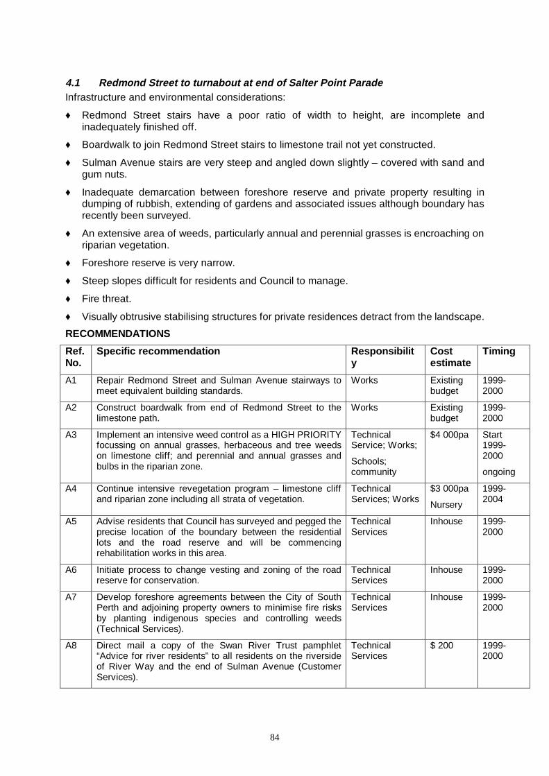
84
4.1 Redmond Street to turnabout at end of Salter Point Parade Infrastructure and environmental considerations:
♦ Redmond Street stairs have a poor ratio of width to height, are incomplete and inadequately finished off.
♦ Boardwalk to join Redmond Street stairs to limestone trail not yet constructed.
♦ Sulman Avenue stairs are very steep and angled down slightly – covered with sand and gum nuts.
♦ Inadequate demarcation between foreshore reserve and private property resulting in dumping of rubbish, extending of gardens and associated issues although boundary has recently been surveyed.
♦ An extensive area of weeds, particularly annual and perennial grasses is encroaching on riparian vegetation.
♦ Foreshore reserve is very narrow.
♦ Steep slopes difficult for residents and Council to manage.
♦ Fire threat.
♦ Visually obtrusive stabilising structures for private residences detract from the landscape.
RECOMMENDATIONS
Ref. No.
Specific recommendation Responsib ility
Cost estimate
Timing
A1 Repair Redmond Street and Sulman Avenue stairways to meet equivalent building standards.
Works Existing budget
1999-2000
A2 Construct boardwalk from end of Redmond Street to the limestone path.
Works Existing budget
1999-2000
A3 Implement an intensive weed control as a HIGH PRIORITY focussing on annual grasses, herbaceous and tree weeds on limestone cliff; and perennial and annual grasses and bulbs in the riparian zone.
Technical Service; Works;
Schools; community
$4 000pa Start 1999-2000
ongoing
A4 Continue intensive revegetation program – limestone cliff and riparian zone including all strata of vegetation.
Technical Services; Works
$3 000pa
Nursery
1999-2004
A5 Advise residents that Council has surveyed and pegged the precise location of the boundary between the residential lots and the road reserve and will be commencing rehabilitation works in this area.
Technical Services
Inhouse 1999-2000
A6 Initiate process to change vesting and zoning of the road reserve for conservation.
Technical Services
Inhouse 1999-2000
A7 Develop foreshore agreements between the City of South Perth and adjoining property owners to minimise fire risks by planting indigenous species and controlling weeds (Technical Services).
Technical Services
Inhouse 1999-2000
A8 Direct mail a copy of the Swan River Trust pamphlet “Advice for river residents” to all residents on the riverside of River Way and the end of Sulman Avenue (Customer Services).
Technical Services
$ 200 1999-2000

85
MAP 6
Salter Point lagoon
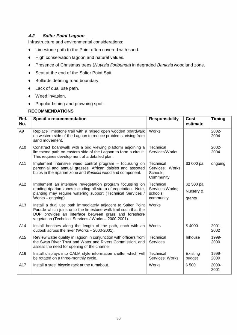
86
4.2 Salter Point Lagoon Infrastructure and environmental considerations:
♦ Limestone path to the Point often covered with sand.
♦ High conservation lagoon and natural values.
♦ Presence of Christmas trees (Nuytsia floribunda) in degraded Banksia woodland zone.
♦ Seat at the end of the Salter Point Spit.
♦ Bollards defining road boundary.
♦ Lack of dual use path.
♦ Weed invasion.
♦ Popular fishing and prawning spot.
RECOMMENDATIONS
Ref. No.
Specific recommendation Responsib ility Cost estimate
Timing
A9 Replace limestone trail with a raised open wooden boardwalk on western side of the Lagoon to reduce problems arising from sand movement.
Works 2002-2004
A10 Construct boardwalk with a bird viewing platform adjoining a limestone path on eastern side of the Lagoon to form a circuit. This requires development of a detailed plan.
Technical Services/Works
2002-2004
A11 Implement intensive weed control program – focussing on perennial and annual grasses, African daisies and assorted bulbs in the riparian zone and Banksia woodland component.
Technical Services; Works; Schools; Community
$3 000 pa ongoing
A12 Implement an intensive revegetation program focussing on eroding riparian zones including all strata of vegetation. Note, planting may require watering support (Technical Services / Works – ongoing).
Technical Services;Works; schools; community
$2 500 pa
Nursery &
grants
A13 Install a dual use path immediately adjacent to Salter Point Parade which joins onto the limestone walk trail such that the DUP provides an interface between grass and foreshore vegetation (Technical Services / Works – 2000-2001).
Works
A14 Install benches along the length of the path, each with an outlook across the river (Works – 2000-2001).
Works $ 4000 2001-2002
A15 Review water quality in lagoon in conjunction with officers from the Swan River Trust and Water and Rivers Commission, and assess the need for opening of the channel
Technical Services
Inhouse 1999-2000
A16 Install displays into CALM style information shelter which will be rotated on a three-monthly cycle.
Technical Services; Works
Existing budget
1999-2000
A17 Install a steel bicycle rack at the turnabout. Works $ 500 2000-2001

87
MAP 7
Salter Point Parade – Sandon Park
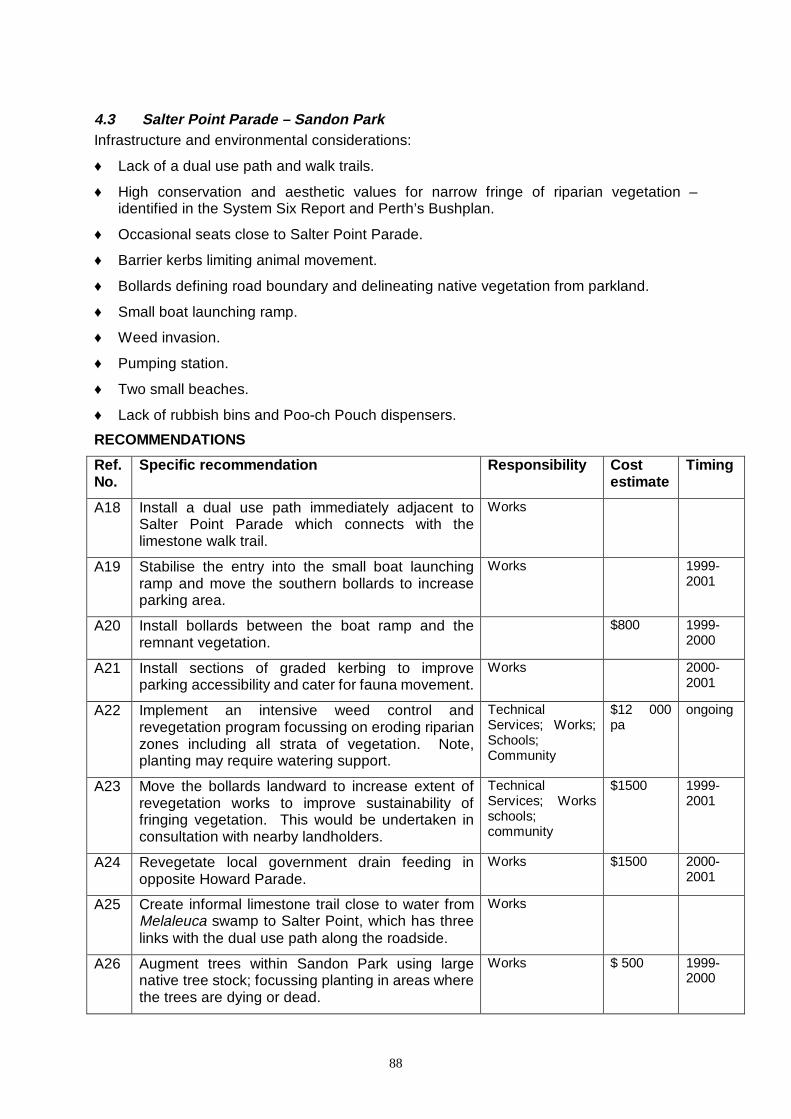
88
4.3 Salter Point Parade – Sandon Park Infrastructure and environmental considerations:
♦ Lack of a dual use path and walk trails.
♦ High conservation and aesthetic values for narrow fringe of riparian vegetation – identified in the System Six Report and Perth’s Bushplan.
♦ Occasional seats close to Salter Point Parade.
♦ Barrier kerbs limiting animal movement.
♦ Bollards defining road boundary and delineating native vegetation from parkland.
♦ Small boat launching ramp.
♦ Weed invasion.
♦ Pumping station.
♦ Two small beaches.
♦ Lack of rubbish bins and Poo-ch Pouch dispensers.
RECOMMENDATIONS
Ref. No.
Specific recommendation Responsib ility Cost estimate
Timing
A18 Install a dual use path immediately adjacent to Salter Point Parade which connects with the limestone walk trail.
Works
A19 Stabilise the entry into the small boat launching ramp and move the southern bollards to increase parking area.
Works 1999-2001
A20 Install bollards between the boat ramp and the remnant vegetation.
$800 1999-2000
A21 Install sections of graded kerbing to improve parking accessibility and cater for fauna movement.
Works 2000-2001
A22 Implement an intensive weed control and revegetation program focussing on eroding riparian zones including all strata of vegetation. Note, planting may require watering support.
Technical Services; Works; Schools; Community
$12 000 pa
ongoing
A23 Move the bollards landward to increase extent of revegetation works to improve sustainability of fringing vegetation. This would be undertaken in consultation with nearby landholders.
Technical Services; Works schools; community
$1500 1999-2001
A24 Revegetate local government drain feeding in opposite Howard Parade.
Works $1500 2000- 2001
A25 Create informal limestone trail close to water from Melaleuca swamp to Salter Point, which has three links with the dual use path along the roadside.
Works
A26 Augment trees within Sandon Park using large native tree stock; focussing planting in areas where the trees are dying or dead.
Works $ 500 1999-2000

89
A27 Encourage more frequent mowing by Council staff and contractors, with improved scheduling to ensure brushcutting is synchronised with mechanical mowers.
Technical Services; Works
inhouse ongoing
A28 Protect the two remaining small beaches by reinforcing the extent of vegetation occurring on either side.
Works $ 1 500 2000-2001
A29 Provide Poo-ch Pouch dispensers and rubbish bins at frequent intervals.
Technical Services
$ 1000 2000-2002
A30 Provide information to local residents to discourage dumping of garden waste into Sandon Park.
Technical Services
inhouse 2000-2001

90
MAP 8
Melaleuca Grove – Manning Road Main Drain
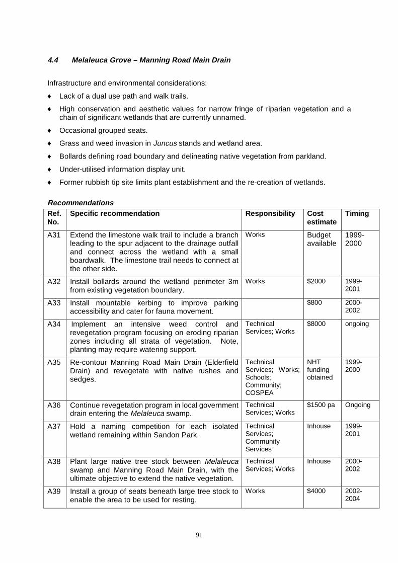
91
4.4 Melaleuca Grove – Manning Road Main Drain
Infrastructure and environmental considerations:
♦ Lack of a dual use path and walk trails.
♦ High conservation and aesthetic values for narrow fringe of riparian vegetation and a chain of significant wetlands that are currently unnamed.
♦ Occasional grouped seats.
♦ Grass and weed invasion in Juncus stands and wetland area.
♦ Bollards defining road boundary and delineating native vegetation from parkland.
♦ Under-utilised information display unit.
♦ Former rubbish tip site limits plant establishment and the re-creation of wetlands.
Recommendations Ref. No.
Specific recommendation Responsib ility Cost estimate
Timing
A31 Extend the limestone walk trail to include a branch leading to the spur adjacent to the drainage outfall and connect across the wetland with a small boardwalk. The limestone trail needs to connect at the other side.
Works Budget available
1999-2000
A32 Install bollards around the wetland perimeter 3m from existing vegetation boundary.
Works $2000 1999-2001
A33 Install mountable kerbing to improve parking accessibility and cater for fauna movement.
$800 2000-2002
A34 Implement an intensive weed control and revegetation program focusing on eroding riparian zones including all strata of vegetation. Note, planting may require watering support.
Technical Services; Works
$8000 ongoing
A35 Re-contour Manning Road Main Drain (Elderfield Drain) and revegetate with native rushes and sedges.
Technical Services; Works; Schools; Community; COSPEA
NHT funding obtained
1999-2000
A36 Continue revegetation program in local government drain entering the Melaleuca swamp.
Technical Services; Works
$1500 pa Ongoing
A37 Hold a naming competition for each isolated wetland remaining within Sandon Park.
Technical Services; Community Services
Inhouse 1999-2001
A38 Plant large native tree stock between Melaleuca swamp and Manning Road Main Drain, with the ultimate objective to extend the native vegetation.
Technical Services; Works
Inhouse 2000-2002
A39 Install a group of seats beneath large tree stock to enable the area to be used for resting.
Works $4000 2002-2004
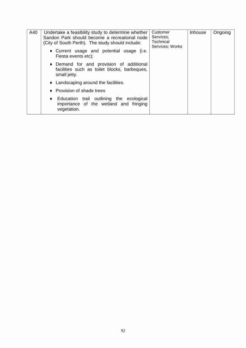
92
A40 Undertake a feasibility study to determine whether Sandon Park should become a recreational node (City of South Perth). The study should include:
♦ Current usage and potential usage (i.e. Fiesta events etc);
♦ Demand for and provision of additional facilities such as toilet blocks, barbeques, small jetty.
♦ Landscaping around the facilities.
♦ Provision of shade trees
♦ Education trail outlining the ecological importance of the wetland and fringing vegetation.
Customer Services; Technical Services; Works
Inhouse Ongoing

93
Map 9 Scout Hall to Fairview Gardens
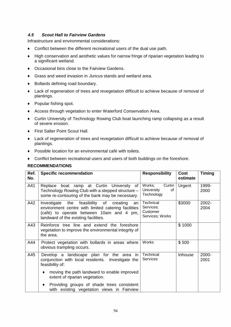
94
4.5 Scout Hall to Fairview Gardens Infrastructure and environmental considerations:
♦ Conflict between the different recreational users of the dual use path.
♦ High conservation and aesthetic values for narrow fringe of riparian vegetation leading to a significant wetland.
♦ Occasional bins close to the Fairview Gardens.
♦ Grass and weed invasion in Juncus stands and wetland area.
♦ Bollards defining road boundary.
♦ Lack of regeneration of trees and revegetation difficult to achieve because of removal of plantings.
♦ Popular fishing spot.
♦ Access through vegetation to enter Waterford Conservation Area.
♦ Curtin University of Technology Rowing Club boat launching ramp collapsing as a result of severe erosion.
♦ First Salter Point Scout Hall.
♦ Lack of regeneration of trees and revegetation difficult to achieve because of removal of plantings.
♦ Possible location for an environmental café with toilets.
♦ Conflict between recreational users and users of both buildings on the foreshore.
RECOMMENDATIONS
Ref. No.
Specific recommendation Responsib ility Cost estimate
Timing
A41 Replace boat ramp at Curtin University of Technology Rowing Club with a stepped structure –some re-contouring of the bank may be necessary.
Works; Curtin University of Technology
Urgent 1999-2000
A42 Investigate the feasibility of creating an environment centre with limited catering facilities (café) to operate between 10am and 4 pm, landward of the existing facilities.
Technical Services; Customer Services; Works
$3000 2002-2004
A43 Reinforce tree line and extend the foreshore vegetation to improve the environmental integrity of the area.
$ 1000
A44 Protect vegetation with bollards in areas where obvious trampling occurs.
Works $ 500
A45 Develop a landscape plan for the area in conjunction with local residents. Investigate the feasibility of:
♦ moving the path landward to enable improved extent of riparian vegetation.
♦ Providing groups of shade trees consistent with existing vegetation views in Fairview
Technical Services
Inhouse 2000-2001
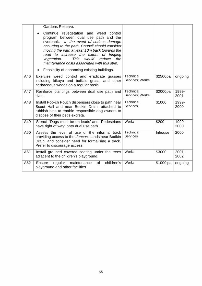
95
Gardens Reserve.
♦ Continue revegetation and weed control program between dual use path and the riverbank. In the event of serious damage occurring to the path, Council should consider moving the path at least 10m back towards the road to increase the extent of fringing vegetation. This would reduce the maintenance costs associated with this strip.
♦ Feasibility of enhancing existing buildings.
A46 Exercise weed control and eradicate grasses including kikuyu and buffalo grass, and other herbaceous weeds on a regular basis.
Technical Services; Works
$2500pa ongoing
A47 Reinforce plantings between dual use path and river.
Technical Services; Works
$2000pa 1999-2001
A48 Install Poo-ch Pouch dispensers close to path near Scout Hall and near Bodkin Drain, attached to rubbish bins to enable responsible dog owners to dispose of their pet’s excreta.
Technical Services
$1000 1999-2000
A49 Stencil “Dogs must be on leads’ and “Pedestrians have right of way” onto dual use path.
Works $200 1999-2000
A50 Assess the level of use of the informal track providing access to the Juncus stands near Bodkin Drain, and consider need for formalising a track. Prefer to discourage access.
Technical Services
Inhouse 2000
A51 Install grouped covered seating under the trees adjacent to the children’s playground.
Works $3000 2001-2002
A52 Ensure regular maintenance of children’s playground and other facilities
Works $1000 pa ongoing

96
MAP 10
Bodkin Park and the Waterford Conservation Area
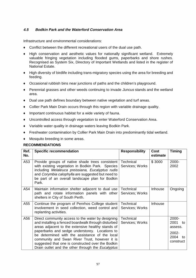
97
4.5 Bodkin Park and the Waterford Conservation Area
Infrastructure and environmental considerations:
♦ Conflict between the different recreational users of the dual use path.
♦ High conservation and aesthetic values for nationally significant wetland. Extremely valuable fringing vegetation including flooded gums, paperbarks and shore rushes. Recognised as System Six, Directory of Important Wetlands and listed in the register of National Estate.
♦ High diversity of birdlife including trans-migratory species using the area for breeding and feeding.
♦ Occasional rubbish bins near junctions of paths and the children’s playground.
♦ Perennial grasses and other weeds continuing to invade Juncus stands and the wetland area.
♦ Dual use path defines boundary between native vegetation and turf areas.
♦ Collier Park Main Drain occurs through this region with variable drainage quality.
♦ Important continuous habitat for a wide variety of fauna.
♦ Uncontrolled access through vegetation to enter Waterford Conservation Area.
♦ Variable water quality in drainage waters leaving Bodkin Park.
♦ Freshwater contamination by Collier Park Main Drain into predominantly tidal wetland.
♦ Mosquito breeding in some areas.
RECOMMENDATIONS
Ref. No.
Specific recommendation Responsib ility Cost estimate
Timing
A53 Provide groups of native shade trees consistent with existing vegetation in Bodkin Park. Species including Melaleuca preissiana, Eucalyptus rudis and Corymbia calophylla are suggested but need to be part of an overall landscape plan for Bodkin Park.
Technical Services; Works
$ 3000 2000-2002
A54 Maintain information shelter adjacent to dual use path and rotate information panels with other shelters in City of South Perth.
Technical Services; Works
Inhouse Ongoing
A55 Continue the program of Penrhos College student involvement in seed collection, weed control and replanting activities.
Technical Services; Works
Inhouse
A56 Direct community access to the water by designing and installing a fenced boardwalk through disturbed areas adjacent to the extensive healthy stands of paperbarks and sedge understorey. Locations to be determined with the assistance of the local community and Swan River Trust, however it is suggested that one is constructed over the Bodkin Drain outlet and the other through the Eucalyptus
Technical Services; Works
2000-2001 to assess.
2002-2004 to construct
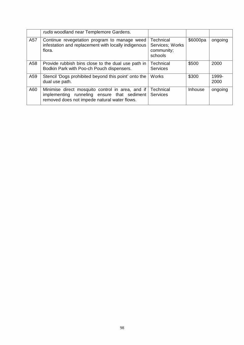
98
rudis woodland near Templemore Gardens.
A57 Continue revegetation program to manage weed infestation and replacement with locally indigenous flora.
Technical Services; Works community; schools
$6000pa ongoing
A58 Provide rubbish bins close to the dual use path in Bodkin Park with Poo-ch Pouch dispensers.
Technical Services
$500 2000
A59 Stencil ‘Dogs prohibited beyond this point’ onto the dual use path.
Works $300 1999-2000
A60 Minimise direct mosquito control in area, and if implementing runneling ensure that sediment removed does not impede natural water flows.
Technical Services
Inhouse ongoing

99
MAP 11
Waterford Conservation Area to Boardwalk
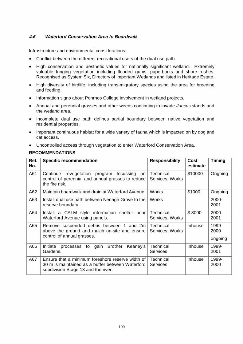
100
4.6 Waterford Conservation Area to Boardwalk
Infrastructure and environmental considerations:
♦ Conflict between the different recreational users of the dual use path.
♦ High conservation and aesthetic values for nationally significant wetland. Extremely valuable fringing vegetation including flooded gums, paperbarks and shore rushes. Recognised as System Six, Directory of Important Wetlands and listed in Heritage Estate.
♦ High diversity of birdlife, including trans-migratory species using the area for breeding and feeding.
♦ Information signs about Penrhos College involvement in wetland projects.
♦ Annual and perennial grasses and other weeds continuing to invade Juncus stands and the wetland area.
♦ Incomplete dual use path defines partial boundary between native vegetation and residential properties.
♦ Important continuous habitat for a wide variety of fauna which is impacted on by dog and cat access.
♦ Uncontrolled access through vegetation to enter Waterford Conservation Area.
RECOMMENDATIONS
Ref. No.
Specific recommendation Responsib ility Cost estimate
Timing
A61 Continue revegetation program focussing on control of perennial and annual grasses to reduce the fire risk.
Technical Services; Works
$10000 Ongoing
A62 Maintain boardwalk and drain at Waterford Avenue. Works $1000 Ongoing
A63 Install dual use path between Nenagh Grove to the reserve boundary.
Works 2000-2001
A64 Install a CALM style information shelter near Waterford Avenue using panels.
Technical Services; Works
$ 3000 2000-2001
A65 Remove suspended debris between 1 and 2m above the ground and mulch on-site and ensure control of annual grasses.
Technical Services; Works
Inhouse 1999-2000
ongoing
A66 Initiate processes to gain Brother Keaney’s Gardens.
Technical Services
Inhouse 1999-2001
A67 Ensure that a minimum foreshore reserve width of 30 m is maintained as a buffer between Waterford subdivision Stage 13 and the river.
Technical Services
Inhouse 1999-2000
101
5.0 REVIEW PERIOD
This review has been undertaken as recommended in the 1994 management plans. Another review should be undertaken in 5 years time, with an annual assessment of the level of implementation contained within the report.
6.0 REFERENCE LISTS AND RELEVANT SOURCES OF INFORMATION Bartle, J., Graham, G., Lane, J. and Moore, S. (1986) Forrestdale Lake Draft Management Plan, Report to Department Conservation and Land Management. Blair, A. (1978) Revision of Irving-Bell and Liehne. A means of identifying the common mosquitoes of the Perth Metropolitan Area. Dept. Cons. & Env. West. Aust. Bull.42. Blair, A. (1979) Control of Mosquitoes and Non-biting Midgies in Perth and Other Urban Areas. Dept. Cons. & Env. West. Aust. Bull.66. Brock, M.A. and Pen, L.J. (1984) Ecological Studies of the Canning River Wetland. Report to the City of Canning, Western Australia. Cogger, H.C. (1975) Reptiles and Amphibians of Australia. A.H. and A.W. Reed, Sydney, Aust. Conservation through Reserves (1981) Conservation Reserves in Western Australia. Report of the C.R.T.C. on System 6, The Darling System Report to the Environmental Protection Authority. Dept. Cons. & Env. West. Aust. No.8. Crowley, F.K. (1962) The History of South Perth. Rigby Ltd., Perth. Ehlers, V.M. and Steel, E.W. (1965) Municipal and Rural Sanitation. 6th Edition, Tokyo Printing Company, Tokyo, Japan. Emberson,J. and Powell, R. (1983) Landscaping of a Reserve; Field Study Centre at Herdsman Lake. Nature Walkabout, Vol. 19 No.1. Fagg, M. and Wrigley, J.W. (1979) Australian Native Plants: Propagation, Cultivation and use in Landscaping. William Collins Publishers, Sydney. Forbes and Fitzhardinge (1977) Swan and Canning Rivers Activity Study. Report to the Dept. of Cons. and Env. West. Aust. Glauert, L. (1961) A Handbook of Lizards of Western Australia. Handbook No. 6. Green, J.W. (1985) Census of the Vascular Plant of Western Australia. Western Australian Herbarium, West. Aust. Lane, J. (1986) “Migratory Waders” in Landscope. Western Australian Department of Conservation and Land Management. Vol.1 No.4. Meagher, T.D. and Le Provost, I. (1975) Ecology of the Canning River Wetlands (Mosquito Survey). Report to the Town of Canning. Merrick, J.R. and Schmida, G.E. (1984) Australian Freshwater Fishes: Biology and Management. Griffin Press Ltd., South Australia. Moore, S.A.(Editor) (1984) The Management of Small Bush Areas in the Perth Metropolitan Region: Proceedings of a Seminar held on the 20th September, 1983. Dept. Fish and Wild. West. Aust Baird, A. Observations in Kings Park P/8. Robley, J. The Bush Fire Risk in the Perth Metropolitan Region P/6.
102
Wycherley, P. People, Fire and Weeds: Can the Vicious Spiral be broken? P/11. Morrissy, N.M. (1978) The Past and Present Distribution of Marron (Cherax tenuimanus) in Western Australia. Fisheries Research Bulletin No.22. Orr, K. (1981) Peripheral Vegetation of the Swan and Canning Estuaries. Western Australian Department of Conservation and Environment. Western. Australian. Bulletin 113. Personal Communication Bamford, M.J., Biologist 9.12.1985 Bolter, Brother, Clontarf Institute, August 1986 Donohoe, J., Member of the Royal Australian Ornithological Union, December 1985 Graham, G., CALM, 1986 Marchant, N., W.A. Herbarium, 1986 Pen, L., Biologist, 19.11.1985 Thomas, L., Biologist, 16.12.1985 Uren, F., Government Chemical Laboratories, 1986 Pizzey, G. (1980) A Field Guide to the Birds of Australia. Collins, Sydney, Aust. Riggert, T.C. (1974) Man and Nature, Conservation of Wetlands Areas. A.C.W.W. Triennial Conference Perth, Oct. 1974. Seddon, G. (1970) Swan River Landscapes. Alpha Print, Perth, West. Aust. Seddon, G. (1972) Sense of Place – A Response to an Environment. The Swan River Coastal Plain, Western Australia. Univ. West. Aust. Press, Nedlands. Siemon N (1995) Lower Canning River Management Plan, Swan River Trust. Perth. Simpson, K. and Day, N. (1984) The Birds of Australia – A Book of Identification 758 Birds in Colour. George Philip and O’Neil Pty. Ltd., Australia. Slater, P. (1972) A Field Guide to Australian Birds: Volume One, Non-Passerines. Rigby Publishers, Adelaide. Slater, P. (1972) A Field Guide to Australian Birds: Volume Two, Passerines. Rigby Publishers, Adelaide. Storr, G.M., Smith, L.A. and Johnstone, R.E. (1981) Lizards of Western Australia, Vol. 1: Skinks. University of Western Australia Press, Western Australia. Strahan, R. (1983) The Australian Museum Complete Book of Australian Mammals. Angus and Robertson Publishers, Australia.
Braithwaite, R.W., Southern-brown Bandicoot Coman, B.J., Fox Jones, E., Feral Cat Newsome, A.E., House Mouse. Richards, G.C., White Striped Mastiff bat Watts, G.H.S., Black Rat Tyler, M.J., Smith, L.A. and Johnstone, R.E. (1984) Frogs of Western Australia. Advance Press Pty. Ltd., Belmont, Western Australia. Thurlow, B.H., Chambers, J. and Klemm, V.V. (1986) Swan-Canning Estuarine System: Environment, Use and the Future. Waterways Commission, Report No. 9. Western Australian Department of Conservation and Environment (1980) Guidelines to Conservation and Management of Wetlands in Western Australia. Bulletin No. 79.
103
APPENDICES
Appendix 1: Flora species list Appendix 2: Fauna species list
Appendix 3: Roles and responsibilities of government organisations
Appendix 4: Suitable species for rehabilitation works Appendix 5: Suggested weed control techniques for common
weeds Appendix 6: Issues raised which were beyond the scope of this
document Appendix 7: Contact details Appendix 8: Previous summary of recommendations and
implementation status
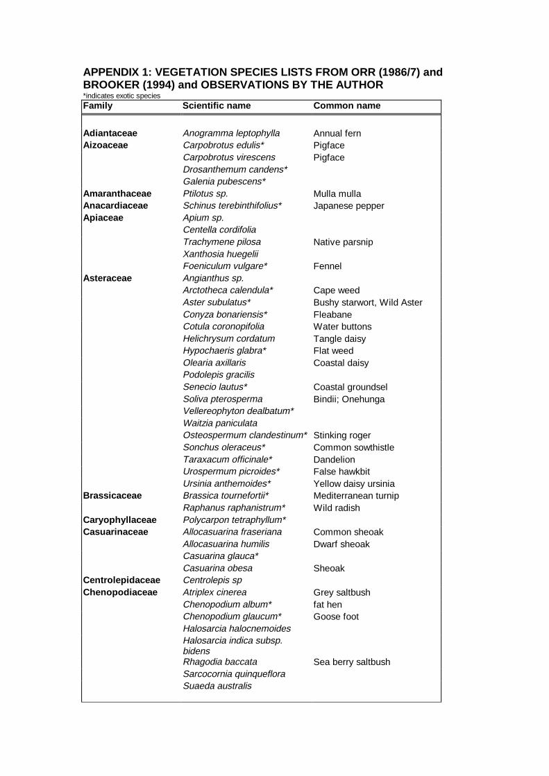
APPENDIX 1: VEGETATION SPECIES LISTS FROM ORR ( 1986/7) and BROOKER (1994) and OBSERVATIONS BY THE AUTHOR *indicates exotic species Family Scientific name Common name
Adiantaceae Anogramma leptophylla Annual fern Aizoaceae Carpobrotus edulis* Pigface
Carpobrotus virescens Pigface Drosanthemum candens* Galenia pubescens*
Amaranthaceae Ptilotus sp. Mulla mulla Anacardiaceae Schinus terebinthifolius* Japanese pepper Apiaceae Apium sp.
Centella cordifolia Trachymene pilosa Native parsnip Xanthosia huegelii Foeniculum vulgare* Fennel
Asteraceae Angianthus sp. Arctotheca calendula* Cape weed Aster subulatus* Bushy starwort, Wild Aster Conyza bonariensis* Fleabane Cotula coronopifolia Water buttons Helichrysum cordatum Tangle daisy Hypochaeris glabra* Flat weed Olearia axillaris Coastal daisy Podolepis gracilis Senecio lautus* Coastal groundsel Soliva pterosperma Bindii; Onehunga Vellereophyton dealbatum* Waitzia paniculata Osteospermum clandestinum* Stinking roger Sonchus oleraceus* Common sowthistle Taraxacum officinale* Dandelion Urospermum picroides* False hawkbit Ursinia anthemoides* Yellow daisy ursinia
Brassicaceae Brassica tournefortii* Mediterranean turnip Raphanus raphanistrum* Wild radish
Caryophyll aceae Polycarpon tetraphyllum* Casuarinaceae Allocasuarina fraseriana Common sheoak
Allocasuarina humilis Dwarf sheoak Casuarina glauca* Casuarina obesa Sheoak
Centrolepidaceae Centrolepis sp Chenopodi aceae Atriplex cinerea Grey saltbush
Chenopodium album* fat hen Chenopodium glaucum* Goose foot Halosarcia halocnemoides Halosarcia indica subsp. bidens
Rhagodia baccata Sea berry saltbush Sarcocornia quinqueflora Suaeda australis
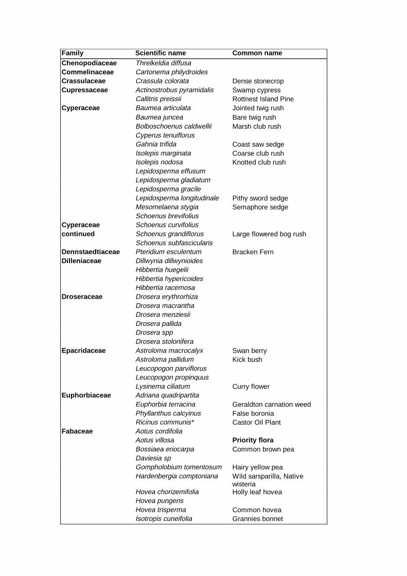
Family Scientific name Common name Chenopodi aceae Threlkeldia diffusa Commelinaceae Cartonema philydroides Crassulaceae Crassula colorata Dense stonecrop Cupressaceae Actinostrobus pyramidalis Swamp cypress
Callitris preissii Rottnest Island Pine Cyperaceae Baumea articulata Jointed twig rush
Baumea juncea Bare twig rush Bolboschoenus caldwellii Marsh club rush Cyperus tenuiflorus Gahnia trifida Coast saw sedge Isolepis marginata Coarse club rush Isolepis nodosa Knotted club rush Lepidosperma effusum Lepidosperma gladiatum Lepidosperma gracile Lepidosperma longitudinale Pithy sword sedge Mesomelaena stygia Semaphore sedge Schoenus brevifolius
Cyperaceae Schoenus curvifolius continued Schoenus grandiflorus Large flowered bog rush
Schoenus subfascicularis Dennstaedtiaceae Pteridium esculentum Bracken Fern Dilleni aceae Dillwynia dillwynioides
Hibbertia huegelii Hibbertia hypericoides Hibbertia racemosa
Droseraceae Drosera erythrorhiza Drosera macrantha Drosera menziesii Drosera pallida Drosera spp Drosera stolonifera
Epacridaceae Astroloma macrocalyx Swan berry Astroloma pallidum Kick bush Leucopogon parviflorus Leucopogon propinquus Lysinema ciliatum Curry flower
Euphorbi aceae Adriana quadripartita Euphorbia terracina Geraldton carnation weed Phyllanthus calcyinus False boronia Ricinus communis* Castor Oil Plant
Fabaceae Aotus cordifolia Aotus villosa Priority flora Bossiaea eriocarpa Common brown pea Daviesia sp Gompholobium tomentosum Hairy yellow pea Hardenbergia comptoniana Wild sarsparilla, Native
wisteria Hovea chorizemifolia Holly leaf hovea Hovea pungens Hovea trisperma Common hovea Isotropis cuneifolia Grannies bonnet

Family Scientific name Common name
Fabaceae Jacksonia furcellata Green stinkwood Jacksonia sternbergiana Grey stinkwood Kennedia prostrata Running postman Lupinus cosentinii* Blue sandplain lupin Oxylobium capitatum Bacon and eggs Oxylobium lineare River pea
Oxylobium sp. Samolus junceus
Samolus repens Creeping brookweed Templetonia retusa Cockies tongue Viminaria juncea Swishbush Cytisus proliferus* Tree lucerne Erythrina sp* Flame tree Melilotus indica* Trifolium spp.* Clover Vicia sativa* Common vetch
Fumariaceae Fumaria capreolata* Little tube weed Geraniaceae Pelargonium capitatum* Rose pelargonium Goodeni aceae Dampiera linearis Common dampiera
Goodenia filiformis Leschenaultia floribunda Free flowering leschenaultia Scaevola canescens Grey scaevola Scaevola holosericea Silky scaevola
Haemodoraceae Anigozanthos humilis Cats paw Anigozanthos manglesii Red and green kangaroo paw Conostylis aculeata Prickly cottonhead Conostylis candicans Grey cottonhead Conostylis involucra Conostylis juncea Haemodorum simplex Haemodorum spicatum Phlebocarya ciliata
Iridaceae Gladiolus caryophyllaceus* Wild gladiolus Hesperantha falcata*
Patersonia occidentalis Purple flag Romulea rosea* Guildford grass
Ferraria crispa* Black flag Freesia aff. leichtlinii* Freesia Homeria breyiana* Cape tulip
Juncaceae Juncus kraussii Shore Rush Juncus pallidus Pale Rush Luzula meridionalis
Lamiaceae Hemiandra pungens Snake bush Lauraceae Cassytha racemosa Dodder laurel Lili aceae Arnocrinum preissii
Borya sp Burchardia multiflora Burchardia umbellata Milkmaids Caesia parviflora Chamaescilla corymbosa Blue squill Corynotheca micrantha
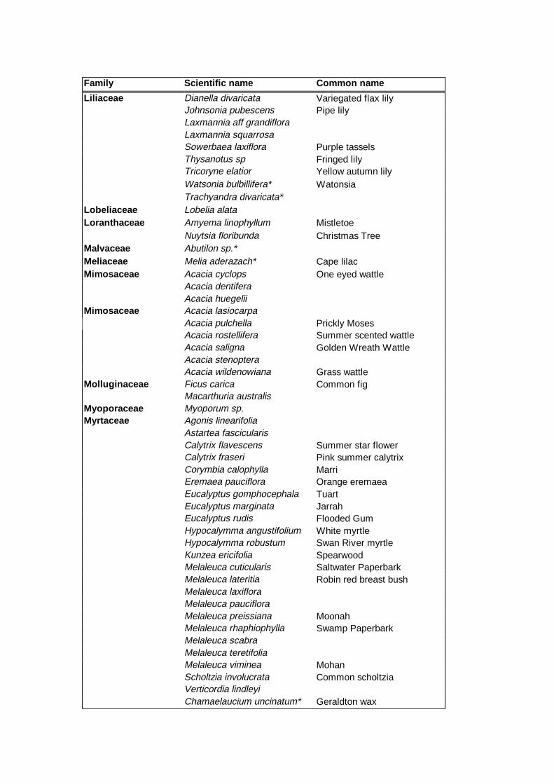
Family Scientific name Common name
Lili aceae Dianella divaricata Variegated flax lily Johnsonia pubescens Pipe lily
Laxmannia aff grandiflora Laxmannia squarrosa Sowerbaea laxiflora Purple tassels Thysanotus sp Fringed lily Tricoryne elatior Yellow autumn lily Watsonia bulbillifera* Watonsia Trachyandra divaricata*
Lobeli aceae Lobelia alata Loranthaceae Amyema linophyllum Mistletoe
Nuytsia floribunda Christmas Tree Malvaceae Abutilon sp.* Meliaceae Melia aderazach* Cape lilac Mimosaceae Acacia cyclops One eyed wattle
Acacia dentifera Acacia huegelii
Mimosaceae Acacia lasiocarpa Acacia pulchella Prickly Moses Acacia rostellifera Summer scented wattle Acacia saligna Golden Wreath Wattle Acacia stenoptera Acacia wildenowiana Grass wattle
Mollugin aceae Ficus carica Common fig Macarthuria australis Myoporaceae Myoporum sp. Myrtaceae Agonis linearifolia
Astartea fascicularis Calytrix flavescens Summer star flower Calytrix fraseri Pink summer calytrix Corymbia calophylla Marri Eremaea pauciflora Orange eremaea Eucalyptus gomphocephala Tuart Eucalyptus marginata Jarrah Eucalyptus rudis Flooded Gum Hypocalymma angustifolium White myrtle Hypocalymma robustum Swan River myrtle Kunzea ericifolia Spearwood Melaleuca cuticularis Saltwater Paperbark Melaleuca lateritia Robin red breast bush Melaleuca laxiflora Melaleuca pauciflora Melaleuca preissiana Moonah Melaleuca rhaphiophylla Swamp Paperbark Melaleuca scabra Melaleuca teretifolia Melaleuca viminea Mohan Scholtzia involucrata Common scholtzia Verticordia lindleyi Chamaelaucium uncinatum* Geraldton wax
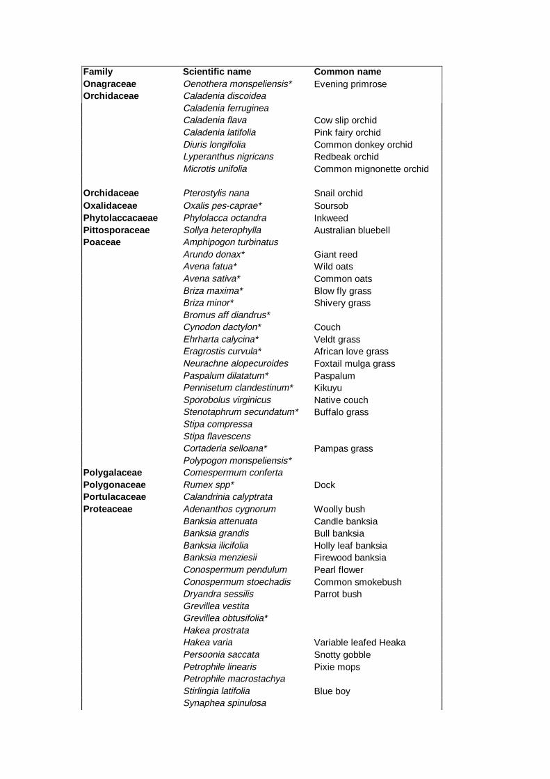
Family Scientific name Common name Onagraceae Oenothera monspeliensis* Evening primrose Orchidaceae Caladenia discoidea
Caladenia ferruginea Caladenia flava Cow slip orchid Caladenia latifolia Pink fairy orchid Diuris longifolia Common donkey orchid Lyperanthus nigricans Redbeak orchid Microtis unifolia Common mignonette orchid
Orchidaceae Pterostylis nana Snail orchid Oxalidaceae Oxalis pes-caprae* Soursob Phytolaccacaeae Phylolacca octandra Inkweed Pittosporaceae Sollya heterophylla Australian bluebell Poaceae Amphipogon turbinatus
Arundo donax* Giant reed Avena fatua* Wild oats Avena sativa* Common oats Briza maxima* Blow fly grass Briza minor* Shivery grass Bromus aff diandrus* Cynodon dactylon* Couch Ehrharta calycina* Veldt grass Eragrostis curvula* African love grass Neurachne alopecuroides Foxtail mulga grass Paspalum dilatatum* Paspalum Pennisetum clandestinum* Kikuyu Sporobolus virginicus Native couch Stenotaphrum secundatum* Buffalo grass Stipa compressa Stipa flavescens Cortaderia selloana* Pampas grass Polypogon monspeliensis*
Polygalaceae Comespermum conferta Polygonaceae Rumex spp* Dock Portulacaceae Calandrinia calyptrata Proteaceae Adenanthos cygnorum Woolly bush
Banksia attenuata Candle banksia Banksia grandis Bull banksia Banksia ilicifolia Holly leaf banksia Banksia menziesii Firewood banksia Conospermum pendulum Pearl flower Conospermum stoechadis Common smokebush Dryandra sessilis Parrot bush Grevillea vestita Grevillea obtusifolia* Hakea prostrata Hakea varia Variable leafed Heaka Persoonia saccata Snotty gobble Petrophile linearis Pixie mops Petrophile macrostachya Stirlingia latifolia Blue boy Synaphea spinulosa
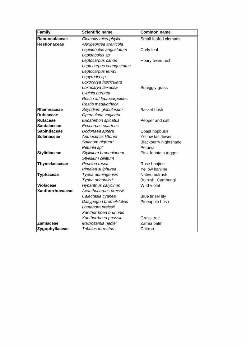
Family Scientific name Common name
Ranuncul aceae Clematis microphylla Small leafed clematis Restionaceae Alexgeorgea arenicola
Lepidobolus angustatum Curly leaf Lepidobolus sp Leptocarpus canus Hoary twine rush Leptocarpus coangustatus Leptocarpus tenax Lepyrodia sp. Loxocarya fasciculata Loxocarya flexuosa Squiggly grass
Lyginia barbata Restio aff leptocarpoides
Restio megalotheca Rhamnaceae Spyridium globulosum Basket bush Rubiaceae Opercularia vaginata Rutaceae Eriostemon spicatus Pepper and salt Santalaceae Exocarpos sparteus Sapind aceae Dodonaea aptera Coast hopbush Solanaceae Anthocercis littorea Yellow tail flower
Solanum nigrum* Blackberry nightshade Petunia sp* Petunia
Stylidi aceae Stylidium brunonianum Pink fountain trigger Stylidium ciliatum
Thymelaeaceae Pimelea rosea Rose banjine Pimelea sulphurea Yellow banjine
Typhaceae Typha domingensis Native bulrush Typha orientalis* Bulrush, Cumbungi
Violaceae Hybanthus calycinus Wild violet Xanthorrhoeaceae Acanthocarpus preissii
Calectasia cyanea Blue tinsel lily Dasypogon bromeliifolius Pineapple bush Lomandra preissii Xanthorrhoea brunonis Xanthorrhoea preissii Grass tree
Zamiaceae Macrozamia riedlei Zamia palm Zygophyllaceae Tribulus terrestris Caltrop
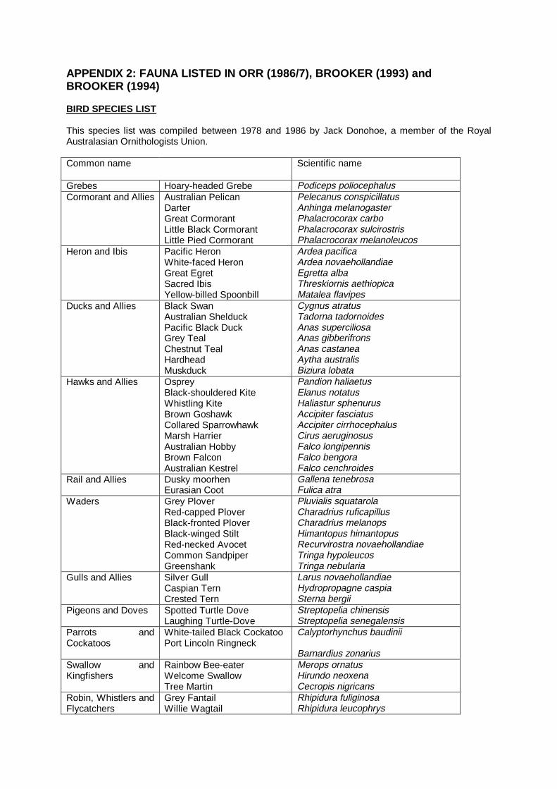
APPENDIX 2: FAUNA LISTED IN ORR (1986/7), BROOKER (1993) and BROOKER (1994) BIRD SPECIES LIST This species list was compiled between 1978 and 1986 by Jack Donohoe, a member of the Royal Australasian Ornithologists Union. Common name Scientific name
Grebes Hoary-headed Grebe Podiceps poliocephalus Cormorant and Allies Australian Pelican
Darter Great Cormorant Little Black Cormorant Little Pied Cormorant
Pelecanus conspicillatus Anhinga melanogaster Phalacrocorax carbo Phalacrocorax sulcirostris Phalacrocorax melanoleucos
Heron and Ibis Pacific Heron White-faced Heron Great Egret Sacred Ibis Yellow-billed Spoonbill
Ardea pacifica Ardea novaehollandiae Egretta alba Threskiornis aethiopica Matalea flavipes
Ducks and Allies Black Swan Australian Shelduck Pacific Black Duck Grey Teal Chestnut Teal Hardhead Muskduck
Cygnus atratus Tadorna tadornoides Anas superciliosa Anas gibberifrons Anas castanea Aytha australis Biziura lobata
Hawks and Allies Osprey Black-shouldered Kite Whistling Kite Brown Goshawk Collared Sparrowhawk Marsh Harrier Australian Hobby Brown Falcon Australian Kestrel
Pandion haliaetus Elanus notatus Haliastur sphenurus Accipiter fasciatus Accipiter cirrhocephalus Cirus aeruginosus Falco longipennis Falco bengora Falco cenchroides
Rail and Allies Dusky moorhen Eurasian Coot
Gallena tenebrosa Fulica atra
Waders Grey Plover Red-capped Plover Black-fronted Plover Black-winged Stilt Red-necked Avocet Common Sandpiper Greenshank
Pluvialis squatarola Charadrius ruficapillus Charadrius melanops Himantopus himantopus Recurvirostra novaehollandiae Tringa hypoleucos Tringa nebularia
Gulls and Allies Silver Gull Caspian Tern Crested Tern
Larus novaehollandiae Hydropropagne caspia Sterna bergii
Pigeons and Doves Spotted Turtle Dove Laughing Turtle-Dove
Streptopelia chinensis Streptopelia senegalensis
Parrots and Cockatoos
White-tailed Black Cockatoo Port Lincoln Ringneck
Calyptorhynchus baudinii Barnardius zonarius
Swallow and Kingfishers
Rainbow Bee-eater Welcome Swallow Tree Martin
Merops ornatus Hirundo neoxena Cecropis nigricans
Robin, Whistlers and Flycatchers
Grey Fantail Willie Wagtail
Rhipidura fuliginosa Rhipidura leucophrys
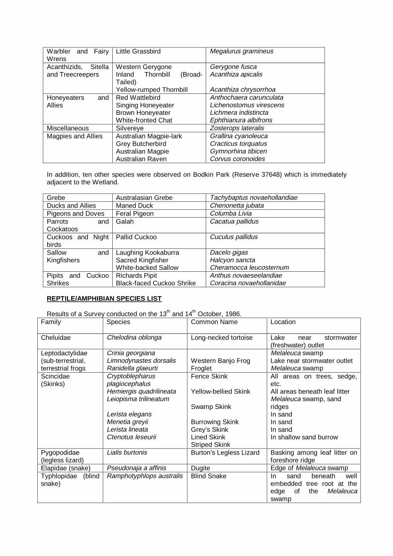
Warbler and Fairy Wrens
Little Grassbird Megalurus gramineus
Acanthizids, Sitella and Treecreepers
Western Gerygone Inland Thornbill (Broad-Tailed) Yellow-rumped Thornbill
Gerygone fusca Acanthiza apicalis Acanthiza chrysorrhoa
Honeyeaters and Allies
Red Wattlebird Singing Honeyeater Brown Honeyeater White-fronted Chat
Anthochaera carunculata Lichenostomus virescens Lichmera indistincta Ephthianura albifrons
Miscellaneous Silvereye Zosterops lateralis Magpies and Allies Australian Magpie-lark
Grey Butcherbird Australian Magpie Australian Raven
Grallina cyanoleuca Cracticus torquatus Gymnorhina tibicen Corvus coronoides
In addition, ten other species were observed on Bodkin Park (Reserve 37648) which is immediately adjacent to the Wetland. Grebe Australasian Grebe Tachybaptus novaehollandiae Ducks and Allies Maned Duck Chenonetta jubata Pigeons and Doves Feral Pigeon Columba Livia Parrots and Cockatoos
Galah Cacatua pallidus
Cuckoos and Night birds
Pallid Cuckoo Cuculus pallidus
Sallow and Kingfishers
Laughing Kookaburra Sacred Kingfisher White-backed Sallow
Dacelo gigas Halcyon sancta Cheramocca leucosternum
Pipits and Cuckoo Shrikes
Richards Pipit Black-faced Cuckoo Shrike
Anthus novaeseelandiae Coracina novaehollanidae
REPTILE/AMPHIBIAN SPECIES LIST Results of a Survey conducted on the 13th and 14th October, 1986.
Family Species Common Name Location
Cheluidae Chelodina oblonga Long-necked tortoise Lake near stormwater (freshwater) outlet
Leptodactylidae (sub-terrestrial, terrestrial frogs
Crinia georgiana Limnodynastes dorsalis Ranidella glaeurti
Western Banjo Frog Froglet
Melaleuca swamp Lake near stormwater outlet Melaleuca swamp
Scincidae (Skinks)
Cryptoblepharus plagiocephalus Hemiergis quadrilineata Leiopisma trilineatum Lerista elegans Menetia greyii Lerista lineata Ctenotus leseurii
Fence Skink Yellow-bellied Skink Swamp Skink Burrowing Skink Grey’s Skink Lined Skink Striped Skink
All areas on trees, sedge, etc. All areas beneath leaf litter Melaleuca swamp, sand ridges In sand In sand In sand In shallow sand burrow
Pygopodidae (legless lizard)
Lialis burtonis Burton’s Legless Lizard Basking among leaf litter on foreshore ridge
Elapidae (snake) Pseudonaja a affinis Dugite Edge of Melaleuca swamp Typhlopidae (blind snake)
Ramphotyphlops australis Blind Snake In sand beneath well embedded tree root at the edge of the Melaleuca swamp
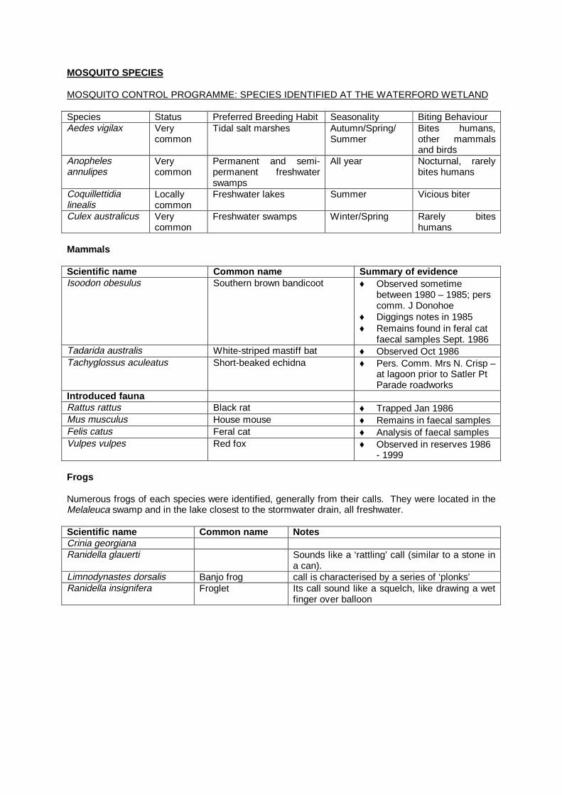
MOSQUITO SPECIES MOSQUITO CONTROL PROGRAMME: SPECIES IDENTIFIED AT THE WATERFORD WETLAND Species Status Preferred Breeding Habit Seasonality Biting Behaviour Aedes vigilax Very
common Tidal salt marshes Autumn/Spring/
Summer Bites humans, other mammals and birds
Anopheles annulipes
Very common
Permanent and semi-permanent freshwater swamps
All year Nocturnal, rarely bites humans
Coquillettidia linealis
Locally common
Freshwater lakes Summer Vicious biter
Culex australicus Very common
Freshwater swamps Winter/Spring Rarely bites humans
Mammals Scientific name Common name Summary of evidence Isoodon obesulus Southern brown bandicoot ♦ Observed sometime
between 1980 – 1985; pers comm. J Donohoe
♦ Diggings notes in 1985 ♦ Remains found in feral cat
faecal samples Sept. 1986 Tadarida australis White-striped mastiff bat ♦ Observed Oct 1986 Tachyglossus aculeatus Short-beaked echidna ♦ Pers. Comm. Mrs N. Crisp –
at lagoon prior to Satler Pt Parade roadworks
Introduced fauna Rattus rattus Black rat ♦ Trapped Jan 1986 Mus musculus House mouse ♦ Remains in faecal samples Felis catus Feral cat ♦ Analysis of faecal samples Vulpes vulpes Red fox ♦ Observed in reserves 1986
- 1999 Frogs Numerous frogs of each species were identified, generally from their calls. They were located in the Melaleuca swamp and in the lake closest to the stormwater drain, all freshwater. Scientific name Common name Notes Crinia georgiana Ranidella glauerti Sounds like a ‘rattling’ call (similar to a stone in
a can). Limnodynastes dorsalis Banjo frog call is characterised by a series of ‘plonks’ Ranidella insignifera Froglet Its call sound like a squelch, like drawing a wet
finger over balloon
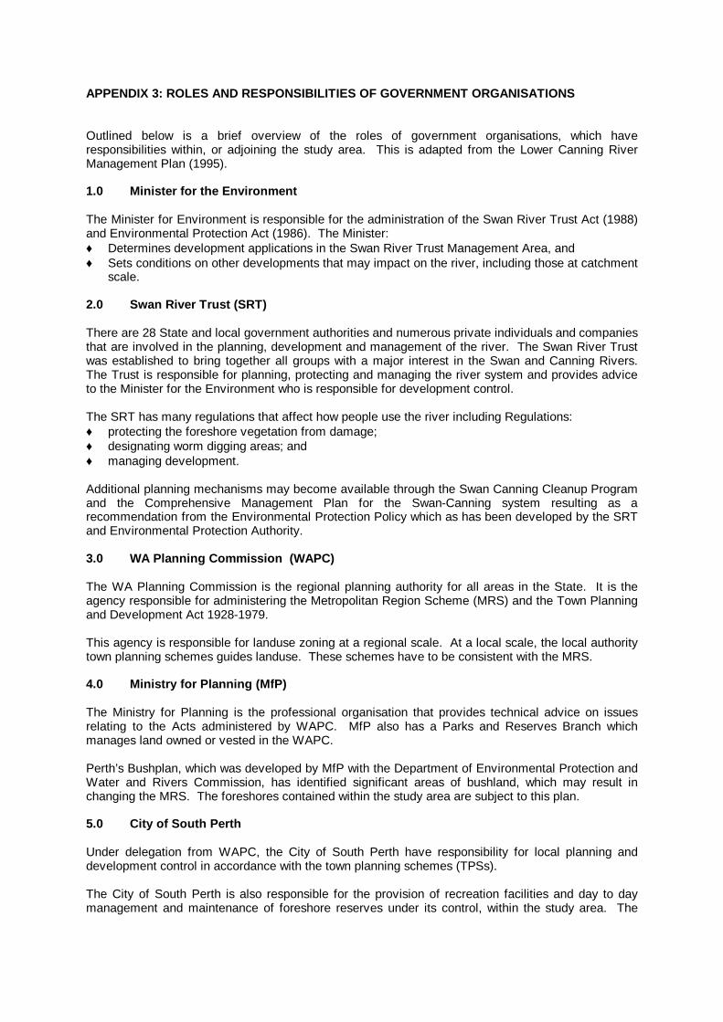
APPENDIX 3: ROLES AND RESPONSIBILITIES OF GOVERNMENT ORGANISATIONS Outlined below is a brief overview of the roles of government organisations, which have responsibilities within, or adjoining the study area. This is adapted from the Lower Canning River Management Plan (1995). 1.0 Minister for the Environment The Minister for Environment is responsible for the administration of the Swan River Trust Act (1988) and Environmental Protection Act (1986). The Minister: ♦ Determines development applications in the Swan River Trust Management Area, and ♦ Sets conditions on other developments that may impact on the river, including those at catchment
scale. 2.0 Swan River Trust (SRT) There are 28 State and local government authorities and numerous private individuals and companies that are involved in the planning, development and management of the river. The Swan River Trust was established to bring together all groups with a major interest in the Swan and Canning Rivers. The Trust is responsible for planning, protecting and managing the river system and provides advice to the Minister for the Environment who is responsible for development control. The SRT has many regulations that affect how people use the river including Regulations: ♦ protecting the foreshore vegetation from damage; ♦ designating worm digging areas; and ♦ managing development. Additional planning mechanisms may become available through the Swan Canning Cleanup Program and the Comprehensive Management Plan for the Swan-Canning system resulting as a recommendation from the Environmental Protection Policy which as has been developed by the SRT and Environmental Protection Authority. 3.0 WA Planning Commission (WAPC) The WA Planning Commission is the regional planning authority for all areas in the State. It is the agency responsible for administering the Metropolitan Region Scheme (MRS) and the Town Planning and Development Act 1928-1979. This agency is responsible for landuse zoning at a regional scale. At a local scale, the local authority town planning schemes guides landuse. These schemes have to be consistent with the MRS. 4.0 Ministry for Planning (MfP) The Ministry for Planning is the professional organisation that provides technical advice on issues relating to the Acts administered by WAPC. MfP also has a Parks and Reserves Branch which manages land owned or vested in the WAPC. Perth’s Bushplan, which was developed by MfP with the Department of Environmental Protection and Water and Rivers Commission, has identified significant areas of bushland, which may result in changing the MRS. The foreshores contained within the study area are subject to this plan. 5.0 City of South Perth Under delegation from WAPC, the City of South Perth have responsibility for local planning and development control in accordance with the town planning schemes (TPSs). The City of South Perth is also responsible for the provision of recreation facilities and day to day management and maintenance of foreshore reserves under its control, within the study area. The
Council also has delegated responsibility to ensure mosquito management occurs in accordance with best management practice determined by Health WA. When the Swan River Trust considers a development proposal that impacts on a local authority, that local authority automatically becomes a member of the Trust while it is deliberating the proposal. The Swan River Trust also can assist the community in foreshore matters and has stencils and a variety of education material available. 6.0 Department of Transport (DOT) The Department of Transport is responsible for safety and navigation in and on the waters adjoining the study area. DOT administers a number of Acts and Regulations which are relevant. The main ones are: ♦ Jetties Act (1926-76) – which relates to the construction and licensing of jetties. ♦ Navigable Waters Regulations 1982 – which relates to:
♦ Control of speed on river ♦ Gazettal of swimming areas ♦ Organisation of regattas ♦ Control of persons in charge of vessels ♦ Silencers on boats ♦ Closure of navigable waters for safety or in cases of emergency.
Under its legislation, DOT is also responsible for the survey of commercial ferries and hire and river vessels, registration and control of pleasure craft, enforcement of safe navigation, granting of mooring licenses, closure of navigable waters and limiting boat speeds, and may also set aside navigable waters for particular purposes. This Act and Regulations were being reviewed in 1995, and their status has not been further investigated for the purposes of this document. 7.0 Department of Environmental Protection The Department of Environmental Protection was established under the Environmental Protection Act 1986. It’s charter is for: ♦ Prevention, control and abatement of environmental pollution, ♦ Conservation, preservation, protection, enhancement and management of the environment, ♦ Matters incidental to or connected with the foregoing. The Act makes it an offence to pollute. The Department of Environmental Protection (DEP) is the professional organisation, which provides technical advice on issues that relate to the Act administered by the Environmental Protection Authority. The DEP’s major objective in its protection of the river environment is to ensure that existing environmental value is maintained and enhanced. This means that a full complement of biophysical functions must be retained in both the system and the catchment. The System Six report (1983), the red Book Status Report (1993) and its update, Perth’s Bushplan (1998), identify the foreshores within the study area to be managed for the purposes of conservation and passive recreation. Public involvement in both documents was fundamental to their development. 8.0 Water Corporation The Water Corporation is responsible for supplying water-related services to the State. Services supplied are public water supply, sewerage, irrigation and major drainage networks. Two main drains discharge directly into the study area. They also have responsibility for managing a sewerage pump station at Kilkenny Close.
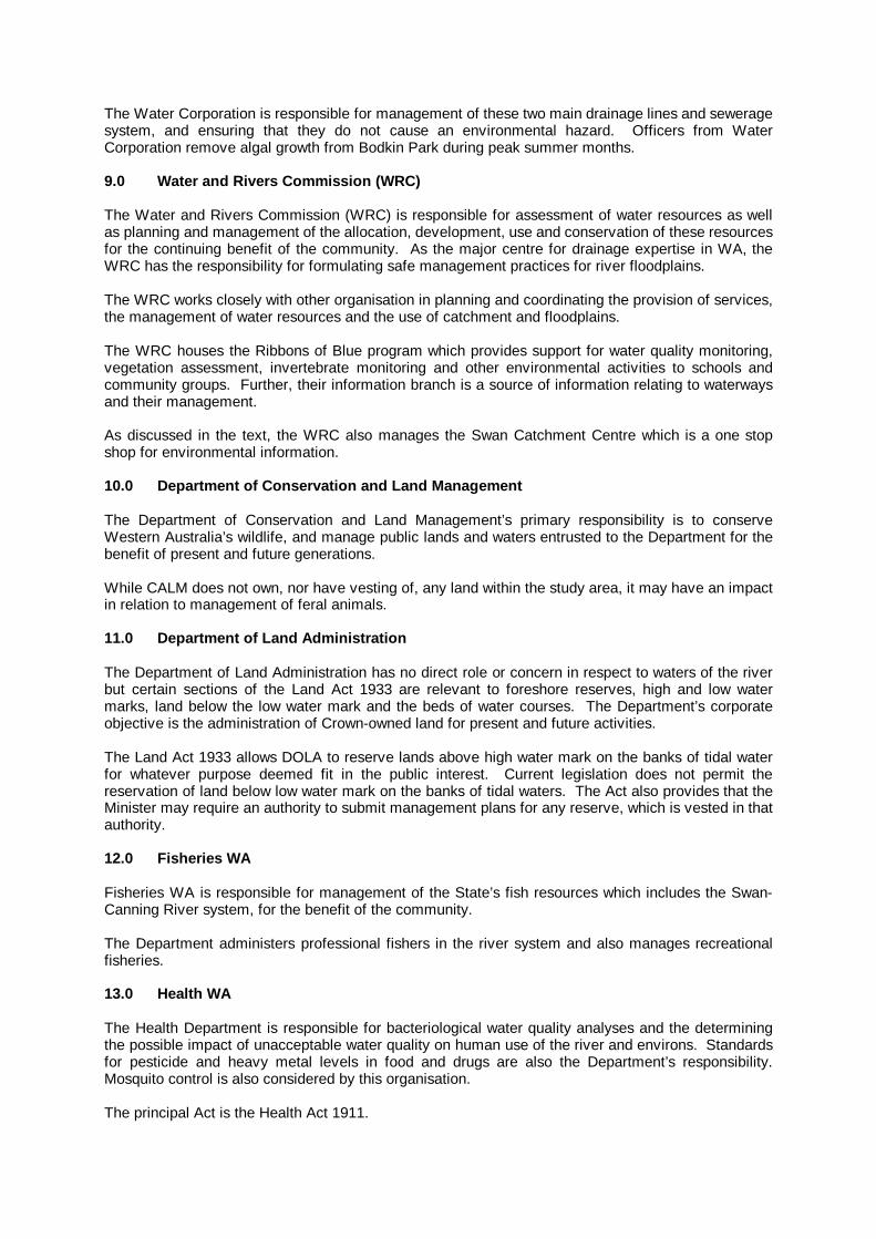
The Water Corporation is responsible for management of these two main drainage lines and sewerage system, and ensuring that they do not cause an environmental hazard. Officers from Water Corporation remove algal growth from Bodkin Park during peak summer months. 9.0 Water and Rivers Commiss ion (WRC) The Water and Rivers Commission (WRC) is responsible for assessment of water resources as well as planning and management of the allocation, development, use and conservation of these resources for the continuing benefit of the community. As the major centre for drainage expertise in WA, the WRC has the responsibility for formulating safe management practices for river floodplains. The WRC works closely with other organisation in planning and coordinating the provision of services, the management of water resources and the use of catchment and floodplains. The WRC houses the Ribbons of Blue program which provides support for water quality monitoring, vegetation assessment, invertebrate monitoring and other environmental activities to schools and community groups. Further, their information branch is a source of information relating to waterways and their management. As discussed in the text, the WRC also manages the Swan Catchment Centre which is a one stop shop for environmental information. 10.0 Department of Conservat ion and Land Manag ement The Department of Conservation and Land Management’s primary responsibility is to conserve Western Australia’s wildlife, and manage public lands and waters entrusted to the Department for the benefit of present and future generations. While CALM does not own, nor have vesting of, any land within the study area, it may have an impact in relation to management of feral animals. 11.0 Department of Land Administration The Department of Land Administration has no direct role or concern in respect to waters of the river but certain sections of the Land Act 1933 are relevant to foreshore reserves, high and low water marks, land below the low water mark and the beds of water courses. The Department’s corporate objective is the administration of Crown-owned land for present and future activities. The Land Act 1933 allows DOLA to reserve lands above high water mark on the banks of tidal water for whatever purpose deemed fit in the public interest. Current legislation does not permit the reservation of land below low water mark on the banks of tidal waters. The Act also provides that the Minister may require an authority to submit management plans for any reserve, which is vested in that authority. 12.0 Fisheries WA Fisheries WA is responsible for management of the State’s fish resources which includes the Swan-Canning River system, for the benefit of the community. The Department administers professional fishers in the river system and also manages recreational fisheries. 13.0 Health WA The Health Department is responsible for bacteriological water quality analyses and the determining the possible impact of unacceptable water quality on human use of the river and environs. Standards for pesticide and heavy metal levels in food and drugs are also the Department’s responsibility. Mosquito control is also considered by this organisation. The principal Act is the Health Act 1911.

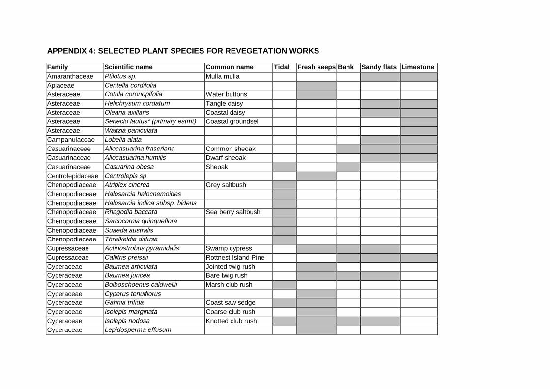
APPENDIX 4: SELECTED PLANT SPECIES FOR REVEGETATION WORKS Family Scientific name Common name Tidal Fresh seeps Bank Sandy flats Limestone Amaranthaceae Ptilotus sp. Mulla mulla Apiaceae Centella cordifolia Asteraceae Cotula coronopifolia Water buttons Asteraceae Helichrysum cordatum Tangle daisy Asteraceae Olearia axillaris Coastal daisy Asteraceae Senecio lautus* (primary estmt) Coastal groundsel Asteraceae Waitzia paniculata Campanulaceae Lobelia alata Casuarinaceae Allocasuarina fraseriana Common sheoak Casuarinaceae Allocasuarina humilis Dwarf sheoak Casuarinaceae Casuarina obesa Sheoak Centrolepidaceae Centrolepis sp Chenopodiaceae Atriplex cinerea Grey saltbush Chenopodiaceae Halosarcia halocnemoides Chenopodiaceae Halosarcia indica subsp. bidens Chenopodiaceae Rhagodia baccata Sea berry saltbush Chenopodiaceae Sarcocornia quinqueflora Chenopodiaceae Suaeda australis Chenopodiaceae Threlkeldia diffusa Cupressaceae Actinostrobus pyramidalis Swamp cypress Cupressaceae Callitris preissii Rottnest Island Pine Cyperaceae Baumea articulata Jointed twig rush Cyperaceae Baumea juncea Bare twig rush Cyperaceae Bolboschoenus caldwellii Marsh club rush Cyperaceae Cyperus tenuiflorus Cyperaceae Gahnia trifida Coast saw sedge Cyperaceae Isolepis marginata Coarse club rush Cyperaceae Isolepis nodosa Knotted club rush Cyperaceae Lepidosperma effusum
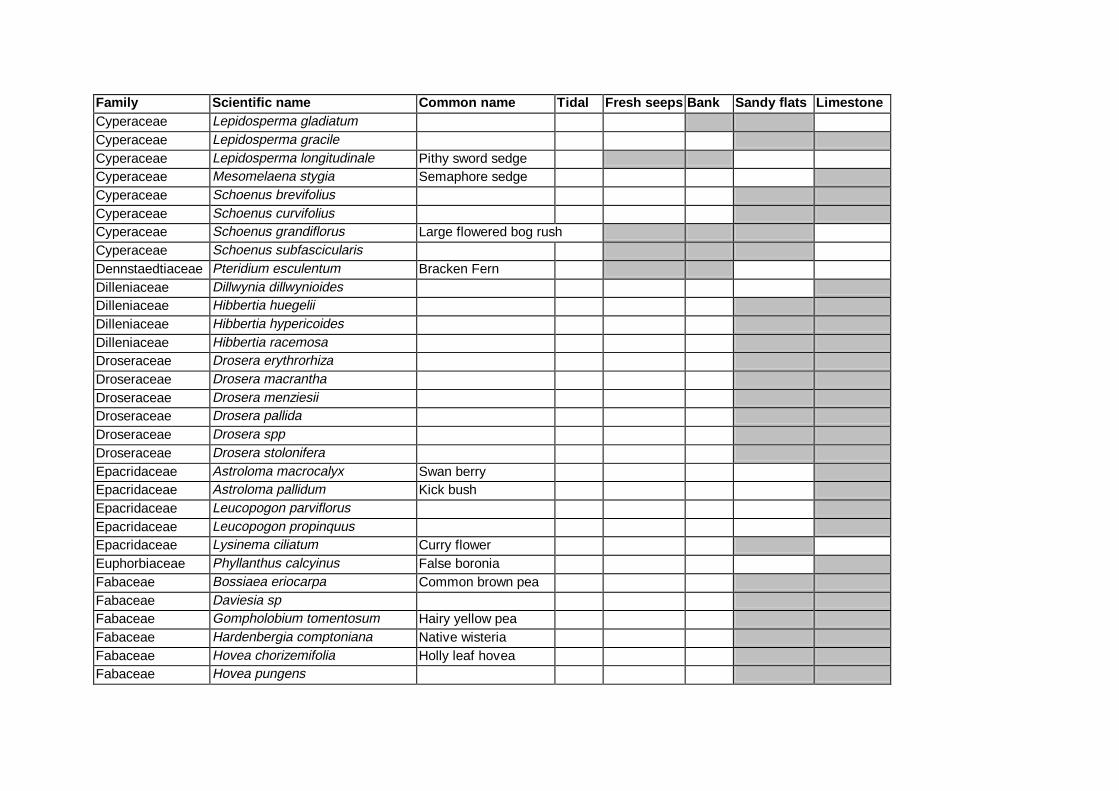
Family Scientific name Common name Tidal Fresh seeps Bank Sandy flats Limestone Cyperaceae Lepidosperma gladiatum Cyperaceae Lepidosperma gracile Cyperaceae Lepidosperma longitudinale Pithy sword sedge Cyperaceae Mesomelaena stygia Semaphore sedge Cyperaceae Schoenus brevifolius Cyperaceae Schoenus curvifolius Cyperaceae Schoenus grandiflorus Large flowered bog rush Cyperaceae Schoenus subfascicularis Dennstaedtiaceae Pteridium esculentum Bracken Fern Dilleniaceae Dillwynia dillwynioides Dilleniaceae Hibbertia huegelii Dilleniaceae Hibbertia hypericoides Dilleniaceae Hibbertia racemosa Droseraceae Drosera erythrorhiza Droseraceae Drosera macrantha Droseraceae Drosera menziesii Droseraceae Drosera pallida Droseraceae Drosera spp Droseraceae Drosera stolonifera Epacridaceae Astroloma macrocalyx Swan berry Epacridaceae Astroloma pallidum Kick bush Epacridaceae Leucopogon parviflorus Epacridaceae Leucopogon propinquus Epacridaceae Lysinema ciliatum Curry flower Euphorbiaceae Phyllanthus calcyinus False boronia Fabaceae Bossiaea eriocarpa Common brown pea Fabaceae Daviesia sp Fabaceae Gompholobium tomentosum Hairy yellow pea Fabaceae Hardenbergia comptoniana Native wisteria Fabaceae Hovea chorizemifolia Holly leaf hovea Fabaceae Hovea pungens
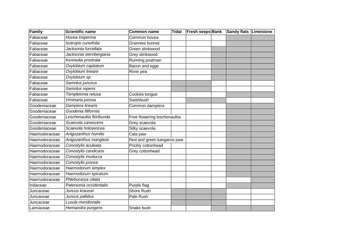
Family Scientific name Common name Tidal Fresh seeps Bank Sandy flats Limestone Fabaceae Hovea trisperma Common hovea Fabaceae Isotropis cuneifolia Grannies bonnet Fabaceae Jacksonia furcellata Green stinkwood Fabaceae Jacksonia sternbergiana Grey stinkwood Fabaceae Kennedia prostrata Running postman Fabaceae Oxylobium capitatum Bacon and eggs Fabaceae Oxylobium lineare River pea Fabaceae Oxylobium sp. Fabaceae Samolus junceus Fabaceae Samolus repens Fabaceae Templetonia retusa Cockies tongue Fabaceae Viminaria juncea Swishbush Goodeniaceae Dampiera linearis Common dampiera Goodeniaceae Goodenia filiformis Goodeniaceae Leschenaultia floribunda Free flowering leschenaultia Goodeniaceae Scaevola canescens Grey scaevola Goodeniaceae Scaevola holosericea Silky scaevola Haemodoraceae Anigozanthus humilis Cats paw Haemodoraceae Anigozanthus manglesii Red and green kangaroo paw Haemodoraceae Conostylis aculeata Prickly cottonhead Haemodoraceae Conostylis candicans Grey cottonhead Haemodoraceae Conostylis involucra Haemodoraceae Conostylis juncea Haemodoraceae Haemodorum simplex Haemodoraceae Haemodorum spicatum Haemodoraceae Phlebocarya ciliata Iridaceae Patersonia occidentalis Purple flag Juncaceae Juncus kraussii Shore Rush Juncaceae Juncus pallidus Pale Rush Juncaceae Luzula meridionalis Lamiaceae Hemiandra pungens Snake bush
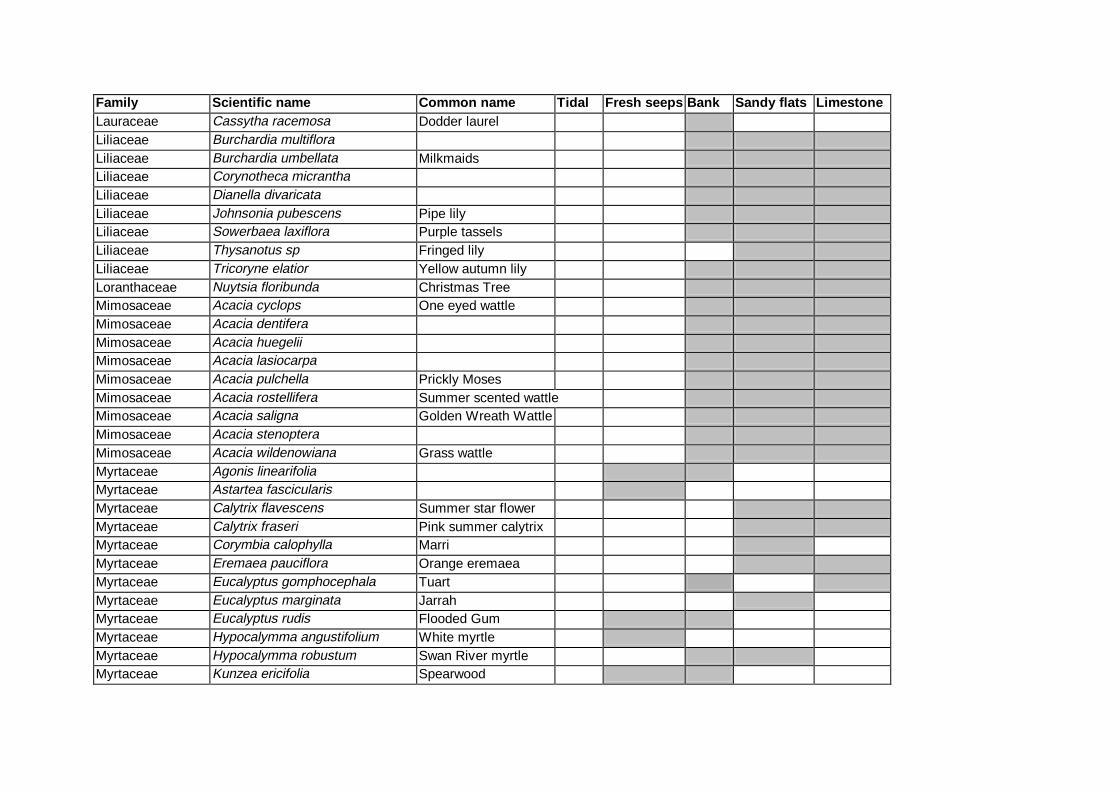
Family Scientific name Common name Tidal Fresh seeps Bank Sandy flats Limestone Lauraceae Cassytha racemosa Dodder laurel Liliaceae Burchardia multiflora Liliaceae Burchardia umbellata Milkmaids Liliaceae Corynotheca micrantha Liliaceae Dianella divaricata Liliaceae Johnsonia pubescens Pipe lily Liliaceae Sowerbaea laxiflora Purple tassels Liliaceae Thysanotus sp Fringed lily Liliaceae Tricoryne elatior Yellow autumn lily Loranthaceae Nuytsia floribunda Christmas Tree Mimosaceae Acacia cyclops One eyed wattle Mimosaceae Acacia dentifera Mimosaceae Acacia huegelii Mimosaceae Acacia lasiocarpa Mimosaceae Acacia pulchella Prickly Moses Mimosaceae Acacia rostellifera Summer scented wattle Mimosaceae Acacia saligna Golden Wreath Wattle Mimosaceae Acacia stenoptera Mimosaceae Acacia wildenowiana Grass wattle Myrtaceae Agonis linearifolia Myrtaceae Astartea fascicularis Myrtaceae Calytrix flavescens Summer star flower Myrtaceae Calytrix fraseri Pink summer calytrix Myrtaceae Corymbia calophylla Marri Myrtaceae Eremaea pauciflora Orange eremaea Myrtaceae Eucalyptus gomphocephala Tuart Myrtaceae Eucalyptus marginata Jarrah Myrtaceae Eucalyptus rudis Flooded Gum Myrtaceae Hypocalymma angustifolium White myrtle Myrtaceae Hypocalymma robustum Swan River myrtle Myrtaceae Kunzea ericifolia Spearwood
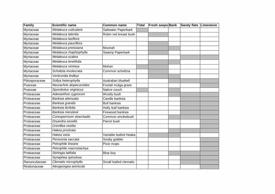
Family Scientific name Common name Tidal Fresh seeps Bank Sandy flats Limestone Myrtaceae Melaleuca cuticularis Saltwater Paperbark Myrtaceae Melaleuca lateritia Robin red breast bush Myrtaceae Melaleuca laxiflora Myrtaceae Melaleuca pauciflora Myrtaceae Melaleuca preissiana Moonah Myrtaceae Melaleuca rhaphiophylla Swamp Paperbark Myrtaceae Melaleuca scabra
Myrtaceae Melaleuca teretifolia
Myrtaceae Melaleuca viminea Mohan Myrtaceae Scholtzia involucrata Common scholtzia
Myrtaceae Verticordia lindleyi
Pittosporaceae Sollya heterophylla Australian bluebell Poaceae Neurachne alopecuroides Foxtail mulga grass Poaceae Sporobolus virginicus Native couch Proteaceae Adenanthos cygnorum Woolly bush Proteaceae Banksia attenuata Candle banksia Proteaceae Banksia grandis Bull banksia Proteaceae Banksia ilicifolia Holly leaf banksia Proteaceae Banksia menziesii Firewood banksia Proteaceae Conospermum stoechadis Common smokebush Proteaceae Dryandra sessilis Parrot bush Proteaceae Grevillea vestita Proteaceae Hakea prostrata Proteaceae Hakea varia Variable leafed Heaka Proteaceae Persoonia saccata Snotty gobble Proteaceae Petrophile linearis Pixie mops Proteaceae Petrophile macrostachya Proteaceae Stirlingia latifolia Blue boy Proteaceae Synaphea spinulosa Ranunculaceae Clematis microphylla Small leafed clematis Restionaceae Alexgeorgea arenicola

Family Scientific name Common name Tidal Fresh seeps Bank Sandy flats Limestone Restionaceae Lepidobolus angustatum Curly leaf Restionaceae Lepidobolus sp Restionaceae Leptocarpus canus Hoary twine rush Restionaceae Leptocarpus coangustatus Restionaceae Leptocarpus tenax Restionaceae Lepyrodia sp. Restionaceae Loxocarya fasciculata Restionaceae Loxocarya flexuosa Squiggly grass Restionaceae Lyginia barbata Rhamnaceae Spyridium globulosum Basket bush Rutaceae Eriostemon spicatus Pepper and salt Sapindaceae Dodonaea aptera Coast hopbush
Solanaceae Anthocercis littorea Yellow tail flower Thymelaeaceae Pimelea rosea Rose banjine Thymelaeaceae Pimelea sulphurea Yellow banjine Typhaceae Typha domingensis Native bulrush Violaceae Hybanthus calycinus Wild violet Xanthorrhoeaceae Acanthocarpus preissii Xanthorrhoeaceae Dasypogon bromeliifolius Pineapple bush Xanthorrhoeaceae Lomandra preissii Xanthorrhoeaceae Xanthorrhoea brunonis Xanthorrhoeaceae Xanthorrhoea preissii Grass tree Zamiaceae Macrozamia riedlei Zamia palm
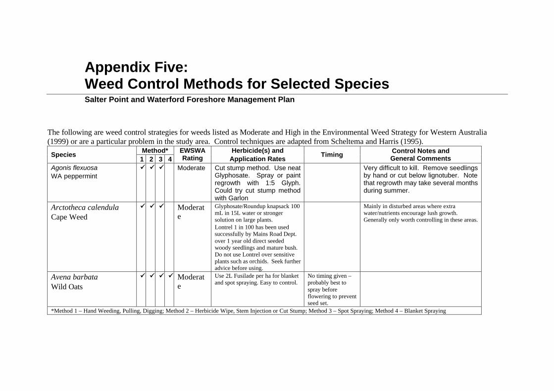
Appendix Five: Weed Control Methods for Selected Species
Salter Point and Waterford Foreshore Management Plan
The following are weed control strategies for weeds listed as Moderate and High in the Environmental Weed Strategy for Western Australia (1999) or are a particular problem in the study area. Control techniques are adapted from Scheltema and Harris (1995).
Method* Species
1 2 3 4 EWSWA Rating
Herbicide(s) and Application Rates
Timing Control Notes and General Comments
Agonis flexuosa WA peppermint
üü üü üü Moderate Cut stump method. Use neat Glyphosate. Spray or paint regrowth with 1:5 Glyph. Could try cut stump method with Garlon
Very difficult to kill. Remove seedlings by hand or cut below lignotuber. Note that regrowth may take several months during summer.
Arctotheca calendula Cape Weed
üü üü üü Moderate
Glyphosate/Roundup knapsack 100 mL in 15L water or stronger solution on large plants. Lontrel 1 in 100 has been used successfully by Mains Road Dept. over 1 year old direct seeded woody seedlings and mature bush. Do not use Lontrel over sensitive plants such as orchids. Seek further advice before using.
Mainly in disturbed areas where extra water/nutrients encourage lush growth. Generally only worth controlling in these areas.
Avena barbata Wild Oats
üü üü üü üü Moderate
Use 2L Fusilade per ha for blanket and spot spraying. Easy to control.
No timing given – probably best to spray before flowering to prevent seed set.
*Method 1 – Hand Weeding, Pulling, Digging; Method 2 – Herbicide Wipe, Stem Injection or Cut Stump; Method 3 – Spot Spraying; Method 4 – Blanket Spraying

Method* Species
1 2 3 4 EWSWA Rating
Herbicide(s) and Application Rates
Timing Control Notes and General Comments
Briza maxima Blowfly Grass
üü üü üü üü Moderate
Sertin or other similar herbicides at 2L/ha.
No timing given – probably best to spray before flowering to prevent seed set.
Easy to control.
Carpobrotus edulis üü Moderate
No specific information – Pull up and destroy
Chamelaucium uncinatum Geraldton Wax
üü üü Moderate
Cut stump method for large plants. Apply Glyphosate immediately after cutting (1 part in 5).
Similar to local variety. Can be prolific in past revegetation. 2-3 years after fire, remove plants before flowering to stop reseeding. Cut stems below ground level.
Cynodon dactylon Couch
üü üü Moderate
Fusilade 4L ha or similar (eg Sertin, Targa). Glyphosate can be used if you can avoid non target species
When actively growing late spring early autumn
Best spraying young growth after fire otherwise several applications may be necessary.
Ehrharta calycina Perennial Veldt Grass
üü üü High Easy to control with Fusilade at 4L/ha. or similar herbicides e.g. Sertin, Targa. Spot spray at 2L/ha to run off.
Treat during winter, early spring, before seeds set and before plants dry out (thus avoiding fire hazard).
Remove small infestations by hand, cut roots as close to culms as possible with a sharp knife. Heavy infestations may require mop up spray the following year. Smothers small plants and competes with natives. A serious fire hazard.
Eragrostis curvula African Love Grass
üü üü üü High Use Roundup or Glyphosate 360, 1L in 100L water and wetter eg Agral 60, X77 when actively growing. In areas clear of non-target sspecies use mixtures of Roundup/Oust or Frenock.
Best to spray after fire on fresh young growth in summer months before seed set.
Thorough coverage of foliage essential. May require mop up spray next year.
*Method 1 – Hand Weeding, Pulling, Digging; Method 2 – Herbicide Wipe, Stem Injection or Cut Stump; Method 3 – Spot Spraying; Method 4 – Blanket Spraying
Freesia aff Leichtlinii Freesia
üü üü üü High Spray large infestations with Glyphosate 1 in 100. Brushoff, Ally 2.5 to 5g ha in 250 to 500 L water ha.
Treat just before flowering to mid-flowering, in August to September.
Competes, smothers, small native plants and bulbous herbs. Prolific seeder. Very difficult to control in natural bushland. Plants spread quickly forming large colonies. Small infestations can be removed by careful digging. Spray large infestations with Glyphosate 1 in 100 just before flowering to mid flowering (Aug – Sept).
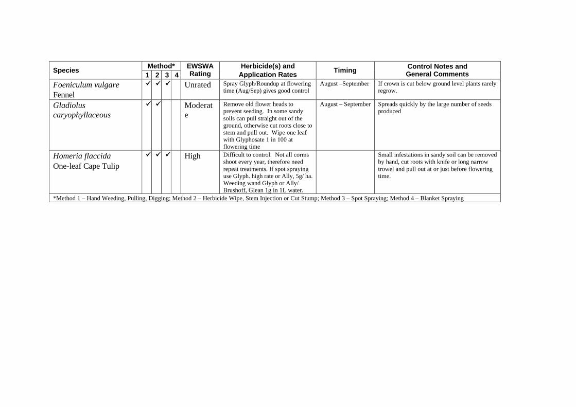
Method* Species
1 2 3 4 EWSWA Rating
Herbicide(s) and Application Rates
Timing Control Notes and General Comments
Foeniculum vulgare Fennel
üü üü üü Unrated Spray Glyph/Roundup at flowering time (Aug/Sep) gives good control
August –September If crown is cut below ground level plants rarely regrow.
Gladiolus caryophyllaceous
üü üü Moderate
Remove old flower heads to prevent seeding. In some sandy soils can pull straight out of the ground, otherwise cut roots close to stem and pull out. Wipe one leaf with Glyphosate 1 in 100 at flowering time
August – September Spreads quickly by the large number of seeds produced
Homeria flaccida One-leaf Cape Tulip
üü üü üü High Difficult to control. Not all corms shoot every year, therefore need repeat treatments. If spot spraying use Glyph. high rate or Ally, 5g/ ha. Weeding wand Glyph or Ally/ Brushoff, Glean 1g in 1L water.
Small infestations in sandy soil can be removed by hand, cut roots with knife or long narrow trowel and pull out at or just before flowering time.
*Method 1 – Hand Weeding, Pulling, Digging; Method 2 – Herbicide Wipe, Stem Injection or Cut Stump; Method 3 – Spot Spraying; Method 4 – Blanket Spraying
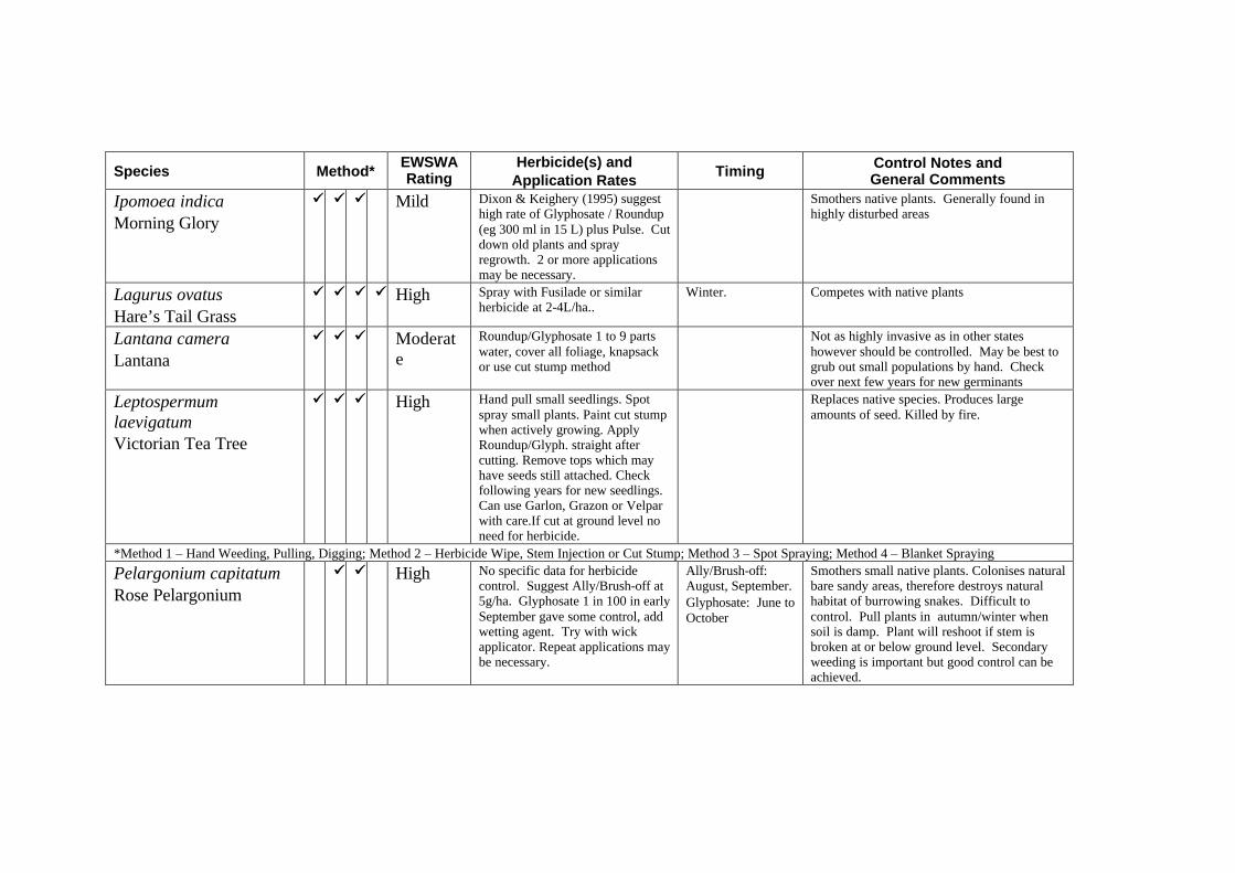
Species Method* EWSWA Rating
Herbicide(s) and Application Rates
Timing Control Notes and General Comments
Ipomoea indica Morning Glory
üü üü üü Mild Dixon & Keighery (1995) suggest high rate of Glyphosate / Roundup (eg 300 ml in 15 L) plus Pulse. Cut down old plants and spray regrowth. 2 or more applications may be necessary.
Smothers native plants. Generally found in highly disturbed areas
Lagurus ovatus Hare’s Tail Grass
üü üü üü üü High Spray with Fusilade or similar herbicide at 2-4L/ha..
Winter. Competes with native plants
Lantana camera Lantana
üü üü üü Moderate
Roundup/Glyphosate 1 to 9 parts water, cover all foliage, knapsack or use cut stump method
Not as highly invasive as in other states however should be controlled. May be best to grub out small populations by hand. Check over next few years for new germinants
Leptospermum laevigatum Victorian Tea Tree
üü üü üü High Hand pull small seedlings. Spot spray small plants. Paint cut stump when actively growing. Apply Roundup/Glyph. straight after cutting. Remove tops which may have seeds still attached. Check following years for new seedlings. Can use Garlon, Grazon or Velpar with care.If cut at ground level no need for herbicide.
Replaces native species. Produces large amounts of seed. Killed by fire.
*Method 1 – Hand Weeding, Pulling, Digging; Method 2 – Herbicide Wipe, Stem Injection or Cut Stump; Method 3 – Spot Spraying; Method 4 – Blanket Spraying
Pelargonium capitatum Rose Pelargonium
üü üü High No specific data for herbicide control. Suggest Ally/Brush-off at 5g/ha. Glyphosate 1 in 100 in early September gave some control, add wetting agent. Try with wick applicator. Repeat applications may be necessary.
Ally/Brush-off: August, September. Glyphosate: June to October
Smothers small native plants. Colonises natural bare sandy areas, therefore destroys natural habitat of burrowing snakes. Difficult to control. Pull plants in autumn/winter when soil is damp. Plant will reshoot if stem is broken at or below ground level. Secondary weeding is important but good control can be achieved.
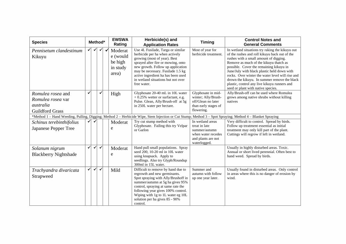
Species Method* EWSWA Rating
Herbicide(s) and Application Rates
Timing Control Notes and General Comments
Pennisetum clandestinum Kikuyu
üü üü üü üü Moderate (would be high in study area)
Use 4L Fusilade, Targa or similar herbicide per ha when actively growing (most of year). Best sprayed after fire or mowing, onto new growth. Follow up application may be necessary. Fusilade 1.5 kg active ingredient ha has been used in wetland situations but not over free water.
Most of year for herbicide treatment.
In wetland situations try raking the kikuyu out of the rushes and roll kikuyu back out of the rushes with a small amount of digging. Remove as much of the kikuyu thatch as possible. Cover the remaining kikuyu in June/July with black plastic held down with rocks. Over winter the water level will rise and drown the kikuyu. In summer remove the black plastic, control any live kikuyu runners and seed or plant with native species.
Romulea rosea and Romulea rosea var australia Guildford Grass
üü üü High Glyphosate 20-40 mL in 10L water + 0.25% wetter or surfactant, e.g. Pulse. Glean, Ally/Brush-off at 5g in 250L water per hectare.
Glyphosate in mid-winter; Ally/Brush-off/Glean no later than early stages of flowering.
Ally/Brush-off can be used where Romulea grows among native shrubs without killing natives
*Method 1 – Hand Weeding, Pulling, Digging; Method 2 – Herbicide Wipe, Stem Injection or Cut Stump; Method 3 – Spot Spraying; Method 4 – Blanket Spraying
Schinus terebinthifolius Japanese Pepper Tree
üü üü Moderate
Try cut stump method with Glyphosate. Failing this try Velpar or Garlon
In wetland areas treat in late summer/autumn when water recedes and plants are not waterlogged.
Very difficult to control. Spread by birds. Follow up treatment essential as initial treatment may only kill part of the plant. Cuttings will regrow if left in wetland.
Solanum nigrum Blackberry Nightshade
üü üü üü Moderate
Hand pull small populations. Spray seed 200, 10-20 ml in 10L water using knapsack. Apply to seedlings. Also try Glyph/Roundup 300ml in 15L water.
Usually in highly disturbed areas. Toxic. Annual or short lived perennial. Often best to hand weed. Spread by birds.
Trachyandra divaricata Strapweed
üü üü üü Mild Difficult to remove by hand due to regrowth and new germinants. Spot spraying with Ally/Brushoff in summer/autumn at 5g ha gives 95% control, spraying at same rate the following year gives 100% control. Wiping with 1g to 1L water eg 10L solution per ha gives 85 - 90% control.
Summer and autumn with follow up one year later.
Usually found in disturbed areas. Only control in areas where this is no danger of erosion by wind.
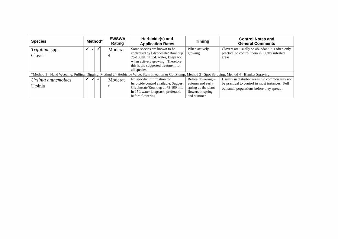
Species Method* EWSWA Rating
Herbicide(s) and Application Rates
Timing Control Notes and General Comments
Trifolium spp. Clover
üü üü üü Moderate
Some species are known to be controlled by Glyphosate/ Roundup 75-100mL in 15L water, knapsack when actively growing. Therefore this is the suggested treatment for all species.
When actively growing.
Clovers are usually so abundant it is often only practical to control them in lightly infested areas.
*Method 1 - Hand Weeding, Pulling, Digging; Method 2 - Herbicide Wipe, Stem Injection or Cut Stump; Method 3 - Spot Spraying; Method 4 - Blanket Spraying
Ursinia anthemoides Ursinia
üü üü üü Moderate
No specific information for herbicide control available. Suggest Glyphosate/Roundup at 75-100 mL in 15L water knapsack, preferable before flowering.
Before flowering – autumn and early spring as the plant flowers in spring and summer.
Usually in disturbed areas. So common may not be practical to control in most instances. Pull
out small populations before they spread.
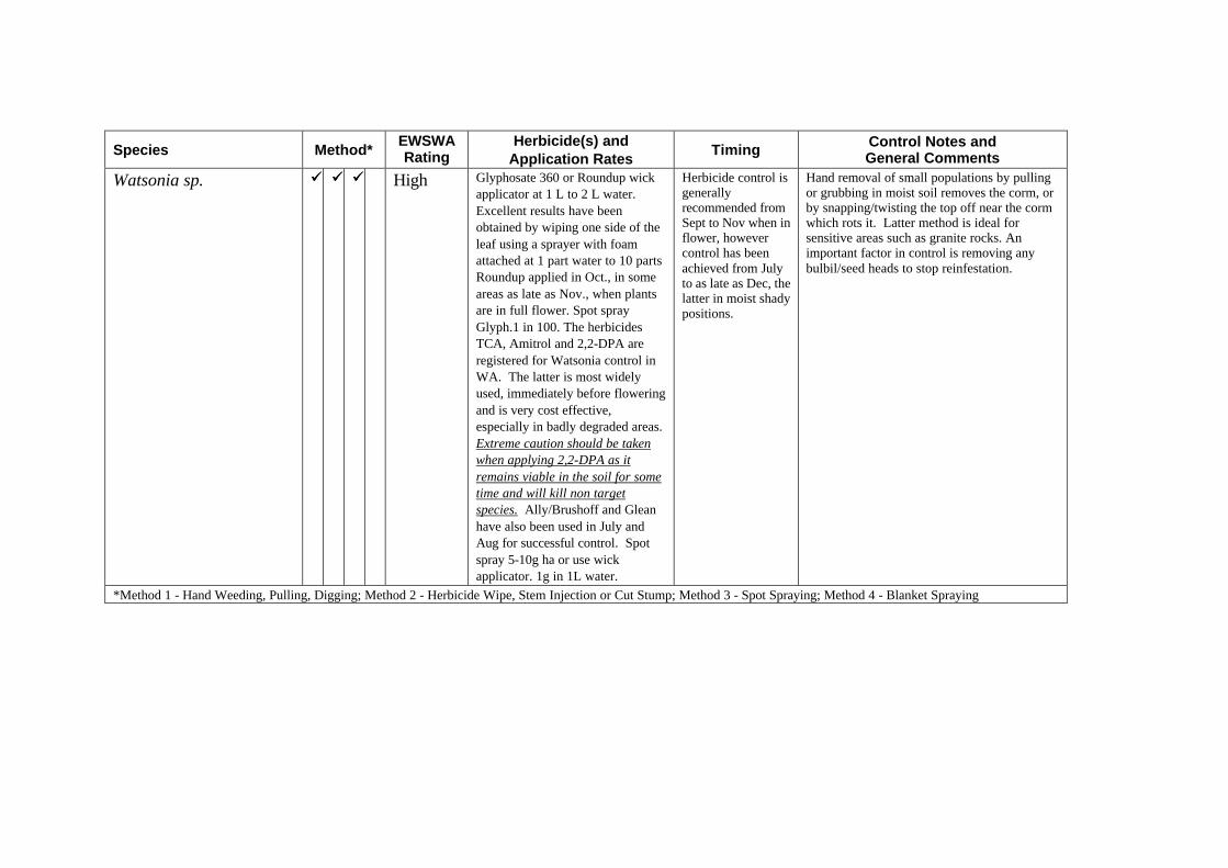
Species Method* EWSWA Rating
Herbicide(s) and Application Rates
Timing Control Notes and General Comments
Watsonia sp. üü üü üü High Glyphosate 360 or Roundup wick applicator at 1 L to 2 L water. Excellent results have been obtained by wiping one side of the leaf using a sprayer with foam attached at 1 part water to 10 parts Roundup applied in Oct., in some areas as late as Nov., when plants are in full flower. Spot spray Glyph.1 in 100. The herbicides TCA, Amitrol and 2,2-DPA are registered for Watsonia control in WA. The latter is most widely used, immediately before flowering and is very cost effective, especially in badly degraded areas. Extreme caution should be taken when applying 2,2-DPA as it remains viable in the soil for some time and will kill non target species. Ally/Brushoff and Glean have also been used in July and Aug for successful control. Spot spray 5-10g ha or use wick applicator. 1g in 1L water.
Herbicide control is generally recommended from Sept to Nov when in flower, however control has been achieved from July to as late as Dec, the latter in moist shady positions.
Hand removal of small populations by pulling or grubbing in moist soil removes the corm, or by snapping/twisting the top off near the corm which rots it. Latter method is ideal for sensitive areas such as granite rocks. An important factor in control is removing any bulbil/seed heads to stop reinfestation.
*Method 1 - Hand Weeding, Pulling, Digging; Method 2 - Herbicide Wipe, Stem Injection or Cut Stump; Method 3 - Spot Spraying; Method 4 - Blanket Spraying
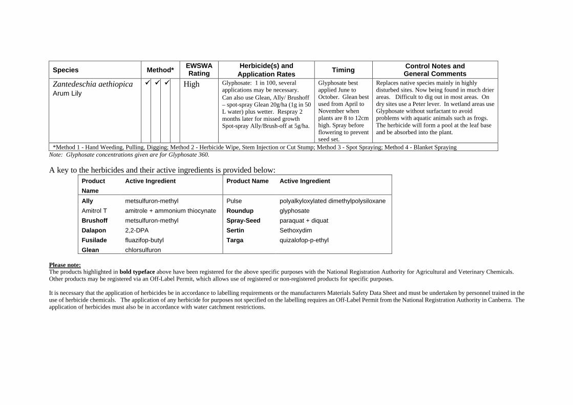
Species Method* EWSWA Rating
Herbicide(s) and Application Rates
Timing Control Notes and General Comments
Zantedeschia aethiopica Arum Lily
üü üü üü High Glyphosate: 1 in 100, several applications may be necessary. Can also use Glean, Ally/ Brushoff – spot-spray Glean 20g/ha (1g in 50 L water) plus wetter. Respray 2 months later for missed growth Spot-spray Ally/Brush-off at 5g/ha.
Glyphosate best applied June to October. Glean best used from April to November when plants are 8 to 12cm high. Spray before flowering to prevent seed set.
Replaces native species mainly in highly disturbed sites. Now being found in much drier areas. Difficult to dig out in most areas. On dry sites use a Peter lever. In wetland areas use Glyphosate without surfactant to avoid problems with aquatic animals such as frogs. The herbicide will form a pool at the leaf base and be absorbed into the plant.
*Method 1 - Hand Weeding, Pulling, Digging; Method 2 - Herbicide Wipe, Stem Injection or Cut Stump; Method 3 - Spot Spraying; Method 4 - Blanket Spraying Note: Glyphosate concentrations given are for Glyphosate 360.
A key to the herbicides and their active ingredients is provided below: Product
Name
Active Ingredient Product Name Active Ingredient
Ally metsulfuron-methyl Pulse polyalkyloxylated dimethylpolysiloxane
Amitrol T amitrole + ammonium thiocynate Roundup glyphosate
Brushoff metsulfuron-methyl Spray-Seed paraquat + diquat
Dalapon 2,2-DPA Sertin Sethoxydim
Fusilade fluazifop-butyl Targa quizalofop-p-ethyl
Glean chlorsulfuron Please note: The products highlighted in bold typeface above have been registered for the above specific purposes with the National Registration Authority for Agricultural and Veterinary Chemicals. Other products may be registered via an Off-Label Permit, which allows use of registered or non-registered products for specific purposes. It is necessary that the application of herbicides be in accordance to labelling requirements or the manufacturers Materials Safety Data Sheet and must be undertaken by personnel trained in the use of herbicide chemicals. The application of any herbicide for purposes not specified on the labelling requires an Off-Label Permit from the National Registration Authority in Canberra. The application of herbicides must also be in accordance with water catchment restrictions.

APPENDIX 6: ISSUES WHICH CAN NOT BE ADEQUATELY ADDRESSED WITHIN THE FRAMEWORK OF THIS PLAN
There were only two issues that could not be addressed within the scope of this document, raised in the submissions and at the community discussion meetings. These were:
• A request for more street lighting after Howard Parade to end of Salter Point Parade; and
• A request for buses to travel to the end of Salter Point Parade to improve mobility for residents who do not drive.
These issues need to be noted by Council and addressed through normal Council procedure.
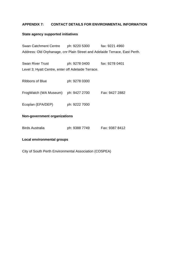
APPENDIX 7: CONTACT DETAILS FOR ENVIRONMENTAL INFORMATION
State agency supported initiatives
Swan Catchment Centre ph: 9220 5300 fax: 9221 4960
Address: Old Orphanage, cnr Plain Street and Adelaide Terrace, East Perth.
Swan River Trust ph: 9278 0400 fax: 9278 0401
Level 3; Hyatt Centre, enter off Adelaide Terrace.
Ribbons of Blue ph: 9278 0300
FrogWatch (WA Museum) ph: 9427 2700 Fax: 9427 2882
Ecoplan (EPA/DEP) ph: 9222 7000
Non-government organizations
Birds Australia ph: 9388 7749 Fax: 9387 8412
Local environmental groups
City of South Perth Environmental Association (COSPEA)

APPENDIX 8: SUMMARY OF RECOMMENDATIONS AND THEIR IMPLEMENTATION STATUS AS AT JUNE 1999
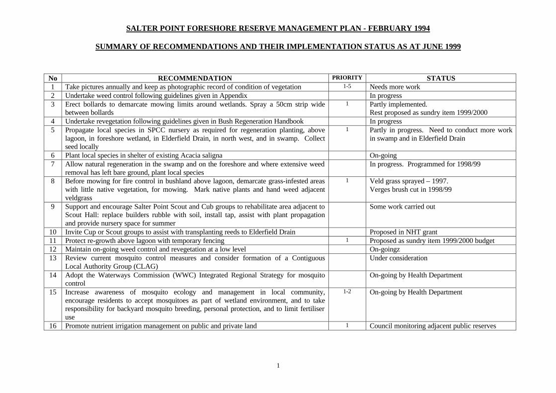
SALTER POINT FORESHORE RESERVE MANAGEMENT PLAN - FEBRUARY 1994
SUMMARY OF RECOMMENDATIONS AND THEIR IMPLEMENTATION STATUS AS AT JUNE 1999
1
No RECOMMENDATION PRIORITY STATUS 1 Take pictures annually and keep as photographic record of condition of vegetation 1-5 Needs more work 2 Undertake weed control following guidelines given in Appendix In progress 3 Erect bollards to demarcate mowing limits around wetlands. Spray a 50cm strip wide
between bollards 1 Partly implemented.
Rest proposed as sundry item 1999/2000 4 Undertake revegetation following guidelines given in Bush Regeneration Handbook In progress 5 Propagate local species in SPCC nursery as required for regeneration planting, above
lagoon, in foreshore wetland, in Elderfield Drain, in north west, and in swamp. Collect seed locally
1 Partly in progress. Need to conduct more work in swamp and in Elderfield Drain
6 Plant local species in shelter of existing Acacia saligna On-going 7 Allow natural regeneration in the swamp and on the foreshore and where extensive weed
removal has left bare ground, plant local species In progress. Programmed for 1998/99
8 Before mowing for fire control in bushland above lagoon, demarcate grass-infested areas with little native vegetation, for mowing. Mark native plants and hand weed adjacent veldgrass
1 Veld grass sprayed – 1997. Verges brush cut in 1998/99
9 Support and encourage Salter Point Scout and Cub groups to rehabilitate area adjacent to Scout Hall: replace builders rubble with soil, install tap, assist with plant propagation and provide nursery space for summer
Some work carried out
10 Invite Cup or Scout groups to assist with transplanting reeds to Elderfield Drain Proposed in NHT grant 11 Protect re-growth above lagoon with temporary fencing 1 Proposed as sundry item 1999/2000 budget 12 Maintain on-going weed control and revegetation at a low level On-goingz 13 Review current mosquito control measures and consider formation of a Contiguous
Local Authority Group (CLAG) Under consideration
14 Adopt the Waterways Commission (WWC) Integrated Regional Strategy for mosquito control
On-going by Health Department
15 Increase awareness of mosquito ecology and management in local community, encourage residents to accept mosquitoes as part of wetland environment, and to take responsibility for backyard mosquito breeding, personal protection, and to limit fertiliser use
1-2 On-going by Health Department
16 Promote nutrient irrigation management on public and private land 1 Council monitoring adjacent public reserves
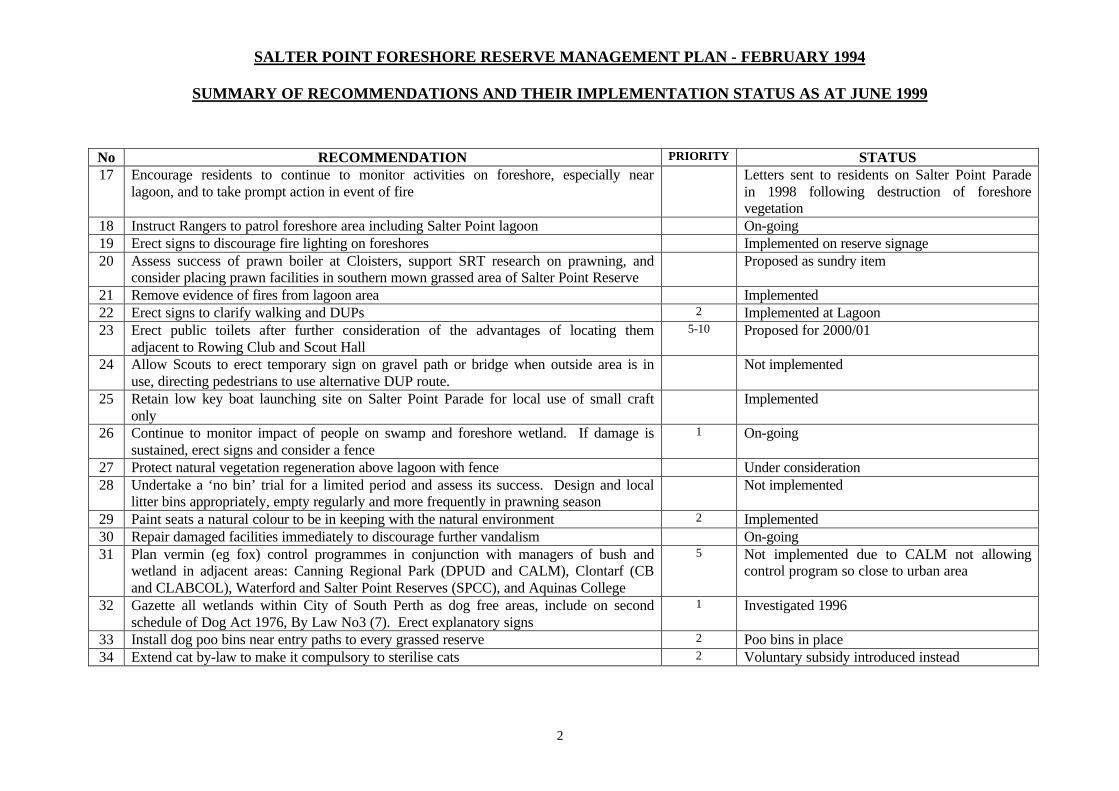
SALTER POINT FORESHORE RESERVE MANAGEMENT PLAN - FEBRUARY 1994
SUMMARY OF RECOMMENDATIONS AND THEIR IMPLEMENTATION STATUS AS AT JUNE 1999
2
No RECOMMENDATION PRIORITY STATUS 17 Encourage residents to continue to monitor activities on foreshore, especially near
lagoon, and to take prompt action in event of fire Letters sent to residents on Salter Point Parade
in 1998 following destruction of foreshore vegetation
18 Instruct Rangers to patrol foreshore area including Salter Point lagoon On-going 19 Erect signs to discourage fire lighting on foreshores Implemented on reserve signage 20 Assess success of prawn boiler at Cloisters, support SRT research on prawning, and
consider placing prawn facilities in southern mown grassed area of Salter Point Reserve Proposed as sundry item
21 Remove evidence of fires from lagoon area Implemented 22 Erect signs to clarify walking and DUPs 2 Implemented at Lagoon 23 Erect public toilets after further consideration of the advantages of locating them
adjacent to Rowing Club and Scout Hall 5-10 Proposed for 2000/01
24 Allow Scouts to erect temporary sign on gravel path or bridge when outside area is in use, directing pedestrians to use alternative DUP route.
Not implemented
25 Retain low key boat launching site on Salter Point Parade for local use of small craft only
Implemented
26 Continue to monitor impact of people on swamp and foreshore wetland. If damage is sustained, erect signs and consider a fence
1 On-going
27 Protect natural vegetation regeneration above lagoon with fence Under consideration 28 Undertake a ‘no bin’ trial for a limited period and assess its success. Design and local
litter bins appropriately, empty regularly and more frequently in prawning season Not implemented
29 Paint seats a natural colour to be in keeping with the natural environment 2 Implemented 30 Repair damaged facilities immediately to discourage further vandalism On-going 31 Plan vermin (eg fox) control programmes in conjunction with managers of bush and
wetland in adjacent areas: Canning Regional Park (DPUD and CALM), Clontarf (CB and CLABCOL), Waterford and Salter Point Reserves (SPCC), and Aquinas College
5 Not implemented due to CALM not allowing control program so close to urban area
32 Gazette all wetlands within City of South Perth as dog free areas, include on second schedule of Dog Act 1976, By Law No3 (7). Erect explanatory signs
1 Investigated 1996
33 Install dog poo bins near entry paths to every grassed reserve 2 Poo bins in place 34 Extend cat by-law to make it compulsory to sterilise cats 2 Voluntary subsidy introduced instead
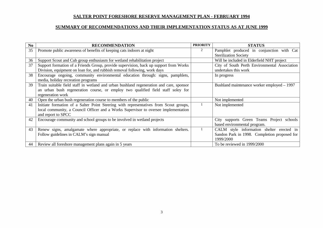
SALTER POINT FORESHORE RESERVE MANAGEMENT PLAN - FEBRUARY 1994
SUMMARY OF RECOMMENDATIONS AND THEIR IMPLEMENTATION STATUS AS AT JUNE 1999
3
No RECOMMENDATION PRIORITY STATUS 35 Promote public awareness of benefits of keeping cats indoors at night 2 Pamphlet produced in conjunction with Cat
Sterilization Society 36 Support Scout and Cub group enthusiasm for wetland rehabilitation project Will be included in Elderfield NHT project 37 Support formation of a Friends Group, provide supervision, back up support from Works
Division, equipment on loan for, and rubbish removal following, work days City of South Perth Environmental Association
undertakes this work 38 Encourage ongoing, community environmental education through: signs, pamphlets,
media, holiday recreation programs In progress
39 Train suitable field staff in wetland and urban bushland regeneration and care, sponsor an urban bush regeneration course, or employ two qualified field staff soley for regeneration work
Bushland maintenance worker employed – 1997
40 Open the urban bush regeneration course to members of the public Not implemented 41 Initiate formation of a Salter Point Steering with representatives from Scout groups,
local community, a Council Officer and a Works Supervisor to oversee implementation and report to SPCC
1 Not implemented
42 Encourage community and school groups to be involved in wetland projects City supports Green Teams Project schools based environmental program.
43 Renew signs, amalgamate where appropriate, or replace with information shelters. Follow guidelines in CALM’s sign manual
1 CALM style information shelter erected in Sandon Park in 1998. Completion proposed for 1999/2000
44 Review all foreshore management plans again in 5 years To be reviewed in 1999/2000
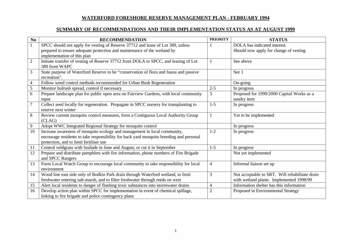
WATERFORD FORESHORE RESERVE MANAGEMENT PLAN - FEBRUARY 1994
SUMMARY OF RECOMMENDATIONS AND THEIR IMPLEMENTATION STATUS AS AT AUGUST 1999
1
No RECOMMENDATION PRIORITY STATUS 1 SPCC should not apply for vesting of Reserve 37712 and lease of Lot 389, unless
prepared to ensure adequate protection and maintenance of the wetland by implementation of this plan
1 DOLA has indicated interest. Should now apply for change of vesting
2 Initiate transfer of vesting of Reserve 37712 from DOLA to SPCC, and leasing of Lot 389 from WAPC
1 See above
3 State purpose of Waterford Reserve to be “conservation of flora and fauna and passive recreation”.
See 1
4 Follow weed control methods recommended for Urban Bush Regeneration On-going 5 Monitor bulrush spread, control if necessary 2-5 In progress 6 Prepare landscape plan for public open area on Fairview Gardens, with local community
input 3 Proposed for 1999/2000 Capital Works as a
sundry item 7 Collect seed locally for regeneration. Propagate in SPCC nursery for transplanting to
reserve next winter 1-5 In progress
8 Review current mosquito control measures, form a Contiguous Local Authority Group (CLAG)
1 Yet to be implemented
9 Adopt WWC Integrated Regional Strategy for mosquito control In progress 10 Increase awareness of mosquito ecology and management in local community,
encourage residents to take responsibility for back yard mosquito breeding and personal protection, and to limit fertiliser use
1-2 In progress
11 Control veldgrass with fusilade in June and August, or cut it in September 1-5 In progress 12 Prepare and distribute pamphlets with fire information, phone numbers of Fire Brigade
and SPCC Rangers Not yet implemented
13 Form Local Watch Group to encourage local community to take responsibility for local environment
4 Informal liaison set up
14 Wood line east side only of Bodkin Park drain through Waterford wetland, to limit freshwater entering salt-marsh, and to filter freshwater through reeds on west
3 Not acceptable to SRT. Will rehabilitate drain with wetland plants. Implemented 1998/99
15 Alert local residents to danger of flushing toxic substances into stormwater drains 4 Information shelter has this information 16 Develop action plan within SPCC for implementation in event of chemical spillage,
linking to fire brigade and police contingency plans 2 Proposed in Environmental Strategy
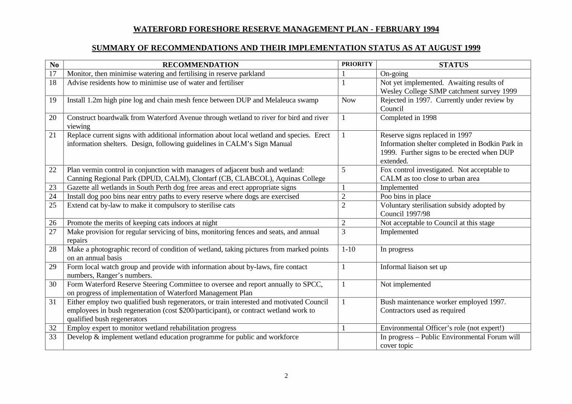
WATERFORD FORESHORE RESERVE MANAGEMENT PLAN - FEBRUARY 1994
SUMMARY OF RECOMMENDATIONS AND THEIR IMPLEMENTATION STATUS AS AT AUGUST 1999
2
No RECOMMENDATION PRIORITY STATUS 17 Monitor, then minimise watering and fertilising in reserve parkland 1 On-going 18 Advise residents how to minimise use of water and fertiliser 1 Not yet implemented. Awaiting results of
Wesley College SJMP catchment survey 1999 19 Install 1.2m high pine log and chain mesh fence between DUP and Melaleuca swamp Now Rejected in 1997. Currently under review by
Council 20 Construct boardwalk from Waterford Avenue through wetland to river for bird and river
viewing 1 Completed in 1998
21 Replace current signs with additional information about local wetland and species. Erect information shelters. Design, following guidelines in CALM’s Sign Manual
1 Reserve signs replaced in 1997 Information shelter completed in Bodkin Park in 1999. Further signs to be erected when DUP extended.
22 Plan vermin control in conjunction with managers of adjacent bush and wetland: Canning Regional Park (DPUD, CALM), Clontarf (CB, CLABCOL), Aquinas College
5 Fox control investigated. Not acceptable to CALM as too close to urban area
23 Gazette all wetlands in South Perth dog free areas and erect appropriate signs 1 Implemented 24 Install dog poo bins near entry paths to every reserve where dogs are exercised 2 Poo bins in place 25 Extend cat by-law to make it compulsory to sterilise cats 2 Voluntary sterilisation subsidy adopted by
Council 1997/98 26 Promote the merits of keeping cats indoors at night 2 Not acceptable to Council at this stage 27 Make provision for regular servicing of bins, monitoring fences and seats, and annual
repairs 3 Implemented
28 Make a photographic record of condition of wetland, taking pictures from marked points on an annual basis
1-10 In progress
29 Form local watch group and provide with information about by-laws, fire contact numbers, Ranger’s numbers.
1 Informal liaison set up
30 Form Waterford Reserve Steering Committee to oversee and report annually to SPCC, on progress of implementation of Waterford Management Plan
1 Not implemented
31 Either employ two qualified bush regenerators, or train interested and motivated Council employees in bush regeneration (cost $200/participant), or contract wetland work to qualified bush regenerators
1 Bush maintenance worker employed 1997. Contractors used as required
32 Employ expert to monitor wetland rehabilitation progress 1 Environmental Officer’s role (not expert!) 33 Develop & implement wetland education programme for public and workforce In progress – Public Environmental Forum will
cover topic

WATERFORD FORESHORE RESERVE MANAGEMENT PLAN - FEBRUARY 1994
SUMMARY OF RECOMMENDATIONS AND THEIR IMPLEMENTATION STATUS AS AT AUGUST 1999
3
34 Review all foreshore management plans again in 5 years Management plan due for review in 1999/2000